City of Apopka Planning Commission Meeting Agenda May 13, :01 CITY COUNCIL CHAMBERS
|
|
|
- Clarence Bennett Sutton
- 5 years ago
- Views:
Transcription

, for property located north of West Lester Road and west of Vick Road.")
1 City of Apopka Planning Commission Meeting Agenda May 13, :01 CITY COUNCIL CHAMBERS I. CALL TO ORDER If you wish to appear before the Planning Commission, please submit a Notice of Intent to Speak card to the Recording Secretary. II. OPENING AND INVOCATION III. APPROVAL OF MINUTES: 1 Approve minutes of the Planning Commission meeting held April 8, 2014, at 5:01 p.m. IV. PUBLIC HEARING: 1. CHANGE OF ZONING Country Crossings, LLC, from R-1AA to Planned Unit Development (Residential), for property located north of West Lester Road and west of Vick Road. (Parcel ID #: ) V. SITE PLANS: 1. REVISED FINAL DEVELOPMENT PLAN Belmonte Reserve Subdivision, owned by K Hovnanian Belmonte Reserve, LLC, c/o Heather Himes, Esq., Akerman, LLP and the engineer is The Civil Design Group, Inc., c/o William C. Fogle; property located south of Lester Road and east of Stoneywood Way at North Fairway Drive. (Parcel ID No ) 2. FINAL DEVELOPMENT PLAN Taco Bell, owned by Special K Enterprises, LLC, c/o James P. Whelan; the engineer is Cornelison Engineering & Design, Inc., c/o Craig L. Cornelison, P.E., property located at 1154 Rock Springs Road (formerly Brusters Ice Cream). (Parcel ID # ) 1
2 Page 2 VI. OLD BUSINESS: 1. LAND DEVELOPMENT CODE AMENDMENT Amending the City of Apopka Code of Ordinances, Part III, Land Development Code, Article III Overlay Zones, to create a Small Lot Overlay Zoning District. (Tabled at the March 11, 2014 and Continued at the April 8, 2014, Planning Commission meetings.) VII. NEW BUSINESS: VIII. ADJOURNMENT: ********************************************************************************************************** All interested parties may appear and be heard with respect to this agenda. Please be advised that, under state law, if you decide to appeal any decision made by the City Council with respect to any matter considered at this meeting or hearing, you will need a record of the proceedings, and that, for such purpose, you may need to ensure that a verbatim record of the proceedings is made, which record includes a testimony and evidence upon which the appeal is to be based. The City of Apopka does not provide a verbatim record. In accordance with the American with Disabilities Act (ADA), persons with disabilities needing a special accommodation to participate in any of these proceedings should contact the City Clerk's Office at 120 East Main Street, Apopka, FL 32703, telephone (407) , no less than 48 hours prior to the proceeding. 2
3 Page 3 Backup material for agenda item: 1 Approve minutes of the Planning Commission meeting held April 8, 2014, at 5:01 p.m. 3
4 MINUTES OF THE PLANNING COMMISSION MEETING HELD ON APRIL 8, 2014, AT 5:01 P.M. IN THE CITY COUNCIL CHAMBERS, APOPKA, FLORIDA. MEMBERS PRESENT: Steve Hooks, Mallory Walters, Melvin Birdsong, Ben Dreiling, James Greene, Teresa Roper, and Robert Ryan ABSENT: Orange County Public Schools (Non-voting) OTHERS PRESENT: R. Jay Davoll, P.E. Community Development Director/City Engineer, David Moon, AICP - Planning Manager, Jimmy Dunn, Ed Hampden, Hang Ju Chon, Jason Gilkey, and Jeanne Green Community Development Department Office Manager/Recording Secretary. OPENING AND INVOCATION: Chairperson Hooks called the meeting to order and asked for a moment of silent meditation. The Pledge of Allegiance followed. APPROVAL OF MINUTES: Chairperson Hooks asked if there were any corrections or additions to the March 11, 2014 minutes. With no one having any corrections or additions, he asked for a motion to approve the minutes of the Planning Commission meeting held March 11, Motion: James Greene made a motion to approve the Planning Commission minutes from the March 11, 2014 meeting, and Mallory Walters seconded the motion. Aye votes were cast by Steve Hooks, Mallory Walters, Melvin Birdsong, Ben Dreiling, James Greene, Teresa Roper, and Robert Ryan (7-0). COMPREHENSIVE PLAN - SMALL SCALE FUTURE LAND USE AMENDMENT JEFFREY B. RANDAZZO David Moon, AICP, Planning Manager, stated this is a request to recommend approval of the Small Scale Future Land Use change from County Rural (1 du/1 ac) to City Residential High Density (1-15 du/ac) for the property owned by Jeffrey B. Randazzo. The applicant is Tallman Development Company, c/o Ed Hampden. The property is located north of S.R. 414, the Apopka Expressway, and Keene Road, east of Stanford Road and west of South Sheeler Avenue. The existing zoning is County A-1 and the proposed zoning is City R-3. The existing maximum allowable development is 3 units and the proposed maximum allowable development is 53 units. The proposed development is residential. The tract size is 3.5 +/- acres. The staff report and its findings are to be incorporated into and made a part of the minutes. The subject parcel was annexed into the City of Apopka on April 2, 2014, through the adoption of Ordinance No The proposed Small-Scale Future Land Use Amendment is being requested by the applicant, Tallman Development. The applicant has the subject parcel under contract to purchase. Although under separate corporate names, the adjacent parcels are owned by entities that also own Tallman Development. Abutting to the north and to the east, respectively, are parcels approximately forty-five (45) acres in size. By pulling the Randazzo parcel into the larger parcel, Tallman Development will create a more compact development site at its southwestern corner of its proposed future residential development. Pursuant to Florida law, properties containing less than ten acres are eligible to be processed as a smallscale amendment. Such process does not require review by State planning agencies. A request to assign an R-3 zoning category to the Property is being processed in conjunction with this future land use amendment request for a Residential High designation. The zoning application covers approximately 3.5 acres. In conjunction with state requirements, staff has analyzed the proposed amendment and determined that adequate public facilities exist to support this land use change as indicated in the Land Use Report. 4
5 MINUTES OF THE PLANNING COMMISSION MEETING HELD ON APRIL 8, 2014, AT 5:01 P.M. The existing and proposed use of the property is consistent with the Residential High Future Land Use designation and the City s proposed R-3 Zoning designation. Site development cannot exceed the intensity allowed by the Future Land Use policies. Staff has notified Orange County Public Schools (OCPS) of the proposed Future Land Use Map Amendment. The Future Land Use change to Residential High Density represents a higher impact on public school capacity than that created by the County Future Land Use assigned to the property. This Future Land Use amendment is subject to school capacity enhancement review; however, the applicant will address capacity enhancement with OCPS for the entire development project. School concurrency will apply at the time of a subdivision plan application. The Joint Planning Agreement (JPA) requires the City to notify the County 30 days before any public hearing or advisory board. The City properly notified Orange County on March 7, The Development Review Committee finds the proposed amendment consistent with the Comprehensive Plan and recommends approval of the change in Future Land Use from County Rural (1 du/1 ac) to City Residential High (0-15 du/ac) for the property owned by Jeffrey B. Randazzo. This item is considered quasi-judicial. The staff report and its findings are to be incorporated into and made a part of the minutes of this meeting. Chairperson Hooks opened the meeting for public hearing. With no one wishing to speak, Chairperson Hooks closed the public hearing. Motion: Ben Dreiling made a motion to recommend approval of the Future Land Use amendment from County Rural (1 du/1 ac) to City Residential High Density (0-15 du/ac) for the property located north of S.R. 414, the Apopka Expressway, and Keene Road, east of Stanford Road and west of South Sheeler Avenue, owned by Jeffrey B. Randazzo, subject to the information and findings in the staff report; and Melvin Birdsong seconded the motion. Aye votes were cast by Steve Hooks, Mallory Walters, Melvin Birdsong, Ben Dreiling, James Greene, Teresa Roper, and Robert Ryan (7-0). CHANGE IN ZONING JEFFREY B. RANDAZZO Mr. Moon stated this is a request to recommend approval of the Change in Zoning from County A-1 to City R-3 for the property owned by Jeffrey B. Randazzo. The applicant is Tallman Development Company, c/o Ed Hampden. The property is located north of S.R. 414, the Apopka Expressway, and Keene Road, east of Stanford Road and west of South Sheeler Avenue. The existing Future Land Use is County Rural (1 du/1 ac) and the proposed Future Land Use City Residential High Density (0-15 du/ac). The existing maximum allowable development is 3 units and the proposed maximum allowable development is 53 units. The proposed development is residential. The tract size is 3.5 +/- acres. The staff report and its findings are to be incorporated into and made a part of the minutes. 5 The subject parcel was annexed into the City of Apopka on April 2, 2014, through the adoption of Ordinance No The proposed Change of Zoning is being requested by the applicant, Tallman Development. The applicant has the subject parcel under contract to purchase. Although under separate corporate names, the adjacent parcels are owned by entities that also own Tallman Development. Abutting to the north and to the east, respectively, are parcels approximately forty-five (45) acres in size. By pulling the Randazzo parcel into the larger parcel, Tallman Development will create a more compact development site at its southwestern corner of its proposed future residential development. 2
6 MINUTES OF THE PLANNING COMMISSION MEETING HELD ON APRIL 8, 2014, AT 5:01 P.M. A request to assign a City Residential High (0-15 du/ac) Future Land Use category to the Property is being processed in conjunction with this change of zoning for an R-3 designation. The zoning application covers approximately 3.5 acres. The property owner intends to use the site for a residential development. In conjunction with state requirements, staff has analyzed the proposed amendment and determined that adequate public facilities exist to support this change of zoning as indicated in the Zoning Report. The proposed R-3 zoning designation is consistent with the proposed Residential High (0-15 du/ac) future land use designation and the existing use of the property. Site development cannot exceed the intensity allowed by the Future Land Use policies. Staff has notified OCPS of the proposed Change of Zoning. The Change of Zoning to R-3 represents a higher impact on public school capacity than that created by the current zoning designation assigned to the property; however, the applicant will address capacity enhancement with OCPS for the entire development project. This Change of Zoning is subject to school capacity enhancement review. School concurrency will apply at the time of a subdivision plan application. The JPA requires the City to notify the County 30 days before any public hearing or advisory board. The City properly notified Orange County on March 7, The Development Review Committee finds the proposed amendment consistent with the Comprehensive Plan and recommends approval of the change in zoning from County A-1 to City R-3 for the property owned by Jeffrey B. Randazzo. This item is considered quasi-judicial. The staff report and its findings are to be incorporated into and made a part of the minutes of this meeting. In response to questions by Chairperson Hooks, Mr. Moon stated the adjacent properties to the north and east are zoned R-3 as well, and owned by Ed Hampden. Chairperson Hooks opened the meeting for public hearing. With no one wishing to speak, Chairperson Hooks closed the public hearing. Motion: Ben Dreiling made a motion to recommend approval of the Future Land Use amendment from County A-1 to City R-3 for the property located north of S.R. 414, the Apopka Expressway, and Keene Road, east of Stanford Road and west of South Sheeler Avenue, owned by Jeffrey B. Randazzo, subject to the information and findings in the staff report; and Mallory Walters seconded the motion. Aye votes were cast by Steve Hooks, Mallory Walters, Melvin Birdsong, Ben Dreiling, James Greene, Teresa Roper, and Robert Ryan (7-0). 6 COMPREHENSIVE PLAN - SMALL SCALE FUTURE LAND USE AMENDMENT ROBERT ROACH Mr. Moon stated this is a request to recommend approval of the Small Scale Future Land Use change from County Rural (1 du/10 ac) to City Residential High Density (1-15 du/ac) for the property owned by Robert Roach. The applicant is Tallman Development Company, c/o Ed Hampden. The property is located north of S.R. 414, the Apopka Expressway, and Keene Road, and west of South Sheeler Avenue. The existing zoning is County A-1 and the proposed zoning is City R-3. The existing maximum allowable development is 1 unit and the proposed maximum allowable development is 22 units. The proposed development is residential. The tract size is 1.5 +/- acres. The staff report and its findings are to be incorporated into and made a part of the minutes. 3
7 MINUTES OF THE PLANNING COMMISSION MEETING HELD ON APRIL 8, 2014, AT 5:01 P.M. The subject parcel was annexed into the City of Apopka on April 2, 2014, through the adoption of Ordinance No The proposed Small-Scale Future Land Use Amendment is being requested by the applicant, Tallman Development. The applicant has the subject parcel under contract to purchase. Although under separate corporate names, the adjacent parcels are owned by entities that also own Tallman Development. Abutting to the north and to the west, respectively, are parcels approximately forty-five (45) acres in size. By pulling the Roach parcel into the larger parcel, Tallman Development will create a more compact development site at its southwestern corner of its proposed future residential development. Pursuant to Florida law, properties containing less than ten acres are eligible to be processed as a smallscale amendment. Such process does not require review by State planning agencies. A request to assign an R-3 zoning category to the Property is being processed in conjunction with this future land use amendment request for a Residential High designation. The zoning application covers approximately 3.5 acres. The property owner intends to use the site for a residential development. In conjunction with state requirements, staff has analyzed the proposed amendment and determined that adequate public facilities exist to support this land use change as indicated in the Land Use Report. The existing and proposed use of the property is consistent with the Residential High Future Land Use designation and the City s proposed R-3 Zoning designation. Site development cannot exceed the intensity allowed by the Future Land Use policies. Staff has notified OCPS of the proposed Future Land Use Map Amendment. The Future Land Use change to Residential High Density represents a higher impact on public school capacity than that created by the County Future Land Use assigned to the property. This Future Land Use amendment is subject to school capacity enhancement review; however, the applicant will address capacity enhancement with OCPS for the entire development project. School concurrency will apply at the time of a subdivision plan application. The JPA requires the City to notify the County 30 days before any public hearing or advisory board. The City properly notified Orange County on March 7, The Development Review Committee finds the proposed amendment consistent with the Comprehensive Plan and recommends approval of the change in Future Land Use from County Rural (1 du/10 ac) to City Residential High (0-15 du/ac) for the property owned by Robert Roach. This item is considered quasi-judicial. The staff report and its findings are to be incorporated into and made a part of the minutes of this meeting. Chairperson Hooks opened the meeting for public hearing. With no one wishing to speak, Chairperson Hooks closed the public hearing. Motion: Mallory Walters made a motion to recommend approval of the Future Land Use amendment from County Rural (1 du/10 ac) to City Residential High Density (0-15 du/ac) for the property located north of S.R. 414, the Apopka Expressway, and Keene Road, and west of South Sheeler Avenue, owned by Robert Roach, subject to the information and findings in the staff report; and Teresa Roper seconded the motion. Aye votes were cast by Steve Hooks, Mallory Walters, Melvin Birdsong, Ben Dreiling, James Greene, Teresa Roper, and Robert Ryan (7-0). 7 4
8 8 MINUTES OF THE PLANNING COMMISSION MEETING HELD ON APRIL 8, 2014, AT 5:01 P.M. CHANGE IN ZONING ROBERT ROACH Mr. Moon stated this is a request to recommend approval of the Change in Zoning from County A-1 to City R-3 for the property owned by Robert Roach. The applicant is Tallman Development Company, c/o Ed Hampden. The property is located north of S.R. 414, the Apopka Expressway, and Keene Road, and west of South Sheeler Avenue. The existing Future Land Use is County Rural (1 du/10 ac) and the proposed Future Land Use City Residential High Density (0-15 du/ac). The existing maximum allowable development is 1 unit and the proposed maximum allowable development is 22 units. The proposed development is residential. The tract size is 1.5 +/- acres. The staff report and its findings are to be incorporated into and made a part of the minutes. The subject parcel was annexed into the City of Apopka on April 2, 2014, through the adoption of Ordinance No The proposed Change of Zoning is being requested by the applicant, Tallman Development. The applicant has the subject parcel under contract to purchase. Although under separate corporate names, the adjacent parcels are owned by entities that also own Tallman Development. Abutting to the north and to the east, respectively, are parcels approximately forty-five (45) acres in size. By pulling the Roach parcel into the larger parcel, Tallman Development will create a more compact development site at its southwestern corner of its proposed future residential development. A request to assign a Residential High (0-15 du/ac) Future Land Use category to the Property is being processed in conjunction with this change of zoning for an R-3 designation. The zoning application covers approximately 1.5 acres. The property owner intends to use the site for a residential development. In conjunction with state requirements, staff has analyzed the proposed amendment and determined that adequate public facilities exist to support this change of zoning as indicated in the Zoning Report. The proposed R-3 zoning designation is consistent with the proposed Residential High (0-15 du/ac) future land use designation and the existing use of the property. Site development cannot exceed the intensity allowed by the Future Land Use policies. Staff has notified Orange County Public Schools (OCPS) of the proposed Change of Zoning. The Change of Zoning to R-3 represents a higher impact on public school capacity than that created by the current zoning designation assigned to the property; however, the applicant will address capacity enhancement with OCPS for the entire development project. This Change of Zoning is subject to school capacity enhancement review. School concurrency will apply at the time of a subdivision plan application. The JPA requires the City to notify the County 30 days before any public hearing or advisory board. The City properly notified Orange County on March 7, The Development Review Committee finds the proposed amendment consistent with the Change of Zoning and recommends approval of the change in Future Land Use from County A-1 to City R-3 for the property owned by Robert Roach. This item is considered quasi-judicial. The staff report and its findings are to be incorporated into and made a part of the minutes of this meeting. Chairperson Hooks opened the meeting for public hearing. With no one wishing to speak, Chairperson Hooks closed the public hearing. 5
9 MINUTES OF THE PLANNING COMMISSION MEETING HELD ON APRIL 8, 2014, AT 5:01 P.M. Motion: Melvin Birdsong made a motion to recommend approval of the Future Land Use amendment from County A-1 to City R-3 for the property located north of S.R. 414, the Apopka Expressway, and Keene Road, and west of South Sheeler Avenue, owned by Robert Roach, subject to the information and findings in the staff report; and James Greene seconded the motion. Aye votes were cast by Steve Hooks, Mallory Walters, Melvin Birdsong, Ben Dreiling, James Greene, Teresa Roper, and Robert Ryan (7-0). CHANGE IN ZONING DEBRA L. JONES, STEVEN P. GILL, AND APOPKA GILKEY, LLC, C/O JASON GILKEY Mr. Moon stated this is a request to recommend approval of the Change of Zoning R-1AA and Planned Unit Development (PUD/R-2) to Planned Unit Development (PUD/R-2) for the properties owned by Debra L. Jones, Steven P. Gill, and Apopka Gilkey, LLC, c/o Jason Gilkey. The properties are located east of Plymouth Sorrento Road, south of Schopke Road. The future land use is Residential Low (0-5 du/ac). The existing maximum allowable development is 56 residential units and the proposed maximum allowable development is 62 residential units. The proposed development is a single family subdivision with minimum lot sizes of 8,625 sq. ft. The lots adjacent to Plymouth Sorrento Road are proposed to have lot sizes of 8,400 sq. ft. The tract size /- acres. The subject property was annexed into the City of Apopka on September 3, 1997, through the adoption of Ordinance No (Parcel ID # ); and on December 16, 1998, through the adoption of Ordinance No (Parcel ID # ). The proposed zoning change is compatible with the character of the surrounding area. A change of zoning application for the Apopka Gilkey LLC parcel from R-1AA to PUD/R-2 was approved by the City on November 6, 2013 through the adoption of Ordinance No Since the adoption of that rezoning ordinance, new information has emerged that Orange County will need thirty feet (30 ) of additional right-of-way on each side of Plymouth Sorrento Road to construct a four-lane divided road within the next ten years. In addition, Apopka Gilkey LLC proposes to acquire the 3.5 acre parcel that abuts to the south owned by Debra L. Jones and Steven P. Gill. In conjunction with state requirements, staff has analyzed the proposed amendment and determined that adequate public facilities exist to support this zoning change as indicated in the Zoning Report. The PUD recommendations are that the zoning classification of the aforementioned properties be designated as Planned Unit Development (PUD), as defined in the Apopka Land Development Code, and with the following Master Plan provisions be subject to the following provisions: A. The uses permitted within the PUD district shall be: single family homes and associated accessory uses or structures consistent with land use and development standards established for the R-2 zoning category except where otherwise addressed in this ordinance. B. Master Plan requirements, as enumerated in Section K. of the Apopka Land Development Code, not addressed herein are hereby deferred until the submittal and review of the Preliminary Development Plan submitted in association with the PUD district. C. If a preliminary Development Plan associated with the PUD district has not been approved by the City within two years after approval of these Master Plan provisions, the approval of the Master Plan provisions will expire. At such time, the City Council may: 9 1. Permit a single six-month extension for submittal of the required Preliminary Development Plan; 6
10 MINUTES OF THE PLANNING COMMISSION MEETING HELD ON APRIL 8, 2014, AT 5:01 P.M. 2. Allow the PUD zoning designation to remain on the property pending resubmittal of new Master Plan provisions and any conditions of approval; or 3. Rezone the property to a more appropriate zoning classification. D. Unless otherwise approved by City Council through an alternative development guideline for the master site plan, the following PUD development standards shall apply to the development of the subject property: 1. The maximum number of single family homes allowed in this PUD is forty-seven (47). Duplexes will not be allowed. 2. Minimum lot area for a single family home shall be 8,625 sq. ft. Lots with a rear-yard facing Plymouth Sorrento Road are allowed a minimum lot size of 8,400 square feet. 3. Wrought-iron style fences shall not be allowed within subdivision buffer tracts placed along Plymouth Sorrento Road or Schopke Road. A brick or masonry wall will not be required where the subject property abuts lands used for agriculture purposes or assigned an agriculture zoning category; but in lieu thereof the City may require a six-foot high vinyl or wood screen fence. 4. Minimum livable area for a single family dwelling unit is 1,500 sq. ft. 5. Unless otherwise addressed within the PUD development standards, the R-2 zoning standards will apply to the subject property. 6. Unless otherwise approved by City Council, road access to any residential development occurring within the subject property shall not occur from Plymouth Sorrento Road. 7. A thirty-foot wide tract along the western property line shall be reserved for future right-ofway (ROW) for Plymouth Sorrento Road. In the event the ROW reservation is not dedicated to the City of Apopka, the ROW shall be valued according to the zoning in effect prior to the effective date of the zoning ordinance (i.e., R-1AAA for acres and R- 1AA for the remaining /-acres). 8. A ten-foot wide landscape buffer with a six-foot high masonry wall shall be placed eastward of the land reserved for future right-of-way. 9. Common open space shall be provided at a minimum of twenty percent (20%) of the subject property, as set forth in and according to Section D of the Land Development Code (2014). Any lot area exceeding 7,500 sq. ft. will qualify toward meeting the minimum open space requirement, as will the buffers and park areas. Land reserved for future road right-of-way for Plymouth-Sorrento Road will not be counted as towards meeting the open space requirement. 10. Planted pine currently existing on the northern parcel may be harvested for silviculture purposes. If harvested for timber product, planted pine shall not be subject to the City s arbor mitigation standards If a school capacity enhancement determination has not been approved by Orange County Public Schools within six months of the effective date of this ordinance, the Master Plan 7
11 MINUTES OF THE PLANNING COMMISSION MEETING HELD ON APRIL 8, 2014, AT 5:01 P.M. provisions shall expire. An application for a preliminary development plan or master site plan shall not be processed by the City until school capacity enhancement determination or mitigation agreement has been obtained from Orange County Public Schools. 12. At the time both parcels are under the same ownership, the owner shall consolidate the two parcels into one parcel by filing a parcel combination application through the Orange County Property Appraiser s Office. The proposed PUD rezoning is consistent with the Future Land Use Designation of Residential Low Density (up to five units per acre) that is assigned to the property. Site development cannot exceed the densities allowed by the Future Land Use policies. Development standards for the proposed PUD zoning category establish a minimum lot area standard of 8,625 sq. ft. except for lots with a rear yard abutting Plymouth Sorrento Road are allowed a minimum lot area standard of 8,400 sq. ft.. The proposed zoning will potentially allow the development of more lots than can be generated by the zoning currently assigned to the subject property. Therefore, the rezoning application is subject to school capacity enhancement. A school capacity enhancement agreement shall be obtained from Orange County Public Schools prior to the change of zoning becoming effective. The JPA requires the City to notify the County 30 days before any public hearing or advisory board. The City properly notified Orange County on February 7, The Development Review Committee recommends approval of the change in Zoning from R-1AA and Planned Unit Development (PUD/R-2) to Planned Unit Development (PUD/R-2) for the properties owned by Debra L. Jones; Steven P. Gill; and Apopka Gilkey, LLC, c/o Jason Gilkey. This item is considered quasi-judicial. The staff report and its findings are to be incorporated into and made a part of the minutes of this meeting. In response to a question by Chairperson Hooks, Mr. Davoll stated that Planned Unit Developments are required to have 20% as common or open space. Mr. Moon stated that square footage of any parks, dry retention areas as open space, and buffers at the perimeter of a project are counted towards that 20%. Jason Gilkey, Apopka Gilkey, LLC, 9220 Bonita Beach Road, Suite 206, Bonita Springs, Florida, stated that they are required to set aside 1.5 lots for a park site and retention. The location and size of the retention will be determined by the engineer. Chairperson Hooks opened the meeting for public hearing. With no one wishing to speak, Chairperson Hooks closed the public hearing. Motion: Mallory Walters made a motion to recommend approval of the Change in Zoning from R-1AA and Planned Unit Development (PUD/R-2) to Planned Unit Development (PUD/R-2) for the properties located east of Plymouth Sorrento Road, south of Schopke Road, owned by Debra L. Jones, Steven P. Gill, and Apopka Gilkey, LLC, c/o Jason Gilkey, subject to the information and findings in the staff report, and James Greene seconded the motion. Aye votes were cast by Steve Hooks, Mallory Walters, Melvin Birdsong, Ben Dreiling, James Greene, Teresa Roper, and Robert Ryan (7-0). 11 8
12 MINUTES OF THE PLANNING COMMISSION MEETING HELD ON APRIL 8, 2014, AT 5:01 P.M. AMENDMENT TO THE CODE OF ORDINANCES, PART III, LAND DEVELOPMENT CODE, ARTICLE III OVERLAY DISTRICTS Item tabled at the March 11, 2014 meeting. Staff request continuance until the May 13, 2014, Planning Commission meeting. Action: The Planning Commission agreed to continue the amendment to the Code of Ordinances, Part III, Land Development Code, Article III to establish Section Small Lot Overlay Zoning District until the May 13, 2014 Planning Commission meeting. FINAL DEVELOPMENT PLAN/PLAT POE RESERVE SUBDIVISION Jay Davoll, P.E., Community Development Director/City Engineer, stated this is a request to recommend approval of the Final Development Plan/Plat for Poe Reserve Subdivision. The owner is Nancy Poe, c/o Floriday Properties, Inc. The applicant/engineer is June Engineering Consultants, Inc., c/o Jeffrey A. Sedloff and Jimmy Dunn. The property is located south of North Orange Blossom Trail, west of S.R The future land use is Residential Low (0-5 du/ac) and the zoning designation for Parcels and is R-1 and for Parcels and is R-3. The existing use is vacant land and the proposed use is a single family residential subdivision with 81 lots. The tract size is /- acres that are developable and the density is 3.08 units per gross acre. The Poe Reserve Final Development Plan/Plat proposes 81 single family lots within /- acres. Approximately half of the property is zoned R-1 residential and the other half is zoned R-3 residential. While the R-3 zoning category allows single family lots with a minimum lot width of 70 feet and a minimum lot area of 7,500 sq. ft., the entire project area proposes a minimum lot width of 75 feet and a minimum lot area of 8,000 sq. ft. the standards for the R-1 zoning category. A brick wall within a five foot buffer easement is required adjacent to the railroad right-of-way and appears on the Final Development plan. Thirteen lots will front Lake Doe Boulevard and have driveway access to this road. Lot 13 fronts Lake Doe Boulevard and will have a buffer tract and six foot high buffer wall along its side and rear yard line along Ralph Poe Drive. The remaining lots access internal streets that connect to Lake Doe Boulevard. Removal of the cul-de-sac and extension of Ralph Poe Drive will allow potential future access to Marshall Lake Road. A future access to Marshall Lake Road will promote better emergency response times as well as promote the distribution of vehicle trips generated from Poe Reserve. Furthermore, the primary access to Poe Reserve occurs from Lake Doe Boulevard, which crosses an active railroad track. If the road is blocked by railroad activity, then an access to Lake Marshall Road will allow an alternative route for residential of Poe Reserve as well as emergency response. The stormwater management system includes an on-site retention area. A dry stormwater pond is located within Tract D. The design meets the City s Land Development Code requirements. The developer is providing a 0.75 acre (37,662.8 sq. ft.) active tot lot (Tract J ). Also being provided is a 0.18 acre (7, sq. ft.) passive park (Tract B ). The equipment provided in Tract J consists of park benches, picnic tables and a tot lot structure. 12 9
13 MINUTES OF THE PLANNING COMMISSION MEETING HELD ON APRIL 8, 2014, AT 5:01 P.M. Buffers are provided consistent with the Land Development Code or as addressed within the Waiver Request. More trees will be planted than are proposed to be removed. A buffer wall and landscape tract is proposed adjacent to Lake Doe Boulevard north of Ralph Poe Drive, as well as along the northern perimeter of Lot 55. An entrance feature is proposed at the western end of Ralph Poe Drive. Regarding a brick wall along S.R. 429, DRC s position is that a wall is not necessary and should be waived because the raised elevation of S.R. 429 and the expressway retention pond screen the highway from Poe Reserve. And as the highway elevation is higher than the subdivision, noise will be projected upward from future residential homes. See further explanation under waiver requests. The following is a summary of the tree replacement program for this project: Total inches on-site: 8583 Total number of specimen trees: 20 Total inches removed: 4688 Total inches retained: 3233 Total specimen inches retained: 662 Total inches required: 4004 Total inches replaced: 955 Total inches post development: 4850 In addition to the 98 inches that will be replaced by new plantings within the park, open space, and around the retention pond. Each lot will have three trees and street trees will be planted every thirty-five feet. The applicant requests a waiver of the City of Apopka Code of Ordinance, Part III, Land Development Code, Article II, Section H.1 - Developments shall provide a minimum six-foot high brick, stone or decorative block finished wall adjacent to all external roadways, erected inside a minimum ten-foot landscaped bufferyard. The applicant is requesting the City waive the requirement for a brick wall along S.R. 451, formerly known as S.R Staff Response to the request is as follows: Regarding a brick wall along S.R. 429 (S.R. 451), DRC s position is that a wall is not necessary and should be waived because the raised elevation of S.R. 429 (S.R. 451) and the expressway retention pond screen the highway from Poe Reserve; and as the highway elevation is higher than the subdivision, noise will be projected upward from future residential homes. Additionally, fences installed within the rear yard of lots abutting S.R. 451 shall be uniform in color, height, and vinyl material. The CCR Document shall include this condition. No development activity or clearing or grading can occur until such time that a concurrency mitigation agreement has been approved by Orange County Public Schools (OCPS). On March 31, 2014, OCPS provided an that states: The Poe Property has some issues with its concurrency determination and we are requesting that the final plat approval be postponed until such time as an agreement is finalized. The County was notified at the time of the land use amendment and rezoning application for this property, and coordination occurred with County planning staff regarding impact on adjacent parcels. Several items are in the process of being resolved. Staff requests the following conditions be a part of the recommendation of approval: 13 10
14 MINUTES OF THE PLANNING COMMISSION MEETING HELD ON APRIL 8, 2014, AT 5:01 P.M. 1. There is a 10 foot Duke Energy easement along the northern property line. Per the February 26, 2014 letter from Duke Energy, the easement can be released. This shall be recorded prior to recording of the plat. 2. Several of the 13 lots along Lake Doe Boulevard have power pole guide wires extending onto the front yards. The developer must coordinate with the City and Duke Energy to resolve this possible safety issue. The Development Review Committee recommends approval of the Poe Reserve Final Development Plan/Plat, subject to approval of the waiver of the brick wall requirement along S.R. 429, and subject to the findings of the staff report. The role of the Planning Commission for this development application is to advise the City Council to approve, deny, or approve with conditions based on consistency with the Comprehensive Plan and Land Development Code. This item is considered quasi-judicial. The staff report and its findings are to be incorporated into and made a part of the minutes of this meeting. Chairperson Hooks opened the meeting for public hearing. With no one wishing to speak, Chairperson Hooks closed the public hearing. Motion: Mallory Walters made a motion to recommend approval of the Poe Reserve Subdivision Final Development Plan/Plat and request to waive the requirement of a wall along S.R. 451 (f.k.a. S.R. 429) due to the raised elevation of the highway and the screening provided by the Expressway retention pond from Poe Reserve subject to: (1) No development activity or clearing or grading can occur until such time that a concurrency mitigation agreement has been approved by Orange County Public Schools (OCPS); (2) fences installed within the rear yard of lots abutting S.R. 451 shall be uniform in color, height, and vinyl material and the Covenants, Codes, and Restrictions Document shall include this condition; (3) the execution and recording of the Duke Energy easement along the northern property line; (4) resolution of the Duke Energy guide wires extending into the front yards of 13 lots along Lake Doe Boulevard; and (5) the findings in the staff report. Teresa Roper seconded the motion. Aye votes were cast by Steve Hooks, Mallory Walters, Melvin Birdsong, Ben Dreiling, James Greene, Teresa Roper, and Robert Ryan (7-0). OLD BUSINESS: Planning Commission: Public: None. None. NEW BUSINESS: Planning Commission: Public: None. None
15 MINUTES OF THE PLANNING COMMISSION MEETING HELD ON APRIL 8, 2014, AT 5:01 P.M. ADJOURNMENT: The meeting was adjourned at 5:36 p.m. Steve Hooks, Chairperson R. Jay Davoll, P.E. Community Development Director G: \Shared\4020\ADMINISTRATION\PLANNING COMMISSION\Minutes\2014\
16 Page 16 Backup material for agenda item: 1. CHANGE OF ZONING Country Crossings, LLC, from R-1AA to Planned Unit Development (Residential), for property located north of West Lester Road and west of Vick Road. (Parcel ID #: ) 16
17 CITY OF APOPKA PLANNING COMMISSION X PUBLIC HEARING DATE: May 13, 2014 ANNEXATION FROM: Community Development PLAT APPROVAL EXHIBITS: Zoning Report OTHER: Vicinity Map Adjacent Zoning Map Adjacent Uses Map SUBJECT: COUNTRY CROSSINGS, LLC PARCEL ID NUMBER: Request: CHANGE OF ZONING FROM: R-1AA (RESIDENTIAL) TO: PUD (RESIDENTIAL) SUMMARY OWNER/APPLICANT: LOCATION: EXISTING USE: CURRENT ZONING: PROPOSED DEVELOPMENT: LAND USE: TRACT SIZE: Country Crossings, LLC, c/o Mark Crone North of West Lester Road, west of Vick Road Vacant Land R-1AA Residential subdivision up to 25 single-family lots Residential Low Suburban (Max. 3.5 du/ac) (Residential) /- Acres MAXIMUM ALLOWABLE DEVELOPMENT: EXISTING: 29 Dwelling Units PROPOSED: 25 Dwelling Units DISTRIBUTION Mayor Kilsheimer Finance Dir. Public Ser. Dir. (2) Commissioners (4) HR Director City Clerk CAO Richard Anderson IT Director Fire Chief Community Dev. Dir. Police Chief G:\Shared\4020\PLANNING_ZONING\Rezoning\2014\Country 17 Crossing LLC\Country Crossings LLC ZON PC
18 PLANNING COMMISSION MAY 13, 2014 COUNTRY CROSSINGS, LLC NORTH CHANGE OF ZONING PAGE 2 ADDITIONAL COMMENTS: The subject parcel was annexed into the City of Apopka on April 7, 2004, through the adoption of Ordinance No The proposed Change of Zoning is being requested by the owner/applicant. The applicant intends to develop the subject property single family residential subdivision. The proposed zoning map amendment does not authorize or imply approval of the subdivision of the subject property. Any proposed subdivision of the property will require review and approval of a development plan in accordance with the City of Apopka s Land Development Code and Development Design Guidelines. On March 7, 2007 the City Council approved a final development plan for this property that proposed a total of nineteen (19) single family lots with a typical minimum lot area of 12,500 sq.ft. and a minimum livable house area of 1,800 square feet. (The minimum livable area for R-1AA zoning district is 1,700 sq. ft.). The final development plan expired and is no longer valid. As only 19 lots were proposed in the previous subdivision plan, a park was not required per the Land Development Code. If more than 19 residential lots are proposed within the master site plan and preliminary development Plan, a park must be included within the subdivision plan, as set forth within the Land Development Code. The previously approved Country Crossing Estates final development plan expired on September 7, Only one road access point is feasible through a connection from Mt. Logan Drive, which is located within the Springs Ridge residential community. In conjunction with state requirements, staff has analyzed the proposed amendment and determined that adequate public facilities exist to support this change of zoning (see attached Zoning Report). PUD RECOMMENDATIONS: The recommendations are that the zoning classification of the aforementioned properties be designated as Planned Unit Development (PUD), as defined in the Apopka Land Development Code, and with the following Master Plan provisions are subject to the following provisions: A. The uses permitted within the PUD district shall be: single family homes and associated accessory uses or structures consistent with land use and development standards established for the R-1AA zoning category except where otherwise addressed in this ordinance. B. Master Plan requirements, as enumerated in Section K. of the Apopka Land Development Code, not addressed herein are hereby deferred until the submittal and review of the Preliminary Development Plan submitted in association with the PUD district. C. If a preliminary Development Plan associated with the PUD district has not been approved by the City within two years after approval of these Master Plan provisions, the approval of the Master Plan provisions will expire. At such time, the City Council may: 1. Permit a single six-month extension for submittal of the required Preliminary Development Plan; Allow the PUD zoning designation to remain on the property pending resubmittal of new Master Plan provisions and any conditions of approval; or
19 PLANNING COMMISSION MAY 13, 2014 COUNTRY CROSSINGS, LLC NORTH CHANGE OF ZONING PAGE 3 3. Rezone the property to a more appropriate zoning classification. D. Unless otherwise approved by City Council through an alternative development guideline for the master site plan, the following PUD development standards shall apply to the development of the subject property: 1. The maximum number of single family homes allowed in this PUD is twenty-five (25). 2. Any lot abutting an existing platted lot that has a width of eighty-five (85) feet or greater, shall have a minimum lot width standard of eighty-five (85) feet and a minimum lot area standard of 10,200 square feet. 3. Any lot abutting an existing platted lot with a width less than eighty-five (feet), and for all interior lots within the PUD, the minimum lot width standard is seventy-five (75) feet and the minimum lot area standard is 8,250 square feet. An interior lot for purposes of this PUD is one that does not abut the western or northern boundary of the PUD. 4. Pertaining to paragraph 2 and 3, any portion of a proposed lot that has fifty (50) percent or more of its rear lot line abutting an existing platted lot with a width of eight-five (85) feet or greater, the minimum lot width shall be no less than eighty-five (85) feet. 5. The minimum livable area for a house shall be 1,700 square feet. 6. Unless otherwise addressed within the PUD development standards, the R-1AA zoning standards will apply to the subject property. 7. The long narrow tract extending eastward from the northeast corner of the PUD shall be owned and maintained by the property owner association. 8. If the PUD property is incorporated into the Spring Ridge property owners association, the park requirement will be waived. Otherwise, a compact park area not less than 8,250 square feet shall be included within the master site plan. COMPREHENSIVE PLAN COMPLIANCE: The proposed Change of Zoning designation is consistent with the City s proposed Future Land Use designation. Site development cannot exceed the intensity allowed by the Future Land Use policies or as set forth in the PUD ordinance. SCHOOL CAPACITY REPORT: Staff has notified Orange County Public Schools (OCPS) of the proposed Zoning Map Amendment. The development will not ORANGE COUNTY NOTIFICATION: The property is surrounded by properties that are within the City limits of Apopka; therefore the notice requirements in the JPA do not apply. PUBLIC HEARING SCHEDULE: May 13, 2014 Planning Commission (5:01 pm) May 21, 2014 City Council (8:00 pm) - 1 st Reading June 4, 2014 City Council (1:30 pm) - 2 nd Reading DULY ADVERTISED: April 25, 2014 Public Notice and Notification May 19 23, 2014 Ordinance Heading Ad
20 PLANNING COMMISSION MAY 13, 2014 COUNTRY CROSSINGS, LLC NORTH CHANGE OF ZONING PAGE 4 RECOMMENDED ACTION: The Development Review Committee recommends approval of the Change in Zoning from R-1AA (Residential) to PUD (Residential) for the property owned by Country Crossings, LLC, subject to the PUD development standards recommended in the staff report. Note: This item is considered quasi-judicial. The staff report and its findings are to be incorporated into and made a part of the minutes of this meeting. 20
21 PLANNING COMMISSION MAY 13, 2014 COUNTRY CROSSINGS, LLC NORTH CHANGE OF ZONING PAGE 5 ZONING REPORT RELATIONSHIP TO ADJACENT PROPERTIES: Direction Future Land Use Zoning Present Use North (City) Res. Low Suburban (0-3.5 du/ac) PUD Oak Hill Reserve East (City) Res. Low Suburban (0-3.5 du/ac) PUD Spring Ridge South (City) Res. Low Suburban (0-3.5 du/ac) PUD Spring Ridge West (City) Res. Low Suburban (0-3.5 du/ac) PUD Oak Hill Reserve LAND USE & TRAFFIC COMPATIBILITY: The property is located north of West Lester Road and west of Vick Road. Lester Road will be reconstructed and extended from Vick Road to Rock Springs Road during the next year. The Lester Road extension is anticipated to be completed by June Access to the PUD can only occur from Mt. Logan Drive. The proposed PUD zoning and residential density is consistent with the Residential Low Suburban (0-3.5 du/ac) Future Land Use category. Development Plans shall not exceed the density allowed in the adopted Future Land Use designation. Development standards recommended for the PUD limit development to a maximum of 25 lots. After application of the Land Development Code and proposed PUD development standards, actual lot yield will likely be less. Most lots within the Oak Hill Reserve community that abut the PUD have a lot typical lot width of 95 feet. Among these lots, the lot size typically runs from 12,600 to 14,500 square feet. A few pie shaped lots abutting the northern PUD boundary are larger. Three lots in Oak Hill Reserve that abut the southwestern edge of the PUD have a lot width of 75 feet and a lot size of 8,200 to 9,500 square feet. Within the Spring Ridge community to the south of the PUD, the typical lot width and lot size area 8,200 to 9,300 square feet. PROPOSED PUD DISTRICT REQUIREMENTS: Minimum Site Area: 10,200 sq. ft. at north and west perimeter: 8,250 sq. ft. at southwest perimeter and site interior 21 Minimum Lot Width: Front Setback: Side Setback: Rear Setback: Corner Setback: Minimum Living Area: 85 ft. north and west perimeter 75 ft. southwest perimeter and site interior 25 ft. 10 ft. 20 ft. 25 ft. 1,700 sq. ft.
22 PLANNING COMMISSION MAY 13, 2014 COUNTRY CROSSINGS, LLC NORTH CHANGE OF ZONING PAGE 6 BUFFERYARD REQUIREMENTS: ALLOWABLE USES: As the proposed development is not adjacent to arterial and collector roads, a buffer wall is not required. Nor is a landscape buffer required at the perimeter of the PUD where it abuts single family residential zoning. Single-family residential homes, including customary accessory structures and uses. 22


23 PLANNING COMMISSION MAY 13, 2014 COUNTRY CROSSINGS, LLC NORTH CHANGE OF ZONING PAGE 7 Country Crossings, LLC /- Acres Existing Maximum Allowable Development: 29 Dwelling Units Proposed Maximum Allowable Development: 25 Dwelling Units Proposed Zoning Change From: R-1AA To: PUD (Residential) Parcel ID #: VICINITY MAP Subject Property 23

24 PLANNING COMMISSION MAY 13, 2014 COUNTRY CROSSINGS, LLC NORTH CHANGE OF ZONING PAGE 8 ADJACENT ZONING Subject Propert y 24

25 PLANNING COMMISSION MAY 13, 2014 COUNTRY CROSSINGS, LLC NORTH CHANGE OF ZONING PAGE 9 ADJACENT USES 25
26 Page 26 Backup material for agenda item: REVISED FINAL DEVELOPMENT PLAN Belmonte Reserve Subdivision, owned by K Hovnanian Belmonte Reserve, LLC, c/o Heather Himes, Esq., Akerman, LLP and the engineer is The Civil Design Group, Inc., c/o William C. Fogle; property located south of Lester Road and east of Stoneywood Way at North Fairway Drive. (Parcel ID No ) 26
27 CITY OF APOPKA PLANNING COMMISSION CONSENT AGENDA MEETING OF: May 13, 2014 X PUBLIC HEARING FROM: Community Development SPECIAL REPORTS EXHIBITS: Vicinity Map OTHER: Revised Final Development Plan Landscape Plan Building Elevations SUBJECT: BELMONTE RESERVE REVISED FINAL DEVELOPMENT PLAN Request: RECOMMEND APPROVAL OF THE BELMONTE RESERVE REVISED FINAL DEVELOPMENT PLAN SUMMARY: OWNER: ENGINEER: LOCATION: LAND USE: K Hovnanian Belmont Reserve, LLC c/o Heather Himes, Esq., Akerman, LLP The Civil Design Group, Inc., c/o William C. Fogle South of Lester Road and Northeast of Stoneywood Way and North Fairway Drive Residential High (0-15 du/ac) ZONING: R-3 EXISTING USE: PROPOSED USE: TRACT SIZE: DENSITY: Vacant land Attached multi-family town-home development: 14 buildings/78 fee-simple ownership lots 8.27 total site acres 9.33 du/ac RELATIONSHIP TO ADJACENT PROPERTIES: DIRECTION LAND USE ZONING PRESENT USE North (City) Residential Low Suburban (0-3.5 du/ac) PUD SFR Spring Ridge East (City) Residential High (0-15 du/ac) R-3 Retention Cambridge Commons South (City) Residential High (0-15 du/ac) R-3 Townhomes West (City) Residential High (0-15 du/ac) R-3 SFR Stoneywood Subdivision DISTRIBUTION Mayor Kilsheimer Finance Dir. Public Ser. Dir (2) Commissioners (4) HR Director City Clerk CAO Richard Anderson IT Director Fire Chief Community Dev. Dir. Police Chief 27G:\Shared\4020\Planning_Zoning\Subdivision Plans\Belmonte Reserve Rev FDP PC
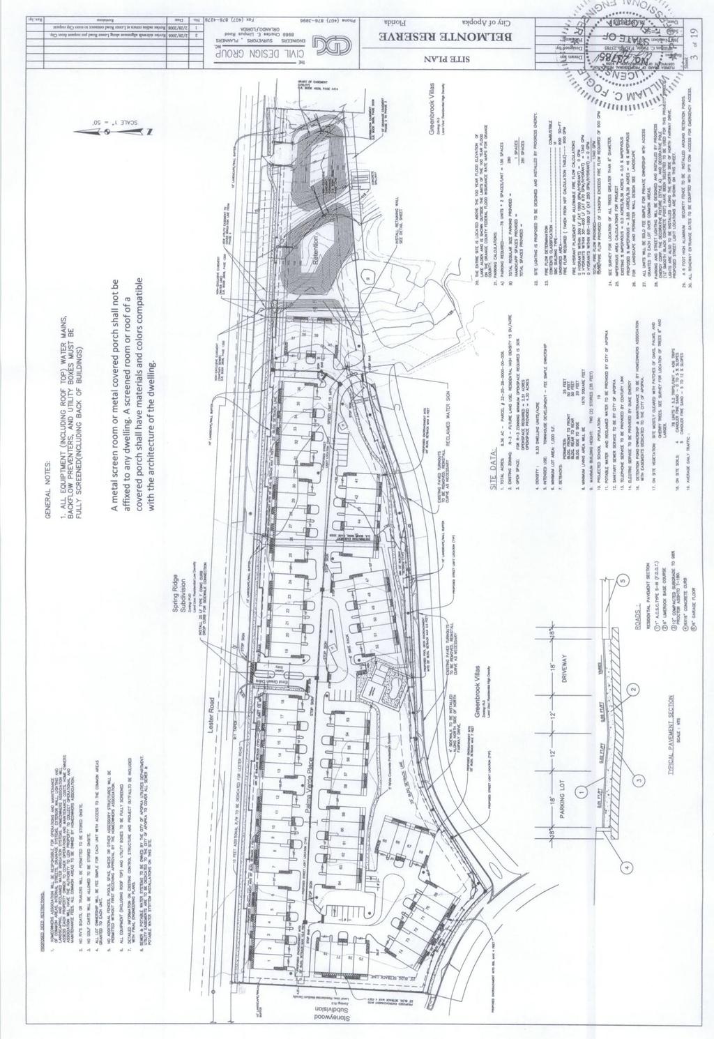
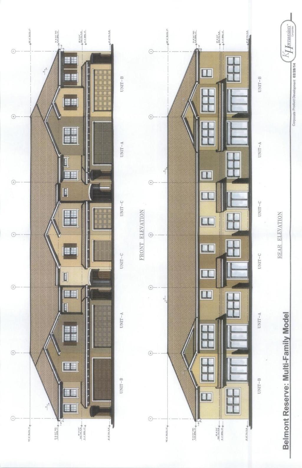
28 PLANNING COMMISSION MAY 13, 2014 BELMONTE RESERVE - REVISED FINAL DEVELOPMENT PLAN PAGE 2 ADDITIONAL COMMENTS: The Final Development Plan for BELMONTE RESERVE, which consisted of 78 townhomes units, was approved by City Council on October 4, A pre-construction meeting was convened on February 5, 2007, at which time construction began on the site. A final walk through was conducted on January 28, 2009, to review the construction activity and created a small list of items that needed to be completed in order to accept the project. This list of items was never completed and a Certificate of Acceptance was not issued. Until recently, the site remained in the same condition as noted in the January 28, 2009, final walkthrough punch list letter. The applicant has submitted the BELMONTE RESERVE Revised Final Development Plan with the following changes: name of owner; addition of hardship criteria table and variance requests; revised parking and open space calculations; lot sizes; and changes to building footprint. The BELMONTE RESERVE proposes to continue the development of 78 attached townhome units/lots. Each unit/lot will be sold as fee-simple, i.e., title goes to the resident for the lot and building unit, but the overall community (internal roads, club house, retention, etc.) is owned and governed by the Homeowner s Association. The project is to be developed in a single phase. This proposed development will have no affiliation or involvement with the existing Greenbrook Villas town homes to the south. The Project Site Details Include: Proposed minimum living area of 1,670 square feet (1,350 square feet required by code) Maximum 2-story building height. Of the proposed town home buildings, 4 will be designed with 4-units, the remaining buildings will contain 6-units. No outside storage of RV, boats, trailers, etc. will be allowed. A community pool and club house will be provided for the residents. Each unit will provide 2 parking spaces for resident/guest parking. The parking for the units will be via a single car garage and one driveway space. A total of 281 parking spaces have been proposed (156 required by code). Individual golf carts will not be allowed, a condition that is self-imposed by the developer. The project is planned as a gated community with access off Lester Road and North Fairway Drive. The entrance gates will be equipped with OPTICON devices for emergency vehicle access. A six-foot high brick wall with columns and landscaping is already in place along Lester Road and Stoneywood Way. A six-foot high ornamental metal fence with brick columns is North Fairway Drive. The following is a summary of the tree replacement program for this project: Total inches on-site: 99 Total inches removed: 56 Total inches replaced:
29 PLANNING COMMISSION MAY 13, 2014 BELMONTE RESERVE - REVISED FINAL DEVELOPMENT PLAN PAGE 3 LANDSCAPE PLANS: The applicant will revise the landscape plan to add cathedral oak along the interior side of the Lester Road brick wall and Stoneywood subdivision, to achieve a spacing of a canopy tree every 35 linear feet. SCHOOL CAPACITY REPORT: The property is exempt from school concurrency as the infrastructure has already been substantially completed within a previously approved project. ORANGE COUNTY NOTIFICATION: The County was notified at the time of the land use amendment and rezoning application for this property, and coordination occurred with County planning staff regarding impact on adjacent parcels. VARIANCE REQUEST: The applicant has proposed the following variance request: 1. LDC Section G.a) Five-foot encroachment into 25 Setback. Multifamily dwelling units for front, side, corner, and rear yards shall all be a minimum of 25 feet from the property line. The applicant requests a variance for all perimeter lots to allow the encroachment of covered porches and second (2nd) floor building extensions into the 25 setback. Buildings will meet the 25 foot setback. The City previously approved the Belmont Reserve final development plan with the buildings lot lines set back 20 feet the property line. The five foot variance previously approved by the City is being documented within the final development plan. The applicant has agreed to prohibit metal or vinyl covered patios, and to require any covered patios facing Lester Road to be constructed of materials and colors compatible with those used for the building. Staff does not object to this variance. 2. LDC Section G(3)(a). Lot 68 was previously approved with a seven foot encroachment into the 25 foot building set back. The proposed plan revisions recognize the variance that was previously approved with the original final development plan. Staff does not object to this variance. 3. LDC G(3(a). The pool location was previously approved at current location. The plan revisions is documenting the variance needed to accommodate the approved pool location. Staff does not object to this variance. 4. LDC H.(5). The proposed dumpster enclosure is located within the required ten (10) feet wide landscape buffer yard. The applicant is requesting a variance of nine (9) feet to place the dumpster enclosure within one (1) foot of the western property line abutting Stoneywood subdivision. Staff does not support this variance request. PUBLIC HEARING SCHEDULE: May 13, Planning Commission, 5:01 p.m. May 21, City Council, 8:00 p.m. 29
30 PLANNING COMMISSION MAY 13, 2014 BELMONTE RESERVE - REVISED FINAL DEVELOPMENT PLAN PAGE 4 RECOMMENDED ACTION: The Development Review Committee recommends approval of the BELMONTE RESERVE REVISED FINAL DEVELOPMENT PLAN, subject to approval of the four variances requests. Planning Commission Recommendation: The role of the Planning Commission for this development application is to advise the City Council to approve, deny, or approve with conditions based on consistency with the Comprehensive Plan and Land Development Code. Note: This item is considered quasi-judicial. The staff report and its findings are to be incorporated into and made a part of the minutes of this meeting. 30

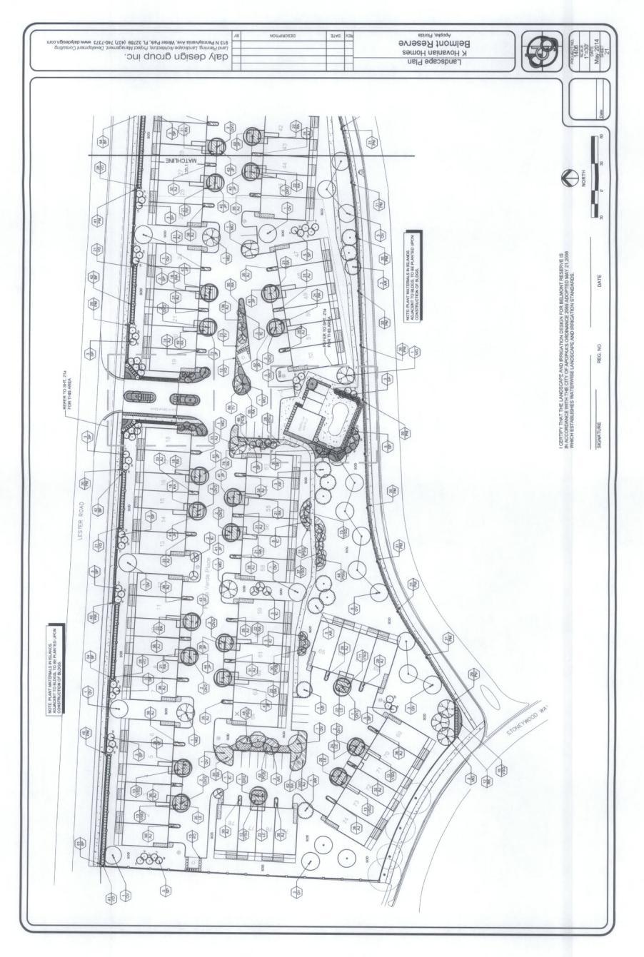
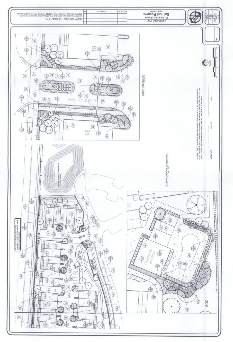
31 PLANNING COMMISSION MAY 13, 2014 BELMONTE RESERVE - REVISED FINAL DEVELOPMENT PLAN PAGE 5 K Hovnanian Belmont Reserve, LLC, c/o Heather Himes, Esq., Akerman, LLP The Civil Design Group, Inc., c/o William C. Fogle BELMONTE RESERVE /- Acres 14 buildings/78 fee-simple ownership lots Parcel ID #s: VICINITY MAP Subject Property 31
32 32
33 33
34 34
35 35
36 36
37 Page 37 Backup material for agenda item: 2. FINAL DEVELOPMENT PLAN Taco Bell, owned by Special K Enterprises, LLC, c/o James P. Whelan; the engineer is Cornelison Engineering & Design, Inc., c/o Craig L. Cornelison, P.E., property located at 1154 Rock Springs Road (formerly Brusters Ice Cream). (Parcel ID # ) 37

38 CITY OF APOPKA PLANNING COMMISSION X PUBLIC HEARING MEETING OF: May 13, 2014 ANNEXATION FROM: Community Development PLAT APPROVAL EXHIBITS: Vicinity Map OTHER: Site/Landscape Plans Window/Speaker Exhibit Building Elevations PROJECT: TACO BELL 1154 ROCK SPRINGS ROAD REQUEST: RECOMMEND APPROVAL OF THE TACO BELL 1154 ROCK SPRINGS ROAD FINAL DEVELOPMENT PLAN SUMMARY: OWNER/APPLICANT: ENGINEER: LOCATION: Special K Enterprises, LLC, c/o James P. Whelan Cornelison Engineering & Design, Inc., c/o Craig L. Cornelison, P.E Rock Springs Road (West of Rock Springs Road, north of Nancy Lee Lane) PARCEL ID #: LAND USE: Commercial ZONING: C-1 EXISTING USE: PROPOSED USE: TRACT SIZE: BUILDING SIZE: Vacant ice cream shop (formerly Bruster s Ice Cream Shop) Drive-Thru Restaurant /- acre (33,158 sq. ft.) 2,153 sq. ft. DISTRIBUTION Mayor Kilsheimer Finance Dir. Public Ser. Dir (2) Commissioners (4) HR Director City Clerk CAO Richard Anderson IT Director Fire Chief Community Dev. Dir. Police Chief G:\Shared\4020\Planning_Zoning\Site 38 Plans\Taco Bell 1154 Rock Springs Road\1 Taco Bell 1154 Rock Springs Rd FDP PC
39 PLANNING COMMISSION MAY 13, 2014 TACO BELL 1154 ROCK SPRINGS ROAD - FINAL DEVELOPMENT PLAN PAGE 2 RELATIONSHIP TO ADJACENT PROPERTIES: Direction Future Land Use Zoning Present Use North (City) Commercial C-1 Warehouse East (City) Res. Very Low Suburban (0-2 du/ac) R-1AAA Vacant Land South (City) Commercial C-1 Shopping Center/Bank West (City) Res. Low-Medium (0-10 du/ac) A-1 (ZIP) Single Family Residence ADDITIONAL COMMENTS: The TACO BELL 1154 ROCK SPRINGS ROAD Final Development Plan proposes a 2,153 square foot restaurant with a drive-thru. To accommodate the new restaurant, the existing 1,366 square foot building will be demolished. Access to the site will use the same driveway access to Rock Springs Road that was used for the former Bruster s Ice Cream. STORMWATER: Stormwater run-off and drainage will be accommodated by on-site retention. The on-site stormwater management system is designed according to standards set forth in the Land Development Code BUFFER/TREE PROGRAM: A ten foot landscape buffer is provided along Rock Springs Road, and the landscape buffers along the north and south parcel lines follow the previous buffers approved for the Bruster s Ice Cream store. PARKING AND ACCESS: A total of 23 parking space are provided, of which two are handicapped parking space. A single driveway to Rock Springs Road uses the same access created for the former Bruster s Ice Cream store. EXTERIOR ELEVATIONS: Design Guidelines. Design of the building exterior meets the intent of the City s Development SIGNAGE: The monument sign proposed near the driveway entrance meets the City s sign code but must be moved to three to four feet towards the interior of the parcel to accommodate the necessary line-of-sight at the driveway cross bar at Rock Springs Road. Prior to commencing site construction, the applicant s engineer shall certify that the monument sign location meets an acceptable line-of-site distance and sight triangle. Menu board signs shall not exceed six feet in height nor 30 square feet of sign area. The menu board signs shall be supported from the grade to the bottom of the sign having or appearing to have a solid base similar to and complementary to the development's monument sign. The design, materials, and finish of a menu board sign shall match those of the buildings on the same lot. One menu board sign is permitted per drive-thru lane or drive-in station. No other commercial or promotional signs, including snipe-type signs, shall be located along the drive-thru lanes. The Taco Bell Logo s shown on the post supporting the clearance bar and drive thru canopy will need to be removed. Applicant must resubmit menu board plans that are consistent with the City code. 39
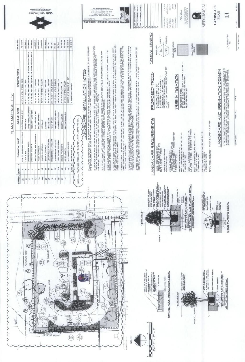
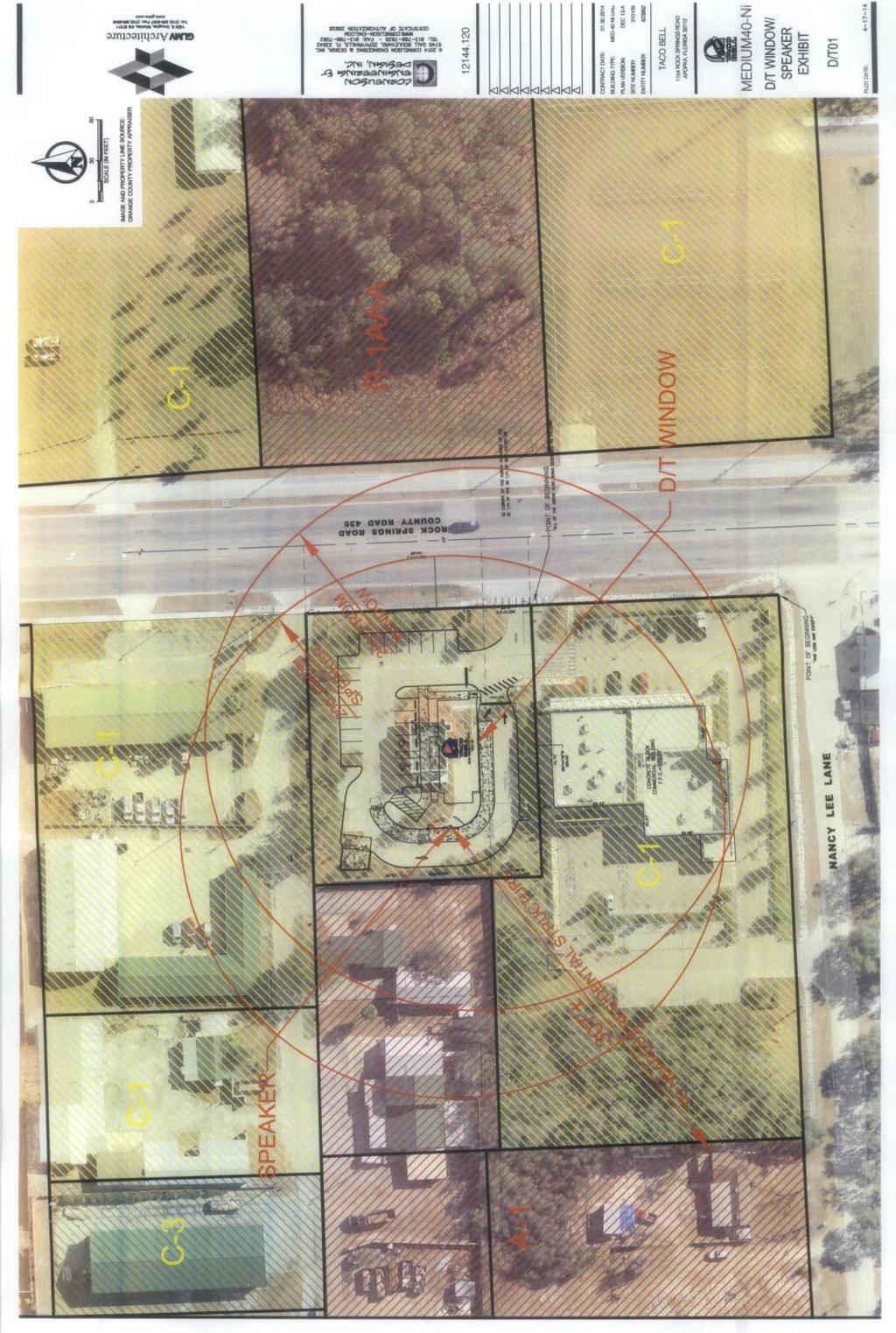
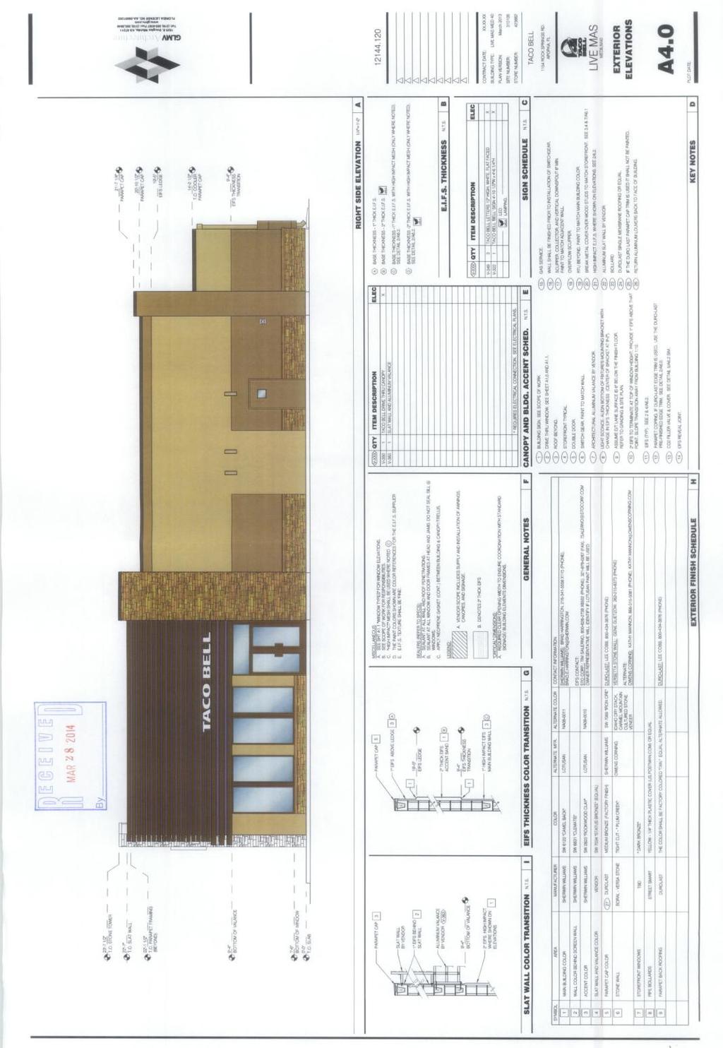
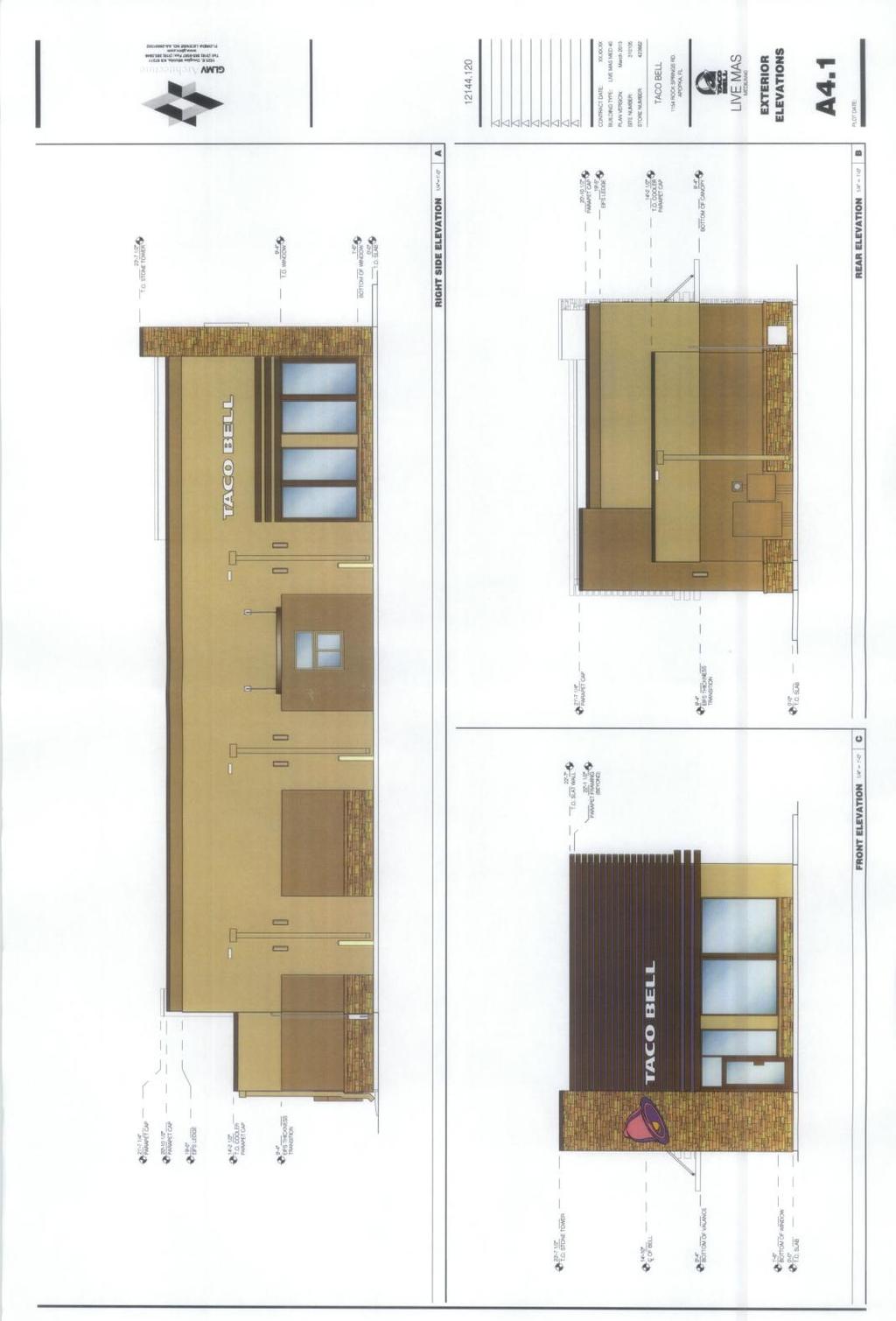
40 PLANNING COMMISSION MAY 13, 2014 TACO BELL 1154 ROCK SPRINGS ROAD - FINAL DEVELOPMENT PLAN PAGE 3 WAIVER REQUEST: The Brewster s Ice Cream Store was approved with the condition that operating hours were limited to 6:30 a.m. to 1:30 a.m. The drive-through service was previously not allowed to operate after 12:00 am (midnight) and open at 6:30 am. All customer service for the Brewster s Ice Cream Store occurs through exterior service windows and did not include interior seating. As the Taco Bell proposes all interior customer seating, conditions no longer warrant a limitation on the hours of operation. Staff supports removal of the operating hour limitation. Further, a residential home existing adjacent to the subject parcel, but has been converted to an office use. Staff does not object to this waiver request. VARIANCE REQEUST: The Brewster s Ice Cream Store received a variance to allow a drive-through service area less than 200 feet from a residential area. Since the construction of the Brewster s store, a residential home to the west of the subject parcel was converted to an office use. Property on the east side of Rock Springs Road is assigned a residential future land use and zoning, but is undeveloped. This residentially zoned, undeveloped property is within 200 feet of the Taco Bell site, measured property line to property line. The City previously approved the variance for the Brewster s store. Moving the drive-through further to the west will impact the applicant s ability to provide adequate driveway width and buffer width to the rear of the property. Staff does not object to this variance request as it was previously approved for the Brewster s Ice Cream Store. PUBLIC HEARING SCHEDULE: May 13, Planning Commission (5:01 pm) May 21, City Council (8:00 pm) RECOMMENDED ACTION: The Development Review Committee recommends approval of the TACO BELL 1154 ROCK SPRINGS ROAD Final Development Plan, the waiver request for hours of operation and the variance for the drivethrough distance to a residentially zoned property, subject to the findings of this staff report. Note: This item is considered quasi-judicial. The staff report and its findings are to be incorporated into and made a part of the minutes of this meeting. 40

41 PLANNING COMMISSION MAY 13, 2014 TACO BELL 1154 ROCK SPRINGS ROAD - FINAL DEVELOPMENT PLAN PAGE 4 Application: Final Development Plan Owner: Special K Enterprises, LLC, c/o James P. Whelan Engineer: Cornelison Engineering & Design, Inc., c/o Craig L. Cornelison, P.E. Parcel I.D. No: Location: 1154 Rock Springs Road Total Acres: /- Acre VICINITY MAP Subject Property 41
42 42
43 43
44 44
45 45
46 46
47 Page 47 Backup material for agenda item: 1. LAND DEVELOPMENT CODE AMENDMENT Amending the City of Apopka Code of Ordinances, Part III, Land Development Code, Article III Overlay Zones, to create a Small Lot Overlay Zoning District. (Tabled at the March 11, 2014 and Continued at the April 8, 2014, Planning Commission meetings.) 47
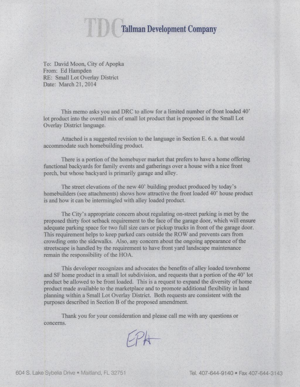
48 CITY OF APOPKA PLANNING COMMISSION CONSENT AGENDA MEETING OF: May 13, 2014 PUBLIC HEARING FROM: Community Development SPECIAL REPORTS EXHIBITS: Exhibit A X OTHER: Workshop TDC Letter SUBJECT: AMENDING ARTICLE III OF THE CITY S LAND DEVELOPMENT CODE, CREATING A SMALL LOT OVERLAY ZONING DISTRICT. Request: DISCUSSION ON THE AMENDMENT TO ARTICLE III OF THE CITY S LAND DEVELOPMENT CODE, CREATING A SMALL LOT OVERLAY ZONING DISTRICT. SUMMARY: Attached Exhibit A is a revised amendment to the City s Land Development Code establishing an Overlay Zoning District related to small lot development within the City of Apopka. The purpose of the Small Lot Overlay Zoning District is to provide flexibility for a dynamic housing market; implement Comprehensive Plan policies that promote housing diversity; provide transition between lower density residential areas and more intense development such as commercial, office, industrial or other non-residential land uses, to provide transition between lower density residential areas and limited access highways; to create an increase in development options for properties assigned medium and high density future land use designations; to promote infill development while preserving the character of the existing residential neighborhoods; and to promote diversity in the size and type of new residential developments thereby providing housing opportunities for various family sizes. The Overlay District delineates permitted uses and prohibitions or limitations on certain uses, as well as certain design standards. As proposed, the Small Lot Overlay District is only eligible for properties that are assigned both a Residential High Density (0 15 un/ac) and an R-3 zoning category. Also, the development site must be a minimum of ten acres but not more than eighty acres. DRC has reviewed the proposed Small Lot Overlay District. Based on the discussion at the March 11, 2014 meeting, the Planning Commission requested staff to coordinate additional review with the development community and the item was tabled. At the April 8, 2014, meeting, staff requested that the item be continued until the May meeting to allow more time for the development community s review. FUNDING SOURCE: N/A RECOMMENDATION ACTION: Planning staff has worked with the development community and prepared this revised development option for the Planning Commission to consider. Several developers or homebuilders have asked the City to consider development options that accommodate smaller residential lot sizes. If after review by the Planning Commission, it is determined that this development option meets the desired vision and goals of the City, the Development Review Committee will schedule the amendment to Article III of the City s Land Development Code. DISTRIBUTION: Mayor Kilsheimer Finance Director Fire Chief Commissioners (4) HR Director Public Ser. Director (2) CAO/Richard Anderson IT Director City Clerk Community Dev. Director Police Chief 48
49 Key: New text shown as underlined and deleted text shown as strikethrough. DRAFT CITY OF APOPKA SMALL LOT OVERLAY ZONING DISTRICT [Add new Section to Article III of the City s Land Development Code] EXHIBIT A Section Small Lot Overlay Zoning District Section Definition Small Lot: For purposes of Section , a lot with a width of less than 70 feet or an area less than 7,000 sq. ft. that accommodates a single family, duplex, or townhome dwelling unit. Section Purpose The purposes of the Small Lot Overlay District to: 1. Provide flexibility for a dynamic housing market; 2. Implement Comprehensive Plan policies that promote housing product diversity; 3. Provide transition between lower density residential areas and more intensely development commercial, office, industrial or other non-residential land uses, or limited access highways; 4. Create increase development options for property assigned a high density future land use designations; 5. Promote infill development while preserving the character of the existing residential neighborhoods; and 6. Promotes diversity in the size and type of new residential developments to provide housing opportunities for various family sizes. Section Applicability 1. The regulations of this section apply to all properties within the small lot overlay district delineated within a zoning ordinance, and shall apply to new development and redevelopment occurring therein. 2. Those parcels that are split by the Overlay District line shall be considered to be wholly within the boundary of the Overlay District if the majority of the acreage is located within the Overlay District. 49
50 DRAFT CITY OF APOPKA SMALL LOT OVERLAY ZONING DISTRICT Section Location Criteria 1. A Small Lot Overlay District shall comply with each of the following location criteria: a. Property must be assigned a Residential High Future Land Use Designation and an R- 3 zoning category. b. A Small Lot Overlay District shall not be located within a half mile from another Small Lot Overlay District. This minimum separation distance is waived if at least fifty percent (50%) of the residential lands within a half mile radius of the Overlay District are assigned a zoning district that requires a minimum single-family residential lot size of 8,000 sq. ft. or larger. c. Property comprising a Small Lot Overlay District shall be contiguous and generally compact. 2. A boundary line of a Small Lot Overlay District must satisfy one (1) of the following location criteria: a. Located within a half mile from a commercial, office, or industrial use center comprising more than ten acres; b. Located within a half mile from an entrance to a limited access highway, or abutting a limited access highway. Section Development Standards 1. Unless otherwise addressed within Section , the development standards established for the R-3 zoning district shall apply. 2. Minimum and Maximum Area Requirements. The Small Lot Overlay District shall comprise a minimum of fifteen (15) acres but shall not exceed a maximum of eighty (80) acres. 3. Housing Types and Mix. For development proposing a small lot width of less than seventy (70) feet, a diversity of lot size or housing types shall be provided. If single family or duplex lots are proposed with a width less than fifty (50) feet, at least one-half (½) of the lots shall have a minimum width equal to or greater than fifty (50) feet. 4. Common Open Space. a. A minimum of thirty percent (30%) of the developable land shall be placed in useable open space. The common open space must be arranged to maximize usability. b. For small lots with a front entry garage and a lot width less than fifty (50) feet wide, no more than twelve such lots shall occur in a row without separation from a common open space area. 5. Landscape Bufferyard. Minimum buffer width adjacent to a local or collector road shall be fifteen (15) feet and twenty (20) feet adjacent to an arterial road. 50 2
51 DRAFT CITY OF APOPKA SMALL LOT OVERLAY ZONING DISTRICT 6. Vehicle Access Points. a. All lots with a width less than fifty (50) feet (including townhome and duplex dwellings) shall have vehicle access points via a rear alley. All townhome and duplex dwelling lots shall have vehicle access points via a rear alley; no less than two thirds of the single family lots with a width less than fifty (50) feet shall have vehicle access points via a rear alley. b. All small lot, duplex and townhome lots shall include a two-car enclosed garage c. A minimum of four parking spaces shall be provided for each single family, duplex or townhome unit unless other determined through a parking study that fewer parking spaces are demanded. The parking study must be accepted by the city engineer and approved by City Council. If a lot is unable to accommodate a minimum of four parking spaces, up to two (2) parking spaces may be placed within parking lots or on-street parking spaces located outside the street travel lane. d. Where on-street parking is provided in front of a dwelling, vehicle access to a garage must occur from a rear alley. 7. Building Setbacks Min. Lot width (feet) (1) Min. Yard Setbacks (feet) Front (2) Rear (3) Side (4) Corner Maximum Lot Coverage (%) Small Lot 40 15/ min./ 10 total 15 75% Small Lot % Small Lot % Townhome 18, 20, 22, 25 15/10 15 (5) 15 80% 1) Width of a single family or duplex lot shall not be less than forty (40) feet along any point of the length of the lot. 2) Setback to primary structure/setback to porch. 3) Setback to primary structure. 4) Side yard setback is zero where duplex and townhome walls separate dwelling unit. 5) Twenty feet between buildings. 8. Garage Setbacks a. Front-entry garage: 30 feet. b. Rear-entry garage: Same as primary structure. 51 3
52 DRAFT CITY OF APOPKA SMALL LOT OVERLAY ZONING DISTRICT 9. Individual townhome buildings shall have no more than six dwellings. Apartment buildings abutting or near single family dwellings shall not exceeding 12 dwellings units. Apartment building mass shall be limited to size and character that is compatible with nearby single family and townhome buildings. 10. Each single family, duplex, or townhome dwelling unit shall be placed within its own lot. 11. Along an Overlay District perimeter, small lots shall not abut existing platted residential lots with a lot width of seventy five (75) feet or greater unless a ten (10) foot buffer tract with a six-foot high buffer wall, or alternatively a twenty (20) foot landscape bufferyard is provided. Section Design Guidelines 1. Subdivision design and site layout avoids the appearance of a long row of homes. Open space and street pattern shall be designed to establish breaks between housing rows. 2. Subdivision design occurs in a block form with design similar housing types grouped together. Streets are interconnected and cul-de-sacs discouraged. 3. Front facades of buildings facing an abutting common area typically have the front walls following a similar building line. 4. Streets and alleyways are designed to accommodate turning movements for large utility and emergency vehicles. 5. Subdivision and street design allow for efficient garbage and utility service. Right-ofway and streets are designed to provide sufficient space for sanitation vehicles to access refuse containers. Where on-street parking is provided outside travel lanes, development plans demonstrate that sanitation service vehicles are able to efficient serve refuse containers within driveways or other locations. 6. Pedestrian systems are an integral part of each development. Section Architecture 1. Maximum number of bedrooms allowed for a house constructed on a small lot is four (4) and three (3) bedrooms for duplex, townhome or apartment. Single family, duplex, and townhome dwellings shall have a minimum of two bedrooms. No more than twentypercent (20%) of apartment units shall have one-bedroom or a suite design. 2. Duplexes, townhomes and apartment buildings must be designed to architecturally blend with the surrounding single-family dwellings. 3. Front building entrance shall be featured with a porch, portico, or similar entry-feature. A porch must have a minimum depth of five (5) feet and must be designed to accommodate at least two humans. 52 4
53 DRAFT CITY OF APOPKA SMALL LOT OVERLAY ZONING DISTRICT 4. The rear of any residential building facing a public street or adjacent established residential neighborhood shall be treated with the same architectural quality as the front façade regarding fenestration, articulation and roofline. Substantial window areas shall overlook streets. 5. Single family and duplex limited to two stories; townhome and apartment buildings abutting or near single family residential shall be limited to two stories. 6. Architectural exterior elevations shall vary among all housing types but have color unified schemes to create diversity in exterior appearances and style. 7. A front entry garage does not extend in front of the front wall. If a useable front porch is provided, then the garage may extend as far as the porch but no further than the front yard setback. Section Accessory Structures 1. No sheds or similar outdoor storage facilities are allowed within a small residential lot. 2. No swimming pools or recreational facilities within a small lot. 3. Metal, vinyl, or other similar materials shall not be used for patios, porticos or porches that extend beyond the wall of the primary residential structure. 4. Fences shall not be allowed within yards abutting common areas unless fence is a height of four feet or less with a gate that leads to a walkway. Fences located at the rear or side yard of lots less than fifty (50) feet wide shall be wrought-iron rate style fences to avoid appearance of clutter. A fence within a rear yard shall not exceed the height of the any abutting common area wall. Section Utilities Air conditioning units or similar utilities located shall be placed behind the residential building and screened from view from a street. Section Review Process Application for a Small Lot Overlay District shall follow the same review process as a change of zoning. A master site plan shall accompany the zoning application for the Overlay District and shall address the requirements of Section K. Section Maintenance All common areas and yard area within any lot with a width less than fifty (50) feet shall be maintained the Property Owners Association unless another maintenance program is approved by the City Council. Any shared residential driveways shall be maintained by the Property Owners Association. All parking space adjacent to/outside the travel lanes shall be maintained by the Property Owners Association. 53 5
54 54
MINUTES OF THE PLANNING COMMISSION MEETING HELD ON MAY 13, 2014, AT 5:01 P.M. IN THE CITY COUNCIL CHAMBERS, APOPKA, FLORIDA.
 MINUTES OF THE PLANNING COMMISSION MEETING HELD ON MAY 13, 2014, AT 5:01 P.M. IN THE CITY COUNCIL CHAMBERS, APOPKA, FLORIDA. MEMBERS PRESENT: Steve Hooks, Mallory Walters, Ben Dreiling, James Greene, Teresa
City of Apopka Planning Commission Meeting Agenda July 08, :01 CITY COUNCIL CHAMBERS
 City of Apopka Planning Commission Meeting Agenda July 08, 2014 5:01 PM @ CITY COUNCIL CHAMBERS I. CALL TO ORDER If you wish to appear before the Planning Commission, please submit a Notice of Intent to
Town of Cary, North Carolina Rezoning Staff Report 14-REZ-24 Indian Wells Road Properties Town Council Meeting November 20, 2014
 Town of Cary, North Carolina Rezoning Staff Report 14-REZ-24 Indian Wells Road Properties Town Council Meeting November 20, 2014 REQUEST To amend the Town of Cary Official Zoning Map by revising a condition
CITY OF BONITA SPRINGS ZONING ORDINANCE NO
 CITY OF BONITA SPRINGS ZONING ORDINANCE NO. 06-05 A ZONING ORDINANCE OF THE CITY OF BONITA SPRINGS, FLORIDA; APPROVING A REQUEST BY NAPITA HOLDINGS, LLC IN REFERENCE TO BONITA ROAD LOCKUP CPD; TO REZONE
PINE RIDGE COMMONS PUD AMEND ORDINANCE NUMBER 99-94
 PINE RIDGE COMMONS PUD AMEND ORDINANCE NUMBER 99-94 Title page of the Planned Unit Development Document, previously attached as Exhibit A to the PUD document of Ordinance Number 99-94, the Pine Ridge commons
CITY OF RIO VISTA PLANNING COMMISSION STAFF REPORT
 MEETING DATE: January10, 2018 CITY OF RIO VISTA PLANNING COMMISSION STAFF REPORT AGENDA ITEM #4.2 PREPARED BY: Lamont Thompson, Planning Manager SUBJECT: Vesting Tentative Tract No. 2017-001: To consider
City of Colleyville City Council Agenda Briefing
 City of Colleyville City Council Agenda Briefing City Hall 100 Main Street Colleyville, Texas 76034 www.colleyville.com Agenda Number 5a Agenda Date 01/06/2015 Number Ordinance O-14-1942 Type Ordinance
RESOLUTION NO. RESOLUTION APPROVING ZONING PETITION 84-71, Special Exception. WHEREAS, the Board of County Commissioners, as the governing
 /. ;C- C, i RESOLUTION NO. R-@+-l2?8 RESOLUTION APPROVING ZONING PETITION 84-71, Special Exception WHEREAS, the Board of County Commissioners, as the governing body, pursuant to the authority vested in
Marion County Board of County Commissioners
 Marion County Board of County Commissioners Date: 12/29/2015 P&Z: 12/28/2015 BCC: 1/12/2016 Item Number 160113Z Type of Application Rezoning Request From: A-1 (General Agriculture) To: PUD (Planned Unit
M E M O R A N D U M. Planning and Zoning Commission. Daniel Turner, Planner I
 M E M O R A N D U M Meeting Date: Monday, April 10, 2017 Item No. F-4 To: From: Planning and Zoning Commission Daniel Turner, Planner I Subject: Consider a recommendation of a Preliminary Site Evaluation
MINUTES JOINT MEETING LINCOLN COUNTY and SIOUX FALLS PLANNING COMMISSIONS 7:00 pm July 14, 2010
 MINUTES JOINT MEETING LINCOLN COUNTY and SIOUX FALLS PLANNING COMMISSIONS 7:00 pm July 14, 2010 Commissioners Room - Lincoln County Court House A joint meeting of Lincoln County and Sioux Falls Planning
AN ORDINANCE AMENDING THE CITY ZONING ORDINANCE AND THE OFFICIAL CODE OF THE CITY OF CLARKSVILLE RELATIVE TO CLUSTER OPTION DEVELOPMENTS
 ORDINANCE 74-2012-13 AN ORDINANCE AMENDING THE CITY ZONING ORDINANCE AND THE OFFICIAL CODE OF THE CITY OF CLARKSVILLE RELATIVE TO CLUSTER OPTION DEVELOPMENTS BE IT ORDAINED BY THE CITY COUNCIL OF THE CITY
31, Township 29 South, Range 25 East, Polk County, Florida, as depicted by the Land Use Plan attached
 ORDINANCE NO. 2013-04 AN ORDINANCE AMENDING THE ZONING MAP OF THE CITY OF BARTOW, FLORIDA, REZONING APPROXIMATELY 2. 2 ACRES OF LAND OWNED BY BALA3I OF POLK COUNTY, LLC AND LOCATED IN SECTION 31, TOWNSHIP
Staff Report: Date: Applicant: Property Identification: Acreage of Request: Current Zoning of Requested Area: Requested Action: Attached:
 Staff Report: Completed by Jeff Palmer Director of Planning & Zoning Date: November 7, 2018, Updated November 20, 2018 Applicant: Greg Smith, Oberer Land Developer agent for Ronald Montgomery ET AL Property
EDMOND PLANNING COMMISSION MEETING. Tuesday, October 5, 2004
 124 EDMOND PLANNING COMMISSION MEETING Tuesday, 5:30 P.M. The Edmond Planning Commission Meeting was called to order by Chairperson David Woods at 5:30 p.m., Tuesday,, in the City Council Chambers at 20
CASE # LUP Commission District: # 3
 CASE # LUP-15-02-038 Commission District: # 3 GENERAL INFORMATION APPLICANT OWNER PROJECT NAME HEARING TYPE REQUEST Richard Frucci Lingo Lane, LLC Lingo Lane Planned Development / Land Use Plan (PD/LUP)
HISTORIC PRESERVATION BOARD BOARD AGENDA
 HISTORIC PRESERVATION BOARD BOARD AGENDA Historic Preservation Board Regular Meeting - Monday, November 24, 2014-6:00 p.m. City Hall - City Commission Chambers, 100 North U.S. #1, Fort Pierce, Florida
PINE RIDGE COMMONS PUD AMEND ORDINANCE NUMBER 99-94
 PINE RIDGE COMMONS PUD AMEND ORDINANCE NUMBER 99-94 Title page of the Planned Unit Development Document, previously attached as Exhibit A to the PUD document of Ordinance Number 99-94, the Pine Ridge commons
PLANNED DEVELOPMENT DISTRICT STANDARDS. Cadence Site
 PLANNED DEVELOPMENT DISTRICT STANDARDS Cadence Site A Planned Development District 1. Statement of General Facts, Conditions and Objectives Property Size: Approximately 57.51 Acres York County Tax Map
Proposed Overland Park Kansas Ordinance RE-1 Residential Estates Community
 18.171 RE-1 Residential Estate Community 18.171.010 Statement of intent. The zoning of property as RE-1, (Residential Estates Community, 1 dwelling unit per Gross acre density), is intended to provide
CITY OF BELLEVIEW PLANNING & ZONING BOARD AGENDA
 CITY OF BELLEVIEW PLANNING & ZONING BOARD AGENDA BELLEVIEW CITY HALL COMMISSION ROOM 5:30 PM IF A PERSON SHOULD DESIRE TO APPEAL ANY DECISION MADE BY THE BOARD, A VERBATIM RECORD OF THE PROCEEDINGS WHICH
City of Flagler Beach Planning and Architectural Review Board Tuesday, November 5, 2013 at 5:30 p.m. City Hall Commission Chambers Agenda
 1. Call the meeting to order. 2. Call the roll. 3. Pledge of Allegiance. City of Flagler Beach Planning and Architectural Review Board Tuesday, November 5, 2013 at 5:30 p.m. City Hall Commission Chambers
EXHIBIT D. Planned Unit Development Written Description April 13, 2016 Rouen Cove Phase II PUD
 1 EXHIBIT D Planned Unit Development Written Description April 13, 2016 Rouen Cove Phase II PUD Development # 8986.001 Developer: Curtis L. Hart Hart Resources LLC 8051 Tara Lane Jacksonville, Florida
Page # 1 of 2 Posted: March 4, 2016
 For More Information, Contact: Kathy Rathel Customer Service Technician City of Winter Garden 300 West Plant Street Winter Garden, FL 34787 407.656.4111 ext. 5149 krathel@cwgdn.com PLANNING & ZONING BOARD
ORANGE COUNTY PLANNING AND ZONING COMMISSION / LOCAL PLANNING AGENCY MEETING OF March 17, 2016
 ORANGE COUNTY PLANNING AND ZONING COMMISSION / LOCAL PLANNING AGENCY MEETING OF March 17, 2016 The Orange County Planning and Zoning Commission (PZC) / Local Planning Agency (LPA) met at 9:00 a.m. on March
LEMOORE PLANNING COMMISSION Regular Meeting AGENDA Lemoore Council Chamber 429 C Street. May 14, :00 p.m.
 LEMOORE PLANNING COMMISSION Regular Meeting AGENDA Lemoore Council Chamber 429 C Street May 14, 2018 7:00 p.m. 1. Pledge of Allegiance 2. Call to Order and Roll Call 3. Public Comment This time is reserved
1. Roll Call. 2. Minutes a. September 24, 2018 Special Joint Meeting with Clay County Planning Commission. 3. Adoption of the Agenda
 1. Roll Call City of Vermillion Planning Commission Agenda 5:30 p.m. Regular Meeting Tuesday, October 9, 2018 City Council Chambers 2 nd Floor City Hall 25 Center Street Vermillion, SD 57069 2. Minutes
ASPEN GLEN PUD. Eighth Amended PUD Guidelines
 ASPEN GLEN PUD Eighth Amended PUD Guidelines A. Applicability Statement To carry out the purposes and provisions of the Garfield County Zoning Regulations, as amended, The Aspen Glen Club Planned Unit
PALM BEACH COUNTY PLANNING, ZONING AND BUILDING DEPARTMENT ZONING DIVISION
 PALM BEACH COUNTY PLANNING, ZONING AND BUILDING DEPARTMENT ZONING DIVISION Application No.: CA-2012-00688 Control No.: 2011-00552 Applicant: Garry Bernardo Owners: Garry Bernardo Agent: Frogner Consulting,
TOWN OF ORO VALLEY PLANNING & ZONING COMMISSION MEETING DATE: December 6, 2011
 PLANNING & ZONING COMMISSION MEETING DATE: December 6, 2011 TO: FROM: SUBJECT: PLANNING & ZONING COMMISSION Matt Michels, Senior Planner mmichels@orovalleyaz.gov; tel. 229-4822 Public Hearing: Rancho de
MINUTES OF THE WORK STUDY MEETING OF THE QUEEN CREEK PLANNING AND ZONING COMMISSION AGENDA
 November 14, 2012, Page 1 of 5 MINUTES OF THE WORK STUDY MEETING OF THE QUEEN CREEK PLANNING AND ZONING COMMISSION WHEN: WEDNESDAY, NOVEMBER 14, 2012 WHERE: TOWN HALL COUNCIL CHAMBERS TIME: 6:00 p.m. Pursuant
PLANNING AND ZONING COMMISSION FEBRUARY 20, :30 P.M. PLANNING AND ZONING MEMBERS PRESENT MEMBERS ABSENT: STAFF PRESENT:
 PLANNING AND ZONING COMMISSION FEBRUARY 20, 2018 5:30 P.M. PLANNING AND ZONING MEMBERS PRESENT Chair Lester Fettig Omar Crisp Paulino Castillo Lydia Alaniz Bryant Ward Jessica Walker Jeremy Langley MEMBERS
INFORMATION PACKET City of Tallahassee Application for PUD or UPUD Rezoning Review
 Comprehensive Plan Consistency Prerequisite INFORMATION PACKET City of Tallahassee Application for PUD or UPUD Rezoning Review Any and all amendments to the Official Zoning Map (rezoning) are required
CHAPTER 8. REVISION HISTORY
 CHAPTER 8. REVISION HISTORY CHAPTER 8. RESIDENTIAL DISTRICTS Ordinance # Plan Commission Town Council Approval Date Adoption Date Description 2002-14 09-24-02 11-14-02 Adoption of Chapter 8. 2010-20 09-27-10
Rezoning. Rezone a portion of the property from CD to RF-9 to allow subdivision into approximately 8 small single family lots with rear lane access.
 City of Surrey PLANNING & DEVELOPMENT REPORT File: Rezoning Proposal: Rezone a portion of the property from CD to RF-9 to allow subdivision into approximately 8 small single family lots with rear lane
Also present were Bill Mann, Senior Planner and Senior Secretary Amber Lehman.
 held Monday, August 26, 2013, at 7:00 P.M. in the Council Chambers, 11 North 3 rd Street, Jacksonville Beach, Florida Call to Order The meeting was called to order by Chairman Greg Sutton. Roll Call Greg
Exhibit "A" have applied for a re-zoning and re-classification of that property from OPEN RURAL (OR) to that of a PLANNED UNIT DEVELOPMENT (PUD); and
 to that of a PLANNED UNIT DEVELOPMENT (PUD); and") I NSTR # 200632845 OR BK 61439 PGS 0728-0750 RECORDED 06/24/2066 12:25:50 PR JOHN Q. CRAWFOKD CLERK OF CIRCUIT COURT NASSAU COUNTY, FLORIDA RECORDING FEES 1.37.80 ORDINANCE NO. 2006-65 AN ORDINANCE AMENDING
I NSTR # 200632845 OR BK 61439 PGS 0728-0750 RECORDED 06/24/2066 12:25:50 PR JOHN Q. CRAWFOKD CLERK OF CIRCUIT COURT NASSAU COUNTY, FLORIDA RECORDING FEES 1.37.80 ORDINANCE NO. 2006-65 AN ORDINANCE AMENDING
PLANNING AND DEVELOPMENT LAND DEVELOPMENT COORDINATION CITY OF TAMPA INSTRUCTIONS FOR REZONING APPLICATION
 PLANNING AND DEVELOPMENT LAND DEVELOPMENT COORDINATION CITY OF TAMPA INSTRUCTIONS FOR REZONING APPLICATION NOTE: Please be aware that these guidelines are provided as a guide to assist you in submitting
INDIAN RIVER COUNTY, FLORIDA. The Honorable Members of the Planning and Zoning Commission DEPARTMENT HEAD CONCURRENCE
 Public Hearing Legislative INDIAN RIVER COUNTY, FLORIDA M E M O R A N D U M TO: The Honorable Members of the Planning and Zoning Commission DEPARTMENT HEAD CONCURRENCE Robert M. Keating, AICP; Community
ARTICLE C. ZONING TEXT, DISTRICT CLASSIFICATIONS AND BOUNDARIES
 ARTICLE C. ZONING TEXT, DISTRICT CLASSIFICATIONS AND BOUNDARIES Sec. 10-2054. ZONING TEXT, DISTRICT CLASSIFICATIONS AND BOUNDARIES. In order to regulate the location of structures, the height and bulk
CITY OF BONITA SPRINGS ZONING ORDINANCE NO
 CITY OF BONITA SPRINGS ZONING ORDINANCE NO. 01-12 A ZONING ORDINANCE OF THE CITY OF BONITA SPRINGS, FLORIDA; APPROVING A REQUEST BY BONITA SPRINGS YMCA FOR REZONING FROM AGRICULTURE (AG-2) AND RESIDENTIAL
PLANNING COMMISSION Thursday, September 5, :00 p.m. Council Chambers, Administration Building 100 Ribaut Road, Beaufort, South Carolina
 PLANNING COMMISSION Thursday, September 5, 2013 6:00 p.m. Council Chambers, Administration Building 100 Ribaut Road, Beaufort, South Carolina In accordance with South Carolina Code of Laws, 1976, Section
ORDINANCE NO. O-5-10
 ORDINANCE NO. O-5-10 AN ORDINANCE OF THE TOWN COMMISSION OF THE TOWN OF PALM BEACH SHORES, FLORIDA, AMENDING THE TOWN CODE OF ORDINANCES AT APPENDIX A. ZONING. SECTION VI. DISTRICT B REGULATIONS BY AMENDING
Location Map S U M M A RY A N X G M P Z O N I TEM #2. Subject Site
 Staff Report to the Municipal Planning Board November 17, 2015 A N X 2 0 1 5-0 0 0 2 3 G M P 2 0 1 5-0 0 0 4 4 Z O N 2 0 1 5-0 0 0 3 9 I TEM #2 HOFFNER POINT Location Map Subject Site S U M M A RY Owner/Applicant
Charter Township of Plymouth Zoning Ordinance No. 99 Page 35 Article 7: R-M Mobile Home Residential Districts Amendments:
 Charter Township of Plymouth Zoning Ordinance No. 99 Page 35 PURPOSE ARTICLE VII R-M MOBILE HOME RESIDENTIAL DISTRICTS This District is designed primarily to provide locations for mobile home parks thus
Application for Pool and Pool Fence (revised 3/14/17)
") Application for Pool and Pool Fence Fees: Pool $100 Electrical $50 Fence $25/$50 Initial Plan Review fee for pools is $100.00 plus inspection fees. Fence Plan Review fee is $50.00. Permit fees are prepared
Application for Pool and Pool Fence Fees: Pool $100 Electrical $50 Fence $25/$50 Initial Plan Review fee for pools is $100.00 plus inspection fees. Fence Plan Review fee is $50.00. Permit fees are prepared
PLANNING AND ZONING COMMISSION AGENDA MEMORANDUM
 City and County of Broomfield, Colorado PLANNING AND ZONING COMMISSION AGENDA MEMORANDUM To: Planning and Zoning Commission From: John Hilgers, Planning Director Anna Bertanzetti, Principal Planner Meeting
FORT MYERS CITY COUNCIL
 ACTION AGENDA FORT MYERS CITY COUNCIL Mayor Randall P. Henderson, Jr. Ward 1 Teresa Watkins Brown Ward 2 Johnny W. Streets, Jr. Ward 3 Christine Matthews Ward 4 Michael Flanders Ward 5 Forrest Banks Ward
Charter Township of Plymouth Zoning Ordinance No. 99 Page 200 Article 20: Schedule of Regulations
 Charter Township of Plymouth Zoning Ordinance No. 99 Page 200 ARTICLE XX SCHEDULE OF REGULATIONS SEC. 20.1 HEIGHT, AREA, LOT COVERAGE, YARD REQUIREMENTS AND FLOOR AREA (as amended /25/07) ZONG DISTRICT
Director Glas-Castro stated the Applicant for Items #2 and #3 requested a continuance to the February 10, 2015 meeting.
 VILLAGE OF PALM SPRINGS MINUTES OF MEETING LAND DEVELOPMENT BOARD WORKSHOP JANUARY 13, 2015 6:30 PM CALL TO ORDER The meeting held in the Council Chambers at Village Hall was called to order by Chairman
MINUTES OF THE TOWN OF LADY LAKE REGULAR PLANNING AND ZONING BOARD MEETING LADY LAKE, FLORIDA. May 8, :30 p.m.
 MINUTES OF THE TOWN OF LADY LAKE REGULAR PLANNING AND ZONING BOARD MEETING LADY LAKE, FLORIDA May 8, 2017 5:30 p.m. The Planning and Zoning Board Meeting was held in the Town Hall Commission Chambers at
Page # 1 of 1 Posted: April 2, 2015
 For More Information, Contact: Kathy Rathel Customer Service Technician City of Winter Garden 300 West Plant Street Winter Garden, FL 34787 407.656.4111 ext. 5149 krathel@cwgdn.com PLANNING & ZONING BOARD
Town of Gorham Development Transfer Fee Program SECTION XVIII DEVELOPMENT TRANSFER OVERLAY DISTRICT
 Town of Gorham Development Transfer Fee Program SECTION XVIII DEVELOPMENT TRANSFER OVERLAY DISTRICT [Note: The Development Transfer Overlay District (a Development Transfer Fee program) is included as
Sec Planned unit development (PUD) zoning district requirements and procedures.
 zoning district requirements and procedures.") Sec. 10-6.696. Planned unit development (PUD) zoning district requirements and procedures. (a) Purpose and intent of district. The planned unit development (PUD) zoning district is intended to provide
Sec. 10-6.696. Planned unit development (PUD) zoning district requirements and procedures. (a) Purpose and intent of district. The planned unit development (PUD) zoning district is intended to provide
CITY OF BONITA SPRINGS ZONING ORDINANCE NO A ZONING ORDINANCE OF THE CITY OF BONITA SPRINGS, FLORIDA;
 PARKLANDS; AMENDING CONDITION FOUR AND ADDING A DEVIATION; AMENDING ZONING ORDINANCE NO. 03-03, PALMIRA RPD/CPD F/K/A A ZONING ORDINANCE OF THE CITY OF BONITA SPRINGS, FLORIDA; u:\city Attorney\Zoning
There was no further discussion. Secretary Warren presented the following resolution: RESOLUTION NO
 FENTON TOWNSHIP CIVIC COMMUNITY CENTER 12060 MANTAWAUKA DRIVE, FENTON, MICHIGAN Chairperson McGuirk called the meeting to order at 7:00 p.m. Present: Cypher, Marko, McGuirk, Mustola, Tucker, Warren, Westbrook
CITY PLAN COMMISSION STAFF REPORT
 CITY PLAN COMMISSION STAFF REPORT SUBJECT: Request for a Change of Zoning and Preliminary Development Plan FROM: Mara Perry, Director of Planning & Development MEETING DATE: November 6, 2017 PETITION:
Town of Farmington 1000 County Road 8 Farmington, New York 14425
 Page 1 of 21 Town of Farmington Zoning Board of Appeals Meeting Minutes APPROVED December 18, 2017 Town of Farmington 1000 County Road 8 Farmington, New York 14425 ZONING BOARD OF APPEALS Established July
COMMISSION MEETING MONDAY, JANUARY 30, 2017 AGENDA
 CITY OF NORTH LAUDERDALE COMMISSION MEETING MONDAY, JANUARY 30, 2017 SPECIAL MEETING 6:00 p.m. AGENDA 1. INVOCATION AND PLEDGE OF ALLEGIANCE Vice Mayor Wood 2. ROLL CALL Mayor Jack Brady Vice Mayor Lorenzo
PLANNING AND ZONING COMMISSION AGENDA
 PLANNING AND ZONING COMMISSION AGENDA Regular Meeting Tuesday, March 10, 2015 7:00 p.m. City Hall - Council Chamber Daniel P. Moore Community Center Complex 1900 Billy G. Webb Drive Portland, Texas 1.
Amendment to the Zoning and Subdivision Ordinances; Consider Repeal Cluster Development Standards
 2 Board of Supervisors Meg Bohmke, Chairman Gary F. Snellings, Vice Chairman Jack R. Cavalier Thomas C. Coen L. Mark Dudenhefer Wendy E. Maurer Cindy C. Shelton February 28, 2018 Thomas C. Foley County
Town of Cary, North Carolina Rezoning Staff Report 14-REZ-20 Habitat for Humanity Evans Road Town Council Meeting October 16, 2014
 Town of Cary, North Carolina Rezoning Staff Report 14-REZ-20 Habitat for Humanity Evans Road Town Council Meeting October 16, 2014 REQUEST To amend the Town of Cary Official Zoning Map by rezoning 0.53
Rezoning. Rezone from RA to RF to create 3 residential lots and a remainder lot in Fraser Heights. Approval to Proceed
 City of Surrey PLANNING & DEVELOPMENT REPORT Rezoning Proposal: Rezone from RA to RF to create 3 residential lots and a remainder lot in Fraser Heights. Recommendation: Approval to Proceed Location: 16156-112
FLORIDA TURNPIKE FLORIDA TURNPIKE
 Orange County Community, Environmental & Development Services Department, Planning Division Orange County, Florida Planning and Zoning Commission/ Local Planning Agency 2 5 FLORIDA TURNPIKE FLORIDA TURNPIKE
Exhibit D. Tallow Ridge PUD. Written Description. Date: January 5, E. City Development Number:
 Exhibit D Tallow Ridge PUD Written Description Date: January 5, 2016 I. SUMMARY DESCRIPTION OF THE PROPERTY A. Current Land Use Designation: RR B. Current Zoning District: PUD C. Requested Zoning District:
RESOLUTION NO. R
 RESOLUTION NO. R-2016-0554 RESOLUTION APPROVING ZONING APPLICATION ABN/CBIZlCA-2015-00538 (CONTROL NO. 1988-00039) a Class A Conditional Use APPLICATION OF Treatment Center of The Palm Beaches LLC BY Land
MONTGOMERY COUNTY PLANNING DEPARTMENT THE MARYLAND-NATIONAL CAPITAL PARK AND PLANNING COMMISSION
 MONTGOMERY COUNTY PLANNING DEPARTMENT THE MARYLAND-NATIONAL CAPITAL PARK AND PLANNING COMMISSION MCPB Item No. 8 Date: 03-07-13 Sonoma, Preliminary Plan, 120130040 Melissa Williams, Senior Planner, Melissa.williams@montgomeryplanning.org,
Town of Cary, North Carolina Rezoning Staff Report 13-REZ-13 An Zou Property Town Council Meeting November 21, 2013
 Town of Cary, North Carolina Rezoning Staff Report 13-REZ-13 An Zou Property Town Council Meeting November 21, 2013 REQUEST To amend the Town of Cary Official Zoning Map by rezoning 0.63 acres located
O-I (Office-Institutional) and AG-1(Agricultural)
 and AG-1(Agricultural)") PROPERTY INFORMATION ADDRESS 3503 and 3505 Bethany Bend DISTRICT, LAND LOTS 2/1 973 and 974 OVERLAY DISTRICT State Route 9 PETITION NUMBERS EXISTING ZONING O-I (Office-Institutional) and AG-1(Agricultural)
PROPERTY INFORMATION ADDRESS 3503 and 3505 Bethany Bend DISTRICT, LAND LOTS 2/1 973 and 974 OVERLAY DISTRICT State Route 9 PETITION NUMBERS EXISTING ZONING O-I (Office-Institutional) and AG-1(Agricultural)
Committed to Service
 Committed to Service Paul Woods, President Rebecca W. Arnold, Vice President Sara M. Baker, Commissioner Jim D. Hansen, Commissioner Kent Goldthorpe, Commissioner August 25, 2017 Development Services TO:
Marion County Board of County Commissioners
 Marion County Board of County Commissioners Date: 12/2/2015 P&Z: 11/30/2015 BCC: 12/16/2015 Item Number 151210SU Type of Application Special Use Permit Request To establish a Clay Electric Co-Operative
Article 7: Residential Land Use and Development Requirements
 Article 7: Residential Land Use and Section 701: Statement of Intent (A) (B) (C) The intent of Article 7 is to develop certain land use and development requirements for the residential uses within Cumru
CITY OF MADISON, WISCONSIN
 CITY OF MADISON, WISCONSIN AN AMENDED SUBSTITUTE ORDINANCE Amending Section 28.04(25) to add a sunset provision, creating new Section 28.04(26) to set out a new inclusionary housing program, and renumbering
Amelia Walk Community Development District. September 27, 2018
 Amelia Walk Community Development District September 27, 2018 AGENDA Amelia Walk Community Development District Continued Meeting Agenda Thursday Amelia Walk Amenity Center September 27, 2018 85287 Majestic
Staff Report: Date: Applicant: Property Identification: Acreage of Request: Current Zoning of Requested Area: Requested Action: Attached:
 Staff Report: Completed by Jeff Palmer Director of Planning & Zoning Date: November 7, 2018 Applicant: Greg Smith, Oberer Land Developer agent for Ronald Montgomery ET AL Property Identification: Frontage
CITY OF PALMDALE COUNTY OF LOS ANGELES, CALIFORNIA RESOLUTION NO. CC
 CITY OF PALMDALE COUNTY OF LOS ANGELES, CALIFORNIA RESOLUTION NO. CC 2011-118 A RESOLUTION OF THE CITY COUNCIL OF THE CITY OF PALMDALE, CALIFORNIA, UPHOLDING THE PLANNING COMMISSION APPROVAL OF CONDITIONAL
PLANNING COMMISSION MEETING November 6, :00 P.M. COMMISSION ROOM/CITY HALL AGENDA
 City of Auburndale Auburndale, Florida 33823 #1 Bobby Green Plaza P. O. Box 186 Community Development Department Phone (863) 965-5530 Fax (863) 965-5507 PLANNING COMMISSION MEETING 4:00 P.M. COMMISSION
Meeting Minutes New Prague Planning Commission Wednesday, June 27, 2018
 Meeting Minutes New Prague Planning Commission Wednesday, 1. Call Meeting to Order The meeting was called to order at 6:30 p.m. by Member Bob Gilman with the following members present: Amy Jirik, Matt
PLANNING AND DEVELOPMENT COMMISSION (PDC) SUMMARY MINUTES September 6, 2018
 SUMMARY MINUTES September 6, 2018") PLANNING AND DEVELOPMENT COMMISSION (PDC) SUMMARY MINUTES Members Present: David Bramblett, Chair; Cheryl Phillips, 1 st Vice Chair; William Garvin, 2 nd Vice Chair; Joel Brender; and James Brooks Staff
PLANNING AND DEVELOPMENT COMMISSION (PDC) SUMMARY MINUTES Members Present: David Bramblett, Chair; Cheryl Phillips, 1 st Vice Chair; William Garvin, 2 nd Vice Chair; Joel Brender; and James Brooks Staff
Request Conditional Rezoning (R-7.5 Residential to Conditional A-18 Apartment) Staff Recommendation Approval. Staff Planner Jimmy McNamara
 Staff Recommendation Approval. Staff Planner Jimmy McNamara") Applicants Property Owners Baker Villas, LLC; Ocean Rental Properties, LLC; James Edward Sollner; & Linda Susan Sollner Public Hearing November 8, 2017 City Council Election District Kempsville Agenda
Applicants Property Owners Baker Villas, LLC; Ocean Rental Properties, LLC; James Edward Sollner; & Linda Susan Sollner Public Hearing November 8, 2017 City Council Election District Kempsville Agenda
EDMOND PLANNING COMMISSION 20 S. Littler, Edmond, Oklahoma Tuesday, May 6, :30 p.m.
 City of Edmond NOTICE OF PUBLIC MEETING The City of Edmond encourages participation from all its citizens. If participation at any Public meeting is not possible due to a disability, notification to the
ARTICLE 15 - PLANNED UNIT DEVELOPMENT
 Section 15.1 - Intent. ARTICLE 15 - PLANNED UNIT DEVELOPMENT A PUD, or Planned Unit Development, is not a District per se, but rather a set of standards that may be applied to a development type. The Planned
A. CONSIDERATION OF THE UNAPPROVED MINUTES OF DECEMBER 11, 2018
 I. CALL TO ORDER OFFICIAL AGENDA PLANNING & ZONING COMMISSION CITY OF STARKVILLE, MISSISSIPPI MEETING OF TUESDAY, JANUARY 8, 2018 1ST FLOOR CITY HALL COURT ROOM 110 WEST MAIN STREET AT 5:30 PM II. III.
PROVIDING FOR THE REZONING OF CERTAIN LAND FROM A-1 (SUBURBAN
 MANATEE COUNTY ZONING ORDINANCE PDR-01-12(Z)(P) - TOROBE CITRUS, INC./SUGAR MILL LAKES AN ORDINANCE OF THE COUNTY OF MANATEE, FLORIDA, AMENDING THE OFFICIAL ZONING ATLAS OF MANATEE COUNTY, ORDINANCE NO.
STAFF REPORT. To: Planning Commission Meeting date: January 11, 2017 Item: UN Prepared by: Marc Jordan. Schoolhouse Development, LLC
 STAFF REPORT # 9 ) UN-05-17 AMERICAN LEADERSHIP ACADEMY SPECIAL USE PERMIT CHARTER SCHOOL PUBLIC HEARING To: Planning Commission Meeting date: January 11, 2017 Item: UN-05-17 Prepared by: Marc Jordan GENERAL
PLANNING COMMISSION STAFF REPORT June 18, 2015
 Community Development Department Planning Division 1600 First Street + P.O. Box 660 Napa, CA 94559-0660 (707) 257-9530 PLANNING COMMISSION STAFF REPORT June 18, 2015 AGENDA ITEM 7.B. PL15-0052 PM, GASSER
16 February 9, 2011 Public Hearing APPLICANT: GEO I, L.L.C.
 16 February 9, 2011 Public Hearing APPLICANT: GEO I, L.L.C. PROPERTY OWNER: GEO I, L.L.C., DONALD K. PILAND, AND BOOTSIE LORAINE TERRY STAFF PLANNER: Faith Christie REQUEST: Conditional Change of Zoning
MEETING MINUTES GRAND HAVEN CHARTER TOWNSHIP PLANNING COMMISSION APRIL 18, 2016
 MEETING MINUTES GRAND HAVEN CHARTER TOWNSHIP PLANNING COMMISSION APRIL 18, 2016 I. CALL TO ORDER Kantrovich called the meeting of the Grand Haven Charter Township Planning Commission to order at 7:30 p.m.
Leon County APPLICATION FOR PUD REZONING REVIEW
 APPLICATION FOR PUD REZONING REVIEW The undersigned, owner of the hereinafter-described property, hereby petitions Leon County for the following amendment to the Official Zoning Map: Change in Zoning District
A. CONSIDERATION OF THE UNAPPROVED MINUTES OF NOVEMBER 13, 2018
 I. CALL TO ORDER OFFICIAL AGENDA PLANNING & ZONING COMMISSION CITY OF STARKVILLE, MISSISSIPPI MEETING OF TUESDAY, DECEMBER 11, 2018 1ST FLOOR CITY HALL COURT ROOM 110 WEST MAIN STREET AT 5:30 PM II. III.
1. Roll Call. 2. Minutes a. September 26, 2016 Regular Meeting. 3. Adoption of the Agenda. 4. Visitors to Be Heard
 1. Roll Call City of Vermillion Planning Commission Agenda 5:30 p.m. Regular Meeting Tuesday, October 11, 2016 Large Conference Room 2 nd Floor City Hall 25 Center Street Vermillion, SD 57069 2. Minutes
R E S O L U T I O N. 2. Development Data Summary:
 R E S O L U T I O N WHEREAS, the Prince George s County Planning Board has reviewed Special Permit Application No. SP-170001, Mama s Care Assisted Living Facility, requesting to expand an existing congregate
Request Subdivision Variance to Sections 4.4 (b) & (d) of the Subdivision Regulations. Staff Planner Kevin Kemp
 & (d) of the Subdivision Regulations. Staff Planner Kevin Kemp") Applicant Property Owner Rhae Adams, Jr. Public Hearing June 8, 2016 City Council Election District Lynnhaven Agenda Item 4 Request Subdivision Variance to Sections 4.4 (b) & (d) of the Subdivision Regulations.
Applicant Property Owner Rhae Adams, Jr. Public Hearing June 8, 2016 City Council Election District Lynnhaven Agenda Item 4 Request Subdivision Variance to Sections 4.4 (b) & (d) of the Subdivision Regulations.
BOARD OF COMMISSIONERS GWINNETT COUNTY LAWRENCEVILLE, GEORGIA RESOLUTION
 BOARD OF COMMISSIONERS GWINNETT COUNTY LAWRENCEVILLE, GEORGIA RESOLUTION READING AND ADOPTION: At the regular meeting of the Gwinnett County Board of Commissioners, held in the Justice and Administration
ARTICLE IV: DEVELOPMENT STANDARDS
 ARTICLE IV: DEVELOPMENT STANDARDS IV-53 409 PRIVATE STREETS A private street means any way that provides ingress to, or egress from, property by means of vehicles or other means, or that provides travel
PLANNING COMMISSION STAFF REPORT
 PLANNING COMMISSION STAFF REPORT ZONING MAP AMENDMENT PLNPCM2011-00091- Zoning Map Amendment PLNSUB2011-00090 Subdivision Amendment Approximately 700 North Columbus Court August 10, 2011 Planning and Zoning
REPORT OF THE PLANNING AND DEVELOPMENT DEPARTMENT FOR APPLICATION FOR REZONING ORDINANCE TO PLANNED UNIT DEVELOPMENT SEPTEMBER 22, 2016
 BEL REPORT OF THE PLANNING AND DEVELOPMENT DEPARTMENT FOR APPLICATION FOR REZONING ORDINANCE 2016-576 TO PLANNED UNIT DEVELOPMENT SEPTEMBER 22, 2016 The Planning and Development Department hereby forwards
CITY COUNCIL AGENDA MEMORANDUM
 City and County of Broomfield, Colorado CITY COUNCIL AGENDA MEMORANDUM To: Mayor and City Council From: Charles Ozaki, City and County Manager Prepared by: Anna Bertanzetti, Principal Planner David Shinneman,
Approved 58 Unit Residential Condo Development for Sale. For Sale: Price Upon Request
 Approved 58 Unit Residential Condo Development for Sale 185 Thorpe Street Fairfield, 06824 For Sale: Price Upon Request u u u u Approved 58 Unit Residential Condo Development For Sale on 6.7 Acres in Fairfield
ARTICLE 9: VESTING DETERMINATION, NONCONFORMITIES AND VARIANCES. Article History 2 SECTION 9.01 PURPOSE 3
 ARTICLE 9 VESTING DETERMINATIONS, NONCONFORMITIES, AND VARIANCES Table of Contents Article History 2 SECTION 9.01 PURPOSE 3 SECTION 9.02 LOT OF RECORD AND VESTING DETERMINATIONS FOR NONCONFORMING DEVELOPMENTS