PLEASANT PRAIRIE PLAN COMMISSION MEETING VILLAGE HALL AUDITORIUM th AVENUE PLEASANT PRAIRIE, WISCONSIN 6:00 P.M. October 8, 2018 AGENDA
|
|
|
- Matilda Stevens
- 5 years ago
- Views:
Transcription
1 1. Call to Order. 2. Roll Call. PLEASANT PRAIRIE PLAN COMMISSION MEETING VILLAGE HALL AUDITORIUM th AVENUE PLEASANT PRAIRIE, WISCONSIN 6:00 P.M. October 8, 2018 AGENDA 3. Consider approval of the August 13 and 27, 2018 Plan Commission meeting minutes. 4. Correspondence. 5. Citizen Comments. 6. New Business: A. PUBLIC HEARING AND CONSIDERATION OF PLAN COMMISSION RESOLUTION #18-23 FOR A COMPREHENSIVE PLAN AMENDMENT for the request of Justin Mathis, on behalf of the property owner Luke Bosman related to the wetlands recently delineated on the vacant property generally located at the 7800 block of 128 th Street: to correctly identify the field delineated wetlands into the Secondary Environmental Corridor with a field verified wetland land use designation on the Village 2035 Land Use Plan Map 9.9; and to update Appendix 10-3 of the Village of Pleasant Prairie Wisconsin, 2035 Comprehensive Plan to reflect the above noted changes to the 2035 Land Use Plan Map 9.9. B. PUBLIC HEARING AND CONSIDERATION OF A ZONING MAP AMENDMENT to consider the request of Justin Mathis, on behalf of the property owner Luke Bosman related to the wetlands recently delineated on the vacant property generally located at the 7800 block of 128 th Street: to amend and correct the Zoning Map to rezone the field delineated wetlands on the property into the C-1, Lowland Resource Conservancy District. C. Consider the request of Kenneth and Kathee Jennings to change the official address of the property located at 9119 Cooper Road. D. Consider approval of Plan Commission Resolution #18-24 to an initiate zoning text amendments related to accessory dwelling units. 7. Adjourn. It is possible that a quorum of members of other governmental bodies of the municipality may be in attendance in the above stated meeting to gather information; no action will be taken by any other governmental body except the governing body noticed above. The Village Hall is handicapped accessible. If you have other special needs, please contact the Village Clerk, th Avenue, Pleasant Prairie, WI (262)
2 PLEASANT PRAIRIE PLAN COMMISSION MEETING VILLAGE HALL AUDITORIUM TH AVENUE PLEASANT PRAIRIE, WISCONSIN 6:00 P.M. August 13, 2018 A meeting for the Pleasant Prairie Plan Commission convened at 6:00 p.m. on August 13, Those in attendance were Michael Serpe, Chairman; Wayne Koessl; Deb Skarda; Jim Bandura; Judy Juliana; John Skalbeck (Alternate #1); Brock Williamson (Alternate #2); and Michael Pollocoff. Bill Stoebig was excused. Also in attendance were Nathan Thiel, Village Administrator; Jean Werbie-Harris, Community Development Director; Peggy Herrick, Assistant Village Planner and Zoning Administrator; and Aaron Kramer, Deputy Planner and Zoning Administrator. 1. CALL TO ORDER. 2. ROLL CALL. 3. CONSIDER APPROVAL OF THE JULY 23, 2018 PLAN COMMISSION MEETING MINUTES. Judy Juliana: Jim Bandura: Move to approve. Second. Voices: MOTION MADE BY JUDY JULIANA AND SECONDED BY JIM BANDURA FOR APPROVAL OF THE JULY 23RD MINUTES. ALL IN FAVOR SAY AYE. Aye. Opposed? The ayes have it. 4. CORRESPONDENCE. Jean Werbie-Harris: Could you pull the microphone a little closer? 1
3 Nathan Thiel: Sure. That s a reminder to everybody to talk closer to the microphone. They re having problems hearing. I apologize. Is it on? That even helps even more. That s why you re the boss, Nathan. 5. CITIZEN COMMENTS. Anybody wishing to speak? Anybody wishing to speak on citizens comments? Hearing none we ll close that. 6. NEW BUSINESS A. Consider approval of the discontinuance of 110th Street east of 116th Avenue at the request of the adjacent property owners. Jean Werbie-Harris: Trustee Serpe and members of the Plan Commission, this is a meeting to consider the approval of the discontinuance of 110th Street east of 116th Avenue at the request of the adjacent property owners. Again, the Plan Commission this evening is going to make a recommendation on this matter, and the Village Board itself will be holding a public hearing on August 20th to take up the matter. On July 2, 2018, the Village Board adopted Resolution to initiate the discontinuance of a portion of 110th Street, this is east of 116th Avenue south of Parcels 19 and 20 of CSM This is within the LakeView West area of the LakeView Corporate Park, and this is pursuant to Section of the Wisconsin Statutes. The slide shows this particular area, again, it s just east of Premium Outlets at 110th Street. This portion of 110th Street right-of-way proposed to be vacated is shown and legally described in the attached request and was dedicated originally by CSM It s being requested to be vacated by all abutting and adjacent property owners. Although this right-of-way was dedicated, roadway improvements were not constructed and are not intended or required to be installed for future development. Nor have any municipal sewer or water been extended in this particular right-of-way. The land to the north and south do not require this roadway, and the land to the east has access via an existing driveway outside of the dedicated 110th Street right-of-way; however, an 2
4 Wayne Koessl: Deb Skarda: easement for the future expansion of public sanitary sewer shall be dedicated to the Village on the western 20 feet of the right-of-way being vacated. So what we re talking about is there s a force main in the east side of 116th Avenue right-of-way, and it s going to be extended south towards the new development for Stateline 94. So we do need to have an easement through that vacated right-of-way to get to the south. Upon vacation of this portion of 110th Street right-of-way, the vacated street will be transferred and attached to Parcels 19 and 20 of CSM 1699 as further identified as Tax Parcel Numbers and And this is land that is owned -- it s not technically owned by Breeze Terrace LLC anymore, is it? There s a new name. It s Interstate Partners II -- I know that there has been a change because I saw the recording that came through. So it s the Breeze Terrace developers, they just have a different LLC name. The Village Board will hold the required public hearing regarding this request on August 20, On July 18, 2018, all required property owners were notified via regular mail and the required Class 3 notice was published in the Kenosha News on July 30th, August 6th and August 13th to notify everyone of the public hearing to be held by the Village Board next Monday. With that if there s any questions. Comments or questions? What s your pleasure? I move approval, Mr. Chairman. Second. Voices: MOTION MADE BY WAYNE KOESSL AND SECONDED BY DEB SKARDA FOR DISCONTINUANCE OF 110TH STREET EAST OF 116TH AVENUE. ALL IN FAVOR SAY AYE. Aye. Opposed? The ayes have it. B. PUBLIC HEARING AND CONSIDERATION OF PLAN COMMISSION RESOLUTION #18-19 FOR A COMPREHENSIVE MAP AMENDMENT for the request of Francis Brzezinski, agent on behalf of Interstate Partners II-WI LLC for 3
5 Jean Werbie-Harris: the development of the proposed Breeze Terrace Apartments generally located south of Corporate Drive and east of 116th Avenue. Specifically the 2035 Land Use Plan Map is being amended as follows: the woodland area in the northeast corner and the wetland/floodplain area in the southeastern area of the site will be located within the Primary Environmental Corridor and the wetlands within this area will be located within the field delineated wetland land use designation; the other two wetland areas in the southwestern area of the site will be located within the Park Recreation and Other Open Space with a field delineated wetland land use designations; the location of the 100-year floodplain will remain unchanged; the remainder of the area will remain in the High Density Residential land use designation; and the urban reserve designation will be removed. In addition, Appendix 10-3 of the Village of Pleasant Prairie Wisconsin, 2035 Comprehensive Plan will be updated to include said amendments. Trustee Serpe and members of the Plan Commission, this is consideration of Plan Commission Resolution for Comprehensive Map Amendments at the request of Fran Brzezinski, agent on behalf of Interstate Partners II-WI LLC, that s the correct name now, for the development of the proposed Breeze Terrace Apartments generally located south of Corporate Drive and east of 116th Avenue. Specifically the 2035 Land Use Plan Map is being amended as follows: the woodland area in the northeast corner and the wetland and floodplain area in the southeastern area of the site will be located within the Primary Environmental Corridor, and the wetlands within this area will be located within the field delineated wetland land use designation. The other two wetland areas in the southwestern area of the site will be located within the Park, Recreation and Other Open Space with a field delineated wetland land use designations. And the location of the 100-year floodplain will remain unchanged. The remainder of the area will remain in the High Density Residential land use designation. And the urban reserve designation will be removed. In addition, Appendix 10-3 of the Village of Pleasant Prairie Wisconsin, 2035 Comprehensive Plan will be updated to include all of these amendments. As indicated, the developer is requesting approval of the Comprehensive Plan Amendment for the proposed Breeze Terrace Apartment development. Again, this is located just generally east of 116th Avenue and Corporate Drive. They are proposing three 33-unit apartment buildings and six 19-unit buildings for a total of 213 apartments with a club house. And the plan is shown on the slide. There are four small wetlands totaling about.55 acre on the properties that have been field delineated as wetlands on April 21, 2016 by Dave Meyer of Wetland and Waterway Consulting. The wetlands on the site will be preserved and protected. In addition, as shown on the tree survey, only a very small corner or portion of the trees within the Primary Environmental Corridor are proposed to be removed to allow for the development. The woodlands that will remain is approximately three acres. The 100-year floodplain.18 acre on the eastern side of the site, again, also will be protected. There were some previous approvals: On May 7, 2018, the Village Board approved the following items: 4
6 Comprehensive Plan Amendments, Ordinance18-18, and this was to amend a portion of the Lakeview West Neighborhood Plan and to amend the 2035 Comprehensive Land Plan to change the Land Use Plan from the Freeway Office Commercial land use designation to the High Density Residential with an Urban Reserve land use designated that would allow for the average lot area per dwelling unit to be lower than 6,200 square feet per dwelling unit for the following Tax Parcel Numbers: and And this, again, is to accommodate the 213 multi-family apartments that we just spoke of. In addition, Appendix 10-3 of the plan was updated to reference the changes to the Land Use Plan Map 9.9. In addition, a Conceptual Plan was approved for the development of 213 apartments with a club house and associated parking and site improvements on acres. And that s shown as the Neighborhood Plan amendment. The pending approvals, the first one we just discussed earlier this evening is the discontinuance or vacation of the 110th Street right-of-way. Again, this is east of 116th Avenue. The public hearing regarding this matter will be held by the Board next Monday on August 20th. The next item is the Certified Survey Map and Memorandum of Understanding. And this is to combine properties, to dedicate additional right-of-way and to dedicate easements for the development and an agreement regarding the public improvements for the development. And the Zoning Map and Text Amendments. Again, primary zoning of the property will be that R-11, Multiple Family Residential District. There is a PUD, Planned Unit Development Overlay District. And the wetlands are in the C-1 District. Woodlands are being preserved in the C-2 District. And the floodplain is going to remain in the FPO District. Comprehensive Plan Amendments, The Resolution 18-19, the Zoning Map and Comprehensive Land Use Map are required to be consistent. Therefore, the following amendments to the Comprehensive Land Use Plan are required and being presented formally this evening. As indicated in the action item the woodland area is being preserved in the northeast corner. The wetland and floodplain area in the southeastern area will be within the Primary Environmental Corridor. And the wetlands within the areas will be in the wetland land use designation. The other two wetland areas in the southwestern portion of the site will be placed in the Park, Recreation and other Open Space Land Use Designation with the field delineated wetlands year floodplains will remain unchanged. The remainder of the properties will remain in that High Density Residential land use designation. And the urban reserve area will be removed. So this is a matter for public hearing. Again, it s kind of the followup or the final aspects of what we need from the Plan Commission in order to complete the planning and zoning and titlement process for the Plan Commission for this project. And there s a representative here, Fran Brzezinski, if you have any questions for him. This is a matter for public hearing. Anybody wishing to speak? Anybody wishing to speak? Fran, do you have anything to add? Okay, we ll close the public hearing and open it up for 5
7 comment. Jean, there was a number of conditions that the Plan Commission discussed for Breeze Terrace. Have those been resolved? Jean Werbie-Harris: Deb Skarda: They have all been resolved. We had a number of conversations the week of the Plan Commission meeting. We received some revised plans which we have reviewed. And we put together a listing of comments and conditions. We reviewed all them with his entire team including engineers and everyone this afternoon. And we have reached agreement on everything. We just have to get some final revisions, tweaks to the plans. And we should be getting all of that I think by Wednesday I think that he indicated. So that everything will go to the Village Board on Monday. And then hopefully we can get a precon scheduled shortly thereafter. Just to clarify, so on slide six it shows still those patios in Building A and B. Are those two where you were you talking about the tweaks? Jean Werbie-Harris: Jim Bandura: Yes. So what we decided to do with respect to that is that they look like patios. And there will be gates from the exterior to those. Actually there s three different buildings, two on the north end and then one that is on the east end of the site. And they ll be fenced in around the perimeter with four foot high fencing. And I actually have the materials in the other room. But there s an aluminum fencing material that s going around that. And then there will be landscaping on either side as well. They re still evaluating whether or not they want to actually connect that outside patio to the two units that are adjacent to it. At this point they have not made that determination yet. So there will be fencing and landscaping around those. Mike Pollocoff: Any other comments or questions? What s your pleasure? Mr. Chairman, I recommend approval of the plan of Resolution I ll second that. MOTION MADE BY JIM BANDURA AND SECONDED BY MIKE POLLOCOFF FOR APPROVAL OF RESOLUTION FOR THE COMPREHENSIVE MAP AMENDMENT. ALL IN FAVOR SAY AYE. 6
8 Voices: Aye. Opposed? The ayes have it. Thank you. We will be taking Items C, D, E and F all at once, two of which are public hearings but we ll take comments on all four items. C. Consider the request of John Shannon, attorney on behalf of GAR FARMS, LLC owner of the vacant property generally located north of 128th Street and on behalf of the Village for the adjacent Village Residential Recycling Center property for approval of a Certified Survey Map to subdivide the GAR FARMS property into 2 parcels and for the dedication of Greenway Court for the proposed Prairie Produce Farm development. D. PUBLIC HEARING AND CONSIDERATION OF PLAN COMMISSION RESOLUTION #18-20 FOR A COMPREHENSIVE MAP AMENDMENT for the request of James Herchenbach with Prairie Produce Farm on behalf of the property owner Gar Farms LLC related to the vacant property generally located north of 128th Street and northeast of the Village Residential Recycling Center to be developed as Prairie Produce Farm. Specifically the 2035 Land Use Plan Map is proposed to be amended as follows: to place the two northern wetland areas into an Isolated Natural Resource Area with a field verified wetlands land use designations and the southern wetland area into the Secondary Environmental Corridor with a field verified wetlands land use designations; to place Lot 2 of the proposed CSM within the Secondary Environmental Corridor land use designation; to place the non-wetland areas of Lot 1 of the proposed CSM into the Agricultural land use designation; and to remove the Urban Reserve land use designation from the property. In addition, to update Appendix 10-3 of the Village of Pleasant Prairie Wisconsin, 2035 Comprehensive Plan to include said amendments. E. PUBLIC HEARING AND CONSIDERATION OF A ZONING MAP AMENDMENT for the request of James Herchenbach with Prairie Produce Farm on behalf of the property owner Gar Farms LLC related to the vacant property generally located north of 128th Street and northeast of the Village Residential Recycling Center to be developed as Prairie Produce Farm. Specifically to rezone the three field delineated wetland areas into the C-1, Lowland Resource Conservancy District, to rezone Lot 2 of the proposed CSM within the C-2, Upland Resource Conservancy District and to rezone the non-wetland areas of Lot 1 of the proposed CSM into the A-2, General Agricultural District. No changes to the portions of the property zoned FPO, Floodplain Overlay District. F. Consider the request of James Herchenbach with Prairie Produce Farm for approval of Site and Operational Plans, Digital Security Imaging System (DSIS) Agreement and DSIS Access Easement, and Development Agreement for required public improvements for the proposed Dutch-style hydroponic green house to be 7
9 Jean Werbie-Harris: known as Prairie Produce Farm generally located north of 128th Street and northeast of the Village Recycling Center. Trustee Serpe and members of the Plan Commission, for the record I m going to read all four items into the record. Item C, consider the request of John Shannon, attorney on behalf of Gar Farms, LLC owner of the vacant property generally located north of 128th Street and on behalf of the Village of Pleasant Prairie and the adjacent Village Residential Recycling Center property for approval of a Certified Survey Map. And this is to subdivide the Gar Farms property into two parcels and for the dedication of right-of-way of Greenway Court to access the proposed Prairie Produce Farm development as well as our recycling center. Item D, public hearing and consideration of Plan Commission Resolution for a Comprehensive Plan Amendment. And this is at the request of Jim Herchenbach with Prairie Produce Farm on behalf of the property owner Gar Farms LLC. And this is related to the vacant property located north of 128th Street and northeast of the Village s Recycling Center to develop that land as Prairie Produce Farm. Specifically the 2035 Land Use Plan Map is proposed to be amended to place two northern wetland areas into an Isolated Natural Resource Area with field verified wetland land use designations, and the southern wetland area into the Secondary Environmental Corridor with a field verified wetlands land designations; to place Lot 2 of the CSM within the Secondary Environmental Corridor land use designation; to place the nonwetland areas of Lot 1 of the proposed CSM into the Agricultural land use designation; and to remove the Urban Reserve land use designation from the property. In addition, we ll be updating Appendix 10-3 of the Village s 2035 Comprehensive Plan to include all these amendments. Item E is a public hearing and consideration of a Zoning Map Amendment for the request of James Herchenbach with Prairie Produce Farm on behalf of Gar Farms LLC. Again, this is specifically to rezone the three field delineated wetland areas into the C-1, Lowland Resource Conservancy District, to rezone Lot 2 of the proposed CSM within the C-2, Upland Resource Conservancy District, and to rezone the non-wetland areas of Lot 1 of the proposed CSM into the A-2, General Agricultural District. No changes to the portions of the property that are zoned FPO or Floodplain Overlay District would occur. And F, also at the request of James Herchenbach with Prairie Produce Farm, and this is for the approval of Site and Operational Plans and the Digital Security Imaging System or DSIS Agreement and DSIS Access Easement, and a Development Agreement for the required public improvements. This is all for his development of the proposed Dutch-style hydroponic greenhouse to be known as Prairie Produce Farm generally located north of 128th Street and northeast of the our recycling center. As you indicated, these items are related and will be discussed at the same time. However, separate action for each of the items is required. The petitioner is requesting several final approvals of the Prairie Produce Farm development including approval of the CSM, the Comprehensive Land Use Map Amendment, the Zoning Map Amendment, the Development Agreement, and Site and Operational Plans including the required DSIS Agreement and DSIS Access Easement. 8
10 With respect to some previous approvals, on December 4, 2017, the Board approved a Comprehensive Plan Amendment to amend a portion of the Green Hill Farm Neighborhood Plan and conditionally approved a Master Conceptual Plan. And this is for the development of a 35-acre Dutch-style hydroponic greenhouse that will grow produce year round on the vacant property generally located west of 122nd Street which is also east of 88th Avenue just north of the state line on a portion of Tax Parcel Number in the Village. The Certified Survey Map proposes to subdivide the property owned by Gar Farms, Inc. into two parcels. In addition, the CSM includes the Village s property to the west so that the Greenway Court right-of-way extending north from 128th Street terminating in a cul-de-sac at Lot 1 of said CSM can be dedicated as a public roadway to serve and provide the required public roadway frontage to each of the three lots. Lot 1 is proposed to be acres and is intended to be purchased for the construction of Prairie Produce Farm, a two phase hydroponic greenhouse development and associated Greenway Court public improvements. Lot 2 is proposed to be acres and is intended to be retained by the property owner. This land could be developed with one single family house. The Lot is zoned C-2, Upland Resource Conservancy District, with the wetland areas zoned C-1, Lowland Resource Conservancy District and the 100-year floodplain areas zoned FPO, Floodplain Overlay District. Lot 3 is proposed to be acres and is intended to be retained by the Village for the continued use as the Village s residential recycling center. Comprehensive Plan and Zoning Map Amendments: A wetland delineation was completed on Lot 1 of the proposed CSM by Hey and Associates on August 25, As you can see on the slides there were three wetland areas that were found along the east property line and north of the wooded area. The Wisconsin DNR has reviewed the report, conducted on the site and provided a concurrence letter on November 27, The wetland areas will be rezoned into that C-1 District. Non-wetland will be remaining in that A-2 General Ag District. The woodlands on Lot 2 will remain in the C-2 District, and the 100-year floodplain on Lots 1 and 2 will remained unchanged. The Comprehensive Land Use Plan will also be amended to reflect the wetland designations. In addition, the Land Use Plan will be amended to change the residential and neighborhood park land use designations on Lot 1 of the proposed CSM into an agricultural land use designation, and an urban reserve land use designation will be removed from the property since the land is not intended to be developed for urban residential purposes. Site and Operational Plans, DSIS Agreement and Access Easement and Development Agreement (for associated public improvements. Lot 1 of the proposed CSM is intended to be sold and developed with a hydroponic greenhouse to be known as Prairie Produce Farm. I m not sure if that s going to be the correct address. I need to talk to Sandro about that. It will be or I need to talk to Sandro about that. But the address will be Greenway Court. So Greenway Court will be the new name for the street. 9
11 Prairie Produce Farm will be the first state of the art hydroponic greenhouse in Wisconsin, based on technology and business processes from the well-established sister companies DeFresco Produce and Sunrite Greenhouses in Kingsville and Leamington, Ontario, Canada. The property is proposed to be developed in two phases. Phase 1 proposes to include 17.1 acres of greenhouse or site development including an attached 30,000 square foot support building that will include equipment, packing line, storage, three loading docks, QA lab offices and possibly a watchman's or caretaker's apartment. Phase 1 is proposed to be completed by the end of the year. I think it might be a little longer. I think it might be next year, but the developer can address that. Phase 2 proposes an additional 19.5 acres of greenhouse site that would be constructed as soon as market conditions allow which is estimated in The produce is intended to be sold to local grocers, their distribution centers and institutional suppliers. There will be no retail sales or outlet facilities operated from the farm site. The entire proposed facility requires water and minimal nutrients for the hydroponic grow systems which is a closed loop system, no runoff. Natural gas is used for night time heating, boiler CO2 exhaust is fed to plants, and electricity mostly to provide auxiliary grow lights. The primary byproducts are oxygen and composted plant trimmings. The facility will be able to produce top quality produce with one third of the energy, one fourth the nutrients and one tenth the water used by comparable field grown produce. The first phase of the facility will employ 35 full-time employees that would work two shifts, sunrise to 3:00 p.m. and 11:00 a.m. to sunset seven days a week. The office area will have one shift working 8:00 a.m. to 5:00 p.m. Delivery hours will be 7:00 a.m. to 4:00 p.m., and the facility will not be open to the public except through scheduled appointments, tours or presentations. The anticipated truck trips to and from the site daily is one with a maximum of three. The site will provide for 61 onsite parking spaces and four handicapped accessible spaces. The owner and the workers will be respectful of the abutting residential neighborhood to the west as it relates to noise and lighting. The greenhouse building Phase 1 is proposed to be constructed of flame-retardant high-impact polycarbonate walls that will be approximately 28 feet high. The 30,000 square foot main building on the south side of the greenhouse will be an all steel construction and will be approximately 32 feet high. This building will house the mechanical infrastructure, packaging, shipping, offices, break room and bathrooms. The header house located between the greenhouse and the main building will have the identical construction as the greenhouse and will contain most of the hydroponic infrastructure including the water tanks. Upon completion of the buildings 31 percent of the site will remain in open space or approximately 17.8 acres. A minimum of 25 percent of the site shall remain within open space. So they re greater than what s required. All site access for the workers and deliveries will be from a new public road, Greenway Court, connecting to 128th Street which is State Line to the south. It s also known as the Village's access roadway to the recycling center southwest of the proposed greenhouse project. The public residential 122nd Street in the Green Hill Farm Subdivision will not be extended further east will not provide commercial public access to the greenhouse project. Again, this is for the daily workers, deliveries and so on and so forth. 10
12 The Village will require, however, that one gated emergency access point that s provided and maintained by Prairie Produce Farm. And as shown on the slide it s the area that is circled with a green circle, and you can see the gray connection to 122nd Street. So this gated emergency access will be provided and maintained by Prairie Produce Farm. The gated emergency access will be 24 feet wide, and it will be a driveway extending south from the east end of 122nd Street through the Village s recycling center property and then connect to the Prairie Produce Farm required fire lane on the west side of their building. This locked and gated entry will only be used in the event of emergency. This access and the fire lane around the building will be required to be plowed and accessible year round. A second access is being provided through an existing farm access easement located west of the existing Lakeview Corporate Park retention basin north of the property that connects to 116th Street. So if you look at the slide at the very north end of the property, there s another green circle, and it shows you that there is a farm access that comes through that property to the north which is adjacent to 116th Street, and then through and around and down and then through to this site. So this is a secondary emergency access, but it s not an access that s going to be plowed, and it s not going to be an access that can really support a fire truck especially during the winter months. So it s just like a bonus and a second emergency access. The existing tree line shall remain on the west property line as shown on their plans. In addition, some new eight to ten foot pines shall be planted along the west property line to screen the site. The detailed engineering and landscape plans shall show all existing trees to remain along the west property line, which they do now, and within the 122nd Street dedicated right-of-way area and the new pine trees to be planted. Mr. Herchenbach met with the adjacent landowners, they walked the property, and I have a landscape plan that he provided me today that shows where they would like those additional pine trees to be planted. In addition, ground mounted mechanical units and transformers shall be screened from view from adjacent residential property owners and shall not generate any noise that would constitute a nuisance to the abutting landowners. The proposed greenhouse use which does not include retail sales from the site is a permitted use in the current A-2, General Agricultural District. The DSIS shall be installed and maintained on the property pursuant to Chapter 410 of the Village Municipal Code. The DSIS will afford the opportunity for the public safety departments including police and fire and rescue departments to visually examine the greenhouse and their site, as needed, and will provide emergency response personnel with a visual assessment of an emergency situation in advance of arrival without placing an undue burden on the Village taxpayers. Attached that you have in the information that you have is the Agreement and required Access Easement. And it just needs to be finalized prior to issuance of permits. In addition, municipal water will be extended to service the greenhouse from an existing water main north of the property. And then going back to the north it s that water line services areas just south of the LakeView Corporate Park, that industrial area. And then in blue it shows you where the water is being extended to the south, to the west along their east property line and then south a little further and then into their building. The water main will be located under the 24 foot gravel driveway along the west side of the building so that the tree line along the west property line is not damaged or removed and so that 11
13 additional pine trees can be planted. All public improvements are being made by the developer at the developer's expense. The Village has prepared the attached Development Agreement which outlines the developer's responsibilities and references, exhibits including the CSM, financial guarantee and final engineering plans and other related documents for the installation of those improvements. The financial security shall be provided to ensure that the required public improvements are installed. And with some of the public improvements, for example the street lights and the street trees, I think the way we ve worked it out with the developer and public works is they are depositing money with public works. For example for the paving or the resurfacing on top of Greenway Court money is being provided to the Village, and it s going to be included as part of the 2019 paving program. With respect to the street lights John Steinbrink, Jr., has identified where the street lights would be located, and the developer is paying the Village money for those, cash on account, so that they can be installed when the road is resurfaced. And the same will apply for the street trees. The developer is doing his own construction with respect to the cul-de-sac turnaround that is being installed at the north end. So that s all going to be primed and ready for the asphalt overlays that will be installed by the Village at his cost. Again, the Village will coordinate street light installation and prepare the plans showing locations of street light fixture details. The developer will be installing the municipal water main, and they ve submitted all of those plans according to the Kenosha Water Utility. And they will need to post a letter of credit, cash on deposit or performance and payment bond to secure those costs to be improved as well. The Village is preparing a public street signage plan. It looks like we re going to have about three signs on this road included a speed limit, no through street or dead end sign as well as a street name sign. The sign cost and installation cost will also be paid for by the developer. The adjacent Lot 2 on the property is not going to be the recipient of any municipal water. So there s no water being extended at this time to that lot. And Mr. Herchenbach has not asked for any type of right of recovery for the resurfacing, the street lighting or street trees or street signs on Greenway Court. So with that, that covers all of the projects. And Jim is here in the audience if you d like him to come up and answer any additional questions. And maybe Jim could come up and just address the schedule because it kind of slipped away from us and him this year. He s going to tell us how 28 foot tall tomato plants are grown. James Herchenbach: Tomato plants grow 50 to 60 feet. Name and address. 12
14 James Herchenbach: Steve Franklin: --: Name is James Herchenbach. I live at Peterson Road in Libertyville, Illinois. I think the main question is where we are on timing. You cannot glaze in the winter so we ve missed our construction for this year. So what we d like to do is once we have everything settled, purchase the property, do the excavating and get the foundations in before winter and then be ready to start the erection in the early spring. We re going to open up to public comments, and if they have any questions we ll call you back. Items D and E are public hearings, but we ll take comments on all four items. Anybody wishing to speak? Anybody? Sir? Hi, Steve Franklin, nd Street. That s the dead end there on the east end. Just a couple questions. Obviously I m not skilled at reading these maps. I was at the December meeting. And has anything generally changed, maybe we can just talk afterwards, other than just timing and that issue? And then just curious is all the surveying done? Okay. The other question I have was the emergency egress onto the property from 122nd, is that going to be paved and plowed or no? I can answer that [inaudible]. Jean Werbie-Harris: Jim, I need to have you come up. James Herchenbach: It s required -- as I understand it it s required to be both paved and plowed. Jean Werbie-Harris: But it s going to have a gate across it with a [inaudible]. James Herchenbach: Steve Franklin: Standard emergency gate. At the 122nd entrance or at the -- 13
15 Jean Werbie-Harris: Steve Franklin: Jim Bandura: Going south right at 122nd. I would like to say I m not terribly in favor of that in that my driveway just goes right out to that. So to have an iron gate there that s something that I don t necessarily like. I understand the need for the gate, but I also with respect that my house dumps right out into that area right there. Jean, to answer that I was looking at the drawings, and I believe the gate -- Jean Werbie-Harris: Jim Bandura: Steve Franklin: Jim Bandura: It s further south. -- is way south. Oh, so it s up the road. Yeah. Jean Werbie-Harris: Steve Franklin: The pink where it says gate and then there s [inaudible] it is going to be further south. I forgot we had adjusted it. Okay. Jean Werbie-Harris: Steve Franklin: [Inaudible] right at the property [inaudible]. Oh, the red circle over here. 14
16 Jean Werbie-Harris: Steve Franklin: Red circle with the -- On the right most of the picture? Jean Werbie-Harris: Yes. Steve Franklin: Okay, that s fine. Okay, thank you. Anybody else wishing to speak? Anybody else wishing to speak? We ll close the public hearing and open it up for comments and questions. Jean, I have a couple questions. The access road to the recycling center that has hours that start at nine o clock in the morning during the week and seven o clock on Saturday. The greenhouse is going to have -- Jean Werbie-Harris: Earlier. Seven o clock in the morning. That may cause a little confusion with the recycling center, and I don t want people to pull in at seven or seven thirty in the morning, find it closed and put out their debris and recycling in front of a closed gate. Jean Werbie-Harris: So we talked about that with John, Jr. And one is, and I can t recall, I looked at it over the weekend, but I think that there s hours posted on the sign that are hanging below. That s one thing. And then his gate will have to move. I mean it will have to move up and towards the recycling center so you can get up but you can t get in. So then the person would have to come up, turn around and go back out. And one other question. Matt, has the entryway on Russell Road, the north shoulder been looked at as far as a little paving to make it easier access to the recycling and to this facility. 15
17 Matt Fineour: Matt Fineour: Matt Fineour: I don t know if that s been looked at, although that will be part of the Village s paving program. That s the Illinois road. That s the Illinois road. But where John ends his paving will be close to that. I don t know if John has actually talked to Illinois regarding that. Okay, we ll talk to John on that, okay. Right now if you go to that site the gravel is all over the road. And now we re going to have semis coming and going. It s going to be that much more difficult to keep that area somewhat neat. I ll ask John [inaudible]. Okay, thanks, Matt. Comments and questions from any of the other Commissioners? Jean Werbie-Harris: If I could just clarify. There aren t going to be any semis going in and out from Prairie Produce Farm. There might be a large box truck, a 20 foot box truck, but there won t be any semis coming in and out for him. How about deliveries coming in? This is an amazing facility. James Herchenbach: [Inaudible] Twenty eight high tomato plants, too. Jim, go ahead. 16
18 Jim Bandura: Just a question to staff. The gated emergency access shows it a very short distance off of 122nd. And one of the other drawings shows it coming in south of the hot water tank. Which one s correct? If you notice on that slide it shows it -- Jean Werbie-Harris: Jim Bandura: On which slide, Jim? On the far right slide? Yeah, this slide it s hooking up further north of the south part where the water tank is. Jean Werbie-Harris: I don t know unless Jim can answer that question. I know that the far left photo and pictorial that was from the original conceptual and the far right one is -- James Herchenbach: Jim Bandura: There s been some debate trying to keep people coming down the emergency road, especially late at night, on weekends and things like that. Or you put it up closer -- for 122nd Street to stop that, or you come on down and don t have to [inaudible] this side of the gate. And the way it s settled is it s going to be closest to our property line so all the way down. I understand that portion of it. Where it s terminated it s terminated more north than where your hot water tank is. It comes into the property there. The drawings that we have that I m looking at shows it coming in closer to the parking lot just south of the above ground hot water tank. James Herchenbach: Jim Bandura: --: Actually I do recall that change as well. The Fire Chief asked if we could have it so that we don t dead end into the building as it shows here, and that s what brought it further south. Okay. Is he -- So that one is not accurate. James Herchenbach: It s been extended -- 17
19 Jim Bandura: So he s okay with -- he ll be able to circulate around the building once he comes down there if he has to? James Herchenbach: Jim Bandura: Correct. He said that was better for his equipment. He also had us put a pumper station in at the same time. So if you don t see a pump station then you know it s the old one. Okay, good, thank you. Brock Williamson: So is this considered organic farming? Because I know you don t use pesticides. James Herchenbach: Actually, this is sensitive information. But the USDA does not give you organic certification if you do not grow in soil. But we consider soil dirty, and it requires us to use pesticides and other things that we don t use. So, no, it is not organic. And what you re seeing now is more what they call transparent farming methods. You re supposed to identify, and this is one of the reasons why I think our expansion in phase 2 is going to come sooner than later, there s more people that want to see where their product is being grown and how it s being grown. And the transparent farm methods are having higher merit than organic farm methods. Brock Williamson: Do you think they ll eventually have some kind of certification just for your type of farming? James Herchenbach: Wayne Koessl: It s hard to guess. I mean this is obviously a multi-billion dollar decisions on how this affects. For example, most people consider organic pesticide free which is not at all true. Most organic produce has two to four times the amount of pesticide as non-organic produce because it s not as efficient and it s applied more often and twice as much just because it s what it takes. So it s really a very politically charged issue. Jim, stick around there. Wayne? You have two operations in Canada. 18
20 James Herchenbach: Correct. Wayne Koessl: Is this going to be similar to those operations? James Herchenbach: Wayne Koessl: Very similar. The difference is there s obviously new techniques and new equipment that comes with every passing year. So this will be better in some ways. Okay, thank you. James Herchenbach: Jim Bandura: You re welcome. Any other comments or questions? Okay, Item C is a Certified Survey Map. What s your pleasure? [Inaudible] Jim Bandura: Wayne Koessl: Microphone, Jim. I recommend approval for the Certified Survey Map. Second. MOTION MADE BY JIM BANDURA AND SECONDED BY WAYNE KOESSL FOR APPROVAL OF THE CERTIFIED SURVEY MAP. ALL IN FAVOR SAY AYE. 19
21 Voices: Aye. Wayne Koessl: Jim Bandura: Opposed? The ayes have it. Item D is consideration of Resolution for a Comprehensive Map Amendment. I d move approval of the Comprehensive Plan Amendment. Second. Voices: MOTION MADE BY WAYNE KOESSL AND SECONDED BY JIM BANDURA FOR APPROVAL OF ALL IN FAVOR SAY AYE. Aye. Jim Bandura: Judy Juliana: Opposed? The ayes have it. Item E is a consideration of the Zoning Map Amendment. So moved, Mr. Chairman. Second. Voices: MOTION MADE BY JIM BANDURA AND SECONDED BY JUDY JULIANA FOR APPROVAL OF THE ZONING MAP AMENDMENT. ALL IN FAVOR SAY AYE. Aye. 20
22 Judy Juliana: Mike Pollocoff: Voices: Opposed? The ayes have it. And Item F is the Digital Security Imaging. Move to approve the Site and Operational Plans and Digital Security System and Agreement. I ll second that. MOTION MADE BY JUDY JULIANA AND SECOND BY MIKE POLLOCOFF FOR APPROVAL OF THE SITE AND OPERATIONAL PLANS AND DIGITAL SECURITY. ALL IN FAVOR SAY AYE. Aye. Opposed? The ayes have it. Thank you. G. PUBLIC HEARING CONSIDERATION OF A ZONING TEXT AMENDMENT for the request of Jon Klema, with Michael Signs, agent for the owner, Willkomm Development, LLP, to amend Chapter 420 Attachment 3 Appendix C Specific Development Plan for the "Rocket Wash/Merlin Muffler/Martino's Dry Cleaning Planned Unit Development Unit Development". Jean Werbie-Harris: Item G is a public hearing and consideration of a zoning text amendment for the request of Jon Klema of Michael Signs, agent for the owner, for Willkomm Development, LLP, to amend Chapter 420 Attachment 3 Appendix C. And this is specific for the Development Plan for the Rocket Wash/Merlin Muffler/Martino's Dry Cleaning Planned Unit Development Ordinance. On June 11, 2018, the Plan Commission had conditionally approved Site and Operational Plans including a Conditional Use Permit #18-04 for the redevelop the Truesdell Plaza property located at 8531 and th Street in the Village. Specifically the gas facility building, canopy and fueling stations and underground fuel tanks were removed, and a new Rocket Wash facility will be constructed. The existing western multi-tenant building on the site currently occupied by Merlin Muffler and Martino's Master Dry Cleaners will remain. On June 18, 2018, the Village Board approved a Zoning Text Amendment, Ordinance 18-31, to create the Rocket Wash/Merlin Muffler/Martino's Dry Cleaning Planned Unit Development 21
23 Ordinance. At this time the petitioner is requesting to modify or amend the PUD Ordinance to allow for the total aggregated permitted background commercial advertising sign area for the Rocket Wash building to be increased from 150 square feet, and then again this is the entire building, to 205 square feet. This will allow for the installation of three wall signs on the building, one sign on the west elevation, one on the east elevation and one the north elevation. In addition we ll be correcting a few typos in the PUD ordinance. So this is a matter for public hearing. We ve taken a look at the signs that they are looking to put up. These are similar to what was installed up in Racine County and Mount Pleasant I believe. And I think it s very similar if not identical to what s going up in the City of Kenosha for their facility. I think it s warranted. And they do have three frontages with people coming and going on Highway 50. So the staff recommends approval. However, this is a public hearing. This is a matter for public hearing. Anybody wishing to speak? Mike, anything to add? Anybody wishing to speak? We ll close the public hearing and open it up to comments and questions from the Commission. Mike Pollocoff: Deb Skarda: Mr. Chairman, I move we approve the PUD amendment as submitted. Second. Voices: MOTION MADE BY MIKE POLLOCOFF AND SECONDED BY DEB SKARDA FOR APPROVAL OF THE ZONING TEXT AMENDMENT. ALL IN FAVOR SAY AYE. Aye. Opposed? The ayes have it. 7. ADJOURN. Judy Juliana: Wayne Koessl: Move to adjourn. Second. 22
24 Motion made and seconded to adjourn. All in favor say aye. Voices: Aye. Opposed? The ayes have it. Thank you. Meeting Adjourned: 5:47 p.m. 23
25 PLEASANT PRAIRIE PLAN COMMISSION MEETING VILLAGE HALL AUDITORIUM TH AVENUE PLEASANT PRAIRIE, WISCONSIN 6:00 P.M. August 27, 2018 A meeting for the Pleasant Prairie Plan Commission convened at 6:00 p.m. on August 27, Those in attendance were Michael Serpe, Chairman; Wayne Koessl; Jim Bandura; Bill Stoebig; Brock Williamson (Alternate #2); and Michael Pollocoff. Deb Skarda, Judy Juliana and John Skalbeck (Alternate #1) were excused. Also in attendance were Nathan Thiel, Village Administrator; Tom Shircel, Assistant Village Administrator; Jean Werbie-Harris, Community Development Director; and Peggy Herrick, Assistant Village Planner and Zoning Administrator. 1. CALL TO ORDER. 2. ROLL CALL. 3. CORRESPONDENCE. 4. CITIZEN COMMENTS. We re only going to be taking comments on Items A, B and C. And if there s anybody wishing to speak on either one of those items you can wait until that item is called. Or if there s anybody wishing to speak on any other item that s not on the agenda, if they want to raise a concern with the Village, now is the time to speak. Anybody wishing to speak? Anybody wishing to speak? We ll close citizens comments. We ll open it up to new business. We ll take Items A, B and C together. Jean, we ll start with the Certified Survey Map, then the Resolution and the Zoning Map. 5. NEW BUSINESS: A. Consider the request of Craig and Christine Miller, on behalf of the Christiansen Trust/Oliver and Patricia Christiansen for approval of a Certified Survey Map to subdivide the property located at 9109 River Road and create a 5-acre parcel for the construction of a single family home. B. PUBLIC HEARING AND CONSIDERATION OF PLAN COMMISSION RESOLUTION #18-21 FOR A COMPREHENSIVE PLAN AMENDMENT the request of Craig and Christine Miller, on behalf of the Christiansen Trust/Oliver and Patricia Christiansen property located at 9109 River Road to amend the Village of Pleasant Prairie, 2035 Comprehensive Land Use Plan Map 9.9 to place the field delineated wetland area within the Primary Environmental Corridor with a field verified wetland land use designation; and to update Appendix 10-3 of the Village of Pleasant Prairie Wisconsin, 2035 Comprehensive Plan to include said amendment. 1
26 C. PUBLIC HEARING AND CONSIDERATION OF A ZONING MAP AMENDMENT for the request of Craig and Christine Miller, on behalf of the Christiansen Trust/Oliver and Patricia Christiansen to rezone the field delineated wetlands areas on a portion of the property located at 9109 River Road into the C-1, Lowland Resource Conservancy District from the A-3, Limited Agricultural District. Jean Werbie-Harris: Trustee Serpe and members of the Plan Commission, the first item is Item A, consider the request of Craig and Christine Miller, on behalf of the Christiansen Trust/Oliver and Patricia Christiansen for approval of a Certified Survey Map to subdivide the property located at 9109 River Road and create a five acre parcel for the construction of a single family home. And then Item B is the Public Hearing and consideration of Plan Commission Resolution #18-21 for a Comprehensive Plan Amendment the request of Craig and Christine Miller, on behalf of the Christiansen Trust/Oliver and Patricia Christiansen property located at 9109 River Road. And this is to amend the Village of Pleasant Prairie 2035 Comprehensive Land Use Plan Map 9.9 to place the field delineated wetland area within the Primary Environmental Corridor with a field verified wetland land use designation, and to update Appendix 10-3 of the Village of Pleasant Prairie 2035 Comprehensive Plan to include said amendments. And Item C is the Public Hearing and consideration of a Zoning Map Amendment also at the request of Craig and Christine Miller, on behalf of the Christiansen Trust. And this is to rezone the field delineated wetland areas on the portion of the property located at 9109 River Road, and the field delineated wetland areas would be placed into the C-1, Lowland Resource Conservancy District from the A-2, Limited Agricultural District. As you indicated, these three items require separate actions. We re going to talk about them at the same time for the project. The petitioner is requesting approval of a Certified Survey Map to create a five acre lot and to correct the land use map and zoning map to reflect the field delineated wetlands within the proposed lot. With this particular project we had some previous approvals. On January 15, 2018, the Village Board had conditionally approved a variance from Section (A) of the Village Land Division and Development Control Ordinance. And this is to allow for a five acre lot to be subdivided from the property located at 9109 River Road owned by Oliver and Patricia Christiansen Trustees of the Christiansen Trust for the construction of a single family home without the extension of or the connection to municipal sanitary sewer. Municipal sanitary sewer is currently located in Highway C or Wilmot Road east of the Des Plaines River. Although sanitary sewer is expected to be extended within Highway C west of the Des Plaines River and possibly south on 114th Avenue in the future where sanitary sewer could serve urban development on both sides of 114th Avenue, really as the road continues south and becomes River Road basically urban development is not really likely due to the large amount of wetlands and 100-year floodplain in that area. Furthermore, the extension of municipal sanitary sewer within River Road would be very costly and would service very few homes. 2
27 If municipal sanitary sewer is required to be extended due to failing on-site sanitary sewerage systems, the property owners would likely install holding tanks. If that was not possible then they would be required to pay the costs of the extension of municipal sanitary sewer and connecting to that system. A soil test was completed, and Kenosha County has indicated that on on-site sewerage system could be installed on the proposed property. A new home will also need to install a well since municipal water is not located within River Road. So with respect to the Certified Survey Map, the property is currently zoned A-3, Limited Agricultural District, and portions of the property are zoned C-1, Lowland Resource Conservancy District, and FPO, Floodplain Overlay District. The A-3 District requires lots to be a minimum of five acres with 300 feet minimum of road frontage. At least 50 percent of the lot will need to be located outside of the wetlands and outside of the 100-year floodplain to be considered buildable. The petitioner is requesting to create a five acre property with over 400 feet of frontage on River Road that meets the aforementioned minimum requirements for the construction of a single family home. The new home on the property shall meet the following minimum setbacks: 40 feet as a street setback, 25 feet as a side setback, 50 feet for a rear setback, and 25 feet for a wetland setback. In addition, no structures are allowed to be constructed within the 100-year, and the first floor elevation of the home shall be set a minimum of two feet above the 100-year floodplain elevation. The100-year floodplain and dry land access: As a condition of the aforementioned variance, dry land access will be required, and a driveway will need to be filled a minimum of two feet above the 100-year floodplain. However, since the required compensation for the filling of the 100-year floodplain will be done on the property within the existing 100-year floodplain, a floodplain boundary adjustment will not be required to be approved by the FEMA because of that. Although the driveway will not be physically located within the 100-year floodplain, it will still be mapped as floodplain since the petitioners have decided that to submit an official map amendment to FEMA. They are not going to be requesting FEMA to bring the driveway out of the 100-year floodplain. So the petitioners are aware that they may be required to purchase flood insurance or have other approvals from FEMA as may be required by their mortgage company. As part of the required erosion control permit required to fill the driveway area, detailed information will need to be submitted showing what is being filled, the volume of fill, and area within the 100 year floodplain being created to compensate for the floodplain being filled to be reviewed and approved by the Village s Engineer. Wetland delineation: On May 29, 2018, a wetland delineation was completed for the proposed five acre property by Tina Myers with RA Smith, a Wisconsin Department of Natural Resources Professional Assured Wetland Delineator. And she delineated four wetland areas on the property. With respect to Land Use Map and Zoning Map Amendments, the field delineated wetland areas are proposed to be located within the Primary Environmental Corridor with a field verified wetland land use designation on the Village 2035 Land Use Plan Map and are proposed to be rezoned into the C-1, Lowland Resource Conservancy District. The location of the 100-year floodplain is not being changed. 3
28 Wayne Koessl: Jim Bandura: This is a matter of public hearing for the Comprehensive Plan Amendment and the Zoning Map Amendment. We should continue the hearing at this time. Item B and C are public hearing and Item A is not, but we will allow comments on all three. This is a matter for public hearing. Anybody wishing to speak? Anybody wishing to speak? We ll close the public hearings and open it up to comments and questions from the Commission. Mr. Chairman, seeing there are no questions I d move that the Plan Commission send a favorable recommendation to the Village Board to approve the Certified Survey Map subject to the comments and conditions of the August 27, 2018 Village staff report. Second. Voices: MOTION MADE BY WAYNE KOESSL AND SECONDED BY JIM BANDURA TO APPROVE THE CERTIFIED SURVEY MAP. ALL IN FAVOR SAY AYE. Aye. Mike Pollocoff: Opposed? The ayes have it. Item B, what s your pleasure? Mr. Chairman, I move approval of the Zoning Map Amendment as presented. Brock Williamson: Second. Mike Pollocoff: Item B is Resolution Sorry, and that, too. 4
29 Brock Williamson: Mike Pollocoff: And I second that. Move approval of 18-21? Yes. And there s a second, Brock? Brock Williamson: Yes. Voices: MOTION MADE BY MIKE POLLOCFF AND SECONDED BY BROCK WILLIAMSON FOR APPROVAL OF RESOLUTION ALL THOSE IN FAVOR SAY AYE. Aye. Mike Pollocoff: Jim Bandura: Mike Pollocoff: Wayne Koessl: Opposed? The ayes have it. Now Item C, Mike. Mr. Chairman, I move that we approve Item C, Resolution The Zoning Map Amendment. The Zoning Map Amendment. Second. 5
30 Voices: MOTION MADE BY MIKE POLLOCOFF AND SECONDED BY WAYNE KOESSL FOR CONSIDERATION ON THE ZONING MAP AMENDMENT. ALL THOSE IN FAVOR SAY AYE. Aye. Opposed? The ayes have it. Are you going to clear cut the land, too? Okay. Item D, E, F and G are not going to be heard tonight. Jean, do you want to explain that? Jean Werbie-Harris: Trustee Serpe and members of the Plan Commission, we received a request from the petitioner for Items D, E, F and G. And these were at the request of Mark Hertzfeldt of Design 2 Construct, and he s the agent on behalf of the property owners. We are still working with them on a number of the details that just were not able to get ironed out prior to submitting all these documents before the Plan Commission. So they ve asked for some additional time in order to get all the documents together. And at this time they ve asked that all these items be withdrawn so they could submit them at a later date this fall. Okay. Do we need a motion on that? Jean Werbie-Harris: Wayne Koessl: Well, they re actually all public hearings, at least three of them are public hearings. So we should accept their request to withdraw all four items. Move approval. Brock Williamson: Second. MOTION MADE BY WAYNE KOESSL AND SECONDED BY BROCK WILLIAMSON TO POSTPONE THE HEARINGS ON D, E, F AND -- 6
31 Jean Werbie-Harris: We re not postponing. We re accepting them to be withdrawn at this time. Withdrawing the items from the agenda, I m sorry. All those in favor say aye. Voices: Aye. Opposed? The ayes have it. Thank you. 6. ADJOURN. Bill Stoebig: I move to end the meeting. Mike Pollocoff: I second to end the meeting. Motion made and seconded to adjourn. All those in favor say aye. Voices: Aye. The ayes have it. Thank you. Meeting Adjourned: 6:11 p.m. 7
32 THESE ITEMS ARE RELATED AND WILL BE DISCUSSES AT THE SAME TIME; HOWEVER, SEPARATE ACTION IS REQUIRED A. PUBLIC HEARING AND CONSIDERATION OF PLAN COMMISSION RESOLUTION #18-23 FOR A COMPREHENSIVE PLAN AMENDMENT for the request of Justin Mathis, on behalf of the property owner Luke Bosman related to the wetlands recently delineated on the vacant property generally located at the 7800 block of 128 th Street: to correctly identify the field delineated wetlands into the Secondary Environmental Corridor with a field verified wetland land use designation on the Village 2035 Land Use Plan Map 9.9; and to update Appendix 10-3 of the Village of Pleasant Prairie Wisconsin, 2035 Comprehensive Plan to reflect the above noted changes to the 2035 Land Use Plan Map 9.9. Village staff recommends that the Plan Commission approve Resolution #18-23 and send a favorable recommendation to the Village Board to approve the Comprehensive Plan Amendment as presented in the October 8, 2018 Village Staff Report. B. PUBLIC HEARING AND CONSIDERATION OF A ZONING MAP AMENDMENT to consider the request of Justin Mathis, on behalf of the property owner Luke Bosman related to the wetlands recently delineated on the vacant property generally located at the 7800 block of 128 th Street: to amend and correct the Zoning Map to rezone the field delineated wetlands on the property into the C-1, Lowland Resource Conservancy District. Village staff recommends that the Plan Commission send a favorable recommendation to the Village Board to approve the Zoning Map Amendment as presented in the October 8, 2018 Village Staff Report.
33 VILLAGE STAFF REPORT OF OCTOBER 8, 2018 CONSIDERATION OF PLAN COMMISSION RESOLUTION #18-23 FOR A COMPREHENSIVE PLAN AMENDMENT for the request of Justin Mathis, on behalf of the property owner Luke Bosman related to the wetlands recently delineated on the vacant property generally located at the 7800 block of 128 th Street: to correctly identify the field delineated wetlands into the Secondary Environmental Corridor with a field verified wetland land use designation on the Village 2035 Land Use Plan Map 9.9; and to update Appendix 10-3 of the Village of Pleasant Prairie Wisconsin, 2035 Comprehensive Plan to reflect the above noted changes to the 2035 Land Use Plan Map 9.9. CONSIDERATION OF A ZONING MAP AMENDMENT to consider the request of Justin Mathis, on behalf of the property owner Luke Bosman related to the wetlands recently delineated on the vacant property generally located at the 7800 block of 128 th Street: to amend and correct the Zoning Map to rezone the field delineated wetlands on the property into the C-1, Lowland Resource Conservancy District. The petitioner is requesting approval of amendments to the Village Comprehensive Plan and Zoning Map to reflect the field delineated wetlands on the property known as Lot 2 of CSM 2403 generally located in the 7800 block of 128 th Street. A wetland delineation was completed on the property by Stantec Consulting Services, Inc., and approved by the Wisconsin Department of Natural Resources (WI DNR) as indicated in the attached letter from the WI DNR dated May 8, The field delineated wetland areas including the pond will be located within the Secondary Environmental Corridor with a field verified wetland land use designation on the Village 2035 Land Use Plan Map 9.9. The non-wetland areas will be located within the low-medium density residential with an urban reserve land use designation and the 100 year floodplain will remain unchanged. The land use map and the zoning map are required to be consistent therefore, the same wetland and pond areas are proposed to be rezoned into the C-1, Lowland Resource Conservancy District. The non-wetland areas will located within the A-3, Limited Agricultural District and the location of the 100-year floodplain will remain unchanged. RECOMMENDATIONS Village staff recommends that the Plan Commission approve Resolution #18-23 and send a favorable recommendation to the Village Board to approve the Comprehensive Plan Amendment as presented. Village staff recommends that the Plan Commission send a favorable recommendation to the Village Board to approve the Zoning Map Amendment as presented. CODE CODE
34 VILLAGE OF PLEASANT PRAIRIE PLAN COMMISSION RESOLUTION #18-23 TO AMEND THE VILLAGE OF PLEASANT PRAIRIE, WISCONSIN 2035 COMPREHENSIVE PLAN WHEREAS, on December 19, 2009 the Village Board adopted the Village of Pleasant Prairie, Wisconsin 2035 Comprehensive Plan (Comprehensive Plan); and WHEREAS, the 2035 Comprehensive Land Use Plan Map 9.9 sets forth that the generalized land use designations of the Village shall be consistent with other components of the Comprehensive Plan including the Village Zoning Map; and WHEREAS, a wetland delineation was completed on the property known as Lot 2 of CSM 2403 generally located in the 7800 block of 128 th Street by Stantec Consulting Services, Inc., and approved by the Wisconsin Department of Natural Resources (WI DNR) as indicated in the letter from the WI DNR dated May 8, 2018 (Exhibit 1); and WHEREAS, the 2035 Land Use Plan Map 9.9 is proposed to be amended to reflect the results of the aforementioned staking. Specifically the location of the field delineated wetlands and the pond as shown and legally described on Exhibit 2 are being placed within the Secondary Environmental Corridor with a field verified wetland land use designation. The non-wetland areas will be located within the low-medium density residential with an urban reserve land use designation and the 100 year floodplain will remain unchanged; and WHEREAS, on September 7, 2018 the required 30-day notice was published in the Kenosha News and notices were sent to property owners within 300 feet for the October 8, 2018 public hearing to be held by the Village Plan Commission. NOW THEREFORE, BE IT RESOLVED, that pursuant to Sections (3) (b) and (4) (b) of the Wisconsin Statutes, the Village of Pleasant Prairie Plan Commission hereby recommends approval of the following amendments to the Village of Pleasant Prairie, Wisconsin 2035 Comprehensive Plan: 1. To amend the Village 2035 Land Use Plan Map 9.9 to show the wetlands and pond areas as shown and legally described on Exhibit 2 within the Secondary Environmental Corridor with a field verified wetland land use designation. The nonwetland areas will be located within the low-medium density residential with an urban reserve land use designation and the 100 year floodplain will remain unchanged. 2. To update Appendix 10-3 of the Village of Pleasant Prairie Wisconsin, 2035 Comprehensive Plan to reflect the above noted changes to the 2035 Land Use Plan Map 9.9. BE IT FURTHER RESOLVED that the Plan Commission does hereby recommend that the Village Board enact an Ordinance adopting said amendments, as referenced above, to the Village of Pleasant Prairie 2035 Comprehensive Plan. ATTEST: Adopted this 8 th day of October VILLAGE OF PLEASANT PRAIRIE James Bandura Secretary Michael J. Serpe Plan Commission Chairman Date Posted: 23-Comp Plan Amend- LU amend-wetland Bosman CODE

35 State of Wisconsin DEPARTMENT OF NATURAL RESOURCES 101 S. Webster Street P.O. Box 7921 Madison, WI Scott Walker, Governor Daniel L. Meyer, Secretary Telephone Toll Free TTY Access via relay May 8, 2018 WIC-SE Wausau Homes Kenosha - Wade Construction Teri Mathis th Street, Suite 124 Kenosha, WI RE: Wetland Delineation Report for a project area located in the SW1/4 of the SE1/4 of Section 33, Township 01 North, Range 22 East, Village of Pleasant Prairie, Kenosha County Dear Mr. or Ms. Mathis: We have received and reviewed the wetland delineation report prepared for the project area referenced above by Stantec Consulting Services, Inc. This letter will serve as confirmation that the wetland boundaries as shown on the attached wetland delineation map are acceptable. This finding is based upon an April 19, 2017 field visit. Any filling or grading within these areas may require DNR approvals. Our wetland confirmation is typically valid for five years unless altered site conditions warrant a new wetland delineation be conducted. Be sure to send a copy of the report, as well as any approved revisions, to the U.S. Army Corps of Engineers. In order to comply with Chapter , State Statutes, please supply the department with a polygon shapefile of the wetland boundaries delineated within the project area. Please do not include data such as parcel boundaries, project limits, wetland graphic representation symbols, etc. If internal upland polygons are found within a wetland polygon, then please label as UPLAND. The shapefile should utilize a State Plane Projection, and be overlain onto recent aerial photography. If a different projection system is used, please indicate what system the data are projected to. In the correspondence sent with the shapefile, please supply a brief description of each wetland s plant community (eg: wet meadow, floodplain forest, etc.). Please send these data to Calvin Lawrence ( , or calvin.lawrence@wisconsin.gov). There is a navigable waterbodies and waterways identified within and adjacent to the project area. DNR Chapter 30 permits may be needed if earthwork (filling, dredging, etc.) or structures (culverts, bridges, erosion control, etc.) are proposed in or adjacent to navigable waterbodies. If you are planning development on the property, you are required to avoid take of endangered and threatened species, or obtain an incidental take authorization, to comply with the state's Endangered Species Law. To insure compliance with the law, you should submit an endangered resources review form (Form ), available at The Endangered Resources Program will provide a review response letter identifying any endangered and threatened species and any conditions that must be followed to address potential incidental take. In addition to contacting WDNR, be sure to contact your local zoning office and U.S. Army Corps of Engineers to determine if any local or federal permits may be required for your project. dnr.wi.gov wisconsin.gov Printed on Recycled Paper
36 If you have any questions, please contact me at (608) or Sincerely, Neil Molstad Wetland Identification Specialist cc: Rachel Nuetzel, Project Manager, U.S. Army Corps of Engineers Village of Pleasant Prairie Brian Lennie, Stantec Elaine Johnson, DNR Water Management Specialist Intake, DNR Stormwater SE Region Chris Jors, SEWRPC Attachments: Project Area Location Map Wetland Delineation Map for the Project Area


37 V:\1937\active\ \03_data\gis_cad\gis\mxds\fig1_topo_ mxd Revised: By: jmarty Approximate Project Boundary BRISTOL 41 Notes ST 174 Pleasant Kenosha Prairie ST 165 WI IL ST31 ST 32 ST 131 Lake ST 173 ST Coordinate System: NAD 1983 StatePlane Wisconsin South FIPS 4803 Feet 2. Data Sources Include: Stantec, WisDOT, WDNR 3. Background: USGS 7.5' Topographic Quadrangles Disclaimer: Stantec assumes no responsibility for data supplied in electronic format. The recipient accepts full responsibility for verifying the accuracy and completeness of the data. The recipient releases Stantec, its officers, employees, consultants and agents, from any and all claims arising in any way from the content or provision of the data. Legend Approximate Project Boundary Figure No. 1 Title Project Location and Topography Client/Project Wausau Homes Kenosha DBA Wade Construction LLC CSM 2403 Lots 1 and 2 - Wetland Delineation Project Location T1N, R22E, S33, Prepared by JM on V. of Pleasant Prairie, Technical Review by AS on Kenosha Co., WI Independent Review by EP on ,000 2,000 Feet 1:24,000 (at original document size of 8.5x11) $ ( $ Page 1 of 1
 676 672 676 670 Possible Connection 680 682 672 680 676 682 678 678 680 WDNR Water Body (ID: 33382) 674")

38 676 V:\1937\active\ \03_data\gis_cad\gis\mxds\fig5_fcd_ mxd Revised: By: kvincent 678 Unnamed Tributary to Des Plaines River (WBIC ) Possible Connection WDNR Water Body (ID: 33382) Possible Connection Pond 1 W P3 P4!(!( P2!( P1!( 680 P6!( P7!( W P5!( W KENOSHA COUNTY LAKE COUNTY th St ST 165 ST IL Kenosha WI Lake ST 173 ST 131 Notes 1. Coordinate System: NAD 1983 StatePlane Wisconsin South FIPS 4803 Feet 2. Data Sources Include: Stantec, WisDOT, WDNR 3. Orthophotography: 2017 NAIP Legend Approximate Project Boundary 2ft Elevation Contour!( Sample Point Culvert Field Delineated Wetland Open Water DNR 24k Hydrography Perennial Stream Intermittent Stream Figure No. 5 Title Field Collected Data Client/Project Wausau Homes Kenosha DBA Wade Construction LLC CSM 2403 Lots 1 and 2 - Wetland Delineation Project Location T1N, R22E, S33, Prepared by JM on V. of Pleasant Prairie, Technical Review by AS on Kenosha Co., WI Independent Review by EP on Feet 1:2,400 (at original document size of 8.5x11) $ ( $ Disclaimer: Stantec assumes no responsibility for data supplied in electronic format. The recipient accepts full responsibility for verifying the accuracy and completeness of the data. The recipient releases Stantec, its officers, employees, consultants and agents, from any and all claims arising in any way from the content or provision of the data. Page 1 of 1
39
40
41
42
43
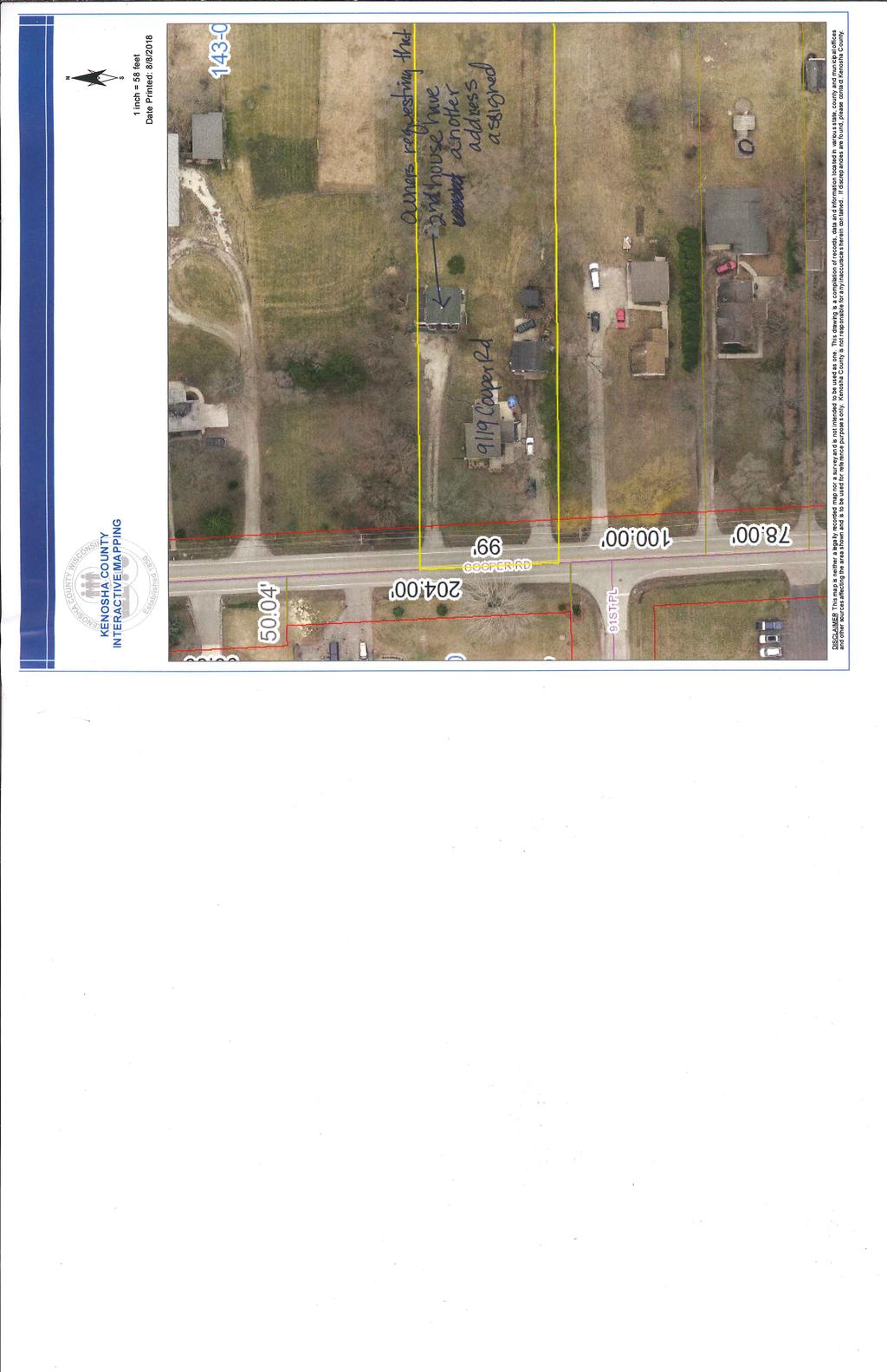
44 C. Consider the request of Kenneth and Kathee Jennings to change the official address of the property located at 9119 Cooper Road. Recommendation: Village staff recommends that the Plan Commission send a favorable recommendation to the Village Board to approve the address change as presented in the October 8, 2018 Village Staff Report.
45 VILLAGE STAFF REPORT OF OCTOBER 8, 2018 Consider the request of Kenneth and Kathee Jennings to change the official address of the property located at 9119 Cooper Road. The owners of the property located at 9919 Cooper Road (Tax Parcel Number ) are requesting that a second address be assigned to the 550 square foot home located on the north side of the property. The property has two homes on the property, the primary home located on the south side of the property was constructed in 1939 and the second home on the north side of the property was constructed in Both homes were legally constructed since at the time of construction there were no zoning regulations in effect; however, the property is currently zoned R-4, Urban Single Family Residential District, which only allows for one living unit per property; therefor this home is considered a legal, non-conforming use. The owners intend to maintain the secondary home on the property and are requesting a second address be assigned to the northern home to eliminate the problems they are having with deliveries and other persons trying to locate the current home. In addition since both homes are located on the same parcel with the same address, problems could create for emergency response personnel. On September 17, 2018 the Village Board adopted Resolution #18-31 to initiate the change of an official address in the Village pursuant to Article IV of the Village Ordinances. The Village Board will hold a Public Hearing to consider changing the address of northern home from 9119 Copper Road to 9115 Cooper Road while the southern home will retain the address of 9119 Cooper Road. Village staff recommends that the Plan Commission approve the address change as requested. DEV


46 KENOSHA COUNTY INTERACTIVE MAPPING 1 inch = 150 feet DISCLAIMER This ma p is neither a lega lly recorded map nor a survey an d is not intended to be used as one. This draw ing is a compilation of records, data an d information loca ted in variou s state, county and mun icip al offices and other sources affecting the area shown and is to be used for reference purposes only. Kenosha County is not responsible for any inaccuracies herein contained. If discrepancies are found, please contact Kenosha County. Date Printed: 8/31/2018
47
48
VILLAGE OF PLEASANT PRAIRIE ZONING BOARD OF APPEALS Tuesday, April 27, :00 PM
 VILLAGE OF PLEASANT PRAIRIE ZONING BOARD OF APPEALS Tuesday, April 27, 2010 6:00 PM Members Present: Christine Genthner, Chairperson; Mark Riley; Jennie Holman; David Hildreth and Sheryl Berner. Bill Morris
URBANDALE PLANNING AND ZONING COMMISSION MINUTES. November 2, 2015
 URBANDALE PLANNING AND ZONING COMMISSION MINUTES The Urbandale Planning and Zoning Commission met in regular session on Monday,, at the Urbandale City Hall, 3600 86 th Street. Chairperson Julie Roethler
PB 7/10/18 - Page 1 CHILI PLANNING BOARD July 10, 2018 A meeting of the Chili Planning Board was held on July 10, 2018 at the Chili Town Hall, 3333 Ch
 PB 7/10/18 - Page 1 CHILI PLANNING BOARD July 10, 2018 A meeting of the Chili Planning Board was held on July 10, 2018 at the Chili Town Hall, 3333 Chili Avenue, Rochester, New York 14624 at 7:00 p.m.
TOWN OF COLONIE BOARD MEMBERS:
 PLANNING BOARD TOWN OF COLONIE COUNTY OF ALBANY ********************************************** PUBLIC HEARING REGARDING ALIX ROAD RECOMMENDATION TO THE TOWN BOARD ON ESTABLISHMENT OF AN OPEN DEVELOPMENT
PORTER COUNTY PLAN COMMISSION Regular Meeting Minutes April 26, 2017
 PORTER COUNTY PLAN COMMISSION Regular Meeting Minutes April 26, 2017 The regular meeting of the was held at 5:30 p.m. on Wednesday, April 26, 2017 in the Porter County Administrative Center, 155 Indiana
PLEASANT PRAIRIE PLAN COMMISSION MEETING VILLAGE HALL AUDITORIUM TH AVENUE PLEASANT PRAIRIE, WISCONSIN 5:00 P.M.
 PLEASANT PRAIRIE PLAN COMMISSION MEETING VILLAGE HALL AUDITORIUM 9915 39TH AVENUE PLEASANT PRAIRIE, WISCONSIN 5:00 P.M. March 26, 2007 A regular meeting for the Pleasant Prairie Plan Commission convened
Ryan Amtmann, David decourcy-bower, Tim Hallquist, Dave Lamerand (Chairperson), Jamie Stefan and Randy Swenson. Excused: Jack Wenstrom
, Jamie Stefan and Randy Swenson. Excused: Jack Wenstrom") VILLAGE OF HARTLAND JOINT ARCHITECTURAL BOARD/PLAN COMMISSION MINUTES MONDAY, JANUARY 20, 2014 7:00 PM BOARD ROOM, MUNICIPAL BUILDING, 210 COTTONWOOD AVE. Present: Ryan Amtmann, David decourcy-bower, Tim
VILLAGE OF HARTLAND JOINT ARCHITECTURAL BOARD/PLAN COMMISSION MINUTES MONDAY, JANUARY 20, 2014 7:00 PM BOARD ROOM, MUNICIPAL BUILDING, 210 COTTONWOOD AVE. Present: Ryan Amtmann, David decourcy-bower, Tim
PLANNING BOARD COUNTY OF ALBANY TOWN OF COLONIE
 PLANNING BOARD COUNTY OF ALBANY TOWN OF COLONIE *************************************************** THE PROPOSED PROJECT OF CEDARVIEW CONDOMINIUMS - CEDARVIEW LANE, REVIEW AND ACTION ON CONCEPT ACCEPTANCE
URBANDALE PLANNING AND ZONING COMMISSION MINUTES. July 9, 2018
 URBANDALE PLANNING AND ZONING COMMISSION MINUTES The Urbandale Planning and Zoning Commission met in regular session on Monday,, at the Urbandale City Hall, 3600 86th Street. Chairperson Jeff Hatfield
Crockery Township Regular Planning Commission Meeting. August 21, 2012 (Approved)
") Crockery Township Regular Planning Commission Meeting August 21, 2012 (Approved) Chairman Bill Sanders called the August 21, 2012, Regular Planning Commission Meeting to order at 7:34 P.M. Roll-call was
Crockery Township Regular Planning Commission Meeting August 21, 2012 (Approved) Chairman Bill Sanders called the August 21, 2012, Regular Planning Commission Meeting to order at 7:34 P.M. Roll-call was
ADA TOWNSHIP PLANNING COMMISSION MINUTES OF THE JUNE 15, 2017 MEETING
 ADA TOWNSHIP PLANNING COMMISSION MINUTES OF THE JUNE 15, 2017 MEETING A meeting of the was held on Thursday, June 15, 2017, 7:00 p.m. at the Ada Township Offices, 7330 Thornapple River Dr., Ada, MI. I.
WHITE OAK BOROUGH PLANNING COMMISSION MEETING MINUTES HELD JULY 1, 2010
 WHITE OAK BOROUGH PLANNING COMMISSION MEETING MINUTES HELD JULY 1, 2010 Planning Commission Members Present: Paul McCarthy Tony Villinger Glenn Beech Al Lebedda Helen Stratigos Planning Commission Members
JUNE 25, 2015 BUTTE-SILVER BOW PLANNING BOARD COUNCIL CHAMBERS BUTTE, MONTANA MINUTES
 JUNE 25, 2015 BUTTE-SILVER BOW PLANNING BOARD COUNCIL CHAMBERS BUTTE, MONTANA Members Present: Absent: Staff: Janet Lindh, Dan Foley, Rick LaBreche, Marc Murphy, Mike Kerns and John Taras Michael Marcum,
MINUTES OF THE VINEYARD TOWN PLANNING COMMISSION MEETING Vineyard Town Hall, 240 East Gammon Road, Vineyard, Utah January 21, 2015, 7:00 PM
 MINUTES OF THE VINEYARD TOWN PLANNING COMMISSION MEETING Vineyard Town Hall, 240 East Gammon Road, Vineyard, Utah January 21, 2015, 7:00 PM PRESENT ABSENT Commission Chair Wayne Holdaway Commissioner Garrett
1. #1713 Hovbros Stirling Glen, LLC Amended Final Major Subdivision
 Call to Order: The meeting was called to order at 7:00 p.m. by Vice Chairman Salvadori who read the following statement: Notice of this meeting was sent in writing to the South Jersey Times on May 28,
AGENDA. EDMOND PLANNING COMMISSION 20 S. Littler, Edmond, Oklahoma Tuesday, February 18, :30 p.m. CITY COUNCIL WORKSHOP
 City of Edmond NOTICE OF PUBLIC MEETING The City of Edmond encourages participation from all its citizens. If participation at any Public meeting is not possible due to a disability, notification to the
TOWN OF HARRISBURG, NORTH CAROLINA BOARD of ADJUSTMENT MEETING TUESDAY, JANUARY 19, :00 PM MINUTES
 TOWN OF HARRISBURG, NORTH CAROLINA BOARD of ADJUSTMENT MEETING TUESDAY, JANUARY 19, 2016 6:00 PM MINUTES 1. CALL TO ORDER called the meeting to order. PRESENT:, John Overcash, Mike Hamamgian,, Thelma Thorne-Chapman,
REGULAR MEETING OF LURAY PLANNING COMMISSION APRIL 13, 2016
 REGULAR MEETING OF LURAY PLANNING COMMISSION The Luray Planning Commission met on Wednesday, April 13, 2016 at 7:00 p.m. in regular session. The meeting was held in the Luray Town Council Chambers at 45
MINUTES OF THE LAKE COUNTY PLANNING COMMISSION July 31, 2007
 MINUTES OF THE LAKE COUNTY PLANNING COMMISSION July 31, 2007 The Lake County Planning Commission hereby finds and determines that all formal actions were taken in an open meeting of this Planning Commission
Boise City Planning & Zoning Commission Minutes November 3, 2014 Page 1
 Page 1 PUD14-00020 / 2 NORTH HOMES, LLC Location: 2818 W. Madison Avenue CONDITIONAL USE PERMIT FOR A FOUR UNIT PLANNED RESIDENTIAL DEVELOPMENT ON 0.28 ACRES LOCATED AT 2818 & 2836 W. MADISON AVENUE IN
SAGINAW CHARTER TOWNSHIP PLANNING COMMISSION SAGINAW CHARTER TOWNSHIP HALL DECEMBER 2, Members Present Members Absent Others Present
 SAGINAW CHARTER TOWNSHIP PLANNING COMMISSION SAGINAW CHARTER TOWNSHIP HALL DECEMBER 2, 2015 Members Present Members Absent Others Present S. McGraw J. (excused) B. Smith, Planner B. Gombar C. Edlinger,
DEWITT CHARTER TOWNSHIP 1401 W. HERBISON ROAD, DeWITT, MI PLANNING COMMISSION MINUTES TUESDAY, SEPTEMBER 5, 2006
 DEWITT CHARTER TOWNSHIP 1401 W. HERBISON ROAD, DeWITT, MI PLANNING COMMISSION MINUTES TUESDAY, SEPTEMBER 5, 2006 The regularly scheduled meeting of the DeWitt Charter Township Planning Commission was called
Town of Hamburg Planning Board Meeting August 22, 2018
 Town of Hamburg Planning Board Meeting August 22, 2018 Minutes The Town of Hamburg Planning Board met for a Regular Meeting on Wednesday, August 22, 2018 in Room 7B of Hamburg Town Hall, 6100 South Park
PLANNING COMMISSION MEETING
 03-13-08: Page 1 of 5 PLANNING COMMISSION MEETING March 13, 2008 The Planning Commission convened in Courtroom No. 1 at City Hall for their regular meeting. Chairman Fitzgerald called the meeting to order
Planning Commission 16 February 4, 2014 EDMOND PLANNING COMMISSION MEETING. Tuesday, February 4, 2014
 Planning Commission 16 EDMOND PLANNING COMMISSION MEETING Tuesday, 5:30 P.M. The Edmond Planning Commission Meeting was called to order by Chairperson Barry K. Moore at 5:30 p.m., Tuesday,, in the City
(b) The location of principal and accessory buildings on the lot and the relationship of each structure to the other.
 The location of principal and accessory buildings on the lot and the relationship of each structure to the other.") ARTICLE XIX SITE PLAN Sec. 20-1900 Site Plan Review Procedure - Intent The site plan review procedures are instituted to provide an opportunity for the Township Planning Commission to review the proposed
ARTICLE XIX SITE PLAN Sec. 20-1900 Site Plan Review Procedure - Intent The site plan review procedures are instituted to provide an opportunity for the Township Planning Commission to review the proposed
Constance Bakall Request for Return of Escrow Balance Mr. Merante asked Mr. Gainer if there was anything outstanding.
 Philipstown Planning Board Meeting Minutes May 19, 2011 The Philipstown Planning Board held its regular monthly meeting on Thursday, May 19, 2011 at the VFW Hall on Kemble Avenue in Cold Spring, New York.
TOWN OF VICTOR ZONING BOARD OF APPEALS August 15,
 TOWN OF VICTOR ZONING BOARD OF APPEALS August 15, 2016 1 A regular meeting of the Town of Victor Zoning Board of Appeals was held on August 15, 2016 at 7:00 P.M. at the Victor Town Hall, 85 East Main Street,
Planner Ken Jaworski. Approval of Minutes: A. Approval of the minutes of the Wednesday, July 8 th, 2015 Regular Plan Commission Meeting.
 Approved 09/09/2015 TOWN OF CLAYTON Town Plan Commission Meeting Minutes 7:00 P.M. on Wednesday, August 12 th, 2015 Town Office Meeting Room, 8348 County Road T, Larsen, WI 54947 I. Call to Order: A. Notice
Present: Chair, B. Brigham, Vice Chair, Arthur Omartian, Clerk, Bruce Thompson, Tom Stanhope, Mike McKennerney and Zoning Administrator, Becky Perron
 Town of St. Albans Development Review Board Meeting Minutes Thursday, February 22 nd, 2018 6:30 p.m. On Thursday, February 22 nd, 2018 at 6:30 p.m., the Town of St. Albans Development Review Board met
Town of Onalaska. A scale map depicting the portion of Pineview Drive to be officially laid out as a Town highway is attached hereto as Exhibit A.
 Town of Onalaska Special Meeting Minutes for March 31, 2011 The Town Board met on site of the Pineview Road and County OT in Onalaska for the purpose of viewing the lay out of the road as required by law.
DEWITT CHARTER TOWNSHIP 1401 W. HERBISON ROAD, DeWITT, MI PLANNING COMMISSION MINUTES MONDAY, APRIL 7, 2008
 DEWITT CHARTER TOWNSHIP 1401 W. HERBISON ROAD, DeWITT, MI PLANNING COMMISSION MINUTES MONDAY, APRIL 7, 2008 The regularly scheduled meeting of the DeWitt Charter Township Planning Commission was called
PUD Ordinance - Thornapple Manor #2 of 1998
 PUD Ordinance - Thornapple Manor #2 of 1998 CASCADE CHARTER TOWNSHIP Ordinance #2 of 1998 AN ORDINANCE TO AMEND THE CASCADE CHARTER TOWNSHIP ZONING ORDINANCE AND ZONING MAP TO ESTABLISH THORNAPPLE MANOR
CITY OF BURTON BURTON PLANNING COMMISSION MEETING OCTOBER 11, 2016 MINUTES. Council Chambers Regular Meeting 5:00 PM
 CITY OF BURTON BURTON PLANNING COMMISSION MEETING OCTOBER 11, 2016 MINUTES Council Chambers Regular Meeting 5:00 PM 4303 S. CENTER ROAD BURTON, MI 48519 This meeting was opened by Chairman Deb Walton at
UNAPPROVED MINUTES PLANNING COMMISSION REGULAR MEETING CITY OF WYOMING, MINNESOTA DECEMBER 9, :00 PM
 UNAPPROVED MINUTES PLANNING COMMISSION REGULAR MEETING CITY OF WYOMING, MINNESOTA DECEMBER 9, 2008 7:00 PM CALL TO ORDER: Michael Thomas called the Regular Meeting of the Wyoming Planning Commission to
PUD, HPUD, OSC Rezoning & Conceptual Plan Application (Planned Unit Development, Haggerty Road Planned Unit Development, Open Space Community)
") Township Use Only RZ #: Date: Hearing Date: Fee Paid: PUD, HPUD, OSC Rezoning & Conceptual Plan Application (Planned Unit Development, Haggerty Road Planned Unit Development, Open Space Community) Project
Township Use Only RZ #: Date: Hearing Date: Fee Paid: PUD, HPUD, OSC Rezoning & Conceptual Plan Application (Planned Unit Development, Haggerty Road Planned Unit Development, Open Space Community) Project
SPRINGFIELD TOWNSHIP ZONING BOARD OF APPEALS REGULAR MEETING October 17, 2018
 SPRINGFIELD TOWNSHIP ZONING BOARD OF APPEALS REGULAR MEETING October 17, 2018 Call to Order: Vice-Chairperson Whitley called the October 17, 2018 Zoning Board of Appeals meeting to order at 7:30 pm at
Staff presented two options for the Commission to consider recommending to Town Council:
 Attendance: Chair Darrell Page; Commissioners: Ann Holland, Scott Burroughs, Steve Clark, Pam Barger, Pam Carter, Michael Aldridge (arrived at 7:39); Hilda Keeney, Planning and Zoning Clerk; Kassie Watts,
Dan Buday, Judy Clock, June Cross, Becky Doan, Toni Felter, Francis (Brownie) Flanders and John Hess
 Flanders and John Hess") Monday, December 13, 2010 7:00 p.m. 210 State Street, City Hall, Council Chambers, Charlevoix, Michigan A) CALL TO ORDER The meeting was called to order by Chairman John Hess at 7:03 p.m. B) ROLL CALL
Monday, December 13, 2010 7:00 p.m. 210 State Street, City Hall, Council Chambers, Charlevoix, Michigan A) CALL TO ORDER The meeting was called to order by Chairman John Hess at 7:03 p.m. B) ROLL CALL
Sign-in sheets are attached at the end of the minutes as Exhibit A.
 Sign-in sheets are attached at the end of the minutes as Exhibit A. It was noted that although the Commissioners are leading the meeting, because there are quorums of different public boards present at
CITY OF MERCED Planning Commission MINUTES
 CITY OF MERCED Planning Commission MINUTES Merced City Council Chambers Wednesday, December 4, 2013 Vice-Chairperson MACKIN called the meeting to order at 7:00 p.m., followed by a moment of silence and
Official Minutes of MARION COUNTY BOARD OF COUNTY COMMISSIONERS. December 20, 2017
 Official Minutes of MARION COUNTY BOARD OF COUNTY COMMISSIONERS December 20, 2017 CALL TO ORDER: The Marion County Board of County Commissioners met in a special session in Commission Chambers at 2:02
Planning and Zoning AGENDA Council Chambers, Fort Dodge Municipal Building 819 1st Avenue South, Fort Dodge, Iowa July 25, 2017, 4:00 PM
 Planning and Zoning AGENDA Council Chambers, Fort Dodge Municipal Building 819 1st Avenue South, Fort Dodge, Iowa July 25, 2017, 4:00 PM I. Roll Call II. Approval of Previous Meeting Minutes a) June 27th
BYRON TOWNSHIP PLANNING COMMISSION September 18, 2006 MINUTES ADJUSTMENTS MADE NOT APPROVED CALL TO ORDER, ATTENDANCE & PRAYER
 BYRON TOWNSHIP PLANNING COMMISSION September 18, 2006 MINUTES ADJUSTMENTS MADE NOT APPROVED CALL TO ORDER, ATTENDANCE & PRAYER Chairman Seymour Gould called a regular meeting of the Byron Township Planning
Perry City Planning Commission Perry City Offices, 3005 South 1200 West April 5, :00 PM
 Perry City Planning Commission Perry City Offices, 3005 South 1200 West April 5, 2012 7:00 PM Members Present: Chairman Jerry Nelson, Commissioner Esther Montgomery, Commissioner Todd Bischoff, Commissioner
Richard Williams, Chairman of the Town of Peru Planning Board, called the meeting of Wednesday, February 14, 2018 at 7:00 p.m. to order.
 Richard Williams, Chairman of the Town of Peru Planning Board, called the meeting of Wednesday, February 14, 2018 at 7:00 p.m. to order. PLEDGE OF ALLEGIANCE. ROLL CALL: RICHARD WILLIAMS, CHAIR BENJAMIN
DeWITT CHARTER TOWNSHIP 1401 W. HERBISON ROAD, DeWITT, MI PLANNING COMMISSION MINUTES MONDAY, MARCH 6, 2006
 DeWITT CHARTER TOWNSHIP 1401 W. HERBISON ROAD, DeWITT, MI PLANNING COMMISSION MINUTES MONDAY, MARCH 6, 2006 The regularly scheduled meeting of the DeWitt Charter Township Planning Commission was called
BAZETTA TOWNSHIP TRUSTEES REGULAR MEETING MINUTES
 BAZETTA TOWNSHIP TRUSTEES REGULAR MEETING MINUTES Date: August 10, 2010 at 7:30pm Bazetta Township Administration Building 3372 State Route 5 NE Cortland, Ohio 44410 Meeting called to order at 7:30pm.
TOWN OF WELLS, MAINE PLANNING BOARD
 1 0 1 0 1 TOWN OF WELLS, MAINE PLANNING BOARD Meeting Minutes Monday, June,, :00 P.M. Littlefield Meeting Room, Town Hall Sanford Road CALL TO ORDER AND DETERMINATION OF QUORUM Chairman Chuck Millian called
RESOLUTION NO. RESOLUTION APPROVING ZONING PETITION 84-71, Special Exception. WHEREAS, the Board of County Commissioners, as the governing
 /. ;C- C, i RESOLUTION NO. R-@+-l2?8 RESOLUTION APPROVING ZONING PETITION 84-71, Special Exception WHEREAS, the Board of County Commissioners, as the governing body, pursuant to the authority vested in
Report to the Plan Commission December 19, 2011
 Report to the Plan Commission Legistar I.D. #24825, Extraterritorial Certified Survey Map Requested Action: Consideration of a two-lot Certified Survey Map (CSM) of the Keryluk-Wee property located at,,
STATE OF MICHIGAN COUNTY OF BERRIEN ORONOKO CHARTER TOWNSHIP PRIVATE ROAD ORDINANCE ORDINANCE NO. 65
 STATE OF MICHIGAN COUNTY OF BERRIEN ORONOKO CHARTER TOWNSHIP PRIVATE ROAD ORDINANCE ORDINANCE NO. 65 AN ORDINANCE TO REQUIRE THAT ALL LOTS OR PARCELS OF LAND WHICH DO NOT ABUT PUBLIC STREETS ABUT A PRIVATE
NEW BUSINESS APPLICATION
 NEW BUSINESS APPLICATION Information Packet City of Delafield Clerk s Office 500 Genesee Street Delafield WI 53018 262-646-6220 www.cityofdelafield.org The steps to opening a business in Delafield are thorough
Chapter 100 Planned Unit Development in Corvallis Urban Fringe
 100.100 Scope and Purpose. Chapter 100 Planned Unit Development in Corvallis Urban Fringe (1) All applications for land divisions in the Urban Residential (UR) and Flood Plain Agriculture (FPA) zones within
1 P a g e T o w n o f W a p p i n g e r Z B A M i n u t e MINUTES
 1 P a g e T o w n o f W a p p i n g e r Z B A M i n u t e 0 5-09- 17 MINUTES Town of Wappinger Zoning Board of Appeals May 9, 2017 Time: 7:00PM Town Hall 20 Middlebush Road Wappinger Falls, NY Summarized
LINCOLN COUNTY PLANNING COMMISSION PO Box 329, Pioche, NV Phone , Fax
 LINCOLN COUNTY PLANNING COMMISSION PO Box 329, Pioche, NV 89043 Phone 775-962-5345, Fax 775-962-5347 Approved Minutes for January 14, 2008, 7:00 P.M. 1. Roll Call, Open Meeting Law: The Board met in regular
MINUTES CASCO TOWNSHIP PLANNING COMMISSION REGULAR MEETING TUESDAY, NOVEMBER 15, 2016
 MINUTES CASCO TOWNSHIP PLANNING COMMISSION REGULAR MEETING TUESDAY, NOVEMBER 15, 2016 Present Members: Stan Pankiewicz, Joe Stevens, Eric Reeve, Keith Teltow, Cynthia Goulston. Absent: Jim Edwards, Kyle
BONNER COUNTY PLANNING DEPARTMENT
 BONNER COUNTY PLANNING DEPARTMENT 1500 HIGHWAY 2, SUITE 208, SANDPOINT, ID 83864 (208) 265-1458 (208) 265-1463 (FAX) planning@bonnercountyid.gov (email) www.bonnercounty.us (web page) INFORMATION SHEET
PLANNING & DEVELOPMENT COMMITTEE MINUTES
 Eau Claire County PLANNING & DEVELOPMENT COMMITTEE MINUTES Tuesday, 6:00 PM *Please note earlier start time* Eau Claire County Courthouse 721 Oxford Avenue Room 1277 Eau Claire, Wisconsin Members Present:
TOWN OF CLAYTON. Town Plan Commission. Meeting Minutes. 7:00 P.M. 8:12 P.M. on Wednesday, July 10 th, 2013
 TOWN OF CLAYTON Approved 08/14/13 Town Plan Commission Meeting Minutes 7:00 P.M. 8:12 P.M. on Wednesday, July 10 th, 2013 Town Office Meeting Room, 8348 County Road T, Larsen, WI 54947 I. Call to Order:
PLANNING COMMISSION AGENDA
 PLANNING COMMISSION AGENDA Planning Commission Meeting 6:30 PM Tuesday, July 17, 2018 Village Administration Building 99 High Street South Lebanon, Ohio 45065 Agenda Item 1. Call to Order 2. Pledge of
EDGERTON CITY HALL PLANNING COMMISSION MEETING REGULAR SESSION March 12, 2019
 EDGERTON CITY HALL PLANNING COMMISSION MEETING REGULAR SESSION The met in regular session with Chair John Daley calling the meeting to order at 7:00 p.m. All present participated in the Pledge of Allegiance.
Request Conditional Use Permits (Craft Brewery, Assembly Use & Open-Air Market) Staff Recommendation Approval. Staff Planner Robert Davis
 Staff Recommendation Approval. Staff Planner Robert Davis") Applicant Property Owner Weathersby Properties, LLC Public Hearing January 9, 2019 City Council Election District Bayside Agenda Item 4 Request Conditional Use Permits (Craft Brewery, Assembly Use & Open-Air
Applicant Property Owner Weathersby Properties, LLC Public Hearing January 9, 2019 City Council Election District Bayside Agenda Item 4 Request Conditional Use Permits (Craft Brewery, Assembly Use & Open-Air
Joint Meeting of the Planning Commission and Board of County Commissioners April 1, 2008 Custer County Courthouse Westcliffe, Colorado
 Joint Meeting of the Planning Commission and Board of County Commissioners April 1, 2008 Custer County Courthouse Westcliffe, Colorado Present: Planning Commission: Lynn Attebery, Pat Bailey, Rod Coker,
WILLIAMSTOWN TOWNSHIP PLANNING COMMISSION MEETING October 20, 2009
 WILLIAMSTOWN TOWNSHIP PLANNING COMMISSION MEETING October 20, 2009 CALL TO ORDER The Williamstown Township Planning Commission convened at 7:30 pm at the Williamstown Township Hall located at 4990 Zimmer
Recommendations. Presented To: Planning Committee. Meeting Date: Tuesday, Feb 05, Report Date: Tuesday, Jan 15, 2008.
 Request for Recommendation an application for rezoning to permit a water bottling facility, fitness club, ancillary office uses and one dwelling unit within the existing building, south east corner of
BUFFALO TOWNSHIP PLANNING COMMISSION REGULAR MONTHLY MEETING AUGUST 2, 2017
 The Regular Monthly Meeting of the Buffalo Township Planning Commission was called to order on August 2, 2017, at 7:40 p.m. in the Buffalo Township Municipal Building by the Chairman, Ray Smetana. This
DICKINSON COUNTY PLANNING AND ZONING COMMISSION. Monday, May 18, :00 P.M.
 DICKINSON COUNTY PLANNING AND ZONING COMMISSION Monday, May 18, 2015 1:00 P.M. The Dickinson County Planning and Zoning Commission met Monday, May 18, 2015 at the 1:00 P.M. in the community room of the
PLAINFIELD BOARD OF ZONING APPEALS August 21, :00 p.m.
 PLAINFIELD BOARD OF ZONING APPEALS August 21, 2017 7:00 p.m. CALL TO ORDER Mr. Monnett: Call to order the Plainfield Board of Zoning Appeals meeting for August 21, 2017. PLEDGE OF ALLEGIANCE Mr. Monnett:
LOCAL PLANNING AGENCY MEETING Martin County Commissioner Chambers 2401 S.E. Monterey Road Stuart, Florida MEETING MINUTES- November 5, 2015
 LOCAL PLANNING AGENCY MEETING Martin County Commissioner Chambers 2401 S.E. Monterey Road Stuart, Florida 34996 MEETING MINUTES- November 5, 2015 Present: Chairman Jim Moir Vice Chairperson Crystal Lucas
Town of Bayfield Planning Commission Meeting September 8, US Highway 160B Bayfield, CO 81122
 Planning Commissioners Present: Bob McGraw (Chairman), Ed Morlan (Vice-Chairman), Dr. Rick K. Smith (Mayor), Dan Ford (Town Board Member), Gabe Candelaria, Michelle Nelson Planning Commissioners Absent:
Project File #: VA Project Name: Beauperthuy Variance Parcel Nos.: , , , ,
 COMMISSIONERS: DARRYL GLENN (PRESIDENT) MARK WALLER (PRESIDENT PRO TEMPORE) STAN VANDERWERF LONGINOS GONZALEZ PEGGY LITTLETON PLANNING AND COMMUNITY DEVELOPMENT DEPARTMENT CRAIG DOSSEY, EXECUTIVE DIRECTOR
CITY OF LEWISTON PLANNING BOARD MEETING MINUTES for November 19, Page 1 of 4
 CITY OF LEWISTON PLANNING BOARD MEETING MINUTES for November 19, 2002 - Page 1 of 4 I. ROLL CALL: This meeting was held in the City Council Chambers, was called to order at 7:00 p.m., and was chaired by
MINUTES OF MEETING SIX MILE CREEK COMMUNITY DEVELOPMENT DISTRICT
 MINUTES OF MEETING SIX MILE CREEK COMMUNITY DEVELOPMENT DISTRICT The regular meeting of the Board of Supervisors of the Six Mile Creek Community Development District was held on Tuesday, at 2:05 p.m. at
PLANNING COMMISSION Thursday, September 5, :00 p.m. Council Chambers, Administration Building 100 Ribaut Road, Beaufort, South Carolina
 PLANNING COMMISSION Thursday, September 5, 2013 6:00 p.m. Council Chambers, Administration Building 100 Ribaut Road, Beaufort, South Carolina In accordance with South Carolina Code of Laws, 1976, Section
TOWN OF WARWICK ZONING BOARD OF APPEALS FEBRUARY 22, 2010
 TOWN OF WARWICK ZONING BOARD OF APPEALS FEBRUARY 22, 2010 Members Present: Mr. Jan Jansen, Chairman Mr. Mark Malocsay, Co-Chairman Mr. Norm Paulsen Attorney Robert Fink Members Absent: Diane Bramich Chairman
Complete applications are due by 2:00 p.m. on the submission cut-off date.
 CONSENT APPLICATION PLEASE READ ALL INSTRUCTIONS WHAT IS A COMPLETE APPLICATION? Your application is complete when you have: o Discussed the application with a City of St. Catharines Planner Name of Planner:
CBJ DOCKS & HARBORS BOARD SUB COMMITTEE MINUTES For Wednesday January 9 th, 2013
 SUB COMMITTEE MINUTES For Wednesday January 9 th, 2013 I. Call to Order. II. Mr. Kueffner called the Sub Committee meeting to order at 12:03 p.m. in CBJ Room 224. Roll Call. The following members were
Chairman Schreiber noted there was a sign up sheet at the back of the room for anyone wishing to sign up for library activities and s.
 Page 1 of 6 The held a Public Informational Meeting on Saturday, January 11, 2014, at the Chester Meeting House, 4 Liberty Street, Chester, Connecticut. Chairman Terry Schreiber called the meeting to order
CITY OF MURFREESBORO BOARD OF ZONING APPEALS
 CITY OF MURFREESBORO BOARD OF ZONING APPEALS Regular Meeting, July 27, 2011, at 1:00 p.m. City Hall, 111 West Vine Street, Council Chambers, 1 st Floor 1. Call to order A G E N D A 2. Consideration of
Watkinsville First Baptist Church Building and Parking Masterplan Norton Road & Simonton Bridge Road Oconee County Georgia
 Watkinsville First Baptist Church Building and Parking Masterplan Norton Road & Simonton Bridge Road Oconee County Georgia Special Use Approval A-1 CUP to A-1 with Special Use Approval Total Site Area
Also present were Bill Mann, Senior Planner and Senior Secretary Amber Lehman.
 held Monday, August 26, 2013, at 7:00 P.M. in the Council Chambers, 11 North 3 rd Street, Jacksonville Beach, Florida Call to Order The meeting was called to order by Chairman Greg Sutton. Roll Call Greg
STAFF REPORT. Guttman Development Group, LLC. PUD-R (Residential Planned Unit Development Plan)
") P a g e 1 STAFF REPORT CASE: APPLICANT: LOCATION: ZONED: REQUEST: ZC09-2017 Guttman Development Group, LLC 4990 Wilmington Pike PUD-R (Residential Planned Unit Development Plan) A Major Change to an Approved
P a g e 1 STAFF REPORT CASE: APPLICANT: LOCATION: ZONED: REQUEST: ZC09-2017 Guttman Development Group, LLC 4990 Wilmington Pike PUD-R (Residential Planned Unit Development Plan) A Major Change to an Approved
EDMOND PLANNING COMMISSION 20 S. Littler, Edmond, Oklahoma Tuesday, May 6, :30 p.m.
 City of Edmond NOTICE OF PUBLIC MEETING The City of Edmond encourages participation from all its citizens. If participation at any Public meeting is not possible due to a disability, notification to the
Village of Cayuga Heights Planning Board Meeting #80 Monday, June 25, 2018 Marcham Hall 7:00 pm Minutes
 Village of Cayuga Heights Planning Board Meeting #80 Monday, June 25, 2018 Marcham Hall 7:00 pm Minutes Present: Planning Board Members Chair F. Cowett, G. Gillespie, J. Leijonhufvud, R. Segelken Code
City Recorder s Office
 City Recorder s Office PUBLIC NOTICE Notice is Hereby Given that the Tooele City Council & Tooele City Redevelopment Agency will meet in a Work Session, on Wednesday, September 19, 2018 at the hour of
BRISTOL PLANNING COMMISSION REGULAR MEETING OF FEBRUARY 22, 2017
 BRISTOL PLANNING COMMISSION REGULAR MEETING OF FEBRUARY 22, 2017 ATTENDANCE: ABSENT: Commissioner John Soares (Vice Chairman) Commissioner Marie Chasse (Secretary) Terry Parker (Alternate) (arrived 7:06
City of Pine Island Planning and Zoning Commission Agenda Tuesday February 11, :00 PM Second Floor City Hall 250 South Main Street
 City of Pine Island Planning and Zoning Commission Agenda Tuesday February 11, 2014 7:00 PM Second Floor City Hall 250 South Main Street I. Roll Call II. III. Pledge of Allegiance Thanks to Roy Larson
URBANDALE PLANNING AND ZONING COMMISSION MINUTES. November 26, 2018
 URBANDALE PLANNING AND ZONING COMMISSION MINUTES The Urbandale Planning and Zoning Commission met in regular session on Monday,, at the Urbandale City Hall, 3600 86th Street. Chairperson Jeff Hatfield
RICHFIELD TOWNSHIP LUCAS COUNTY, OHIO BOARD OF RICHFIELD TOWNSHIP TRUSTEES REGULAR MEETING MINUTES. September 16 th, 2010
 RICHFIELD TOWNSHIP LUCAS COUNTY, OHIO BOARD OF RICHFIELD TOWNSHIP TRUSTEES REGULAR MEETING MINUTES September 16 th, 2010 The regular meeting of the Richfield Township Trustees was called to order by Arthur
Village of Bellevue Plan Commission
 Village of Bellevue Plan Commission Pursuant to Section 19.84 Wis. Stats., a scheduled regular meeting of the Village of Bellevue Plan Commission was held on Tuesday, at 7:00 p.m. at the Bellevue Village
4 June 11, 2014 Public Hearing
 4 June 11, 2014 Public Hearing APPLICANT: FRANKLIN JOHNSTON MANAGEMENT DEVELOPMENT, L.L.C. PROPERTY OWNER: TRUSTEES OF FIRST LYNNHAVEN BAPTIST CHURCH STAFF PLANNER: Stephen J. White REQUEST: Change of
CITY OF ST. FRANCIS ST. FRANCIS, MN PLANNING COMMISSION MINUTES APRIL 19, 2006
 CITY OF ST. FRANCIS ST. FRANCIS, MN PLANNING COMMISSION MINUTES APRIL 19, 2006 1. Call to Order: The Planning Commission meeting was called to order at 7:00 pm by Chairman Rich Skordahl. 2. Roll Call:
SMITHFIELD CITY REDEVELOPMENT AGENCY JANUARY 23, 2019
 SMITHFIELD CITY REDEVELOPMENT AGENCY JANUARY 23, 2019 The Smithfield City Redevelopment Agency Board met for a specially scheduled board meeting at 96 South Main, Smithfield, Utah on Wednesday, January
PORT SHELDON TOWNSHIP PLANNING COMMISISON September 23, De Leeuw, Frantom, Monhollon, Petroelje, Stump, Timmer, Van Malsen
 PORT SHELDON TOWNSHIP PLANNING COMMISISON September 23, 2015 Van Malsen called the meeting to order at 6:03 p.m. PRESENT: De Leeuw, Frantom, Monhollon, Petroelje, Stump, Timmer, Van Malsen STAFF PRESENT:
FRANKLIN COUNTY PLANNING COMMISSION MINUTES May 2, Brent Stenson, Claude Pierret, Mike Corrales, Melinda Didier, Layton Lowe and Mike Vincent.
 FRANKLIN COUNTY PLANNING COMMISSION MINUTES May 2, 2017 MEMBERS PRESENT: Brent Stenson, Claude Pierret, Mike Corrales, Melinda Didier, Layton Lowe and Mike Vincent. MEMBERS ABSENT: None. STAFF PRESENT:
MINUTES OF THE LINCOLN COUNTY PLANNING COMMISSION June 18, 2018 COUNTY PLANNING COMMISSION MEMBERS PRESENT: Tyler Klatt, Ron Albers, Darrel Sogn,
 MINUTES OF THE LINCOLN COUNTY PLANNING COMMISSION June 18, 2018 COUNTY PLANNING COMMISSION MEMBERS PRESENT: Tyler Klatt, Ron Albers, Darrel Sogn, Monty Derousseau, Stacey Namminga, Jim Schmidt STAFF PRESENT:
1293 Washington Ave, Cedarburg Date/Time: March 19, 2014 / 7:00PM Posted: March 14, 2014
 Meeting: Plan Commission Place: 1293 Washington Ave, Cedarburg Date/Time: March 19, 2014 / 7:00PM Web Page: www.town.cedarburg.wi.us Posted: March 14, 2014 Chairman Dave Valentine Town Administrator Jim
BINGHAM TOWNSHIP PLANNING COMMISSION Regular Meeting Minutes - September 7, 2017
 BINGHAM TOWNSHIP PLANNING COMMISSION Regular Meeting Minutes - September 7, 2017 1. Call meeting to order Mike Park, Chairman, called the Bingham Township Planning Commission Regular Meeting to order on
EDMOND PLANNING COMMISSION MEETING. Tuesday, October 5, 2004
 124 EDMOND PLANNING COMMISSION MEETING Tuesday, 5:30 P.M. The Edmond Planning Commission Meeting was called to order by Chairperson David Woods at 5:30 p.m., Tuesday,, in the City Council Chambers at 20