January 22, Bureau of Land Management California Desert District WMRNP Plan Amendment Calle San Juan de Los Lagos
|
|
|
- Frederica Pierce
- 5 years ago
- Views:
Transcription

1 P.O. Box 24 Joshua Tree, CA January 22, 2016 Bureau of Land Management California Desert District WMRNP Plan Amendment Calle San Juan de Los Lagos Moreno Valley, CA Sent by surface mail and Subject: Conflict between the WMRNP and the road network established from Small Tracts Act ROWs in the Morongo Basin and other areas in San Bernardino County. Dear Ms. Seehafer: The Morongo Basin Conservation Association, its board and members, have been diligent in researching, educating community members, and responding to what we consider the failings of the West Mojave Plan (WEMO). The Plan Amendment, particularly Alternative 3, threatens our quality-of-life, property values, tourism economics, and public land conservation values by legalizing OHV riding on thousands of miles of dirt roads throughout our Morongo Basin and other area communities in the West Mojave. The astonishment of residents over the small green orphan routes flecked throughout their communities has led to the question: What gives BLM the authority to invite OHVs to invade our communities and use our roads to do it? The green flecks, of course, are the BLM rights-of-ways (ROWs) on orphaned public land parcels within rural residential areas (See BLM map layers for TMA 3). How did this checkerboard pattern of land ownership come about to allow this configuration of routes? It is worthwhile to refresh our memories. The Small Tracts Act The checkerboard pattern of land ownership results from the popularity of the Small Tracts Act (STA) which was in effect from 1938 until the passage of the Federal Land Policy and Management Act (FLPMA) in The STA authorized the sale or lease at fair market value to any person or organization a tract not exceeding 5 acres of any vacant, unreserved public lands for residence, recreation, or community site purposes. After 1943 rights-of-way (ROW) easements of 33 feet (later amended to 50 feet) were added to provide a corridor for access and utilities to small tracts. Before purchase or lease the land had to be surveyed and classified. The history of the STA is told in the 30 page pamphlet Five Acres of Heaven by Ed Ainsworth. The pamphlet was commissioned and published by Col. E.B. Moore, a land locator and advocate for providing individuals, especially veterans with lung problems, the possibility of living amid great beauty with clear clean air to breath. The impetus for the STA came from Paul Witmer, head of the Office of Land Management in Los Angeles in the 1930s. Confused why so many veterans were homesteading 160 acres of land in the desert, land obviously unsuitable for agriculture, he investigated. Traveling to Twentynine Palms he heard their need

2 was to live affordably where they could breathe. Witmer conceived the STA, which would allow the purchase of 5 acres without the requirement to prove up the land with water loving crops and scarce human energy. It took Congress three sessions but they finally passed the bill in Ainsworth describes the STA s popularity By the start of 1955, the Five Acre Tract movement was established so firmly that about 25,000 permits had been issued, 1,200 others were being processed by Mr. Witmer s Bureau of Land Management in Los Angeles, and some 12,000 others were starting along the procedural route to Federal Offices. Many thousands of homes had been built, much more than $1,000,000 of assessed valuation added to the tax rolls of San Bernardino and Riverside counties, and many more homes were being started all the time. (Page 29) Col. Moore assisted over 10,000 individual families in locating and filing on five acre tracts. To accomplish this he also made the first publically available detailed maps (with regular updates) of the desert showing the 5 acre tracts with clarity. His original need for maps grew until his series contained tract maps of many areas as well as maps showing regions of industrial expansion, oil and gas possibilities, and geological sketches dealing particularly with water supplies all this before government maps of the area were available to the public. See Figure 1. Col. Moore also engaged in land planning, including overcoming the real estate dealers who wanted to develop subdivisions in the choice areas. We, and all the species using the Joshua Tree-to-29 Palms Wildlife Linkage, can thank Col. Moore for today s open spaces. This background on the STA explains the checkerboard pattern we live with now. As communities developed roads were built, electricity generated, water provided, all while maintaining the wilderness appeal of the primeval desert. Figure 1: 1955 Edition of Col. Moore s map of the High Joshua Desert showing private lands and land available for small tracts MBCA WEMO Comments 2
3 Small Tracts Act Rights-of-Way It was generally accepted that small tract ROWs were common law dedications to the public to provide ingress and egress to the leased or patented land and as access for utility service. The dedication was completed (accepted) with the use of the easement for a road or a public utility to serve a small tract. After the termination of the Small Tracts Act classification in 1976 additional ROWs could be added within the borders of the existing ROWs that serve the small tract patents without additional authorization from the United States. Rights-of-Way Management (BLM Penfold. DOI Instruction Memo No appended to this letter) 1. The only intended governmental purpose of the ROW is to provide for utilization of the public land. The government has no intent to reserve rights to collect revenue, therefore, the ROW authorized under the STA are rental free. 2. Utilities that cross public land outside the small tract borders (regardless if they serve the small tract) or that do not serve the small tract, require separate authorization. 3. When a patent is issued the fee title lies with the owner of the land subject to the easement for use by the public. The Secretary no longer has rights to the land except those specifically reserved to the United States (i.e. oil, gas, minerals or prospecting for same, or interfere with water for grazing, or impair protection of watersheds). This restriction can only be eliminated through the process of eminent domain proceedings for some governmental purpose. 4. Rights-of- way connected to classified but not patented small tracts can be used for the construction of roads to serve owned small tracts without the necessity of a formal grant from the United States. 5. Once ROWs become dedicated public easements through use by the public, the dedication may be abandoned only by proper authority pursuant to due course of law. In most cases the proper authority is the county or city. (Underlines added for emphasis) The ROWs were clearly meant to become community roads and utility corridors. The Secretary s reserved rights do not include OHV Transportation Management Corridors. San Bernardino County and Rights-Of-Way in U.S. Land Patents (referenced memo appended to this letter) Memo: March 13, 1991 From: Charles S. Scolastico Deputy County Council To: Larry Cotton, San Bernardino County Surveyor The analysis was in response to a request for an opinion on whether the County can accept rights-of-way reserved in U.S. land patents for public use or legal access. Based upon our research, it is our opinion that rights-of-way for public road and utility purposes reserved in land patents authorized under the Small Tract Act constitute local rights-of-way for those entitled to use them, i.e., the public and utility companies. Moreover, since they are reservations rather than offers of dedications or something similar, there is no requirement of acceptance by the public or by a government agency. (Underlines added for emphasis.) MBCA WEMO Comments 3
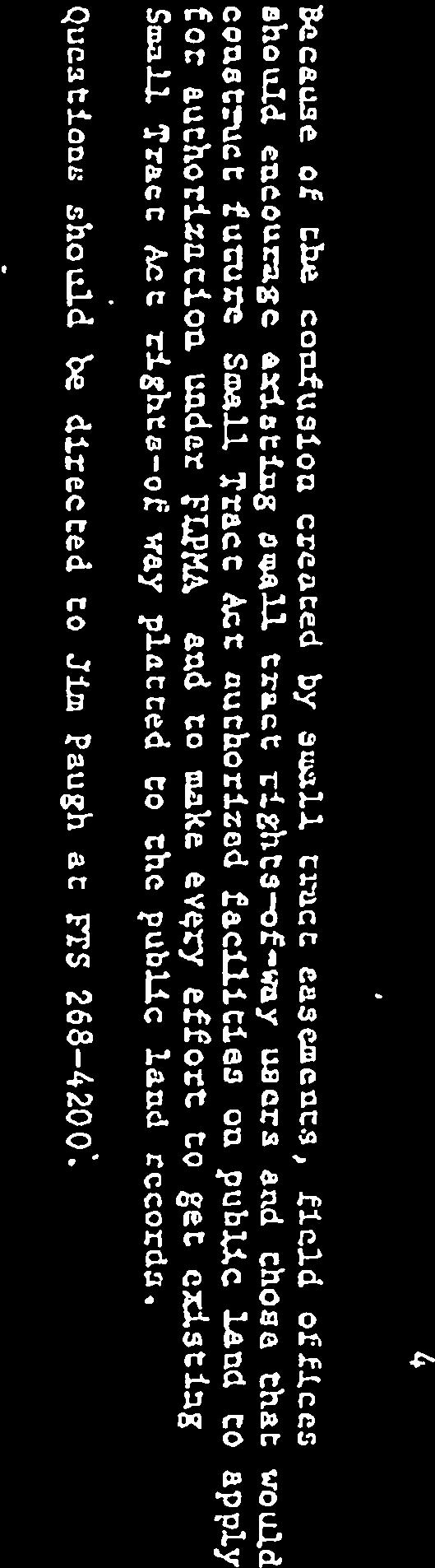
4 Federal Land Policy and Management Act (FLPMA) 1976 and the Repeal of the Small Tracts Act Contained in the passage of FLPMA in 1976 was the repeal of the Small Tracts Act. However, under Title VII Effect on Existing Rights, Sec [43 U.S.C note] (a) Nothing in this Act, or in any amendment made by this Act, shall be construed as terminating any valid lease, permit, patent, right-of-way, or other land use right or authorization existing on the date of approval of this Act. (Underlines added for emphasis.) The government relinquished the right for BLM to use public ROWs to construct federal Transportation Management Corridors through rural communities. We find no indication that the Secretary intends to reclaim any relinquished rights on ROWs. The proper authority is now the county. San Bernardino County Ordinance Off-Highway Motor Vehicle Use The County has jurisdiction over, but not necessarily responsibility for, the STA public road and utility easements based on their use by the public. Therefore, the County OHV Motor Vehicle Ordinance 4103 applies to not only the roads in County Service Areas but all county roads used by the public and utilities to access private property. County Code no person shall operate any motor vehicle (including any off-highway motor vehicle), or the motor thereof, nor shall any person organize conduct, or participate in staging (as defined herein), in a manner that disturbs the peace or quiet of any neighborhood or person by noise, dust, smoke, or fumes caused by such motor vehicles or staging activity. County General Plan (See appended S.B. County GP and WEMO document) The ordinance complies with the Vision of the County General Plan and the Goals and Policies for the following elements: Land Use, Circulation and Infrastructure, Conservation, Air Quality, Open Space, Noise, Safety, and Economic Development. VISION Continued rural character in many areas of the County, with buffering as needed adjacent to more urban areas (see Goal LU-2). A sense of place and community identity in distinct communities where residents may choose to remain in unincorporated neighborhoods (see Goal LU-10). Clean air and a reliable clean water supply (see Goal CI-12). Growth and development consistent with the maintenance of environmental quality (see Goal LU-7) Conservation/preservation of the natural environment, which defines and enhances our quality of life (see Goal CO-1). California Desert Conservation Act (CDCA) of 1980 and Private Land (Chapter L Appended to this letter) The CDCA Final EIS and Proposed Plan had this Finding as the introduction to Chapter L. Land Tenure Adjustment Element. Intermingled land ownership patterns in much of the CDCA make management difficult for BLM, other Federal, State and local agencies, Indian reservations, and private land owners. History has demonstrated this to be true. And Goal D: Cooperate with other public agencies at all levels of government in the management of adjacent and interspersed public and private lands. The Management of unclassified lands (shown in white on Figure 2 below) contains the following guideline: Parcels which are found not to contain sensitive resources and would be better used for development MBCA WEMO Comments 4
 for fair market value Public roads will be used to gain access to these isolated parcels.")
 Under Implementation the following prophetic observation is made: It is important to recognize that a land exchange program which specifically deals with sensitive resource protection and")

5 purposes will be considered for disposal after appropriate inventories and consultation with local government are completed. The most common form of disposal is competitive bid (sale) for fair market value Public roads will be used to gain access to these isolated parcels. Otherwise, access to these tracts would require traversing (and thereby trespassing) or obtaining a road easement over private property. (P-93) Under Implementation the following prophetic observation is made: It is important to recognize that a land exchange program which specifically deals with sensitive resource protection and enhancement of recreation opportunities is an essential action program for Desert Resource Management. Without such a program the BLM will continue to be at a disadvantage concerning the management of recreation and sensitive resources adjacent to adjacent to private or State-owned property; access and trespass may be difficult or nearly impossible to control or protect BLM resources, private or State-owned property. And that is where we are today. (Underlines added for emphasis.) Figure 2 Section from CDCA (1980) Proposed Plan Map 2 White is Unclassified Public lands Gray, not otherwise State or Federal, is Private Lands. The checkerboard arrangement is patented land, mainly the result of private purchases of 5 acres under the Small Tracts Act. Some white (160 or 320 acres) would be homesteaded land. Contains examples of checkerboarded public/private land Alternative 3 is not an implementation solution. It is an OHV transportation network that trespasses on private lands and county roads endangering communities as well as the natural resources on public lands. BLM Desert Access Guide (DAG) Maps: 1991 and 1998 Editions Figure 3 Section from BLM Yucca Valley #14 DAG map. Reprinted1991. Red circles added around Private Land OHV USE for emphasis. Figure 4 Section from BLM Big Bear DAG Map 1998 Edition MBCA WEMO Comments 5
6 Maps tell stories and it is clear that the jurisdictional story shown in the 1991 map (Figure 3) is not reflected in the 1998 map (Figure 4). We see a shift from respect for patented land (private ownership) to recreation without consideration of private land. The 1991 edition has 9 Private Land NO OHV USE! warnings within community areas on the map. The 1998 edition neglects to mention private land except in the Land Status Index where private lands are called Patented Lands. The average rider is not apt to understand that nomenclature unless they have purchased one of the small tracts. Further, the recreational rider would not be expected to read the fine print on the back of the map in their quest for adventure in the desert. The 2006 Final WEMO EIS reflects a catering to the OHV riders and industry that worked to land the BLM in court. Sent back to the drawing board the judge required BLM to reduce the number of routes that could result in damage to invaluable natural and cultural resources and encourage trespass on private lands. Instead of complying with the court order the route mileage has doubled to 10,428 miles. BLM has mentioned the possibility of reclassifying checkerboarded communities, such as those in the corridor from Lucerne Valley through Wonder Valley, as Rural Residential - Street Legal Vehicles ( SLO ). This reclassification would: Harmonize the BLM regulations with the County OHV Ordinance 4103 Conform to the County General Plan and Vision for Rural Communities Improve Air Quality and public health by diminishing dust and PM10 pollution Reduce conflicts with private property owners Preserve the rural character and sense of place that Col. Moore fought for Protect sensitive habitat for desert tortoise and other species Protect cultural resources Protect the quality of the wildlife linkages. (WEMO was negligent in not considering the Joshua Tree to Twentynine Palms Linkage Design (SC Wildlands 2008). This oversight must be remedied. Protect property values Protect the tourism economy. MBCA encourages the Bureau to reclassify checkerboarded public/private land areas as Rural Residential Street Legal Only. There are many positive outcomes to reclassification and, based on history, it is the legal and right thing to do. Thanks you for your time and careful reading of this comment letter. Sincerely, Sarah Kennington, Board President Steve Bardwell, Treasurer David Fick Pat Flanagan Meg Foley Ruth Rieman Claudia Sall Laraine Turk Marina West, Secretary MBCA WEMO Comments 6
7 Cc: Secretary of the Interior Sally Jewell Department of the Interior 1849 C Street, N.W. Washington DC Supervisor James Ramos, Chair and Third District Supervisor James.Ramos@bos.sbcounty.gov Phil Paule Phil.Paule@bos.sbcounty.gov Supervisor Robert A. Lovingood, First District Supervisor Robert.Lovingood@bos.sbcounty.gov Melissa McClain Melissa.mclain@bos.sbcounty.gov Don Holland Don.holland@bos.sbcounty.gov Greg C. Devereaux, Chief Executive Officer Greg.Devereaux@cao.sbcounty.gov Tom Hudson, Director Land Use Services Tom.Hudson@lus.sbcounty.gov Terri Rahhal, Planning Director Terri.Rahhal@lus.sbcounty.gov Joe Stout, BLM California Acting State Director j2stout@blm.gov Teri Raml, BLM Desert District Manager traml@blm.gov Katrina Symons, BLM Barstow Field Manager ksymons@blm.gov Edythe Seehafer, WEMO Manager eseehafer@blm.gov Documents appended to this letter 1. Penfold. DOI Instruction Memorandum No Charles S. Scolastico Deputy County Council Memo San Bernardino County General Plan and WEMO 4. CDCA 1980 Chapter L. Land Tenure Adjustment Element MBCA WEMO Comments 7


8

9

10

11


12

13
14 SAN BERNARDINO COUNTY GENERAL PLAN AND WEMO PURPOSE Provide residents with opportunities to participate in the planning and decision-making processes of their community. VISION Continued rural character in many areas of the County, with buffering as needed adjacent to more urban areas (see Goal LU-2). A sense of place and community identity in distinct communities where residents may choose to remain in unincorporated neighborhoods (see Goal LU-10). Clean air and a reliable clean water supply (see Goal CI-12). Growth and development consistent with the maintenance of environmental quality (see Goal LU-7) Conservation/preservation of the natural environment, which defines and enhances our quality of life (see Goal CO-1). 2. JURISDICTIONAL ISSUES Although San Bernardino County is the largest county in the contiguous United States, the span of control of the Board of Supervisors over the entire County is limited. This General Plan has been undertaken with full recognition of these limitations of land use jurisdiction and other governmental structure issues. These issues are presented below; all acreages and percentages in the following discussion are approximated and presented for descriptive purposes. a. Federal and state agencies own and control most of the County lands First and foremost, of the almost 13 million acres comprising San Bernardino County, approximately 10.5 million acres (81 percent of the total) are outside governing control of the County Board of Supervisors. This land is referenced as nonjurisdiction land or non-jurisdiction territory. Of this non-jurisdiction land, approximately 6 million acres are owned and controlled by the Federal Bureau of Land Management; and 1.9 million acres are owned and controlled by the United States Department of Defense. c. Non-jurisdiction territory is fragmented and scattered throughout the County d. The fact that the vast majority of the County territory is outside the control of the Board of Supervisors is further compounded by the scattered distribution of these non-jurisdiction properties. Rather than one singular unified ownership pattern (such as a military base or a national park), the non-jurisdiction territory is distributed throughout the Mountain and Desert planning regions, interspersed with other parcels owned by private entities, which are regulated by the County Board of Supervisors. Such fragmentation of property ownership and land use regulations can be addressed only through comprehensive land use planning in San Bernardino County. LAND USE Rural Living This district provides sites for rural residential uses, incidental agricultural uses, and similar and compatible uses. GOAL LU 10. Encourage distinct communities with a sense of place and identity. POLICIES LU 11.1 Foster intergovernmental cooperation among federal, state, and local agencies on key land use decisions. DESERT REGION GOALS AND POLICIES OF THE LAND USE ELEMENT
15 GOAL D/LU 1. Maintain land use patterns in the Desert Region that enhance the rural environment and preserve the quality of life of the residents of the region. POLICIES D/LU 1.1 Encourage low density development by retaining Rural Living (RL) zoning in Community Plan areas that are outside of city spheres of influence and removed from more urbanized community core areas. D/LU 1.2 Limit future industrial development to those uses which are compatible with the Community Industrial Land Use Zoning District or zone, are necessary to meet the service, employment and support needs of the region, do not have excessive water requirements, and do not adversely impact the desert environment. D/LU 1.3 Utilize Rural Living (RL) areas to buffer Resource Conservation (RC) areas from more intensive land uses. D/LU 1.4 Continue the conversion of the Special Development Land Use Zoning District (SD) in remote, outlying Desert areas to the appropriate land use designation [e.g., Rural Commercial (CR), Highway Commercial (CH), etc.]. D/LU 1.5 Work with Bureau of Land Management (BLM) to identify BLM lands that would be more appropriately managed under private ownership and under the jurisdiction of the County to provide a more effective land use pattern for the Desert Region. D/LU 1.6 Prohibit commercial Off-Highway-Vehicle tracks/facilities on private parcels less than 160 acres. Off-Highway-Vehicles tracks/facilities shall only be allowed within the Resource Conservation (RC) Land Use Zoning District and shall require approval of a Conditional Use Permit. GOAL D/LU 3. Ensure that commercial and industrial development within the region is compatible with the rural desert character and meets the needs of local residents. CIRCULATION AND INFRASTRUCTURE ELEMENT PURPOSE A well-functioning transportation system that meets the public facilities demand in the County is of vital statewide importance and a high priority. The California Legislature requires local governments to address this priority while considering economic, environmental, and fiscal factors and community goals set forth in the General Plan. RELATIONSHIP TO OTHER ELEMENTS OF THE GENERAL PLAN State planning law requires that a general plan include a circulation element and mandates that it be directly correlated to the Land Use Element. The relationship between the Circulation and Infrastructure Element and Land Use Element is one of the most critical the circulation system must be able to accommodate the traffic that is generated by virtue of the County s Land Use Plan. The Circulation and Infrastructure Element is closely related to the Noise Element because of the potential noise impacts that can be created by all forms of transportation. The Circulation and Infrastructure Element is directly linked to the Economic Development Element because the efficient movement of employees, visitors, residents, and goods throughout the County is a critical factor to strengthening the County s economy. Other elements also are tied to Circulation and Land Use.
16 D/CI 1.6 The County Department of Public Works shall coordinate with the local communities to identify priorities and establish a schedule to pave roads and provide improved maintenance of dirt roads within the plan area. D/CI 1.7 Encourage strict enforcement of regulations governing the use of off-highway vehicles. CONSERVATION ELEMENT Conservation is the planned management, preservation, and wise utilization of natural resources. Conservation is one of the most important strategies for managing the County of San Bernardino s resources. Resources include, but are not limited to, water, energy, land, biodiversity, minerals, natural materials, recyclables, view sheds and air. GOAL CO 1. The County will maintain to the greatest extent possible natural resources that contribute to the quality of life within the County. D/CO 1.4 Reduce disturbances to fragile desert soils as much as practicable in order to reduce fugitive dust. The County shall consider the following in the development of provisions to limit clearing AIR QUALITY ELEMENT GOAL CO 4. The County will ensure good air quality for its residents, businesses, and visitors to reduce impacts on human health and the economy D/CO 1.4 Reduce disturbances to fragile desert soils as much as practicable in order to reduce fugitive dust. The County shall consider the following in the development of provisions to limit clearing OPEN SPACE ELEMENT E. DESERT REGION GOALS AND POLICIES OF THE OPEN SPACE ELEMENT GOAL D/OS 1. Preserve open space lands to ensure that the rural desert character of the region is maintained. GOAL D/OS 2. Ensure that Off-Highway Vehicle use within the plan area and in the surrounding region is managed to protect residential uses and environmentally sensitive areas. POLICIES D/OS 2.1 Establish programs for Off-Highway Vehicle use education. D/OS 2.2 Work with the BLM, National Park Service, law enforcement agencies and adjacent communities to improve management of off highway vehicle use by establishing programs for offhighway vehicle use education. D/OS 2.3 The County shall, in cooperation with the San Bernardino National Forest, ensure that Off- Road Vehicle (OHV) use within the plan area and in the surrounding region is restricted to designated trails. D/OS 2.4 Utilize signage to designate appropriate OHV trails or access areas and to notify where OHV use is prohibited NOISE ELEMENT
17 Noise has long been accepted as a byproduct of urbanization and is considered a potential environmental hazard. Excessive and/or sustained noise can contribute to both temporary and permanent hearing loss, and may be associated with increased fatigue, stress, annoyance, anxiety, and other psychological reactions in humans. For the various elements of the society to coexist, noise levels need to be controlled and minimized to limit exposure to residential communities and noise-sensitive land uses. The control of noise, therefore, is an essential component in creating a safe, compatible, and productive environment. PURPOSE OF THE NOISE ELEMENT The purpose of the Noise Element is to limit the exposure of the community to excessive noise levels... B. COUNTYWIDE GOALS AND POLICIES OF THE NOISE ELEMENT GOAL N 1. The County will abate and avoid excessive noise exposures through noise mitigation measures incorporated into the design of new noise-generating and new noise-sensitive land uses, while protecting areas within the County where the present noise environment is within acceptable limits. N 1.7 Prevent incompatible land uses, by reason of excessive noise levels, from occurring in the future. GOAL N 2. The County will strive to preserve and maintain the quiet environment of mountain, desert and other rural areas. N 2.2 The County will continue to work aggressively with federal agencies, including the branches of the military, the U.S. Forest Service, BLM, and other agencies to identify and work cooperatively to reduce potential conflicts arising from noise generated on federal lands and facilities affecting nearby land uses in unincorporated County areas SAFETY ELEMENT Under Wind Erosion In addition, wind is a cause of erosion in the County. Therefore, erosion policies are also included here. However, erosion is not only wind-generated. Natural causes include landslide, fire, flood, and wind. Man-made causes include irresponsible grading and other construction practices, use of off-road vehicles, and other indiscriminate disruption of fragile ecological surfaces. GOAL S 4. The County will minimize damage due to wind and water erosion where possible. S 4.5 Restrict use of off-road vehicles in areas susceptible to erosion ECONOMIC DEVELOPMENT ELEMENT GOAL ED 9. The County will promote increased capacity to serve tourists within the County s established tourist attractions to bring more destination spending into San Bernardino County. ED 9.5 The County will work with federal land management agencies, such as the National Park Service, U.S. Forest Service and Bureau of Land Management, to promote tourism activities appropriate to the federal lands open to the public that will benefit both the economic development of the County and the health and well-being of the landscape and associated natural or cultural resources that attract people to visit. GOAL D/ED 1. Promote economic development that is compatible with the rural desert character of the Desert Region.
18
19
20
4.2 LAND USE INTRODUCTION
 4.2 LAND USE INTRODUCTION This section of the EIR addresses potential impacts from the Fresno County General Plan Update on land use in two general areas: land use compatibility and plan consistency. Under
CCC XXX Rural Neighborhood Conservation (NC)
") CCC 33.10.XXX Rural Neighborhood Conservation (NC) Purpose: Maintain low density rural residential areas and associated uses commonly found in rural areas consistent with the local character of the distinctive
CCC 33.10.XXX Rural Neighborhood Conservation (NC) Purpose: Maintain low density rural residential areas and associated uses commonly found in rural areas consistent with the local character of the distinctive
3.23 LANDS AND SPECIAL USES
 3.23 LANDS AND SPECIAL USES Introduction This section addresses those aspects of SJPLC management relating to public land ownership and use. Special Use Permits, rights-of-way (ROW) grants, easements,
GOVERNMENT CODE SECTION GOVERNMENT CODE SECTION 65302
 GOVERNMENT CODE SECTION 65300 65300. Each planning agency shall prepare and the legislative body of each county and city shall adopt a comprehensive, long-term general plan for the physical development
SPECIAL PUBLIC NOTICE
 SPECIAL PUBLIC NOTICE U.S. ARMY CORPS OF ENGINEERS BUILDING STRONG LOS ANGELES DISTRICT APPLICATION FOR PERMIT Coachella Valley In-Lieu Fee Program Public Notice/Application No.: SPL-2013-00324-TOB Project:
Chapter 10 Local Protection Measures
 The DPC fully supports the protection of private property rights and the DPC will work to ensure that there will be no negative impacts stemming from NHA activities on private property, should the designation
Be Happy, Stay Rural!
 Be Happy, Stay Rural! Board of Directors: Diane Neubert, President Judy Lawrence, Vice President Cindy Ellsmore, Treasurer Linda Frost, Secretary Stevee Duber, Project Manager stevee@highsierrarural.org
Forest Service Role CHAPTER 2
 CHAPTER 2 Forest Service Role Implementation of the Management Plan charters a federal presence with an expanded focus beyond traditional Forest Service roles. In addition to administration of the National
SECTION 1 INTRODUCTION TO THE PANAMA CITY BEACH COMPREHENSIVE GROWTH DEVELOPMENT PLAN
 1. PURPOSE SECTION 1 INTRODUCTION TO THE PANAMA CITY BEACH COMPREHENSIVE GROWTH DEVELOPMENT PLAN The purpose of the City of Panama City Beach's Comprehensive Growth Development Plan is to establish goals,
For the reasons set forth in the preamble, the Department proposes to amend 25 CFR 151
 For the reasons set forth in the preamble, the Department proposes to amend 25 CFR 151 as follows: 1. Revise Part 151 of Title 25 of the Code of Federal Regulations to read as follows: PART 151 LAND ACQUISITION
2030 General Plan. December 6, 7 pm
 2030 General Plan GPAC Meeting #9 GPAC Meeting #9 December 6, 7 pm City Council Input on Working Draft Land Use Map Council discussed GPAC & PC versions of the working draft land use map 11/28 Council
ORDINANCE NO. 875 (AS AMENDED THROUGH 875
 ORDINANCE NO. 875 (AS AMENDED THROUGH 875.1) AN ORDINANCE OF THE COUNTY OF RIVERSIDE TO ESTABLISH A LOCAL DEVELOPMENT MITIGATION FEE FOR FUNDING THE PRESERVATION OF NATURAL ECOSYSTEMS IN ACCORDANCE WITH
ARTICLE 2: General Provisions
 ARTICLE 2: General Provisions 2-10 Intent The basic intent of the Town of Orange s Zoning Ordinance is to implement the goals and objectives of the adopted Town of Orange Comprehensive Plan, hereafter
CITY OF FORT COLLINS NATURAL AREAS AND CONSERVED LANDS EASEMENT POLICY
 CITY OF FORT COLLINS NATURAL AREAS AND CONSERVED LANDS EASEMENT POLICY Adopted January 3, 2012 PURPOSE: The purpose of the policy statement is to clarify the policies and procedures of the City of Fort
Some Points Re Perpetuity - Code and Regulations
 College of William & Mary Law School William & Mary Law School Scholarship Repository William & Mary Annual Tax Conference Conferences, Events, and Lectures 2010 Some Points Re Perpetuity - Code and Regulations
APPENDIX B COMPLIANCE WITH THE GOVERNMENT CODE
 APPENDIX B COMPLIANCE WITH THE GOVERNMENT CODE A. GENERAL PLAN AMENDMENT PROCEDURE In general, local governments may not amend any of the mandatory elements of the General Plan (e.g. Land Use, Open Space,
Nevada Public Land Management Task Force Final Report, SJR 1 of the 78 th Nevada Legislature and Implementation through Federal Legislation
 Nevada Public Land Management Task Force Final Report, SJR 1 of the 78 th Nevada Legislature and Implementation through Federal Legislation Churchill County Public Meeting Churchill County Commission Chamber
CHAPTER 352 COUNTY LAND PRESERVATION AND USE COMMISSIONS
 CHAPTER 352 COUNTY LAND PRESERVATION AND USE COMMISSIONS Referred to in 6B.3, 15E.111, 159.6, 173.3, 455B.275 Chapter does not invalidate ordinances existing on July 1, 1982, or require adoption of zoning
BROCHURE # 37 OPEN SPACE
 BROCHURE # 37 OPEN SPACE The information and instructions in this publication are to be used when applying for assessment on the basis of current use under the open space laws, chapter 84.34 RCW and chapter
MIDWAY CITY Municipal Code
 MIDWAY CITY Municipal Code TITLE 9 ANNEXATION CHAPTER 9.01 PURPOSE CHAPTER 9.02 GENERAL REQUIREMENTS CHAPTER 9.03 PROPERTY OWNER INITIATION OF ANNEXATION CHAPTER 9.04 PROCEDURES FOR CONSIDERATION OF PETITION
Chapter VIII. Conservation Easements: Valuing Property Subject to a Qualified Conservation Contribution
 A. Overview and Purpose Chap. VIII Conservation Easements: Valuing... Jacobson & Becker 91 Chapter VIII Conservation Easements: Valuing Property Subject to a Qualified Conservation Contribution Forest
GENERAL PURPOSES OF ZONES
 9-7-1 9-7-2 CHAPTER 7 GENERAL PURPOSES OF ZONES SECTION: 9-7-1: Residential Agricultural Zone (RA) 9-7-2: Agricultural Residential Zone (AR) 9-7-3: Agricultural Prime Zone (AP) 9-7-4: Multiple Use Zone
SEQRA (For Land Surveyors) Purpose of this Presentation
 Purpose of this Presentation") SEQRA (For Land Surveyors) Purpose of this Presentation Understand the basics and legal requirements of SEQRA Recognize the role that Land Surveyors play in the SEQRA Identify the problems posed by SEQRA
SEQRA (For Land Surveyors) Purpose of this Presentation Understand the basics and legal requirements of SEQRA Recognize the role that Land Surveyors play in the SEQRA Identify the problems posed by SEQRA
Financial Impact Statement There are no immediate financial impacts associated with the adoption of this report.
 STAFF REPORT Planning and Development Department Subject: Application by RYC Property to rezone a portion of lands on John Murray Dr. and Megan Lynn Dr. from R2 to R3 and to enter into a Development Agreement
Land Use. Land Use Categories. Chart 5.1. Nepeuskun Existing Land Use Inventory. Overview
 Land Use State Comprehensive Planning Requirements for this Chapter A compilation of objectives, policies, goals, maps and programs to guide the future development and redevelopment of public and private
Land Trust of Santa Cruz County. Strategic Plan. July 2012 to June This is a public version of a more detailed internal plan.
 Land Trust of Santa Cruz County Strategic Plan July 2012 to June 2015 This is a public version of a more detailed internal plan. Over the next three years the Land Trust will pursue four critical strategies.
Pierce County Comprehensive Plan Review
 2015-2016 Pierce County Comprehensive Plan Review March 16, 2016 Introduction Planning and Management Policies Some of the policies governing both the planning and management of growth and change within
BUSI 330 Suggested Answers to Review and Discussion Questions: Lesson 1
 BUSI 330 Suggested Answers to Review and Discussion Questions: Lesson 1 1. The three characteristics necessary to gain professional recognition are: Integrity, Competence, and Provide Quality Work. Students
PROJECT SCORING GUIDANCE. Introduction: National Proiect Selection:
 FOREST LEGACY PROGRAM PROJECT SCORING GUIDANCE Introduction: This document provides guidance to the National Review Panel on how to score individual Forest Legacy Program (FLP) projects, including additional
Agricultural Lease Bid Process and Policy Updated September 21, 2017
 Agricultural Lease Bid Process and Policy Updated September 21, 2017 Introduction: Pitkin County Open Space & Trails (OST) was established by the voters of Pitkin County in 1990 with the following mission;
Texas Land Trust Conference March 6, 2015
 Texas Land Trust Conference March 6, 2015 James D. Bradbury James D. Bradbury, PLLC Austin Fort Worth An Overview Unique area of law where the government can take private property Protected by the US Constitution
Public Law th Congress An Act
 114 STAT. 2563 Public Law 106 538 106th Congress An Act To establish the Las Cienegas National Conservation Area in the State of Arizona. Be it enacted by the Senate and House of Representatives of the
This is a conditional use permit request to establish a commercial wind energy conversion system.
 Public Works 600 Scott Boulevard South Hutchinson, Kansas 67505 620-694-2976 Road & Bridge Planning & Zoning Noxious Weed Utilities Date: March 28, 2019 To: From: Reno County Planning Commission Russ Ewy,
Thurston County Planning Department PUBLIC HEARING DRAFT. AMENDMENTS TO THE CRITICAL AREAS REGULATIONS Chapter /18/2011 GENERAL PROVISIONS
 Thurston County Planning Department PUBLIC HEARING DRAFT AMENDMENTS TO THE CRITICAL AREAS REGULATIONS Chapter 24.01 11/18/2011 Chapter 24.01 GENERAL PROVISIONS GENERAL PROVISIONS Sections: 24.01.005 Short
Interpretation of Conservation Purpose INTERNAL REVENUE GUIDANCE AS TO WHAT CONSTITUES A CONSERVATION PURPOSE
 Interpretation of Conservation Purpose INTERNAL REVENUE GUIDANCE AS TO WHAT CONSTITUES A CONSERVATION PURPOSE 170(h)(4)(A) of Title 26, Internal Revenue Code, Subtitle A of the United States Code gives
FINAL DRAFT 12/1/16, Rev. to 7/18/17
 FINAL DRAFT 12/1/16, Rev. to 7/18/17 (As Adopted 8/8/17 Effective 9/1/17) SHELTON PLANNING AND ZONING COMMISSION Proposed Amendments to Zoning Regulations I. Amend Section 23 PERMITTED USES by inserting
Land Matters Regarding the Pipeline
 Land Matters Regarding the Pipeline Leigh Youngblood Executive Director Mount Grace Land Conservation Trust 1461 Old Keene Road, Athol, MA 01331 www.mountgrace.org January 13, 2015 1 Outline Introduction
LCRA BOARD POLICY 401 LAND RESOURCES. Sept. 21, 2016
 LCRA BOARD POLICY 401 LAND RESOURCES Sept. 21, 2016 401.10 PURPOSE This policy establishes guidelines for the acquisition, disposition, use and management of all LCRA land rights. 401.20 DEFINITIONS Land
Lane Code CHAPTER 10 CONTENTS
 Lane Code CHAPTER 10 CONTENTS AGRICULTURAL LAND DISTRICT (A-2) 10.107-05 Purpose. 10.107-10 Uses. 10.107-12 Review Process. 10.107-20 Land Division Requirements. 10.107-30 Land s. 10.107-40 Setback Requirements.
HOOD RIVER COUNTY EXCEPTIONS DOCUMENT. (Amended 12/17/84)
") HOOD RIVER COUNTY EXCEPTIONS DOCUMENT 1984 (Amended 12/17/84) COUNTY EXCEPTIONS DOCUMENT The Hood River County Comprehensive Land Use Plan is the basic instrument used for County land use planning. It
HOOD RIVER COUNTY EXCEPTIONS DOCUMENT 1984 (Amended 12/17/84) COUNTY EXCEPTIONS DOCUMENT The Hood River County Comprehensive Land Use Plan is the basic instrument used for County land use planning. It
Notice of Continuance Land Classified as Current Use or Forest Land Chapter and Revised Code of Washington
 When Recorded Return to: Cowlitz County Assessor s Office Attn: Forest Land / Current Use Dept 207 N 4 th Avenue Kelso WA 98626 Notice of Continuance Land Classified as Current Use or Forest Land Chapter
MARK TWAIN LAKE MASTER PLAN CLARENCE CANNON DAM AND MARK TWAIN LAKE MONROE CITY, MISSOURI
 MARK TWAIN LAKE MASTER PLAN CLARENCE CANNON DAM AND MARK TWAIN LAKE MONROE CITY, MISSOURI CHAPTER 4 LAND ALLOCATION, LAND CLASSIFICATION, WATER SURFACE, AND EASEMENT LANDS This Master Plan is a land use
Staying Connected in the Northern Appalachians
 Staying Connected in the Northern Appalachians Potential Conservation Easement Provisions Designed to Explicitly Address Connectivity in the Northern Appalachians Updated and Revised May 2012 In this document,
Mendocino County Planning Commission March 14, Low Gap Road Ukiah, CA 95482
 Mendocino County Planning Commission March 14, 2018 501 Low Gap Road Ukiah, CA 95482 RE: CASE#: OA_2018-004 Honorable Commission Members: I greatly appreciate the careful attention this Commission has
Central Pennsylvania Conservancy Project Selection Criteria Form
 Central Pennsylvania Conservancy Project Selection Criteria Form The following criteria guide the actions of the Central Pennsylvania Conservancy s Land Protection Committee and Board of Directors in selecting
Code of Ordinances, Town of Chincoteague, VA Abstracted March CHAPTER 2.
 Code of Ordinances, Town of Chincoteague, VA Abstracted March 2016 http://www.chincoteague-va.gov/pdf/town-code2010.pdf CHAPTER 2. POWERS OF TOWN Sec. 1. Generally. 15. To acquire, establish, enter, open,
Burlington Unincorporated Community Plan
 Burlington Unincorporated Community Plan June 30, 2010 Meeting Page 1 of 24 Table of Contents (Page numbers to be inserted) I. Background a. Location and Community Description b. Planning of Unincorporated
Town zoning: A good option for your town?
 Photo credit: Landslides Aerial Photography Town zoning: A good option for your town? Lynn Markham Town of Auburn May 27, 2015 Main points 1. Zoning is one tool to implement community plans 2. What does
APPENDIX "B" STANISLAUS COUNTY FARMLAND MITIGATION PROGRAM GUIDELINES
 APPENDIX "B" STANISLAUS COUNTY FARMLAND MITIGATION PROGRAM GUIDELINES 7-35 Appendix "B" Stanislaus County Purpose and Intent: The purpose of the Farmland Mitigation Program (FMP) is to aid in mitigating
ORDINANCE NO The Board of Supervisors of the County of San Joaquin ordains as follows:
 ORDINANCE NO. 4308 AN ORDINANCE ADDING CHAPTER 9-1080 OF DIVISION 10 OF TITLE 9 OF THE ORDINANCE CODE OF SAN JOAQUIN COUNTY PERTAINING TO AGRICULTURAL MITIGATION. The Board of Supervisors of the County
Spirit Lake North, LLC
 BONNER COUNTY PLANNING DEPARTMENT PLANNING AND ZONING COMMISSION STAFF REPORT FOR March 1, 2018 Project Name: Amendment & Zone Change: Spirit Lake North, LLC File Number,Type: AM 162-18/ZC365-18 Request:
BOARD OF COUNTY COMMISSIONERS ARCHULETA COUNTY, COLORADO RESOLUTION 2018-
 BOARD OF COUNTY COMMISSIONERS ARCHULETA COUNTY, COLORADO RESOLUTION 2018- ARCHULETA COUNTY IMPROPERLY DIVIDED PARCELS EXEMPTION INTERIM RESOLUTION - A RESOLUTION ADDRESSING PARCELS UNDER THE SIZE OF 35
City of New York OFFICE OF THE COMPTROLLER. Scott M. Stringer COMPTROLLER AUDIT AND SPECIAL REPORTS
 City of New York OFFICE OF THE COMPTROLLER Scott M. Stringer COMPTROLLER AUDIT AND SPECIAL REPORTS Marjorie Landa Deputy Comptroller for Audit Audit Report on the Tax Classification of Real Property in
GOVERNMENT CODE - GOV
 GOVERNMENT CODE - GOV TITLE 7. PLANNING AND LAND USE [65000 66499.58] ( Heading of Title 7 amended by Stats. 1974, Ch. 1536. ) DIVISION 2. SUBDIVISIONS [66410 66499.38] ( Division 2 added by Stats. 1974,
Thurston County Planning Department BOARD OF COUNTY COMMISSIONERS PUBLIC HEARING DRAFT AMENDMENTS TO THE CRITICAL AREAS REGULATIONS. Chapter 24.
 Thurston County Planning Department BOARD OF COUNTY COMMISSIONERS PUBLIC HEARING DRAFT AMENDMENTS TO THE CRITICAL AREAS REGULATIONS Chapter 24.01 GENERAL PROVISIONS Chapter 24.01 6/4/2012 GENERAL PROVISIONS
Understanding the Conditional Use Process
 Understanding the Conditional Use Process The purpose of this document is to explain the process of applying for and obtaining a conditional use permit in the rural unincorporated towns of Dane County.
March 9, Planning Commission. Benjamin J. Ziskal, AICP, CEcD Planning Office
 COUNTY OF PRINCE WILLIAM 5 County Complex Court, Suite 210, Prince William, Virginia 22192-9201 PLANNING (703) 792-7615 FAX (703) 792-4401 www.pwcgov.org OFFICE Rebecca Horner, AICP, CZA Director of Planning
RESIDENTIAL AND RECREATIONAL
 Energy, Mines & Resources Land Management Branch 320-300 Main Street Whitehorse, Yukon Y1A 2B5 667-5215 Fax 667-3214 www.emr.gov.yk.ca RESIDENTIAL AND RECREATIONAL Lot Enlargement Policy OBJECTIVE To facilitate
IRS FORM 8283 SUPPLEMENTAL STATEMENT DONATION OF CONSERVATION EASEMENT
 Name(s) shown on income tax return Identifying Number Robert T. Landowner 021-34-1234 Susan B. Landowner 083-23-5555 IRS FORM 8283 SUPPLEMENTAL STATEMENT DONATION OF CONSERVATION EASEMENT On November 12,
City of Brandon Brownfield Strategy
 City of Brandon Brownfield Strategy 2017 Executive Summary A brownfield is a property, the expansion, redevelopment, or reuse of which may be complicated by the presence or potential presence of a hazardous
STAFF REPORT. Permit Number: Porter. Kitsap County Board of Commissioners; Kitsap County Planning Commission
 STAFF REPORT Permit Number: 15 00461 Porter DATE: November 9, 2015 TO: FROM: Kitsap County Board of Commissioners; Kitsap County Planning Commission Katrina Knutson, AICP, Senior Planner, DCD and Jeff
CHAPTER 21.01: GENERAL PROVISIONS
 CHAPTER 21.01: GENERAL PROVISIONS 21.01.010 TITLE AND EFFECTIVE DATE... 1-2 21.01.020 AUTHORITY... 1-2 21.01.030 PURPOSE OF THIS TITLE... 1-2 21.01.040 APPLICABILITY AND JURISDICTION... 1-3 A. General...
DRAFT FOR PUBLIC HEARING (rev. March, 2016)
") Chapter 200. ZONING Article VI. Conservation/Cluster Subdivisions 200-45. Intent and Purpose These provisions are intended to: A. Guide the future growth and development of the community consistent with
Chapter 200. ZONING Article VI. Conservation/Cluster Subdivisions 200-45. Intent and Purpose These provisions are intended to: A. Guide the future growth and development of the community consistent with
LEGISLATIVE COUNSEL'S DIGEST
 Senate Bill No. 209 CHAPTER 8 An act to amend Sections 607, 2207, and 2714 of, and to add Sections 2006.5, 2770.1, and 2773.1.5 to, the Public Resources Code, relating to surface mining. [ Approved by
Bylaw No , being "Official Community Plan Bylaw, 2016" Schedule "A" DRAFT
 Bylaw No. 2600-2016, being "Official Community Plan Bylaw, 2016" Schedule "A" Urban Structure + Growth Plan Urban Structure Land use and growth management are among the most powerful policy tools at the
LAND USE Inventory and Analysis
 LAND USE Inventory and Analysis The land use section is one of the most important components of the comprehensive plan as it identifies the location and amount of land available and suitable for particular
Guide to Combined Preliminary and Final Plats
 Guide to Combined Preliminary and Final Plats Introduction The Douglas County is committed to providing open, transparent application processes to the public. This Guide is provided to assist anyone interested
DEPARTMENT OF THE ARMY U.S. Army Corps of Engineers Washington, DC Regulation No May 2015
 CEMP-CR DEPARTMENT OF THE ARMY U.S. Army Corps of Engineers Washington, DC 20314-1000 ER 405-1-19 Regulation No. 405-1-19 29 May 2015 Real Estate ACQUISITION BY CONDEMNATION PROCEEDINGS 1. Purpose. Engineer
SUBJECT: AMENDMENTS TO TITLE 13 DATE: June 5, 2017 OF THE SAN JOSE MUNICIPAL CODE
 COUNCIL AGENDA: 06/27/17 ITEM: 4.5 CITY OF cr SAN JOSE CAPITAL OF SILICON VALLEY Memorandum TO: HONORABLE MAYOR AND CITY COUNCIL FROM: Barry Ng Rosalynn Hughey SUBJECT: AMENDMENTS TO TITLE 13 DATE: June
GENERAL PLAN UPDATE SPECIFIC AREAS OF THE CITY
 GENERAL PLAN UPDATE SPECIFIC AREAS OF THE CITY Background There are a total of 14 specific areas that are being reviewed as part of the update of the General Plan. Requests to review these areas came from
CHALLENGES IN MANAGING MULTIPLE USE LANDS & TOOLS TO ENABLE SUCCESS
 CHALLENGES IN MANAGING MULTIPLE USE LANDS & TOOLS TO ENABLE SUCCESS Rocky Mountain Land Use Institute Conference March 13, 2015 Susan Culp Principal, NextWest Consulting, LLC Challenges to Achieving Conservation
STAFF REPORT. Permit Number: Unlimited. Kitsap County Board of Commissioners; Kitsap County Planning Commission
 STAFF REPORT Permit Number: 15 00550 Unlimited DATE: March 2, 2016 TO: FROM: Kitsap County Board of Commissioners; Kitsap County Planning Commission Katrina Knutson, AICP, Senior Planner, DCD and Jeff
PART 1 Enactment and Applicability
 PART 1 Enactment and Applicability Article 1. Purpose and Effect of the Zoning Ordinance... 3 24-1 Title... 3 24-2 Purpose of the Zoning Ordinance... 3 24-3 Relationship to the General Plan... 4 24-4 Responsibility
OFFICIAL PLAN THE CORPORATION OF THE TOWNSHIP OF SEVERN
 OFFICIAL PLAN THE CORPORATION OF THE TOWNSHIP OF SEVERN CONSOLIDATION SEPTEMBER, 2010 TOWNSHIP OF SEVERN OFFICIAL PLAN OFFICE CONSOLIDATION SEPTEMBER, 2010 This is the Official Plan of the Corporation
RE: Recommendations for Reforming Inclusionary Housing Policy
 Circulate San Diego 1111 6th Avenue, Suite 402 San Diego, CA 92101 Tel: 619-544-9255 Fax: 619-531-9255 www.circulatesd.org September 25, 2018 Chair Georgette Gomez Smart Growth and Land Use Committee City
78th OREGON LEGISLATIVE ASSEMBLY Regular Session. House Bill 2510 SUMMARY
 th OREGON LEGISLATIVE ASSEMBLY--0 Regular Session Sponsored by Representative CLEM (Presession filed.) House Bill 0 SUMMARY The following summary is not prepared by the sponsors of the measure and is not
RECITALS. B. WHEREAS, Ranch, its successors and assigns, are referred to in the Easement as the Grantor ; and
 Basic Components of Management Plans Associated with Conservation Easement Acquisitions Where A Land Trust Or other third party Is the Grantee April 17, 2012 Key: Text in normal font, without highlight,
Rule 80. Preservation of Primary Agricultural Soils Revised and approved by the Land Use Panel during its public meeting on January 31, 2006.
 Rule 80. Preservation of Primary Agricultural Soils Revised and approved by the Land Use Panel during its public meeting on January 31, 2006. (A) Purpose. In accordance with 10 V.S.A. Sections 6025(b)
SAFEGUARD OUR SAN DIEGO COUNTRYSIDE INITIATIVE. The people of the County of San Diego do hereby ordain as follows:
 To the Honorable Registrar of Voters of the County of San Diego: We, the undersigned, registered and qualified voters of the County of San Diego, hereby propose an initiative measure to amend the County
Section 1: US 19 Overlay District
 Section 1: US 19 Overlay District Section 1.1 Intent and Purpose The purpose of the US Highway 19 Overlay District is to manage access to land development along US Highway 19 in a manner that preserves
APPENDIX B. Fee Simple v. Conservation Easement Acquisitions NTCOG Water Quality Greenprint - Training Workshops
 APPENDIX B Fee Simple v. Conservation Easement Acquisitions NTCOG Water Quality Greenprint - Training Workshops Lake Arlington Watershed and Lewisville Lake East Watershed June 21, 2011 Presenter Talking
TREASURE COAST REGIONAL PLANNING COUNCIL M E M O R A N D U M. February 19, 2010 Regional Planning Council Meeting
 TREASURE COAST REGIONAL PLANNING COUNCIL M E M O R A N D U M To: Council Members AGENDA ITEM 5G From: Date: Subject: Staff February 19, 2010 Regional Planning Council Meeting Local Government Comprehensive
SUBURBAN AND URBAN RESIDENTIAL LAND USE
 SUBURBAN AND URBAN RESIDENTIAL LAND USE GOAL 1 DISCOURAGE URBAN AND SUBURBAN DEVELOPMENT OUTSIDE INCORPORATED AREAS IN WHITMAN COUNTY, EXCEPT WITHIN DESIGNATED UNINCORPORATED COMMUNITIES, AND THOSE AREAS
The Ironwood proclamation includes the same language and similar language is provided in the Military Lands Withdrawal Act of 1999, which states:
 Federal land withdrawals are only applicable to federal lands or interests in land and do not have jurisdiction over private or state properties including inholdings. Consider this excerpt from the Sonoan
Easement Program Guidelines for Locating Towers and Communication Devices
 Easement Program Guidelines for Locating Towers and Communication Devices The following guidelines are established by the Easement Committee to create standards for reviewing requests by landowners to
UNOFFICIAL COPY OF HOUSE BILL 1272 A BILL ENTITLED
 UNOFFICIAL COPY OF HOUSE BILL 1272 M4 6lr0525 By: Delegates Smigiel, Kelley, Rosenberg, and Sossi Introduced and read first time: February 10, 2006 Assigned to: Environmental Matters 1 AN ACT concerning
Article 12.5 Exemptions for Agricultural Housing, Affordable Housing, and Residential Infill Projects
 Title 14. California Code of Regulations Chapter 3. Guidelines for Implementation of the California Environmental Quality Act Article 12.5 Exemptions for Agricultural Housing, Affordable Housing, and Residential
Implementation TOWN OF LEON COMPREHENSIVE PLAN 9-1
 9 Implementation 9.1 Implementation Chapter Purpose and Contents This element includes a compilation of regulatory and non-regulatory measures to implement the objectives of this comprehensive plan. The
TREASURE COAST REGIONAL PLANNING COUNCIL M E M O R A N D U M
 TREASURE COAST REGIONAL PLANNING COUNCIL M E M O R A N D U M To: Council Members AGENDA ITEM 5F From: Date: Subject: Staff July 16, 2010 Council Meeting Local Government Comprehensive Plan Review Draft
Community Development Department Planning Division 1600 First Street + P.O. Box 660 Napa, CA (707)
") Community Development Department Planning Division 1600 First Street + P.O. Box 660 Napa, CA 94559-0660 (707) 257-9530 PLANNING COMMISSION STAFF REPORT July 7, 2016 AGENDA ITEM #6.C. PL16-0038 HEXA PERSONAL
Community Development Department Planning Division 1600 First Street + P.O. Box 660 Napa, CA 94559-0660 (707) 257-9530 PLANNING COMMISSION STAFF REPORT July 7, 2016 AGENDA ITEM #6.C. PL16-0038 HEXA PERSONAL
Notice of Continuance Land Classified as Current Use or Forest Land RCW Chapter and 84.33
 When Recorded Return to: Notice of Continuance Land Classified as Current Use or Forest Land RCW Chapter 84.34 and 84.33 Grantor(s)/Sellers: Grantee(s)/Buyers: Mailing Address: City, State, Zip: Assessor
COUNTY OF LOS ANGELES
 JAMES A. NOYES, Director COUNTY OF LOS ANGELES DEPARTMENT OF PUBLIC WORKS 900 SOUTH FREMONT AVENUE ALHAMBRA, CALIFORNIA 91803-1331 Telephone: (626) 458-5100 www.ladpw.org ADDRESS ALL CORRESPONDENCE TO:
13 Sectional Map Amendment
 13 Sectional Map Amendment Introduction This chapter reviews land use and zoning policies and practices in Prince George s County and presents the proposed zoning in the sectional map amendment (SMA) to
DIVISION 1 PURPOSE OF DISTRICTS
 ARTICLE 2 ZONING DISTRICTS AND MAP DIVISION 1 PURPOSE OF DISTRICTS Section 2.101 Zoning Districts. For the purpose of this Ordinance, the City of Richmond is hereby divided into districts as follows: DISTRICT
TOTTENHAM SECONDARY PLAN
 TOTTENHAM SECONDARY PLAN AMENDMENT NO. 11 TO THE OFFICIAL PLAN OF THE TOWN OF NEW TECUMSETH The following text and schedules to the Official Plan of the Town of New Tecumseth constitute Amendment No. 11
APPLICATION FOR SUBDIVISION APPROVAL OF A SKETCH PLAN with checklist
 Prior to filing any application for SUBDIVISION approval, the applicant shall request in writing that the zoning administrator schedule a pre-submission conference. APPLICATION TO THE PLANNING BOARD TOWN
Washoe Public Lands Management Act TITLE I FEDERAL LAND DISPOSAL
 Washoe Public Lands Management Act TITLE I FEDERAL LAND DISPOSAL SEC. 101. DEFINITIONS. (a) Secretary. The term Secretary means (1) the Secretary of Agriculture with respect to land in the National Forest
Chapter 100 Planned Unit Development in Corvallis Urban Fringe
 100.100 Scope and Purpose. Chapter 100 Planned Unit Development in Corvallis Urban Fringe (1) All applications for land divisions in the Urban Residential (UR) and Flood Plain Agriculture (FPA) zones within
Residential Project Convenience Facilities
 Standards for Specific Land Uses 35.42.220 E. Findings. The review authority shall approve a Land Use Permit in compliance with Subsection 35.82.110.E (Findings required for approval) or a Conditional
NOTICE OF PREPARATION of a Draft Program Environmental Impact Report for the Fresno County General Plan Review and Zoning Ordinance Update
 NOTICE OF PREPARATION of a Draft Program Environmental Impact Report for the Fresno County General Plan Review and Zoning Ordinance Update Date: March 21, 2018 To: State Clearinghouse, Responsible Agencies,