Columbia County Farmland Preservation Plan
|
|
|
- Curtis Johns
- 5 years ago
- Views:
Transcription


1 Columbia County Farmland Preservation Plan Draft #4 February 19, 2013
2
3 Acknowledgements ACKNOWLEDGEMENTS Columbia County Board of Supervisors Robert McClyman Mary Cupery Adam Field Kenneth Hutler Don DeYoung Bruce Rashke Tim Zander Brad Basten James Foley James Bechen Robert Westby John Stevenson Philip Baebler Kevin Kessler Susan Martin John Tramburg Mike Weyh Vern Gove Kirk Konkel Richard Boockmeier Fred Teitgen Mark Sleger Andy Ross, Chairman JoAnn Wingers Barry Pufahl Susanna Bradley Harlan Baumgartner Teresa Ann Sumnicht Columbia County Farmland Preservation Steering Committee Harlan Baumgartner Fred Teitgen Mike Weyh Mary Cupery Jim Foley Debra Healy Wopat Bill Hoffman Columbia County Staff Darren Schroeder Darwin Selle Alan Kaltenberg Bruce Walker Bob Breneman Ralph Levzow John Bluemke, Director of Planning and Zoning Department Randy Thompson, Planning and& Zoning Administrator Susan Runnion, Office Administrator - Planning and& Zoning Department Kurt Calkins, Director of Land and Water Conservation Department Consultant Staff Mark Roffers, AICP, Project Manager MDRoffers Consulting LLC 4324 Upland Drive Madison, WI (608) Jessica Schmiedicke, AICP, Principal Author Dan Eckberg, GIS Technician Elona Bartnick, Associate Designer Parker Jones, Intern Vandewalle & Associates 120 East Lakeside Street P.O. Box Madison, WI (608) Draft #43: November 12, 2012February 19, 2013 i
4 Table of Contents TABLE OF CONTENTS CHAPTER 1: FRAMEWORK AND OVERVIEW 1 PURPOSE AND RELATIONSHIP TO PAST PLANNING... 1 PLANNING PROCESS SUMMARY... 2 ORGANIZATION OF PLAN... 2 THE IMPORTANCE OF AGRICULTURE... 2 REGIONAL INFLUENCES... 3 Map 1: Jurisdictional Boundaries... 5 Map 2: Columbia County s Regional Influences... 7 VISION, GOAL, AND OBJECTIVES... 9 OVERVIEW OF COLUMBIA COUNTY S FARMLAND PRESERVATION PROGRAM Figure A: Effect of the Working Lands Law on Columbia County Figure B: Effect of the Working Lands Law on Columbia County, cont Figure C: Columbia County s Farmland Preservation Program Map 3: Farmland Preservation Map for Columbia County CHAPTER 2: FARMLAND PRESERVATION PLANNING & ZONING APPROACH 21 OVERVIEW FARMLAND PRESERVATION PLAN MAP AND CATEGORIES FARMLAND PRESERVATION AREA Figure D: Residential Development Approaches within Planned Farmland Preservation Areas Figure E: Alternative Rezoning Approaches for Pre-1984 Substandard (<35 acre) A-1 Lots with Non-Farm Residence DEVELOPED/INFILL AREA URBAN TRANSITION AREA CITY OR VILLAGE AREA Map 4: Town of Arlington Farmland Preservation Plan Map Map 5a: Town of Caledonia Farmland Preservation Plan Map Map 5b: Town of Caledonia Farmland Preservation Plan Map Map 6: Town of Columbus Farmland Preservation Plan Map Map 7: Town of Courtland Farmland Preservation Plan Map Map 8: Town of Dekorra Farmland Preservation Plan Map Map 9: Town of Fort Winnebago Farmland Preservation Plan Map Map 10: Town of Foutain Prairie Farmland Preservation Plan Map Map 11: Town of Hampden Farmland Preservation Plan Map Draft #43: November 12, 2012February 19, 2013 ii
5 Table of Contents Map 12: Town of Leeds Farmland Preservation Plan Map Map 13: Town of Lewiston Farmland Preservation Plan Map Map 14: Town of Lodi Farmland Preservation Plan Map Map 15: Town of Lowville Farmland Preservation Plan Map Map 16: Town of Marcellon Farmland Preservation Plan Map Map 17: Town of Newport Farmland Preservation Plan Map Map 18: Town of Otesgo and Village of Doylestown Farmland Preservation Plan Map Map 19: Town of Pacific Farmland Preservation Plan Map Map 20: Town of Randolph Farmland Preservation Plan Map Map 21: Town of Scott Farmland Preservation Plan Map Map 22: Town of Springvale Farmland Preservation Plan Map Map 23: Town of West Point Farmland Preservation Plan Map Map 24: Town of Wyocena Farmland Preservation Plan Map CHAPTER 3: IMPLEMENTATION 79 SUGGESTED ACTIONS FOR PLAN IMPLEMENTATION PLAN ADOPTION, EVALUATION, AMENDMENTS, AND UPDATE APPENDIX A: PUBLIC PARTICIPATION RESULTS 83 APPENDIX B: EXISTING CONDITIONS AND TRENDS 87 Draft #43: November 12, 2012February 19, 2013 iii
6 Table of Contents Draft #43: November 12, 2012February 19, 2013 iv
7 Chapter 1: Framework and Overview CHAPTER 1: FRAMEWORK AND OVERVIEW Purpose and Relationship to Past Planning This Columbia County Farmland Preservation Plan, replacing a 1988 plan of the same name, provides direction for farmland preservation in Columbia County over the next decade and beyond (see Map 1). This Farmland Preservation Plan has been prepared and adopted to be the County s State-certified farmland preservation plan under Wisconsin s Working Lands Initiative (Chapter 91 of Wisconsin Statutes). What is the Wisconsin Working Lands Initiative? The Wisconsin Working Lands Initiative was passed as part of the State s biennial budget bill. The Wisconsin Working Lands Initiative is primarily documented through a rewrite of Chapter 91 of Wisconsin State Statutes. Main components of the Initiative include: Modernization of land use planning and zoning program for farmland preservation Requirement that all counties update their farmland preservation plans Establishment of a competitive Agricultural Enterprise Area (AEA) program to designate areas with greatest opportunity for and commitment to farmland preservation Increased State income tax credit opportunities for farmers in areas with farmland preservation zoning or AEAs Development of a Purchase of Agricultural Easement (PACE) program, which providesd matching grants for conservation easement purchases but is not currently funded This Farmland Preservation Plan focuses on Columbia County s land use planning and zoning approach to farmland preservation. This Plan identifies farmland preservation areas and also accommodates compatible growth in planned locations, forms, and densities. It responds to emerging trends, activities, policy discussions, and opportunities as well. This Farmland Preservation Plan is an integral part of the Columbia County Comprehensive Plan 2030, which the County Board adopted in 2007 as the County s comprehensive plan under Section of Wisconsin Statutes. The Columbia County Comprehensive Plan 2030 was prepared in conjunction with comprehensive plans for most of the towns in Columbia County, and also reflected city and village plans. The Columbia County Comprehensive Plan 2030 includes an Agricultural, Natural, and Cultural Resources element; a future land use map that identifies planned Agricultural and Other Open Space Areas, and policies for limited residential development within such areas. Concurrent with adoption of this Farmland Preservation Plan, the County adopted amendments to the Columbia County Comprehensive Plan 2030 to ensure full consistency with this Farmland Preservation Plan, which itself was adopted as a detailed component of the County s Comprehensive Plan under Section In March 2012, after a 3½ year effort that overlapped with the State s adoption of the Working Lands Initiative, Columbia County adopted a comprehensive revision to its general county zoning ordinance. The County elected as part of that process not to make substantial changes to its agricultural and open space zoning districts and zoning standards. Instead, the County agreed to defer such effort until after the completion of this Farmland Preservation Plan and to treat such second effort as another comprehensive revision. Under Wisconsin Statutes, a comprehensive revision to a general county zoning ordinance must be approved by each town in the county for that zoning ordinance to take effect in that town. Draft #43: February 19, 2013November 12,
8 Chapter 1: Framework and Overview Planning Process Summary The success of this Farmland Preservation Plan is linked to the County s ability to implement related zoning regulations and pursue other initiatives, in cooperation with town, city and village governments; farmers and their organizations; farm-related businesses; economic development organizations; and other agricultural stakeholders and landowners. Therefore, collaboration in the development of this Plan was important The County engaged in a public process to create this Plan starting in Spring A Steering Committee comprised of the County Planning and Zoning Committee and other key stakeholders including farmers directed Plan content and helped provide and interpret public input. Opportunities for public involvement punctuated the planning process, including two rounds of public meetings focused particularly on town officials. Following recommendations from the Steering Committee and Planning and Zoning Committee, the County Board adopted this Plan. Summaries of participation opportunities can be found in Appendix A. Organization of Farmland Preservation Plan This Plan is organized to first communicate the County s general framework for farmland preservation and then elaborate with the detailed policies, with a particular focus on land use policies related to farmland preservation. This Plan is presented in three chapters, plus appendices with supporting information. Chapter 1 provides the framework for farmland preservation in Columbia County. Chapter 2 includes the County s farmland preservation land use planning and zoning approach. Chapter 3 outlines the steps that will be used to implement this Plan. One major and short-term implementation step will be another comprehensive revision to the County s general zoning ordinance. This revision is focused particularly on new and revised farmland preservation and other agricultural and open space zoning districts and standards. The Importance of Agricultur re Agriculture remains central to Columbia County s economic and land use future. The eastern two-thirds of the county are dominated by a mixture of dairy, cash crop, and livestock farms. These farms sit on productive soils, enriched by ten thousand years of prairie growth on glacial deposits. The remainderr of the County has more variable soil quality, less farming activity, more significant topographical changes, and more population and non-farm development. Draft #43: February 19, 2013November 12,
9 Chapter 1: Framework and Overview Columbia County s farmers own and manage over 296,000 acres of land. The industry also contributes over 4,500 jobs in the County, accounts for one quarter ($1 billion) of business sales in the County, contributes $261 million to County income, and pays $24 million in property taxes. Grain, especially corn and soy beans, remains the largest part of agriculture in the County, though dairy (through the sale of milk) is also strong. Columbia County adopted its first agricultural preservation zoning district in The County s program was refined following the State s adoption of its farmland preservation planning, zoning, and tax credit program in 1977, and then again in 1988 with the adoption of the County s last Farmland Preservation Plan. Regional Influences Understanding the forces that have shaped the County s past and will influence farmland preservation (and development) in the future requires understanding the County s broader context. As illustrated in Map 2, the County s proximity to the growing Madison metropolitan area, related commuting patterns, major recreational and tourism destinations, and the physical landscape are key shapers of change in the County. They also place pressure on the agricultural landscape and farming, while at the same time creating and growing markets for farm products. The County s excellent access via Interstate 39/90/94 and U.S. Highways 151 and 51, its relatively affordable cost of living, and its rural character have led to commuter development pressure in the southern part of the County in particular. Dane County is, by a substantial margin, was the second most common work destination for Columbia County workers (outside of Columbia County itself). The recent economic recession has slowed development and kept people closer to metropolitan areas and job centers. However, as the economy recovers, the former trend may continue. Columbia County has a wealth of recreational amenities and natural resources from the Wisconsin River and numerous state wildlife areas and public hunting grounds to the water park capital of the world in Wisconsin Dells. There is also high demand for lakefront seasonal recreational homes and retirement homes along the Wisconsin River and its Lake Wisconsin flowage. The Merrimac Ferry, the only free ferry in Wisconsin, takes travelers to Sauk County via the Wisconsin River, providing access to additional attractions like Baraboo and Devil s Lake State Park in the summer months. Columbia County is positioned at the ecological transition between the agricultural landscape of southern and central Wisconsin and the forested landscape of northern and western Wisconsin. Its position at this transition zone creates an attractive rural landscape mosaic of farm fields and open spaces interspersed with dense forest stands. This transition landscape influences the aesthetics and recreational opportunities within the County not to mention providing diverse choices in living environments. The most agriculturally productive areas are located in the southeastern area in the County. Known as the Arlington Prairie, this former deep soil prairie is intensively farmed due to highly productive soils. Productive agricultural areas surround the County as well, as evidenced by nearby Agricultural Enterprise Areas (state-approved long term agricultural focus areas) in Dodge, Sauk, and Dane counties. Without continued dedication to long term farmland preservation and careful planning, these influences may result in direct conversion of farmland, and increased difficulty in conducting normal farming activities if nearby lands develop. On the other side of the coin, local and regional populations and visitors create sizable markets for locally-grown products. Draft #43: February 19, 2013November 12,
10 Chapter 1: Framework and Overview Draft #43: February 19, 2013November 12,
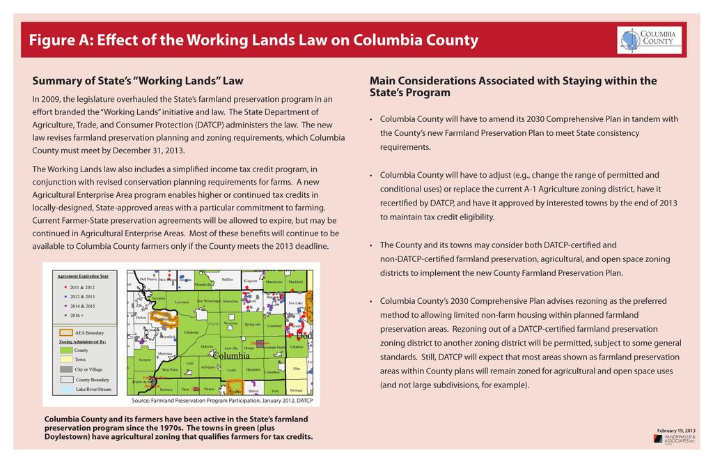
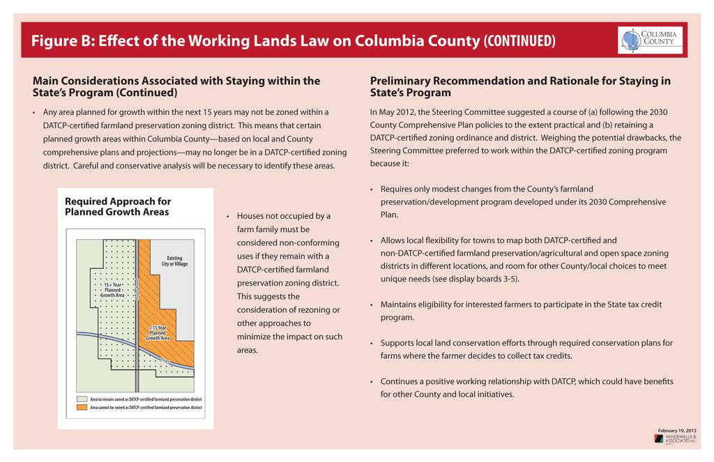
11 Chapter 1: Framework and Overview Map 1: Jurisdictional Boundaries Draft #43: February 19, 2013November 12,
12 Chapter 1: Framework and Overview Draft #43: February 19, 2013November 12,
13 Chapter 1: Framework and Overview Map 2: Columbia County s Regional Influences Draft #43: February 19, 2013November 12,
14 Chapter 1: Framework and Overview Draft #43: February 19, 2013November 12,

15 Chapter 1: Framework and Overview Vision, Goal,, and Objectives Columbia County has made a commitment to preserve farmland and farming for future generations. The following vision statement, included within the Columbia County Comprehensive Plan 2030, provides a useful starting point for how the County views farmland preservation relative to other priorities. Further, the goal of preservation of the most productive agricultural areas in the County from the Columbia County Comprehensive Plan 2030 remains appropriate for this Farmland Preservation Plan. Columbia County s Vision Columbia County will continue to have a high quality of life and be an exceptional place to live, work, and engage in recreation. The County will continue to find balance among economic development, the preservation of agriculture, the protection of natural and cultural resources, and the recognition of private property rights. Well-planned development, supported by appropriate infrastructure and an efficient transportation system, will ensure a vibrant and sustainable economy and provide a strong quality of life for its citizens. Columbia County s agricultural resources are regarded as irreplaceable resources to be protected for future generations. Additionally, agricultural preservation objectives within the Columbia County Comprehensive Plan 2030 contributed to the following Farmland Preservation Plan objectives intend to advance this goal. 1. Preserve and protect the best agricultural soils by developing and implementing appropriate land use regulations. 2. Focus new development in areas, on sites, and in forms (e.g., clusters) that will not adversely impact productive farmland in the County. 3. Review residential and other development proposals for potential impacts and encroachments on the land needed for agriculture. 4. Encourage efforts to slow and reduce the fragmentation of agricultural lands. 5. Limit non-farm development on prime agricultural soils. 6. Maintain the integrity of the agricultural (farmland preservation) zoning district by restricting the uses in this district to those related to agriculture. 7. Implement a density-based standard for limited housing on lands planned for farmland preservation, including modest incentives for clustering of smaller lots as opposed to large residential parcels. 8. Encourage the owners of farmland to follow best practices to minimize impacts to the County s natural resources. 9. Support animal agriculture in the County, with consideration managing large herds within livestock siting rules from the State of Wisconsin. Draft #43: February 19, 2013November 12,
16 Chapter 1: Framework and Overview 10. Support the continuation and enhancement of State income tax credits to those farmers who wish to take advantage of that program. 11. Support town and farmer initiatives to preserve farmland via approaches that go beyond farmland preservation zoning. 12. Encourage the continued growth of the agricultural economy in Columbia County. Overview of Columbia County s Farmland Preservation Program The County s farmland preservation program is aimed at providing and enabling: The right economic conditions for farming and the growth of the agricultural industry, Appropriate incentives and flexibility to help farmers continue farming, and A land use planning and zoning approach to retain productive agricultural lands and attain a compatible development pattern. Economics Agriculture is and should continue to be an economic driver in Columbia County, contributing to both individual and community success. As a result, agricultural-related economic development is a component of the County s farmland preservation program. The importance of commercial (production) agriculture is documented earlier in this chapter. The County will continue to support the health and growth of commercial (production) agriculture, in part through complementary land use policies and providing incentives for keeping large blocks of land in agricultural production. There is also increasing interest from consumers in locally produced, organic and specialty agricultural products, including dairy products, meat, vegetables, and fruit. County stakeholders should make the most of these additional opportunities. Local processing of local agricultural products also creates significant future opportunities. This includes food processing industry extending in scale from small and on-farm operations to major businesses within the industrial parks in the County. There are also multiple new use opportunities for agricultural products, including energy, plastics, pharmaceuticals, and fiber-based products. The County s land use, zoning, and economic development efforts support agricultural product processing in appropriate locations. Finally, agricultural support businesses, such as implement dealers, feed and seed operations, and agricultural product processors provide necessary services, materials, and access to markets for the County s farmers. As such, the maintenance and expansion of these businesses are critical to the economics of farmland preservation in Columbia County. The County will continue to support agricultural support businesses in appropriate locations that are close to the farms they serve. Incentives Farmers control most of the land in Columbia County, and have alternative means of profiting from that land via housing and other non-agricultural development. An overall farmland preservation approach that includes financial incentives as one component can serve to counteract this pressure to convert farmland. The Wisconsin Working Lands Initiative continues the opportunity for farmers within areas planned and zoned for agricultural preservation to claim farmland preservation income tax credits. There is $27 million available annually to provide farmland preservation tax credits to eligible State landowners. Claimants must be in an area planned and zoned for agricultural preservation, have $6,000 in gross farm revenue (including rental revenue) in the past year or $18,000 over the past three years, and have been issued a Certificate of Compliance by the Columbia County Land and Water Conservation Department that certifies they are in compliance with the NR 151 Agricultural Performance Standards and Prohibitions incorporated into ATCP 50. (Landowners who claimed the tax credit in good standing for tax year 2009, may continue to claim tax credits under the authority of a signed scheduled of compliance related to the conservation requirements thru Draft #43: February 19, 2013November 12,
17 Chapter 1: Framework and Overview 2015.)have an approved conservation plan and nutrient management plan. Eligible farmers may collect $7.50 per acre if in an area planned and zoned for farmland preservation. The County continues to support the tax credit as a key incentive tool for farmland preservation. Land owners who wish to claim farmland preservation tax credits must comply with State soil and water conservation standards by preparing and implementing a nutrient management plan and conservation plan for their farms, and updating these plans on a regular basis thereafter. The County will provide technical support where possible, support the development of the local marketplace to prepare and update affordable and effective conservation and nutrient management plans, and answer questions and assure compliance through its Land and Water Conservation Department. In addition, the U.S Department of Agriculture s Environmental Quality Incentives Program (EQIP) offers financial assistance to agricultural producers to implement on-farm conservation practices. These efforts will help buffer the expense of these plans. In addition, as the need for these plans becomes more common, the cost should come down. The Columbia County Land and Water Conservation Department is responsible for certifying compliance and providing technical support to meet compliance as needed. Compliance with these standards often overlaps with other programming carried out by the Columbia County Land and Water Conservation Department. Additional financial resources from both the State (DNR, DATCP) and federal government (NRCS, EPA) may be used to help offset the technical cost of implementing the necessary Best Management Practices to help landowners reach and maintain compliance. Compliance must include all of the NR 151 Agricultural Runoff Performance Standards and Prohibitions incorporated into ATCP 50. Starting with tax year 2010, farmers may not claim the farmland preservation tax credit under the new program unless they certify on their tax returns that they are in compliance with these State conservation standards. In order for a claimant to certify compliance on a tax return, the claimant s farm must: Have been issued a signed certificate of compliance that documents compliance with the NR 151 state agricultural performance standards and prohibitions incorporated into ATCP 50, OR Have a signed schedule of compliance designed to meet state conservation standards by a specific deadline set by the county (which currently cannot extend beyond December 31, 2015). An Agricultural Enterprise Area (AEA) another creation of the Working Lands Initiative is a defined as a contiguous land area devoted primarily to agricultural use and locally targeted for agricultural preservation and agricultural development. AEAs preserve areas considered most valuable for current and future agricultural use, promote the development of agricultural businesses, and ensure eligibility of farm owners for enhanced tax credits through farmland preservation agreements. The State is authorized to designate up to one million acres total statewide. While nearly all of the surrounding counties have an AEA (see Map 2), there are none within Columbia County to date. The County will support the creation of one or more AEAs where consistent with this Plan, and where there is sufficient town government and landowner initiative to create the AEA. Where a landowner has entered into a new farmland preservation agreement with the State, Tthe tax credit rate is $10 per acre where land is both in an AEA and zoned for farmland preservation, and $5 per acre if only in an AEA. Once current farmland preservation agreements with individual farmers expire, only a location in a farmland preservation zoning district or in an AEA (with a new agreement if in AEA) will allow interested farmers to collect tax credits. Land Use Planning and Zoning This Farmland Preservation Plan focuses particularly on the land use planning and zoning aspects of farmland preservation. These area the aspects within which the County has the most direct legal abilities, responsibilities, and experience. A focus on land use planning and zoning reflects the fact that the County has limited resources to devote to other types of farmland preservation initiatives. Draft #43: February 19, 2013November 12,

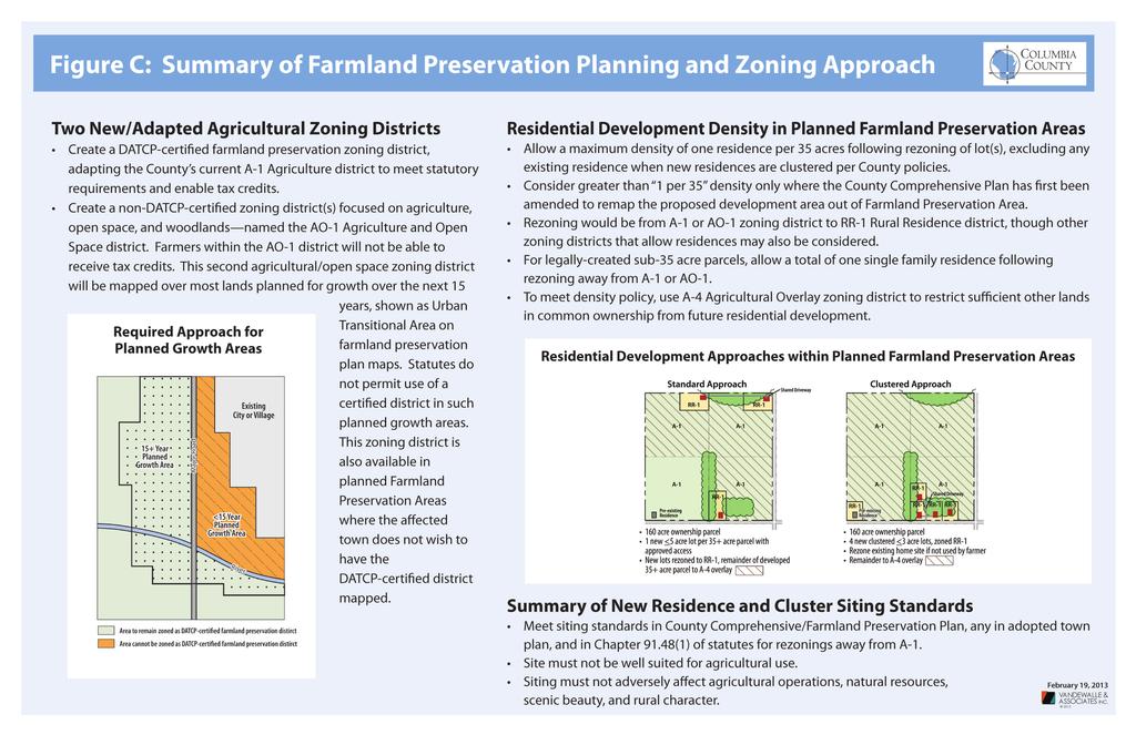
18 Chapter 1: Framework and Overview The Columbia County Comprehensive Plan 2030 established the most recent and applicable framework for farmland preservation planning and zoning in the County. That framework was established after years of analysis and discussion in the mid-2000s. The 2009 adoption of the State s Working Lands Initiative has required some adjustments to the County s program, which were consider as part of the planning process and are documented in Figures A and B. The resulting County farmland preservation land use planning and zoning approach focuses on continued farmland preservation and other agricultural/open space zoning of most lands within unincorporated parts of the County, as summarized in Figure C. Within the planned Farmland Preservation Area, depicted in Map 3 and in the 21 component Town farmland preservation maps in Chapter 2, agricultural-related development will be supported and non-farm development will be limited. Residential development in the planned Farmland Preservation Area will be limited to a density (not a minimum lot size) of one home per 35 acres of land. This density-based approach to housing will better serve to preserve farming than the large-lot zoning approach of the past. The County s program further provides incentives for clustering allowable home sites, as suggested in Figure C. Outside of planned Farmland Preservation Areas, the County supports denser housing development and other types of development to support the County s quality of life and economy., This includesing some development that may also support the agricultural economy, such as. These may include industrial parks that include sites for businesses that process locally-produced agricultural products. Chapter 2 of this Farmland Preservation Plan, combined with the Columbia County Comprehensive Plan 2030 and the County zoning ordinance, describes the County s land use/zoning approach to farmland preservation in detail. Draft #43: February 19, 2013November 12,
19
20 Chapter 1: Framework and Overview Draft #43: February 19, 2013November 12,
21
22 Chapter 1: Framework and Overview Draft #43: February 19, 2013November 12,
23
24 Chapter 1: Framework and Overview Draft #43: February 19, 2013November 12,
25 Chapter 1: Framework and Overview Map 3: Farmland Preservation Map for Columbia County Draft #43: February 19, 2013November 12,
26 Chapter 1: Framework and Overview Draft #43: February 19, 2013November 12,

27 CHAPTER 2: FARMLAND PRESERVATION PLANNING & ZONING APPROACH Overview This chapter describes the County s approach to farmland preservation-supportive land use planning and zoning. The policies and maps in this chapter will guide County decision-making on future development, preservation, zoning changes, and land divisions, in combination with land use policies and maps in the Columbia County Comprehensive Plan The chapter is generally organized by the general categories of future use presented on Maps 3 through 24, particularly focusing on the Farmland Preservation Area presented on those maps. This chapter and its included maps do not identify, in detail, the specific types of future land uses that are allowed or encouraged in different parts of the County. For example, they do not show areas appropriate for residential versus commercial development, or provide any detail within cities and villages. Instead, within the unincorporated areas, this level of planning detail is included in the Columbia County Comprehensive Plan 2030 and within town comprehensive plans. Within incorporated areas and their proposed growth areas, this detail is available within city and village comprehensive plans. Farmland Preservation Plan Map and Categories Map 3, the Columbia County Farmland Preservation Map, presents recommendations for future preservation and development in Columbia County. The future can generally be understood as a 10+ year planning horizon, in light of the fact that both the State s comprehensive planning and Working Lands laws will require that this map be revisited at least once every 10 years. Based on interactions with local governments in Columbia County, the Farmland Preservation Map may be amended more frequently. For purposes of managing growth and preserving land resources, all land in Columbia County has been delineated into one of the following four base future preservation or development categories: Farmland Preservation Area City or Village Non-Farmland Preservation Area Developed/Infill Area Urban Transition Area The assignment of land into one of the above categories is based on mapping criteria presented later in this chapter under each category description. Each of these four future preservation or development categories is described in the sections that follow, along with mapping criteria and policies related to each category. The policies are particularly focused on approaches for preserving and enhancing agriculture. Draft #43: February 19, 2013November 12,
28 Farmland Preservation Area Purpose and Description Asserting the right of Columbia County landowners to continue farming with minimal disturbance and conflict from current and future land uses is critical to the future survival of farms. The purpose of the Farmland Preservation Area is to: Preserve productive agricultural lands in the long-term. Preserve the rural character and aesthetic quality of Columbia County. Provide equity and fairness to owners of land with comparable resource and location characteristics. Minimize nonagricultural development on prime farmland. Maintain the integrity of agricultural zoning districts allowing for accepted agricultural practices. Protect existing farm operations from encroachment by incompatible uses. Allow a maximum residential development density of one residence per 35 acres of land, as described in greater detail in the policies that follow. Maintain farmer eligibility for farmland preservation incentive programs, such as tax credits. The Farmland Preservation Area is mapped primarily to accommodate agricultural uses or agricultural-related uses (e.g., implement dealerships), and to focus on areas actively used for farming, with productive agricultural soils, with topographic conditions suitable for farming, and with long-term (15+ year) suitability for farming. This category also includes and is intended to accommodate forest management, farmsteads, limited non-farm housing in accordance with the policies described below, associated home occupations and family businesses, and other uses identified as permitted and conditional uses in implementing zoning districts. Mapping Criteria for Farmland Preservation Area A variety of factors were used to map the Farmland Preservation Area on Maps 3 through 24, focused particularly on requirements and guidance supplied under the State s Working Lands law. The Farmland Preservation Area identified on the maps largely coincides with the area designated for future Agricultural and Other Open Space use on the Future Land Use map (Map 8-3) within the Columbia County Comprehensive Plan 2030 and within individual town comprehensive plans. The Columbia County Comprehensive Plan 2030 and most individual town comprehensive plans were prepared during the same mid-2000s planning process. As a result, the Future Land Use map in the Columbia County Comprehensive Plan 2030 was prepared in closely coordinatesion with similar maps in local comprehensive planstown planning efforts. The Future Land Use map in the Columbia County Comprehensive Plan 2030 also reflects future land use maps from city and village comprehensive plans without change, where the respective city or village identified areas beyond its municipal limits for future development. This is in response to the County s interpretation of the requirements of Section 59.69(3)(b) of Wisconsin Statutes. The County incorporated those city and village future land use map recommendations on the Columbia County Comprehensive Plan 2030 Future Land Use map knowing that some city/village planned development areas would not be ripe for development within the ensuing 20+ years. However, Because only those lands planned for growth in the next 15 years cannot bewere identified as Farmland Preservation Areas; as such, there are differences in some geographic areas between the Farmland Preservation Area shown on Maps 3 through 24 and the future Agricultural and Other Open Space Use area on the Future Land Use map in the Columbia County Comprehensive Plan This is not an inconsistency, but rather an acknowledgement of different planning timeframes and land demand forecasts. Other factors that contributed to where the Farmland Preservation Area is shown on Maps 3 through 24 include the following: Draft #43: February 19, 2013November 12,
29 Areas with concentrations of prime farmland, lands currently being farmed, agricultural infrastructure, and uses that are compatible with agriculture such as mineral extraction sites. Lands in which current residential development density generally does not exceed a density of one home per 35 acres; or with scattered, small-scale, pre-existing commercial uses. The purpose of this factor is to allow, within the Farmland Preservation Area, a limited amount of pre-existing zoning and use conditions that do not technically meet Farmland Preservation Area policies, while at the same time assuring that a vast majority of lands that are planned for farmland preservation are also zoned for farmland preservation. Lands outside of current city and village limits, except for certain lands within the Village of Doylestown that are planned and zoned for farmland preservation. Lands outside of the planned Urban Transition Area and Developed/Infill Area, as described in the associated sections below. General Policies, Programs, and Actions for Farmland Preservation Area 1. Preferred Zoning District: Utilize the A-1 Agriculture zoning district as the preferred primary zoning district to implement Farmland Preservation Area policies. Additional zoning districts consistent with the Farmland Preservation Area category include the AO-1 Agriculture and Open Space, A-2 General Agriculture, A-3 Agriculture Business, A-4 Agricultural Overlay, RC-1 Recreation (for open space uses), and RR-1 Rural Residence zoning districts. Other zoning districts may be utilized on an occasional basis, particularly based on pre-existing land use and zoning patterns. 2. Other Primary Zoning District Option: Consider use of the new AO-1 Agriculture and Open Space district as a primary zoning district to implement Farmland Preservation Area policies within interested towns, under the following circumstances: a. A town under general county zoning has requested use and mapping of the AO-1 zoning district as an alternative to the A-1 district in all or parts of the town. b. The town has provided justification for use of the AO-1 district instead of the A-1 district. c. The AO-1 district will be mapped over one or more large blocks of the interested town, not less than one-quarter section each in area. d. The requesting town has made landowners in the proposed AO-1 zoned area aware that they will no longer be eligible for farmland preservation tax credits. e. As of the date of adoption of this Farmland Preservation Plan, the AO-1 District was not used by any Town as an alternative zoning tool to implement Farmland Preservation Area policies, but instead was used as a transitional zoning district as described later in this chapter. 3. Secondary Zoning Districts: Additional zoning districts consistent with the Farmland Preservation Area category include the AO-1 Agriculture and Open Space, A-2 General Agriculture, A-3 Agriculture Business, A-4 Agricultural Overlay, and RC-1 Recreation (for open space uses) districts. Other zoning districts may be utilized on an occasional basis, particularly based on pre-existing land use and zoning patterns and, in the case of the RR-1 Rural Residence District, to implement the Rezoning and Density Policies for Residential Development in Farmland Preservation Area below. Additional zoning districts consistent with the Farmland Preservation Area category include the AO- 1 Agriculture and Open Space, A-2 General Agriculture, A-3 Agriculture Business, A-4 Agricultural Overlay, RC-1 Recreation (for open space uses), and RR-1 Rural Residence zoning districts. Other zoning districts may be utilized on an occasional basis, particularly based on pre-existing land use and zoning patterns. 4. Preexisting Residences to Remain: Allow legally established residences to remain within the A-1 zoning district when historically zoned in that manner, except where new land divisions are required outside of farm consolidation situations. Support State administrative rules and/or statutory changes to Draft #43: February 19, 2013November 12,
30 enable all preexisting residences to be allowed as legal conforming uses in the A-1 district. In the meantime: Define preexisting farm residence with the maximum flexibility allowed in statutes to minimize the number of thesepreexisting residences in the A-1 district that will become non-conforming uses under current State law. 3. Adjust non-conforming use standards in the County zoning ordinance to allow reasonable modifications, expansions, and replacement of non-farm residences without rezoning away from the A-1 district. 4. Anticipate proposed administrative rules (ATCP 49), by indicating in the County zoning ordinance that all preexisting residences in the A-1 district will become legal conforming uses if and when such rules are adopted in a manner that allows for this type of treatment. For the rest of the preexisting residences that remain in the A-1 district, adjust non-conforming use standards in the County zoning ordinance to allow reasonable modifications, expansions, and replacement of such residences without rezoning, where new land divisions are not required. 5. Residential Lots Resulting from Farm Consolidation: When the owner of a preexisting residence legally established before December 21, 1977 desires to divide the land occupied by such residence and accessory buildings from the farm, in conjunction with a farm consolidation, require the resulting residential lot to be as small as practical, considering the desire to keep accessory buildings with the residence and the future probability that farm animals will be kept on the lot. All future farm consolidation lots should be rezoned to the RR-1 zoning district. 6. Agricultural-Related Businesses: Encourage agricultural-related businesses that support farmers, including farm-scale businesses the A-1 and AO-1 zoning districts (meeting statutory requirements as applicable), and larger-scale operations in the A-3 Agriculture Business district. The A-3 district allows a wide range of agricultural-related businesses and other rural businesses that are compatible in a predominately agricultural area. Utilize criteria in Section of Wisconsin Statutes and the County s zoning ordinance in evaluating proposals for rezoning land from the A-1 district to the A-3 district. 7. General Rezoning Criteria: Whenever land is proposed for rezoning from the A-1 district to a non- DATCP-certified zoning district, require that the following criteria are met: a. The land is better suited for a use not allowed in the A-1 zoning district. b. The rezoning is consistent with the applicable town and County comprehensive plans. c. The rezoning is substantially consistent with this County certified farmland preservation plan. d. The rezoning will not substantially impair or limit current or future agricultural use of surrounding parcels of land that are zoned for or legally restricted to agricultural use. 8. Conversion of Prime Farmland: Minimize the conversion of prime farmland, as shown on Map 5-6 of the Columbia County Comprehensive Plan 2030 ( generally Class I-III soils), for residences and other nonfarm development. The County Planning and Zoning Committee will consider creation of new residential lots on prime farmland only if the Committee determines that no available non-prime farmland exists on the parcel of record or that placement of lots on prime farmland provides better protection of land, environmental, and habitat resources than a non-prime location. In addition, per Section (2) of Wisconsin Statutes, new development may not convert prime farmland from agricultural use or convert land previously used as cropland, other than a woodlot, from agricultural use if on the farm there is a reasonable alternative location or size for a nonfarm residential parcel or nonfarm residence; or significantly impair or limit the current or future agricultural use of other protected farmland. 9. Limitation on Subdivision Plats: The division of four or more lots from lands in Contiguous Common Ownership requires a subdivision plat. Subdivision plats to accommodate residential Draft #43: February 19, 2013November 12,
31 development are not permitted within the Farmland Preservation Area. Land owners desiring to develop a subdivision plat must first achieve County Board approval of an amendment to this Plan redesignating the affected lands out of the Farmland Preservation Area. 10. Support for Complementary Town Policies and Initiatives: Where associated policies within the adopted town comprehensive plan are stricter than County policies for lands within a designated Farmland Preservation Area, support the town in its actions on rezoning requests, so that the stricter policy based on the town s comprehensive plan may be applied. In addition, support town development of creative farmland preservation approaches, such as purchase of conservation easement (PACE) and transfer of development rights (TDR), where consistent with the policies of this Farmland Preservation Plan. 11. Potential Agricultural Enterprise Areas (AEAs): Support landowner/town applications to DATCP to establish new Agricultural Enterprise Areas that meet the following criteria: a. The AEA is located within portions of the Farmland Preservation Area particularly suited for longterm agricultural enterprise development. b. The AEA is consistent with DATCP criteria for such designation. c. The AEA is clearly consistent with this Plan. d. There is sufficient interest among area farmers and town governments. 12. Land Conservation: As budget resources allow, work through the Land Conservation Department to assist farmers in the Farmland Preservation Area meet land conservation and nutrient management requirements. Also, enact zoning standards to enable local review of large-scale livestock operations, in conformance with Wisconsin statutes and administrative rules. 13. Lands Also Mapped as Environmental Corridors: Environmental corridors include environmentally sensitive and developmentally-challenged lands; corridors are susceptible to negative impacts from intense development including damage to natural resources and private property. The Columbia County Comprehensive Plan 2030 describes and maps environmental corridors (see particularly Maps 5-7 and 8-3 of that plan), and Appendix B also includes a description. In addition the above policies within this section of the Farmland Preservation Plan, the County will use associated policies within the Columbia County Comprehensive Plan 2030 where lands overlap with a mapped environmental corridor. Rezoning and Density Policies for Residential Development in Farmland Preservation Area 1. New Residences Require Rezoning: Allow no new residences in the A-1 and AO-1 zoning districts, except for replacement of existing residences permitted under the Working Lands law and the County zoning ordinance. Instead, require the rezoning of A-1 and AO-1 zoned lands to another district when new homes are proposed. 2. RR-1 as Preferred Rezoning District: Utilize the County s RR-1 Rural Residence zoning district as the preferred zoning district for rezoning for new housing in the Farmland Preservation Area, in accordance with the maximum residential density policy in this section. Consider a different zoning district, such as the R-1 Single Family Residence district, where the applicant can demonstrate to the satisfaction of the associated town and the County Planning and Zoning Committee that such different zoning district meets the Farmland Preservation Area purpose and policies and responds to a unique circumstance not generally applicable to other properties in the area. 3. Right-to-Farm Notice on Residential Plats and CSMs: Protect the rights of farmers by requiring that the following language be included on all new certified survey maps (CSMs) that enable new residential development in the Farmland Preservation Area, to notify future residents of the potential effects of nearby farming activities on their property: Through Section of Wisconsin Statutes, the Wisconsin Legislature has adopted a right to farm law. This statute limits the remedies of owners of later Draft #43: February 19, 2013November 12,
32 established residential property to seek changes to pre-existing agricultural practices in the vicinity of residential property. Active agricultural operations are now taking place and may continue on lands in the vicinity of this plat/csm. These active agricultural operations may produce noises, odors, dust, machinery traffic, or other conditions during daytime and evening hours. 4. Definitions: As used in this Farmland Preservation Plan, the terms listed below shall have the definitions so indicated: a. Contiguous: Lots or parcels shall be considered contiguous if they share a common boundary. Parcels in common ownership which are directly across from a public street, rail right-of-way, easement, or navigable river, stream, or creek, along with parcels that meet only at a corner, shall be considered contiguous. b. Common Ownership: Any combination of contiguous tax parcels singly owned by one uniquely named entity as identified by deed. Such an entity includes, but is not necessarily limited to, an individual person, a married couple or family trust, or a partnership or corporation. c. Contiguous Common Ownership: For determining the right to develop lands in the Farmland Preservation Area, means all contiguous lands zoned A-1, AO-1, and/or A-2 and under common ownership at the time of the development proposal. Contiguous Common Ownership may include one or more tax parcels, 40 s, or lots with lots defined as a parcel designated in a recorded plat or certified survey map, or described in a conveyance recorded in the office of the Register of Deeds, except that each residential lot legally created through a farm consolidation process and documented with a recorded certified survey map (CSM) shall not be considered part of any Contiguous Common Ownership. Determinations of Contiguous Common Ownership may require research by the Planning and Zoning Department and/or verification as to acreage and ownership from the land owner/applicant. d. Cluster: A contiguous grouping of three or four allowable lots for new residential development. 5. Residential Development Density 35+ acres in Contiguous Common Ownership: Subject to County and town rezoning approval and compliance with all associated County Comprehensive/Farmland Preservation Plan and ordinance requirements, the owner of each set of lands in Contiguous Common Ownership of 35 acres or greater within the Farmland Preservation Area may develop single family residences, subject to the following criteria: a. The owner is allowed one single family residence per 35 acres of Contiguous Common Ownership, including any existing house(s) within the Contiguous Common Ownership, except where a cluster is approved per policy 5(f) below. Figure D illustrates this standard approach for executing residential density. b. Before or at the time of rezoning, the owner may acquire additional land from adjacent landowners to assemble a larger Contiguous Common Ownership, provided that such land is also in the Farmland Preservation Area and is not restricted against additional residential development by policy, zoning rule, deed restriction, conservation easement, or otherwise. c. Each new residence must be on a new lot of one acre or greater created by CSM. Each new lot for a new residence may not exceed five acres in area, except that larger lots may be permitted where other policies in this Plan are met and where an additional ten acres in Contiguous Common Ownership are restricted via A-4 zoning for every one acre greater than the five acre normal maximum. If the affected town has a base density policy that is stricter than policy 5(a) above, the requirement for additional restricted land associated with a lot that is larger than five areas may be waived or modified. d. Each newly created residential lot must abut a public road, or have a suitable access easement approved by the affected town or the Planning and Zoning Committee. Draft #43: February 19, 2013November 12,

33 e. The balance of the acreage used to enable the approval of a single family residential lot within the Contiguous Common Ownership shall be restricted to agricultural or open space uses via A-4 Agricultural Overlay zoning. Land in the A-4 district cannot be used together with other land not in the A-4 district to achieve the acreage normally necessary to build another single family residence. The location of the restricted A-4 lands will be determined through the review process and under associated zoning requirements. f. Landowners with the ability to build three or more single family residences under this residential density policy may develop one or more clusters of lots for single family residential purposes. Clustered lots need not have frontage on a public road provided that the affected town and County both approve a shared access easement and agreement. Where Contiguous Common Ownership allows, clusters may be located adjacent to other clusters. Where no lot in the cluster exceeds three acres and all lots are restricted against farm animals, any existing residence(s) on the Contiguous Common Ownership at time of development does not count against the number of single family residences permitted under the residential density policy (see clustered approach in Figure D). Figure D: Residential Development Approaches within Planned Farmland Preservation Areas 6. Residential Development Density <35 acres in Contiguous Common Ownership: Subject to County and town rezoning approval and compliance with all associated County Comprehensive/Farmland Preservation Plan and ordinance requirements, the owner of each set of lands in Contiguous Common Ownership less than 35 acres within the Farmland Preservation Area may have a total of one single family residence, subject to the following criteria: a. The Contiguous Common Ownership, and all parcels within it, shall be a valid parcel(s) created legally prior to November 1, b. The Contiguous Common Ownership and each newly divided lot for a residence must abut a public road. Draft #43: February 19, 2013November 12,

34 c. The landowner has the potential to develop a maximum of one single family residence for all parcels that make up the Contiguous Common Ownership combined, including any existing residence. d. The balance of the Contiguous Common Ownership shall be restricted to agricultural or open space uses via A-4 Agricultural Overlay zoning, and against any further land division. Land in the A-4 district cannot be used together with other land not in the A-4 district to achieve the acreage normally necessary to build another single family residence. The location of the restricted A-4 lands will be determined through the review process and under associated zoning requirements. e. Consider different zoning options for the future of such lands, including the A-2 General Agriculture district and combinations of the RR-1 Rural Residential and A-1 zoning districts (see Figure E). Figure E: Alternative Rezoning Approaches for Pre-1984 Substandard (<35 acre) A-1 Lots with Non-Farm Residence Siting Policies for Residential Development in Farmland Preservation Area Except where a town applies comparable siting policies in its Comprehensive Plan or in an ordinance, the County will apply the following policies for siting new residential development in the Farmland Preservation Area. 1. EAffect on and of Agricultural Operations: The proposed residential lot(s) will not adversely affect agricultural operations in surrounding areas or be situated such that future inhabitants of a residence on that lot(s) might be adversely affected by agricultural operations in surrounding areas. In considering whether this policy is achieved, the County Planning and Zoning Committee shall evaluate the following factors: a. The proposed lot(s) are located in a manner as to minimize the amount of agricultural land converted to nonagricultural use, including compliance with statutory requirements related to prime farmland (will be applied by County per statutes even if town policies also used). b. The proposed lot(s) are not located within 100 feet of any operating farm animal facility. c. A new road or driveway needed to serve the site does not divide existing farm fields. 2. Unsuitability for Agricultural Use: The proposed residential site(s) is not well suited for agricultural use by virtue of wooded areas, topography, shape of parcel, soil characteristics, or similar factors. In considering whether this policy is achieved, the County Planning and Zoning Committee shall evaluate the following factors: a. Whether the area of the lot(s) is enrolled in a land preservation program (e.g., CRP, CREP, farmland preservation tax credit). b. The site(s) is not of a size or shape to be efficiently worked for farming. Draft #43: February 19, 2013November 12,
. d. Isolated small pockets of uncultivable land in an area otherwise farmed will not result. e. Slopes in excess of 12 percent but not more than 20 percent may be developed only in accordance with an approved erosion control plan.")
35 c. Prime farmland is preserved per statutory requirements and this Plan, and not more than 70 percent of the soils on the proposed site are rated as National Prime Farmland (will be applied by County per statutes even if town policies also used). d. Isolated small pockets of uncultivable land in an area otherwise farmed will not result. e. Slopes in excess of 12 percent but not more than 20 percent may be developed only in accordance with an approved erosion control plan. 3. Suitability for Residential Use: The proposed residential lot(s) is particularly well suited for residential use, as indicated by rolling topography, wooded areas, soil types, vistas, proximity to lakes or streams, or similar factors, proximity to school bus routes, traffic access and egress, established transportation routes and adequacy of area schools to accommodate increased enrollment that might result from such development. In considering whether this policy is achieved, the County Planning and Zoning Committee shall evaluate the following additional factors: a. The site has soils that are able to support a private on-site waste treatment (septic) system, other than a holding tank. b. Soils on the site afford sound structural support for buildings. c. Proposed development has adequate access to existing town roads or, the developer shall provide such a road built to town road standards or such other suitable access approved by the town and County, at the developer's expense. d. Proposed access points shall meet minimum spacing requirements as established by County and town ordinances, as applicable. e. Proposed driveways will not exceed 1,000 feet in length, except as otherwise may be allowed by County zoning ordinance. 4. Relationship to Natural Resources and Character: The residential lot(s) relates positively to the natural resources, beauty, and rural character of the area. In considering whether this policy is achieved, the Planning and Zoning Committee shall evaluate the following specific factors: a. The lot(s) is not on land prone to flooding. b. The lot(s) is not detrimental to natural resource components within mapped environmental corridors. c. The lot(s) is not on slopes exceeding 20 percent. d. The lot(s) is not on land considered to be of archaeological, cultural, historical, or religious significance. e. The lot(s) minimizes the visibility of structures by utilizing landforms, existing vegetation, and/or new plantings to provide screening. Draft #43: February 19, 2013November 12,
Columbia County. Farmland Preservation Plan
 Columbia County Farmland Preservation Plan Acknowledgements ACKNOWLEDGEMENTS Columbia County Board of Supervisors Robert McClyman Mary Cupery Adam Field Kenneth Hutler Don DeYoung Bruce Rashke Tim Zander
Residential Construction in Farmland Preservation Zoning Districts
 Updated Draft: October 25, 2009 Residential Construction in Farmland Preservation Zoning Districts 2009 Wis. Act 28 repealed and recreated Wisconsin s Farmland Preservation program under ch. 91, Stats.
Working Lands Initiative
 Working Lands Initiative June 2010 Working Lands Initiative Overview Expands and modernizes the existing Farmland Preservation Program Establishes Agricultural Enterprise Areas Creates a Purchase of Agricultural
Comprehensive Plan 2030
 Introduction Land use, both existing and future, is the central element of a Comprehensive Plan. Previous chapters have discussed: Projected population growth. The quality housing available in the Township
TDR RULES AND PROCEDURES TRANSFER OF DEVELOPMENT RIGHTS (TDR) PROGRAM
 PROGRAM") TDR RULES AND PROCEDURES TRANSFER OF DEVELOPMENT RIGHTS (TDR) PROGRAM TOWN OF SPRINGFIELD, DANE COUNTY, WISCONSIN RECOMMENDED BY TOWN PLAN COMMISSION: 7/12/10 TDR RULES AND PROCEDURES, PLAN COMM. RECOMMENDED
TDR RULES AND PROCEDURES TRANSFER OF DEVELOPMENT RIGHTS (TDR) PROGRAM TOWN OF SPRINGFIELD, DANE COUNTY, WISCONSIN RECOMMENDED BY TOWN PLAN COMMISSION: 7/12/10 TDR RULES AND PROCEDURES, PLAN COMM. RECOMMENDED
Transitioning from the Farmland Preservation Program to the Working Lands Initiative
 Transitioning from the to the The table below describes differences between the Department of Agriculture, Trade and Consumer Protection s (DATCP) previous and the new. Contact: DATCPWorkingLands@wisconsin.gov
CHAPTER 4: STRATEGIES FOR PRESERVING FARMLAND
 CHAPTER 4: STRATEGIES FOR PRESERVING FARMLAND Increasing housing density in non-farmland preservation areas In 2013, Marathon County will begin the process of revising the Marathon County General Zoning
Farmland Preservation Plan
 WELCOME! Farmland Preservation Plan Douglas County, WI Kickoff Steering Committee Meeting Amnicon Town Hall Tuesday, February 9, 2016 1:30 pm to 3:30 pm Source: http://www.loc.gov/item/fsa2000044046/pp/
General Development Plan Background Report on Agricultural Land Preservation
 General Development Plan 2008 Background Report on Agricultural Land Preservation February 2008 I. Introduction Anne Arundel County has been an agricultural community for over 350 years, beginning with
Walworth County Farmland Preservation Plan Update, Chapter 1 Plan Summary (Cover Document)
") Background Walworth County Farmland Preservation Plan Update, 2012 Chapter 1 Plan Summary (Cover Document) For over 30-years, the Wisconsin Farmland Preservation Program has served to preserve Walworth
Background Walworth County Farmland Preservation Plan Update, 2012 Chapter 1 Plan Summary (Cover Document) For over 30-years, the Wisconsin Farmland Preservation Program has served to preserve Walworth
Land Use. Land Use Categories. Chart 5.1. Nepeuskun Existing Land Use Inventory. Overview
 Land Use State Comprehensive Planning Requirements for this Chapter A compilation of objectives, policies, goals, maps and programs to guide the future development and redevelopment of public and private
May 12, Randy Gilbertson Burnett County Land Conservation Department 7410 County Road K, #109 Siren, WI Dear Randy:
 May 12, 2016 Randy Gilbertson Burnett County Land Conservation Department 7410 County Road K, #109 Siren, WI 54872 Dear Randy: Re: Certification of the Burnett County Farmland Preservation Plan Attached
Farmland Preservation Agreements. -Frequently Asked Questions-
 Farmland Preservation Agreements -Frequently Asked Questions- The timing of when a farmland preservation agreement was entered into is important when determining applicable laws, requirements and tax credits.
CHAPTER 352 COUNTY LAND PRESERVATION AND USE COMMISSIONS
 CHAPTER 352 COUNTY LAND PRESERVATION AND USE COMMISSIONS Referred to in 6B.3, 15E.111, 159.6, 173.3, 455B.275 Chapter does not invalidate ordinances existing on July 1, 1982, or require adoption of zoning
Town of. River Falls. Land Use Element Vierbicher Associates, Inc
 Town of River Falls 2005 Vierbicher Associates, Inc Contents Contents s. 66.1001(2)(h) Wis. Stats................................................. ii Introduction................................................................
SUBURBAN AND URBAN RESIDENTIAL LAND USE
 SUBURBAN AND URBAN RESIDENTIAL LAND USE GOAL 1 DISCOURAGE URBAN AND SUBURBAN DEVELOPMENT OUTSIDE INCORPORATED AREAS IN WHITMAN COUNTY, EXCEPT WITHIN DESIGNATED UNINCORPORATED COMMUNITIES, AND THOSE AREAS
4. If any perennial surface water passes through or along the property lines of the acreage, a minimum of 200 feet or frontage should be required.
 b. Provide adequate acreage for appropriate productive use of rural residential land, such as small numbers of livestock, large gardens, etc. 3. Minimum of 200 feet of frontage on an improved county or
ADMINISTRATIVE REPORT A HISTORY OF PRESERVING FARMLAND IN MARATHON COUNTY April Marathon County. Land Conservation & Zoning Committee
 ADMINISTRATIVE REPORT A HISTORY OF PRESERVING FARMLAND IN MARATHON COUNTY 1978-2010 April 2011 Marathon County Land Conservation & Zoning Committee 3 Land Conservation & Zoning Committee Committee Members
Torch Lake Township Antrim County, Michigan
 Torch Lake Township Antrim County, Michigan Farmland and Open Space Development Rights Ordinance Ordinance No. 04-01 Effective September 3, 2004 AN ORDINANCE creating a farmland and open space protection
Planning & Zoning Department GENERAL APPLICATION 400 DeWitt Street - Portage, WI Phone: Fax:
 Planning & Zoning Department GENERAL APPLICATION 400 DeWitt Street - Portage, WI 53901 Phone: 608-742-9660 Fax: 608-742-9817 www.@co.columbia.wi.us The applicant hereby authorizes access to the property
GENERAL PURPOSES OF ZONES
 9-7-1 9-7-2 CHAPTER 7 GENERAL PURPOSES OF ZONES SECTION: 9-7-1: Residential Agricultural Zone (RA) 9-7-2: Agricultural Residential Zone (AR) 9-7-3: Agricultural Prime Zone (AP) 9-7-4: Multiple Use Zone
CHAPTER Committee Substitute for Committee Substitute for Senate Bill No. 2188
 CHAPTER 2004-372 Committee Substitute for Committee Substitute for Senate Bill No. 2188 An act relating to land development; amending s. 197.502, F.S.; providing for the issuance of an escheatment tax
4.2 LAND USE INTRODUCTION
 4.2 LAND USE INTRODUCTION This section of the EIR addresses potential impacts from the Fresno County General Plan Update on land use in two general areas: land use compatibility and plan consistency. Under
2012 Agricultural Enterprise Area Program Report
 2012 Agricultural Enterprise Area Program Report Wisconsin Department of Agriculture, Trade and Consumer Protection January 2013 Page 2 Program Background The Agricultural Enterprise Area (AEA) program
Land Use. Existing Land Use
 8 Land Use 8.1 Land Use Chapter Purpose and Contents This element includes a brief summary of existing land use conditions and trends followed by a series of goals, objectives, and recommendations to guide
Farmland and Open Space Preservation Purchase of Development Rights Program Frequently Asked Questions
 Farmland and Open Space Preservation Purchase of Development Rights Program Frequently Asked Questions Why should a community consider farmland preservation programs? Farmland preservation is important
Bylaw No , being "Official Community Plan Bylaw, 2016" Schedule "A" DRAFT
 Bylaw No. 2600-2016, being "Official Community Plan Bylaw, 2016" Schedule "A" Urban Structure + Growth Plan Urban Structure Land use and growth management are among the most powerful policy tools at the
DRAFT FOR PUBLIC HEARING (rev. March, 2016)
") Chapter 200. ZONING Article VI. Conservation/Cluster Subdivisions 200-45. Intent and Purpose These provisions are intended to: A. Guide the future growth and development of the community consistent with
Chapter 200. ZONING Article VI. Conservation/Cluster Subdivisions 200-45. Intent and Purpose These provisions are intended to: A. Guide the future growth and development of the community consistent with
Comprehensive Plan 2030
 Introduction The purpose of this chapter of the Comprehensive Plan is to accurately describe, in words and images, the goals and visions for the future of Clearfield, as determined by the people who live
CCC XXX Rural Neighborhood Conservation (NC)
") CCC 33.10.XXX Rural Neighborhood Conservation (NC) Purpose: Maintain low density rural residential areas and associated uses commonly found in rural areas consistent with the local character of the distinctive
CCC 33.10.XXX Rural Neighborhood Conservation (NC) Purpose: Maintain low density rural residential areas and associated uses commonly found in rural areas consistent with the local character of the distinctive
ALC Bylaw Reviews. A Guide for Local Governments
 2018 ALC Bylaw Reviews A Guide for Local Governments ALC Bylaw Reviews A Guide for Local Governments This version published on: August 14, 2018 Published by: Agricultural Land Commission #201-4940 Canada
STAFF REPORT. Permit Number: Porter. Kitsap County Board of Commissioners; Kitsap County Planning Commission
 STAFF REPORT Permit Number: 15 00461 Porter DATE: November 9, 2015 TO: FROM: Kitsap County Board of Commissioners; Kitsap County Planning Commission Katrina Knutson, AICP, Senior Planner, DCD and Jeff
Town zoning: A good option for your town?
 Photo credit: Landslides Aerial Photography Town zoning: A good option for your town? Lynn Markham Town of Auburn May 27, 2015 Main points 1. Zoning is one tool to implement community plans 2. What does
Town of Prairie du Sac Sauk County, WI. Land Division Ordinance 07-3
 Town of Prairie du Sac Sauk County, WI Land Division Ordinance 07-3 1.01 DISCLAIMER (1) Multiple Jurisdictions. All persons reviewing the provisions of this Ordinance should be aware that the Town of Prairie
Pierce County Comprehensive Plan Review
 2015-2016 Pierce County Comprehensive Plan Review March 16, 2016 Introduction Planning and Management Policies Some of the policies governing both the planning and management of growth and change within
8Land Use. The Land Use Plan consists of the following elements:
 8Land Use 1. Introduction The Land Use Plan consists of the following elements: 1. Introduction 2. Existing Conditions 3. Opportunities for Redevelopment 4. Land Use Projections 5. Future Land Use Policies
Claudia Stuart, Williamson Act Program Manager and Nick Hernandez, Planning Intern
 Land Conservation (Williamson) Act Advisory Committee STAFF REPORT September 15, 2014 Prepared by: Claudia Stuart, Williamson Act Program Manager and Nick Hernandez, Planning Intern Subject: Discussion:
UNOFFICIAL COPY OF HOUSE BILL 1272 A BILL ENTITLED
 UNOFFICIAL COPY OF HOUSE BILL 1272 M4 6lr0525 By: Delegates Smigiel, Kelley, Rosenberg, and Sossi Introduced and read first time: February 10, 2006 Assigned to: Environmental Matters 1 AN ACT concerning
Board of County Commissioners Agenda Request
 Board of County Commissioners Agenda Request Date of Meeting: March 26, 2019 Date Submitted: March 19, 2019 To: From: Agenda Location: Subject: Honorable Chairman and Members of the Board Margaret Emblidge,
Special Consideration Multiple jurisdictions is cumbersome
 Elements of Agricultural Land Preservation Hawaii Technique Comments Status in Hawaii Agriculture Zoning Most effective if it minimizes farmland conversion and prevents the intrusion of nonfarm uses into
Georgia Conservation Tax Credit Program Frequently Asked Questions
 Georgia Conservation Tax Credit Program Frequently Asked Questions What are the minimum requirements for eligibility under the Georgia Conservation Tax Credit Program (GCTCP)? Individual and corporate
HENDRY COUNTY PLANNING & ZONING DEPARTMENT POST OFFICE BOX S. MAIN STREET LABELLE, FLORIDA (863) FAX: (863)
 FAX: (863)") HENDRY COUNTY PLANNING & ZONING DEPARTMENT POST OFFICE BOX 2340 640 S. MAIN STREET LABELLE, FLORIDA 33975 (863) 675-5240 FAX: (863) 674-4194 STAFF REPORT CPA19-0001 Comprehensive Plan Map Amendment Local
HENDRY COUNTY PLANNING & ZONING DEPARTMENT POST OFFICE BOX 2340 640 S. MAIN STREET LABELLE, FLORIDA 33975 (863) 675-5240 FAX: (863) 674-4194 STAFF REPORT CPA19-0001 Comprehensive Plan Map Amendment Local
Barbara County Housing Element. Table 5.1 Proposed Draft Housing Element Goals, Policies and Programs
 Table 5.1 Proposed Draft Housing Element Goals, Policies and Programs Goal 1: Enhance the Diversity, Quantity, and Quality of the Housing Supply Policy 1.1: Promote new housing opportunities adjacent to
Interpretation of Conservation Purpose INTERNAL REVENUE GUIDANCE AS TO WHAT CONSTITUES A CONSERVATION PURPOSE
 Interpretation of Conservation Purpose INTERNAL REVENUE GUIDANCE AS TO WHAT CONSTITUES A CONSERVATION PURPOSE 170(h)(4)(A) of Title 26, Internal Revenue Code, Subtitle A of the United States Code gives
Residential Project Convenience Facilities
 Standards for Specific Land Uses 35.42.220 E. Findings. The review authority shall approve a Land Use Permit in compliance with Subsection 35.82.110.E (Findings required for approval) or a Conditional
Planning Justification Report
 Planning Justification Report, Township of Puslinch FARHI HOLDINGS CORPORATION Updated January 27, 2017 Zelinka Priamo Ltd. Page i TABLE OF CONTENTS Page No. 1.0 1.1 1.2 1.3 2.0 2.1 2.2 2.3 2.4 2.5 3.0
CHAPTER 156: FARMLAND PRESERVATION. General Provisions. Qualifications and Certification of Farmland. Voluntary Agricultural Districts
 CHAPTER 156: FARMLAND PRESERVATION Section General Provisions 156.001 Definitions 156.002 Title 156.003 Authority 156.004 Purpose 156.005 Jurisdiction 156.020 Requirements 156.021 Certification Qualifications
** If your lot does not meet the requirements above, please read Sec below
 Sec. 13-1-60 Zoning District Dimensional Requirements. For the Zoning Dept To Issue a Land Use Permit The Following Dimensions are Required. Minimum Side and Rear Yards s Lakes Classification Minimum Class
LAND USE. As such, the Township has estasblished the following statement of objectives for future development within its borders:
 LAND USE When creating a land use plan, a municipality should consider a process which firsts determines future population figures, whether growth or decline, and its targeted areas within the municipal
TASK 2 INITIAL REVIEW AND ANALYSIS U.S. 301/GALL BOULEVARD CORRIDOR FORM-BASED CODE
 TASK 2 INITIAL REVIEW AND ANALYSIS U.S. 301/GALL BOULEVARD CORRIDOR FORM-BASED CODE INTRODUCTION Using the framework established by the U.S. 301/Gall Boulevard Corridor Regulating Plan (Regulating Plan),
Existing Land Use. Typical densities for single-family detached residential development in Cumberland County: 1
 Existing Land Use A description of existing land use in Cumberland County is fundamental to understanding the character of the County and its development related issues. Economic factors, development trends,
ARTICLE 3: Zone Districts
 ARTICLE 3: Zone Districts... 3-1 17.3.1: General...3-1 17.3.1.1: Purpose and Intent... 3-1 17.3.2: Districts and Maps...3-1 17.3.2.1: Applicability... 3-1 17.3.2.2: Creation of Districts... 3-1 17.3.2.3:
COLDSTREAM (PC-1) INCLUSIONARY HOUSING PLAN
 INCLUSIONARY HOUSING PLAN") COLDSTREAM (PC-1) INCLUSIONARY HOUSING PLAN A. Overview The proposed affordable housing strategy for PC-1 has evolved over time to reflect changes in the marketplace, including the loss of redevelopment
COLDSTREAM (PC-1) INCLUSIONARY HOUSING PLAN A. Overview The proposed affordable housing strategy for PC-1 has evolved over time to reflect changes in the marketplace, including the loss of redevelopment
STAFF REPORT. Permit Number: Unlimited. Kitsap County Board of Commissioners; Kitsap County Planning Commission
 STAFF REPORT Permit Number: 15 00550 Unlimited DATE: March 2, 2016 TO: FROM: Kitsap County Board of Commissioners; Kitsap County Planning Commission Katrina Knutson, AICP, Senior Planner, DCD and Jeff
Burlington Unincorporated Community Plan
 Burlington Unincorporated Community Plan June 30, 2010 Meeting Page 1 of 24 Table of Contents (Page numbers to be inserted) I. Background a. Location and Community Description b. Planning of Unincorporated
Chapter 210 CONDITIONAL USES
 Chapter 210 CONDITIONAL USES 210.01 Purpose 210.02 Authorization 210.03 Process Type 210.04 Determination of Major or Minor Conditional Use Review 210.05 Approval Criteria 210.06 Conditions of Approval
Instructions: Script:
 Before the course, select four of the 11 tool topics to insert into the presentation, including at least one tool from each of the three goal categories. Replace each tool placeholder slide with the slides
ADAMS COUNTY, NEBRASKA
 ADAMS COUNTY, NEBRASKA LAND USE PLAN 2010 AMENDED AND ADOPTED BY ADAMS COUNTY, NEBRASKA AUGUST 3, 2010 RESOLUTION NO. 10-08-03.1 Prepared By 1 EXISTING LAND USE INTRODUCTION Evaluating the land uses that
1. Future Land Use FLU6.6.8 Land uses within the Rural Service Area portion of the Wekiva Study Area shall be limited to very low and low intensity
 1. Future Land Use FLU6.6.8 Land uses within the Rural Service Area portion of the Wekiva Study Area shall be limited to very low and low intensity uses to the greatest extent possible. Existing land uses
Chapter 52 FARMLAND AND OPEN SPACE PRESERVATION
 Chapter 52 FARMLAND AND OPEN SPACE PRESERVATION [HISTORY: Adopted by the Town Board of the Town of Troy 10-11-1999 by Ord. No. 99-2. Amendments noted where applicable.] GENERAL REFERENCES Building construction
COUNTY OF SAN MATEO PLANNING AND BUILDING DEPARTMENT
 COUNTY OF SAN MATEO PLANNING AND BUILDING DEPARTMENT DATE: April 16, 2015 TO: FROM: Zoning Hearing Officer Planning Staff SUBJECT: Consideration of a Coastal Development Permit and Planned Agricultural
MIDWAY CITY Municipal Code
 MIDWAY CITY Municipal Code TITLE 9 ANNEXATION CHAPTER 9.01 PURPOSE CHAPTER 9.02 GENERAL REQUIREMENTS CHAPTER 9.03 PROPERTY OWNER INITIATION OF ANNEXATION CHAPTER 9.04 PROCEDURES FOR CONSIDERATION OF PETITION
Presentation to the Real Estate Institute of New Zealand 28 October 2016
 Presentation to the Real Estate Institute of New Zealand 28 October 2016 Disclaimer This presentation provides a high level overview of specific parts of the Proposed Auckland Unitary Plan Decisions Version
Working Lands Initiative WI TOWNS ASSOCIATION December 2010
 Working Lands Initiative WI TOWNS ASSOCIATION December 2010 Certification of Plans and Ordinances 2011 Calumet* Brown Dane Dodge Jefferson Kenosha La Crosse Outagamie Ozaukee Racine Rock Walworth Waukesha
PLANNING REPORT. Prepared for: John Spaleta 159 Delatre Street Woodstock Ontario N4S 6C2
 PLANNING REPORT County Official Plan Amendment and Zoning By-law Amendment to Permit a Seasonal Dwelling on an Existing Lot of Record with Access onto a Seasonally Maintained Road Parts of Lot 29, Concession
Attachment 4. Planning Commission Staff Report. June 26, 2017
 Planning Commission Staff Report June 26, 2017 Agenda #: Regular Agenda - 2 Title: Applicant: Request: Location: Existing Zoning: Proposed Use: Staff Planner: The Brands and The Brands West Eagle Crossing
Corman Park - Saskatoon Planning District Official Community Plan
 1 Corman Park - Saskatoon Planning District Official Community Plan CONSOLIDATED: October, 2017 2 Table of Contents Bylaw Amendments... 3 Section 1: Foundations... 4 Section 2: Future Growth Sector Objectives
Appendix J Agricultural Land Preservation in Other States
 Appendix J Agricultural Land Preservation in Other States Appendix J Agricultural land preservation in other states Many states across the U.S. are working to protect agricultural land from development.
Dane County Land Use Handbook
 Dane County Land Use Handbook Dane County Board of Supervisors Prepared by The Office of the County Board Last revision 4/6/98 Summary September 15, 1997 Dane County has land area of 1,202 square miles,
Bylaw No The Corman Park Saskatoon Planning District Official Community Plan Bylaw, 2010
 Bylaw No. 8844 The Corman Park Saskatoon Planning District Official Community Plan Bylaw, 2010 Codified to Bylaw No. 9446 May 23, 2017 BYLAW NO. 8844 The Corman Park Saskatoon Planning District Official
Farmland Preservation Program Application
 Farmland Preservation Program Application Purchase of Development Rights Program Application Deadline: Wednesday June 1, 2016 at 11:00a.m. Ingham County Purchasing Department c/o Farmland and Open Space
Comprehensive Plan /24/01
 IV The is a central component of the Comprehensive Plan. It is an extension of the general goals and policies of the community, as well as a reflection of previous development decisions and the physical
Flexibility in the Law: Reengineering of Zoning to Prevent Fragmented Landscapes
 Pace University DigitalCommons@Pace Pace Law Faculty Publications School of Law 2-18-1998 Flexibility in the Law: Reengineering of Zoning to Prevent Fragmented Landscapes John R. Nolon Elisabeth Haub School
Business Item Community Development Committee Item:
 Business Item Community Development Committee Item: 2008-124 C Meeting date: July 21, 2008 ADVISORY INFORMATION Date: May 21, 2008 Subject: Flexible Residential Development Ordinance Guidelines District(s),
HOUSING ELEMENT GOALS, OBJECTIVES, AND POLICIES
 HOUSING ELEMENT GOALS, OBJECTIVES, AND POLICIES GOAL 1: To promote the preservation and development of high-quality, balanced, and diverse housing options for persons of all income levels throughout the
ARTICLE 2 ZONING DISTRICTS AND MAPS
 ARTICLE 2 ZONING DISTRICTS AND MAPS SECTION 2.100 PURPOSE OF DISTRICTS Section 2.101. For the purpose of this Ordinance, Billings Township is hereby divided into districts as follows: DISTRICT NAME SYMBOL
County of Loudoun. Department of Planning MEMORANDUM
 County of Loudoun Department of Planning MEMORANDUM DATE: September 3, 2013 TO: FROM: Marchant Schneider, Project Manager Land Use Review Marie Genovese, AICP, Planner III, Community Planning SUBJECT:
Appendix T Chapter VIII IMPLEMENTATION
 Appendix T Chapter VIII IMPLEMENTATION INTRODUCTION Section 91.10(2) of the Wisconsin Statutes requires that if a county has a comprehensive plan, the county shall include the farmland preservation plan
Subtitle H Agricultural Conservation Easement Program
 1 1 1 1 1 1 0 1 0 1 0 Subtitle H Agricultural Conservation Easement Program SEC.. [1 U.S.C. ] ESTABLISHMENT AND PURPOSES. (a) Establishment. The Secretary shall establish an agricultural conservation easement
BY BOARD OF COUNTY COMMISSIONERS AN ACT TO BE ENTITLED
 BY BOARD OF COUNTY COMMISSIONERS ORDINANCE NO. AN ACT TO BE ENTITLED AN ORDINANCE AMENDING THE PASCO COUNTY LAND DEVELOPMENT CODE, ARTICLE 700, BY REPEALING EXISTING SECTION 702, ENVIRONMENTALLY SENSITIVE
Chapter 10 Local Protection Measures
 The DPC fully supports the protection of private property rights and the DPC will work to ensure that there will be no negative impacts stemming from NHA activities on private property, should the designation
Rural Municipality of Kellross No Official Community Plan. Bylaw No
 Rural Municipality of Kellross No. 247 Official Community Plan Bylaw No. 2009-03 2 BYLAW NO. 2009-03 THE RURAL MUNICIPALITY OF KELLROSS NO. 247 LEROSS, SASKATCHEWAN A Bylaw of the Rural Municipality of
Appendix A: Guide to Zoning Categories Prince George's County, Maryland
 Appendix A: Guide to Zoning Categories Prince George's County, Maryland RESIDENTIAL ZONES 1 Updated November 2010 R-O-S: Reserved Open Space - Provides for permanent maintenance of certain areas of land
Attachment A First Submittal JAZB Safety Zones A and B
 Attachment A First Submittal JAZB Safety Zones A and B Attachment B Second Submittal JAZB Safety Zones A and B Attachment C Flying Cloud Airport (FCM) Draft Airport Zoning Ordinance Social and Economic
Transfer of Development Rights (TDR) in Practice
 in Practice") Transfer of Development Rights (TDR) in Practice Transfer of Development Rights (TDR) programs use market forces to simultaneously promote conservation in high value natural, agricultural, and open space
Transfer of Development Rights (TDR) in Practice Transfer of Development Rights (TDR) programs use market forces to simultaneously promote conservation in high value natural, agricultural, and open space
Protecting Farmland in Maryland: A Review of the Agricultural Land Preservation Program
 Protecting Farmland in Maryland: A Review of the Agricultural Land Preservation Program Craig Shollenberger Planning Intern (former) Anne Arundel County Maryland INTRODUCTION During the past ten to twelve
CITY OF FORT COLLINS NATURAL AREAS AND CONSERVED LANDS EASEMENT POLICY
 CITY OF FORT COLLINS NATURAL AREAS AND CONSERVED LANDS EASEMENT POLICY Adopted January 3, 2012 PURPOSE: The purpose of the policy statement is to clarify the policies and procedures of the City of Fort
MASTER INTERLOCAL AGREEMENT FOR GROWTH MANAGEMENT ACT IMPLEMENTATION IN YAKIMA COUNTY TABLE OF CONTENTS
 MASTER INTERLOCAL AGREEMENT FOR GROWTH MANAGEMENT ACT IMPLEMENTATION IN YAKIMA COUNTY TABLE OF CONTENTS I. PREAMBLE A. Purpose... 1 B. Background... 2 II. AGREEMENT A. Parties to Agreement... 3 B. Authority...
The following information is furnished in response to your request regarding the Agricultural Preserve Program: CALIFORNIA LAND CONSERVATION PROGRAM
 KERN COUNTY AGRICULTURAL PROPERTY OWNER Re: Agricultural Preserve Program The following information is furnished in response to your request regarding the Agricultural Preserve Program: CALIFORNIA LAND
Chapter 100 Planned Unit Development in Corvallis Urban Fringe
 100.100 Scope and Purpose. Chapter 100 Planned Unit Development in Corvallis Urban Fringe (1) All applications for land divisions in the Urban Residential (UR) and Flood Plain Agriculture (FPA) zones within
Introduction to INRMP Implementation Options
 El Dorado County Integrated Natural Resources Management Plan Introduction to INRMP Implementation Options 1 Our approach to the options evaluation is based on the INRMP components as they are currently
*SB0046* S.B. 46 S.B AGRICULTURE SUSTAINABILITY ACT. LEGISLATIVE GENERAL COUNSEL 6 Approved for Filing: V. Ashby :38 AM 6
 LEGISLATIVE GENERAL COUNSEL 6 Approved for Filing: V. Ashby 6 6 01-27-12 10:38 AM 6 S.B. 46 1 AGRICULTURE SUSTAINABILITY ACT 2 2012 GENERAL SESSION 3 STATE OF UTAH 4 Chief Sponsor: Scott K. Jenkins 5 House
Ann Item # AGENDA MEMORANDUM
 Ann Item # AGENDA MEMORANDUM Meeting Date: January 7, 2014 To: From: Title: Honorable Mayor and Members of Town Council Mark Stevens, Town Manager Ordinance No. 2013 37: An Ordinance Approving a Public
STAFF REPORT. Permit Number: Lee. Kitsap County Board of Commissioners; Kitsap County Planning Commission
 STAFF REPORT Permit Number: 15 00689 Lee DATE: March 2, 2016 TO: FROM: Kitsap County Board of Commissioners; Kitsap County Planning Commission Katrina Knutson, AICP, Senior Planner, DCD and Jeff Arango,
RESEARCH BRIEF. Jul. 20, 2012 Volume 1, Issue 12
 RESEARCH BRIEF Jul. 2, 212 Volume 1, Issue 12 Do Agricultural Land Preservation Programs Reduce Overall Farmland Loss? When purchase of development rights () programs are in place to prevent farmland from
2014 Plan of Conservation and Development. Development Plan & Policies
 The Town of Hebron Section 3 2014 Plan of Conservation and Development Development Plan & Policies C. Residential Districts I. Residential Land Analysis This section of the plan uses the land use and vacant
Conceptual Scheme SE W4
 December 2012 1. PURPOSE 1.1. The purpose of a Conceptual Scheme (CS) is as follows: a) To provide a framework for the subsequent subdivision and/or development of land within the Country Residential Policy
A. Land Use Relationships
 Chapter 9 Land Use Plan A. Land Use Relationships Development patterns in Colleyville have evolved from basic agricultural and residential land uses, predominate during the early stages of Colleyville
Rezoning Staff Report St. Croix County Community Development Committee Gerald & Joan Mellgren Hearing Date: July 16, 2015
 Rezoning Staff Report St. Croix County Community Development Committee Gerald & Joan Mellgren Hearing Date: Property Owners: Gerald & Joan Mellgren Agent: William Mellgren Site Address: 97 230 th Street
Township of Tay Official Plan
 Township of Tay Official Plan Draft for Consultation (v.3) March 2016 Contents 1. INTRODUCTION... 1 1.1 Content, Title and Scope... 1 1.2 Basis and Purpose of this Plan... 1 1.3 Plan Structure... 2 2.