DLCD ACKNOWLEDGMENT or DEADLINE TO APPEAL: Thursday, July 08, 2010
|
|
|
- Neil Thornton
- 5 years ago
- Views:
Transcription
1 Oregon Department of Land Conservation and Development Theodore R KjibngDski, Governor 635 Capitol Street, Suite 150 Salem, O R (503) Fax (503) w w w. lcd.state.or.us NOTICE OF ADOPTED AMENDMENT Mis. 6/28/2010 TO: Subscribers to Notice of Adopted Plan or Land Use Regulation Amendments FROM: Plan Amendment Program Specialist SUBJECT: City of Medford Plan Amendment DLCD File Number The Department of Land Conservation and Development (DLCD) received the attached notice of adoption. A Copy of the adopted plan amendment is available for review at the DLCD office in Salem and the local government office. Appeal Procedures* DLCD ACKNOWLEDGMENT or DEADLINE TO APPEAL: Thursday, July 08, 2010 This amendment was submitted to DLCD for review prior to adoption with less than the required 45-day notice. Pursuant to ORS (2)(b) only persons who participated in the local government proceedings leading to adoption of the amendment are eligible to appeal this decision to the Land Use Board of Appeals (LUBA). If you wish to appeal, you must file a notice of intent to appeal with the Land Use Board of Appeals (LUBA) no later than 21 days from the date the decision was mailed to you by the local government. If you have questions, check with the local government to determine the appeal deadline. Copies of the notice of intent to appeal must be served upon the local government and others who received written notice of the final decision from the local government. The notice of intent to appeal must be served and filed in the form and manner prescribed by LUBA, (OAR Chapter 661, Division 10). Please call LUBA at , if you have questions about appeal procedures. *NOTE: Cc: The Acknowledgment or Appeal Deadline is based upon the date the decision was mailed by local government. A decision may have been mailed to you on a different date than it was mailed to DLCD. As a result, your appeal deadline may be earlier than the above date specified. NO LUBA Notification to the jurisdiction of an appeal by the deadline, this Plan Amendment is acknowledged. Kathy Helmer, City of Medford Gloria Gardiner, DLCD Urban Planning Specialist Angela Lazarean, DLCD Urban Planner Bill Holmstrom, DLCD Transportation Planner Thomas Hogue, DLCD Regional Representative Darren Nichols, DLCD Community Services Division Manager <paa> YA

2 I I In person O doc Ironic O mailed S2 DLCD Notice of Adoption DEPT JUN LAND CONSERVATION AND DEVELOPMENT This Form 2 must be mailed to DLCD within 5-Working Days after the Final Ordinance is signed by the public Official Designated by the jurisdiction and all other requirements of ORS and OAR For O f f i c e IJ if Only Jurisdiction: M e d f o r d Local file number: ZC Date of Adoption: Date Mailed: Was a Notice of Proposed Amendment (Form 1) mailed to DLCD? Comprehensive Plan Text Amendment Land Use Regulation Amendment New Land Use Regulation OF [El Yes No Date: Comprehensive Plan Map Amendment Zoning Map Amendment Other: Summarize the adopted amendment. Do not use technical terms. Do not write "See Attached". Request for a change of zone from Light Industrial (I-L) to General Industrial (I-G) on a 4.94 parcel within Limited Industrial (1-00) and Airport Approach (A-A) overlay districts, located approximately 270 feet north of the intersection of Schulz Road and Table Rock Road. Does the Adoption differ from proposal? Please select one No. Plan Map Changed from: NA to: Zone Map Changed from: l-l to: l-g Location: near Schulz Road in north Medford Acres Involved: 4.94 Specify Density: Previous: NA New: Applicable statewide planning goals: W a s an Exception Adopted? 8 « YES [El NO Did DLCD receive a Notice of Proposed Amendment days prior to first evidentiary hearing? If no, do the statewide planning goals apply? If no, did Emergency Circumstances require immediate adoption? DLCD File No (18279) [16176] IKi Yes Yes Yes No No No
 774-2380 Address: 200 South Ivy Street Fax Number: 541-618-1708 City: Medford Zip: 97501 E-mail Address: Extension: 2375 Kathy.helmer@cityofmedford.")
3 DLCD file No. Please list all affected State or Federal Agencies, Local Governments or Special Districts: Jackson County Roads, Parks and Planning. Local Contact: Kathy Helmer Phone: (541) Address: 200 South Ivy Street Fax Number: City: Medford Zip: Address: Extension: 2375 ADOPTION SUBMITTAL REQUIREMENTS This Form 2 must be received by DLCD no later than 5 days after the ordinance has been signed by the public official designated by the jurisdiction to sign the approved ordinance(s) per ORS and OAR Chapter 660, Division This Form 2 must be submitted by local jurisdictions only (not by applicant). 2. When submitting, please print this Form 2 on light green paper if available. 3. Send this Form 2 and One (1) Complete Paper Copy and One (1) Electronic Digital CD (documents and maps) of the Adopted Amendment to the address in number 6: 4. Electronic Submittals: Form 2 - Notice of Adoption will not be accepted via or any electronic or digital format at this time. 5. The Adopted Materials must include the final decision signed by the official designated by the jurisdiction. The Final Decision must include approved signed ordinance(s), finding(s), exhibit(s), and any map(s). 6. DLCD Notice of Adoption must be submitted in One (1) Complete Paper Copy and One (1) Electronic Digital CD via United States Postal Service, Common Carrier or Hand Carried to the DLCD Salem Office and stamped with the incoming date stamp, (for submittal instructions, also see # 5)] MAIL the PAPER COPY and CD of the Adopted Amendment to: ATTENTION: PLAN AMENDMENT SPECIALIST DEPARTMENT OF LAND CONSERVATION AND DEVELOPMENT 635 CAPITOL STREET NE, SUITE 150 SALEM, OREGON Submittal of this Notice of Adoption must include the signed ordinance(s), finding(s), exhibit(s) and any other supplementary information (see ORS ). 8. Deadline to appeals to LUBA is calculated twenty-one (21) days from the receipt (postmark date) of adoption (see ORS to ). 9. In addition to sending the Form 2 - Notice of Adoption to DLCD, please notify persons who participated in the local hearing and requested notice of the final decision at the same time the adoption packet is mailed to DLCD (see ORS ). 10. Need More Copies? You can now access these forms online at You may also call the DLCD Office at (503) ; or Fax your request to: (503) Updated December 22, 2009
4 CITY OF MEDFORD PLANNING DEPARTMENT June 15, 2010 Richard Wooton 904 Pittview Court Central Point, OR Decision Date: June 10, 2010 Final Date for Appeal: July 1, 2010 File No.: ZC The Medford Planning Commission adopted the final order containing Findings of Fact relating to the approval of the following request: Consideration of a change of zone from Light Industrial (l-l) to General Industrial (l-g) on a 4.94 acre parcel within Limited Industrial (I-00) and Airport Approach (A-A) overlay districts, located on the east side of Table Rock Road, approximately 270 feet north of Schulz Road. The approval is based on the findings and subject to the conditions and time periods set forth in the Staff Report dated June 1, The final date for filing an appeal is 21 days from the date of the decision. The written appeal and filing fee must be received by the City Recorder no later than 5:00 p.m. on the Final Appeal Date stated above. Appeals must be filed in the form prescribed, and will be decided based upon Medford Code Sections (copies available). James E. Huber, AICP planning Director kg Enclosure: Final Order/ Staff Report/ Legal Description cc: Interested Party Affected Agencies Lausmann Annex # 200 South Ivy Street Medford OR Phone (541) fax (541) ford.or.us
5 BEFORE THE MEDFORD PLANNING COMMISSION STATE OF OREGON, CITY OF MEDFORD IN THE MATTER OF PLANNING COMMISSION FILE ZC APPLICATION FOR A ZONE CHANGE SUBMITTED BY RICHARD WOOTON ) ) ORDER 3 ORDER granting approval of a request for changing the zoning Light Industrial (I-L) to General Industrial (I-G) on a 4.94 acre parcel within Limited Industrial (1-00) and Airport Approach (A-A) overlay districts, located on the east side of Table Rock Road, approximately 270 feet north of Schulz Road. WHEREAS, the City Planning Commission in the public interest has given consideration to changing the zoning of real property described below from Light Industrial (I-L) to General Industrial (I-G) on a 4.94 acre parcel within Limited Industrial (1-00) and Airport Approach (A-A) overlay districts, located on the east side of Table Rock Road, approximately 270 feet north of Schulz Road; and WHEREAS, the City Planning Commission has given notice of, and held, a public hearing, and after considering all the evidence presented hereby adopts the Staff Report dated June 1,2010, Applicant's Findings - Exhibit "B," and Legal Description attached hereto and hereby incorporated by reference; now, therefore, BE IT RESOLVED BY THE PLANNING COMMISSION OF THE CITY OF MEDFORD, OREGON, that: The zoning of the following described area within the City of Medford, Oregon: 37 2W01A Tax Lot 8300 is hereby changed from Light Industrial (I-L) to General Industrial (I-G) zoning district. Accepted and approved this 10th day of June, CITY OF MEDFORD PLANNING COMMISSION
6 CITY OF MEDFORD PLANNING DEPARTMENT STAFF REPORT Date: June 1,2010 To: From: By: Subject: Planning Commission Kelly Akin, Senior Planner U/' Kathy Helmer, Planner IV Wooten Zone Change (ZC ) Richard Wooten, Applicant/Agent BACKGROUND Proposal Consideration of a change of zone from Light Industrial (l-l) to General Industrial (l-g) on a 4.94 acre parcel within Limited Industrial (I-00) and Airport Approach (A-A) overlay districts, located on the east side of Table Rock Road, approximately 270 feet north of Schulz Road. Subject Site Zoning, GLUP Designation and Existing Uses The subject site was developed with mini-storage units in The current zoning on the property is l-l/aa/l-00 (Light Industrial/Airport Approach Overlay/Limited Industrial Overlay) zoning district. This zoning is consistent with the General Land Use Plan map designation of Gl (General lndustrial)(exhibit J). Surrounding Property Zoning and Uses North South East Zone: Use: Zone: Use: Zone: Use: General Industrial (l-g); County Light Industrial Electrical Distributor; low intensity light industrial uses General Industrial; City Light Industrial Medical equipment refurbishing; trucking distribution center, small industrial shops Light Industrial with Airport Approach Overlay Rogue Valley International/Medford Airport West Zone: Central Point M-1 (Industrial) Use: Light industrial uses
7 Wooten Zone Change (ZC ) June 1, 2010 Staff Report Applicable Criteria Section of the Medford Land Development Code (Exhibit A). ISSUES/ANALYSIS Compatibility of the Airport Approach Overlay with General Industrial Zoning The eastern portion of the subject parcel is within the Airport Approach Overlay. A concern addressed in the review process has been the compatibility of General Industrial zoning and the Airport Approach Overlay. According to Medford Land Development Code (MLDC) Section , a major purpose of the Airport Approach Overlay District is: "...to reduce or eliminate incompatible land use development which may jeopardize the present and future operations of the airport functions... " Within the Overlay (MLDC Section ), prohibited uses are those that produce smoke, dust, steam or any other substance that would impair visibility in the vicinity of the airport. The applicant is aware that certain uses permitted in the General Industrial zoning district may be considered prohibited uses within the Airport Approach Overlay and he is discussing potential uses with the airport administration. What is more, the Rogue Valley International/Medford Airport has an avigation easement agreement (Exhibit J) with the owner of the subject property. Among other rights, this easement gives the airport the right to prohibit any use of the property which would interfere with landing or taking off of aircraft at the airport, or otherwise constitute an airport hazard. Staff discussions with airport administration regarding this zone change request concluded that adequate controls are in place to avoid the establishment of incompatible uses in the future. Thus, airport administration submitted no comments on this request. Limited Industrial Overlay District The purpose of the Limited Industrial Overlay District (MLDC ) is to limit the number of vehicle trips in the City industrial zones to that which would be generated under the comparable County industrial zoning designations. As per the memo from the Engineering Division (Exhibit C), the proposed zone change has the potential to produce a net decrease of 500 ADT to the transportation system. Thus, this zone change is compatible with that overlay district. Central Point Urban Growth Boundary to the West The parcels directly west of the subject parcel are within Central Point's Urban Growth Boundary (Exhibit J) and designated as M -1 (Industrial) which, according to Central Point Community Development Director, is comparable to Medford's Light Industrial zoning district. Thus, the intensity of uses on either side of Table Rock Road would be compatible. Page 2 of 3
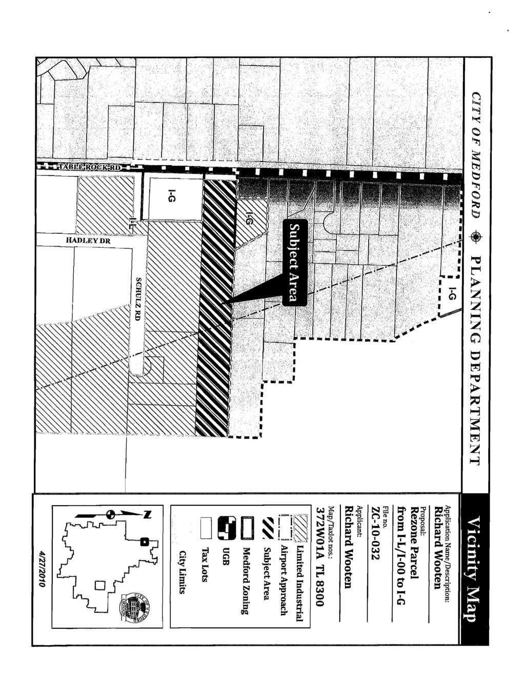
8 Wooten Zone Change (ZC ) Staff Report June 1,2010 FINDINGS OF FACT This request satisfies all criteria for a zone change. Staff has reviewed the applicant's Findings of Fact (Exhibit B) and recommends that the Commission adopt the Findings, along with the following with the following additions: 1) This zone change is consistent with the subject parcel's General Land Use Plan Designation of General Industrial and, by extension, with the Transportation System Plan and the Transportation Planning Rule; 2) If approved, this General Industrial property would abut properties zoned Light Industrial and General Industrial, satisfying the criteria regarding location in MLDC (1 )(d)(ii); and, 3) As confirmed by Exhibits C through G, Category A Urban Services and Facilities are available or can and will be provided, to adequately serve the subject property with the permitted uses allowed under the proposed zoning. RECOMMENDED ACTION Adopt the Final Order for approval of ZC per the Staff Report dated June 1, 2010, including Exhibits A through I. EXHIBITS A Approval Criteria B Applicant's Findings of Fact, received April 21, 2010; C Memorandum from Medford Engineering Division received May 18, 2010; D Memorandum from Medford Water Commission received May 19, 2010; E Memorandum from Medford Fire Department, received May 18, 2010; F Memorandum from Rogue Valley Sewer Services, received May 12, 2010; G Letter from Jackson County Roads, received May 14, 2010; H Jackson County Assessor's Map I Avigation and Hazard Easement, received May 12, 2010; J General Land Use Plan Map K Central Point Zoning Map Vicinity Map PLANNING COMMISSION AGENDA: JUNE 10, 2010 Page 2 of 3
9 ZONE CHANGE APPROVAL CRITERIA - INDUSTRIAL ZONES FROM SECTION OF THE MEDFORD LAND DEVELOPMENT CODE The approving authority (Planning Commission) shall approve a quasi-judicial zone change if it finds that the zone change complies with subsections (1) and (2) below: (1) The proposed zone is consistent with the Transportation System Plan (TSP) and the General Land Use Plan Map designation. A demonstration of consistency with the acknowledged TSP will assure compliance with the Oregon Transportation Planning Rule.) Where applicable, the proposed zone shall also be consistent with the additional locational standards of the below sections (1)(a), (1)(b), (1)(c), or (1)(d). Where a special area plan requires a specific zone, any conflicting or additional requirements of the plan shall take precedence over the locational criteria below. (d) (e) For zone changes to any industrial zoning district, the following criteria shall be met for the applicable zoning sought: (i) The l-l zone may abut residential and commercial zones, and the General Industrial (l-g) zone. The l-l zone is ordinarily considered to be unsuitable when abutting the Heavy Industrial (I- H) zone, unless the applicant can show it would be suitable pursuant to (1)(e) below. (ii) The l-g zone may abut the Heavy Commercial (C-H), Light Industrial (l-l), and the Heavy Industrial (l-h) zones. The l-g zone is ordinarily considered to be unsuitable when abutting the other commercial and residential zones, unless the applicant can show it would be suitable pursuant to (1)(e) below. (iii) The l-h zone may abut the General Industrial (l-g) zone. The l-h zone is ordinarily considered to be unsuitable when abutting other zones, unless the applicant can show it would be suitable pursuant to (1)(e) below. For purposes of (1)(c) and (1)(d) above, a zone change may be found to be "suitable" where compliance is demonstrated with one or more of the following criteria: (i) The subject property has been sited on the General Land Use Plan Map with a GLUP Map designation that allows for only one zone; (ii) At least 50% of the subject property's boundaries abut zones that are expressly allowed under the criteria in (1)(c) or (1)(d) above; (iii) At least 50% of the subject property's boundaries abut properties that contain one or more existing uses which are permitted or conditional uses in the zone sought by the applicant, regardless of whether the abutting properties are actually zoned for such existing uses; or (iv) Notwithstanding the definition of "abutting" in MLDC and for purposes of determining suitability under Section (1) (e), the Page 1 of 3 GITVdpM«jRD SXH IT# A
10 Zone Change Approval Criteria - Industrial Zones subject property is separated from the "unsuitable" zone by a public right-of-way of at least 60 feet in width. (2) It shall be demonstrated that Category A urban services and facilities are available or can and will be provided, as described below, to adequately serve the subject property with the permitted uses allowed under the proposed zoning, except as provided in subsection (c) below. The minimum standards for Category A services and facilities are contained in the MLDC and Goal 3, Policy 1 of the Comprehensive Plan "Public Facilities Element." (a) (b) Storm drainage, sanitary sewer, and water facilities must already be adequate in condition, capacity, and location to serve the property or be extended or otherwise improved to adequately serve the property at the time of issuance of a building permit for vertical construction. Adequate streets and street capacity must be provided in one of the following ways: (i) Streets which serve the subject property, as defined in Section (2), presently exist and have adequate capacity; or (ii) Existing and new streets that will serve the subject property will be improved and/or constructed, sufficient to meet the required condition and capacity, at the time building permits for vertical construction are issued; or (iii) If it is determined that a street must be constructed or improved in order to provide adequate capacity for more than one proposed or anticipated development, the Planning Commission may find the street to be adequate when the Improvements needed to make the street adequate are fully funded. A street project is deemed to be fully funded when one of the following occurs: (a) the project is in the City's adopted capital improvement plan budget, or is a programmed project in the first two years of the State's current STIP (State Transportation Improvement Plan), or any other public agencies adopted capital improvement plan budget; or (b) when an applicant funds the improvement through a reimbursement district pursuant to the MLDC. The cost of the improvements will be either the actual cost of construction, if constructed by the applicant, or the estimated cost. The "estimated cost" shall be 125% of a professional engineer's estimated cost that has been approved by the City, including the cost of any right-of-way acquisition. The method described in this paragraph shall not be used if the Public Works Department determines, for reasons of public safety, that the improvement must be constructed prior to issuance of building permits. (iv) When a street must be improved under (b)(ii) or (b)(iii) above, the specific street improvement(s) needed to make the street adequate must be identified, and it must be demonstrated by the applicant that the improvement(s) will make the street adequate in condition and capacity. Page 2 of 3
11 Zone Change Approval Criteria - Industrial Zones (c) In determining the adequacy of Category A facilities, the approving authority (Planning Commission) may evaluate potential impacts based upon the imposition of special development conditions attached to the zone change request. Special development conditions shall be established by deed restriction of covenant, which must be recorded with proof of recordation returned to the Planning Department, and may include, but are not limited to the following: (i) Restriction of uses by type or intensity; however, in cases where such a restriction is proposed, the Planning Commission must find that the resulting development pattern will not preclude future development, or intensification of development, on the subject property or adjacent parcels. In no case shall residential densities be approved which do not meet minimum density standards, (ii) Mixed-use, pedestrian-friendly design which qualifies for the trip reduction percentage allowed by the Transportation Planning Rule, (iii) Transportation Demand Management (TDM) measures which can be reasonably quantified, monitored, and enforced, such as mandatory car/van pools. [Amd. Ord. No. 7036, Dec, 5, 1991; Amd. Sec. 1, Ord. No , June 3, 1999; Amd. Sec. 1, Ord. No , Feb. 6, 2003; Amd. Ord. No , March 18, 2004.] Page 2 of 3
12 Findings of Fact APR 21 Planning For an application of a change in zoning of property described on the Jackson county assessors map as T37 2W1A tax lot 8300 located on the east side of Table Rock Road approximately 1700 feet north of Biddle road. Applicant: Richard Wooton 904 Pittview et Central Point, OR Background Information Current Zoning: City of Medford light Industrial (l-l) Proposed Zoning: City of Medford General Industrial (l-g) Land Use: Proposed Use: Access: Public Facilities: The site consists of 4.94 acres, and Is currently developed with existing structures, access, and parking for Table Rock Mini Storage, a self storage facility. Same as on site. Any change or expansion of use in the future would be required to be submitted consistent with the site plan and Architectural Review Criteria. Access is via Table Rock Road from the North and South. Category A public facilities exist at the property including water service, sewer service, drainage, and streets. Scope and purpose of the Application: The purpose of this application is to apply for a zone change to General Industrial (l-g). The property is currently zoned Light Industrial (l-l). The information contained in these finding will demonstrate compliance with the applicable criteria contained in section of the Medford Land Development Code for a change in zoning designation from light industrial (l-l) to General Industrial (l-g) zoning. Applicable Criteria: crry0f Medfqrd EXHIBIT # 2-C- - tp O 3 2.
13 The criteria in Section of the Medford Land Development Code for a zone change require that the proposed zone change is consistent with the transportation System Plan and the General land use Plan Map designation. The proposed Zone change to General Industrial (l-g) shall also be consistent with the additional locational standards in section (l)(d)(ii) and/or (l)(e). (l)(d)(ii) (l)(e) The l-g zone may abut the Heavy Commercial (C-H), Light Industrial (l-l), and Heavy Industrial (l-h) zones. The l-g zone is ordinarily considered unsuitable when abutting other zones, unless the applicant can show it would be suitable pursuant to (l)(e) below. For the purposes of (l)(c) and (l)(d) above. A zone change may be found to be suitable where compliance is demonstrated with one (1) or more of the following criteria: (i) (ii) (iii) The subject property has been sited on the General Land Use Plan map with a GLUP Map designation that allows only one (1) zone; At least fifty percent (50%) of the subject property's boundaries abut zones that are expressly allowed under the criteria in (l)(c) or 1(d) above; At least fifty percent (50%) of the subject property's boundaries abut properties that contain one (1) or more existing uses which are permitted or conditional uses in the zone sought by the applicant, regardless of whether the abutting properties are actually zoned for such existing uses: or (iv) Notwithstanding the definition of abutting in section and for purposes of determining suitability under Section (l)(e). The subject property is separated from the unsuitable zone by a public right-ofway of at least sixty (60) feet in width. Demonstration of Compliance: Consistency with the General Land use Plan Map The General Land Use Plan Map for the city of Medford indicates that the subject area is designated as General Industrial (l-g). The requested zoning of General Industrial is consistent with the General Industrial Plan designation as noted in the Land Use Element section 6. Finding: The application is consistent with the Comprehensive Plan Designation of General Industrial. The proposed zoning is General Industrial (l-g) which is an appropriate zoning for the site per the General Land Use Plan Map and the Land Use Element. The zoning of the surrounding
14 properties is City of Medford Light Industrial (l-l), City of Medford General Industrial (l-g) and Jackson county Light Industrial. In addition, a review of the zoning and uses of the abutting properties shows that at least 50% of the subject property has boundaries that abut Light Industrial (l-l) and/or General Industrial (G-L) zoning. These findings show the application is consistent with section (l)(d)(ii) and (l)(e) of the Land Development Code. Compliance with the Transportation Planning Rule The current designation of Light Industrial (l-l) generates 300 ADT per acre, while the proposed zoning of General Industrial (l-g) generates 200 ADT per acre. Access, via Table Rock Road from the North and South is adequate to serve the property. Finding: The application will have little or no impact on the transportation system. The requested Zone change would decrease the projected ADT of the property. AS such the Traffic Impact Analysis Form required as part of the Zone change application has been signed off by the public works department indicating that a Traffic Impact Analysis in not required. Category A Public Facilities The site is currently served by Category A Public Facilities including Water service, Sewer service, Drainage and Streets. Water Service: The site is serviced by the Medford Water Commission. Sewer service: The site is serviced by Rogue Valley Sewer Services. Drainage: Streets: Drainage ditches currently serve the site. An Underground storm drain exists on the west side of the property. An underground irrigation ditch runs under the facility. The site is serviced by Table Rock Road. Findings: Adequate public facilities currently exist to serve the property, and there will be little or no impact of the proposed zone change on water capacity, drainage capacity, sewer capacity, or road and street capacity. Summary and Conclusion: The requested zone change is consistent with the approval criteria of the City Of Medford Land Development Code section The requested General Industrial (l-g) zoning district is an appropriate zoning for the General Industrial (l-g) General Land Use Plan designation. As required by
15 the in the TPR, there would be no substantial impact to the transportation plan as a result of the requested zone change. And category A public services currently serve the property. Richard Wooton
16 MECEÏVEB CITY OF MEDFORD INTER - OFFICE MEMORANDUM MAY 1S2010 PLANNING DEPT. TO: Planning Department FROM: Engineering Division SUBJECT: Zone Change Request, File No. ZC DATE: May 13,2010 Reviewed by: Larry Beskow 1. Sanitary Services: 2. Streets: 3. Drainage: A. Currently serviced by: This site lies within the Rogue Valley Sewer Service area. Contact Rogue Valley Sewer Service for sanitary sewer accessibility and capacity adequacy. A. Current condition of nearest streets: Table Rock Road, an existing Major Arterial Street is paved with curb and gutter along the frontage of this site. B: Who has maintenance responsibilities: Jackson County C: Traffic analysis including potential impact of nearby and anticipated improvements required: Land Development Code Section governs traffic impact analyses (TIA) required to determine development impacts on the street system. The proposed zone change from City I- L (Light Industrial) to City I-G (General Industrial), on 5.0 acres has the potential to generate 1000 average daily trips (ADT) or produce a net decrease of 500 ADT to the transportation system. Based on this and code sections and , a traffic impact analysis (TIA) isn't required. This site lies within the Midway Creek Drainage Basin. Development of this site will require storm drainage detention in accordance with Sections and of the Municipal Code. CflYÔPMffiPORB m'mril^... Cl ^ % rnui*. kìfrnisàrp g
17 MAY BOARD OF WATER COMMISSIONERS Staff Memo TO: FROM: SUBJECT: Planning Department, City of Medford Rodney Grehn P.E., Water Commission Staff Engineer ZC PARCEL ID: 372W01ATL 8300 PROJECT: Consideration of a change of zone from Light Industrial (l-l) to General Industrial (l-g) on a 4.94 acre parcel withi n Limited Industrial (I-00) and Airport Approach (A- A) overlay districts, located approximately 270 feet north of the intersection of Table Rock Road and Schulz Road; Richard Wooten, Applicant. Kathy Helmer, Planner. DATE: May 17, 2010 I have reviewed the above plan authorization applicati on as requested. Conditions for approval and comments are as follows: COMMENTS 1. The water faci lity planning/design/construction process will be done in accordance with the Medford Water Commission (MWC) "Regulations Governing Water Service" and "Standards For Water Facilities/Fire Protection Systems/Backflow Prevention Devices." 2. All parcels/lots of proposed property divisions will be required to have metered water service prior to recordation of final map, unless otherwise arranged with MWC. 3. The MWC system does have adequate capacity to serve this property. 4. Off-site water facility construction is not required. 5. On-site water facility construction may be required depending on future I and development review. 6. MWC-metered water service does exi st to this property. There is a %" water meter near the entrance off Table Rock Road that serves the existing mini-storage office. 7. Access to MWC water lines for connection is available. There is a 12-inch water line in the private drive to the north of this parcel that extends approxim ately 1200-feet east of Table Rock Road. K:\Land Dsvelopment\Medford Planning\zc10032.doc Paga 1 of 1 mm* JP t&itjxé-- iò- ò i o.
18 Medford Fire Department 200 S. Ivy Street, Room #257 Medford, OR Phone: ; Fax: ; MAY PLANNING DEPT. LAND DEVELOPMENT REPORT - PLANNING To: Kathy Helmer LD Meeting Date: 05/19/2010 From: Kleinberg, Greg Report Prepared: 05/18/2010 File #: ZC Site Name/Description: Consideration of a change of zone from Light Industrial (l-l) to General Industrial (l-g) on a 4.94 acre parcel within Limited Industrial (I-00) and Airport Approach (A-A) overlay districts, located approximately 270 feet north of the intersection of Table Rock Road and Schulz Road; Richard Wooten, Applicant. Kathy Helmer, Planner. DESCRIPTION OF CORRECTIONS., REFERENCE" 1 Approved as Submitted Meets Requirement: No Additional Requirements m Development shall comply with access and water supply requirements in accordance with the Fire Code in affect at the time of development submittal. Fire apparatus access roads are required to be installed and made servicable prior to the time of construction. Water supply for fire protection is required to be installed and made serviceable prior to the time of vertical combustible construction. Specific fire protection systems may be required in accordance with the Oregon Fire Code. This plan review shall not prevent the correction of errors or violations that are found to exist during construction. This plan review is based on the information provided only. Design and installation shall meet the Oregon requirements of the IBC, IFC, IMC and NFPA standards. ërrvop mìspòrb ;xhiiit*u 05/18/ :13 1
19 PLANNING DEPT. ROGUE VALLEY SEWER SERVICES Location: 138 West Vilas Road, Central Point, OR - Mailing Address: P.O. Box 3130, Central Point, OR Tel. (541) , Fax (541) May 12, 2010 City of Medford Planning Department 411 West 8th Street Medford, Oregon Re: ZC , Wooten Zone Change (372W01A- 8300) ATTN: Kathy, There are 8 inch sewer mains on the West and North sides of the subject property. The 60 inch diameter Upper Bear Creek Interceptor runs along the East side of the property. The 8 inch mains have adequate capacity to serve most dry industrial uses. More intensive wet industrial use may require connection to the interceptor. Connection to any existing sewer main will require a permit from Rogue Valley Sewer Services which will be issued upon payment of related development fees. Sincerely, Digitally signed by Ç a r CarlTappert Carl Tappert P.E. DN:cn=Carl District Engineer T a p p e f t Date: ^ 09:02:19-07'00' \\BCVSA_TREE\BCVSA4 l_vol 1,MEDOR.BCVSA\DATA\AGENCIES\MEDFORDVPLANlSiG\ZO NE CHANGE\2010\ZC WOOTEN.DOC eirv of Bedford
20 MAY/14/20IO/FRI 10:07 JACF'""N COUNTY ROADS FAX No P. 001/001 JC Roads Engineering May 11,2010 JACKSON COUNTY Roads Russel liogub Construction & Development 200 Antelope Road White City, OR Phone: (641) Paw (641) Manager Attention: Kathy Helmer Planning Department City of Medford 200 South Ivy Street, Lausmann Annex, Room 240 Medford, OR RE: Zone Change off Table Rock Road - a county-maintained road. Planning File: ZC Dear Kathy: Thank you for the opportunity to comment on this request for a change of zone from Light Industrial (l-l) to General Industrial (l-g) on a 4.94 acre parcel within Limited Industrial (I- 00) and Airport Approach (A-A) overlay districts, located approximately 270 feet north of the intersection of Table Rock Road and Schulz Road. Jackson County Roads has the following comments: 1.. Table Rock Road is an Arterial road and is county-maintained. The Average Daily Traffic Count one-hundred yards north of Biddle Road was 16,544 on August All proposed access roads or frontage improvements shall be permitted and inspected by the City. 3, Future construction plans shall be submitted to Roads, so we may determine if county permits will be required. If you have any questions or need further information feel free to call me at I :\Engineering\Development\CITlES\MEDFORD\2010\ZC-2Ó doc QntQFMEDFORD -is#
21 K ^ Sg PS" u < a asi «dvn í HMOSNHOf <(0KV9ZL9003 'm AinrAvaNOH aaivaso VHO\mdOO/V/lO/M2 C/dVW/ : M31IJV13H
22 ' 35-H85S5 por / AVIOMIIOH MP HR2RKD EABEHBNT /' WHEREAS, RICHARD MOOTEìl. ali iti dividual, hereinafter called Grantor, is the owner in fee of that certain parcel of land located at 4574 Table Rock Road, situated in the County of Jackson, State of Oregon, more particularly desoribed as follows! "Legal - Description! 37, 2W,""l'fi, Tax Lot 8300" hereinafter called "Grantor's property," and outlined on the attached site map, Exhibit 1; NOW THEREFORE, in consideration of the sum of One Dollar ($1.00) and other good and valuable consideration, the receipt and sufficiency of which is hereby acknowledged, the Grantor, for himself, his heirs, administrators, executors, successors and assigns does hereby grant, bargain, sell and convey unto Jackson County, a county organized and existing under the laws of Oregon, hereinafter called the Grantee, its successors and assigns for the use and benefit of the public, as easement and right of way, appurtenant to the Rogue Valley International - Medford Airport for the unobstructed passage of all aircraft, ("aircraft" being defined for the purpose of this instrument as any contrivance now known or hereafter invented, used or designed for navigation of or flight in the air) by whomsoever owned and operated, the following. l. The right of flight for the purpose of aircraft in the airspace above the surface of the real property above described, together with the right to cause in said airspace such noise as may be inherent in the operation of aircraft, now known or hereafter used, for navigation of or flight in said airspace, noise which will not exceed 80 Ldn attributable to airport operations measured anywhere on the property, and for use of said airspace for i landing on, taking off from, or operating on Rogue Valley : International - Medford Airport, i! 2. The right to prohibit the erection of any structure or. I object and to require the removal of any tree on thé property ' conveyed hereby that would violate the standards established in '? Federal Aviation Regulations, Part 77, objects Affecting navigable S. i Airspace, as amended and Grantee reserves the right to enter on the property conveyed hereby and remove, lower, mark, or light any such offending structure, tree, or other object, all at the expense of Grantor. - 1 qiwqfl^dfop EXHIBIT #
23 3, The right to prohibit any usa of thé property hereby conveyed which would interfere with landing or taking off of airoraft at Rogue Valley international - Medford Airport or otherwise constitute an airport hazard. Such hazards inolude uses that create electrical interference with navigational signals or radio communications between the airport and aircraft, wake it difficult for pilots to distinguish between airport lights and others, result in glare in the eyes of pilots using the airport, impair visibility in the vicinity of the airport, or create bird strike hazards. In the event J^_aforosaid,coyen.antjLs_.breached,. the'grantee reserves die right to enter on tlie property hereby conveyed and cause the abatement of any suoh interference, all at the expanse of Grantor. ' IK WITNESS wiblkot, the parties hereto have executed this aareemevit this dav of -^V fr'i Usai - i q q s
 ' OfflCIAl RECORDS i.")
24 ' 1 H I )55 Jackton County, Oregon Roccrdu) ' OfflCIAl RECORDS i.-«h I
25 GENERAL LAND USE PLAN MAP 0!+ oh' M'e&PöRß EXHIBIT ÜU file t ^ G ^ J i M ä Z z -.

26 CENTRAL POINT ZONING ABUTTING MEDFORD * ÖHVÖ^WÖRB EXHIBIT* ^
27
28 qk jr RECORDING RETURN TU: ai Affilie ^ I S f r - WHEN RECORDED RETURN TO: Hornecker, Cowling, Hassen & Heysell, L.L.P. Attn: John R. Hassen 717 Murphy Road Medford, OR SEND TAX STATEMENTS TO: RHW Properties, L.L.C. Attn: Richard H. Wooton 4570 Table Rock Road Central Point, OR II BARGAIN AND SALE DEED Richard H. Wooton Trust, U.T.A.D. October 2, 1998, Grantor, conveys to RHW Properties, L.L.C., an Oregon limited liability company, Grantee, the following real property situated in Jackson County, Oregon, described as follows, to-wit: The South half of the following described tract: Commencing at the North quarter comer of Section 1 in Township 37 South, Range 2 West of the Willamette Meridian in Jackson County, Oregon; thence South0 02' West, feet, to the point of beginning; thence North 89 58' East, feet, to the West line of the Southeast quarter of the Northeast quarter of said Section; thence South 0 02'30" West, feet; thence South 89 58' West, feet, to intersect the North and South center line of said Section; thence North 0 02' East, feet, to the point of beginning. / There is no cash consideration for this transfer. THIS INSTRUMENT WILL NOT ALLOW USE OF THE PROPERTY DESCRIBED IN THIS INSTRUMENT IN VIOLATION OF APPLICABLE LAND USE LAWS AND REGULATIONS. BEFORE SIGNING OR ACCEPTING THIS INSTRUMENT, THE PERSON ACQUIRING FEE TITLE TO THE PROPERTY SHOULD CHECK WITH THE APPROPRIATE CITY OR COUNTY PLANNING DEPARTMENT TO VERIFY APPROVED USES 1 - BARGAIN AND SALE DEED


29 o -J b- 1 o o b- 1 Ln CP c b- 1 -C
Oregon Theodore R KjibngDski, Governor
 Oregon Theodore R KjibngDski, Governor Department of Land Conservation and Development 635 Capitol Street, Suite 150 Salem, OR 97301-2540 (503) 373-0050 Fax (503) 378-5518 www. lcd.state.or.us NOTICE OF
Oregon Theodore R. Kulongoski, Governor
 Oregon Theodore R. Kulongoski, Governor Department of Land Conservation and Development 635 Capitol Street NE, Suite 150 Salem, Oregon 97301-2524 Phone: (503) 373-0050 First Floor/Coastal Fax: (503) 378-6033
Department of Land Conservation and Development 635 Capitol Street, Suite 150 Salem, OR Theodore R. Kulongoski, Governor (503)
") Oregon Department of Land Conservation and Development 635 Capitol Street, Suite 150 Salem, OR 97301-2540 Theodore R. Kulongoski, Governor (503) 373-0050 AMENDED NOTICE OF ADOPTED AMENDMENT November 2,
Oregon Department of Land Conservation and Development 635 Capitol Street, Suite 150 Salem, OR 97301-2540 Theodore R. Kulongoski, Governor (503) 373-0050 AMENDED NOTICE OF ADOPTED AMENDMENT November 2,
DLCD ACKNOWLEDGMENT or DEADLINE TO APPEAL: Thursday, July 21, 2011
 Department of Land Conservation and Development 635 Capitol Street, Suite 150 Salem, OR 9730 1-2540 (503) 373-0050 Fax (503) 378-5518 www. lc d. s tat e. or. us NOTICE OF ADOPTED AMENDMENT ÄeA 07/11/2011
NOTICE OF ADOPTED CHANGE TO A COMPREHENSIVE PLAN OR LAND USE REGULATION
 NOTICE OF ADOPTED CHANGE TO A COMPREHENSIVE PLAN OR LAND USE REGULATION Date: Jurisdiction: Local file no.: DLCD file no.: May 17, 2016 City of Lebanon 16-02-09 002-16 The Department of Land Conservation
DLCD ACKNOWLEDGMENT or DEADLINE TO APPEAL: Wednesday, June 15, 2011
 Department of Land Conservation and Development 635 Capitol Street, Suite 150 Salem, OR 9730 1-2540 (503) 373-0050 Fax (503) 378-5518 www. Icd.state.or.us NOTICE OF ADOPTED AMENDMENT 06/02/2011 TO: FROM:
GRANT OF SURFACE AND OVERHEAD AVIGATION EASEMENTS W I T N E S S E T H:
 GRANT OF SURFACE AND OVERHEAD AVIGATION EASEMENTS As a requirement of a land use application for property in the Airport Influence Area, THIS GRANT of Avigation Easements is made and executed this day
DLCD ACKNOWLEDGMENT or DEADLINE TO APPEAL: Tuesday, February 16, 2010
 Oregon Theodore R KjibngDski, Governor Department of Land Conservation and Development 635 Capitol Street, Suite 150 Salem, OR 97301-2540 (503) 373-0050 Fax (503) 378-5518 www. lcd.state.or.us NOTICE OF
DLCD ACKNOWLEDGMENT or DEADLINE TO APPEAL: Wednesday, December 09, 2009
 Oregon Theodore R KjibngDski, Governor Department of Land Conservation and Development 635 Capitol Street, Suite 150 Salem, OR 97301-2540 (503) 373-0050 Fax (503) 378-5518 www. lc d. s tat e. or. us NOTICE
DLCD ACKNOWLEDGMENT or DEADLINE TO APPEAL: Wednesday, August 11, 2010
 Oregon Theodore R KjibngDski, Governor Department of Land Conservation and Development 635 Capitol Street, Suite 150 Salem, OR 97301-2540 (503) 373-0050 Fax (503) 378-5518 www. lcd.state.or.us NOTICE OF
URBANIZATION ELEMENT. PREPARED BY CITY OF MEDFORD PLANNING DEPARTMENT 200 SOUTH IVY STREET MEDFORD, OREGON
 PREPARED BY CITY OF MEDFORD PLANNING DEPARTMENT 200 SOUTH IVY STREET MEDFORD, OREGON 97501 plnmed@ci.medford.or.us ROBERT O. SCOTT, AICP, PLANNING DIRECTOR COMPREHENSIVE PLANNING SECTION MARK GALLAGHER,
For Office Use Only. Permit No. Fee: $ $ per proposed lot (AN ADDITIONAL 10% CODE COMPLIANCE FEE WILL BE CHARGED)
") For Office Use Only Permit No. Fee: $1600 + $560.00 per proposed lot (AN ADDITIONAL 10% CODE COMPLIANCE FEE WILL BE CHARGED) LAND PARTITION FOREST (Conditional Use) Crook County Planning Department 300
For Office Use Only Permit No. Fee: $1600 + $560.00 per proposed lot (AN ADDITIONAL 10% CODE COMPLIANCE FEE WILL BE CHARGED) LAND PARTITION FOREST (Conditional Use) Crook County Planning Department 300
STAFF REPORT. Community Development Director PO Box 4755 Beaverton, OR 97076
 STAFF REPORT HEARING DATE: July 7, 2010 TO: Planning Commission STAFF: Jana Fox, Assistant Planner PROPOSAL: Southeast Beaverton Office Commercial Zoning Map Amendment (ZMA2010-0006) LOCATION: The subject
Oregon Theodore R KjibngDski, Governor
 Oregon Theodore R KjibngDski, Governor D e p a r t m e n t of L a n d C o n s e r v a t i o n a n d D e v e l o p m e n t 635 Capitol Street, Suite 150 Salem, OR 97301-2540 (503) 373-0050 Fax (503) 378-5518
Avigation Easement Instructions
 Avigation Easement Instructions Based on the project location, you will need to complete the Avigation Easement process. 1.) Provide Legal Description: Include a legal description labeled Exhibit A that
Community Development Department
 Community Development Department Easement Submission Form and Checklist Project Information Project Name: Location/street address: Applicant/Contact Information Applicant: Phone: Applicant e-mail: Owner/Grantor
Umatilla County Department of Land Use Planning
 Umatilla County Department of Land Use Planning 216 SE 4 th ST, Pendleton, OR 97801, (541) 278-6252 Property Line Adjustment, Type V Application & Information Packet PROCESSING THE APPLICATION The application
SOUTH DAKOTA BOARD OF REGENTS. Committee on Budget and Finance ******************************************************************************
 SOUTH DAKOTA BOARD OF REGENTS Committee on Budget and Finance AGENDA ITEM: III O DATE: December 12-13, 2012 ****************************************************************************** SUBJECT: Resolution
DLCD ACKNOWLEDGMENT or DEADLINE TO APPEAL: Friday. January
 Oregon Theodora El KibngDski,Governor Department of Land Conservation and Development 635 Capitol Street, Suite 50 Salem, OR 9730-2540 (503) 373-0050 Fax (503) 373-553 www.lcd.state.or. us NOTICE OF ADOPTED
Subject: Ordinance 1657, Annexation of 3.55 acres of land at 3015 and 3001 Parker Road.
 Agenda Report 2016-12-12-09 Date: December 8, 2016 To: From: Russ Axelrod, Mayor Members, West Linn City Council Jennifer Arnold, Planning Department Through: John Boyd, Interim Community Development Director
PIPELINE RIGHT-OF-WAY EASEMENT
 PIPELINE RIGHT-OF-WAY EASEMENT THIS RIGHT-OF-WAY EASEMENT made this day of March, 2014, by the City of Rochester Hills, a municipal corporation in the State of Michigan,, having an address at 1000 Rochester
Oregon. Department of Land Conservation and Development
 Oregon Theodore R. Kulongoski, Governor NOTICE OF ADOPTED AMENDMENT November 22, 2006 TO: FROM: Subscribers to Notice of Adopted Plan or Land Use Regulation Amendments Mara Ulloa, Plan Amendment Program
WIND ENERGY CONVERSION SYSTEM (WECS) APPLICATION
 APPLICATION") PLANNING & DEVELOPMENT SERVICES PO Box 4169, 911 North 7 Avenue Pocatello, Idaho 83205 WIND ENERGY CONVERSION SYSTEM (WECS) APPLICATION Submittal Date: Contact Person: Permit #: Receipt Date: Plan Review
PLANNING & DEVELOPMENT SERVICES PO Box 4169, 911 North 7 Avenue Pocatello, Idaho 83205 WIND ENERGY CONVERSION SYSTEM (WECS) APPLICATION Submittal Date: Contact Person: Permit #: Receipt Date: Plan Review
COMMUNITY DEVELOPMENT DEPARTMENT 333 Broadalbin Street SW, P.O. Box 490 Albany, OR 97321
 COMMUNITY DEVELOPMENT DEPARTMENT 333 Broadalbin Street SW, P.O. Box 490 Albany, OR 97321 STAFF REPORT Application for Site Plan Review (SP-02-18) Residential Accessory Building Ph: 541-917-7550 Fax: 541-917-7598
Time Extension Staff Report
 Time Extension Staff Report Subdivision Name Lunara Subdivision File Number SUB07-00019 Approval Time Extension for Lead Agency Boise City Certification Signature of Boise City Engineer Annexation Date
EASEMENT AGREEMENT. WHEREAS, Ferguson is the 100% owner of the property described on Exhibit B attached hereto (the Williams Property );
;") EASEMENT AGREEMENT THIS EASEMENT AGREEMENT ( Agreement ) is entered into as of this day of, 2016, by and between CRAIG FERGUSON ( Ferguson ), and MAMIE DAVIS and JERRY MOORE ( Davis & Moore ), whose legal
EASEMENT AGREEMENT THIS EASEMENT AGREEMENT ( Agreement ) is entered into as of this day of, 2016, by and between CRAIG FERGUSON ( Ferguson ), and MAMIE DAVIS and JERRY MOORE ( Davis & Moore ), whose legal
COUNCIL AGENDA MEMO ITEM NO. III - #1
 COUNCIL AGENDA MEMO ITEM NO. III - #1 FROM: Anton Jelinek, Director of Utilities MEETING: October 24, 2017 SUBJECT: PRESENTER: Permanent Utility and Right-of-Way Easement Anton Jelinek Discussion: At the
NON-EXCLUSIVE ROADWAY AND UTILITY EASEMENT DEED AND AGREEMENT
 RETURN TO: STOGSDILL LAW OFFICE, P.C. 505 West Main, Suite 313 Lewistown, Montana 59457 (406) 538-2623 NON-EXCLUSIVE ROADWAY AND UTILITY EASEMENT DEED AND AGREEMENT THIS EASEMENT DEED AND AGREEMENT is
ARTICLE IV: DEVELOPMENT STANDARDS
 ARTICLE IV: DEVELOPMENT STANDARDS IV-53 409 PRIVATE STREETS A private street means any way that provides ingress to, or egress from, property by means of vehicles or other means, or that provides travel
APPLICATION PROCEDURES FOR A MAJOR SUBDIVISION PRELIMINARY PLAT
 APPLICATION PROCEDURES FOR A DEFINITION: The subdivision of a tract of land into at least three (3) residential, commercial, or industrial parcels, including the remainder of the original parcel, fronting
UPPER MOUNT BETHEL TOWNSHIP NORTHAMPTON COUNTY, PENNSYLVANIA
 UPPER MOUNT BETHEL TOWNSHIP NORTHAMPTON COUNTY, PENNSYLVANIA JOINDER DEED / LOT CONSOLIDATION TOWNSHIP REVIEW PROCESS When accepting proposed Joinder Deeds / Lot Consolidations, review the Joinder Deed
ORDINANCE NO. 41. PRIVATE ROAD ORDINANCE As Amended Through April 10, 2008
 ORDINANCE NO. 41 PRIVATE ROAD ORDINANCE As Amended Through April 10, 2008 An Ordinance to protect the health, safety, and general welfare of the inhabitants of Port Sheldon Township. The Township of Port
BYRON TOWNSHIP ZONING APPLICATION
 BYRON TOWNSHIP ZONING APPLICATION Phone: (616) 878-9104 * Fax: (616) 878-3980 * Website: www.byrontownship.org This application will not be accepted if incomplete. APPLICATION FOR & REQUIRED COPIES Private
TOWN OF LEWISTON PLANNING BOARD APPLICATION
 TOWN OF LEWISTON PLANNING BOARD APPLICATION DESCRIPTION OF PROPOSED REQUEST: Name of Property Owner: Phone #: Name of Applicant:Phone #: Address or Location of Proposal:_SBL# Size of Parcel or Structure:Existing
Department of Land Conservation and Development 635 Capitol Street, Suite 150 Salem, OR Theodore R. Kulongoski, Governor (503)
") regon Departent of Land Conservation and Developent 635 Capitol Street, Suite 150 Sale, R 97301-2540 Theodore R. Kulongoski, Governor (503) 373-0050 NTICE F ADPTED AMENDMENT March 17, 2008 Fax (503) 378-5518
regon Departent of Land Conservation and Developent 635 Capitol Street, Suite 150 Sale, R 97301-2540 Theodore R. Kulongoski, Governor (503) 373-0050 NTICE F ADPTED AMENDMENT March 17, 2008 Fax (503) 378-5518
DLCD ACKNOWLEDGMENT or DEADLINE TO APPEAL: Monday, June 03, 2013
 NOTICE OF ADOPTED AMENDMENT 05/20/2013 TO: FROM: Subscribers to Notice of Adopted Plan or Land Use Regulation Amendments Plan Amendment Program Specialist SUBJECT: City of Salem Plan Amendment DLCD File
Regular Agenda / Public Hearing for Board of Commissioners meeting September 24, 2014
 John S. Franden, President Mitchell A. Jaurena, Vice President Rebecca W. Arnold, Commissioner Sara M. Baker, Commissioner Jim D. Hansen, Commissioner TO: FROM: ACHD Board of Commissioners & Bruce S. Wong,
ORDINANCE NO AN ORDINANCE AMENDING THE CODE OF ORDINANCES OF THE CITY OF PORT ARANSAS, TEXAS, BY ADOPTING A NEW CHAPTER
 ORDINANCE NO. 2008-09 AN ORDINANCE AMENDING THE CODE OF ORDINANCES OF THE CITY OF PORT ARANSAS, TEXAS, BY ADOPTING A NEW CHAPTER TWENTY-SIX CONCERNING IMPACT FEES FOR ROADWAY FACILITIES; INCORPORATING
SOUTH DAKOTA BOARD OF REGENTS. Budget and Finance ******************************************************************************
 SOUTH DAKOTA BOARD OF REGENTS Budget and Finance AGENDA ITEM: 6 K DATE: October 2-4, 2018 ****************************************************************************** SUBJECT USD Discovery District:
WRITTEN DECISION OF THE HAYDEN CITY COUNCIL REGARDING MAPLE GROVE PRELIMINARY SUBDIVISION APPLICATION (SUB-0013) HAYDEN SIGNATURE, LLC
 HAYDEN SIGNATURE, LLC") WRITTEN DECISION OF THE HAYDEN CITY COUNCIL REGARDING MAPLE GROVE PRELIMINARY SUBDIVISION APPLICATION (SUB-0013) HAYDEN SIGNATURE, LLC Application of Hayden Signature, LLC, an Idaho limited liability company,
WRITTEN DECISION OF THE HAYDEN CITY COUNCIL REGARDING MAPLE GROVE PRELIMINARY SUBDIVISION APPLICATION (SUB-0013) HAYDEN SIGNATURE, LLC Application of Hayden Signature, LLC, an Idaho limited liability company,
CHAPTER 2 RELATED DOCUMENTS AND FORMS
 CHAPTER 2 RELATED DOCUMENTS AND FORMS TABLE OF CONTENTS CHAPTER 2 RELATED DOCUMENTS AND FORMS Resolution R00- Establishing Public Improvement Design Standards Page 1 Current Plans Review & Construction
STORMWATER BEST MANAGEMENT PRACTICES OPERATIONS AND MAINTENANCE AGREEMENT
 STORMWATER BEST MANAGEMENT PRACTICES OPERATIONS AND MAINTENANCE AGREEMENT THIS AGREEMENT, made and entered into this day of, 20, by and between, (hereinafter the Landowner ), and the TOWNSHIP OF HEMPFIELD,
SITE PLAN AGREEMENT THE CORPORATION OF THE TOWN OF KINGSVILLE,
 SITE PLAN AGREEMENT THIS AGREEMENT made (in triplicate) this 12 th day of February 2018. BETWEEN: THE CORPORATION OF THE TOWN OF KINGSVILLE, hereinafter called the Corporation, OF THE FIRST PART -and-
PALM BEACH COUNTY PLANNING, ZONING AND BUILDING DEPARTMENT ZONING DIVISION
 PALM BEACH COUNTY PLANNING, ZONING AND BUILDING DEPARTMENT ZONING DIVISION Application No.: Z-2014-01627 Application Name: Dazco Center Control No.: 2003-00040 Applicant: 4730 Hypoluxo LLC Owners: 4730
STANDARDIZED LEGAL DESCRIPTIONS AND EXHIBITS
 STANDARDIZED LEGAL DESCRIPTIONS AND EXHIBITS Public Works Department, Engineering Division June 14, 2004 UNIFIED GOVERNMENT STANDARDIZED LEGAL DESCRIPTIONS AND EXHIBITS For: Roads, Bridges, Short Span
GRANT OF TRAIL ACCESS EASEMENT, COVENANTS AND RESTRICTIONS
 This is a sample easement provided for discussion and illustrative purposes only. Easements for each property will be customized based upon the needs of each landowner and the Path. GRANT OF TRAIL ACCESS
-Section Contents- 201 Districts Overlay Districts Incorporation of Maps District Boundaries...
 SECTION 2 GENERAL REQUIREMENTS AND EXCEPTIONS -Section Contents- ZONING DISTRICTS 201 Districts... 2-2 202 Overlay Districts... 2-2 203 Incorporation of Maps... 2-3 204 District Boundaries... 2-3 LAND
Short Title: Performance Guarantees/Subdivision Streets. (Public) April 28, 2016
 April 28, 2016") GENERAL ASSEMBLY OF NORTH CAROLINA SESSION S SENATE BILL Transportation Committee Substitute Adopted // House Committee Substitute Favorable // Fourth Edition Engrossed // Short Title: Performance Guarantees/Subdivision
GENERAL ASSEMBLY OF NORTH CAROLINA SESSION S SENATE BILL Transportation Committee Substitute Adopted // House Committee Substitute Favorable // Fourth Edition Engrossed // Short Title: Performance Guarantees/Subdivision
610 LAND DIVISIONS AND PROPERTY LINE ADJUSTMENTS OUTSIDE A UGB
 ARTICLE VI: LAND DIVISIONS AND PROPERTY LINE ADJUSTMENTS VI-21 610 LAND DIVISIONS AND PROPERTY LINE ADJUSTMENTS OUTSIDE A UGB 610-1 Property Line Adjustments (Property Line Relocation) A property line
LOCATION AND EXTENT REVIEW FOR DEVELOPMENT OF PUBLIC FACILITIES (Revised 3/1/2017)
") LOCATION AND EXTENT REVIEW FOR DEVELOPMENT OF PUBLIC FACILITIES (Revised 3/1/2017) Lana Gallegos, AICP Senior Planner 970-524-1729 Cindy Schwartz, Assistant Planner 970-524-1750 DATE APPLICATION SUBMITTED:
LOCATION AND EXTENT REVIEW FOR DEVELOPMENT OF PUBLIC FACILITIES (Revised 3/1/2017) Lana Gallegos, AICP Senior Planner 970-524-1729 Cindy Schwartz, Assistant Planner 970-524-1750 DATE APPLICATION SUBMITTED:
Oregon Theodore R. Kulongoski, Governor
 Oregon Theodore R. Kulongoski, Governor NOTICE OF ADOPTED AMENDMENT Department of Land Conservation and Development 635 Capitol Street NE, Suite 150 Salem, Oregon 97301-2524 Phone: (503) 373-0050 First
SUBDIVISION APPLICATION
 SUBDIVISION APPLICATION Preliminary Plat Minor Plat Final Plat Amended Plat Applicant Name: Owner (if different from applicant) Name: Company: Company: Address: Address: City, State, Zip City, State, Zip
DLCD ACKNOWLEDGMENT or DEADLINE TO APPEAL: Thursday, October 20, 2011
 epartment of Land Conservation and evelopment Capitol Street, Suite 0 Salem, OR 0 1-0 (0) -000 Fax (0) - www. lc d. s tat e. or. us NOTICE OF AOPTE AMENMENT îbua /0/0 TO: FROM: Subscribers to Notice of
TO: Glynn County Board of Commissioners. Eric Landon, Planner II. ZM2773 Peppertree Crossing Phase II
 COMMUNITY DEVELOPMENT DEPARTMENT Planning and Zoning Division 1725 Reynolds Street, Suite 200, Brunswick, GA 31520 Phone: 912-554-7428/Fax: 1-888-252-3726 TO: Glynn County Board of Commissioners MEMO FROM:
-ii~ ADAMS COUNTY. &,.ee8.& PUBLIC HEARING AGENDA ITEM
 -ii~ ADAMS COUNTY &,.ee8.& PUBLIC HEARING AGENDA ITEM DATE: January 6,2015 SUBJECT: Easement grant to Molson Coors FROM: Jeffery A. Maxwell, P.E., PTOE, Transportation Director~ AGENCYIDEPARTMENT: Transportation
Department of Planning & Development Services
 Department of Planning & Development Services S T A F F R E P O R T February 9, 2015 CASE NO: PROJECT: EXECUTIVE SUMMARY: ZA14-154 Plat Revision for Lots 25R-1A, 25R-1B and 25R-1C, Block 1, Woodland Heights
MINOR SUBDIVISION INFORMATION
 A. POINTS OF CONTACT: MINOR SUBDIVISION INFORMATION Surveyor: Address: Phone #: Fax # E-Mail Address: Representative (If different from applicant): Address: Phone #: Fax # E-Mail Address: B. GENERAL INFORMATION:
Bethel Romanian Church - Rezone, RZ
 / Planning and Zoning Staff Report Bethel Romanian Church - Rezone, RZ2018-0023 Hearing Date: November 15, 2018 Development Services Department Owners: Bethel Romanian Church, Corp. Applicant: Viorel Botos
CITY OF SARALAND PRELIMINARY SUBDIVISION PLAT REVIEW
 PRELIMINARY SUBDIVISION PLAT REVIEW Application Number: Date Plat Submitted: Name of Subdivision: Name of Owner: Owner Address: (Street or P.O. Box) Telephone #: (City) (State) (Zip) E-mail: Name of Authorized
MUNICIPALITY OF THE DISTRICT OF CLARE SUBDIVISION BY-LAW
 MUNICIPALITY OF THE DISTRICT OF CLARE SUBDIVISION BY-LAW 1 Table of Contents PART 1 - TITLE... 4 PART 2 - INTERPRETATION... 4 PART 3 - DEFINITIONS... 4 PART 4 - PROCEDURE FOR APPROVAL OF PLANS OR INSTRUMENTS
Regular Agenda / Public Hearing for Board of Commissioners meeting May 4, 2016
 Kent Goldthorpe, President Paul Woods, Vice President Rebecca W. Arnold, Commissioner Sara M. Baker, Commissioner Jim D. Hansen, Commissioner TO: FROM: ACHD Board of Commissioners & Bruce S. Wong, Director
BEFORE THE LAND USE HEARINGS OFFICER OF CLACKAMAS COUNTY, OREGON
 BEFORE THE LAND USE HEARINGS OFFICER OF CLACKAMAS COUNTY, OREGON Regarding an Application for a Conditional Use ) Case File No. Permit to Establish a New Headquarters and ) Demonstration Center. ) (Soils
COMMUNITY DEVELOPMENT DEPARTMENT 333 Broadalbin Street SW, P.O. Box 490 Albany, OR 97321
 COMMUNITY DEVELOPMENT DEPARTMENT 333 Broadalbin Street SW, P.O. Box 490 Albany, OR 97321 Ph: 541-917-7550 Fax: 541-917-7598 www.cityofalbany.net STAFF REPORT Application for Site Plan Review SP-07-18 and
City of Leavenworth DEPARTMENT OF DEVELOPMENT SERVICES MAJOR SUBDIVISION APPLICATION 1
 Proposed Name of Subdivision: City of Leavenworth DEPARTMENT OF DEVELOPMENT SERVICES MAJOR SUBDIVISION APPLICATION 1 FOR PRELIMINARY SUBDIVISION APPROVAL This application must be filled out legibly, in
Operating Standards Attachment to Development Application
 Planning & Development Services 2255 W Berry Ave. Littleton, CO 80120 Phone: 303-795-3748 Mon-Fri: 8am-5pm www.littletongov.org Operating Standards Attachment to Development Application 1 PLANNED DEVELOPMENT
CONDITIONAL USE PERMIT APPLICATION FOR AN EXCAVATION/BORROW PIT
 CONDITIONAL USE PERMIT APPLICATION FOR AN EXCAVATION/BORROW PIT CHESAPEAKE PLANNING DEPARTMENT APPLICATION NUMBER: (Ased by Chesapeake Planning Department) GENERAL INFORMATION Project 1. Applicant(s) Intending
CITY OF SARALAND FINAL SUBDIVISION PLAT REVIEW
 CITY OF SARALAND FINAL SUBDIVISION PLAT REVIEW Application Number: Date Plat Submitted: Name of Subdivision: Name of Owner: Owner Address: (Street or P.O. Box) Telephone #: (City) (State) (Zip) E-mail:
PALM BEACH COUNTY PLANNING, ZONING AND BUILDING DEPARTMENT ZONING DIVISION
 PALM BEACH COUNTY PLANNING, ZONING AND BUILDING DEPARTMENT ZONING DIVISION Application No.: DOA-2014-01111 Application Name: World Class Academy Control No.: 1998-00052 Applicant: World Class Academy Inc
An Ordinance to provide regulations for private roads and driveways.
 30.0400 PRIVATE ROADS AND DRIVEWAYS TOWNSHIP OF GRAND HAVEN, MICHIGAN ord no. 262 eff. Apr. 27, 1997 An Ordinance to provide regulations for private roads and driveways. 30.0401 Sec. 1 TITLE This Ordinance
ARTICLE VI. SPECIAL EXCEPTION REGULATIONS
 ARTICLE VI. SPECIAL EXCEPTION REGULATIONS SECTION 601. GENERAL DESCRIPTION Special exceptions are deemed to be permitted uses in their respective districts, subject to the satisfaction of the requirements
PLANNING COMMISSION APPLICATION - INSTRUCTIONS AND CHECKLIST
 City of North Royalton Mayor Robert A. Stefanik Community Development, Building Division Dan Kulchytsky Building Commissioner 11545 Royalton Road, North Royalton, OH 44133 Phone: 440-582-3000 Fax: 440-582-3089
ORDINANCE NO
 ORDINANCE NO. 2014-160 AN ORDINANCE OF THE CITY COUNCIL OF THE CITY OF MENIFEE, CALIFORNIA, REPEALING SECTION 10.35 OF RIVERSIDE COUNTY LAND USE ORDINANCE NO. 460.152 AS ADOPTED BY THE CITY OF MENIFEE
FINAL DRAFT 12/1/16, Rev. to 7/18/17
 FINAL DRAFT 12/1/16, Rev. to 7/18/17 (As Adopted 8/8/17 Effective 9/1/17) SHELTON PLANNING AND ZONING COMMISSION Proposed Amendments to Zoning Regulations I. Amend Section 23 PERMITTED USES by inserting
DEPARTMENT OF PLANNING SERVICES 1555 N 17 th Ave Greeley CO Phone (970) Fax (970)
 Fax (970)") DEPARTMENT OF PLANNING SERVICES 1555 N 17 th Ave Greeley CO 80631 Phone (970) 400-6100 Fax (970) 304-6498 SITE SPECIFIC DEVELOPMENT PLAN USE BY SPECIAL REVIEW PROCEDURAL GUIDE SOLID WASTE DISPOSAL SITES
DEPARTMENT OF PLANNING SERVICES 1555 N 17 th Ave Greeley CO 80631 Phone (970) 400-6100 Fax (970) 304-6498 SITE SPECIFIC DEVELOPMENT PLAN USE BY SPECIAL REVIEW PROCEDURAL GUIDE SOLID WASTE DISPOSAL SITES
The applicant is requesting to amend the note to allow for 18 townhouse units in lieu of the commercial use. The requested note reads as follows:
 Page 1 of 27 STAFF REPORT Davie 39 Street Addition 133-MP-83 A request to amend the plat note has been filed with the Planning and Redevelopment Division. This plat was approved by the County Commission
CITY OF MEDFORD COMPREHENSIVE PLAN BUILDABLE LAND INVENTORY
 CITY OF MEDFORD COMPREHENSIVE PLAN PREPARED BY CITY OF MEDFORD PLANNING DEPARTMENT 200 SOUTH IVY STREET MEDFORD, OREGON 97501 BIANCA PETROU, A.I.C.P., ACTING PLANNING DIRECTOR LONG RANGE PLANNING SECTION
RESOLUTION NUMBER 5059
 RESOLUTION NUMBER 5059 A RESOLUTION OF THE CITY COUNCIL OF THE CITY OF PERRIS, COUNTY OF RIVERSIDE, STATE OF CALIFORNIA, APPROVING MITIGATED NEGATIVE DECLARATION 2325 FOR GENERAL PLAN AMENDMENT 15-05207,
PALM BEACH COUNTY PLANNING, ZONING AND BUILDING DEPARTMENT ZONING DIVISION
 PALM BEACH COUNTY PLANNING, ZONING AND BUILDING DEPARTMENT ZONING DIVISION Application No.: Z-2016-00663 Application Name: Autism School Control No.: 2014-00133 Applicant: Dayna2, LLC Owners: Dayna2, LLC
Planning Commission. Lisa Anderson-Ogilvie, AICP Interim Community Development Director. Christopher Green, AICP, Planner II
 FOR MEETING OF: July 18,2017 AGENDA ITEM NO.: 6.1 TO: FROM: STAFF: HEARING DATE: APPLICATION: LOCATION: SIZE: REQUEST: Planning Commission Lisa Anderson-Ogilvie, AICP Interim Community Development Director
AAAA. Planning and Zoning Staff Report Zoning Text Amendment, ZOA-PH Request
 AAAA Hearing Date: September 3, 2015 Planning and Zoning Staff Report Zoning Text Amendment, ZOA-PH2015-23 Development Services Department Applicant: Request Staff: Christian Samples, 455-5958 csamples@canyonco.org
Time Extension Staff Report
 Time Extension Staff Report Subdivision Name Therrin Subdivision File Number SUB06-00020 Approval Time Extension for Lead Agency Boise City Certification Signature of Boise City Engineer Annexation Date
CHAPTER 18 SITE CONDOMINIUM PROJECTS
 15.1800 CHAPTER 18 SITE CONDOMINIUM PROJECTS 15.1801 SECTION 18.01 PURPOSE AND SCOPE GRAND HAVEN CHARTER TOWNSHIP Site condominium projects are condominium developments in which each condominium unit consists
CHAPTER 4 IMPACT FEES
 Change 1, March 11, 2014 12-6 SECTION 12-401. Title, authority, applicability. 12-402. Definitions. 12-403. Intent and purposes. 12-404. Basis for fees. 12-405. Use of fees. 12-406. Fee calculations. 12-407.
Conditional Use Application
 Conditional Use Application City of St. Pete Beach Community Development Department 155 Corey Avenue St. Pete Beach, Florida 33706 (727) 367-2735 www.stpetebeach.org Case Number: PROPERTY OWNER: Name:
ARTICLE SINGLE FAMILY SITE CONDOMINIUM DEVELOPMENT STANDARDS
 ARTICLE 28.00 SINGLE FAMILY SITE CONDOMINIUM DEVELOPMENT STANDARDS Section 28.01 PURPOSE The purpose of this Article is to recognize that conventional single family developments, traditionally developed
ARTICLE 24 SITE PLAN REVIEW
 ARTICLE 24 SITE PLAN REVIEW 24.1 PURPOSE: The intent of these Ordinance provisions is to provide for consultation and cooperation between the land developer and the Township Planning Commission in order
Preliminary Plat Application & Submittal Checklist
 Planning & Community Development Department 550 Landa Street New Braunfels, Texas 78130 (830) 221-4050 www.nbtexas.org Preliminary Plat Application & Submittal Checklist Applicant Name: *Signature. * By
78th OREGON LEGISLATIVE ASSEMBLY Regular Session. House Bill 2510 SUMMARY
 th OREGON LEGISLATIVE ASSEMBLY--0 Regular Session Sponsored by Representative CLEM (Presession filed.) House Bill 0 SUMMARY The following summary is not prepared by the sponsors of the measure and is not
DECLARATION OF PROTECTIVE COVENANTS, RESTRICTIONS, LIMITATIONS, CONDITIONS AND AGREEME1NTS WITH RESPECT TO THE PLAT OF SOMERSET # 8
 Auditors File #5499481 Dated: October 16, 1962 Auditor's File No. 5499481 Recorded: October 30, 1962 DECLARATION OF PROTECTIVE COVENANTS, RESTRICTIONS, LIMITATIONS, CONDITIONS AND AGREEME1NTS WITH RESPECT
Agreement - Engineering - Underground Right-of-Way Easement. Submitted for your approval and execution is the attached Underground Right-of-Way
 TULSA COUNTY PURCHASING DEPARTMENT DATE: FROM: TO: May 23, 2018 Matney M. EUis Purchasing Director Board of County Commissione -
Village of Glenview Plan Commission
 Village of Glenview Plan Commission STAFF REPORT March 24, 2015 TO: Chairman and Plan Commissioners CASE #: P2015-012 FROM: Community Development Department CASE MANAGER: Michelle House, Planner SUBJECT:
MINOR SUBDIVISION PLAT CHECKLIST
 MINOR SUBDIVISION PLAT CHECKLIST Project Name: Tax ID #: Project Number: Date: _ Reviewed By: Telephone: NOTES: All lots on septic systems must comply with the Fulton County Health Department requirements
THIS CONVEYANCE IS SUBJECT TO
 Page 1 of 10 Return signed document to: Property Agent Real Property Section 115 S. Andrews Avenue, Room 326 Fort Lauderdale, FL 33301 Formatted: Top: 1.19" Field Code Changed This instrument prepared
DEED OF EASEMENT STATE OF NEW JERSEY AGRICULTURE RETENTION AND DEVELOPMENT PROGRAM. BETWEEN, whose address is and is referred to as the Grantor;
 Page 1 of 8 E3-E DEED OF EASEMENT STATE OF NEW JERSEY AGRICULTURE RETENTION AND DEVELOPMENT PROGRAM This Deed is made, 20. BETWEEN, whose address is and is referred to as the Grantor; AND, whose address
M E M O R A N D U M. Planning and Zoning Commission. Daniel Turner, Planner I
 M E M O R A N D U M Meeting Date: Monday, April 10, 2017 Item No. F-4 To: From: Planning and Zoning Commission Daniel Turner, Planner I Subject: Consider a recommendation of a Preliminary Site Evaluation
Guide to Combined Preliminary and Final Plats
 Guide to Combined Preliminary and Final Plats Introduction The Douglas County is committed to providing open, transparent application processes to the public. This Guide is provided to assist anyone interested
Multi-family (3+ units) Office Commercial Institutional Industrial Other: Property Identification Number(s) (PIN): 6) Area to be
 Office Commercial Institutional Industrial Other: Property Identification Number(s) (PIN): 6) Area to be") Site Plan Application 5515 Abercorn Street ~ Savannah, GA 31405 P.O. Box 1027 Savannah, GA 31402-1027 Phone: 912.651.6510 / Fax: 912.651.6519 www.savannahga.gov 1) Project Name: 2) Category of Use: Multi-family
Site Plan Application 5515 Abercorn Street ~ Savannah, GA 31405 P.O. Box 1027 Savannah, GA 31402-1027 Phone: 912.651.6510 / Fax: 912.651.6519 www.savannahga.gov 1) Project Name: 2) Category of Use: Multi-family
Planning and Zoning Staff Report Maverick Towers Van Wassenhove, PH
 Planning and Zoning Staff Report Maverick Towers Van Wassenhove, PH2018-17 Hearing Date: April 19, 2018 Development Services Department Applicant: Maverick Towers - Nadine Bostwick Owner: Paul Van Wassenhove
AAAA. Planning and Zoning Staff Report Lake Shore Land Holdings, LLC CU-PH Analysis
 AAAA Planning and Zoning Staff Report Lake Shore Land Holdings, LLC CU-PH2016-28 Hearing Date: April 21, 2016 Development Services Department Applicant: BRS Architects/Cindy Huebert Staff: Kyle McCormick,
NOW, THEREFORE, BE IT RESOLVED by the Albany City Council that it does hereby accept this easement.
 RESOLUTION NO. 5991 A RESOLUTION ACCEPTING THE FOLLOWING EASEMENT: Grantor Albany Industrial Properties, LLC Purpose A 40 -foot wide easement over a new deep trunk sewer main east of I -5 as part of the