EDGERTON PLANNING COMMISSION AGENDA SPECIAL SESSION January 28, :00 PM
|
|
|
- Daniel Summers
- 5 years ago
- Views:
Transcription
1 1. Call meeting to order 2. Pledge of Allegiance 3. Roll Call: EDGERTON PLANNING COMMISSION AGENDA SPECIAL SESSION January 28, :00 PM A. Members: Phyllis Harris, Chairperson Maria O Neill, Secretary Bob O'Neill Chuck Davis Missy Drinkard Ron Conus Present / Absent Present / Absent Present / Absent Present / Absent Present / Absent Present /Absent 4. Approval of Minutes: A. December 10, Guests Present: A. B. 6. Communications: 7. New Business A. Consideration of Final Plat requesting approval of TSL Edgerton, Lots 1 located in the southwest corner of 191 st Street and Waverly Road, in the northeast ¼ of the northeast ¼ of Section 3, Township 15, Range 22, containing approximately 20 acres, more or less. Applicant: TranSpec Leasing, Inc., Tom Hastings. Action requested: Consider motion to of recommendation to approve, deny, or table. B. Consideration of Final Plat requesting approval of a final plat for Logistics Park Kansas City, Third Plat (Lot 3) located west of Waverly Road and 191 st Street, in the southeast and southwest quarters of Section 34, Township 14 South, Range 22 East, Johnson County, Kansas. Applicant: Edgerton Land Holding Company, LLC. Action requested: Consider motion to of recommendation to approve, deny, or table. C. Consideration of Final Site Plan requesting appro9val of a final site plan for Logistics Park Kansas City, Third Plat (Lot 3) located west of Waverly Road and 191 st Street, in the southeast and southwest quarters of Section 34, Township 14 South, Range 22 East, Johnson County, Kansas. Applicant: Edgerton Land Holding Company, LLC. 8. Other Business Action requested: Consider motion to approve, deny, or table.
2 9. Future Meeting Regular meeting February 11, Adjournment:
3 EDGERTON COMMUNITY BUILDING PLANNING COMMISSION MEETING December 10, 2013 Minutes The Edgerton Planning Commission met in regular session with Chair Harris calling the meeting to order at 7:00 p.m. All present participated in the Pledge of Allegiance. The Roll Call was answered, indicating those present were: Commissioners Phyllis Harris, Maria O Neill, Bob O Neill, Chuck Davis, Ron Conus, and Alternate Tom McClusky. Absent was Commissioner Missy Drinkard. Also present were City Administrator Beth Linn and Recording Officer, Debra S. Gragg. Chair Harris declared a quorum was present. MINUTES Minutes of November 12, 2013 were considered. Motion by B. O Neill, seconded by M. O Neill, to approve the minutes as presented. The motion was approved, 6-0. GUESTS No guests were formally introduced. COMMUNICATIONS There were no communications made. FINAL SITE PLAN Amended final site plan, S , TSL Edgerton Phase I of TSL Edgerton, located in the southwest corner of 191 st Street and Waverly Road was considered. Owner: Tom Hastings, TranSpec Leasing, Inc. The City Administrator informed the Commissioners this final site plan was previously considered, but noted the application was amended when presented to the Governing Body. She indicated this was sent back for consideration of the amended request. Ms. Linn indicated the request is to allow the two existing buildings shown on the plan to remain, adding they would be ADA compliant. She overviewed the building finishes and reviewed the Uniform Development Code (UDC) regulations for re-use of buildings. Dan Cook, Renaissance Infrastructure Consulting (R I C), was present to address the matter for the applicant. He indicated the applicant agrees with staff s recommendations.
4 Edgerton Planning Commission December 10, 2013 Page 2 Commissioner B. O Neill questioned if the stipulation for concrete was for the project over all. The response was this is only for Phase 1. Commissioner Conus asked if there is any grandfathering for the exterior finish. The City Administrator indicated there is not. Motion by M. O Neill, seconded by B. O Neill, to approve the amended final site plan with the following stipulations: 1) Revised final site plans shall be submitted prior to any building permit approvals or commencement of the use to address all Site Plan requirements in the Section 5.2 of Article 5 Logistics Park (L-P) and Section 10.1 of Article 10 Site Plan including all items listed; 2) Only the area shown as Phase I on the amended Site Plan dated December 3, 2013 shall be approved herein. Phase II and other future phases are not approved by this review and shall be reviewed by the Planning Commission in other applications yet to be submitted; 3) No signage is proposed with this application. Signage proposed later shall receive separate approval according to the provisions of the UDC; 4) No exterior lighting is proposed with this application. Lighting proposed later shall receive separate approval according to the provisions of the UDC; 5) Permanent paving of asphalt or concrete shall be completed by July 2014; 6) Utility connections for existing buildings and future phases shall be reviewed and approved by the City. All construction plans for any public infrastructure shall be prepared to City standards and approved by the City. Plans for any sanitary sewer extension will need to obtain a KDHE permit; 7) All building permit and sign permit requirements of the City shall be met; 8) The City will not require at time of site plan approval the construction of sidewalks along 191 st Street or street improvements for Waverly Road adjacent to the subject property. Prior to obtaining a building permit, the property owner will execute the necessary agreement to waive and relinquish any right he/she may have under K.S.A. 12-6a06 to protest the formation of a benefit district to pay for the construction of those sidewalks and street improvements adjacent to the above described property for a period of thirty (30) years, and that such agreement is intended to be a covenant running with the land for said period of time; and 9) Applicant/Owner Obligation. The site plan, a scale map of proposed buildings, structures, parking areas, easements, roads and other city requirements (landscaping/berm plan, lighting plan) used in physical development, when approved by the Planning Commission shall create an enforceable obligation to build and develop in accordance with all specifications and notations contained in the site plan instrument. The applicant prior to the issuance of any development permit shall sign all site plans. A final site plan filed for record shall indicate that the applicant shall perform all obligations and requirements contained therein. The motion was approved, 6-0. CONDITIONAL USE PERMIT Amended conditional use permit, CU , requesting a permit to allow use of land, in the L-P, Logistics Park Zoning District, generally located at the southwest corner of 191 st Street and Waverly Road, for Cargo Container Storage, Maintenance, and Repair Facilities was considered. Owner: Tom Hastings, TranSpec Leasing, Inc.
5 Edgerton Planning Commission December 10, 2013 Page 3 The City Administrator announced this item was previously heard by the Planning Commission. She added the applicant made changes to the application submitted before the Governing Body. It was noted due to changes, the Governing Body remanded the request back to the Planning Commission for further review. She noted a new stipulation is proposed requiring compliance with ADA standards for existing buildings remaining for applicant s use. Motion by Conus, seconded by M. O Neill, to approve the conditional use permit with the following stipulations: 1) The property owner shall continuously comply with all performance criteria in Article 7 pertaining to Cargo Container Storage Facilities and Cargo Repair and Maintenance Facilities, including, but not limited to, noise maximums and cargo container and chassis stacking height requirements. There is residentially zoned property abutting and across the street from the subject property. The application can comply with the requirement by not utilizing the Phase II area of the property and foregoing the use of the southern-most row of trailer parking in Phase 1. This condition shall be continually met until the residentially zoned property is changed to a nonresidential use; 2) The property shall be developed in accordance with the amended Site Plan, as approved by the City, prior to commencement of the cargo container storage use. Plant material shall be continuously maintained and replaced when dead. When the project is complete, new trees shall be added to fill the gaps in the existing trees (on the north and west property lines) to fulfill the screening requirements; 3) All existing building exteriors shall be modified in accordance with the City of Edgerton Unified Development Code. Applicant shall provide documentation for review and approval by City for service of utilities and compliance with ADA standards for all existing buildings to remain; 4) Cargo containers and chassis may be stored only in the designated, striped areas shown on the Site Plan; 5) No other outside storage of equipment or materials shall be allowed on the property; 6) Any future phases or additional areas used for cargo container maintenance and repair uses shall not commence until a Site Plan is submitted and approved by the City for that phase, including photometric and landscaping plans; and 7) This Conditional Use Permit shall be valid for ten years from approval by the City of Edgerton. The motion was approved, 6-0. PUBLIC HEARING FINAL SITE PLAN A public hearing for Final Site Plan, S , requesting approval for International Transload Logistics, Lot 1, located in the vicinity of the southeast corner of 191 st Street and Homestead Lane, within the Northwest one-quarter of Section 3, Township 15, Range 22 containing approximately acres more or less was opened. Owners: Omar and India Holtgraver. Agent: International Transload Logistics. The Commissioners were informed this request is for Lot 1 and the purpose of this action is to operate a cargo container storage facility. The property is located near Homestead and 191st Street which are paved and designed to accommodate intermodal and logistic park traffic. Utility services are provided by Rural Water District No. 7 for water; sanitary sewer service through the Homestead Lane lift station; fire
6 Edgerton Planning Commission December 10, 2013 Page 4 protection by Johnson County Rural Fire District No. 1; and police protection by Johnson County Sheriff. The Commissioners were informed the applicant has requested to use the existing single-family home for business purposes. It was noted that Type 2 perimeter buffering is required on the west property line to the back of the Transfer Dock building. The City Administrator reviewed the sheets for this request and noted the need for specifying permanent parking material and execution of an agreement not to protest formation of a benefit district for 191 st Street sidewalk improvements, review for drainage needs; handicapped access to include parking spaces and ADA compatibility, access point at 191 st Street, and existing buildings brought into compliance with UDC to include facing building with appropriate material, additional landscaping, etc. Ms. Linn stated this site is a unique composition and noted if staff s review lacks full comfort, it will be returned to the Planning Commission in January, Other comments noted were need for storm water study, cross-access easement, location for fire hydrants, scale of site plan adjusted for legibility, and depiction of electrical hookups to eliminate excessive idling. Craig Swope, ITL, indicated his company is out of Chicago and holds a contract with Burlington Northern Santa Fe Rail Road. He spoke about the proposed use of existing buildings and increased landscaping. He noted the area would appear business-like and presentable with increased landscaping/buffering. Commissioner B. O Neill questioned the project s start date. Mr. Swope noted the asphalt cannot be added until after March or later, after the rainy season is over, overall weather permitting. John Rohderer spoke about the composite process which is used in Illinois; he indicated that is the proposed method for this project as well. The City Administrator indicated staff and the City Engineer will review and if this process is viable, the request will be brought back to the Commissioners to modify the code. She indicated if the material process is good, this would possibly be returned as an amended plan in January. Motion by B. O Neill, seconded by M. O Neill, to close the hearing. The motion was approved, 6-0. Motion by B. O Neill, seconded by Conus, the approve the final site plan, with the following stipulations: 1) Revised final site plans shall be submitted prior to any building permit approvals or commencement of the use to address all Site Plan requirements in the Section 5.2 of Article 5 Logistics Park (L-P) and Section 10.1 of Article 10 Site Plan including all items listed; 2) Only the area shown as Phase I on the Site Plan shall be approved herein. Phase II and other future phases are not approved by this review and shall be reviewed by the Planning Commission in other applications yet to be submitted; 3) No signage is proposed with this application. Signage proposed later shall receive separate approval according to the provisions of the UDC; 4) No exterior lighting is proposed with this application. Lighting proposed later shall receive separate approval
7 Edgerton Planning Commission December 10, 2013 Page 5 according to the provisions of the UDC; 5) Utility connections for existing buildings and all future phases shall be reviewed and approved by the City. All construction plans for any public infrastructure shall be prepared to City standards and approved by the City. Plans for any public sanitary sewer extension will need to obtain a KDHE permit; 6) All building permit and sign permit requirements of the City shall be met; 7) The City will not require at time of site plan approval the construction of sidewalks along 191 st Street. Prior to obtaining a building permit, the property owner will execute the necessary agreement to waive and relinquish any right he/she may have under K.S.A. 12-6a06 to protest the formation of a benefit district to pay for the construction of those sidewalks and street improvements adjacent to the above described property for a period of thirty (30) years, and that such agreement is intended to be a covenant running with the land for said period of time; and 8) Applicant/Owner Obligation. The site plan, a scale map of proposed buildings, structures, parking areas, easements, roads and other city requirements (landscaping/berm plan, lighting plan) used in physical development, when approved by the Planning Commission shall create an enforceable obligation to build and develop in accordance with all specifications and notations contained in the site plan instrument. The applicant prior to the issuance of any development permit shall sign all site plans. A final site plan filed for record shall indicate that the applicant shall perform all obligations and requirements contained therein. The motion was approved, 6-0. PUBLIC HEARING - CONDITIONAL USE PERMIT A public hearing for a Conditional Use Permit, CU , for Lot 1, ITL, requesting approval for a conditional use permit to operate a cargo container storage, repair and maintenance facility located in the southeast corner of 191 st Street and Homestead Lane, within the Northwest one-quarter of Section 3, Township 15, Range 22 containing approximately acres more or less was opened. Applicant: Omar and India Holtgraver. Agent: International Transload Logistics (ITL). The City Administrator reviewed the criteria and noted most of the process is the same as the rezoning request. She also overviewed this project for cargo container storage and compared the project to the Golden Criteria. The stipulations were noted and staff recommended the permit be granted for ten (10) years, which would allow for the investment needed for the upgrade. The Planning Commission Chair questioned if ITL is agreeable with the stipulations. The response was in the affirmative. Motion by Davis, seconded by B. O Neill, to close the hearing. The motion was approved, 6-0. Motion by B. O Neill, seconded by Conus, to approve the conditional use permit with the following stipulations: 1) The property owner shall continuously comply with all performance criteria in Article 7 pertaining to Cargo Container Storage Facilities and Cargo Repair and Maintenance Facilities, including, but not limited to, noise maximums
8 Edgerton Planning Commission December 10, 2013 Page 6 and cargo container and chassis stacking height requirements, paving requirements, etc.; 2) The property shall be developed in accordance with the Site Plan, Landscaping Plan, and Photometric Plan as revised, as approved by the City, prior to commencement of the cargo container storage use; 3) All existing building exteriors shall be modified in accordance with the City of Edgerton Unified Development Code. Applicant shall provide documentation for review and approval by City for service of utilities and compliance with ADA standards for all existing buildings to remain; 4) Cargo containers and chassis may be stored only in the designated, striped areas shown on the Site Plan.; 5) No other outside storage of equipment or materials shall be allowed on the property; 6) Any future phases or additional areas used for cargo container maintenance and repair uses shall not commence until a Site Plan is submitted and approved by the City for that phase, including photometric and landscaping plans; and 7) This Conditional Use Permit shall be valid for ten (10) years from approval by the City of Edgerton. The motion was approved, 6-0. PUBLIC HEARING REZONING A public hearing in regards to rezoning request, RZ , requesting a change of zoning from Johnson County Rural (RUR) to City of Edgerton Logistics Park (L-P) for property located in Section 35, Township 14, Range 22 located approximately.2 miles east of Waverly Road on the north side of 191 st Street containing 20 acres more or less was opened. Owners: William E and Lucy E. Dailey. Applicant/Agent: Lynn Boyd, JB Hunt. The City Administrator overviewed the background, infrastructure and comparisons to the Golden Criteria. She noted the proposed use for the property is for a cargo container and truck storage facility. She also noted the property may need a holding tank for wastewater until a sewer line of extended to the property. Discussion ensued regarding the improvement for 191 st Street. It was noted there is a temporary pavement installed by KDOT, and added that the applicant should execute an agreement not to protest the formation of a benefit district for roadway, if warranted. Motion by B. O Neill, seconded by M. O Neill, to close the public hearing. The motion was approved, 6-0. Motion by B. O Neill, seconded by Conus, to approve the rezoning with the following stipulations: 1) All Site Plan application requirements of the City shall be met; 2) All infrastructure requirements of the City shall be met; 3) Prior to any grading on the subject property, a Land Disturbance Permit and a Stormwater Water Quality Management Plan shall be submitted and approved by the City; and 4) Prior to issuance of building permits, the property shall be developed in accordance with a Site Plan reviewed and approved by the City. The motion was approved, 6-0.
9 Edgerton Planning Commission December 10, 2013 Page 7 PUBLIC HEARING PRELIMINARY PLAT A public hearing for PP , for Preliminary Plat for J. B. Hunt for preliminarily platting property in Section 35, Township 14, Range 22 located approximately.2 miles east of Waverly Road on the north side of 191 st Street containing 20 acres more or less was opened. Owners: William E. and Lucy E. Dailey. Applicant/Agent: J.B. Hunt, Lynn Boyd. The City Administrator provided an analysis of the preliminary plat for a proposed cargo container and truck storage facility. Items noted for addressing include: different name for the plat; adding a legend; adding proposed utility easements; dedicating drainage easement; extension of sanitary line through property; identification of all utility connections for buildings; execution of an agreement not to protest formation of a benefit district for 191 st Street prior to issuance of a building permit; addition of proposed sidewalks and storm sewers; proposed entrances; include notation indicating public water and sewer provision as required by the Uniform Development Code Article 13.3 D 9. In addition, the applicants shall provide a traffic study. Commissioner Davis spoke about the asphalt millings; staff noted potential discussion at the next meeting regarding the propose surface. The City Administrator addressed questions about setbacks/deviations. It was noted that a deviation of the 50 setback would include higher berm and shorter height for stacking of containers. Mike Osbourn, Kaw Engineering, spoke about deviation requested. He noted the flood plain is limited and indicated this would be addressed with the Site Plan. He overviewed the set up for the storage containers. Commissioner Davis asked how close the house is to the north. The response indicated it is over 400 feet. Fred Fraley, Gardner, Kansas, stated his property is to the north and indicated concern that his property is being used for the set back and that he is not in favor/support of the deviation. Motion by M. O Neill, seconded by B. O Neill, to close the public hearing. The motion was approved, 6-0. Motion by B. O Neill, seconded by M. O Neill, to approve the preliminary plat with the following stipulations: 1) All Preliminary Plat requirements of the City noted shall be met or addressed during the Final Plat submittal as identified; 2) Preliminary plat be approved for a one-year period and shall be extended for an additional year upon the approval of a final plat for the same parcel of land or any part thereof. If a final plat is not approved for a portion or all of the land covered under the preliminary plat within one year, the preliminary plat shall be ruled null and void. The Planning Commission
10 Edgerton Planning Commission December 10, 2013 Page 8 upon submittal and approval of a written request may grant a one-year extension on the approval of a preliminary plat; 3) All infrastructure requirements of the City shall be met; 4) The preliminary plat shall be revised to show the drainage easements, streamway buffers, floodplain restrictions, and NPDES (stormwater management) requirements, according to and as required by City Engineer review; and 5) The preliminary plat shall be revised to show a not indicating public water and sewer provision as required by Article 13.3 D 9. Commissioner Davis asked if the preliminary plat would be brought back with any changes at the final plat. The City Administrator addressed and noted the potential changes would be addressed with the site plan. The motion was approved, 6-0. PUBLIC HEARING FINAL SITE PLAN A public hearing for Final Site Plan, S , requesting approval for property located in Section 35, Township 14, Range 22 located approximately.2 miles east of Waverly Road on the north side of 191 st Street containing 20 acres more or less was opened. Owners: William E and Lucy E. Dailey. Applicant/Agent: Lynn Boyd, JB Hunt. The City Administrator overviewed staff analysis of the plan. Ms. Linn addressed the project name which should be the same as the plat, which also needs to be renamed. She addressed the landscape plan regarding required right-of-way along 191 st Street to include buffer, trees and bushes. The plan requires a noted trash container, landscaped islands inside the parking areas to minimize the heat island effect and the elimination of a chain line fence which is not permitted in the designated zoning. Ms. Linn addressed needs for Sheet #3 which include: pedestrian access within and to the development and noted the need to have the property owner execute an agreement not to protest formation of a benefit district or districts. Other items to be addressed include: accessible parking spaces and accessible routes to the buildings. She noted a traffic study shall be completed and details for access point to 191 st Street shall be reviewed and approved by the City Engineer; location of utility easements shall be shown; and inclusion of a drainage easement, and extension of sewer line to allow property to the east to connect. Ms. Linn indicated the storm water study would need to address noted items prior to approval, the plan s scale should be adjusted for better reading and inclusion of electrical hook-ups as required per the Diesel Emission Requirements in the UDC. Lynn Boyd, J.B. Hunt, and Mike Osbourn, Kaw Engineering, were present to address the Commission.
11 Edgerton Planning Commission December 10, 2013 Page 9 Mr. Osbourn spoke about the potential changes to the building, berm, driveway, and aggregate/composite for the pavement. He stated samples would be submitted in the future for review. Mr. Boyd overviewed the project and business operations. He noted if the alternative options for the hard surface are not viable for this site, asphalt or concrete would be installed. He indicated the number of trucks at this site would accommodate approximately drivers, but noted a better number would be available in the near future. He stated this purpose is controlled growth, noting his company ships domestic containers. Mr. Conus questioned how the company would work with the neighbor to the north. Mr. Osbourn addressed the engineering concerns. Mr. Fred Fraley, Gardner, Kansas informed the Planning Commissioners he opposes his adjacent residential property being used as a buffer for this project. Motion by Conus, seconded by Davis, to close the public hearing. The motion was approved, 6-0. Motion by Conus, seconded by B. O Neill, to approve the final site plan with the following stipulations: 1) Revised final site plans shall be submitted prior to any building permit approvals or commencement of the use to address all Site Plan requirements in the Section 5.2 of Article 5 Logistics Park (L-P) and Section 10.2 of Article 10 Site Plan including all items noted; 2) The revised Site Plan shall provide a designated off-street space for the loading and unloading of goods and merchandise. The revised site plan shall address the requirement for bumper guards in required parking areas; 3) Revised landscaping plan shall be submitted and approved. Additional mitigating measures along north property line shall be submitted and approved; 4) No signage is proposed with this application. Signage proposed later shall receive separate approval according to the provisions of the UDC; 5) No exterior lighting is proposed with this application. Applicant shall submit a photometric plan according to the provisions of the UDC; 6) All paved surfaces must be asphalt or concrete. Asphalt millings is not permitted; 7) Traffic study shall be completed and approved by City Engineer prior to construction; 8) Comments regarding stormwater study shall be addressed prior to construction; 9) Utility connections for all buildings shall be reviewed and approved by the City. All construction plans for any public infrastructure shall be prepared to City standards and approved by the City. Plans for any public sanitary sewer extension will need to obtain a KDHE permit; 10) All building permit and sign permit requirements of the City shall be met; 11) The City will not require at time of site plan approval the upgrade of 191 st Street adjacent to the property. Prior to obtaining a building permit, the property owner will execute the necessary agreement to waive and relinquish any right he/she may have under K.S.A. 12-6a06 to protest the formation of a benefit district to pay for the construction of those sidewalks and street improvements adjacent to the above described property for a period of thirty (30) years, and that such agreement is intended
12 Edgerton Planning Commission December 10, 2013 Page 10 to be a covenant running with the land for said period of time; and 12) Applicant/Owner Obligation. The site plan, a scale map of proposed buildings, structures, parking areas, easement, roads and other city requirements (landscaping/berm plan, lighting plan) used in physical development, when approved by the Planning Commission shall create an enforceable obligation to build and develop in accordance with all specifications and notations contained in the site plan instrument. The applicant prior to the issuance of any development permit shall sign all site plans. A final site plan filed for record shall indicate that the applicant shall perform all obligations and requirements contained therein. The motion was approved, 6-0. PUBLIC HEARING CONDITIONAL USE PERMIT A public hearing for Conditional Use Permit, CU , requesting approval of a conditional use permit to operate a cargo container storage, maintenance and repair facility for one lot located in Section 35, Township 14, Range 22 located approximately.2 miles east of Waverly Road on the north side of 191 st Street containing 20 acres more or less was opened. Owners: William E. and Lucy E. Dailey. Applicant/Agent: Lynn Boyd, J.B. Hunt. The City Administrator reviewed the project and operations with this requested permit and overviewed the general criteria. She spoke about the limitations of stacking height along the northern area setback. In addition, the language for the deviation request was reviewed. It was discussed that an additional stipulation regarding stacking of cargo containers adjacent to residentially zoned property be added to the listing and to allow this permit to be valid for ten (10) years. Motion by B. O Neill, seconded by M. O Neill, to close the public hearing. The motion was approved, 6-0. Motion by B. O Neill, seconded by Davis, to approve the conditional use permit with the following stipulations: 1) Additional mitigation measures are submitted by the applicant with regard to the setback along the north property line; 2) Revised landscaping plan be submitted and approved. The revised plans shall include modification of the berm closed to the southeast property line as an additional mitigation measure for the property to the east. Additional mitigating measures along north property line shall be submitted and approved; 3) The property owner shall continuously comply with all performance criteria in Article 7 pertaining to Cargo Container Storage Facilities and Cargo Repair and Maintenance Facilities, including, but not limited to, noise maximums and cargo container and chassis stacking height requirements, paving requirements, etc.; 4) The property shall be developed in accordance with the Site Plan, Landscaping Plan and Photometric Plan as revised, as approved by the City, prior to commencement of the cargo container storage use. Plant material shall be continuously maintained and replaced when dead; 5) Detailed building construction plans shall be submitted as
13 Edgerton Planning Commission December 10, 2013 Page 11 required for building permit review. All new building exteriors shall comply with the City of Edgerton Unified Development Code. Applicant shall provide documentation for review and approval by City for service of and compliance with ADA standards for all existing buildings to remain.; 6) Cargo containers and chassis may be stored only in designated, striped areas shown on the Site Plan; 7) No other outside storage of equipment or materials shall be allowed on the property; 8) This Conditional Use Permit shall be valid for ten (10) years from approval by the City of Edgerton; and 9) Cargo containers stacked only two (2) high along the north row as long as the adjacent property remains residential. The motion was approved, 6-0. Ms. Linn announced these items would be considered by the Governing Body at its regular meeting of January 9, OTHER BUSINESS The City Administrator informed the Commissioners of a possible lease on a new building for Edgerton Land Holding Company which may require a special session. Ms. Linn reminded the Commissioners of the Open House scheduled for the next evening, December 11, Commissioner Conus spoke about the quarry blasting and his concern with operations. The City Administrator addressed, noting the quarry is outside of the corporate limits and indicated Fire District No. 1 oversees the blasting. She indicated the quarry operators are blasting on a lower shelf and at times will cause more vibration. ADJOURNMENT Motion by Conus, seconded by M. O Neill, to adjourn. The motion was approved, 6-0. The meeting adjourned at 9:15 p.m.
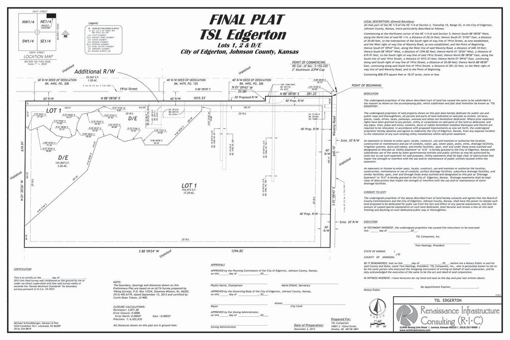
14 STAFF REPORT January 10, 2014 To: Fr: Re: Edgerton Planning Commission Beth Linn, City Administrator Mike Mabrey, Zoning Administrator Application for Final Plat for TSL Edgerton, generally located on the southwest corner of 191st Street and Waverly Road APPLICATION INFORMATION Applicant/Property Owner: Requested Action: TSL Edgerton Final Plat for TSL Edgerton Legal Description: Part of Section 3, Township 15, Range 22 Site Address/Location: Existing Zoning and Land Uses: Approximately 20 acres at the southwest corner of 191st Street and Waverly Road Multiple parcels containing residences and accessory structures Surrounding Zoning and Uses: BNSF Intermodal Facility and L-P zoned land for warehouse development to the north in the City of Edgerton; unincorporated County to the south and east; and land in the City of Edgerton at the northeast corner of Waverly and 191 st. Existing Improvements: Site Size: Single family homes with accessory structures Approximately 20 acres Project Background and Description: The subject property is located on the southwest corner of 191st Street and Waverly Road, with about 1,300 feet of frontage along 191st and about 640 feet along Waverly Street. This land was annexed into the City of Edgerton on September 12, The conditional use has been requested to facilitate the development of the property for a cargo container storage facility. The BNSF intermodal facility is located about 1/2 mile to the northwest and a warehouse industrial (logistics) park is adjacent, across 191st Road to the north. Demand for businesses to store and maintain cargo containers and chassis, such as the facility proposed here, is a by-product of the activity on and around the

15 intermodal facility. The logistics park and intermodal s primary function is to transport and redistribute containers and the products they contain. Since they are not in the business of storing containers for an extended period of time, there is a need for companies, like the applicant s, that specialize in storage and maintenance. Figure 1: Subject Property and Immediate Vicinity Intermodal City of Gardner City of Edgerton Logistics Park (Under Development) Floodplain SUBJECT PROPERTY Waverly Road Unincorporat ed Johnson County 191 st I-35 Background Information The subject property is located on the southwest corner of 191st Street and Waverly Road, with about 1,300 feet of frontage along 191st and about 640 feet along Waverly Street. The property, annexed in September 12, 2013, is entirely within the City of Edgerton. Infrastructure and Services: a. Waverly Road, currently gravel surfaced but planned for future improvement to pavement that will support intermodal and logistic park traffic, will provide access to the proposed facility. 191 st Street west of Waverly is paved/heavy haul. 191 st Street east of Waverly is paved (6 asphalt). b. The property is located within the Big Bull Creek watershed, which flows south from 167th Street to the southern edge of the county at Homestead Lane. c. A little over three acres of the west and southwest portion of the property is located within the flood plain of a tributary of Bull Creek. The site plan does not show any development within the floodplain.

16 d. The property does not currently have sanitary sewer service. No new buildings are planned that would necessitate sewer hook-ups. The existing homes are on septic systems. e. The property is located within the service area of Rural Water District No. 7. A 12-inch water main is located along the Waverly Road property frontage, which is able to supply domestic needs. No new buildings are planned that would necessitate water connection in Phase I. f. Police protection is provided by the Johnson County Sheriff's Department under contract with the City of Edgerton. Fire protection is provided by Johnson County Rural Fire District No. 1. A fire station is located in the City of Edgerton, to the west. Vicinity Map City Boundaries (Gray Dashed Lines) SUBJECT PROPERTY STAFF ANALYSIS Staff has reviewed the Final Plat submittal for compliance with the Approved Preliminary Plat and requirements in Section 13.3 of Article 13 of the Edgerton UDC. Review comments are listed below. 1. Scale, the same used for the preliminary plat; North point; vicinity map. Final Plat complies. 2. The words "FINAL PLAT" followed by the name of the subdivision at the top of the sheet, and then followed by a metes and bounds description of the tract. The title of the plat says Lots 1, 2 & D/E. Both lots are labeled Lot The instrument of survey which shows the point of beginning, corners, bearings, courses, distances, exterior boundaries, interior lot boundaries, abandoned lot lines, pins,
17 monuments found or set. All P.I. s corners, boundaries must be monumented with a 2" x 24" metal bar. The boundary line with a bearing of N W is described differently in the legal description. Abandoned lot lines have not been shown. It appears that no monuments have been set. All P.I. s corners, boundaries must be monumented with a 2" x 24" metal bar. Adjoining parcels should be identified by title description or record reference if pertinent to the boundary lines. The area shown on the plat (17.29 ac ac) is larger than the area in the legal description (18.57 ac). 4. A boundary survey of third order surveying accuracy (maximum closure error one in five thousand (1' in 5,000), with bearings and distances referenced to section or fractional section corners or other base line shown on the plat and readily reproducible on the ground. The corresponding supporting quarter corners should be shown and identified on the plat. 5. Individual notations and a TABLE showing: lot area, setbacks, and building envelopes. Table has not been provided. 6. A number for each lot, starting (if practical) in the northwest corner. Both lots are numbered Lot 1. The drainage easement should be part of one or both of the lots. 7. All easements with widths, and roads with curve data. Additional utility easements may be necessary. Plat should be reviewed by Utility Companies. 8. Ingress/egress limitations if required. Final Plat complies. 9. The location of existing utility easements. Final Plat complies. 10. A written legal description from the survey. Final Plat complies. 11. An instrument of dedication for all roads and easements. Dedication should include Pedestrian Easement. 12. Special notations required as a condition of platting by the Planning Commission. Final Plat complies. 13. Approved phases clearly delineated. Final Plat complies. 14. Private travel easements. Final Plat complies. 15. The Owner's Certificate with Notary Seal. Final Plat complies. 16. Certificate of the Governing Body with City Clerk's attest and Seal. Final Plat complies. 17. Edgerton City Planning Commission chair and secretary approval. Final Plat complies. 18. Certificate of the Register of Deeds. Not provided. 19. Surveyor's Certificate and Seal and certificate for survey review by the County Surveyor or designated Land Surveyor. County Surveyor approval block has not been provided. 20. Certificate of the Zoning Administrator. Final Plat complies. Other Comments Modify Consent to Levy section to correct pubic typo. RECOMMENDATIONS City staff recommends approval of the Final Plat for TSL Edgerton subject to compliance with the following stipulations: 1. All Final Plat requirements of the City listed above shall be met or addressed prior to recording of the Plat. 2. The commencement of any improvements shall not occur prior to the approval and endorsement of the final plat and the submittal to and approval of construction plans for all
18 streets, sidewalks, storm water sewers, sanitary sewers, and water mains contained within the final plat by the Governing Body. Sanitary sewer drawings and specifications must be submitted to and approved by the City of Edgerton and Kansas Department of Health and Environment prior to the commencement of any improvements. 3. A Public Improvement Inspection Fee, established by the Fee Schedule for the Unified Development Code, shall be submitted with the document of financial assurance as defined in Section 13.7 prior to the commencement of any improvements. 4. The applicant shall meet all requirements of Recording a Final Plat as defined in Section 13.5 of the Edgerton Unified Development Code, including payment of excise tax. 5. The applicant shall meet all requirements of Financial Assurances as defined in Section 13.7 of the Edgerton Unified Development Code. ATTACHMENTS Final Plat TSL Edgerton
19
20
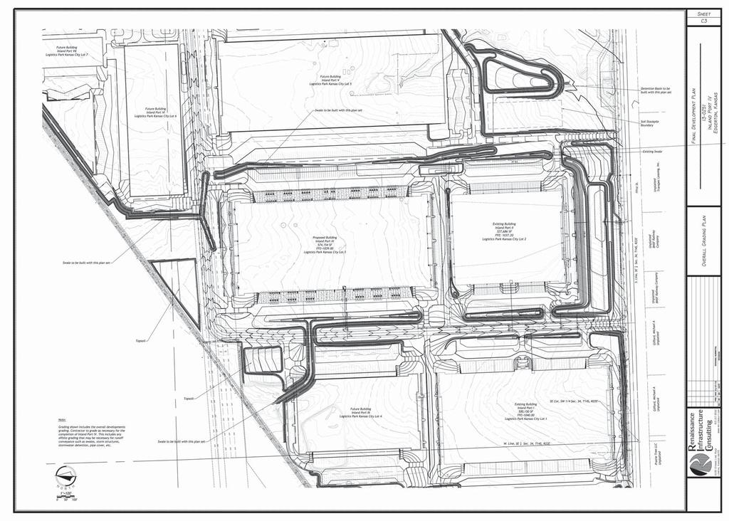
21 STAFF REPORT January 10, 2014 To: Edgerton Planning Commission Fr: Beth Linn, City Administrator Mike Mabrey, Zoning Administrator Re: Application for Logistics Park Kansas City, Third Plat (Lot 3) APPLICATION INFORMATION Applicant/Property Owner: Requested Action: Legal Description: Site Address/Location: Existing Zoning and Land Uses: Existing Improvements: Site Size: Edgerton Land Holding Company Final Plat Logistics Park Kansas City, Third Plat (Lot 3) See Final Plat attached Kill Creek Rd City of Edgerton L-P Logistics Park on vacant land None Approximately Acres PROJECT DESCRIPTION This is the third phase of development of the Logistics Park Kansas City by Edgerton Land Holding Company (ELHC), a subsidiary of NorthPoint Development. The property will serve the BNSF intermodal facility to the north of the subject site. The intermodal facility s purpose is to transfer loaded cargo containers from trains to trucks. BNSF owns 1,000 acres, annexed into the City in 2010, to develop both the intermodal facility and an adjacent warehouse industrial (logistics) park. ELHC, the applicant for this project, is BNSF s partner for developing warehousing which is planned to eventually surround the intermodal facility. The subject property is located directly to the north of Lot 2 (Second Plat) a build-to-suit building for DEMDACO. The property is zoned L-P, Logistics Park. The City s Unified Development Code (UDC) defines this district as a limited multimodal industrial zone created to support activities related to truck, rail and other transport services. The property has an approved preliminary plat and preliminary site plan. The planned use for this lot is a 574,154 square foot warehouse that is build-to-suit for Smart Warehousing a Third Party Logistics Firm.
22 INFRASTRUCTURE AND SERVICES Infrastructure was reviewed previously per the rezoning and preliminary plat. Some conditions continue to exist as noted below. a. Homestead Lane and 191st Street are paved and designed to accommodate intermodal and logistic park truck traffic. Driveway and street connections will need to comply with city requirements regarding location and design. b. All of the property is located within the Big Bull Creek watershed, which flows south from 167th Street to the southern edge of the county at Homestead Lane. c. The property will construct a sanitary sewer main extension to connect to the Intermodal Lift Station of the Big Bull Creek Wastewater Conveyance System recently constructed by the City of Edgerton. d. The property is located within the service area of Water 7. A 12-inch water line is located along the 191st Street. The City of Edgerton, Water District No. 7 and Edgerton Land Holding Company have an approved agreement for construction of a new water tower to supply sufficient fire flows to the site. e. Police protection is provided by the Johnson County Sheriff's Department under contract with the City of Edgerton. Fire protection is provided by Johnson County Rural Fire District No. 1. The nearest fire station is located in the City of Edgerton, approximately 1.5 miles to the west. FINAL PLAT REVIEW Staff has reviewed the Final Plat submittal for compliance with the Approved Preliminary Plat and requirements in Section 13.3 of Article 13 of the Edgerton UDC. Review comments are listed below. 1. Scale, the same used for the preliminary plat; North point; vicinity map. Final Plat complies. 2. The words "FINAL PLAT" followed by the name of the subdivision at the top of the sheet, and then followed by a metes and bounds description of the tract. Final Plat complies. 3. The instrument of survey which shows the point of beginning, corners, bearings, courses, distances, exterior boundaries, interior lot boundaries, abandoned lot lines, pins, monuments found or set. All P.I. s corners, boundaries must be monumented with a 2" x 24" metal bar. The basis of bearings should be labeled on the graphic part of the plat. 4. A boundary survey of third order surveying accuracy (maximum closure error one in five thousand (1' in 5,000), with bearings and distances referenced to section or fractional section corners or other base line shown on the plat and readily reproducible on the ground. Final Plat complies. 5. Individual notations and a TABLE showing: lot area, setbacks, and building envelopes. Final Plat complies. 6. A number for each lot, starting (if practical) in the northwest corner. Final Plat complies. (Lot 1 Inland Port I Spec Building; Lot 2 DEMDACO; Lot 3 this application). 7. All easements with widths, and roads with curve data. Additional utility easements may be necessary. Plat should be reviewed by Utility Companies. The 15 U/E adjacent to the 50 R/W should also be labeled as a pedestrian
23 easement. A 15 U/ E & P/ E should be dedicated on the west side of Kill Creek Road and north side of 187th Street by separate instrument. 8. Ingress/egress limitations if required. Final Plat complies. 9. The location of existing utility easements. Verify existing 15 U/E been recorded via plat or book and page. 10. A written legal description from the survey. Final Plat complies. 11. An instrument of dedication for all roads and easements. Dedication should include Pedestrian Easement. 12. Special notations required as a condition of platting by the Planning Commission. Final Plat complies. 13. Approved phases clearly delineated. Final Plat complies. 14. Private travel easements. Final Plat complies. 15. The Owner's Certificate with Notary Seal. Final Plat complies. 16. Certificate of the Governing Body with City Clerk's attest and Seal. Final Plat complies. 17. Edgerton City Planning Commission chair and secretary approval. Final Plat complies. 18. Certificate of the Register of Deeds. Not provided. 19. Surveyor's Certificate and Seal and certificate for survey review by the County Surveyor or designated Land Surveyor. County Surveyor approval block has not been provided. 20. Certificate of the Zoning Administrator. Final Plat complies. RECOMMENDATION City staff recommends approval of the Final Plat for Logistics Park Kansas City, Third Plat (Lot 3) subject to compliance with the following stipulations: 1. All Final Plat requirements of the City listed above shall be met or addressed prior to recording of the Plat. 2. The commencement of any improvements shall not occur prior to the approval and endorsement of the final plat and the submittal to and approval of construction plans for all streets, sidewalks, storm water sewers, sanitary sewers, and water mains contained within the final plat by the Governing Body. Sanitary sewer drawings and specifications must be submitted to and approved by the City of Edgerton and Kansas Department of Health and Environment prior to the commencement of any improvements. 3. A Public Improvement Inspection Fee, established by the Fee Schedule for the Unified Development Code, shall be submitted with the document of financial assurance as defined in Section 13.7 prior to the commencement of any improvements. 4. The applicant shall meet all requirements of Recording a Final Plat as defined in Section 13.5 of the Edgerton Unified Development Code, including payment of excise tax. 5. The applicant shall meet all requirements of Financial Assurances as defined in Section 13.7 of the Edgerton Unified Development Code. ATTACHMENTS Final Plat for Logistics Park Kansas City, Third Plat (Lot 3)
24
25
26
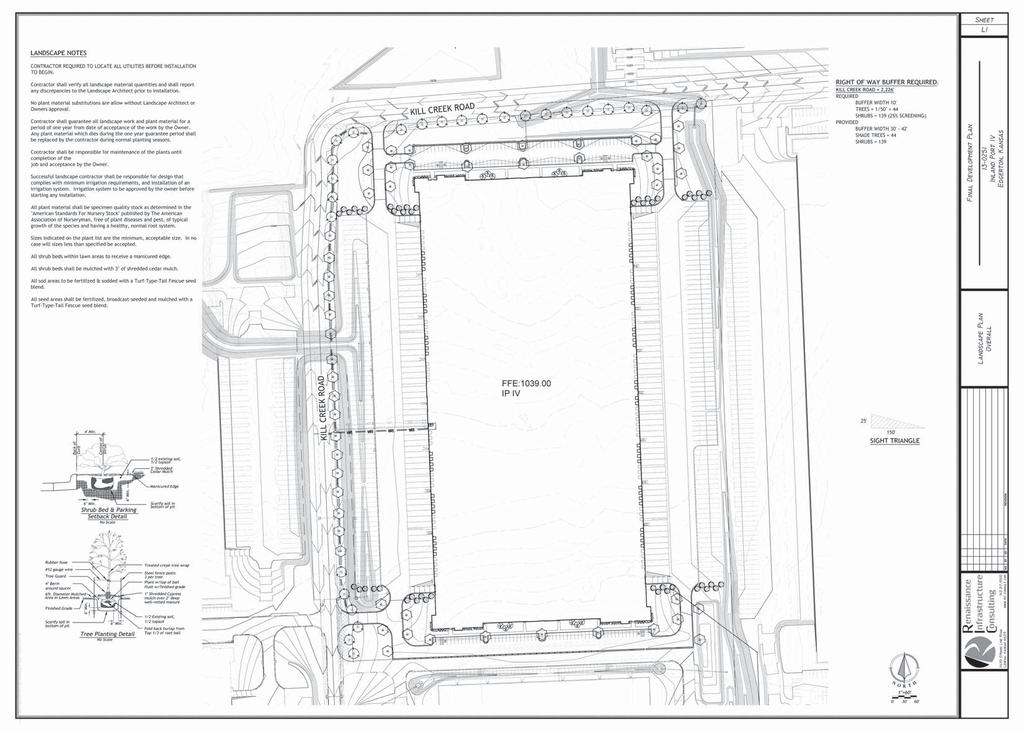
27 STAFF REPORT January 10, 2014 To: Edgerton Planning Commission Fr: Beth Linn, City Administrator Mike Mabrey, Zoning Administrator Re: Application for Final Site Plan for Logistics Park Kansas City, Third Plat (Lot 3) APPLICATION INFORMATION Applicant/Property Owner: Requested Action: Edgerton Land Holding Company Final Site Plan Logistics Park Kansas City, Second Plat (Lot 3) Legal Description: Site Address/Location: Existing Zoning and Land Uses: Existing Improvements: Site Size: Kill Creek Rd City of Edgerton L-P Logistics Park on vacant land None Approximately Acres PROJECT DESCRIPTION This is the third phase of development of the Logistics Park Kansas City by Edgerton Land Holding Company (ELHC), a subsidiary of NorthPoint Development. The property will serve the BNSF intermodal facility to the north of the subject site. The intermodal facility s purpose is to transfer loaded cargo containers from trains to trucks. BNSF owns 1,000 acres, annexed into the City in 2010, to develop both the intermodal facility and an adjacent warehouse industrial (logistics) park. ELHC, the applicant for this project, is BNSF s partner for developing warehousing which is planned to eventually surround the intermodal facility. The subject property is located directly to the north of Lot 2 (Second Plat) a build-to-suit building for DEMDACO. The property is zoned L-P, Logistics Park. The City s Unified Development Code (UDC) defines this district as a limited multimodal industrial zone created to support activities related to truck, rail and other transport services. The property has an approved preliminary plat and preliminary site plan. The planned use for this lot is a 574,154 square foot warehouse that is build-to-suit for Smart Warehousing a Third Party Logistics Firm.
28 INFRASTRUCTURE AND SERVICES Infrastructure was reviewed previously per the rezoning and preliminary plat. Some conditions continue to exist as noted below. a. Homestead Lane and 191st Street are paved and designed to accommodate intermodal and logistic park truck traffic. Driveway and street connections will need to comply with city requirements regarding location and design. b. All of the property is located within the Big Bull Creek watershed, which flows south from 167th Street to the southern edge of the county at Homestead Lane. c. The property will construct a sanitary sewer main extension to connect to the Intermodal Lift Station of the Big Bull Creek Wastewater Conveyance System recently constructed by the City of Edgerton. d. The property is located within the service area of Water 7. A 12-inch water line is located along the 191st Street. The City of Edgerton, Water District No. 7 and Edgerton Land Holding Company have an approved agreement for construction of a new water tower to supply sufficient fire flows to the site. e. Police protection is provided by the Johnson County Sheriff's Department under contract with the City of Edgerton. Fire protection is provided by Johnson County Rural Fire District No. 1. The nearest fire station is located in the City of Edgerton, approximately 1.5 miles to the west. FINAL SITE PLAN REVIEW Staff has reviewed the Final Site Plan submittal for compliance with the Approved Preliminary Site Plan and Section 5.2 Logistics Park (L-P) of Article 5. It is also reviewed for compliance with Section 10.1 of Article 10 for Site Plan requirements. The combined details of that review are listed below. 1. Front or cover sheet. a) A scale vicinity map showing the relationship of the site to surrounding neighborhoods, roads and other physical features. Final Site Plan complies. b) A project title, zoning designation and project sponsor. A street, lot or tract address of the project. Add the street address Kill Creek Rd. c) An index to contents, and a data table which, at a minimum, includes: Acreage of the site and number of units per acre (if applicable); gross square feet of the building(s) area; the proposed use of each building; number of employees and the BOCA or Uniform Building Code or NEPA 101 Life Safety Code Occupancy Design Load and, the total number of parking places. Not provided. d) The name of the architect, engineer, surveyor or draftsman. Final Site Plan complies. e) The specified certificates and signature blocks. Final Site Plan complies. 2. Sheet #2 a) A landscape plan drawn to scale, showing the site, building location, planting and seeding schedules, refuse and outdoor storage screening and boundary screening. All landscape features shall be shown in relation to sidewalks, paths, lawns, parking areas and drives. The site plan does not show trash enclosures and required screening. The ROW Buffer requires 45 trees and 557 hedge/shrub/evergreens. Plan only provides 44 trees and 139 shrubs.
29 Additional landscaping should be considered similar to the DEMDACO building as dock doors face the public right-of-w ay. Provide written confirmation from KCPL that the proposed landscaping is acceptable within their 160 easement. b) A table entitled "Planting Schedule" which lists the common name, size and condition of all planting materials, together with a timetable for planting. Final Site Plan complies. 3. Sheet #3 a) A site map with the following features. i. Topography at reasonable intervals. Final Site Plan complies. ii. Exterior lot lines with any survey pins. See Final Plat. iii. Location of buildings. Final Site Plan complies. Parking areas, paths, walks with sizes and surfaces material specifications. Final Site Plan accommodates space for sidewalks; however sidewalk locations have not been shown adjacent to the Public Street or within the proposed lot development. Section 5.2.I.3.f of the UDC states that pedestrian access within a development and adjacent public and private property shall be considered as a component to the design of an employment center. Show proposed sidewalk along Kill Creek Road and 187 th Street. Provide required number of employee spaces and provided number of employee spaces. iv. Exterior lighting specifications. Applicant shall provide a photometric plan in compliance with the lighting specifications for L-P District. v. Site entrance and connections to streets. There is not sufficient distance between existing and proposed driveways. Additional separation is needed. Applicant should also consider driveway location with regard to future building to west. Exact location shall be reviewed and approved by City Engineer prior to construction to insure the public health, safety and welfare of the travelling public. A schedule for completion of the public street should be submitted. There is only one access point for the IP IV building and for the entire LPKC development. Verify restrictions in the Fire Code regarding amount of building square footage to be served by a single access point. vi. The location of easements. Proposed easements should be shown. Missing easements include interior utility easements. vii. Connection point for utilities. Construction plans for all public infrastructure will need to be prepared to City standards and approved prior to construction. A KDHE sewer extension permit will also be required. b) A sketch of the entry sign, and all other free-standing, façade, and building signs to be used on the premises. Not provided. c) Features to facilitate handicapped access. Handicapped accessible spaces have been shown. The spaces should also be located as close to the doors as practical. An accessible route should be provided that is not in the driving lanes. Provide the total number of stalls along with the number of
30 accessible spaces to confirm that ADA requirements are met. The accessible parking spaces and access areas should not exceed 2% slope in any direction. d) Profile and detail for roads (if required). To be determined during construction plan preparation. 4. Sheet #4 a) Scale drawing of building floor plans. Final Site Plan complies. b) Dimensions and use of rooms and areas. Not provided. Will be addressed during building permit review process. c) Dimensions of entrances/exits and corridors. Not provided. Will be addressed during building permit review process. d) Interior specifications for handicapped accessibility as required by ANSI and this ordinance. Not provided. Will be addressed during building permit review process. 5. Sheet #5 a) Scale drawings of all building elevations. Review to be completed during building permit process. b) Roof pitch and materials. Review to be completed during building permit process. c) Siding type and materials, including facie. Review (including compliance to UDC requirements for building massing, color, horizontal articulation, vertical articulation, etc.) to be completed during building permit process. Parking and Loading. 1. Each establishment shall provide sufficient off-street parking spaces for all employees, customers, visitors, and others who may spend time at the establishment during working hours. Such parking spaces shall be at least nine (9) feet by twenty (20) feet. Parking spaces proposed on the site plan are 9 feet by 18 feet. Proposed parking spaces must be expanded to meet the standard. 2. Light manufacturing shall provide one parking stall per one hundred (100) sq. ft.; general manufacturing shall provide one park stall per one hundred fifty (150) sq. ft.; and, heavy manufacturing shall provide one parking stall per 200 sq. ft. 3. Minimum parking standards may be adjusted to greater or lesser capacities to account for location, expected circulation flows, and conversion probabilities by the Planning Commission or Zoning Administrator. Each establishment shall provide adequate loading space within a building or in a side or rear yard, in such a way that all storage, standing and maneuvering of trucks shall be off the public right-of-way. Final Site Plan complies. 4. No portion of a parking or loading space, including maneuvering areas, except the necessary drives, shall be located closer than 30 feet from a public street right-of-way. Final Site Plan complies 5. All parking shall be on a surface prepared from concrete or asphalt. Final Site Plan complies. 6. All commercial buildings shall provide a designated off-street space for the loading and unloading of goods and merchandise. Final Site Plan complies. 7. See Article 10 for additional parking requirements.
31 Design Standards and Required Dimensions 1. Access. Each required parking space shall open directly on an aisle or driveway to provide safe and efficient means of ingress and egress. Final Site Plan complies. 2. Location. All parking shall be located on the same zoning lot as the structure or use served, or an adjacent lot under the same taxpayer's name, unless special permission is granted for collective or group parking. Final Site Plan complies. 3. Lighting. All lighting used to illuminate parking areas shall be directed away or shielded from residential properties. No exterior lighting information has been provided. Property owner is required to submit a Photometrics plan in conformance with the Photometrics standards included in the L-P District. 4. Bumper Guards & Pavement Marking. Parking areas shall have adequate bumper guards to prevent extension or overhang of vehicles beyond property lines or parking spaces. Parking areas shall have adequate markings for channelization and movement of vehicles. Wheel stops are required for parking spaces around the perimeter of the parking lot and adjacent to sidewalks. Wheel stops are not indicated on the site plan and should be stipulated. 5. Screening. All parking areas containing more than six (6) spaces shall be screened on each side that adjoins any property situated in a residential district. Screening shall be by a wall, or fence, or evergreen hedge not less than six (6) feet nor more than eight (8) feet in height. Parking areas shall be arranged and designed so as to prevent damage to, or intrusion into, walls, fences, or hedges. General Design and Layout Criteria. 1. Relation to Adjoining Street System. The arrangement of streets in new subdivisions shall make provisions for the continuation of the principal existing streets in adjoining subdivisions (or their proper projection where adjoining property is not subdivided) where required by the Planning Commission or the Governing Body. Final Site Plan complies. 2. Street Provisions for Future Development. Where appropriate, areas shall be reserved for future street usage in conjunction with the development of adjacent tracts. Areas reserved for future street usage will not be required to be improved; however, these areas shall be reserved for street improvements to be provided by the subdivider of the adjacent tract. Final Site Plan complies. 3. Lot Access. The Planning Commission may disapprove any point of ingress or egress to any lot, tract, or development from any street or highway when the proposed ingress or egress would create unsafe conditions, reduce the capacity of the adjoining street or highway, or result in substandard circulation and impaired vehicle movement. Final Site Plan complies. 4. Construction Standards. All streets shall be built to standards established by the City of Edgerton. Any public infrastructure will submit plans to be reviewed and approved by City. Other Comments A storm water study has been provided. Review is not yet complete and comments will be provided once review is completed. Review the Diesel Emission Requirements in the UDC. Provide electrical hook-ups as required to eliminate excessive idling. Verify compliance with other requirements Diesel Emission. A
32 Diesel Emission Plan shall be provided as specific tenants and their uses become known. Diesel Emission Plan can be more difficult and/or more expensive to retrofit after the building is constructed. Final Site Plan shall be reviewed by Water 7 to determine if district requirements being met. RECOMMENDATION City staff recommends approval of the Final Site Plan for Logistics Park Kansas City, Second Plat (Lot 3) subject to compliance with the following stipulations: 1. Revised final site plans shall be submitted prior any building permit approvals or commencement of the use to address all Site Plan requirements in the Section 5.2 of Article 5 Logistics Park (L-P) and Section 10.1 of Article 10 Site Plan including all items listed above. 2. No signage is proposed with this application. Signage proposed later shall receive separate approval according to the provisions of the UDC. 3. No exterior lighting is proposed with this application. Lighting proposed later shall receive separate approval according to the provisions of the UDC. 4. All construction plans for any public infrastructure shall be prepared to City standards and approved by the City. Plans for any public sanitary sewer extension will need to obtain a KDHE permit. 5. All building permit and sign permit requirements of the City shall be met. 6. Applicant/Owner Obligation. The site plan, a scale map of proposed buildings, structures, parking areas, easements, roads and other city requirements (landscaping/berm plan, lighting plan) used in physical development, when approved by the Planning Commission shall create an enforceable obligation to build and develop in accordance with all specifications and notations contained in the site plan instrument. The applicant prior to the issuance of any development permit shall sign all site plans. A final site plan filed for record shall indicate that the applicant shall perform all obligations and requirements contained therein. ATTACHMENTS Final Site Plan for Logistics Park Kansas City, Third Plat (Lot 3)
33
34
35
36

37

38

39
40

41
42
43
44
45

46
47
48
49
50
51
52
53
54
55
56
57

58
EDGERTON CITY HALL PLANNING COMMISSION MEETING REGULAR SESSION March 12, 2019
 EDGERTON CITY HALL PLANNING COMMISSION MEETING REGULAR SESSION The met in regular session with Chair John Daley calling the meeting to order at 7:00 p.m. All present participated in the Pledge of Allegiance.
EDGERTON PLANNING COMMISSION AGENDA REGULAR SESSION Edgerton City Hall February 14, :00 PM
 EDGERTON PLANNING COMMISSION AGENDA REGULAR SESSION Edgerton City Hall February 14, 2017 7:00 PM 1. Call Meeting to Order 2. Pledge of Allegiance 3. Roll Call 4. Consent Agenda (Consent Agenda items will
EDGERTON CITY HALL PLANNING COMMISSION MEETING REGULAR SESSION October 9, 2018
 EDGERTON CITY HALL PLANNING COMMISSION MEETING REGULAR SESSION The Edgerton Planning Commission met in regular session with Chair John Daley calling the meeting to order at 7:00 p.m. All present participated
EDGERTON PLANNING COMMISSION REGULAR SESSION Edgerton City Hall May 8, :00 P.M.
 EDGERTON PLANNING COMMISSION REGULAR SESSION Edgerton City Hall May 8, 2018 7:00 P.M. (Meeting will convene immediately following the adjournment of the Board of Zoning Appeals Meeting.) 1. Call Meeting
EDGERTON CITY COUNCIL MEETING AGENDA CITY HALL, 404 EAST NELSON STREET April 26, :00 P.M.
 EDGERTON CITY COUNCIL MEETING AGENDA CITY HALL, 404 EAST NELSON STREET April 26, 2018 7:00 P.M. Call to Order 1. Roll Call Roberts Longanecker Brown Conus Lewis 2. Welcome 3. Pledge of Allegiance Consent
Residential Major Subdivision Review Checklist
 Residential Major Subdivision Review Checklist Plan Submittal Requirements: 2 full sets of stamped plans Electric submittal - all plans contained in a single PDF 3 full sets if commercial kitchen or dining
Residential Minor Subdivision Review Checklist
 Residential Minor Subdivision Review Checklist Plan Submittal Requirements: 2 full sets of stamped plans Electric submittal - all plans contained in a single PDF 3 full sets if commercial kitchen or dining
ZONING AMENDMENT, PLANNED UNIT DEVELOPMENT & SUBDIVISION STAFF REPORT Date: August 8, 2013
 ZONING AMENDMENT, PLANNED UNIT DEVELOPMENT & SUBDIVISION STAFF REPORT Date: August 8, 2013 NAME SUBDIVISION NAME PV-Magnolia, LLC Twelve Trees Subdivision LOCATION 2860, 2862 and 2866 Pleasant Valley Road
PLANNING & ZONING DEPARTMENT 401 South Rogers Street Waxahachie, Texas (469)
") ZONING APPLICATION Select Application Type: Zoning Change Specific Use Permit (SUP) PD Concept Plan PD Detailed Plan PD Amendment Site Plan The following items shall be included in the application submittal:
ZONING APPLICATION Select Application Type: Zoning Change Specific Use Permit (SUP) PD Concept Plan PD Detailed Plan PD Amendment Site Plan The following items shall be included in the application submittal:
MASTER SUBDIVISION FINAL PLAT APPLICATION Town of Apex, North Carolina
 MASTER SUBDIVISION FINAL PLAT APPLICATION Town of Apex, North Carolina This document is a public record under the North Carolina Public Records Act and may be published to the Town s website or disclosed
CONDOMINIUM REGULATIONS
 ARTICLE 37 CONDOMINIUM REGULATIONS SECTION 37.01. Purpose The purpose of this Article is to regulate projects that divide real property under a contractual arrangement known as a condominium. New and conversion
MINOR SUBDIVISION PLAT CHECKLIST
 MINOR SUBDIVISION PLAT CHECKLIST Project Name: Tax ID #: Project Number: Date: _ Reviewed By: Telephone: NOTES: All lots on septic systems must comply with the Fulton County Health Department requirements
DAUPHIN CREEK ESTATES SUBDIVISION
 # 12 SUB-000076-2017 DAUPHIN CREEK ESTATES SUBDIVISION Engineering Comments: FINAL PLAT COMMENTS (should be addressed prior to submitting the FINAL PLAT for review and/or signature by the City Engineer):
Site Plan Application
 Site Plan Application City of St. Pete Beach Community Development Department 155 Corey Avenue St. Pete Beach, Florida 33706 (727) 367-2735 www.stpetebeach.org Case Number: PROPERTY OWNER: Name: Address:
FINAL SITE PLAN PLAT APPLICATION Town of Apex, North Carolina
 FINAL SITE PLAN PLAT APPLICATION Town of Apex, North Carolina This document is a public record under the North Carolina Public Records Act and may be published on the Town s website or disclosed to third
ZONING AMENDMENT, PLANNED UNIT DEVELOPMENT & SUBDIVISION STAFF REPORT Date: September 15, 2011
 ZONING AMENDMENT, PLANNED UNIT DEVELOPMENT & SUBDIVISION STAFF REPORT Date: September 15, 2011 NAME SUBDIVISION NAME LOCATION Stratford, L.L.C. Grelot Office Park Subdivision North side of Grelot Road,
ZONING AMENDMENT & SUBDIVISION STAFF REPORT Date: July 9, 2015
 ZONING AMENDMENT & SUBDIVISION STAFF REPORT Date: July 9, 2015 APPLICANT NAME 2513 Dauphin Street, Inc. SUBDIVISION NAME Audubon Place Extension No. 3, Resubdivision of Lots 1-5 LOCATION 2513 Dauphin Street
Final Plat Mapping Requirements
 CURRENT PLANNING DIVISION 410 E. 5 th Street Loveland, CO 80537 970-962-2523 eplan-planning@cityofloveland.org cityofloveland.org/dc Final Plat Mapping Requirements All Final plats shall comply with the
PLANNED UNIT DEVELOPMENT & SUBDIVISION STAFF REPORT Date: November 17, 2016
 PLANNED UNIT DEVELOPMENT & SUBDIVISION STAFF REPORT Date: November 17, 2016 DEVELOPMENT NAME SUBDIVISION NAME LOCATION Autonation Ford of Mobile Autonation Ford of Mobile Subdivision 901, 909, and 925
SUBDIVISION, PLANNED UNIT DEVELOPMENT, ZONING AMENDMENT, & SIDEWALK WAIVER STAFF REPORT Date: July 19, 2018
 SUBDIVISION, PLANNED UNIT DEVELOPMENT, ZONING AMENDMENT, & SIDEWALK WAIVER STAFF REPORT Date: July 19, 2018 NAME SUBDIVISION NAME LOCATION West Mobile Properties, LLC U.S. Machine Subdivision 556, 566,
To provide for the review of the final engineering plans, the subdivision improvement agreement, public dedications, and other legal agreements.
 ARTICLE 5 FINAL PLAT 501 Intent DOUGLAS COUNTY SUBDIVISION RESOLUTION To provide for the review of the final engineering plans, the subdivision improvement agreement, public dedications, and other legal
Condominium Unit Requirements.
 ARTICLE 19 CONDOMINIUM REGULATIONS Section 19.01 Purpose. The purpose of this Article is to regulate projects that divide real property under a contractual arrangement known as a condominium. New and conversion
APPLICATION PROCEDURE
 ANTRIM PLANNING BOARD P. O. Box 517 Antrim, New Hampshire 03440 Phone: 603-588-6785 FAX: 603-588-2969 APPLICATION FORM AND CHECKLIST FOR MINOR OR MAJOR SITE PLAN REVIEW File Date Received By APPLICATION
City of Fort Lupton Amended Plat Process
 City of Fort Lupton Amended Plat Process Purpose The Amended Plat process is an administrative process to amend a recorded Plat. An Amended Subdivision is an administrative revision to a recorded Subdivision
MINOR SUBDIVISION FINAL PLAT APPLICATION Town of Apex, North Carolina
 MINOR SUBDIVISION FINAL PLAT APPLICATION Town of Apex, North Carolina This document is a public record under the North Carolina Public Records Act and may be published on the Town s website or disclosed
PROCEDURE. Chapter 12: Subdivision Regulations
 SECTION 14-600 ADMINISTRATIVE REPLAT PROCEDURE 14-601 INTENT These procedures are to provide an abbreviated process for Replat applications that demonstrate compliance with the criteria contained herein.
(voice) (fax) (voice) (fax) Site Plan Review
 (fax) (voice) (fax) Site Plan Review") Town of South Boston PO Box 417 455 Ferry Street South Boston Virginia 24592 Planning Department Public Works Department (Engineering) 434.575.4241 (voice) 434.575.4275 (fax) 434.575.4260 (voice) 434.575.4275
Town of South Boston PO Box 417 455 Ferry Street South Boston Virginia 24592 Planning Department Public Works Department (Engineering) 434.575.4241 (voice) 434.575.4275 (fax) 434.575.4260 (voice) 434.575.4275
SUBDIVISION APPLICATION
 SUBDIVISION APPLICATION Preliminary Plat Minor Plat Final Plat Amended Plat Applicant Name: Owner (if different from applicant) Name: Company: Company: Address: Address: City, State, Zip City, State, Zip
ARTICLE 13 CONDOMINIUM REGULATIONS
 ARTICLE 13 CONDOMINIUM REGULATIONS Section 13.01 Purpose. The purpose of this Article is to regulate projects that divide real property under a contractual arrangement known as a condominium. New and conversion
PLANNED UNIT DEVELOPMENT & SUBDIVISION STAFF REPORT August 18, 2016
 PLANNED UNIT DEVELOPMENT & SUBDIVISION STAFF REPORT August 18, 2016 DEVELOPMENT NAME SUBDIVISION NAME Mullinax Ford Subdivision Mullinax Ford Subdivision LOCATION CITY COUNCIL DISTRICT District 6 Southeast
ORDINANCE NO. Z REZONING NO
 ORDINANCE NO. Z- 3960 REZONING NO. 2018-00014 AN ORDINANCE RELATING TO ZONING: AMENDING CERTAIN ZONING REGULATIONS SHOWN ON SHEET NO. 15 OF THE ZONING DISTRICT MAP INCORPORATED BY REFERENCE BY OVERLAND
APPENDIX B. SUBMISSION REQUIREMENTS
 Master Major Site Minor Site Landscape Section B.1 Table of /Plat Requirements Proposed or approved name of development, project, subdivision, and/or phase. Location, including township, county, and state.
INSTRUCTIONS FINAL PLAT APPROVAL APPLICATION
 INSTRUCTIONS FINAL PLAT APPROVAL APPLICATION 1. The applicant/agent shall fill out the attached application. The attached application form must be completely filled in before it can be filed. Portions
CITY OF FAYETTEVILLE, ARKANSAS FINAL PLAT FOR STAFF USE ONLY FINAL PLAT FEE: $ $ Date Application Submitted: Date Accepted as Complete:
 CITY OF FAYETTEVILLE, ARKANSAS FINAL PLAT FOR STAFF USE ONLY FINAL PLAT FEE: $200.00-$800.00 Date Application Submitted: Date Accepted as Complete: Project Number: Public Hearing S-T-R: PP#: Zone: Please
MAJOR RESIDENTIAL AND NONRESIDENTIAL SUBDIVISIONS
 MAJOR RESIDENTIAL AND NONRESIDENTIAL SUBDIVISIONS Final Plats The applicant shall schedule a Pre-Application meeting with Planning Staff at least seven (7) working days prior to submittal of the application.
Exhibit "A" have applied for a re-zoning and re-classification of that property from OPEN RURAL (OR) to that of a PLANNED UNIT DEVELOPMENT (PUD); and
 to that of a PLANNED UNIT DEVELOPMENT (PUD); and") I NSTR # 200632845 OR BK 61439 PGS 0728-0750 RECORDED 06/24/2066 12:25:50 PR JOHN Q. CRAWFOKD CLERK OF CIRCUIT COURT NASSAU COUNTY, FLORIDA RECORDING FEES 1.37.80 ORDINANCE NO. 2006-65 AN ORDINANCE AMENDING
I NSTR # 200632845 OR BK 61439 PGS 0728-0750 RECORDED 06/24/2066 12:25:50 PR JOHN Q. CRAWFOKD CLERK OF CIRCUIT COURT NASSAU COUNTY, FLORIDA RECORDING FEES 1.37.80 ORDINANCE NO. 2006-65 AN ORDINANCE AMENDING
ZONING AMENDMENT & SUBDIVISION STAFF REPORT Date: November 3, 2016
 ZONING AMENDMENT & SUBDIVISION STAFF REPORT Date: November 3, 2016 APPLICANT NAME SUBDIVISION NAME David Shumer 5955 Airport Subdivision CITY COUNCIL DISTRICT District 6 5955 Airport Boulevard, 754 Linlen
MTC ALABAMA SUBDIVISION
 # 2 SUB-000370-2017 MTC ALABAMA SUBDIVISION Engineering Comments: FINAL PLAT COMMENTS (should be addressed prior to submitting the FINAL PLAT for review and/or signature by the City Engineer): A. Provide
SUBDIVISION, PLANNING APPROVAL, & REZONING STAFF REPORT Date: June 4, 2015
 SUBDIVISION, PLANNING APPROVAL, & REZONING STAFF REPORT Date: June 4, 2015 APPLICANT NAME SUBDIVISION NAME DEVELOPMENT NAME LOCATION Board of Water & Sewer Commissioners of the City of Mobile MAWSS MLK
MINOR PLAT. The following documents are provided as required by the City of Conroe for use in the above titled platting submittals:
 Public Works - Engineering Division CITY OF CONROE MINOR PLAT The following documents are provided as required by the City of Conroe for use in the above titled platting submittals: Submittal Questionnaire
FINAL PLAT GUIDE TO SUBDIVIDING PROPERTY. Background
 FINAL PLAT GUIDE TO SUBDIVIDING PROPERTY Background A final plat is the second step in the process of subdividing land into separate parcels for future sale or lease. Once a preliminary plat has been approved
ARTICLE 14 PLANNED UNIT DEVELOPMENT (PUD) DISTRICT
 DISTRICT") ARTICLE 14 PLANNED UNIT DEVELOPMENT (PUD) DISTRICT Section 14.01 Intent. It is the intent of this Article to allow the use of the planned unit development (PUD) process, as authorized by the Michigan Zoning
ARTICLE 14 PLANNED UNIT DEVELOPMENT (PUD) DISTRICT Section 14.01 Intent. It is the intent of this Article to allow the use of the planned unit development (PUD) process, as authorized by the Michigan Zoning
A Final Plat will be reviewed concurrently with any other development review application(s) that is required.
 that is required.") RELATED FACTS TO KNOW: Adams County Recording Requirements, Annexation, Common Wall Subdivision, Development Plan (PUD Development Permit), Fees, Helpful Contact Information, Lot Line Adjustment, Neighborhood
RELATED FACTS TO KNOW: Adams County Recording Requirements, Annexation, Common Wall Subdivision, Development Plan (PUD Development Permit), Fees, Helpful Contact Information, Lot Line Adjustment, Neighborhood
ARTICLE 900 PLAT AND PLAN REQUIREMENTS
 ARTICLE 900 PLAT AND PLAN REQUIREMENTS SEC. 900.1 ITEMS TO BE SHOWN ON PLAT OR PLAN General (1) Property lines of all property owners adjacent to the exterior boundaries of the project shall be located
Applications will be received on business days between 9:00 AM and 3:00 PM
 Special Use Permit Application Douglas County Board of Commissioners Douglas County, Georgia Applications will be received on business days between 9:00 AM and 3:00 PM Date of Application: Application
CITY OF OCOEE LAND DEVELOPMENT CODE SUFFICIENCY TABLE WITH NOTES
 CITY OF OCOEE LAND DEVELOPMENT CODE SUFFICIENCY TABLE WITH NOTES The Sufficiency Table is a checklist to help identify the types of information and documentation needed for various types of projects. The
COLLIER COUNTY Growth Management Department
 COLLIER COUNTY Growth Management Department March 24, 2016 Tim Hancock, AICP Stntec Consulting Services Inc. 3200 Bailey Lane, Suite 200 Naples, FL 34105 EMAIL - Tim.Hancock@stantec.com RE: Planned Unit
ARTICLE 5 MINOR SUBDIVISION/LAND DEVELOPMENT
 ARTICLE 5 MINOR SUBDIVISION/LAND DEVELOPMENT SECTION 501 ONLY FINAL PLAN REQUIRED The classification of a proposed subdivision as a "Minor Subdivision" shall only require the submission, review and approval
SUBDIVISION & PLANNING APPROVAL STAFF REPORT Date: December 1, 2016
 SUBDIVISION & PLANNING APPROVAL STAFF REPORT Date: December 1, 2016 APPLICANT NAME SUBDIVISION NAME DEVELOPMENT NAME LOCATION Board of Water and Sewer Commissioners of the City of Mobile Halls Mill Road
APPLICANT NAME SUBDIVISION NAME DEVELOPMENT NAME LOCATION. CITY COUNCIL DISTRICT Council District 4 PRESENT ZONING PROPOSED ZONING
 SUBDIVISION, PLANNED UNIT DEVELOPMENT, PLANNING APPROVAL, ZONING AMENDMENT, & SIDEWALK WAIVER REQUEST STAFF REPORT Date: February 17, 2010 APPLICANT NAME SUBDIVISION NAME DEVELOPMENT NAME LOCATION David
LAND USE APPLICATION
 LAND USE APPLICATION File Name: File No(s).: Receipt No.: Receipt Date: Received By: Amount.: $ Instructions for Applicants Please read and follow all instructions on your application carefully. If you
Township of Little Egg Harbor Planning Board 665 Radio Road Little Egg Harbor, New Jersey Phone: ext. 221 Fax:
 BLOCK(S) LOT(S) Township of Little Egg Harbor Planning Board 665 Radio Road Little Egg Harbor, New Jersey 08087 Phone: 609-296-7241 ext. 221 Fax: 609-294-3040 Development Application Amended Development
ANDOVER CODE. Checklist #5 Preliminary Site Plan Conditional Use
 ANDOVER CODE Checklist #5 Preliminary Site Plan Conditional Use Applicant: Block Lot File No. This checklist is for general reference only. Further information may be required by the reviewing authority.
SUBMITTAL REQUIREMENTS: The number indicates the number of copies for submittal (if applicable).
.") Office Use Only Preliminary Long Plat Long Subdivision Applicant Checklist PLANNING, COMMUNITY, & ECONOMIC DEVELOPMENT DEPARTMENT FINAL LONG PLAT LONG SUBDIVISION CHECKLIST Mailing Address: P.O. Box 547,
Office Use Only Preliminary Long Plat Long Subdivision Applicant Checklist PLANNING, COMMUNITY, & ECONOMIC DEVELOPMENT DEPARTMENT FINAL LONG PLAT LONG SUBDIVISION CHECKLIST Mailing Address: P.O. Box 547,
TOWN OF OCEAN ISLE BEACH
 TOWN OF OCEAN ISLE BEACH PLANNED UNIT DEVELOPMENT ORDINANCE ADOPTED IN EFFECT FEBRUARY 13, 2001 This ordinance has been prepared by the Ocean Isle Beach Planning & Inspections Department. Section 66-55.
ZONING AMENDMENT & SUBDIVISION STAFF REPORT Date: July 3, 2014
 ZONING AMENDMENT & SUBDIVISION STAFF REPORT Date: July 3, 2014 APPLICANT NAME SUBDIVISION NAME LOCATION Georgia Crown Distributing Subdivision Georgia Crown Distributing Subdivision Southwest corner of
McGowin Park, LLC. B-3, Community Business District
 # 10, 11, 12 SUB2014-00024 ZON2014-00500 ZON2014-00501 SUBDIVISION, PLANNED UNIT DEVELOPMENT (East), PLANNED UNIT DEVELOPMENT (West) STAFF REPORT Date: April 3, 2014 DEVELOPMENT NAME LOCATION McGowin Park,
WRITTEN DECISION OF THE HAYDEN CITY COUNCIL REGARDING MAPLE GROVE PRELIMINARY SUBDIVISION APPLICATION (SUB-0013) HAYDEN SIGNATURE, LLC
 HAYDEN SIGNATURE, LLC") WRITTEN DECISION OF THE HAYDEN CITY COUNCIL REGARDING MAPLE GROVE PRELIMINARY SUBDIVISION APPLICATION (SUB-0013) HAYDEN SIGNATURE, LLC Application of Hayden Signature, LLC, an Idaho limited liability company,
WRITTEN DECISION OF THE HAYDEN CITY COUNCIL REGARDING MAPLE GROVE PRELIMINARY SUBDIVISION APPLICATION (SUB-0013) HAYDEN SIGNATURE, LLC Application of Hayden Signature, LLC, an Idaho limited liability company,
WILTON MANORS, Island City 2020 WILTON DRIVE, WILTON MANORS, FLORIDA 33305
 WILTON MANORS, Island City 2020 WILTON DRIVE, WILTON MANORS, FLORIDA 33305 COMMUNITY DEVELOPMENT SERVICES (954) 390-2180 FAX: (954) 567-6069 PLAT APPLICATION PACKAGE This package includes: General Submittal
Community Development Department Council Chambers, 7:30 PM, December 1, 2016
 STAFF REPORT 2016-35P: Subdivision Community Development Department Council Chambers, 7:30 PM, December 1, 2016 To: From: Re: Paul Luke, Chairman, Skokie Plan Commission Mike Voitik, Planning Technician
Individual Well Individual Septic. Community Well 19. What is the proposed method of sewage disposal? Public. None
 Please Answer the Following Questions: (attach sheet if needed). What type of facility is being proposed? Campground Recreational Vehicle (RV) Park Both 2. What is the total acreage of the proposed facility?
Plans shall be drawn at a readable scale, signed, and sealed by a Florida Registered Engineer. The application package shall include:
 CHAPTER 400. SECTION 403. PERMIT TYPES AND APPLICATIONS SITE DEVELOPMENT 403.3. Preliminary Site Plans (PSP) A. Intent and Purpose PSPs are used to identify existing site conditions and demonstrate general
Preliminary Subdivision Application (Major) (Four (4) lots or more)
 (Four (4) lots or more)") Gunnison City Offices www.gunnisoncity.org 38 West Center Gunnison, Utah 84634 (435) 528 7969 Date of Application: Preliminary Subdivision Application (Major) (Four (4) lots or more) APPLICANT INFORMATION
Gunnison City Offices www.gunnisoncity.org 38 West Center Gunnison, Utah 84634 (435) 528 7969 Date of Application: Preliminary Subdivision Application (Major) (Four (4) lots or more) APPLICANT INFORMATION
City of Colleyville Community Development Department. Subdivision Application Packet
 Community Development Department Subdivision Application Packet 1 Development Application Fees 100 Main Street Colleyville TX 76034 817.503.1050 Zoning Zoning Change $ 500 + $5 per acre Planned Unit Development
Oakland County Michigan Register of Deeds Plat Engineering, GIS, & Remonumentation Dept. Ph: (248) Fax (248)
 Fax (248)") Oakland County Michigan Register of Deeds Plat Engineering, GIS, & Remonumentation Dept. Ph: (248)-858-1447 Fax (248)-858-7466 Requirements Needed for Final Plat Approval No. General Requirements. 1 Routing
Oakland County Michigan Register of Deeds Plat Engineering, GIS, & Remonumentation Dept. Ph: (248)-858-1447 Fax (248)-858-7466 Requirements Needed for Final Plat Approval No. General Requirements. 1 Routing
Administrative Plat Application Form
 1 Administrative Plat Application Form This form shall be submitted with each application for an administrative plat. CONTACT INFORMATION Applicant Architect (if different) Property Owner (if different)
TOWNSHIP OF BORDENTOWN LAND DEVELOPMENT APPLICATION CHECKLIST. General Requirements for all Applications
 TOWNSHIP OF BORDENTOWN LAND DEVELOPMENT APPLICATION CHECKLIST This CHECKLIST has been adopted in accordance with Section 25:807 of the Land Development Ordinance of the Township of Bordentown and will
CONCEPT PLAN APPLICATION Meeting with Staff Commercial Projects
 COMMUNITY DEVELOPMENT City of South Salt Lake Community Development Department 220 E. Morris Avenue South Salt Lake City, Utah 84115 Phone (801) 483-6011 Fax (801) 483-6060 CONCEPT PLAN APPLICATION Meeting
REPORT TO THE SHELBY COUNTY PLANNING COMMISSION From the Department of Development Services Planning Services. February 4, 2019
 REPORT TO THE SHELBY COUNTY PLANNING COMMISSION From the Department of Development Services Planning Services February 4, 2019 Case No. Request for Rezoning Approval From E-1 to E-2 SD This is a request
STANDARDS GOVERNING CONVEYANCES OF REAL PROPERTY
 STANDARDS GOVERNING CONVEYANCES OF REAL PROPERTY Hancock County, Ohio Charity A. Rauschenberg, Hancock County Auditor Steven C. Wilson, Hancock County Engineer Revised: March 1, 2007 TRANSFER AND CONVEYANCE
CITY OF SARALAND PRELIMINARY SUBDIVISION PLAT REVIEW
 PRELIMINARY SUBDIVISION PLAT REVIEW Application Number: Date Plat Submitted: Name of Subdivision: Name of Owner: Owner Address: (Street or P.O. Box) Telephone #: (City) (State) (Zip) E-mail: Name of Authorized
PLANNED UNIT DEVELOPMENT & SUBDIVISION STAFF REPORT Date: April 18, 2019
 PLANNED UNIT DEVELOPMENT & SUBDIVISION STAFF REPORT Date: April 18, 2019 DEVELOPMENT NAME SUBDIVISION NAME Springhill Village Subdivision Springhill Village Subdivision LOCATION 4350, 4354, 4356, 4358,
Preliminary Subdivision Application (Minor) (Three (3) lots or less)
 (Three (3) lots or less)") Gunnison City Offices www.gunnisoncity.org 38 West Center Gunnison, Utah 84634 (435) 528 7969 Date of Application: Preliminary Subdivision Application (Minor) (Three (3) lots or less) APPLICANT INFORMATION
Gunnison City Offices www.gunnisoncity.org 38 West Center Gunnison, Utah 84634 (435) 528 7969 Date of Application: Preliminary Subdivision Application (Minor) (Three (3) lots or less) APPLICANT INFORMATION
City of Leavenworth DEPARTMENT OF DEVELOPMENT SERVICES MAJOR SUBDIVISION APPLICATION 1
 Proposed Name of Subdivision: City of Leavenworth DEPARTMENT OF DEVELOPMENT SERVICES MAJOR SUBDIVISION APPLICATION 1 FOR PRELIMINARY SUBDIVISION APPROVAL This application must be filled out legibly, in
Larimer County Planning Dept. Procedural Guide for 1041 PERMITS
 - Larimer County Planning Dept. Procedural Guide for 1041 PERMITS PLEASE NOTE: A PRE-APPLICATION CONFERENCE IS REQUIRED PRIOR TO SUBMITTING THIS APPLICATION. PURPOSE: State Statutes allow local governments
UPPER ALLEN TOWNSHIP PLANNING COMMISSION REGULAR MEETING August 27, :00 P.M.
 UPPER ALLEN TOWNSHIP PLANNING COMMISSION REGULAR MEETING August 27, 2018 7:00 P.M. PC MEMBERS TOWNSHIP OFFICIALS - PRESENT R. Wayne Willey, Chairperson Jennifer Boyer, Comm. Dev. Director Philip Cerveny,
Time Extension Staff Report
 Time Extension Staff Report Subdivision Name Therrin Subdivision File Number SUB06-00020 Approval Time Extension for Lead Agency Boise City Certification Signature of Boise City Engineer Annexation Date
COMMERCIAL SITE DEVELOPMENT GUIDE FOR UNINCORPORATED ST. CHARLES COUNTY
 COMMERCIAL SITE DEVELOPMENT GUIDE FOR UNINCORPORATED ST. CHARLES COUNTY GENERAL INFORMATION: This brochure is to be used as a guide and is not intended to amend or supersede the corresponding County ordinances
FINAL PLAT CHECKLIST
 FINAL PLAT CHECKLIST Project Name: Tax ID #: Project Number: Date: _ Reviewed By: Telephone: Please address all items marked with an "X" Please return redline comments with corrected plan, original mylar,
STAFF REPORT. Director Planning, Zoning and Building Department. Longboat Key, Florida
 STAFF REPORT DATE: October 12, 2015 TO: FROM: THROUGH: Planning and Zoning Board Maika Arnold, Planner Planning, Zoning and Building Department Alaina Ray, AICP Director Planning, Zoning and Building Department
ORDINANCE NO. Be it ordained by the City Council of the City of Abilene, Texas:
 ORDINANCE NO. An ordinance repealing Chapter 23, Subpart B of the Code of the City of Abilene, Texas, entitled Mobile Homes and Vacation Travel Trailers; stating the authority; setting forth the scope
PLANNED UNIT DEVELOPMENT (PUD) AREA PLAN/REZONING REVIEW PROCEDURE
 AREA PLAN/REZONING REVIEW PROCEDURE") PLANNED UNIT DEVELOPMENT (PUD) AREA PLAN/REZONING REVIEW PROCEDURE Professional inquiries will be made to our Township Planning Consultant, Township Engineer, and Township Attorney to get their opinions
PLANNED UNIT DEVELOPMENT (PUD) AREA PLAN/REZONING REVIEW PROCEDURE Professional inquiries will be made to our Township Planning Consultant, Township Engineer, and Township Attorney to get their opinions
ARTICLE 24 SITE PLAN REVIEW
 ARTICLE 24 SITE PLAN REVIEW 24.1 PURPOSE: The intent of these Ordinance provisions is to provide for consultation and cooperation between the land developer and the Township Planning Commission in order
PLANNED UNIT DEVELOPMENT (East), PLANNED UNIT DEVELOPMENT (West) STAFF REPORT Date: September 18, 2014
, PLANNED UNIT DEVELOPMENT (West) STAFF REPORT Date: September 18, 2014") PLANNED UNIT DEVELOPMENT (East), PLANNED UNIT DEVELOPMENT (West) STAFF REPORT Date: September 18, 2014 DEVELOPMENT NAME LOCATION McGowin Park, LLC PLANNED UNIT DEVELOPMENT (East) 1401 Satchel Paige Drive
PLANNED UNIT DEVELOPMENT (East), PLANNED UNIT DEVELOPMENT (West) STAFF REPORT Date: September 18, 2014 DEVELOPMENT NAME LOCATION McGowin Park, LLC PLANNED UNIT DEVELOPMENT (East) 1401 Satchel Paige Drive
Plan and Zoning Commission Review Process
 . Village of Northfield Plan and Zoning Commission Review Process.......... Department of Community Development and Building Village of Northfield Department of Community Development and Building 361 Happ
TILDEN TOWNSHIP PLANNING COMMISSION
 TILDEN TOWNSHIP PLANNING COMMISSION Tuesday, Regular Meeting The Tilden Township Planning Commission met in the Township Municipal Building on Tuesday, with the following present: Dale Keener, Sharon Enevoldson,
CHECKLIST FOR DEVELOPMENT REVIEW
 CHECKLIST FOR DEVELOPMENT REVIEW Petitions and related documents and plans for land development or other proposals regulated by Title 16 of the Municipal Code (Development Ordinance) and Title 17 of the
I. Requirements for All Applications. C D W
 108-16.1. Application checklists. Checklist for Required Submissions to the Planning Board or Zoning Board of Adjustment of Monroe Township All required submissions are to be made to the Administrative
Cover Letter with Narrative Statement
 Cover Letter with Narrative Statement March 31, 2017 rev July 27, 2017 RE: Rushton Pointe Residential Planned Unit Development Application for Public Hearing for RPUD Rezone PL2015 000 0306 Mr. Eric Johnson,
ARTICLE 9 SPECIFICATIONS FOR DOCUMENTS TO BE SUBMITTED
 ARTICLE 9 SPECIFICATIONS FOR DOCUMENTS TO BE SUBMITTED SECTION 950 GENERALLY All applications shall be properly signed and filed by the owner or, with the owner s specific written consent, a contract purchaser
ZONING AMENDMENT & SUBDIVISION STAFF REPORT Date: March 1, 2018
 #13 SUB-000406-2018 & ZON-000407-2018 ZONING AMENDMENT & SUBDIVISION STAFF REPORT Date: March 1, 2018 NAME SUBDIVISION NAME LOCATION Creekside @ Kooiman Dairy Creekside @ Kooiman Dairy Subdivision (South
Article 6: Planned Unit Developments
 LUDC 2013 GARFIELD COUNTY, COLORADO Article 6: Planned Unit Developments ARTICLE 6 PLANNED UNIT DEVELOPMENTS TABLE OF CONTENTS DIVISION 1. GENERAL.... 1 6-101. GENERAL PROVISIONS.... 1 A. Purpose....
SITE PLAN REVIEW ADMINISTRATIVE REVIEW. Please Note: Once submitted to the County, all application materials become a matter of public record.
 200 W. Oak Street, 3rd Floor Fort Collins, CO 80521 (970) 498-7683 / larimer.org/planning SITE PLAN REVIEW ADMINISTRATIVE REVIEW The submittal requirements listed in this packet are intended to collect
JEFFERSON COUNTY, ALABAMA
 JEFFERSON COUNTY, ALABAMA Major Development Checklist, Notes and Information A Major Development is any proposed new structure or addition to an existing structure which will cause a change in the topography
CHAPTER 22 SUBDIVISION AND LAND DEVELOPMENT
 CHAPTER 22 SUBDIVISION AND LAND DEVELOPMENT 22-101. Title 22-102. Legislative Intent Part 1 General Provisions 22-201. Development Permits Part 2 Administration 22-301. Fee Schedule Part 3 Fee Schedule
R/W PREQUALIFICATION ODOT, 3/14/2018 PROPERTY MAP SHEET
 R/W PREQUALIFICATION ODOT, 3/14/2018 3A Title Block 3B Sheet Heading 3C Station Limit Flags 3D Revision Block 3E Ownership Name and Number 3F Centerline Stationing 3G Proposed R/W and Pavement 3H Structures
AGENDA ADDITIONS / DELETIONS: REYNOLDS MOVED, SECOND BY JOHNSON, TO APPROVE THE AGENDA. UPON THE VOTE, THERE WERE 4 AYES, 0 NAYS. MOTION CARRIED.
 THE MEETING OF THE PLANNING COMMISSION HELD ON APRIL 16, 2018, AT 7:00 P.M., AT THE CITY HALL COUNCIL CHAMBERS ****************************************************************************** The meeting
Gates County Planning and Zoning
 Gates County Planning and Zoning PO Box 411, 200 Court Street, Gatesville, NC 27938 phone: 252-357-2411 fax: 252-357-0073 Application for Technical Review Committee For Staff Use Only: Date: Application
MINUTES JOINT MEETING LINCOLN COUNTY and SIOUX FALLS PLANNING COMMISSIONS 7:00 pm July 14, 2010
 MINUTES JOINT MEETING LINCOLN COUNTY and SIOUX FALLS PLANNING COMMISSIONS 7:00 pm July 14, 2010 Commissioners Room - Lincoln County Court House A joint meeting of Lincoln County and Sioux Falls Planning
ALBA BEACH SUBDIVISION, RESUBDIVISION OF LOT 17
 ALBA BEACH SUBDIVISION, RESUBDIVISION OF LOT 17 Engineering Comments: FINAL PLAT COMMENTS (should be addressed prior to submitting the FINAL PLAT for acceptance and signature by the City Engineer): A.