DEPARTMENT OF ENVIRONMENTAL PROTECTION BUREAU OF WATERWAYS ENGINEERING AND WETLANDS GENERAL PERMIT BWEW-GP-7 MINOR ROAD CROSSINGS
|
|
|
- Flora Byrd
- 5 years ago
- Views:
Transcription
1 3150-PM-BWEW0507 Rev. 6/2013 DEPARTMENT OF ENVIRONMENTAL PROTECTION BUREAU OF WATERWAYS ENGINEERING AND WETLANDS GENERAL PERMIT BWEW-GP-7 MINOR ROAD CROSSINGS 1. GENERAL DESCRIPTION AND AUTHORITY - The Department of Environmental Protection hereby authorizes by General Permit, (1) the construction, operation and maintenance of a minor road crossing across wetlands which disturbs less than 0.1 acre of wetlands, (2) the construction, operation, and maintenance of a minor road crossing across a stream where the watershed drainage area is 1.0 square mile or less and (3) the removal of an existing minor road crossing across a stream where the drainage area is 1.0 square mile or less. This authorization is pursuant to Section 7(b) of the Dam Safety and Encroachments Act, 32 P.S (b) and the rules and regulations promulgated thereunder at 25 Pennsylvania Code (relating to General Permits). This General Permit is subject to the terms and conditions set forth below. 2. DENIAL OF AUTHORIZATION - The Department shall have the discretion, on a case-by-case basis, to deny, revoke or suspend the authorization to use this General Permit for any project which the Department determines to present a risk to life, property or the environment or otherwise would not be adequately regulated by the provisions of this General Permit. 3. DEFINITIONS - The following terms as used in this General Permit shall have the following meaning: BODY OF WATER - Any natural or artificial lake, pond, reservoir, swamp, marsh, or wetland. BRIDGE - A structure and its appurtenant works erected over the regulated waters of this Commonwealth. CAUSEWAY - A roadway embankment constructed in or across a wetland. CONSTRUCT - To erect, build, place, or deposit including preliminary preparation of a site for construction. CULVERT - A structure with appurtenant works which carries a stream under or through an embankment or fill. DREDGE - To remove sand, gravel, mud, or other materials from the beds of regulated waters of this Commonwealth. EXISTING MINOR ROAD CROSSING - A bridge or culvert and fill crossing of a stream where the watershed drainage area is 1.0 square mile or less. FEMA - The Federal Emergency Management Agency. FILL - Sand, gravel, earth, or other material placed or deposited so as to form an embankment or raise the elevation of the land surface. The term includes material used to replace an area with aquatic life with dry land or to change the bottom elevation of a regulated water of this Commonwealth. FLOOD - A general but temporary condition of partial or complete inundation of normally dry land areas from the overflow of streams, rivers, or other waters of this Commonwealth. FLOODWAY The channel of the watercourse and those portions of the adjoining floodplains which are reasonably required to carry and discharge the 100-year frequency flood. Unless otherwise specified, the boundary of the floodway is as indicated on maps and flood insurance studies provided by FEMA. In an area where no FEMA maps or studies have defined the boundary - 1 -
2 3150-PM-BWEW0507 Rev. 6/2013 of the 100-year frequency floodway, it is assumed absent evidence to the contrary, that the floodway extends from the stream to 50 feet from the top of the bank of the stream. FORD - A road crossing of a stream utilizing the existing stream bed. MAINTENANCE DREDGING - Dredging conducted as part of the construction of a dam, water obstruction, or encroachment and periodic dredging conducted in order to: (i) (ii) (iii) maintain adequate depths for navigation; assure proper passage of ice and flood flows; or preserve the safety, stability, and proper operation of the facility. MINOR ROAD CROSSING - A road constructed across a wetland where the length of the crossing is less than 100 feet and the total wetland area disturbed is less than 0.1 acre, or a road constructed across a stream and an adjacent wetland utilizing a bridge, culvert or ford crossing where the watershed drainage area is 1.0 square mile or less and the total wetland area disturbed is less than 0.1 acre. OWNER - A person who owns, controls, operates, maintains or manages a dam or reservoir, water obstruction or encroachment. PERSON - A natural person, partnership, association, corporation, public utility, municipality, municipal authority, political subdivision of the Commonwealth, receiver or trustee and a department, board, commission, or authority of the Commonwealth. REGULATED WATERS OF THE COMMONWEALTH - Watercourses, streams or bodies of water and their floodways wholly or partly within or forming part of the boundary of this Commonwealth. REPLACEMENT WETLANDS - Artificially created wetlands to replace those wetlands destroyed by the construction of a minor road crossing. STOCKED TROUT STREAMS- Streams classified as approved trout waters by the Pennsylvania Fish and Boat Commission. Classification shall be verified by contacting the Pennsylvania Fish and Boat Commission's Regional Office or Division of Environmental Services (see Exhibit A ). STREAM - A watercourse. STREAM ENCLOSURE - Any bridge, culvert, or other structure in excess of 100 feet in length upstream to downstream which encloses any regulated water of this Commonwealth. SUBMERGED LANDS OF THIS COMMONWEALTH - Waters and permanently or periodically inundated lands owned by the Commonwealth, including lands in the beds of navigable lakes and rivers and beds of streams declared public highways which are owned and held in trust by the Commonwealth. WATERCOURSE - A channel or conveyance of surface water having defined bed and banks, whether natural or artificial, with perennial or intermittent flow. WATERSHED - A region or area contributing to the supply of a stream or lake; drainage area, drainage basin or catchment area. WETLANDS - Those areas that are inundated or saturated by surface or ground water at a frequency and duration sufficient to support, and that under normal circumstances do support, a prevalence of vegetation typically adapted for life in saturated soil conditions, including swamps, marshes, bogs and similar areas. The term includes but is not limited to wetland areas listed in the State Water Plan, United States Forest Service Wetlands Inventory of Pennsylvania, the Pennsylvania Coastal Zone Management Plan, and any wetland area designated by a river basin commission
3 3150-PM-BWEW0507 Rev. 6/2013 WILD TROUT STREAMS - Streams classified as supporting reproducing trout populations by the Fish and Boat Commission. Classifications shall be verified by contacting the Fish and Boat Commission's Regional Office or the Division of Environmental Services (see Exhibit A ). 4. SUBMERGED LANDS OF THIS COMMONWEALTH - This General Permit shall not be effective to authorize any project over, across or occupying submerged lands of this Commonwealth until the owner has obtained a license from the Department authorizing the occupation of such submerged lands issued under Section 15 of the Dam Safety and Encroachments Act, 32 P.S , Section 514 of the Administrative Code of 1929 (71 P.S. 194), or other applicable laws. Upon receipt of notification from the owner, the Department will review the project to determine if its location is over, across or occupies submerged lands of the Commonwealth. 5. SPECIFIC AREAS AND ACTIVITIES WHERE GENERAL PERMIT DOES NOT APPLY - This General Permit does not apply in and is not valid in the following situations: a. Historic, cultural or archaeological sites as identified in the latest published version of the Pennsylvania Inventory of Historic Places or the National Register of Historic Places. b. Local historical sites officially approved or recognized by a municipality. c. Sites identified in the latest published version of the National Registry of Natural Landmarks. d. Areas in or within 100 feet of a watercourse or body of water designated as a National or State Wild or Scenic river in accordance with the National Wild and Scenic Rivers Act of 1968 or the Pennsylvania Scenic Rivers Act 32 P.S e. Stocked trout streams from March 1 through June 15, wild trout streams from October 1 through December 31, and Lake Erie tributaries from September 1 through December 1 unless written approval is obtained from the Fish and Boat Commission's Division of Environmental Services (See Exhibit A ) f. Stream enclosures. g. Streams or water bodies designated as exceptional value waters as defined in Chapter 93 of the Department's Rules and Regulations (relating to Water Quality Standards). h. Stream channel crossing(s) where the watershed drainage area upstream of the crossing is greater than 1.0 square mile. i. A stream channel and the adjoining floodplain which is delineated as a floodway on Flood Insurance Maps that are part of a Flood Insurance Study prepared by FEMA. These maps are available from the local municipality. j. Wetland crossings where the extent of wetland impact for an individual minor road crossing is greater than 0.1 acre and the cumulative wetland impact for all minor road crossings installed by an owner on an individual property or project including phased projects is greater than 0.25 acre. A project shall include the aggregate of all stages of development and all parcels within a sub-division plan, which are under the control of the registrant. k. Wetland crossings where the wetlands serve as habitat for fauna or flora listed as threatened or endangered under the Endangered Species Act of 1973, the Wild Resource Conservation Act, the Fish and Boat Code or the Game and Wildlife Code. Sites for minor road crossings may be checked through the Pennsylvania Natural Diversity Inventory by completing an online search at
4 3150-PM-BWEW0507 Rev. 6/ OTHER PERMITS - Nothing in this General Permit relieves the owner(s) of the obligation of complying with all Federal, Interstate Compacts and State laws, regulations and standards for the construction, operation or maintenance of the minor road crossings. 7. REGISTRATION OF PROPOSED USE OF GENERAL PERMIT - Prior to construction, the owner(s) shall submit the General Permit Registration form along with the required attachments to the delegated County Conservation District or to the appropriate DEP Regional Offices Permitting and Technical Services Section (see attached listings). A copy of the General Permit Registration form shall also be sent to the municipality and county in which the work will be performed. The owner may not begin work until he has notified the appropriate office and received an acknowledgement of that registration. 8. CHANGE OF OWNERSHIP - If there is a change in ownership of a minor road crossing installed in accordance with this General Permit, the new owner is required to register the crossing with the Department in accordance with Item FEES - The fee required for a project authorized under this General Permit shall be consistent with 25 PA Code (relating to regulated activities information and fees). 10. EFFECTIVE TIME PERIOD - This General Permit will remain in effect indefinitely, unless specifically modified, suspended or revised by the Department. 11. SUSPENSION, MODIFICATION OR REVOCATION - The Department may suspend, modify or revoke this General Permit at any time upon notice in the Pennsylvania Bulletin. 12. PROJECT INTERFERENCE - This General Permit does not authorize any interference with any existing or proposed Local, State, Federal or Federally Licensed Project, and permittee shall not be entitled to compensation for damage or injury to the work authorized herein which may be caused by or a result of existing or future operations undertaken by the United States, Commonwealth of Pennsylvania, and its Political Subdivisions in the public interest. 13. CONDITIONS a. The construction of a minor road crossing shall be completed within three (3) years of the date of the Department's acknowledgement letter. If all construction is not completed within this time frame, the owner(s) shall remove all of the minor road crossing and restore the watercourse and floodplain to their former conditions. b. Minor road crossings shall not create or constitute a risk to life, property, or the environment. c. No fill shall be placed in any floodway, watercourse, or body of water, including approaches to the minor road crossing, except as specifically authorized in this General Permit. d. Each minor road crossing shall be constructed in such a manner so that there is no interference with the migration of fish. e. Plans, specifications and reports for bridges and culverts across a stream which are to be used by the general public such as an access to an industrial, commercial or residential development, etc., shall be prepared by a registered professional engineer and shall be affixed with his seal and his certification which shall read as follows: I (name) do hereby certify to the best of my knowledge, information and belief, that the information contained in the accompanying plans, specifications, and reports have been prepared in accordance with accepted engineering practice, is true and correct, and is in conformance with Chapter 105 of the Rules and Regulations of the Department of Environmental Protection - 4 -
5 3150-PM-BWEW /2013 f. A project which disturbs wetlands requires (1) a wetland delineation performed in accordance with current procedures and (2) a mitigation plan prepared and affixed with a statement which shall read as follows: I (name) do hereby state to the best of my knowledge, informat on and belief that the information contained in the plans specifications and reports have been prepared in accordance with accepted environmental practices, is true and correct, and is in conformance with Chapter 105 of the Rules and Regulations of the Department of Environmental Protection. g. Bridges and culverts shall be of sufficient width and size so as not to narrow the existing stream channel. h. The crossing shall be designed to prevent the restriction of and to withstand expected high flows. Bridge and culvert crossings shall have a waterway opening sufficient to adequately discharge, at a minimum, the bank-full flow of the watercourse or stream. The waterway opening shall be large enough to minimize and confine any backwater to the owner's property. i. Headwalls, wingwalls and riprap shall be installed for bridges and culverts as required to pass flood flows without loss of stability. j. Bridges and culverts shall not increase velocity or direct flow so as to result in erosion of stream bed and banks. k. Bridges and culverts shall be inspected by the owner on a regular basis to provide for continued operation and maintenance during the lifetime of the structure. l. Bridges and culverts shall be kept open and functioning at all times by maintaining the waterway opening free of debris and other obstructions. Maintenance shall be performed in accordance with the Standards for Channel Cleaning at Bridges and Culverts. Copies of this document are available from the offices noted in Exhib t B m. Approaches to bridges, culverts and fords should be constructed at original grades where possible. Where necessary, depth of fill in the approaches shall be minimized to allow overflow of the roadway during periods of high water. n. Bridges shall have abutments set well into the stream banks in such a manner as to assure minimal increase in flood elevations and no encroachment into the stream. o. Bridges shall have abutments aligned with the flow of the stream. The use of wing walls at the upstream side of the bridge to assist in directing flood flows through the bridge opening is recommended. p. Bridges having piers shall be designed and constructed to offer the least obstruction to the passage of water and ice, consistent with safety. q. Culverts installed in stream channels shall be aligned with the stream flow. r. Culverts shall be installed with the invert 6 inches below natural stream bed and so that the gradient of the invert shall not deviate from that of the natural stream bed. s. The length of culverts installed shall be only that which is necessary to provide adequate road width with stable side slopes. t. Spacing for multiple culvert installation in a stream channel shall be in accordance with the then current manufacturer's specifications
6 3150-PM-BWEW /2013 u. Depth of fill covering culverts shall not exceed the minimum cover required by the then current manufacturer's specifications for the intended use of the crossing. v. The removal of existing minor road crossings shall be completed in the following manner: (1) crossing is removed in its entirety, (2) the original stream gradient is restored and (3) the stream banks are stabilized. w. Fords which are excavated or graded through stream banks must be properly stabilized. x. Crossings of wetlands shall be avoided if an alternate location is possible. If the crossing of wetlands cannot be avoided, the crossing must be undertaken at the narrowest point of the wetland and shall not exceed 100 feet in length and 0.1 acre of disturbance. y. The total wetland impact for all minor road crossings installed by an owner on an individual property or project including phased projects shall not exceed 0.25 acre. A project shall include the aggregate of all stages of development and all parcels within a sub-division plan, which are under the control of the registrant. z. All wetlands impacted through the use of this General Permit must be replaced adjacent to or in the immediate proximity of the minor road crossing and at a ratio of 1:1 for function, value and areal extent (acreage). aa. bb. cc. The use of this General Permit shall not prejudice any future Departmental decisions related to regulated activities on this property. Any archaeological artifacts discovered during the performance of work authorized under this General Permit must be adequately protected and their discovery promptly reported to the Bureau for Historic Preservation, Pennsylvania Historic and Museum Commission, 400 Market Street, Second Floor, Harrisburg, PA , Telephone (717) Owner(s) shall investigate for drinking water intakes or reservoirs for public water supplies and permitted public bathing beaches within five (5) miles downstream of the site of the minor road crossing. Written notice shall be given to operators of any such intakes or reservoirs or public bathing beaches at least ten (10) days prior to construction of the minor road crossing. Owner(s) must notify operators immediately and no longer than one (1) hour after an occurrence at the crossing site which results in a release of suspended solids and turbidity to the stream. 14. DEPARTMENT INSPECTION - As a condition of use of this General Permit and of the owner's authority to conduct the activities authorized by this General Permit, the owner hereby authorizes and consents to allow authorized employees or agents of the Department, without advance notice or a search warrant, at any reasonable time and upon presentation of appropriate credentials, and without delay, to have access to and to inspect all areas where the project is being constructed, operated or maintained. The authorization and consent shall include consent to conduct tests or sampling, to take photographs, to perform measurements, surveys and other tests, to inspect the methods of construction, operation or maintenance, to examine and copy books, papers and records pertinent to any matter under investigation, and to take any other action necessary to assure the project is constructed, operated or maintained in accordance with the terms and conditions of the General Permit. This General Permit condition is included pursuant to Section 16 of the Dam Safety and Encroachments Act, 32 P.S , and in no way limits any other powers granted under the Dam Safety and Encroachments Act. 15. ACTIVITIES NOT IN ACCORDANCE WITH THE TERMS OR CONDITIONS - If the Department determines, upon inspection, that the construction, operation or maintenance of a project has violated the terms or conditions of this General Permit or the Chapter 105 Rules and Regulations, the Department may take such actions, legal or administrative, that it may deem to be appropriate, including revocation of the General Permit with regard to the violation
7 3150-PM-BWEW0507 Rev. 6/ STRUCTURE REMOVAL - The owner(s) shall remove all or any portion of the minor road crossing upon written notification to the owner by the Department in the event the project is causing an adverse impact on public health, safety or the environment or in any other manner violates the conditions of this General Permit or Chapter PROPERTY RIGHTS - This General Permit does not convey any property rights, either in real estate or material, or any exclusive privileges; nor does it authorize any injury to property or invasion of rights or any infringement of Federal, State or local laws or regulations. 18. OTHER APPROVALS - The owner(s) shall secure all other approvals that may be necessary under Federal, State or local laws or regulations. 19. FISH AND BOAT COMMISSION NOTIFICATION - The owner(s) shall notify the Pennsylvania Fish and Boat Commission's Regional Field Office Manager (see Exhibit A ) responsible for the County where the activities are proposed ten (10) days prior to start of construction. Written notification is suggested. The project site shall at all times be available for inspection by authorized officers and employees of the Pennsylvania Fish and Boat Commission. 20. BEST MANAGEMENT PRACTICES - Work must be done in compliance with Chapter 102 of the Department's Rules and Regulations (relating to Erosion Control). Prior to construction, an Erosion and Sediment Control Plan must be reviewed and determined to be adequate by the County Conservation District in which the activities are proposed and implemented prior to, during and after construction. The project site shall at all times be available for inspection by authorized employees of the County Conservation District. The Erosion and Sediment Control Plan shall be available at the site at all times
8
9
10
11
12
13
14 3150-PM-BWEW0500 Rev. 2/2013 COMMONWEALTH OF PENNSYLVANIA Instructions DEPARTMENT OF ENVIRONMENTAL PROTECTION BUREAU OF WATERWAYS ENGINEERING AND WETLANDS CHAPTER 105 WATER OBSTRUCTIONS AND ENCROACHMENT GENERAL PERMIT REGISTRATION Please review the conditions of the General Permit(s) prior to completing the General Permit Registration to determine if the project meets the terms and conditions of the permit. REGISTERING A GENERAL PERMIT (GP): After determining that the project meets the terms and conditions of the General Permit (GP) intended to be registered, the following instructions are useful to properly complete the GP Registration (Registration) process. A properly completed Registration, done in blue or black ink, allows for a more efficient and timely review. Marking N/A indicates that a requirement is non-applicable to the project. Please leave blank if the information is unknown or there is a question regarding the proper answer or information. Please note however, that leaving out information may result in delays or denial of the authorization to use the GP. If the project is located in a county where the Conservation District (District) has been delegated responsibility under the Chapter 105 program, the Registration form and other associated documents (Registration package) must be sent to the District (except GP-10, GP-11, GP-15 or a GP for oil and gas related activities). If the District is not delegated or the applicant intends to register a GP-10, GP-11, GP-15 or a GP for oil and gas related activities, the Registration package must be sent to the appropriate Department of Environmental Protection (DEP) Regional Office. Contact Information for District and DEP Regional Offices can be found on GP Registration Exhibit B (3150-PM-BWEW0500B) and Exhibit C (3150-PM-BWEW0500C); and on DEP s elibrary at Please provide ONE (1) ORIGINAL and FOUR (4) COPIES of the Registration package, starting with the Registration form and followed by the required attachments provided in the order they are requested. Not all attachments will be required in all situations for all projects. This standardized format will assist the permit reviewer to process the Registration package more efficiently. The Registration package should be assembled and provided in the following order (additional details are in Section E): 1. General Permit Registration form See 16 for additional requirements for GP General Permit Registration Fee & Chapter 105 Fee Calculation Worksheet 3. General Permit Registration form sent to the Municipality & County Proof of receipt is optional 4. PASPGP-4 Cumulative Impact Project Screening Form 5. Location Map 6. Color Photographs 7. Stream Name and Chapter 93 Classification 8. Project Description 9. Site Specific and/or Standard Drawings 10. Site Plan Erosion & Sediment Control Plan (E&S Plan) Where required per Chapter 105 permit 12. Written Directions to Project Site 13. Pennsylvania Natural Diversity Inventory (PNDI) receipt 14. Request for a Bog Turtle Habitat Screening Form 15. Activities which impact wetlands: wetland delineation wetland replacement plan check (where required for compensatory mitigation) 16. Registration of a GP-11: E&S Plan Project Inventory Worksheet Bridge and/or Culvert Replacement Projects or Projects That Change the Waterway Opening Worksheet Upon review by the District or DEP Regional Office, if the project is determined to not meet the terms and conditions of the GP or the Registration package is incomplete, the applicant will be contacted appropriately. CHAPTER 105 GPs: TYPE OF GENERAL PERMIT: Place an X in the box next to the appropriate Registration type, choosing new permit or transfer of existing permit. o If registering a new permit, the applicant shall provide all items required as detailed in this document. o If transferring a permit, the new owner shall provide ONE (1) ORIGINAL Registration form indicating transfer of existing permit, ONE (1) COPY of a location map, and the Application for Transfer of Permit and Submerged Lands License Agreement (3150-PM-BWEW0016) form. Additional items required under Sections B, D, E, and G are not applicable if there are no proposed construction activities.
15 3150-PM-BWEW0500 Rev. 2/2013 Instructions PLEASE MARK ( X ) ALL THAT APPLY: Place an X in the box next to the GP(s) the applicant intends to register. Mark all GPs that apply to the project. o If registering GP-2, place an X in the box next to the appropriate dock or facility type. Additional details are available in the GP-2 permit. o GP-11 registrations will require additional items under Section E, Item 15. Activity Related to Oil and Gas Exploration, Production or Transmission: Place an X in the box next to Activity Related to Oil and Gas Exploration, Production or Transmission if it applies to the project. Contact Information for DEP s Regional Oil and Gas offices can be found on GP Registration Exhibit B (3150-PM- BWEW0500B); and on DEP s elibrary at SECTION A. APPLICANT INFORMATION: Please fill in the requested information about the applicant (the owner) as accurately as possible. If the property of the project site is privately owned, please list all owners. If owned by a partnership, please list all members. If owned by a corporation, a political subdivision, or a Commonwealth department, board, commission, receiver, trustee or authority, please list the name of the entity. Please be sure to include DEP Client Identification Number (if known) and Employer Identification Number (EIN), as well as select or write in the proper Client Type and Code (listed below). This information is important to DEP s data tracking system. Please leave blank if the information is unknown or there is a question regarding the proper answer or information. Please note however, that leaving out information may result in delays or denial of the authorization to use the GP. Government Non-Government Individual AUTH Authority ASSOR Association/Organization INDIV Individual CNTY County NPACO Non-Pennsylvania Corporation FED Federal Agency PACOR Pennsylvania Corporation MUNI Municipality PARTG Partnership-General SCHDI School District PARTL Partnership-Limited STATE State Agency OTHER Other (Non-government) OTHG Other (Government) SOLEP Sole Proprietorship NONPG Non-Pennsylvania Government LLP Limited Liability Partnership LLC Limited Liability Company ESTST Estate/Trust SECTION B. CONSULTANT INFORMATION: If there is a consultant involved in the project, please fill in the requested information about the consultant as accurately as possible. Please be sure to include Employer Identification Number (EIN). If there is no consultant, please place an X in the box next to N/A. SECTION C. PROJECT INFORMATION: Please fill in the requested information to identify the project. Please be sure to include DEP Site Identification Number (if known), as well as select or write in the proper Site-to-Client Relationship and Code (listed below). Please leave blank if the information is unknown or there is a question regarding the proper answer or information. Please note however, that leaving out information may result in delays or denial of the authorization to use the GP. AGENT Agent for Owner or Operator OPR Operator GEN Generator CONTR Contractor for Owner or Operator OTHER Other PROWN Property Owner LESSE Lessee OWN Owner LESOP Lessee/Operator OWNOP Owner/Operator The applicant will provide the latitude and longitude coordinates for each impact in Section G. The coordinates should be in degrees, minutes and seconds. It is important to identify the method used to determine the latitude and longitude. Check the appropriate box matching the collection method used. Also check the appropriate box matching the Horizontal Reference Datum (or projection datum) employed in the latitude and longitude collection process. Identify the date of collection (mm/dd/yyyy) if latitude and longitude coordinates were collected via GPS, WAAS and LORAN
16 3150-PM-BWEW0500 Rev. 2/2013 Instructions Description of collection methods: EMAP: Method based on emap Pa program. ( HGIS: Method based on the Pennsylvania Natural Heritage Program database (formerly known as PNDI). The database is located at Note: This method may be preferable since all GP registrations require a PNDI search be conducted. GISDR: Method based on the use of GIS and Digital Raster Graphic 1:24,000 scale USGS 7.5 minute quadrangle maps. ITPMP: Method based on map interpolation of USGS 7.5 minute quadrangle maps. GPS: Global Positioning method with unspecified parameters. WAAS: Method base on GPS WAAS differentially correct. LORAN: Method based on Loran C. Types of Horizontal Reference Datum (or projection datum): NAD27: North American Datum of 1927 NAD83: North American Datum of 1983 WGS84: World Geodetic System of 1984 (GEO84) SECTION D. RESOURCE IDENTIFICATION: Please place an X in the appropriate box next to each item to indicate the applicant has identified any of these resources which may be present at the project site. Please review the conditions of the specific GP(s) as they pertain to these items prior to completing the Registration form to determine eligibility. The registration resource identification list in this form is not all-inclusive and other resources may also require certain restrictions or prohibit registering the GP. Identification of these resources on the project site may result in specific areas, sites or conditions where the GP does not apply and is not valid. The following items are useful in identifying these resources: Historic Places: The Pennsylvania Historic and Museum Commission, Bureau for Historic Preservation manages the National Register of Historic Places for Pennsylvania. Access to these paper records is free and open to the public by appointment at the office in Harrisburg (see Exhibit A PM-BWEW0500A). Access to some of these data is available on the Cultural Resources Geographic Information System (CRGIS) at National Natural Landmarks: Additional information on Natural National Landmarks and the National Registry of Natural Landmarks are available at Exceptional Value and High Quality Waters (and Wetlands): Additional information on Exceptional Value (EV) and High Quality (HW) waters can be found on DEP s website at and 25 Pa. Code Chapter 93 at 25 Pa. Code Chapter 93 also provides an important linkage to Exceptional Value Wetlands which are determined in 25 Pa. Code Chapter found here Threatened and Endangered Species: (see also Section E, Items 12 & 13 for requirements and documentation): Additional information on the Pennsylvania Natural Diversity Inventory (PNDI) Project Planning and Environmental Review Tool can be found at Wild and Stocked Trout Waters: Additional information on Wild and Stocked Trout Waters can be found at Wild or Scenic Rivers: Additional information on National or State Wild or Scenic rivers can be found at and Wetlands: (see also Section E, Item 14 for requirements and documentation): Additional information on the 1987 Corps of Engineers Wetlands Delineation Manual and the appropriate Regional Supplements to the Corps of Engineers Wetland Delineation Manual for use in Pennsylvania can be found at Additional Information: on resource identification (including agency contact information) can be found on GP Registration Exhibit A (3150-PM-BWEW0500A) and Exhibit B (3150-PM-BWEW0500B); on DEP s website at keyword: Wetlands; and on DEP s elibrary at
17 3150-PM-BWEW0500 Rev. 2/2013 Instructions SECTION E. REGISTRATION CHECKLIST AND REQUIREMENTS: Please place an X next to each item (1-16) to ensure it is completed and/or provided. Unless otherwise specified, all items are required to ensure a complete Registration package. Please carefully read the GP the applicant intends to register as additional actions may be required outside of the registration and acknowledgement process prior to construction. Please provide ONE (1) ORIGINAL and FOUR (4) COPIES of the Registration package, starting with the Registration Form and followed by the required attachments provided in the order they are requested. 1. General Permit Registration form properly completed and signed The original GP Registration form shall be accurately completed, signed and provided. 2. General Permit Registration Fee and Chapter 105 Fee Calculation Worksheet The fee required for a project authorized under these GPs shall be consistent with 25 PA Code (relating to regulated activities information and fees). To determine the registration fee, please complete the Chapter 105 Fee(s) Calculation Worksheet (3150-PM-BWEW0553). Please provide the completed worksheet and a check for the applicable fee(s) made payable to the Commonwealth of Pennsylvania Clean Water Fund OR County Conservation District, Clean Water Fund, whichever is the reviewing entity. 3. Notification sent to the Municipality & County: Please provide a copy of the Registration form to the Municipality & County in which the work will be performed. Please mark the checklist appropriately to indicate that the applicant has done so. Proof of receipt is not required to be provided to DEP, however if it is volunteered, it shoud be provided in this position within the Registration package. 4. PASPGP-4 Cumulative Impact Project Screening Form (3150-PM-BWEW0050) properly completed: PASPGP-4 Cumulative Impact Project Screening Form must be completed and provided in order to determine the appropriate Pennsylvania State Programmatic General Permit-4 (PASPGP-4) review procedure. Specific instructions are found on the form and should be carefully followed. 5. Location Map with project site marked: The location map shall be 1:24000 scale 8 ½ x 11 photocopy of the appropriate portion of the U.S.G.S. Quadrangle Map with the project site marked. The Location Map may be a GIS generated map containing the required items with the project site marked. 6. Color Photographs with dates and descriptions: Please provide color photographs of the project site area including dates and descriptions. The photos, dates and descriptions should be provided on an 8 ½ x 11 piece of paper. Color photographs are only required for GP-3 and GP-11. Please see those permit conditions for additional details. 7. Stream Name and Chapter 93 Classification (example: UNT to HOUSE RUN, HQ-WWF/EV): Please indicate the stream name and Chapter 93 classification in a format similar to the example. Please reference both the Designated Use Classification found in 25 Pa. Code Chapter 93 and the Existing Use Classification found on DEP s website (provided in Section D). If the stream segment is on the Existing Use list, then that classification should be provided. The stream name will assist DEP or District reviewers in determing if the project or activity also requires a Submerged Lands License Agreement (SLLA). GPs shall not be effective to authorize any project on, under or over submerged lands of this Commonwealth until the owner has obtained a license from DEP authorizing the occupation of such submerged lands issued under Section 15 of the Dam Safety and Encroachments Act, (32 P.S ), Section 514 of The Administrative Code of 1929 (71 P.S. 194), or other applicable laws. Upon receipt of the Registration package, the Department will review the project to determine if its location is on, under or over submerged lands of the Commonwealth. If applicable, DEP will prepare a SLLA and forward it to the applicant for execution prior to acknowledgement of registration to use the GP. An annual charge is required for facilities constructed, owned or operated except for a Political Subdivision of the Commonwealth. 8. Project Description including proposed impacts and PNDI Avoidance Measures (if applicable): Briefly describe the project, including proposed impacts to waters and/or wetlands. If the PNDI Project Environmental Review Receipt for the project contains Avoidance Measures, please include the Avoidance Measures in the - 4 -
18 3150-PM-BWEW0500 Rev. 2/2013 Instructions description. The Project Description may be provided on a separate sheet and included in the appropriate location as part of the Registration package. 9. Site Specific Drawing(s) depicting the project s site specific activities (or Standard Drawing): Please provide a unique site specific drawing for the project and the GP being registered. Standard Drawings (included in the GPs) may be properly completed and provided when appropriate to the project and the GP being registered, but are not required. If registering multiple GPs at one time, or the project has several locations, please including all applicable Site Specific and/or Standard Drawings for each GP and location. Please label each drawing with a unique identifer and use the same identifier in all related items (such as Section G.). 10. Site Plan depicting the site of the project s General Permit activities: Please prepare and provide a detailed Site Plan as it pertains to the project s activities per the instructions provided in Section F. If registering multiple GPs at one time, or the project has several locations, please mark all Standard Drawing locations on the Site Plan. Site Plan may consist of required items placed on or provided by a USGS Quadrangle map, aerial map, etc. If required information cannot be included on the Site Plan, it may be attached as part of the Registration package. For example, a FEMA map may be provided instead of including the 100 year flood elevation. 11. Erosion & Sediment Control Plan (E&S Plan) specific to the activity conducted under this permit Work must be done in compliance with Chapter 102 of the Department's Rules and Regulations (relating to Erosion Control). Prior to construction, the applicant must provide an E&S Plan to be reviewed and deemed appropriate by the appropriate DEP Regional Office or delegated District in which the activities are proposed. The E&S Plan shall be implemented prior to, during and after construction. The E&S Plan is not a requirement for Registration of a GP (except GP-11 or GPs for oil and gas related activities), and does not need to be included in the Registration package. If the applicant intends to register a GP-11 or a GP for oil and gas related activities an E&S Plan must be provided to be reviewed and deemed appropriate by the appropriate DEP Regional Office and shall be implemented prior to, during and after construction. The project site shall at all times be available for inspection by authorized employees of DEP or the delegated District. The E&S Plan shall be available at the site at all times. Guidance for preparing an E & S Plan, as well as BMP specifications that meet DEP requirements, can be found in the Department s Erosion and Sediment Pollution Control Program Manual ( ). 12. Detailed Written Directions to Project Site: Please provide detailed written driving directions or GPS coordinates to the project site. The directions should go to the location(s) of the GP activity(s), not just the project site entrance or access point. The directions and/or coordinates may be provided on a separate sheet and included in the appropriate location as part of the Registration package. 13. Pennsylvania Natural Diversity Inventory (PNDI): Pennsylvania Natural Diversity Inventory (PNDI) reviews are required for all GP s. Please check the appropriate box indicating the information provided: Complete the Pennsylvania Natural Diversity Inventory (PNDI) Project Planning and Environmental Review Form (8100-FM-FR0161) and provide it to the person conducting the online PNDI Project Planning and Environmental Review Tool search. The person performing the search could be someone from DEP, the appropriate District, or a consultant. If the completed PNDI Project Planning & Environmental Review Form is the only information provided as part of the Registration package, additional review time will be required and the Permit Decision Guarantee (see Policy for Implementing the Department of Environmental Protection Permit Review Process and Permit Decision Guarantee ( )) will not apply. Alternatively, if the applicant plans to conduct the PNDI online search, a Review form is not needed prior to the PNDI online search. If the applicant conducts the PNDI online search, different registration items are required based on the search results: o If the PNDI Project Environmental Review Receipt shows No Known Impacts, please provide a copy of the inititaled Review Receipt as part of the Registration package. o If the PNDI Project Environmental Review Receipt contains Avoidance Measures, the PNDI review is not complete or satisfied unless the applicant has initialed indicating he/she can and will fulfill the Avoidance - 5 -
19 3150-PM-BWEW0500 Rev. 2/2013 Instructions Measure(s) for that project. DEP recommends including Avoidance Measures in the Project Description. Please provide a copy of the inititaled Review Receipt as part of the Registration package. If the applicant cannot or chooses not to meet the Avoidance Measure(s), he/she must follow the process below. o If the PNDI Project Environmental Review Receipt has "Potential Impacts, DEP and the jurisdictional agencies require that the applicant provides additional information to the agencies noted on the Receipt for further review. Please provide a copy of the initialed PNDI Project Environmental Review Search Receipt showing Potential Impacts AND documentation of appropriate agency coordination required on the PNDI Receipt. 14. Bog Turtle Habitat Screening: Bog Turtle Habitat screening is required for GPs 5, 6, 7, 8, 9, 11, and 15 which may impact wetlands in the following Counties: Adams, Berks, Bucks, Carbon (Aquashicola Creek Watershed only), Chester, Cumberland, Cumberland, Delaware, Lancaster, Lebanon, Lehigh, Monroe, Montgomery, Northampton, Schuylkill (Swatara Creek Watershed only) and York. Please check the appropriate box indicating the information is provided: Complete the Request for a Bog Turtle Habitat Screening Form (3150-PM-BWEW0550) and provide it as part of the Registration package. If the completed Request for a Bog Turtle Habitat Screening Form is the only information provided in the Registration package, additional review time will be required. Alternatively, if the applicant plans to contact an agency representative to schedule an on-site assessment of the wetlands for bog turtle habitat prior to providing the Registration package, different registration items are required based on the search results: o Copy of No Effect determination from the Army Corp of Engineers o Documented clearance from the US Fish and Wildlife Service 15. Activities which impact wetlands (temporary and/or permanent): For activities which will impact wetlands (temporary and/or permanent), the following are required to be provided as part of the Registration package: A wetland delineation with complete data sheets in accordance with the 1987 Corps of Engineers Wetland Delineation Manual AND the appropriate Regional Supplements to the Corps of Engineers Wetland Delineation Manual for use in Pennsylvania. If permanent direct or indirect wetland impacts are greater than 0.05 acres and require compensatory mitigation or an applicant offers compensatory mitigation to address potential antidegration conerns, include a wetland replacement, restoration or enhancement plan in accordance with the Department s Replacement criteria which provides wetland replacement acreage or funtion at a minimum one to one acre ratio. If compensatory mitigation (for permanent direct or indirect wetland impacts) onsite is not feasible: A check payable to the National Fish and Wildlife Foundation, N.A. 1237, may be provided in accordance with the fee schedule below as compensatory mitigation for impacts in wetlands, in accordance with the Pennsylvania Wetland Replacement Project. Fee Schedule: Deminimus impact.05 acre $ 0.00 >.20 acre to.30 acre - $2, >.05 acre to.10 acre - $ >.30 acre to.40 acre - $5, >.10 acre to.20 acre - $1, >.40 acre to.50 acre - $7, Registration of a GP-11: Registration of a GP-11 can only be performed by DEP and requires additional information based on the details of the project, please check the appropriate box indicating the information is provided as part of the Registration package: N/A because not registering GP-11 An E&S Plan shall be provided as part of the Registration package to be reviewed and deemed appropriate by the appropriate DEP Regional Office and shall be implemented prior to, during and after construction. The project site shall at all times be available for inspection by authorized employees of DEP or the delegated District. The E&S Plan shall be available at the site at all times. Using the Project Inventory (3150-PM-BWEW0552A) worksheet, list each water obstruction and/or encroachment that requires maintenance. Please fill out the row for each activity in its entirety. Please make sure the activity number corresponds with the area identified on the site location map
20 3150-PM-BWEW0500 Rev. 2/2013 Instructions If the project includes a bridge or culvert replacement or the proposed work will change the waterway opening, please complete and provide the Bridge and/or Culvert Replacement Projects or Projects That Change the Waterway Opening (3150-PM-BWEW0552B) worksheet. If the project consists of similar work (replacement or change in waterway opening) on more than one structure, provide the data requested for each structure included in this Registration package. SECTION F. SITE PLAN Please prepare and provide a detailed Site Plan as it pertains to the project s activities as requested in Section E, Item 9. Please place an X next to each item to indicate it is shown on the Site Plan. Unless otherwise specified, all items are required to be included in the site plan. Stream Name (provide name of impacted stream) Stream Limits and Flow Direction Stream Impacts on site (including dimensions) Wetlands on site (including acreage) Wetland Impacts on site (including acreage) Other Waters (i.e. streams, pond, lakes) Site Specific and/or Standard Drawings location(s) Photograph location(s) 100 year Flood Elevation OR FEMA map with location marked Limits of Earth Disturbance Associated with this Activity Location of Property Lines Relative to the Project Existing Utilities, Right Of Ways (ROWs), Easements Existing Buildings, Roadways, Other Structures Proposed Buildings, Roadway ROWs, Other Structures Other (please list) SECTION G. IMPACTS ASSOCIATED WITH PROJECT WORK SITE Provide the unique identifier (from Section E.9.), latitude and longitude (in degrees, minutes, seconds format), total area and dimensions of impact to waters (including streams, lakes, ponds, etc.) and/or wetlands associated with the project for each category. Included in this calculation are the area(s) and dimension(s) of waters and wetlands affected by all the regulated activities, including the area of the waters and/or wetlands filled, drained and/or flooded as a result of the regulated activities. Please provide the area and dimensions of the water and/or wetland impact per each category listed. The water (stream and floodway) impact dimensions shall be measured in feet from top-of-bank to top-of-bank and feet from edge of 100 year floodway to edge of 100 year floodway. The square feet dimensions should then be converted to acres for the area of impact. Wetland dimensions should be measured as accurately as possible given that wetlands are frequently irregular in shape. The square feet dimension should also then be converted into acres for the area of impact. Permanent Impacts are those areas affected by a water obstruction or encroachment that consist of both direct and indirect impacts that result from the placement or construction of a water obstruction or encroachment and include areas necessary for the operation and maintenance of the water obstruction or encroachment located in, along or across, or projecting into a watercourse, floodway or body of water. Temporary Impacts are those areas affected during the construction of a water obstruction or encroachment that consists of both direct and indirect impacts located in, along or across, or projecting into a watercourse, floodway or body of water that are restored upon completion of construction. This does not include areas that will be maintained as a result of the operation and maintenance of the water obstruction or encroachment located in, along or across, or projecting into a watercourse, floodway or body of water (these are considered permanent impacts). All dimensions should be accurate to the nearest one (1) foot. Length in feet multiplied by width in feet results in a square feet dimension; there are 43,560 square feet in one (1) acre. All areas should be accurate to the nearest 0.01 acre. If the project has multiple locations, please complete and provide a separate chart detailing the same information for each impact to waters and wetlands. Include the identifier developed in Section E.9. for each location. Additional impacts should be totaled and provided in (b) field of the table in the form. The Additional Impacts Associated with Project Work Site (3150-PM-BWEW0554) worksheet may be used but is not required. Similar information is also required on the PASPGP-4 Cumulative Impact Project Screening Form (3150-PM-BWEW0050). See PASPGP-4, Part II, Definitions, for calculation of linear footage of stream impact, and Part IV, C, 2 for thresholds which require a Corps review of application (Category III Activity)
21 3150-PM-BWEW0500 Rev. 2/2013 Instructions SECTION H. CERTIFICATION Please sign and date in the appropriate locations. The Registration package will not be accepted unless the original form and all copies are signed and dated by the applicant. This GP shall not be authorized until the E&S Plan has been reviewed by the appropriate DEP Regional Office or District, obtained Federal Authorization and, where required, obtained an SLLA from DEP. An acknowledged copy of this GP Registration package and the E&S Plan must be available at the project site during construction. SECTION I. ACKNOWLEDGEMENT Upon review of this Registration package, the applicant will receive a signed copy acknowledging use of the GP and federal authorization under Pennsylvania State Programmatic General Permit-4 (PASPGP-4). If PASPGP-4 is not attached, work on the project may NOT begin work until federal authorization is obtained. ONE (1) COPY of the Registration package will be returned to the applicant signed by the DEP reviewer or District review person and their manager. Additional information such as the reviewers printed name, phone number and address will also be provided if the applicant has questions about the authorized project. There will be no letter accompanying the authorization, only the signed, returned Registration package. Please remember the authorization is subject to all terms and conditions listed in the GP (s). Reminders of specific limitations may be noted by the reviewer. If use of the GP cannot be acknowledged due to incomplete information, the applicant will receive a notification explaining why and a deadline of 60 days to provide the required information
22 3150-PM-BWEW0500 Rev. 2/2013 COMMONWEALTH OF PENNSYLVANIA Form DEPARTMENT OF ENVIRONMENTAL PROTECTION BUREAU OF WATERWAYS ENGINEERING AND WETLANDS TYPE OF GENERAL PERMIT: PLEASE MARK ( X ) ONE: PLEASE MARK ( X ) ALL THAT APPLY: GP- 1 Fish Habitat Enhancement Structures GP- 2 Small Docks & Boat Launching Ramps Please mark ( X ) the specific type of project: private recreational dock public access facility public service facility other private or commercial facility GP- 3 Bank Rehabilitation, Bank Protection and Gravel Bar Removal GP- 4 Intake and Outfall Structures CHAPTER 105 GENERAL PERMIT REGISTRATION New Permit Transfer of Existing Permit (Complete Section A, C & F below and all of form 3150-PM-BWEW0016) GP- 5 Utility Line Stream Crossing GP- 6 Agricultural Crossings & Ramps GP- 7 Minor Road Crossings GP- 8 Temporary Road Crossings GP- 9 Agricultural Activities GP-10 Abandoned Mine Reclamation GP-11 Maintenance, Testing, Repair, Rehabilitation, or Replacement of Water Obstructions and Encroachments (reviewed by DEP Regional Office only) GP-15 Private Residential Construction in Wetlands Activity Related to Oil and Gas Exploration, Production or Transmission SECTION A. APPLICANT INFORMATION Applicant s Name / Client DEP Client ID# (if known) Employer ID# (EIN) Client Information - Please select Client Type / Code from Government Non-Government Individual drop down box under the correct entity shown to the right (or may be written in) Mailing Address City State ZIP + 4 Contact Person Last Name First MI Suffix Telephone ( ) Address SECTION B. CONSULTANT INFORMATION (Complete if different than above) Contact Person Last Name First MI Suffix Consultant s Title Consulting Firm Mailing Address City State ZIP + 4 N/A Telephone ( ) Project /Site Name: Fax ( ) Employer ID# (EIN) SECTION C. PROJECT INFORMATION DEP Site ID# (if known or leave blank) Client Relationship - Please select Site-to-Client Relationship / Code from drop down box to the right (or may be written in) County Municipality City Borough Township Double-click on shaded area below to select correct Site-to-Client Relationship / Code Site Location / Address City State ZIP + 4 Collection Method: EMAP HGIS GISDR* ITPMP GPS WAAS LORAN Check the horizontal reference datum (or projection datum) employed in the collection method. EMAP and HGIS (PNDI) have known datum and do not require checking here. NAD27 NAD83 WGS84 (GEO84) Enter the date of collection if coordinates were derived from GPS, WAAS or LORAN. mm dd yyyy - 1 -
23 3150-PM-BWEW0500 Rev. 2/2013 Form Applicant s Name GENERAL PERMIT REGISTRATION SECTION D. RESOURCE IDENTIFICATION Please place an X in the appropriate box next to each item to indicate the applicant has identified any of these resources which may be present at the project site. Each General Permit (GP) has a specific set of restrictions and some resources may require certain actions or prohibit the project from being eligible to register use of the GP. This list is not all-inclusive, please see GPs for details. YES NO YES NO National Register of Historic Places Threatened and Endangered Species National Registry of Natural Landmarks Wild or Stocked Trout Streams Local historical site Wild and Scenic Rivers Exceptional Value (EV) Waters Wetlands High Quality (HQ) Waters Other SECTION E. REGISTRATION CHECK LIST AND REQUIREMENTS Please place an X next to each item (1-16) to ensure it is completed and/or provided. Unless otherwise specified, all items are required to ensure a complete Registration package. **Provide ONE (1) ORIGINAL and FOUR (4) COPIES of the Registration package** 1. General Permit Registration form properly completed and signed I have read the terms and conditions of the GP(s) indicated above. 2. General Permit Registration Fee and Chapter 105 Fee Calculation Worksheet 3. Notification sent to the Municipality & County (copy of General Permit Registration form) 4. PASPGP-4 Cumulative Impact Project Screening Form properly completed 5. Location Map (USGS quad map) with project site marked 6. Color Photographs with dates and descriptions (see instructions) N/A 7. Stream Name and Chapter 93 Classification (example: UNT to #40637 HOUSE RUN, HQ-WWF/EV) Applicant Entry DEP Use Only 8. Project Description including proposed impacts and PNDI Avoidance Measures (if applicable) 9. Site Specific and/or Standard Drawings depicting the project s GP activities 10. Site Plan depicting the site of the project s GP activities (see Section F.) 11. Erosion & Sediment Control Plan (E&S Plan) (required for GP-11 only - see instructions) 12. Written Directions to Project Site: 13. Pennsylvania Natural Diversity Inventory (PNDI): Please place an X next to the appropriate box indicating the information provided: Completed PNDI Project Planning & Environmental Review Form Initialed PNDI Project Environmental Review Search Receipt showing No Known Impacts Initialed PNDI Project Environmental Review Search Receipt showing Avoidance Measures which have ALSO been incorporated into the project description Initialed PNDI Project Environmental Review Search Receipt showing Potential Impacts AND documentation of appropriate agency coordination required on PNDI Receipt 14. Bog Turtle Habitat Screening: Please place an X next to the appropriate box indicating the information provided: Completed Request for a Bog Turtle Habitat Screening Form No Effect determination from the Army Corp of Engineers Documented clearance from the US Fish and Wildlife Services N/A - 2 -
24 3150-PM-BWEW0500 Rev. 2/2013 Form Applicant s Name GENERAL PERMIT REGISTRATION 15. Activities which impact wetlands: Please place an X next to the appropriate box indicating the information provided: N/A because no wetland impacts are proposed or no compensatory mitigation is necessary. A wetland delineation with complete data sheets in accordance with the 1987 Corps of Engineers Wetland Delineation Manual AND the appropriate Regional Supplements to the Corps of Engineers Wetland Delineation Manual for use in Pennsylvania. If direct or indirect wetland impacts are greater than 0.05 acres, a compensatory mitigation plan in accordance with the Department s Replacement criteria which provides compensation at a minimum one to one acre ratio. If compensatory mitigation onsite is determined not feasible: A check, number, in the amount of $ payable to the National Fish and Wildlife Foundation, N.A. 1237, as compensatory mitigation for acres of impact in wetlands, in accordance with the Pennsylvania Wetland Replacement Project. 16. Registration of a GP-11: Please place an X next to the appropriate box indicating the worksheet(s) provided: N/A because not registering use of GP-11 E&S Plan Project Inventory Bridge and/or Culvert Replacement Projects or Projects That Change the Waterway Opening SECTION F. SITE PLAN Please place an X next to each item to ensure it is shown on the site plan. Unless otherwise specified in the permit, all items are required to ensure a complete Registration package. YES NO YES NO Stream Name: 100 year Flood Elevation OR FEMA map Stream Limits and Flow Direction Limits of Earth Disturbance Associated with Activity Stream Impacts on site (including dimensions) Location of Property Lines Relative to the Project Wetlands on site (including acres) Existing Utilities, ROWs, Easements Wetland Impacts on site (including acres) Existing Buildings, Roadway, etc. Other Waters (i.e. pond, lakes, wetlands) Proposed Buildings, Roadways, ROW etc. Site Specific / Standard Drawings location(s) Other Photograph location(s) Other SECTION G. IMPACTS ASSOCIATED WITH PROJECT WORK SITE Provide the unique identifier (from Section E.9.), latitude and longitude, total area and dimensions of impact to waters (including streams, lakes, ponds, etc.) and/or wetlands associated with the project for each category below. If the project has multiple locations, please complete and provide a separate chart detailing the same information for each impact to waters and wetlands. The additional impacts should be totaled and provided in (b) below. The Additional Impacts Associated with Project Work Site (3150-PM-BWEW0554) may be used but is not required. Identifier * 43,560 square feet per acre Impact Latitude (DMS) Temporary Impacts Permanent Impacts Impact Longitude (DMS) Impacts to Waters Area* (in acres) Dimensions* (in feet) Area* (in acres) Dimensions* (in feet) Stream N/A ac x ac x Floodway N/A ac x ac x Impacts to Wetlands N/A ac x ac x Total Impacts for this location (a) + Total Impacts from additional locations (b) Total Impacts for Project (a+b=c) - 3 -
25 3150-PM-BWEW0500 Rev. 2/2013 Form Applicant s Name GENERAL PERMIT REGISTRATION SECTION H. CERTIFICATION I certify under penalty of law that the information provided in this permit registration is true and correct to the best of my knowledge and information and that I possess the authority to undertake the proposed action. I am aware that there are significant penalties for submitting false information, including the possibility of fine and imprisonment for knowing violations. (If any of the information and/or plans is found to be in error, falsified, and/or incomplete, this authorization/verification may be subject to modification, suspension, or revocation in accordance with applicable regulations.) Signature of Applicant Date Typed / Printed Name PA Fish and Boat Commission Approval (for GP-1 only) Signature of Reviewer Reviewer s Typed / Printed Name Reviewer s Typed / Printed Title ( ) Date Phone Number Address This General Permit shall not be effective until the owner has had their E&S Plan reviewed by the appropriate Regional Office or District, obtained Federal Authorization and, where required, obtained an SLLA from DEP. AN ACKNOWLEDGED COPY OF THIS GENERAL PERMIT REGISTRATION PACKAGE AND THE E&S PLAN MUST BE AVAILABLE AT THE PROJECT SITE DURING CONSTRUCTION. SECTION I. ACKNOWLEDGEMENT DEP USE ONLY Signatures authorizing acknowledgment to use and register: A. Completeness Review: DEP / District Reviewer Signature Reviewer s Typed / Printed Name B. Eligibility Review: DEP / District Reviewer Signature Reviewer s Typed / Printed Name C. Decision Review: Begin Date: Incomplete Date: Response Date: End Date: Begin Date: Incomplete Date: Response Date: End Date: Completeness Status YES NO Deficient - DENIED Disposition Status DEP / District Manager Signature Reviewer s Typed / Printed Name Begin Date: End Date: WITHDRAWN RETURNED APPROVED DENIED D. Contact Information: ( ) Typed / Printed Name Phone Number Address E. Permit Tracking: Received Acknowledged SLLA required: NO YES PASPGP-4: NO YES CAT 1 CAT 3 GP - GP - GP - GP - GP - Notes: - 4 -
26 3150-PM-BWEW0500A 9/2012 EXHIBIT A PENNSYLVANIA OFFICES PENNSYLVANIA FISH AND BOAT COMMISSION Regional Headquarters Address County Responsibility Northwest Region Regional Manager Butler, Clarion, Crawford, Erie, Forest, Lawrence, Highway 98 Mercer, Venango and Warren Meadville, PA Southwest Region Regional Manager Allegheny, Armstrong, Beaver, Cambria, Fayette, 236 Lake Road Greene, Indiana, Somerset, Washington and Somerset, PA Westmoreland Northcentral Region Regional Manager Cameron, Centre, Clearfield, Clinton, Elk, Jefferson, 1150 Spring Creek Road Lycoming, McKean, Montour, Northumberland, Bellefonte, PA Potter, Snyder, Tioga and Union Southcentral Region Regional Manager Adams, Bedford, Blair, Cumberland, Dauphin, 1704 Pine Road Franklin, Fulton, Huntingdon, Juniata, Lebanon, Newville, PA Mifflin, Northumberland (Mahatango Creek in Jordan and Lower Mahanoy Townships only), Perry and York Southeast Region Regional Manager P.O. Box 9 Elm, PA Berks, Bucks, Chester, Delaware, Lancaster, Lehigh, Montgomery, Northampton, Philadelphia and Schuylkill Northeast Region Regional Manager Bradford, Carbon, Columbia, Lackawanna, Luzerne, 5566 Main Road Monroe, Pike, Sullivan, Susquehanna, Wayne and Sweet Valley, PA Wyoming
27 3150-PM-BWEW0500A 9/2012 PENNSYLVANIA FISH AND BOAT COMMISSION continued DIVISION OF ENVIRONMENTAL SERVICES 450 Robinson Lane, Bellefonte, PA DIVISION OF FISHERIES MANAGEMENT 450 Robinson Lane, Bellefonte PA BUREAU OF LAW ENFORCEMENT Aids to Navigation Coordinator P.O. Box 67000, Harrisburg, PA PENNSYLVANIA HISTORIC AND MUSEUM COMMISSION BUREAU FOR HISTORIC PRESERVATION Commonwealth Keystone Building, 400 North Street, 2nd Floor, Harrisburg, PA PENNSYLVANIA DEPARTMENT OF CONSERVATION AND NATURAL RESOURCES BUREAU OF FORESTRY ECOLOGICAL SERVICES SECTION P.O. Box 8552, Harrisburg, PA
28 3150-PM-BWEW0500B 9/2012 EXHIBIT B U.S. ARMY CORPS OF ENGINEERS DISTRICT OFFICES AND DEPARTMENT OF ENVIRONMENTAL PROTECTION REGIONAL OFFICES U.S. ARMY CORPS OF ENGINEERS DISTRICT OFFICES Ohio River Basin Portions of Lake Erie and Genesee River Basins Located in PA Susquehanna River Basin Delaware River Basin Pittsburgh District Corps of Engineers Regulatory Branch Federal Building, 20 th Floor 1000 Liberty Avenue Pittsburgh, PA Phone: Fax: Baltimore District Corps of Engineers Pennsylvania Field Office 1631 South Atherton Street, Suite 101 State College, PA Phone: Fax: Philadelphia District Corps of Engineers Regulatory Branch Wanamaker Building 100 Penn Square East Philadelphia, PA Phone: Phone: (to report violations) Fax: DEPARTMENT OF ENVIRONMENTAL PROTECTION REGIONAL OFFICES General Permit Registrations associated with oil and gas activities - The General Permit Registration form and other associated documents must be sent to the appropriate DEP Bureau of Oil and Gas Management, Surfaces Permitting Section, Regional Office listed below. Bureau of Oil and Gas Management Surfaces Permitting Section County Responsibility Northwest Regional Office 230 Chestnut Street Butler, Clarion, Crawford, Elk, Erie, Forest, Jefferson, Meadville, PA Lawrence, McKean, Mercer, Venango and Warren (814) Southwest Regional Office 400 Waterfront Drive Allegheny, Armstrong, Beaver, Cambria, Fayette, Pittsburgh, PA Greene, Indiana, Somerset, Washington and (412) Westmoreland Eastern Regional Office 208 W. Third Street, Suite 101 Adams, Bedford, Berks, Blair, Bradford, Bucks, Carbon, Williamsport, PA Cameron, Centre, Chester, Clearfield, Clinton, Columbia, (570) Cumberland, Dauphin, Delaware, Franklin, Fulton, Huntingdon, Juniata, Lackawanna, Lancaster, Lebanon, Lehigh, Luzerne, Lycoming, Mifflin, Monroe, Montgomery, Montour, Northampton, Northumberland, Perry, Philadelphia, Pike, Potter, Schuylkill, Snyder, Sullivan, Susquehanna, Tioga, Union, Wayne, Wyoming and York - 1 -
29 3150-PM-BWEW0500B 9/2012 DEPARTMENT OF ENVIRONMENTAL PROTECTION REGIONAL OFFICES continued General Permit Registrations not associated with oil and gas activities The General Permit Registration form and other associated documents must be sent to the appropriate delegated County Conservation District (see Exhibit C). This process does not apply to GP-11 or GP-15, which are sent to the DEP Regional Offices. If the County Conservation District has not been delegated responsibility under the Chapter 105 program the General Permit Registration form and other associated documents must be sent to the appropriate DEP Permitting and Technical Service Section, Regional Office listed below. Permitting and Technical Services Section County Responsibility Northwest Regional Office 230 Chestnut Street Butler, Clarion, Crawford, Elk, Erie, Forest, Jefferson, Meadville, PA Lawrence, McKean, Mercer, Venango and Warren (814) Southwest Regional Office 400 Waterfront Drive Allegheny, Armstrong, Beaver, Cambria, Fayette, Pittsburgh, PA Greene, Indiana, Somerset, Washington and Westmoreland (412) Northcentral Regional Office 208 W. Third Street, Suite 101 Bradford, Cameron, Centre, Clearfield, Clinton, Columbia, Williamsport, PA Lycoming, Montour, Northumberland, Potter, Snyder, (570) Sullivan, Tioga and Union Southcentral Regional Office 909 Elmerton Avenue, Second Floor Adams, Bedford, Berks, Blair, Cumberland, Dauphin, Harrisburg, PA Franklin, Fulton, Huntingdon, Juniata, Lancaster, Lebanon, (717) Mifflin, Perry and York Northeast Regional Office 2 Public Square Carbon, Lackawanna, Lehigh, Luzerne, Monroe, Wilkes-Barre, PA Northampton, Pike, Schuylkill, Susquehanna, Wayne (570) and Wyoming Southeast Regional Office 2 East Main Street Bucks, Chester, Delaware, Montgomery and Philadelphia Norristown, PA (484)
30 3150-PM-BWEW0500C Rev. 10/2012 Adams County 670 Old Harrisburg Rd., Suite 201 Gettysburg, PA Allegheny County Lexington Technology Park Building 1, Suite N. Lexington St. Pittsburgh, PA Armstrong County Armsdale Admin. Building 124 Armsdale Rd., Suite B-2 Kittanning, PA Beaver County 156 Cowpath Rd. Aliquippa, PA Bedford County 702 W. Pitt St., Suite 4 Bedford, PA Ext. 4 Berks County 1238 County Welfare Rd.,Suite 200 Leesport, PA Ext. 5 Blair County 1407 Blair St, Hollidaysburg, PA Ext. 5 Bradford County Stoll Natural Resource Center RR 5, Box 5030C, Towanda, PA Ext. 6 Bucks County 1456 Ferry Rd., Suite 704 Doylestown, PA Butler County 122 McCune Dr. Butler, PA Cambria County 401 Candlelight Dr., Suite 221 Ebensburg, PA Cameron County 20 E. Fifth St., Room 105 Emporium, PA EXHIBIT C CONSERVATION DISTRICTS Carbon County 5664 Interchange Rd. Lehighton, PA Ext. 4 Centre County 414 Holmes Ave., Suite 4 Bellefonte, PA Chester County Willowdale Town Center 688 Unionville Rd., Suite 200 Kennett Square, PA Clarion County County Administrative Building 330 Main Street, Room 9 Clarion, PA Ext. 113 Clearfield County 650 Leonard St. Clearfield, PA Clinton County 45 Cooperation Lane Mill Hall, PA Columbia County 702 Sawmill Rd., Suite 204 Bloomsburg, PA Ext. 5 Crawford County Woodcock Creek Nature Center German Rd. Meadville, PA Cumberland County 310 Allen Rd., Suite 301 Carlisle, PA Dauphin County 1451 Peters Mountain Rd. Dauphin, PA Delaware County Rose Tree Park Hunt Club 1521 N. Providence Rd. Media, PA Elk County P.O. Box Center St. Ridgway, PA Delegated Programs Chapter 105 * GP6 and GP9 only NPDES and E&S Permits Erie County 1927 Wager Rd. Erie, PA Fayette County 10 Nickman Plaza Lemont Furnace, PA Forest County 526 Elm St., Box 4 Tionesta, PA Franklin County 185 Franklin Farm Lane Chambersburg, PA Fulton County 216 N. Second St., Suite 15 McConnellsburg, PA Greene County 19 S Washington St., Suite 150 Waynesburg, PA Huntingdon County Raystown Rd., Suite A Huntingdon, PA Indiana County 625 Kolter Dr., Suite 8 Indiana, PA Jefferson County 1514 Route 28 Brookville, PA Juniata County 146 Stoney Creek Dr. Mifflintown, PA Ext. 5 Lackawanna County 1300 Old Plank Rd. Mayfield, PA Lancaster County 1383 Arcadia Rd., Room 200 Lancaster, PA Ext. 5 Lawrence County 430 Court St. New Castle, PA
31 3150-PM-BWEW0500C Rev. 10/2012 Lebanon County Lebanon Valley Ag. Center 2120 Cornwall Rd., Suite 5 Lebanon, PA Ext. 4 Lehigh County Lehigh Ag. Center, Suite Dorney Park Rd. Allentown, PA Luzerne County 325 Smiths Pond Rd. Shavertown, PA Lycoming County 542 County Farm Rd., Suite 202 Montoursville, PA McKean County Route 6 Smethport, PA Mercer County 753 Greenville Rd. Mercer, PA Mifflin County 20 Windmill Hill #4 Burnham, PA Monroe County 8050 Running Valley Rd. Stroudsburg, PA Montgomery County 143 Level Rd. Collegeville, PA Montour County 112 Woodbine Lane, Suite 2 Danville, PA Northampton County Greystone Building. 14 Gracedale Ave. Nazareth, PA Northumberland County 441 Plum Creek Rd. Sunbury, PA Ext. 4 Perry County P.O. Box W. Main St., New Bloomfield, PA Ext. 4 Pike County 556 Route 402 Hawley, PA Potter County 107 Market St. Coudersport, PA Ext. 4 Schuylkill County 1206 AG Center Dr. Pottsville, PA Ext. 5 Snyder County Route 522 Middleburg, PA Ext. 0 Somerset County 6024 Glades Pike, Suite 103 Somerset, PA Ext. 5 Sullivan County 9219 Route 487, Suite B Dushore, PA Susquehanna County 81 Public Ave Montrose, PA Ext. 280 Tioga County 50 Plaza Lane Wellsboro, PA Ext. 3 Union County 155 N. 15 th St. Lewisburg, PA Venango County 1793 Cherrytree Rd. Franklin, PA Warren County 300 Hospital Dr., Suite D Warren, PA Washington County * 100 W. Beau St., Suite 105 Washington, PA Wayne County Wayne Co. Park St. Complex 648 Park St. Honesdale, PA Westmoreland County Center for Conservation Ed. 218 Donohoe Rd. Greensburg, PA Wyoming County 1 Hollowcrest Complex Tunkhannock, PA Ext. 3 York County 118 Pleasant Acres Rd. York, PA
32 3150-PM-BWEW0553 Rev. 3/2013 COMMONWEALTH OF PENNSYLVANIA DEPARTMENT OF ENVIRONMENTAL PROTECTION BUREAU OF WATERWAYS ENGINEERING AND WETLANDS CHAPTER 105 FEE(S) CALCULATION WORKSHEET Additional information can be found at 25 PA Code (relating to regulated activities information and fees). Federal, State, county or municipal agencies or municipal authorities: EXEMPT from fees These entities are exempt from these fees. If the applicant falls into one of these categories, please check the box above and provide only the first page of this worksheet with the project application or registration. ALL OTHERS: 1. Please place an X in the box next to all authorizations that apply to the project and complete the fee information below those authorization(s). Projects may require multiple authorizations and fees, further clarification and examples are included below and at the end of this document. 2. Total each authorization, Section, and Part. Part One is for Water Obstructions and Encroachment authorizations, Part Two is for Dam Safety authorizations. 3. Please provide this completed worksheet (page 1 and page 2 and/or page 3, as is appropriate to the project) and a check for the applicable fee(s) with the project application or registration. The check should be made payable to the Commonwealth of Pennsylvania Clean Water Fund OR Conservation District Clean Water Fund, whichever is the reviewing entity. NOTE: Entities proposing structures or activities to occupy a Submerged Lands of the Commonwealth must obtain a Submerged Lands License Agreement (SLLA) and pay the appropriate annual charge. The applicant will be contacted if this charge applies to the project. 1 Wetland and Stream Clarification: In many instances, wetlands are located within the floodplain of a stream. These resources for the purposes of calculating disturbance fees are considered co-located or overlapping and the area of disturbance would only be used once. In the case of BDWM GP-05 and BDWM GP-07 fees are charged per structure per resource crossing and the following also applies to the disturbance fees: A crossing of the stream and the floodplain with wetlands present within the floodplain is considered one resource crossing. When the crossing traverses a stream and the floodplain and a wetland that is located outside of the floodplain or a wetland that extends out beyond the floodplain, it is considered two resource crossings. Wetland Floodplains Streams - 1 -
33 3150-PM-BWEW0553 Rev. 3/2013 PART ONE: WATER OBSTRUCTIONS AND ENCROACHMENTS SECTION A. APPLICATION FEES WATER OBSTRUCTION AND ENCROACHMENT PERMIT (Joint Permit Application) Some activities or structures within a project may also qualify for an accumulation of General Permit fees, please mark the box above indicating an Individual Water Obstruction and Encroachment Permit AND the corresponding fee(s) in the General Permit section below those. Activities or structures not qualifying for a General Permit fee must include a disturbance fee. Administrative Filing Fee... $ 1,750 + Temporary Disturbance 1 ($400/0.1ac).... acres x $4,000 = $ + Permanent Disturbance 1 ($800/0.1ac).... acres x $8,000 = $ = $ WO&E FEE subtotal (a) $ GENERAL PERMIT(S) (select activity/structure(s) below, see page 4 for # explanation) Some activities or structures within a project requiring an Individual Water Obstruction and Encroachment Permit may qualify for an accumulation of General Permit fees, please mark the corresponding fee(s) below but not the box above indicating a General Permit. GP-1 Fish Habitat Enhancement Structures... $ 50 = $ GP-2 Small Docks and Boat Launching Ramps... (#) x $ 175 = $ GP-3 Bank Rehabilitation, Bank Protection and Gravel Bar Removal... (#) x $ 250 = $ GP-4 Intake and Outfall Structures... (#) x $ 200 = $ GP-5 Utility Line Stream Crossings 1... (#) x $ 250 = $ GP-6 Agricultural Crossings and Ramps... (#) x $ 50 = $ GP-7 Minor Road Crossings 1... (#) x $ 350 = $ GP-8 Temporary Road Crossings 1... (#) x $ 175 = $ GP-9 Agricultural Activities... $ 50 = $ GP-10 Abandoned Mine Reclamation... $ 500 = $ GP-11 Maintenance, Testing, Repair, Rehabilitation, or Replacement of Water Obstructions and Encroachments... $ Temporary Disturbance 1 ($400/0.1ac).... acres x $4,000 = $ + Permanent Disturbance 1 ($800/0.1ac).... acres x $8,000 = $ = $ GP-15 Private Residential Construction in Wetlands... $ Temporary Disturbance 1 ($400/0.1ac).... acres x $4,000 = $ + Permanent Disturbance 1 ($800/0.1ac).... acres x $8,000 = $ = $ GP(s) FEE subtotal (b) $ PART ONE: SECTION A. APPLICATION FEE(S) subtotal (a+b=c) $ SECTION B. OTHER FEES Environmental Assessment for Waived Activities ( (c)(2)(iv))... $ 500 $ Amendment to Water Obstruction and Encroachment Permit Major Amendment... $ Temporary Disturbance acres x $4,000 = $ + Permanent Disturbance acres x $8,000 = $ = $ Minor Amendment... $ 250 $ Transfer of Water Obstruction and Encroachment Permit WITH Submerged Lands License Agreement... $ 200 $ WITHOUT Submerged Lands License Agreement... $ 100 $ PART ONE: SECTION B. OTHER FEE(S) subtotal (d) $ DEP USE ONLY FEE TOTAL: Permit / Authorization Number (s): Correct Amount: Check #: Check Amount: Payable to: PART ONE: FEE(S) TOTAL (c+d=e) $ - 2 -
34 3150-PM-BWEW0553 Rev. 3/2013 PART TWO: DAM SAFETY SECTION A. APPLICATION FEES DAM PERMIT APPLICATION NEW DAM Size A Hazard 1 $26,500 Hazard 2 $26,500 Hazard 3 $25,500 Hazard 4 $23,500 $ Size B Hazard 1 $19,000 Hazard 2 $19,000 Hazard 3 $18,500 Hazard 4 $17,000 $ Size C Hazard 1 $10,500 Hazard 2 $10,500 Hazard 3 $10,000 Hazard 4 $ 8,000 $ DAM PERMIT APPLICATION MODIFICATION OF DAM Size A Hazard 1 $18,500 Hazard 2 $18,500 Hazard 3 $18,500 Hazard 4 $18,000 $ Size B Hazard 1 $12,000 Hazard 2 $12,000 Hazard 3 $12,000 Hazard 4 $11,500 $ Size C Hazard 1 $ 7,500 Hazard 2 $ 7,500 Hazard 3 $ 7,500 Hazard 4 $ 7,500 $ DAM PERMIT APPLICATION OPERATION & MAINTANANCE OF EXISTING DAM Size A Hazard 1 $12,500 Hazard 2 $12,500 Hazard 3 $12,000 Hazard 4 $10,000 $ Size B Hazard 1 $10,000 Hazard 2 $10,000 Hazard 3 $ 9,500 Hazard 4 $ 8,500 $ Size C Hazard 1 $ 7,000 Hazard 2 $ 7,000 Hazard 3 $ 6,500 Hazard 4 $ 6,000 $ PART TWO: SECTION A. APPLICATION FEE(S) subtotal (a) $ SECTION B. OTHER FEES Letter of Amendment or Authorization Major ( $250,000) Size A $14,700 Size B $ 8,700 Size C $ 4,400 $ Minor (<$250,000) Size A $ 1,300 Size B $ 1,000 Size C $ 650 $ Major Dam Design Revision Size A $ 4,700 Size B $ 3,200 Size C $ 1,700 $ Environmental Assessment Non-Jurisdictional Dams $ 900 $ Letter of Amendment or Authorization Size A $ 1,400 Size B $ 1,000 Size C $ 900 $ Transfer of Dam Permit No Proof of Financial Responsibility $ 550 Proof of Financial Responsibility $ 300 Annual Registration Hazard 1 $ 1,500 Hazard 2 $ 1,500 Hazard 3 $ 800 $ PART TWO: SECTION B. OTHER FEE(S) subtotal (b) $ PART TWO: FEE(S) TOTAL (a+b=c) $ $ DEP USE ONLY FEE TOTAL: Permit / Authorization Number (s): Correct Amount: Check #: Check amount: Payable to: - 3 -
35 3150-PM-BWEW0553 Rev. 3/2013 GP Fee Explanation: GP # Description Fee Fee Explanation GP-1 Fish Habitat Enhancement Structures $ 50 Fee is assessed per project not per individual structure. GP-2 Small Docks and Boat Launching Ramps $175 Fee is assessed per individual dock or boat ramp. The fee is the number of docks and ramps totaled times the fee. GP-3 Bank Rehabilitation, Bank Protection and Gravel Bar Removal $250 GP-4 Intake and Outfall Structures $200 GP-5 1 Utility Line Stream Crossings 1 $250 GP-6 Agricultural Crossings and Ramps $ 50 GP-7 1 Minor Road Crossings 1 $350 GP-8 1 Temporary Road Crossings 1 $175 GP-9 Agricultural Activities $ 50 GP-10 Abandoned Mine Reclamation $500 GP-11* 1 GP-15* 1 Maintenance, Testing, Repair, Rehabilitation, or Replacement of Water Obstructions and Encroachments* 1 $750 Private Residential Construction in Wetlands* 1 $750 Fee is assessed per project and not individual bank or gravel bar removal locations. Only one single and complete project along a continuous stream reach not exceeding 500 feet measured down centerline of stream. Additional projects or areas must be separately registered and the fee would apply to each registration. Fee is assessed per individual intake or outfall structure. The fee is the total number of structures times the fee. Fee is assessed per individual utility line or conduit crossing (a wetland and stream crossing may be separate crossings even if adjacent). The fee is the total number of utility lines times the number of resource crossings times the fee. Fee is assessed per individual crossing or ramp structure. The fee is the total number of crossings and ramps times the fee. Fee is assessed per individual minor road crossing (a wetland and stream crossing may be separate crossings even if adjacent). The fee is the total number of road crossings times the fee. Fee is assessed per individual temporary road crossing (a wetland and stream crossing may be separate crossings even if adjacent). The fee is the total number of temporary road crossings times the fee. Fee is assessed per project not per individual structure or activity. Multiple projects can be registered under a single registration and as such the fee is applied to each project and then totaled. Fee is assessed per project not per individual activity. Multiple projects can be registered under a single registration and as such the fee is applied to each project and then totaled. Fee is assessed for each registration package (can include multiple activities or structures) and is added to the permanent and temporary disturbance review fees calculated for each registration package respectively. Fee is assessed for each registration package (can include multiple activities or structures) and is added to the permanent and temporary disturbance review fees calculated for each registration package respectively. Water Obstruction and Encroachment Examples: 1. GP-7 Minor Road Crossing: Minor road crossing of a stream that qualifies for BDWM GP-07. GENERAL PERMIT(S) (select activity/structure(s) below) Some activities or structures within a project requiring an Individual Water Obstruction and Encroachment Permit may qualify for an accumulation of General Permit fees, please mark the corresponding fee(s) below but not the box above indicating a General Permit. GP-7 Minor Road Crossings... 1 (#) x $ 350 = $ 350 GP(s) FEE subtotal (b) $ Joint Permit Application for Individual Water Obstruction Encroachment Permit: The project proposes to construct an access road requiring the placement of fill in 0.27 acres of wetlands as part of a residential subdivision. Administrative Filing Fee... $ 1,750 + Temporary Disturbance ($400/0.1ac) acres x $4,000 = $ 0 + Permanent Disturbance ($800/0.1ac) acres x $8,000 = $ 2,400 = $ 4,150 WO&E FEE subtotal (a) $ 4,
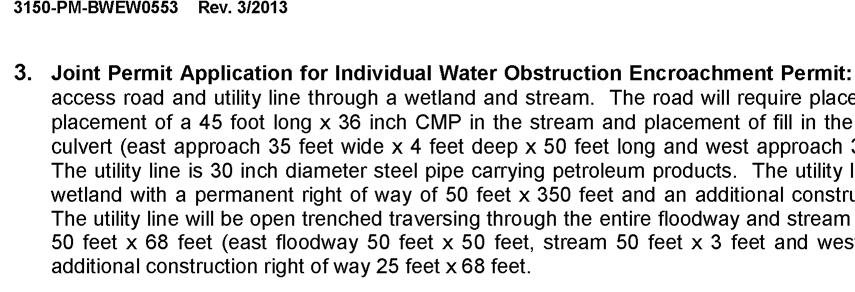
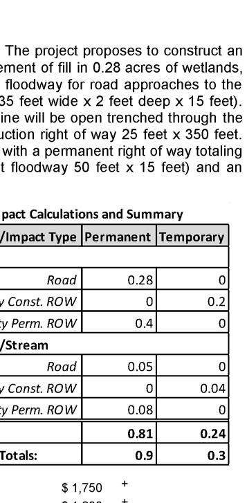
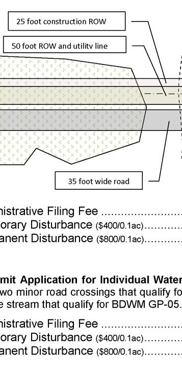
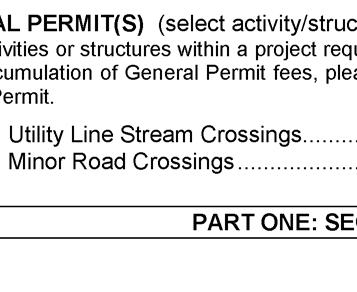
36
DEPARTMENT OF ENVIRONMENTAL PROTECTION BUREAU OF WATERWAYS ENGINEERING AND WETLANDS GENERAL PERMIT BWEW-GP-8 TEMPORARY ROAD CROSSINGS
 3150-PM-BWEW0508 Rev. 6/2013 DEPARTMENT OF ENVIRONMENTAL PROTECTION BUREAU OF WATERWAYS ENGINEERING AND WETLANDS GENERAL PERMIT BWEW-GP-8 TEMPORARY ROAD CROSSINGS 1. GENERAL DESCRIPTION AND AUTHORITY -
INSTRUCTIONS FOR USING THE GENERAL PERMIT...i A. GENERAL DESCRIPTION AND FEES
 3150-PM-BWEW0501 Rev. 8/2013 COMMONWEALTH OF PENNSYLVANIA DEPARTMENT OF ENVIRONMENTAL PROTECTION BUREAU OF WATERWAYS ENGINEERING AND WETLANDS GENERAL PERMIT BWEW-GP-1 FISH HABITAT ENHANCEMENT STRUCTURES
INSTRUCTIONS FOR USING THE GENERAL PERMIT...i A. GENERAL DESCRIPTION AND FEES
 3150-PM-BWEW0501 Rev. 8/2013 COMMONWEALTH OF PENNSYLVANIA DEPARTMENT OF ENVIRONMENTAL PROTECTION BUREAU OF WATERWAYS ENGINEERING AND WETLANDS GENERAL PERMIT BWEW-GP-1 FISH HABITAT ENHANCEMENT STRUCTURES
INSTRUCTIONS FOR USING THE GENERAL PERMIT...i A. GENERAL DESCRIPTION AND FEES
 3150-PM-BWEW0502 Rev. 8/2013 COMMONWEALTH OF PENNSYLVANIA DEPARTMENT OF ENVIRONMENTAL PROTECTION BUREAU OF WATERWAYS ENGINEERING AND WETLANDS GENERAL PERMIT BWEW-GP-2 SMALL DOCKS AND BOAT LAUNCHING RAMPS
INSTRUCTIONS FOR USING THE GENERAL PERMIT...i A. GENERAL DESCRIPTION AND FEES
 3150-PM-BWEW0502 Rev. 8/2013 COMMONWEALTH OF PENNSYLVANIA DEPARTMENT OF ENVIRONMENTAL PROTECTION BUREAU OF WATERWAYS ENGINEERING AND WETLANDS GENERAL PERMIT BWEW-GP-2 SMALL DOCKS AND BOAT LAUNCHING RAMPS
***** Subchapter A. GENERAL PROVISIONS ***** PERMIT APPLICATIONS
 105.11. Permit requirements. 105.12. Waiver of permit requirements. Title 25 Environmental Protection Part I. Department of Environmental Protection Subpart C. Protection of Natural Resources Article I.
INSTRUCTIONS FOR TRANSFER OF A CHAPTER 105 PERMIT AND/OR SUBMERGED LANDS LICENSE AGREEMENT (SLLA)
") 3150-PM-BWEW0016 Rev. 10/2016 Instructions COMMONWEALTH OF PENNSYLVANIA DEPARTMENT OF ENVIRONMENTAL PROTECTION BUREAU OF WATERWAYS ENGINEERING AND WETLANDS INSTRUCTIONS FOR TRANSFER OF A CHAPTER 105 PERMIT
3150-PM-BWEW0016 Rev. 10/2016 Instructions COMMONWEALTH OF PENNSYLVANIA DEPARTMENT OF ENVIRONMENTAL PROTECTION BUREAU OF WATERWAYS ENGINEERING AND WETLANDS INSTRUCTIONS FOR TRANSFER OF A CHAPTER 105 PERMIT
Chapter 102 Permit Amendments. Frequently Asked Questions (FAQ) Final, October 19, 2018
 Final, October 19, 2018") Bureau of Clean Water Chapter 102 Permit Amendments Frequently Asked Questions (FAQ) Final, October 19, 2018 Background Erosion and Sediment Control (E&S) Plans and Post Construction Stormwater Management
Bureau of Clean Water Chapter 102 Permit Amendments Frequently Asked Questions (FAQ) Final, October 19, 2018 Background Erosion and Sediment Control (E&S) Plans and Post Construction Stormwater Management
SEWAGE FACILITIES PLANNING MODULE
 Code. COMMONWEALTH OF PENNSYLVANIA DEPARTMENT OF ENVIRONMENTAL PROTECTION BUREAU OF WATER STANDARDS AND FACILITY REGULATION SEWAGE FACILITIES PLANNING MODULE Component 3s. Small Flow Treatment Facilities
Public Notice U.S. ARMY CORPS OF ENGINEERS, GALVESTON DISTRICT AND TEXAS COMMISSION ON ENVIRONMENTAL QUALITY
 Public Notice U.S. Army Corps Permit Application No: SWG-2016-00384 Of Engineers Date Issued: 27 December 2018 Galveston District Comments Due: 29 January 2019 U.S. ARMY CORPS OF ENGINEERS, GALVESTON DISTRICT
BRISTOL CONSERVATION COMMISSION INLAND WETLANDS AGENCY FORM IW-1 (Application for a Wetlands Permit)
") APPLICATION NO. BRISTOL CONSERVATION COMMISSION INLAND WETLANDS AGENCY FORM IW-1 (Application for a Wetlands Permit) DATE FILED: APPROVED: DENIED: 1. APPLICANT: Name: Signature: Address: City: State: Zip
APPLICATION NO. BRISTOL CONSERVATION COMMISSION INLAND WETLANDS AGENCY FORM IW-1 (Application for a Wetlands Permit) DATE FILED: APPROVED: DENIED: 1. APPLICANT: Name: Signature: Address: City: State: Zip
Regulatory Requirement: This form serves to fulfill the obligations referenced in 25 Pa. Code (related to Permit Termination).
.") COMMONWEALTH OF PENNSYLVANIA DEPARTMENT OF ENVIRONMENTAL PROTECTION BUREAU OF WATERWAYS ENGINEERING AND WETLANDS OFFICIAL USE ONLY PA NOTICE OF TERMINATION FOR A GENERAL OR INDIVIDUAL NATIONAL POLLUTANT
COMMONWEALTH OF PENNSYLVANIA DEPARTMENT OF ENVIRONMENTAL PROTECTION BUREAU OF WATERWAYS ENGINEERING AND WETLANDS OFFICIAL USE ONLY PA NOTICE OF TERMINATION FOR A GENERAL OR INDIVIDUAL NATIONAL POLLUTANT
Chapter 5. Floodplain Management. 5.0 Introduction. 5.1 Floodplain Management and Regulation
 5.0 Introduction This chapter summarizes the Town s rules and regulations regarding floodplain management and development. The requirements presented in this chapter should be used by the design engineer
Town of Middleborough Conservation Commission 2014 Policy
 Approved February 20, 2014 Town of Middleborough Conservation Commission 2014 Policy The Wetland Protection Act under M.G.L. c. 131, sec. 40 and regulations 310 CMR 10.02(1)(a-f) & 310 CMR 10.02 (2)(a)
Honolulu District U.S. Army Corps of Engineers
 Honolulu District U.S. Army Corps of Engineers Nationwide Permit Pre-Construction Notification (PCN) This PCN template integrates requirements of the U.S. Army Corps of Engineers (Corps) Nationwide Permit
SEWAGE FACILITIES PLANNING MODULE
 COMMONWEALTH OF PENNSYLVANIA DEPARTMENT OF ENVIRONMENTAL PROTECTION BUREAU OF WATER STANDARDS AND FACILITY REGULATION SEWAGE FACILITIES PLANNING MODULE Component 2. Individual and Community Onlot Disposal
Chapter 5. Floodplain Management. 5.0 Introduction. 5.1 Douglas County Comprehensive Master Plan. 5.2 Floodplain Management and Regulation
 5.0 Introduction This chapter summarizes the County s rules and regulations regarding floodplain management and development. The requirements presented in this chapter should be used by the design engineer
COMMONWEALTH OF PENNSYLVANIA DEPARTMENT OF ENVIRONMENTAL PROTECTION BUREAU OF CLEAN WATER
 3800-FM-BCW0229b 7/2017 COMMONWEALTH OF PENNSYLVANIA DEPARTMENT OF ENVIRONMENTAL PROTECTION BUREAU OF CLEAN WATER OFFICIAL USE ONLY PA NOTICE OF TERMINATION FOR A GENERAL (PAG-02) OR INDIVIDUAL NPDES PERMIT,
Purpose: Regulations:
 Administrative Procedures for the Designation and Refinement Of Chesapeake Bay Preservation Area Boundaries Guidance on the Chesapeake Bay Preservation Area Designation and Management Regulations September,
Residential Major Subdivision Review Checklist
 Residential Major Subdivision Review Checklist Plan Submittal Requirements: 2 full sets of stamped plans Electric submittal - all plans contained in a single PDF 3 full sets if commercial kitchen or dining
SIMPLIFIED APPROACH PERMIT PROCEDURES
 SIMPLIFIED APPROACH PERMIT PROCEDURES UPPER ALLEN TOWNSHIP Community Development Department 100 Gettysburg Pike, Mechanicsburg, PA 17055 Phone: 717-766-0756 Fax: 717-796-983 Office Hours: M-F 8:00 AM 4:30
BRIDGETON SUBDIVISION APPLICATION CHECKLIST
 APPLICATION NAME AND # CHECKLIST COMPLETED BY: DATE: Signature and printed name BRIDGETON SUBDIVISION APPLICATION CHECKLIST TO SUBDIVISION APPLICANTS: The attached checklist is to assist you in the submission
ARTICLE 5 MINOR SUBDIVISION/LAND DEVELOPMENT
 ARTICLE 5 MINOR SUBDIVISION/LAND DEVELOPMENT SECTION 501 ONLY FINAL PLAN REQUIRED The classification of a proposed subdivision as a "Minor Subdivision" shall only require the submission, review and approval
CHAPTER 13 WINCHESTER WETLANDS BYLAW
 CHAPTER 13 WINCHESTER WETLANDS BYLAW Section 1. PURPOSE The purpose of this by-law is to protect the wetlands, related water resources, and adjoining land areas in the town by prior review and control
YCCD EROSION & SEDIMENT POLLUTION CONTROL (E&SPC) PROGRAM SERVICES FEE SCHEDULE, RULES, & GUIDELINES
 PROGRAM SERVICES FEE SCHEDULE, RULES, & GUIDELINES") YCCD EROSION & SEDIMENT POLLUTION CONTROL (E&SPC) PROGRAM SERVICES FEE SCHEDULE, RULES, & GUIDELINES Adopted by the YCCD Board of Directors on December 14, 2018 Effective January 1, 2019. I. Authority
YCCD EROSION & SEDIMENT POLLUTION CONTROL (E&SPC) PROGRAM SERVICES FEE SCHEDULE, RULES, & GUIDELINES Adopted by the YCCD Board of Directors on December 14, 2018 Effective January 1, 2019. I. Authority
Residential Minor Subdivision Review Checklist
 Residential Minor Subdivision Review Checklist Plan Submittal Requirements: 2 full sets of stamped plans Electric submittal - all plans contained in a single PDF 3 full sets if commercial kitchen or dining
INSTRUCTIONS FOR COMPLETING COMPONENT 1 EXCEPTION TO THE REQUIREMENT TO REVISE THE OFFICIAL PLAN
 COMMONWEALTH OF PENNSYLVANIA DEPARTMENT OF ENVIRONMENTAL PROTECTION BUREAU OF WATER STANDARDS AND FACILITY REGULATION Remove and recycle these instructions before mailing component to the approving agency
RULES AND REGULATIONS Title 25 ENVIRONMENTAL PROTECTION
 RULES AND REGULATIONS Title 25 ENVIRONMENTAL PROTECTION ENVIRONMENTAL QUALITY BOARD [ 25 PA. CODE CH. 105 ] Dam Safety and Waterway Management The Environmental Quality Board (Board) amends Chapter 105
City Of Attleboro Conservation Commission
 City Of Attleboro Conservation Commission GOVERNMENT CENTER, 77 PARK STREET ATTLEBORO, MASSACHUSETTS 02703 (508) 223 2222 FAX 222 3046 GENERAL INSTRUCTIONS AND CHECKLIST FOR COMPLETING STORMWATER MANAGEMENT
SEWAGE FACILITIES PLANNING MODULE
 COMMONWEALTH OF PENNSYLVANIA DEPARTMENT OF ENVIRONMENTAL PROTECTION BUREAU OF WATER SUPPLY AND WASTEWATER MANAGEMENT Code No. SEWAGE FACILITIES PLANNING MODULE Component 1. Exception to the Requirement
ADAMS COUNTY CONSERVATION DISTRICT S
 Approved by District Board on 12-15-2016 I. Authority & Applicability of Fees for Services A. Authority - The Adams County Conservation District is delegated with the responsibility to administer the Commonwealth
CONDITIONAL USE PERMIT Application Packet
 CONDITIONAL USE PERMIT Application Packet Community Development Department 1020 East Pioneer Road, Draper, UT 84020 (801) 576-6539 Fax (801) 576-6526 Dear Applicant, This application packet has been developed
APPLICATION. Telephone Fax Address. Telephone Fax Address FOR MARTIN COUNTY USE ONLY
 APPLICATION PRESERVE AREA MANAGEMENT PLAN/ ABBREVIATED PRESERVE AREA MANAGEMENT PLAN Growth Management Department Environmental Division PART 1: Applicant Information A. Land Owner(s) Name Title and Company
MINNESOTA POLLUTION CONTROL AGENCY GENERAL PERMIT FOR DISPOSAL OF UNCOMTAMINATED CONCRETE
 MINNESOTA POLLUTION CONTROL AGENCY GENERAL PERMIT FOR DISPOSAL OF UNCOMTAMINATED CONCRETE ISSUANCE DATE: December 23, 2013 EXPIRATION DATE: December 23. 2018 This permit is a General Permit issued pursuant
Land Use Application
 Land Use Application Check all permits you are applying for in the boxes provided. Submit this application form, the applicable materials listed in the corresponding permit application packet(s) and application
ARTICLE III GENERAL PROCEDURES, MINOR PLANS AND FEE SCHEDULES
 ARTICLE III GENERAL PROCEDURES, MINOR PLANS AND FEE SCHEDULES 301. Prior to Submission a. Copies of this Ordinance shall be available on request, at cost, for the use of any person who desires information
VILLAGE OF ASHVILLE DEPARTMENT OF PUBLIC UTILITIES DIVISION OF STORMWATER MANAGEMENT STORMWATER MANAGEMENT PROGRAM STORMWATER CREDIT MANUAL
 VILLAGE OF ASHVILLE DEPARTMENT OF PUBLIC UTILITIES DIVISION OF STORMWATER MANAGEMENT STORMWATER MANAGEMENT PROGRAM STORMWATER CREDIT MANUAL SECTION I. OVERVIEW AND GENERAL INSTRUCTIONS INTRODUCTION A stormwater
Town of Lisbon, Maine SUBDIVISION REVIEW APPLICATION
 Date Received: Fee Paid (amount): Applicant: Town of Lisbon, Maine SUBDIVISION REVIEW APPLICATION Subdivision Name/Title: This application must be received at the Town Office by close of business on the
Initial Subdivision Applications Shall Include the Following:
 Initial Subdivision Applications Shall Include the Following: 1) Subdivision Application Form: completely filled out (12 copies) 2) Plat: The Plat must adhere to the requirements set forth in the Town
Completeness Checklist
 3800-FM-BPNPSM0350 2/2015 Checklist COMMONWEALTH OF PENNSYLVANIA DEPARTMENT OF ENVIRONMENTAL PROTECTION BUREAU OF POINT AND NON-POINT SOURCE MANAGEMENT Completeness Checklist The following items should
Attached is a Clinton Township Zoning Permit Application and requirements for issuance of a permit.
 To Whom It May Concern: Attached is a Clinton Township Zoning Permit Application and requirements for issuance of a permit. The fee for the permit application is $75.00, which shall be made payable to
DEPARTMENT OF THE ARMY OFFICE OF THE CHIEF OF ENGINEERS WASHINGTON, D.C
 DEPARTMENT OF THE ARMY OFFICE OF THE CHIEF OF ENGINEERS WASHINGTON, D.C. 20314-1000 REPLY TO ATTENTION OF: CECW-PM (10-1-7a) THE SECRETARY OF THE ARMY 1. I submit for transmission to Congress my report
Construction & Earthwork Request Form (CERF)
") ShoreLand Traditions Construction & Earthwork Request Form (CERF) SECTION 1 SECTION 2 SECTION 3 Definitions and Points to Remember Requirements and Process Site Sketch Requirements and Sample If you have
ShoreLand Traditions Construction & Earthwork Request Form (CERF) SECTION 1 SECTION 2 SECTION 3 Definitions and Points to Remember Requirements and Process Site Sketch Requirements and Sample If you have
JOINT APPLICATION FOR INDIVIDUAL ENVIRONMENTAL RESOURCE PERMIT/ AUTHORIZATION TO USE STATE-OWNED SUBMERGED LANDS/ FEDERAL DREDGE AND FILL PERMIT
 Form 62-330.060(1) JOINT APPLICATION FOR INDIVIDUAL ENVIRONMENTAL RESOURCE PERMIT/ AUTHORIZATION TO USE STATE-OWNED SUBMERGED LANDS/ FEDERAL DREDGE AND FILL PERMIT FLORIDA DEPARTMENT OF ENVIRONMENTAL PROTECTION/
OWNERSHIP DETAILS. Mailing Address: City / Town: Postal Code. Phone Business: ( ) Residence: ( ) FAX: ( )
 Residence: ( ) FAX: ( )") P.O. Box 81067 838 Mineral Springs Road Ancaster, ON L9G 4X1 Email: Darren.Kenny@conservationhamilton.ca x131 Jaime.Tellier@conservationhamilton.ca x165 Phone: (905) 648-4427 or (905) 525-2181 FAX: (905)
P.O. Box 81067 838 Mineral Springs Road Ancaster, ON L9G 4X1 Email: Darren.Kenny@conservationhamilton.ca x131 Jaime.Tellier@conservationhamilton.ca x165 Phone: (905) 648-4427 or (905) 525-2181 FAX: (905)
Floodplain Development Land Use Review
 PUBLIC WORKS - COMMUNITY DEVELOPMENT 333 Broadalbin Street SW, PO Box 490, Albany, Oregon 97321-0144 BUILDING 541-917-7553 PLANNING 541-917-7550 Floodplain Development Land Use Review Application Information
Regulatory Requirement: This form serves to fulfill the obligations referenced in 25 PA Code (related to Permit Termination).
.") COMMONWEALTH OF PENNSYLVANIA DEPARTMENT OF ENVIRONMENTAL PROTECTION BUREAU OF WATERWAYS ENGINEERING AND WETLANDS OFFICIAL USE ONLY PA NOTICE OF TERMINATION FOR A GENERAL OR INDIVIDUAL NATIONAL POLLUTANT
COMMONWEALTH OF PENNSYLVANIA DEPARTMENT OF ENVIRONMENTAL PROTECTION BUREAU OF WATERWAYS ENGINEERING AND WETLANDS OFFICIAL USE ONLY PA NOTICE OF TERMINATION FOR A GENERAL OR INDIVIDUAL NATIONAL POLLUTANT
SEWAGE FACILITIES PLANNING MODULE APPLICATION MAILER
 SEWAGE FACILITIES PLANNING MODULE APPLICATION MAILER COMMONWEALTH OF PENNSYLVANIA Department of Environmental Protection Mark Schweiker, Governor David E. Hess, Secretary For more information, visit us
WETLAND PROTECTION BY-LAW
 WETLAND PROTECTION BY-LAW Article 3.7 Wetland and Natural Resources Protection As Amended at Town Meeting October 26, 2009 Section 3.7.1 Intent, Purpose and Jurisdiction: The intent and purpose of this
FINAL PLAT APPLICATION
 FINAL PLAT APPLICATION (Page 1 of 3) LEGAL OWNER(s): NAME: STREET ADDRESS OWNER(s): CITY, STATE, ZIP CODE: PHONE NUMBER: BILLING ADDRESS: NAME OF ENGINEER/SURVEYOR: Engineer/Surveyor Address, Phone: PROPERTY
E L M E R B O R O U G H L A N D U S E B O A R D APPLICATION COVER SHEET (to be completed for all applications and appeals)
") E L M E R B O R O U G H L A N D U S E B O A R D APPLICATION COVER SHEET (to be completed for all applications and appeals) 1. Name(s): 2. Address: 3. Telephone Number(s): 4. E-mail: 5. Owner Name(s) (if
E L M E R B O R O U G H L A N D U S E B O A R D APPLICATION COVER SHEET (to be completed for all applications and appeals) 1. Name(s): 2. Address: 3. Telephone Number(s): 4. E-mail: 5. Owner Name(s) (if
City of Fort Lupton Amended Plat Process
 City of Fort Lupton Amended Plat Process Purpose The Amended Plat process is an administrative process to amend a recorded Plat. An Amended Subdivision is an administrative revision to a recorded Subdivision
OWNERSHIP DETAILS. Mailing Address: City / Town: Postal Code. Phone Business: ( ) Residence: ( ) FAX: ( )
 Residence: ( ) FAX: ( )") P.O. Box 81067 838 Mineral Springs Road Ancaster, ON L9G 4X1 Email: Darren.Kenny@conservationhamilton.ca x131 Jaime.Tellier@conservationhamilton.ca x165 Phone: (905) 648-4427 or (905) 525-2181 FAX: (905)
P.O. Box 81067 838 Mineral Springs Road Ancaster, ON L9G 4X1 Email: Darren.Kenny@conservationhamilton.ca x131 Jaime.Tellier@conservationhamilton.ca x165 Phone: (905) 648-4427 or (905) 525-2181 FAX: (905)
(Chapter Flood Damage Prevention)
") Chapter 13.10 Flood Damage Prevention Section: 13.10.010 Purpose and Policy 13.10.020 Definitions 13.10.030 Applicability and Areas of Special Flood Hazard 13.10.040 Administration 13.10.050 Provisions
Chapter 13.10 Flood Damage Prevention Section: 13.10.010 Purpose and Policy 13.10.020 Definitions 13.10.030 Applicability and Areas of Special Flood Hazard 13.10.040 Administration 13.10.050 Provisions
INSTRUCTIONS AND INFORMATION FOR LAND LEASE APPLICATION
 TED STEVENS ANCHORAGE INTERNATIONAL AIRPORT Department of Transportation & Public Facilities Airport Leasing & Property Management PO Box 196960, Anchorage AK 99519-6960 Phone: 907-266-2420 Fax: 907-266-2458
A.3. ARTICLE 7 PLAN REQUIREMENTS FOR MINOR SUBDIVISION AND/OR LAND DEVELOPMENT
 700. 701.A.3. ARTICLE 7 PLAN REQUIREMENTS FOR MINOR SUBDIVISION AND/OR LAND DEVELOPMENT SECTION 700 PURPOSE The purpose of this Article is to set forth a streamlined set of Plan Requirements for minor
Part 72. Sec. 1. This ordinance shall be known and may be cited as the Clyde Township Wetlands Ordinance.
 Part 72 72.000 WETLANDS ORDINANCE Ord. No. 1 Adopted: June 12, 1991 Amended: April 13, 1994 72.001 SHORT TITLE. 72.002 PURPOSE. 72.003 DEFINITIONS. CLYDE TOWNSHIP ORDAINS: Sec. 1. This ordinance shall
Section A: General Information for All Activities
 Section A: General Information for All Activities PART 1: NAME, APPLICATION TYPE, LOCATION, AND DESCRIPTION OF ACTIVITY A. Name of project, including phase if applicable: F.B.I. Commercial Park B. This
PLYMOUTH PLANNING BOARD APPLICATION FOR A MINOR SUBDIVISION OR MAJOR SUBDIVISION
 CASE # PLYMOUTH PLANNING BOARD APPLICATION FOR A MINOR SUBDIVISION OR MAJOR SUBDIVISION The undersigned Applicant hereby submits to the Plymouth Planning Board a completed application for a proposed minor
CHAPTER 3 PRELIMINARY PLAT
 10-3-1 10-3-3 SECTION: CHAPTER 3 PRELIMINARY PLAT 10-3-1: Consultation 10-3-2: Filing 10-3-3: Requirements 10-3-4: Approval 10-3-5: Time Limitation 10-3-6: Grading Limitation 10-3-1: CONSULTATION: Each
Sabine River Authority, State of Louisiana
 Sabine River Authority, State of Louisiana Policy for Administering the Shoreline Management Plan (SMP) Encroachments Adopted by SRA Board of Commissioners: Introduction The Federal Energy Regulatory Commission
DEPARTMENT OF THE ARMY U.S. ARMY CORPS OF ENGINEERS, SAVANNAH DISTRICT 100 WEST OGLETHORPE AVENUE SAVANNAH, GEORGIA
 DEPARTMENT OF THE ARMY U.S. ARMY CORPS OF ENGINEERS, SAVANNAH DISTRICT 100 WEST OGLETHORPE AVENUE SAVANNAH, GEORGIA 31401-3604 June 8, 2018 Regulatory Branch SAS-2018-00375 PUBLIC NOTICE Reissuance of
SUBDIVISION APPLICATION CHECKLIST SKETCH PLAN PRELIMINARY PLAT FINAL PLAT
 RECEIVED STAMP SUBDIVISION APPLICATION CHECKLIST SKETCH PLAN PRELIMINARY PLAT FINAL PLAT A checklist of background information and submission requirements for processing of a sketch plan, preliminary plat
REGULAR FINAL PLAT SUBDIVISION APPLICATION
 REGULAR FINAL PLAT SUBDIVISION APPLICATION Name of Subdivision (Subdivision Name must be approved by at 856-6216) ( )Cluster Subdivision ( )Lot-by-Lot Subdivision ( )Open Space Subdivision Name of Subdivision
Major Subdivision Application Packet. Revised June 2018
 Major Subdivision Application Packet Revised June 2018 Caroline County Department of Planning and Community Development 233 West Broaddus Avenue Bowling Green, VA 22427 www.co.caroline.va.us Phone: 804-633-4303
Chapter 136. SOIL EROSION
 1 of 8 12/19/2011 4:17 PM Township of Andover, NJ Monday, December 19, 2011 Chapter 136. SOIL EROSION [HISTORY: Adopted by the Township Committee of the Township of Andover by Ord. No. 77-11 (Ch. XVII
EXPERIMENTAL AQUACULTURE LEASE APPLICATION
 EXPERIMENTAL AQUACULTURE LEASE APPLICATION This is an application for an experimental aquaculture lease. You are encouraged to review the experimental lease regulations and application instructions to
Receiving Water Body:
 62-330 ENVIRONMENTAL RESOURCE PERMIT INDIVIDUAL - TECHNICAL STAFF REPORT 23-Nov-2016 APPLICATION #: IND-005-9658-2 Applicant: Agent: Charles Commander CCSH, LLC 2708 Highway 77 Lynn Haven, FL 32444 850-819-5850
Instructions to the Applicant
 CONDITIONAL USE PERMIT APPLICATION Lake of the Woods County Land and Water Planning Office 206 8 th Avenue Southeast, Suite #290 Baudette MN 56623-2867 www.co.lake-of-the-woods.mn.us Phone: (218) 634-1945
Township of Collier 2418 Hilltop Road Presto, PA 15142
 Township of Collier 2418 Hilltop Road Presto, PA 15142 Fees: Major: 2 checks $600 + $50 per lot & $1700 Escrow) APPLICATION FOR SUBDIVISION major FINAL only Plans must be folded Rolled plans will not be
SECTION 4: PRELIMINARY PLAT
 SECTION 4: PRELIMINARY PLAT After the completion of the sketch plan process, if submitted, the owner or developer shall file with the City an application for preliminary plat. The preliminary plat stage
A. General Information
 Important: When filling out forms on the computer, use only the tab key to move your cursor - do not use the return key. Massachusetts Department of Environmental Protection A. General Information 1. Project
TOWN OF BRISTOL. Ontario County, New York APPLICATION FOR LOT LINE ADJUSTMENT
 TOWN OF BRISTOL Ontario County, New York APPLICATION FOR LOT LINE ADJUSTMENT Lot Line Adjustment: The adjusting of common property line(s) or boundaries between adjacent lots, tracts, or parcels for the
FLORIDA DEPARTMENT OF ENVIRONMENTAL PROTECTION
 FLORIDA DEPARTMENT OF ENVIRONMENTAL PROTECTION NOTICE OF INTENT TO USE S. 403.9327, F.S., GENERAL PERMIT FOR MANGROVE TRIMMING OR APPLICATION FOR S. 403.9328, F.S., INDIVIDUAL PERMIT TO TRIM OR ALTER MANGROVES
A. General Information
 Important: When filling out forms on the computer, use only the tab key to move your cursor - do not use the return key. Massachusetts Department of Environmental Protection A. General Information 1. Project
Jurisdictional Determination Request
 This form is intended for use by anyone requesting a jurisdictional determination (JD) from the U.S. Army Corps of Engineers, Wilmington District (Corps). Please include all supporting information, as
ARTICLE I. IN GENERAL
 Adopted by City Council on December 7, 2009 AN ORDINANCE TO AMEND AND REORDAIN CHAPTER 10 (WATER PROTECTION) OF THE CODE OF THE CITY OF CHARLOTTESVILLE, 1990, AS AMENDED, BY DELETING SECTIONS 10-51 AND
Town of Alexandria. Floodplain Management Ordinance
 1 of 7 8/8/2009 4:56 PM Town of Alexandria Floodplain Management Ordinance SECTION 1 PURPOSE Certain areas of the Town of Alexandria, New Hampshire are subject to periodic flooding, causing serious damages
Emergency Watershed Program Sandy Recovery Activities and Flood Plain Easement Program
 Emergency Watershed Program Sandy Recovery Activities and Flood Plain Easement Program Greg Westfall, Resource Conservationist USDA-Natural Resources Conservation Service (NRCS) Set up by Congress to respond
SUBDIVISION APPLICATION
 SUBDIVISION APPLICATION Community Planning and Economic Development Development Services Division 250 South 4 th Street, Room 300 Minneapolis MN 55415-1316 612-673-3000 This application packet is used
JOINT PUBLIC NOTICE CORPS OF ENGINEERS STATE OF ARKANSAS Application Number: Date: December 9, 2016 Comments Due: January 3, 2017
 US Army Corps of Engineers Little Rock District JOINT PUBLIC NOTICE CORPS OF ENGINEERS STATE OF ARKANSAS Application Number: 2016-00183-1 Date: December 9, 2016 Comments Due: January 3, 2017 TO WHOM IT
OWNERSHIP DETAILS. Mailing Address: City / Town: Postal Code. Phone Business: ( ) Residence: ( ) FAX: ( )
 Residence: ( ) FAX: ( )") P.O. Box 81067 838 Mineral Springs Road Ancaster, ON L9G 4X1 Email: Darren.Kenny@conservationhamilton.ca Phone: (905) 648-4427 or (905) 525-2181 FAX: (905) 648-4622 Development, Interference with Wetlands,
P.O. Box 81067 838 Mineral Springs Road Ancaster, ON L9G 4X1 Email: Darren.Kenny@conservationhamilton.ca Phone: (905) 648-4427 or (905) 525-2181 FAX: (905) 648-4622 Development, Interference with Wetlands,
ST. TAMMANY PARISH PATRICIA P. BRISTER PARISH PRESIDENT
 revised Completed Permit Application REQUIREMENTS FOR RESIDENTIAL PLAN REVIEW Swimming Pools Assessment # / Parcel #(10 digit number from Assessor s Office 985-809-8180 www.stpao.org) Legal Description
City of Prior Lake APPLICATION FOR COMBINED PRELIMINARY AND FINAL PLAT
 Case File No. Property Identification No. City of Prior Lake APPLICATION FOR COMBINED PRELIMINARY AND FINAL PLAT Requested Action Brief description of proposed project (Please describe the proposed amendment,
ALREADY SUBMITTED FOR HIGHLANDS COUNCIL PRE
 Highlands Preservation Area Approval Application Checklist Items Block 15901 Lot 1, West Milford See Highlands Council Review at: http://www.highlands.state.nj.us/njhighlands/projectreview/ **For advisory
Application Procedures for Easements or Rights of Way on City of Fort Collins Natural Areas and Conserved Lands March 2012
 Application Procedures for Easements or Rights of Way on City of Fort Collins Natural Areas and Conserved Lands March 2012 IMPORTANT NOTE: This document was created to accompany the City of Fort Collins
MINOR & MAJOR SUBDIVISION APPLICATION
 TOW OF HOOKSETT APPLICATIO # DATE MIOR & MAJOR SUBDIVISIO APPLICATIO Application for: Completeness Map and Lot o. Public Hearing o. of Lots LOCATIO: (Specify Street Address) OWER: APPLICAT: ADDRESS: ADDRESS:
[Type e-signature] This document has been electronically signed.
![[Type e-signature] This document has been electronically signed.](/thumbs/92/110470274.jpg "[Type e-signature] This document has been electronically signed.") Notice of Coverage - SW State Disposal System (SDS) Permit GCB000000 General Permit Authorization to Dispose of Uncontaminated Concrete Permittee (Owner): Various City or Township: Various County: Various
Notice of Coverage - SW State Disposal System (SDS) Permit GCB000000 General Permit Authorization to Dispose of Uncontaminated Concrete Permittee (Owner): Various City or Township: Various County: Various
APPLICATION PROCEDURE
 ANTRIM PLANNING BOARD P. O. Box 517 Antrim, New Hampshire 03440 Phone: 603-588-6785 FAX: 603-588-2969 APPLICATION FORM AND CHECKLIST FOR MINOR OR MAJOR SITE PLAN REVIEW File Date Received By APPLICATION
Open Space Model Ordinance
 Open Space Model Ordinance Section I. Background Open space development has numerous environmental and community benefits, including: 1) Reduces the impervious cover in a development. Impervious cover
Subdivision (Plat) Checklist
 Checklist") Subdivision (Plat) Checklist This Checklist is intended to assist you in preparing a complete application for submittal. Occasionally, additional items may be required to complete the review. Incomplete
Subdivision (Plat) Checklist This Checklist is intended to assist you in preparing a complete application for submittal. Occasionally, additional items may be required to complete the review. Incomplete
CITY OF FORT COLLINS NATURAL AREAS AND CONSERVED LANDS EASEMENT POLICY
 CITY OF FORT COLLINS NATURAL AREAS AND CONSERVED LANDS EASEMENT POLICY Adopted January 3, 2012 PURPOSE: The purpose of the policy statement is to clarify the policies and procedures of the City of Fort
Notice of Intent Supplemental Form for Riverfront Area
 Notice of Intent Supplemental Form for Riverfront Area The Notice of Intent Supplemental Form for Riverfront Area is recommended for use with the Notice of Intent (Form 3) in the wetland regulations (310
PRELIMINARY PLAT Application Packet
 PRELIMINARY PLAT Application Packet Community Development Department 1020 East Pioneer Road, Draper, UT 84020 (801) 576-6539 Fax (801) 576-6526 Dear Applicant, This application packet has been developed
A. General Information
 Important: When filling out forms on the computer, use only the tab key to move your cursor - do not use the return key. Massachusetts Department of Environmental Protection A. General Information 1. Project
Lower Gwynedd Township 1130 N. Bethlehem Pike, P.O. Box 625 Spring House, PA (215) phone (215) fax
 phone (215) fax") Lower Gwynedd Township 1130 N. Bethlehem Pike, P.O. Box 625 Spring House, PA 19477 (215)646-5302- phone (215)646-3357-fax www.lowergwynedd.org Subdivision and Land Development Application Procedures Requests
Lower Gwynedd Township 1130 N. Bethlehem Pike, P.O. Box 625 Spring House, PA 19477 (215)646-5302- phone (215)646-3357-fax www.lowergwynedd.org Subdivision and Land Development Application Procedures Requests
The Drainage Control Regulations
 1 The Drainage Control Regulations Repealed by Saskatchewan Regulations 89/2015 (effective October 16, 2015) Formerly Chapter D-33.1 Reg 1 (effective August 18, 1981) as amended by Saskatchewan Regulations
Land Use Application
 Permit Center 210 Lottie Street, Bellingham, WA 98225 Phone: (360) 778-8300 Fax: (360) 778-8301 TTY: (360) 778-8382 Email: permits@cob.org Web: www.cob.org/permits Land Use Application Check all permits
FLOOD HAZARD AREA LAND USE MANAGEMENT
 FLOOD HAZARD AREA LAND USE MANAGEMENT Introduction Guidance For Selection of Qualified Professionals and Preparation of Flood Hazard Assessment Reports This document is intended to provide guidance for
CHAPTER 24 F FLOOD ZONE OVERLAY DISTRICT
 CHAPTER 24 OVERLAY DISTRICT SECTION 24.01 PURPOSE It is the intent of this district to apply special regulation to the use of land in those areas subject to periodic inundation. Such regulation is deemed