Committee of the Whole Report
|
|
|
- Mark Cannon
- 5 years ago
- Views:
Transcription

1 Item: Committee of the Whole Report DATE: Tuesday, June 05, 2018 WARD: 1 TITLE: OFFICIAL PLAN AMENDMENT FILE OP ZONING BY-LAW AMENDMENT FILE Z DRAFT PLAN OF SUBDIVISION FILE 19T-17V009 TESTON SANDS INC. VICINITY OF DUFFERIN STREET AND TESTON ROAD FROM: Jason Schmidt-Shoukri, Deputy City Manager, Planning and Growth Management ACTION: DECISION Purpose To seek endorsement from the Committee of the Whole of the Recommendation contained in this report for Official Plan Amendment File OP , Zoning By-law Amendment File Z and Draft Plan of Subdivision File 19T-17V009, which have been appeal to the Local Planning Appeal Tribunal ( LPAT ), to permit a residential plan of subdivision consisting of 87 lots that would be developed with detached dwellings. Report Highlights The Owner proposes a residential plan of subdivision consisting of 87 lots to be developed with detached dwellings. The Owner is dedicating 6.44 ha of core features and their related vegetative protection zone into public ownership, in accordance with the policies of Vaughan Official Plan 2010 ( VOP 2010 ). The Owner has appealed the Official Plan and Zoning By-law Amendment Applications and the Draft Plan of Subdivision Application to the Local Planning Application Tribunal. The Development Planning Department recommends that Council endorses the Recommendations in this report regarding the proposed development as it is consistent with the Provincial Policy Statement, conforms with the Growth Plan, Oak Ridges Moraine Conservation Plan, the York Region Official Plan, VOP 2010 and is consistent with the existing and planned land uses in the surrounding area.
2 Recommendations THAT the Local Planning Appeal Tribunal ( LPAT ) be advised that Vaughan Council ENDORSES the following Recommendations: 1. THAT Official Plan Amendment File OP (Teston Sands Inc.) BE APPROVED; to amend Site-Specific Policy (Attachment #6) of the Vaughan Official Plan 2010 (VOP 2010), Volume 2 to redesignate the Subject Lands from Natural Areas to Low-Rise Residential subject to the Low-Rise Residential policies of VOP THAT the implementing Official Plan Amendment include the following policy to the satisfaction of York Region: The southern portion of the Subject Lands may be affected by the recommendations of the Teston Road Individual Environmental Assessment ( IEA ) and that a portion may be subject to the Holding Symbol (H) provisions under the Planning Act, implemented through subsequent development applications. If it is determined that the lands are not required for the Teston Road extension, the underlying land use designations identified in this Plan shall prevail, without the need for further amendment to this Plan. Subsequent development applications will need to be consistent with the findings of the approved Teston Road IEA." 3. THAT Zoning By-law Amendment File Z (Teston Sands Inc.) BE APPROVED; to amend Zoning By-law 1-88, to rezone the Subject Lands from A Agricultural Zone and OS5 Open Space Environmental Protection Zone to RD1 Residential Detached Zone One, RD3 Residential Detached Zone Three, RD3 (H) Residential Detached Zone Three with the Holding Symbol (H), OS1 (H) Open Space Conservation Zone with the Holding Symbol (H), and OS5 Open Space Environmental Protection Zone in the manner shown on Attachment #4. 4. THAT the Holding Symbol (H) shall not be removed from the lands zoned RD3(H) Detached Residential Zone Three with the Holding Symbol (H) and OS1(H) Open Space Conservation Zone with the Holding Symbol (H) as shown on Attachment #4, until the following matters have been addressed to the satisfaction of the City, York Region and the Toronto and Region Conservation Authority: i) For Lots 1 to 5 and Block 92 (Stormwater Management Pond) until York Region has completed the design and is satisfied the vertical and horizontal design is approved or until the Region has sufficient certainty regarding the potential alignment(s) of the Teston Road extension, or in the likelihood of its ultimate approval and construction; and,
3 ii) For Lots 46 to 53, Lots 1 to 7 and Blocks 91 and 92 until such time as the design of Teston Road has been completed and approved by York Region and until an alternative stormwater management solution which does not require these lands is approved by the City, York Region and the Toronto and Region Conservation Authority. 5. THAT the Owner be permitted to apply for a Zoning By-law Amendment application(s) or a Minor Variance Application(s) to the City and/or the Vaughan Committee of Adjustment, if required, before the second anniversary of the day on which the implementing Zoning By-law for the Subject Lands comes into effect, to permit minor adjustments to the implementing Zoning By-law. 6. THAT Draft Plan of Subdivision File 19T-17V009 (Teston Sands Inc.) as shown on Attachment #4 BE APPROVED; to facilitate a residential plan of subdivision consisting of 87 lots that would be developed with detached dwellings, subject to the Conditions of Draft Plan Approval set out in Attachment #1. 7. THAT the Subdivision Agreement for Draft Plan of Subdivision File 19T-17V009 (Teston Sands Inc.) shall contain the following clause: i) The Owner shall pay to the City of Vaughan by way of certified cheque, cash-in-lieu of the dedication of parkland equivalent to 5% or 1 ha per 300 dwelling units of the value of the Subject Lands, prior to the issuance of a Building Permit, in accordance with the Planning Act and the City s Cashin-lieu Policy. The Owner shall submit an appraisal of the Subject Lands, in accordance with Section 42 of the Planning Act, prepared by an accredited appraiser for approval by the Office of the City Solicitor, Real Estate Department, and the approved appraisal shall form the basis of the cash-inlieu payment. 8. THAT Vaughan Council adopt the following resolution for allocation of water and sewage servicing capacity: IT IS HERBY RESOLVED THAT Draft Plan of Subdivision File 19T- 17V009 (Teston Sands Inc.) be allocated servicing capacity from the York Sewage Servicing / Water Supply System for a total of 87 residential units (311 persons equivalent). 9. Should the Local Planning Appeal Tribunal ( LPAT ) approve the applications, then LPAT withhold its final Order on the Official Plan Amendment File OP , Zoning by-law Amendment File Z and Draft Plan of Subdivision File 19T- 17V009 until confirmation from the City is received indicating that the Owner s LPAT appeal of Vaughan Official Plan 2010 (File No. PL111184) (Appeal #162) as
4 it pertains to the Subject Lands is resolved to the satisfaction of the City Solicitor and Deputy City Manager, Planning and Growth Management. 10. THAT City of Vaughan Staff be directed to attend the LPAT proceedings in support of the Recommendations contained in this report and the Conditions of Draft Approval identified in Attachment #1 for Official Plan Amendment File OP , Zoning By-law Amendment File Z and Draft Plan of Subdivision File 19T-17V009. Background The Subject Lands (the Subject Lands ) are located on the north side of the unopened allowance for Teston Road, west of Dufferin Street, and are municipally known as 1600 Teston Road, shown as Subject Lands on Attachments #2 and #3. The surrounding land uses are shown on Attachment #3. The Owner has appealed Vaughan Official Plan 2010 ( VOP 2010 ) and the current Official Plan and Zoning By-law Amendment Applications and the Draft Plan of Subdivision Application to the Local Planning Appeal Tribunal On August 22, 2016, the Owner submitted an Appeal (File No ) to the then Ontario Municipal Board ( OMB ) now the Local Planning Appeal Tribunal ( LPAT ) respecting the Subject Lands, specifically Schedule 2 Natural Heritage Network of VOP On December 19, 2017, the Owner submitted an Appeal (File No.PL180012) to the then OMB on Zoning By-law Amendment File Z , pursuant to Section 34 (11) of the Planning Act for Vaughan Council s failure to make a decision on the Application within 120 days of the City deeming the Application complete. On April 1, 2018, the Owner submitted Appeals to the then OMB on Official Plan Amendment File OP and Draft Plan of Subdivision File 19T-17V009, pursuant to Sections 17 (40) and 51 (34) of the Planning Act for Vaughan Council s failure to make a decision on the Applications within 180 days of the City deeming the Applications complete. The LPAT has scheduled a pre-hearing for the Official Plan Amendment and Zoning Bylaw Amendment Application, and the Draft Plan of Subdivision Application on November 8, Official Plan and Zoning By-law Amendment and Draft Plan of Subdivision Applications have been submitted to permit the Draft Plan The Owner has submitted, the following applications (the Applications ) to permit a residential plan of subdivision consisting of 87 lots that would be developed with detached dwellings:
5 1. Official Plan Amendment File OP to amend Site-Specific Policy of Vaughan Official Plan 2010 ( VOP 2010 ), Volume 2, to redesignate the subject lands from Natural Areas to Low-Rise Residential in the manner shown on Attachment #4, and subject to the Low-Rise Residential policies of VOP Zoning By-law Amendment File Z to amend Zoning By-law 1-88, to rezone the Subject Lands from A Agricultural Zone and OS5 Open Space Environmental Protection Zone to RD1 Residential Detached Zone One, RD3 Residential Detached Zone Three, RD3(H) Residential Detached Zone Three with the Holding Symbol (H), OS1(H) Open Space Conservation Zone with the Holding Symbol (H), and OS5 Open Space Environmental Protection Zone in the manner shown on Attachment #4. 3. Draft Plan of Subdivision File 19T-17V009 (the Draft Plan ) shown on Attachment #4, to facilitate a residential plan of subdivision consisting of the following: Lots 1-87 Detached Residential (frontages 12m - 21m) 4.21ha 87 units Block 89 Vegetation Protection Zone 0.81ha Block 90 Natural Heritage (Core Features) 5.63ha Blocks 88 & 91 Walkway / SWM Access 0.04ha Block 92 Stormwater Management Pond 1.15ha Block 96 Open Space 0.08ha Block 93 Road Widening 0.28ha Blocks 94-95, m Reserves 0.01ha Roads 17.5m to 20m (Public Roads A - E ) 1.48ha Total 13.69ha 87 units The Owner has revised the Draft Plan to address comments from internal departments, external pubic agencies and comments from local residents The original Draft Plan shown on Attachment #5 was the subject of the Public Hearing held on January 23, 2018, and the Community Meeting held on March 27, The Owner has made the following revisions to the Draft Plan, as shown on Attachment #4 to address comments from internal departments, external public agencies and from area residents: The number of lots has been reduced from 96 to 87; The lot areas for Lots 14 to 27 have been increased to be consistent with the existing abutting lots to the north and east; The lot frontages for Lots 14 to 27 have been increased from 15 m to 21 m, except for pie-shaped Lots 19 to 23 and 27, to be consistent with existing abutting lots to the north and east;
6 The interior lot lines for Lots 14 to 27 are matched with the interior lot lines of the existing abutting lots to the east and north; A stormwater management pond (Block 92) designed to meet City s and TRCA s requirements resulting in the removal of Street F and reconfiguration of the lots formerly located south of Street D and formerly east of Street A is included in the Draft Plan. The Owner will convey the pond to the City; Public connections (Blocks 91 and 88) are included through the stormwater management pond and to the core features, specifically the valley and stream corridor area; 6.44 ha of core features (valley and stream corridor, natural features, natural hazards) and associated vegetation protection zone (Blocks 89 and 90) are included on the Draft Plan. The Owner will be dedicating these Blocks into public ownership in accordance with City and TRCA policies as it promotes the longterm protection of these important natural areas for the Don River corridor; and A minimum vegetation protection zone ( MVPZ ) to the valley and stream corridor, is included on the Draft Plan, as a separate buffer block (Block 89), in accordance with City and TRCA policies. These lands will be rezoned to OS5 Open Space Environmental Protection Zone as Attachment #4. The Official Plan Amendment, Zoning By-law Amendment and the Draft Plan of Subdivision Applications were considered at the January 23, 2018, Public Hearing On December 22, 2017, a Notice of Public Hearing was circulated to all property owners within an expanded notification area beyond 150 m as shown on Attachment #2 and to the MacKenzie Ridge Ratepayers Association. The Notice of Public Hearing was also posted on the City s web-site at and a Notice Sign was installed on the property in accordance with the City s Notice Sign Procedures and Protocols. The recommendation of the Committee of the Whole to receive the Public Hearing report of January 23, 2018, and to forward a comprehensive technical report to a future Committee of the Whole meeting was ratified by Vaughan Council on January 30, Council also resolved to hold a community meeting with residents, City staff, and the Local and Regional Councillors. The Community Meeting was held on March 27, The following is a list of individuals who either made a deputation or submitted written correspondence at the January 23, 2018 Public Hearing and at the March 27, 2018 Community Meeting: Deputations: R. Kenedy, Mackenzie Ridge Ratepayers Association, Giorgia Crescent R. Lorello, Treelawn Boulevard, Kleinburg Mr. Gary, street name and first initial redacted, Maple Mr. Atticus, street name and first initial redacted, Maple
7 Written Submissions: S. Sigrist, dated September 18, 2017 R. Kenedy, Georgia Crescent, dated September 22, 2017 A. Avsiannikov, Hunterwood Chase, dated September 24, 2017 M. Muzzo, Georgia Crescent, dated September 25, 2017 P. Bender, dated September 25, 2017 N. and S. Chopra, Georgia Crescent, dated September 25, 2017 J. Vitale, Adirondack Road, dated October 1, 2017 C. Gabriel, Germana Place, dated October 1, 2017 K. Gabriel, Germana Place, dated October 1, 2017 R. Gabriel, Germana Place, dated October 1, 2017 J. and M. Baksi, Antonini Court, dated October 1, 2017 K. Gabriel, Germana Place, dated October 2, 2017 F. Liberatore, dated October 1, 2017 J. Vukman, Germana Place, dated October 2, 2017 S. Lee, Teston Road, dated January 22, 2018 The following is a summary of the comments made by the Public at the Public Hearing meeting, community meeting and in written submissions, including comments appended to a petition signed by approximately 70 individuals and ed March 29, 2018 by the Mackenzie Ratepayers Association and responses to these comments from the Development Planning Department: i) The Subject Lands are located within the Oak Ridge Moraine and the proposed development will harm the surrounding environment; Response The Subject Lands are designated Settlement Area by the Oak Ridges Moraine Conservation Plan ( ORCMP ), which permits development and lot creation subject to the policies of the ORCMP. The Development conforms to the Settlement Area policies of the ORCMP, discussed in detail in the Analysis and Options section of this report. The City and the TRCA are satisfied with the development limits shown on Attachment #4, discussed further in the TRCA section of this report. ii) The quality of fill should be monitored, and the large quantity of fill required to properly grade the Subject Lands and the tamping of the fill may cause vibrations and structural damage to neighbouring properties.
8 Response The placement of fill is regulated by City s Fill By-law and grading and drainage plans approved by the City submitted in support of the Applications. The Vaughan Development Engineering Department has reviewed the submitted grading plans and has no objections to the proposed grading, which is discussed further in the Development Engineering section of this report. iii) A large treed buffer zone between the proposed development and all neighbouring properties should be established and be publicly owned. Response Publicly owned landscaped buffer blocks located between compatible residential uses are not required. The Tree Inventory and Preservation Plan and the Arborist Report submitted in support of the Applications recommends that where possible existing vegetation located along the east property boundary be preserved and protected. A condition approval is included in Attachment #1 that the Owner shall not remove trees without written approval from the City and that Owner shall enter into a tree protection agreement with the City. iv) There will be potential drainage issues caused by heavy rain and potential flooding of new homes and existing neighbouring properties. Response The Development includes a stormwater management pond (Block 92). The Development Engineering Department and the TRCA have reviewed the submitted stormwater management report and have no objection to the report, which is discussed further in the Development Engineering section of this report. v) There will be increased traffic generated by the proposed development given there is only one access onto Teston Road. Response The Traffic Impact Study ( TIS ) submitted in support of the Applications concludes that the existing road system can accommodate the increase in traffic volumes attributed to the Development. The Development Engineering Department and York Region have reviewed the TIS and have no comment. vi) The development proposal should include executive lots like the abutting residential neighbourhood.
9 Response The original Draft Plan (Attachment #5) has been revised to increase the lot area for Lots 14 to 27 (Attachment #4) and to increase the lot frontage from 15 m to 21 m for Lots 14 to 27, except for pie-shaped Lots 19 to 23 and 27, to be consistent with existing abutting lots to the east and north. The interior lot lines for Lots 14 to 27 are modified to match the interior lot lines of the existing abutting lots to the east and north. vii) The unauthorized removal of trees on the Subject Lands should be replaced and the replanting program and should be monitored. Response The By-law and Compliance Department laid charges for the unauthorized tree removal. The City requires that a compensation plan be prepared by the Owner for all trees removed to date and for all trees that will be removed as part of the inventory removals plans for the proposed Draft Plan. A condition of approval to this effect is included in Attachment #1 viii) There is no public transit along Dufferin Street, between Major Mackenzie and King-Vaughan Road to support the proposed development. Response Public transit is the responsibility of York Region. York Region has reviewed the Applications and has not provided comments with respect to transit (Attachment #1b). The Region of York Transportation Master Plan indicates that public transit is planned for both Dufferin Street and Teston Road adjacent to the Subject Lands in the next 10 to 14 years. ix) Existing schools in the area are at capacity. Response The York Catholic and the York District School Boards have reviewed the Applications and have advised they have no comment or objection to the Draft Plan. On May 28, 2018, the Vaughan Development Planning Department mailed a nonstatutory courtesy notice of this Committee of the Whole meeting to those individuals that requested notice of further consideration of the Applications, appeared at the Public Hearing and submitted correspondence to the City.
10 Previous Reports/Authority Analysis and Options The Development Planning Department has reviewed the proposed amendment to Site- Specific policy of VOP 2010, Volume 2 in consideration of the following policies: The Draft Plan is consistent with the Provincial Policy Statement (2014) The Provincial Policy Statement, 2014 ( PPS ) provides policy direction on matters of provincial interest related to land use planning and development. The PPS is applied province-wide and enables development while ensuring that the resources of provincial interests, public health and safety, and the quality of the natural and built environment are protected. Part V - Policies of the PPS state (in part) the following: Settlement Areas Settlement areas shall be the focus of growth and development, and their vitality and regeneration shall be promoted Land use patterns within settlement areas shall be based on: a) densities and a mix of land uses which: efficiently use land and resources; are appropriate for, and efficiently use, the infrastructure and public service facilities which are planned or available, and avoid the need for their unjustified and/or uneconomical expansion Planning authorities shall identify appropriate locations and promote opportunities for intensification and redevelopment where this can be accommodated taking into account existing building stock or areas, including brownfield sites, and the availability of suitable existing or planned infrastructure and public service facilities required to accommodate projected needs. Housing Planning authorities shall provide for an appropriate range and mix of housing types and densities to meet projected requirements of current and future residents of the regional market by (in part):
11 c) directing the development of new housing towards locations where appropriate levels of infrastructure and public service facilities are or will be available to support current and projected needs; and d) promoting densities for new housing which efficiently use land, resources, infrastructure and public service facilities, and support the use of active transportation and transit in areas where it exists or is to be developed. Natural Heritage The diversity and connectivity of natural features in an area, and the long-term ecological function and biodiversity of natural heritage systems, should be maintained, restored or, where possible, improved, recognizing linkages between and among natural heritage features and areas, surface water features and ground water features Development and site alteration shall not be permitted on adjacent lands to the natural heritage features and areas identified in policies 2.1.4, 2.1.5, and unless the ecological function of the adjacent lands has been evaluated and it has been demonstrated that there will be no negative impacts on the natural features or on their ecological functions. The Subject Lands are located within a defined settlement area by the PPS. The Draft Plan achieves the intention of the Settlement Areas, Housing and Natural Heritage policies of the PPS, by making more efficient use of the Subject Lands as it minimizes land consumption, proposes a housing typology that will help meet projected housing needs, and utilizes existing servicing and infrastructure. In addition, the Draft Plan will result in the long-term protection for the surrounding natural environment by bringing it into public ownership. The Draft Plan conforms with the Growth Plan for the Greater Golden Horseshoe (2017) The Provincial Growth Plan for the Greater Golden Horseshoe ( Growth Plan ) is intended to guide decision making on the development of land by encouraging compact built form, diverse land uses, and a range and mix of housing types. The Growth Plan encourages the concentration of population and employment growth within the settlement areas, and promotes the development of complete communities that offer a mix of housing types, access to local amenities, and connections to municipal water and wastewater systems.
12 Managing Growth (in part) Policies and of the Growth Plan state that the forecasted population and employment growth identified will be used for planning and managing growth to the horizon of the Growth Plan, and the forecasted growth will be allocated based on the following (in part): c) within settlement areas, growth will be focused in: i) delineated built-up areas; ii) iv) strategic growth areas; and, areas with existing or planned public service facilities. Policy further states that the Growth Plan will support the achievement of complete communities that (in part): a) feature a diverse mix of land uses, including residential and employment uses, and convenient access to local stores, services, and public service facilities; c) provide a diverse range and mix of housing options, including second units and affordable housing, to accommodate people at all stages of life, and to accommodate the needs of all household sizes and incomes; and e) ensure the development of high quality compact built form, an attractive and vibrant public realm, including public open spaces, through site design and urban design standards. The Draft Plan is consistent with the policy framework envisioned by the Growth Plan by making more efficient use of the Subject Lands by incorporating a compatible form of ground related residential development within an existing built-up area, utilizing municipal services, providing a stormwater management pond and protecting for new Regional infrastructure, the extension of Teston Road. The Draft Plan conforms to the Oak Ridges Moraine Conservation Plan (2017) The Subject Lands are located within the Oak Ridges Moraine Conservation Plan ( ORMCP ) and are designated Settlement Area. Development within the Settlement Area designation of the ORMCP shall focus and contain urban growth by minimizing the encroachment and impact of development on the ecological functions and hydrological features of the ORMCP Area (Section 18(1)(a)), and to maintain, and where feasible, restore the health, diversity, size and connectivity of key natural heritage features, hydrologically sensitive features and related ecological functions (Section 18(2)(a)). New lots may be created in Settlement Areas (Section 18(2)(4)), subject to the policies of the
13 ORMCP, the Owner must demonstrate that the Draft Plan will not adversely affect the ecological integrity of the ORCMP (Section 18(6)(d)). The Draft Plan conforms to the ORMCP as the proposed lots for detached residential dwelling units are located on lands designated Settlement Area. The Owner has provided the vegetation protection zone as a separate buffer block (Block 89) to minimizing the impact of development on the adjacent core features (Block 90) and to maintain the connectivity of the natural heritage system. Blocks 89 and 90 will be dedicated into Public ownership to provide for the long-term protection of the surrounding natural environment. The Draft Plan conforms to the York Region Official Plan 2010 The York Region Official Plan 2010 ( YROP 2010 ) designates the Subject Lands as Urban Area by Map 1 Regional Structure, which permits a range of residential, commercial, industrial and institutional uses, subject to additional policy criteria. The Draft Plan conforms to the YROP York Region has commenced the Terms of Reference for the Individual Environmental Assessment ( IEA ) for the proposed Teston Road link between Keele Street and Bathurst Street. York Region, in consultation with residents, stakeholders and the general public will draft the Terms of Reference framework to guide the future IEA study. The project construction date is currently scheduled for 2026 and the Terms of Reference for the Teston Road IEA remains under review. The preferred alignment of Teston Road is being considered by York Region and all options of right-of-way requirements are being protected. Therefore, York Region requests the implementing Official Plan Amendment include the following policy: "The southern portion of the Subject Lands may be affected by the recommendations of the Teston Road Individual Environmental Assessment ( IEA ) and that a portion may be subject to Holding Symbol (H) provisions under the Planning Act, implemented through subsequent development applications. If it is determined that the lands are not required for the Teston Road extension, the underlying land use designations identified in this Plan shall prevail, without the need for further amendment to this Plan. Subsequent development applications will need to be consistent with the findings of the approved Teston Road IEA." York Region has indicated they have no objections to the Applications, subject to their comments in the Regional Implications section of this report, and the Conditions of Approval included in Attachment #1. The Draft Plan conforms to the Vaughan Official Plan 2010 The Subject Lands are designated Natural Areas by Vaughan Official Plan 2010 ( VOP 2010 ) as identified on Schedule 13 - Land Use and are subject to Site-Specific Policy of VOP 2010, Volume 2, as outlined on Attachment #6.
14 Site-Specific Policy states (in part) that notwithstanding Schedule 13 Land Use the Enhancement Area policies in Section of VOP 2010, Volume 1 shall apply to the Subject Lands. Enhancement Areas are identified conceptually on Schedule 2 Natural Heritage Network of VOP The Subject Lands are identified as an Unapproved site under consideration for Core Features Additions, Core Feature Deletions or classification as an Enhancement Area (Note 3, Schedule 2, VOP 2010). Enhancement Areas have the potential to provide additional habitat and or ecological connectivity to the Natural Heritage Network through restoration or re-naturalization (Section , in part). As noted, Enhancement Areas including unapproved areas are identified as approximate on Schedule 2 and as part of development process (Planning Act applications) environmental studies will be conducted to determine the final location and boundary of the Enhancement Area (Section , in part). In accordance with Site-Specific Policy 13.20, and the Enhancement Area policies noted above, the Owner has submitted Official Plan Amendment File OP together with the required environmental studies in support of the Applications to redesignate the Subject Lands to Low-Rise Residential in the manner shown on Attachment #4, to permit the Draft Plan. The lands identified as Other Lands Owned by the Applicant shown on Attachment #4, as the undeveloped balance of Area B (Block 89 and parts of Block 90) will remain designated Natural Areas and will be rezoned from A Agricultural Zone to OS5 Open Space Environmental Protection Zone and dedicated into public ownership. The privately-owned lands identified as Area A (Block 90 and parts of Block 89) will remain designated Agricultural Area, zoned OS5 Open Space Environmental Protection Zone and are subject to the Core Features policies noted below (in part). Section of VOP 2010 requires that Core Features and their related vegetation protection zone(s) be conveyed to the City and/or TRCA as a condition of development approval. To enable comprehensive management, such features shall not be fragmented, but shall be brought into public ownership to ensure their continued protection and management. In accordance the enhancement area policies the Applications and supporting studies have been reviewed by internal City departments and external public agencies. The City and the TRCA are satisfied with the limits of development shown on Attachment #4. The Owner is conveying the Natural Areas (Block 90) and the related vegetation protection zone (Block 89) into public ownership in accordance with the Core Features policies of VOP The Draft Plan conforms to VOP 2010.
15 In consideration of the above, the Development Planning Department is satisfied that the Draft Plan is consistent with the PPS conforms with the Growth Plan, Oak Ridges Moraine Conservation Plan, the York Region Official Plan, VOP 2010 and is compatible with the existing land uses in the surrounding area. The conveyance of the core features and vegetation protection zone will ensure the continued protection and comprehensive management of the natural heritage system. Accordingly, the Development Planning Department can support the proposal to redesignate the Subject Lands from Natural Areas to Low Rise Residential, subject to the Low Rise Residential policies of VOP The Amendments to Zoning By-law 1-88 are required to permit the Draft Plan The Subject Lands are zoned A Agricultural Zone by Zoning By-law 1-88, as shown on Attachment #3, which does not permit the Draft Plan. The Owner is proposing to rezone the Subject Lands to RD1 Residential Detached Zone One, RD3 Residential Detached Zone Three, RD3(H) Residential Detached Zone Three with the Holding Symbol (H), OS1(H) Open Space Conservation Zone with the Holding Symbol (H) and OS5 Open Space Environmental Protection Zone in the manner shown on Attachment #4. The Owner is proposing to comply with all zoning provisions and development standards in Zoning By-law 1-88 for the RD1, RD3, OS1 and the OS5 Zones. Should the Applications be approved, the Vaughan Development Planning Department recommends that the implementing Zoning By-law rezone a portion of Subject Lands (Lots 1 to 7, 46 to 53 and Block 91) to RD3(H) Residential Detached Zone Three with the Holding Symbol (H) and the storm water management pond (Block 92) to OS1 Open Space Conservation Zone. The Holding Symbol (H) is being added to ensure the York Region, TRCA and City requirements regarding the final alignment of the Teston Road extension and the ultimate design and location of the stormwater management pond identified in this report and added as a Recommendation to this report, are satisfied. This condition is also included in Attachment #1. The Development Planning Department has no objection to the approval of the Draft Plan, subject to the Conditions of Approval The Draft Plan shown on Attachment #4 consists of 87 residential lots for detached dwelling units with frontages ranging from 12 m to 21 m, and lot depths ranging from 27 m to 50 m. The Draft Plan will be accessed by new public roads (Streets A to D ) from the future Teston Road extension. Street A will be 23 m wide at the Teston Road intersection and taper to 17.5 m internal to the Draft Plan, together with the remain public roads B to D, as shown on Attachment #4. Core features Block 90 and vegetation protection zone Block 89 are proposed along the westerly limit of Lots 28 to 46 and stormwater management Block 92. The rear yards of Lots 28 to 46 will be fenced to prevent the encroachment of rear yard amenity into the
16 natural heritage and protection zone lands. Two 6 m wide trail connections are proposed, Block 88 connects Street E to the adjacent natural heritage system and Block 91 connects Street D through stormwater management pond Block 92 to a trail system that provides a circuitous connection around the pond. Open space Block 96 is proposed along the easterly limit of Street A. Blocks 89 and 90 will be conveyed into public ownership to the City or the TRCA and Blocks 88, 92 and 96 will be conveyed to the City. Conditions to this effect are included in Attachment #1. The Policy Planning and Environmental Sustainability Department has no objection to the Draft Plan, subject to the Conditions of Approval The Policy Planning and Environmental Sustainability ( PPES ) Department have reviewed the Oak Ridges Moraine Conservation Plan Conformity Report, dated April 2018, and the Natural Heritage Evaluation Report, dated April 2018, and are satisfied that the Department s comments dated December 16, 2017, have been addressed in the revised reports. The Department acknowledges that the Owner will be conveying core features (valley and stream corridor) and their related vegetation protection zone into public ownership. In consideration that the TRCA is satisfied that the appropriate limits of development have been established for the Subject Lands, the Department defers to the TRCA and the City s Development Engineering Department for the final approval of the design of the stormwater management pond. The PPES Department has no objection to the Draft Plan subject to the conditions of approval set out in Attachment #1. The Parks Development Department has no objection to the approval of the Draft Plan, subject to comments in this report and the Conditions Approval Pedestrian Pathway Two 6 m wide pedestrian pathway connections (Blocks 88 and 91) are included in the Draft Plan. Block 88 will connect Street E west to the valley and stream corridor and Block 91 will connect Street D to the edge of the stormwater management pond (Block 92) to a trail system that provides a circuitous connection around the pond. These trail connections shall be dedicated to the City, free of all charges and encumbrances. The Owner shall construct these pathways, lit from Street E to the edge of the pathway entering the valley and stream corridor and lit from Street D to the edge of the stormwater facility in accordance with City standards and requirements. A 1.5 m high black vinyl chain link fence and a 1.8 m high wood privacy fence shall be constructed along the flankage to delineate the boundary of the proposed pathways.
17 Parkland Through the provision of the valley and stream corridor and stormwater pond trail system which will connect the Subject Lands with the existing development and a municipal park to the north, parkland on the Subject Lands are not required. The Owner shall provide payment-in-lieu of the dedication of parkland. Blanket Easement and Trail Feasibility Report The Parks Development Department requires a blank easement in favour of the City on the valley and stream corridor and related vegetation protection zone (Blocks 90 and 89) on the Subject Lands for the purposes of constructing and maintaining a publicly accessible trail in the valley and stream corridor. The objective is to connect the Subject Lands, utilizing connecting lands to the north owned by the TRCA and a private landowner in order to access City-owned lands located to the north; thereby creating a larger trail network system in the valley and stream corridor and connecting to the North Maple Regional Park, in the future. The City will require an easement for the future trail on the private landowner s site and will make efforts to obtain an easement in favour of the City in the future. The Owner shall submit a Trail Feasibility Report, which will examine trail connections and provide alternative trail alignment options should the first option not be feasible. This Trail Feasibility Report shall include costs estimates for the above-noted trail alignment along with alternative alignments should the first option prove to be impractical, all to the satisfaction of the Parks Development Department. The Parks Development Department has no objection to the Applications, subject to the Conditions of Draft Approval set out in Attachment #1. The Development Engineering ( DE ) Department has no objection to the Draft Plan, subject to the comments in this report and the Conditions of Approval Environmental The Owner has submitted a Phase I and a Limited Phase II Environmental Site Assessments ( ESA ), which confirmed the property is suitable for the Development and no further environmental investigation is recommended at this time. The DE Department has reviewed the ESA reports and has no further objections. Road Network Teston Road does not currently extend to the Subject Lands. York Region is currently undertaking an IEA Study on Teston Road and Dufferin Street. The Owner shall be
18 responsible to construct a temporary road from Dufferin Street to the proposed Street A at the Owner s cost to the satisfaction of the City and York Region. Lot Grading There is a grade transition within the property and filling is proposed to support the proposed municipal right-of-way. The Subject Lands drain generally in a south/southwesterly direction toward the valley and stream corridor and ultimately the nearby East Don River tributary. All run-off generated on the Subject Lands is to be contained and captured within the storm sewer network proposed for the Development. In some limited areas along the perimeter of the Subject Lands, 3:1 grading and retaining walls (in the range of 1 to 4m in height) are proposed to allow the internal site grades to match into grades of adjacent properties, while keeping lot grades within the acceptable limits of City s Lot Grading Criteria. The DE Department has reviewed the provided Grading Plans and has no objections to the proposed grading, however, requires fences and berms to be shown on the grading plans. At the detailed design stage, the Owner shall provide detailed grading plans confirming that the grading of the site and lot grading of the individual lots meet the current City s Lot Grading Criteria. Water/Sanitary/Storm Servicing and Stormwater Management The Owner has submitted a revised Functional Servicing and Stormwater Management Report prepared by Schaeffers Consulting Engineers, dated April 27, The report demonstrates that servicing is available for the Development and the proposed water supply, sanitary servicing and stormwater management plans are consistent with City s criteria. The DE Department has reviewed the report and agrees with the conclusions. The report provides the following site servicing and stormwater management schemes for the Development: a) Water Servicing Water will be supplied to the Subject Lands via two watermains along the proposed road connected to the existing 300mm watermain on Dufferin Street. Fire flow for the Subject Lands is expected to be adequate. b) Sanitary Servicing The sanitary sewer flow will be discharged to the existing 450mm sanitary sewer on Dufferin Street, which is part of the Bathurst Collector network. The proposed sanitary flows will not adversely affect the existing sanitary sewer system.
19 c) Stormwater Management Noise In the present condition, the Subject Lands are not serviced by any existing stormwater management infrastructure. Stormwater management ( SWM ) for the Draft Plan will consists of on-site detention to attenuate the post-development flows to levels that are less than or equal to the maximum allowable release rates. The Plan provides for the ultimate pond in Block 92. However, Teston Road does not extend past Street A, which creates grading unknowns for Block 92. As such, a temporary SWM facility in the form of a dry pond located on Lots 6, 7, 46 to 53, Block 91 and partially on Block 92 is proposed until the design of Teston Road is completed and approved and the dry pond located on Block 92 in the ultimate condition is constructed. The site release rate will be achieved through use of an inlet structure system in each of the ponds including orifice controls at the outlets. The Owner has submitted a Noise Report prepared by Jade Acoustics, dated April 28, The noise report recommends acoustical measures to be implemented into the Development and concludes that with the recommended noise control measures the sound levels will be within the appropriate environmental noise criteria. The DE Department has reviewed the report and agrees with the analysis. The Owner shall provide an updated Noise Report to incorporate the revisions on the Draft Plan and Grading Plan at the detailed design stage. The future occupants will be advised through the use of warning clauses where mitigation is required. The DE Department has no objection to the Applications, subject to the Conditions of Draft Approval set out in Attachment #1. Cash-in-lieu of the dedication of parkland is required for the Draft Plan The Real Estate Department has provided the following condition to be included in the Subdivision Agreement: The Owner shall pay to the City of Vaughan by way of certified cheque, cash-inlieu of the dedication of parkland equivalent to 5% or 1 ha per 300 dwelling units of the value of the Subject Lands, prior to the issuance of a Building Permit, in accordance with the Planning Act and the City s Cash-in-lieu Policy. The Owner shall submit an appraisal of the Subject Lands, in accordance with Section 42 of the Planning Act, prepared by an accredited appraiser for approval by the Office of the City Solicitor, Real Estate Department, and the approved appraisal shall form the basis of the cash-in-lieu payment.
20 The Toronto and Region Conservation Authority (TRCA) has no objection to the Draft Plan, subject to the comments in this report and the Conditions of Approval The TRCA has reviewed the Applications and the supporting materials and is satisfied that the appropriate limits of development have been established on the northern portion of the Draft Plan, north of Street D. The TRCA has concluded that the southern portion of the Draft Plan, south of Street D may require adjustments pending the outcome of the required studies, taking into account the Teston Road IEA and TRCA comments outlined in Attachment #1c). The TRCA supports the approval of the Draft Plan with the use of the Holding Symbol (H) provision, in accordance with the Planning Act, placed on Lots 1 to 7 inclusive, Lots 46 to 53 inclusive and Blocks 91 and 92. The Holding Symbol (H) shall not be lifted until such time as the technical input and re-design of the area needed to confirm the stormwater management pond (Block 92) boundaries and lot configuration taking into account the work being undertaken by York Region related to Teston Road. A condition to this effect is included in the Recommendations of this report and in Attachment #1. The Owner shall address the TRCA s comments outlined in Attachment #1c) prior to moving forward with detailed design which may necessitate redline revisions to the Draft Plan. The TRCA has no objection to the Applications subject to the Conditions of Draft Approval set out in Attachment #1c). Canada Post has no objection to the Draft Plan Canada Post has no objection to the Draft Plan, subject to the Owner installing mail box facilities and equipment to the satisfaction of Canada Post. Conditions to this effect are included in Attachment #1d) of this report. The various utilities have no objection to the Draft Plan Alectra Utilities Corporation has indicated no objection to the Draft Plan. It is the Owner s responsibility to contact Alectra and discuss all aspects of the Draft Plan. Conditions to this effect are included in Attachment #1e). Enbridge Gas Distribution Inc. has no objection to the Draft Plan subject to the conditions included in Attachment #1f). The York Region School Boards have no objection to the Draft Plan The York Catholic and the York District School Boards have advised they have no comment or objection to the Draft Plan.
21 Financial Impact N/A Broader Regional Impacts/Considerations The Subject Lands are designated "Urban Area" by the York Region Official Plan (2010), which permits a wide range of residential, commercial, industrial and institutional uses. York Region has commenced the Terms of Reference for the Individual Environmental Assessment ( IEA ) for the proposed Teston Road link between Keele Street and Bathurst Street. York Region, in consultation with residents, stakeholders and the general public will draft the Terms of Reference framework to guide the future IEA study. The project construction date is currently scheduled for 2026 and the Terms of Reference for the Teston Road IEA remains under review. The preferred alignment of Teston Road is being considered by York Region and all options of right-of-way requirements are being protected. Therefore, the Region requests the Official Plan Amendment (File OP ) include the following policy: "The southern portion of the Subject Lands may be affected by the recommendations of the Teston Road IEA and that a portion may be subject to Holding Symbol ( H) provisions under the Planning Act, implemented through subsequent development applications. If it is determined that the Subject Lands are not required for the Teston Road extension, the underlying land use designations identified in this Plan shall prevail, without the need for further amendment to this Plan. Subsequent development applications will need to be consistent with the findings of the approved Teston Road IEA." York Region requests the use of a Holding Symbol (H) provision in accordance with Section 32 of the Planning Act for Lots 1 to 5 and Block 92 (Stormwater Management) until York Region has completed the design and is satisfied the vertical and horizontal design is approved or until York Region has sufficient certainty regarding the potential alignment(s) of the Teston Road extension, or in the likelihood of its ultimate approval and construction. Conditions respecting the Official Plan Amendment policy and the Holding Symbol provision have been included in the Recommendations section of this report. York Region has reviewed the Applications and has no objection to their approval, subject to the comments and conditions of approval set out in Attachment #1b). At the time of the preparation of this report York Region had not exempted the Official Plan Amendment application from York Region approval. Conclusion Official Plan Amendment File OP , Zoning By-law Amendment File Z and Draft Plan of Subdivision File 19T-17V009 have been reviewed in consideration of the
22 policies of the PPS, the Growth Plan, the ORCMP, the YROP 2010, VOP 2010, the requirements of Zoning By-law 1-88 and comments from the public, City departments and external public agencies. The Vaughan Development Planning Department can support the Applications to redesignate the Subject Lands from Natural Areas to Low-Rise Residential, and to rezone the Subject Lands into the appropriate residential and open space zone categories as shown on Attachment #4. The Development is consistent with the Provincial Policy Statement, conforms with the Growth Plan, Oak Ridges Moraine Conservation Plan, the York Region Official Plan, VOP 2010 and is consistent with the existing and planned land uses in the surrounding area. These Applications have been appealed to the Local Policy Appeal Tribunal ( LPAT ). The Development Planning Department has provided Recommendations for Council s endorsement, should the LPAT approve the applications. The Vaughan Development Planning Department supports the Applications, subject to the conditions in the Recommendations section of this report and the Conditions of Draft Approval in Attachment #1, including the recommendation to advise the LPAT of the City s Recommendations. For more information, please contact: Christina Napoli, Senior Planner at extension Attachments 1. Conditions of Draft Plan Approval 2. Context Location Map 3. Location Map 4. Proposed Draft Plan of Subdivision File 19T-17V009, Official Plan and Zoning Bylaw Amendments 5. Original Proposal: Draft Plan of Subdivision File 19T-17V009, Official Plan and Zoning By-law Amendments, Public Hearing January 23, Approved Site-Specific Policy 13.20, VOP 2010, Volume 2 Prepared by Christina Napoli, Senior Planner, extension 8483 Carmela Marrelli, Interim Senior Manager of Development, extension 8791 Mauro Peverini, Director of Development Planning, extension 8407 /LG
23 ATTACHMENT NO. 1 CONDITIONS OF DRAFT APPROVAL DRAFT PLAN OF SUBDIVISION 19T-17V009 (THE PLAN ) TESTON SANDS INC. (THE OWNER ) PART OF LOT 26, CONCESSION 3, CITY OF VAUGHAN THE CONDITIONS OF THE COUNCIL OF THE CITY OF VAUGHAN (THE CITY ) THAT SHALL BE SATISFIED PRIOR TO THE RELEASE FOR REGISTRATION OF PLAN OF SUBDIVISION FILE 19T-17V009, ARE AS FOLLOWS: City of Vaughan Conditions The Owner shall satisfy the following conditions: 1. The Conditions of Approval of the City of Vaughan as set out in Attachment No. 1a). 2. The Conditions of Approval of York Region as set out in Attachment No. 1b), dated May 7, 2018 and February 20, The Conditions of Approval of the Toronto and Region Conservation Authority as set out in Attachment No. 1c), dated May 14, The Conditions of Approval of Canada Post as set out in Attachment No. 1d), dated September 29, The Conditions of Approval of Alectra Utilities as set out in Attachment No. 1e), dated September 1, The Conditions of Approval of Enbridge Gas as set out in Attachment No. 1f), dated September 5, 2017 and May 4, Clearances 1. Final approval for registration may be issued in phases to the satisfaction of the City, subject to all applicable fees provided that: a) phasing is proposed in an orderly progression, in consideration of such matters as the timing of road improvements, infrastructure, schools and other essential services; and b) all commenting agencies agree to registration by phases and provide
24 clearances, as required by Conditions in Attachments Nos. 1a) to 1f) for each phase proposed for registration; furthermore, the required clearances may relate to lands not located within the phase sought to be registered. 2. The City shall advise that Conditions in Attachment No. 1a) have been satisfied; the clearance letter shall include a brief statement detailing how each condition has been met. 3. York Region shall advise that Conditions in Attachment No. 1b) have been satisfied; the clearance letter shall include a brief statement detailing how each condition has been met. 4. The Toronto and Region Conservation Authority shall advise that Conditions in Attachment No. 1c) have been satisfied; the clearance letter shall include a brief statement detailing how each condition has been met. 5. Canada Post shall advise that Conditions in Attachment No. 1d) have been satisfied; the clearance letter shall include a brief statement detailing how each condition has been met. 6. Alectra Utilities shall advise that Conditions in Attachment No. 1e) have been satisfied; the clearance letter shall include a brief statement detailing how each condition has been met. 7. Enbridge Gas shall advise that Conditions in Attachment No. 1f) have been satisfied; the clearance letter shall include a brief statement detailing how each condition has been met.
25 ATTACHMENT NO. 1a) DRAFT PLAN OF SUBDIVISION FILE 19T-17V009 ( THE PLAN ) TESTON SANDS INC. (THE OWNER ) PART OF LOT 26, CONCESSION 3, CITY OF VAUGHAN THE CONDITIONS OF THE COUNCIL OF THE CITY OF VAUGHAN (THE CITY ) THAT SHALL BE SATISFIED PRIOR TO THE RELEASE FOR REGISTRATION OF PLAN OF SUBDIVISION FILE 19T-17V009, ARE AS FOLLOWS: City of Vaughan Conditions Vaughan Development Planning Department 1. The Plan shall relate to the Draft Plan of Subdivision, prepared by Lucas & Associates Consultants in Planning and Land Development, dated May 4, 2018, Revision #6. 2. The lands within this Plan shall be appropriately zoned by a zoning by-law which has come into effect in accordance with the provisions of The Planning Act., Particular zoning categories to be applied are as follows: RD1 Residential Detached Zone One; RD3 Residential Detached Zone Three; RD3 (H) Residential Detached Zone Three with the Holding Symbol H for Lots 1 to 7 and Lots 46 to 53 and Block 91; OS1 (H) Open Space Conservation Zone with the Holding Symbol H for Block 92; and OS5 Open Space Environmental Protection Zone. The Owner shall submit a surveyor s certificate prior to registration of the Plan to confirm compliance with lot areas, frontages and depths. Lot Frontage shall be measured in accordance with Lot Frontage as defined in Section 2.0 Definitions of the City s Zoning By-law The Owner shall pay any and all outstanding application fees to the Development Planning Department, in accordance with Tariff of Fees By-law The Owner shall agree to create easements for maintenance purposes for all lots providing less than 1.2 m side yards, or having roof encroachments, prior to transfer of land. 5. Prior to final approval, easements required for utility, drainage and construction purposes shall be created and granted to the appropriate authority(ies), free of all charge and encumbrances.
26 6. The Owner shall enter into a subdivision agreement with the City to satisfy all conditions, financial or otherwise of the City, with regard to such matters as the City may consider necessary, including development charges. 7. Prior to final approval, the Owner shall provide a detailed tree preservation study to the satisfaction of the City. The study shall include an inventory of all existing trees, assessment of significant trees to be preserved and proposed methods of tree preservation based on the arborist report recommendations. The study shall also include a compensation plan for all trees removed to date and for trees that will be removed as part of the inventory/preservation/removals plan; The Owner shall not remove trees without written approval by the City; and The Owner shall enter into a Tree Protection Agreement, which will form a condition of Draft Plan of Subdivision approval. 8. Prior to final approval, the Owner shall prepare an Urban Design Brief in accordance with the City-Wide Urban Design Guidelines. The Urban Design Brief is required to demonstrate an ability to achieve the performance standards outlined in the City-Wide Urban Design Guidelines with an overall master plan; and Deviations from the applicable standards are to be summarized with justification in the Urban Design Brief. Acceptance of these deviations shall be at the discretion of the City. 9. Prior to the landscape plan review by the City, a fee shall be provided by the Owner to the Development Planning Department in accordance with Council approved Tariff of Fee By-law (commencing January 31, 2018); i.e. Tariff of Fees for Vaughan Planning Applications - Landscape Plan Review. This fee will include the City s review and approval of proposed streetscaping/landscaping within the Development (including but not limited to urban design guidelines, landscape master plan, architectural design guidelines, perfect submission landscape architectural drawings, stormwater management pond planting plans, natural feature edge restoration/management plans), and tree inventory/preservation/removals plans. In addition, a fee will be applied for each subsequent inspection for the start of the guaranteed maintenance period and assumption of the development by the City.
27 10. Prior to final approval, the Owner shall prepare a Landscape Master Plan ( LMP) which shall address, but not be limited to the following: Co-ordination of the urban design/streetscape elements including lot fabric, built form, fencing treatments, street tree planting, and natural heritage / open space lands; Sustainability design practices/guidelines; The LMP shall address the appropriate landscaping for the stormwater management pond; and The LMP shall address the pedestrian urban connections between streets, built forms, natural heritage / open space lands, and the stormwater management pond. 11. Prior to final approval, the Owner shall prepare Architectural Control Design Guidelines. 12. Prior to final approval, the Owner shall provide a buffer Block abutting the natural heritage Block in accordance with TRCA policies along residential lots. 13. Prior to final approval, the Owner shall prepare a detailed Edge Management Plan Study (the Study ) for the perimeter of the natural heritage Block. The Study shall include an inventory of all existing trees within an 8 metre zone inside the staked edges, and areas where the natural heritage Block edges are disturbed, assessment of significant trees to be preserved and proposed methods of edge management and/or remedial planting shall be included. The Owner shall not remove any vegetation without written approval by the City. The Owner shall provide a Study for a 20 metre zone within all staked natural heritage Block edges to the satisfaction of the TRCA and City, which identifies liability and issues of public safety and recommends woodlot/forestry management practices and removal of hazardous and all other trees as identified to be removed prior to assumption of the Plan. 14. The warning clause Council approved September 29,1997, with regard to Tree Fees shall be included in the subdivision agreement: Purchasers are advised that the planting of trees on City boulevards in front of residential units is a requirement of the subdivision agreement. A drawing depicting the conceptual location for boulevard trees is included as a schedule in this subdivision agreement. This is a conceptual plan only and while every attempt will be made to plant trees as shown, the City reserves the right to relocate or delete any boulevard tree without further notice.
28 The City has not imposed an amount of a Tree Fee or any other fee which may be charged as a condition of purchase for the planting of trees. Any Tree Fee paid by the purchasers for boulevard trees does not guarantee that a tree will be planted on the boulevard in front or on the side of a residential dwelling. 15. The Owner shall agree in the subdivision agreement to erect a permanent 1.5 metre-high black vinyl chain-link fence or approved equal along the limits of the residential lots that abut the natural heritage Block 90 and associated vegetation protection zone buffer Block The Owner shall agree in the subdivision agreement to erect a permanent 1.5 metre high black vinyl chain-link fence or approved equal along the limits of the residential lots that abut the stormwater management pond Block The Owner shall agree in the subdivision agreement to erect a permanent 1.5 metre high black vinyl chain-link fence or approved equal along the limits of the existing City Fire Station that abut the open space Block The Owner shall agree in the subdivision agreement to erect permanent wood fence treatments for flanking residential Blocks; to be co-ordinated with the Environmental Noise Report and Urban Design Brief. 19. The Owner shall convey the natural heritage Block 90, vegetation protection zone Block 89, and open space Block 96 to the TRCA or the City free of all cost and encumbrances. 20. Prior to final approval, the Owner shall submit a Stage 2 Archeological Assessment and a Heritage Impact Assessment prior to any disturbance to the lands in the Plan, to the satisfaction of the City. 21. Prior to final approval, the Owner acknowledges that the City has Species at Risk within its jurisdiction, which are protected under the Endangered Species Act. 2007, S.O The Owner is required to comply with Ministry of Natural Resources and Forestry regulations and guidelines to protect these species at risk and their habitat. The Owner acknowledges that, notwithstanding any approvals made or provided by the City in respect to the Plan or the related Subdivision Agreement, the Owner must comply with the provisions of the Act. 22. Prior to final approval, a Pond Evaluation and Strategy should be conducted to determine the form and function of the feature to the satisfaction of the City. The implementation of the Pond Strategy shall be at the cost of the Owner.
29 23. Prior to final approval, the Owner shall provide an updated detailed Enhancement Area/ Compensation Plan as an Addendum to the Natural Heritage Evaluation to the satisfaction of the City. 24. Prior to final approval, the Owner shall provide an Excess Soil Management Plan to the satisfaction of the City, as per the Ministry of the Environment and Climate Change Management of Excess Soil - A Guide for Best Management Practices. 25. Prior to Plan registration, the Owner agrees to convey a Blanket Easement (the Blanket Easement ) on the whole of the Natural Heritage/Valleyland Block 90 and Buffer Block 89, for the purposes of public access and the construction and maintenance of a future public trail/walkway over the portion of the blanket easement lands. Upon execution of the agreement, the Owner agrees to convey a Blanket Easement over the whole of Blocks 89 and 90, in favour of the City for the purposes of public access and the construction and maintenance of a future public trail/walkway and associated structures (the Public Trail/Walkway ) over a portion of Blocks 89 and/or 90. The Owner and the City agree that the Blanket Easement shall remain on Blocks 89 and 90 until the following is under taken, to the satisfaction of the City: (i) a reference plan showing the location of the Public Trail/Walkway and associated structures on a portion of the Blanket Easement Lands, is prepared by the City and deposited on title; (ii) the Public Trail/Walkway is constructed; and (iii) an easement for the Public Trail/Walkway has been registered on title. Upon the occurrence of items (i), (ii), and (iii) the City shall register a Transfer, Release and Abandonment of the Blanket Easement. All costs associated with the works as noted above as it relates to the Blanket Easement and transfer, release and abandonment of the Blanket Easement shall be borne by the Owner. 26. The Owner shall submit a Trail Feasibility Report, to the satisfaction of Parks Development, which is to be completed by an active transportation specialist and will include the following: Examines the potential trail connection from the subject lands through the adjacent valleylands/buffer Blocks and proceeding in a general northerly direction and connecting into City owned lands in the adjacent existing residential subdivision; Tree Assessment/Arborist component which examines the impact of the proposed trail on vegetation and proposed Restoration Plan; Geotechnical/Slope Stability component which examines slopes in the area in the context of the proposed trail connection; Examines alternative trail alignments with the general goal of achieving a
30 connection to North Maple Regional Park; taking into account the abovenoted natural features and as any other natural features including wetlands; Examines a trail alignment that achieve a circuitous route around Stormwater Management Pond Block 92; and Total cost estimates for each trail alignment proposed. All costs associated with the preparation of the Trail Feasibility Report shall be borne by the Owner. 27. Prior to registration of the Plan, the Owner shall design and agree to construct the following: Lit pedestrian walkway from Street E to the eastern edge of Buffer Block 89 to the satisfaction of and at no cost to the City; Lit pedestrian walkway from Street D to the northerly edge of Stormwater Management Block 92; and An open space and stormwater management pond pedestrian trail in accordance with the approved Trail Feasibility Report including portions of the trail located off the subject lands, to the satisfaction of and no cost to the City. The Owner will be responsible for obtaining approvals, including any associated application fees from any applicable regulatory bodies, including but not limited to the Toronto and Region Conservation Authority ( TRCA ) and the Ministry of Natural Resources and Forestry ( MNRF ) for the development and construction of said trail. 28. The Owner shall provide the City with a Letter of Credit totaling the complete costs to build the lit pedestrian pathways on City property (Blocks 88 and 91) and the open space/stormwater pedestrian trail, as detailed in the future approved Trail Feasibility Report, which shall be held for the estimated construction costs for the proposed site works, which shall include but is not limited to all required geotechnical reports, construction testing, surveying, and all required construction costs to build said lit path and trail. The Owner is responsible for the total cost of the design and construction of all works to complete the lit pedestrian pathway, open space pedestrian trail and associated landscape works, including but not limited to any works of a temporary nature. Portions or the total sum of the Letter of Credit may be drawn upon by the City, as necessary, to complete the above-noted pedestrian path and trail works, in the case where the Owner does not fulfil Condition No. 27 and/or if deemed necessary by the City. 29. The Owner shall erect a 1.5 metre high black vinyl chain link and a 1.8 metre high wood privacy fence abutting the walkway boundary (Blocks 88 and 91) with all fencing material, including foundations, wholly on the lot as per City
31 Walkway Standard to delineate the boundary of the walkway and to screen the side yard amenity area on the adjacent lots (Lots 29, 30 and Lots 48, 49). 30. To meet dedication requirements under the Planning Act, the VOP 2010 (Section Parkland Dedication) and By-law , as amended by , payment-in-lieu of parkland shall be provided. The Vaughan Real Estate Department shall review and provide comments as required. 31. An Arborist Report shall be submitted to Transportation Services, Parks and Forestry Operations for review and advice and approval on tree compensation requirements/values, if any. Appropriate securities in the form of a Letter of Credit will be required prior to final approval, to the satisfaction of the City. 32. The following warning clauses are to be placed within all Offers of Agreement of Purchase and Sale or Lease for all lots abutting the Open Space Valleylands/Buffer and Stormwater Management Blocks (Lots 1 to 7 inclusive and Lots 28 to 53 inclusive): Open Space Trail: "Purchasers and/or tenants are advised that the lot abuts an open space valley and associated buffer, and are designed for naturalization and therefore, shall receive minimal maintenance. "Purchasers and/or tenants are advised that any encroachments and/or dumping from the lot to the valley and/or open space buffer Block(s) are prohibited. "Purchasers and/or tenants are advised that the lot abuts an open space valley and associated buffer, which may include trails and maintenance access routes and that noise and/or lighting should be expected from the use of the trail and operation and maintenance of the associated structures and facilities. "Purchasers and/or tenants are advised that the lot abuts an open space valley space buffer within which the City or other contracted party may construct a trail in the future together with satisfactory security and safety arrangements, and that noise and/or lighting should be expected from the active use of the trail. Stormwater Management Trail: "Purchasers and/or tenants are advised that any encroachments and/or dumping from the lot to the stormwater management Block are prohibited.
32 "Purchasers and/or tenants are advised that the lot abuts a stormwater management pond Block, which may include trails and maintenance access routes and that noise and/or lighting should be expected from the use of the trail and operation and maintenance of the associated structures and facilities. "Purchasers and/or tenants are advised that the lot abuts a stormwater management pond Block within which the City or other contracted party may construct a trail in the future together with satisfactory security and safety arrangements, and that noise and/or lighting should be expected from the active use of the trail. 33. The Owner shall enter into a subdivision agreement with the City to satisfy all conditions, financial or otherwise of the City, with regard to such matters as the City may consider necessary, including payments of development levies, the provisions of roads and municipal services, landscaping and fencing. The said agreement shall be registered against the lands to which it applies. 34. The road allowances included within this Plan shall be dedicated as public highways without monetary consideration and free of all encumbrances. 35. The road allowances included within this Plan shall be named to the satisfaction of the City and the York Region Community Planning and Development Services Department. 36. The road allowances included in the Plan shall be designed in accordance with the City's standards for road and intersection design, temporary turning circles, daylighting triangles, and 0.3 metre reserves. The pattern of streets and the layout of lots and Blocks shall be designed to correspond and coincide with the pattern and layout of abutting developments. 37. Any dead ends or open sides of road allowances created by this Plan shall be terminated in 0.3 metre reserves, to be conveyed to the City without monetary consideration and free of all encumbrances, to be held by the City until required for future road allowances or development of adjacent lands. 38. The Owner shall agree in the subdivision agreement that construction access shall be provided only in a location approved by the City and York Region. 39. Prior to final approval, a soils report prepared at the Owner's expense shall be submitted to the City for review and approval. The Owner shall agree in the subdivision agreement to carry out, or cause to carry out, the recommendations including pavement design structure for ideal and non-ideal conditions to the satisfaction of the City.
33 40. Prior to the initiation of grading, and prior to the registration of this Plan or any phase thereof, the Owner shall submit to the City for review and approval the following: A detailed engineering report that describes the storm drainage system for the proposed development within this draft plan, which report shall include: a. plans illustrating how this drainage system will tie into surrounding drainage systems, and indicating whether it is part of an overall drainage scheme, how external flows will be accommodated, and the design capacity of the receiving system; b. the location and description of all outlets and other facilities; c. storm water management techniques which may be required to control minor or major flows; and d. proposed methods of controlling or minimizing erosion and siltation onsite and in downstream areas during and after construction. The Owner shall agree in the subdivision agreement to carry out, or cause to carry out, the recommendations set out in any and all of the aforementioned reports to the satisfaction of the City. 41. The Owner shall agree in the subdivision agreement that no Building Permits will be applied for or issued until the City is satisfied that adequate road access, municipal water supply, sanitary sewers, and storm drainage facilities are available to service the Plan. 42. Prior to final approval of the Plan, the Owner shall pay its proportionate share of the cost of any external municipal services, temporary and/or permanent built or proposed, that have been designed and oversized by others to accommodate the development of the Plan. 43. Prior to final approval of the Plan, the Owner shall make the necessary arrangements at the expense of the Owner for the relocation of any utilities required by the development of the Plan to the satisfaction of the City. 44. The Owner shall agree in the subdivision agreement to design, purchase material and install a streetlighting system in the Plan in accordance with City Standards and specifications. This Plan shall be provided with decorative streetlighting to the satisfaction of the City.
34 45. The Owner shall agree that all lots or Blocks to be left vacant shall be graded, seeded, maintained and signed to prohibit dumping and trespassing. 46. The Owner shall agree in the subdivision agreement to maintain adequate chlorine residuals in the watermains within the Plan after successful testing and connection to the potable municipal water system and continue until such time as determined by the City or until assumption of the Plan. In order to maintain adequate chlorine residuals, the Owner will be required to retain a licensed water operator to flush the water system and sample for chlorine residuals on a regular basis determined by the City. The Owner shall be responsible for the costs associated with these activities including the metered consumption of water used in the program. 47. The Owner shall cause the following warning clauses to be included in a schedule to all offers of Purchase and Sale, or Lease for all lots/blocks within the entire Plan: (a) Purchasers and/or tenants are advised that proper grading of all lots in conformity with the Subdivision Grading Plans is a requirement of this subdivision agreement. The City has taken a Letter of Credit from the Owner (Subdivision Developer) for the security to ensure all municipal services including, but not limited to lot grading, are constructed to the satisfaction of the City. Direct cash deposit from the Purchasers to the City and/or Owner, for lot grading purposes, is NOT a requirement of this subdivision agreement. The City of Vaughan does not control the return of such deposits and purchasers/tenants must direct inquiries regarding this return to their vendor/landlord. (b) (c) Purchasers and/or tenants are hereby put on notice that the Telecommunications Act and the CRTC authorize telephone and telecommunication facilities and services to be provided by telecommunication carriers other than traditional carriers for such services and that purchasers and tenants are advised to satisfy themselves that such carriers servicing the lands provide sufficient service and facilities to meet their needs. Purchasers and/or tenants are advised that driveway widths and curb cut widths are governed by City of Vaughan By-law 1-88, as amended, as follows: a) The maximum width of a driveway shall be 6 metres measured at the street curb, provided circular driveways shall have a maximum combined width of
35 9 metres measured at the street curb. b) Driveway in either front or exterior side yards shall be constructed in accordance with the following requirements: Lot Frontage m¹ m¹ m¹ 12.0m and greater² Maximum Width of Driveway 3.5m 3.75m 6.0m 9.0m ¹The Lot Frontage for Lots between m shall be comprised of a Minimum of 33% Landscaped Front or Exterior side yard and a minimum sixty percent (60%) of the Minimum Landscaped Front or Exterior side yard shall be soft landscaping in accordance with Paragraph ²The Lot Frontage for Lots 12.0m and greater shall be comprised of a Minimum of 50% Landscaped Front or Exterior side yard and a minimum sixty percent (60%) of the Minimum Landscaped Front or Exterior side yard shall be soft landscaping in accordance with Paragraph (d) (e) (f) (g) Purchasers and/or tenants are advised that mail delivery will be from a designated community mailbox as per requirements dictated by Canada Post. The location of the mailbox shall be shown on the community plan provided by the Owner in its Sales Office. Purchasers and/or tenants are advised that despite the inclusion of noise control features within both the development area and the individual building units, noise levels, including from construction activities, may be of concern and occasionally interfere with some activities of the building occupants. Purchasers and/or tenants are advised that fencing and/or noise attenuation features along the lot lines of lots and Blocks abutting public lands, including public highway, laneway, walkway or other similar public space, is a requirement of this subdivision agreement and that all required fencing and barriers shall be constructed with all fencing materials, including foundations, completely on private lands and totally clear of any 0.3m reserve, as shown on the Construction Drawings. The City has taken a Letter of Credit from the Owner for security to
36 ensure all fencing including, but not limited to privacy fencing, chain link fencing and acoustic fencing, are constructed to the satisfaction of the City. Direct cash deposit from the Purchasers to the City and/or Owner, for fencing, is not a requirement of this subdivision agreement. (h) Purchasers and/or tenants are advised that fencing along the lot lines of Lots and Blocks abutting public lands is a requirement of this subdivision agreement and that all required fencing, noise attenuation feature and barriers shall be constructed with all fencing materials, including foundations, completely on private lands and totally clear of any 0.3 metre reserve, as shown on the Construction Drawings. The maintenance of the noise attenuation feature or fencing shall not be the responsibility of the City, or York Region and shall be maintained by the Owner until assumption of the services of the Plan. Thereafter the maintenance of the noise attenuation feature or fencing shall be the sole responsibility of the lot Owner. Landscaping provided on York Region Road right- of-ways by the Owner or the City for aesthetic purposes shall be approved by the Region and maintained by the City with the exception of the usual grass maintenance. (i) (j) Purchasers and/or tenants are advised that this plan of subdivision is designed to include rear lot catchbasins. The rear lot catchbasin is designed to receive and carry only clean stormwater. It is the home Owner s responsibility to maintain the rear lot catchbasin in proper working condition by ensuring that the grate is kept clear of ice, leaves and other debris that would prevent stormwater from entering the catchbasin. The rear lot catchbasins are shown on the Construction Drawings and the location is subject to change without notice. Purchasers and/or tenants are advised that the Owner (Subdivision Developer) has made a contribution towards recycling containers for each residential unit as a requirement of this subdivision agreement. The City has taken this contribution from the Owner to off-set the cost for the recycling containers, therefore, direct cash deposit from the Purchasers to the Owner for recycling containers purposes is not a requirement of the City of Vaughan. The intent of this initiative is to encourage the home Purchasers to participate in the City s waste diversion programs and obtain their recycling containers from the Joint Operation Centre (JOC), 2800 Rutherford Road, Vaughan, Ontario, L4K 2N9, (905) ; the JOC is located on the north side of Rutherford Road just west of Melville Avenue. Any additional warning clause as noted in the subdivision agreement shall be included in all Offers of Purchase and Sale or Lease for all Lots and/or Blocks within the Plan to the satisfaction of the City.
37 48. The Owner acknowledges that the final engineering design(s) may result in minor variations to the Plan (e.g. in the configuration of road allowances and lotting, number of lots etc.), which may be reflected in the final Plan to the satisfaction of the City. 49. The Owner shall agree in the subdivision agreement to revise the Plan to incorporate the recommendation of the approved Individual Environmental Assessment ( IEA ) for Teston Road, if required, to the satisfaction of the City and York Region. 50. The Owner shall agree in the subdivision agreement that a Holding Zone (H) shall be placed on Lots 1 to 7 and Lots 46 to 53 until the design of Teston Road has been completed and approved by York Region, the ultimate pond on Block 92 is constructed and the temporary pond is decommissioned to the satisfaction of the City. 51. The Owner shall agree in the subdivision agreement to construct a temporary road from Dufferin Street to the proposed Plan at the Owner s cost as per approved Construction Drawings and to the satisfaction of the City and York Region. 52. The Owner acknowledges that the alignment of Street A from Teston Road to Street D may change as a result of the outcome of the Individual Environmental Assessment ( IEA ) for Teston Road. The Owner shall agree in the subdivision agreement to design and reconstruct Street A, the cost shall be secured through a Letter of Credit based on cost estimate, to the satisfaction of the City. 53. The Owner acknowledges that all infrastructure constructed along the temporary access road and along Street A from Teston Road to Street D may require relocation, replacement, decommissioning to accommodate the ultimate design for Teston Road. The Owner shall agree in the subdivision agreement to relocate the necessary infrastructure, the cost shall be secured through a Letter of Credit based on cost estimates, to the satisfaction of the City. 54. The Owner shall agree in the subdivision agreement to submit sightline analyses for the intersection of Teston Road and Street A and provide all necessary mitigation measures to ensure that adequate sightlines are available, when the design of Teston Road has been completed and approved by York Region.
38 55. The Owner shall agree in the subdivision agreement to remove the existing Cul- De-Sac on Teston Road external to the Plan for the temporary Teston Road extension to Street A and reinstate the road at the Owner s cost in accordance with the approved Construction Drawings and to the satisfaction of the City. 56. Prior to final approval of the Plan and/or commencement of construction within the Plan, the Owner shall submit a detailed Geotechnical report to the satisfaction of the City. The report shall consider the impact of the extensive proposed filling to support the proposed municipal right-of-ways and include monitoring for future road settlements. 57. The Owner shall provide Geotechnical certification for any engineered fill or retaining wall to support the proposed municipal roads or stormwater management facilities within Plan. The Owner shall be responsible for all costs associated with the engineered fill or retaining wall solution, including costs and security associated with proposed future removal of the temporary solution. 58. The Owner shall agree in the subdivision agreement to convey a temporary easement at intersection of Teston Road and Street A within Block 92 for the purpose of grading to support Street A until such time Block 92 is conveyed to the City. 59. The Owner shall convey Block 93 for future road and temporary access to Street A to the City or York Region free of all charge and encumbrances. 60. The Owner shall agree in the subdivision agreement to construct a temporary pond per City Standards within Lots 6, 7, 46 to 53, Block 91 and partially on Block 92 at the Owner s cost as per the approved Construction Drawings and to the satisfaction of the City. 61. The Owner shall agree in the subdivision agreement to construct the ultimate pond on Block 92 per City Standards and decommission the temporary pond located on Lots 6, 7, 46 to 53, Block 91 and partially on Block 92, when the design of Teston Road has been completed and approved by York Region at the Owner s cost as per the approved Construction Drawings and to the satisfaction of the City. The cost shall be secured through a letter of credit based on cost estimates, to the satisfaction of the City. 62. The Owner shall covey Blocks 91 and 92 to the City for stormwater management purposes, free of all costs and encumbrances, when the design of Teston Road has been completed and approved by York Region, to the satisfaction of the City.
39 63. The Owner shall convey an easement within Lots 6, 7, 46 to 53, Block 91 and part of Block 92 to the City for temporary stormwater management purposes, free of all costs and encumbrances, to the satisfaction of the City. 64. The Owner shall agree in the subdivision agreement that prior to the conveyance of Block 92 all existing structures located on Blocks 89 and 92 shall be demolished to the satisfaction of the City. 65. The Owner shall agree in the subdivision agreement to convey any lands and/or easements, free of all costs and encumbrances, to the City that are necessary to construct the municipal services for the Plan, which may include any required easements and/or additional lands within and/or external to the Draft Plan, to the satisfaction of the City. 66. Prior to final approval, or prior to the initiation of grading or stripping of topsoil, whichever comes first, the Owner shall submit an Erosion and Sedimentation Control Plan, including topsoil storage plan, detailing the location, size, side slopes, stabilization methods and time period, for approval by the City; topsoil storage shall be limited to the amount required for final grading with the excess removed from the site. 67. Prior to the initiation of the grading or striping of top soil and final approval, the Owner shall submit a top soil storage Plan detailing the location, size, slopes stabilization methods and time period, for the review and approval by the City. Top soil storage shall be limited to the amount required for final grading, with theexcess removed from the site, and shall not occur on the either park or school Blocks. 68. Prior to final approval, the Owner shall not remove any vegetation or topsoil or start any grading of the lands, without a fill permit issued by the City, and a development agreement, if necessary. 69. The Owner shall cause the following to be displayed on the interior wall of the sales office, information approved by the City of Vaughan, prior to offering any units for sale, to be monitored periodically by the City, and no Building Permit shall be issued for a sales office or model home, or a residential unit until such information is approved by the City of Vaughan: a. the Neighbourhood Plan for the broader area, showing surrounding land uses, arterials/highways, railways and hydro lines etc.; b. the location of street utilities, community mailboxes, entrance features, fencing and noise attenuation features, together with the sidewalk plan approved in conjunction with draft plan approval; c. the location of parks, open space, stormwater management facilities and trails;
40 d. the location of institutional uses, including schools, places of worship, community facilities; e. the location and type of commercial sites; f. colour-coded residential for townhouses; and g. the following notes in BOLD CAPITAL TYPE on the map: "For further information, on proposed and existing land uses, please call or visit the City of Vaughan Development Planning Department, at 2141 Major Mackenzie Drive, (905) " "For detailed grading information, please call the developer s engineering consultant, (name) at ". "This map is based on information available as of (date of map), and may be revised or updated without notification to purchasers." [In such circumstances, the Owner is responsible for updating the map and forwarding it to the City for verification.] 70. Where the Owner proposes to proceed with the construction of a model home(s) prior to registration of the Plan, the Owner shall enter into an agreement with the City, setting out the conditions, and shall fulfill relevant conditions of that agreement prior to issuance of a Building Permit. 71. The Owner shall prepare a noise report at the Owner s expense and shall be submitted to the City for review and approval. The Owner shall agree in the subdivision agreement to carry out, or cause to carry out, the noise consultant recommendations in the report to the satisfaction of the City. 72. The Owner shall agree in the subdivision agreement to revise the noise report and amend the subdivision agreement if additional noise attenuation is required to the satisfaction of the City. 73. Prior to final approval of the Plan, the Trustee for Block 12 shall provide the City with a letter indicating that the Owner has fulfilled all cost sharing and other obligations of the Block 12 Land Owners Cost Sharing Agreement. 74. Prior to final approval of the Plan, a Water Supply Analysis Report shall be submitted to the satisfaction of the City which shall include a comprehensive water network analysis of the water distribution system and shall demonstrate that adequate water supply for the fire flow demands is available for the Plan. 75. Prior to final approval of the Plan and/or commencement of construction within the Plan, the Owner shall submit a detailed Stormwater Management Report to the satisfaction of the City.
41 76. Any proposed road allowances, road widening, and daylight corners on the Plan shall be dedicated as public highway on the final plan for registration to the satisfaction of the City and free of all encumbrances. 77. Prior to final approval of the Plan and/or commencement of construction within the Plan, the Owner shall submit a detailed hydrogeological impact study for the review and approval of the City that identifies, if any, local wells that may be influenced by construction and, if necessary, outline a monitoring program to be undertaken before, during and after construction of the subdivision. 78. Prior to final approval of the Plan, and/or any conveyance of land, and/or any initiation of grading or construction, the Owner shall submit the Environmental Site Assessment ( ESA ) Phase 1 Report and if required, Phase 2 Report and the Remedial Action Plan for the lands within the Plan, in accordance with the Ontario Regulation 153/04, Soil, Ground Water and Sediment Standards for Use Under Part XV.1 of the Environmental Protection Act. In addition, for park Blocks and open space Blocks, a Phase II Environmental Site Assessment ( ESA ) report is to be carried out in accordance with the Guideline Phase II Environmental Assessment, Proposed Parkland, City of Vaughan and submitted to the City for review and approval. 79. The Owner shall agree in the subdivision agreement to include following warning statements, in wording satisfactory to the City, in all agreements of Purchase and Sale/or tenants within the Plan: a) gate of access point: Purchasers and/or tenants are advised that the installation of any gate of access point from the lot/block to the walkway is prohibited. b) Teston Road: Purchasers and/or tenants are advised that York Region has Plans to widen and reconstruct Teston Road between Dufferin Street and Keele Street, which may impact the intersection of Teston Road and Street A, including reconstruction, road closures, delays, etc. c) potential transit route: "Purchasers and/or tenants are advised that Teston Road may be used as transit routes in the future."
42 d) Landfill: Purchasers and/or tenants are advised that the City of Toronto owned and operated a landfill within 4 kilometres of the property and the facility is now closed and will be redeveloped into a passive park. e) Oak Ridges Moraine: Purchasers and/or tenants are advised that the Plan lies within the boundary of the Oak Ridges Moraine as defined through the Oak Ridges Moraine Conservation Plan f) abutting any open space, woodlot or stormwater facility: "Purchasers and/or tenants are advised that the adjacent open space, woodlot or stormwater management facility may be left in a naturally vegetated condition and receive minimal maintenance." g) Fire Station: Purchasers and/or tenants are advised that the Lands abut a Fire Station and the emergency response of the facility could impact their living environment due to the noise, lighting and 24/7 nonstop service. 80. Prior to final approval of the Plan, the City and York Region shall confirm that adequate water supply and sewage treatment capacity are available and have been allocated to accommodate the proposed development. 81. Prior to initiation of grading or stripping of topsoil and prior to final approval of the Plan, the Owner shall prepare and implement a detailed erosion and sedimentation control plan(s) addressing all phases of the construction of the municipal services and house building program including stabilization methods, topsoil storage locations and control measures to the satisfaction of the City. The Owner shall prepare the erosion and sediment control plan(s) for each stage of construction (pre-stripping/earthworks, pre-servicing, post-servicing) in accordance with the TRCA Erosion and Sediment Control Guidelines for Urban Construction, dated December 2006 and implement a monitoring and reporting program to the satisfaction of the City. 82. The Owner shall agree in the subdivision agreement to decommission any existing wells and driveways on the Plan in accordance with all applicable provincial legislation and guidelines and to the satisfaction the City.
43 83. The Owner shall agree in the Subdivision Agreement to carry out, or cause to carry out, the recommendations set out in any and all of the aforementioned reports to the satisfaction of the City. 84. That all homes within the proposed subdivision shall be sprinklered under National Fire Protection Association ( NFPA ) 13D residential sprinkler design. 85. The Owner shall enter into an Agreement with York Region and the City of Vaughan acknowledging that all liability and maintenance responsibilities associated with the temporary road shall be the responsibility of the Owner.

44 Attachment #1b)
45
46
47
48

49
50

51

52
53
54 Attachment #1c)

55


56
57
58

59

60
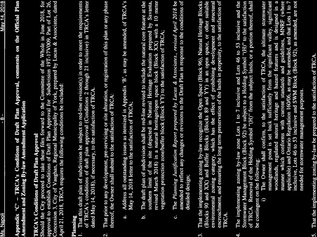
61

62

63
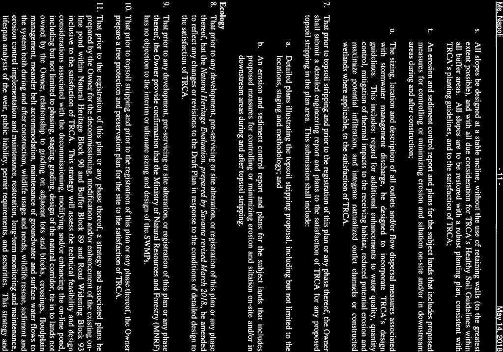
64
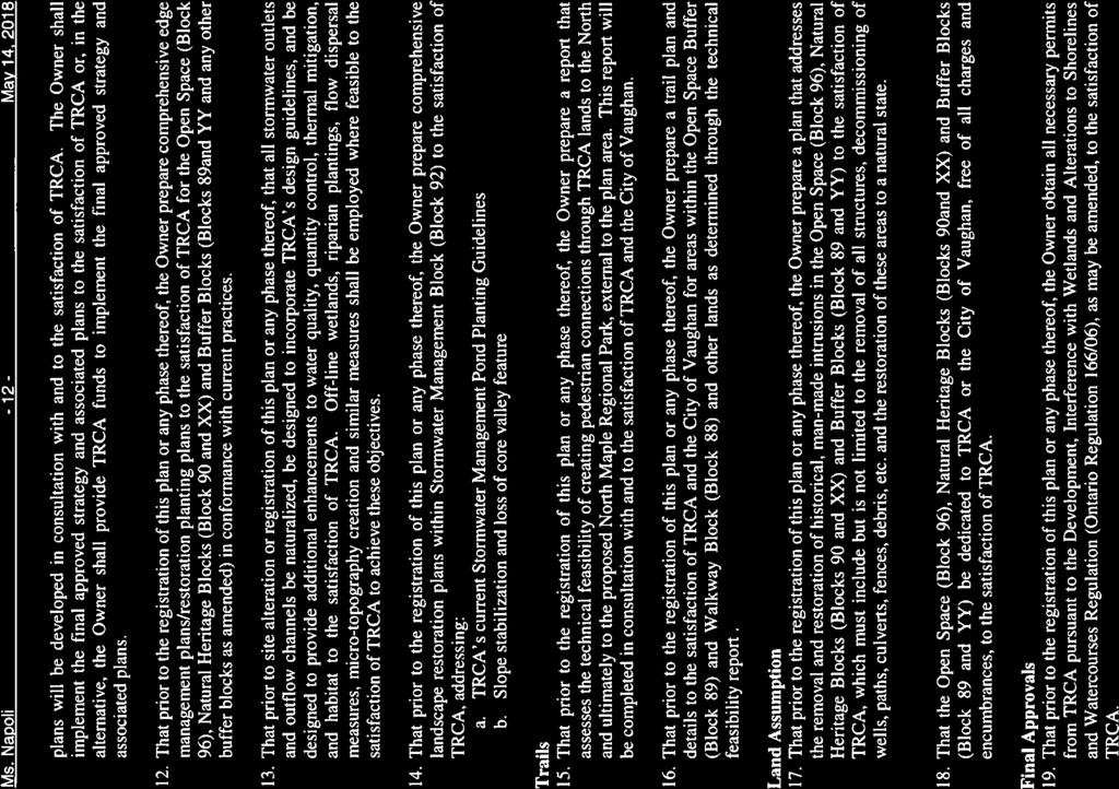
65
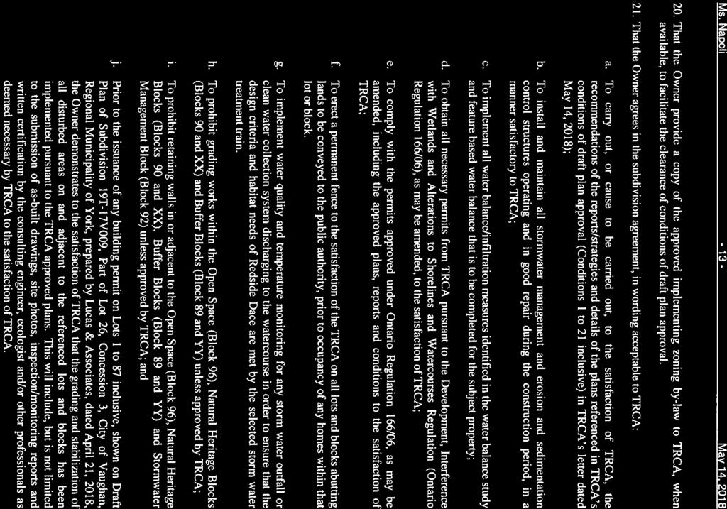
66
67
68

69

70
71
72 Attachment #1 d)
73
74 Attachment #1e) Date: September 1 st, 2017 Attention: RE: Christina Napoli Request for Comments File No.: 19T-17V009 Applicant: Location Cam Milani, Teston Sands Inc Teston Road 1
75 COMMENTS: Alectra Utilities (formerly PowerStream) has received and reviewed the submitted plan proposal. This review, however, does not imply any approval of the project or plan. The owner, or his agent, for this plan is required to contact Alectra to discuss all aspects of the above project. Alectra will require site plan drawings, draft m-plans, legal plans, architectural design drawings, electrical consultant s drawings, number of units/lots in the subdivision/development and type of the subdivision/development (i.e., single family residential, town homes, condominium town homes, industrial etc.), square footage of the buildings, the required voltage, amperage and building loads, along with the completed and signed Subdivision Application Information Form (SAIF). Alectra will then use this information to determine the type of available service in the area to supply this project and determine the design fee for the subdivision or development. Once Alectra has received the design fee and requested information, Alectra will prepare the hydro design, obtain the owner s /developer s approval of the design and obtain the required approvals from the local municipality and prepare the cost of the electrical distribution system (EDS) installation. Alectra will provide the owner/developer with an Offer to Connect (OTC) agreement which will specify all the details and the responsibilities of each party. The information on the SAIF must be as accurate as possible to reduce unnecessary customer costs, and to provide a realistic in-service date. The information from the SAIF is also used to allocate/order materials, to assign a technician to the project, and to place the project in the appropriate queue. All proposed buildings, billboards, signs, and other structures associated with the development must maintain minimum clearances to the existing overhead or underground electrical distribution system as specified by the Ontario Electrical Safety Code and the Occupational Health and Safety Act. If there are any existing components of Alectra s electrical distribution system on the proposed project site, they will have to be relocated by Alectra at the Developer s cost. Any conflicts due to driveway locations or clearances to the existing overhead or underground distribution system will have to be relocated by Alectra at the Developer s cost. We trust this information is adequate for your files. Regards, Mr. Tony D Onofrio Supervisor, Subdivisions & New Services Phone: ext Fax: tony.donofrio@alectrautilities.com Subdivision Application Information Form is available by calling ext
76 Attachment #1 f) From: Municipal Planning Sent: Friday, May 04, :19 AM To: Napoli, Christina Subject: RE: URGENT REQUEST FOR COMMENTS SUBMISSION 2: 19T-17V009, Z & OP (Teston Sands Inc.) 1600 Teston Road, Vaughan Good morning Christina, I reviewed your comment sheet and the following 2 requirements were not included and should be. If the gas main needs to be relocated as a result of changes in the alignment or grade of the future road allowances or for temporary gas pipe installations pertaining to phase construction, all costs are the responsibility of the applicant. In the event that easement(s) are required to service this development, the applicant will provide the easement(s) to Enbridge Gas Distribution at no cost. I am attaching the original letter as reference. Regards, Alice Coleman Municipal Planning Coordinator Long Range Distribution Planning ENBRIDGE GAS DISTRIBUTION TEL: Consumers Road, North York, Ontario M2J 1P8 Enbridgegas.com Integrity. Safety. Respect.
77 Enbridge Gas Distribution 500 Consumers Road North York, Ontario M2J 1P8 Canada September 5, 2017 Christina Napoli Senior Planner City of Vaughan Development Planning Division 2141 Major Mackenzie Drive Vaughan, ON L6A 1T1 Dear Christina Napoli, Re: Draft Plan of Subdivision, Official Plan Amendment & Zoning By-Law Amendment Cam Milani, Teston Sands Inc Teston Road In Part Lot 26, Concession 3 City of Vaughan File No.: 19T-17V009 Related: OP & Z Enbridge Gas Distribution does not object to the proposed application(s). This response does not constitute a pipe locate or clearance for construction. The applicant shall contact Enbridge Gas Distribution s Customer Connections department by ing SalesArea30@enbridge.com for service and meter installation details and to ensure all gas piping is installed prior to the commencement of site landscaping (including, but not limited to: tree planting, silva cells, and/or soil trenches) and/or asphalt paving. If the gas main needs to be relocated as a result of changes in the alignment or grade of the future road allowances or for temporary gas pipe installations pertaining to phase construction, all costs are the responsibility of the applicant. In the event that easement(s) are required to service this development, the applicant will provide the easement(s) to Enbridge Gas Distribution at no cost. The applicant will grade all road allowances to as close to final elevation as possible, provide necessary field survey information and all approved municipal road cross sections, identifying all utility locations prior to the installation of the gas piping.
78 Enbridge Gas Distribution reserves the right to amend or remove development conditions. Sincerely, Alice Coleman Municipal Planning Coordinator Long Range Distribution Planning ENBRIDGE GAS DISTRIBUTION TEL: Consumers Rd, North York, ON, M2J 1P8 enbridgegas.com Integrity. Safety. Respect. AC/jh
79 KIRBY ROAD Subject Lands Expanded Polling Area TESTON ROAD Town of RICHMOND HILL TESTON ROAD 150m Polling Area DUFFERIN STREET BATHURST STREET KEELE STREET MAJOR MACKENZIE DRIVE Context Location Map LOCATION: Part of Lot 26, Concession 2 APPLICANT: Teston Sands Inc. Development Planning Department Not to Scale Attachment FILES: OP , Z & 19T-17V009 DATE: June 5,
80 R1 EXISTING RESIDENTIAL ANTONINI COURT DUFFERIN STREET R1 CELESTE DRIVE R1 HUNTERWOOD CHASE OS5 R1 EXISTING RESIDENTIAL GEORGIA CRECENT R1 GERMANA PLACE A Legend A - AGRICULTURAL ZONE OS5 - OPEN SPACE ENVIRONMENTAL PROTECTION ZONE R1 - RESIDENTIAL ZONE RA3 - APARTMENT RESIDENTIAL ZONE RR - RURAL RESIDENTIAL ZONE Subject Lands Location Map LOCATION: Part of Lot 26, Concession 3 APPLICANT: Teston Sands Inc. EXISTING VALLEY LANDS Other Lands Owned by Applicant to be dedicated into Public Ownership OS5 OS5 EXISTING VALLEY LANDS A A EXISTING AGRICULTURAL USES East UNOPENED ROAD ALLOWANCE OS5 Don River Development Planning Department EXISTING RESIDENTIAL R1 CITY OF VAUGHAN FIRE STATION 7-10 RR EXISTING VALLEY LANDS OS5 RR EXISTING RESIDENTIAL RA3 TESTON ROAD APPROVED DRAFT PLAN OF SUBDIVISION FILE 19T-15V013 (7 DETACHED LOTS) EXISTING RICHVIEW MANOR 6 STOREY SENIORS RESIDENCE EXISTING AGRICULTURAL USES TESTON ROAD OS5 EXISTING VALLEY LANDS - MAPLE NATURE RESERVE Not to Scale Attachment FILES: OP , Z & 19T-17V009 DATE: June 5,
 TESTON ROAD Existing STREET A 27.00 12.")
81 Pond STORMWATER MANAGEMENT BLOCK 90 NATURAL HERITAGE EXISTING RESIDENTIAL FIRE STATION EXISTING RESIDENTIAL BLOCK 88 BLOCK 89 BLOCK 89 BLOCK 91 BLOCK 92 BLOCK 96 CITY OF VAUGHAN ROAD ALLOWANCE BETWEEN LOTS 25 AND 26, CONCESSION 3 (TESTON ROAD) TESTON ROAD Existing STREET A STREET D STREET E RD1 24 RD RD3 BLOCK DUFFERIN STREET TO REMAIN DESIGNATED "AGRICULTURAL (5.63 HA) AREA" AND 'OS5' ZONE STREET A STREET B (1.15 HA) STREET C RD1 RD3 RD3(H) Subject Lands Other Lands owned by Applicant to be dedicated into Public Ownership (6.44ha.) Not to Scale Proposed Draft Plan of Subdivision File 19T-17V009, Official Plan and Zoning By-Law Amendments APPLICANT: Teston Sands Inc. Attachment Residential Detached Zone One Residential Detached Zone Three Residential Detached Zone Three with the Holding Symbol "(H)" OS1(H) Open Space Conservation Zone with BLOCK 90 the Holding Symbol "(H)" OS5 ZONES Open Space Environmental Protection Zone LOCATION: Part of Lot 26, Concession 2 OS5 BOUNDARY BETWEEN AREA 'A' AND 'B' SUBJECT TO SECTION VOLUME 2 VOP 2010 (SEE ATTACHMENT 6) OS5 OS5 OS5 OS5 OS1(H) RD3(H) RD1 Development Planning Department APPROVED DRAFT PLAN OF SUBDIVISION FILE 19T-15V013 (7 DETACHED LOTS) OS1(H) EXISTING RESIDENTIAL FILE OP TO REDESIGNATE FROM "NATURAL AREAS" TO "LOW RISE RESIDENTIAL" AND TO REZONE FROM 'A' ZONE TO 'RD1', 'RD3', RD3(H), OS1(H) AND 'OS5' ZONE EXISTING RESIDENTIAL FILES: OP , Z & 19T-17V009 DATE: June 5, GERMANA PLACE 38.14
82 BLOCK 98 Pond Existing OWNED BY APPLICANT OTHER LANDS EXISTING RESIDENTIAL EXISTING RESIDENTIAL FIRE STATION EXISTING RESIDENTIAL CITY OF VAUGHAN BLOCK VACANT ROAD ALLOWANCE BETWEEN LOTS 25 AND 26, CONCESSION 3 (TESTON ROAD) Subject Lands RD STREET A STREET D STREET E STREET C BLOCK DUFFERIN STREET STREET F TO REMAIN DESIGNATED "AGRICULTURAL (7.25 HA) AREA" AND 'OS5' ZONE STREET A A RD2 RD3 OS2 OS5 Other Lands owned by Applicant Not to Scale Original Proposal: Draft Plan of Subdivision File 19T-17V009, Official Plan and Zoning By-Law TESTON ROAD Attachment 5 Amendments, Public Hearing January 23, 2018 Part of Lot 26, Concession 2 LOCATION: Development Planning Department DATE: June 5, 2018 Z & 19T-17V009 FILES: OP , STREET B ZONES Agricultural Zone Residential Detached Zone Two Residential Detached Zone Three Open Space Park Zone Open Space Environmental Protection Zone OS5 A BOUNDARY BETWEEN AREA 'A' AND 'B' SUBJECT TO SECTION VOLUME 2 VOP 2010 (SEE ATTACHMENT 4) OS5 OS2 RD3 A APPLICANT: Teston Sands Inc RD2 EXISTING RESIDENTIAL FILE OP TO REDESIGNATE FROM "NATURAL AREAS" TO "LOW RISE RESIDENTIAL" AND TO REZONE FROM 'A' ZONE TO 'RD2', 'RD3' AND 'OS2' ZONE APPROVED DRAFT PLAN OF SUBDIVISION FILE 19T-15V013 (7 DETACHED LOTS) TO REMAIN DESIGNATED "NATURAL AREAS" AND ZONED 'A' AGRICULTURAL ZONE EXISTING RESIDENTIAL GERMANA PLACE

83 Not to Scale Approved Site Specific Policy VOP 2010, Volume 2 APPLICANT: Teston Sands Inc. LOCATION: Part of Lot 26, Concession 2 Development Planning Department Attachment FILES: OP , Z & 19T-17V009 DATE: June 5,
CITY OF VAUGHAN EXTRACT FROM COUNCIL MEETING MINUTES OF SEPTEMBER 27, 2018
 CITY OF VAUGHAN EXTRACT FROM COUNCIL MEETING MINUTES OF SEPTEMBER 27, 2018 Item 3, Report No. 27, of the Committee of the Whole, which was adopted without amendment by the Council of the City of Vaughan
CITY OF VAUGHAN EXTRACT FROM COUNCIL MEETING MINUTES OF SEPTEMBER 27, 2018
 CITY OF VAUGHAN EXTRACT FROM COUNCIL MEETING MINUTES OF SEPTEMBER 27, 2018 Item 5, Report No. 28 of the Committee of the Whole (Public Hearing), which was adopted without amendment by the Council of the
CITY OF VAUGHAN EXTRACT FROM COUNCIL MEETING MINUTES OF JUNE 19, 2018
 CITY OF VAUGHAN EXTRACT FROM COUNCIL MEETING MINUTES OF JUNE 19, 2018 Item 5, Report No. 22, of the Committee of the Whole (Public Hearing), which was adopted without amendment by the Council of the City
Committee of the Whole (Public Hearing) Report
 Report") Item: 6 Committee of the Whole (Public Hearing) Report DATE: Tuesday, January 22, 2019 WARD: 1 TITLE: CAL-CROWN HOMES (THREE) INC. ZONING BY-LAW AMENDMENT FILE Z.18.016 DRAFT PLAN OF SUBDIVISION FILE 19T-18V007
Item: 6 Committee of the Whole (Public Hearing) Report DATE: Tuesday, January 22, 2019 WARD: 1 TITLE: CAL-CROWN HOMES (THREE) INC. ZONING BY-LAW AMENDMENT FILE Z.18.016 DRAFT PLAN OF SUBDIVISION FILE 19T-18V007
Committee of the Whole (Public Hearing) Report
 Report") Item: 5 Committee of the Whole (Public Hearing) Report DATE: Tuesday, January 22, 2019 WARD: 5 TITLE: OFFICIAL PLAN AMENDMENT FILE OP.18.016 ZONING BY-LAW AMENDMENT FILE Z.18.028 YONGE & STEELES DEVELOPMENTS
Item: 5 Committee of the Whole (Public Hearing) Report DATE: Tuesday, January 22, 2019 WARD: 5 TITLE: OFFICIAL PLAN AMENDMENT FILE OP.18.016 ZONING BY-LAW AMENDMENT FILE Z.18.028 YONGE & STEELES DEVELOPMENTS
CITY OF VAUGHAN EXTRACT FROM COUNCIL MEETING MINUTES OF MAY 16, 2017
 CITY OF VAUGHAN EXTRACT FROM COUNCIL MEETING MINUTES OF MAY 16, 2017 Item 1, Report No. 18, of the Committee of the Whole (Public Hearing), which was adopted without amendment by the Council of the City
CITY OF VAUGHAN EXTRACT FROM COUNCIL MEETING MINUTES OF FEBRUARY 21, 2017
 CITY OF VAUGHAN EXTRACT FROM COUNCIL MEETING MINUTES OF FEBRUARY 21, 2017 Item 1, Report No. 7, of the Committee of the Whole (Public Hearing), which was adopted, as amended, by the Council of the City
CITY OF VAUGHAN EXTRACT FROM COUNCIL MEETING MINUTES OF JUNE 19, 2018
 CITY OF VAUGHAN EXTRACT FROM COUNCIL MEETING MINUTES OF JUNE 19, 2018 Item 39, Report No. 21, of the Committee of the Whole, which was adopted, as amended, by the Council of the City of Vaughan on June
CITY OF VAUGHAN EXTRACT FROM COUNCIL MEETING MINUTES OF MAY 5, 2009
 Item 1, Report No. 25, of the Committee of the Whole (Public Hearing), which was adopted without amendment by the Council of the City of Vaughan on May 5, 2009. 1 ZONING BY-LAW AMENDMENT FILE Z.06.027
Staff Report for Council Public Meeting
 Agenda Item 3.3 a Staff Report for Council Public Meeting Date of Meeting: April 11, 2018 Report Number: SRPRS.18.087 Department: Division: Subject: Planning and Regulatory Services Development Planning
Members of the City of Brantford Committee of Adjustment. 1.0 TYPE OF REPORT Committee of Adjustment Decision Regarding an Application for Consent
 DATE: October 18 th 2017 REPORT NO. CD2017-168 TO: Members of the City of Brantford Committee of Adjustment FROM: Brandon Kashin, Current Development Planner 1.0 TYPE OF REPORT Committee of Adjustment
Staff Report for Council Public Meeting
 Agenda Item 3.3 Staff Report for Council Public Meeting Date of Meeting: September 27, 2017 Report Number: SRPRS.17.134 Department: Division: Subject: Planning and Regulatory Services Development Planning
Council Public Meeting
 Agenda 3.1 a Council Public Meeting Department: Division: Subject: Planning and Regulatory Services Development Planning Request for Comments Zoning By-law Amendment and Draft Plan of Subdivision Applications
CITY OF VAUGHAN EXTRACT FROM COUNCIL MEETING MINUTES OF JUNE 19, 2018
 CITY OF VAUGHAN EXTRACT FROM COUNCIL MEETING MINUTES OF JUNE 19, 2018 Item 34, Report No. 21, of the Committee of the Whole, which was adopted without amendment by the Council of the City of Vaughan on
5. That the Owner shall agree that all development Blocks shown within the Draft Plan will be connected to full municipal services.
 Conditions Relating to Draft Plan of Subdivision Approval East Fonthill 26T 01014 (Draft Plan dated December 1, 2013, and revised August 28, 2014), the Town of Pelham 1. This approval applies to the Draft
4027 and 4031 Ellesmere Road Zoning Amendment and Draft Plan of Subdivision Applications - Request for Direction Report
 STAFF REPORT ACTION REQUIRED 4027 and 4031 Ellesmere Road Zoning Amendment and Draft Plan of Subdivision Applications - Request for Direction Report Date: August 22, 2013 To: From: Wards: Reference Number:
3035 Weston Road - Official Plan and Zoning By-law Amendment and Draft Plan of Subdivision Applications - Request for Directions Report
 STAFF REPORT ACTION REQUIRED 3035 Weston Road - Official Plan and Zoning By-law Amendment and Draft Plan of Subdivision Applications - Request for Directions Report Date: December 18, 2007 To: From: Wards:
TOTTENHAM SECONDARY PLAN
 TOTTENHAM SECONDARY PLAN AMENDMENT NO. 11 TO THE OFFICIAL PLAN OF THE TOWN OF NEW TECUMSETH The following text and schedules to the Official Plan of the Town of New Tecumseth constitute Amendment No. 11
CITY OF VAUGHAN EXTRACT FROM COUNCIL MEETING MINUTES OF MAY 7, 2007
 Item 1, Report No. 24, of the Committee of the Whole (Public Hearing), which was adopted without amendment by the Council of the City of Vaughan on May 7, 2007. 1 ZONING BY-LAW AMENDMENT FILE Z.06.071
PLANNING REPORT Gordon Street City of Guelph. Prepared on behalf of Ontario Inc. March 17, Project No. 1507
 PLANNING REPORT 1131 Gordon Street City of Guelph Prepared on behalf of 1876698 Ontario Inc. March 17, 2016 Project No. 1507 423 Woolwich Street, Suite 201, Guelph, Ontario, N1H 3X3 Phone (519) 836-7526
111 Plunkett Road (formerly part of 135 Plunkett Road) - Zoning By-law Amendment Application and Plan of Subdivision Application - Preliminary Report
 - Zoning By-law Amendment Application and Plan of Subdivision Application - Preliminary Report") STAFF REPORT ACTION REQUIRED 111 Plunkett Road (formerly part of 135 Plunkett Road) - Zoning By-law Amendment Application and Plan of Subdivision Application - Preliminary Report Date: May 27, 2013 To:
STAFF REPORT ACTION REQUIRED 111 Plunkett Road (formerly part of 135 Plunkett Road) - Zoning By-law Amendment Application and Plan of Subdivision Application - Preliminary Report Date: May 27, 2013 To:
40 Moccasin Trail and 50 Green Belt Drive - OMB
 REPORT FOR ACTION 40 Moccasin Trail and 50 Green Belt Drive - OMB Date: March 21, 2017 To: City Council From: City Solicitor Wards: Ward 34 SUMMARY The purpose of this report is to request further direction
3.1. OBJECTIVES FOR RESIDENTIAL LAND USE DESIGNATIONS GENERAL OBJECTIVES FOR ALL RESIDENTIAL DESIGNATIONS
 3. RESIDENTIAL LAND USE DESIGNATIONS INTRODUCTION The Residential land use designations provide for housing and other land uses that are integral to, and supportive of, a residential environment. Housing
TOWN OF WHITBY REPORT RECOMMENDATION REPORT
 TOWN OF WHITBY REPORT RECOMMENDATION REPORT REPORT TO: Planning and Development Committee REPORT NO: PL 4-08 DATE OF MEETING: January 21, 2008 FILE NO(S): MI-01-07 (SW- 2002-03) PREPARED BY: Planning Department
THE CORPORATION OF THE TOWNSHIP OF KING THE CERTIFICATE PAGE FOR AMENDMENT NO. 89 TO THE OFFICIAL PLAN OF THE TOWNSHIP OF KING
 THE CORPORATION OF THE TOWNSHIP OF KING THE CERTIFICATE PAGE FOR AMENDMENT NO. 89 TO THE OFFICIAL PLAN OF THE TOWNSHIP OF KING (KING CITY COMMUNITY PLAN) The attached text and schedules constituting Amendment
1. That the Block 18 Phasing Plan (Attachment #4) BE APPROVED.
 BE APPROVED.") COMMITTEE OF THE WHOLE JUNE 21, 2004 ZONING BY-LAW AMENDMENT FILE Z.02.084 DRAFT PLAN OF SUBDIVISION FILE 19T-02V10 1275620 ONTARIO INC. REPORT P.2004.15 Recommendation 1. That the Block 18 Phasing Plan
COMMITTEE OF THE WHOLE JUNE 21, 2004 ZONING BY-LAW AMENDMENT FILE Z.02.084 DRAFT PLAN OF SUBDIVISION FILE 19T-02V10 1275620 ONTARIO INC. REPORT P.2004.15 Recommendation 1. That the Block 18 Phasing Plan
THE CORPORATION OF THE CITY OF VAUGHAN
 Arvit Investments Inc. (Mosaik Homes Inc.) THE CORPORATION OF THE CITY OF VAUGHAN IN THE MATTER OF Section 17(28) of the Planning Act, RSO 1990, c.p.13 and IN THE MATTER OF Amendment Number 724 to the
CITY OF VAUGHAN EXTRACT FROM COUNCIL MEETING MINUTES OF MAY 23, 2018
 CITY OF VAUGHAN EXTRACT FROM COUNCIL MEETING MINUTES OF MAY 23, 2018 Item 2, Report No. 18, of the Committee of the Whole, which was adopted without amendment by the Council of the City of Vaughan on May
Director, Community Planning, Scarborough District ESC 44 OZ & ESC 44 SB
 STAFF REPORT ACTION REQUIRED 6175, 6183 Kingston Road and 1, 2, 4, 5, 7,10 & 11 Franklin Avenue - Official Plan Amendment, Zoning Amendment and Draft Plan of Subdivision Applications Preliminary Report
3390, 3392, 3394, 3396 and 3398 Bayview Avenue - Official Plan Amendment, Zoning By-law Amendment Application - Preliminary Report
 STAFF REPORT ACTION REQUIRED 3390, 3392, 3394, 3396 and 3398 Bayview Avenue - Official Plan Amendment, Zoning By-law Amendment Application - Preliminary Report Date: March 14, 2016 To: From: Wards: Reference
PLANNING REPORT. 33 Arkell Road City of Guelph. Prepared on behalf of OHM Arkell Inc. August 4, Project No. 1327
 PLANNING REPORT 33 Arkell Road City of Guelph Prepared on behalf of OHM Arkell Inc. August 4, 2015 Project No. 1327 423 Woolwich Street, Suite 201, Guelph, Ontario, N1H 3X3 Phone (519) 836-7526 Fax (519)
Planning Justification Report
 Planning Justification Report 101 Kozlov Street, Barrie, Ont. Destaron Property Management Ltd. November 2015 Revised February 2017 TABLE OF CONTENTS Page 1.0 INTRODUCTION... 1 2.0 DESCRIPTION OF SUBJECT
CITY OF VAUGHAN EXTRACT FROM COUNCIL MEETING MINUTES OF APRIL 2, 2007
 Item 1, Report No. 17, of the Committee of the Whole (Public Hearing), which was adopted without amendment by the Council of the City of Vaughan on April 2, 2007. 1 ZONING BY-LAW AMENDMENT FILE Z.07.001
Frequently Asked Questions
 Frequently Asked Questions Cambridge West Land Use Planning Matters January 10, 2018 Q1 What is proposed for the undeveloped lands within the Cambridge West area? A. Four separate landowners each own part
CITY OF VAUGHAN EXTRACT FROM COUNCIL MEETING MINUTES OF JUNE 30, 2009
 Item 1, Report No. 37, of the Committee of the Whole (Public Hearing), which was adopted without amendment by the Council of the City of Vaughan on June 30, 2009. 1 ZONING BY-LAW AMENDMENT FILE Z.09.015
For Vintages of Four Mile Creek Town of Niagara on the Lake, Ontario
 Planning Impact Analysis For Vintages of Four Mile Creek Town of Niagara on the Lake, Ontario Prepared by: Upper Canada Consultants 261 Martindale Road Unit #1 St. Catharines, Ontario L2W 1A1 Prepared
507, 509 and 511 Kingston Road - Official Plan and Zoning By-law Amendment Applications Request for Interim Directions Report
 REPORT FOR ACTION 507, 509 and 511 Kingston Road - Official Plan and Zoning By-law Amendment Applications Request for Interim Directions Report Date: June 6, 2018 To: From: Wards: Reference Number: Toronto
250, 252, 254 and 256 Royal York Road and 8 and 10 Drummond Street - Zoning By-law Amendment Application - Preliminary Report
 STAFF REPORT ACTION REQUIRED 250, 252, 254 and 256 Royal York Road and 8 and 10 Drummond Street - Zoning By-law Amendment Application - Preliminary Report Date: May 28, 2013 To: From: Wards: Reference
5, 7 and 9 Dale Avenue - Official Plan Amendment and Zoning Amendment Applications - Preliminary Report
 STAFF REPORT ACTION REQUIRED 5, 7 and 9 Dale Avenue - Official Plan Amendment and Zoning Amendment Applications - Preliminary Report Date: September 15, 2016 To: From: Wards: Reference Number: Toronto
Committee of Adjustment Agenda
 Committee of Adjustment Agenda Hearing Date: May 25, 2017 Time: 7:00 p.m. Location: 225 East Beaver Creek Road, 1 st Floor (Council Chambers) Call to Order Disclosure of Pecuniary Interest Requests for
Staff Report for Council Public Meeting
 Agenda Item 3.3 a Staff Report for Council Public Meeting Date of Meeting: February 7, 2018 Report Number: SRPRS.18.022 Department: Division: Subject: Planning and Regulatory Services Development Planning
Planning and Building Department
 Page 1 of Report PB-83-13 TO: Development and Infrastructure Committee Planning and Building Department SUBJECT: OP & Rezoning 5001 Corporate Drive Appleby Gardens LJM Developers Report Number: PB-83-13
The Corporation of The Town of Richmond Hill. Schedule of Conditions. Draft Plan of Subdivision. File 19T(R)-16002
-16002") Town of Richmond Hill The Corporation of The Town of Richmond Hill Development Planning Division Schedule of Conditions Draft Plan of Subdivision File 19T(R)-16002 Country Wide Homes (Jefferson) Inc. Lots
Town of Richmond Hill The Corporation of The Town of Richmond Hill Development Planning Division Schedule of Conditions Draft Plan of Subdivision File 19T(R)-16002 Country Wide Homes (Jefferson) Inc. Lots
CITY OF VAUGHAN EXTRACT FROM COUNCIL MEETING MINUTES OF DECEMBER 11, 2012
 Item 6, Report No. 50, of the Committee of the Whole (Public Hearing), which was adopted, as amended, by the Council of the City of Vaughan December 11, 2012, as follows: By receiving Communication C1
The Corporation of The Town of Richmond Hill. Schedule of Conditions. Draft Plan of Subdivision. File 19T(R) Town of Richmond Hill
 Town of Richmond Hill") The Corporation of The Town of Richmond Hill Development Planning Division Schedule of Conditions Draft Plan of Subdivision File 19T(R)-14009 Country Wide Homes (Jefferson) Inc. Lot 3, Plan 65M-2071 Town
The Corporation of The Town of Richmond Hill Development Planning Division Schedule of Conditions Draft Plan of Subdivision File 19T(R)-14009 Country Wide Homes (Jefferson) Inc. Lot 3, Plan 65M-2071 Town
AMENDMENT NUMBER 38 TO THE OFFICIAL PLAN OF THE TOWNSHIP OF WEST LINCOLN (COMPLIANCE)
") AMENDMENT NUMBER 38 TO THE OFFICIAL PLAN OF THE TOWNSHIP OF WEST LINCOLN (COMPLIANCE) 2013 AMENDMENT NUMBER 38 TO THE OFFICIAL PLAN OF THE TOWNSHIP OF WEST LINCOLN PART 1 - THE PREAMBLE 1.1 TITLE This
AMENDMENT NUMBER 38 TO THE OFFICIAL PLAN OF THE TOWNSHIP OF WEST LINCOLN (COMPLIANCE) 2013 AMENDMENT NUMBER 38 TO THE OFFICIAL PLAN OF THE TOWNSHIP OF WEST LINCOLN PART 1 - THE PREAMBLE 1.1 TITLE This
DATE: April 26, 2017 REPORT NO. CD Members of the City of Brantford Committee of Adjustment
 DATE: April 26, 2017 REPORT NO. CD2017-075 TO: Members of the City of Brantford Committee of Adjustment FROM: Victoria Coates, Current Development Planner 1.0 TYPE OF REPORT Committee of Adjustment Decision
PIN , Part 1, Plan SR-713 in Lot 2, Concession 5, Township of McKim (1096 Dublin Street, Sudbury)
") STAFF REPORT Applicant: Dalron Construction Limited Location: PIN 02124-0103, Part 1, Plan SR-713 in Lot 2, Concession 5, Township of McKim (1096 Dublin Street, Sudbury) Official Plan and Zoning By-law:
STAFF REPORT Applicant: Dalron Construction Limited Location: PIN 02124-0103, Part 1, Plan SR-713 in Lot 2, Concession 5, Township of McKim (1096 Dublin Street, Sudbury) Official Plan and Zoning By-law:
Residential (170 detached lots) Park, Buffer, Walkways
 Park, Buffer, Walkways") COMMITTEE OF THE WHOLE SEPTEMBER 3, 2002 ZONING BY-LAW AMENDMENT FILE Z.01.024 DRAFT PLAN OF SUBDIVISION FILE 19T-01V04 HUMBERPLEX DEVELOPMENTS INC. REPORT #P.2001.35 Recommendation The Commissioner of
COMMITTEE OF THE WHOLE SEPTEMBER 3, 2002 ZONING BY-LAW AMENDMENT FILE Z.01.024 DRAFT PLAN OF SUBDIVISION FILE 19T-01V04 HUMBERPLEX DEVELOPMENTS INC. REPORT #P.2001.35 Recommendation The Commissioner of
25 Vickers Road, 5555 and 5559 Dundas Street West and 10 Shorncliffe Road - Zoning Amendment Application - Request for Direction Report
 STAFF REPORT ACTION REQUIRED 25 Vickers Road, 5555 and 5559 Dundas Street West and 10 Shorncliffe Road - Zoning Amendment Application - Request for Direction Report Date: October 31, 2011 To: From: Wards:
Kingston Road - Zoning Amendment and Draft Plan of Subdivision Applications - Preliminary Report
 STAFF REPORT ACTION REQUIRED 6480-6484 Kingston Road - Zoning Amendment and Draft Plan of Subdivision Applications - Preliminary Report Date: April 19, 2016 To: From: Wards: Reference Number: Scarborough
CITY OF VAUGHAN EXTRACT FROM COUNCIL MEETING MINUTES OF JUNE 23, 2015
 CITY OF VAUGHAN EXTRACT FROM COUNCIL MEETING MINUTES OF JUNE 23, 2015 Item 2, Report No. 27, of the Committee of the Whole (Public Hearing), which was adopted, as amended, by the Council of the City of
MINTO COMMUNITIES INC. AVALON WEST STAGE 4 PLANNING RATIONALE. July Prepared for:
 MINTO COMMUNITIES INC. AVALON WEST STAGE 4 PLANNING RATIONALE July 2015 Prepared for: MINTO COMMUNITIES INC. 200 180 Kent Street Ottawa, Ontario K1P 0B6 Prepared by: J.L. RICHARDS & ASSOCIATES LIMITED
12, 14, 16 and 18 Marquette Avenue and 7 Carhartt Street Zoning By-law Amendment Application - Preliminary Report
 STAFF REPORT ACTION REQUIRED 12, 14, 16 and 18 Marquette Avenue and 7 Carhartt Street Zoning By-law Amendment Application - Preliminary Report Date: July 17, 2014 To: From: Wards: Reference Number: North
TO: CHAIR AND MEMBERS PLANNING AND ENVIRONMENT COMMITTEE
 TO: CHAIR AND MEMBERS PLANNING AND ENVIRONMENT COMMITTEE FROM: GEORGE KOTSIFAS, P.ENG. MANAGING DIRECTOR, DEVELOPMENT & COMPLIANCE SERVICES AND CHIEF BUILDING OFFICIAL SUBJECT: APPLICATION BY: SIFTON PROPERTIES
Committee of Adjustment Agenda
 Committee of Adjustment Agenda Hearing Date: November 24, 2016 Time: 7:15 p.m. Location: 225 East Beaver Creek Road, 1 st Floor (Council Chambers) Staff reports obtained online do not include hard copy
Staff Report Summary Item 5
 File: B011/18 Staff Report Summary Item 5 Ward 1 Applicant: Address: Agent: Haastown Holdings (Vaughan) Inc. 9770 Keele St Maple Evans Planning Inc. Please note that comments received after the preparation
Financial Impact Statement There are no immediate financial impacts associated with the adoption of this report.
 STAFF REPORT Planning and Development Department Subject: Application by RYC Property to rezone a portion of lands on John Murray Dr. and Megan Lynn Dr. from R2 to R3 and to enter into a Development Agreement
Paul D. Ralph, BES, RPP, MCIP, Commissioner, Development Services Department
 Public Report To: From: Report Number: Development Services Committee Paul D. Ralph, BES, RPP, MCIP, Commissioner, Development Services Department DS-16-50 Date of Report: April 14, 2016 Date of Meeting:
Planning Justification Report Addendum
 Planning Justification Report Addendum 2031818 Ontario Inc 0 Airport Road Town of Caledon, Region of Peel September 2015 File 5073 i Table of Contents 1 Introduction... 1 2 Historical Overview and Site
Staff Report for Committee of the Whole Meeting
 Agenda Item 22 Staff Report for Committee of the Whole Meeting Department: Division: Subject: Planning and Regulatory Services Development Planning Request for Approval Zoning Amendment and Draft Plan
SUBJECT: Official Plan and Zoning By-law Amendment Applications for 4853 Thomas Alton Boulevard
 Page 1 of Report PB-100-16 SUBJECT: Official Plan and Zoning By-law Amendment Applications for 4853 Thomas Alton Boulevard TO: FROM: Development and Infrastructure Committee Planning and Building Department
CITY OF VAUGHAN EXTRACT FROM COUNCIL MEETING MINUTES OF DECEMBER 11, 2012
 CITY OF VAUGHAN EXTRACT FROM COUNCIL MEETING MINUTES OF DECEMBER 11, 2012 Item 12, Report No. 48, of the Committee of the Whole, which was adopted, as amended, by the Council of the City of Vaughan December
STAFF REPORT PLN September 11, 2017
 Page: 1 TO: SUBJECT: GENERAL COMMITTEE APPLICATIONS FOR OFFICIAL PLAN AMENDMENT AND ZONING BY-LAW AMENDMENT 37 JOHNSON STREET WARD: WARD 1 PREPARED BY AND KEY CONTACT: SUBMITTED BY: GENERAL MANAGER APPROVAL:
Township of Tay Official Plan
 Township of Tay Official Plan Draft for Consultation (v.3) March 2016 Contents 1. INTRODUCTION... 1 1.1 Content, Title and Scope... 1 1.2 Basis and Purpose of this Plan... 1 1.3 Plan Structure... 2 2.
Keele Street - Official Plan and Zoning By-law Amendment Application - Preliminary Report
 STAFF REPORT ACTION REQUIRED 406-410 Keele Street - Official Plan and Zoning By-law Amendment Application - Preliminary Report Date: September 20, 2017 To: From: Wards: Reference Number: Etobicoke York
Request for Approval Proposed Expansion to the Puccini Drive Neighbourhood Residential Infill Study Town File D (SRPRS.17.
 Staff Report for Committee of the Whole Meeting Department: Division: Subject: Planning and Regulatory Services Development Planning Request for Approval Proposed Expansion to the Puccini Drive Neighbourhood
STAFF REPORT ACTION REQUIRED
 STAFF REPORT ACTION REQUIRED 7, 8, 9, 11 and 15 Foundry Avenue and 31 Powerhouse Street (Phase 5 Lands) - Zoning By-law Amendment Application to Lift the Holding (H) Symbol - Final Report Date: February
Sheppard Ave East and 6, 8 and 10 Greenbriar Road - Official Plan Amendment and Zoning Amendment Applications - Preliminary Report
 STAFF REPORT ACTION REQUIRED 625-627 Sheppard Ave East and 6, 8 and 10 Greenbriar Road - Official Plan Amendment and Zoning Amendment Applications - Preliminary Report Date: April 15, 2016 To: From: Wards:
111 Wenderly Drive Official Plan and Zoning By-law Amendment Applications - Preliminary Report
 STAFF REPORT ACTION REQUIRED 111 Wenderly Drive Official Plan and Zoning By-law Amendment Applications - Preliminary Report Date: August 17, 2015 To: From: Wards: Reference Number: North York Community
Staff Report for Council Public Meeting
 Agenda Item 3.1 a Staff Report for Council Public Meeting Date of Meeting: October 25, 2017 Report Number: SRPRS.17.161 Department: Division: Subject: Planning and Regulatory Services Development Planning
CITY OF HAMILTON PLANNING AND ECONOMIC DEVELOPMENT DEPARTMENT Planning Division
 CITY OF HAMILTON PLANNING AND ECONOMIC DEVELOPMENT DEPARTMENT Planning Division TO: Chair and Members Planning Committee COMMITTEE DATE: January 16, 2018 SUBJECT/REPORT NO: WARD(S) AFFECTED: Ward 11 PREPARED
CITY OF VAUGHAN EXTRACT FROM COUNCIL MEETING MINUTES OF FEBRUARY 16, 2016
 CITY OF VAUGHAN EXTRACT FROM COUNCIL MEETING MINUTES OF FEBRUARY 16, 2016 Item 1, Report No. 8, of the Committee of the Whole (Public Hearing), which was adopted, as amended, by the Council of the City
Richmond Street West - Zoning Amendment Application Final Report
 STAFF REPORT ACTION REQUIRED 842-856 Richmond Street West - Zoning Amendment Application Final Report Date: May 24, 2012 To: From: Wards: Reference Number: Toronto and East York Community Council Director,
Committee of Adjustment Hearing Thursday, September 1, 2016 at 7 p.m. 225 East Beaver Creek Road, Richmond Hill, ON 1 st Floor (Council Chambers)
") Committee of Adjustment Hearing Thursday, September 1, 2016 at 7 p.m. 225 East Beaver Creek Road, Richmond Hill, ON 1 st Floor (Council Chambers) Call to Order Disclosure of Pecuniary Interest Requests
Committee of Adjustment Hearing Thursday, September 1, 2016 at 7 p.m. 225 East Beaver Creek Road, Richmond Hill, ON 1 st Floor (Council Chambers) Call to Order Disclosure of Pecuniary Interest Requests
Committee of Adjustment Agenda
 Committee of Adjustment Agenda Hearing Date: July 6, 2017 Time: 7:00 p.m. Location: 225 East Beaver Creek Road, 1 st Floor (Council Chambers) Staff reports obtained online do not include hard copy information
32-50 Forest Manor Road - Official Plan and Zoning Amendment Application - Preliminary Report
 STAFF REPORT ACTION REQUIRED 32-50 Forest Manor Road - Official Plan and Zoning Amendment Application - Preliminary Report Date: December 15, 2016 To: From: Wards: Reference Number: North York Community
The following material is submitted in support of the Plan of Subdivision and Zoning By law Amendment applications:
 June 27, 2011 Mr. Colin White Program Manager Development Review Process (Suburban West) Infrastructure Services and Community Sustainability Planning and Growth Management Department City of Ottawa 110
Holding Provisions General Prohibition Exceptions to Prohibition Holding Provisions
 16.1 General Prohibition Portions of this by-law not yet in effect are covered with a blue tone. This version consolidates all amendments and orders of the OMB up to the consolidation date shown below.
i. The only permitted uses shall be a maximum of two (2) multiple dwellings and related accessory uses;
 multiple dwellings and related accessory uses;") Presented To: Planning Committee Request for Decision Application for rezoning in order to permit 80 dwelling units, comprising two (2) six-storey multiple dwellings with 40 units, Paris Street, Sudbury
Presented To: Planning Committee Request for Decision Application for rezoning in order to permit 80 dwelling units, comprising two (2) six-storey multiple dwellings with 40 units, Paris Street, Sudbury
COMMITTEE OF THE WHOLE REPORT
 THE CORPORATION OF THE TOWN OF COBOURG COMMITTEE OF THE WHOLE REPORT TO: FROM: TITLE: Mayor and Council Desta McAdam Planner I - Development DATE OF MEETING: April 2 nd, 2018. TITLE / SUBJECT: Application
1370 Neilson Road - Zoning Amendment Application - Preliminary Report
 STAFF REPORT ACTION REQUIRED 1370 Neilson Road - Zoning Amendment Application - Preliminary Report Date: July 18, 2014 To: From: Wards: Reference Number: Scarborough Community Council Director, Community
Housing & Residential Intensification Study Discussion Paper Township of King
 Housing & Residential Intensification Study Discussion Paper Prepared by Planning Department January 2011 1.0 Background 1.1 Provincial Policies (Greenbelt and Growth Plan) Since 2001, the Province of
Chair and Members Planning and Economic Development Committee
 TO: FROM: Chair and Members Planning and Economic Development Committee Melissa Halford Manager of Planning DATE: June 23, 2016 SUBJECT: Amendment No. 6 to Draft Approval Subdivision File No. S2006-3 (Loon
50 and 52 Finch Avenue East - Official Plan and Zoning By-law Amendment Applications - Preliminary Report
 STAFF REPORT ACTION REQUIRED 50 and 52 Finch Avenue East - Official Plan and Zoning By-law Amendment Applications - Preliminary Report Date: August 16, 2016 To: From: Wards: Reference Number: North York
MUNICIPAL DISTRICT OF ROCKY VIEW NO. 44 ELBOW VALLEY WEST DIRECT CONTROL DISTRICT BYLAW C
 This document has been consolidated for convenience only. A current listing of any and all amendments can be obtained from the Municpal District Office Bylaw No. Date of Approval Amendment Type Bylaw C-6042-2005
CITY OF VAUGHAN EXTRACT FROM COUNCIL MEETING MINUTES OF NOVEMBER 8, 2011
 Item 1, Report No. 47, of the Committee of the Whole, which was adopted without amendment by the Council of the City of Vaughan on November 8, 2011. 1 WESTON ROAD LAND USE INVENTORY AND ANALYSIS STUDY
EXCERPTS FROM HALIFAX REGIONAL MUNICIPALITY CHARTER
 EXCERPTS FROM HALIFAX REGIONAL MUNICIPALITY CHARTER Municipal planning strategy 227 The Council may adopt a municipal planning strategy for all, or part, of the Municipality and there may be separate strategies
ii. That the driveway access from Desloges Road be controlled with a gate and access only be used for maintenance and emergency purposes; and,
 Presented To: Planning Committee Request for Decision Melissa Cotesta - Application for rezoning in order to permit a contractor s yard and warehouse, Pioneer Road, Sudbury Presented: Monday, Jun 27, 2016
CITY OF VAUGHAN EXTRACT FROM COUNCIL MEETING MINUTES OF NOVEMBER 21, 2017
 CITY OF VAUGHAN EXTRACT FROM COUNCIL MEETING MINUTES OF NOVEMBER 21, 2017 Item 5, Report No. 39, of the Committee of the Whole, which was adopted without amendment by the Council of the City of Vaughan
CITY OF VAUGHAN EXTRACT FROM COUNCIL MEETING MINUTES OF OCTOBER 19, 2016
 CITY OF VAUGHAN EXTRACT FROM COUNCIL MEETING MINUTES OF OCTOBER 19, 2016 Item 14, Report No. 34, of the Committee of the Whole, which was adopted without amendment by the Council of the City of Vaughan
1555 Midland Avenue - Zoning Amendment & Subdivision Applications - Preliminary Report
 STAFF REPORT ACTION REQUIRED 1555 Midland Avenue - Zoning Amendment & Subdivision Applications - Preliminary Report Date: October 24, 2013 To: From: Wards: Reference Number: Scarborough Community Council
FURTHER THAT Consent B-19/16 be subject to the following conditions:
 September 21, 2016 Page 1 of 6 Report No.: PDSD-P-53-16 Meeting Date: September 21, 2016 Submitted by: Ben Puzanov, Senior Planner Subject: Application for Consent (B-19/16); Steven Yarkovsky 13295 Ilderton
and Members of Municipal Council
 REPORT TO: SUBMITTED BY: SUBJECT: Mayor James M. Diodati and Members of Municipal Council Planning, Building & Development 26T-11-2017-002 Winzen Niagara Draft Plan of Subdivision 4825 Pettit Avenue Applicant:
DEVELOPMENT APPLICATION PRE-CONSULTATION FORM
 DEVELOPMENT APPLICATION PRE-CONSULTATION FORM Meeting Date: Property Owner: Site Address: Applicant & Address Site Area: APPLICATION TYPE (check applicable applications): Local Official Plan Amendment
Cover Letter with Narrative Statement
 Cover Letter with Narrative Statement March 31, 2017 rev July 27, 2017 RE: Rushton Pointe Residential Planned Unit Development Application for Public Hearing for RPUD Rezone PL2015 000 0306 Mr. Eric Johnson,
APPLICATIONS FOR OFFICIAL PLAN AMENDMENT AND ZONE CHANGE
 COMMUNITY AND STRATEGIC PLANNING P. O. Box 1614, Court House, Woodstock Ontario N4S 7Y3 Phone: 519-539-9800 Fax: 519-537-5513 Web Site: www.county.oxford.on.ca Our Files: OP 11-153 & ZON 3-07-18 APPLICATIONS
Date to Committee: October 13, 2015 Date to Council: November 2, 2015
 Page 1 of Report PB-76-15 TO: FROM: Development and Infrastructure Committee Planning and Building SUBJECT: Statutory public meeting and information report regarding 1371975 Ontario Inc. (Markay Homes)
166 Clinton Street Zoning Amendment Application Preliminary Report
 STAFF REPORT ACTION REQUIRED 166 Clinton Street Zoning Amendment Application Preliminary Report Date: May 4, 2011 To: From: Wards: Reference Number: Toronto and East York Community Council Director, Community
39 Thora Avenue Zoning Amendment Application Preliminary Report
 STAFF REPORT ACTION REQUIRED 39 Thora Avenue Zoning Amendment Application Preliminary Report Date: January 28, 2014 To: From: Wards: Reference Number: Scarborough Community Council Director, Community