CITY OF OAK FOREST Planning and Zoning Commission Meeting Agenda Wednesday, February 21, :00 p.m. Council Chambers
|
|
|
- Marjorie Chapman
- 5 years ago
- Views:
Transcription
 687-4050 CALL TO ORDER ROLL CALL PLEDGE OF ALLEGIANCE READING OF AGENDA ADDITIONS, DELETIONS NEW BUSINESS 1.")
1 CITY OF OAK FOREST Planning and Zoning Commission Meeting Agenda Wednesday, February 21, :00 p.m. Council Chambers S. Central Avenue Oak Forest, IL (708) CALL TO ORDER ROLL CALL PLEDGE OF ALLEGIANCE READING OF AGENDA ADDITIONS, DELETIONS NEW BUSINESS 1. ZC # Holiday Inn Express Minor Plat of Subdivision: PUBLIC MEETING The applicant requests review and recommendation of approval of a minor subdivision to resubdivide three lots into two lots at 4375 Frontage Road in the I1 Industrial District at the property commonly known as 4375 Frontage Road. 2. ZC # Holiday Inn Express Special Use Permit/Variations/Text Amendment: PUBLIC HEARING The applicant requests review and recommendation of approval of three forms of zoning relief at 4375 Frontage Road in the I1 Industrial District and one text amendment to the Oak Forest Zoning Ordinance, each in accordance with Article 11. The applicant requests a special use permit request to allow a hotel, a variation to allow the reduction of required parking stalls, and a variation to allow a four (4) story principal structure where three (3) stories are permitted. The applicant further requests a text amendment to Subsection (E), Permitted Variations, to allow requests for variations to the maximum permitted height of principal structures in non-residential districts. Notice published: February 6, 2018 in the Daily Southtown APPROVAL OF THE MINUTES February 7, 2018 CITIZEN PARTICIPATION ADJOURNMENT
2 CITY OF OAK FOREST PLANNING & ZONING COMMISSION Staff Report February 21, 2018 TITLE: HOLIDAY INN EXPRESS SUBDIVISION CASE NUMBER: ZC # REQUEST: Minor Subdivision The applicant requests review and recommendation of approval of a minor subdivision to resubdivide three lots into two lots at 4375 Frontage Road in the I1 Industrial District. LOCATION: 4375 Frontage Road To the southeast of I-57, on Frontage Road. APPLICANT INFORMATION APPLICANT: Chirag Patel, HD Hotels, LLC SURVEYOR: Michael Nelson, IL Professional and Surveyor, Wolf Consulting, LLC MEETING DATE: February 21, 2018 NOTICE MAILED: February 6, 2018 STAFF: Travis Bandstra, Director of Economic and Community Development Katie Ashbaugh, Community Planner ATTACHMENTS: 1. Alta Plat of Survey 2. Parvati Subdivision 3. HD Hospitality Subdivision
3 ZC # Holiday Inn Express Subdivision February 21, 2018 Page 2 I. REQUEST The applicant requests review and recommendation of approval of a minor subdivision to resubdivide three lots into two lots at 4375 Frontage Road in the I1 Industrial District. The request qualifies as a minor subdivision because it involves the subdivision of land into less than four (4) lots, does not involves the extension of any public facilities, nor any variations from the Oak Forest Subdivision Ordinance. The applicant proposes the two-lot minor subdivision in conjunction with the associated zoning relief request for ZC #17-015, Holiday Inn Express. This minor subdivision request is to allow the additional parking, driveway access, and stormwater management facilities proposed under ZC # to be shared between the proposed hotel and the existing hotel. The existing subdivision plat, Parvati Subdivision, does not provide provisions allowing and enforcing such joint use and maintenance, rendering new easements and new property line placement as necessary. Because this is a request for minor subdivision approval, preliminary plat of subdivision approval prior to final plat of subdivision approval is not required. Therefore, the Planning and Zoning Commission (PZC) shall make a recommendation that City Council approve, approve with conditions, or deny the minor subdivision request. Upon receipt of these recommendations, Council shall then make a final determination. II. EXISTING CONDITIONS This section refers to the existing three lots as shown on the existing plat of subdivision (Parvati Subdivison) approved under Ordinance Zoning Surrounding Zoning & Uses Current Use Future Land Use Site Area & Dimensions (see Attachment 1) Existing Site Features (see Exhibits 1 and 2) I1 Industrial District North: Industrial District (CubeSmart Self-Storage) South: I1 Industrial District West: I1 Industrial District (vacant, undeveloped; owned by pipeline company) East: I1 Industrial District (CubeSmart Self-Storage) Vacant Industrial Frontage: approximately 240 ft. along Frontage Road with visibility from I-57 Total area of three parcels: approximately 3.76 acres (163,734 sq. ft.) Area of Lot 1 (existing Best Western): approximately 1.15 acres (50,241 sq. ft.) Area of Lot 2 (part of existing parking lot): approximately 1.3 acres (56,282 sq. ft.) Area of Lot 3 (detention pond): approximately 1.3 acres (57,211 sq. ft.) Easements A total of six (6) easements exist on the subdivision at present. They are listed below. A twenty-five (25) foot building line and utility easement runs along the exterior property lines of each of the three properties. A ten (10) foot ComEd utility easement lies between the southernmost property line and the aforementioned twenty-five (25) foot easement. A ten (10) foot water main easement lies between the westernmost property line and the aforementioned twenty-five (25) foot easement.
 foot ComEd utility easement aligns with the twenty-five (25) foot building line and utility easement along the easternmost property line.")
4 ZC # Holiday Inn Express Subdivision February 21, 2018 Page 3 A fifteen (15) foot Nicor gas utility easement lies between the easternmost property line and the aforementioned twenty-five (25) foot easement. An additional ten (10) foot ComEd utility easement aligns with the twenty-five (25) foot building line and utility easement along the easternmost property line. A sixty (60) x five (5) foot rectangular perpetual easement is located in the northern-most corner of the property allowing an existing billboard to remain, as it is not owned or under the control of the applicant per cited, recorded documents on the proposed minor subdivision. Exhibit 2: Easements 25 Bldg/utility 10 Water 10 ComEd 15 Nicor Billboard Exhibit 1: Aerial Fieldcrest Subdivision CubeSmart Best Western Allied Lot 1 Lot 2 Lot 3 Emerson 166 th St. III. ZONING ANALYSIS When creating new lots through the subdivision process, each new lot must conform to the applicable zoning district s minimum lot size standards. Applicable standards for easements, new public right-ofway, and stormwater management must also be met. Bulk, Yard, and Space Requirements The dimensions of the two proposed lots of the minor plat of subdivision are as follows:
5 Lot 1 (southern-most lot) Lot 2 (northern-most lot) Lot width feet feet (frontage on Frontage Rd.) Lot depth 166 feet 450 feet (from northernmost point to south property line) Gross lot area 50, ft 2 (1.15 acres) 113, ft 2 (2.6 acres) ZC # Holiday Inn Express Subdivision February 21, 2018 Page 4 I1 District 100 feet Met N/A 10,000 ft 2 (0.23 acres) Met or Not Met N/A Met III. SUBDIVISION ANALYSIS Per the City s Subdivision Ordinance, all subdivisions are subject to the design and improvement standards as stated in Article IV of said ordinance. Specifically, non-residential subdivisions are required to meet the above referenced zoning requirements of the applicable zoning district and the lot standard as listed below. Section 4-101(C) Lot Standards, Oak Forest Subdivision Ordinance 1. General Size, Shape, and Orientation. All lots shall be designed and subdivided in Met. conformance with all of the zoning requirements applicable to the subject property. Side lot lines shall generally be located at right angles or radial to the street-right-ofway. 2. Single-Family Detached Residential Subdivisions. N/A 3. Additional Requirements for Lots Served by Private Water or Sanitary Sewer. N/A 4. Multiple-Family and Non-Residential Lots. Subdivision or Development applications Met. involving two-family, townhouse or multiple-family dwellings and non-residential uses shall be designed in a manner to promote the reasonable development of the property in conformance with zoning requirements, making adequate provision for the location of appropriate building sites, off-street parking and loading requirements and other on-site circulation system requirements, and all applicable requirements of this Code. 5. Outlots. N/A Section 4-101(E), Easement Standards, requires that easements be provided where necessary for public utilities, stormwater drainage, etc. and that the city may require subdivisions at its discretion and their width are subject to the Standards and Specifications Manual. The applicant proposes to maintain the existing easements, and add the following: A cross access and drainage easement covering both existing driveways and the drive aisles surrounding the existing Best Western hotel A blanket easement across Lot 2 for the benefit of Lot 1 to allow drainage from Lot 1 to go to the detention basin

6 ZC # Holiday Inn Express Subdivision February 21, 2018 Page 5 Lot 1 Lot 2 N Cross access/public utility/drainage easement IV. PZC MOTION PZC Resolution 18-2 states that this Commission recommends approval of all requests, subject to the following conditions: A. That the easement language provisions be modified to the satisfaction of the City Engineer prior to City Council approval; and B. That the shared parking agreement, detention basin stewardship plan and maintenance agreement as required by the Metropolitan Reclamation District and the Oak Forest Public Works Department, and all other documents as deemed necessary by the Community Development Director be identified on the subject plat prior to its recording with Cook County; and C. That shared parking agreement, detention basin stewardship plan and maintenance agreement and all other documents as deemed necessary by the Community Development Director be recorded on the same date as the subject plat be recorded; and D. That the subject plat and all of the supporting documents as specified herein be recorded with Cook County prior to the issuance of building permits. Motion to adopt PZC Resolution 18-2.
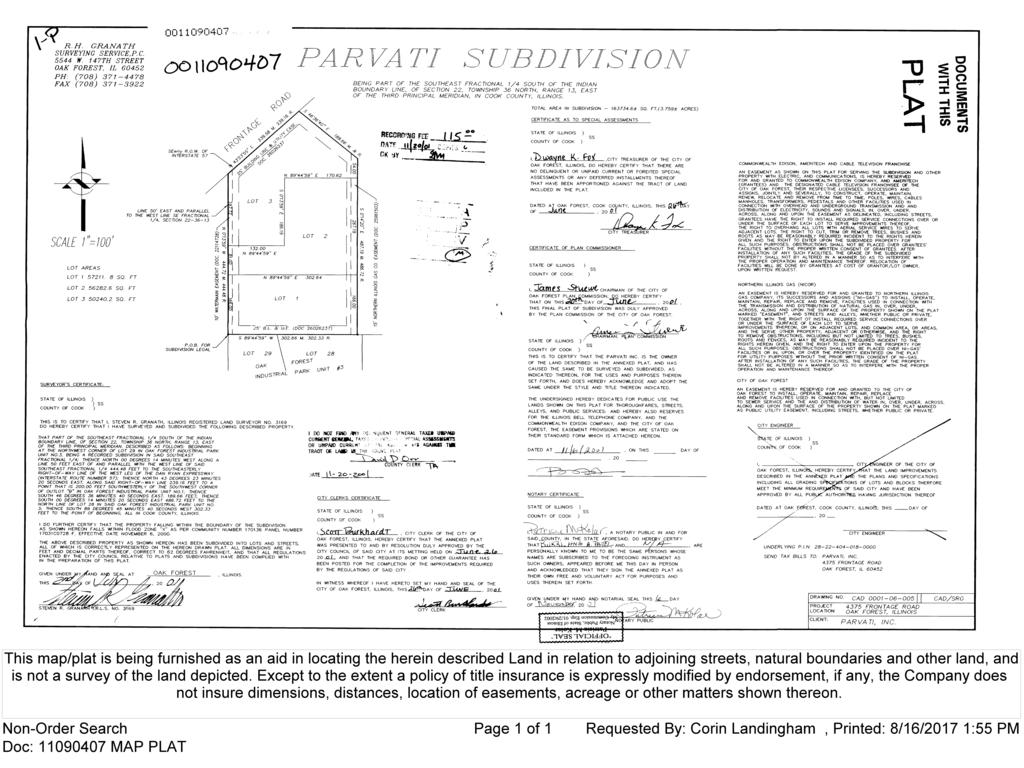
7 DE. MONUMENT FOUND LEGEND DRAINAGE EASEMENT STORM SEWER INLET STORM SEWER MANHOLE-INLET SANITARY MANHOLE PROJECT LOCATION WOLF PACK CONSULTING, LLC PARCEL 1: LOTS 2 AND 3 IN PARVATI SUBDIVISION, BEING PART OF THE SOUTHEAST FRACTIONAL QUARTER SOUTH OF THE INDIAN BOUNDARY LINE, OF SECTION 22, TOWNSHIP 36 NORTH, RANGE 13, EAST OF THE THIRD PRINCIPAL MERDIAN, AS SHOWN ON THE PLAT OF WHICH WAS RECORDED NOVEMBER 20, 2001 AS DOCUMENT , IN COOK COUNTY, ILLINOIS. ALTA/NSPS "LAND TITLE SURVEY" PARCEL 2: ( ' ) S S '4 '2 0" 0" E RE E MME A E C A S O RD SU UR E & RE D D M EA SU RE D 35' N89 10'19"E 25' N89 10'19"E 10' 15' 15' 25.00' 10' 25' 15' 418 South Cass Avenue, Westmont, IL Office: (815) wolfpackdg.com Illinois Professional Design Firm No ') RE M)ERECO.27 7'08"W 8"W (45 N '2 (N D RE SU EA D &M RD SURED CO R A HD HOSPITALITY, INC. FIRST AMERICAN TITLE INSURANCE COMPANY CERTIFIED TO: STATE OF ILLINOIS) SS. COUNTY OF DUPAGE) 15' S00 49'00"E MEASURED S00 49'00"E MEASURED ILLINOIS PROFESSIONAL LAND SURVEYOR NO PROFESSIONAL DESIGN FIRM LICENSE NO EXPIRES 04/30/2019 FIELD WORK COMPLETED ON AUGUST 24, 2016 AUGUST 24, 2017 WESTMONT, ILLINOIS. THIS PROFESSIONAL SERVICE CONFORMS TO THE CURRENT ILLINOIS MINIMUM STANDARDS FOR A BOUNDARY SURVEY. THIS IS TO CERTIFY THAT THIS MAP OR PLAT AND THE SURVEY ON WHICH IT IS BASED WERE MADE IN ACCORDANCE WITH THE 2016 MINIMUM STANDARD DETAIL REQUIREMENTS FOR ALTA/NSPS LAND TITLE SURVEYS, JOINTLY ESTABLISHED AND ADOPTED BY ALTA AND NSPS, AND INCLUDES ITEMS 1,2,3,4,6,8,9,11,17 AND 18 OF TABLE A THEREOF. THE FIELD WORK WAS COMPLETED ON AUGUST 24, ' COMBINATION MANHOLE S00 48'40"E MEASURED (S00 14'00"E) RECORD FIRE HYDRANT COMMON ADDRESS: 4375 FRONTAGE ROAD, OAK FOREST, ILLINOIS LOT 1 IN CORPORATE CENTER OF OAK FOREST, BEING A SUBDIVISION OF PART OF THE SOUTHWEST FRACTIONAL QUARTER SOUTH OF THE INDIAN BOUNDARY LINE, OF SECTION 22, TOWNSHIP 36 NORTH, RANGE 13, EAST OF THE THIRD PRINCIPAL MERIDIAN, IN COOK COUNTY, ILLINOIS. (387.02') RECORD & MEASURED WATERMAIN VALVE VAULT MANHOLE WATERMAIN VALVE BOX WATERMAIN B-BOX CONCRETE LIGHT POLE BASE CONCRETE LIGHT POLE BASE W/STREET LIGHT SANITARY SEWERLINE STORM SEWERLINE UTILITY POLE COMBINATION SEWERLINE WATERMAIN LINE OVERHEAD WIRES STORM SEWER FLARED END-SECTION BOLLARD ELECTRIC OUTLET BOX MONITORING WELL SIGN 25 PE ' R U BU D TIL IL O C IT DIN U Y G M EN EA LIN T SE E N ME A O. 2 NT ND (N89 44'59"E) RECORD N89 10'19"E MEASURED (170.62') RECORD & MEASURED COMMONWWEALTH EDISON COMPANY EASEMENT PER DOCUMENT NO LOT 2 PARVATI SUBDIVISION PER DOCUMENT NO , SQ. FT. 10' P.U. & D.E. PER DOCUMENT NO LOT 28 OAK FOREST INDUSTRIAL PARK UNIT 3 PER DOCUMENT NO (S00 14'20"E) RECORD TRAFFIC CONTROL VAULT LOT 3 PARVATI SUBDIVISION PER DOCUMENT NO , SQ. FT. PARCEL 1 END LOCATION UNKNOWN S89 10'19"W MEASURED (S89 44'59"W) RECORD (302.64') RECORD & MEASURED LOT 1 PARVATI SUBDIVISION PER DOCUMENT NO , SQ. FT. 25' BUILDING LINE AND UTILITY EASEMENT PER DOCUMENT NO AND PER DOCUMENT ' COMMONWWEALTH EDISON COMPANY EASEMENT PER DOCUMENT NO (302.66') RECORD & MEASURED S89 10'19"W MEASURED (S89 44'59"W) RECORD SCHEDULE B SURVEY RELATED ITEMS ITEM 25: BUILDING SETBACK LINES PER DOCUMENT NO (SHOWN HEREON). ITEM 26: EASEMENTS FOR PUBLIC UTILITES PER DOCUMENT NO (SHOWN HEREON). ITEM 27: EASEMENT FOR WATERMAIN PER DOCUMENT NO (SHOWN HEREON). ITEM 28: EASEMENT PROVISIONS AS CONTAINED ON THE PLAT OF SUBDIVISION PER DOCUMENT NO (SEE DOCUMENT FOR PATICULARS). ITEM 29: EASEMENTS FOR PUBLIC UTILITES PER DOCUMENT NO (SHOWN HEREON). ITEM 30: EASEMENT PROVISIONS AS CONTAINED ON THE PLAT OF SUBDIVISION PER DOCUMENT NO (SEE DOCUMENT FOR PATICULARS). ITEM 31: EASEMENT FOR NORTH ILLINOIS GAS COMPANY PER DOCUMENT NO (SHOWN HEREON). ITEM 33: PERPETUAL EASEMENT AGREEMENT MADE BETWEEN PARVATI, INC. AND CONVENANT MEDIA OF ILLINOIS, LLC PER DOCUMENT NO , TERMS AND PROVISIONS CONTAINED THEREIN (SEE DOCUMENT FOR PATICULARS). ASSIGNMENT OF EASEMENT FROM COVENANT MEDIA OF ILLINOIS TO TLC PROPERTES PER DOCUMENTS AND (SEE DOCUMENT FOR PATICULARS) AFFIDAVIT OF LOST DOCUMENT (PAVRATI EASEMENT) PER DOCUMENT (SEE DOCUMENT FOR PATICULARS). (AFFECTS PARCEL 1) ITEM 32: EASEMENT IN FAVOR OF COMMONWEALTH EDISON PER DOCUMENT NO (SHOWN HEREON.) 12' ITEM 35: EASEMENT IN FAVOR OF COMCAST OF CALIFORNIA/COLORADO/ILLINOIS/INDIANA/MICHIGAN, LP PER DOCUMENT (SEE DOCUMENT FOR PATICULARS). (AFFECTS PARCEL 2) ITEM 34: PERPETUAL EASEMENT AGREEMENT MADE BETWEEN BALKRISHNA PATEL AND CONVENANT MEDIA OF ILLINOIS, LLC PER DOCUMENT NO , TERMS AND PROVISIONS CONTAINED THEREIN (SEE DOCUMENT FOR PATICULARS). AFFIDAVIT OF LOST DOCUMENT (PAVRATI EASEMENT) PER DOCUMENT (SEE DOCUMENT FOR PATICULARS) (AFFECTS PARCEL 1) ITEM 36: COVENANTS, CONDITIONS, RESTRICTIONS CONTAINTED IN THE DECLARATION OF RESTRICTIONS PER DOCUMENTS AND (SEE DOCUMENT FOR PATICULARS) 10' ITEM 37: RELINQUISHMENT OF ALL RIGHTS OR EASEMENTS OF ACCESS, CROSSING, LIGHT, AIR AND VIEW OVER ADJOINING LAND DEDICATED FOR ROAD PURPOSES AS F.A.I. ROUTE I-57 (NO DOCUMENT PROVIDED) S00 49'00"E MEASURED (54.00') RECORD & MEASURED TRAFFIC CONTROL SIGNAL 50.00' (N89 44'59"E) RECORD N89 10'19"E MEASURED (132.00') RECORD & MEASURED LOT 29 OAK FOREST INDUSTRIAL PARK UNIT 3 PER DOCUMENT NO U PER FIRST AMERICAN TITLE INSURANCE COMPANY COMMITMENT FILE NO: DATED SEPTEMBER 8, 'B TRAFFIC CONTROL SIGNAL/ARM LOT 1 10' 25 BASIS OF BEARINGS = THE EAST LINE OF LOTS 2 AND 3 IN PARVATI SUBDIVISION = S00 49'00"E (ASSUMED) ATTACHMENT 1 IL D AN PE IN D RD GL PE O IN R CU E A D M N O E C NT D U U M N TIL EN O IT T. 26 Y 00 0 E AS EM 04 7 EN 07 T (N00 13'59"W) RECORD N00 48'39"W MEASURED (186.19') RECORD & MEASURED R GAS PIPELINE MARKER M A EC EA SU OR SU R D RE ED & D M EA SU RE D CORPORATE CENTER OF OAK FOREST PER DOCUMENT NO , SQ. FT. S89 26'20"W MEASURED (N89 59'00"W) RECORD 50.00' O ITEM 39: EASMENTS FOR WATER MAIN PER DOCUMENT NO (SHOWN HEREON). 10' COMMONWWEALTH EDISON COMPANY EASEMENT PER DOCUMENT NO ' 25' BUILDING LINE AND UTILITY EASEMENT PER DOCUMENT NO AND PER DOCUMENT ' 15' NORTHERN ILLINOIS GAS COMPANY EASEMENT PER DOCUMENT NO AND PER DOCUMENT (S00 14'20"E) RECORD S00 49'00"E MEASURED (267.19') RECORD & MEASURED 420' (2 39 N (N ' 9'1 '55 ) R 5"E "E) EC D 10' M RE E C RD AS O U RD RE & M EA D SU RE D 25' A O 25' BUILDING LINE AND UTILITY EASEMENT PER DOCUMENT NO AND PER DOCUMENT GAS VALVE ITEM 4: TOTAL AREA = AREA 153, SQ. FEET OR ACRES ITEM 6: NO ZONING REPORT HAS BEEN PROVIDED TO SURVEYOR. ITEM 8: SUBSTANTIAL FEATURES ARE AS SHOWN ON THE FACE OF PLAT. ITEM 9: 17 REGULAR PARKING SPACES AND 1 HANDICAPPED PARKING SPACE AT THE TIME OF THIS SURVEY. (N00 13'59"W) RECORD N00 48'39"W MEASURED E TA (197.72') RECORD & MEASURED N00 48'39"W MEASURED (N00 13'59"W) RECORD (81.00') RECORD & MEASURED N00 48'39"W MEASURED (N00 13'59"W) RECORD E PARCEL 2 D ITEM 17: SURVEYOR HAS NO KNOWLEDGE OF AND HAS NOT BEEN PROVIDED ANY NOTICE OF PROPOSED CHANGES IN STREET RIGHT OF WAY LINES. (N00 13'59"W) RECORD G 10' WATERMAIN EASEMENT PER DOCUMENT AND PER DOCUMENT ' N O FR (278.72') RECORD & MEASURED N00 48'39"W MEASURED (166.00') RECORD & MEASURED LIN Y AR Y ITEM 18: NO FIELD DELINEATION OF WETLAND MARKERS WERE OBSERVED AT THE TIME OF THIS SURVEY. (323.07') RECORD N 00 48'40" W 10' P.U. & D.E. PER DOCUMENT NO BO AMERITECH MANHOLE IA N D N U (1 10 N3N '20 7' '40 "E ) R "E ME IN LD (NOT TO SCALE) O (132.92') RECORD & MEASURED A SW VICINITY MAP ES LOT 2 CORPORATE CENTER OF OAK FOREST PER DOCUMENT NO EA OR RE SU D CO RE RD D &M EA SU RE D ITEM 3: I CERTIFY THAT A REVIEW OF THE FEDERAL EMERGENCY MANAGEMENT AGENCY (FEMA) FLOOD INSURANCE RATE MAP COMMUNITY PANEL 17031C0728J WITH AN EFFECTIVE DATE OF AUGUST 19, 2008 THAT THE PROPERTY PLATTED HEREON IS SITUATED IN ZONE "X", AREAS DETERMINED TO BE OUTSIDE THE 0.2% ANNUAL CHANCE FLOODPLAIN AS DESIGNATED BY FLOOD INSURANCE RATE MAP. TABLE "A" NOTES: (N00 01'00"E) RECORD N00 33'40"W MEASURED ELECTRIC VAULT TREE AND SIZE 100/16-17 MJN. CAGE ENGINEERING FLD. BK/PG: DRAWN BY: (17 N2(N '39'19"E 8') "E M ) REC O F IN D TE AN R R ST Y A AN TE E 57 XP R (100.00') RECORD & MEASURED (321.19') RECORD & MEASURED (166.00') RECORD & MEASURED S00 49'00"E MEASURED (S00 14'20"E) RECORD G LE T ES RECORD DIMENSION (50.0') P.U. & D.E. PUBLIC UTILITY AND DRAINAGE EASEMENT 10" "=20' AUGUST 18, 2017 PREPARED FOR: DATE: SCALE: JOB# W WEST LINE OF THE SOUTHEAST FRACTIONAL QUARTER SOUTH OF THE INDIAN BOUNDARY LINE IN SECTION
8 ATTACHMENT 2
9 10' P.U. & D.E ' RECORD & MEASURED S00 48'40"E MEASURED S00 14'00"E RECORD N00 13'59"W RECORD 81.00' RECORD & MEASURED N00 48'39"W MEASURED N00 48'39"W N00 48'39"W MEASURED N00 48'39"W 10' WATERMAIN EASEMENT N00 48'39"W MEASURED S00 49'00"E MEASURED S00 14'20"E RECORD S00 49'00"E MEASURED PER DOCUMENT ' S00 14'20"E RECORD S00 49'00"E (HERETOFORE GRANTED) (HERETOFORE GRANTED) (HERETOFORE GRANTED) 10' 25' (N00 13'59"W) RECORD 10' 25' 12' (HERETOFORE GRANTED) 420' S00 49'00"E 54.00' RECORD & MEASURED ' ' MEASURED 88.25' N00 48'39"W 13.25' 16.75' S00 49'00"E 54.30' 13.25' S00 49'00"E 84.77' 90.65' S00 49'00"E S00 49'00"E 57.64' ' S00 49'00"E ' ' N00 49'00"W 16.75' 13.25' 13.25' 24.70' 11.44' 28' 23' N00 49'00"W ' S00 49'00"E 63.25' ' 10' STATE OF ILLINOIS ) COUNTY OF ) SS. OWNER'S CERTIFICATE THIS IS TO CERTIFY THAT IS THE LEGAL OWNER OF THE LAND DESCRIBED ON THE ATTACHED PLAT, AND HAS CAUSED THE SAME TO BE SURVEYED AND SUBDIVIDED AS INDICATED THEREON FOR THE USES AND PURPOSES THEREIN SET FORTH. THE UNDERSIGNED HEREBY DEDICATES FOR THE PUBLIC THE LANDS SHOWN ON THE PLAT FOR THOROUGHFARES, STREETS, ALLEY, AND PUBLIC SERVICES: AND HEREBY ALSO RESERVES FOR THE AT&T AND NICOR, COMMONWEALTH EDISON COMPANY, AUTHORIZED CABLE FRANCHISE AND THE CITY OF OAK FOREST, THE EASEMENT PROVISIONS WHICH ARE STATED ON THEIR STANDARD FORM WHICH IS ATTACHED. DATED THIS DAY OF, 20. BY: TITLE: BY: TITLE: NOTARY CERTIFICATE STATE OF ILLINOIS) SS. COUNTY OF ) I, THE UNDERSIGNED, A NOTARY PUBLIC IN AND FOR SAID COUNTY AND STATE, DO HEREBY CERTIFY THAT (NAME) (TITLE) OF AND (NAME) (TITLE) OF APPEARED BEFORE ME THIS DAY IN PERSON AND ACKNOWLEDGED THAT THEY SIGNED THE ABOVE CERTIFICATE AS THEIR OWN FREE AND VOLUNTARY ACT AND DEED FOR THE USES AND PURPOSES THEREIN SET FORTH. GIVEN UNDER MY HAND AND NOTARIAL SEAL, THIS DAY OF, A.D., 20. NOTARY PUBLIC STATE OF ILLINOIS) COUNTY OF COOK) SS. CITY TREASURER CERTIFICATE I,, CITY TREASURER OF THE CITY OF OAK FOREST, DO HEREBY CERTIFY THAT THERE ARE NO DELINQUENT OR UNPAID CURRENT OR FORFEITED SPECIAL ASSESSMENTS, OR ANY DEFERRED INSTALLMENTS THEREOF, THAT BEEN APPORTIONED AGAINST THE TRACT OF LAND INCLUDED IN THE PLAT. DATED AT OAK FOREST, ILLINOIS, THIS DAY OF, A.D., 20. CITY TREASURER COMMON ADDRESS: 4375 FRONTAGE ROAD, OAK FOREST, ILLINOIS PIN: (LOT 1) PIN: (LOT 2) PIN: (LOT 3) FINAL PLAT OF SUBDIVISION HD HOSPITALITY SUBDIVISION OF PART OF THE SOUTHEAST FRACTIONAL QUARTER SOUTH OF THE INDIAN BOUNDARY LINE, OF SECTION 22, TOWNSHIP 36 NORTH, RANGE 13, EAST OF THE THIRD PRINCIPAL MERIDIAN, IN COOK COUNTY, ILLINOIS. EASEMENT PROVISIONS AN EASEMENT SERVING THE SUBDIVISION AND OTHER PROPERTY WITH ELECTRIC AND COMMUNICATIONS SERVICE IS HEREBY RESERVED FOR AND GRANTED TO: COMMONWEALTH EDISON COMPANY, AT&T AND COMCAST,GRANTEES THEIR RESPECTIVE SUCCESSORS AND ASSIGNS, JOINTLY AND SEVERALLY, TO INSTALL, OPERATE, MAINTAIN AND REMOVE, FROM TIME TO TIME, FACILITIES USED IN CONNECTION WITH OVERHEAD AND UNDERGROUND TRANSMISSION AND DISTRIBUTION OF ELECTRICITY AND SOUNDS AND SIGNALS IN, OVER UNDER, ACROSS, ALONG AND UPON THE SURFACE OF THE PROPERTY SHOWN WITHIN THE DOTTED LINES ON THE PLAT AND MARKED "EASEMENT", THE PROPERTY DESIGNATED IN THE DECLARATION OF CONDOMINIUM AND/OR ON THIS PLAT AS "COMMON ELEMENTS", AND THE PROPERTY DESIGNATED ON THE PLAT AS A "COMMON AREA OR AREAS", AND THE PROPERTY DESIGNATED ON THE PLAT FOR STREETS AND ALLEYS, WHETHER PUBLIC OR PRIVATE, TOGETHER WITH THE RIGHT TO INSTALL REQUIRED SERVICE CONNECTIONS OVER OR UNDER THE SURFACE OF EACH LOT AND COMMON AREA OR AREAS TO SERVE IMPROVEMENTS THEREON, OR ON ADJACENT LOTS, AND COMMON AREA OR AREAS, THE RIGHT TO CUT, TRIM OR REMOVE TREES, BUSHES AND ROOTS AS MAY BE REASONABLY REQUIRED INCIDENT TO THE RIGHTS HEREIN GIVEN, AND THE RIGHT TO ENTER UPON THE SUBDIVIDED PROPERTY FOR ALL SUCH PURPOSES. OBSTRUCTIONS SHALL NOT BE PLACED OVER GRANTEES' FACILITIES OR IN, UPON OR OVER THE PROPERTY WITHIN THE DOTTED LINES MARKED "EASEMENT" WITHOUT THE PRIOR WRITTEN CONSENT OF GRANTEES. AFTER INSTALLATION OF ANY SUCH FACILITIES, THE GRADE OF THE SUBDIVIDED PROPERTY SHALL NOT BE ALTERED IN A MANNER AS TO INTERFERE WITH THE PROPER OPERATION AND MAINTENANCE THEREOF. THE TERM "COMMON ELEMENTS" SHALL HAVE THE MEANING SET FORTH FOR SUCH TERM IN SECTION 2(e) OF "AN ACT IN RELATION TO CONDOMINIUMS" (ILLINOIS REVISED STATUES, Ch. 30, par. 302(e)), AS AMENDED FROM TIME TO TIME. THE TERM "COMMON AREA OR AREAS" IS DEFINED AS A LOT, PARCEL OR AREA OF REAL PROPERTY, THE BENEFICIAL USE AND ENJOYMENT OF WHICH IS RESERVED IN WHOLE AS AN APPURTENANCE TO SEPARATELY OWNED LOTS, PARCELS OR AREAS WITHIN THE PLANNED DEVELOPMENT, EVEN THOUGH SUCH BE OTHERWISE DESIGNATED ON THE PLAT BY TERMS SUCH AS, "OUTLOTS", "COMMON ELEMENTS", "OPEN SPACE", "OPEN AREA", "COMMON GROUND", "PARKING AND COMMON AREA". THE TERMS "COMMON AREA OR AREAS" AND "COMMON ELEMENTS" INCLUDES REAL PROPERTY SURFACED WITH INTERIOR DRIVEWAYS AND WALKWAYS, BUT EXCLUDES REAL PROPERTY PHYSICALLY OCCUPIED BY A BUILDING, SERVICE BUSINESS DISTRICT OR STRUCTURES SUCH AS A POOL OR RETENTION POND, OR MECHANICAL EQUIPMENT. RELOCATION OF FACILITIES WILL BE DONE BY GRANTEES AT COST OF GRANTOR/LOT OWNER, UPON WRITTEN REQUEST. AN EASEMENT IS HEREBY RESERVED FOR AND GRANTED TO NORTHERN ILLINOIS GAS COMPANY, ITS SUCCESSORS AND ASSIGNS, ("NI-GAS") TO INSTALL, OPERATE, MAINTAIN, REPAIR, REPLACE AND REMOVE, FACILITIES USED IN CONNECTION WITH THE TRANSMISSION AND DISTRIBUTION OF NATURAL GAS IN, OVER UNDER, ACROSS, ALONG AND UPON THE SURFACE OF THE PROPERTY SHOWN ON THE PLAT MARKED "EASEMENT", AND STREETS AND ALLEYS, WHETHER PUBLIC OR PRIVATE, TOGETHER WITH THE RIGHT TO INSTALL REQUIRED SERVICE CONNECTIONS OVER OR UNDER THE SURFACE OF EACH LOT TO SERVE IMPROVEMENTS THEREON, OR ON ADJACENT LOTS, AND COMMON AREA, OR AREAS, AND SERVE OTHER PROPERTY, ADJACENT OF OTHERWISE, AND THE RIGHT TO REMOVE OBSTRUCTIONS, INCLUDING BUT NOT LIMITED TO TREES, BUSHES, ROOTS AND FENCES, AS MAY BE REASONABLY REQUIRED INCIDENT TO THE RIGHTS HEREIN GIVEN, AND THE RIGHT TO ENTER UPON THE PROPERTY FOR ALL SUCH PURPOSES, OBSTRUCTIONS SHALL NOT BE PLACED OVER NI-GAS FACILITIES OR IN, UPON, OR OVER THE PROPERTY IDENTIFIED ON THE PLAT FOR UTILITY PURPOSES WITHOUT THE PRIOR WRITTEN CONSENT OF NI-GAS, AFTER INSTALLATION OF ANY SUCH FACILITIES, THE GRADE OF THE PROPERTY SHALL NOT BE ALTERED IN A MANNER SO AS TO INTERFERE WITH THE PROPER OPERATION AND MAINTENANCE THEREOF. EASEMENT, INCLUDING STREET, WHETHER PUBLIC OR PRIVATE. CROSS ACCESS EASEMENT PROVISIONS A PERPETUAL NON-EXCLUSIVE EASEMENT FOR VEHICULAR AND PEDESTRIAN ACCESS IS HEREBY GRANTED OVER AND ACROSS THE PORTIONS OF LOT 1 AS MARKED AND IDENTIFIED AS CROSS ACCESS EASEMENT ON THIS PLAT. THE OWNERS OF LOTS 1 AND 2 SHALL, AT THEIR SOLE EXPENSE, KEEP AND MAINTAIN THE CROSS ACCESS EASEMENT IN GOOD ORDER AND REPAIR, AND IMPROVE WITH A CONTINUOUS IMPERVIOUS MATERIAL (SUCH AS CONCRETE OR ASPHALT) OF SUFFICIENT BEARING STRENGTH SO AS TO ACCOMMODATE VEHICLE AND PEDESTRIAN TRAFFIC. NO OBSTRUCTIONS OR BARRIERS SHALL BE ERECTED ON OR ABOUT CROSS ACCESS EASEMENT. IN ESTABLISHING AND/OR MAINTAINING THE GRADE LEVEL OF THE IMPERVIOUS SURFACE OF THE CROSS ACCESS EASEMENT AREA, THE OWNERS OF LOTS 1 AND 2 SHALL COOPERATE WITH THE RESPECTIVE OWNERS OF THE PARCELS TO THE NORTH AND SOUTH TO PROVIDE A REASONABLY CONSISTENT GRADE LEVEL SO AS TO PERMIT UNOBSTRUCTED VEHICLE MOVEMENTS AND CONSISTENT MAINTENANCE. FOR PURPOSES OF CROSS ACCESS EASEMENT, MAINTENANCE SHALL BE DEEMED TO INCLUDE (BUT NOT BE LIMITED TO) THE REPAIR OF POTHOLES AND CRACKS, KEEPING THE SURFACE OF THE EASEMENT AREA FREE OF SNOW AND ICE, AND PROVIDING SURFACE STRIPING AND SIGNAGE FOR THE COORDINATED MOVEMENT AND CIRCULATION OF VEHICLES AND PEDESTRIANS THROUGH THE EASEMENT AREA. PUBLIC UTILITY AND DRAINAGE EASEMENT PROVISIONS INTERSTATE 57 FRONTAGE ROAD 52.45' 33.00' N42 49'15"E MEASURED ' RECORD & MEASURED N43 23'55"E RECORD SOUTHEASTERLY LINE OF INTERSTATE 57 N47 10'45"W 84.18' S47 10'45"E 93.53' 33.00' PER DOCUMENT NO AND PER DOCUMENT (HERETOFORE GRANTED) 25' BUILDING LINE AND UTILITY EASEMENT LOT 3 PARVATI SUBDIVISION PER DOCUMENT NO , SQ. FT ' CROSS ACCESS, PUBLIC UTILITY AND DRAINAGE EASEMENT 30' 5' NOTE: THERE IS A PERPETUAL EASEMENT AGREEMENT PER DOCUMENT NUMBER AND PER DOCUMENT NUMBER , RELATING TO THE LOCATION OF A PROPOSED BILLBOARD. THE PROPOSED BILLBOARD LOCATION IS NOTED AND SHOWN ON SAID DOCUMENTS, WITH TERMS AND PROVISIONS CONTAINED THEREIN ALONG WITH THE ASSIGNMENT OF EASEMENT PER DOCUMENTS NUMBERS AND AN AFFIDAVIT OF LOST DOCUMENT PER DOCUMENT NUMBERS AND ' 60' NOTE: THE DASHED LINES SHOWN HEREON RELATE TO THE LOCATION OF THE PROPOSED BILLBOARD AS NOTED IN PER PERPETUAL EASEMENT AGREEMENT PER DOCUMENT NUMBER AND PER DOCUMENT NUMBER ' ' N47 11'20"W ' CROSS ACCESS, PUBLIC UTILITY AND DRAINAGE EASEMENT 5' UTILITY EASEMENT PER DOCUMENT NO N89 44'59"E RECORD N89 10'19"E MEASURED ' RECORD & MEASURED S46 36'40"E RECORD S47 11'20"E MEASURED 25' BUILDING LINE AND (HERETOFORE GRANTED) RECORD & MEASURED COMMONWWEALTH EDISON COMPANY EASEMENT PER DOCUMENT NO (HERETOFORE GRANTED) N24 14'20"W 37.77' 24' 25' 30' 15' CITY CLERK CERTIFICATE STATE OF ILLINOIS) COUNTY OF COOK) SS. I,, CITY CLERK OF THE CITY OF OAK FOREST, ILLINOIS, HEREBY CERTIFY THAT THE ANNEXED PLAT PRESENTED TO, AND BY RESOLUTION DULY APPROVED BY, THE CITY COUNCIL OF SAID CITY AT ITS MEETING HELD ON THE DAY OF 20. AND THAT THE REQUIRED BOND OR OTHER GUARANTEE HAS BEEN POSTED FOR THE COMPLETION OF THE IMPROVEMENTS REQUIRED BY THE REGULATIONS OF SAID CITY. IN WITNESS WHEREOF, I HERETO SET MY HAND AND SEAL OF THE CITY OF OAK FOREST, ILLINOIS, THIS DAY OF, A.D., 20. CITY CLERK A PERMANENT NON-EXCLUSIVE EASEMENT IS HEREBY RESERVED AND GRANTED TO THE CITY OF OAK FOREST, ILLINOIS AND TO ITS SUCCESSORS AND ASSIGNS, IN, UPON, ACROSS, OVER, UNDER, AND THROUGH THE AREAS SHOWN BY DASHED LINES AND LABELED "EASEMENT" ON THE ATTACHED PLAT OF SUBDIVISION FOR THE PURPOSE OF INSTALLING, CONSTRUCTING, INSPECTING, OPERATING, REPLACING, RENEWING, ALTERING, ENLARGING, REMOVING, REPAIRING, CLEANING, MAINTAINING, AND ABANDONING IN PLACE STORM AND FLOOD WATER CHANNELS, BASINS, SEWERS, STORM SEWERS AND SANITARY SEWERS, WATER TRANSMISSION MAINS AND LINES, VALVE VAULTS AND HYDRANTS, AND ANY AND ALL MANHOLES, HYDRANTS, PIPES, CONNECTIONS, CATCH BASINS, BUFFALO BOXES AND WITHOUT LIMITATION, SUCH OTHER STRUCTURES AND APPURTENANCES AS MAY BE NECESSARY OR CONVENIENT FOR THE FURNISHING OF STORM WATER MANAGEMENT AND OTHER PUBLIC UTILITY SERVICES TOGETHER WITH THE RIGHT OF INGRESS AND EGRESS ACROSS AND THROUGH THE EASEMENTS FOR PERSONS AND EQUIPMENT TO DO ANY OR ALL OF THE ABOVE WORK. FOR THOSE AREAS LABELED "INTERNAL ACCESS ONLY", THE CITY SHALL INSTALL, CONSTRUCT, INSPECT, REPLACE, RENEW, ALTER, ENLARGE, REMOVE, REPAIR, CLEAN, MAINTAIN, OR ABANDON THE UTILITY EQUIPMENT OR APPURTENANCE THROUGH INDIRECT METHODS, NOT REQUIRING DIRECT ACCESS THROUGH THE EASEMENT AREA, INCLUDING, WITHOUT LIMITATION, DIRECTIONAL BORING OR REMOTE TELEVISING. THE RIGHT IS ALSO HEREBY GRANTED TO THE CITY TO CUT DOWN, TRIM OR REMOVE ANY TREES, SHRUBS OR OTHER PLANTS ON THE EASEMENTS AS WELL AS REMOVE ANY FENCE OR OTHER STRUCTURE THAT INTERFERES WITH THE INSTALLATION, MAINTENANCE OR OPERATION OF THE ABOVE OR WITH THE EXERCISE OF ANY RIGHTS GRANTED HEREIN. ALL THE EASEMENTS INDICATED SHALL BE PERPETUAL, EXCEPT THOSE IDENTIFIED AS "TEMPORARY". THE EASEMENT AREAS SHOWN AS DETENTION OR RETENTION EASEMENTS SHALL INCLUDE, IN ADDITION TO THE ABOVE RIGHTS, THE RIGHT TO FLOOD SUCH AREA WITH STORM WATERS, AND SHALL ALSO INCLUDE THE RIGHT TO INSTALL AND MAINTAIN STORM WATER DETENTION AND RETENTION STRUCTURES. NO FENCES, LANDSCAPING, STRUCTURES OR TREE WHICH BLOCK OR DIVERT OVERLAND DRAINAGE OF STORMWATER SHALL BE PLACED IN EASEMENTS. AND PER DOCUMENT BLANKET EASEMENT OVER ALL OF LOT 2 FOR DRAINAGE PURPOSES FOR THE BENEFIT OF LOT 1 S15 32'27"E 51.14' 33.00' 52.18' S15 32'27"E 54' S55 19'00"E 29.72' 4.00' 84.50' N89 11'00"E 15' NORTHERN ILLINOIS GAS COMPANY EASEMENT PER DOCUMENT NO (HERETOFORE GRANTED) AND PER DOCUMENT ' 25' 10' N89 10'19"E N89 10'19"E 50' CROSS ACCESS, PUBLIC UTILITY AND DRAINAGE EASEMENT 15' CITY ENGINEER CERTIFICATE ' RECORD & MEASURED (186.19') RECORD & MEASURED STATE OF ILLINOIS) COUNTY OF COOK) SS ' I,, CITY ENGINEER OF THE CITY OF OAK FOREST, ILLINOIS, HEREBY CERTIFY THAT THE LAND IMPROVEMENTS DESCRIBED IN THE ANNEXED PLAT AND THE PLANS AND SPECIFICATIONS, INCLUDING ALL GRADING SPECIFICATIONS OF LOTS THEREFORE, MEET THE MINIMUM REQUIREMENTS OF SAID CITY AND HAVE BEEN APPROVED BY ALL PUBLIC AUTHORITIES HAVING JURISDICTION THEREOF. 25' BUILDING LINE AND UTILITY EASEMENT PER DOCUMENT NO AND PER DOCUMENT LOT 2 113, SQ. FEET 25' BUILDING LINE AND UTILITY EASEMENT PER DOCUMENT NO AND PER DOCUMENT DATED AT OAK FOREST, ILLINOIS, THIS DAY OF, A.D., 20. CITY ENGINEER CITY PRESIDENT CERTIFICATE STATE OF ILLINOIS) COUNTY OF COOK) SS. NOTICE IS HEREBY GIVEN THAT THE FINAL PLAT OF SUBDIVISION SHOWN HEREON HAS RECEIVED APPROVAL BY THE CITY COUNCIL OF CITY OF OAK FOREST, ILLINOIS, AND UPON COMPLIANCE BY THE SUBDIVIDER WITH REQUIREMENTS OF QUALIFICATIONS GOVERNING THE APPROVAL OF PRELIMINARY PLATS AND WITH OTHER REVISIONS AND STIPULATIONS THAT MAY BE REQUIRED, THE CITY COUNCIL WILL RECEIVE THE FINAL PLAT FOR CONSIDERATION WHEN SUBMITTED BY THE SUBDIVIDER IN SUCH FORM AND WITHIN SUCH TIME AS REQUIRED BY THIS ORDINANCE. MAYOR: DATE: BLANKET EASEMENT FOR DRAINAGE PROVISIONS A PERMANENT NON-EXCLUSIVE EASEMENT, DESIGNATED FOR DRAINAGE, IS HEREBY RESERVED FOR LOT 1, THEIR SUCCESSORS AND ASSIGNEES, OVER ALL OF LOT 2 EXCEPT WHERE NOTED AS "EXCEPTION TO BLANKET EASEMENT" INCLUDING ALL PLATTED EASEMENT AREAS, STREETS, AND OTHER PUBLIC WAYS AND PLACES SHOWN ON THIS PLAT, SAID EASEMENT SHALL BE FOR THE INSTALLATION, MAINTENANCE, RELOCATION, RENEWAL AND REMOVAL OF ANY AND ALL DRAINAGE PURPOSES, AND RELATED APPURTENANCES IN, OVER, UNDER, ACROSS, ALONG, AND UPON THE SO DESIGNATED PROPERTY. SAID EASEMENT SHALL INCLUDE THE RIGHT TO ENTER THE SUBDIVIDED PROPERTY FOR ALL SUCH PURPOSES, AND THE RIGHT WITHOUT LIABILITY TO CUT, TRIM, ALTER, OR REMOVE ANY VEGETATION, ROOTS, STRUCTURES, OR DEVICES WITHIN THE DESIGNATED EASEMENT PROPERTY AS MAY BE REASONABLY REQUIRED INCIDENT TO THE RIGHTS HEREIN GIVEN WITHOUT CONSENT OF GRANTEES. NO BUILDINGS, STRUCTURES, OR OTHER OBSTRUCTION SHALL BE CONSTRUCTED, PLANTED, OR PLACED IN ANY SUCH EASEMENT AREA, STREETS, OR OTHER PUBLIC WAYS OR PLACES, NOR SHALL ANY OTHER USES BE MADE THERE OF WHICH WILL INTERFERE WITH THE EASEMENTS RESERVED AND GRANTED HEREBY. S26 39'48"E 40.87' 54' CROSS ACCESS EASEMENT AND 27' PUBLIC UTILITY EASEMENT 28.25' S18 08'51"W 4.00' EXCEPTION TO BLANKET EASEMENT LOT 2 PARVATI SUBDIVISION PER DOCUMENT NO , SQ. FT ' RECORD & MEASURED N00 13'59"W RECORD N00 13'59"W RECORD 10' COMMONWWEALTH EDISON COMPANY EASEMENT PER DOCUMENT NO ' (N89 44'59"E) RECORD N89 10'19"E MEASURED (132.00') RECORD & MEASURED WEST LINE OF THE SOUTHEAST FRACTIONAL QUARTER SOUTH OF THE INDIAN BOUNDARY LINE IN SECTION N00 48'39"W MEASURED ' ' RECORD & MEASURED S00 49'00"E MEASURED S00 14'20"E RECORD ATTACHMENT 3 CITY CLERK: DATE: PLANNING AND ZONING COMMISSION CERTIFICATE STATE OF ILLINOIS) SS. COUNTY OF ) THE PLANNING AND ZONING COMMISSION OF THE CITY OF OAK FOREST RECOMMENDED APPROVAL OF THE FINAL PLAT ON THIS DAY OF, A.D. 20. PLANNING AND ZONING COMMISSION CHAIRMAN 50' ILLINOIS DEPARTMENT OF TRANSPORTATION CERTIFICATE STATE OF ILLINOIS) COUNTY OF ) SS. CHORD=28.28' CHORD BEARING=S44 10'40"W RADIUS=20.00' L=31.41' 27' CHORD=28.29' CHORD BEARING=S45 49'20"E RADIUS=20.00' L=31.42' N89 11'00"E 84.50' CHORD=28.28' CHORD BEARING=N44 10'40"E RADIUS=20.00' L=31.41' 30' THIS PLAT HAS BEEN APPROVED BY THE ILLINOIS DEPARTMENT OF TRANSPORTATION WITH RESPECT TO ROADWAY ACCESS PURSUANT TO SECTION 2 OF "AN ACT TO REVISE THE LAW IN RELATION TO PLATS," AS AMENDED. A PLAN THAT MEETS THE REQUIREMENTS CONTAINED IN THE DEPARTMENT'S "POLICY ON PERMITS FOR ACCESS DRIVEWAYS TO STATE HIGHWAYS' WILL BE REQUIRED BY THE DEPARTMENT. LOT 1 CORPORATE CENTER OF OAK FOREST PER DOCUMENT NO PER DOCUMENT NO S89 10'19"W ' N89 10'19"E 77.68' DATED THIS DAY OF, A.D. 20. DISTRICT ENGINEER SURFACE WATER STATEMENT CROSS ACCESS, PUBLIC UTILITY AND DRAINAGE EASEMENT ' RECORD & MEASURED S89 10'19"W MEASURED S89 44'59"W RECORD CROSS ACCESS, PUBLIC UTILITY AND DRAINAGE EASEMENT STATE OF ILLINOIS) SS. COUNTY OF ) 24' ' N89 10'19"E TO THE BEST OF OUR KNOWLEDGE AND BELIEF THE DRAINAGE OF SURFACE WATERS WILL NOT BE CHANGED BY THE CONSTRUCTION OF SUCH SUBDIVISION OR ANY PART THEREOF, OR, THAT IF SUCH SURFACE WATER DRAINAGE WILL BE CHANGED, REASONABLE PROVISION HAS BEEN MADE FOR THE COLLECTION AND DIVERSION OF SUCH SURFACE WATERS INTO PUBLIC AREAS, OR DRAINS WHICH THE SUBDIVIDER HAS THE RIGHT TO USE, AND THAT SUCH SURFACE WATERS WILL BE PLANNED FOR IN ACCORDANCE WITH GENERALLY ACCEPTED ENGINEERING PRACTICES SO AS TO REDUCE THE LIKELIHOOD OF DAMAGE TO THE ADJOINING PROPERTY BECAUSE OF THE CONSTRUCTION OF THE SUBDIVISION. CROSS ACCESS, PUBLIC UTILITY AND DRAINAGE EASEMENT 24' DATED THIS DAY OF, A.D., 20. ILLINOIS PROFESSIONAL ENGINEER STATE REGISTRATION NUMBER REGISTRATION EXPIRATION DATE LOT 1 50, SQ. FEET 24' CROSS ACCESS, PUBLIC UTILITY AND DRAINAGE EASEMENT OWNER'S SIGNATURE OWNER'S SIGNATURE PRINT NAME PRINT NAME LOT 1 PARVATI SUBDIVISION PER DOCUMENT NO , SQ. FT ' S16 37'46"W SCHOOL DISTRICT CERTIFICATE 24' N45 49'10"W 14.14' S89 10'19"W ' 10' 15' THIS SUBDIVISION IS LOCATED WITHIN THE BOUNDARIES OF ELEMENTARY SCHOOL DISTRICT #145, COMMUNITY HIGH SCHOOL DISTRICT #228 AND SOUTH SUBURBAN COMMUNITY COLLEGE DISTRICT # ' STATE OF ILLINOIS) SS. COUNTY OF DUPAGE) SURVEYOR'S CERTIFICATE CROSS ACCESS, PUBLIC UTILITY AND DRAINAGE EASEMENT 15' BASIS OF BEARINGS = THE EAST LINE OF LOTS 2 AND 3 IN PARVATI SUBDIVISION = S00 49'00"E (ASSUMED) THIS IS TO CERTIFY THAT I, MICHAEL NELSON, AN ILLINOIS PROFESSIONAL LAND SURVEYOR NUMBER , HEREBY STATE THAT I HAVE SURVEYED AND SUBDIVIDED THE FOLLOWING DESCRIBED PROPERTY: LOTS 1, 2 AND 3 IN PARVATI SUBDIVISION, BEING PART OF THE SOUTHEAST FRACTIONAL QUARTER SOUTH OF THE INDIAN BOUNDARY LINE, OF SECTION 22, TOWNSHIP 36 NORTH, RANGE 13, EAST OF THE THIRD PRINCIPAL MERIDIAN, AS SHOWN ON THE PLAT OF WHICH WAS RECORDED NOVEMBER 20, 2001 AS DOCUMENT , IN COOK COUNTY, ILLINOIS. AS SHOWN BY THE ATTACHED PLAT, WHICH IS A CORRECT REPRESENTATION OF SAID SURVEY AND SUBDIVISION. ALL DISTANCES ARE SHOWN IN FEET AND DECIMAL PARTS THEREOF. I FURTHER CERTIFY THAT THE TOTAL AREA OF THE PROPERTY SURVEYED HEREON CONTAINS 163, SQUARE FEET OR ACRES. I FURTHER CERTIFY THAT THE PROPERTY INCLUDED IN THE ANNEXED PLAT IS WITHIN THE CORPORATE LIMITS OF THE CITY OF OAK FOREST, ILLINOIS. I FURTHER CERTIFY THAT ALL REGULATIONS ENACTED BY THE CITY OF OAK FOREST RELATIVE TO PLATS AND SUBDIVISIONS HAVE BEEN COMPLIED WITH IN THE PREPARATION OF THIS PLAT. I FURTHER STATE THAT A REVIEW OF THE FEDERAL EMERGENCY MANAGEMENT AGENCY (FEMA) FLOOD INSURANCE RATE MAP COMMUNITY PANEL 17031C0728J WITH AN EFFECTIVE DATE OF AUGUST 19, 2008 THAT THE PROPERTY PLATTED HEREON IS SITUATED IN ZONE "X", AREAS DETERMINED TO BE OUTSIDE THE 0.2% ANNUAL CHANCE FLOODPLAIN AS DESIGNATED BY FLOOD INSURANCE RATE MAP. GIVEN UNDER MY HAND AND SEAL THIS 22ND DAY OF JANUARY, A.D ILLINOIS PROFESSIONAL LAND SURVEYOR NO MY REGISTRATION EXPIRES ON NOVEMBER 30, 2018 PROFESSIONAL DESIGN FIRM LICENSE NO EXPIRES 04/30/2019 LOT 2 CORPORATE CENTER OF OAK FOREST PER DOCUMENT NO REV: PER CITY COMMENTS REV: PER CITY COMMENTS REV: ADD BILLBOARD EASE. NOTES 50.00' 10' 23' 28' COOK COUNTY CLERK CERTIFICATE STATE OF ILLINOIS) COUNTY OF COOK) SS. I,, COUNTY CLERK OF THE COUNTY OF COOK, DO HEREBY CERTIFY THAT THERE ARE NO DELINQUENT OR UNPAID CURRENT OR SPECIAL ASSESSMENTS, OR ANY DEFERRED INSTALLMENTS THEREOF, THAT HAVE BEEN APPORTIONED AGAINST THE TRACT OF LAND INCLUDED IN THIS PLAT, AND THAT ALL APPLICABLE FEES HAVE BEEN RECEIVED BY COOK COUNTY ON THIS DAY OF, A.D. 20. COUNTY CLERK ' 25' BUILDING LINE AND UTILITY EASEMENT PER DOCUMENT NO (HERETOFORE GRANTED) PER DOCUMENT NO AND PER DOCUMENT ' COMMONWWEALTH EDISON COMPANY EASEMENT S89 10'19"W MEASURED S89 44'59"W RECORD LOT 29 OAK FOREST INDUSTRIAL PARK UNIT 3 10' P.U. & D.E. PER DOCUMENT NO PER DOCUMENT NO LOT 28 PER DOCUMENT NO (HERETOFORE GRANTED) RECORD & MEASURED OAK FOREST INDUSTRIAL PARK UNIT South Cass Avenue, Westmont, IL Office: (815) wolfpackdg.com Illinois Professional Design Firm No
10 PZC CASE NO CITY OF OAK FOREST PLANNING AND ZONING COMMISSION PZC RESOLUTION NO WHEREAS, Chirag Patel, representing HD Hotels, LLC, ( Applicant ) filed an application for a minor plat of subdivision to resubdivide three lots into two lots ( Subdivision ); and WHEREAS, the Applicant s requested Subdivision is for the property commonly known as 4375 Frontage Road ( Property ); and WHEREAS, certified letters were duly mailed on February 6, 2018 and a public meeting was convened before the Planning and Zoning Commission ( PZC ) on February 21, 2018; and WHEREAS, the PZC has considered all of the evidence presented to it, including without limitation, those documents attached and incorporated into this resolution by reference as Exhibit A; NOW THEREFORE, BE IT RESOLVED, by the PZC of the City of Oak Forest, Cook County, based on the foregoing recitals which are hereby incorporated by reference that; Section 1. FINDINGS AND RECOMMENDATION. Based on the evidence presented at the public meeting, the PZC finds that the Applicant s application for Subdivision complies with all applicable zoning and subdivision requirements and recommends that the City Council approve the Applicant s requested Subdivision, on condition that: DRAFT A. That the easement language provisions be modified to the satisfaction of the City Engineer prior to City Council approval; and B. That the shared parking agreement, detention basin stewardship plan and maintenance agreement as required by the Metropolitan Reclamation District and the Oak Forest Public Works Department, and all other documents as deemed necessary by the Community Development Director be identified on the subject plat prior to its recording with Cook County; and C. That shared parking agreement, detention basin stewardship plan and maintenance agreement and all other documents as deemed necessary by the Community Development Director be recorded on the same date as the subject plat be recorded; and Page 1 of 2
11 PZC CASE NO D. That the subject plat and all of the supporting documents as specified herein be recorded with Cook County prior to the issuance of building permits. ADOPTED THIS day of, 20 AYES: ( ) NAYS: ( ) ABSENT: ( ) ABSTAIN: ( ), Chairman Oak Forest PZC DRAFT Page 2 of 2

12 PZC CASE NO EXHIBIT A Minor Plat of Subdivision DRAFT
13 CITY OF OAK FOREST PLANNING & ZONING COMMISSION Staff Report February 21, 2018 TITLE: HOLIDAY INN EXPRESS CASE NUMBER: ZC # REQUESTS: 1. SPECIAL USE PERMIT APPROVAL 2. VARIATION PARKING REDUCTION 3. TEXT AMENDMENT 4. VARIATION HEIGHT INCREASE The applicant requests review and recommendation of approval of three forms of zoning relief at 4375 Frontage Road in the I1 Industrial District and one text amendment to the Oak Forest Zoning Ordinance, each in accordance with Article 11. The applicant requests a special use permit request to allow a hotel, a variation to allow the reduction of required parking stalls, and a variation to allow a four (4) story principal structure where three (3) stories are permitted. The applicant further requests a text amendment to Subsection (E), Permitted Variations, to allow requests for variations to the maximum permitted height of principal structures in non-residential districts. LOCATION: APPLICANT INFORMATION APPLICANT: ARCHITECT: ENGINEERS: 4375 Frontage Road To the southeast of I-57, on Frontage Road. Chirag Patel, HD Hotels, LLC Shilpa Purohit, LEED AP BD+C, Purohit Architects, Inc. Matt Schumacher, P.E., Cage Civil Engineering MEETING DATE: February 21, 2018 NOTICE PUBLISHED: STAFF: February 6, 2018 Daily Southtown Travis Bandstra, Director of Economic and Community Development Katie Ashbaugh, Community Planner
14 ZC # Holiday Inn Express February 21, 2018 Page 2 TABLE OF CONTENTS PAGE # I. Request 3 II. Site History 3 III. Existing Conditions 4-5 IV. Proposal 6-8 V. Analysis & Standards Special Use Permit Variation Parking Stall Reduction Text Amendment Variation Height Increase 8-12 VI. PZC Motion 13 ATTACHMENTS 1. Alta Survey 2. Existing Conditions (Sheet C2.0) 3. Site Layout Plan (Sheet C3.0) 4. Landscape Plan (Sheet L.2) 5. Parking Analysis (Sheet A1.3) 6. Description of Operations 7. Response to Special Use Standards 8. Response to Variation Standards (Parking Reduction) 9. Response to Text Amendment 10. Response to Variation Standards (Height Increase) 11. Variations of Other Communities
15 I. REQUEST ZC # Holiday Inn Express February 21, 2018 Page 3 The applicant requests review and recommendation of approval of three forms of zoning relief at 4375 Frontage Road in the I1 Industrial District and one text amendment to the Oak Forest Zoning Ordinance, each in accordance with Article 11. The applicant requests a special use permit request to allow a hotel, a variation to allow the reduction of required parking stalls by thirty (35) spaces (variation parking reduction), and a variation to allow a four (4) story principal structure where three (3) stories are permitted (variation height increase). The applicant further requests a text amendmen to Subsection (E), Permitted Variations, to allow requests for variations to the maximum permitted height of principal structures in non-residential districts. The Planning and Zoning Commission (PZC) shall make recommendations that City Council approve, approve with conditions, or deny each request. Upon receipt of these recommendations, Council shall then make a final determination. The scope of work, as described in greater detail in Part IV of this report, includes: construction of a four (4) story hotel and associated parking lot with required modifications to the existing stormwater detention basin. Landscaping, wayfinding signs, and other site amenities are also proposed. This Commission should be aware that I1 Industrial District properties are not subject to design review. II. SITE HISTORY On January 19, 2000, this Commission reviewed and recommended approval of the preliminary site plan for a motel complex on a single lot. The preliminary site plan included three motels, with associated parking to the north and to the south of the southernmost building and to the east of the northern two buildings. A small detention pond was along Frontage Road. At this time, the property was zoned M1 Manufacturing District, in which a code amendment had been added to allow for commercial uses on properties with highway frontage through the site plan approval process. This change allowed the owner to apply for preliminary site plan approval for the motel complex. The PZC recommended approval of preliminary site plan. On January 25, 2000, the City Council approved the preliminary site plan. On February 16, 2000, this Commission reviewed and recommended denial the final site plan for the motel complex. This was due to outstanding concerns regarding stormwater management, fire hydrant access, and driveway design. Staff found that these concerns could be addressed during final engineering and building permitting. On February 28, 2000, the City Council reviewed and approved the final site plan. On June 20, 2001, this Commission recommended approval of the single lot being subdivided into three lots on which the Ramada hotel, associated parking and detention pond was located. On June 26, 2001, the City Council approved the three-lot subdivision. In 2016, the applicant purchased all three lots to acquire the existing hotel, which is now a Best Western. The applicant, architect and engineers in collaboration with staff determined that the proposed site plan also required a resubdivision to consolidate the three lots into two and create necessary easements not included on the original subdivision.
16 III. EXISTING CONDITIONS ZC # Holiday Inn Express February 21, 2018 Page 4 This section refers to the existing three lots as shown on the existing plat of subdivision (Parvati Subdivision) approved under Ordinance Zoning Surrounding Zoning & Uses Current Use Future Land Use Site Area & Dimensions (see Exhibit 1 and Attachment 1) Existing Site Features I1 Industrial District North: Industrial District (CubeSmart Self-Storage) South: I1 Industrial District (Emerson Instrument & Valve Services) West: I1 Industrial District (vacant, undeveloped; owned by pipeline company) East: I1 Industrial District (CubeSmart Self-Storage) Vacant Industrial Frontage: approximately 240 ft. along Frontage Road with visibility from I-57 Total area of three parcels: approximately 3.76 acres (163,734 sq. ft.) Area of Lot 1 (existing Best Western): approximately 1.15 acres (50,241 sq. ft.) Area of Lot 2 (part of existing parking lot): approximately 1.3 acres (56,282 sq. ft.) Area of Lot 3 (detention pond): approximately 1.3 acres (57,211 sq. ft.) Building One building, the existing Best Western hotel, exists on Lot 1, the southernmost property, and shall remain. The building footprint is 16,542 square feet. Parking Two parking lots serve the existing hotel. The parking lot located to the south of the existing hotel contains forty-one (41) standard parking stalls and three (3) ADA stalls. The parking lot to the north contains seventeen (17) parking standard parking stalls and one (1) ADA stall, for a total of sixty-two (62) stalls. Access One thirty (30) foot driveway to the west serves as the primary access point to the site from the south side of Frontage Road. A second fifteen and a half (15.5) foot driveway to the east serves as a secondary access point from the south side of Frontage Road. It runs along the east property lines of all three lots, terminating at the rear of the hotel in the south parking lot. Pulaski Road/Crawford Avenue, located to east of the existing hotel, provides access to Frontage Road from the 159 th Street and 167 th Street I-57 exits. Landscaping Minimal landscaping borders the existing hotel. Sparse trees and bushes spot the lawn and the trees are of low caliper.


17 ZC # Holiday Inn Express February 21, 2018 Page 5 Exhibit 1: Aerial Fieldcrest Subdivision CubeSmart Allied Best Western Lot 1 Lot 2 Lot 3 Emerson 166 th St. Exhibit 2: Future Land Use SINGLE- FAMILY Exhibit 3: Surrounding Zoning & Uses R4 INDUSTRIAL I1
18 IV. PROPOSAL ZC # Holiday Inn Express February 21, 2018 Page 6 This section uses the proposed two lots as shown on the proposed minor plat of subdivision (HD Hospitality Subdivision) filed under Zoning Case # Refer to this zoning case for additional information regarding the minor plat. The text below in bold and italicized indicates each of the four requests by the applicant and its related site improvements. Proposed Use Proposed Site Improvements Hotel Building The applicant proposes to construct one four (4) story hotel with a maximum parapet wall height of 45 feet 5 inches on the proposed Lot 2, the northern-most lot. It provides ninety (90) guest rooms, one 985 square foot conference room, a pool and fitness center, and approximately 2,312 square feet of common area. The main pedestrian entrance, anchored by a marquee area for vehicular drop-offs, is located on the east elevation. The secondary pedestrian entrance is located on the east elevation. Required Relief The I1 Industrial District requires hotels to receive special use permit approval. The I1 Industrial District also limits the height of principal structures to fifty (50) feet or three (3) stories, whichever is less. To allow the hotel to be a height of four (4) stories and exceed the three (3) story maximum by one (1) story, a text amendment and a variation are required. Section (E)(1), Permitted Variations, does not allow any non-residentially zoned properties to request height variations of any kind or amount. Therefore, to allow the principal structure to be four (4) stories, a text amendment allowing such a variation must first be requested and approved, followed by the variation (height increase) request and approval. Parking The applicant proposes to add 102 parking stalls to the site to serve the proposed Holiday Inn Express hotel. Twenty (20) parking stalls are proposed to connect to the existing parking lot located to the north of the existing Best Western hotel. Three (3) standard parking stalls and four (4) ADA stalls are proposed to front the west elevation and flank the main pedestrian entrance. Twenty-two (22) parking stalls are proposed to front the east elevation, adjacent to the secondary pedestrian entrance. The remaining fifty-three (53) spaces are proposed to the north of the hotel. Per Section 9-104(F)(1)(e), Off-Street Parking Requirements by Land Use - Services, hotels are required to provide the following: (2) Hotels and other Lodging Places 1 per lodging room PLUS 1 per 200 square feet of net floor area devoted to affiliated meeting, lobby, recreational and administrative uses, PLUS parking for
19 ZC # Holiday Inn Express February 21, 2018 Page 7 affiliated eating and drinking places as herein specified. Given that the applicant proposes to install new parking stalls to serve the proposed Holiday Inn Express hotel on the same property as the existing Best Western hotel, the parking stalls must be evaluated cumulatively and with the current code requirements. Below is an analysis of the proposed parking stalls to be added to the site for the proposed hotel, combined with the required parking for the existing Best Western hotel in accordance with the current Zoning Ordinance, as adopted in March of Refer to Attachment 5 for the floor plan analysis used to determine these requirements. Proposed vs. Required Parking (includes all affiliated net floor area, strict interpretation) BEST WESTERN (EXISTING) Required Spaces Existing/Provided Spaces Total Number of 60 rooms Hotel Rooms Net Floor Area of 3,734 sq. ft. Affiliated Space Hotel Room Parking 1 space per 60 required Ratio room Affiliated Net Floor 1 space per 200 Area Parking Ratio sq. ft. HOLIDAY INN EXPRESS (PROPOSED) Total Number of Hotel Rooms spaces 19 required spaces 90 rooms Net Floor Area of 5,876 sq. ft. Affiliated Space Hotel Room Parking 1 space per 90 required Ratio room spaces Affiliated Net Floor Area Parking Ratio 1 space per 200 sq. ft. 32 required spaces Final Parking Counts Required Variation to Required Number of Spaces 35 The parking for the Best Western was found to meet the requirements of the city in place at that time. The Best Western hotel on its own is therefore considered legal nonconforming because it does not meet the above referenced parking requirement. Required Relief Staff finds that the site as a whole, to be two (2) separate lots with one (1) hotel each and related parking lots, requires 199 parking stalls. The site provides 164 stalls, rendering a shortage of thirty-five (35) stalls and requiring a variation (parking reduction) to allow fewer parking stalls than is required. Access & Circulation One thirty (30) foot driveway to the west provides ingress and egress to the site. One fifteen and a half (15.5) foot driveway to the east provides egress only to the
20 site from the south side of Frontage Road. ZC # Holiday Inn Express February 21, 2018 Page 8 V. ANALYSIS & STANDARDS Guests and staff are to use the wider, westernmost driveway to enter the site. This driveway full-access and continues with a thirty (30) foot width as it approaches the proposed hotel. Directly adjacent to the main entrance of the proposed hotel is a landscaped median, which will support the marquee posts. Guests as they travel south, shall enter from the right of the median and turn counter-clockwise to approach the marquee drop-off area, or continue south to approach the Best Western and its related parking. The left side of the median, as approached from the north, is one-way and not to be entered by those traveling south on the driveway. Only those exiting the site or those exiting the drop-off area to the north parking lot shall use it. All drive aisles throughout the site meet the code required minimum width of twenty-four (24) feet, with the exception of the one-way drive aisle of the marquee drop-off area. Staff directed the applicant to adjust the median so as to prevent and deter accidental south-bound entries. Landscaping The proposed landscaping meets the requirements of Section 9-107, Buffers and Landscaping Requirements. In all districts except the Gateway Redevelopment Subarea and the I1 Industrial District, foundation landscaping is required. Staff notes that although it is not required, the applicant proposes a continuous landscape bed around the majority of the proposed hotel. To ensure this site enhancement remains a part of this zoning relief, the preliminary landscape plan (Attachment 4) will be included with the recommendation to City Council and in the adopted ordinance. Lighting The applicant proposed parking lot light fixtures throughout the development area to be developed. Staff directed the applicant to install light fixtures near to the right-of-way for wayfinding and navigation, with which they have complied. The photometric plan will be submitted and reviewed during final engineering and building permitting. Special Use Permit The proposed use of a hotel on the subject property does not directly align with the Comprehensive Plan s future land use designation as industrial. However, given that a hotel exists on the property directly to the south with which the subject hotel will share parking, staff finds that it is a compatible use. The plans submitted to date generally comply with staff review comments. Outstanding comments are minor and are to be addressed during the final engineering review conducted by staff and the Metropolitan Water Reclamation District, and building permit review. Below is a list of site plan design comments which the applicant will address during final engineering. Any redundant or minor/technical comments are removed.
21 Site Plan Design Comments A shared parking agreement will be required. Indicate that consistent curbing type will be installed along the entire length of the west, primary driveway on both sides. Seating should be provided near the main entrance. Indicate that east, secondary driveway on all sheets shall be a one-way exit only driveway. Install Fire Lane No Parking signs along the east driveway to ensure fire lane access at all times. Submit a five-year stewardship plan for the long-term, regular maintenance of the detention basin SEED2 wildflower mix to ensure overgrowth is mitigated and invasive species are regularly removed. This can be added to Sheet L.3 or as an addendum to the L plan set. ZC # Holiday Inn Express February 21, 2018 Page 9 To be reviewed during final engineering/permit review; must be recorded with the minor plat of subdivision. Not met. Refer to Condition C.1 Not met. At discretion of PZC and Council. Not met. Refer to Condition C.2 To be reviewed during final engineering/permit review. To be reviewed during final engineering/permit review. 1. Special Use Permit No special permit shall be recommended or granted pursuant to the below unless the applicant establishes that they are met Code and Plan Purposes. No Undue Adverse Impact. No Interference with Surrounding Development. Adequate Public Facilities. No Traffic Congestion. No Destruction of Significant Features. Compliance with Standards. Met. The proposed use of the subject property, a hotel, will be in harmony with the general and specific purpose for which this code was enacted and for which the regulations of the I1 Industrial District were established and with the general purpose and intent of the Official Comprehensive Plan. Met. Provided that compliance of all conditions is proven, no undue adverse impact is shown. Met. Provided that compliance of all conditions is proven, no interference with surrounding development is shown. Met. The subject property is presently served by adequate public utilities and any necessary upgrades to service will be addressed at the time of final engineering and building permitting. Met. The proposed use, hotel, will not cause undue traffic congestion nor draw significant amounts of traffic through residential streets. Not applicable. No significant natural features exist on the property at present. Met. All standards outlined herein and all other applicable standards are met. Staff finds that overall, the proposed use, associated site improvements, and conditions of approval serve to ensure the use will meet the standards for form of zoning relief listed below.
22 ZC # Holiday Inn Express February 21, 2018 Page 10 Variation Parking Stall Reduction The applicant requests to reduce the amount of required parking spaces from 199 spaces to 164 spaces, for a total reduction of thirty-five (35) spaces. Staff conducted a review of adjacent communities parking requirements for hotels and recent hotel project proposals. Generally, hotels are required to provide one (1) parking space per guest room and a specified ratio dependent upon the maximum number of staff, and any accessory uses or services the hotel provides, such as a restaurant/bar, event room, etc. The city s code requires one (1) space per guest room, in addition to one (1) space per 200 square feet of affiliated net floor area. The affiliated net floor area is then described to include: meeting, lobby, recreational and administrative uses, PLUS parking for affiliated eating and drinking places as herein specified. The subject hotel does not include a separate destination eating or drinking place. It does include a meeting room, a lobby, a breakfast area, a pool and a fitness center as recreational uses, and administrative offices for staff. The net floor area of these uses is 5,876 square feet, requiring thirty (30) spaces, in addition to the ninety (90) spaces required per guest room for a total of 120 spaces. Based on the description of business operations (Attachment 6) and the review of hotel parking requirements of adjacent communities, staff determined that including the lobby area, the recreational uses, and the breakfast area was redundant given that these areas are only used by guests or staff already accounted for using the one (1) space per guest room and one (1) space per 200 square feet of meeting rooms and administrative offices. Staff found that applying the one space per 200 square feet ratio was similar to other communities requiring one space per employee and is the same ratio required for office space in the city s parking code. Therefore, excluding the redundant uses from the proposed hotel results in the total number of parking spaces needed to adequately serve its primary and accessory uses being ninety-eight (98) spaces: ninety (90) for the guest rooms and eight (8) for the meeting room and administrative offices. The applicant proposes 102 spaces. Applying this same methodology to the Best Western to grant a variation for both properties given that they will share parking, the Best Western would need sixty-four (64) parking spaces. Including the lobby/breakfast area and recreational uses, seventy-nine (79) parking spaces are required. The site currently provides sixty-two (62) spaces. The Best Western will have access to all of the required seventy-nine (79) spaces per the pending shared parking agreement. To conclude, staff finds that the proposed 164 parking spaces where 199 parking spaces are required will adequately serve the proposed hotel and the existing hotel. A shared parking agreement, as will be required in conjunction with the minor plat of subdivision, will provide each hotel with the appropriate number of parking spaces based on the aforementioned analysis. 2. Variation - Parking Reduction Section 9-104(F)(1)(e)(2) Off-Street Parking, Hotels and other Lodging Places The applicant requests to reduce the amount of required parking spaces from 199 spaces to 164 spaces, for a total reduction of 35 parking spaces. General Standard Met. Carrying out the letter of the code to install the required 199 parking spaces results in a practical difficulty on the subject property due to its irregular shape Unique Physical Condition and limited size. Met. The irregular shape and limited size of the subject property are considered unique physical conditions that amount to more than mere inconvenience to the present owner. The north end of the property is composed of two diagonal lines intersecting to create a more triangular shape, rather than a straight line running east to west as most property lines are drawn. This is due to the I-57 highway
23 Not Self-Created. Denied Substantial Rights Not Merely Special Privilege Code Plan and Purposes Essential Character of the Area No Other Remedy ZC # Holiday Inn Express February 21, 2018 Page 11 running along the northwest edge of the property. The lot shape therefore prevent the owner from constructing additional parking on the site. Met. The unique physical conditions are characteristics of the subject property not caused by the past or present owner. The north end of the property is composed of two diagonal lines intersecting to create a more triangular shape, rather than a straight line running east to west as most property lines are drawn. This is due to the I-57 highway running along the northwest edge of the property. The lot shape therefore prevent the owner from constructing additional parking on the site. Met. Carrying out the strict letter of this code to meet the minimum parking space requirement would prevent the present owner from installing the stormwater management facilities to the west of the property, as required by the Metropolitan Reclamation District. This stormwater management facility is limited to its location, as its depth cannot be extended into the surface of the earth and is in its only possible location. Met. The practical difficulty resulting from the unique physical conditions is not due to merely the inability of the present owner to enjoy any special privilege or right enjoyed by others as it applies to their properties. Not applicable. The proposed use, a hotel, meets the Comprehensive Plan and Zoning Ordinance s combined purpose and intent, as reviewed through the associated Special Use Permit request. Met. Refer to the Standards for Special Use Permits to which this variation request is related. Met. There is no means other than the requested variation by which the alleged hardship or difficulty can be avoided or remedied to a degree sufficient to permit a reasonable use of the subject property. Text Amendment In general, staff finds the existing Zoning Ordinance to be more restrictive than surrounding communities in the south Chicago suburbs. Attachment 11 is a summary table of other communities and their variation (variance) procedures and allowed variations. The majority of communities allow property owners within their corporate boundaries to request any variation from any provision of the zoning code. Some communities do impose limitations explicitly in the text as to what degree the request may vary from the provision. Others give that discretion to the reviewing bodies on a case-bycase basis. Based on the findings in Attachment 11, staff finds that the following language should be added as a text amendment to Section (E)(1), Permitted Variations: (r) To increase, by not more than one (1) story, the maximum allowable height of a principal structure in any non-residential district, provided that the increase in height by one (1) story shall not require a related increase to the maximum allowable height in feet of the same district. 3. Text Amendment Section (E) Standard for Amendments The wisdom of amending the Zoning Map or the text of this Code is a matter committed to the legislative discretion of the City Council and is not dictated by any set standard. However, in determining whether a proposed amendment should be granted or denied, the Board should be guided by the principle that its power to amend this Code is not an arbitrary one but one that may be exercised only when the public good demands or requires the amendment to be made. In considering whether that principle is satisfied in any
24 ZC # Holiday Inn Express February 21, 2018 Page 12 particular case, the Board should weigh the factors that Paragraph E8 requires the applicant to address. Proposed (r) To increase, by not more than one (1) story, the maximum allowable height of a Amendment to principal structure in any non-residential district, provided that the increase in height Section 11- by one (1) story shall not require a related increase to the maximum allowable height 403(E)(1) in feet of the same district. Variation Height Increase The height of the proposed Holiday Inn Express hotel is feet is 45 feet, 5 inches. This is four (4) feet, seven (7) inches less than the dimensioned maximum height of fifty (50) feet in the I1 Industrial District. The language of Section 7-109(A), Maximum Height, states whichever is less. This language imposes the three (3) story requirement, although the building meets the fifty (50) foot requirement. Dimensionally and visually, the building conforms and should not detract from character with the surrounding area. Functionally, the hotel use requires an additional story for its purposing of lodging for guests. The ground floor is eleven (11) feet, floor to ceiling and the three (3) stories above are each nine (9) feet, which are typical story heights. The Holiday Inn brand imposes brand-specific requirements on franchisees, including building footprints, layouts, minimum number of rooms, and architecture. This building, with the exception of the elevations being fifty (50) percent masonry as required by the city s building code, strictly follows these standards. 4. Variation Height Increase Section 7-109(A)(2) Bulk, Space and Yard Requirements, Maximum Height The applicant requests to increase the maximum height of the proposed principal structure from three (3) stories to four (4) stories, for an increase in height by one (1) story above what is permitted. General Standard Met. Carrying out the letter of the code to construct a three (3) story hotel while maintaining the same number of rooms (90) would result in a larger overall building footprint and minimize the land available of the property for a sufficient Unique Physical Condition Not Self-Created. Denied Substantial Rights Not Merely Special Privilege Code Plan and Purposes Essential Character of the Area No Other Remedy number of parking spaces. Met. The irregular shape and limited size of the subject property further prevents the applicant from enlarging the building footprint in area. Met. The unique physical conditions are characteristics of the subject property are not caused by the past or present owner. Met. Carrying out the strict letter of this code to maintain the required three-story height maximum would deprive the present owner from constructing a ninetyroom hotel on the subject property, therefore depriving substantial rights commonly enjoyed by owners of other lots subject to the same provision. Met. The practical difficulty resulting from the unique physical conditions is not due to merely the inability of the present owner to enjoy any special privilege or right enjoyed by others as it applies to their properties. Not applicable. The proposed use, a hotel, meets the Comprehensive Plan and Zoning Ordinance s combined purpose and intent, as reviewed through the associated Special Use Permit request. Met. Refer to the Standards for Special Use Permits to which this variation request is related. Met. There is no means other than the requested variation by which the alleged hardship or difficulty can be avoided or remedied to a degree sufficient to permit a reasonable use of the subject property.
25 ZC # Holiday Inn Express February 21, 2018 Page 13 VI. PZC MOTION PZC Resolution 18-3 states that this Commission recommends approval of all requests, subject to the following conditions: A. No Authorization of Work. The Ordinance approving the Zoning Relief ( Ordinance ) does not authorize commencement of any work on the Property. Except as otherwise specifically provided in writing in advance by the City, no work of any kind shall be commenced on the Property pursuant to the approvals granted unless and until all conditions of the Ordinance precedent to such work have been fulfilled and after all permits, approvals, and other authorizations for such work have been properly applied for, paid for, and granted in accordance with applicable law, including, without limitation, approval of final engineering plans and issuance of required permits. B. Compliance with Laws. The development, maintenance and operation of the Property must comply with all applicable State, County and City statutes, ordinances, codes, rules, and regulations. C. Compliance with Plans. The development, maintenance, and operation of the Property will be in substantial compliance with the following documents and plans, attached hereto as Exhibit A, except for the specific changes listed below under this Condition C; minor changes and site work required to the satisfaction of the City Engineer; and in accordance with all applicable City rules, regulations, and ordinances. 1. That a consistent curbing type be installed along the entire length of the west, primary driveway on both sides. 2. That east, secondary driveway be a one-way exit only driveway and appropriate wayfinding be installed. D. Limitation of Approval. The special use permit as documented in Exhibit A is limited to the Property, provided that any and all signs indicated on said exhibit shall be subject to review and approval in accordance with Section of the Oak Forest Zoning Ordinance. E. Final Engineering Approval. Petitioner must obtain approval of final engineering plans from the City Engineer prior to the release of any building or occupancy permits for the Property. F. Final Landscape Plan Approval. Petitioner must obtain approval of a final landscape plan, which shall be in substantial conformance with the special use permit documented in Exhibit A, from the Community Development Director prior to the release of any building or occupancy permits for the Property. G. Other. Petitioner must agree to enter into a parking enforcement agreement with the City of Oak Forest Police Department to prevent parking in designated fire lanes and any other areas designated as no parking on the Property. H. The associated minor plat of subdivision (Zoning Case #17-016) and all its supporting documents (shared parking agreement, detention pond stewardship plan, and any and all other documents deemed necessary by the Community Development Director) shall be required to be approved and recorded with Cook County prior to building permit issuance. Motion to adopt PZC Resolution 18-3.

26 DE. MONUMENT FOUND LEGEND DRAINAGE EASEMENT STORM SEWER INLET STORM SEWER MANHOLE-INLET SANITARY MANHOLE PROJECT LOCATION WOLF PACK CONSULTING, LLC PARCEL 1: LOTS 2 AND 3 IN PARVATI SUBDIVISION, BEING PART OF THE SOUTHEAST FRACTIONAL QUARTER SOUTH OF THE INDIAN BOUNDARY LINE, OF SECTION 22, TOWNSHIP 36 NORTH, RANGE 13, EAST OF THE THIRD PRINCIPAL MERDIAN, AS SHOWN ON THE PLAT OF WHICH WAS RECORDED NOVEMBER 20, 2001 AS DOCUMENT , IN COOK COUNTY, ILLINOIS. ALTA/NSPS "LAND TITLE SURVEY" PARCEL 2: ( ' ) S S '4 '2 0" 0" E RE E MME A E C A S O RD SU UR E & RE D D M EA SU RE D 35' N89 10'19"E 25' N89 10'19"E 10' 15' 15' 25.00' 10' 25' 15' 418 South Cass Avenue, Westmont, IL Office: (815) wolfpackdg.com Illinois Professional Design Firm No ') RE M)ERECO.27 7'08"W 8"W (45 N '2 (N D RE SU EA D &M RD SURED CO R A HD HOSPITALITY, INC. FIRST AMERICAN TITLE INSURANCE COMPANY CERTIFIED TO: STATE OF ILLINOIS) SS. COUNTY OF DUPAGE) 15' S00 49'00"E MEASURED S00 49'00"E MEASURED ILLINOIS PROFESSIONAL LAND SURVEYOR NO PROFESSIONAL DESIGN FIRM LICENSE NO EXPIRES 04/30/2019 FIELD WORK COMPLETED ON AUGUST 24, 2016 AUGUST 24, 2017 WESTMONT, ILLINOIS. THIS PROFESSIONAL SERVICE CONFORMS TO THE CURRENT ILLINOIS MINIMUM STANDARDS FOR A BOUNDARY SURVEY. THIS IS TO CERTIFY THAT THIS MAP OR PLAT AND THE SURVEY ON WHICH IT IS BASED WERE MADE IN ACCORDANCE WITH THE 2016 MINIMUM STANDARD DETAIL REQUIREMENTS FOR ALTA/NSPS LAND TITLE SURVEYS, JOINTLY ESTABLISHED AND ADOPTED BY ALTA AND NSPS, AND INCLUDES ITEMS 1,2,3,4,6,8,9,11,17 AND 18 OF TABLE A THEREOF. THE FIELD WORK WAS COMPLETED ON AUGUST 24, ' COMBINATION MANHOLE S00 48'40"E MEASURED (S00 14'00"E) RECORD FIRE HYDRANT COMMON ADDRESS: 4375 FRONTAGE ROAD, OAK FOREST, ILLINOIS LOT 1 IN CORPORATE CENTER OF OAK FOREST, BEING A SUBDIVISION OF PART OF THE SOUTHWEST FRACTIONAL QUARTER SOUTH OF THE INDIAN BOUNDARY LINE, OF SECTION 22, TOWNSHIP 36 NORTH, RANGE 13, EAST OF THE THIRD PRINCIPAL MERIDIAN, IN COOK COUNTY, ILLINOIS. (387.02') RECORD & MEASURED WATERMAIN VALVE VAULT MANHOLE WATERMAIN VALVE BOX WATERMAIN B-BOX CONCRETE LIGHT POLE BASE CONCRETE LIGHT POLE BASE W/STREET LIGHT SANITARY SEWERLINE STORM SEWERLINE UTILITY POLE COMBINATION SEWERLINE WATERMAIN LINE OVERHEAD WIRES STORM SEWER FLARED END-SECTION BOLLARD ELECTRIC OUTLET BOX MONITORING WELL SIGN 25 PE ' R U BU D TIL IL O C IT DIN U Y G M EN EA LIN T SE E N ME A O. 2 NT ND (N89 44'59"E) RECORD N89 10'19"E MEASURED (170.62') RECORD & MEASURED COMMONWWEALTH EDISON COMPANY EASEMENT PER DOCUMENT NO LOT 2 PARVATI SUBDIVISION PER DOCUMENT NO , SQ. FT. 10' P.U. & D.E. PER DOCUMENT NO LOT 28 OAK FOREST INDUSTRIAL PARK UNIT 3 PER DOCUMENT NO (S00 14'20"E) RECORD TRAFFIC CONTROL VAULT LOT 3 PARVATI SUBDIVISION PER DOCUMENT NO , SQ. FT. PARCEL 1 END LOCATION UNKNOWN S89 10'19"W MEASURED (S89 44'59"W) RECORD (302.64') RECORD & MEASURED LOT 1 PARVATI SUBDIVISION PER DOCUMENT NO , SQ. FT. 25' BUILDING LINE AND UTILITY EASEMENT PER DOCUMENT NO AND PER DOCUMENT ' COMMONWWEALTH EDISON COMPANY EASEMENT PER DOCUMENT NO (302.66') RECORD & MEASURED S89 10'19"W MEASURED (S89 44'59"W) RECORD SCHEDULE B SURVEY RELATED ITEMS ITEM 25: BUILDING SETBACK LINES PER DOCUMENT NO (SHOWN HEREON). ITEM 26: EASEMENTS FOR PUBLIC UTILITES PER DOCUMENT NO (SHOWN HEREON). ITEM 27: EASEMENT FOR WATERMAIN PER DOCUMENT NO (SHOWN HEREON). ITEM 28: EASEMENT PROVISIONS AS CONTAINED ON THE PLAT OF SUBDIVISION PER DOCUMENT NO (SEE DOCUMENT FOR PATICULARS). ITEM 29: EASEMENTS FOR PUBLIC UTILITES PER DOCUMENT NO (SHOWN HEREON). ITEM 30: EASEMENT PROVISIONS AS CONTAINED ON THE PLAT OF SUBDIVISION PER DOCUMENT NO (SEE DOCUMENT FOR PATICULARS). ITEM 31: EASEMENT FOR NORTH ILLINOIS GAS COMPANY PER DOCUMENT NO (SHOWN HEREON). ITEM 33: PERPETUAL EASEMENT AGREEMENT MADE BETWEEN PARVATI, INC. AND CONVENANT MEDIA OF ILLINOIS, LLC PER DOCUMENT NO , TERMS AND PROVISIONS CONTAINED THEREIN (SEE DOCUMENT FOR PATICULARS). ASSIGNMENT OF EASEMENT FROM COVENANT MEDIA OF ILLINOIS TO TLC PROPERTES PER DOCUMENTS AND (SEE DOCUMENT FOR PATICULARS) AFFIDAVIT OF LOST DOCUMENT (PAVRATI EASEMENT) PER DOCUMENT (SEE DOCUMENT FOR PATICULARS). (AFFECTS PARCEL 1) ITEM 32: EASEMENT IN FAVOR OF COMMONWEALTH EDISON PER DOCUMENT NO (SHOWN HEREON.) 12' ITEM 35: EASEMENT IN FAVOR OF COMCAST OF CALIFORNIA/COLORADO/ILLINOIS/INDIANA/MICHIGAN, LP PER DOCUMENT (SEE DOCUMENT FOR PATICULARS). (AFFECTS PARCEL 2) ITEM 34: PERPETUAL EASEMENT AGREEMENT MADE BETWEEN BALKRISHNA PATEL AND CONVENANT MEDIA OF ILLINOIS, LLC PER DOCUMENT NO , TERMS AND PROVISIONS CONTAINED THEREIN (SEE DOCUMENT FOR PATICULARS). AFFIDAVIT OF LOST DOCUMENT (PAVRATI EASEMENT) PER DOCUMENT (SEE DOCUMENT FOR PATICULARS) (AFFECTS PARCEL 1) ITEM 36: COVENANTS, CONDITIONS, RESTRICTIONS CONTAINTED IN THE DECLARATION OF RESTRICTIONS PER DOCUMENTS AND (SEE DOCUMENT FOR PATICULARS) 10' ITEM 37: RELINQUISHMENT OF ALL RIGHTS OR EASEMENTS OF ACCESS, CROSSING, LIGHT, AIR AND VIEW OVER ADJOINING LAND DEDICATED FOR ROAD PURPOSES AS F.A.I. ROUTE I-57 (NO DOCUMENT PROVIDED) S00 49'00"E MEASURED (54.00') RECORD & MEASURED TRAFFIC CONTROL SIGNAL 50.00' (N89 44'59"E) RECORD N89 10'19"E MEASURED (132.00') RECORD & MEASURED LOT 29 OAK FOREST INDUSTRIAL PARK UNIT 3 PER DOCUMENT NO U PER FIRST AMERICAN TITLE INSURANCE COMPANY COMMITMENT FILE NO: DATED SEPTEMBER 8, 'B TRAFFIC CONTROL SIGNAL/ARM LOT 1 10' 25 BASIS OF BEARINGS = THE EAST LINE OF LOTS 2 AND 3 IN PARVATI SUBDIVISION = S00 49'00"E (ASSUMED) ATTACHMENT 1 IL D AN PE IN D RD GL PE O IN R CU E A D M N O E C NT D U U M N TIL EN O IT T. 26 Y 00 0 E AS EM 04 7 EN 07 T (N00 13'59"W) RECORD N00 48'39"W MEASURED (186.19') RECORD & MEASURED R GAS PIPELINE MARKER M A EC EA SU OR SU R D RE ED & D M EA SU RE D CORPORATE CENTER OF OAK FOREST PER DOCUMENT NO , SQ. FT. S89 26'20"W MEASURED (N89 59'00"W) RECORD 50.00' O ITEM 39: EASMENTS FOR WATER MAIN PER DOCUMENT NO (SHOWN HEREON). 10' COMMONWWEALTH EDISON COMPANY EASEMENT PER DOCUMENT NO ' 25' BUILDING LINE AND UTILITY EASEMENT PER DOCUMENT NO AND PER DOCUMENT ' 15' NORTHERN ILLINOIS GAS COMPANY EASEMENT PER DOCUMENT NO AND PER DOCUMENT (S00 14'20"E) RECORD S00 49'00"E MEASURED (267.19') RECORD & MEASURED 420' (2 39 N (N ' 9'1 '55 ) R 5"E "E) EC D 10' M RE E C RD AS O U RD RE & M EA D SU RE D 25' A O 25' BUILDING LINE AND UTILITY EASEMENT PER DOCUMENT NO AND PER DOCUMENT GAS VALVE ITEM 4: TOTAL AREA = AREA 153, SQ. FEET OR ACRES ITEM 6: NO ZONING REPORT HAS BEEN PROVIDED TO SURVEYOR. ITEM 8: SUBSTANTIAL FEATURES ARE AS SHOWN ON THE FACE OF PLAT. ITEM 9: 17 REGULAR PARKING SPACES AND 1 HANDICAPPED PARKING SPACE AT THE TIME OF THIS SURVEY. (N00 13'59"W) RECORD N00 48'39"W MEASURED E TA (197.72') RECORD & MEASURED N00 48'39"W MEASURED (N00 13'59"W) RECORD (81.00') RECORD & MEASURED N00 48'39"W MEASURED (N00 13'59"W) RECORD E PARCEL 2 D ITEM 17: SURVEYOR HAS NO KNOWLEDGE OF AND HAS NOT BEEN PROVIDED ANY NOTICE OF PROPOSED CHANGES IN STREET RIGHT OF WAY LINES. (N00 13'59"W) RECORD G 10' WATERMAIN EASEMENT PER DOCUMENT AND PER DOCUMENT ' N O FR (278.72') RECORD & MEASURED N00 48'39"W MEASURED (166.00') RECORD & MEASURED LIN Y AR Y ITEM 18: NO FIELD DELINEATION OF WETLAND MARKERS WERE OBSERVED AT THE TIME OF THIS SURVEY. (323.07') RECORD N 00 48'40" W 10' P.U. & D.E. PER DOCUMENT NO BO AMERITECH MANHOLE IA N D N U (1 10 N3N '20 7' '40 "E ) R "E ME IN LD (NOT TO SCALE) O (132.92') RECORD & MEASURED A SW VICINITY MAP ES LOT 2 CORPORATE CENTER OF OAK FOREST PER DOCUMENT NO EA OR RE SU D CO RE RD D &M EA SU RE D ITEM 3: I CERTIFY THAT A REVIEW OF THE FEDERAL EMERGENCY MANAGEMENT AGENCY (FEMA) FLOOD INSURANCE RATE MAP COMMUNITY PANEL 17031C0728J WITH AN EFFECTIVE DATE OF AUGUST 19, 2008 THAT THE PROPERTY PLATTED HEREON IS SITUATED IN ZONE "X", AREAS DETERMINED TO BE OUTSIDE THE 0.2% ANNUAL CHANCE FLOODPLAIN AS DESIGNATED BY FLOOD INSURANCE RATE MAP. TABLE "A" NOTES: (N00 01'00"E) RECORD N00 33'40"W MEASURED ELECTRIC VAULT TREE AND SIZE 100/16-17 MJN. CAGE ENGINEERING FLD. BK/PG: DRAWN BY: (17 N2(N '39'19"E 8') "E M ) REC O F IN D TE AN R R ST Y A AN TE E 57 XP R (100.00') RECORD & MEASURED (321.19') RECORD & MEASURED (166.00') RECORD & MEASURED S00 49'00"E MEASURED (S00 14'20"E) RECORD G LE T ES RECORD DIMENSION (50.0') P.U. & D.E. PUBLIC UTILITY AND DRAINAGE EASEMENT 10" "=20' AUGUST 18, 2017 PREPARED FOR: DATE: SCALE: JOB# W WEST LINE OF THE SOUTHEAST FRACTIONAL QUARTER SOUTH OF THE INDIAN BOUNDARY LINE IN SECTION
27 BENCHMARK 2 BENCHMARK 2 BPH "=30' EXISTING CONDITIONS PLAN C2.0 5 FRONTAGE ROAD WEST LEG OF DAN RYAN EXPRESSWAY INTERSTATE 57 l:\_projects\ holiday inn express - oak forest\03 - drawings\dwg\plan set\preliminary\c2.0_existing conditions_ /15/ :26:27 AM HOLIDAY INN EXPRESS OAK FOREST, IL ATTACHMENT SCALE: 1"=30' 60 FT REVISIONS THIS DESIGN AND THESE DRAWINGS ARE THE PROPERTY OF CAGE ENGINEERING, INC. NO PART OF THIS WORK MAY BE REPRODUCED WITHOUT PRIOR WRITTEN PERMISSION FROM CAGE ENGINEERING, INC. PROJ NO: ENG : DATE : SCALE: SHEET TITLE SHEET NUMBER OF
 22.5' PROP. LIGHT (TYP.) TRASH ENCLOSURE 16'-8\"W x 10'-8\"D R=10' R=10' R=20' R=5' FRONTAGE ROAD 13 STALLS @ 8.5' = 110.")
28 10 8.5' = 85' 4 8.5' = 34' 18' 6.85' 20' 6' 7' 24' 24' 5.5' 2.5' 3 8.5' = 25.5' 8.5' 24' (MIN.) 16.7' 5' (TYP.) 26.2' 51.4' 169.7' ' = 187' 18' 18' 24' 18' 3 H/C 18' = 56' 2.9' 24' (MIN.) 22.5' PROP. LIGHT (TYP.) TRASH ENCLOSURE 16'-8"W x 10'-8"D R=10' R=10' R=20' R=5' FRONTAGE ROAD ' = 110.5' 18' 24' 18' 24' 18' 18.3' 18' EX. LIGHT, CONCRETE POLE BASE, AND WIRING TO ENTRY SIGN TO BE REMOVED 30' (MIN.) ' = 110.5' 159.1' R=10' COMBINED HOLIDAY INN AND BEST WESTERN ENTRANCE SIGN ' = 85' COMBINED BEST WESTERN AND HOLIDAY INN PYLON SIGN EX. LIGHT, CONCRETE POLE BASE, AND WIRING TO ENTRY SIGN TO BE REMOVED STOP SIGN PROP. LIGHT (TYP.) EX. LIGHT, CONCRETE POLE BASE, AND WIRING TO ENTRY SIGN TO BE REMOVED R=80' DEPRESSED CURB & GUTTER STOP SIGN 24' (MIN.) DETENTION BASIN DO NOT ENTER SIGN LOADING AREA ACCESS R=20' DELIVERY ENTRANCE R=24' HOLIDAY INN EXPRESS U-TURN R=90' PROP. LIGHT (TYP.) OVERHANG FRONT ENTRANCE SIGN ONE WAY ONLY SIGN BIKE PARKING PROPOSED BUILDING 4-STORY 13,836 S.F ' = 85' R=20' HANDICAP SIGN (TYP.) ' = 85' DEPRESSED CURB & GUTTER 24' 11' 24' 18' ' = 85' 4 8.5' = 34' PARKING SUMMARY: EXISTING BEST WESTERN: REQUIRED STALLS (STRICT) 72 REQUIRED STALLS (LIBERAL) 64 STANDARD STALLS 58 HANDICAP STALLS 4 TOTAL PROVIDED 62 PROPOSED HOLIDAY INN EXPRESS: OVERALL: REQUIRED STALLS (STRICT) 122 REQUIRED STALLS (LIBERAL) 98 STANDARD STALLS 98 HANDICAP STALLS 4 TOTAL PROVIDED 102 REQUIRED STALLS (STRICT) 198 REQUIRED STALLS (LIBERAL) 162 STANDARD STALLS 156 HANDICAP STALLS 8 TOTAL PROVIDED 164 PAVING LEGEND STANDARD DUTY ASPHALT MILL AND OVERLAY EX. PAVEMENT HEAVY DUTY CONCRETE DECORATIVE PAVERS CONCRETE SIDEWALK BPH "=30' SITE LAYOUT PLAN C3.0 5 R=28' R=20' R=20' WEST LEG OF DAN RYAN EXPRESSWAY INTERSTATE 57 l:\_projects\ holiday inn express - oak forest\03 - drawings\dwg\plan set\preliminary\c3.0_site layout plan_ /15/ :26:34 AM HOLIDAY INN EXPRESS OAK FOREST, IL ATTACHMENT SCALE: 1"=30' 60 FT REVISIONS THIS DESIGN AND THESE DRAWINGS ARE THE PROPERTY OF CAGE ENGINEERING, INC. NO PART OF THIS WORK MAY BE REPRODUCED WITHOUT PRIOR WRITTEN PERMISSION FROM CAGE ENGINEERING, INC. PROJ NO: ENG : DATE : SCALE: SHEET TITLE SHEET NUMBER OF

29 PRELIMINARY PLANT LIST SYM SIZE QTY BOTANICAL NAME COMMON NAME COMMENT DECIDUOUS SHADE TREES ACF 3.0" CAL. 5 ACER FREEMANII 'AUTUMN BLAZE' AUTUMN BLAZE RED MAPLE B&B AMM 3.0" CAL. 7 ACER MIYABEI 'MORTON' MIYABE MAPLE B&B GDE 2.0" CAL. 3 GYMNOCLADUS DIOIC. 'ESPRESSO' ESPRESSO KENTUCKY COFFEETREE B&B PYC 3.0" CAL. 5 PYRUS CALLERYANA 'CHANTICLEAR' CHANTICLEAR PEAR B&B TCR 2.0" CAL. 4 TILIA AMERICANA REDMOND REDMOND LINDEN B&B ORNAMENTAL TREES AGP 6' MULTI 4 AMELANCHIER GRAN. 'PRINCESS DI' PRINCESS DIANA SERVICEBERRY B&B BEN 6' MULTI 6 BETULA NIGRA 'BNMTP' DURA-HEAT RIVER BIRCH B&B VIP 6' MULTI. 4 VIBURNUM PRUNIFOLIUM BLACKHAW VIBURNUM B&B DECIDUOUS SHRUBS AAB 30" HT. 12 ARONIA ARBUT. 'BRILLIANTISSIMA' BRILLIANT RED CHOKEBERRY B&B AMA 24" HT. 25 ARONIA MELANO. 'AUTUMN MAGIC' AUTUMN MAGIC CHOKEBERRY B&B CSI 24" HT. 24 CORNUS SERICEA ' ISANTI ISANTI DOGWOOD B&B FOS 24" HT. 15 FORSYTHIA X INTERMED. 'SUNRISE' SUNRISE FORSYTHIA B&B RAG 18" W. 10 RHUS AROMATICA 'GRO-LOW' GRO-LOW SUMAC B&B SBT 18" W. 9 SPIREA BETUFOLIA 'TOR' TOR BIRCHLEAF SPIRAEA B&B SNS 24" HT. 10 SPIREA NIPPONICA 'SNOWMOUND' SNOWMOUND SPIRAEA B&B SPM 24" HT. 31 SYRINGA PATULA 'MISS KIM' MISS KIM KOREAN LILAC B&B VCC 24" HT. 17 VIBURNUM CARLESII 'COMPACTUM' DWARF KOREANSPICE VIBURNUM B&B VTC 30" HT. 10 VIBURNUM TRILOBUM 'ALFREDO' ALFREDO AMER.CRANBERRY BUSH B&B VTA 36" HT. 3 VIBURNUM TRILOBUM 'ALFREDO' ALFREDO AMER.CRANBERRY BUSH B&B EVERGREEN SHRUBS JCK 24" W. 13 JUNIP. CHIN. 'KALLAY'S COMPACTA' KALLAY COMPACT JUNIPER B&B TMT 24" W. 33 TAXUS X MEDIA 'TAUNTON' TAUNTON YEW B&B TME 24" W. 15 TAXUS X MEDIA 'EVERLOW' EVERLOW DENSE YEW B&B ORNAMENTAL GRASSES CAA #3 CONT. 19 CALAMAGROSTIS ACUT. 'STRICTUS' STRICTUS FEATHER REED GRASS MSZ #3 CONT. 9 MISCANTHUS SIN. 'LITTLE ZEBRA' LITTLE ZEBRA DWARF JAP. SILVER GRASS PAV #1 CONT. 12 PANICUM VIRGATUM 'SHENANDOAH' SHENANDOAH RED SWITCH GRASS GROUNDCOVER / PERENNIALS ACH #1 CONT. 44 ACHILLEA MILLE. 'PAPRIKA' PAPRIKA YARROW 18" O.C. ALS #1 CONT. 71 ALLUM TANGUT. 'SUMMER BEAUTY' SUMMER BEAUTY WILD OINION 18" O.C. ASA #1 CONT. 54 ASTILBE ARENDSII 'FANAL' FANAL ASTILBE 18" O.C. GEM #1 CONT. 32 GERANIUM SANGUINEUM 'MAX FREI' MAX FREI BLOODY CRANESBILL 18" O.C. HEM #1 CONT. 56 HEMEROCALLIS 'STELLA DE ORO' STELLA DE ORO DAYLILY 15" O.C. LAV #1 CONT. 53 LAVENDULA 'MUNSTEAD STRAIN' MUNSTEAD ENGLISH LAVENDAR 24" O.C. PHD #1 CONT. 21 PHLOX DIVARICATA BLUE PHLOX 15" O.C. SEED2 SQ. FT. 10,570 LOW GROWING PRAIRIE FOR CLAY SOILS SEED MIX - SEE NOTE BELOW SEED SQ. FT. 5,750 SEEDED LAWN - REPAIR AND OVERSEED EXISTING LAWN AREAS SOD SQ. YD. 470 SODDED LAWN SEED 2 APPLICATION LOW GROWING PRAIRIE FOR CLAY SOILS MIX CONTENTS - AVAILABLE THROUGH PRAIRIE NURSERY, WESTFIELD, WI., WWW. PRAIRIENURSERY.COM APPLICATION RATE 10LBS PER ACRE SEED 2 SPECIES CONTAINED WILDFLOWERS: NODDING PINK ONION, SMOOTH ASTER, CANADA MILK VETCH, CREAM FALSE INDIGO, LANCELEAF COREOPSIS, WHITE PRAIRIE CLOVER, PURPLE PRAIRIE CLOVER, SHOOTINGSTAR, PURPLE CONEFLOWER, PRAIRIE BLAZINGSTAR, WILD QUININE, SMOOTH PENSTEMON, BLACK EYED SUSAN, OHIO GOLDENROD, STIFF GOLDENROD, OHIO SPIDERWORT, GOLDEN ALEXANDERS. GRASSES & SEDGES: SIDEOATS GRAMA, PRAIRIE BROME GRASS, LITTLE BLUESTEM, PRAIRIE DROPSEED, FOX SEDGE VILLAGE LANDSCAPE REQUIREMENT CALCULATIONS REQUIREMENT DESCRIPTION CALC. / LENGTH REQUIRED PROPOSED 9-107(C)(2)(a) PARKING LOT TREES ONE (1) - 3" CAL. PER 8 PARKING SPOTS 102 SPACES 13 TREES 16 TREES 9-107(C)(1)(a) PARKING LOT TREES 9-107(B)(2)(b) FOUNDATION PLANTINGS LANDSCAPE LEGEND PARKING LOTS VISIBLE FROM A RIGHT-OF-WAY SHALL BE BUFFERED AND SCREENED FOUNDATION PLANTINGS SHALL PROVIDED FOR MIN. 50% OF BUILDING PERIMETER TREE RELACEMENTS FOR REMOVALS. TOTAL CALIPER EXISTING TREE PROPOSED 3.0" CAL. SHADE TREE FOR PARKING LOT REQUIREMENT PROPOSED SHADE TREE PROPOSED ORNAMENTAL TREE 427 L.F. 427 L.F. SHRUB COVERAGE 609 L.F. 305 L.F. 422 L.F. 8" CAL. TOTAL (4 X 2" CAL.) REMOVED N/A PROPOSED LARGE SHRUB PROPOSED MEDIUM DECIDUOUS SHRUB PROPOSED EVERGREEN SHRUB PROPOSED LOW SHRUB PROPOSED ORNAMENTAL GRASS PROPOSED PERENNIAL PLANTING SODDED LAWN SEEDED LAWN LOW PRAIRIE SEEDED DETENTION 427 L.F. SHRUB COVERAGE 14" CAL. TOTAL (7 X 2" CAL.) NEW TREE PLANTINGS ADD'L TO PARKING SPOT REQUIREMENT 3 BEN 1 GDE 5 FOS SEED 654 SEED SEED SEED 655 SEED2 5 TMT 1 GDE 5 AMA 5 TMT 1 GDE 5 CSI SOD SEED2 SEED SEED2 SEED2 SEED2 13 ALS 11 LAV 21 HEM 5 JCK 2 VIP 3 BEM 5 VCC 1 ACF 5 SPM 5 CSI 7 ASA 5 SNS 7 ASA SOD PRELIMINARY LANDSCAPE ATTACHMENT PLAN 4 SEED 1 ACF 3 SPM 11 GEM 655 SEED2 SEED2 SEED2 SEED 1 TCR 5 FOS 5 VCC 5 SPM 1 AMM SOD 655 W W W W W W W W SOD SOD SEED 5 SPM 1 ACF 5 AMA 3 TMT 1 ACF 13 ACH 1 TCR 5 FOS 1 TCR 9 PHD 3 CAA 4 VCC 3 CAA 7 PHD SOD 2 PYC 1 AMM SOD 13 ALS 1 TCR 11 HEM 5 CAA 5 CAA 11 HEM 13 ALS 1 PYC 13 ASA 14 LAV 2 PYC 13 ASA 1 AMM 5 TMT 7 AMA SA SOD SOD SEED 9 CSI 5 JCK 11 ACH 1 ACF 9 GEM 3 MSZ 3 AMA 5 TMT 3 CAA 3 AAB SOD SOD SEED 12 GEM 3 MSZ 3 VCC 1 VIP 2 SPM 1 AGP 5 SBT 2 SPM 3 TME 2 SPM 6 RAG 1 VIP 5 ALS 3 TME 3 PAV 3 PAV 5 VCC 3 PAV 13 ASA 2 AMM 5 SNS 11 ASA 13 HEM 9 ALS 3 MSZ 5 CSI 1 AGP 9 ALS 5 LAV 9 ACH 5 LAV 1 SMP 2 SPM 9 LAV 11 ACH 3 TME 4 AAB 3 PAV SOD SOD SOD SEED 9 ALS 1 ACF 9 LAV 3 VTA 5 VTC 5 TMT 5 PHD 3 JCK 1 VIP 1 VIP 3 RAG 5 SBT 3 TME 2 SPM 2 SPM 5 AAB 3 TME 3 TME N 5 TMT 1 AMM 5 VTC SEED SEED SEED SEED SEED SEED S H E E T S C A L E 1"=20' 0' 10' 20' 40' 60' LG Workshop Landscape Architecture Site Planning Illustration 2324 W. Armitage Avenue Chicago, IL ph S E A L EXPIRES 08/2019 P R O J E C T T E A M CIVIL ENGINEER: P R O J E C T N A M E 4373 Frontage Rd, Oak Forest, IL D R A W I N G I S S U E D NO. TITLE DATE S E T T Y P E LANDSCAPE PLANS P R O J E C T N U M B E R D A T E DRAWN BY: APPROVED BY: LCG LCG S H E E T T I T L E LANDSCAPE PLAN S H E E T N U M B E R L.2,LLC 1. Issued for Village Review 12/29/17 2. Rev's per Village Comments 1/23/18 3. Rev's per Village Comments 2/06/18 2/07/18

 496-5322")


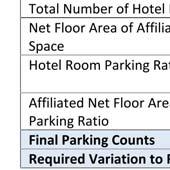


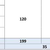
30 UP P A 2020 E. Algonquin Road Suite 302 Schaumburg, IL Office (847) shilpa@purohitarchitects.com D.J S o f t e c h Pvt. Ltd. Document Record Date Description Issued to Village for Concept Review Issued to Village for PZC Review Preliminary Review- IHG Issued to Village for PZC Meeting- Date AREA 320 SF " 4" 36" AREA 1161 SF AREA 510 SF AREA 1169 SF " 4" 36" " 4" 36" " 4" 36" " 13.6" 36" " 20.4" 48" CHUTE MECH/ELEC STAIR 1 EQUIP ENG/MAINT BREAK STORAGE UNISEX LAUNDRY AREA 145 SF CORR.-BOH PANTRY SALES WORK AREA GENERAL MANAGER AREA 435 SF BREAKFAST 1" MARKET & LUGGAGE MARKET STORAGE SERVER CHECK-IN OFFICE VESTIBULE " 4" 36" 6'-10" LOBBY/GREAT ROOM 630 SF DRIVEWAY BUSINESS CENTER MEETING AREA 1151 SF STORAGE ELEV. LOBBY ELEC ELEV. SHAFT ES1 TOILET WOMENS ELEV. EQUIP. CONFERENCE ROOM AREA 985 SF CORR.-FIT. TOILET MENS GUEST LAUNDRY POOL-VEST. FITNESS CORRIDOR GUESTROOM GUESTROOM ACCESS QQ KING GUESTROOM KING POOL GUESTROOM KING GUESTROOM KING POOL EQ. UP STAIR 2 120' -0 " GUESTROOM HA KING " 20.4" 48" " 13.6" 36" " 4" 36" Holiday Inn Express & Suites Frontage Rd. (Near existing Best Western), Oak Forest, IL PROPOSED HOLIDAY INN EXPRESS & SUITES- PARKING AREA -1ST FLOOR SCALE: 1/2"= 1'-0" 1 SCALE: EXISTING BEST WESTERN- PARKING AREA -1ST FLOOR 1/2"= 1'-0" 2 ATTACHMENT 5 PARKING ANALYSIS A1.3 PAI PROJECT NUMBER
31 ATTACHMENT 6
32 PUROHIT ARCHITECTS, INC E. Algonquin Road, Suite 302 Architects & Planners Schaumburg, IL P: ; C: January 23, 2018 Village of Oak Forest Community Development Department S. Central Avenue, Oak Forest, IL P: (708) Attn.: Ms. Katie Ashbaurgh, Community Planner Project Address: Holiday Inn Express & Suites 4375 Frontage Road, Oak Forest, IL (Next to Existing Best Western Hotel) Ref.: Application for Special Use Permit to allow hotel in I1 Dear Ms. Katie, The ownership would like to propose a new 4-story tall Holiday Inn Express & Suites hotel at the above address. Holiday Inn Express & Suites is a mid-priced hotel chain within the InterContinental hotels group family of brands. Per your request, please find our written responses to satisfy the standards set forth in Subsections section (E)(1) of the Zoning ordinance. 1: Code and Plan Purposes: The property owner, also owns the existing Best Western hotel in the same campus. Given the location of the site along with the fact that there is only one common access serving all the parcels; having another similar type of hotel in the empty lot seems to be the best fit/approach. The proposed use and development will be in harmony with what is already on the site 2: No Undue Adverse Impact: All existing utilities, access roads, drainage and other necessary facilities either are in place or, shall be modified as per the required ordinance. Thus, the establishment of the special use will not have undue adverse effect upon adjacent property, the character of the area and shall not be detrimental to or endanger the public health, safety, morals or general welfare 3: No Interference with surrounding Development: This property was originally designed for a hotel use and it has been used as such thru -out. Since we are proposing to continue using the property for a hotel, we believe the establishment will not be dominate the immediate vicinity or interfere with the use and development of neighboring property in accordance with the applicable district regulations. 4: No Traffic Congestion: New onsite parking is proposed for the establishment. Cars will not be leaving or entering the site/ street at the same time and thus will not cause undue traffic congestion nor draw significant amounts of traffic through residential streets. ATTACHMENT 7 Page 1 of 2
33 5: No Destruction of Significant features: The proposed hotel will not result in the destruction, loss, or damage of any natural scenic or historic features of significant importance. 6: Compliance with Standards: The requested special use shall fully conform to applicable regulations of the Village ordinance. Please do not hesitate to contact us should you have any questions or concerns regarding this matter. Thank you. Sincerely, Shilpa Purohit, Architect (On behalf of the Owner) Cc.: Mr. Chirag Patel, Owners Representative Purohit Architects, Inc E. Algonquin Road, Suite 302, Schaumburg, IL P: Special Use Permit Req Page 2 of 2 Holiday Inn Express & Suites at Oak Forest, IL January 23, 2017 ATTACHMENT 7
34 PUROHIT ARCHITECTS, INC E. Algonquin Road, Suite 302 Architects & Planners Schaumburg, IL P: ; C: February 07, 2018 Village of Oak Forest Community Development Department S. Central Avenue, Oak Forest, IL P: (708) Attn.: Ms. Katie Ashbaurgh, Community Planner Project Address: Holiday Inn Express & Suites 4375 Frontage Road, Oak Forest, IL (Next to Existing Best Western Hotel) Ref.: Application for Variance To reduce minimum parking required Dear Ms. Katie, The ownership would like to propose a new Holiday Inn Express & Suites hotel at the above address. Holiday Inn Express & Suites is a mid-priced hotel chain within the InterContinental hotels group family of brands. Per your request, please find our written responses to satisfy the standards set forth in Subsections section (E)(1) of the Zoning ordinance. 1: Code and Plan Purposes: Based on the parking count/calculations, following parking spots are required: Existing Best Western Hotel: 79 parking spaces Proposed Holiday Inn Express & Suites: 120 parking spaces Total Required Parking: 199 Parking Spaces; Provided: 164 Parking Spaces 1: General Standard: Per the ordinance the facility shall be short of 35 parking spots from the village ordinance. The ordinance requires one parking spot per guest room and one parking spot for every 200 SF of common spaces such as lobby, breakfast, conference rooms, fitness & pool. Pool and Fitness center are amenities only for the guests who are staying at the hotel. These are keyed entries/ wrist band entries only. No additional parking spots are anticipated for these areas, even though the ordinance requires. From the owner s current experience, in these days people who travel for leisure especially families they bring in one car and some corporate travelers prefer to use taxi / uber / lyft services to commute. There have also been scenarios when existing Best western hotel is almost completely sold out, yet parking would not be full. 2: Unique Physical Condition: The parking is only short 35 spaces than the current ordinance requirements. This is about 17.6% short of the parking requirement. The current BW hotel is usually running at its about 65% occupancy and the proposed hotel is expected to run at 55% for the first few years. Additionally, the chances of both the hotels to be completely ATTACHMENT 8 Page 1 of 2
35 booked at the same time are very slim. Knowing this we do not see any issue with shortage of parking and see no undue adverse impact on anything. 3: Not Self-Created: Request for the fourth story is not the result of any action or inaction of the owner or his predecessor in title and existed at the time of the enactment of the provision from which a variation is sought or was created by natural forces or was the result of government action, other than the adoption of this code, for which no compensation was paid. 4: Denied Substantial Rights: New onsite parking is proposed for the establishment. Cars will not be leaving or entering the site/ street at the same time and thus will not cause undue traffic congestion nor draw significant amounts of traffic through residential streets. We believe the establishment will not dominate the immediate vicinity or interfere with the use and development of neighboring property in accordance with the applicable district regulations. 5: Not Merely Special Privilege: Hotels of this nature in similar location setups, are typically required have 1 parking per the number of provided guest rooms. All other associated amenities, such as pool, fitness center, breakfast, meeting rooms, lobby spaces are for the guest uses; for whom the parking is already counted. The ownership is not requesting the variation to enjoy any special privilege. 6: Code and Plan Purposes: We believe the establishment will not dominate the immediate vicinity or interfere with the use and development of neighboring property in accordance with the applicable district regulations. 7: No Destruction of Significant features: The requested variance shall fully conform to applicable regulations of the Village ordinance. The proposed four-story hotel will not result in the destruction, loss, or damage of any natural scenic or historic features of significant importance, as the hotel is still within the maximum allowable variance of 25% and the fact that there already exists another hotel within the same so-called campus. Would not block light/ ventilation to the nearby properties Would have enough parking, not to create substantial traffic/ congestion in the public street Would have code required storm detention not to increase the danger. Would comply with the fire department requirements, so as not increase the danger of fire. Would take steps not to unduly tax public utilities and facilities in the area Would not endanger the public health and safety. Please do not hesitate to contact us should you have any questions or concerns regarding this matter. Thank you. Sincerely, Shilpa Purohit, Architect (On behalf of the Owner) Cc.: Mr. Chirag Patel, Owners Representative Purohit Architects, Inc E. Algonquin Road, Suite 302, Schaumburg, IL P: info@purohitarchitects.com Variance to Reduce minimum parking required Page 2 of 2 Holiday Inn Express & Suites at Oak Forest, IL February 07, 2018 ATTACHMENT 8
36 PUROHIT ARCHITECTS, INC E. Algonquin Road, Suite 302 Architects & Planners Schaumburg, IL P: ; C: February 07, 2018 Village of Oak Forest Community Development Department S. Central Avenue, Oak Forest, IL P: (708) Attn.: Ms. Katie Ashbaurgh, Community Planner Project Address: Holiday Inn Express & Suites 4375 Frontage Road, Oak Forest, IL (Next to Existing Best Western Hotel) Ref.: Text Amendment response for height increase variation Dear Ms. Katie, The ownership would like to propose a new 4-story high Holiday Inn Express & Suites hotel at the above address and is requesting below text amendment to the zoning ordinance. Holiday Inn Express & Suites is a mid-priced hotel chain within the InterContinental hotels group family of brands. Wording of the proposed text Amendment: (E)(1)(r) To increase, by not more than one (1) story, the maximum allowable height of a principal structure in any non-residential district, provided that the increase in height by one (1) story shall not require a related increase to the maximum allowable height in feet of the same district. Statement of the need and justification for the proposed text amendment: The proposed building has one more story than the allowable maximum, but the total height is within the allowable maximum of Typically, this kind of projects (hotels and such) do not require more than floor-to-floor height. Allowing the maximum height of 50-0 in the industrial zone and restricting the stories to three, does not truly correlate/ connect. A statement concerning the conformity to the City Official Comprehensive Plan: The 4-story hotel shall blend with the nature of the surrounding establishments and shall beautify the existing vacant/ underutilized land. It will bring in more job opportunities to the neighborhood and will help the surrounding industrial areas with nearby lodging. The hotel shall confirm to detention/ storm water requirements and shall not put any adverse effect to the surrounding properties, in fact it will create positive environment. Please do not hesitate to contact us should you have any questions or concerns regarding this matter. Thank you. Sincerely, Shilpa Purohit, Architect (On behalf of the Owner) Cc.: Mr. Chirag Patel, Owners Representative ATTACHMENT 9 Page 1 of 1
37 PUROHIT ARCHITECTS, INC E. Algonquin Road, Suite 302 Architects & Planners Schaumburg, IL P: ; C: February 07, 2018 Village of Oak Forest Community Development Department S. Central Avenue, Oak Forest, IL P: (708) Attn.: Ms. Katie Ashbaurgh, Community Planner Project Address: Holiday Inn Express & Suites 4375 Frontage Road, Oak Forest, IL (Next to Existing Best Western Hotel) Ref.: Application for Variance Permit 4-Story Building in I1 zoning district Dear Ms. Katie, The ownership would like to propose a new 4-story tall Holiday Inn Express & Suites hotel at the above address. Holiday Inn Express & Suites is a mid-priced hotel chain within the InterContinental hotels group family of brands. Per your request, please find our written responses to satisfy the standards set forth in Subsections section (E)(1) of the Zoning ordinance. 1: General Standard: The I1-Zoning district restricts the height of the building to be no more than 50-0 and stories to be no more than three. The building code IBC 2006, under construction type IA and building type R1 allows unlimited stories and height. The proposed building has one more story than the allowable maximum, but the total height is within the allowable maximum. Typically, this kind of projects (hotels and such) do not require more than floor-tofloor height, including the structure. Thus, allowing the maximum height of 50-0, but at the same time restricting the stories to three; does not correlate/ connect. 2: Unique Physical Condition: Most of the surrounding buildings are true industrial type of buildings, which are typically tall. Allowing a fourstory building, if the building is below the maximum building height requirement should not pose any undue adverse impact to the neighboring properties or the fire department. 3: Not Self-Created: Request for the fourth story is not the result of any action or inaction of the owner or his predecessor in title and existed at the time of the enactment of the provision from which a variation is sought or was created by natural forces or was the result of government action, other than the adoption of this code, for which no compensation was paid. ATTACHMENT 10 Page 1 of 2

38 4: Denied Substantial Rights: Restricting the stories to three, will make it harder for many hotel businesses of this scale/ type to consider building within the industrial zone, due to the competitions from the surrounding hotels in nearby villages. New onsite parking is proposed for the establishment. Cars will not be leaving or entering the site/ street at the same time and thus will not cause undue traffic congestion nor draw significant amounts of traffic through residential streets. 5: Not Merely Special Privilege: IHG s prototype hotels of this nature are required to have four stories. The ownership is not requesting the variation to enjoy any privilege. 6: Code and Plan Purposes: We believe the establishment will not dominate the immediate vicinity or interfere with the use and development of neighboring property in accordance with the applicable district regulations. 7: No Destruction of Significant features: The requested variance shall fully conform to applicable regulations of the Village ordinance. The proposed four-story hotel will not result in the destruction, loss, or damage of any natural scenic or historic features of significant importance, as the hotel is still within the maximum allowable building height and the fact that there already exists another hotel within the same so-called campus. Would not block light/ ventilation to the nearby properties Would have enough parking, not to create substantial traffic/ congestion in the public street Would have code required storm detention not to increase the danger. Would comply with the fire department requirements, so as not increase the danger of fire. Would take steps not to unduly tax public utilities and facilities in the area Would not endanger the public health and safety. Please do not hesitate to contact us should you have any questions or concerns regarding this matter. Thank you. Sincerely, Shilpa Purohit, Architect (On behalf of the Owner) Cc.: Mr. Chirag Patel, Owners Representative Purohit Architects, Inc E. Algonquin Road, Suite 302, Schaumburg, IL P: info@purohitarchitects.com Variance to permit 4 stories in I1 Zoning District Page 2 of 2 Holiday Inn Express & Suites at Oak Forest, IL February 08, 2018 ATTACHMENT 10
39 EXHIBIT A Permitted Variations Zoning Variations in Other Communities OAK FOREST, VARIATIONS Intent (A) Authority The Planning and Zoning Commission, and, in the cases specified in Paragraph D4 of this Section, the City Council, shall have the authority to grant variations from the provisions of this Code, but only in compliance with the procedures set forth in Subsection D of this Section and in those specific instances enumerated in Subsection E of this Section and then only in accordance with each of the standards enumerated in Subsection F of this Section. Review 18 specified forms of relief are reviewed and determined by the PZC acting as the Procedure Zoning Board of Appeals 3 specified forms of relief are reviewed and determined by the City Council, following PZC recommendation 1 specified form of relief is reviewed and determined by the Community Development Director Any and all other variations not specified are not permitted. FRANKFORT, ARTICLE B VARIATIONS Intent Review Procedure Part 1: Purpose. The variation process is intended to provide limited relief from the requirements of this Ordinance in those cases where strict application of those requirements will create a practical difficulty or particular hardship prohibiting the use of land in a manner otherwise allowed under this Ordinance. It is not intended that variations be granted merely to remove inconveniences or financial burdens that the requirements of this Ordinance may impose on property owners in general. Rather, it is intended to provide relief where the requirements of this Ordinance render the land difficult to use because of some unique physical attribute of the property itself or some other factor unique to the property for which the variation is requested. In no event, however, shall the Village grant a variation which would allow the establishment of a use which is not otherwise allowed in a zoning district or which would change the zoning district classification of any or all of the affected property. Any and all variations may be requested and are reviewed and determined by the Village Board, following Zoning Board of Appeals recommendation Any variation granted must be the least degree of variation needed to make up for hardship or unique physical attribute LEMONT, VARIATIONS Intent A. A variation is a grant of relief to a property owner from the requirements of this Unified Development Ordinance where literal adherence would cause undue hardship. Additionally, a variation is intended to provide relief where the requirements of this ordinance would render the land difficult to use because of some unique physical attribute of the property itself or some other factor unique to the property for which the variation is requested. A variation is not intended merely to remove an inconvenience or financial burden that the requirements of this ordinance may impose. A variation is not intended to allow the establishment of a use that is otherwise prohibited in a zoning district or that would change the zoning district classification, and a variation should not be granted where a special use approval or amendment to the Unified Development Ordinance would be more appropriate. Review Procedure 5 specified forms of relief are reviewed and determined by the Village Board, following Zoning Officer recommendation Any and all other forms of relief, specified or otherwise, may be requested then are reviewed and determined by the Village Board, following PZC recommendation Conditions and/or limitations may be imposed in conjunction with the granted relief MIDLOTHIAN, VARIATIONS ATTACHMENT 11
40 Intent Review Procedure (A) Establishment And Purpose: The village has previously established the process for review of variation requests. The process is to provide a narrowly circumscribed means by which relief may be granted from unforeseen applications of this title that create practical difficulties or particular hardships. (B) Initiation Of Variations: Any person having a right of ownership or right of possession in any property in the village may request a variation. All applications for variations shall be filed with the village clerk in accordance with the requirements in section , "Applications", of this chapter. Any and all forms, specified or otherwise, may be requested then are reviewed and determined by the Village Board following Zoning Board of Appeals recommendation CRESTWOOD, VARIATIONS Intent Review Procedure (A) A variation of the provisions of this chapter is the allowance of a specific change of a requirement of this chapter for a specific case. A variation shall not change or alter the provisions of this chapter, nor should it be considered an amendment hereto. Any and all forms of reliefmay be requested then are reviewed and determined by the Zoning Board of Appeals; it is unclear if the Village Board makes the final determination or not ORLAND PARK, VARIANCES (LAND DEVELOPMENT CODE) Intent Review Procedure (A) The Hearing Officer(s) and the Plan Commission are hereby authorized to grant and/or recommend to the Board of Trustees such variances from the literal terms of these regulations where there are practical difficulties or unnecessary hardships that may result from strict compliance with these regulations so that the spirit of these regulations shall be observed, public safety and welfare secured, and substantial justice done. The Hearing Officer(s) shall hear those applications affecting one (1) single family residential dwelling and those applications affecting multi-family dwellings of fewer than six (6) units. All other applications for a variance shall be heard by the Plan Commission. (Ord /16/99; Amd. Ord /2/08) Five (5) specified forms of relief may be requested for single family homes or multifamily homes less than six (6) dwelling units and shall be reviewed and determined by the Hearing Officer Six (6) specified forms of relief may be requested for all other properties, then reviewed and determined by the Plan Commission Any and all forms, specified or otherwise, may be requested then are reviewed and determined by the Village Board following Plan Commission recommendation TINLEY PARK, SECTION X-G - VARIATIONS Intent (1) Authority: Except as specifically provided below in Section X.G.5 and above in Section X.E.3.B.(6), and X.E.3.D, the Village Board of Trustees shall decide all applications for variations of the provisions of this Ordinance after a Public Hearing held before the Board. The Board shall, except as provided in Section X.G.5 below, hold a Public Hearing upon all applications for variations and, except as provided in Section X.E.4 above, report its recommendations to the Village Board of Trustees for action. The Board shall not approve where it has final decisionmaking power, nor shall it recommend where it does not, any variation unless the Board has made Findings of Fact specifying the reason or reasons for recommending or approving the variation. Such findings shall be based upon the standards hereinafter prescribed. Also, where the Village Board decides whether to grant a variation hereunder, no variation shall be granted by the Village Board without such Findings of Fact. If a request for a variation, however, is combined with a request for rezoning, a Special Use Permit or a Planned Unit Development, then the Plan Commission of this Village shall have jurisdiction over such request, Exhibit 1 Permitted Variations ZC # Holiday Inn Express Special Use Permit Page 2 ATTACHMENT 11
41 Review Procedure shall conduct a Public Hearing thereon, and shall make the Findings of Fact and recommendation to the Village Board in the same manner and under the same standards and procedures as set forth herein for the Board. Six (6) specified forms of relief may be requested for all other properties, then reviewed and determined by the Village Board Any and all forms may be requested then are reviewed and determined by the Village Board following Plan Commission or Board recommendation HOMER GLEN, VARIANCES Intent Review Procedure (A) Purpose of variance. The variance process is intended to provide limited relief from the requirements of this chapter in those cases where strict application of those requirements will create a practical difficulty or particular hardship prohibiting the use of land in a manner otherwise allowed under this chapter. It is not intended that variances be granted merely to remove inconveniences or financial burdens that the requirements of this chapter may impose on property owners in general. Rather, it is intended to provide relief where the requirements of this chapter render the land difficult to use because of some unique physical attribute of the property itself or some other factor unique to the property for which the variance is requested. In no event, however, shall the Village grant a variance which would allow the establishment of a use which is not otherwise allowed in a zoning district or which would change the zoning district classification of any or all of the affected property. Seven (7) specified forms of relief may be requested and then are reviewed and determined by the Zoning Officer Any and all forms, specified or otherwise, may be requested then are reviewed and determined by the Village Board following Plan Commission recommendation Exhibit 1 Permitted Variations ZC # Holiday Inn Express Special Use Permit Page 3 ATTACHMENT 11
42 PZC CASE NO CITY OF OAK FOREST PLANNING AND ZONING COMMISSION PZC RESOLUTION NO WHEREAS, Chirag Patel, representing HD Hotels, LLC, ( Applicant ) filed an application for a special use permit to allow a hotel in the I1 Industrial District; a variation to Section 9-104(F)(1)(e)(2) to allow 164 parking spaces where 199 are required; and a variation to allow a four (4) story principal structure where three (3) stories are permitted ( Zoning Relief ); and such other and further zoning relief as may be required; and WHEREAS, the Applicant also requested a text amendment to Subparagraph (E)(1), Permitted Variations, of the City of Oak Forest Zoning Ordinance to allow for variations to the maximum permitted height of principal structures in non-residential districts ( Text Amendment ) and such other and further zoning relief as may be required; and WHEREAS, the Applicant s requested Zoning Relief is for the property commonly known as 4375 Frontage Road ( Property ); and WHEREAS, the Applicant s requested Text Amendment is fully set forth in Exhibit B which is attached and by this reference incorporated into this resolution; and WHEREAS, a public notice was duly published in the Daily Southtown on February 6, 2018 and a public hearing was convened before the Planning and Zoning Commission ( PZC ) on February 21, 2018; and DRAFT WHEREAS, the PZC has considered all of the evidence presented to it, including without limitation, those documents attached and incorporated in to this resolution by this reference as Exhibit A; NOW THEREFORE, BE IT RESOLVED by the PZC of the City of Oak Forest, Cook County, based on the foregoing recitals which are hereby incorporated by reference, that: Section 1. FINDINGS. Page 1 of 3
43 PZC CASE NO Based on the evidence presented at the public hearing, and the Findings of Fact attached hereto as Exhibit C, the PZC hereby finds that the Applicant s requests do satisfy the standards for the requested Zoning Relief and for the requested Text Amendment as set forth in the Zoning Ordinance of Oak Forest. Section 2. ZONING RELIEF RECOMMENDATION. Based on the findings of fact set forth in Section 1 of this resolution, the PZC herby recommends that the City Council approve the Applicant s requested Zoning Relief, on the conditions that: A. No Authorization of Work. The Ordinance approving the Zoning Relief ( Ordinance ) does not authorize commencement of any work on the Property. Except as otherwise specifically provided in writing in advance by the City, no work of any kind shall be commenced on the Property pursuant to the approvals granted unless and until all conditions of the Ordinance precedent to such work have been fulfilled and after all permits, approvals, and other authorizations for such work have been properly applied for, paid for, and granted in accordance with applicable law, including, without limitation, approval of final engineering plans and issuance of required permits. B. Compliance with Laws. The development, maintenance and operation of the Property must comply with all applicable State, County and City statutes, ordinances, codes, rules, and regulations. C. Compliance with Plans. The development, maintenance, and operation of the Property will be in substantial compliance with the following documents and plans, attached hereto as Exhibit A, except for the specific changes listed below under this Condition C; minor changes and site work required to the satisfaction of the City Engineer; and in accordance with all applicable City rules, regulations, and ordinances. DRAFT 1. That a consistent curbing type be installed along the entire length of the west, primary driveway on both sides. 2. That east, secondary driveway be a one-way exit only driveway and appropriate wayfinding be installed. D. Limitation of Approval. The special use permit as documented in Exhibit A is limited to the Property, provided that any and all signs indicated on said exhibit shall be subject to review and approval in accordance with Section of the Oak Forest Zoning Ordinance. E. Final Engineering Approval. Petitioner must obtain approval of final engineering plans from the City Engineer prior to the release of any building or occupancy permits for the Property. F. Final Landscape Plan Approval. Petitioner must obtain approval of a final landscape plan, which shall be in substantial conformance with the special use Page 2 of 3
44 PZC CASE NO permit documented in Exhibit A, from the Community Development Director prior to the release of any building or occupancy permits for the Property. G. Other. Petitioner must agree to enter into a parking enforcement agreement with the City of Oak Forest Police Department to prevent parking in designated fire lanes and any other areas designated as no parking on the Property. H. The associated minor plat of subdivision (Zoning Case #17-016) and all its supporting documents (shared parking agreement, detention pond stewardship plan, and any and all other documents deemed necessary by the Community Development Director) shall be required to be approved and recorded with Cook County prior to building permit issuance. Section 3. TEXT AMENDMENT RECOMMENDATION. Based on the findings of fact set forth in Section 1 of this resolution, the PZC herby recommends the that the City Council adopt the Applicant s requested Text Amendment as set forth in Exhibit B. ADOPTED THIS day of, 20 AYES: ( ) NAYS: ( ) ABSENT: ( ) ABSTAIN: ( ) DRAFT, Chairman Oak Forest PZC Page 3 of 3
45 PZC CASE NO EXHIBIT A Site Plan DRAFT

46 PZC CASE NO EXHIBIT A Landscape Plan DRAFT
Certificates and Statements
 CITY OF NAPERVILLE Certificates and Statements Development Review Team Updated: 10/29/2015 Please use the decision matrix found in the Plat Review Checklist to determine which certificates and statements
SPECIAL SERVICE AREA DISCLOSURE
 SPECIAL SERVICE AREA DISCLOSURE All lots within this subdivision are included within the County of Will Special Service Area Number and are subject to an annual tax levy in accordance with the provisions
Department of Planning & Zoning 200 E. Wood Street Palatine, IL Telephone: (847) Fax (847)
 Fax (847)") Department of Planning & Zoning 200 E. Wood Street Palatine, IL 60067-5339 Telephone: (847) 359-9047 Fax (847) 963-6247 www.palatine.il.us RE: FINAL PLANNED DEVELOPMENT Dear Petitioner: It is the responsibility
Department of Planning & Zoning 200 E. Wood Street Palatine, IL 60067-5339 Telephone: (847) 359-9047 Fax (847) 963-6247 www.palatine.il.us RE: FINAL PLANNED DEVELOPMENT Dear Petitioner: It is the responsibility
Community Development Department Council Chambers, 7:30 PM, July 20, 2017
 STAFF REPORT 2017-25P: Subdivision Community Development Department Council Chambers, 7:30 PM, July 20, 2017 To: From: Re: Paul Luke, Chairman, Skokie Plan Commission Mike Voitik, Planning Technician 2017-25P:
PART OF SECTION 9, TOWNSHIP 36 NORTH, RANGE 9 EAST OF THE THIRD PRINCIPAL MERIDIAN, NORTH OF THE INDIAN BOUNDRY LINE, IN WILL COUNTY, ILLINOIS.
 PART OF SECTION 9, TOWNSHIP 6, RANGE 9 EAST OF THE THIRD PRINCIPAL MERIDIAN, OF THE INDIAN BOUNY LINE, IN WILL COUNTY, ILLINOIS. ASSUMED THE LINE OF THE WEST / OF SECTION 9-6-9 TO BE: S89 5' 7"E 60 0 0
SUBDIVISION APPLICATION
 SUBDIVISION APPLICATION Preliminary Plat Minor Plat Final Plat Amended Plat Applicant Name: Owner (if different from applicant) Name: Company: Company: Address: Address: City, State, Zip City, State, Zip
ARTICLE 23 CONDOMINIUM STANDARDS
 ARTICLE 23 CONDOMINIUM STANDARDS Section 23.01 Intent. The intent of this Article is to provide regulatory standards for condominiums and site condominiums similar to those required for projects developed
SECTION 10.7 R-PUD (RESIDENTIAL PLANNED UNIT DEVELOPMENT) ZONE
 ZONE") Article X Zones 10-20 SECTION 10.7 R-PUD (RESIDENTIAL PLANNED UNIT DEVELOPMENT) ZONE A. PURPOSE AND INTENT: The R-PUD Residential PUD Zone is intended to provide alternative, voluntary zoning procedures
Article X Zones 10-20 SECTION 10.7 R-PUD (RESIDENTIAL PLANNED UNIT DEVELOPMENT) ZONE A. PURPOSE AND INTENT: The R-PUD Residential PUD Zone is intended to provide alternative, voluntary zoning procedures
Community Development Department Council Chambers, 7:30 PM, December 1, 2016
 STAFF REPORT 2016-35P: Subdivision Community Development Department Council Chambers, 7:30 PM, December 1, 2016 To: From: Re: Paul Luke, Chairman, Skokie Plan Commission Mike Voitik, Planning Technician
MAJOR RESIDENTIAL AND NONRESIDENTIAL SUBDIVISIONS
 Lawrence-Douglas County MAJOR RESIDENTIAL AND NONRESIDENTIAL SUBDIVISIONS Preliminary Plats The applicant shall schedule a Pre-Application meeting with Planning Staff at least seven (7) working days prior
SUBMITTAL REQUIREMENTS: The number indicates the number of copies for submittal (if applicable).
.") Office Use Only Preliminary Long Plat Long Subdivision Applicant Checklist PLANNING, COMMUNITY, & ECONOMIC DEVELOPMENT DEPARTMENT PRELIMINARY LONG PLAT LONG SUBDIVISION CHECKLIST Mailing Address: P.O.
Office Use Only Preliminary Long Plat Long Subdivision Applicant Checklist PLANNING, COMMUNITY, & ECONOMIC DEVELOPMENT DEPARTMENT PRELIMINARY LONG PLAT LONG SUBDIVISION CHECKLIST Mailing Address: P.O.
CHAPTER 2 RELATED DOCUMENTS AND FORMS
 CHAPTER 2 RELATED DOCUMENTS AND FORMS TABLE OF CONTENTS CHAPTER 2 RELATED DOCUMENTS AND FORMS Resolution R00- Establishing Public Improvement Design Standards Page 1 Current Plans Review & Construction
Residential Major Subdivision Review Checklist
 Residential Major Subdivision Review Checklist Plan Submittal Requirements: 2 full sets of stamped plans Electric submittal - all plans contained in a single PDF 3 full sets if commercial kitchen or dining
CHECKLIST FOR DEVELOPMENT REVIEW
 CHECKLIST FOR DEVELOPMENT REVIEW Petitions and related documents and plans for land development or other proposals regulated by Title 16 of the Municipal Code (Development Ordinance) and Title 17 of the
I. Requirements for All Applications. C D W
 108-16.1. Application checklists. Checklist for Required Submissions to the Planning Board or Zoning Board of Adjustment of Monroe Township All required submissions are to be made to the Administrative
Preliminary Subdivision Application (Minor) (Three (3) lots or less)
 (Three (3) lots or less)") Gunnison City Offices www.gunnisoncity.org 38 West Center Gunnison, Utah 84634 (435) 528 7969 Date of Application: Preliminary Subdivision Application (Minor) (Three (3) lots or less) APPLICANT INFORMATION
Gunnison City Offices www.gunnisoncity.org 38 West Center Gunnison, Utah 84634 (435) 528 7969 Date of Application: Preliminary Subdivision Application (Minor) (Three (3) lots or less) APPLICANT INFORMATION
APPLICATION PROCEDURE
 ANTRIM PLANNING BOARD P. O. Box 517 Antrim, New Hampshire 03440 Phone: 603-588-6785 FAX: 603-588-2969 APPLICATION FORM AND CHECKLIST FOR MINOR OR MAJOR SITE PLAN REVIEW File Date Received By APPLICATION
Preliminary Subdivision Application (Major) (Four (4) lots or more)
 (Four (4) lots or more)") Gunnison City Offices www.gunnisoncity.org 38 West Center Gunnison, Utah 84634 (435) 528 7969 Date of Application: Preliminary Subdivision Application (Major) (Four (4) lots or more) APPLICANT INFORMATION
Gunnison City Offices www.gunnisoncity.org 38 West Center Gunnison, Utah 84634 (435) 528 7969 Date of Application: Preliminary Subdivision Application (Major) (Four (4) lots or more) APPLICANT INFORMATION
Condominium Unit Requirements.
 ARTICLE 19 CONDOMINIUM REGULATIONS Section 19.01 Purpose. The purpose of this Article is to regulate projects that divide real property under a contractual arrangement known as a condominium. New and conversion
COUNTY OF ADAMS, STATE OF COLORADO E. 40TH AVE. TOWER RD. E. 38TH AVE. SALIDA ST. HIGH LINE CANAL PROJECT LOCATION E. 32ND PKWY.
 LEGAL DESCRIPTION:, GATEWAY EAST AT TOWER SUBDIVISION FILING NO. 1, SAID PARCEL CONTAIN 598,154 SQUARE FEET OR MORE OR LESS GENERAL NOTES: 1. NOTICE: ACCORDING TO COLORADO LAW YOU MUST COMMENCE ANY LEGAL
FINAL PLAT. Community Development Department 8101 Ralston Road Arvada, Colorado 80002
 FINAL PLAT Community Development Department 8101 Ralston Road Arvada, Colorado 80002 September 2015 FINAL SUBDIVISION PLAT Final Subdivision Plat Review Applications for a Final Plat shall be submitted
Township of Little Egg Harbor Planning Board 665 Radio Road Little Egg Harbor, New Jersey Phone: ext. 221 Fax:
 BLOCK(S) LOT(S) Township of Little Egg Harbor Planning Board 665 Radio Road Little Egg Harbor, New Jersey 08087 Phone: 609-296-7241 ext. 221 Fax: 609-294-3040 Development Application Amended Development
ARTICLE 900 PLAT AND PLAN REQUIREMENTS
 ARTICLE 900 PLAT AND PLAN REQUIREMENTS SEC. 900.1 ITEMS TO BE SHOWN ON PLAT OR PLAN General (1) Property lines of all property owners adjacent to the exterior boundaries of the project shall be located
Plan and Zoning Commission Review Process
 . Village of Northfield Plan and Zoning Commission Review Process.......... Department of Community Development and Building Village of Northfield Department of Community Development and Building 361 Happ
Residential Minor Subdivision Review Checklist
 Residential Minor Subdivision Review Checklist Plan Submittal Requirements: 2 full sets of stamped plans Electric submittal - all plans contained in a single PDF 3 full sets if commercial kitchen or dining
City of Melissa, Texas Plat Dedication Language
 City of Melissa, Texas Plat Dedication Language [INCLUDE THE FOLLOWING DEDICATION LANGUAGE FOR INDIVIDUALS (MODIFY APPROPRIATELY TO REFLECT EXACTLY AS SHOWN ON PROPERTY DEED)]: NOW THEREFORE, KNOW ALL
MINOR SUBDIVISION FINAL PLAT APPLICATION Town of Apex, North Carolina
 MINOR SUBDIVISION FINAL PLAT APPLICATION Town of Apex, North Carolina This document is a public record under the North Carolina Public Records Act and may be published on the Town s website or disclosed
CERTIFIED SURVEY MAP
 SCONSIN STATE PLANE N:389676.12 E:2130390.15 Center of Section 23 CERTIFIED SURVEY MAP 734.06' THE (PRITCHETTE) ORIGINAL PLAT OF ALL IN THE NW 1 4 OF THE SE 1 4 OF FRACTIONAL SECTION 23, T7N, R9E, IN THE
MINOR SUBDIVISION PLAT
 MINOR SUBDIVISION PLAT Community Development Department 8101 Ralston Road Arvada, Colorado 80002 September 2015 MINOR SUBDIVISION PLAT Subdivisions consisting of five (5) or fewer lots are eligible for
FINAL PLAT GUIDE TO SUBDIVIDING PROPERTY. Background
 FINAL PLAT GUIDE TO SUBDIVIDING PROPERTY Background A final plat is the second step in the process of subdividing land into separate parcels for future sale or lease. Once a preliminary plat has been approved
CITY OF SARALAND FINAL SUBDIVISION PLAT REVIEW
 CITY OF SARALAND FINAL SUBDIVISION PLAT REVIEW Application Number: Date Plat Submitted: Name of Subdivision: Name of Owner: Owner Address: (Street or P.O. Box) Telephone #: (City) (State) (Zip) E-mail:
Time Extension Staff Report
 Time Extension Staff Report Subdivision Name Lunara Subdivision File Number SUB07-00019 Approval Time Extension for Lead Agency Boise City Certification Signature of Boise City Engineer Annexation Date
STANDARDIZED LEGAL DESCRIPTIONS AND EXHIBITS
 STANDARDIZED LEGAL DESCRIPTIONS AND EXHIBITS Public Works Department, Engineering Division June 14, 2004 UNIFIED GOVERNMENT STANDARDIZED LEGAL DESCRIPTIONS AND EXHIBITS For: Roads, Bridges, Short Span
MINOR SUBDIVISION PLAT
 MINOR SUBDIVISION PLAT Community Development Department 8101 Ralston Road Arvada, Colorado 80002 MINOR SUBDIVISION PLAT Subdivisions consisting of five (5) or fewer lots are eligible for the minor subdivision
SUBMITTAL REQUIREMENTS: The number indicates the number of copies for submittal (if applicable).
.") Office Use Only Preliminary Long Plat Long Subdivision Applicant Checklist PLANNING, COMMUNITY, & ECONOMIC DEVELOPMENT DEPARTMENT FINAL LONG PLAT LONG SUBDIVISION CHECKLIST Mailing Address: P.O. Box 547,
Office Use Only Preliminary Long Plat Long Subdivision Applicant Checklist PLANNING, COMMUNITY, & ECONOMIC DEVELOPMENT DEPARTMENT FINAL LONG PLAT LONG SUBDIVISION CHECKLIST Mailing Address: P.O. Box 547,
AGENDA ITEM FORM INFORMATION ONLY PRESENTATION DISCUSSION ONLY ACTION ITEM
 Town of Dumfries Council Meeting AGENDA ITEM FORM Meeting Date: Agenda Item# February 5, 2019 XIII-A TYPE OF AGENDA ITEM: PURPOSE OF ITEM: CONSENT AGENDA INFORMATION ONLY PRESENTATION DISCUSSION ONLY ACTION
SECTION SITE SURVEYS
 PART 1 - GENERAL 1.1 DESCRIPTION SECTION 02 21 00 SPEC WRITER NOTES: 1. Use this section only for NCA projects. 2. Delete between //---// if not applicable to project. Also delete any other item or paragraph
FINAL SUBDIVISION AND LAND DEVELOPMENT PLAN CHECKLIST. Plan Name. Applicant's Name:
 TOWNSHIP OF UPPER ST. CLAIR FINAL SUBDIVISION AND LAND DEVELOPMENT PLAN CHECKLIST Date Filed Plan Name PLC Applicant's Name: Phone Filing Date for Final Application Final Plat 114.22. FINAL APPLICATION
E L M E R B O R O U G H L A N D U S E B O A R D APPLICATION COVER SHEET (to be completed for all applications and appeals)
") E L M E R B O R O U G H L A N D U S E B O A R D APPLICATION COVER SHEET (to be completed for all applications and appeals) 1. Name(s): 2. Address: 3. Telephone Number(s): 4. E-mail: 5. Owner Name(s) (if
E L M E R B O R O U G H L A N D U S E B O A R D APPLICATION COVER SHEET (to be completed for all applications and appeals) 1. Name(s): 2. Address: 3. Telephone Number(s): 4. E-mail: 5. Owner Name(s) (if
City of Yelm. Community Development Department BOUNDARY LINE ADJUSTMENT OR LARGE LOT SUBDIVISION
 City of Yelm Community Development Department BOUNDARY LINE ADJUSTMENT OR LARGE LOT SUBDIVISION Fee Date Received By File No. FEES: Boundary Line Adjustment $100.00 LARGE LOT SUBDIVISION $250.00, + $10.00/lot
CONDOMINIUM REGULATIONS
 ARTICLE 37 CONDOMINIUM REGULATIONS SECTION 37.01. Purpose The purpose of this Article is to regulate projects that divide real property under a contractual arrangement known as a condominium. New and conversion
JOINT PLANNING BOARD APPLICATION FORM
 JOINT PLANNING BOARD APPLICATION FORM TOWNSHIP OF RIVER VALE 406 RIVERVALE ROAD RIVER VALE, NJ 07675 The application, with supporting documentation, must be filed with the Administrative Officer to the
LYON COUNTY COMMUNITY DEVELOPMENT DEPARTMENT
 LYON COUNTY COMMUNITY DEVELOPMENT DEPARTMENT B UILDING D EVELOPMENT E NGINEERING P LANNING 27 S. MAIN S TREET Y ERINGTON, NEVADA 89447 (775) 463-6591 F AX: (775) 463-5305 34 LAKES B OULEVARD D AYTON, NEVADA
MINOR PLAT FILING APPLICATION
 FILING APPLICATION Date of PC Meeting: Date of BCC Meeting: Fee Paid: 1. APPLICANT: DAYTIME PHONE: MAILING ADDRESS: LANDOWNER: DAYTIME PHONE: MAILING ADDRESS: AUTHORIZED AGENT: MAILING ADDRESS: RELATIONSHIP
RIVERDALE CITY PLANNING COMMISSION APPLICATION FOR RESIDENTIAL SUBDIVISION SITE PLAN APPROVAL
 Community Development 4600 So. Weber River Drive Riverdale, Utah 84405 RIVERDALE CITY PLANNING COMMISSION APPLICATION FOR RESIDENTIAL SUBDIVISION SITE PLAN APPROVAL CASE NO: DATE SUBMITTED: APPLICANT S
E. 140TH AVE. VICINITY MAP SCALE: 1"=600' LAND USE TABLE NET AREA 599,946 SQFT AC. GROSS AREA 741,420 SQFT AC.
 SHEET OF PURPOSE STATEMENT: THIS PLAT IS INTENDED TO SUBDIVIDE. ACRES INTO SINGLE FAMILY ATTACHED LOTS, TRACTS, DEDICATE AND GRANT EASEMENTS. LEGAL DESCRIPTION: THE UNDERSIGNED BEING THE OWNER(S) OF A
FINAL PLAT APPLICATION
 FINAL PLAT APPLICATION (Page 1 of 3) LEGAL OWNER(s): NAME: STREET ADDRESS OWNER(s): CITY, STATE, ZIP CODE: PHONE NUMBER: BILLING ADDRESS: NAME OF ENGINEER/SURVEYOR: Engineer/Surveyor Address, Phone: PROPERTY
ARTICLE 15 - PLANNED UNIT DEVELOPMENT
 Section 15.1 - Intent. ARTICLE 15 - PLANNED UNIT DEVELOPMENT A PUD, or Planned Unit Development, is not a District per se, but rather a set of standards that may be applied to a development type. The Planned
ARTICLE 3 DEFINITIONS
 Sections: 3-1 Rules of Construction 3-2 Definitions ARTICLE 3 DEFINITIONS SECTION 3-1 RULES OF CONSTRUCTION 3-101. a. The language set forth in these regulations shall be interpreted in accordance with
FINAL SITE PLAN PLAT APPLICATION Town of Apex, North Carolina
 FINAL SITE PLAN PLAT APPLICATION Town of Apex, North Carolina This document is a public record under the North Carolina Public Records Act and may be published on the Town s website or disclosed to third
CHAPTER 26 PLANNING AND ZONING ARTICLE VII. MOBILE HOMES AND RECREATIONAL VEHICLE (RV) PARKS. Recreational Vehicle (RV) Park Development Standards
 PARKS. Recreational Vehicle (RV) Park Development Standards") CHAPTER 26 PLANNING AND ZONING ARTICLE VII. MOBILE HOMES AND RECREATIONAL VEHICLE (RV) PARKS. Section 26-VII-1. Section 26-VII-2. Section 26-VII-3. Section 26-VII-4. Section 26-VII-5. Purpose Permitted
CHAPTER 26 PLANNING AND ZONING ARTICLE VII. MOBILE HOMES AND RECREATIONAL VEHICLE (RV) PARKS. Section 26-VII-1. Section 26-VII-2. Section 26-VII-3. Section 26-VII-4. Section 26-VII-5. Purpose Permitted
MASTER SUBDIVISION FINAL PLAT APPLICATION Town of Apex, North Carolina
 MASTER SUBDIVISION FINAL PLAT APPLICATION Town of Apex, North Carolina This document is a public record under the North Carolina Public Records Act and may be published to the Town s website or disclosed
Site Plan Application
 Site Plan Application City of St. Pete Beach Community Development Department 155 Corey Avenue St. Pete Beach, Florida 33706 (727) 367-2735 www.stpetebeach.org Case Number: PROPERTY OWNER: Name: Address:
The Filing Fee for a Minor Plat is $ PLUS $20.00 per lot created
 DEPARTMENT OF COMMUNITY DEVELOPMENT MINOR PLAT PROCEDURE The Filing Fee for a Minor Plat is $250.00 PLUS $20.00 per lot created Description: The purpose of a Minor Plat is to allow property to be platted
DETAILED GRADING PLAN CHECKLIST (TEARDOWN/REDEVELOPMENT) Updated: 12/12/2017
 Updated: 12/12/2017") DETAILED GRADING PLAN CHECKLIST (TEARDOWN/REDEVELOPMENT) Updated: 12/12/2017 ADDRESS: PERMIT #: DATE: Sat. Not GENERAL 1. A disposition of comments should be included in all subsequent submittals. 2. Plan
DETAILED GRADING PLAN CHECKLIST (TEARDOWN/REDEVELOPMENT) Updated: 12/12/2017 ADDRESS: PERMIT #: DATE: Sat. Not GENERAL 1. A disposition of comments should be included in all subsequent submittals. 2. Plan
ARTICLE 900 PLAT AND PLAN REQUIREMENTS
 Final SEC. 900.01 ARTICLE 900 PLAT AND PLAN REQUIREMENTS General provisions. (a) Scale. The scale of all plats and plans shall be a minimum of 1 to 100 ft. (b) Size. The minimum page size for all plats
Memorandum: October 13, 2008 REVISED To: Trowbridge Township Planning Commission From: P. Hudson, AICP Re: Suggested New Ordinance
 1 Memorandum: October 13, 2008 REVISED 2-11-09 To: Trowbridge Township Planning Commission From: P. Hudson, AICP Re: Suggested New Ordinance Because of changes in both the Michigan Planning Enabling Act
ARTICLE 7: PLOT PLANS AND SITE PLAN REQUIREMENTS AND REVIEW
 ARTICLE 7: PLOT PLANS AND SITE PLAN REQUIREMENTS AND REVIEW Section 7.0 - Purpose The purpose of this article is to specify the documents and/or drawings required for a Site Plan Review or a Plot Plan
DEED AND DEDICATION FOR PUBLIC RIGHT OF WAY
 TO : BOARD OF DIRECTORS FROM : GARY PLATT, EXEC. DIRECTOR BUSINESS AND OPERATIONS SUBJECT : CITY OF STANWOOD CONSTRUCTION EASEMENT AND RIGHT-OF-WAY DEDICATION DATE : MARCH 17, 2009 TYPE : ACTION NEEDED
ARTICLE 13 CONDOMINIUM REGULATIONS
 ARTICLE 13 CONDOMINIUM REGULATIONS Section 13.01 Purpose. The purpose of this Article is to regulate projects that divide real property under a contractual arrangement known as a condominium. New and conversion
610 LAND DIVISIONS AND PROPERTY LINE ADJUSTMENTS OUTSIDE A UGB
 ARTICLE VI: LAND DIVISIONS AND PROPERTY LINE ADJUSTMENTS VI-21 610 LAND DIVISIONS AND PROPERTY LINE ADJUSTMENTS OUTSIDE A UGB 610-1 Property Line Adjustments (Property Line Relocation) A property line
COMMERCIAL SITE PLAN & CONDITIONAL USE PERMIT REVIEW PROCESS & CHECKLIST
 Community Development 110 South Main Street Springville, UT 84663 COMMERCIAL SITE PLAN & CONDITIONAL USE PERMIT REVIEW PROCESS & CHECKLIST 801.491.7861 www.springville.org Prior to the issuance of a building
ELK RAPIDS TOWNSHIP ANTRIM COUNTY, MICHIGAN ORDINANCE NO
 ELK RAPIDS TOWNSHIP ANTRIM COUNTY, MICHIGAN ORDINANCE NO. 3-2011 AN ORDINANCE TO REPLACE THE SUBDIVISION CONTROL ORDINANCE WITH A NEW SUBDIVISION DEVELOPMENT ORDINANCE, IN ACCORD WITH THE LAND DIVISION
City of Edwardsville, Kansas Special Benefit District Policy
 City of Edwardsville, Kansas Special Benefit District Policy Date Adopted: September 12, 2011 Section 1. Objective The objective is to establish a policy to finance public streets, sanitary sewers, water
DETAILED GRADING PLAN CHECKLIST (TEARDOWN/REDEVELOPMENT)
") GENERAL DETAILED GRADING PLAN CHECKLIST (TEARDOWN/REDEVELOPMENT) ADDRESS: PERMIT #: DATE: 1. Plan is signed and sealed by an Illinois registered professional engineer including date signed and license
GENERAL DETAILED GRADING PLAN CHECKLIST (TEARDOWN/REDEVELOPMENT) ADDRESS: PERMIT #: DATE: 1. Plan is signed and sealed by an Illinois registered professional engineer including date signed and license
EASEMENT AGREEMENT. WHEREAS, Ferguson is the 100% owner of the property described on Exhibit B attached hereto (the Williams Property );
;") EASEMENT AGREEMENT THIS EASEMENT AGREEMENT ( Agreement ) is entered into as of this day of, 2016, by and between CRAIG FERGUSON ( Ferguson ), and MAMIE DAVIS and JERRY MOORE ( Davis & Moore ), whose legal
EASEMENT AGREEMENT THIS EASEMENT AGREEMENT ( Agreement ) is entered into as of this day of, 2016, by and between CRAIG FERGUSON ( Ferguson ), and MAMIE DAVIS and JERRY MOORE ( Davis & Moore ), whose legal
Final Plat Mapping Requirements
 CURRENT PLANNING DIVISION 410 E. 5 th Street Loveland, CO 80537 970-962-2523 eplan-planning@cityofloveland.org cityofloveland.org/dc Final Plat Mapping Requirements All Final plats shall comply with the
65.00 Right-of-Way, Easements, Subordination Agreements and Licenses
 65.00 Subordination Agreements and Licenses Right-of-way, easements, subordination agreements and licenses are located as follows: Subject Name Page Number Single Lot Development... 65.00-1 Subdivision
PERMANENT EASEMENT AGREEMENT. good and valuable consideration, the sufficiency and receipt of which is hereby acknowledged, The Esther Harrison
 PERMANENT EASEMENT AGREEMENT For and in consideration of the sum of Seven thousand thirty and 00/100 dollars ($7,030.00) and other good and valuable consideration, the sufficiency and receipt of which
APPROVAL REQUIRED... A5 APPLICATION FOR APPROVAL OF PRELIMINARY PLAN... A6 APPLICATION FOR APPROVAL OF DEFINITIVE PLAN... A7
 APPENDIX FORM A. FORM A-2. FORM A-3. FORM B. FORM C. FORM C-1. FORM C-2. FORM D. FORM E. FORM F. FORM G. FORM H. FORM I. FORM J. FORM J-1. FORM K. FORM K-1 FORM L Form M. APPLICATION FOR A DETERMINATION
APPENDIX B. SUBMISSION REQUIREMENTS
 Master Major Site Minor Site Landscape Section B.1 Table of /Plat Requirements Proposed or approved name of development, project, subdivision, and/or phase. Location, including township, county, and state.
Lake County Planning, Building and Development Department
 SUBMISSION CHECKLIST FOR SUBDIVISION FINAL PLAT Lake County Planning, Building and Development Department 500 W. Winchester Rd. Unit 101 Libertyville, Illinois 60048-1331 Telephone (847) 377-2600 E-mail:
City of Leavenworth DEPARTMENT OF DEVELOPMENT SERVICES MAJOR SUBDIVISION APPLICATION 1
 Proposed Name of Subdivision: City of Leavenworth DEPARTMENT OF DEVELOPMENT SERVICES MAJOR SUBDIVISION APPLICATION 1 FOR PRELIMINARY SUBDIVISION APPROVAL This application must be filled out legibly, in
Washington County, Minnesota Ordinances
 Washington County, Minnesota Ordinances Ordinance No. 153 Text Amendment to the Washington County Development Code - Chapter One, Section 2 and Chapter Two, Part 1, Part 2, Part 3, of the Development Code
Scale 1" = 100' PLAT OF DEDICATION. Sheet 1 of 9 LEGAL DESCRIPTION. Areas of Dedication. Areas of Access Easement
 LEGAL DESCRIPTION PART OF LOTS 2, 4, 6 AND 7 IN GNAS MIXED USE RETAIL CENTER, BEING A SUBDIVISION OF PART OF THE WEST HALF OF SECTION 27, TOWNSHIP 42 NORTH, RANGE 12, EAST OF THE THIRD PRINCIPAL MERIDIAN,
CERTIFICATION OF THE APPROVAL OF WATER AND SEWERAGE SYSTEMS
 ARTICLE 9 FORMS AND CHECK LISTS 9.100 On preliminary layout & final subdivision plat CERTIFICATION OF THE APPROVAL OF WATER AND SEWERAGE SYSTEMS I hereby certify that the (...type: private or pubic...)
TOWNSHIP OF BORDENTOWN LAND DEVELOPMENT APPLICATION CHECKLIST. General Requirements for all Applications
 TOWNSHIP OF BORDENTOWN LAND DEVELOPMENT APPLICATION CHECKLIST This CHECKLIST has been adopted in accordance with Section 25:807 of the Land Development Ordinance of the Township of Bordentown and will
-MENDOCINO COUNTY PLANNING AND BUILDING SERVICES- DIVISION OF LAND REGULATIONS TITLE 17
 ARTICLE VI -- GENERAL REGULATIONS AND PROVISIONS Sec. 17-50. Sec. 17-51 General Plan. Sec. 17-52 Lot and Block Design and Configuration. Sec. 17-53 Lot Access. Sec. 17-54 Private Roads. Sec. 17-55 Water
PERMANENT EASEMENT AGREEMENT
 PERMANENT EASEMENT AGREEMENT This Permanent Easement Agreement ("Agreement") effective this day of, 2016, by and between Goin Straight, LLC, a Colorado limited liability company (Grantor"), whose mailing
CHAPTER XVIII SITE PLAN REVIEW
 CHAPTER XVIII SITE PLAN REVIEW Section 18.1 Section 18.2 Description and Purpose. The purpose of this chapter is to provide standards and procedures under which applicants would submit, and the Township
COMMUNITY DEVELOPMENT DEPARTMENT
 COMMUNITY DEVELOPMENT DEPARTMENT SUBDIVISION APPLICATION - PRELIMINARY FOR CITY USE ONLY Date Received: Date Determined Complete: Fees Paid: PC Meeting: CC Meeting: $250 + $25 per lot; plus all applicable
PRELIMINARY PLAT Checklist
 PRELIMINARY PLAT Checklist 3715 Bridgeport Way W University Place, WA 98466 PH: (253) 566-5656 FAX: (253) 460-2541 This is a checklist of materials required for a Preliminary Plat. This checklist is provided
DEED OF DEDICATION OF WEST ECHO FIRST ADDITION CITY OF JESUP, BLACK HA WK COUNTY, IOWA
 KNOW ALL MEN BY THESE PRESENTS: DEED OF DEDICATION OF WEST ECHO FIRST ADDITION CITY OF JESUP, BLACK HA WK COUNTY, IOWA That West Jesup Development, LLC, an Iowa limited liability company, with its principal
SUBDIVISION APPLICATION
 SUBDIVISION APPLICATION City of Horn Lake Planning Department 3101 Goodman Road, W Horn Lake, MS 38637 662-342-3559 Fax: 662-342-3485 Applications due the 1st working day of the month. Submit application
HARDYSTON TOWNSHIP MUNICIPAL UTILITIES AUTHORITY
 HARDYSTON TOWNSHIP MUNICIPAL UTILITIES AUTHORITY A RESOLUTION OF THE HARDYSTON TOWNSHIP MUNICIPAL UTILITIES ATHORITY AUTHORIZING THE CONVEYANCE OF A UTILITY EASEMENT AND THE ACCEPTANCE OF A BILL OF SALE
City of Prior Lake APPLICATION FOR COMBINED PRELIMINARY AND FINAL PLAT
 Case File No. Property Identification No. City of Prior Lake APPLICATION FOR COMBINED PRELIMINARY AND FINAL PLAT Requested Action Brief description of proposed project (Please describe the proposed amendment,
DEED OF EASEMENTS PREPARED BY, AND WHEN RECORDED RETURN TO:
 Addendum-12-14-13-C1-4736 Lee Highway Easements - Page 1 PREPARED BY, AND WHEN RECORDED RETURN TO: Real Estate Bureau Chief Department of Environmental Services Arlington County Government 2100 Clarendon
DEED OF DEDICATION OF LOTS 1-94 OF TWIN OAKS, HUDSON, IOWA TWIN OAKS, HUDSON, IOWA EASEMENTS RESTRICTIONS
 KNOW ALL MEN BY THESE PRESENTS: DEED OF DEDICATION OF LOTS 1-94 OF TWIN OAKS, HUDSON, IOWA That Hudson Land Development, LLC, an Iowa limited liability company, with its principal office in Cedar Falls,
PRELMINARY PLAT CHECKLIST
 PRELMINARY PLAT CHECKLIST A. All preliminary plat submitted for approval shall be prepared by a Registered Professional Land Surveyor. B. Preliminary plats must be drawn to a scale of XXX with such accuracy
CITY OF INDIANAPOLIS GRANT OF PERPETUAL DRAINAGE EASEMENT AND RIGHT-OF-WAY
 CROSS REFERENCE TO DEED#: PROJECT #: DRN - INSTRUMENT NO.: PARCEL #: CITY OF INDIANAPOLIS GRANT OF PERPETUAL DRAINAGE EASEMENT AND RIGHT-OF-WAY THIS INDENTURE made this day of, 20, by and between, ("GRANTOR")
QUEBEC STREET EAST 130TH AVENUE ONEIDA STREET E. 130TH AVE. VALENTIA ST TAMARAC ST EAST 128TH AVENUE MONACO STREET BACHMAN DR. SITE QUINCE ST.
 SHEET OF CASE NO.: SUBA 0-0 PURPOSE STATEMENT: THIS PLAT IS INTENDED TO SUBDIVIDE. ACRES INTO 0 SINGLE FAMILY LOTS, AND TRACTS FOR PARKS, OPEN SPACE, DRAINAGE AND DETENTION, DEDICATE RIGHT-OF-WAY AND GRANT
City of East Orange. Department of Policy, Planning and Development LAND USE APPLICATION & SITE PLAN REVIEW CHECKLIST
 Department of Policy, Planning and Development LAND USE APPLICATION & SITE PLAN REVIEW CHECKLIST COMPLETE: Applicant Information: Type of Proposal: OFFICE USE ONLY: New Residential Case #: Date: New Accessory
RULES, REGULATIONS AND REQUIREMENTS RELATING TO THE APPROVAL AND ACCEPTANCE OF IMPROVEMENTS IN SUBDIVISIONS OR RE-SUBDIVISIONS
 GALVESTON COUNTY RULES, REGULATIONS AND REQUIREMENTS RELATING TO THE APPROVAL AND ACCEPTANCE OF IMPROVEMENTS IN SUBDIVISIONS OR RE-SUBDIVISIONS GALVESTON COUNTY ENGINEERING DEPARTMENT MARCH 3, 1997 Amendment
Recitals. WHEREAS, Grantor owns real property ("Property"), under which Improvements (as defined in Section 1 below) will pass; and
, under which Improvements (as defined in Section 1 below) will pass; and") EASEMENT AGREEMENT This Easement Agreement ("Agreement") effective this 24 th day of April, 2017, by and between YMCA Community Campus, LLC, whose address is 3200 Spaulding Avenue, Pueblo, CO 81008 ( Grantor
EASEMENT AGREEMENT This Easement Agreement ("Agreement") effective this 24 th day of April, 2017, by and between YMCA Community Campus, LLC, whose address is 3200 Spaulding Avenue, Pueblo, CO 81008 ( Grantor
ARTICLE 8C SITE CONDOMINIUM DEVELOPMENT ORDINANCE
 ARTICLE 8C SITE CONDOMINIUM DEVELOPMENT ORDINANCE SECTION 8C.01 PURPOSE It is the purpose of this Ordinance to insure that plans for development within Oceola Township proposed under the provisions of
1. Approval of Plans and Specifications/Architectural Review Procedure.
 COMMERCE CROSSING Protective Covenants WHEREAS, the undersigned City of Kaukauna, a Wisconsin Municipal Corporation, hereinafter City, is the owner of the following described lands collectively known as
APPLICATION PACKET LAND SPLIT OR COMBINATION REVIEW
 APPLICATION PACKET LAND SPLIT OR COMBINATION REVIEW COMMUNITY DEVELOPMENT DEPARTMENT CHARTER TOWNSHIP OF PLYMOUTH 9955 N. Haggerty Road Plymouth, MI 48170 Fees Revised 9.13.2017 APPLICATION PACKET LAND
DEED OF EASEMENT (RECLAIMED WATER,WATER AND SEWER) [AND DEED OF VACATION (RECLAIMED WATER, WATER AND SEWER)]
![DEED OF EASEMENT (RECLAIMED WATER,WATER AND SEWER) [AND DEED OF VACATION (RECLAIMED WATER, WATER AND SEWER)]](/thumbs/72/66569549.jpg "DEED OF EASEMENT (RECLAIMED WATER,WATER AND SEWER) [AND DEED OF VACATION (RECLAIMED WATER, WATER AND SEWER)]") Project Name: Loudoun Water Project Number: DEED OF EASEMENT (RECLAIMED WATER,WATER AND SEWER) [AND DEED OF VACATION (RECLAIMED WATER, WATER AND SEWER)] THIS DEED OF EASEMENT [AND VACATION] is made and
Project Name: Loudoun Water Project Number: DEED OF EASEMENT (RECLAIMED WATER,WATER AND SEWER) [AND DEED OF VACATION (RECLAIMED WATER, WATER AND SEWER)] THIS DEED OF EASEMENT [AND VACATION] is made and
ABBREVIATION LEGEND SITE INFORMATION:
 SITE INFORMATION: Current Zone: R-3 PUD, governed by Fox Hollow 2nd MDA Basis of Elevations: Northeast Corner of Section 13, T6S, R1W, S.L.B. & M Elevation: 4599.26 (Benchmark) ABBREVIATION LEGEND Owners:
TOWN OF LEWISTON PLANNING BOARD APPLICATION
 TOWN OF LEWISTON PLANNING BOARD APPLICATION DESCRIPTION OF PROPOSED REQUEST: Name of Property Owner: Phone #: Name of Applicant:Phone #: Address or Location of Proposal:_SBL# Size of Parcel or Structure:Existing