State Level Historic Documentation Report. Lilly Bridge Summers County
|
|
|
- Dennis O’Neal’
- 6 years ago
- Views:
Transcription
1 State Level Historic Documentation Report State Project No. S Federal Project No. BR-0020(164)E Lilly Bridge Summers County Prepared by: Randy Epperly III, Historian Department of Transportation Division of Highways Engineering Division Environmental Section December 7, 2011
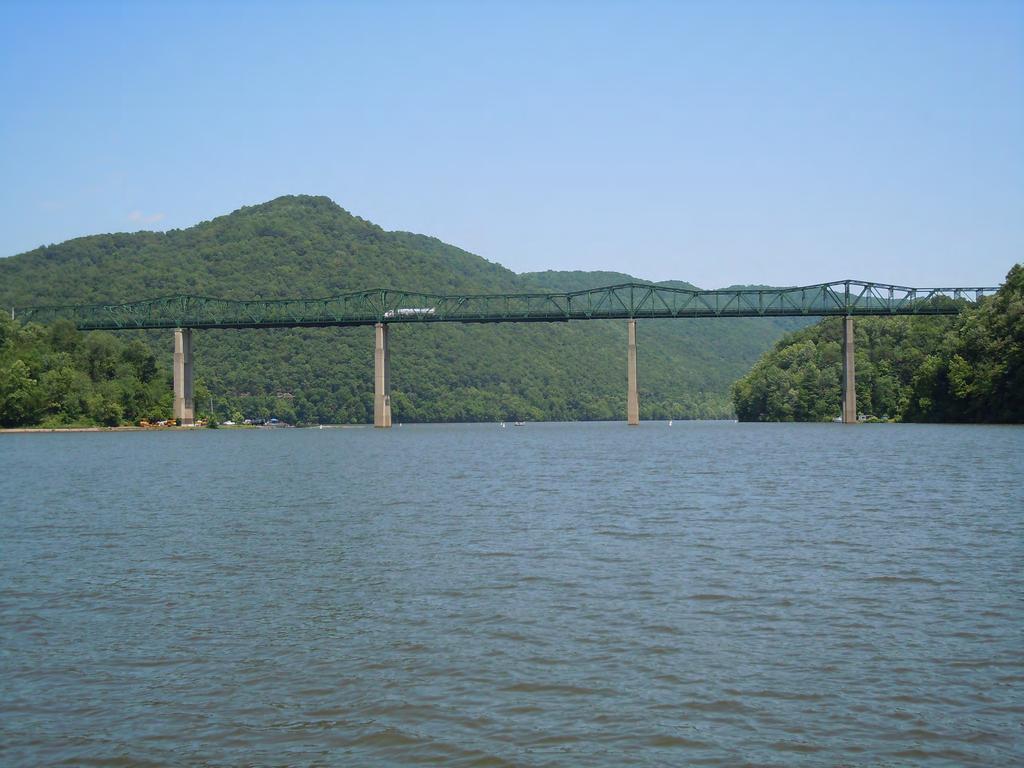
2 STATE LEVEL HISTORIC DOCUMENTATION LILLY TRUSS BRIDGE Location: WV Route 20, over Bluestone Lake Summers County West Virginia USGS Pipestem Quadrangle Date of Construction: 1950 Builder: Virginia Bridge Company Present Owner: West Virginia Department of Transportation Division of Highways 1900 Kanawha Boulevard, Building 5, Room A-110 Charleston, WV Present Use: Vehicular Bridge Significance: The Lilly Truss Bridge is significant due to its association with a well known bridge builder and as an example of the use of a Cantilevered Thru Truss. also significant due to its association with local history and the flood control acts. It Project Information: The project has been undertaken due to the poor condition of the bridge. Any future deterioration of the bridge would result in its closure. The existing bridge warrants replacement. The documentation was undertaken in September 2011 in accordance with a Memorandum of Agreement among the Federal Highway Administration, West Virginia Department of Transportation, West Virginia State Historic Preservation Office, West Virginia Division of Natural Resources, and Summers County Board of Education. These measures are required prior to replacement of this National Register eligible structure. Randy Epperly III, Historian West Virginia Division of Highways Charleston, WV December 7, 2011
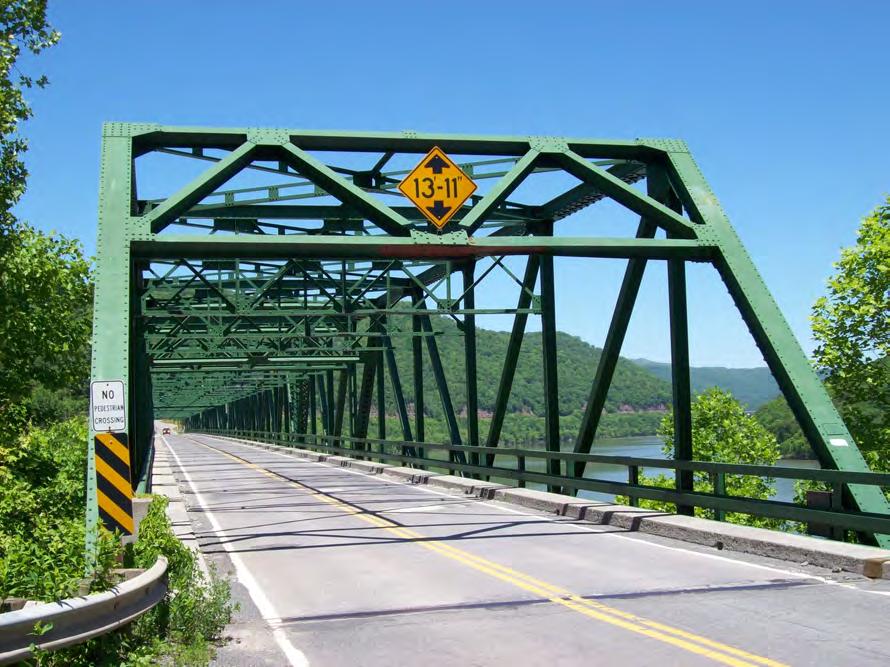
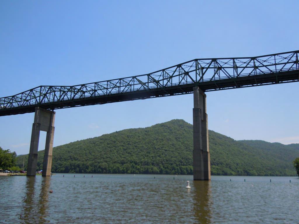
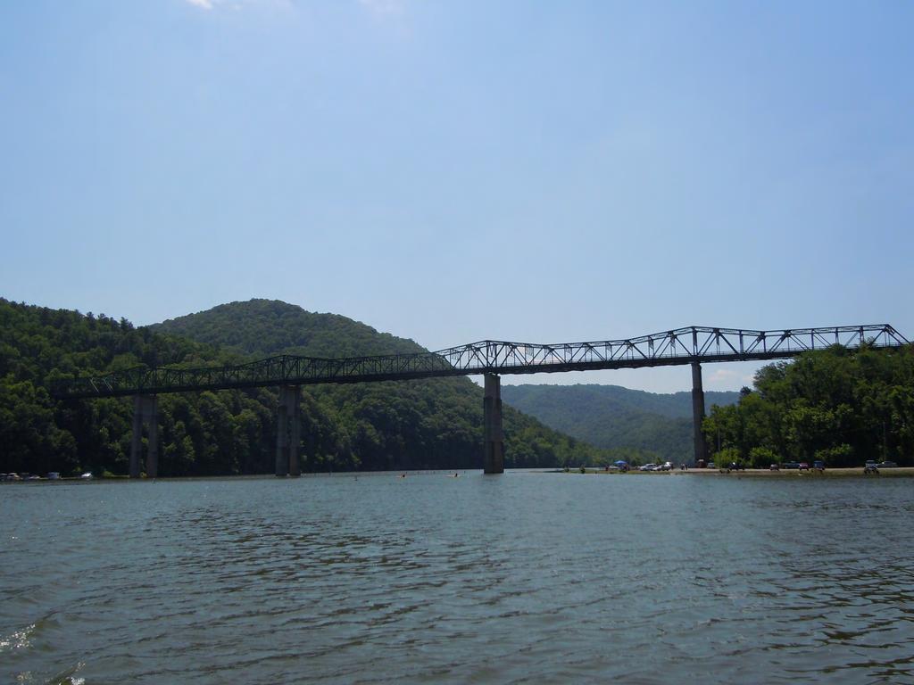
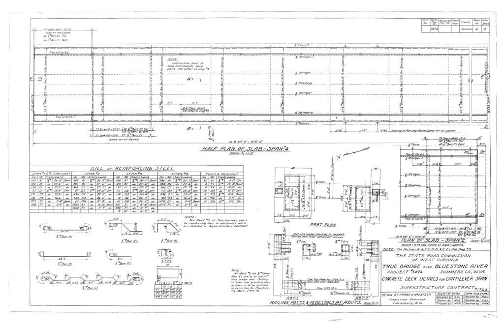
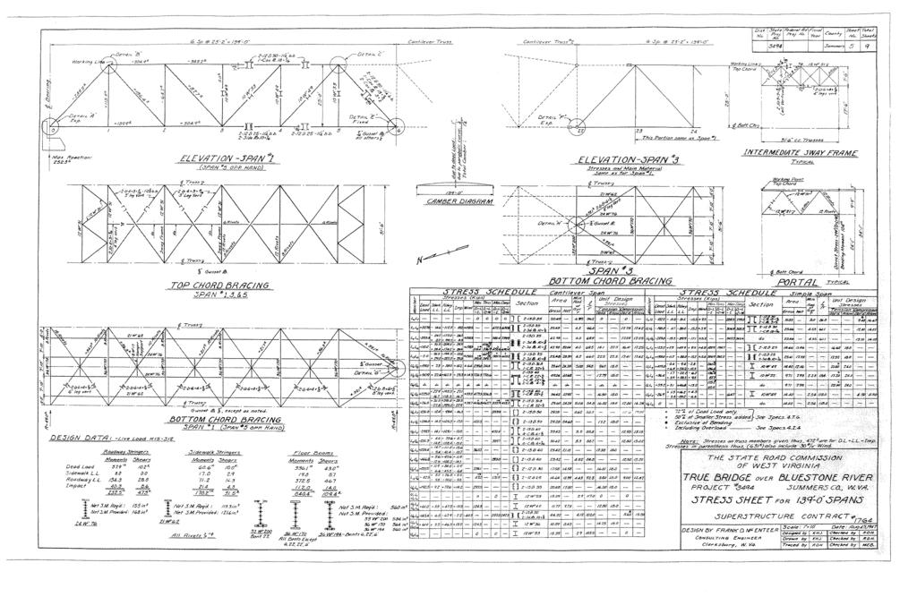
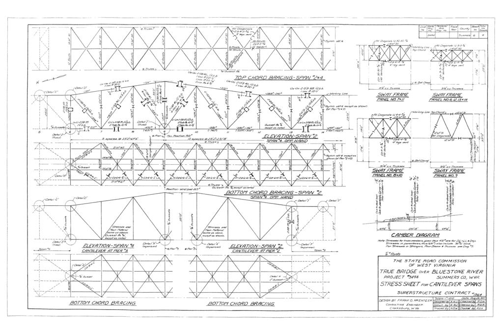
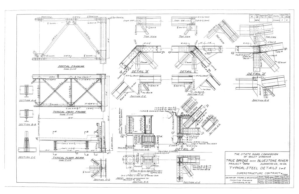
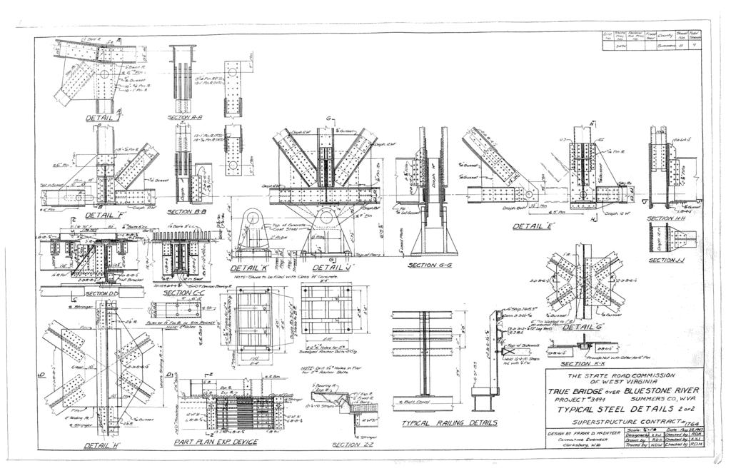
3 Lilly Truss Bridge Page 2 The Lilly Truss Bridge is located on WV State Route 20 in Summers County, West Virginia. The existing bridge crosses over Bluestone Lake. Lilly Bridge was built in 1950, one year after the Bluestone Dam was completed and ready for operation. The Bluestone Dam was built to control flooding in the New River Gorge and possible hydroelectric production. The dam created Bluestone Lake by flooding most of the town of Lilly (Princeton Times). Lilly Bridge was named in honor of the town, which was one of the oldest in Summers County and was located about 3 miles from the current location of the bridge. A proclamation was issued in 1949 naming the bridge after Lilly but needed legislative action to make it official. The resolution was forgotten and it was not until the 1990s that it was passed and the bridge was named Lilly Bridge (Clarksburg Telegram). This bridge was the first bridge established to cross Bluestone Lake. It provided a direct route from Hinton to Pipestem State Park and Bluestone Dam. The Giles, Fayette, and Kanawha Turnpike, chartered in 1837, was located in this area. But due to the construction of the Bluestone Dam and Lake, the area has changed and the original route can no longer be seen (WVDOH Turnpike Files). Lilly Bridge is eligible for the National Register of Historic Places under Criterion A. The bridge is also eligible under Criterion C for engineering and as a good example of its type. It was built in 1950 by the Virginia Bridge Company. The Virginia Bridge Company was known primarily for their highway and railroad bridges. The company was founded in 1889 as the American Bridge Company. The name was changed in 1895 to the Virginia Bridge and Iron Company. It became the largest steel fabricating company in the south. In 1952 the company merged into the American Bridge Company, a subsidiary of U.S. Steel (Clarkton Bridge). The Lilly Bridge is a 5-span cantilevered thru truss bridge built in 1950 by the Virginia Bridge Company. It is supported by concrete abutments and 4 concrete piers. The bridge is long and has a roadway width of 24. The bridge has a concrete deck and sidewalks. It contains steel channel and angle bridge rails. (WVDOH Bridge Files). Cantilevered bridges are built by extending cantilevers horizontally, supported only on one end (ACROW). The steel trusses are the cantilevers on Lilly Bridge. KCI s Historic Context states that cantilevered bridges are used for spanning great lengths and are defined by their supports and not their configuration. Only 7 cantilevered truss bridges remain in West Virginia. KCI also stated that other cantilever truss bridges may exist and be categorized under through trusses (KCI, 2006). Pictured below are some of the supports and connections for the Lilly Truss Bridge.
4 Lilly Truss Bridge Page 3 BIBLIOGRAPHY Carver, Martha. Tennessee s Survey Report for Historic Highway Bridges. Virginia Bridge and Iron Co Clarksburg Telegram. It s Finally Official, Bridge Has a Name. 17 May Princeton Times. Village of Lilly. 30 March Staunton River Tour, Halifax County, Virginia. Clarkton Bridge. West Virginia Division of Highways, Bridge Files, Maintenance Division, Building 5, Capitol Complex, Charleston, West Virginia, March West Virginia Division of Highways, Turnpike Files, Environmental Section, Engineering Division, Building 5, Capitol Complex, Charleston, West Virginia.
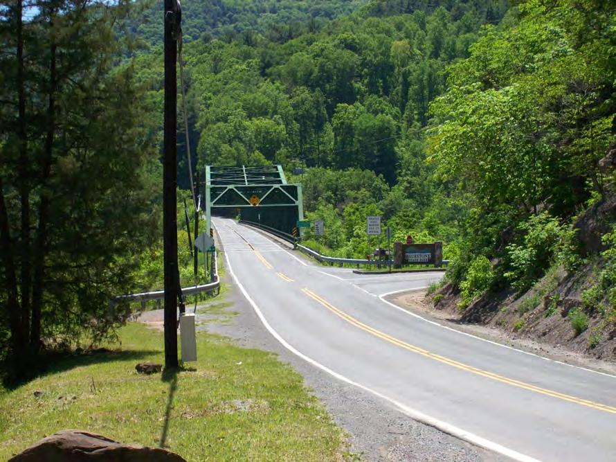
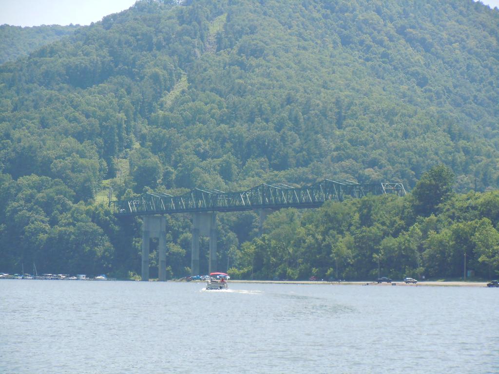
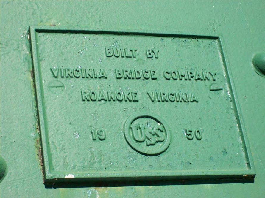
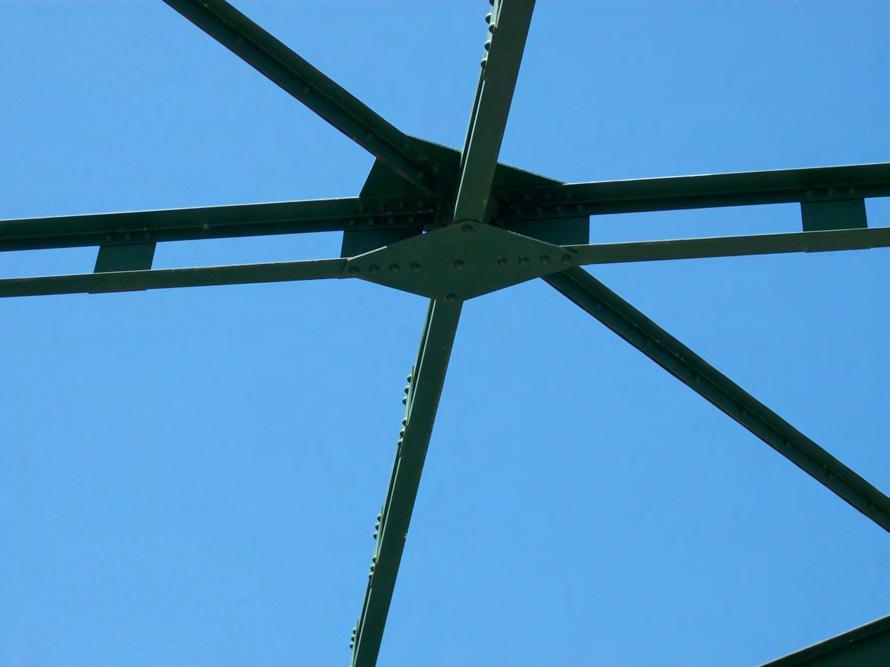
5 STATE LEVEL HISTORIC DOCUMENTATION INDEX TO PHOTOGRAPHS Lilly Truss Bridge WV Route 20 Bluestone Lake Summers County, West Virginia Photographer: Randy Epperly and Traci Cummings Summer 2009 and July 2011 LILLY TRUSS BRIDGE-1 View of bridge looking west from Bluestone Lake. LILLY TRUSS BRIDGE-2 View of bridge looking east from Bluestone Lake. LILLY TRUSS BRIDGE-3 View from Northern approach on WV 20. LILLY TRUSS BRIDGE-4 View from southern approach on WV 20. LILLY TRUSS BRIDGE-5 View of bridge builder plate. LILLY TRUSS BRIDGE-6 View of trusses along the top of the bridge. LILLY TRUSS BRIDGE-7 View of abutments and bridge looking east from Bluestone Lake. LILLY TRUSS BRIDGE-8 View of underside of bridge looking south from lake access site. LILLY TRUSS BRIDGE-9 View of connection. LILLY TRUSS BRIDGE-10 View of connection. LILLY TRUSS BRIDGE-11 View of eastern side of bridge looking south across Bluestone Lake. Original plans are attached.

6


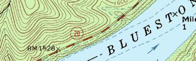
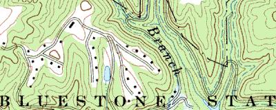
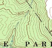

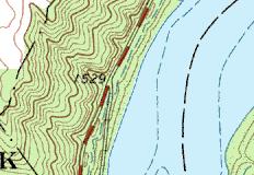
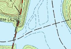


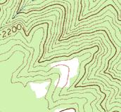


7 Lilly Bridge Project Area 8 W Name: PIPESTEM Date: 6/9/2010 Scale: 1 inch equals 2000 feet Location: E N Caption: Lilly Bridge Summers County Copyright (C) 1998, Maptech, Inc.
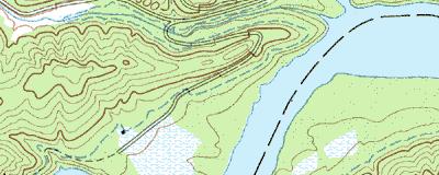
8 Ü Bluestone Dam WV Route 20 County Route 20/2 Bluestone River Bluestone State Park Lilly Bridge New River Legend West Virginia Division of Highways Engineering Division Environmental Section Randy Epperly January 21, 2010 Roads Lilly APE Miles
 Town or Community County Negative No.")

9 HPI Internal Rating: WEST VIRGINIA HISTORIC PROPERTY INVENTORY FORM Street Address Located on WV Route 20, approximately 0.25 miles south of County Route 20/2, spanning Bluestone Lake. Common/Historic Name/Both Lilly Bridge Field Survey # HPI #1 Site # (SHPO Only) Town or Community County Negative No. NR Listed Date Near Hinton Summers Architect/Builder Date of Construction Style (SHPO Only) Virginia Bridge Company 1950 Exterior Siding / Materials Five-Span Cantilevered Thru Truss Roofing Material Deck Material: Concrete Foundation Abutments: Concrete Piers: Concrete Property Use or Function Transportation Survey Organization & Date WVDOH May 20, 2009 UTM Zone17 NAD 1981 Easting E Northing N Quadrangle Name Pipestem Part of What Survey / FR# State County Route S Federal Route BR-0020(164)E
10 Name: Lilly Bridge Survey #: HPI #1 Survey / FR#: State County Route: S Present Owners WVDOH Owners Mailing Address Building 5, Capitol Complex Charleston, WV HPI Describe Setting Unknown--<1 Acres Archaeological Artifacts Present Lilly Bridge is located in a rural area in Summers County. It carries WV Route 20 across Bluestone Lake. Description of Buildings or Site (Original and Present) Stories Front Bays The structure is a 5-span cantilevered thru-truss bridge built in 1950 by the Virginia Bridge Company. It is supported by concrete abutments and 4 concrete piers. The bridge is and has a roadway width of 24. The bridge has a concrete deck and sidewalks. The bridge has steel channel and angle bridge rails. There are flexbeam guardrails on the approaches. The bridge is posted for vertical clearance and weight limits. The ADT in 2006 was 1950 vehicles per day. Alterations Yes No If yes, describe Abutment #2 approaches and bridge seats were raised Stringers were repaired Portal and sway strut members damaged by impact were removed and replaced Bridge was painted Various steel truss members were replaced Cracked welds were repaired. Additions Yes No If yes, describe Describe All Outbuildings N/A Statement of Significance: See Continuation Sheet Bibliographical References Carver, Martha. Tennessee s Survey Report for Historic Highway Bridges. Virginia Bridge and Iron Co Clarksburg Telegram. It s Finally Official, Bridge Has a Name. 17 May KCI Technologies. Draft Historic Context. West Virginia Statewide Historic Bridge Survey. October Modjeski and Masters. Final Feasibility Study, Lilly Bridge. March 20, Princeton Times. Village of Lilly. 30 March Staunton River Tour, Halifax County, Virginia. Clarkton Bridge. WVDOH Maintenance Division. Bridge Inspection Report Form Prepared By: Date: May 4, 2009 Name/Organization: Randy Epperly Address: WV Division of Highways Capitol Complex Building 5, Rm. 463 Charleston, WV Phone #:
11 WEST VIRGINIA HISTORIC PROPERTY FORM CONTINUATION SHEET HPI Name: Lilly Bridge Survey Number: HPI #1 Project / FR#: State County Route: S Lilly Bridge was built in 1950, one year after the Bluestone Dam was completed and ready for operation. The Bluestone Dam was built to control flooding in the New River Gorge and possible hydroelectric production. The dam created Bluestone Lake by flooding most of the town of Lilly (Princeton Times). Lilly Bridge was named in honor of the town, which was one of the oldest in Summers County and was located about 3 miles from the current location of the bridge. A proclamation was issued in 1949 naming the bridge after Lilly but needed legislative action to make it official. The resolution was forgotten and it was not until the 1990s that it was passed and the bridge was named Lilly Bridge (Clarksburg Telegram). This bridge was the first bridge established to cross Bluestone Lake. It provided a direct route from Hinton to Pipestem State Park and Bluestone Dam. The Giles, Fayette, and Kanawha Turnpike, chartered in 1837, was located in this area. But due to the construction of the Bluestone Dam and Lake, the area has changed and the original route can no longer be seen. Lilly Bridge is eligible for the National Register of Historic Places under Criterion A based on its significance with the local history. Lilly Bridge is not associated with the significance of an individual or an individual s historic contribution. The bridge is not eligible under Criterion B. Lilly Bridge is a 5-span cantilevered thru truss built in 1950 by the Virginia Bridge and Iron Company. The company was founded in 1889 as the American Bridge Company. Its name was changed to the Virginia Bridge and Iron Company in 1895 by its founders P.K. Wentworth, I.E. Hunter, and C.L. Michael. The company became the largest steel fabricating company in the south. Plants and offices were built in cities throughout the country (Clarkton Bridge). Highway bridges and railroad bridges were the specialties for the Virginia Bridge and Iron Company. They also produced steel and iron for other industries (Carver, 216). In 1952, the Virginia Bridge and Iron Company merged into the American Bridge Company. The American Bridge Company was a subsidiary of U.S. Steel, the largest bridge company in the United States (Clarkton Bridge). It is a basic cantilever truss design, of which there are only 7 remaining in West Virginia. KCI s Historic Context states that other cantilever bridges may exist and be categorized under through trusses (KCI). KCI also states that cantilever bridges were used as a cheaper alternative to suspension bridges (KCI). Although the bridge has been repaired for various reasons, it has retained its integrity as an example of a cantilever truss. Lilly Bridge is eligible for the National Register of Historic Places under Criterion C for bridge design. The bridge is not likely to possess any important information that will contribute to our understanding of early human history or prehistory. The potential for information is minimal. This structure is not eligible under Criterion D.
12
13
14
15
16
17
18
19
20
21
22
23
24
25
26
27
28

29
30
31
32
33
34
35
36
37
38
39
40
41
42
43
44
45
46
47
48
49
50
BLUESTONE DAM DAM SAFETY ASSURANCE MEGA-PROJECT NATIONAL INVENTORY OF DAMS ID: WV08902
 1 BLUESTONE DAM DAM SAFETY ASSURANCE MEGA-PROJECT NATIONAL INVENTORY OF DAMS ID: WV08902 237 237 237 217 217 217 200 200 200 0 0 0 163 163 163 131 132 122 Updated 10 October 2017 255 255 255 239 65 53
NFS Form (Rev )
") NFS Form 10-900 (Rev. 10-90) OMB No. 1fl?4-QQia RECEIVED 2280 MAY I 9 1998 NAT. REGISTER OF HISTORIC PLACES NATIONAL PARK SERVICE This form is for use in nominating or requesting determinations for individual
NFS Form 10-900 (Rev. 10-90) OMB No. 1fl?4-QQia RECEIVED 2280 MAY I 9 1998 NAT. REGISTER OF HISTORIC PLACES NATIONAL PARK SERVICE This form is for use in nominating or requesting determinations for individual
Site Inventory Form State Inventory No New Supplemental
 Site Inventory Form State Inventory No. 70-00940 New Supplemental State Historical Society of Iowa Part of a district with known boundaries (enter inventory no.) (December 1, 1999) Relationship: Contributing
DESIGN PUBLIC HEARING JULY 7, 2016 CITY COUNCIL HEARING ROOM, FIRST FLOOR ONE GOVERNMENT CENTER FALL RIVER, MASSACHUSETTS 6:30 PM FOR THE PROPOSED
 DESIGN PUBLIC HEARING JULY 7, 2016 AT CITY COUNCIL HEARING ROOM, FIRST FLOOR ONE GOVERNMENT CENTER FALL RIVER, MASSACHUSETTS 6:30 PM FOR THE PROPOSED AIRPORT ROAD OVER ROUTE 24, BRIDGE DECK REPLACEMENT
NATIONAL REGISTER NOMINATION CHECK-OFF LIST (Revised )
") Office of Archaeology and Historic Preservation History Colorado Publication #1413a NATIONAL REGISTER NOMINATION CHECK-OFF LIST (Revised 2-2015) This check-off list is to insure that all necessary materials
Office of Archaeology and Historic Preservation History Colorado Publication #1413a NATIONAL REGISTER NOMINATION CHECK-OFF LIST (Revised 2-2015) This check-off list is to insure that all necessary materials
HISTORIC RESOURCE SURVEY FORM University of Oregon Cultural Resources Survey Eugene, Lane County, Oregon Summer 2006
 HISTORIC RESOURCE SURVEY FORM University of Oregon Cultural Resources Survey Eugene, Lane County, Oregon Summer 2006 RESOURCE IDENTIFICATION Current building name: Cascade Annex West Wing Historic building
Current Functions (Enter categories from instructions) Materials (Enter categories from instructions)
 Materials (Enter categories from instructions)") Site Inventory Form State Inventory No. 92-00584 New Supplemental State Historical Society of Iowa Part of a district with known boundaries (enter inventory no.) 92-00349 (November 2005) Relationship:
Site Inventory Form State Inventory No. 92-00584 New Supplemental State Historical Society of Iowa Part of a district with known boundaries (enter inventory no.) 92-00349 (November 2005) Relationship:
STATE OF OHIO FINANCIAL REPORTING APPROACH GASB 34 IMPLEMENTATION ISSUES TRANSPORTATION INFRASTRUCTURE
 TRANSPORTATION INFRASTRUCTURE GASB 34 Reporting Requirements (Paragraphs 19 through 26) Paragraph 19 includes infrastructure assets in the definition of capital assets. Infrastructure assets are defined
other names/site number_!!w~s!<.do~t~1~7l.j{:.::4t10'.!,1~
 NPS Form 10 900, (001. 1990).. United States Department of the Interior National Park Service National Register of Historic Places Registration Form OMS No. 10024.()()18 This form is for use in nominating
1. Name of Property Historic name: Other names/site number: Name of related multiple property listing:
 United States Department of the Interior National Park Service National Register of Historic Places Registration Form This form is for use in nominating or requesting determinations for individual properties
II' i. Entered in the National Register. National Register of Historic Places Registration Form. historic name other names/site number
 NPS Form 10-900 (Rev. 10-90) RECEIVED DPmvFH 2280 ***, 11""-* OMBNo. 1024-0018 Registration Form SEP ' w96 This form is for use in nominating or requesting determinations for individual properties and
1. Name of Property. other names/site number Downtown Survey Map # DT- 053
 Site Inventory Form State Inventory No. 92-00510 New Supplemental State Historical Society of Iowa Part of a district with known boundaries (enter inventory no.) 92-00349 (November 2005) Relationship:
Sickels Laundry and Dry Cleaning
 Site Inventory Form State Inventory No. 29-03677 New Supplemental State Historical Society of Iowa Part of a district with known boundaries (enter inventory no.) 29-03685 (November 2005) Relationship:
Current Functions (Enter categories from instructions) 02D01: Commerce / financial / savings and loan 11D03: doctor office chiropractic
 02D01: Commerce / financial / savings and loan 11D03: doctor office chiropractic") Site Inventory Form State Inventory No. 92-00550 New Supplemental State Historical Society of Iowa Part of a district with known boundaries (enter inventory no.) 92-00349 (November 2005) Relationship:
Site Inventory Form State Inventory No. 92-00550 New Supplemental State Historical Society of Iowa Part of a district with known boundaries (enter inventory no.) 92-00349 (November 2005) Relationship:
County Bridge Inspection. IACC Conference Presented by: Michael L. McCool, PE Bridge Department Manager Beam, Longest and Neff, LLC
 County Bridge Inspection Road Scholar Core Course # 9: Bridge Basics IACC Conference - 2015 Presented by: Michael L. McCool, PE Bridge Department Manager Beam, Longest and Neff, LLC Topics National Bridge
Current Functions (Enter categories from instructions) Materials (Enter categories from instructions)
 Materials (Enter categories from instructions)") Site Inventory Form State Inventory No. 29-00089 New Supplemental State Historical Society of Iowa Part of a district with known boundaries (enter inventory no.) 29-03522 (November 2005) Relationship:
Site Inventory Form State Inventory No. 29-00089 New Supplemental State Historical Society of Iowa Part of a district with known boundaries (enter inventory no.) 29-03522 (November 2005) Relationship:
5^3 CAM MAY United States Department of the Interior National Park Service
 NPS Fonn 10-900 (Oct 1990) United States Department of the Interior National Park Service NATIONALREGISTER OFHISTORIC PLACES REGISTRATIONFORM PECtlVEO 2290 MAY - 6 1997 OMB No. 10024-0018 5^3 1. NAME OF
106?! WHAT IS THAT? Elizabeth L. Davoli, R.P.A. DOTD Environmental Section 2007 LTEC
 106?! WHAT IS THAT? Elizabeth L. Davoli, R.P.A. DOTD Environmental Section 2007 LTEC THE BEGINNINGS 1950s saw the beginnings of the U.S. Interstate System In the 1960s, interstate construction in metro
other names/site number Downtown Survey Map # J-135
 Site Inventory Form State Inventory No. 29-01109 New Supplemental State Historical Society of Iowa Part of a district with known boundaries (enter inventory no.) 29-03685, 29-00001 (November 2005) Relationship:
HISTORIC RESOURCE SURVEY FORM University of Oregon Cultural Resources Survey Eugene, Lane County, Oregon Summer 2006
 HISTORIC RESOURCE SURVEY FORM University of Oregon Cultural Resources Survey Eugene, Lane County, Oregon Summer 2006 RESOURCE IDENTIFICATION Current building name: Condon Hall Historic building name: Science
1. Name of Property. historic name Coonradt, Ernest E. and Ruth G., House. other names/site number. 2. Location
 Site Inventory Form State Inventory No. 09-00875 New Supplemental State Historical Society of Iowa Part of a district with known boundaries (enter inventory no.) 09-00962 (November 2005) Relationship:
DESIGN PUBLIC HEARING FEBRUARY 9, ABIGAIL ADAMS MIDDLE SCHOOL Auditorium WEYMOUTH, MASSACHUSETTS 7:00 PM FOR THE PROPOSED
 DESIGN PUBLIC HEARING FEBRUARY 9, 2012 AT ABIGAIL ADAMS MIDDLE SCHOOL Auditorium WEYMOUTH, MASSACHUSETTS 7:00 PM FOR THE PROPOSED FORE RIVER BRIDGE REPLACEMENT ROUTE 3A (WASHINGTON STREET/BRIDGE STREET)
1 Total Total. Current Functions (Enter categories from instructions) Materials (Enter categories from instructions)
 Materials (Enter categories from instructions)") Site Inventory Form State Inventory No. 29-03663 New Supplemental State Historical Society of Iowa Part of a district with known boundaries (enter inventory no.) (November 2005) Relationship: Contributing
Site Inventory Form State Inventory No. 29-03663 New Supplemental State Historical Society of Iowa Part of a district with known boundaries (enter inventory no.) (November 2005) Relationship: Contributing
Resolution Approving an Industrial Facilities Exemption Certificate for American SpiralWeld Pipe Co., L.L.C (Public Act 198 of 1974 as amended)
") EM Submission: Ema~S 22dJ~/ Presented: /~2fr/~ Adopted: By the Emergency Manager: Resolution Approving an Industrial Facilities Exemption Certificate for American SpiralWeld Pipe Co., L.L.C (Public Act
EM Submission: Ema~S 22dJ~/ Presented: /~2fr/~ Adopted: By the Emergency Manager: Resolution Approving an Industrial Facilities Exemption Certificate for American SpiralWeld Pipe Co., L.L.C (Public Act
STATE REGISTER NOMINATION CHECK-OFF LIST (Revised )
") STATE REGISTER NOMINATION CHECK-OFF LIST (Revised 2-2015) This check-off list is to insure that all necessary materials are turned in with the nomination form. Check off each item as you prepare the nomination
STATE REGISTER NOMINATION CHECK-OFF LIST (Revised 2-2015) This check-off list is to insure that all necessary materials are turned in with the nomination form. Check off each item as you prepare the nomination
DIVISION 2 - CONSTRUCTION PLAN AND MISCELLANEOUS REQUIREMENTS
 DIVISION 2 - CONSTRUCTION PLAN AND MISCELLANEOUS REQUIREMENTS 2.1 Required Plan Sheets 2.2 Drawing Requirements 2.3 Graphic Standards 2.4 Easements 2.5 Utility Locations 2.6 Private Facility Locations
BLUESTONE DAM AN OVERVIEW NATIONAL INVENTORY OF DAMS ID: WV08902
 1 BLUESTONE DAM AN OVERVIEW NATIONAL INVENTORY OF DAMS ID: WV08902 237 237 237 217 217 217 200 200 200 0 0 0 163 163 163 131 132 122 Updated 10 October 2017 255 255 255 239 65 53 80 119 27 252 174.59 110
other names/site number Downtown Survey Map # J-143
 Site Inventory Form State Inventory No. 29-01123 New Supplemental State Historical Society of Iowa Part of a district with known boundaries (enter inventory no.) 29-03685, 29-00001 (November 2005) Relationship:
HISTORIC RESOURCE SURVEY FORM University of Oregon Cultural Resources Survey Eugene, Lane County, Oregon Summer 2006
 HISTORIC RESOURCE SURVEY FORM University of Oregon Cultural Resources Survey Eugene, Lane County, Oregon Summer 2006 RESOURCE IDENTIFICATION Current building name: Esslinger (Arthur A.) Hall Historic building
1816, Independence Hall 1850, Washington s Headquarters
 Historic Preservation: An Evolving Relation with Our Past 1816, Independence Hall 1850, Washington s Headquarters 1 Mount Vernon Ladies Association, 1853 Ann Pamela Cunningham United States 100 th Birthday
J. PAUL GUYER, P.E., R.A.
 J. PAUL GUYER, P.E., R.A. Paul Guyer is a registered architect, civil engineer, mechanical engineer and fire protection engineer with over 35 years experience designing all types of buildings. For an additional
Current Functions (Enter categories from instructions) 02E03; Commerce/Specialty/ dry goods/notions 02G: Commerce/Restaurant
 02E03; Commerce/Specialty/ dry goods/notions 02G: Commerce/Restaurant") Site Inventory Form State Inventory No. 29-01241 New Supplemental State Historical Society of Iowa Part of a district with known boundaries (enter inventory no.) (November 2005) Relationship: Contributing
Site Inventory Form State Inventory No. 29-01241 New Supplemental State Historical Society of Iowa Part of a district with known boundaries (enter inventory no.) (November 2005) Relationship: Contributing
NATIONAL REGISTER OF HISTORIC PLACES
 1501 (Rev. 07/2012) INFORMATION ON NOMINATING PROPERTIES TO THE NATIONAL REGISTER OF HISTORIC PLACES AND THE COLORADO STATE REGISTER of HISTORIC PROPERTIES National Register and State Register Programs
Total 1 Total. Current Functions (Enter categories from instructions) 02E03; Commerce/Specialty/ dry goods/notions 02G: Commerce/Restaurant
 02E03; Commerce/Specialty/ dry goods/notions 02G: Commerce/Restaurant") Site Inventory Form State Inventory No. 29-01241 New Supplemental State Historical Society of Iowa Part of a district with known boundaries (enter inventory no.) 29-03685 (November 2005) Relationship:
Site Inventory Form State Inventory No. 29-01241 New Supplemental State Historical Society of Iowa Part of a district with known boundaries (enter inventory no.) 29-03685 (November 2005) Relationship:
Current Functions (Enter categories from instructions) Materials (Enter categories from instructions)
 Materials (Enter categories from instructions)") Site Inventory Form State Inventory No. 92-00503 New Supplemental State Historical Society of Iowa Part of a district with known boundaries (enter inventory no.) 92-00349 (November 2005) Relationship:
Site Inventory Form State Inventory No. 92-00503 New Supplemental State Historical Society of Iowa Part of a district with known boundaries (enter inventory no.) 92-00349 (November 2005) Relationship:
Virginia Department of Transportation 2005 Subdivision Street Requirements 24 VAC et seq.
 24 VAC 30-91-10. Definitions. CHAPTER 91. SUBDIVISION STREET REQUIREMENTS. PART I. GENERAL PROVISIONS. The following words and terms when used in these regulations shall have the following meanings unless
SUBCHAPTER 02C - SECONDARY ROADS SECTION SECTION SECONDARY ROADS
 SUBCHAPTER 02C - SECONDARY ROADS SECTION SECTION.0100 - SECONDARY ROADS Note: The Department of Transportation publishes a volume entitled "Minimum Design and Construction Criteria for Subdivision Streets"
Site Inventory Form State Inventory No New Supplemental
 Site Inventory Form State Inventory No. 70-00938 New Supplemental State Historical Society of Iowa Part of a district with known boundaries (enter inventory no.) (December 1, 1999) Relationship: Contributing
Architectural Inventory Form
 OAHP1403 Rev. 9/98 COLORADO CULTURAL RESOURCE SURVEY Architectural Inventory Form Official eligibility determination (OAHP use only) Date Initials Determined Eligible- NR Determined Not Eligible- NR Determined
Total 1 Total. Current Functions (Enter categories from instructions) 02F04: Commerce / department store 02E: Commerce / specialty store
 02F04: Commerce / department store 02E: Commerce / specialty store") Site Inventory Form State Inventory No. 29-01103 New Supplemental State Historical Society of Iowa Part of a district with known boundaries (enter inventory no.) 29-03685, 29-00001 (November 2005) Relationship:
Site Inventory Form State Inventory No. 29-01103 New Supplemental State Historical Society of Iowa Part of a district with known boundaries (enter inventory no.) 29-03685, 29-00001 (November 2005) Relationship:
2.0 Section 106 Scope of Work and Methodology
 measures for those impacts found to be unavoidable; and 6) development of a financing plan that identifies sources of funding and the timing of their availability. This report documents the historic properties
Trinity Guardrail End Cap Survey - Part III
 Trinity Guardrail End Cap Survey - Part III Posting Date: 21-Oct 2014 Certain guardrail end caps produced by Trinity Highway Products of Dallas Texas are alleged to be defective and dangerous. The truth
National Register of Historic Places Continuation Sheet
 NPS Fonn :0-»00-a OUB Approval No. 102*001$ United States Department of the Interior National Park Service National Register of Historic Places Continuation Sheet AUG c S. ^'-..7 Section number all Page
DESIGN PUBLIC HEARING
 DESIGN PUBLIC HEARING October 25, 2016 AT STEVENS MEMORIAL LIBRARY 345 MAIN STREET NORTH ANDOVER, MASSACHUSETTS 7:00 PM FOR THE PROPOSED Chickering Road (Route 125) & Massachusetts Avenue Intersection
- site. - structure - ob j ect. (Do not include previously listed resources in the count.)
") Terra Alta Bank Name of Property Preston Countv, WV County and State 5. Classification Ownership of Property: (Check as many boxes as - x private - public-local - public-state - public-federal Category
Terra Alta Bank Name of Property Preston Countv, WV County and State 5. Classification Ownership of Property: (Check as many boxes as - x private - public-local - public-state - public-federal Category
R/W PREQUALIFICATION ODOT, 3/14/2018
 R/W PREQUALIFICATION ODOT, 3/14/2018 BRETT SHEARER, C.O. REAL ESTATE PROPOSED RIGHT OF WAY DESIGN 172 PROPOSED RIGHT OF WAY DESIGN PROPOSED RIGHT OF WAY DESIGN Section 3200 Types of Title 173 PROPOSED
JANUARY 2016 MAMARONECK & SHELDRAKE RIVERS NEW YORK FLOOD RISK MANAGEMENT GENERAL REEVALUATION REPORT FOR THE VILLAGE OF MAMARONECK APPENDIX E
 U.S. Army Corps of Engineers New York District MAMARONECK & SHELDRAKE RIVERS NEW YORK FLOOD RISK MANAGEMENT GENERAL REEVALUATION REPORT FOR THE VILLAGE OF MAMARONECK JANUARY 2016 APPENDIX E REAL ESTATE
NEW HAMPSHIRE HISTORIC PROPERTY DOCUMENTATION DINARDO-DUPUIS HOUSE NH STATE NO Wight Street, Berlin, Coos County, New Hampshire
 NEW HAMPSHIRE HISTORIC PROPERTY DOCUMENTATION DINARDO-DUPUIS HOUSE NH STATE NO. 696 Location:, Berlin, Coos County, New Hampshire USGS Berlin Quadrangle UTM Coordinates: Z19 4926650N 325990E Present Owner:
HISTORIC PRESERVATION COMMISSION MEETING CITY OF DAVENPORT, IOWA TUESDAY, NOVEMBER 13, 2018; 6:00 PM
 HISTORIC PRESERVATION COMMISSION MEETING CITY OF DAVENPORT, IOWA TUESDAY, NOVEMBER 13, 2018; 6:00 PM CITY COUNCIL CHAMBERS 226 WEST 4TH STREET DAVENPORT, IOWA 52801 WORK SESSION I. Call to Order II. Secretary's
RM-11 and RM-11N Districts Schedule
 Districts Schedule 1 Intent The intent of this Schedule is to permit medium density residential development primarily in the form of four-storey T -shaped apartments, and to foster compact, sustainable,
other names/site number Downtown Survey Map # J-146
 Site Inventory Form State Inventory No. 29-01129 New Supplemental State Historical Society of Iowa Part of a district with known boundaries (enter inventory no.) 29-03685, 29-00001 (November 2005) Relationship:
Current Functions (Enter categories from instructions) 14D09 Automotive Service or Repair. Materials (Enter categories from instructions)
 14D09 Automotive Service or Repair. Materials (Enter categories from instructions)") Site Inventory Form State Inventory No. 29-03504 New Supplemental State Historical Society of Iowa Part of a district with known boundaries (enter inventory no.) (November 2005) Relationship: Contributing
Site Inventory Form State Inventory No. 29-03504 New Supplemental State Historical Society of Iowa Part of a district with known boundaries (enter inventory no.) (November 2005) Relationship: Contributing
Historic Property Report
 Location Address: 1224 E ROCKWOOD PINES RD, SPOKANE, WA 99203 Tax No/Parcel No: 35294.0243 Plat/Block/Lot: ROCKWOOD PINES 2ND L15 Geographic Areas: Spokane County, SPOKANE NW Quadrangle, T25R43E29 Information
AUTO SALVAGE YARD AND SCRAP METAL BUSINESS WITH REAL ESTATE
 AUTO SALVAGE YARD AND SCRAP METAL BUSINESS WITH REAL ESTATE Auto Salvage and recycling business and real estate for sale. 40 yr old business available turn key or real estate & business only (with all
[Disposition and Development Agreement - Seawall Lot 337 Associates, LLC - Mission Rock Project]
![[Disposition and Development Agreement - Seawall Lot 337 Associates, LLC - Mission Rock Project]](/thumbs/93/113566845.jpg "[Disposition and Development Agreement - Seawall Lot 337 Associates, LLC - Mission Rock Project]") AMENDED IN COMMITTEE FILE NO. 00 // RESOLUTION NO. - 1 [Disposition and Development Agreement - Seawall Lot Associates, LLC - Mission Rock Project] Resolution approving a Disposition and Development Agreement
AMENDED IN COMMITTEE FILE NO. 00 // RESOLUTION NO. - 1 [Disposition and Development Agreement - Seawall Lot Associates, LLC - Mission Rock Project] Resolution approving a Disposition and Development Agreement
PLANNING COMMISSION AGENDA PACKET
 City of Litchfield PLANNING COMMISSION AGENDA PACKET Monday, December 11 th, 2017 City of Litchfield Planning Commission AGENDA Monday, December 11, 2017 5:30 P.M. Held in the Council Chambers of City
Combined Zoning/Minor Variance and Boulevard Parking Agreement Exception
 Residential Front Yard and Boulevard Parking Policy Name: Residential Front Yard and Boulevard Parking Legislative History: Enacted September 19, 2017 (By-law No. CPOL.-223-475); Amended June 26, 2018
Current Functions (Enter categories from instructions) 02G: Commerce/Restaurant - 1st floor 03C01: Social/Civic/Volunteer (Heritage Trust)
 02G: Commerce/Restaurant - 1st floor 03C01: Social/Civic/Volunteer (Heritage Trust)") Site Inventory Form State Inventory No. 29-01638 New Supplemental State Historical Society of Iowa Part of a district with known boundaries (enter inventory no.) (November 2005) Relationship: Contributing
Site Inventory Form State Inventory No. 29-01638 New Supplemental State Historical Society of Iowa Part of a district with known boundaries (enter inventory no.) (November 2005) Relationship: Contributing
APPENDIX D - REAL ESTATE
 APPENDIX D - REAL ESTATE 1. Purpose Real Estate Plan For Feasibility Study For Lake Lou Yaeger Section 206 Aquatic Ecosystem Restoration Continuing Authorities Project Feasibility Study This report is
1. Name of Property. historic name Beyer, Christian P and Olive, House. other names/site number. 2. Location
 Site Inventory Form State Inventory No. 09-00724 New Supplemental State Historical Society of Iowa Part of a district with known boundaries (enter inventory no.) 09-00621 (November 2005) Relationship:
Architectural Inventory Form
 COLORADO CULTURAL RESOURCE SURVEY Page 1 Official eligibility determination (OAHP use only) Date Initials Determined Eligible- NR Determined Not Eligible- NR Determined Eligible- SR Determined Not Eligible-
COMMUNITY DEVELOPMENT. Staff Report. Site Plan Review. SP June 19, 2018
 COMMUNITY DEVELOPMENT 333 Broadalbin Street SW, PO Box 490, Albany, Oregon 97321-0144 BUILDING 541-917-7553 PLANNING 541-917-7550 Staff Report Site Plan Review SP-18-18 June 19, 2018 Summary On May 1,
VICINITY MAP. Board of Adjustment File No.: VAR & VAR January 9, 2014 Page 2 of 11 ATTACHMENTS
 Board of Adjustment File No.: VAR2013 0024 & VAR2013 0025 January 9, 2014 Page 2 of 11 VICINITY MAP ATTACHMENTS Attachment A Applicant s Letter Attachment B Site Plan Attachment C Elevation Drawings Board
other names/site number Downtown Survey Map # J-158, J-159
 Site Inventory Form State Inventory No. 29-01136, 29-01137 New Supplemental State Historical Society of Iowa Part of a district with known boundaries (enter inventory no.) 29-03685, 29-00001 (November
Agenda Report DATE: APRIL 30,2007 TO: CITY COUNCIL CYNTHIA J. KURTZ, CITY MANAGER FROM:
 Agenda Report DATE: APRIL 30,2007 TO: FROM: SUBJECT: CITY COUNCIL CYNTHIA J. KURTZ, CITY MANAGER APPROVAL OF THE DEVELOPMENT AGREEMENT FOR THE SMVIA NOISE WITHIN MIXED-USE PROJECT BETWEEN THE ClTY OF PASADENA
IMPORTANT NOTICE. Architectural Inventory Form COLORADO CULTURAL RESOURCE SURVEY I. IDENTIFICATION North Grand Avenue 5PE.
 IMPORTANT NOTICE OAHP1403 Rev. 9/98 COLORADO CULTURAL RESOURCE SURVEY Architectural Inventory Form Page 1 This survey form represents an UNOFFICIAL COPY and is provided for informational purposes only.
CARPORTS, GARAGES AND SHEDS
 CARPORTS, GARAGES AND SHEDS INCLUDED: LIST OF REQUIREMENTS SAMPLE DRAWINGS Planning & Development Services Tel. 905-683-4550 Fax. 905-686-0360 TOWN OF AJAX 65 Harwood Ave South Ajax ON L1S 2H9 www.ajax.ca
PROJECT NH 0050(99)381 PCN 6926 YANKTON COUNTY. SD HWY 50 (4 th Street) from Broadway Ave to Archery Road in Yankton, SD
381 PCN 6926 YANKTON COUNTY. SD HWY 50 (4 th Street) from Broadway Ave to Archery Road in Yankton, SD") Public Meeting/ Open House April 4, 2013 PROJECT NH 0050(99)381 PCN 6926 YANKTON COUNTY SD HWY 50 (4 th Street) from Broadway Ave to Archery Road in Yankton, SD Grading, PCC Pavement, Asphalt Concrete
Public Meeting/ Open House April 4, 2013 PROJECT NH 0050(99)381 PCN 6926 YANKTON COUNTY SD HWY 50 (4 th Street) from Broadway Ave to Archery Road in Yankton, SD Grading, PCC Pavement, Asphalt Concrete
SUBDIVISION DESIGN PRINCIPLES AND STANDARDS
 SECTION 15-200 SUBDIVISION DESIGN PRINCIPLES AND STANDARDS 15-201 STREET DESIGN PRINCIPLES 15-201.01 Streets shall generally conform to the collector and major street plan adopted by the Planning Commission
APPENDIX C: PLAT SPECIFICATIONS AND CERTIFICATES
 APPENDIX C: PLAT SPECIFICATIONS AND CERTIFICATES A. Drawing. All plats for recording must be submitted on photographically reproducible and dimensionally stable polyester sheets such as Mylar, Cronar or
2.0 Section 4(f) Properties
 Properties") 2.0 Section 4(f) Properties A Cultural Resource Assessment Survey (CRAS) and a CRAS Addendum were completed for the Wekiva Parkway PD&E Study in accordance with the provisions of the National Historic
2.0 Section 4(f) Properties A Cultural Resource Assessment Survey (CRAS) and a CRAS Addendum were completed for the Wekiva Parkway PD&E Study in accordance with the provisions of the National Historic
Total 1 Total. Current Functions (Enter categories from instructions) 02E03: Commercial / specialty store / dry goods 70: Vacant / Not in Use
 02E03: Commercial / specialty store / dry goods 70: Vacant / Not in Use") Site Inventory Form State Inventory No. 29-03652 New Supplemental State Historical Society of Iowa Part of a district with known boundaries (enter inventory no.) 26-03685 (November 2005) Relationship:
Site Inventory Form State Inventory No. 29-03652 New Supplemental State Historical Society of Iowa Part of a district with known boundaries (enter inventory no.) 26-03685 (November 2005) Relationship:
Table of Contents Introduction... 1 II. Standards for Survey Personnel... 3 III. Historic Preservation Planning... 4 IV.
 Table of Contents I. Introduction... 1 II. Standards for Survey Personnel... 3 III. Historic Preservation Planning... 4 IV. Identification of Historic Properties... 5 A. Research Design... 5 B. Archival
PLANNING COMMISSION MAY 3, 2018 PUBLIC HEARING
 PLANNING COMMISSION MAY 3, 2018 PUBLIC HEARING SUBJECT: REQUEST TO DEMOLISH TWO SINGLE-FAMILY DWELLINGS ON TWO ADJOINING LOTS AND CONSTRUCT TEN RESIDENTIAL CONDOMINIUM UNITS AT 947 GENESEE AVENUE AND 944
STAFF REPORT Administrative Subdivision Hearing West 150 South Street, Parcel # , and
 Petition Number: 490-06-24 STAFF REPORT Administrative Subdivision Hearing Project Name: Project Location: Project Type: Applicant: Planning Staff: Haight Industrial Subdivision 5550 West 150 South Street,
Hastings CBD Heritage Inventory Project
 Hastings CBD Heritage Inventory Project RUAHINE BUILDING LOCATION: Street and Number: 106-108 Heretaunga Street West City / Town: Hastings Region: Hawke s Bay LEGAL DESCRIPTION: Legal Description: Unit
-.-OCT 1119 date entered
 NPS Fom 10-900-1 United States Department of the Interior National Park Service National Register off Historic Piaces Inventory Nomination Form Continuation sheet Item number all rec< NPS UM only OMB NO
The property is located south of Dell Diamond with 2, feet of rail frontage just south of US HWY 79.
 3 8 0 1 P a l m Va l l e y B l v d. R o u n d R o c k T e x a s 7 8 6 6 5 The property is located south of Dell Diamond with 2,865.09 feet of rail frontage just south of US HWY 79. 155.589 acres; There
National Register of Historic Places Inventory Nomination Form
 NPS Form 10-900-* 042) United States Department of the Interior National Park Service National Register of Historic Places Inventory Nomination Form OMB No. 1024-0018 Expires 10-31-87 For Nl^ u*» onty
NPS Fom I OMB NO Expires
 NPS Fom 10-900.I OMB NO 1024-0018 Expires 10.31.87 United States Department of the Interior National Park Service National Register off Historic Piaces Inventory Nomination Form Continuation sheet Item
ARLINGTON COUNTY, VIRGINIA
 ARLINGTON COUNTY, VIRGINIA County Board Agenda Item Meeting of July 19, 2014 DATE: July 8, 2014 SUBJECTS: A. ZOA-14-03 Zoning Ordinance amendments to: 1. Revise Map 34-1 (Sign Map) to update the placement
SUBDIVISION REGULATIONS
 SUBDIVISION REGULATIONS KANAWHA COUNTY, WEST VIRGINIA KANAWHA COUNTY SUBDIVISION REGULATIONS TABLE OF CONTENTS PARAGRAPH PAGE SECTION I. AUTHORITY Purpose 101 2 Grant of Power 102 2 Effective Date 103
February 6, Operations Division Regulatory Branch (North) ID No. LRL dlz
 ID No. LRL dlz") DEPARTMENT OF THE ARMY U.S. ARMY ENGINEER DISTRICT, LOUISVILLE CORPS OF ENGINEERS INDIANAPOLIS REGULATORY OFFICE 8902 OTIS AVENUE, SUITE S106B INDIANAPOLIS, INDIANA 46216 February 6, 2013 Operations Division
DEPARTMENT OF THE ARMY U.S. ARMY ENGINEER DISTRICT, LOUISVILLE CORPS OF ENGINEERS INDIANAPOLIS REGULATORY OFFICE 8902 OTIS AVENUE, SUITE S106B INDIANAPOLIS, INDIANA 46216 February 6, 2013 Operations Division
The Drainage Control Regulations
 1 The Drainage Control Regulations Repealed by Saskatchewan Regulations 89/2015 (effective October 16, 2015) Formerly Chapter D-33.1 Reg 1 (effective August 18, 1981) as amended by Saskatchewan Regulations
$28,145,000 THE COUNTY COMMISSION OF HARRISON COUNTY (WEST VIRGINIA) TAX INCREMENT REVENUE AND REFUNDING BONDS (CHARLES POINTE PROJECT NO
 TAX INCREMENT REVENUE AND REFUNDING BONDS (CHARLES POINTE PROJECT NO") $28,145,000 THE COUNTY COMMISSION OF HARRISON COUNTY (WEST VIRGINIA) TAX INCREMENT REVENUE AND REFUNDING BONDS (CHARLES POINTE PROJECT NO. 2 - SOUTH LAND BAY IMPROVEMENTS) AMENDED AND RESTATED SERIES 2008B
$28,145,000 THE COUNTY COMMISSION OF HARRISON COUNTY (WEST VIRGINIA) TAX INCREMENT REVENUE AND REFUNDING BONDS (CHARLES POINTE PROJECT NO. 2 - SOUTH LAND BAY IMPROVEMENTS) AMENDED AND RESTATED SERIES 2008B
Oakland County Michigan Register of Deeds Plat Engineering, GIS, & Remonumentation Dept. Ph: (248) Fax (248)
 Fax (248)") Oakland County Michigan Register of Deeds Plat Engineering, GIS, & Remonumentation Dept. Ph: (248)-858-1447 Fax (248)-858-7466 Requirements Needed for Final Plat Approval No. General Requirements. 1 Routing
Oakland County Michigan Register of Deeds Plat Engineering, GIS, & Remonumentation Dept. Ph: (248)-858-1447 Fax (248)-858-7466 Requirements Needed for Final Plat Approval No. General Requirements. 1 Routing
CRITERIA FOR EVALUATION
 This project focused on establishing the historic context for the commercial buildings in West Hollywood from its initial development in the 1890s through its incorporation as a city in 1984. The scope
and (P2c, P2e, and P2b or P2d. Attach a Location Map as necessary.)
") State of California -- The Resources Agency PRIMARY RECORD Primary # HRI # NRHP Status Code Other Listings Review Code Reviewer Date Page 1 of 6 *Resource Name or #: (Assigned by Recorder) Casa Magnolia
State of California -- The Resources Agency PRIMARY RECORD Primary # HRI # NRHP Status Code Other Listings Review Code Reviewer Date Page 1 of 6 *Resource Name or #: (Assigned by Recorder) Casa Magnolia
Grand Mesa, Uncompahgre and Gunnison National Forests Region 2, USDA Forest Service
 Decision Memo Taylor River Land Exchange Under the General Exchange Act of March 20, 1922 as Amended, The Federal Land Policy and Management Act of 1976 as Amended and the Federal Land Exchange Facilitation
SECTION 7000 LAND DEVELOPMENT REQUIREMENTS
 SECTION 7000 LAND DEVELOPMENT REQUIREMENTS 7000 LAND DEVELOPMENT REQUIREMENTS... 1 7001 LEGISLATIVE AUTHORITY... 1 7001.1 LAND DEVELOPMENT... 1 7001.1.1 Title 40, Idaho Code... 1 7001.1.2 Idaho Code 40-1415
MAJOR SUBDIVISION PRELIMINARY PLAT CHECKLIST
 TOWNSHIP OF EGG HARBOR PLANNING BOARD/ZONING BOARD OF ADJUSTMENT 3515 BARGAINTOWN ROAD EGG HARBOR TOWNSHIP, NJ 08234 MAJOR SUBDIVISION PRELIMINARY PLAT CHECKLIST The following checklist is designed to
Title: ENCROACHMENT POLICY Number: 0132 Reference: Administrative Committee January 21, Adopted by City Council: February 2, 2009
 POLICY Title: ENCROACHMENT POLICY Number: 0132 Reference: Administrative Committee January 21, 2009 February 2, 2009 Supersedes: May 2, 2005 Prepared by: PLANNING, BUILDING AND DEVELOPMENT SERVICES STATEMENT
National Register of Historic Places Registration Form
 NFS Form 10-900 OMBNo. 10024-0018 (Oct. 1990) United States Department of the Interior National Park Service National Register of Historic Places Registration Form 11. Name of Property historic name other
'A'J ' NATIONAL REGISTER. NPS Fonn (Rev. 8-86) OMB No
 OMB No") NPS Fonn 10-900 (Rev. 8-86) OMB No. 1024-0018 United States Department of the National Park Service NATIONAL REOISTER OF HISTORIC PLACES REGISTRATION FORM Interior J 'A'J 1 41990' NATIONAL REGISTER 1.
NPS Fonn 10-900 (Rev. 8-86) OMB No. 1024-0018 United States Department of the National Park Service NATIONAL REOISTER OF HISTORIC PLACES REGISTRATION FORM Interior J 'A'J 1 41990' NATIONAL REGISTER 1.
DESIGN PUBLIC HEARING JANUARY 12, 2017 TOWN HALL SULLIVAN MEETING ROOM 558 SOUTH MAIN STREET RAYNHAM, MASSACHUSETTS 7:00 PM FOR THE PROPOSED
 DESIGN PUBLIC HEARING JANUARY 12, 2017 AT TOWN HALL SULLIVAN MEETING ROOM 558 SOUTH MAIN STREET RAYNHAM, MASSACHUSETTS 7:00 PM FOR THE PROPOSED REPLACEMENT OF BRIDGE NO. R-02-013 US ROUTE 44 OVER STATE
REQUEST FOR EVALUATION FOR POTENTIAL HISTORIC SIGNIFICANCE
 COMMUNITY DEVELOPMENT DEPARTMENT PLANNING DIVISION 701 Laurel Street Menlo Park, CA 94025 phone: (650) 330-6702 fax: (650) 327-1653 planning@menlopark.org http://www.menlopark.org REQUEST FOR EVALUATION
TEXAS HISTORIC SITES INVENTORY FORM-TEXAS HISTORICAL COMMISSION (rev.8-82) 6. Date: Factual. Est Address. 600 E 27TH Contractor
 6. Date: Factual. Est Address. 600 E 27TH Contractor") NPS Form 10.S00-a OMB NO. 1024-0018 Expires 10-31.87 United States Department of the Interior National Park Senrice National Register of Historic Piaces Inventory Nomination Form For NPS use only date
NPS Form 10.S00-a OMB NO. 1024-0018 Expires 10-31.87 United States Department of the Interior National Park Senrice National Register of Historic Piaces Inventory Nomination Form For NPS use only date
West Bullard & Riverside Avenue
 Apartment Land for Sale General Plan: Urban Neighborhood Location West Bullard & Riverside Avenue Fresno CA Zoning (Residential Multi-Family) Allows 16-30 units/acre Parcel 1 ±5.13 Acres, $661,700 APN
PLNSUB Meridian Commerce Center Subdivision Amendment & PLNPCM Meridian Commerce Center Street Closure
 Staff Report PLANNING DIVISION COMMUNITY & ECONOMIC DEVELOPMENT To: From: Salt Lake City Planning Commission Daniel Echeverria, 801-535-7165, daniel.echeverria@slcgov.com Date: September 4, 2014 Re: PLNSUB2014-000469
Response to Community Questions Regarding Hunter College-68th Street ADA Project
 Response to Community Questions Regarding Hunter College-68th Street ADA Project 1. Has the MTA completed and/or published an Environmental Impact Statement or Environmental Assessment under NEPA (or the