City Council Consideration of Findings of Fact Related to Proposed Zoning Map and Text Amendments for the Central District
|
|
|
- Beverly Doyle
- 6 years ago
- Views:
Transcription
1 City Council Consideration of Findings of Fact Related to Proposed Zoning Map and Text Amendments for the Central District City Council July 14, 2014
2 Central District Zoning Map/Text Amendments - Continued Discussion Council considered a staff presentation and public input on this matter on May 27 th Plan Commission considered the proposed amendments from October 2013 through May 2014
3 Why Consider Changing Zoning in the Central District? Regional and national economic changes Vacancies and lack of new development Competition from nearby suburban communities Recognition of social, economic and community importance of downtown Desire to leverage transportation assets support more compact/sustainable development
4 Vision Statement (2009) Vision was developed as part of a public community process Downtown Highland Park will be a vibrant, easily accessible and sustainable place for people to live, work and engage in commerce, cultural arts and entertainment activities. Future planning and development will promote the Downtown pedestrian and historic character, and adapt to ongoing challenges and opportunities.
5 Strategic Objectives to Help Achieve Vision Increase downtown resident population By encouraging developments to include a residential component Provide developers and community more predictable urban/building design Through clear form-based zoning regulations and design standards Incentivize land assembly by allowing greater density on larger development sites where appropriate for residential and mixed-use developments in the Downtown. Build on the pedestrian and transit-oriented character of Downtown mixed use development and urban design regulation
6 Identifying Development Constraints Evaluation of the Zoning Code revealed 5 key development constraints: Residential Density Greater building height Lower parking requirements Revised PD thresholds Lack of guidance for desired urban design & lack of connectivity
7 Next Steps Overview discussion of key zoning code amendments Constraints Recommendation Rationale
8 Residential Density Constraint: Allowed residential densities in the B4 and B5 are too low to encourage mixed use development including residential use Recommendation: Increase residential density in the B4 and B5 zoning districts Rationale: Increase resident population in Central District, growing market for downtown living, more customers, reduces land area required for development, broader range of dwelling unit sizes, improves pedestrian environment
9 Building Height Constraint: Building height limits are too restrictive, limit upper level development including residential particularly for incorporating affordable housing requirements and allowable market rate bonus units Recommendation: Increase allowable building height in the RO, B4 and B5 districts to allow for increased density and improved design and function of buildings Rationale: Increase building envelope allowance to provide floor area for market rate and affordable dwelling units, reduces land area required for development, allows taller floor to ceiling height in buildings, can improve building design
10 Off-Street Parking Constraint: Off-street parking requirements are too high and out of line with current norms for a downtown business district and multiple family parking requirements Recommendation: Reduce parking rates for residential and commercial uses; approach offstreet parking requirements as minimums; coreliance on public on and off-street parking Rationale: Reduces land area required for development; reduces cost; improves pedestrian environment; private sector will provide minimum off-street parking to meet needs
11 Planned Development Thresholds Constraint: Current planned development thresholds make mixed-use development more difficult Recommendation: Amend PD triggers to allow larger developments & mixed use developments to be built by right Rationale: Provide zoning whereby desired developments can be built by right, PD regs. should be used to provide extra scrutiny for projects that work against the City s goal of a denser, more pedestrian-friendly Central District
12 Urban Design Regulations Constraint: Lack of guidance and regulation for desired design of development sites and buildings Recommendation: Establish new zoning article regulating site design & building form based on the location of a property as it relates to the adjacent roadway (pedestrian, vehicular or neighborhood) Rationale: more predictable site and building design, improved pedestrian environment
13 Connectivity Constraint: Lack of street connections in specified areas (Elm Place, Green Bay, 1 st Street area and in the Sunset Park/Sunset Foods area) inhibit development potential and limit pedestrian and vehicle connectivity Recommendation: Identify in new Article XXIII future roadway connections Rationale: Increase pedestrian and driving routes, create more street frontage for development, reduce block sizes to enhance develop potential
14 Will Zoning Changes Alone Address the Central Districts Needs? Zoning is an important part of achieving the vision but to be successful other factors impact the Central District Regional and national economic and demographic trends Existing conditions in the community: infrastructure; community institutions (schools and parks); access to transit Public/private partnership opportunities Existing and planned infrastructure Engaged public & business community
15 Trade-Offs: Increased Density Supports economic development more & closer customers Broader range of housing types appeal to smaller, younger households, improved options for moving/staying in community More sustainable environmentally oriented development compact, pedestrian-oriented, access to transit, reduced infrastructure cost/capita Improved safety & security Longer hours of downtown activity Changed community character Worse environment downtown pedestrian and traffic and traffic congestion, reduced green space Less parking-further to walk to destination - drive business to other communities Overcrowding in small units Decreased property values Windfall for downtown property owners Inconsistent with previous Central Dist Plan and Zoning (2001)
16 Trade-Offs: Increased Building Height Supports increased residential living in downtown Compact development Improved building aesthetics Accommodates other City policy goals for affordable housing More sustainable development Loss of community character Overwhelming loss of pedestrian environment - lack of light and air Height limits won t be strictly maintained Decreased property values
17 Next Steps Presentations of key policy considerations: Location of zoning district changes Density Height Parking Urban design Connectivity Planned Development review triggers and implications on: Community character, infrastructure, economic development, and land use rights
18 City Council Consideration of Findings of Fact Related to Proposed Zoning Map and Text Amendments for the Central District City Council July 14, 2014
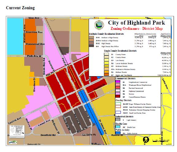
19 Proposed Zoning Map Amendments Proposed map amendments implement the proposed text amendments in certain locations PC recommendation nearly identical to Lakota Study Except 1660 First Street (Sheridan Square condo) recommended to retain in RO zoning district as opposed to change this property to B4-5
20
21 Plan Commission Recommended Zoning Map
22 Proposed Zoning Alternatives for First Street Lakota Recommendation: B4-5 Staff recommendation: Retain RO zoning PC Recommendation: Accept Lakota team recommendation:b4-5
23 Future Connectivity & Frontage Classification Map Road extensions need to create development blocks with multisided access Glenview; Homewood and Park Ave. from Green Bay to First St. New Roadway connecting Park Ave. and Central Ave. Provide for improved connectivity Alignments are illustrative and not final but do provide a trigger for Planned Development Review

24 RO District Amendments

25 B4 District Amendments

26 B5 District Amendments
27 Background Slides Additional information previously presented to City Council and Plan Commission
28 Lakota Study Identified five (5) zoning constraints to achieving the City s preferred vision for the Central District: 1. Residential densities are too low 2. Permitted building heights are too low to accommodate desired density 3. Off-street parking requirements are too high 4. Planned development thresholds make mixed-use development more difficult 5. Lack of controls to communicate and achieve desired urban form.
29 Plan Commission & City Council Process Plan Commission Oct 15 th, 2013 opens its public hearing May 6 th makes findings of fact and recommendation to City Council City Council consideration of Plan Commission recommendation Note the Administration does not expect the City Council to vote on this matter tonight. Next steps, if approved: City Council directs corporation counsel to prepare ordinances City Council final action on proposed zoning map and text amendments
30 Community Planning Process This proposal is the culmination of a multiyear process that began in : Community Open House, Roundtables and Visioning Process & Vision Statement : Lakota Group consulting team develops Central District Study Feb. 2013: Final report submitted to City and POA June 2013: Committee of the Whole Oct Mar. 2014: Public Hearings on proposed amendments at Plan Commission
31 Outline of Proposed Changes by Article The proposed amendments make changes to seven Articles and introduce a new Article to the Zoning Code, Article XXIII Downtown Form and Design Changes to Articles I General and XX Signs are merely references to new B4 sub-district designations proposed.
32 Article II Interpretations and Definitions The proposed changes to this Article: Introduce definitions for Auto-Oriented Use, Car- Share Program, Downtown Frontage Map, Downtown Future Connectivity Map, Height Maximum, Neighborhood Frontage, Pedestrian Frontage, and Vehicular Frontage Revise the definition for maximum height to provide more architectural flexibility for roof lines.
33 Changes to Definition of Max Height in RO, B4-4, B4-5, B4-6 and B5 Zoning Districts To provide more architectural flexibility for roof lines, the definition of maximum height is proposed to be changed. The proposed amendment measures the vertical distance measured from grade to the top of the coping or parapet on buildings with a flat or nearly flat roof, to the eave of buildings with a peaked roof, or to the deck line of buildings with a mansard roof. This change in the way height is measured will allow for building roof height to exceed the height limitations found in the Zoning Code (see graphic).
34 Building Height Illustration To be inserted
35 Article IV Regulations for Permitted and Conditional Land Uses The proposed changes to this Article: Remove the B4 zoning district from the Table of Allowable Uses and introduces three new zoning districts, B4-4 B4-5 and B4-6 in its place. The uses permitted in these new zoning districts mirror the uses currently permitted in B4 Zoning Districts.
36 Article V Planned Development Changes proposed introduce, modify and eliminate Planned Development thresholds to encourage walkable, mixed-use development and allow larger developments by-right provided they conform with the proposed downtown form and design standards.
37 Article V Planned Development Height Mitigation Design Standards: Changes to this article introduce design standards regarding upper-story building design for new building and building additions that exceed the non-planned development height, for RO, B4-4,B4-5,B4-6 or B5 Zoning Districts Requires step-backs to mitigate the perception of height by pedestrians. Proposed Changes to Existing Thresholds for Select Districts: Increases the existing gross floor area trigger for new developments from 10,000 SF to 50,000 SF. This will allow larger developments by-right provided the they meet all other requirements and design standards.
38 Article V Planned Development Proposed New Thresholds for Select Districts: Nonresidential development or additions that provide more than an avg. of 3.33 parking spaces/1,000 SF GFA exception that required parking for restaurant uses is not included in the calculation. Any auto-oriented use with driveway access onto a pedestrian frontage or neighborhood frontage. Any development in B5 Districts that includes auto-oriented use. Any new principal building in B4-4,B4-5,B4-6 & B5 Districts that: does not comply with the minimum height or exceeds the maximum asof-right height limits by district. Any development that would preclude the opportunity to make a connection shown in the Downtown Connectivity Map.
39 Article V Planned Development Proposed Threshold to be Eliminated: The mixed use trigger is proposed to be eliminated since, consistent with the vision for the Central District, it is hoped that future development in the Central District will be pre-dominantly mixed use.
40 Article VII Area, Bulk and Density In an effort to capture a growing market for downtown living and to encourage economic development, the proposed changes to this Article allow for: Significantly greater development density byright. Increases maximum density from 15 du/ac to du/ac depending on zoning district Taller buildings by-right and additional height beyond that through planned development consideration.
41 Article VII Area, Bulk and Density Changes to this Article also: Introduce a minimum building height requirement of two stories for B4-4 and B5 Zoning Districts and three stories for B4-5 and B4-6 districts. Regulate all developments within B4-5 and B4-6 that do not meet the minimum lot area requirements in accordance with the proposed requirements for B4-4.
42 Article VIII Off-Street Parking & Loading The proposed changes to this Article: Reduce overall parking requirements for residential and many non-residential uses (not Hotels and Restaurants) Provides off-street parking exemption for first 2,000 SF of Gross Floor Area (building) Provide modest additional parking relief for developments that include reserved parking for carshare vehicles, valet parking, long-term bicycle parking, and permits electric vehicle charging stations to be counted toward off-street parking requirements Introduce design standards for parking structures in RO, B4 and B5 zoning districts to minimize the aesthetic impact of structured parking on abutting streets
43 Article XXIII Downtown Form & Design This entirely new Article: Introduces form and design standards to ensure good urban design for all development along designated streets within the RO, B4-4, B4-5, B4-6 and B5 zoning districts.
44 Article XXIII Downtown Form and Design Introduces building form and design requirements that are applicable within the B4-4, B4-5, B4-6, B5 and RO Zoning Districts in the following cases: (1) all new buildings; and (2) renovations of, or additions to, existing buildings that result in an increase of 50% or more in the building s gross floor area.

45 1660 First St. Retain RO (Zoning Per Plan Comm.)
46 Visioning Process: Public participation facilitated through community opinion surveys, an open house and a series of facilitated, issue-based, roundtable discussions about zoning and urban design. Roundtable Themes Creating a Vibrant Downtown Promoting Commerce and Service Advancing a Sustainable Downtown Assuring a Well Functioning Downtown
47 Vision Statement Downtown Highland Park will be a vibrant, easily accessible and sustainable place for people to live, work and engage in commerce, cultural arts and entertainment activities. Future planning and development will promote the Downtown pedestrian and historic character, and adapt to ongoing challenges and opportunities.
48 Visioning Strategic Objectives Evaluate the B4 zoning requirements to facilitate office, residential and mixed-use development Promote residential use in B4 & B5 zones through increased density and additional building height Provide better building design guidance through form based zoning regulations and design guidelines Encourage land assembly where appropriate for residential and mixed-use developments in the Downtown. Build on the pedestrian and transit-oriented character of Downtown

49 Lakota Group Team Project Study Area

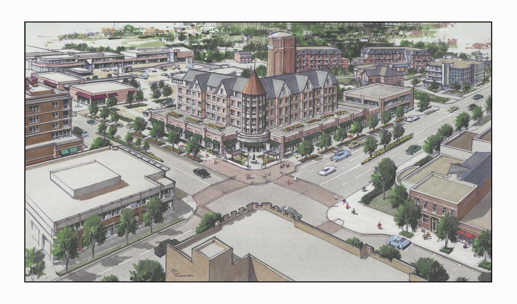
50 Vision Plan: North Triangle Elm Place; Green Bay Road & First Street Total Area: 11.3 ac DU: 354 Comm Space: 90,000 s.f. Hotel Rooms: 55 Overall Density: 31 du/ac

51 South Green Bay Road

52 Vision Plan: Sunset Park/ Green Bay Rd West Area Total Area: 21 ac DU: 338 Comm Space: 260,500 s.f. Hotel Rooms: 120 Overall Density: 15 du/ac
53
54 Development Constraints
 B4 and B5 permitted density most suited to townhouse developments (14.")
55 Development Constraints (Permitted Density is Too Low to Establish a Residential Downtown) B4 and B5 permitted density most suited to townhouse developments (14.5 du/acre)


56 Development Constraints (Building Height Requirements Do Not Promote Good Building Design and Inhibit Residential Density
57 Development Constraints (Parking Requirements are Too High) Existing parking requirements 1.25 to 3 space per dwelling unit 3.3 to 4 spaces per 1,000 square feet of commercial space (higher for restaurants) Off-street parking is expensive to provide per space Requiring too much parking inhibits achieving the City s vision Off-Street Parking rates are a minimum requirement; sufficient to accommodate most parking demand, not peak day of year demand
58 Development Constraints Parking Requirements are Too High City should maximize within its power the efficient use of all existing private and public parking Private sector has a vested interest in self-provided private off-street parking to meet its market demands The City will need to identify opportunities to increase on-street and off-street public parking in centralized locations where it does not presently exist
59 Development Constraints Planned Development Thresholds The zoning ordinance s current planned development thresholds run counter to the preferred visions Current ordinance works to discourage mixed-use projects or building over 10,000 sq ft by requiring PD PD review should be used to provide extra scrutiny for projects that work against the City s goal of a denser, more pedestrian-friendly Central District
60 Development Constraints Lack Of Urban Form Controls The existing zoning ordinance does not include guidelines or regulations to promote or ensure the provision of these vital urban form elements. The vision for the main B4 areas of downtown identify the need for ensuring high-quality streetscapes, well-designed buildings at the sidewalk level and other traditional urban form elements.
61 Downtown Form Regulation

62 Future Connectivity & Frontage Classification Map Road extensions need to create development blocks with multi-sided access Glenview; Homewood and Park Avenue from Green Bay to 1st St. New Roadway connecting Park Avenue and Central Avenue Provide for improved connectivity Alignments are illustrative and not final
63 Downtown Form Guidelines Areas of building form controls include: Build-to-Zones (the area on the lot where a certain percentage of the front building facade must be located, measured as a minimum and maximum setbacks Building Transparency (govern the percentage of a streetfacing building façade that must be covered by glazing (e.g., transparent windows and doors) Blank Wall Area (areas on the exterior facade of a building that do not include a substantial material change; windows or doors; columns, pilasters or other articulation) Street-Facing Building Entrances (Required street-facing building entrances must provide ingress and egress for residents and customers, Additional entrances off another street, pedestrian area or internal parking area are also permitted)

64 Pedestrian Frontage Streets Downtown s primary pedestrian-shopping streets where the highest level of walkability is expected and desired. Buildings are pulled up to the front property line Buildings are designed to promote pedestrian interest, comfort and safety.

65 Vehicular Frontage Streets Streets that generally carry the greatest volumes of traffic at higher speeds than along other downtown streets. Higher speed requires wider parkway/sidewalk, and greater building setback The regulations allow greater flexibility in terms of building location and site design.

66 Neighborhood Frontage Streets Downtown streets that are not classified as pedestrian or vehicular streets. Streets typically include a mix of residential and nonresidential building types Regulations allow flexibility in terms of building location and site design.
67 Proposed Zoning Map Amendments Proposed Map Amendments implement the proposed text amendments PC recommendation nearly identical to Lakota team recommendations Except 1660 First Street (Sheridan Square condo retained in RO zoning district as opposed to B4-5)
68

69 Proposed Zoning

70 First Street Lakota Recommendation: B4-5 Staff recommendation: Retain RO zoning PC Recommendation: Accept Lakota team recommendation:b4-5


71 RM1 to RM2 Zoning Change Existing uses are already legal nonconforming Area rezoned to RM1 in Glenview Ave; Homewood Ave; Green Bay Rd
72 Recommendation The Department of Community Development respectfully recommends that the City Council consider the findings of fact and recommendation of the Plan Commission and direct Corporation Counsel to prepare ordinances amending the text and map of the Highland Park Zoning Code pertaining to regulations for areas located in the City s Central District.
73 City Council Consideration of Findings of Fact Related to Proposed Zoning Map and Text Amendments for the Central District City Council July 14, 2014
74 Additional Slides Previously used at Plan Commission public hearings
75 Article VII: Lot Area Current HP Code Recommendati on. R0 21,780 s.f. 21,780 s.f. B4 No min. lot area na B4-4 na No min. B4-5 na 15,000 (1) B4-6 na 25,000 (1) B5 No min. B5: no min lot area but more density and ht when lot is >15,000 (1) Lots with less lot area than required will be subject to the B4-4 requirements.
76 Article VII: Residential Density Current HP Code Recommendatio n R0 50 du/ac 50 du/ac B4 15 du/ac na B4-4 na 50 du/ac B4-5 na 65 du/ac B4-6 na 81 du/ac B5 No min. B5: du/ac based on lot size
77 Article VII: Building Height Current HP Code Recommendation. R0 45 feet 4 stories/50 ft B4 3 stories/40 ft na B4-4 na 4 story & 51 ft 4 story & 51 ft (PD) B4-5 na 4 story & /51 ft 5 story and 63 feet (PD) B4-6 na 4 st/51 ft 6 story & 75 ft (PD) B5 3 story & 40 ft 4 story & 50 ft (PD) Less than 15,000 s.f. 4 story & 51 ft 4 story & 51 ft (PD) 15,000 or more s.f. 4 story & 51 feet 5 story & 63 feet (PD)
78 Article VII: Historic & Proposed Building Ht. Restrictions District 1968 Code 1978 Code 1997 Code Consultant Proposal Staff Proposal RO (was F Multi-Family of H Central Business Dist in 1968) 35 ft 45 ft 45 ft 4 stories/50 ft 5 stories w/pud 4 stories/50 ft 5 stories w/pd * B4 (H-1 Business in 1968 Code) 3 stories/45 ft 45 ft. 3 stories/40 ft 4 stories/45 ft (w/pud) B4-4: 3/45 (4/PD) B4-5: 4/45 (5/PD) B4-5: 5/45 (6/PD) 4 story/50 feet with increases to 6 stories per intensity district w/pd B5 (H Central Business in 1968 Code) 3 stories/45 ft 60 ft 3 stories/40 ft 4 stories/50 ft (w/pud) B5-4: 3/45 (/PD) B5-5: 4/45 (5/PD) 4 story/50 feet with increases to 5 stories when it >15,000 sq ft in PD
79 ARTICLE VIII: OFF-STREET PARKING AND LOADING Proposed changes based on: Transit-oriented nature of downtown Philosophy that downtown parking issues are best addressed as an overall district, rather than parcel-by-parcel. Approach promotes a park-once approach, treating the entire downtown area much like a large shopping center. Parking requirements are minimums. Developers can provide additional offstreet parking (w/in limits) to match their development needs.
80 1770 First Street - Optima Building 7 Stories - 70 Feet
81 513 Central Chase Bank Building 5 Stories - 64 Feet

82 Sunrise Assisted Living 4 Stories - 50 Feet
83 Article VIII: Retail and Service Parking Requirements Current Requirements Retail and Office: spaces/1,000 s.f. Restaurant: 10.8 spaces/1,000 s.f. Proposed Requirements None for first 2,000 s.f.; then 2.5/1,000 s.f. No change proposed for Medical Offices; Hotels
84 Article VIII: Off-Street Parking & Loading (MF Residential) Land Use Multiple Family Dwellings in RO, B4 and B5 Dwellings above first floor of only retail or office in RO, B4 and B5 Dwellings as Part of a Planned Development Residential Guest Parking in RO, B4 and B5 Non- planned development and planned development Current Highland Park Code Parking Spaces Studio 1.25/du One bedroom 1.5/du Two or more 2 In addition, Guest Parking shall be required as specified in the Table of Guest Parking Requirements One per residential unit No guest parking requirement Studio 1.25/du One bedroom 1.5/du Two or more 2 In addition, Guest Parking shall be required as specified in the Table of Guest Parking Requirements 0.25/du if > 5 units 0.5/du if < 4 units Staff Recomm. The greater of 1.4 parking spaces per dwelling unit or the amount calculated using the following parking rates: 0 to 999 s.f. = 1/du 1,000 1,699 s.f. = 1.5/du 1,700 s.f. or larger = 2/du No change from consultant recomm.
85 Retail and Service Parking Land Use General retail sales and related service uses in the RO, B4 and B5 Zoning Districts Personal services establishments and custom craft uses in the RO, B4 and B5 Zoning Districts Current Highland Park Code Parking Spaces Typically 3.3/1,000 sq ft Gross Floor Area (GFA) [ Recommendation None for first 2,000 sq. ft. 2.5/1,000 s.f. Typically None for first 2,000 sq. ft /1,000 sq ft GFA [ spaces/1,000 sq. ft. Food product uses in the RO, B4 and B5 Zoning Districts Typically 3.3/1,000 sq ft GFA None for first 2,000 sq. ft. 2.5 spaces/1,000 sq. ft. This exemption is only applicable one time per development and is not applied per building in a multi-building development or per tenant multi-tenant Food and beverage service uses in the B4 and B5 Zoning Districts Financial Uses in the RO, B4 and B5 Zoning Districts Range from 4 20 spaces/1,000 sq ft GFA Restaurants = 10.8/1,000 sq ft GFA Typically 2.5-4/1,000 GFA None for first 2,000 sq. ft. B4: 4 20 spaces/1,000 s.f. B5: 2.5 spaces/1,000 s.f. None for first 2,000 sq. ft. 2.5 spaces/1,000 sq. ft. building. Business Service Uses in the RO, B4 and B5 Zoning Districts Typically 2.5-4/1,000 GFA None for first 2,000 sq. ft. 2.5 spaces/1,000 sq. ft.
86 Article VIII: Parking Analysis for North Triangle and Sunset Park Development Areas Assumes build-out to the parameters of the Lakota Vision Plans; not maximum potential density Compares current Multi-Family and Business/Service Rates to proposed rates Incorporates no off-street parking for first 3,000 s.f. of building for each development site
87 North Triangle Parking Analysis Current and Proposed Parking Regulations Proposed Land Use Off-Street Parking Required Under Current Zoning Rates [1] Off-Street Parking Required Under Proposed Zoning Rates Parking Differential' Site B Site C 5 Story Hotel (55 Rooms) w/5,000 s.f. Restaurant Mixed-Use Redevelopment - 5,000 sq. ft retail w/20 du above Site D Site F Site G Site H 4 Mixed Use Buildings including 42,000 s.f. retail; 34,500 s.f. office service and 170 du 4 Residential Buildings w/100 du plus guest 2 Residential Buildings w/52 du and 12 TH plus guest 3,600 s.f. office/service building Total all proposed land uses
88 Sunset Park Vision Plan Parking Analysis Current and Proposed Parking Regulations Proposed Land Use Off-Street Parking Required Under Current Zoning Rates [1] Off-Street Parking Required Under Proposed Zoning Rates Parking Differential Site A Site C 5 Story Mixed Use: 7,500 s.f. service/office w/32 du 5 Story Mixed Use: 4,000 s.f. service/office w/24 units Site D Hotel Use; 25,000 s.f. conference space & 120 rooms 120 plus parking for conference space 120 plus parking for conference space 0 Site E Site G 5 Story Mixed Use: 4,000 s.f. retail w/22 units 6 Story Mixed Use: 9,000 s.f. retail w/60 units Site I 15,000 sq. ft service/office Site J Mixed Use Retail 50,000 s.f. (Grocery) and 33,000 s.f. Office Site K 110 multi-family du Site L 16 Townhouses Total all proposed land uses 1,
89 Estimated Student and Total Population Generation for Main Sub-Areas Lakota Zoning Plan* North Triangle Pre- School Student s Grades K - 8 Student s High School Students Adults Total Unit Type Total # 35 4 MF Apt/Condo 34 2 Est. Studio Est. 1 BR Est. 2 BR Est. 3 BR Townhouse 12 Est. 2 BR Est. 3 BR Est. 4 BR Sunset Park District Unit Type Total # 23 4 Studio BR BR BR
90 New Article XXIII Downtown Form and Design Purpose and Applicability Maintain and enhance the transit-oriented, walkable character of downtown Highland Park Proposed for B4, B5 and RO zoning districts to all new buildings Also to renovations of, and additions to, existing buildings that result in an increase of 50% or more of building s gross floor area Form and design regulations govern in the event of conflict with the area, bulk and density regulations of Article VII Provide differing regulations based on the nature of the street Frontage Classification on which the building is located (Pedestrian, Vehicular, Neighborhood)
91 Issues Related to Roadway Extensions The inclusion of the future roadway extensions is similar to designating future land use in the City s Master Plan; the community is then aware of future transportation network needs Not all of the roadways may be necessary to achieve the connectivity and block-shape goals illustrated in The Lakota Group design illustrations The implementation of the roadway extensions will be redevelopment driven- discussions for alignment will begin at the time of a development proposal Alignments are illustrative and not final; they can be adjusted Proposed development on or abutting the proposed roadways will be required to go through the Planned Development process Additional building setbacks will be imposed abutting these proposed roadways The roadways may be public or private or even developed as jointly shared parking lots with through-connections There may be opportunities to develop the roadways along property lines so that impacts are limited

92 Lot Sizes in Areas Proposed for Rezoning in B4 Areas
93
94 New B4 Zoning District Concepts & B5 Regulations B4 and B5 zoning districts currently allow 15 du/ac Eliminate the B4 zoning district and establish three new density & height alternatives: B4-4: 50 du/ac; 4 story & 51 ft. B4-5: 65 du/ac; 4 story & 51 ft. (5 story & 63 ft w/pd) B4-6: 81 du/ac; 4 story & 51 ft. (6 story & 75 w/pd) B5 Central Business District: 0-14,999 SF Lot Area: 50 du/ac; 4 story & 51 ft 15,000 SF (lot area) and up square feet of Lot Area: 65 du/ac; 4 story & 51 feet (5 story & 63 ft w/pd)
COMMISSION ACTION FORM SUBJECT: ZONING TEXT AMENDMENT FOR LINCOLN WAY CORRIDOR PLAN DOWNTOWN GATEWAY COMMERCIAL ZONING DISTRICT STANDARDS
 ITEM #: 7 DATE: _02-07-18 COMMISSION ACTION FORM SUBJECT: ZONING TEXT AMENDMENT FOR LINCOLN WAY CORRIDOR PLAN DOWNTOWN GATEWAY COMMERCIAL ZONING DISTRICT STANDARDS BACKGROUND: The Downtown Gateway area
Puyallup Downtown Planned Action & Code Changes. January 10, 2017
 Puyallup Downtown Planned Action & Code Changes January 10, 2017 Purpose & Location Purpose Promote economic development and downtown revitalization Tools: Municipal Code amendments Change development
MERIDEN TOD A NEW TRANSIT-ORIENTED DEVELOPMENT DISTRICT ZONING REGULATION FOR MERIDEN. Greater Meriden Chamber & Connecticut Bar Association
 A NEW TRANSIT-ORIENTED DEVELOPMENT DISTRICT ZONING REGULATION FOR MERIDEN PRESENTATION TO Greater Meriden Chamber & Connecticut Bar Association 25 September 2013 Dominick J. Caruso, AICP Director of Planning
Poughkeepsie City Center Revitalization Plan
 Purpose and Need Purpose Increase job and educational opportunities for all residents Maximize fiscal productivity of downtown land uses Diversify retail mix Eliminate surface and building vacancies Create
DEVELOPMENT STANDARDS FOR RESIDENTIAL PROJECTS RESIDENTIAL BUILDING TYPES: APPROPRIATE ZONES AND DENSITIES 2-1
 2 DEVELOPMENT STANDARDS FOR RESIDENTIAL PROJECTS RESIDENTIAL BUILDING TYPES: APPROPRIATE ZONES AND DENSITIES 2-1 This Chapter presents the development standards for residential projects. Section 2.1 discusses
TRANSIT-ORIENTED DEVELOPMENT PLAN EXISTING CONDITIONS REPORT LAWRENCE TO BRYN MAWR MODERNIZATION
 TRANSIT-ORIENTED DEVELOPMENT PLAN EXISTING CONDITIONS REPORT LAWRENCE TO BRYN MAWR MODERNIZATION March 2018- FINAL DRAFT SITE SPECIFIC DEVELOPMENT CONCEPTS SITE SPECIFIC DEVELOPMENT CONCEPTS This report
COMMERCIAL AND MIXED USE zones COMMERCIAL AND MIXED USE ZONES. Zoning By-law PLANNING & ECONOMIC DEVELOPMENT PLANNING DEPARTMENT DIVISION
 Zoning By-law 05-200 COMMERCIAL AND MIXED USE zones PLANNING & ECONOMIC DEVELOPMENT PLANNING DEPARTMENT DIVISION CONTENTS CONTEXT... 1 URBAN HAMILTON OFFICIAL PLAN... 2 COMMERCIAL AND MIXED USE ZONES...
Article 3. SUBURBAN (S-) NEIGHBORHOOD CONTEXT
 NEIGHBORHOOD CONTEXT") Article 3. SUBURBAN (S-) NEIGHBORHOOD CONTEXT this page left intentionally blank Contents ARTICLE 3. SUBURBAN (S-) NEIGHBORHOOD CONTEXT DIVISION 3.1 NEIGHBORHOOD CONTEXT DESCRIPTION...3.1-1 Section 3.1.1
Article 3. SUBURBAN (S-) NEIGHBORHOOD CONTEXT this page left intentionally blank Contents ARTICLE 3. SUBURBAN (S-) NEIGHBORHOOD CONTEXT DIVISION 3.1 NEIGHBORHOOD CONTEXT DESCRIPTION...3.1-1 Section 3.1.1
DRAFT FOR DISCUSSION PURPOSES ONLY. Port Credit Local Area Plan Built Form Guidelines and Standards DRAFT For Discussion Purposes
 Port Credit Local Area Plan Built Form Guidelines and Standards DRAFT For Discussion Purposes 1 Local Area Plan - Project Alignment Overview Directions Report, October 2008 (General Summary Of Selected
Policy Issues City of Knoxville Zoning Code Update
 Policy Issues City of Knoxville Zoning Code Update ADU's (Accessory Dwelling Units) The draft zoning ordinance update permits ADU s as an accessory use in all single-family residential zoning districts.
MONROE WARD REZONING SUMMARY. October 2018
 MONROE WARD REZONING SUMMARY October 2018 WHY IS THE CITY REZONING MONROE WARD? In July of 2017 Richmond City Council adopted The Pulse Corridor Plan, a corridor-long planning document that outlines steps
Ann Arbor Downtown Zoning Evaluation
 Ann Arbor Downtown Zoning Evaluation Options Workbook ENP & Associates in cooperation with the City of Ann Arbor September, 2013 Photo Courtesy of Andrew Horne, February 9, 2013 Introduction Thank you
Goal 1 - Retain and enhance Cherry Creek North s unique physical character.
 Introduction This document summarizes the proposed new zoning for the area of roughly bordered by University Boulevard, Steele Street, 3rd Avenue, and 1st Avenue. It provides a high-level review of the
4 DEVELOPMENT STANDARDS FOR
 4 DEVELOPMENT STANDARDS FOR RESIDENTIAL MIXED-USE PROJECTS This chapter presents standards for residential mixed-use projects in the Ashland-Cherryland Business District and the Castro Valley Central Business
Chapter MIXED USE ZONING DISTRICTS
 Page 1 of 12 Page 1/12 Chapter 17.18 MIXED USE ZONING DISTRICTS Sections: 17.18.010 Purposes. 17.18.020 Permitted, conditional and prohibited uses. 17.18.030 Bulk, 17.18.010 Purposes. A. Mixed Use Districts.
City Avenue District Rezoning. Regional Center Area & Bala Cynwyd Retail District December 14, 2011 Public Hearing
 City Avenue District Rezoning Regional Center Area & Bala Cynwyd Retail District December 14, 2011 Public Hearing Board of Commissioners Agenda Public Hearings An Ordinance to create The City Avenue District,
City of Coral Gables Planning and Zoning Staff Report
 City of Coral Gables Planning and Zoning Staff Report Applicant: Application: Public Hearing: Date & Time: Location: City of Coral Gables Giralda Restaurant Row Overlay Zoning Code Text Amendment Planning
Waikïkï Special District Amendments 2010 Initiative
 Waikïkï Special District Amendments 2010 Initiative Eliminate the Resort Commercial Precinct and merge it with the Resort Mixed Use Precinct Merger of the two precincts conforms to the intent of the Waikïkï
Attachment 5 - Ordinance 3154 Exhibit D (Revised for 9/15 Council Meeting) Page 1 of 7 Port Townsend Municipal Code. Chapter 17.18
 Page 1 of 7 Port Townsend Municipal Code. Chapter 17.18") Page 1 of 7 Page 1/7 Chapter 17.18 MIXED USE ZONING DISTRICTS Sections: 17.18.010 Purposes. 17.18.020 Permitted, conditional and prohibited uses. 17.18.030 Bulk, 17.18.010 Purposes. A. Mixed Use Districts.
Page 1 of 7 Page 1/7 Chapter 17.18 MIXED USE ZONING DISTRICTS Sections: 17.18.010 Purposes. 17.18.020 Permitted, conditional and prohibited uses. 17.18.030 Bulk, 17.18.010 Purposes. A. Mixed Use Districts.
Salem HNA and EOA Advisory Committee Meeting #6
 Salem HNA and EOA Advisory Committee Meeting #6 Residential Land Policies Employment Land Policies Policy Discussions with the Committee Outcome of today s meeting Direction from this Committee on proposed
Composition of traditional residential corridors.
 Page 1 of 7 St. Petersburg, Florida, Code of Ordinances >> PART II - ST. PETERSBURG CITY CODE >> Chapter 16 - LAND DEVELOPMENT REGULATIONS >> SECTION 16.20.060. CORRIDOR RESIDENTIAL TRADITIONAL DISTRICTS
PUBLIC REVIEW DRAFT OF OFF-STREET PARKING PROPOSAL CITY OF OAKLAND PLANNING DEPARTMENT OCTOBER 2015
 PUBLIC REVIEW DRAFT OF OFF-STREET PARKING PROPOSAL CITY OF OAKLAND PLANNING DEPARTMENT OCTOBER 2015 1. Downtown Parking Minimums Problem: The current regulations do not prescribe a minimum amount of required
MEMORANDUM. I1 District Industrial Living Overlay District 110,703 square feet / 2.54 acres
 Department of Community Planning & Economic Development 250 South 4th Street, Room 300 Minneapolis, MN 55415-1385 MEMORANDUM To: City Planning Commission, Committee of the Whole Prepared By: Peter Crandall,
Chapter DOWNTOWN ZONING DISTRICTS
 Chapter 20.14 Sections: 20.14.010 Purpose of the Downtown Zoning Districts 20.14.020 Land Use Regulations for Downtown Zoning Districts 20.14.030 Development Standards for Downtown Zoning Districts 20.14.010
Chapter URBAN VILLAGE ZONING DISTRICTS
 Chapter 20.16 Sections: 20.16.010 Purpose of the Urban Village Zoning Districts 20.16.020 Land Use Regulations for the Urban Village Zoning Districts 20.16.030 Development Standards & Guidelines for the
Appendix A: Guide to Zoning Categories Prince George's County, Maryland
 Appendix A: Guide to Zoning Categories Prince George's County, Maryland RESIDENTIAL ZONES 1 Updated November 2010 R-O-S: Reserved Open Space - Provides for permanent maintenance of certain areas of land
COMMERCIAL ZONING DISTRICTS (Amended 11/13/14) Part I. C-1 Restricted Commercial District
 Part I. C-1 Restricted Commercial District") ARTICLE XI. COMMERCIAL ZONING DISTRICTS (Amended 11/13/14) Part I. C-1 Restricted Commercial District Section 152: Purpose This district is designed to accommodate commercial uses which act as a transition
ARTICLE XI. COMMERCIAL ZONING DISTRICTS (Amended 11/13/14) Part I. C-1 Restricted Commercial District Section 152: Purpose This district is designed to accommodate commercial uses which act as a transition
Chapter 17-2 Residential Districts
 Chapter 17-2 Residential Districts 17-2-0100 District Descriptions...2-1 17-2-0200 Allowed Uses...2-2 17-2-0300 Bulk and Density Standards...2-5 17-2-0400 Character Standards...2-18 17-2-0500 Townhouse
Compatible-Scale Infill Housing (R-2 Zones) Project
 Project") Project Scope: A targeted amendment to the regulations for building bulk/height in the R-2 zones. Objectives: Allow more housing opportunities in the R-2A, R-2D, and R-2M zones, while ensuring the height
Project Scope: A targeted amendment to the regulations for building bulk/height in the R-2 zones. Objectives: Allow more housing opportunities in the R-2A, R-2D, and R-2M zones, while ensuring the height
ARTICLE 5. COMMERCIAL AND OFFICE DISTRICTS 5.1 PURPOSE STATEMENTS 5.2 USES 5.3 DIMENSIONAL STANDARDS 5.4 DESIGN STANDARDS 5.5 DK DISTRICT STANDARDS 5
 ARTICLE 5. COMMERCIAL AND OFFICE DISTRICTS 5.1 PURPOSE STATEMENTS 5.2 USES 5.3 DIMENSIONAL STANDARDS 5.4 DESIGN STANDARDS 5.5 DK DISTRICT STANDARDS 5.6 CU DISTRICT STANDARDS 5.7 SW DISTRICT STANDARDS THE
UPDATE Board of Selectmen June 20, 2017
 MAPLE STREET I-1 AREA DRAFT ZONING BYLAW & DEVELOPMENT STANDARDS Town of Danvers, MA UPDATE Board of Selectmen June 20, 2017 The Danvers Team: Brovitz Community Planning & Design Dodson & Flinker Danvers
PLANNING AND DEVELOPMENT DEPARTMENT STAFF REPORT STAFF REPORT PREMIER AUTO SERVICES, INC. VARIANCES
 PLANNING AND DEVELOPMENT DEPARTMENT STAFF REPORT Meeting Date: February 14, 2019 Item #: PZ2019-402 STAFF REPORT PREMIER AUTO SERVICES, INC. VARIANCES Project Name: Premier Auto Services, Inc. Applicant:
Technology Park Planned Unit Development Technology Park PUD-IP
 Technology Park Planned Unit Development Technology Park PUD-IP Rob Anderson Community Development Director Planned Unit Development Background 2 Planned Unit Development (PUD) means a mixed use redevelopment
Plan Dutch Village Road
 Plan Dutch Village Road Objective: The lands around Dutch Village Road are a minor commercial area that services the larger Fairview community. Maintaining the vibrancy of the area by planning for redevelopment
LITTLE MOUNTAIN ADJACENT AREA REZONING POLICY
 LITTLE MOUNTAIN ADJACENT AREA REZONING POLICY JANUARY 2013 CONTENTS 1.0 INTENT & PRINCIPLES...1 2.0 APPLICATION...2 3.0 HOUSING TYPES, HEIGHT & DENSITY POLICIES...3 3.1 LOW TO MID-RISE APARTMENT POLICIES...4
Appendix1,Page1. Urban Design Guidelines. Back to Back and Stacked Townhouses. DRAFT September 2017
 Appendix1,Page1 Urban Design Guidelines DRAFT September 2017 Back to Back and Stacked Townhouses Appendix1,Page2 Table of Contents 1 Introduction 1 1.1 Purpose 1 1.2 Urban Design Objectives 1 1.3 Building
Oak Cliff Gateway District PD 468
 Oak Cliff Gateway District PD 468 August 21, 2014 2013 Authorized Hearing Authorized Hearing September, 2013 September 12, 2013 City Plan Commission expanded boundaries to represent current Oak Cliff Gateway
Chapter 5: Testing the Vision. Where is residential growth most likely to occur in the District? Chapter 5: Testing the Vision
 Chapter 5: Testing the Vision The East Anchorage Vision, and the subsequent strategies and actions set forth by the Plan are not merely conceptual. They are based on critical analyses that considered how
City of Valdosta Land Development Regulations
 Chapter 206 Section 206-1 Base Zoning Districts Standards for Uses, Structures, and Property Development (B) (C) Principal Uses and Structures. Principal uses and structures permitted in each base zoning
From Policy to Reality
 From Policy to Reality Updated ^ Model Ordinances for Sustainable Development 2000 Environmental Quality Board 2008 Minnesota Pollution Control Agency Funded by a Minnesota Pollution Control Agency Sustainable
The Corporation of the District of Central Saanich
 The Corporation of the District of Central Saanich COMMITTEE OF THE WHOLE REPORT For the Committee of the Whole meeting on November 28, 2016 To: Patrick Robins Chief Administrative Officer File: From:
CITY OF KAMLOOPS BYLAW NO A BYLAW TO AMEND THE ZONING BYLAW OF THE CITY OF KAMLOOPS
 67 68 CITY OF KAMLOOPS BYLAW NO. 5-1-2796 A BYLAW TO AMEND THE ZONING BYLAW OF THE CITY OF KAMLOOPS The Municipal Council of the City of Kamloops, in open meeting assembled, enacts as follows: 1. This
Central Business District Core Ordinance
 Central Business District Core Ordinance July 2, 2013 Urban Districts Map, Pembroke SGA CBC District Map (tentative) BACKGROUND 11/09 - Pembroke SGA Plan adopted. Goal: Encourage urban-style development
PLANNING COMMISSION REPORT Regular Agenda -Public Hearing Item
 PDP-13-00518 Item No. 3B- 1 PLANNING COMMISSION REPORT Regular Agenda -Public Hearing Item PC Staff Report 2/24/14 ITEM NO. 3B PRELIMINARY DEVELOPMENT PLAN FOR HERE @ KANSAS; 1101 INDIANA ST (SLD) PDP-13-00518:
3804 Wilson Boulevard (Staples Site) Special General Land Use Plan Study
 Special General Land Use Plan Study") 1 3804 Wilson Boulevard (Staples Site) Special General Land Use Plan Study Long Range Committee of the Planning Commission Meeting May 16, 2018 Department of Community Planning, Housing and Development
1 3804 Wilson Boulevard (Staples Site) Special General Land Use Plan Study Long Range Committee of the Planning Commission Meeting May 16, 2018 Department of Community Planning, Housing and Development
ARTICLE OPTIONAL METHOD REGULATIONS
 ARTICLE 59-6. OPTIONAL METHOD REGULATIONS DIV. 6.1. MPDU DEVELOPMENT IN RURAL RESIDENTIAL AND RESIDENTIAL ZONES SEC. 6.1.1. GENERAL REQUIREMENTS... 6 2 SEC. 6.1.2. GENERAL SITE AND BUILDING T PE MIX...
City of Coral Gables Planning and Zoning Staff Report
 City of Coral Gables Planning and Zoning Staff Report Applicant: Application: Public Hearing: Date & Time: Location: City of Coral Gables Zoning Code Text Amendment Giralda Plaza Overlay District Planning
Public Review of the Slot Home Text Amendment
 Public Review of the Slot Home Text Amendment The proposed amendments to the Denver Zoning Code have been informed by the Slot Home Strategy Report. This document has been developed out of a robust process
A APPENDIX A: FORM-BASED BUILDING PROTOTYPES
 A : A.1 Introduction Form-based prototypes are specific building types that are either encouraged or discouraged in historic multi-family residential or mixed-use neighborhoods. Their intent is to ensure
Division Development Impact Review.
 Division 51-4.800. Development Impact Review. SEC. 51-4.801. PURPOSE. The general objectives of this division are to promote and protect the health, safety, and general welfare of the public through the
Yonge Street and 3 Gerrard Street East - Zoning Amendment Application - Preliminary Report
 STAFF REPORT ACTION REQUIRED 363-391 Yonge Street and 3 Gerrard Street East - Zoning Amendment Application - Preliminary Report Date: May 22, 2015 To: From: Wards: Reference Number: Toronto and East York
Downtown Development Focus Area: I. Existing Conditions
 Downtown Development Focus Area: I. Existing Conditions The Downtown Development Focus Area is situated along Route 1, south of the train tracks, except for the existing Unilever property. It extends west
CAN TRADITIONAL ZONING ACHIEVE OUR GOALS FOR DOWNTOWN ANN ARBOR?
 TRADITIONAL ZONING TRADITIONAL ZONING CAN TRADITIONAL ZONING ACHIEVE OUR GOALS FOR DOWNTOWN ANN ARBOR? A dense, mixed use core with flexible land uses A range of housing types and costs A walkable, pedestrian-oriented
Item # 9 September 13, 2006
 Item # 9 September 13, 2006 Planning and Development Department Land Use Planning Division To: From: Planning Commission Allan Gatzke Principal Planner Memorandum Date: September 13, 2006 Subject: Housing
Staff recommends the City Council hold a public hearing, listen to all pertinent testimony, and introduce on first reading:
 CITY COUNCIL PUBLIC HEARING JANUARY 16, 2018 SUBJECT: INITIATED BY: MULTI-FAMILY NEIGHBORHOODS ZONE TEXT AMENDMENTS: AMEND MINIMUM DENSITY REQUIREMENTS FOR R3 AND R4 DISTRICTS; AMEND THE DENSITY BONUS
GETTING IT BUILT: OVERCOMING THE IMPLEMENTATION BARRIERS TO SMART GROWTH
 GETTING IT BUILT: OVERCOMING THE IMPLEMENTATION BARRIERS TO SMART GROWTH February 15, 2014 New Partners for Smart Growth Dena Belzer Challenges to Implementing Smart Growth The Typical Smart Growth Vision
Bunker Hill Part II Urban Design. Specific Plan. Case No. CPC SP TABLE OF CONTENTS
 Bunker Hill Part II Urban Design Specific Plan Case No. CPC-2011-684-SP TABLE OF CONTENTS Section 1. Section 2. Section 3. Section 4. Section 5. Section 6. Section 7. Section 8. Section 9. Section 10.
Proposed Transit Oriented Communities Affordable Housing Incentive Program Guidelines (TOC Guidelines)
") March 13, 2017 - Pg. 1 Proposed Transit Oriented Communities Affordable Housing Incentive Program Guidelines (TOC Guidelines) Implementing Section 6 of Measure JJJ, approved by the voters in November 2016,
March 13, 2017 - Pg. 1 Proposed Transit Oriented Communities Affordable Housing Incentive Program Guidelines (TOC Guidelines) Implementing Section 6 of Measure JJJ, approved by the voters in November 2016,
CITY OF CHARLOTTESVILLE DEPARTMENT OF NEIGHBORHOOD DEVELOPMENT SERVICES STAFF REPORT
 CITY OF CHARLOTTESVILLE DEPARTMENT OF NEIGHBORHOOD DEVELOPMENT SERVICES STAFF REPORT UPDATE: REQUEST FOR A ZONING TEXT AMENDMENT ZT15 00007: WEST MAIN STREET MIXED USE CORRIODRS AMENDMENT PLANNING COMMISSION
Planning Commission June 25, Lincoln Boulevard
 Purpose Float Up Review Inform Planning Commission and public about the proposed project concept; Opportunity to review and discuss the concept plans, and to provide feedback about the project design,
Accessory Coach House
 Updated July 2018 Accessory Coach House Development Permit Guidelines 1 Accessory Coach House Development Permit Guidelines Zoning Bylaw, 1995 DIVISION VII C. Contents Part I General Reglations 1 Introduction
Parking Challenges and Trade-Offs
 Parking Challenges and Trade-Offs What is the best way to balance competing interests and priorities while updating the City s off street parking regulations? Updating off street parking regulations can
PUBLIC DRAFT May 2017 Zoning Districts Use Regulations Definitions (partial)
") PUBLIC DRAFT May 2017 Zoning Districts Use Regulations Definitions (partial) Table of Contents Subchapter 1: General Provisions... 1 Subchapter 2: Administration & Procedures... 3 Subchapter 3: Zoning
PUBLIC DRAFT May 2017 Zoning Districts Use Regulations Definitions (partial) Table of Contents Subchapter 1: General Provisions... 1 Subchapter 2: Administration & Procedures... 3 Subchapter 3: Zoning
DEVELOPMENT DEPARTMENT STAFF REPORT DRESDEN HEIGHTS PHASE II DCI
 DEVELOPMENT DEPARTMENT Meeting Date: January 10, 2019 Item #: PZ2019-393 Project Name: Applicant and Owner: Proposed Development: Requests: STAFF REPORT DRESDEN HEIGHTS PHASE II DCI Dresden Heights Phase
Summary of Recommended Changes to the Town of Ballston Zoning Law and Key Items for Ongoing Discussion
 Summary of Recommended Changes to the Town of Ballston and Key Items for Ongoing Discussion Major Themes Incorporated to Bring Zoning into Consistency with Comprehensive Plan 1. Removed PUDD as allowable
ARTICLE 887. PD 887. Valley View - Galleria Area Special Purpose District
 ARTICLE 887. PD 887. Valley View - Galleria Area Special Purpose District SEC. 51P-887.101. LEGISLATIVE HISTORY. PD 887 was established by Ordinance No. 29032, passed by the Dallas City Council on June
The Forecaster Building Notice of Project Change
 The Forecaster Building June 13, 2013 Mr. Peter Meade, Director Boston Redevelopment Authority One City Hall Plaza, 9 th Floor Boston, MA 02201 Attn: Heather Campisano, Deputy Director for Development
Duplex and Tandem Development Community Workshop. Presented by: Elisabeth Dang, AICP
 Duplex and Tandem Development Community Workshop Presented by: Elisabeth Dang, AICP September 21, 2016 Staff presentation Agenda Overview Outreach to date Explanation of proposed code amendments Examples
City of Tacoma Zoning Reference Guide
 City of Tacoma Zoning Reference Guide Planning and Development Services 747 Market Street, Room 345 Tacoma, WA 98402 (253) 591-5577 This document should not be used as a substitute for codes and regulations.
ARLINGTON COUNTY, VIRGINIA
 ARLINGTON COUNTY, VIRGINIA County Board Agenda Item Meeting March 17, 2007 DATE: March 8, 2007 SUBJECT: Request to Advertise Public Hearings on Amendments to Section 25B. C-O Rosslyn Commercial Office
CITY OF COLD SPRING ORDINANCE NO. 304
 CITY OF COLD SPRING ORDINANCE NO. 304 AN ORDINANCE AMENDING THE CITY CODE OF COLD SPRING BY ADDING SECTIONS 555 AND 510 PERTAINING TO PAYMENT-IN-LIEU-OF-PARKING THE CITY COUNCIL OF THE CITY OF COLD SPRING,
DEVELOPMENT DEPARTMENT STAFF REPORT STAFF REPORT MCDONALD S ZONING MAP AMENDMENT AND CONCURRENT VARIANCES
 DEVELOPMENT DEPARTMENT STAFF REPORT Meeting Date: October 12, 2017 Item #: _PZ2017-172_ STAFF REPORT MCDONALD S ZONING MAP AMENDMENT AND CONCURRENT VARIANCES Request: Rezone property from MU-BC to CC,
4 LAND USE 4.1 OBJECTIVES
 4 LAND USE The Land Use Element of the Specific Plan establishes objectives, policies, and standards for the distribution, location and extent of land uses to be permitted in the Central Larkspur Specific
David J. Gellner, AICP, Principal Planner; (801) ; Zoning Map Amendment
 ; Zoning Map Amendment") Staff Report PLANNING DIVISION DEPARTMENT of COMMUNITY and NEIGHBORHOODS To: From: Salt Lake City Planning Commission David J. Gellner, AICP, Principal Planner; (801) 535-6107; david.gellner@slcgov.com
Staff Report PLANNING DIVISION DEPARTMENT of COMMUNITY and NEIGHBORHOODS To: From: Salt Lake City Planning Commission David J. Gellner, AICP, Principal Planner; (801) 535-6107; david.gellner@slcgov.com
Wilson Bridge Corridor Zoning. Department of Planning & Building
 Wilson Bridge Corridor Zoning Department of Planning & Building Background: Wilson Bridge Road Corridor Study The City conducted a strategic study of one of the community s primary economic centers, the
UDO Advisory Committee Meeting #3 August 18, 2011
 UDO Advisory Committee Meeting #3 August 18, 2011 Today s s Agenda Welcome Recap of Meeting #2 Overview of Strategy Statement Overview of Zoning Districts What changes and what stays the same? Break Putting
PLANNING COMMISSION REPORT Regular Agenda - Public Hearing Item
 Z-11-25-09; Z-11-26-09; Z-11-28-09 Item No. 2-1 PC Staff Report 3/28/11 PLANNING COMMISSION REPORT Regular Agenda - Public Hearing Item ITEM NO. 2A RM32 TO MU;.19 ACRES; 1340 TENNESSEE ST (MJL) Z-1-1-11:
Urban Design Brief Dundas Street. London Affordable Housing Foundation. November Zelinka Priamo Ltd.
 Urban Design Brief 1039-1047 Dundas Street London Affordable Housing Foundation November 2017 Zelinka Priamo Ltd. TABLE OF CONTENTS Page No. INTRODUCTION... 3 SECTION 1 LAND USE PLANNING CONTEXT... 3 1.1
Town of Cary, North Carolina Rezoning Staff Report 14-REZ-20 Habitat for Humanity Evans Road Town Council Meeting October 16, 2014
 Town of Cary, North Carolina Rezoning Staff Report 14-REZ-20 Habitat for Humanity Evans Road Town Council Meeting October 16, 2014 REQUEST To amend the Town of Cary Official Zoning Map by rezoning 0.53
Charlottesville Planning Commission, Neighborhood Associations & News Media
 CITY OF CHARLOTTESVILLE A World Class City Department of Neighborhood Development Services City Hall Post Office Box 911 Charlottesville, Virginia 22902 Telephone 434-970-3182 Fax 434-970-3359 www.charlottesville.org
Chair and Members of Committee of Adjustment Toronto and East York Panel. A0596/16TEY Yonge St New 5 Storey Non-residential Building
 Armando Barbini Planning and Permit Services Inc Armando Barbini 30 Brixham Terrace Toronto, On, M3M 2S1 (647) 991-3657 abarbini@rogers.com To: From: Chair and Members of Committee of Adjustment Toronto
City of North Richland Hills Transit Oriented Development Code
 Section 118-561. Purpose and Intent: City of North Richland Hills Transit Oriented Development Code The purpose of the Transit Oriented Development (TOD) Code is to support the development of the community
50 and 52 Finch Avenue East - Official Plan and Zoning By-law Amendment Applications - Preliminary Report
 STAFF REPORT ACTION REQUIRED 50 and 52 Finch Avenue East - Official Plan and Zoning By-law Amendment Applications - Preliminary Report Date: August 16, 2016 To: From: Wards: Reference Number: North York
AGENDA SLOT HOME EVALUATION & TEXT AMENDMENT. 5:30 - Welcome
 AGENDA 5:30 - Welcome Please sign-in, put a sticker on the map, grab snacks, materials and a seat 5:45 - Staff Presentation 6:15 - Open House Stations Background Information Mixed Use Districts Multi Unit
DIVISION 7. R-6 AND R-6A RESIDENTIAL ZONES* The purpose of the R-6 residential zone is:
 Date of Draft: March 6, 2015 DIVISION 7. R-6 AND R-6A RESIDENTIAL ZONES* Sec. 14-135. Purpose. The purpose of the R-6 residential zone is: (a) To set aside areas on the peninsula for housing characterized
Evolution of the Vision for NE 181st Street Study Area
 City Council Action on NE 181 St Street Study Area Evolution of the Vision for NE 181st Street Study Area such uses to ensure neighborhood compatibility. More intense uses may be allowed through a conditional
Executive Summary Planning Code Text & Zoning Map Amendment HEARING DATE: APRIL 2, 2015
 Executive Summary Planning Code Text & Zoning Map Amendment HEARING DATE: APRIL 2, 2015 Date: March 26, 2015 Project Name: Establishing the Divisadero Street NCT District Case Number: 2015-001388PCA [Board
Washington Boulevard + Kirkwood Road Special General Land Use Plan (GLUP) Study "Plus"
 Study Plus") Washington Boulevard + Kirkwood Road Special General Land Use Plan (GLUP) Study "Plus" Long Range Committee of the Planning Commission Meeting #4 May 18, 2017 Department of Community Planning, Housing
Washington Boulevard + Kirkwood Road Special General Land Use Plan (GLUP) Study "Plus" Long Range Committee of the Planning Commission Meeting #4 May 18, 2017 Department of Community Planning, Housing
Jefferson County. Case RZ. Presenter: Alan Tiefenbach. Planning and Zoning Division
 Green Gables Official Development Plan Case 11-119319RZ Presenter: Alan Tiefenbach Proposal Rezone from Agricultural-Two (A-2) to Planned Development (PD) 225,000 square feet of commercial uses, including
Unified Development Ordinance. Chamblee Chamber of Commerce Meeting May 21, 2015
 Chamblee Chamber of Commerce Meeting May 21, 2015 What is the UDO? Consolidates multiple development ordinances into a coordinated format Zoning Ordinance Uses and District Standards Use Standards Subdivision
ARTICLE 3: Zone Districts
 ARTICLE 3: Zone Districts... 3-1 17.3.1: General...3-1 17.3.1.1: Purpose and Intent... 3-1 17.3.2: Districts and Maps...3-1 17.3.2.1: Applicability... 3-1 17.3.2.2: Creation of Districts... 3-1 17.3.2.3:
An Introduction to the City of Winnipeg s New Zoning By-Law
 An Introduction to the City of Winnipeg s New Zoning By-Law Presentation To: APEGM PIDIM MAA April 30, 2008 1 The Planning Hierarchy Plan Winnipeg s Primary Purpose: To ensure that the use and development
PINE CANYON PD ZONING REGULATIONS
 Review Notes: Green highlight = blanks to be completed before recording. 1. DEFINITIONS For purposes of the PD Plan and these Zoning Regulations: (1) capitalized terms used but not defined in the PD Plan
CASE SUMMARY Conditional District Zoning Modification Planning Commission January 9, 2013 CD M1212
 CASE SUMMARY Conditional District Zoning Modification Planning Commission January 9, 2013 CD-3-109-M1212 Jim Diepenbrock, Associate Planner jim.diepenbrock@wilmingtonnc.gov 910-341-3257 Staff recommendation
Planning Justification Report
 Planning Justification Report Kellogg s Lands City of London E&E McLaughlin Ltd. June 14, 2017 Zelinka Priamo Ltd. Page i TABLE OF CONTENTS Page No. 1.0 2.0 2.1 2.2 3.0 4.0 5.0 5.1 5.2 5.3 5.4 5.5 5.6
Incentive Zoning. City Plan Commission September 20, Pam Thompson, Senior Planner, Sustainable Development and Construction
 Incentive Zoning City Plan Commission September 20, 2018 Pam Thompson, Senior Planner, Sustainable Development and Construction Background Definition Incentive zoning refers to a type of zoning that incentivizes
Text Amendment July 29, Charlotte - Mecklenburg Planning Department
 Text Amendment July 29, 2009 TONIGHT S AGENDA Welcome and Introductions Background, Purpose and Process Presentation of Draft Text Amendment Provisions Review and Discussion of Follow-Up Information from
PEDESTRIAN OVERLAY DISTRICT. November 6, 2013 Charlotte-Mecklenburg Planning Department
 Midtown Morehead Cherry PEDESTRIAN OVERLAY DISTRICT November 6, 2013 Charlotte-Mecklenburg Planning Department Meeting Purpose To provide a background on the Pedestrian Overlay District Zoning text amendment
CITY OF PORTSMOUTH PLANNING DEPARTMENT
 CITY OF PORTSMOUTH PLANNING DEPARTMENT MEMORANDUM TO: JOHN P. BOHENKO, CITY MANAGER FROM: JULIET T.H. WALKER, PLANNING DIRECTOR SUBJECT: GATEWAY MIXED USE DISTRICT ZONING AMENDMENTS DATE: /9/7 Recommended
66 Isabella Street Rezoning Application - Preliminary Report
 STAFF REPORT ACTION REQUIRED 66 Isabella Street Rezoning Application - Preliminary Report Date: November 15, 2010 To: From: Wards: Reference Number: Toronto and East York Community Council Director, Community