Street-level air quality in the 18 districts, Hong Kong
|
|
|
- Eustace Hutchinson
- 5 years ago
- Views:
Transcription

1
2 Acknowledgements The MAP team would like to acknowledge the financial support of The Hong Kong Jockey Club Charities Trust and the Civic Exchange for the project. Special thanks go to Christine LOH, Mike KILBURN, Andrew LAWSON and other colleagues of the Civic Exchange for their help and advice throughout the project.
3 Street-level air quality in the 18 districts, Hong Kong By NT Lau, Joe WT Yeung, Arthur PS Lau and Chak K Chan Division of Environment Department of Chemical and Biomolecular Engineering Institute for the Environment The Hong Kong University of Science and Technology Clear Water Bay, Hong Kong, China 19 July 21
4 Table of Content Table of content Executive summary 1. Introduction The need for a thorough study on street-level air pollution MAP the measurement tool for street-level air pollution The Hong Kong Air Quality Objectives the benchmark for air quality WHO Air Quality Guidelines Report layout Method Route selection Measurement schedule Traffic data Results and Discussions Overview General air quality during the measurement period Hotspots Spatial variations of air pollution The role of traffics The role of open space in air circulation Marine emission Firework emission Conclusions 42 Appendix A. Routes.. 43 B. Highlights of the measurements conducted in the 18 districts. 83 C. Data archive and file naming convention. 12 D. Operation summary.. 15
5 Executive Summary The Mobile Real-time Air Monitoring Platform (MAP) was deployed to study the streetlevel air pollution in all 18 districts in Hong Kong. This study has revealed the key factors that determine the pollution levels at the street-level. It has also identified that local emissions other than vehicles, such as marine emissions from the ports and firework emissions, can be important sources of street-level pollutants. Representative measurement routes that captured the key district features and covered a wide variety of streets, roads and highways, were selected in each district for repeated measurements, one district in four (mostly) consecutive days at a time from late August 29 to mid March 21. These measurements were made at various times of the day spanning the whole day from 8: to 21:, covering rush hours and non-rush hours. It was found that high levels of street-level pollution were not restricted to Central, Mong Kok and Causeway Bay, but instead were common throughout Hong Kong. A number of hotspots (either highways or roads in the urban area) with substantially higher air pollution levels have been identified. The highways including Fanling Highway, San Tin Highway and Tolo Highway usually had high concentrations of fine particles while the arterial roads such as Des Voeux Central, Hennessy, King's, Ma Tau Wai and Nathan were often associated with high concentrations of NO 2. These hotspots were frequently used by a large number of road users, including pedestrians, drivers and commuters. The poor air quality poses a serious health threat to the general public, particularly the more sensitive groups such as patients, children and the elderly. Significant variations in the street-level air pollution were recorded among the 18 districts. In general, the districts in urban Kowloon and Hong Kong Island had higher pollution levels than those in the New Territories, with the Wan Chai District being the one having the highest pollution level. Substantial variations in street-level air quality within each district or even along the same street or just around the corner, within a distance of as little as 1 m were also common. These variations depend on a number of factors: The volume of traffic The more vehicles there are on the roads, the higher the amount of emitted pollution. Highways, such as Tolo Highway and Kwun Tong Bypass (the typically busy highways with severe pollution), exhibit positive correlation between street-level concentration of vehicular pollutants (NOx and black carbon) and traffic density. The degree of congestion The more the traffic stops and starts (because of traffic lights, tight corners, merging lanes or other blockages such as buses lining up at bus stops), the slower it moves and the more pollution is emitted. s such as Nathan in Mong Kok, Hennessy in Wan Chai and Kau Yau in Yuen Long are consistently congested and often have high air pollution levels.
6 The degree of ventilation The more enclosed the road (by street canyons between tall and bulky buildings, and flyovers, e.g. Hennessy, Gloucester /Sugar Street junction), the greater the concentration of pollutants. Conversely where roads run through or alongside open spaces (e.g. Kwun Tong Bypass, Wylie ), the pollutants disperse more effectively, and the concentrations are lower. It is common for well-ventilated highways to show much lower pollution levels than roads that run through street canyons carrying a much smaller number of vehicles.
7 1. Introduction In order to evaluate the risk of exposure of the road users, including pedestrians, drivers and commuters, to air pollutants on the streets, the Mobile Real-time Air Monitoring Platform (MAP) was deployed to study the street-level air pollution of the 18 districts in Hong Kong. The results were used to characterize the spatial distribution of street-level air pollution and identify a number of air pollution hotspots in these districts as well as to illustrate how the traffic conditions and open space affect street-level air pollution. 1.1 The need for a thorough study on street-level air pollution Hong Kong has a total land area of approximately 1,14 km 2 (HKSAR 21a) and a population of more than seven million at the end of 29 (HKSAR 21b). The Hong Kong Environmental Protection Department (HKEPD) operates 14 air quality monitoring stations including 11 roof-top stations and 3 roadside stations (see A variety of air pollution emission sources exists and people living, working and commuting in these districts suffer from varying degrees of exposure risk. In particular, pedestrians are the ones who are closest to the high strength emission sources such as vehicles and restaurants. The concentration of air pollutants not only varies significantly with time (temporal variation) but can also change dramatically within a short distance (spatial variation) due to various factors including a change in traffic conditions, the micrometeorology of the location, and the presence and arrangement of buildings and depots. Hotspots are often found in the busiest streets with many pedestrians. This translates to high emission and exposure simultaneously in these areas. We also need to pay special attention to locations where sensitive groups aggregate. These locations include schools, kindergartens, hospitals, clinics and elderly care centers. Thus, it is vital to obtain information of the street-level air pollution in these places in order to evaluate the level of risk exposure and to identify any hotspots so that control or protective measures can be initiated to safeguard both the average citizen and the particularly sensitive ones from excessive exposure to air pollution. Hong Kong has 18 administrative districts, each with its distinctive characteristics in area, population, land use, traffic density, meteorological conditions and air quality. The 18 districts are: Hong Kong Island 1. Central and Western District, 2. Eastern District, 3. Southern District, 4. Wan Chai District, 1
8 Kowloon 5. Kowloon City District, 6. Kwun Tong District, 7. Sham Shui Po District, 8. Wong Tai Sin District, 9. Yau Tsim Mong District, New Territories 1. Islands District, 11. Kwai Tsing District, 12. North District, 13. Sai Kung District, 14. Shatin District, 15. Tai Po District, 16. Tsuen Wan District, 17. Tuen Mun District, 18. Yuen Long District. Those districts in Kowloon and the Hong Kong Island, except the Southern District, are the traditional urban areas and are generally densely populated with intense commercial and/or industrial activities, heavy traffic and few open spaces. The major arterial roads penetrating through these areas carry tens of thousands of vehicles and passengers a day while both vehicles and pedestrians share the cramped space in the streets. On the other hand, most districts in the New Territories consist of a few densely populated urban centers scattered in larger suburban and rural areas with highways and expressways connecting these districts from the border to Kowloon and the Hong Kong Island. These highways and expressways are the arteries for cargo transportation to and from the Mainland, the Container Port in Kwai Chung and the Hong Kong Airport in Chek Lap Kok as well as other commercial, industrial and residential centers throughout Hong Kong. Hence, there are often dramatic variations in the spatial distribution of air pollution in the 18 districts of Hong Kong. On the other hand, traffic loadings and pedestrian activities in these districts can change dramatically from day to night and from rush hours to non-rush hours. These variations can translate into significant temporal variations in emission strengths and exposure risks. The present study addresses these spatial and temporal variations with specially and carefully designed measurement schemes and schedules using a special mobile air monitoring platform, which will be described in the next section. 1.2 MAP the measurement tool for street-level air pollution MAP (Mobile real-time Air-monitoring Platform) is a mobile facility built by the Hong Kong University of Science and Technology in 21, with a generous grant from The Hong Kong Jockey Club Charities Trust, to make street-level air quality measurements. With the sample inlets for both gas and particles at a height of 3.5 m above ground, MAP is designed to study the street-level air pollution while travelling. It has been used in air quality studies in Hong Kong and Macau since 22 and has gathered more than 3, km of data. It has been used in studying the areal/spatial distribution of air quality, in tracking plumes from a power plant, in measuring longitudinal air quality in tunnels and in examining the dynamics of the gaseous and particulate pollutants in the 2
9 atmosphere. MAP s mobility and maneuverability in streets and its ability to do mobile measurements make it an ideal tool for mapping the air quality on busy roads, where space is limited, parking is not allowed and a power supply is not available. MAP is an effective means to obtain the spatial distribution of air quality in the streets of the 18 districts. These results provide us with a way to assess the impacts of vehicular and other emissions from sources close to the street-level as well as the risks of exposure. MAP measures the concentration of the following critieria gaseous pollutants and particulates: 1. NO/NO 2 /NO X 2. SO 2 3. CO 4. O 3 5. black carbon (BC) in particulate matter (PM) 6. particle number concentration of fine particles (PN) between 2 nm and 1 µm 7. particle number size distribution between 1 nm and 1 µm Map can also measure the navigation data including the GPS (Global Positioning System) location, and the meteorological data including: 1. ambient temperature 2. ambient pressure 3. relative humidity 4. solar irradiance 5. wind speed and direction 1.3 The Hong Kong Air Quality Objectives the benchmark for air quality Hong Kong has established the Air Quality Objectives (AQOs) in 1987 on seven widespread air pollutants for its air quality management policy under the Air Pollution Control Ordinance (APCO). The established AQOs (HKEPD, 24), which have both short-term and long-term objectives, apply to the whole territory. The concentration of those seven pollutants is routinely monitored with the 14 air quality monitoring stations maintained by the HKEPD. Out of these 14 stations, 11 are general air quality monitoring stations that are set up on the roofs of buildings away from the local vehicular sources, and 3 are roadside air quality monitoring stations. The stations provide the HKEPD and the public with the exposure information of the typical pedestrian at or near to each of the monitored locations. Concentration in μg m -3 Pollutant Averaging Time 1hr 8hrs 24hrs 1yr Sulfur Dioxide Nitrogen Dioxide Carbon Monoxide Photochemical Oxidants (as ozone) Respirable Suspended Particulates
10 MAP measures street-level air pollution, which is closely associated with vehicular emissions. Since ambient O 3 is readily scavenged through reaction with NO, the concentration of O 3 is usually low on roads and hence was not focused on in this study. Since MAP measures PM with a set of fast (real-time) and advanced research instruments (as-sampled and wet PM), which is different from the conventional regulatory method (dry PM), the PM data is not directly comparable to the PM AQO. 1.4 WHO Air Quality Guidelines The World Health Organization (WHO, 2 and 26) has recommended a set of Air Quality Guidelines (AQGs) more stringent than most of the air quality standards implemented around the world in order to protect people from exposure to harmful air pollutants. The guidelines cover a set of pollutants more than what MAP measures. For the criteria gases, WHO specifies more stringent requirements than and in some cases with an averaging time that is different from the HKAQOs. Pollutant Concentration in μg/m 3 Averaging Time 1mins 1hr 8hrs 24hrs 1yr Sulfur Dioxide Nitrogen Dioxide Ozone Carbon monoxide* 3 1 PM PM *WHO, Report layout This report is structured as follows. Chapter 1 gives an introduction on the rationale of the project, the MAP tool employed and the air quality standards that we draw reference to. Chapter 2 describes the methods used in this study and how the measurement routes were selected. Chapter 3 highlights the major findings, which include the hotspots found and the dramatic spatial variations, with discussions. Chapter 4 concludes the project. We acknowledge the supporting organization and friends who have helped us throughout the project in Chapter 5. Finally, supplementary information are attached in the Appendix, including A) the main and local routes selected; B) the average pollution level in each district; C) data archival and naming convention of measurement data and spatial distribution tracks of pollutants; and D) an operation summary of the project. 4
11 References HKSAR, 21a. Hong Kong Geographic Data. Survey & Mapping Office, Lands Department, The Hong Kong Special Administration Region Government. HKSAR, 21b. Hong Kong Monthly Digest of Statistics January 21. The Hong Kong Special Administration Region Government MM1B1.pdf&title=HKMDS+- +Population%2c+Labour+and+Social+Statistics&issue=January+21&lang=1&c=1. HKEPD, 24. Air Quality Objectives. Environmental Protection Department, The Hong Kong Special Administration Region Government. WHO, 2. Air quality guidelines for Europe second edition. World Health Organization Regional Office for Europe. WHO, 26. WHO Air quality guidelines for particulate matter, ozone, nitrogen dioxide and sulfur dioxide - Global update 25 - Summary of risk assessment. World Health Organization. 5
12 2. Measurement design 2.1 Route selection A number of routes, including one main route and two to three local routes for each district, were selected for repeated measurements in order to capture both the general characteristics and the typical spatial distribution of street-level pollution in the 18 districts. There are three selection criteria for these routes: 1. Representative emission and exposure characteristics: The routes were selected to cover the main emitters such as highways and arterial roads in these districts, as well as the locations where pedestrians are typically exposed or where the sensitive groups are. 2. Length of the route and measurement time: The route should be limited to such a length that repeated measurements of the route can be accomplished within a reasonable timeframe. Normally, the measurement time for each route was kept to less than an hour. 3. Operation feasibility: Routes that required climbing very steep slopes or contain roads where access is restricted were usually avoided. The main route covers the areas or streets that are representative of the emission and exposure in the region, such as commercial and industrial centers, and large residential housing estates as well as the major traffic pollution emitters. These emitters include highways and major arterial roads. The local routes focus on sub-regions of particular emission or exposure interests, for examples, densely populated residential area, schools and hospitals. The details of the selected routes for the 18 districts can be found in Appendix A. 2.2 Measurement schedule Air quality measurements of the 18 districts were made one district at a time in the following sequence: 1. Yau Tsim Mong District 2. Kowloon City District 3. Central & Western District 4. Wan Chai District 5. Eastern District 6. Southern District 7. Kwun Tong District 8. Wong Tai Sin District 9. Sham Shui Po District 1. Kwai Tsing District 11. Tsuen Wan District 6
13 12. Islands District 13. Tuen Mun District 14. Yuen Long District 15. North District 16. Tai Po District 17. Sha Tin District 18. Sai Kung District The measurement exercise for each district lasted for 5 days in a 4 (district measurement) plus 1 (circle measurement) manner. Repeated measurements of the selected routes were performed in 4 consecutive days at various time slots from morning to night in each district to obtain statistically representative temporal and spatial profiles of the air quality in that district. Two of these days covered the morning (AM) peak hours and the other two days covered the afternoon (PM) peak hours. The typical measurement time for AMdays was 8:-15: and that for PM-days was 15:-21:. In general, each route was measured at different times covering both the AM and PM periods. Normally, measurements along a special route that circles around Hong Kong were made on one of those days for each district, normally sometime during the 4 days. These circle route measurements were made to facilitate comparisons of the measurements taken in different districts at different times, which altogether lasted for more than six months. Not only the atmospheric and meteorological conditions but also the contributions of the regional air pollutants to the overall air pollution could be significantly different throughout the period of study. 2.3 Traffic data The traffic flow data were obtained from The Annual Traffic Census 28, HKSAR Government ( The data are given as annualized average daily traffic (AADT) in vehicles per day for the year 28. In case the streets or their segments of interests have multiple traffic flow data, their arithmetic mean were used. Data relevant to our measurement period are unfortunately not available at this stage. 7
14 3. Results and Discussions Street-level pollution is a severe exposure risk to the residents of Hong Kong because of the enormous volume of traffic emissions and the close proximity of these emissions to pedestrians and road users. The pollutants are usually emitted close to our breathing zone. In many occasions, the risk is enhanced by the poor traffic conditions on the streets and the bad air circulation in deep street canyons. We shall illustrate the effects of traffic and air circulation on street-level air quality with examples in the later sections. 3.1 Overview General air quality during the measurement period The general air quality in Hong Kong changed appreciably during the project, which lasted for almost eight months from the hot summer in 29, through the cold winter and warm but humid spring in 21. Figure 3-1 shows the variation of the general air quality in terms of the round Hong Kong circle-averaged concentration of NO 2, SO 2, CO, fine particles (PN) and black carbon (BC) measured by MAP in the project period. The circle-average concentrations of NO 2, SO 2 and CO were usually higher than those measured at the EPD roadside and general air monitoring stations, possibly because the circle averages measure air quality closer to emission sources and the circle route is comprised of major highways and urban arteries that are usually more polluted than the areas monitored by the EPD stations. These gaseous pollutants followed similar trends to the EPD station data. It is interesting to note that the circle averages of SO 2 and CO concentration were usually 1-2 times higher than the station concentrations while they were only a few tens of percents higher for NO 2. Both SO 2 and CO are primary pollutants emitted from vehicles and are diluted by the ambient air as they dispersed, eventually reaching the station. Atmospheric NO 2 is mainly the product of conversion from the freshly emitted NO as the vehicular exhaust diluted and travelled to the stations. Thus, the difference between the MAP data and the EPD station data for NO 2 is smaller than those for SO 2 and CO. The average particle concentration varied approximately between 3, and 11, particles cm -3 with low PN in summer. For black carbon, it was between 13 and 24 μg m -3. The trend of the particle concentration was almost the mirror image of the black carbon. The black carbon particles provide a surface on which organic vapor emitted from vehicle exhaust can condense and hence suppress the formation of new organic particles via nucleation. 8
15 (a) 3 NO2 /ug m Aug-9 19-Sep-9 7-Nov-9 26-Dec-9 13-Feb-1 3-Apr-1 EPD side Circle EPD General (b) 5 4 SO2/ug m Aug-9 19-Sep-9 7-Nov-9 26-Dec-9 13-Feb-1 3-Apr-1 EPD side Circle EPD General (c) 3 CO/ug m Aug-9 19-Sep-9 7-Nov-9 26-Dec-9 13-Feb-1 3-Apr-1 EPD side Circle EPD General (d) PN/1 3 cm BC/ug m Aug-9 19-Sep-9 7-Nov-9 26-Dec-9 13-Feb-1 3-Apr-1 Figure 3-1. Circle average of (a) NO 2, (b) SO 2, (c) CO and (d) PN and BC. Open squares and rhombuses are circle averaged concentrations of these pollutants. Filled rhombuses and triangles are the averaged concentration of these pollutants obtained by the EPD roadside and general air-monitoring stations in the same periods. 1 PN BC 9
16 (a) Hong Kong Island Kowloon New Territories (b) (c) (d) NO 2/µg m -3 NOx/µg m -3 SO 2/ug m -3 CO/µg m Wan Chai Central & Western Wan Chai Central & Western Wan Chai Central & Western Wan Chai Central & Western Eastern Southern Yau Tsim Mong Kowloon City Kwun Tong Wong Tai Sin Sham Shui Po Kwai Tsing Tsuen Wan Islands Tuen Mun Yuen Long North Tai Po Sha Tin Sai Kung Eastern Southern Yau Tsim Mong Kowloon City Kwun Tong Wong Tai Sin Sham Shui Po Kwai Tsing Tsuen Wan Islands Tuen Mun Yuen Long North Tai Po Sha Tin Sai Kung Eastern Southern Yau Tsim Mong Kowloon City Kwun Tong Wong Tai Sin Sham Shui Po Kwai Tsing Tsuen Wan Islands Tuen Mun Yuen Long North Tai Po Sha Tin Sai Kung Eastern Southern Yau Tsim Mong Kowloon City Kwun Tong Wong Tai Sin Sham Shui Po Kwai Tsing Tsuen Wan Islands Tuen Mun Yuen Long North Tai Po Sha Tin Sai Kung Figure 3-2. Mean main route-averaged concentrations of (a) NO 2, (b) NOx, (c) SO 2 and (d) CO in the 18 districts. The red line (3 μg m -3 ) in (a) marks the short-term 1-h Hong Kong Air Quality Objective while the blue line (2 μg m -3 ) marks that of the World Health Organization Air Quality Guideline. The districts are categorized into Hong Kong Island, Kowloon and New Territories. The I-bars indicate the standard deviations. 1
17 (a) 1 8 Hong Kong Island Kowloon New Territories (b) (c) PN/1 3 cm -3 BC/µg m -3 PM2.5/µg m Wan Chai Central & Western Wan Chai Central & Western Wan Chai Central & Western Eastern Southern Yau Tsim Mong Kowloon City Kwun Tong Wong Tai Sin Sham Shui Po Kwai Tsing Tsuen Wan Islands Tuen Mun Yuen Long North Tai Po Sha Tin Sai Kung Eastern Southern Yau Tsim Mong Kowloon City Kwun Tong Wong Tai Sin Sham Shui Po Kwai Tsing Tsuen Wan Islands Tuen Mun Yuen Long North Tai Po Sha Tin Sai Kung Eastern Southern Yau Tsim Mong Kowloon City Kwun Tong Wong Tai Sin Sham Shui Po Kwai Tsing Tsuen Wan Islands Tuen Mun Yuen Long North Tai Po Sha Tin Sai Kung Figure 3-3. Mean main route-averaged concentrations of (a) fine particles, (b) black carbon and (c) PM 2.5 in the 18 districts. PM2.5 is the wet aerosol mass concentration calculated from the number size distribution measurement made by Wide-range Particle Spectrometer. The districts are categorized into Hong Kong Island, Kowloon and New Territories. The I-bars indicate the standard deviations. Figure 3-2 shows the mean main route-averaged concentration (averages of repeated measurements of the main route in 4 days) of (a) NO 2, (b) NOx, (c) SO 2 and CO in the 18 districts. For the gaseous pollutants, the level of NO 2 was usually high in the urban area (Hong Kong Island and Kowloon). In fact, the highest concentration was found in the Wan Chai District, which had a mean route-average of NO 2 higher than the Hong Kong 11
18 1-h Air Quality Objective for NO 2 1. In addition to the Wan Chai District, the Eastern District, Yau Tsim Mong District, Kowloon City District and Kwun Tong District also had mean route-averaged levels of NO 2 higher than the World Health Organization 1-h Air Quality Guideline for NO 2. All these main routes contained busy roads with poor traffic conditions, plenty of bus stops and crowded buildings. Although the level of NOx was also the highest in the Wan Chai District, relatively higher levels were also found in the districts in New Territories, which cover more and longer heavily used highways than do districts in Hong Kong Island and Kowloon. Direct emissions from vehicles are the main source of NO, which lead to high levels of NOx (= NO + NO 2 ). The mean main route-averaged SO 2 concentrations in the 18 districts were usually low, between 15 and 43 μg m -3. The five districts with the highest levels of SO 2 were the Central and Western District, Eastern District and Wan Chai District in Hong Kong Island, Kwun Tong District in Kowloon and Tuen Mun District in the New Territories. It is noted that exceptionally high standard deviations were found in the Central and Western District, Kwai Tsing District and Tuen Mun District, where high levels of SO 2 occurred episodically on one of the four measurement days. In particular, an abrupt and momentary increase in SO 2 was observed at Kwai Tsing on 1 December 29 due to marine emissions from the Container Port. More discussions on this episode can be found in Section 3.3. The mean main route-averaged CO concentration did not show significant variations among the 18 districts, varying between 1,5 and 2,6 μg m -3. The two lowest records were found in the Southern District and Islands District. Figure 3-3 compares the mean main route-averaged concentration of fine particles (PN, below 1 μm), black carbon (BC) and PM2.5 in the 18 districts. The level of PN was usually high in the districts in the New Territories especially when the main routes covered the major highways, which are associated with high traffic flow and fleets of heavy diesel vehicles. There was no significant difference in the level of BC among districts in Hong Kong but the level was noticeably lower in the Wong Tai Sin District, Islands District and Sai Kung District possibly because their main routes cover a number of roads that are relatively open and have relatively lower traffic flow, such as Tung Tau Tsuen in Wong Tai Sin District, South Perimeter and Shun Tung in Islands District, and Clear Water Bay and Tai Mong Tsai in Sai Kung District. The PM2.5 data were calculated based on the size distribution measurements made by Wide-range Particle Spectrometer, and are wet aerosol data without removal of water from the particles. Such calculated PM2.5 concentrations should be higher than those 1 It should be pointed out that MAP measured air quality in a way not fully compatible with the conventional regulatory method for AQOs. Thus, it is not appropriate to compare the MAP data, including the route-averaged air quality data, against the AQOs. Nonetheless, it usually took close to an hour (tens of minutes) to complete one cycle of route measurement. We may draw rough reference from the short-term AQOs defined on/for a comparable time scale to interpret the MAP air quality data. The same principle may be applied to the mean route-averaged air quality data, although they are the averages of repeated measurements in 4 mostly consecutive days. 12
19 obtained by using conventional filter-based methods. These air quality results were obtained at different time slots and are snapshots of air quality over only 4 days, but they provide some indications on the possible air quality experienced in these districts. PM2.5 was usually high in the districts in the urban districts (Hong Kong Island and Kowloon) except Wong Tai Sin while significantly high PM2.5 was found in the Wan Chai District. The main route of the Wong Tai Sin District includes a number of roads that are open and with low traffic density. On the contrary, the main route of the Wan Chai District includes Hennessy and Queen s East, which have a lot of traffic lights, bus stops, tall and crowded buildings, a significant amount of traffic flow and are often congested. District/Circle ratio 2 1 Wan Chai Central & Western Hong Kong Island Kowloon Eastern Southern Yau Tsim Mong Kowloon City Kwun Tong Wong Tai Sin Sham Shui Po Kwai Tsing New Territories PN NO2 SO2 BC CO PM2.5 Tsuen Wan Islands Tuen Mun Yuen Long North District Tai Po Sha Tin Figure 3-4. Normalized concentrations in the 18 districts. The District/Circle ratio is the value of the main route-average for the 4 days divided by the 1-day circle HK routeaverage. Figure 3-4 shows the concentrations of NO2, NOx, SO2, CO, black carbon and fine particles in the 18 districts normalized to the circle route measurements taken during the measurement period in each corresponding district. First of all, the circle route has a significant proportion (approximately half the distance) of the route covering highways, such as San Tin Highways, Fanling Highway, Tolo Highways and others, which are usually associated with fresh vehicular emissions and less aged pollutants such as NO 2. In addition, the circle route also covers tunnels such as Aberdeen Tunnel, Cross Harbor Tunnel, Eastern Harbor Tunnel, Lion Rock Tunnel, Tate s Cairn Tunnel and Tseung Kwan O Tunnel. On the other hand, the main routes selected for the 18 districts usually covered fewer highways than the circle route, and included no tunnels. It is interesting to note that the normalized concentration of these pollutants, except NO 2 and SO 2, were usually smaller than one. An exceptionally higher level of NO 2 was found in the Wan Chai District. 13
 of these streets together with a number of other streets are listed in Table")
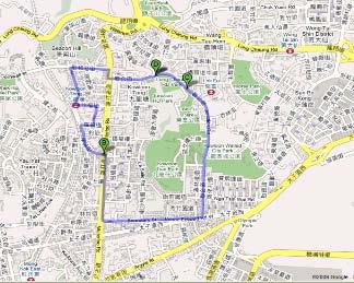
20 3.1.2 Hotspots Figures 3-5 and 3-6 highlight the air pollution hotspots, which are the streets where MAP has obtained the five highest mean route-averaged concentrations of NO 2, NOx, PN and BC. The concentrations of these pollutants and the mean traffic flow measured as the AADT (annualized average daily traffic) of these streets together with a number of other streets are listed in Table 3-1 for reference. Figure 3-5. Hotspots in Hong Kong (Hong Kong Island and Kowloon). Satellite image obtained from Google. 14

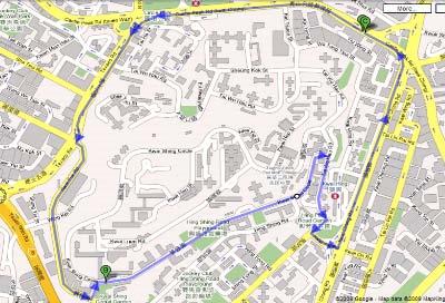
21 Figure 3-6. Hotspots in Hong Kong (New Territories). Satellite image obtained from Google. Table 3-1. Mean road segment-averaged concentration of NO 2, NOx, black carbon and fine particles of selected roads ranked in descending order of road traffic in AADT. AADT NO 2 NOx BC PN vehicles d -1 µg m -3 µg m -3 µg m -3 # cm -3 Kwun Tong Bypass 96, ,8 Lung Cheung 93, ,8 Tolo Highway 93, ,5 Island Eastern Corridor 91, ,5 Tsing Kwai Highway 86, ,8 Tuen Mun (Tuen Mun) 86, ,5 Tuen Mun (Tsuen Wan) 84, ,4 Lion Rock Tunnel 77, ,5 Gloucester 74, ,1 San Tin Highway 71, ,4 Fanling Highway 68, ,8 Kwai Chung 66, ,6 Kwun Tong 65, ,5 Yuen Long Highway 65, ,5 15
22 Tate's Cairn Highway 58, ,3 Texaco 44, ,8 Nathan 41, , ,7 Aberdeen Praya 35, ,5 Po Shek Wu 35, ,5 North Lantau Highway 35, ,9 Queen's East 34, ,1 Sheung Ning 33, ,9 Container Port South 31, ,9 Ma Tau Wai 27, ,7 Hennessy 24, 479 1, ,9 King's 23, , Hiram's Highway 23, ,9 Sha Lek Highway 23, ,9 Po Heung Street & Kwong Fuk 22, ,2 Sha Tsui 21, ,9 Sha Tin Wai 2, ,6 Ting Kok 2, ,4 Sha Tau Kok 2, ,7 Lai Chi Kok 19, ,3 Jockey Club 18, ,3 Aberdeen Main 18, ,3 Queen's Central 18, ,1 Chai Wan & Shau Kei Wan 17, ,8 Tuen Mun Heung Sze Wui 17, ,8 Po Lam North 17, ,1 Wylie 17, , Sai Sha 16, ,1 Un Chau Street 15, ,2 Kam Tin 14, ,8 Kau Yuk 14, ,9 Shun Tung 13, ,8 Des Voeux Central 13, 388 1, ,3 Tin Shui 11, ,7 Canton 11, ,1 Clear Water Bay 1, ,3 Po Fung 9, , Suffolk & Kent 9, ,6 Tung Chung Waterfront 6, ,8 Kam Sheung 5, ,8 Luk Keng ,5 16
23 It is interesting to note that although all of these pollutants came mainly from vehicles, the streets with a high concentration of NO 2 did not necessarily have a high concentration of PN or other pollutants. For example, high levels of PN were usually found along highways in the New Territories while high levels of NO 2 were associated with arterial roads in the urban areas. These highways and roads are listed below: NO 2 : 1. Hennessy (479 μg m -3 ) 2. Des Voeux Central (388 μg m -3 ) 3. Nathan (378 μg m -3 ) 4. King s (335 μg m -3 ) 5. Ma Tau Wai (32 μg m -3 ) NOx: 1. Hennessy (1,32 μg m -3 ) 2. Nathan (1,17 μg m -3 ) 3. Des Voeux Central (1,14 μg m -3 ) 4. Container Port South (966 μg m -3 ) 5. Kwun Tong (924 μg m -3 ) PN: 1. Container Port South (83,9 particles cm -3 ) 2. Po Shek Wu (83,5 particles cm -3 ) 3. Tolo Highway (81,5 particles cm -3 ) 4. Fanling Highway (79,8 particles cm -3 ) 5. San Tin Highway (74,4 particles cm -3 ) BC: 1. Container Port South (3.4 μg m -3 ) 2. Tuen Mun (Tuen Mun) (27.2 μg m -3 ) 3. Hennessy (25.8 μg m -3 ) 4. Po Shek Wu (25.1 μg m -3 ) 5. Nathan (24.7 μg m -3 ) The concentrations of the pollutants on these streets are likely determined by both traffic and environmental factors. The traffic factors include, but are not limited to, traffic density, traffic control and vehicle fleet mix while the environmental factor focuses on micrometeorology, which is affected by the building environment and any open space along these streets. The possible roles played by these factors will be addressed in more details in Section 3.2. More importantly, many of these air pollution hotspots are also hotspots for pedestrians and other road users. For example, Des Voeux Central in Central, Hennessy in Wan Chai/Causeway Bay, King s in North Point, Nathan in Yau Tsim Mong, Kwun Tong and Ma Tau Wai in East Kowloon are all in either commercial centers with a large number of commercial outlets and residential apartments or financial centers. In addition to busy traffics, there are often a large number of pedestrians in these areas (see Figure 3-7, which shows Hennessy crowded with pedestrians and vehicles) resulting in a serious exposure concern. All road users, 17

24 including pedestrians, drivers and commuters, should be protected from the exposure to these harmful pollutants. Although there are few pedestrians near highways, the high concentration of fine particles measured on highways also raises exposure concern for the neighborhood nearby. Zhu, et al. (22) found that the concentration of air pollutants, such as fine particles, particulate matter, CO and black carbon could be drastically high near highways but dropped to a background level at about 15 m from the highways. Since 23, a statute has been introduced in California to prohibit building schools within 5 ft of a busy road in order to reduce health risk to pupils and staff (CalRecycle, 21). Figure 3-7. Photo taken from MAP on Hennessy. It should be emphasized that the hotspots listed above are not the only hotspots in Hong Kong. These hotspots were selected from the roads that we have measured. There are possibly other locations with high pollutant concentrations that we have not visited in the project. There may also be other hot locations with slightly lower but still substantial pollution levels and plenty of pedestrians. The luxurious shopping area of Canton (NO μg m -3, NOx 556 μg m -3 and BC 11.2 μg m -3 ) and Queen s Central (NO μg m -3, NOx 677 μg m -3 and BC 12.4 μg m -3 ) are two examples. 18
25 References CalRecycle, 21. SB 352, Statutes of 23, History of California Solid Waste Law, California Department of Resources Recycling and Recovery Zhu Y, Hinds WC, Kim S, Sioutas C, 22. Concentration and size distribution of ultrafine particles near a major highway. Journal of Air and Waste Management Association, 52,


26 3.2 Spatial variations of air pollution The hotspots identified shows that there is a prominent variability in the concentration of pollutants across Hong Kong. Huge spatial variations in pollutant concentration are also frequently found within each district, even in the same road segment or just around a corner of an intersection. Figure 3-8 and 3-9 show the examples of NO 2 variations in the Yau Tsim Mong District and Wan Chai District. NO 2 concentration in the Yau Ma Tei/King s Park route is obviously lower than that in the Mong Kok route. Similar observations can be made between the Caroline Hill route and the main route in the Wan Chai District. The distance covered in the Caroline Hill route is short and takes 1 minutes to traverse. However, NO 2 concentration can vary from 2 to 15 μg m -3 even in such a short distance. This kind of variation is common in every district since traffic condition and air circulation can vary a lot in different sections of a road. Furthermore, as there are schools and hospitals along the Caroline Hill route, these public facilities and any sensitive groups in the vicinity would certainly be exposed to appreciably different levels of air pollution, even though they are located close to each other. Students, patients and people coming from less polluted areas would inevitably be exposed to poor air quality when they are commuting through the busy roads. More examples of these variations in air pollution over short distances can easily be found in other districts in Hong Kong Island (e.g. Eastern District - Figure 3-1), Kowloon (e.g. Kowloon City District - Figure 3-11) and New Territories (Yuen Long District - Figure 3-12). (a) (b) Figure 3-8. Spatial variation of NO 2 in Yau Tsim Mong District: (a) Yau Ma Tei/ King s Park route; (b) Mong Kok route. 2

; (b) Main route")
27 (a) (b) Figure 3-9. Spatial variation of NO 2 in Wan Chai District: (a) Caroline Hill route (Schools and hospitals are marked with stars and red crosses); (b) Main route (Hennessy and Queen s East). 21

 North")
28 (a) (b) Figure 3-1. Spatial variation of NO 2 in Eastern District: (a) Main route; (b) North Point route 22

 Main route; (b) Ho Man")
29 (a) (b) Figure Spatial variation of NO 2 in Kowloon City District: (a) Main route; (b) Ho Man Tin route 23
 and traffic")

30 (a) (b) Figure Spatial variation of NO 2 in Yuen Long District: (a) Tin Shui Wai route; (b) Kam Tin route The role of traffics Traffic density is an important factor which determines street-level air pollution. This is illustrated by the highways data in Figures 3-13 and 3-14, which clearly show the positive correlations between the pollutants (mean road segment-averages of NOx and black carbon) and traffic density. These highways, including Fanling Highway, North Lantau Highway, San Tin Highway, Tate's Cairn Highway, Tsing Kwai Highway and Yuen Long Highway, are wide with multiple lanes and ample open space, and possibly have a similar mix of vehicle fleet. It is worth mentioning that Yuen Long Highway, San Tin Highway and Fanling Highway merge in northern New Territories and is one of the main trunks in Hong Kong, while Tate's Cairn Highway is a main connection artery in Sha Tin linking to the Tate's Cairn Tunnel, through which vehicles enter eastern Kowloon. 24
31 16 Highways Urban s 12 NOx/µg m Traffic Density/1 3 veh d -1 Figure Changes in NOx concentration with traffic density on highways (Fanling Highway, San Tin Highway, Yuen Long Highway, Tsing Kwai Highway, North Lantau Highway, Tate s Cairn Highway) and urban roads (Hennessy, Des Voeux Central, Nathan, King s, Ma Tau Wai, Kwun Tong, Un Chau Street, Queen s East). 3 Highways Urban s Black Carbon/µg m Traffic Density/1 3 veh d -1 Figure Changes in black carbon concentration with traffic density on highways (Fanling Highway, San Tin Highway, Yuen Long Highway, Tsing Kwai Highway, North Lantau Highway, Tate s Cairn Highway) and urban roads (Hennessy, Des Voeux Central, Nathan, King s, Ma Tau Wai, Kwun Tong, Un Chau Street, Queen s East). 25
32 However, traffic density is not the sole determining factor of street-level air pollution as can be concluded from Figures 3-13 and There is clearly no relationship between the pollutants (NOx and black carbon) and traffic density among the arterial roads in urban areas, even if highways are included. Although the urban arterial roads usually have lower traffic densities than do the highways, they are associated with higher mean road segment-averaged concentrations of NOx and black carbon. Similar observations can also be made with the mean road segment-averaged concentration of NO 2. For example, Tolo Highway and Kwun Tong Bypass had traffic densities of over 9, vehicles d -1 and mean NO 2 concentrations of 117 μg m -3 and 178 μg m -3 while Nathan and Des Voeux Central had traffic densities of 41,4 and 13, vehicles d -1 and much higher NO 2 concentrations of 378 μg m -3 and 388 μg m -3 respectively. All these urban arterial roads, including Des Voeux Central, Hennessy, King's, Kwun Tong, Ma Tau Wai, Nathan, Queen s East and Un Chau Street, share a number of common features - traffic lights and bus stops abound, hordes of pedestrians, and tall and crowded buildings along both sides of the road with little open space, although the vehicle fleet mix can be different. These roads are usually congested and the vehicle speed is usually low. The air circulation in the street canyon is limited. In addition, emissions from local sources such as restaurants can add to the burden of air pollution on these roads. Figure 3-15a shows the typical spatial distribution of NO 2 on Kau Yu, Yuen Long at 7:39-8:5, on 4 January 21. It illustrates the role of traffic lights and bus stops in air quality. Consistently high levels of NO 2 can be observed at all times on Kau Yu close to the junction of Tai Tong (circled in Figure 3-15a). Figure 3-15b (from Google) shows the typical traffic condition and the bus stop at the junction. Many passengers were waiting at the bus stop at the time of this photo. Although there are two lanes leading into Tai Tong, the lane closest to the sidewalk is usually occupied by boarding buses so that the traffic flow into Tai Tong, which is already significantly impaired by the traffic light at the junction, is further impeded/crippled. These factors combine to result in traffic jams on this narrow street most of the time. Moreover, the street-level air quality is worsened by the crowded buildings on the two sides, which limit the air circulation and the dispersion of air pollutants. More detailed investigations into the accumulation of air pollutants at this junction are worthwhile to devise a strategy to reduce the impact of air pollution here. 26
 The typical road condition on Kau Yau. Photo obtained from Google.")
.")
.")
33 (a) (b) Figure (a) Elevated NO 2 concentration on Kau Yau, Yuen Long (circled). (b) The typical road condition on Kau Yau. Photo obtained from Google. Another example of the effect of traffic control on street-level air quality can be found on Po Fung, Tseung Kwan O (see Figure 3-16a). There are two traffic lights prior to the junction of Pong Hong and Po Fung (Figure 3-16b). The increased NO 2 concentration after the traffic lights may be attributed to the increased exhaust from accelerating vehicles. 27
 Elevated NO 2")
.")

34 (a) (b) Figure (a) Elevated NO 2 concentration on Po Fung, Tseung Kwan O (circled). (b) Typical road condition on Po Fung. Photo obtained from Google. 28

. Yet, Canton had a significantly higher mean road segment-averaged concentration of NO 2 (182 vs. 1 μg m -3 ), NOx (556 vs. 318 μg m -3 ) and black carbon (11.2 vs. 4.")
35 3.2.2 The role of open space in air circulation While traffic density is a vital factor when trying to determine the street-level air pollution, air circulation in the area, which is usually increased with open space, is an equally important criterion. This is illustrated with the following examples. The segment of Canton in the luxurious goods shopping area in Tsim Sha Tsui and Wylie are both in the Yau Tsim Mong District. Wylie has a higher traffic density than Canton (AADT in 28: 17, vs. 11,5 vehicles d -1 ). Yet, Canton had a significantly higher mean road segment-averaged concentration of NO 2 (182 vs. 1 μg m -3 ), NOx (556 vs. 318 μg m -3 ) and black carbon (11.2 vs. 4.1 μg m -3 ) at the time of our measurements. Although the difference in traffic control between these two roads and vehicle fleets mix could have played a role, the large open space surrounding Wylie contrasts with the deep street canyon of Canton (see Figure 3-17), constituting one of the key factors for the higher pollution level on Canton. (a) (b) Figure (a) Street view of Wylie. (b) Street view of Canton. Photos obtained from Google. Hennessy and the parallel Gloucester are busy roads in the Wan Chai District (see Figure 3-18). The traffic density of Hennessy (24, vehicles d -1 ) was less than a third of that of Gloucester (74,5 vehicles d -1 ) but the mean road segmentaveraged NO 2, NOx and black carbon were significantly higher on Hennessy (NO 2 : 479 vs. 217 μg m -3 ; NOx: 1,32 vs. 67 μg m -3 ; and black carbon: 25.8 vs. 1.9 μg m -3 ). 29

36 Figure 3-19 shows the deep and narrow street canyon of Hennessy with crowded and tall buildings on both sides, in contrast to Gloucester, which is wider and has more open space on the side facing the Victoria Harbor. The better air circulation in Gloucester might have helped to disperse the vehicular emissions and bring in fresh air to dilute the air pollutants. Figure Gloucester (purple) and Hennessy (green) in Wan Chai District. Aerial/satellite image obtained from Google. 3
 Elevated NO 2 concentration near New Town Plaza, Sha Tin (circled).")
 and the covered road segment in")

37 Figure The street canyon of Hennessy. Photo obtained from Google. (a) (b) Figure 3-2. (a) Elevated NO 2 concentration near New Town Plaza, Sha Tin (circled). (b) A street-view of Sha Tin Centre Street. Photo obtained from Google. Centre Street outside New Town Plaza in Sha Tin (Figure 3-2) and the covered road segment in Kwong Fuk Estate, Tai Po (Figure 3-21) are two typical examples of how the lack of open space hampers air circulation. Centre Street is a narrow street with buildings (New Town Plaza) surrounding three sides of the street. Although the traffic flow was 31

 Elevated NO 2 concentration on the road in Kwong Fuk Estate, Tai Po (circled). (b) The covered road segment in Kwong Fuk Estate. Photo obtained from Google.")
38 low, NO 2 concentration was high due to poor air ventilation. Similar conditions can be found in the covered area in Kwong Fuk Estate, in which the road segment is shielded on the two sides and covered on top. Although the traffic flow was low, NO 2 concentration was high and was comparable to the more busy Tai Po outside the Estate. (a) (b) Figure (a) Elevated NO 2 concentration on the road in Kwong Fuk Estate, Tai Po (circled). (b) The covered road segment in Kwong Fuk Estate. Photo obtained from Google. The segment of Gloucester which is next to the Victoria Park illustrates how open space can help to improve street-level air quality. MAP often recorded high concentrations of NO 2 near the junction of Gloucester and Sugar Street and relatively lower NO 2 on the rest of the segment near to the harbor (see left panel of Figure 3-22). The high NO 2 is probably caused by the elevated road over Gloucester at the junction of Sugar Street (see bottom right panel of Figure 3-22). This elevated road, together with the tall buildings around, hindered air ventilation and kept the air pollutant concentration high there. As the elevated road merges with the ground further down Gloucester, the road segment becomes open to Victoria Park (see top right panel of Figure 3-22). With much better air ventilation, the concentration of NO 2 at the segment was reduced appreciably. 32


39 Figure NO 2 distribution along Gloucester outside Victoria Park (left). The street view of Gloucester from the corner of Great George Street (top right) and Sugar Street (bottom right). Photos obtained from Google. 33
40 3.3 Marine emission We have observed an episode in which an extraordinarily high concentration of SO 2 was recorded on segments of Lai King Hill and Kwai Chung in Kwai Chung in the morning of 1 December 29, when the prevailing wind changed from a southerly at about 7 am to a westerly at 11 am. Kwai Chung is a developed, mixed commercial/industrial/ residential area, and houses one of the busiest container ports in the world. Both Lai King Hill and Kwai Chung are part of the main route of Kwai Tsing District and the air quality along these two roads were repeatedly measured on 7-8, 1-11 December 29. Figure 3-23 shows the temporal distribution of the road segment-averaged concentration of SO 2 of these two roads. In general, both Kwai Chung and Lai King Hill had similar SO2 concentrations, although the traffic density and vehicle fleet mix of Kwai Chung (a main arterial road with high traffic density) and Lai King Hill (a local distributor road on an open hill slope) are very different. This could be because the vehicle fuel in Hong Kong is of ultra-low sulfur content and thus emissions from vehicles using local fuel contain little SO 2. The average concentration of SO 2 on the two roads was around 2 μg m -3 on all days except for the morning of 1 December 29 when the concentration shot up to 1 μg m -3. Additionally, significantly higher levels of SO 2 were found on Kwai Chung and Lai King Hill indicating the existence of hotspots of SO 2 on these two roads which were possibly moving. No exceptional road traffic events such as traffic jams were identified in the period when high pollutant concentrations were recorded. This indicates that the two roads were under the influence of some extraordinary emission sources containing a high concentration of SO 2 other than motor vehicles. SO 2 /µg m Kwai Chung Lai King Hill 3pm 7-Dec 6:3pm 7-Dec 3pm 8-Dec 6pm 8-Dec 7:3am 1-Dec 1:3am 1-Dec 11am 1-Dec 8:3am 11-Dec 11am 11-Dec Figure segment-averaged concentration of SO 2 on Kwai Chung and Lai King Hill 34
41 Figure 3-24 shows the color plot of the spatial distribution of SO 2 obtained on the morning of 1 December 29. Three sets of measurements had been made: 1. early morning: 7:2-7:5 (mean wind direction: south east south with a mean wind speed of below 1 m s -1, see Figure 3-23 and 3-24); 2. late morning: 1:14-1:36 (south west with a mean wind speed of about 1-2 m s -1 ); and 3. 1:51-11:1 (north west west with a mean wind speed of about 2 m s -1 ). The wind data was obtained from the Kwai Chung General Air Monitoring Station. Figures 3-25 and 3-26 show the variation of wind direction and wind speed at the station on 7-1 December 29. A high concentration of SO 2 was found along segments of Kwai Chung and Lai King Hill in measurements 2 and 3, while that obtained in measurement 1 was low and close to the average concentration. It is interesting to note that these cases of high SO 2 concentration were associated with wind coming from the container port (possibly due to land-sea breeze) and that the mean wind direction appears to determine the whereabouts of these cases. A large number of container vessels visit the container port on a daily basis. These vessels consume un-regulated fossil fuel, which most likely contains much higher sulfur content than the ultra-low sulfur fuels used in road vehicles in Hong Kong. The emission plumes from these vessels contain not only NO X, black carbon and particulate matter but also an exceedingly high concentration of SO 2, many times higher than the ordinary ambient SO 2 concentration. These plumes are usually emitted from the chimneys of the vessels. They may touch down on the streets, hitting Kwai Chung in this case, and increase the ambient concentration of these pollutants. All the above observations support the theory that the high SO 2 concentrations observed was caused by the marine emission from cargo vessels in the container port area. These observations suggest that marine emission can have an impact on the street-level air quality, as well as the general air quality, of Kwai Tsing if the meteorological conditions are right. Between June 29 and May 21, based on the meteorological measurements taken by the Kwai Chung General Air Quality Monitoring Station of the Hong Kong Environmental Protection Department, in one third of the time, the prevailing wind direction was conducive to bringing these emissions to Kwai Tsing. Furthermore, at and near Lai King Hill, there are a number of schools and two hospitals - Princess Margaret Hospital and Kwai Chung Hospital - in addition to public and private housings. These emissions can potentially result in frequent episodic exposure for sensitive groups (e.g. school children and patients). 35


42 Kwai Chung General Air Monitoring Station Kwai Chung Lai King Hill Container Port Kwai Chung Rd: 7:2-7:27 am Lai King Hill Rd: 7:42-7:5 am Kwai Chung Rd: 1:3-1:36 am Lai King Hill Rd: 1:14-1:26 am Kwai Chung Rd: 11:2-11:1 am Lai King Hill Rd: 1:51-11: am Figure Mean wind and spatial distribution of SO 2. Mean wind directions (yellow arrows) obtained from Kwai Chung General Air Monitoring Station, Hong Kong Environmental Protection Department. Measurement times are listed below the maps. 36
43 Figure Change in mean wind direction at Kwai Chung on 7-1 December 29. Wind data obtained from Kwai Chung General Air Monitoring Station, Hong Kong Environmental Protection Department. (Line colors: 7 Dec 8 Dec 9 Dec 1 Dec) Figure Mean wind speed at Kwai Chung on 7-1 December 29. Data obtained from Kwai Chung General Air Monitoring Station, Hong Kong Environmental Protection Department. (Line colors: 7 Dec 8 Dec 9 Dec 1 Dec) 37
, MAP took a 5-minute measurement just after the fireworks on 4 January 21, after the local route measurement at")
44 3.4 Firework emission Fireworks are displayed every evening at the Hong Kong Disneyland. Parked on Magic, which is located on the west of the theme park (see Figure 3-27), MAP took a 5-minute measurement just after the fireworks on 4 January 21, after the local route measurement at Disneyland (see Figure 3-28). Figure 3-27 Sampling location after the fireworks. Photo obtained from Google. 38
 measured along the Disneyland local route on the")
45 HK Disneyland Figure Local route at Disneyland. Map obtained from Google. Figure 3-29 compares the plume from fireworks that MAP intercepted at Disneyland with the mean route-averaged concentration of pollutants (R1 and R2) measured along the Disneyland local route on the same day before the fireworks. R1 was obtained during 2:31 2:49 while R2 was obtained during 2:49 21:8. The plume from the fireworks with its distinct smell was intercepted on Magic during 21:13 21:18. In this case, the fireworks display did not make a significant impact on SO 2 and only slightly increased the concentration of CO, NOx and black carbon. However, it momentarily increased the concentration of fine particle (2-1 nm) number and PM2.5 (wet) significantly. PM2.5 was elevated by three times compared with those of R1 and R2, while the particle number concentration was more than doubled. Figure 3-3 shows the particle size distributions of R1 and R2 and that obtained after fireworks. It shows clearly that more and larger particles were produced as a result of the fireworks display. The size of ambient particles along the local route normally peaked at 4-5 nm, which is typical of vehicle emissions. Particles of modal size 15 nm appeared in the firework plume during 21:14 21:16 and disappeared abruptly due possibly to the movement of the plume. This observation illustrates that firework emissions do affect the quality of local ground-level air although the plume may shift quickly. 39
46 (a) (b) 5 4 Fine Particle conc. 1 8 Black Carbon #/cm3 3 2 ug/m Firework R1 R2 Firework R1 R2 (c) (d) 1 8 Particle Mass conc NO NO2 ug/m ug/m Firework R1 R2 Firework R1 R2 (e) (f) 3 SO2 15 CO 2 1 ug/m3 ug/m3 1 5 Firework R1 R2 Firework R1 R2 Figure Averaged pollutant concentration obtained along the Disneyland local route (R1 & R2) before the fireworks display and on Magic just after the display on 4 January 21. (a) Fine particle, (b) Black carbon, (c) PM2.5, (d) NO & NO 2, (e) SO 2 and (f) CO. 4
47 (a) 4th January 21 R1 & R2 21:11: 21:1: Time 2:51: 2:41: 2:31: 1 1 Dp (nm) (b) 4th January 21 Firework :19: 21:18: 21:17: Time 21:16: 21:15: 21:14: :13: 1 1 Dp (nm) Figure 3-3. Particle number size distribution obtained (a) before the fireworks display along the Disneyland local route and (b) just after the display on Magic. 41
48 4. Conclusions 1. Many roads in Hong Kong have severe street-level air pollution. These pollution hotspots include not only major highways but also a number of major roads in urban areas, such as Fanling Highway, Lung Cheung, Des Voeux Central, Hennessy and Nathan to name a few. Many of these hotspots are heavily used on a daily basis by the general public, including the more sensitive groups such as children, patients and the elderly. The poor air quality poses a serious health threat to everyone. 2. There are significant spatial variations in street-level air pollution in Hong Kong. These variations were found not only across districts but also within districts and even within tens of meters along the same street or around corners, caused by differences in the traffic and environmental conditions. 3. Traffics (including traffic density, traffic arrangement and control) have significant impacts on local air quality. 4. Open space helps to improve the street-level air quality. s with deep street canyons created as a result of crowded and tall buildings on both sides can easily suffer from poor air quality even if the traffic densities are low. 5. Careful town planning, including the planning for buildings and traffics, is essential to improve the local air quality. 6. Marine emissions from the Container Port can be an important emission source contributing to the air pollution in Kwai Tsing. Occasionally, these emissions can reach the streets. They can increase the air pollution burden and thus exposure threat for the community (the children, patients and the elderly in particular) at locations near Lai Kill Hill (such as schools, hospitals and public estates), where we intercepted the marine emissions. 7. Emissions due to fireworks can affect the local street-level air pollution. 42
49 Appendix A. Routes The road components of the main and local routes in each district (A.1-A.18) and the circle Hong Kong route (A.19) are listed below. A.1 Central & Western District Main route: Queen's Central, Des Voeux Central, Cotton Tree Drive, Garden, Robinson, Park, Bonham, Pok Fu Lam, Smithfield, Smithfield, Pokfield, Forbes Street, Cadogan Street, Catchick Street, Kennedy Town Praya, Des Voeux West, Connaught West, Connaught Central, Rumsey Street, Chater, Murray. Local routes: i. Central Cotton Tree Drive, Queen s Central, Bonham Strand, Hillier Street, Des Voeux Central, Chater, Murray. ii. Sai Wan/Sheung Wan Queen s Central, Queen s West, Belcher s Street, Cadogan Street, Catchick Street, Kennedy Town Praya, Des Voeux West, Connaught West, Rumsey Street, Des Voeux Central, Pottinger Street, Connaught Central, Jubilee Street. 43

")

50 (a) (b) (c) Figure A-1. Central & Western District: (a) Main route, and local routes - (b) Central, (c) Sai Wan/Sheung Wan. Map obtained from Google. 44
51 A.2 Eastern District Main route: Island Eastern Corridor, Chai Wan, Shau Kei Wan, King's, Kornhill, Causeway, Hing Fat Street. Local routes: i. North Point/Braemar Hill Hing Fat Street, Gordon, Electric, Java, Man Hong Street, Healthy West, Pak Fuk, Braemar Hill, Cloud View, Tin Hau Temple, Causeway. ii. Chai Wan/Siu Sai Wan Island Eastern Corridor, Chai Wan, Siu Sai Wan, Sun Yip Street, Ka Yip Street, Sheung On Street, Chai Wan, Wing Tai, Tsui Wan Street, Shun Tai. 45
")
 North")

52 (a) (b) (c) Figure A-2. Eastern District: (a) Main route, and local routes - (b) North Point, (c) Chai Wan. Map obtained from Google. 46
53 A.3 Islands District Main route: North Lantau Highway, Airport, Cheong Hong, Chun Yue, South Perimeter, Chek Lap Kok South, Shun Tung, Yu Tung. Local routes: i. Tung Chung Yu Tung, Shun Tung, Waterfront, Yi Tung. ii. Airport/AsiaWorld-Expo Airport Expo Boulevard, Sky City East, Cheong Lin, Airport, Cheong Hong, Cheong Tat. 47
")
 Tung Chung,")

54 (a) (b) (c) Figure A-3. Islands District: (a) Main route, and local routes - (b) Tung Chung, (c) Airport/AsiaWorld-Expo. Map obtained from Google. 48
55 A.4 Kowloon City District Main route: Junction, Prince Edward West, Ma Tau Chung, Ma Tau Wai, Tak Man Street, Hung Hom, Hung Hom Bypass, Princess Margaret, Waterloo. Local routes: i. To Kwa Wan Ma Tau Wai, Chatham North, Wuhu Street, Tak Man Street, Hung Hom, Bailey Street, To Kwa Wan, Ma Tau Kok. ii. Kowloon Tong Junction, Cornwall Street, Suffolk, Kent, Waterloo, Boundary Street. iii. Ho Man Tin Argyle Street, Princess Margaret, Fat Kwong Street, Sheung Shing Street, Tin Kwong. 49
 5")

56 (a) (b) (c) 5
 Main route, and local routes - (b) To Kwa Wan,")
57 (d) Figure A-4. Kowloon City District: (a) Main route, and local routes - (b) To Kwa Wan, (c) Kowloon Tong, (d) Ho Man Tin. Map obtained from Google. 51
58 A.5 Kwai Tsing District Main route: Kwai Chung, Castle Peak, Texaco, Tsing Tsuen, Fung Shue Wo, Kwai Tsing, Lai King Hill. Local routes: i. Container Port Container Port, Tsing Kwai Highway, Tsuen Wan, Kwai Tsing. ii. Kwai Chung/Tai Wo Hau Kwai Chung, Castle Peak, Texaco, Kwai Fuk, Kwai Shing Circle, Tai Wo Hau, Kwai Yat. iii. Tsing Yi Tsing King, Tsing Yi Heung Sze Wui, Chung Mei, Ching Hong, Tsing Yi West. 52
 53")

59 (a) (b) (c) 53
 Main route, and local routes - (b) Container")
60 (d) Figure A-5. Kwai Tsing District: (a) Main route, and local routes - (b) Container Port, (c) Tai Wo Hau, (d) Tsing Yi. Map obtained from Google. 54
61 A.6 Kwun Tong District Main route Kwun Tong, Lei Yue Mun, Kai Tin, Tak Tin Street, Lin Tak, Sau Mau Ping, Shun Lee Tsuen, New Clear Water Bay. Local routes: i. Kowloon Bay Kwun Tong Bypass, Wang Chiu, Kai Cheung, Wai Yip Street. ii. Kwun Tong Ngau Tau Kok, Hong Ning, Mut Wah Street, Hip Wo Street, Hong Ning, Chun Wah Street. iii. Lam Tin/Yau Tong Kai Tin, Tak Tin Street, Lin Tak, Pik Wan, Ko Chiu, Lei Yue Mun. 55
 56")


62 (a) (b) (c) 56
 Main route, and local routes - (b) Kowloon Bay, (c)")
63 (d) Figure A-6. Kwun Tong District: (a) Main route, and local routes - (b) Kowloon Bay, (c) Kwun Tong, (d) Lam Tin/Yau Tong. Map obtained from Google. 57
64 A.7 North District Main route: Fanling Highway, San Tin Highway, Po Shek Wo, Man Kam To, Jockey Club. Local routes: i. Sheung Shui/Fanling San Wan, Jockey Club, Ma Sik, Luen Chik Street, Luen On Street, Sha Tau Kok. ii. Sha Tau Kok Sha Tau Kok, Luk Keng. 58
 Main")
 Sheung")

65 (a) (b) (c) Figure A-7. North District: (a) Main route, and local routes - (b) Sheung Shui/Fanling, (c) Sha Tau Kok. Map obtained from Google. 59
66 A.8 Sai Kung District Main route: Clear Water Bay, Hiram s Highway, Po Tung, Tai Mong Tsai. Local routes: i. Tseung Kwan O Industrial Estate Wen Po, Chun Wang Street, Chun Yat Street. ii. Tseung Kwan O Town Area Chiu Shun, Wen Po, Po Yap, Po Shun, Po Lam North, Po Fung, Po Hong, Ngan O, Pui Shing, Sheung Ning, Po Ning. 6
 Main")
 Tseung Kwan O Industrial")

67 (a) (b) (c) Figure A-8. Sai Kung District: (a) Main route, and local routes - (b) Tseung Kwan O Industrial Estate, (c) Tseung Kwan O Town Area. Map obtained from Google. 61
68 A.9 Sha Tin District Main route: Sha Tin, Hung Mui Kuk, Mei Tin, Tai Po, Tolo Highway, Tate s Cairn Highway, Ma On Shan, Sai Sha, Ma On Shan Bypass. Local routes: i. Sha Tin Town Tam Kon Po Street, Yuen Wo, Fo Tan (Banyan Bridge), Tai Chung Kiu, Siu Lek Yuen, Sha Lek Highway, Sha Tin Wai, Sha Kok Street, Lion Tunnel, Sha Tin Centre Street. ii. Tai Wai Mei Tin, Tai Po, Lion Rock Tunnel, Che Kung Miu, Hin Keng Street, Fu Kin Street, Tin Sam Street, Hung Mei Kuk. 62
")
 Sha Tin")

69 (a) (b) (c) Figure A-9. Sha Tin District: (a) Main route, and local routes - (b) Sha Tin Town, (c) Tai Wai. Map obtained from Google. 63
70 A.1 Sham Shui Po District Main route: Lai Chi Kok, Boundary Street, Tai Hang Tung, Woh Chai Street, Wai Chi Street, Nam Cheong Street, Cornwall Street, Lung Cheung, Ching Cheung, Butterfly Valley. Local routes: i. Sham Shui Po Lai Chi Kok, Nam Cheong Street, Un Chau Street, Hing Wah Street. ii. Yau Yat Tsuen/Shek Kip Mei Tat Chee Avenue, Tai Hang Tung, Woh Chai Street, Wai Chi Street, Nam Cheong Street, Cornwall Street. 64
")
 Sham Shui Po,")

71 (a) (b) (c) Figure A-1. Sham Shui Po District: (a) Main route, and local routes - (b) Sham Shui Po, (c) Yau Yat Tsuen/Shek Kip Mei. Map obtained from Google. 65
72 A.11 Southern District Main route Victoria, Shek Pai Wan, Aberdeen Praya, Wong Chuk Hang, Island, Repulse Bay, Stanley Gap. Local routes: i. Aberdeen/Ap Lei Chau Shek Pai Wan, Aberdeen Praya, Aberdeen Main, Ap Lei Chau Bridge, Lee Nam, Yi Nam, South Horizons Drive, Tin Wan Hill. ii. Stanley Stanley Gap, Chung Hom Kok, Cape, Carmel, Stanley Village. 66
")
 Aberdeen/Ap")

73 (a) (b) (c) Figure A-11. Southern District: (a) Main route, and local routes - (b) Aberdeen/Ap Lei Chau, (c) Stanley. Map obtained from Google. 67
74 A.12 Tai Po District Main route: Tolo Highway, Lam Kim Interchange, Tai Po, Tai Wo, Ting Tai, Ting Kok, Yuen Sin. Local routes: i. Tai Po Town Area Ting Kok, Ting Tai, Tai Po Tai Wo, Po Nga Rd, Po Heung Street, Kwong Fuk, Wan Tau Street, Nam Wan, Tai Po Rd (Yeun Chau Tsai), Kwong Wang Street, Plover Cove. ii. Tai Mei Tuk/Tai Po Suburban Ting Kok, Dai Kwai Street, Dai Cheong Street, Dai Fat Street, Yuen Sin. 68
 Main")
 Tai Po Town Area, (c)")

75 (a) (b) (c) Figure A-12. Tai Po District: (a) Main route, and local routes - (b) Tai Po Town Area, (c) Tai Mei Tuk/Tai Po Suburban. Map obtained from Google. 69
76 A.13 Tsuen Wan District Main route: Texaco, Cheung Pei Shan, Tuen Mun, Castle Peak, Hoi On, Tsuen Wan. Local routes: i. Tsuen Wan Town Area Castle Peak, Cheung Wing, Wo Yi Hop, Sam Tung Uk, Yi Pei Chun, Shek Wai Kok, Wai Tsuen, Miu Kong Street, Shing Mun, Kwan Mun Hau Street, Sha Tsui, Tai Chung. ii. Disneyland Sunny Bay, Magic, Fantasy. 7
")
 Tsuen Wan")

77 (a) (b) (c) Figure A-13. Tsuen Wan District: (a) Main route, and local routes - (b) Tsuen Wan Town Area, (c) Disneyland. Map obtained from Google. 71
78 A.14 Tuen Mun District Main route: Tuen Mun, Castle Peak, Hoi Wing, Hoi Wong, Wu Shan, Lung Mun, Tsing Wun, Ming Kum, Tsing Tin. Local routes: i. Tuen Mun Town Area Castle Peak, Hoi Wing, Tuen Mun Heung Sze Wui, Pui To, Ming Kum, Tsing Tin, Tsing Wun. ii. Castle Peak - Industrial Area and Landfill Lung Mun, Lung Kwu Tan, Nim Wan. 72
 Main")
")

79 (a) (b) (c) Figure A-14. Tuen Mun District: (a) Main route, and local routes - (b) Tuen Mun Town Area, (c) Castle Peak Industrial Area and Landfill. Map obtained from Google. 73
80 A.15 Wan Chai District Main route: King's, Causeway, Irving Street, Pennington Street, Yee Wo Street, Hennessy, Anton Street, Queen's East, Morrison Hill, Leighton, Ngan Mok Street, Lau Li Street. Local routes: i. Wan Chai Tunnel Area: Gloucester, Fenwick Street, Hennessy, Yee Wo Street, Sugar Street. ii. Caroline Hill Caroline Hill, Eastern Hospital, Tung Lo Wan, Moreton Terrace, Causeway, Leighton. 74
")
 Wan Chai")

81 (a) (b) (c) Figure A-15. Wan Chai District: (a) Main route, and local routes - (b) Wan Chai Tunnel Area, (c) Caroline Hill. Map obtained from Google. 75
82 A.16 Wong Tai Sin District Main route: Hammer Hill, Po Kong Village, Junction, Tung Tau Tsuen, Choi Hung. Local routes: i. Tsz Wan Shan Yuk Wah Street, Sheung Fung Street, Fung Tak, Hammer Hill, Po Kong Village. ii. Wong Tai Sin Chuk Yuen, Junction, Tung Tau Tsuen, Tseuk Luk Street, Tai Yau Street, Po Kong Village. 76

 Tsz")

83 (a) (b) (c) Figure A-16. Wong Tai Sin District: (a) Main route, and local routes - (b) Tsz Wan Shan, (c) Wong Tai Sin. Map obtained from Google. 77
84 A.17 Yau Tsim Mong District Main route: Gascoigne, Nathan, Lai Chi Kok, Lin Cheung, Canton, Salisbury. Local routes: i. Yau Ma Tei King s Park Gascoigne, Wiley, Waterloo, Ferry Street, New Reclamation Street, Nathan. ii. Mong Kok Mong Kok, Sai Yee Street, Prince Edward West, Tong Mi, Argyle Street, New Reclamation Street. 78

 Yau Ma Tei")

85 (a) (b) (c) Figure A-17. Yau Tsim Mong District: (a) Main route, and local routes - (b) Yau Ma Tei King s Park, (c) Mong Kok. Map obtained from Google. 79

86 A.18 Yuen Long District Main route: Yuen Long Highway, Castle Peak, Tin Ying, Wetland Park, Tin Tsz, Long Tin, Wang Tat, Long Yip Street. Local routes: i. Yuen Long Town Area Kau Yuk, Tai Tong, Hop Yick, Fung Cheung, On Lok, Po Yip Street, Hong Yip Street, Fu Yip Street, Wang Lok Street, Wang Li Street, Fuk Wang Street, Fuk Hi Street, Long Ping, Fung Chi, Ping Wui Street, Ma Miu, Yuen Long Tai Yuk. ii. Tin Shui Wai Tin Tsz, Tin Wah, Tin Kwai, Wetland Park, Tin Shui, Tin Wu, Tin Yiu, Tin Fuk. iii. Kam Tin Kam Tin, Kam Sheung. (a) 8
")
 Yuen Long Town")

87 (b) (c) (d) Figure A-18. Yuen Long District: (a) Main route, and local routes - (b) Yuen Long Town Area, (c) Tin Shui Wai, (d) Kam Tin. Map obtained from Google. 81
, Tuen Mun, Castle Peak (Lam Tei, Yuen Long), Long Yat, Yuen Long Highway, Tsing Long Highway, San Tin Highway, Fanling Highway, So Kwun Po, Jockey Club, Sun Wan, Sha Tau Kok, Jockey")
88 A.19 Circle Hong Kong Clear Water Bay, Hang Hau, Chiu Shun, Wan Po, Tseung Kwan O Tunnel, Tseung Kwan O Tunnel, Tseung Kwan O, Lei Yue Mun, Kwun Tong, Lung Cheung, Ching Cheung, Kwai Chung, Castle Peak (Tsuen Wan), Tuen Mun, Castle Peak (Lam Tei, Yuen Long), Long Yat, Yuen Long Highway, Tsing Long Highway, San Tin Highway, Fanling Highway, So Kwun Po, Jockey Club, Sun Wan, Sha Tau Kok, Jockey Club, Fanling Highway, Tolo Highway, Tai Po (Sha Tin), Sha Tin, Lion Rock Tunnel, Lion Rock Tunnel, Waterloo, Princess Margaret, Cross Harbor Tunnel, Aberdeen Tunnel, Wong Chuk Hang, Aberdeen Praya, Shek Pai Wan, Victoria, Cadogan Street, New Praya Kennedy Town, Shing Sai, Connaught Central, Harcourt, Gloucester, Island Eastern Corridor, Eastern Harbor Tunnel. Figure A-19. Circle Hong Kong route. Map obtained from Google. 82
Government Vaccination Programme 2018/19 List of HA GOPCs for GVP Vaccination
 Government Vaccination Programme 2018/19 List of HA GOPCs for GVP Vaccination Anne Black General 1/F, 140 Tsat Tse Mui Road, North Point 2561 6161 Chai Wan General G/F, 1 Hong Man Street, Chai Wan 2556
Project Summary Major Property Development Projects in Hong Kong. Project Summary Major Property Development Projects in Hong Kong.
 Project Summary Major Property Development Projects in Hong Kong Project Summary Major Property Development Projects in Hong Kong Queen s Terrace Parc Palais 10 Seaview Crescent Wang Chau Yuen Long 31
BUILDING FOR THE BETTER CHINA. Hong Kong
 CHINA Hong Kong BUILDING FOR THE BETTER The Group always strives to maximize the aesthetic potential of development lots so as to integrate its projects into their surroundings harmoniously with minimal
Appendix: List of CLP Power s EV charging stations (14 December 2018)
") Appendix: List of CLP Power s EV charging stations (14 December 2018) Quick EV charging stations No. Location Address Parking Bay Qty. District Type 1 CLP Centenary Building CLP Centenary Building, G/F
Appendix: List of CLP Power s EV charging stations (14 December 2018) Quick EV charging stations No. Location Address Parking Bay Qty. District Type 1 CLP Centenary Building CLP Centenary Building, G/F
MTR to work closely and align with the Government on announcement mechanism in relation to Railway Protection Area
 PR068/18 6 August 2018 MTR to work closely and align with the Government on announcement mechanism in relation to Railway Protection Area The MTR Corporation notes that a new announcement mechanism has
Collection Point Address
 Collection Point Hong Kong Island Business Hours Mon to Fri Aberdeen Ap Lei Chau Shau Kei Wan Sai Wan North Point Office 1, 9/F, Goodview Centre, 12 Wu Pak Street, Aberdeen, Hong Kong Shop S11, G/F, Wah
Self Service Terminal Service Hour Hong Kong District Branch
 Self Service Terminal Service Hour Hong Kong District Branch Head Office 83 Des Voeux Central 24 hours X 09:00-19:00 09:00-19:00 09:00-19:00 Aberdeen 10 Nam Ning Street Causeway Bay Prestige & 28 Yee Wo
SUN HUNG KAI PROPERTIES LIMITED ANNUAL REPORT 2001/02
 38 39 PROPERTY INVESTMENT The Group maintains an optimal tenant mix in its investment property portfolio, and strives to raise the standard of customer and tenant service. Aiming to be the landlord of
CLP Power Extends Electric Vehicle Charging Network as Popularity of Green Motoring Accelerates
 24 November 2016 中華電力有限公司 CLP Power Hong Kong Limited CLP Power Extends Electric Vehicle Network as Popularity of Green Motoring Accelerates CLP Power Hong Kong Limited (CLP Power) today (24 November)
Delia Memorial School (Hip Wo) Guidance notes on filling Student s Particulars Record
 Guidance notes on filling Student s Particulars Record") Delia Memorial School (Hip Wo) Guidance notes on filling Student s Particulars Record 2014-2015 Part (1) Candidate s Particulars: Name in English STRN No. Given Name Surname Name in Chinese Sex C C Code
Delia Memorial School (Hip Wo) Guidance notes on filling Student s Particulars Record 2014-2015 Part (1) Candidate s Particulars: Name in English STRN No. Given Name Surname Name in Chinese Sex C C Code
Parallel Lines : Railway Infrastructure Development and its interaction with Urban Growth in Hong Kong
 Parallel Lines : Railway Infrastructure Development and its interaction with Urban Growth in Hong Kong Ir Enoch LAM Deputy Secretary (Works)2, Development Bureau The Government of the Hong Kong Special
Gross Floor Area of HOS Flat by Phase / Estate
 Gross Floor Area of HOS Flat by / Estate 1 February 1978 12.6.80 Shun Chi Court East Kowloon 49.1-77.9 12.5.81 Chun Man Court Ho Man Tin 54.1-66.5 13.8.80 Yue Fai Court, I Aberdeen 42.7-46.6 23.9.80 Sui
香港物業管理公司協會有限公司 The Hong Kong Association of Property Management Companies Limited
 C Ching Ho Shopping Centre Ching Hiu Road Sheung Shui NT hopping Arcad 16 C Chow Shing Kee Comm. Building 25 Tong Mei Road Tai Kwok Tsui KLN 1 42 C Hung Fuk Shopping Centre Hung Fuk Estate 1 3456 C Tai
Supplementary Material
 Supplementary Material 15-Year PM 2.5 Trends in the Pearl River Delta Region and Hong Kong from Satellite Observation C.Q. Lin 1,2, Y. Li 3, A.K.H. Lau 1,2,4,*, C.C. Li 5, J.C.H. Fung 2,4,6 * Corresponding
HKBN Mass Deploys Fiber-To-The-Home Making the Future Today in Hong Kong
 For Immediate Release HKBN Mass Deploys Fiber-To-The-Home Making the Future Today in Hong Kong (Hong Kong, 19th September 2007) Hong Kong Broadband Network Limited ( HKBN ) today announced a revolution
Property Investment. 1. Two IFC, Central 2. International Commerce Centre, Kowloon Station 3. East Point City, Tseung Kwan O 4.
 Property Investment The local retail sector has flourished and the Group s shopping centres keep attracting more visitors, benefiting retail tenants with higher traffic and turnover. The Group will keep
Monthly update of MTR facilities for passengers with disabilities December 2017
 Monthly update of MTR facilities for passengers with disabilities 1. Ma On Shan Line The installation of Automatic Platform Gates at Ma On Shan Line has commenced at Tai Wai Station in November 2014. It
FOR VIBRANT LIFESTYLES THE REACH, YUEN LONG, HONG KONG
 FOR VIBRANT LIFESTYLES THE REACH, YUEN LONG, HONG KONG Review of Operations Business in Hong Kong Progress of Major Development Projects Status of property developments with anticipated completion during
Selection Method for Shaw College Student Hostel Places 2014/2015 (Second draft)
") Selection Method for Shaw College Student Hostel Places 2014/2015 (Second draft) 1. Quota 1.1 Category of special quota Number President of the Student Union of The Chinese University of Hong Kong 1 Chief
Selection Method for Shaw College Student Hostel Places 2014/2015 (Second draft) 1. Quota 1.1 Category of special quota Number President of the Student Union of The Chinese University of Hong Kong 1 Chief
The Past, Present and Future Land-forming in Hong Kong
 The Past, Present and Future Land-forming in Hong Kong 27 April 2013 Thematic Series Engineering Advancement in Hong Kong Land-forming (HKIE and HKIP) Planning Department Population: 7.07 million (2011)
Property Development. 1. YOHO Town, Yuen Long 2. Park Island, Ma Wan 3. Severn 8, The Peak 4. The Arch, Kowloon Station. Park Island, Ma Wan
 Property Development The Group s trusted brand name for quality enhances marketability and development margins on new projects. It will continue satisfying homebuyers by offering premiumquality developments
Property Development 26 SUN HUNG KAI PROPERTIES LIMITED. Manhattan Hill, West Kowloon
 Property Development The Group is constantly raising standards and coming up with new innovations to satisfy homebuyers ever-changing aspirations. Its brand name and reputation for quality enhance the
The highly distinctive Manulife Financial Centre sets a precedent for the regeneration of the older districts of Hong Kong, providing over one
 Gateway to the future The highly distinctive Manulife Financial Centre sets a precedent for the regeneration of the older districts of Hong Kong, providing over one million square feet of Grade-A office
MTR Kwun Tong Line Extends to Ho Man Tin and Whampoa Stations From 23 October 2016
 PR081/16 21 September 2016 MTR Kwun Tong Line Extends to Ho Man Tin and Whampoa Stations From 23 October 2016 Commuters travelling to and from Ho Man Tin and Whampoa will be able to enjoy the convenience
Selection Method for Shaw College Student Hostel Places 2017/2018 (Second Draft)
") Selection Method for Shaw College Student Hostel Places 2017/2018 (Second Draft) 1. Quota 1.1 Category of special quota Quota President of the Student Union of the Chinese University of Hong Kong 1 Editor-in-chief
Selection Method for Shaw College Student Hostel Places 2017/2018 (Second Draft) 1. Quota 1.1 Category of special quota Quota President of the Student Union of the Chinese University of Hong Kong 1 Editor-in-chief
Unopened Space: Mapping Equitable Availability of Open Space in Hong Kong Press Conference Report by Carine Lai
 Unopened Space: Mapping Equitable Availability of Open Space in Hong Kong Press Conference Report by Carine Lai 24 Feb 2017 Open Space Why do we need open space? How does HKSAR Govt define open space?
A Dissertation On Hang Hau Town And Ap Chai Wan By Kwok-shing Pun READ ONLINE
 A Dissertation On Hang Hau Town And Ap Chai Wan By Kwok-shing Pun READ ONLINE Your Travel Guide to Hong Kong PUBLIC HEALTH AND MUNICIPAL SERVICES ORDINANCE Chai Wan Pool-side Garden Ha Wan Tsuen Basketball
Selection Method for Shaw College Student Hostel Places 2017/2018 (First Draft)
") Selection Method for Shaw College Student Hostel Places 2017/2018 (First Draft) 1. Quota 1.1 Category of special quota Quota President of the Student Union of the Chinese University of Hong Kong 1 Editor-in-chief
Selection Method for Shaw College Student Hostel Places 2017/2018 (First Draft) 1. Quota 1.1 Category of special quota Quota President of the Student Union of the Chinese University of Hong Kong 1 Editor-in-chief
Selection Method for Shaw College Student Hostel Places 2016/2017 (Final Version)
") Selection Method for Shaw College Student Hostel Places 2016/2017 (Final Version) 1. Quota 1.1 Category of special quota Number President of the Student Union of The Chinese University of Hong Kong 1 Editor-in-chief
Selection Method for Shaw College Student Hostel Places 2016/2017 (Final Version) 1. Quota 1.1 Category of special quota Number President of the Student Union of The Chinese University of Hong Kong 1 Editor-in-chief
/ 2736 BOULEVARD, NATHAN ROAD, TSIM SHA TSUI
 Address Telephone 2545 1851/ 2544 G/F YU SUNG BOON BLDG 107-111 DES VOEUX ROAD, Central 3856/ 2544 4385 2121 1069/ 2121 SHOP 1 & 2, LOWER G/F., MELBOURNE PLAZA, 33 QUEEN'S ROAD CENTRAL 1077 2506 1120/
Shaw College Selection Method for Student Hostel Places 2018/2019 (1st Draft)
") Shaw College Selection Method for Student Hostel Places 2018/2019 (1st Draft) 1. Quota 1.1 Category of special quota Quota President of the Student Union of the Chinese University of Hong Kong 1 Editor-in-chief
Shaw College Selection Method for Student Hostel Places 2018/2019 (1st Draft) 1. Quota 1.1 Category of special quota Quota President of the Student Union of the Chinese University of Hong Kong 1 Editor-in-chief
SHOP NAME ADDRESS Tel No. Fax No. SHOP G2, AON CHINA BUILDING, 29 QUEEN'S ROAD CENTRAL, CENTRAL, H.K.
 1 st CENTRAL BRANCH SHOP G2, AON CHINA BUILDING, 29 QUEEN'S ROAD CENTRAL, CENTRAL, 25237128 25371309 2 nd CENTRAL BRANCH 42-46 QUEEN'S ROAD CENTRAL, CENTRAL, 25243374 25371312 3 rd CENTRAL BRANCH 39 QUEEN'S
HONG KONG EXAMINATIONS AND ASSESSMENT AUTHORITY 2019 HONG KONG DIPLOMA OF SECONDARY EDUCATION EXAMINATION ENGLISH LANGUAGE
 P.1 HONG KONG EXAMINATIONS AND ASSESSMENT AUTHORITY 2019 HONG KONG DIPLOMA OF SECONDARY EDUCATION EXAMINATION ENGLISH LANGUAGE General Notes to Applicants As a general rule, only ONE service agreement
BANK OF CHINA LIMITED (A joint stock company incorporated in the People s Republic of China with limited liability) Stock Code: 3988
 Stock Code: 3988") This announcement is for information purposes only and does not constitute an invitation or offer to acquire, purchase or subscribe for securities. The Stock Exchange of Hong Kong Limited and Hong Kong
This announcement is for information purposes only and does not constitute an invitation or offer to acquire, purchase or subscribe for securities. The Stock Exchange of Hong Kong Limited and Hong Kong
Property Investment. International Commerce Centre, Kowloon Station 38 SUN HUNG KAI PROPERTIES LIMITED
 Property Investment International Commerce Centre, Kowloon Station 38 SUN HUNG KAI PROPERTIES LIMITED With over six million square feet of investment property under development in Hong Kong and other projects
Gross Rental Income* Gross Rental Income* by Sector
 Property Investment The Group strives to generate better returns from its rental portfolio by continually monitoring the needs of its valued tenants closely. It will keep upgrading its investment portfolio
Centre and the Hong Kong Sectio
 Reconstructing Urbanscape Research Repor rt on Development Strategies of the Hong Kong Secondary City Centre and the Hong Kong Sectio on of fthe Hi-Speed HiS National Rail Network Executive Summary The
Shaw College Selection Method for Student Hostel Places 2019/2020
 Shaw College Selection Method for Student Hostel Places 2019/2020 (1st Draft) 1. Quota 1.1 Category of special quota Quota 20 President of the Student Union of the Chinese University of Hong Kong 1 Editor-in-chief
Railway Developments and Highlights of the Construction Features of Recent Railway Projects
 Railway Developments and Highlights of the Construction Features of Recent Railway Projects Statistics on Rail Transport KCR rail lengths & stations Statistics on Rail Transport MTR rail lengths & stations
Shatin to Central Link. Transport Advisory Committee 4 May 2011
 Shatin to Central Link Transport Advisory Committee 4 May 2011 MTR Corporation 05/05/2011 Page 1 Background One of the ten major infrastructure projects in 2007-2008 Policy Address Government invited MTRCL
18 D Shop D & Portion of Shop B, G/F, B. 16 B Shop B, G/F and Shop A2 & A3, Upper G/F, A2
 126 FAIRWOOD FAST FOOD RESTAURANTS Hong Kong 41A-434-9 Shop Nos. 4-9, G/F, Smithfield Court, 2856 8688 41A-43 Smithfield, Kennedy Town 93-103 G/F, New Victory House, Nos. 93-103, 2856 8650 Wing Lok Street,
From Western District to Airport
 - Hong Kong Island/ Kowloon s Bus-Bus Interchange Scheme By this BBI scheme, passengers can take selected Citybus and NWFB routes, interchanging s,,, A20 or A21, to enjoy the following fare concession.
S.F. Service Points Update Notice
 Points Update Notice The update of Points during 16 th Mar 2018 to 15 th May 2018 is as follows: Business Effective Date District Address Points Code Types Business Hours (Mon-Fri) Business Hours (Sat)
Kowloon Region. Unit No. District Meeting Venue & Contact Tel. Meeting Time. The Salvation Army Chuk Yuen Children and Youth Centre
 Kowloon Region Happy Bee (Age: 4-6) 84 KLN HBH vacancy K3) Lok Fu The Salvation Army Chuk Yuen Children and Youth Centre (2/F, Chuk Yuen (South) Estate,Community Centre,. Tel: 2351 5321 5:30 pm-6:30pm
THE HONG KONG HOUSING AUTHORITY. Memorandum for the Commercial Properties Committee. Shopping Centres Scheduled for Completion in 2000/2001
 PAPER NO. CPC 6/2000 THE HONG KONG HOUSING AUTHORITY Memorandum for the Commercial Properties Committee Shopping Centres Scheduled for Completion in 2000/2001 PURPOSE To inform Members of the details of
FY2013 Annual Results. 26 September New World One Step Forward We Create New Living Experience
 FY2013 Annual Results 26 September 2013 New World One Step Forward We Create New Living Experience Disclaimer IMPORTANT NOTICE The information contained in these materials is intended for reference and
S.F. Service Points Update Notice
 S.F. Service Points Update Notice The update of S.F. Service Points during 16 th August to 15 th September 2017 is as follows: Effective Date District Address G/F, Chung On Shopping Centre, 632 16-Aug
Major SmarTone Authorised Resellers
 Aberdeen Stanley Kennedy Town Sai Ying Pun Sai Wan Sheung Wan Central Wan Chai Causeway Bay North Point Quarry Bay Shau Kei Wan Chai Wan Hong Kong G/F, Aberdeen Municipal Service Building, 203 Aberdeen
S.F. Express Circle K Convenience Store Self-pickup Service Service Coverage: Kowloon
 Kowloon City 852H2008 Shop B002, G/F, Ching Long Shopping Centre, Kowloon City, 852K2008 Flat C, G/F, 47 Nga Tsin Wai Road, Kowloon City, Kowloon Bay 852H2001 852H2002 852H2003 Shop 27-30, G/F, Amoy Plaza
Provisional District Council Constituency Areas
 (16,964) R01 Sha Tin Town Centre 19,821 +16.84 N Tai Po Road - Sha Tin 1. HILTON PLAZA 2. LUCKY PLAZA NE Tai Po Road - Sha Tin 3. MAN LAI COURT Sha Tin Rural Committee Road Shing Mun River Channel 4. NEW
High Park Grand Mong Kok, Hong Kong
 High Park Grand Mong Kok, Hong Kong Review of Operations Business in Hong Kong Progress of Major Development Projects Status of property developments with anticipated completion during the period to the
NOTIFIER JOB REFERENCE IN HONG KONG
 1 Pacific Place 1 Atrium & Mech. Floor Upgrade 1990 2 Pacific Place I Mall Upgrade 1990 3 Central Plaza (78-storey) 1992 4 Tai Po Convalescent & Infirmary Hospital 5 Dorset House & HK Telecom HQ. Taikoo
Business in Hong Kong Property Development
 Review of Operations Business in Hong Kong 2006 Highlights Approximately 680,448 square feet of residential properties completed for sale An attributable HK$3,434.6 million worth of properties in Hong
Appendix. Office and Unit Lists. HKFYG Website: hkfyg.org.hk M21 Multimedia Web: M21.hk
 Appendix Office and Unit Lists HKFYG Website: hkfyg.org.hk M21 Multimedia Web: M21.hk Head Office Tel: 2527 2448 Fax: 2528 2105 Email: hq@hkfyg.org.hk Youth S.P.O.Ts Youth S.P.O.T. 21 1/F, The Hong Kong
HONG KONG HOUSING AUTHORITY HOME OWNERSHIP SCHEME AND PRIVATE SECTOR PARTICIPATION SCHEME AND TENANTS PURCHASE SCHEME INFORMATION FOR APPLICANTS ON
 HONG KONG HOUSING AUTHORITY HOME OWNERSHIP SCHEME AND PRIVATE SECTOR PARTICIPATION SCHEME AND TENANTS PURCHASE SCHEME INFORMATION FOR APPLICANTS ON APPLICATION FOR CHANGE IN MORTGAGE ARRANGEMENT Prepared
Major Project/Studies Areas undertaken by Raymond Wong since 1993
 Major Project/Studies Areas undertaken by Raymond Wong since 1993 A. General Building Projects 1. Pioneer Centre, Nathan Road, Mong Kok, Kowloon (1993 1994) 2. Lee s Theatre Redevelopment, Percival Street,
Causeway Bay ( Sec. ) A of Marine Lot No. 269; RP of Sec. A of Marine Lot No. 269; and RP of Sec. E of Marine Lot No. 201
 A of Marine Lot No. 269; RP of Sec. A of Marine Lot No. 269; and RP of Sec. E of Marine Lot No. 201") PRINCIPAL PROPERTIES (a) For investment Description Lot No. Hong Kong Flat B & C on 2/F, Hin Wah Building The Remaining Portion ( RP ) of at Nos. 446-450 Hennessy Road, Sub-Section ( Subsec. ) 1 of Section
PRINCIPAL PROPERTIES (a) For investment Description Lot No. Hong Kong Flat B & C on 2/F, Hin Wah Building The Remaining Portion ( RP ) of at Nos. 446-450 Hennessy Road, Sub-Section ( Subsec. ) 1 of Section
HK Island Central. Central / Admiralty / Sheung Wan Admiralty Centre ifc (International Finance Centre) (One & Two) Shanghai Commercial Bank Building
 (One & Two) Shanghai Commercial Bank Building") Homeasy Services Limited CT Catalyst Air Purification Service Job Reference of Commercial Buildings/Units (in alphabetical order) HK Island Central Central / Admiralty / Sheung Wan Admiralty Centre ifc
Homeasy Services Limited CT Catalyst Air Purification Service Job Reference of Commercial Buildings/Units (in alphabetical order) HK Island Central Central / Admiralty / Sheung Wan Admiralty Centre ifc
(sq.ft.)!!"!!!" HONG KONG 1. No. 1 Chatham Path % 7,800 R Completed Existing Mid-levels, Hong Kong!"#$1
!!!!! HONG KONG 1. No. 1 Chatham Path % 7,800 R Completed Existing Mid-levels, Hong Kong!#$1") " Completed investment properties HONG KONG 1. No. 1 Chatham Path 2072 100.0% 7,800 R Completed Existing Mid-levels, "#$1 2. No. 8 Mount Cameron Road 2082 100.0% 15,617 5,500 R Completed Existing The Peak,
" Completed investment properties HONG KONG 1. No. 1 Chatham Path 2072 100.0% 7,800 R Completed Existing Mid-levels, "#$1 2. No. 8 Mount Cameron Road 2082 100.0% 15,617 5,500 R Completed Existing The Peak,
Recommended District Council Constituency Areas
 (16,964) H01 Lung Tsui 15,872-6.44 N Lung Cheung Road 1. LIONS RISE 2. LOWER WONG TAI SIN (II) ESTATE NE Lung Cheung Road, Po Kong Village Road (PART) : E Po Kong Village Road Lung Chi House SE Choi Hung
(sq.ft.)!!"!!!" HONG KONG 1. No. 1 Chatham Path % 4,017 R Completed Existing Mid-levels, Hong Kong!"#$1
!!!!! HONG KONG 1. No. 1 Chatham Path % 4,017 R Completed Existing Mid-levels, Hong Kong!#$1") " Completed investment properties HONG KONG 1. No. 1 Chatham Path 2072 51.5% 4,017 R Completed Existing Mid-levels, "#$1 2. No. 8 Mount Cameron Road 2082 51.5% 15,617 2,833 R Completed Existing The Peak,
" Completed investment properties HONG KONG 1. No. 1 Chatham Path 2072 51.5% 4,017 R Completed Existing Mid-levels, "#$1 2. No. 8 Mount Cameron Road 2082 51.5% 15,617 2,833 R Completed Existing The Peak,
Hong Kong Out-patient Direct Settlement Network - April 2015
 Allianz Worldwide Care Out-patient Direct Settlement Network - April 2015 In order to provide our insured membership with access to the best possible medical care and service, AWC has developed a network
DEVELOPMENT PROJECTS COMPLETED
 DEVELOPMENT PROJECTS COMPLETED The following development projects were completed during this financial year: Group s Interest Site Area Floor Area Land-Use Floor Area Location (sq.ft.) (sq.ft.) Purpose
Hong Kong Property Business
 Hong Kong Property Business Highlights Acquired/converted four sites in Hong Kong with aggregate gross floor area of 420,000 square feet Diverse land bank of 43 million square feet by gross floor area,
Raymond Wong, Wai Man. Prof. Tam, Chi Ming
 Proceedings of the XXXVIII IAHS World Congress April 16 19, 2012, Istanbul, Turkey Reshaping the urban quality of Hong Kong Using Mass Transit Railway Networks Raymond Wong, Wai Man Division of Building
Recommended District Council Constituency Areas
 (16,964) S01 Kwai Hing 17,975 +5.96 N Yiu ing Street Castle Peak Road - Kwai Chung NE Castle Peak Road - Kwai Chung E Kwai Chung Road SE Kwai Chung Road S Kwai Chung Road, Kwai Yik Road Hing Fong Road
Kiosk SHW 8 at Unpaid Concourse, MTR Sheung Wan Station Kiosk No. HOK 31, MTR Hong Kong Station, HK (Paid Concourse) Kiosk No.
 Kiosk No.") Address Telephone Kiosk SHW 8 at Unpaid Concourse, MTR Sheung Wan Station 2543 1712 Kiosk No. HOK 31, MTR Hong Kong Station, HK (Paid Concourse) 2524 8042 Kiosk No. HOK 29, MTR Hong Kong Station, HK 2523
Address Telephone Kiosk SHW 8 at Unpaid Concourse, MTR Sheung Wan Station 2543 1712 Kiosk No. HOK 31, MTR Hong Kong Station, HK (Paid Concourse) 2524 8042 Kiosk No. HOK 29, MTR Hong Kong Station, HK 2523
Merchants Offers Details and Merchant's Additional Terms and Conditions Contact Details. 10% off on eligible hotels booking at Expedia website
 The hyperlinks of merchant websites will bring to you to another website on the Internet, which is published and operated by a third party. Such links are only provided on our website for the convenience
BRANCH NETWORK & CORPORATE BANKING CENTRES
 148 BRANCH NETWORK & CORPORATE BANKING CENTRES Bank of China (Hong Kong) - Branch Network Hong Kong Island CENTRAL & WESTERN DISTRICT Bank of China Tower Br. 1 Garden Road, H.K. 2826 6888 Central District
S.F. Service Points Update Notice
 S.F. Service Points Update Notice The update of S.F. Service Points during 16 th October to 15 th November 2017 is as follows: Effective Date District Address Podium, 3/F, Block 2, Belvedere Garden Phase
S.F. Service Points Update Notice
 S.F. Service Points Update Notice The update of S.F. Service Points during 16 th May 2018 to 15 th June 2018 is as follows: Effective Date 14/5/2018 Kwun Tong 14/5/2018 Kowloon City 15/5/2018 Tuen 15/5/2018
HOUSING MATTERS DISCUSSED AT DISTRICT BOARDS AND THEIR COMMITTEES (1 JUNE 1998 to 31 AUGUST 1998) Abbreviations : PDB Provisional District Board
 Abbreviations : PDB Provisional District Board") Annex HOUSING MATTERS DISCUSSED AT DISTRICT BOARDS AND THEIR COMMITTEES (1 JUNE 1998 to 31 AUGUST 1998) Abbreviations : PDB Provisional District Board CAC CBC CILAC CWDC DFCC DHC DMC EAC EC EIC EIDDC EPC
Annex HOUSING MATTERS DISCUSSED AT DISTRICT BOARDS AND THEIR COMMITTEES (1 JUNE 1998 to 31 AUGUST 1998) Abbreviations : PDB Provisional District Board CAC CBC CILAC CWDC DFCC DHC DMC EAC EC EIC EIDDC EPC
Offers Details and Merchant's Additional Terms and Conditions
 The hyperlinks of merchant websites will bring to you to another website on the Internet, which is published and operated by a third party. Such links are only provided on our website for the convenience
S.F. Express Circle K Convenience Store Self-pickup Service Service Coverage: New Territories
 Sheung Shui 852A2002 852A2007 Shop 301 & 302, Choi Wah House, Choi Yuen Estate, Sheung Shui, Shop 1005-1006, G/F, Sheung Shui Centre Shopping Arcade, Sheung Shui, 852A2012 Shop 13, Ching Ho Shopping Centre,
Merchants Offers Details and Merchant's Additional Terms and Conditions Contact Details
 The hyperlinks of merchant websites will bring to you to another website on the Internet, which is published and operated by a third party. Such links are only provided on our website for the convenience
MEGA CUBE. Kowloon Bay, Hong Kong
 MEGA CUBE Kowloon Bay, Hong Kong Review of Operations Business in Hong Kong Progress of Major Development Projects Status of property developments with anticipated completion during the period to the end
Summary of Publication by Raymond Wong Wai Man Since 1993 (Technical and Academic Nature)
") Summary of Publication by Raymond Wong Wai Man Since 1993 (Technical and Academic Nature) Title Sources Date Published General Technical Paper 1. Debate about the 3 Gorges project in Chang Jiang, China
Summary of Publication by Raymond Wong Wai Man Since 1993 (Technical and Academic Nature) Title Sources Date Published General Technical Paper 1. Debate about the 3 Gorges project in Chang Jiang, China
Offers Details and Merchant's Additional Terms and Conditions. 10% off on regular-priced items
 The hyperlinks of merchant websites will bring to you to another website on the Internet, which is published and operated by a third party. Such links are only provided on our website for the convenience
S.F. Service Points Update Notice
 S.F. Service Points Update Notice The update of S.F. Service Points during 15 th July to 15 th August 2017 is as follows: Effective Date District Address LK02, 3/F, Sau Mau Ping Shopping Centre, 14-Jul
AVT CONTRACTING. Shanghai Head Offi ce. Branch Offi ce CHINA Class 2 Qualification for Specialized Contracting of Architectural Decoration Project
 PROJECT REFERENCE AVT CONTRACTING AVT CONTRACTING is a subsidiary company of AVT DESIGN. We are Registered Contractor delivering Interior Fitting Out Work, A&A and Minor Work, as well as Design and Fitting
Redeveloping/Upgrading old and dilapidate districts as a form of improving the urban quality of Hong Kong
 Redeveloping/Upgrading old and dilapidate districts as a form of improving the urban quality of Hong Kong -An overview of the general urban condition Presented by Raymond Wong, City University of Hong
Progress Update on Shatin to Central Link (SCL) 2 May 2013
 2 May 2013") Progress Update on Shatin to Central Link (SCL) 2 May 2013 MTR Corporation 02/05/2013 Page 1 Alignment Tai Wai Hin Keng SCL (Tai Wai to Hung Hom Section) Diamond Hill Kai Tak To Kwa Wan Ma Tau Wai Ho Man
Progress Update on Shatin to Central Link (SCL) 2 May 2013 MTR Corporation 02/05/2013 Page 1 Alignment Tai Wai Hin Keng SCL (Tai Wai to Hung Hom Section) Diamond Hill Kai Tak To Kwa Wan Ma Tau Wai Ho Man
Hong Kong Office MarketView
 Core Fringe Core Midtown Decentralised Core Fringe Core Kowloon East Decentralised Hong Kong Office MarketView Q2 2013 Global Research and Consulting OVERALL HONG KONG Rents +0.3% q-o-q CENTRAL Rents -0.2%
HONG KONG HOUSING AUTHORITY
 HONG KONG HOUSING AUTHORITY HOME OWNERSHIP SCHEME AND PRIVATE SECTOR PARTICIPATION SCHEME AND TENANTS PURCHASE SCHEME INFORMATION FOR APPLICANTS ON APPLICATION FOR TRANSFER OF OWNERSHIP Prepared by Housing
Proposed District Council Constituency Areas
 (16 599) E01 Tsim Sha Tsui West 12 673-23.65 N Austin Road West Western Harbour Crossing NE Austin Road, Bowring Street Canton Road, Jordan Road Kwun Chung Street, Min Street Nathan Road, Shanghai Street
Develop a GIS-based Electronic Mark Plant Circulation System in a collaborative and end-user computing approach
 Develop a GIS-based Electronic Mark Plant Circulation System in a collaborative and end-user computing approach Presented by Spencer Li, Howard Cheng 24 Nov 2010 Electronic Mark Plant Circulation (EMPC)
Job Reference for "LH" Cable Trunking, Cable Trays & Cable Ladders
 Job Reference for "LH" Cable Trunking, Cable Trays & Cable Ladders Housing Authority, H.K Housing Association & Highway Department 1 Shek Mun Phase 2 2017 2 Tung Chung Area 39 2017 3 Tuen Mun - Chek lap
AVT CONTRACTING. Shanghai Head Offi ce. Branch Offi ce CHINA Class 2 Qualification for Specialized Contracting of Architectural Decoration Project
 PROJECT REFERENCE AVT CONTRACTING AVT CONTRACTING is a subsidiary company of AVT DESIGN. We are Registered Contractor delivering Interior Fitting Out Work, A&A and Minor Work, as well as Design and Fitting
MAJOR PROPERTIES HELD BY THE GROUP
 MAJOR PROPERTIES HELD BY THE GROUP 165 Properties for investment/own use HONG KONG 1. No. 1 Chatham Path 2072 100.0% 7,800 R Completed Existing Mid-levels, 2. 15 Shek O Headland, 2047 100.0% 2,970 2,228
Summary of Major Properties At 31st March, 2001
 Summary of Major Properties MAJOR PROPERTIES UNDER DEVELOPMENT Approx. Approx. no. of car Nature Develop- Expected Major properties Approx. gross parking of Group s ment completion under development site
Merchants Offers Details and Merchant's Additional Terms and Conditions Contact Details
 The hyperlinks of merchant websites will bring to you to another website on the Internet, which is published and operated by a third party. Such links are only provided on our website for the convenience
Job Expo for Elderly and Rehabilitation Services
 Job Expo for Elderly and Rehabilitation Services Date: 18 & 19 July 2018 (Wednesday & Thursday) Time: 11:00 a.m. 5:30 p.m. (Last admission at 5:00 p.m.) Venue: MacPherson Stadium, 1/F, 38 Nelson Street,
PROPERTIES HELD BY THE GROUP (Continued)
") ! " # $ % "#$%& " expiry interest site area floor area completion completion (sq.ft.) attributable date to the Group (sq.ft.) " " Completed investment properties "#$% HONG KONG 1. No. 1 Chatham Path 2072
! " # $ % "#$%& " expiry interest site area floor area completion completion (sq.ft.) attributable date to the Group (sq.ft.) " " Completed investment properties "#$% HONG KONG 1. No. 1 Chatham Path 2072
項目名稱應用完工年份建築師承辦商 1. 2 nos of Plant Room at Yau Oi Roof Sport Cladding Centre WIP ASD Shui On Bldg Co Ltd
 1. 2 nos of Plant Room at Yau Oi Roof Sport Cladding Centre WIP ASD Shui On Bldg Co 2. Community Green Station Purpose, Roof Oi Cladding Shun RoadWIP ASD Shui On Bldg Co And Hing Man Street, Shau Kei Wan
More than 170 Restaurants Serve up Free Breakfasts from today in CLP Power Elderly Yum Cha Programme
 中華電力有限公司 CLP Power Hong Kong Limited 3 May 2016 More than 170 Restaurants Serve up Free Breakfasts from today in CLP Power Elderly Yum Cha Programme Tens of thousands of free dim sum breakfasts will be
Offers Details and Merchant's Additional Terms and Conditions. 12% off on regular-priced jewellery items
 The hyperlinks of merchant websites will bring to you to another website on the Internet, which is published and operated by a third party. Such links are only provided on our website for the convenience
Development Projects Completed
 Development Projects Completed The following development projects were completed during the financial year: Group s Interest Site Area Floor Area Floor Area Location (sq.ft.) (sq.ft.) Purpose (%) (sq.ft.)
A MAJOR PROPERTIES UNDER DEVELOPMENT
 40 41 42 A MAJOR PROPERTIES UNDER DEVELOPMENT Total Group s Expected Main Gross Attributable Stage of Completion Site Area Usage Floor Area Interest Completion Date Location (sq.m.) (sq.m.) (%) HONG KONG
THE HONG KONG MORTGAGE CORPORATION LIMITED ISSUANCE OF RETAIL BONDS. Press Release
 THE HONG KONG MORTGAGE CORPORATION LIMITED ISSUANCE OF RETAIL BONDS Press Release The Hong Kong Mortgage Corporation Limited ( HKMC ) is pleased to announce today (Monday) the launch of the debut issue
New Asia College Student Hostel Selection Criteria, Rules and Regulations
 New Asia College Student Hostel Selection Criteria, Rules and Regulations (Revised in April 2016) Introduction In order to achieve the educational goals of New Asia College, residential halls were established