Redfern-Waterloo Built Environment Plan (Stage One) August 2006
|
|
|
- Leona Sherman
- 5 years ago
- Views:
Transcription

1 Redfern-Waterloo Built Environment Plan (Stage One) August 2006

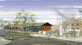
2 Artist s impression of the proposed television and media centre (43,500 sqm) at ATP to include the Seven Network and Pacific Magazines. Architect and image by PTW. i Redfern-Waterloo Built Environment Plan August 2006
3 Contents Redfern-Waterloo: On the road to renewal 1. Introduction The Redfern-Waterloo Plan Purpose of the Built Environment Plan (Stage One) Area Covered by the Plan Implementation of the Plan Community Consultation Structure of the Plan 6 2. The Redfern-Waterloo Area Strategic Location Metropolitan Strategy Planning Objectives History and Heritage Community Built Environment and Land Use Transport and Access Open Space and Public Domain Topography and Views Infrastructure Strategies for Revitalising Redfern-Waterloo Land Use Strategy Urban Design Strategy Open Space and Public Domain Strategy Infrastructure Strategy Heritage Strategy Transport Strategy Ecologically Sustainable Development Strategy Land Use and Design Concepts for RWA s Strategic Sites Australian Technology Park (ATP) North Eveleigh South Eveleigh Eveleigh Street Redfern Railway Station, Gibbons and Regent Streets Former Rachel Forster Hospital Former Local Court House and Redfern Police Station Former Redfern Public School Future Key Tasks Proposed Stage Two of the Built Environment Plan 85 Appendices 86 Appendix 1 Community Profile Credits 87 List of Tables Table 3.1 Potential development yield 22 Table 3.2 Items of heritage and buildings of historical interest 36 Table 4.1 Existing and proposed land use zones, heights and floor space ratios for RWA s strategic sites 45 List of Diagrams 1.1 RWA s operational area and RWA s strategic sites Strategic location of Redfern-Waterloo Proximity to Sydney CBD and other facilities Land use strategy for RWA s strategic sites Land use zones for RWA s strategic sites Heights for RWA s strategic sites Floor space ratios for RWA s strategic sites Indicative location of publicly accessible open space areas within RWA s strategic sites Items of heritage and buildings of historical interest ATP land use ATP height and floor space ratio North Eveleigh land use North Eveleigh height and floor space ratio South Eveleigh land use South Eveleigh height and floor space ratio Eveleigh Street land use Eveleigh Street height and floor space ratio Redfern Railway Station, Gibbons and Regent Streets land use Redfern Railway Station, Gibbons and Regent Streets height and floor space ratio 4.11 Former Rachel Forster Hospital land use Former Rachel Forster Hospital height and floor space ratio Former Local Court House and Redfern Police Station land use Former Local Court House and Redfern Police Station height and floor space ratio 4.15 Former Redfern Public School land use Former Redfern Public School height and floor space ratio 81 Redfern-Waterloo Authority August 2006 This work is copyright. The Redfern-Waterloo Authority will allow part or all of the work to be copied on condition that the source is identifi ed, the Authority s rights are acknowledged and the copy or copies are not associated with any commercial transaction. Business enquiries should be directed to the Redfern-Waterloo Authority on or redfernwaterloo@rwa.nsw.gov.au Redfern-Waterloo Built Environment Plan August
4 Redfern-Waterloo: On the road to renewal The New South Wales Government established the Redfern-Waterloo Authority (RWA) on 17 January 2005, with the support of the major political parties. In doing so, the Government demonstrated an enhanced commitment to tackling the myriad of issues that are necessary to drive a successful program of urban renewal. The Built Environment Plan, which is primarily designed to stimulate economic and social progress, has been finalised in August 2006 following an extensive period of community consultation. The Plan has been developed in the context of some significant advances having been made over the past one and half years, with the RWA s urban renewal program now well underway. Since the RWA s commencement, the Government has directly facilitated the investment of nearly $300 million towards infrastructure development in Redfern-Waterloo. Of this amount, more than $76 million has been directly committed by the RWA itself. Some of the major infrastructure investment already committed includes: $120 million to be invested by Sydney Broadcast Property in constructing a new 43,500 square metre state-of-theart media centre at the Australian Technology Park (ATP) in a deal negotiated by the RWA which will create 2000 permanent jobs. $47.5 million being invested by the RWA in a new building currently under construction at the ATP to house National ICT Australia and the Defence, Science and Technology Organisation, with 600 permanent jobs being created. $40 million being invested by Arts NSW to construct a new Contemporary Performing Arts Centre through adaptive reuse of heritage buildings at North Eveleigh in conjunction with the RWA and RailCorp. $35 million being invested by the Indigenous Land Corporation (ILC) in purchasing and transforming the former Redfern Public School into a new National Indigenous Development Centre in a deal brokered by the RWA with the ILC and the NSW Department of Education and Training. $16 million to be invested by RWA towards the provision of affordable housing for Aboriginal residents of Redfern- Waterloo. $10 million to be invested by NSW Health in transforming the former Local Redfern Court House and Police Station into a major new community health facility in an arrangement facilitated and supported by the RWA. $6 million to be invested by the RWA and its subsidiary company ATP in constructing a new pedestrian and cycle link between North Eveleigh and the ATP. $6 million being invested by RWA and ATP in new roads and infrastructure to facilitate the ATP s future development. $4.2 million invested by NSW Police in 2005 in establishing the new Redfern Police Station in the towers on Lawson Square, opposite Redfern Railway Station. $0.75 million being invested by the RWA in developing a new education and training centre at North Eveleigh, which includes the Yaama Dhinawan Indigenous cuisine training enterprise. $0.3 million to be invested by RWA to refurbish the former Murawina building in Eveleigh Street to support Indigenous enterprises and organisations. The RWA has established a partnership with GROW to undertake this refurbishment. $0.25 million being invested by the RWA and RailCorp in a concept design study for the redevelopment of Redfern Railway Station. The list does not include some significant private sector investment which is occurring in Redfern-Waterloo as a result of the enhanced commercial environment generated by the Government s urban renewal initiatives and the release of the RWA s draft Built Environment Plan in February this year; nor does it include the $52 million committed by the City of Sydney for infrastructure upgrades following the establishment of the RWA. Redfern-Waterloo is on the road to social and economic revitalisation and the Built Environment Plan is a key driver in this most important process. It is imperative that the local community is a major beneficiary of the urban renewal program and all of the RWA s planning is being directed to this end. This is particularly the case with the more disadvantaged sections of the community, where unemployment and welfare dependency are major factors. As the Employment and Enterprise Plan states: The RWA s employment and enterprise development strategy aims to directly challenge the area s social and economic disadvantage by fostering jobs, educational and life opportunities and a higher standard of living. Wealth creation is seen as an antidote to welfare dependency. The Redfern-Waterloo Plan is being implemented in 2006 as part of the Government s ten year strategy. The Plan is being developed in stages as it is intended to be a living document, which builds upon its earlier priorities and strategies, with community input as an ongoing feature. The Built Environment Plan component of the overall Redfern-Waterloo Plan represents part of Stage One of this process. 2 Redfern-Waterloo Built Environment Plan August 2006
5 Redfern-Waterloo is a unique inner city area sited at the southern gateway of the Sydney Central Business District (CBD) with significant potential for revitalisation. Its physical attributes include its accessibility and infrastructure; proximity to educational and health facilities; central location within the Sydney CBD to Airport corridor; and the availability of underutilised government land. The revitalisation of the area through job growth is not inconsistent with the objectives of the NSW Government s Metropolitan Strategy for Sydney because the Strategy does not identify Redfern as a population centre. The Strategy does however advocate the concentration of jobs and activity, as well as the provision of sufficiently zoned land for businesses in centres such as Redfern which are within the Sydney CBD to Airport corridor and in locations with high quality transport. This is reflected in the Built Environment Plan. The area is characterised by cultural and ethnic diversity. As the traditional home of the Gadigal Clan of the Eora nation, Redfern is a centre of major significance to the Aboriginal community with a strong association to the area. Despite some gentrification over the past decade, Redfern- Waterloo is less socio-economically diverse than the rest of Sydney and is characterised by a disproportionately high level of unemployment, public housing and social welfare dependency. Job growth and investment in the area offers opportunities to redress imbalances evidenced by the local community. This Built Environment Plan (Stage One) proposes a strategic planning framework to facilitate revitalisation of the Redfern- Waterloo area and guide future development on strategic sites by setting the parameters for future development. It is intended to provide a holistic response to redevelopment opportunities, deliver sustainable outcomes and support a State Environmental Planning Policy that will provide a consolidated and consistent planning approach to the area which meets the objectives of the Redfern-Waterloo Authority Act. The underlying concept for the Plan revolves around the creation of a town centre with an economic and civic heart focused around Redfern Railway Station and which is connected through pedestrian linkages to residential and business hubs at the Australian Technology Park, North Eveleigh, and Redfern and Regent Streets. Fundamentally the Plan is aimed at ensuring that benefits gained from redevelopment and economic prosperity are shared by the whole community, especially local residents and businesses, by facilitating: the provision of around 18,000 jobs the construction of around 2,000 new dwellings that will provide greater housing choice, demographic and socioeconomic mix and is supported by an affordable housing program an upgraded Redfern Railway Station, civic square and public domain improvements promoting better amenity, safety and surveillance the establishment of cultural and community facilities improved opportunities for the establishment of Aboriginal enterprises and cultural facilities high quality urban design and architecture. Redfern-Waterloo Built Environment Plan August
6 1. Introduction 1.1 The Redfern-Waterloo Plan The Redfern-Waterloo Authority s (RWA) operational area includes the suburbs of Darlington, Redfern, Waterloo and Eveleigh (Diagram 1.1 RWA s Operational Area and RWA s Strategic Sites). Under the Redfern-Waterloo Act 2004, the Minister for Redfern-Waterloo is required to prepare a Redfern-Waterloo Plan to provide an overall framework for the revitalisation of the operational area through urban renewal, job creation, improvements to the physical environment and improvements to the provision of human services. The Redfern-Waterloo Plan is an evolving document that will be updated over time and in stages. The Redfern-Waterloo Plan will comprise three major components - the Built Environment Plan, Human Services Plan and Employment and Enterprise Plan. This Built Environment Plan (Stage One) relates to the planning and design of RWA s strategic sites in Redfern-Waterloo (Diagram 1.1 RWA s Operational Area and RWA s Strategic Sites). Under the Redfern-Waterloo Authority Act, the Minister for Planning may prepare an environmental planning instrument to give effect to the planning aspects contained within the Redfern-Waterloo Plan. Over the next decade it is likely that the Built Environment Plan will be extended to incorporate other sites in the RWA s operational area. The Human Services Plan establishes a framework for improving access to health, education, employment and other essential services in Redfern-Waterloo. It identifi es actions to improve the delivery of services to ensure positive results for individuals and the community as a whole. The Employment and Enterprise Plan aims to address the area s social and economic disadvantage by fostering jobs, business and educational/training opportunities. Strategies have been developed to support the development of employment and enterprise opportunities for local residents, as well as the broader Sydney metropolitan community. Human Services improve quality & delivery of human services Sustainable Redfern- Waterloo community Built Environment improve the physical environment and provide more opportunities for housing & businesses, supported by improved transport, access & infrastructure Employment & Enterprise create jobs & training opportunities 1.2 Purpose of the Built Environment Plan (Stage One) This Built Environment Plan (Stage One) (referred to as the Plan) has been prepared to provide a planning framework for the redevelopment of the RWA s strategic sites. The Plan has considered comments and ideas provided by residents, land owners, business operators, peak organisations and government agencies during the two month exhibition period of the draft Plan in early The State Environmental Planning Policy (Major Projects) 2005 (as amended) provides the statutory basis to guide future development on the RWA s strategic sites The Plan has been prepared taking into consideration the area s regional, metropolitan and local context and issues. It also draws on earlier work and community consultation undertaken by the former Redfern-Waterloo Partnership Project and the former Department of Infrastructure, Planning and Natural Resources, as part of the Redfern, Eveleigh, Darlington and Waterloo (RED) Strategy in The land use and design strategies in the Plan have been developed through an urban design analysis of the existing context and site specifi c conditions of each strategic site. This process has generated potential development yields, and indicative employment and residential projections. 1.3 Area Covered by the Plan The Plan applies to the eight RWA s strategic sites within the RWA s operational area as shown in Diagram 1.1. The RWA s strategic sites are identifi ed in the State Environmental Planning Policy (Major Projects) They are mostly State Government owned and are strategically located near Redfern Railway Station and the Redfern Town Centre. They have a total area of around 35 hectares. The eight RWA s strategic sites covered in this Plan are: Australian Technology Park (ATP) North Eveleigh South Eveleigh Eveleigh Street Redfern Railway Station, Gibbons and Regent Streets Former Rachel Forster Hospital Former Local Court House and Redfern Police Station Former Redfern Public School. 4 Redfern-Waterloo Built Environment Plan August 2006
7 1.1 RWA s OPERATIONAL AREA & RWA s RATEGIC SITES NOT TO SCALE 1. BUCKNELL CARILLON AV CAMPBELL BURREN Sydney University FITZROY WILSON RANDLE QUEEN FORBES GOLDEN GROVE DARLINGTON RD ROSE ABERCROMBIE C Victoria Park B HENDERSON RD CITY RD WILSON SHEPHERD SHEPHERD ROSE SHEPHERD VINE BOUNDARY IVY A PINE CLEVELAND THOMAS LA VINE ABERCROMBIE LAWSON CORNWALLIS ABERCROMBIE GIBBONS WYNDHAM E D REGENT CHIPPEN COPE REGENT REGENT H RENWICK GEORGE G WILLIAM F PHILLIP RAGLAN Prince Alfred Park CLEVELAND PITT REDFERN CHALMERS CHALMERS GREAT BUCKINGHAM ELIZABETH Redfern Park WALKER JAMES MOREHEAD DEVONSHIRE BELVOIR GOODLET YOUNG MARRIOTT BAPTI CROWN KEPOS BOURKE CRESCENT CLEVELAND CHELSEA MADDISON EAERN DR OFF RAMP SOUTH DOWLING RWA s OPERATIONAL AREA RWA s RATEGIC SITES A AURALIAN TECHNOLOGY PARK [ATP] B NORTH EVELEIGH C SOUTH EVELEIGH D JOHN BRIDGE SWANSON RAILWAY PDE ASHMORE PARK NEWTON BRANDLING Erskineville Park KINGSCLEAR RD RENWICK MITCHELL RD PHILLIPS PARK RD GERARD MCEVOY GARDEN BUCKLAND Alexandria Park POWER BOTANY RD COPE COOPER GEORGE MCEVOY WE GEORGE Waterloo Park PITT POWELL YOUNG BOURKE LACHLAN Moore Park EVELEIGH REET E REDFERN RAILWAY ATION, GIBBONS & REGENT REETS F FORMER RACHEL FORER HOSPITAL LAWRENCE LA School BOTANY RD ELIZABETH ODEA AV G FORMER LOCAL COURT HOUSE & REDFERN POLICE ATION H FORMER REDFERN PUBLIC SCHOOL Redfern-Waterloo Built Environment Plan August
8 1. Introduction 1.4 Implementation of the Plan The intent and direction of this Plan is reflected in the State Environmental Planning Policy (Major Projects) 2005 (SEPP (Major Projects)). The SEPP replaces existing statutory plans and policies that currently apply to the RWA s strategic sites. A Development Control Plan (DCP) for the RWA s strategic sites will be prepared to complement the SEPP and provide more detailed site specific guidelines for future development. The DCP will include general planning guidelines and controls that will apply to all sites. Site specific requirements will be prepared where necessary as parts of a DCP or Concept Plan. Under the Environmental Planning and Assessment Act the Minister for Planning is the consent authority for the carrying out of development on RWA s strategic sites. A proposal for the carrying out of development will be assessed under Part 3A of the Environmental Planning and Assessment Act if it has a capital investment value of more than $5 million. A proposal for development under $5 million may be assessed under Part 4 of the Act. The Minister for Planning has the discretion to decide whether a development should be determined under Part 4. The Minister may require a Concept Plan to be prepared for a development site in accordance with Part 3A of the Environmental Planning and Assessment Act. 1.5 Community Consultation The draft Plan and amendment to SEPP (Major Projects) were publicly exhibited for two months between February and April During this period the RWA undertook extensive community consultation including: the distribution of 15,000 newsletters and around 2,000 copies of the draft Plan: briefings to key stakeholders; presentations; a public meeting; feedback and information sessions over a three week period; focus group sessions; and replying to individual enquiries. The consultation process raised many issues, which were considered and assisted in finalising this Plan. 1.6 Structure of the Plan The Plan is divided into the following sections. Section 2 The Redfern-Waterloo Area This section provides a snapshot of the social, economic and environmental characteristics of the Redfern-Waterloo area and issues facing the area now and in coming years. Section 3 Strategies for Revitalising Redfern-Waterloo This section outlines the key strategies needed to achieve the vision for Redfern-Waterloo including land use, urban design, open space and public domain, infrastructure, heritage, transport and ecologically sustainable development. Section 4 Land Use and Design Concepts for RWA s Strategic Sites This section details the proposed land uses and design concepts for each of the RWA s strategic sites. Section 5 Future Key Tasks This section summarises the key tasks to be undertaken to progress the planning for the RWA s strategic sites. Section 6 Proposed Stage Two of Built Environment Plan The section gives an outline of the major issues currently anticipated to form the basis of the future Stage Two of the Built Environment Plan. 6 Redfern-Waterloo Built Environment Plan August 2006
. Image by PTW.")
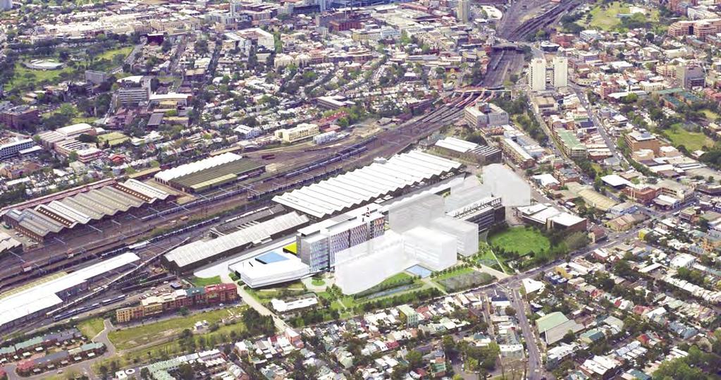
9 1. Aerial view of Redfern, Darlington and Eveleigh with Sydney CBD (and inclusion of future development at the ATP). Image by PTW. Redfern-Waterloo Built Environment Plan August

10 Redfern Railway Station 8 Redfern-Waterloo Built Environment Plan August 2006

11 2. The Redfern- Waterloo Area Redfern-Waterloo Built Environment Plan August
12 2. The Redfern-Waterloo Area This section provides an overview of the social, economic and environmental context, and characteristics of the Redfern-Waterloo area. It recognises the area s assets, highlights issues to be addressed and the need for revitalisation. The opportunities identifi ed in this section are summarised below and are addressed in the strategies outlined in Section 3. Opportunities Ensure the redevelopment and revitalisation of Redfern- Waterloo contributes towards the achievement of metropolitan employment targets and improves opportunities for people to live and work within acceptable commuting distances. Reinforce the role of Redfern-Waterloo in the Sydney CBD to Airport economic corridor and support links to key educational and health facilities in the region. Support employment opportunities and initiatives for local residents as outlined in the Employment and Enterprise Plan. Facilitate provision of additional housing, greater housing choice and affordable housing. Facilitate the upgrade of Redfern Railway Station and the creation of a signifi cant civic space adjacent to the Railway Station. Realise the potential of Redfern Railway Station and anchor Redfern as a major destination. Facilitate improved linkages between Redfern Railway Station and local employment hubs, Redfern Town Centre, and the University of Sydney. Work with relevant government agencies to address regional and local traffi c and public transport issues; ensure traffi c generated by new development is managed: and improve bus access. Facilitate improved connectivity between east and west Redfern. Facilitate public domain improvements along linkages and increase open space provision through redevelopment of RWA s strategic sites. Improve safety and amenity in the area. Encourage Aboriginal enterprise and cultural development and reinforce Redfern as a meeting place for Aboriginal people. Facilitate the establishment of community and cultural facilities for all residents and support the initiatives outlined in the Human Services Plan. Ensure high quality urban design and architecture, and encourage design excellence. Protect and adaptively reuse heritage items, where practicable. 2.1 Strategic Location Redfern-Waterloo is strategically located to the south of the Sydney Central Business District (CBD), 3 kilometres from the Sydney Town Hall. To the south-west of Redfern-Waterloo are Sydney s economic gateways, Port Botany and Sydney Airport. Under the NSW Government s Metropolitan Strategy (City of Cities, A Plan for Sydney s Future) released in 2005, the Redfern-Waterloo area is designated as part of the Sydney CBD to Sydney Airport economic corridor and the broader global economic corridor from North Sydney to the Airport. This corridor contains activities critical to the Sydney metropolitan economy. Diagram 2.1 illustrates the important strategic position of the Redfern-Waterloo area. The area s close proximity to the Sydney CBD accentuates the emergence of a major employment centre in Redfern located close to Sydney s national and international businesses; and key health, education, cultural and entertainment facilities as shown on Diagram 2.2. It is important that future development reinforces the area s proximity to the Sydney CBD and provides stronger physical links to these facilities and activities. 10 Redfern-Waterloo Built Environment Plan August 2006


13 2. RWA s OPERATIONAL AREA RWA s OPERATIONAL AREA GLOBAL ECONOMIC CORRIDOR SYDNEY CBD SYDNEY CBD TO AIRPORT CORRIDOR MAIN ROADS - M5, EAERN DIRIBUTOR, GORE HILL FREEWAY, WARRINGAH FREEWAY & M2 HYDE PARK ROYAL BOTANICAL GARDENS THE DOMAIN KEY OPEN SPACE RAILWAY LINE Macquarie Park RAILWAY LINE BICENTENNIAL PARK SYDNEY TOWN HALL Chatswood JUBILEE PARK WENTWORTH PARK St Leornards SYDNEY INITUTE OF TAFE 3 km. VINCENTS HOSPITAL North Sydney Sydney CBD UNIVERSITY OF SYDNEY UNIVERSITY OF TECHNOLOGY C.U.B. VICTORIA PARK PRINCE ALFRED PARK REDFERN-WATERLOO ROYAL PRINCE ALFRED HOSPITAL REDFERN RAILWAY ATION REDFERN PARK MOORE PARK CENTENNIAL PARK Airport ERSKINEVILLE PARK ALEXANDRIA PARK WATERLOO PARK Port Botany GREEN SQUARE TOWN CENTRE SYDNEY PARK Diagram 2.1 Strategic location of Redfern-Waterloo Diagram 2.2 Proximity to Sydney CBD and other facilities UNIVERSITY OF NSW Redfern-Waterloo Built Environment Plan August
14 2. The Redfern-Waterloo Area Redfern-Waterloo is highly accessible to: Tertiary educational campuses of the University of Sydney, University of Technology, University of NSW, University of Notre Dame and Sydney Institute of Technology. Health facilities such as Royal Prince Alfred Hospital and St Vincent s Hospital. Regional and local open space Victoria Park, Moore Park, Centennial Park, Prince Alfred Park, Redfern Park, Waterloo Park and Alexandria Park. Community facilities and services. Transport infrastructure rail and bus networks, major road networks including regional roads linking to the Sydney CBD, Sydney Airport and Port Botany (such as Botany Road, Regent Street, Cleveland Street and O Riordan Street). Residential and commercial developments proposed at Green Square and the Carlton United Brewery (CUB) site. 2.2 Metropolitan Strategy Planning Objectives In December 2005 the NSW Government released the City of Cities A Plan for Sydney s Future, the 25 year Metropolitan Strategy for Sydney. The Metropolitan Strategy predicts Sydney s population to grow from the current population of 4.2 million to 5.3 million by 2031 (an additional 1.1 million people in 25 years). The NSW Government predicts that this will require 640,000 new homes, 500,000 additional jobs, 6.8 million square metres of additional commercial space and 3.7 million square metres of additional retail space. A key approach to the Metropolitan Strategy is residential and employment growth within existing key centres and economic corridors. The Metropolitan Strategy identifi es Redfern-Waterloo as an area which lies within Sydney s Economic Corridors (the corridor refers to the concentration of employment and gateway infrastructure from Macquarie Park through to Chatswood, St Leonards, North Sydney and the Sydney CBD to the Airport and Port Botany). Due to the area s strategic location and public transport provision, it plays a major role in supporting Sydney s Economic Corridor by concentrating jobs and activity around Redfern Railway Station and ensuring the provision of suffi ciently zoned land for business. The Metropolitan Strategy sets planning targets for the City of Sydney of 55,000 new dwellings and 58,000 new jobs by The development of the RWA s strategic sites can contribute to providing land for business and residential purposes to assist in meeting these Sydney metropolitan planning targets. It will maximise the advantage of existing public transport; the Sydney CBD, Airport and Port; recreational and cultural facilities; and nearby signifi cant health and educational facilities. The Redfern-Waterloo area has a population of nearly 20,000, which is less than half the population in the early 1950 s. Redfern-Waterloo has experienced a decline in its traditional industrial and warehousing business base. There are currently about 12,500 jobs within the RWA s operational area. The decline in population and the traditional industrial base has impacted on the area s economic sustainability. Redfern- Waterloo, as with many suburbs along the Sydney CBD to Airport corridor, is undergoing a transformation towards a more commercial and service oriented business base. The RWA s strategic sites can contribute positively by injecting more development potential for employment generation. Redfern-Waterloo s accessible location provides a great opportunity to support sustainability by providing a greater number of jobs within Sydney s south east region. Job growth in Redfern-Waterloo will enhance opportunities for people to live and work within acceptable commuting distance, positively contributing to family life and the reduction of greenhouse emissions. 2.3 History and Heritage Redfern-Waterloo has a rich built history that is evidenced by the late nineteenth century terrace housing, industrial buildings and warehouses, all of which still characterise the area today. Redfern has a strong industrial history dating back to the mid 1800 s. It attracted a wide range of industries such as tanneries, brickworks, wool washing and market gardens. Much housing was constructed for the workers of these industries. The Eveleigh Railway Workshops, built in the 1870 s, provided a unique infl uence to the development of the area. The Workshops attracted many workers to the area and at the height of operations employed over 3,000 skilled workers. The late nineteenth century terrace housing was largely constructed to provide housing for those employed at the Workshops. The Workshops closed in the late 1980 s with railway operations and maintenance facilities still existing on the southern side of the railway line. Today the Australian Technology Park (ATP) has brought back employment and people to the southern part of Eveleigh with adaptive reuse of the Locomotive Workshop and new developments. The Eveleigh Railway Workshops is currently listed on the State Heritage Register. The adaptive reuse of signifi cant heritage buildings such as the Locomotive Workshop at the ATP and the Contemporary Performing Arts Centre at the Carriage Workshops in North Eveleigh contribute to the unique character and setting of the railway yards, reinforces the industrial history of the area and preserves the heritage signifi cance of the railway yards. The Chief Mechanical Engineers Offi ce building that fronts Wilson Street is another fi ne example of a heritage building that lends itself to adaptive reuse. The history of the area is also refl ected in the former Local Court House on Redfern Street, some buildings on the former Redfern Public School site (along George Street) and various buildings on the former Rachel Forster Hospital site. 12 Redfern-Waterloo Built Environment Plan August 2006
 provided for the demolition of houses to be replaced with high rise apartment")


15 2. Further work will be undertaken to determine the heritage integrity of individual heritage items and appropriate measures to protect their relative importance with each development proposal. Due to the poor condition of housing within Redfern-Waterloo in the mid 1900 s, the County of Cumberland Plan ( ) provided for the demolition of houses to be replaced with high rise apartment blocks in a landscaped setting. The Housing Commission at the time played a key role in developing Redfern-Waterloo as evidenced by the public housing that remains today. The Department of Housing towers remain a strong built feature in the landscape and continue to refl ect the very high proportion of public housing tenancies in the area. The State Government has given its commitment that there will be no reduction to the amount of public housing tenancies in the area; current residents will not be disadvantaged; and all public tenancies are secure. The Aboriginal community has continually occupied the Redfern-Waterloo area. Since the 1940 s Redfern and the area known as the Block (bound by Eveleigh, Vine, Louis and Caroline Streets) has become an important base for Aboriginal people in Sydney. The Block has been in Aboriginal ownership since 1973 when it was purchased for Aboriginal housing through a Commonwealth Government grant. The struggle to gain ownership of the Block was part of the movement by Aboriginal people during the 1970 s towards self-determination. Many of the original houses on the Block have been demolished. Of the remaining dwellings a number are derelict. The much needed redevelopment of the Block must recognise the social and cultural importance of the area for Aboriginal people. Redfern has a special status for Aboriginal people as evidenced by the various organisations in the area, including the Aboriginal Medical Service, Metropolitan Local Aboriginal Land Council, Aboriginal Legal Service, Wyanga (Aboriginal aged care), Aboriginal Dance Theatre and Aboriginal Children s Service. 2.4 Community The Redfern-Waterloo area is the traditional home of the Gadigal Clan of the Eora Nation. Redfern is a centre of major signifi cance to Aboriginal people who have a strong association with the area and contribute to its strong sense of identity. The Block is particularly important as a meeting place for local Aboriginal people, as well as visitors from outside the area. Redfern has a modern tradition of being a beacon for Aboriginal people from around Australia it provides an opportunity to reunite with family and friends from their hometowns or to simply be with their mob. Originally there has been a sense of place here for the Aboriginal community and a sense of cultural and spiritual identity in an otherwise alienating environment. (Aboriginal Housing Company; 2001) Redfern-Waterloo is also characterised by strong cultural and ethnic diversity. The area has a rich multicultural community with residents from Russian, Chinese, Arabic, Greek, Spanish, Vietnamese and various backgrounds other than English. There is a strong sense of community spirit within the area. From interviews with the local community (Making Connections: Better Services, Stronger Community, 2004) it was expressed that people value the diversity of the area and that there is a high level of respect despite some negative external perceptions. Appendix One provides a community profi le. Compared to the Sydney region the Redfern-Waterloo area experiences higher levels of economic and social disadvantage. This is attributed to lower incomes, education, home ownership and labour force participation, high levels of unemployment and public housing occupancy. Community events Heritage buildings - North Eveleigh Carriage Workshops Cycle routes - Little Eveleigh Street Redfern-Waterloo Built Environment Plan August


16 2. The Redfern-Waterloo Area Within the Aboriginal community the social and economic disadvantage is more signifi cant with people more likely to be unemployed, have lower incomes and fewer assets, poorer education, literacy and health and lower life expectancy. The social and economic disadvantage has contributed to complex social issues and a negative perception of the Redfern-Waterloo area. Crime levels, including a re-offending population, drug and alcohol dependence and poor health, (particularly mental health); and family breakdown and stress are issues for people living in Redfern-Waterloo. Empowerment through access to jobs, education and training are key to addressing the fundamental problems associated with social disadvantage. The Employment and Enterprise Plan prepared by the RWA outlines opportunities for job creation for the local community. The Built Environment Plan provides the planning mechanism for much of the job creation identifi ed in the Employment and Enterprise Plan. The Human Services Plan complements these initiatives by ensuring a more effi cient and appropriate delivery of human services to those in need in the community. In support of the Human Services Plan, this Plan provides land use and planning controls that will facilitate the establishment of community and cultural facilities. As a result of gentrifi cation and private housing ownership in parts of Redfern-Waterloo over the past decade, the relative proportion of lower to medium income households has decreased and is comparative to the wider Sydney region. While gentrifi cation has facilitated increased growth and prosperity it has also reduced the affordability of housing within Redfern-Waterloo, which has led to the displacement of lower income households. This in turn has contributed to increasing social polarisation as the gap between high and low income earners widens. Declining housing affordability is an issue that needs to be addressed. This objective is reinforced by the Redfern-Waterloo Authority Act, which makes provision for the RWA to collect funds to provide for affordable housing in the area. The RWA seeks to create a more sustainable future for the community in the Redfern-Waterloo area. 2.5 Built Environment and Land Use Redfern-Waterloo is characterised by a fi ne grained subdivision pattern within residential areas featuring narrow frontages (about fi ve to six metres) and deep lots (about thirty metres) with streets to the front and laneways to the rear. Larger lots occur where warehousing and railway uses were located. Overall the street pattern provides simple rectilinear street blocks. Many are divided by narrow laneways that provide rear access to dwellings and business premises. Much of the residential development in the area responds to the alignment of the streets, resulting in a strong sense of enclosure along streets within the area. There are many street types within the area, ranging from wide industrial streets that lack trees, to residential streets and laneways featuring signifi cant mature trees and a high level of pedestrian amenity. As is typical of many inner city areas of Sydney, the built form is a mixture of terrace housing, small single storey cottages, and two to three storey commercial and retail buildings. To the west of the Redfern-Waterloo area the built form includes signifi cant groupings of two storey terraces. Interspersed within this, especially along the main traffi c routes (such as, Cleveland Street and Regent Street) and close to the railway line are larger four to six storey warehouses, industrial and apartment buildings. Along streets such as Abercrombie Street and Lawson Street there are concentrations of older warehouses and buildings associated with the University of Sydney that have greater height. Generally, the scale is three to fi ve storeys, which continue back along Lawson Street to the Redfern Railway Station. Schools and public housing - Former Redfern Public School (Proposed National Indigenous Development Centre) and Waterloo public housing Open Space - Former Redfern Public School oval Public Transport - Regent Street bus stop 14 Redfern-Waterloo Built Environment Plan August 2006
17 2. It is this mix of scale and architectural form that is part of the character of these inner city locations. The Redfern-Waterloo area has also been subject to more recent twentieth century modernist development featuring tall buildings set within open space. This development has introduced a high rise built form, with the 11 storey commercial towers on Lawson and Regent Streets and the Department of Housing towers of up to 30 storeys. The commercial towers on Lawson Street coincide with the ridge line to create a visual marker for the Redfern Town Centre (Redfern Railway Station and Redfern Street). The Redfern Town Centre at Redfern Street has a mixture of built form including the 11 storey towers and two to four storey buildings. The centre lacks active uses at street level and is visually unappealing. The Eveleigh Railway lands contrast to the general built form of the area with large warehouse structures covering extensive footprints. The ATP provides a positive built environment incorporating adaptive reuse of buildings, contemporary designed buildings and a good public domain. Along Regent Street and its surrounds there has recently been new mixed use development characterised by commercial and retail on the ground fl oor and residential above. This has provided new premises for businesses and increased activity along the street, while increasing the population. There are no major supermarkets servicing the local population and residents often travel to Surry Hills, East Gardens, Marrickville or Broadway for their weekly shopping. Despite the extensive movement network, transport options and grid street system, connectivity for pedestrians and residents to some key destinations, such as the Redfern Railway Station, the Town Centre and between North and South Eveleigh is restricted. This is primarily due to the rail corridor, rail yards and major roads carrying through traffi c. The result is a disconnected suburban structure and development sites enclosed by the transportation network. This has led to the separation of Redfern and Regent Streets from the western residents and worker population, which has discouraged pedestrian movement through to the Redfern Town Centre. 2.6 Transport and Access Public Transport The Redfern Railway Station is one of the most signifi cant assets of Redfern-Waterloo. Railway stations and other public transport nodes play an important role in the revitalisation of a local area by providing transport for workers and residents. Redfern Railway Station is the tenth busiest railway station in the metropolitan CityRail network in terms of passenger movements with approximately 31,000 movements occurring on a typical weekday (entries and exits). In addition, considerable passenger interchanges occur between platforms (approximately 18,000 rail to rail passenger interchange movements within the station on a weekday). More CityRail suburban and inter urban trains stop at Redfern Railway Station than any other station, with the exception of Central, providing it with superior access to and within metropolitan Sydney. Redfern Railway Station provides an exceptional opportunity as a destination for commuters. Information provided by RailCorp indicates that over 55 percent of commuters walk to the station and approximately 37 percent travel to the station by bus. Only about fi ve percent of rail commuters arrive at the station by car. There is signifi cant movement of people to the University of Sydney and over 1,300 people interchange during the peak period from rail to bus to access the employment areas of Mascot, Botany and Alexandria. This data clearly indicates that access and connectivity to bus stops, key adjoining destinations, such as the University of Sydney, and future activity nodes at Redfern Town Centre (Redfern Street), ATP and North Eveleigh must be well considered to ensure ease of access and safety for workers, residents and visitors. Redfern Railway Station does not currently provide access for people with a disability, in line with the Disability Standards for Accessible Public Transport and the Disability Discrimination Act. The stairway access to the platforms is inequitable for the elderly, young children and less mobile people. In addition, many of the movement areas are not suffi ciently large enough to comfortably accommodate the amount of people moving to and from the Station at peak periods. Any proposed redevelopment of the RWA s strategic sites must be matched with improvements to Redfern Railway Station and associated connections to key destinations in the Redfern-Waterloo area. This is reinforced in the Metropolitan Strategy where upgrading the station is seen as a key initiative to providing better services for future development. The Redfern Railway Station upgrade needs to occur to provide: disabled access and enhanced safety a general increase in rail patronage growth increased capacity to service new business and residential development proposed on the RWA s strategic sites a physically improved Railway Station that improves the entry and connections to the Redfern-Waterloo area a more effi cient rail interchange facility improved connection to key destinations within 5 to 15 minutes walking radius of the Station safe access out of the station onto busy roads that divides the Station environs a high degree of public and pedestrian amenity. Existing bus services operating in Redfern offer a high level of regional and local connectivity. The service levels on Gibbons and Regents Streets are split due to the one-way traffi c fl ow, which can make locating bus stops diffi cult. Redfern-Waterloo Built Environment Plan August
18 2. The Redfern-Waterloo Area In 2007 the RTA will be considering the upgrade of the Gibbons and Regent Streets corridor as part of its Strategic Bus Corridor Program linking Miranda to the CBD. This will improve the speed and reliability of buses along this corridor. As a result, the frequency of services and the expansion of existing bus routes need to be closely examined. Pedestrian connections to key bus stops, especially on Regent and Lawson Streets also need to be improved. Roads and Traffic According to the Australian Bureau of Statistics 2001 Census data, compared to the Sydney metropolitan region, Redfern- Waterloo has almost half the level of car ownership and double the public transport patronage. This is due to the socioeconomic profi le of the existing population and the area s close proximity to a number of destinations, such as Newtown, the University of Sydney, Moore Park, Cleveland Street and Surry Hills. The Redfern-Waterloo area channels signifi cant volumes of regional traffi c and people to other destinations in Sydney, rather than being a key destination. Currently, large volumes of regional traffi c travelling north-south along Gibbons and Regent Streets physically dissect the Redfern Railway Station from the Redfern Town Centre area. This limits physical connections, restricts pedestrian movement and reduces pedestrian safety. The Department of Planning has advised that over the next 10 years traffi c in the Sydney CBD to Airport corridor is anticipated to increase by 20,000 road trips in the morning peak. The continuing strong growth in the movement of vehicles and trucks through the Airport and Port Botany will increase traffi c on the regional transport network. Without any action to address the increasing traffi c from the Airport and Port Botany, regional traffi c will continue to increase through Redfern-Waterloo impacting on pedestrian amenity and safety. Unless carefully managed, this will continue to negatively impact on the already poor business environment along Regent and Gibbons Streets and reduce the pedestrian amenity. The RWA in partnership with the Roads and Traffi c Authority (RTA) is currently examining various options to manage regional traffi c through Redfern-Waterloo to create a safer main street and pedestrian environment. The solution may require a more strategic response that takes into consideration broader metropolitan and regional traffi c issues, which may take some time to investigate and resolve. Pedestrian Network The pedestrian network is highly accessible and the main pedestrian routes are likely to remain. Lawson and Redfern Streets are the main east-west pedestrian link. The western footpath of Gibbons Street carries a heavy volume of pedestrians to the Station and bus services. Lawson Street is a major pedestrian route for university students. Pedestrian movement between the Station and the Town Centre is severely impeded by the speed and volume of traffi c using Regent and Gibbons Streets. In order to improve the pedestrian network and safety this issue needs to be addressed. Approaching the Station there is little shelter for pedestrians from wind, rain and sun. Pedestrian connections to North Eveleigh from the Station are indirect, whilst pedestrian routes from the Station are unclear. Footpaths along Regent Street have more active frontages than on Gibbons Street. Cycling There are many existing on road bicycle routes through or adjoining the RWA s strategic sites. Currently, there are on road bicycle routes along Redfern Street, Lawson Street connecting to Little Eveleigh Street and Wilson Street, which extend towards Erskineville, Newtown, the University of Sydney and City Road. There are also on road bicycle routes along Henderson Road and Railway Parade. The only off road bicycle route in the locality is through the ATP. As part of the City of Sydney s upgrade of Redfern Street, Council is establishing cycle and traffi c lanes and 10 kilometres per hour speed limits along Wells Street and Turner Street to improve the safety for cyclists and to direct them off the busier and more dangerous traffi c routes (such as Redfern Street). Further work will be undertaken to determine linkages to and through RWA s strategic sites for cyclists. 2.7 Open Space and Public Domain Redfern-Waterloo and the immediate surrounds are characterised by a hierarchy of public open spaces consisting of: regional parks example, Moore Park district parks examples, Redfern Park, Victoria Park and Prince Alfred Park local parks scattered throughout residential areas, including Hollis Park, Alexandria Park, Yellowmudee Park, Hugo Street Reserve and Pemulwuy Park. The City of Sydney is currently completing the upgrade of a number of local parks in Eveleigh Street and east Redfern to make the parks more attractive, improve their function, and improve safety and visibility. Despite the availability of open space in the general area, the Redfern Town Centre lacks a well designed central meeting place. Redevelopment offers the opportunity to create a quality civic space adjacent to the Redfern Railway Station. The public domain within the town centre and other RWA s strategic sites is unattractive. Dark streets and shuttered shop fronts create the perception that the area is unsafe and unwelcoming. 16 Redfern-Waterloo Built Environment Plan August 2006


19 2. This is especially the case in the Redfern Town Centre, along Redfern and Regents Streets, which are currently underperforming as the area s retail hub. Improvements to the public domain of surrounding town centres, such as King Street, Newtown; Erskineville Road, Erskineville; and Oxford Street, Paddington; have had a signifi cant impact on encouraging people to use these areas, and boosted local business activity signifi cantly. Crime and personal safety has been identifi ed by the community as the most signifi cant issue that needs to be addressed in the area. This especially relates to the use and enjoyment of public areas frequently compromised by crime and intimidating behaviour. The NSW Government Submission for the Inquiry into Redfern and Waterloo 2004 highlights the strong community concern about crime and safety. These concerns were also expressed by the public during consultation for the RED Strategy. Improvements to the public domain and increased public surveillance are important ways in which public safety and perception can be improved and are an important element of this Plan. The community has also indicated a need for public domain and streetscape improvements. The City of Sydney council has commenced a $20 million streetscape improvement program. The works include improvements to the footpaths, under grounding of power lines, new street furniture, new street trees and lighting on Redfern Street. In addition, improvements to the Jack Floyd Reserve and a limited upgrade of Regent Street are also to be undertaken. This public investment is a positive start to improving the access and amenity of the area, however, the RWA has indicated to the City of Sydney that much more needs to be done to revitalise Regent Street. The lack of connectivity also contributes to poor passive surveillance of the public spaces. The access to the north eastern part of the area around Eveleigh Street is heavily compromised due to the lack of visual connection and passive surveillance, which contributes to antisocial behaviour in public open space areas. 2.8 Topography and Views Topography The majority of the Redfern-Waterloo area is located either along the ridge line or on north, west and south facing slopes. Redfern Street and the commercial towers along Lawson Street are located along a ridge line. There is also a ridge line running slightly east of Elizabeth Street. Views The Redfern-Waterloo area offers magnifi cent views looking north towards the Sydney CBD. The Sydney CBD is visible from most of the north-south streets crossing Redfern Street and along Lawson Street where it intersects Eveleigh Street. To the south are district views of the Department of Housing high rise apartments and views towards Sydney Airport and Botany Bay. Views to the east and west are generally local in nature. The Redfern Street ridge line is visible from the southern parts of the Sydney CBD and from the high rise development on the southern edge of the city. The existing commercial towers along Lawson Street and the Department of Housing high rise apartments are prominent features that can be viewed when travelling southward through the area. From the south, the Redfern-Waterloo area is less visible as the slope is fairly gradual, although the high rise apartment grouping is highly visible. Redfern community Public open space - Gibbons Street Connectivity - Regent Street view towards Sydney CBD Redfern-Waterloo Built Environment Plan August


20 2. The Redfern-Waterloo Area 2.9 Infrastructure The proposed increases in residential population and businesses will have an impact on capacity of infrastructure. This includes the provision of gas, electricity, telecommunications, water, sewerage, and stormwater. The feedback from preliminary consultation with infrastructure service providers is detailed below. Electricity Energy Australia has advised that there is extensive infrastructure in the area consisting of underground 132 kv, 11kV and low voltage cables. This is supported by substations located on private properties, Energy Australia owned properties and on footpaths. There is also a 330kV underground TransGrid cable running form Sydney South to Haymarket. This cable forms a major part of supply to the CBD. Energy Australia is planning for substantial electricity load growth in the area. The general capacity of the network is constantly monitored and reviewed in light of more detailed development plans. Energy Australia has indicated that the area has aged assets that will be replaced over the next 5 to 10 years. These works will be focused in Redfern, Regent, Renwick, Gibbons and Abercrombie Streets; Henderson Road; Botany Road to O Riordan Street; and Elizabeth and Chalmers Streets south of Cleveland Street. Future developments in the area may require the provision of on-site substations. Energy Australia has indicated that they are undertaking extensive excavation works and under grounding of overhead power lines in Redfern Street between Elizabeth and Regent Streets as part of the City of Sydney s Redfern Street upgrade. Gas Preliminary details provided by Agility indicate that all RWA s strategic sites have good access to gas mains. Reticulation mains may be required on a number of the strategic sites such as North Eveleigh, South Eveleigh, and the Redfern Railway Station, Gibbons and Regents Streets sites. There is capacity in the gas network to supply current projected growth for the next 10 years. Agility reviews gas capacity on an ongoing basis taking into consideration issues of timing and natural gas consumption patterns. To ensure a reliable supply of gas, Agility will advise on the servicing options for specifi c development proposals on RWA s strategic sites as they occur on a case by case basis. Telecommunications All basic telephone services are currently delivered from the Redfern exchange by copper cable. In addition, there is an extensive optical fi bre network in the area, serving business and residential needs. Technology is rapidly changing and delivery of services by optical fi bre is becoming more economical. Telstra has advised that they will soon be delivering basic telephone services and ADSL using Fibre to the Node (FTTN). As a result, in the Redfern-Waterloo there will be a mix of delivery by conventional copper cables and FTTN in the short to medium term. Telstra has processes in place to initiate augmentation of copper cables before capacity is exhausted. The optical fi bre network capacity and coverage will be provided as the needs of the area increase. For businesses requiring network security, Telstra can provide additional fi bre feeds from adjacent exchanges (such as Newtown and Kensington) as already provided for the Australian Technology Park customers. Public spaces - Gibbons Street Heritage - Industrial/rail buildings in North Eveleigh Employment - ATP 18 Redfern-Waterloo Built Environment Plan August 2006
21 2. Water, wastewater and stormwater Sydney Water and RWA are currently examining water and waste water capacity and infrastructure requirements for RWA s strategic sites. This will provide a basis for forward planning of infrastructure requirements based on the land uses, heights and fl oor space ratios indicated in this Plan. It is envisaged that water cycle management strategies including water reuse and recycling will be considered for the strategic sites. This may involve treated wastewater, sewer mining and stormwater harvesting. Three stormwater channels fall within the Redfern-Waterloo area, namely: Sheas Creek, Munni Creek and Blackwattle Bay. With the exception of the Eveleigh Street site, the RWA s strategic sites are located in the Alexandria Canal catchment. This catchment ultimately feeds into the Cooks River and Botany Bay. The Redfern-Waterloo area has been identifi ed as an area of low stormwater capacity. The Alexandra Canal Master Plan produced in 2001 provides a basis for stormwater management on the RWA s strategic sites. The RWA and Sydney Water will be examining the stormwater capacity of the area to provide a more holistic approach to water cycle management. Port radar Sydney Ports has advised that a radar projects from Port Botany to the Harbour Control Tower at Millers Point. The radar is used by Sydney Ports to monitor ship movements in Botany Bay. Developments protruding into or adjacent to the line of sight of the radar will impact on the radar s microwave transmission and may affect the safety of shipping movements. The microwave beam traverses the Australian Technology Park and North Eveleigh sites. Accordingly, development proposals that may impact on the radar are required to be referred to Sydney Ports and may require microwave repeaters to be incorporated on sites and buildings. Redfern-Waterloo Built Environment Plan August

22 Redfern Railway Station entrance 20 Redfern-Waterloo Built Environment Plan August 2006

23 3. Strategies for Revitalising Redfern-Waterloo Redfern-Waterloo Built Environment Plan August
24 3. Strategies for Revitalising Redfern-Waterloo This section presents the framework for revitalisation of the built environment of Redfern-Waterloo. The framework is based on the achievement of strategies for the future development of the RWA s strategic sites. The strategies relate to: land use and zoning; urban design; open space and public domain infrastructure; heritage; transport; and ecologically sustainable development. The principles of sustainable development have been considered in developing these strategies and underpin the Built Environment Plan and State Environmental Planning Policy (Major Projects) for the RWA s strategic sites. To achieve an improved social and cultural environment, the Plan and SEPP (Major Projects) promote an increase in housing provision, choice and affordability; safety and access; activation of sites adjoining residential areas that are degraded and underutilised; fostering of retail and employment activity; and quality community, cultural and civic spaces for residents, workers and visitors. To achieve an improved physical environment, the Plan and SEPP (Major Projects) promote a place with a built form and civic spaces that are responsive to the existing context; provides for increased emphasis on public transport; improves access and connections; and encourages development that has regard for environmental sustainable outcomes. To achieve a more viable economic environment that provides greater employment for local residents and the wider metropolitan area, the Plan and SEPP (Major Projects) encourage high quality developments where retail, cultural and commercial businesses are able to provide jobs for the local and broader Sydney population. A stronger local economy will mean greater investment that will improve the places and spaces in the area. To achieve a strong governance structure, the Plan will be supported by the SEPP (Major Projects) that will provide the guidelines for future development, and the initiatives of the Human Services Plan and the Employment and Enterprise Plan. The strategies are supplemented by site specific land use and design concepts for each of RWA s strategic site detailed in Section Land Use Strategy The Land Use Strategy provides for sustainable outcomes based on sound urban design principles. Diagram 3.1 illustrates the Land Use Strategy. The Land Use Strategy is underpinned by the following actions, which have been developed from an analysis of metropolitan, local and site specific issues: zoning land to provide for flexible land uses facilitating economic and employment growth facilitating the creation of a town centre and improved linkages developing a design for the upgrade of Redfern Railway Station facilitating housing provision, choice and affordability facilitating community and cultural development. Estimated Development Yield The following table illustrates the indicative development yield that the Plan seeks to achieve on the RWA s strategic sites. Table 3.1 Potential Development Yield Site Area (estimate) 35 hectares (350,000 square metres) Total development yield (estimate) 600,000 square metres Zoning and flexibility of land uses A plethora of land uses, land use zones, plans and controls currently apply to the RWA s strategic sites. The South Sydney Local Environmental Plan; various Development Control Plans of the current City of Sydney and former South Sydney Councils; Sydney Regional Environmental Plan No. 26 City West; Urban Development Plan Eveleigh Precinct and the Australian Technology Park Master Plan represent the myriad of planning instruments and policies applying to the RWA s strategic sites. These plans and policies do not provide a consistent or comprehensive set of controls and guidelines, and were not specifically developed to revitalise and renew Redfern- Waterloo. They present a lack of certainty and clarity for development opportunities and do not provide the basis for achieving the vision for Redfern-Waterloo. These policies are no longer appropriate and need to be replaced. The Land Use Strategy proposes the adoption of new land use zones that provide flexible land uses to encourage investment, generate jobs and provide housing to facilitate the revitalisation and renewal of Redfern-Waterloo. The new land use zones will replace the redundant and restrictive zones currently applying to the sites. 22 Redfern-Waterloo Built Environment Plan August 2006


25 3.1 LAND USE RATEGY FOR RWA S RATEGIC SITES NOT TO SCALE 3. SYDNEY UNIVERSITY ABERCROMBIE REET To Eveleigh & Cleveland Streets CLEVELAND REET REGENT REET PRINCE ALFRED PARK REDFERN ATION UPGRADE & CONCOURSE CURRENTLY BEING INVEIGATED CIVIC SPACE LAWSON REET PREDOMINANTLY BUSINESS CODRINGTON REET To Sydney University, North Eveleigh & Darlington ABERCROMBIE REET To Redfern shops, Redfern & Regent Streets PREDOMINANTLY RESIDENTIAL REDFERN REET MIXED BUSINESS & RESIDENTIAL WILSON REET LOCOMOTIVE REET To ATP GIBBONS REET REGENT REET COPE REET PHILLIP REET PITT REET PREDOMINANTLY CULTURAL & ARTIIC COMMUNITY, EDUCATION & RECREATION RAILWAY USE HENDERSON ROAD DAVY ROAD To Alexandria & Erskineville BOTANY ROAD PUBLIC & PRIVATE OPEN SPACE MITCHELL ROAD POTENTIAL PEDERIAN & CYCLE BRIDGE PEDERIAN & CYCLE LINKS TO BE REINFORCED ALEXANDRIA PARK Redfern-Waterloo Built Environment Plan August
26 3. Strategies for Revitalising Redfern-Waterloo For example, large areas of under-utilised surplus railway land that are sterilised from redevelopment opportunities due to existing railway zoning, will be rezoned to allow for a mix of non-residential and residential uses. The proposed land use zones indicated in Section 4 are based on the land use zones included in the Standard Instrument (Local Environmental Plans) Order 2006 under the Environmental Planning and Assessment Act Diagram 3.2 indicates the proposed land use zones for the RWA s strategic sites. The land use zones allow for a range of business, office, retail, light industrial uses; residential development; community uses and public open spaces. Facilitate economic and employment growth Economic and job growth is integral to the renewal of Redfern- Waterloo. To encourage employment growth higher floor space ratios will be provided for employment generating land uses on the strategic sites where mixed uses are proposed. The Land Use Strategy will generate development potential (non-residential) of around 440,000 square metres to accommodate around 18,000 jobs in Redfern-Waterloo. It is envisaged that land uses will include a range of activities including commercial and retail development, community and cultural facilities, health facilities, educational establishments, entertainment facilities, restaurants, light industries, film and television, research and development. The Strategy complements the RWA s Employment and Enterprise Plan, which identifies actions to translate development potential into actual jobs for local and non local workers through: education and training, including a dedicated vocational training centre to provide people with the opportunities to gain access to well paid work strengthening partnerships with local employers industry based employment strategies employment and enterprise strategies for Aboriginal people support for local business. The strategy is based on harnessing the potential for job growth and activity around the Redfern Railway Station, within Australian Technology Park, on the disused railway land at North and South Eveleigh and the Eveleigh Street sites to meet local and metropolitan employment needs. The Strategy recognises the need to establish a threshold density necessary to encourage employment clusters, economic viability and vitality. It strongly supports job growth as a key driver to achieving a sustainable community in Redfern-Waterloo. The proposed concentration of activity and development density around the Redfern Railway Station: reflects synergies with Central Station reflects Redfern s status as the southern gateway to the Sydney CBD takes advantage of the underutilised land capacity is environmentally responsible builds on the unique accessibility of Redfern Railway Station. Importantly, the concentration provides an employment centre for the south east metropolitan sub-region of Sydney and increases the opportunity for residents to live and work within the region. It also arrests the significant loss of traditional industrial and employment generating land from residential rezonings that have occurred in the sub-region over the past decade. Movement in and around Redfern Railway Station will be directed to Redfern Town Centre and Regent Street to boost economic activity and enhance the viability of the town centre. The ATP, which is a unique employment hub located a short walking distance from Redfern Railway Station, has not realised its economic and investment potential. Further job growth at the ATP will benefit local residents, as well as provide a vital employment destination for residents in the south eastern metropolitan sub-region. North Eveleigh provides the unique opportunity as a precinct where people can live, work and recreate in an iconic and artistic place within short distance of a major public transport hub. The Contemporary Performing Arts Centre being built by Arts NSW will boost activity and interest in the area and encourage complementary activity. North Eveleigh is ideally located for a range of land uses, including student accommodation, innovative incubator businesses, training centres, markets and other activities linked with its cultural and artistic focus. The Eveleigh Street site, which extends to Cleveland Street, has traditionally been a mixed use area with both housing and employment activity. Opportunities for employment generating uses will be increased within this site, including the potential for Aboriginal enterprises. The scope of potential uses and activities will generate a range of jobs for both skilled and less skilled workers in the local area and in the sub-region. Facilitate the creation of a town centre and improved linkages The town centre will grow around Redfern Railway Station and provide the activity heart of Redfern. It will be a destination for jobs and housing, and provide a focus for people to meet and socialise. A central element of the town centre will be the improvement of Redfern Railway Station and the creation of a civic space that connects Redfern Railway Station to Redfern Street, Regent Street and the ATP through well defined pedestrian and cycle linkages. Linkages between the town centre, North Eveleigh and the University of Sydney will also be improved to provide better access. It is envisaged that the town centre will develop into a lively, safe and attractive area with a quality civic space and public domain activated by a variety of uses at street level. A concept design study for the upgrade of Redfern Railway Station has commenced and is being funded by the RWA and RailCorp. The study is aimed at delivering a design for the upgrade of the Station to improve capacity, provide access for people with disabilities, enhance pedestrian movement and connectivity, and to support the vision of the Built Environment Plan. 24 Redfern-Waterloo Built Environment Plan August 2006
27 ERS S T HOLT AM S T GRE A T BUC E WA LK E R MOR E HEAD EL IZ A ERS S T CHA LM RE NW IC O COP E ML A B ET H T RE GE N K MOR E HEAD R WA LK E T YOUN G ON S GIB S T HUN T ER S AL LE N H B ET D R H IT C M T N S JA ME POW E YO UN G SY D N E LL S T W HA AM O NDH LE KS BE LM WY ES HIL E CHA LM IS HU G OU WI YR DAV WE LK R TT O SU EL L Y E C EN R NALD Y MACDO W SY DN E G BINN IN COL M Y MAL E R T PIT BRID G E POW 200 Metres RGE RGE GEO GEO T ER S JOHN T ES ONT PIT T P COO RD G RID D LM NT BE AIN LENTON PDE RECREATION ZONE PRIVATE RECREATION E LOV EL AN FO U RECREATION ZONE PUBLIC RECREATION ELLINGT ON NY CO P RAGL AN A BOT DEN KE TTLE SPECIAL PURPOSE ZONE INFRARUCTURE GAR S N SPECIAL PURPOSE ZONE COMMUNITY A AM L YDH NG RD AS HMOR X LA ND RE DF ER BUSINESS ZONE BUSINESS PARK RY K PAR FO AV K BUC ARD R RD N NN I K GER CLE A LING JE T SS L IP PHIL S KING D BRA N N PL LYNE RE NWIC T RS T ET W HENDERSON RD N K PAR A CL A R SWANSO NE W TO S RD SS RD L BURREN st hn JoS CHARLE E V IL LE REET PE PHILLIP RE D T ERS K IN S O AVE RE LL IA ALLIS LA CORNW CEN ROWLE Y DE REDFERN CO O BUSINESS ZONE COMMERCIAL CORE EL IZ A NS L TRA LA ALLIS OTIV OM LOC V NA L T N BOUNDA CORNW YS L A IV E R T HS RT WO T ES R ROSE H T ES P AY ILW RA BUSINESS ZONE MIXED USE S ON WIL BUCK INGH AM ER D PH E SH OV MARIA N DS E PIN I ZONE LOCAL CENTRE LAWSO N L HO T RE M LE A E 3. D RD VE LAND BUSINESS S PITT GR AS R BU TO ING T AR D E BI LA D ER R M IV Y D LA E AB O CR HER DE R LA N BE DFO H VIN E PH SH E D R Y CI T RD DE R CA L A L R NDE IV Y T NS LA ON GT G RA RIN D NR GTO LA LIN TON G DA R LIN DA R A E RY L ROS NDA BIE BOU OM RCR E AB A L S ON WIL RGIN E TT ER S T RESIDENTIAL ZONE MEDUIM DENSITY RESIDENTIAL AND S MA Y AR ED W ND CL EVEL TH O U BO P SHE LA D CO N LDE BES T NS GEO N BE N COO P K INGH VINE RUTLAN RE GE N WILEY AV GO FOR EE QU KING T MBIE Y RD LIBRAR EA ERN CARILLON AV E DL ES T 3.2 LAND USE ZONES FOR RWA s RATEGIC SITES RD RD MANNING N RA RO S PL L ND RD BA RFF SITY PL UNIV ER RUSS ELL SCIE NCE Redfern-Waterloo Built Environment Plan August
28 3. Strategies for Revitalising Redfern-Waterloo Facilitate housing provision, choice and affordability Around 2,000 new dwellings will be developed in Redfern- Waterloo under Stage One of the Plan reflecting a potential population increase of around 4,000 residents. The dwellings will be located throughout the RWA s strategic sites and include low, medium and high-rise apartment development, town houses and terraces. The increase in dwelling numbers, diversity and tenancy mix will provide greater housing choice and contribute to the creation of a more socio-economic diverse community. The Land Use Strategy proposes that future residential development located outside the town centre and adjacent to existing residential areas will be designed to be compatible with the surrounding residential areas. Design guidelines governing residential amenity for new and existing residents will be outlined in supporting Development Control Plans. The provision of affordable housing is important for ensuring greater housing choice and a more socio-economically diverse community. The RWA will develop an Affordable Housing Program largely financed by new development on the RWA s strategic sites and the Carlton United Brewery site. The Program will target special groups and be supported by an Affordable Housing Contribution Plan. It is envisaged that the Program and Plan will be exhibited in the next few months. Facilitate community and cultural development Community and cultural facilities are an important aspect of a healthy and vibrant community. The RWA is committed to facilitating the provision of community facilities in the area that cater to education and the needs of the community, as well as cultural facilities that can play an important role in revitalisation. The key community and cultural actions are to: provide for flexible land uses to enable the location and operation of community, health and cultural facilities in accessible locations provide secure public open space including civic spaces that are well designed and safe for the enjoyment of the community encourage community events and celebrations on public open spaces support increased housing provision and choice facilitate the establishment of a centre of Aboriginal cultural, social and sporting excellence facilitate opportunities for cultural enterprise developments. The RWA has recently facilitated the purchase of the former Redfern Public School by the Indigenous Land Corporation (ILC). The site will be transformed into a national centre of Aboriginal cultural, social and sporting excellence. Educational services will also be delivered from the site. The RWA has also been instrumental in securing the former Local Court House and Police Station as a community health facility that will provide a range of services for the community in a central location. The Employment and Enterprise Plan indicates the opportunity to reposition Redfern-Waterloo as a cultural precinct in Sydney. The North Eveleigh site has been identified as an ideal location to build a cultural industry leveraging off art galleries, performance spaces and practising artists in the area. Cultural activities are an important element in creating a sustainable and vibrant community. The new Contemporary Performing Arts Centre to be located in the Carriage Works in North Eveleigh is scheduled to open in January 2007 and will provide the foundations for future residential and commercial development in North Eveleigh. The RWA, Arts NSW and City of Sydney will be developing a Cultural Industries Strategy to identify opportunities for cultural industry development such as local markets, indigenous cultural tourism, festivals and indigenous art. The Plan reinforces the initiatives of the Human Services Plan for achieving efficient and appropriate delivery of human services to those in need in the community, by facilitating the provision of community services through land use and zoning controls. 3.2 Urban Design Strategy The Urban Design Strategy complements the Land Use Strategy and has been developed through site specific and contextual analysis of the urban structure, the existing building form and massing, and the character of places and buildings on RWA s strategic sites. An integral component of the Urban Design Strategy is respecting the urban structure; upgrade of streets and open spaces; and establishing linkages and connections to transport, employment, housing and open space. Opportunities for architectural design excellence competitions on iconic and important sites, such as North Eveleigh, ATP, Redfern Railway Station and Gibbons Street will be encouraged to promote design quality, innovation and the achievement of sustainable development. The Strategy proposes maximum height and floor space ratio controls (Diagrams 3.3 and 3.4), a design concept and design principles to inform future development outcomes on RWA s strategic sites. The site specific design concepts detailed in Section 4 of the Plan complement the design concept and principles outlined in this Strategy. The height and floor space ratio controls have been included in the SEPP (Major Projects). Development on RWA s strategic sites will be required to achieve a high standard of: architectural design for buildings design and amenity within the public domain environmental amenity in terms of sustainable design, overshadowing, noise, wind, reflectivity and solar access. 26 Redfern-Waterloo Built Environment Plan August 2006


29 3.3 HEIGHTS FOR RWA s RATEGIC SITES NOT TO SCALE 3. CLEVELAND REET PRINCE ALFRED PARK REDFERN ATION UPGRADE & CONCOURSE CURRENTLY BEING INVEIGATED SYDNEY UNIVERSITY ABERCROMBIE REET REGENT REET CIVIC SPACE EXIING BUILDING HEIGHT TO REMAIN 2 OREY HEIGHT MAX. ABERCROMBIE REET WILSON REET CODRINGTON REET LOCOMOTIVE REET GIBBONS REET REGENT REET COPE REET REDFERN REET GEORGE REET PHILLIP REET PITT REET 3 OREY HEIGHT MAX. 4 OREY HEIGHT MAX. 5 OREY HEIGHT MAX. 6 OREY HEIGHT MAX. 9 OREY HEIGHT MAX. DAVY ROAD 10 OREY HEIGHT MAX. HENDERSON ROAD MITCHELL ROAD BOTANY ROAD 11 OREY HEIGHT MAX. 12 OREY HEIGHT MAX. ALEXANDRIA PARK 14 OREY HEIGHT MAX. 16 OREY HEIGHT MAX. 18 OREY HEIGHT MAX. ERSKINEVILLE PARK OPEN SPACE RAILWAY USE Redfern-Waterloo Built Environment Plan August


30 3.4 FLOOR SPACE RATIOS FOR RWA s RATEGIC SITES NOT TO SCALE SYDNEY UNIVERSITY ABERCROMBIE REET WILSON REET CODRINGTON REET B A H C I ABERCROMBIE REET LAWSON REET GIBBONS REET EVELEIGH VINE D F E HOLDEN J CLEVELAND REET COPE REET GEORGE REET L K REGENT REETREGENT REET REDFERN REET PHILLIP REET N M PRINCE ALFRED PARK PITT REET RAILWAY USE Floor Space Ratio for A, B, C, D, E, F and M Maximum Maximum FSR Residential FSR The Residential FSR component should not exceed FSR indicated in Maximum Residential FSR column A 2:1 2:1 B 0.5:1 1:1 C 1:1 2:1 D 0.75:1 1.5:1 E 1:1 3:1 F 1:1 2:1 M 2:1 2:1 Floor Space Ratio for G, J and K Maximum FSR G Existing FSR J 7:1 K 2:1 Floor Space Ratio for H, I, L and N Residential Uses Maximum FSR H Residential uses prohibited. 2:1 I Residential uses prohibited. 2:1 L Residential uses prohibited. 2:1 N Residential uses permitted subject to compliance with design guidelines. 1.3:1 G BOTANY ROAD HENDERSON ROAD MITCHELL ROAD ALEXANDRIA PARK 28 Redfern-Waterloo Built Environment Plan August 2006
31 3. The design concepts and principles within this Plan will be translated into more detailed controls and guidelines, and incorporated into the plans and policies that will be developed subsequent to this Plan, to guide development on RWA s strategic sites. Design concept The design concepts for the RWA s strategic sites are to: Maximise density within the commercial core to facilitate the establishment of a defined town centre around Redfern Railway Station, and maintain the established character of residential areas. Create the greatest density around Redfern Railway Station in terms of built form, use and activity. Reconnect east and west Redfern across the rail line and link the ATP, North Eveleigh, South Eveleigh and the major employment zones. Improve the public domain by improving pedestrian amenity, walkability and increasing surveillance and eyes on the street. Improve streets and open spaces with quality landscaping, signage and street furniture. Ameliorate traffic impacts to create safe pedestrian links across Gibbons and Regent Streets to Redfern Street. Reinforce and continue existing pedestrian links to the street pattern and extend street alignments into the RWA s strategic sites to integrate them into the broader context. General urban design principles The following design principles will guide future development on RWA s strategic sites: Built form and massing of new development is to respond to the immediate context and character of the site and should provide a transition between scales. Development around the Redfern Railway Station to emulate the southern Sydney CBD (as around Railway Square). Reinforce the sense of enclosure to the streets, reinforce street alignments and achieve an appropriate human scale at street level. Development is to incorporate sustainability principles, including building design that maximises energy efficiency. The massing and design of building must maintain solar access to adjacent development, open space and the public domain in accordance with best practice. The massing and design of buildings must minimise wind impacts on pedestrian amenity. Future development proposals will be subject to detailed wind tunnel testing and analysis to demonstrate the achievement of comfortable wind conditions throughout the year. Within the Town Centre future development proposals shall incorporate wind mitigation measures such as: podiums; towers to be setback a minimum of eight metres from all sides on the podium level; canopies around the base of buildings; podium level planting and screening; street planting and screens; and maximum spacing between adjacent towers. Developments are to be designed to maximise amenity for future occupants. Ensure glare reflectivity from new buildings will not adversely impact on the uses of the public domain, occupants of adjacent buildings or motorist visibility. Ensure that new development is designed and located to minimise acoustic and vibration impacts from the railway corridor and traffic on major roads. New buildings must achieve design excellence in architectural, landscape and urban design. Design competitions for significant sites will be encouraged. Provide active frontages to all public domain areas including streets and parks to maximise informal surveillance. Encourage quality landscape design within public spaces and at the interface between public spaces and private development. Create new links and connections through larger sites with public streets and laneways. 3.3 Open Space and Public Domain Strategy Open space refers to land on RWA s strategic sites that will be used as: Public open space, recreation areas or thoroughfares including parks, civic squares, pedestrian and cycle linkages, footpaths, verges and median strips. These areas are generally owned, managed and maintained on behalf of the community by government. Private open space areas that will be publicly accessible through managed access arrangements made with the landowner such as sporting fields, training grounds, tennis or basketball courts. These areas are generally privately owned, managed and maintained. Private open space that will be required to meet the needs of new residents on development sites. These areas are generally in private ownership of individuals and/or body corporate schemes. Diagram 3.5 identifies the indicative location of future and existing publicly accessible open space areas within RWA s strategic sites. As indicated on the diagram these include: the so called Marian Street Park, which is currently zoned Special Uses-Railway to be rezoned Public Recreation Redfern-Waterloo Built Environment Plan August
32 PHILLIP REET 3.5 INDICATIVE LOCATION OF PUBLICLY ACCESSIBLE OPEN SPACE AREAS WITHIN RWA s RATEGIC SITES NOT TO SCALE PRINCE ALFRED PARK RWA s RATEGIC SITES SYDNEY UNIVERSITY ABERCROMBIE REET LAWSON REET REGENT REET INDICATIVE LOCATION OF PUBLICLY ACCESSIBLE OPEN SPACE (INCLUDES PARKS, PLAZAS AND URBAN SPACES) ABERCROMBIE REET WILSON REET CODRINGTON REET GIBBONS REET REGENT REET JACK FLOYD RESERVE COPE REET PRIVATE OPEN SPACE REDFERN REET GEORGE REET PITT REET HENDERSON ROAD BOTANY ROAD MITCHELL ROAD ALEXANDRIA PARK ERSKINEVILLE PARK 30 Redfern-Waterloo Built Environment Plan August 2006


33 3. a new civic space that will link the Town Centre and Redfern Railway Station and potentially provide a focus for activity and enterprise areas within North Eveleigh comprising around 15 percent of the total site, including a substantial section of the Fan of Tracks and the curtilage around the Chief Mechanical Engineers Offi ce building areas within the Australian Technology Park, including tennis courts, playing fi elds and pedestrian/cycle walkways around 4,500 square metres comprising training and sporting fi elds at the former Redfern Public School site, which is currently zoned Special Uses-Community and which will be rezoned Private Recreation land located at the Pitt Street frontage of the former Rachel Forster Hospital site, which is currently zoned Special Uses- Hospital. New development on RWA s strategic sites will be required to provide private open space in the form of communal areas, courtyards and balconies. The location and proportion of private open space will be determined with more detailed concept, project or development applications to best respond to each site and its characteristics. Guidelines are also being developed to provide criteria for private open space provision based on best practice and adopted standards for other similar infi ll areas and will include guidance on sunlight access, security and safety. The treatment of open space will depend on their relative function (example, passive, active, heritage curtilage) and contribution to the environment, intrinsic nature and local context. A preliminary analysis of possible open space treatment has been undertaken for public open space areas on RWA s strategic sites. While not prescriptive they provide an interpretation of the space and possible outcomes. Possible treatment for certain public open space on RWA s strategic sites The Civic Space (Redfern Railway Station, Gibbons and Regent Streets) The redevelopment of Redfern Railway Station provides an opportunity to create a civic heart, which reinforces Redfern as the southern gateway to the city and promotes a distinct character for the area. It is envisaged that the civic space would provide a sense of arrival. It would facilitate people moving through the plaza to or from the Railway Station and also provide a dynamic gathering space to sit, wait and meet. The plaza is likely to predominantly comprise a paved open space that people not only move through, but which also is viewed from above, placing an emphasis on creating a graphic composition of paving and seating elements such as low walls and benches. Wind and traffi c noise could be ameliorated by a grove of Eucalyptus trees that would defi ne the edge of the civic space and lead pedestrians across Gibbons Street to the Redfern Street thoroughfare. The tree species and location would need to be designed to ensure the highest level of security and surveillance. Lighting the grove could create a unique and memorable night time experience; an opportunity for lighting as an art installation. Edges of the space could be activated by retail and cafes with awnings providing shelter throughout the seasons. The Redfern Street Thoroughfare (Redfern Railway Station, Gibbons and Regent Streets) The Redfern Street thoroughfare is primarily a space that people move through, providing pedestrian connectivity between Redfern and Regent Streets and the Railway Station, visually and physically. Conceptually it is an extension of the Civic Space, and should be designed using similar landscape elements and ground treatments. Example of Civic Space landscape treatment Example of Civic Space landscape treatment Example of The Redfern Street Thoroughfare landscape treatment Redfern-Waterloo Built Environment Plan August


34 3. Strategies for Revitalising Redfern-Waterloo Example of possible landscape treatment of the Civic Space, Gibbons Street and Marian Street Park and connectivity of these public open spaces. Example of Marian Street Park landscape treatment - Benches Example of Marian Street Park landscape treatment - Wall feature 32 Redfern-Waterloo Built Environment Plan August 2006


 landscape treatment -")
35 3. Example of possible landscape treatment for Little Eveleigh Park at North Eveleigh and pedestrian and cycle connection between north and south Redfern. This could be achieved by the installation of a bridge or an access through Redfern Railway Station. Example of Little Eveleigh Park (North Eveleigh) landscape treatment - Planting Example of Little Eveleigh Park (North Eveleigh) landscape treatment - Retaining walls Redfern-Waterloo Built Environment Plan August


36 3. Strategies for Revitalising Redfern-Waterloo It is envisaged that a grove of Eucalyptus trees could draw pedestrians across Gibbons Street and along the thoroughfare. A second grove could mark the termination at Regent Street. The trees would reduce the impact of wind and provide scale and organic form to the space. The tree species and location would need to be designed to ensure the highest level of security and surveillance. Buildings edging the thoroughfare should be designed to engage with the public space, creating activity and improving safety. Little Eveleigh Park (North Eveleigh) This park provides an important public space, as a major pedestrian connection and ties into the existing pedestrian space adjacent to The Foundry. It also provides a good curtilage to the heritage signifi cant Chief Mechanical Engineers Offi ce building. It is envisaged that the park could be linked to the ATP and potentially the redeveloped Railway Station via an elevated pedestrian connection. The space has the potential to also facilitate improved connectivity between the Redfern Town Centre and the University of Sydney. Elements in the treatment of this space could include the introduction of new retaining walls, strengthening the tree cover, use of interpretative heritage elements and lighting. Fan of Tracks (North Eveleigh) The Fan of Tracks could be designed as the primary active public open space for North Eveleigh and its strong existing character provides exciting opportunities to retain and explore the site s heritage. Design interventions could provide opportunities to heighten perception and legibility of heritage items, and emphasise and exaggerate existing forms and spatial qualities. It is envisaged that a signifi cant section of the Fan of Tracks will be preserved predominantly as active open space, which is punctuated by the remnant exposed railways tracks, providing subtle level changes across the site. Areas of planting, turf and hard paving, which follow the geometry of the railways tracks, create a textured ground plane. Informal play elements designed from recycled railway materials should be incorporated into the overall design. Views to the active railway and to the North Eveleigh heritage buildings should be reinforced. Traverser 1 (North Eveleigh) The Traverser, defi ned by two existing heritage buildings (Paint Shop and Carriage Workshops), has a strong existing character, rhythm and texture and creates a potential pedestrian connection between Wilson Street and the ATP. Its existing qualities will be retained and enhanced to create a contained, linear and dynamic public space. The proposed viewing platform at the termination of the Traverser at Wilson Street will accentuate its heritage and design qualities. Possible treatment could include a system of ramps, staircases, green elements, lighting and interpretative heritage elements. The Public Garden (North Eveleigh) This refers to a possible linear park, adjacent to a new circulation road on the western section of North Eveleigh and could potentially provide a garden setting for the heritage buildings, and a public space that is domestic in scale. The overall character of this garden would be dominated by the historic buildings that form its edges, and other railway remnants could be incorporated into the design of elements within the garden such as furniture, fences and lighting. It is envisaged that pedestrian access to the surrounding apartment buildings would also be through the public garden, which will increase activation of this space. Planting design and other semi permeable screening elements may be used to increase privacy for the residential buildings. Example of Fan of Tracks landscape treatment - Play equipment Example of Traverser 1 landscape treatment - Paving Example of Public Garden landscape treatment - Planting 34 Redfern-Waterloo Built Environment Plan August 2006
37 Infrastructure Strategy The proposed increases in the residential population and business activity in the area will have an impact on the capacity of existing infrastructure. To ensure adequate infrastructure capacity and servicing in the area more detailed development plans must be prepared and ongoing review of infrastructure undertaken. Development contributions plan for public amenities and services A number of strategies will be employed to facilitate the delivery of public amenities and services including public domain improvements and the upgrade of the Redfern Railway Station. These will include: the imposition of development levies linked to value capture from increased development potential; sale of government land with development approval; borrowings; partnerships with State Government agencies; and partnerships with the private sector. A Contributions Plan for public amenities and services will be prepared to complement any plan governing development in the area. Electricity Energy Australia has advised that the general capacity of the electricity network is monitored and reviewed in light of new developments. Developers will be required to pay for connections to the existing network and new substations as required. RWA will inform Energy Australia of any specifi c proposals under consideration to maximise the lead time for the installation of infrastructure. Gas Access to the gas network is easily available to all the RWA s strategic sites. Agility has indicated that capacity is reviewed on an ongoing basis in light of new developments arising. Agility will provide more detailed comments at the site development design stage. Developers will be required to pay for connections to the existing network. Telecommunications Telstra has indicated that they will provide additional copper and fi bre network capacity and additional fi bre network coverage as the needs of the Redfern-Waterloo area increase. For large development sites, such as North Eveleigh, there may be a need to relocate Telstra plants. Developers will be required to pay for connections to the existing network and on-site works. Telstra has advised that they will provide detailed advice at the site development design stage. Water, wastewater and stormwater Sydney Water and RWA are working together to examine the water and waste water capacity and infrastructure requirements for the RWA s strategic sites based on the indicative development yields that may be generated for each site. RWA will work with Sydney Water and the City of Sydney to develop a more holistic approach to water, waste water and stormwater management by exploring water reuse and recycling schemes. This will reduce the potable water demand and more effi ciently use this water resource. A water tank is being installed at the Contemporary Performing Arts Centre in North Eveleigh to capture water for irrigating of local parks. Sydney Water advised that developers are required to obtain a Section 73 Compliance Certifi cate (Sydney Water Act 1994) as a condition of development consent. This will ensure that developers have complied with all relevant Sydney Water requirements, including appropriate connecting points, correctly sized mains and amplifi cations, the procurement of trade waste agreements and the payment of developer charges. Developers will be responsible for costs with regard to connection and augmentation of the water, wastewater and stormwater systems. The Redfern Thoroughfare Redfern-Waterloo Built Environment Plan August
38 3. Strategies for Revitalising Redfern-Waterloo 3.5 Heritage Strategy The RWA s strategic sites contain many buildings and structures that provide evidence of the diverse and significant history and heritage of the area. These buildings and structures also contribute to the physical character of the area and can provide a unique quality to future development. Heritage items on RWA s strategic sites are identified in the South Sydney Local Environmental Plan and the Sydney Regional Environmental Plan No 26 City West (SREP No. 26). The State Heritage Register identifies the Eveleigh Railway Workshops as an item of state significance. The Heritage Strategy is based on: The identification on a map of heritage items in the SEPP (Major Projects) for RWA s strategic sites. The heritage map in the SEPP (Major Projects) will list relevant items that are identified in the South Sydney Local Environmental Plan and the Sydney Regional Environmental Plan No 26 City West, as well as additional items. Diagram 3.6 Items of Heritage and Buildings of Historical Interest identifies the heritage items. Table 3.2 provides a summary of proposed heritage items. The introduction of a heritage clause in the SEPP (Major Projects) that will relate to development under Part 4 of the EP&A Act. Under the SEPP (Major Projects) a person may not demolish, dismantle or alter heritage items identified, except with the approval of the consent authority. The clause also provides that the consent authority must take into consideration the heritage impact of carrying out of the proposed development and may decline to grant development consent until consideration of a Statement of Heritage Impact. The review of existing Conservation Management Plans and heritage inventories for items on RWA s strategic sites to determine the value of any items and to provide for appropriate development controls. In some cases, Conservation Management Plans and/or Heritage Impact Statements will need to be prepared with Development Applications to identify existing significant heritage items to be retained and appropriate management of heritage items. Where any item needs to be removed, an archival record will be prepared in accordance with the NSW Heritage guidelines. Ensuring that in cases where the proposed maximum height on a heritage item exceeds that of any listed heritage item, any additional height shown is contingent upon detailed heritage studies and compliance with SEPP (Major Projects). Adaptive reuse of heritage items as far as practicable. Table 3.2 Items of Heritage and Buildings of Historical Interest Items of Heritage South Sydney Local Environmental Plan Former Local Court House building Former Rachel Forster Hospital Five storey surgery building and part of two storey colonnade building Former Redfern Public School-Two buildings on George and Phillip Streets Buildings of Historical Interest Clothing Store (North Eveleigh) Timber Shed Extension pre 1911 (North Eveleigh) Sydney Regional Environmental Plan No. 26 Locomotive Workshop (ATP) New Locomotive Workshop (ATP) Works Managers Office (ATP) Chief Mechanical Engineers Office Building (North Eveleigh) Large Erecting Shop (South Eveleigh) Redfern Station Booking Office (Lawson Street) Proposed Additional Heritage Items Carriage Workshops (North Eveleigh) Blacksmiths Shop (North Eveleigh) Telecommunications Equipment Centre (North Eveleigh) Scientific Services Building No.1 (North Eveleigh) Paint Shop (North Eveleigh) 36 Redfern-Waterloo Built Environment Plan August 2006
 BUILDINGS OF HIORICAL INTERE ABERCROMBIE REET B")
39 3.6 ITEMS OF HERITAGE AND BUILDINGS OF HIORICAL INTERE NOT TO SCALE 3. SYDNEY UNIVERSITY ABERCROMBIE REET CLEVELAND REET REGENT REET PRINCE ALFRED PARK RWA s RATEGIC SITES HERITAGE ITEMS TO BE LIED IN SEPP (MAJOR PROJECTS) BUILDINGS OF HIORICAL INTERE ABERCROMBIE REET B A WILSON REET CODRINGTON REET LAWSON REET GIBBONS REET 11 REGENT REET COPE REET 12 GEORGE REET PITT REET ATP 1 Locomotive Workshop 2 New Locomotive Workshop 3 Works Manager s Office South Eveleigh 4 Large Erecting Shop North Eveleigh 5 Carriage Workshops 6 Blacksmiths' Shop 7 Paint Shop 8 Scientific Services Building No. 1 9 Chief Mechanical Engineers Office Building 10 Telecommunications Equipment Centre Redfern Railway Station 11 Redfern Station Booking Office Former Redfern Public School 12 Two buildings on George & Phillip Streets Former Rachel Forster Hospital 13 Five storey surgery building & part of two storey colonnade building Former Local Court House 14 Former Court House Building HENDERSON ROAD MITCHELL ROAD BOTANY ROAD Buildings of Historical Interest A Clothing Store B Timber Shed Extension pre 1911 Note: A portion of the Fan of Tracks in North Eveleigh will be adapted to a publicly accessible open space area. ALEXANDRIA PARK ERSKINEVILLE PARK Redfern-Waterloo Built Environment Plan August

40 3. Strategies for Revitalising Redfern-Waterloo 3.6 Transport Strategy Changing Redfern-Waterloo from simply being an interchange locality that funnels people to other areas in Sydney, to an area that is a key destination for workers, visitors and residents, requires reconfi guration of transport provision and servicing to the area. This shift is about providing better access to Redfern-Waterloo and ensuring people can access activities and places within the area safely and easily. RWA has engaged a traffi c and transport consultant to provide technical advice on the provision of transport to the area, as well as proposing strategies to manage new development on the strategic sites, without compromising the existing amenity of the area. This information will be used as a basis to develop a more comprehensive Transport Management Plan which will be undertaken in partnership with key stakeholders. The key transport initiatives are outlined below. Public Transport Redevelopment of Redfern Railway Station As discussed in Section 2, upgrading Redfern Railway Station is central to the revitalisation of the area. Upgrading will enable the Station to better cater for the proposed increased residential and worker population; improve entry and connections to the area, provide disabled access; provide for better rail to rail interchange; improve the attraction of rail travel; and improve the physical amenity of the Station. A key aspect of the upgrade is to ensure that the Station is better integrated with the surrounding land uses and to improve the public domain around the Station area. These changes in turn will make the area more accessible and attract businesses to the area. In addition to upgrading the Redfern Railway Station, the land adjoining the Railway Station and Gibbons Street will be redeveloped for residential and business activities. Retail and other active uses at street level will create safer and more vibrant public spaces around the Station. The RWA and RailCorp have engaged a consultant to assist in developing a preferred concept design option for the redevelopment of the Redfern Railway Station. These options are anticipated to be presented to the community in late Improved connections to bus services Due to the high regional connectivity provided by the bus services in Redfern and the signifi cant rail to bus interchange that occurs during weekday morning and afternoon peaks, it is important to enhance the visual and physical connection between the Railway Station entrance/exit, the proposed civic space and well used bus stops on Regent and Lawson Streets. The RWA will ensure that any development proposed for this area considers these important connections to facilitate ease of access to other forms of transport and will work with the Ministry of Transport and the State Transit Authority to address these issues. Improved community transport provision The RWA will work with community transport providers, the Ministry of Transport and key stakeholders to improve transport for frail older people, people with disabilities and people who are public transport disadvantaged. Roads and Traffic Management Management of traffic generated from new development RWA has undertaken a preliminary analysis of traffi c impacts associated with the development of the RWA s strategic sites, namely North Eveleigh and the Redfern Railway Station, Gibbons and Regent Streets sites. The preliminary analysis was used to estimate the trip generation rates for the developments and the trip assignment of the generated trips to the surrounding road network. The analysis was performed for the morning and afternoon peak hours. Traffi c from the Australian Technology Park was also included. For commercial development a traffi c generation rate of 0.75 trips per 100 square metres of development was used. This is based on a mode split of 30 percent for car driver and passenger, due to the proximity to good public transport (both rail and bus) and the CBD, and a high vehicle occupancy rate as observed in the inner city area. A rate of 4 employees per 100 square metres gross fl oor area was also applied. For residential a trip generation rate of 0.24 trips per residential unit per peak was adopted. Based on the land use and planning controls the number of trips likely to be generated from North Eveleigh and the Redfern Station, Gibbons and Regents Streets sites was estimated to be 1,560 vehicle trips per peak period (when development is completed). The intersection modelling software, SIDRA, was used to analyse eight key intersections for pre-development and post development conditions. The intersections analysed were Wilson and Forbes Streets; Wilson and Golden Grove Streets; Wilson and Ivy Streets; Abercrombie and Shepherd Streets; Abercrombie and Lawson Streets; Lawson and Gibbons Streets; Lawson and Regent Streets; and Cleveland and Shepherd Streets. The intersection analysis results for the existing condition show that the intersections are currently operating at a level of service of B (good with acceptable delays and spare capacity) or better, during the morning and afternoon peak periods. Existing - Traverser 1, North Eveleigh 38 Redfern-Waterloo Built Environment Plan August 2006

41 3. Artist s impression of bridge connecting to ATP and possible landscape treatment for Traverser 1 (near the new Contemporary Performing Arts Centre, North Eveleigh). RWA has committed $6 million to design and construct a bridge connecting North Eveleigh and ATP. Design by ARUP and Oculus. Image by Oculus. Redfern-Waterloo Built Environment Plan August


42 3. Strategies for Revitalising Redfern-Waterloo The intersection analysis results for post-development condition showed that three intersections, Abercrombie and Shepherd Streets, Abercrombie and Lawson Streets, and Cleveland and Shepherd Streets can be managed to operate at a satisfactory level of service during peak hours with modifi cation of traffi c light cycle times and minor changes to the intersections. All other intersections would continue to operate at a good and acceptable level of service post development. As a result the RWA will be seeking to achieve these peak hour traffi c results by: Proposing for business a mode target of 60 percent for non car use journey to work trips in general, with a 70 percent non car use journey to work trips for sites close to Redfern Railway Station. This would be achieved by improvements to public transport, namely the upgrade to Redfern Railway Station and improved bus services. Implementing a car parking policy for RWA s strategic sites, to be incorporated into a Development Control Plan. Ensuring with the assistance of the City of Sydney that any car parking on surrounding streets is managed appropriately. These preliminary results will provide a basis to undertake more detailed traffi c analysis, which will then be incorporated into a Transport Management Plan. The Transport Management Plan will be developed in partnership with the RTA, Ministry for Transport, City of Sydney, RailCorp and the Redfern Chamber of Commerce. Further traffi c analysis will be undertaken by modifying the RTA s existing sub regional traffi c model. There are some broader regional and metropolitan traffi c issues that impact on the area, which will take some time to plan and implement. Improved traffic operations on Regent and Gibbons Streets Regional traffi c through Redfern is having a negative impact on pedestrian amenity and the operation of businesses along Regent and Gibbons Streets. This impact will continue to worsen due to foreshadowed increases in vehicular and truck movements from the Airport and Port Botany. The RWA and RTA will work together to look at options on improving the pedestrian amenity and movement along these roads. To improve pedestrian amenity RWA will be investigating options for an underpass at Gibbons Street. Any solution will however need to take account of broader metropolitan and regional traffi c issues and address any associated congestion issues. The RTA has recently lifted the clearway along the western side of Regent Street allowing for increased on-street parking and improved access to businesses. A number of local traffi c management initiatives such as improved phasing at intersections may be introduced in the short term to improve pedestrian movements across Gibbons and Regent Streets. These actions would help to revitalise the Regent Street retail strip by providing an improved environment for pedestrians and additional on-street parking spaces. Cycling and Pedestrian Encourage safe and easy cycling in the area There are a number of off-road cycle routes through the Redfern-Waterloo area. The RWA and City of Sydney will work in partnership to ensure that existing cycle routes are enhanced, including providing bicycle routes to RWA s strategic sites and to key destinations. The provision of bicycle facilities/storage will be encouraged in new developments and at Redfern Railway Station. Improved connection between ATP and North Eveleigh The rail corridor physically disconnects the northern and southern parts of Redfern-Waterloo and limits access to key destinations such as ATP, the University of Sydney and other health and educational facilities. Improve traffic operations on Regent Street to improve the local pedestrian environment Redevelopment of Redfern Railway Station required to improve access to platforms Improve connections to bus services 40 Redfern-Waterloo Built Environment Plan August 2006

43 Pedestrian and cycle links are proposed to connect the northern and southern part of Redfern-Waterloo. A link will be considered as part of the overall concept design study for the Redfern Railway Station upgrade and may be integrated as an unpaid access through the Redfern Station area. The RWA has committed $6 million for the construction of a pedestrian and cycle bridge between North Eveleigh and ATP. In addition, to overcome the disconnection RWA will also undertake a design and feasibility study for a vehicle link between North Eveleigh and the Australian Technology Park to provide a direct north-south connection between the sites. 3.7 Ecologically Sustainable Development Strategy Development on RWA s strategic sites will be required to contribute to the implementation of an Ecologically Sustainable Development (ESD) Strategy. The ESD Strategy is based on the achievement of the following initiatives: Energy effi ciency, conservation and reduction of greenhouse gas. Applying passive design principles in the orientation and design of development to minimise the need for mechanical heating and cooling and artifi cial lighting. This includes selecting materials with appropriate thermal mass, use of insulation, provision of shading devices, installation of skylights and other approaches that achieve this principle. Water conservation and grey water reuse. Effi cient waste management, including minimisation and recycling in the demolition, construction and operational phases of development. Reduced car dependence; promoting public transport use, cycling and walking through improved access to public transport; minimising car parking provision and providing facilities for cyclists. Compliance with BASIX for residential development and SEDA Building Greenhouse Ratings for non-residential buildings. Future development proposals for new buildings or major alterations and additions to new buildings will need to be supported by a report prepared by a qualifi ed environmental energy consultant, which demonstrates achievement of ESD requirements. More detailed controls and guidelines regarding sustainability will be formulated and incorporated into the plans and policies that will be developed subsequent to this Plan. Improve connectivity and safety for pedestrians and cyclists Redfern-Waterloo Built Environment Plan August

44 North Eveleigh - Artist s impression of new Contemporary Performing Arts Centre. Architect and image by Tonkin Zulaikha Greer. 42 Redfern-Waterloo Built Environment Plan August 2006

45 4. Land Use and Design Concepts for RWA s Strategic Sites Redfern-Waterloo Built Environment Plan August
46 4. Land Use and Design Concepts for RWA s Strategic Sites This section outlines the land use and design concept for the eight RWA s strategic sites. The land use and design concept for each strategic site comprises the following: description of the existing character; description of the existing land use zone; proposed land use concept; proposed design concept; and proposed land use zone. The proposed land uses and design concepts are illustrated in the accompanying land use, height and floor space ratio (FSR) diagrams that have been prepared for each of RWA s strategic sites. The land use and design concepts for each site reinforce the broader land use and design principles included in the previous section. Indicative locations of publicly accessible open space and items of heritage are discussed in Section 3 of the Plan. The proposed land use zones are based on the land use zones included in the Standard Instrument (Local Environmental Plans) Order 2006 under the Environmental Planning and Assessment Act 1979 prepared by the Department of Planning. A comparison between existing and proposed planning controls for RWA s strategic sites has led to the following conclusions: Floor space controls for the former Local Court House, Rachel Forster Hospital and Redfern Public School sites are compatible with existing floor space ratios and height controls surrounding these sites. It is noted that the South Sydney Local Environmental Plan does not prescribe floor space ratio or height controls for these sites. The maximum floor space ratio for the southern part of the Eveleigh Street site adjoining the existing 2 storey terraces has increased from 1:1 to 1.5:1 with a maximum residential floor space ratio of 0.75:1. This is intended to encourage employment and mixed uses as well as to provide for some residential development. The maximum height has increased from 2 to 3 storeys to support development while also ensuring compatibility with adjacent residential development, character of the area and sensitivity to the site s orientation. The maximum floor space ratio on the eastern part of the Eveleigh Street site which is adjacent to the railway line has been increased from 1:1 to 2:1 with a maximum residential floor space ratio of 1:1. The maximum height has been increased from 3 to 5 storeys. The existing open space zone adjacent to the railway line will be rezoned to Business Zone-Mixed Use with an overall maximum floor space ratio of 2:1 and maximum residential floor space ratio of 1:1. The maximum height has been increased to 5 storeys. This will encourage employment and mixed uses as well as allow some residential development. The 5 storey height limit is an extension of the maximum height permitted to the north and will facilitate a built form which could provide a barrier between the railway line and the lower density development to the west. Activities on the northern part of the Eveleigh Street site (north of Vine and Holden Streets) are predominantly non-residential at present. The proposed mixed use zoning is consistent with the existing land use zoning. Lot sizes, existing character, proximity to the Redfern Railway Station and Cleveland Street and the site s orientation offer the opportunity to encourage a greater proportion of employment generating uses, which is reflected in a higher floor space ratio and height. The maximum overall floor space ratio has been increased from 1.5:1 to 3:1 with a maximum residential floor space ratio of 1:1. Existing 3 and 4 storey limits have been increased to 5 storey, however a 3 storey limit along Vine Street has been maintained to ensure solar access for properties to the south. The Australian Technology Park and South Eveleigh sites are important employment hubs. Proposed development will reflect the character of the railway yards, lot sizes and configuration. The ATP is physically separated from lower rise residential development by major roads. Where this does not occur, appropriate heights in the ATP and South Eveleigh adjoining the existing residential area have been considered. The proposed increase of floor space ratio and heights offers the opportunity to anchor these sites as major employment generating centres for the local and metropolitan workforce. The Redfern Railway Station and surrounding area is distinctive and the proposed maximum floor space ratio of 7:1 is similar to the floor space ratio of 7.5:1 applying around Railway Square at Central Station (with an increase of 1:1 FSR subject to meeting certain requirements in the City of Sydney LEP). North Eveleigh comprises one large land parcel physically separated from existing residential development by Wilson Street and Iverys Lane. A grade separation between Wilson Street of 3 to 5 metres further isolates the site. Currently there are no prescribed height limits on the site and no floor space ratio for residential uses. The proposed maximum floor space ratio of 2:1 for the western and eastern sections of the site responds to the larger lot sizes and building footprints characteristic of its previous industrial character. Future development along Wilson Street and Iverys Lane will be required to respect the character of the existing adjoining development. Table 4.1 provides a summary of the existing and proposed land use zones, height controls and floor space ratios. Notes to accompany Table 4.1: Existing height controls have been converted from metres to storeys. Existing height and floor space ratio controls do not necessarily reflect the height and floor space ratio of existing buildings on the sites. For certain RWA strategic sites a maximum residential floor space ratio component has been proposed. This is indicated in Diagram 3.4 in Section Redfern-Waterloo Built Environment Plan August 2006
47 Table 4.1 Existing and proposed land use zones, heights and floor space ratios for RWA s strategic sites 4. Redfern Railway Station, Gibbons and Regent Streets ATP North Eveleigh South Eveleigh Eveleigh Street Former Local Court House and Police Station Former Rachel Forster Hospital Former Redfern Public School Existing land use zone Special Uses- Railway Mixed Use Railways Residential Business Public Recreation Railways Railways Residential Residential-Business Public Recreation Northern Portion- Mixed Use Residential (Medium Density) Special Uses-Police Station Special Uses- Hospital Special Uses- School Special Uses- Community Centre Southern Portion Residential (Medium Density) Mixed Use Special Uses Community Centre/ Preschool Local Recreation Proposed land use zone Business Zone Commercial Core Recreation Zone Public Recreation Business Zone Business Park Recreation Zone Public Recreation Business Zone Mixed Use Special Purpose Zone Infrastructure Business Zone Business Park Residential Zone Medium Density Residential Recreation Zone Public Recreation Special Purpose Zone Infrastructure Existing height control 4 storeys 4 to 9 storeys None specified 4 storeys None specified Business Zone Mixed Use Northern Portion 3 to 4 storeys Southern Portion 2 to 3 storeys Business Zone Local Centre Residential Zone Medium Density Residential Special Purpose Zone Community Recreation Zone Private Recreation Business Zone Mixed Use None specified None specified None specified Proposed height control 2 to 18 storeys 3 to 12 storeys 4 to 10 storeys 16 storey iconic building 4 to 12 storeys Northern Portion 3 to 5 storeys Southern Portion 3 storeys (west) 5 storeys (east) 3 to 6 storeys 3 to 6 storeys 4 storeys Existing FSR control 2:1 to 3:1 1.2:1 (business uses only) no limit for residential 1.2:1 (business uses only) no limit for residential 1.2:1 (business uses only) no limit for residential Northern Portion 1.5:1 Southern Portion 1:1 None specified None specified None specified Proposed maximum FSR 7:1 2:1 1:1 to 2:1 2:1 Northern Portion 3:1 Southern Portion 1.5:1 (west) 2:1 (east) 1.3:1 2:1 2:1 Redfern-Waterloo Built Environment Plan August
 ATP is bounded by the railway corridor and Redfern Railway Station to the north, Henderson Road to the South, Garden and Cornwallis Streets to the east, housing")

48 4. Land Use and Design Concepts for RWA s Strategic Sites 4.1 Australian Technology Park (ATP) ATP is bounded by the railway corridor and Redfern Railway Station to the north, Henderson Road to the South, Garden and Cornwallis Streets to the east, housing owned by the Department of Housing and RailCorp operational facilities to the west. Existing characteristics ATP has an area of approximately 13 hectares. It was previously owned by the State Rail Authority and formed part of the Eveleigh Railway Workshops established in the 1880 s for the assembly and maintenance of steam locomotives. ATP is focused on supporting the growth and commercialisation of Australian technology businesses. Since its establishment in 1994, ATP has become the premier scientifi c and technological research and development facility in NSW, with more than 100 companies working in various fi elds of technological innovation. The site accommodates a number of signifi cant heritage buildings, most notably the Locomotive Workshop, which have been re-adapted to house a community of researchers, entrepreneurs, incubator businesses, start-up and mature technology companies and educational organisations. The six storey Biomedical building is the main contemporary building located on the site. The RWA commenced construction in early 2006 of a new six storey research building on Garden Street (Building D). Open space and tennis courts are accommodated within the site. The remainder of the site is undeveloped and primarily utilised for temporary car parking. Development of ATP has been guided by the ATP Eveleigh Master Plan, which was last amended in June This master plan sets out a clear vision and principles for development of the site, including preferred uses, fl oor space ratio, public open space, heritage, car parking, transport and access and public domain. Existing land use zone ATP is predominantly zoned Residential Business under Sydney Regional Environmental Plan (SREP) No. 26. A small portion of the site is zoned Public Recreation under SREP No. 26. SREP No. 26 requires the adoption of a Master Plan for the site. The ATP Eveleigh Master Plan supplements SREP No. 26 with detailed objectives and provisions for the development of the site. While residential development is permissible within the Residential Business Zone, the Master Plan requires ATP to be developed principally for employment purposes. Temporary residential accommodation for staff and visitors in the form of serviced apartments is the only form of potential residential development envisaged for the site. ATP - Artist s impression of Sydney Broadcast Property development ATP - Public domain and rail heritage 46 Redfern-Waterloo Built Environment Plan August 2006


49 Proposed land use concept Promote a range of technology enterprises involved in research, development, innovation and commercialisation, media as well as supporting uses to reinforce ATP as a world class technology and business centre. Restrict residential uses. Permit serviced apartments, hotel accommodation, hostels, motels and other accommodation related or ancillary to business or educational purposes. Diagram 4.1 illustrates the proposed land use concept for the site. Proposed design concept The Plan reinforces the vision and objectives of the adopted Master Plan for the continuing establishment of research and development activities at ATP while recognising the value and relationship of the site to the local community. The current Master Plan allows for development of 166,650 square metres of fl oor space (gross fl oor area) at ATP, of which some 57,000 square metres has been developed. In response to growth in the technology and innovation sectors and to ensure the role of ATP as a world class centre for scientifi c and technological research, this Plan increases the total fl oor space to around 200,000 square metres and potential employment to around 5,000 to 8,000 jobs. Increasing the employment capacity of the site also capitalises on its location adjacent to a major railway station node, which is proposed to be upgraded. A Development Control Plan will be prepared to replace the current Master Plan. The proposed heights and fl oor space ratio for the site are illustrated on Diagram 4.2. Open space provision at ATP to be in accordance with the Open Space and Public Domain Strategy in Section 3.3. Heritage items at ATP are identifi ed in accordance with the Heritage Strategy in Section 3.5. Proposed land use zoning Business Zone Business Park Recreation Zone Public Recreation 4.1 ATP - Locomotive Workshop ATP - Public domain Redfern-Waterloo Built Environment Plan August


50 4.1 AURALIAN TECHNOLOGY PARK LAND USE NOT TO SCALE TO REDFERN RAILWAY ATION, TOWN CENTRE AND PROPOSED PEDERIAN & CYCLE BRIDGE PREDOMINANTLY BUSINESS LOCOMOTIVE REET GARDEN REET CORNWALLIS REET ROSEHILL REET BOUNDARY REET GIBBONS REET CHAPEL LANE MARGARET REET REGENT REET PUBLIC AND PRIVATE OPEN SPACE SITE ENTRY PEDERIAN & CYCLE LINKS TO BE REINFORCED VEHICLE, PEDERIAN & CYCLE ROUTE CENTRAL AVENUE POTENTIAL PEDERIAN & CYCLE BRIDGE WYNDHAM REET DAVY ROAD BOTANY ROAD HENDERSON ROAD TO ALEXANDRIA & ERSKINEVILLE WYNDHAM REET HENDERSON NEWTON REET LANE BRANDLING LANE KINGSCLEAR ROAD KINGSCLEAR LANE NEWTON LANE BRANDLING REET HENDERSON ALEXANDER REET LYNE LYNE LANE REET LANE DADLEY ALLEN LANE MITCHELL ROAD WASSELL LANE PHILLIPS REET GERARD REET GARDEN REET ALLEN AVENUE COPELAND LANE JENNINGS REET RENWICK LANE GIBBS REET GIBBS LANE BROWN REET RENWICK ANDERSON REET BUCKLAND LANE BUCKLAND REET RENWICK REET BUCKLAND 48 Redfern-Waterloo Built Environment Plan August 2006


51 4.2 AURALIAN TECHNOLOGY PARK HEIGHT & FLOOR SPACE RATIO NOT TO SCALE 4.1 E EXIING HEIGHT TO REMAIN E E CORNWALLIS REET ROSEHILL REET BOUNDARY REET GIBBONS REET MARGARET REET REGENT REET 3 OREY HEIGHT MAX. 4 OREY HEIGHT MAX. 6 OREY HEIGHT MAX. LOCOMOTIVE REET GARDEN REET CHAPEL LANE 9 OREY HEIGHT MAX. 11 CENTRAL AVENUE 6 10 OREY HEIGHT MAX BOTANY ROAD 11 OREY HEIGHT MAX. 10 DAVY ROAD 4 12 OREY HEIGHT MAX. HENDERSON ROAD PUBLIC & PRIVATE OPEN SPACE HENDERSON LANE NEWTON REET NEWTON LANE JENNINGS REET BRANDLING REET RENWICK LANE BRANDLING LANE ALLEN AVENUE RENWICK REET GIBBS REET KINGSCLEAR ROAD GIBBS LANE KINGSCLEAR LANE ALEXANDER REET BROWN REET LYNE REET LYNE LANE HENDERSON LANE DADLEY RENWICK REET ALLEN LANE MITCHELL ROAD WASSELL LANE ANDERSON REET BUCKLAND LANE BUCKLAND REET PHILLIPS REET WYNDHAM REET GARDEN REET GERARD REET 2:1 BUCKLAND LANE BUCKLAND REET MAXIMUM FLOOR SPACE RATIO POTENTIAL PEDERIAN & CYCLE BRIDGE VIEW CORRIDORS SITE ENTRY VEHICLE, PEDERIAN & CYCLE ROUTE PUBLIC OPEN SPACE: Refer to Indicative Location of Publicly Accessible Open Space diagram. HERITAGE ITEMS: Locomotive Workshop New Locomotive Workshop Works Manager s Office Redfern-Waterloo Built Environment Plan August

52 4. Land Use and Design Concepts for RWA s Strategic Sites 4.2 North Eveleigh North Eveleigh is bounded by Wilson Street to the north, the railway corridor to the south, Iverys Lane to the west and residential development to the east fronting Little Eveleigh Street. Existing characteristics The North Eveleigh site is located within 50 metres of Redfern Railway Station. It comprises 11 hectares of disused railway land. The site is separated physically from surrounding residential development, Redfern Railway Station, the University of Sydney and employment activity at the ATP by a grade separation and limited connections. The site is poorly linked to the arterial road system. Vehicular access to the site is currently provided at the western extremes of the site from Wilson Street, with limited access on the eastern side of the site. Pedestrian and cycle access into the site is limited. In past decades North Eveleigh was a hive of employment activity and railway operations. Today the site is predominantly used for storage of railway items and infrastructure and is largely inactive. There are a number of important heritage items located on the site, many of which are in a state of disrepair. This includes the Carriage Workshops, Blacksmiths Shop, Chief Mechanical Engineers Offi ce, Scientifi c Services Building No.1, Telecommunications Equipment Centre and Paint Shop. In 2004 development consent was granted for the redevelopment of the Carriage Workshop building as a Contemporary Performing Arts Centre for Arts NSW. Work on the redevelopment has commenced and will open to the public in early It is envisaged that the redevelopment will provide the catalyst for regeneration of activity on the site and provide the anchor for the establishment of other compatible developments on the site. The industrial character of the site is refl ected in its built form and railway infrastructure. The site comprises a single lot, with no street network and large industrial buildings, which is refl ective of the site s historical use. The site presents a blank and inactive frontage to Wilson Street and there is a considerable grade differentiation of some 3 to 5 metres from Wilson Street. Existing views are limited to glimpses on street alignments. Forbes, Golden Grove, Shepherd, Codrington and Ivy Streets all terminate at the site providing for good connectivity and accessibility to the site from the surrounding area. The majority of the site is likely to be contaminated and require remediation. Existing infrastructure on the site will need to be upgraded to accommodate the change in land uses. Land extending along Iverys Lane and the southern boundary adjacent to the railway corridor will be retained by RailCorp for rail access and maintenance, and other rail related infrastructure. The proposed Macdonaldtown Stabling site is located directly south-west of the site. This proposal is an important component of the Railways Clearways Program, which is intended to improve the reliability and capacity of the rail network within the metropolitan area. The impact of rail related facilities must be considered in the design of future development at North Eveleigh in order to maximise amenity, while ensuring the continued operation of rail related activities. Existing land use zone North Eveleigh is zoned Railways under SREP No. 26. The objectives of the Railways Zone are to: provide for the ongoing day-to-day operational activities of the SRA, Freight Rail Corporation and Rail Access Corporation ensure that uses within the zone do not detrimentally impact on the use of adjoining land provide for community facilities within and public access across the zone. Only land uses that are consistent with the above objectives are permissible within the Railway Zone. As such, permissible uses are largely restricted to railway related activities. North Eveleigh - Blacksmiths Shop to be adapted for new use 50 Redfern-Waterloo Built Environment Plan August 2006


53 Proposed land use concept Create a vibrant cultural, business and residential precinct that provides jobs, quality housing, services and facilities and opportunities for artistic and cultural expression that integrates with the surrounding established area. Encourage employment generating uses within proximity to Redfern Railway Station, to maximise the opportunities presented by public transport infrastructure and the Redfern Town Centre. Encourage residential development on the western portion of the site in proximity to existing residential development, cultural and community uses in the middle of the site and a mix of residential and non-residential development at the eastern end. Diagram 4.3 illustrates the proposed land use concept for the site. Proposed design concept Maximise accessibility to and within the site by: formalising the existing east-west access spine within the site for a mix of vehicular, pedestrian, and cycle access through the site and to provide frontages for new buildings and new uses providing a street system on the site that connects with Wilson Street proposing two vehicular accesses to the site from Wilson Street one using the existing entry to the site (western part of site) and the other opposite Shepherd Street proposing pedestrian and cycle access to the site at various points along Wilson Street creating a pedestrian and cycle link north-east of the site to connect the site to Redfern Railway Station, Redfern Street, and the north of the ATP the provision of a pedestrian and cycle connection between North Eveleigh and the ATP to improve access to the University of Sydney and link the site with the ATP, South Eveleigh and Henderson Road. 4.2 Protect the heritage and industrial character of the site by: identifying heritage items on the site in accordance with the Heritage Strategy in Section 3.5 ensuring new development enhances the interpretation and signifi cance of heritage items where practical, adaptively re-use signifi cant heritage buildings associated with the former industrial railway uses encouraging the reinterpretation of heritage through the reuse of heritage materials and fabric in any redevelopment encouraging retention of views to signifi cant heritage items. Respect the industrial character on the site while providing an appropriate interface to the residential and mixed use character of the surrounding area by: ensuring that development along Wilson Street and Iverys Lane responds to the smaller lot subdivision pattern that characterise these streets respecting the character, building alignment and landscaping of established streets, buildings and laneways surrounding the site North Eveleigh - Chief Mechanical Engineers Office building to be adapted for new use Currently poor interface between North Eveleigh site and Wilson Street Redfern-Waterloo Built Environment Plan August

54 4. Land Use and Design Concepts for RWA s Strategic Sites locating larger parcels towards the centre of the site and the railway corridor ensuring development along Wilson Street and Iverys Lane responds to the predominant terrace house typology within the area with a contemporary architectural interpretation in terms of alignment to the street, vertical and horizontal proportion and landscaping ensuring that the architectural character of new development responds to the industrial character of the site ensuring development along Iverys Lane is setback to minimise overlooking of existing residential development on the opposite side of the Lane providing lower to medium rise building heights along the perimeter of the site to respond to existing adjacent residential buildings increasing building heights to the southern boundary of the site and adjacent to the railway corridor with medium to high rise development discouraging blank facades and extensive car park entries and servicing along public streets. Provide for the development of a landmark building at the eastern section of the site near Redfern Railway Station. The provision and confi guration of open space is to: be in accordance with the Open Space and Public Domain Strategy in Section 3.3. provide a high level of residential amenity for new developments by providing adequate private and communal open space within and around new development parcels be located and designed to achieve a high level of privacy and separation between dwellings be provided for all new dwellings be adjacent to active uses to enable surveillance and maximise the safety and security of spaces have good solar access be appropriately designed and landscaped with planting, paving, lighting, benches, furniture and public art. Ensure that new development is designed and located to minimise acoustic, electrolysis and vibration impacts from the railway corridor and rail related activities, in particular the Macdonaldtown Stabling facility. The proposed heights and fl oor space ratio for the site are illustrated in Diagram 4.4. Proposed land use zoning Business Zone Mixed Use Special Purpose Zone Infrastructure North Eveleigh Title Design by? and image by Spencer Perspectives 52 Redfern-Waterloo Built Environment Plan August 2006 Existing - Former Canteen and Construction building off Wilson Street
. RWA has invested funds to renovate and establish the catering and construction training facility. Image by spencerperspectives.com.")
55 4.2 Artist s impression of proposed Indigenous catering (Yaama Dhinawan) and construction training facility, and viewing platform and stairs leading to North Eveleigh site (off Wilson Street). RWA has invested funds to renovate and establish the catering and construction training facility. Image by spencerperspectives.com. Redfern-Waterloo Built Environment Plan August


56 HOLDSWORTH REET IVERYS LANE 4.3 NORTH EVELEIGH LAND USE NOT TO SCALE LANDER REET SHEPERD REET To Sydney University, North Eveleigh & Darlington LAWSON REET To Eveleigh & Cleveland Streets ROSE REET LITTLE EVELEIGH GOLDEN GROVE REET FORBES REET ABERCROMBIE REET QUEEN REET WILSON REET REDFERN ATION UPGRADE & CONCOURSE CURRENTLY BEING INVEIGATED PREDOMINANTLY CULTURAL & ARTIIC PREDOMINANTLY RESIDENTIAL MIXED BUSINESS & RESIDENTIAL RAILWAY USE POTENTIAL PEDERIAN & CYCLE BRIDGE PEDERIAN & CYCLE LINKS TO BE REINFORCED SITE ENTRY VEHICLE, PEDERIAN & CYCLE ROUTE ACCESS FOR RAILWAY MAINTENANCE 54 Redfern-Waterloo Built Environment Plan August 2006


57 4.4 NORTH EVELEIGH HEIGHT & FLOOR SPACE RATIO NOT TO SCALE 4.2 LANDER REET SHEPERD REET LAWSON REET QUEEN REET FORBES REET GOLDEN GROVE REET ROSE REET ABERCROMBIE REET 5 E LITTLE EVELEIGH E WILSON REET E HERITAGE ITEMS: Chief Mechanical Engineers Office Building Carriage Workshops Blacksmiths Shop Paint Shop Scientific Services Building No. 1 Telecommunications Equipment Centre 4 10 NOTE: Any additional height indicated on a heritage item (refer to Items of Heritage & Buildings of Historical Interest diagram) is subject to a detailed heritage study. HOLDSWORTH REET IVERYS LANE PUBLIC OPEN SPACE: Refer to Indicative Location of Publicly Accessible Open Space diagram. MAXIMUM FLOOR SPACE RATIO Western Section Central Section Eastern Section Max. Residential FSR 2:1 0.5:1 1:1 Max. FSR* 2:1 1:1 2:1 *Note: The Residential FSR component should not exceed FSR indicated in Maximum Residential FSR. REDFERN ATION UPGRADE & CONCOURSE CURRENTLY BEING INVEIGATED EXIING BUILDING HEIGHT TO REMAIN 4 OREY HEIGHT MAX. 5 OREY HEIGHT MAX. 10 OREY HEIGHT MAX. 16 OREY HEIGHT MAX. RAILWAY USE POTENTIAL PEDERIAN & CYCLE BRIDGE PROPOSED SET BACK/ VIEW CORRIDORS ACCESS FOR RAILWAY VEHICLE, PEDERIAN & BUFFER TO EXIING RESIDENTIAL MAINTENANCE CYCLE ROUTE SITE ENTRY Redfern-Waterloo Built Environment Plan August

58 4. Land Use and Design Concepts for RWA s Strategic Sites 4.3 South Eveleigh South Eveleigh is bounded by the railway corridor to the north and west, ATP to the east and south, and Railway Parade and residential development to the south. Existing characteristics The majority of South Eveleigh comprises operational railway land with large industrial footprints and a predominantly industrial character. It is envisaged that railway uses will remain the predominant use for South Eveleigh. The southern part of South Eveleigh accommodates existing residential development and includes public housing owned by the Department of Housing. Land for potential redevelopment is generally restricted to the far eastern portion of the site, which is approximately 2.5 hectares in area. The site comprises of large railway buildings including the Train Presentation Centre, the Tangara Workshops and the Large Erecting Shed. The site is isolated from its surrounds and largely inaccessible. There is minimal on-site vegetation and no open space. Existing land use zone South Eveleigh is zoned predominantly Railways under SREP No. 26. The existing residential development is zoned Residential and Residential Business under SREP No. 26. Within the Railways Zone permissible development is primarily restricted to railway related activities. Residential uses and various non-residential uses are permitted within the Residential Business zone. Land between the existing residential development and Henderson Road is zoned Public Recreation under SREP No. 26. Proposed land use concept Railway uses will remain the predominant use for South Eveleigh. The existing residential uses to the south will be maintained. The remaining area will be predominantly business and light industrial uses that complement and extend the commercial and technology uses at ATP. Within the business and light industrial area, residential uses will be restricted to serviced apartments, hotel accommodation, hostel, motel and other accommodation related or ancillary to business or educational purposes. The land fronting Henderson Road will be maintained for public open space. Diagram 4.5 illustrates the proposed land use concept for the site. Proposed design concept Respond to the industrial character of the site by: ensuring that the scale and form of development works with and enhances the larger building footprints of the existing industrial buildings ensuring any new street system is interconnected and provides a quality setting to and interpretation of the existing industrial buildings ensuring the design and architectural character of new development responds to the industrial buildings already on site with a contemporary interpretation. Protect the heritage of the site by: identifying heritage items on the site in accordance with the Heritage Strategy in Section 3.5 ensuring new development respects and responds to the qualities, character, massing and alignments of heritage items South Eveleigh - rail operational uses 56 Redfern-Waterloo Built Environment Plan August 2006

59 4.3 where practical, adaptively re-use heritage items associated with the railway uses encouraging the reinterpretation of heritage through the reuse of heritage materials and fabric in any redevelopment. Respond to the character of the surrounding area and provide an appropriate interface to the adjacent residential development by: providing lower to medium rise building heights along the street edges to respond to the heights of the adjoining residential development increasing building heights adjacent to the railway lands, the rail corridor and ATP with medium to high rise development. Encourage permeability and reduce isolation on the site by providing vehicle and pedestrian access to the site that links with ATP. The provision and confi guration of open space is to: be in accordance with the Open Space and Public Domain Strategy in Section 3.3 provide a high level of amenity for new developments by providing adequate private and communal open space within and around new development parcels be located and designed to achieve a high level of privacy be adjacent to active uses to enable surveillance and maximise the safety and security of spaces have good solar access be appropriately designed and landscaped with planting, paving, lighting, benches and furniture. Ensure that new development is designed and located to minimise acoustic, electrolysis and vibration impacts from the continued operation of rail-related activities on the site, the rail corridor and the Macdonaldtown Stabling facility. The proposed heights and fl oor space ratio for the site are illustrated in Diagram 4.6. Proposed land use zone Business Zone Business Park Residential Zone Medium Density Special Purpose Zone Infrastructure Recreation Zone Public Recreation South Eveleigh - Xplorer Endeavour Service Centre and Large Erecting Shed in the background Redfern-Waterloo Built Environment Plan August


60 BURREN REET QUEEN REET FITZROY REET PINE REET FORBES REET SWANSON REET 4.5 SOUTH EVELEIGH LAND USE NOT TO SCALE GOLDEN GROVE REET PREDOMINANTLY BUSINESS PREDOMINANTLY RESIDENTIAL WILSON REET PUBLIC OPEN SPACE IVERYS LANE RAILWAY USE VEHICLE, PEDERIAN & CYCLE ROUTE BURREN REET SITE ENTRY POTENTIAL PEDERIAN & CYCLE BRIDGE HENDERSON ROAD HENDERSON ROAD MONKS LANE HENDERSON LANE NEWTON REET SYDNEY REET ADA LANE ADA REET ETHEL REET ADA LANE PARK LANE NEWTON LANE BRANDLING LANE KINGSCLEAR ROAD KINGSCLEAR LANE LYNE REET LYNE LANE HENDERSON LANE DADLEY REET ALLEN LANE WASSELL LANE PARK REET JENNINGS REET COPELAND LANE BRANDLING REET ALEXANDER REET MITCHELL ROAD RAILWAY PARADE ALLEN AVENUE RENWICK LANE RENWICK REET GIBBS REET GIBBS LANE BROWN REET RENWICK REET ANDERSON REET 58 Redfern-Waterloo Built Environment Plan August 2006


61 QUEEN REET FITZROY REET PINE REET FORBES REET 4.6 SOUTH EVELEIGH HEIGHT & FLOOR SPACE RATIO NOT TO SCALE 4.3 GOLDEN GROVE REET EXIING BUILDING HEIGHT TO REMAIN 4 OREY HEIGHT MAX. WILSON REET 12 OREY HEIGHT MAX. IVERYS LANE PUBLIC OPEN SPACE 12 RAILWAY USE BURREN REET 4 VEHICLE, PEDERIAN & CYCLE ROUTE E SITE ENTRY E POTENTIAL PEDERIAN & CYCLE BRIDGE MAXIMUM FLOOR SPACE RATIO BURREN REET MONKS LANE HENDERSON LANE SYDNEY REET ADA LANE ADA REET ETHEL REET SWANSON REET ADA LANE PARK LANE NEWTON REET NEWTON LANE BRANDLING LANE KINGSCLEAR ROAD KINGSCLEAR LANE LYNE REET LYNE LANE HENDERSON LANE DADLEY REET ALLEN LANE WASSELL LANE PARK REET JENNINGS REET COPELAND LANE BRANDLING REET ALEXANDER REET HENDERSON ROAD Max. FSR HENDERSON ROAD MITCHELL ROAD G Existing I 2:1 I RAILWAY PARADE ALLEN AVENUE RENWICK LANE RENWICK REET GIBBS REET GIBBS LANE BROWN REET RENWICK REET ANDERSON REET G HERITAGE ITEMS: Large Erecting Shed NOTE: Any additional height indicated on a heritage item (refer to Items of Heritage & Buildings of Historical Interest) is subject to a detailed heritage study. Redfern-Waterloo Built Environment Plan August

62 4. Land Use and Design Concepts for RWA s Strategic Sites 4.4 Eveleigh Street The Eveleigh Street site is bounded by Cleveland Street to the north, Lawson Street to the south, the railway corridor to the east, and Abercrombie and Eveleigh Streets to the west. Existing characteristics The site has a diverse mix of residential and older industrial buildings, refl ecting the multiple land ownership and its proximity to Cleveland Street. The total area of the site is approximately 3 hectares. The site accommodates the Block, the area defi ned by Eveleigh, Caroline, Vine and Louis Streets. The Block is owned by the Aboriginal Housing Company (AHC) and is an important and symbolic place for Aboriginal people. The Block reinforces the wider signifi cance of Redfern as meeting place it provides an opportunity to reunite with family and friends from their hometowns or to simply be with their mob (AHC, 2001). The Block was a centre for Aboriginal activism, which led to the establishment of a number of Aboriginal controlled services, including the fi rst medical and legal services. It is also signifi cant as the fi rst urban land rights claim in Australia, when in 1973 the Commonwealth government provided a grant to allow the AHC to purchase and restore terrace houses on the Block. Since that time the majority of the AHC terrace houses have been demolished, which has resulted in an informal park area within the centre of the Block. The remaining 19 terrace houses occupy the northern part of the Block and an apartment building fronts Caroline Street at the southern end. The housing on the residential streets surrounding the Block is predominantly characterised by terrace houses. Residential fl at buildings have been developed along parts of Cleveland Street. Development between Cleveland and Vine Streets is characterised by larger scale industrial buildings. These buildings are occupied by various light industrial, warehousing and other non-residential uses. There are a number of shops along Abercrombie Street. A pocket park, Pemulwuy Park and disused community building are located on the eastern side of Eveleigh Street adjacent to the railway. The Park has recently been upgraded by City of Sydney council. The community building was formerly occupied by the Murawina Aboriginal Preschool, which relocated to the former Redfern Public School site in The site benefi ts from its proximity to Redfern Railway Station, located directly to the south on Lawson Street. Creating a vibrant, safe and sustainable community within this site requires a mix of uses. Existing land use zone The following zones apply to the Eveleigh Street site under the South Sydney LEP: Mixed Use 10 Zone, generally applies to the northern side of Vine Street and extends to Cleveland Street. Residential 2(b) Medium Density Zone generally applies between Lawson Street and the southern side of Vine Street, including the Block, with the exception of the property located on the north western corner of Eveleigh and Lawson Streets which is zoned Mixed Use 10 Zone. Special Uses Community Centre Preschool Zone applies to properties between the eastern side of Eveleigh Street and the railway corridor Eveleigh Street - Aerial view 60 Redfern-Waterloo Built Environment Plan August 2006

63 4.4 Open Space Zone applies to properties between the eastern side of Eveleigh Street and the railway corridor; and properties bound by Caroline Street, Eveleigh Street and Caroline Lane. Proposed land use concept Encourage employment growth within the site. Create a vibrant sustainable business and residential community, providing opportunities for Aboriginal enterprise; housing, including culturally appropriate housing; and community and cultural facilities. Diagram 4.7 illustrates the proposed land use concept for the site. Proposed design concept Reinforce the signifi cance of Redfern as a meeting place and centre for Aboriginal activism by: ensuring the establishment of a mix of community, cultural and recreation facilities for Aboriginal residents and the wider community allowing for the establishment of Aboriginal enterprises, businesses and training and support services on the Block. Enhance employment uses and the mixed use character of the site, given its proximity to Redfern Railway Station by: ensuring appropriate business development opportunities are provided within the site encouraging employment activity providing for residential development. Facilitate the development of quality housing for existing and new residents that: provides a range of housing types that responds to the social mix of the area provides culturally appropriate and sustainable housing for Aboriginal residents is designed and located to respond to external factors, including the railway corridor and Cleveland Street, to maximise amenity. Respect the existing residential and industrial character and built form of the site and provide an appropriate interface to surrounding development by: ensuring development responds to the scale, form and design of surrounding development providing a three storey height limit along Louis Street, Caroline Street, the western side of Eveleigh Street and northern and southern side of Vine Street in response to the scale of the adjacent terrace houses. ensuring landscaping, tree planting, lighting and good design of civic spaces, streets and pedestrian paths ensuring development fronts and overlooks public streets to facilitate passive surveillance maintaining existing street linkages to neighbouring areas to ensure continuous paths for walking, cycling and motorists to maximise activity and opportunities for surveillance limiting blank facades and extensive car entry/parking and servicing areas along public streets. The provision and confi guration of open space is to: be in accordance with the Open Space and Public Domain Strategy in Section 3.3 provide a high level of residential amenity for new developments by providing adequate private and communal open space within and around new development parcels be located and designed to achieve a high level of privacy and separation between dwellings be provided for all new dwellings be adjacent to active uses to enable surveillance and maximise the safety and security of spaces have good solar access be appropriately designed and landscaped with planting, paving, lighting, benches and furniture. Increased height and fl oor space ratio along the railway corridor to provide a buffer to the lower scale development to the west. The proposed heights and fl oor space ratio for the site are illustrated in Diagram 4.8. Eveleigh Street Provide a safe, vibrant and cohesive community by: ensuring active uses adjoin and overlook existing and new open space to provide passive surveillance encouraging active non residential uses at street level and along pedestrian paths to improve pedestrian safety and amenity Proposed land use zone Business Zone - Mixed Use Redfern-Waterloo Built Environment Plan August


64 CLEVELAND REET 4.7 EVELEIGH REET LAND USE NOT TO SCALE REDFERN ATION UPGRADE & CONCOURSE CURRENTLY BEING INVEIGATED VINE REET EVANS LANE HUDSON REET HART REET WOODBURN REET MIXED BUSINESS, RESIDENTIAL & COMMUNITY FACILITIES PEDERIAN & CYCLE LINK TO BE REINFORCED ABERCROMBIE REET HUGO REET LOUIS REET EVELEIGH LANE EVELEIGH REET HOLDEN REET REGENT REET CAROLINE REET CAROLINE LANE To Eveleigh & Cleveland Streets LAWSON REET GIBBONS REET 62 Redfern-Waterloo Built Environment Plan August 2006


65 CLEVELAND REET 4.8 EVELEIGH REET HEIGHT & FLOOR SPACE RATIO NOT TO SCALE 4.4 REDFERN ATION UPGRADE & CONCOURSE CURRENTLY BEING INVEIGATED VINE REET 4 EVANS LANE HUDSON REET HART REET 5 WOODBURN REET 5 3 OREY HEIGHT MAX. 4 OREY HEIGHT MAX. 5 OREY HEIGHT MAX. ABERCROMBIE REET HUGO REET LOUIS REET 3 EVELEIGH LANE 3 EVELEIGH REET HOLDEN REET 5 REGENT REET MAXIMUM FLOOR SPACE RATIO D E F Max. Residential FSR 0.75:1 1:1 1:1 Max. FSR* 1.5:1 3:1 2:1 *Note: The Residential FSR component should not exceed FSR indicated in Maximum Residential FSR. VINE E CAROLINE REET 5 HOLDEN D F CAROLINE LANE 3 3 LAWSON REET GIBBONS REET Redfern-Waterloo Built Environment Plan August

66 4. Land Use and Design Concepts for RWA s Strategic Sites 4.5 Redfern Railway Station, Gibbons and Regent Streets The Redfern Railway Station, Gibbons and Regent Streets site straddles the rail corridor. It is bounded by Lawson Street to the north, Margaret Street to the south, Regent Street to the east, and the rail corridor and residential development to the west. Existing characteristics Redfern Railway Station and its immediate surrounds is the southern gateway to the Sydney CBD. Despite its proximity to the Sydney CBD and its role in the metropolitan transport network, the Railway Station and Town Centre retain a suburban character and density. With the exception of the Airport line, all suburban and interurban train lines stop at Redfern Railway Station. Central is the only other station that provides superior access to the Sydney metropolitan rail network. Despite this, Redfern Railway Station is underutilised and has become a through route for commuters rather than a destination. This is further reinforced by the limited activity around the station. Economic and social opportunities associated with activity generated by the Redfern Railway Station are at present unrealised. The Town Centre area is located directly east of the Station. Redfern Street is the main shopping street and Regent Street is a secondary shopping street. These three streets are relatively separate shopping areas and do not form a cohesive, vibrant town centre. Business activity in Redfern and Regent Streets has suffered a decline in trade and patronage over the past decade despite signs of emerging small business, such as cafes and artist studios. Employment is concentrated around the commercial towers, which are located opposite the Railway Station between Gibbons and Regent Streets within Lawson Square. The recent relocation of the police and government agencies to this area has boosted local business. Lawson Square is the highest point within the Town Centre, being located on the ridge. However, Lawson Square is windswept and empty and lacks any level of public amenity either for people coming to the Town Centre or for those passing through. The Railway Station is the focus of local public transport activity in Redfern-Waterloo. Pedestrian movement from the Railway Station is generally eastward toward the Town Centre and westward to the University of Sydney. However, pedestrian connections to the Town Centre are not strong as Gibbons and Regent Streets traverse the Town Centre and disconnect the Railway Station from retail and employment activity. These are arterial roads carrying metropolitan and regional traffi c through Redfern to and from the Sydney CBD in a north south direction. The amount and speed of traffi c using these roads presents a physical and safety barrier for pedestrians. The Railway Station itself is in need of an upgrade. The entry and ticketing arrangement and inadequate access, particularly for less mobile persons need to be improved. Recent development in the area such as the ATP now provide opportunities for better connection between the Railway Station and surrounding public destinations. The areas around the Railway Station are generally unattractive and uninviting. This is to a large degree a result of buildings that do not have active street and laneway frontages. The lack of activated civic spaces and ground level business activity contribute to a perception of dereliction. The Railway Station contains heritage items, which are identifi ed in the South Sydney LEP, including the Redfern Station ticket offi ce on Lawson Street. The Town Centre has an established street, laneway and block pattern that will guide quality development and ensure connectivity and accessibility. Redfern Railway Station - platform 64 Redfern-Waterloo Built Environment Plan August 2006


67 4.5 Existing land use zone The following zones apply to the Redfern Railway Station, Gibbons and Regent Streets site: Redfern Railway Station and the rail corridor is zoned Railways under SREP No. 26. Within the Railways Zone permissible uses are largely restricted to railway related activities. The remainder of the site is zoned Mixed Use 10 under the South Sydney LEP. The land use zone permits a mixture of compatible uses such as residential, retail, commercial, lightindustrial and industrial development. Proposed land use concept Establish a vibrant, active local hub for business, retail and residential activity around the Railway Station, with attractive, functional civic spaces and pedestrian scaled urban spaces linked by streets and laneways. Diagram 4.9 illustrates the proposed land use concept for the site. Proposed design concept Transform the site to emulate its status as the southern gateway to the Sydney CBD by: providing opportunities to harness the social, civic and economic potential generated by Redfern Railway Station as one of Sydney s central public transport hubs achieving a critical mass of density to activate and generate development encouraging the development of a vibrant, culturally diverse, multi use Town Centre with quality medium and high density development upgrading Redfern Railway Station including the concourse and entrance to cater for the existing and increased residential and commuter population, and improve connections to adjoining commercial sites, such as the ATP and North Eveleigh. Create a new Town Centre at the Redfern Railway Station, Gibbons and Regent Streets site to provide a vibrant focal point for Redfern by: providing suffi cient development potential to create a business hub comprising jobs, shops, services and amenities for residents and workers providing a quality, safe, activated and accessible civic space around the Railway Station upgrading the Railway Station to improve the entrance, access and facilities encourage the retention of laneway reserves where practicable ensuring that the Railway Station upgrade allows for adjoining future development. Reinforce the status of the Town Centre and Redfern and Regent Streets as the main shopping strips by: establishing a new concourse at the station to improve east west connections and access to the Town Centre connecting the Railway Station to the Town Centre, Redfern Street, Regent Street, Marian Street, North Eveleigh, and ATP through defi ned pedestrian and cycle links introducing traffi c management measures to improve pedestrian safety and accessibility to and from Redfern Railway Station across Gibbons and Regent Streets. Redfern Street - Cafe Regent Street - Shops Redfern-Waterloo Built Environment Plan August

68 4. Land Use and Design Concepts for RWA s Strategic Sites Establish an identifi able character and appropriate urban scale for the Town Centre by: creating a consistent block edge along all streets to a height of fi ve storeys and tower development towards the centre of the blocks retaining the two storey height of existing shopfronts along the length of Regent Street creating a consistent scale and alignment around Lawson Square providing a two storey height limit along the length of the Redfern Street laneway ensuring all new development is built to the street boundary and in alignment with the street creating areas for new ground fl oor retail space and active street edges, such as Redfern Street laneway, linking the station with Regent and Redfern Streets creating a scale and architectural proportions that are consistent with existing shopfronts retaining the small lot subdivision pattern particularly along streets and laneways eliminating blank facades, extensive car entry/parking and servicing areas along public streets ensuring that all new car parking is below ground level providing a transition in urban scale from south of Marian Street toward the centre to respond to the existing residential development. Provide a safe, high quality and pleasant public domain: in accordance with the Open Space and Public Domain Strategy in Section 3.3 with quality landscaping, tree planting, lighting, wind mitigation, solar access and good urban design of civic spaces along defi ned pedestrian and cycle spines and streets by locating active uses such as cafes and shops on the ground fl oor along all streets that are accessible and visible for passing pedestrians by locating residential uses above ground overlooking streets and public spaces and not at ground level that adjoins or is overlooked by active uses to provide passive surveillance at all times. Provide quality private open space: for new commercial development for all new dwellings with good solar access with a high level of privacy for residents that is appropriately landscaped. Protect the heritage of the site by: identifying heritage items on the site in accordance with the Heritage Strategy in Section 3.5 encouraging the reinterpretation of heritage through the reuse of heritage materials and fabric in any redevelopment where practical, the adaptive re-use of signifi cant heritage items associated with the Railway Station and railway lines. The proposed heights and fl oor space ratio for the site are illustrated in Diagram Proposed land use zoning Business Zone Commercial Core Recreation Zone Public Recreation Redfern Street - View towards Surry Hills 66 Redfern-Waterloo Built Environment Plan August 2006


69 4.5 Redfern Railway Station, Gibbons and Regent Streets - Artist s impression of possible landscape treatment for Marian Street Park. RWA is rezoning this land as open space in response to community wishes. Design and image by Oculus. Redfern Street - Existing community services/facilities Gibbons Street - Existing Marian Street Park Redfern-Waterloo Built Environment Plan August


70 4.9 REDFERN RAILWAY ATION, GIBBONS & REGENT s LAND USE NOT TO SCALE LAWSON REET TO ABERCROMBIE SHOPS, DARLINGTON, SYDNEY UNIVERSITY & NORTH EVELEIGH To Eveleigh & Cleveland Streets GIBBONS REET REGENT REET REDFERN ATION UPGRADE & CONCOURSE CURRENTLY BEING INVEIGATED CIVIC SPACE TO ABERCROMBIE SHOPS, DARLINGTON, SYDNEY UNIVERSITY & NORTH EVELEIGH PREDOMINANTLY BUSINESS LAWSON SQUARE TO REGENT LITTLE EVELEIGH REET PUBLIC OPEN SPACE NORTH EVELEIGH TO REDFERN & REGENT SHOPS REDFERN REET PEDERIAN & CYCLE LINKS TO BE REINFORCED POTENTIAL PEDERIAN & CYCLE BRIDGE JACK FLOYD RESERVE VEHICLE, PEDERIAN & CYCLE ROUTE MARIAN REET TO AURALIAN TECHNOLOGY PARK, ALEXANDRIA & ERSKINEVILLE GIBBONS REET REGENT REET TO REGENT AURALIAN TECHNOLOGY PARK CORNWALLIS REET ROSEHILL REET MARGARET REET 68 Redfern-Waterloo Built Environment Plan August 2006

71 4.10 REDFERN RAILWAY ATION, GIBBONS & REGENTS s HEIGHT & FLOOR SPACE RATIO NOT TO SCALE 4.5 LAWSON REET GIBBONS REET REGENT REET REDFERN ATION UPGRADE & CONCOURSE CURRENTLY BEING INVEIGATED CIVIC SPACE 2 OREY HEIGHT MAX. LITTLE EVELEIGH REET 3 LAWSON SQUARE OREY HEIGHT MAX. NORTH EVELEIGH 2 REDFERN REET 5 OREY HEIGHT MAX OREY HEIGHT MAX. 18 OREY HEIGHT MAX. MARIAN REET JACK FLOYD RESERVE PUBLIC OPEN SPACE CORNWALLIS REET ROSEHILL REET GIBBONS REET 5 18 MARGARET REET 2 REGENT REET POTENTIAL PEDERIAN & CYCLE BRIDGE VIEW CORRIDORS PUBLIC OPEN SPACE: Refer to Indicative Location of Publicly Accessible Open Space diagram. HERITAGE ITEM: Redfern Station Booking Office AURALIAN TECHNOLOGY PARK MAXIMUM FLOOR SPACE RATIO 7:1 Redfern-Waterloo Built Environment Plan August

72 4. Land Use and Design Concepts for RWA s Strategic Sites 4.6 Former Rachel Forster Hospital The former Rachel Forster Hospital site is located at 150 Pitt Street. It is bounded by Albert Street to the north, residential development to the south, Pitt Street to the east and a warehouse and residential development to the west. Existing characteristics The site has an area of approximately 0.7 hectares and is occupied by various buildings. A two to three storey building fronts Albert Street, which is linked to a central two storey wing. The central wing links to a fi ve storey building extending along the southern boundary and fronting Pitt Street. The site is identifi ed as a heritage item in the South Sydney Local Environmental Plan. The fi ve storeys building on Pitt Street is identifi ed as an example of Inter-War functionalist style hospital building. The Hospital closed in 2003 when staff and facilities were transferred to the nearby Prince Alfred Hospital in Camperdown. A community health facility currently operates from the building fronting Albert Street. The site is surrounded by residential development. Development along Pitt Street and Albert Street is characterised by two storey terrace houses. The southern boundary of the site is adjoined by a modern residential development up to four storeys in height. Existing land use zone The site is zoned Special Uses Hospital under the South Sydney LEP. Permissible uses within the zone are restricted to hospital and supporting uses, as well as permissible uses in adjacent zones (in this case residential zone). Proposed land use concept Predominantly residential development consistent with the surrounding land uses. Provide the opportunity for community uses in keeping with the residential use. Diagram 4.11 illustrates the proposed land use concept for the site. Proposed design concept Respect the character of existing development and development on Albert and Pitt Streets and provide an appropriate interface with adjoining and surrounding residential development by: providing a three storey height limit to Albert Street in response to the scale of terrace housing that dominates the street ensure that new buildings along Albert Street have the same rhythm and proportions as terrace housing allowing buildings of up to six storeys on the central and southern sections of the site locating on-site car parking below ground level ensuring new development responds to the predominant terrace house typology along Pitt Street with a contemporary interpretation discouraging blank facades and extensive car parking entry and servicing areas along public streets. Former Rachel Forster Hospital - Existing surgery building 70 Redfern-Waterloo Built Environment Plan August 2006


73 4.6 Protect the heritage of the site by: identifying heritage items on the site in accordance with the Heritage Strategy in Section 3.5 ensuring new development responds sensitively to signifi cant heritage items retaining and adaptively reusing the heritage buildings and landscape associated with the site encouraging an interpretation plan to commemorate the history of the site and conservation of signifi cant features such as the memorial panels. be provided for all new dwellings be adjacent to active uses to enable surveillance and maximise the safety and security of open spaces have good solar access be appropriately designed and landscaped with planting, paving, lighting, benches, and furniture. Orientate new development towards Pitt and Albert Streets to provide surveillance of the public spaces for improved safety. The provision and confi guration of open space is to: be in accordance with the Open Space and Public Domain Strategy in Section 3.3 provide quality landscaping to reinforce the landscape setting of the site and Pitt Street provide a high level of residential amenity for new developments by providing adequate private and communal open space within and around the site be located and designed to achieve a high level of privacy and separation between dwellings The proposed heights and fl oor space ratio for the site are illustrated in Diagram Proposed land use zone Residential Zone - Medium Density Residential Former Rachel Forster Hospital - Existing entrance Title Former Rachel Forster Hospital - Existing facade Redfern-Waterloo Built Environment Plan August


74 4.11 FORMER RACHEL FORER HOSPITAL LAND USE NOT TO SCALE PREDOMINANTLY RESIDENTIAL TURNER REET SITE ENTRY ALBERT REET GEORGE REET PETERS LANE PITT REET CHALMERS REET PHILLIP REET 72 Redfern-Waterloo Built Environment Plan August 2006


 PHILLIP REET NOTE: Any additional height")
 is subject to a detailed heritage study.")
75 4.12 FORMER RACHEL FORER HOSPITAL HEIGHT & FLOOR SPACE RATIO NOT TO SCALE OREY HEIGHT MAX. TURNER REET 6 OREY HEIGHT MAX. SITE ENTRY MAXIMUM FLOOR SPACE RATIO Max. Residential FSR Max. FSR* 2:1 2:1 ALBERT REET *Note: The Residential FSR component should not exceed FSR indicated in Maximum Residential FSR. GEORGE REET PETERS LANE 6 3 PITT REET CHALMERS REET HERITAGE ITEMS: Five storey surgery building and part of two storey colonnade building (refer to Items of Heritage & Buildings of Historical Interest diagram) PHILLIP REET NOTE: Any additional height indicated on a heritage item (refer to Indicative Items of Heritage & Buildings of Historical Interest diagram) is subject to a detailed heritage study. PUBLIC OPEN SPACE: Refer to Indicative Location of Publicly Accessible Open Space diagram. Redfern-Waterloo Built Environment Plan August
76 4. Land Use and Design Concepts for RWA s Strategic Sites 4.7 Former Local Court House and Redfern Police Station The former Local Court House and Police Station site is located at 103 Redfern Street. The site is bounded by Redfern Street to the north, Turner Street to the south, and retail and residential uses to the east and west. Existing characteristics The site is approximately 0.25 hectares in area and is occupied by the former Court House and Redfern Police Station buildings. The Local Court House building fronts Redfern Street and is identifi ed as a heritage item in the South Sydney Local Environmental Plan. It is a signifi cant building element in the Redfern Street streetscape. Access to an existing laneway on the western boundary of the site is closed. Both the Local Court House and the Police Station buildings are currently vacant. As a result they do not contribute to the activation of either Redfern or Turner Streets. The Court House is an iconic building in Redfern Street and sits in the streetscape with a number of other important public buildings. To the rear of the site is the Police Station Building, which comprises 2 storeys and is accessed via Turner Street. The building does not warrant retention. A group of terrace houses are located south of the site on the opposite side of Turner Street. Redfern Street is characterised by retail and commercial uses. Existing land use zone The site is zoned Special Uses - Police under the South Sydney LEP. Permissible uses in the zone are limited to a Police Station, as well as permissible uses in adjacent zones (in this case residential and business zones). Proposed land use concept Predominantly business and community uses (such as a community health facility) in the former Local Court House building and Police Station. Diagram 4.13 illustrates the proposed land use concept for the site. Proposed design concept Respond to character and built form of surrounding development with transition from 3 storeys along Turner Street up to 6 storeys. Protect the heritage of the site by: identifying heritage items on the site in accordance with the Heritage Strategy in Section 3.5 retaining the former Local Court House building and facilitating its adaptive reuse in a manner that is sensitive to the existing structure and its heritage signifi cance ensuring that new car parking is below ground level ensuring new development to the rear of the site responds to the heritage signifi cance of the former Local Court House ensuring that the form and massing of new development at the rear of the site does not visually dominate the former Local Court House as viewed from Redfern Street providing adequate separation between the former Court House and new development at the rear. Activate the public domain and site frontages to Redfern Street and Turner Street by: retaining and reinterpreting the former Local Court House forecourt area along Redfern Street and its importance as a formal setting for the building reinforcing the original building entry area with appropriate landscape design, lighting and materials building to the street boundary along Turner Street to reinforce the existing built form and provide surveillance to the street discourage blank facades and extensive car parking entry and servicing areas along public streets. The provision and confi guration of open space is to: be in accordance with the Open Space and Public Domain Strategy in Section 3.3 provide a high level of residential amenity for new developments by providing adequate private and communal open space within and around new development sites be located and designed to achieve a high level of privacy and separation between dwellings be provided for in all new dwellings be adjacent to active uses to enable surveillance and maximise the safety and security of open spaces have good solar access be appropriately designed and landscaped with planting, paving, lighting, benches, and furniture. The proposed heights and fl oor space ratio for the site are illustrated in Diagram Proposed land use zone Business Zone - Local Centre 74 Redfern-Waterloo Built Environment Plan August 2006


77 4.7 Artist s impression of NSW Health s proposed re-use of Former Local Court House to community health facility. Image by spencerperspectives.com. Former Local Court House - Existing entrance Former Local Court House - Existing facade Redfern-Waterloo Built Environment Plan August
78 4.13 FORMER LOCAL COURT HOUSE & POLICE ATION LAND USE NOT TO SCALE MIXED BUSINESS & RESIDENTIAL WELLS REET SITE ENTRY REDFERN REET GEORGE REET PITT REET JONES LANE TURNER REET 76 Redfern-Waterloo Built Environment Plan August 2006

79 4.14 FORMER LOCAL COURT HOUSE & POLICE ATION HEIGHT & FLOOR SPACE RATIO NOT TO SCALE 4.7 EXIING BUILDING HEIGHT TO REMAIN WELLS REET 3 OREY HEIGHT MAX. 6 OREY HEIGHT MAX. SITE ENTRY MAXIMUM FLOOR SPACE RATIO REDFERN REET 1.3:1 GEORGE REET 6 E PITT REET JONES LANE TURNER REET 3 HERITAGE ITEM: Former Local Court House building Redfern-Waterloo Built Environment Plan August
80 4. Land Use and Design Concepts for RWA s Strategic Sites 4.8 Former Redfern Public School The former Redfern Public School is located at George Street, Redfern. The site is bounded by residential development to the north, Phillip Street to the south, George Street to the east and Cope Street to the west. Existing characteristics The site has an area of 1.6 hectares of land and is dissected by Renwick Street, extending north-south through the centre of the site. Five former school buildings occupy the site. The two storey Victorian buildings on the site along George Street are listed as items of local heritage signifi cance under South Sydney Local Environmental Plan. The school site includes a playing fi eld on the western boundary at Cope Street and a car park on the northern boundary. The Murawina Child Care Centre operates from one of the school buildings. The majority of the site is not used and access to the playing fi elds, once used by pupils has been boarded up. The south western part of the site, fronting Phillip Street is currently occupied by the Salvation Army. The site is located within a landscaped setting surrounded by terrace houses to the east, Department of Housing towers to the south and mixed use medium density development to the west. Some of the buildings on Phillip Street have graffi ti and are vandalised. Renwick Street terminates as a vehicular link at the northern end of the site and continues to Phillip Street as a pedestrian/ cycle link. The site and existing school buildings provide an important view termination from the south. Existing land use zone The site is currently zoned Special Uses School under the South Sydney LEP. Permissible uses within the zone are restricted to schools and supporting uses, as well as permissible uses in adjacent zones (in this case mixed use and residential zones). The south western part of the site is zoned Special Uses - Community Centre. Proposed land uses concept Community, recreational/sporting and educational uses. Permit serviced apartments, hotel accommodation, hostel, motel and other accommodation related or ancillary to community, recreational or educational purposes. Mixed business and residential in the south-western corner of the site. Diagram 4.15 illustrates the proposed land use concept for the site. Proposed design concept Respect the character and built form of the site and provide an appropriate interface to surrounding development by: ensuring development responds to the scale, form and design of surrounding development ensuring the height of new development provides a transition between the lower scale terrace housing to the north and east, the medium scale mixed use development to the west and tower development to the south on Phillip Street ensuring development responds to the smaller lot sizes and widths that are characteristic of the adjacent terrace house development. Protect the heritage of the site by: identifying heritage items on the site in accordance with the Heritage Strategy in Section 3.5 ensuring new development retains, restores and reuses heritage items ensuring new development responds sensitively to signifi cant heritage items encouraging the adaptive re-use of signifi cant heritage items associated with the former school use encouraging the reinterpretation of heritage through the reuse of heritage materials and fabric in any redevelopment. The provision and confi guration of open space is to: be in accordance with the Open Space and Public Domain Strategy in Section 3.3 ensure a high level of amenity for new developments by providing adequate open space within and around new development parcels be located and designed to achieve an adequate level of privacy and separation between uses, in particular adjacent residential development have good solar access be appropriately designed and landscaped with planting, paving, lighting and benches and furniture. The open space (oval) along Cope Street will be primarily used by the land owner to provide facilities for sports training. The owner will be responsible for managing public access to the site. Improve safety and security for future occupants of the site, surrounding development and pedestrians by: ensuring active uses adjoin and overlook existing and new open space and pedestrian links to maximise surveillance ensuring appropriate landscaping, lighting and good design of streets and pedestrian paths discouraging blank facades and extensive car parking and servicing areas along public streets: George, Phillip and Cope Streets. Protect local views to and through the site. The proposed heights and fl oor space for the site are illustrated in Diagram Proposed land use zone Special Purpose Zone Community Business Zone Mixed Use Recreation Zone Private Recreation 78 Redfern-Waterloo Built Environment Plan August 2006


81 4.8 Artist s impression of proposed National Indigenous Development Centre by the Indigenous Land Corporation on the Former Redfern Public School site. View from above Cope Street. Architect and image by Tonkin Zulaikha Greer. Former Redfern Public School - Existing building along George Street Former Redfern Former Public Redfern School - Public Existing School oval Former Redfern Public School - Existing building on corner of Phillip and George Streets Redfern-Waterloo Built Environment Plan August


82 4.15 FORMER REDFERN PUBLIC SCHOOL LAND USE NOT TO SCALE COMMUNITY, EDUCATION & RECREATION MIXED BUSINESS & RESIDENTIAL REDFERN REET PRIVATE OPEN SPACE SITE ENTRY COPE REET RENWICK REET GEORGE REET TURNER REET PITT REET REGENT REET PHILLIP REET 80 Redfern-Waterloo Built Environment Plan August 2006

83 4.16 FORMER REDFERN PUBLIC SCHOOL HEIGHT& FLOOR SPACE RATIO NOT TO SCALE 4.8 EXIING BUILDING HEIGHT TO REMAIN 4 OREY HEIGHT MAX. REDFERN REET PRIVATE OPEN SPACE SITE ENTRY MAXIMUM FLOOR SPACE RATIO COPE REET RENWICK REET GEORGE REET TURNER REET PITT REET K L Max. FSR 2:1 2:1 REGENT REET 4 K L 4 E PHILLIP REET HERITAGE ITEMS: Two buildings on George and Phillip Streets (refer to Items of Heritage & Buildings of Historical Interest diagram) NOTE: Any additional height indicated on a heritage item (refer to Items of Heritage & Buildings of Historical Interest diagram) is subject to a detailed heritage study. Redfern-Waterloo Built Environment Plan August

84 Redfern Railway Station, Gibbons and Regent Streets - Artist s impression of possible landscape treatment for Marian Street Park. Design and image by Oculus. 82 Redfern-Waterloo Built Environment Plan August 2006

85 5. Future Key Tasks 6. Proposed Stage Two of Built Environment Plan Redfern-Waterloo Built Environment Plan August
86 5. Future Key Tasks Below is a summary of the key tasks to be completed by RWA, in partnership with stakeholders. Finalise draft Development Control Plan Finalise draft Development Control Plan for the ATP Finalise draft Development Contributions Plan for Public Amenities and Services Finalise draft Affordable Housing Contributions Plan and Affordable Housing Program Finalise draft Public Domain Improvement Plan Establish Project Coordination Group with RailCorp for Redfern Station Upgrade Concept Design Study Establish Stakeholder Partnership on Traffic Issues and Transport Management Plan The Development Control Plan for RWA s strategic sites will be prepared and will complement the State Environmental Planning Policy (Major Projects). The Development Control Plan will comprise one document and contain general guidelines that will apply to development on all sites, as well as site specifi c guidelines and controls for individual sites. A draft Development Control Plan (DCP) will be prepared specifi cally for the ATP and will replace the current Master Plan. The draft DCP will refl ect proposed new planning and design controls for the site. A Contributions Plan and associated regulations will be fi nalised in accordance with the Redfern-Waterloo Authority Act and the Environmental Planning and Assessment Act to enable the levying of development contributions toward the provision of public amenities. The Plan will identify the amenities and services for which contributions will be levied. The draft Affordable Housing Contributions Plan will provide the basis for levying contributions for the provision of affordable housing in Redfern-Waterloo. The Plan will be supported by an affordable housing program. The draft public domain improvement plan will guide the public domain improvements in Redfern- Waterloo and provide an overview of works that will be facilitated over the next 10 years. The Project Coordination Group will be responsible for managing the concept design study for the upgrade of Redfern Railway Station. The RWA will establish a stakeholder partnership with the Roads and Traffi c Authority, the City of Sydney, Ministry of Transport, RailCorp and community representatives including the Redfern Chamber of Commerce to facilitate improvements to local area traffi c management. The RWA will continue working with the RTA on a traffi c management approach to address regional traffi c issues and any local traffi c issues that arise in relation to future redevelopment on RWA s strategic sites. The RWA will work with the key stakeholders to prepare a Transport Management Plan. 84 Redfern-Waterloo Built Environment Plan August 2006


87 6. Proposed Stage Two of the Built Environment Plan The RWA, in partnership with the Department of Housing, proposes to commence detailed research in 2006 on the options that may exist for revitalisation of existing public housing stock and the opportunities that this may create to enhance the availability of affordable housing in Redfern-Waterloo. Any proposals to revitalise public housing will be the subject of extensive community consultation, including during the concept formulation phase. The NSW Government s commitments on public housing in Redfern-Waterloo has been expressed very clearly- there will be no cuts to the amount of public housing current residents will not be disadvantaged all public tenancies are secure. Any work that the RWA undertakes on public housing as part of the proposed Stage Two of the Built Environment Plan will be subject to the Government s fi rm guarantees and commitments to public housing tenants. Public housing comprises 50 percent of the housing stock in the Redfern-Waterloo area and accounts for 35 percent of the residents. Conventional wisdom these days does not support concentration of public housing. This is particularly so in the Redfern-Waterloo context, where the original concentration of low-income people in public housing, many of whom are tenants with disabilities or complex needs, has occurred in conjunction with a declining overall residential base. The social and economic sustainability of the area has been impacted as a consequence of the changing demography. The Redfern-Waterloo Authority Act 2004 stipulates that the RWA should provide and promote housing choices in its operational area (including for Aboriginal residents). The Act also provides that the Redfern-Waterloo Plan may, in part, make provision for the maintenance of a social mix of income levels, household types and cultural groupings, as well as for the provision of affordable housing for owners and tenants (including publicly funded housing). The primary focus of the proposed Stage Two of the Built Environment Plan will accordingly be the development of proposals to: revitalise public housing stock improve the associated public domain reduce concentration of public housing increase the local population to establish a more sustainable social mix facilitate the provision of affordable housing, including a shared equity model of home ownership. Waterloo - Public housing Waterloo - Public housing Redfern-Waterloo Built Environment Plan August
88 Appendix 1 Community Profile The Redfern-Waterloo area has a population of 19,194. Redfern and Waterloo are the most densely populated with a population of 11,202 and 5,202 respectively, followed by Darlington and Eveleigh. There are approximately 759 Aboriginal people living in the area, representing 3.9 percent of the total population. Key socio-economic characteristics of the Redfern and Waterloo population are summarised below based on 2001 Australian Bureau of Statistics census data. Population Waterloo has an older age profile than Redfern and Sydney generally. The median age for Waterloo is 45 years, while for Redfern the median age is 35, which reflects Sydney s median age of 34. Within Waterloo 37 percent of residents are aged 55 and over. Waterloo has a very high proportion of single parent families, comprising 46 percent of all families, compared to Redfern (19 percent) and Sydney (15 percent). Redfern and Waterloo have smaller households than Sydney generally. People living alone appear at twice the rate in Redfern and three times the rate in Waterloo than for the Sydney region. Redfern and Waterloo have markedly higher proportions of overseas born residents than Sydney as a whole. Within Redfern 37 percent of the population are overseas born, while in Waterloo the figure is 43 percent. Employment Waterloo has a very high proportion of people over 15 years of age not in the labour force (59 percent) and persons employed at less than half the rate of Redfern and Sydney as a whole. In Redfern the proportion of people not in the labour force (30 percent) is similar to Sydney. Unemployment in Redfern and Waterloo (7.6 percent in Redfern and 16.6 percent in Waterloo), was higher than the state average (7.2 percent). In the Redfern-Waterloo operational area, the number of people employed in the area has decreased from 15,207 in 1981 to 12,502 in Income Within Waterloo the majority of households (56 percent) have a weekly income less than $400, of these, 25 percent have less than $200 per week. The income levels for Redfern reflect the gentrification process with concentrations of high and low income households. Within Redfern 28.9 percent of households have a weekly income of less than $400 and 39.2 percent of households earn $1,000 or more. Housing Tenure Rental accommodation dominates tenure type for Redfern (55 percent) and Waterloo (79.6 percent), unlike Sydney as a whole where 29 percent of dwellings are rented and 62.7 percent of dwellings are either owned or purchased. Within Waterloo, 92 percent of all housing is public housing, while in Redfern there is considerably less public housing at 29 percent. Housing Type Redfern and Waterloo have very low proportions of freestanding dwellings compared to Sydney as a whole. Redfern has more semi-detached dwellings (31.8 percent) than Waterloo, which has predominantly flats and units (75.2 percent). 86 Redfern-Waterloo Built Environment Plan August 2006
89 Credits URBAN DESIGN GMU Design architectus Ruker and Associates Urban Design LANDSCAPE AND PUBLIC DOMAIN DESIGN Oculus TRANSPORT AND TRAFFIC Parsons Brinckerhoff WIND ADVICE Vipac Engineers and Scientists Limited GRAPHIC DESIGN joelspencerdesign.com PERSPECTIVES spencerperspectives.com Tonkin Zulaikha Greer PTW Oculus PHOTOGRAPHY joelspencerdesign.com Redfern-Waterloo Authority Oculus Cox PRINTED ON 100% recycled paper Front Cover (left to right): Aerial view of Redfern and Sydney CBD, image by PTW; artist s impression of proposed National Indigenous Development Centre, image by Tonkin Zulaikha Greer; artist s impression of possible landscape treatment for Marian Street Park, image by Oculus; artist s impression of proposed Indigenous catering (Yaama Dhinawan) and construction training facility, and viewing platform and stairs leading to the new Contemporary Performing Arts Centre, North Eveleigh, image by spencerperspectives.com. Back cover: Artist s impression of the RWA s proposed new building at ATP currently under construction to house National ICT Australia and the Defence, Science and Technology Organisation. Architect and image by Cox. Title Redfern-Waterloo Built Environment Plan August

90 Level 11, Tower 2 1 Lawson Square Redfern NSW 2016 PO Box 3332, Redfern 2016 Tel: Fax: redfernwaterloo@rwa.nsw.gov.au
BEP 2: What you need to know
 Revitalising Redfern & Waterloo Draft Built Environment Plan Stage 2 (BEP 2) JANUARY 2011 Draft BEP 2: to create a safer and more sustainable environment BEP 2: What you need to know The Draft Built Environment
Laying the Foundations
 Laying the Foundations A Submission from the Community Housing Federation of Victoria Thank you for the opportunity to input into this important exercise in setting the objectives and identifying the needs
Representation re: Sullivans Cove Planning Scheme /2015 Amendments - Macquarie Point Site Development: Affordable housing
 General Manager, Hobart City Council, GPO Box 503, Tas 7001 16 November, 2015 Representation re: Sullivans Cove Planning Scheme 1997-2/2015 Amendments - Macquarie Point Site Development: Affordable housing
SPACE + QUALITY ALEXANDRIA INDUSTRIAL ESTATE BOURKE ROAD, ALEXANDRIA
 SPACE + QUALITY ALEXANDRIA INDUSTRIAL ESTATE 35 39 BOURKE ROAD, ALEXANDRIA OVERVIEW 2 Flexible spaces Alexandria Industrial Estate is a six hectare estate which enjoys one of the best locations in South
The South Australian Housing Trust Triennial Review to
 The South Australian Housing Trust Triennial Review 2013-14 to 2016-17 Purpose of the review The review of the South Australian Housing Trust (SAHT) reflects on the activities and performance of the SAHT
HOUSING AFFORDABILITY
 HOUSING AFFORDABILITY (RENTAL) 2016 A study for the Perth metropolitan area Research and analysis conducted by: In association with industry experts: And supported by: Contents 1. Introduction...3 2. Executive
Alexandria Property Factsheet
 Alexandria Property Factsheet 1st Half 2018 OVERVIEW Alexandria is an inner-eastern Sydney suburb located approx. 4km south of the Sydney CBD. Formerly recognised as an industrial suburb, it is now growing
A TRIBECA AREA FACT FILE
 03 A TRIBECA AREA FACT FILE SOUTH WEST MELBOURNE FOCUS AREA: TARNEIT AREA PROFILE AREA PROFILE: This report encompasses the South West Melbourne growth precinct of Wyndham. Specifically, the demographic
City of Greater Dandenong Our Place
 City of Greater Dandenong Our Place 2 City of Greater Dandenong Our Place Contents Greater Dandenong 4 Economic activity clusters 7 Connectivity 8 Residential property prices 10 Value of building work
Housing renewal and the Compact City: The social implications of a planning orthodoxy
 Housing renewal and the Compact City: The social implications of a planning orthodoxy Planning for Australia's Major Cities Seminar, 30th May 2006, Museum of Sydney Bill Randolph City Futures Research
Development Area - Sunnynook
 Development Area - Sunnynook Sunnynook, including Totara Vale, on the west of State Highway 1, has good access through its station on the Northern Busway. It has significant potential for redevelopment
The Heygate Masterplan Elephant and Castle. Outline Planning Application. Equalities Impact Statement
 The Heygate Masterplan Elephant and Castle Outline Planning Application Equalities Impact Statement Prepared for Lend Lease by Quod March 2012 Lend Lease is committed to the successful regeneration of
IMPLEMENTATION MASTERPLAN
 ROTHERHAM TOWN CENTRE IMPLEMENTATION MASTERPLAN Prepared by WYG for Rotherham Metropolitan Borough Council June 2017 Contents Rotherham Town Centre Masterplan Introduction Town Centre Context Opportunity
The cost of increasing social and affordable housing supply in New South Wales
 The cost of increasing social and affordable housing supply in New South Wales Prepared for Shelter NSW Date December 2014 Prepared by Emilio Ferrer 0412 2512 701 eferrer@sphere.com.au 1 Contents 1 Background
DRAFT FOR DISCUSSION PURPOSES ONLY. Port Credit Local Area Plan Built Form Guidelines and Standards DRAFT For Discussion Purposes
 Port Credit Local Area Plan Built Form Guidelines and Standards DRAFT For Discussion Purposes 1 Local Area Plan - Project Alignment Overview Directions Report, October 2008 (General Summary Of Selected
Bridgeland-Riverside Area Redevelopment Plan (ARP)
") Bridgeland-Riverside Area Redevelopment Plan (ARP) The current Bridgeland-Riverside Area Redevelopment Plan (ARP) was approved in 1980. Since then, a lot of changes have taken place in the city and the
Bridgeland-Riverside Area Redevelopment Plan (ARP) The current Bridgeland-Riverside Area Redevelopment Plan (ARP) was approved in 1980. Since then, a lot of changes have taken place in the city and the
PIA would be pleased to meet with the Department to outline any aspect of our submission. Please contact myself or John Brockhoff on
 31 January 2018 Deborah Brill Director, Housing and Infrastructure Policy Department of Planning and Environment PO Box 39 SYDNEY NSW 2001 Dear Deborah, PIA Submission: Affordable Housing SEPP 70 Amendments
AUBURN BANKSTOWN BLACKTOWN HOLROYD PARRAMATTA THE HILLS. West Central District Demographic & Economic Characteristics
 AUBURN BANKSTOWN BLACKTOWN HOLROYD PARRAMATTA THE HILLS West Central District Demographic & Economic Characteristics Contents The West Central District 3 People 4 Population 4 Age Profile 6 Households
SOCIAL SUSTAINABILITY THROUGH AFFORDABLE HOUSING IN SOUTH AUSTRALIA. Alice Lawson. Urban Renewal Authority, South Australia
 SOCIAL SUSTAINABILITY THROUGH AFFORDABLE HOUSING IN SOUTH AUSTRALIA Alice Lawson Urban Renewal Authority, South Australia Alice.Lawson@dcsi.sa.gov.au Paper Presented at the Planning Institute of Australia
Miscellaneous Report No. M2/17
 Miscellaneous Report No. M2/17 Subject: Folder No: F2009/00315 Author: Introduction Impacts of the AHSEPP within suburbs of Randwick City Elena Sliogeris, Senior Environmental Planning Officer - Strategic
Chapter 3: A Framework for a National Land Information Infrastructure
 Chapter 3: A Framework for a National Land Information Infrastructure Brian Marwick Overview As a federated county, Australia s land administration systems are state and territory based. These systems,
Submission July 2014 Response to the City of Cockburn Draft Housing Affordability and Diversity Strategy
 Submission July 2014 Response to the City of Cockburn Draft Housing Affordability and Diversity Strategy Chantal Roberts Organisation Email Executive Officer Shelter WA eo@shelterwa.org.au About Shelter
LAKE MERRITT STATION AREA PLAN
 LAKE MERRITT STATION AREA PLAN Emerging Plan Open House Summary October 2011 2 1 Introduction The City of Oakland, Bay Area Rapid Transit (BART), and the Peralta Community College District, through a grant
CITY OF SUBIACO 1.SEP PUCE MATCH 1 SEP 2017
 OF SUBIACO 1.SEP 1 7017 Our Ref 17-765 DC1C RECORDS 0 PUCE MATCH 8 September 2017 241 Rokeby Road SUBIACO WA 6008 Attention: David Milliken Manager Planning Services Dear David, DEVELOPMENT APPLICATION
Link Housing s Tenant Engagement and Community Development Strategy FormingLinks
 Link Housing s Tenant Engagement and Community Development Strategy 2015-2018 FormingLinks Contents CEO s Welcome 3 TAG Welcome 4 About Link 5 Links Tenants 6 Measuring Success 7 The 4 Pillars People 8
PUBLIC OPEN HOUSE September 19, 2018
 PUBLIC OPEN HOUSE September 19, 2018 Board 1 BACKGROUND Council direction was given to develop a The is looking at new housing in mature and recent communities, as outlined in the City of Winnipeg s planning
WEST MELBOURNE URBIS RESIDENTIAL MARKET OUTLOOK
 WEST URBIS RESIDENTIAL MARKET OUTLOOK WEST S APARTMENT MARKET IS SUPPORTED BY STRONG AMENITY AND PROXIMITY TO THE CBD. WEST The average annual income of residents in West Melbourne is 45% greater than
City of Port Phillip response to the draft 30-year Infrastructure Strategy for Victoria
 Enquiries: Claire Ferres Miles Telephone: (03) 9209 6300 File Ref: 58/04/144 28 October 2016 Michel Masson CEO Infrastructure Victoria Level 16, 530 Collins Street MELBOURNE VIC 3000 Dear Mr Masson City
2. The Purpose of the Estates Strategy
 Royal National Orthopaedic Hospital NHS Trust Trust Board - December 2012 Estates Strategy 2012 to 2017 - Executive Summary 1. Purpose of the Report The purpose of this report is to advise the Trust Board
PROPOSED APARTMENT DEVELOPMENT 32 & 34 TENNYSON AVE TAKAPUNA INTEGRATED TRANSPORT ASSESSMENT
 PROPOSED APARTMENT DEVELOPMENT 32 & 34 TENNYSON AVE TAKAPUNA INTEGRATED TRANSPORT ASSESSMENT Prepared by E.R Hebner 30 th November 2016 Z:\2015_Projects\15155-34 Tennyson Ave\doc\34 Tennyson Ave - Traffic
Information Memorandum
 Information Memorandum Frenchs Forest 67-75 Dareen Street 320-328 Warringah Road Agent - Stuart Bath 0416 207 215 INFORMATION Memorandum Sections 1 Executive Summary 2 About the property 3 Northern Beaches
Cressingham Gardens Estate, Brixton. DRAFT Masterplan Objectives for discussion. September 2015
 Cressingham Gardens Estate, Brixton DRAFT Masterplan Objectives for discussion September 2015 Contents Introduction 1 Project objectives 2 Masterplan objectives 4 Draft masterplan objectives for the Cressingham
Residential Design Guide Appendices
 Residential Design Guide Appendices Appendix 1 Thorndon Appendix 2 Mt Victoria Appendix 3 Aro Valley Appendix 4 Southern Inner Residential Areas Appendix 5 Oriental Bay Appendix 6 Residential Coastal Edge
On: 20 April Report by: Director of Development and Housing Services. Heading: Paisley West End - Regeneration Masterplan. 1.
 To: Council On: 20 April 2017 Report by: Director of Development and Housing Services Heading: Paisley West End - Regeneration Masterplan 1. Summary 1.1 This report sets out proposals for the regeneration
Sydney Local Environmental Plan 2012 (Amendment No 17)
") New South Wales Sydney Local Environmental Plan 2012 (Amendment No 17) under the Environmental Planning and Assessment Act 1979 I, the Minister for Planning, make the following local environmental plan
New South Wales Sydney Local Environmental Plan 2012 (Amendment No 17) under the Environmental Planning and Assessment Act 1979 I, the Minister for Planning, make the following local environmental plan
Community Housing Federation of Victoria Inclusionary Zoning Position and Capability Statement
 Community Housing Federation of Victoria Inclusionary Zoning Position and Capability Statement December 2015 Introduction The Community Housing Federation of Victoria (CHFV) strongly supports the development
Marrickville Metro to City Gresham St via Redfern
 Marrickville Metro to City Gresham St via Redfern How to use this timetable This timetable provides a snap shot of service information in 24-hour time (e.g. 5am = 05:00, 5pm = 17:00). Information contained
Proposals for the Redevelopment of the Magistrates Court & Police Station, Normandy Street / Orchard Lane, Alton
 THE SITE THE SITE The Site in Context WELCOME Welcome to our public exhibition in connection with our draft proposals ahead of a planning application being proposals for the redevelopment of the magistrates
Chapter 5: Testing the Vision. Where is residential growth most likely to occur in the District? Chapter 5: Testing the Vision
 Chapter 5: Testing the Vision The East Anchorage Vision, and the subsequent strategies and actions set forth by the Plan are not merely conceptual. They are based on critical analyses that considered how
NSW Affordable Housing Guidelines. August 2012
 August 2012 NSW AFFORDABLE HOUSING GUIDELINES TABLE OF CONTENTS 1.0 INTRODUCTION... 1 2.0 DEFINITION OF KEY TERMS... 1 3.0 APPLICATION OF GUIDELINES... 2 4.0 PRINCIPLES... 2 4.1 Relationships and partnerships...
Bylaw No , being "Official Community Plan Bylaw, 2016" Schedule "A" DRAFT
 Bylaw No. 2600-2016, being "Official Community Plan Bylaw, 2016" Schedule "A" Urban Structure + Growth Plan Urban Structure Land use and growth management are among the most powerful policy tools at the
Sydney Regional Environmental Plan No 28 Parramatta
 New South Wales Sydney Regional Environmental Plan No 28 Parramatta under the Environmental Planning and Assessment Act 1979 I, the Minister for Urban Affairs and Planning, make the following regional
Flinders Avenue, Lara Planning Scheme Amendment Combined Application for Rezoning and Multi-Lot Subdivision Reference : Decembe
 143-179 Flinders Avenue, Lara Planning Scheme Amendment Combined Application for Rezoning and Multi-Lot Subdivision Reference: 14134-03 TGM Group Geelong Melbourne Ballarat 1/27-31 Myers Street (PO Box
ENABLING AFFORDABLE HOUSING IN LOCAL GOVERNMENT AREAS. Discussion Paper COMMONEQUITY.COM.AU
 ENABLING AFFORDABLE HOUSING IN LOCAL GOVERNMENT AREAS Discussion Paper COMMONEQUITY.COM.AU ENABLING AFFORDABLE HOUSING IN LOCAL GOVERNMENT AREAS Discussion Paper 42 Initiatives to facilitate affordable
What are Urban Landuse Zones?
 Urban Landuse Zones What are Urban Landuse Zones? Urban = Landuse = Zones = a city or densely populated area. is the function of land or what it is used for. land use varies from area to area. These are
Marrickville Council Parramatta Road Corridor and Camperdown Precinct Parking Management Study
 Marrickville Council Parramatta Road Corridor and Camperdown Precinct Parking Management Study Draft1 19 April 2016 This report takes into account the particular instructions and requirements of our client.
[2010] VSC (2004) 18 VPR 229
![[2010] VSC (2004) 18 VPR 229](/thumbs/74/70555400.jpg "[2010] VSC (2004) 18 VPR 229") MOOT COURT 2017 PREPARED BY TIM RETROT VICTORIAN CIVIL AND ADMINISTRATIVE TRIBUNAL PLANNING PERMIT APPLICATION NO. TP418/2016 OUTLINE OF SUBMISSIONS ON BEHALF OF LIONHEART HOMES 93-95 VICTORIA STREET,
MOOT COURT 2017 PREPARED BY TIM RETROT VICTORIAN CIVIL AND ADMINISTRATIVE TRIBUNAL PLANNING PERMIT APPLICATION NO. TP418/2016 OUTLINE OF SUBMISSIONS ON BEHALF OF LIONHEART HOMES 93-95 VICTORIA STREET,
Subject. Date: 2016/10/25. Originator s file: CD.06.AFF. Chair and Members of Planning and Development Committee
 Date: 2016/10/25 Originator s file: To: Chair and Members of Planning and Development Committee CD.06.AFF From: Edward R. Sajecki, Commissioner of Planning and Building Meeting date: 2016/11/14 Subject
Rental, hiring and real estate services
 Rental, hiring and real estate services covers rental and hiring services including motor vehicle and transport equipment rental and hiring, farm animal and blood stock leasing, heavy machinery and scaffolding
Montreal Road District Secondary Plan [Amendment #127, October 9, 2013]
![Montreal Road District Secondary Plan [Amendment #127, October 9, 2013]](/thumbs/72/66783104.jpg "Montreal Road District Secondary Plan [Amendment #127, October 9, 2013]") [Amendment #127, October 9, 2013] 1.0 General The following policies are applicable to the Montreal Road District as set out in Schedule 1. 1.1 District Objectives The objective of this Plan is to guide
[Amendment #127, October 9, 2013] 1.0 General The following policies are applicable to the Montreal Road District as set out in Schedule 1. 1.1 District Objectives The objective of this Plan is to guide
Assets, Regeneration & Growth Committee 17 March Development of new affordable homes by Barnet Homes Registered Provider ( Opendoor Homes )
") Assets, Regeneration & Growth Committee 17 March 2016 Title Report of Wards Status Urgent Key Enclosures Officer Contact Details Development of new affordable homes by Barnet Homes Registered Provider
Assets, Regeneration & Growth Committee 17 March 2016 Title Report of Wards Status Urgent Key Enclosures Officer Contact Details Development of new affordable homes by Barnet Homes Registered Provider
New challenges for urban renewal... Patrick Fensham Principal SGS Economics and Planning
 New challenges for urban renewal... Patrick Fensham Principal SGS Economics and Planning 27 March 2013 Housing supply a problem... The housing shortfall (gap) increased by 28,000 dwellings over the year
2) COMPREHENSIVE PLAN AMENDMENT
 COMPREHENSIVE PLAN AMENDMENT") The Inwood Road Corridor, (Sector 2) COMPREHENSIVE PLAN AMENDMENT In 2016, the City Council approved a contract with M. Arthur Gensler Jr. And Associates, Inc. (Gensler) to facilitate a special study process
The Inwood Road Corridor, (Sector 2) COMPREHENSIVE PLAN AMENDMENT In 2016, the City Council approved a contract with M. Arthur Gensler Jr. And Associates, Inc. (Gensler) to facilitate a special study process
Government of Western Australia Department of Local Government and Communities. Submission
 Government of Western Australia Department of Local Government and Communities Submission Consultation Paper: Proposal for Caravan Parks and Camping Ground Legislation August 2014 Chantal Roberts Organisation
Action P12: Develop a South West Priority Growth Area land use and infrastructure plan
 31 March 2017 Sheridan Dudley South West District Commissioner Greater Sydney Commission PO Box 257 Parramatta NSW 2124 Dear Sheridan, Re: SUBMISSION TO DRAFT SYDNEY SOUTH WEST DISTRICT PLAN MacroPlan
APPENDIX D: DEFINITIONS
 D APPENDIX D: DEFINITIONS Terms used throughout the 2040 Comprehensive Plan should be interpreted using the definitions provided in this appendix. For interpretation of any term not defined, defer to the
Hutt River City Centre Upgrade Project Preliminary Integrated Design
 Report 2016.24 Date 5 February 2016 File N/03/18/22 Committee Author Hutt Valley Flood Management Subcommittee Daya Atapattu, Senior Project Engineer Hutt River City Centre Upgrade Project Preliminary
Compass Housing Services Submission to Central Coast Council Draft Affordable and Alternative Housing Strategy
 Compass Housing Services Submission to Central Coast Council Draft Affordable and Alternative Housing Strategy Compass Housing Services (Compass) would like to congratulate Central Coast Council for its
WYNYARD CENTRAL HOUSING POLICY
 WYNYARD CENTRAL HOUSING POLICY 1 Policy objectives 1.1 To clarify the approach that Waterfront Auckland (WA) will take to delivering a thriving residential community. 2 Scope 2.1 Covers the approach to
Director, Community Planning, Toronto and East York District
 STAFF REPORT September 1, 2005 To: From: Subject: Toronto and East York Community Council Director, Community Planning, Toronto and East York District Further Report Applications to amend Official Plan
Approval of Takoma Amended Joint Development Agreement and Compact Public Hearing
 Planning, Program Development and Real Estate Committee Item IV - B March 13, 2014 Approval of Takoma Amended Joint Development Agreement and Compact Public Hearing Washington Metropolitan Area Transit
CPC CA 3 SUMMARY
 CPC-2009-3955-CA 2 CONTENTS Summary Staff Report Conclusion 3 4 7 Appendix A: Draft Ordinance A-1 Attachments: 1. Land Use Findings 2. Environmental Clearance 1-1 2-1 CPC-2009-3955-CA 3 SUMMARY Since its
Planning the Arden Precinct
 Planning the Arden Precinct Presentation to Melbourne Metro Environment Effects Statement IAC 13 September 2016 Kate Alder, Strategic Planning Manager Emily Mottram, Director Urban Renewal Introductory
Case Study: Tokyu Corporation
 Case Study Tokyu Corporation 357 1 Introduction Rail lines beginning in the central city can create value in the areas immediately surrounding the rail lines, by improving accessibility and facilitating
Refer to the appendices to this release for more information on the Projects.
 ASX Release 20 December 2007 BLP EXPANDS INTO WESTERN AUSTRALIA Babcock & Brown Residential Land Partners (ASX: BLP) today announced the formation of a strategic partnership with Western Australian developer
CASEY PLANNING SCHEME AMENDMENT C219
 Who is the planning authority? Planning and Environment Act 1987 CASEY PLANNING SCHEME AMENDMENT C219 EXPLANATORY REPORT This amendment has been prepared by the, which is the planning authority for this
Effective 11 September 2017 SYDNEY OPERA HOUSE TRUST STEENSEN VARMING (AUSTRALIA) PTY LIMITED NSW ARCHITECTS REGISTRATION BOARD
 PTY LIMITED NSW ARCHITECTS REGISTRATION BOARD") Charter Effective 11 September 2017 FACILITATORS SYDNEY OPERA HOUSE TRUST THE ROYAL DANISH ACADEMY OF FINE ARTS - SCHOOLS OF ARCHITECTURE, DESIGN AND CONSERVATION AUSTRALIAN PARTNERS ARUP PTY LIMITED STEENSEN
Charter Effective 11 September 2017 FACILITATORS SYDNEY OPERA HOUSE TRUST THE ROYAL DANISH ACADEMY OF FINE ARTS - SCHOOLS OF ARCHITECTURE, DESIGN AND CONSERVATION AUSTRALIAN PARTNERS ARUP PTY LIMITED STEENSEN
Sydney. Affordable & Liveable Property Guide
 Sydney Affordable & Liveable Property Guide 1st Half 2018 SYDNEY AFFORDABLE & LIVEABLE PROPERTY GUIDE 1 st HALF 2018 METHODOLOGY This guide analyses all suburbs within the greater Sydney area. The suburbs
Qualification Snapshot CIH Level 3 Certificate in Housing Services (QCF)
") Qualification Snapshot CIH Certificate in Housing Services (QCF) The Chartered Institute of Housing (CIH) is an awarding organisation for national qualifications at levels 2, 3 and 4. CIH is the leading
Qualification Snapshot CIH Certificate in Housing Services (QCF) The Chartered Institute of Housing (CIH) is an awarding organisation for national qualifications at levels 2, 3 and 4. CIH is the leading
Kassner Goodspeed Architects Ltd.
 Kassner Goodspeed Architects Ltd. 29 & State Street Developments Ltd. The Promenade at Robie South Case 20761: Application for Development Agreement Design Rationale The land assembly is a 1.3 Acre parcel
RESIDENTIAL MARKET & ECONOMIC OUTLOOK QUEENSLAND, BRISBANE & WEST END
 RESIDENTIAL MARKET & ECONOMIC OUTLOOK QUEENSLAND, BRISBANE & WEST END WEST END OUTLOOK INSIGHTS INFRASTRUCTURE 04 $4.1 billion in existing and future infrastructure, with a high proportion being constructed
TASK 2 INITIAL REVIEW AND ANALYSIS U.S. 301/GALL BOULEVARD CORRIDOR FORM-BASED CODE
 TASK 2 INITIAL REVIEW AND ANALYSIS U.S. 301/GALL BOULEVARD CORRIDOR FORM-BASED CODE INTRODUCTION Using the framework established by the U.S. 301/Gall Boulevard Corridor Regulating Plan (Regulating Plan),
Draft London Plan Review
 Draft London Plan Review Briefing Note Date: 04/12/2017 Ref No: 283 Introduction On the 29th November the Mayor of London, Sadiq Khan, published his draft London Plan for consultation (Regulation 19).
Newlands Planning Application - Public Consultation Frequently Asked Questions
 Newlands Planning Application - Public Consultation Frequently Asked Questions 5 th April 2017 We have collated the most frequently raised issues and queries following the latest stage of consultation.
Release: 1. CPPDSM4011A List property for lease
 Release: 1 CPPDSM4011A List property for lease CPPDSM4011A List property for lease Modification History Not Applicable Unit Descriptor Unit descriptor This unit of competency specifies the outcomes required
Parking Challenges and Trade-Offs
 Parking Challenges and Trade-Offs What is the best way to balance competing interests and priorities while updating the City s off street parking regulations? Updating off street parking regulations can
WELCOME TIMESCALES. Thank you for attending Anthology s final public exhibition on the emerging plans for Kennington Stage. ANTHOLOGY S COMMITMENTS
 WELCOME Thank you for attending Anthology s final public exhibition on the emerging plans for Kennington Stage. Since the second consultation in October 2018, which asked your views on the preferred approach,
LOCATION + VALUE BURROWS INDUSTRIAL ESTATE 1 3 BURROWS ROAD, ALEXANDRIA, NSW
 LOCATION + VALUE BURROWS INDUSTRIAL ESTATE 1 3 BURROWS ROAD, ALEXANDRIA, NSW OVERVIEW 2 Opportunity Ideally situated for port and airport users, Burrows Industrial Estate offers functional warehouse+office
CORNER BARWON HEADS ROAD & BURVILLES ROAD, ARMSTRONG CREEK. Artist Impression
 CORNER BARWON HEADS ROAD & BURVILLES ROAD, ARMSTRONG CREEK Artist Impression 2 Artist Impression INTRODUCTION The Village Warralily will be the activity centre for the Armstrong Creek community, it will
LITTLE MOUNTAIN ADJACENT AREA REZONING POLICY
 LITTLE MOUNTAIN ADJACENT AREA REZONING POLICY JANUARY 2013 CONTENTS 1.0 INTENT & PRINCIPLES...1 2.0 APPLICATION...2 3.0 HOUSING TYPES, HEIGHT & DENSITY POLICIES...3 3.1 LOW TO MID-RISE APARTMENT POLICIES...4
Strata Titles Act Reform Consultation Summary
 Strata Titles Act Reform Consultation Summary landgate.wa.gov.au Strata Titles Act Reform - Consultation Summary Overview The State Government has set strata reform as a key priority and Landgate has been
a new community at the former burwood brickworks Burwood East Artist s impression Retail and Social Hub
 a new community at the former burwood brickworks Burwood East Artist s impression Retail and Social Hub A New Addition to the Burwood East Community Australand Overview With our proven track record of
6 Central Government as Initiator: Housing Action Trusts
 6 Central Government as Initiator: Housing Action Trusts The Housing Act 1988 sets up a framework within which the Secretary of State will be able to appoint Housing Action Trusts to take over council
Participants of the Ministerial Meeting on Housing and Land Management on 8 October 2013 in Geneva
 Summary At its meeting on 2 April 2012, the Bureau of the Committee on Housing and Land Management of the United Nations Economic Commission for Europe agreed on the need for a Strategy for Sustainable
HOUSING STRATEGY FOR SYDNEY
 STRATEGY FOR SYDNEY C introduction 118 THIS PAGE LANDCOM, PREVIOUS PAGE KARL SCHWERDTFEGER VISION FOR As Sydney s population grows and changes, the supply of appropriate and well located housing will be
Appendix 2: Mt Victoria
 Appendix 2: Mt Victoria Contents 2.1 Significance of Mt Victoria to the City 2.2 Character Overview 2.3 Areas in Mt Victoria Moir Street Armour Avenue Porritt Avenue Scarborough Terrace Queen Street Elizabeth
Greater Broadmeadows. Draft Framework Plan April 2017
 Greater Broadmeadows Draft Framework Plan April 2017 Contents Executive Summary...1 Planning for Urban Renewal... 3 The Framework Plan... 5 Vision... 6 Key Principles... 7 Strategic Outcome Areas...9 1
Leeds City Region Statement of Common Ground. August 2018
 Leeds City Region Statement of Common Ground August 2018 1.0 Introduction 1.1 The Leeds City Region partner councils have prepared this Statement of Common Ground in response to the requirement as set
RYEDALE SITES LOCAL PLAN MATTER 3 PROPOSED HOUSING SITE OPTION REF. 116 LAND AT MIDDLETON ROAD, PICKERING BARRATT HOMES & DAVID WILSON HOMES
 RYEDALE SITES LOCAL PLAN MATTER 3 PROPOSED HOUSING SITE OPTION REF. 116 LAND AT MIDDLETON ROAD, PICKERING BARRATT HOMES & DAVID WILSON HOMES REPRESENTOR ID: 1064 INTRODUCTION 1.1 We write on behalf of
Chapter 7 Riverfront District
 Chapter 7 Riverfront District Downtown Capital District Master Plan Trenton, New Jersey Riverfront District Trenton will reclaim its connection with the Delaware River to enhance the experience of living,
Sherwood Forest (Trinity) Housing Corporation. Urban Design Brief
 Housing Corporation. Urban Design Brief") Sherwood Forest (Trinity) Housing Corporation Sherwood Place Affordable Housing Apartments Trinity Presbyterian Church Orchard Park Nursery School 590 Gainsborough Road, London Urban Design Brief REVISED
Sherwood Forest (Trinity) Housing Corporation Sherwood Place Affordable Housing Apartments Trinity Presbyterian Church Orchard Park Nursery School 590 Gainsborough Road, London Urban Design Brief REVISED
RYEDALE SITES LOCAL PLAN MATTER 4 PROPOSED HOUSING SITE OPTION REF. 116 LAND AT MIDDLETON ROAD, PICKERING BARRATT HOMES & DAVID WILSON HOMES
 RYEDALE SITES LOCAL PLAN MATTER 4 PROPOSED HOUSING SITE OPTION REF. 116 LAND AT MIDDLETON ROAD, PICKERING BARRATT HOMES & DAVID WILSON HOMES REPRESENTOR ID: 1064 INTRODUCTION 1.1 We write on behalf of
Richmond Street West - Zoning Amendment Application - Preliminary Report
 STAFF REPORT ACTION REQUIRED 457-457 Richmond Street West - Zoning Amendment Application - Preliminary Report Date: March 10, 2017 To: From: Wards: Reference Number: Toronto and East York Community Council
5.0 Development Strategy 32
 5.0 Development Strategy 32 Objectives To ensure the long term future of the Bazaar Market building by giving it a higher order retail use, reflecting the development of retail on the Guy s site To ensure
Riverton Properties Ltd Proposed Special Housing Area
 Riverton Properties Ltd Proposed Special Housing Area Housing Accords and Special Housing Areas Act 2013 Expression of Interest 1 This Expression of Interest is made on behalf of Riverton Properties Ltd,
Ku-ring-gai Local Environmental Plan No 194
 New South Wales Ku-ring-gai Local Environmental Plan No 194 under the Environmental Planning and Assessment Act 1979 I, the Minister Assisting the Minister for Infrastructure and Planning (Planning Administration),
Beyond Black Stumps: fostering improved ecological and economic outcomes on Aboriginal held pastoral stations
 Beyond Black Stumps: fostering improved ecological and economic outcomes on Aboriginal held pastoral stations Eringa, K.P. and Wittber, N.C. Department of Regional Development and Lands, PO Box 1575, Midland,
Cork Planning Authorities Joint Housing Strategy. Managers Joint Report on the submissions received and issues raised.
 Joint Housing Strategy Managers Joint Report on the submissions received and issues raised. June 2013 Introduction This is a joint report which reviews the submissions received during the public consultation
CONTENTS. Recommendation One Provision of Professional Development and Mentoring Opportunities
 CONTENTS Recommendation One Provision of Professional Development Mentoring Opportunities 01 Recommendation two Develop an Integrated Early Years Network 02 Recommendation THREE Develop a Pool of Qualified
Ingleburn Property Factsheet
 Ingleburn Property Factsheet 1st Half 2018 OVERVIEW Ingleburn is a suburb situated approx. 44 kilometres from the Sydney CBD. This small hub is an ideal location for families and professionals due to its