Marrickville Council Parramatta Road Corridor and Camperdown Precinct Parking Management Study
|
|
|
- Prudence Cook
- 6 years ago
- Views:
Transcription
1 Marrickville Council Parramatta Road Corridor and Camperdown Precinct Parking Management Study Draft1 19 April 2016 This report takes into account the particular instructions and requirements of our client. It is not intended for and should not be relied upon by any third party and no responsibility is undertaken to any third party. Job number Arup Arup Pty Ltd ABN Arup Level Kent Street PO Box 76 Millers Point Sydney 2000 Australia
2 Marrickville Council Parramatta Road Corridor and Camperdown Precinct Parking Management Study Executive Summary The Parramatta Road Corridor and Camperdown Parking Study was commissioned by Marrickville Council in order to review the parking policy and management strategy within the precinct. The study identifies the extent and utilisation of parking in the precinct, establishes community opinion and concerns and proposes a strategy for parking in the area based on the collected data. The objective of the study is to: Review the existing documentation, previous parking studies, strategies and survey data for the area Identify the extent and nature of the existing on-street and off-street public car parking demand, utilisation and inventory Undertake community consultations to identify existing issues and aspirations in relation to parking in the Parramatta Road Corridor and Camperdown precinct Develop a parking management strategy that will help optimise the amount of parking available for road users. Community opinions were collected by a questionnaire survey to establish how residents and workers view the parking arrangements for their given area. A process was established whereby comments could be mapped to specific locations which allowed issues to be grouped throughout the study area. Typically residents of the precinct found it more difficult to locate a parking space nearby to their residence at the eastern end of the precinct (near Camperdown Park) and towards the western end near the TAFE. Parking surveys were undertaken to establish the number of available spaces and the demand for parking within the study area. The surveys recorded the number of potential parking spaces and their utilisation, with 4,251 on-street parking spaces surveyed across the study area. The surveys were conducted on an hourly basis during the week and during the weekend, and would provide an indication of the busiest streets during these periods to provide guidance towards implementing a fair and reasonable strategy. The data collection showed opinions throughout the study area aligned areas of high community concern and areas with a high demand for parking. Notable areas where parking occupancy was high included to at the eastern end of the precinct (north of Camperdown Park) and towards the western end of the precinct near Petersham TAFE and Parramatta Road retail strip. Draft1 19 April 2016 Arup J:\246000\ MARRICKVILLE PARKING STUDIES\WORK\INTERNAL\REPORTS\CAMPERDOWN\CAMPERDOWN PARKING STUDY REPORT - DRAFT ISSUE 2.DOCX
3 Marrickville Council Parramatta Road Corridor and Camperdown Precinct Parking Management Study Following community feedback and review of parking survey data, a suite of draft recommendations have been developed. The aim of the parking recommendations is to provide where possible an improved management system for parking for the area. The draft recommendations proposed takes into consideration: The current transport environment and conditions in the Parramatta Road / Camperdown precinct; Existing parking controls in neighbouring areas both in the Marrickville Council and City of Sydney Local Government Areas Feedback received during the community and stakeholder engagement process; and Results of the parking surveys conducted in the precinct A summary of draft recommendations contained within the report is outlined in the table below. These will be the subject of review during the public exhibition period of the document. Table 1: Draft Parking Strategy Recommendations Recommendation Recommendation 1: Australia Street Recommendation 2: Hopetoun Street, Roberts Street and Northwood Street Recommendation 3: Federation Road Recommendation 4: Australia Street Recommendation 5: Salisbury Road north side Recommendation 6: Standardisation of parking restrictions within the M5 area Recommendation 7: Margaret Street north side Recommendation Description Modify existing time restrictions on the eastern side of Australia Street (between Federation Road and Salisbury Street) to 2P 8:00am-10pm (Monday to Sunday, M1 permit holders excepted) Modify existing time restrictions on the western side of Hopetoun Street, Roberts Street and Northwood Street to 2P 8:00am-10pm (Monday to Sunday, M1 permit holders excepted) Convert the existing unrestricted parking spaces on the southern side of Federation Road to 10 hour time restricted parking Monitor the occupancy and turnover of the western side of Australia Street (between Lennox Street and Federation Road) following the implementing 10P parking along the south side of Federation Road Conversion of the existing 19 unrestricted spaces on the northern side of Salisbury Road (between Kingston Lane and St Mary s Lane) to time restricted parking (2P 8am-10pm Mon- Fri, M1 permit holders excepted) Standardisation of time limits within the M5 parking area, to 2P 8am-10pm (Mon-Fri) M5 permit holders excepted Convert the existing 33 unrestricted spaces on the northern side of Margaret Street (between Charles Street and Margaret Lane) to time restricted parking (2P 8am-10pm Mon-Fri, M5 permit holders excepted) Draft1 19 April 2016 Arup J:\246000\ MARRICKVILLE PARKING STUDIES\WORK\INTERNAL\REPORTS\CAMPERDOWN\CAMPERDOWN PARKING STUDY REPORT - DRAFT ISSUE 2.DOCX
4 Marrickville Council Parramatta Road Corridor and Camperdown Precinct Parking Management Study Recommendation Recommendation 8: Margaret Street south side Recommendation 9: Corunna Road, east of Charles Street Recommendation 10: Corunna Road, west of Charles Street Recommendation 11: Westbourne Street Recommendation 12: Fort Street Recommendation 13: Railway Street and Croydon Street Recommendation 14: Number of parking permits within M5 area Recommendation 15: Bridge Road Recommendation 16: Availability of parking permits for residents of multi-unit developments Recommendation 17: Enforcement Recommendation 18: Reducing parking demand Recommendation Description Convert the existing 15 time restricted parking spaces on the southern side of Margaret Street (between Charles Street and Crystal Street) to unrestricted parking Convert the existing 35 unrestricted spaces on the northern side of Corunna Road (between Charles Street and Cannon Street) to time restricted parking (2P 8am-10pm Mon-Fri, M5 permit holders excepted) Convert the existing 27 time restricted parking spaces on the southern side of Corunna Road (between Charles Street and Crystal Street) to unrestricted parking Convert the 42 spaces on the northern side of Westbourne Street (between Charles Street and Crystal Street) to time restricted parking (2P 8am-10pm Mon-Fri, M5 permit holders excepted) Convert the 16 unrestricted spaces on the northern side of Fort Street (between Railway Street and Crystal Street) to time restricted parking (2P 8am-10pm Mon-Fri, M5 permit holders excepted) Convert the 24 unrestricted spaces on the eastern side of Railway Street (between Elswick Street and Croydon Street) and the 20 spaces on the northern side of Croydon Street (between Railway Street and Crystal Street) to time restricted parking (2P 8am-10pm Mon-Fri, M5 permit holders excepted) A maximum of one residential permit be issued per household for those entitled to parking permits within the expanded M5 area. Six existing parking spaces on Bridge Road be converted to short stay (one hour) parking to provide greater parking opportunities for customers of nearby businesses. The recommended spaces to be converted are as follows: Two spaces along the eastern side of Bridge Road (between Salisbury Road and the driveway entrance to the site at Bridge Road); and Four spaces along the western side of Bridge Road (between Macaulay Road and Albany Lane) Maintain the current Marrickville Council policy of imposing conditions of development consent limiting new multi unit development resident s access to RPS permits Increase patrols by Council parking officers/ rangers, particularly targeting main streets/ car parks where overstaying is highest. Continue to lobby Transport for NSW to ensure that the best possible public transport facilities are provided for users of the precinct and continue to look for opportunities to increase the provision of car share throughout the precinct. Draft1 19 April 2016 Arup J:\246000\ MARRICKVILLE PARKING STUDIES\WORK\INTERNAL\REPORTS\CAMPERDOWN\CAMPERDOWN PARKING STUDY REPORT - DRAFT ISSUE 2.DOCX
5 Marrickville Council Parramatta Road Corridor and Camperdown Precinct Parking Management Study The streets subject to the proposed changes to parking restrictions, and the number of car parking spaces impacted, are summarised in Table 2. Table 2: Overview of parking restriction changes Location Between Proposed Changes Australia Street (east) Hopetoun Street (west) Roberts Street (west) Northwood Street (west) Federation Road (south) Salisbury Road (north) Margaret Street (north) Margaret Street (south) Corunna Road (north) Corunna Road (south) Westbourne Street (north) Fort Street (north) Railway Street (east) Croydon Street (north) Bridge Road (east) Bridge Road (east) Federation Road and Salisbury Street Federation Road and Salisbury Street Federation Road and Salisbury Street Federation Road and Salisbury Street Australia Street and Church Street Kingston Lane and St Marys Lane Charles Street and Margaret Lane Charles Street and Crystal Street Charles Street and Cannon Street Charles Street and Crystal Street Charles Street and Crystal Street Railway Street and Crystal Street Elswick Street and Croydon Street Railway Street and Crystal Street Salisbury Road and Bridge Rd Macaulay Road and Albany Lane 1P (Pemit Excepted, Mon to Fri) 2P (Permit Excepted - Mon to Fri) 2P (Permit Excepted - Mon to Sun) No restrictions P 10P Total Draft1 19 April 2016 Arup J:\246000\ MARRICKVILLE PARKING STUDIES\WORK\INTERNAL\REPORTS\CAMPERDOWN\CAMPERDOWN PARKING STUDY REPORT - DRAFT ISSUE 2.DOCX


6 Marrickville Council Parramatta Road Corridor and Camperdown Precinct Parking Management Study These changes are illustrated in the figures below. Draft1 19 April 2016 Arup J:\246000\ MARRICKVILLE PARKING STUDIES\WORK\INTERNAL\REPORTS\CAMPERDOWN\CAMPERDOWN PARKING STUDY REPORT - DRAFT ISSUE 2.DOCX
7 Marrickville Council Parramatta Road Corridor and Camperdown Precinct Parking Management Study Contents Executive Summary 1 1 Introduction Objectives Report Structure 1 2 Study Background Appreciation of Study 2 3 Study Area and Planning Context Location Planning context Parking permit charges Parramatta Road Urban Transformation Strategy 7 4 Existing Conditions Existing land uses Population Vehicle Ownership Travel Patterns Road classification Public transport 15 5 Community and Stakeholder Consultation Results summary Parking for residents Travel to work Parking policies 26 6 Parking Survey Overview Theoretical parking capacity Parking supply Parking occupancy Parking occupancy maps 34 7 Parking Management Recommendations Overview Key Principles Resident Parking Scheme 47 Page Draft1 19 April 2016 Arup J:\246000\ MARRICKVILLE PARKING STUDIES\WORK\INTERNAL\REPORTS\CAMPERDOWN\CAMPERDOWN PARKING STUDY REPORT - DRAFT ISSUE 2.DOCX
8 Marrickville Council Parramatta Road Corridor and Camperdown Precinct Parking Management Study 7.4 M1 Parking Area Draft Recommendations M5 Parking Area Draft Recommendations Short Term Parking Future Changes to Land Uses in the Area Parking Enforcement Reducing Parking Demand 60 8 Summary 63 Tables Table 1 Car Parking Provision Rates in Marrickville DCP Table 2 Marrickville Council Parking Fees 2015/16 Table 3: Sydney Buses - Bus Routes on Parramatta Road, Camperdown Table 4: Summary of On-Street Parking Table 5: Permit holder areas Table 6: Draft Parking Strategy Recommendations Figures Figure 1: Integrated Approach to Reducing Car Dependency Figure 2: Parramatta Road Corridor and Camperdown Precinct parking strategy study area Figure 3: Camperdown structure plan Figure 4: 2011 Land Use Map for the Parramatta Road/Camperdown Study Area Figure 5: Total number of residents by household size for Camperdown and the Sydney Urban Centre/Locality (UCL) Figure 6 Age Profile of Residents in Camperdown and Sydney UCL Figure 7: Car ownership per dwelling rates Figure 8: Comparison of vehicle ownership per dwelling Figure 9: Journey to work mode share Figure 10: Classified roads around the study area Figure 11 Sydney Light Rail network Figure 12: Survey response locations Figure 13: How far residents park from their homes Figure 14 How far away do you park from your residence Figure 15: Proportion of residents with off-street parking at their residence Figure 16: Main parking issues Figure 17: Preference for a parking scheme Figure 18: Preferred parking policy Figure 19: Permit holder areas - Average hourly occupancy Draft1 19 April 2016 Arup J:\246000\ MARRICKVILLE PARKING STUDIES\WORK\INTERNAL\REPORTS\CAMPERDOWN\CAMPERDOWN PARKING STUDY REPORT - DRAFT ISSUE 2.DOCX
9 Marrickville Council Parramatta Road Corridor and Camperdown Precinct Parking Management Study Figure 20: Short term parking - Average hourly occupancy Figure 21: Unrestricted parking - Average hourly occupancy Figure 22: Average duration of stay study area wide Figure 23: Average occupancy Tuesday Figure 24: Average occupancy Thursday Figure 25: Average occupancy Saturday Figure 26: Peak occupancy Tuesday Figure 27: Peak occupancy Thursday Figure 28: Peak occupancy Saturday Figure 29: 85% or higher occupancy for 3 or more hours Tuesday Figure 30: 85% or higher occupancy for 3 or more hours Thursday Figure 31: 85% or higher occupancy for 3 or more hours Saturday Figure 32 Summary of recommendations M1 Parking Area Figure 33 Summary of recommendations M5 Parking Area Figure 34: Existing GoGet Parking Spot Locations Draft1 19 April 2016 Arup J:\246000\ MARRICKVILLE PARKING STUDIES\WORK\INTERNAL\REPORTS\CAMPERDOWN\CAMPERDOWN PARKING STUDY REPORT - DRAFT ISSUE 2.DOCX
10 1 Introduction Arup has been engaged by Marrickville Council to prepare a parking study for the Parramatta Road Corridor and Camperdown precinct. The study investigates and reviews on-street and off-street parking policy and management strategies in the precinct. 1.1 Objectives The objective of the study is to: Review the existing documentation, previous parking studies, strategies and survey data for the area Identify the extent and nature of the existing on-street and off-street public car parking demand, utilisation and inventory Undertake community consultations to identify existing issues and aspirations in relation to parking in the Parramatta Road Corridor and Camperdown precinct Develop a parking management strategy that will help optimise the amount of parking available for road users. 1.2 Report Structure The structure of the study is as follows: Chapter 1 Introduction Chapter 2 Study Background Chapter 3 Study Area Chapter 4 Existing Conditions Chapter 5 - Community and Stakeholder Consultation Chapter 6 - Parking Survey Chapter 7 - Parking Management Recommendations Chapter 8 - Summary 1


11 2 Study Background 2.1 Appreciation of Study The Parramatta Road Corridor and Camperdown precinct is a primarily residential area characterised by a variety of different surrounding competing land uses, including, retail, entertainment and recreational. Each of these land uses has specific parking requirements. Peak parking demand often exceeds capacity, particularly on weekdays where high numbers of employees, students and commuters are attracted to the study area. Key transport and parking issues for the Parramatta Road Corridor and Camperdown precinct include: Future urban densification associated with Parramatta Road corridor strategy Competing parking demands from residents and visitors in key retail corridors, including Newtown shops Overnight parking along Federation Road Proximity to Newtown railway station leading to demands for commuter parking Measures to reduce the dependence on and use of the private car need to be coordinated with a range of transport system investments and stakeholders, and integrated with broader travel demand and behaviour change programs. It is identified that policies and strategies need to address initiatives that require modification to the built environment ( hard infrastructure) as well as those that are related to the modification of use behaviour ( soft infrastructure). It is recognised that these hard and soft infrastructure initiatives are mutually exclusive and support one another to result in integrated and efficient transport alternatives see Figure 1. reducing parking demand support strategies Reduced car dependency increased parking efficiency Figure 1: Integrated Approach to Reducing Car Dependency 2
12 3 Study Area and Planning Context 3.1 Location The study area is shown in Figure 2. This area is bound by Parramatta Road to the north, Mallett Street and Church Street to the east, Brighton Street and Albany Road to the south, and Petersham Park to the west. 3
13 PARRAMATTA ROAD GORDON STREET RAILWAY STREET Petersham NEW CANTERBURY ROAD WESTBOURNE STREET ALBANY ROAD Stanmore CHURCH STREET Newtown Meters Study area Parramata Road Corridor and Camperdown Parking Study - Figure 2
14 3.2 Planning context Marrickville Local Environmental Plan (LEP) 2011 was introduced in December 2011 in accordance with the NSW Standard Template. The Marrickville Council Development Control Plan 2011 (DCP 2011), identifies three ranks of parking controls for the LGA. The tiers are classified based on the level of accessibility to each zone. The objective of the DCP parking rates are To balance the need to meet car parking demand on-site to avoid excessive spill over on to streets, with the need to constrain parking to maintain Marrickville LGA s compact urban form and promote sustainable transport. The majority of the area of the Parramatta Road/Camperdown Parking Strategy 2013 is situated within the DCP s Area 2 where car parking is limited. The central part of the study area is within Area 3 where parking is generally less constrained. Table 1 Car Parking Provision Rates in Marrickville DCP Land use Car spaces: Parking Area 1 Car spaces: Parking Area 2 Car spaces: Parking Area 3 Residential Dwelling houses (incl. attached, semidetached and secondary dwellings) 1 per dwelling house or 1 per principal dwelling and secondary dwelling combined 1 per dwelling house or 1 per principal dwelling and secondary dwelling combined 1 per dwelling house or 1 per principal dwelling and secondary dwelling combined All residential flat buildings and shoptop housing with 7 or more units non-adaptable units 0.2 per studio per 1br unit per 2br unit per 3+br unit for residents 0.4 per studio per 1br unit per 2br unit per 3+br unit for residents per unit for visitors 0.6 per studio per 1br unit per 2br unit per 3+br unit for residents per unit for visitors All residential flat buildings and shoptop housing with 7 or more units - adaptable units 1 mobility space per studio, 1br, 2br or 3+br unit for residents 1 mobility space per studio, 1br, 2br or 3+br unit for residents visitor mobility spaces per unit 1 mobility space per studio, 1br, 2br or 3+br unit for residents visitor mobility spaces per unit Business and Retail Up to 500m2 1 per 100m2 GFA for customers & staff m per 65m2 GFA over 500m2 GFA for customers & staff 750-1,000m2 Over 1,000m per 45m2 GFA over 750m2 GFA for customers & staff per 35m2 GFA over 1000m2 GFA for customers & staff 1 per 80m2 GFA for customers & staff per 45m2 GFA over 500m2 GFA for customers & staff per 35m2 GFA over 750m2 GFA for customers & staff per 30m2 GFA over 1,000m2 GFA for customers & staff 1 per 50m2 GFA for customers & staff per 30m2 GFA over 500m2 GFA for customers & staff per 25m2 GFA over 750m2 GFA for customers & staff per 20m2 GFA over 1000m2 GFA for customers & staff 5
15 3.3 Parking permit charges Existing fees and charges for parking permits in Marrickville Council for all areas (excluding the Newtown-Enmore area) are outlined below in Table 2. Table 2 Marrickville Council Parking Fees 2015/16 Permit Type Resident Parking Permit Business Parking Permit Replacement Parking Permit Residents Visitor Parking Permit Mobility Parking Space Permit Cost (including GST) 1st Permit 2nd Permit Pensioner permit Free $99.90 First permit - Free Second Permit - $50.10 $ Not Permissible $26.90 $53.50 (where permitted) $23.30 for 10 Permits $11.80 for 10 Permits Free of Charge Major Condition For vehicles less than 3 tonnes tare For company vehicles written authorisation is required from the company - Max 1 permit per business For businesses which have no on-street parking and no unrestricted parking close to the business $13.60 Residents who do not have any off-street/ unrestricted parking at the vicinity Only for residents genuine visitors e.g. families, friends, carers or trade persons. Limit of 30 permits per year for every household RMS mobility permit required Doctors certificate may be required Rates are correct as of December Note that rates are reviewed on the 1 July every year. 6

16 3.4 Parramatta Road Urban Transformation Strategy In September 2015 UrbanGrowth NSW released the draft Parramatta Road Urban Transformation Strategy. This strategy outlines the process to transform the Parramatta Road corridor to bring new life to local communities living and working along the corridor. The draft strategy proposes that renewal will be focused in precincts that are suitable for long term growth and change. Relevant to this study, the strategy proposes densification within the Camperdown area with the vision for the precinct as follows: An attractive highly urbanised precinct with high-quality amenity for housing and workplaces, well connected to the surrounding city and parklands, and focused on a busy and active local centre Within the Marrickville LGA, the corridor strategy proposes residential intensification to the west of Australia Street as shown in Figure 3 below. Figure 3: Camperdown structure plan Source: Draft Parramatta Road Urban Transformation Strategy (UrbanGrowth NSW, September 2015) 7
17 4 Existing Conditions 4.1 Existing land uses The Parramatta Road Corridor and Camperdown study area is located approximately on the northern border of the Marrickville Council LGA. The existing land uses in the study area are primarily residential with five educational institutions and 6 public parks as illustrated in Figure 4. The area is primarily served by buses along Parramatta Road. The Stanmore and Lewisham railway stations are located within 400 metres from the southern border of the LGA. The precinct contains the Leichhardt local centre along Parramatta Road and primarily low density residential land uses. The University of Sydney campus is situated to the east of the Mallett Street border. The study area is characterised by a primary mix of residential land uses to the southern aspect of Parramatta Road. The town centre along Parramatta road service the residents in the area. Figure 4 shows an overview of the land uses within the precinct. 8
18 BALMAIN ROAD PYRMONT BRIDGE ROAD WEST STREET m PARRAMATTA ROAD TRAFALGAR STREET RAILWAY STREET SHAW STREET km NORTON STREET CRYSTAL STREET Petersham WESTBOURNE STREET PERCIVAL ROAD SALISBURY ROAD Stanmore STANMORE ROAD BRIDGE ROAD LIBERTY ROAD KINGSTON STREET MALLETT STREET Newtown ERSKINEVILLE ROAD B1 - Neighbourhood Center B5 - Business Development R1 - General Residential RU4 - Rural Small Holdings B2 - Local Center B7 - Business Park R2 - Low Density Residential SP1 - Special Activities B3 - Commercial Core IN1 - General Industrial R3 - Medium Density Residential SP2 - Infrastructure B4 - Mixed Use Parramata Road Corridor and Camperdown Parking Study - Figure 4 IN2 - Light Industrial R4 - High Density Residential
19 4.2 Population 2011 Census Data for the suburb of Camperdown encompassing the majority of the study area, surveyed 7,866 residents across the 1.5 square kilometres. There are approximately 3,200 occupied households across Camperdown Census Data for the suburb of Camperdown indicates an average household occupancy of 1.9 people per dwelling. The household size for the Camperdown suburb is summarised in Figure 5. There is a trend in the preference of smaller households with approximately 39% and 42% occupied by one- and two-bedroom dwellings respectively. This correlates with the high density nature of the areas with close proximity to the Sydney Central Business District (CBD). The Sydney Urban Centre/Locality (UCL) was used as a basis for statistical comparison to Camperdown. The study area is within close proximity to the Sydney CBD and therefore 45% Number of residents in each household Percentage of population 40% 35% 30% 25% 20% 15% 10% 5% 0% One Two Three Four Five Six or more Camperdown Sydney UCL Figure 5: Total number of residents by household size for Camperdown and the Sydney Urban Centre/Locality (UCL) (Source: 2011 Census Data) 10
20 In the suburb of Camperdown, the 2011 Census indicates 67% of residents over the age of fifteen are employed, accounting for a total of 4,853 persons. The rate is relatively high compared to the surveyed 59% across Sydney. The high rate may correlate to the workers within the Sydney CBD residing within suburbs in close proximity including the Camperdown study area. The following figure outlines the age profile of Camperdown compared to that of the Sydney Urban Centre/Locality (UCL). There is a significantly higher percentage of residents between the ages of compared to that across Sydney. As a result, there is a significantly lower number of persons over the age of 55 and under the age of % Percentage of population by age profile 25% Percentage of population 20% 15% 10% 5% 0% Age (years) Camperdown Sydney UCL Figure 6 Age Profile of Residents in Camperdown and Sydney UCL (Source: 2011 Census Data) 11
21 4.3 Vehicle Ownership Car ownership in the Camperdown area has remained relatively static over the past ten years - decreasing from 0.94 vehicles per dwelling in 2001 to 0.93 in 2011 (1% decrease) is shown in Figure 7. Vehicle ownership per dwelling Vehicle ownership per dwelling Year Camperdown Sydney UCL Figure 7: Car ownership per dwelling rates 2011 Census data shows that 26% of households have no vehicles in comparison to a Sydney average of 13%. In Camperdown, less than 20% of households own more than one vehicle. The comparison of vehicle ownership between Stanmore and the Sydney average is shown in Figure 8. Vehicles per Dwelling Percentage of all dwellings 60% 50% 40% 30% 20% 10% 0% 26% 13% 57% 40% 15% 34% 2% 13% 0 Vehicles 1 Vehicles 2 Vehicles 3 Vehicles or more Number of vehicles per dwelling Camperdown Sydney UCL Figure 8: Comparison of vehicle ownership per dwelling (Source: 2011 Census Data) 12
22 4.4 Travel Patterns Journey to Work travel characteristics for people working in the Camperdown area are presented in Figure 9, over the three census periods. The data shows that approximately 32% of workers drive themselves to work from the area significantly lower than the Sydney average of 69% in Journey to work by private vehicles Workforce driving to work 80% 70% 60% 50% 40% 30% 20% 10% 66% 34% 36% 69% 69% 32% Camperdown Sydney UCL 0% Year Figure 9: Journey to work mode share The Bureau of Transport Statistics 2011 approximates 3,519 journey to work trips destined to the Stanmore precinct, and 6,307 trips originating. The origin and destination of the trips are summarised based on a spatial aggregation of Australia, a SA3 Level (Statistical Area Level 3) 1. Of the trips destined to Camperdown by private vehicles only, the highest majority of these drivers live in: Strathfield (10%) Marrickville (9%) Sydney Inner City (9%) This indicates that a high proportion of private vehicle users who work in the study area, live within some 10km from the study area. The key trend to emerge from the 2011 Census data is the decreasing usage of private vehicle usage despite the relatively equal level of private vehicle ownership (as shown in Figure 7). Since 2006, the level of car usage has been steadily decreasing with these journeys replaced with public transport, walking and cycling trips


23 4.5 Road classification To manage the extensive network of roads for which council is responsible under the Roads Act 1993, RMS in partnership with local government established an administrative framework of State, Regional, and Local Road categories. State Roads are managed and financed by RMS and Regional and Local Roads are managed and financed by councils. Regional Roads perform an intermediate function between the main arterial network of State Roads and council controlled Local Roads. Due to their network significance RMS provides financial assistance to councils for the management of their Regional Roads. The classified roads in the study area are illustrated in Figure 10. State Roads Parramatta Road runs along the northern border of the study area and is classified as a state road. Parramatta Road provides access to small retail spaces within the vicinity of the study area. Bus lanes can be found on both sides of the road. Clearways and bus lanes make parking restrictive along the road. Regional Roads Regional roads in the study area include Crystal Street, Bridge Road, Mallet Street and Salisbury Road. Local Roads The remaining roads within the corridor are local roads. Figure 10: Classified roads around the study area 14
24 4.6 Public transport Trains The Camperdown study area is served by Stanmore Railway Station and Newtown Railway Station. Newtown is served by the Airport, Inner West and South and the North Shore, Northern and Western train lines. The Airport, Inner West and South Line operates between the Sydney CBD and Campbelltown, and the North Shore, Northern and Western operates between Richmond and the CBD. Newtown Station has a train frequency of approximately every 15 minutes during the day, with peak period arrivals in each direction increasing to approximately every 7 minutes Buses Parramatta Road is a major route for buses travelling to and from the Sydney CBD. The bus routes travelling along Parramatta Road are detailed in Table 3 below. Table 3: Sydney Buses - Bus Routes on Parramatta Road, Camperdown Bus Number Route 413 Campsie to City 436 Chiswick to City 438 Abbotsford to City 439 Mortlake to City 440 Bronte to Rozelle 461 Burwood to Domain 480 Strathfield and Burwood to City 483 Strathfield to Ashfield L38 L39 M10 Abbotsford to City Mortlake to City Maroubra Junction to Leichhardt 15

25 4.6.3 Light rail The light rail services between Central and Dulwich Hill. Figure 11 shows the study area relative to the Inner West Light Rail. Taverners Hill Light Rail Station is situated within 600 metres from the western border of the study area. Services operating between 6am to 11pm, frequent every minutes during the weekday and up to 25 minutes on weekends. Figure 11 Sydney Light Rail network 16

26 5 Community and Stakeholder Consultation The parking strategy involved an extensive community consultation process to understand specific local issues which are currently in place within the study areas. Arup has utilised the feedback received during the consultation period to inform the recommendations of the parking strategy. Making parking fairer was a questionnaire survey distributed by the Marrickville Council. The survey went to all dwellings within the study area and a total of 264 responses were received. Residents had a choice of submitting the surveys online or submitting by Australia Post. 5.1 Results summary The questions were designed to establish how residents and workers view the parking arrangements for their given area. The key findings were: Residents found that the most common issues in the study area were local employees taking up parking spaces, and the lack of monitoring /enforcement. A majority (60%) of the residents are able to park within of their residence, while the significant majority (95%) are able to park within 200 metres of their residence. Residents found that it was most difficult to find a convenient parking space at their residence during weekend afternoons Many respondents located at the eastern end of the precinct noted the parking impacts associated with staff and visitors attending Royal Prince Alfred Hospital, limiting available parking opportunities for both residents and customers of nearby businesses on Parramatta Road. 6% of the respondents had complaints about TAFE students and employees parking along the streets largely focused around Crystal Street 3% of the respondents raised concerns of people parking near train stations on a long term basis focused in the east of the study area near Newtown Station 4% of the respondents raised concerns about boat trailers being permanently parked along the streets which took up parking space More than 90% of those working in the precinct noted they found it difficult to find a parking space nearby to their place of employment. The general location of residents who responded to the survey is illustrated in Figure
27 NORTON STREET BALMAIN ROAD PYRMONT BRIDGE ROAD WEST STREET PARRAMATTA ROAD TRAFALGAR STREET RAILWAY STREET Petersham CRYSTAL STREET WESTBOURNE STREET ALBANY ROAD PERCIVAL ROAD SALISBURY ROAD Stanmore BRIDGE ROAD KINGSTON STREET CHURCH STREET GORDON STREET NEW CANTERBURY ROAD km SHAW STREET STANMORE ROAD LIBERTY ROAD MALLETT STREET Newtown ERSKINEVILLE ROAD! Survey Response Locations Parramata Road Corridor and Camperdown Parking Study - Figure 12
28 5.2 Parking for residents Parking distances Survey results indicate that respondents (60%) find parking spaces within one block of their place of residence, however others (35%) park some 100 metres to 200 metres away. A small proportion of residents (5%) parked more than 200 metres from their residence. A total of 167 residents responded to this question with the results shown in Figure 13. Typically residents of the precinct found it more difficult to locate a parking space nearby to their residence at the eastern end of the precinct (near Camperdown Park) and towards the western end near the TAFE. The area around Australia Street (near King Street) was also raised as a concern during the consultation process, as drivers are attracted to this area as they attempt to avoid the paid options on King Street and Lennox Street. This limits the available parking opportunities for residents and visitors of the nearby businesses. Railway Street near Parramatta Road was also raised as a concern during the community consultation. It was noted this street attracts overflow parking generated by the restaurants along the nearby Norton Street, on the northern side of Parramatta Road. This high parking demand is generally evident in the evenings and on weekends. The distance residents in the study area park from their homes are shown in Figure 14. Figure 13: How far residents park from their homes 19
29 NORTON STREET BALMAIN ROAD PYRMONT BRIDGE ROAD WEST STREET PARRAMATTA ROAD TRAFALGAR STREET RAILWAY STREET Petersham CRYSTAL STREET WESTBOURNE STREET ALBANY ROAD PERCIVAL ROAD SALISBURY ROAD Stanmore BRIDGE ROAD KINGSTON STREET CHURCH STREET GORDON STREET NEW CANTERBURY ROAD km SHAW STREET STANMORE ROAD LIBERTY ROAD MALLETT STREET Newtown ERSKINEVILLE ROAD How far away do you usually park from your residence?! Less than 100m! 100m to 200m! More than 200m Parramata Road Corridor and Camperdown Parking Study - Figure 14
30 5.2.2 Off-street parking 63% of the respondents indicated that they had off-street parking spaces, such as garages at their residence. The majority of these residents who had such facilities used them. However, 18 respondents indicated that they did not use them, with the most common reasons being: They had more than one car Their vehicle was too big to fit in the off-street car park It was more convenient for them to park along the street Figure 15: Proportion of residents with off-street parking at their residence 21
31 5.2.3 On-street parking availability Survey data indicated that residents who had issues with parking, found it the most difficult to find on-street parking during the afternoon, on weekends. Residents found that the most common issues in the study area were local employees taking up parking spaces, and the lack of monitoring. Residents living at the western end of the precinct (e.g. Railway Street) and the eastern end (e.g. Denison Street) noted issues with local employees taking up parking spaces. This reflects the proximity of the TAFE, Parramatta Road businesses and Royal Prince Alfred Hospital to these areas. A number of responses were received regarding the unrestricted nature of parking near both Camperdown Park (bounded by Fowler Street, Mallet Street and Australia Street) and Camperdown Memorial Rest Park (bounded by Australia Street, Federation Road and Church Street). The responses noted that these parking spaces are sometimes occupied by campervans for long periods. A number of respondents, particularly those living along Roberts Street near Camperdown Park, raised concerns of insufficient monitoring and enforcement of parking restrictions. The location of the responses received are illustrated in Figure
32 NORTON STREET BALMAIN ROAD PYRMONT BRIDGE ROAD WEST STREET PARRAMATTA ROAD TRAFALGAR STREET RAILWAY STREET Petersham CRYSTAL STREET WESTBOURNE STREET ALBANY ROAD PERCIVAL ROAD SALISBURY ROAD Stanmore BRIDGE ROAD KINGSTON STREET CHURCH STREET GORDON STREET NEW CANTERBURY ROAD km SHAW STREET STANMORE ROAD LIBERTY ROAD MALLETT STREET Newtown ERSKINEVILLE ROAD!!! Not enough time restricted parking Insufficient monitoring / enforcement Local employees parking on streets Parramata Road Corridor and Camperdown Parking Study - Figure 16
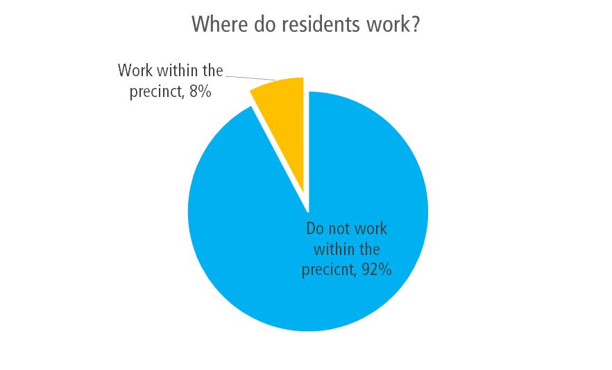
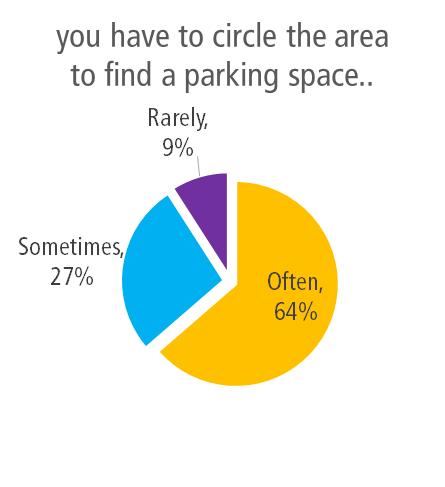
33 5.3 Travel to work The questionnaire survey included questions to gain an understanding of how residents got to work, and any difficulties they might face with parking issues. Residents who do not have off-street parking at their workplace within Marrickville, generally find it difficult to park on-street. Of the 259 respondents, 20 (8%) worked within the precinct of the Marrickville LGA. This sample size is an accurate representation of the proportion of local workers, as suggested by the journey to work data in section 4.4, where 9% were found to work in Marrickville. A majority of the residents who worked locally (13 people), did not have off street parking facilities at their workplace. Of these, only 9% find parking spaces at their workplace easily along the streets. 64% indicated that they often had to circle the area to find a parking space. This indicates the difficulties employees face in the precinct finding a parking space nearby to their place of work. 24
34 25
35 5.4 Parking policies The questionnaire survey included questions to gain an understanding of how residents felt about the existing parking schemes and what could be done to improve it. A summary of these responses are provided in Figure 17, with the location of these responses illustrated in Figure 18. Over 80% of respondents noted they would prefer some type of resident parking scheme. Demand for an expanded resident parking scheme was greatest at the eastern end of the corridor near Camperdown Oval and the western end near Crystal Street, the TAFE and Parramatta Road. Issues raised during the community engagement process with respect to current parking policies include: Inconsistency between the current M1 (Camperdown) and M3 (Newtown- Enmore) zones in terms of times of restrictions. This is an issue for residents at the eastern end of the Parramatta Road / Camperdown precinct which have reduced time restricted parking compared with the adjacent M3 zone. Streets within the M1 zone have time restricted parking on both sides of the street, while those in the adjacent M3 zone only have restrictions on one side of the street. There is a scattered resident parking scheme in Area M5 (Petersham) largely driven by demand from the TAFE. Residents noted that they would like to see this area widened due to parking impacts associated with the TAFE. Parking near the Fanny Durack Aquatic Centre and Petersham Oval at the western end of the precinct is a common concern. Residents of the eastern end of Station Street (opposite Petersham Oval) are entitled to a resident parking permit as they are within the M16 (Lewisham) parking area, however those at the western end of the street are not. Figure 17: Preference for a parking scheme 26
36 NORTON STREET BALMAIN ROAD PYRMONT BRIDGE ROAD WEST STREET PARRAMATTA ROAD TRAFALGAR STREET RAILWAY STREET Petersham CRYSTAL STREET WESTBOURNE STREET ALBANY ROAD PERCIVAL ROAD SALISBURY ROAD Stanmore BRIDGE ROAD KINGSTON STREET CHURCH STREET GORDON STREET NEW CANTERBURY ROAD km SHAW STREET STANMORE ROAD LIBERTY ROAD MALLETT STREET Newtown ERSKINEVILLE ROAD Preference for parking permits and restrictions! resident permit parking scheme! a combination of restricted and unrestricted parking! no restricted parking Parramata Road Corridor and Camperdown Parking Study - Figure 18
37 6 Parking Survey 6.1 Overview Parking surveys were undertaken by Matrix Traffic and Transport Data to establish the number of available spaces and the demand for parking within the study area. The surveys, undertaken at hourly intervals, recorded the number of potential parking spaces and their utilisation. The surveys were conducted at the following dates: Weekday Tuesday 8am to 6pm and Thursday 8am to 8pm This survey aimed to determine the parking situation on a typical weekday with residents vacating parking spaces when driving to work in the morning, spaces being occupied by visitors, TAFE students, to the area during the daytime and residents occupying parking spaces when returning from work in the evening. Saturday 10am to 6pm The weekend survey aimed to determine the parking situation on a typical weekend. Survey data indicated that residents who had issues with parking, found it the most difficult to find on-street parking during the afternoon, on weekends, which was discussed in section The surveys would provide an indication of the busiest streets during these periods, and provide guidance towards implementing a fair and reasonable strategy Survey methodology Occupancy In order to maintain consistency throughout the survey data, surveyors assumed the number of parking spaces on a street was the maximum number of spaces which could legally fit within the area. In practice, vehicles are often parked with gaps greater than required for pulling out of a parking space. Therefore it can be assumed that full capacity is reached when parking occupancy is over 85%. Duration of stay To gain an understanding of the duration of stay, number plates were recorded on an hourly basis. An average duration of each street section is then calculated based on the number of vehicles. This information would provide an estimate of the proportion of residents and visitors using the on-street parking space. 28
38 6.2 Theoretical parking capacity 6.3 Parking supply The survey recorded 4,251 on-street parking spaces across the study area. Private commercial car parks were not considered as part of the study area On-street parking supply A summary of the on-street parking supply by area surveyed is summarised in Table 4. Table 4: Summary of On-Street Parking Parking control Total supply (number of spaces) P 5 min 11 P 10 min 18 1/2P 10 1/4P 5 1P 255 2P 74 Unrestricted 2,877 Bus zone 5 Disabled 26 Loading zone 5 Mail zone 4 Motorbikes only 0 M1 Permit Holders 577 M3 Permit Holders 70 M5 Permit Holders 207 M15 Permit Holders 107 Proportion of total supply 0.3% 0.2% 0.1% 0.1% 3.0% 0.9% 35.4% 0.1% 0.5% 0.1% 0.1% 0.0% 11.1% 1.5% 4.5% 2.5% Total 4, % 29
39 6.4 Parking occupancy Permit holder areas Areas with time restricted parking (permit holders excepted) i.e. a resident parking scheme (RPS), were investigated. A total capacity of some 961 spaces were estimated had these enforcements, with the average occupancy profile shown in Figure 19. The data was collected for the following areas, shown in Table 5. Table 5: Permit holder areas Permit type M1 (Camperdown) 577 M3 (Newtown-Enmore) 70 M5 (Petersham) 207 M Total 961 Number of spaces Data shows that occupancy rates in permit areas are higher during weekends, when parking restrictions are not enforced. During the weekdays, occupancy rates were found to be lower when compared to short term and unrestricted parking areas. This shows that the implemented resident parking schemes are relatively effective in discouraging long term usage. Figure 19: Permit holder areas - Average hourly occupancy As no parking restrictions are currently in force for these streets on weekends, special consideration was given to the weekend survey results. A number of streets in the eastern end of the precinct, within the M1 area, were found to exhibit occupancy levels of 85% or greater for three or more hours of the day. Occupancy levels on Queen Street and Charles Street within the M5 area were also recorded to exceed 85% for three or more hours of the day. 30
40 6.4.2 Time Restricted Parking Areas The occupancy profile for short term parking with time restrictions between 5 minutes and 2 hours is presented below in Figure 20. These areas have typical parking restrictions enforced during the following peridos: 8:30am-6pm (Mon-Fri) 8:30am-12:30pm (Sat). The analysis was based on a total of 373 available short term parking spaces. The occupancy rates for short term parking is higher during weekdays, with a peak occupancy rate of around 85% occurring between 12pm to 1pm. The occupancy rate during weekends are relatively constant, peaking at 50%. Figure 20: Short term parking - Average hourly occupancy 31
41 6.4.3 Unrestricted parking areas Unrestricted parking across the study area have a relatively flat occupancy profile throughout the day, indicating that these spaces are used for long term parking. Occupancy rates, shown in Figure 21 are higher during weekdays, with a peak of around 70% at 3pm. This gradually decreases after 5pm to 60%, and is indicative of employees leaving the study area. This suggests that the remaining 60% of utilised spaces are occupied by residents or long term parkers. This is further justified by Saturday s occupancy profile remaining constant at 60% in the morning. Figure 21: Unrestricted parking - Average hourly occupancy 32
42 6.4.4 Duration of stay Car parking occupancy and duration of stay surveys were conducted to assess the demand and the length of stay of the parking spaces within the study area. A comparison of the duration of stay between unrestricted and permit holders parking areas is shown in Figure 22. In unrestricted parking areas, data indicates that vehicles are parked for an average duration of seven hours during the weekdays, suggesting that these spaces may be used by employees or students of the TAFE. Duration of stay during weekends were found to be lower than weekdays, suggesting a higher turnover. This is reflective of the reduced extent of employee/commuter parking on weekends as compared to weekdays. An overall longer duration of stay is observed in unrestricted areas, indicating that permit holder policies are generally effective during the weekdays. Figure 22: Average duration of stay study area wide 33
43 6.5 Parking occupancy maps Parking occupancy maps, which are presented in section 6.5.5, have been produced based on the survey data gathered, to gain an accurate understanding of the occupancy in each street. Together with the feedback from stakeholder surveys, busier streets were identified to be considered in guiding policy making. Each set of maps show the parking occupancy rates of various sections of the street, over the Tuesday, Thursday and Saturday periods Average occupancy The average occupancy of each section of a street, over the entire survey period is shown in these maps. This data provides a high level analysis of existing streets that are at or above the theoretical parking capacity of 85%. However, this does not provide a refined indication of peak period occupancies, being an occupancy analysis over the entire survey period, this. For example a street might be over an 85% occupancy from 12pm to 3pm, but may have an average occupancy of less than 85% over the survey period. The following bands have been identified on a colour scale: The following streets were found to have an occupancy over 85% throughout the period of the survey, during the weekdays: Fort Street Margaret Street Charles Street Westbourne Street Corunna Road Albany Road Salisbury Road Australia Street Mallet Street Federation Road Lennox Street Peak occupancy The peak occupancy for each survey period is shown in these maps, with similar bands used described in section This provides an indication of the busiest period of the day, for each street during the survey period. 34
44 % or higher occupancy for 3 or more hours Streets with 85% or higher occupancy, for three or more hours (both consecutive and non-consecutive), over the survey period are shown in these maps. This provides a clear indication of streets that need further investigations and possible policy implementations. The following do not have a resident parking scheme on either side of the street, and were found to fit this criteria during the weekdays: Australia Street Petersham Street Margaret Street Westbourne Street Corunna Road Fort Street Cannon Street Railway Street Average occupancy at key time periods Hourly occupancy rates throughout the survey periods are shown in Appendix A. During the Thursday survey period, a general trend was observed that parking occupancy increased from 10am and reached a peak at 1pm. Streets located near parks tended to have an increase in occupancy at 3pm, while it decreased in other streets. Occupancy was the lowest at 8pm, with the following streets remaining at capacity between 8pm to 9pm: Margaret Street Westbourne Street Corunna Road Fort Street Macaulay Road Federation Road Salisbury Road Mallet Street 35
45 6.5.5 Occupancy map catalogue Average Occupancy Figure 23: Average occupancy Tuesday Figure 24: Average occupancy Thursday Figure 25: Average occupancy Saturday Figure 26: Peak occupancy Tuesday Figure 27: Peak occupancy Thursday Figure 28: Peak occupancy Saturday Figure 29: 85% or higher occupancy for 3 or more hours Tuesday Figure 30: 85% or higher occupancy for 3 or more hours Thursday Figure 31: 85% or higher occupancy for 3 or more hours Saturday Appendix A. Average hourly occupancy at throughout the survey period 36
46 PARRAMATTA ROAD GORDON STREET RAILWAY STREET Petersham NEW CANTERBURY ROAD WESTBOURNE STREET ALBANY ROAD Stanmore CHURCH STREET Meters Parramata Road Corridor and Camperdown Parking Study - Figure 23 Newtown Tuesday Average Occupancy Occupancy <50% 50-75% 75-85% >=85%
47 PARRAMATTA ROAD GORDON STREET RAILWAY STREET Petersham NEW CANTERBURY ROAD WESTBOURNE STREET ALBANY ROAD Stanmore CHURCH STREET Meters Parramata Road Corridor and Camperdown Parking Study - Figure 24 Newtown Thursday Average Occupancy Occupancy <50% 50-75% 75-85% >=85%
48 PARRAMATTA ROAD GORDON STREET RAILWAY STREET Petersham NEW CANTERBURY ROAD WESTBOURNE STREET ALBANY ROAD Stanmore CHURCH STREET Meters Parramata Road Corridor and Camperdown Parking Study - Figure 25 Newtown Saturday Average Occupancy Average Occupancy <50% 50-75% 75-85% >=85%
49 PARRAMATTA ROAD GORDON STREET RAILWAY STREET Petersham NEW CANTERBURY ROAD WESTBOURNE STREET ALBANY ROAD Stanmore CHURCH STREET Meters Parramata Road Corridor and Camperdown Parking Study - Figure 26 Newtown Tuesday Peak Occupancy Peak Occupancy <50% 50-75% 75-85% >=85%
50 PARRAMATTA ROAD GORDON STREET RAILWAY STREET Petersham NEW CANTERBURY ROAD WESTBOURNE STREET ALBANY ROAD Stanmore CHURCH STREET Meters Parramata Road Corridor and Camperdown Parking Study - Figure 27 Newtown Thursday Peak Occupancy Peak Occupancy <50% 50-75% 75-85% >=85%
51 PARRAMATTA ROAD GORDON STREET RAILWAY STREET Petersham NEW CANTERBURY ROAD WESTBOURNE STREET ALBANY ROAD Stanmore CHURCH STREET Meters Parramata Road Corridor and Camperdown Parking Study - Figure 28 Newtown Saturday Peak Occupancy Peak Occupancy <50% 50-75% 75-85% >=85%
52 PARRAMATTA ROAD GORDON STREET RAILWAY STREET Petersham NEW CANTERBURY ROAD WESTBOURNE STREET ALBANY ROAD Stanmore CHURCH STREET Meters Newtown Tuesday Over Capacity 3 hours above 85% Parramata Road Corridor and Camperdown Parking Study - Figure 29
53 PARRAMATTA ROAD GORDON STREET RAILWAY STREET Petersham NEW CANTERBURY ROAD WESTBOURNE STREET ALBANY ROAD Stanmore CHURCH STREET Meters Newtown Thursday Over Capacity 3 hours above 85% Parramata Road Corridor and Camperdown Parking Study - Figure 30
54 PARRAMATTA ROAD GORDON STREET RAILWAY STREET Petersham NEW CANTERBURY ROAD WESTBOURNE STREET ALBANY ROAD Stanmore CHURCH STREET Meters Newtown Saturday Over Capacity 3 hours above 85% Parramata Road Corridor and Camperdown Parking Study - Figure 31
55 7 Parking Management Recommendations 7.1 Overview Following community feedback and review of parking survey data, a suite of draft recommendations have been developed. The aim of the parking recommendations is to provide where possible an improved management system for parking for the area. The draft recommendations proposed takes into consideration: The current transport environment and conditions in the Parramatta Road / Camperdown precinct; Existing parking controls in neighbouring areas both in the Marrickville Council and City of Sydney Local Government Areas Feedback received during the community and stakeholder engagement process; and Results of the parking surveys conducted in the precinct 7.2 Key Principles There is a high demand for parking in sections of the Parramatta Road / Camperdown precinct due to the convenient inner city location of both residential and business areas. Based on the community consultation and parking occupancy surveys which have been undertaken for this study, it is evident that parking demand can exceed supply during the peak times. On many occasions residents have to compete with visitors and all day commuters for a suitable parking space within reasonable walking distance from their home. Typically, car parking occupancy levels greater than 85% are often considered to represent the theoretical capacity. A utilisation rate higher than 85% defines the limit of constraint in the on-street parking network. This occupancy level represents a good utilisation of car parking and provides the ability for drivers arriving to an area to find a car parking without excessive circulation. Streets where the parking utilisation was found to be 85% or greater for three or more hours of the day were considered to be of greatest significance when considering new or increased parking restrictions. In certain areas, particularly at the eastern end of the corridor and near the TAFE campus on Crystal Street, the current supply of parking is insufficient to accommodate the unconstrained peak car parking demand from all sources in the study area. However building large new carparks is very expensive, will create amenity impacts and will attract additional vehicles and traffic to the study area which is also not a desirable outcome. The only equitable way to give both residents and visitors access to parking is to place additional parking time restrictions to help manage the limited available parking capacity in the area. 46
56 It is without doubt that local businesses in the area do generate jobs and contribute significantly to the local economy in the area. It is important that the parking strategy supports the needs of small businesses especially to ensure the dynamic and eccentric character of the area is supported and promoted. Therefore the overall philosophy of the parking management must maintain an appropriate balance between the car parking needs of the residents and the businesses in the area. The optimum outcome is to ensure that all the available parking is well utilised, while still retaining some free space to facilitate parking turnover i.e. by achieving parking occupancy rates in the order of 85%. 7.3 Resident Parking Scheme Modifications to the existing resident parking scheme (RPS) is proposed for the study area. A resident parking scheme has the following advantages: It allows a more consistent approach to address parking issues It enables resident parking scheme permits to be used in the whole area so if the street where the resident lives is fully parked for any reason, there are opportunities to park in other nearby parallel streets It simplifies parking enforcement The extent of the RPS needs to be large enough to provide residents with a good opportunity to find a convenient parking space whilst not too big to encourage residents in one area to drive between land uses. The size of the area is generally dependant on the competing land uses within each zone. Areas should also be logical and ideally border on main streets. One of the disadvantages with an area wide parking scheme occurs for residential properties that are located on border of the area. A limited amount of parking permit overlap should be allowed within the border streets in future enforcement of the RPS restrictions. In order for Marrickville Council to implement a residential parking permit scheme, a number of criteria are required to be met by RMS. The complete set of criteria is specified in RMS guidelines, RMS Permit Parking November The requirements must be satisfied before the issue of residential parking permits: The resident has no on-site parking or limited on-site parking and also has no unrestricted on-street parking available near their residence. The place of residence could not be reasonably modified to provide onsite parking space(s). The vehicle is not a truck, bus, tram, trailer (boats and caravans) or tractor. The number of permits to be issued for an area should not exceed the number of available on-street parking spaces in the area. Based on the community consultation and traffic engineering analysis which was undertaken for this study, Arup developed a number of draft recommendations relating to the existing RPS in the Parramatta Road / Camperdown study area. These recommendations are outlined in the sections below. 47
57 7.4 M1 Parking Area Draft Recommendations Federation Road and Salisbury Road area The existing resident parking restrictions on streets in the area bounded by Salisbury Road, Federation Road, Northwood Street and Australia Street was considered for modification in this parking strategy. Most streets within this area have two hour parking restrictions between 8:30am-6pm (Monday to Friday) with permit holders of area M1 excepted on both sides of the street. Resident parking permits around this area proves to be effective during the weekdays with surveys indicating average occupancy rates in these areas ranging from 50% to 70%. However on weekends, survey data and community comments show that parking demand is high, where parking restrictions are no longer in effect. These spaces are predominantly used by visitors to the Newtown-Enmore retail / entertainment area on weekends particularly during the evening when restaurant activity is higher and events are held at the Enmore theatre. Residents have expressed concerns of parking spaces outside their residence being occupied at these times. Parking surveys indicate many of the streets within this area were at 85% occupancy (or above) on the weekend. The issue is exacerbated in this area by the proximity to the adjacent M3 (Newtown-Enmore) parking area, where controls are in place which limit parking to two hours (residents excepted) between 8am and 10pm Monday to Sunday. These same parking restrictions are in place on streets to the east in the City of Sydney Council area. Recommendation 1: Australia Street eastern side It is recommended that the time restrictions along the eastern side of Australia Street (between Federation Road and Salisbury Street) be modified 2P 8:00am-10pm (Monday to Sunday, M1 permit holders excepted). This provides consistency with the time restrictions in the adjacent M3 parking area and provides for resident parking on weekends as well as weekdays. Recommendation 2: Hopetoun Street, Roberts Street and Northwood Street These streets have two hour parking restrictions on weekdays (M1 permit holder excepted), on both sides of the street. It is recommended that the time restrictions along the western side of these streets (between Salisbury Road and Federation Road) be modified to 2P 8:00am-10pm (Monday to Sunday, M1 permit holders excepted). This provides consistency with the time restrictions in the adjacent M3 parking area and the restrictions in place to the east on City of Sydney Council controlled streets, and provides for resident parking on weekends as well as weekdays. Implementing this modification on only one side of the street would ensure that parking would still be provided for visitors to the area on weekends wishing to stay longer than two hours. This recommendation would provide an appropriate balance for accommodating visitors to the nearby the Newtown-Enmore retail / entertainment area while also ensuring spaces are available for residents. 48
58 7.4.2 Federation Road Federation Road is located north of the Camperdown Memorial Rest Park, with M1 permit parking restrictions on the north side between Hopetoun Lane and Northwood Lane. Survey data indicated that average occupancy in permit areas were generally low, showing existing permit parking schemes in the area are effective. 81 unrestricted parking spaces can be found on the southern side of the road. Survey data and community comments show that parking demand for these spaces is high consistently above 85% throughout the day and on weekends. These spaces are predominantly used by commuters, visitors and businesses. Community feedback received for this study noted a number of vehicles utilise the southern side of Federation Road for long stay parking including trailers and campervans. This restricts available opportunities for visitors to the precinct including users of the adjacent park. Recommendation 3: Federation Road Converting the existing unrestricted parking spaces on the southern side of Federation Road (between Australia Street and Church Street) to 10 hour time restricted parking is proposed in this strategy. This initiative would discourage long term parking but still ensure parking for nearby businesses and visitors is maintained. This initiative would provide more opportunities for all users to utilise these parking spaces Australia Street The western side of Australia Street is not currently subject to any parking restrictions. Survey data indicates parking demand can be high on both weekdays and weekends area. Should the 10P restriction be implemented along Federation Road south (Recommendation 3), Australia Street may experience a spill over effect for vehicles parking for extended periods of time. Recommendation 4: Australia Street western side Monitor the occupancy and turnover of the western side of Australia Street (between Lennox Street and Federation Road) following the implementing 10P parking along the south side of Federation Road as recommended in this strategy. Implementation of a similar 10P restriction along Australia Street could be considered should long stay parking become an issue. 49
59 7.4.4 Salisbury Road The southern side of Salisbury Road between St Marys Lane and Kingston Lane is already subject to time restricted parking (M3 permit holders excepted). The north side contains 19 unrestricted parking spaces. Parking survey data indicated that average occupancy during peak hours were at 85% in M3 zone and 100% in the unrestricted areas. Community feedback also indicates that residents find difficulties finding a convenient parking space during peak hours. Recommendation 5: Salisbury Road north side Conversion of the existing 19 unrestricted spaces on the northern side of Salisbury Road (between Kingston Lane and St Mary s Street) to time restricted parking (2P 8am-10pm, M1 permit holders excepted) is recommended. Implementation of a resident parking scheme along the north side of Salisbury Street would ensure that residents can obtain a parking space where survey data indicates demand for parking is high along this street, and responds to community feedback received during this study Available Parking Permits M1 Within the existing M1 (Camperdown) area, where resident parking is provided on both sides of the street in most areas, the number of parking spaces exceeds the number of parking permits available for residents. Therefore no change is proposed to the current arrangement whereby residents are entitled to apply for up to two parking permits. 50
60 Church St Northwood St Northwood Ln Roberts St Roberts Ln Federation Rd Salisbury Rd Gibbens St Hopetoun St Hopetoun Ln Australia St Brookes Ln Australia St Denison St St Mary La Salisbury La Salisbury Rd Kingston La Summary of Draft Recommendations for M1 Area - Figure 32 10P restrictions Mon- Sun 2P 8am - 10pm Mon-Sun (M1 permit holders excepted) Monitor and consider implementing 10P restrictions
61 7.5 M5 Parking Area Draft Recommendations Time Restrictions for Resident Parking Currently a mix of time restrictions are provided across the precinct. Examples of existing parking restrictions within the current M5 (Petersham) area include: 1P 8:30am-6pm (Mon-Fri) and 8.30am-12.30pm (Sat) residents excepted 1P 8:30am-8pm (Mon-Fri) residents excepted 2P 8:30am-8pm (Mon-Fri) residents excepted 1P 8:30am-9pm (Mon-Fri) residents excepted 2P 8:30am-9pm (Mon-Fri) residents excepted 2P 8:30am-10pm (Mon-Fri) residents excepted Applying consistency with respect to the time periods where resident parking restrictions are in force is a key element of this parking strategy. The current inconsistency creates confusion amongst drivers and limits enforcement opportunities. Recommendation 6: Standardisation of parking restrictions within the M5 area To create consistency throughout the M5 area and reduce confusion it is recommended that the existing parking restrictions be modified to the following: 2P - 8:00am-10pm (Mon-Fri) M5 permit holders excepted These changes would apply to all streets with parking restrictions within the M5 area with the exception of Queen Street, where the existing 1 hour restrictions on weekdays and Saturdays would remain in place Margaret Street The south side of Margaret Street, west of Charles Street has seven unrestricted parking spaces and 15 parking spaces subject to one hour parking restrictions between 8:30am-8pm (Mon-Fri), with M5 permit holders excepted. Margaret Street, east of Charles Street has 33 unrestricted spaces on the north side and 25 unrestricted spaces on the south side Parking survey data indicated that average occupancy on Margaret Street in areas subject to time restricted parking were generally low, demonstrating availability of spaces for residents of the precinct. The south side of Margaret Street, west of Charles Street was found to be relatively underutilised, with an average occupancy rate of 36% on weekdays. However the 58 unrestricted spaces along Margaret Street, east of Charles Street were found to have high demands during both weekday and weekends, with occupancy rates above 85% for more than three hours observed. Residents in the area have also expressed interests in having a resident parking scheme implemented. 52
62 Recommendation 7: Margaret Street north side Conversion of the existing 33 unrestricted spaces on the northern side of Margaret Street (between Charles Street and Margaret Lane) to time restricted parking (2P 8am-10pm Mon-Fri, M5 permit holders excepted) is recommended. Implementation of a resident parking scheme along the north side of Margaret Street would ensure that residents can obtain a parking space on weekdays where survey data indicates demand for parking is high along this street, and responds to community feedback received during this study. Retaining unrestricted parking on the southern side of the street will continue to accommodate visitors to the area. Recommendation 8: Margaret Street south side Conversion of the existing 15 time restricted parking spaces on the southern side of Margaret Street (between Charles Street and Crystal Street) to unrestricted parking is recommended. Given that this section of parking is underutilised, conversion of these spaces to unrestricted parking zones would provide a more efficient utilisation of the parking spaces. This would accommodate visitors to the precinct in particular those travelling to/from the retail precinct on Parramatta Road. Existing residents would not be disadvantaged given the retention of time restrictions on the northern side of the street. Parking survey data indicates that average occupancy on the north side of Margaret Street is at 37% on weekdays, and could accommodate additional residents to park in this area. Further, Recommendation 7 provides for additional resident parking in the precinct. 53
63 7.5.3 Corunna Road Corruna Road, west of Charles Street, has time restricted parking on both sides of the road (M5 permit holders excepted). Survey data indicates parking demand is generally low in these areas, with an average occupancy of 55% on weekdays. The section of Corruna Road east of Charles Street has unrestricted parking on both sides of the street, with roughly nine resident permit parking spaces on the south side of the road. Survey data indicates parking demand on the east section of Corruna Road is low, averaging 35% on weekdays. Recommendation 9: Corunna Road, east of Charles Street Conversion of the existing 35 unrestricted spaces on the northern side of Corunna Road (between Charles Street and Cannon Street) to time restricted parking (2P 8am-10pm Mon-Fri, M5 permit holders excepted) is recommended. Implementation of a resident parking scheme along the north side of Corunna Road would ensure that residents can obtain a parking space on weekdays where survey data indicates demand for parking is high along this street, and responds to community feedback received during this study. Retaining unrestricted parking on the southern side of the street will continue to accommodate visitors to the area. Recommendation 10: Corunna Road, west of Charles Street Conversion of the existing 27 time restricted parking spaces on the southern side of Corunna Road (between Charles Street and Crystal Street) to unrestricted parking is recommended. Given that this section of parking is underutilised, conversion of these spaces to unrestricted parking zones would provide a more efficient utilisation of the parking spaces. This would accommodate visitors to the precinct in particular those travelling to/from the retail precinct on Parramatta Road. Existing residents would not be disadvantaged given the retention of time restrictions on the northern side of the street. Parking survey data indicates that average occupancy on the north side of Corunna Road is at 54% on weekdays, and could accommodate additional residents to park in this area. Further, Recommendation 9 provides for additional resident parking in the precinct Westbourne Street Westbourne Street, between Charles Street and Crystal Street, is located some 200 metres south of Petersham TAFE. The street has 42 unrestricted parking spaces on both sides of the street (84 total) and is a convenient area for TAFE students and staff to park. Westbourne Street may also be used by commuters, being just 350 metres north of Petersham railway station. Survey data shows that parking demand is high during the weekdays, with average occupancy levels after midday being 92% for both sides of the street. Recommendation 11: Westbourne Street Conversion of the 42 spaces on the northern side of Westbourne Street (between Charles Street and Crystal Street) to time restricted parking (2P 8am-10pm Mon- Fri, M5 permit holders excepted) is recommended. Implementation of a resident 54
64 parking scheme along this street responds to any spillover effects generated by the expansion of the M5 parking area to the north as recommended in this study. It would ensure that residents can obtain a parking space on weekdays where survey data indicates demand for parking is high along this street, and responds to community feedback received during this study. Retaining unrestricted parking on the southern side of the street will continue to accommodate visitors to the area including the nearby TAFE and Petersham railway station Fort Street Fort Street, between Crystal Street and Railway Street, is located opposite Petersham TAFE. Unrestricted parking is provided on both the northern (16 spaces) and southern (22 spaces) sides of the street). Survey data and community comments shows that parking demand is high during both weekdays and weekends, with average occupancy levels of 85% which is the theoretical capacity for on-street parking. The unrestricted spaces on both sides of the street is typically used by residents, TAFE students and staff as well as visitors to businesses along Parramatta Road. In the evenings parking demand is high given Fort Street s proximity to the restaurant precinct along Norton Street north of Parramatta Road. Recommendation 12: Fort Street Conversion of the 16 unrestricted spaces on the northern side of Fort Street (between Railway Street and Crystal Street) to time restricted parking (2P 8am- 10pm Mon-Fri, M5 permit holders excepted) is recommended. Implementation of a resident parking scheme along this street responds to any spillover effects generated by the expansion of the M5 parking area as recommended in this study. It would ensure that residents can obtain a parking space on weekdays where survey data indicates demand for parking is high along this street, and responds to community feedback received during this study. Retaining unrestricted parking on the southern side of the street will continue to accommodate visitors to the area including the nearby TAFE and Norton Street restaurant precinct. Further, the two hour parking limit would discourage commuters and long term stays, but still provide adequate time for TAFE students to attend classes. 55
65 7.5.6 Railway Street and Croydon Street Railway Street (between Elswick Street and Croydon Street) and Croydon Street (between Railway Street and Crystal Street) are not currently subject to any parking restrictions. Railway Street has an average parking occupancy approaching 85% on weekdays, while Croydon Street has an average parking occupancy of approximately 70% on weekdays. With the expansion of the M5 parking area as proposed in this strategy, there is the potential for spillover of parking to occur on these streets. Recommendation 13: Railway Street and Croydon Street Conversion of the 24 unrestricted spaces on the eastern side of Railway Street (between Elswick Street and Croydon Street) and the 20 spaces on the northern side of Croydon Street (between Railway Street and Crystal Street) to time restricted parking (2P 8am-10pm Mon-Fri, M5 permit holders excepted) is recommended. Implementation of a resident parking scheme along this street responds to any spillover effects generated by the expansion of the M5 parking area as recommended in this study. The proposals will ensure an equitable distribution of spaces between the residents, visitors and employees in the area. Residents should normally be able to obtain a parking space within reasonable walking distance of their home. On the other hand, many visitors and local business employees in the area will still continue to be able to park on the unrestricted side of the streets in the area Available Parking Permits M5 This draft strategy proposes a number of modifications to the existing RPS in the M5 (Petersham) area, including: Extension of resident parking controls to adjacent streets Amendments to the existing time restrictions to provide better consistency across the precinct; and Changes in parking controls where resident parking is currently in force on both sides of the street, providing additional unrestricted parking in these areas. Recommendation 14: Number of parking permits within M5 area While parking is unrestricted on the opposite side of the street it is expected that additional parking will occur via visitors to the area. Therefore it is recommended a maximum of one residential permit be issued per household for those entitled to parking permits within the expanded M5 area. This measure will encourage residents in the area to either develop their own off-street parking spaces, where property dimensions permit, or limit owning the number of vehicles to one vehicle per household. Visitor parking permits may be obtained as per the existing arrangements for resident parking areas within Marrickville Council. 56
66 Corunna Ln Elswick St Cannon St Westbourne Ln Albany Rd Westbourne St Parramatta Rd Margaret St Corunna Rd Charles St Robert St Crystal St Queen St Fort St Railway St Croydon St Summary of Draft Recommendations for M5 Area - Figure 33 2P 8am-10pm Mon-Fri (M5 permit holders excepted) Conversion of existing time-restricted parking to unrestricted parking
67 7.6 Short Term Parking As previously noted, it is important that the parking strategy supports the needs of small businesses especially to ensure the dynamic and eccentric character of the area is supported and promoted. The policy to generally provide resident parking on one side of the road, with unrestricted parking on the other side, aligns with this objective. In addition to this, an area of parking along Bridge Road has been identified as suitable for providing short term parking to increased turnover of parking adjacent to businesses. The parking spaces Bridge Road (between Corunna Road and Salisbury Road) are not currently subject to any parking restrictions during daytime hours. As a result some of these spaces are occupied by all day parkers (e.g. commuters) which limits opportunities for visitors to the local businesses to the area requiring only short stay parking. Several businesses along Bridge Road do not have access to short term parking for customers. Recommendation 15: Bridge Road It is recommended that six existing parking spaces on Bridge Road be converted to short stay parking to provide greater parking opportunities for customers of nearby businesses. The recommended spaces to be converted are as follows: Two spaces along the eastern side of Bridge Road (between Salisbury Road and the driveway entrance to the site at Bridge Road); and Four spaces along the western side of Bridge Road (between Macaulay Road and Albany Lane) It is recommended these spaces be signposted as 1P 8:30am-6pm (Mon-Fri) & 8:30am-12:30pm (Sat). The current no stopping restrictions between 9pm and 5am would remain in force for these spaces. 58
68 7.7 Future Changes to Land Uses in the Area Potential future changes in land use will impact on the demand for on-street parking within the study area. The current situation parking surveys have provided a snapshot of parking demand at the current time. It is nevertheless also important to consider how this might change in the future when determining strategic transport planning and car parking strategy objectives for the area. The future developments which are most likely to generate significant additional parking demand in the study area are: Restaurants, clubs and hotels High density residential flat buildings The Marrickville Local Environmental Plan (LEP) 2011 (in section 3.2 of this report) illustrates the current Marrickville Council off-street car parking requirements for new developments, which are able to be reduced / waived in an areas such as Camperdown with good access to services and public transport. However, a major challenge in the future is how to tackle the likely increased demand for on street car parking in the area from additional residents and visitors in new residential and commercial developments if insufficient on-site parking is provided. It is understood that development applications for a number of high density residential flat developments are currently being considered by Marrickville Council. In the Parramatta Road / Camperdown precinct, the potential for new high density residential development is significant given UrbanGrowth NSW s plans for future urban densification associated with their Parramatta Road urban transformation program as previously described in Section 3.4 of this report. Recommendation 16: Availability of parking permits for residents of multi-unit developments As the capacity of kerbside parking spaces is relatively fixed, to prevent new commercial and residential developments from applying further pressure on residential parking in the precinct, the current Marrickville Council policy of imposing conditions of development consent limiting new multi unit development resident s access to RPS permits should be maintained. This policy is similar to the adjacent City of Sydney Council policy whereby. In the City East and City South precincts, residents of multi-unit developments approved after 8 May 1996 are not eligible to participate in the resident permit parking schemes. In the CBD precinct, residents of all developments approved after 1 May 2000 are not eligible to participate in the resident permit parking schemes. 59
69 7.8 Parking Enforcement It is essential that the recommended modifications to the current parking restrictions in the area must be accompanied by an increased level of parking enforcement. Motorists must have a perception that they are likely to be fined if they overstay parking time restrictions. Council s community traffic officers currently undertake patrols of the area as labour resources allow and demand requires. An increase in patrols in the evening hours may result in a higher compliance with parking restrictions. Any increase in evening patrols would require an increase in labour, with the cost being offset by revenue from penalty infringements. A relatively small increase in the current level of parking enforcement may be sufficient to eliminate most overstaying of parking time limits and therefore even higher levels of enforcement, such as regular patrols every day, should be unnecessary. However, it should be noted that any increase in parking enforcement in the area will require a Council commitment to meet the following additional costs: Parking officers salaries; Parking officers uniforms; Equipment purchase (vehicles, hand held device, digital cameras etc.); and Legal cost (while required). Recommendation 17: Enforcement Parking enforcement can effectively be improved by increasing patrols by Council parking officers/ rangers, particularly targeting main streets/ car parks where overstaying is highest. This measure would increase parking availability by increasing turnover. 7.9 Reducing Parking Demand It is apparent from this study that many residents in the study area are currently experiencing significant parking problems. It is also likely that residents and visitors are currently circulating local streets to find a parking space, creating unnecessary traffic congestion and associated pollution at times of peak parking demand. There are various ways to address the parking issues in the study area. Construction of a major new parking station is not considered an economically or environmentally feasible option, and encouraging of the use of sustainable transport (i.e. walking, cycling, public transport and taxi) is the best option to reduce the future parking demand. The Marrickville integrated Transport Strategy addresses various ways to reduce the future parking demand in all areas of the municipality by increased walking, public transport initiatives, bike plans, car share etc. Council is currently implementing these strategies as part of an ongoing project. 60
70 The following matters have been identified as the major current barriers to the promoting of sustainable public transport based travel patterns in the study area: Inadequate train frequency at Newtown and Petersham during weekend evenings Current availability of unrestricted parking; and Low cost of parking generally in the study area. Marrickville Council will need to work with the State Government and Public Transport operators to ensure that transport services in the study area are comprehensive, interlinked and cater for the needs of both the local community and the visitors. Marrickville Council will also need to ensure that alternatives to car use are well promoted and supported. For a future reliable, accessible and sustainable transport system, Council needs to: Incorporate true environmental and social costs in the transport planning (e.g. congestion, air and noise pollution); Pursue improvement of the frequency, quality and diversity of sustainable transport options (e.g. negation with Transport for NSW); Ensure that public transport is attractive and cost effective compared to driving (e.g. supported by the introduction of pay parking); Ensure that transport management is coordinated at a regional level; Ensure that the pedestrians and cyclists enjoy easy and safe access throughout the study area; Ensure that equity of available parking spaces is achieved; Ensure that effective compliance of the restricted parking spaces is reached over 75% of the time; and Ensure that access to the precinct by taxi, particularly at night, is encouraged and facilitated by pick-up and drop-off areas and taxi information. GoGet car share has been successfully operating in Marrickville for several years (refer to Figure 34). Car sharing is a proven means of reducing the number of car journeys generated by a development. A recent study on the effectiveness of car sharing schemes across Sydney found that every car share space replaces the need for 12 private vehicle spaces 2. Marrickville Council introduced a car share policy in May 2014 to support car share activity within the LGA as part of its approach to supporting sustainable transport options. 2 SGS Economics & Planning (2012), Benefit-Cost Analysis of Car Share within the City of Sydney 61

71 Figure 34: Existing GoGet Parking Spot Locations Recommendation 18: Reducing parking demand Continue to lobby Transport for NSW to ensure that the best possible public transport facilities are provided for users of the precinct and continue to look for opportunities to increase the provision of car share throughout the precinct. 62
City of Greater Dandenong Our Place
 City of Greater Dandenong Our Place 2 City of Greater Dandenong Our Place Contents Greater Dandenong 4 Economic activity clusters 7 Connectivity 8 Residential property prices 10 Value of building work
[2010] VSC (2004) 18 VPR 229
![[2010] VSC (2004) 18 VPR 229](/thumbs/74/70555400.jpg "[2010] VSC (2004) 18 VPR 229") MOOT COURT 2017 PREPARED BY TIM RETROT VICTORIAN CIVIL AND ADMINISTRATIVE TRIBUNAL PLANNING PERMIT APPLICATION NO. TP418/2016 OUTLINE OF SUBMISSIONS ON BEHALF OF LIONHEART HOMES 93-95 VICTORIA STREET,
MOOT COURT 2017 PREPARED BY TIM RETROT VICTORIAN CIVIL AND ADMINISTRATIVE TRIBUNAL PLANNING PERMIT APPLICATION NO. TP418/2016 OUTLINE OF SUBMISSIONS ON BEHALF OF LIONHEART HOMES 93-95 VICTORIA STREET,
Miscellaneous Report No. M2/17
 Miscellaneous Report No. M2/17 Subject: Folder No: F2009/00315 Author: Introduction Impacts of the AHSEPP within suburbs of Randwick City Elena Sliogeris, Senior Environmental Planning Officer - Strategic
AUBURN BANKSTOWN BLACKTOWN HOLROYD PARRAMATTA THE HILLS. West Central District Demographic & Economic Characteristics
 AUBURN BANKSTOWN BLACKTOWN HOLROYD PARRAMATTA THE HILLS West Central District Demographic & Economic Characteristics Contents The West Central District 3 People 4 Population 4 Age Profile 6 Households
Direct Development Contributions Plan
 Direct Development Contributions Plan 2010-2030 Strathfield LGA Adoption 20 September 2016 Effective 27 September 2016 Header 3 Peter Andrews + Associates Pty Ltd paa.design. architecture. planning. urban
AN ORDINANCE REGULATING AND CONTROLLING SHARED PARKING IN THE CITY OF MADISON, MISSISSIPPI March 22, 2006
 AN ORDINANCE REGULATING AND CONTROLLING SHARED PARKING IN THE CITY OF MADISON, MISSISSIPPI March 22, 2006 Introduction Cumulative parking requirements for mixed-use occupancies or shared facilities may
New challenges for urban renewal... Patrick Fensham Principal SGS Economics and Planning
 New challenges for urban renewal... Patrick Fensham Principal SGS Economics and Planning 27 March 2013 Housing supply a problem... The housing shortfall (gap) increased by 28,000 dwellings over the year
Action P12: Develop a South West Priority Growth Area land use and infrastructure plan
 31 March 2017 Sheridan Dudley South West District Commissioner Greater Sydney Commission PO Box 257 Parramatta NSW 2124 Dear Sheridan, Re: SUBMISSION TO DRAFT SYDNEY SOUTH WEST DISTRICT PLAN MacroPlan
PIP practice note 1 planning assumptions. How to use this practice note. Planning assumptions. What are planning assumptions? Type.
 PIP PRACTICE NOTE 1 How to use this practice note This practice note has been prepared to support in the preparation or amending of planning assumptions within a priority infrastructure plan (PIP). It
PROPOSED APARTMENT DEVELOPMENT 32 & 34 TENNYSON AVE TAKAPUNA INTEGRATED TRANSPORT ASSESSMENT
 PROPOSED APARTMENT DEVELOPMENT 32 & 34 TENNYSON AVE TAKAPUNA INTEGRATED TRANSPORT ASSESSMENT Prepared by E.R Hebner 30 th November 2016 Z:\2015_Projects\15155-34 Tennyson Ave\doc\34 Tennyson Ave - Traffic
Technical Report 7.1 MODEL REPORT AND PARKING SCENARIOS. May 2016 PARKING MATTERS. Savannah GA Parking Concepts PARKING MATTERS
 Savannah GA Parking Concepts PARKING MATTERS A Strategic Plan for Parking + Mobility in Savannah PARKING MATTERS Technical Report 7.1 MODEL REPORT AND PARKING SCENARIOS Prepared for the Chatham County-Savannah
PIA would be pleased to meet with the Department to outline any aspect of our submission. Please contact myself or John Brockhoff on
 31 January 2018 Deborah Brill Director, Housing and Infrastructure Policy Department of Planning and Environment PO Box 39 SYDNEY NSW 2001 Dear Deborah, PIA Submission: Affordable Housing SEPP 70 Amendments
DCLG consultation on proposed changes to national planning policy
 Summary DCLG consultation on proposed changes to national planning policy January 2016 1. Introduction DCLG is proposing changes to the national planning policy framework (NPPF) specifically on: Broadening
Trip Rate and Parking Databases in New Zealand and Australia
 Trip Rate and Parking Databases in New Zealand and Australia IAN CLARK Director Flow Transportation Specialists Ltd ian@flownz.com KEYWORDS: Trip rates, databases, New Zealand developments, common practices
DRAFT FOR DISCUSSION PURPOSES ONLY. Port Credit Local Area Plan Built Form Guidelines and Standards DRAFT For Discussion Purposes
 Port Credit Local Area Plan Built Form Guidelines and Standards DRAFT For Discussion Purposes 1 Local Area Plan - Project Alignment Overview Directions Report, October 2008 (General Summary Of Selected
Rawlinson House, Lewisham, London SE13 5EL
 Rawlinson House, Lewisham, London SE13 5EL Client: Lewisham Homes Old Town Hall Catford London SE6 4RU Date: 18 February 2016 Job No: 2540-MA-N-RP-0001-D00 Martin Arnold Ltd 4 Gunnery Terrace The Royal
PUBLIC OPEN HOUSE September 19, 2018
 PUBLIC OPEN HOUSE September 19, 2018 Board 1 BACKGROUND Council direction was given to develop a The is looking at new housing in mature and recent communities, as outlined in the City of Winnipeg s planning
DEPARTMENT OF COMMUNITY PLANNING, HOUSING AND DEVELOPMENT Planning Division
 DEPARTMENT OF COMMUNITY PLANNING, HOUSING AND DEVELOPMENT Planning Division #1 Courthouse Plaza, 2100 Clarendon Boulevard, Suite 700 Arlington, VA 22201 TEL 703.228.3525 FAX 703.228.3543 www.arlingtonva.us
Housing & Residential Intensification Study Discussion Paper Township of King
 Housing & Residential Intensification Study Discussion Paper Prepared by Planning Department January 2011 1.0 Background 1.1 Provincial Policies (Greenbelt and Growth Plan) Since 2001, the Province of
Submission Cover Sheet Fishermans Bend Planning Review Panel
 Submission Cover Sheet Fishermans Bend Planning Review Panel 128 Full Name: Organisation: Affected property: Attachment 1: Attachment 2: Attachment 3: Comments: Request to be heard?: Precinct: General
Adequacy of car parking policies for flats, units and apartments in the Sydney region
 Australasian Transport Research Forum 2010 Proceedings 29 September 1 October 2010, Canberra, Australia Publication website: http://www.patrec.org/atrf.aspx Adequacy of car parking policies for flats,
Kidbrooke Village, Greenwich
 Village, Greenwich Key details Name Village Location Royal Borough of Greenwich, London Number of dwellings 4,763 (1,906 council homes demolished to make way for the development) Date first homes sold
UNDERSTANDING DEVELOPER S DECISION- MAKING IN THE REGION OF WATERLOO
 UNDERSTANDING DEVELOPER S DECISION- MAKING IN THE REGION OF WATERLOO SUMMARY OF RESULTS J. Tran PURPOSE OF RESEARCH To analyze the behaviours and decision-making of developers in the Region of Waterloo
Sydney. Affordable & Liveable Property Guide
 Sydney Affordable & Liveable Property Guide 1st Half 2018 SYDNEY AFFORDABLE & LIVEABLE PROPERTY GUIDE 1 st HALF 2018 METHODOLOGY This guide analyses all suburbs within the greater Sydney area. The suburbs
R E Q U E S T F O R P R O P O S A L S
 P.O. Box 3209, Houghton, 2041 Block A, Riviera Office Park, 6-10 Riviera Road, Riviera R E Q U E S T F O R P R O P O S A L S M A R K E T S U R V E Y T O I N F O R M R E S I D E N T I A L H O U S I N G
We thank you for the opportunity to provide our services, and we look forward to discussing the report with you at your earliest convenience.
 565 East Swedesford Road, Suite 300 Wayne, PA 19087 Office: 610.995.0260 Fax: 888.502.5726 www.walkerparking.com Mr. Maury Stern Partner Road & Washington, LLC c/o Insight Property Group 4601 N Fairfax
State of the Johannesburg Inner City Rental Market
 State of the Johannesburg Inner City Rental Market Presentation to TUHF- 5th July 2017 5 July 2017 State of the Johannesburg Inner City Rental Market National Association of Social Housing Organisations
WYNYARD CENTRAL HOUSING POLICY
 WYNYARD CENTRAL HOUSING POLICY 1 Policy objectives 1.1 To clarify the approach that Waterfront Auckland (WA) will take to delivering a thriving residential community. 2 Scope 2.1 Covers the approach to
A TRIBECA AREA FACT FILE
 03 A TRIBECA AREA FACT FILE SOUTH WEST MELBOURNE FOCUS AREA: TARNEIT AREA PROFILE AREA PROFILE: This report encompasses the South West Melbourne growth precinct of Wyndham. Specifically, the demographic
AHURI Research & Policy Bulletin
 AHURI Research & Policy Bulletin Issue 88 July 2007 ISSN 1445-3428 Where do low-income private renters live? Low-income private renters are increasingly to be found in the middle and outer suburbs of Sydney,
ENABLING AFFORDABLE HOUSING IN LOCAL GOVERNMENT AREAS. Discussion Paper COMMONEQUITY.COM.AU
 ENABLING AFFORDABLE HOUSING IN LOCAL GOVERNMENT AREAS Discussion Paper COMMONEQUITY.COM.AU ENABLING AFFORDABLE HOUSING IN LOCAL GOVERNMENT AREAS Discussion Paper 42 Initiatives to facilitate affordable
Wigan Core Strategy Examination Additional Hearing Sessions
 Wigan Core Strategy Examination Additional Hearing Sessions Morris Homes & Persimmon Homes Session on Specific Proposals to Meet the Identified Shortfall in Housing Land Golborne & Lowton 6 th March 2013
CITY OF SUBIACO 1.SEP PUCE MATCH 1 SEP 2017
 OF SUBIACO 1.SEP 1 7017 Our Ref 17-765 DC1C RECORDS 0 PUCE MATCH 8 September 2017 241 Rokeby Road SUBIACO WA 6008 Attention: David Milliken Manager Planning Services Dear David, DEVELOPMENT APPLICATION
2015 Downtown Parking Study
 2015 Downtown Parking Study City of Linden Genesee County, Michigan November 2015 Prepared by: City of Linden Downtown Development Authority 132 E. Broad Street Linden, MI 48451 www.lindenmi.us Table of
RE: Transportation Overview Youth Services Bureau Housing First Hub for Youth 2887 Riverside Drive
 TECHNICAL MEMORANDUM TO: FROM: SUBJECT: Jasmine Tranter c/o Wes Richardson, Youth Services Bureau (YSB) Paul Tétreault, P. Eng., MCIP, MUP; Emmett Proulx, EIT RE: Transportation Overview Youth Services
Activity Centre Parking Demand: a Novel Forecasting Model, its Applications and Extensions
 JACOB MARTIN Team Leader Transport Planning Cardno jacob.martin@cardno.com PAPER TITLE There is a growing recognition that parking is an essential contributor to the function of the transport system. Widely
Renewing the Compact City
 City Futures Research Centre June 2015 Renewing the Compact City Interim Report Renewing the Compact City: Interim Report By Laurence Troy, Hazel Easthope, Bill Randolph, Simon Pinnegar City Futures Research
Information Memorandum
 Information Memorandum Frenchs Forest 67-75 Dareen Street 320-328 Warringah Road Agent - Stuart Bath 0416 207 215 INFORMATION Memorandum Sections 1 Executive Summary 2 About the property 3 Northern Beaches
BURWOOD MARKET INSIGHTS REPORT
 BURWOOD MARKET INSIGHTS REPORT JOHN HILL & CO BURWOOD OFFICE December 2017 THE PURPOSE OF THIS REPORT The purpose of the Burwood Market Insights Report it to present an analytical review of the Burwood
Bylaw No , being "Official Community Plan Bylaw, 2016" Schedule "A" DRAFT
 Bylaw No. 2600-2016, being "Official Community Plan Bylaw, 2016" Schedule "A" Urban Structure + Growth Plan Urban Structure Land use and growth management are among the most powerful policy tools at the
Parking Assessment Proposed Mixed-Use Residential Development. 177 Cross Avenue Town of Oakville. Prepared For: Ontario Inc.
 Proposed Mixed-Use Residential Development Town of Oakville Prepared For: 915643 Ontario Inc. April 2014 16-13073 PROJECT TEAM MEMBER LIST Project Manager: Derek Dalgleish Technical Staff: Josie Li TABLE
HOUSING STRATEGY FOR SYDNEY
 STRATEGY FOR SYDNEY C introduction 118 THIS PAGE LANDCOM, PREVIOUS PAGE KARL SCHWERDTFEGER VISION FOR As Sydney s population grows and changes, the supply of appropriate and well located housing will be
DOWNTOWN BEAUMONT CENTRE-VILLE: PARKING MANAGEMENT REPORT
 DOWNTOWN BEAUMONT CENTRE-VILLE: PARKING MANAGEMENT REPORT Prepared for: Prepared by: Town of Beaumont Planning & Development Services WATT Consulting Group Our File: 3364.T01 Date: October 5, 2016 1.0
We re with you all the way.
 Over 50 years, Meriton has become Australia s largest and most renowned developer, building over 65,000 apartments across Sydney, Brisbane and the Gold Coast. Meriton offers a complete and tailored apartment
Existing Land Use. Typical densities for single-family detached residential development in Cumberland County: 1
 Existing Land Use A description of existing land use in Cumberland County is fundamental to understanding the character of the County and its development related issues. Economic factors, development trends,
DRAFT REPORT. Boudreau Developments Ltd. Hole s Site - The Botanica: Fiscal Impact Analysis. December 18, 2012
 Boudreau Developments Ltd. Hole s Site - The Botanica: Fiscal Impact Analysis DRAFT REPORT December 18, 2012 2220 Sun Life Place 10123-99 St. Edmonton, Alberta T5J 3H1 T 780.425.6741 F 780.426.3737 www.think-applications.com
WILLIAM THOMAS STUDENT RESIDENCE
 WILLIAM THOMAS STUDENT RESIDENCE Parking Study Prepared For: WGD Architects Inc. August 20, 2015 BA Consulting Group Ltd. 45 St. Clair Avenue West, Suite 300 Toronto, ON M4V 1K9 www.bagroup.com TABLE OF
Strategic Property Consulting. Charlie Richmond 7-11 Judd Street Richmond. Prepared for Baracon Pty Ltd. 23rd April 2008
 Strategic Property Consulting Market Overview and Commentary Proposed Residential Development Charlie Richmond 7-11 Judd Street Richmond Prepared for Baracon Pty Ltd 23rd April 2008 T257808:AR:LK Artist
Housing Opportunity Area 6
 61 Housing Opportunity Area 6 Whitfords Station to Goollelal Drive proposed R-Code changes Features Connecting people to places Whitfords Station - a transport hub where train and bus services are well-integrated.
MOTIVATIONAL MEMORANDUM: REMOVAL OF RESTRICTIONS AND SIMULTANEOUS REZONING. Erf 44 MELROSE ESTATE
 MOTIVATIONAL MEMORANDUM: REMOVAL OF RESTRICTIONS AND SIMULTANEOUS REZONING Erf 44 MELROSE ESTATE Ground Floor Henley House Greenacres Office Park 13 Victory Road Victory Park 2195 P.O. Box 52287 Saxonwold
Representation re: Sullivans Cove Planning Scheme /2015 Amendments - Macquarie Point Site Development: Affordable housing
 General Manager, Hobart City Council, GPO Box 503, Tas 7001 16 November, 2015 Representation re: Sullivans Cove Planning Scheme 1997-2/2015 Amendments - Macquarie Point Site Development: Affordable housing
FEASIBILITY REPORT. 1486, 1490 and 1494 Clementine. Prepared by: Lloyd Phillips & Associates Ltd. For: Ottawa Salus
 DRAFT FEASIBILITY REPORT 1486, 1490 and 1494 Clementine Prepared by: Lloyd Phillips & Associates Ltd. For: Ottawa Salus LPA File No. 1008 Lloyd Phillips & Associates June 9, 2010 Feasibility Report Page
Fiscal Impact Analysis Evergreen Community
 Evergreen Community July 16, 2015 Evergreen Community Prepared for: Evergreen Community (Burlington) Ltd. Prepared by: 33 Yonge Street Toronto Ontario M5E 1G4 Phone: (416) 641-9500 Fax: (416) 641-9501
Laying the Foundations
 Laying the Foundations A Submission from the Community Housing Federation of Victoria Thank you for the opportunity to input into this important exercise in setting the objectives and identifying the needs
PIN , Part 1, Plan SR-713 in Lot 2, Concession 5, Township of McKim (1096 Dublin Street, Sudbury)
") STAFF REPORT Applicant: Dalron Construction Limited Location: PIN 02124-0103, Part 1, Plan SR-713 in Lot 2, Concession 5, Township of McKim (1096 Dublin Street, Sudbury) Official Plan and Zoning By-law:
STAFF REPORT Applicant: Dalron Construction Limited Location: PIN 02124-0103, Part 1, Plan SR-713 in Lot 2, Concession 5, Township of McKim (1096 Dublin Street, Sudbury) Official Plan and Zoning By-law:
The New House Market in Outer Sydney
 Will the new house market on broadhectare land in Outer Sydney ever recover back to previous peak levels? Extract to indicate the general nature of the report RESIDENTIAL PROPERTY Contents The New House
12 month optional rental guarantee available now!!
 Property Summary Property investment Summary 148 Treasure Road, Queens Park, Perth, Western Australia Prices from A$ 425,000 12 month optional rental guarantee available now Development overview This is
Housing renewal and the Compact City: The social implications of a planning orthodoxy
 Housing renewal and the Compact City: The social implications of a planning orthodoxy Planning for Australia's Major Cities Seminar, 30th May 2006, Museum of Sydney Bill Randolph City Futures Research
Briefing: National Planning Policy Framework
 December 2015 Briefing: National Planning Policy Framework DCLG consultation on proposed changes This briefing note: Outlines the policy changes proposed to the NPPF Details the proposed transitional arrangements
A Mini-Guide. to Monitoring Property Values. Introduction For many British Columbians, November 2000
 A Mini-Guide to Monitoring Property Values November 2000 Introduction For many British Columbians, homeownership is the most significant investment they and their families will make. Homeowners are concerned
Downtown Parking Strategy. Final Report
 Downtown Parking Strategy Final Report Submitted to the City of New Westminster December 2, 2013 PROJECT DELIVERABLE CONTACT PERSON AND TITLE: PROJECT TITLE: Downtown Parking Strategy BUSINESS ADDRESS:
Planning Justification Report
 Planning Justification Report 101 Kozlov Street, Barrie, Ont. Destaron Property Management Ltd. November 2015 Revised February 2017 TABLE OF CONTENTS Page 1.0 INTRODUCTION... 1 2.0 DESCRIPTION OF SUBJECT
National Overview. NSW/ACT Property Report January 2014
 NSW/ACT Property Report National Overview This quarter we look around the nation to identify affordable properties with the potential to deliver healthy long term gains suitable for first home buyers and
The spatial distribution of parking policy and demand
 ATRF 21 An analysis of the spatial distribution of parking supply policy and demand William Young 1, David Beaton 1 and Sutha Satgunarajah 1 1 Department of Civil Engineering, Monash University, Victoria,
Settlement Pattern & Form with service costs analysis Preliminary Report
 Settlement Pattern & Form with service costs analysis Preliminary Report Prepared for Regional Planning Halifax Regional Municipality by Financial Services, HRM May 15, 2004 TABLE OF CONTENTS INTRODUCTION...
UNIT 1 and 2, 23 SALISBURY GROVE, MYTCHETT, CAMBERLEY, GU16 6BP
 2014/0764 Reg Date 15/08/2014 Mytchett/Deepcu t LOCATION: PROPOSAL: TYPE: APPLICANT: OFFICER: UNIT 1 and 2, 23 SALISBURY GROVE, MYTCHETT, CAMBERLEY, GU16 6BP Change of Use from Class B1 (Offices) to Class
Link Housing s Tenant Engagement and Community Development Strategy FormingLinks
 Link Housing s Tenant Engagement and Community Development Strategy 2015-2018 FormingLinks Contents CEO s Welcome 3 TAG Welcome 4 About Link 5 Links Tenants 6 Measuring Success 7 The 4 Pillars People 8
QUALITY + SPACE BINARY CENTRE 3 RICHARDSON PLACE, NORTH RYDE
 QUALITY + SPACE BINARY CENTRE 3 RICHARDSON PLACE, NORTH RYDE OVERVIEW 2 A positive outlook Binary Centre offers modern office suites overlooking Lane Cove River and the National Park in North Ryde. The
City of Maple Ridge. Rental Housing Program: Secondary Suite Update and Next Steps
 City of Maple Ridge TO: Her Worship Mayor Nicole Read MEETING DATE: September 19, 2017 and Members of Council FROM: Chief Administrative Officer MEETING: Council Workshop SUBJECT: Rental Housing Program:
Council Policy. 1 Policy intent To provide transparent and equitable application and management of the Residential Parking Permit Scheme.
 Council Policy Council policy title: Council policy ref no: Council policy owner: Adopted by: Date adopted: (Council Policy is a public statement formally resolved by Council, which clearly states Council
Communal Areas Policy
 Communal Areas Policy Originator: Executive Management Team Approval Date: Review date: Policy and Strategy Team 24 th October 2017 October2020 1 Introduction 1.1 1.2 One Vision Housing s (OVH) mission
Flinders Avenue, Lara Planning Scheme Amendment Combined Application for Rezoning and Multi-Lot Subdivision Reference : Decembe
 143-179 Flinders Avenue, Lara Planning Scheme Amendment Combined Application for Rezoning and Multi-Lot Subdivision Reference: 14134-03 TGM Group Geelong Melbourne Ballarat 1/27-31 Myers Street (PO Box
Note on housing supply policies in draft London Plan Dec 2017 note by Duncan Bowie who agrees to it being published by Just Space
 Note on housing supply policies in draft London Plan Dec 2017 note by Duncan Bowie who agrees to it being published by Just Space 1 Housing density and sustainable residential quality. The draft has amended
PLANNING RATIONALE. Site Conditions and Surrounding Context. June 25, 2013
 PLANNING RATIONALE June 25, 2013 Ms. Hieu Nguyen Planner II Planning and Growth Management Portfolio 110 Laurier Avenue West, 4 th Floor Ottawa, ON K1P 1J1 Dear Ms. Nguyen, RE: Cash-in-Lieu of Parking
Retail shopping centres
 Retail shopping centres Introduction Retail can be defined as the sale of goods and commodities to consumers, usually in smaller quantities as opposed to wholesale. This activity is usually confined to
The Suburbanisation of the Lower Income Rental Market
 The Suburbanisation of the Lower Income Rental Market Presentation to Shelter NSW seminar, Sydney, 15 June 2006 Bill Randolph City Futures Research Centre Objectives 1 Background why is lower income private
STRATEGIC PLANNING FOR RETAILING IN METROPOLITAN AREAS THE UK EXPERIENCE
 STRATEGIC PLANNING FOR RETAILING IN METROPOLITAN AREAS THE UK EXPERIENCE Paper by Max Cowan, Planning Consultant I have spent more than 30 years working with various local authorities in the West of Scotland,
BEP 2: What you need to know
 Revitalising Redfern & Waterloo Draft Built Environment Plan Stage 2 (BEP 2) JANUARY 2011 Draft BEP 2: to create a safer and more sustainable environment BEP 2: What you need to know The Draft Built Environment
Community Occupancy Guidelines
 Community Occupancy Guidelines Auckland Council July 2012 Find out more: phone 09 301 0101 or visit www.aucklandcouncil.govt.nz Contents Introduction 4 Scope 5 In scope 5 Out of scope 5 Criteria 6 Eligibility
Badby Parish. Housing Needs Survey Report
 Badby Parish Housing Needs Survey Report February 2013 Contents Introduction Page 3 Methodology Page 4 About Badby Page 5 Survey Results Page 6 Local Housing Market & Affordability Page 11 Section B Analysis
HOUSING AFFORDABILITY
 HOUSING AFFORDABILITY (RENTAL) 2016 A study for the Perth metropolitan area Research and analysis conducted by: In association with industry experts: And supported by: Contents 1. Introduction...3 2. Executive
Research & Forecast Report New Zealand Workplace Report. Occupational trends across New Zealand. Accelerating success.
 Research & Forecast Report New Zealand 14 Workplace Report Occupational trends across New Zealand Accelerating success. Introduction In the seventh edition of our biennial CBD office workplace report,
From: Gerard Reiter, EGM/Asset Management Date: 14 April 2015 Peter McIntyre, Managing Director
 TO THE BOARD Item: 6 From: Gerard Reiter, EGM/Asset Management Date: 14 April 2015 Peter McIntyre, Managing Director Category: FOR APPROVAL SECOND SUPPLY TO THE ACT STOCKDILL DRIVE 330kV SWITCHING STATION
CASEY PLANNING SCHEME AMENDMENT C219
 Who is the planning authority? Planning and Environment Act 1987 CASEY PLANNING SCHEME AMENDMENT C219 EXPLANATORY REPORT This amendment has been prepared by the, which is the planning authority for this
SPACE + QUALITY ALEXANDRIA INDUSTRIAL ESTATE BOURKE ROAD, ALEXANDRIA
 SPACE + QUALITY ALEXANDRIA INDUSTRIAL ESTATE 35 39 BOURKE ROAD, ALEXANDRIA OVERVIEW 2 Flexible spaces Alexandria Industrial Estate is a six hectare estate which enjoys one of the best locations in South
Rental, hiring and real estate services
 Rental, hiring and real estate services covers rental and hiring services including motor vehicle and transport equipment rental and hiring, farm animal and blood stock leasing, heavy machinery and scaffolding
Cressingham Gardens Estate, Brixton. DRAFT Masterplan Objectives for discussion. September 2015
 Cressingham Gardens Estate, Brixton DRAFT Masterplan Objectives for discussion September 2015 Contents Introduction 1 Project objectives 2 Masterplan objectives 4 Draft masterplan objectives for the Cressingham
Proposed Variation to Stage 1 Proposed District Plan VISITOR ACCOMMODATION DRAFT
 Proposed Variation to Stage 1 Proposed District Plan VISITOR ACCOMMODATION Prepared by Ian Johnson, Mitchell Daysh Ltd For Bookabach Ltd Version 0.4 Residential Visitor Accommodation The Variation Alternative
The South Australian Housing Trust Triennial Review to
 The South Australian Housing Trust Triennial Review 2013-14 to 2016-17 Purpose of the review The review of the South Australian Housing Trust (SAHT) reflects on the activities and performance of the SAHT
SHL. Southern Highlands Line. How to use this timetable. Real-time planning. Explanation of definitions and symbols. Accessible services.
 Southern Highlands Line How to use this timetable This timetable provides a snap shot of service information in 24-hour time (e.g. 5am = 05:00, 5pm = 17:00). Information contained in this timetable is
LOCAL GOVERNMENT INFRASTRUCTURE PLAN SUPPORTING DOCUMENT PLANNING ASSUMPTIONS SUMMARY REPORT
 LOCAL GOVERNMENT INFRASTRUCTURE PLAN SUPPORTING DOCUMENT PLANNING ASSUMPTIONS SUMMARY REPORT 2000 2016 TABLE OF CONTENTS 1.0 INTRODUCTION... 1 1.1 PREAMBLE...1 1.2 BACKGROUND...1 1.3 OVERVIEW...2 2.0 IPSWICH
Earls Barton. Rural Housing Survey. Authors: A Miles & S Butterworth Date: October 2012
 Earls Barton Rural Housing Survey Authors: A Miles & S Butterworth Date: October 2012 Swanspool House, Doddington Road, Wellingborough, Northamptonshire, NN8 1BP Tel: 01933 229777 DX 12865 www.wellingborough.gov.uk
ATTACHMENT 1: Proposed Official Plan Amendment - Affordable Housing
 ATTACHMENT 1: Proposed Official Plan Amendment - Affordable Housing AMENDMENT NUMBER (?) TO THE OFFICIAL PLAN FOR THE CORPORATION OF THE CITY OF GUELPH: AFFORDABLE HOUSING AMENDMENT INDEX PART A - THE
OFFICE MARKET REPORT. Sandton CBD, Gauteng. June 2018
 OFFICE MARKET REPORT Sandton CBD, Gauteng BROLL INSIGHT Accessibility Sandton CBD is easily accessible via Grayston Drive off the M1 and via main arterials such as William Nicol Drive and Rivonia Road.
Change of use of former shop (Class A1 retail) to drinking establishment (Class A4 Drinking Establishment) Approval with Conditions.
 to drinking establishment (Class A4 Drinking Establishment) Approval with Conditions.") Application Number 07/2018/3291/FUL Address Unit 3 143 Station Road Bamber Bridge Preston Lancashire PR5 6LA Applicant Development Officer Recommendation Officer Name Mr Mark Bentham Change of use of former
Application Number 07/2018/3291/FUL Address Unit 3 143 Station Road Bamber Bridge Preston Lancashire PR5 6LA Applicant Development Officer Recommendation Officer Name Mr Mark Bentham Change of use of former
Sydney Lifestyle Study D E C E M B E R
 Sydney Lifestyle Study D E C E M B E R 2 0 1 7 Contents Research objectives 3 Research methodology 3 The changing lifestyle of Sydneysiders 4 Australia in the 1990s 4 A nation of 16 million 4 Modern Sydney
FUTURE LIVING COMMUNITY ENGAGEMENT FINDINGS
 FUTURE LIVING COMMUNITY ENGAGEMENT FINDINGS NOVEMBER 2013 A CITY FOR PEOPLE We support our community members - whatever their age, sex, physical ability, socioeconomic status, sexuality, or cultural background
Hurstville Section 94 Development Contributions Plan 2012
 Hurstville City Council Hurstville Section 94 Development Contributions Plan 2012 Adopted: 12 December 2012 Effective: 14 March 2013 Hurstville Section 94 Development Contributions Plan 2012 Plan prepared
REPORT - RIBA Student Destinations Survey 2014
 REPORT - RIBA Student Destinations Survey 2014 There needs to be a stronger and more direct link between the architectural profession and the study of it as a subject at university. It is a profession
MAKING THE MOST EFFECTIVE AND SUSTAINABLE USE OF LAND
 165 SOC146 To deliver places that are more sustainable, development will make the most effective and sustainable use of land, focusing on: Housing density Reusing previously developed land Bringing empty