LOVELAND PLANNING COMMISSION MEETING AGENDA Monday, May 14, E. 3 rd Street Council Chambers Loveland, CO :30 PM
|
|
|
- Branden Howard
- 5 years ago
- Views:
Transcription
1 LOVELAND PLANNING COMMISSION MEETING AGENDA Monday, May 14, E. 3 rd Street Council Chambers Loveland, CO :30 PM The City of Loveland is committed to providing an equal opportunity for services, programs and activities and does not discriminate on the basis of disability, race, age, color, national origin, religion, sexual orientation or gender. For more information on non-discrimination or for translation assistance, please contact the City s Title VI Coordinator at TitleSix@cityofloveland.org or The City will make reasonable accommodations for citizens in accordance with the Americans with Disabilities Act (ADA). For more information on ADA or accommodations, please contact the City s ADA Coordinator at ADAcoordinator@cityofloveland.org. La Ciudad de Loveland está comprometida a proporcionar igualdad de oportunidades para los servicios, programas y actividades y no discriminar en base a discapacidad, raza, edad, color, origen nacional, religión, orientación sexual o género. Para más información sobre la no discriminación o para asistencia en traducción, favor contacte al Coordinador Título VI de la Ciudad al TitleSix@cityofloveland.org o al La Ciudad realizará las acomodaciones razonables para los ciudadanos de acuerdo con la Ley de Discapacidades para americanos (ADA). Para más información sobre ADA o acomodaciones, favor contacte al Coordinador de ADA de la Ciudad en ADAcoordinator@cityofloveland.org. LOVELAND PLANNING COMMISSIONERS: Carol Dowding (Chair), Pat McFall, Jamie Baker Roskie, Rob Molloy, Jeff Fleischer, Tim Hitchcock, Michael Bears, David Hammond, and Buddy Hovland. CALL TO ORDER I. PLEDGE OF ALLEGIANCE II. REPORTS: a. Citizen Reports This is time for citizens to address the Commission on matters not on the published agenda. b. Current Planning Updates 1. Monday, May 21, 2018 UDC Study Session at 6:00 pm at the DC 2. Monday, June 11, 2018 Agenda Preview i ½ E 2 nd Street - Variance Request ZBA Hearing ii. 37 th St. Vacation - Resolution iii. Kendall Brook GDP Amendment (Village Coop) - PH iv. Hendricks 1 st Addition Zoning PH 3. Hot Topics: Welcome new Commissioner: Milo "Buddy" Hovland Page 1 of 3
2 c. City Attorney's Office Updates: d. Committee Reports e. Commission Comments III. APPROVAL OF MINUTES Review and approval of the April 23, 2018 Meeting minutes IV. CONSENT AGENDA The consent agenda includes items for which no discussion is anticipated. However, any Commissioner, staff member or citizen may request removal of an item from the consent agenda for discussion. Items requested to be removed from the consent agenda will be heard at the beginning of the regular agenda. Public hearings remaining on the Consent Agenda are considered to have been opened and closed, with the information furnished in connection with these items considered as the only evidence presented. Adoption of the items remaining on the Consent Agenda is considered as adoption by the Planning Commission and acceptance by the Applicant of the staff recommendation for those items. Does anyone in the audience wish to remove an item from the Consent Agenda? Does any staff member wish to remove an item from the Consent Agenda? Does any Commissioner wish to add any item from the Regular Agenda to the Consent Agenda or remove an item from the Consent Agenda? 1. Ward Industrial 4 th Subdivision This is a noticed public hearing required by Colorado Revised State Statutes that affords mineral rights owners the opportunity to appear and state their interest in property that is undergoing an initial subdivision process within the City of Loveland. The subject property is a 7.7-acre site at the northwest corner of Ward Avenue and Crossroads Boulevard that is currently undergoing an administrative minor subdivision process. The role of the Planning Commission is to conduct the public hearing, allowing owners of severed mineral interests to be heard. The Commission has no role other than conducting the hearing; any subsequent negotiations will remain private, involving surface owners and mineral rights owners. No motion or action by the Commission is required. V. REGULAR AGENDA 2. Bighorn Addition - PH This is an application to annex and zone an undeveloped 5-acre property located at the NW quadrant of the intersection of Hwy. 287 and 57th Street. The applicant is requesting B- Developing Business District zoning. The applicant has not submitted development plans with the current applications but has indicated a desire to develop an indoor vehicle storage business at this location; this use would require special review approval under current code requirements. Staff has determined that the annexation and requested zoning are consistent with applicable regulations, plans and policies and is supporting approval of the applications. The Planning Commission's role is to conduct a public hearing and make recommendations to the City Council on the annexation and zoning applications. Page 2 of 3
3 3. Foundry Theater - PH On February 26, 2018 the Planning Commission conducted a public hearing and approved the site plan for The Foundry Theatre based on a determination of compliance with the design standards of the Downtown Be Zoning District. Subsequent to the Planning Commission's approval, the Theatre design team submitted amended plans to the City which specified modifications to the elevations of the Theatre building. Given the nature of the modifications, it is necessary for the Planning Commission to conduct a new public hearing to determine if the adjusted design is in compliance with the applicable design standards specified in the Downtown Be Zoning District. Staff has reviewed the amended plans and is recommending approval. The Commission's role to conduct a public hearing and determine whether the modified plans meet the applicable findings specified in the Downtown Be Zoning District. The Commission's decision on this application is final barring appeal. VI. ADJOURNMENT Page 3 of 3
 Mineral Rights Hearing")
4 410 East 5 th Street Loveland, Colorado MEMORANDUM May 14, 2018 Consent Agenda Item 1 To: From: RE: Planning Commissioners Troy Bliss, Senior Planner Ward Industrial Park East Fourth Subdivision (PZ # ) Mineral Rights Hearing This a public hearing concerning mineral rights that is associated with an application for a minor subdivision being processed by the City. The minor subdivision proposes the division of a 7.7 acre-site' into three (3) separate lots for purposes of creating future industrial development sites. The new subdivision would be known as the Ward Industrial Park East Fourth Subdivision. The subject property is located at the northwest corner of Ward Avenue and Crossroads Boulevard. SITE CROSSROADS BOULEVARD INTERSTATE 25 BUILDING LOVELAND TOGETHER
5 Minor subdivision applications typically are not considered by the Planning Commission. Rather, such applications are generally processed administratively. However, the property being platted includes severed mineral estate owners, meaning that the mineral rights are owned separately from the surface rights. Title 24, Article 65.5 of the Colorado Revised State Statutes identifies this as a development application whereby a public hearing is required to be held with respect to the mineral estate owners. The requirement for a public hearing at the platting level reflects changes to state statutes which went into effect in August, The Planning Commission serves as a conduit in which to facilitate the public hearing. No motion or action other than opening and closing the public hearing shall be made. Based upon the City of Loveland Municipal Code, approval of the minor subdivision plat is issued by the Director of Development Services. This approval will be issued following the public hearing providing no objections are made from mineral owners. Any mineral owners objecting to the application at the public hearing on May 14, 2018, may seek a surface use agreement with the property owner or pursue other civil remedies. This is coordinated through the property owner and mineral estate owner(s). The City is not party to such an agreement, consequently the only role of Planning Commission is to conduct a public hearing which affords notice to mineral rights owners and provides them the opportunity to be heard. The Planning Commission has no role relative to approval of this Minor Subdivision plat. ATTACHMENT Ward Industrial Park East Fourth Subdivision Minor Subdivision Plat 2
6

7 Development Services Current Planning 410 East Fifth Street Loveland, CO (970) TDD (970) Planning Commission Staff Report May 14, 2018 Agenda #: Regular Agenda #1 Title: Applicant: Request: Location: Existing Zoning: Proposed Zoning: Staff Planner: Bighorn Annexation Bighorn Loveland, LLC Annexation and Zoning West of N. Garfield Ave (Hwy 287), north of 57 th Street Larimer County B Business B-Developing Business Noreen Smyth. Staff Recommendation: Subject to additional evidence presented at the public hearing, City staff recommends the following motions: Recommended Motions: 1. Move to make the findings listed in Section VIII of the Planning Commission staff report dated May 14, 2018; and, based on those findings, recommend that City Council approve the Bighorn Addition, subject to the conditions listed in Section IX, as amended on the record, and zone the addition B- Developing Business. Summary of Analysis: This is a public hearing and the Commission s role is to make recommendations to the City Council on the two associated components of this request. The applicant's request is to annex a 5.02-acre property at the northwest corner of the intersection of N. Garfield Avenue (Highway 287) and W. 57 th Street and zone it B-Developing Business. Future development would be subject to the standards of that district and other Municipal Code requirements. No specific developments are being reviewed in conjunction with the annexation and zoning, but the applicant is interested in submitting an application for a special review for an indoor recreational vehicle storage facility if the annexation and zoning are approved. At the neighborhood meeting, the applicant described to neighbors the annexation and the B- Developing Business zoning, along with the proposed indoor recreational vehicle storage facility that the applicant intends to pursue in the future. No specific concerns were voiced about the annexation or the zoning. No specific concerns were voiced about the proposed future development except for increased traffic, which will be considered in detail by the City with future development applications. The annexation and B-Developing Business zoning are in line with the goals of the Create Loveland Comprehensive Plan and the goals of our Growth Management Area, and City services are readily available to the property. Staff supports the annexation and zoning. 1
 and W. 57 th Street; City of Loveland Application #PZ-17-193.")
8 I. VICINITY MAP: II. SUMMARY: Application This is a public hearing concerning a request to annex as the Bighorn Addition (Attachment 1) a 5.02-acre tract of land at the northwest corner of the intersection of N. Garfield Avenue (Highway 287) and W. 57 th Street; City of Loveland Application #PZ In conjunction with the annexation, the applicant is seeking to zone the property B-Developing Business (Attachment 2). This public hearing concerns only the proposed annexation and zoning of the land, and not a specific development for the land. If the annexation and zoning are approved, detailed development applications will need to be submitted prior to development. 2 Planning Commision Staff Report 5/14/18

9 Description of Subject Property and General Area The subject property is a rectangular area of land, roughly 400 feet by 600 feet in dimension. The easternmost part of the property, adjacent to N. Garfield Avenue, has a permanent ditch easement for the Louden Irrigating Canal & Reservoir Company. The Louden ditch runs through this area in a north-south direction. The ditch easement is 40 feet wide along the north half of the property and gets wider at the south half of the property, and totals 0.58 acres in size. There are other easements along the eastern portion of the property, including easements for City utilities, pedestrians & bicyclists, and telecommunications, some of which overlap the ditch easement and some of which are adjacent to the ditch easement. Near the western property line is a north-south City water & sanitary sewer easement. Mobile Home Park (outside City limits) Peakview Commercial Development Subject property as viewed from the intersection of N. Garfield Avenue and 57 th Street. The property is undeveloped, and is covered in grass with some shrubs along the ditch (Attachment 3). The land is relatively flat (except for the ditch), but sits at a higher elevation than the adjacent streets. There is a box culvert near the southeast corner of the property associated with the Louden Ditch and located within the ditch easement, and a few utility boxes are situated south of the culvert. An informal asphalt path extends on the east side of the subject property in a north-south direction. A wood fence extends along the west property line, separating the subject property from an adjacent mobile home park that is outside City limits. The owner of the subject property also owns the adjacent mobile home park. The northwest corner of the property was previously utilized for parking and storage, but is no longer used as such. To the north is a commercial development within City limits, the Peakview Commercial Park, which includes the Murphy Express gas station. To the east and to the south are N. Garfield Avenue and W. 57 th Street, and the sections of both adjacent to the subject property are already 3 Planning Commision Staff Report 5/14/18
10 within City limits. East and south of the adjacent streets are undeveloped properties that are currently outside City limits but have proposed to annex with business zoning. To the southeast is the Tractor Supply-anchored Drake Loveland Commons commercial development. Annexation Both City of Loveland policy and Larimer County policy, as documented in an Intergovernmental Agreement between the two entities, supports the annexation of land within the City s Growth Management Area (GMA) prior to development. In addition to meeting GMA standards, annexation requires compliance with state statutes regarding contiguity with municipal boundaries, an intent to develop at an urban level, and an indication that the property can be served with infrastructure. The subject property complies with these matters, which is further summarized in the Findings section at the end of this report, and thus staff supports its annexation. Zoning and the Comprehensive Plan Zoning The subject property is zoned B Business in Larimer County s zoning system. The uses allowed by right and by special review in the requested City of Loveland B-Developing Business district are listed in Attachment 6, which is an excerpt from Title 18 of the Municipal Code (also known as the Zoning Code). While the specific uses and development standards of the county s business district differ from the City s B-Developing Business district, the existing county zoning classification and the proposed City zoning classification are similar. Create Loveland Comprehensive Plan The assignment of a City zoning district for property occurs concurrently with its annexation. In determining appropriate zoning, the Create Loveland Comprehensive Plan, which is the City s vision for development, is intended to be basis of analysis by staff, by the Planning Commission, and by City Council. The subject property is designated Corridor Commercial (Attachment 8) by the Future Land Use Map of the Create Loveland Comprehensive Plan (Attachment 7), and it is also within the Enhanced Corridor Overlay (Attachment 9). The requested B-Developing Business zoning for this property aligns with the goals of areas designated as Corridor Commercial. The Enhanced Corridor Overlay addresses matters related to specific uses and design standards along major transportation corridors in Loveland. The B-Developing Business designation is in line with the goals of the Enhanced Corridor Overlay, although most matters relevant to such goals will need to be implemented through the review of specific development applications rather than through the review of the annexation and zoning application. Loveland 287 Strategic Plan The City has also adopted the Loveland 287 Strategic Plan, which applies to all properties on Garfield Avenue/Highway 287, including the subject property. The Loveland 287 Strategic Plan was adopted in 2015, prior to the 2016 adoption of the Create Loveland Comprehensive Plan. References were included within Create Loveland incorporating other adopted area plans, included the Loveland 287 Strategic Plan, into the Create Loveland Plan. Thus, the Loveland Planning Commision Staff Report 5/14/18
11 Strategic Plan is considered a component of the Comprehensive Plan even though it is a separate document. The subject property is in Zone 1 (Attachment 10) of the Loveland 287 Strategic Plan. The Plan supports business uses along major corridors in the City that will promote a lively atmosphere and promote the interaction of customers/employees with other nearby businesses. Design policies within the Plan are proposed by staff to be implemented in the development of the property through conditions in the annexation agreement, which will be drafted by the City Attorney to accompany the annexation. These conditions are also referenced in Section IX of this report. The design policies include the following: Construction of detached sidewalk along adjacent streets Establishment of additional pedestrian and bicycle paths where appropriate A site layout that refrains from situating parking along Highway 287 Installation of street trees Burial of overhead utility lines High-quality design of buildings and other structures, including use of high-quality building materials Note that any future development may be exempted from one or more of the above once detailed development plans are submitted for City review, if it is assessed during the review that an exemption is warranted. Future Development Applications If the annexation and B-Developing Business zoning are approved, the applicant intends to pursue development of an indoor recreational vehicle storage business on the subject property. The use, which is categorized as a self service storage facility by the Zoning Code, is a special review use in the B district. While draft plans for the storage facility have been presented to the City at concept review meetings, the applicant is continuing to refine the layout. As such, there is no current draft site plan available for inclusion with this report, but the applicant will be prepared to field questions about the intended development at the May 14 hearing. Note that bringing the property into the B-Developing Business district will allow any of the district s uses by right and uses by special review to potentially be developed on the property (pending compliance with any associated Municipal Code standards). It is also important to note that the City is in the process of preparing a Unified Development Code that, if adopted, will replace the Zoning Code (Title 18). The draft Unified Development Code retains the B- Developing Business district as a City zoning district, although it is possible that there will be adjustments to the district s use standards. Also, approval processes and certain design standards may change with the Unified Development Code that will impact how development applications are reviewed. If the Bighorn annexation and zoning are approved, the applicant anticipates submitting a special review application for an indoor recreational vehicle storage business shortly thereafter. As such, the special review application would be submitted prior to the adoption of the Unified Development Code, and would therefore be processed under the current standards of our Zoning Code (Title 18). 5 Planning Commision Staff Report 5/14/18
12 In addition to the special review application, a site development plan, public improvement construction plans, and building permit application are needed to pursue development after annexation. The City will be able to provide water and sewer for any development on the property through existing lines. The property is currently in Xcel s service area for power, but will become part of the City s service area upon annexation. Stormwater facilities and transportation improvements will be determined at the time detailed development applications are submitted. III. KEY ISSUES: There are no key issues identified by staff with the annexation and B-Developing Business zoning proposed for the property. IV. ATTACHMENTS: 1. Annexation Map 2. Zoning Map 3. Site Inventory 4. Applicant s Narrative, Rezoning Assessment, and Land Use Consistency Summary 5. Petition for Annexation 6. B-Developing Business Chapter of the Municipal Code 7. Future Land Use Map-Create Loveland 8. CC Corridor Commercial Description-Create Loveland 9. EC Enhanced Corridor Overlay Description- Create Loveland 10. Zone 1 Policies- Loveland 287 Strategic Plan V. SITE DATA: SIZE OF SITE-GROSS ACRES COMPREHENSIVE PLAN DESIGNATION... CORRIDOR COMMERCIAL & ENHANCED CORRIDOR OVERLAY EXISTING ZONING... LARIMER COUNTY B BUSINESS EXISTING USE... VACANT PROPOSED ZONING... B-DEVELOPING BUSINESS PROPOSED USE... NO SPECIFIC USES PROPOSED IN CONJUNCTION WITH THE ANNEXATION AND ZONING REQUEST. A FUTURE SPECIAL REVIEW APPLICATION FOR AN INDOOR RECREATIONAL VEHICLE STORAGE FACILITY IS INTENDED TO BE SUBMITTED. EXIST ADJ ZONING & USE - NORTH... PUD / COMMERCIAL EXIST ADJ ZONING & USE - SOUTH... LARIMER COUNTY B BUSINESS / VACANT EXIST ADJ ZONING & USE - WEST... LARIMER COUNTY M1 MULTIPLE-FAMILY / MOBILE HOME PARK EXIST ADJ ZONING & USE - EAST... LARIMER COUNTY C COMMERCIAL / VACANT UTILITY SERVICE - WATER... CITY OF LOVELAND 6 Planning Commision Staff Report 5/14/18
13 UTILITY SERVICE - WASTEWATER... CITY OF LOVELAND UTILITY SERVICE - POWER... CURRENTLY XCEL; UPON ANNEXATION IT WILL BECOME A PART OF THE CITY OF LOVELAND S SERVICE AREA VI. BACKGROUND: The application under consideration in this staff report was submitted in October 2017 to bring the parcel within the limits of the City of Loveland and the B-Developing Business district. VII. STAFF, APPLICANT, AND NEIGHBORHOOD INTERACTION: A. Notification: Affidavits were received from the applicant certifying that notice of both the neighborhood meeting and of the Planning Commission hearing was mailed to all owners of property within 1200 feet of the site, and that notices were posted in prominent locations on the perimeter of the project site at least 15 days prior to the date of the neighborhood meeting and of the Planning Commission hearing. A notice of the hearing was also published in the Reporter Herald on April 28, All notices stated that a neighborhood meeting would be held on April 3, 2018 or that a public hearing would be held by the Planning Commission on May 14, B. Neighborhood Response: A noticed neighborhood meeting was held at 6:00 p.m. on April 3, 2018 at the clubhouse in the adjacent Cherry Village Mobile Home Park. Approximately 10 persons attended the meeting along with City staff, the applicant, and the applicant s consultants. At the meeting, the applicant described the proposal to annex the land, zone it B- Developing Business, and later develop an indoor storage facility for recreational vehicles. Proposed elevations for the storage buildings were displayed. There were general questions about the proposal and timing from attendees. Concerns were voiced by a couple of neighbors about increases in traffic. There were no concerns voiced about the proposed annexation and B-Developing Business zoning. VIII. FINDINGS AND ANALYSIS In this section of the report, applicable findings are referenced in italic print, followed by staff analysis as to whether the findings can be met by the submitted application. The annexation findings are from the Create Loveland Comprehensive Plan and from Title 17 (Annexations) of the Municipal Code, and the zoning findings are from the Create Loveland Comprehensive Plan and Title (Zoning-Purpose) of the Municipal Code. The consideration and action of the Planning Commission should be based on these findings. 7 Planning Commision Staff Report 5/14/18
14 1. Comprehensive Plan-Neighborhood & Community Assets Policy 4: Coordinate the timing, location, and character of growth within the Growth Management Area (Annexation) 4.1 Annexations shall promote quality developments. 4.2 All annexations shall be contingent upon a development agreement that clearly details the rights and obligations of the City and the land owner regarding the annexation and development of the annexed land. 4.3 Property owners and developers are encouraged to assemble available adjoining land parcels and prepare a master plan design for the larger area, rather than submit separate individual proposal. 4.4 Encourage the annexation of county enclaves within City limits and discourage the creation of future enclaves. Planning: Staff believes that these findings can be met, based on the following facts: An annexation agreement will accompany the annexation of the property. The agreement will detail the obligations of the land owner relative to matters of City interest, including the provision of infrastructure and compliance with the design goals of the Loveland 287 Strategic Plan. While there remains some undeveloped land to the north/northwest of the subject property, that land, which is in City limits, is part of the Peakview Commercial Center and already has a General Development Plan guiding its future development. There are no immediately adjacent undeveloped parcels of land that could be assembled with the subject property for a larger development. While the subject property is not an enclave, its annexation helps fill in one of the few remaining gaps in the City boundary on the west side of N. Garfield Avenue/Highway 287. The City limit here extends to 71 st Street/E. County Road 30 except for those few remaining unincorporated parcels. 2. Comprehensive Plan-Neighborhood & Community Assets Policy 5: Evaluate the fiscal and environmental impacts of development of annexation proposals. 5.1 Consider the capacity of community services and facilities, environmental resources, education, and transportation to accommodate development when annexing new lands to the City. 5.2 Consider the need for open lands and natural areas within the City limits when evaluating annexation proposals consistent with the recommendations contained in the adopted Parks & Recreation Master Plan. 5.3 Minimize the short and long term costs to the City of providing community services and facilities for the benefit of the annexed area. 5.5 The annexation of land should be allowed only if the owner can provide assurances that the land does not contain hazardous conditions that may pose a danger to the City or that reasonable avoidance and mitigation measures can be taken in the event that hazards or contamination exists. To make this determination, a Phase 1 Environmental Report should be prepared by a qualified third-party specialist. 5.6 Evaluate all development agreements and proposed annexations against the fiscal model included in this plan, ensuring that they deal satisfactorily with any fiscal or environmental impacts upon the property. 8 Planning Commision Staff Report 5/14/18
15 Planning: Staff believes that these findings can be met, based on the following facts: The capacity of community services and facilities to accommodate development on the annexed land is summarized below under Loveland Municipal Code, Section The Parks & Recreation Master Plan does not call for open lands or natural areas on the subject property. A north-south pedestrian easement is shown on the Annexation Map, along with additional right-of way along both adjacent streets that can potentially accommodate bicycle and pedestrian facilities. In addition, there is an existing eastwest bicycle trail in close proximity to the subject property, in the Peakview Commercial Center to the north. The close proximity of the annexed land to existing City facilities will minimize the costs to the City of providing such facilities to the annexed land. A Phase 1 Environmental Site Assessment Report prepared by Smith Environmental and Engineering dated June 1, 2017 has been submitted and there is no evidence of recognized environmental conditions on the subject property. The annexation and B-Developing Business zoning of the property are not anticipated to have a negative fiscal impact. 3. Comprehensive Plan-Neighborhood & Community Assets Policy 6: Encourage a pattern of compact and contiguous development. 6.1 Direct growth to where infrastructure capacity is available, or committed to be available in the future. Continue to align financial incentives with contiguous development by requiring developers to install the infrastructure required to support their development. 6.2 Expand urban development and levels of service in a thoughtful and deliberate way through integration in land use, utility, and transportation planning; implementation of growth management policies, and the identification and preservation of open lands and natural areas. 6.3 Encourage development of new annexations that are immediately contiguous to other land in the City that are already receiving City services. Planning: Staff believes that these findings can be met, based on the following facts: The availability of infrastructure to accommodate development on the annexed land is summarized below under Loveland Municipal Code, Section Upon the future submittal of detailed development plans, the developer will be required to provide all necessary infrastructure. An annexation agreement that details the developer s obligations relative to the provision of infrastructure will accompany the annexation. Annexation of this land meets the City s growth management policies. There are no known natural areas on the subject property per the conclusions of the Phase 1 Environmental Site Assessment Report. The existing Louden Ditch will be preserved with the annexation and with any future development applications. The subject property is immediately contiguous to other land in the City to the east and to the north. 9 Planning Commision Staff Report 5/14/18
16 4. Loveland Municipal Code, Section : The annexation complies with the laws of the State of Colorado regarding annexation, including at least one-sixth contiguity between the City and the area seeking annexation. Planning: Staff believes that this finding can be met, based on the following facts: The annexation complies with the Colorado State Statutes regarding annexation of lands and is within the City s Growth Management Area (GMA). With three sides of the subject property adjacent to City limits, the annexation complies with the contiguity requirements of the Colorado State Statutes. No enclaves will be created by this annexation and the standards for annexation in the Municipal Code have been met. The development of the property will encourage a compact pattern of urban development and will not be leapfrog or scattered site development. City utilities are available to the site. 5. Loveland Municipal Code, Section : i. Whether certain public facilities and/or community services are necessary and may be required as a part of the development of any territory annexed to the City in order that the public needs may be served by such facilities and services. Such facilities include, but are not limited to, parks and recreation areas, schools, police and fire station sites, and electric, water, wastewater and storm drainage facilities. Such services include, but are not limited to, fire and police protection, provision of water, and wastewater services. ii. Whether the annexation and development pursuant to the uses permitted in the zone district will create any additional cost or burden on the existing residents of the City to provide such facilities and services in the area proposed for annexation. iii. Whether the annexation is in compliance with the Comprehensive Master Plan. iv. Whether the annexation is in compliance with all pertinent intergovernmental agreements to which the City is a party. v. Whether the annexation is in the best interest of the citizens of the City of Loveland. vi. Whether all existing and proposed streets in the newly annexed property are, or will be, constructed in compliance with City street standards, unless the City determines that the existing streets will provide proper access during all seasons of the year to all lots and that curbs, gutters, sidewalks, bike lanes, and other structures in compliance with City standards are not necessary to protect public health, safety, and welfare. vi. Whether the annexation complies with the water rights requirements set forth in Title 19 of the Loveland Municipal Code. Planning: Staff believes that this finding can be met, based on the following facts: The Create Loveland Comprehensive Plan advocates the annexation of parcels within the Growth Management Area (GMA). The annexation is in line with the policies of the Comprehensive Plan per the summary provided in sections VIII(1) through VII(3) above. The annexation complies with the Intergovernmental Agreement with Larimer County to annex property within the City s GMA that are eligible for annexation. It is in the City s interest for development to occur on undeveloped infill sites such as 10 Planning Commision Staff Report 5/14/18
17 the subject property. The requested B-Developing Business zoning of the property to allow commercial uses is compatible with other nearby development along N. Garfield Avenue/Highway 287. It is in the best interest of the citizens of Loveland if the land is developed according to City standards and under the review of City staff. Any future detailed development applications will need to demonstrate compliance with City zoning, building, fire, transportation, and infrastructure standards. Transportation: Staff believes that this finding can be met, due to the following facts: Annexing and zoning a parcel or property does not warrant compliance with the City s Adequate Community Facilities (ACF) ordinance for transportation. A condition is recommended to clearly ensure that all future development applications within this property shall be in compliance with the City of Loveland Street Plan, the Larimer County Urban Area Street Standards and any updates to either in effect at the time of development application. Moreover, as identified in the City Municipal Code Title 16, a Traffic Impact Study shall be required with all future development or other land use applications. The annexation will also be required to dedicate, free and clear, all applicable right-of-way to the City, at no cost to the City, at the time of development. Therefore, pending future proposed development within this property, of which review and approval by the City is required, the Transportation Engineering Staff does not object to the proposed annexation and zoning. Water/Wastewater: Staff believes that this finding can be met, due to the following facts: The subject annexation is situated within the City s current service area for both water and wastewater. There is an existing City of Loveland water main and wastewater main that run through the western portion of the lot. The Department finds that the annexation and zoning is consistent with the Department s Water and Wastewater master plan by being consistent with the Comprehensive Master Plan. Public facilities are available to serve the development. Power: Staff believes that this finding can be met, due to the following facts: The subject annexation is situated within the City s current Growth Management Area. The annexation and zoning is consistent with the Department s Power master plan by being consistent with the Comprehensive Master Plan. Public facilities are available to serve the development. The proposed development currently lies in the certified service territory of Xcel Energy. Upon completion of successful annexation, future development of the proposed annexation will be served power by the City of Loveland. Stormwater: Staff believes that this finding can be met, due to the following facts: With the annexation and future development, the Developer will engineer certain Stormwater facilities that will adequately collect, detain, and release Stormwater runoff in a manner that will eliminate off-site impacts. 11 Planning Commision Staff Report 5/14/18
18 Development of the subject property pursuant to any of the uses permitted by right under the zoning district would result in impacts on City infrastructure and services that are consistent with current infrastructure and service master plans. Fire: Staff believes that this finding can be met, due to the following facts: The development site will comply with the requirements in the ACF Ordinance for response distance requirements from the first due Engine Company. The annexation of this property for future RV storage development will not negatively impact fire protection for the subject development or surrounding properties. 6. Loveland Municipal Code Section : i. Whether the zoning will lessen congestion in the streets; secure safety from fire, panic, and other dangers; promote health and general welfare; provide adequate light and air; prevent overcrowding of land; avoid undue concentration of population; and facilitate the adequate provision of transportation, water, sewage, schools, parks, and other public improvements. ii. Whether the character of the district and the particular uses permitted in the district will conserve the value of buildings and land and encourage the most appropriate use of land in accordance with the master plan for the City or other approved planning or engineering studies. Planning: Staff believes that these findings can be met, based on the following facts: The development of the property pursuant to the standards of the B-Developing Business district and other applicable standards within the Municipal Code is not anticipated to be detrimental to the health, safety or welfare of the neighborhood or the general public. Per the summary in subsection 5 above, the City will be able to provide services to developments that locate on the annexed land in a manner that is not anticipated to be detrimental to other property in proximity to the subject property. As shown on the Annexation Map (Attachment 1), 22 feet of the subject property adjacent to N. Garfield Avenue and 20 feet along W. 57 th Street will be dedicated as right-of-way with the recordation of the annexation. While any development of vacant land will increase traffic, at the time a specific special review and/or site development plan application is submitted to the City for review, appropriate transportation improvements will be required to address the transportation needs associated with the new development. The applicant is interested in submitting a special review for an indoor recreational vehicles storage facility if the annexation and zoning application is approved. Storage facilities generate a particularly low volume of traffic. Any future development applications will be reviewed in light of the design goals of the Create Loveland Comprehensive Plan and the associated Loveland 287 Strategic Plan. Conditions requiring the enactment of the design goals of these plans are proposed to be attached to the approval of this application; see Section IX of this report. The B-Developing Business district allows, by right or by special review, a wide variety of business uses along with certain light industrial and residential uses. Some 12 Planning Commision Staff Report 5/14/18
19 B-Developing Business district uses are in accordance with the Comprehensive Plan and other approved plans/studies while some uses are not. Thus, the district allows for the development of uses that are in accordance with the Comprehensive Plan and other approved plans/studies, but does not limit development to such uses. 7. Mineral Extraction Colorado Revised Statute: The proposed location and the use of the land, and the conditions under which it will be developed, will not interfere with the present or future extraction of a commercial mineral deposit underlying the surface of the land, as defined by CRS (1) as amended. Planning: Staff believes that this finding can be met, due to the following fact: A Mineral Extraction Evaluation Report from Cole Garner Geotechnical was submitted, dated February 14, 2018, identifying no economically viable minerals to be extracted from the property. The report states that: Sand and gravel deposits are not present; The site is not mapped as a source for non-metallic minerals; There are no known significant coal deposits; and There are no oil/gas wells in the vicinity. IX. RECOMMENDED CONDITIONS: Staff recommends that the following condition be attached to the approval of the request: Planning: 1. The policies of the Create Loveland Comprehensive Plan, including those for the Corridor Commercial and Enhanced Corridor areas, shall be implemented in the development of the property. 2. The policies of the Loveland 287 Strategic Plan shall be implemented in the development of the property. These include the following, unless exempted by the City during the development review process: a. Construction of detached sidewalk along Highway 287. b. Construction of sidewalk along W. 57th Street. c. Installation of street trees along Highway 287 and W. 57th Street. d. A site layout that refrains from situating parking between the building(s) on site and Highway 287. e. Enhanced architectural elevations. f. Landscape bufferyards along both Highway 287 and W. 57th Street meeting the minimum width and plant requirements of the Municipal Code. 3. No B-Developing Business district special review land use and no site layout is vested or approved as part of the annexation and zoning of the property. PW-Transportation: 1. All future development within this addition shall comply with the Larimer County Urban Area Street Standards adopted October 2002 and the 2035 Transportation Plan and any updates to 13 Planning Commision Staff Report 5/14/18
20 either in effect at the time of site specific development application. Any and all variances from these standards and plans require specific written approval by the City Engineer. 2. The owner shall dedicate to the City, at no cost to the City, right-of-way for all street facilities adjacent to, or within, this addition that are shown on the adopted Transportation Plan and CDOT Access Control Plan. Unless otherwise approved by the City Engineer, right-of-way for the following facilities shall be dedicated prior to recording of the annexation map: a. Additional 20 feet of right-of-way to achieve a total minimum width of 60 feet for the north 1/2 of the right-of-way along the adjacent portion of W 57th Street. b. Additional 22 feet of right-of-way to achieve a total minimum width of 72 feet for the west 1/2 of the right-of-way along the adjacent portion of US-287. c. Prior to any future development plan approval by the City, the owner shall provide a preliminary design and additional right-of-way dedication for the ultimate free right intersection improvements on the north west corner of US-287 and W 57th Street. 3. The developer agrees to acquire, at no cost to the City, any off-site right-of-way necessary for mitigation improvements. Prior to the approval of any site specific development applications within this addition, the developer shall submit documentation satisfactory to the City Attorney and the City Engineer, establishing the developer s unrestricted ability to acquire sufficient public right-of-way for the construction and maintenance of any required street improvements to both adjacent and off-site streets 14 Planning Commision Staff Report 5/14/18
21 Attachment 1 FILEPATH: P:\170108\SURVEY\170108_ANNEX.DWG LAYOUT: ANNEX PG1 NO XREFs PLOTTED: WED 12/13/17 7:31:31A BY: AARON HANDL CHECKED BY: DRAWN BY: AWM AJH 1120 Lincoln Street, Suite 1000 Denver, Colorado P: F: HarrisKocherSmith.com NO CHANGES ARE TO BE MADE TO THIS DRAWING WITHOUT WRITTEN PERMISSION OF HARRIS KOCHER SMITH. BIGHORN FIRST ADDITION SITUATED IN THE SOUTHEAST 1/4 OF SECTION 26, TOWNSHIP 6 NORTH, RANGE 69 WEST OF THE 6TH P.M. COUNTY OF LARIMER, STATE OF COLORADO. WEST 57TH STREET (LARIMER COUNTY ROAD NO. 28) BIGHORN FIRST ADDITION PLAN SHEET NORTH GARFIELD AVENUE (US HIGHWAY NO. 287) ISSUE DATE: DRAFT PROJECT #: DATE REVISION COMMENTS BIGHORN FIRST ADDITION SHEET NO. 1 1 OF 1 BIGHORN FIRST ADDITION
 0/WER: P AKV/ W COMMERCIAL PARK 0/WERS ASSOC.")
( (ILLEGIBLE) sa9 3s oo w 390.00' / (350.")


22 BIGHORN FIRST ADDITION REZONING MAP REZONE SITUATED IN THE SOUTHEAST 1/4 OF SECTION 26, TOWNSHIP 6 NORTH, RANGE 69 WEST OF THE 6TH P.M. COUNTY OF LARIMER, STATE OF COLORADO. I TRACT A, AMENDED PLAT OF P AKV/ W COMMERCIAL PARK FIRST SUBDIVISION (REC. NO /84) 0/WER: P AKV/ W COMMERCIAL PARK 0/WERS ASSOC. ADDRESS 192 W ST LOT J, BLOCK I, P AKV/ W COMMERCIAL PARK FIRST SUBDIVISION 0/WD/: K & G DEVELOPMENT COMPANY LLC ADDRESS: 216 W ST OTR. COR. SEC. 26 T6N, R69W 6111 PM FOUND 2 5" ALUM. CAP IN RANCE 80)( (ILLEGIBLE) sa9 3s oo w ' / (350.00') LEGAL DESCRIPTION (AREA TO BE REZONED): KNOW ALL MEN BY THESE PRESENTS THAT THE UNDERSIGNED BEING ALL THE OWNERS ANO UENHOLDERS OF THE FOLLOWING DESCRIBED PROPERTY EXCEPT ANY EXISTING PUBLIC STREETS, ROADS OR HIGHWAYS, WHICH PROPERTY IS LOCATED IN THE SOUTHEAST QUARTER OF SECTION 26, TOWNSHIP 6 NORTH, RANGE 69 WEST CF THE 6TH P.M. CONTAINING 5.60 ACRES MORE OR LESS BEING MORE PARTICULARLY DESCRIBED AS FOLLOWS: SITE P RIIANEIIT EASEIIEIIT A PARCEL OF LAND DESCRIBED IN BOOK 1060 ON PAGE 60 AS RECORDED IN THE OFFICIAL RECORDS OF LARIMER COUNTY a.erk AND RECORDER, SAID PARCEL BEING MORE PARTICULARLY DESCRIBED AS FOLLOWS: BEGINNING AT A POINT ON THE NORTH COUNTY ROAD RIGHT-OF-WAY FROM 'M-IICH P NT THE SE COONER OF SECTION 26 T.6N., R.69W., BEARS S.591>0'E., A DISTANCE OF 58.5 FEET; 1. THENCE, ALONG THE PROPOSED W. RIGHT-OF-WAY OF S.H. N.014'W., A DISTANCE OF FEET TO A POINT ON THE N. PROPERTY LINE; 2. THENCE, ALONG THE N. PROPERTY LINE, S.89.38'W., A DISTANCE OF FEET; 3. THENCE, S.0014'E., A DISTANCE OF FEET TO A POINT ON THE N. COUNTY ROAD RIGHT-OF-WAY: 4. THENCE ALONG THE N. COUNTY ROAD RIGHT OF WAY S.89'52'E., A DISTANCE OF 40.0 FEET, MORE OR LESS, TO THE POINT OF BEGINNING. THE ABOVE DESCRIBED PARCEL OF LAND CONTAINS 0.58 ACRES, t.10re OR LESS. 1RACT B A TRACT OF LAND DESCRIBED BY RECEPTION NUMBER AS RECORDED IN THE OFFICIAL RECORDS OF LARIMER COUNTY CLERK AND RECORDER, SAID TRACT BEING t.10re PARTICULARLY DESCRIBED AS FOLLOWS: 1 LOT 4, BLOCK I. LOVELAND COMMERCIAL PLAZA (REC. NO ) OIW R. COLORADO LOAN PARTNERS ADDRESS NOT LISTED/ VACANT LAND 4-0.0' PERMANENT DITCH EASEMENT THE LOUDEN IRRIGATING CANAL & RESERVOIR COMPANY (BOOK 1060, PAGE 60) > w < NOTICE: ACCOODING TO COLORADO LAW YOU MUST COMMENCE ANY LEGAL ACTION BASED UPON ANY DEFECT IN THIS SURVEY WITHIN THREE YEARS AFTER YOU FIRST DISCOVER SUCH DEFECT. IN NO EVENT MAY ANY ACTION BASED UPON ANY DEFECT IN THIS SURVEY BE COMMENCED t.10re THAN TEN YEARS FROM THE DATE Of THE CERTIFICATION SHOWN HEREON. THE EXISTING DRAINAGE STRUCTURE AND UTILITY EQUIPMENT SHO\\N HEREON ARE BASED UPON A FIELD SURVEY PERFORMED BY HARRIS KOCHER St.11TH COt.1PLETED ON JANUARY 31, HARRIS KOCHER SMITH DOES NOT GUARANTEE THESE LOCATIONS OR THAT THE UTILITIES SHOWN HEREON COMPRISE ALL UTILITIES IN THIS AREA, EITHER IN SERvlCE OR ABANDONED. FOR THE EXACT LOCATION OF ALL UNDERGROUND UTILITIES, CONTACT THE UTILITY NOTIFICATION CENTER OF COLORADO (UNCC) AND THE APPROPRIATE UTILITY COMPANY PRIOR TO EXCAVATION OR CONSTRUCTION. BASIS OF BEARINGS; BEARINGS ARE BASED ON THE ASSUMPTION THAT THE SOUTH LINE OF THE SOUTHEAST QUARTER Of SECTION 26, TO\litlSHIP 6 NORTH, RANGE 69 WEST OF THE 6TH PRINOPAL MERIDIAN, BEARS NORTH EAST WITH ALL BEARINGS REFERENCED HEREIN RELATIVE THERETO. THE SOUTH QUARTER CORNER OF SAID SECTION IS MONUt.1ENTED WTH A 3-1/2" BRASS DISK IN t.10nument BOX WTH ILLEGIBLE STAMPING. THE SOUTHEAST CORNER OF SAID SECTION IS MONUMENTED WITH A STONE AND CHISELED CROSS IN MONUMENT BOX. ;_- h.. V) "" "' il: rs...: 0\ " L...il.j! st '<I;: V) Y) "' f,i i.. ll, '< <:> 0 0 SANITARY SEWER MANHOLE 0 0,.., ""lj I 0,.., "" I -... o_ z :;o (244,090 SQ. FT. OF 5.60 ACRES±) -TOTAL TO BE ANNEXED- "'"" ;P- - SUB. CT PROPERTY FALLS WITHIN ZONE X OF THE FEDERAL EMERGENCY MANAGEMENT AGENCY FLOOD INSURANCE RATE DIGITAL MAP, COMMUNITY PANEL NO C12DOF, DATED DECEMBER 18, ZONE X IS DEFINED AS AREAS OUTSIDE THE 0.2-PERCENT ANNUAL CHANCE FLOODPLAIN. UNPLATIED PARCEL Ol'INER: BIGHORN LOVELAND, LLC (REC. NO ) (REC. NO. 2D ) (218,682 SQ. FT. OR 5.02 ACRES±) $ SECTION I HI I I I I I I I TRACT B LEGEND: "'""!-" "",.., 1 0 3: z I - ftl "' THE LINEAR UNITS FOO THIS SURVEY ARE U.S. SURVEY FEET. ; ft'1 "' _, "' SECTION LINE WOOD FENCE RIGHT OF WAY LINE PROPERTY BOUNDARY LINE PARCEL LINE/ LOT LINE,1 EDGE OF DITCH/ CANAL AREA TO BE REZONED S OTR. COR. SEC. 26 T6N, R69W 6111 PM FOUND 3.25' BRASS CAP (ILLEGIBLE) ', i5 = i w 5!t- \ I u.j i..,:.. : ' i.. r Knowwhafs below. Call before you dig. CALL 3 BUSINESS DAYS IN ADVANCE BEFORE YOU DIG, GRADE, OR EXCAVATE FOR THE MARKING OF UNDERGROUND MEMBER UTILITIES. os :t 4D 0 SCALE: 1 "= 40' 4D BD CHECKED BY: AWM 4D.O' HARRIS KOCHER SMITH 1120 Lincoln Street, Suite 1000 Denver, Colorado P: F: HarrisKocherSmith.com N89'41' 40"E ' < I ' c "" \ COLUMBINE DR---\ / I B P-65 DEVELOPING BUSINESS (DISTRICT B) PLANNED UNIT DEVELOPMENT (DISTRICT P-65) PLANNED UNIT DEVELOPMENT (DISTRICT P-94) PLANNED UNIT DEVELOPMENT (DISTRICT P-95) INCORPORATED AREA/ CITY OF LOVELAND LOT 2, BLOCK I. LOVELAND COMMERCIAL PLAZA (REC. NO ) OIW R. COLORADO LOAN PARTNERS ADDRESS NOT LISTED/ VACANT LAND -< < 0 0 Q oc SURVEYOR CERTIFICATE: I, AARON J. HANDL, A REGISTERED LAND SURVEYOR IN THE STATE OF COLORADO, DO HEREBY CERTIFY THAT THE REZONING MAP OF "LOVELAND RV STORAGE" TO THE CITY OF LOVELAND, COUNTY OF LARIMER, STATE OF COLORADO WAS MADE UNDER MY DIRECT SUPERvlSION AND THE ACCOMPANYING t.1ap ACCURATELY AND PRCPERLY SHOWS SAID ANNEXATION. z AARON J. HANDL, PLS J8328 FOR AND ON BEHALF OF HARRIS KOCHER SMITH 1120 LINCOLN STREET, SUITE 1000 DENvER, CO I I I I I I I I CITY COUNCIL: LOT I, BLOCK I, LOVELAND COMMERCIAL PLAZA (REC. NO ) 0/WER. COLORADO LOAN PARTNERS ADDRESS NOT LISTED/ VACANT LANO APPROVED THIS DAY Cf' 20, BY THE LOVELAND CITY COUNCIL (aty COUNOL PRESIDENT) (AITTST: CITY a.erk) CITY PLANNING COMMISSION: APPROVED THIS I :!, (CHAIR) P.O.B. PERMANENT EASEMENT (AffiST: RECORDING SECRETARY) 0 1 -"' I "'' DAY Cf' 20, BY THE LOVELAND PLANNING COMt.11SION. o. -l 0 S LIN SE OTR SEC ' O I CULVERT (350.00') 80.0' ROW w oc BURIED -CONC. BOX-1 XXXXXXXXXXXXXXXX> INCORPORATED AREA/ CITY OF LOVELAND w c:: n, c:: (/) '!= G) ::r: C, = Q 1xxxxxxxxxxxxxxxx;1 1<': ' ROW--- CONCRETE BOX CULVERT/ DRAINAGE STRUCTURE WOOD FENCE /(((/(/(/(//(//(/(//(/(/(//(/c = SCALE: 1" = 500' 5D.o'-j-5D.O' (R) RECORD BEARING & DISTANCE - oc!f------;?l(', '--, SANITARY SEWER MANHOLE TRAFFIC SIGN - a w Q p.94 p.95 -::::! TELE-COMMUNICATIONS CABINET es N ::e G") --1 "' I > corri,u) PROPOSED ZONE PER OTY OF LOVELAND ZONE MAP: "ZONE-B" (BUSINESS) -' "'!. I.:'.l,.., zz I :::o ""Cl '" "' - "" z 0 0 1coc:c- ;::: 1 8 )>. AG>Z --- EXISTING ZONE PER LARIMER COUNTY ZONE MAP: - "ZONE-B" (BUSINESS) > w = A' '!'l",57],h T VICINITY MAP & CURRENT ZONING CLASSIFICATION J:i "' i!!d c::! :t, %",.. "' r '-"!. w ' ::0 :;,, a! "" CJ) A G) :t, 0 Q LOT J, BLOCK I. LOVELAND COMMERCIAL PLAZA (REC. NO ) 0/WER. COLORADO LOAN PARTNERS ADDRESS NOT LISTED/ VACANT LANO ::0 THIS REZONING MAP DOES NOT CONSTITUTE A TITLE SEARCH BY HARRIS KOCHER SMITH. NOT ALL RIGHTS OF WAY OR EASEt.1ENTS OF RECORD MAY BE SHOWN. THIS t.1ap WAS COt.1PILED USING EXISTING PLATS, DEEDS, LEGAL DESCRIPTIONS, AND OTHER DOCUMENTS AND IS NOT BASED ON THE FIELD SURVEY NOR SHOULD IT BE CONSTRUED AS A BOUNDARY SURVEY. 3 w ::i w NOTES: Q Q THE ABOVE DESCRIBED PARCEL OF LAND CONTAINS 5.02 ACRES, t.10re OR LESS. oc oc A TRACT OF LAND SITUATED IN THE SOUTHEAST QUARTER (SEX) OF SECTION TWENTY-SIX (26), TOWNSHIP SIX (6) NORTH, RANGE SIXTY-NINE (69) 't. ST OF THE SIXTH (6TH) PRINOPAL t.1er1dian, COUNTY OF LARIMER, STATE OF COLORADO, WHICH CONSIDERING THE SOUTH LINE OF SAID SOUTHEAST QUARTER (SEX) AS BEARING NORTH 89'41'4-0"EAST AND WITH ALL BEARINGS CONTAINED HEREIN, RELATIVE THERETO, IS CONTAINED WITHIN THE BOUNDARY LINES 'M--IICH BEGIN AT A POINT WHICH BEARS SOUTH 89'41'4-0" ll. ST NINETY (90) FEET, AND AGAIN NORTH 0013'00" WEST FORTY (4-0) FEET FROM THE SOUTHEAST CORNER OF SAID SECTION TWENTY-SIX (26) AND RUN THENCE NORTH 0013' \fi ST SIX HUNDRED TWENTY-FIVE AND THIRTEEN ONE HUNDREDTHS (625.13) FEET TO A POINT ON THE NORTH LINE OF THE SOUTH ONE-HALF ( OF THE SOUTH ONE-HALF ( Of THE SOUTHEAST QUARTER (SEY.); THENCE SOUTH WEST THREE HUNDRED FIFTY (350) FEET ALONG SAID NORTH LINE; THENCE SOUTH 0013'00" EAST SIX HUNDRED TWENTY-FOUR AND FORTY-SEVEN ONE HUNDREDTHS (624.47) FEET; THENCE NORTH 89'41'4-0" EAST THREE HUNDRED FIFTY (350) FEET TO THE POINT OF BEGINNING, COUNTY OF LARIMER, STATE OF COLORADO. 1. r w.' -ti+ '>t BASIS OF BEARINGS N89'4/ 0T ' WEST 57TH STREET (LARIMER COUNTY ROAD NO 28) BLOCK /, SECOND REPLAT CHERRY PARK SUBDIVISION (REC. NO ) OIW R. COLORADO LOAN PARTNERS ADDRESS 5601 N GARFIELD A VE 90.00' (R) P.O.C. PERMANENT EASEMENT & TRACT B SE COR. SEC. 26 T6N, R69W 6111 PM FOUND STONE W/ CHISE1 D CROSS IN RANG BOX CITY ATIORNEY APPROVAL: APPROVED AS TO FORM THIS DAY OF (LOVELAND CITY ATTORNEY) i I BIGHORN FIRST ADDITION REZONING MAP ISSUE DATE: DRAFT PR OJECT#: DATE REVISION COMMENTS PLAN SHEET SHEET NO. 1 1 OF 1 DRAWN BY: AJH czc Attachment 2
23 NO CHANGES ARE TO BE MADE TO THIS DRAWING WITHOUT WRITTEN PERMISSION OF HARRIS KOCHER SMITH. BIGHORN LOVELAND SITE INVENTORY S SHIELDS ST BNSF RAILROAD N FRANKLIN AVE W 69TH ST SEC. 26 T.6N, R.69W SITE W 65TH ST N GARFIELD AVE E COUNTY RD 30 LOUDEN CANAL BROOK KNOLLS WAY NORTH GARFIELD AVENUE (US HIGHWAY NO. 287) W 57TH ST WEST 57TH STREET (LARIMER COUNTY ROAD NO. 28) PLOTTED: FRI 02/09/18 2:56:41P BY: RMMOLLOY R below. Call before you dig. Know what's CALL 3 BUSINESS DAYS IN ADVANCE BEFORE YOU DIG, GRADE, OR EXCAVATE FOR THE MARKING OF UNDERGROUND MEMBER UTILITIES. CHECKED BY: DRAWN BY: NNM JPS 1120 Lincoln Street, Suite 1000 Denver, Colorado P: F: HarrisKocherSmith.com BIGHORN LOVELAND SITE INVENTORY EXHIBIT 5855 N GARFIELD AVE., LOVELAND, CO ISSUE DATE: DATE PROJECT #: REVISION COMMENTS SHEET NO. 1 1 OF 1 Attachment 3
24 Narrative The applicants are proposing to annex and zone this property into the City of Loveland as required by IGA (Intergovernmental Agreement) between the city and Larimer County. The property falls within the GMA (Growth Management Area). The intention is to construct self storage buildings and rent the spaces to the public for recreation vehicles storage. Currently there is a high demand for indoor climate controlled storage spaces that are large enough to house recreational vehicles. The lot is 5.02 acres in size and is zoned B Business within the county and is currently vacant. The property is bordered by N Garfield Ave. (Highway 287) to the east, 57 th Street to the south, Cherry Village Mobile home Park to the west and Prairie View Commercial Park to the north. The Laudon Ditch runs along the east side of the property. It enters the property from under 57 th Street on the south side and exit the property on the north side where it then crosses under highway 287. A street that was constructed as part of the Prairie View Commercial Park currently ends at the north property line in the northwest corner of the property with the intention of a future connection to this property. A detention basin also borders the north property line that is within the Prairie View Commercial Park. A temporary asphalt path runs along the west side of the Laudon Ditch. This path and access easement was added due to safety concerns for access to the commercial businesses to the north. The large mobile home park to the east is within the county and has existed for a number of years. Topography is relatively flat with a slight slope to the southwest. The zoning proposed by the owners is B Developing Business and falls in line with what is written in the Create Loveland Comprehensive Plan. Indoor self storage is a use by special review within this zoning district. The applicants believe the city will agree that this type of self storage will be the best fit for this property due to the very limited access to the site. An unofficial neighborhood meeting was held in the evening of September 7 th at the Cherry Village Mobile Home Park clubhouse. Over 1000 invites were sent out 2 weeks before the meeting to all addresses within a 1000 ft buffer of the site. Around 40 residents were present at the meeting to look over site plan, building elevations and a landscape plan of what was to be proposed for the site. The overall opinions were positive for what was being proposed. The concerns mainly pertained to vehicle and pedestrian traffic. The residents were concerned that this development would provide ingress and egress onto 57 th Street. They were informed that the owner intends to only provide emergency access to 57 th Street. The residents were also concerned with pedestrian access to and from Wal Mart and other commercial properties in the Prairie View Commercial Parks and the Wintergreen Development. They were highly satisfied with the Siteplan that showed sidewalk improvements along 57 th street and maintaining of the existing path along the Laudon Ditch. The overall consensus was that this type of development would be a benefit to them as opposed to most use by right land uses allowed in the B Developing Business zoning district. Some of the most important benefits they acknowledged were the limited amount of traffic and noise this business would produce and the amount of noise buffering from the traffic on North Garfield the new buildings would provide. Attachment 4
25 Attachment 4
26 REZONING ASSESSMENT a) The purpose set forth in Section of the Loveland Municipal Code would be met if any use permitted by right in the zone district being requested was developed on the subject property. The zoning district proposed in this application is B-Developing Business which is consistent with the Comprehensive Plan. The most intense use permitted by right allowed in this zoning district could be a retail store or standard restaurant. These uses fall within what has been established to the north and have limited effect to the residential properties to the west. Access to this property has been established with the development to the north and not available thru the residential area to the west Purpose. The zoning regulations and districts, as herein set forth, which have been made in accordance with a comprehensive zoning study, are designed to accomplish the following: lessen congestion in the streets; secure safety from fire, panic and other dangers; promote health and general welfare; provide adequate light and air; prevent overcrowding of land; avoid undue concentration of population; and facilitate the adequate provision of transportation, water, sewage, schools, parks and other public improvements. These regulations have been made with reasonable consideration as to the character of each district and its suitability for particular uses, with a view to conserving the value of buildings, land and encouraging the most appropriate use of land throughout the city in accordance with the adopted master plan for the city or other approved planning or engineering studies. Land uses allowed The land use to be proposed is not a use permitted by right but falls under a use by special review for the proposed zoning district. This land use will accomplish what is written under Purpose in the Title 18 Zoning Code. The property has a few restrictive elements that limit access to the property and because of this most uses permitted by right may not be successful but the land use proposed is the most appropriate use of this land. The development of this property will follow the rules and guidelines established in the City of Loveland s Site Performance Development Standards. The north side of this property has contiguity to the city boundary therefore falls within the Growth Management Area as part of the Inter-Governmental Agreement with Larimer County. Annexation and zoning of this property must be applied for thru the city before development can occur. If annexation is denied by the city then the property will remain and can be developed in the county as stated in section of the Larimer County Code Larimer County shall not accept applications for any of the following development applications for property within the GMA Overlay Zone District which has any contiguity to the boundary of the City unless the owner(s) of the property described in the application has first sought a decision concerning annexation from Loveland and Loveland has issued to Larimer County a written denial of the request for annexation: 2.1 Growth Management Area (GMA) The Growth Management Area is that area into which urban development and annexation shall be directed and within which urban level services to support urban development will be needed. Urban level services for the GMA are anticipated to be provided by the City of Attachment 4
27 Loveland, the private sector, or a special district. The GMA includes land that is expected by the Parties to be annexed and developed within a timeframe as anticipated by the Loveland Comprehensive Plan. The Growth Management Area is that area of the County included in the Growth Management Overlay Zone District and subject to an intergovernmental agreement between the County and the applicable city or town. WHEREAS, maintaining and enhancing areas of urban development in a thoughtful and deliberate way involves cooperation in land use and transportation planning, implementation of growth management policies, and the identification and preservation of open lands and natural areas; and WHEREAS, concentrating urban development in areas designated for such development affords greater efficiency in the delivery of such services as electrical power, water, storm water, sanitary sewage disposal systems, transportation, fire and police protection and other services, and also affords a measure of predictability to landowners and residents concerning where services will, in the future, be provided and urban development will be permitted; and assure land eligible for annexation to the City of Loveland is annexed to the City prior to development. b) Development of the subject property pursuant to any of the uses permitted by right under the zoning district being requested would result in development that is compatible with existing land uses adjacent to and in close enough proximity to the subject property to be effected by development of it. The Comprehensive Master Plan designates this site as B- Developing Business. The proposed use of this site will be indoor RV storage which is a Use-By-Special-Review under the B- Developing Business zone district and is compatible with adjacent land uses. The adjacent land use to the immediate north is detention pond. Beyond the detention pond is a retail tire dealer followed by a convenient store gas station which is part of the Prairie View PUD. The adjacent land use to the west is a large mobile home park and is part of the county. The land use to the east is a vacant piece of property that is zoned C-Commercial within county and is separated from this property by highway 287. The property to the south is a vacant piece of property and is zoned B-Business within the county. An unofficial neighborhood meeting was held on site of the neighboring mobile home park that shares the west property line of this property. A 1000 foot buffer was used as the designation for the notification area and over 1000 notification letters were sent 2 weeks before the scheduled meeting. Approximately 40 individuals from neighboring properties were present at the meeting. The proposed site plan, building elevations, and landscape plan were presented to the attendees and the overall comments from the residents were positive toward the use and design presented. The main concerns were existing vehicular and pedestrian traffic and if this proposal had a positive or negative effect. This property is located within Zone 1 of the Hwy 287 Corridor Plan. Zone 1 includes properties along Highway 287 from 71 st Street to 37 th Street. The Plan states that the challenges consist of A large number of vacant commercial properties along US 287 from 37th to 65th create gaps in destinations, and the strength of the Longview/Midway employment node could be better leveraged to generate additional growth. This lot is recognized as one of those vacant commercial properties that creates a gap. Attachment 4
28 The plan also states that an economic strategy would be to Concentrate future commercial uses at 65th Street, and employment uses in Longview/Midway. Transition remaining corridor to community-oriented services and higher-density residential uses to create more coherent and better planned commercial nodes, and open vacant parcels to alternative development opportunities. This is consistent with the proposed land use in that the owner intends to use this parcel as an alternate development opportunity. The indoor RV storage that will be proposed will be very compatible to the existing land use to the west in that it will provide a buffer from the increasing disruption that highway 287 has caused due to growth. The intention is to provide vehicular access to the north within the commercial development and provide pedestrians a safer path along 57 th Street and Highway 287. c) Development of the subject property pursuant to any of the uses permitted by right under the zoning district being requested would result in impacts on city infrastructure and services that are consistent with current infrastructure and services master plans. This property contains the necessary infrastructure due to the development to the north. There is a utility easement that crosses this property from north to south and city utilities that service properties to the north exist within this easement. Due to the limited access to this property ingress and egress is provided thru the property to the north which is part of the Peak view Commercial Park. The Louden Ditch runs south to north along the east property line which restricts access to the property from highway 287. Due to the location of the property and its proximity to a major intersection on Highway 287, CDOT is also restricting access to the property d) Development of the subject property pursuant to any of the uses permitted by right under the zoning district being requested would result in development that is consistent with the policies contained in Section 4 of the Loveland Comprehensive Master Plan. This property is designated in Section 4 as EC-Enhance Corridor Commercial under the Create Loveland Comprehensive Plan. The B-Developing Business falls under the zoning compliance. The planned development of this property will be part of the overall circulation of the PUD to the north which contains a variety of different land uses. The architecture for this proposal will meet or exceed the requirements written in the City of Loveland Site Performance Development Standards. There will be an emphasis on pedestrian connectivity with the residential property surrounding this area and the commercial properties to the north. Today the pedestrian connectivity only partially exists and this has been a safety concern for a number of years to local residents. The proposal will consist of wide detached sidewalks that can accommodate bicycles at written in section 4. e) Development of the subject property pursuant to any of the uses permitted by right under the zoning district being requested would result in development that is not detrimental to the health, safety, or welfare of the neighborhood or general public. Attachment 4
29 The development proposed for this property which is a use by special review under this zoning district will be an improvement to the health, safety and welfare of the neighborhood. The proposal will greatly reduce the noise created by the traffic that exists on highway 287 by creating a buffer made up of buildings and landscaping. Currently the property is vacant and does not provide a sound barrier for the ever increasing traffic that exists on Highway 287. The property is within the county and if annexed into the city and developed, improvement will be made to highway 287 and 57 th Street that will provide safer passage for pedestrians. The proposal will only allow emergency access to 57 th Street which reduces the concern of local residents. The proposed use will have a limited amount of traffic as compared to most uses by right allowed in the B-Developing Business zoning district. Attachment 4
30 LAND USE MAP CONSISTENCY The Create Loveland Comprehensive Plan suggests that this piece of property should be designated as Corridor Commercial with an overlay of Enhanced Corridor EC. Zoning compliance under the CC Corridor Commercial can be BE- Established Business, B Developing Business, MAC Mixed-use Activity Center, or PUD Planned Unit Development. The intention of this application is to establish a B Developing business zone district which is consistent with the Land-Use Map which was adopted in The property owner intends to develop a indoor RV storage facility which is a use by special review under the B Developing Business zone district. The development of this property will be cohesive with the established Prairie View commercial development to the north and utilize Prairie Views existing internal circulation for access. An emphasis on quality architecture will be stressed which follows the philosophies contained in the CC-Corridor Commercial category. Attachment 4
31 PETITION FOR ANNEXATION The undersigned, in accordance with Section 30(1)(a) of Article II of the State Constitution, and Article 12, Chapter 31, CRS, as amended, hereby petition the City Council of the City of Loveland, Colorado, for annexation to the City of Loveland the unincorporated territory more particularly described in Exhibit A, hereto, to be known as Bighorn 1 st Addition, and in support of said Petition, the petitioners allege that: 1. It is desirable and necessary that the area described in Exhibit A be annexed to the City of Loveland, Colorado; 2. Not less than one-sixth (1/6) of the perimeter of the area described in Exhibit A is contiguous to the City of Loveland, Colorado; 3. A community of interest exists between the territory proposed to be annexed and the City of Loveland, Colorado; 4. The territory proposed to be annexed is urban or will be urbanized in the near future; 5. The territory proposed to be annexed is integrated or is capable of being integrated with the City of Loveland, Colorado; 6. The landowner signatures on the Petition comprise more than fifty percent (50%) of the landowners in the area proposed to be annexed, owning more than fifty percent (50%) of the area proposed to be annexed excluding streets and public alleys and any land owned by the annexing municipality and said landowners attest to the facts and agree that the conditions herein contained will negate the necessity of any annexation election; 7. No land held in identical ownership, whether consisting of one tract or parcel of real estate or two or more contiguous tracts or parcels of real estate: a. Is divided into separate parts or parcels without the written consent of the landowner or landowners thereof, unless such tracts or parcels are separated by a dedicated street, road or other public way; b. Comprising twenty (20) acres or more and which, together with the buildings and improvements situated thereon has an assessed value in excess of Two Hundred Thousand Dollars ($200,000.00) for ad valorem tax purposes for the year preceding the annexation, is included within the territory proposed to be annexed without written consent of the landowner or landowners. 8. No part of the area proposed to be annexed is more than three miles from a point on the municipal boundary, as such was established more than one year before this annexation will take place; 9. The area proposed to be annexed comprises ten acres or less and an impact report as provided for in Section , CRS, is not required; 10. The area proposed to be annexed is located within Larimer County, the Thompson School District R2-J, Thompson R2-J Bond Payment the Thompson Valley Health Services District, the Loveland Fire Protection District, the Fort Collins-Loveland Water District, N Colorado Water Conservation District, Larimer County Pest Control and no others; 11. The mailing address of each signer, the legal description of the land owned by each signer and the date of signing of each signature are all shown on this Petition; Attachment 5 Page 1
32 12. Accompanying this Petition are four (4) prints of the annexation map containing the information required under the City of Loveland Annexation Submittal Checklist; 13. The territory to be annexed is not presently a part of any incorporated city, city and county, or town; 14. The undersigned agree to the following conditions, which shall be covenants running with the land, and which shall, at the option of the city, appear on the annexation map: a. Water rights shall be provided pursuant to city ordinance; b. The territory to be annexed shall be included in the Municipal Sub-district of the Northern Colorado Water conservancy District; c. The owners shall participate in providing drainage plans and improvements and payment of a unit drainage fee as may be required by the city for the area; d. Future development of this property shall be subject to payment of the capital expansion fees pursuant to the Loveland Municipal Code; e. The undersigned hereby waive any and all vested rights previously created pursuant to Section , CRS, as amended; f. Future provision of electrical services within the annexed territory is subject to a surcharge as provided in the Loveland Municipal Code; g. The undersigned and the city may enter into a Pre-Annexation Agreement prior to the effective date of this annexation, which agreement shall be additional conditions as effectively as if set forth in this Petition; and h. Any adverse development within the annexed territory shall comply with the City of Loveland Comprehensive Master Plan Attachment 5 Page 2
', Coo\"\"a\"'..r. Jr'\"lc- -;a; created a vested right. IN WITNESS WHEREOF, 11\Ye have executed this Peffia ::0. of 'i)t;, 20...1.1.,,---- I - --- {'- 0 t'(rl, lo n r;r -----2.")
ra C!f \"\"'\"-,L\"1\"'\"3:C'. hereby certify that I have examined the records of the Qleri{ and et:twder d!cl, --.")
33 15. P tltloner represents that: (Check one) No part of the property to be annexed is included within an Si'!:e specnc tterebr,ai. ;,a- pproved by Larimer County, Colorado. D A site specific development plan has been approved by arimer C,oun't)', Coo""a"'..r. Jr'"lc- -;a; created a vested right. IN WITNESS WHEREOF, 11\Ye have executed this Peffia ::0. of 'i)t;, ,,---- I {'- 0 t'(rl, lo n r;r ' Ctty Olty Zo STATE OF COLORADO ) )ss COUNTY OF LARIMER ) The foregoing signature was acknowledged before me this m r ::a Witness my hand and official seal. My commission expires: Attorney Certification I, Jessica Alizadeh, an attome 00 t g.l)ra C!f ""'"-,L"1"'"3:C'. hereby certify that I have examined the records of the Qleri{ and et:twder d!cl, --.., cra -c- a--c have verified that the signers of this Annexation Petmon for the srea refe as Bighorn First ffl,ea:,:_ '":'I re CT' property in the area proposed for annexation. Furthermore.,! rer: -, :hst.ssi. land area, exclusive of street and alle y s, as said ares,s de.. re Attachment 5 ne--:-s.. ir, -a-::, - n -:f :-e $3C:.---.-e>-...aca- :: tc-r. -=-':iet= :
34 Attachment 5
35 Chapter B DISTRICT-DEVELOPING BUSINESS DISTRICT Sections: Purpose Uses permitted by right Uses permitted by special review Minimum yards Height limitations Off-street parking Site development plan review Usable open space Lot area, multiple-family dwellings Residential landscaping Purpose. The developing business (B) district is intended to provide for auto-oriented and auto-dependent uses, primarily along established commercial corridors of the city. This district is applied to many of the city s established commercial corridors and corresponds to the areas depicted as CC-corridor commercial on the Comprehensive Master Plan s Land Use Plan Map. These areas provide a wide range of general retail goods and services for residents of the entire community, as well as businesses and highway users, primarily inside of enclosed structures. Locations for this zone require good vehicular access Uses permitted by right. The following uses are permitted by right in the B district: A. Financial services; B. Gas station with or without convenience goods or other services subject to Sections and and located three hundred feet or more from a residential use or zone district (measurement shall be made from the nearest site or lot line of the gas station to the nearest lot line of the residential use or zone district); C. Place of worship or assembly; D. Lodging establishments; E. Clubs and lodges; F. Medical, dental, or professional office or clinic; G. Office, general administrative; H. Parking lot and parking garage; I. Park or recreation area; J. Personal and business service shop; K. Public and private school; L. Essential public utility uses, facilities, services, and structures (underground); M. Indoor entertainment facility and theater; N. Restaurant standard; O. Retail store; P. Bed and breakfast establishment; Q. Accessory buildings and uses; R. Commercial child day care center licensed according to the statutes of the state; S. Multiple-family dwellings for the elderly; T. Combined use (or mixed-use) developments of permitted use; Current as of 06/20/2017 Attachment 6 Page 18-75
36 U. Boardinghouses and rooming houses; V. Community facility; W. Long term care facility; X. One-family dwelling; Y. Printing shop, provided that no such shop occupies more than 3,500 square feet of floor area; Z. Retail laundry; AA. Special trade contractor s shop (any outdoor storage shall be subject to special review as provided in Chapter ); BB. Two-family dwelling; CC. Antennas, as defined in Section , located on an existing tower or structure as provided in Section and Section and meeting all other requirements of Chapter 18.55; DD. Art gallery, studio, and workshop including live/work studio and workshop. Such facilities may include the display, sale, fabrication or production of paintings, sculptures, ceramics and other art media. Limited outdoor fabrication of art work may be permitted subject to special review as provided in Chapter EE. Bar or tavern; FF. Convention and conference center; GG. Food catering; HH. Funeral home II. Garden supply; JJ. Health care service facility; KK. Outdoor storage of equipment or products or other goods as an accessory use subject to Section 4.06 of the Site Development Performance Standards and Guidelines; LL. Parking garage and parking lots; MM. Research laboratory; NN. Warehouse and distribution (enclosed within a building); OO. Hospital; PP. Workshop and custom small industry (entirely enclosed within a building and provided there is no excessive odor, glare, smoke, heat, vibration, etc.). Limited outdoor fabrication of products may be permitted subject to special review as provided in Chapter 18.40; and QQ. Shelter for victims of domestic violence, subject to Section Uses permitted by special review. The following uses are permitted by special review in a B district subject to the provisions of Chapter 18.40: A. Vehicle sales and leasing of cars and light trucks; B. Vehicle minor and major repair, servicing and maintenance; C. Car wash; D. Combined-use (or mixed-use) developments containing one or more special review use(s); E. Dairy processing plants, laundry and dry-cleaning plants; F. Gas station with or without convenience goods or other services subject to Sections and and located less than three hundred feet from a residential use or zone district (measurement shall be made from the nearest site or lot line of the gas station to the nearest lot line of the residential use or zone district) G. Lumberyard; H. Light industrial, indoor; I. Mobile home park and RV park/campground; J. Pet store and veterinary clinic small animal hospitals; K. Printing shop over 3,500 square feet of floor area; L. Aboveground public utility and public service installations and facilities, essential public utility Current as of 06/20/2017 Attachment 6 Page 18-76
37 uses, facilities, services, and structures (above ground); M. Private recreational uses, outdoor; N. Restaurants and other eating and drinking places, outdoor; O. Undertaking establishments; P. Warehouses and enclosed storage; Q. Wholesale stores; R. Multiple-family dwelling; S. Restaurant, drive-in or fast food; T. Massage parlors(massage therapy included in definition of health care service facility); U. Congregate care facility; V. Combined use developments including one or more special review use(s); W. Attended recycling collection facility; X. Unattended recycling collection facility; Y. Convenience store; Z. Personal wireless service facility (on new structure) as defined in Section , located on a new structure, meeting all requirements of Chapter 18.55; AA. Group care facility; BB. Contractor s storage yard; CC. Domestic animal day care facility; DD. Open-air farmers market; EE. Outdoor recreation facility; FF. Nightclub; GG. Plant nursery; HH. Self-service storage facility; II. Vehicle rentals for cars, light trucks and light equipment; JJ. Sales and leasing of farm equipment and mobile homes, recreational vehicles, large trucks and boats with outdoor storage; KK. Vehicle rental for heavy equipment, large trucks, and trailers; LL. Outdoor storage of equipment, products or other goods as a principle use; MM. Crematorium, subject to Section ; and NN. Firing range, indoor. *See Chapter Minimum yards. A. Minimum yards in a B district, being the minimum distance of any building from a street rightof-way or zoning district boundary line, shall be twenty-five feet. The minimum distance of any building to an alley right-of-way or public alley easement boundary line shall be fifteen feet. B. Subsection A. notwithstanding, residential uses within a B district shall be the following setback requirements: 1. The minimum front yard lot shall be as follows: a. Single, two, and three-family dwelling: twenty feet. b. All other residential uses: twenty-five feet. 2. The minimum side yard of a lot shall be as follows: a. Single, two, and three-family dwelling: one foot for each three feet or fraction thereof of building height; except that no side yard shall be less than five feet. b. All other residential uses: ten feet. c. Subsections 2.a. and b. notwithstanding, the minimum street side yard for any residential use shall be fifteen feet. 3. The minimum rear yard of a lot shall be as follows: Current as of 06/20/2017 Attachment 6 Page 18-77
38 a. Principal structure: fifteen feet. b. Detached accessory: five feet Height limitations. Buildings and structures in this zone shall comply with Chapter Off-street parking. The minimum off-street parking in the B district shall be as provided in Chapter Site development plan review. Category 2 development shall be subject to the provisions of Chapters and 18.46, and the site development performance standards and guidelines as provided in Chapter Usable open space. The usable open space in the B district shall be ten percent of the total lot area Lot area, multiple-family dwellings. A. The minimum area of a lot for multiple-family dwellings in the B district shall be seven thousand square feet for the first two units, plus one thousand square feet for each additional dwelling unit up to four dwelling units, plus two thousand square feet for each additional dwelling unit over four units. B. The minimum area of a lot for multiple-family dwellings for the elderly shall be seven thousand square feet Residential landscaping. All residential parcels developed within the B district shall be landscaped with materials such as grass, shrubs, trees, or decorative materials. A minimum of two trees shall be provided for each twofamily dwelling. The required trees shall be combinations of deciduous and coniferous trees with each deciduous tree having a minimum caliper of two inches at time of planting and each coniferous tree having a minimum height of six feet. All landscaping requirements shall be completed prior to occupancy of the structure or within thirty days following the beginning of the next planting season. Current as of 06/20/2017 Attachment 6 Page 18-78
39 N Garfield Ave N Fairgrounds Ave W 57th St N Taft Ave E 1st St S Wilson Ave N Wilson Ave N Boyd Lake Ave Byrd Dr Crossroads Blvd W 43rd St E 29th St W Eisenhower Blvd Sculptor Dr W 1st St 14th St SE S CR21 S Lincoln Ave N CR17 N CR19 Larimer County Weld County S CR9 CREATE LOVELAND CHAPTER 287 E 57th St Donath Lake Windsor N CR11c Byrd Dr 25 70DB Horseshoe Lake 65DB N Monroe Ave Centerra Pkwy Lake Loveland Silver Lake Boyd Lake Houts Reservoir W 29th St W 37th St 60DB N CR3 E 29th St Equalizer Lake 55DB E Eisenhower Blvd 34 N Denver Ave N Boise Ave N Namaqua Ave Boedecker Lake Jayhawker Ponds Lon Hagler Reservoir Bud Mielke Reservoir Ryan Gulch Reservoir th St SW Berthoud Chapman Reservoir 60 Johnstown S Taft Ave Larimer County 42nd St SE Weld County Future Land Use Miles Figure 3-9. Future Land Use Plan LEGEND Major Roads Railroad Tracks Growth Management Area (GMA) County Boundary Plan for The Region Between Fort Collins and Loveland Lakes Canals Big Thompson Airport Influence Area Residential Mixed Use Estate Residential Low Density Residential Medium Density Residential High Density Residential Activity Center Mixed Use Regional Activity Center Corridor Commercial Downtown Activity Center Community Activity Centers Neighborhood Activity Centers Employment Other Categories & Overlays Industrial Public Quasi Public Parks, Open Lands, and Environmentally Sensitive Places River Adjacent Complete Neighborhood Enhanced Corridor This map is intended to serve as a guide for future land use patterns within Loveland's GMA and is advisory in nature. Land use patterns depicted on the map are generalized, recognizing that development proposals may contain a mixture of land uses and density levels to achieve the intent of the Comprehensive Plan. All development is subject to City zoning, standards for protection of environmentally sensitive areas, and other performance guidelines. 1. Land Use descriptions can be found in Chapter 3 of the Comprehensive Plan. 2. The Future Land Use Map works in tandem with Specific Area Plans, System Plans, and Intergovernmental Agreements as described in Chapter 2 of the Comprehensive Plan and the Specific Area and Related Plans Map. 3. See the Plan for The Region Between Fort Collins & Loveland for more information about land use patterns and density in that area. Updated 2/5/ Attachment 7

 Hotels/motels Employment Low-rise office Medical facilities Civic Middle/ high schools Places of worship Senior or community center Public/quasi-public uses Recreational Plazas Residential")


40 CC - Corridor Commercial Serves local and regional retail uses; applies to a limited number of established businesses. New development under this category should better integrate parcels and circulation as they redevelop. Redevelopment should emphasize quality architecture and public realm over parking Example: Shops at Wintergreen Village, Hwy 287 Land Use Mix Commercial Retail Entertainment (restaurants, theaters, etc.) Hotels/motels Employment Low-rise office Medical facilities Civic Middle/ high schools Places of worship Senior or community center Public/quasi-public uses Recreational Plazas Residential Single- & multi-family as permitted by zoning Mixed-use preferred Transportation Highest Priority Mode Wide detached sidewalks with amenities like benches, planters, gathering places; connectivity between adjacent uses Priority Mode Designated bike accommodation such as bike lanes or protected bikeway Priority Mode Secondary Mode Enhanced transit stations on adjacent collector & arterial network for local & regional bus service Access to/from arterials; slow speeds within & connectivity between adjacent uses Zoning Compliance BE - Established Business B - Developing Business MAC - Mixed-use Activity Center PUD - Planned Unit Development Form Upgrade existing streetscape and building appearance Screen existing parking lots Improve circulation and access control Street Pattern: Grid Block Length: 250-1,300 Front Yard Setbacks: Building Height: 1-3 stories Core Non-residential Area: Shallow strips along portions of existing arterial roads Attachment 8 CREATE LOVELAND CHAPTER


41 EC -Enhanced Corridor Overlay Intended to encourage redevelopment patterns and densities sufficient to leverage new private re-investment along established commercial corridors. Example: Daybreak, UT; Mason Street in Fort Collins Description Underlying designations include a wide range of commercial, employment, and residential uses. Maximize transit investment and advance transit readiness. Emphasize improving site planning and form rather than regulating use. Location Factors Along arterial roads and near planned stations along commuter rail and I-25 corridors. Encourage mode transfer facilities. Transportation Highest Priority Mode Transit mobility hub or commuter rail stations to serve frequent local and regional bus &/or rail service Priority Mode Oversized sidewalks with amenities like benches, planters, gathering places; connections to transit stops & adjacent areas Priority Mode Designated bike accommodation such as bike lanes or protected bikeway; bike parking Non-prioritized Mode Slow speeds within the development; parking access to transit Zoning Compliance Underlying zoning will vary. Form Highly connected transportation network Places for neighborhood activity encouraged High quality architecture Density: units / acre Street Pattern: Grid Block Length: 350 maximum Front Yard Setbacks: 0-15 Building Height: 2-7 stories Attachment 9 CREATE LOVELAND CHAPTER
42 ACTION PLAN The detailed Zone 1 Action Plan consists of three Actions and seven Sub-Actions, as listed in the following table. All Sub-Actions have been individually ranked based on their ability to address the specific issues related to Zone 1, depending on each Sub-Action s overall effectiveness vs. anticipated cost, as shown in the quadrant diagram at right. ACTIONS 1.1 Encourage Mixed Use. Apply zoning to encourage mixed use and residential development in order to support retail districts to the north and south. 1.2 Include Multimodal Amenities. Improve the overall street section and east-west connections to incorporate multimodal travel. 1.3 Attract Business. Leverage the existing employment concentration to strengthen employment base and attract additional business. High Anticipated Effectiveness Low Anticipated Effectiveness High Cost a Bike & Pedestrian Amenities 1.2c Bike Lanes Study 1.2b Gateway Enhancements 1.2e Grant Avenue 3 1.1a Zoning Map Revisions 1.2d East / West Connections 1.3a Longview/ Midway Expansion Low Cost SUB-ACTIONS Zoning District Map Revisions Flexible Code Bike & Pedestrian Amenities & East/ West Connections Gateway Enhancements Longview/ Midway Industrial Park and the Peakview Commercial Park Expansion 1-8 LOVELAND 287 STRATEGIC PLAN Attachment 10
43 ACTION PLAN Action / Sub-Action Value Added Timeframe Estimated Cost to City Citizen Concern 1.1 Encourage Mixed Use. Apply zoning to encourage mixed use and residential development in order to support retail districts to the north and south. 1.1a. Zoning District Map Revisions & Code Updates: Update the zoning code, including new overlay zones, to promote mixed use and residential development to support retail districts to the north and south. Create an overlay zone that reflects intent of the Complete Neighborhood category of the Future Land Use Plan. Update Shared Parking standards to provide reduced parking requirements for mixed-use areas as a whole, and not just mixed-use buildings. Implement a flexible code within the undeveloped area between 64th and 71st Streets to allow for flexibility in development. Encourage rental and ownership highdensity housing on the Corridor. Removes barriers to redevelopment Facilitates business reinvestment Brings retail customers into walking and biking distance Supports transit Allows developers to create cohesive projects better suited to specific sites Encourages residential and mixed use development to support commercial uses Immediate In house and funds are appropriated for code consultant Medium 1.2 Include Multimodal Amenities. Improve the overall street section and east-west connections to incorporate multimodal travel. 1.2a. Bike and Pedestrian Amenities: Require pedestrian and cyclist amenities as new development occurs along US 287 and from adjacent neighborhoods. Require that new development provide connections and future right-of-way for east/west street connections from retail districts to adjacent neighborhoods. Look at revising the purpose of the B zoning designation to include the encouragement of walking and biking access to and from adjacent neighborhoods, and add a subsection outlining circulation, safety, and access standards for vehicles, bicycles, and pedestrians, such as stated in B. 1.2b. Gateway Enhancements: Create a northern gateway into Loveland. Improves public safety Increases business activity by providing easy access from adjacent residential neighborhoods Promotes business reinvestment Promotes City recognition Builds sense of City pride Immediate Immediate No cost, unless provided by City Approx. $250,000 High Medium Attachment
44 ACTION PLAN Action / Sub-Action Value Added Timeframe 1.2c. Bike Lanes Study: Undertake a study specifically for the US 287 Corridor to investigate the feasibility of a formal, dedicated bike lane for the length of US 287. Investigate opportunities for creative, alternative solutions to enhance bicyclist safety, such as painted, textured lanes, buffered lanes, or grade-separated lanes. Look at alternative parallel options through sections of reduced right-of-way widths. Coordinate with the Bicycle and Pedestrian Education Coalition (BPEC) to increase knowledge and awareness about how to safely share roads. 1.2d. East/ West Connections: Investigate opportunities for new development to provide connections and future right-of-way for east/west street connections from retail districts to adjacent neighborhoods. 1.2e. Grant Avenue: Study the feasibility of connecting Grant Avenue between 52nd Street and the Peakview Industrial Park to allow for an additional north/ south connection. Furthers City plans to provide bike lanes on US 287 Promotes multi-modal accessibility Encourages active transportation Creates a finer-grained transportation network and higher visibility with more development opportunities Increases east-west mobility and improves access between residential and commercial uses Provides more cohesive organization of land uses Improves north/ south mobility Reduces traffic congestion on US 287 Estimated Cost to City 0-5 years Approx. $200, years No cost, in house 5-10 years Approx. $50,000 for initial feasibility study Citizen Concern High High Medium 1.3 Attract Business. Leverage the existing employment concentration to strengthen employment base and attract additional business. 1.3a Longview/ Midway Industrial Park and Peakview Commercial Park Expansion: Capitalize on the recent growth and development within the industrial park, and promote its access to FLEX bus transit. Work with existing businesses to determine what linkages and partnerships would benefit from additional development. Increases the viability of this employment center Provides additional job opportunities Encourages transit ridership 0-5 years No cost, in house Medium 1-10 LOVELAND 287 STRATEGIC PLAN Attachment 10
45 410 East 5 th Street Loveland, Colorado MEMORANDUM May 14, 2018 Regular Agenda Item 3 To: From: RE: Planning Commissioners Troy Bliss, Senior Planner Foundry Theatre Proposed Building Modifications Recommended Motion: 1. Move to make the finding listed in Section I of the Planning Commission memorandum dated May 14, 2018, and based on the finding, approve the Foundry Theatre Building Modifications. I. BACKGROUND/OVERVIEW/ANALYSIS/FINDING On February 26, 2018, the Planning Commission held a public hearing to consider the site plan and building design associated with the Foundry Theatre. The Planning Commission approved the project unanimously, subject to incorporating a minimum 30% brick along the east building elevation, facing N. Lincoln Avenue. Following the Planning Commission s approval, the theatre developer (Metropolitan) has had ongoing discussions with their contractor relating to building costs. A specific issue has been the rising cost of steel and it's impact on the overall budget for the project. In an effort to contain costs, modifications to the building design are proposed and attached to this memorandum (see Attachments 1 and 2). Adjustments to the exterior design of the building since the February Planning Commission public hearing at which the project was approved are as follows: East elevation An additional 347 square feet of red brick has been added along the N. Lincoln Avenue façade, bringing the total amount of brick to 1601 square feet. When calculated over the entire east façade (5111 square feet) the overall percentage of brick is 31.32%. This is in compliance with the Be Established Business District zoning requirements for building facades along a primary street. Southeast and Southwest elevations - The proposed modifications at these corners of the building represent the largest adjustments from the prior Planning Commission approval. The metal oval-shaped hats as they are called have been eliminated. These architectural elements were removed given the high expenses associated with their fabrication and shipment to Loveland helping bring construction BUILDING LOVELAND TOGETHER

46 of the building within budget. Smaller rectangular eaves are being provided in place of the hats. Additionally, the vertical projecting blade sign at the southeast corner has been reduced in scale and shape to correspond with the scale and shape of the rectangular eave. City staff has reviewed the proposed building modifications and is recommending approval to the Planning Commission. The oval metal hats, while creating distinctive architectural features at prominent building corners, were not elements required as stipulated in the Be zoning design standards. Consequently, in the view of staff, the elimination of these design features does not compromise the project in terms meeting the required finding. Therefore, Planning staff believes all applicable finding can be met and staff is recommending approval of the project design as adjusted. Attached to this memorandum (see Attachment 3) is the Planning Commission Staff Report dated February 26, This report is being provided for comparison and consideration for the proposed building modifications. Additionally, the applicable finding from this report has been extracted and updated to correspond with the recommended motion as follows: G. Architectural Features The following architectural standards are applicable to the Core Character Area in the Be zoning district: Building shall incorporate a combination of features including columns, pilasters, window dormers, bay windows, corbels, balconies, porches, or other similar architectural features that add interest; Elevations facing public streets and plazas shall contain a cornice parapet, capstone finish, eaves, projecting at least 12 inches, or other roof features; All rooftop mechanical equipment shall be screened from public streets; Each building fronting a public street shall have at least one primary entrance placed on the primary pedestrian street; Windows/doors shall comprise at least 40% of the ground floors and 15% on all upper floors facing N. Lincoln Avenue, N. Cleveland Avenue, and E. Third Street. No wall facing a public street shall extend more than 20 feet (horizontally) without a window or other opening; Facades shall include recesses or projections and quality materials that reinforce the pedestrian character of the downtown (i.e. brick, textured and/or ground face concrete block, textured architectural precast panels, masonry, natural/synthetic stone, exterior insulation finishing systems, stucco, and similar high quality materials), and; Facades in the core character area are not required to mimic historical architecture however should be compatible in scale, rhythm, materials, and mass The building includes recesses/projections, raised parapets, cantilevers, canopies, etc. The building incorporates these elements along all facades especially placing a lot of emphasis towards the public streets (i.e. E. Third Street and N. Lincoln Avenue). The building includes a primary entrance along E. Third Street and exits that resemble primary entrances along N. Lincoln Avenue. A significant amount of glazing is used at the entry of the building (southwest corner). However, given the nature of a theatre it becomes difficult to provide the amount of required window/door treatments. Building recesses/projections are incorporated with the entrances/exists, rooflines, marquee elements, and sign locations. The materials selected for the building 2
47 pull from those used throughout downtown such as brick, stucco, and decorative metal panels. (The use of metal is intended to be limited to an accent material (25% or less of any one façade). The building is designed with a strong linear orientation found throughout downtown but not within any traditional historic context. The building has more of a modern feel, especially with the choice of colors and architectural detailing. In terms of scale, rhythm, materials, and mass it is compatible with downtown as a whole but it will also create its own uniqueness that can be distinguished from downtown which is intentional with this development and the nature of use. II. ATTACHMENTS 1. Foundry Theatre South Elevation 2. Foundry Theatre East Elevation 3. Planning Commission Staff Report dated February 26, 2018 (without attachments) 3
48
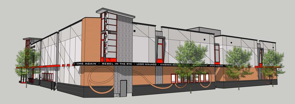
49
 Scott Ranweiler, Brinkman Partners")
50 Current Planning Division 410 E. 5th Street Loveland, CO (970) Planning Commission Staff Report February 26, 2018 Agenda #: Regular Agenda - 2 Title: Applicant: Request: The Foundry Theatre Site Development Plan (PZ ) Scott Ranweiler, Brinkman Partners Be-Established Business District Site Development Plan Review Location: Between E. First Street and E. Second Street (north/south) and between N. Lincoln Avenue and N. Cleveland Avenue (east/west) Existing Zoning: Be Established Business District Proposed Use: Staff Planner: Mixed-use development (Foundry) Troy Bliss Staff Recommendation Subject to additional evidence presented at the public hearing, City staff recommends the following motion: Recommended Motions: 1. Move to make the findings listed in Section VIII of the Planning Commission staff report dated February 26, 2018, and based on those findings, approve the Foundry Theatre Site Development Plan, subject to the conditions listed in Section IX, as amended on the record. Summary of Analysis This is a public hearing and quasi-judicial matter to consider The Foundry Theatre Site Development Plan (SDP). The role of the Planning Commission is to determine whether the plan as presented is in compliance with the standards specified in the Be Zoning District, Chapter of the Loveland Municipal Code. The decision of the Planning Commission is final with respect to the SDP barring appeal. The project is a collaboration between the applicant, Brinkman Partners, and the City of Loveland. The Foundry represents the City Council's effort to create a "downtown catalyst" project that will spur revitalization and renewed investment in the downtown. The envisioned mix of residential, entertainment, restaurant and retail uses, along with a city-owned parking structure oriented around a central plaza is part of a longstanding community vision. The financial and timing aspects of the project were established in January of 2016 between the Council and Brinkman; the project team is now working with a high level of urgency in order to meet various development parameters. City staff has worked closely with the Brinkman team to move the design to fruition. Staff believes that all key issues have been resolved and recommends approval of the submitted plans. PC Hearing February 26, 2018 Page 1
 PC Hearing February")
51 I. VICINITY MAP/AERIAL PHOTOGRAPHS (The Foundry Site as Highlighted Theatre Site Outlined in Red) PC Hearing February 26,
 (View:")
 PC")
52 (View: Looking south from E. Third Street Prior to Site Demolition) (View: Looking north from Irrigation Ditch along E. First Street Prior to Site Demolition) PC Hearing February 26,

53 II. INTRODUCTION UThe Foundry Description and Status The SDP is the fundamental application guiding the overall mixed-use redevelopment plan for the Foundry. The project itself is a $75 million redevelopment in the core of downtown Loveland and is the focal point of the City s downtown redevelopment plans since The Foundry is a public/private partnership between the City of Loveland and Brinkman Partners that has been approved by City Council. The Foundry represents a significant reinvestment to Loveland and its downtown. The redevelopment does create a catalyst for the south end adding a destination to downtown that could draw regionally or beyond. This is also the single largest redevelopment in downtown Loveland that the City has ever considered. As an entrance or exit (depending on which way you are traveling), the magnitude of this project will present a visual attraction that incorporates elements from downtown but creates its own unique place. A key component of the project has been to provide more parking for downtown in the form of a multi-level parking garage. Uses including mixed-use, theater, and hotel have taken shape around creating this vision. The Project is consistent with the City s approved Downtown Strategic Plan, specifically: Goal 1 - Maintain and enhance the economic vitality of Downtown through private/public partnerships. And; Goal 2 Identify funding gaps to project development and structure tools to fill the gaps and achieve development. PC Hearing February 26,

54 P Street Goal 4 Identify strategic catalyst projects that will significantly improve the economic conditions in downtown. The Downtown Vision Book, approved by Council in 2010, envisioned this project and was the first to coin the term South Catalyst. The Vision Book was the basis for the original RFP for the developer, which led to the North Catalyst project ( Gallery Flats ) as well as the South Catalyst, now Foundry Project. As outlined in Section B of the Loveland Municipal Code, the Planning Commission shall review the SDP and issue a decision based on specific findings that would approve, approve with conditions, or deny the project as presented. Decision of the Planning Commission is final. This decision may however be appealed as specified in Section of the Loveland Municipal Code. City Council approved a Disposition and Redevelopment Agreement in December 2016, which identifies, among many other items, timing on consideration of entitlements for the project. This SDP application covers the third and final phase of the Foundry Project, for development of a theatre. Remaining project components an amenity package for all site furnishings and final façade design of the parking garage, which are anticipated to be presented to the Planning Commission on March 12, The project site is approximately 4 acres in size located in the heart of downtown between st Backstage Alley and E. 1P and N. Lincoln Avenue and Cleveland Avenue. In order to visualize the magnitude and scope of this project, please see the following link: (29TUhttps://vimeo.com/ U29T). (Please note the video does not depict the final facades or building designs. It only illustrates the project mass and general building locations.) Prior actions by the Planning Commission related to this project have included: Recommendation for approval on vacating Opera Alley, portions of E. Third Street, a portion of E. Second Street; Approval of a Site Development Plan for the first phase of the Foundry (i.e. Parking Garage, Lincoln Mixed-Use Building, Cleveland Mixed-Use Building, and Central Plaza; and, Approval of a Site Development Plan for the second phase of the Foundry (i.e. Hotel). The overall intent with this third phase is to obtain land use approval relative to compliance with the Be zoning district for a theatre operated by Metropolitan. PC Hearing February 26,

 with a color palate that does introduce some new colors like the red entry.")
55 Foundry Theatre Overview The Foundry Theatre represents the third phase of the project in terms of land use entitlements. The site is approximately 0.65 acres in size, legally described as Lot 2, Block 3 of the Loveland Eleventh Subdivision, located at the far northeast end of the Foundry development. The general location is the northwest corner of N. Lincoln Avenue and E. Third Street. The building consists of a 26,000+ square foot, 2-story, 7-screen theatre. Exterior building materials are similar to those approved on the other Foundry buildings (i.e. brick, stucco, and decorative metal) with a color palate that does introduce some new colors like the red entry. Additionally, the rhythm is very linear (with the exception of the oval metal grid structures located at the southeast and southwest building corners). It is of the same bulk and scale as the parking garage and mixed-use buildings under construction to the south. In terms of height, the theatre is the shortest primary building within the Foundry development. The building is approximately 42 feet in height which is about 23 feet less than the mixed use buildings, about 13 feet less than the hotel (not under construction) and less than the bulk of the parking garage. In terms of the site, the main entrance to the building is located along E. Third Street (southwest corner) that incorporates a lot of glass and store front systems, important to a downtown setting. The entry is embellished by prominent red window frames and marquee topped with a large oval tower element. The southern portion of the site orients itself to the internal plaza. The east building elevation is another prominent elevation in terms of being adjacent to a public street (N. Lincoln Avenue). While no entry is provided, it was important to create entry features and architectural elements that that relate to the street from both a pedestrian and vehicular perspective. Service access is proposed off of Backstage Alley to the north. It will be fully enclosed and screened from public view. Along the west property boundary is an extension of the pedestrian walkway (paseo) PC Hearing February 26,
56 through the Foundry connecting to Backstage Alley. Backstage Alley is currently being redesigned to not only be a service area for all the businesses along the alley but also to establish a pedestrian corridor. III. ROLE OF THE PLANNING COMMISSION This Site Development Plan for the Foundry Theatre is a public hearing in which the Planning Commission determines whether the project as presented is consistent with applicable Be Zoning District standards based upon the findings outlined in Section IV of this staff report. City staff is recommending conditional approval to the Planning Commission. Conditions of approval are primarily conditions that apply to the Foundry development as a whole and have been applied to previous phases. As part of the Planning Commission review, a determination needs to be made that the following findings have been met: The proposed development complies with the standards of Chapter and any other provisions of the Municipal Code; The proposed development is consistent with the City s HIP Streets Master Plan; The proposed development is compatible with surrounding properties when considering the allowances for development intensity specified in Chapter and the urban orientation of downtown; and, Adequate infrastructure is available to serve the proposed development. The Planning Commission does not determine if the theatre use is appropriate. A theatre in the Be Zoning District is allowed by right. Exterior building material colors are not part of the Planning Commission consideration unless accent colors are found to not be compatible with predominant base colors. IV. REVIEW OF THE THEATRE Project Review With respect to building design, the building falls short in complying with the following applicable Be zoning requirements: East building elevation facing N. Lincoln Avenue: o Windows and doors are to comprise at least 40% of the building façade; o No building wall shall extend more than 25 horizontal feet without a window or opening; and, o Building recesses and/or projections of approximately 4 feet shall be provided along at least 20% of the façade. All building facades: o At least 30% of the facades shall include brick or stone finish materials consistent with the historic character of the area. The type/functionality of a theatre use and the orientation of the lot fronting three public rights-of-way (i.e. N. Lincoln Avenue, E. Third Street and Backstage Alley) complicates development being able to fully comply with these standards. In consideration, City staff has found that the intent is being met based on the following: East building elevation facing N. Lincoln Avenue: o The interior space along N. Lincoln Avenue includes all screening rooms. Introducing 40% of windows/doors defeats the purpose. Faux windows are being applied along the upper portion of the building. However, the intent is to limit faux windows and/or doors PC Hearing February 26,
57 due to not being true openings. Use of the movie poster glass inserts and backdrop to the sign/tower element add to the overall efforts in glazing requirements. o The building would be constructed at the property line. Therefore, the only option to address building recesses/projections is recessing. Again, this complicates the functionality and use of the interior screening room space essentially taking away square footage. The screening rooms are programed to specific dimensions. The overall size of the lot adds further complications it is a tight fit. In order to speak to the purpose and intent, elements of the building such as the oval tower, upper faux windows, and sign marquee provide appropriate projections. These elements do extend beyond the property line but given that they are elevated at certain heights above the sidewalk, such encroachments are allowed. All building facades: o The base and primary pedestrian level of the building incorporates the same type of brick that will be used on other buildings within the Foundry (i.e. black and red brick). Instead of adding brick to 30% of the entire building façades, which drives cost, the alternative is to include another compatible high-quality masonry element (i.e. stucco that incorporates a patterned design). Other Key Project Considerations Parking: The overall Foundry site is located within General Improvement District #1 (GID) which will contribute to the assessments collected for maintaining/upgrading public parking and pedestrian facilities downtown. This project represents a big contribution to the GID due to the size of redevelopment and inclusion of the parking garage. As specified in B, off-street parking is not required for non-residential or mixed-use developments located in the GID. And, while parking is not a component to Planning Commission s consideration on the SDP, it is important to understand the relationship of the Foundry to the parking garage and its effects on downtown as a whole. Walker Parking Consultants prepared a parking study in June 2016 with an update in December 2016 (see Attachment 1). This study is based on an overall shared-parking demand analysis that modeled aggregate, peak, and shared parking for all uses on the site. The model is specific enough to provide a breakdown of parking demand generated by different user groups, weekday versus weekend demand patterns, and the fluctuations in this demand at different times of the year. The analysis concludes that on average, the parking demand for the Foundry would never exceed the amount of parking spaces in the parking garage. Moreover, the parking garage would always have available public space for downtown visitors as a whole not just the Foundry. This is important to note because the parking garage (and lot it sits on) will be owned and maintained by the City, offering public parking for all of downtown. Adequate Community Facilities (ACF) Review: The purpose of ACF is to ensure that community facilities needed to support new development meet or exceed the adopted level of service established by the City. Section requires all non-residential and/or residential (containing more than 12 dwelling units) site plans to conform to ACF. The DRT has evaluated ACF throughout review of the Foundry with the following analysis: Fire Protection and Emergency Rescue Services Loveland Fire Authority Adequate fire protection services are currently in place. To ensure that fire protection and emergency rescue services remain in place during construction, a development agreement is being prepared. Additionally, Loveland Fire Authority has been working with the applicant s construction team in establishing proper access during construction in the event of any emergency. All PC Hearing February 26,
58 fire protection standards for the City of Loveland are being met as referenced in Appendix A Table 2.3 of Chapter of the Loveland Municipal Code Transportation Facilities Transportation Development Review - Staff believes that this finding can be met, due to the following: 1. A Traffic Impact Study (TIS), prepared by Sean Kellar, P.E., PTOE, has been submitted with The Foundry Site Development Plan which demonstrates that the existing transportation system, can adequately serve the proposal. 2. Access to the development will be provided by the existing downtown street network with new driveway access to a parking garage located on Second Street. 3. The TIS has demonstrated that the operation of Cleveland Avenue, Lincoln Avenue, Second Street and Third Street will meet City standards. 4. The TIS shows the need for a west-bound right turn lane on First Street at Lincoln Avenue for the proposed development. 5. The proposed development is estimated to generate approximately 2,244 daily trips, 211 weekday AM peak hour trips, and 289 weekday PM peak hour trips and 349 Saturday peak hour trips. In conclusion, the development of the subject property pursuant to any of the uses permitted by right under the zoning district will not adversely impact any existing City infrastructure. A positive determination of adequacy for transportation facilities for the proposed application has been made under the provisions above and Water Facilities and Services AND Wastewater Facilities and Services Water/Wastewater - This development is situated within the City s current service area for both water and wastewater. Previous buildings within the development area received water and wastewater services from the City. Significant water and wastewater infrastructure upgrades will occur prior to building construction to provide water main capacity and relocate the existing wastewater main. The Department finds that the Development will be compliant to ACF for the following reason: 1. Water and wastewater facilities and services meet or exceed the applicable ACF criteria Stormwater Facilities Stormwater - Staff believes that this the ACF finding can be met, due to the following: 1. Original development within downtown Loveland was constructed long before Storm Drainage Criteria was developed. As such, the original drainage system in downtown Loveland was deemed inadequate within the City of Loveland Master Drainage Plan. The Loveland Stormwater Utility has since constructed all of the identified storm drainage master planned improvements within downtown Loveland. 2. When constructed, the development will not negatively affect the existing City storm drainage infrastructure and will comply with the Adequate Community Services ordinance outlined in the Loveland Municipal Code, Section the best it can given the downtown Loveland parameters of which we have to work Power PC Hearing February 26,
59 Power This development is situated within the City s current service area for power. Previous buildings within the development area received power service from the City. Power infrastructure upgrades will occur prior to building construction to provide City power services to the new development. The Power Division finds that the development will comply with Adequate Community Facilities for the following reasons: 1. The proposed development will not negatively affect City power facilities. 2. The proposed public facilities and services are adequate and consistent with the City s utility planning and provides for efficient and cost-effective delivery of City power service. ACF Review Summary: In summary, adequate infrastructure is in place to accommodate the development along with changes that will create greater levels of service compared to what is currently in place. For example, the inclusion of a right turn lane at the intersection of N. Lincoln Avenue and E. First Street will create greater efficiency in vehicular movements. Additionally, improvements to the original drainage system in downtown will no longer have a negative impact to the City s storm drainage infrastructure. From an infrastructure perspective, the Foundry will add to improving downtown as a whole. Key Issues A significant amount of coordination and initial planning was conducted with this project. Weekly meetings were held with the DRT and Brinkman Partners between October 6, 2016 and December 22, 2016, prior to any development application review. Formal applications were submitted at the beginning of January 2017 which began another series of bi-weekly meetings with the DRT and Brinkman Partners over the course of almost 3 months. This commitment to the project has been extremely valuable in addressing key issues ahead of time and finding solutions. Significant issues were uncovered that included: Complications with respect to location of existing fiber in N. Cleveland Avenue that needs to be rerouted; Construction of a right-turn lane at the intersection of E. First Street and N. Lincoln Avenue; CDOT approval on lane configurations in N. Lincoln Avenue and N. Cleveland Avenue; Re-routing sewer main; Transformer locations; Re-routing of external service provider lines (i.e. Century Link and Comcast); Dewatering of the parking garage; and, Grading/drainage for new development in relation to existing. Staff, Applicant, Neighborhood Interaction A. Notification Mike McBride with BHA provided an affidavit, certifying that proper notice was provided which included signs posted in prominent locations and written notice mailed to all surface owners within 300 feet of the site on February 10, Additionally, notice was published in the Reporter Herald on February 10, All notices stated that the Planning Commission will hold a public hearing on February 26, B. Neighborhood Interaction/Response A neighborhood meeting is not required in conjunction with this application. However, from a neighborhood and surrounding property owner perspective, a lot of outreach has been done with the Foundry project as a whole. This has included information being conveyed through City newsletters/press releases, the Loveland Downtown Development PC Hearing February 26,
60 Authority (LDDA), speaking with surrounding business owners, and sharing the proposal during downtown events. Information obtained suggests a strong support to the project. Many citizens are encouraged to see redevelopment of this magnitude in downtown. City staff has also received correspondence in support of the Foundry Theatre. V. ATTACHMENTS 1. Parking Study Excerpts (for reference only) 2. Traffic Impact Study Excerpts 3. Loveland Eleventh Subdivision (for reference only) 4. Foundry Theatre Site Development Plan 5. Foundry Theatre Perspectives VI. SITE DATA ACREAGE OF SITE... +/- 4.0 ACRES EXISTING ZONING... BE CENTRAL BUSINESS DISTRICT MASTER PLAN DESIGNATION... DAC DOWNTOWN ACTIVITY CENTER EXISTING USE... VACANT/UNDEVELOPED PROPOSED USE... MIXED-USE DEVELOPMENT (FOUNDRY) ACREAGE OF OPEN SPACE PROPOSED... N/A EXISTING ADJACENT ZONING AND USE - NORTH... BE CENTRAL BUSINESS DISTRICT VARIOUS COMMERCIAL USES EXISTING ADJACENT ZONING AND USE - EAST... BE CENTRAL BUSINESS DISTRICT VARIOUS COMMERCIAL USES EXISTING ADJACENT ZONING AND USE - SOUTH... BE CENTRAL BUSINESS DISTRICT VARIOUS COMMERCIAL USES EXISTING ADJACENT ZONING AND USE - WEST... BE DEVELOPING BUSINESS VARIOUS COMMERCIAL USES AND RESIDENTIAL USES UTILITY SERVICE PROVIDER - SEWER... CITY OF LOVELAND UTILITY SERVICE PROVIDER - ELECTRIC... CITY OF LOVELAND UTILITY SERVICE PROVIDER - WATER... CITY OF LOVELAND WATER RIGHTS PAID... NO WATER RIGHTS DUE VII. BACKGROUND The Loveland Original Town Addition is the oldest part of the City, annexed in The addition includes properties between E. Ninth Street and E. First Street (north and south) and N. Lincoln Avenue and N. Garfield Avenue (east and west). Most of the properties are within the Be zoning district. There are also some commercial and high-density residential properties up near E. Ninth Street. The City went through an extensive environmental, demolition, and abatement process over the course of many months before getting to the point of preparing the SDP with Brinkman Partners. A lot went into this process involving a number of City staff and outside consultation to better understand the nature of the property and deliver a buildable site for the Foundry. In January 2016, City Council selected Brinkman Partners ( Developer ) as the preferred developer following a competitive bid process. Throughout 2016, the City engaged in negotiation with the Brinkman Partners on the project. As negotiations progressed, the developer engaged the DRT, starting PC Hearing February 26,
61 the process of developing the SDP. At that point, the Developer renamed the project, the Foundry from its previous name of South Catalyst. The DRT along with Brinkman Partners began a series of in-depth weekly design review meetings from October 6, 2016 to December 22, 2016 (11 weeks) before submittal of any formal development applications for review. The purpose was for the creation of a project charter. With a project of this size and scope, it was extremely important to identify all the participants, their roles, and open up all lines of communication. A project schedule was developed and agreed to between the DRT and Brinkman Partners setting clear expectations and identifying key milestones/deliverables. And WE created the framework allowing for a less complication and more efficiency during an aggressive review schedule. An incredible amount of coordination in terms of infrastructure, bringing external agencies to the table (CDOT, Comcast, Century Link, Xcel Energy), and design solutions resulted from these initial meetings. The value of this approach was extremely beneficial to the project. Everyone involved from the DRT to the Brinkman Team members, a huge amount of initial time and effort was put forth. It demonstrates the collaboration and quality of work presented. The behind the scenes work is not always brought forward. However, with The Foundry it was critical to the success of the project - worthy of recognition. Remaining Components Details of the parking garage façade and amenities/site furniture, and theatre are still undergoing design review. These final design features will be brought to the Planning Commission for review and approval at a later date likely March 12, The following includes further details regarding these items: Parking Garage: Final detailing of the parking garage have not been fully provided. The applicant and the City staff are investigating features to enhance the building. Consideration has through the Arts Commission to make this determination. An artist has been selected that will feature three dimensional ribbons (meant to resemble flames associated with a foundry) along with a sculpture of a sun. Amenities/Site Furniture: Specific materials, colors, building/structure designs for the amenities/street furniture including but not limited to railings, benches, bicycle racks, planters, tree grates, fire pit, splash pad, shade structure, decorative lighting, and the Little Man Ice Cream have not been finalized. The expectation is that once these are finalized, Planning Commission will have the opportunity to review the site amenity package in relation to Destination Downtown: HIP Streets Master Plan. Specific Colors Palate for Ground Surfaces: All pavement colors including concrete, brick pavers, patios, etc. are not included. This however is not required in conjunction with Chapter but has influenced the City s efforts in updating Destination Downtown: HIP Streets Master Plan. These elements are anticipated with the site amenity package as well. VIII. FINDINGS AND ANALYSIS Site Development Plan Foundry Theatre In approving a SDP application, the Planning Commission must determine that the findings outlined in this section have been met (Title 18, Chapter 18.24, Section B). The following information provided includes the code citation/requirements (findings) identified in bold italic and the responses (analysis) underneath: PC Hearing February 26,

62 1. The proposed development complies with the standards of this chapter and any other applicable provisions of the Loveland Municipal Code Standards Applying to Entire BE Zoning District A. Building Height: The Foundry site is located in Height District C as depicted in Figure The building is less than 70 feet in height (approximately 55 feet). The tallest buildings within the overall project include both mixed-use buildings which are under 66 feet in height B. Off Street Parking: The Foundry site is located in the GID. No off-street parking is required for non-residential and mixed-use development. Please refer to Section IV. (above) for information regarding parking. PC Hearing February 26,
63 D. Signs: Signs shown on the building elevations are illustrative and have not been fully developed but will be designed to comply with all applicable City standards. The City will also be exploring options for unique signs like the marquee (shown along the east façade) through current efforts in updating the zoning ordinance. Electronic signs are currently not allowed in downtown due to their moving parts/flashing lights E. Illumination: A photometric plan is included with the SDP demonstrating compliance with the City s outdoor lighting standards. All functional lighting and exterior to the site is designed to include full cut-off luminares. While illustrated in the photometric plan, decorative lighting intended to provide ambiance is not evaluated under the City s outdoor lighting standards for being full cut-off F. Outdoor Eating Areas: All areas along E. Third Street anticipated to include outdoor seating for eating areas will be fenced and distinguishable from the general pedestrian path. These areas will not create inadequate clear space affecting pedestrian movement. All areas will be defined by appropriate enclosures and properly maintained by the business owners G. Outdoor Storage: No outdoor storage is proposed with this project. All service areas including trash/recycling/laundry/etc. are designed to be incorporated within each mixed-use building completely screened from view H. Outdoor Display: No outdoor display is proposed with this project except during special events which require separate permit approvals I. Alley Levels of Service: No alleys are being affected with this phase J. Civic Structures: The parking garage is the only civic structure associated with this project. Details were provided to the Planning Commission in March 2017 with the expectation to have façade designs for a future hearing. PC Hearing February 26,
, N. Cleveland Avenue (From Backstage Alley to Opera Alley), and E. Third Street (between N. Lincoln Avenue and N.")
64 General and Core Character Areas Urban Design Standards: C Primary Pedestrian Streets: The primary pedestrian streets associated with this project include N. Lincoln Avenue (from Backstage Alley to E. Second Street), N. Cleveland Avenue (From Backstage Alley to Opera Alley), and E. Third Street (between N. Lincoln Avenue and N. Cleveland Avenue) as depicted in Figure PC Hearing February 26,

65 D-F. Primary and Secondary Elevations and Lot Frontage: The building fronts two primary pedestrian streets (i.e. N. Lincoln Avenue and E. Third Street). The building provides over an 14-foot setback from building façade to face of curb for the majority of the building frontages. Site design for the Foundry focuses heavily on the primary pedestrian streets in terms of creating adequate clear space for pedestrian movement especially when considering architectural elements like canopies/awnings that extend beyond the property lines. The street level walk (where there are no elevation changes) maintains a wide path along all street frontages. Amenities such as street canopy streets, street furniture, outdoor seating areas, and decorative lighting will all add to the pedestrian experience creating a pleasant and safe walkable development around the perimeters especially along a State Highway. PC Hearing February 26,
LOVELAND PLANNING COMMISSION MEETING AGENDA Monday, April 09, E. 3 rd Street Council Chambers Loveland, CO :30 PM
 LOVELAND PLANNING COMMISSION MEETING AGENDA Monday, April 09, 2018 500 E. 3 rd Street Council Chambers Loveland, CO 80537 6:30 PM The City of Loveland is committed to providing an equal opportunity for
Attachment 4. Planning Commission Staff Report. June 26, 2017
 Planning Commission Staff Report June 26, 2017 Agenda #: Regular Agenda - 2 Title: Applicant: Request: Location: Existing Zoning: Proposed Use: Staff Planner: The Brands and The Brands West Eagle Crossing
COUNTY OF ADAMS, STATE OF COLORADO E. 40TH AVE. TOWER RD. E. 38TH AVE. SALIDA ST. HIGH LINE CANAL PROJECT LOCATION E. 32ND PKWY.
 LEGAL DESCRIPTION:, GATEWAY EAST AT TOWER SUBDIVISION FILING NO. 1, SAID PARCEL CONTAIN 598,154 SQUARE FEET OR MORE OR LESS GENERAL NOTES: 1. NOTICE: ACCORDING TO COLORADO LAW YOU MUST COMMENCE ANY LEGAL
Planning Commission Staff Report
 Development Services Current Planning 410 E 5 th Street Loveland, CO 80537 (970) 962-2523 Fax (970) 962-2945 TDD (970) 962-2620 www.cityofloveland.org Planning Commission Staff Report November 14, 2016
VICINITY MAP SCALE 1'' = 2000'
 CITY CREEK ANNEXATION TO THE CITY OF THORNTON LOCATED IN THE SOUTHWEST QUARTER OF SECTION 11 AND THE WEST HALF OF SECTION 14, TOWNSHIP 1 SOUTH, RANGE 68 WEST OF THE 6TH PRINCIPAL MERIDIAN, COUNTY OF ADAMS,
PLANNING AND ZONING DEPARTMENT
 Town of Minturn Development Review Process: Guide To Planned Unit Developments (Concept Plan) This guide describes the Planned Unit Development Process. This guide should be utilized in conjunction with
Planning Commission Staff Report. February 13, 2017
 Current Planning Division 410 E. 5th Street Loveland, CO 80537 (970) 962-2523 eplanplanning@cityofloveland.org Planning Commission Staff Report February 13, 2017 Agenda #: Consent Agenda - 1 Title: Applicant:
STAFF REPORT FOR ANNEXATION AND ZONING. CASE NAME: Taylor Annexation and Zoning PC DATE: August 7, 2013
 STAFF REPORT FOR ANNEATION AND ZONING ANNEATION CASE NO: A-13-001 ZONING CASE NO: RZ-13-002 REPORT DATE: July 30, 2013 CASE NAME: Taylor Annexation and Zoning PC DATE: August 7, 2013 ADDRESS OF PROPOSAL:
ARTICLE 15 - PLANNED UNIT DEVELOPMENT
 Section 15.1 - Intent. ARTICLE 15 - PLANNED UNIT DEVELOPMENT A PUD, or Planned Unit Development, is not a District per se, but rather a set of standards that may be applied to a development type. The Planned
NOT TO BE SUBMITTED WITH SKETCH DESIGN APPROVAL Subdivision Checklist: Major Subdivision Final Plat
 Must be received with review fee (equal to $200.00, plus $25.00 per lot) no later than 15 days prior to Planning Board meeting, which is normally the first Monday of the month (certain holidays may modify
MINOR SUBDIVISION INFORMATION
 A. POINTS OF CONTACT: MINOR SUBDIVISION INFORMATION Surveyor: Address: Phone #: Fax # E-Mail Address: Representative (If different from applicant): Address: Phone #: Fax # E-Mail Address: B. GENERAL INFORMATION:
Conditional Use Permit / Standard Subdivision Application
 Conditional Use Permit / Standard Subdivision Application Name of Proposed Subdivision: Total Area (Acres) Is Proposed Subdivision to be built in phases? Number of Lots If yes, how many phases? Applicant/Owner
Section Preliminary Plat Checklist and Application Forms
 Section 201 - Preliminary Plat Checklist and Application Forms PRELIMINARY SUBDIVISION PLAT REVIEW PROCESS CHART PRELIMINARY SUBDIVISION PLAT APPLICATION PRELIMINARY PLAT REVIEW CHECKLIST CITY OF NAMPA
ADUs and You! Common types of ADUs include mother-in-law suite, garage apartments and finished basements.
 ADUs and You! Accessory Dwelling Units Town of Lyons Accessory Dwelling Units (ADUs) are a form of housing that can be an important tool for diversifying and increasing the local housing stock. Lyons lost
SITE PLAN REVIEW ADMINISTRATIVE REVIEW. Please Note: Once submitted to the County, all application materials become a matter of public record.
 200 W. Oak Street, 3rd Floor Fort Collins, CO 80521 (970) 498-7683 / larimer.org/planning SITE PLAN REVIEW ADMINISTRATIVE REVIEW The submittal requirements listed in this packet are intended to collect
Submittal Requirements: Subdivision Plat (Final)
") s Planning and Zoning Submittal Requirements: Subdivision Plat (Final) 1. Application form, APO fees, and filing fee. Transportation Development Review Fee please contact Engineering at (970) 221-6605
s Planning and Zoning Submittal Requirements: Subdivision Plat (Final) 1. Application form, APO fees, and filing fee. Transportation Development Review Fee please contact Engineering at (970) 221-6605
Planning Commission Staff Report
 Development Services Current Planning 410 E 5 th Street Loveland, CO 80537 (970) 962-2523 Fax (970) 962-2945 TDD (970) 962-2620 www.cityofloveland.org Planning Commission Staff eport February 27, 2017
Guide to Preliminary Plans
 Guide to Preliminary Plans Introduction The Douglas County is committed to providing open, transparent application processes to the public. This Guide is provided to assist anyone interested in the procedures
Guide to Combined Preliminary and Final Plats
 Guide to Combined Preliminary and Final Plats Introduction The Douglas County is committed to providing open, transparent application processes to the public. This Guide is provided to assist anyone interested
Guide to Minor Developments
 Guide to Minor Developments Introduction The Douglas County (DCD) is committed to providing open, transparent application processes to the public. This Guide is provided to assist anyone interested in
AAAA. Planning and Zoning Staff Report Lake Shore Land Holdings, LLC CU-PH Analysis
 AAAA Planning and Zoning Staff Report Lake Shore Land Holdings, LLC CU-PH2016-28 Hearing Date: April 21, 2016 Development Services Department Applicant: BRS Architects/Cindy Huebert Staff: Kyle McCormick,
MIDWAY CITY Municipal Code
 MIDWAY CITY Municipal Code TITLE 9 ANNEXATION CHAPTER 9.01 PURPOSE CHAPTER 9.02 GENERAL REQUIREMENTS CHAPTER 9.03 PROPERTY OWNER INITIATION OF ANNEXATION CHAPTER 9.04 PROCEDURES FOR CONSIDERATION OF PETITION
E. 140TH AVE. VICINITY MAP SCALE: 1"=600' LAND USE TABLE NET AREA 599,946 SQFT AC. GROSS AREA 741,420 SQFT AC.
 SHEET OF PURPOSE STATEMENT: THIS PLAT IS INTENDED TO SUBDIVIDE. ACRES INTO SINGLE FAMILY ATTACHED LOTS, TRACTS, DEDICATE AND GRANT EASEMENTS. LEGAL DESCRIPTION: THE UNDERSIGNED BEING THE OWNER(S) OF A
Larimer County Planning Dept. Procedural Guide for 1041 PERMITS
 - Larimer County Planning Dept. Procedural Guide for 1041 PERMITS PLEASE NOTE: A PRE-APPLICATION CONFERENCE IS REQUIRED PRIOR TO SUBMITTING THIS APPLICATION. PURPOSE: State Statutes allow local governments
CHAPTER 3 PRELIMINARY PLAT
 10-3-1 10-3-3 SECTION: CHAPTER 3 PRELIMINARY PLAT 10-3-1: Consultation 10-3-2: Filing 10-3-3: Requirements 10-3-4: Approval 10-3-5: Time Limitation 10-3-6: Grading Limitation 10-3-1: CONSULTATION: Each
Cover Letter with Narrative Statement
 Cover Letter with Narrative Statement March 31, 2017 rev July 27, 2017 RE: Rushton Pointe Residential Planned Unit Development Application for Public Hearing for RPUD Rezone PL2015 000 0306 Mr. Eric Johnson,
FINAL PLAT SUBMITTAL CHECKLIST
 FINAL PLAT SUBMITTAL CHECKLIST The submission requirements for a Final Plat Review are found beginning in Section 24-4-40 of the Weld County Code. The Weld County Code is available on line at www.co.weld.co.us
BOARD OF COUNTY COMMISSIONERS ARCHULETA COUNTY, COLORADO RESOLUTION 2018-
 BOARD OF COUNTY COMMISSIONERS ARCHULETA COUNTY, COLORADO RESOLUTION 2018- ARCHULETA COUNTY IMPROPERLY DIVIDED PARCELS EXEMPTION INTERIM RESOLUTION - A RESOLUTION ADDRESSING PARCELS UNDER THE SIZE OF 35
ADMINISTRATIVE HEARING STAFF REPORT Country Club Acres Second Amended Subdivision Amendment PLNSUB E Parkway Avenue December 12, 2013
 ADMINISTRATIVE HEARING STAFF REPORT Country Club Acres Second Amended Subdivision Amendment PLNSUB2013-00925 2167 E Parkway Avenue December 12, 2013 Planning Division Department of Community & Economic
Medical Marijuana Special Exception Use Information
 Medical Marijuana Special Exception Use Information The Special Exception Use information below is a modified version of the Unified Development Code. It clarifies the current section 5:104 Special Exceptions
SUBDIVISION, PLANNED UNIT DEVELOPMENT, ZONING AMENDMENT, & SIDEWALK WAIVER STAFF REPORT Date: July 19, 2018
 SUBDIVISION, PLANNED UNIT DEVELOPMENT, ZONING AMENDMENT, & SIDEWALK WAIVER STAFF REPORT Date: July 19, 2018 NAME SUBDIVISION NAME LOCATION West Mobile Properties, LLC U.S. Machine Subdivision 556, 566,
MAJOR RESIDENTIAL AND NONRESIDENTIAL SUBDIVISIONS
 Lawrence-Douglas County MAJOR RESIDENTIAL AND NONRESIDENTIAL SUBDIVISIONS Preliminary Plats The applicant shall schedule a Pre-Application meeting with Planning Staff at least seven (7) working days prior
CHAPTER XVIII SITE PLAN REVIEW
 CHAPTER XVIII SITE PLAN REVIEW Section 18.1 Section 18.2 Description and Purpose. The purpose of this chapter is to provide standards and procedures under which applicants would submit, and the Township
Residential Major Subdivision Review Checklist
 Residential Major Subdivision Review Checklist Plan Submittal Requirements: 2 full sets of stamped plans Electric submittal - all plans contained in a single PDF 3 full sets if commercial kitchen or dining
Chapter 100 Planned Unit Development in Corvallis Urban Fringe
 100.100 Scope and Purpose. Chapter 100 Planned Unit Development in Corvallis Urban Fringe (1) All applications for land divisions in the Urban Residential (UR) and Flood Plain Agriculture (FPA) zones within
FINAL PLAT APPLICATION
 FINAL PLAT APPLICATION (Page 1 of 3) LEGAL OWNER(s): NAME: STREET ADDRESS OWNER(s): CITY, STATE, ZIP CODE: PHONE NUMBER: BILLING ADDRESS: NAME OF ENGINEER/SURVEYOR: Engineer/Surveyor Address, Phone: PROPERTY
FINAL SUBDIVISION AND LAND DEVELOPMENT PLAN CHECKLIST. Plan Name. Applicant's Name:
 TOWNSHIP OF UPPER ST. CLAIR FINAL SUBDIVISION AND LAND DEVELOPMENT PLAN CHECKLIST Date Filed Plan Name PLC Applicant's Name: Phone Filing Date for Final Application Final Plat 114.22. FINAL APPLICATION
PLANNING COMMISSION REPORT Regular Agenda Public Hearing Item
 PC Staff Report 11/12/12 Item No. 2B- 1 PLANNING COMMISSION REPORT Regular Agenda Public Hearing Item ITEM NO. 2B: A TO GPI; 110 ACRES; E OF K-10 & N OF W 6 TH ST (MKM) : Consider a request to rezone approximately
Final Plat Mapping Requirements
 CURRENT PLANNING DIVISION 410 E. 5 th Street Loveland, CO 80537 970-962-2523 eplan-planning@cityofloveland.org cityofloveland.org/dc Final Plat Mapping Requirements All Final plats shall comply with the
Article 6: Planned Unit Developments
 LUDC 2013 GARFIELD COUNTY, COLORADO Article 6: Planned Unit Developments ARTICLE 6 PLANNED UNIT DEVELOPMENTS TABLE OF CONTENTS DIVISION 1. GENERAL.... 1 6-101. GENERAL PROVISIONS.... 1 A. Purpose....
PROCEDURE. Chapter 12: Subdivision Regulations
 SECTION 14-600 ADMINISTRATIVE REPLAT PROCEDURE 14-601 INTENT These procedures are to provide an abbreviated process for Replat applications that demonstrate compliance with the criteria contained herein.
Oakland County Michigan Register of Deeds Plat Engineering, GIS, & Remonumentation Dept. Ph: (248) Fax (248)
 Fax (248)") Oakland County Michigan Register of Deeds Plat Engineering, GIS, & Remonumentation Dept. Ph: (248)-858-1447 Fax (248)-858-7466 Requirements Needed for Final Plat Approval No. General Requirements. 1 Routing
Oakland County Michigan Register of Deeds Plat Engineering, GIS, & Remonumentation Dept. Ph: (248)-858-1447 Fax (248)-858-7466 Requirements Needed for Final Plat Approval No. General Requirements. 1 Routing
CHECKLIST FOR DEVELOPMENT REVIEW
 CHECKLIST FOR DEVELOPMENT REVIEW Petitions and related documents and plans for land development or other proposals regulated by Title 16 of the Municipal Code (Development Ordinance) and Title 17 of the
Plan and Zoning Commission Review Process
 . Village of Northfield Plan and Zoning Commission Review Process.......... Department of Community Development and Building Village of Northfield Department of Community Development and Building 361 Happ
DEPARTMENT OF PLANNING SERVICES 1555 N 17 th Ave Greeley CO Phone (970) Fax (970)
 Fax (970)") DEPARTMENT OF PLANNING SERVICES 1555 N 17 th Ave Greeley CO 80631 Phone (970) 400-6100 Fax (970) 304-6498 SITE SPECIFIC DEVELOPMENT PLAN USE BY SPECIAL REVIEW PROCEDURAL GUIDE SOLID WASTE DISPOSAL SITES
DEPARTMENT OF PLANNING SERVICES 1555 N 17 th Ave Greeley CO 80631 Phone (970) 400-6100 Fax (970) 304-6498 SITE SPECIFIC DEVELOPMENT PLAN USE BY SPECIAL REVIEW PROCEDURAL GUIDE SOLID WASTE DISPOSAL SITES
CHAPTER 26 PLANNING AND ZONING ARTICLE VII. MOBILE HOMES AND RECREATIONAL VEHICLE (RV) PARKS. Recreational Vehicle (RV) Park Development Standards
 PARKS. Recreational Vehicle (RV) Park Development Standards") CHAPTER 26 PLANNING AND ZONING ARTICLE VII. MOBILE HOMES AND RECREATIONAL VEHICLE (RV) PARKS. Section 26-VII-1. Section 26-VII-2. Section 26-VII-3. Section 26-VII-4. Section 26-VII-5. Purpose Permitted
CHAPTER 26 PLANNING AND ZONING ARTICLE VII. MOBILE HOMES AND RECREATIONAL VEHICLE (RV) PARKS. Section 26-VII-1. Section 26-VII-2. Section 26-VII-3. Section 26-VII-4. Section 26-VII-5. Purpose Permitted
Mount Airy Planning Commission March 26, Staff Report
 Mount Airy Planning Commission March 26, 2018 Staff Report Special Exception Request Mixed Use Development in CC District Recommendation to Board of Appeals CASE MA-A-18-01 Applicant: Location: Zoning:
Staff Report: Date: Applicant: Property Identification: Acreage of Request: Current Zoning of Requested Area: Requested Action: Attached:
 Staff Report: Completed by Jeff Palmer Director of Planning & Zoning Date: November 7, 2018, Updated November 20, 2018 Applicant: Greg Smith, Oberer Land Developer agent for Ronald Montgomery ET AL Property
Letter of Intent May 2017 (Revised November 2017)
") THE BEACH AT WOODMOOR LETTER OF INTENT MAY 2017 (REVISED NOVEMBER 2017) OWNER/APPLICANT: CONSULTANT: Lake Woodmoor Holdings LLC N.E.S. Inc. 1755 Telstar Drive, Suite 211 619 North Cascade Avenue Colorado
THE BEACH AT WOODMOOR LETTER OF INTENT MAY 2017 (REVISED NOVEMBER 2017) OWNER/APPLICANT: CONSULTANT: Lake Woodmoor Holdings LLC N.E.S. Inc. 1755 Telstar Drive, Suite 211 619 North Cascade Avenue Colorado
FINAL PLAT GUIDE TO SUBDIVIDING PROPERTY. Background
 FINAL PLAT GUIDE TO SUBDIVIDING PROPERTY Background A final plat is the second step in the process of subdividing land into separate parcels for future sale or lease. Once a preliminary plat has been approved
ARTICLE 900 PLAT AND PLAN REQUIREMENTS
 ARTICLE 900 PLAT AND PLAN REQUIREMENTS SEC. 900.1 ITEMS TO BE SHOWN ON PLAT OR PLAN General (1) Property lines of all property owners adjacent to the exterior boundaries of the project shall be located
ARTICLE SINGLE FAMILY SITE CONDOMINIUM DEVELOPMENT STANDARDS
 ARTICLE 28.00 SINGLE FAMILY SITE CONDOMINIUM DEVELOPMENT STANDARDS Section 28.01 PURPOSE The purpose of this Article is to recognize that conventional single family developments, traditionally developed
APPLICATION PACKET SINGLE FAMILY CLUSTER HOUSING OPTION REVIEW
 APPLICATION PACKET SINGLE FAMILY CLUSTER HOUSING OPTION REVIEW COMMUNITY DEVELOPMENT DEPARTMENT CHARTER TOWNSHIP OF PLYMOUTH 9955 N. Haggerty Road Plymouth, MI 48170 Fees Revised 7/01/2012 1. PURPOSE APPLICATION
SUBMITTAL REQUIREMENTS
 PRELIMINARY PLAT APPLICATION ***A PRE-APPLICATION MEETING WITH CITY STAFF IS REQUIRED FOR THIS APPLICATION*** DATE STAMP FOR CITY USE ONLY PROJECT NAME (if any): TO BE FILLED OUT BY APPLICANT PROJECT STREET
Residential Minor Subdivision Review Checklist
 Residential Minor Subdivision Review Checklist Plan Submittal Requirements: 2 full sets of stamped plans Electric submittal - all plans contained in a single PDF 3 full sets if commercial kitchen or dining
II. What Type of Development Requires Site Plan Review? There are five situations where a site plan review is required:
 I. What is a Site Plan Review? Site Plan Review is a process where the construction of new buildings, new additions, and certain types of canopies and/or tax-exempt institutions are reviewed by the City
REPORT TO THE SHELBY COUNTY PLANNING COMMISSION From the Department of Development Services Planning Services. February 4, 2019
 REPORT TO THE SHELBY COUNTY PLANNING COMMISSION From the Department of Development Services Planning Services February 4, 2019 Case No. Request for Rezoning Approval From E-1 to E-2 SD This is a request
Time Extension Staff Report
 Time Extension Staff Report Subdivision Name Lunara Subdivision File Number SUB07-00019 Approval Time Extension for Lead Agency Boise City Certification Signature of Boise City Engineer Annexation Date
Rapid City Planning Commission
 Rapid City Planning Commission Initial Planned Development Overlay Project Report March 9, 2017 Item #15 Applicant Request(s) Case # 17PD007 Initial Planned Development Overlay to allow a residential development
APPLICATION PACKET SINGLE FAMILY CLUSTER HOUSING OPTION REVIEW
 APPLICATION PACKET SINGLE FAMILY CLUSTER HOUSING OPTION REVIEW COMMUNITY DEVELOPMENT DEPARTMENT CHARTER TOWNSHIP OF PLYMOUTH 9955 N. Haggerty Road Plymouth, MI 48170 Fees Revised 9.13.2017 1. PURPOSE APPLICATION
MINOR PLAT. The following documents are provided as required by the City of Conroe for use in the above titled platting submittals:
 Public Works - Engineering Division CITY OF CONROE MINOR PLAT The following documents are provided as required by the City of Conroe for use in the above titled platting submittals: Submittal Questionnaire
DEVELOPMENT AGREEMENT RIVER EDGE COLORADO PLANNED UNIT DEVELOPMENT
 DEVELOPMENT AGREEMENT RIVER EDGE COLORADO PLANNED UNIT DEVELOPMENT THIS AGREEMENT, is made and entered into between the BOARD OF COUNTY COMMISSIONERS OF THE COUNTY OF GARFIELD, a body politic and corporate
CHAPTER XIX ANNEXATION ARTICLE 1. ANNEXATION
 CHAPTER XIX ANNEXATION ARTICLE 1. ANNEXATION 19.0101 JABORSKY ADDITION: WHEREAS, The City of Belfield pursuant to Section 40-51.2-07 of the North Dakota Century Code has amended having passed a Resolution
SUBDIVISION APPLICATION CHECKLIST SKETCH PLAN PRELIMINARY PLAT FINAL PLAT
 RECEIVED STAMP SUBDIVISION APPLICATION CHECKLIST SKETCH PLAN PRELIMINARY PLAT FINAL PLAT A checklist of background information and submission requirements for processing of a sketch plan, preliminary plat
610 LAND DIVISIONS AND PROPERTY LINE ADJUSTMENTS OUTSIDE A UGB
 ARTICLE VI: LAND DIVISIONS AND PROPERTY LINE ADJUSTMENTS VI-21 610 LAND DIVISIONS AND PROPERTY LINE ADJUSTMENTS OUTSIDE A UGB 610-1 Property Line Adjustments (Property Line Relocation) A property line
CHAPTER 22 SUBDIVISION AND LAND DEVELOPMENT
 CHAPTER 22 SUBDIVISION AND LAND DEVELOPMENT 22-101. Title 22-102. Legislative Intent Part 1 General Provisions 22-201. Development Permits Part 2 Administration 22-301. Fee Schedule Part 3 Fee Schedule
SUBDIVISION, PLANNING APPROVAL, & REZONING STAFF REPORT Date: June 4, 2015
 SUBDIVISION, PLANNING APPROVAL, & REZONING STAFF REPORT Date: June 4, 2015 APPLICANT NAME SUBDIVISION NAME DEVELOPMENT NAME LOCATION Board of Water & Sewer Commissioners of the City of Mobile MAWSS MLK
PLANNING AND ZONING COMMISSION AGENDA MEMORANDUM
 City and County of Broomfield, Colorado PLANNING AND ZONING COMMISSION AGENDA MEMORANDUM To: Planning and Zoning Commission From: John Hilgers, Planning Director Anna Bertanzetti, Principal Planner Meeting
RECOMMENDATION Following the public hearing, consider Zoning Case PD14-16, with a Development Plan.
 Staff Report Zoning Case PD14-16 (Helzer Tract) Planning and Zoning Meeting Date: 12-17-14 Document Being Considered: Ordinance RECOMMENDATION Following the public hearing, consider Zoning Case PD14-16,
Town of Onalaska. A scale map depicting the portion of Pineview Drive to be officially laid out as a Town highway is attached hereto as Exhibit A.
 Town of Onalaska Special Meeting Minutes for March 31, 2011 The Town Board met on site of the Pineview Road and County OT in Onalaska for the purpose of viewing the lay out of the road as required by law.
QUEBEC STREET EAST 130TH AVENUE ONEIDA STREET E. 130TH AVE. VALENTIA ST TAMARAC ST EAST 128TH AVENUE MOACO STREET BACHMAN DR. SITE QUINCE ST.
 SHEET OF CASE NO.: SUBA - PURPOSE STATEMENT: THIS PLAT IS INTENDED TO SUBDIVIDE. ACRES INTO SINGLE FAMILY LOTS, AND TRACTS FOR PARKS, OPEN SPACE, DRAINAGE AND DETENTION, DEDICATE RIGHT-OF-WAY AND GRANT
LYON COUNTY COMMUNITY DEVELOPMENT DEPARTMENT
 LYON COUNTY COMMUNITY DEVELOPMENT DEPARTMENT B UILDING D EVELOPMENT E NGINEERING P LANNING 27 S. MAIN S TREET Y ERINGTON, NEVADA 89447 (775) 463-6591 F AX: (775) 463-5305 34 LAKES B OULEVARD D AYTON, NEVADA
CITY OF ALBERT LEA PLANNING COMMISSION ADVISORY BOARD
 CITY OF ALBERT LEA PLANNING COMMISSION ADVISORY BOARD 9/1/2015, 5:30 p.m. City Council Chambers AGENDA A. CALL TO ORDER AND ROLL CALL B. APPROVAL OF THE AGENDA C. APPROVAL OF MINUTES 1. PC Minutes from
LARAMIE COUNTY PLANNING & DEVELOPMENT DEPARTMENT
 LARAMIE COUNTY PLANNING & DEVELOPMENT DEPARTMENT Planning Building MEMORANDUM TO: FROM: Laramie County Planning Commission Brett Walker, Planner DATE: January 25, 2018 TITLE: Review and action of a Subdivision
SUBDIVISION APPLICATION (CHECK THE BOX THAT APPLIES)
") GARFIELD COUNTY Building & Planning Department 108 8 th Street, Suite 401 Glenwood Springs, Colorado 81601 Telephone: 970.945.8212 Facsimile: 970.384.3470 www.garfield-county.com SUBDIVISION APPLICATION
GARFIELD COUNTY Building & Planning Department 108 8 th Street, Suite 401 Glenwood Springs, Colorado 81601 Telephone: 970.945.8212 Facsimile: 970.384.3470 www.garfield-county.com SUBDIVISION APPLICATION
APPENDIX B. SUBMISSION REQUIREMENTS
 Master Major Site Minor Site Landscape Section B.1 Table of /Plat Requirements Proposed or approved name of development, project, subdivision, and/or phase. Location, including township, county, and state.
City of Talent. Planning Commission. Public Meeting Thursday, February 27, :30 PM. Talent Community Center, 206 East Main Street AGENDA
 City of Talent Planning Commission Public Meeting Thursday, February 27, 2014 6:30 PM Talent Community Center, 206 East Main Street AGENDA The Planning Commission of the City of Talent will meet on Thursday,
SUBDIVISION APPLICATION
 SUBDIVISION APPLICATION Preliminary Plat Minor Plat Final Plat Amended Plat Applicant Name: Owner (if different from applicant) Name: Company: Company: Address: Address: City, State, Zip City, State, Zip
Chapter Plat Design (LMC)
") Chapter 18.14 Plat Design (LMC) Sections: 18.14.010 Lot width 18.14.020 Right-of-way requirements 18.14.030 Pipe stem lots 18.14.040 Division resulting in minimum lot sizes 18.14.050 Flood prone and bad
Chapter 18.14 Plat Design (LMC) Sections: 18.14.010 Lot width 18.14.020 Right-of-way requirements 18.14.030 Pipe stem lots 18.14.040 Division resulting in minimum lot sizes 18.14.050 Flood prone and bad
Planning Department Oconee County, Georgia STAFF REPORT
 Planning Department Oconee County, Georgia STAFF REPORT REZONE CASE #: 7332 DATE: November 28, 2017 STAFF REPORT BY: Gabriel Quintas, Planner APPLICANT NAME: Smith Planning Group PROPERTY OWNER: John Hadden
Planning Department Oconee County, Georgia
 Planning Department Oconee County, Georgia STAFF REPORT REZONE CASE #: 6985 DATE: October 31, 2016 STAFF REPORT BY: Andrew C. Stern, Planner APPLICANT NAME: Williams & Associates, Land Planners PC PROPERTY
PLANNING COMMISSION REPORT Non-Public Hearing Item
 PC Staff Report 09/21/2015 Item No. 2B - 1 PLANNING COMMISSION REPORT Non-Public Hearing Item PC Staff Report 09/212015 ITEM NO. 2B: FINAL PLAT FOR MORGAN ADDITION; 800 MONTEREY WAY (MKM) : Consider a
, Assistant County Attorney. when the following proceedings, among others were had and done, to-wit: RESOLUTION NO.
 STATE OF COLORADO ) )ss County of Garfield ) At a regular meeting of the Board of County Commissioners for Garfield County, Colorado, held in the Commissioners' Meeting Room, Garfield County Administration
Presented by: Michael G. Geier, PLS Snyder & Associates, Inc.
 Presented by: Michael G. Geier, PLS Snyder & Associates, Inc. Background Society of Land Surveyors of Iowa (SLSI) Iowa County Recorders Association (ICRA) Iowa Land Records (ILR) Started a process three
Township of Collier 2418 Hilltop Road Presto, PA 15142
 Township of Collier 2418 Hilltop Road Presto, PA 15142 Fees: Major: 2 checks $600 + $50 per lot & $1700 Escrow) APPLICATION FOR SUBDIVISION major FINAL only Plans must be folded Rolled plans will not be
CITY OF SARALAND PRELIMINARY SUBDIVISION PLAT REVIEW
 PRELIMINARY SUBDIVISION PLAT REVIEW Application Number: Date Plat Submitted: Name of Subdivision: Name of Owner: Owner Address: (Street or P.O. Box) Telephone #: (City) (State) (Zip) E-mail: Name of Authorized
COUNCIL COMMUNICATION
 Meeting Date: October 24, 2017 COUNCIL COMMUNICATION Agenda Item: Agenda Location: Public Hearings Work Plan # Legal Review: X 1 st Reading 2 nd Reading Subject: A public hearing regarding Zoning and a
APPLICATION PROCEDURES FOR A PLAT AMENDMENT OR REVISION
 APPLICATION PROCEDURES FOR A PLAT AMENDMENT OR REVISION DEFINITION: Any revision or amendment to an approved recorded or unrecorded final plat. A revision (not recorded) does not require a public hearing
COMMUNITY DEVELOPMENT DEPARTMENT 333 Broadalbin Street SW, P.O. Box 490 Albany OR 97321
 COMMUNITY DEVELOPMENT DEPARTMENT 333 Broadalbin Street SW, P.O. Box 490 Albany OR 97321 NOTICE OF DECISION DATE OF NOTICE: August 16, 2016 FILE: TYPE OF APPLICATION: REVIEW BODY: SD-01-16 Ph: 541-917-7550
APPLICATION for MINOR SUBDIVISION REVIEW for CONCEPT and FINAL PLAT within COALVILLE CITY. Project Name: Project Address or Area: Name of Owner:
 APPLICATION for MINOR SUBDIVISION REVIEW for CONCEPT and FINAL PLAT within COALVILLE CITY For Office Use Only: Application #: Application Date: PC Approval Date: CC Approval Date: Community Development
LARAMIE COUNTY PLANNING & DEVELOPMENT DEPARTMENT
 LARAMIE COUNTY PLANNING & DEVELOPMENT DEPARTMENT Planning Building MEMORANDUM TO: FROM: Laramie County Planning Commission Bryan Nicholas, Associate Planner DATE: April 11, 2019 TITLE: Review and action
City of Fayetteville, Arkansas Page 1 of 1
 City of Fayetteville, Arkansas 113 West Mountain Street Fayetteville, AR 72701 (479) 575-8323 Legislation Text File #: 2015-0400, Version: 1 RZN 15-5148 (402 E. 7TH ST./NIEDERMAN): AN ORDINANCE REZONING
HOW TO APPLY FOR A USE PERMIT
 HOW TO APPLY FOR A USE PERMIT MENDOCINO COUNTY PLANNING AND BUILDING SERVICES What is the purpose of a use permit? Throughout the County, people use their properties in many different ways. They build
River Rock Estates Sketch Plan, a proposed major subdivision in S24, T35N R2W NMPM on County Rd 119 (PLN18-336)
") MEMORANDUM Archuleta County Development Services Planning Department 1122 HWY 84 P. O. Box 1507 Pagosa Springs, Colorado 81147 970-264-1390 Fax 970-264-3338 TO: Archuleta County Planning Commission FROM:
MEMORANDUM Archuleta County Development Services Planning Department 1122 HWY 84 P. O. Box 1507 Pagosa Springs, Colorado 81147 970-264-1390 Fax 970-264-3338 TO: Archuleta County Planning Commission FROM:
HARMONY & STRAUSS CABIN SUBDIVISION FILING NO. 1
 STATEMENT OF OWNERSHIP AND SUBDIVISION: KNOW ALL PERSONS BY THESE PRESENTS, THAT THE UNDERSIGNED OWNER(S) OF THE FOLLOWING DESCRIBED LAND: A PARCEL OF LAND BEING A PART OF THE WEST HALF OF SECTION 3, TOWNSHIP
M E M O R A N D U M. Meeting Date: October 23, Item No. F-1. Planning and Zoning Commission. Daniel Turner, Planner I
 M E M O R A N D U M Meeting Date: October 23, 2017 Item No. F-1 To: From: Subject: Planning and Zoning Commission Daniel Turner, Planner I PUBLIC HEARING: Consider a recommendation of a of Planned Development
AN ORDINANCE TO AMEND SECTION OF THE RAPID CITY MUNICIPAL CODE TO ALLOW FOR ADMINISTRATIVE DISSOLUTION OF PLANNED DEVELOPMENTS
 Ordinance No. 6231 AN ORDINANCE TO AMEND SECTION 17.50.050 OF THE RAPID CITY MUNICIPAL CODE TO ALLOW FOR ADMINISTRATIVE DISSOLUTION OF PLANNED DEVELOPMENTS WHEREAS, the City of Rapid City has adopted a
Nassau County Department of Planning & Economic Opportunity Nassau Place Yulee, Florida 32097
 Nassau County Department of Planning & Economic Opportunity 96161 Nassau Place Yulee, Florida 32097 APPLICATION AND INSTRUCTIONS FOR FUTURE LAND USE MAP AMENDMENT (TEN (10) ACRES OR MORE) NOTICE: Florida
EDGERTON CITY HALL PLANNING COMMISSION MEETING REGULAR SESSION March 12, 2019
 EDGERTON CITY HALL PLANNING COMMISSION MEETING REGULAR SESSION The met in regular session with Chair John Daley calling the meeting to order at 7:00 p.m. All present participated in the Pledge of Allegiance.
COUNCIL ACTION FORM. 1. The City Council can approve the Preliminary Plat for Menards Ames Subdivision
 ITEM #: 49 DATE: 03-27-18 COUNCIL ACTION FORM SUBJECT: PRELIMINARY PLAT FOR MENARDS BACKGROUND: Menards Ames Subdivision is a proposed 41-acre development on SE 16 th Street just west of the Skunk River.