Conservation Easement Baseline Documentation Report
|
|
|
- Nora Dorsey
- 5 years ago
- Views:
Transcription
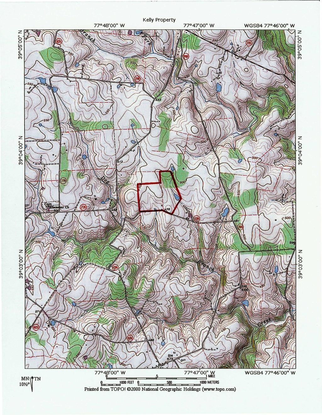
1 Conservation Easement Baseline Documentation Report Grantors: Kelly Family Partnership, LLC Grantee: Land Trust of Virginia Property: 81 acres south of Round Hill, Virginia
2 Baseline Documentation Report For the Deed of Gift of Conservation Easement donated to the Land Trust of Virginia Kelly Property Poor House Lane, Round Hill, Loudoun County, Virginia Narrative, photography and mapping compiled by: Land Trust of Virginia Middleburg, Virginia
3 Table of Contents Property Summary 1 Scenic and Natural Features 2 Man-made Features 3 Conservation Values 5 Summary of Restrictions 8 Appendices: Appendix A: USGS map Appendix B: Conservation easement Appendix C: Property legal description Appendix D: Aerial maps Appendix E: Property features (maps and information) Appendix F: Surrounding protected lands map Appendix G: Photo location map Appendix H: Photographs with descriptions and orientation Appendix I: Building envelope plat (Exhibit A)
4 Property Summary Site: Address: Grantor: Grantee: Acres: Kelly Property Poor House Lane, Round Hill, Virginia Kelly Family Partnership, LLC Land Trust of Virginia acres (total) PINs and Tax Map Numbers: Tax Map #/55//34/////7A (24.76 ac.) Tax Map #/55///7//19A1/ (6.85 ac.) Tax Map #/55//34/////1A (5.15 ac.) Tax Map #/55//34/////5A (3.07 ac.) Tax Map #/55//33/////4B (3.63 ac.) Tax Map #/55//34/////3A (7.75 ac.) Tax Map #/55//34/////4A (3.00 ac.) Tax Map #/55//33/////3B (5.82 ac.) Tax Map #/55/34/////6A (3.01 ac.) Tax Map #/55//33/////1B (3.57 ac.) Tax Map #/55///6////14A (15.28 ac.) Directions: From the Land Trust Office in Atoka, go 0.6 miles east on Rt. 50. Turn left on Rt. 611 (St. Louis Road) and go 6.1 miles. Turn left on Rt. 630 (Unison Road) and go 0.4 miles. Turn right on Rt. 700 (Woodtrail Road) and go 0.4 miles. Turn left on Poor House Lane and go 0.7 miles and find the property entrance on the right. 1
5 Scenic and Natural Features General Description: The property is situated approximately 4 miles southeast of Bluemont, Virginia, 1.5 miles south of Airmont, Virginia and 1.5 miles north of Unison, Virginia. The topography on the property descends from the northwest to the southeast. The highest elevation on the property is 500 feet and the lowest elevation is 460 feet where the main stream leaves the property. Forest Cover: The property has approximately 14 acres of forest cover, found near the northeast corner of the property. The forested area provides cover for wildlife and contributes to the property s scenic values. Water: The property has 2.71 acres of wetlands recognized by the National Wetlands Inventory (NWI) of the U.S. Fish and Wildlife Service. Both wetland areas include ponds. One of the NWI areas (~1.46 acres) is associated with a ~0.25 acre pond. The second NWI area (~1.25 acres) is associated with a ~1.0 acre pond. There is also a third pond (~0.28 acres) near the southwest corner. The property has ~1.3 miles of intermittent streams and is within the Dog Branch, Beaverdam Creek, Goose Creek (a Virginia Scenic River), Potomac River and Chesapeake Bay watersheds. Scenic Open Space: The property has ~1,700 ft. (0.3 miles) of road frontage on Poor House Lane, which is provides open, unobstructed views of the farm. The farm is mostly unimproved with the exception of a group of structures (including the main residence) near the center of the property and a few small run-in sheds (used for equine purposes). Soils: More than a third of the property (~30 acres) contains soils classified by Loudoun County (with information from USDA studies) as Prime Farmland soils. The rest of the farm contains soils that are classified as suitable for Secondary Cropland and Grassland Agriculture. The farm is therefore well qualified for agricultural uses and is currently being used for haymaking and equine purposes. Protection of the open space and agricultural resources afforded by the conservation easement over this property will maintain this land for these and many other agricultural uses. Additional information on property soils can be found in Appendix E. 2
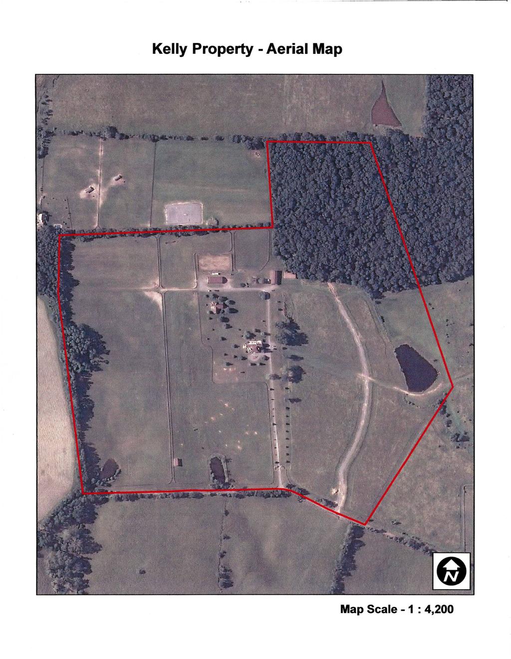
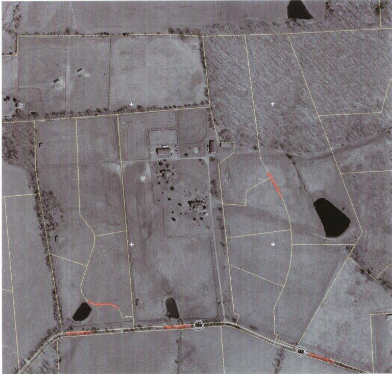
6 Surrounding Community: The property adjoins another property (~141 acres) under conservation easement with the Land Trust of Virginia. The local area surrounding the property is one of the most densely conserved areas of privately owned property in Virginia. A conservation easement over the Kelly property increases the proportion of locally conserved land for the additional benefit of the general public. Man-made Features Roads: The property lies on the north side of Rt. 756 (Poor House Lane). The property is also eligible for inclusion in the Beaverdam Creek Historic Roadways District, which includes properties with road frontage on numerous roads such as Rt The property has 1,700 feet of road frontage on Rt. 756 and within the property there are stretches of farm roads and a driveway leading to the main residence. The driveway continues from there to the secondary residence for a total length (from Rt. 756) of 1,600 feet. Fencing: The boundary of the property is completely fenced and there are numerous fenced horse paddocks within the property. Structures: The property has eight (8) structures including the main residence, a secondary residence, two barns, three run-in sheds and a storage shed. The eight structures on the property are listed below and are referenced in the property photography. Structure Name ~ Size Structure 1: Main residence 2,938 ft 2 Structure 2: Barn 2,808 ft 2 Structure 3: Storage shed 1,830 ft 2 Structure 4: Secondary residence 1,621 ft 2 Structure 5: Stables 3,108 ft 2 Structure 6: Run-in shed # ft 2 Structure 7: Run-in shed # ft 2 Structure 8: Run-in shed # ft 2 Total ~ 14,409 ft 2 3
7 Conservation Values of the Property The property has the following significant conservation values: 1) Scenic Open Space Scenic Open Space is one of the property s most significant conservation values. The property has approximately 1,700 feet of road frontage and scenic open space on the north side of Rt. 756 (Poor House Lane). These scenic open space values can be seen in the property photographs, specifically in photos 1 6. Since it is has road frontage on and is highly visible from Rt. 756, the property is eligible to be part of the Beaverdam Creek Historic Roadways District. There are unobstructed views of the property s open fields, which have historically been and are currently being used for equine purposes. As of easement recordation, the property has the potential (based on the appraisal) to be developed as 11 separate residential lots. As a result of the easement, the property will be forever restricted to a total of two lots with building envelopes that have been designed with particular sensitivity to scenic and open space conservation values. Preservation of the property s open space is a conservation purpose that satisfies the conservation purpose test vis-à-vis compliance with Treasury Regulation, Subchapter A, Section 1.170A-14(d). Preservation of the property s open space will yield significant and substantial public benefit and is both (A) pursuant to a clearly delineated Federal, state or local governmental conservation policy and (B) for the scenic enjoyment of the general public. Preservation of the property s open space values with this conservation easement provides significant and substantial public benefit in the following ways: (i) the public has substantial opportunity to view the property, given the road frontage on Rt. 756, (ii) development of the property would degrade the scenic and natural character of the area, which is predominately used for agricultural purposes (iii) the open space use is consistent with public conservation programs mentioned in part (A) below, (iv) the open space use is consistent with private conservation programs, such as the numerous other land trust programs operating in the Piedmont, several of which hold similar easements in the area (see 4
8 Conservation Value Adjacency to Existing Conserved Land below) and (v) preservation of the property s open space helps counteract the intense land development pressure in the area, which is well known and extensively cited in the qualified conservation easement appraisal. A) Preservation of the property s open space values furthers clearly delineated policies of Loudoun County, by implementing the Green Infrastructure Strategy of the Loudoun County Revised Comprehensive Plan, including County policies: to promote private, state and federal conservation programs and their allocated resources to advance conservation programs within the County through public and private means such as voluntary easements, (at 5-3); to protect river and stream corridors by preserving, conserving, and restoring their water quality, flood protection, aquatic and wildlife habitat, and scenic value, (at 5-4); to pursue conservation of river and stream corridor assets through open space dedication or easement, purchase of development rights, and other such programs to ensure the protection of these resources for the public good, (at 5-4); to promote the preservation of forested areas through the use of easements and other voluntary means, (at 5-18); to seek through open space easements the preservation of greenways, (at 5-25); to encourage the use of open space easements as a way to complement and enhance the Green Infrastructure and its elements, (at 5-26); to support an integrated Green Infrastructure approach to help prevent habitat fragmentation while enhancing ecological connections with larger natural areas, (at 5-19); to proactively promote state and federal conservation policies such as voluntary easements, (at 5-3); to use protective buffers [and] donation of open-space easements by the County and individual property owners to manage open space assets, (at 5-24); to seek and encourage the preservation, protection, and management of forest resources for their economic and environmental benefits, (at 5-18); to fully protect, through easement the lands that are critical to the quality of key water supplies, (at 5-10); and to promote the planting and preservation of trees as a means to improve air quality, (at 5-27); and by advancing the Rural Policy Area goals of the Loudoun County Revised Comprehensive Plan: to explore and pursue all available federal, state and local options for acquiring conservation easements, at (7-9); and to protect [the County s] natural and cultural-resource base (including stream corridors, wetlands, steep slopes, ridges, 5
9 mountains, working landscapes, woodlands, historic and archaeological resources, habitats, greenways in order to preserve the rural character of the land and the social and experiential aspects of the rural way of life, (at 7-4); and B) Preservation of the property s open space values will also maintain scenic enjoyment for the general public in the following ways: (i) the property s use is and will remain consistent with other land use in the vicinity (see # 2 below), (ii) the open and mostly undeveloped nature of the property, with its pastoral farm fields, provides a visual scene with contrast and variety and (iii) these same open fields, dotted with trees and ponds, provide the visual scene with a harmonious variety of shapes and textures. 2) Adjacency to Conserved Properties The property adjoins another property to the north (~141 acres) that is under conservation easement with the Land Trust of Virginia. The property is also within the vicinity of numerous other properties that are protected by conservation easements. The local area surrounding the property is one of the most densely conserved areas of privately owned property in Virginia. A conservation easement over the Kelly property increases the proportion of locally conserved land for the additional benefit of the general public and furthers local, state and federal goals for land conservation. The agricultural uses of the farm are also consistent with agricultural uses on many other properties in the vicinity. 3) Agricultural The farm is designated by Loudoun County as Agricultural for the purposes of use value assessment and taxation. Since the farm is in County-defined agricultural use, the protection of this use potential qualifies as an important conservation purpose for Agricultural Use in section A(1)(a)(1) of the Conservation Value Review Criteria of the VLCF. The farm is currently being used for pasture, equine purposes and haymaking. The farm is well suited for agricultural uses since more than a third of the property (30 acres) contains soils classified by Loudoun County as Prime Farmland soils. The rest of the farm contains soils that are classified by Loudoun County as suitable for Secondary Cropland and Grassland Agriculture uses. Protection of agriculturally significant land (soils), which are designated as such by Loudoun County (especially the Prime Farmland soils), qualifies as an important conservation purpose for Agricultural Use in section 6
10 A(1)(a)(3) of the Conservation Value Review Criteria of the VLCF. Protection of the property s significant agricultural resources (soils and open space) afforded by the conservation easement over this property will maintain this land for its current, as well as numerous potential future agricultural uses. 4) Forestal The property has approximately 14 acres of Eastern hardwood forest, found near the northeast corner of the property. The forested area provides wildlife habitat and adds scenic value to the property. 5) Water Resources On the Kelly property there are two occurrences of wetlands recognized by the National Wetlands Inventory (NWI) of the U.S. Fish and Wildlife Service. The property has several ponds and 1.3 miles of intermittent streams. The property is within the Dog Branch, Beaverdam Creek, Goose Creek (a Virginia Scenic River), Potomac River and Chesapeake Bay watersheds. 6) Historic Value The property is part of the Beaverdam Creek Historic Roadways District. This district is characterized by a network of mostly rural, unpaved roads that have evolved from Colonial paths and trails these roadways offer scenic views of woodlands, pastures, farms, streams and mountain vistas. These travel ways are important to the cultural history of the county and provide a unique glimpse into Loudoun s rich heritage. The Kelly farm is an excellent example of a property in this historic district that has significant road frontage and visibility. The farm retains its historic character and usage, and thereby contributes significantly to the scenic views of the general public traveling within the Historic District. 7
11 Summary of Easement Restrictions Designed to Protect Conservation Values Following are summarized versions of the key terms and conditions of the conservation easement (a full copy of the easement is provided in Appendix B). These terms and conditions are designed to protect the conservation values and ensure that the public interest is served: 1. DIVISION/SUBDIVISION. The following restriction has been designed by the Land Trust of Virginia, the Grantor and the Grantor s representatives with conservation value protections in mind. The purpose of this restriction is to limit the potential future development of the property so as to protect the conservation values listed in the deed, such as scenic open space values, historical values, natural resource values etc. The main restriction specific to division and subdivision is as follows: The Property shall not be divided or subdivided into, or separately conveyed as, more than two parcels, a large lot of approximately acres, hereinafter referred to as Lot A, and a small lot of approximately acres, hereinafter referred to as Lot B, as shown on the attached plat. Boundary line adjustments with adjoining parcels of land are permitted and shall not be considered a prohibited division of the Property, provided that Grantee is made party to the deed creating the boundary line adjustment and at least one of the following conditions is met: (i) The entire adjacent parcel is subject to a recorded open-space easement held by Grantee; or (ii) Grantor has made a written request to the Grantee to approve the proposed boundary line adjustment and said request shall have been reviewed and approved in advance by the Board of Directors of Grantee. Nothing in this paragraph shall restrict the sale, gift or transfer as a whole of the Property subject to this easement. 2. BUILDINGS AND STRUCTURES. The following restrictions have been designed by the Land Trust of Virginia, the Grantor and the Grantor s representatives with conservation value protections in mind. The purpose of these restrictions is to limit the visual impact on the general public of allowed structures and to maintain historic structures and landscapes. The restrictions specific to buildings and structures are as follows: 8
12 Grantor shall give Grantee written notice at least 60 days before beginning construction, replacement, or enlargement of any dwelling on the Property or of any building, structure, road or utility on the Property. No permanent or temporary building or structure (including, specifically, cell phone towers or commercial wind power facilities) shall be built or maintained on the Property other than: (i) one primary single-family dwelling on each lot, one of which exists on the larger of the two lots on the date of the Easement. For Lot A, said primary single-family dwelling, incorporating all additions thereto, shall not exceed 4,500 square feet in ground area or footprint, with said ground area or footprint being defined as the square footage of the foundation of dwelling, inclusive of all roofed decks, porches, stoops, and other attached roofed structures ( Ground Area ), unless prior written approval shall have been obtained from the Grantee. For Lot B, said primary single-family dwelling, incorporating all additions thereto, shall not exceed 3,000 square feet in ground area or footprint, with said ground area or footprint being defined as the square footage of the foundation of dwelling, inclusive of all roofed decks, porches, stoops, and other attached roofed structures, unless prior written approval shall have been obtained from the Grantee. (ii) one secondary single family dwelling on Lot A, provided that said secondary single-family dwelling, incorporating all additions thereto, shall not exceed 1,500 square feet in ground area or footprint, with said ground area or footprint being defined as the square footage of the foundation of dwelling, inclusive of all roofed decks, porches, stoops, and other attached roofed structures, unless prior written approval shall have been obtained from the Grantee. (iii) non-residential outbuildings and structures commonly and appropriately incidental to the dwellings permitted under subparagraph (i) and sized appropriately to serve as an amenity to single family residential use, but the aggregate ground area or footprint of such non-residential outbuildings and structures shall not exceed 2,500 square feet, with said ground area or footprint being defined as the square footage of the foundation of the structure(s), inclusive of all roofed decks, porches, and stoops, for each division or subdivision of the property, unless prior written approval shall have been obtained from Grantee; and (iv) farm buildings and farm structures, including all existing farm buildings, provided the aggregate ground area or footprint of said farm buildings and structures on Lot A does not exceed 7,700 square feet in ground area, and the ground area or footprint of said farm buildings and structures on Lot B does not exceed 1,300 square feet in ground area, with said ground area or footprint being defined as the square footage of the foundation of said farm buildings and farm structures, inclusive of all roofed areas, unless prior written approval for the building or structure shall have been obtained from Grantee. For purposes of this subparagraph, a farm building or farm structure shall mean a building or structure constructed and used for the activities specified in section 4 subparagraph (i). In the event of a division of the Property, as provided in Section 1, herein, reserved rights for permitted dwellings and structures shall be allocated between the 9
13 parcels in the instrument creating the division as follows: as described in subparagraphs (i), (ii), (iii), and (iv) above. No-build lines and building envelopes: No building or structure may be constructed beyond the area marked on the attached plat as the Building Envelopes. A Building Envelope is defined as that area that is 200 feet or less from the radius point coordinates shown on the attached plat. Buildings that already exist outside of said Building Envelopes, as identified in the Kelly Baseline Documentation Report, may be maintained and repaired, but may not be altered, extended or expanded. Building height: Building height of any dwelling or non-dwelling structure shall not be more than thirty-five (35) feet, as measured from final grade to ridge of roof. Downlighting: Use of exterior lighting in all areas shall be limited to fully horizontally shielded lighting fixtures. The light element (lamp or globe) of a fixture shall not extend below the cut off shield. Viewshed protection for Beaverdam Creek Historic Roadways District: Buildings or structures visible from historic roads within the Beaverdam Creek Historic Roadways District shall be designed and sited to minimize their visibility from said locations during all seasons of the year. Private roads and utilities that serve only permitted buildings or structures, roads to parcels created by permitted divisions of the Property, and roads with permeable surfaces for other permitted uses, such as farming or forestry, may be constructed and maintained, with 60 days of advance written notice to Grantee and written approval of Grantee. Utilities, other than those serving the Property, may be permitted if the Grantee, in its sole and absolute discretion, determines and provides notice of such determination in writing that construction and maintenance of said utilities will not impair the Property s conservation values. The collective ground area of all buildings and structures on the Property, excluding roads, shall not exceed 23,000 square feet without prior written approval of Grantee. For the purpose of this paragraph the collective ground area is the measurement in square feet of the foundations of the buildings and structures set forth in subsections (i) through (iv) above, inclusive of all roofed areas. In the event of division of the Property, the collective ground area or footprint of all buildings and structures on Lot A, excluding roads, shall not exceed 16,200 square feet, and the collective ground area or footprint of all buildings and structures on Lot B, excluding roads, shall not exceed 6,800 square feet. Any new, replaced or enlarged permitted building or structure must not be inconsistent with and must not conflict with, diminish, impair or interfere with the purpose and intent of this Conservation Easement, or with its Conservation Purposes or Conservation Values. These prohibitions shall not apply to the repair or replacement of any structures (other than buildings) existing as of the date of this Deed of Gift of Easement or the construction or maintenance of reasonably sized fencing, mailboxes, gate posts, or 10
14 permitted signs that do not diminish, impair, or interfere with the purpose and intent of this Conservation Easement. (v) Alterations, Demolition, and Ground-Disturbing Activities. Other than as otherwise allowed under this Section or Section 8 of this Article, there shall be no alterations, demolition, or ground-disturbing activity with regard to buildings, other structures, roads and utilities that may impact on historic, cultural, or natural heritage resources. 3. RIPARIAN BUFFER/WETLANDS. The following restrictions have been designed by the Land Trust of Virginia, the Grantor and the Grantor s representatives with conservation value protections in mind. The purpose of these restrictions is to maintain and enhance the water quality values on the property, now and in the future, for the benefit of the general public and the environment, local or otherwise. The restrictions specific to water resources are as follows: (i) To protect water quality, a 100-foot buffer strip shall be maintained in forest or be permitted to revegetate naturally along each edge of any perennial stream on the property, as measured from the top of the bank, and there shall be no damaging or filling of wetlands except as set forth below. Further, there shall be no plowing, cultivation or other earth disturbing activity in said 100-foot buffer strip or in wetlands except as set forth below. Wetlands are defined as any area marked as wetlands on county, state or federal maps, and any lands with characteristic hydric soils that are saturated or inundated by surface or ground water at a frequency or for a duration sufficient to support, and that under normal conditions do support, a prevalence of vegetation typically adapted for life in saturated soil conditions, or any land below an identifiable debris line left by water action. Nothing contained herein shall prohibit or prevent the Grantor from undertaking efforts to restore or create additional wetlands upon the Property. (ii) Within this buffer strip there shall be no construction of buildings, structures, roads, or other impervious surfaces, no storage of compost, manure, fertilizers, chemicals, machinery or equipment, and no cultivation, dumping, filling or damaging of wetlands, plowing, or other earth disturbing activity conducted, except as may be reasonably necessary for (a) wetland or stream bank restoration and erosion control pursuant to a government permit, (b) fencing along or within the buffer area, (c) removal of individual trees presenting a danger to persons or property and removal of diseased, dead, non-native trees, shrubs or plants, or invasive trees, shrubs or plants (as defined in the Virginia Department of Conservation and Recreation s publication: Invasive Alien Plant Species of Virginia or other, independent authoritative source), or (d) creation and maintenance of foot or horse trails with unimproved surfaces. (iii) The buffer shall be composed of vegetative cover that includes, but is not limited to, forest, shrubs, or warm-season grasses. (iv) Livestock shall be fenced out of the buffer strip. 11
15 The prohibitions in (i), (ii) and (iii) above shall not preclude the repair or replacement of any structures existing as of the date of this Deed of Gift of Easement or the construction or maintenance of reasonably sized fencing, mailboxes, gate posts, or permitted signs that do not diminish, impair, or interfere with the purpose and intent of this Conservation Easement. 4. INDUSTRIAL OR COMMERCIAL ACTIVITIES. The following restrictions have been designed by the Land Trust of Virginia, the Grantor and the Grantor s representatives with conservation value protections in mind. The purpose of these restrictions is to prevent possible negative impacts of industrial or commercial activities on the conservation values listed in the whereas clauses of the deed, such as scenic open space values, natural resource values, historical values etc. The restrictions specific to these activities are as follows: Industrial or commercial activities other than the following are prohibited: (i) agriculture, including, but not limited to, viticulture, horticulture, floriculture and animal husbandry, aquaculture, silviculture, forestry, and equine and equestrian activities; (ii) temporary or seasonal outdoor activities which do not permanently alter the physical appearance of the Property, and which do not diminish or impair the Conservation Values herein protected; (iii) activities which can be and are in fact conducted wholly within permitted buildings without alteration to the external appearance thereof; and (iv) operation of seasonal markets for the sale of agricultural products produced on the property. 5. MANAGEMENT OF FOREST. The following restrictions have been designed by the Land Trust of Virginia, the Grantor and the Grantor s representatives with conservation value protections in mind. The purpose of these restrictions is to prevent poor management of forest resources, which could impair the forest resource conservation values, which are listed for protection in the deed of conservation easement. The restrictions specific to forest management are as follows: (i) Forest Management Non Commercial. Grantor reserves the right to manage forested land by selective cutting, pruning, and planting for noncommercial purposes, which may include forest management for the creation of trails and recreational areas; for safety of users of the Property; for control of active fire, and prevention of fire and disease; for prevention or removal of invasive species (as defined in the Virginia Department of Conservation and Recreation s publication: Invasive Alien Plant Species of Virginia, or other, independent, authoritative source); for restoration or enhancement of wildlife habitat and riparian areas (as to riparian areas, subject to the Terms and Conditions applicable to riparian buffer areas in Section 3 of this Conservation Easement); for household gardening and landscaping in the Building Envelope or the general maintenance of the high scenic character and healthy wildlife habitat of the Property. The prohibition against commercial purposes in the following sub-paragraph should not be construed to prohibit the harvest of forest products for personal use by 12
16 Grantor on the Property, such as lumber, firewood, and raw material for small-scale home industry, nor the incidental sale of forest products harvested in the exercise of Grantor s noncommercial cutting rights. No more than one new opening or clearing, and no new opening or clearings greater than 1,000 square feet, in the forest are permitted for noncommercial purposes, unless approved in advance and in writing by Grantee as necessary to safeguard the health of forested acreage, to prevent or mitigate greater harm to the Conservation Values or the Property or to enhance wildlife habitat. (ii) Forest Management Commercial. No clear cutting is allowed. All forest management activities on the Property shall comply with a forest stewardship plan approved in advance by the Virginia Department of Forestry. The primary purposes of the forest stewardship plan may include but may not be limited to maintenance of the health and biological diversity of the forest, as well as management of woodlands to improve wildlife habitat, forest stand management to maintain the health of the forest, protection of uncommon, rare or unique biological communities or natural areas, management of timber for income, soil and water conservation, and preservation of historical and cultural resources. All forestry activities shall be carried out so as to preserve the Conservation Values of the Property. Best Management Practices, as defined by the Virginia Department of Forestry, shall be used to control erosion and protect water quality when any forest management, timber harvesting or land clearing activity is undertaken. The Grantor shall notify the Grantee, in writing, no later than 30 days prior to the start of any such activity, as well as within 7 days of its completion. 6. TRASH. The following restrictions have been designed by the Land Trust of Virginia, the Grantor and the Grantor s representatives with conservation value protections in mind. The purpose of these restrictions is to prevent materials being stored on the property in any manner that would impair the conservation values listed, such as scenic open space values, natural resource values, etc. The restrictions specific to this are as follows: Accumulation or dumping of trash, refuse, junk, or toxic materials is not permitted on the Property. This restriction shall not prevent generally accepted agricultural or wildlife management practices, such as creation of brush piles, composting, or the storage of farm machinery, organic matter, agricultural products or agricultural byproducts incidental to operation of the farm on the Property, as long as such practices are conducted in accordance with applicable governmental laws and regulations and are not inconsistent with the Conservation Values of the Property. 7. SIGNS. The following restrictions have been designed by the Land Trust of Virginia, the Grantor and the Grantor s representatives with conservation value protections in mind. The purpose of these restrictions is to prevent any signs from being constructed or displayed in such a way that would have a negative impact on the property s conservation values, such as scenic open space values and historic values. The restrictions specific to signage are as follows: 13
17 Display of billboards, signs, or other advertisements that are visible from outside the Property is not permitted on or over the Property except to: (i) state the name and/or address of the owners, (ii) advertise the sale or lease of the Property, (iii) advertise the sale of goods or services produced incidentally to a permitted use of the Property, (iv) provide notice necessary for the protection of the Property, (v) give directions to visitors, (vi) recognize historic status or participation in a conservation program, or (vii) advertise political candidates or parties. No such sign shall exceed nine square feet in size. 8. CHANGES IN TOPOGRAPHY; GRADING, BLASTING, MINING. The following restrictions have been designed by the Land Trust of Virginia, the Grantor and the Grantor s representatives with conservation value protections in mind. The purpose of these restrictions is to prevent any changes in the topography of the property that would impair conservation values listed in the deed, such as scenic open space values, natural resource values, historic landscape values, etc. The restrictions specific to changes in topography are as follows: Grading, blasting or earth removal shall not alter the topography of the Property except for wetlands or stream bank restoration pursuant to a government permit, or for erosion and sediment control pursuant to a government-required erosion and sediment control plan, or as required in the construction of permitted buildings, structures, private connecting roads, and utilities as described in Section 2. Best Management Practices, in accordance with the Virginia Erosion and Sediment Control Law, shall be used to control erosion and protect water quality in such construction. Generally accepted agricultural activities shall not constitute any such alteration. Notwithstanding the foregoing, no grading, blasting, or earth removal is permitted on the Property if it will be inconsistent with or will conflict with, diminish, impair or interfere with the Conservation Values protected by this Easement. Mining by surface mining or any other method, dredging on or from the Property, or drilling for oil and gas on or under the Property is prohibited. 9. LANDS IN AGRICULTURAL USE. The following restrictions have been designed by the Land Trust of Virginia, the Grantor and the Grantor s representatives with conservation value protections in mind. The purpose of these restrictions is to prevent any agricultural uses on the property that would diminish or impair conservation values listed in the deed, such as scenic open space values, natural resource values, historic landscape values, etc. The restrictions specific to agricultural uses are as follows: If the Property contains land in agricultural use, Grantor shall maintain and implement a written conservation plan protecting highly erodible soils, developed in consultation with the local Soil and Water Conservation District or the Natural Resources Conservation Services. The Farm Conservation Plan shall stipulate the use of Best Management Practices for water quality protection, be approved in advance by the Grantee, and may, 14
18 from time to time, be modified or amended by mutual agreement of the Grantor and Grantee, provided that said Farm Conservation Plan (or any modification of amendment thereof) shall not adversely affect, be inconsistent with, conflict with, diminish, impair, or interfere with the Conservation Purpose or Conservation Values protected by this Conservation Easement 15
19
20 After the deed of gift of conservation easement for the Kelly property is recorded, a copy of the certified, recorded deed will be included in the Baseline Documentation Report for future reference.
21 Legal Description Lots 1A through 7A, Family Subdivision Plat Property of John W. Kelly, Jr. as duly dedicated, platted and recorded in Instrument # , among the land records of Loudoun County, Virginia And Lots 1B through 4B, Family Subdivision Plat Property of Phyllis E. Kelly as duly dedicated, platted and recorded in Instrument # , among the land records of Loudoun County, Virginia. And being the same properties conveyed to Kelly Family Partnership, LLC, a Virginia limited liability company by Deeds of Gift recorded immediately prior hereto from Phyllis Marie Leimbach, Custodian for Ryan Zachary Lawrence, Phyllis Marie Leimbach, Custodian for Connor Jacob Lawrence, Phyllis Marie Leimbach, Custodian for Sean William Leimbach, Phyllis Marie Leimbach, Custodian for Liam Patrick Kelly, Phyllis Marie Leimbach, Custodian for Brooke Elizabeth Hawkins, Phyllis Marie Leimbach, Custodian for Kelsey Lynn Hawkins, Phyllis Marie Leimbach, John W. Kelly, Jr. and Phyllis E. Kelly, being all of the members of the Kelly Family Partnership, LLC.
22
23
Forested Buffer Water Resource Easement Carroll County, Maryland
 Forested Buffer Water Resource Easement Carroll County, Maryland FORESTED BUFFER WATER RESOURCE EASEMENT THIS DEED OF EASEMENT, made this day of, in the year nineteen hundred and ninety-five, by and between,
This document was prepared by: Albemarle County Attorney County of Albemarle 401 McIntire Road Charlottesville, Virginia 22902
 This document was prepared by: Albemarle County Attorney County of Albemarle 401 McIntire Road Charlottesville, Virginia 22902 Parcel ID Number [insert 14-digit number] This deed is exempt from taxation
Subtitle H Agricultural Conservation Easement Program
 1 1 1 1 1 1 0 1 0 1 0 Subtitle H Agricultural Conservation Easement Program SEC.. [1 U.S.C. ] ESTABLISHMENT AND PURPOSES. (a) Establishment. The Secretary shall establish an agricultural conservation easement
ALBEMARLE COUNTY CODE APPENDIX A.1 ACQUISITION OF CONSERVATION EASEMENTS PROGRAM
 APPENDIX A.1 ACQUISITION OF CONSERVATION EASEMENTS PROGRAM Sections: A.1-100 A.1-101 A.1-102 A.1-103 A.1-104 A.1-105 A.1-106 A.1-107 A.1-108 A.1-109 A.1-110 A.1-111 A.1-112 A.1-113 Short title. Purpose.
MODEL DEED RESTRICTION FOR THE PENNSYLVANIA STATE PROGRAMMATIC GENERAL PERMIT-3 (PASPGP-3) DECLARATION OF RESTRICTIVE COVENANTS FOR CONSERVATION
 DECLARATION OF RESTRICTIVE COVENANTS FOR CONSERVATION") MODEL DEED RESTRICTION FOR THE PENNSYLVANIA STATE PROGRAMMATIC GENERAL PERMIT-3 (PASPGP-3) DECLARATION OF RESTRICTIVE COVENANTS FOR CONSERVATION THIS DECLARATION OF RESTRICTIVE COVENANTS FOR CONSERVATION
MODEL DEED RESTRICTION FOR THE PENNSYLVANIA STATE PROGRAMMATIC GENERAL PERMIT-3 (PASPGP-3) DECLARATION OF RESTRICTIVE COVENANTS FOR CONSERVATION THIS DECLARATION OF RESTRICTIVE COVENANTS FOR CONSERVATION
DRAFT FOR PUBLIC HEARING (rev. March, 2016)
") Chapter 200. ZONING Article VI. Conservation/Cluster Subdivisions 200-45. Intent and Purpose These provisions are intended to: A. Guide the future growth and development of the community consistent with
Chapter 200. ZONING Article VI. Conservation/Cluster Subdivisions 200-45. Intent and Purpose These provisions are intended to: A. Guide the future growth and development of the community consistent with
Examples of Agricultural Easement Language
 Examples of Agricultural Easement Language Compiled by: Judy Anderson, Columbia Land Conservancy Jerry Cosgrove, American Farmland Trust October 1999, Updated 2003 Based on the belief that a working, commercially-viable,
THIS DEED OF CONSERVATION EASEMENT
 NOTICE TO TITLE EXAMINERS: THIS DEED OF CONSERVATION EASEMENT CONTAINS COVENANTS THAT INCLUDE RESTRICTIONS ON THE USE, SUBDIVISION AND OFF-CONVEYANCE OF LAND. THIS DEED OF CONSERVATION EASEMENT ("Conservation
THIS DECLARATION OF RESTRICTIVE COVENANTS is made this day of, 20, by ("Covenantor"). RECITALS
. RECITALS") Model for Use with Permits Without Mitigation Plans STATE OF COUNTY OF DECLARATION OF RESTRICTIVE COVENANTS THIS DECLARATION OF RESTRICTIVE COVENANTS is made this day of, 20, by ("Covenantor"). RECITALS
Model for Use with Permits Without Mitigation Plans STATE OF COUNTY OF DECLARATION OF RESTRICTIVE COVENANTS THIS DECLARATION OF RESTRICTIVE COVENANTS is made this day of, 20, by ("Covenantor"). RECITALS
Guidelines for Construction of Recreational Buildings and Improvements Greater than 1000 Square Feet Outside Acceptable Development Areas
 Guidelines for Construction of Recreational Buildings and Improvements Greater than 1000 Square Feet Outside Acceptable Development Areas The following guidelines are established by the Easement Committee
Interpretation of Conservation Purpose INTERNAL REVENUE GUIDANCE AS TO WHAT CONSTITUES A CONSERVATION PURPOSE
 Interpretation of Conservation Purpose INTERNAL REVENUE GUIDANCE AS TO WHAT CONSTITUES A CONSERVATION PURPOSE 170(h)(4)(A) of Title 26, Internal Revenue Code, Subtitle A of the United States Code gives
ARTICLE XI - CONSERVATION SUBDIVISIONS
 ARTICLE XI - CONSERVATION SUBDIVISIONS Section 1101: Purpose and Intent. This Article is intended to provide for residential subdivisions that are designed based first and foremost on the preservation
Stormwater Ordinance Appendix APPENDIX K EXAMPLE TAR-PAM CONVERSATION EASEMENT
 APPENDIX K EXAMPLE TAR-PAM CONVERSATION EASEMENT Tax Parcel ID # NORTH CAROLINA FRANKLIN COUNTY CONSERVATION EASEMENT Franklin County, North Carolina THIS CONSERVATION EASEMENT (this "Conservation Easement")
CONSERVATION EASEMENT DEED
 Return to: CONSERVATION EASEMENT DEED (Riparian Buffer/Wildlife Habitat Model) WHEREAS,, with a mailing address of (hereinafter referred to as the Grantor, which word where the context requires includes
CHAPTER 6 CHESAPEAKE BAY PRESERVATION AREAS AND STREAM PROTECTION AREAS
 CHAPTER 6 CHESAPEAKE BAY PRESERVATION AREAS AND STREAM PROTECTION AREAS 6.1 INTRODUCTION Virginia s Chesapeake Bay Preservation Area (CBPA) Designation and Management Regulations (9VAC10-20 et seq.) require
WEST VIRGINIA DIVISION OF FORESTRY Cooperative Forest Legacy Program. Sample Conservation Easement
 WEST VIRGINIA DIVISION OF FORESTRY Cooperative Forest Legacy Program Sample Conservation Easement This document is included in the forest legacy kit as an example for information and possible guidance
Some Points Re Perpetuity - Code and Regulations
 College of William & Mary Law School William & Mary Law School Scholarship Repository William & Mary Annual Tax Conference Conferences, Events, and Lectures 2010 Some Points Re Perpetuity - Code and Regulations
Staying Connected in the Northern Appalachians
 Staying Connected in the Northern Appalachians Potential Conservation Easement Provisions Designed to Explicitly Address Connectivity in the Northern Appalachians Updated and Revised May 2012 In this document,
Central Pennsylvania Conservancy Project Selection Criteria Form
 Central Pennsylvania Conservancy Project Selection Criteria Form The following criteria guide the actions of the Central Pennsylvania Conservancy s Land Protection Committee and Board of Directors in selecting
ARTICLE FIVE FINAL DRAFT
 ARTICLE FIVE 021218 FINAL DRAFT Sec. 503.6 Open Space Preservation Option Open Space Preservation Option Open Space Preservation developments may be approved in the AR, R-1, R-2 and R-3 zoning districts,
This Deed is Exempt from Taxation under Virginia Code (A)(3) and (C)(4) [no retention of dwelling unit rights] PIN DEED OF EASEMENT
![This Deed is Exempt from Taxation under Virginia Code (A)(3) and (C)(4) [no retention of dwelling unit rights] PIN DEED OF EASEMENT](/thumbs/84/89690785.jpg "This Deed is Exempt from Taxation under Virginia Code (A)(3) and (C)(4) [no retention of dwelling unit rights] PIN DEED OF EASEMENT") This Deed is Exempt from Taxation under Virginia Code 58.1-811(A)(3) and 58.1-811(C)(4) [no retention of dwelling unit rights] PIN DEED OF EASEMENT THIS DEED OF EASEMENT made this day of, 2007, by and
This Deed is Exempt from Taxation under Virginia Code 58.1-811(A)(3) and 58.1-811(C)(4) [no retention of dwelling unit rights] PIN DEED OF EASEMENT THIS DEED OF EASEMENT made this day of, 2007, by and
RECITALS. B. WHEREAS, Ranch, its successors and assigns, are referred to in the Easement as the Grantor ; and
 Basic Components of Management Plans Associated with Conservation Easement Acquisitions Where A Land Trust Or other third party Is the Grantee April 17, 2012 Key: Text in normal font, without highlight,
Conservation Design Subdivisions
 Conservation Design Subdivisions An excerpt from the Rules and Regulations Governing Division of Land in Sheridan County, Wyoming, November 5, 2010 Sheridan County Public Works Department 224 S. Main Street
Conservation Easement Stewardship
 Conservation Easements are effective tools to preserve significant natural, historical or cultural resources. Conservation Easement Stewardship Level of Service Standards March 2013 The mission of the
Town of Falmouth s Four Step Design Process for Subdivisions in the Resource Conservation Zoning Overlay District
 Town of Falmouth s Four Step Design Process for Subdivisions in the Resource Conservation Zoning Overlay District All subdivisions shall be designed in accordance with the following four-step process.
CHARLES CITY COUNTY SITE PLAN ORDINANCE. This Ordinance shall be known as the Charles City County Site Plan Ordinance.
 CHARLES CITY COUNTY SITE PLAN ORDINANCE Section 1. Title This Ordinance shall be known as the Charles City County Site Plan Ordinance. Section 2. Authority. This Ordinance is enacted pursuant to the authority
SUBDIVISION GUIDELINES (As Approved by the State Agricultural Land Preservation Board on July 10, 1996)
") SUBDIVISION GUIDELINES (As Approved by the State Agricultural Land Preservation Board on July 10, 1996) Section XI: CONSTRUCTION OF AN ADDITIONAL STRUCTURE AND SUBDIVISION A. Authority Authority for the
SUBDIVISION GUIDELINES (As Approved by the State Agricultural Land Preservation Board on July 10, 1996) Section XI: CONSTRUCTION OF AN ADDITIONAL STRUCTURE AND SUBDIVISION A. Authority Authority for the
AMENDED DEED OF CONSERVATION EASEMENT
 Prepared by: Wayne E. Flowers Lewis, Longman & Walker, P.A. 245 Riverside Ave. Suite 150 Jacksonville, FL 32202 Return recorded original to: Mitigation Marketing 1091 W. Morse Blvd. Suite 101 Winter Park,
New Cingular Wireless Telecommunication Tower at County Road 48, Milner Conditional Use Permit
 New Cingular Wireless Telecommunication Tower at 39415 County Road 48, Milner ACTIVITY #: Conditional Use Permit PP2012-023 HEARING DATES: Planning Commission (PC): August 16, 2012 at 6:00pm PETITIONER:
WARRANTY DEED OF AGRICULTURAL LAND EASEMENT
 This instrument prepared by and return to: STATE OF NORTH CAROLINA COUNTY OF WARRANTY DEED OF AGRICULTURAL LAND EASEMENT This Deed of Agricultural Land Easement ( ALE ) is granted on this day of, 2017,
GWINNETT COUNTY CSO CONSERVATION SUBDIVISION OVERLAY DISTRICT REQUIREMENTS
 GWINNETT COUNTY CSO CONSERVATION SUBDIVISION OVERLAY DISTRICT REQUIREMENTS Section 1316. CSO Conservation Subdivision Overlay District. 1. Purposes. The purposes of this overlay district are as follows:
CCC XXX Rural Neighborhood Conservation (NC)
") CCC 33.10.XXX Rural Neighborhood Conservation (NC) Purpose: Maintain low density rural residential areas and associated uses commonly found in rural areas consistent with the local character of the distinctive
CCC 33.10.XXX Rural Neighborhood Conservation (NC) Purpose: Maintain low density rural residential areas and associated uses commonly found in rural areas consistent with the local character of the distinctive
Easement Program Guidelines for Water Resources and Stream Work
 Easement Program Guidelines for Water Resources and Stream Work The following guidelines are established by the Easement Committee to create standards for reviewing requests by landowners to conduct stream
CHARLOTTE PLANNING COMMISSION FINDINGS OF FACT AND DECISION IN RE APPLICATION OF. George R. Aube 1450 Dorset Street
 CHARLOTTE PLANNING COMMISSION FINDINGS OF FACT AND DECISION IN RE APPLICATION OF George R. Aube 1450 Dorset Street Final Plan Review For A Two-Lot Subdivision Application # PC-13-19 Background The Planning
Easement Program Guidelines for Locating Towers and Communication Devices
 Easement Program Guidelines for Locating Towers and Communication Devices The following guidelines are established by the Easement Committee to create standards for reviewing requests by landowners to
TRENDS IN QUALIFIED CONSERVATION EASEMENTS. By: Melinda M. Beck, Esq.
 TRENDS IN QUALIFIED CONSERVATION EASEMENTS By: Melinda M. Beck, Esq. What is a Conservation Easement? An easement interest granted by a landowner to a land trust or governmental entity that voluntarily
DEED TO DEVELOPMENT RIGHTS CONSERVATION RESTRICTIONS
 DOC s 00000246 Bk5 319 Pss 29 DEED TO DEVELOPMENT RIGHTS A N D CONSERVATION RESTRICTIONS THIS WARRANTY DEED made this day of ^XP/'f ( 2018, by and between CATHERINE CONTE, hereinafter referred to as the
DECLARATION OF RESTRICTIVE COVENANTS
 STATE OF MARYLAND COUNTY OF DECLARATION OF RESTRICTIVE COVENANTS THIS DECLARATION OF RESTRICTIVE COVENANTS is made this day of, 20, by ( Declarant(s) ). RECITALS WHEREAS, Declarant(s) is/are the owner(s)
County of Henrico, Virginia. Buffer Management Plan. Cobbs Creek Regional Water Supply Reservoir. Task 2.1. August 21, 2013.
 County of Henrico, Virginia Buffer Management Plan Task 2.1 August 21, 2013 Prepared By: Table of Contents Buffer Management Plan Paul E. Peterson Project Manager Water Supply Reservoir Michael H. Wooden,
APRIL 30, ILL. ADM. CODE 2580 CH. I, SEC. 2580
 TITLE 17: CONSERVATION CHAPTER I: DEPARTMENT OF NATURAL RESOURCES SUBCHAPTER f: ADMINISTRATIVE SERVICES PART 2580 CONSERVATION STEWARDSHIP PROGRAM Section 2580.10 Definitions 2580.20 Eligibility 2580.30
Conceptual Scheme SE W4
 December 2012 1. PURPOSE 1.1. The purpose of a Conceptual Scheme (CS) is as follows: a) To provide a framework for the subsequent subdivision and/or development of land within the Country Residential Policy
BY BOARD OF COUNTY COMMISSIONERS AN ACT TO BE ENTITLED
 BY BOARD OF COUNTY COMMISSIONERS ORDINANCE NO. AN ACT TO BE ENTITLED AN ORDINANCE AMENDING THE PASCO COUNTY LAND DEVELOPMENT CODE, ARTICLE 700, BY REPEALING EXISTING SECTION 702, ENVIRONMENTALLY SENSITIVE
CONSERVATION EASEMENT INCLUDING MITIGATION
 After recording return to: GRANTOR: GRANTEE: GRANTEE (Trustee): LEGAL DESCRIPTION: TAX PARCEL I.D. #: REFERENCE # s: WHATCOM COUNTY N/A CONSERVATION EASEMENT INCLUDING MITIGATION This grant of a conservation
TOWN OF MIDDLEBOROUGH COMMUNITY PRESERVATION PLAN
 TOWN OF MIDDLEBOROUGH COMMUNITY PRESERVATION PLAN Vision The residents of Middleborough desire a community which is family-oriented and which retains its small town character while preserving an abundance
RESTRICTED USE EASEMENT
 RESTRICTED USE EASEMENT THIS CONSERVATION EASEMENT ("Easement") is made this day of, 2014, by, Individually and Trustee of the Trust (the "Grantor"), and the Compatible Lands Foundation, 1305 East 15 th
Conservation Easement Donations
 Landowner Information Series: Conservation Easement Donations Conservation Easement Donations Thousands of acres of farm and forestland that contribute to the unique, rural character of Vermont have been
PENINSULA TOWNSHIP DONATION of DEVELOPMENT RIGHTS ORDINANCE (DDR, No. 45)
") PENINSULA TOWNSHIP DONATION of DEVELOPMENT RIGHTS ORDINANCE (DDR, No. 45) THE TOWNSHIP OF PENINSULA, GRAND TRAVERSE COUNTY, MICHIGAN ORDAINS: Section 101 General Provisions A. Title: This Ordinance shall
PENINSULA TOWNSHIP DONATION of DEVELOPMENT RIGHTS ORDINANCE (DDR, No. 45) THE TOWNSHIP OF PENINSULA, GRAND TRAVERSE COUNTY, MICHIGAN ORDAINS: Section 101 General Provisions A. Title: This Ordinance shall
MODEL DEED RESTRICTION
 MODEL DEED RESTRICTION This type of Protective Covenant is the most commonly used. It is a legal agreement between the grantor, typically the property owner or applicant, and the Corps. Please view instructions
County of Sonoma Agenda Item Summary Report
 Revision No. 20170501-1 County of Sonoma Agenda Item Summary Report Agenda Item Number: 4 (This Section for use by Clerk of the Board Only.) Clerk of the Board 575 Administration Drive Santa Rosa, CA 95403
Horse Gulch Management Plan Final Draft: April 18, 2013
 I. INTRODUCTION This Plan provides a framework for the sound stewardship of the City of Durango Horse Gulch open space area. The Plan includes baseline information regarding the area, management objectives
4. If any perennial surface water passes through or along the property lines of the acreage, a minimum of 200 feet or frontage should be required.
 b. Provide adequate acreage for appropriate productive use of rural residential land, such as small numbers of livestock, large gardens, etc. 3. Minimum of 200 feet of frontage on an improved county or
Multiple Use Forest District (MUF)
") This district is defined as Multiple Use Forest District with a minimum lot size of 20 acres. 11.15.2162 Purposes The purposes of the Multiple Use Forest District are to conserve and encourage the use
This district is defined as Multiple Use Forest District with a minimum lot size of 20 acres. 11.15.2162 Purposes The purposes of the Multiple Use Forest District are to conserve and encourage the use
CT Department of Agriculture
 CT Department of Agriculture FARMING PROTECTED LAND Workshop DoAg Agriculture Viability Grant, American Farmland Trust, CT Farmland Trust & CT Land Conservation Council Senexet Grange, Woodstock, CT October
PERMITTED ACTS and RURAL ENTERPRISES
 PERMITTED ACTS and RURAL ENTERPRISES Pennsylvania s Agricultural Area Security Law, known as Act 43, 3 P.S. 901. et seq., and the Regulations promulgated thereunder by the Pennsylvania Department of Agriculture
MARK TWAIN LAKE MASTER PLAN CLARENCE CANNON DAM AND MARK TWAIN LAKE MONROE CITY, MISSOURI
 MARK TWAIN LAKE MASTER PLAN CLARENCE CANNON DAM AND MARK TWAIN LAKE MONROE CITY, MISSOURI CHAPTER 4 LAND ALLOCATION, LAND CLASSIFICATION, WATER SURFACE, AND EASEMENT LANDS This Master Plan is a land use
APPLICATION FOR SUBDIVISION APPROVAL OF A SKETCH PLAN with checklist
 Prior to filing any application for SUBDIVISION approval, the applicant shall request in writing that the zoning administrator schedule a pre-submission conference. APPLICATION TO THE PLANNING BOARD TOWN
Chapter 100 Planned Unit Development in Corvallis Urban Fringe
 100.100 Scope and Purpose. Chapter 100 Planned Unit Development in Corvallis Urban Fringe (1) All applications for land divisions in the Urban Residential (UR) and Flood Plain Agriculture (FPA) zones within
Easement Grant of Easement for Habitat Protection
 Date: Grantor(s): XXXXXXXXXX Grantee: Tri-Basin Natural Resources District, (hereinafter referred to as Tri-Basin NRD)1308 2 nd St., Holdrege NE 68949 Protected Property: See Exhibit A attached for legal
DECLARATION OF RESTRICTIVE COVENANTS
 DECLARATION OF RESTRICTIVE COVENANTS The Declarant,, is the fee simple owner of the certain real property located in County, Kansas, as described on Exhibit A, which is attached hereto and incorporated
Napa County Planning Commission Board Agenda Letter
 Agenda Date: 9/20/2017 Agenda Placement: 8C Napa County Planning Commission Board Agenda Letter TO: FROM: Napa County Planning Commission Charlene Gallina for David Morrison - Director Planning, Building
New York State Department of Agriculture and Markets Model Agricultural Conservation Easement
 New York State Department of Agriculture and Markets Model Agricultural Conservation Easement Deed of Conservation Easement {Italics text in brackets is informational to the drafter; please delete when
GRANT OF CONSERVATION EASEMENT
 Prepared by: Return to: Mississippi Land Trust Mississippi Land Trust Attn: Brian W. Ballinger Attn: Brian W. Ballinger Post Office Box 23 Post Office Box 23 Stoneville, MS 38776 Stoneville, MS 38776 (662)
Draft Zoning Changes for the 2nd Planning Board Public Hearing, January 22, 2018.
 Draft Zoning Changes for the 2nd Planning Board Public Hearing, January 22, 2018. No changes were made at the 1st Public Hearing. Proposed wording for the 1 st Public Hearing in red, eliminated text in
WAC Easement Program Guidelines for Pesticide and Fertilizer Application for the Purpose of Forest Management
 WAC Easement Program Guidelines for Pesticide and Fertilizer Application for the Purpose of Forest Management The following guidelines are established by WAC to create standards for the Application of
About Conservation Easements
 Section Three: Farm Transfer Tools About Conservation Easements Editor s note: One question that our education collaborative has fielded consistently throughout the years is about conservation easements.
Submittal of the Minutes from the March 9, 2011, April 5, 2011, and April 19, 2011 Cabinet Meetings.
 AGENDA BOARD OF TRUSTEES OF THE INTERNAL IMPROVEMENT TRUST FUND JUNE 16, 2011 Attachments to the items below can be viewed at the following link: http://www.dep.state.fl.us/secretary/cab/public_notices.htm
Sample Baseline Documentation Report (BDR) Annotated Template for Environmentally Important Land
 Annotated Template for Environmentally Important Land") Sample Baseline Documentation Report (BDR) Annotated Template for Environmentally Important Land The baseline documentation report (BDR) provides a snap shot of the biophysical condition of a property
Sample Baseline Documentation Report (BDR) Annotated Template for Environmentally Important Land The baseline documentation report (BDR) provides a snap shot of the biophysical condition of a property
CITY OF FORT COLLINS NATURAL AREAS AND CONSERVED LANDS EASEMENT POLICY
 CITY OF FORT COLLINS NATURAL AREAS AND CONSERVED LANDS EASEMENT POLICY Adopted January 3, 2012 PURPOSE: The purpose of the policy statement is to clarify the policies and procedures of the City of Fort
A. Maintenance. All legally established, nonconforming structures can be maintained (e.g., painting and repairs);
;") Chapter 24.50 NONCONFORMING USES, STRUCTURES AND LOTS Sections: 24.50.010 Nonconforming uses, structures, and lots Purpose. 24.50.020 Nonconforming uses, structures, and lots Alteration or expansion of
Chapter 24.50 NONCONFORMING USES, STRUCTURES AND LOTS Sections: 24.50.010 Nonconforming uses, structures, and lots Purpose. 24.50.020 Nonconforming uses, structures, and lots Alteration or expansion of
Article XII. R-1 Agricultural-Low Density Residential District
 Article XII R-1 Agricultural-Low Density Residential District Section 1200. Declaration of Legislative Intent In expansion of the Declaration of Legislative Intent and Statement of Community Development
Residential Project Convenience Facilities
 Standards for Specific Land Uses 35.42.220 E. Findings. The review authority shall approve a Land Use Permit in compliance with Subsection 35.82.110.E (Findings required for approval) or a Conditional
RURAL RESIDENTIAL FARMIFOREST 5 ACRES (RRFF-5) (6126/03)
 (6126/03)") CLACKAMAS COUNTY WNING AND DEVELOPMENT ORDINANCE 309 309.01 RURAL RESIDENTIAL FARMIFOREST 5 ACRES (RRFF-5) (6126/03) PURPOSE A. To provide areas for rural living where this type of development is compatible
CLACKAMAS COUNTY WNING AND DEVELOPMENT ORDINANCE 309 309.01 RURAL RESIDENTIAL FARMIFOREST 5 ACRES (RRFF-5) (6126/03) PURPOSE A. To provide areas for rural living where this type of development is compatible
GRANT OF TRAIL ACCESS EASEMENT, COVENANTS AND RESTRICTIONS
 This is a sample easement provided for discussion and illustrative purposes only. Easements for each property will be customized based upon the needs of each landowner and the Path. GRANT OF TRAIL ACCESS
Claudia Stuart, Williamson Act Program Manager and Nick Hernandez, Planning Intern
 Land Conservation (Williamson) Act Advisory Committee STAFF REPORT September 15, 2014 Prepared by: Claudia Stuart, Williamson Act Program Manager and Nick Hernandez, Planning Intern Subject: Discussion:
19.12 CLUSTER RESIDENTIAL DISTRICT
 Chapter 19.12 CLUSTER RESIDENTIAL DISTRICT (Adopted 12/22/2003; Ordinance #0061970). Amended 7/3/17, Ordinance #079100. Section 19.12.010 - Declaration of Intent. The Cluster Residential District provides
MASTER TEMPLATE STATE OF NORTH CAROLINA DEED OF CONSERVATION EASEMENT; OPTION TO PURCHASE REAL ESTATE AND RIGHT OF FIRST REFUSAL COUNTY OF
 MASTER TEMPLATE STATE OF NORTH CAROLINA COUNTY OF DEED OF CONSERVATION EASEMENT; OPTION TO PURCHASE REAL ESTATE AND RIGHT OF FIRST REFUSAL THIS DEED OF CONSERVATION EASEMENT (the Agreement ) is made this
CONDITIONAL USE PERMIT Application Packet
 CONDITIONAL USE PERMIT Application Packet Community Development Department 1020 East Pioneer Road, Draper, UT 84020 (801) 576-6539 Fax (801) 576-6526 Dear Applicant, This application packet has been developed
ARLINGTON COUNTY, VIRGINIA. County Board Agenda Item Meeting of June 17, 2017
 ARLINGTON COUNTY, VIRGINIA County Board Agenda Item Meeting of June 17, 2017 DATE: June 9, 2017 SUBJECT: Request to authorize advertisement of public hearings by the Planning Commission and County Board
CHAPTER 156: FARMLAND PRESERVATION. General Provisions. Qualifications and Certification of Farmland. Voluntary Agricultural Districts
 CHAPTER 156: FARMLAND PRESERVATION Section General Provisions 156.001 Definitions 156.002 Title 156.003 Authority 156.004 Purpose 156.005 Jurisdiction 156.020 Requirements 156.021 Certification Qualifications
(a) Administrator: "Administrator" means the county employee assigned to administer the provisions of this subtitle.
 Administrator: Administrator means the county employee assigned to administer the provisions of this subtitle.") Howard County, Maryland Subtitle 5. Agricultural Land Preservation Sec. 15.500. Short Title; Findings; Purpose. (a) Short Title: This subtitle may be known as the Howard County Agricultural Land Preservation
Howard County, Maryland Subtitle 5. Agricultural Land Preservation Sec. 15.500. Short Title; Findings; Purpose. (a) Short Title: This subtitle may be known as the Howard County Agricultural Land Preservation
Clarke County Zoning Ordinance, Code Chapter 188 Section 3 Page Version
 Table of Contents Section 3 Page 3 DISTRICT REGULATIONS... 1 3-A SCHEDULE OF DISTRICT REGULATIONS... 1 3-A-1 Agricultural-Open Space-Conservation District - AOC... 1 3-A-2 Forestal-Open Space-Conservation
Clustering & Cluster Development Regulations New York Municipal Town of Clinton
 Topic: Resource Type: State: Jurisdiction Type: Municipality: Year (adopted, written, etc.): 1991 Community Type applicable to: Title: Clustering & Cluster Development Regulations New York Municipal Town
ZONING ORDINANCE. Calvert County, MD. Department of Planning and Zoning ARTICLE 5 DEVELOPMENT REQUIREMENTS
 ZONING ORDINANCE Calvert County, MD Department of Planning and Zoning ARTICLE 5 DEVELOPMENT REQUIREMENTS 5-0 Development Requirements 5-1 Lot Area, Lot Width, Setback & Height Requirements B All Zones
A. Preserve natural resources as identified in the Comprehensive Plan.
 1370.08 Conservation Residential Overlay District. Subd. 1 Findings. The City finds that the lands and resources within the Conservation Residential Overlay District are a unique and valuable resource
204 Minor Subdivision & Large Lot Division
 204 Minor Subdivision & Large Lot Division 204.01 Purpose and Intent 204.05 General Procedures 204.10 Large Lot Division 204.02 Comprehensive Land Use 204.06 Submittal Requirements Plan Policies 204.07
Tools for Conservation: Land Trusts & Easements
 Tools for Conservation: Land Trusts & s CSS 235 Dr. Ed Krumpe 2 4 Basic Ways to Protect Land Acquisition the only permanent solution? Regulation Protect sensitive areas Control development patterns Address
Preserving Forested Lands
 Preserving Forested Lands Maryland Woodland Stewards October 3, 2014 Megan Benjamin, Western & Central Region Planner Forestlands in Maryland Forests cover 41% of the State 2.6 million acres Ownership
FINAL REVIEW: Seigfreid Conservation Easement non-ownership interest Date: October 22, 2015 Staff Assigned: Castino
 DEPARTMENT OF NATURAL RESOURCES Parks & Visitor Services Open Lands Weed Management & Forestry 1800 South County Road 31 Loveland, CO 80537 (970) 679-4570/ (970) 679-4574 FAX www.larimer.org/naturalresources
CONSERVATION EASEMENT AGREEMENT
 CONSERVATION EASEMENT AGREEMENT THIS INDENTURE made this day of, 20, by and between of the Town of, County of, and State of ( Grantor ), and the Town of Coventry, a municipal corporation having its territorial
DOUGLAS COUNTY ZONING RESOLUTION Section 4 LRR - Large Rural Residential District 3/10/99. -Section Contents-
 SECTION 4 LRR LARGE RURAL RESIDENTIAL DISTRICT -Section Contents- 401 Intent... 4-2 402 Principal Uses... 4-2 403 Accessory Uses... 4-3 404 Uses Permitted by Special Review... 4-4 405 Land Dedication...
Georgia Conservation Tax Credit Program Frequently Asked Questions
 Georgia Conservation Tax Credit Program Frequently Asked Questions What are the minimum requirements for eligibility under the Georgia Conservation Tax Credit Program (GCTCP)? Individual and corporate
Working Together to Conserve Land
 Working Together to Conserve Land A Resource for Landowners Protecting land for future generations About Loon Echo was formed as a 501(c)(3)nonprofit organization in 1987 to preserve land in the northern
Conservation Design Development Amendment to Zoning Ordinance as adopted by Town Council December 8, 2010
 Conservation Design Development Amendment to Zoning Ordinance as adopted by Town Council December 8, 2010 Definitions Add: Cluster- A site planning technique that concentrates buildings in specific areas
Open Space Model Ordinance
 Open Space Model Ordinance Section I. Background Open space development has numerous environmental and community benefits, including: 1) Reduces the impervious cover in a development. Impervious cover
OPEN SPACE TIMBER PROGRAM OKANOGAN COUNTY CODE, CHAPTER 14.09
 OPEN SPACE TIMBER PROGRAM OKANOGAN COUNTY CODE, CHAPTER 14.09 14.09.010 - Short Title 14.09.020 - Purpose 14.09.030 - Administration 14.09.040 - Compliance with Regulations 14.09.050 - Scope 14.09.060
UNOFFICIAL COPY OF HOUSE BILL 1272 A BILL ENTITLED
 UNOFFICIAL COPY OF HOUSE BILL 1272 M4 6lr0525 By: Delegates Smigiel, Kelley, Rosenberg, and Sossi Introduced and read first time: February 10, 2006 Assigned to: Environmental Matters 1 AN ACT concerning
SUBCHAPTER 59F CONSERVATION RESERVE ENHANCEMENY ENHANCEMENT PROGRAM (CREP) STATE PORTION OF THE PROGRAM
 STATE PORTION OF THE PROGRAM") SUBCHAPTER 59F CONSERVATION RESERVE ENHANCEMENY ENHANCEMENT PROGRAM (CREP) STATE PORTION OF THE PROGRAM SECTION.0100 - CONSERVATION RESERVE ENHANCEMENT PROGRAM (CREP) -- STATE PORTION OF THE PROGRAM 02
SUBCHAPTER 59F CONSERVATION RESERVE ENHANCEMENY ENHANCEMENT PROGRAM (CREP) STATE PORTION OF THE PROGRAM SECTION.0100 - CONSERVATION RESERVE ENHANCEMENT PROGRAM (CREP) -- STATE PORTION OF THE PROGRAM 02
Climate Change and Conservation Easement Clause Databank
 Photograph by Alice Kubler of the Archer Taylor Preserve Climate Change and Conservation Easement Clause Databank (May 15, 2009, last edited June 3, 2009) This Databank is a work in progress assembled
Land Use. Existing Land Use
 8 Land Use 8.1 Land Use Chapter Purpose and Contents This element includes a brief summary of existing land use conditions and trends followed by a series of goals, objectives, and recommendations to guide
EAST GOSHEN TOWNSHIP CHESTER COUNTY, PENNSYLVANIA ORDINANCE NO.
 EAST GOSHEN TOWNSHIP CHESTER COUNTY, PENNSYLVANIA ORDINANCE NO. AN ORDINANCE AMENDING THE EAST GOSHEN TOWNSHIP ZONING ORDINANCE OF 1997, AS AMENDED, WHICH IS CODIFIED IN CHAPTER 240 OF THE EAST GOSHEN