Conservation Design Subdivisions
|
|
|
- Tracey Young
- 6 years ago
- Views:
Transcription

1 Conservation Design Subdivisions An excerpt from the Rules and Regulations Governing Division of Land in Sheridan County, Wyoming, November 5, 2010 Sheridan County Public Works Department 224 S. Main Street Sheridan, Wyoming
2 Section Conservation Design Subdivisions a. Purpose and Intent. The purpose of the Conservation Design Subdivision option is to implement the Sheridan County Comprehensive Plan and allow creative design of conservation subdivisions as an alternative to conventional large-lot subdivisions. It is available in the A-Agricultural, RR-Rural Residential, and UR-Urban Residential (outside the Urban Service Area (USA)) districts. The option will allow subdividers to design subdivisions creatively to maintain the open character and agricultural viability of the county s agricultural and rural areas, continue the use of lands for agricultural and ranching activities, conserve riparian areas and other natural resources, such as wildlife habitat, and avoid placing residential buildings in floodplains or on steep slopes. This option allows residential units on parcels of 70 acres or more (in the A district) and 10 acres or more in the RR and UR districts) to be clustered on lots smaller than the minimum lot size otherwise permitted by the Land Division Rules and Regulations. The allowable density remains the same. In turn, the option requires that a portion of the property be set aside as a conservation area that will have a limited range of allowed uses and activities. b. Applicability. i. General. To be eligible for the Conservation Design Subdivision option, the parcel of land shall be located within one of the following districts: ii. 1. A-Agricultural, 2. RR-Rural Residential, or 3. UR-Urban Residential (only outside the Urban Services Area, as shown in Appendix H). Minimum Land Area. The application for the Conservation Design Subdivision option must involve a single parcel of land under common ownership, or alternatively,
. iii. Conservation Development Area.")
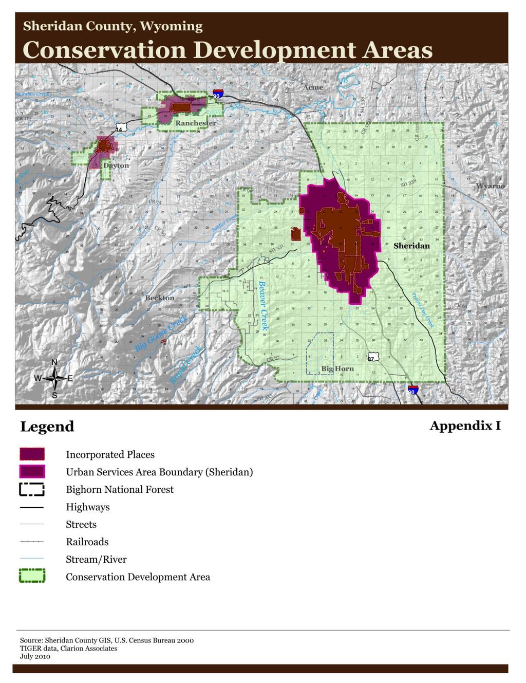
3 two or more contiguous parcels of land under different ownerships aggregated that meet the following minimum land area sizes: acres in the A-Agricultural district, acres in the RR-Rural Residential district, acres UR-Urban Residential district (only outside the Urban Services Area as shown in Appendix H). iii. Conservation Development Area. For property within the Conservation Development Area, as mapped by county GIS and shown in Figure 2, below (and shown in the official map of the Conservation Development Area, Appendix I), the subdivider shall be eligible for additional density bonus incentives as set forth in Section 2.12 of these rules and regulations. Conservation Development Area Figure 2: Conservation Development Area, (See Appendix I.)
4 iv. Allowed Uses General. In a Conservation Design Subdivision, the proposed uses shall be limited to single-family detached residences, agriculture (as defined in the Rules and Regulations Governing Zoning for Sheridan County), and nonmotorized recreational uses. Only agriculture, open space, forestry, noncommercial greenhouses, and non-motorized recreational uses are allowed in the conservation area(s). c. Submittal and Review Requirements. A Conservation Design Subdivision shall be processed as a subdivision of land, subject to the approval of Conservation Design Subdivision, as described in subsection vii, Approval, below. The steps in the preparation of a Conservation Design Subdivision application shall be as described in subsections i through v, below. i. Pre-application Meeting. Prior to submittal of a Conservation Design Subdivision application, the subdivider or his agent shall meet with Public Works Department staff, in accordance with Section 2.3, Pre-application Meeting, of these rules and regulations. In addition to requirements set forth in Section 2.3, staff and the subdivider shall also address preparation of a site analysis map and scheduling of a site visit, as described herein. ii. Preliminary Site Analysis Map. After the pre-application meeting, but prior to submittal of the Conservation Design Subdivision application, the subdivider shall prepare and submit a preliminary site analysis map that provides information about existing site conditions and context and that comprehensively analyzes existing conditions both on the proposed subdivision property and on all lands within 1,500 feet of the subject property s boundaries. The site analysis map scale shall be in accordance with standards for the preliminary plat contents, set forth in Section 2.6b. The map shall contain the information listed in subsections A through C, below.
5 A. Natural and Constructed Features. The site analysis map shall show the relationship of the property to natural and constructed features located on the property and within 1,500 feet of its boundaries. The features to be shown include: 1. Public roads and trails. 2. Utility easements and rights-of-way, as filed with the County Clerk and Recorder s office. 3. Constructed features, including but not limited to driveways, farm roads, buildings, foundations, walls and fences, wells, drainage fields, ditches, dumps, and utilities. 4. Topography (from United States Geological Survey (USGS) maps) as required for preliminary plats, including steep slopes, as defined in these rules and regulations and Rules and Regulations Governing Zoning, Section Classified surface waters and setbacks required in the Rules and Regulations Governing Zoning, Section Base flood areas. 7. Wetlands (from maps published by the U.S. Fish and Wildlife Service or the U.S. Department of Agriculture (USDA) Natural Resources Conservation Service, as available). 8. Crucial Habitat Priority Areas (identified and mapped by the Wyoming Game and Fish Department). 9. Soils (mapped by the USDA Natural Resources Conservation Service). 10. Public lands. 11. Lands protected under conservation easements. 12. Historically and culturally significant sites or structures. B. Proposed Conservation Area. The site analysis map shall depict the proposed or potential conservation area(s) (including total calculated conservation area

.")
6 and its percentage of the total subdivision) based on the natural features to be protected and to achieve the minimum amount of land to be conserved, as set forth in Section 2.12.d.iii, Minimum Conservation Area. C. Potential Buildable Areas. The site analysis map shall delineate the potential buildable areas (including total calculated conservation area and its percentage of the total subdivision) as a last step, following delineation of the natural and constructed features and potential conservation area(s). Conservation Area(s) Figure 3: First, determine the conservation area(s), Figure 4: Then, draw in buildable areas, roads, and lot lines as final step. iii. Site Visit. After the subdivider creates a preliminary site analysis map, and prior to the subdivider s formal submittal of the concept plan and complete application, Public Works Department staff shall schedule a site visit to the property and shall invite the subdivider and representatives of agencies and organizations with land conservation management and land use planning expertise. Such agencies and organizations may include, but are not limited to, entities such as the Sheridan County Conservation District, Wyoming Department of Environmental Quality, local land trusts, and municipalities within one-mile of the site. Prior to the site visit, the
7 subdivider shall provide staff with a permission form to allow staff (or designee) to enter the property. The purpose of the site visit is to: 1. Familiarize staff with the property s existing conditions and special features, 2. Identify potential site development issues, and 3. Provide an opportunity to discuss design concepts, including the general location and layout of the conservation area(s), the potential locations for proposed buildable areas and lots and building envelopes within lots (as applicable), and the potential locations and design of utilities, roads, fences, and other development features. Comments made by staff or designee during the site visit are not binding in any way, and shall be interpreted as suggestions only. No official decisions shall be made during the site visit. iv. Concept Plan. After the pre-application meeting and site visit, the Subdivider shall submit the site analysis map and a concept plan in accordance with Section 2.4 of these regulations. v. Complete Application. Following receipt of the written comments on the Concept Plan from the Public Works staff, the subdivider shall submit a complete subdivision application for a Conservation Design Subdivision in accordance with Section 2.5 of these regulations and shall include supporting materials as set forth in Sections 2.6c and 27.c. vi. Final Plat. Subdivider shall submit a final plat in accordance with Section 2.7 of these rules and regulations. Public hearing requirements and notification shall be the same as for a Preliminary Plat as set forth in Section 2.6. The
8 county shall waive all application review and lot fees for final plats associated with a Conservation Design Subdivision. vii. Approval of a Conservation Design Subdivision. The Planning & Zoning Commission shall review the final plat for the Conservation Design Subdivision and make a recommendation to the Board of County Commissioners. The Board of County Commissioners shall review the final plat and make the decision. d. Standards Applicable to Conservation Design Subdivisions. In addition to the general standards set forth in Section 3.1 through 3.15 of these rules and regulations, the following standards shall apply to Conservation Design Subdivisions. i. Components of a Conservation Design Subdivision. A Conservation Design Subdivision is comprised of two components: (A) the conservation area, and (B) the residential cluster. The conservation area is the larger portion of the development parcel that is platted as a tract(s) and permanently conserved for agriculture, open space, or nonmotorized recreation uses. The residential cluster is the portion of the development parcel that is subdivided into lots for single-family residential development and accessory uses. ii. Summary of Conservation Design Subdivision Standards. Table below sets forth a summary of the general requirements for the Conservation Design Subdivision option. (See standards for streams and steep slopes in the Rules and Regulations Governing Zoning, Section 22.)
9 Table : Summary of General Requirements for Conservation Design Subdivisions Zoning District Minimum Land Area Base Density Maximum Density with Bonuses Lot Size Minimum Conservation Area(s) A- Agricultural 70 acres 1 unit per 40 acres (0.025 units per acre) 1 unit per 20 acres (100% increase) Minimum: 0.25 acres, as long as the subdivider complies with wastewater facility minimum isolation distance requirements required by Sheridan County and approved by DEQ and provides central sewer or enhanced systems within the Groundwater Protection Area. 70% of gross land area of parcel Maximum: 10 acres, except for conservancy lots. RR-Rural Residential (outside Groundwater Protection Area (GPA)) 10 acres 1 unit per 2 acres (0.5 units per acre) 0.75 units per acre (50% increase) Minimum: No minimum, as long as subdivider complies with wastewater facility minimum isolation distance requirements required by Sheridan County and approved by DEQ 70% of gross land area of parcel Maximum: No maximum. RR-Rural Residential (within a GPA) 10 acres 1 unit per 5 acres (0.2 units per acre) 0.30 units per acre (50% increase) Minimum: No minimum, as long as subdivider complies with wastewater facility minimum isolation distance requirements required by Sheridan County and approved by DEQ and provides central sewer or enhanced systems 70% of gross land area of parcel Maximum: No maximum. UR-Urban Residential (outside the Urban Services Area) Same requirements as RR.
10 iii. Minimum Conservation Area(s) A. Conservation Area(s) The minimum percentage of the Conservation Design Subdivision parcel s gross land area that shall be set aside as conservation area(s) is 70%. The conservation area(s) and its calculated percentage of the gross area shall be clearly delineated on the Conservation Design Subdivision Plat. The acreage, intended use, and final ownership of all conservation area tracts shall be shown on the plat. B. Conservation Lot(s) Up to two conservation lots may be designated for a parcel, provided that the minimum 70% conservation area is set aside within the conservation lot(s). iv. Base Density with Conservation Design Subdivision Option The base density permitted under the Conservation Design Subdivision option shall be measured using the gross land area (in acres) of the entire parcel divided by the number of dwelling units permitted per acre, as set forth in Table and subsections A through C, below. Where the total number of dwelling units calculated results in a fractional number, the subdivider shall round down the number of dwelling units to the nearest whole number. A. A-Agricultural District. Base density shall not exceed 1 dwelling unit per 40 acres, unless a bonus is granted, pursuant to Section 2.12.d.v, below. This represents a 100% increase over the base density permitted if the Conservation Design Subdivision option is not utilized.
11 B. RR-Rural Residential District. Base density shall not exceed 1 dwelling unit per 2 acres for parcels outside a Groundwater Protection Area and 1 dwelling unit per 5 acres within a Groundwater Protection Area, unless a bonus is granted, pursuant to Section 2.12.d.v, Density Bonuses, below. C. UR-Urban Residential District (outside the USA). Base density shall be the same as that in the RR-Rural Residential district, as set forth in subsection B, above. v. Density Bonuses. The subdivider may earn density bonuses (in addition to the base density, as described in subsection iv, above) in keeping with the purposes of these rules and regulations. (See Appendix J, Calculating the Density Bonus, for further explanation.) The County shall have final authority to determine the appropriate density bonus award. A. Conservation Development Area Location. The parcel shall be located within the Conservation Development Area to be eligible for density bonuses. (See subsection 2.12.b.iii, Minimum Conservation Area(s), above.) B. Cumulative Bonuses. The subdivider may request more than one density bonus from the Density Bonus Menu in subsection E below. The cumulative density bonus shall not increase above the base density by more than 100% in the A-Agricultural District and 50% in the RR-Rural Residential and UR-Urban Residential Districts. C. Flexibility in Minimum Lot Size and Conservation Area. The Board shall have the authority to vary the minimum lot size and the minimum amount of conservation area required by these standards to accommodate the additional lots earned through the
12 density bonus provisions and/or to bolster the economics of community sewer systems. However, in no case shall the Board reduce the minimum lot size to less than 0.25 acres in the A- Agricultural District, or reduce the percentage of conservation area to less than 65% of the parcel. D. No Guarantee of Density. This subsection shall not be interpreted as a guarantee of achievable density. Conservation Design Subdivisions using density bonus provisions shall be subject to all standards in Section 2.12 of these rules and regulations. Other regulations or sitespecific conditions may prevent maximum bonus density levels from being achieved. Density bonuses options are identified in Table : Menu of Density Bonuses Available. E. Density Bonus Menu. The following density bonuses are available for Conservation Design Subdivisions. Table : Menu of Density Bonuses Available Density Bonus F.1. Providing Central Sewer F.2. Conserving Prime Farmland F.3. Dedicating Additional Conservation Area(s) F.4. Protecting Streams and Riparian Areas (beyond that required by Section 22.B of the Rules and Regulations Governing Zoning) Maximum Percentage of Density Increase 25% bonus 25% bonus 25% bonus (for dedicating 80% of the parcel for conservation) 50% bonus (for dedicating 90% of the parcel for conservation) 25% bonus F.5. Protecting Visual Resources F.6. Conserving Connected Open Space or Wildlife Habitat F.7. Replatting Large Acreage F.8. Providing Fire Protection Measures 25% bonus 25% bonus 10% bonus 10% bonus
13 F.9. Public Trail Dedication (land only, not including trail improvements) F.10. Stream Bank Restoration and Tree Planting F.11 Installation of Wildlife-Friendly Fencing As Recommended By Public Works Department Staff 10% bonus 10% bonus 5% bonus 1. Bonus for Providing Central Sewer. The county may grant up to a 25% density increase for providing a central sewer system to serve three or more residential lots. 2. Bonus for Conserving Prime Farmland. The county may grant up to a 25% density increase if the subdivider, and any successors in title, conserves prime farmland soils and retains existing water rights on the conservation area(s). 3. Bonus for Dedicating Additional Conservation Area(s). The county may grant up to a 25% density increase for dedicating 80% of the parcel as conservation area(s) and 50% density increase for dedicating 90% of the parcel as conservation area(s). 4. Bonus for Protecting Streams and Riparian Areas. The county may grant up to a 25% density increase for provision of an additional buffer for riparian areas that exceed the minimum stream setback requirement. The bonus will depend on the quantity and quality of riparian vegetation in the buffer. 5. Bonus for Protecting Visual Resources. The county may grant up to a 25% density increase for protection of views and setting residential buildings back
14 from ridgelines at least 50-feet, so that rooflines do not dominate the ridges. 6. Bonus for Conserving Connected Open Space or Wildlife Habitat. The county may grant up to a 25% density increase for conservation of open space that is connected to or contiguous with other permanently protected lands or for conserving wildlife habitat (Crucial Habitat Priority Areas mapped by Wyoming Game and Fish). 7. Bonus for Replatting Large Acreage. The county may grant up to a 10% density increase for replatting a large acreage subdivision in the A-Agricultural district to achieve objectives of the Conservation Design Subdivision. 8. Bonus for Providing Fire Protection Measures The county may grant up to a 10% density increase for provision of sprinkler systems for fire protection in each approved residential dwelling unit. Such systems must be approved by the county and the applicable fire district. 9. Bonus for Public Trail Dedications. The county may grant a 10% density increase for the development and dedication of public trails if the trail(s) are consistent with the Sheridan County Comprehensive Plan, as amended from time to time or with any county or municipal trails/open space plan, as adopted and amended.
15 10. Bonus for Stream Bank Restoration and Tree Planting. The county may grant a 10% density increase for stream bank restoration and tree planting, as proposed through a management plan and guaranteed through funds in escrow. 11. Bonus for Wildlife-Friendly Fencing The county may grant a 5% density increase if the developer adopts the wildlife-friendly fencing recommendations of county staff. vi. Siting Standards. Conservation Design Subdivisions shall comply with the standards in subsections A through C below and general standards set forth in Sections 3.1 through 3.15 of these rules and regulations. If a conflict exists, these standards will take precedence. A. Location of Conservation Area(s). The conservation area(s) shall be delineated to include the following features, in order of priority: 1. Stream setbacks, as set forth in Section 22 of the Rules and Regulations Governing Zoning; 2. Base flood areas; 3. Other rivers, streams, and water bodies, as identified through county mapping; 4. Prime farmland as mapped by NRCS; 5. Steep slopes, as set forth in Section 22 of the Rules and Regulations Governing Zoning; and 6. Identified historic and cultural features identified on the parcel. B. Contiguous Conservation Area(s). The conservation area(s), or open space, shall be contiguous, to the maximum extent feasible.
16 C. Location of Residential Lots. The buildable residential lots shall be sited to: 1. Be located outside the delineated conservation area(s); 2. Avoid interference with existing or viable agricultural activities, by providing a 100-foot setback from such activities; 3. Cluster up to eight residential lots together in the A- Agricultural district, to avoid the appearance of the creation of small towns and to protect agricultural operations and maintain rural character. Residential clusters shall be spaced with a minimum of a 200-foot buffer between them. e. Management of the Conservation Area(s). i. Conservation Area(s) Ownership Options. The subdivider shall propose measures or methods for permanent or longterm ownership of the conservation area(s). The following methods may be used, either individually or in combination, for long-term ownership of the conservation area with the approval of Sheridan County: A. Fee Simple Dedication to Sheridan County. The county may, but shall not be required to, accept any portion of the conservation area as a fee simple dedication, provided: 1. The county shall have no acquisition costs, unless the county agrees to purchase the property; and 2. Sheridan County agrees to and has access to maintain such land. B. Fee Simple Dedication to Other Governmental Entity. The County may approve dedication of the conservation area to another governmental entity federal, state, or local under terms
17 that ensure permanent protection and maintenance of the conservation area. C. Dedication of Easements to Sheridan County. The county may, but shall not be required to, accept conservation easements on any portion of the conservation area. In such cases, the land remains in the ownership of the property owners association, private conservation organization, or other acceptable entity, while the county holds the easement (which may allow for public access or other public benefit). In addition, the following regulations shall apply: 1. The county shall have no acquisition costs; and 2. A satisfactory maintenance agreement shall be reached between the owner and the county. D. Property Owners Association. Conservation areas may be held in common ownership by a property owners association, subject to all of the provisions for such associations set forth by the State of Wyoming. In addition, the subdivider shall meet the following regulations: 1. The subdivider shall provide the county for review and approval a description of the organization of the proposed association, including its bylaws, and all documents governing ownership, maintenance, and use restrictions for the conservation area, including a legal description of the land and any restrictions placed upon its future use and enjoyment. 2. The proposed association shall be established by the owner or subdivider and shall be operating (with financial subsidization by the owner or subdivider, if necessary) before the approval of any final plat within the Conservation Design Subdivision.
18 3. Membership in the association shall be automatic (mandatory) for all purchasers of lots therein and their successors in title. The by-laws shall confer legal authority on the association to place a lien on the real property of any member who falls delinquent in his dues. Such dues shall be paid with the accrued interest before the lien may be lifted. 4. The association shall be responsible for maintenance of and provision of insurance for the conservation area(s). 5. The association shall provide written notice of any proposed transfer of, or the assumption of, maintenance for the conservation area to all association members and to the county no less than 60 days prior to such event. 6. The association by-laws shall give the county authority (but no obligation or duty) to assume responsibility to enforce these restrictions if the association fails to maintain the conservation area, in which case any escrow funds may be forfeited and any permits may be revoked or suspended. E. Retention of Interest by Owner or Subdivider. The owner may retain title to the conservation area, provided: 1. A deed restriction limiting development is placed on the conservation area, which is acceptable to the county, and 2. The subdivider submits a Management Plan acceptable to the County pursuant to subsection 2.12.e.ii, Management of Conservation Area(s), below, that ensures perpetual maintenance. F. Private Conservation Organization (with approval of county). With approval of the county, an owner may transfer either a conservation easement or fee simple title for the conservation area to a private non-profit organization, provided:
19 1. The conservation organization is acceptable to the county and is a qualified conservation organization intended to exist indefinitely; 2. The conveyance contains appropriate provisions for proper reverter or transfer in the event that the organization becomes unwilling or unable to continue carrying out its functions; 3. The conservation area is permanently restricted from future development through a conservation easement, and the county is given the authority (but no obligation or duty) to enforce these restrictions; and 4. A maintenance agreement acceptable to the county is established between the owner and the conservation organization. G. Non-Common Private Ownership Conservancy Lots. As approved in a Conservation Design Subdivision Plat, a portion of the required conservation area may be included within up to two large conservancy lots, provided: 1. The conservation area(s) within the conservancy lot(s) meets the minimum size requirements for a conservation area(s) set forth in Section 2.12.d.iii, Minimum Conservation Area(s). 2. The conservation area(s) within the conservancy lot is permanently restricted from future development and activities through a conservation easement or other deed restriction acceptable to the county, and the county is given the express authority (but no obligation or duty) to enforce these restrictions.
20 ii. Management of Conservation Area(s). A. Management Cost and Responsibility. Unless otherwise agreed to by the county or unless the land is dedicated to the county, the cost and responsibility of maintaining and managing the conservation area shall be borne by the owner, property owners association, conservation organization, or other owner entity as identified pursuant to Section 2.12.e.i, Conservation Area(s) Ownership Options, above. B. Management Plan for Conservation Areas Greater than 20 acres. For all conservation areas greater than 20 acres, the subdivider shall, at the time of the Conservation Design Subdivision Plat submission, provide a Plan for Management of the Conservation Area(s) ( Management Plan ) in accordance with requirements in this subsection. The Management Plan shall accomplish the following: 1. Define ownership of the conservation area(s), and the organization(s) that will monitor and maintain the area(s). 2. Include a baseline report identifying the condition of the conservation area(s) at the time the Conservation Design Subdivision application is submitted. 3. State its purpose and objectives for management of the conservation area(s), including but not limited to the following, as applicable: wildlife management; agricultural operations; non-motorized recreational uses; cultural resource management; weed management; and stream bank restoration. 4. Establish necessary regular and periodic operation and maintenance responsibilities.
21 5. Estimate staffing needs, insurance requirements, and costs, and define the means for funding maintenance on an ongoing basis. Such plan shall include the means for funding long-term capital improvements as well as regular yearly operating and maintenance costs. Designation of a long-term stewardship lot wherein the proceeds from the sale of such lot are permanently dedicated to the costs associated with management of the conservation area may be considered and is encouraged. 6. Allow approval to any changes to the Management Plan by the county. 7. Allow the county to enter the premises and take corrective action including extended maintenance. The costs of such corrective action may be charged to the owner, property owners association, conservation organization, or individual property owners who make up a property owners association, and may include administrative costs and penalties. Such cost shall become a lien on said properties. Notice of such lien shall be filed by the county. 8. In the event that the organization established to maintain the conservation area(s), or any successor organization thereto, fails to maintain all or any portion thereof in reasonable order and condition, the county may assume responsibility for maintenance (but shall have no obligation or duty to do so), in which case any escrow funds may be forfeited and any permits may be revoked or suspended. 9. To ensure execution of the Management Plan, the county may require the subdivider to escrow sufficient funds for the maintenance and operation costs of the conservation area(s) for up to one year.
22 Appendix H
23
24
25
26
27
28 Appendix I
29
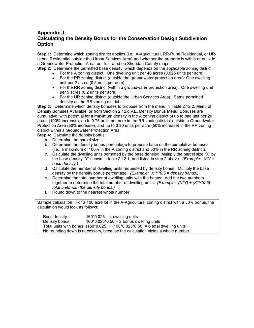
30 Appendix J
31
32 Excerpt of Section 22 from the Rules and Regulations Governing Zoning in Section 22. Development Standards. B. Stream Protection Sheridan County, Wyoming, November 5, Purpose. The stream protection standard is intended to accomplish the following objectives: Implement the water quality protection, environmental, and rural character protection goals and policies of the Sheridan County Comprehensive Plan; Achieve the goals in a manner that is reasonable and sensitive to local conditions and concerns of owners; Protect water quality and habitat quality in the rivers, streams, contiguous wetlands, and other riparian features, thereby protecting the public health, safety, and welfare; Encourage filtering of stormwater runoff through natural vegetative buffers and cover along stream banks to provide shade, thereby managing water temperatures and high-quality stream habitat; Protect river and stream banks from erosion by providing for effective vegetative buffers adjacent to stream corridors and by prohibiting building activities within a specified distance from streambanks and contiguous wetlands; Protect the character of river and stream corridors which contribute to the valued natural character of the county, its quality of life, and property values; and Allow and encourage owners to enhance native vegetation along stream banks. 2. Applicability. This standard shall apply to all buildable lots legally established after November 5, Agriculture uses and buildings used exclusively in the production of livestock or crops shall be exempt from any stream setback requirements. 3. Standards. a. Stream Setbacks. 1. Permitted Uses. No new dwelling, commercial, or industrial structures shall be allowed in the stream setbacks set forth in subsection 2, below. The county discourages other disturbance including but not limited to dredging, filling, installation of septic systems, scraping by motorized equipment, and removal of vegetation, except for trails, bridges, and public utilities. The county also encourages uses that will enhance flood protection function or riparian vegetation.
33 2. Minimum Setback. Any buildable lot adjacent to streams classified as Class 1, 2, or 3 waters on the Wyoming Surface Water Classification List, (published and periodically updated by the Wyoming DEQ, Water Quality Division), shall be subject to the following minimum setbacks, as measured from the ordinary high water mark or defined stream bank, whichever will result in less potential disturbance. (See Attachment 2: Wyoming Department of Environmental Quality, Water Quality Division, Surface Water Classification List.) a. Streams Classified as Class 1 Waters. Two-hundred foot setback, provided that the setback may be reduced to one-hundred feet in some locations if an average setback of two-hundred feet is maintained across the property as a whole. b. Streams Classified as Class 2 Waters. One-hundred foot setback, provided that the setback may be reduced to fifty feet in some locations if an average setback of one-hundred feet is maintained across the property as a whole. c. Streams Classified as Class 3 Waters. Fifty foot setback, provided that the setback may be reduced in some locations if an average setback of fifty feet is maintained across the property as a whole. d. Variances. Should the developer demonstrate that because of peculiar physical conditions pertaining to the property, the literal enforcement of one or more of these regulations is impractical or will exact undue hardship, the Board may permit a variance, in accordance with Section 26 of these rules and regulations and upon a finding that the developer has demonstrated that a smaller setback will not have a significant adverse impact on the stream in terms of water quality, wildlife habitat, and similar natural resource considerations. b. Density Transfer. For Conservation Design Subdivisions, the base density otherwise permitted in the applicable district that is attributable to the portion of the parcel encompassed by the stream setback is transferable to other areas of the parcel. (See Rules and Regulations Governing Division of Land, Section 2.12 and Sections 8 through 10 in these rules and regulations.) C. Steep Slope Standards. 1. Purpose. The steep slope standards are set forth to accomplish the following objectives: reduce damage to streams and rivers from the erosion and sedimentation caused from development on steep slopes, preserve rural character, encourage innovative grading practices which are more appropriate on hillsides, conserve the natural topography in steep slope areas of Sheridan County, and
34 prevent damage to life and property caused by development on unstable landslide areas. 2. Applicability. The steep slopes standard shall apply to all areas with a natural slope that is 20% or greater and where the proposed site disturbance is greater than 2,500 square feet. 3. Standards. a. Disturbance Minimized on Slopes of 20% or Greater. Any grading, tree removal, or other site disturbance of slopes of twenty percent (20%) or greater shall be minimized to the maximum extent practicable. b. Disturbance Prohibited on Slopes of 30% or Greater. New dwellings, commercial, and industrial structures shall be prohibited on slopes of thirty percent (30%) or greater, except under the following circumstances: 1. Grading for a portion of a driveway to access a residential unit, when it can be demonstrated that no other route which avoids the 30% or greater slope is possible and where finished slopes of all cuts and fills shall not exceed three-to-one (3:1), unless the developer can demonstrate that steeper slopes can be stabilized and maintained adequately. 2. Utilities and communications facilities are allowed. 3. Agriculture is allowed. 4. Forestry is allowed. 5. Non-motorized recreation is allowed. c. Landslide Areas. New dwellings, commercial, or industrial structures shall be prohibited on landslide areas mapped by the Wyoming Geological Society Survey. d. Density Transfer. For Conservation Design Subdivisions, the base density otherwise permitted in the applicable district and attributable to the steep slope areas of the parcel is transferable to other developable areas of the parcel. (See Rules and Regulations Governing Division of Land, Section 2.12 and Sections 8 through 10 in these rules and regulations.)
Conservation Design Subdivision Option
 Sheridan County, Wyoming Conservation Design Subdivision Option Recent Amendments to Zoning and Subdivision Rules and Regulations Adopted November 2010 Mark Reid, County Planner 1 County Road #255 traffic
Conservation Design Development Amendment to Zoning Ordinance as adopted by Town Council December 8, 2010
 Conservation Design Development Amendment to Zoning Ordinance as adopted by Town Council December 8, 2010 Definitions Add: Cluster- A site planning technique that concentrates buildings in specific areas
Open Space Model Ordinance
 Open Space Model Ordinance Section I. Background Open space development has numerous environmental and community benefits, including: 1) Reduces the impervious cover in a development. Impervious cover
FINAL DRAFT 12/1/16, Rev. to 7/18/17
 FINAL DRAFT 12/1/16, Rev. to 7/18/17 (As Adopted 8/8/17 Effective 9/1/17) SHELTON PLANNING AND ZONING COMMISSION Proposed Amendments to Zoning Regulations I. Amend Section 23 PERMITTED USES by inserting
Chapter 100 Planned Unit Development in Corvallis Urban Fringe
 100.100 Scope and Purpose. Chapter 100 Planned Unit Development in Corvallis Urban Fringe (1) All applications for land divisions in the Urban Residential (UR) and Flood Plain Agriculture (FPA) zones within
ARTICLE FIVE FINAL DRAFT
 ARTICLE FIVE 021218 FINAL DRAFT Sec. 503.6 Open Space Preservation Option Open Space Preservation Option Open Space Preservation developments may be approved in the AR, R-1, R-2 and R-3 zoning districts,
A. Preserve natural resources as identified in the Comprehensive Plan.
 1370.08 Conservation Residential Overlay District. Subd. 1 Findings. The City finds that the lands and resources within the Conservation Residential Overlay District are a unique and valuable resource
APPLICATION FOR SUBDIVISION APPROVAL OF A SKETCH PLAN with checklist
 Prior to filing any application for SUBDIVISION approval, the applicant shall request in writing that the zoning administrator schedule a pre-submission conference. APPLICATION TO THE PLANNING BOARD TOWN
CHAPTER 3 PRELIMINARY PLAT
 10-3-1 10-3-3 SECTION: CHAPTER 3 PRELIMINARY PLAT 10-3-1: Consultation 10-3-2: Filing 10-3-3: Requirements 10-3-4: Approval 10-3-5: Time Limitation 10-3-6: Grading Limitation 10-3-1: CONSULTATION: Each
TRANSFER OF DEVELOPMENT RIGHTS (TDR) ORDINANCE Revised November 2013
 ORDINANCE Revised November 2013") ARTICLE III Transfer of Development Rights (TDR) Program Part 301 Establishment and Purpose. 165-301.01. Purpose. Pursuant to the authority granted by 15.2-2316.1 and 2316.2 of the Code of Virginia, there
ARTICLE III Transfer of Development Rights (TDR) Program Part 301 Establishment and Purpose. 165-301.01. Purpose. Pursuant to the authority granted by 15.2-2316.1 and 2316.2 of the Code of Virginia, there
Planned Unit Development (PUD). Sections:
. Sections:") Chapter 19.07. Planned Unit Development (PUD). Sections: 19.07.01. Purpose. 19.07.02. PUD Definition and Design Compatibility. 19.07.03. General PUD Standards. 19.07.04. Underlying Zones. 19.07.05. Permitted
Chapter 19.07. Planned Unit Development (PUD). Sections: 19.07.01. Purpose. 19.07.02. PUD Definition and Design Compatibility. 19.07.03. General PUD Standards. 19.07.04. Underlying Zones. 19.07.05. Permitted
Article XII. R-1 Agricultural-Low Density Residential District
 Article XII R-1 Agricultural-Low Density Residential District Section 1200. Declaration of Legislative Intent In expansion of the Declaration of Legislative Intent and Statement of Community Development
DRAFT FOR PUBLIC HEARING (rev. March, 2016)
") Chapter 200. ZONING Article VI. Conservation/Cluster Subdivisions 200-45. Intent and Purpose These provisions are intended to: A. Guide the future growth and development of the community consistent with
Chapter 200. ZONING Article VI. Conservation/Cluster Subdivisions 200-45. Intent and Purpose These provisions are intended to: A. Guide the future growth and development of the community consistent with
Draft Zoning Changes for the 2nd Planning Board Public Hearing, January 22, 2018.
 Draft Zoning Changes for the 2nd Planning Board Public Hearing, January 22, 2018. No changes were made at the 1st Public Hearing. Proposed wording for the 1 st Public Hearing in red, eliminated text in
5-703 Agricultural Rural (AR) District Cluster Option. (A)
 District Cluster Option. (A)") 5-703 Agricultural Rural (AR) District Cluster Option. (A) Purpose. The purpose of the Agricultural Rural (AR) District Cluster Option is to provide for residential singlefamily detached development in
5-703 Agricultural Rural (AR) District Cluster Option. (A) Purpose. The purpose of the Agricultural Rural (AR) District Cluster Option is to provide for residential singlefamily detached development in
SECTION 16. "PUD" PLANNED UNIT DEVELOPMENT OVERLAY DISTRICT
 SECTION 6. "PUD" PLANNED UNIT DEVELOPMENT OVERLAY DISTRICT Subsection. Purpose. This district is established to achieve the coordinated integration of land parcels and large commercial and retail establishments
Town of Falmouth s Four Step Design Process for Subdivisions in the Resource Conservation Zoning Overlay District
 Town of Falmouth s Four Step Design Process for Subdivisions in the Resource Conservation Zoning Overlay District All subdivisions shall be designed in accordance with the following four-step process.
4. facilitate the construction of streets, utilities and public services in a more economical and efficient manner;
 PVPC MODEL BYLAW BY-RIGHT CLUSTER ZONING BYLAW Prepared by Pioneer Valley Planning Commission Revised: October 2001 1.00 Development 1.01 Development Allowed By Right Development in accordance with this
OPEN SPACE RESIDENTIAL DEVELOPMENT (OSRD) MODEL SITE PLAN BYLAW
 MODEL SITE PLAN BYLAW") OPEN SPACE RESIDENTIAL DEVELOPMENT (OSRD) MODEL SITE PLAN BYLAW 1) PURPOSE AND INTENT a) The Primary Purposes for OSRD are the following: i) To allow for greater flexibility and creativity in the design
OPEN SPACE RESIDENTIAL DEVELOPMENT (OSRD) MODEL SITE PLAN BYLAW 1) PURPOSE AND INTENT a) The Primary Purposes for OSRD are the following: i) To allow for greater flexibility and creativity in the design
FINAL DRAFT 10/23/06 ARTICLE VI
 FINAL DRAFT 10/23/06 ARTICLE VI 185-41.1. Planned Residential Development A. Purpose and Intent. The purposes of the Planned Residential Development (PRD) bylaw are to maintain the rural character of Dover,
MEMORANDUM. Critical Areas Ordinance Density Requirements
 COUNTY COMMISSIONERS Creating Solutions for Our Future Cathy Wolfe District One Sandra Romero District Two Karen Valenzuela District Three PLANNING DEPARTMENT Scott Clark Director MEMORANDUM TO: FROM:
CCC XXX Rural Neighborhood Conservation (NC)
") CCC 33.10.XXX Rural Neighborhood Conservation (NC) Purpose: Maintain low density rural residential areas and associated uses commonly found in rural areas consistent with the local character of the distinctive
CCC 33.10.XXX Rural Neighborhood Conservation (NC) Purpose: Maintain low density rural residential areas and associated uses commonly found in rural areas consistent with the local character of the distinctive
Chapter Planned Residential Development Overlay
 Chapter 19.29 Planned Residential Development Overlay Sections 010 Purpose 020 Scope 030 Definitions 030 Minimum Size 040 Allowable Uses 050 Minimum Development Standards 060 Density Bonus 070 Open Space
ARTICLE XI - CONSERVATION SUBDIVISIONS
 ARTICLE XI - CONSERVATION SUBDIVISIONS Section 1101: Purpose and Intent. This Article is intended to provide for residential subdivisions that are designed based first and foremost on the preservation
Georgia Conservation Tax Credit Program Frequently Asked Questions
 Georgia Conservation Tax Credit Program Frequently Asked Questions What are the minimum requirements for eligibility under the Georgia Conservation Tax Credit Program (GCTCP)? Individual and corporate
Special Use Permit - Planned Unit Development Checklist. Property Address:
 Special Use Permit - Planned Unit Development Checklist Special Use Permit Number. Parcel Code/s #28-11- - - Property Address: Applicant: ARTICLE VIII Ordinance Reference - Section 8.1.2 Permit Procedures:
AN ORDINANCE AMENDING THE CITY ZONING ORDINANCE AND THE OFFICIAL CODE OF THE CITY OF CLARKSVILLE RELATIVE TO CLUSTER OPTION DEVELOPMENTS
 ORDINANCE 74-2012-13 AN ORDINANCE AMENDING THE CITY ZONING ORDINANCE AND THE OFFICIAL CODE OF THE CITY OF CLARKSVILLE RELATIVE TO CLUSTER OPTION DEVELOPMENTS BE IT ORDAINED BY THE CITY COUNCIL OF THE CITY
I. Requirements for All Applications. C D W
 108-16.1. Application checklists. Checklist for Required Submissions to the Planning Board or Zoning Board of Adjustment of Monroe Township All required submissions are to be made to the Administrative
Article 7: Residential Land Use and Development Requirements
 Article 7: Residential Land Use and Section 701: Statement of Intent (A) (B) (C) The intent of Article 7 is to develop certain land use and development requirements for the residential uses within Cumru
Town of Norwich, Vermont SUBDIVISION REGULATIONS
 Town of Norwich, Vermont SUBDIVISION REGULATIONS Adopted: August 6, 2002 Amended: February 8, 2006 Prepared by Norwich Planning Commission with the assistance of: Burnt Rock Inc. A ssociates in Community
Subdivision and Land Development Regulations TABLE OF CONTENTS
 TABLE OF CONTENTS I. AUTHORITY AND INTENT A. Authority... 1-1 B. Purpose... 1-1 C. Construction and Intent... 1-2 D. Effective Date... 1-2 E. Vested Rights - Continuation of Prior Regulations... 1-3 II.
A. ARTICLE 16 - STEEP SLOPE CONSERVATION DISTRICT
 1600. 1601.A. ARTICLE 16 - STEEP SLOPE CONSERVATION DISTRICT SECTION 1600 PURPOSE The purpose of this Article is to expand upon the Community Development Objectives associated with environmental protection
SITE PLAN REVIEW PROCEDURES SECTION DEVELOPMENTS REQUIRING SITE PLAN APPROVAL
 SECTION 22.01 PURPOSE ARTICLE XXII PROCEDURES The purpose of this Article is to establish uniform requirements of procedure for all developments in the Township. Certain specific types of minor development
IV. REVIEW PROCEDURES FOR MINOR SUBDIVISIONS
 IV. REVIEW PROCEDURES FOR MINOR SUBDIVISIONS IV-A. General Minor subdivisions create five or fewer lots from a tract of record, each lot of which has legal and physical access. If the tract of record proposed
GWINNETT COUNTY CSO CONSERVATION SUBDIVISION OVERLAY DISTRICT REQUIREMENTS
 GWINNETT COUNTY CSO CONSERVATION SUBDIVISION OVERLAY DISTRICT REQUIREMENTS Section 1316. CSO Conservation Subdivision Overlay District. 1. Purposes. The purposes of this overlay district are as follows:
CHAPTER 3 SPECIAL DISTRICTS
 CHAPTER 3 SPECIAL DISTRICTS Part 4: Conservation/Cluster Developments Sec. 13-3-11 Conservation/Cluster Developments. (a) Title. These regulations shall specifically be known cited and referred to as the
Rule 80. Preservation of Primary Agricultural Soils Revised and approved by the Land Use Panel during its public meeting on January 31, 2006.
 Rule 80. Preservation of Primary Agricultural Soils Revised and approved by the Land Use Panel during its public meeting on January 31, 2006. (A) Purpose. In accordance with 10 V.S.A. Sections 6025(b)
ARTICLE VII TDR. 701 Purpose.
 ARTICLE VII TDR 701 Purpose. The primary purpose of establishing a TDR program is to permanently preserve prime farmland, sensitive natural areas, and rural community character that would be lost if the
ARTICLE 14 PLANNED UNIT DEVELOPMENT (PUD) DISTRICT
 DISTRICT") ARTICLE 14 PLANNED UNIT DEVELOPMENT (PUD) DISTRICT Section 14.01 Intent. It is the intent of this Article to allow the use of the planned unit development (PUD) process, as authorized by the Michigan Zoning
ARTICLE 14 PLANNED UNIT DEVELOPMENT (PUD) DISTRICT Section 14.01 Intent. It is the intent of this Article to allow the use of the planned unit development (PUD) process, as authorized by the Michigan Zoning
A. Maintenance. All legally established, nonconforming structures can be maintained (e.g., painting and repairs);
;") Chapter 24.50 NONCONFORMING USES, STRUCTURES AND LOTS Sections: 24.50.010 Nonconforming uses, structures, and lots Purpose. 24.50.020 Nonconforming uses, structures, and lots Alteration or expansion of
Chapter 24.50 NONCONFORMING USES, STRUCTURES AND LOTS Sections: 24.50.010 Nonconforming uses, structures, and lots Purpose. 24.50.020 Nonconforming uses, structures, and lots Alteration or expansion of
Village of Hobart CHAPTER 296: LAND DIVISION & SUBDIVISION REGULATIONS TABLE OF CONTENTS
 Article I. Introduction TABLE OF CONTENTS 296-1. Title... 1 296-2. Authority... 1 296-3. Jurisdiction... 1 296-4. Adoption... 1 296-5. Purpose and Intent... 1 296-6. Severability... 2 296-7. Abrogation
Transfer of Development Rights
 Ordinance Transfer of Development Rights King County s (WA) 2008 ordinance establishes a transfer of development rights program. The ordinance: Sets eligibility criteria for sending and receiving sites
ARTICLE 12 PLANNED UNIT DEVELOPMENT DISTRICTS (PUDS) Sec Intent CHARTER TOWNSHIP OF BRIGHTON ZONING ORDINANCE
 Sec Intent CHARTER TOWNSHIP OF BRIGHTON ZONING ORDINANCE") ARTICLE 12 PLANNED UNIT DEVELOPMENT DISTRICTS (PUDS) Sec. 12-01 Intent 1 2 (a) The intent of this Article is to permit the coordinated development on larger sites, protect significant natural features
ARTICLE 12 PLANNED UNIT DEVELOPMENT DISTRICTS (PUDS) Sec. 12-01 Intent 1 2 (a) The intent of this Article is to permit the coordinated development on larger sites, protect significant natural features
The following regulations shall apply in the R-E District:
 "R-E" RESIDENTIAL ESTATE DISTRICT (8/06) The following regulations shall apply in the R-E District: 1. Uses Permitted: The following uses are permitted. A Zoning Certificate may be required as provided
Larimer County Planning Dept. Procedural Guide for 1041 PERMITS
 - Larimer County Planning Dept. Procedural Guide for 1041 PERMITS PLEASE NOTE: A PRE-APPLICATION CONFERENCE IS REQUIRED PRIOR TO SUBMITTING THIS APPLICATION. PURPOSE: State Statutes allow local governments
ARTICLE 8C SITE CONDOMINIUM DEVELOPMENT ORDINANCE
 ARTICLE 8C SITE CONDOMINIUM DEVELOPMENT ORDINANCE SECTION 8C.01 PURPOSE It is the purpose of this Ordinance to insure that plans for development within Oceola Township proposed under the provisions of
SECTION 10.7 R-PUD (RESIDENTIAL PLANNED UNIT DEVELOPMENT) ZONE
 ZONE") Article X Zones 10-20 SECTION 10.7 R-PUD (RESIDENTIAL PLANNED UNIT DEVELOPMENT) ZONE A. PURPOSE AND INTENT: The R-PUD Residential PUD Zone is intended to provide alternative, voluntary zoning procedures
Article X Zones 10-20 SECTION 10.7 R-PUD (RESIDENTIAL PLANNED UNIT DEVELOPMENT) ZONE A. PURPOSE AND INTENT: The R-PUD Residential PUD Zone is intended to provide alternative, voluntary zoning procedures
ARTICLE V AGRICULTURAL PRESERVATION AND RURAL RESIDENTIAL DISTRICT
 ARTICLE V AP AGRICULTURAL PRESERVATION AND RURAL RESIDENTIAL DISTRICT Section 500. PURPOSE It is the purpose of the AP, Agricultural Preservation and Rural Residential District, to foster the preservation
Section Intent
 Section 246. 1. Intent 2. Authority a. It is the intent of these Transfer of Development Rights (TDR s) regulations to encourage the preservation of natural resources and facilitate orderly growth in the
BY BOARD OF COUNTY COMMISSIONERS AN ACT TO BE ENTITLED
 BY BOARD OF COUNTY COMMISSIONERS ORDINANCE NO. AN ACT TO BE ENTITLED AN ORDINANCE AMENDING THE PASCO COUNTY LAND DEVELOPMENT CODE, ARTICLE 700, BY REPEALING EXISTING SECTION 702, ENVIRONMENTALLY SENSITIVE
EXCERPTS FROM HALIFAX REGIONAL MUNICIPALITY CHARTER
 EXCERPTS FROM HALIFAX REGIONAL MUNICIPALITY CHARTER Municipal planning strategy 227 The Council may adopt a municipal planning strategy for all, or part, of the Municipality and there may be separate strategies
PLANNED UNIT DEVELOPMENTS
 PLANNED UNIT DEVELOPMENTS SECTION 9.01 DESCRIPTION AND PURPOSE. A. The purpose of a planned unit development (PUD) is to permit greater flexibility in development than is generally possible under standard
Town of Prairie du Sac Sauk County, WI. Land Division Ordinance 07-3
 Town of Prairie du Sac Sauk County, WI Land Division Ordinance 07-3 1.01 DISCLAIMER (1) Multiple Jurisdictions. All persons reviewing the provisions of this Ordinance should be aware that the Town of Prairie
The Ranches Sketch Plan
 The Ranches Sketch Plan APPLICATION: RURAL LAND USE PROCESS (AKA CLUSTER DEVELOPMENT) HEARING DATES: Planning Commission: 12 July 2017 at 6:30 pm Board of County Commissioners: TBD APPLICANT: REQUEST:
204 Minor Subdivision & Large Lot Division
 204 Minor Subdivision & Large Lot Division 204.01 Purpose and Intent 204.05 General Procedures 204.10 Large Lot Division 204.02 Comprehensive Land Use 204.06 Submittal Requirements Plan Policies 204.07
ZONING ORDINANCE: OPEN SPACE COMMUNITY. Hamburg Township, MI
 ZONING ORDINANCE: OPEN SPACE COMMUNITY Hamburg Township, MI ARTICLE 14.00 OPEN SPACE COMMUNITY (Adopted 1/16/92) Section 14.1. Intent It is the intent of this Article to offer an alternative to traditional
Chapter XX Purchase of Development Rights Program
 Chapter XX Purchase of Development Rights Program Short Title. This ordinance is to be known and may be cited as the Purchase of Development Rights ( PDR ) Program. Purpose Pursuant to the authority granted
1. an RSF-R, RSF-1, RSF-2, RSF-4, RMF-5, or RMF-8 zoning district; or
 Chapter 9 INCENTIVES 9.1 General 9.1.1 Review and Approval Procedure Projects requesting bonuses under this chapter for land that has not been platted, or for land that is being voluntarily replatted,
MAJOR SUBDIVISION PRELIMINARY PLAT CHECKLIST
 TOWNSHIP OF EGG HARBOR PLANNING BOARD/ZONING BOARD OF ADJUSTMENT 3515 BARGAINTOWN ROAD EGG HARBOR TOWNSHIP, NJ 08234 MAJOR SUBDIVISION PRELIMINARY PLAT CHECKLIST The following checklist is designed to
Cluster Development Princeton Township, Mercer County
 Cluster Development Princeton Township, Mercer County Division 9 Residential Clusters Section 10B-189 Statement of purposes. The township committee to implement the goals and objectives of the Princeton
19.12 CLUSTER RESIDENTIAL DISTRICT
 Chapter 19.12 CLUSTER RESIDENTIAL DISTRICT (Adopted 12/22/2003; Ordinance #0061970). Amended 7/3/17, Ordinance #079100. Section 19.12.010 - Declaration of Intent. The Cluster Residential District provides
CHAPTER Committee Substitute for Committee Substitute for Senate Bill No. 2188
 CHAPTER 2004-372 Committee Substitute for Committee Substitute for Senate Bill No. 2188 An act relating to land development; amending s. 197.502, F.S.; providing for the issuance of an escheatment tax
CONDOMINIUM REGULATIONS
 ARTICLE 37 CONDOMINIUM REGULATIONS SECTION 37.01. Purpose The purpose of this Article is to regulate projects that divide real property under a contractual arrangement known as a condominium. New and conversion
(Draft Glenville ordinance, June 2008) ARTICLE XXII Transfer of Development Rights
 ARTICLE XXII Transfer of Development Rights") (Draft Glenville ordinance, June 2008) ARTICLE XXII Transfer of Development Rights 270-161. Purpose. The primary purpose of establishing a transfer of development rights (TDR) program is to permanently
(Draft Glenville ordinance, June 2008) ARTICLE XXII Transfer of Development Rights 270-161. Purpose. The primary purpose of establishing a transfer of development rights (TDR) program is to permanently
ARTICLE SINGLE FAMILY SITE CONDOMINIUM DEVELOPMENT STANDARDS
 ARTICLE 28.00 SINGLE FAMILY SITE CONDOMINIUM DEVELOPMENT STANDARDS Section 28.01 PURPOSE The purpose of this Article is to recognize that conventional single family developments, traditionally developed
A.3. ARTICLE 7 PLAN REQUIREMENTS FOR MINOR SUBDIVISION AND/OR LAND DEVELOPMENT
 700. 701.A.3. ARTICLE 7 PLAN REQUIREMENTS FOR MINOR SUBDIVISION AND/OR LAND DEVELOPMENT SECTION 700 PURPOSE The purpose of this Article is to set forth a streamlined set of Plan Requirements for minor
ORDINANCE NO. _4.06 AN ORDINANCE TO ESTABLISH BUILDING SITE REGULATIONS SECTION A PURPOSE AND INTENT
 ORDINANCE NO. _4.06 AN ORDINANCE TO ESTABLISH BUILDING SITE REGULATIONS SECTION A PURPOSE AND INTENT This Ordinance provides minimum regulations, provisions and requirements for safe, aesthetically pleasing
PRELIMINARY PLAT Checklist
 PRELIMINARY PLAT Checklist 3715 Bridgeport Way W University Place, WA 98466 PH: (253) 566-5656 FAX: (253) 460-2541 This is a checklist of materials required for a Preliminary Plat. This checklist is provided
4. If any perennial surface water passes through or along the property lines of the acreage, a minimum of 200 feet or frontage should be required.
 b. Provide adequate acreage for appropriate productive use of rural residential land, such as small numbers of livestock, large gardens, etc. 3. Minimum of 200 feet of frontage on an improved county or
STATE OF MICHIGAN COUNTY OF MARQUETTE, TOWNSHIP OF NEGAUNEE LAND DIVISION, SUBDIVISION AND CONDOMINIUM ORDINANCE
 STATE OF MICHIGAN COUNTY OF MARQUETTE, TOWNSHIP OF NEGAUNEE LAND DIVISION, SUBDIVISION AND CONDOMINIUM ORDINANCE Adopted: August 8 th, 2008 Effective: August 28 th, 2008 Sec.100. Title ARTICLE I GENERAL
SUBURBAN AND URBAN RESIDENTIAL LAND USE
 SUBURBAN AND URBAN RESIDENTIAL LAND USE GOAL 1 DISCOURAGE URBAN AND SUBURBAN DEVELOPMENT OUTSIDE INCORPORATED AREAS IN WHITMAN COUNTY, EXCEPT WITHIN DESIGNATED UNINCORPORATED COMMUNITIES, AND THOSE AREAS
-MENDOCINO COUNTY PLANNING AND BUILDING SERVICES- DIVISION OF LAND REGULATIONS TITLE 17
 ARTICLE VI -- GENERAL REGULATIONS AND PROVISIONS Sec. 17-50. Sec. 17-51 General Plan. Sec. 17-52 Lot and Block Design and Configuration. Sec. 17-53 Lot Access. Sec. 17-54 Private Roads. Sec. 17-55 Water
SUBDIVISION REGULATIONS
 CHAPTER 14 SUBDIVISION REGULATIONS 14-100 Provisions 14-200 Preliminary Plat 14-300 Final Plat 14-400 Replat 14-500 Minor Subdivision 14-600 Administrative Replat 14-700 Vacation of Roadways, Public Easements,
Land Use. Existing Land Use
 8 Land Use 8.1 Land Use Chapter Purpose and Contents This element includes a brief summary of existing land use conditions and trends followed by a series of goals, objectives, and recommendations to guide
PLANNED UNIT DEVELOPMENTS (Ordinance No.: 3036, 12/3/07; Repealed & Replaced by Ordinance No.: 4166, 10/15/12)
") 159.62 PLANNED UNIT DEVELOPMENTS (Ordinance No.: 3036, 12/3/07; Repealed & Replaced by Ordinance No.: 4166, 10/15/12) A. PURPOSE 1. General. The Planned Unit Development (PUD) approach provides the flexibility
159.62 PLANNED UNIT DEVELOPMENTS (Ordinance No.: 3036, 12/3/07; Repealed & Replaced by Ordinance No.: 4166, 10/15/12) A. PURPOSE 1. General. The Planned Unit Development (PUD) approach provides the flexibility
Residential Project Convenience Facilities
 Standards for Specific Land Uses 35.42.220 E. Findings. The review authority shall approve a Land Use Permit in compliance with Subsection 35.82.110.E (Findings required for approval) or a Conditional
CONSERVATION SUBDIVISION ORDINANCE
 CONSERVATION SUBDIVISION ORDINANCE - Draft Chapter From: Innovative Land Use Planning Techniques -. Related Tools: Pedestrian-Oriented Development Design, Density Transfer Credit, Feature- Based Density,
HHLT Educational Forum: Conservation Subdivisions and the Open Space Overlay. February 5th 2018 Winter Hill
 HHLT Educational Forum: Conservation Subdivisions and the Open Space Overlay February 5th 2018 Winter Hill 1 Topics Covered SECTION I II III IV V TOPIC Comprehensive Plan Open Space Index Conservation
The purpose of this Chapter is to establish rules, regulations, standards and procedures for approval of subdivisions of land to promote and ensure:
 CHAPTER 7 SUBDIVISION SECTION 7.1 PURPOSE The purpose of this Chapter is to establish rules, regulations, standards and procedures for approval of subdivisions of land to promote and ensure: A. Conformity
CHAPTER34 PRUD - PLANNED RESIDENTIAL UNIT DEVELOPMENT
 CHAPTER34 PRUD - PLANNED RESIDENTIAL UNIT DEVELOPMENT 17-34-1 17-34-2 17-34-3 17-34-4 17-34-5 17-34-6 17-34-7 17-34-8 17-34-9 Purpose Planned Residential Unit Development Defined Planned Residential Unit
BOUNDARY LINE ADJUSTMENT
 DEPARTMENT OF COMMUNITY DEVELOPMENT 621 Sheridan Street, Port Townsend, WA 98368 Tel: 360.379.4450 Fax: 360.379.4451 Web: www.co.jefferson.wa.us/communitydevelopment E-mail: dcd@co.jefferson.wa.us BOUNDARY
WILLIAMSON ACT CONTRACTS GUIDELINES
 NEVADA COUNTY COMMUNITY DEVELOPMENT AGENCY PLANNING DEPARTMENT ERIC ROOD ADMINISTRATION BUILDING 950 Maidu Avenue Nevada City, California 95959-8617 Phone: (530) 265-1222 FAX : (530) 265-9851 WILLIAMSON
ARTICLE VI PUD PLANNED UNIT DEVELOPMENT DISTRICT 1
 PUD PLANNED UNIT DEVELOPMENT DISTRICT 1 SECTION A. PURPOSE 2,3 The purpose of a Planned Unit Development District (PUD) is to provide flexibility in achieving a more integrated development, each comprised
All roads developed to access four (4) or more parcels shall be constructed to Park County Road and Bridge Standards.
 or more parcels shall be constructed to Park County Road and Bridge Standards.") P a r k C o u n t y P l a n n i n g a n d Z o n i n g 1002 Sheridan Avenue Cody, WY 82414 Phone: 307-527-8540 35-40 ACRE SUBDIVISIONS www.parkcounty.us/planandzone.htm May 2011 This is only intended as
P a r k C o u n t y P l a n n i n g a n d Z o n i n g 1002 Sheridan Avenue Cody, WY 82414 Phone: 307-527-8540 35-40 ACRE SUBDIVISIONS www.parkcounty.us/planandzone.htm May 2011 This is only intended as
SUBDIVISION APPLICATION (CHECK THE BOX THAT APPLIES)
") GARFIELD COUNTY Building & Planning Department 108 8 th Street, Suite 401 Glenwood Springs, Colorado 81601 Telephone: 970.945.8212 Facsimile: 970.384.3470 www.garfield-county.com SUBDIVISION APPLICATION
GARFIELD COUNTY Building & Planning Department 108 8 th Street, Suite 401 Glenwood Springs, Colorado 81601 Telephone: 970.945.8212 Facsimile: 970.384.3470 www.garfield-county.com SUBDIVISION APPLICATION
Exhibit "A" have applied for a re-zoning and re-classification of that property from OPEN RURAL (OR) to that of a PLANNED UNIT DEVELOPMENT (PUD); and
 to that of a PLANNED UNIT DEVELOPMENT (PUD); and") I NSTR # 200632845 OR BK 61439 PGS 0728-0750 RECORDED 06/24/2066 12:25:50 PR JOHN Q. CRAWFOKD CLERK OF CIRCUIT COURT NASSAU COUNTY, FLORIDA RECORDING FEES 1.37.80 ORDINANCE NO. 2006-65 AN ORDINANCE AMENDING
I NSTR # 200632845 OR BK 61439 PGS 0728-0750 RECORDED 06/24/2066 12:25:50 PR JOHN Q. CRAWFOKD CLERK OF CIRCUIT COURT NASSAU COUNTY, FLORIDA RECORDING FEES 1.37.80 ORDINANCE NO. 2006-65 AN ORDINANCE AMENDING
PLANNED UNIT DEVELOPMENT (PUD)
") SECTION 38.01. ARTICLE 38 PLANNED UNIT DEVELOPMENT (PUD) Purpose The purpose of this Article is to implement the provisions of the Michigan Zoning Enabling Act, Public Act 110 of 2006, as amended, authorizing
SECTION 38.01. ARTICLE 38 PLANNED UNIT DEVELOPMENT (PUD) Purpose The purpose of this Article is to implement the provisions of the Michigan Zoning Enabling Act, Public Act 110 of 2006, as amended, authorizing
TABLE OF CONTENTS. Page TITLE, SHORT TITLE, AND PURPOSE SUBMISSION AND REVIEW PROCEDURES
 ARTICLE I TABLE OF CONTENTS TITLE, SHORT TITLE, AND PURPOSE Page 101 Title 3 102 Short Title 3 103 Purpose 3 104 Application of the Ordinance 3 105 Interpretation 4 106 Revision and Resubdivisions 4 ARTICLE
ARTICLE 13 CONDOMINIUM REGULATIONS
 ARTICLE 13 CONDOMINIUM REGULATIONS Section 13.01 Purpose. The purpose of this Article is to regulate projects that divide real property under a contractual arrangement known as a condominium. New and conversion
APPLICATION for MINOR SUBDIVISION REVIEW for CONCEPT and FINAL PLAT within COALVILLE CITY. Project Name: Project Address or Area: Name of Owner:
 APPLICATION for MINOR SUBDIVISION REVIEW for CONCEPT and FINAL PLAT within COALVILLE CITY For Office Use Only: Application #: Application Date: PC Approval Date: CC Approval Date: Community Development
Condominium Unit Requirements.
 ARTICLE 19 CONDOMINIUM REGULATIONS Section 19.01 Purpose. The purpose of this Article is to regulate projects that divide real property under a contractual arrangement known as a condominium. New and conversion
ARTICLE 15 - PLANNED UNIT DEVELOPMENT
 Section 15.1 - Intent. ARTICLE 15 - PLANNED UNIT DEVELOPMENT A PUD, or Planned Unit Development, is not a District per se, but rather a set of standards that may be applied to a development type. The Planned
CHAPTER 1268 R-1-F (SINGLE FAMILY RESIDENTIAL, GOLF COURSE COMMUNITY)
") CHAPTER 1268 R-1-F (SINGLE FAMILY RESIDENTIAL, GOLF COURSE COMMUNITY) 1268.01 PURPOSE: The R-1-F (Single Family Residential - Golf Course Community) zoning district has been established to permit residential
CHAPTER 1268 R-1-F (SINGLE FAMILY RESIDENTIAL, GOLF COURSE COMMUNITY) 1268.01 PURPOSE: The R-1-F (Single Family Residential - Golf Course Community) zoning district has been established to permit residential
TOWNSHIP OF EGG HARBOR ZONING BOARD ADJUSTMENT CHECK LIST
 TOWNSHIP OF EGG HARBOR ZONING BOARD ADJUSTMENT CHECK LIST Schedule A - General Requirements 1. Where the application involves only a variance one (1) original and nineteen (19) copies of the appropriate
WASCO COUNTY PRELIMINARY SUBDIVISION APPLICATION
 WASCO COUNTY PRELIMINARY SUBDIVISION APPLICATION DETAILED SPECIFIC WRITTEN REQUEST File Number: SDV- Number of Proposed Lots & their Dimensions: PRELIMINARY SUBDIVISION PLAN REQUIREMENTS The approval of
MINOR BOUNDARY LINE ADJUSTMENT PROCESS GUIDE
 MINOR BOUNDARY LINE ADJUSTMENT PROCESS GUIDE Clear Creek County Planning Department P.O. Box 2000 Georgetown, Colorado 80444 (303) 679-2436 phone (303) 569-1103 fax 1 PURPOSE To establish criteria and
TOWN OF BRASELTON, GEORGIA STREAM BUFFER AND SETBACK VARIANCE APPLICATION
 TOWN OF BRASELTON, GEORGIA STREAM BUFFER AND SETBACK VARIANCE APPLICATION An applicant seeking a grant of variance from the stream buffer protection regulations found in Section 15.5 of the Town of Braselton
Section SKETCH PLAN REVIEW
 Section 210 - SKETCH PLAN REVIEW 1. Within 30 days of receiving a complete application for a subdivision involving three or more lots, the Zoning Administrator shall refer the matter to the first available
Town of Gorham Development Transfer Fee Program SECTION XVIII DEVELOPMENT TRANSFER OVERLAY DISTRICT
 Town of Gorham Development Transfer Fee Program SECTION XVIII DEVELOPMENT TRANSFER OVERLAY DISTRICT [Note: The Development Transfer Overlay District (a Development Transfer Fee program) is included as
***** Subchapter A. GENERAL PROVISIONS ***** PERMIT APPLICATIONS
 105.11. Permit requirements. 105.12. Waiver of permit requirements. Title 25 Environmental Protection Part I. Department of Environmental Protection Subpart C. Protection of Natural Resources Article I.