DEED TO DEVELOPMENT RIGHTS CONSERVATION RESTRICTIONS
|
|
|
- Estella McDaniel
- 5 years ago
- Views:
Transcription
1 DOC s Bk5 319 Pss 29 DEED TO DEVELOPMENT RIGHTS A N D CONSERVATION RESTRICTIONS THIS WARRANTY DEED made this day of ^XP/'f ( 2018, by and between CATHERINE CONTE, hereinafter referred to as the "GRANTOR", for consideration of FOUR HUNDRED SEVETY-EIGHT THOUSAND 00/100 ($478,000.00) Dollars paid grants to and the UnTLE COMPTON AGRICULTURAL CONSERVANCY TRUST, hereinafter referred to as the "Grantee". WHEREAS, the GRANTOR is the owner in fee simple that certain parcel of land located in Little Compton. RI as more particularly described on Exhibit "A" attached hereto and made a part hereof containing approximately 26 acres± located at West Main Road, Little Compton, Rhode Island; and WHEREAS, the Rhode Island General Assembly has determined that land suitable for food production has become extremely scarce in this State, that it is an increasingly valuable resource, and that it is in the best interest of the citizens of the State of Rhode Island that the remaining such land, which is most in danger of being lost, be maintained for farming uses; and WHEREAS, the GRANTEE has determined that the Premises is valuable for crop production and to restrict the use of the Premises according to terms and conditions hereinafter set forth; and WHEREAS, the GRANTOR is willing to devote the Premises to agricultural production and to restrict the use of the Premises according to terms and conditions hereinafter set forth; and WHEREAS, the grant and conveyance of the development rights by the GRANTOR to the GRANTEE will preserve the Premises for crop production and directly related uses, in accordance with the following terms and conditions: and WHEREAS, the Rhode Island General Assembly has provided for the use of "conservation restrictions" to preserve land in perpetuity for farming and agricultural uses, among others (Title 34. Chapter 39 of the Rhode Island General Laws): and WHEREAS, the parties hereto wish to avail themselves of the provisions of said law governing "conservation restrictions". NOW, THEREFORE, GRANTOR does hereby forever grant, transfer, assign and convey in perpetuity to the GRANTEE with WARRANTY COVENANTS the Development Rights and Conservation Restrietions to the Premises, of the nature and character described in Exhibit "B". "Covenants Regarding Restriction of Property to Agricultural Uses", which is attached hereto and made a part hereof, and covenants that said Development Rights and Conservation Restrictions shall bind GRANTOR and his heirs, successors and assigns, and that said Development Rights and Conservation Restrictions shall be perpetual and shall run with the land, and that the Premises shall not be converted to non-agricultural uses.
2 Bk= 319 Pss 30 GRANTOR covenant that she is seized of the Premises in fee simple, have good right to grant and convey the aforesaid Development Rights and Conservation Restrictions, that the Premises are free and clear of any and all encumbrances and that all existing liens, attachments, mortgages or similar encumbrances on the Premises have been discharged. GRANTOR further covenant that she and her heirs and assigns, agree to pay all real estate taxes and assessments levied by competent authorities on the Premises. SUBJECT TO rights of way as shown on plan and SUBJECT TO utility easements and any other easements and/or restrictions of record. a _ WITNESS our hands this p day of / % Q ^ Y /, Catherine Conte STATE OF MASSACHUSETTS COUNTY OF NANTUCKET In Nantucket on the i L 4 day of,2018 before me personally appeared CATHERINE CONTE, to me knovl^n and known by me to be the party executing the foregoing instrument and she acknowledges said instrument by her and the execution thereof, to be her free act and deed. Notary Public LESLIE A. BRESETTE Notary Public Commonwealth of Massacnusetts My Commission Expii e.< July 10,2020 TAX % *2» Oats: APR 18, 2018 RECORDER: AS TOWN OF LITTLE COtlPTON 2483 RHODE ISLAND REAL ESTATE CONVEYANCE TAX
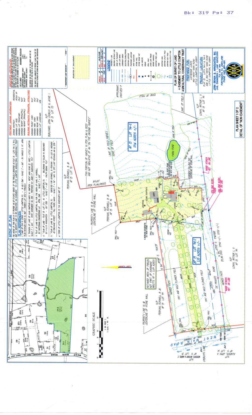
3 Bk= 319 Pgs 31 EXHIBIT A That approximately 26+/-acre portion of the real property located at West Main Road, Little Compton, Rhode Island, identified in the tax assessor's records in the Town of Little Compton as Plat 19, Lots 34-1 and 34-2 and generally set forth as a conveyed conservation easement and restrietions on the "Plan of Survey of Land & Easement to Little Compton Agricultural Conservancy Trust - Prepared for Catherine Conte Project Location: Plat 19 - Lots 34-1 & Little Compton, RI Latest Revision: 04/13/2018" annexed hereto and made a part hereof as Exhibit C ("Map"). For further identincation purposes, the following description delineates that portion of Town of Little Compton as Plat 19, Lots 34-1 and 34-2 that shall not be intentionally burdened by the conveyed conservation easement and restriction: Beginning at a point, the northwesterly corner of the herein described parcel as Illustrated on a Plan entitled "Plan of Survey of Land & Easement to Little Compton Agricultural Conservancy Trust - Prepared for Catherine Conte Project Location: Plat 19 - Lots 34-1 & Little Compton, RI Latest Revision: 04/13/2018", and said point also being located at a "drill hole set" on the westerly face of a stone wall on the easterly side of West Main Road, so called; Thence a northeasterly direction and a distance of ' to a point identified as a "rebar set"; Thence turning an interior angle of ' 05" and a distance of 73.63' to a point at an angle point of a stone wall, said point being marked by a "drill hole set"; Thence turning an interior angle of ' 27" and a distance of ' along the centerline of a stone wall to a point at the angle point of said stone wall, said point being marked by a "drill hole set"; Thence turning an interior angle of 93 08' 57" and a distance of ' along the centerline of the stone wall to a point at the angle point of said stone wall, said point being marked by a "drill hole set"; Thence turning an interior angle of 89 13' 37" and a distance of ' to a point at the end of a stone wall; Thence along the centerline of said stone wall the following distances; 9.1', 4.6', 19.0', 25.2T, & 35.99' to the Intersection of two stone walls; Thence turning an interior angle of 86 50' 43" and a distance of 53.42' along the centerline of a stone wall to a point at an angle point of a stone wall;
4 Bk= 319 Pss 32 Thence turning an interior angle of ' 59" and a distance of 48.27' along the centerline of a stone wall to an angle point of a stone wall; Thence turning an interior angle of ' 15" and a distance of 51.55' along the centerline of a stone wall to an angle point in said stone wall; Thence turning an interior angle of 94 04' 43 and a distance of 103.3T along the centerline of a stone wall and beyond the end of said stone wall to a point being marked by a "stone bound with a drill hole found"; Thence turning an interior angle of ' 59" and a distance of 96.10' to a point identified as a "rebar set"; Thence turning an interior angle of ' 31" and a distance of ' to a point on the westerly face of a stone wall on the easterly side of West Main Road, so called; said point being identified as a "drill hole set"; Thence in a northwesterly direction along the westerly face of said stone wall a distance of 50.00' to the point of beginning of the herein described parcel, said first and course having an interior angle of 92 20' 52" said parcel containing an area of 88, square feet of land; EXHIBIT B
5 Bk= 319 P3= 33 COVENANT REGARDING RESTRICTION OF PROPERTY TO AGRICULTURAL USES A. The GRANTOR covenant for herself, her heirs, devisees, legal representatives, sueeessors and assigns, that the protected property will at all times be held, used and conveyed subject to. and not used in violation of. the following restrietions and reversed: (1) No building, residential dwelling, tennis court, artificial swimming pool, asphalt driveway, road, parking lot. mobile home, utility pole, tower, conduit or line or other temporary or permanent structure or improvement requiring construction shall be constructed, placed or permitted to remain on the Protected Property, except as follows: (a) Structures existing on the Protected Property at the time of the execution of this covenant as identified and described within the Baseline Documentation Report: and (b) Those buildings, structures, utilizes, drives and roadways now existing or permitted herein. (2) No loam, peat, gravel, soil, sand, bed rock, other natural resource or deposit, or stone wall shall be excavated, dredged, or removed from the Protected Property unless approved by the Grantee under Section B below and removal is solely for use by the GRANTOR for the purpose of grading and maintaining the existing roadway, driveways and parking areas now located on the Protected Property. Except for the foregoing, no land which is currently in agricultural use shall be disturbed. The construction of an irrigation pond(s) is permitted. (3) No refuse, trash, vehicle bodies or parts, rubbish, debris, junk, waste, radioactive or hazardous waste or other substance or material whatsoever not normally used in accepted agricultural practices shall be placed, stored, dumped or permitted to remain on the Protected Property. Except that storage of agricultural products, byproducts (including the composting of biodegradable matter for use on the protected Property) produced on the Protected Property and agricultural equipment in use on the Property is allowable so long as such storage is done in accordance with all applicable laws and regulations and in such a manner so as to not impair the Conservation Values of the Protected Property. (4) No use shall be made of the Property, and no activity thereon shall be permitted which is or may be inconsistent with the intent of this grant, being the perpetual protection and preservation of agricultural lands and
6 Bks 319 P3= 34 Open spaee lands. No activity, including, but not limited to, drainage or flood control activities shall be carried on which is detrimental to the actual or potential agricultural use of the Property, or detrimental to water conservation, soil conservation, or to good agricultural and/or forestry management practices. (5) The Protected Property, subject to the terms of this Deed, shall be used for agricultural uses including engaging in any and all open field agricultural uses in accordance with sound, generally acceptable agricultural practices, and other uses directly related to or necessary in connection with agricultural uses. Permitted agricultural uses shall include the breeding, raising, pasturing and grazing of horses, donkeys, cattle, livestock and animals of any kind for production of food and fiber; turf farming: the breeding and raising of bees, planning, raising, harvesting and producing agricultural horticultural and forestry crops and vegetables and fruit crops. (6) Except for the plans referenced and described on page 1 of this Deed, no further subdivision or division of the Protected Property or any portion thereof shall be permitted. (7) The GRANTOR hereby reserves to and for themselves their heirs, devisees, legal representative, successor and assigns all other customary rights privileges ownership not prohibited or regulated by the time of this deed or inconsistent with the protection of the agricultural and conservation values. Except as specifically set forth herein nothing contained in this deed shall give or grant any right to enter upon or use the protected property or any portion thereof where no such right existed immediately prior to the execution of this deed. (8) In the event GRANTOR it successors or assigned should fail for a period of one year to comply with the stipulation herein contained the GRANTEE reserves the right to farm the protected property and raise crops that are presently or have historically been raised on the protected property. Should this event occur GRANTEE shall indemnify and hold GRANTOR its successor and assigns harmless Ifom the negligent acts or omissions of the local grantee its agents employees contractors and assigns (9) The trails and farm roads on the Protected Property existing on the effective date of this grant, as described in the baseline Documentation Report, must be maintained and used substantially in their present condition or as reasonably necessary for the agricultural uses thereof. Notwithstanding the foregoing, all structures, roadways, and any other impervious shall in no event exceed Two percent (2%) of the surface area of the Protected property. Subject to such Two percent (2%) impervious surface limit. (10) The GRANTOR hereby reserves the right to construct or place of buildings, structures, or parking areas for agricultural purposes, including buildings for related retail sales (all be subject to the prior written approval of the GRANTEE, as provided in Section B hereof. Any existing or permitted structures, paving, and
7 Bks 319 pgs 35 permanent, non-seasonal roofltops, are subject to an impervious surface limit of 2% of the area of the Protected Premises.
8 EXHIBIT C (MAP) V1
9
10 Bks 319 Pas 38 Filed in the Town Clerk's Office Little CofflPtom RI on APR 18f>i :15 All Witness TOWN CLERK
CONSERVATION EASEMENT AGREEMENT
 CONSERVATION EASEMENT AGREEMENT THIS INDENTURE made this day of, 20, by and between of the Town of, County of, and State of ( Grantor ), and the Town of Coventry, a municipal corporation having its territorial
Stormwater Ordinance Appendix APPENDIX K EXAMPLE TAR-PAM CONVERSATION EASEMENT
 APPENDIX K EXAMPLE TAR-PAM CONVERSATION EASEMENT Tax Parcel ID # NORTH CAROLINA FRANKLIN COUNTY CONSERVATION EASEMENT Franklin County, North Carolina THIS CONSERVATION EASEMENT (this "Conservation Easement")
CONSERVATION EASEMENT AND RESTRICTION
 CONSERVATION EASEMENT AND RESTRICTION The purpose of a Conservation Easement is to protect in perpetuity significant natural features and to minimize the environmental impact of activities associated with
DECLARATION OF RESTRICTIVE COVENANTS
 DECLARATION OF RESTRICTIVE COVENANTS The Declarant,, is the fee simple owner of the certain real property located in County, Kansas, as described on Exhibit A, which is attached hereto and incorporated
DEED OF AGRICULTURAL CONSERVATION EASEMENT TO THE COMMONWEALTH OF PENNSYLVANIA IN PERPETUITY
 Prepared By: Return To: UPI# DPERSF (6-2006) EXHIBIT C DEED OF AGRICULTURAL CONSERVATION EASEMENT TO THE COMMONWEALTH OF PENNSYLVANIA IN PERPETUITY THIS DEED OF AGRICULTURAL CONSERVATION EASEMENT, made
To achieve the conservation purposes, the following conditions and restrictions are set forth:
 DEED OF CONSERVATION EASEMENT (Conservation Subdivision District) STATE OF GEORGIA COUNTY OF COBB THIS DEED OF CONSERVATION EASEMENT (herein "Conservation Easement") is made this day of, 20, by and between
Municipal Lien Certificate - Little Compton, RI
 Municipal Lien Certificate - Little Compton, RI Per RIGL 44-7-11(a);, valid for recording through: 10/08/2016 te of certificate: 08/09/2016. enalty as of: 08/09/2016 Parcel: 031/0052-2C33 Location: l OO
50-Foot Non-Exclusive EASEMENT AGREEMENT
 50-Foot Non-Exclusive EASEMENT AGREEMENT THIS EASEMENT AGREEMENT is dated this day of _, 20, by Parker Task Force For Human Services (hereafter referred to as "Grantor"), having an address at 20118 East
MODEL DEED RESTRICTION FOR THE PENNSYLVANIA STATE PROGRAMMATIC GENERAL PERMIT-3 (PASPGP-3) DECLARATION OF RESTRICTIVE COVENANTS FOR CONSERVATION
 DECLARATION OF RESTRICTIVE COVENANTS FOR CONSERVATION") MODEL DEED RESTRICTION FOR THE PENNSYLVANIA STATE PROGRAMMATIC GENERAL PERMIT-3 (PASPGP-3) DECLARATION OF RESTRICTIVE COVENANTS FOR CONSERVATION THIS DECLARATION OF RESTRICTIVE COVENANTS FOR CONSERVATION
MODEL DEED RESTRICTION FOR THE PENNSYLVANIA STATE PROGRAMMATIC GENERAL PERMIT-3 (PASPGP-3) DECLARATION OF RESTRICTIVE COVENANTS FOR CONSERVATION THIS DECLARATION OF RESTRICTIVE COVENANTS FOR CONSERVATION
This document was prepared by: Albemarle County Attorney County of Albemarle 401 McIntire Road Charlottesville, Virginia 22902
 This document was prepared by: Albemarle County Attorney County of Albemarle 401 McIntire Road Charlottesville, Virginia 22902 Tax Map and Parcel Number This deed is exempt from taxation under Virginia
Examples of Agricultural Easement Language
 Examples of Agricultural Easement Language Compiled by: Judy Anderson, Columbia Land Conservancy Jerry Cosgrove, American Farmland Trust October 1999, Updated 2003 Based on the belief that a working, commercially-viable,
DEED AND DEDICATION FOR PUBLIC RIGHT OF WAY
 TO : BOARD OF DIRECTORS FROM : GARY PLATT, EXEC. DIRECTOR BUSINESS AND OPERATIONS SUBJECT : CITY OF STANWOOD CONSTRUCTION EASEMENT AND RIGHT-OF-WAY DEDICATION DATE : MARCH 17, 2009 TYPE : ACTION NEEDED
CORPORATE SPECIAL WARRANTY DEED FOR RIGHT OF WAY
 CORPORATE SPECIAL WARRANTY DEED FOR RIGHT OF WAY THIS INDENTURE WITNESSETH that ELI LILLY AND COMPANY, an Indiana corporation, ( Grantor ), as a gift and for no other consideration, CONVEYS ANDSPECIALLY
AGREEMENT FOR TEMPORARY CONSTRUCTION EASEMENT AND PERMANENT SEWER UTILITY EASEMENT
 AGREEMENT FOR TEMPORARY CONSTRUCTION EASEMENT AND PERMANENT SEWER UTILITY EASEMENT This Agreement for Temporary Construction Easement and Permanent Sewer Utility Easement (hereinafter the "Agreement")
GRANT OF TRAIL ACCESS EASEMENT, COVENANTS AND RESTRICTIONS
 This is a sample easement provided for discussion and illustrative purposes only. Easements for each property will be customized based upon the needs of each landowner and the Path. GRANT OF TRAIL ACCESS
WEST VIRGINIA DIVISION OF FORESTRY Cooperative Forest Legacy Program. Sample Conservation Easement
 WEST VIRGINIA DIVISION OF FORESTRY Cooperative Forest Legacy Program Sample Conservation Easement This document is included in the forest legacy kit as an example for information and possible guidance
Forested Buffer Water Resource Easement Carroll County, Maryland
 Forested Buffer Water Resource Easement Carroll County, Maryland FORESTED BUFFER WATER RESOURCE EASEMENT THIS DEED OF EASEMENT, made this day of, in the year nineteen hundred and ninety-five, by and between,
AMENDED DEED OF CONSERVATION EASEMENT
 Prepared by: Wayne E. Flowers Lewis, Longman & Walker, P.A. 245 Riverside Ave. Suite 150 Jacksonville, FL 32202 Return recorded original to: Mitigation Marketing 1091 W. Morse Blvd. Suite 101 Winter Park,
Dated October 14, 1966 As to Acknowledged October 14, 1966 University Hills No. 2 Subdivision Reported October 18, 1966 Liber 1954, Page 28
 Orchard Lane Land Company Declaration of Restrictions Dated October 14, 1966 As to Acknowledged October 14, 1966 University Hills No. 2 Subdivision Reported October 18, 1966 Liber 1954, Page 28 This Declaration,
DECLARATION OF PARTY WALL RIGHTS, COVENANTS, CONDITIONS, RESTRICTIONS AND EASEMENTS
 DECLARATION OF PARTY WALL RIGHTS, COVENANTS, CONDITIONS, RESTRICTIONS AND EASEMENTS This Declaration of Party Wall Rights, Covenants, Conditions, Restrictions and Easements (the Declaration) is made this
EASEMENT DEED. 2) Thence N 60º12 36 W through said Parcel 1 a distance of Two Hundred Ninety- Five and 97/100 (295.97) feet to a point;
 Thence N 60º12 36 W through said Parcel 1 a distance of Two Hundred Ninety- Five and 97/100 (295.97) feet to a point;") EASEMENT DEED TALL TREES CONSTRUCTION CORP., a Maine corporation having a mailing address of 30 Preservation Drive, Falmouth, Maine 04105 (the "Grantor") for consideration paid, grants to the TOWN OF FALMOUTH,
EASEMENT DEED TALL TREES CONSTRUCTION CORP., a Maine corporation having a mailing address of 30 Preservation Drive, Falmouth, Maine 04105 (the "Grantor") for consideration paid, grants to the TOWN OF FALMOUTH,
TEMPORARY CONSTRUCTION EASEMENT AND AGREEMENT
 Recording Requested By and When Recorded Mail to: City Clerk City of Albany 1000 San Pablo Avenue Albany, CA 94706 TEMPORARY CONSTRUCTION EASEMENT AND AGREEMENT No recording fee pursuant to Government
DECLARATION OF RESTRICTIVE COVENANTS
 STATE OF MARYLAND COUNTY OF DECLARATION OF RESTRICTIVE COVENANTS THIS DECLARATION OF RESTRICTIVE COVENANTS is made this day of, 20, by ( Declarant(s) ). RECITALS WHEREAS, Declarant(s) is/are the owner(s)
THIS DEED OF EASEMENT AND AGREEMENT Archaeological Resource Preservation Easement
 THIS DEED OF EASEMENT AND AGREEMENT Archaeological Resource Preservation Easement THIS DEED OF EASEMENT AND AGREEMENT ( Easement ), made this day of, 20, between, (hereinafter called Property Owner(s)
DEED OF EASEMENT STATE OF NEW JERSEY AGRICULTURE RETENTION AND DEVELOPMENT PROGRAM. This Deed is made, 20. BETWEEN, and is referred to as the Grantor;
 DEED OF EASEMENT E3E Page 1 of 7 STATE OF NEW JERSEY AGRICULTURE RETENTION AND DEVELOPMENT PROGRAM This Deed is made, 20 BETWEEN whose address is, and is referred to as the Grantor; AND the State Agriculture
NON-EXCLUSIVE EASEMENT AGREEMENT
 Prepared by: Catherine D. Reischmann, Esq. 111 N. Orange Ave., Ste. 2000 Orlando, FL 32801 Return to: City Clerk City of Palm Coast 160 Cypress Point Parkway, Ste. B-106 Palm Coast, FL 32164 NON-EXCLUSIVE
DEED OF EASEMENT STATE OF NEW JERSEY AGRICULTURE RETENTION AND DEVELOPMENT PROGRAM. BETWEEN, whose address is and is referred to as the Grantor;
 Page 1 of 8 E3-E DEED OF EASEMENT STATE OF NEW JERSEY AGRICULTURE RETENTION AND DEVELOPMENT PROGRAM This Deed is made, 20. BETWEEN, whose address is and is referred to as the Grantor; AND, whose address
MEMORANDUM. Mayor and City Council. Warren Hutmacher, City Manager. Date: February 11, 2013
 MEMORANDUM To: From: Mayor and City Council Warren Hutmacher, City Manager Date: February 11, 2013 Subject: Approval of an Intergovernmental agreement by and between the City of Dunwoody and DeKalb County
MODEL CONSERVATION EASEMENT. January 18, 2001 Rev d October 16, 2002 Rev d August, 2003
 MODEL CONSERVATION EASEMENT January 18, 2001 Rev d October 16, 2002 Rev d August, 2003 Model Conservation Easement for use in preserving mitigation property. Language in italics is instructional, and should
EASEMENT AGREEMENT. WHEREAS, Hall Brothers owns certain real property located in Weber County, Utah ( Hall Brothers Property );
;") When Recorded Return to: Parcel No. EASEMENT AGREEMENT THIS EASEMENT AGREEMENT ( Agreement ) is entered into this day of, 2016 by and between VALLEY DREAMS PROPERTIES, LLC, a Utah limited liability company
When Recorded Return to: Parcel No. EASEMENT AGREEMENT THIS EASEMENT AGREEMENT ( Agreement ) is entered into this day of, 2016 by and between VALLEY DREAMS PROPERTIES, LLC, a Utah limited liability company
City of East Providence
 City of East Providence 145 TAUNTON AVENUE, EAST PROVIDENCE STATE OF RHODE ISLAND AND PROVIDENCE PLANTATIONS 02914-4505 TEL. (401) 435-7521 FAX (401) 438-1719 TDD (401) 431-1633 CITY MANAGER PETER GRACZYKOWSKI
MEETING TYPE: Board of Commissioners - Regular. MEETING DATE: 23 May STAFF RESPONSIBLE: Matt Hubert. DEPARTMENT: Development Services Department
 MEETING TYPE: Board of Commissioners - Regular MEETING DATE: 23 May 2017 STAFF RESPONSIBLE: Matt Hubert DEPARTMENT: Development Services Department DESCRIPTION Approval of Easement Agreement To approve
CHAPTER 2 RELATED DOCUMENTS AND FORMS
 CHAPTER 2 RELATED DOCUMENTS AND FORMS TABLE OF CONTENTS CHAPTER 2 RELATED DOCUMENTS AND FORMS Resolution R00- Establishing Public Improvement Design Standards Page 1 Current Plans Review & Construction
BILL NO (Emergency Measure) ORDINANCE NO. 5072
 ORDINANCE NO. 5072") BILL NO. 5210 (Emergency Measure) ORDINANCE NO. 5072 AN ORDINANCE AUTHORIZING THE MAYOR TO EXECUTE WITH MICHELSON-HADLEY HEIGHTS DEVELOPMENT, LLC, A CONTRACT AND QUIT CLAIM DEED CONVEYING CERTAIN PROPERTIES
BILL NO. 5210 (Emergency Measure) ORDINANCE NO. 5072 AN ORDINANCE AUTHORIZING THE MAYOR TO EXECUTE WITH MICHELSON-HADLEY HEIGHTS DEVELOPMENT, LLC, A CONTRACT AND QUIT CLAIM DEED CONVEYING CERTAIN PROPERTIES
DEED OF EASEMENT AND AGREEMENT Forest Conservation Easement
 DEED OF EASEMENT AND AGREEMENT Forest Conservation Easement THIS DEED OF EASEMENT AND AGREEMENT, made this day of, 20, between ( Property Owner ), and Anne Arundel County, Maryland, a body corporate and
Tax Map Key Nos. (1) : 003, :004 and :008 CPR No. Total Pages: Unit No.
 : 003, :004 and :008 CPR No. Total Pages: Unit No.") LAND COURT SYSTEM AFTER RECORDATION: RETURN BY MAIL ( ) PICK UP ( ) REGULAR SYSTEM Tax Map Key Nos. (1) 2-3-016: 003, :004 and :008 CPR No. Total Pages: Unit No. LIMITED WARRANTY UNIT DEED, ENCUMBRANCES
LAND COURT SYSTEM AFTER RECORDATION: RETURN BY MAIL ( ) PICK UP ( ) REGULAR SYSTEM Tax Map Key Nos. (1) 2-3-016: 003, :004 and :008 CPR No. Total Pages: Unit No. LIMITED WARRANTY UNIT DEED, ENCUMBRANCES
Stormwater Treatment Facility Maintenance Agreement
 Stormwater Treatment Facility Maintenance Agreement This Agreement made and entered into this day of, 20, by, (hereinafter referred to as Property Owner") RECITALS: WHEREAS, the Property Owner is the owner
RESOLUTION NO. A RESOLUTION AUTHORIZING EXECUTION OF AN EASEMENT AGREEMENT TO ILLINOIS BELL TELEPHONE COMPANY D.B.A. AT&T ILLINOIS
 RESOLUTION NO. A RESOLUTION AUTHORIZING EXECUTION OF AN EASEMENT AGREEMENT TO ILLINOIS BELL TELEPHONE COMPANY D.B.A. AT&T ILLINOIS BE IT RESOLVED by the Village Council of the Village of Downers Grove,
DECLARATIONS OF COVENANTS, RESTRICTIONS, CONDITIONS AND RESERVATIONS
 THIS DECLARATION, made this 30 th day of December, 1969, by Jasper Valley Development Corporation, hereinafter called the Developer. WITNESSETH: Whereas, Developer is the owner of the real property described
WATER CONSERVATION EASEMENT
 WHEN RECORDED RETURN TO: Washington County Water Conservancy District 533 East Waterworks Dr. St. George, Utah 84770 Space Above This Line for Recorder s Use Serial No. WATER CONSERVATION EASEMENT THIS
PERMANENT DEEP TUNNEL EASEMENT AGREEMENT
 PERMANENT DEEP TUNNEL EASEMENT AGREEMENT Project Number: 75918 Project Name: Three Rivers Protection & Overflow Reduction Tunnel [3RPORT] Cross Reference Document(s): Deed Record F, page 481; Deed Book
WENTWORTH PHASE 1. RESTRICTIVE COVENANT AND EASEMENT Pursuant to Sections 48(1) and 68(1) of the Land Titles Act, Alberta
 and 68(1) of the Land Titles Act, Alberta") WW1SF-RC -1- RESTRICTIVE COVENANT AND EASEMENT Pursuant to Sections 48(1) and 68(1) of the Land Titles Act, Alberta RECITALS: 101. Dundee Development Corporation (herein called Dundee ), a body corporate
WW1SF-RC -1- RESTRICTIVE COVENANT AND EASEMENT Pursuant to Sections 48(1) and 68(1) of the Land Titles Act, Alberta RECITALS: 101. Dundee Development Corporation (herein called Dundee ), a body corporate
DECLARATION OF PROTECTIVE COVENANTS FOR UTE MESA SUBDIVISION
 DECLARATION OF PROTECTIVE COVENANTS FOR UTE MESA SUBDIVISION KNOW ALL MEN BY THESE PRESENTS THAT: WHEREAS, Chubb Investments, Inc., a Colorado Corporation, is owner of certain real estate situate, lying,
DEED OF EASEMENT & MAINTENANCE AGREEMENT FOR STORMWATER MANAGEMENT FACILITIES THIS DEED OF EASEMENT AND MAINTENANCE AGREEMENT FOR
 (The City of Chesapeake is exempt from recordation taxes pursuant to Section 58.1-811.A.3. and Grantors are exempt pursuant to Section 58.1-811.C.5. of the 1950 Code of Virginia as amended.) DEED OF EASEMENT
DECLARATION OF COVENANTS, CONDITIONS AND RESTRICTIONS HICKORY NUT OF WILDEWOOD ASSOCIATION, INC.
 DECLARATION OF COVENANTS, CONDITIONS AND RESTRICTIONS OF HICKORY NUT OF WILDEWOOD ASSOCIATION, INC. THIS DECLARATION, made and entered into this 17 th day of February, 1987 by PARAGON BUILDERS, INC., a
RIGHT OF WAY AND COMMON DRIVEWAY AGREEMENT SUN8 PDC, LLC, c/o DISTRIBUTED SUN, LLC SUBDIVISION DRYDEN, NEW YORK
 RIGHT OF WAY AND COMMON DRIVEWAY AGREEMENT SUN8 PDC, LLC, c/o DISTRIBUTED SUN, LLC SUBDIVISION DRYDEN, NEW YORK THIS RIGHT OF WAY AGREEMENT ( Agreement ) is made this day of, 2017 by SCOTT PINNEY, an individual
This Deed is Exempt from Taxation under Virginia Code (A)(3) and (C)(4) [no retention of dwelling unit rights] PIN DEED OF EASEMENT
![This Deed is Exempt from Taxation under Virginia Code (A)(3) and (C)(4) [no retention of dwelling unit rights] PIN DEED OF EASEMENT](/thumbs/84/89690785.jpg "This Deed is Exempt from Taxation under Virginia Code (A)(3) and (C)(4) [no retention of dwelling unit rights] PIN DEED OF EASEMENT") This Deed is Exempt from Taxation under Virginia Code 58.1-811(A)(3) and 58.1-811(C)(4) [no retention of dwelling unit rights] PIN DEED OF EASEMENT THIS DEED OF EASEMENT made this day of, 2007, by and
This Deed is Exempt from Taxation under Virginia Code 58.1-811(A)(3) and 58.1-811(C)(4) [no retention of dwelling unit rights] PIN DEED OF EASEMENT THIS DEED OF EASEMENT made this day of, 2007, by and
CONVEYANCE - COMMONWEALTH PROPERTY IN DELAWARE TOWNSHIP, NORTHUMBERLAND COUNTY, TO THE WARRIOR RUN-FORT FREELAND HERITAGE SOCIETY
 CONVEYANCE - COMMONWEALTH PROPERTY IN DELAWARE TOWNSHIP, NORTHUMBERLAND COUNTY, TO THE WARRIOR RUN-FORT FREELAND HERITAGE SOCIETY Act of Oct. 30, 2017, P.L., No. 47 Cl. 85 An Act Authorizing the Department
THIS DEED OF CONSERVATION EASEMENT
 NOTICE TO TITLE EXAMINERS: THIS DEED OF CONSERVATION EASEMENT CONTAINS COVENANTS THAT INCLUDE RESTRICTIONS ON THE USE, SUBDIVISION AND OFF-CONVEYANCE OF LAND. THIS DEED OF CONSERVATION EASEMENT ("Conservation
CHAPTER 8 MODEL AGRICULTURAL CONSERVATION EASEMENT WITH OPTION TO PURCHASE
 CHAPTER 8 MODEL AGRICULTURAL CONSERVATION EASEMENT WITH OPTION TO PURCHASE (Section-by-section commentary on this model document appears in Chapter 9.) THIS CONSERVATION EASEMENT WITH OPTION TO PURCHASE
Wilmington District Process for Preservation of Mitigation Property
 November 25, 2003 Wilmington District Process for Preservation of Mitigation Property The Wilmington District Regulatory Branch (District), consistent with Corps of Engineers guidance, often accepts or
QUIT CLAIM DEED (Pursuant to F. S )
") Page 1 of 10 Return signed document to: M. Andrée Hammond, Asst. R.E. Officer Real Property Section 115 S. Andrews Avenue, Room 501 Fort Lauderdale, FL 33301 This instrument prepared by: Broward County
Page 1 of 10 Return signed document to: M. Andrée Hammond, Asst. R.E. Officer Real Property Section 115 S. Andrews Avenue, Room 501 Fort Lauderdale, FL 33301 This instrument prepared by: Broward County
See Exhibit "A", attached hereto, incorporated herein, and by this reference made a part hereof.
 Pinellas Suncoast Transit Authority HD Gateway Ulmerton 115kV Rebuild Thor #: 2801T1 Oracle #: 30000935 Site #: 108267 Land Unit: 1696232 Project #: 108267-458563 Prepared By: Bruce C. Crawford, Esq. Crawford
PIPELINE RIGHT-OF-WAY EASEMENT
 PIPELINE RIGHT-OF-WAY EASEMENT THIS RIGHT-OF-WAY EASEMENT made this day of March, 2014, by the City of Rochester Hills, a municipal corporation in the State of Michigan,, having an address at 1000 Rochester
DECLARATION OF COVENANTS CONDITIONS AND RESTRICTIONS
 DECLARATION OF COVENANTS CONDITIONS AND RESTRICTIONS This Declaration, made on the date hereinafter set forth by PAREC Realty Skippack Associates, a Pennsylvania Limited Partnership, (hereinafter referred
THIRD AMENDED DECLARATION OF COVENANTS, CONDITIONS AND RESTRICTIONS FOR TIMBER RIDGE
 THIRD AMENDED DECLARATION OF COVENANTS, CONDITIONS AND RESTRICTIONS FOR TIMBER RIDGE THE STATE OF TEXAS KNOW ALL MEN BY THESE PRESENTS: COUNTY OF BURNET WHEREAS, TIMBER RIDGE is an unrecorded subdivision
DECLARATION OF RESTRICTIVE COVENANTS OF FALLS CREEK SUBDIVISION
 DECLARATION OF RESTRICTIVE COVENANTS OF FALLS CREEK SUBDIVISION KNOW ALL MEN BY THESE PRESENTS, that Falls Creek, Inc. (hereinafter referred to as Developer), is the owner and developer of that certain
PURCHASE AND SALE AGREEMENT
 PURCHASE AND SALE AGREEMENT THIS AGREEMENT made this day of July, 2017, by and between JPMCC 2011- C5 APPLETREE MALL LLC, having an address at c/o Torchlight Loan Services, 475 5th Avenue, 10 th Floor,
SOUTH DAKOTA BOARD OF REGENTS. Budget and Finance ******************************************************************************
 SOUTH DAKOTA BOARD OF REGENTS Budget and Finance AGENDA ITEM: 6 K DATE: October 2-4, 2018 ****************************************************************************** SUBJECT USD Discovery District:
MODEL DEED RESTRICTION
 MODEL DEED RESTRICTION This type of Protective Covenant is the most commonly used. It is a legal agreement between the grantor, typically the property owner or applicant, and the Corps. Please view instructions
DECLARATION OF RESTRICTIVE COVENANTS. THIS DECLARATION OF RESTRICTIVE COVENANTS made this day of, 200_, by ( Declarant ). RECITALS
. RECITALS") DECLARATION OF RESTRICTIVE COVENANTS THIS DECLARATION OF RESTRICTIVE COVENANTS made this day of, 200_, by ( Declarant ). RECITALS WHEREAS, Declarant is the owner of the surface of certain real property
DECLARATION OF RESTRICTIVE COVENANTS THIS DECLARATION OF RESTRICTIVE COVENANTS made this day of, 200_, by ( Declarant ). RECITALS WHEREAS, Declarant is the owner of the surface of certain real property
DOCUMENT VET SHEET for Karen McConnaughay Chairman, Kane County Board
 DOCUMENT VET SHEET for Karen McConnaughay Chairman, Kane County Board Name of Document: Temporary Construction Easement for Grading Purposes between Geneva School District and Counzy of Kane Submitted
DEED OF DEDICATION, BOUNDARY LINE ADJUSTMENT, CONVEYANCE, VACATION, TRUST MODIFICATION AND RELEASE (Minor Adjustment of Property Lines)
") Prepared by/return to: Reed Smith LLP 7900 Tysons One Place, Suite 500 McLean, VA 22102-5979 Attn: Robert M. Diamond, Esq. Parcel ID Nos.: 58 2 10 01 001 58 2 10 01 002 58 2 10 01 003 58 2 10 01 004 58
Prepared by/return to: Reed Smith LLP 7900 Tysons One Place, Suite 500 McLean, VA 22102-5979 Attn: Robert M. Diamond, Esq. Parcel ID Nos.: 58 2 10 01 001 58 2 10 01 002 58 2 10 01 003 58 2 10 01 004 58
THIS DECLARATION OF RESTRICTIVE COVENANTS is made this day of, 20, by ("Covenantor"). RECITALS
. RECITALS") Model for Use with Permits Without Mitigation Plans STATE OF COUNTY OF DECLARATION OF RESTRICTIVE COVENANTS THIS DECLARATION OF RESTRICTIVE COVENANTS is made this day of, 20, by ("Covenantor"). RECITALS
Model for Use with Permits Without Mitigation Plans STATE OF COUNTY OF DECLARATION OF RESTRICTIVE COVENANTS THIS DECLARATION OF RESTRICTIVE COVENANTS is made this day of, 20, by ("Covenantor"). RECITALS
THIS CONVEYANCE IS SUBJECT TO
 Page 1 of 10 Return signed document to: Property Agent Real Property Section 115 S. Andrews Avenue, Room 326 Fort Lauderdale, FL 33301 Formatted: Top: 1.19" Field Code Changed This instrument prepared
FEE SIMPLE OPTION AGREEMENT Ecosystem Enhancement Program SPO File Number
 STATE OF NORTH CAROLINA COUNTY OF Prepared by State Property Office Return after recording to: Blane Rice, State Property Office 1321 Mail Service Center Raleigh, NC 27699-1321 FEE SIMPLE OPTION AGREEMENT
CONSERVATION EASEMENT
 When recorded return to: City of Milton Attn: City Clerk 13000 Deerfield Parkway, Suite 107-F Milton, GA 30004 CONSERVATION EASEMENT THIS DEED OF CONSERVATION EASEMENT ("Easement") is made by having an
EASEMENT AGREEMENT. WHEREAS, Ferguson is the 100% owner of the property described on Exhibit B attached hereto (the Williams Property );
;") EASEMENT AGREEMENT THIS EASEMENT AGREEMENT ( Agreement ) is entered into as of this day of, 2016, by and between CRAIG FERGUSON ( Ferguson ), and MAMIE DAVIS and JERRY MOORE ( Davis & Moore ), whose legal
EASEMENT AGREEMENT THIS EASEMENT AGREEMENT ( Agreement ) is entered into as of this day of, 2016, by and between CRAIG FERGUSON ( Ferguson ), and MAMIE DAVIS and JERRY MOORE ( Davis & Moore ), whose legal
EASEMENT AGREEMENT (Distributor Performance Non-Exclusive)
") EASEMENT AGREEMENT (Distributor Performance Non-Exclusive) THIS EASEMENT AGREEMENT, effective the day of, 20, is made between WITNESSETH:, hereafter called Grantor, (whether grammatically singular or plural)
EASEMENT AGREEMENT (Distributor Performance Non-Exclusive) THIS EASEMENT AGREEMENT, effective the day of, 20, is made between WITNESSETH:, hereafter called Grantor, (whether grammatically singular or plural)
ORDINANCE NO
 DRAFT NO. 09-90 ORDINANCE NO. 2009-81 AN ORDINANCE ACCEPTING FOR DEDICATION PURPOSES, A SANITARY SEWER EASEMENT FROM THE STATE OF OHIO FOR THE GREEK VILLAGE ON KENT STATE UNIVERSITY PROPERTY AND DECLARING
SCHEDULE U : EASEMENT FOR PARKING TERMS OF INSTRUMENT PART 2
 SCHEDULE U : EASEMENT FOR PARKING [attach Land Title Act Form C General Filing Instrument Part 1] TERMS OF INSTRUMENT PART 2 This Easement dated for reference the day of,. BETWEEN: AND AND WHEREAS: bcimc
SOUTH DAKOTA BOARD OF REGENTS. Budget and Finance ******************************************************************************
 SOUTH DAKOTA BOARD OF REGENTS Budget and Finance AGENDA ITEM: 7 U DATE: October 4-6 ****************************************************************************** SUBJECT: SDSU 6 th Street Land Sale for
DECLARATION OF COVENANTS, CONDITIONS AND RESTRICTIONS THE STATE OF TEXAS KNOW ALL MEN BY THESE PRESENTS THAT: COUNTY OF GILLESPIE
 DECLARATION OF COVENANTS, CONDITIONS AND RESTRICTIONS THE STATE OF TEXAS KNOW ALL MEN BY THESE PRESENTS THAT: COUNTY OF GILLESPIE WHEREAS, HOHS, LTD., is the owner of that 172.71 acre tract of land situated
DEED OF EASEMENTS PREPARED BY, AND WHEN RECORDED RETURN TO:
 Addendum-12-14-13-C1-4736 Lee Highway Easements - Page 1 PREPARED BY, AND WHEN RECORDED RETURN TO: Real Estate Bureau Chief Department of Environmental Services Arlington County Government 2100 Clarendon
DEED OF EASEMENT Utility Line and Grinder Pump
 RECORD AND RETURN TO: Jerry Jackson City of LaPorte, Wastewater Department 2101 Boyd Blvd, LaPorte IN 46350 DEED OF EASEMENT Utility Line and Grinder Pump THIS DEED OF EASEMENT, made this day of,, by (insert
THE GENERAL ASSEMBLY OF PENNSYLVANIA SENATE BILL AN ACT
 PRINTER'S NO. THE GENERAL ASSEMBLY OF PENNSYLVANIA SENATE BILL No. INTRODUCED BY VANCE, APRIL, 00 REFERRED TO STATE GOVERNMENT, APRIL, 00 Session of 00 AN ACT 0 0 Authorizing the Department of General
Micro Scale Practices Declaration
 Micro Scale Practices Declaration THIS DECLARATION, made this day of, by, hereinafter OWNERS WHEREAS, on May 3, 2011, Cecil County adopted the Cecil County Stormwater Management Ordinance which establishes
ARTICLES OF INCORPORATION COUNTRY LAKES HOMEOWNERS ASSOCIATION, INC.
 ARTICLES OF INCORPORATION OF COUNTRY LAKES HOMEOWNERS ASSOCIATION, INC. The undersigned, a natural person at least twenty-one years of age, for the purposes of forming a Corporation pursuant to the provisions
Case 1:01-cv BLW Document Filed 01/18/11 Page 120 of 152 EXHIBIT I ) ) ) ) ) ) ) ) ) ) ) ) ) ) ) ) ) )
 ) ) ) ) ) ) ) ) ) ) ) ) ) ) ) ) )") Case 1:01-cv-00286-BLW Document 202-2 Filed 01/18/11 Page 120 of 152 EXHIBIT I DENNIS KOYLE, CHARLES K. TURNER, and the CARAVELLE CORPORATION, INC. on behalf of themselves and all others similarly situated,
Case 1:01-cv-00286-BLW Document 202-2 Filed 01/18/11 Page 120 of 152 EXHIBIT I DENNIS KOYLE, CHARLES K. TURNER, and the CARAVELLE CORPORATION, INC. on behalf of themselves and all others similarly situated,
DECLARATION OF DECLARANT SEPTEMBER 2007
 DECLARATION OF COVENANTS, CONDITIONS AND RESTRICTIONS EPHRAIM INDUSTRIAL PARK II DECLARANT EPHRAIM CITY, UTAH SEPTEMBER 2007 - Ind. Park II.DOC 0895805/HCH/msp (2126677) THIS DECLARATION is made as of
COUNCIL AGENDA MEMO ITEM NO. III - #1
 COUNCIL AGENDA MEMO ITEM NO. III - #1 FROM: Anton Jelinek, Director of Utilities MEETING: October 24, 2017 SUBJECT: PRESENTER: Permanent Utility and Right-of-Way Easement Anton Jelinek Discussion: At the
ORDINANCE NO
 Draft No. 12-21 ORDINANCE NO. 2012-23 AN ORDINANCE ACCEPTING A RIGHT-OF-WAY AND UTILITY EASEMENT FOR WATER LINES, SEWER LINES, STORM SEWER LINES AND SUCH OTHER UTILITIES AS ARE NEEDED FROM THE CARTER JONES
Explanation of Permanent Stormwater Management Facilities Maintenance Agreement
 Explanation of Permanent Stormwater Management Facilities Maintenance Agreement The Permanent Stormwater Management Facilities Maintenance Agreement for a site is comprised of the following elements: 1.
PERMANENT DRAINAGE EASEMENT
 City Project No. Project Name: ; Tr. # Parcel No. (LLC, Corporation, Partnership) PERMANENT DRAINAGE EASEMENT THIS AGREEMENT, made and entered into this day of, 201, by and between, a, hereinafter called
CITY OF TONKA BAY HENNEPIN COUNTY, MINNESOTA DEVELOPMENT AGREEMENT REGARDING THE SUNRISE ADDITION SUBDIVISION
 CITY OF TONKA BAY HENNEPIN COUNTY, MINNESOTA DEVELOPMENT AGREEMENT REGARDING THE SUNRISE ADDITION SUBDIVISION THIS DEVELOPMENT AGREEMENT ( Agreement ) is made and entered into this day of, 2016, by and
TOWNSHIP OF LOWER MERION Department of Public Works
 EXHIBIT B TOWNSHIP OF LOWER MERION Department of Public Works MEMORANDUM TO: Douglas S. Cleland, Township Manager FROM: Donald K. Cannon, Director of Public Works SUBJECT: 1200 Farview Road Sanitary Sewer
WATER LINE & INGRESS/EGRESS EASEMENT AGREEMENT WITNESSETH:
 Prepared by and return to: Carie E. Shealy, MMC, City Clerk City of Cocoa 65 Stone Street Cocoa, Florida 32922 Parcel ID. #(s): WATER LINE & INGRESS/EGRESS EASEMENT AGREEMENT THIS EASEMENT AGREEMENT is
APPROVAL REQUIRED... A5 APPLICATION FOR APPROVAL OF PRELIMINARY PLAN... A6 APPLICATION FOR APPROVAL OF DEFINITIVE PLAN... A7
 APPENDIX FORM A. FORM A-2. FORM A-3. FORM B. FORM C. FORM C-1. FORM C-2. FORM D. FORM E. FORM F. FORM G. FORM H. FORM I. FORM J. FORM J-1. FORM K. FORM K-1 FORM L Form M. APPLICATION FOR A DETERMINATION
RECORD OF ORDINANCES
 RECORD OF ORDINANCES Ordinance No. 2016-8 August 8, 2016 City of Bellbrook Ordinance No. 2016-8 An Ordinance Granting an Easement to the State of Ohio, Department of Transportation for Improvements to
PERMANENT EASEMENT AGREEMENT. good and valuable consideration, the sufficiency and receipt of which is hereby acknowledged, The Esther Harrison
 PERMANENT EASEMENT AGREEMENT For and in consideration of the sum of Seven thousand thirty and 00/100 dollars ($7,030.00) and other good and valuable consideration, the sufficiency and receipt of which
(Space above this line reserved for Recorder of Deeds)
") (Space above this line reserved for Recorder of Deeds) STORMWATER MANAGEMENT and BEST MANAGEMENT PRACTICES FACILITIES MAINTENANCE AGREEMENT COVER PAGE Date: Grantor: Grantee: Property Owner Owner's Address
(Space above this line reserved for Recorder of Deeds) STORMWATER MANAGEMENT and BEST MANAGEMENT PRACTICES FACILITIES MAINTENANCE AGREEMENT COVER PAGE Date: Grantor: Grantee: Property Owner Owner's Address
DEED OF CONSERVATION EASEMENT WITNESS THAT:
 DEED OF CONSERVATION EASEMENT THIS DEED OF CONSERVATION EASEMENT is made on this day of, 20, by, having an address of, ( Grantor ), and Compatible Lands Foundation. an Oklahoma nonprofit public benefit
DECLARATION OF DRAINAGE EASEMENTS. Document No. Document Title. (Declarant) Recording Data Return Address
 Recording Data Return Address") Document No. DECLARATION OF DRAINAGE EASEMENTS Document Title (Declarant) Recording Data Return Address DOCUMENT PREPARED BY AND AFTER RECORDING RETURN TO: Parcel No. - - - - - - DECLARATION OF DRAINAGE
Document No. DECLARATION OF DRAINAGE EASEMENTS Document Title (Declarant) Recording Data Return Address DOCUMENT PREPARED BY AND AFTER RECORDING RETURN TO: Parcel No. - - - - - - DECLARATION OF DRAINAGE
PERPETUAL STORM WATER DRAINAGE EASEMENT (Non-Exclusive) This Non-Exclusive Perpetual Storm Water Drainage Easement (this Easement ) is
 This Non-Exclusive Perpetual Storm Water Drainage Easement (this Easement ) is") Magnolia Park COM15-0081 T4N, R1E, Section13 (Space Above Reserved for Ada County Recorder s Office) PERPETUAL STORM WATER DRAINAGE EASEMENT (Non-Exclusive) This Non-Exclusive Perpetual Storm Water Drainage
Magnolia Park COM15-0081 T4N, R1E, Section13 (Space Above Reserved for Ada County Recorder s Office) PERPETUAL STORM WATER DRAINAGE EASEMENT (Non-Exclusive) This Non-Exclusive Perpetual Storm Water Drainage
GENERAL INSTRUMENT - PART 1 (This area for Land Title Office use) Page 1 of pages
 Page 1 of pages") LAND TITLE ACT FORM C (Section 233) Province of British Columbia GENERAL INSTRUMENT - PART 1 (This area for Land Title Office use) Page 1 of pages 1. APPLICATION: (Name, address, phone number and signature
LAND TITLE ACT FORM C (Section 233) Province of British Columbia GENERAL INSTRUMENT - PART 1 (This area for Land Title Office use) Page 1 of pages 1. APPLICATION: (Name, address, phone number and signature
DECLARATION OF COVENANTS. CONDITIONS AND RESTRICTIONS
 FILED in Perquimans Count, NC On Apr 04 2000 at 01:30:43 PM By Deborah S. Reed Register of Deeds BOOK 204 PAGE 747 STATE OF NORTH CAROLINA 40-101 South COUNTY OF PERQUIMANS DECLARATION OF COVENANTS. CONDITIONS
CONTRACT TO BUY AND SELL REAL ESTATE
 CONTRACT TO BUY AND SELL REAL ESTATE THIS CONTRACT TO BUY AND SELL REAL ESTATE ( Contract ) is made and entered into as of April 9, 2018 (the Effective Date ) by and between the City of Pueblo, Colorado,
PURCHASE AND SALE AGREEMENT AND ESCROW INSTRUCTIONS [292 STOCKTON AVENUE]
![PURCHASE AND SALE AGREEMENT AND ESCROW INSTRUCTIONS [292 STOCKTON AVENUE]](/thumbs/79/79090901.jpg "PURCHASE AND SALE AGREEMENT AND ESCROW INSTRUCTIONS [292 STOCKTON AVENUE]") PURCHASE AND SALE AGREEMENT AND ESCROW INSTRUCTIONS [292 STOCKTON AVENUE] This Purchase and Sale Agreement and Escrow Instructions ( Agreement ) is entered into as of this day of, 2017, by and between
PURCHASE AND SALE AGREEMENT AND ESCROW INSTRUCTIONS [292 STOCKTON AVENUE] This Purchase and Sale Agreement and Escrow Instructions ( Agreement ) is entered into as of this day of, 2017, by and between
WAKE COUNTY STORMWATER CONTROL STRUCTURE AND ACCESS EASEMENT AND AGREEMENT (Corporate)
") Return to: Matthew Flynn Stormwater Field Services Administrator Water Resources Department Town of Cary PO Box 8005, Cary, NC 27512 NORTH CAROLINA WAKE COUNTY STORMWATER CONTROL STRUCTURE AND ACCESS EASEMENT
Return to: Matthew Flynn Stormwater Field Services Administrator Water Resources Department Town of Cary PO Box 8005, Cary, NC 27512 NORTH CAROLINA WAKE COUNTY STORMWATER CONTROL STRUCTURE AND ACCESS EASEMENT
BEACH STORM DAMAGE REDUCTION EASEMENT
 STATE OF FLORIDA COUNTY OF WALTON WALTON COUNTY, FL HURRICANE & STORM DAMAGE REDUCTION PROJECT FILE/REACH#: PARCEL ID#: BEACH STORM DAMAGE REDUCTION EASEMENT KNOW ALL MEN BY THESE PRESENTS, that for and