Status Report. Contents
|
|
|
- Edmund Lewis
- 5 years ago
- Views:
Transcription
1 Working Group 4 (Cadastre and Land Management) Status Report 17 October, 2016 Kuala Lumpur, Malaysia Chair Prof. BG Lee, Republic of Korea Vice Chair Mr. Ali Bakar Kasim, Brunei Darussalam Mr. Zhao Yousong, China Mr. Azamat Karypov, Kyrgyzstan Dr. Teng Chee Hua, Malaysia Mr. Gankhuyag Radnaabazar, Mongolia Mr. Soh Kheng Peng, Singapore Dr. Luu Van Nang, Viet Nam Mr. Solomon Nata, Fiji Contents 1. WG4 Plans for A Conceptual Model for Cadastre and Land Management 3. Workflow for WG4 4. Questionnaire I and II 5. Some Results on the Questionnaires 6. Summary 1


2 WG4 Plans for A Conceptual Model for Cadastre and Land Management 2
3 Workflow for WG4 Characteristics of the Questionnaire For Vice Chair Countries (Brunei Darussalam, China, Fiji, Kyrgyzstan, Malaysia, Mongolia, Singapore, Viet Nam) + 1 3
4 Questionnaire I A. Country Information 1)Country 2)Name 3)Institution 4)Position 5)Contact 6) Address B. General Status of Nation 1. Please describe the total population and the population rates for urban and rural areas. 1) Total population : 2) Urban population ratio : 3) Rural population ratio 2. What is the total area of nation and the ratio for each category of land respectively? 1) Total area of nation 2) Farm land 3) Forest land 4) Building site 5) Undeveloped land and etc. C. Land Related Law System D. Land Investigation and Registration E. Utilization of Land Information F. Land Management Information System C. Land Related Law System I. Establishment of Law System 1. Do you have a law system regarding the management and operation of land? 2. Do you include the contents of spatial information in the land related law system? 3. Regarding the management and operation of land, do the roles of the central and the local governments differ? 4. Regarding the management and operation of land, are the roles between the central and the local governments well established? 5. Please check on all the major roles of central government regarding the management and operation of land. 6. Please check on all the major roles of local government regarding the management and operation of land. II. Ownership and Operation of Land 1. Who has the main ownership of land? 2. Is the registration of land ownership mandatory or optional? 3. What is the type of land ownership? 4. What is the method for the transaction of land? 5. What is the type of the period of land ownership? 6. What is the range for the exercise of rights for land? 7. Is land ownership approved for foreigners? 8. Are the agents for registration of land and management of land register separated? III. Topographic Map and Cadastral Map 1. Is your country using a united survey control point? 2. Is your country using a united coordinate system? 3. Are you constructing each topographic and cadastral map respectively? 4. Are the agents for the management of topographic and cadastral maps different? 5. What is the current status for the construction of topographic map? 4
5 D. Land Investigation and Registration 1. Are you surveying for land investigation and registration? 2. If the survey mentioned in the question above is carried out, does the survey related license exist? 3. When was the time you started to register land by document through land management system? 4. Did you complete the registration of your country s whole land by document through land management system? 5. When was the time you started to draw up the maps of land through land management system? 6. Did you complete the maps for your country s whole land through land management system? 7. If you have a map (cadastral map), what is the scale of the map? E. Utilization of Land Information 1. Please select all the options that you think necessary for real estate related administrative documents. 2. Please select all the options that are included in your cadastral map and register information. 3. Please select all the options that are included in major civil complaint relating to the land 4. Please select all the options that are included in major land related administrative tasks. F. Land Management Information System 1. Is there a system operated to manage land register and land map? 2. Do you manage land register and land map (cadastral map) by linking them together? 3. If there is an information system being operated to manage land register, what is the corresponding region? 4. Is there is an information system operated to manage land map, what is the corresponding region? 5. Is the institution that manages the systems for land register and land map identical? 6. If you have land maps (cadastral map) in digital version, what is the type of its format? 7. If there is a land related information system constructed, please select all the types of security method in use. 5
6 Questionnaire II I. Type of a Country System and Foundation Human Factor Condition of Infrastructure II. Requirement Level National Policy Cadastral, Topographic and Estate Information III. Current Status of Construction Construction of GIS data Current Status of Construction of Land Management System I. Type of a Country (System and Foundation) Is there a country s long term spatial information plan established? Is there a general plan established at national level for the construction of land information system? Is there a law/system organized to construct and operate land information system? Do you have an organization which can comprehensively carry forward the land information system for the whole nation? (Human Factor) Is there any inconvenience regarding the system connection and information sharing among various public institutions in the country? If a system which can manage land information is developed, is there a basic environment(networks and hardware) prepared to utilize this system for related government institutions? (Condition of Infrastructure) If a system which can manage land information is developed, is there a basic environment(networks and hardware) prepared to utilize this system for related government institutions? 6
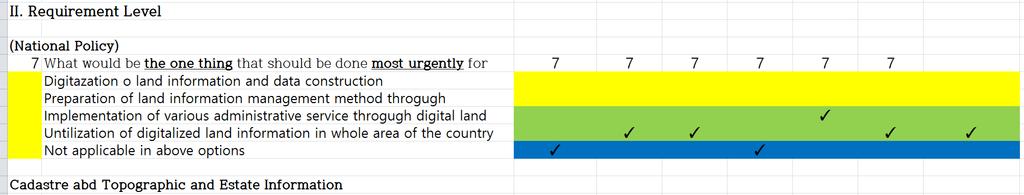
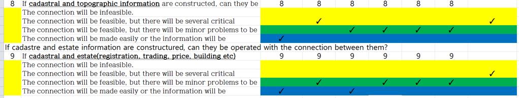
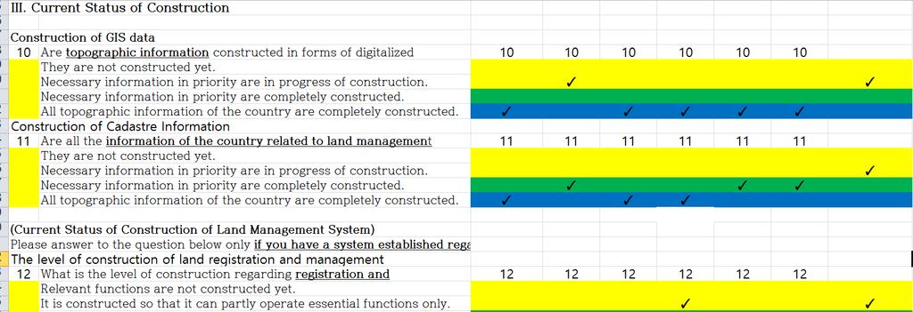
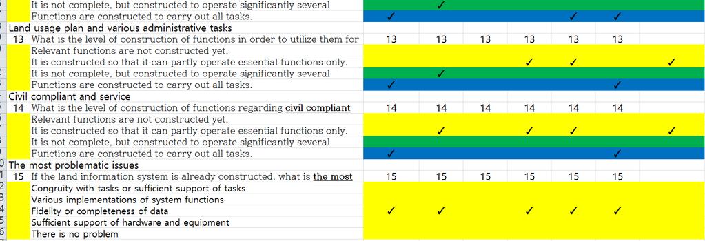
7 II. Requirement Level (National Policy) What would be the one thing that should be done most urgently for your country regarding the construction of land information system? (Cadastral, Topographic and Estate Information) If cadastral and topographic information are constructed, can they be operated with the connection between them? If cadastral and estate(registration, trading, price, building etc) information are constructed, can they be operated with the connection between them? III. Current Status of Construction (Construction of GIS data) Are topographic information constructed in forms of digitalized information(features and properties) for the country's whole area? Are all the information of the country related to land management constructed through digitalization? Do you have an organization which can comprehensively carry forward the land information system for the whole nation? (Current Status of Construction of Land Management System) What is the level of construction regarding registration and management of land information? What is the level of construction of functions in order to utilize them for land usage plan and various administrative tasks? What is the level of construction of functions regarding civil compliant and service? If the land information system is already constructed, what is the most problematic issue in carrying out land-related tasks using the system? 7

")
8 Some Results on the Questionnaires Based on Vice Chair Countries (Brunei Darussalam, China, Fiji, Kyrgyzstan, Malaysia, Mongolia, Singapore, Viet Nam) + 1 Country A 8


9 Country B Country C 9
10 Country D Country E 10

11 Country F Country G 11

12 Some Results on the Questionnaire II 12
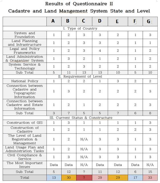
13 13
14 G1 Group: Advanced Type - Near-perfect land management and administration system G2: Data Management Issue Type -Improving Data Management with a certain methodology G3: Data Management and Application Issue Type -Improving Data and System Management with long term plans G4: All System Issue Type - GIS and Cadastre Systems have already been formed. But rechecking all systems in detail. Summary Survey Investigation Result of the 1 st questionnaires All the countries have land related legislation, law system and spatial information system. Most countries have an unitary datum point system. But, a few countries use various coordinate systems. Regarding the land ownership, many countries acknowledge an individual s land ownership and the registration of land mandatory. Regarding the land management, the roles of central and local government are different from each other. Digitalized topographic map is constructed in most countries. However, the digitization of cadastral map has made less progress. All the countries are making the land registration mandatory. In many countries, agents for managing topographic and cadastral maps, and real estate are different from each other. 14
15 Summary Survey Investigation Result of the 2 nd questionnaires Many countries which use hardware or network environment to operate the land information system have not faced significant problems. A few countries are pointing out that there are a lot of problems regarding the comprehensiveness of data related to land information. Many countries find it necessary to improve the functions of their current land management systems. The results show that land infomatization and utilizing land information to cover the whole regions of the country are necessary for various administrative services. Thank you 15
LAND ADMINISTRATION SYSTEM IN BRUNEI DARUSSALAM
 LAND ADMINISTRATION SYSTEM IN BRUNEI DARUSSALAM Presenter: Maslina Abu Bakar Brunei Darussalam AVA-Brunei Chapter 1 Presentation Content: 1. Introduction. 2. Land Administration. 3. Relevant Laws on Land
Towards Kenya s Profile of the Land Administration Domain Model
 Department of Geospatial and Space Technology University of Nairobi Towards Kenya s Profile of the Land Administration Domain Model David N. Siriba and Jasper N. Mwenda dnsiriba, jnmwenda{@uonbi.ac.ke}
CURRENT TREND IN GEOINFORMATION TECHNOLOGY INTRODUCTION
 CURRENT TREND IN GEOINFORMATION TECHNOLOGY STUDIES TOWARD THE DEVELOPMENT OF IMPLEMENTATION PLAN OF COORDINATED CADASTRAL SYSTEM FOR MALAYSIA Abd. Majid A. Kadir, Shahrum Ses, Ghazali Desa, Kamalludin
SCOPE OF PRESENTATION
 INTERNATIONAL SYMPOSIUM AND EXHIBITION ON GEOINFORMATION Global Trends: Geoinformation For The New Economy Studies Toward the Development of Implementation Plan Of Coordinated Cadastral System for Peninsular
STATUS REPORT
 Working Group 3 Land Administration STATUS REPORT 2006-2009 2009 Prof Ian Williamson (Chair) Mr Ahmad Fauzi Nordin (Vice Chair) Assoc. Prof Abbas Rajabifard (Vice Chair) 18th UNRCC-AP Conference Bangkok
Challenges for the multi purpose cadastre
 Jens RIECKEN, Markus SEIFERT, Germany Key words: Multi purpose cadastre, 3d-cadastre, land use, SDI, solar cadastre SUMMARY Over the past 30 years, with the progress of information technologies the development
Land Cadastre Act. Chapter 1. Passed RT I 1994, 74, 1324 Entry into force (except 3 which entered into force on 1.01.
 Issuer: Riigikogu Type: act In force from: 01.01.2011 In force until: 31.12.2014 Translation published: 24.10.2014 Passed 12.10.1994 RT I 1994, 74, 1324 Entry into force 08.11.1994 (except 3 which entered
Towards LADM country cadastral profile case Poland
 Towards LADM country cadastral profile case Poland Jarosław Bydłosz Department of Geomatics Faculty of Mining Surveying and Environmental Engineering International FIG workshop on the Land Administration
Exchange of Experiences and Knowledge in Land Administration and Cadastral Services between Sweden and Indonesia
 TS 10G Knowledge Sharing Exchange of Experiences and Knowledge in Land Administration and Cadastral Services between Sweden and Indonesia Endri Diyanto, Indonesia Karolina Larsson, Sweden IPSLA INSTITUTIONAL
Croatian SDI: a Tool for Accelerated Development of the Geo-Conscious Society
 STATE GEODETIC ADMINISTRATION Croatian SDI: a Tool for Accelerated Development of the Geo-Conscious Society Prof.Dr.Sc. Željko Bačić, Mr.Sc. Ljerka Rašić FIG Working Week 2009 - Surveyors Key Role in Accelerated
Presented at the FIG Congress 2018, May 6-11, 2018 in Istanbul, Turkey
 Presented at the FIG Congress 2018, May 6-11, 2018 in Istanbul, Turkey 5 Bibliometric Analysis of Articles Presented Under Commission 7: A Case of the 25th Fig Congress in Malaysia in 2014 Zeynel Abidin
METHODOLOGY FOR THE DEVELOPMENT OF NATIONAL DIGITAL CADASTRAL DATABASE (NDCDB)
") KURSUS COORDINATED CADASTRAL SYSTEM (CCS) INSTITUT TANAH & UKUR NEGARA BEHRANG, PERAK METHODOLOGY FOR THE DEVELOPMENT OF NATIONAL DIGITAL CADASTRAL DATABASE (NDCDB) OLEH: PROF DR ABD MAJID BIN A KADIR
KURSUS COORDINATED CADASTRAL SYSTEM (CCS) INSTITUT TANAH & UKUR NEGARA BEHRANG, PERAK METHODOLOGY FOR THE DEVELOPMENT OF NATIONAL DIGITAL CADASTRAL DATABASE (NDCDB) OLEH: PROF DR ABD MAJID BIN A KADIR
FIG Commission 3 Spatial Information Management. Report of Activities 2009
 Appendix to item 10.3 Report to the 33 rd General Assembly FIG Congress in Sydney, Australia 2010 FIG Commission 3 Spatial Information Management Report of Activities 2009 1. General Since 2007, FIG Commission
FIG Task Force on: Property and Housing
 International Federation of Surveyors Fédération Internationale des Géomètres International Vereinigung der Vermessungsingenieure FIG Task Force on: Property and Housing Chryssy Potsiou, Assist Prof, FIG
D DAVID PUBLISHING. Mass Valuation and the Implementation Necessity of GIS (Geographic Information System) in Albania
 in Albania") Journal of Civil Engineering and Architecture 9 (2015) 1506-1512 doi: 10.17265/1934-7359/2015.12.012 D DAVID PUBLISHING Mass Valuation and the Implementation Necessity of GIS (Geographic Elfrida Shehu
Journal of Civil Engineering and Architecture 9 (2015) 1506-1512 doi: 10.17265/1934-7359/2015.12.012 D DAVID PUBLISHING Mass Valuation and the Implementation Necessity of GIS (Geographic Elfrida Shehu
Cadastre and Land Registration in Europe
 Annex A: Questionnaire 2007 for Information Resource Cadastre and Land Registration in Europe Introduction This questionnaire is based on the EuroGeographics vision document 'Cadastre and Land Registration
Functional system for cadastral plans
 , Republic of Macedonia Key words: Cadastre, Digital plans, Data, System SUMMARY The analysis shows that the real estate market in Republic of Macedonia grows daily. With the expansion of this market increases
Directorate of Survey and Mapping NAMIBIA. Cadastral Information System. Vehupisa Kasuko Tjatindi Surveyor Directorate of Survey and Mapping NAMIBIA
 Vehupisa Kasuko Tjatindi Directorate of Survey and Mapping NAMIBIA Tel: +64 61 965000 Directorate of Survey and Mapping NAMIBIA Cadastral Information System Introduction Over the past few decades cadastral
The Survey Data Model Technology A practical survey solution to generate all levels of spatial and e-governance outcomes.
 Land Governance in a Rapidly Changing Environment Annual World Bank Conference on Land and Poverty April 24 & 25, 2012 The Survey Data Model Technology A practical survey solution to generate all levels
Country report, HUNGARY
 Country report, HUNGARY Gyula IVÁN Institute of Geodesy, Cartography & Remote Sensing (FÖMI) HUNGARY FIG Commission 7 Annual Meeting 2009 12-16 October, 2009, Kuala Lumpur, Malaysia Institute of Geodesy,
Developing Infrastructure Framework To Facilitate The Malaysia Multipurpose 3D Cadastre
 Developing Infrastructure Framework To Facilitate The Malaysia Multipurpose 3D Cadastre Sr Dr. Tan Liat Choon Sr Looi Kam Seng University of Technology Malaysia Department of Survey and mapping Malaysia
Ministry of Mines, Industry and SME
 Republic of Senegal Ministry of Mines, Industry and SME User Conference 2010 08/02/2010 COPYRIGHT 2010. SPATIAL DIMENSION (PTY) LTD. A MINING CADASTRE IN SENEGAL: IMPLEMENTATION PROCESS AND ORGANIZATIONAL
Test and Implementation of DATR System in Hungary
 Test and Implementation of DATR System in Hungary, Hungary Key words: unified land registry, cadastral map, Hungary SUMMARY During the last years there has been an important development in the Hungarian
The Governance of Land Use
 The Governance of Land Use Country fact sheet Sweden The planning system Levels of government and their responsibilities Sweden is a unitary country with 3 levels of government; the national level, 21
Hungarian Cadastre and its relation to LADM
 Hungarian Cadastre and its relation to LADM Gyula IVÁN CLGE General Assembly 22 March 2013, Budapest, HUNGARY Content Historical background Evolution of Cadastral modeling in Hungary LADM issues Conclusion
Ownership Data in Cadastral Information System of Sofia (CIS Sofia) from the Available Cadastral Map
 from the Available Cadastral Map") Ownership Data in Cadastral Information System of Sofia (CIS Sofia) from the Available Cadastral Map Key words: ABSTRACT Lydmila LAZAROVA, Bulgaria CIS Sofia is created and maintained by GIS Sofia ltd,
Ownership Data in Cadastral Information System of Sofia (CIS Sofia) from the Available Cadastral Map Key words: ABSTRACT Lydmila LAZAROVA, Bulgaria CIS Sofia is created and maintained by GIS Sofia ltd,
BULGARIAN CADASTRE A GUARANTEE FOR THE OWNERSHIP RIGHTS IN IMMOVABLE PROPERTIES
 4 TH INTERNATIONAL CONFERENCE RECENT PROBLEMS IN GEODESY AND RELATED FIELDS WITH INTERNATIONAL IMPORTANCE February 28 - March 2, 2007, Inter Expo Centre, Sofia, Bulgaria BULGARIAN CADASTRE A GUARANTEE
A NOMINAL ASSET VALUE-BASED APPROACH FOR LAND READJUSTMENT AND ITS IMPLEMENTATION USING GEOGRAPHICAL INFORMATION SYSTEMS
 A NOMINAL ASSET VALUE-BASED APPROACH FOR LAND READJUSTMENT AND ITS IMPLEMENTATION USING GEOGRAPHICAL INFORMATION SYSTEMS by Tahsin YOMRALIOGLU B.Sc., M.Sc. A thesis submitted for the Degree of Doctor of
Overview of PCGIAP-WG3 and Spatially Enabled Government
 Working Group 3 3 rd Land Administration Forum Overview of and Spatially Enabled Government Abbas Rajabifard Vice Chair, Established in 2000 based on a Resolution from the 15th UNRCC-AP in Malaysia. With
LAUNCH OF CADASTRAL TEMPLATE 2.0
 LAUNCH OF CADASTRAL TEMPLATE 2.0 Dr. Daniel Steudler Scientific Associate, swisstopo Prof. Abbas Rajabifard Director Centre for SDIs and Land Administration, Melbourne University FIG-Commission 7, Annual
Building Integrated Land Information Systems and Development of NSDI
 Stig JÖNSSON, Sweden Key words: Land administration, land information systems, property formation, spatial data infrastructure, Inspire, institutional cooperation SUMMARY Lantmäteriet the Swedish agency
INTRODUCTION. Regulation of GI as stated in the Law of Indonesia No. 4 of 2011 about
 FRANKO JHONER, SH As Speaker at Geospatial World Forum 2014, Legal Drafter at The Indonesian Geospatial Information Agency (Badan Informasi Geospasial, Republik Indonesia) Geneva - Switzerland TITLE: PERMISSION
Shaping the Cadastral Infrastructure for a Digital Future
 DEPARTMENT OF LANDS PLANNING and the ENVIRONMENT Shaping the Cadastral Infrastructure for a Digital Future Craig Sandy Director Surveys Surveyor General Survey Branch NT Australia Digital Cadastral Databases
From 2D representation of the buildings into cadastral maps towards 3D GIS applications and BIM a case study for Prishtina
 From 2D representation of the buildings into cadastral maps towards 3D GIS applications and BIM a case study for Prishtina This is a Peer Reviewed Paper Fisnik LOSHI, Kosovo Keywords: 3D cadastre, property
SAVILLS VIETNAM HA NOI DA NANG HCMC. The most innovative Advisory Services in Viet Nam. Over 22 years First to Market. 68,000 sqm Leased in 2016
 SAVILLS VIETNAM HA NOI Over 22 years First to Market The most innovative Advisory Services in Viet Nam DA NANG 68,000 sqm Leased in 2016 US$ 200 mil 2016 residential sales Over USD 100M pa Number one for
The Hellenic National Cadastre: An elemental institution for nurturing and promoting innovation in 3D geospatial data
 Hellenic National Cadastre: An elemental institution for nurturing and promoting innovation in 3D geospatial data Professor Byron Nakos President NATIONAL CADASTRE AND MAPPING AGENCY SA (NCMA SA) 288 Mesogion
SAVILLS VIETNAM HA NOI DA NANG HCMC. The most innovative Advisory Services in Viet Nam. Over 22 years First to Market. 68,000 sqm Leased in 2016
 SAVILLS VIETNAM HA NOI Over 22 years First to Market The most innovative Advisory Services in Viet Nam DA NANG 68,000 sqm Leased in 2016 US$ 200 mil 2016 residential sales Over USD 100M pa Number one for
FIG-WB Forum on Land Administration and reform in Sub-Sahara Africa
 FIG-WB Forum on Land Administration and reform in Sub-Sahara Africa Chris Mnyanga Ministry of Lands UNITED REPUBLIC OF TANZANIA] FIG WORKING WEEK, Abuja, NIGERIA 2013-6-10 MAY 2013 Country at Glance UNITED
Problems and Solution Proposals in Integration of Cadastral Data into Geographical Information System (GIS) in Turkey
 in Turkey") Problems and Solution Proposals in Integration of Cadastral Data into Geographical Information System (GIS) in Turkey Gülgün OZKAN, S. Savas DURDURAN, Ali ERDI and Bilal GIRGIN, Turkey Key words: Cadastre,
Problems and Solution Proposals in Integration of Cadastral Data into Geographical Information System (GIS) in Turkey Gülgün OZKAN, S. Savas DURDURAN, Ali ERDI and Bilal GIRGIN, Turkey Key words: Cadastre,
WORKSHOP ON TAX POLICY FOR DOMESTIC RESOURCE MOBILIZATION AND SEMINAR ON PROPERTY TAX REFORM: THE PHILIPPINE REGALA EXPERIENCE
 WORKSHOP ON TAX POLICY FOR DOMESTIC RESOURCE MOBILIZATION AND SEMINAR ON PROPERTY TAX REFORM: THE PHILIPPINE REGALA EXPERIENCE ADBI, Tokyo 20-23 February 2018 The Philippines is at a critical juncture.
Improvement of Effectiveness Present Developments in Hungarian Land Administration
 Improvement of Effectiveness Present Developments in Hungarian Land Administration Gyula IVÁN and András OSSKÓ, Hungary Key words: Land Administration, Cadastre, Land Registry SUMMARY New Act on Surveying
Demonstrate knowledge of, and extract, cadastral data from Landonline
 Page 1 of 5 Demonstrate knowledge of, and extract, cadastral data from Landonline Level 3 Credits 5 Purpose This unit standard is for people who are working in the surveying industry in jobs which involve
The Role of the Swedish Land Information System
 The Role of the Swedish Land Information System In the Business Society Tommy Österberg Swedesurvey 1 SWEDEN 9 million inhabitants 450 000 sq. km 21 Counties 291 Municipalities 4.6 million properties in
Unified Land Administration for a Better Spatial Infrastructure
 Unified Land Administration for a Better Spatial Infrastructure Gyula IVÁN Institute of Geodesy, Cartography & Remote Sensing FÖMI (HUNGARY) Open Symposium 30th Korean Cadastral Seminar & FIG Commission
Developing a Performance Review Questionnaire for Hong Kong Cadastral Survey System
 Developing a Performance Review Questionnaire for Hong Kong Cadastral Survey System Haodong ZHANG and Conrad TANG, Hong Kong SAR, CHINA Key words: Fit-for-Purpose, Cadastral Surveying, Land Administration,
Cadastre in Addis Ababa. Status and future development
 Status and future development Dr.-Ing. Paul Hartfiel Mülheim, 1. Oct. 2010-1 - Addis Ababa Capital of Ethiopia Area population 540 km² > 3,200,000 (rapidly growing) 2,300,000 in 1994 > 22% of all urban
Facilitating the Use of Modern Technology for Contract Management - Relevance of United Nations Commission on International Trade Law Texts
 2018/SOM1/EC/WKSP2/007 Facilitating the Use of Modern Technology for Contract Management - Relevance of United Nations Commission on International Trade Law Texts Submitted by: Workshop on the Use of Modern
PROJECT INFORMATION DOCUMENT (PID) CONCEPT STAGE Report No.: AB3229 Project Name. Land Registry and Cadastre Modernization Project Region
 CONCEPT STAGE Report No.: AB3229 Project Name. Land Registry and Cadastre Modernization Project Region") PROJECT INFORMATION DOCUMENT (PID) CONCEPT STAGE Report No.: AB3229 Project Name Land Registry and Cadastre Modernization Project Region EUROPE AND CENTRAL ASIA Sector Central government administration
PROJECT INFORMATION DOCUMENT (PID) CONCEPT STAGE Report No.: AB3229 Project Name Land Registry and Cadastre Modernization Project Region EUROPE AND CENTRAL ASIA Sector Central government administration
ABSTRACT Land Administration System in Lithuania
 ABSTRACT Land Administration System in Lithuania 1. General introduction to the Lithuanian Land Administration System and State Enterprise Centre of Registers ( shortly SECR) Lithuania has established
Republic of Bulgaria
 Geodesy, Cartography and Cadastre Agency Republic of Bulgaria www.cadastre.bg 24. 01. 2018 г., гр. София The Cadastre Legislation in Bulgaria - historical reference 1908 г. The Cadastre Act The objective
Role of spatial planning in modern society
 Republic of Croatia State Geodetic Administration The Role of Cadastre in the Development of Regional and Local Planning Structure in Croatia Zdravko Cesarec and Željko Bačić 1 Role of spatial planning
Tidal Datum Consistency for Marine Cadastre Littoral Zone Commencement in Malaysia
 Tidal Datum Consistency for Marine Cadastre Littoral Zone Commencement in Malaysia Rasheila Rahibulsadri, Abdullah Hisam Omar, Ashraf Abdullah, Wan Muhammad Aizzat Wan Azhar, Chan Keat Lim, Teng Chee Hua,
Iranian Cadastre System. Nasrollah Jahangard Iran s Deeds and Properties Registration Organization I.R. of Iran 14 th PCGIAP, KL, Malaysia 2008
 Iranian Cadastre System Nasrollah Jahangard Iran s Deeds and Properties Registration Organization I.R. of Iran 14 th PCGIAP, KL, Malaysia 2008 General Information Europe Middle East Asia Africa Middle
THE XXV FIG INTERNATIONAL CONGRESS IN MALAYSIA Kuala Lumpur, Malaysia, June 2014 at Kuala Lumpur Convention Centre
 CALL FOR PAPERS TO THE XXV FIG INTERNATIONAL CONGRESS IN MALAYSIA Kuala Lumpur, Malaysia, 16 21 June 2014 at Kuala Lumpur Convention Centre Dear Friend and Colleague, It is our privilege and honour to
Cadastral Parcels in the context of INSPIRE
 Cadastral Parcels in the context of INSPIRE Gyula IVÁN Institute of Geodesy, Cartography & Remote Sensing, HUNGARY Open Symposium on Environment and Land Administration Big Works for the Defence of Territory
Land Administration Infrastructures for Sustainable Development
 The Global Challenges Land Administration Infrastructures for Sustainable Development Prof. Stig Enemark Department of Development and Planning Aalborg, University, Denmark INTERNATIONAL CONFERENCE ON
Cadastral Template 2003
 PCGIAP-Working Group 3 "Cadastre" FIG-Commission 7 "Cadastre and Land Management" Cadastral Template 2003 The establishment of a cadastral template is one of the objectives of Working Group 3 "Cadastre"
Technology-driven solutions for the innovation of land administration and management
 Technology-driven solutions for the innovation of land administration and management Technology and economic growth - Studies*find link between technology innovation and national economic prosperity especially,
Addressing Land Sector Opportunities with Geospatial Information in Nepal
 The 20th UNRCC-AP and the 4th UN-GGIM-AP 5-10 October 2015 Jeju Island, Republic of Korea Addressing Land Sector Opportunities with Geospatial Information in Nepal Krishna Raj BC Executive Director Land
Support to Implementation of Multipurpose Cadastral Information system in Vietnam
 Support to Implementation of Multipurpose Cadastral Information system in Vietnam Lennart JOHANSSON and Per SÖRBOM, Sweden Key words: Land Registration, Land Information, Land Administration, SWOT analyse,
A Complete, Free Solution for Cadastral Map Management
 A Complete, Free Solution for Cadastral Map Management Gyula IVÁN Institute of Geodesy, Cartography & Remote Sensing (FÖMI) HUNGARY FIG Commission 7, Annual Meeting 11-15 September 2008., Verona, ITALY
Reporting Thailand Cadastral System in Cadastre 2014 Trends BY VUTTINAN UTESNAN. Rajamangala University of Technology Krungthep
 Reporting Thailand Cadastral System in Cadastre 2014 Trends BY VUTTINAN UTESNAN Rajamangala University of Technology Krungthep Faculty of Engineering, Bangkok, THAILAND Topics INTRODUCTION THAILAND CADASTRAL
The Digital Cadastral Database and the Role of the Private Licensed Surveyors in Denmark
 IRISH INSTITUTE OF SURVEYORS, DUBLIN INSTITUTE OF TECHNOLOGY, 23 NOVEMBER 2005 PUBLISHED IN IIS NEWS, WINTHER 2006. The Digital Cadastral Database and the Role of the Private Licensed Surveyors in Denmark
Cadastral services and virtual office in e-cadastre
 Cadastral services and virtual office in e-cadastre Priit Kuus Estonian Land Board October 26, 2016 Coimbra Scope of data Cadastral parcels (as of September 2016) 674 383 cadastral parcels, i.e. 97,7 %
Assessing the worldwide comparison of cadastral systems
 Assessing the worldwide comparison of cadastral systems Abbas Rajabifard 1, Ian Williamson 1, Daniel Steudler 2, Andrew Binns 1 and Mathew King 1 1 Centre for Spatial Data Infrastructures and Land Administration
Egyptian Nationwide Title Cadastre System
 Kholoud SAAD, Egypt Key words: Cadastre, Registration, Urban, Rural, National Cadastre, Automation, reengineering. SUMMARY With growing need for integrated information, Enterprise Solutions has become
Regional Cadastral Study Reforms in the Region
 UNECE WORKING PARTY ON LAND ADMINISTRATION Workshop on the Influence of Land Administration on People and Business Cavtat, Croatia 2-3 October 2008 Regional Cadastral Study Reforms in the Region Miodrag
Land Registration in a Digital Environment.
 Land Registration in a Digital Environment Emmanuel Tembo, Johnson Kampamba and Boipuso Nkwae tembo@mopipi.ub.bw Paper presented 17 th June 2014, Kuala Lumpur, Malaysia XXV International Federation of
Developing a Modern Cadastre in Lao PDR
 Developing a Modern Cadastre in Lao PDR Bounhom Heuangsavath Deputy Director General, Department of Lands, Lao PDR 1 May 27 Project Contributors Lao PDR 16 provinces, 1municipality 6.2 million population
Spatial Data Infrastructure in Sweden
 Spatial Data Infrastructure in Sweden Hans-Erik WIBERG, Sweden Key words: ABSTRACT Sweden was one of the first countries to address Data Infrastructure matters and have during several decades developed
THE REPUBLIC OF TURKEY MINISTRY OF PUBLIC WORKS GENERAL DIRECTORATE OF LAND REGISTRY AND CADASTRE (TKGM) UNECE WPLA WORKSHOP. October 2010.
 UNECE WPLA WORKSHOP. October 2010.") THE REPUBLIC OF TURKEY MINISTRY OF PUBLIC WORKS GENERAL DIRECTORATE OF LAND REGISTRY AND CADASTRE (TKGM) UNECE WPLA WORKSHOP " The role of spatial planning to improve security of tenure" October 2010 Antalya
THE REPUBLIC OF TURKEY MINISTRY OF PUBLIC WORKS GENERAL DIRECTORATE OF LAND REGISTRY AND CADASTRE (TKGM) UNECE WPLA WORKSHOP " The role of spatial planning to improve security of tenure" October 2010 Antalya
BIOMASS-BASED DISTRICT HEATING PROJECT
 Public Disclosure Authorized Public Disclosure Authorized Public Disclosure Authorized Public Disclosure Authorized Biomass-Based District Heating Project BIOMASS-BASED DISTRICT HEATING PROJECT Construction
New Developments in the Hellenic Cadastre
 New Developments in the Hellenic Cadastre Prof. M. Kavouras Vice-president Ktimatologio S.A. (Hellenic Cadastre) The Hellenic Cadastre Background The Hellenic National Cadastre Organizational and institutional
REFORM OF LAND CADASTRE IN LITHUANIA
 REFORM OF LAND CADASTRE IN LITHUANIA Romualdas KASPERAVICIUS, Lithuania Key words: ABSTRACT Main aim for every Government is to create legal, financial and organisational circumstances for real property.
Modern concepts of urban cadastre
 Modern concepts of urban cadastre CARMEN GRECEA Department of Land Measurements and Cadastre POLITEHNICA University of Timisoara 300006 Timisoara, P-ta Victoriei no. 2 ROMANIA carmen.grecea@ct.upt.ro http://www.upt.ro
An Analysis of Spatial Distribution of Hanoi Apartment
 , pp.276-281 http://dx.doi.org/10.14257/astl.2018.150.62 An Analysis of Spatial Distribution of Hanoi Apartment Youseok Chung 1 and Saejoon Oh 2* 1 National Housing Organization JSC ITower 49 Pham Ngoc
GLOBAL GEOSPATIAL MANAGEMENT INFORMATION
 GLOBAL GEOSPATIAL MANAGEMENT INFORMATION SEOUL, KOREA 24 th to 26 th October 2011 COUNTRY REPORT - REPUBLIC OF BOTSWANA 1. INTRODUCTION 1.1. SOCIAL, ECONOMIC AND POLITICAL BACKGROUND Botswana attained
Lessons for federated countries that have state land registries the Australian experience
 Lessons for federated countries that have state land registries the Australian experience Ian Williamson Centre for SDI and Land Administration Department Infrastructure Engineering University of Melbourne
Hungary is a landlocked, Central European country in the Carpathian Basin
 Brief Overview on Hungarian Land Administration MSc. György Domokos Hungarian Geodetic Surveying Liaison Group CLGE GA Hannover 12 13 October 2012 Hungary is a landlocked, Central European country in the
The Needs for Improvement in Turkish Land Administration System: Lessons Learned from German Case
 The Needs for Improvement in Turkish Land Administration System: Lessons Learned from German Case Mehmet CETE and Holger MAGEL, Germany, and Tahsin YOMRALIOGLU, Turkey Key words: Land administration, cadastre,
Key Registers in Finland and some views of Cadastre 2035
 Presented at the FIG Working Week 2016, May 2-6, 2016 in Christchurch, New Zealand Key Registers in Finland and some views of Cadastre 2035 FIG Working Week, Christchurch New Zealand May, the 3rd, 2016
Country Report SWITZERLAND
 armasuisse Federal Office of Topography, swisstopo Country Report SWITZERLAND Dr. Daniel Steudler Swiss Annual Meeting 2013, FIG-Commission 7 22 October 2013, Yaoundé, Cameroon Basic Dimensions SWITZERLAND
PROTOCOL ASDI ARCTIC SPATIAL DATA INFRASTRUCTURE PROJECT KICK-OFF MEETING
 1(9) Friday, 15 October 2010 PROTOCOL ASDI ARCTIC SPATIAL DATA INFRASTRUCTURE PROJECT KICK-OFF MEETING Point of time: 09.00 October 14 11.15 October 15, 2010 Locality: Rue du Nord 76, 1000 Brussels, BELGIUM
LAND CADASTRE AND BUILDING CADASTRE IN SLOVENIA: CURRENT SITUATION AND POTENTIAL OF 3D DATA
 3D Cadastres Organizational and Governmental Aspects LAND CADASTRE AND BUILDING CADASTRE IN SLOVENIA: CURRENT SITUATION AND POTENTIAL OF 3D DATA EMA POGORELČNIK AND MARINA KOROŠEC Surveying and Mapping
R-CDTA 8243: Statistical Capacity Development for Social Inclusion and Gender Equality
 R-CDTA 8243: Statistical Capacity Development for Social Inclusion and Gender Equality The process by which Mongolia decided which assets to collect data on based upon the country s policy needs and the
Territorial Planning System in Lithuania
 UN ECE - Working Party on Land Administration Athens, 28-31 March 2007 Territorial Planning System in Lithuania Jaunius Grigas Bronislovas Mikuta State Enterprise Centre of Registers Lithuania LEGISLATION
PROPOSED LEGISLATION FOR 3D CADASTRE IN MALAYSIA
 PROPOSED LEGISLATION FOR 3D CADASTRE IN MALAYSIA CHAN Keat Lim, TENG Chee Hua, DAVID LOO Kean Beng Key words: Stratum, Spatium, 2D and 3D cadastre, volumetric lot SUMMARY Malaysia is fortunate to be acknowledged
Preprint.
 http://www.diva-portal.org Preprint This is the submitted version of a paper presented at 10th EC GI & GIS Workshop, ESDI State of the Art, Warsaw, Poland, 23-25 June 2004. Citation for the original published
Information System of Electronic Cadastre Registration of Lands in Azerbaijan
 The State Committee on Property Issues of the Republic of Azerbaijan Information System of Electronic Cadastre Registration of Lands in Azerbaijan Chıngız Tanırverdiyev-chief engineer Cadastre and Land
Quality Improvement to Cadastral Information in Sweden
 Gunnar BLIXT, Sweden Key words: digital cadastre, quality, cadastral index map, real property register. SUMMARY Lantmäteriet is a governmental agency which gives support for creating an efficient and sustainable
Cadastre: definitions
 Introduction New vision towards a multipurpose cadastral system to support land management in Morocco Moha EL-AYACHI, El Hassane SEMLALI, Mohamed ETTARID, Driss TAHIRI, Institut Agronomique et Vétérinaire
FIG Task Force on: Property and Housing
 International Federation of Surveyors Fédération Internationale des Géomètres International Vereinigung der Vermessungsingenieure FIG Task Force on: Property and Housing Chryssy Potsiou, Assist Prof, FIG
The Development of the Austrian Cadastre from Documentation to an Integrated Planning and Decision Support System
 The Development of the Austrian Cadastre from Documentation to an Integrated Planning and Decision Support System WPLA - Working Party on Land Administration 15-17 October 2014, Vienna, Austria Wernher
Public private collaboration model in the cadastral workflow in Denmark
 Public private collaboration model in the cadastral workflow in Denmark Jakob HØJGAARD-GERAAE, Denmark Key words: Cadastre, digital cadastre, e-governance, history, land management SUMMARY The structure
Estonian e-cadastre as basis for efficient land management
 Estonian e-cadastre as basis for efficient land management Priit Kuus Estonian Land Board November 14, 2017 Tallinn Scope of data Cadastral parcels (as of October 2017) 693 026 cadastral parcels, i.e.
Land Administration in Jordan
 Land Administration in Jordan Problems and Challenges Eng. Director of Registration Services Department of Lands & Survey q General information q Historical Background q Properties Initiation q Problems
I GIS market of Korea.
 I. GIS market of Korea National Informationization Base Preparing National Informationization Driving The 1st National basic computer network basic plan(1987~1991) GIS Base Creating The 1st National geographic
Get Fit, Healthy and United Through Sport for All
 Get Fit, Healthy and United Through Sport for All Kuala Lumpur, Malaysia 25-28 October 2007 Organized by the National Fitness Council (NFC) in partnership with the Ministry of Youth and Sport, Ministry
Development of Cadastral Survey and Land Ownership Registration System in Mongolia
 Development of Cadastral Survey and Land Ownership Registration System in Mongolia M.Saandar,, Ph. D Vice President, the Mongolian Association of Surveying and Mapping, ( As National Member of FIG ) MonMap
Cadastral Template Project
 Annual Meeting FIG-Commission 7 Clermont-Ferrand, France, 13 Sept. 2004 Cadastral Template Project Daniel Steudler Swiss Federal Directorate of Cadastral Surveying In cooperation with: Ian P. WILLIAMSON,