MEETING DATE: Monday, June 25, 2018 MEETING TIME: 6:00 p.m. MEETING LOCATION: City Council Chambers, 448 East First Street, Salida, CO
|
|
|
- Bertram Luke Chambers
- 5 years ago
- Views:
Transcription
1 page 1 of 98 AGENDA CITY OF SALIDA PLANNING COMMISSION MEETING DATE: Monday, June 25, 2018 MEETING TIME: 6:00 p.m. MEETING LOCATION: City Council Chambers, 448 East First Street, Salida, CO AGENDA SECTION: I. CALL TO ORDER BY CHAIRMAN 6:00 p.m. II. ROLL CALL III. APPROVAL OF THE MINUTES May 29, 2018 IV. UNSCHEDULED CITIZENS V. AMENDMENT(S) TO AGENDA VI. VII. UPDATES PUBLIC HEARINGS- 1. Two Rivers Commercial Center Major Subdivision - The applicant is requesting to subdivide the commercial property which is zoned Central Business District (C-2), into approximately 23 lots for a mixed-use development including commercial and residential uses. A. Open Public Hearing B. Proof of Publication C. Staff Review of Application D. Applicant s Presentation E. Public Input F. Close Public Hearing G. Commission Discussion H. Commission Action 2. Buckley-Meadows Annexation, Zoning and Minor Subdivision - The applicant is requesting to annex and zone the 2.55 acre parcel located at 7221 County Road 105 into the City. The request is to zone the property with the Manufactured Housing Residential (R-4) zone district. The Commission will also be considering approval of the Geodesia Minor subdivision of four lots subject to approval of the annexation and zoning. A. Open Public Hearing for all 3 B. Proof of Publication C. Staff Review of Application D. Applicant s Presentation E. Public Input F. Close Public Hearing G. Commission Discussion H. Commission Recommendation & Action 3. Amendment to Chapter 16, Land Use Code (continued from the May 29, 2018 meeting) - The proposed request is for the following amendment to the Land Use Code; The addition of new Article XIII - Inclusionary Housing to require standards for the provision of affordable housing in areas that are proposed for annexation, planned development overlay or subdivision. A. Continue Public Hearing E. Public Input B. Proof of Publication F. Close Public Hearing C. Staff Review of Application G. Commission Discussion D. Applicant s Presentation H. Commission Recommendation
2 page 2 of Amendment to Chapter 16, Land Use Code (continued from the May 29, 2018 meeting) - The proposed request is for an amendment to the Land Use Code; Section Types of Subdivisions to amend the process for further subdivision of minor subdivisions (five or fewer lots). A. Continue Public Hearing E. Public Input B. Proof of Publication F. Close Public Hearing C. Staff Review of Application G. Commission Discussion D. Applicant s Presentation H. Commission Recommendation VIII. UNFINISHED BUSINESS- IX. NEW BUSINESS X. COMMISSIONERS COMMENTS XI. ADJOURN
3 page 3 of 98 MEETING DATE: Tuesday May 29, 2018 MEETING TIME: 6:00 PM MEETING LOCATION: City Council Chambers, 448 E. First Street, Suite 190, Salida, CO Present: Mandelkorn, Follet, Denning, Thomas, Farrell, Bomer, Judd, Van Nimwegen, Jefferson, Franklin Absent: AGENDA SECTION: I. CALL TO ORDER BY - Mandelkorn: - 6:00 PM II. III. ROLL CALL: APPROVAL OF THE MINUTES April 23, Bomer made a motion to approve the minutes as written. The motion was seconded by Denning. All voters were unanimous and the motion carried. IV. UNSCHEDULED CITIZENS None V. AMENDMENTS TO AGENDA- None VI. UPDATES: None VII. PUBLIC HEARINGS 1. Limited Impact Review- McDonald Multiple Principal Structures - The request is to receive limited impact review approval to construct a second primary structure within the medium density residential (R-2) zone district at the property located at 1128 H Street. A. Open Public Hearing 6:03 PM B. Proof of Publication Yes C. Staff Review of Application Jefferson gave an overview of the application and made a request to the commission that they make a recommendation for the height of the building, as this is a concern for the neighbors. Staff supports the application and recommends approval with 3 conditions. 1. That at the time of building permit application submission for the second principal structure a fee in lieu of sidewalks shall be paid. Based on the 2017 bid unit prices the fee in lieu is $40.00 per linear foot, per Public Works Director, David Lady. 2. That a maximum height of the proposed structure be reduced to fit within the mass and scale of the surrounding neighborhood. 3. That this Limited Impact approval expires in three (3) years from the date of its approval if a building permit for the second principal structure has not been issued and acted upon. D. Applicant s Presentation The applicant is Bonnie McDonald, 929 Dodge Street, Salida, CO She mentioned that there are ten new units within her one block on H Street, she would like to design this property for seniors, with larger doors and
4 page 4 of 98 showers. She proposed that they can lower the height to 28 and that the second floor will be used mostly for storage. Denning asked about the height and setbacks, McDonald stated they will work with the neighbors and try to accommodate their needs. Judd asked if this will be a business or if it is a rental for one family. Bomer inquired about the foot print, approximately 1020 with a patio, stated McDonald. Follet asked if the house would be slab on grade or if it would have a crawl space. Judd questioned if the applicant will be providing more parking with the proposed dwelling. E. Public Input Citizens that spoke against the project Debbie Wilcox, Kenneth Shake, Sarah Gates, and Janine Frazee. The main concerns are height, privacy, number of people living on the property, parking, quality of renters, changing the landscaping, and taps/utilities. F. Close Public Hearing 6:16 PM G. Commission Discussion Thomas finds that this project fits well within the area and made mention of the new properties that surround it on smaller lots. He appreciates the openness of the applicant to make changes and protect the neighbors privacy. Bomer and Denning would like for the applicant to return with drawings that include elevations. Judd asked how many taps the applicant will need to purchase, Jefferson stated that both primary structures will need separate taps, with the ADU currently on the existing tap. Judd voiced concern that the neighbors are not the designers, Mandelkorn agreed that we need to stay within the code. Follet would like to address the parking and possibly ask the applicant to adjust the setbacks. Denning asked about current parking, Jefferson stated the applicant currently meets the requirement for the two units on the property. Commission Action A motion was made by Judd to accept the limited impact review to construct a second primary structure on the property located at 1128 H Street application with the recommended three conditions. Farrell seconded the motion. Thomas, Farrell, Judd, Follet, and Mandelkorn were in favor, and the motion carried; Denning and Bomer opposed. 2. Limited Impact Review - Cocovinis Minor Subdivision - The request is for approval to subdivide the parcel known as 325 G Street, into two (2) lots in the Central Business (C-2) zone district. A. Open Public Hearing 6:30 PM B. Proof of Publication - Yes C. Staff Review of Application Jefferson gave an overview of the application and stated that staff supported the application and recommends approval with 3 conditions. 1. That the City Administrator signature block be removed prior to printing the mylars. 2. That the utilities serving Lot 1 be relocated prior to recording the subdivision plat. 3. That number 5 under General Notes be amended with the correct Land Use Code section (8). D. Applicant s Presentation The applicants are Dwight & Suzanne Cocovinis, 325 G Street Salida, CO They would like to use the full lot and increase the
5 page 5 of 98 residential use for this site within the C-2 zone. They are planning a two story house max height of 26, with all utilities located off G Street. Mandelkorn asked about the garage currently being constructed. E. Public Input None F. Close Public Hearing 6:39 PM G. Commission Discussion All commission agreed the open space (8) Commission Action A motion was made by Bomer to accept the limited impact review application with the correction of Land Use Code (8) along with the recommended three conditions. Follet seconded the motion. All were in favor and the motion carried. 3. Limited Impact Review - East Riverside Park Minor Subdivision- The request is for approval to subdivide two parcels of land into five (5) lots located at 207 North D Street and 314 E. Sackett Avenue. A. Open Public Hearing 6:44 PM B. Proof of Publication Yes C. Staff Review of Application Jefferson gave an overview of the application mentioning any further subdivision after five lots is considered a major subdivision. She also stated that Mr. Kimmett met his open space requirements with an easement allowing the river trail. Staff supported the application and recommends approval with the following 5 conditions. 1. That the City Administrator signature block be removed. 2. Number 5 under General Notes be removed. 3. The sheds located on Lots 2 and 3 must be removed. 4. That the requirement of Excel Energy and Atmos Energy be met. 5. That a plat note be added meeting Land Use Code Section (11); No residential façade elevation shall be repeated more than once every five (5) lots on the same side of the street. The first and fifth lots in a row may contain the same façade elevation, but the second, third, and fourth lots must contain some different façade elevations. D. Applicant s Presentation The applicant is Michael Kimmett, 207 North D Street, Salida, CO He would like to sell lots 3-5 and keep lot 1 and 2. He will be removing the building on lot 3 and the building between lot 2 and 3 will be will meet the side setbacks for lot 3. He asked for help with the maintenance of rocks and the removal of trees. Mandelkorn asked the applicant about the location of the utilities and the need to have them extend to all lots. Thomas stated that the approval for the subdivision does not include public works agreeing to help with his project along the bank of his property, as they are not at the meeting. E. Public Input - None F. Close Public Hearing 6:51 PM
6 page 6 of 98 G. Commission Discussion Judd questioned that the burden of a major impact that is placed on the buyer and not the seller if the purchaser decides to further subdivide creating condos or townhouses. Mandelkorn asked if this should be put on the plat as a plat note, Van Nimwegen said it currently is not in our code, but we are in discussion to modify the code language regarding subdivisions. Jefferson stated that the buildings will need to be removed in order to create conforming lots prior to the plat being recorded. Follet inquired about the utilities, it was confirmed by Jefferson that the utilities will come off of Sackett. Thomas agreed saying he ran electric and gas to this property when rehabilitating the property to the East. Commission Action A motion was made by Bomer to accept the limited impact review application with the recommended five conditions. Thomas seconded the motion. All were in favor and the motion carried. 4. Conditional Use - Downtown Street Patio- The applicant is requesting conditional use approval for a downtown street patio to be placed in F Street adjacent to Here s the Scoop ice cream shop located between 215 and 219 F Street. The conditional use must be consistent with Section (r) of the Salida Municipal Code. A. Open Public Hearing 6:54 PM B. Proof of Publication Yes C. Staff Review of Application Van Nimwegen gave an overview of the application, staff recommends the conditional use for the downtown street patio to be located in front of Here s the Scoop at 215 F Street be approved subject to the 7 conditions. Van Nimwegen read through the standards adopted by Planning Commission, and remarked on how Leavitt has complied with the standards to the best of his ability. 1. It shall be the responsibility of the business owner to remove snow from the street on all sides of the patio that cannot be reached by city snow plows, within 24 hours of a storm event. 2. The patio may be 9 feet by 22 feet, with one foot of the length up on curb and sidewalk. The location of the patio must allow access to the existing water meter and curb shut-off. 3. Installation of the patio must be approved by staff. 4. There shall be no other street furniture or signage allowed within the sidewalk in front of Here s the Scoop. 5. The applicant shall designate a parking space behind the building as limited for the use of the employees and customers of Here s the Scoop. Signage shall be provided that describes the limitation. 6. The conditional use is approved for one year from the date of approval. After review by the Planning Commission, the conditional use permit may be renewed for longer intervals. 7. Approval of a revocable license agreement is required prior to installation of the patio. Regarding condition #7, the City Council will be reviewing the form and lease rate for our revocable license agreement on June 5, Therefore we should have the agreement ready for execution after that date.
7 page 7 of 98 D. Applicant s Presentation The applicant is Richard Leavitt, 1111 I Street, Salida, CO He contracted to have the patio measured, kid proofed, and engineered. He is hoping to get more foot traffic down to South end of F Street. He is also proposing shade sails, will keep the snow shoveled, and provided three off-site parking spaces. E. Public Input Michelle Riggio, 233 F Street has concerns about parking F. Close Public Hearing 7:47 PM G. Commission Discussion Commissioners asked if the patio lines up to the patio lines up to the curb. Mandelkorn was concerned with the size, the applicant stated the width is smaller. Thomas asked if this was a use by right, Van Nimwegen replied yes, but this process allows the commission to review and add conditions. Bomer and Denning are concerned about the size of 22. Mandelkorn reminded commission that the applicant built the patio originally with the required specs, given to him by prior staff members. Commission Action A motion was made by Denning to accept the Conditional Use application for the downtown street patio to be located at 215 F Street, Here s the Scoop as submitted, subject to the following 7 conditions that are listed with an amendment to item number two that this approval is for the current business and application. Follet seconded the motion. All were in favor and the motion carried. 5. Amendment to Chapter 16, Land Use Code- The proposed request is for the following amendment to the Land Use Code; The addition of new Article XIII - Inclusionary Housing to require standards for the provision of affordable housing in areas that are proposed for annexation, planned development overlay or subdivision A. Open Public Hearing 8:03 PM B. Proof of Publication Yes C. Staff Review of Amendment Van Nimwegen, stated that council directed staff to prepare amendments to the Land Use and Development Code to ensure the request for affordable housing be part of future annexations and planned developments. Staff has been working with the City Attorney to prepare the amendments. We have included the provision that future major subdivisions and condominium plats of five units or more be included in the requirements. They are asking for an increase from 12% to 12.5%. D. Applicant s Presentation None E. Public Input None F. Close Public Hearing 8:22 PM G. Commission Discussion Denning asked how they would figure the fees and where would the fees be applied, Van Nimwegen believes they can go towards a dedicated affordable housing fund that we would use to purchase land, pay utility charges, or something to help build affordable housing. Judd asked if there is a dollar
8 page 8 of 98 value, and believes it should be set, rather than negotiated. Van Nimwegen briefly explained how Boulder uses their affordable fee housing schedule. Commission agreed this needs further discussion and that they would like for the affordable projects to be created at the same time as the developments, thus keeping affordable units physically within all developments. Thomas made a suggestion to place a fee for commercial and residential per square foot on the permits. Van Nimwegen suggested having an indepth Nexus study for the impact of various structures before setting a fee. Mandelkorn would like more time to discuss this, commission agreed to extend this to the work session on June 12, Commission Action Bomer made a motion to continue the public hearing to the next regular meeting on June 25, Denning seconded the motion. All were in favor and the motion carried. 6. Amendment to Chapter 16, Land Use Code- The proposed request is for an amendment to the Land Use Code; Section Types of Subdivisions to amend the process for further subdivision of minor subdivisions (five or fewer lots). A. Open Public Hearing 8:26 PM B. Proof of Publication Yes C. Staff Review of Application None; Mandelkorn made the suggestion to continue the public hearing to the next regular meeting on June 25, D. Applicant s Presentation None E. Public Input- None F. Close Public Hearing 8:28 PM G. Commission Discussion None Commission Action Bomer made a motion to continue the public hearing to the next regular meeting on June 25, Follet seconded the motion. All were in favor and the motion carried. VIII. IX. UNFINSHED BUSINESS None NEW BUSINESS None X. COMMISSIONER S COMMENTS- None XI. ADJOURN: With no further business to come before the Commission, the meeting adjourned at 8:38 PM.

9 page 9 of 98 PLANNING COMMISSION STAFF REPORT MEETING DATE: June 25, 2018 AGENDA ITEM TITLE: AGENDA SECTION: 1. Recommendation on Two Rivers Commercial Center Major Subdivision for a mixed-use development of 50,001 or greater floor area Major Impact Review Public Hearing REQUEST / BACKGROUND: The applicant is requesting the Planning Commission recommend the City Council approve the Two Rivers Commercial Center Major Subdivision for a mixed-use development of 50,001 square feet or greater floor area, located at 1 Old Stage Road. The 4.4 acre parcel is zoned C-2, Central Business. A Conceptual Review Meeting with the Planning Commission and City Council occurred on April 16, A Minor Subdivision for the site was approved by the Planning Commission on June 26, Applicants: Old Stage, LLC as represented by Tom Pokorny. Surrounding Land Use and Zoning: A site to the north is zoned C-1 Commercial and includes the Shangri La Mobile Home Park. There are also some residences within Chaffee County jurisdiction north of the site. To the east is the Two Rivers Planned Development. Specifically, Parcel 1 to the east is owned by Chaffee Housing Trust and will be developed into eight affordable housing units. The South Arkansas River is south of the site and Highway 50 is to the west.
10 page 10 of 98 Two Rivers Commercial Center Major Subdivision The applicant is intending to develop the site into a mixed-use development with retail, office and residential units on the second floor of some of the buildings. A central parking lot will be provided. The site is integrated into the Two Rivers Planned Development through shared alley access and open space with trail access. Because the site is zoned C-2, there are no dimensional standards, except primary buildings may not exceed 35 feet and accessory buildings may not exceed 25 feet in height. No buildings are proposed at this time, but they will have to meet the Large Scale Commercial Design Guidelines of Section The applicant is also proposing an overall reduction in parking due to the mixed-uses with different peak times that may be approved by staff according to Section (a)(2). MAJOR SUBDIVISION: A major subdivision requires a recommendation from the Planning Commission and final approval by the City Council. The proposed subdivision must comply with the following standards: 1. Comprehensive Plan. The proposed subdivision is consistent with the Comprehensive Plan that promotes mixed-uses and access to trails and open space.
11 page 11 of Zone District Standards. The proposed subdivision and ultimate development of the lots will comply with the C-2 standards and other applicable standards of the Land Use and Development Code. 3. Improvements. The developer has completed the street improvements adjacent to the site, but will be extending public sewer and water within Outlot A to serve the various commercial and residential users. 4. Natural Features. The development integrates well with natural open space of the South Arkansas River. 5. Floodplains. A portion of the south side of the site is within the 100 year floodplain. No buildings are provided in this area which includes a public trail. 6. Noise Reduction. Where a subdivision borders on or contains a highway right-of-way, the City shall require adequate provisions for reduction of noise. A parallel street, landscaping, screening, easement, greater lot depth, increased rear yard setbacks and fencing are potentially appropriate solutions, among others. The Highway 50 Corridor Overlay requires additional landscaping and sidewalks on properties adjacent to the highway. The applicant will be putting these improvements in and has increased the setback from Highway 50 over what would be required in the C-2 district. The site is roughly six feet below the Highway 50 frontage. 7. Future Streets. The owner/developer has improved CR 105 (Old Stage Road) adjacent to the site. Staff is requesting this street be improved to its full width from the east edge of the subject site to the intersection of State Highway 291. There are no new public streets within the site. 8. Parks, Trails and Open Space. As mentioned above, the applicant has integrated the trail access within the Two Rivers development and South Arkansas River. This provides a viable pedestrian connection that will reduce vehicle trips normally associated with a commercial center. The developer has met the open space requirements through the development of the open space and trail system within the development. 9. Lots and Blocks. The size, shape and orientation of lots shall be appropriate to the design and location of the proposed subdivision and to the type of development contemplated. Where appropriate, lots shall be laid out to respect the existing City pattern. Blocks generally shall not be less than three hundred (300) feet nor more than one thousand two hundred (1,200) feet in length. The orientation of the commercial lots is appropriate for the development of a mixeduse center within an existing neighborhood that is not laid out in a traditional form. The lots surround a central private parking courtyard versus a typical city block. 10. Architecture. The design of the commercial buildings will have to meet the standards of the Land Use and Development Code, specifically the Large Scale Commercial Design Guidelines of Section Also, the development will have a property owners association which will evaluate the design of structures. 11. Codes. The subdivision will comply with all applicable City building, fire and safety codes for the proposed development. RESPONSE FROM REFERRAL DEPARTMENTS AND AGENCIES: Salida Fire Department: Doug Bess, Fire Chief, responded No concerns at this time. Salida Police Department: Lieutenant Russ Johnson responded I have reviewed the plans that have been submitted and have no concerns at this time. Chaffee County Development Services Department: No response.
12 page 12 of 98 Salida Public Works Department: Public Works Director David Lady has attached a memo which outlines his requirements for additional road improvements, easements and corrections to the improvement plans. Salida Finance Department: No response. STAFF RECOMMENDATION: Staff recommends the Planning Commission recommend the Council approve the application, subject to the conditions listed below. RECOMMENDED MOTIONS: I make a motion to recommend to the City Council approval of the Two Rivers Commercial Center Major Subdivision for a mixed-use development of 50,001 square feet of floor area or greater, subject to the following conditions: 1. Owner shall dedicate up to 30 feet of right-of-way from centerline of CR 105 (Old Stage Road) adjacent to the site. 2. Developer shall receive final approval by staff of the on-site development plans including landscaping and hardscape; as well as the parking analysis and architectural designs, prior to issuance of a building permit. 3. Developer shall receive final approval of the improvement plans for the site; and the full width of Old Stage Road from SH 291 to the eastern edge of the subject site, prior to the issuance of a building permit. Other plan corrections are outlined in the attached memo from the Public Works Director. 4. Provide exclusive easement for the public sewer and water lines that are within Outlot A. 5. Designate the portion of the 20 foot utility easement that includes the public trail as a utility and public trail easement. 6. Developer shall enter into a subdivision improvement agreement that guarantees the construction of street improvements to CR 105 (Old Stage Road) as described above and in the Public Works Department memo; and the public sewer and water lines within the site. Improvements shall be complete prior to issuance of a Certificate of Occupancy. 7. The improvements to the intersection of Oak Street and Highway 50 as mandated by CDOT be complete prior to issuance of a Certificate of Occupancy. Attachments: Memo from Public Works Director Application for Major Subdivision Two Rivers Commercial Center Major Subdivision Conceptual Commercial Site Plan Proof of publication
13 page 13 of 98 June 21, 2018 RE: To: Two Rivers Commercial Development Public Works Plan Review Glen VanNimwegen, Community Development Director Public Works has completed a review of the Two Rivers Commercial Development plans dated 5/18/2018. Comments are provided below. 1. Provide cover sheet with index. 2. Neither the Commercial Plans or the Applicant s proposed CDOT SH-291 Improvements Plans on file with the City, show CR-105/Old Stage Road Improvements from the intersection of SH-291 to the eastern boundary of the commercial parcel. It is recommended that CR105/Old Stage Road be improved within this section to match the City s standard 60-ft ROW street cross-section. 3. SH-291 (Oak Street) and Highway 50 intersection improvements to be completed according to CDOT permit requirements. 4. Sheet C2; water main serving Lot 4 shall be 8-inch minimum per Design Criteria Manual. 5. The 6-inch water main stubbed to the west between Lot 4 and 5 does not appear to serve any lots and shall be removed. Mains shall 8-inch minimum per Design Criteria Manual. 6. Sheet C9/10; EX-MH-1 calls out three invert outs. This should be corrected. Stationing or northing/easting should be shown on plans to match call-outs. 7. Water plan and profile sheets were not included in the plan set and shall be provided. 8. Plans show multiple stormwater pipe discharges directly into the South Arkansas River. It would appear that discharge location should be moved further away from the normal high water mark, specifically for the 18-inch pipe. Water quality and sediment control improvements need further detailing. See the City of Salida s Stormwater Criteria Manuel for guidance. 9. Planned irrigation, fire protection, or other use requiring a testable backflow device shall be reported to public works prior to connection pursuant to Ordinance
14 page 14 of 98 Plat Comments 1. A Final Plat to be provided to Public Works for review. 25-ft public water and sewer exclusive utility easements shall be provided for all public mains as shown. 2. Provide plat note that water and sewer mains shall be accepted by City in accordance with improvements agreement prior to issuance of building permit. Plans shall be resubmitted for review prior to approval. Thanks, David Lady, P.E., Director of Public Works
15 page 15 of 98 Major Impact Review (Major Subdivision) Two Rivers Commons --- A Commercial/Mixed-Use project PREPARED BY: Old Stage, LLC: Tom Pokorny and Dan Thomas Phone: Address: P.O. Box 745, Salida, CO Prepared for: City of Salida Planning Commission BASIC SITE INFORMATION General Description: The 4.44 acre site is located on the north side of the S. Arkansas River and is Lot 1 of the Little River Properties annexation and minor subdivision off of CR105 near the intersection of Hwy 291 and Hwy 50. Currently, the land is platted as the Two Rivers Commercial Minor Subdivision. It is bordered by the following properties: 1) to the north, a 4 acre parcel zoned C-1 with trailers and campers, 2) to the east adjacent to this parcel lies the Two Rivers residential planned development, 3) to the south, across the S. Arkansas River is a 18.6 acres parcel that is planned to be used as a RMU development of approximately 50 lots, and 4) to the west is highway 50. Parcel ID: R Tax ID: (CR 105, LLC E.I.N. ) Owner: CR 105, LLC (P.O. Box 745, Salida, CO 81201) Applicant: Old Stage, LLC, (P.O. Box 745, Salida, CO 81201) Street Address: N/A --- Lot 1 of Little River Properties Subdivision: a.k.a. 1 Old Stage Road Jurisdiction: City of Salida County: Chaffee County Frontage: 426 feet along C.R. 105 Size: 4.44 acres Zoning: Currently zoned C-2 Title: Title work is on file with the City of Salida PLANNING AND ZONING --- Current and Proposed: Current Zoning: C-2 within City of Salida Proposed Zoning: C no change Current Property use: Vacant Adjacent zoning: The 4 acre property to the north across CR 105 is zoned C-1. The property to the east is zoned R-3 and RMU. The property to the south is zoned RMU. Some of the properties to the west across Hwy 50 are zoned Rural Residential, but will be annexed into the Hwy 50 Commercial Overlay District. Proposed Use: Commercial/Mixed Use development within C-2 zoning on individual lots.
16 page 16 of 98 Please see the attached required documents: 1) Cover Letter-Narrative-Compliance Reports for Standards 2) Two Rivers Development Plan 3) Current Plat 4) Proposed Plat 5) Landscape Plan 6) Civil Engineering 7) Geological and Drainage Report 8) Soils Report 9) CDOT submittal letter and response 10) Public Notice Addresses 11) Special Fee and Cost Reimbursement Agreement 12) General Development Application 13) Major Impact Application
17 page 17 of 98 Two Rivers Commercial Lots WRITTEN NARRATIVE Purpose and Objective: The proposed subdivision will subdivide the existing 5 lots on the 4.44 acre parcel into 23 individual lots within the C-2 zone district. The design allows for an out-lot with a blanket easement that will provide for the following future uses: vehicular access, parking, landscaping, utilities, drainage system, enclosed trash containers, common areas, open space, a pedestrian/bike trail and other common uses as needed. There are no projects or building designs in place for the individual lots. These lots will be sold and/or developed individually. As developed, each individual project will comply with both 1) the City of Salida Land Use Code for C-2 zoning and 2) the Property Owners Association requirements. This development may be phased, beginning with lots 1 or 5 near the front entry. If phased, the out-lot would be developed so as to provide adequate parking and landscaping for the intended uses within the proposed developments. Vision: Our vision strives toward the following goals: A commercial/mixed-use village integrated with the Two Rivers residential development and surrounding areas with access to the S. Arkansas River open space and Two Rivers trail system. A project based on a mixed-use neighborhood concept, providing smaller lots with the opportunity to develop into work/live structures or apartments over storefront commercial units at the street level. This will not be another soulless strip mall that lies vacant at night A well-maintained development. A professionally managed POA will maintain the landscaping, parking areas, sidewalks, drainage facilities, lighting and open spaces. A neighborhood that promotes a healthy, outdoor lifestyle by providing outdoor gathering places, trails, open space and Arkansas River access. The developer has provided a trail easement/dedication to the City of Salida and currently is completing over 3,000 feet of new pedestrian/bike trails as well as an 80 span bridge over the S. Arkansas River that lands within the mixed-use village open space. Open Space: The open space requirement for the Little River Properties annexation was met with the extraordinary contribution of dedicating the land for and construction of a public pedestrian/bike trail along the southern bank of the S. Arkansas River. Moreover, a portion of the out-lot land along the S. Arkansas River will serve as open space.
18 page 18 of 98 Major Impact Review Standards (From Application) 1) Consistency with Comprehensive Plan: The use shall be consistent with the City s Comprehensive Plan. Response: This subdivision provides lots within an existing C-2 zone district that is located adjacent to both Hwy 50 and Hwy 291. It lies within the Hwy 50 overlay district and will meet the goals and requirements of the district. From Chapter 3 Land Use and Growth, page 20 of the Salida Comprehensive Plan it states as the goal of new development the following: The traditional neighborhood has proven to be a more sustainable form of growth that has allowed development to occur without excessive infrastructure cost and more limited destruction to the country side. Salida is a traditional neighborhood, representative of mixed-use, pedestrian friendly communities. New development should create or contribute to parks, trails or open space. It should occur as a logical extension of existing development to avoid costly extensions of city owned infrastructure. It should be done so that the social fabric of the city remains intact and new residents can be part of the community. This can be accomplished through the integration of uses, creation of community places and emphasis on the pedestrian and bicycling environment. The stated goals of the Comprehensive Plan concerning development and growth are my mantra when it comes to designing new development and are evidenced by the following design considerations that we incorporated into the project: 1) we have provided a new park and 6+ acres of open space within the Two Rivers development, over 3,000 feet of new pedestrian/bike trails about 1,000 feet of which will run through this proposed mixed-use development 2) the development is contiguous with existing infrastructure and neighborhoods 3) We are proposing a mixed-use development that is integrated with the existing Two Rivers residential development 4) We are providing dedicated public gathering places alongside dedicated restaurant/assembly use building envelops that overlook and connect to the South Arkansas River and the 6+ acre open space.
19 page 19 of 98 2) Conformance to Code: the use shall conform to all other applicable provisions of the Land Use Code, including but not limited to: a) Zoning District Standards ---- Dimensional Standards, Allowed Uses b) Site Development Standards: parking, signage, and improvement standards. Response: The proposed subdivision and all future development within will comply with the existing C-2 zoning. All development standards will be met. The application will be reviewed by staff, department heads, Planning Commissioners, and Council Members to verify compliance. 3) Use Appropriate and Compatible. The use shall be appropriate to its proposed location and be compatible with the character of neighboring uses, or enhance the mixture of complementary uses and activities in the immediate vicinity. Response: The proposed mixed-use commercial development is within an existing C-2 zone district within the highway 50 corridor overlay district. It serves as a walkable commercial hub and community gathering place for the existing and new neighborhoods within the area. It serves as a transition from the commercial highway zone to the residential zones adjacent. We believe it will complement the existing neighborhood and uses in the immediate vicinity and complies with the stated goals of the Comprehensive Plan for similar areas and new development. Note that the Vandaveer Annexation property that abuts our southern boundary is zoned as a Mixed-Use Village. 4) Nuisance. The operating characteristics of the use shall not create a nuisance and the impacts of the use on surrounding properties shall be minimized with respect to noise, odors, vibrations, glare, and similar conditions. Response: The proposed subdivision will be subject to all the approved uses within the C-2 zone district as allowed by the City of Salida Code, which already takes into consideration the nuisance issues stated above. Moreover, this proposed development will be further policed toward nuisances by providing a Property Owners Association that may further restrict nuisance uses and which will also serve as a mechanism to address and enforce violations in conjunction with corresponding City regulations.
20 page 20 of 98 5) Facilities: There shall be adequate public facilities in place to serve the proposed use, or the applicant shall propose necessary improvements to address service deficiencies which the use would cause. Response: There shall indeed be adequate public facilities such as parking, public utilities, public gathering places, public open spaces, lighting, landscaping and buffer zones, night-sky compliant lighting, electric charging stations, loading zones, shielded trash enclosures with water available to pressure wash and clean the dumpsters. We hope to coordinate with both the City of Salida and CDOT to develop the adjacent un-used CDOT property to serve as a Gateway information center and peripheral parking/shuttle location for visitors. The staff, department heads, Commissioners and Councilmembers will review our proposal and include any public facilities we may have overlooked. 6) Environment. The use shall not cause significant deterioration to water resources, wetlands, wildlife habitat, scenic characteristics, or other natural features. As applicable, the proposed use shall mitigate its adverse impacts on the environment. Response: The proposed development is part of a larger 45 acre development that embraces 2,000 feet of the South Arkansas River riparian zone. We have consulted with professionals to prepare Wildlife/Endangered Species studies, Wetland studies, Army Corps of Engineers permits, FEMA flood control studies and permits and we currently have a State Water and Environmental control permit (SWMP) with bi-weekly inspections to ensure compliance with environmental regulations. We have set aside almost seven (7) acres of riparian open space and constructed over 3,000 feet of pedestrian/bike trails including an 80 span bridge to allow the public to enjoy the riparian open space. Note that this property grew grass for cattle for over 150 years and there has been a lot of damage done to the existing wetlands and riparian zone. Toward repairing the damage, we have removed invasive plant species and begun to replant native species throughout the seven acres of open space. The construction of the trail did impact marginal wetland areas, but we have drawn up a wetlands mitigation plan that has been approved by the Army Corp. of Engineers and which we will complete this summer. Moreover, we are in discussions with the Central Colorado Land Conservancy toward obtaining matching grant money to do in-stream and stream bank improvements toward improving the habitat of the fish.
21 page 21 of 98 Two Rivers Commercial/Mixed-Use Village: Overlay Compliance Report --- Hwy 50 Overlay Section Highway 50 Corridor Overlay requires new development within the overlay district meet the following standards: 1) Vehicular Access: Access requires CDOT approval. We have preliminary approval (see attached CDOT document). 2) Streetscape and Lighting: a. Sidewalks: Sidewalks shall be provided within the corridor. Sidewalks fronting Highway 50 shall be detached sidewalks with a width of 6 feet and a parkway of 4 feet. A sidewalk design may be modified, with approval, due to the existing site constraints. The proposed development abuts Hwy 50 for about 300. We have constructed an 8 wide pedestrian/bike path with a plant buffer along this area. We cannot meet the standard sidewalk/parkway profile as the development land is approximately 6-8 feet below the highway in this area as the highway approaches the bridge over the South Arkansas River. When the highway actually crosses over the river, the land is approximately feet below the highway grade. Thus, it is impractical to construct the standard profile. However, we have constructed a new 80 foot long span bridge to carry the pedestrian/bike path across the river so that pedestrians can walk along the highway throughout the full length of our property. This path will continue along the highway approximately 8-10 feet below the grade of the highway with future development to a point where the land and the highway grade are the same. b. Lighting: the pedestrian/bike path will be illuminated from the parking lighting within the development. c. Building Setbacks: To create a consistent image throughout the corridor, new construction should be developed in a manner that complements the historic pattern of buildings being located close to the highway.
22 page 22 of 98 We have located the building setbacks as close to the highway as possible. There is an existing 20 utility easement between the highway and the setback. d. Landscape Standards: We have attached a Landscape Plan that shows we are in compliance with landscape buffering, number of plants and minimum distance between trees. e. Storage Areas: Storage areas shall be visually screened. We are not constructing any storage areas. However, the POA will contain a provision to accommodate this rule, and any future construction will be subject to the City of Salida application review process. f. Architectural Standards: We are not proposing to build any structures at this time. However, the POA will contain a provision to accommodate this rule, and any future construction will be subject to the City of Salida application review process.
23 page 23 of 98 Two Rivers Commercial/Mixed-Use Village: City of Salida Land Use and Development Code, Off-Street Parking Standards: The Areas used in this analysis come from the proposed Two Rivers Commercial development plan. It assumes a 100% build-out of allowed building footprints as currently conceived. B --- Professional Office -- total s.f space/400 s.f. = 44 spaces M --- Retail Sales total s.f , 1 space/250 s.f. = 73 spaces A-2 Eating and Drinking - total s.f space/200 s.f. = 81 spaces R-2 Multi-family - total s.f space/unit (28 units) = 42 spaces Total Conditioned Area ,143 s.f. If we assume that typical percentages of 30% of the M and B-usage areas and 40% of A-2 usage area will consist of storage, mechanical, closets and kitchens, then the parking spaces required fall to a total of approximately 153 spaces. (see Table 16-J, Notes: Floor area shall be measured as gross floor area within a building exclusive of mechanical rooms, closets, or storage areas and kitchen spaces, unless specifically stated otherwise. If we assume some level of de-rating due to the provision in City code (2) Shared Parking that allows up to a 25% reduction in parking due to varying times for peak use associated with different businesses and uses, then the least number of parking would be 115 spaces. Our Site plan shows 169 parking spaces within the parking lot. However, we anticipate that the mixed-use buildings on Lot 5 will provide up to 16 parking spaces off the alley. Moreover, the mixed-use building on Lot 4 will provide more parking for any residential units. Thus, the most likely number of parking spaces provided at build-out will be nearly 200, well above the required parking of 115 spaces per the City of Salida code. We have over-built the parking spaces so as to allow for possible higher occupantload businesses or other unforeseen circumstances that may arise.
24 page 24 of 98 Large Scale Commercial Design Guidelines ( ) Compliance Report Section (Large Scale Commercial Design Guidelines) requires new commercial centers to meet the intent of providing for the reuse of large retail stores by meeting the following standards. These standards and guidelines apply to all projects for retail or commercial establishments of twenty thousand (20,000) square feet or greater as a use by right or any retail or commercial center in which the overall square footage of the entire development equals or exceeds twenty thousand (20,000) square feet. 1) Facades and Exterior Walls: Facades should be articulated to reduce the massive scale and the uniform, impersonal appearances of large retail buildings and provide visual interest that will be consistent with the community s identity, character and scale. The intent is to encourage a more human scale that the City s residents will be able to identify with their community. a. Articulation: Facades measured more than 100 feet in length shall incorporate wall projections or recesses having a depth of at least 3% of the length of the façade and extending at least 20% of the length of the façade. No uninterrupted length of any façade shall exceed one hundred (100) horizontal feet. b. 360 Degree Architecture. All sides of all buildings are to be treated with the same architectural style, use of materials and details as the front elevation of the building. c. Cohesive Design: A single building or development or multiple buildings within a development must maintain a consistent style/architectural theme. Architectural design, building materials, colors, forms, roof style and detailing must all work together to express a harmonious and consistent design, yet shall avoid uniformity of design. This includes all pads within a retail development, as well as gasoline pump canopies or other accessory buildings. This language is directed towards development of a large-scale shopping center with one owner and spaces for lease. We are not building out a commercial shopping center as one owner to lease out spaces. We are designing a mixed-use village where both commercial and residential
25 page 25 of 98 opportunities exist. We are selling lots within a C-2 zone district that allow for future expansion per the Salida Code. Although there will be a POA with Design Guidelines that will maintain complementary architecture and massing, we will not enforce a theme park look. A theme-park look contradicts the stated intent of this Code as given above that the intent is to encourage a more human scale that the City s residents will be able to identify with their community.and provide visual interest that will be consistent with the community s identity, character and scale. Moreover, this contradicts the Comprehensive Plan that speaks to those same issues. I have never heard anyone say that we want Salida to be a Disney Land-like theme park. We will maintain the intent of the Code of assuring that all building design is complementary to each other, complies with the Hwy 50 overlay design requirements and fits in with the Salida feel. Landscape Standards (6-8-90): We shall comply with all the landscaping standards as outlined in this section as shown on the Landscape Plan. More specifically, we have complied with the requirements concerning: 1) Trash Receptacles be screened 2) Landscaped buffer strips at the perimeter of the development and planters between parking areas 3) Interior landscaping within the parking lot 4) Curbs for area definition within the parking lot 5) Dispersed landscape islands within the parking lot 6) Minimum areas of planting buffers and islands
26 Planning Commission Meeting June 25, 2018 page 26 of 98
27 Planning Commission Meeting June 25, 2018 page 27 of 98
28 Planning Commission Meeting June 25, 2018 page 28 of 98
29 Planning Commission Meeting June 25, 2018 page 29 of 98
30 page 30 of 98 Tom Pokorny, CR 105, LLC P.O. Box 745 Salida, CO Jo Heinlein Access Manager Region 5 Traffic & Safety 3803 N. Main Avenue, Suite 100 Durango, CO October 18, 2016 Re: CDOT review of the proposed Two Rivers Commercial Center near the intersection of CR 105 and S.H. 291, Salida, CO Dear Jo, I have attached the following documents for your review: 1) Cover Letter 2) CDOT Access Application 3) Development Plan 4) Little River Properties Subdivision 5) Two Rivers Commercial Center Minor Subdivision 6) Deed to property 7) Legal Description see 5) above --- plat 8) Aerial photo of area 9) Traffic Generation with internal capture 10) CDOT Access Permit No The 4.5 acre property under consideration is located within the City of Salida. It is shown on the attached plat for the Little River Properties Subdivision as Lot 1. This lot was recently subdivided into fiver smaller building pad/lots as shown on the attached Two Rivers Commercial Center Minor Subdivision plat. We, CR 105, LLC, plan to develop a commercial center with a mixed-use potential (see attached Development Plan). As described within the attached access application, we believe that upon complete build-out, the commercial center could potentially contain up to the following areas for the following uses: 1) 17,500 S.F. of Business/Professional offices 2) 18,500 S.F. of Mercantile 3) 16,000 S.F. of Restaurant space 4) 28 apartment units. We have contracted Walker Engineering to help with any requests for information and/or studies CDOT may require. Towards this, we have attached a Traffic Generation with Internal Capture print-out for your review. Also attached is the CDOT Access Permit per request of line 11 of the application. Please let me know how I should proceed and what further information you require. Thanks for your time and help with this application, Tom Pokorny Managing Member, CR 105, LLC (719) tpokorny@naturalhabitats.biz
31 3/28/2018 Planning Commission Meeting June 25, Page of 5 page 31 of 98 Tom Pokorny From: Sent: To: Cc: Heinlein - CDOT, Jo [jo.heinlein@state.co.us] Wednesday, March 28, :53 PM Morey Walker cc: Tom Pokorny; Thomas Humphrey - CDOT; Paul Frank - CDOT; Shaylyn Hatch - CDOT Subject: Re: SH 291/SH 050/CR Two Rivers Morey, You are correct. No additional improvements beyond what was required in the original permit will be required under the new permit. This new permit is in my queue to write, although there are a few others still ahead of it. Hopefully I will be getting that out to you within the next couple of weeks. Where are we on the plans? Jason Fullerton left our unit a couple of months ago, however, he is still with CDOT, so I will be able to double check with him if necessary. I believe he provided you with some direction on the plans at (or following) the Design Scoping meeting we had in December, but I have not seen a modified set of plans since then. Thanks, Jo Heinlein Permits Program Manager Region 5 - Traffic & Safety P F N. Main Ave., Suite 100, Durango, CO jo.heinlein@state.co.us Right-click here to download pictures. To help protect your privacy, Outlook prevented automatic download of this picture from the Inte Confidentiality Disclaimer: This message may contain confidential information and is intended only for individual(s) named. If you are not the intended recipient you are not authorized to disseminate, distribute or copy this . Please notify the sender immediately if you have received this by mistake and delete this from your system. Thank you. On Tue, Mar 20, 2018 at 10:16 AM, Morey Walker <morey@walkerengineering.net> wrote: Jo Have you gotten through your backlog? Tom wants to start work on the improvements to US 50 and SR 291 in Salida. Have the plans been approved yet? What is the status?

 Any application for approval of a development permit shall include a written list of information which shall constitute the applicant's development")
32 page 32 of 98 LIMITED IMPACT & MAJOR IMPACT SUBMITTAL REQUIREMENTS 448 East First Street, Suite 112 Salida, CO Phone: Fax: An application is meant to highlight the requirements and procedures of the Land Use Code. With any development application, it is the responsibility of the applicant to read, understand, and follow all of the provisions of the Land Use Code. 1. PROCEDURE (Section ) A. Development Process (City Code Section ) Any application for approval of a development permit shall include a written list of information which shall constitute the applicant's development plan, which shall be that information necessary to determine whether the proposed development complies with this Code. The development plan shall include the following, as further specified for each level of review on the pre-application checklist: 1. Pre-Application Conference (Limited Impact and Major Impact Review Applications) 2. Submit Application 4. Staff Review. Staff report or decision forwarded to the applicant (Administrative review) 5. Public Notice 6. Public Hearing with Planning Commission (Limited Impact and Major Impact Review Applications) 7. Public Notice 8. Hearing Conducted by City Council (Major Impact Review) B. Application Contents (City Code Section ( ) 1. A copy of a current survey or the duly approved and recorded subdivision plat covering the subject lots where the proposal is for development on previously subdivided or platted lots; 2. A brief written description of the proposed development signed by the applicant; 3. Special Fee and Cost Reimbursement Agreement completed. 4. Public Notice. a) List. A list shall be submitted by the applicant to the city of adjoining property owners names and addresses. A property owner is considered adjoining if it is within 175 feet of the subject property regardless of public ways. The list shall be created using the current Chaffee County tax records. b) Postage Paid Envelopes. Each name on the list shall be written on a postage-paid envelope. Postage is required for up to one ounce. Return Address shall be: City of Salida, 448 E. First Street, Suite 112, Salida, CO c) Applicant is responsible for posting the property and submittal of notarized affidavits for proof of posting the public notice. 5. Developments involving construction shall provide the following information:
33 page 33 of 98 (i) A development plan map, at a scale of one (1) inch equals fifty (50) feet or larger with title, date, north arrow and scale on a minimum sheet size of eight and one-half (8½) inches by eleven (11) inches, which depicts the area within the boundaries of the subject lot, including: a. The locations of existing and proposed land uses, the number of dwelling units and the square footage of building space devoted to each use; b. The location and dimensions, including building heights, of all existing and proposed Buildings or structures and setbacks from lot lines or building envelopes where exact dimensions are not available; c. Parking spaces; d. Utility distribution systems, utility lines, and utility easements; e. Drainage improvements and drainage easements; f. Roads, alleys, curbs, curb cuts and other access improvements; g. Any other improvements; h. Any proposed reservations or dedications of public right-of-way, easements or other public lands, and i. Existing topography and any proposed changes in topography, using five-foot contour intervals or ten-foot contour intervals in rugged topography. (ii) 24 x 36 paper prints certified by a licensed engineer and drawn to meet City specifications to depict the following: a. Utility plans for water, sanitary sewer, storm sewer, electric, gas and telephone lines; b. Plans and profiles for sanitary and storm sewers; and c. Profiles for municipal water lines; and d. Street plans and profiles. (iii) Developments in the major impact review procedure shall provide a development plan map on paper prints of twenty-four (24) inches by thirty-six (36) inches, with north arrow and scale, and with title and date in lower right corner, at a scale of one (1) inch equals fifty (50) feet or larger which depicts the area within the boundaries of the subject lots and including those items in Section (a)(3). 6. Any request for zoning action, including review criteria for a requested conditional use (Sec ) or zoning variance (Sec ); 7. Any subdivision request including a plat meeting the requirements of Section ;
34 page 34 of Any other information which the Administrator determines is necessary to determine whether the proposed development complies with this Code, including but not limited to the following: (i) A tabular summary of the development proposal, which identifies the total proposed development area in acres, with a breakdown of the percentages and amounts devoted to specific land uses; total number and type of proposed residential units; total number of square feet of proposed nonresidential space; number of proposed lots; and sufficient information to demonstrate that the plat conforms with all applicable dimensional standards and off-street parking requirements. (ii) A description of those soil characteristics of the site which would have a significant influence on the proposed use of the land, with supporting soil maps, soil logs and classifications sufficient to enable evaluation of soil suitability for development purposes. Data furnished by the USDA Natural Resource Conservation Service or a licensed engineer shall be used. The data shall include the shrink/swell potential of the soils, the groundwater levels and the resulting foundation requirements. Additional data may be required by the City if deemed to be warranted due to unusual site conditions. (iii) A report on the geologic characteristics of the area, including any potential natural or manmade hazards which would have a significant influence on the proposed use of the land, including but not limited to hazards from steep or unstable slopes, rockfall, faults, ground subsidence or radiation, a determination of what effect such factors would have, and proposed corrective or protective measures. (iv) (v) Engineering specifications for any improvements. A plan for erosion and sediment control, stabilization and revegetation. (vi) A traffic analysis prepared by a qualified expert, including projections of traffic volumes to be generated by the development and traffic flow patterns, to determine the impacts of a proposed development on surrounding City streets and to evaluate the need for road improvements to be made. (vii) A storm drainage analysis consisting of the following: (a) A layout map (which may be combined with the topographic map) showing the method of moving storm sewer water through the subdivision shall be provided. The map shall also show runoff concentrations in acres of drainage area on each street entering each intersection. Flow arrows shall clearly show the complete runoff flow pattern at each intersection. The location, size and grades of culverts, drain inlets and storm drainage sewers shall be shown, as applicable. (b) The applicant shall demonstrate the adequacy of drainage outlets by plan, crosssection and/or notes and explain how diverted stormwater will be handled after it leaves the subdivision. Details for ditches and culverts shall be submitted, as applicable. (c) The projected quantity of stormwater entering the subdivision naturally from areas outside of subdivision and the quantities of flow at each pickup point shall be calculated. (viii) Evidence of adequate water supply and sanitary sewer service - Data addressing the population planned to occupy the proposed subdivision and future development phases and other developments that may need to be served by extensions of the proposed water supply and sewage disposal systems. The resulting domestic, irrigation and fire flow demands shall be expressed in terms of gallons of water needed on an average day and at peak time, and the resulting amounts of sewage to be treated shall be expressed in gallons per day.
35 page 35 of 98 (ix) An analysis shall be submitted addressing how water for domestic use and for fire flows is to be provided, along with the collection and treatment of sewage generated by the property to be subdivided. (x) A statement shall be submitted addressing the quantity, quality and availability of any water that is attached to the land. (xi) A preliminary estimate of the cost of all required public improvements, tentative development schedule (with development phases identified), proposed or existing covenants and proposed maintenance and performance guarantees. The applicant shall submit, at least in summary or outline form, any agreements as may be required by Section , relating to improvements and dedications. (xii) If intending to use solar design in the development, include a description of the steps that have been taken to protect and enhance the use of solar energy in the proposed subdivision. This shall include how the streets and lots have been laid out and how the buildings will be sited to enhance solar energy usage. (xiii) If applicable, a report shall be submitted identifying the location of the one-hundred-year floodplain and the drainageways near or affecting the property being subdivided. If any portion of a onehundred-year floodplain is located on the property, the applicant shall also identify the floodway and floodway fringe area. The applicant shall also describe the steps that will be taken to ensure that development locating in the floodway fringe area is accomplished in a manner which meets Federal Insurance Administration standards. (xiv) If applicable, a report shall be submitted on the location of wetlands, as defined by the U.S. Army Corp of Engineers, on or affecting the property being subdivided. The report shall outline the development techniques planned to ensure compliance with federal, state and local regulations. (xv) A landscape plan, meeting the specifications of Section (xvi) the overlays. If applicable, a description of how the proposal will comply with the standards of any of (xvii) A site plan for parks, trails and/or open space meeting the requirements of Section below. If an alternate site dedication or fee in lieu of dedication is proposed, detailed information about the proposal shall be submitted. (xviii) All development and subdivision naming shall be subject to approval by the City. No development or subdivision name shall be used which will duplicate or be confused with the name of any existing street or development in the City or the County; 9. An access permit from the Colorado Department of Transportation; and 10. A plan for locations and specifications of street lights, signs and traffic control devices.
36 page 36 of REVIEW STANDARDS (If necessary, attach additional sheets) The application for Limited or Major Impact Review shall comply with the following standards. 1. Consistency with Comprehensive Plan. The use shall be consistent with the City s Comprehensive Plan. 2. Conformance to Code. The use shall conform to all other applicable provisions of this Land Use Code, including, but not limited to: a. Zoning District Standards. The purpose of the zone district in which it is located, the dimensional standards of that zone district, and any standards applicable to the particular use, all as specified in Article 5, Use and Dimensional Standards. b. Site Development Standards. The parking, landscaping, sign and improvements standards. 3. Use Appropriate and Compatible. The use shall be appropriate to its proposed location and be compatible with the character of neighboring uses, or enhance the mixture of complementary uses and activities in the immediate vicinity.
37 page 37 of Nuisance. The operating characteristics of the use shall not create a nuisance and the impacts of the use on surrounding properties shall be minimized with respect to noise, odors, vibrations, glare, and similar conditions. 5. Facilities. There shall be adequate public facilities in place to serve the proposed use, or the applicant shall propose necessary improvements to address service deficiencies which the use would cause. 6. Environment. The use shall not cause significant deterioration to water resources, wetlands, wildlife habitat, scenic characteristics, or other natural features. As applicable, the proposed use shall mitigate its adverse impacts on the environment.
38 page 38 of 98

39 page 39 of 98 PLANNING COMMISSION STAFF REPORT MEETING DATE: June 25, 2018 AGENDA ITEM TITLE: AGENDA SECTION: 2. Recommendation on Proposed Annexation and Zoning; Approval of Minor Subdivision Buckley-Meadows Public Hearing REQUEST / BACKGROUND: The applicant is requesting the following actions regarding 2.55 acres located at 7221 County Road 105: A. Recommendation of approval for the proposed annexation and rezoning of the site to R-4, Manufactured Housing Residential District; and B. Approval of the Geodesia Minor Subdivision. Applicants: Michael Buckley and Kathryn Meadows.


40 page 40 of 98 Surrounding Land Use and Zoning: The site to the west is zoned R-4, Manufactured Housing Residential District; South is Planned Development with the underlying districts of R-2, Medium Density Residential and R-3, High Density Residential District. The property adjacent to the site on the north remains in Chaffee County and is zoned RES, Residential Zone District. The land east of the parcel is also in Chaffee County and is zoned REC, Recreational. Buckley-Meadows Annexation, Zoning and Minor Subdivision ANNEXATION AND ZONING: An application for annexation is a multi-step process. The application has been accepted by the City Council and scheduled for a public hearing on July 3, The annexation shall be considered by the Commission as a required step prior to the zoning and subdivision of the property. The following findings of facts are required for annexation:
41 page 41 of The proposed annexation has greater than 1/6 th contiguity with the municipal boundary of the City of Salida. 2. The annexation property is under single ownership and the owners are a party to the annexation. 3. The annexation property is currently zoned RES, Residential and REC, Recreational in Chaffee County. 4. The annexation property is within the Municipal Services Area of the City of Salida as defined in the Comprehensive Plan and intergovernmental agreement with Chaffee County and therefore can be served by City sewer and water utilities. 5. The property is adjacent to a burgeoning part of the city and therefore may be efficiently served by City fire and police departments. 6. The property is a natural extension of the City s municipal boundary and meets the legal requirements for annexation. 7. The property to be annexed includes a portion of County Road 105 right-of-way, now known as Old Stage Road, thereby ensuring the roadway that serves city residents is completely within the city s jurisdiction. 8. The annexation of the property is consistent with the vision and goals set forth in the Comprehensive Land Use Plan. Specifically, it is a strategic goal of the Plan to provide for new neighborhoods and opportunities for a variety of housing types and densities. In addition, the proposal will provide for a logical extension of the City boundary to support the demand for residentially zoned land, which will provide both housing and job opportunities. The annexation of the property will be accompanied by an agreement which will address the street improvements required with the development; and other goals for the property including the provision of affordable housing. The applicant is requesting R-4 zoning, primarily to take advantage of the five foot reduction in the front and rear setbacks the district affords over the R-3 or R-2 districts. The setbacks are important to the owners as they intend to build a riverfront home on Lot 4, which is over an acre and a half, but three-quarters of the lot is cut-off from road access by the Arkansas River. The other three lots are considerably over the size required by the requested zoning, but the buildable area is reduced by the river. Though the application and minor subdivision indicates a desire to build four principal homes on the site, the Commission should be aware that the allowed density could be as many as 42 homes. However, the physical constraints caused by the river bifurcating the property limits the capacity of the site. Regardless, the R-4 district is consistent with the city zoning on the east and south. The review standards for a rezoning include: 1. Consistency with the Comprehensive Plan: The Comprehensive Plan includes the goals that new projects should complement the neighborhood s mass and scale and be focused within the Municipal Services Area. The proposal supports these goals. 2. Consistency with the Purpose of the Zone District: The purpose of the R-4 district is to provide relatively high density manufactured housing, mobile home residences and mobile home

42 page 42 of 98 parks. Though this is not the intent of the owners, historically this has been the primary use in the area. 3. Compatibility with Surrounding Zone District and Uses: The R-4 district is the dominant zoning classification on the north side of Old Stage Road. On the south side, lots 33 and 34 of the Two Rivers PD are zoned R-2, however the planned development allowed the front setback be reduced to 10 feet, five feet less than the R-4 district. Lot 51 of Two Rivers is also across the street from the subject site, has the underlying zoning of R-3 and also has a reduced front setback of 10 feet. 4. Changed Conditions or Errors: The proposed zoning is occurring because of the requirement to rezone property annexed to the City in accordance with Section of the Land Use and Development Code. MINOR SUBDIVISION: The proposed subdivision must comply with the following standards: 1. Comprehensive Plan. The proposed subdivision is consistent with the Comprehensive Plan. 2. Zone District Standards. The proposed subdivision complies with the dimensional standards of the R-4 district. 3. Improvements. The developer of the proposed subdivision will be required to extend street improvements for Old Stage Road to a point past the Two Rivers Subdivision. From there the roadway will have to transition back to the county standard. Water and sewer lines will also be extended. 4. Natural Features. The layout of lots were done to take advantage of the Arkansas River frontage. Natural features and native vegetation shall be preserved whenever possible. Tree masses and individual trees of six-inch caliper or greater should be preserved. 5. Floodplains. A large portion of the parcel is impacted by the 100 year floodplain. Tracts of land or portions thereof lying within the 100-year floodplain may only be subdivided for open space until the subdivider has shown that compliance with the requirements of the City's floodplain regulations can be met.

43 page 43 of Noise Reduction. The site is not adjacent to a highway. 7. Future Streets. The owner/developer will be improving CR 105 (Old Stage Road). 8. Parks, Trails and Open Space. An open space fee in-lieu of $3,000 per lot shall be required at the time of building permit issuance. The applicant may consider a dedication of open space to the City, such as the property on the northeast of the river. This may be an Extraordinary Contribution, and the Commission may recommend reducing or waiving the open space fee. Staff is recommending a 20 foot wide trail easement be dedicated on the northeast edge of the river for a future trail to be constructed by the City. 9. Lots and Blocks. The lots front on a local, public street; and the side lot lines are radial to the street frontage. 10. Architecture. The standards that require diversity in architectural design only apply of subdivisions of five lots or greater. 11. Codes. The subdivision will comply with all applicable City building, fire and safety codes for the proposed development. RESPONSE FROM REFERRAL DEPARTMENTS AND AGENCIES: Salida Fire Department: Doug Bess, Fire Chief, responded If water line is extended to the east property line, a fire hydrant shall be installed. Salida Police Department: Lieutenant Russ Johnson responded I have reviewed the plans that have been submitted and have no concerns at this time. However, I would request that the property on the east side of the river be marked because we have an issue with homeless camps in the area. This would allow us to determine venue for enforcing any issues that may arise.
44 page 44 of 98 Chaffee County Development Services Department: Jon Roorda, Planning Manager stated CR 105 should be dedicated 30 feet from center of road. City to assume road maintenance. Salida Public Works Department: Public Works Director David Lady stated Complete road improvements adjacent to the site to match cross section on the south side of the road, including paving, curb gutter and sidewalk to a point even with the east property line of Lot 33 in Two Rivers Subdivision Phase 1. Salida Finance Department: Jodi McClurkin stated Owners should be aware of the system development fees, and when payment is due. STAFF RECOMMENDATION: Staff recommends the Planning Commission recommend the Council approve the proposed annexation and zoning; and approval of the Geodesia Minor Subdivision, subject to the conditions listed below. RECOMMENDED MOTIONS: A. I make a motion to recommend the City Council approve the proposed Buckley-Meadows annexation as it meets the findings for annexation, subject to Council approval of an annexation agreement that addresses: Provision of one residential unit, or accessory dwelling units (ADU), that is affordable to a household earning 80% or less of the Area Median Income for Chaffee County; or Provision of an in-lieu fee equal to the lessor of $7,874 or $3.94 (livable square feet of home), per unit at the time of issuance of a building permit. If an affordable unit is provided on-site, the water and sewer system development fees for the unit will be reduced by 60% of the fees in effect at the time of issuance of a building permit, unless the effective fee structure accounts for cost reductions for affordable housing. Provision of in-lieu open space fees (currently $3,000 per unit) in an amount then in effect at the time of issuance of a building permit; or dedication of open space that the City Council finds to be an Extraordinary Contribution per Section (8) (v). Provision of a 20 foot wide pedestrian trail easement along the northeast side of the river within Lot 4 for the construction of a trail by the City of Salida at a future date. Provision of school impact fees (currently $354 per unit) in an amount then in effect at the time of issuance of a building permit. Dedication of right-of-way and completion of street improvements as required by the approval of the Geodesia Minor Subdivision. This agreement is for development of the Geodesia Minor Subdivision for four principal residences and associated ADU s. Any increase to the density of the property will require Council approval of an amendment to this agreement. B. I make a motion to recommend the City Council approve the rezoning of the subject site to R- 4, Manufactured Housing Residential District as it meets the review standards for a rezoning. C. I make a motion to approve the Geodesia Minor Subdivision as it meets the review standards for a subdivision, subject to the following conditions:
45 page 45 of Approval of the subdivision is contingent upon the annexation and rezoning becoming effective. 2. The plat shall delineate the 100 year floodplain. 3. Owner shall dedicate up to 30 feet of right-of-way from centerline of CR 105 (Old Stage Road) so the total right-of-way for the road equals 60 feet. 4. Developer shall enter into a subdivision improvement agreement that guarantees the construction of street improvements to the half of CR 105 (Old Stage Road) adjacent to the subdivision to include additional paving, curb, gutter and sidewalk from the west edge of Lot 1 to the east edge of Lot 33 in Two Rivers Subdivision Phase 1. Improvements are also to include the extension of sewer and water lines within this frontage. The waterline shall terminate at a fire hydrant. 5. Provide 20 foot wide pedestrian trail easement along the northeast side of the river within Lot Provide a note on the plat: Pursuant to section (8), Parks Trails and Open Space of the Salida Municipal Code, as may be amended, neither land dedication nor fees-in-lieu have been paid for this subdivision. At the time that residential dwelling units are constructed on any of the lots herein, either by further subdivision or building permit approval, land dedication and/or fees in lieu for parks, trails and open space in the amount then in effect shall be payable to the City prior to issuance of building permits. 7. Provide note on plat: Pursuant to section , Fair Contributions for Public School Sites, as may be amended, a payment in lieu of land dedication for fair contributions for public school sites shall be paid by the owner of each lot within this subdivision prior to issuance of a building permit for any new residence on such lot. Attachments: Application for Annexation Application for Zoning Application for Minor Subdivision Proof of publication


46 page 46 of 98

47 page 47 of 98

48 page 48 of 98

49 page 49 of 98

50 page 50 of 98


51 page 51 of 98

52 page 52 of 98

53 page 53 of 98

54 page 54 of 98

55 page 55 of 98

56 page 56 of 98

57 page 57 of 98


58 page 58 of 98


59 page 59 of 98

60 page 60 of 98

61 page 61 of 98

62 page 62 of 98


63 page 63 of 98

64 page 64 of 98

65 page 65 of 98

66 page 66 of 98


67 page 67 of 98

68 page 68 of 98


69 page 69 of 98

70 page 70 of 98


71 page 71 of 98

72 page 72 of 98 From: To: Subject: Date: katie meadows Glen VanNimwegen Re: Geodesia Friday, June 8, :27:32 PM Yep, here you go. Thanks!
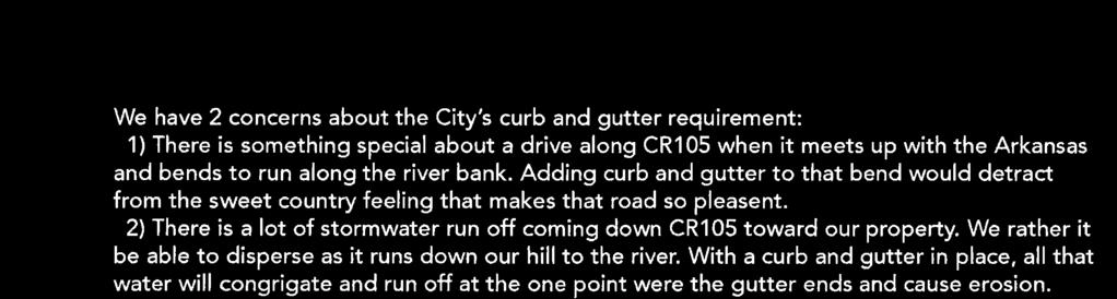
73 page 73 of 98
74 page 74 of 98 PLANNING COMMISSION STAFF REPORT MEETING DATE: June 25, 2018 AGENDA ITEM TITLE: AGENDA SECTION: 5. Amendment to Chapter 16, Addition of new Article XIII. Inclusionary Housing Public Hearing BACKGROUND: Council directed staff to prepare amendments to the Land Use and Development Code to ensure the request for affordable housing be part of future annexations and planned developments. Staff has been working with the City Attorney to prepare the amendments. We have included the provision that future major subdivisions and condominium plats of five units or more be included in the requirements. Attached to this report is Ordinance No , adopted in December, 2008, which amended the code in a similar manner. The ordinance required 12% of the units proposed in an annexation to be affordable for households earning 80% or less of the Area Median Income (AMI). This ordinance also gave some options to meeting the requirements such as providing the housing in another location, paying an in-lieu fee, providing more units above 80% AMI, or less units below 80% AMI. It appears these requirements were part of the Land Use and Development Code within Article XVI. Annexation from its adoption in December of 2008 until the code was re-adopted after an overhaul in September, Though this section did not appear in versions of the code after 2012, the requirement did appear in annexation agreements as recently as The draft ordinance places many of the requirements of Ordinance No back into the Land Use and Development Code, and includes new requirements. Specifically the draft ordinance requires: Any new annexation, planned development, condominium plats of five (5) or more units, or major subdivisions (greater than five lots) provide 12.5% of the units as permanently affordable. Permanently affordable shall mean the sale price or rents shall be affordable for households earning 80% of the Area Median Income for Chaffee County. Affordable units within a subdivision or development shall have comparable exterior finishes and blend in with the market rate units in the development. Other options for meeting this requirement includes providing the affordable housing in another location in Salida; paying a negotiated fee in-lieu of providing the units; or providing more affordable housing units at up to 120% of the AMI.
 study completed in January, 2007 which indicated Salida needed to address the growing affordable housing shortage.")
75 page 75 of 98 DISCUSSION: The recitals within Ordinance No references a report by Economic and Planning Systems (EPS) study completed in January, 2007 which indicated Salida needed to address the growing affordable housing shortage. EPS updated the study in August, 2016 with the same results. The table below shows their recommendations for yearly additions to Chaffee County s affordable housing stock.
76 page 76 of 98 According to Chapter 16, a text amendment should comply with the following standards: (1) Consistency with Purposes. The proposed amendment shall be consistent with the purposes of this Chapter. (2) No Conflict with Other Provisions. The proposed amendment shall not conflict with any other applicable provisions of this Chapter, or shall repeal or amend provisions of this Chapter which are inconsistent, unreasonable or out-of-date. (3) Consistency with Comprehensive Plan. The proposed amendment shall be consistent with the Comprehensive Plan, shall implement a new portion of the Comprehensive Plan or shall implement portions of the Comprehensive Plan which have proven difficult to achieve under the existing provisions of this Land Use Code. (4) Public Health, Safety and Welfare. The proposed amendment shall preserve the public health, safety, general welfare and environment and contribute to the orderly development of the City. STAFF RECOMMENDATION: Staff believes the proposed changes to the Land Use and Development Code complies with the above standards and will help move Salida towards the goals outlined in the recent housing study. Therefore, staff recommends the Planning Commission make a recommendation to the City Council to adopt the proposed changes to Chapter 16 by adding new Article XIII. Inclusionary Housing. RECOMMENDED MOTION: I make a motion to recommend the City Council approve the proposed changes to Chapter 16 to add new Article XIII. Inclusionary Housing. Attachments: Ordinance No Proposed ordinance adding new Article XIII. Inclusionary Housing Advertisement
77 page 77 of 98
78 page 78 of 98
79 page 79 of 98
80 page 80 of 98 ORDINANCE NO. _ (Series of 2018) AN ORDINANCE OF THE CITY COUNCIL FOR THE CITY OF SALIDA, COLORADO ADDING A NEW ARTICLE XIII TO CHAPTER SIXTEEN OF THE SALIDA CITY CODE REGARDING INCLUSIONARY HOUSING WHEREAS, the City of Salida, Colorado ( City ) is a statutory city, duly organized and existing under the laws of the state of Colorado; and WHEREAS, pursuant to C.R.S et seq., the Salida City Council ( Council ) possesses the authority to adopt and enforce zoning regulations; and WHEREAS, under such authority, the Council previously adopted land use and zoning regulations, codified as Chapter 16 of the Salida Municipal Code ( Code ); and WHEREAS, pursuant to this authority, the City Council desires to adopt certain rules and regulations to address the need for a diverse and affordable housing stock within the community; and WHEREAS, the Council wishes to ensure that applications for new residential and mixeduse annexations, planned developments, condominiums of five (5) or more units and major subdivisions include affordable housing; WHEREAS, residential units including single-family, multi-family, duplexes and townhouses can provide a market driven affordable housing opportunity in the community; and WHEREAS, the City of Salida City Council finds it in the best interest of the general health, safety and welfare of its citizens to adopt this new Article XIII to Chapter 16 of the Code concerning inclusionary housing. NOW, THEREFORE, BE IT ORDAINED BY THE CITY COUNCIL FOR THE CITY OF SALIDA, COLORADO as follows: Section One That a new article XIII be added to Chapter Sixteen of the City of Salida Municipal Code, concerning Land Use and Development to read as follows: ARTICLE XIII Inclusionary Housing Sec Purpose and objectives. (a) Promote the construction of housing that is affordable to the community's workforce; (b) Retain opportunities for people that work in the city to also live in the city; (c) Maintain a balanced community that provides housing for people of all income levels; and
81 page 81 of 98 (d) Ensure that housing options continue to be available for very low-income, low-income, moderate, and middle-income residents, for special needs populations and for a significant proportion of those who work or live in the city. Sec General Inclusionary Housing Requirements. (a) Any application brought under the annexation, planned development, condominium plats of five (5) or more units or major subdivision sections of this Code is required to include at least twelve and a half percent (12.5%) of the total number of residential dwelling units as permanently affordable dwelling units. (b) The prices for sale or rents charged for permanently affordable priced dwelling units shall not exceed a price that is affordable to a household earning eighty percent (80%) of the Area Median Income (AMI) for Chaffee County as defined annual by the United States Department of Housing and Urban Development (HUD). (c) The city administrator is authorized to adopt or create pricing categories within this income range to be utilized in the enforcement of the provisions of this article. (d) Units designated as affordable in the project should be comparable to the market rate housing units in exterior finish and should blend into the overall project. Sec Options for Satisfaction of Inclusionary Housing Requirement. An applicant may seek an alternative to providing the required percentage of housing under this article by providing the required housing off-site, paying a negotiated fee in lieu of providing units, or providing more units affordable to households earning between eighty percent (80%) and one hundred twenty percent (120%) of the AMI for Chaffee County. Such alternative shall be implemented at the discretion of the city administrator and be approved by agreement with the City Council. Sec Administrative Regulations. To the extent the city administrator deems necessary, rules and regulations pertaining to this article will be developed, maintained and enforced in order to assure that the purposes of this article are accomplished. No person shall violate any rule or regulation issued by the city administrator under this article. Section Two The provisions of this ordinance are severable and the invalidity of any section, phrase, clause or portion of the ordinance as determined by a court of competent jurisdiction shall not affect the validity or effectiveness of the remainder of the ordinance.
82 page 82 of 98 INTRODUCED ON FIRST READING, ADOPTED and ORDERED PUBLISHED IN FULL in a newspaper of general circulation in the City of Salida by the City Council on the day of, 2018 and set for second reading and public hearing on the day of INTRODUCED ON SECOND READING, FINALLY ADOPTED and ORDERED PUBLISHED BY TITLE ONLY, by the City Council on the day of, CITY OF SALIDA By: Mayor ATTEST: (SEAL) City Clerk PUBLISHED IN FULL in the Mountain Mail after First Reading on the day of, 20, and BY TITLE ONLY, OR IN FULL, after Final Adoption on the day of, 20. By: City Clerk
83 page 83 of 98
84 page 84 of 98 PLANNING COMMISSION STAFF REPORT MEETING DATE: June 25, 2018 AGENDA ITEM TITLE: AGENDA SECTION: 6. Amend Article VI. Subdivisions Public Hearing BACKGROUND: Council directed staff to prepare amendments to the Land Use and Development Code to ensure serial amendments of a minor subdivision (5 lots or less) would not have the effect of circumventing the requirements of the major impact review process. The Planning Commission reviewed the potential amendments at the meetings of March 26, 2018 and April 23, The draft ordinance proposes the following changes to the subdivision section of the Code: Eliminates the conflict between Section (2) and Section Resubdivisions. The conflict that exists between these two section is one states any resubdivision must follow the major impact review; whereas the other section states a resubdivisions must have more than 10 lots. The amendment removes the definition of a resubdivisions being more than 10 lots. Requires an additional criteria for the creation of a minor subdivision through the Limited Impact process. The underlying zoning of the previously un-subdivided land must not in its entirety allow development that would normally require the Major Impact Process. For example, if a two acre parcel has R-3 zoning that is proposed for a minor subdivision of two, one acre lots, a development plan and major subdivision must occur. The math behind this determination is as follows: 2 X one acre (43,560 square feet) / 2,400 = 36 units. Per Table 16-D Schedule of Uses, any multi-family development greater than 19 units requires Major Impact Review. However, each lot would only allow 18 units which would be an Administrative Review. The other proposed changes are to provide notice that major subdivisions; and condominium plats of five units or greater are required to meet the proposed Inclusionary Housing requirements. The proposed changes to the subdivision code are shown in red. DISCUSSION: According to Chapter 16, a text amendment should comply with the following standards: (1) Consistency with Purposes. The proposed amendment shall be consistent with the purposes of this Chapter.
85 page 85 of 98 (2) No Conflict with Other Provisions. The proposed amendment shall not conflict with any other applicable provisions of this Chapter, or shall repeal or amend provisions of this Chapter which are inconsistent, unreasonable or out-of-date. (3) Consistency with Comprehensive Plan. The proposed amendment shall be consistent with the Comprehensive Plan, shall implement a new portion of the Comprehensive Plan or shall implement portions of the Comprehensive Plan which have proven difficult to achieve under the existing provisions of this Land Use Code. (4) Public Health, Safety and Welfare. The proposed amendment shall preserve the public health, safety, general welfare and environment and contribute to the orderly development of the City. STAFF RECOMMENDATION: Staff believes the proposed changes to the Land Use and Development Code complies with the above standards and will ensure the subdivision of land will require the appropriate public process and standards. Therefore, staff recommends the Planning Commission make a recommendation to the City Council to adopt the proposed changes Article VI. Subdivisions. RECOMMENDED MOTION: I make a motion to recommend the City Council approve the proposed changes to Article VI. Subdivisions. Attachments: Exhibit A: Proposed amendments to Article VI. Subdivisions. Advertisement
86 page 86 of 98 EXHIBIT A ARTICLE VI. - SUBDIVISION Sec Types of subdivisions. The division of land into two (2) or more separate parcels, lots, sites, tracts or interests, including any parcel of land which is to be used for condominiums or any other multiple-dwelling units with separately conveyed interests, is a subdivision and is regulated by the provisions of this Chapter. The subdivision of land is a significant step in the process of urban development. The arrangement of land parcels for residential, commercial, industrial, recreational, utility and other public purposes will determine to a large degree the qualities of health, safety, convenience, environment and general welfare of the City. The following are types of subdivisions in the City. (1) Major subdivisions are subdivisions that result in the creation of more than five (5) parcels, lots, units, sites, tracts or interests out of the property as it existed prior to any subdivision. (2) The division of lots or parcels of previously subdivided land or amended plats that involve more than ten (10) lots are resubdivisions. Rare resubdivisions and are reviewed as major subdivisions. (3) The division of previously unsubdivided land into five (5) or fewer separate parcels, lots, units, sites, tracts or interests is a minor subdivision. Additionally, public and private utility mains must be available and in place to serve each proposed lot such that only a service line connection for each lot to a main is necessary. If the previously unsubdivided land has zoning which would allow development requiring a major impact review per Table 16-D, then a development plan and major subdivision is required. (4) Subdivision actions that affect no more than ten (10) lots within a subdivision and do not create additional lots or interests in property and that result in a material change in the boundaries of a subdivision by way of adding or deleting land or lots to the subdivision, reconfiguration, division or aggregation of existing platted lots or correction of technical errors on subdivision plats are amended plats. (5) The division of a single lot on which an existing duplex dwelling is located, or is to be constructed, into two (2) separate lots is a duplex conversion subdivision. Sec Major subdivision. A major subdivision is subject to the major impact review process established in Article III of this Chapter unless the subject property has an approved overall development plan, in which case conceptual plan is waived. Major subdivisions must meet the requirements of Article XIII. Inclusionary Housing. Sec Minor subdivision. A minor subdivision is generally subject to the limited impact review process established in Article III of this Chapter. Sec Resubdivisions. Resubdivisions are reviewed in the same manner as a major subdivision with the same purposes. To the extent that submittal information, otherwise required in Section , was submitted as part of the
87 page 87 of 98 original subdivision proposal and is adequate by current standards, the applicant for approval of a resubdivision does not need to submit the information again and may reference such submittal information in the resubdivision application. The Community Development Director will determine the technical adequacy of previously submitted information. Sec Amended plats. (a) Amended plats do not create additional lots or interests in property but are subdivision actions that result in a material change in the boundaries of a subdivision by way of adding or deleting land or lots to the subdivision, or the reconfiguration, division or aggregation of existing platted lots. Amended plats are also used to correct errors on a subdivision plat. The amended plat process is limited to applications that affect no more than ten (10) lots within a subdivision. Amendments affecting more than ten (10) lots or amendments within a subdivision with an expired subdivision improvements agreement or which affect existing subdivision improvements agreements shall be considered re-subdivisions. Amended plats shall be generally subject to administrative review and approval according to the procedure established at Article III of this Chapter. Amended plat review ensures the technical accuracy of the amended plat and to maintain the record of associated real estate activities. (b) Amended plat approval shall be granted provided: (1) The lot line adjustment does not result in the creation of additional lots. (2) The lot line adjustment does not result in the creation of lots that do not comply with zoning requirements. (3) The lot line adjustment does not result in the creation of a lot or lots that cannot be built upon under City requirements. (4) The requirements of utility companies serving the property have been satisfied, and easements are appropriately maintained or granted in the deed(s) affecting the adjustment or dissolution. (5) The lot line dissolution does not change the location of any remaining lot lines in the subdivision Sec Duplex conversion subdivision. A duplex conversion subdivision is generally subject to the administrative review process established in Article III of this Chapter. The subdivision of a single lot on which an existing duplex dwelling is located or is to be constructed, into two (2) separate lots will be approved if all of the following conditions have been met: (1) Common Wall. The duplex is to be divided along a code-compliant fire-resistant common wall into two (2) separate single-family dwelling units on separate lots. (2) Separate Utilities. Utilities are available and each of the dwelling units is served by its own separate utility service lines and meters, inclusive of water, sewer, electricity and natural gas. (3) Maintenance Agreement. A common wall maintenance agreement shall be established and recorded to run with the land comprising the proposed duplex lots. (4) Zone District Compliance. Except for the original primary structure comprising the dwelling units and any common and/or side-by-side or connected garages or driveways, all new structures, or the expansion of any existing structures on the two (2) new duplex lots shall be subject to the setback requirements for the underlying zone district in which the lots are located.
88 page 88 of 98 (5) Lot Size. Each separate lot created shall meet the minimum lot size (square feet) for the underlying zone district in which the lots are located. The proposed duplex lots shall be the same size, or approximately the same. Sec Lot line adjustments. The adjustment of a lot line between two (2) contiguous lots that is necessary to correct a survey or engineering error in a recorded plat, to allow a boundary change between adjacent lots or parcels to relieve hardship or practical necessity or to allow a transfer of land from a larger conforming lot to a smaller nonconforming lot so as to make both lots conforming is generally subject to administrative review and approval according to the procedure established at Article III of this Chapter. The lot lines between contiguous lots which are under separate or single ownership may be adjusted if the following conditions are met: (1) The owners of affected properties whose lot lines are being adjusted shall provide written consent to the application. (2) The adjustment shall not create the opportunity to further subdivide either lot to create a new lot for resale or development. (3) All resulting lots shall meet the standards of this Chapter. If any of the lots or structures thereon are nonconforming prior to the adjustment, no adjustment shall be allowed that increases the net nonconformity of the lots or structures. Sec Insubstantial change to recorded plat. An insubstantial change shall be limited to changes to address engineering or technical constraints discovered during development which could not be anticipated during the original approval process, or any other change to a plat which has no material effect on the character of the approved plat, the representations made by the applicant or the conditions of approval. Street locations and street rights-ofway shall not be changed. A change to a plat which is not insubstantial, including any resubdivision of a lot other than a boundary line adjustment, shall be considered an amendment and shall follow the review procedures applicable to minor subdivisions. Applications for an insubstantial change to a recorded plat are generally subject to administrative review and approval according to the procedure established at Article III of this Chapter. An insubstantial change to a recorded plat will be approved if following approval of the insubstantial change, the recorded plat shall continue to conform to all applicable standards of this Chapter. Sec Elimination of lot lines. The elimination of lot lines to merge not more than two (2) conforming lots, or two (2) or more nonconforming lots, to create no more than two (2) conforming lots within the applicable zone district shall be generally subject to administrative review and approval according to the procedure established at Article III of this Chapter. A lot line elimination meeting the requirements established herein shall be approved if the following conditions are met: (1) Public and private utilities must be present and available to serve the newly created conforming lots. Utilities (whether public or private) to existing structures that, with the elimination of lot lines, will cross a newly created conforming lot shall be provided an easement where the existing utilities are located or shall be relocated into an easement. (2) The lots to be consolidated shall be under single ownership.
89 page 89 of 98 Sec Condominiums. (a) In addition to the subdivision submittal requirements described in Section , an application for a condominium plat approval shall contain the following information: (1) Required parking spaces and joint trash collection areas; (2) Floor plans, elevations, and site plan as required to show separate ownership of all separate units, common elements, and limited common elements labeled as such; (3) Number, type, and floor area of units, common elements and limited elements, delineated in square feet and fractions thereof; proposed use for each unit; land area; floor area ratio; and (4) Statement of the total number of units shown on the proposed plat; (5) Documentation showing compliance with the standards and terms of the Colorado Common Interest Ownership Act, C.R.S , et seq., as may be amended. (b) For condominium projects requiring limited impact or major impact review (see standards for multifamily projects), the applicant shall submit detailed engineering plans and specifications for all improvements, whether private or public. (c) Condominium plats including five units or greater must meet the requirements of Article XIII. Inclusionary Housing. (cd) After buildings have been constructed and final "as-built" surveys have been completed, the applicant shall submit an amended condominium plat showing graphically and dimensionally the subdivision of buildings into volumetric spaces and the relationship of these spaces with the boundaries of the site and other appurtenances on the site. These condominium plats shall comply with the requirements of C.R.S , as may be amended, and may be approved by the Administrator. No individual condominium unit shall be sold into separate ownership until and unless a condominium plat has been approved by the City based upon an "as-built" survey of the unit boundaries and such plat has been recorded in the real estate records of Chaffee County. A plat note on the final subdivision plat for each condominium development shall be included to this effect. Sec Subdivision plat requirements. (a) Application Contents. An application for a subdivision plat approval shall contain the following information: (1) Subdivision Plat. A subdivision plat shall be drawn which reflects the layout of the lots, blocks and structures in the proposed subdivision. The preferred scale of the plat is one (1) inch equals one hundred (100) feet; the minimum allowable scale is one (1) inch equals two hundred (200) feet. Sheet size shall be twenty-four (24) inches by thirty-six (36) inches. If it is necessary to draw the plat on more than one (1) sheet, a sheet index shall be placed on the first sheet. The subdivision plat shall contain the following: (i) Name of subdivision. (ii) Legal description. (iii) Names and addresses of the owner, subdivider, land planner and land surveyor registered in the State. (iv) Scale of the plat. (v) North arrow. (vi) Date the plat was prepared.
90 page 90 of 98 (vii) Boundary lines and dimensions. The boundary lines of the proposed subdivision (shown as a heavy solid line), the proposed zoning boundary lines, approximate dimensions of all lots, blocks and all land intended to be held in common for use by all property owners in the proposed subdivision. (viii) Contours. Existing and proposed topographic contours, with intervals of five (5) feet or less, referring to U.S.G.S. datum. (ix) Improvements and easements. The location and dimensions of all existing and proposed streets, alleys, easements, ditches and utilities within or adjacent to the proposed subdivision. (2) Vicinity Map. A vicinity map shall be submitted, if the application has not been reviewed at the conceptual plan review phase, along with the plat. The vicinity map shall show the location of the proposed subdivision, all adjacent lands owned or under option by the applicant, commonly known landmarks and federal, state and local streets with names, and the zone districts in which the proposed subdivision and adjacent properties are located. (3) Boundary Survey. An accurate and complete boundary survey and survey of interior street lines shall be made of the land to be subdivided. Every lot shall close mathematically within onehundredth (0.01) of a foot. Field measurements shall be accurate within a limit of one (1) foot to ten thousand (10,000) feet. The boundary of the subdivision shall be clearly indicated on the final plat. All lines shown on the plat which do not constitute a part of the subdivision shall be dashed. Any area enclosed by the subdivision, but not a part thereof, shall be labeled "NOT A PART OF THIS SUBDIVISION." Adjacent subdivisions shall be identified by official names. (4) Survey Data. The final subdivision plat shall show all survey, mathematical information and data necessary to locate all monuments and to locate and retrace all interior and exterior boundary lines appearing thereon, including bearings or angles, continued with distances and deflection angles for all circular corners. The location and description of all section corners and permanent survey monuments in or near the tract, to at least one (1) of which the subdivision shall be referenced. (5) Land to be Dedicated. All lots, blocks and parcels offered for dedication shall be particularly delineated and designated with all dimensions, boundaries and courses clearly shown and defined in every case. Parcels offered for dedication, other than for streets and easements, shall be designated by letter or number, which shall be explained on the plat. (6) Linear, Angular and Curve Data. Sufficient linear, angular and curve data shall be shown to readily determine the bearing and length of the boundary lines of every block, lot and parcel which is part thereof. All lots and, wherever practicable, blocks in their entirety, shall be shown on one (1) sheet. Ditto marks shall not be used for lot dimensions. All lots and blocks shall be numbered systematically. Building setback lines shall be shown by long thin dash lines. The use of the lots and the zoning shall be designated on the plat. (7) Streets. The plat shall show the right-of-way lines and names of each street and the width of any portion being dedicated, and the widths of any existing dedications. The widths, locations and names of adjacent streets and other public properties within fifty (50) feet of the subdivision shall be shown. If any street in the subdivision is a continuation or approximately a continuation of an existing street, the conformity or the amount of nonconformity of such street to such existing streets shall be accurately shown. Whenever the centerline of a street has been established or recorded, the data shall be shown on the final plat. (8) Easements. The sidelines of all easements, including easements for utilities, ditches and drainage, shall be shown by fine dashed lines. If any easement already of record cannot be definitely located, a statement of the existence, the nature thereof and its recorded reference shall appear on the title sheet. Distances and bearings on the sidelines of lots which are cut by easement shall be designated, or so shown, that the plat will clearly indicate the actual length of the lot lines. The widths of all easements and sufficient ties thereto to definitely locate the same with respect to the subdivision shall be shown. All easements shall be clearly labeled and
91 page 91 of 98 identified. If an easement is being dedicated by the plat, it shall be set out in the owner's certificate of dedication and dedicated to the City. If an easement shown on the plat is already of record, its recorded reference shall be given. (9) Certificates. The following certificates, as appropriate, are required to appear on the final subdivision plat. (i) Certificate of Dedication and Ownership. Know all men by these presents, that the undersigned, being all of the Owner(s), Mortgagee(s) and Lien Holder(s) of certain land in the City of Salida, Chaffee County, Colorado, described as follows: Beginning, containing acres, more or less, have by these presents laid out, platted and subdivided the same into lots, blocks or tracts, as shown on this plat, under the name and style of, and do hereby dedicate to the City of Salida as public roads, the streets and roads as shown on said plat, these being. The undersigned hereby further dedicate to the public all utility easements on the property as described and as shown hereon. The undersigned hereby further dedicate to the public utilities the right to install, maintain and operate mains, transmission lines, service lines and appurtenances to provide such utility services within this subdivision or property contiguous thereto, under, along and across public roads as shown on this plat and also under, along and across utility easements as shown hereon. The lands comprising this subdivision are subject to certain covenants which are recorded in Book at Page of the records of Chaffee County, Colorado. Executed this day of, 20. Owner(s): Mortgagee(s)/Lienholder(s): County of Chaffee ) ) ss. State of Colorado ) The foregoing dedication was acknowledged before me this day of 20, by. Witness my hand and seal. My commission expires. Notary Public (ii) Certificate of Street and Utility Maintenance. Public notice is hereby given that neither the dedicated public roads nor the public utilities shown on this plat will be maintained by the City of Salida until and unless the subdivider constructs the streets, roads and utilities in accordance with the subdivision agreement, if any, and the subdivision regulations in effect at the date of the recording of this plat, and
92 page 92 of 98 approval of the City has been issued to that effect. When the City approves a street or utility for maintenance, the street or utility shall become public in all senses of the word and the subdivider has no further obligations in regards to that particular street or utility. (iii) Surveyor's Certificate. I,, a Registered Professional Land Surveyor in the State of Colorado, do hereby certify that the survey represented by this plat was made under my supervision, the monuments shown thereon actually exist and this plat accurately represents said survey. Registered Land Surveyor (iv) Title Certificate. I,, an (attorney at law duly licensed to practice before the Courts of Record or a licensed title insurance agent representing ) in the State of Colorado, certify that I have examined title to the property described herein and that in my opinion title to the above described real property is held by. Signed this day of, 20. Attorney at Law (v) City Administrator Approval This plat is approved by the Salida City Administrator this day of 20. City Administrator (vi) Planning Commission Approval. This plat is approved by the City of Salida Planning Commission this day of, 20. Chairman (vii) City Council Approval. This plat is approved for filing and the City hereby accepts the dedication of the streets and roads shown hereon subject to the provisions in "Street Maintenance" set forth above, and further accepts the dedication of the easements shown hereon. Signed this day of, 20. City of Salida By: Mayor (viii) Recorder's Certificate.
93 page 93 of 98 This plat was filed for record in the office of the County Clerk and Recorder of Chaffee County at.m. on the day of, 20, Reception No.. County Clerk and Recorder By: Deputy Sec Subdivision review standards. In order to achieve the intent and purpose of this Chapter, the proposed subdivision shall comply with the following standards: (1) Comprehensive Plan. The proposed subdivision shall carry out the purpose and spirit of the Comprehensive Plan and conform with all of the Plan's applicable objectives, guiding principles and recommended actions. It shall be designed to be compatible with surrounding land uses and to protect neighbors from undesirable noise, glare and shadows, and shall not cause adverse effects on their privacy, solar access and views. (2) Zone District Standards. The proposed subdivision shall comply with the use and dimensional standards of the underlying zone district and shall provide off-street parking as required for the uses. (3) Improvements. The proposed subdivision shall be provided with improvements which comply with Section and landscaping which complies with Section (i) Streets. Existing and proposed streets shall be suitable and adequate to carry anticipated traffic within and in the vicinity of the proposed subdivision. (ii) Utilities. Existing and proposed utility services shall be suitable and adequate to meet the needs of the proposed subdivision. (iii) Phases. If the subdivision is to be developed in phases, each phase shall contain the required parking spaces, landscape areas, utilities and streets that are necessary for creating and sustaining a stable environment. (4) Natural Features. The layout of lots and blocks shall provide desirable settings for structures by making use of natural contours and maintaining existing views, affording privacy for residents and protecting them from adverse noise and vehicular traffic. The system of roadways and the lot layout shall be designed to take advantage of visual qualities of the area. Natural features and native vegetation shall be preserved whenever possible. Tree masses and individual trees of six-inch caliper or greater shall be preserved. (5) Floodplains. Tracts of land or portions thereof lying within the 100-year floodplain may only be subdivided for open space until the subdivider has shown that compliance with the requirements of the City's floodplain regulations can be met. (6) Noise Reduction. Where a subdivision borders on or contains a highway right-of-way, the City shall require adequate provisions for reduction of noise. A parallel street, landscaping, screening, easement, greater lot depth, increased rear yard setbacks and fencing are potentially appropriate solutions, among others. (7) Future Streets. When a tract is subdivided into lots or parcels which are intended for future resubdivision, such lots or parcels shall be arranged so as to permit the logical location and opening of future streets and appropriate resubdivision, with provision for adequate utility easements and connectors for such resubdivision. (8) Parks, Trails and Open Space. Each subdivision, minor or major, or condominium project with five (5) units or more, shall dedicate and develop land or pay a fee-in-lieu for the purpose of
94 page 94 of 98 providing active parks, open space, passive recreation facilities and/or recreation trails or other public purposes as determined by the City for the benefit of those who occupy the property and be made accessible to the public. The intent of this regulation is to ensure that a comprehensive, integrated network of parks, trails and open spaces is developed and preserved as the community grows. (i) Dedication requirement. Land for parks, trails and open space shall be dedicated in the ratio of two-hundredths (0.02) acre per residential unit of the proposed subdivision. When a development plan has not been determined for the property, the number of units shall be assumed as the maximum density permitted on the site. When a mix of residential and nonresidential uses is proposed on the site, the dedication shall still be provided for the residential units. All areas dedicated for parks, trails and open space must be shown on the plat. All dedications of land as required under this Section shall be dedicated in fee simple to the City as a condition of approval unless the City determines that the specific situation warrants consideration of an easement or designation rather than dedication. (ii) Fee-in-lieu. For those subdivisions where the dedication of land for parks, trails or open space is not practicable, such as developments involving inappropriate location, impractical geography, small land area or few lots, in its discretion, the City may require a cash fee in lieu of dedication based upon Salida land values. When possible, the requirement for cash in lieu of dedication shall be noted as a plat note on the final plat of the subdivision. Moneys collected in lieu of dedication of land for parks, trails or open space shall be collected at the time of approval of the final plat and placed into a City park development fund to be earmarked for future acquisition or improvement of parks, trails or open space. In extraordinary circumstances, the City Council may authorize the deferral of the payment of cash in lieu of dedication as required by this Section. In such event, the owner of the property shall agree with the City, in such form as shall be acceptable to the City Council, to pay such sums at the time of issuance of any building permit upon the property. Notice shall be given of such deferred payment by the recording of a first mortgage or other security instrument with the County Clerk and Recorder. In no event, however, shall the deferral of any dedication fee required by this Section extend for a period of greater than five (5) years from the date it would otherwise be payable. The developer shall agree to pay the higher of the dedication fee calculated in accordance with this Section at the time originally owed or at the time actually paid. (iii) Residential subdivisions or the residential portion of mixed use subdivisions. For the square footage of required land not provided on the site the value of the fee shall be based upon the most recent available formula used by the Chaffee County Assessor's office for valuing vacant land in Salida subdivisions. The amount of such fees and charges shall be established by resolution of the City Council, as may be amended from time to time, and available for review by the public at City Hall during normal business hours. (iv) Condominiums. For condominium projects with five (5) or more residential units developed after the effective date of the ordinance codified herein, which have not already provided open space through an approved subdivision, a fee established by resolution of the City Council shall be paid for each residential unit, as may be amended from time to time, and available for review by the public at City Hall during normal business hours. (v) Extraordinary contributions. If the Planning Commission finds that the land proposed for dedication is an extraordinary contribution that meets a unique or highly desired purpose of the community, the Planning Commission may recommend a reduction of the overall dedication requirement as appropriate. Examples of extraordinary contributions may include public access to a waterway or important trail connections. (vi) Dedication at alternate site. In lieu of dedicating land within the subdivision, the applicant may dedicate an alternate parcel of land to the City, consisting of the same number of acres in another area, if the City determines it is capable of use for recreational purposes and will serve the proposed development.
95 page 95 of 98 (vii) When a land dedication, designation or easement is accepted by the City, the City Council shall have full discretion to require the applicant or assigns to provide construction and/or maintenance of the park, trail or open space. Land for public use must be suitable for the type of development and/or use for which it is intended. Excessively steep land, land for utility easements or other types of unsuitable land may not be accepted as determined by the Planning Commission. Lands including floodplains, waterways and wetlands may be accepted. Drainage areas that also meet the purposes of this provision may be accepted. (viii) Whenever a subdivision includes land or areas identified in the Parks, Trails, Recreation and Open Space Plan, Comprehensive Plan or any other adopted community plan for the installation of or connection to any part of a park, trail or open space, such land or areas shall be dedicated to the City and such dedication shall be credited against any required land dedication. (ix) Lands for parks, trails or open space will not be counted towards the landscape area required for each lot in the subdivision. (9) Common Recreation Facilities. Where a development is proposed to contain common recreation facilities, such facilities shall be located within the development so as to be easily accessible to the residents and to least interfere with neighboring developments. (10) Lots and Blocks. (i) Pattern. The size, shape and orientation of lots shall be appropriate to the design and location of the proposed subdivision and to the type of development contemplated. Where appropriate, lots shall be laid out to respect the existing City pattern. Blocks generally shall not be less than three hundred (300) feet nor more than one thousand two hundred (1,200) feet in length. (ii) Frontage. Residential lots should front only on local streets; however, when necessary, lots designated to face a collector street shall provide adequate means for automobile turnaround within the lot and should provide consolidated access points to the maximum extent feasible. (iii) Right angles. Side lot lines shall be approximately at right angles or radial to street lines. (iv) Double frontage lots. Double frontage lots are prohibited, except where they are necessary to provide for the separation of residential development from collector or arterial streets or to overcome specific limitations of topography or orientation. A planting and screening easement of at least ten (10) feet shall be provided along the portion of the lot which abuts such a collector or arterial street. There shall be no right of access across a planting and screening easement. The screening easement shall be maintained by the property owner. (v) "T" intersections. The building area of lots shall not face directly into the oncoming traffic of an intersecting street of a "T" intersection. (vi) Solar energy. For purposes of protecting and enhancing the potential for utilizing solar energy in the proposed subdivision, detached single-family lots are encouraged to be laid out in such a manner that the houses will be oriented so that their long axis will run east/west and so that the houses will not block the solar access of adjacent houses. (11) Architecture. The following architectural standard is intended to prevent monotonous streetscapes and offer consumers a wider choice of housing styles. To avoid uniformity and lack of variety in design among housing units within the subdivision, no residential façade elevation shall be repeated more than once every five (5) lots on the same side of the street (e.g., the first and fifth lots in a row may contain the same façade elevation, but the second, third, and fourth lots must contain some different façade elevations). No residential elevation shall be repeated directly across the street from the same façade elevation. Mirror images of the same residential façade shall not count as two (2) distinctly different façades. In unusual circumstances, the Planning Commission may grant a petition seeking waiver of this requirement. Such an exception may be granted if the petitioner demonstrates that the proposed plan uses repetition
96 page 96 of 98 for an architectural purpose, such as allusion to historical repetition that would not create a monotonous streetscape of the type this standard seeks to prevent. (12) Codes. The subdivision shall comply with all applicable City building, fire and safety codes for the proposed development. (13) Inclusionary Housing. Major subdivisions and condominium plats of five (5) units or greater must meet the requirements of Article XIII. Inclusionary Housing. Formatted: Normal, Indent: Left: 0.31", Hanging: 0.31" Sec Vacation of recorded plat, right-of-way or easement. An applicant requesting to vacate a recorded subdivision plat, public right-of-way or dedicated easement shall same process by which it was originally approved. (1) Evaluation standards. The following items shall be considered in evaluating the vacation of a recorded plat, right-of-way or easement outlined below: (i) Access to public road. No roadway shall be vacated so as to leave any adjoining land without a means of access to another public road. (ii) Easements. In granting a vacation, the City may reserve easements for the installation or maintenance of utilities, ditches and similar improvements. (iii) Comprehensive Plan. A subdivision plat, public right-of-way or dedicated easement may be vacated if the vacation would be consistent with or implements the applicable intent statements, specific directions and recommended actions of the Comprehensive Plan. (iv) Transfers or sales of lots. A subdivision plat may be vacated if none of its lots have been sold or transferred; or, if there have been sales or transfers, no development on any lots in the subdivision and all of the owners agree to the vacation of the plat. (2) Quitclaim Deed. Whenever the City approves an application vacating a public right-of-way, the City shall provide abutting landowners with a quitclaim deed for the vacated lands. Each abutting landowner shall be deeded that portion of the vacated right-of-way to which the owner's land is nearest in proximity. Sec Fair contributions for public school sites. (a) General. Growth in residential land development and the construction of new residential dwellings in the City and Chaffee County necessitates the acquisition of additional public school capital facilities to accommodate increases in student population. Requiring land dedication or conveyance for public school capital facilities or payments in lieu of such dedication or conveyance ("Fair Contribution for Public School Sites") is intended to provide a portion of the resources to meet such demand. (b) Referral. All residential subdivision applications and planned developments creating residential dwelling units shall be referred to the Salida School District R-32-J for review and comment concerning impact of the development on the School District and the adequacy of public school sites and facilities. If a nonresidential land development application may have influence or effect on property owned by or activities of the Salida School District R-32-J, the information pertaining to that application shall also be referred to the School District for review and comment. (c) Dedication Requirement. (1) If recommended by the Salida School District R-32-J, the applicant shall dedicate or convey land for a public school facility to the School District based on acres per residential dwelling unit. Otherwise, the applicant shall agree to a payment in lieu of land dedication or
97 page 97 of 98 (d) conveyance in the amount of three hundred fifty-four dollars ($354.00) per residential dwelling unit. The applicant may elect for such amount to paid by the owner of a particular lot at the time a residential building permit is obtained. Such requirement shall be noted on the underlying plat and, if required by the City, a separate covenant. (2) If the Fair Contribution for Public School Sites includes the dedication or conveyance of land, prior to recording the final plat, the applicant shall provide proof that the dedication has been made to the School District in a manner and on terms satisfactory to the School District and in accordance with the following requirements: (i) Title shall be conveyed by a general warranty deed, free and clear of all liens, encumbrances, and exceptions (except those approved in writing by the School District), including, without limitation, real property taxes, which will be prorated to the date of conveyance or dedication. The land to be conveyed shall be conveyed pursuant to a contract for the sale and purchase of real property containing customary terms for the land which is being conveyed to the School District. (ii) At the time of dedication or conveyance, the applicant shall provide a title insurance commitment and policy in an amount equal to the fair market value of the dedicated property. At the appropriate time, not later than the issuance of the first building permit for the land development project, the person or entity shall also pay or provide for the payment of one-half (½) of street development costs, and shall either provide, or pay or make provision for the payment of the costs associated with making improvements for water, sewer, and utilities stubbed to the site, and overlot grading of the dedicated land. The applicant shall also have furnished any off-site easements which the School District needs to develop the site. (iii) The lands being dedicated or conveyed to the School District shall be located and configured as directed by the School District. (iv) The person or entity conveying the land to the School District shall satisfy the City's water rights dedication requirements, as may be amended, prior to conveying the property to the School District. (v) In addition to conveyed or dedicated lands, the School District shall be given the right to purchase adjacent lands owned by the developer at its fair market value so that the dedicated or conveyed and purchased lands together form a contiguous parcel which meets the School District's land area requirements. Exemptions. The following uses shall be excepted from Fair Contribution for Public School Sites: (1) Construction of any nonresidential building or structure; (2) Alteration, replacement or expansion of any legally existing building or structure with a comparable new building or structure which does not increase the number of residential dwelling units; (3) Construction of any building or structure for limited term stay or for long term assisted living, including, but not limited to, bed and breakfast establishments, boarding or rooming houses, family-care homes, group-care homes, halfway houses, nursing homes, or hospices, except where such building or structure will be used primarily to house school aged children; (4) Construction of any residential building or structure classified as housing for older persons, pursuant to the Federal Fair Housing Act in effect; (5) The construction of accessory buildings or structures; and (6) Construction of any low-income housing unit, on lots designated as such by the City.

98 page 98 of 98
PLANNING COMMISSION Minutes
 MEETING DATE: Monday January 22, 2018 MEETING TIME: 6:00 PM MEETING LOCATION: City Council Chambers, 448 E. First Street, Suite 190, Salida, CO Present: Mandelkorn, Follet, Denning, Thomas, Farrell, Bomer,
AGENDA CITY OF SALIDA PLANNING COMMISSION
 AGENDA CITY OF SALIDA PLANNING COMMISSION MEETING DATE: Monday, June 27, 2016 MEETING TIME: 6:00 p.m. MEETING LOCATION: City Council Chambers, 448 East First Street, Salida, CO AGENDA SECTION: I. CALL
MEETING DATE: Monday, August 28, 2017 MEETING TIME: 6:00 PM MEETING LOCATION: City Council Chambers, 448 E. First Street, Suite 190, Salida, CO
 MEETING DATE: Monday, August 28, 2017 MEETING TIME: 6:00 PM MEETING LOCATION: City Council Chambers, 448 E. First Street, Suite 190, Salida, CO Present: Wood, Kasper, Mandelkorn, Follet, Berg, Thomas,
AGENDA CITY OF SALIDA PLANNING COMMISSION
 AGENDA CITY OF SALIDA PLANNING COMMISSION MEETING DATE: Monday, May 23, 2016 MEETING TIME: 6:00 p.m. MEETING LOCATION: City Council Chambers, 448 East First Street, Salida, CO AGENDA SECTION: I. CALL TO
AGENDA CITY OF SALIDA PLANNING COMMISSION
 AGENDA CITY OF SALIDA PLANNING COMMISSION MEETING DATE: Monday, July 23, 2018 MEETING TIME: 6:00 p.m. MEETING LOCATION: City Council Chambers, 448 East First Street, Salida, CO AGENDA SECTION: I. CALL
AGENDA CITY OF SALIDA PLANNING COMMISSION
 AGENDA CITY OF SALIDA PLANNING COMMISSION MEETING DATE: Monday, September 26, 2016 MEETING TIME: 6:00 p.m. MEETING LOCATION: City Council Chambers, 448 East First reet, Salida, CO AGENDA SECTION: I. CALL
PLANNING BOARD REPORT PORTLAND, MAINE
 PLANNING BOARD REPORT PORTLAND, MAINE India Newbury Residences Subdivision & Conditional Use Review 2016-096 India Newbury Residences, LLC Submitted to: Portland Planning Board Date: May 20, 2016 Public
ARTICLE 15 - PLANNED UNIT DEVELOPMENT
 Section 15.1 - Intent. ARTICLE 15 - PLANNED UNIT DEVELOPMENT A PUD, or Planned Unit Development, is not a District per se, but rather a set of standards that may be applied to a development type. The Planned
ARTICLE 14 PLANNED UNIT DEVELOPMENT (PUD) DISTRICT
 DISTRICT") ARTICLE 14 PLANNED UNIT DEVELOPMENT (PUD) DISTRICT Section 14.01 Intent. It is the intent of this Article to allow the use of the planned unit development (PUD) process, as authorized by the Michigan Zoning
ARTICLE 14 PLANNED UNIT DEVELOPMENT (PUD) DISTRICT Section 14.01 Intent. It is the intent of this Article to allow the use of the planned unit development (PUD) process, as authorized by the Michigan Zoning
PLANNED UNIT DEVELOPMENT & SUBDIVISION STAFF REPORT Date: April 18, 2019
 PLANNED UNIT DEVELOPMENT & SUBDIVISION STAFF REPORT Date: April 18, 2019 DEVELOPMENT NAME SUBDIVISION NAME Springhill Village Subdivision Springhill Village Subdivision LOCATION 4350, 4354, 4356, 4358,
PLANNED UNIT DEVELOPMENT STAFF REPORT Date: October 19, 2017
 PLANNED UNIT DEVELOPMENT STAFF REPORT Date: October 19, 2017 DEVELOPMENT NAME LOCATION Custom Boat Storage 3975 Demetropolis Road (East side of Demetropolis Road, 0.2± miles South of Halls Mill Road.)
ARTICLE VII. NONCONFORMITIES. Section 700. Purpose.
 ARTICLE VII. NONCONFORMITIES. Section 700. Purpose. The purpose of this chapter is to regulate and limit the development and continued existence of legal uses, structures, lots, and signs established either
Article 7: Residential Land Use and Development Requirements
 Article 7: Residential Land Use and Section 701: Statement of Intent (A) (B) (C) The intent of Article 7 is to develop certain land use and development requirements for the residential uses within Cumru
ARTICLE XI CONDITIONAL USE PERMITS
 ARTICLE XI CONDITIONAL USE PERMITS 11.1 Purpose. The City of Hailey recognizes that certain uses possess unique and special characteristics with respect to their location, design, size, method of operation,
Guide to Combined Preliminary and Final Plats
 Guide to Combined Preliminary and Final Plats Introduction The Douglas County is committed to providing open, transparent application processes to the public. This Guide is provided to assist anyone interested
MEETING DATE: Monday, February 27, 2017 MEETING TIME: 6:00 p.m. MEETING LOCATION: City Council Chambers, 448 East First Street, Salida, CO
 AGENDA CITY OF SALIDA PLANNING COMMISSION MEETING DATE: Monday, February 27, 2017 MEETING TIME: 6:00 p.m. MEETING LOCATION: City Council Chambers, 448 East First Street, Salida, CO AGENDA SECTION: I. CALL
Town of Lisbon, Maine SUBDIVISION REVIEW APPLICATION
 Date Received: Fee Paid (amount): Applicant: Town of Lisbon, Maine SUBDIVISION REVIEW APPLICATION Subdivision Name/Title: This application must be received at the Town Office by close of business on the
Guide to Minor Developments
 Guide to Minor Developments Introduction The Douglas County (DCD) is committed to providing open, transparent application processes to the public. This Guide is provided to assist anyone interested in
PLANNED UNIT DEVELOPMENT & SUBDIVISION STAFF REPORT Date: July 20, 2017
 PLANNED UNIT DEVELOPMENT & SUBDIVISION STAFF REPORT Date: July 20, 2017 DEVELOPMENT NAME SUBDIVISION NAME LOCATION Rangeline Crossing III Subdivision Rangeline Crossing III Subdivision 5289 Halls Mill
PLANNED UNIT DEVELOPMENT & SUBDIVISION STAFF REPORT Date: November 17, 2016
 PLANNED UNIT DEVELOPMENT & SUBDIVISION STAFF REPORT Date: November 17, 2016 DEVELOPMENT NAME SUBDIVISION NAME LOCATION Autonation Ford of Mobile Autonation Ford of Mobile Subdivision 901, 909, and 925
ADUs and You! Common types of ADUs include mother-in-law suite, garage apartments and finished basements.
 ADUs and You! Accessory Dwelling Units Town of Lyons Accessory Dwelling Units (ADUs) are a form of housing that can be an important tool for diversifying and increasing the local housing stock. Lyons lost
AAAA. Planning and Zoning Staff Report Lake Shore Land Holdings, LLC CU-PH Analysis
 AAAA Planning and Zoning Staff Report Lake Shore Land Holdings, LLC CU-PH2016-28 Hearing Date: April 21, 2016 Development Services Department Applicant: BRS Architects/Cindy Huebert Staff: Kyle McCormick,
WASCO COUNTY PRELIMINARY SUBDIVISION APPLICATION
 WASCO COUNTY PRELIMINARY SUBDIVISION APPLICATION DETAILED SPECIFIC WRITTEN REQUEST File Number: SDV- Number of Proposed Lots & their Dimensions: PRELIMINARY SUBDIVISION PLAN REQUIREMENTS The approval of
Guide to Preliminary Plans
 Guide to Preliminary Plans Introduction The Douglas County is committed to providing open, transparent application processes to the public. This Guide is provided to assist anyone interested in the procedures
Town of Truckee. Contents. Article I - Development Code Enactment and Applicability. Chapter Purpose and Effect of Development Code...
 Town of Truckee TITLE 18 - DEVELOPMENT CODE Article I - Development Code Enactment and Applicability Chapter 18.01 - Purpose and Effect of Development Code... I-3 18.01.010 - Title... I-3 18.01.020 - Purposes
PLANNING AND ZONING DEPARTMENT
 Town of Minturn Development Review Process: Guide To Planned Unit Developments (Concept Plan) This guide describes the Planned Unit Development Process. This guide should be utilized in conjunction with
Watertown City Council
 City of Watertown Watertown City Council 2/14/2017 Agenda Item: Riverpointe Subdivision 2 nd Replat Request for Action: Sketch Plan Department: Planning Request for Action Request: Paxmar, LLC (Applicant)
ARTICLE FIVE FINAL DRAFT
 ARTICLE FIVE 021218 FINAL DRAFT Sec. 503.6 Open Space Preservation Option Open Space Preservation Option Open Space Preservation developments may be approved in the AR, R-1, R-2 and R-3 zoning districts,
Special Use Permit - Planned Unit Development Checklist. Property Address:
 Special Use Permit - Planned Unit Development Checklist Special Use Permit Number. Parcel Code/s #28-11- - - Property Address: Applicant: ARTICLE VIII Ordinance Reference - Section 8.1.2 Permit Procedures:
ARTICLE 24 SITE PLAN REVIEW
 ARTICLE 24 SITE PLAN REVIEW 24.1 PURPOSE: The intent of these Ordinance provisions is to provide for consultation and cooperation between the land developer and the Township Planning Commission in order
ZONING AMENDMENT & SUBDIVISION STAFF REPORT Date: November 3, 2016
 ZONING AMENDMENT & SUBDIVISION STAFF REPORT Date: November 3, 2016 APPLICANT NAME SUBDIVISION NAME David Shumer 5955 Airport Subdivision CITY COUNCIL DISTRICT District 6 5955 Airport Boulevard, 754 Linlen
The following regulations shall apply in the R-E District:
 "R-E" RESIDENTIAL ESTATE DISTRICT (8/06) The following regulations shall apply in the R-E District: 1. Uses Permitted: The following uses are permitted. A Zoning Certificate may be required as provided
UPPER MOUNT BETHEL TOWNSHIP NORTHAMPTON COUNTY, PENNSYLVANIA
 UPPER MOUNT BETHEL TOWNSHIP NORTHAMPTON COUNTY, PENNSYLVANIA JOINDER DEED / LOT CONSOLIDATION TOWNSHIP REVIEW PROCESS When accepting proposed Joinder Deeds / Lot Consolidations, review the Joinder Deed
THE AREA PLAN COMMISSION OF ST. JOSEPH COUNTY, IN AGENDA
 THE AREA PLAN COMMISSION OF ST. JOSEPH COUNTY, IN AGENDA Tuesday, January 17, 2017 Fourth-Floor Council Chambers 3:30 p.m. County-City Building, South Bend, IN EXECUTIVE SESSION: A. Election of Officers
AGENDA CITY OF SALIDA PLANNING COMMISSION
 Page 1 of 42 AGENDA CITY OF SALIDA PLANNING COMMISSION MEETING DATE: Monday, August 27, 2018 MEETING TIME: 6:00 p.m. MEETING LOCATION: City Council Chambers, 448 East First Street, Salida, CO AGENDA SECTION:
City of Driggs PLANNING AND ZONING COMMISSION MEETING MINUTES March 14, :30PM
 City of Driggs PLANNING AND ZONING COMMISSION MEETING MINUTES March 14, 2018 6:30PM MEMBERS PRESENT: Brian Gibson, Josh Holmes, Grant Wilson, and Larry Young STAFF PRESENT: Ashley Koehler, Planning and
APPLICATION PROCEDURE
 ANTRIM PLANNING BOARD P. O. Box 517 Antrim, New Hampshire 03440 Phone: 603-588-6785 FAX: 603-588-2969 APPLICATION FORM AND CHECKLIST FOR MINOR OR MAJOR SITE PLAN REVIEW File Date Received By APPLICATION
O-I (Office-Institutional) and AG-1(Agricultural)
 and AG-1(Agricultural)") PROPERTY INFORMATION ADDRESS 3503 and 3505 Bethany Bend DISTRICT, LAND LOTS 2/1 973 and 974 OVERLAY DISTRICT State Route 9 PETITION NUMBERS EXISTING ZONING O-I (Office-Institutional) and AG-1(Agricultural)
PROPERTY INFORMATION ADDRESS 3503 and 3505 Bethany Bend DISTRICT, LAND LOTS 2/1 973 and 974 OVERLAY DISTRICT State Route 9 PETITION NUMBERS EXISTING ZONING O-I (Office-Institutional) and AG-1(Agricultural)
R E S O L U T I O N. 2. Development Data Summary:
 R E S O L U T I O N WHEREAS, the Prince George s County Planning Board has reviewed Special Permit Application No. SP-170001, Mama s Care Assisted Living Facility, requesting to expand an existing congregate
Financial Impact Statement There are no immediate financial impacts associated with the adoption of this report.
 STAFF REPORT Planning and Development Department Subject: Application by RYC Property to rezone a portion of lands on John Murray Dr. and Megan Lynn Dr. from R2 to R3 and to enter into a Development Agreement
TOOELE COUNTY LAND USE ORDINANCE CHAPTER 31 Page 1
 CHAPTER 31 PLANNED COMMUNITY ZONE (P-C) Section 31-1 Definitions. 31-2 Purpose. 31-3 Land use districts. 31-4 P-C zone area minimum requirements. 31-5 Permitted uses. 31-6 Conditional uses. 31-7 Planning
SUBJECT: Application for Planned Unit Development and Rezoning 1725 Winnetka Road
 TO: FROM: CHAIRMAN BILL VASELOPULOS AND MEMBERS OF THE PLAN & ZONING COMMISSION STEVE GUTIERREZ DIRECTOR OF COMMUNITY DEVELOPMENT MEETING DATE: September 5, 2017 SUBJECT: Application for Planned Unit Development
TOWN OF ORO VALLEY PLANNING & ZONING COMMISSION MEETING DATE: December 6, 2011
 PLANNING & ZONING COMMISSION MEETING DATE: December 6, 2011 TO: FROM: SUBJECT: PLANNING & ZONING COMMISSION Matt Michels, Senior Planner mmichels@orovalleyaz.gov; tel. 229-4822 Public Hearing: Rancho de
City of Fayetteville, Arkansas Page 1 of 3
 City of Fayetteville, Arkansas 113 West Mountain Street Fayetteville, AR 72701 (479) 575-8323 Legislation Text File #: 2018-0144, Version: 1 ADM 18-6094 (AMEND UDC 164.19/ACCESSORY DWELLING UNITS): AN
Conditional Use Permit case no. CU 14-06: Bristol Village Partners, LLC
 PLANNING AND ZONING COMMISSION STAFF REPORT August 7, 2014 Conditional Use Permit case no. CU 14-06: Bristol Village Partners, LLC CASE DESCRIPTION: LOCATION: LEGAL DESCRIPTION: EXISTING LAND USE: ZONING:
CASTLES OF CALEDON URBAN DESIGN REPORT
 CASTLES OF CALEDON URBAN DESIGN REPORT PROPOSED RESIDENTIAL DEVELOPMENT CALEDON, ONTARIO 10 JULY, 2015 TABLE CONTENTS: 1.0 DEVELOPMENT 4.0 CONCLUSION 1.1 Introduction 1.2 Castles of Caledon- Urban Design
SUBDIVISION, PLANNED UNIT DEVELOPMENT, ZONING AMENDMENT, & SIDEWALK WAIVER STAFF REPORT Date: July 19, 2018
 SUBDIVISION, PLANNED UNIT DEVELOPMENT, ZONING AMENDMENT, & SIDEWALK WAIVER STAFF REPORT Date: July 19, 2018 NAME SUBDIVISION NAME LOCATION West Mobile Properties, LLC U.S. Machine Subdivision 556, 566,
NOTICE OF MEETING AND AGENDA FOR THE PLANNING COMMISSION OF SPRINGVILLE, UTAH... JANUARY 23, 2018
 NOTICE OF MEETING AND AGENDA FOR THE PLANNING COMMISSION OF SPRINGVILLE, UTAH............................ JANUARY 23, 2018 Notice is hereby given that the Planning Commission will hold a public meeting
PALM BEACH COUNTY PLANNING, ZONING AND BUILDING DEPARTMENT ZONING DIVISION
 PALM BEACH COUNTY PLANNING, ZONING AND BUILDING DEPARTMENT ZONING DIVISION Application No.: CA-2012-00688 Control No.: 2011-00552 Applicant: Garry Bernardo Owners: Garry Bernardo Agent: Frogner Consulting,
Chapter Planned Residential Development Overlay
 Chapter 19.29 Planned Residential Development Overlay Sections 010 Purpose 020 Scope 030 Definitions 030 Minimum Size 040 Allowable Uses 050 Minimum Development Standards 060 Density Bonus 070 Open Space
MEETING LOCATION: City Council Chambers, 448 East First Street, Salida, CO
 AGENDA CITY OF SALIDA BOARD OF ADJUSTMENT MEETING DATE: Tuesday, May 10, 2016 MEETING TIME: 6:00 p.m. MEETING LOCATION: City Council Chambers, 448 East First Street, Salida, CO AGENDA SECTION: I. CALL
Guide to Replats. Step 1. Step 2. Step 3. Step 4. Step 5. Step 6. Step 7. Step 8. Step 9. Step 10
 Guide to Replats Introduction Douglas County is committed to providing open, transparent application processes to the public. This Guide is provided to assist anyone interested in the procedures and expectations
Town of Cary, North Carolina Rezoning Staff Report 12-REZ-27 Morris Branch Town Council Public Hearing January 24, 2013
 Town of Cary, North Carolina Rezoning Staff Report 12-REZ-27 Morris Branch Town Council Public Hearing January 24, 2013 REQUEST To amend the Town of Cary Official Zoning Map to rezone approximately 9.0
DEVELOPMENT DEPARTMENT STAFF REPORT THE PARK AT 5 TH
 DEVELOPMENT DEPARTMENT STAFF REPORT ARB Meeting Date: July 3, 2018 Item #: _PZ2018-293_ THE PARK AT 5 TH Request: Site Address: Project Name: Parcel Number: Applicant: Proposed Development: Current Zoning:
Meeting Announcement and Agenda Mt. Pleasant Zoning Board of Appeals. Wednesday, April 25, :00 p.m. City Hall Commission Chamber
 Meeting Announcement and Agenda Mt. Pleasant Zoning Board of Appeals Wednesday, April 25, 2018-7:00 p.m. City Hall Commission Chamber I. Roll Call: Assmann, Berkshire, Friedrich, Orlik, Raisanen, White
Staff Report PLANNED DEVELOPMENT. Salt Lake City Planning Commission. From: Lauren Parisi, Associate Planner; Date: December 14, 2016
 Staff Report PLANNING DIVISION COMMUNITY & NEIGHBORHOODS To: Salt Lake City Planning Commission From: Lauren Parisi, Associate Planner; 801-535-7932 Date: December 14, 2016 Re: 1611 South 1600 East PLANNED
MEETING LOCATION: City Council Chambers, 448 East First Street, Salida, CO
 AGENDA CITY OF SALIDA BOARD OF ADJUSTMENT MEETING DATE: Monday, April 25, 2016 MEETING TIME: 6:00 p.m. MEETING LOCATION: City Council Chambers, 448 East First Street, Salida, CO AGENDA SECTION: I. CALL
PLANNING RATIONALE REPORT
 PLANNING RATIONALE REPORT Zoning By-law Amendment Application 2920 Danbury Way Prepared for: Bravar Custom Builders Inc. and Village View Estates Ltd. by: 6393 Roslyn Street Ottawa (Orleans), Ontario K1C
ARTICLE I ZONE BASED REGULATIONS
 ARTICLE I ZONE BASED REGULATIONS RZC 21.08 RESIDENTIAL REGULATIONS 21.08.290 Cottage Housing Developments A. Purpose. The purpose of the cottage housing requirements is to: 1. Provide a housing type that
ARTICLE 5 GENERAL REQUIREMENTS
 5.1 SUITABILITY OF THE LAND ARTICLE 5 GENERAL REQUIREMENTS 5.1.1 Land subject to flooding, improper drainage or erosion, and land deemed to be unsuitable for development due to steep slope, unsuitable
REPORT TO PLANNING AND DESIGN COMMISSION City of Sacramento
 REPORT TO PLANNING AND DESIGN COMMISSION City of Sacramento 915 I Street, Sacramento, CA 95814-2671 www.cityofsacramento.org 9 PUBLIC HEARING December 10, 2015 To: Members of the Planning and Design Commission
City of Midland Application for Site Plan Review
 City of Midland Application for Site Plan Review Submission Date: Property Owner: Mailing Address: Phone number: ( ) Cell phone: ( ) Email address: Fax: ( ) Owner s Signature: Applicant Name (if not owner):
RESIDENTIAL DISTRICTS
 RESIDENTIAL DISTRICTS RESIDENTIAL DISTRICTS The residential district standards have been revised to reflect on-the-ground development conditions, while continuing to respect the use patterns established
SITE DEVELOPMENT PLAN REQUIREMENTS CHECKLIST
 SITE DEVELOPMENT PLAN REQUIREMENTS CHECKLIST Completed DRC Application for Review Required for Application Process DRC Processing Fee 1 Commercial $2,500.00 Fire Department Review Fee 150.00 Total $2,650.00
SUBDIVISION DESIGN PRINCIPLES AND STANDARDS
 SECTION 15-200 SUBDIVISION DESIGN PRINCIPLES AND STANDARDS 15-201 STREET DESIGN PRINCIPLES 15-201.01 Streets shall generally conform to the collector and major street plan adopted by the Planning Commission
SUBDIVISION, PLANNING APPROVAL, & REZONING STAFF REPORT Date: June 4, 2015
 SUBDIVISION, PLANNING APPROVAL, & REZONING STAFF REPORT Date: June 4, 2015 APPLICANT NAME SUBDIVISION NAME DEVELOPMENT NAME LOCATION Board of Water & Sewer Commissioners of the City of Mobile MAWSS MLK
PLANNED UNIT DEVELOPMENT & SUBDIVISION STAFF REPORT August 18, 2016
 PLANNED UNIT DEVELOPMENT & SUBDIVISION STAFF REPORT August 18, 2016 DEVELOPMENT NAME SUBDIVISION NAME Mullinax Ford Subdivision Mullinax Ford Subdivision LOCATION CITY COUNCIL DISTRICT District 6 Southeast
CHAPTER 26 PLANNING AND ZONING ARTICLE VII. MOBILE HOMES AND RECREATIONAL VEHICLE (RV) PARKS. Recreational Vehicle (RV) Park Development Standards
 PARKS. Recreational Vehicle (RV) Park Development Standards") CHAPTER 26 PLANNING AND ZONING ARTICLE VII. MOBILE HOMES AND RECREATIONAL VEHICLE (RV) PARKS. Section 26-VII-1. Section 26-VII-2. Section 26-VII-3. Section 26-VII-4. Section 26-VII-5. Purpose Permitted
CHAPTER 26 PLANNING AND ZONING ARTICLE VII. MOBILE HOMES AND RECREATIONAL VEHICLE (RV) PARKS. Section 26-VII-1. Section 26-VII-2. Section 26-VII-3. Section 26-VII-4. Section 26-VII-5. Purpose Permitted
CHAPTER XVIII SITE PLAN REVIEW
 CHAPTER XVIII SITE PLAN REVIEW Section 18.1 Section 18.2 Description and Purpose. The purpose of this chapter is to provide standards and procedures under which applicants would submit, and the Township
HISTORIC PRESERVATION BOARD BOARD AGENDA
 HISTORIC PRESERVATION BOARD BOARD AGENDA Historic Preservation Board Regular Meeting - Monday, November 24, 2014-6:00 p.m. City Hall - City Commission Chambers, 100 North U.S. #1, Fort Pierce, Florida
PROPOSED AMENDMENTS TO THE DERBY ZONING REGULATIONS AUGUST 12, 2008
 ARTICLE II Definitions and word usage 195-7. Definitions and word usage. Modify the following: HOUSING FOR THE ELDERLY OLDER PERSONS Housing in accordance with and as defined in the United States Fair
Section Preliminary Plat Checklist and Application Forms
 Section 201 - Preliminary Plat Checklist and Application Forms PRELIMINARY SUBDIVISION PLAT REVIEW PROCESS CHART PRELIMINARY SUBDIVISION PLAT APPLICATION PRELIMINARY PLAT REVIEW CHECKLIST CITY OF NAMPA
WEST BOUNTIFUL PLANNING COMMISSION
 Mayor Kenneth Romney City Engineer/ Zoning Administrator Ben White City Recorder Cathy Brightwell WEST BOUNTIFUL PLANNING COMMISSION 550 North 800 West West Bountiful, Utah 84087 Phone (801) 292-4486 FAX
GC General Commercial District
 Section 712. GC General Commercial District 712.1 Intent of District. It is the intent of this section that the GC Zoning District be developed and reserved for general business purposes. The regulations
Town of Cary, North Carolina Rezoning Staff Report 14-REZ-31 Cary Park PDD Amendment (Waterford II) Town Council Meeting January 15, 2015
 Town Council Meeting January 15, 2015") Town of Cary, North Carolina Rezoning Staff Report 14-REZ-31 Cary Park PDD Amendment (Waterford II) Town Council Meeting January 15, 2015 REQUEST To amend the Town of Cary Official Zoning Map by amending
Town of Cary, North Carolina Rezoning Staff Report 14-REZ-31 Cary Park PDD Amendment (Waterford II) Town Council Meeting January 15, 2015 REQUEST To amend the Town of Cary Official Zoning Map by amending
SUBDIVISION, PLANNED UNIT DEVELOPMENT, PLANNING APPROVAL, ZONING AMENDMENT, & SIDEWALK WAIVER REQUEST STAFF REPORT Date: February 17, 2010
 SUBDIVISION, PLANNED UNIT DEVELOPMENT, PLANNING APPROVAL, ZONING AMENDMENT, & SIDEWALK WAIVER REQUEST STAFF REPORT Date: February 17, 2010 APPLICANT NAME SUBDIVISION NAME DEVELOPMENT NAME LOCATION David
REPORT TO THE SHELBY COUNTY PLANNING COMMISSION From the Department of Development Services Planning Services. February 4, 2019
 REPORT TO THE SHELBY COUNTY PLANNING COMMISSION From the Department of Development Services Planning Services February 4, 2019 Case No. Request for Rezoning Approval From E-1 to E-2 SD This is a request
Larimer County Planning Dept. Procedural Guide for 1041 PERMITS
 - Larimer County Planning Dept. Procedural Guide for 1041 PERMITS PLEASE NOTE: A PRE-APPLICATION CONFERENCE IS REQUIRED PRIOR TO SUBMITTING THIS APPLICATION. PURPOSE: State Statutes allow local governments
4.2 RESIDENTIAL ZONING DISTRICTS
 4.2 RESIDENTIAL ZONING DISTRICTS A. Purpose: To define regulations and standards for each residential zoning district in the City. The following sections identify uses, regulations, and performance standards
Coding For Places People Love Main Street Corridor District
 Coding For Places People Love Main Street Corridor District 1) Scope a) District boundaries are assigned according to the District Boundary Map. b) The Primary Retail Corridor is assigned according to
CHAPTER 3 PRELIMINARY PLAT
 10-3-1 10-3-3 SECTION: CHAPTER 3 PRELIMINARY PLAT 10-3-1: Consultation 10-3-2: Filing 10-3-3: Requirements 10-3-4: Approval 10-3-5: Time Limitation 10-3-6: Grading Limitation 10-3-1: CONSULTATION: Each
M E M O R A N D U M. Meeting Date: October 23, Item No. F-1. Planning and Zoning Commission. Daniel Turner, Planner I
 M E M O R A N D U M Meeting Date: October 23, 2017 Item No. F-1 To: From: Subject: Planning and Zoning Commission Daniel Turner, Planner I PUBLIC HEARING: Consider a recommendation of a of Planned Development
Action Recommendation: Budget Impact:
 City of Fayetteville Staff Review Form Garner Stoll Submitted By 2018-0144 Legistar File ID 4/17/2018 City Council Meeting Date - Agenda Item Only N/A for Non-Agenda Item 3/22/2018 Submitted Date Action
Community Development
 Land Use Petition RZ-16-002 Date of Staff Recommendation Preparation: April 15, 2016 (CEL) Date of Planning Commission Recommendation: May 3, 2016 PROJECT LOCATION: DISTRICT/SECTION/LANDLOT(S): ACREAGE
APPLICANT NAME SUBDIVISION NAME DEVELOPMENT NAME LOCATION. CITY COUNCIL DISTRICT Council District 4 PRESENT ZONING PROPOSED ZONING
 SUBDIVISION, PLANNED UNIT DEVELOPMENT, PLANNING APPROVAL, ZONING AMENDMENT, & SIDEWALK WAIVER REQUEST STAFF REPORT Date: February 17, 2010 APPLICANT NAME SUBDIVISION NAME DEVELOPMENT NAME LOCATION David
Administrative Review Application Blair Township, Grand Traverse County. Blair Township
 Blair Township ZONING DEPARTMENT 2121 Co. Rd. 633 Grawn, MI 49637 231.276.9263 Applications will NOT be accepted unless ALL information and fully completed application are submitted. Please take note of
GOALS, OBJECTIVES, AND STRATEGIES
 GOALS, OBJECTIVES, AND STRATEGIES What follows is a series of goals, recommendations and actions that reflect the themes outlined in the Mineral Springs Vision Plan (incorporated into this document as
PLANNED UNIT DEVELOPMENT (East), PLANNED UNIT DEVELOPMENT (West) STAFF REPORT Date: September 18, 2014
, PLANNED UNIT DEVELOPMENT (West) STAFF REPORT Date: September 18, 2014") PLANNED UNIT DEVELOPMENT (East), PLANNED UNIT DEVELOPMENT (West) STAFF REPORT Date: September 18, 2014 DEVELOPMENT NAME LOCATION McGowin Park, LLC PLANNED UNIT DEVELOPMENT (East) 1401 Satchel Paige Drive
PLANNED UNIT DEVELOPMENT (East), PLANNED UNIT DEVELOPMENT (West) STAFF REPORT Date: September 18, 2014 DEVELOPMENT NAME LOCATION McGowin Park, LLC PLANNED UNIT DEVELOPMENT (East) 1401 Satchel Paige Drive
SITE PLAN REVIEW ADMINISTRATIVE REVIEW. Please Note: Once submitted to the County, all application materials become a matter of public record.
 200 W. Oak Street, 3rd Floor Fort Collins, CO 80521 (970) 498-7683 / larimer.org/planning SITE PLAN REVIEW ADMINISTRATIVE REVIEW The submittal requirements listed in this packet are intended to collect
City of Fraser Residential Zoning District
 City of Fraser Residential Zoning District The one-family districts are established to provide principally for one-family dwellings at varying densities. The specific interest of these districts is to
Level III Preliminary and Final Site Plans Development Review Application Portland, Maine Planning and Urban Development Department Planning Division
 Level III Preliminary and Final Site Plans Development Review Application Portland, Maine Planning and Urban Development Department Planning Division Portland s Planning and Urban Development Department
Condominium Unit Requirements.
 ARTICLE 19 CONDOMINIUM REGULATIONS Section 19.01 Purpose. The purpose of this Article is to regulate projects that divide real property under a contractual arrangement known as a condominium. New and conversion
PLANNING & ZONING DEPARTMENT 401 South Rogers Street Waxahachie, Texas (469)
") ZONING APPLICATION Select Application Type: Zoning Change Specific Use Permit (SUP) PD Concept Plan PD Detailed Plan PD Amendment Site Plan The following items shall be included in the application submittal:
ZONING APPLICATION Select Application Type: Zoning Change Specific Use Permit (SUP) PD Concept Plan PD Detailed Plan PD Amendment Site Plan The following items shall be included in the application submittal:
Composition of traditional residential corridors.
 Page 1 of 7 St. Petersburg, Florida, Code of Ordinances >> PART II - ST. PETERSBURG CITY CODE >> Chapter 16 - LAND DEVELOPMENT REGULATIONS >> SECTION 16.20.060. CORRIDOR RESIDENTIAL TRADITIONAL DISTRICTS
AN ORDINANCE TO AMEND SECTION OF THE RAPID CITY MUNICIPAL CODE TO ALLOW FOR ADMINISTRATIVE DISSOLUTION OF PLANNED DEVELOPMENTS
 Ordinance No. 6231 AN ORDINANCE TO AMEND SECTION 17.50.050 OF THE RAPID CITY MUNICIPAL CODE TO ALLOW FOR ADMINISTRATIVE DISSOLUTION OF PLANNED DEVELOPMENTS WHEREAS, the City of Rapid City has adopted a
ZONING AMENDMENT, PLANNED UNIT DEVELOPMENT & SUBDIVISION STAFF REPORT Date: August 8, 2013
 ZONING AMENDMENT, PLANNED UNIT DEVELOPMENT & SUBDIVISION STAFF REPORT Date: August 8, 2013 NAME SUBDIVISION NAME PV-Magnolia, LLC Twelve Trees Subdivision LOCATION 2860, 2862 and 2866 Pleasant Valley Road
COMMERCIAL SITE PLAN & CONDITIONAL USE PERMIT REVIEW PROCESS & CHECKLIST
 Community Development 110 South Main Street Springville, UT 84663 COMMERCIAL SITE PLAN & CONDITIONAL USE PERMIT REVIEW PROCESS & CHECKLIST 801.491.7861 www.springville.org Prior to the issuance of a building
Town of Silverthorne Agenda Memorandum
 Town of Silverthorne Agenda Memorandum TO: Planning Commission THRU: Matt Gennett, Planning Manager FROM: Lina Lesmes, Senior Planner DATE: June 5, 2018 SUBJECT: Smith Ranch Final Plat, Filing No. 1 Town
MEETING DATE: Monday, January 30, 2017 MEETING TIME: 6:00 p.m. MEETING LOCATION: City Council Chambers, 448 East First Street, Salida, CO
 AGENDA CITY OF SALIDA PLANNING COMMISSION MEETING DATE: Monday, January 30, 2017 MEETING TIME: 6:00 p.m. MEETING LOCATION: City Council Chambers, 448 East First Street, Salida, CO AGENDA SECTION: I. APPOINT
Agenda Item No.: G.1 Date: August 11, 2009
 Agenda Item No.: G.1 Date: August 11, 2009 CASE NUMBER: PHG 09-0015 APPLICANT: LOCATION: TYPE OF PROJECT: PROJECT DESCRIPTION: Humberto Martinez On the eastern side of Orange Street, western side of Escondido