US 72 Corridor Study FINAL REPORT. July Prepared for: Shoals Area Metropolitan Planning Organization By: Funded in part by:
|
|
|
- Jessie Sherman
- 6 years ago
- Views:
Transcription


1 FINAL REPORT July 2009 Prepared for: Shoals Area Metropolitan Planning Organization By: Funded in part by:


.")

2 This report was nanced in part by the Appalachian Regional Commission, U.S. Department of Transportation, Federal Highway Administration, Federal Transit Administration, the Alabama Department of Transportation, and local participating governments, in partial ful llment of Task 4A of the FY2009 Uni ed Planning Work Program and requirements of amended Title 23 USC 134 (SAFETEA-LU Sec August 2005). The contents of this report do not necessarily re ect the of cial views or policy of the U.S. Department of Transportation.


3 TABLE OF CONTENTS 1. BACKGROUND AND INTRODUCTION THE CONTEXT THE PROCESS THE PLAN IMPLEMENTATION SUMMARY Appendix TABLES FIGURES i


4 ii


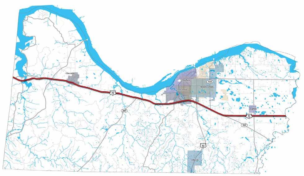


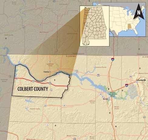


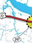
5 1. BACKGROUND AND INTRODUCTION Figure 1-2. Regional Context Figure 1-1. US 72 Corridor in Colbert County 1
6 2

 Free Flow Travel Time Actual Travel")
 65 7:30 7:30 0:00 N.")
 SR 247 65 4:46 4:46")


 Traf ic Volumes on US 72 Location")


7 2. THE CONTEXT Existing Land Use and Character Mobility Regional Travel Times on US 72 Table 2-1. Posted Speed, Travel Time, and Delay on US 72 From To Posted Speed (mph) Free Flow Travel Time Actual Travel Time Delay Mississippi N. Pike Road State Line (Cherokee) 65 7:30 7:30 0:00 N. Pike Road Mulberry (Cherokee) Lane (Barton) 65 3:59 3:59 0:00 Mulberry Lane (Barton) SR :46 4:46 0:00 SR 247 Woodmont Drive 55/65 6:25 6:43 0:18 Woodmont Drive US :47 2:28 0:41 US 43 SR :16 2:47 0:31 SR 133 SR :16 2:36 0:20 SR 157 County Line 65 7:59 7:59 0:00 36:58:00 38:48:00 1:50 Table 2-2. Existing (2008) Traf ic Volumes on US 72 Location Vehicles per Day Between MS State line and Cherokee 9,200 Between Cherokee and Barton 9,600 Between Barton and SR ,900 Between SR 247 and Tuscumbia City limits 18,100 West of Woodmont Drive 23,800 Bewteen Woodmont Drive and US 43 22,000 Bewteen US 43 and SR ,500 Between SR 133 and SR ,700 East of SR 157 8,400 West of Lawrence County line 9,500 Source: Alabama Department of Transportation Colbert County s Economic Backbone Multiple means of freight movement make the US 72 corridor very attractive for industry 3


8 Colbert County s Main Street Access and Mobility Land Development Trends Direct driveway access Multiple driveway access Lack of cross-access Full median openings Communities perceive US 72 as an important venue for commercial and tourist development. Continued development trends on US 72 mean that the corridor may one day look like US 43 in Muscle Shoals and in Florence. Current Development Trends on US 72 Relatively few friction points - driveways and signals - are reasons why US 72 is a high-speed corridor. 4


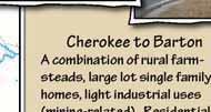
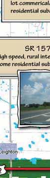
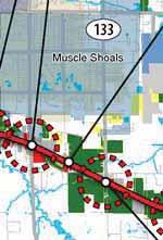
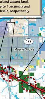
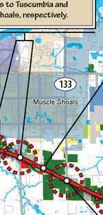


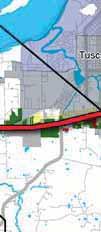
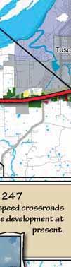
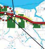

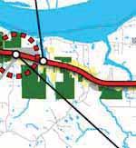
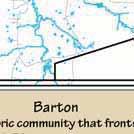

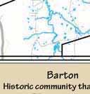

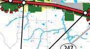
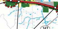
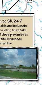


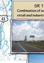
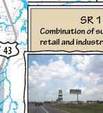

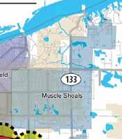
9 US 72 Corridor Study Figure 2-1. Existing Land Use and Character Mississippi State Line to Cherokee The westernmost part of the corridor is marked by thick forest, steep slopes and rolling terrain that eventually give way to level fields. Topography and water features limit the amount of development that can take place here. SR 247 to Woodmont A combination of rural farmsteads, large lot single family homes, light industrial uses (mining-related). Residential parcels get smaller as you approach Barton. Traditionally rural, high-speed segment that is gradually giving way to large lot, single use commercial developments, including restaurants, hotels and the Alabama Music Hall of Fame. Woodmont and d US 43 US 43 to SR 133 Suburban, strip style development, including shopping centers, fast food restaurants, gas stations, light industrial, some residential and vacant land. Gateways to Tuscumbia and Muscle Shoals, respectively. Mostly agricultural, but slowly transitioning to single use, large lot commerical/industrial, some residential subdivisions. SR 157 High speed, rural interchange. Some residential subdivisions. Cherokee Sheffield 133 Muscle Shoals Muscle 72 Tuscumbia LEGEND Agriculture Business Service Gov t/institutional Cherokee This historic, small town consisting of a network of small streets was built around the original US 72. Most development exists north of the present US 72 corridor. 247 Barton Historic community that fronts the US 72 corridor consisting of residential, civic and commercial land uses. This is the entry point for the Barton Industrial Plant. Industrial Leighton Park/Cemetery Residential Barton to SR 247 Agicultural fields and industrial uses (quarries, etc.) that take advantage of close proximity to both US 72, the Tennessee River and the rail line. Retail/Mixed-use SR 247 Rural, high-speed crossroads with very little development at present. SR 133 Combination of suburban strip retail and industrial uses. SR 157 to County Line Almost entirely agricultural, high-speed corridor. 43 Littleville US 72 Corridor Study C Y 5


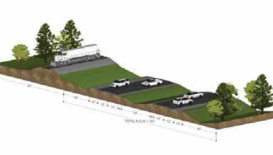


10 US 72 Corridor Study Figure 2-2. Existing Cross-sections on US 72 Cherokee Sheffield 133 Muscle Shoals Muscle Tuscumbia Tuscumbia 72 Leighton Littleville US 72 Corridor Study C Y 6


 to Mulberry Ln.")


11 US 72 Corridor Study Figure 2-3. Travel Times on US 72 in Colbert County 6:00 4:48 Free flow travel time 3:36 2:24 1:12 2:36 Total Time 0:20 Delay 72 SR 157 to County Line SR 133 to SR 157 US 43 to SR 133 Woodmont Dr. to US 43 Mulberry Ln. (Barton) to SR 247 0:00 SR 247 to Woodmont Dr. Cherokee Total Travel Time on US 72: 38 minutes, 48 seconds (During the afternoon rush hour in the eastbound direction) Delay (congestion) N. Pike Rd. (Cherokee) to Mulberry Ln. (Barton) 3:59 Total Time 0:00 Delay 7:12 Mississippi State Line to N. Pike Rd. (Cherokee) Travel time in minutes, seconds 8:24 2:47 Total Time 0:32 Delay Sheffield 133 Muscle Shoals Muscle Tuscumbia Leighton 7:30 Total Time 0:00 Delay :46 Total Time 0:00 Delay 2:28 Total Time 0:41 Delay 6:43 Total Time 00:18 Delay 43 7:59 Total Time 0:00 Delay Littleville COLBERT COUNTY US 72 Corridor Study Travel Time along the US 72 Corridor 7

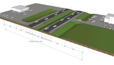
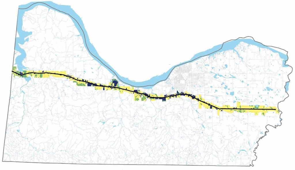
12 Figure 2-4. Driveway Spacing on US 72 8


13 3. THE PROCESS Issues and Opportunities... and at a Stakeholder Group meeting. Alternative Futures Workshop participants provide input at a public meeting in Cherokee... Scenario One: Scenario Two: Scenario Three: Comparing the Scenarios Access Planning policy, guidance and regulation Mobility 9


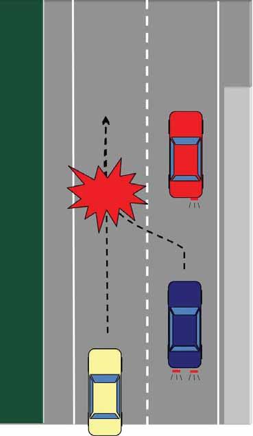


14 Safety Open Space and Natural Resources Vehicle makes a right turn into a driveway Driveway connections increase turn movements and 'friction' in the corridor. Vehicle approaching from behind must stop There is a clear relationship between the driveways and crash rates. 10

15 Figure 3-1. Scenario One: Continuous Strip Development 11

16 Figure 3-2. Scenario Two: Development Focused on Towns and Centers 12

17 Figure 3-3. Scenario Three: Development Focused on Interchange Areas 13


18 Figure 3-4a. Vacant and Developable Land in the US 72 Corridor Developed Parcels Constrained Land Vacant and Developable Land 14


19 Figure 3-4b. Scenario One: Likelihood of Development on US 72 Likelihood/Intensity of Development MORE LESS 15


20 Figure 3-4c. Scenario Two & Three: Likelihood of Development on US 72 Likelihood/Intensity of Development MORE LESS 16


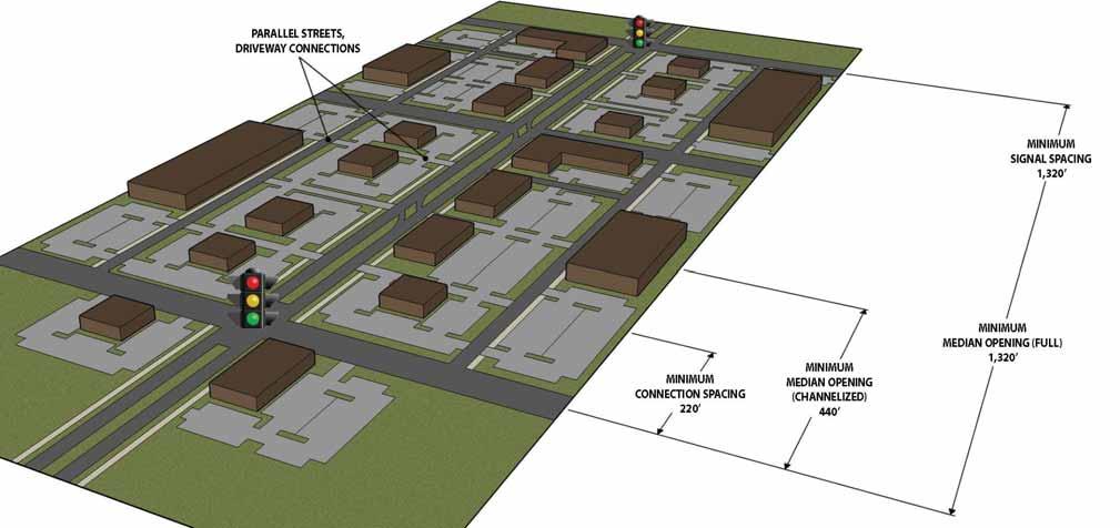
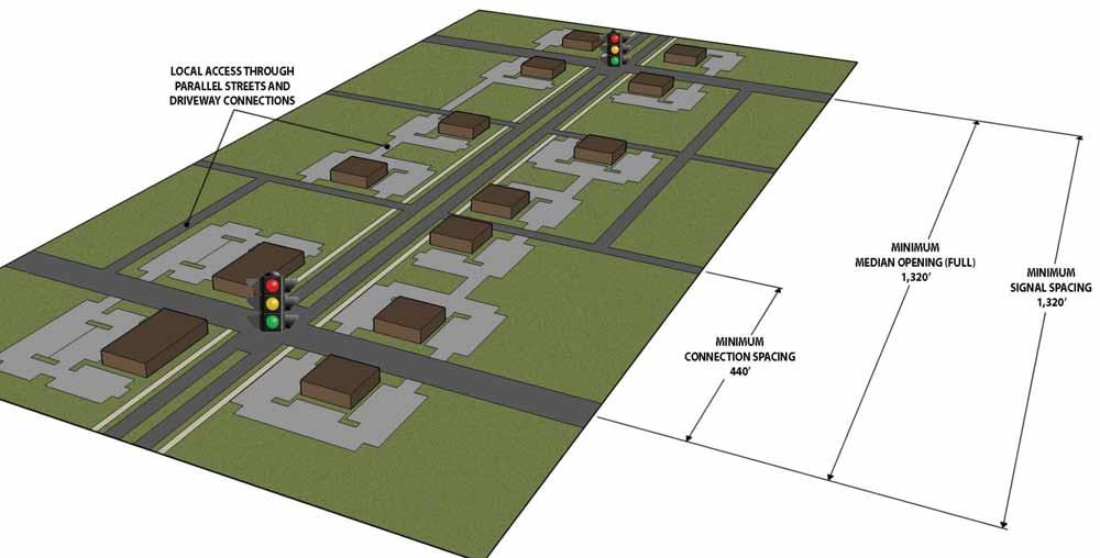
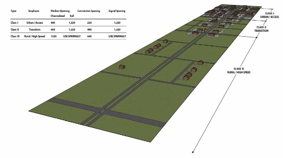
21 4. THE PLAN What is your most preferred outcome for US 72? Scenario 1 Scenario 2 Scenario 3 15% 70% 15% Preferred Development Concept Focus areas for growth Rural segments Transition areas Land Development and Access Management Focus area for growth Transition area Figure 4-1. Development Concept for Activity Nodes 1/2 to 1 MILE Rural Segment Cherokee ¼ MILE Signalized intersections Cross-streets and driveway connections Shared access Parallel streets Median openings Table 4-1. Proposed Access Management Guidelines Type Emphasis Median Opening Channelized Connection Spacing Parallel Streets Signal Spacing Class I (Focus Area) Urban/ access 440 1, ,320 Class II (Transition) Transition 660 1, ,320 Class III (Rural) Rural/high speed 1,320 Use Sparingly 660 Use Sparingly Full Parallel streets create connectivity and reduce local traf c on US 72 17


22 Figure 4-2. Corridor Development Concept for US 72 Focus area for growth Cherokee 1/2 to 1 MILE ¼ MILE Transition area Rural Segment 18


23 Figure 4-3a. Land Development and Access Management Strategy for Activity Nodes Figure 4-3b. Land Development and Access Management Strategy for Transition Areas 19


24 Figure 4-3c. Land Development and Access Management Strategy for Rural Areas Figure 4-3d. Land Development and Access Management Strategy in Context 20


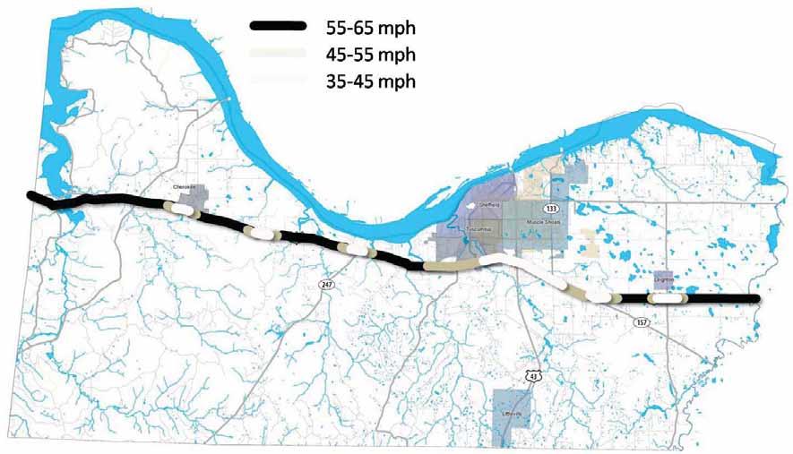


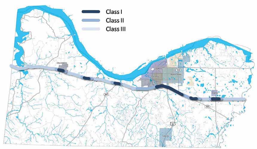
25 Figure 4-4. Proposed Access Management Classi ications for US mph mph mph Figure 4-5. Posted Speed Limits Consistent with Access Strategy for US 72 21


26 Figure 5-1. Proposed Urban Service Areas on US 72 22


27 5. IMPLEMENTATION Zoning and Subdivision Regulations Master Plans Model subdivision regulations that support access management. Urban Services Alabama Department of Transportation Planning and Programming for Major Streets Example of a master plan. 23
28 24
29 6. SUMMARY 25
30 26
31 Appendix 27
32 28
33 Land Development and Subdivision Regulations that Support Access Management Overview Effective local access management requires planning as well as regulatory solutions. Communities should establish a policy framework that supports access management in the local comprehensive plan, prepare corridor or access management plans for specific problem areas, and encourage good site planning techniques. Land development and subdivision regulations should be amended accordingly and communities may also consider a separate access management ordinance. Access management programs should address commercial development along thoroughfares, as well as flag lots, residential strips, and other issues related to the division and subdivision of land. Comprehensive and subarea plans provide the rationale for access management programs and can serve as the legal basis for public policy decisions. Communities are increasingly concerned about the effects of development on service costs, community character, and overall quality of life. Yet conventional regulatory practice has played a role in perpetuating land development problems. Nowhere is this more apparent than the cycle of functional obsolescence created by strip commercial development along major arterials. The practice of strip zoning major corridors for commercial use is widespread. The primary reasons are accessibility and the expedience of rezoning highway frontage for commercial use as additional land is needed. Extension of utilities along highway rights-of-way promotes this linear land use pattern, and commercial businesses favor corridor locations because of the ready supply of customers. Yet as development intensifies, the growing number of curb cuts and turning movements conflict with the intended function of arterials to move people and goods safely, quickly, and efficiently. Unlike urban downtowns or activity centers, commercial strips are rarely designed for pedestrians or transit. Commercial corridors, residential areas, and office parks are frequently sealed off from each other with walls, ditches, loading docks and a host of other barriers including the heavily traveled arterials that serve them. Poorly coordinated access systems force more trips onto the arterial, traffic conflicts multiply, and congestion increases. As the level of service declines, additional lanes, controlled medians, and other expensive retrofitting measures are needed to maintain the capacity of the corridor for regional traffic. Businesses also suffer as accessibility deteriorates. Heavy traffic, difficult left turns, and poor sight clearance at corners deter customers. Businesses may relocate to areas where accessibility is less impaired, vacancies increase, and property values decline. Eventually the corridor is transformed into an unattractive and confusing jumble of signs, curb cuts, utility lines, and asphalt. These are not inevitable results of development and growth. Rather, they relate to the lack of adequate land division and access controls and problems inherent in current planning and regulatory practice. This report examines the role of the comprehensive plan in developing an access management program, aspects of current regulatory practice that contribute to access problems, and regulatory techniques that support access management principles. The Comprehensive Plan The local comprehensive plan is the policy and decision making guide for future development and capital improvements in the municipality. It analyzes development trends; identifies key planning issues; provides the policy framework; and specifies strategies for carrying out the plan. Purposes of the plan are to: promote orderly and efficient development; protect property values; preserve community character, natural resources, and the environment; promote economic development; and increase public awareness of the forces of community change. Local comprehensive plans should establish how the community will balance mobility with access, identify the desired access management approach, and designate corridors that will receive special treatment. This may be supplemented through functional plans, such as an access management or thoroughfare plan, or through subarea plans, such as an interchange or corridor plan
34 These plans evaluate long term trends; provide data on traffic accidents and related considerations; and establish the relationship between access management and other community objectives, such as congestion management and transportation level of service. By establishing the relationship between regulatory strategies and public health, safety, and welfare, these plans can serve as the legal basis for access controls. The comprehensive planning process is an opportunity to increase community awareness of the forces of change and determine a strategic course of action. What level of growth can the community expect? What are the future land use and capital improvement needs? And what type of land development patterns do citizens prefer? Public opinion surveys, town meetings, and visioning workshops may be used to identify citizen concerns and build political support for regulatory change. Citizen dissatisfaction with commercial strips, for example, can be translated into policies for joint access, shared parking, and sign regulation. When evaluating future land use needs, communities should account for vacancies and surplus land already available for that use (Chapin and Kaiser, 1985). Many communities set aside far more land than required to accommodate reasonable estimates of growth, thereby encouraging scattered development patterns and strip development. It is not uncommon for communities to strip zone the majority of their highway frontage for commercial use. Additional highway frontage should not be planned or rezoned for commercial use where vacant or surplus commercial space is already available. This encourages reuse of existing commercial sites, increases property values in those areas, and is a long term economic development strategy. The City of Orlando has incorporated these planning and access management principles throughout its comprehensive plan. Orlando's planning and regulatory framework includes mixed-use corridors, rather than commercial strips, and mandatory mixed use with transit access in activity centers. The City limited the supply of commercial areas to encourage reuse, designated cross access corridors with joint access requirements, and adopted a comprehensive access classification and driveway spacing program modelled after Florida Department of Transportation standards. The City also has strong policies and standards relating to bicycle and pedestrian access, including standards for pedestrian streets. Subdivision Regulations Subdivision regulations help ensure: proper street layout in relation to existing or planned roadways; 1-2 adequate space for emergency access and utilities; adequate water, drainage, and sanitary sewer facilities; and appropriate site design. The subdivision ordinance establishes: the administrative review and evaluation procedure for processing conceptual, preliminary, and final plats; information that must be included on the plat; design principles and standards for lots, blocks, streets, public places, pedestrian ways, and utilities; required improvements, including streets, sidewalks, water, sewer, and curbs and gutters; and financing and maintenance responsibilities. The subdivision review process should address a variety of issues, including: Is the road system designed to meet the projected traffic demand and does the road network consist of hierarchy of roads designed according to function? Is access properly placed in relation to sight distance, driveway spacing, and other related considerations? Do units front on residential access streets rather than major roadways? Does the project avoid areas unsuitable for development? Does the pedestrian path system link buildings with parking areas, entrances to the development, open space, and recreational and other community facilities? Have utilities been properly placed? (Listokin and Walker, 1989) State subdivision statutes grant local governments authority to regulate subdivision of land and establish minimum requirements for subdividing and platting. New Jersey s statutory framework is among the most stringent, defining subdivision as the division of land into two or more parcels and provides exceptions only in special circumstances (i.e., a new street will not be required and the lot will be 5 acres or more, but only if the planning official determines it will be used for agricultural purposes). The New Jersey legislature recently took an unprecedented step in strengthening its subdivision requirements. The New Jersey Site Improvement Standards Act of 1993 provides for updating technical provisions of the State's model subdivision and site plan ordinance (1987) and adoption of the ordinance by the state. The requirements will automatically repeal and replace all local subdivision and site plan provisions. The new regulations will also consist of standardized application forms and administrative procedures, and should be completed by Yet many subdivision statutes exempt division of land into larger parcels or creation of a small number of lots from review and conformance with subdivision standards. Michigan has one of the more lenient statutes exempting creation of parcels larger than 10 acres from local review and allowing successive redivision into four more parcels of 10 acres or less after a ten year period. Florida's Subdivision Statute Florida's Plat Act, Chapter 177, F.S. provides local governments in Florida with the authority to regulate the subdivision of land and establishes minimum regulatory requirements. Chapter 177, F.S. defines subdivision as the division or platting of real property into three or more lots or parcels and includes resubdivision or establishment of streets or alleys. Under these requirements, division of land into two lots or parcels is exempt from review. Although some state subdivision statutes preclude more restrictive requirements at the local level, Chapter 177 establishes minimum requirements "and does not exclude additional provisions or regulations by local ordinance, laws or regulations." (Section , F.S.) In turn, state growth management requirements mandate local adoption of subdivision regulations and the Florida Model Land Development Code provides a model framework for local subdivision regulation that goes beyond statutory requirements to encourage local review of minor subdivision activity (see Lot Split Requirements). The practice of allowing unregulated division of land produces results that are contrary to access management and other important public goals. Lots may be created that are unbuildable because they lack sufficient width or depth to meet lot dimension or setback requirements, are in a wetland or floodplain, or have inadequate access to public roads. Buyers may be unaware that the lot has been divided in a manner that is inconsistent with state or local regulations until they are denied a building or driveway permit. At that point the community is often compelled to issue a variance due to the risk of a regulatory takings suit. A streamlined review process for smaller subdivisions and lot splits helps assure that new lots are buildable under the regulatory framework and access is appropriate, without placing an unnecessary review burden on the property owner. Lot Split Requirements Lot split regulations provide for local review of divisions of land that would otherwise be exempted from subdivision review. Types of lots that pose special access concerns are flag lots, through lots, and corner lots. A review process for lot splits is intended to prevent 1-3 creation of unbuildable lots, excessive flag lots, or other land division patterns that can lead to access problems. It further prevents creation of lots with inadequate or inappropriate access to a public road. Florida's Model Land Development Code establishes a process for reviewing lot splits, called minor replats. Minor replat is defined as: The subdivision of a single lot or parcel of land into two (2) lots or parcels, or the subdivision of a parcel into two or more lots solely for the purpose of increasing the area of two or more adjacent lots or parcels of land, where there are no roadways, drainage, or other required improvements, and where the resultant lots comply with the standards of this Code. The Florida Model Land Development Code provides for review by the local Planning Department (and any other local departments); requires information regarding water or sewer service; requires a scaled drawing of the intended division and any principal or accessory structures by a registered surveyor; provides for recording the replat in the official county records; and requires conformance with the following standards: 1. Each proposed lot must conform to the requirements of this Code. 2. Each lot shall abut a public or private street (except as hereinafter provided) for the required minimum lot width for the zoning district/category where the lots are located. 3. If any lots abuts a street right-of-way that does not conform to the design specification provided in this Code, the owner may be required to dedicate one-half the right-of-way width necessary to meet the minimum design requirements. Once a Minor Replat has been approved, the Code restricts further division unless a development plan (or plat) is prepared and submitted for review. Local regulations should also require proof of lot split approval by the planning commission or zoning administrator before a building permit may be issued. Residences scattered along state and county roads can be more damaging to the regional transportation network than commercial strips because they may occupy hundreds of miles of highway frontage. Over time such development patterns landlock interior land, school buses must make longer trips, emergency services must cover a wider area, and the cost of extending utilities becomes 30
35 prohibitive. As the number of driveways increase, the highway is gradually transformed into a high speed version of a local road. The safety implications are obvious, as vehicles travelling 55 mph are mixed with residents entering and exiting their driveway. Yet this development pattern is virtually prescribed by the combination of conventional zoning and unregulated land division. Despite authority to monitor creation of new lots, many communities continue to exempt lot splits. Sarasota County, Florida, for example, goes beyond the exemptions prescribed in statute to exempt lots of 5 acres or larger from review or division of land into two parcels. The division of agricultural land into 5 acre parcels effectively converts it for residential use. Over time the land is subdivided, creating residential strips along rural roadways rather than shared access subdivisions. Lot split review provides an opportunity to discourage residential stripping of rural highways. Yet flexible zoning can be even more effective in achieving access management and resource management objectives. An innovative approach is the combination of subdivision review with site planning and cluster zoning techniques, proposed by rural landscape planner Randall Arendt. Arendt recommends the following access standard for small rural subdivisions: Figure 1: Flag Lots on a State Highway This area in northern Florida was divided into 3 acre lots to avoid subdivision review. The resulting flag lot "plat" creates long term access problems on a state highway and county road. Problems such as this can be prevented with flag lot restrictions and a review process for minor subdivisions and lot splits. 1-4 Subdivisions with frontage on state-numbered highways shall be designed into shared access points to and from the highway. Normally a maximum of two accesses shall be allowed regardless of the number of lots or businesses served (Yaro, Arendt, et al. 1990). In the absence of flexible zoning, a sliding scale or quarter/quarter zoning approach to land division in rural areas is preferable. The former might permit division of one two acre lot per 10 acre parcel, and the latter may permit one nonfarm residential lot per 40 acres of farmland (Misseldine and Wyckoff, 1987). See Section 18 of the Model Regulations for shared access standards and Section 20 for lot split requirements. Flag Lots Local plat maps often reveal lots shaped like flags with long narrow access poles. Flag lots are especially prevalent along lakes, rivers, cul-de-sacs, and rural highways. They are useful as a land division technique in areas where natural features or land division patterns create access problems, but flag lots proliferate in some areas where interior lots should instead be served by a private road. Landowners may stack flag lots when dividing a parcel to provide interior lots with direct access to a state or county road, thereby avoiding the expense of providing a public or private road. The narrow frontages afford inadequate spacing between driveways and increase safety hazards from vehicles turning on and off the high speed roadway (See Figure 1). Local land development or subdivision regulations should discourage creation of flag lots, except in unique circumstances. Exceptions could be provided where a site has unique physical constraints, such as wetlands or other natural features, that prevent access via a local street or where frontage requirements create access problems. Moskowitz and Lindbloom (1993) suggest the following flag lot standards: a minimum lot area (often at least twice the area allowed in that zone, not including the access rightof-way); minimum front, side, and rear yard requirements for primary lot; a minimum of 20 feet and maximum of 50 feet for the access right-of-way; not more than one flag lot per private right-of-way; and a minimum separation distance of at least the minimum frontage requirement of that zoning district. [Note: Some communities also restrict the length of the access pole.] The City of Orlando, Florida, provides for flag lots when deemed necessary to achieve creative planning, to eliminate access to collector or thoroughfare streets, preservation of natural amenities or important historical or archaeological values...but only in residential developments approved in accordance with [site plan review requirements] and provided the following conditions are satisfied: no flag lot shall abut more than one other flag lot, nor shall flag lots be double stacked across a common street; in no instances shall flag lots constitute more than 10% of the total number of building sites in a given development, or 3 lots (whichever is more); the lot area occupied by the flag driveway shall not be counted as part of the required minimum lot area; flag lots shall not be permitted whenever their effect would be to increase the number of building sites taking driveway access to a Collector or arterial Street; and no flag driveway shall be longer than 150 feet [Section ]. Access requirements in Hillsborough County, Florida's Land Development Code require all lots to have access to a public street through a portion of the lot, through an approved private street, or through commonly owned property [Section ]. If through commonly owned property and serving more than one lot, the access must be at least fifty feet wide. Additional flag lot standards are provided for rural or semi-rural areas. These allow a single parcel to have a minimum twenty foot access provided it is separated from any other such access by at least the minimum lot width for the district and the access pole is not longer than 800 feet. If an easement access is required, it is subject to a minimum width of 20 feet and can serve no more than one parcel. See Section 16 of the Model Regulations for flag lot standards. Private Road Ordinances Private roads offer an alternative means of access to small subdivisions in rural areas and to lots that are not subject to subdivision review. In the absence of provisions for private roads, common practice is the creation of multiple lots served by a common lot, easement, or multiple easements as in the example of stacked flag lots. The easement then becomes a private unpaved road serving several properties. Unregulated private roads raise several problems. They may be inaccessible to emergency vehicles or large delivery trucks, placing public safety and private property at risk. Substandard roads deteriorate quickly and without a maintenance agreement, the local government may be called upon to maintain it. Buyers may not be aware of the maintenance issues associated with the road. Narrow rights-of-way may impede placement of utilities and private roads can exacerbate inefficient land development patterns. These problems can be avoided through private road regulations that address design, construction, joint maintenance agreements, signage, and review. Private roads should be permitted for residential uses only and standards should be tied to lot split (minor replat) or subdivision regulations. Limitations should be placed upon the number of residences that may be served by a single access to a public road. Most communities require a minimum 66 foot right-of-way. Many rural areas do not require paving if the roadway conforms to gravel road specifications, whereas others require paving after the number of dwelling units served exceeds a certain number. Some ordinances provide a sliding scale approach, allowing gravel roads of about 12 feet to 18 feet wide for 2-4 parcels and requiring county road specifications for larger developments (Bloom, 1990)
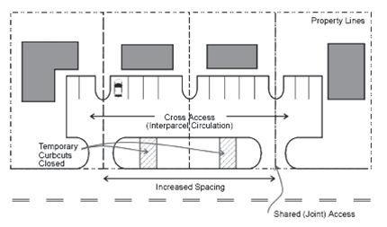
36 See Section 21 of the Model Regulations for private road standards. Single Access Subdivisions Linear subdivisions served by a single access drive ending in a cul-de-sac may inhibit emergency access and increase traffic congestion during peak hours by providing only one point of ingress and egress. Single access problems may also result in phased subdivisions where additional access is proposed for future phases. If future phases are not built, the remaining subdivision may have insufficient access. Although this is not a problem where only a few dwelling units are served, how many lots is too many? Average daily trips for residential streets provide a baseline for access and cul-de-sac standards. Listokin and Walker (1989) recommend that when a subdivision on a single access rural road exceeds 20 lots (or 20 dwelling units), it should have at least two access points. The maximum number of dwelling units permitted for residential access streets would be about 50 per loop. A minimum turning radius that accommodates emergency vehicles should be required for cul-de-sacs. See Section 18(3) of the Model Regulations related to single access subdivisions. Lot Frontage and Dimensional Requirements Through lots, also known as double frontage lots, are lots with frontage on two streets. Through lots should be required to obtain access on the street with the lower functional classification. When a residential subdivision is proposed that would abut an arterial, it should be designed to provide through lots along the arterial with access from a local road. These requirements are known as reverse frontage (Figure 2). In either case, the community could require that access rights to the arterial or collector be dedicated to the local government and this restriction recorded with the deed. Sarasota County, Florida provides that when a new subdivision is created, lots abutting an arterial are prohibited from having direct access to that arterial. Instead, access to these lots must be from an interior local street or frontage street and access rights to the arterial must be dedicated to the County and run with the land (Sarasota County Land Development Regulations, Section B3.3(j)). Figure 2: Reverse Frontage Minimum lot frontage requirements are tied to zoning requirements for a district and set the minimum lot width or frontage on a public road. Minimum lot frontage standards should be higher on arterials and collectors to allow for greater spacing between commercial or residential driveways. The frontage requirement will vary depending upon the minimum lot size in that zoning district and other dimensional requirements, such as the width-to-depth ratio. Although driveway spacing standards may be used to limit residential driveways along rural highways, land division controls and higher minimum lot frontage requirements can be more effective in controlling residential strips. Minimum lot frontage and maximum lot width-todepth ratios prevent the creation of long and narrow or irregularly shaped lots. Width-to-depth ratios may be included in the local land development code or subdivision regulations. Rural areas may adopt a maximum width-to-depth ratio of 1:4, meaning that parcels with 100 feet of frontage may not be longer than 400 feet. Urban or suburban areas may use maximum ratios of 1:2.5 or 1:3. Width-to-depth ratios should be set higher in coastal areas to account for erosion (Williams, McCauley, Wyckoff, 1990). See Section 15 of the Model Regulations for reverse frontage requirements; Section 14(1) for lot frontage requirements; and Section 17 for width-to-depth ratios. Driveway Spacing Requirements Spacing standards limit the number of driveways on a roadway by mandating a minimum separation distance between driveways. These standards help reduce the potential for collisions as travellers enter or exit the roadway, encourage sharing of access for smaller parcels, and can improve community character by discouraging haphazard placement of driveways along corridors. Driveway spacing at intersections and corners should provide adequate sight distance and response times and permit adequate stacking space. Driveway spacing standards should be tied to the state DOT access classification and driveway permitting standards for the state highway system. Driveway spacing standards on other roadways may be tied to the posted speed limit or functional classification of the roadway, with the minimum distance between driveways greater as speed limits increase. Some communities also provide variable spacing depending upon the land use intensity of the site served and that of adjacent sites. See Sections 5 and 6 of the Model Regulations for recommended driveway spacing standards. Joint Access Joint access requirements provide for a unified onsite circulation plan and adequate driveway spacing along developing commercial corridors. Orlando, Florida has a comprehensive program for minimizing curb cuts through joint access and cross access requirements. Joint use driveways and cross access easements must be established wherever feasible and the building site must incorporate a unified access and circulation system. Orlando's cross access standards require: a. A continuous linear travel corridor extending the entire length of each block it serves, or at least 1,000 feet of linear frontage along the thoroughfare, and having a design speed of 10 mph; b. Sufficient width to accommodate two-way travel aisles designed to accommodate automobiles, service vehicles and loading vehicles in accordance with design requirements; c. Stub-outs and other design features that make it visually obvious that the abutting properties may be tied in to provide cross-access; d. Linkage to other cross-access corridors in the area. All plats, site plans, and other development must meet these standards on designated thoroughfares and property owners must record an easement with the deed allowing cross access to and from other properties in that affected area. The property owner must also enter an agreement to dedicate remaining access rights along the thoroughfare to the City and enter an agreement to be recorded with the deed that pre-existing driveways will be closed and eliminated after construction of the joint-use driveway. Cross-access corridors are indicated on the zoning map by dashed or dotted lines and distinguish those portions of the corridor where easements have been recorded. Standards are included for coordinated or joint parking design and joint maintenance agreements must also be recorded with the deed. These standards are applied to phased development in the same ownership and leasing situations. Where abutting properties are in different ownership, cooperation is encouraged but not required. Only the building site under consideration is subject to the requirements, which are recorded as a Binding Lot Agreement prior to issuing a building permit. As abutting properties are developed or initiate retrofitting requirements then they must abide by the standards (see Retrofitting). If properties are unable to meet driveway spacing requirements of the Access Management Classification System, the Public Works Director may waive the requirements and provide for less restrictive spacing (see Figure 3). The waiver is based on the condition that joint use driveways, cross access easements, and a unified parking and circulation plan must be established wherever feasible. Where unified access and circulation is not practical, the City may provide a variance. Figure 3: Joint Access See Section 7 of the Model Regulations for joint and cross access requirements. Retrofitting Nonconforming Properties
37 Land development regulations are not retroactive. Existing properties that do not meet land development requirements must be designated as nonconforming a process commonly known as grandfathering. Nonconformities may relate to land use or dimensional requirements, as in a nonconforming lot of record. Nonconforming properties may continue in the same manner as they existed before land development regulations were adopted. These requirements protect the substantial investment of property owners and recognize the expense of bringing those properties into conformance. future division and subdivision of parcels could occur, but each newly created lot would obtain access via the connection permitted by the ordinance. Because of this constraint, property owners would be obliged to share driveways, use service drives, cross access, and even rear access drives in some instances to maintain appropriate access. Limitations on new driveways may be established using a corridor overlay approach. See Section 14 of the Model Regulations for corridor overlay standards based on this technique. purpose and administration of the new standards. It is essential that the regulations be applied consistently especially when opportunities arise for retrofitting nonconforming features. Variance requests should be judiciously evaluated according to specified review procedures and discretionary standards to avoid inconsistency. See Section 23 of the Model Regulations for procedures on coordinating access review with the Florida Department of Transportation on the State Highway System. References Bloom, Clifford H. Regulating Private Roads. Planning and Zoning News, Vol. 8, No.3, January 1990: Brough, Michael B. A Unified Development Ordinance. Washington, D.C.: Planners Press American Planning Association, Chapin, F., Kaiser E. Urban Land Use Planning. Chicago: University of Illinois Press, Yet the negative impacts of nonconforming properties may be substantial. Nonconforming properties may pose significant safety hazards, increase traffic congestion, reduce property values, degrade the environment, or undermine community character. To address the public interest in these matters, land development regulations include conditions or circumstances where nonconforming access features may be brought into conformance. Such conditions may include: when new driveway permits are requested; an increase in land use intensity; substantial enlargements or improvements; significant change in trip generation; and as changes to roadway design allow. Opportunities to bring nonconforming features into compliance typically occur after a change of ownership when the costs of required improvements may be amortized in the business loan or mortgage. See Section 13 of the Model Regulations for retrofitting requirements. Limiting New Driveways Along Major Roads An effective method of managing curb cuts in newly emerging commercial corridors is to restrict the permitted number of future driveways to one driveway per existing lot or parcel. This may be accomplished as follows: 1. Identify and map the emerging commercial corridor. 2. Verify the boundaries of all existing lots. 3. Assign one driveway to each mapped parcel. The assigned driveway would be permitted by right effective upon adoption of the ordinance and map. Parcels with larger frontages could be permitted more than one driveway and additional driveways could be permitted by special use permit. Under this approach, 1-8 Outparcel Requirements Outparcels are lots on the perimeter of a larger parcel that abut a roadway. Outparcel regulations are adopted for commercial corridors to foster coordinated on-site circulation systems that serve outparcels as well as interior development, thereby reducing the need for driveways on an arterial. Outparcel regulations may include standards governing: the number of outparcels; minimum lot frontage; access; unified parking and circulation; landscaping and pedestrian amenities; building height, coverage, and setback requirements; and signage. The City of Pembroke Pines, Florida limits the number of outparcels to one per ten acres of site area, with a minimum frontage requirement of 500 lineal feet per outparcel. Standards also call for a minimum of 300 lineal feet of open space between outparcels. Roadways separating adjacent parcels may be included with open space in meeting this requirement. The ordinance prohibits more than one building per outparcel. Each parcel must provide all required parking on site and conform to all landscaping and setback requirements of that zoning district. Access requirements are as follows: "Access to the outparcel shall be as direct as possible avoiding excessive movement across parking aisles and queuing across surrounding parking and driving aisles. All access to the outparcel must be internalized utilizing the main access drive of the principal retail center... Drivein facilities shall be provided on the outparcel site exclusively. In no instance shall the circulation and access of the principal commercial facilty and its parking and service be impaired." In addition, covenants imposed by the Planning and Zoning Board and Architectural Review Board must be added to the deed if title to the outparcel is transferred after the site plan is approved. The seller must notify the buyer, who is bound by the restrictions. Conclusion Access management addresses a broad array of quality of life issues fundamental to promoting livable, prospering communities. Land division and access controls: foster well designed circulation systems that improve the safety and character of commercial corridors; discourage subdivision practices that destroy the rural character of the landscape or essential natural resources; advance economic development goals by promoting more efficient use of land and transportation systems; and help control public service costs and the substantial public investment in infrastructure and services. Effective local access management requires both planning and regulatory solutions. Communities should establish a policy framework that supports access manage-ment in the local comprehensive plan, prepare corridor or access management plans for specific problem areas, and encourage good site planning techniques. Zoning and subdivision regulations should be amended accordingly and communities could consider a separate access management ordinance. Comprehensive and subarea plans provide the rationale for access management programs and can serve as the legal basis for public policy decisions. Because land division and access controls are politically charged, planning officials are advised to develop strategies for diffusing opposition before advancing recommendations. Be aware of the practical concerns of those most affected by proposed amendments and devise strategies for ameliorating hardship. Town meetings, attitude surveys, and other techniques should be used to educate stakeholders and generate political support Falconi, Xavier R. Access Management: Relationship Between Developers, Local Government and State Government. ITE 1991 Compendium of Technical Papers, Koepke, F.J., Levinson H.S. Access Management Guidelines for Activity Centers. NCHRP Report 348, Washington, D.C.: National Academy Press, Listokin, D. and Walker, C. The Subdivision and Site Plan Handbook. New Jersey: The State University of New Jersey McPherson, J.K., Coffey D., Easley, G. Land Development Regulations, Technical Assistance Manual for Florida Cities and Counties. Prepared for the Department of Community Affairs. August 28, McPherson, J.K., Coffey D., Easley, G. Model Land Development Code for Florida Cities and Counties. Prepared for the Department of Community Affairs. December Misseldine, C., Wyckoff M. Planning and Zoning for Farmland Protection: A Community Based Approach. American Farmland Trust, Moskowitz, H., Lindbloom C. The New Illustrated Book of Development Definitions. New Brunswick, New Jersey: Center for Urban Policy Research, Stover, V.G. and F.J. Koepke. Transportation and Land Development. Prentice Hall, Englewood Cliffs, New Jersey, Williams, Kristine M. Reserving Right-of-Way with Official Maps. Planning and Zoning News. July 1991:
38 Williams, K.M., McCauley, T.J., Wyckoff, M.A. Land Division and Access Controls. Lansing: Planning and Zoning Center Inc., April Wyckoff M, Williams K., Armstrong M, et al. Community Planning Handbook: Tools and Techniques for Guiding Community Change. Planning & Zoning Center, Inc., March Wyckoff M., Grand Traverse Bay Region Development Guidebook. Planning & Zoning Center, Inc., September Wyckoff M., Grand Traverse Bay Region Sample Regulations. Planning & Zoning Center, Inc., September Yaro, R., Arendt, R. Dodson, H., Brabec, E. Dealing with Change in the Connecticut River Valley: A Design Manual for Conservation and Development. Amherst: Lincoln Institute of Land Policy and the Environmental Law Foundation, Model Land Development and Subdivision Regulations That Support Access Management Section 1. Intent and Purpose Section 2. Applicability Section 3. Conformance with Plans, Regulations, and Statutes Section 4. Definitions Section 5. Access Management Classification System and Standards Section 6. Corner Clearance Section 7. Joint and Cross Access Section 8. Interchange Areas Section 9. Access Connection and Driveway Design Section 10. Requirements for Outparcels and Phased Development Plans Section 11. Emergency Access Section 12. Transit Access Section 13. Nonconforming Access Features Section 14. Corridor Access Management Overlay Section 15. Reverse Frontage Section 16. Flag Lot Standards Section 17. Lot Width-to-Depth Ratios Section 18. Shared Access Section 19. Connectivity Section 20. Minor Subdivisions Section 21. Private Roads Section 22. Regulatory Flexibility Section 23. Site Plan Review Procedures Section 24. Variance Standards
39 The following model ordinance language is provided for adoption into the local land development code. Local governments should obtain professional planning and legal assistance when adapting this model language to fit local needs. Although a regulatory program is essential, it is further recommended that local governments prepare subarea plans for high priority corridors that are experiencing development pressure. Section 1. Intent and Purpose The intent of this ordinance is to provide and manage access to land development, while preserving the regional flow of traffic in terms of safety, capacity, and speed. Major thoroughfares, including highways and other arterials, serve as the primary network for moving people and goods. These transportation corridors also provide access to businesses and homes and have served as the focus for commercial and residential development. If access systems are not properly designed, these thoroughfares will be unable to accommodate the access needs of development and retain their primary transportation function. This ordinance balances the right of reasonable access to private property, with the right of the citizens of the (city/county) and the State of Florida to safe and efficient travel. To achieve this policy intent, state and local thoroughfares have been categorized by function and classified for access purposes based upon their level of importance, with highest priority on the Florida Intrastate Highway System and secondary priority on the primary network of regional arterials. Regulations have been applied to these thoroughfares for the purpose of reducing traffic accidents, personal injury, and property damage attributable to poorly designed access systems, and to thereby improve the safety and operation of the roadway network. This will protect the substantial public investment in the existing transportation system and reduce the need for expensive remedial measures. These regulations also further the orderly layout and use of land, protect community character, and conserve natural resources by promoting well-designed road and access systems and discouraging the unplanned subdivision of land. Section 2. Applicability This ordinance shall apply to all arterials and selected collectors within (city/county), as identified in Table 1, and to all properties that abut these roadways. The access classification system and standards of the Florida Department of Transportation shall apply to all roadways on the State Highway System. Section 3. Conformance with Plans, Regulations, and Statutes This ordinance is adopted to implement (cite specific policies) of the (city/county) as set forth in the (name local comprehensive plan). In addition, this ordinance conforms with (cite specific policies) of the Metropolitan Planning Organization (MPO) as specified in the (name of long range transportation plan), and the planning policies of the Florida Department of Transportation set forth in the Florida Transportation Plan. The ordinance also conforms with the access classification system and standards of the Florida Department of Transportation, the access management requirements of the Florida Intrastate Highway System Program, and policy and planning directives of the federal Intermodal Surface Transportation Efficiency Act of
Land Development and Subdivision Regulations that Support Access Management
 Land Development and Subdivision Regulations that Support Access Management Overview Effective local access management requires planning as well as regulatory solutions. Communities should establish a
Model Access Management Policies and Regulations for Florida Cities and Counties, 2nd Edition
 Model Access Management Policies and Regulations for Florida Cities and Counties, 2nd Edition Final Report September 2017 PROJECT NO. FDOT BDV25 Task Work Order #931-10 PREPARED FOR Florida Department
Section 1: US 19 Overlay District
 Section 1: US 19 Overlay District Section 1.1 Intent and Purpose The purpose of the US Highway 19 Overlay District is to manage access to land development along US Highway 19 in a manner that preserves
M-43 CORRIDOR OVERLAY ZONE
 ARTICLE 26.00 M-43 CORRIDOR OVERLAY ZONE Section 26.01 Findings A primary function of the M-43 state highway is to move traffic through the Township and to points beyond. As the primary east-west arterial
Draft Model Access Management Overlay Ordinance
 Draft Model Access Management Overlay Ordinance This model was developed using the City of Hutchinson and the Trunk Highway 7 corridor. The basic provisions of this model may be adopted by any jurisdiction
ACCOMPLISHING ALTERNATIVE ACCESS ON MAJOR TRANSPORTATION CORRIDORS
 ACCOMPLISHING ALTERNATIVE ACCESS ON MAJOR TRANSPORTATION CORRIDORS Kristine M. Williams, AICP 1 Karen E. Seggerman, AICP 2 Introduction Many communities have developed access management plans and programs
ARTICLE 23 CONDOMINIUM STANDARDS
 ARTICLE 23 CONDOMINIUM STANDARDS Section 23.01 Intent. The intent of this Article is to provide regulatory standards for condominiums and site condominiums similar to those required for projects developed
a. provide for the continuation of collector streets and thoroughfare streets between adjacent subdivisions;
 Section 7.07. Intent The requirements of this Section are intended to provide for the orderly growth of the Town of Holly Springs and its extra-territorial jurisdiction by establishing guidelines for:
The following information is for use by the Lincoln County Planning Board at their meeting/public hearing on February 3, 2014.
 LINCOLN COUNTY PLANNING & INSPECTIONS DEPARTMENT 302 NORTH ACADEMY STREET, SUITE A, LINCOLNTON, NORTH CAROLINA 28092 704-736-8440 OFFICE 704-736-8434 INSPECTION REQUEST LINE 704-732-9010 FAX To: Planning
SUBDIVISION DESIGN PRINCIPLES AND STANDARDS
 SECTION 15-200 SUBDIVISION DESIGN PRINCIPLES AND STANDARDS 15-201 STREET DESIGN PRINCIPLES 15-201.01 Streets shall generally conform to the collector and major street plan adopted by the Planning Commission
THE COUNTY BOARD OF SUPERVISORS OF THE COUNTY OF DOUGLAS DOES ORDAIN AS FOLLOWS:
 8.1 SUBDIVISION CONTROL ORDINANCE THE COUNTY BOARD OF SUPERVISORS OF THE COUNTY OF DOUGLAS DOES ORDAIN AS FOLLOWS: SECTION I. GENERAL INTERPRETATION This ordinance shall not repeal, impair or modify private
Chapter Plat Design (LMC)
") Chapter 18.14 Plat Design (LMC) Sections: 18.14.010 Lot width 18.14.020 Right-of-way requirements 18.14.030 Pipe stem lots 18.14.040 Division resulting in minimum lot sizes 18.14.050 Flood prone and bad
Chapter 18.14 Plat Design (LMC) Sections: 18.14.010 Lot width 18.14.020 Right-of-way requirements 18.14.030 Pipe stem lots 18.14.040 Division resulting in minimum lot sizes 18.14.050 Flood prone and bad
SECTION 7000 LAND DEVELOPMENT REQUIREMENTS
 SECTION 7000 LAND DEVELOPMENT REQUIREMENTS 7000 LAND DEVELOPMENT REQUIREMENTS... 1 7001 LEGISLATIVE AUTHORITY... 1 7001.1 LAND DEVELOPMENT... 1 7001.1.1 Title 40, Idaho Code... 1 7001.1.2 Idaho Code 40-1415
-MENDOCINO COUNTY PLANNING AND BUILDING SERVICES- DIVISION OF LAND REGULATIONS TITLE 17
 ARTICLE VI -- GENERAL REGULATIONS AND PROVISIONS Sec. 17-50. Sec. 17-51 General Plan. Sec. 17-52 Lot and Block Design and Configuration. Sec. 17-53 Lot Access. Sec. 17-54 Private Roads. Sec. 17-55 Water
ARTICLE 24 PRIVATE ROAD, SHARED PRIVATE DRIVEWAY AND ACCESS EASEMENT STANDARDS
 ARTICLE 24 PRIVATE ROAD, SHARED PRIVATE DRIVEWAY AND ACCESS EASEMENT STANDARDS SECTION 24.00 INTENT AND PURPOSE The standards of this Article provide for the design, construction and maintenance of private
ZONING AMENDMENT & SUBDIVISION STAFF REPORT Date: November 3, 2016
 ZONING AMENDMENT & SUBDIVISION STAFF REPORT Date: November 3, 2016 APPLICANT NAME SUBDIVISION NAME David Shumer 5955 Airport Subdivision CITY COUNCIL DISTRICT District 6 5955 Airport Boulevard, 754 Linlen
ARTICLE VI. SUBDIVISION STANDARDS, PUBLIC
 ARTICLE VI. SUBDIVISION STANDARDS, PUBLIC IMPROVEMENTS, AND DESIGN REQUIREMENTS ARTICLE VI. SUBDIVISION STANDARDS, PUBLIC IMPROVEMENTS, AND DESIGN REQUIREMENTS DIVISION 1. GENERAL PROVISIONS Sec. 21-6100.
CITY OF EAU CLAIRE, WISCONSIN. SPECIAL ASSESSMENT POLICY (Dated: November 8, 2016)
") CITY OF EAU CLAIRE, WISCONSIN SPECIAL ASSESSMENT POLICY (Dated: November 8, 2016) (Adopted by reference by Ordinance No. 7207 adopted November 8, 2016) PURPOSE The purpose of this Policy is to assure fair
CITY OF EAU CLAIRE, WISCONSIN SPECIAL ASSESSMENT POLICY (Dated: November 8, 2016) (Adopted by reference by Ordinance No. 7207 adopted November 8, 2016) PURPOSE The purpose of this Policy is to assure fair
Open Space Model Ordinance
 Open Space Model Ordinance Section I. Background Open space development has numerous environmental and community benefits, including: 1) Reduces the impervious cover in a development. Impervious cover
Community Development Department 333 Broadalbin Street SW, P.O. Box 490 Albany, OR 97321
 SUMMARY Community Development Department 333 Broadalbin Street SW, P.O. Box 490 Albany, OR 97321 STAFF REPORT Application for Tentative Partition Plat Review Planning File PA-06-17 Phone: 541-917-7550
FREQUENTLY USED PLANNING & ZONING TERMS
 City Of Mustang FREQUENTLY USED PLANNING & ZONING TERMS Abut: Having property lines, street lines, or zoning district lines in common. Accessory Structure: A structure of secondary importance or function
13-2 SUBDIVISION PLANS AND PLATS REQUIRED EXCEPTIONS Subdivision Plats Required To be Recorded
 ARTICLE XIII SUBDIVISIONS 13-1 INTENT AND PURPOSE 13-1-1 Intent: It is the intent of the County Commission through the adoption of this Article to more fully avail itself of the power granted under 17-27-601
ARTICLE 5. SUBDIVISION STANDARDS
 ARTICLE 5. SUBDIVISION STANDARDS 5.1. General 5.1.1. Applicability The requirements of this article shall apply to all development required to submit site plans or plats, unless expressly exempted by the
Midwest City, Oklahoma Zoning Ordinance
 2010 Midwest City, Oklahoma Zoning Ordinance 9/2/2010 Table of Contents Section 1. General Provisions... 5 1.1. Citation... 5 1.2. Authority... 5 1.3. Purpose... 5 1.4. Nature and Application... 5 1.5.
Medical Marijuana Special Exception Use Information
 Medical Marijuana Special Exception Use Information The Special Exception Use information below is a modified version of the Unified Development Code. It clarifies the current section 5:104 Special Exceptions
PLANNED UNIT DEVELOPMENT & SUBDIVISION STAFF REPORT Date: April 18, 2019
 PLANNED UNIT DEVELOPMENT & SUBDIVISION STAFF REPORT Date: April 18, 2019 DEVELOPMENT NAME SUBDIVISION NAME Springhill Village Subdivision Springhill Village Subdivision LOCATION 4350, 4354, 4356, 4358,
ZONING ORDINANCE: OPEN SPACE COMMUNITY. Hamburg Township, MI
 ZONING ORDINANCE: OPEN SPACE COMMUNITY Hamburg Township, MI ARTICLE 14.00 OPEN SPACE COMMUNITY (Adopted 1/16/92) Section 14.1. Intent It is the intent of this Article to offer an alternative to traditional
ARTICLE 15 - PLANNED UNIT DEVELOPMENT
 Section 15.1 - Intent. ARTICLE 15 - PLANNED UNIT DEVELOPMENT A PUD, or Planned Unit Development, is not a District per se, but rather a set of standards that may be applied to a development type. The Planned
REPORT OF THE PLANNING AND DEVELOPMENT DEPARTMENT FOR APPLICATION FOR REZONING ORDINANCE TO PLANNED UNIT DEVELOPMENT SEPTEMBER 22, 2016
 BEL REPORT OF THE PLANNING AND DEVELOPMENT DEPARTMENT FOR APPLICATION FOR REZONING ORDINANCE 2016-576 TO PLANNED UNIT DEVELOPMENT SEPTEMBER 22, 2016 The Planning and Development Department hereby forwards
Article Optional Method Requirements
 Article 59-6. Optional Method Requirements [DIV. 6.1. MPDU DEVELOPMENT IN RURAL RESIDENTIAL AND RESIDENTIAL ZONES Sec. 6.1.1. General Requirements... 6 2 Sec. 6.1.2. General Site and Building Type Mix...
DEVELOPMENT DEPARTMENT STAFF REPORT STAFF REPORT VARIANCE AND WAIVER THE ROSALYNN APARTMENTS
 DEVELOPMENT DEPARTMENT STAFF REPORT Meeting Date: September 14, 2017 Item #: _PZ-2017-153_ STAFF REPORT VARIANCE AND WAIVER THE ROSALYNN APARTMENTS Request: Variance and Waiver Project Name: The Rosalynn
610 LAND DIVISIONS AND PROPERTY LINE ADJUSTMENTS OUTSIDE A UGB
 ARTICLE VI: LAND DIVISIONS AND PROPERTY LINE ADJUSTMENTS VI-21 610 LAND DIVISIONS AND PROPERTY LINE ADJUSTMENTS OUTSIDE A UGB 610-1 Property Line Adjustments (Property Line Relocation) A property line
ARTICLE FIVE FINAL DRAFT
 ARTICLE FIVE 021218 FINAL DRAFT Sec. 503.6 Open Space Preservation Option Open Space Preservation Option Open Space Preservation developments may be approved in the AR, R-1, R-2 and R-3 zoning districts,
Draft Zoning Changes for the 2nd Planning Board Public Hearing, January 22, 2018.
 Draft Zoning Changes for the 2nd Planning Board Public Hearing, January 22, 2018. No changes were made at the 1st Public Hearing. Proposed wording for the 1 st Public Hearing in red, eliminated text in
ARTICLE 15. RULES, REGULATIONS AND DEFINITIONS
 ARTICLE 15. RULES, REGULATIONS AND DEFINITIONS Section 1. Interpretation and Construction: The following rules and regulations regarding interpretation and construction of the Ulysses-Grant County, Kansas,
ARTICLE 3 DEFINITIONS
 Sections: 3-1 Rules of Construction 3-2 Definitions ARTICLE 3 DEFINITIONS SECTION 3-1 RULES OF CONSTRUCTION 3-101. a. The language set forth in these regulations shall be interpreted in accordance with
City of Edwardsville, Kansas Special Benefit District Policy
 City of Edwardsville, Kansas Special Benefit District Policy Date Adopted: September 12, 2011 Section 1. Objective The objective is to establish a policy to finance public streets, sanitary sewers, water
REPORT OF THE PLANNING AND DEVELOPMENT DEPARTMENT FOR APPLICATION FOR REZONING ORDINANCE TO PLANNED UNIT DEVELOPMENT MAY 18, 2017
 BEL REPORT OF THE PLANNING AND DEVELOPMENT DEPARTMENT FOR APPLICATION FOR REZONING ORDINANCE 2016-805 TO PLANNED UNIT DEVELOPMENT MAY 18, 2017 The Planning and Development Department hereby forwards to
9. REZONING NO Vicinity of the northwest corner of 143 rd Street and Metcalf Avenue
 9. REZONING NO. 2002-15 Vicinity of the northwest corner of 143 rd Street and Metcalf Avenue 1. APPLICANT: Andrew Schlagel is the applicant for this request. 2. REQUESTED ACTION: The applicant is requesting
Group Sewer Only** 80 Ft Frontage* 20,000 Sq. Ft. (.46 acre) Minimum** 120 Ft Frontage* 20,000 Sq. Ft. (.46acre) Minimum** 150 Ft Frontage*
 Minimum** 120 Ft Frontage* 20,000 Sq. Ft. (.46acre) Minimum** 150 Ft Frontage*") Residential Lots Minimum Chart The minimum lot size of any minor subdivision where there is no public sewers shall be as shown below or as required by township zoning and/or the Tuscarawas General Health
Residential Lots Minimum Chart The minimum lot size of any minor subdivision where there is no public sewers shall be as shown below or as required by township zoning and/or the Tuscarawas General Health
REPORT TO PLANNING AND DESIGN COMMISSION City of Sacramento
 REPORT TO PLANNING AND DESIGN COMMISSION City of Sacramento 915 I Street, Sacramento, CA 95814-2671 www.cityofsacramento.org 9 PUBLIC HEARING December 10, 2015 To: Members of the Planning and Design Commission
ELK RAPIDS TOWNSHIP ANTRIM COUNTY, MICHIGAN ORDINANCE NO
 ELK RAPIDS TOWNSHIP ANTRIM COUNTY, MICHIGAN ORDINANCE NO. 3-2011 AN ORDINANCE TO REPLACE THE SUBDIVISION CONTROL ORDINANCE WITH A NEW SUBDIVISION DEVELOPMENT ORDINANCE, IN ACCORD WITH THE LAND DIVISION
Contributing Authors:
 chapter 10 Site/Development Plan Review Contributing Authors: Jackie Turner, AICP, LEED AP and Robert Thompson, AICP - Current Authors Robert S. Cowell, Jr., AICP - Previous Author In this chapter... Introduction
Condominium Unit Requirements.
 ARTICLE 19 CONDOMINIUM REGULATIONS Section 19.01 Purpose. The purpose of this Article is to regulate projects that divide real property under a contractual arrangement known as a condominium. New and conversion
PLANNED UNIT DEVELOPMENT & SUBDIVISION STAFF REPORT Date: November 17, 2016
 PLANNED UNIT DEVELOPMENT & SUBDIVISION STAFF REPORT Date: November 17, 2016 DEVELOPMENT NAME SUBDIVISION NAME LOCATION Autonation Ford of Mobile Autonation Ford of Mobile Subdivision 901, 909, and 925
KEIZER COMMUNITY DEVELOPMENT DEPARTMENT STAFF RECOMMENDATION Subdivision Case No
 KEIZER COMMUNITY DEVELOPMENT DEPARTMENT STAFF RECOMMENDATION Subdivision Case No. 2014-14 TO: FROM: Cynthia Domas, Keizer Hearings Officer Sam Litke, Senior Planner SUBJECT: Subdivision Case No. 2014-14
The purpose of this Chapter is to establish rules, regulations, standards and procedures for approval of subdivisions of land to promote and ensure:
 CHAPTER 7 SUBDIVISION SECTION 7.1 PURPOSE The purpose of this Chapter is to establish rules, regulations, standards and procedures for approval of subdivisions of land to promote and ensure: A. Conformity
ORDINANCE NO. 41. PRIVATE ROAD ORDINANCE As Amended Through April 10, 2008
 ORDINANCE NO. 41 PRIVATE ROAD ORDINANCE As Amended Through April 10, 2008 An Ordinance to protect the health, safety, and general welfare of the inhabitants of Port Sheldon Township. The Township of Port
REPORT TO THE SHELBY COUNTY PLANNING COMMISSION From the Department of Development Services Planning Services. February 4, 2019
 REPORT TO THE SHELBY COUNTY PLANNING COMMISSION From the Department of Development Services Planning Services February 4, 2019 Case No. Request for Rezoning Approval From E-1 to E-2 SD This is a request
DISCUSSION DRAFT 1 INTRODUCTORY PROVISIONS
 1 INTRODUCTORY PROVISIONS 1.1 GENERAL...3 Title 3 Authority 3 Applicability 3 Purpose 3 Regulatory Scope 4 Compliance 4 Fines and Penalties 4 Conflicting Provisions 5 Meaning & Intent 5 Text & Graphics
CHAPTER 5. Subdivisions Regulations
 CHAPTER 5 Subdivisions Regulations 10-5-1 Introduction and Purpose 10-5-2 Definitions 10-5-3 General Provisions 10-5-4 Procedure for Submitting Subdivisions 10-5-5 Design Standards; Streets and Lots 10-5-6
1101 MAIN STREET ANDREWS NC PHONE FAX MAYOR NANCY J. CURTIS MEMORANDUM
 1101 MAIN STREET ANDREWS NC 28901 PHONE 828-321-3113 FAX 828-321-4159 MAYOR NANCY J. CURTIS ALDERMAN RAY FRAZIER ALDERMAN JERRY PULLIUM ALDERMAN GARY JAMES ALDERMAN PHIL HORTON MEMORANDUM March 7, 2017
4. facilitate the construction of streets, utilities and public services in a more economical and efficient manner;
 PVPC MODEL BYLAW BY-RIGHT CLUSTER ZONING BYLAW Prepared by Pioneer Valley Planning Commission Revised: October 2001 1.00 Development 1.01 Development Allowed By Right Development in accordance with this
ARTICLE B ZONING DISTRICTS
 ARTICLE B ZONING DISTRICTS Sec. 8-3021 Established. In order to protect the character of existing neighborhoods; to prevent excessive density of population in areas which are not adequately served with
HERON LANDING SUBDIVISION
 HERON LANDING SUBDIVISION Engineering Comments: Per FEMA guidelines, any development greater than 5 acres in size or subdivision 50 lots in size, requires a flood study. Width of drainage easement to be
SUBDIVISION, PLANNED UNIT DEVELOPMENT, ZONING AMENDMENT, & SIDEWALK WAIVER STAFF REPORT Date: July 19, 2018
 SUBDIVISION, PLANNED UNIT DEVELOPMENT, ZONING AMENDMENT, & SIDEWALK WAIVER STAFF REPORT Date: July 19, 2018 NAME SUBDIVISION NAME LOCATION West Mobile Properties, LLC U.S. Machine Subdivision 556, 566,
KEIZER COMMUNITY DEVELOPMENT DEPARTMENT STAFF RECOMMENDATION Subdivision Case No
 KEIZER COMMUNITY DEVELOPMENT DEPARTMENT STAFF RECOMMENDATION Subdivision Case No. 2014-01 TO: FROM: Cynthia Domas, Keizer Hearings Officer Sam Litke, Senior Planner SUBJECT: Subdivision Case No. 2014-01
PLANNING COMMISSION REPORT REGULAR AGENDA
 PP-4-4-11 Item No. 9-1 PLANNING COMMISSION REPORT REGULAR AGENDA PC Staff Report 06/22/11 ITEM NO 9: PRELIMINARY PLAT; KASOLD WATER TOWER ADDITION; SE OF TAM O SHANTER & KASOLD DR (MKM) PP-4-4-11: Consider
May 21, ACHD Board of Commissioners Stacey Yarrington, Planner II DRH /DRH
 Development Services Department May 21, 2013 TO: FROM: SUBJECT: ACHD Board of Commissioners Stacey Yarrington, Planner II DRH13-00106/DRH13-00108 Executive Summary: This is a design review application
Min. Lot Frontage (Ft.) 1. Min. Front Yard (Ft.) Min. Rear Yard (Ft.) R , R , R ,
 1. Min. Front Yard (Ft.) Min. Rear Yard (Ft.) R , R , R ,") SECTION 11 - DIMENSIONAL REQUIREMENTS A. The following standards shall be required for single family dwellings and associated accessory uses and structures within Residence s, except as expressly permitted
SECTION 11 - DIMENSIONAL REQUIREMENTS A. The following standards shall be required for single family dwellings and associated accessory uses and structures within Residence s, except as expressly permitted
LAND USE AND ZONING OVERVIEW
 OVERVIEW OF PLANNING POLICIES LAND USE AND ZONING OVERVIEW The Minneapolis Plan for Sustainable Growth and Other Adopted Plans Community Planning and Economic Development Development Services Division
CONDOMINIUM REGULATIONS
 ARTICLE 37 CONDOMINIUM REGULATIONS SECTION 37.01. Purpose The purpose of this Article is to regulate projects that divide real property under a contractual arrangement known as a condominium. New and conversion
Cover Letter with Narrative Statement
 Cover Letter with Narrative Statement March 31, 2017 rev July 27, 2017 RE: Rushton Pointe Residential Planned Unit Development Application for Public Hearing for RPUD Rezone PL2015 000 0306 Mr. Eric Johnson,
Land Use. Existing Land Use
 8 Land Use 8.1 Land Use Chapter Purpose and Contents This element includes a brief summary of existing land use conditions and trends followed by a series of goals, objectives, and recommendations to guide
Operating Standards Attachment to Development Application
 Planning & Development Services 2255 W Berry Ave. Littleton, CO 80120 Phone: 303-795-3748 Mon-Fri: 8am-5pm www.littletongov.org Operating Standards Attachment to Development Application 1 PLANNED DEVELOPMENT
PLANNED UNIT DEVELOPMENTS (Ordinance No.: 3036, 12/3/07; Repealed & Replaced by Ordinance No.: 4166, 10/15/12)
") 159.62 PLANNED UNIT DEVELOPMENTS (Ordinance No.: 3036, 12/3/07; Repealed & Replaced by Ordinance No.: 4166, 10/15/12) A. PURPOSE 1. General. The Planned Unit Development (PUD) approach provides the flexibility
159.62 PLANNED UNIT DEVELOPMENTS (Ordinance No.: 3036, 12/3/07; Repealed & Replaced by Ordinance No.: 4166, 10/15/12) A. PURPOSE 1. General. The Planned Unit Development (PUD) approach provides the flexibility
ARTICLE 5.0 SCHEDULE OF REGULATIONS
 ARTICLE 5.0 SCHEDULE OF REGULATIONS Section 5.101 Table of Dimensional Standards by District. Dimensional Standards AG AG with sewer Districts Rural Residential Business Other SF SF with sewer R-1 R-1
Washington County, Minnesota Ordinances
 Washington County, Minnesota Ordinances Ordinance No. 153 Text Amendment to the Washington County Development Code - Chapter One, Section 2 and Chapter Two, Part 1, Part 2, Part 3, of the Development Code
Chapter 22 PLANNED UNIT DEVELOPMENT.
 Chapter 22 PLANNED UNIT DEVELOPMENT. Sec. 22.1 INTENT. The use of land and the construction and use of buildings and other structures as Planned Unit Developments in Georgetown Township may be established
STATE OF MICHIGAN COUNTY OF MARQUETTE, TOWNSHIP OF NEGAUNEE LAND DIVISION, SUBDIVISION AND CONDOMINIUM ORDINANCE
 STATE OF MICHIGAN COUNTY OF MARQUETTE, TOWNSHIP OF NEGAUNEE LAND DIVISION, SUBDIVISION AND CONDOMINIUM ORDINANCE Adopted: August 8 th, 2008 Effective: August 28 th, 2008 Sec.100. Title ARTICLE I GENERAL
The following regulations shall apply in the R-E District:
 "R-E" RESIDENTIAL ESTATE DISTRICT (8/06) The following regulations shall apply in the R-E District: 1. Uses Permitted: The following uses are permitted. A Zoning Certificate may be required as provided
Village of Port Jefferson Urban Renewal Plan
 Urban Renewal Plan Village of Port Jefferson Urban Renewal Plan Port Jefferson, New York PREPARED FOR Village of Port Jefferson Village Board 121 West Broadway Port Jefferson, NY 11777 631.473.4724 PREPARED
EXCERPT Planned Residential Development (PRD)
") LAND DEVELOPMENT CODE ESTABLISHING ZONING DISTRICTS AND REGULATIONS FOR LAND DEVELOPMENT AND SUBDIVISION IN THE CITY OF HATTIESBURG, MISSISSIPPI ORDINANCE NO. 2330 ADOPTED DECEMBER 05, 1989 EXCERPT Planned
LAND DEVELOPMENT CODE ESTABLISHING ZONING DISTRICTS AND REGULATIONS FOR LAND DEVELOPMENT AND SUBDIVISION IN THE CITY OF HATTIESBURG, MISSISSIPPI ORDINANCE NO. 2330 ADOPTED DECEMBER 05, 1989 EXCERPT Planned
ARTICLE 14 PLANNED UNIT DEVELOPMENT (PUD) DISTRICT
 DISTRICT") ARTICLE 14 PLANNED UNIT DEVELOPMENT (PUD) DISTRICT Section 14.01 Intent. It is the intent of this Article to allow the use of the planned unit development (PUD) process, as authorized by the Michigan Zoning
ARTICLE 14 PLANNED UNIT DEVELOPMENT (PUD) DISTRICT Section 14.01 Intent. It is the intent of this Article to allow the use of the planned unit development (PUD) process, as authorized by the Michigan Zoning
SUBDIVISION APPLICATION
 SUBDIVISION APPLICATION Community Planning and Economic Development Development Services Division 250 South 4 th Street, Room 300 Minneapolis MN 55415-1316 612-673-3000 This application packet is used
Appendix J - Planned Unit Development (PUD)
") Appendix J - Planned Unit Development (PUD) Intent and Purpose The purpose of the PUD is: 1. To provide development that is consistent with the Comprehensive Land Use Plan and promote the goals and objectives
Appendix J - Planned Unit Development (PUD) Intent and Purpose The purpose of the PUD is: 1. To provide development that is consistent with the Comprehensive Land Use Plan and promote the goals and objectives
ORDINANCE NO. Be it ordained by the City Council of the City of Abilene, Texas:
 ORDINANCE NO. An ordinance repealing Chapter 23, Subpart B of the Code of the City of Abilene, Texas, entitled Mobile Homes and Vacation Travel Trailers; stating the authority; setting forth the scope
Chapter 100 Planned Unit Development in Corvallis Urban Fringe
 100.100 Scope and Purpose. Chapter 100 Planned Unit Development in Corvallis Urban Fringe (1) All applications for land divisions in the Urban Residential (UR) and Flood Plain Agriculture (FPA) zones within
SECTION 1 INTRODUCTION TO THE PANAMA CITY BEACH COMPREHENSIVE GROWTH DEVELOPMENT PLAN
 1. PURPOSE SECTION 1 INTRODUCTION TO THE PANAMA CITY BEACH COMPREHENSIVE GROWTH DEVELOPMENT PLAN The purpose of the City of Panama City Beach's Comprehensive Growth Development Plan is to establish goals,
ARTICLE VII. NONCONFORMITIES. Section 700. Purpose.
 ARTICLE VII. NONCONFORMITIES. Section 700. Purpose. The purpose of this chapter is to regulate and limit the development and continued existence of legal uses, structures, lots, and signs established either
ORDINANCE NO AN ORDINANCE AMENDING THE CODE OF ORDINANCES OF THE CITY OF PORT ARANSAS, TEXAS, BY ADOPTING A NEW CHAPTER
 ORDINANCE NO. 2008-09 AN ORDINANCE AMENDING THE CODE OF ORDINANCES OF THE CITY OF PORT ARANSAS, TEXAS, BY ADOPTING A NEW CHAPTER TWENTY-SIX CONCERNING IMPACT FEES FOR ROADWAY FACILITIES; INCORPORATING
c) Stub streets shall be required as follows:
 Stub streets shall be required as follows:") Sec. 7.2.1 / Streets 7.2 DESIGN STANDARDS 7.2.1 Streets A) Interconnectivity 1) Conformity with Apex Transportation Plan. The subdivision s street system shall conform to the Apex Transportation Plan.
Sec. 7.2.1 / Streets 7.2 DESIGN STANDARDS 7.2.1 Streets A) Interconnectivity 1) Conformity with Apex Transportation Plan. The subdivision s street system shall conform to the Apex Transportation Plan.
Secondary Street Acceptance Requirements Virginia Administrative Code
 Secondary Street Acceptance Requirements Virginia Administrative Code 24VAC30-92-10. Definitions. The following words and terms when used in these regulations shall have the following meanings unless the
1.0 Introduction. November 9, 2017
 November 9, 2017 Andrew Bone, Planner III Regional Planning Policy and Strategic Initiatives Halifax Regional Municipality 40 Alderney Drive Dartmouth, NS, B2Y 2N5 Subject: Application to amend the Bedford
PLANNED UNIT DEVELOPMENT (PUD) AREA PLAN/REZONING REVIEW PROCEDURE
 AREA PLAN/REZONING REVIEW PROCEDURE") PLANNED UNIT DEVELOPMENT (PUD) AREA PLAN/REZONING REVIEW PROCEDURE Professional inquiries will be made to our Township Planning Consultant, Township Engineer, and Township Attorney to get their opinions
PLANNED UNIT DEVELOPMENT (PUD) AREA PLAN/REZONING REVIEW PROCEDURE Professional inquiries will be made to our Township Planning Consultant, Township Engineer, and Township Attorney to get their opinions
EVALUATION AND APPRAISAL REPORT OF THE CITY OF FELLSMERE COMPREHENSIVE PLAN APPENDIX D HOUSING ELEMENT
 OBJECTIVE H-A-1: ALLOW AFFORDABLE HOUSING AND ADEQUATE SITES FOR VERY LOW, LOW, AND MODERATE INCOME HOUSING. The City projects the total need for very low, low, and moderate income-housing units for the
Comprehensive Plan 2030
 Introduction The purpose of this chapter of the Comprehensive Plan is to accurately describe, in words and images, the goals and visions for the future of Clearfield, as determined by the people who live
ARTICLE IV: DEVELOPMENT STANDARDS
 ARTICLE IV: DEVELOPMENT STANDARDS IV-53 409 PRIVATE STREETS A private street means any way that provides ingress to, or egress from, property by means of vehicles or other means, or that provides travel
Town of Norwich, Vermont SUBDIVISION REGULATIONS
 Town of Norwich, Vermont SUBDIVISION REGULATIONS Adopted: August 6, 2002 Amended: February 8, 2006 Prepared by Norwich Planning Commission with the assistance of: Burnt Rock Inc. A ssociates in Community
SECTION 16. "PUD" PLANNED UNIT DEVELOPMENT OVERLAY DISTRICT
 SECTION 6. "PUD" PLANNED UNIT DEVELOPMENT OVERLAY DISTRICT Subsection. Purpose. This district is established to achieve the coordinated integration of land parcels and large commercial and retail establishments
4. No subdivision shall contain a lot that is less than the minimum dimensions set out in the applicable zoning district regulations.
 Article 8 Subdivisions Part 1 Major and Minor Subdivisions Section 161: Purpose The intent of these regulations is to protect the public health, safety and welfare by providing for the orderly growth and
City of Grande Prairie Development Services Department
 City of Grande Prairie Development Services Department COUNTRYSIDE SOUTH OUTLINE PLAN Prepared by: GPEC Consulting Ltd. #202, 10712-100th Street Grande Prairie, AB Council Resolution of August 20, 2001
Subdivision and Land Development Regulations. Jefferson County, West Virginia
 Subdivision and Land Development Regulations Jefferson County, West Virginia Adopted October 9, 2008 Amended September 29, 2016 Amendment Reference This document contains additions and amendments approved
ARTICLE PRIVATE ROADS, ACCESS MANAGEMENT, BIKEPATHS, AND SIDEWALKS
 ARTICLE 16 PRIVATE ROADS, ACCESS MANAGEMENT, BIKEPATHS, AND SIDEWALKS Sec. 16-01 Intent It is the intent of this Article to: 2 (a) Provide for access to private property in a manner that protects public
6.1 SCHEDULE OF AREA, FRONTAGE, YARD AND HEIGHT REQUIREMENTS
 SECTION 6.0 6.1 SCHEDULE OF AREA, FRONTAGE, YARD AND HEIGHT REQUIREMENTS Minimum Minimum Minimum Minimum Minimum Maximum Maximum Lot Lot Front Side Rear Height Lot District Area Front Yard Yard Yard Coverage
PLANNED UNIT DEVELOPMENT & SUBDIVISION STAFF REPORT Date: July 20, 2017
 PLANNED UNIT DEVELOPMENT & SUBDIVISION STAFF REPORT Date: July 20, 2017 DEVELOPMENT NAME SUBDIVISION NAME LOCATION Rangeline Crossing III Subdivision Rangeline Crossing III Subdivision 5289 Halls Mill
19.12 CLUSTER RESIDENTIAL DISTRICT
 Chapter 19.12 CLUSTER RESIDENTIAL DISTRICT (Adopted 12/22/2003; Ordinance #0061970). Amended 7/3/17, Ordinance #079100. Section 19.12.010 - Declaration of Intent. The Cluster Residential District provides
THE AREA PLAN COMMISSION OF ST. JOSEPH COUNTY, IN AGENDA
 THE AREA PLAN COMMISSION OF ST. JOSEPH COUNTY, IN AGENDA Tuesday, June 20, 2017 Fourth-Floor Council Chambers 3:30 p.m. County-City Building, South Bend, IN PUBLIC HEARINGS: 1. Rezonings: A. A combined
this page left intentionally blank DENVER ZONING CODE
 Article 1. GENERAL PROVISIONS this page left intentionally blank Contents ARTICLE 1. GENERAL PROVISIONS DIVISION 1.1 GENERAL...1.1-1 Section 1.1.1 Purpose...1.1-1 Section 1.1.2 Intent...1.1-1 Section 1.1.3
KASSON TOWNSHIP PRIVATE ACCESS ROAD ORDINANCE ORDINANCE NO (EFFECTIVE: MAY 12, 2007)
") KASSON TOWNSHIP PRIVATE ACCESS ROAD ORDINANCE ORDINANCE NO. 2007-01 (EFFECTIVE: MAY 12, 2007) An ordinance providing for the standards and specifications incident to the development of Private Motor Vehicle
KASSON TOWNSHIP PRIVATE ACCESS ROAD ORDINANCE ORDINANCE NO. 2007-01 (EFFECTIVE: MAY 12, 2007) An ordinance providing for the standards and specifications incident to the development of Private Motor Vehicle