BURGESS CAWLEY SULLIVAN & Associates Ltd. Appraisal Report: Agricultural and Mixed-Use Multi-Family Residential and Commercial Land Development Site
|
|
|
- Stephanie Robinson
- 6 years ago
- Views:
Transcription
 689-1233 Fax: (604) 689-0538 www.bcappraisers.com")
1 BURGESS CAWLEY SULLIVAN & Associates Ltd. Appraisal Report: Agricultural and Mixed-Use Multi-Family Residential and Commercial Land Development Site Address: Delta Southlands Delta, B.C. Effective Date: August 29, 2012 Report Date: October 4, 2012 Prepared For: CORPORATION OF DELTA 2 nd Floor, 602 West Hastings Street Vancouver, B.C. V6B 1P2 Phone: (604) Fax: (604)
2 October 4, 2012 Our Ref: A AA Corporation of Delta 4500 Clarence Taylor Crescent Delta, B.C. V4K 3E2 Attention: Mr. Sean McGill Dear Mr. McGill: Re: APPRAISAL OF DELTA SOUTHLANDS AS 1) ALL AGRICULTURAL LAND; 2) MIXED USE MULTI-FAMILY RESIDENTIAL AND COMMERCIAL LAND DEVELOPMENT SITE SOUTHLANDS, DELTA, B.C. In response to your instructions, we have undertaken a valuation analysis on the above property in order to provide estimate of the current market value of the fee simple interest as at August 29, 2012 under two approaches: 1) Assuming 100% of the subject property is agricultural land; 2) Assuming 80% of the subject property is agricultural land while the remaining 20% is mixed-use multi-family residential and commercial development land. On the basis as set out in the Narrative Report, it is our opinion that the current market value, subject to the assumptions and contingent and limiting conditions contained in the report, is: 100% AGRICULTURAL LAND THIRTY TWO MILLION TWO HUNDRED TWENTY THOUSAND DOLLARS $32,220,000 80% AGRICULTURAL LAND AND 20% DEVELOPMENT LAND ONE HUNDRED THIRTY FIVE MILLION THREE HUNDRED SIXTY FIVE THOUSAND DOLLARS $135,365,000 This appraisal report has been prepared exclusively for Corporation of Delta for negotiation purposes. We are not aware of any third parties that are likely to see or rely on the report: liability in this respect or for any other use is expressly denied.
3 Mr. Sean McGill Corporation of Delta October 4, 2012 The data, conclusions, assumptions and limiting conditions upon which this value is based are contained within the accompanying report which should be read in conjunction with this letter. Our value estimate is free and clear of mortgage financing and other encumbrances unless otherwise indicated. If you have any questions or comments, please do not hesitate to contact the under-signed. Respectfully submitted Francis Yee BBA, CA FY/- Lonnie H. Neufeld B.Comm, RI, AACI, P.App LHN/ Direct Line: (604) A AA PAGE 2
4 TABLE OF CONTENTS EXECUTIVE SUMMARY... 3 CRITICAL ASSUMPTIONS & LIMITING CONDITIONS... 6 Subject Photos... 7 APPRAISAL ASSIGNMENT Property Appraised Description of Subject Property Legal Description Relevant Dates Purpose & Intended Use of Report Nature of Interest Current Owner of Record Title Information Sales History Scope of the Assignment LOCATIONAL DATA British Columbia Economic Overview BC Economic Trends Regional/City Profile Area Map Neighbourhood Profile PROPERTY DATA Improvements Site Site Plan Aerial Photo of Subject Site and Improvements Assessments & Taxes Zoning and Land Use Considerations HIGHEST & BEST USE Conclusion Highest & Best Use as if Vacant VALUATION PROCESS Methods of Valuation Approach to Estimating Value COMPARABLE SALES AGRICULTURAL LAND Introduction Map of Comparable Sales (Agricultural Land) No th Avenue, Surrey No and Lot 1 64 th Street, Delta No Tamboline Road, Delta No nd Avenue, Langley No Colebrook Road, Surrey No nd Street, Langley No & Lot B Street, Delta Analysis of Comparable Sales Agricultural Land Sales Summary COMPARABLE SALES LOW DENSITY RESIDENTIAL LAND Introduction Map of Comparable Sales (Low Density Residential Land) No th Avenue, Surrey No Grade Crescent, City of Langley No th Street, Langley A AA PAGE 1
5 No nd Street, Surrey No nd Street, Surrey Analysis of Comparable Sales Low Density Residential Land Sales Summary COMPARABLE SALES MEDIUM DENSITY RESIDENTIAL LAND Introduction Map of Comparable Sales (Medium Density Residential Land) No th Avenue, Surrey No th Street, Surrey No th Avenue, Surrey No th Avenue, Surrey Analysis of Comparable Sales Medium Density Residential Land Sales Summary COMPARABLE SALES HIGHER DENSITY RESIDENTIAL LAND Introduction Map of Comparable Sales (Higher Density Residential Land) No Fraser Highway, Surrey No th Avenue, Delta No th Avenue, Delta No th Avenue, Surrey Analysis of Comparable Sales Higher Density Residential Land Sales Summary COMPARABLE SALES COMMERCIAL LAND SALES Introduction Map of Comparable Sales (Commercial Land Sales) No River Road, Delta No A Street, Surrey No nd Street, Surrey No nd Avenue, Surrey Analysis of Comparable Sales Commercial Land Sales Sales Summary VALUATION SUMMARY CERTIFICATION EXTRAORDINARY & LIMITING CONDITIONS ADDENDUM A - APPRAISAL DEFINITIONS. ADDENDUM B - TITLE SEARCH. ADDENDUM C - ZONING BYLAW. A AA PAGE 2
6 EXECUTIVE SUMMARY This summary forms part of a full appraisal report and should be read in conjunction with it. CIVIC ADDRESS: TYPE OF PROPERTY: The subject is referred to as the Delta Southlands which is located in the Tsawwassen area of Delta, B.C. The subject is composed of seven separate parcels (some of which do not have civic addresses). Refer to the chart detailed the various land parcels below. Agricultural and mixed-use development site. SITE AREA: Parcel Roll # P.I.D.# Civic Address Area (acres) 1 D na D Boundary Bay Road D Boundary Bay road D rd Avenue D Boundary Bay Road D na D na Total ZONING CLASSIFICATION: A1 Agricultural. REGISTERED OWNER: Century Industries Ltd., Inc. No A AA PAGE 3
7 VALUATION SUMMARY: 100% Agricultural Land Land Use Area (Acres) Value ($/Acre) Value ($) Agricultural 537 $60,000 $32,220,000 80% Agricultural Land and 20% Development Land Development Land Phase 1 35 acres Future Phases 72 acres Total 107 acres PHASE 1 Land Use Units UPA (Gross) Value ($/unit) Land Value ($) Low Density Residential to 13 $162,500 $5,362,500 Medium Density Residential to 18 $70,000 $5,040,000 Higher Density Residential $45,000 $15,525,000 Land Use Area (per sq.ft.) Area (acres) Value ($/acre) Land Value ($) Commercial 80, $1,300,000 $2,387,511 FUTURE PHASES Land Use Units Average UPA (Gross) Value ($/unit) Land Value ($) Low Density Residential $162,500 $81,250,000 Total Development Land Value Estimate $109,565,011 Agricultural Land 430 acres Land Use Area (Acres) Value ($/Acre) Value ($) Agricultural 430 $60,000 $25,800,000 Aggregate Development Land 107 $109,565,011 Total Agricultural and Development Land Estimate 537 $135,365,011 FINAL VALUE CONCLUSION: $32,220,000 (As 100% Agricultural Land). EFFECTIVE DATE OF VALUE: August 29, DATE OF REPORT: October 4, DATE OF INSPECTION: August 29, $135,365,000 (As 80% Agricultural Land and 20% Development Land). A AA PAGE 4
8 PROPERTY FEATURES AND MARKET DYNAMICS: Strengths Location: Surrounding area is good quality single family dwellings; Retail and commercial is in close proximity; Close proximity to major highways and ferry terminal. Weaknesses Peripheral location in Greater Vancouver Metro area; Public transportation is somewhat limited. Physical: Mainly level topography, open fields; some areas with sloping terrain heavily treed. Market Dynamics: Current low interest rates. Good economic fundamentals and positive in-migration creating continued demand. Velocity of residential housing market in Metro Vancouver has slowed and there is downside risk. Income & Investment Risk Development to be completed in multiple phases in response to market conditions. Risk of decline in residential housing market. A AA PAGE 5
9 CRITICAL ASSUMPTIONS & LIMITING CONDITIONS We have relied upon the information provided by Sean McGill and Michael Ruskowski of the Planning Department of the Corporation of Delta. The report assumes that there is no change in the physical status of the subject property between the valuation date, inspection date and date of this report. It is assumed that there are no other existing leases or financial encumbrances affecting the subject property as of the effective date of appraisal unless expressly noted within this report. The subject photos were taken on the date of inspection, unless otherwise noted, and are assumed to reflect the condition of the subject property as of the effective date of appraisal. The author is not a qualified surveyor and no legal survey concerning the subject property has been provided. Site dimensions, areas, diagrams and photographs, etc., are presented in this report for the limited purpose of illustration and are not to be relied upon in themselves. No investigation has been undertaken with the local zoning office, the fire department, the building inspector, the health department or any other government regulatory agency unless such investigations are expressly represented to have been made in this report. The subject property must comply with such government regulations and, if it does not comply, its non-compliance may affect market value. To be certain of compliance, further investigation may be necessary. The analysis set out in this report relied upon written and verbal information of market transactions, data and statistics obtained from a variety of sources we considered reliable. A concerted effort was made to verify the accuracy of the information herein contained. Since this appraisal is not intended to be used for court purposes or arbitration, some of the information set out in this report may not have been fully documented or confirmed by reference to primary sources. A AA PAGE 6


10 SUBJECT PHOTOS SUBJECT FROM BOUNDARY BAY ROAD (SITE OF PROPOSED PHASE 1) WEST SIDE OF SUBJECT FROM 56 TH STREET A AA PAGE 7


11 IMPROVEMENT ON EASTERN PORTION OF SUBJECT ALEXANDER GUNN HOUSE (HERITAGE BUILDING) ON EASTERN PORTION OF SUBJECT A AA PAGE 8
 SOUTHWEST PORTION")
")
12 SOUTH EAST PORTION OF SUBJECT (SITE OF PROPOSED FUTURE PHASE) SOUTHWEST PORTION OF SUBJECT FROM TIMBERVALLEY ROAD (PROPOSED NATURAL HABITAT AREA) A AA PAGE 9


13 LOOKING NORTH ALONG BOUNDARY BAY ROAD (SUBJECT ON LEFT) LOOKING EAST ALONG 3RD AVENUE A AA PAGE 10
 56 TH")
")
14 56 TH STREET LOOKING SOUTH (SUBJECT ON LEFT) 56 TH STREET LOOKING NORTH (SUBJECT ON RIGHT) A AA PAGE 11
15 SECTION I PROPERTY ANALYSIS A AA PAGE 12
16 APPRAISAL ASSIGNMENT PROPERTY APPRAISED Description of Subject Property The subject property comprises seven separate irregularly shaped land parcels that are zoned as A1- Agricultural land, although they are not in the ALR. The seven parcels aggregate to a total of gross acres of land. Legal Description Parcel Roll # P.I.D.# Legal Description Civic Address 1 D SOUTH HALF OF THE NORTH WEST QUARTER SECTION 2 TOWNSHIP 5 EXCEPT: FIRSTLY: PART SUBDIVIDED BY PLAN 35478; SECONDLY: PART ON STATUTORY RIGHT OF WAY PLAN BCP16605; NEW WESTMINSTER DISTRICT 2 D NORTH EAST QUARTER SECTION 2 TOWNSHIP 5 EXCEPT: FIRSTLY: PART DEDICATED ROAD ON PLAN AND SECONDLY: PART DEDICATED ROAD ON PLAN THIRDLY: PARCEL 1 (REFERENCE PLAN LMP23515), NEW WESTMINSTER DISTRICT 3 D PARCEL A (T80286E) NORTH WEST QUARTER SECTION 1 TOWNSHIP 5 EXCEPT: PARCEL 1 (REFERENCE PLAN LMP23514), NEW WESTMINSTER DISTRICT 4 D WEST CHAINS DISTRICT LOT 30 GROUP 2 EXCEPT: FIRSTLY: PART SUBDIVIDED BY PLAN 2616 SECONDLY: PARCEL "A" (REFERENCE PLAN 14733) AND ROAD THIRDLY: PART SUBDIVIDED BY PLAN FOURTHLY: PART SUBDIVIDED BY PLAN 34591, NEW WESTMINSTER DISTRICT 5 D THE NORTH AND WEST PORTIONS OF THE SOUTH EAST QUARTER OF SECTION 2 TOWNSHIP 5 AS SHOWN ON ABSOLUTE FEES PARCEL BOOK "A" NEW WESTMINSTER DISTRICT EXCEPT: PART DEDICATED ROAD ON PLAN na 581 Boundary Bay Road 500 Boundary Bay road rd Avenue 301 Boundary Bay Road 6 D EAST HALF OF THE SOUTH WEST QUARTER SECTION 2 TOWNSHIP 5 NEW WESTMINSTER DISTRICT 7 D NORTH CHAINS OF THE WEST HALF OF THE SOUTH WEST QUARTER SECTION 2 TOWNSHIP 5 EXCEPT: WEST HALF CHAIN, NEW WESTMINSTER DISTRICT na na Note: Certain of the above parcels do not have civic addresses available. RELEVANT DATES Date of Report: October 4, Date of Valuation: August 29, Date of Inspection: August 29, The value estimate within this report assumes an exposure period of 6 to 9 months. A AA PAGE 13
17 PURPOSE & INTENDED USE OF REPORT The purpose of the report is to determine the current market value of the fee simple interest in the subject property as of the valuation date under two scenarios: 1) Assuming 100% of the subject property is agricultural land; 2) Assuming 80% of the subject property is agricultural land while the remaining 20% is mixeduse multi-family residential and commercial development land. The property rights being appraised in this report are those which accrue to the owner of the property described herein. This encompasses the rights normally attached to the fee simple interest in the property, subject to the lease agreements outlined in this report (if applicable). The property has been appraised on a debt-free basis. The report is intended to be used for negotiation purposes. NATURE OF INTEREST Current Owner of Record The registered owner of the subject property is: Century Industries Ltd. (Incorporation #59876). Title Information The current title documents are registered as BX291837, BJ171682, BJ171681, AC328902, AC328907, AC and AA96274E. A copy of the title documents are included in Addendum B. Nothing in this report is intended as a legal opinion as to the state of the title. This report is prepared on the premise that the property is free and clear of all liens or encumbrances, except as shown on the title search and interpreted herein, and on the assumption that the improvements do not encroach onto adjacent lands. There are several legal notations on title (see Addendum B). The charges, including any pertaining to leases and mortgages, have not been reviewed. For the purposes of this appraisal report, we have assumed that the subject property is free and clear of any encumbrances that would have a material effect upon value, other than the leases in place and the excluded areas noted above. If the reader has questions regarding the impact of these charges against the subject s title, legal advice should be obtained. Sales History Based upon our review of available sources and our discussions with the property owner s representative, it is our understanding that the subject property has not been marketed for sale or sold within the last three years. A AA PAGE 14
18 SCOPE OF THE ASSIGNMENT The scope of the appraisal encompasses the necessary research and analysis to prepare an appraisal report in accordance with the intended use, the Ethics and Standard of Professional Practice, and the Canadian Uniform Standards of Professional Appraisal Practice (CUSPAP) of the Appraisal Institute of Canada (AIC). CUSPAP was adopted on January 1, 2001 (Amended effective January 1, 2010) by the AIC, and is required to be followed by all members of the AIC for all appraisals. In regard to the subject property, this involved the following steps: 1. The property was inspected by both appraisers on August 29, 2012, and all photographs of the subject property were taken on that date. Together with any pertinent information supplied by the client, the site and property description forms the basis for the property description contained herein. 2. The subject property legal description and ownership profile was confirmed by way of an on-line title search at B.C. Land Titles Registry. 3. Regional, City, District and Neighbourhood data were based on information supplied by the Corporation of Delta, Statistics Canada and other relevant sources. Additionally, the Neighbourhood and Location Description section of this report is based upon a physical inspection of the area by the appraiser. 4. Site and zoning information was obtained from the Corporation of Delta, the site plan and from a physical inspection of the property. 5. Additional information obtained from the Corporation of Delta included details on: taxes, building and development, regional and neighbourhood trends and Land Use policies. 6. Statistical data has also been reviewed from the Land Registry, Canada Mortgage and Housing, the Multiple Listing Service (MLXchange) and information available from the British Columbia Assessment Authority. 7. In estimating the highest and best use of the subject property, an analysis was made of the data contained in all the steps noted in the Scope Section of this report. 8. The Direct Comparison Approach was used to estimate the value of the subject property. 9. The Income and Cost Approaches were not used and reasons for this are discussed in the Methods of Valuation section of the report. 10. In developing the Direct Comparison Approach, market data was obtained from discussions with owners, managers and agents, municipal officials and others knowledgeable with properties similar to the subject or this sector of the market. 11. Subsequent to the assembly and analysis of the data collected and defined in the Scope of the Appraisal, a final estimate of market value was made, subject to the Assumptions and Limiting Conditions of the Appraisal. 12. This appraisal did NOT include the completion of technical surveys or investigations, such as: A AA PAGE 15
19 a survey of the site; investigations into the load-bearing qualities of the soils; an environmental review of the property; environmental assessment of the land. 13. This appraisal excludes all sub-surface (mineral, oil, etc.) rights, as well as timber rights, if any exist. A AA PAGE 16
20 LOCATIONAL DATA BRITISH COLUMBIA ECONOMIC OVERVIEW The data provided below describes the general condition of the British Columbia economy at this time. The statistics used are the latest data available on each segment of the economy as at August 6, B.C. s economy increased by 2.9% in 2011, driven by natural resource extraction. The first quarter of 2012 indicated a 9.6% decrease in non-residential construction investment from one year earlier, driven by decreases in the larger commercial and institutional sectors, although industrial investment increased by 40.4%. The total value of building permits issued increased by 21.9% from one year earlier, with increases in both residential and non-residential sectors. The first quarter of 2012 also saw manufacturing shipments increase by 0.3%, wholesale sales increase by 4.6% and retail sales increase by 5.4% from one year earlier. Economic growth for B.C. in 2012 is expected to be around 2.6% due to lower Asian demand, slow growth in the U.S., the ongoing financial problems in Europe and a cooling housing market. In February, 2012, the B.C. Government released transitional rules for the reinstatement of the P.S.T., which will take effect on April 1, These rules include an increased H.S.T. rebate threshold ($850,000 instead of $525,000) on new home purchases and a 2% transition tax on new home sales after April 1, 2013 with a completion date before April 1, The recent changes to mortgage regulations, discussions on the Trans-Pacific Partnership and a Free Trade Agreement with the E.U., trade disputes with the U.S. over stumpage fees and charging a harbour maintenance tax on goods coming from Canadian ports, and the unstable U.S. economy are other current events that may impact the economy. BC Economic Trends CONSUMER PRICE INDEX Jun-11 to Jun-12 5-year Avg. B.C. 1.5% 1.4% Canada 1.5% 1.7% LABOUR FORCE Jun year Avg. Unemployment Rate (B.C.) 6.6% 6.5% Unemployment Rate (Canada) 7.2% 7.1% OTHER Aug year Avg. Bank of Canada 1.00% 2.33% Prime Rate (Royal Bank) 3.00% 4.13% 5-year Closed (Royal Bank) 5.24% 6.16% U.S. $ per Cdn. $ $0.980 $0.867 Population: British Columbia is the westernmost province in Canada, strategically situated on the Pacific Rim, comprising 13% of Canada s total population and 10% of Canada s total land area. After Ontario and Quebec, it is the third most populous province, with 4,606,451 residents as of April 1, 2012, up 1.0% from April, This is B.C. s slowest growth rate since Employment: As of July 1, 2012, 2,322,200 persons were employed in British Columbia, 60.9% of the population counted by the Labour Force Survey. 79.9% of employed British Columbians work in the service-producing sector, including health care and education A AA PAGE 17
21 (20.4%), trade (15.3%), professional and technical services (7.2%) and accommodation and food (7.2%). 20.1% are employed in the goods-producing sector, including manufacturing (8.4%), construction (8.2%), forestry and mining (1.9%) and agriculture (1.1%). Approximately 22% of jobs in B.C. were part-time. Migration: In the first quarter of 2012, net migration to B.C. was 6,465 persons, driven entirely by international immigration offset by a net interprovincial loss. The largest net interprovincial outflow was to Alberta (2,651 persons). Approximately 84% of immigrants B.C. Components of Population Change International Immigrants Inter- Provincial Immigrants Total Net Migration 2011 Total 35,799 (100%) -1,920 (0%) 33,879 5-yr Avg. 41,796 (87%) 6,437 (13%) 48,234 Q ,019 (100%) -2,554 (0%) 6,465 5-yr Avg. 9,666 (98%) 164 (2%) 9,829 settle in Vancouver. The B.C. Government s May, 2011 update to its population projections predicts a 6.5% increase in total immigration in 2012, although 2011 figures suggest that this increase may be too optimistic. Tourism: In April, 2012, B.C. s occupancy rate was 57.4%, while Metro Vancouver s occupancy rate was 66.6%. Vancouver hotels are expected to achieve 65% to 75% occupancy rates in Visitor entries to B.C. fell by 4.3% in The 2011 cruise season saw 199 calls with 663,000 passengers, a 15% increase from An additional 7,000-passenger increase is expected in 2012 due to several lines adding port calls and Princess Cruises addition of one ship to their Vancouver fleet. Port Metro Vancouver is predicting at least 800,000 passengers and 220 calls in However, concerns have been raised regarding the long-term growth of the cruise industry due to the inability of newer, larger ships to fit under the Lions Gate Bridge. Overall, Tourism Vancouver expects the number of visitors in 2012 to increase by 1.6% from 2011, while the Conference Board of Canada is predicting a 3.1% increase driven by China and Japan. B.C. Pavilion Corp is predicting a 20% drop in the city s convention business this year due to the sluggish U.S. economy. Trade: The total value of B.C. exports to all countries in May, 2012 was approximately $2.73 billion, down 6.0% from one year earlier exports totalled $33.28 billion, 14.4% higher than in 2010; the annual average over the past five years has been $30.79 billion. British Columbia is more diversified than the nation as an exporter, given its West Coast proximity to major importing countries. While Canada sent some 73.8% of its exports to the U.S. in 2011, only 42.1% of B.C. s exports went to the U.S., slightly below B.C. exports to the Pacific Rim. 14.8% of B.C. s exports in 2011 went to China, which is now B.C. s second largest export market. In the past three years, coal has surpassed softwood lumber as B.C. s largest export due to the weak U.S. housing market. Lumber exports to China increased by 60% in 2011, to $1.1 billion, compared to $1.6 billion to the U.S.; furthermore, lumber exports to China are expected to increase by 20% to 30% in 2012 although a recent slowdown in Chinese residential construction may affect this. Retail: Retail sales in B.C. for May, 2012 totalled approximately $5.16 billion, up 4.8% from one year earlier. Retail sales totalled $59.28 billion in 2011, up 2.4% from Total retail sales have averaged $56.75 billion for the last five years. Interest Rates: In May, 2012, financial institutions lowered the posted five-year fixed mortgage rates by 20 basis points, to 5.24%, although competitive rates are usually 120 to A AA PAGE 18
22 150 basis points lower. This rate reduction was due to falling bond yields caused by Europe s continued economic instability. The Office of the Superintendent of Financial Institutions of Canada has released guidelines aimed at further tightening of mortgage lending practices, including reducing the maximum loan-to-value (L.T.V.) ratio on home equity lines of credit from 80% to 65%, forcing borrowers to qualify for a five-year term regardless of the mortgage, and eliminating the use of cash back payments as part of the down payment. These guidelines are expected to take effect by October, Additionally, the Department of Finance has reduced the maximum amortization on C.M.H.C.-insured mortgages to 25 years from 30, reduced the maximum refinancing L.T.V. ratio to 80% from 85%, capped the maximum gross and total debt service ratios at 39% and 44% respectively, and eliminated federal mortgage insurance on properties over $1 million. The Bank of Canada is expected to delay increasing the overnight interest rate (currently at 1%) at least until 2013, due to the strong Canadian dollar, economic risks and expected inflation. Housing Starts: In the second quarter of 2012, both the provincial and Vancouver C.M.A. housing starts were above the total from the same period last year and above the five-year average. Over three-quarters of the provincial housing starts were multi-family Housing Starts 2011 Total Q YTD Total Vancouver C.M.A. 17,867 5,276 9,907 5-yr Avg. 15,970 4,039 7,756 B.C. 26,400 7,619 13,769 5-yr Avg. 28,494 6,932 12,709 units. Overall, in 2011, Vancouver C.M.A. housing starts were up 17.4% from 2010, while provincial housing starts fell less than 1% from 2010 s total. Housing starts are expected to increase to approximately 28,500 in In the 2012 budget, the B.C. Government included a temporary grant, effective until March 31, 2013, of up to $10,000 for first-time home buyers to encourage the purchase of new homes. Major Projects: As of the first quarter of 2012, the capital cost of all major projects currently under construction in B.C. is estimated at a total cost of $78.9 billion. Included in this figure are the 22 major projects commencing construction during the first quarter at an estimated $6.9 billion. Municipality Projects commencing Jan-Mar 2012 (>$100 mill) Est. Cost ($ mill) Kitimat Aluminum Smelter Expansion $3,300 Vancouver Area SkyTrain Evergreen Line $1,400 Colwood Capital City Centre (Colwood Corners) Res. Dev. $1,000 Tumbler Ridge Quintette Coal Mine $500 Prince Rupert Ridley Terminals Expansion $200 All other 17 projects $529 Total All 22 projects commencing Jan-Mar 2012 $6,929 The total capital cost of proposed projects that are in preliminary stages, but have not yet been approved for construction, is estimated at $117.6 billion. There are approximately $18.5 billion worth of projects judged to be on hold for the time being. The capital cost of 26 new projects proposed in the first quarter of 2012 was approximately $7.4 billion. The larger projects are listed below. Municipality New Proposed Projects Jan-Mar 2012 (>$100 mill) Est. Cost ($ mill) Richmond Vancouver International Plaza $4,000 Vancouver Vancouver International Airport Upgrades $1,743 Peace River Carbon Creek Mine $301 Vancouver Massey Tower Condominiums $300 Vancouver Cambie Place Condominiums $200 All other 21 projects $865 Total All 26 proposed projects in B.C. Jan-Mar 2012 $7,409 Sources: Statistic Canada, B.C. Stats, Bank of Canada, Royal Bank of Canada, C.M.H.C., Tourism British Columbia and Industry Canada. A AA PAGE 19
23 A AA PAGE 20
24 REGIONAL/CITY PROFILE Delta is located in the southern portion of Metro Vancouver. The Municipality is bounded by the south arm of the Fraser River to the north, the Gulf of Georgia to the west and the City of Surrey to the east. The south boundary is defined by Boundary Bay and Point Roberts, a small peninsula below the 49th Parallel in the United States. Delta is one of 22 municipalities that comprise Metro Vancouver. Delta's estimated population for 2011 is 100,094. This represents an increase of 0.6% since 2006, compared to a 9.4% increase in the G.V.R.D. population over the same period. Highway 99, the main artery which links Vancouver with the United States border at Blaine, runs directly through the centre of the Municipality. Highway 17 leads south to the Tsawwassen/Victoria ferry while Highway 10, a major east-west artery, crosses Highway 17 and Highway 99 en route to Surrey, Langley and Highway 1. Highway 91 leads north from Highway 99 in the eastern portion of the Municipality towards the Alex Fraser Bridge en route to Richmond and New Westminster. Delta encompasses three communities. They are situated in the furthest extremes of the land mass, separated by large areas of agricultural land and peat bog. Ladner, long classified as an agricultural and fishing community, is situated on the northwest corner of the Municipality, along the south banks of the Fraser River. Tsawwassen, or South Delta, a middle to upper income residential community, lies in the most southerly portion of the Municipality, directly north of the bordering Point Roberts. North Delta, the most densely populated residential region in the Municipality, is situated in the northeast corner of Delta. This community, which is predominantly single-family oriented, borders the Municipality of Surrey and caters more to middle income residents. Due to their relative proximity to the employment centres of Greater Vancouver, Tsawwassen and North Delta have grown rapidly as commuter settlements, with growth in Ladner, until recently, occurring at a slower rate. There has been an erosion of the agricultural base in the Municipality as new housing developments have occurred and a number of new industrial parks have been developed. Although the principal land use in the rural area is agricultural, there is a large area of non-useable land situated between Ladner and North Delta, known as Burns Bog. Traditionally utilized for peat extraction, this area was threatened by development and the Provincial Government has moved to preserve the bog in its natural state. There is substantial heavy and light industry located in the north of Delta, along the banks of the Fraser River. Industrial activity in Delta has been limited in growth as compared to other municipalities closer to Vancouver, such as Richmond and Burnaby. However, in more recent years since the mid-1980's, the completion of the Alex Fraser Bridge, along with extensive sales programmes at Tilbury and Annacis Business Parks, has intensified the pace of industrial activity within the Municipality. The main industrial areas are at Tilbury and at Annacis Island as well as a newer industrial area, Nordel Business Park, at the south end of the Alex Fraser Bridge. Shopping facilities in Delta are primarily of the convenience neighbourhood variety; many are anchored by supermarkets. Several community malls and power centres are located on the Scott Road border with Surrey, serving the easterly portion of the Municipality. Delta residents must travel to Richmond and Surrey to patronize regional scale shopping facilities. Given the anticipated modest rates of growth, combined with the relatively isolated nature of the community, these shopping patterns are not expected to change significantly in the near future. A AA PAGE 21

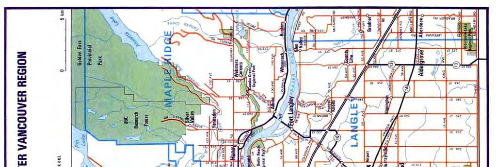
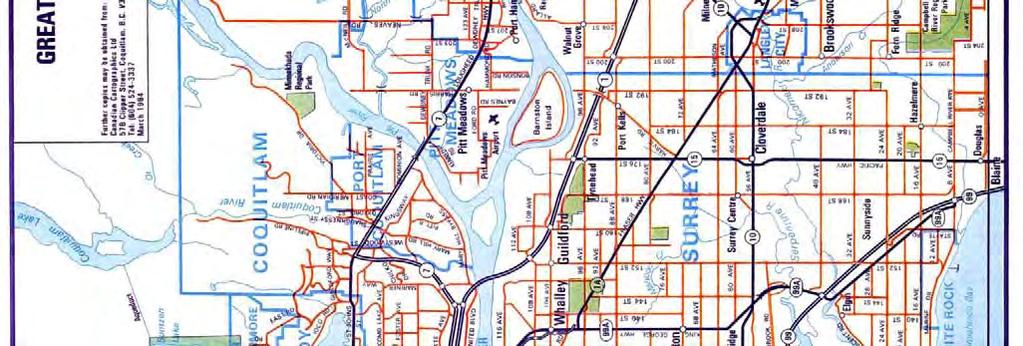
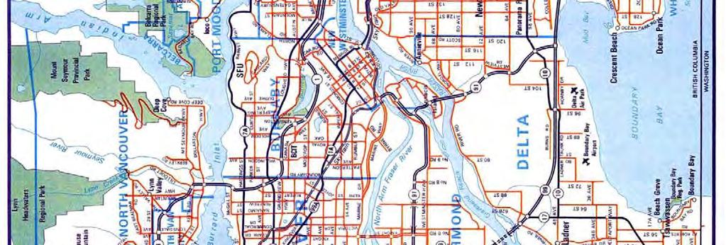
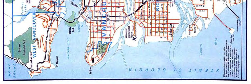
25 The Alex Fraser Bridge (completed in 1986) provides a fourth crossing of the Fraser River in Greater Vancouver. This six-lane cable-stayed bridge, the largest of its kind in the world when built, connects the Annacis Island industrial area and New Westminster with the south bank between Tilbury Industrial Park and North Delta. An extensive network of high speed access routes provides connections to Richmond, New Westminster (via the Queensborough Bridge), North Delta, South Surrey and White Rock (via Highways 91 and 99). The bridge has improved access to the City from the southern portion of the Greater Vancouver District while reducing commuting time for many Delta residents. The bridge also facilitates direct bus service between the Municipality and the SkyTrain rapid transit line in New Westminster. People residing in Delta basically comprise commuters working in Vancouver and surrounding communities, airport and ferry employees, fishermen and farmers. Transportation improvements such as the Alex Fraser Bridge and SkyTrain, along with the relatively high real estate prices in the urban Vancouver area and the general growth of the regional district, have served to increase the importance and popularity of this suburban municipality. At present, lower real estate prices are encouraging a significant number of families to move to this area. Area Map A AA PAGE 22
26 NEIGHBOURHOOD PROFILE The subject property is situated in the Tsawwassen area of Delta. The northern border of the subject is bounded by Boundary Bay Road. The southern portion of the subject property is bounded by the Canada / United States border. To the west, the subject property is bounded by Boundary Bay Road and also 56 th Street. To the east, the subject property is bounded by 56 th Street. Property Uses in the Surrounding Area: North: South: East: West: Beach Grove Golf Course and Boundary Bay Regional Park; Canada / United States border; Single and multi-family residential; Single family residential. Development Activity: Property Development Group is planning to develop 50-arces of land to create a retail power centre in the Tsawwassen area. Tsawwassen Commons is being developed in cooperation with Ivanhoe Cambridge s development of a 1.2 million sq.ft. Tsawwassen Mills project. Together these developments will occupy 175 acres of Tsawwassen First Nations lands along Highway 17 from the intersection of 52 nd Street to 48 th Street. These developments will have significant exposure to the ferry terminal traffic and is surrounded by the municipalities of Richmond, Delta and Surrey. This shopping centre will be developed in two phases. Phase 1 will consist of 600,000 sq.ft. of retail space on 53 acres of land and is scheduled to open in Q1, Reportedly, there are active negotiations underway with three major anchor tenants. Phase 2 of the Tsawwassen Power Centre is proposed to include an enclosed mall. A retail centre of this scale would be attractive to prospective residents and be a positive factor in future potential residential developments in the subject area. Transportation and Access: Road Network: The main arterial road to the subject area is 56 th Street which runs north/south and connects to Highway 17. Highway 17 connects to the Swartz Bay Ferry Terminal to the northwest of the subject and Highway 99 to the north. Public Transit: There is currently limited public transportation in the subject area. The Coast Mountain Bus Company s route 601 services the South Delta and Boundary Bay area. Summary: The subject is located in a neighbourhood that is characterized mainly by single family and low-rise multi-family developments. The subject area offers a location that is in close proximity to the Swartz Bay Ferry Terminal and has reasonable road access to major highways. A AA PAGE 23
27 PROPERTY DATA IMPROVEMENTS There are improvements on three of the seven legal parcels comprising the subject property. At 581 Boundary Bay Road, there are three single family homes and one outbuilding. Located at 500 Boundary Bay Road, there is one single family home situated in the southeast corner. At rd Avenue, there are two single family dwellings, including the Alexander/Gunn Farmhouse (which is noted on Delta s Heritage Inventory), a detached garage for each dwelling, two barns and several sheds. Based on information provided by Mike Ruskowski, Senior Planner at the Corporation of Delta, the owner of the subject property is currently leasing a portion of the site for farming purposes. Boundary Bay Earthwise Garden and Farm occupies a portion of the property at rd Avenue and features a one acre ecological demonstration garden, 65 allotment plots, a two acre organic farm with year-round production in a hoop house, a nursery and a farm store. SITE Site Area: Configuration: Utilities: Topography: Soil Conditions: Approximately acres (based on data from the Corporation of Delta). Irregular. The site is predominantly agricultural land. If the site were to be developed, the typical servicing, paving and other amenities would need to be provided. Level. We are not environmental consultants or geotechnical engineers and have not been provided with any soils surveys or other environmental studies on the subject property. As such, we do not know if the subject property is free of soil contamination and environmental problems. For the purpose of this report, it is assumed that the property does not suffer from any environmental or geotechnical problems. The reader is cautioned that if such a problem were to exist, it could have an impact on value. A AA PAGE 24


28 Site Plan Aerial Photo of Subject Site and Improvements A AA PAGE 25
29 ASSESSMENTS & TAXES The 2012 assessed value is the Assessor s opinion of value for assessment purposes and is not necessarily reflective of market value. The assessment is based upon the value as at July 1, The value is based upon the physical condition of the subject property as of October 31, Parcel Roll # P.I.D.# Land Improvement Total 2012 Gross Assessment Assessment Assessment Taxes 1 D $1,293,396 $0 $1,293,396 $10, D $5,886,000 $105,000 $5,991,000 $34, D $2,585,000 $23,600 $2,608,600 $14, D $5,172,775 $273,000 $5,445,775 $32, D $3,109,112 $0 $3,109,112 $19, D $3,155,857 $0 $3,155,857 $19, D $2,097,000 $0 $2,097,000 $12, $23,299,140 $401,600 $23,700, , ZONING AND LAND USE CONSIDERATIONS Introduction: Further details of this zoning are available in the Corporation of Delta Official Bylaws and attached as Addendum C. Zoning Classification: Maximum Height: Permitted Uses: O.C.P. or Future Rezoning: A1 Agricultural (Non-ALR). The maximum height of a Farm House, Additional Farm House or Accessory Farm Residential Facilities shall not exceed 2 ½ storeys. Farming, breeding pets and kennel. The current Tsawwassen Area Plan (Schedule D of the Delta O.C.P.) has the stated objective to preserve the farmlands within the Southlands for agricultural uses, which reinforces the O.C.P. objective of preserving farmland for the food production needs of the future. The Century Group submitted an application for an amendment to the O.C.P. on September 26, 2011 with respect to the subject property. This application proposes a revision to the land use designations as shown in the following chart. Land Parcel Areas Acres % Agricultural % Natural Habitat % Public Open Space and Greenways 47 9% % Neighbourhood Centre / Housing % Total % A AA PAGE 26
30 The proposal would involve contributing the 430 acres noted in the above chart to the Corporation of Delta (which would remain agricultural land), while developing the remaining 107 acres with a mix of single and multi-family residential structures and commercial space. With respect to the proposed residential development land, the application proposes a maximum number of 950 units (which is a reduction from a previous proposal of 1,900 units). In this application, the following chart summarizes the proposed types of residential buildings and estimated density ranges. Unit Typology Storeys Density (UPA) Cottage 2 10 to 12 Townhouses 3 12 to 16 Rowhouses 3 20 to 24 Flats 3 to 4 30 to 45 Flats/Mixed Use 4 30 to 45 On April 3, 2012, a rezoning application was submitted by the Century Group for Phase 1 of the Southlands development. Phase 1 is proposed to include 53 parcels on approximately 35 gross acres of land located on the eastern portion of the Southlands. The following chart is a breakdown of the intended use of the first 35 acres of land. Site Areas Area (acres) Public Amenity Area 8.4 Roads and Circulation 10.4 Net Developable Area 16.3 Total Area This first phase is proposed to be concentrated around a Market Square and along a newly created street named High Street. High Street would run east/west through the development area. The Market Square would feature an estimated 80,000 sq.ft. of ground oriented commercial space. In terms of development of residential buildings, Phase 1 is proposed to include 450 of the maximum number of 950 proposed for the entire Southlands development. Considering Phase 1 is intended to be constructed on approximately 35 gross acres of land, this first phase would feature a higher overall density compared with subsequent phases. The following chart summarizes the breakdown of the types of residential units proposed for Phase 1: A AA PAGE 27
31 Type Density Approxim ate Units Average Units per Acre Implied Land Area (acres) Cottage Style Homes Low % Single Family Homes Low % Duplexes Medium % Manor Homes Medium % Townhomes/Rowhomes Medium % Condominiums/Mews Homes High % Total % The rezoning application submitted provides the following proposes zoning designations for phase 1: % Zone Designation Short Description VC 1 Village Commercial High Street, Mixed Commercial with Residential VC 2 Village Commercial Mixed Residential with Commercial VC 3 Village Commercial Live Work VR 1 Village Commercial Cottage Homes, Strata VR 2 Village Commercial Cottage Homes, Fee Simple VR 3 Village Commercial Duplex VR 4 Village Commercial Manor Homes VR 5 Village Commercial Townhomes / Rowhomes VR 6 Village Commercial Condominiums / Mews Homes PA 1 Public Amenity Public Open / Green Space / Trail PA 2 Public Amenity Public Open / Green Space / Parking PA 3 Public Amenity Community Centre PA 4 Public Amenity Community Heritage PA 5 Public Amenity Earthwise Gardens PA 6 Public Amenity Community Gardens On May 3, 2012, the Century Group and City Council met to discuss the proposed development and the previously submitted application for rezoning for Phase 1. It was noted that subsequent to the proposed construction of 450 units in Phase 1, the balance of the 500 units would be divided into two further phases. The timing for the build-out would be market driven and could take up to 20 years to complete. It was emphasized that a transportation study would be critical to address the potential of the addition of 900 or more cars to the subject area. The Delta Development Department submitted a report dated June 21, 2012 to the Mayor and City Council regarding recommendations of how to move forward with the proposed development. The report noted that the Chief Administrative Office recommends that the Corporation of Delta retain consultants to prepare two independent studies: 1) Flood Construction Level Study; 2) Storm Water Management and Irrigation Options Study. Information that would be provided from such studies is deemed critical in responding to public questions regarding the Southlands rezoning application. There were a number of other questions posed and suggestions on further actions for the rezoning application to move forward that were outlined in the report. A AA PAGE 28
32 A memo from the Acting Director of Community Planning & Development dated August 10, 2012 was sent to the Mayor and City Council providing an update to the status of the rezoning application. This memo noted that Century Group has provided further information since the last meeting with City Council including a preliminary agronomy study (dated April, 2008), a draft letter regarding the engineering serviceability of the proposed development and a draft revised master plan of the Southlands project. Items that were still outstanding included an updated traffic study, an environmental report, heritage information, a summary of sustainability features to be incorporated and details on the proposed land and building transfer. It was also indicated that the applicant will be submitting a rezoning application for the remaining phases of the Southlands development in the future. Based on discussions with the Senior Planner at the Corporation of Delta, the Planning Department cannot comment on the probability of the development being ultimately approved. It was noted that the application needs to go through the standard application process which would require approval by both the Delta Council and Metro Vancouver. A AA PAGE 29
33 HIGHEST & BEST USE Real Estate is valued in terms of its optimum or highest and best use. Highest and best use is defined as: The reasonably probable and legal use of vacant land or an improved property, which is physically possible, appropriately supported, financially feasible, and that results in the highest value to the property. The four criteria the Highest and Best Use must meet are: LEGAL PERMISSIBILITY: This considers public restrictions, including zoning guidelines, utility right-of-way, etc., and private restrictions such as easements. Based on the description of improvements on the subject property and the information provided by the Corporation of Delta on the current known land uses, the subject property appears to conform to its current A1 zoning. Thus, the subject property appears to be a legally conforming use. As noted above, the owner of the subject property has submitted an application to amend the O.C.P. and a rezoning application for Phase 1 of a development that would involve developing 35 acres (gross) of the subject property with residential and commercial uses. It is envisioned that a further 72 acres would be developed. The remaining 430 acres would be contributed to the Corporation of Delta as agricultural land. Discussions of this proposal are ongoing. The Planning and Development department of the Corporation of Delta are unable to comment on the probability of the rezoning and development applications being approved. PHYSICALLY POSSIBLE: This considers site area, configuration, topography, availability of utilities street improvements and accessibility. The subject property is irregular in shape, but is a vast land mass totalling approximately 537 gross acres. The topography of the overall site is generally level. There are several large forested areas on the subject parcels, located along the west, south and east boundaries of the site. Overall, the subject property s characteristics are appropriate for its current use. In order to develop the subject property as a mixed-use residential and commercial site, additional costs would need to be incurred to provide the required utilities and amenities (e.g. appropriate water and sewage, electricity, natural gas, telephone, etc.). Geotechnical studies and work would also be required; areas to be developed may require fill and preload and/or other soil preparations to support future construction. A AA PAGE 30
34 FINANCIALLY FEASIBLE: This considers marketability in terms of supply/demand characteristics, profitability as it relates to return on cost, market rent levels, etc., and the availability and cost of capital. A number of recent sales of large agricultural land parcels in the Delta, Surrey and Langley indicate there is a demand in the market for productive land for the expansion or start-up of farming operations. Land in the subject area is known to be some of the most fertile and productive agricultural land in the province; combined with easy access to a wide variety of distributors and independent farmers markets, the subject land is considered a desirable location for agricultural production. The Real Estate Board of Greater Vancouver benchmark detached home in Tsawwassen averaged $728,700 in August 2012, a figure which was up 2.0% from August 201. Demand for housing in the South Delta area is primarily driven by the growing population in the Metro Vancouver area, with the subject area attracting purchasers looking for a more rural setting and the lower housing prices found further from the Metro core. In general, the market suggests a good level of demand for agricultural and residential properties in the subject area. Thus, the subject property is considered financially feasible. MAXIMUM PROFITABILITY: This considers use that produces the highest residual land value consistent with the rate of return warranted by the market for that use. Agricultural land sales in Delta and comparable areas have indicated values of less than $100,000 per acre in all cases involving larger (i.e. 50 acres plus) tracts of land. In contrast, residential development land in the same areas have achieved sales prices in excess of $1,000,000 per acre. Although there are costs associated with rezoning and implementing the servicing required for residential developments, if the subject property were to be rezoned and developed, it would likely achieve a net value greater than its value as agricultural land. CONCLUSION Having regard to the discussion above, the current use of the subject land as developed with the existing use is a legal and conforming use, according to the applicable A1 zoning guidelines. Given the subject s location and surrounding developments, we are of the opinion a development of the subject land with residential, with varying densities, and commercial would yield the greatest return. HIGHEST & BEST USE AS IF VACANT If the subject property was vacant and unimproved, and was able to be developed in today s market, it is our opinion that its highest and best use would be parallel to the conclusion above. A AA PAGE 31
35 SECTION II VALUATION A AA PAGE 32
36 VALUATION PROCESS METHODS OF VALUATION Generally, appraisers rely upon three basic approaches to estimate value: the Direct Comparison Approach, the Cost Approach, and the Income Approach. The decision to apply any one or all of these approaches is determined by the type of property being appraised. DIRECT COMPARISON APPROACH: This approach is based upon comparison of the subject property with other properties of similar characteristics that have recently sold, and best applies in the valuation of property types that frequently trade in the open marketplace. The Direct Comparison Approach is used to estimate the value of both vacant land and improved properties. Comparable sales are gathered and analyzed, to which logical adjustments are made for dissimilar characteristics. It is the most common and preferred method of land valuation when comparable sales data are available. COST APPROACH: This approach is based on the cost of constructing improvements identical to the subject property, allowing deduction for accrued depreciation. To this residual, the estimated land value is added, and the resulting sum indicates the value of the whole property. This approach to value best applies when buildings are new or proposed, and where accrued depreciation is not a significant factor. INCOME APPROACH: Direct Capitalization Method: This approach is based on the assumption that there is a definitive relationship between the income producing ability of a property and its value. The anticipated annual net income before debt service is analyzed and quantified, and a capitalization rate is then selected and applied to arrive at an estimate of the market value of the property. The process of converting net income into value is known as Capitalization, which in its basic form is the process of dividing the net income by a capitalization rate. The appropriateness of this rate is critical, and there are a number of techniques by which it may be developed. The appraiser closely observes the actions of buyers and sellers to determine market trends. The final step in the appraisal process is to reconcile the one or more value indications. In this reconciliation to provide one final estimate of market value, the purpose of the appraisal, the type of property, and the adequacy and reliability of the data studies, all influence the weight attributed to each of the approaches. APPROACH TO ESTIMATING VALUE The subject property consists of approximately acres of land zoned A1-Agricultural. There is adequate sales comparable sales data in valuing the subject as 1) agricultural land and 2) as a A AA PAGE 33
37 combination of agricultural land and mixed-use residential and commercial development land. As such the most common and preferred method of this land valuation would be the Direct Comparison Method, which has been applied as such in this report. A AA PAGE 34

38 COMPARABLE SALES AGRICULTURAL LAND INTRODUCTION We have examined a number of sales of investment properties over the past several years and have undertaken discussions with agents with respect to investor yield expectations for properties such as the subject in the current market. The following sales have been selected as they represent the most relevant transactions. The sales research and analysis has been broken out into the component parts of: Agricultural Land; Low Density Residential; Medium Density Residential Land; Higher Density Residential Land and; Commercial Land. Map of Comparable Sales (Agricultural Land) A AA PAGE 35

39 No th Avenue, Surrey Sale Price: $5,500,000 Closing Sale Date: Jun-12 Site Area (acres): Zoning: A1 (A.L.R.) Sale Price/Acre: $91,667 This comprises a acre parcel in the South Surrey area. This site is located on the north side of 8 th Avenue, between 188 th and 192 nd Streets. The majority of the site was cleared agricultural land with approximately one-quarter to one-third of the site (the back portion of the lot) requiring heavy clearing. This property has access to municipal water, but no septic field was installed at the time of sale. This property is zoned A1 and approximately half of the site is located within the A.L.R. A AA PAGE 36
 Sale Price/Acre: $73,220 This comprises two separate land parcels sold in one transaction.")
40 No and Lot 1 64 th Street, Delta Sale Price: $5,650,000 Closing Sale Date: Aug-12 Site Area (acres): Zoning: A1 (A.L.R.) Sale Price/Acre: $73,220 This comprises two separate land parcels sold in one transaction. This property is located southeast of the Fraser River and in close proximity to the interchange between Highway 17 and Highway 99. At the time of the sale, the property was improved with a single-family dwelling. There was strong interest in this property with several offers made. At the time of the sale, the land was being utilized as a potato farm and all services and utilities were available on site. Reportedly, the buyer intended to continue using the land for farming purposes. The property is zoned A1 and is located in the A.L.R. A AA PAGE 37

41 No Tamboline Road, Delta Sale Price: $3,200,000 Closing Sale Date: May-12 Site Area (acres): Zoning: A1 (A.L.R.) Sale Price/Acre: $64,000 This comprises a acre parcel on the east side of Westham Island in the Tsawwassen area of Delta. At the time of the sale, the property was improved with a single-family dwelling and two sheds. Subsequent to the sale, the previously existing dwelling was demolished and a new singlefamily residence was under construction. This transaction was between two individuals acting in their own capacity. This property has access to municipal water, but no septic field was installed at the time of sale. This property is zoned A1 and is in the A.L.R. A AA PAGE 38

42 No nd Avenue, Langley Sale Price: $2,900,000 Closing Sale Date: Oct-11 Site Area (acres): Zoning: RU-3 (A.L.R.) Sale Price/Acre: $22,734 This comprises a acre parcel in the Fraser Flood Plain area of Langley. This site is located on the north side of 72 nd Avenue, between 252A Crescent and Telegraph Trail. There is good access to the Trans-Canada Highway via 72 nd Avenue. The majority of the site (roughly two-thirds) requires heavy clearing. At the time of the sale, the property was improved with two single-family detached dwellings. This property has access to municipal water. This property is zoned RU-3 and is located within the A.L.R. A AA PAGE 39

43 No Colebrook Road, Surrey Sale Price: $3,300,000 Closing Sale Date: Sep-11 Site Area (acres): Zoning: A-1 (A.L.R.) Sale Price/Acre: $50,587 This was a non-brokered sale by the City of Surrey to an individual acting in his own capacity. This property is a acre parcel of farmland located on the south side of Colebrook Road, approximately three kilometres west of King George Boulevard in the Central Serpentine Valley neighbourhood. The City of Surrey purchased this property in 1998 for park purposes in conjunction with the purchase of several properties located along the north side of Colebrook Road. The properties purchased to the north of Colebrook Road are now known as Colebrook Park. In 2001, City Council recommended that the land on the south side of Colebrook Road not be incorporated in the park but rather retained for agricultural uses. Prior to the date of sale, the City of Surrey had been leasing the land for agricultural use. The property was advertised for sale in July and August of 2010 and multiple offers were received. The proceeds of the sale were to be returned to the Parkland Acquisition Reserve Fund for use in funding other parkland purchases. This property has access to municipal water. This property is zoned A-1 and is located within the A.L.R. A AA PAGE 40
 and Lott and John Hect Memorial Foundation (the vendor).")
44 No nd Street, Langley Sale Price: $1,800,000 Closing Sale Date: Mar-10 Site Area (acres): Zoning: RU-3 (A.L.R.) Sale Price/Acre: $36,000 This transaction involved Grafton Farm Ltd. (the purchaser) and Lott and John Hect Memorial Foundation (the vendor). This property is an irregular-shaped parcel located on the west side 232 nd Street, just north of the intersection with 20 th Avenue. It is approximately 0.8 kilometres from the intersection of 232 nd Street and 16 th Avenue and is approximately 4.2 kilometres from 0 Avenue (the Canada/U.S. border). 16 th Avenue is a secondary arterial route running east to west that connects to Surrey and White Rock to the west and Abbotsford to the east. It is noted that 20 th Avenue (to the immediate south) does not extend westwards past the intersection with 232 nd Street. Furthermore, to the rear of the lot (the western boundary), 228 th Street does not extend south to provide for a rear access onto the subject site. Therefore, the only road access for the subject property is via 232 nd Street. At the time of the sale, this property was used for horse grazing purposes and not utilized for farming. Capital costs would be required to bring the land to a productive level suitable for farming. This property does not have access to municipal water. Water is available via a well and sewer is provided by way of a septic tank. This property is zoned RU-3 and is located within the A.L.R. A AA PAGE 41
 Sale Price/Acre: $40,053 Two separate parcels that were sold together to a single purchaser.")
45 No & Lot B Street, Delta Sale Price: $3,350,786 Closing Date: Jun-10 Site Area (acres): Current Zoning: A1 (A.L.R.) Sale Price/Acre: $40,053 Two separate parcels that were sold together to a single purchaser. The property is located on the west side of 62B Street, east of Deas Island and just north of the interchange of Highway 17 and Highway 99. The property was improved with various farm-related structures, including two single-family residences and a barn. The property is zoned A1 and is in the Agricultural Land Reserve, and was actively farmed at the time of sale. The vendor in this transaction was Shato Holdings, a holding company with various farming and real estate holdings, notably including the White Spot restaurant franchise and property development operations. Indications are that the property was purchased by an individual who plans to continue active farming of the property. The properties had been marketed separately, with an aggregate asking price of $5,800,000, and sold after approximately one month on the market. Subsequent to the sale, individuals involved in the sale of the property reported that the vendor had been motivated to move the property and likely could have obtained a higher price if they had been willing to consider more offers. A AA PAGE 42
46 Analysis of Comparable Sales Agricultural Land The Direct Comparison Approach considers each of the comparables on a price per acre basis. The overall subject property is a total of approximately 540 acres over seven land parcels. The land parcels range from acres to acres in size. This represents an average of approximately 77 acres per parcel. We have adjusted the comparables price per acre for size using the base size of a 77 acre parcel. The subject property is not designated in the ALR. However, the vast majority of sales transactions of agricultural land sales are designated as such. The challenge is the lack of non-alr land sales available, and therefore, we have conducted paired sales analysis. We were able to locate two land parcels (approximately 80 acres each) in South Surrey that both sold in mid-2007, one that was within the ALR and one that was not. The property not in the ALR showed a premium of approximately 30%. However, part of this premium is due to the superior location within South Surrey of the non-alr sale. Neither of these properties have been developed to date to our knowledge and are still considered agricultural land. In recognition that there is a premium associated with non-alr land versus ALR land, we have made upward adjustments to the following sales comparables (i.e. located in the ALR). However, as noted above, the premium would not be as high as 30%. In addition, it should be noted that although there is a premium for agricultural land not in the ALR, the process of attempting to develop agricultural land to other uses (e.g. residential) can be very costly and quite lengthy. The chart on the following page provides a summary of the particulars of each comparable sale. The majority of these agricultural land sales include some value in the improvements on the respective properties. To estimate the land residual of each comparable, the assessed value of the improvements of each property have been deducted from the sale price. A AA PAGE 43
47 No. Address (PID) Date of Sale Price/$ Land Area (Acres) Price/Acre Imprv. (Assmt.) th Avenue, Surrey Jun-12 $5,500, $91,667 $102,400 $5,397,600 $89,960 A ALR Land Residual Adjusted Price/Acre Zoning Comments The property was improved with a single family dwelling at the time of the sale. Located in the South Surrey area between 188th and 192nd Streets. The site has close proximity and ease of access to the United States vis 176th Street. Highway 99 is also readily accessible via 8th Avenue. Approximately one third of the lot would require heavy clearing and one half is in the ALR and Lot 1-64th Street, Delta Aug-12 $5,650, $73,215 $97,200 $5,552,800 $71,955 A ; ALR This comprises of two separate land parcels sold in one transaction. This property is located southeast of the Fraser River and in close proximity to the interchange between Highway 17 and Highway 99. At the time of the sale, the property was improved with a single family dwelling. There was strong interest in this property with several offers made. At the time of the sale, the land was being utilized as a potato farm and all services and utilities were available on site Tamboline Road, Delta May-12 $3,200, $64,000 $30,000 $3,170,000 $63,400 A ALR This property is located on the east side of Westham Island. At the time of the sale the property was improved with a single family dwelling and two sheds. Subsequent to the sale, the previously existing dwelling was demolished and a new single family residence was under construction.this transaction was between two individuals acting in their own capacity nd Avenue, Langley Oct-11 $2,900, $22,734 $124,000 $2,776,000 $21,762 RU ALR This comprises a acre parcel in the Fraser Flood Plain area of Langley. This site is located on the north side of 72nd Avenue, between 252A Crescent and Telegraph Trail. There is good access to the Trans-Canada Highway via 72nd Avenue. The majority of the site (roughly two thirds) requires heavy clearing. At the time of the sale, the property was improved with two single family detached dwellings Colebrook Road, Surrey Sep-11 $3,300, $50,590 $0 $3,300,000 $50,590 A ALR This was a non-brokered sale by the City of Surrey to an individual acting in his own capacity. This property is a acre parcel of farmland located on the south side of Colebrook Road, approximately 3 km west of King George Boulevard and is in close proximity to Highway 99. The property is located in the Central Serpentine Valley neighbourhood nd Street, Langley Mar-10 $1,800, $36,000 $207,000 $1,593,000 $31,860 RU ALR This property is an irregular shape parcel located on the west side 232nd Street, just north of the intersection with 20th Avenue. The only road access for the subject property is via 232nd Street. At the time of the sale, this property was used for horse grazing purposes and not utilized for farming. Capital costs would be required to bring the land to a productive level suitable for farming. This property does not have access to municipal water. Water is available via a well and sewer is provided by way of a septic tank This property is zoned RU-3 the site is located within the A.L.R & Lot B Street, Delta Jun-10 $3,350, $40,053 $67,900 $3,282,886 $39,241 A & ALR The property was in use as a potato farm at the time of sale, and was sold by Shato Holdings, holding company of White Spot. The property was improved with various farm related structures and a single family dwelling. Comparable No. 1, th Avenue, Surrey This is a recent sale of a 60 acre parcel in the South Surrey area. We would adjust down for size. A further downward adjustment is warranted for this comparable s superior location and quality of land (i.e. the majority of the site was cleared agricultural land). This is partially offset by an upward adjustment for this comparable s A.L.R. designation. Overall, a downward adjustment from $89,960 per acre is suggested. Comparable No. 2, 5905 and Lot 1 64 th Street, Delta This property was being utilized as a potato farm at the time of the sale and all services and utilities were available on site. Downward adjustments are warranted for this comparable s superior land quality and for this property s close proximity to the Highway 17 and Highway 99 interchange. This is partially offset by an upward adjustment for this comparable s A.L.R. designation. No size adjustment is warranted. Overall, a downward adjustment from $71,995 per acre is suggested. A AA PAGE 44
48 Comparable No. 3, 4362 Tamboline Road, Delta This is a 50 acre parcel in the Tsawwassen area of Delta. No location adjustment has been applied. A downward adjustment is required for size. This is partially offset by an upward adjustment for this comparable s A.L.R. designation. Overall, a downward adjustment from $63,400 per acre is shown. Comparable No. 4, nd Avenue, Langley This is a 128 acre parcel in the Fraser Flood Plain area of Langley. Upward adjustments are required for the A.L.R. zoning of this comparable, for size and for time. A further upward adjustment is required for the fact that this comparable requires heavy clearing for the majority of the site. Overall, an upward adjustment from $21,762 per acre is indicated. Comparable No. 5, Colebrook Road, Surrey This is a 65 acre parcel of farmland in the Central Serpentine Valley neighbourhood. An upward adjustment is required for this comparable s A.L.R. designation. A further upward adjustment is required for time. This is partially offset by downward adjustments for quality of land (i.e. as this property was being used for agricultural purposes) and size. Overall, an upward adjustment from $50,590 per acre is shown. Comparable No. 6, nd Street, Langley This is a 50 acre parcel which was used for horse grazing (i.e. not farming) at the time of the sale. An upward adjustment is warranted for the subject s superior location. Further upward adjustments are required for this comparable s A.L.R. designation and for time. This is partially offset by a downward adjustment for size. Overall, an upward adjustment from $31,860 per acre is suggested. Comparable No. 7, 6785 & Lot B Street, Delta This is an 84 acre land parcel that was actively farmed at the time of sale. Reportedly, this sale involved a motivated seller and a higher price could potentially have been achieved. This comparable s A.L.R. designation requires an upward adjustment. A further upward adjustment is required for time. Overall, an upward adjustment from $39,241 per acre is shown. Sales Summary The above comparables suggest downward adjustments for Comparable Nos. 1, 2, and 3 at $89,960, $71,955 and $63,400 per acre, respectively. Upward adjustments are required for Comparable Nos. 4, 5, 6 and 7 at $21,762, $50,590, $31,860 and $39,241 per acre, respectively. This provides a narrower range from $50,590 to $63,400 per acre. Comparable No. 3 is in Delta and is a recent sale, and therefore, has been given more weight. Overall, we conclude an estimated value for the subject s agricultural land of $60,000 per acre. Based on a review of these sales and consideration of the local market for properties similar to the subject, we would expect that the subject would need to be exposed to the market for a period of 6 to 12 months prior to a sale being completed. A AA PAGE 45


49 COMPARABLE SALES - LOW DENSITY RESIDENTIAL LAND INTRODUCTION We have examined a number of sales of investment properties over the past several years and have undertaken discussions with agents with respect to investor yield expectations for properties such as the subject in the current market. The following sales have been selected as they represent the most relevant transactions. Map of Comparable Sales (Low Density Residential Land) A AA PAGE 46
: Mar-12 0775372 B.C. Ltd.")


 and 15 RF-9C (Coach House Zone) lots.")
 are expected to be resolved in September, 2012 and move forward to the next stage of the development process.")
50 No t11 Avenue, Surrey ó QO COO) C LL).fl CD CD F F.. CD C ,.. çj. -J..çj , Sale Price: Closing Sale Date: Vendor: Purchaser: $3,3 18,000 Site Area (acres): Mar B.C. Ltd B.C. Ltd. Zoning: Max U.P.A. (proposed): Price per Unit: Price per Acre (gross): 2.68 RA 6.7 $184,333 $1,238,522 This is a residential development site on the north side of 60 th Avenue, mid-block between l40 and l42 Streets in the Newton area of Surrey. This site comprises three separate parcels of land totalling 2.68 acres. This property offers servicing to the lot line. Prior to the date of the sale, a rezoning application ( ) received third reading. The proposed project would involve three RF lots (Single Family Residential) and 15 RF-9C (Coach House Zone) lots. Based on discussions with planners at the City of Surrey, outstanding issues outlined in a preliminary layout approval letter (P.L.A.) are expected to be resolved in September, 2012 and move forward to the next stage of the development process. The site was purchased for $3,318,000 or approximately $1,240,000 per acre (rounded). the proposed rezoning, a value of $184,333 per unit is indicated. Based on A AA PAGE 47
51 No Grade Crescent, City of Langley Sale Price: Closing Sale Date: Vendor: Purchaser: $1,950,000 Dec-il Individual(s) B.C. Ltd. Site Area (acres): Zoning: Max U.P.A. (proposed): Price per Unit: Price per Acre (gross): 1.89 RS $162,500 $1,034,483 This is a residential development site at the southwest corner of Grade Crescent and 201 st Street in the City of Langley. This site comprises a single land parcel with a gross site area of 1.89 acres. This property offers servicing to the lot line. A subdivision application (SD ) for 12 single-family lots was received by the city subsequent to the sale date. The site was purchased for $1,950,000 or approximately $1,030,000 (rounded) per acre. the proposed development plans, a value of $162,500 per unit is indicated. Based on A AA PAGE 48
: Zoning: Max U.P.A.: Price per Unit: Price per Acre (gross): 1.92 R-CL(B) 6.")
52 No I 1F1 f I l w Sale Price: Closing Sale Date: Vendor: Purchaser: $2,400,000 Nov-li B.C. Ltd. and B.C. Ltd. Silver Star Enterprises Coquitlam Ltd. Site Area (acres): Zoning: Max U.P.A.: Price per Unit: Price per Acre (gross): 1.92 R-CL(B) 6.3 $200,000 $1,251,956 This is a residential development site on the northwest corner of 2O6 Street and 68 th Avenue in the Willowbrook neighbourhood of the Township of Langley. This property offers servicing to the lot line. Prior to the date of sale, a rezoning and subdivision application (RZ ) had received third reading on July ii, 2011 regarding the rezoning of the property to a Residential Compact Lot R-CL(B) to allow for the subdivision of the property to 12 single-family lots. The rezoning application received final reading and was passed in July, Final approval was granted in August, 2012 based on information from the Township of Langley. The site was purchased for $2,400,000 or approximately $1,250,000 (rounded) per acre. the proposed development plans, a value of $200,000 per unit is indicated. Based on A AA PAGE 49
53 No nd Street, Surrey Sale Price: $4,555,000 Site Area (acres): 4.94 (2.90 net) Closing Sale Date: Mar-i 1 Zoning: Mixed Vendor: Clayton Ridge Management Max U.P.A.: 9.3 proposed (on net) Purchaser: Legendary Developments Price per Unit: $168,704 Price per Acre (gross): $922,065 This is a residential development site on the west side of I 92 Street, north of 731( Avenue, in the Clayton neighbourhood of Surrey. This site comprises a gross area of 4.94 acres. This property offers servicing to the lot line. A previous owner had proposed a 56-unit development that included a combination of single-family lots, townhouse and duplex units; this proposal was rejected when it was determined a 2.04 acre area on the western portion of the site could not be serviced at this time. A scaled-back rezoning application had received third reading prior to the closing of this transaction; the new zoning was adopted in May, 2011, allowing 16 coach house lots and 11 duplex units. The approved project covers a net site area of 2.90 acres, although discussions with parties involved noted that the purchaser expects to be able to develop the remaining area in the future. The site was purchased for $4,555,000 or approximately $920,000 (rounded) per acre. Based on the proposed development plans, a value of $168,704 per approved unit is indicated. This price reflects the purchaser s belief that the western portion of the site that could not be serviced can be developed in the future. A AA PAGE 50
54 No nd Street, Surrey Sale Price: Closing Sale Date: Vendor: Purchaser: $4,400,000 Mar-li Individual Legendary Developments Site Area (acres): Zoning: Max U.P.A.: Price per Unit: Price per Acre (gross): 5.23 (4.65 net) Mixed 8.4 proposed (on net) $112,821 $841,300 This is a residential development site on the west side of l92 Street, at 73k Avenue, in the Clayton neighbourhood of Surrey. This site comprises a gross area of 5.23 acres, although the proposed project relates to a net site area of 4.65 acres. This property offers servicing to the lot line. The rezoning would create a 0.58-acre remainder lot on the western portion of the site that cannot be serviced at this time and therefore would not be developable, although discussions with parties involved noted that the purchaser expects to be able to develop this area in the future. The current proposal for this parcel includes a rezoning to RF-9C, RF-12C, and RF-SD to accommodate 31 coach house lots and eight duplex units. The purchaser in this transaction also closed on the adjacent parcel to the north at the same time; these were two separately negotiated transactions with different vendors. The site was purchased for $4,400,000 or approximately $840,000 (rounded) per acre, though the agent involved speculated that a higher value could have likely been achieved if not for the uncertainty involved with developing the remainder lot. Based on the proposed development plans, a value of $1 12,821 per unit is indicated. A AA PAGE 51

55 I Low Analysis of Comparable Sales - Density Residential Land The Direct Comparison Approach considers each of the comparables on a price per acre and price per unit. The following chart shows the proposed densities for the subject property development, categorized by housing type for comparison purposes. Type Density Approxim Average ate Units Units per Acre Cottage Style Homes Low Single Family Homes Low Ouplexes Medium Manor Homes Medium Townhomes/Rowhomes Medium Condominiums/Mews Homes High Total The property offers servicing to the lot line based on discussions with the Engineering Department at the Corporation of Delta. In our analysis of comparables, we have considered the level of servicing offered by the comparable sites and made adjustments accordingly. In the following comparable sales analysis, we have reviewed sales from Langley, Surrey and Delta. We have conducted a review of the Development Cost Charges (DCC S) applicable to developments in these municipalities. DCC s are applicable for new developments and are typically charged on a per unit basis. Thus, purchaser s typically consider the level of DCC s for prospective development sites in comparing acquisition targets. Based on our research, DCC s in the Corporation of Delta are significantly lower than in Surrey and Langley on a per unit basis, generally across all building types. Thus, for comparable sales we have selected in Surrey and Langley, we have applied upward adjustments to the value per unit indicated by the sale price inherently in our consideration of an overall location adjustment (if any). The following chart provides a summary of the particulars of each comparable sale. _., RA Mar-12 S3.3I9.. SI,2= Surrey 116,697 $28 S rezoning application for RF-9C I 9 2lXl86&ade Crescent Dc-I Sl, $1,034,483 $162,500 RS-I 6.3 City oflangley 82,111 $ th Street Nos-Il $2,400, Sl,251,956 $200,000 SR-2 63 Langley 83,505 $29 rezoning application for R-CUB) nd Street Mar-Il $4,555, $922,065 $168,704 RF-9C,RF-SD 9.3 Sumry 215,186 $21 (2.90 net) nd Street Mar-tI 84,400, S841.30() SI Proposal to rezone to RF-9C, Surrey 227,819 $19 l2cand RI-SD Comparable No. 8, Avenue This is a residential development site on the north side of 60 th Avenue mid-block between 140 th and 142 IId Streets in the Newton area of Surrey. This is a relatively recent sale and little or no time adjustment is required. A downward adjustment is required for this comparable s price per unit for this comparable s lower density (i.e. compared with A AA PAGE 52

56 This the subject s lower density residential development land). A further downward adjustment is required for size. We conducted a cursory review of average detached single family home sale prices of this comparable s neighbourhood versus the subject neighbourhood. Based on this review a partially offsetting upward adjustment is required for location. Overall, this comparable indicates a value below $184,333 per unit for the subject s low density residential development land. Comparable No. 9, Grade C rescent, City of Langley This is a residential development site at the southwest corner of Grade Crescent and 201 This site comprises a single land parcel with a gross site area of 1.89 acres. A downward adjustment is required for this comparable s smaller size. The density of this comparable s proposed development is lower than the subject s proposed low density residential development, requiring a further downward adjustment. Average single family home sales prices for recent sales in this comparable s neighbourhood are less than prices in the subject neighbourhood on a price per sq.ft. basis. An upward adjustment is required for this factor. A further upward adjustment is warranted for time. Overall, this comparable indicates a value in the region of $162,500 per unit for the subject s low density residential development land. st Street in the City of Langley. Comparable No. 10, !? Street, Township of Langley This is a residential development site on the northwest corner of 206 the Township of Langley. A downward adjustment is required for this comparable s smaller size. This comparable has a development proposal for 12 single family lots which translates to approximately 6 units per acre (upa). A further downward adjustment to this comparable s price per unit is required for its lower density. A partially offsetting upward adjustment is required for Location as the subject s area has achieved higher detached sales prices on a per sq.ft. basis. A further upward adjustment is warranted for time. Overall, this comparable indicates a value below than $200,000 per unit for the subject s low density residential development land. th Street and Avenue in the Willowbrook neighbourhood of Comparable No. 11, Street, Surrey This is a residential development site on the west side of l92 Street, north of 73 td Avenue, in the Clayton neighbourhood of Surrey. A downward adjustment is required for this comparable s smaller size. This comparable has a development proposal for 27 units which translates to approximately 9 upa (based on net acres). A further downward adjustment to this comparable s price per unit is required for its lower density. A partially offsetting upward adjustment is required for the subject s superior location. A further upward adjustment is warranted for time. Overall, this comparable suggests a value below $168,704 per unit for the subject s low density residential development land. Comparable No. 12, Street, Surrey is a residential development site on the west side of 1921 Street, at 73 rd Avenue, in the Clayton neighbourhood of Surrey. The rezoning proposal would create 0.58 acre remainder lot on the western portion of the site that cannot be serviced at this time, although there is reportedly potential to develop in the future. An upward adjustment is required for this factor. Further upward adjustments are required for location and time. A partially offsetting downward adjustment is required for this comparable s smaller size. This comparable has a development proposal for a total of 39 units (i.e. 31 coach houses and 8 duplex units) which translates to approximately 8 upa (based on net acres). A further downward adjustment to this comparable s price per unit is required for its lower density. Overall, this comparable suggests a value above $112,821 per unit for the subject s low density residential development land. A AA PAGE 53

57 Sales Summary Based on the above analysis, an upward adjustment is required to Comparable No. 12 at $112,821 per unit. Downward adjustments are warranted for Comparable Nos. 8, 10 and 11 at $184,333, $200,000 and $168,704 per unit, respectively. A narrower range of $112,821 to $168,704 per unit is shown, with support from Comparable No. 9 for a value estimate in the region of $162,500. For the subject s low density residential development land, we have applied a value estimate of $162,500 per unit. Based on a review of these sales and consideration of the local market for properties similar to the subject, we would expect that the subject would need to be exposed to the market for a period of 6 to 12 months prior to a sale being completed. A AA PAGE 54
58 .. COMPARABLE SALES - MEDIUM DENSITY RESIDENTIAL LAND INTRODUCTION We have examined a number of sales of investment properties over the past several years and have undertaken discussions with agents with respect to investor yield expectations for properties such as the subject in the current market. The following sales have been selected as they represent the most relevant transactions. Map of Comparable Sales (Medium Density Residential Land) Nw Wrn.ir 14 MA Surrey or Richmond I H f 1 13 Lakr I 16 W1Roá A AA PAGE 55


59 No th Avenue, Surrey Sale Price: Closing Sale Date: Vendor: Purchaser: $2,675,000 Aug-12 Individuals Various Site Area (acres): Zoning: Max U.P.A.: Price per unit: Price per acre: 1.79 RA 20.0 $76,429 $1,492,961 This property is a 1.79-acre rectangular parcel that is currently zoned RA. It is located on the north side of 58 Avenue, mid-block between 128 th and 13 1St Streets, in the Newton neighbourhood of Surrey. This property offers servicing to the lot line. The property is designated Suburban in the O.C.P., which allows two residential units. It is designated under the West Newton/Highway 10 N.C.P., which allows attached housing up to a maximum U.P.A. of 20, which would allow for approximately 35 units. Currently, there are no rezoning or development applications for this site. The properties directly to the west and north have the same O.C.P. and N.C.P. designations. Discussions with the Surrey Planning Department indicated that the City of Surrey envisions an assembly of these three parcels for residential development. The site was purchased for $2,675,000 or approximately $1,490,000 (rounded) per acre. Based on the maximum allowable units per acre indicated in the N.C.P., a value of $76,429 per unit is indicated. A AA PAGE 56
60 No th Street, Surrey Sale Price: Closing Sale Date: Vendor: Purchaser: $2,712,500 Feb-12 Satnam Education Society of B.C B.C. Ltd. Site Area (acres): Zoning: Max U.P.A. (proposed): Price per Unit: Price per Acre: 3.06 RIvI $63,081 $885,281 This is an irregular-shaped parcel located at the end of a cul-de-sac south of Old Yale Road and north of 104 th Avenue. This property offers servicing to the lot line. Subsequent to the date of the sale, an O.C.P. and N.C.P. amendment and rezoning and redevelopment permit application (DP ) was in place (originally approved October 18, 2010). This involves a proposal for a 43-unit townhouse complex. Based on discussions with the City of Surrey planning department, there has been no building permit submitted and the development permit is set to expire on October 18, The site was purchased for $2,712,500 or approximately $885,000 (rounded) per acre. Based on the development s proposed U.P.A. of 14, a value of $63,081 per unit is indicated. A AA PAGE 57


 zone. The developer proposes to build a 168-unit townhouse development.")
61 No th Avenue, Surrey Sale Price: Closing Sale Date: Negotiated Date: Vendor: Purchaser: $10,250,000 Site Area (acres): Jun-il Zoning (proposed): Summer 2010 Max U.P.A.: M B & F Holdings Ltd. Price per Unit: Anthem Properties Group Price per Acre: 6.06 RM $61,012 $1,692,816 This comparable represents a six-acre development site in the Fleetwood neighbourhood of Surrey. This property offers servicing to the lot line. The property is improved with an older two-storey building and additional warehouse buildings used primarily for storage; the eastern portion of the site is used for truck storage. The site is in the process of being rezoned from CHI (Highway Commercial Industrial Zone) to an RM-30 (Multiple Residential 30) zone. The developer proposes to build a 168-unit townhouse development. Anthem Properties Group negotiated the purchase of the site for $10,250,000 in mid-2010 and the site closed in June, The purchase price suggests a value of approximately $61,000 per unit (rounded). A AA PAGE 58


 and 69% as Medium Density (10 to 15 units per acre); our calculations")
62 No th Avenue, Surrey Sale Price: Closing Sale Date: Vendor: Purchaser: $5,650,000 Site Area (acres): May-il Zoning: N/A Max U.P.A. Confidential Price per Unit: Price per Acre: 4.29 RA/Mixed $67,262 $1,317,016 This is a 4.29-acre triangular parcel that is currently part of a 9.3-acre parcel and requires subdivision (approved by the city but not submitted to Land Titles). Services are nearby, running along 28 Avenue to the neighbouring property. The sale of this property was negotiated in late The property is currently zoned RA, with the Grandview Heights Area I Neighbourhood Plan depicting approximately 31% of the site as Medium-High Density (20 to 30 units per acre) and 69% as Medium Density (10 to 15 units per acre); our calculations estimate roughly 20 units per acre maximum blended for the entire site. An application has been submitted to rezone the site from RA to CD in order to permit the development of approximately 84 townhome units. A AA PAGE 59

63 16241 This Analysis of Comparable Sales - Medium Density Residential Land The Direct Comparison Approach considers each of the comparables on a price per acre and a price per unit basis. The following chart provides a summary of the particulars of each comparable sale. 13 1,...i 58th Avenue Surrey 1.79 $1,492,961 $., 29 78,048 $34 (at 20 UPA) (based on NCP) th Street Feb-12 $2,712, $885,281 $63,081 RM Surrey 133,468 $20 (proposed) ! ! 84th Avenue Jun-il $10,250, $1,692,816 $61,012 CHI 27.7 Surrey 263,756 $39 rezoning proposed to CD(RM3O) (proposed) th Avenue May-Il $5,650, $1,317,016 $67,262 RA 20.0 Surrey (iandview Heights) 186,872 $30 (at 20 UPA) rezoning proposed to CD (proposed) Comparable No. 13, th Avenue, Surrey This property is located on the north side of 58 th Avenue mid-block between 128 th and 13 15t Streets in the Newton neighbourhood of Surrey. A downward adjustment is required for this comparable s smaller size. There is no formal development or rezoning application in place. Based on the NCP, the maximum density is 20 upa allowing attached housing, which is slightly higher than the subject s medium density land requiring a slight upward adjustment to the price per unit for this comparable. No adjustment for time has been applied. Overall, this comparable suggests a value in the region of or slightly below $76,429 per unit for the subject s medium density residential development land. ( oinparable No. 14, l.24 Street, Surrey This is an irregular-shaped parcel located at the end of a cul-de-sac, south of Old Yale Road and north of 104 tui Avenue. An upward adjustment is required for this comparable s inferior North Surrey location. A further upward adjustment to this comparable s price per unit is required for the higher density of this comparable versus the subject. Little or no time adjustment is considered for this sale. A partially offsetting downward adjustment is warranted for this comparable s smaller size. Overall, this comparable suggests a value above $63,081 per unit for the subject s medium density residential development land. Comparable No. 15, Avenue, Surrey This comparable represents a six-acre development site in the Fleetwood neighbourhood of Surrey. An upward adjustment to this comparable s price per unit is required for the higher density of this comparable versus the subject. Further upward adjustments are required for this comparable s inferior location and for time. Overall, this comparable suggests a value above $61,012 per unit for the subject s medium density residential development land. Comparable No. 16, Avenue, Surrey comparable is located in the Grandview neighbourhood in South Surrey. No location adjustment has been applied for this sale. This sale occurred in May, An upward adjustment is required for time. The density (i.e. 20 A AA PAGE 60

64 upa) of the proposed development (i.e. 84 townhouses) is slightly higher than the subject s medium density residential land warranting a slight upward adjustment. Overall, this comparable suggests a value above $67,262 per unit for the subject s medium density residential development land. Sales Summary Based on the above analysis, upward adjustments are required to Comparable Nos. 14, 15 and 16 at $63,081, $61,012 and $67,262 per unit, respectively. A slight downward adjustment is warranted for Comparable No. 13 at $76,429 per unit. A narrower range of $67,262 to $76,429 per unit is shown. Comparable Nos. 13 and 16 have similar densities compared with the subject s medium density residential development land. We have applied less weight to Comparable No. 13 as there is currently no development or rezoning application in place and the maximum upa used in the above analysis is based on the maximum permitted in the NCP. For the subject s medium density residential development land, we have applied a value estimate of $70,000 per unit. Based on a review of these sales and consideration of the local market for properties similar to the subject, we would expect that the subject would need to be exposed to the market for a period of 6 to 12 months prior to a sale being completed. A AA PAGE 61 BURGESS, CAWLEY, SULLIVAN & ASsoCiATEs LTD.
65 COMPARABLE SALES - HIGHER DENSITY RESIDENTIAL LAND INTRODUCTION We have examined a number of sales of investment properties over the past several years and have undertaken discussions with agents with respect to investor yield expectations for properties such as the subject in the current market. The following sales have been selected as they represent the most relevant transactions. Map of Comparable Sales (Higher Density Residential Land) Ne Vdtr W,*mWt#4 NW 1* 19 Surrey 4 Richmond jri I S 4 1 / a I? :3 C V- DCk 20 3 A AA PAGE 62


 which was at the third")

66 No Fraser Hithwav. Surrey Sale Price: Closing Sale Date: Vendor: Purchaser: $2,825,000 Jan-12 Las Tapas Enterprises Ltd. Rempel Development Site Area (acres): Zoning: Max U.P.A. (proposed): Price per Unit: Price per Acre: 1.86 C $49,561 $1,515,126 This comprises two irregular-shaped parcels that were previously the site of La Masia Restaurant. This property offers servicing to the lot line. At the time of the sale, there was a rezoning and development application ( ) which was at the third reading stage of the development process. The proposed development would feature 57 apartment units above retail. This represents a proposed density of approximately 30 U.P.A. The site was purchased for $2,825,000 or approximately $1,520,000 (rounded) per acre. the development s proposed density, a value of $49,561 per unit is indicated. Based on A PAGE 63
67 No th Avenue, Delta Sale Price: Closing Sale Date: Vendor: Purchaser: S4,4 10,000 Jul Il B.C. Ltd. Marshall Mountain Homes Ltd. Site Area (acres): Zoning: Max U.P.A. (proposed): Price per Unit: Price per Acre: 1.48 Cl 89.5 $33,664 $2,979,720 This comprises a single land parcel located on the north side of 80 th Avenue, mid-block between 119 Based on discussions with the Engineering Department of the Corporation of Delta, no servicing is offered on this site. th and 120 th Streets. There is an approved development application (CD-399) which proposes a five-storey mixed use building including 13 1 residential units and retail at grade. To the west of this property is low- to medium-density and single-family detached residential buildings. To the north, south and east of the property are commercial properties. The site was purchased for $4,410,000 or approximately $2,980,000 (rounded) per acre. Based on the development s proposed density of approximately 88 U.P.A., a value of $33,664 per unit is indicated AA PAGE 64


68 No th Avenue, Delta Sale Price: $3,736,000 Closing Sale Date: May-12 Vendor: Royal Heights Baptist Church Purchaser: Lion Rock Developments Site Area (acres): Zoning: Max U.P.A. (proposed): Price per Unit: Price per Acre: 2.04 RM-1, P 59.3 $30,876 $1,829,579 th and 118 th This comprises two separate land parcels located on 96 thi Avenue, mid-block between 116 Streets. This property offers servicing to the lot line. Based on discussions with the Planning Department at the Corporation of Delta, there has been no formal development application submitted as of August, However, there has been an inquiry on developing 121 condos on this site, which would represent a density of approximately 59 U.P.A. The site was purchased for $3,736,000 or approximately $1,830,000 (rounded) per acre. Based on the informal inquiry received by Delta s planning department, a value of $30,876 per unit is indicated. A AA PAGE 65 BtRGESS, CAWLEY, SULLIVAN & ASSOCIATES LTD.


69 No th Avenue, Surrey Sale Price: Sale Date: Vendor: Purchaser: $5,650,000 May-11 N/A Confidential Site Area (acres): Zoning: Max U.P.A. Price per unit: Price per acre: 4.29 RA/Mixed $67,262 $1,317,016 This is a 4.29-acre triangular parcel that is currently part of a 9.3-acre parcel and requires subdivision (approved by the city but not submitted to Land Titles). Services are nearby, running along 28 Avenue to the neighbouring property. The sale of this property was negotiated in late The property is currently zoned RA, with the Grandview Heights Area 1 Neighbourhood Plan depicting approximately 31% of the site as Medium-High Density (20 to 30 units per acre) and 69% as Medium Density (10 to 15 units per acre); our calculations estimate roughly 20 units per acre maximum blended for the entire site. An application has been submitted to rezone the site from RA to CD in order to permit the development of approximately 84 townhome units. A AA P4 GE 66

70 This Analysis of Comparable Sales - Higher Density Residential Land The Direct Comparison Approach considers each of the comparables on a price per acre and price per unit basis. The following chart provides a summary of the particulars of each comparable sale FrnserHighvay. Jan , rdReading -Rezoning 30.6npa Surrey Application: th Avenue Jul-Il 84, S2, ,664 Approved: CD upa Delta 64, th Avenue May , S1.829, Pand RM upa Delta th Avenue May-Il S5,650, ,317, RA 20.0 Surrey (&andview Heights) (at 20 UP.-1) rorning proposed to CD (proposed) Comparable No. 17, Fraser Highway, S,,rrej. site is comprised of two adjoining parcels which are located on the southeast corner of 192 Cloverdale. The subject s higher density land has a upa in the region of 42 which is higher than this comparable. This warrants a downward adjustment to this comparable s value per unit. This site is approved for 30 upa which will consist of a five storey mixed use building with two retail pads at grade hence the purchase price will carry some value attributable to the commercial component. A further downward adjustment is required for this comparable s smaller size. For comparison we briefly reviewed the sale price per sq.fi. for condominiums in the Cloverdale neighbourhood in relation to the subject s Tsawwassen/Ladner neighbourhood and the evidence indicated that the sale values being achieved are at higher price points per sq.ft. for inventory which is located in the subject area. This would require a partially offsetting upward adjustment. Overall, a value for the subject s higher density land below $49,561 per unit is indicated. nd Street and 64 th Avenue, in Comparable No. 18, Avenue, Delta This comparable is located rnidblock on the north side of 80 The subject is located in an area with a quieter outlook than this comparable which has exposure to 80 Scott Road. In addition, a review of recent residential condo sales indicate that the subject area has been achieving a higher average price per sq.ft. than this comparable s area. At the density permitted, up to 131 residential units are allowed. The project is to consist of a five storey mixed use apartment building with retail at grade hence the purchase price will carry some value attributable to the commercial component. The subject has a lower density (i.e. 42 upa versus 89 upa). In addition, this comparable does not have servicing available to the site. Upward adjustments to this comparable s price per unit are required for the foregoing factors. A further upward adjustment is applied for time. Overall, a value for the subject s higher density land above $33,664 per unit is indicated. tb Avenue, one site west of 120 t1i Street in Delta. th Avenue and in close proximity to ( omparable No. 19, j Avenue, Delta This comprises two separate land parcels located on 96 An upward adjustment is required to this comparable s price per unit for location based on the subject area s higher average condo prices. th Avenue, mid-block between 116 th and 118 th Streets. A AA P.4 GE 67 BURGESS, CAWI.EY, SULLIVAN & ASSOCIATES LTD.

71 A further upward adjustment is required for comparable s higher upa (i.e. based on a recent inquiry on development opportunities received by the Corporation of Delta s planning department). This is partially offset by a downward adjustment for size. Overall, a value for the subject s higher density land above $30,876 per unit is shown. Comparable No. 20, Avenue, Surrey This is a 4.29-acre triangular parcel that is currently part of a 9.3-acre parcel and requires subdivision. It is located at the southeast corner of 28 th Avenue and 156 Street in the Grandview neighbourhood of South Surrey. Downward adjustments are required for location and for this comparable s lower density. A further downward adjustment is required for this comparable s smaller size. This is partially offset by an upward adjustment for time. Overall, a value for the subject s higher density land below $67,262 per unit is shown. Sales Summary Based on the above analysis, upward adjustments are required to Comparable Nos. 18 and 19 at $33,664 and $30,876 per unit, respectively. Downward adjustments are warranted for Comparable Nos. 17 and 20 at $49,561 and $67,262 per unit. A narrower range of $33,664 to $49,561 per unit is shown. Comparable Nos. 17 and 19 have densities which are the most similar to the subject and are the most recent sales. More weighting has been applied for Comparable No. 17 as the rezoning application is in the 3 reading stage of the development process. Comparable No. 19 s density is based on a recent inquiry to Delta s planning department for the development of 121 condos (i.e. no formal proposal has been made). For the subject s higher density residential development land, we have applied a value estimate of $45,000 per unit. Based on a review of these sales and consideration of the local market for properties similar to the subject, we would expect that the subject would need to be exposed to the market for a period of 6 to 12 months prior to a sale being completed. A A.4 PAGE 68
72 COMPARABLE SALES - COMMERCIAL LAND SALES INTRODUCTION We have examined a number of sales of investment properties over the past several years and have undertaken discussions with agents with respect to investor yield expectations for properties such as the subject in the current market. The following sales have been selected as they represent the most relevant transactions. Map of Comparable Sales (Commercial Land Sales) IA Surrey loft L3y bl% 21 *IA bde t4 I 4 A.. / II 23&24 I A.* 22 4%,, A AA P4GE69
: Zoning: Sale Price/Acre:")


73 No River Road, Delta Sale Price: Sale Date: Site Area (acres): Zoning: Sale Price/Acre: $1,000,000 Jun CD-307 $1,117,318 This property is located at the base of the south side of the Alex Fraser Bridge, on the south side of River Road. This site offers servicing to the lot line. At the time of the sale, the property was vacant and unimproved. Prior to the date of sale, a Development Permit Application (LU006582) had been received by the Corporation of Delta regarding the development of a 6,124 sq.ft. commercial building which would contain four commercial retail units and a licensee retail liquor store. On June 7, 2012, the Corporation of Delta s planning and development department made a recommendation to the mayor and council that the development permit be issued. The site was purchased for $1,000,000 which represents a price per acre of $1, 117,3 18. A AA PAGE 71)


74 No A Street, Surrey Sale Price: Closing Sale Date: $6,600,000 Jun-12 Site Area (acres): 6.02 Zoning: CD Sale Price/Acre: $1,095,618 This property is Located at the northeast corner of 175A Street and 2 Avenue in South Surrey, in close proximity to the Canada/U.S. border. This site offers servicing to the lot line. A General Development Permit Application was approved prior to the sale. The General Development Permit includes a total of nine buildings, including five industrial buildings, one hotel, one drive-through restaurant, one retail/office building and one retail building. However, based on discussions with the Planning Department with the City of Surrey, the purchaser has made preliminary proposals (i.e. pre-application) for the development of a self-storage facility, a seniors care facility and a hotel, which would require an amendment to the current O.C.P. which permits industrial uses. No development permit application has been submitted regarding these preliminary proposals. The purchaser also owns two land parcels directly to the north, which are to be developed into retail and office uses. The site was purchased for $6,600,000, which represents a price per acre of$1,095,618. A A PAGE 71
:")


75 No nd Street, Surrey Sale Price: Closing Sale Date: Site Area (acres): Zoning: Sale Price/Acre: $2,000,000 Oct-i I 1.61 CD $1,245,330 This property is located on the northwest corner of 192 nd Street and 27 Avenue in the Campbell Heights neighbourhood of South Surrey. This site offers servicing to the lot line. Subsequent to the date of sale, a Development Permit application received approval to amend the CD bylaw No to accommodate the development of two commercial/retail buildings, including a 7,228 sq.ft. drive-through restaurant and a 3,444 sq.ft. commercial building. The site was purchased for $2,000,000. which represents a price per acre ofsl,245,330. A IA PAGE 72 BURGESS, CAWLEY, SULLIVAN & AssocIATEs LTD.


76 No nd Avenue, Surrey Sale Price: $1,400,000 Closing Sale Date: Jun-12 Site Area (acres): 1.02 Zoning: RA Sale Price/Acre: S 1,371,205 This property is located on the northwest corner of I92 Street and 721 Avenue in the East Clayton neighbourhood. This site offers servicing to the lot line. This is part of a larger residential land assembly with 7241, 7287 & 7329 l92 Street. However, the purchaser has been in discussions with the City of Surrey to develop a two-storey building that is proposed to be used as a childcare and education facility. The development permit application ( ) is in the pre-council stage as it was received in August, However, there has been lots of discussion and adjustments to the proposal prior to the submission of the application. The building is expected to have a gross area of 18,412 sq.ft., with some office support space. A rezoning from RA to CD would be required. The purchaser reportedly owns and has developed surrounding parcels for family-oriented residential development and a childcare facility would be supportive of such developments. The site was purchased for S1,400,000, which represents a price per acre of$l,37l,205. A AA PAGE 73 BURGESS, CAWLEY, SuLLivAN & ASSOCIATES LTD.

77 Analysis of Comparable Sales - Commercial Land Sales The Direct Comparison Approach considers each of the cornparables on a price per acre and price per unit basis. The following chart provides a summary of the particulars of each comparable sale. Delta A Street Jun-12 $6,600, $1,095,618 $0 $ $1,095,618 CD Surrey nd Street Oct-li $2,000, $1,245,330 $0 $2,000,000 $1,245,330 CD Surrey nd Aenue Jun-12 $1,400, $1,371,205 $10,000 $1,390,000 $1,361,410 RA Surrey ( oniparable No. 21, River Road, Delta This property is located on the south side of the Alex Fraser Bridge on the south side of River Road. At the time of the sale, a development permit application had been submitted for the development of a 6,124 sq.ft. commercial building. This site is located within an industrial area in North Delta and an upward adjustment is warranted for the subject s superior location. This is partially offset by a downward adjustment for the larger size of the subject s commercial component. Overall, this comparable suggests a price above $1,117,318 per acre for the subject s commercial land component. comparable No. 22, A Street, Surrey This site is located just north of the Canada/US border at the northeast corner of 1 75A Street and 2nd Avenue is South Surrey. There is some low density residential development in the vicinity of this site. However, much of the other surrounding lands are agricultural and golf course uses. The subject s commercial land is surrounded by high quality residential developments and is proposed to be part of a master planned cormnunity. An upward adjustment is required for the subject s superior location. A further upward adjustment is required for the subject s smaller size. Overall, a price above $1,095,618 per acre for the subject s commercial land component is shown. Comparable No. 23, Street, Surrey This site is located on the northwest corner of l92h1c Street and 27 t1i Avenue in the Campbell Heights neighbourhood of South Surrey. This site is located within a high quality industrial area. A slight upward adjustment is suggested for location. A further upward adjustment is required for time. This is partially offset by a downward adjustment for size. Overall, a price above $1,245,330 is suggested. Comparable No. 24, nd Avenue, Surrey This is located on the northwest corner of 192 Street and 72 Avenue in the East Clayton neighbourhood. The purchaser acquired the site to allow for the development of a child care and education facility that would include a two-storey commercial building and second floor office space. A downward adjustment is required for this comparable s smaller size. No location adjustment has been applied. Overall, this sale indicates a price below $1,361,410 per acre for the subject s commercial component. A AA PAGE 74 BURGESS, CAWLEY, SULLIVAN & AssocIATEs LTD.

78 Sales Summary Based on the above analysis, upward adjustments are required to Comparable Nos. 21, 22 and 23 at $1,117,318, $1,095,618 and $1,245,330, respectively. A downward adjustment is warranted for Comparable No. 24 at $1,361,410 per acre. A narrower range of S1,245,330 to S1.361,410 per acre is shown. Overall, we have concluded a estimated value of S 1,300,000 per acre for the subject s commercial land component. Based on a review of these sales and consideration of the local market for properties similar to the subject, we would expect that the subject would need to be exposed to the market for a period of 6 to 12 months prior to a sale being completed. A AA PAGE 75
 Value (5/unit) Land Value ($) Low Density Residential 33 l2to 13 $162,500 $5,362,500 Medium Density")
 Value ($/unit) Land Value ($) Low Density Residential 500 13 $162,500 $81,250,000 Total Development Land Value Estimate $109,565,011 Land")
79 VALUATION SUMMARY AS 100% AGRICULTURAL LAND Land Use Area (Acres) Value ($/Acre) Value ($) Agricultural 537 $60,000 $32,220,000 AS AGRICULTURAL LAND (80%) AND DEVELOPMENT LAND (20%) DeveloDment Land Phase 1 35 acres Future Phases 72 acres Total 107 acres PWAF 1 Land Use Units UPA (Gross) Value (5/unit) Land Value ($) Low Density Residential 33 l2to 13 $162,500 $5,362,500 Medium Density Residential 72 17to18 $70,000 $5,040,000 Higher Density Residential $45,000 $15,525,000 Land Use Area (per sq.ft.) Area (acres) Value ($/acre) Land Value($) Commercial 80, $1,300,000 $2,387,511 Land Use Units Average UPA (Gross) Value ($/unit) Land Value ($) Low Density Residential $162,500 $81,250,000 Total Development Land Value Estimate $109,565,011 Land 430 acres Land Use Area (Acres) Value (S/Acre) Value ($) Agricultural 430 $60,000 $25,800,000 Aggregate Development Land 107 $109,565,011 Total Agricultural and Development Land Estimate 537 $135,365,011 A PAGE 76


80 Based on an inspection of the property and the investigation and analyses undertaken herein, we have formed the opinion that as of August 29, 2012, the market value of the subject property, in Fee Simple Estate, assuming an exposure period of 6 to 12 months is estimated to be: AS 100% AGRICULTURAL LAND THIRTY TWO MILLION TWO HUNDRED TWENTY THOUSAND DOLLARS $32,220,000 AS 80% AGRICULTURAL LAND AND 20% DEVELOPMENT LAND ONE HUNDRED THIRTY FIVE MILLION THREE HUNDRED SIXTY FIVE THOUSAND DOLLARS $135,365,000 A AA PAGE 77 BURGESS, CAWLEY, SULLIVAN & ASSOCEATES LTD.


81 CERTIFICATION I certifr, to the best of my knowledge and belief, that; I have no present or prospective interest in the property that is the subject of this report, and I have no personal interest or bias with respect to the parties involved; compensation is not contingent upon the reporting of a predetermined value or direction in value that favours the cause of the client, the amount of the value estimate, the attainment of a stipulated result or the occurrence of a subsequent event; the reported analyses, opinions and conclusions are limited only by the reported assumptions and limiting conditions, and are my personal, unbiased professional analyses, opinions and conclusions; the statements of fact contained in this report are true and correct; my analyses, opinions and conclusions were developed, and this report has been prepared to the best of our knowledge and belief, in conformity with the Canadian Uniform Standards of Professional Appraisal Practice of the Appraisal Institute of Canada; the appraisers signing the report are registered in the Professional Liability Insurance Program of the A.I.C. the appraisers signing this report have fulfilled the Continuing Professional Development Program for designated members of the Appraisal Institute of Canada. I have the knowledge and experience to complete the assignment competently; I have made a personal inspection of the subject property at SOUTHLANDS, DELTA, B.C. on August 29, 2012 and conclude a value, subject to the assumptions contained in the attached report, as at August 29, 2012, of $32,220,000 (As 100% agricultural land) and $135,365,000 (As 80% agricultural land and 20% development land); a detailed inspection to report building condition has not been carried out; APPRAISER: SUPERVISORY APPRAISER: Francis Yee BBA, CA Lonnie H. Neufeld B.Cornrn, RI, AACI, P.App Inspected Property: Yes Inspected Property: Yes Date of Inspection: August 29, 2012 Date Signed: October 4, 2012 A AA PAGE 78

82 EXTRAORDINARY & LIMITING CONDITIONS 1. Any third party intending to rely upon the conclusions of this report should not do so without prior reference to Burgess, Caw ley, SuLlivan & Associates Ltd. This report must be presented in its full context. No responsibility is accepted for any partial presentation of a portion of the report. 2. Information contained within this report is from sources considered reliable and believed to be correct. No responsibility is accepted for the accuracy of information supplied by others. 3. It is assumed that the title to the subject property is good and marketable and capable of providing security for typical market financing. Unless otherwise stipulated in this report, the title documents for the subject property have not been inspected and are assumed to be free and clear of any financial encumbrances which would have a material effect on value. 4. No legal survey has been made on the subject property as a part of this report and it is assumed that all legally described boundaries and registered plans are correct. The sketches (if any) contained within this report are intended to assist the reader to visualize the subject property and are not necessarily based on legal survey. 5. We have not conducted a site survey of the subject property and have assumed that the measurements indicated on the plan attached are correct. For proper verification of the site area, it is recommended that the property be surveyed by a qualified professional. 6. No responsibility is assumed for the legal locations of any improvements as described within this report but it would appear that all improvements, if any, are located within the legal boundaries of the subject site except as may otherwise be specified herein. 7. The buildings (if any) were inspected to provide a building description and to ascertain their general condition and a detailed structural survey was not undertaken. We have not inspected woodwork or other parts of the structure which are covered, unexposed or inaccessible and we are unable, therefore, to report that such parts of the property are free of rot, beetle or other defects. Unless othenvise stipulated herein, the buildings are assumed to be in sound structural condition. 8. This appraisal does not carry with it the rights to Court testimony. If this service is required, specific arrangements must be agreed upon in advance. 9. As per our letter of instructions, it is assumed that there are no structural or soil problems which materially affect value. A AA P.4GE 79 BURGESS, CAWLEY, SULLIVAN & AssocIATEs LTD.

83 ADDENDUM A Appraisal Definitions

84 Definitions form an integral part of The Canadian Uniform Standards of Professional Appraisal Practice. These and other definitions can be found in the Standards. For the purpose of this report, the relevant definitions only are replicated here. AACI: Accredited Appraiser Canadian Institute designation. AIC: Appraisal Institute of Canada ACCEPTED APPRAISAL STANDARDS: This is a level of professional practice qualifications that affect current appraisal teachings, experience and work performance that reasonable appraisers would believe to be justified. APPRAISAL: A fon-nal opinion of value: prepared as a result of a retainer; intended for reliance by identified parties, and for which the appraiser assumes responsibility. APPRAISAL REPORT: Types include: Narrative - Comprehensive and detailed; Short Narrative - Concise and briefly descriptive; Form - A standardized format combining check-off boxes and narrative comments. ASSIGNMENT: An appraisal, consulting or review service provided as a consequence of an agreement between an appraiser and client. ASSUMPTION: That which is taken to be true. BIAS: A preference or inclination used in the development or communication of an appraisal, review, or consulting assignment that precludes an appraiser s impartiality. CLIENT: The party or parties who engages an appraiser in a specific assignment. COMPETENCE: assignment. Having the required or adequate ability or qualities to perform the specific CONFIDENTIAL INFORMATION: Information, not otherwise publicly available, provided in the trust that the recipient will not disclose it to another. CO-SIGNATURE: Personalized evidence indicating authentication of the work performed by the members as joint authors, where each is responsible for content, analyses, and the conclusions in the report; a member cannot co-sign a report with a student or non-member. EFFECTIVE DATE: The date at which the analyses, opinions and advice in an appraisal, review or consulting service apply. EXPOSURE TIME: Is the estimated length of time the subject property (property interest being appraised) would have been offered on the market before the hypothetical consummation of a sale at market value on the effective date of the appraisal. This is a retrospective estimate based upon an analysis of past events, assuming a competitive and open market. The overall concept of reasonable exposure time encompasses not only adequate, sufficient and reasonable time but also adequate, sufficient and reasonable marketing effort. EXTRAORDINARY ASSUMPTION: An assumption, directly related to a specific assignment, which, if found to be false, could alter the appraiser s opinions or conclusions. Canadian Unitbnn Standards of Professional Appraisal Practice Effective 01/01/2010 Section 2. Pages 2 7.

85 EXTRAORDINARY LIMITING CONDITION: A necessary modification or exclusion of a Standard Rule. May diminish the reliability of the report. FEE SIMPLE INTEREST: The absolute ownership unencumbered by any other interest or estate. HAZARDOUS SUBSTANCE: Any material within, around or near the property in question that has sufficient form, quantity and bio-availability to create a negative impact on value. HIGHEST AND BEST USE: The reasonably probable and legal use of property that is physically possible, appropriately supported and financially feasible, and that results in the highest value. HYPOTHETICAL CONDITION: purpose of analysis. That which is contrary to what exists but is supposed for the INTENDED USE: The use or uses of an appraiser s reported appraisal, consulting or review assignment opinions and conclusions, as identified by the appraiser, based on communication with the client at the time of the assignment. INTENDED USER: The client and any other party as identified by name or type, as users of the appraisal, consulting or review report, by the appraiser based on communication with the client at the time of the assignment. LEASE: A legal agreement which grants to another the right to use, occupy or control all or part of a property for a stated period of time at a stated rental. LEASED FEE INTEREST: Is an ownership interest held by a landlord with the right of use and occupancy conveyed by lease to others; the rights of the lessor (the leased fee owner) and the leased fee are specified by contract terms contained within the lease. 2 In the appraisal of income producing property, the leased fee is the most frequently valued property interest. LIMITING CONDITION: conclusion. A statement in the appraisal identifying conditions that impact the value 1 IARKET ANALYSIS: A study of real estate market conditions for a specific type of property. MARKET VALUE: The most probable price which a property should bring in a competitive and open market under all conditions requisite to a fair sale, the buyer and seller each acting prudently and knowledgeably, and assuming the price is not affected by undue stimulus. Implicit in this definition is the consummation of a sale as of a specified date and the passing of title from seller to buyer under conditions whereby: 1. buyer and seller are typically motivated; 2. both parties are well informed or well advised, and acting in what they consider their best interests; 3. a reasonable time is allowed for exposure in the open market; 4. payment is made in terms of cash in Canadian dollars or in terms of financial arrangements comparable thereto; and 5. the price represents the normal consideration for the property sold unaffected by special or creative financing or sales concessions granted by anyone associated with the sale. P.APP: Professional Appraiser designation. 2 The Appraisal of Real Estate Second Canadian Edition, The Appraisal Instirnte of Canada (UBC Commerce Real Estate Division, Vancouver, 2002) - Glossaiy.14.

86 PERSONAL PROPERTY: Identifiable portable and tangible objects which are considered by the general public as being personal, e.g. furnishings, artwork, antiques, gems and jewelry, collectibles, machinery and equipment; all property, tangible and intangible, that is not classified as real estate. PROFESSIONAL ASSISTANCE: Professional assistance involves support to the member that has a direct and significant bearing on the outcome of his or her report. A member may rely on significant professional, valuation, consulting or review appraisal assistance of an employee. Such assistance would generally be provided by insured members of the Institute or other professionals. Inspection of a property is professional assistance as it forms part of the analysis leading to an opinion. PROFESSIONAL PRACTICE PEER GROUP: Institute to administer Canadian Uniform Standards. Committees authorized under the Bylaws of the REAL ESTATE: Land, buildings and other affixed improvements as a tangible entity. REAL PROPERTY: The interests, benefits and rights inherent in the ownership of real estate. Comment: In some jurisdictions, the terms real estate and real property have the same legal meaning. The separate definitions recognize the traditional distinction between the two concepts in appraisal theory. REASONABLE APPRAISER: Means an appraiser that provides appraisal, appraisal review and consulting services within an acceptable standard of skill and expertise, and based on rational assumptions. RECERTIFICATION OF VALUE: An inspection performed to confirm whether or not the hypothetical conditions in the appraisal have been met. REPORT: Any communication, written or oral, of an appraisal, review or consulting service that is transmitted to the client upon completion of an assignment. SCOPE OF WORK: The type and extent of research and analysis in an assignment. Scope of work includes, but is not limited to, the following: the degree to which the property is inspected or identified; the extent of research into physical or economic factors that could affect the property; the extent of data research; and the type and extent of analysis applied to arrive at opinions or conclusions. TECHNICAL ASSISTANCE: Technical assistance involves support to the member in the preparation of a report, such as collecting property data and other factual information but does not, in itself, include interpretation or analysis. A member may rely on technical assistance from student members of the Institute or others, keeping in mind that the responsibility for the finished product rests with the member signing the report. VALUE: The monetary relationship between properties and those who buy, sell or use those properties. Comment: Value expresses an economic concept. As such, it is never a fact but always an opinion of the worth of a property at a given time in accordance with a specific definition of value. In appraisal practice, value must always be qualified, e.g. market value, liquidation value, investment value, rental value.

87 ADDENDUM B Title Search

88 56TH NEW WESTMINSTER LAND TITLE OFFICE TITLE NO: BX DECLARED VALUE N/A FROM TITLE NO: AC APPLICATION FOR REGISTRATION RECEIVED ON: 09 DECEMBER, 2005 ENTERED: 09 DECEMBER, 2005 REGISTERED OWNER IN FEE SIMPLE: CENTURY INDUSTRIES LTD., INC.NO STREET DELTA, BC V4L 2B2 TAXATION AUTHORITY: MUNICIPALITY OF DELTA DESCRIPTION OF LAND: PARCEL IDENTIFIER: SOUTH HALF OF THE NORTH WEST QUARTER SECTION 2 TOWNSHIP 5 EXCEPT: FIRSTLY: PART SUBDIVIDED BY PLAN 35478; SECONDLY: PART ON STATUTORY RIGHT OF WAY PLAN BCP16605; NEW WESTMINSTER DISTRICT LEGAL NOTATIONS: NONE CHARGES, LIENS AND INTERESTS: NATURE OF CHARGE CHARGE NUMBER DATE TIME STATUTORY RIGHT OF WAY D :04 REGISTERED OWNER OF CHARGE: THE CORPORATION OF DELTA D24089 REMARKS: SOUTH 33 FEET AND WEST 10 FEET STATUTORY RIGHT OF WAY AB :02 REGISTERED OWNER OF CHARGE: THE CORPORATION OF DELTA AB REMARKS: PLAN STATUTORY RIGHT OF WAY AB :07 REGISTERED OWNER OF CHARGE: B.C. GAS INC. INCORPORATION NO AB REMARKS: ASSIGNMENT OF C REC D 15:04 SOUTH 33 FEET ANCILLARY RIGHTS INTER ALIA MORTGAGE AC :27 REGISTERED OWNER OF CHARGE: THE ROYAL BANK OF CANADA

89 CHARGES NO AC REMARKS: INTER ALIA SECTION 198 LAND TITLE ACT MORTGAGE BT :55 REGISTERED OWNER OF CHARGE: ROYAL BANK OF CANADA BT REMARKS: INTER ALIA CAUTION - MAY NOT APPEAR IN ORDER OF PRIORITY. SEE SECTION 28, L.T.A. DUPLICATE INDEFEASIBLE TITLE: NONE OUTSTANDING TRANSFERS: NONE PENDING APPLICATIONS: NONE CURRENT INFORMATION ONLY - CANCELLED INFORMATION SHOWN

90 NEW WESTMINSTER LAND TITLE OFFICE TITLE NO: BJ DECLARED VALUE N/A FROM TITLE NO: AC APPLICATION FOR REGISTRATION RECEIVED ON: 14 JUNE, 1995 ENTERED: 14 JUNE, 1995 REGISTERED OWNER IN FEE SIMPLE: CENTURY INDUSTRIES LTD., INC.NO TH STREET DELTA, BC V4L 2B2 TAXATION AUTHORITY: MUNICIPALITY OF DELTA DESCRIPTION OF LAND: PARCEL IDENTIFIER: NORTH EAST QUARTER SECTION 2 TOWNSHIP 5 EXCEPT: FIRSTLY: PART DEDICATED ROAD ON PLAN AND SECONDLY: PART DEDICATED ROAD ON PLAN THIRDLY: PARCEL 1 (REFERENCE PLAN LMP23515), NEW WESTMINSTER DISTRICT LEGAL NOTATIONS: NONE CHARGES, LIENS AND INTERESTS: NATURE OF CHARGE CHARGE NUMBER DATE TIME STATUTORY RIGHT OF WAY D :54 REGISTERED OWNER OF CHARGE: THE CORPORATION OF DELTA D52247 REMARKS: INTER ALIA PLAN STATUTORY RIGHT OF WAY AB :08 REGISTERED OWNER OF CHARGE: BRITISH COLUMBIA TELEPHONE COMPANY AB REMARKS: PLAN WITH ANCILLARY RIGHTS INTER ALIA STATUTORY RIGHT OF WAY AB :07 REGISTERED OWNER OF CHARGE: B.C. GAS INC. INCORPORATION NO AB REMARKS: ASSIGNMENT OF C REC D 12/06/ :04 SOUTH 33 FEET ANCILLARY RIGHTS INTER ALIA MORTGAGE

91 CHARGES NO AC :14 REGISTERED OWNER OF CHARGE: MONTREAL TRUST COMPANY IN TRUST SEE 99804C AND AC AC14O 681 REMARKS: OF AB63568 SUPPLEMENTAL TO 99804C INTER ALIA 1 MORTGAGE AC :27 REGISTERED OWNER OF CHARGE: THE ROYAL BANK OF CANADA AC REMARKS: INTER ALIA SECTION 198 LAND TITLE ACT MORTGAGE BT :55 REGISTERED OWNER OF CHARGE: ROYAL BANK OF CANADA BT REMARKS: INTER ALIA CAUTION - MAY NOT APPEAR IN ORDER OF PRIORITY. SEE SECTION 28, L.T.A. DUPLICATE INDEFEASIBLE TITLE: NONE OUTSTANDING TRANSFERS: NONE PENDING APPLICATIONS: NONE k CURRENT INFORMATION ONLY - CANCELLED INFORMATION SHOWN

92 CHARGES NEW WESTMINSTER LAND TITLE OFFICE TITLE NO: BJ DECLARED VALUE N/A FROM TITLE NO: AC APPLICATION FOR REGISTRATION RECEIVED ON: 14 JUNE, 1995 ENTERED: 14 JUNE, 1995 REGISTERED OWNER IN FEE SIMPLE: CENTURY INDUSTRIES LTD., INC.NO TH STREET DELTA, BC V4L 2B2 TAXATION AUTHORITY: MUNICIPALITY OF DELTA DESCRIPTION OF LAND: PARCEL IDENTIFIER: PARCEL A (T80286E) NORTH WEST QUARTER SECTION 1 TOWNSHIP 5 EXCEPT: PARCEL 1 (REFERENCE PLAN LMP23514), NEW WESTMINSTER DISTRICT LEGAL NOTATIONS: NONE CHARGES, LIENS AND INTERESTS: NATURE OF CHARGE CHARGE NUMBER DATE TIME STATUTORY RIGHT OF WAY AB :25 REGISTERED OWNER OF CHARGE: THE CORPORATION OF DELTA AB REMARKS: PLAN MORTGAGE AC :27 REGISTERED OWNER OF CHARGE: THE ROYAL BANK OF CANADA AC REMARKS: INTER ALIA SECTION 198 LAND TITLE ACT MORTGAGE BT :55 REGISTERED OWNER OF CHARGE: ROYAL BANK OF CANADA BT REMARKS: INTER ALIA CAUTION - MAY NOT APPEAR IN ORDER OF PRIORITY. SEE SECTION 28, L.T.A. DUPLICATE INDEFEASIBLE TITLE: NONE OUTSTANDING

93 NO TRANSFERS: NONE PENDING APPLICATIONS: NONE kk CURRENT INFORMATION ONLY - CANCELLED INFORMATION SHOWN

94 NEW WESTMINSTER LAND TITLE OFFICE TITLE NO: AC DECLARED VALUE $500, FROM TITLE NO: AA96277E APPLICATION FOR REGISTRATION RECEIVED ON: 27 DECEMBER, 1989 ENTERED: 12 JANUARY, 1990 REGISTERED OWNER IN FEE SIMPLE: CENTURY INDUSTRIES LTD. (INCORPORATION #59876) TH STREET DELTA, B.C. V4L 2B2 TAXATION AUTHORITY: MUNICIPALITY OF DELTA DESCRIPTION OF LAND: PARCEL IDENTIFIER: WEST CHAINS DISTRICT LOT 30 GROUP 2 EXCEPT: FIRSTLY: PART SUBDIVIDED BY PLAN 2616 SECONDLY: PARCEL A (REFERENCE PLAN 14733) AND ROAD THIRDLY: PART SUBDIVIDED BY PLAN FOURTHLY: PART SUBDIVIDED BY PLAN 34591, NEW WESTMINSTER DISTRICT LEGAL NOTATIONS: NONE CHARGES, LIENS AND INTERESTS: NATURE OF CHARGE CHARGE NUMBER DATE TIME MORTGAGE AC :27 REGISTERED OWNER OF CHARGE: THE ROYAL BANK OF CANADA AC REMARKS: INTER ALIA SECTION 198 LAND TITLE ACT STATUTORY RIGHT OF WAY BE :06 REGISTERED OWNER OF CHARGE: THE CORPORATION OF DELTA BE REMARKS: PLAN LMP2355 INTER ALIA PRIORITY AGREEMENT 3E :06 REMARKS: GRANTING BE PRIORITY OVER AC MORTGAGE BT :55 REGISTERED OWNER OF CHARGE:

95 CHARGES NO ROYAL BANK OF CANADA BT REMARKS: INTER ALIA CAUTION - MAY NOT APPEAR IN ORDER OF PRIORITY. SEE SECTION 28, L.T.A. DUPLICATE INDEFEASIBLE TITLE: NONE OUTSTANDING TRANSFERS: NONE PENDING APPLICATIONS: NONE CURRENT INFORMATION ONLY - CANCELLED INFORMATION SHOWN

96 NEW WESTMINSTER LAND TITLE OFFICE TITLE NO: AC DECLARED VALUE $500, FROM TITLE NO: AB19657 APPLICATION FOR REGISTRATION RECEIVED ON: 27 DECEMBER, 1989 ENTERED: 12 JANUARY, 1990 REGISTERED OWNER IN FEE SIMPLE: CENTURY INDUSTRIES LTD. (INCORPORATION #59876) TH STREET DELTA, B.C. V4L 252 TAXATION AUTHORITY: MUNICIPALITY OF DELTA DESCRIPTION OF LAND: PARCEL IDENTIFIER: THE NORTH AND WEST PORTIONS OF THE SOUTH EAST QUARTER OF SECTION 2 TOWNSHIP 5 AS SHOWN ON ABSOLUTE FEES PARCEL BOOK A NEW WESTMINSTER DISTRICT EXCEPT: PART DEDICATED ROAD ON PLAN LEGAL NOTATIONS: NONE CHARGES, LIENS AND INTERESTS: NATURE OF CHARGE CHARGE NUMBER DATE TIME MORTGAGE AC :27 REGISTERED OWNER OF CHARGE: THE ROYAL BANK OF CANADA AC REMARKS: INTER ALIA SECTION 198 LAND TITLE ACT STATUTORY RIGHT OF WAY BE :06 REGISTERED OWNER OF CHARGE: THE CORPORATION OF DELTA BE REMARKS: PLAN LMP2355 INTER ALIA PRIORITY AGREEMENT BE :06 REMARKS: GRANTING BE PRIORITY OVER AC MORTGAGE BT :55 REGISTERED OWNER OF CHARGE: ROYAL BANK OF CANADA BT

97 CHARGES NO REMARKS: INTER ALIA CAUTION - MAY NOT APPEAR IN ORDER OF PRIORITY. SEE SECTION 28, L.T.A. DUPLICATE INDEFEASIBLE TITLE: NONE OUTSTANDING TRANSFERS: NONE PENDING APPLICATIONS: NONE CURRENT INFORMATION ONLY - CANCELLED INFORMATION SHOWN kk

98 CHARGES NO NEW WESTMINSTER LAND TITLE OFFICE TITLE NO: AC DECLARED VALUE $920, FROM TITLE NO: AA88244E APPLICATION FOR REGISTRATION RECEIVED ON: 27 DECEMBER, 1989 ENTERED: 12 JANUARY, 1990 REGISTERED OWNER IN FEE SIMPLE: CENTURY INDUSTRIES LTD. (INCORPORATION #59876) TH STREET DELTA, B.C. V4L 2B2 TAXATION AUTHORITY: MUNICIPALITY OF DELTA DESCRIPTION OF LAND: PARCEL IDENTIFIER: EAST HALF OF THE SOUTH WEST QUARTER SECTION 2 TOWNSHIP 5 NEW WESTMINSTER DISTRICT LEGAL NOTATIONS: NONE CHARGES, LIENS AND INTERESTS: NATURE OF CHARGE CHARGE NUMBER DATE TIME MORTGAGE AC :27 REGISTERED OWNER OF CHARGE: THE ROYAL BANK OF CANADA AC REMARKS: INTER ALIA SECTION 198 LAND TITLE ACT MORTGAGE BT :55 REGISTERED OWNER OF CHARGE: ROYAL BANK OF CANADA BT REMARKS: INTER ALIA CAUTION - MAY NOT APPEAR IN ORDER OF PRIORITY. SEE SECTION 28, L.T.A. DUPLICATE INDEFEASIBLE TITLE: NONE OUTSTANDING TRANSFERS: NONE PENDING APPLICATIONS: NONE CANCELLED INFORMATION SHOWN *** NEW WESTMINSTER LAND TITLE OFFICE TITLE NO: AC k CURRENT INFORNATION ONLY -
 1631 56TH STREET DELTA, B.C. V4L 2B2 TAXATION AUTHORITY: MUNICIPALITY OF DELTA DESCRIPTION OF LAND: PARCEL IDENTIFIER: 007-551-070 NORTH 5.")
99 CHARGES DECLARED VALUE $290, FROM TITLE NO: AA96274E APPLICATION FOR REGISTRATION RECEIVED ON: 27 DECEMBER, 1989 ENTERED: 12 JANUARY, 1990 REGISTERED OWNER IN FEE SIMPLE: CENTURY INDUSTRIES LTD. (INCORORATION 59876) TH STREET DELTA, B.C. V4L 2B2 TAXATION AUTHORITY: MUNICIPALITY OF DELTA DESCRIPTION OF LAND: PARCEL IDENTIFIER: NORTH CHAINS OF THE WEST HALF OF THE SOUTH WEST QUARTER SECTION 2 TOWNSHIP 5 EXCEPT: WEST HALF CHAIN, NEW WESTMINSTER DISTRICT LEGAL NOTATIONS: NONE CHARGES, LIENS AND INTERESTS: NATURE OF CHARGE CHARGE NUMBER DATE TIME STATUTORY RIGHT OF WAY D :04 REGISTERED OWNER OF CHARGE: THE CORPORATION OF DELTA D24090 REMARKS: PLAN STATUTORY RIGHT OF WAY P :55 REGISTERED OWNER OF CHARGE: THE CORPORATION OF DELTA P REMARKS: PLAN MORTGAGE AC :27 REGISTERED OWNER OF CHARGE: THE ROYAL BANK OF CANADA AC REMARKS: INTER ALIA SECTION 198 LAND TITLE ACT MORTGAGE BT :55 REGISTERED OWNER OF CHARGE: ROYAL BANK OF CANADA BT REMARKS: INTER ALIA CAUTION - MAY NOT APPEAR IN ORDER OF PRIORITY. SEE SECTION 28, L.T.A.

100 NO DUPLICATE INDEFEASIBLE TITLE: NONE OUTSTANDING TRANSFERS: NONE PENDING APPLICATIONS: NONE kk CURRENT INFORMATION ONLY - CANCELLED INFORMATION SHOWN k

101 i a IU!UO7 3 INf1OM300V

102 PARTV: Al PART V Amend 501 Permitted Uses: BL 6555, 2007 Farming Amend. BL 6555, 2007 Breeding pets Kennel Permitted Accessory Uses: Al ZONE: AGRICULTURE Notwithstanding any other provision of this zoning Bylaw, Accessory Uses shall be permitted in this Zone as follows: Accessory Farm Residential Facilities accessory to a Farmhouse or Additional Farmhouse, Additional Farmhouse accessory to Farming Agricultural Liquid Waste Storage Facility accessory to Farming, Agricultural Solid Waste Storage Facility accessory to Farming, Agri-tourism accessory to Farming, Farm House accessory to Frming, breeding pets, or Kennel, Farm Retail Sales accessory to Farming. Home Occupation accessory to a Farm House or Additional Farm House, Migrant Farm Worker Housing accessory to Farming, On-farm Composting accessory to Farming, On-farm Processing accessory to Farming, On-farm Product Preparation accessory to Farming, Soilless Medium preparation and storage accessory to Farming. Bed and Breakfast operation with a maximum of three (3) Bed and Breakfast Units accessory to a Farm House, Horse riding, training and boarding with a maximum of 40 permanent stalls but not including a racetrack licensed by the Province of B.C. accessory to Farming, Keeping of Household Pets accessory to a Farm House or Additional Farm House, Office space, change rooms, lunchrooms, washrooms, storage and product preparation areas accessory to any Permitted Use, Retail shop for equestrian-related goods that has a maximum retail Floor Area of 50 square metres accessory to a horse riding, training and boarding facility. Amend. 502 Setbacks for Farm House, Additional Farm House and Accessory Farm Residential Facilities BL 6555, 2007 and Migrant Farm Worker Housing : Amend BL The regulations for setbacks as set out in this Section shall be reviewed and amended to be consistent with setbacks established by the Provincial Minister responsible for Agriculture when such guidelines are established. 43

103 PARTV: Al Amend BL 6367, 2006 Farm Houses, Additional Farm Houses, Accessory Farm Residential Facilities and Migrant Farm Worker Housing shall be no closer in horizontal distance to the front Lot line or a Lot line adjacent to a Flanking Street or other Lot lines than the distance specified below. Section 305 does not apply for Farm Houses, Additional Farm Houses, Accessory Farm Residential Facilities and Migrant Farm Worker Housing in this zone. Please refer to Section 510 in this zone for information on separation distances between Migrant Farm Worker Housing and other agricultural uses. The following front Lot line and Flanking Street setbacks apply to the closer of either, the dedicated or constructed frontage road, abutting road, lane or Highway: Farm House Front Lot Line and a Lot Line Adjacent to a Flanking Street Other Lot Lines Additional Farm House 6 metres 15 metres Accessory Farm Residential Facilities except for decorative landscaping Migrant Farm Worker Housing 2. No building or Amenity Open Space used for Migrant Farm Worker Housing shall be located closer than 30 metres from the nearest exterior wall of a Dwelling Unit on another Lot. Where this setback cannot be provided because of the existing configuration of farm buildings or the size of the Lot, landscape screening as set out below can be used instead. 3. Landscape screening used in lieu of the 30 metre setback described above shall be: a) located between the Migrant Farm Worker Housing and the Dwelling Unit in question; b) located at least 6 metres from the nearest wall of the building used for Migrant Farm Worker Housing ; c) a minimum length equivalent to the longest side of the building used for Migrant Farm Worker Housing ; d) a minimum width of 1.5 metres; and e) comprised of a thick hedge of hardy shrubs or evergreen trees not less than 1.8 metres in height and maintained in a healthy, growing condition. Maximum Height of Structure: The maximum height of a Farm House, Additional Farm House, or Accessory Farm Residential Facilities shall not exceed 21/2 storeys as defined in Section 607 (1), measured from finished grade. 504 Other Regulations: 1. The provisions of Section 603 Home Occupations apply to this zone except Sections 603 (8) and 603 (13). 2. A maximum of four boarders or lodgers shall be permitted in a Farm House or an Additional Farm House. 44
 hectares subject to approval under the Agricultural Land Commission Act if applicable. 2.")
104 Migrant Migrant Migrant Migrant PARTV: Al 505 Minimum Lot Size: 1. The minimum Lot size that may be created by subdivision is eight (8) hectares subject to approval under the Agricultural Land Commission Act if applicable. 2. The minimum Lot size shall not apply to a home site severance in accordance with the Agricultural Land Commission Act, Policy No. 11 March 2003 as amended or superseded from time to time. Amend. 506 Farm Home Plate and Farm Home Plate Farm Worker Housing : BL 6367, 2006.,. Amend 1. The maximum area of a Farm Home Plate containing one Farm House is 3,600 square metres. BL 6600, The maximum area of a Farm Home Plate containing a Farm House and Additional Farm House is 5,000 square metres. 3. Where a Farm Home Plate and Farm Home Plate - Farm Worker Housing are located on the same parcel of land, they shall be located so as to minimize loss of productive agricultural land. Amend. 4. The maximum area of a Farm Home Plate - Farm Worker Housing is 1,400 BL 6798, 2010 square metres except for greenhouses, mushroom operations and berry/vegetable operations with on-farm processing or on-farm product preparation, which are permitted up to 4,300 square metres based on a ratio of 33 square metres per worker. 5. a) The maximum depth of a Farm Home Plate is 60 metres measured from a dedicated or constructed road. b) The maximum depth of a Farm Home Plate Migrant Farm Worker Housing where it does not adjoin a Farm Home Plate, is 60 metres measured from a dedicated or constructed road. c) Where a Farm Home Plate and Farm Home Plate - Farm Worker Housing are adjoining and located on the same Lot, their maximum combined depth is 100 metres measured from a dedicated or constructed road. d) In subsections (a) through (c), distance shall be measured to the closer of either the dedicated or constructed frontage road, abuffing road, lane or Highway. 6. The rear face of a Farm House, Additional Farm House, Accessory Farm Residential Facilities, or Migrant Farm Worker Housing shall not be located within 10 metres of the rear of the Farm Home Plate. For the purposes of this section, the rear face of any Farm House, Additional Farm House, Accessory Farm Residential Facilities, or Migrant Farm Worker Housing faces the Lot line opposite the front Lot line. 7. The sewerage septic tank for a dwelling on a Farm Home Plate shall be located on the Farm Home Plate. 8. The sewerage septic tank for Migrant Farm Worker Housing shall be located on the same Farm Home Plate Migrant Farm Worker Housing as the Migrant Farm Worker Housing that it serves. 9. Subsections 1 through 6 shall not apply to any Farm House, Additional Farm House or Accessory Farm Residential Facilities constructed prior to the adoption of Delta Zoning Bylaw No. 2750, 1977, Amendment (Rural Residential Bylaw P03-i 7) Bylaw No. 6367, For greater certainty, after the adoption of Delta Zoning Bylaw No. 2750, 1977, Amendment (Rural Residential Bylaw P03-17) Bylaw No. 6367, 2005, any Farm House, Additional Farm House or Accessory Farm Residential Facilities shall be located on the same Farm Home Plate, unless varied by a Development Variance Permit. 10. A Development Variance Permit may be considered in order to vary subsections 1 through 8. 45

105 Farm Farm PARTV: Al Amend. 507 Area of a Farm House, Additional Farm House or Migrant Farm Worker Housing : BL 6600, 2007 The maximum Floor Area House on a Lot less than 8 hectares shall be 330 square metres. 2. The maximum Floor Area square metres. House on a Lot 8 hectares or greater shall be The maximum Floor Area Additional Farm House is a maximum of 180 square metres if located on a Lot less than 8 hectares or a maximum of 233 square metres if located on a Lot 8 hectares or greater. Amend. 4. The maximum Floor Area Migrant Farm Worker Housing shall be 10 square metres BL 6798, 2010 per approved* Migrant Farm Worker. If the building to be used exceeds the maximum allowable floor area per worker or per farm unit, the excess area must be made inaccessible to the workers. *Approved by the recognized Federal Government program under which the workers are hired. The regulations set out in relation to maximum Floor Area and numbers of workers shall be reviewed and amended to be consistent with guidelines for Migrant Farm Worker Housing established by the Provincial Minister responsible for Agriculture and as amended from time to time. 5. An Additional Farm House may only be used as Migrant Farm Worker Housing where the Additional Farm House legally existed prior to the adoption of Bylaw No on May 31, Amend. 508 A. Additional Farm House : BL 6600, 2007 Not more than one Additional Farm House is permitted on any Lot. 2. An Additional Farm House is only permitted if: a) it is occupied by a retired person who worked full-time on the farm and is a member of the family that currently operates the farm and written approval of the Agricultural Land Commission has been obtained; or b) it is occupied by Migrant Farm Workers only. The Additional Farm House used for Migrant Farm Worker Housing shall meet the standards of this Zoning Bylaw, the B. C. Health Act and the Guidelines for the Provision of Seasonal Housing for Migrant Farm Workers in BC, all as amended or replaced from time to time; or c) (i) it is occupied by a full-time farm employee who is required for the farm operation and who provides a net benefit to the existing farm operation; and (ii) (iii) The Additional Farm House is sited so as not to have a negative effect on the existing farm operation; and The net benefit of every Additional Farm House is supported by a report prepared by a Professional Agrologist to be retained by The Corporation of Delta who is a full member of the British Columbia Institute of Agrologists describing: - the - detailed - an established level of farm operation; agricultural rationale of the necessity for a full-time farm employee living in the Additional Farm House ; assessment of the impacts on the farm operation of the proposed Additional Farm House ; and 46
 Written approval of the Agricultural Land Commission has been obtained. 3. A building permit for an Additional Farm House shall not be unreasonably withheld. 508 B.")
106 PARTV: Al such report to be prepared to a standard acceptable to the Director of Community Planning & Development, contain sufficient and appropriate rationale for recommendations made, and completed at the cost of the applicant; or d) Written approval of the Agricultural Land Commission has been obtained. 3. A building permit for an Additional Farm House shall not be unreasonably withheld. 508 B. Migrant Farm Worker Housing : Migrant Farm Worker Housing shall only be permitted where all of the following criteria are met: a) The Lot is located in the Agricultural Land Reserve and has Farming as a Permitted Use. b) The Lot is classified as a Farm under the British Columbia Assessment Act as amended or replaced from time to time. c) The Farm on which the Migrant Farm Workers are employed is no less than 8 ha in area. d) The Lot on which the Migrant Farm Worker Housing is located is no less than 4 ha in area. 2. For Migrant Farm Worker Housing the following conditions apply: a) All Migrant Farm Worker Housing shall meet the standards in the B.C. Health Act and the Guidelines for the Provision of Seasonal Housing for Migrant Farm Workers in BC, both as amended or replaced from time to time. b) Not more than one Farm Home Plate - Migrant Farm Worker Housing is permitted per Farm. c) Any new building for Migrant Farm Worker Housing shall be a Dwelling, Manufactured Home and may only be placed on a temporary foundation or footings. d) If a Lot contains two or more existing permanent dwellings, only one can be used for Migrant Farm Worker Housing. Amend. e) The total Floor Area Migrant Farm Worker Housing shall not exceed 420 m2 per BL 6798, 2010 farm except for greenhouses, mushroom operations and berry/vegetable operations with on-farm processing or on-farm product preparation, which are permitted a maximum of 1,300 square metres per farm based on one Migrant Farm Worker per 1,000 square metres of Principal Farm Building. This limit shall be reviewed and amended to be consistent with guidelines for migrant farm worker housing, established by the Provincial Minister responsible for Agriculture and as amended from time to time. Amend. f) Not more than 42 Migrant Farm Workers per Farm are permitted except for BL 6798, 2010 greenhouses, mushroom operations and berry/vegetable operations with on-farm processing or on-farm product preparation, which are permitted one Migrant Farm Worker per 1,000 square metres of Principal Farm Building floor area, to a maximum of 130 workers per farm. This limit shall be reviewed and amended to be consistent with guidelines for migrant farm worker housing established by the Provincial Minister responsible for Agriculture and as amended from time to time. Amend. g) The minimum Floor Area per Migrant Farm Worker in Migrant Farm Worker BL 6798, 2010 Housing is 7.44 m2, which includes living and sleeping areas but does not include: a) any common laundry, washroom or storage areas and mechanical rooms; b) open balconies, decks, terraces and exterior steps. 47
 Amenity Open Space shall be provided on the same Farm Home Plate Migrant Farm Worker Housing as the Migrant Farm Worker Housing at a minimum standard of 50 m2 plus 5 m2 per Migrant Farm Worker.")
107 Migrant PARTV: Al h) The minimum volume per Migrant Farm Worker is 8.5 m3 per person in the sleeping area of any Migrant Farm Worker Housing. i) Amenity Open Space shall be provided on the same Farm Home Plate Migrant Farm Worker Housing as the Migrant Farm Worker Housing at a minimum standard of 50 m2 plus 5 m2 per Migrant Farm Worker. Where the Amenity Open Space is subject to inundation by water or is otherwise unsuitable for leisure use, a deck or similar tructure shall be provided at the minimum standard noted above. This requirement shall be reviewed and amended to be consistent with migrant farm worker housing guidelines when such guidelines are established by the Provincial Minister responsible for Agriculture. Amend. j) Where a Farm accommodates more than 20 Migrant Farm Workers, Amenity BL 6798, 2010 Indoor Space Farm Worker Housing may also be provided in a mobile, manufactured building to a maximum of 50 square metres floor area. This building shall be separate from the building(s) which contain workers sleeping areas but included on the Farm Home Plate Migrant Farm Worker Housing. This space may also be provided in a mobile, manufactured building to a maximum of 50 square metres of floor area. This building shall be separate from the building(s) which contain workers sleeping area but included on the Farm Home Plate Migrant Farm Worker Housing. This space may include one enclosed bathroom with a toilet and sink but may not include any other plumbing fixtures or wall partitions. Provision of Amenity Indoor Space Migrant Farm Worker Housing is optional and may only be provided in addition to the minimum requirement for Amenity Outdoor Space. k) Prior to occupancy of the Migrant Farm Worker Housing and annually thereafter, the operator of a Farm shall deposit a statutory declaration with The Corporation of Delta, verifying: the dates of proposed occupancy; the number of Migrant Farm Workers approved for that farm in an employment confirmation provided through the Federal Migrant Agricultural Farm Worker Program or Pilot Project for Occupations Requiring Lower Levels of Formal Training, as amended or replaced from time to time; that the housing complies with all applicable Municipal regulations; that the housing has been inspected by an Inspector recommended by the Western Agriculture Labour Initiative (WALl.) and certified as being in compliance with the Guidelines for the Provision of Housing for Seasonal Agricultural Workers in BC as amended or replaced from time to time; Amend. that there is available by telephone twenty-four hours a day, a person who is BL 6798, 2010 fluent in English and who may be contacted by phone twenty-four hours a day, to answer enquiries from the municipality as to occupancy of Migrant Farm Worker Housing on the farm; the contact information for the appointed person shall be provided in the required annual statutory declaration and updated should it change prior to deposit of the next annual statutory declaration; that the Migrant Farm Worker Housing is covered by insurance for the dwelling; and Amend. that the Migrant Farm Worker Housing shall be occupied only by workers BL 6798, 2010 hired through the Federal Migrant Agricultural Farm Worker Program or the Pilot Project for Occupations Requiring Lower Levels of Formal Training for that Farm. Documentation shall be provided to support the statements made in the statutory declaration. 48
 The owner of the Lot on which the Migrant Farm Worker Housing is located shall register on the title of that Lot, a restrictive covenant against the title stating that: Amend.")
108 PARTV: Al I) Migrant Farm Worker Housing shall not be occupied except during the time periods identified in the statutory declaration. m) The owner of the Lot on which the Migrant Farm Worker Housing is located shall register on the title of that Lot, a restrictive covenant against the title stating that: Amend. the accommodation shall only be used for the accommodation of full-time BL 6798, 2010 Migrant Farm Workers hired for that Farm through the Federal programs specified in this Bylaw, as amended or replaced from time to time; the accommodation shall only be used during the periods of time approved by the Federal program under which the workers are hired; the Dwelling, Manufactured Home used for Migrant Farm Worker Housing shall be removed, at the owner s expense, by December 3l of the second year following the year when the most recent statutory declaration was submitted; an Additional Farm House used for Migrant Farm Worker Housing shall be removed or converted to a non-residential use, at the owner s expense, by December 3l of the second year following the year when the most recent statutory declaration was submitted; a minimum financial security, equal to the cost to remove a Dwelling, Manufactured Home or to demolish or convert an Additional Farm House as the case may be, shall be provided to Delta. This security may be drawn upon by the Municipality should the owner fail to remove, demolish or convert the Migrant Farm Worker Housing as required in this Bylaw by December 31st of the second year following the year when the most recent statutory declaration was submitted; a new estimated cost prepared by a qualified contractor to remove, demolish or convert as appropriate, the Migrant Farm Worker Housing shall be provided to Delta every five years and the financial security deposited with Delta adjusted accordingly; if the security is not sufficient to cover the costs incurred by the Municipality, the Owners shall pay the balance owing to the Municipality. If the balance is not paid, the Municipality shall be authorized to recover the amount of the invoice, from the Lands in the same manner as it would be able to collect unpaid Municipal taxes; Amend. the owner shall provide Delta with current contact information for a person BL 6798, 2010 who is fluent in English and who may be contacted by phone twenty-four hours a day, to answer enquiries from the municipality as to occupancy of Migrant Farm Worker Housing on the farm; Amend. the contact information for the appointed person shall be provided in the BL 6798, 2010 required annual statutory declaration and updated should it change prior to deposit of the next annual statutory declaration; and the operator of the Farm shall indemnify and save Delta harmless for any loss or damage suffered as a result of Delta exercising any rights or enforcing any obligations in the covenant. 49

109 PARTV: Al n) The operator of the Farm shall provide to Delta a minimum financial security, equal to the cost to remove a Dwelling, Manufactured Home or to demolish or convert an Additional Farm House as the case may be, which may be drawn upon by the Municipality should the owner fail to remove, demolish or convert the Migrant Farm Worker Housing as required in this Bylaw by December 31 st of the second year following the year when the most recent statutory declaration was submitted. Amend. BL 6600, 2007 Amend. BL 6798, 2010 Amend. BL 6798, Special Requirements in Edge Planning Area*: - (Non-Residential Farm Use) Notwithstanding Section 501, the following uses, buildings or structures are not permitted in the Edge Planning Area shown on Schedule I: a) Raising and keeping of swine and fur-bearing animals; b) Kennel, Breeding pets; c) Buildings, structures and outdoor areas containing Mushroom Growing Medium or where Mushroom Growing Medium is prepared or stored. *The regulations set out in this section shall be reviewed and amended to be consistent with Edge-Planning Guidelines established by the Provincial Minister responsible for Agriculture when such guidelines are established. 510 Setbacks: Non-Residential Farm Use and Migrant Farm Worker Housing*: The uses, buildings and structures set out in Column 1 below shall be no closer in horizontal distance to the Lot lines in Columns 2, 3 and 4 or to any point of a building used for Migrant Farm Worker Housing in Column 5 below, than the distance specified in those columns. The front lot line and Lot line adjacent to flanking road setbacks in Column 2 applies to the frontage road and abutting roads, lanes or Highways. Column 4 applies in place of Column 2 or 3 for property lines along the ALR boundary in the Edge Planning Area shown on Schedule I. Section 305 does not apply to lands in this Zone. The following front lot line and flanking road setbacks apply to a frontage road, abutting road, lane or Highway. Where there is no dedicated road in place, distance shall be measured to the closer of either the dedicated or constructed frontage road, abutting road, lane or Highway. Column 1 Column 2 Column 3 Column 4 Column 5 (Edge Planning Area) Use, Building or Front Lot Line Other Lot Property within Migrant Structure and Lot line lines the area Farm Worker adjacent to a outlined in Housing flanking road Schedule I Building a. Farm buildings, 7.5 metres 4.5 metres 7.5 m except for 7.5 metres structures, or boilers and outdoor storage exterior fans areas, except as where setback provided in Rows is 15 metres. (b) through (q) below. 50

110 PART V: Al b. Farm buildings, 15 metres 15 metres 60 metres 30 metres structures, or outdoor storage areas, including Confined Livestock Areas, containing animals other than swine and furbearing animals. i Farm buildings, 30 metres 30 metres Not Permitted 30 metres structures, or outdoor storage areas, including Confined Livestock Areas, containing swine and furbearing animals. d. Agricultural Liquid 30 metres 30 metres 30 metres 30 metres Waste Storage Facility e. Agricultural Solid 15 metres 15 metres 30 metres 30 metres Waste Storage Facility f. Agricultural Solid 30 metres 30 metres 30 metres 30metres Waste Field Storage g. On-farm 30 metres 30 metres 30 metres 30 metres Composting, whether inside or outside of farm buildings or structures. h. Mushroom 30 metres 30 metres Not permitted 30 metres Growing Medium preparation and storage whether inside or outside of farm buildings or structures. L Soilless Medium 15 metres 15 metres 15 metres 30 metres Preparation 1. Soilless Medium 7.5 metres 7.5 metres 7.5 metres 7.5 metres Storage k. Detention Pond 7.5 metres 4.5 metres 4.5 metres 4.5 metres L Wood Waste 7.5 metres 7.5 metres 7.5 metres 7.5 metres Storage m. Silo 30 metres 30 metres 30 metres 30 metres n. Chemical Storage 7.5 metres 7.5 metres 15 metres 30 metres o. Incinerators 30 metres 30 metres 30 metres 30 metres p. Generator Shed 15 metres 15 metres 15 metres 30 metres 51

111 Non-Residential PARTV: Al Amend. BL 6798, 2010 q. Migrant Farm 6.0 metres 15 metres 15 metres 3 metres Worker Housing building *The regulations set out in Columns 4 and 5 above shall be reviewed and amended to be consistent with Edge Planning Guidelines established by the Provincial Minister responsible for Agriculture when such guidelines are established. 511 Additional Separation Distance Farm Use*: 1. The uses, activities, buildings, and structures set out in Column 1 below shall be no closer in horizontal distance to a Natural Stream, Channelized Stream, or a Constructed Ditch, than the distance specified below: Natural Channelized, Constructed Ditch Stream Stream Seasonal Feeding areas, Agricultural 30 m 30 m 30 m Solid Waste field storage facility with more than 2 weeks storage time, Confined livestock Area with more than 10 agricultural units (1 agricultural unit = live weight of 455 kg of livestock, poultry, or farmed game or any combination of them equalling 455 kg) Agricultural Solid Waste Storage Facility, 15 m 15 m 15 m Agricultural Liquid Waste Storage Facility, chemical storage, compost storage, composting, incinerator, silo, wood waste storage, mushroom barn, Confined Livestock Area with less than 10 agricultural units (1 agricultural unit = live weight of 455 kg of livestock, poultry, or farmed game or any combination of them equalling 455 kg) All other farm buildings and structures 15 m 10 m 5 m *The regulations set out in the table above shall be reviewed and amended to be consistent with Streamside Protection Guidelines established by the Province of B.C. when such guidelines are established. 2. A Development Variance Permit may be used to vary the setbacks in subsection 1 if supported by a report documenting the impacts of a reduced setback. The report shall be prepared at the cost of the applicant by a qualified environmental professional as defined in the Riparian Areas Regulation as amended from time to time. The report shall be prepared to a standard acceptable to the Director of Community Planning and contain sufficient and appropriate rationale for the recommendations made. 512 Maximum Agricultural Site Coverage Non-Residential Farm Use: The Agricultural Site Coverage associated with the following uses shall not exceed the percentage set out opposite thereto: a) Apiculture b) Nurseries, Specialty Wood Crops, and Turf Farms c) Raising of Livestock, Poultry, Game, and Fur including Confined Livestock Areas d) Mushroom growing 52 20% 35% 35% 35%
 must be consumed as animal feed or used in")
112 PARTV: Al e) Growing of Tree, Vine, Field & Forage Crops 25% 513 Agricultural Product and Mushroom Growing Medium Storage, Processing and Preparation: A minimum of 50% of the total volume of the Agricultural Products or Mushroom Growing Medium stored on a Lot or processed or prepared by On-farm Processing or On-Farm Product Preparation on a Lot : a) must be consumed as animal feed or used in the production of mushrooms, on a farm owned or operated by the owner or lessee of the Lot : or b) must have been harvested, grown, raised, or produced on a farm owned or operated by the owner or lessee of the Lot. 514 Agricultural Waste Management and On-Farm Composting : 1. Using, storing, and managing Agricultural Solid Waste and Agricultural Liquid Waste must conform to the Code of Agricultural Practice for Waste Management, April 1, 1992 established by the Agricultural Waste Control Regulation of the Environmental Management Act, as amended from time to time. 2. All On-farm Composting, including but not limited to mushroom and manure composting, must conform to the Code of Agricultural Practice for Waste Management, April 1, 1992, established by the Agricultural Waste Control Regulation of the Environmental Management Act, as amended from time to time, and the Organic Matter Recycling Regulation of the Environmental Management Act, as amended from time to time. Mushroom Growing Medium preparation and storage shall comply with the Mushroom Composting Pollution Prevention Regulation of the Environmental Management Act as amended from time to time. 3. Notwithstanding the above, where On-farm Composting takes place within the Edge Planning Area identified in Schedule I, the following regulations apply: a) Compost shall be maintained in a manner that allows aerobic decomposition. b) Impermeable surfaces shall be required for all storage. c) The total volume of compost production on site, including mixed and finished compost, shall be limited to 100 m3 at any one time. 4. Where more than 50% of the raw materials or Agricultural Solid Waste used for On-farm Composting originates from on the farm, then 100% of the finished compost may be distributed or sold off the farm. 5. Where less than 50% but more than 1% of the raw materials or Agricultural Solid Waste used for On-farm Composting originates from on the farm, then up to 50% of the finished compost may be distributed or sold off the farm. 6. Where 100% of the raw materials or Agricultural Solid Waste used for On-farm Composting originates from off the farm, then 100% of the finished compost must be used on that farm and shall not be distributed or sold off the farm. 515 Farm Retail Sales*: 1. Notwithstanding Section 501, Farm Retail Sales shall only be permitted on a Lot assessed as a farm pursuant to the Assessment Act. 2. Where all of the products offered for sale are produced on the farm on which the retail sales are taking place, the size of the Farm Retail Area shall not be limited, but the location is subject to all applicable siting and setback provisions. 3. Where any of the products offered for sale are not produced on the farm on which the retail sales are taking place: a) a Farm Retail Area shall not exceed 300 m2; and b) a minimum of 50% of the Farm Retail Area shall be limited to product produced on 53

113 PARTV: Al that farm. *The regulations set out in this section shall be reviewed and amended to be consistent with amendments to any policies on farm retail uses established by the Provincial Minister responsible for Agriculture when such policies are amended. 516 Vehicle Storage, Parking and Loading: 1. Nothing in the regulations of this section shall be interpreted so as to restrict the parking, storage or numbers of farm vehicles. 2. Off-Street parking shall be provided as per Part IX and Section 410 of this Bylaw. 3. For each Farm House or Additional Farm House overnight parking of a maximum of six recreational vehicles is permitted. For the purposes of this section, recreational vehicles include only utility trailers not exceeding 5,500 kilograms licensed gross vehicle weight, pleasure boats, motor homes and towable campers, all of which shall be uninhabited and are kept primarily for other than gain, rent or sale. 4. The storage or parking of any wrecked motor vehicles is prohibited unless: a) they are within an enclosed building or obscured from view from any property line; or b) they are: i) considered farm tractors or implements of husbandry under the Motor Vehicle Act, as amended from time to time; ii) trucks over 5,500 kilograms licensed gross vehicle weight which are considered farm vehicles as defined in the Commercial Transport Regulation of the Commercial Transport Act as amended from time to time; and are kept for the purpose of salvaging parts to repair or maintain other farm tractors, implements of husbandry as defined in the Motor Vehicle Act, as amended from time to time or farm vehicles as defined in the Commercial Transport Regulation of the Commercial Transport Act as amended from time to time on that farm. 5. Off-Street loading spaces shall be provided as per Part IV, Section 409 and 411 and Part IX, Section Facilities and Services to be Available: Notwithstanding any other provision of this Bylaw, land may be used for those Permitted Uses and Permitted Accessory Uses set out in the Al-Agricultural Zone subject to immediate availability and adequacy of Municipal facilities and services to serve each parcel of land and each unit of every building, structure and use to be erected, placed, or carried out thereon. For the purposes of this section, facilities and services means Sanitary sewer, waterworks, on-site fire protection, and drainage works to the standards set out in the current Delta Subdivision and Development Standards Bylaw. 54
4.0. Residential. 4.1 Context
 4. 0Residential 4.1 Context In 1986, around the time of Burnaby s last Official Community Plan, the City had a population of 145,000 living in 58,300 residential units. By 1996, there were 179,000 people
Metro Vancouver's 2011 Generalized Land Use by Municipality (Net Land Area - excluding dedicated road right-of-way and water bodies)
") METRO VANCOUVER Land Percent Share Land Use Category Area (ha) of METRO Total Agriculture 48,822 17.1% Airport/Airstrip 1,577 0.6% Cemetery 292 0.1% Commercial 2,980 1.0% Harvesting and Research 8,630
METRO VANCOUVER Land Percent Share Land Use Category Area (ha) of METRO Total Agriculture 48,822 17.1% Airport/Airstrip 1,577 0.6% Cemetery 292 0.1% Commercial 2,980 1.0% Harvesting and Research 8,630
Date: April 15, 2016 Meeting Date: May 6, Park for Other Land to be used for Park Purposes Bylaw No. 1233, 2016 ;
 Section G 1.1 To: From: Regional Parks Committee Renato Jadrijev, Senior Property Negotiator, Financial Services Chris Plagnol, Director, Board and Information Services/Corporate Officer, Legal and Legislative
Bylaw No , being "Official Community Plan Bylaw, 2016" Schedule "A" DRAFT
 Bylaw No. 2600-2016, being "Official Community Plan Bylaw, 2016" Schedule "A" Urban Structure + Growth Plan Urban Structure Land use and growth management are among the most powerful policy tools at the
Condominiums and townhomes in high demand across Metro Vancouver
 News Release FOR IMMEDIATE RELEASE: Condominiums and townhomes in high demand across Metro Vancouver VANCOUVER, BC May 2, Demand for condominiums and townhomes continues to drive the Metro Vancouver* housing
Peter Kenward. Profile. Matthew Southwest Bethel
 www.cwilson.com Peter Kenward Partner Municipal Law Commercial Real Estate 604 891 7710 pkenward@cwilson.com Profile Vancouver is a real estate city, and how land is used, developed and conserved here
Table of Contents. UDI State of the Market Quarterly Publication (Q4 2017).. 4 Population Economic Indicators Economic Indicators...
.. 4 Population Economic Indicators Economic Indicators...") -217 Table of Contents UDI State of the Market Quarterly Publication ( 217).. 4 Population... 8 1.1 Metro Vancouver Population 27 Present 1.2 Metro Vancouver Population Growth Rate (%yoy) 1.3 British Columbia
-217 Table of Contents UDI State of the Market Quarterly Publication ( 217).. 4 Population... 8 1.1 Metro Vancouver Population 27 Present 1.2 Metro Vancouver Population Growth Rate (%yoy) 1.3 British Columbia
News Release FOR IMMEDIATE RELEASE:
 News Release FOR IMMEDIATE RELEASE: Metro Vancouver home sales set record pace in VANCOUVER, B.C. July 3, Last month was the highest selling, and the second highest overall monthly total, on record for
VANCOUVER, BC December 2, 2016 Home buyer and seller activity remains near historical averages in the Metro Vancouver* housing market.
 News Release FOR IMMEDIATE RELEASE: Home sales and listings just below 10-year average VANCOUVER, BC December 2, Home buyer and seller activity remains near historical averages in the Metro Vancouver*
2011 Census Bulletin #4 Dwellings & Structure Type in Metro Vancouver
 2011 Census Bulletin #4 Dwellings & Structure Type in Metro Vancouver Regional Dwelling Count According to the 2011 Census figures recently released by Statistics Canada, there were 891,340 occupied private
Prospective home buyers remain on the sidelines in March
 News Release FOR IMMEDIATE RELEASE: Prospective home buyers remain on the sidelines in VANCOUVER, BC April 2, Metro Vancouver* home sales dipped to the lowest levels seen in in more than three decades.
Last month s sales were the second lowest February total in the region since 2001 and 30.9 per cent below the 10-year sales average for the month.
 News Release FOR IMMEDIATE RELEASE: Home sales continue at below average pace VANCOUVER, B.C. March 4, Home sale activity has trended below historical averages for a full year in the Greater Vancouver
Home sale activity improves but remains below historical averages
 News Release FOR IMMEDIATE RELEASE: Home sale activity improves but remains below historical averages VANCOUVER, B.C. April 3, Lower levels both supply and demand in recent months are holding home prices
Home sale and listing activity dip below historical averages in October
 News Release FOR IMMEDIATE RELEASE: Home sale and listing activity dip below historical averages in VANCOUVER, BC November 2, Reduced home sale and listing activity are changing market dynamics in communities
Metro Vancouver continues to experience above-average demand and below-average supply
 News Release FOR IMMEDIATE RELEASE: Metro Vancouver continues to experience above-average demand and below-average supply VANCOUVER, BC December 4, Metro Vancouver* saw modest home listing changes and
July home sale activity increases in Greater Vancouver
 News Release home sale activity increases in Greater Vancouver VANCOUVER, B.C. August 2, Sunny weather did not slow the pace home sale activity in. Last month was the highest selling month the year in
News Release FOR IMMEDIATE RELEASE:
 News Release FOR IMMEDIATE RELEASE: Home buyer demand stays below historical averages in VANCOUVER, BC September 5, The Metro Vancouver 1 housing market continues to experience reduced demand across all
METHODOLOGY GUIDE VALUING LANDS IN TRANSITION IN ONTARIO. Valuation Date: January 1, 2016
 METHODOLOGY GUIDE VALUING LANDS IN TRANSITION IN ONTARIO Valuation Date: January 1, 2016 August 2017 August 22, 2017 The Municipal Property Assessment Corporation (MPAC) is responsible for accurately assessing
Staff Report for Council Public Meeting
 Agenda Item 3.3 Staff Report for Council Public Meeting Date of Meeting: September 27, 2017 Report Number: SRPRS.17.134 Department: Division: Subject: Planning and Regulatory Services Development Planning
Home sales down, listings up across Metro Vancouver
 News Release FOR IMMEDIATE RELEASE: Home sales down, listings up across Metro Vancouver VANCOUVER, BC May 2, The Metro Vancouver* housing market saw fewer home buyers and more home sellers in. The Real
Spring delivers greater balance to Greater Vancouver housing market
 News Release FOR IMMEDIATE RELEASE: Spring delivers greater balance to Greater Vancouver housing market VANCOUVER, B.C. May 2, A closer relationship between home buyer demand and the supply homes for sale
Fewer home sales and listings in the first quarter of 2018
 News Release FOR IMMEDIATE RELEASE: Fewer home sales and listings in the first quarter VANCOUVER, BC April 4, Home buyers and sellers were less active in Metro Vancouver* throughout the first quarter.
Competition continues to drive Metro Vancouver s housing market
 News Release FOR IMMEDIATE RELEASE: Competition continues to drive Metro Vancouver s housing market VANCOUVER, B.C. September 2, Metro Vancouver* home buyers spent the summer months searching for their
Annual (2013) Review of the Surrey Official Community Plan
 Review of the Surrey Official Community Plan") CORPORATE REPORT NO: R118 COUNCIL DATE: JUNE 23, 2014 REGULAR COUNCIL TO: Mayor & Council DATE: June 23, 2014 FROM: General Manager, Planning and Development FILE: 6440-01 SUBJECT: Annual (2013) Review
CORPORATE REPORT NO: R118 COUNCIL DATE: JUNE 23, 2014 REGULAR COUNCIL TO: Mayor & Council DATE: June 23, 2014 FROM: General Manager, Planning and Development FILE: 6440-01 SUBJECT: Annual (2013) Review
News Release FOR IMMEDIATE RELEASE
 News Release FOR IMMEDIATE RELEASE Greater Vancouver housing market trends near long-term averages as spring market approaches VANCOUVER, B.C. March 2, Closer alignment between home buyer and seller activity
Housing market conditions continue to favour home buyers
 News Release FOR IMMEDIATE RELEASE: Housing market conditions continue to favour home buyers VANCOUVER, BC March 4, The Metro Vancouver* housing market saw increased supply from home sellers and below
R-11. REPORT ON SUBDIVISION WITHIN THE AGRICULTURAL LANDRESERVE FILE NO. 212/2017 (Simpson) PEACE RIVER REGIONAL DISTRICT DEVELOPMENT SERVICES
 PEACE RIVER REGIONAL DISTRICT DEVELOPMENT SERVICES") PEACE RIVER REGIONAL DISTRICT DEVELOPMENT SERVICES REPORT ON SUBDIVISION WITHIN THE AGRICULTURAL LANDRESERVE FILE NO. 212/2017 (Simpson) OWNER: David A. Simpson DATE: October 19, 2017 AREA: Electoral Area
PEACE RIVER REGIONAL DISTRICT DEVELOPMENT SERVICES REPORT ON SUBDIVISION WITHIN THE AGRICULTURAL LANDRESERVE FILE NO. 212/2017 (Simpson) OWNER: David A. Simpson DATE: October 19, 2017 AREA: Electoral Area
Metro Vancouver home sales surpass 4,000 for third consecutive month
 News Release FOR IMMEDIATE RELEASE: Metro Vancouver home sales surpass 4,000 for third consecutive month VANCOUVER, B.C. June 2, It continues to be a competitive spring market for Metro Vancouver home
Reduced demand is allowing housing supply to accumulate
 News Release FOR IMMEDIATE RELEASE: Reduced demand is allowing housing supply to accumulate VANCOUVER, BC June 4, Home buyer demand continues to decline across the Metro Vancouver* housing market. The
News Release FOR IMMEDIATE RELEASE:
 News Release FOR IMMEDIATE RELEASE: Demand for condominiums continues to outstrip supply VANCOUVER, BC July 5, The imbalance between supply and demand in the condominium market is creating home buyer competition
VANCOUVER, BC March 2, 2018 Metro Vancouver* home sales dipped below the longterm historical average in February.
 News Release FOR IMMEDIATE RELEASE: Home buyers were less active in VANCOUVER, BC March 2, Metro Vancouver* home sales dipped below the longterm historical average in. The Real Estate Board Greater Vancouver
Metro Vancouver homes sales down across all property types
 News Release FOR IMMEDIATE RELEASE: Metro Vancouver homes sales down across all property types VANCOUVER, BC December 4, Home buyer demand remains below long-term historical averages in the Metro Vancouver*
Steady trends continue in the Greater Vancouver housing market
 News Release FOR IMMEDIATE RELEASE: Steady trends continue in the Greater Vancouver housing market VANCOUVER, B.C. February 4, 2014 The first month 2014 saw home sale and listing totals outpace historical
News Release FOR IMMEDIATE RELEASE:
 News Release FOR IMMEDIATE RELEASE: Market activity picks up in VANCOUVER, BC June 2, Home buyer activity returned to near record levels across the Metro Vancouver* housing market in. Residential property
STATE OF THE MARKET. Ballistic Arts '-.:7MEDIA STUDIOS INC. TERRA114i\tJ QUARTERLY MARKET RESEARCH REPORT URBAN ANALYTICS SPONSORED BY PRODUCED BY
 STATE OF THE MARKET QUARTERLY MARKET RESEARCH REPORT SPONSORED BY TERRA114i\tJ COVER DESIGN BY Ballistic Arts '-.:7MEDIA STUDIOS INC PRODUCED BY URBAN ANALYTICS Table of Contents UDI State of the Market
October sales were 28.5 per cent below the 10-year October sales average of 2,700.
 News Release Housing market sees slight changes in Vancouver, B.C. November 2, The Greater Vancouver housing market saw a slight increase in the number home sales, a slight reduction in the number listings,
Last month s sales were 33.5 per cent above the 10-year sales average for the month.
 News Release FOR IMMEDIATE RELEASE: Summer heat doesn t slow home buyer activity VANCOUVER, B.C. August 5, Metro Vancouver home sales were more than a third above the 10-year average in, while the number
News Release FOR IMMEDIATE RELEASE
 News Release FOR IMMEDIATE RELEASE Greater Vancouver housing market hits summer lull VANCOUVER, B.C. August 2, Residential property sales in Greater Vancouver remained at a 10-year low in, while the number
Home sales remain at record levels across Metro Vancouver
 News Release FOR IMMEDIATE RELEASE: Home sales remain at record levels across Metro Vancouver VANCOUVER, BC May 3, Last month was the highest selling on record for Metro Vancouver.* Residential property
Last month s sales were 28.7 per cent below the 10-year June sales average.
 News Release FOR IMMEDIATE RELEASE: Home seller supply grows as demand declines VANCOUVER, BC July 4, With home sale activity dipping below long-term historical averages, the supply homes for sale in Metro
STAFF REPORT. Permit Number: Porter. Kitsap County Board of Commissioners; Kitsap County Planning Commission
 STAFF REPORT Permit Number: 15 00461 Porter DATE: November 9, 2015 TO: FROM: Kitsap County Board of Commissioners; Kitsap County Planning Commission Katrina Knutson, AICP, Senior Planner, DCD and Jeff
Staff Report for Council Public Meeting
 Agenda Item 3.3 a Staff Report for Council Public Meeting Date of Meeting: April 11, 2018 Report Number: SRPRS.18.087 Department: Division: Subject: Planning and Regulatory Services Development Planning
Home buyer demand depends on property type
 News Release FOR IMMEDIATE RELEASE: Home buyer demand depends on property type VANCOUVER, BC February 2, Attached and apartment homes are in demand across Metro Vancouver* while detached home buyers are
Home listings at four-year October high as sales remain below typical levels
 News Release FOR IMMEDIATE RELEASE: Home listings at four-year high as sales remain below typical levels VANCOUVER, BC November 2, Home sale activity across Metro Vancouver* remained below long-term historical
Greater Vancouver residential property sale and listing activity below 10-year averages in November
 News Release Greater Vancouver residential property sale and listing activity below 10-year averages in Vancouver, B.C. December 4, Over the past six months, the Greater Vancouver housing market has seen
Metro Vancouver home buyers compete for fewer home listings
 News Release FOR IMMEDIATE RELEASE: Metro Vancouver home buyers compete for fewer home listings VANCOUVER, B.C. October 2, Conditions continue to favour home sellers across *Metro Vancouver s housing market.
News Release FOR IMMEDIATE RELEASE:
 News Release FOR IMMEDIATE RELEASE: Metro Vancouver sees fewer home sales and more listings in VANCOUVER, BC August 2, Home buyer activity returned to more typical summer levels in Metro Vancouver* last
News Release FOR IMMEDIATE RELEASE:
 News Release FOR IMMEDIATE RELEASE: Home buyers remain active despite reduced selection VANCOUVER, B.C. February 3, 2015 The first month 2015 saw home sale activity above historical norms, while the number
Housing Bulletin Monthly Report
 January 21 1 Housing Bulletin Monthly Report Most new homes built in second half of 29 25, 2, 15, 1, 5, Dec 7 Jan 8 Feb 8 mar 8 apr 8 Alberta s 29 housing starts increased 72.8 per cent over 28, suggesting
Table of Contents. Appendix...22
 Table Contents 1. Background 3 1.1 Purpose.3 1.2 Data Sources 3 1.3 Data Aggregation...4 1.4 Principles Methodology.. 5 2. Existing Population, Dwelling Units and Employment 6 2.1 Population.6 2.1.1 Distribution
News Release FOR IMMEDIATE RELEASE:
 News Release FOR IMMEDIATE RELEASE: Home buyers remain active across Metro Vancouver VANCOUVER, BC July 5, Home buyers continue to compete for homes listed for sale across the Metro Vancouver housing market.
Powell River. Courtenay. Port Alberni Parksville. Vancouver Nanaimo. Duncan. Avg. Rent
 Housing Market Information RENTAL MARKET REPORT Highlights 1 Canada Mortgage and Housing Corpor ation Date Released: 2016 The overall vacancy rate *... INCREASED to 1.3 % The average rent is *... $ 1,099
Steady trends continue in the Greater Vancouver housing market
 News Release Steady trends continue in the Greater Vancouver housing market VANCOUVER, B.C. December 3, Consistent home sale and listing activity has allowed balanced market conditions to prevail in the
Metro Vancouver housing market off to a quieter start than last year
 News Release FOR IMMEDIATE RELEASE: Metro Vancouver housing market f to a quieter start than last year VANCOUVER, BC February 2, 2017 Home sales and listings trends are below long-term averages in the
Metro Vancouver home sales decline below historical averages in 2018
 News Release FOR IMMEDIATE RELEASE: Metro Vancouver home sales decline below historical averages in VANCOUVER, BC January 3, 2019 Metro Vancouver* home sales in were the lowest annual total in the region
Home sale and listing activity continue to chart a steady path for the region s housing market
 News Release FOR IMMEDIATE RELEASE: Home sale and listing activity continue to chart a steady path for the region s housing market VANCOUVER, B.C. April 2, home sales in Greater Vancouver outpaced last
News Release FOR IMMEDIATE RELEASE:
 News Release FOR IMMEDIATE RELEASE: Spring months bring balance to Greater Vancouver housing market VANCOUVER, B.C. June 4, While the number home sales in Greater Vancouver continued to trend below the
research highlight Impact of the 2010 Winter Olympic Games on the Vancouver and Sea-to-Sky Housing Markets introduction Methodology
 research highlight November 2006 Socio-economic Series 06-022 Impact of the 2010 Winter Olympic Games on the Vancouver and Sea-to-Sky Housing Markets introduction Cities are increasingly using mega events
Housing Bulletin Monthly Report
 December 21 1 Housing Bulletin Monthly Report Alberta Housing Starts Fall in November 21 Canada Housing Starts 25 2 15 1 5 8 NOV 8 DEC 8 Preliminary Housing Starts in Alberta* and Canada* November 28 to
Steady sales and diminished listings characterize 2017 for the Metro Vancouver housing market
 News Release FOR IMMEDIATE RELEASE: Steady sales and diminished listings characterize for the Metro Vancouver housing market VANCOUVER, BC January 3, 2018 After reaching record levels in 2015 and 2016,
Vancouver market update
 Vancouver market update Robyn adamache Senior market Analyst - Vancouver CMHC Market Analysis BC Region January, 27 BC Housing Market Update Economic Fundamentals New Home Construction Resale Market Economic
Spring Market trends
 2016 Spring Market trends Report NATIONAL SUMMARY Vancouver and Toronto continued to see significant price appreciation in the first quarter of the year. Greater Vancouver s average residential sale price
Demand for homes continues to outpace supply in Metro Vancouver
 News Release FOR IMMEDIATE RELEASE: Demand for homes continues to outpace supply in Metro Vancouver VANCOUVER, BC April 4, A shortage residential property listings coupled with strong demand, particularly
Q Table of Contents
 218 -218 Table of Contents UDI State of the Market Quarterly Publication ( 218).. 4 Population... 8 1.1 Metro Vancouver Population 28 Present 1.2 Metro Vancouver Population Growth Rate (%yoy) 1.3 British
Housing Bulletin Monthly Report
 February 211 1 Housing Bulletin Monthly Report Alberta s preliminary housing starts declined in January 211 Canada Housing Starts 25, 2, 15, 1, 5, DEC 8 JAN 9 Preliminary Housing Starts in Alberta* and
Low supply continues to limit Metro Vancouver home buyers
 News Release FOR IMMEDIATE RELEASE: Low supply continues to limit Metro Vancouver home buyers VANCOUVER, BC March 2, Reluctance amongst Metro Vancouver* home sellers is impacting sale and price activity
News Release FOR IMMEDIATE RELEASE:
 News Release FOR IMMEDIATE RELEASE: Demand remains elevated across the Metro Vancouver housing market VANCOUVER, BC June 2, Metro Vancouver* homes continue to sell at an unprecedented rate in communities
FILE: EFFECTIVE DATE: May 15, 2013 AMENDMENT: 1
 APPROVED AMENDMENTS: Effective Date Briefing Note /Approval Summary of Changes: June 1, 2011 BN 175892 Policy and Procedure update to reflect reorganization of resource ministries April 2011 May 15, 2013
Burlington Unincorporated Community Plan
 Burlington Unincorporated Community Plan June 30, 2010 Meeting Page 1 of 24 Table of Contents (Page numbers to be inserted) I. Background a. Location and Community Description b. Planning of Unincorporated
Metro Vancouver Purpose-Built Rental Housing Inventory and Risk Analysis. Profile for the District of West Vancouver
 Metro Vancouver Purpose-Built Rental Housing Inventory and Risk Analysis Profile for the District of West Vancouver May 2012 Prepared for: Metro Vancouver By: Coriolis Consulting Corp. Table of Contents
Produced by. State of the Market Quarterly Market Research Report
 Produced by 4 State of the Market Quarterly Market Research Report Cover Design by Sponsored by Table of Contents - UDI State of the Market Quarterly Publication ( ) 4 Population.. 7 1.1 Metro Vancouver
STEVEN J. DREW Assessor OFFICE OF THE ASSESSOR Service, Integrity, Fairness, Internationally Recognized for Excellence
 STEVEN J. DREW Assessor OFFICE OF THE ASSESSOR Service, Integrity, Fairness, Internationally Recognized for Excellence OVERVIEW OF RESIDENTIAL APPRAISAL PROCESS And Cost Valuation Report Introduction The
Existing Land Use. Typical densities for single-family detached residential development in Cumberland County: 1
 Existing Land Use A description of existing land use in Cumberland County is fundamental to understanding the character of the County and its development related issues. Economic factors, development trends,
BUSI 398 Residential Property Guided Case Study
 BUSI 398 Residential Property Guided Case Study PURPOSE AND SCOPE The Residential Property Guided Case Study course BUSI 398 is intended to give the real estate appraisal student a working knowledge of
October sales were 28.5 per cent below the 10-year October sales average of 2,700.
 News Release Housing market sees slight changes in Vancouver, B.C. November 2, The Greater Vancouver housing market saw a slight increase in the number home sales, a slight reduction in the number listings,
Planning Justification Report
 Planning Justification Report Kellogg s Lands City of London E&E McLaughlin Ltd. June 14, 2017 Zelinka Priamo Ltd. Page i TABLE OF CONTENTS Page No. 1.0 2.0 2.1 2.2 3.0 4.0 5.0 5.1 5.2 5.3 5.4 5.5 5.6
DEVELOPMENT LAND FOR SALE
 DEVELOPMENT LAND FOR SALE Chris Hauk DULE Commercial Real Estate Investment Royal LePage City Centre O 604 684 8844 x 9 F 604 684 8844 C 778 245 4285 TF 1 877 877 0417 chauk@kleingroup.com www.kleingroup.com
What is an Appraisal? Equity Valuations and Consulting Services Ltd.
 What is an Appraisal? Equity Valuations and Consulting Services Ltd. Reid Umlah AACI designation since 1993 Principal of Equity Valuations and Consulting Services Ltd. Experience with First Nations Lands
PHASE II Pratt Road, Coombs
 PHASE II TOLL-FREE: 1.877.239.4811 couverdon.com PHO TOS, UPDA TES & MORE Featuring acres of lush pasture and just minutes away from the sandy beaches of Oceanside, Pratt Road Acreages offer the best of
News Release FOR IMMEDIATE RELEASE:
 News Release FOR IMMEDIATE RELEASE: sales exceed historical average VANCOUVER, BC November 2, Metro Vancouver* home sales exceeded typical historical levels in with the majority concentrated in the townhouse
STAFF REPORT. January 25, North York Community Council. Director, Community Planning, North District
 STAFF REPORT January 25, 2005 To: From: Subject: Purpose: North York Community Council Director, Community Planning, North District Refusal Report OPA & Rezoning Application 04 194214 NNY 33 OZ Applicant:
HOUSING MARKET OUTLOOK Vancouver and Abbotsford CMAs
 Housing Market Information HOUSING MARKET OUTLOOK Vancouver and Abbotsford CMAs Date Released: Fall 2010 Vancouver Highlights MLS 1 sales will remain stable until mid-2011, due to steady population growth
STEVEN J. DREW Assessor OFFICE OF THE ASSESSOR Service, Integrity, Fairness, Internationally Recognized for Excellence
 STEVEN J. DREW Assessor OFFICE OF THE ASSESSOR Service, Integrity, Fairness, Internationally Recognized for Excellence OVERVIEW OF RESIDENTIAL APPRAISAL PROCESS And Cost Valuation Report Introduction The
ADMINISTRATIVE REPORT
 ADMINISTRATIVE REPORT TO: FROM: Advisory Planning Commission B. Newell, Chief Administrative Officer DATE: February 14, 2017 RE: OCP & Zoning Bylaw Amendment Electoral Area D Purpose: To facilitate a residential
ATTACHMENT NO Growth and Staging of Development Report
 ATTACHMENT NO. 1 2016 Growth and Staging of Development Report This page intentionally left blank. Table of Contents Introduction... 2 Section 1: Provincial Policy Statement (2014) and Provincial Growth
Ry from BC Residential Report
 Ry from BC Residential Report 1 P a g e BC Housing develops and administers a wide range of initiatives supporting different housing options across British Columbia (BC). In partnership with the private
Infill Housing Analysis
 City of Victoria Proposed Fairfield and Gonzales Neighbourhood Infill Housing Analysis Urbanics Consultants Ltd. Proposed Fairfield and Gonzales Neighbourhood Infill Housing Analysis Victoria, B.C. Prepared
Fraser Valley Real Estate Board. Monthly Statistics Package
 Monthly Statistics Package September 2008 NEWS RELEASE For Immediate Release: October 2, 2008 HOMES BECOME MORE AFFORDABLE IN THE FRASER VALLEY (Surrey, BC) In September, a record level of inventory combined
SAMPLE CASE STUDY. Beaver Bay Office Building
 SAMPLE CASE STUDY Beaver Bay Office Building Marks PURPOSE: Find the current market value of the subject property. DATE OF APPRAISAL: July 1, 2013 SPECIFIC INSTRUCTIONS 10 1. Estimate the market rent of
Vancouver, Edmonton and Calgary Rental Market Overview
 Vancouver, Edmonton and Calgary Rental Market Overview Christina Butchart, Regional Economist April 2018 Themes 2 Calgary Employment growth has returned Employment, Calgary CMA employed (,000s) 900 850
HOUSING ISSUES REPORT
 HOUSING ISSUES REPORT 8, 12 & 14 HIGH PARK AVENUE AND 1908, 1910, 1914 & 1920 BLOOR STREET WEST CITY OF TORONTO PREPARED FOR: 619595 ONTARI O INC. February 2016 TABLE OF CONTENTS 1.0 INTRODUCTION 1 2.0
Home sale and listing activity reach historical norms in 2014
 News Release FOR IMMEDIATE RELEASE: Home sale and listing activity reach historical norms in VANCOUVER, B.C. January 5, 2015 It was a typical year for the Metro Vancouver housing market in certain respects.
News Release. Canadian home sales ease back in September Ottawa, ON, October 15, The Canadian Real Estate Association
 The Canadian Real Estate Association News Release Canadian home sales ease back in September Ottawa, ON, October 15, 2014 According to statistics 1 released today by The Canadian Real Estate Association
NCP Amendment Rezoning Development Variance Permit
 City of Surrey PLANNING & DEVELOPMENT REPORT File: NCP Amendment Rezoning Development Variance Permit Proposal: NCP amendment from "Single Family Residential" to "Single Family Residential Small Lots";
Economic Spotlight September 1, 2009
 Economic Spotlight September 1, 29 Update on Alberta s Housing Market Summary Alberta s housing market is beginning to show signs of recovery. Housing starts have rebounded from March lows and activity
Planning Justification Report
 Planning Justification Report, Township of Puslinch FARHI HOLDINGS CORPORATION Updated January 27, 2017 Zelinka Priamo Ltd. Page i TABLE OF CONTENTS Page No. 1.0 1.1 1.2 1.3 2.0 2.1 2.2 2.3 2.4 2.5 3.0
*DO NOT REMOVE * R Sharp McRae Avenue
 *DO NOT REMOVE * R16-003 - Sharp 32385 McRae Avenue This Public Hearing Information Package has been compiled to provide information pertaining to the subject property. If you have questions regarding
A heated year for Metro Vancouver real estate draws to a close
 News Release FOR IMMEDIATE RELEASE: A heated year for Metro Vancouver real estate draws to a close VANCOUVER, BC January 4, 2017 The Metro Vancouver* housing market had its third highest selling year on
Housing Bulletin Monthly Report
 October 21 1 Housing Bulletin Monthly Report Housing Starts show Slight improvement in September CANADA Housing Starts 2, 15, 1, 5, Sep 8 Oct 8 Nov 8 Dec 8 Preliminary Housing Starts in Alberta and Canada
1 June FNB House Price Index - Real and Nominal Growth MAY FNB HOUSE PRICE INDEX FINDINGS
 1 June 2016 MARKET ANALYTICS AND SCENARIO FORECASTING UNIT JOHN LOOS: HOUSEHOLD AND PROPERTY SECTOR STRATEGIST 087-328 0151 john.loos@fnb.co.za THEO SWANEPOEL: PROPERTY MARKET ANALYST 087-328 0157 tswanepoel@fnb.co.za