Registration of Easements in the Property Registration Authority
|
|
|
- Abner Jordan
- 5 years ago
- Views:
Transcription
1 Registration of Easements in the Property Registration Authority Thursday, 11 April 2019 Marcus Kennedy, Senior Associate Mason Hayes & Curran Dublin Dublin London London New New York York San San Franscisco Francisco
2 Topics 1. Typical Easements Encountered 2. Characteristics of an Easement 3. Express Easements (i.e. in writing) 4. Implied Easements (i.e. not in writing) 5. Long Use (or Prescription) 6. Property Registration Authority 7. Registration of Easements i. Deeds ii. Court Order iii. By Prescription Dublin Dublin London London New New York York San San Franscisco Francisco
3 Typical Easements Encountered A house accessed over a private road owned by another party. Houses with septic tanks and pipes on neighbouring lands. An urban property with an emergency exit through adjoining property. Managed estates where the roads and services have not yet been taken in charge. Water supply from lake, well or group scheme. Right to cut turf this is an appurtenant profit a prendre and treated as an easement. Dublin Dublin London London New New York York San San Franscisco Francisco
4 Characteristics of an Easement 1. There must be a dominant tenement (i.e. the land benefiting) and servient tenement (i.e. the land burdened). There must be proximity between the two properties. 2. The right must accommodate the land and be connected with its ordinary use. 3. Ownership/occupation must be by different parties. 4. The right must have a utility or benefit capable of precise definition (i.e. it may not be uncertain). Dublin Dublin London London New New York York San San Franscisco Francisco
5 Express Easements (i.e. in writing) Occurs where the easement is specifically granted (or reserved) in a writing e.g. in a deed or lease. The nature and extent of the easement should be described, for example:- The party that may exercise the right. The purpose e.g. pedestrian/vehicular. The route and physical dimensions clearly set out on a map. The land benefiting (Dominant) and the land burdened (Servient). Dublin Dublin London London New New York York San San Franscisco Francisco
6 Implied Easements (i.e. not in writing) Easements of necessity. Easements of common intention. Non-derogation from grant (e.g. lands conveyed for building purpose may imply rights of support or access from public road). Section 40 of the 2009 Act provides for implied easements where it was reasonable for the parties (if they had adverted to the matter) to assume that an easement arose by implication. Dublin Dublin London London New New York York San San Franscisco Francisco
7 Long Use (or Prescription) Prescription is the acquisition of rights by long use over a substantial period of time. Up to 30 November 2021 Period of use required is 20 years From 1 December 2021 Period of use required is 12 years (30 years in the case of a state authority) Non-contentious application may be made to the Land Registry to register the easement. Contentious Court Order must be obtained. Dublin Dublin London London New New York York San San Franscisco Francisco
8 Property Registration Authority Registry of Deeds i. Registration of Deeds/Documents not title. ii. Not compulsory (but best practice) iii. Title not guaranteed by the State iv. Property identified by written description contained in deed Land Registry i. The title is registered ii. Compulsory ii. Guaranteed by the State iii. Property identified by Land Registry map (boundaries not conclusive) Dublin Dublin London London New New York York San San Franscisco Francisco
9 Registration of Easements By Deed or Court Order Complete Land Registry prescribed form and lodge with relevant fees. By Prescription Full facts relating to easement claimed must be set out in an Affidavit:- i. Facts relied upon to show how right is established. ii. The exercise of the right has been without force, secrecy and without permission. iii. Characteristics of an easements must be shown. iv. Full description of the right must be set out. v. PRA compliant map identifying the right must be lodged. Dublin Dublin London London New New York York San San Franscisco Francisco

10 Registration Process Dublin Dublin London London New New York York San San Franscisco Francisco


11 Surveying for the registration of Rights of Way and easements Sarah Sherlock


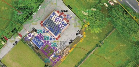
12 About Murphy Surveys 30+ survey services supporting the entire construction lifecycle Quick to mobilise with in-house teams nationwide & in Europe 36 years experience at the forefront of the industry 12,000,000 Confidence & assurance with a fully funded business with the highest levels of indemnity & ISO certification Best practice approach & continuous investment in innovation 250+ experienced, passionate & friendly staff 100% Accident free Reduce risk of delays of costly reworks, with consistently high customer satisfaction Collaborative approach offering impartial advice & guidance Trusted by thousands of customers Commitment to a sustainable future for the industry 90% masters, degree or diploma qualified


13 Our Sectors Construction Industrial Property Infrastructure Public Sector Natural Environment Smart Cities Design Ground works Civils Mechanical & Electrical Fit out / cladding Facilities Management High rise construction Nuclear Oil & Gas Pharma & Tech Manufacturing & Logistics Agriculture Quarry & Mining Data centres Commercial Retail Hotel & Leisure Estates Residential Heritage & Archaeology Rail Road Airports/Aviation Ports & Harbours Bridges / Structures Telecoms Utilities (water, gas, energy, wind, solar, nuclear, waste ) Defence & Security Healthcare Education Rivers, Lakes & Coastal Forestry & Agriculture Urban regeneration
14 OSI & PRA Joint Statement The Property Registration Authority (Land Registry) and Ordnance Survey Ireland (OSI) enjoy a very close working relationship. The Land Registry utilises Ordnance Survey Ireland s topographic mapping to crossreference and associate their boundary information. This forms the basis of all Land Registry digital map data. Ordnance Survey Ireland is the national mapping agency of Ireland. It is the State Agency responsible for the official, definitive surveying and topographic mapping of the Republic of Ireland. As this mapping is topographic, it only represents the physical features on the ground at the time of survey. The features shown must fall within the specification for the survey scale and within agreed accuracy tolerances. OSI maps never indicate legal property boundaries, nor do they show ownership of physical features. Although some property boundaries may be coincident with surveyed map features, no assumptions should be made in these instances and consequently it is not possible to identify the position of a legal property boundary from an OSI map. OSI has a continuous mapping revision programme for the whole of the Republic of Ireland. Changes that have occurred on the ground since the property was registered may result in differences between later OSI map editions and the mapping used by the Land Registry. The Physical Boundary The Land Registry identifies properties not boundaries and never shows ownership of individual boundary structures such as walls, fences and hedges etc. It should also be noted that deeds rarely deal with such matters. Non-conclusive Boundary System The boundary system adopted by the Land Registry under the Registration of Title Act, 1964 is known as a non-conclusive boundary system. The non-conclusive provision dispenses with the need for determining the exact location of title boundaries when defining the extent of registered properties and the ownership of the physical features which mark the limits of a property is left undetermined. In the case of boundaries located within buildings, the exact line or plane of the title boundary is also left undetermined. The non-conclusive boundary system will not indicate whether a title boundary includes a hedge or a wall and ditch or runs along the centre of a wall or fence or runs along its inner or outer face or how far it runs within or without it or whether or not the land registered includes the whole or any portion of an adjoining road or stream. However, the location of the physical features within which the title boundary lies or the points between which an undefined title boundary runs must be accurately defined by the applicant on the map lodged for registration within the limitations of the scale of the application map. Where boundaries have been transferred to a larger scale or to a different map series, whether on paper or in a digital environment, measurements must not be expected to give a degree of accuracy greater than that of the smaller scale or older map series. Since the commencement of land registration in 1892, almost all registrations were recorded by reference to the topographic detail shown on OSI published map scales. OSI Cassini/County Series and Irish Grid published scales in the paper system were 1/10,560, 1/2,500 1/1,000 and some urban areas were published at 1/1,250 and 1/1,056, (both 1/1,250 and 1/1,056 were enlarged by OSI from 1/2,500 mapping).. Accuracy of the Land Registry s boundary data is, accordingly, limited to the survey accuracy and scale of the source map originally lodged and upon which registration was based. The Land Registry is unable to tell you precisely where a property boundary is located
15 PRA Preparation of Application Maps: Maps lodged for registration purposes must be prepared to the accuracy standard of the OSi map, be not less than A4 in paper size andclearlydisplaythe County andmap scale. Where new boundaries for registration are coincident with current OSi topographic detail they must be highlighted in colour. New boundaries for registration that are not coincident with current OSi topographic detail must be shown by thin red lines the centres of which denote the correct field positions of the boundaries. It is in the applicant's interest to ensure that maps are prepared in accordance with accepted land surveying practice and procedures. All slope distances must be reduced to the horizontal (and if necessary to mean sea level) before plotting work or area computation is carried out. The Authority may require the production of any map, survey or book for inspection under Section 16 (2) of the Act of Where part(s) of an adjoining river or roadway are included in an application for registration, separate area values should be stated for the parts on the map and a composite area quoted in the deed. In all cases an indication should be given as to whether adjoining roadways are in public or private ownership. Customers can submit ITM coordinate geometry captured directly in the field in the form of a CAD file. A hard copy must then be lodged with the application and must be printed at the OSi published scale for the area.
16 Basic Requirements for Acceptance of Maps in the Land Registry Special RegistrationMap Title Plan Official Map Search Land RegistryCompliant Map A Computer generated map - a CAD file with the geometry of the new property referenced to the OSi ITM coordinate reference system can be submitted in electronic form in compliance with the Registry s CAD requirements, together with a hard copy version that complies with the requirements as set out in Appendix 4. A copy of an approved scheme map Other requirements: Scheme Maps must be plotted from site surveys and must clearly show the reference number by which each holding or part thereof is to be identified in subsequent dealings and correspondence. Responsibility for the accuracy of the application map(s) lodgedrests with the applicant. To ensure that the application map(s) submitted for registration reflect the applicant s intentions, it is recommended that: The locations of site corners be unambiguouslydefinedand clearly marked on the groundbefore the surveyis carried out. Maps submitted for registration be preparedand certified by competentland Surveyors. Two grid intersections with ITM coordinate values must be clearly printed at the lower left and upper right corners on all scheme maps and multi-storey maps submitted for registration. The minimum hard copy map size must not be less than A4 and not larger than A3 and clearly display the County name and Map Scale. Maps attached to original lease and counterpart/copy must be identical as to colour and scale.
17 Fact bad data costs! Volume Variety Velocity Veracity Who created it? When it was created? Are there any changes since its making and if so what exactly are they? What purpose was it first compiled? DO NOT USE IT


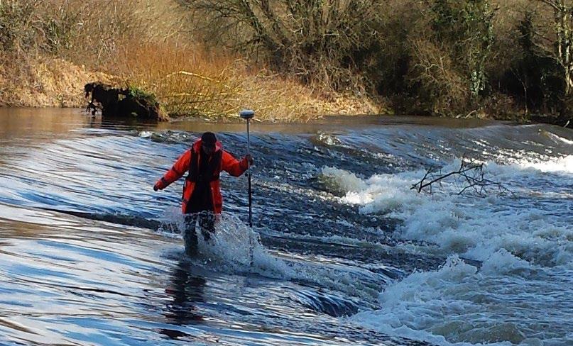
18 Why survey? Theory Reality


19 True ground position


20 Ground Truth Survey


21 Survey, to confirm the difference between truth and belief!
22

23


24 Trusted by Clients


25 Accreditations


26 Commitment to Social Responsibility

27 Offices throughout Ireland, the UK and Europe Ireland Dublin Kilcullen Cork UK London Birmingha m Mancheste r Glasgow Belfast Germany Cologne Italy Genoa Spain Barcelona

28 Any Questions?

29
Title goes here. Application to Register an Easement/ Profit-à-Prendre Acquired by Prescription.
 Application to Register an Easement/ Profit-à-Prendre Acquired by Prescription. eamonn.morris@prai.ie Topics 1. Characteristics of an Easement. 2. Acquisition of an Easement. 3. Prescription Law Timeline.
STEP Land Registration Rules 2012 and Transmissions on Death, Trusts in Land and Prescriptive Easements
 STEP Land Registration Rules 2012 and Transmissions on Death, Trusts in Land and Prescriptive Easements John Murphy Examiner of Titles Property Registration Authority 27 th February 2013 Introduction Land
Boundary Disputes. Geomatics Client Guides. A clear impartial guide to... Check. They re Chartered.
 Check. They re Chartered. Geomatics Client Guides A clear impartial guide to... Boundary Disputes Property Registration Boundary Dispute Resolution Boundary Identification and Demarcation A clear, impartial
Analysis of Commercial Buildings in the GeoDirectory Database Q Vacancy Rates
 GEOVIEW Quarterly Commercial Vacancy Rates Report Analysis of Commercial Buildings in the GeoDirectory Database Q4 2013 This is the first GeoView end of year analysis. It is based on the quarterly reports
Progress Report on Green Paper. Dr. Paddy Prendergast. on behalf of the. IIS Commission on Land Registration
 Progress Report on Green Paper By Dr. Paddy Prendergast on behalf of the IIS Commission on Land Registration Paddy Prendergast - Chair Brendan Sweeny - Hempenstall Surveys Paul Corrigan - P Corrigan Associates
DAWSON COUNTY MINOR PLAT REVIEW CHECKLIST $50.00 FEE PER PLAT REVIEW, $5.00 FEE FOR SCAN & CD FOR RECORDING
 DAWSON COUNTY MINOR PLAT REVIEW CHECKLIST $50.00 FEE PER PLAT REVIEW, $5.00 FEE FOR SCAN & CD FOR RECORDING NAME ON PLAT: CONTACT/PHONE #: NAMED STREET/ADDRESS: LAND LOT: DISTRICT: SECTION: ZONING: SETBACKS:
Aignan Municipality. Guihemblanc Housing Estate. Housing Estate Regulations
 Aignan Municipality Guihemblanc Housing Estate Housing Estate Regulations 1. Object of this document. The purpose of this document is to fix the regulations and general public constraints imposed on the
GEOVIEW. 224,003 Total stock of commercial properties 195,803 Total stock of occupied properties pp -1.2pp. 12.6% National vacancy rate
 GEOVIEW Commercial Vacancy Rates Report Analysis of Commercial Buildings in the GeoDirectory Database Q4 2015 This is the final GeoView analysis for 2015 and the tenth in the GeoView series. The statistics
LIST 1 (Persons whose lands or interests would benefit by the proposed work, and who have joined in this application)
") APPLICATION FORM NO. APPLICATION FORM FOR LOCAL IMPROVEMENTS SCHEME (LIS) We the undersigned, each being the occupier of a property in the townland(s) referred to at (1) overleaf, hereby apply to Longford
APPLICATION FORM NO. APPLICATION FORM FOR LOCAL IMPROVEMENTS SCHEME (LIS) We the undersigned, each being the occupier of a property in the townland(s) referred to at (1) overleaf, hereby apply to Longford
Land rights requirements relating to assets to be installed or adopted by SEPD or SHEPD for new connections
 Land rights requirements relating to assets to be installed or adopted by SEPD or SHEPD for new connections Information for SEPD and SHEPD Staff, ICPs, IDNOs and connection customers v1.1 August 2016 Background
RULES OF THE GEORGIA STATE BOARD OF REGISTRATION FOR PROFESSIONAL ENGINEERS AND LAND SURVEYORS CHAPTER APPLICATIONS TABLE OF CONTENTS
 RULES OF THE GEORGIA STATE BOARD OF REGISTRATION FOR PROFESSIONAL ENGINEERS AND LAND SURVEYORS CHAPTER 180-7 APPLICATIONS TABLE OF CONTENTS 180-7-.07 Maps and Plats. All maps, plats and similar documents
( RICS. A clear, impartial guide to. Boundary disputes. rics.org/consumerguides
 ( RICS A clear, impartial guide to Boundary disputes rics.org/consumerguides Contents Moving in...3 Living with your boundaries...4 Changes to your boundaries...4 Dealing with disputes...5 Free RICS guides...6
 Page 1 of 6 Office of the Professions Land Surveying Practice Guidelines - February 2000 The State Board for Engineering and Land Surveying issued the first draft of its proposed Land Surveying Practice
250 CMR: BOARD OF REGISTRATION OF PROFESSIONAL ENGINEERS AND LAND SURVEYORS DRAFT FOR DISCUSSION PURPOSES ONLY
 250 CMR 6.00: LAND SURVEYING PROCEDURES AND STANDARDS Section 6.01: Elements Common to All Survey Works 6.02: Survey Works of Lines Affecting Property Rights All land surveying work is considered work
Highways Highway Records
 Highways Highway Records Helen Baker, PROW and Records, Highways Introduction to the Highway Records The Highway Records team are tasked to respond to enquiries made of Essex County Council in respect
Jack McKenna, Director of Business Development, Africa and the Caribbean
 Presented at the FIG Working Week 2016, May 2-6, 2016 in Christchurch, New Zealand Jack McKenna, Director of Business Development, Africa and the Caribbean FIG WORKING WEEK 2016 Fit for Purpose Parcel
Pre-Sale Information Pack For: 49 Cyprus Road Heysham Morecambe LA3 2QS
 Pre-Sale Information Pack For: 49 Cyprus Road Heysham Morecambe LA3 2QS Contents Introduction Land Registry Official Copy of Title Register Land Registry Official Copy of Title Plan Anti-Money Laundering
Plats and subdivisions; mapping requirements. (a) Size Requirements. All land plats presented to the register of deeds for recording in the
 Size Requirements. All land plats presented to the register of deeds for recording in the") 47-30. Plats and subdivisions; mapping requirements. (a) Size Requirements. All land plats presented to the register of deeds for recording in the registry of a county in North Carolina after September
47-30. Plats and subdivisions; mapping requirements. (a) Size Requirements. All land plats presented to the register of deeds for recording in the registry of a county in North Carolina after September
Land Registry Practice Guide 40 Oct Land Registry plans
 Land Registration Act 2002 Scope of this guide This guide provides background information about the plans records held and maintained by Land Registry. It also explains the pre-registration requirements
LEVEL 3 - UNIT 4 LAND LAW SUGGESTED ANSWERS JUNE 2010
 Note to Candidates and Tutors: LEVEL 3 - UNIT 4 LAND LAW SUGGESTED ANSWERS JUNE 2010 The purpose of the suggested answers is to provide students and tutors with guidance as to the key points students should
Services connected with Immovable Property
 Services connected with Immovable Property Services connected with Immovable Property This document should be read in conjunction with section 33(2) and section 34(c) of the VAT Consolidation Act 2010
PRE-CONTRACT QUESTIONNAIRE FOR PROPERTY SALE
 PRE-CONTRACT QUESTIONNAIRE FOR PROPERTY SALE FULL ADDRESS OF PROPERTY BEING SOLD (INCLUDING EIRCODE) Address line 1 Address line 2 Town / City County Eircode PROPERTY OWNER(S) MAIN CONTACT DETAILS Name
Initial Notice Protocol October 2012
 Initial Notice Protocol October 2012 This Initial Notice Protocol document and supporting Policy Advice Notes should be read in addition to the requirements of The Building Act 1984 and The Building (Approved
Spatial Data Warehouse Ltd. Cadastral Mapping INITIATIVE 1: CADASTRAL MAPPING. Version Spatial Data Warehouse Ltd. & AltaLIS Ltd.
 Spatial Data Warehouse Ltd. Initiative 1: Cadastral Mapping INITIATIVE 1: CADASTRAL MAPPING 29 P3 The SDW/AltaLIS Model Background The Government of Alberta started a mapping program, the Municipal Integrated
EASEMENTS - INSURING
 EASEMENTS - INSURING I. If the easement has been insured previously by the Company, skip to step VII. II. III. Consider an additional premium for the easement examination. SCHEDULE A - Verify that the
BOUNDARIES & SQUATTER S RIGHTS
 BOUNDARIES & SQUATTER S RIGHTS Odd Results? The general boundary rule can have results that seem odd - for example the Land Registry s Practice Guides make it clear that they may regard you as owning land
WYANDOT COUNTY BASIC STANDARDS FOR THE APPROVAL OF REAL ESTATE DEED TRANSFERS & LAND CONTRACT AGREEMENTS
 GENERAL In compliance with Section 315.251 of the Ohio Revised Code, the County Auditor and the County Engineer have adopted these written standards governing the conveyance of real property in Wyandot
Application for Outline Plan / Outline Plan Waiver Section 176A, Resource Management Act
 Email: applications@waidc.govt.nz www.waikatodistrict.govt.nz Telephone (all hours) 07 824 8633 Call Free 0800 492 452 District Office 15 Galileo Street Private Bag 544 Ngaruawahia 3742 Application for
Rule 21 STANDARDS OF PRACTICE FOR SURVEYING
 Rule 21 STANDARDS OF PRACTICE FOR SURVEYING 21.1 Whenever a survey is performed, it shall comply with Section 73-13-71 (4) and Section 73-13- 73 and the Standards of Practice for Surveying in Mississippi
A CONCISE GUIDE TO STATUTORY CHARGES Arthur Moir
 A CONCISE GUIDE TO STATUTORY CHARGES Arthur Moir Some conveyancers, who are only vaguely acquainted with the Statutory Charges Register, responded to Folio s recent survey by requesting an article on the
Policy and Procedures for Lawyers and Surveyors March 2006
 PDCAs Policy and Procedures for Lawyers and Surveyors March 2006 MGA Compliance Statement: Exception for parcels created in land registration as result of an approved plan of survey/subdivision Clause
Consent Application Form
 NOTE TO APPLICANTS: Consent Application Form Prior to submission of an application for consent to create a new lot or an addition to a lot, the Committee of Adjustment recommends that the applicant and/or
For sale. 4-6 Lightbody Street Liverpool L5 9UZ. Development Opportunity. Circa 0.7 hectares (1.72 acres)
") For sale 4-6 Lightbody Street Liverpool L5 9UZ Development Opportunity Circa 0.7 hectares (1.72 acres) 0151 255 1910 4-6 Lightbody Street Liverpool L5 9UZ Highlights Exciting mixed use development opportunity
For sale 4-6 Lightbody Street Liverpool L5 9UZ Development Opportunity Circa 0.7 hectares (1.72 acres) 0151 255 1910 4-6 Lightbody Street Liverpool L5 9UZ Highlights Exciting mixed use development opportunity
The Society of Chartered Surveyors Ireland - enhancing, advancing and enforcing professional standards in construction, land and property.
 The Society of - enhancing, advancing and enforcing professional standards in construction, land and property. 1 Overview Independent Expert Qualified The Society of is the leading professional body for
SOUTH TIPPERARY COUNTY COUNCIL
 SOUTH TIPPERARY COUNTY COUNCIL POLICY FOR THE TAKING IN CHARGE OF RESIDENTIAL DEVELOPMENTS 1 POLICY POLICY This document outlines South Tipperary County Council s policy and procedure in relation to taking
PR0PERTY AND LAND BOUNDARIES A CHECKLIST FOR PURCHASERS
 PR0PERTY AND LAND BOUNDARIES A CHECKLIST FOR PURCHASERS Patrick shine Chartered Geomatics Surveyor and Chartered Civil Engineer GEOMATICS PROFESSIONAL GROUP SCSI BOUNDARY ISSUES Boundary issues that arise
Land Administration in Jordan
 Land Administration in Jordan Problems and Challenges Eng. Director of Registration Services Department of Lands & Survey q General information q Historical Background q Properties Initiation q Problems
Former Nuclear Bunker, Woodside Road, Ballymena For Sale **Extremely Rare Listing/Unique Opportunity** Former Regional Government HQ Nuclear bunker
 Former Nuclear Bunker, Woodside Road, Ballymena For Sale **Extremely Rare Listing/Unique Opportunity** Former Regional Government HQ Nuclear bunker totalling c.46,383 sq ft, set on a self contained site
An easement is an incorporeal hereditament, an interest which does not give the owner right to physical possession.
 Easement An easement is a right which the owner of land (known as dominant tenement) has over another land (servient tenement) to compel the owner of servient tenement to allow something to be done on
Standards of Practice for Surveying in the State of Alabama
 Standards of Practice for Surveying in the State of Alabama Effective January 1, 2017 RULE NO. 1.01 PURPOSE The purpose of these rules is to establish standards for the practice of surveying in the State
An Opportunity for Change
 Land Registry s Digital Mapping Project A Driver for Change Dr Paddy Prendergast FIS Department of Spatial Information Sciences Dublin Institute of Technology, IRELAND An Opportunity for Change Existing
Papers The Digital Economy Act : What surveyors need to know about changes to the law on telecommunications equipment
 Journal of Building Survey, Appraisal & Valuation Volume 6 Number 3 Papers The Digital Economy Act : What surveyors need to know about changes to the law on telecommunications equipment Michael Watson
LETTER TO COMPANY - DRAFT CITY OF LONDON LAW SOCIETY LAND LAW COMMITTEE CERTIFICATE OF TITLE (7 TH EDITION 2016 UPDATE)
") LETTER TO COMPANY - DRAFT CITY OF LONDON LAW SOCIETY LAND LAW COMMITTEE CERTIFICATE OF TITLE (7 TH EDITION 2016 UPDATE) This is the first of two letters which may be sent by the solicitors giving the Certificate
LETTER TO COMPANY - DRAFT CITY OF LONDON LAW SOCIETY LAND LAW COMMITTEE CERTIFICATE OF TITLE (7 TH EDITION 2016 UPDATE) This is the first of two letters which may be sent by the solicitors giving the Certificate
Easements, Covenants and Profits à Prendre Executive Summary
 Easements, Covenants and Profits à Prendre Executive Summary Consultation Paper No 186 (Summary) 28 March 2008 EASEMENTS, COVENANTS AND PROFITS À PRENDRE: A CONSULTATION PAPER EXECUTIVE SUMMARY 1.1 This
A.3. ARTICLE 7 PLAN REQUIREMENTS FOR MINOR SUBDIVISION AND/OR LAND DEVELOPMENT
 700. 701.A.3. ARTICLE 7 PLAN REQUIREMENTS FOR MINOR SUBDIVISION AND/OR LAND DEVELOPMENT SECTION 700 PURPOSE The purpose of this Article is to set forth a streamlined set of Plan Requirements for minor
June 28, Technical Director File Reference No Financial Accounting Standards Board 401 Merritt 7 P.O. Box 5116 Norwalk, CT
 Technical Director File Reference No. 2016-200 401 Merritt 7 P.O. Box 5116 Norwalk, CT 06856-5116 Comments by the Edison Electric Institute and the American Gas Association Regarding the Accounting for
Minimum Educational Requirements
 Minimum Educational Requirements (MER) For all persons elected to practice in each Member Association With effect from 1 January 2011 1 Introduction 1.1 The European Group of Valuers Associations (TEGoVA)
THE PURPOSE OF MEASUREMENTS IN BOUNDARY SURVEYS. (THE ETERNAL SUVRVEY QUESTION: HOW CLOSE IS CLOSE ENGOUGH?) By. Norman Bowers, P.S. & P.E.
 By. Norman Bowers, P.S. & P.E.") THE PURPOSE OF MEASUREMENTS IN BOUNDARY SURVEYS (THE ETERNAL SUVRVEY QUESTION: HOW CLOSE IS CLOSE ENGOUGH?) By Norman Bowers, P.S. & P.E. Steven S. Brosemer, P.S. Figure 1 Surveyors are all about measurements.
THE PURPOSE OF MEASUREMENTS IN BOUNDARY SURVEYS (THE ETERNAL SUVRVEY QUESTION: HOW CLOSE IS CLOSE ENGOUGH?) By Norman Bowers, P.S. & P.E. Steven S. Brosemer, P.S. Figure 1 Surveyors are all about measurements.
CHARTERED S URV E Y ORS & ACCREDIT ED EN ERG Y AS SES SORS
 CHARTERED S URV E Y ORS & ACCREDIT ED EN ERG Y AS SES SORS I NCORPO R A T I N G D W A DES IGN DWA Surveyors are Chartered Surveyors and Accredited Energy Assessors with over 25 years professional experience
Application Form - Broker
 Application Form - Broker Version 3 How to Complete this Form Please be aware that you only need to complete the sections of the form which apply to your type of build project. The following scheme definitions
Sale of land - questions for the vendor
 Sale of land - questions for the vendor Instructions Please circle yes or no as applicable. Please provide the additional information as indicated e.g. a copy of your title(s). If you do not know the answer
RESIDENTIAL AND RECREATIONAL
 Energy, Mines & Resources Land Management Branch 320-300 Main Street Whitehorse, Yukon Y1A 2B5 667-5215 Fax 667-3214 www.emr.gov.yk.ca RESIDENTIAL AND RECREATIONAL Lot Enlargement Policy OBJECTIVE To facilitate
SUBDIVISION AND DEVELOPMENT APPLICATION FORM
 SUBDIVISION AND DEVELOPMENT APPLICATION FORM Bylaw No. 404, Subdivision and Development Standards Bylaw, 2014 APPLICATION FOR (check box): PRELIMINARY LAYOUT ASSESSMENT (PLA) PLA EXTENSION LOT LINE ADJUSTMENT
LAND AT FRIZINGTON, WEST CUMBRIA
 Particulars of sale of: LAND AT FRIZINGTON, WEST CUMBRIA An opportunity to acquire 101.71 acres (41.16 hectares) of top quality agricultural land suitable for mowing and grazing For sale by Private Treaty
LAND REGISTRY DEEDS CUSTOMER INFORMATION GUIDE
 LAND REGISTRY DEEDS CUSTOMER INFORMATION GUIDE Which document do I need? There are numerous documents held and maintained by the Land Registry; each one serving a different purpose to the others. I want
Balbriggan Shopping Centre
 FOR SALE BY PRIVATE TREATY Development Site at Balbriggan Shopping Centre Quay Street, Balbriggan, Co. Dublin EXCELLENT DEVELOPMENT OPPORTUNITY (S.P.P.) SUBJECT SITE HIGH STREET Development Overview BRACKEN
Sale and Other Disposition of Land Policy
 Section Community & Development Services Subsection Sale and Other Disposition of Land DATE Approved by By-law : December 12, 2017 158-2017 Supersedes By-law : 138-2000 PAGE OF 1 1.0 Purpose 1.1 To provide
GENERAL ASSEMBLY OF NORTH CAROLINA SESSION 2017 H 1 HOUSE BILL 454* Short Title: Surveying and Plat Recording Changes. (Public)
") GENERAL ASSEMBLY OF NORTH CAROLINA SESSION H 1 HOUSE BILL * Short Title: Surveying and Plat Recording Changes. (Public) Sponsors: Referred to: Representative Arp. For a complete list of sponsors, refer
GENERAL ASSEMBLY OF NORTH CAROLINA SESSION H 1 HOUSE BILL * Short Title: Surveying and Plat Recording Changes. (Public) Sponsors: Referred to: Representative Arp. For a complete list of sponsors, refer
PREPARING SURVEY TENDER GIS DATABASE OUTCOMES
 PREPARING SURVEY TENDER SPECIFICATIONS FOR PROJECT GIS DATABASE OUTCOMES Presentation by Ian Harper GEODATA AUSTRALIA ESRI User Conference 2009 24 st July 2009 BACKGROUND GIS databases now provide a more
GULLABA FOREST & LAKE COUNTY KERRY, REPUBLIC OF IRELAND
 GULLABA FOREST & LAKE COUNTY KERRY, REPUBLIC OF IRELAND 135.47 Hectares / 334.74 Acres John Clegg & Co CHARTERED SURVEYORS & FORESTRY AGENTS Gullaba Forest - Co. Kerry 2 Rutland Square Edinburgh EH1 2AS
Summary of Professional and Administrative Services
 Summary of Professional and Administrative Services Accounts and Book Keeping We offer the following accounts and book keeping services for Farms and Estates: Budgets Cash flows Payroll administration.
Application for warranty on a development 8 storeys and over
 Application for warranty on a development 8 storeys and over SNIN Reference: NHBC USE ONLY Completion of this form is required where an NHBC warranty quotation is sought on developments where any structure
Boston National Title Agency, LLC. 129 West Trade St, 9th Floor. Charlotte NC 28202
 Boston National Title Agency, LLC 129 West Trade St, 9th Floor Charlotte NC 28202 FIDELITY NATIONAL TITLE INSURANCE COMPANY 800-943-1196 Prepared By: Boston National Title Agency, LLC 129 West Trade St,
The Challenge to Implement International Cadastral Models Case Finland 1
 The Challenge to Implement International Cadastral Models Case Finland 1 Tarja MYLLYMÄKI and Tarja PYKÄLÄ, Finland Key words: cadastre, modelling, LADM, INSPIRE SUMMARY Efforts are currently made to develop
Standards for All Instruments of Conveyance
 Standards for All Instruments of Conveyance Perry County, Ohio Effective Date: May 1, 1997 Effective Date of Revision: April 1, 2011 Page 2 of 12 Minimum Standards for all Instruments of Conveyance Perry
LEVEL 3 - UNIT 4 LAND LAW SUGGESTED ANSWERS JANUARY 2012
 Note to Candidates and Tutors: LEVEL 3 - UNIT 4 LAND LAW SUGGESTED ANSWERS JANUARY 2012 The purpose of the suggested answers is to provide students and tutors with guidance as to the key points students
The Digital Cadastral Database and the Role of the Private Licensed Surveyors in Denmark
 IRISH INSTITUTE OF SURVEYORS, DUBLIN INSTITUTE OF TECHNOLOGY, 23 NOVEMBER 2005 PUBLISHED IN IIS NEWS, WINTHER 2006. The Digital Cadastral Database and the Role of the Private Licensed Surveyors in Denmark
SECTION SITE SURVEYS
 PART 1 - GENERAL 1.1 DESCRIPTION SECTION 02 21 00 SPEC WRITER NOTES: 1. Use this section only for NCA projects. 2. Delete between //---// if not applicable to project. Also delete any other item or paragraph
The EU Bank supporting social and affordable housing needs
 EUROPEAN INVESTMENT BANK The EU Bank supporting social and affordable housing needs Irish Council for Social Housing Biennial Meeting Kilkenny October 25, 2018 Cormac Murphy Head of EIB Group Office, Dublin
The Use of Negative Easements To Facilitate Construction Projects
 The Use of Negative Easements To Facilitate Construction Projects John D. Schwarz Jr., JD California State University, Chico Chico, CA This paper discusses the use of negative easements to facilitate construction
WARNING: It is recommended that the within should not be completed without prior legal advice. LAW SOCIETY OF IRELAND CONDITIONS OF SALE 2017 EDITION
 WARNING: It is recommended that the within should not be completed without prior legal advice. LAW SOCIETY OF IRELAND CONDITIONS OF SALE 2017 EDITION PARTICULARS and CONDITIONS OF SALE of property at Leggatinty,
Key findings from an investigation into low- and medium-value property sales. National Audit Office September 2017 DP
 from an investigation into low- and medium-value property sales National Audit Office September 207 DP 557-00 from an investigation into low- and medium-value property sales Contents 3 4 5 6 7 8 9 0 2
Groundsure HS2 and Crossrail
 Groundsure HS2 and Crossrail Address: Specimen Address Date: Report Date Groundsure Reference: HS2 & Crossrail Specimen Your Reference: HS2 & Crossrail Specimen Grid Reference:123456,123456 HS2*: The property
New Jersey Administrative Code Title 13, Chapter 40 State Board of Professional Engineers and Land Surveyors
 New Jersey Administrative Code Title 13, Chapter 40 State Board of Professional Engineers and Land Surveyors SUBCHAPTER 1. TITLE BLOCKS AND SEALS FOR PROFESSIONAL ENGINEERS AND LAND SURVEYORS 13:40-1.1
SKETCH OF BOUNDARY SURVEY ALTA / ACSM LAND TITLE SURVEY
 SKETCH OF BOUNDARY SURVEY ALTA / ACSM LAND TITLE SURVEY SURVEYOR'S NOTES: All distances as shown hereon are based on the US Survey foot. Subject property lies inside the UBD (Urban Development Boundary),
Requirements For All Instruments of Conveyance In Monroe County, Ohio. Transfer and Conveyance Standards of the Monroe County Auditor & Engineer
 Requirements For All Instruments of Conveyance In Monroe County, Ohio Transfer and Conveyance Standards of the Monroe County Auditor & Engineer Effective November 8, 2013 1 TRANSFER PROCEDURES FOR MONROE
PLEASE COMPLETE ALL SECTIONS USING BLOCK CAPITALS AND BLACK INK
 Application for adoption of new sewers Section 104 WIA t a~united ~ ~ Utilities ~~tng life f\ow smoothly This form should be used to offer proposed drainage systems for adoption by United Utilities under
Canadian Bar Association Mid Winter. Branch SCOTIA (LIANS) CONFERENCE. Halifax, Nova Scotia October 20, Deeds New Brunswick
 CONFERENCE. Halifax, Nova Scotia October 20, Deeds New Brunswick") Canadian Bar Association LAWYERS INSURANCE ASSOCIATION OF NOVA Mid Winter SCOTIA (LIANS) Meeting of NB CONFERENCE Branch Halifax, Nova Scotia October 20, 2016. LAND TITLES PET PEEVES andregistrar Raves
Canadian Bar Association LAWYERS INSURANCE ASSOCIATION OF NOVA Mid Winter SCOTIA (LIANS) Meeting of NB CONFERENCE Branch Halifax, Nova Scotia October 20, 2016. LAND TITLES PET PEEVES andregistrar Raves
Fees and charges. Consenting and property information fees and charges. Effective from 1 July 2018
 Fees and charges 18-PRO-3532 Consenting and property information fees and charges Effective from 1 July 2018 Find out more: phone 09 301 0101 or visit aucklandcouncil.govt.nz Building consent fees (including
Property Information Form
 Property Information Form Full Names of the Seller Address of Property Seller s Solicitor Name of firm Address E-mail Reference ABOUT THIS FORM This form is completed by the seller to provide detailed
Meaning of words 3. Introduction 5. Further information 6. Scope of the Code 7
 Contents Meaning of words 3 Introduction 5 Further information 6 Scope of the Code 7 1.0 Adopting the Code 8 1.1 Adopting the Code 8 1.2 Making the Code available 8 1.3 Customer service 8 1.4 Appropriately
Specimen. Property Purchase Information. Sample. UK Land Registry Services. Contents:
 www.landsearch.net www.landsearch.net England and Wales Contents: Sample Property Purchase Information Title Register List of Pending Registrations (if there are any) Title Plan Deeds (page 5 of a Conveyance
CARMACOUP FOREST Glespin, South Lanarkshire Hectares / Acres
 CARMACOUP FOREST Glespin, South Lanarkshire 310.50 Hectares / 767.24 Acres FREEHOLD FOR SALE AS A WHOLE John Clegg & Co Chartered Surveyors CARMACOUP FOREST Glespin 1 mile Irvine 35 miles Lockerbie 46
2010 No. 11 LAND REGISTRATION. Land Registry (Fees) Order (Northern Ireland) 2010
 Order (Northern Ireland) 2010") STATUTORY RULES OF NORTHERN IRELAND 2010 No. 11 LAND REGISTRATION Land Registry (Fees) Order (Northern Ireland) 2010 Made - - - - 21st January 2010 Affirmed by resolution of the Assembly on 1st March 2010
STATUTORY RULES OF NORTHERN IRELAND 2010 No. 11 LAND REGISTRATION Land Registry (Fees) Order (Northern Ireland) 2010 Made - - - - 21st January 2010 Affirmed by resolution of the Assembly on 1st March 2010
Tentative Map Application Review Procedures
 FOR REFERENCE ONLY This page is not part of the application. Tentative Map Application Review Procedures The tentative map process in Churchill County is designed to provide a mechanism in order to divide
Historic Environment Scotland Àrainneachd Eachdraidheil Alba
 The Schemes of Delegation from Scottish Ministers to Historic Environment Scotland Introduction This document sets out how Historic Environment Scotland shall fulfil the Scheme of Delegation for both properties
Demonstrate knowledge of, and extract, cadastral data from Landonline
 Page 1 of 5 Demonstrate knowledge of, and extract, cadastral data from Landonline Level 3 Credits 5 Purpose This unit standard is for people who are working in the surveying industry in jobs which involve
Registration of fishing rights
 Registration of fishing rights Fact sheet 7 Registration of fishing rights Since 2003 it has been possible to register fishing rights separately from ownership of the land to which they are connected.
Submission. Better Apartments Draft Design Standards
 Submission Better Apartments Draft Design Standards Arnold Bloch Leibler September 2016 1 Who are we? 1.1 This submission, prepared by Ken Gray, Partner (Head of Practice) and Andrea Towson, Senior Associate
Surveyor-General's Rules for Cadastral Survey 2002/2. Office of the Surveyor-General
 Surveyor-General's Rules for Cadastral Survey 2002/2 17 October 2002 Surveyor-General's Rules For Cadastral Survey 2002/2 Page 2 of 36 Pursuant to Sec 49 Cadastral Survey Act 2002, I hereby make the Surveyor-General
TOWN OF LEWISTON PLANNING BOARD APPLICATION
 TOWN OF LEWISTON PLANNING BOARD APPLICATION DESCRIPTION OF PROPOSED REQUEST: Name of Property Owner: Phone #: Name of Applicant:Phone #: Address or Location of Proposal:_SBL# Size of Parcel or Structure:Existing
PROJECT INFORMATION DOCUMENT (PID) CONCEPT STAGE Report No.: AB3229 Project Name. Land Registry and Cadastre Modernization Project Region
 CONCEPT STAGE Report No.: AB3229 Project Name. Land Registry and Cadastre Modernization Project Region") PROJECT INFORMATION DOCUMENT (PID) CONCEPT STAGE Report No.: AB3229 Project Name Land Registry and Cadastre Modernization Project Region EUROPE AND CENTRAL ASIA Sector Central government administration
PROJECT INFORMATION DOCUMENT (PID) CONCEPT STAGE Report No.: AB3229 Project Name Land Registry and Cadastre Modernization Project Region EUROPE AND CENTRAL ASIA Sector Central government administration
Total stock of residential properties. Detached dwellings account for 43.1% of the total stock. Terraced housing account for 27% of the total stock
 GEOVIEW RESIDENTIAL BUILDINGS Report February 2015 This is the second GeoView analysis of the stock of residential properties in Ireland based on GeoDirectory s comprehensive database of over 2 million
Strata Plan Fast Facts
 December 2015 ISSN: 2201-4292 Title: Strata Plan Fast Facts ISSN: 2201-4292 Land and Property Information www.lpi.nsw.gov.au Copyright Crown in right of New South Wales through Land and Property Information
Boston National Title Agency, LLC. 129 West Trade St, 9th Floor. Charlotte NC 28202
 Boston National Title Agency, LLC 129 West Trade St, 9th Floor Charlotte NC 28202 FIDELITY NATIONAL TITLE INSURANCE COMPANY 800-943-1196 Prepared By: Boston National Title Agency, LLC 129 West Trade St,
You can complete and submit this form electronically via the Planning Portal by visiting
 holder Application for Planning Permission for works or extension to a dwelling and listed building consent. Town and Country Planning Act 1990 Planning (Listed Buildings and Conservation Areas) Act 1990
Sale of Land: Questions for the Vendor
 Sale of Land: Questions for the Vendor Instructions 1. Please circle yes or no as applicable. 2. Please provide the additional information as indicated e.g. a copy of your title(s). 3. If you do not know
Building Integrated Land Information Systems and Development of NSDI
 Stig JÖNSSON, Sweden Key words: Land administration, land information systems, property formation, spatial data infrastructure, Inspire, institutional cooperation SUMMARY Lantmäteriet the Swedish agency
Land Administration and Spatial Enablement Victoria s Experience. Chris McRae, Executive Director Land Victoria
 Land Administration and Spatial Enablement Victoria s Experience Chris McRae, Executive Director Land Victoria 4 th UN Land Administration Forum, October 2011 Outline About Land Victoria Land Victoria
EXCELLENCE IN SURVEYING AWARD,
 EXECUTIVE SUMMARY Cottrell Cameron & Steen Surveys Pty Ltd is a private, survey company registered with the Surveyors Board of Queensland and an accredited surveyor with the Department of Natural Resources