July 14, Sincerely,
|
|
|
- Ralf Clark
- 5 years ago
- Views:
Transcription

1 July 14, 2010 Chairperson Yolanda Johnson Planning Committee Members Dear Committee Members: Attached for your review are the agenda and attachments for your regular meeting to be held on Tuesday, July 20, 2010 at 5:00 p.m. in Room 280 located on the 2 nd Floor of the Charlotte- Mecklenburg Government Center. At the July 20 th meeting, the Committee will be asked to make recommendations on three mandatory referrals. Attached are copies of Mandatory Referrals #10-09, #10-13, and # Also, in your packet you will find a summary of the issues discussed at your last meeting surrounding the Independence Boulevard Area Planning Process. Staff prepared this information in response to some of your concerns. The draft Independence Boulevard Area Plan will appear on a future Planning Committee agenda. If you cannot attend the July 20 th meeting, please contact me at (704) or mmccullough@ci.charlotte.nc.us at your earliest convenience. Sincerely, c. Planning Staff Tim O Brien, City Real Estate Melony C. McCullough, Planning Coordinator Charlotte-Mecklenburg Planning Department CHARLOTTE-MECKLENBURG PLANNING DEPARTMENT East Fourth Street Charlotte, NC PH: (704) FAX: (704)
2 Charlotte-Mecklenburg Planning Committee Meeting July 20, 2010 CMGC 2 nd Floor, Conference Room 280, 5:00 p.m. AGENDA I. Introductions and Call to Order II. Election of Planning Committee vice-chairperson. III. Approve June 15, 2010 Meeting Minutes. Attachment 1. IV. M.R. #10-09: Proposed Sale of City Owned Property Located in Stanley (Gaston County) Background: City of Charlotte Real Estate proposes to sale a.54 acre site located at 2323 Old NC Highway 27 in Gaston County via the upset bid process. Attachment 2. Staff Resources: Jonathan Wells, Planning Robert W. Drayton, City Real Estate Action Requested: Approve Planning staff recommendation for M.R. #10-09 V. M.R. #10-13: Proposed Acquisition of Flood-Prone Structure along Briar Creek (Doral Apartments) Background: Mecklenburg County Storm Water Services proposes to acquire a portion of the Doral Apartments, located off Monroe Road along Briar Creek. If this property is acquired, all improvements will be removed and the property will be added to the County s open space/greenway system. Attachment 3. Staff Resources: John Howard, Planning Jacqueline McNeil, County Real Estate Action Requested: Approve Planning staff recommendation for M.R. #
3 VI. M.R. #10-14: Proposed Acquisition of Flood-Prone Structures along Briar Creek (Shannonhouse Drive) Background: Mecklenburg County Storm Water Services proposes to purchase five parcels located along Briar Creek on Shannonhouse Drive in east Charlotte. If this property is acquired, all improvements will be removed and the property will be added to the County s open space/greenway system. Attachment 4. Staff Resources: Alysia Osborne, Planning Jacqueline McNeil, County Real Estate Action Requested: Approve Planning staff recommendation for M.R. #10-14 VII. Area Plan Status and Meeting Report Background: Committee members assigned to area plans will provide a report on any meetings that have occurred since the last report. Resources: Center City 2020 Vision Plan Commissioner Finch-Dobson Elizabeth Area Plan Commissioner Lipton Steele Creek Area Plan Commissioners Fallon and Zoutwelle Action Requested: None, for information only. VIII. Adjourn 2
4 Attachment 1 Charlotte-Mecklenburg Planning Commission Planning Committee Meeting Minutes CMGC Innovation Station, 8 th Floor June 15, :00 p.m. DRAFT Commissioners Present: Yolanda Johnson (Chairperson), Eric Locher (Vice-Chairperson), Claire Fallon, Steve Firestone, Nina Lipton, Greg Phipps, and Andrew Zoutewelle Planning Staff Present: Kathy Cornett, Sonda Kennedy, Melony McCullough, Bryman Suttle, and Jonathan Wells Other Staff Present: Robert Drayton (City Real Estate), Tim O Brien (City Real Estate), Susan DeSoto (Real Estate), and Denice Beteta (Neighborhood and Business Services) Call to Order Chairperson Johnson called the meeting to order at 5:05 p.m. Approval of Meeting Minutes A motion was made by Commissioner Firestone and seconded by Commissioner Locher to approve the May 18, 2010 meeting minutes with the following changes to the draft Independence Boulevard Area Plan (IBAP) discussion: (1) Correct the spelling of Chris Bakis name, change Backus to Bakis. (2) Clarify comments made by Councilmember Nancy Carter about the transitional setback to read We looked at transitional setbacks; we ve deleted 150 feet within a certain parameter in the Conference Drive area so that businesses can develop using that designated setback for undesignated parking ; and (3) Clarify that Ron and Kathy McManus do not own the Olive Garden Restaurant but own a building on Independence Boulevard which is leased to the Olive Garden Restaurant. The vote was unanimous (7-0) to approve the minutes with the changes noted above. University Research Park Area Plan Kathy Cornett (Planning Staff) stated that City Council received public comments on the draft University Research Park Area Plan at their May 24 th meeting and the Commission is being asked to make a recommendation on the draft plan. Ms. Cornett explained that the Errata Sheet correcting minor typographical errors in the draft plan that do not impact the intent of the plan. Ms. Mary Hopper was present to show her support of the plan. A motion was made by Commissioner Lipton and seconded by Commissioner Zoutewelle to approve the University Research Park Area Plan with the changes noted on the Errata sheet and any future typographical errors. The vote was unanimous (7-0) to approve with noted changes.
5 M.R. #10-08: Proposed Transfer of Three Parcels and a House to the Belmont Community Development Corporation Melony McCullough (Planning Staff) presented the mandatory referral for the proposed transfer of three vacant parcels and one property with a vacant house to the Belmont Community Development Corporation (Belmont CDC). The Belmont CDC Foundation will construct affordable houses on the vacant lots; renovate the house, if feasible; and sale them to qualified buyers. Commissioner Locher asked if it is typical for a CDC to own property outside of their community. Denise Beteta (Neighborhood and Business Services Staff) replied that the Belmont CDC received permission from the State to build in other neighborhoods. Commissioner Firestone asked who grants this authority. Ms. Beteta answered the State Treasurer s office. Commissioner Phipps asked if this is the first time that the Belmont CDC has developed housing outside of their area. Ms. Beteta replied yes. Chairperson Johnson asked the number of years that the property would have to remain affordable and Ms. Beteta replied ten. Commissioner Fallon asked how many houses will be constructed and what will be the price points. Ms. Beteta said one house will be constructed on each lot and the houses will cost less than $120,000. She added that the Belmont CDC has buyers for three of the four houses. Because one of the lots is located adjacent to the Belmont Center, Commissioner Zoutewelle asked who manages the Belmont Center and if there will be any possible changes to the Center, such as an expansion. He also asked if adjacent property owners have been notified. Ms. Beteta stated that this is City-owned property, managed by City staff. The building houses the Belmont Center administrative offices as well as meeting and recreational spaces. Robert Drayton (City Real Estate) said there are no plans for expansion of the Belmont Center. Commissioner Zoutewelle requested that staff make sure that the appropriate staff is aware of plans to sale the parcel adjacent to the Belmont Center. A motion was made by Commissioner Lipton and seconded by Commissioner Zoutewelle to approve staff s recommendation for Mandatory Referral # The vote was 7-0 to approve staff s recommendation for the mandatory referral. M.R. #10-10: Proposed Sale of City Owned Property Located on W. Todd Lane Jonathan Wells (Planning Staff) presented the mandatory referral for the proposed sale of an 8,000 square foot parcel located on West Todd Lane to New Zion Baptist Church. Mr. Drayton explained to the group that the City originally acquired the property for construction of the Southwest Water Main project. There was lengthy discussion on how the property could be used and the conditions that the church needs to meet. Planning Committee members were concerned about the church s use of the parcel as a parking lot and zoning issues. A motion was made by Commissioner Fallon and seconded by Commissioner Firestone to defer making a recommendation on Mandatory Referral #10-10 until City Real Estate notifies the church that the property has to be rezoned in order to be used as a parking lot. The vote was 7-0 to defer the Mandatory Referral. 2
6 M.R. #10-11: Proposed Sale of City Owned Property Located at 750 E. 9 th Street Jonathan Wells, (Planning Staff) presented the mandatory referral for the proposed sale of two parcels located at 750 E. 9 th Street to Trinity Episcopal School (TES). Staff recommends approval of the proposed sale, subject to TES granting the City a permanent easement for pedestrian access on the eastern portion of the parcel. Commissioner Zoutewelle revealed that he has done surveys for the school and Commissioner Locher revealed that he is a former Trinity board member. Chairperson Johnson asked committee members were concerned since neither of them have financial ties. Committee members agreed that Commissioners Locher and Zoutewelle did not have a conflict and could hear the plan. A motion was made by Commissioner Lipton and seconded by Commissioner Firestone to approve staff s recommendation for Mandatory Referral # The vote was 7-0 to approve staff s recommendation for the mandatory referral. M.R. #10-12: Proposed Land Exchange for Future School Site on Fred Brown Road in Huntersville Jonathan Wells, (Planning Staff) presented the mandatory referral for the proposed exchange of a 1.7 acre vacant parcel for a 2.1 acre vacant parcel located off Fred Brown Road with the developer of an adjacent subdivision, Centennial Subdivision, in the Town of Huntersville. The developer plans to construct ten single family homes on the property. A motion was made by Commissioner Lipton and seconded by Commissioner Zoutewelle to approve staff s recommendation for Mandatory Referral # The vote was 7-0 to approve staff s recommendation for the mandatory referral. Area Plan Status and Meeting Report Elizabeth Area Plan Commissioner Lipton stated that there was a public meeting in the Elizabeth Area on June 9 to update the community about transportation options and specifically on Seventh Street. The next meeting will be on June 23, 2010 to discuss the details that CDOT is contemplating. Commissioner Zoutewelle stated that transportation is a big concern. Steele Creek Area Plan The last Citizen s Advisory Group meeting was May 20 th. 3
7 Draft Independence Boulevard Area Plan This item was removed from the agenda and will appear on a future agenda. However, the Committee discussed this item at length. The bullets below provide a general summary of the Committee s discussion. Compensation of property owners for loss of use of their property along Independence Boulevard Concern that the area plan pushes traffic onto neighborhood streets. Timetable for the Independence Boulevard road project, funding for construction of the overpass, linking it with other transportation projects and how the road will look upon completion? Lack of a bold vision statement in the plan. Need for two plans or to divide the plan into phases: Phase 1 to deal with present issues and Phase 2 to deal with economic development in the short term. Transit stations areas along Independence Boulevard should be planned separately. The size of the plan area and its many issues. Adjourn The meeting adjourned at 6:30 p.m. 4
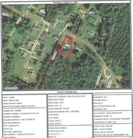
8 Attachment 2 Submitted by: Robert W. Drayton: City E&PM Real Estate Initiated by: Denice Beteta, Neighborhood & Business Services MANDATORY REFERRAL REPORT NO Proposed Sale of City Owned Property in Stanley (Gaston County) PROJECT PROPOSAL AND LOCATION: City of Charlotte Real Estate is proposing to sell a parcel located in Gaston County, Tax ID Number , via the upset bid process. The property is located at 2323 Old NC Highway 27 in Gaston County and consists of approximately 0.54 acres of land and a vacant single-wide mobile home manufactured in The property was acquired by the City in 2006 through foreclosure of a loan. The previous owner received a relocation loan from the City and was able to buy property outside Mecklenburg County, purchased this property, and subsequently defaulted on the City loan. The area surrounding the subject parcel is an attractive, rural and low density residential area with a mix of manufactured and stick-built houses. PROJECT JUSTIFICATION: Departmental Polling was conducted in May 2010 on these parcels. No replies were received that indicated interest by any City departments or other participating entities. The property is not needed by the City. CONSISTENCY WITH ADOPTED PUBLIC POLICIES: It is the City Real Estate policy to maximize the City s return from its current and future asset portfolio and minimize the maintenance and liability costs. The City will aggressively manage these assets. Maximizing the City s return will include alternative ownership / management strategies to optimize the benefits of private ownership (property tax revenue streams and public costs associated with ownership) while meeting the City s public policy objectives. The value of the property will be determined by an independent appraisal and will be sold via the upset bid process as outlined in the State of North Carolina General Statutes. CONSISTENCY WITH ADOPTED LAND USE PLANS: The property is in Gaston County and within the extraterritorial jurisdiction (including zoning) of the Town of Stanley. The zoning of the property is R-20 according to the Stanley Zoning Ordinance which allows mobile homes and other uses. The current use is consistent with the Town of Stanley s zoning. PROJECT IMPACT: The transfer of this property would eliminate any potential maintenance and liability costs that could be incurred by the City. RELATIONSHIP TO OTHER PUBLIC OR PRIVATE PROJECTS: No City of Charlotte or Mecklenburg County projects are related to this proposed transaction. ESTIMATED PROJECT COMPLETION DATE: Completion of the process to obtain Council approval and sale of the property should be complete by the end of JOINT USE TASK FORCE REVIEW COMMENTS: The Joint Use Task Force discussed this matter at their June 2 nd meeting and had no comments. PLANNING STAFF RECOMMENDATION: Staff recommends approval of the sale of this property. CMPC PLANNING COMMITTEE RECOMMENDATION: Staff resource: Greg Burnham 1
9
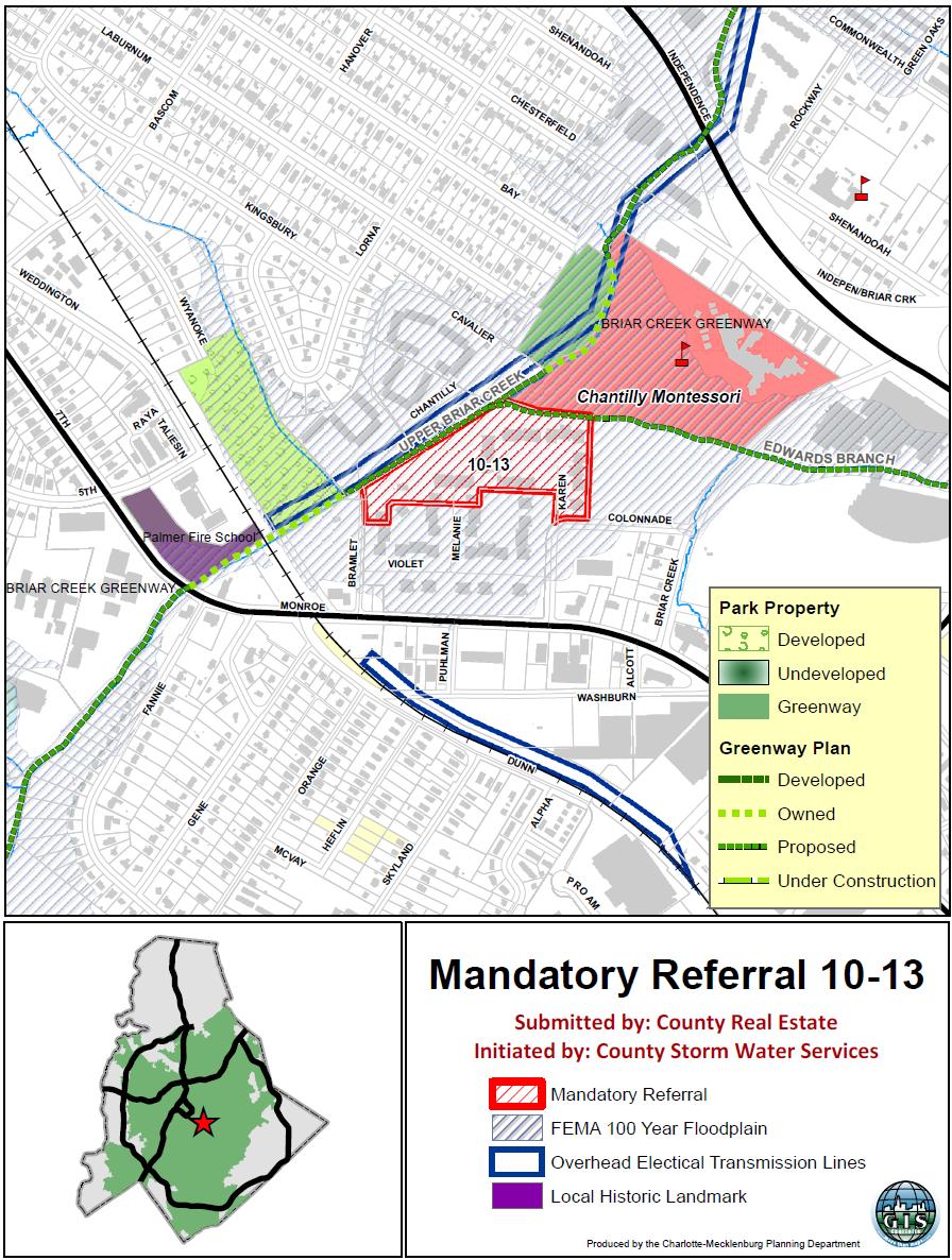
10 Attachment 3 Submitted by: Jacqueline McNeil, County Real Estate Services Initiated by: Robert Billings, County Storm Water Services MANDATORY REFERRAL REPORT NO Proposed Acquisition by Mecklenburg County of Flood-prone Structure Along Briar Creek PROJECT PROPOSAL AND LOCATION: Mecklenburg County s Storm Water Services Program proposes to acquire Tax Parcel # which is a portion of the Doral Apartments, located along Briar Creek off Monroe Road. The Doral Apartments has been identified as one of the most flood prone properties within Mecklenburg County, and has suffered from repeated flooding and property damage. The property is zoned R-22MF (multi-family residential) according to the Charlotte Zoning Ordinance. Mecklenburg County applied for and received grant funding to acquire the property through FEMA s Flood Mitigation Assistance program. The grant will cover 75% of the purchase price and related costs with 25% of those costs being covered by local storm water fees. Participation in the program is voluntary. Should the County s Storm Water Program successfully acquire the property, all improvements on the property will be removed and the property will be added to the County s open space/greenway system and maintained in a natural state. At a future date, Storm Water Services may consider stream improvements to this stretch of Briar Creek. PROJECT JUSTIFICATION: The proposed acquisition is located within a Federal Emergency Management Administration (FEMA) designated floodplain and is at continued risk of life and property damage and/or loss from future floods. The proposed acquisition is intended to eliminate potential future losses. Additionally, acquisition of this parcel will add to greenway connectivity and assemblage along Briar Creek. CONSISTENCY WITH ADOPTED PUBLIC POLICIES: Acquisition of this parcel is consistent with the Mecklenburg County Floodplain Management Guidance Document (adopted by County Commission on December 3, 1997) which aimed to 1) prevent and reduce the loss of life, property damage, and service disruptions and 2) restore natural and beneficial functions of the floodplain. Continued greenway property assembly along Briar Creek is consistent with the 2008 Greenway Master Plan, a component of the 2008 Park and Recreation 10-Year Master Plan adopted by the County Commission on May 7, CONSISTENCY WITH ADOPTED LAND USE PLANS: The Central District Plan (2003) recommends greenway as the future land use. Therefore, this request is consistent with the publicly adopted area plan. PROJECT IMPACT: Acquisition of these parcels will contribute to a reduction in property damage and potential loss of life for the affected communities as well as adding to the water quality/open space needs of the community. RELATIONSHIP TO OTHER PUBLIC OR PRIVATE PROJECTS: The purpose of these acquisitions is the protection of life and property. Additionally, the County will work with Charlotte- Mecklenburg Utilities in the placement of the Briar Creek Sewer pipeline project. ESTIMATED PROJECT COMPLETION DATE: Mecklenburg County anticipates acquiring this property by Fall JOINT USE TASK FORCE REVIEW COMMENTS: The Joint Use Task Force met on July 7, 2010 and it was offered that Charlotte-Mecklenburg Utilities Briar Creek Phase 2 project is scheduled for this area, so any open space development or stream restoration planned subsequent to this acquisition should be coordinated closely with Charlotte-Mecklenburg Utilities (CMU). No one from CMU was in attendance to offer clarification. Additionally, while City Storm Water Services (SWS) was not represented at the meeting, SWS staff offered the comment before-hand that they would be partnering with the County in this initiative. PLANNING STAFF RECOMMENDATION: Planning staff recommends acquisition of this parcel for floodway mitigation, and development of greenway and open space. Coordination between CMU and SWS is recommended to minimize costs and negative impacts to the land. CMPC PLANNING COMMITTEE RECOMMENDATION: Staff resource: John Howard
11
12 Attachment 4 Submitted by: Jacqueline McNeil, County Real Estate Services Initiated by: David Love, County Storm Water Services MANDATORY REFERRAL REPORT NO Proposed Acquisition by Mecklenburg County of Flood-prone Structures Along Briar Creek PROJECT PROPOSAL AND LOCATION: Mecklenburg County Storm Water Services proposes to purchase five parcels in one of Mecklenburg County s most flood prone areas along Briar Creek in east Charlotte. These parcels are zoned R-4 with single family residential dwellings located on each property. The parcels are 1. Tax Parcel Identification Number : 1750 Shannonhouse Drive 2. Tax Parcel Identification Number : 1800 Shannonhouse Drive 3. Tax Parcel Identification Number : 1806 Shannonhouse Drive 4. Tax Parcel Identification Number : 1812 Shannonhouse Drive 5. Tax Parcel Identification Number : 5400 Galway Drive To promote public health, safety, and welfare by reducing the risk of future flood damages, Mecklenburg County received grant funding from the Federal Emergency Management Administration (FEMA) Pre-Disaster Mitigation (PDM) program to establish a voluntary property acquisition program to purchase property. The grant will cover 75% of the purchase price with Mecklenburg County covering 25% of the purchase price and related closing costs (including relocation if necessary) through the use of local storm water fees. Following acquisition, existing structures will be removed and the land will be added to the County s open space/greenway system. In addition, Storm Water Services may consider stream improvements to this portion of Briar Creek in the future. PROJECT JUSTIFICATION: The proposed acquisitions are located within a FEMA-designated floodplain and are at continued risk of life and property damage and/or loss from future floods. The proposed acquisitions are intended to eliminate potential future losses by removing the residential structures. Acquisition of the parcels will improve greenway connectivity along Briar Creek. CONSISTENCY WITH ADOPTED PUBLIC POLICIES: Acquisition of these parcels is consistent with the Mecklenburg County Floodplain Management Guidance Document (adopted by Mecklenburg County Commission in December 1997) which aimed to 1) prevent and reduce the loss of life, property damage, and service disruptions and 2) restore natural and beneficial functions of the floodplain. Continued greenway property assembly along Briar Creek is supported by and consistent with the 2008 Greenway Master Plan, a component of the 2008 Park and Recreation 10-Year Master Plan (adopted by the Mecklenburg County Commission in May 2008). CONSISTENCY WITH ADOPTED LAND USE PLANS: The East District Plan (1990) recommends park/open space as the future land use for the subject properties; consequently this proposal is consistent with the publicly adopted area plan. PROJECT IMPACT: Acquisition of these parcels will contribute to a reduction in property damage and potential loss of life for the affected communities as well as adding to the water quality/open space needs of the community. RELATIONSHIP TO OTHER PUBLIC OR PRIVATE PROJECTS: The purpose of these acquisitions is the protection of life and property. The County will work with Charlotte-Mecklenburg Utilities in the placement of the Briar Creek Sewer pipeline project, if necessary. Additionally, Storm Water Services has worked with the Charlotte-Mecklenburg Police Department and the Charlotte Fire Department to provide training opportunities for police and fire personnel prior to the demolition of these structures. County Storm Water Services also works with Habitat for Humanity of Charlotte to reuse any usable materials in the structure prior to demolition. ESTIMATED PROJECT COMPLETION DATE: Mecklenburg County anticipates acquiring this property by Fall JOINT USE TASK FORCE REVIEW COMMENTS: The Joint Use Task Force discussed this matter at their July 7, 2010 meeting and no comments were provided. PLANNING STAFF RECOMMENDATION: Staff recommends approval of the proposed land acquisition and proposed use of the properties which is consistent with the recommended future land uses specified in the East District Plan (1990). CMPC PLANNING COMMITTEE RECOMMENDATION: Staff resource: Alysia Osborne

13 Attachment 4
14 Planning Committee Questions/Concerns Transportation 1. How will the City compensate property owners for loss of use of their property along Independence Boulevard? Independence Boulevard Area Plan Summary of Planning Committee Discussion July 14, 2010 Staff Response Attachment 5 The matrix below summarizes some of the concerns that Planning Committee members discussed at their June 15, 2010 meeting concerning the draft Independence Boulevard Area Plan and staff s response. The Independence Boulevard Area Plan Implementation Guide includes an implementation strategy to develop and evaluate a process to purchase parcels impacted by existing and proposed Independence Boulevard road improvements. This would apply to property owners that are willing to sell and whose property is negatively impacted by the road project. 2. Citizens concern that the plan pushes traffic onto neighborhood streets. 3. What is the timetable for the Independence Boulevard road project, funding for construction of the overpass, linking it with other transportation projects and how the road will look upon completion? Area Plan 4. There is almost a need for two plans or the plan should be divided into phases: Phase 1 to deal with present issues and Phase 2 to deal with economic development in the short term. The Implementation Guide is not adopted by City Council. However, once the area plan is adopted, Charlotte City Council will be asked to approve funding for this voluntary property acquisition program. The draft area plan includes various new street connections to supplement the existing street network in locations where increases in land use intensity are proposed. The currently funded transportation project along Independence Boulevard is 1.6 miles from Albemarle Road to Wallace Lane. The right of way acquisition process began in June 2010 and construction is scheduled to begin in The completed project will include the following : Eight travel lanes, including right-turn lanes, partial control of access; Two interchanges, one at Sharon Amity Road and one at Idlewild Road; One bridge at Conference Drive; and Median dedicated for future rapid transit (BRT or LRT) The remainder of the project, from Wallace Lane to I-485 has not been planned or funded. The plan document is organized into three parts. Part I, the Concept Plan, includes the Purpose, Vision Statement, Goals, and Policies. Only Part I will become adopted City policy. Part II, the Implementation Guide, contains short-term and long-term action steps identified to carry out plan policies, and will be used primarily to guide staff work. Part III, the Appendix provides technical information such as the existing conditions report, trends and forecasts, and other supporting data used to develop the plan. Independence Boulevard Area Plan Comments / Responses Page 1
15 5. The area plan is very large, detailed and has many issues 6. There is no bold vision statement in the plan and it is weakened by saying it came from the Citizen s Advisory Group. The draft Independence Boulevard Area Plan includes approximately 5,800 acres, over 20 neighborhoods and approximately 10,000 property owners. The purpose of the plan is to develop comprehensive land use and accessibility strategies to help position the corridor for growth and reinforce existing neighborhoods for continued stability and livability. While there are a number of complex issues surrounding this area plan, the size of the geography is similar to many area plans. The focus of the area plan is not to reevaluate existing plans for rapid transit or highway improvements. However, the Plan is intended to build upon the work completed in the Independence Blvd. Land Use & Infrastructure Study (2007) which identified the need to develop a clear vision and predictable future for Independence Boulevard. Significant development is unlikely to happen until some certainty about the future land use direction, design of the road and transit improvement, and the timing of construction can be obtained. The draft Independence Boulevard Area Plan provides a future land use vision and a certainty about the transportation future of Independence Boulevard. The vision statement developed for the plan area is based on feedback received from the stakeholder interviews, the first public meeting, and the first Citizens Advisory Group (CAG) workshop. (See below) Community input in developing the vision statement is an integral part of the plan development process as it clearly articulates the community s values and aspirations. This statement describes the kind of place the community envisions for the future, outlines common goals, hopes, and aspirations and offers the possibility for fundamental change for the community. Nine Guiding Principles were also developed from community input to supplement the vision statement and to help guide development of the Concept Plan. Draft Independence Boulevard Area Plan Community Vision Statement: The Independence Boulevard Plan Area will be a healthy, safe, and attractive area where a wide diversity of businesses can thrive, where a network of greenways connects important ecological places, and where everyone has multiple transportation options. Most of all, it will continue to be a place with strong neighborhoods, where residents and visitors enjoy a high quality of life with ample employment, shopping and recreational opportunities. Independence Boulevard Area Plan Comments / Responses Page 2
16 7. The transit stations areas along Independence Boulevard should be planned separately. Independence Boulevard has been identified as the Southeast Rapid Transit Corridor by the 2030 Corridor Systems Plan. The proposed future cross-section for Independence Boulevard includes the right-of-way necessary to construct either BRT or LRT in the future. Sixteen stations were identified along the Southeast Corridor, seven with park and ride facilities. The draft Independence Boulevard Area Plan includes six transit station area plans with preliminary land use, community design and transportation policies. Similar area planning efforts completed that included rapid transit station area plans are the Northlake Area Plan (2008) which includes the Eastfield Transit Station Area Plan, a proposed station along the North Corridor Commuter Rail Line, and the University City Area Plan (2007), which includes the Rocky River, City Boulevard, Harris/N. Tryon and University City transit station area plans, proposed stations along the Northeast Rapid Transit Corridor. Staff has found that planning for future transit stations within a larger context is a more comprehensive approach rather than focusing on the transit station itself. Independence Boulevard Area Plan Comments / Responses Page 3
Planning Committee Agenda Packet
 Planning Committee Agenda Packet May 16, 2017 Room 280 5:00 p.m. Charlotte-Mecklenburg Planning Commission Planning Committee Meeting Agenda May 16, 2017 5:00 p.m. CMGC 2 nd Floor, Room 280 1. Call to
Planning Committee Agenda Packet
 Planning Committee Agenda Packet June 17, 2014 Room 280 5:00 p.m. Charlotte-Mecklenburg Planning Commission Planning Committee Meeting Agenda June 17, 2014 5:00 p.m. CMGC 2 nd Floor, Room 280 1. Call
Planning Committee Agenda Packet
 Planning Committee Agenda Packet May 17, 2016 Room 280 5:00 p.m. Charlotte-Mecklenburg Planning Commission Planning Committee Meeting Agenda May 17, 2016 5:00 p.m. CMGC 2 nd Floor, Room 280 1. Call to
June 20, Sincerely,
 June 20, 2012 Chairperson Yolanda Johnson Planning Committee Members Dear Committee Members: Attached for your review are the agenda and attachments for your regular meeting to be held on Tuesday, June
Planning Committee Agenda Packet
 Planning Committee Agenda Packet March 15, 2016 Room 280 5:00 p.m. Charlotte-Mecklenburg Planning Commission Planning Committee Meeting Agenda March 15, 2016 5:00 p.m. CMGC 2 nd Floor, Room 280 1. Call
Planning Committee Agenda Packet
 Planning Committee Agenda Packet September 19, 2017 Room 280 5:00 p.m. Charlotte-Mecklenburg Planning Commission Planning Committee Meeting Agenda September 19, 2017 5:00 p.m. CMGC 2 nd Floor, Room 280
Rezoning Petition ZONING COMMITTEE RECOMMENDATION September 6, 2011
 Rezoning Petition 2011-044 ZONING COMMITTEE RECOMMENDATION September 6, 2011 REQUEST LOCATION SUMMARY OF PETITION PROPERTY OWNER PETITIONER AGENT/REPRESENTATIVE Current Zoning: BP(CD), business park, conditional
PLANNING COMMISSION STAFF REPORT
 PLANNING COMMISSION STAFF REPORT REZONING CASE: RZ-16-001 REPORT DATE: March 8, 2016 CASE NAME: Trailbreak Partners Rezoning PLANNING COMMISSION DATE: March 16, 2016 ADDRESSES OF REZONING PROPOSAL: 5501
CITY OF FORT COLLINS NATURAL AREAS AND CONSERVED LANDS EASEMENT POLICY
 CITY OF FORT COLLINS NATURAL AREAS AND CONSERVED LANDS EASEMENT POLICY Adopted January 3, 2012 PURPOSE: The purpose of the policy statement is to clarify the policies and procedures of the City of Fort
Town of Onalaska. A scale map depicting the portion of Pineview Drive to be officially laid out as a Town highway is attached hereto as Exhibit A.
 Town of Onalaska Special Meeting Minutes for March 31, 2011 The Town Board met on site of the Pineview Road and County OT in Onalaska for the purpose of viewing the lay out of the road as required by law.
Rezoning Petition Final Staff Analysis May 21, 2018
 Rezoning Petition 2017-182 Final Staff Analysis May 21, 2018 REQUEST LOCATION Current Zoning: R-3 (single family) and no zoning (current NC State right-of-way) Proposed Zoning: B-2(CD) (general business,
CLEARFIELD CITY COUNCIL AGENDA AND SUMMARY REPORT July 31, 2018 SPECIAL POLICY SESSION
 CLEARFIELD CITY COUNCIL AGENDA AND SUMMARY REPORT July 31, 2018 SPECIAL POLICY SESSION Meetings of the City Council of Clearfield City may be conducted via electronic means pursuant to Utah Code Ann. 52-4-207
PROPOSED METRO JOINT DEVELOPMENT PROGRAM: POLICIES AND PROCESS July 2015 ATTACHMENT B
 PROPOSED METRO JOINT DEVELOPMENT PROGRAM: POLICIES AND PROCESS ATTACHMENT B TABLE OF CONTENTS I. INTRODUCTION / PURPOSE............................ 3 II. OBJECTIVES / GOALS..................................
MINUTES OF THE TOWN OF LADY LAKE REGULAR PLANNING AND ZONING BOARD MEETING LADY LAKE, FLORIDA. February 8, :30pm
 MINUTES OF THE TOWN OF LADY LAKE REGULAR PLANNING AND ZONING BOARD MEETING LADY LAKE, FLORIDA 5:30pm The Planning and Zoning Board Meeting was held in the Town Hall Commission Chambers at 409 Fennell Blvd.,
2/22/2016. Planning and Zoning. David Owens March 2016 SOME CONTEXT
 Planning and Zoning David Owens March 2016 SOME CONTEXT 1 N.C. Population 1900 1.6 million 1950 2.4 million 2015 10 million 2 3 Population Growth Housing Units/ Square Mile Source: UNC Carolina Population
EDGERTON CITY HALL PLANNING COMMISSION MEETING REGULAR SESSION March 12, 2019
 EDGERTON CITY HALL PLANNING COMMISSION MEETING REGULAR SESSION The met in regular session with Chair John Daley calling the meeting to order at 7:00 p.m. All present participated in the Pledge of Allegiance.
SOUTHERN GROVE FACT SHEET
 SOUTHERN GROVE FACT SHEET What and where is Southern Grove? Southern Grove is a 3,605-acre Development of Regional Impact (DRI) south of Tradition Parkway. It is a part of an 8,200-acre region known to
LETTER OF APPLICATION
 Description of Proposed Land Division: LETTER OF APPLICATION The proposed land division would split a 1.94 acres rectangular lot into two lots. The general configuration would have one lot in front of
PLANNING COMMISSION Thursday, September 5, :00 p.m. Council Chambers, Administration Building 100 Ribaut Road, Beaufort, South Carolina
 PLANNING COMMISSION Thursday, September 5, 2013 6:00 p.m. Council Chambers, Administration Building 100 Ribaut Road, Beaufort, South Carolina In accordance with South Carolina Code of Laws, 1976, Section
Rezoning Petition Final Staff Analysis June 18, 2018
 Rezoning Petition 2018-005 Final Staff Analysis June 18, 2018 REQUEST Current Zoning: R-3 (single family residential) Proposed Zoning: R-5(CD) (single family residential, conditional), with five-year vested
PLANNING COMMISSION STAFF REPORT
 PLANNING COMMISSION STAFF REPORT West Capitol Hill Zoning Map Amendment Petition No. PLNPCM2011-00665 Located approximately at 548 W 300 North Street, 543 W 400 North Street, and 375 N 500 West Street
CITY OF ALBERT LEA PLANNING COMMISSION ADVISORY BOARD
 CITY OF ALBERT LEA PLANNING COMMISSION ADVISORY BOARD 9/1/2015, 5:30 p.m. City Council Chambers AGENDA A. CALL TO ORDER AND ROLL CALL B. APPROVAL OF THE AGENDA C. APPROVAL OF MINUTES 1. PC Minutes from
Community Development Committee
 Community Development Committee For the Metropolitan Council meeting of February 13, 2013 Committee Report Business Item 2013-29 ADVISORY INFORMATION Date Prepared: January 25, 2013 Subject: Rice Creek
THE AREA PLAN COMMISSION OF ST. JOSEPH COUNTY, IN AGENDA
 THE AREA PLAN COMMISSION OF ST. JOSEPH COUNTY, IN AGENDA Tuesday, June 20, 2017 Fourth-Floor Council Chambers 3:30 p.m. County-City Building, South Bend, IN PUBLIC HEARINGS: 1. Rezonings: A. A combined
METROPOLITAN COUNCIL 390 North Robert Street, St. Paul, MN Phone (651) TDD (651)
 TDD (651)") METROPOLITAN COUNCIL 390 North Robert Street, St. Paul, MN 55101 Phone (651) 602-1000 TDD (651) 291-0904 DATE: December 26, 2012 TO: Metropolitan Parks and Open Space Commission FROM: Jan Youngquist, AICP;
METROPOLITAN COUNCIL 390 North Robert Street, St. Paul, MN 55101 Phone (651) 602-1000 TDD (651) 291-0904 DATE: December 26, 2012 TO: Metropolitan Parks and Open Space Commission FROM: Jan Youngquist, AICP;
Walworth County Farmland Preservation Plan Update, Chapter 1 Plan Summary (Cover Document)
") Background Walworth County Farmland Preservation Plan Update, 2012 Chapter 1 Plan Summary (Cover Document) For over 30-years, the Wisconsin Farmland Preservation Program has served to preserve Walworth
Background Walworth County Farmland Preservation Plan Update, 2012 Chapter 1 Plan Summary (Cover Document) For over 30-years, the Wisconsin Farmland Preservation Program has served to preserve Walworth
Exit 25 Sam Furr Road
 Exit 25 Sam Furr Road Huntersville 101: Planning Department 1. Planning Overview 2. Basic Regulatory Framework: State Statutes 3. Overview of Long Range Planning 4. Tools to Implement Long Range Plan Vision
Town of Cary, North Carolina Rezoning Staff Report 14-REZ-31 Cary Park PDD Amendment (Waterford II) Town Council Meeting January 15, 2015
 Town Council Meeting January 15, 2015") Town of Cary, North Carolina Rezoning Staff Report 14-REZ-31 Cary Park PDD Amendment (Waterford II) Town Council Meeting January 15, 2015 REQUEST To amend the Town of Cary Official Zoning Map by amending
Town of Cary, North Carolina Rezoning Staff Report 14-REZ-31 Cary Park PDD Amendment (Waterford II) Town Council Meeting January 15, 2015 REQUEST To amend the Town of Cary Official Zoning Map by amending
PLANNING COMMISSION STAFF REPORT
 PLANNING COMMISSION STAFF REPORT REZONING CASE: RZ-15-002 REPORT DATE: January 26, 2016 CASE NAME: Thursday Lunch Club Rezoning PLANNING COMMISSION DATE: February 17, 2016 ADDRESS OF REZONING PROPOSAL:
Planning Justification Report
 Planning Justification Report Kellogg s Lands City of London E&E McLaughlin Ltd. June 14, 2017 Zelinka Priamo Ltd. Page i TABLE OF CONTENTS Page No. 1.0 2.0 2.1 2.2 3.0 4.0 5.0 5.1 5.2 5.3 5.4 5.5 5.6
ESTES VALLEY STORMWATER MANAGEMENT PROGRAM
 ESTES VALLEY STORMWATER MANAGEMENT PROGRAM Phase I. Stormwater Master Plan Phase II. Stormwater Utility Feasibility Study Board of Realtors Meeting May 3, 2018 Stormwater Master Plan Summary Stormwater
A Guide to the Municipal Planning Process in Saskatchewan
 A Guide to the Municipal Planning Process in Saskatchewan A look at the municipal development permit and the subdivision approval process in Saskatchewan May 2008 Prepared By: Community Planning Branch
LAND USE AND ZONING OVERVIEW
 OVERVIEW OF PLANNING POLICIES LAND USE AND ZONING OVERVIEW The Minneapolis Plan for Sustainable Growth and Other Adopted Plans Community Planning and Economic Development Development Services Division
INGHAM COUNTY LAND BANK FAST TRACK AUTHORITY. June 13, 2011 Minutes. Comm. Bahar-Cook, Comm. DeLeon, Comm. Nolan and Comm. McGrain
 APPROVED July 11, 2011 INGHAM COUNTY LAND BANK FAST TRACK AUTHORITY June 13, 2011 Minutes Members Present: Comm. Bahar-Cook, Comm. DeLeon, Comm. Nolan and Comm. McGrain Members Excused: Eric Schertzing
Housing Commission Report
 Housing Commission Report To: From: Subject: Housing Commission Meeting: July 21, 2016 Agenda Item: 4-B Chair and Housing Commission Barbara Collins, Housing Manager Draft Request for Proposals for Mountain
Request from Chad DeWaard for a Special Land Use Permit to Operate a Home-Based Business on property located at Cascade Road SE
 LOWELL CHARTER TOWNSHIP PLANNING COMMISSION REGULAR MEETING AND PUBLIC HEARINGS PRESENT: Blough, Batchelor, Simmonds, Clements, Edwards TOWNSHIP PLANNER: Tim Johnson CITIZENS IN ATTENDANCE: 13 The Regular
Darren Wyss, Associate Planner, Community Development Department
 Agenda Bill 2019-03-11-01 Date: February 25, 2019 Meeting Date: March 11, 2019 To: From: Through: Russ Axelrod, Mayor Members, West Linn City Council Darren Wyss, Associate Planner, Community Development
WOODLAND AREA GENERAL PLAN URBAN DEVELOPMENT POLICY
 APPENDIX A WOODLAND AREA GENERAL PLAN URBAN DEVELOPMENT POLICY The following text indicates proposed amendments to the Woodland Area General Plan Urban Development Policy currently adopted and included
Community Dev. Coord./Deputy City Recorder
 1 2 3 4 5 6 7 8 9 10 11 12 13 14 15 16 17 18 19 20 21 22 23 24 25 26 27 28 29 30 31 32 33 34 35 36 37 38 39 40 41 42 43 44 45 46 NORTH OGDEN PLANNING COMMISSION MEETING MINUTES December 18, 2013 The North
SUBJECT: Application for Planned Unit Development and Rezoning 1725 Winnetka Road
 TO: FROM: CHAIRMAN BILL VASELOPULOS AND MEMBERS OF THE PLAN & ZONING COMMISSION STEVE GUTIERREZ DIRECTOR OF COMMUNITY DEVELOPMENT MEETING DATE: September 5, 2017 SUBJECT: Application for Planned Unit Development
Chapter 100 Planned Unit Development in Corvallis Urban Fringe
 100.100 Scope and Purpose. Chapter 100 Planned Unit Development in Corvallis Urban Fringe (1) All applications for land divisions in the Urban Residential (UR) and Flood Plain Agriculture (FPA) zones within
5.5 Relocations and Displacements
 I-70 East Final EIS 5.5 Relocations and Displacements 5.5 Relocations and Displacements This section investigates the impacts from the project alternatives resulting from land acquisition of residential
Approval of Takoma Amended Joint Development Agreement and Compact Public Hearing
 Planning, Program Development and Real Estate Committee Item IV - B March 13, 2014 Approval of Takoma Amended Joint Development Agreement and Compact Public Hearing Washington Metropolitan Area Transit
HOUSING ELEMENT OF THE CITY OF PEMBROKE PINES COMPREHENSIVE PLAN ADOPTION DOCUMENT
 HOUSING ELEMENT OF THE CITY OF PEMBROKE PINES COMPREHENSIVE PLAN RULES 9J-5.010, FAC City of Pembroke Pines, Florida ADOPTION DOCUMENT HOUSING ELEMENT HOUSING ELEMENT ADOPTION DOCUMENT VI. GOALS, OBJECTIVES
Rapid City Planning Commission Rezoning Project Report
 Rapid City Planning Commission Rezoning Project Report August 4, 2016 Case # 16RZ027 Associated Case #16RZ028 Associated Case #16RZ029 Item 2 Applicant Request(s) A request to rezone property from High
Questions and Answers about Neighborhood Conservation Districts
 Questions and Answers about Neighborhood Conservation Districts NEIGHBORHOOD CONSERVATION Planning Department Housing and Neighborhood Services NCD@townofchapelhill.org (919) 968-2728 Questions about Neighborhood
Zoning and Subdivision Ordinances Public Hearing
 Zoning and Subdivision Ordinances Public Hearing June 14, 2007 Kise Straw & Kolodner Public Process Begun in September 2004 Comprehensive Plan (June 2006) Zoning Ordinance SALDO Comprehensive Plan Committee
AGENDA. CITY OF CENTRALIA, MISSOURI Planning and Zoning Commission Thursday, April 21, :00 P.M. City Hall Council Chambers
 AGENDA CITY OF CENTRALIA, MISSOURI Planning and Zoning Commission Thursday, April 21, 2016 6:00 P.M. City Hall Council Chambers I. ROLL CALL II. III. IV. Pledge of Allegiance Approval of Minutes of Previous
1. Roll Call. 2. Minutes a. September 24, 2018 Special Joint Meeting with Clay County Planning Commission. 3. Adoption of the Agenda
 1. Roll Call City of Vermillion Planning Commission Agenda 5:30 p.m. Regular Meeting Tuesday, October 9, 2018 City Council Chambers 2 nd Floor City Hall 25 Center Street Vermillion, SD 57069 2. Minutes
Hennepin County Department of. Housing, Community Works and Transit. Transit Oriented Development (TOD) Guidelines
 Guidelines") Hennepin County Department of Housing, Community Works and Transit 2007 Transit Oriented Development (TOD) Guidelines Hennepin County Transit Oriented Development (TOD) Bond Funds Hennepin County Housing,
Hennepin County Department of Housing, Community Works and Transit 2007 Transit Oriented Development (TOD) Guidelines Hennepin County Transit Oriented Development (TOD) Bond Funds Hennepin County Housing,
KENT COUNTY LAND BANK AUTHORITY REVIEW DECEMBER 2018
 KENT COUNTY LAND BANK AUTHORITY REVIEW DECEMBER 2018 1 Overview On July 26, 2018, Dave Allen, Executive Director of the Kent County Land Bank Authority (KCLBA) presented an update about the KCLBA to the
STAFF REPORT. January 25, North York Community Council. Director, Community Planning, North District
 STAFF REPORT January 25, 2005 To: From: Subject: Purpose: North York Community Council Director, Community Planning, North District Refusal Report OPA & Rezoning Application 04 194214 NNY 33 OZ Applicant:
9. REZONING NO Vicinity of the northwest corner of 143 rd Street and Metcalf Avenue
 9. REZONING NO. 2002-15 Vicinity of the northwest corner of 143 rd Street and Metcalf Avenue 1. APPLICANT: Andrew Schlagel is the applicant for this request. 2. REQUESTED ACTION: The applicant is requesting
RESOLUTION AUTHORIZING THE PUBLIC AUCTION OF CERTAIN REAL ESTATE
 IREDELL COUNTY BOARD OF COMMISSIONERS PRE-AGENDA MINUTES The Iredell County Board of Commissioners met in pre-agenda session on Tuesday,, at 5:30 PM, in the Iredell County Government Center (South Wing
Riverside County Transportation Commission Rail Station Joint Development Guidelines June 2005
 Riverside County Transportation Commission Rail Station Joint Development Guidelines June 2005 PURPOSE These guidelines are issued under the authority of the Riverside County Transportation Commission
Public Participation Zoning Code Amendment OV Planning and Zoning Commission Draft December 1, 2015 Attachment 1 Additions are shown in ALL CAP
 Public Participation Zoning Code Amendment OV1501056 Planning and Zoning Commission Draft December 1, 2015 Attachment 1 Additions are shown in ALL CAPS font, deletions shown in strikethrough font Section
PLANNING & DEVELOPMENT
 PLANNING & DEVELOPMENT STAFF REPORT Rezoning PETITION: APPLICANT: PROPERTY OWNER: TYPE OF REQUEST: SIZE OF TRACT: LOCATION: (#17-22) Rezone from A-PUD (Agri-Business Planned Unit Development) to A-PUD
5.5 Relocations and Displacements
 I-70 East Supplemental Draft EIS 5.5 Relocations and Displacements 5.5 Relocations and Displacements This section investigates the impacts to residential units, businesses, and non-profit associations
Town of Yucca Valley GENERAL PLAN 1
 Town of Yucca Valley GENERAL PLAN 1 This page intentionally left blank. 3 HOUSING ELEMENT The Housing Element is intended to guide residential development and preservation consistent with the overall values
Town of Cary, North Carolina Rezoning Staff Report 12-REZ-27 Morris Branch Town Council Public Hearing January 24, 2013
 Town of Cary, North Carolina Rezoning Staff Report 12-REZ-27 Morris Branch Town Council Public Hearing January 24, 2013 REQUEST To amend the Town of Cary Official Zoning Map to rezone approximately 9.0
Town of Cary, North Carolina Rezoning Staff Report 13-REZ-31 Weston PDD Amendment at Centregreen Park Town Council Meeting March 13, 2014
 Town of Cary, North Carolina Rezoning Staff Report 13-REZ-31 Weston PDD Amendment at Centregreen Park Town Council Meeting March 13, 2014 REQUEST This proposed amendment to the Town of Cary Official Zoning
ZRTD , Glenn Drive. M. Tyler Klein, AICP, Project Manager, Planning and Zoning John Merrithew, Acting Director, Planning and Zoning
 DEPARTMENT OF PLANNING Date of Hearing: AND ZONING STAFF REPORT # 4 BOARD OF SUPERVISORS PUBLIC HEARING SUBJECT: ELECTION DISTRICT: ZRTD-2014-0003, 22675 Glenn Drive Broad Run CRITICAL ACTION DATE: September
City of Charlotte. Charlotte-Mecklenburg Government Center 600 East 4th Street Charlotte, NC Zoning Agenda. Monday, December 14, 2015
 City of Charlotte Charlotte-Mecklenburg Government Center 600 East 4th Street Charlotte, NC 28202 Monday, Council Chambers City Council Zoning Meeting - Mayor Jennifer W. Roberts - - Mayor Pro-Tem Vi Lyles
STAFF REPORT. Permit Number: Porter. Kitsap County Board of Commissioners; Kitsap County Planning Commission
 STAFF REPORT Permit Number: 15 00461 Porter DATE: November 9, 2015 TO: FROM: Kitsap County Board of Commissioners; Kitsap County Planning Commission Katrina Knutson, AICP, Senior Planner, DCD and Jeff
Lincoln County Board of Commissioner s Agenda Item Cover Sheet
 Lincoln County Board of Commissioner s Agenda Item Cover Sheet Board Meeting Date: Agenda Item Type: Consent Agenda: Public Hearing: Regular Agenda: Presentation Time (est): Submitting Person: Phone Number/Ext:
PART 1: PROJECT SUMMARY
 PART 1: PROJECT SUMMARY R18-04: Walden Major Revision Staff Analysis Petition R18-04 Walden Conditional District Rezoning Revision to revise Phases 3, 6, & 8 and add 6.16-acres of land (new Phase 9). Applicant:
GOALS, OBJECTIVES, AND STRATEGIES
 GOALS, OBJECTIVES, AND STRATEGIES What follows is a series of goals, recommendations and actions that reflect the themes outlined in the Mineral Springs Vision Plan (incorporated into this document as
Petition R17-12 Villages at Skybrook North Conditional District Rezoning Revision to delete 10 garage recess requirement.
 Petition R17-12 Villages at Skybrook North Conditional District Rezoning Revision to delete 10 garage recess requirement. PART 1: PROJECT SUMMARY Applicant: Laureldale, LLC Property Owner: Laureldale,
MEMORANDUM Planning Commission Travis Parker, Planning Director DATE: April 4, 2018 Lakewood Zoning Amendments Housing and Mixed Use
 MEMORANDUM TO: FROM: Travis Parker, Planning Director DATE: April 4, 2018 SUBJECT: Lakewood Zoning Amendments Housing and Mixed Use In August 2017, the Lakewood Development Dialogue process began with
Financial Analysis of Urban Development Opportunities in the Fairfield and Gonzales Communities, Victoria BC
 Financial Analysis of Urban Development Opportunities in the Fairfield and Gonzales Communities, Victoria BC Draft 5 December 2016 Prepared for: City of Victoria By: Table of Contents Summary... i 1.0
ROSEMEAD CITY COUNCIL STAFF REPORT
 ROSEMEAD CITY COUNCIL STAFF REPORT TO THE HONORABLE MAYOR AND CITY COUNCIL FROM JEFF ALLRED CITY MANAGER DATE JUNE 9 2015 6 SUBJECT MUNICIPAL CODE AMENDMENT 15 02 AMENDING CHAPTERS 17 04 AND 17 72 OF TITLE
Land Use Planning Analysis. Phase 2 Drayton Valley Annexation Proposal
 Land Use Planning Analysis Phase 2 Drayton Valley Annexation Proposal Prepared for Town of Drayton Valley Prepared by Mackenzie Associates Consulting Group Limited March, 2011 TABLE OF CONTENTS 1.0 INTRODUCTION...
Lincoln County Board of Commissioner s Agenda Item Cover Sheet
 Lincoln County Board of Commissioner s Agenda Item Cover Sheet Board Meeting Date: Agenda Item Type: Consent Agenda: Public Hearing: Regular Agenda: Presentation Time (est): Submitting Person: Phone Number/Ext:
Feedback from the CAB about the Acquisition and Relocation Program
 HARBOR BRIDGE PROJECT COMMUNITY ADVISORY BOARD MEETING MINUTES July 7, 2016 CAB Procedural Matters A need for a Vice Chairperson was identified during the June 16 CAB meeting, and Floyd Williams, who had
CHAPTER Committee Substitute for Committee Substitute for Senate Bill No. 2188
 CHAPTER 2004-372 Committee Substitute for Committee Substitute for Senate Bill No. 2188 An act relating to land development; amending s. 197.502, F.S.; providing for the issuance of an escheatment tax
Noise Mitigation Plan
 1 of 61 Noise Mitigation Plan Runway 9R/27L Expansion Project Broward County Aviation Department PREPARED BY: The Urban Group, Inc. October 25, 2010 2 of 61 Noise Mitigation Plan Prepared By: The Urban
SUBJECT: AMENDMENTS TO TITLE 13 DATE: June 5, 2017 OF THE SAN JOSE MUNICIPAL CODE
 COUNCIL AGENDA: 06/27/17 ITEM: 4.5 CITY OF cr SAN JOSE CAPITAL OF SILICON VALLEY Memorandum TO: HONORABLE MAYOR AND CITY COUNCIL FROM: Barry Ng Rosalynn Hughey SUBJECT: AMENDMENTS TO TITLE 13 DATE: June
CLAY TOWNSHIP PLANNING COMMISSION MEETING MINUTES September 28, 2015
 CLAY TOWNSHIP PLANNING COMMISSION MEETING MINUTES September 28, 2015 Members present were: Bruce Leisey, Clair Beyer and Annie Reinhart. Jon Price arrived at 7:10 and Adrian Kapp were absent. Also present
174 North King Street Workforce Housing Development Downtown Jackson, Wyoming
 174 North King Street Workforce Housing Development Downtown Jackson, Wyoming Request for Proposals Release Date November 7, 2017 Information Session December 4, 2017 Submission Deadline February 9, 2018
Background. ADOPTED ACTION PLAN Proposed Regulatory Strategies
 Background June 2011 Council adopted Action Plan to pursue 11 regulatory and financial strategies incentivizing development of affordable housing Directed staff to work with Citizen Advisory Group (CAG)
Land Use, Transportation, and Infrastructure Committee of the Denver City Council FROM: Scott Robinson, Senior City Planner DATE: March 22, 2018 RE:
 Community Planning and Development Planning Services 201 W. Colfax Ave., Dept. 205 Denver, CO 80202 p: 720.865.2915 f: 720.865.3052 www.denvergov.org/cpd TO: Land Use, Transportation, and Infrastructure
Hearing Date: April 17, 2014
 Community Development Department SUBJECT: ACTION ITEM: PUBLIC HEARING: PLANNING COMMISSION STAFF REPORT Comprehensive Plan CPA #13-01; Comprehensive Plan Amendment (CPA) _ X_ YES X NO _ Hearing Date: April
John Hutchinson, Michelle Casserly, Mark Fitzgerald, John Lisko, Chuck Ross, Robert Cupoli, and Manny Fowler
 PRESENT: ABSENT: John Hutchinson, Michelle Casserly, Mark Fitzgerald, John Lisko, Chuck Ross, Robert Cupoli, and Manny Fowler Phil Greig & Judy Young ALSO PRESENT: Board Attorney Kevin Kennedy and Board
ARTICLE 3: Zone Districts
 ARTICLE 3: Zone Districts... 3-1 17.3.1: General...3-1 17.3.1.1: Purpose and Intent... 3-1 17.3.2: Districts and Maps...3-1 17.3.2.1: Applicability... 3-1 17.3.2.2: Creation of Districts... 3-1 17.3.2.3:
DESIGN PUBLIC HEARING JULY 7, 2016 CITY COUNCIL HEARING ROOM, FIRST FLOOR ONE GOVERNMENT CENTER FALL RIVER, MASSACHUSETTS 6:30 PM FOR THE PROPOSED
 DESIGN PUBLIC HEARING JULY 7, 2016 AT CITY COUNCIL HEARING ROOM, FIRST FLOOR ONE GOVERNMENT CENTER FALL RIVER, MASSACHUSETTS 6:30 PM FOR THE PROPOSED AIRPORT ROAD OVER ROUTE 24, BRIDGE DECK REPLACEMENT
Minutes of 09/03/2003 Planning Board Meeting [adopted]
![Minutes of 09/03/2003 Planning Board Meeting [adopted]](/thumbs/89/98509328.jpg "Minutes of 09/03/2003 Planning Board Meeting [adopted]") Minutes of 09/03/2003 Planning Board Meeting [adopted] Angel M Kropf on 09/10/2003 at 11:04 AM Category: Planning Board Minutes MINUTES Wake County Planning Board Wednesday, September 3, 2003 1:30 p.m.,
Minutes of 09/03/2003 Planning Board Meeting [adopted] Angel M Kropf on 09/10/2003 at 11:04 AM Category: Planning Board Minutes MINUTES Wake County Planning Board Wednesday, September 3, 2003 1:30 p.m.,
Glendale Housing Development Project Plan
 Glendale Housing Development Project Plan Draft for Public Review May 29, 2015 Table of Contents I. Introduction... 1 II. Description of Project... 1 A. Boundary of Housing Development Project... 1 B.
CITY OF RENO REDEVELOPMENT RENO CITY COUNCIL CHAMBER ONE EAST FIRST STREET RENO, NV Wednesday, June 13, :00 P.M.
 A.0 ROLL CALL (For Possible Action) CITY OF RENO REDEVELOPMENT RENO CITY COUNCIL CHAMBER ONE EAST FIRST STREET RENO, NV 89501 Wednesday, June 13, 2012 12:00 P.M. A.1 PUBLIC COMMENT - This item is for either
ARLINGTON COUNTY, VIRGINIA
 ARLINGTON COUNTY, VIRGINIA County Board Agenda Item Meeting of November 15, 2005 DATE: November 8, 2005 SUBJECTS: A. Adoption of Proposed Amendments to Section 20 (Appendix A) CP-FBC Columbia Pike - Form
CITY OF NORWALK PLANNING COMMISSION. August 16, 2016
 CITY OF NORWALK PLANNING COMMISSION PRESENT: STAFF: Torgny Astrom, Chair; Frances DiMeglio; Walter McLaughlin; David Davidson; William Dunne; Steven Ferguson; Nora King; George Tsiranides Mike Wrinn I.
CITY OF WEST PARK PROPOSED TRANSIT ORIENTED CORRIDOR (TOC) EXPANSION WORKSHOP JUNE 15, 2016 FREQUENTLY ASKED QUESTIONS (FAQ)
 EXPANSION WORKSHOP JUNE 15, 2016 FREQUENTLY ASKED QUESTIONS (FAQ)") CITY OF WEST PARK PROPOSED TRANSIT ORIENTED CORRIDOR (TOC) EXPANSION WORKSHOP JUNE 15, 2016 FREQUENTLY ASKED QUESTIONS (FAQ) Q: Have you considered that people here love driving their cars and trucks,
CITY OF WEST PARK PROPOSED TRANSIT ORIENTED CORRIDOR (TOC) EXPANSION WORKSHOP JUNE 15, 2016 FREQUENTLY ASKED QUESTIONS (FAQ) Q: Have you considered that people here love driving their cars and trucks,
4.13 Population and Housing
 Environmental Impact Analysis Population and Housing 4.13 Population and Housing 4.13.1 Setting This section evaluates the impacts to the regional housing supply and population growth associated with implementation
CITY OF CEDARBURG. City Attorney Kaye Vance, City Planner Marty Marchek, Administrative Secretary Darla Drumel
 CITY OF CEDARBURG PLN20110906-1 A regular meeting of the Plan Commission of the City of Cedarburg was held on Tuesday, at Cedarburg City Hall, W63 N645 Washington Avenue, second floor, Council Chambers.
MINUTES. August 6, 2013
 MINUTES August 6, 2013 Vice Chairman Smith called the Planning Commission Meeting to order in the Planning Department at 7:05 p.m. in the City Council Chamber. The following Commission members were in
CITY OF APPLE VALLEY PLANNING COMMISSION MINUTES DECEMBER 7, 2016
 PLANNING COMMISSION MINUTES DECEMBER 7, 2016 1. CALL TO ORDER The City of Apple Valley Planning Commission meeting was called to order by Chair Melander at 7:01 p.m. Members Present: Tom Melander, Ken
City of Lake Elmo Planning Commission Meeting Minutes of January 14, 2013
 City of Lake Elmo Planning Commission Meeting Minutes of January 14, 2013 Chairman Williams called to order the workshop of the Lake Elmo Planning Commission at 7:00pm COMMISSIONERS PRESENT: Fliflet, Obermueller,
THE CORPORATION OF THE TOWNSHIP OF KING THE CERTIFICATE PAGE FOR AMENDMENT NO. 89 TO THE OFFICIAL PLAN OF THE TOWNSHIP OF KING
 THE CORPORATION OF THE TOWNSHIP OF KING THE CERTIFICATE PAGE FOR AMENDMENT NO. 89 TO THE OFFICIAL PLAN OF THE TOWNSHIP OF KING (KING CITY COMMUNITY PLAN) The attached text and schedules constituting Amendment
CHAUTAUQUA COUNTY LAND BANK CORPORATION
 EXHIBIT H CHAUTAUQUA COUNTY LAND BANK CORPORATION LAND ACQUISITION AND DISPOSITION POLICIES AND PRIORITIES November 14, 2012 *This document is intended to provide guidance to the Chautauqua County Land
18 Sale and Other Disposition of Regional Lands Policy
 Clause 18 in Report No. 7 of Committee of the Whole was adopted, without amendment, by the Council of The Regional Municipality of York at its meeting held on April 19, 2018. 18 Sale and Other Disposition
STAFF REPORT FOR ANNEXATION AND ZONING. CASE NAME: Taylor Annexation and Zoning PC DATE: August 7, 2013
 STAFF REPORT FOR ANNEATION AND ZONING ANNEATION CASE NO: A-13-001 ZONING CASE NO: RZ-13-002 REPORT DATE: July 30, 2013 CASE NAME: Taylor Annexation and Zoning PC DATE: August 7, 2013 ADDRESS OF PROPOSAL: