REQUEST FOR COUNCIL ACTION
|
|
|
- Ernest Riley
- 5 years ago
- Views:
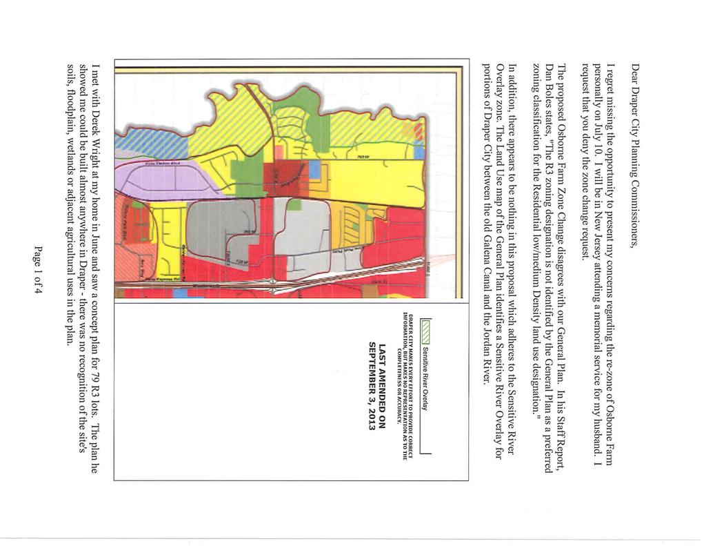
Transcription
1 REQUEST FOR COUNCIL ACTION To: From: Mayor & City Council Date: August 5, 2014 Subject: Applicant Presentation: Staff Presentation: Dan Boles, AICP, Senior Planner Osborne Farm Zoning Map Amendment Derek Wright, representing Wright Homes Dan Boles RECOMMENDATION: To approve the request for a Zoning Map Amendment, as recommended by both Planning Commission and staff, as per the staff report dated July 1, 2014, and as reflected in Ordinance #1120. BACKGROUND AND FINDINGS: This recommendation is based on the following findings: 1. That Section of the Draper City Code allows for the amendment of the City s zoning map. 2. That the proposed amendment is consistent with the goals, objectives and policies of the City s General Plan, such as: a. Promote development patterns and standards that are consistent with the surrounding uses and reinforce an area s character. b. Encourage land uses that create a sense of community among those who work, live, and play within local neighborhoods. c. Protect and revitalize established areas/neighborhoods by promoting new development and the adaptive reuse of existing community resources that reenergize an area. 3. That all five findings for a zone change, as contained in I and outlined in this staff report, are satisfied. 4. That adequate facilities and services exist to serve the subject property, including but not limited to roadways, parks and recreation facilities, police and fire protection, schools, storm water drainage systems, water supplies, and waste water and refuse collection. 5. That there is R3 zoning adjacent to the subject property to the north. 6. That the proposed amendment would not adversely affect adjacent property or the character of the neighborhood. Land Use Map The applicant has opted to not ask for a change in Land Use Designation on the subject property. Neither Utah State nor Draper City Municipal Code require the zoning and land use designations to match as the General Plan is a guiding document. In such cases, an applicant will sometimes amend the Land Use map to keep the two consistent, but not always. In this case, the General Plan suggests Residential Low/Medium density which would be consistent with a RA1 or RA2 zone. R3, which the applicant is seeking, falls under the Residential Medium Density land use category. Arguments for the change At three units to the acre, the development would still be a relatively low density. Though the general plan does not contemplate this density, the general plan is still served by meeting some of its goals and objectives such as: o Promote development patterns and standards that are consistent with the surrounding uses and reinforce an area s character.
2 o Encourage land uses that create a sense of community among those who work, live, and play within local neighborhoods. o Protect and revitalize established areas/neighborhoods by promoting new development and the adaptive reuse of existing community resources that reenergize an area. The property to the north-west is zoned R3 and would therefore not be introducing a new zoning category to the area. On 700 West, between South and South there are other neighborhoods which exceed this density such as River Park Estates, Sunset at Draper Ridge and Galena Grove. Windsor Mill, directly adjacent to Soccer City will also have similar densities and is currently under review. Property along 700 West have adequate facilities and services to service the subject property such as water, drainage systems, roadways, police and fire protection, waste and refuse collection, etc. Arguments against the change The R3 zoning category is not identified in the general plan as a preferred zoning category in the Low/Medium density category. The addition of eighty homes on the property would change the character of the existing neighborhood. The R3 zone does not include animal rights, a right which has been used and enjoyed in the area since settlement occurred in Draper. PREVIOUS LEGISLATIVE ACTION: There has been no previous legislative action on the property FISCAL IMPACT: Finance Review: No fiscal impact is anticipated by approving a rezone. Maintenance of roads, including plowing would come with a future subdivision should this rezone be approved. SUPPORTING DOCUMENTS: Ordinance #1120 with Exhibits Staff Report with Supporting Documentation Zoning, Land Use & Aerial Maps Planning Commission Minutes July 10, 2014
3 ORDINANCE NO AN ORDINANCE AMENDING THE OFFICIAL ZONING MAP OF DRAPER CITY FOR APPROXIMATELY 36.9 ACRES OF PROPERTY FROM RA1 (RESIDENTIAL AGRICULTURAL, 40,000 SQUARE FEET MINIMUM LOTS) AND A5 (AGRICULTURAL) TO R3 (RESIDENTIAL, 13,000 SQUARE FEET MINIMUM LOTS), LOCATED AT APPROXIMATELY SOUTH 700 WEST WITHIN DRAPER CITY, OTHERWISE KNOWN AS THE OSBORNE FARM ZONE CHANGE REQUEST. WHEREAS, pursuant to State law, Draper City has adopted a Zoning Ordinance and Zoning Map to guide the orderly development and use of property within the City; and WHEREAS, from time to time it is necessary to review and amend the Zoning Map to keep pace with development within the City and to ensure the provision of a variety of economic uses; and WHEREAS, the proposed zone change set forth herein has been reviewed by the Planning Commission and the City Council, and all appropriate public hearings have been held in accordance with Utah law to obtain public input regarding the proposed revisions to the Zoning Map; and WHEREAS, the Planning Commission has reviewed and made a recommendation to the City Council concerning the proposed amendment to the official Zoning Map of Draper City, and the City Council has found the proposed zone change to be consistent with the goals and objectives of the City s General Plan. NOW, THEREFORE, BE IT ORDAINED BY THE CITY COUNCIL OF DRAPER CITY, STATE OF UTAH: Section 1. Zoning Map Amendment. The following described real property located at approximately South 700 West within Draper City, Salt Lake County, State of Utah, previously zoned RA1 and A5 as shown on the Draper City Zoning Map, as depicted in Exhibit A hereto, are hereby changed and rezoned to R3: Beginning at the Southeast Corner of Riverview Ranch Subdivision, said point also being the East Quarter Corner of Section 23, Township 3 South, Range 1 West, Salt Lake Base and Meridian; and running thence South 00 05'05" East feet along the section line; thence West feet; thence South feet; thence West feet; thence South feet; thence North 89 17'52" West 1, feet; thence North 69 27'17" West feet; thence North 49 28'01" West feet; thence Northeasterly feet along the arc of a 1, foot radius curve to the right (center bears South 89 11'34" East and the chord bears North 03 14'34" East feet with a central angle of 04 52'17"); thence North 05 46'17" East 4.72 feet; thence South 88 30'00" East feet; Ordinance No Osborne Farm Zone Change Request
4 thence North 05 46'17" East feet; thence North 19 52'45" East feet; thence North 09 03'58" East feet; thence South 84 45'45" East 1, feet to the point of beginning. Contains 1,607,746 square feet or acres Section 2. Severability Clause. If any part or provision of this Ordinance is held invalid or unenforceable, such invalidity or unenforceability shall not affect any other portion of this Ordinance and all provisions, clauses and words of this Ordinance shall be severable. Section 3. Effective Date. This Ordinance shall become effective 20 days after publication or posting, or 30 days after final passage, whichever is closer to the date of final passage. PASSED AND ADOPTED BY THE CITY COUNCIL OF DRAPER CITY, STATE OF UTAH, ON THIS DAY OF, ATTEST: DRAPER CITY: By: By: City Recorder Mayor Ordinance No Osborne Farm Zone Change Request

5 EXHIBIT A OSBORNE FARM ZONE CHANGE REQUEST Ordinance No Osborne Farm Zone Change Request

6 Development Review Committee 1020 East Pioneer Road Draper, UT (801) STAFF REPORT July 1, 2014 To: From: Draper City Planning Commission Business Date: July 10, 2014 Development Review Committee Prepared By: Dan Boles, AICP, Senior Planner Planning Division Community Development Department Re: Osborne Farm Zoning Map Amendment Request Application No.: S Applicant: Derek Wright, representing Wright Homes Project Location: Approximately South 700 West Zoning: A5 and RA1 Zone Acreage: Approximately Acres (Approximately 1,609,542 ft 2 ) Request: Request for approval of a Zoning Map Amendment from A5 (Agricultural) and RA1 (Residential one acre lots) to R3 (Residential third acre lots). SUMMARY This application is a request for approval of a Zoning Map Amendment for approximately acres located on the west side of 700 West, at approximately South. The property is currently zoned A5 (agricultural) and RA1 (single-family residential). The applicant is requesting that a Zoning Map Amendment be approved to allow the property to be subdivided into third acre (13,000 ft²) lots. BACKGROUND The property has been family owned for many years. However, the Osborne family has decided that it is now time to sell the property. Wright Homes which has built other projects within Draper City would like to develop the property but the A5 and RA1 zones would not yield the amount of lots they would need to make that feasible for them to do so. As such, they are seeking to change the zoning designation to R3. ANALYSIS General Plan and Zoning. The Land Use Map of the General Plan calls for the Residential Low/Medium Density land use designation for the subject property. This category includes areas of very large lot single-family neighborhoods and ranchettes. The property is zoned A5 on the western portion of the property, closer to the river and the RA1 on the east as it abuts 700 West. A5 zoning does allow Osborne Farm App. # S Zoning Map Amendment Request 1
7 residential facilities but is primarily an agricultural designation and all lots must meet a five acre minimum size. The RA1 zone is primarily a residential zone but also allows a limited amount of agricultural uses as well. The RA1 zone requires each lot to have a minimum of 40,000 ft² or just under an acre. The R3 zoning designation is not identified by the General Plan as a preferred zoning classification for the Residential Low/Medium Density land use designation. Land Use Map The Draper City General Plan states A general plan is an expression of long-term community intentions regarding the future development and physical form of the community. It is a living fluid document that is not static but is reviewed and updated periodically by the City. It contains maps, goals, objectives and policies that are used to coordinate and implement land use decisions with other decisions about infrastructure, parks, recreation and open space, city services, housing supply and affordability and public resources such as air and water. In the Land Use Element of the General Plan, it states, The purpose of the Land Use Element is to encourage the orderly and efficient distribution of land uses in the city. A full range and mix of land uses, including rural, suburban, and urban neighborhoods; employment, commercial recreational; cultural, and preservation areas are provided in this Element. The applicant has opted to not ask for a change in Land Use Designation on the subject property. Neither Utah State nor Draper City Municipal Code require the zoning and land use designations to match as the General Plan is a guiding document. In such cases, an applicant will sometimes amend the Land Use map to keep the two consistent, but not always. In this case, the General Plan suggests Residential Low/Medium density which would be consistent with a RA1 or RA2 zone. R3, which the applicant is seeking, falls under the Residential Medium Density land use category. Arguments for the change At three units to the acre, the development would still be a relatively low density. Though the general plan does not contemplate this density, the general plan is still served by meeting some of its goals and objectives such as: o Promote development patterns and standards that are consistent with the surrounding uses and reinforce an area s character. o Encourage land uses that create a sense of community among those who work, live, and o play within local neighborhoods. Protect and revitalize established areas/neighborhoods by promoting new development and the adaptive reuse of existing community resources that reenergize an area. The property to the north-west is zoned R3 and would therefore not be introducing a new zoning category to the area. On 700 West, between South and South there are other neighborhoods which exceed this density such as River Park Estates, Sunset at Draper Ridge and Galena Grove. Windsor Mill, directly adjacent to Soccer City will also have similar densities and is currently under review. Property along 700 West have adequate facilities and services to service the subject property such as water, drainage systems, roadways, police and fire protection, waste and refuse collection, etc. Arguments against the change The R3 zoning category is not identified in the general plan as a preferred zoning category in the Low/Medium density category. The addition of eighty homes on the property would change the character of the existing neighborhood. The R3 zone does not include animal rights, a right which has been used and enjoyed in the area since settlement occurred in Draper. Osborne Farm App. # S Zoning Map Amendment Request 2
8 Criteria For Approval. The criteria for review and potential approval of a Zoning Map Amendment request is found in Sections of the Draper City Municipal Code. This section depicts the standard of review for such requests as: Approval Standards. A decision to amend the text of this Title or the zoning map is a matter committed to the legislative discretion of the City Council and is not controlled by any one standard. However, in making an amendment, the City Council should consider the following factors: (1) Whether the proposed amendment is consistent with goals, objectives and policies of the City s General Plan; (2) Whether the proposed amendment is harmonious with the overall character of existing development in the vicinity of the subject property; (3) Whether the proposed amendment is consistent with the standards of any applicable overlay zone. (4) The extent to which the proposed amendment may adversely affect adjacent property; and (5) The adequacy of facilities and services intended to serve the subject property, including but not limited to roadways, parks and recreation facilities, police and fire protection, schools, storm water drainage systems, water supplies, and waste water and refuse collection. REVIEWS Planning Division Review. The Draper City Planning Division has completed their review of the Zoning Map Amendment submission and has issued a recommendation for approval for the request. Engineering and Public Works Divisions Review. The Draper City Engineering and Public Works Divisions have completed their reviews of the Zoning Map Amendment submission and have issued a recommendation for approval for the request with the following comments: 1. Connectivity with the proposed parcels will occur from 700 West. Access to South is also projected through the residential road of proposed subdivision to the north. 2. There are no storm drainage facilities fronting the properties in 700 West and the general slope of the subject properties drains west towards the Jordan River. Any discharge must still comply with the provisions of the drainage requirements within the Draper City Municipal Code. 3. Sanitary sewer facilities will be provided by South Valley Sewer District. Any site plan application will require a commitment to serve from the Sewer District that facilities are adequate to provide service for the proposed uses. 4. Culinary water service is provided by Draper City. For single family residential uses there are adequate water pressure and supply from 700 West. Fire flow adequacy for high density or other uses shall be determined by the applicant at the subdivision approval process. 5. A few of the proposed parcels on the west side of the subject property are within the flood zone. The applicant shall be aware Salt Lake County Flood Control and Utah State Stream Alteration Permits may be necessary at the subdivision approval process. Noticing. The applicant has expressed their desire to rezone the subject property and do so in a manner which is compliant with the City Code. As such, notice has been properly issued in the manner outlined in the City and State Codes. Osborne Farm App. # S Zoning Map Amendment Request 3
9 STAFF RECOMMENDATION Staff recommends approval of the request for a Zoning Map Amendment by Derek Wright, representing Wright Homes, application S, based on the following findings: 1. That Section of the Draper City Code allows for the amendment of the City s zoning map. 2. That the proposed amendment is consistent with the goals, objectives and policies of the City s General Plan, such as: a. Promote development patterns and standards that are consistent with the surrounding uses and reinforce an area s character. b. Encourage land uses that create a sense of community among those who work, live, and play within local neighborhoods. c. Protect and revitalize established areas/neighborhoods by promoting new development and the adaptive reuse of existing community resources that reenergize an area. 3. That all five findings for a zone change, as contained in I and outlined in this staff report, are satisfied. 4. That adequate facilities and services exist to serve the subject property, including but not limited to roadways, parks and recreation facilities, police and fire protection, schools, storm water drainage systems, water supplies, and waste water and refuse collection. 5. That there is R3 zoning adjacent to the subject property to the north. 6. That the proposed amendment would not adversely affect adjacent property or the character of the neighborhood. MODEL MOTIONS Sample Motion for a Positive Recommendation I move we forward a positive recommendation to the City Council for the Osborne Farm Zoning Map Amendment Request by Derek Wright, representing Wright Homes to change the zoning from A5 and RA1 to R3, application S, based on the findings and subject to the conditions listed in the Staff Report dated June17, 2014 and as modified by the conditions below: 1. List any additional findings and conditions Sample Motion for a Negative Recommendation I move we forward a negative recommendation to the City Council for the Osborne Farm Zoning Map Amendment Request by Derek Wright, representing Wright Homes to change the zoning from A5 and RA1 to R3, application S, based on the following findings: 1. List any additional findings Osborne Farm App. # S Zoning Map Amendment Request 4
10
11 Exhibit A Land Use Map
12 445 W Willow Creek Ave W Dr 675 W S S T r en t 540 Residential Medium-High Density Cultural/Institutional Community Commercial A la np oi n Residential Low/MediumDensity Open Space/Parks 700 W Sensitive River Overlay td Clintwoo d Dr Residential Medium Density r Osborne Property Rezone South 700 West Land Use Map 1,200 Feet N W 2,400 E S
13 Exhibit B Current Zoning Map
14 445 W Willow Creek Ave RM1 540 W Dr 675 W S S T r en t 700 W PI CR RA1 RA1 A5 Clintwoo d Dr A5 td tio n oi n u ra np r OS Osborne Property Rezone South 700 West Zoning Map 1,200 Feet d I n aug RA2 A la R R3 N W 2,400 E S
15 Exhibit C Aerial Map
16 445 W Willow Creek Ave 700 W 540 W Dr 675 W S S T r en t td tio n oi n u ra np r Osborne Property Rezone South 700 West Aerial Map 1,200 Feet d I n aug A la R Clintwoo d Dr N W 2,400 E S
17 Exhibit D Letter from Wright Homes
18
19 Exhibit E Use Table for R3 Zone
20 Table Permitted and Conditional Uses Allowed in Residential Zones Zones Use RA1 RA2 RH R3 R4 R5 RM1 RM2 Agricultural Uses Agricultural business C NP NP NP NP NP NP NP Agriculture P P C P P P P P Animals and fowl for recreation and family food production (subject to Sections and of this Title) P (one animal unit per ½ acre C (more than one animal unit per ½ acre) C NP NP NP NP NP NP Animal specialties C NP NP NP NP NP NP NP Residential Uses Day care, limited 2 C C C C C C C 4 NP Dwelling, single-family 1 P P P P P P C C Dwelling, single-family with accessory dwelling unit See Chapter 9-31 of this Title Dwelling, two-family NP NP NP NP NP NP P P Dwelling, multiple-family NP NP NP NP NP NP P P Dwelling, temporary P P P P P P P P Home Occupations 3 See Chapter 9-34 of this Title Pre-school, limited 2 C C C C C C C 4 NP Residential facility for elderly persons P P P P P P P P Residential facility for persons with a disability P P P P P P P P Public and Civic Uses Cemetery P P P P P P C C Charter schools P P P P P P P P Church or place of worship C C C C C C C C Convalescent care facility NP NP NP NP NP NP C C 1 See Chapter 9-30 of this Title for provisions for a Second Kitchen in a Single Family Dwelling 2 See Chapter 9-34 of this Title for applicable provisions 3 See Use Table regulations and specifications for Day Care, Limited and Pre-School Limited Home Occupations 4 In Detached Single-Family Dwellings Only Title 9 Chapter 10 Ord Page 15 of
21 Table Permitted and Conditional Uses Allowed in Residential Zones Zones Use RA1 RA2 RH R3 R4 R5 RM1 RM2 Public and Civic Uses Cultural service (only in a See Chapter 9-33 of this Title historic building) Golf course C C C C C C C C Government service C C C C C C C C Higher education facility, private NP NP NP NP NP NP NP NP Higher education facility, public NP NP NP NP NP NP NP NP Park C C C C C C C C Private school C NP NP NP NP NP NP NP Public school P P P P P P P P Trade / vocational school NP NP NP NP NP NP NP NP Public utility substation See Chapter 9-36 of this Title School, elementary, middle, or high C C C C C C C C Utility, minor P P P P P P P P Municipal Uses Franchise Municipal Use C C C C C C C C Municipal Use P P P P P P P P Commercial Uses Agricultural sales and service C C NP NP NP NP NP NP Bed and breakfast inn See Chapter 9-33 of this Title Temporary construction or model home office See Chapter 9-40 of this Title Day Care, General NP NP NP NP NP NP NP NP Kennel C NP NP NP NP NP NP NP Office, general (only in a historic building) Personal care service (only in a historic building) See Chapter 9-33 of this Title Personal instruction service (only in a historic building) Pre-school, general C NP NP NP C C NP NP Title 9 Chapter 10 Ord Page 16 of
22 Use Commercial Uses (Cont.) Zones RA1 RA2 RH R3 R4 R5 RM1 RM2 Reception center (only in a historic building) Restaurant, general (only in a historic building) See Chapter 9-33 of this Title Retail, general (antique store only in a historic building) Veterinary service C NP NP NP NP NP NP NP Wireless telecommunication facility See Chapter 9-41 of this Title Title 9 Chapter 10 Ord Page 17 of
23 Table Development Standards in Residential Zones Development Standard Minimum area, singlefamily dwelling Minimum lot area, singledwelling unit with accessory dwelling unit Minimum area, two-family dwelling Minimum project area, multiple-family dwelling Minimum area, townhouse dwelling Minimum area, other main buildings Maximum lot depth (as a multiple of lot width at widest point) Zones RA1 RA2 RH R3 R4 R5 RM1 RM2 Lot Standards 1 40,000 s.f. 20,000 s.f. 40,000 s.f. 13,000 s.f. 10,000 s.f. 8,000 s.f. 6,000 s.f. 4,000 s.f. 40,000 s.f. 20,000 s.f. 40,000 s.f. 13,000 s.f. N/A N/A 12,000 s.f. 40,000 s.f. 20,000 s.f. 40,000 s.f. 13,000 s.f. Not Permitted Not Permitted NP NP NP NP NP NP 10,000 s.f. 8,000 s.f. 1 acre 1 acre 1,000 s.f. 1,000 s.f. 40,000 s.f. 20,000 s.f. 40,000 s.f. 13,000 s.f. 10,000 s.f. 8,000 s.f. N/A N/A 4.0 to to to to to to to to 1 Minimum lot frontage 50 feet 50 feet 50 feet 50 feet 50 feet 50 feet N/A N/A Minimum lot width feet 90 feet 100 feet 80 feet 80 feet 70 feet N/A N/A Maximum dwelling unit density per acre Maximum square footage of floor area at ground level (including garages) as a percentage of lot area Maximum height, main building Maximum height, accessory buildings Building Standards 1 du/acre 2 du/acre 1 du/acre 3 du/acre 4 du/acre 5 du/acre 8 du/acre 12 du/acre 40% 40% 40% 40% 40% 40% N/A N/A 35 feet 35 feet 35 feet 35 feet 35 feet 35 feet 35 feet 35 feet See Section (c) of this Title 1 2 Minimum required lot area on private right-of-way or access easement shall be net area, excluding any area of the lot located within a private right-of-way or access easement. Corner lots should be platted ten feet wider than interior lots of subdivisions to accommodate two front yards in accordance with Section of Draper City Code. Title 9 Chapter 10 Ord Page 18 of
24 Table Development Standards in Residential Zones Development Standard Zones RA1 RA2 RH R3 R4 R5 RM1 RM2 Setback Standards - Front Yard 3 Main Buildings 4 30 feet 30 feet 30 feet 25 feet 25 feet 25 feet N/A 5 N/A 5 Adjacent to existing or proposed minor collector street right-of-way as shown on the most recently amended version of the City s Official Street Map, except those in Section of this Title 40 feet 40 feet 40 feet 35 feet 30 feet 30 feet N/A 5 N/A 5 Accessory buildings See Section (A) of this Title Swimming Pools See Section of this Title Setback Standards - Rear Yard Main Buildings 20 feet 20 feet 20 feet 20 feet 20 feet 20 feet N/A 5 N/A 5 Adjacent to existing or proposed minor collector street right-ofway as shown on the most recently amended 30 feet 30 feet 30 feet 30 feet 25 feet 25 feet N/A 5 N/A 5 version of the City s Official Street Map, except those in Section of this Title Corner lots with rear yards that abut the side yard of another lot 20 feet 20 feet 20 feet 20 feet 20 feet 20 feet N/A 5 N/A 5 Accessory buildings Barns and stables Swimming Pools See Section (A) of this Title See Section of this Title See Section of this Title Except as modified by the provisions of Section (Lots and Yards) of this Title. Except as modified by the provisions of Chapter (g) (Setback Measurement) of this Title Setbacks between building units (i.e. 4-plex, 6-plex, etc.) as well as setbacks for all buildings (clubhouses, building units, etc.) from project boundaries shall be determined at site plan approval Title 9 Chapter 10 Ord Page 19 of
25 Table Development Standards in Residential Zones Development Standard Zones RA1 RA2 RH R3 R4 R5 RM1 RM2 Setback Standards Side Yard Main buildings 4 12 feet 12 feet 12 feet 10 feet 8 feet 8 feet N/A 5 N/A 5 Accessory buildings Barns and stables Swimming Pools See Section (A) of this Title See Section of this Title See Section of this Title 4 Except as modified by the provisions of Chapter (g) (Setback Measurement) of this Title 5 Setbacks between building units (i.e. 4-plex, 6-plex, etc.) as well as setbacks for all buildings (clubhouses, building units, etc.) from project boundaries shall be determined at site plan approval Title 9 Chapter 10 Ord Page 20 of
26 Exhibit F Letters from Neighbors
27

28

29
30
31 McKay & Ellen Douglas South 700 West Draper, Utah Dan Boles, AICP Senior Planner Draper City Community Development Department 1020 East Pioneer Road Draper, Utah Dear Dan, I preside over 4000 plus members of my religious organization, the Draper Utah River View Stake, of The Church of Jesus Christ of Latter Day Saints. I will not likely make any comments at your public hearing for a Zoning Map Amendment change. But I would love to go on record as in favor of the change. Some of my land is offered with the Osborne Property in this change amendment. I moved here in May 1983 when Draper was very open and rural. Ellen and I raised our family of seven children (6 boys and 1 favorite daughter) here and have loved the community and country feeling. We were welcomed by our neighbors, and it is wonderful to be part of a great community. I was shortly asked to be the president of a small neighborhood irrigation organization called West Crescent Irrigation. We held annual neighborhood barbeques to build our community and keep it green. I have watched Draper and our little neighborhood grow and change over the last thirty one years. We have work hard to keep our property beautiful and open for agriculture, and I know the Osborne Family has owned their property for over a century, and have maintained it and preserved it well. We have welcomed all those that moved here for the beauty and great location. There is a feeling among a few neighbors that the area shouldn t change, leave it just like I found it when I moved here, is said. Our society has changed over the last few years. Higher density and access to public transportation are big concerns; this property s location may warrant even higher density due to its closeness to 114oo South highway. Some may say that this is sensitive land and considered wetlands, then require a study. In my LDS Stake we have nine Wards or units, with 450 average memberships. Our boundaries are South on the North, the Utah Stake Prison on the South, the Jordan River on the West and East to Juan Diego High School. With all the high density residential in the area, not to mention the near 2000 proposed units around the new EBAY complex, it is welcomed by me and others to have a stable mature family subdivision that would be a base to maintain the growth and movement that comes with high density Apartments, townhomes and Starter homes. We are very much in approval of this density and the quality of development in our changing world. We welcome new neighbors and families. Sincerely, McKay and Ellen Douglas
32 From: To: Subject: Date: BONNEY THOM Dan Boles Fwd: Doug"s letter...if you couldn"t open it Thursday, July 3, :27:38 AM Subject: Doug's letter...if you couldn't open it Draper City Planning Commission Public Hearing For Zoning Map Amendment Regarding: App# S App. Name: Osborne Farm Zoning Map Amendments Applicant: Derek Wright for Wright Homes July 10, :30 p.m. First, I would like to recognize the Planning Commission for their continued diligent work and efforts on this matter. Secondly, I would like to thank them for their combined service, commitment and dedication to the citizens of Draper City. Their work is critical in maintaining planned and well balanced progress to benefit all the citizens of the city, not just for today but for the next 100+ years. Everything of this nature has a lasting impact on the nature and appeal, or lack thereof, of the city as a great place to live, work and to contribute to society. I would like to acknowledge and respect the fact that the Osborne families have every right to sell their property at a significant profit when they feel it is in their best interests. I would also like to acknowledge the fact that Wright Homes has the right to pursue personal interests of economic gain to and for their company. I would like to acknowledge that some of the new Planning Commission Board members are relatively new and may or may not be aware of the history involved with this area. There are a number of issues of concern that I and others have regarding this proposed change to the zoning. I will try to be as succinct and brief as possible, but as with all issues of this nature the issues are complex and require a certain attention to detail to grasp all of the ramifications. It is critical to revisit at least the last ten year history of the general area: In Draper City Staff and citizens joined together to establish a New Land Use Element of the General Plan. Analysis and input suggested and results were included as follows: 1. Preservation of rural lifestyle 2. Maintaining this general area of large lots suitable for large animals (many which still exist) 3. Much of the area is within designated flood plains 4. The area should remain low density residential, with a sensitive area overlay designation for the acreage within the Jordan River flood plain 5. The Jordan River Parkway (directly bordering this property on the
33 West) was identified for preservation. 6. Low density residential land use designation of 0-2 units (or homes in this case) with an overall target density of 1.5 units per acre Also to be considered are the following: 1. Draper s own Open Space Conservation Plan identifies the area adjacent to the Jordan River (which this property is) as an absolute conservation area. This is supported by the Utah State Code which requires a minimum of 150 feet from the high water mark be preserved. 2. The only reason that zoning changes were allowed for the Soccer City development was because it was directly adjacent to 114 th South and therefore not conducive to typical housing development. The allowance granted for that project should not be used as a reasonable argument for any similar changes to other non-adjacent property because the reasons for another change would not have the same basis. 3. Draper City s own regulations require things like substantial buffer zones between areas with large animals and there are those areas in the nearby area (one of which could be surrounded completely by a rezoned area. ) When this is coupled with the required streets, setbacks of property, river protected zone buffers and more, it is going to shrink the available property for development. In the past other types of rezoning attempts in the general area have been made but have been denied because of: 1. Inconsistency with goals and objective of Draper City s General Plan. 2. Zoning changes would not be harmonious with the character of the area nor the patterns of surrounding development and could adversely affect adjacent property. 3. RA-2 or higher density is too intense for the Sensitive River Overlay Zone. 4. Existing property owners invested in their property due to the rural character of the area. 5. Allowing higher density may change the character of the area and would negatively impact property values (and of course a subsequent lowering of property taxes paid due to lower values negatively impacting the Draper City budget revenue). 6. The natural topography of the area makes it challenging to provide city supported services, such as storm water retention and sewerage. 7. Intensification of the area has repeatedly been challenged and rejected by City staff. Reasons for typical rezoning attempts used in the past do not make any sense and should not even be considered for this area. Those are: 1. The area has changed over the years and higher density is more
34 realistic. The only higher density that has been allowed (not by Planning and Zoning, but by the City Council by the way) was for the Soccer City development directly adjacent to 114 th south. That particular development has not come to fruition and is currently in excessive debt. It has not done what the developer assured the city it would do. 2. The 114 th South expansion has already adversely affected the area. This is a poor reason to continue to adversely impact the area. Poor decisions are not a good reason to make more poor decisions. 3. The market no longer supports larger homes. This is patently untrue. Utah is known for its larger than average families and trying to stuff large families into small homes is just not rational and it leads to other social problems. 4. No one has large animals, nor do they want to practice a rural lifestyle. Take a look at the area in question. There are horses, cattle and even alpacas being raised. This is the lifestyle in the nearby areas. Current considerations prior to changing the zoning to allow for more density: 1. Is this type of change sustainable or will it lead to other problems when it is too late to address them? 2. What will be the impact on infrastructure support (water, sewer, streets, etc) from Draper City? 3. To date we have received a variety of erroneous information about this development. For example- Maps: We have now received three different maps indicating the area in question. a- The first map sent to us showed one area with a single very large portion extending up to and including 700 West. This map was on Wright Homes letter dated June 10, b-the second map was on the public hearing notice sent by Draper City. It indicated a similar large area but with three separate extensions of the area up to 700 West. c-the third map received on the new public hearing notice shows another difference, in that there are now only two separate extensions of the area up to 700 West. This constant change in the maps of the area to be discussed at the public hearing makes it subject to major questions. Which map is correct and which area is to be discussed? Does this latest map include the MacKay Douglas property that was included on the second map but not on the other two maps? Draper General Plan seems to be constantly changed without solid reason. What is the purpose of a General Plan if it is not followed? Consider the 30 year and 100 year flood levels that effect the area (flooded in 1990 and ). What would be Draper City s liability if they allowed development in a potential flood plane? What are the ramifications on wildlife (deer, fox that may be protected and the wide variety of other wildlife?) The erroneous information sent to date has been confusing at best and intentionally obscure at worst. The letters and notices have been very
35 difficult in which to determine truth from fiction. The latest letter sent by Draper City is a most inopportune time for eliciting public comment due to the holiday and the time requirements to prepare a letter and submit it within 7 days prior to the meeting. It means that most residents, if they are not out of town already for the long holiday weekend will not even be aware they can comment until it is too late to submit for inclusion in the commission packets. The last new letter that was sent out by Draper City did indicate that the original meeting was cancelled but it did not state it was rescheduled for the 10th, which is was. The Wright Homes letter dated June 10, 2014 had what appear to be some inconsistencies: a-letter stated that would be no opportunities for a public hearing b-letter stated that current zoning is RA2 and it is not c-the letter s attached map is not consistent with Draper City s map, nor it is consistent with the latest map sent out for this latest meeting on July 10 th. d-as a side note, the Wright Homes letter was dated June 10 but not received by some residents until June 25 th, which was the day prior to the original public meeting; some residents received no notice whatsoever. This is confusing at best. Perhaps Wright Homes was misinformed by the city as to the correct current zoning. Perhaps Wright Homes has not performed their own due diligence with this project. Perhaps Wright Homes personnel did not understand the city s information. Perhaps no one thinks that local Draper citizens will not notice or care about ill-advised, ill-planned growth/development. We do notice and we do care. Does Draper personnel perform their own due diligence or do they rely on developers to protect the interests of Draper City and its citizens. As a side note I pose this question: When a developer requests something from a city (such as this request) whose interests are being looked after? The developer s profit margin or the city s long range planning and the citizens needs? I would submit to you that: a-growth does not mean the same as progress. Progress is defined as forward movement; a gradual betterment, whereas growth is merely a stage or condition of growing. Oddly enough another definition for growth is an abnormal mass of tissue such as a tumor. We would prefer not to have this planned zoning request become a tumor in the tissue of the fabric of Draper City. b-progress is the result of appropriate planning, attention to the needs of all (development in the area is not a need of the developer; it is a desire for profit). That desire for profit does not or should not over-ride the city s own written and agreed upon plan. c- The Draper citizens desires for city progress is not growth for the sake of profit or tax base, it is a desire for progress for the benefit of all the citizens of Draper. d-the owners/sellers of the property in question have every right to sell
36 their property and to make a very significant profit. They do not have the right to over-ride existing regulations but instead to work within the boundary of those regulations for positive change. Please perform your own due diligence to make a Good Faith effort that benefits Draper City! Sent by C. Douglas and Bonney Thom, 649 W. Dunning, Draper, Utah
37 From: To: Date: Robert Bautner Dan Boles Thursday, July 3, :59:02 AM July 1, 2014 Re: Osborne Farms Zoning Map Amendment Dear Draper City Planning Commissioners, We are most definitely opposed to changing the zoning for this parcel of land to an R3 non-agricultural designation. The Land Use Element of the General Plan for this area of 700 West is as relevant today as it was ten years ago when it was revisited and approved by city leaders and neighbors alike. The purpose of the General Plan was and is a means to protect our distinctive neighborhood from inappropriate development on environmentally sensitive land, with conflicting uses and character. We own a 10.5 acre farm, a large undeveloped lot away from the subject property on the south side. We raise several types of large farm animals on our pasture land and work extensive gardens. All of our neighbors between us and the south border of this parcel also keep large animals and farm their land. Up and down both sides of the northern stretch of 700 west you ll find unique, large lots with custom homes with both large and small farm animals, fowl, bee hives, lush trees and gardens (little concrete or asphalt), living in harmony with the environment. There is no reason, other than developer profit, that a subdivision like the one proposed should be plopped down in the middle of this rural/country neighborhood on the Jordan River floodplain. Larger lots towards the Jordan river smaller towards 700 west like the 1/3 acre lots purposed. Fewer homes would be nicer then the some 89 or there abouts purposed please. The only residents that support this change are the owners of land being sold off. The General Plan should be kept intact, allowing only low density housing on larger lots that honors and preserves our unique ecosystem, wildlife habitats, sensitive river corridor limitations, topography and way of life of its residents. Thank you for your consideration. Subdivisions developed within the last few decades on 700 West have faced construction issues with those houses built closest to the river. Cracked, flooded foundations have required extensive repairs resulting from high waters tables that refuse to be tamed by fill alone. (Much of the Osborne farm is fill but don't know how much to explain.) Draper City may face future liability issues by permitting development on a recognized 100 year floodplain with a sensitive area overlay, or homes built on uncompacted ground. We respectfully request that you deny this Zoning Map Amendment request from Wright Homes and instead require a development plan that conforms to current land use designations, devised to preserve the Jordan River Corridor and this pocket of rural life for future generations. We appreciate your consideration again, Thank you
38 Robert Bautner, (801) S.700 W. Draper, UT 84020
39
40 July 3, 2014 Draper City Planning Commission Re: Osborne Douglas Zone change request Ladies? And Gentlemen of the Commission, I am concerned Draper City citizen Rick Taylor, residing at S. 700 W. I own 2 acres and lease 2 acres of property currently zoned for ½ acre minimum per home development. When I moved in 18 years ago, it was zoned 1 acre minimum. The reason I (and many of my neighbors) live here in this area is for the rural atmosphere, larger lots give a feel of open space, ability to build barns & storage facilities for the equipment needed to maintain these acreages, and most of all the area required by Draper City ordinance to own and care for livestock. Large animal rights Please realize we don t own and care for horses, cattle, llama s, sheep, chickens, exotic fowl including peacocks, etc. as a hobby or whim. This is a way of life, a culture, a likeness of ethics and moral that create an original social demographic we nick name Rural Lifestyle I and many of my neighbors were told by previous Draper City Commissions and Councils that this rural atmosphere was the target goal of development for the Northwest corner of Draper City. For nearly two decades now, I have done all in my power to protect the rights those officials promised us. I ask you now to uphold the previous promises, to earn your own and protect the integrity of Commissioners before you. Please deny this application. Give credence to the many hours of dialogue expended in the creation of the 20 year Master Plan for Land Use and Zoning for Draper City. Myself and many of my neighbors helped with many hours of discussion, ideas, and opinion sharing in the meetings with Commissioners and Council to design and approve the Master plan that still represents the opinion, wishes, and welfare of this community. We welcome new neighbors; we hope you will help us attain neighbors we have commonality with! We can develop this area with ½ acre lots and larger as currently set forth in the Master Plan, enabling new residents at least a conditional right to own large animals. I enjoy being able to saddle up my horses and ride out of my yard to the river trail system and see & be greeted by many of my neighbors as well as residents from Riverton and South Jordan and I firmly believe the equestrian and ranching residency in this area of the trail system truly do create a unique and coveted enjoyable atmosphere for all comers. I am certain this is an impressive representation of Draper City. In closing I wish to make this point; THE developer is the only ONE that benefits from 1/3 acre development. WE ALL PAY THE COST and inconvenience of road, utilities, law enforcement, fire safety, maintenance & snow removal growth and improvements necessary to provide for the growth proposed. WE AS A COMMUNITY BENEFIT AND SUSTAIN MANAGABLE GROWTH with the current Land Use Master Plan. Please DENY this application to change current zoning! Sincere thanks for your consideration, ~Rick Taylor~ S. 700 W. Draper, Utah
41 July 3, 2014 RE: Osborne Farm Zoning Map Amendment We appreciate the opportunity to comment on the proposed zoning change to the Osborne site. We are unable to attend the public meeting on July 10, Bonnie Thom forwarded to us your regarding accepting comments via . Thank you. We too were concerned about the short time frame for responding and appreciate being able to do it via . We ve lived in this corner of Draper for 18 years and have owned the property for 19 years. We love living here. We picked this site and invested here because of the larger lot size and the rural character of the neighborhood, access to Jordan River trail system, the presence of wildlife. It is our retirement home. The future use of the neighborhood was protected by land use planning and zoning that, we believe, correctly reduced development of the floodplain and maintained home sites that contributed to the rural character. Our peaceful retirement has been taken away by endless meetings to change zoning first by Soccer City. This failed operation was allowed, seemingly actually supported by the City. Wetland/bottomlands formerly protected by the Master Plan as sensitive areas were rezoned to allow less than 1/3 acre home sites, high density housing and a commercial for profit operation under the guise of Public Purposes. The feeling here is that the City would prefer to change the lifestyle of our neighborhood to business and encourage us to leave. We always knew that at some time, the agricultural property surrounding us would change from agricultural to residential. We never dreamt that the zoning change requests would reduce lot size to about a third of an acre. Our primary concern is not that development is going to occur on the uplands, but our concern is about the bottomlands. We ve biked the Jordan River Trail between Sandy and Bluffdale. The only bottomland areas which seem to have been developed or zoned to be developed right up to the river are just at South in South Jordan and at South in Draper (although not yet fully developed, zoning has been approved, and endless loads of fill were brought in to compensate for planned construction on shallow groundwater). Draper has gone further than surrounding communities and approved residential zoning right up to the Jordan River Trail in the Soccer City/Windsor Mill rezoning effort a few years ago. Although we may not be using the correct terminology/buzz words, we believe that the area next to the river and along the Jordan River Trail should never be zoned to accommodate residential development (if only to protect unsuspecting buyers). The current request for rezoning, when it includes the property west of the old Galena Canal does not correspond with other current usage along the Jordan River. We believe the existing Master Plan and zoning are the correct approach, and smart approach, and encourage finding a way to include this into the Jordan River Parkway system. The plan


42 correctly recognizes that this area has been and is vulnerable to flooding and shallow groundwater, and has serious engineering limitations for development. We have included a couple pictures FYI. We know that sale of the land represents funds for a large owner-family that certainly needs it for their own retirement. This zoning change, if approved, does directly affect us and all of our neighbors. We encourage you to look at the zoning change not only in terms of how it affects the integrity of the Jordan River bottomlands but also how it affects current Draper residents and try and find a solution where we, as neighbors, are not enduring another 5+ years (our retirement years) of contentious meetings, endless truckloads of fill and other construction traffic, constant dust as we are on the downwind side of prevailing breezes, construction trash blowing onto us, interruption of irrigation use, and eventually much elevated traffic on 700 West. Bottomlands on Osborne property

43 Sincerely, Bruce and Kathy Waddell 744 W S Draper, UT bruce-kathy@att.net
44 From: Kelly McAdams Sent: Thursday, July 3, :47 PM To: Angie Olsen; Robyn Kruppa Subject: Osborne Farms rezoning Hi Angie, Please see that this is forwarded to all members the Draper planning department and the city council members prior the July 10th meeting. I've been reading letters written by the other residents in the are. We are all of the same opinion as far as letting this area being considered for denser development. My wife and I just bought our property in We were assured that future development of the remaining open spaces and agricultural areas would be limited to 1/2+minimum acre lots along 7th West. It is my opinion that ONE acre parcels would be more in keeping with the area and anything less than 1/2 acre lots per family should never even be considered. The low density plan for this area was the primary reason we bought here. We were assured by the planning department that the density issue had been settled years before by the City of Draper and there was a general plan in place. It is very unfair to the local residents that projects such as these (and Soccer City) that dramatically alter the area are even to be considered. The only residents in the area that are in favor of this proposal are the ones that plan to cash-in and move away-and of course the developer. Every city needs open space and diversification and it's up to our city planners to protect these areas, and the citizens that elected them. -- Sincerely yours, Kelly W. McAdams 661 Dunning Court Draper Ut 84020
45 From: To: Subject: Date: Attachments: Derek Wright Dan Boles Fwd: Osborne Farm Project Wednesday, July 9, :26:49 PM image002.png Dan, This is a small taste of many that support our project. Unfortunately they won t speak up against the negative voice.thought you might want this. Derek R. Wright President WRIGHT HOMES (801) derek@wrighthomes.com Begin forwarded message: From: "Jeremy Smith" <jeremy@communitylendinggroup.com> Subject: Osborne Farm Project Date: July 9, 2014 at 10:15:58 AM MDT To: <derek@wrighthomes.com> Derek, I appreciate the due diligence that you and your team have done to make this process as smooth as possible and head off any issues getting the project and zoning changes approved by the city. Like with anything in life change is hard to accept sometimes and especially when it involves development and the loss of open areas. But, with that being said, if change is going to happen then we welcome it so long as it is what is proposed (1/3 acres or larger). Due to scheduling conflicts, I don t believe we will be in attendance in the city meeting and if we were there we would just be a fly on the wall since we welcome Wright Homes to the neighborhood. I would be very interested to see a plat map if at all possible. There will obviously be a building lot that borders the west side of our lot and my wife and I are very interested in discussing the option of buying the lot that will border the west side of our property. Is that an option? Do you have an idea of what these lots will be selling for? Thanks again.

46 Respectfully, Jeremy
Planning Commission Application Summary
 Planning Commission Application Summary Project Name: Ballard Property Rezone Address: 12773 & 12775 South 300 East, 415 East Pheasant View Dr. Current Zoning: RA1 (Residential 40,000 sq. ft. minimum)
Planning Commission Application Summary
 Planning Commission Application Summary Project Name: Creekside Estates Zone Change and Land Use Amendment Address: 571 West 11400 South Current Zoning: RA1 Hearing Date: July 14, 2016 Summary of Request
REQUEST FOR COUNCIL ACTION
 REQUEST FOR COUNCIL ACTION To: From: Mayor & City Council Dan Boles, AICP, Senior Planner Date: November 18, 2014 Subject: Applicant Presentation: Staff Presentation: Hoggan Lane Plat Amendment Jarin Dana
Planning Commission Application Summary
 Planning Commission Application Summary Project Name: Lone Peak Business Park Minor Subdivision request Address: 12044 South Lone Peak Pkwy. Current Zoning: CSD-LP (Lone Peak Commercial Special District)
Planning Department Oconee County, Georgia
 Planning Department Oconee County, Georgia STAFF REPORT REZONE CASE #: 6985 DATE: October 31, 2016 STAFF REPORT BY: Andrew C. Stern, Planner APPLICANT NAME: Williams & Associates, Land Planners PC PROPERTY
Staff Report: Date: Applicant: Property Identification: Acreage of Request: Current Zoning of Requested Area: Requested Action: Attached:
 Staff Report: Completed by Jeff Palmer Director of Planning & Zoning Date: November 7, 2018, Updated November 20, 2018 Applicant: Greg Smith, Oberer Land Developer agent for Ronald Montgomery ET AL Property
Staff Report: Date: Applicant: Property Identification: Acreage of Request: Current Zoning of Requested Area: Requested Action: Attached:
 Staff Report: Completed by Jeff Palmer Director of Planning & Zoning Date: November 7, 2018 Applicant: Greg Smith, Oberer Land Developer agent for Ronald Montgomery ET AL Property Identification: Frontage
NYE COUNTY, NV PAHRUMP REGIONAL PLANNING COMMISSION REGULAR MEETING DECEMBER 14, 2016
 NYE COUNTY, NV PAHRUMP REGIONAL PLANNING COMMISSION REGULAR MEETING DECEMBER 14, 2016 Staff Report Agenda Item No. 14 CASE DESCRIPTION(S): LOCATION: For possible action ZC-2016-000011: Public hearing,
O-I (Office-Institutional) and AG-1(Agricultural)
 and AG-1(Agricultural)") PROPERTY INFORMATION ADDRESS 3503 and 3505 Bethany Bend DISTRICT, LAND LOTS 2/1 973 and 974 OVERLAY DISTRICT State Route 9 PETITION NUMBERS EXISTING ZONING O-I (Office-Institutional) and AG-1(Agricultural)
PROPERTY INFORMATION ADDRESS 3503 and 3505 Bethany Bend DISTRICT, LAND LOTS 2/1 973 and 974 OVERLAY DISTRICT State Route 9 PETITION NUMBERS EXISTING ZONING O-I (Office-Institutional) and AG-1(Agricultural)
ARTICLE 7 R-1 ONE FAMILY RESIDENTIAL DISTRICT
 ARTICLE 7 R-1 ONE FAMILY RESIDENTIAL DISTRICT SECTION 700 STATEMENT OF PURPOSE This district classification is designed to be the most restrictive of the residential districts intended to encourage an
LOCATION MAP: AERIAL PHOTOGRAPH, 2015:
 LOCATION MAP: AERIAL PHOTOGRAPH, 2015: ORDINANCE NO. AN ORDINANCE OF THE CITY OF BRYAN, TEXAS, AMENDING CHAPTER 130, ZONING, OF THE CITY OF BRYAN CODE OF ORDINANCES, BY CHANGING THE ZONING CLASSIFICATION
CITY OF TARPON SPRINGS Staff Report May 16, 2017
 CITY OF TARPON SPRINGS Staff Report May 16, 2017 TO: FROM: HEARING DATES: SUBJECT: MAYOR & BOARD OF COMMISSIONERS PLANNING & ZONING DEPARTMENT MAY 15, 2017 (PLANNING & ZONING BOARD) JUNE 6, 2017 (BOC 1
MIDWAY CITY Municipal Code
 MIDWAY CITY Municipal Code TITLE 9 ANNEXATION CHAPTER 9.01 PURPOSE CHAPTER 9.02 GENERAL REQUIREMENTS CHAPTER 9.03 PROPERTY OWNER INITIATION OF ANNEXATION CHAPTER 9.04 PROCEDURES FOR CONSIDERATION OF PETITION
Larimer County Planning Dept. Procedural Guide for 1041 PERMITS
 - Larimer County Planning Dept. Procedural Guide for 1041 PERMITS PLEASE NOTE: A PRE-APPLICATION CONFERENCE IS REQUIRED PRIOR TO SUBMITTING THIS APPLICATION. PURPOSE: State Statutes allow local governments
PLAINFIELD CHARTER TOWNSHIP COMMUNITY DEVELOPMENT DEPARTMENT PLANNING, ZONING & BUILDING SERVICES MEMORANDUM
 PLAINFIELD CHARTER TOWNSHIP COMMUNITY DEVELOPMENT DEPARTMENT PLANNING, ZONING & BUILDING SERVICES 6161 BELMONT AVENUE N.E. BELMONT, MI 49306 PHONE 616-364-1190 FAX: 616-364-1170 www.plainfieldchartertwp.org
Planning Department Oconee County, Georgia STAFF REPORT
 Planning Department Oconee County, Georgia STAFF REPORT REZONE CASE #: 7332 DATE: November 28, 2017 STAFF REPORT BY: Gabriel Quintas, Planner APPLICANT NAME: Smith Planning Group PROPERTY OWNER: John Hadden
Article XII. R-1 Agricultural-Low Density Residential District
 Article XII R-1 Agricultural-Low Density Residential District Section 1200. Declaration of Legislative Intent In expansion of the Declaration of Legislative Intent and Statement of Community Development
ARTICLE 14 PLANNED UNIT DEVELOPMENT (PUD) DISTRICT
 DISTRICT") ARTICLE 14 PLANNED UNIT DEVELOPMENT (PUD) DISTRICT Section 14.01 Intent. It is the intent of this Article to allow the use of the planned unit development (PUD) process, as authorized by the Michigan Zoning
ARTICLE 14 PLANNED UNIT DEVELOPMENT (PUD) DISTRICT Section 14.01 Intent. It is the intent of this Article to allow the use of the planned unit development (PUD) process, as authorized by the Michigan Zoning
1 Accessory Dwelling Unit Project
 1 Welcome Welcome, and thank you for coming to tonight s open house! The purpose of tonight s meeting is to provide information, discuss, and gather input on the topic of Accessory Dwelling Units (s).
STAFF REPORT. Permit Number: Lee. Kitsap County Board of Commissioners; Kitsap County Planning Commission
 STAFF REPORT Permit Number: 15 00689 Lee DATE: March 2, 2016 TO: FROM: Kitsap County Board of Commissioners; Kitsap County Planning Commission Katrina Knutson, AICP, Senior Planner, DCD and Jeff Arango,
Staff Report PLANNED DEVELOPMENT. Salt Lake City Planning Commission. From: Lauren Parisi, Associate Planner; Date: December 14, 2016
 Staff Report PLANNING DIVISION COMMUNITY & NEIGHBORHOODS To: Salt Lake City Planning Commission From: Lauren Parisi, Associate Planner; 801-535-7932 Date: December 14, 2016 Re: 1611 South 1600 East PLANNED
CHAPTER URBAN TRANSITION - UT ZONE
 CHAPTER 16.13 URBAN TRANSITION - UT ZONE Section Title Page 16.13.000 Purpose 1 16.13.010 Uses 1 16.13.020 Conditional Uses 2 16.13.030 Conditional Use Criteria 3 16.13.040 Prohibited Uses 4 16.13.100
DOUGLAS COUNTY ZONING RESOLUTION Section 4 LRR - Large Rural Residential District 3/10/99. -Section Contents-
 SECTION 4 LRR LARGE RURAL RESIDENTIAL DISTRICT -Section Contents- 401 Intent... 4-2 402 Principal Uses... 4-2 403 Accessory Uses... 4-3 404 Uses Permitted by Special Review... 4-4 405 Land Dedication...
CONDITIONAL USE PERMIT Application Packet
 CONDITIONAL USE PERMIT Application Packet Community Development Department 1020 East Pioneer Road, Draper, UT 84020 (801) 576-6539 Fax (801) 576-6526 Dear Applicant, This application packet has been developed
City of Fayetteville, Arkansas Page 1 of 1
 City of Fayetteville, Arkansas 113 West Mountain Street Fayetteville, AR 72701 (479) 575-8323 Legislation Text File #: 2015-0400, Version: 1 RZN 15-5148 (402 E. 7TH ST./NIEDERMAN): AN ORDINANCE REZONING
Draft Model Access Management Overlay Ordinance
 Draft Model Access Management Overlay Ordinance This model was developed using the City of Hutchinson and the Trunk Highway 7 corridor. The basic provisions of this model may be adopted by any jurisdiction
PLANNING COMMISSION REPORT Regular Agenda Public Hearing Item
 PC Staff Report 11/12/12 Item No. 2B- 1 PLANNING COMMISSION REPORT Regular Agenda Public Hearing Item ITEM NO. 2B: A TO GPI; 110 ACRES; E OF K-10 & N OF W 6 TH ST (MKM) : Consider a request to rezone approximately
Action Recommendation: Budget Impact:
 City of Fayetteville Staff Review Form 2018-0477 Legistar File ID 9/18/2018 City Council Meeting Date - Agenda Item Only N/A for Non-Agenda Item Garner Stoll Submitted By 8/28/2018 Submitted Date Action
Planning Commission Application Summary
 Planning Commission Application Summary Project Name: Academy Office Park Plat Amendment Request Address: 339 West 13490 South Current Zoning: CSD-DPMU Hearing Date: August 11, 2016 Summary of Request
TOOELE COUNTY LAND USE ORDINANCE CHAPTER 31 Page 1
 CHAPTER 31 PLANNED COMMUNITY ZONE (P-C) Section 31-1 Definitions. 31-2 Purpose. 31-3 Land use districts. 31-4 P-C zone area minimum requirements. 31-5 Permitted uses. 31-6 Conditional uses. 31-7 Planning
PIN , Part 1, Plan SR-713 in Lot 2, Concession 5, Township of McKim (1096 Dublin Street, Sudbury)
") STAFF REPORT Applicant: Dalron Construction Limited Location: PIN 02124-0103, Part 1, Plan SR-713 in Lot 2, Concession 5, Township of McKim (1096 Dublin Street, Sudbury) Official Plan and Zoning By-law:
STAFF REPORT Applicant: Dalron Construction Limited Location: PIN 02124-0103, Part 1, Plan SR-713 in Lot 2, Concession 5, Township of McKim (1096 Dublin Street, Sudbury) Official Plan and Zoning By-law:
PLANNING COMMISSION REPORT Regular Agenda - Public Hearing Item
 Z-14-00056 Item No. 1-1 PLANNING COMMISSION REPORT Regular Agenda - Public Hearing Item PC Staff Report 4/21/2014 ITEM NO. 1: RSO TO CN1;.126 ACRES; 512 & 514 LOCUST ST (DRG) Z-14-00056: Consider a request
BY BOARD OF COUNTY COMMISSIONERS AN ACT TO BE ENTITLED
 BY BOARD OF COUNTY COMMISSIONERS ORDINANCE NO. AN ACT TO BE ENTITLED AN ORDINANCE AMENDING THE PASCO COUNTY LAND DEVELOPMENT CODE, ARTICLE 700, BY REPEALING EXISTING SECTION 702, ENVIRONMENTALLY SENSITIVE
Courtyards at Kinnamon Park Sketch Plan
 Courtyards at Kinnamon Park Sketch Plan Courtyards at Kinnamon Park Sketch Plan Staff Analysis PART 1: PROJECT SUMMARY Applicant: EPCON Communities Property Owner: Johnsie M. Kinnamon Heirs, Douglas and
Planned Unit Development (PUD). Sections:
. Sections:") Chapter 19.07. Planned Unit Development (PUD). Sections: 19.07.01. Purpose. 19.07.02. PUD Definition and Design Compatibility. 19.07.03. General PUD Standards. 19.07.04. Underlying Zones. 19.07.05. Permitted
Chapter 19.07. Planned Unit Development (PUD). Sections: 19.07.01. Purpose. 19.07.02. PUD Definition and Design Compatibility. 19.07.03. General PUD Standards. 19.07.04. Underlying Zones. 19.07.05. Permitted
NORMAN, OKLAHOMA OWNER: RCB BANK APPLICATION FOR 2025 PLAN CHANGE PLANNED UNIT DEVELOPMENT PRELIMINARY PLAT. 12 December 2011 Revised 5 January 2012
 THE VILLAGE AT OAKHURST ADDITION NORMAN, OKLAHOMA OWNER: RCB BANK APPLICATION FOR 2025 PLAN CHANGE PLANNED UNIT DEVELOPMENT PRELIMINARY PLAT 12 December 2011 Revised 5 January 2012 PREPARED BY: THE RIEGER
Magna Metro Township Council Meeting Public Meeting Agenda. Tuesday, July 18, :00 P.M.
 Planning and Development Services 2001 S. State Street N3-600 Salt Lake City, UT 84190-4050 Phone: (385) 468-6700 Fax: (385) 468-6674 www.pwpds.slco.org Magna Metro Township Council Meeting Public Meeting
Charter Township of Plymouth Zoning Ordinance No. 99 Page 208 Article 21: Residential Unit Developments Amendments: ARTICLE XXI
 Charter Township of Plymouth Zoning Ordinance No. 99 Page 208 ARTICLE XXI RESIDENTIAL UNIT DEVELOPMENTS PURPOSE The purpose of the Residential Unit Development (RUD) is to permit two (2) optional methods
Midway City Council 4 December 2018 Regular Meeting. Ordinance / General Plan Amendment
 Midway City Council 4 December 2018 Regular Meeting Ordinance 2018-23 / General Plan Amendment CITY COUNCIL MEETING STAFF REPORT DATE OF MEETING: December 4, 2018 DOCUMENT: NAME OF APPLICANT: AGENDA ITEM:
ARTICLE V AGRICULTURAL PRESERVATION AND RURAL RESIDENTIAL DISTRICT
 ARTICLE V AP AGRICULTURAL PRESERVATION AND RURAL RESIDENTIAL DISTRICT Section 500. PURPOSE It is the purpose of the AP, Agricultural Preservation and Rural Residential District, to foster the preservation
Article 3: Zoning Districts
 rticle 3: Zoning Districts Chapter 3- Multiple Use, gricultural, and Rural Residential District Sections. 3--0. Purpose. 3--0. Scope. 3--030. Definitions. 3--0. Uses llowed. 3--00. Use Regulations. 3--060.
Staff Report to the North Ogden Planning Commission
 Staff Report to the North Ogden Planning Commission SYNOPSIS / APPLICATION INFORMATION Application Request: Consideration and action on an administrative application for final approval for the Legacy North
ARTICLE 8 R-2 MULTIPLE FAMILY RESIDENTIAL DISTRICT
 ARTICLE 8 R-2 MULTIPLE FAMILY RESIDENTIAL DISTRICT SECTION 800 STATEMENT OF PURPOSE This district classification is designed to permit the greatest density of residential uses allowed within the Township,
4.2 RESIDENTIAL ZONING DISTRICTS
 4.2 RESIDENTIAL ZONING DISTRICTS A. Purpose: To define regulations and standards for each residential zoning district in the City. The following sections identify uses, regulations, and performance standards
Midway City Council 16 October 2018 Work Meeting. Ordinance / General Plan Amendment
 Midway City Council 16 October 2018 Work Meeting Ordinance 2018-23 / General Plan Amendment CITY COUNCIL MEETING STAFF REPORT DATE OF MEETING: October 16, 2018 DOCUMENT: NAME OF APPLICANT: AGENDA ITEM:
ACTION FORM BRYAN CITY COUNCIL
 ACTION FORM BRYAN CITY COUNCIL DATE OF COUNCIL MEETING: July 8, 2014 DATE SUBMITTED: June 17, 2014 DEPARTMENT OF ORIGIN: Development Services SUBMITTED BY: Maggie Dalton MEETING TYPE: CLASSIFICATION: ORDINANCE:
Town of Cary, North Carolina Rezoning Staff Report 14-REZ-31 Cary Park PDD Amendment (Waterford II) Town Council Meeting January 15, 2015
 Town Council Meeting January 15, 2015") Town of Cary, North Carolina Rezoning Staff Report 14-REZ-31 Cary Park PDD Amendment (Waterford II) Town Council Meeting January 15, 2015 REQUEST To amend the Town of Cary Official Zoning Map by amending
Town of Cary, North Carolina Rezoning Staff Report 14-REZ-31 Cary Park PDD Amendment (Waterford II) Town Council Meeting January 15, 2015 REQUEST To amend the Town of Cary Official Zoning Map by amending
Preliminary Subdivision Application (Minor) (Three (3) lots or less)
 (Three (3) lots or less)") Gunnison City Offices www.gunnisoncity.org 38 West Center Gunnison, Utah 84634 (435) 528 7969 Date of Application: Preliminary Subdivision Application (Minor) (Three (3) lots or less) APPLICANT INFORMATION
Gunnison City Offices www.gunnisoncity.org 38 West Center Gunnison, Utah 84634 (435) 528 7969 Date of Application: Preliminary Subdivision Application (Minor) (Three (3) lots or less) APPLICANT INFORMATION
CHAPTER 1268 R-1-F (SINGLE FAMILY RESIDENTIAL, GOLF COURSE COMMUNITY)
") CHAPTER 1268 R-1-F (SINGLE FAMILY RESIDENTIAL, GOLF COURSE COMMUNITY) 1268.01 PURPOSE: The R-1-F (Single Family Residential - Golf Course Community) zoning district has been established to permit residential
CHAPTER 1268 R-1-F (SINGLE FAMILY RESIDENTIAL, GOLF COURSE COMMUNITY) 1268.01 PURPOSE: The R-1-F (Single Family Residential - Golf Course Community) zoning district has been established to permit residential
Town of Cary, North Carolina Rezoning Staff Report 12-REZ-27 Morris Branch Town Council Public Hearing January 24, 2013
 Town of Cary, North Carolina Rezoning Staff Report 12-REZ-27 Morris Branch Town Council Public Hearing January 24, 2013 REQUEST To amend the Town of Cary Official Zoning Map to rezone approximately 9.0
2-1 TITLE 4 ZONING CODE 2-2
 2-1 TITLE 4 ZONING CODE 2-2 Chapter 2 RESIDENTIAL ZONING DISTRICTS Sec. 2-1: Sec. 2-2: Sec. 2-3: Sec. 2-4: Sec. 2-5: Sec. 2-6: Sec. 2-7: Sec. 2-8: Purpose Agriculture/Forestry Zoning District (AF) Farm,
Financial Impact Statement There are no immediate financial impacts associated with the adoption of this report.
 STAFF REPORT Planning and Development Department Subject: Application by RYC Property to rezone a portion of lands on John Murray Dr. and Megan Lynn Dr. from R2 to R3 and to enter into a Development Agreement
STAFF REPORT. Permit Number: Porter. Kitsap County Board of Commissioners; Kitsap County Planning Commission
 STAFF REPORT Permit Number: 15 00461 Porter DATE: November 9, 2015 TO: FROM: Kitsap County Board of Commissioners; Kitsap County Planning Commission Katrina Knutson, AICP, Senior Planner, DCD and Jeff
Chapter AGRICULTURAL DISTRICT A-1
 Chapter 18.20 AGRICULTURAL DISTRICT A-1 Sections: 18.20.010 Permitted uses. 18.20.020 Conditional uses. 18.20.010 Permitted uses Permitted uses in the A-1 district are: Single-family residence General
Staff Report to the North Ogden City Council
 Staff Report to the North Ogden City Council SYNOPSIS / APPLICATION INFORMATION Application Request: Consideration and action on an administrative application to provide comments on the preliminary plan
Preliminary Subdivision Application (Major) (Four (4) lots or more)
 (Four (4) lots or more)") Gunnison City Offices www.gunnisoncity.org 38 West Center Gunnison, Utah 84634 (435) 528 7969 Date of Application: Preliminary Subdivision Application (Major) (Four (4) lots or more) APPLICANT INFORMATION
Gunnison City Offices www.gunnisoncity.org 38 West Center Gunnison, Utah 84634 (435) 528 7969 Date of Application: Preliminary Subdivision Application (Major) (Four (4) lots or more) APPLICANT INFORMATION
City of Grande Prairie Development Services Department
 City of Grande Prairie Development Services Department COUNTRYSIDE SOUTH OUTLINE PLAN Prepared by: GPEC Consulting Ltd. #202, 10712-100th Street Grande Prairie, AB Council Resolution of August 20, 2001
Cover Letter with Narrative Statement
 Cover Letter with Narrative Statement March 31, 2017 rev July 27, 2017 RE: Rushton Pointe Residential Planned Unit Development Application for Public Hearing for RPUD Rezone PL2015 000 0306 Mr. Eric Johnson,
Master Plan, Zoning Amendment and Preliminary Subdivision
 Staff Report PLANNING DIVISION COMMUNITY & ECONOMIC DEVELOPMENT To: From: Salt Lake City Planning Commission Doug Dansie, 801-535-6182, doug.dansie@slcgov.com Date: September 9, 2015 Re: PLNPCM2014-00254/00253
Planning & Zoning Commission
 Planning & Zoning Commission Planning & Development Department August 14, 01 Zoning Map Amendment MAP-1-0001 (Bay View Section 4) Request Rezone approximately 1.19 acres from OS (Open Space) to RSF- (Residential
SUMMARY OF AMENDMENTS TO THE AGENDA Monroe County Planning Commission October 11, 2017
 SUMMARY OF AMENDMENTS TO THE AGENDA Monroe County Planning Commission October 11, 2017 8. New Business: A. Consent Agenda: Additions Township Zoning Reviews 200.1-10-17-32 Whiteford Township (map) This
Special Use Permit - Planned Unit Development Checklist. Property Address:
 Special Use Permit - Planned Unit Development Checklist Special Use Permit Number. Parcel Code/s #28-11- - - Property Address: Applicant: ARTICLE VIII Ordinance Reference - Section 8.1.2 Permit Procedures:
Tuss and Lisa Taylor. Agriculture
 ZONE CHANGE STAFF REPORT CCPC City-County Planning Commission warrenpc.org (270) 842-1953 1141 State Street Bowling Green, KY 42101 DOCKET/CASE/APPLICATION NUMBER 2018-29-Z-CO PUBLIC HEARING DATE July
PLANNING COMMISSION STAFF REPORT
 PLANNING COMMISSION STAFF REPORT West Capitol Hill Zoning Map Amendment Petition No. PLNPCM2011-00665 Located approximately at 548 W 300 North Street, 543 W 400 North Street, and 375 N 500 West Street
Action Recommendation: Budget Impact:
 City of Fayetteville Staff Review Form 2018-0744 Legistar File ID 1/3/2019 City Council Meeting Date - Agenda Item Only N/A for Non-Agenda Item Garner Stoll 12/14/2018 CITY PLANNING (630) Submitted By
STAFF REPORT. Permit Number: Laurier Enterprises, Inc. Kitsap County Board of Commissioners; Kitsap County Planning Commission
 STAFF REPORT Permit Number: 15 00740 Laurier Enterprises, Inc. DATE: December 18, 2015 TO: FROM: Kitsap County Board of Commissioners; Kitsap County Planning Commission Katrina Knutson, AICP, Senior Planner,
Residential Project Convenience Facilities
 Standards for Specific Land Uses 35.42.220 E. Findings. The review authority shall approve a Land Use Permit in compliance with Subsection 35.82.110.E (Findings required for approval) or a Conditional
Draft Zoning Changes for the 2nd Planning Board Public Hearing, January 22, 2018.
 Draft Zoning Changes for the 2nd Planning Board Public Hearing, January 22, 2018. No changes were made at the 1st Public Hearing. Proposed wording for the 1 st Public Hearing in red, eliminated text in
ARTICLE C. ZONING TEXT, DISTRICT CLASSIFICATIONS AND BOUNDARIES
 ARTICLE C. ZONING TEXT, DISTRICT CLASSIFICATIONS AND BOUNDARIES Sec. 10-2054. ZONING TEXT, DISTRICT CLASSIFICATIONS AND BOUNDARIES. In order to regulate the location of structures, the height and bulk
Chapter 210 CONDITIONAL USES
 Chapter 210 CONDITIONAL USES 210.01 Purpose 210.02 Authorization 210.03 Process Type 210.04 Determination of Major or Minor Conditional Use Review 210.05 Approval Criteria 210.06 Conditions of Approval
ARTICLE 23 CONDOMINIUM STANDARDS
 ARTICLE 23 CONDOMINIUM STANDARDS Section 23.01 Intent. The intent of this Article is to provide regulatory standards for condominiums and site condominiums similar to those required for projects developed
CITY OF TYLER CITY COUNCIL COMMUNICATION
 CITY OF TYLER CITY COUNCIL COMMUNICATION Agenda Number: Z-2 Date: January 23, 2019 Subject: PD18-035 FAIR NANCY WOOD (2801 AND 2835 SOUTH BROADWAY AVENUE) Request that the City Council consider approving
PLANNING COMMISSION REPORT Regular Agenda -Public Hearing Item
 PDP-13-00518 Item No. 3B- 1 PLANNING COMMISSION REPORT Regular Agenda -Public Hearing Item PC Staff Report 2/24/14 ITEM NO. 3B PRELIMINARY DEVELOPMENT PLAN FOR HERE @ KANSAS; 1101 INDIANA ST (SLD) PDP-13-00518:
A. Land Use Relationships
 Chapter 9 Land Use Plan A. Land Use Relationships Development patterns in Colleyville have evolved from basic agricultural and residential land uses, predominate during the early stages of Colleyville
CHAPTER 8 LAND AND BUILDING REGULATIONS 826. ZONING - DISTRICT PROVISIONS
 CHAPTER 8 LAND AND BUILDING REGULATIONS 826. ZONING - DISTRICT PROVISIONS Section 826.01. Zoning Districts. For the purpose of this Section, the City is hereby divided into the following use districts:
PROPOSED AMENDMENTS TO THE DERBY ZONING REGULATIONS AUGUST 12, 2008
 ARTICLE II Definitions and word usage 195-7. Definitions and word usage. Modify the following: HOUSING FOR THE ELDERLY OLDER PERSONS Housing in accordance with and as defined in the United States Fair
ORDINANCE NO LOCATED AT ROAD AND PROPERPT SOUTH TO 1-70 BETWEEN 23 ROAD AND BOOKCLIFF RANCHES SUBDIVISION
 RECEPTIONS 2859566 10/29/18 1:52:59 PM,1 of 11 Recording: $63.00, Sheila Reiner, Mesa County, CO. CITY OF GRAND JUNCTION, COLORADO CUERKAND RECORDER ORDINANCE NO. 4822 AN ORDINANCE AMENDING THE COMPREHENSIVE
David J. Gellner, AICP, Principal Planner; (801) ; Zoning Map Amendment
 ; Zoning Map Amendment") Staff Report PLANNING DIVISION DEPARTMENT of COMMUNITY and NEIGHBORHOODS To: From: Salt Lake City Planning Commission David J. Gellner, AICP, Principal Planner; (801) 535-6107; david.gellner@slcgov.com
Staff Report PLANNING DIVISION DEPARTMENT of COMMUNITY and NEIGHBORHOODS To: From: Salt Lake City Planning Commission David J. Gellner, AICP, Principal Planner; (801) 535-6107; david.gellner@slcgov.com
ARTICLE FIVE FINAL DRAFT
 ARTICLE FIVE 021218 FINAL DRAFT Sec. 503.6 Open Space Preservation Option Open Space Preservation Option Open Space Preservation developments may be approved in the AR, R-1, R-2 and R-3 zoning districts,
FINAL DRAFT 12/1/16, Rev. to 7/18/17
 FINAL DRAFT 12/1/16, Rev. to 7/18/17 (As Adopted 8/8/17 Effective 9/1/17) SHELTON PLANNING AND ZONING COMMISSION Proposed Amendments to Zoning Regulations I. Amend Section 23 PERMITTED USES by inserting
STAFF REPORT. Permit Number: Unlimited. Kitsap County Board of Commissioners; Kitsap County Planning Commission
 STAFF REPORT Permit Number: 15 00550 Unlimited DATE: March 2, 2016 TO: FROM: Kitsap County Board of Commissioners; Kitsap County Planning Commission Katrina Knutson, AICP, Senior Planner, DCD and Jeff
8Land Use. The Land Use Plan consists of the following elements:
 8Land Use 1. Introduction The Land Use Plan consists of the following elements: 1. Introduction 2. Existing Conditions 3. Opportunities for Redevelopment 4. Land Use Projections 5. Future Land Use Policies
Deeming By-law, Maple Leaf Drive, Bourdon Avenue, Venice Drive, Stella Street and Seabrook Avenue Final Report
 STAFF REPORT ACTION REQUIRED Deeming By-law, Maple Leaf Drive, Bourdon Avenue, Venice Drive, Stella Street and Seabrook Avenue Final Report Date: October 16, 2007 To: From: Wards: Reference Number: Etobicoke
ARTICLE PERMISSIVE USES. A building or premises shall be permitted to be used for the following purposes in the A-1 Agricultural District:
 ARTICLE 3.00 A-1 AGRICULTURAL SECTIONS: 3.01 Intent 3.02 Permissive Uses 3.03 Permitted Special Uses 3.04 Conditional Uses 3.05 Accessory Uses 3.06 Parking Regulations 3.07 Sign Regulations 3.08 Density,
UPPER MOUNT BETHEL TOWNSHIP NORTHAMPTON COUNTY, PENNSYLVANIA
 UPPER MOUNT BETHEL TOWNSHIP NORTHAMPTON COUNTY, PENNSYLVANIA JOINDER DEED / LOT CONSOLIDATION TOWNSHIP REVIEW PROCESS When accepting proposed Joinder Deeds / Lot Consolidations, review the Joinder Deed
Request. Recommendation. Recommended Motion. Planning Division Department of Community and Economic Development
 PLANNING COMMISSION STAFF REPORT Legislative Item 900 South 900 East Rezone Zoning Map Amendment PLNPCM2010-00360 700 East 900 East, 700 South 900 South December 12, 2012 Applicant: City Council Luke Garrott
AGENDA. a. Carol Crews Special Exception Hair Salon (Continued from February) b. James Barber Special Exception Horse
 b. James Barber Special Exception Horse") Baker County Land Planning Agency (LPA) Thursday, April 23, 2015 Baker County Administration Building 55 North Third Street Macclenny, FL 32063 (904) 259-3354 AGENDA 5:OO P.M. LDR Mining Workshop A. Draft
Baker County Land Planning Agency (LPA) Thursday, April 23, 2015 Baker County Administration Building 55 North Third Street Macclenny, FL 32063 (904) 259-3354 AGENDA 5:OO P.M. LDR Mining Workshop A. Draft
Town of Jamestown Planning Board Zoning Staff Report June 14, 2010
 Town of Jamestown Planning Board Zoning Staff Report June 14, 2010 The information provided in this staff report has been included for the purpose of reviewing proposed zoning changes. Since the zoning
Implementation. Approved Master Plan and SMA for Henson Creek-South Potomac 103
 Implementation Approved Master Plan and SMA for Henson Creek-South Potomac 103 104 Approved Master Plan and SMA for Henson Creek-South Potomac Sectional Map Amendment The land use recommendations in the
RECOMMENDATION REPORT
 SARPY COUNTY PLANNING & BUILDING DEPARTMENT RECOMMENDATION REPORT CHANGE OF ZONE (CZ 18-005) PRELIMINARY PLAT (PP 18-007) FINAL PLAT (FP 18-008) SCHOLTING ESTATES APPLICANT: DIANE SCHOLTING PLANNING COMMISSION
ZONING AMENDMENT, PLANNED UNIT DEVELOPMENT & SUBDIVISION STAFF REPORT Date: March 5, 2009
 ZONING AMENDMENT, PLANNED UNIT DEVELOPMENT & SUBDIVISION STAFF REPORT Date: March 5, 2009 NAME SUBDIVISION NAME LOCATION Kentress Morrisette Booker T. Washington Highlands Subdivision, First Addition,
City Recorder s Office
 City Recorder s Office PUBLIC NOTICE Notice is Hereby Given that the Tooele City Council & Tooele City Redevelopment Agency will meet in a Work Session, on Wednesday, September 19, 2018 at the hour of
MINNETONKA PLANNING COMMISSION June 2, A conditional use permit for 2,328 square feet of accessory structures at 4915 Highland Road
 MINNETONKA PLANNING COMMISSION June 2, 2016 Brief Description A conditional use permit for 2,328 square feet of accessory structures at Recommendation Recommend the city council adopt the resolution approving
STAFF REPORT. Permit Number: Laurier Enterprises, Inc. Kitsap County Board of Commissioners; Kitsap County Planning Commission
 STAFF REPORT Permit Number: 15 00740 Laurier Enterprises, Inc. DATE: November 9, 2015 TO: FROM: Kitsap County Board of Commissioners; Kitsap County Planning Commission Katrina Knutson, AICP, Senior Planner,
Chapter RESIDENTIAL ZONING DISTRICTS
 Chapter 18.16 RESIDENTIAL ZONING DISTRICTS Sections: 18.16.010 Purpose of Chapter 18.16.020 Purpose of Residential Zoning Districts 18.16.030 Regulations for Residential Zoning Districts 18.16.040 Residential
THE CORPORATION OF THE TOWNSHIP OF SEVERN PLANNING & DEVELOPMENT COMMITTEE AGENDA ADDENDUM AGENDA
 THE CORPORATION OF THE TOWNSHIP OF SEVERN PLANNING & DEVELOPMENT COMMITTEE Wednesday, January 17, 2018 Council Chambers - Municipal Office 7:00 P.M. AGENDA ADDENDUM AGENDA G. CORRESPONDENCE (for information)
Canyons South. Annexation Impact Report. September 1, 2015
 Canyons South Annexation Impact Report September 1, 2015 1 Introduction This Annexation Impact Report has been prepared to meet the statutory requirements set forth in Colorado Revised Statutes 31 12 108.5
Town of Cary, North Carolina Rezoning Staff Report 14-REZ-24 Indian Wells Road Properties Town Council Meeting November 20, 2014
 Town of Cary, North Carolina Rezoning Staff Report 14-REZ-24 Indian Wells Road Properties Town Council Meeting November 20, 2014 REQUEST To amend the Town of Cary Official Zoning Map by revising a condition
CHAPTER 50 LAND USE ZONES ARTICLE 50 BASIC PROVISIONS
 CHAPTER 50 LAND USE ZONES ARTICLE 50 BASIC PROVISIONS 50.010 - PURPOSE The purposes of this chapter are to establish land use zones required to implement the goals and policies of the Klamath County Comprehensive
Midway City Council 2 October 2018 Regular Meeting. Issuance of General Obligation Bonds / Public Meeting
 Midway City Council 2 October 2018 Regular Meeting Issuance of General Obligation Bonds / Public Meeting Memo Date: 29 September 2018 To: Mayor, City Council and Staff Cc: File From: Brad Wilson, City