STANISLAUS LAFCO LOCAL AGENCY FORMATION COMMISSION
|
|
|
- Howard Perry
- 5 years ago
- Views:
Transcription
1 STANISLAUS LAFCO LOCAL AGENCY FORMATION COMMISSION Sara Lytle-Pinhey, Executive Officer th Street, Third Floor Modesto, California Phone: Fax: Chair Michael Van Winkle, City Member Vice Chair, Jim DeMartini, County Member Terry Withrow, County Member Bill Berryhill, Public Member Amy Bublak, City Member Richard O Brien, Alternate City Member Brad Hawn, Alternate Public Member Vito Chiesa, Alternate County Member AGENDA Wednesday, March 27, :00 P.M. Joint Chambers Basement Level th Street, Modesto, California The Stanislaus Local Agency Formation Commission welcomes you to its meetings. As a courtesy, please silence your cell phones during the meeting. If you want to submit documents at this meeting, please bring 15 copies for distribution. Agendas and staff reports are available on our website at least 72 hours before each meeting. Materials related to an item on this Agenda, submitted to the Commission or prepared after distribution of the agenda packet, will be available for public inspection in the LAFCO Office at th Street, 3 rd Floor, Modesto, during normal business hours. 1. CALL TO ORDER A. Pledge of Allegiance to the Flag. B. Introduction of Commissioners and Staff. 2. PUBLIC COMMENT PERIOD This is the period in which persons may speak on items that are not listed on the regular agenda. All persons wishing to speak during this public comment portion of the meeting are asked to fill out a Speaker s Card and provide it to the Commission Clerk. Each speaker will be limited to a three-minute presentation. No action will be taken by the Commission as a result of any item presented during the public comment period. 3. APPROVAL OF MINUTES A. Minutes of the January 23, 2019 Meeting. 4. CORRESPONDENCE No correspondence addressed to the Commission, individual Commissioners or staff will be accepted and/or considered unless it has been signed by the author, or sufficiently identifies the person or persons responsible for its creation and submittal. A. Specific Correspondence. B. Informational Correspondence. 1. Letter from CALAFCO regarding Membership Dues for , dated March 6, Memo regarding Availability of Support Documentation for Upcoming Application: Whitmore Ranch Reorganization to the City of Ceres.
2 LAFCO AGENDA MARCH 27, 2019 PAGE 2 C. In the News. 5. DECLARATION OF CONFLICTS AND DISQUALIFICATIONS 6. CONSENT ITEMS The following consent items are expected to be routine and non-controversial and will be acted upon by the Commission at one time without discussion, unless a request has been received prior to the discussion of the matter. A. LAFCO APPLICATION NO & SOI AMENDMENT FAIRWAY 7 ESTATES CHANGE OF ORGANIZATION TO COUNTY SERVICE AREA 18 (ATLAS PARK) - The Commission will consider a request to modify the sphere of influence and annex approximately 8.44 acres to County Service Area 18 (Atlas Park). The annexation will serve a proposed residential subdivision with extended county services, including CSA administration, storm drainage, and maintenance of streetscape, sidewalks, chain-link fencing and a masonry wall. Pursuant to the California Environmental Quality Act (CEQA), the Commission, as a Responsible Agency, will also review and consider the Negative Declaration prepared by Stanislaus County, as Lead Agency APN: (Staff Recommendation: Approve the proposal and adopt Resolution No ) B. LAFCO APPLICATION NO LINDE CHANGE OF ORGANIZATION TO THE KEYES COMMUNITY SERVICES DISTRICT - The Commission will consider a Request to annex a 5.2-acre parcel to the Keyes Community Services District (CSD) for water service for a liquid carbon dioxide (CO2) purification and liquefication plant. Pursuant to the California Environmental Quality Act (CEQA), the Commission, as a Responsible Agency, will also review and consider the Mitigated Negative Declaration prepared by Stanislaus County, as Lead Agency. APN: (Staff Recommendation: Approve the proposal and adopt Resolution No ) C. BIENNIAL AUDIT FOR FISCAL YEARS AND (Staff Recommendation: Accept and File Audit Report.) 7. PUBLIC HEARING Any member of the public may address the Commission with respect to a scheduled public hearing item. Comments should be limited to no more than three (3) minutes, unless additional time is permitted by the Chair. All persons wishing to speak during this public hearing portion of the meeting are asked to fill out a Speaker s Card and provide it to the Commission Clerk prior to speaking. A. PROPOSED AMENDMENT TO COMMISSION POLICY 22- AGRICULTURAL PRESERVATION POLICY - The Commission will consider an amendment to its existing Agricultural Preservation Policy (Policy 22 of the Commission s Policies and Procedures) regarding the timing of in-lieu fee collection if being used as an agricultural preservation strategy. This item is exempt from the California Environmental Quality Act (CEQA) review pursuant to Regulation 15061(b)(3) of the State Guidelines. (Staff Recommendation: Adopt Resolution No , approving the amendment.)
3 LAFCO AGENDA MARCH 27, 2019 PAGE 3 8. OTHER BUSINESS A. TERMINIATION OF DISSOLUTION PROCEEDINGS FOR RECLAMATION DISTRICT NUMBERS 1602, 2031, AND 2101 (Staff Recommendation: Adopt Resolution No , terminating dissolution proceedings.) 9. COMMISSIONER COMMENTS Commission Members may provide comments regarding LAFCO matters. 10. ADDITIONAL MATTERS AT THE DISCRETION OF THE CHAIRPERSON The Commission Chair may announce additional matters regarding LAFCO matters. 11. EXECUTIVE OFFICER'S REPORT The Commission will receive a verbal report from the Executive Officer regarding current staff activities. A. On the Horizon. 12. ADJOURNMENT A. Set the next meeting date of the Commission for April 24, B. Adjournment.
4 LAFCO AGENDA MARCH 27, 2019 PAGE 4 LAFCO Disclosure Requirements Disclosure of Campaign Contributions: If you wish to participate in a LAFCO proceeding, you are prohibited from making a campaign contribution of more than $250 to any commissioner or alternate. This prohibition begins on the date you begin to actively support or oppose an application before LAFCO and continues until three months after a final decision is rendered by LAFCO. No commissioner or alternate may solicit or accept a campaign contribution of more than $250 from you or your agent during this period if the commissioner or alternate knows, or has reason to know, that you will participate in the proceedings. If you or your agent have made a contribution of more than $250 to any commissioner or alternate during the twelve (12) months preceding the decision, that commissioner or alternate must disqualify himself or herself from the decision. However, disqualification is not required if the commissioner or alternate returns the campaign contribution within thirty (30) days of learning both about the contribution and the fact that you are a participant in the proceedings. Lobbying Disclosure: Any person or group lobbying the Commission or the Executive Officer in regard to an application before LAFCO must file a declaration prior to the hearing on the LAFCO application or at the time of the hearing if that is the initial contact. Any lobbyist speaking at the LAFCO hearing must so identify themselves as lobbyists and identify on the record the name of the person or entity making payment to them. Disclosure of Political Expenditures and Contributions Regarding LAFCO Proceedings: If the proponents or opponents of a LAFCO proposal spend $1,000 with respect to that proposal, they must report their contributions of $100 or more and all of their expenditures under the rules of the Political Reform Act for local initiative measures to the LAFCO Office. LAFCO Action in Court: All persons are invited to testify and submit written comments to the Commission. If you challenge a LAFCO action in court, you may be limited to issues raised at the public hearing or submitted as written comments prior to the close of the public hearing. All written materials received by staff 24 hours before the hearing will be distributed to the Commission. Reasonable Accommodations: In compliance with the Americans with Disabilities Act, hearing devices are available for public use. If hearing devices are needed, please contact the LAFCO Clerk at Notification 24 hours prior to the meeting will enable the Clerk to make arrangements. Alternative Formats: If requested, the agenda will be made available in alternative formats to persons with a disability, as required by Section 202 of the Americans with Disabilities Act of 1990 (42 USC 12132) and the Federal rules and regulations adopted in implementation thereof. Notice Regarding Non-English Speakers: Pursuant to California Constitution Article III, Section IV, establishing English as the official language for the State of California, and in accordance with California Code of Civil Procedure Section 185 which requires proceedings before any State Court to be in English, notice is hereby given that all proceedings before the Local Agency Formation Commission shall be in English and anyone wishing to address the Commission is required to have a translator present who will take an oath to make an accurate translation from any language not English into the English language.
5 STANISLAUS LOCAL AGENCY FORMATION COMMISSION 1. CALL TO ORDER MINUTES January 23, 2019 Chair Withrow called the meeting to order at 6:00 p.m. A. Pledge of Allegiance to Flag. Vice-Chair Van Winkle led in the pledge of allegiance to the flag. B. Introduction of Commissioners and Staff. Vice-Chair Van Winkle led in the introduction of the Commissioners and Staff. Commissioners Present: Staff Present: Commissioners Absent: Michael Van Winkle, Vice Chair, City Member Jim DeMartini, County Member Brad Hawn, Alternate Public Member Vito Chiesa, Alternate County Member Richard O Brien, Alternate City Member Sara Lytle-Pinhey, Executive Officer Javier Camarena, Assistant Executive Officer Jennifer Goss, Commission Clerk Robert J. Taro, LAFCO Counsel Terry Withrow, Chair, County Member Amy Bublak, City Member Bill Berryhill, Public Member 2. PUBLIC COMMENT None. 3. APPROVAL OF MINUTES A. Minutes of the December 4, 2018 Meeting. Motion by Commissioner Hawn, seconded by Commissioner O Brien and carried with a 5-0 vote to approve the Minutes of the December 4, 2018 meeting by the following vote: Ayes: Noes: Ineligible: Absent: Abstention: Commissioners: Chiesa, DeMartini, Hawn, O Brien and Van Winkle Commissioners: None Commissioners: None Commissioners: Berryhill, Bublak and Withrow Commissioners: None
6 LAFCO MINUTES JANUARY 23, 2019 PAGE 2 4. CORRESPONDENCE A. Specific Correspondence. None. B. Informational Correspondence. 1. CALAFCO Quarterly December Letter dated January 22, 2019 to the City of Patterson Planner from LAFCO regarding the Notice of Preparation of an Environmental Impact Report for the Zacharias Master Plan. C. In the News 5. DECLARATION OF CONFLICTS AND DISQUALIFICATIONS None. 6. CONSENT ITEMS A. MID-YEAR BUDGET REPORT FOR FISCAL YEAR (Staff Recommendation: Receive and File Report.) Motion by Commissioner Chiesa, seconded by Commissioner Hawn, and carried with a 5-0 vote to receive and file the report, by the following vote: Ayes: Noes: Ineligible: Absent: Abstention: Commissioners: Chiesa, DeMartini, Hawn, O Brien and Van Winkle Commissioners: None Commissioners: None Commissioners: Berryhill, Bublak and Withrow Commissioners: None 7. PUBLIC HEARING A. LAFCO APPLICATION NO AND SOI NO KEYES 19 NORTH & SOUTH REORGANIZATION TO THE KEYES COMMUNITY SERVICES DISTRICT (CSD) AND COUNTY SERVICE AREA (CSA) 26. The Commission will consider a request annex two residential subdivisions totaling 19 acres to the Keyes CSD for water and sewer services and CSA 26 for storm drainage, park facilities, a block wall and landscaping. The CSA 26 annexation will include a sphere of influence amendment. APNs: , 023, 024, and a portion of for the CSD and the entire parcel for the CSA 26. The Commission will consider the mitigated negative declaration prepared by the County pursuant to CEQA (Staff Recommendation: Adopt Resolution No , approving the proposal.) Javier Camarena, Assistant Executive Officer, presented the item with a recommendation of approval. Vice-Chair Van Winkle opened the Public Hearing at 6:13 p.m.
7 LAFCO MINUTES JANUARY 23, 2019 PAGE 3 No one spoke. Vice-Chair Van Winkle closed the Public Hearing at 6:13 p.m. Motion by Commissioner O Brien, seconded by Commissioner Chiesa, and carried with a 5-0 vote to approve the proposal and adopt Resolution No , by the following vote: Ayes: Noes: Ineligible: Absent: Abstention: Commissioners: Chiesa, DeMartini, Hawn, O Brien and Van Winkle Commissioners: None Commissioners: None Commissioners: Berryhill, Bublak and Withrow Commissioners: None 8. OTHER BUSINESS A. INITIATION OF DISSOLUTION PROCEEDINGS FOR INACTIVE RECLAMATION DISTRICTS NUMBERS 1602, 2031, AND (Staff Recommendation: Adopt Resolution No initiating dissolution proceedings for the inactive Reclamation Districts.) Motion by Commissioner Chiesa, seconded by Commissioner Hawn, and carried with a 5-0 vote to adopt Resolution No , by the following vote: Ayes: Noes: Ineligible: Absent: Abstention: Commissioners: Chiesa, DeMartini, Hawn, O Brien and Van Winkle Commissioners: None Commissioners: None Commissioners: Berryhill, Bublak and Withrow Commissioners: None B. ANNUAL ELECTION OF OFFICERS. (Staff Recommendation: Appoint a Chairperson and Vice-Chairperson and adopt Resolution No a and b.) Vice-Chair Van Winkle asked for nominations for Chairperson and Vice-Chairperson. Motion by Commissioner Chiesa, seconded by Commissioner O Brien and carried with a 5-0 vote to approve Resolution No a to elect Commissioner Van Winkle as Chairperson by the following vote: Ayes: Noes: Ineligible: Absent: Abstention: Commissioners: Chiesa, DeMartini, Hawn, O Brien and Van Winkle Commissioners: None Commissioners: None Commissioners: Berryhill, Bublak and Withrow Commissioners: None Motion by Commissioner Chiesa, seconded by Commissioner O Brien and carried with a 5-0 vote to approve Resolution No b to elect Commissioner DeMartini as Vice-Chairperson by the following vote: Ayes: Noes: Commissioners: Chiesa, DeMartini, Hawn, O Brien and Van Winkle Commissioners: None
8 LAFCO MINUTES JANUARY 23, 2019 PAGE 4 Ineligible: Absent: Abstention: Commissioners: None Commissioners: Berryhill, Bublak and Withrow Commissioners: None 9. COMMISSIONER COMMENTS Commissioner DeMartini commented that he would like to hear an update on the Modesto Mobile Home Park Annexation. Commissioner Chiesa commented on the Monterey Park Tract and City of Ceres water extension. 10. ADDITIONAL MATTERS AT THE DISCRETION OF THE CHAIRPERSON None. 11. EXECUTIVE OFFICER S REPORT A. On the Horizon. The Executive Officer informed the Commission of the following: 12. ADJOURNMENT Following up from the December meeting, the Commission had approved an extension of sewer service to a Modesto Mobile Home Park conditioned upon the owner submitting an application for annexation to the City of Modesto. That application has been submitted, along with fees to the City. Staff conducted preliminary outreach to the California Farmland Trust regarding the request for a technical amendment to LAFCO s Agricultural Preservation Policy regarding in lieu fee timing. Staff will be sending out a formal referral and notice of public hearing soon. Staff is currently coordinating with the California Special Districts Association and the County to bring some free governance training for the special districts. Its is tentatively scheduled for June. Upcoming items include an annexation application from the Eastside Water District and Keyes Community Services District. Staff is also expecting to receive an application for the Whitmore Rach annexation to the City of Ceres this week. Staff is recommending cancellation of the February meeting. Staff is working on items for March. A. Vice-Chair Van Winkle adjourned the meeting at 6:23 p.m. Sara Lytle-Pinhey, Executive Officer

9 California Association of Local Agency Formation Commissions March 6, 2019 TO: Member LAFCos Dear Member LAFCos: Over the last several years the CALAFCO Board of Directors has continued to develop member services to meet the changing needs of LAFCo commissioners, staff and stakeholders. Over its 48-year existence, CALAFCO has matured from a volunteer organization to a professional educational organization. At the CALAFCO Annual Meeting in Yosemite last fall, the Board explained that additional revenues must be raised to close the ongoing structural deficit, which the association has operated with since its inception. As many of you heard, CALAFCO has had an unhealthy reliance on Conference revenue to balance the budget which is not a sound fiscal practice. Approximately $69,000 in additional revenue is needed next fiscal year just to close the structural deficit. Failing to close this deficit jeopardizes CALAFCO s ability to maintain the existing level of services provided. During the regional roundtables at the 2018 Conference, members provided the Board valuable feedback about the structural deficit and the dues structure. At the Board s recent strategic planning workshop and meeting, they deliberated at length about these two matters. It is clear the current dues structure no longer reflects the diversity of our membership and our structural deficit continues to grow as core revenue does not meet operational expenses. During the recent Board strategic planning workshop, the Board-appointed ad hoc financial committee (who have been meeting for more than a year) presented the Board several options to close the deficit and offered a recommendation. After long (almost half-day) discussion, followed by another round of discussions at the Board meeting the next day, the Board made two critical decisions. The first decision is a short-term action strategy to close the structural deficit. The Board unanimously approved a one-time cost sharing option to close the structural deficit. This option will take effect FY The cost sharing option includes a 16.25% dues increase to all member LAFCos, which will generate an additional $33,452. The other $35,591 necessary to close the structural deficit will be covered by using a substantial portion of the net profit received from the 2018 Annual Conference. Just as important, the Board is committed to a long-term strategy of revising the current dues structure into a more sustainable and equitable model. As a result, the Board directed the ad hoc finance committee to bring a proposal to the Board at their May 10 meeting for a new dues structure to move the organization forward. This new dues structure will use the current FY dues as the baseline (rather than the increased dues for next FY). A new dues structure requires the approval of the membership as it is a change in the Bylaws. It is the intention of the Board to place this item on the agenda for membership approval at the October 31, 2019 Annual Membership Business Meeting. Once the draft proposal is approved at its May 10 meeting, the Board will distribute the draft dues structure to the membership with ample time for review and discussion before the Annual Membership Business Meeting. We understand raising dues at any time is a difficult proposition. Our work at CALAFCO strives to support the success and meet the needs of all member LAFCos, large and small. We are committed to continually enhancing the services of CALAFCO and fulfilling our mandate to assist member LAFCos with educational and technical resources that otherwise would not be available. We hope you will agree when we discuss this at our annual membership meeting at this year s Conference. We and the rest of the Board are available to answer any questions you may have. You are encouraged to seek out the feedback of your regional Board members. On behalf of the CALAFCO Board of Directors, Josh Susman Chair of the Board Pamela Miller Executive Director Cc: CALAFCO Board of Directors enclosures 1215 K Street, Suite 1650, Sacramento, CA Voice Fax

10 CALAFCO BULLETIN Membership Dues Increase Questions & Answers Question: What s the issue? Answer: The issue is that CALAFCO has operated for many years with a structural deficit. The structural deficit is defined as the member LAFCo dues do not cover the operational costs of the organization. The organization continues an unhealthy and unstable fiscal reliance on net profits from the Annual Conference and a year-end net balance carryover to balance the budget. Question: How did the structural deficit happen? Answer: For many, many years CALAFCO s member LAFCo dues have not covered the operational costs of the organization. Overall, the cost of doing business is increasing and we are not accounting for the additional inflow of sustainable revenue to keep up with rising costs and expansion of services. As a result, the deficit grows. Question: How has CALAFCO been able to sustain itself if the structural deficit has been ongoing? Answer: In previous years, the organization relied on Fund Reserves and Conference net profit. Recently we have been using Conference net profits and end-of-year savings (net balance) to avoid having to use reserves. However, for FY , the Board adopted an unbalanced budget, relying on Fund Reserves for the first time in a long time. As recently as FY the organization ended the year with a deficit. The dues restructuring beginning FY helped close a portion of the structural deficit. The Board has been successful over the past 12 years in building a healthy Fund Reserve. Today the Fund Reserve balance is $162,754, which represents approximately 60% of the operating costs of the organization. Some years CALAFCO has a strong net profit on the Conference, which sustains the budget for a few years. Further, CALAFCO has been budgeting a Conference net profit much higher than policy calls for in order to balance the budget. Last year we did not meet that target and this year our Annual Conference was at one time in jeopardy of happening due to the fires in the area. Question: How was the cost sharing solution and dues increase developed? Answer: In October 2016 the Board formed an ad hoc finance committee (with equitable regional representation as well as urbansuburban-rural representatives). After 15 months of work the committee made recommendations to the Board at the recent strategic planning workshop. To close the structural deficit short-term, the committee provided the Board four (4) options. In addition, CALAFCO has been reducing costs with minimal to no impact to the level of service being provided wherever possible. After lengthy consideration, the Board unanimously approved a hybrid of one of the options. The approved option calls for a 16.25% increase from member LAFCos and the other portion of the deficit to be filled using net profits from the 2018 Annual Conference. These profits would have otherwise been budgeted for transfer to the Reserve Fund and/or used for special projects for the association. As the cost-sharing strategy is a one-year only solution, the Board instructed the ad hoc committee to work on a long-term solution that calls for a revision of the current dues structure. Question: What is the current dues structure based on and will that change? Answer: The current dues structure is codified in the CALAFCO Bylaws and was approved by the membership in It is based on the county population categories by the California State Association of Counties (CSAC) as urban, suburban and rural. As stated above, the ad hoc committee is working on a new dues structure that goes beyond the current three (3) categories. It is anticipated the new structure will have more categories and will create greater equity in terms of the categories and their associated populations. The financial situation was discussed at the 2018 Annual Conference and in response to information gathered from the membership at the regional roundtables, the Board is intent on presenting all member LAFCos with a sustainable and equitable solution. At its May 10 meeting the Board plans to review and discuss this new draft structure, then distribute the draft recommended dues structure to the membership with ample time for review and discussion before the Annual Membership Business Meeting on October 31, If approved at this Annual Business Meeting, the new dues structure would take effect FY and serve to finally close the structural deficit. As directed by the Board, the baseline for the new dues structure will be the current FY dues amount. What this means for you is the lower amount of what your LAFCo is paying now (versus what you will pay in FY ) will be the minimum baseline for calculating the new dues. Question: How do we know there will not be more dues increases in the future? Answer: Of course no one can predict the future economy. The goal of the Board is to permanently close the structural deficit and it believes this two-part strategy will accomplish that. Further, setting sights into the future, the hope is eventually there is enough sustainable revenue to again increase member services. Question: Who can I talk to if I have questions? Answer: If you have questions you are encouraged to contact Pamela Miller, CALAFCO s Executive Director at pmiller@calafco.org or You can also contact the CALAFCO Board Chair Josh Susman at jsusman@calafco.org. You are highly encouraged to reach out to any of your regional Board members. All of their names and contact information can be found on the CALAFCO website at K Street, Suite 1650, Sacramento, CA Voice Fax
11 CALAFCO LAFCo Dues FY As adopted by the Board March 1, 2019 County DOF Population Jan 2018 Category Dues 7.0% Increase Dues 2.9% Increase Dues 16.25% Increase Dues ALAMEDA 1,660,202 Urban 8, , ,926 1,450 10,376 ALPINE 1,154 Rural ,075 AMADOR 38,094 Rural ,075 BUTTE 227,621 Suburban 2, , , ,261 CALAVERAS 45,157 Rural ,075 COLUSA 22,098 Rural ,075 CONTRA COSTA 1,149,363 Urban 8, , ,926 1,450 10,376 DEL NORTE 27,221 Rural ,075 EL DORADO 188,399 Suburban 2, , , ,261 FRESNO 1,007,229 Urban 7, , ,887 1,282 9,169 GLENN 28,796 Rural ,075 HUMBOLDT 136,002 Suburban 2, , , ,261 IMPERIAL 190,624 Suburban 2, , , ,261 INYO 18,577 Rural ,075 KERN 905,801 Urban 6, , ,722 1,092 7,814 KINGS 151,662 Suburban 2, , , ,261 LAKE 65,081 Rural ,075 LASSEN 30,911 Rural ,075 LOS ANGELES 10,283,729 Urban 8, , ,926 1,450 10,376 MADERA 158,894 Suburban 2, , , ,261 MARIN 263,886 Suburban 2, , , ,261 MARIPOSA 18,129 Rural ,075 MENDOCINO 89,299 Rural ,075 MERCED 279,977 Suburban 2, , , ,261 MODOC 9,612 Rural ,075 MONO 13,822 Rural ,075 MONTEREY 443,281 Suburban 3, , , ,411 NAPA 141,294 Suburban 2, , , ,261 NEVADA 99,155 Rural ,075 ORANGE 3,221,103 Urban 8, , ,926 1,450 10,376 PLACER 389,532 Suburban 2, , , ,261 PLUMAS 19,773 Rural ,075 RIVERSIDE 2,415,955 Urban 8, , ,926 1,450 10,376 SACRAMENTO 1,529,501 Urban 8, , ,926 1,450 10,376 SAN BENITO 57,088 Rural ,075 SAN BERNARDINO 2,174,938 Urban 8, , ,926 1,450 10,376 SAN DIEGO 3,337,456 Urban 8, , ,926 1,450 10,376 SAN FRANCISCO 883,963 Urban 6, , ,136 1,160 8,296 SAN JOAQUIN 758,744 Suburban 5, , , ,780 SAN LUIS OBISPO 280,101 Suburban 2, , , ,261 SAN MATEO 774,155 Urban 5, , ,456 1,049 7,505 SANTA BARBARA 453,457 Suburban 3, , , ,350 SANTA CLARA 1,956,598 Urban 8, , ,926 1,450 10,376 SANTA CRUZ 276,864 Suburban 2, , , ,261 SHASTA 178,271 Suburban 2, , , ,261 SIERRA 3,207 Rural ,075 SISKIYOU 44,612 Rural ,075 SOLANO 439,793 Suburban 3, , , ,376 SONOMA 503,332 Suburban 3, , , ,965 STANISLAUS 555,624 Suburban 4, , , ,235 SUTTER 97,238 Rural ,075 TEHAMA 64,039 Rural ,075 TRINITY 13,635 Rural ,075 TULARE 475,834 Suburban 3, , , ,254 TUOLUMNE 54,740 Rural ,075 VENTURA 859,073 Urban 6, , ,257 1,179 8,436 YOLO 221,270 Suburban 2, , , ,261 YUBA 74,727 Rural ,075 TOTAL 39,809,693 $187,012 $13,091 $200,103 $5,803 $205,906 $33,452 $239,358
12 DATE: March 20, 2019 TO: FROM: SUBJECT: LAFCO Commissioners Sara Lytle-Pinhey, Executive Officer Availability of Support Documentation for Upcoming Application: Whitmore Ranch Reorganization to the City of Ceres This memo is intended to inform the Commission of the availability of support documentation for an upcoming application known as the Whitmore Ranch Reorganization to the City of Ceres. A public hearing for this item will be held at the Commission s April 24, 2019 meeting. Project Description The City of Ceres has submitted an application to annex approximately 94 acres at the southeast corner of Whitmore Avenue and Moore Road within the City s Sphere of Influence. The reorganization is part of the Whitmore Ranch Specific Plan which proposes a mix of residential and open space uses adjacent to existing school sites. As part of the request, the project area will detach from the Ceres Fire Protection District. Review Documents In order to allow ample time for review, the following documents are available on the Public Notice section of our website ( Annexation Application and Attachments: Map and Legal Description Plan for Services Plan for Agricultural Preservation City Resolution Whitmore Ranch Specific Plan Whitmore Ranch Financing Plan Draft Environmental Impact Report Final Environmental Impact Report Please review the documents as they will be referenced in the April 24th staff report. Should you have any questions regarding this information, please contact the office at ESTABLISHED BY THE STATE OF CALIFORNIA TO SERVE THE CITIZENS, CITIES, SPECIAL DISTRICTS AND COUNTY OF STANISLAUS
13
14
15
16
17
18
19
20
21
22
23
24
25
26
27
28
29
30
31
32
33
34
35
36
37
38
39
40
41
42
43
44
45
46
47
48
49

50
51
52
53
54
55
 PROPOSAL The project is a request to modify the sphere of influence and annex")
56 EXECUTIVE OFFICER S AGENDA REPORT MARCH 27, 2019 TO: FROM: LAFCO Commissioners Javier Camarena, Assistant Executive Officer SUBJECT: LAFCO APPLICATION NO & SOI AMENDMENT FAIRWAY 7 ESTATES CHANGE OF ORGANIZATION TO COUNTY SERVICE AREA 18 (ATLAS PARK) PROPOSAL The project is a request to modify the sphere of influence and annex approximately 8.44 acres to County Service Area 18 (Atlas Park). The annexation will serve a proposed residential subdivision with extended county services, including CSA administration, storm drainage, and maintenance of streetscape, sidewalks, chain-link fencing and a masonry wall. 1. Applicant: Stanislaus County Department of Public Works 2. Location: The proposal is located on the east side of Stearns Road just north of Highway 120/108 northeast of the City of Oakdale. (See Exhibit A Maps and Legal Description). 3. Parcels Involved and Acreage: The project includes Assessor s Parcel Number (APN) totaling approximately 8.44 acres. (See Exhibit A Maps and Legal Description). 4. Reason for Request: The project is requested to fund extended county services including CSA administration, storm drainage, and maintenance of streetscape, sidewalks, chain-link fencing and a masonry wall from County Service Area 18 (Atlas Park). BACKGROUND In January of 2016, the Stanislaus County Board of Supervisors approved Vesting Tentative Subdivision Map, PLN Fairway 7 Estates. The map will create 13 lots ranging in size from 20,000 to 27,466 square feet. Twelve lots will be used as residential parcels with the remaining 13 th lot to be used as a utility/drainage parcel. As part of the County s approval, a condition requires that the area annex into County Service Area 18 Atlas Park (CSA 18) for extended county services including CSA administration, storm drainage, and maintenance of streetscape, sidewalks, chain-link fencing and a masonry wall. FACTORS The Cortese-Knox-Hertzberg Local Government Reorganization Act of 2000 requires several factors to be considered by a LAFCO when evaluating a proposal. The following discussion pertains to the factors, as set forth in Government Code Section and : 1
57 EXECUTIVE OFFICER S AGENDA REPORT MARCH 27, 2019 PAGE 2 a. Population and population density; land area and land use; per capita assessed valuation; topography, natural boundaries, and drainage basins; proximity to other populated areas; the likelihood of significant growth in the area, and in adjacent incorporated and unincorporated areas, during the next 10 years. The proposed change of organization will serve the Fairway 7 Estates subdivision. The subdivision was approved in January of 2016 by the Stanislaus County Board of Supervisors. The subdivision will contain 12 residential parcels and one utility parcels (13 total). The extension County services to the subdivision will not induce any further growth and annexation into CSA 18 is a condition of approval required by Stanislaus County. The project site is zoned R-A (Rural Residential). Annexation to the District will not change or lead to change in the zoning. The subject parcel is located in Tax Code Area: The current total assessed value for all of the parcels within the proposed annexation area is $356, b. The need for organized community services; the present cost and adequacy of governmental services and controls in the area; probable future needs for those services and controls; probable effect of the proposed incorporation, formation, annexation, or exclusion and of alternative courses of action on the cost and adequacy of services and controls in the area and adjacent areas. The proposed annexation will provide the funding mechanism for extended county services including CSA administration, storm drainage, parks and landscape maintenance, sidewalk maintenance, chain-link fencing and a masonry wall. The infrastructure improvements will be installed by the Developer of the subdivisions. The project site is surrounded by similar low-density residential development to the east, agricultural land to the south, the City of Oakdale to the west, a golf course to the north, and is considered an infill project. c. The effect of the proposed action and of alternative actions, on adjacent areas, on mutual social and economic interests, and on the local governmental structure of the county. There are no social or economic communities of interest as defined by the Commission in the area. The proposal is consistent with adopted Commission policies to encourage efficient and effective delivery of governmental services. d. The conformity of both the proposal and its anticipated effects with both the adopted commission policies on providing planned, orderly, efficient patterns of urban development, and the policies and priorities set forth in Section The territory is located within an area that is zoned R-A (Rural Residential) by Stanislaus County, which is considered low-density residential. The proposed change of organization will provide services to an approved subdivision. There are no plans to change the land uses. 2
58 EXECUTIVE OFFICER S AGENDA REPORT MARCH 27, 2019 PAGE 3 e. The effect of the proposal on maintaining the physical and economic integrity of agricultural lands, as defined by Section The proposal will not result in the loss of agricultural land and will not affect the physical and economic integrity of agricultural land. The land has been zoned for low density residential uses since 1964 by Stanislaus County and is considered in-fill development. f. The definiteness and certainty of the boundaries of the territory, the nonconformance of proposed boundaries with lines of assessment or ownership, the creation of islands or corridors of unincorporated territory, and other similar matters affecting proposed boundaries. The proposed boundary includes one existing parcel (to be subdivided into 12 residential parcels and one utility parcel). The proposed annexation is defined by the boundaries of the parcel. The proposed change of organization also includes a sphere of influence (SOI) amendment to the CSA 18 SOI. The amendment will result in a coterminous SOI and CSA boundary. g. A regional transportation plan adopted pursuant to Section The Regional Transportation Plan (RTP) is prepared and adopted by the Stanislaus Association of Governments (StanCOG) and is intended to determine the transportation needs of the region as well as strategies for investing in the region s transportation system. The proposal is infill in nature and does not appear to conflict with the County s Regional Transportation Plan. h. The proposal s consistency with city or county general and specific plans The proposal is consistent with the Stanislaus County General Plan, which designates the territory as LDR (Low Density Residential). i. The sphere of influence of any local agency, which may be applicable to the proposal being reviewed. The proposed change of organization also includes a sphere of influence (SOI) amendment to the CSA 18 SOI. The amendment will result in a coterminous SOI and CSA boundary. j. The comments of any affected local agency or other public agency. All affected agencies and jurisdictions have been notified pursuant to State law requirements and the Commission s adopted policies. A response letter was received from the Stanislaus County Environmental Review Committee and Sherriff s Department, both indicating that they had no comment on the proposed annexation. No comments have been received from any other local or public agencies. 3
59 EXECUTIVE OFFICER S AGENDA REPORT MARCH 27, 2019 PAGE 4 k. The ability of the receiving entity to provide services which are the subject of the application to the area, including the sufficiency of revenues for those services following the proposed boundary change. The services provided by the CSA will be funded by existing and future landowners of the parcels within the territory. The CSA is a dependent district, with the Stanislaus County Board of Supervisors serving as the district s governing body. Operations and maintenance of the CSA will be provided by the County Public Works Department. l. Timely availability of water supplies adequate for projected needs as specified in Government Code Section Each residential lot will be served with the extension of an existing 10 water line of the Oakdale Irrigation District (OID) for domestic water services. The site is currently within OID s boundary. m. The extent to which the proposal will affect a city or cities and the county in achieving their respective fair shares of the regional housing needs as determined by the appropriate council of governments consistent with Article 10.6 (commencing with Section 65580) of Chapter 3 of Division 1 of Title 7. The 8± acre parcel is within the R-A (Rural Residential) zoning district in the Stanislaus County zoning ordinance. In total the project will contribute 12 residential parcels towards regional housing needs. n. Any information or comments from the landowner or owners, voters, or residents of the affected territory. All of the landowners within the area have consented to the proposed annexation. No information or comments, other than what was provided in the application, have been received as of the drafting of this report. o. Any information relating to existing land use designations. All territories within the proposal are zoned R-A (Rural Residential) within the Stanislaus County Zoning Ordinance and are designated as Low Density Residential in the General Plan. There are currently no plans to change the land uses. q. Information contained in a local mitigation plan, information contained in a safety element of a general plan, and any maps that identify land as a very high fire hazard zone pursuant to Section or maps that identify land determined to be in a state responsibility area pursuant to Section 4102 of the Public Resources Code, if it is determined that such information is relevant to the area that is the subject of the proposal. According to the CEQA Initial Study, the project site has not been identified as being within a very high fire hazard severity zone. Stanislaus County has placed a condition of approval on the project requiring that development meet all Department of Environmental Resources HazMat Division and Fire District standards, as well as obtain all required permits. 4
60 EXECUTIVE OFFICER S AGENDA REPORT MARCH 27, 2019 PAGE 5 SPHERE OF INFLUENCE MODIFICATION When a County Service Area is formed, the sphere of influence established for the CSA is typically coterminous with its boundaries. However, where appropriate, expansion of an existing CSA and its sphere of influence is preferred rather than the formation of a new CSA. Pursuant to LAFCO Policies, a minor amendment to the sphere of influence of an agency may be processed and acted upon by the Commission without triggering a new or revised Municipal Service Review (MSR) where a previous MSR has been conducted. The Commission recently adopted an MSR for all of the CSAs in the County on February 24, Therefore, consistent with Commission policies, the proposal is being processed as a minor sphere amendment with no new Municipal Service Review required. Sphere of Influence Determinations Government Code Section gives purpose to the determination of a sphere of influence by charging the Commission with the responsibility of planning and shaping the logical and orderly development of local governmental agencies. In approving a sphere of influence amendment, the Commission is required to make written determinations regarding the following factors: 1. The present and planned land uses in the area, including agriculture and open-space lands. The County retains the responsibility for land use decisions within the CSA boundaries and sphere of influence. The present land use in the area includes residential uses which are consistent with the planned land uses contemplated under the County General Plan and Zoning Ordinance. 2. The present and probable need for public facilities and services in the area. When the County approves development within an unincorporated area, it may require annexation to or formation of a County Service Area in order to fund extended services necessary to serve the land uses within the development boundaries. The present and probable need for public facilities and services in the area has been considered, as reflected in County-approved Engineer s Report for CSA 18 (included in Exhibit B). The extended services to be provided by CSA 18 are administration, storm drainage, and maintenance of streetscape, sidewalks, chain-link fencing and a masonry wall to support the residential development. 3. The present capacity of public facilities and adequacy of public services that the agency provides or is authorized to provide. The project developers will be required to install the necessary improvements to serve the development. Stanislaus County will maintain and operate these facilities with the funding provided through the CSA. 5
61 EXECUTIVE OFFICER S AGENDA REPORT MARCH 27, 2019 PAGE 6 Only those property owners who benefit from the extended services provided by the CSA pay for them, which are funded through an assessment levied on parcels within the CSA boundaries. Based on the information provided by the County, it can be determined that, CSA 18 will have adequate controls and funding streams to provide the appropriate level of extended County services in order to serve the existing and future properties within the boundaries of the CSA. 4. The existence of any social or economic community of interest in the area if the commission determines that they are relevant to the agency. There are no known social or economic communities of interest within the proposed Sphere of Influence. 5. The present and probable need for sewer, municipal and industrial water, or structural fire protection of any disadvantaged unincorporated communities within the existing sphere of influence. The project site is not located within a disadvantaged unincorporated community. The area is planned to be developed with a residential subdivision that will be served by the Oakdale Rural Fire Protection District for fire protection services, Oakdale Irrigation District for water services, private septic systems for sewer services, and CSA 18 for storm drain, parks and landscaping services. DISCUSSION Based on the information provided by the applicant, annexation of project site can be considered a logical extension of the District s boundaries. Staff has determined that the proposed annexation is consistent with Government Code and LAFCO policies. Waiver of Protest Proceedings Pursuant to Government Code Section 56662(d), the Commission may waive protest proceedings for the proposal when the following conditions apply: 1. The territory is uninhabited. 2. All of the owners of land within the affected territory have given their written consent to the change of organization. 3. No subject agency has submitted written opposition to a waiver of protest proceedings. As all of the above conditions have been met, the Commission may waive the protest proceedings in their entirety. ENVIRONMENTAL REVIEW Stanislaus County, as Lead Agency under the California Environmental Quality Act (CEQA) prepared an initial study for the approved subdivision. In January of 2016, the Stanislaus County Board of Supervisors approved and adopted a Mitigated Negative Declaration for Vesting Tentative Subdivision Map, PLN Fairway 7 Estates. LAFCO, as a 6
62 EXECUTIVE OFFICER S AGENDA REPORT MARCH 27, 2019 PAGE 7 Responsible Agency, must consider the environmental documentation prepared by the County. The proposed annexation will not result in a change of land use under the current zoning, which is under Stanislaus County jurisdiction. The Notice of Determination and Initial Study prepared by the County are attached to this report as Exhibit C. ALTERNATIVES FOR COMMISSION ACTION Following consideration of this report and any testimony or additional materials that are submitted at the public hearing for this proposal, the Commission may take one of the following actions: Option 1 Option 2 Option 3 APPROVE the proposal, as submitted by the applicant. DENY the proposal. CONTINUE this proposal to a future meeting for additional information. STAFF RECOMMENDATION Approve Option 1. Based on the information and discussion contained in this staff report, and the evidence presented, it is recommended that the Commission adopt Resolution No (attached as Exhibit D), which: a. Certifies, as a Responsible Agency under CEQA, that the Commission has considered the environmental documentation prepared by Stanislaus County as Lead Agency; b. Finds the proposal to be consistent with State law and the Commission s adopted Policies and Procedures; c. Waives protest proceedings pursuant to Government Code Section 56662(d); and, d. Approves LAFCO Application & SOI Amendment Fairway 7 Estates Change of Organization to County Service Area 18 (Atlas Park) as outlined in the resolution. Respectfully submitted, Javier Camarena Javier Camarena Assistant Executive Officer Attachments - Exhibit A: Maps and Legal Descriptions Exhibit B: Stanislaus County Board of Supervisors Resolution No & CSA 18 Engineer s Report Exhibit C: Stanislaus County Initial Study and Notice of Determination Exhibit D: LAFCO Resolution No
63 This page intentionally left blank. 8
64 EXHIBIT A Maps and Legal Descriptions 9


65 OAKDALE SOI CSA #11 28 MILE RD FAIRWAY 7 CHANGE OF ORGANIZATION TO CSA 18 AREA MAP SITE CSA #18 CSA #23 DILLWOOD RD CSA #16 OAKDALE PONTIAC ST SIERRA RD GREGOR ST CRANE RD S YOSEMITE AVE 10 S STEARNS RD WARNERVILLE RD


66 FAIRWAY 7 CHANGE OF ORGANIZATION TO CSA 18 AREA MAP 2 OAKHURST DR CSA #23 OAKDALE PROPOSED CSA #18 SOI AMENDMENT SITE ATLAS RD CSA #18 DIXON RD DILLWOOD RD OAKDALE SOI 11
67 12
68 13
69 14
70 EXHIBIT B Stanislaus County Board of Supervisors Resolution No & CSA 18 Engineer s Report 15

71 DEPARTMENT OF PLANNING AND COMMUNITY DEVELOPMENT th Street, Suite 3400, Modesto, CA Phone: Fax: CEQA INITIAL STUDY Adapted from CEQA Guidelines APPENDIX G Environmental Checklist Form, Final Text, December 30, Project title: Vesting Tentative Subdivision Map And Exception Application No. PLN Fairway 7 Estates 2. Lead agency name and address: Stanislaus County th Street, Suite 3400 Modesto, CA Contact person and phone number: Jeremy Ballard, Assistant Planner 4. Project location: At the northeast corner of State Route 108/120 and north Stearns Road, directly east of the City of Oakdale boundary. (APN: ) 5. Project sponsor s name and address: Rich Deponte P.O. Box 909 Ripon, CA General Plan designation: Low Density Residential (LDR) 7. Zoning: Rural Residential (R-A) 8. Description of project: This is a request to subdivide an existing 8± acre parcel into 12, 20,000± square foot minimum residential lots, 1 utility lot that features a fenced stormwater basin including a landscaped public utility easement. The proposed project will extend Plaza Del Oro Drive and terminate into a cul-de-sac, providing a 20 emergency access point extending to North Stearns Road. An exception is being requested for the cul-de-sac length. Each residential lot will be served with the extension of an existing 10 water line of the Oakdale Irrigation District for domestic water services; provide a 10 public utilities easement, and install a Measure X approved septic system. All lots, proposed street and basin will be graded to allow for the proposed development and any future residential expansion on each lot. The proposed project will also feature curb, gutter, sidewalks, a landscaped entry feature, an 8 foot block wall along State Route 108/120 with landscaping, and a 6 foot block wall along Stearns Road. The development will be maintained in perpetuity through the creation of or annexation to a community service district. 9. Surrounding land uses and setting: To the west is north Stearns Road and the City of Oakdale, to the south is State Route 108/120 and the City of Oakdale, to the east is residential development of similar nature, and finally to the north is the Oakdale Golf and Country Club. 10. Other public agencies whose approval is required (e.g., permits, financing approval, or participation agreement.): City of Oakdale, Oakdale Irrigation District, California Department of Transportation, Stanislaus County Department of Public Works, Department of Environmental Resources. 16 STRIVING TO BE THE BEST COUNTY IN AMERICA
72 ENVIRONMENTAL FACTORS POTENTIALLY AFFECTED: The environmental factors checked below would be potentially affected by this project, involving at least one impact that is a Potentially Significant Impact as indicated by the checklist on the following pages. Aesthetics Agriculture & Forestry Resources Air Quality Biological Resources Cultural Resources Geology / Soils Greenhouse Gas Emissions Hazards & Hazardous Materials Hydrology / Water Quality Land Use / Planning Mineral Resources Noise Population / Housing Public Services Recreation Transportation / Traffic Utilities / Service Systems Mandatory Findings of Significance DETERMINATION: (To be completed by the Lead Agency) On the basis of this initial evaluation: I find that the proposed project COULD NOT have a significant effect on the environment, and a NEGATIVE DECLARATION will be prepared. I find that although the proposed project could have a significant effect on the environment, there will not be a significant effect in this case because revisions in the project have been made by or agreed to by the project proponent. A MITIGATED NEGATIVE DECLARATION will be prepared. I find that the proposed project MAY have a significant effect on the environment, and an ENVIRONMENTAL IMPACT REPORT is required. I find that the proposed project MAY have a potentially significant impact or potentially significant unless mitigated impact on the environment, but at least one effect 1) has been adequately analyzed in an earlier document pursuant to applicable legal standards, and 2) has been addressed by mitigation measures based on the earlier analysis as described on attached sheets. An ENVIRONMENTAL IMPACT REPORT is required, but it must analyze only the effects that remain to be addressed. I find that although the proposed project could have a significant effect on the environment, because all potentially significant effects (a) have been analyzed adequately in an earlier EIR or NEGATIVE DECLARATION pursuant to applicable standards, and (b) have been avoided or mitigated pursuant to that earlier EIR or NEGATIVE DECLARATION, including revisions or mitigation measures that are imposed upon the proposed project, nothing further is required. Jeremy Ballard September 24, 2015 Signature Date 17
73 EVALUATION OF ENVIRONMENTAL IMPACTS: 1) A brief explanation is required for all answers except No Impact answers that are adequately supported by the information sources a lead agency cites in the parentheses following each question. A No Impact answer is adequately supported if the referenced information sources show that the impact simply does not apply to projects like the one involved (e.g., the project falls outside a fault rupture zone). A No Impact answer should be explained where it is based on project-specific factors as well as general standards (e.g., the project will not expose sensitive receptors to pollutants, based on a project-specific screening analysis). 2) All answers must take account of the whole action involved, including off-site as well as on-site, cumulative as well as project-level, indirect as well as direct, and construction as well as operational impacts. 3) Once the lead agency has determined that a particular physical impact may occur, than the checklist answers must indicate whether the impact is potentially significant, less than significant with mitigation, or less than significant. Potentially Significant Impact is appropriate if there is substantial evidence that an effect may be significant. If there are one or more Potentially Significant Impact entries when the determination is made, an EIR is required. 4) Negative Declaration: Less Than Significant With Mitigation Incorporated applies where the incorporation of mitigation measures has reduced an effect from Potentially Significant Impact to a Less Than Significant Impact. The lead agency must describe the mitigation measures, and briefly explain how they reduce the effect to a less than significant level (mitigation measures from Section XVII, Earlier Analyses, may be crossreferenced). 5) Earlier analyses may be used where, pursuant to the tiering, program EIR, or other CEQA process, an effect has been adequately analyzed in an earlier EIR or negative declaration. Section 15063(c)(3)(D). In this case, a brief discussion should identify the following: a) Earlier Analysis Used. Identify and state where they are available for review. b) Impacts Adequately Addressed. Identify which effects from the above checklist were within the scope of and adequately analyzed in an earlier document pursuant to applicable legal standards, and state whether such effects were addressed by mitigation measures based on the earlier analysis. c) Mitigation Measures. For effects that are Less than Significant with Mitigation Measures Incorporated, describe the mitigation measures which were incorporated or refined from the earlier document and the extent to which they address site-specific conditions for the project. 6) Lead agencies are encouraged to incorporate into the checklist references to information sources for potential impacts (e.g., general plans, zoning ordinances). References to a previously prepared or outside document should, where appropriate, include a reference to the page or pages where the statement is substantiated. 7) Supporting Information Sources: A source list should be attached, and other sources used or individuals contacted should be cited in the discussion. 8) This is only a suggested form, and lead agencies are free to use different formats; however, lead agencies should normally address the questions from this checklist that are relevant to a project s environmental effects in whatever format is selected. 9) The explanation of each issue should identify: a) the significant criteria or threshold, if any, used to evaluate each question; and b) the mitigation measure identified, if any, to reduce the impact to less than significant. 18
74 ISSUES I. AESTHETICS -- Would the project: Potentially Significant Impact a) Have a substantial adverse effect on a scenic vista? Less Than Significant With Mitigation Included Less Than Significant Impact X No Impact b) Substantially damage scenic resources, including, but not limited to, trees, rock outcroppings, and historic buildings within a state scenic highway? X c) Substantially degrade the existing visual character or quality of the site and its surroundings? X d) Create a new source of substantial light or glare which would adversely affect day or nighttime views in the area? X Discussion: Per the Stanislaus County General Plan s Conservation Element, the site is not considered to be a scenic resource or a unique scenic vista. Community standards generally do not dictate the need or desire for architectural review of agricultural or residential subdivisions. Currently, the project site is undeveloped and historically owned by the California Department of Transportation (CalTrans). The Vesting Tentative Subdivision Map will feature 12 residential lots of similar size and nature as the surrounding residential development. As part of the overall development plan, the proposed project has includes a tree planting plan as well as a traffic circle upon entry to the subdivision that will be landscaped. These project features will enhance the site s overall visual character as well as blending with the existing surrounding development. All street lights that will be installed will be conditioned as to dampen any intrusive glare at night or during the day. Mitigation: None References: Application packet, Stanislaus County General Plan and Support Documentation 1. II. AGRICULTURE AND FOREST RESOURCES: In determining whether impacts to agricultural resources are significant environmental effects, lead agencies may refer to the California Agricultural Land Evaluation and Site Assessment Model (1997) prepared by the California Department of Conservation as an optional model to use in assessing impacts on agriculture and farmland. In determining whether impacts to forest resources, including timberland, are significant environmental effects, lead agencies may refer to information compiled by the California Department of Forestry and Fire Protection regarding the state s inventory of forest land, including the Forest and Range Assessment Project and the Forest Legacy Assessment project; and forest carbon measurement methodology provided in Forest Protocols adopted by the California Air Resources Board. -- Would the project: a) Convert Prime Farmland, Unique Farmland, or Farmland of Statewide Importance (Farmland), as shown on the maps prepared pursuant to the Farmland Mapping and Monitoring Program of the California Resources Agency, to non-agricultural use? Potentially Significant Impact Less Than Significant With Mitigation Included Less Than Significant Impact X No Impact b) Conflict with existing zoning for agricultural use, or a Williamson Act contract? X 19
75 c) Conflict with existing zoning for, or cause rezoning of, forest land (as defined in Public Resources Code section 12220(g)), timberland (as defined by Public Resources Code section 4526), or timberland zoned Timberland Production (as defined by Government Code section 51104(g))? d) Result in the loss of forest land or conversion of forest land to non-forest use? e) Involve other changes in the existing environment which, due to their location or nature, could result in conversion of Farmland, to non-agricultural use or conversion of forest land to non-forest use? X X X Discussion: The project site is designated LDR (Low Density Residential) in the County s General Plan and zoned R- A (Rural Residential). The development of this project site for residential purposes is a permitted use in the County Zoning Ordinance. The project site is also adjacent to residential development as well as the Oakdale Country Club and the City of Oakdale. The project site is considered an in-fill development and will not contribute to the loss of farmland or forest land. Mitigation: References: None Stanislaus County General Plan and Support Documentation 1. Stanislaus County Zoning Ordinance. III. AIR QUALITY: Where available, the significance criteria established by the applicable air quality management or air pollution control district may be relied upon to make the following determinations. -- Would the project: a) Conflict with or obstruct implementation of the applicable air quality plan? b) Violate any air quality standard or contribute substantially to an existing or projected air quality violation? c) Result in a cumulatively considerable net increase of any criteria pollutant for which the project region is nonattainment under an applicable federal or state ambient air quality standard (including releasing emissions which exceed quantitative thresholds for ozone precursors)? d) Expose sensitive receptors to substantial pollutant concentrations? e) Create objectionable odors affecting a substantial number of people? Potentially Significant Impact Less Than Significant With Mitigation Included Less Than Significant Impact X X X X X No Impact Discussion: The project site is within the San Joaquin Valley Air Basin, which has been classified as severe nonattainment for ozone and respirable particulate matter (PM-10) as defined by the Federal Clean Air Act. The San Joaquin Valley Air Pollution Control District (SJVAPCD) has been established by the State in an effort to control and minimize air pollution. As such, the District maintains permit authority over stationary sources of pollutants. The primary source of air pollutants generated by this project would be classified as being generated from "mobile" sources. Mobile sources would generally include dust from roads, farming, and automobile exhausts. Mobile sources are generally regulated by the Air Resources Board of the California EPA which sets emissions for vehicles and acts on issues regarding cleaner burning fuels and alternative fuel technologies. As such, the District has addressed most criteria air pollutants through basin wide programs and policies to prevent cumulative deterioration of air quality within the Basin. 20
76 The project will not conflict with, or obstruct implementation of, any applicable air quality plan. Traffic increase will be minimal due to the number of residents added. The construction phase of this project will be required to meet SJVAPCD s standards and to obtain all applicable permits. This District did not respond to the early consultation and later confirmed they did not have any comment on the project. Therefore, no significant impacts to air quality are anticipated. Mitigation: None References: Referral response from San Joaquin Valley Air Pollution Control District dated October 28, 2014, Stanislaus County General Plan and Support Documentation 1 IV. BIOLOGICAL RESOURCES -- Would the project: a) Have a substantial adverse effect, either directly or through habitat modifications, on any species identified as a candidate, sensitive, or special status species in local or regional plans, policies, or regulations, or by the California Department of Fish and Game or U.S. Fish and Wildlife Service? b) Have a substantial adverse effect on any riparian habitat or other sensitive natural community identified in local or regional plans, policies, regulations, or by the California Department of Fish and Game or U.S. Fish and Wildlife Service? c) Have a substantial adverse effect on federally protected wetlands as defined by Section 404 of the Clean Water Act (including, but not limited to, marsh, vernal pool, coastal, etc.) through direct removal, filling, hydrological interruption, or other means? d) Interfere substantially with the movement of any native resident or migratory fish or wildlife species or with established native resident or migratory wildlife corridors, or impede the use of native wildlife nursery sites? e) Conflict with any local policies or ordinances protecting biological resources, such as a tree preservation policy or ordinance? f) Conflict with the provisions of an adopted Habitat Conservation Plan, Natural Community Conservation Plan, or other approved local, regional, or state habitat conservation plan? Potentially Significant Impact Less Than Significant With Mitigation Included Less Than Significant Impact X X X X No Impact X X Discussion: The undeveloped project site is bound by State Route 108/120, north Stearns Road, the Oakdale Country Club and similar residential development. Staff received a comment letter from the California Department of Fish and Wildlife concerning the project site and its proposed parcelization. The comment letter dated June 2, 2015, identifies three species that may be or are known to occur in the project area. Included in the comment letter are some recommended actions for the applicant to perform as to limit any disturbance of the species identified. Therefore, there will be a condition of approval placed on the project that prior to any ground disturbing activity the applicant shall employ a qualified wildlife biologist to survey they site for nesting birds, Swanson hawks and burrowing owls. If during the survey any of these species are found the applicant shall contact the Department of Fish & Wildlife and perform any practices the department prescribes. The construction of residential units and roadways on the project site could result in removal of several oak trees. The Stanislaus County General Plan Conservation and Open Space Element Goal One, Policy Four requires protection and enhancement of oak woodlands and other native hardwood habitat by requiring a management plan for their protection. Therefore, the project will also be subject to a condition of approval to develop Oak Tree Management for any qualifying oak trees on site. Mitigation: None 21
77 References: Referral response from California State Department of Fish and Wildlife dated June 2, 2015,, Stanislaus County General Plan and Support Documentation 1 V. CULTURAL RESOURCES -- Would the project: Potentially Significant Impact a) Cause a substantial adverse change in the significance of a historical resource as defined in ? Less Than Significant With Mitigation Included Less Than Significant Impact X No Impact b) Cause a substantial adverse change in the significance of an archaeological resource pursuant to ? X c) Directly or indirectly destroy a unique paleontological resource or site or unique geologic feature? X d) Disturb any human remains, including those interred outside of formal cemeteries? X Discussion: According to the Central California Information Center (CCIC), there are no reports on record for prehistoric or historic archaeological resources on site. The CCIC data suggests that the project area has a low to moderate sensitivity for the possible discovery of historical resources. The CCIC recommends a survey by a qualified resources consultant prior to implementation of the project or issuance of any discretionary permit. As stated previously the site is currently undeveloped, however, could be considered infill as it is surrounded by residential development as well as the Oakdale Golf & Country Club. Therefore, a condition of approval will be placed on the project that if any prehistoric or historic resources are found, construction activities will be halted and the appropriate agencies will be contacted. Mitigation: None References: Referral response from Central California Information Center dated March 24, 2014 Stanislaus County General Plan and Support Documentation 1 VI. GEOLOGY AND SOILS -- Would the project: a) Expose people or structures to potential substantial adverse effects, including the risk of loss, injury, or death involving: i) Rupture of a known earthquake fault, as delineated on the most recent Alquist-Priolo Earthquake Fault Zoning Map issued by the State Geologist for the area or based on other substantial evidence of a known fault? Refer to Division of Mines and Geology Special Publication 42. ii) Strong seismic ground shaking? iii) Seismic-related ground failure, including liquefaction? Potentially Significant Impact Less Than Significant With Mitigation Included Less Than Significant Impact iv) Landslides? b) Result in substantial soil erosion or the loss of topsoil? X c) Be located on a geologic unit or soil that is unstable, or that would become unstable as a result of the project, and potentially result in on- or off-site landslide, lateral spreading, subsidence, liquefaction or collapse? d) Be located on expansive soil creating substantial risks to life or property? X X No Impact X X X X 22
78 e) Have soils incapable of adequately supporting the use of septic tanks or alternative waste water disposal systems where sewers are not available for the disposal of waste water? X Discussion: As contained in Chapter Five of the General Plan Support Documentation, the areas of the County subject to significant geologic hazard are located in the Diablo Range, west of Interstate 5; however, as per the California Building Code, all of Stanislaus County is located within a geologic hazard zone (Seismic Design Category D, E, or F) and a soils test may be required as part of the building permit process. Results from the soils test will determine if unstable or expansive soils are present. If such soils are present, special engineering of the structure will be required to compensate for the soil deficiency. Any structures resulting from this project will be designed and build according to building standards appropriate to withstand shaking for the area in which they are constructed. Any earth moving is subject to Public Works Standards and Specifications which consider the potential for erosion and run-off prior to permit approval. Likewise, any addition of a septic tank or alternative waste water disposal system would require the approval of the Department of Environmental Resources (DER) through the building permit process, which also takes soil type in consideration within the specific design requirements. As detailed in the project description, the proposed project will feature a grading plan as well as engineered septic systems for specific lots. Prior to recording of the final map, the applicant will submit a geotechnical study as well percolation rate data to DER to detail the ability of each lot s septic system capacity as well as submit a grading plan for each lot. All septic systems will need to meet the requirements adopted by the Central Valley Regional Water Quality Control Board (RWQCB) and Stanislaus County DER. Mitigation: None References: Referral response from Stanislaus County Department of Environmental Resources dated January 6, 2015, Stanislaus County General Plan and Support Documentation 1 VII. GREENHOUSE GAS EMISSIONS -- Would the project: a) Generate greenhouse gas emissions, either directly or indirectly, that may have a significant impact on the environment? b) Conflict with an applicable plan, policy or regulation adopted for the purpose of reducing the emissions of greenhouse gases? Potentially Significant Impact Less Than Significant With Mitigation Included Less Than Significant Impact X X No Impact Discussion: The proposed project will not generate greenhouse gas emissions, either directly or indirectly, that may have a significant impact on the environment or conflict with any plan, policy or regulation adopted for the purpose of reducing the emissions of greenhouse gases. No referral response was received from the San Joaquin Valley Air Pollution Control District (SJVAPCD), however, later confirmed they did not have any comment on the project. Mitigation: None References: Referral response from San Joaquin Valley Air Pollution Control District dated October 28, 2014, Stanislaus County General Plan and Support Documentation 1 VIII. HAZARDS AND HAZARDOUS MATERIALS -- Would the project: a) Create a significant hazard to the public or the environment through the routine transport, use, or disposal of hazardous materials? b) Create a significant hazard to the public or the environment through reasonably foreseeable upset and accident conditions involving the release of hazardous materials into the environment? 23 Potentially Significant Impact Less Than Significant With Mitigation Included Less Than Significant Impact X X No Impact
79 c) Emit hazardous emissions or handle hazardous or acutely hazardous materials, substances, or waste within one-quarter mile of an existing or proposed school? d) Be located on a site which is included on a list of hazardous materials sites compiled pursuant to Government Code Section and, as a result, would it create a significant hazard to the public or the environment? e) For a project located within an airport land use plan or, where such a plan has not been adopted, within two miles of a public airport or public use airport, would the project result in a safety hazard for people residing or working in the project area? f) For a project within the vicinity of a private airstrip, would the project result in a safety hazard for people residing or working in the project area? g) Impair implementation of or physically interfere with an adopted emergency response plan or emergency evacuation plan? h) Expose people or structures to a significant risk of loss, injury or death involving wildland fires, including where wildlands are adjacent to urbanized areas or where residences are intermixed with wildlands? X X X X X X Discussion: DER s HAZMAT Division is responsible for overseeing hazardous materials and has not indicated any particular concerns in this area. Pesticide exposure is a risk in areas located in the vicinity of agricultural uses. Sources of exposure include contaminated groundwater, which is consumed and drift from spray applications. Application of sprays are strictly controlled by the Agricultural Commissioner and can only be accomplished after first obtaining permits. The groundwater is not known to be contaminated in this area and the project will be served by the Oakdale Irrigation District (OID) for their domestic water. The project is located in an area rated as a Moderate Fire risk. The property is served by the Oakdale Rural Fire Protection District and will pay fire impact fees for all new construction. A project referral was sent to Oakdale Rural Fire, but no comment has been received at the time of document preparation. The project site is also located within the Planning Area of the Oakdale Municipal Airport, specifically zone 4 according to the adopted Stanislaus County Airport Land Use Commission Plan. The Commission Plan has provided prescriptive uses that are compatible for zone 4. The proposed creation of twelve 20,000 square foot lots are a compatible use within zone 4 and will not result in a significant safety hazard for people residing or working in the project area. Mitigation: None References: Stanislaus County General Plan and Support Documentation, Airport Land Use Commission Plan 1 IX. HYDROLOGY AND WATER QUALITY -- Would the project: a) Violate any water quality standards or waste discharge requirements? b) Substantially deplete groundwater supplies or interfere substantially with groundwater recharge such that there would be a net deficit in aquifer volume or a lowering of the local groundwater table level (e.g., the production rate of pre-existing nearby wells would drop to a level which would not support existing land uses or planned uses for which permits have been granted)? c) Substantially alter the existing drainage pattern of the site or area, including through the alteration of the course of a stream or river, in a manner which would result in substantial erosion or siltation on- or off-site? Potentially Significant Impact Less Than Significant With Mitigation Included Less Than Significant Impact X X No Impact X 24
80 d) Substantially alter the existing drainage pattern of the site or area, including through the alteration of the course of a stream or river, or substantially increase the rate or X amount of surface runoff in a manner which would result in flooding on- or off-site? e) Create or contribute runoff water which would exceed the capacity of existing or planned stormwater drainage X systems or provide substantial additional sources of polluted runoff? f) Otherwise substantially degrade water quality? X g) Place housing within a 100-year flood hazard area as mapped on a federal Flood Hazard Boundary or Flood X Insurance Rate Map or other flood hazard delineation map? h) Place within a 100-year flood hazard area structures X which would impede or redirect flood flows? i) Expose people or structures to a significant risk of loss, injury or death involving flooding, including flooding as a X result of the failure of a levee or dam? j) Inundation by seiche, tsunami, or mudflow? X Discussion: On-site areas subject to flooding have not been identified in accordance with the Federal Emergency Management Act and/or County designated flood areas. Development of the project site will include paving for the roadway, house pads, and driveways, which will alter the existing drainage pattern of the site. However, the project proposes to convey any altered runoff via French drain to a landscape retention basin at the southwest portion of the project site. Prior to the recording of the final map the applicant will annex or create a County Service Area to maintain the retention basin. Preliminary drainage plans have been reviewed by Department of Public Works. The proposed project will not have a significant effect on groundwater levels as all proposed development will be served with domestic water from OID. The applicant has received a will serve letter from OID for each lot. Mitigation: None References: Application Material, Tentative Map, Oakdale Irrigation District Will Serve Letter dated May 6, 2014, Stanislaus County General Plan and Support Documentation 1 X. LAND USE AND PLANNING -- Would the project: Potentially Significant Impact Less Than Significant With Mitigation Included Less Than Significant Impact a) Physically divide an established community? X b) Conflict with any applicable land use plan, policy, or regulation of an agency with jurisdiction over the project (including, but not limited to the general plan, specific plan, local coastal program, or zoning ordinance) adopted for the purpose of avoiding or mitigating an environmental effect? c) Conflict with any applicable habitat conservation plan or natural community conservation plan? No Impact Discussion: The proposed project is consistent with the LDR (Low Density Residential) General Plan Designation, which allows for zero to eight units per net acre. The R-A (Rural Residential) zoning district also provides for lots 20,000 square feet in size when served by either public water and septic system or a private well and public sewer facilities. As described earlier each lot will be served with domestic water from OID and utilize private septic facilities as approved by DER. The proposed project will not conflict with any applicable habitat conservation plan or natural community conservation plan, as there are none in the area, and will not physically divide an established community as the project is bordering the City of Oakdale s eastern boundary line. East of the project site consists of residential development and like zoning, the proposed project could be considered infill. The applicant has applied for an exception to the Stanislaus 25 X X
81 County Subdivision Ordinance for the extension of Plaza Del Oro cul-de-sac. The length will extend further than the required length according to the adopted Stanislaus County Standards and Specifications and Subdivision Ordinance. Based on a convening of the Stanislaus County Subdivision Committee, the exception will be recommended for approval due to the secondary emergency access point included in the tentative map. Mitigation: None References: Application Material, Referral response from Stanislaus County Subdivision Committee dated October 22, 2014, Stanislaus County General Plan and Support Documentation, County Code. 1 XI. MINERAL RESOURCES -- Would the project: a) Result in the loss of availability of a known mineral resource that would be of value to the region and the residents of the state? b) Result in the loss of availability of a locally-important mineral resource recovery site delineated on a local general plan, specific plan or other land use plan? Potentially Significant Impact Less Than Significant With Mitigation Included Less Than Significant Impact No Impact X X Discussion: The location of all commercially viable mineral resources in Stanislaus County has been mapped by the State Division of Mines and Geology in Special Report 173. There are no known significant resources on the site. Mitigation: None References: Stanislaus County General Plan and Support Documentation 1 XII. NOISE -- Would the project result in: a) Exposure of persons to or generation of noise levels in excess of standards established in the local general plan or noise ordinance, or applicable standards of other agencies? b) Exposure of persons to or generation of excessive groundborne vibration or groundborne noise levels? c) A substantial permanent increase in ambient noise levels in the project vicinity above levels existing without the project? d) A substantial temporary or periodic increase in ambient noise levels in the project vicinity above levels existing without the project? e) For a project located within an airport land use plan or, where such a plan has not been adopted, within two miles of a public airport or public use airport, would the project expose people residing or working in the project area to excessive noise levels? f) For a project within the vicinity of a private airstrip, would the project expose people residing or working in the project area to excessive noise levels? Potentially Significant Impact Less Than Significant With Mitigation Included Less Than Significant Impact X X X X X No Impact X Discussion: Based on the proximity to State Route 108/120 the proposed project will feature an 8-foot high block wall with landscaping along the State Route and a 6 foot block wall along North Stearns Road. The 8-foot high block wall with landscaping is prescribed by the Stanislaus County Noise Element and Support Document to mitigate any exterior noise exposure. The incorporated block wall and distance from the centerline of State Route 108/120 will dampen the exterior noise ranges to acceptable levels for Low Density Single Family areas. Prior to the recording of the final map, submittal of 26
82 a landscaping plan is required for review of the type of material chosen to accompany the 8-foot high block wall. A standard condition of approval will be added to the project to address the temporary increase in noise during the construction phase of the project. As described previously, the project site is located within zone 4 of the Oakdale Municipal Airport, which is a permitted area for single family dwellings. Mitigation: None References: Tentative Map; Referral response from Stanislaus County Department of Planning and Community Development dated October 22, 2014l; Stanislaus County General Plan and Support Documentation 1 XIII. POPULATION AND HOUSING -- Would the project: a) Induce substantial population growth in an area, either directly (for example, by proposing new homes and businesses) or indirectly (for example, through extension of roads or other infrastructure)? b) Displace substantial numbers of existing housing, necessitating the construction of replacement housing elsewhere? c) Displace substantial numbers of people, necessitating the construction of replacement housing elsewhere? Potentially Significant Impact Less Than Significant With Mitigation Included Less Than Significant Impact X No Impact X X Discussion: The proposed project will not create significant service extensions or new infrastructure which could be considered as growth inducing, as services are available to neighboring properties. The extension of OID water services and of Plaza Del Oro cul de sac will not induce any further growth as the site will be bordered by north Stearns Road and State Route 108/120. As mentioned previously, the site neighbors similar residential development. Mitigation: None References: Stanislaus County General Plan and Support Documentation 1 XIV. PUBLIC SERVICES -- a) Would the project result in the substantial adverse physical impacts associated with the provision of new or physically altered governmental facilities, need for new or physically altered governmental facilities, the construction of which could cause significant environmental impacts, in order to maintain acceptable service ratios, response times or other performance objectives for any of the public services: Fire protection? Police protection? Schools? Parks? Other public facilities? Potentially Significant Impact Less Than Significant With Mitigation Included Less Than Significant Impact X X X X X No Impact Discussion: The County has adopted Public Facilities Fees, School as well as a Fire Facility Fees on behalf of the appropriate district, to address impacts to public services. In addition the Sheriff s department also uses a standardized fee for new dwellings that will be incorporated into the Conditions of Approval. Mitigation: None References: Stanislaus County General Plan and Support Documentation 1 27
83 XV. RECREATION -- a) Would the project increase the use of existing neighborhood and regional parks or other recreational facilities such that substantial physical deterioration of the facility would occur or be accelerated? b) Does the project include recreational facilities or require the construction or expansion of recreational facilities which might have an adverse physical effect on the environment? Potentially Significant Impact Less Than Significant With Mitigation Included Less Than Significant Impact X X No Impact Discussion: The General Plan requires at least three net acres of developed neighborhood parks, or the maximum number allowed by law, to be provided for every 1,000 residents. Based on the number of lots being created, conditions of approval will be added to the project to require in-lieu park fees. These fees will be required at the issuance of building permit for each lot. Mitigation: None References: Stanislaus County General Plan and Support Documentation 1 XVI. TRANSPORATION/TRAFFIC -- Would the project: a) Conflict with an applicable plan, ordinance or policy establishing measures of effectiveness for the performance of the circulation system, taking into account all modes of transportation including mass transit and non-motorized travel and relevant components of the circulation system, including but not limited to intersections, streets, highways and freeways, pedestrian and bicycle paths, and mass transit? b) Conflict with an applicable congestion management program, including, but not limited to level of service standards and travel demand measures, or other standards established by the county congestion management agency for designated roads or highways? c) Result in a change in air traffic patterns, including either an increase in traffic levels or a change in location that results in substantial safety risks? d) Substantially increase hazards due to a design feature (e.g., sharp curves or dangerous intersections) or Potentially Significant Impact Less Than Significant With Mitigation Included Less Than Significant Impact incompatible uses (e.g., farm equipment)? e) Result in inadequate emergency access? X f) Conflict with adopted policies, plans, or programs regarding public transit, bicycle, or pedestrian facilities, or otherwise decrease the performance or safety of such facilities? X X X X X No Impact Discussion: Each parcel will access a county maintained roadway (Plaza Del Oro Drive). Only emergency access will be granted onto North Stearns Road and no access will take place onto State Route 108/120. It is not anticipated that the proposed project will have any significant impacts on transportation or traffic. A comment referral was received from the State of California Department of Transportation, which no comment was proffered. Mitigation: None 28
84 References: Referral response from State of California Department of Transportation October 6, 2014; Stanislaus County General Plan and Support Documentation 1 XVII. UTILITIES AND SERVICE SYSTEMS -- Would the project: a) Exceed wastewater treatment requirements of the applicable Regional Water Quality Control Board? b) Require or result in the construction of new water or wastewater treatment facilities or expansion of existing facilities, the construction of which could cause significant environmental effects? c) Require or result in the construction of new storm water drainage facilities or expansion of existing facilities, the construction of which could cause significant environmental effects? d) Have sufficient water supplies available to serve the project from existing entitlements and resources, or are new or expanded entitlements needed? e) Result in a determination by the wastewater treatment provider which serves or may serve the project that it has adequate capacity to serve the project s projected demand in addition to the provider s existing commitments? f) Be served by a landfill with sufficient permitted capacity to accommodate the project s solid waste disposal needs? g) Comply with federal, state, and local statutes and regulations related to solid waste? Potentially Significant Impact Less Than Significant With Mitigation Included Less Than Significant Impact X X X X X X No Impact X Discussion: Limitations on providing utility services have not been identified. The project will be served by public water and be subject to DER requirements for all septic facilities. The project also features a storm water retention basin that will maintain all runoff on-site. Mitigation: None References: Tentative Map; Referral response from Oakdale Irrigation received May 22, 2015, Stanislaus County General Plan and Support Documentation 1 XVIII. MANDATORY FINDINGS OF SIGNIFICANCE -- a) Does the project have the potential to degrade the quality of the environment, substantially reduce the habitat of a fish or wildlife species, cause a fish or wildlife population to drop below self-sustaining levels, threaten to eliminate a plant or animal community, reduce the number or restrict the range of a rare or endangered plant or animal or eliminate important examples of the major periods of California history or prehistory? b) Does the project have impacts that are individually limited, but cumulatively considerable? ( Cumulatively considerable means that the incremental effects of a project are considerable when viewed in connection with the effects of past projects, the effects of other current projects, and the effects of probable future projects.) Potentially Significant Impact Less Than Significant With Mitigation Included Less Than Significant Impact X X No Impact 29
85 c) Does the project have environmental effects which will cause substantial adverse effects on human beings, either directly or indirectly? X Discussion: Review of this project has not indicated any features which might significantly impact the environmental quality of the site and/or adjacent areas. 1 Stanislaus County General Plan and Support Documentation adopted in October 1994, as amended. Optional and updated elements of the General Plan and Support Documentation: Agricultural Element adopted on December 18, 2007; Housing Element adopted on August 28, 2012; Circulation Element and Noise Element adopted on April 18,
86 NEGATIVE DECLARATION NAME OF PROJECT: LOCATION OF PROJECT: PROJECT DEVELOPERS: Vesting Tentative Subdivision Map Application No. PLN Fairway 7 Estates At the northeast corner of State Route 108/120 and north Stearns Road, directly east of the City of Oakdale boundary. (APN: ) Rich Deponte P.O Box 909 Ripon, CA DESCRIPTION OF PROJECT: This is a request to subdivide an 8± acre parcel into 13 lots measuring in size from 20,000 square feet to 27,466 square feet, in the R-A (Rural Residential zoning district). The property is generally located at the northeast corner of State HWY 108/120 and North Stearns Road, in the Oakdale area. The Planning Commission will consider adoption of a CEQA Negative Declaration for this project. Based upon the Initial Study, dated September 24, 2015, the Environmental Coordinator finds as follows: 1. This project does not have the potential to degrade the quality of the environment, nor to curtail the diversity of the environment. 2. This project will not have a detrimental effect upon either short-term or long-term environmental goals. 3. This project will not have impacts which are individually limited but cumulatively considerable. 4. This project will not have environmental impacts which will cause substantial adverse effects upon human beings, either directly or indirectly. The Initial Study and other environmental documents are available for public review at the Department of Planning and Community Development, th Street, Suite 3400, Modesto, California. Initial Study prepared by: Submit comments to: Jeremy Ballard, Assistant Planner Stanislaus County Planning and Community Development Department th Street, Suite 3400 Modesto, California I:\PLANNING\STAFF REPORTS\TM\2014\TM PLN FAIRWAY 7 ESTATES\CEQA-30-DAY-REFERRAL\NEGATIVE DECLARATION.DOC 31
87 32 EXHIBIT F
88 33
89 34
90 35
91 36
92 AREA MAP VTSM PLN FAIRWAY 7 ESTATES 37 EXHIBIT B SITE
93 ACREAGE VTSM PLN FAIRWAY 7 ESTATES 38 EXHIBIT B-1

94 GENERAL PLAN MAP VTSM PLN FAIRWAY 7 ESTATES 39 EXHIBIT B-2 SITE

95 ZONING DESIGNATION MAP VTSM PLN FAIRWAY 7 ESTATES 40 EXHIBIT B-3 SITE


96 2013 AERIAL MAP VTSM PLN FAIRWAY 7 ESTATES 41 EXHIBIT B-4 SITE HWY 108/120

97 VESTING TENTATIVE SUBDIVISION MAP VTSM PLN FAIRWAY 7 ESTATES 42 EXHIBIT B-5
98 CONCEPTUAL TREE PLANTING PLAN VTSM PLN FAIRWAY 7 ESTATES 43 EXHIBIT B-6
99 SUMMARY OF RESPONSES FOR ENVIRONMENTAL REVIEW REFERRALS PROJECT: VESTING TENTATIVE SUBDIVISION MAP & EXCEPTION PLN FAIRWAY 7 ESTATES REFERRED TO: 2 WK 30 DAY PUBLIC HEARING NOTICE CA DEPT OF FISH & WILDLIFE X X X X CA DEPT OF FORESTRY (CAL FIRE) X X X X YES NO WILL NOT HAVE SIGNIFICANT IMPACT MAY HAVE SIGNIFICANT IMPACT NO COMMENT NON CEQA CA DEPT OF TRANSPORTATION DIST 10 X X X X X X X CA DEPT OF WATER RESOURCES X X X CA OPR STATE CLEARINGHOUSE X X X X X X X CA RWQCB CENTRAL VALLEY REGION X X X X X X X CA STATE LANDS COMMISSION X X X X CITY OF: OAKDALE X X X X X X X COOPERATIVE EXTENSION X X X X FIRE PROTECTION DIST: STAN CONSOLIDATED X X X X X X X HOSPITAL DISTRICT: OAK VALLEY X X X X IRRIGATION DISTRICT: OID X X X X X MOSQUITO DISTRICT: EASTSIDE X X X X X X X MT VALLEY EMERGENCY MEDICAL X X X X PACIFIC GAS & ELECTRIC X X X X RAILROAD: SIERRA NORTHERN X X X X SAN JOAQUIN VALLEY APCD X X X X X X X SCHOOL DISTRICT 1: OAKDALE JOINT UNIFIED X X X X STAN CO AG COMMISSIONER X X X STAN CO BUILDING PERMITS DIVISION X X X X STAN CO CEO X X X STAN CO DER X X X X X X STAN CO ERC X X X X X X STAN CO HAZARDOUS MATERIALS X X X X X X STAN CO PARKS & RECREATION X X X X X X X STAN CO PUBLIC WORKS X X X X X X STAN CO SHERIFF X X STAN CO SUPERVISOR DIST 1: O'BRIEN X X X X STAN COUNTY COUNSEL X X STANISLAUS FIRE PREVENTION BUREAU X X X X STANISLAUS LAFCO X X X SURROUNDING LAND OWNERS X RESPONDED TELEPHONE COMPANY: ATT X X X X US FISH & WILDLIFE X X X X RESPONSE MITIGATION MEASURES WATER DISTRICT: OID X X X X X YES NO CONDITIONS YES NO 44

100 45
101 This page intentionally left blank. 46
102 EXHIBIT C Stanislaus County Initial Study and Notice of Determination 47
103 48
104 49
105 50
106 51
107 52
108 53
109 54
110 55
111 56
112 57
113 58
114 59
115 60
116 61
117 62
118 63
119 64
120 65
121 66
122 67
123 68
124 69
125 70
126 71

127 72
128 73
129 74
130 75
131 76
132 77
133 78
134 79
135 This page intentionally left blank. 80
136 EXHIBIT D LAFCO Resolution No
137 STANISLAUS COUNTY LOCAL AGENCY FORMATION COMMISSION RESOLUTION DATE: March 27, 2019 NO SUBJECT: LAFCO Application No & SOI Modification No Fairway 7 Estates to County Service Area 18 (Atlas Park) On the motion of Commissioner, seconded by Commissioner, and approved by the following: Ayes: Noes: Absent: Ineligible: Commissioners: Commissioners: Commissioners: Commissioners: THE FOLLOWING RESOLUTION WAS ADOPTED: WHEREAS, a request has been submitted to modify the Sphere of Influence and simultaneously annex approximately 8.44 acres to County Service Area (CSA) No. 18 (Atlas Park); WHEREAS, there are less than 12 registered voters within the area and it is thus considered uninhabited; WHEREAS, the above-referenced proposal has been filed with the Executive Officer of the Stanislaus Local Agency Formation Commission pursuant to the Cortese-Knox-Hertzberg Local Government Reorganization Act (Section et seq. of the Government Code); WHEREAS, the proposal was initiated by a Resolution of Application from the Stanislaus County Board of Supervisors to satisfy a Condition of Approval for a County-approved subdivision and all of the owners of land within the affected territory have consented in writing to the sphere of influence modification and change of organization (annexation) into CSA No. 18 (Atlas Park); WHEREAS, the purpose of the proposal is to allow the subject territory to receive the extended county services offered by County Service Area No. 18 (Atlas Park), including storm drainage, and maintenance of streetscape, sidewalks, chain-link fencing and a masonry wall; WHEREAS, proceedings for adoption and amendment of a Sphere of Influence are governed by the Cortese-Knox-Hertzberg local Government Reorganization Act, Section et seq. of the Government Code; WHEREAS, Commission policies allow a minor amendment to a sphere of influence of any agency without triggering a new or revised Municipal Service Review (MSR) when a previous MSR has been conducted; 82
138 LAFCO Resolution No March 27, 2019 Page 2 WHEREAS, on September 18, 2018, the Stanislaus County Board of Supervisors adopted Resolution No supporting the annexation to County Service Area No. 18 (Atlas Park); WHEREAS, Stanislaus County has prepared an Engineer s Study identifying the assessment formula to be applied to the territory and its compliance with Proposition 218; WHEREAS, in the form and manner provided by law pursuant to Government Code Sections and 56157, the Executive Officer has given notice of the public hearing by the Commission on this matter; and WHEREAS, the Commission has, in evaluating the proposal, considered the report submitted by the Executive Officer, which included determinations and factors set forth in Government Code Sections and 56668, and any testimony and evidence presented at the meeting held on March 27, NOW, THEREFORE, BE IT RESOLVED that the Commission: 1. Finds this proposal to be categorically exempt from the provisions of the California Environmental Quality Act (CEQA), pursuant to Section 15061(b)(3) of the CEQA Guidelines. 2. Adopts the written determinations pursuant to Government Code Section 56425, as described and put forth in the staff report dated March 27, 2019, and determines that the sphere of influence for CSA No. 18 (Atlas Park) will include the territory and be coterminous with its approved boundaries, as shown in Attachment Approves the proposal subject to the following terms and conditions: (a) (b) (c) (d) The Applicant shall pay the required State Board of Equalization fees and submit a map and legal description prepared to the requirements of the State Board of Equalization and accepted to form by the Executive Officer. The Applicant agrees to defend, hold harmless and indemnify LAFCO and/or its agents, officers and employees from any claim, action or proceeding against LAFCO and/or its agents, officers and employees to attack, set aside, void or annul the approval of LAFCO concerning this proposal or any action relating to or arising out of such approval, and provide for reimbursement or assumption of all legal costs in connection with that approval. In accordance with Government Code Sections 56886(t) and 57330, the subject territory shall be subject to the levying and collection of all previously authorized charges, fees, assessments and taxes of County Service Area No. 18 (Atlas Park). The effective date shall be the date of recordation of the Certificate of Completion. 83
139 LAFCO Resolution No March 27, 2019 Page 3 4. Designates the proposal as the Fairway 7 Estates Change of Organization to County Service Area No. 18 (Atlas Park). 5. Pursuant to Government Code Section 56662(d), waives protest proceedings and orders the change of organization subject to the requirements of Government Code Section et seq. 6. Authorizes the Executive Officer to prepare and execute Certificate of Completion upon receipt of a map and legal description prepared to the requirements of the State Board of Equalization and accepted to form by the Executive Officer and payment of any outstanding fees, subject to the specified terms and conditions. ATTEST: Sara Lytle-Pinhey Executive Officer 84

140 EXECUTIVE OFFICER S AGENDA REPORT MARCH 27, 2019 TO: FROM: SUBJECT: LAFCO Commissioners Javier Camarena, Assistant Executive Officer LAFCO APPLICATION NO LINDE CHANGE OF ORGANIZATION TO KEYES COMMUNITY SERVICES DISTRICT PROPOSAL The project is a proposal to annex a 5.2-acre parcel to the Keyes Community Services District (CSD) for water service for a liquid carbon dioxide (CO2) purification and liquefication plant. 1. Applicant: Keyes Community Services District (Keyes CSD) 2. Location: The project area is located on the east side of Faith Home Road southwest of Highway 99 within the Keyes CSD sphere of influence. (See Exhibit A - Maps & Legal Description.) 3. Parcels Involved and Acreage: The project includes Assessor s Parcel Number (APN) totaling approximately 5.2 acres (See Exhibit A maps and Legal Description). 4. Reason for Request: The annexation is requested in order to provide water service for a proposed CO2 purification and liquefication plant into the Keyes CSD. The water service will be for domestic and fire suppression use. ENVIRONMENTAL REVIEW Stanislaus County, through its planning process, assumed the role of Lead Agency under the California Environmental Quality Act (CEQA) for the CO2 purification and liquefication plant. The County approved a Mitigated Negative Declaration (Exhibit B). LAFCO, as a Responsible Agency, must consider the environmental documentation prepared by Stanislaus County. The proposed annexation will not result in a change of land use under the current zoning, which is under Stanislaus County jurisdiction. BACKGROUND In August of 2018, the Stanislaus County Board of Supervisors approved Rezone and Parcel Map Application No. PLN Linde Group, LLC. The project approval allows for the development of a liquid carbon dioxide (CO2) purification and liquefication plant. The project includes a condition of approval requiring annexation into the Keyes Community Services District for domestic and fire suppression water services. The proposed LAFCO application has been submitted in order to fulfill the condition of approval. 1
141 EXECUTIVE OFFICER S AGENDA REPORT MARCH 27, 2019 PAGE 2 FACTORS The Cortese-Knox-Hertzberg Local Government Reorganization Act of 2000 requires several factors to be considered by a LAFCO when evaluating a proposal. The following discussion pertains to the factors, as set forth in Government Code Section and : a. Population and population density; land area and land use; per capita assessed valuation; topography, natural boundaries, and drainage basins; proximity to other populated areas; the likelihood of significant growth in the area, and in adjacent incorporated and unincorporated areas, during the next 10 years. The extension of Keyes CSD water will not induce any further growth. The annexation and water extension is being proposed in order to provide domestic and fire suppression water to a CO2 purification and liquefication plant. The site is currently vacant and surrounded by industrial type uses, vacant land and agricultural land. The project site is zoned PD 339 (Planned Development) in the Stanislaus County Zoning Ordinance and is designated Planned Development in the County s General Plan. The proposed development is a legal use within the zoning district. Annexation to the District will not change or lead to change in the zoning. The subject parcel is located in Tax Code Area: The current total assessed value for the parcel within the proposed annexation area is $1,203,278. b. The need for organized community services; the present cost and adequacy of governmental services and controls in the area; probable future needs for those services and controls; probable effect of the proposed incorporation, formation, annexation, or exclusion and of alternative courses of action on the cost and adequacy of services and controls in the area and adjacent areas. The proposed annexation will provide water service to the approved Linde CO2 purification and liquification plant. The water service improvements will be installed by the developer. Service and maintenance will be financed through the collection of water charges. The Keyes CSD has indicated that it has the capacity to serve the CO2 purification and liquification plant. c. The effect of the proposed action and of alternative actions, on adjacent areas, on mutual social and economic interests, and on the local governmental structure of the county. There are no social or economic communities of interest as defined by the Commission in the area. The proposal is consistent with adopted Commission policies to encourage efficient and effective delivery of governmental services. d. The conformity of both the proposal and its anticipated effects with both the adopted commission policies on providing planned, orderly, efficient patterns of urban development, and the policies and priorities set forth in Section The parcel is located within an area that is zoned PD 339 (Planned Development) by Stanislaus County. The proposed CO2 purification and liquefication plant is consistent with 2
142 EXECUTIVE OFFICER S AGENDA REPORT MARCH 27, 2019 PAGE 3 the County s Zoning Ordinance. The proposed annexation will provide water service to the proposed development. There are no other plans to change the land uses. e. The effect of the proposal on maintaining the physical and economic integrity of agricultural lands, as defined by Section The proposal will not result in the loss of agricultural land and will not affect the physical and economic integrity of agricultural land. The land is currently zoned PD 339 (Planned Development) by Stanislaus County. f. The definiteness and certainty of the boundaries of the territory, the nonconformance of proposed boundaries with lines of assessment or ownership, the creation of islands or corridors of unincorporated territory, and other similar matters affecting proposed boundaries. The proposed boundary includes a whole newly created parcel (APN: ), which is consistent with adopted Commission policies. Although the parcel is not contiguous to the existing boundaries of Keyes CSD, the laws governing Community Service Districts allow for non-contiguous annexations when consistent with the policies of the Commission. The current proposal would be served by an existing 12 water line located in Faith Home Road, near one of the District s existing wells, and would be consistent with its service area. g. A regional transportation plan adopted pursuant to Section The Regional Transportation Plan (RTP) is prepared and adopted by the Stanislaus Association of Governments (StanCOG) and is intended to determine the transportation needs of the region as well as the strategies for investing in the region s transportation system. The annexation will not change traffic or transportation routes for the area. h. The proposal s consistency with city or county general and specific plans The proposal is consistent with both the Stanislaus County General Plan land use designation of Planned Development and zoning designation of PD 339 (Planned Development). i. The sphere of influence of any local agency, which may be applicable to the proposal being reviewed. The territory is within the Keyes Community Services District s Sphere of Influence. The proposal is consistent with those adopted spheres of influence and Commission policies. j. The comments of any affected local agency or other public agency. All affected agencies and jurisdictions have been notified pursuant to State law requirements and the Commission adopted policies. A No Comment letter was received from both the Sheriff s Department and Stanislaus County Environmental Review Committee. No additional comments have been received from any other local or public agencies. 3
143 EXECUTIVE OFFICER S AGENDA REPORT MARCH 27, 2019 PAGE 4 k. The ability of the receiving entity to provide services which are the subject of the application to the area, including the sufficiency of revenues for those services following the proposed boundary change. The Keyes Community Services District, as applicant for the proposed annexation, has indicated it is willing and able to serve the proposal. The Developer will be responsible for installing all necessary infrastructure improvements required for the water connection. Once the site is on line, service and maintenance will be financed through the collection of water charges. l. Timely availability of water supplies adequate for projected needs as specified in Government Code Section Keyes CSD has indicated that it is able to provide water service to the proposed project site. Currently, the District has four groundwater wells that provide drinking water to District customers. The District has some excess water capacity for growth; although, the District is in the process of establishing a treatment process to remediate arsenic levels that represent in the area that currently exceed the State s maximum contaminant levels. m. The extent to which the proposal will affect a city or cities and the county in achieving their respective fair shares of the regional housing needs as determined by the appropriate council of governments consistent with Article 10.6 (commencing with Section 65580) of Chapter 3 of Division 1 of Title 7. The proposed annexation will serve a CO2 purification and liquefication plant. Therefore, this item is not applicable. n. Any information or comments from the landowner or owners, voters, or residents of the affected territory. The owner of the project site has consented to the proposed annexation. No information or comments, other than what was provided in the application, have been received as of the drafting of this report. o. Any information relating to existing land use designations. The property within the proposal is zoned PD 339 (Planned Development) within the Stanislaus County Zoning Ordinance and is designated as Planned Development in the General Plan. The annexation will provide water that will serve a CO2 purification and liquefication plant which is consistent with both designations. There are currently no plans to change the land uses. p. The extent to which the proposal will promote environmental justice. As defined by Government Code 56668, environmental justice means the fair treatment of people of all races, cultures, and incomes with respect to the location of public facilities and the provision of public services. Staff has determined that approval of the proposal would not result in the unfair treatment of any person based on race, culture or income with respect to the provision of services within the proposal area. 4
144 EXECUTIVE OFFICER S AGENDA REPORT MARCH 27, 2019 PAGE 5 q. Information contained in a local mitigation plan, information contained in a safety element of a general plan, and any maps that identify land as a very high fire hazard zone pursuant to Section or maps that identify land determined to be in a state responsibility area pursuant to Section 4102 of the Public Resources Code, if it is determined that such information is relevant to the area that is the subject of the proposal. According to the CEQA Initial Study, the project site has not been identified as being within a very high fire hazard severity zone. Stanislaus County has placed a condition of approval on the project requiring that development meet all Department of Environmental Resources HazMat Division and Fire District standards, as well as obtain all required permits. DISCUSSION Based on the information provided by the Keyes CSD, annexation of project site can be considered a logical extension of the District s boundaries. Staff has determined that the proposed annexation is consistent with Government Code and LAFCO policies. Waiver of Protest Proceedings Pursuant to Government Code Section 56662(d), the Commission may waive protest proceedings for the proposal when the following conditions apply: 1. The territory is uninhabited. 2. All of the owners of land within the affected territory have given their written consent to the change of organization. 3. No subject agency has submitted written opposition to a waiver of protest proceedings. As all the above conditions for the waiver of protest proceedings have been met, the Commission may waive the protest proceedings in their entirety. ALTERNATIVES FOR COMMISSION ACTION Following consideration of this report and any testimony or additional materials that are submitted at the public hearing for this proposal, the Commission may take one of the following actions: Option 1 Option 2 Option 3 APPROVE the proposal, as submitted by the applicant. DENY the proposal. CONTINUE this proposal to a future meeting for additional information. 5
145 EXECUTIVE OFFICER S AGENDA REPORT MARCH 27, 2019 PAGE 6 STAFF RECOMMENDATION Approve Option 1. Based on the information and discussion contained in this staff report, and the evidence presented, it is recommended that the Commission adopt Resolution No (attached as Exhibit C), which: a. Certifies, as a Responsible Agency under CEQA, that the Commission has considered the environmental documentation prepared by Stanislaus County as Lead Agency; b. Finds the proposal to be consistent with State law and the Commission s adopted Policies and Procedures; c. Waives protest proceedings pursuant to Government Code Section 56662(d); and, d. Approves LAFCO Application Linde Change of Organization to the Keyes Community Services District as outlined in the resolution. Respectfully submitted, Javier Camarena Javier Camarena Assistant Executive Officer Attachments - Exhibit A: Maps and Legal Description Exhibit B: CEQA Initial Study, Mitigation Monitoring Plan and Notice of Determination Exhibit C: Draft LAFCO Resolution No
146 EXHIBIT A Maps and Legal Description 7

147 LINDE CHANGE OF ORGANIZATION TO KEYES CSD PROJECT MAP KEYES CSD SOI KAISER RD SITE ANNA AVE ESMAIL AVE 7 TH ST 9 TH ST 10 TH ST LUCINDA WAY WASHINGTON RD PIONEER RD E KEYES RD FAITH HOME RD JESSUP RD NORMA WAY NUNES RD E KEYES RD 8 N
148 Northeast corner of said Parcel A; 9
149 ' PARCEL A 57-PM-83 50' ACRES (NET) ' 5 REMAINDER 23.5 ± ACRES N DAVID S. SCHEEL LS 6646 JUSTIN W. CAPP, Inc. ENGINEERING + DESIGN STANISLAUS COUNTY SCALE: 1" = 100' PLAT TO ACCOMPANY LEGAL DESCRIPTION 10 EXHIBIT ''B'' CALIFORNIA 1 of 1
150 EXHIBIT B CEQA Initial Study, Mitigation Monitoring Plan and Notice of Determination 11
151 12
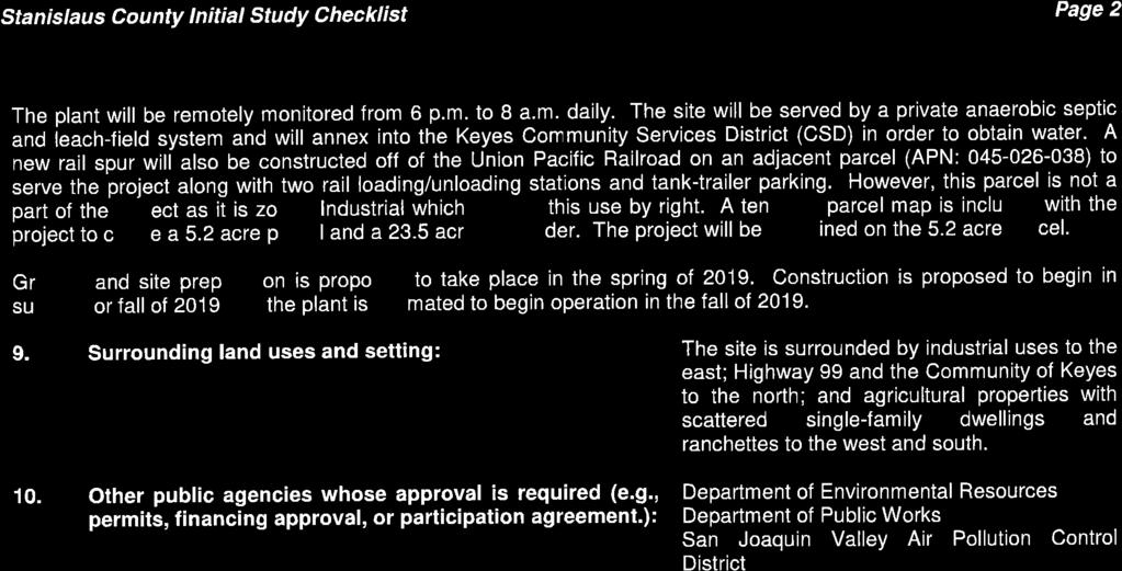
152 13
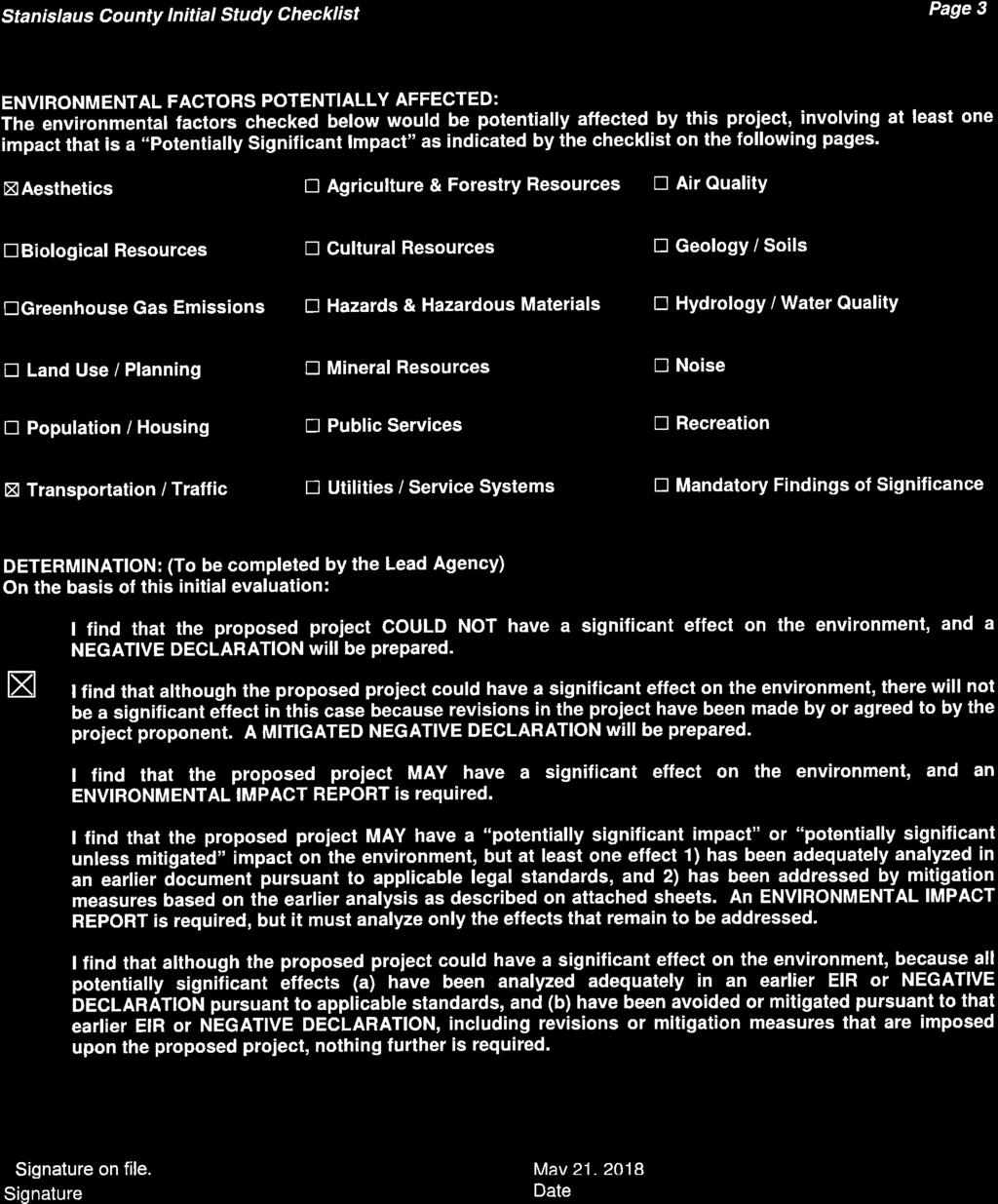
153 14
154 15
155 16
156 17
157 18
158 19
159 20
160 21
161 22
162 23
163 24
164 25
165 26
166 27
167 28
168 29
169 30
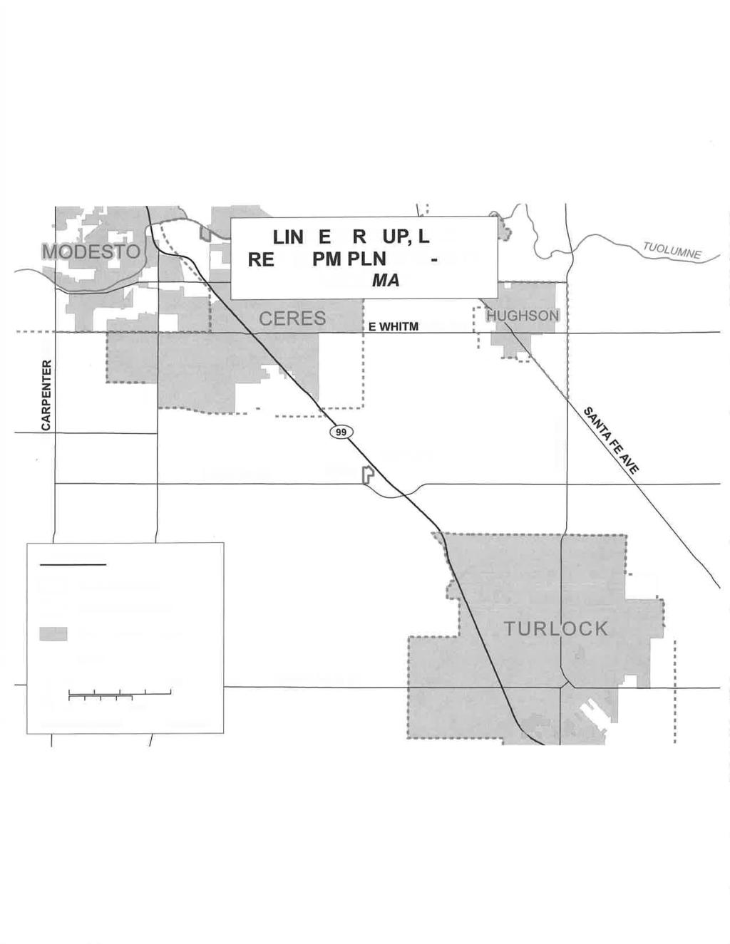
170 31
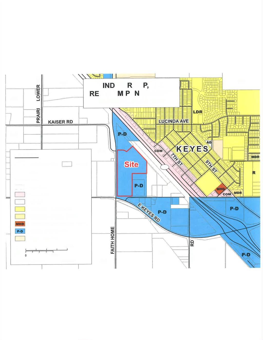
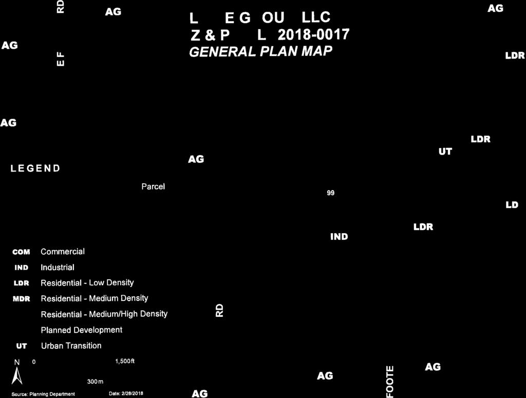

171 32
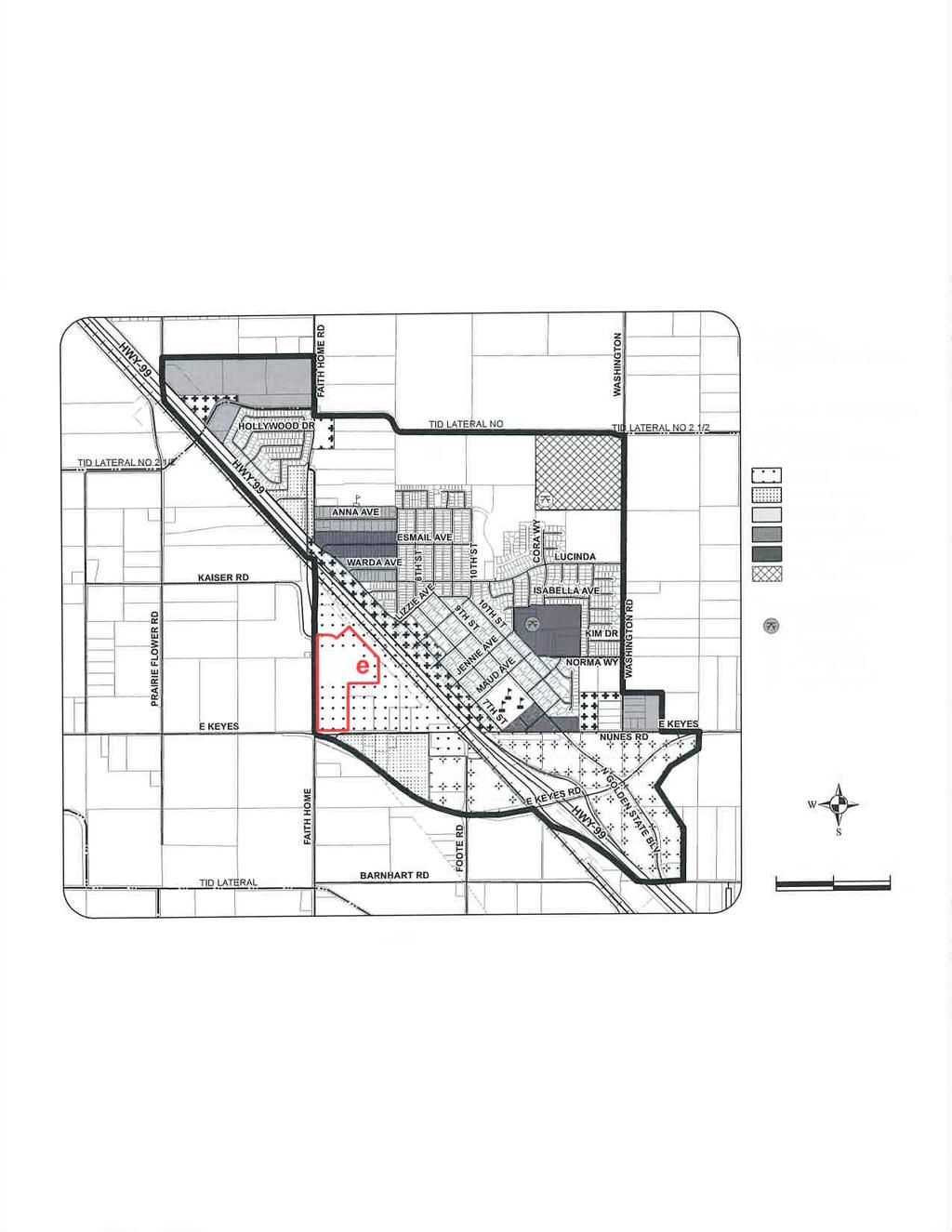
172 33
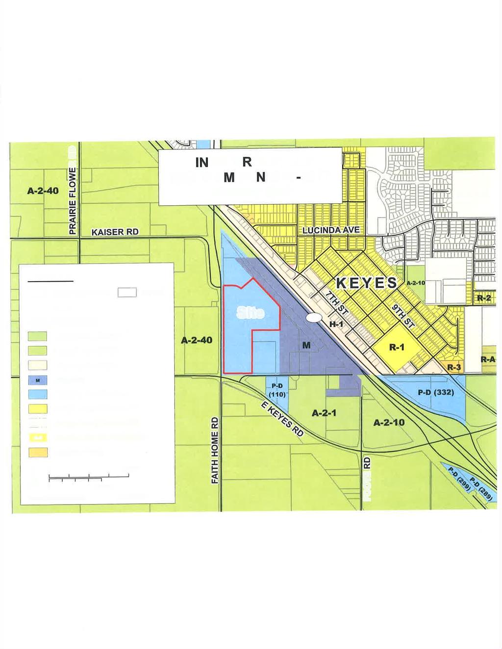

173 34

174 35

175 36
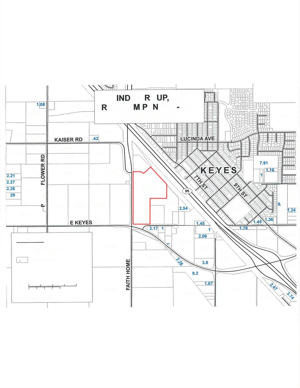

176 37
177 38
178 39
179 40
180 41
181 42
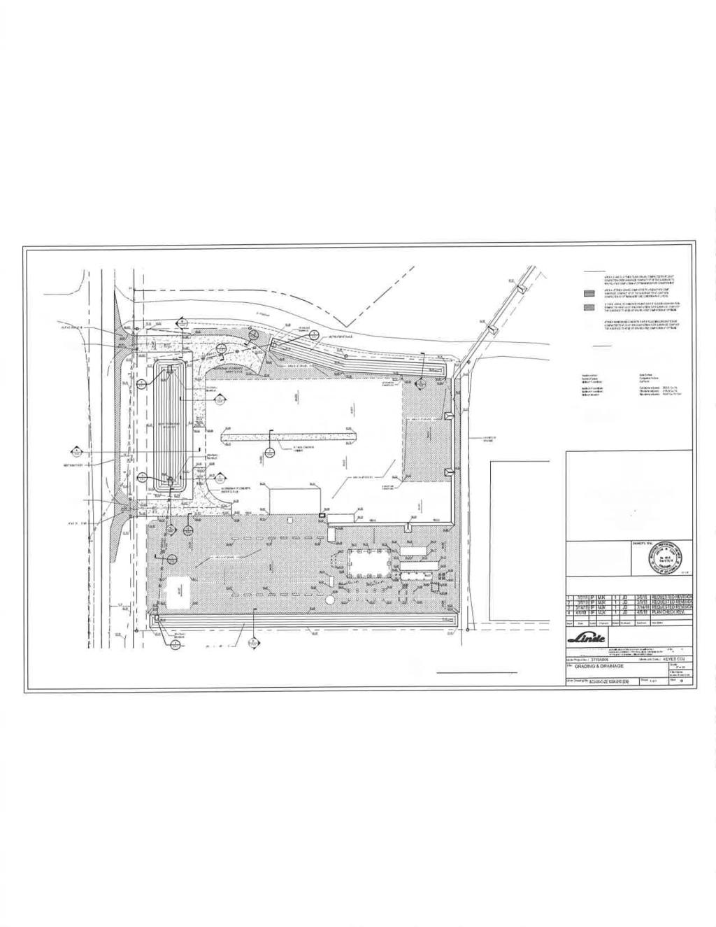
182 43
183 44
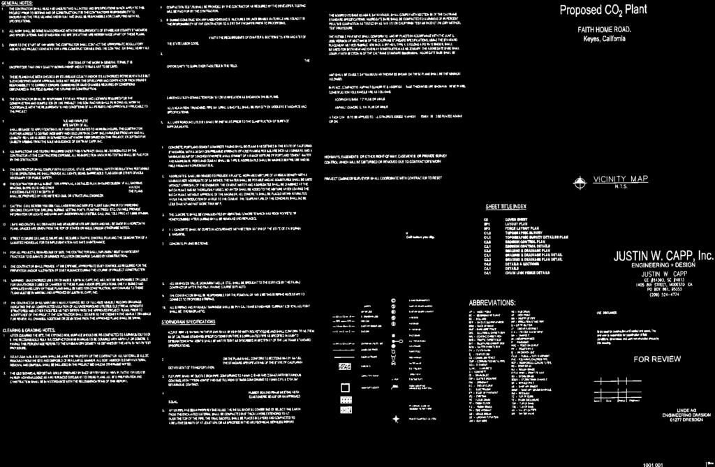
184 45
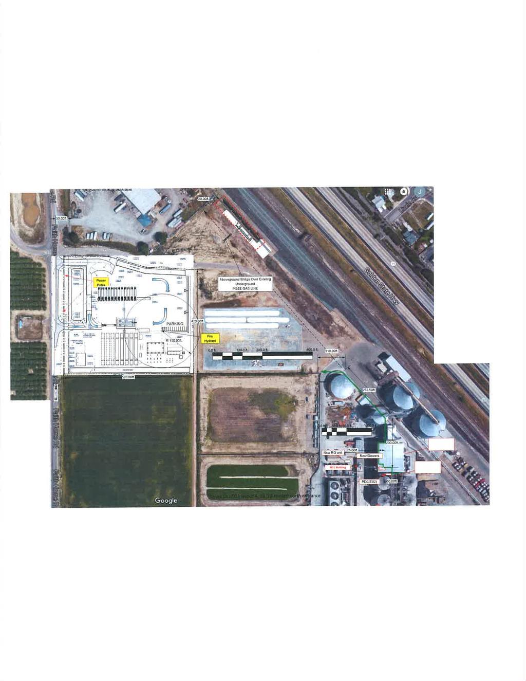

185 46
186 47

187 48
188 49
189 50
190 51
191 52
192 53
193 54
194 55
195 56

196 57

197 58
198 EXHIBIT C LAFCO Resolution No
199 STANISLAUS COUNTY LOCAL AGENCY FORMATION COMMISSION RESOLUTION DATE: March 27, 2019 NO SUBJECT: LAFCO Application No Linde Change of Organization to Keyes Community Services District On the motion of Commissioner, seconded by Commissioner, and approved by the following vote: Ayes: Noes: Absent: Ineligible: Commissioners: Commissioners: Commissioners: Commissioners: THE FOLLOWING RESOLUTION WAS ADOPTED: WHEREAS, the applicant has requested to annex 5.2 acres located on the east side of Faith Home Road into the Keyes Community Services District that is within its existing Sphere of Influence; WHEREAS, the Keyes Community Services District is the applicant and is willing to provide water service to the project site; WHEREAS, the Commission has conducted a public hearing to consider the proposal on March 27, 2019, and notice of said hearing was given at the time and in the form and manner provided by law; WHEREAS, the territory is considered uninhabited as it contains less than 12 registered voters; WHEREAS, the purpose of the proposal is to allow the subject territory to receive water service from the Keyes Community Services District; WHEREAS, Stanislaus County, as Lead Agency, prepared and subsequently approved Mitigated Negative Declarations for the proposal in compliance with the California Environmental Quality Act (CEQA); WHEREAS, in the form and manner provided by law pursuant to Government Code Sections and 56157, the Executive Officer has given notice of the public hearing by the Commission on this matter; and WHEREAS, the Commission has, in evaluating the proposal, considered the report submitted by the Executive Officer, which included determinations and factors set forth in Government Code Sections and 56668, and any testimony and evidence presented at the meeting held on March 27,
200 LAFCO Resolution No March 27, 2019 Page 2 WHEREAS, proceedings for adoption and amendment of a Sphere of Influence are governed by the Cortese-Knox-Hertzberg local Government Reorganization Act, Section et seq. of the Government Code; NOW, THEREFORE, BE IT RESOLVED that the Commission: 1. Certifies, in accordance with CEQA, as a Responsible Agency, that it has considered the Mitigated Negative Declarations prepared by Stanislaus County. 2. Determines that: (a) the subject territory is within the Keyes Community Services District s Sphere of Influence; (b) approval of the proposal is consistent with all applicable spheres of influence, overall Commission policies and local general plans; (c) there are less than twelve (12) registered voters within the territory and it is considered uninhabited; (d) all the owners of land within the subject territory have given their written consent to the annexation; (e) no subject agencies have submitted written protest to a waiver of protest proceedings; and (f) the proposal is in the interest of the landowners within the territory. 3. Approves the proposal subject to the following terms and conditions: a. The applicant shall pay State Board of Equalization fees, pursuant to Government Code Section b. The applicant agrees to defend, hold harmless and indemnify LAFCO and/or its agents, officers and employees from any claim, action or proceeding brought against any of them, the purpose of which is to attack, set aside, void or annul LAFCO s action on a proposal or any action relating to or arising out of such approval, and provide for the reimbursement or assumption of all legal costs in connection with that approval. c. In accordance with Government Code Sections 56886(t) and 57330, the subject territory shall be subject to the levying and collection of all previously authorized charges, fees, assessments or taxes of the Keyes Community Services District. d. The effective date of the change of organization shall be the date of recordation of the Certificate of Completion. e. The application submitted has been processed as a change of organization consisting of annexation to the Keyes Community Services District. 4. Designates the proposal as the Linde Change of Organization to the Keyes Community Services District. 5. Waives the protest proceedings pursuant to Government Code Section 56662(d) and orders the change of organization subject to the requirements of Government Code Section et. seq. 61
201 LAFCO Resolution No March 27, 2019 Page 3 6. Authorizes and directs the Executive Officer to prepare and execute a Certificate of Completion in accordance with Government Code Section 57203, upon receipt of a map and legal description prepared pursuant to the requirements of the State Board of Equalization and accepted to form by the Executive Officer, subject to the specified terms and conditions. ATTEST: Sara Lytle-Pinhey Executive Officer 62
202 MEMORANDUM DATE: March 27, 2019 TO: FROM: LAFCO Commissioners Sara Lytle-Pinhey, Executive Officer SUBJECT: Biennial Audit for Fiscal Years and RECOMMENDATION It is recommended that the Commission accept and file the financial audit for fiscal years and DISCUSSION The Commission s outside audit firm, Johnson & Associates CPAs, Inc., has completed the LAFCO biennial audit for fiscal years and The purpose of the biennial audit is for an independent third-party to review and assess the Commission s financial records to determine their compliance with generally accepted governmental accounting standards. LAFCO currently contracts with the County Auditor- Controller Office for financial services and maintains its funds in the County Treasury, pursuant to an adopted Memorandum of Understanding. The outside audit provides an opportunity for a third-party to identify reporting errors and omissions as well as to make suggestions for improvements. As with the prior audits, the auditor found that the financial statements present fairly the financial position of the Commission. The auditor made a recommendation for strengthening internal controls related to transactions initiated by the County. This is currently being implemented. The biennial audit is attached in full to this memo. Attachment: Financial Audit for Fiscal Years and
203 This page intentionally left blank.
204
205
206
207
208
209
210
211
212
213
214
215
216
217
218
219
220
221
222
223
224
225
226
227
228
229
230
231
232
233
234
235
236
237
238
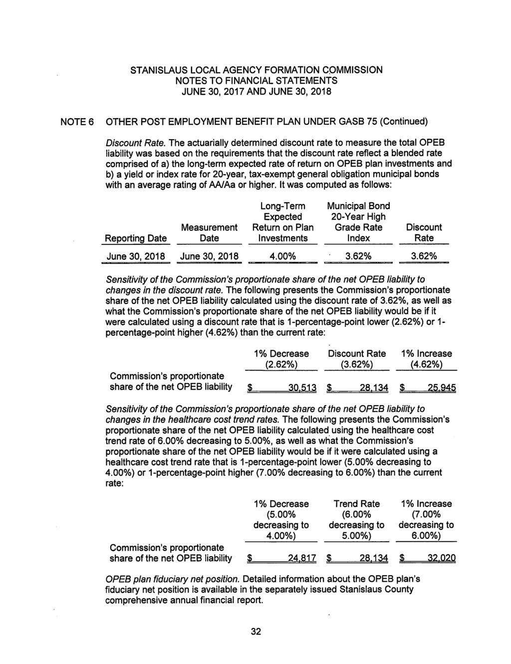
239
240
241
242
243
244
245
246
247
248
249
250
251
252
253
254
255
256
257
258
259 EXECUTIVE OFFICER S AGENDA REPORT MARCH 27, 2019 TO: FROM: SUBJECT: LAFCO Commissioners Sara Lytle-Pinhey, Executive Officer PROPOSED AMENDMENT TO COMMISSION POLICY 22 AGRICULTURAL PRESERVATION POLICY RECOMMENDATION Staff recommends that the Commission approve and adopt an amendment to Policy 22 Agricultural Preservation Policy related to collection of in-lieu fees, when used as an agricultural preservation strategy. BACKGROUND Staff received a letter from the Keith J. Schneider of the Keystone Corporation requesting a technical amendment to LAFCO s Agricultural Preservation Policy (attached as Exhibit A). Staff shared Mr. Schneider s request with the Commission and received direction to bring back a proposed amendment for their consideration. DISCUSSION The Commission s current Policy states that in-lieu fees are to be collected before the issuance of a grading permit, building permit, or final map approval, whichever comes first (emphasis added). The proposed amendment removes the whichever comes first constraint and adds a plural option to recognize that in-lieu fees could potentially be spread over multiple building permits. A copy of the proposed policy amendment is attached in full as Exhibit B. The whichever comes first phrase was originally included in the Commission s Policy following example language from Santa Clara LAFCO and the City of Hughson. A breakdown of how other entities with agricultural preservation policies treat the timing of collection of fees is attached as Exhibit C. Of note, Yolo LAFCO, Stanislaus County, and San Joaquin County also tie mitigation collection to various development-related permits, but they do not include the more restrictive, whichever comes first phrase. Staff believes the more restrictive language was likely included in these policies to ensure that the in-lieu fees were paid as near-to the impact or development as possible. However, in practice, it is not uncommon for mitigation fees to be divided and collected upon the issuance of individual permits. Removal of this restriction from LAFCO s policy will allow cities additional flexibility regarding when and how in-lieu fees are collected, should they be used as the selected agricultural preservation strategy. Comments from Interested Agencies Staff conducted preliminary outreach with the planning directors from the nine cities, the County, as well as representatives from the California Farmland Trust. A request for comments was also sent out to interested parties and agencies on February 6 th. correspondence was received from Denny Jackman, a Board Director for the California Farmland Trust, who suggested that LAFCO Staff request updates from cities that are in the 1
260 AMENDMENT TO POLICY 22 IN-LIEU FEE TIMING MARCH 27, 2019 PAGE 2 process of collecting in-lieu fees. Mr. Jackman also provided a spreadsheet that cities could use to track the information. Individual cities are responsible for tracking and ensuring collection of in-lieu fees. However, follow-up reports, while not required, would be of interest to the Commission. The Stanislaus County Environmental Review Committee submitted a letter indicating it had no comment on the proposed amendment. No other written comments have been received as of the drafting of this report. Environmental Analysis Staff has determined that there is no possibility that the proposed amendment to the Agricultural Preservation Policy will have a significant effect on the environment. It is therefore found to be exempt from the California Environmental Quality Act (CEQA) pursuant to Section 15061(b)(3) of the State Guidelines. The proposed amendment is minor in nature and serves to clarify that in-lieu fees may be collected at the time of building permit issuance. The proposed amendment is consistent with the Cortese-Knox-Hertzberg Act (Government Code Section et. seq.), which requires LAFCOs to consider the effects that a proposal may have on agricultural lands (Government Code Sections and 56668(e)). Further, annexation and sphere of influence proposals brought forth to LAFCO are subject to their own stand-alone CEQA review, which evaluates proposals on a site-by-site and case-by-case basis. A Notice of Exemption is the appropriate environmental document and has been drafted for filing should the Commission approve the proposal (Exhibit D). CONCLUSION Staff recommends that the Commission, following the public hearing and consideration of all relevant information presented, approve the proposed update and adopt Resolution (attached as Exhibit E), which: 1. Finds that the proposed Policy and Procedures amendment is consistent with State Law as well as the overall goals of LAFCO; 2. Finds that the proposed Policy and Procedures amendment is exempt for the purposes of the California Environmental Quality Act (CEQA) pursuant to Section 15061(b)(3); and, 3. Adopts the proposed Policy and Procedures amendment to be effective immediately. Attachments: Exhibit A: Letter from Keith J. Schneider, Keystone Corporation Exhibit B: Proposed Amendment to Policy 22 Agricultural Preservation Policy Exhibit C: Comparison Chart - Timing of In-Lieu Fees Exhibit D: Draft Notice of Exemption Exhibit E: Draft LAFCO Resolution
261 EXHIBIT A Letter from Keith J. Schneider, Keystone Corporation 3
262 This page intentionally left blank. 4
263 5
264 This page intentionally left blank. 6
265 EXHIBIT B Proposed Amendment to Policy 22 Agricultural Preservation Policy 7
266 This page intentionally left blank. 8
267 Proposed amendments are shown as bold and double-underlined text on page 3. Stanislaus LAFCO POLICY 22 - AGRICULTURAL PRESERVATION POLICY Agriculture is a vital and essential part of the Stanislaus County economy and environment. Accordingly, boundary changes for urban development should only be proposed, evaluated, and approved in a manner which, to the fullest extent feasible, is consistent with the continuing growth and vitality of agriculture within the County. LAFCO s mission is to discourage urban sprawl, preserve open space and prime agricultural lands, promote the efficient provision of government services and encourage the orderly formation of local agencies. Additionally, Government Code Section 56668(e) requires LAFCO to consider the effect of the proposal on maintaining the physical and economic integrity of agricultural lands. Consistent with the legislative intent of LAFCO, the goals of this policy are as follows: Guide development away from agricultural lands where possible and encourage efficient development of existing vacant lands and infill properties within an agency s boundaries prior to conversion of additional agricultural lands. Fully consider the impacts a proposal will have on existing agricultural lands. Minimize the conversion of agricultural land to other uses. Promote preservation of agricultural lands for continued agricultural uses while balancing the need for planned, orderly development and the efficient provision of services. The Commission encourages local agencies to identify the loss of agricultural land as early in their processes as possible, and to work with applicants to initiate and execute plans to minimize that loss, as soon as feasible. Agencies may also adopt their own agricultural preservation policies, consistent with this Policy, in order to better meet their own local circumstances and processes. The Commission shall consider this Agricultural Preservation Policy, in addition to its existing goals and policies, as an evaluation standard for review of those proposals that could reasonably be expected to induce, facilitate, or lead to the conversion of agricultural land. A. Plan for Agricultural Preservation Requirement Upon application for a sphere of influence expansion or annexation to a city or special district ( agency ) providing one or more urban services (i.e. potable water, sewer services) that includes agricultural lands, a Plan for Agricultural Preservation must be provided with the application to LAFCO. The purpose of a Plan for Agricultural Preservation is to assist the Commission in determining how a proposal meets the stated goals of this Policy. The Plan for Agricultural Preservation shall include: a detailed analysis of direct and indirect impacts to agricultural resources on the site and surrounding area, including a detailed description of the agricultural resources affected and information regarding Williamson Act Lands; a vacant land inventory and absorption study evaluating lands Public Review Draft (Feb. 6, 2019) Page 1 9
268 within the existing boundaries of the jurisdiction that could be developed for the same or similar uses; existing and proposed densities (persons per acre); relevant County and City General Plan policies and specific plans; consistency with regional planning efforts (e.g. the San Joaquin Valley Blueprint and the Sustainable Communities Strategy); and an analysis of mitigation measures that could offset impacts to agricultural resources. The Plan for Agricultural Preservation should be consistent with documentation prepared by the Lead Agency in accordance with the California Environmental Quality Act (CEQA). The Plan for Agricultural Preservation shall specify the method or strategy proposed to minimize the loss of agricultural lands. The Commission encourages the use of one or more of the following strategies: 1. Removal of agricultural lands from the existing sphere of influence in order to offset, in whole or in part, a proposed sphere of influence expansion or redirection. 2. An adopted policy or condition requiring agricultural mitigation at a ratio of at least 1:1. This can be achieved by acquisition and dedication of agricultural land, development rights and/or conservation easements to permanently protect agricultural land, or payment of in-lieu fees to an established, qualified, mitigation program to fully fund the acquisition and maintenance of such agricultural land, development rights or easements, consistent with Section B-2 of this Policy. a. In recognition of existing County policies applicable to agricultural land conversions in the unincorporated areas, as well as the goals of individual agencies to promote employment growth to meet the stated needs of their communities, an agency may select to utilize a minimum of 1:1 mitigation for conversions to residential uses. b. Agricultural mitigation easements or offsets shall not be required for any annexations of land for commercial or industrial development. 3. A voter-approved urban growth boundary designed to limit the extent to which urban development can occur during a specified time period. B. Commission Evaluation of a Plan for Agricultural Preservation 1. The Commission may consider approval of a proposal that contains agricultural land when it determines that there is sufficient evidence within the Plan for Agricultural Preservation that demonstrates all of the following: a. Insufficient alternative land is available within the existing sphere of influence or boundaries of the agency and, where possible, growth has been directed away from prime agricultural lands towards soils of lesser quality. b. For sphere of influence proposals, that the additional territory will not exceed the twenty year period for probable growth and development (or ten years within a proposed primary area of influence). For annexation proposals, that the development is imminent for all or a substantial portion of the proposal area. c. The loss of agricultural lands has been minimized based on the selected agricultural preservation strategy. For the purposes of making the determination in this section, the term minimize shall mean to allocate no more Public Review Draft (Feb. 6, 2019) Page 2 10
269 agricultural land to non-agricultural uses than what is reasonably needed to accommodate the amount and types of development anticipated to occur. d. The proposal will result in planned, orderly, and efficient use of land and services. This can be demonstrated through mechanisms such as: i. Use of compact urban growth patterns and the efficient use of land that result in a reduced impact to agricultural lands measured by an increase over the current average density within the agency s boundaries (e.g. persons per acre) by the proposed average density of the proposal area. ii. Use of adopted general plan policies, specific or master plans and project phasing that promote planned, orderly, and efficient development. 2. For those proposals utilizing agricultural mitigation lands or in-lieu fees, the Commission may approve a proposal only if it also determines all of the following: C. Exceptions a. The mitigation lands must be of equal or better soil quality, have a dependable and sustainable supply of irrigation water, and be located within Stanislaus County. b. An adopted ordinance or resolution has been submitted by the agency confirming that mitigation has occurred, or requires the applicant to have the mitigation measure in place before the issuance of a grading permit, building permit(s), or final map approval for the site, whichever comes first. c. The agricultural conservation entity is a city or a public or non-profit agency that: has the legal and technical ability to hold and administer agricultural preservation easements and in-lieu fees for the purposes of conserving and maintaining lands in agricultural production; and has adopted written standards, policies and practices (such as the Land Trust Alliance s Standards and Practices ) and is operating in compliance with those standards. d. The agricultural mitigation land is not already effectively encumbered by a conservation easement of any nature. e. Proposed in-lieu fees shall fully fund the costs associated with acquiring and managing an agricultural conservation easement, including the estimated transaction costs and the costs of administering, monitoring and enforcing the easement. Should the proposed in-lieu fees be less than 35% of the average per acre price for five (5) comparable land sales in Stanislaus County, plus a 5% endowment, the applicant shall provide evidence that the lesser amount will in fact achieve the stated agricultural mitigation goals. The following applications are considered exempt from the requirement for a Plan for Agricultural Preservation and its implementation, unless determined otherwise by the Commission: 1. Proposals consisting solely of the inclusion of lands owned by a city or special district and currently used by that agency for public uses. Public Review Draft (Feb. 6, 2019) Page 3 11
270 2. Proposals which have been shown to have no significant impact to agricultural lands, including, but not limited to: DEFINITIONS a. Proposals consisting solely of lands which are substantially developed with urban uses. b. Proposals brought forth for the purpose of providing irrigation water to agricultural lands. Agricultural Conservation Easement: An easement over agricultural land for the purpose of restricting its use to agriculture. The interest granted pursuant to an agricultural conservation easement is an interest in land which is less than fee simple. Agricultural conservation easements acquired shall be established in perpetuity (or shall be permanently protected from future development via enforceable deed restriction). Agricultural Lands: Land currently used for the purpose of producing an agricultural commodity for commercial purposes, land left fallow under crop rotational program, or land enrolled in an agricultural subsidy or set-aside program (Government Code Section 56016). As used in this section, agricultural lands also includes those lands defined in Government Code Section as prime agricultural land and those lands identified as prime farmland, farmland of statewide importance, and unique farmland as part of the California Department of Conservation s Farmland Mapping and Monitoring Program. Agricultural Mitigation Land: Agricultural land encumbered by an agricultural conservation easement or other conservation mechanism acceptable to LAFCO. Primary Area of Influence: The area around a local agency within which territory is eligible for annexation and the extension of urban services within a ten year period. Prime Agricultural Land: An area of land, whether a single parcel or contiguous parcels, that has not been developed for a use other than an agricultural use and that meets any of the following qualifications: (a) Land that qualifies, if irrigated, for rating as class I or class II in the USDA Natural Resources Conservation Service land use capability classification, whether or not the land is actually irrigated, provided that irrigation is feasible. (b) Land that qualifies for rating 80 through 100 Storie Index Rating. (c) Land that supports livestock used for the production of food and fiber and that has an annual carrying capacity equivalent to at least one animal unit per acre as defined by the United States Department of Agriculture in the National Range and Pasture Handbook, Revision 1, December (d) Land planted with fruit or nut-bearing trees, vines, bushes, or crops that have a nonbearing period of less than five years and that will return during the commercial bearing period on an annual basis from the production of unprocessed agricultural plant production not less than four hundred dollars ($400) per acre. Public Review Draft (Feb. 6, 2019) Page 4 12
271 (e) Land that has returned from the production of unprocessed agricultural plant products an annual gross value of not less than four hundred dollars ($400) per acre for three of the previous five calendar years (Government Code Section 56064). Sphere of Influence: A plan for the probable physical boundaries and service area of a local agency, as determined by the commission (Government Code Section 56076). The area around a local agency within which territory is eligible for annexation and the extension of urban services within a twenty year period. Public Review Draft (Feb. 6, 2019) Page 5 13
272 This page intentionally left blank. 14
273 EXHIBIT C Comparison Chart Timing of In-Lieu Fees 15
274 This page intentionally left blank. 16
275 Policy Comparison: Timing of In-Lieu Fees Stanislaus LAFCO (current language) An adopted ordinance or resolution has been submitted by the agency confirming that mitigation has occurred, or requires the applicant to have the mitigation measure in place before the issuance of a grading permit, building permit, or final map approval for the site, whichever comes first. Stanislaus County Final approval shall be obtained prior to any of the following: 1) the issuance of any building, grading or encroachment permit(s) required for development, 2) recording of any parcel or final subdivision map, or 3) operation of the approved use. Santa Clara LAFCO LAFCO prefers that agricultural mitigation be in place at the time of LAFCO approval or as soon as possible after LAFCO approval. The mitigation (as detailed in the Plan for Mitigation) should be fulfilled no later than at the time of city s approval of the final map, or issuance of a grading permit or building permit, whichever occurs first. Yolo LAFCO An adopted ordinance or resolution must be submitted confirming that mitigation has occurred, or requiring the applicant to have the mitigation measure in place before the issuance of a grading permit, a building permit or final map approval for the site. San Joaquin County Submission of the required legal instrument or payment of the in-lieu fee shall occur at the time of Grading Permit or Building Permit issuance. The in-lieu fee shall be updated annually based on an inflator that takes into account the inflation of property values City of Hughson Final approval of any project subject to this program shall be contingent upon the execution of any necessary legal instrument and/or payment of fees as specified by this program. Final approval shall be obtained prior to whichever of the following shall occur first: (1) the issuance of any building grading or encroachment permit(s) required for development; (2) recording of any parcel or final subdivision map; or (3) operation of the approved use. 17
276 This page intentionally left blank. 18
277 EXHIBIT D Draft Notice of Exemption 19
278 This page intentionally left blank. 20
279 CEQA NOTICE OF EXEMPTION TO: County Clerk-Recorder FROM: Stanislaus LAFCO Stanislaus County 1010 Tenth Street, 3 rd Floor 1021 I" Street Modesto, CA Modesto, CA (209) TITLE: STANISLAUS LOCAL AGENCY FORMATION COMMISSION AMENDMENT TO POLICY 22 - AGRICULTURAL PRESERVATION POLICY DESCRIPTION: Stanislaus LAFCO will consider an amendment to its existing Agricultural Preservation Policy (Policy 22 of the Commission s Policies and Procedures) regarding the timing of in-lieu fee collection if being used as an agricultural preservation strategy. The current Policy states fees are to be collected before the issuance of a grading permit, building permit, or final map approval, whichever comes first (emphasis added). The amendment would remove the whichever comes first constraint and add a plural option to recognize the in-lieu fee may be spread over multiple building permits. The proposed amendment is being made in accordance with the Cortese-Knox-Hertzberg Act (Government Code Section et. seq.), which requires LAFCOs to consider the effects that a proposal may have on agricultural lands (Government Code Sections and 56668(e)). LOCATION: Countywide PUBLIC AGENCY APPROVING PROJECT: Stanislaus Local Agency Formation Commission CONTACT PERSON: Sara Lytle-Pinhey, Executive Officer, (209) ENVIRONMENTAL DETERMINATION: In this case, it has been determined with certainty that there is no possibility that the policy amendment may have a significant effect on the environment and therefore it is found to be exempt from CEQA pursuant to Section 15061(b)(3) of the State Guidelines. The Local Agency Formation Commission will file this Notice of Exemption upon approval of the policy amendment. REASONS FOR EXEMPTION: LAFCO approval of such policies is encouraged under Government Code et seq. The policy amendment does not involve, authorize, or permit the construction of any facilities associated with any property. The policy amendment is minor in nature and serves to clarify the timing of collection of an in-lieu fee when used as an agricultural preservation strategy. It also allows for collection of an in-lieu fee to be spread over multiple building permits. Approval of this policy amendment has no possibility of affecting the environment directly or indirectly as LAFCO is not proposing the approval of any application or engaging in any activity. The Cortese-Knox-Hertzberg Act calls for LAFCO to discourage urban sprawl, preserve open space and prime agricultural lands, promote the efficient provision of government services and encourage the orderly formation of local agencies. The Act also requires LAFCOs to establish written policies and procedures to exercise its powers consistent with its purpose. The policy amendment is consistent with the intent of the Act. Signature: Name & Title: Sara Lytle-Pinhey, Executive Officer Date: 21
280 This page intentionally left blank. 22
281 EXHIBIT E Draft LAFCO Resolution
282 This page intentionally left blank. 24
283 STANISLAUS LOCAL AGENCY FORMATION COMMISSION RESOLUTION DATE: March 27, 2019 NO SUBJECT: Adoption of Amendment to Policy 22 - Agricultural Preservation Policy On the motion of Commissioner, seconded by Commissioner, and approved by the following: Ayes: Noes: Absent: Ineligible: Commissioners: Commissioners: Commissioners: Commissioners: THE FOLLOWING RESOLUTION WAS ADOPTED: WHEREAS, the Cortese-Knox-Hertzberg Local Government Reorganization Act (Government Code Section et seq.) is replete with provisions that grant to a Local Agency Formation Commission (LAFCO) the authority to consider and provide for the preservation of agricultural lands; WHEREAS, Section 56375(g) of the Government Code authorizes Stanislaus LAFCO to adopt procedures and standards for the evaluation of proposals, including the effect of a proposal on maintaining the physical and economic integrity of agricultural lands; WHEREAS, Stanislaus LAFCO has adopted Policies and Procedures in accordance with the Cortese-Knox-Hertzberg Local Government Reorganization Act and desires to adopt a policy to more specifically address preservation of agricultural lands; WHEREAS, the Commission conducted a noticed public hearing on March 27, 2019 to consider an amendment to the Commission s Policy 22 - Agricultural Preservation Policy ( Policy ); WHEREAS, the Commission has considered the written staff report and testimony and evidence presented at the public hearing held on March 27, 2019 regarding the proposed Policy amendment; WHEREAS, adoption of the Policy amendment is generally exempt from the California Environmental Quality Act (CEQA) pursuant to Guideline 15061(b)(3) as there is no substantial evidence that the proposed Policy will have a significant effect on the environment; and, WHEREAS, annexation and sphere of influence amendment proposals brought forth to LAFCO are subject to their own stand-alone CEQA review, which evaluates proposals on a site-by-site and case-by-case basis. 25
284 LAFCO Resolution No March 27, 2019 Page 2 NOW, THEREFORE, BE IT RESOLVED that this Commission: 1. Finds that the proposed Policy amendment is generally exempt from the California Environmental Quality Act (CEQA) pursuant to Guideline 15061(b)(3). 2. Directs the Executive Officer to file a Notice of Exemption with the Stanislaus County Clerk Recorders Office. 3. Finds that the proposed Policy amendment is consistent with the overall goals and policies of LAFCO. 4. Adopts the amendment to the Agricultural Preservation Policy, to be included in the Stanislaus LAFCO Policies and Procedures Manual, effective immediately. ATTEST: Sara Lytle-Pinhey Executive Officer Attachment 1: Proposed Amendment to Policy 22 - Agricultural Preservation Policy 26
285 LAFCO Resolution No March 27, 2019 Page 3 Attachment 1: Proposed amendments are shown as bold and double-underlined text. Stanislaus LAFCO POLICY 22 - AGRICULTURAL PRESERVATION POLICY Agriculture is a vital and essential part of the Stanislaus County economy and environment. Accordingly, boundary changes for urban development should only be proposed, evaluated, and approved in a manner which, to the fullest extent feasible, is consistent with the continuing growth and vitality of agriculture within the County. LAFCO s mission is to discourage urban sprawl, preserve open space and prime agricultural lands, promote the efficient provision of government services and encourage the orderly formation of local agencies. Additionally, Government Code Section 56668(e) requires LAFCO to consider the effect of the proposal on maintaining the physical and economic integrity of agricultural lands. Consistent with the legislative intent of LAFCO, the goals of this policy are as follows: Guide development away from agricultural lands where possible and encourage efficient development of existing vacant lands and infill properties within an agency s boundaries prior to conversion of additional agricultural lands. Fully consider the impacts a proposal will have on existing agricultural lands. Minimize the conversion of agricultural land to other uses. Promote preservation of agricultural lands for continued agricultural uses while balancing the need for planned, orderly development and the efficient provision of services. The Commission encourages local agencies to identify the loss of agricultural land as early in their processes as possible, and to work with applicants to initiate and execute plans to minimize that loss, as soon as feasible. Agencies may also adopt their own agricultural preservation policies, consistent with this Policy, in order to better meet their own local circumstances and processes. The Commission shall consider this Agricultural Preservation Policy, in addition to its existing goals and policies, as an evaluation standard for review of those proposals that could reasonably be expected to induce, facilitate, or lead to the conversion of agricultural land. A. Plan for Agricultural Preservation Requirement Upon application for a sphere of influence expansion or annexation to a city or special district ( agency ) providing one or more urban services (i.e. potable water, sewer services) that includes agricultural lands, a Plan for Agricultural Preservation must be provided with the application to LAFCO. The purpose of a Plan for Agricultural Preservation is to assist the Commission in determining how a proposal meets the stated goals of this Policy. The Plan for Agricultural Preservation shall include: a detailed analysis of direct and indirect impacts to agricultural resources on the site and surrounding area, including a detailed description of the agricultural resources affected and information regarding Williamson Act Lands; a vacant land inventory and absorption study evaluating lands within the existing 27
286 LAFCO Resolution No March 27, 2019 Page 4 boundaries of the jurisdiction that could be developed for the same or similar uses; existing and proposed densities (persons per acre); relevant County and City General Plan policies and specific plans; consistency with regional planning efforts (e.g. the San Joaquin Valley Blueprint and the Sustainable Communities Strategy); and an analysis of mitigation measures that could offset impacts to agricultural resources. The Plan for Agricultural Preservation should be consistent with documentation prepared by the Lead Agency in accordance with the California Environmental Quality Act (CEQA). The Plan for Agricultural Preservation shall specify the method or strategy proposed to minimize the loss of agricultural lands. The Commission encourages the use of one or more of the following strategies: 1. Removal of agricultural lands from the existing sphere of influence in order to offset, in whole or in part, a proposed sphere of influence expansion or redirection. 2. An adopted policy or condition requiring agricultural mitigation at a ratio of at least 1:1. This can be achieved by acquisition and dedication of agricultural land, development rights and/or conservation easements to permanently protect agricultural land, or payment of in-lieu fees to an established, qualified, mitigation program to fully fund the acquisition and maintenance of such agricultural land, development rights or easements, consistent with Section B-2 of this Policy. a. In recognition of existing County policies applicable to agricultural land conversions in the unincorporated areas, as well as the goals of individual agencies to promote employment growth to meet the stated needs of their communities, an agency may select to utilize a minimum of 1:1 mitigation for conversions to residential uses. b. Agricultural mitigation easements or offsets shall not be required for any annexations of land for commercial or industrial development. 3. A voter-approved urban growth boundary designed to limit the extent to which urban development can occur during a specified time period. B. Commission Evaluation of a Plan for Agricultural Preservation 1. The Commission may consider approval of a proposal that contains agricultural land when it determines that there is sufficient evidence within the Plan for Agricultural Preservation that demonstrates all of the following: a. Insufficient alternative land is available within the existing sphere of influence or boundaries of the agency and, where possible, growth has been directed away from prime agricultural lands towards soils of lesser quality. b. For sphere of influence proposals, that the additional territory will not exceed the twenty year period for probable growth and development (or ten years within a proposed primary area of influence). For annexation proposals, that the development is imminent for all or a substantial portion of the proposal area. c. The loss of agricultural lands has been minimized based on the selected agricultural preservation strategy. For the purposes of making the determination in this section, 28
287 LAFCO Resolution No March 27, 2019 Page 5 the term minimize shall mean to allocate no more agricultural land to non-agricultural uses than what is reasonably needed to accommodate the amount and types of development anticipated to occur. d. The proposal will result in planned, orderly, and efficient use of land and services. This can be demonstrated through mechanisms such as: i. Use of compact urban growth patterns and the efficient use of land that result in a reduced impact to agricultural lands measured by an increase over the current average density within the agency s boundaries (e.g. persons per acre) by the proposed average density of the proposal area. ii. Use of adopted general plan policies, specific or master plans and project phasing that promote planned, orderly, and efficient development. 2. For those proposals utilizing agricultural mitigation lands or in-lieu fees, the Commission may approve a proposal only if it also determines all of the following: C. Exceptions a. The mitigation lands must be of equal or better soil quality, have a dependable and sustainable supply of irrigation water, and be located within Stanislaus County. b. An adopted ordinance or resolution has been submitted by the agency confirming that mitigation has occurred, or requires the applicant to have the mitigation measure in place before the issuance of a grading permit, building permit(s), or final map approval for the site, whichever comes first. c. The agricultural conservation entity is a city or a public or non-profit agency that: has the legal and technical ability to hold and administer agricultural preservation easements and in-lieu fees for the purposes of conserving and maintaining lands in agricultural production; and has adopted written standards, policies and practices (such as the Land Trust Alliance s Standards and Practices ) and is operating in compliance with those standards. d. The agricultural mitigation land is not already effectively encumbered by a conservation easement of any nature. e. Proposed in-lieu fees shall fully fund the costs associated with acquiring and managing an agricultural conservation easement, including the estimated transaction costs and the costs of administering, monitoring and enforcing the easement. Should the proposed in-lieu fees be less than 35% of the average per acre price for five (5) comparable land sales in Stanislaus County, plus a 5% endowment, the applicant shall provide evidence that the lesser amount will in fact achieve the stated agricultural mitigation goals. The following applications are considered exempt from the requirement for a Plan for Agricultural Preservation and its implementation, unless determined otherwise by the Commission: 29
288 LAFCO Resolution No March 27, 2019 Page 6 1. Proposals consisting solely of the inclusion of lands owned by a city or special district and currently used by that agency for public uses. 2. Proposals which have been shown to have no significant impact to agricultural lands, including, but not limited to: DEFINITIONS a. Proposals consisting solely of lands which are substantially developed with urban uses. b. Proposals brought forth for the purpose of providing irrigation water to agricultural lands. Agricultural Conservation Easement: An easement over agricultural land for the purpose of restricting its use to agriculture. The interest granted pursuant to an agricultural conservation easement is an interest in land which is less than fee simple. Agricultural conservation easements acquired shall be established in perpetuity (or shall be permanently protected from future development via enforceable deed restriction). Agricultural Lands: Land currently used for the purpose of producing an agricultural commodity for commercial purposes, land left fallow under crop rotational program, or land enrolled in an agricultural subsidy or set-aside program (Government Code Section 56016). As used in this section, agricultural lands also includes those lands defined in Government Code Section as prime agricultural land and those lands identified as prime farmland, farmland of statewide importance, and unique farmland as part of the California Department of Conservation s Farmland Mapping and Monitoring Program. Agricultural Mitigation Land: Agricultural land encumbered by an agricultural conservation easement or other conservation mechanism acceptable to LAFCO. Primary Area of Influence: The area around a local agency within which territory is eligible for annexation and the extension of urban services within a ten year period. Prime Agricultural Land: An area of land, whether a single parcel or contiguous parcels, that has not been developed for a use other than an agricultural use and that meets any of the following qualifications: (a) Land that qualifies, if irrigated, for rating as class I or class II in the USDA Natural Resources Conservation Service land use capability classification, whether or not the land is actually irrigated, provided that irrigation is feasible. (b) Land that qualifies for rating 80 through 100 Storie Index Rating. (c) Land that supports livestock used for the production of food and fiber and that has an annual carrying capacity equivalent to at least one animal unit per acre as defined by the United States Department of Agriculture in the National Range and Pasture Handbook, Revision 1, December (d) Land planted with fruit or nut-bearing trees, vines, bushes, or crops that have a nonbearing period of less than five years and that will return during the commercial bearing period on an 30
289 LAFCO Resolution No March 27, 2019 Page 7 annual basis from the production of unprocessed agricultural plant production not less than four hundred dollars ($400) per acre. (e) Land that has returned from the production of unprocessed agricultural plant products an annual gross value of not less than four hundred dollars ($400) per acre for three of the previous five calendar years (Government Code Section 56064). Sphere of Influence: A plan for the probable physical boundaries and service area of a local agency, as determined by the commission (Government Code Section 56076). The area around a local agency within which territory is eligible for annexation and the extension of urban services within a twenty year period. 31
290 EXECUTIVE OFFICER S AGENDA REPORT MARCH 27, 2019 TO: FROM: SUBJECT: LAFCO Commissioners Sara Lytle-Pinhey, Executive Officer TERMINATION OF DISSOLUTION PROCEEDINGS FOR RECLAMATION DISTRICT NUMBERS 1602, 2031, AND 2101 RECOMMENDATION Staff recommends that, in accordance with Government Code section and based on information received since the January 23, 2019 Commission meeting, the Commission adopt Resolution (Exhibit A) terminating dissolution proceedings for the following districts originally identified by the State Controller s Office as being inactive: Reclamation District No (Del Puerto aka Patterson Ranch), Reclamation District No (Elliot), and Reclamation District No (Blewett). DISCUSSION In 2017, the Governor signed Senate Bill 448 which defines inactive districts and requires the State Controller s Office to annually publish a list of these districts with notification given to LAFCOs. LAFCOs are then required to adopt a resolution to initiate dissolution proceedings of the inactive districts within 90 days. The Commission must then hold a public hearing for the dissolution within an additional 90 days, unless evidence is provided that would otherwise qualify the districts as active. On November 9, 2018, Stanislaus LAFCO received a notice from the State Controller s Office identifying three reclamation districts in Stanislaus County as inactive and eligible for dissolution (attached as Exhibit B). Government Code section defines an inactive district as meeting all the following: a. The special district is as defined in Section (within LAFCO s purview for changes of organization). b. The special district has had no financial transactions in the previous fiscal year. c. The special district has no assets and liabilities. d. The special district has no outstanding debts, judgements, litigation, contracts, liens, or claims. As required by statute, the Commission adopted a resolution on January 23, 2019 to initiate dissolution proceedings. Since the January meeting, Staff has continued outreach and research efforts with the three districts, as well as the Central Valley Flood Protection Board (CVFPB, formerly known as the Reclamation Board). The CVFPB is the regulatory authority for flood control activities in the Central Valley. CVFPB also serves as the local sponsor to the Corps of Engineers on Federal flood control projects, cost shares in projects, holds title or easements to the lands underlying projects and inspects the operations and maintenance of facilities. 1
291 Termination of Dissolution Proceedings March 27, 2019 Page 2 The following additional documents have been obtained since the January 23, 2019 meeting and are attached to this report as Exhibits C through E: Letter from Reclamation District No dated January 17, 2019 (received after the Commission s January meeting) with a copy of a recent financial transaction for the District Letter from the CVFPB dated March 14, 2019 regarding Reclamation Districts 1602, 2031, and 2101 An example maintenance agreement (for Reclamation District No. 2031) The CVFPB letter dated March 14, 2019 identifies that the agency has ongoing maintenance agreements with each reclamation district, that each is conducting regular maintenance of their respective areas that are inspected annually. Within the maintenance agreements, each reclamation district (or local maintaining agency) assumes obligation of maintenance and operation of flood control project works. Staff reviewed this additional documentation with LAFCO Counsel and has been advised that the reclamation districts do not meet the criteria for inactive districts, pursuant to Government Code section Specifically, Reclamation District No has provided evidence of a financial transaction within the last year, disqualifying it from subsection b of the inactive definition. Further, the existence of ongoing maintenance agreements and obligations with CVFPB for all the districts disqualify them from subsection d of the inactive definition. CONCLUSION While the documentation disqualifies the districts as being inactive for the purposes of the dissolution process, the reclamation districts will remain responsible for functioning in accordance with all State laws as special districts, including filing their financial transaction reports with the State Controller. Staff recommends that the Commission adopt Resolution which determines the reclamation districts do not qualify as inactive, terminates dissolution proceedings, and directs the Executive Officer to provide notification to the State Controller of this determination. Attachments: Exhibit A: Draft LAFCO Resolution Exhibit B: Letter from the State Controller s Office Dated November 6, 2018 Exhibit C: Letter from Reclamation District No Dated January 17, 2019 Exhibit D: Letter from Central Valley Flood Protection Board Dated March 14, 2019 Exhibit E: Maintenance Agreement for Reclamation District No. 2031, dated February 20, 1964 Exhibit F: Map of Reclamation Districts 2
292 EXHIBIT A Draft LAFCO Resolution
293 This page intentionally left blank. 4
294 STANISLAUS COUNTY LOCAL AGENCY FORMATION COMMISSION RESOLUTION DATE: March 27, 2019 NO SUBJECT: Termination of Dissolution Proceedings for Inactive Reclamation District Numbers 1602, 2031, and 2101 On the motion of Commissioner, seconded by Commissioner, and approved by the following: Ayes: Noes: Absent: Ineligible: Commissioners: Commissioners: Commissioners: Commissioners: THE FOLLOWING RESOLUTION WAS ADOPTED: WHEREAS, on November 9, 2018, Stanislaus LAFCO received a letter from the State Controller s Office informing LAFCO that Reclamation District numbers 1602 (Del Puerto aka Patterson Ranch), 2031 (Elliot), and 2101 (Blewett) are eligible for dissolution pursuant to Government Code section 56879; WHEREAS, pursuant to Government Code Section 56879, the Commission initiated dissolution proceedings on January 23, 2019; WHEREAS, following the January 23, 2019 meeting, the Commission has received information that disqualifies the Districts from the definition of inactive, pursuant to Government Code Section 56036; and WHEREAS, the termination of dissolution proceedings is not subject to the California Environmental Quality Act (CEQA). NOW, THEREFORE, BE IT RESOLVED that the Commission: 1. Determines based on the information provided regarding the districts that the do not meet the definition of inactive, pursuant to Government Code Section Terminates dissolution proceedings for Reclamation District numbers 1602 (Del Puerto aka Patterson Ranch), 2031 (Elliot), and 2101 (Blewett). 3. Directs the Executive Officer to notify the State Controller s office of the Commission s determination. ATTEST: Sara Lytle-Pinhey Executive Officer 5
295 This page intentionally left blank. 6
296 EXHIBIT B Letter from State Controller s Office Dated November 6,
297 This page intentionally left blank. 8
298 9
299 10
300 11
301 12
302 EXHIBIT C Letter from Reclamation District No Dated January 17,
303 This page intentionally left blank. 14
304 15
305 16
306 EXHIBIT D Letter from the Central Valley Flood Protection Board Dated March 14,
307 This page intentionally left blank. 18
308 19
309 20
310 EXHIBIT E Maintenance Agreement for Reclamation District No dated February 20,
311 This page intentionally left blank. 22
312 23
313 24
314 25
315 26
316 EXHIBIT F Map of Districts 27
317 This page intentionally left blank. 28
 Source LAFCO files, County GIS, Jan.")
318 Reclamation District Numbers 1602, 2031, 2101 RD 2101 (Blewett) RD 2031 (Elliot) W GRAYSON RD HOWARD RD S CARPENTER RD WEST MAIN ST RD 1602 (Del Puerto / Patterson Ranch) Source LAFCO files, County GIS, Jan
LAFCO APPLICATION NO LINDE CHANGE OF ORGANIZATION TO KEYES COMMUNITY SERVICES DISTRICT
 EXECUTIVE OFFICER S AGENDA REPORT MARCH 27, 2019 TO: FROM: SUBJECT: LAFCO Commissioners Javier Camarena, Assistant Executive Officer LAFCO APPLICATION NO. 2019-01 LINDE CHANGE OF ORGANIZATION TO KEYES
Housing Affordability in California
 Housing Affordability in California Households with a High Housing Cost Burden: 2013 Definition: Estimated percentage of households that spend 30% or more of household income on housing costs. The U.S.
$ FACTS ABOUT CALIFORNIA: WAGE HOUSING MOST EXPENSIVE AREAS WAGE RANKING
 STATE #3 * RANKING In California, the Fair Market Rent () for a two-bedroom apartment is $1,699. In order this level of and utilities without paying more than 30% of income on housing a household must
STANISLAUS LAFCO LOCAL AGENCY FORMATION COMMISSION
 STANISLAUS LAFCO LOCAL AGENCY FORMATION COMMISSION Sara Lytle-Pinhey, Executive Officer 1010 10 th Street, Third Floor Modesto, California 95354 Phone: 209-525-7660 Fax: 209-525-7643 www.stanislauslafco.org
CALIFORNIA FORECLOSURE ACTIVITY MIXED
 CALIFORNIA FORECLOSURE ACTIVITY MIXED Foreclosure delays may be behind current peak in foreclosure activity Discovery Bay, CA, September 16, 2008 ForeclosureRadar (www.foreclosureradar.com), the only website
INVESTORS PURCHASE RECORD NUMBER OF FORECLOSURES AT AUCTION
 INVESTORS PURCHASE RECORD NUMBER OF FORECLOSURES AT AUCTION April Foreclosure Notices Drop from March Record Levels Discovery Bay, CA, May 12, 2009 ForeclosureRadar (www.foreclosureradar.com), the only
CONTRA COSTA LOCAL AGENCY FORMATION COMMISSION EXECUTIVE OFFICER'S REPORT August 12, 2015 (Agenda)
") CONTRA COSTA LOCAL AGENCY FORMATION COMMISSION EXECUTIVE OFFICER'S REPORT PROPONENTS ACREAGE & LOCATION Laurel Place/Pleasant View Annexation to the City of Concord Curt Blomstrand, Lenox Homes landowner/petitioner
CONTRA COSTA LOCAL AGENCY FORMATION COMMISSION EXECUTIVE OFFICER'S REPORT PROPONENTS ACREAGE & LOCATION Laurel Place/Pleasant View Annexation to the City of Concord Curt Blomstrand, Lenox Homes landowner/petitioner
LOCAL AGENCY FORMATION COMMISSION MEETING AGENDA *************************************************************************
 LOCAL AGENCY FORMATION COMMISSION MEETING AGENDA Wednesday, May 23, 2007 9:00 a.m. Room 381B Kenneth Hahn Hall of Administration 500 West Temple Street, Los Angeles 90012 *************************************************************************
U.S. DEPARTMENT OF HUD 03/25/2015 STATE:CALIFORNIA ADJUSTED HOME INCOME LIMITS
 Bakersfield-Delano, CA MSA Chico, CA MSA El Centro, CA MSA Fresno, CA MSA Hanford-Corcoran, CA MSA Los Angeles-Long Beach, CA HUD Metro FMR Area 30% LIMITS 17450 19950 22450 24900 26900 28900 30900 32900
U.S. DEPARTMENT OF HUD 01/22/2014 STATE:CALIFORNIA ADJUSTED HOME INCOME LIMITS
 Bakersfield-Delano, CA MSA Chico, CA MSA El Centro, CA MSA Fresno, CA MSA Hanford-Corcoran, CA MSA Los Angeles-Long Beach, CA HUD Metro FMR Area 30% LIMITS 17150 19600 22050 24450 26450 28400 30350 32300
U.S. DEPARTMENT OF HUD 04/11/2017 STATE: CALIFORNIA ADJUSTED HOME INCOME LIMITS
 Bakersfield, CA MSA Chico, CA MSA El Centro, CA MSA Fresno, CA MSA Hanford-Corcoran, CA MSA 30% LIMITS 13200 15050 16950 18800 20350 21850 23350 24850 VERY LOW INCOME 21950 25050 28200 31300 33850 36350
LAFCO FILE 4-R-14: Dissolution of County Service Area No. 17 (California Valley).
.") LAFCO FILE 4-R-14: Dissolution of County Service Area No. 17 (California Valley). DATE: November 20, 2014 RECOMMENDATION 1. Recommended Action on the Environmental Determination for the Dissolution: It
LAFCO FILE 4-R-14: Dissolution of County Service Area No. 17 (California Valley). DATE: November 20, 2014 RECOMMENDATION 1. Recommended Action on the Environmental Determination for the Dissolution: It
BUTTE LOCAL AGENCY FORMATION COMMISSION (LAFCO) EXECUTIVE OFFICER S REPORT. LAFCo File City of Chico Extension of Services 716 Oak Lawn Avenue
 EXECUTIVE OFFICER S REPORT. LAFCo File City of Chico Extension of Services 716 Oak Lawn Avenue") Agenda Item 4.4 BUTTE LOCAL AGENCY FORMATION COMMISSION (LAFCO) EXECUTIVE OFFICER S REPORT TO: FROM: SUBJECT: Local Agency Formation Commission Stephen Betts, Deputy Executive Officer LAFCo File 15-21
Agenda Item 4.4 BUTTE LOCAL AGENCY FORMATION COMMISSION (LAFCO) EXECUTIVE OFFICER S REPORT TO: FROM: SUBJECT: Local Agency Formation Commission Stephen Betts, Deputy Executive Officer LAFCo File 15-21
CONTRA COSTA LOCAL AGENCY FORMATION COMMISSION EXECUTIVE OFFICER'S REPORT. May 12, 2010 (Agenda)
") CONTRA COSTA LOCAL AGENCY FORMATION COMMISSION EXECUTIVE OFFICER'S REPORT LAFCO 10-01: Annexation 174 to Central Contra Costa Sanitary District (CCCSD) PROPONENT: CCCSD by Resolution No. 2009-027 adopted
CONTRA COSTA LOCAL AGENCY FORMATION COMMISSION EXECUTIVE OFFICER'S REPORT LAFCO 10-01: Annexation 174 to Central Contra Costa Sanitary District (CCCSD) PROPONENT: CCCSD by Resolution No. 2009-027 adopted
Fresno Local Agency Formation Commission Change of Organization/Reorganization Application
 Fresno Local Agency Formation Commission Change of Organization/Reorganization Application Not for use with update/revision to sphere of influence, city incorporation, or district formation. Contact LAFCo
HB , Appendix 5 PAGE 29 GUARANTEED HOUSING PROGRAM INCOME LIMITS
 HB - 1-3555, Appendix 5 PAGE 29 Bakersfield, CA MSA Chico, CA MSA El Centro, CA MSA Fresno, CA MSA VERY LOW INCOME 31300 31300 31300 31300 41300 41300 41300 41300 LOW INCOME 50100 50100 50100 50100 66150
BUTTE LOCAL AGENCY FORMATION COMMISSION (LAFCO) EXECUTIVE OFFICER S REPORT. LAFCo File City of Chico Extension of Services 16 Mayfair Drive
 EXECUTIVE OFFICER S REPORT. LAFCo File City of Chico Extension of Services 16 Mayfair Drive") Agenda Item 4.2 BUTTE LOCAL AGENCY FORMATION COMMISSION (LAFCO) EXECUTIVE OFFICER S REPORT TO: FROM: SUBJECT: Local Agency Formation Commission Stephen Lucas, Executive Officer LAFCo File 19-03 DATE: December
Agenda Item 4.2 BUTTE LOCAL AGENCY FORMATION COMMISSION (LAFCO) EXECUTIVE OFFICER S REPORT TO: FROM: SUBJECT: Local Agency Formation Commission Stephen Lucas, Executive Officer LAFCo File 19-03 DATE: December
BUTTE LOCAL AGENCY FORMATION COMMISSION (LAFCO) EXECUTIVE OFFICER S REPORT. LAFCo File City of Chico Extension of Services 1212 Glenwood Avenue
 EXECUTIVE OFFICER S REPORT. LAFCo File City of Chico Extension of Services 1212 Glenwood Avenue") Agenda Item 4.3 BUTTE LOCAL AGENCY FORMATION COMMISSION (LAFCO) EXECUTIVE OFFICER S REPORT TO: FROM: SUBJECT: Local Agency Formation Commission Stephen Lucas, Executive Officer LAFCo File 19-05 City of
Agenda Item 4.3 BUTTE LOCAL AGENCY FORMATION COMMISSION (LAFCO) EXECUTIVE OFFICER S REPORT TO: FROM: SUBJECT: Local Agency Formation Commission Stephen Lucas, Executive Officer LAFCo File 19-05 City of
LOCAL AGENCY FORMATION COMMISSION REGULAR MEETING AGENDA. Wednesday, October 13, :00 a.m.
 LOCAL AGENCY FORMATION COMMISSION REGULAR MEETING AGENDA Wednesday, October 13, 2004 9:00 a.m. Board of Supervisors Hearing Room, Room 381B Kenneth Hahn Hall of Administration 500 West Temple Street, Los
Fresno Local Agency Formation Commission Change of Organization/Reorganization Application
 Fresno Local Agency Formation Commission Change of Organization/Reorganization Application Not for use with update/revision to sphere of influence, city incorporation, or district formation. Contact LAFCo
CONTRA COSTA LOCAL AGENCY FORMATION COMMISSION EXECUTIVE OFFICER'S REPORT. September 15, 2010 (Agenda)
") CONTRA COSTA LOCAL AGENCY FORMATION COMMISSION EXECUTIVE OFFICER'S REPORT : Northeast Area Annexation to Delta Diablo Sanitation District (DDSD) PROPONENT: City of Pittsburg Resolution No. 09-11357 adopted
CONTRA COSTA LOCAL AGENCY FORMATION COMMISSION EXECUTIVE OFFICER'S REPORT : Northeast Area Annexation to Delta Diablo Sanitation District (DDSD) PROPONENT: City of Pittsburg Resolution No. 09-11357 adopted
CONTRA COSTA LOCAL AGENCY FORMATION COMMISSION EXECUTIVE OFFICER'S REPORT. January 8, 2014 (Agenda)
") CONTRA COSTA LOCAL AGENCY FORMATION COMMISSION EXECUTIVE OFFICER'S REPORT : Rodeo Marina Annexation to Rodeo Sanitary District (RSD) PROPONENT: RSD by Resolution No. 2011-01 adopted April 12, 2011 ACREAGE
CONTRA COSTA LOCAL AGENCY FORMATION COMMISSION EXECUTIVE OFFICER'S REPORT : Rodeo Marina Annexation to Rodeo Sanitary District (RSD) PROPONENT: RSD by Resolution No. 2011-01 adopted April 12, 2011 ACREAGE
San Luis Obispo Local Agency Formation Commission
 San Luis Obispo Local Agency Formation Commission Serving the Area of San Luis Obispo County Since 1963 www.slolafco.com Policies and Procedures Update January 2016 1 San Luis Obispo Local Agency Formation
BUTTE LOCAL AGENCY FORMATION COMMISSION (LAFCO) EXECUTIVE OFFICER S REPORT. LAFCo File City of Chico Extension of Services 624 Oak Lawn Avenue
 EXECUTIVE OFFICER S REPORT. LAFCo File City of Chico Extension of Services 624 Oak Lawn Avenue") Agenda Item 5.2 BUTTE LOCAL AGENCY FORMATION COMMISSION (LAFCO) EXECUTIVE OFFICER S REPORT TO: FROM: SUBJECT: Local Agency Formation Commission Stephen Betts, Deputy Executive Officer LAFCo File 18-12
Agenda Item 5.2 BUTTE LOCAL AGENCY FORMATION COMMISSION (LAFCO) EXECUTIVE OFFICER S REPORT TO: FROM: SUBJECT: Local Agency Formation Commission Stephen Betts, Deputy Executive Officer LAFCo File 18-12
FILING REQUIREMENTS FOR SUBMITTING APPLICATIONS
 S T A N I S L A U S L A F C O Stanislaus Local Agency Formation Commission 1010 10th Street, 3 rd Floor Modesto, CA 95354 (209) 525-7660 FAX (209) 525-7643 www.stanislauslafco.org FILING REQUIREMENTS FOR
STANDARDS FOR EVALUATING PROPOSALS
 STANDARDS FOR EVALUATING PROPOSALS Amended by Resolution No. 2011-1; February 2, 2011 Pursuant to Government Code Section 56375, Santa Cruz LAFCO has established standards for the evaluation of proposals.
How Wall Street Foreclosures Are Devastating Communities
 How Wall Street Foreclosures Are Devastating Communities Who Is Responsible For This Mess? Wall Street s reckless and predatory lending practices have devastated California. Bankers pushed homeowners into
CALIFORNIA EVICTIONS ARE FAST AND FREQUENT
 CALIFORNIA EVICTIONS ARE FAST AND FREQUENT BY AIMEE INGLIS AND DE AN PRESTON MAY 2018 TENANTS TOGETHER CALIFORNIA S STATEWIDE ORGANIZATION FOR RENTERS RIGHTS MAPS BY ANTI-EVICTION MAPPING PROJECT Recent
COUNTY OF SONOMA PERMIT AND RESOURCE MANAGEMENT DEPARTMENT 2550 Ventura Avenue, Santa Rosa, CA (707) FAX (707)
 FAX (707)") COUNTY OF SONOMA PERMIT AND RESOURCE MANAGEMENT DEPARTMENT 2550 Ventura Avenue, Santa Rosa, CA 95403 (707) 565-1900 FAX (707) 565-1103 MEMO Date:, 1:05 p.m. To: Sonoma County Planning Commission From:
COUNTY OF SONOMA PERMIT AND RESOURCE MANAGEMENT DEPARTMENT 2550 Ventura Avenue, Santa Rosa, CA 95403 (707) 565-1900 FAX (707) 565-1103 MEMO Date:, 1:05 p.m. To: Sonoma County Planning Commission From:
MEMORANDUM CITY COUNCIL TERESA MCCLISH, COMMUNITY DEVELOPMENT DIRECTOR ROBIN DICKERSON, CITY ENGINEER
 MEMORANDUM TO: FROM: BY: CITY COUNCIL TERESA MCCLISH, COMMUNITY DEVELOPMENT DIRECTOR ROBIN DICKERSON, CITY ENGINEER SUBJECT: CONSIDERATION TO ADOPT RESOLUTIONS ACCEPTING EASEMENTS AND PUBLIC IMPROVEMENTS;
c) the land area does not exceed 150 acres.
 the land area does not exceed 150 acres.") The City of Rialto updated this FAQ to address many of the questions that arose during the Community Meeting on April 10, 2017 and at the Planning Commission meeting on April 12, 2017. It also incorporates
The City of Rialto updated this FAQ to address many of the questions that arose during the Community Meeting on April 10, 2017 and at the Planning Commission meeting on April 12, 2017. It also incorporates
Contra Costa County Airport Land Use Commission (ALUC)
") Contra Costa County Airport Land Use Commission (ALUC) Meeting When: Where: Wednesday, September 23, 2015-7:00 P.M. Department of Conservation and Development 30 Muir Road, Martinez, CA 94553 AGENDA 1.
Contra Costa County Airport Land Use Commission (ALUC) Meeting When: Where: Wednesday, September 23, 2015-7:00 P.M. Department of Conservation and Development 30 Muir Road, Martinez, CA 94553 AGENDA 1.
LAFCO Commissioners. Javier Camarena, Assistant Executive Officer
 TO: FROM: SUBJECT: LAFCO Commissioners Javier Camarena, Assistant Executive Officer LAFCO APPLICATION NO. 2018-08 & SOI AMENDMENT 2018-08 KEYES 19 NORTH & SOUTH REORGANIZATION TO THE KEYES COMMUNITY SERVICES
RESOLUTION NO. R2010-
 RESOLUTION NO. R2010- A RESOLUTION OF THE CITY OF MANTECA CITY COUNCIL AUTHORIZING SUBMITTAL OF APPLICATION TO THE SAN JOAQUIN LOCAL AGENCY FORMATION COMMISSION IN THE MATTER OF REORGANIZATION, INCLUDING
LAFCO APPLICATION NO SHACKELFORD CHANGE OF ORGANIZATION TO THE CITY OF MODESTO
 EECUTIVE OFFICER S AGENDA REPORT FEBRUARY 22, 2012 LAFCO APPLICATION NO. 2011-07 SHACKELFORD CHANGE OF ORGANIZATION TO THE CITY OF MODESTO PROPOSAL A request to annex approximately 145 acres known as the
CITY OF ESCONDIDO ANNEXATION GUIDE
 CITY OF ESCONDIDO ANNEXATION GUIDE A. PURPOSE The purpose of this document is to provide information on the process and procedure of annexation to the City of Escondido and to answer basic questions regarding
Memorandum /14/17. FROM: Harry Freitas TO: HONORABLE MAYOR AND CITY COUNCIL. DATE: February 9, 2017 SUBJECT: SEE BELOW. Date.
 ---------3/14/17 COUNCIL AGENDA: 02/28/17 ITEM: -------- 3 4.1 CITY OF SAN JOSE CAPITAL OF SILICON VALLEY TO: HONORABLE MAYOR AND CITY COUNCIL SUBJECT: SEE BELOW Memorandum FROM: Harry Freitas DATE: February
THE BOARD OF SUPERVISORS OF THE COUNTY OF STANISLAUS
 THE BOARD OF SUPERVISORS OF THE COUNTY OF STANISLAUS DEPT: Board of Supervisors 9:15 a.m.(c) BOARD AGENDA # Urgent AGENDA DATE April 22, 2008 CEO Concurs with Recomm 415 Vote Required YES NO SUBJECT: Approval
4.2 LAND USE INTRODUCTION
 4.2 LAND USE INTRODUCTION This section of the EIR addresses potential impacts from the Fresno County General Plan Update on land use in two general areas: land use compatibility and plan consistency. Under
AGENDA ITEM 6B. MEETING: March 21, 2018
 MEETING: March 21, 2018 TO: FROM: SUBJECT: AGENDA ITEM 6B Humboldt LAFCo Commissioners Colette Metz, Administrator Humboldt Community Services District Extension of Water and Wastewater Services Outside
MIDWAY CITY Municipal Code
 MIDWAY CITY Municipal Code TITLE 9 ANNEXATION CHAPTER 9.01 PURPOSE CHAPTER 9.02 GENERAL REQUIREMENTS CHAPTER 9.03 PROPERTY OWNER INITIATION OF ANNEXATION CHAPTER 9.04 PROCEDURES FOR CONSIDERATION OF PETITION
CITY OF MERCED Planning Commission MINUTES
 CITY OF MERCED Planning Commission MINUTES Merced City Council Chambers Wednesday, December 4, 2013 Vice-Chairperson MACKIN called the meeting to order at 7:00 p.m., followed by a moment of silence and
Referral Early Consultation
 DEPARTMENT OF PLANNING AND COMMUNITY DEVELOPMENT 1010 10 TH Street, Suite 3400, Modesto, CA 95354 Planning Phone: (209) 525-6330 Fax: (209) 525-5911 Building Phone: (209) 525-6557 Fax: (209) 525-7759 Date:
RESOLUTION NO. WHEREAS, a map showing the location of such territory is attached hereto as Exhibit "B" and incorporated herein by this reference; and
 RD:VMT :JMD RESOLUTION NO. A RESOLUTION OF THE COUNCIL OF THE CITY OF SAN JOSE ORDERING THE REORGANIZATION OF CERTAIN UNINHABITED AND UNINCORPORATED TERRITORY DESIGNATED AS STORY NO. 66, SUBJECT TO LIABILITY
RESOLUTION NO. (ANNEXATION AREA NO. 2)
") RD:EEH:LCP 4-6-16 RESOLUTION NO. A RESOLUTION OF INTENTION OF THE COUNCIL OF THE CITY OF SAN JOSE TO ANNEX TERRITORY INTO COMMUNITY FACILITIES DISTRICT NO. 8 (COMMUNICATIONS HILL) AND TO AUTHORIZE THE
RD:EEH:LCP 4-6-16 RESOLUTION NO. A RESOLUTION OF INTENTION OF THE COUNCIL OF THE CITY OF SAN JOSE TO ANNEX TERRITORY INTO COMMUNITY FACILITIES DISTRICT NO. 8 (COMMUNICATIONS HILL) AND TO AUTHORIZE THE
CITY COUNCIL AGENDA REPORT
 Approved by City Manager: CITY COUNCIL AGENDA REPORT DATE: DECEMBER 2, 2013 TO: FROM: HONORABLE MAYOR AND COUNCILMEMBERS TOM BARTLETT, A.I.C.P., CITY PLANNER SUBJECT: CONSIDERATION OF A RESOLUTION TO INITIATE
Order of Business. D. Approval of the Statement of Proceedings/Minutes for the meetings of June 20, 2018 and June 27, 2018.
 COUNTY OF SAN DIEGO BOARD OF SUPERVISORS REGULAR MEETING MEETING AGENDA WEDNESDAY, JULY 11, 2018, 9:00 AM BOARD OF SUPERVISORS NORTH CHAMBER 1600 PACIFIC HIGHWAY, SAN DIEGO, CALIFORNIA Order of Business
EL DORADO LAFCO LOCAL AGENCY FORMATION COMMISSION
 EL DORADO LAFCO LOCAL AGENCY FORMATION COMMISSION AGENDA OF APRIL 27, 2011 REGULAR MEETING TO: FROM: PREPARED BY: AGENDA ITEM #4: Ron Briggs, Chair, and Members of the El Dorado County Local Agency Formation
RESOLUTION NO
 ITEM 4 ATTACHMENT B RESOLUTION NO. 2014-1412 A RESOLUTION OF THE CITY COUNCIL OF THE CITY OF CALABASAS APPROVING GENERAL PLAN AMENDMENTS ASSOCIATED WITH THE WEST AGOURA ROAD TERRITORY IN CONFORMANCE WITH
LEMOORE PLANNING COMMISSION Regular Meeting AGENDA Lemoore Council Chamber 429 C Street. May 14, :00 p.m.
 LEMOORE PLANNING COMMISSION Regular Meeting AGENDA Lemoore Council Chamber 429 C Street May 14, 2018 7:00 p.m. 1. Pledge of Allegiance 2. Call to Order and Roll Call 3. Public Comment This time is reserved
Proposition 218 Notification NOTICE TO PROPERTY OWNERS OF PUBLIC HEARING ON HILLSIDE ZONE ADDITIONAL SEWER RATE. Name Address City, State, Zip
 100 East Sunnyoaks Ave. Campbell, CA 95008 Regarding APN Number: APN #, Street, City Proposition 218 Notification NOTICE TO PROPERTY OWNERS OF PUBLIC HEARING ON HILLSIDE ZONE ADDITIONAL SEWER RATE Name
CITY OF TAFT PLANNING COMMISSION REGULAR MEETING WEDNESDAY, JANUARY 20, 2016 CITY HALL COUNCIL CHAMBERS 209 E. KERN ST.
 CITY OF TAFT PLANNING COMMISSION REGULAR MEETING AGENDA WEDNESDAY, JANUARY 20, 2016 CITY HALL COUNCIL CHAMBERS 209 E. KERN ST., TAFT, CA 93268 AS A COURTESY TO ALL - PLEASE TURN OFF CELL PHONES Any writings
PLANNING COMMISSION RESOLUTION NO
 Exhibit A PLANNING COMMISSION RESOLUTION NO. 2014-566 A RESOLUTION OF THE PLANNING COMMISSION OF THE CITY OF CALABASAS RECOMMENDING TO THE CITY COUNCIL APPROVAL OF FILE NO. 140000288, GENERAL PLAN AMENDMENTS
MEMORANDUM. TERESA McCLISH, COMMUNITY DEVELOPMENT DIRECTOR
 MEMORAND MEMORANDUM TO: FROM: BY: PLANNING COMMISSION TERESA McCLISH, COMMUNITY DEVELOPMENT DIRECTOR MATTHEW DOWNING, PLANNING MANAGER SUBJECT: CONSIDERATION OF LOT LINE ADJUSTMENT NO. 17-005; LOCATION
Brendan Vieg, Principal Planner ( ;
 * CITy,HICO City Council Agenda Report Meeting Date: July 5, 2017 TO: City Council FROM: Brendan Vieg, Principal Planner (879-6806; brendan.vieg@chicoca.gov) RE Esplanade Annexation District No. 29 (ANX
Order of Business. D. Approval of the Statement of Proceedings/Minutes for the meetings of June 21, 2017 and June 28, 2017.
 COUNTY OF SAN DIEGO BOARD OF SUPERVISORS REGULAR MEETING MEETING AGENDA WEDNESDAY, JULY 19, 2017, 9:00 AM BOARD OF SUPERVISORS NORTH CHAMBER 1600 PACIFIC HIGHWAY, SAN DIEGO, CALIFORNIA Order of Business
California Economic Policy: Lawns and Water Demand in California
 California Economic Policy: Lawns and Water Demand in California Data Box and Appendix Ellen Hanak Matt Davis July 2006 Data Box: Using County Assessor Data to Measure Trends in Single Family Lot Sizes
Item 4c. May 10, 2017
 Item 4c May 10, 2017 To: From: LAFCo Commissioners Martha Poyatos, Executive Officer Subject: LAFCo File 17-05 Proposed Annexation of 160 Fawn Lane, Portola Valley (APN 077-223-050) to West Bay Sanitary
After taking public testimony, staff recommends the City Council take the following course of action:
 City Council Agenda May 5, 2015 Public Hearings Agenda Item No. B.04 Reviewed by City Mgr s office: /KLM Memo to: From: Manteca City Council Erika E. Durrer, Senior Planner Date: April 22, 2015 Subject:
TENTATIVE PARCEL MAP APPLICATION GUIDE TENTATIVE PARCEL MAP APPLICATION REQUIREMENTS
 TENTATIVE PARCEL MAP APPLICATION GUIDE SISKIYOU COUNTY PLANNING DIVISION 806 South Main Street, Yreka CA 96097 Phone: (530) 841-2100 / Fax: (530) 841-4076 TENTATIVE PARCEL MAP APPLICATION REQUIREMENTS
Sonoma Local Agency Formation Commission 575 Adminstration Drive Room 104A Santa Rosa, CA sonomalafco.org
 575 Adminstration Drive Room 104A Santa Rosa, CA 95403 707-565-2577 sonomalafco.org 1. NOTICE OF INTENT TO CIRCULATE A PETITION If the proposal includes parcels owned by parties other than the applicant,
WOODLAND AREA GENERAL PLAN URBAN DEVELOPMENT POLICY
 APPENDIX A WOODLAND AREA GENERAL PLAN URBAN DEVELOPMENT POLICY The following text indicates proposed amendments to the Woodland Area General Plan Urban Development Policy currently adopted and included
CONTRA COSTA LOCAL AGENCY FORMATION COMMISSION EXECUTIVE OFFICER'S REPORT. February 12, 2014 (Agenda)
") CONTRA COSTA LOCAL AGENCY FORMATION COMMISSION EXECUTIVE OFFICER'S REPORT PROPONENT Northeast Antioch Reorganization Area 2A - Annexations to the City of Antioch and Delta Diablo Sanitation District (DDSD)
CONTRA COSTA LOCAL AGENCY FORMATION COMMISSION EXECUTIVE OFFICER'S REPORT PROPONENT Northeast Antioch Reorganization Area 2A - Annexations to the City of Antioch and Delta Diablo Sanitation District (DDSD)
CONTRA COSTA LOCAL AGENCY FORMATION COMMISSION EXECUTIVE OFFICER'S REPORT. August 9, 2017 (Agenda)
") LAFCO 17-04 CONTRA COSTA LOCAL AGENCY FORMATION COMMISSION EXECUTIVE OFFICER'S REPORT North Peak Equestrian Center Annexation to Contra Costa Water District PROPONENT Contra Costa Water District by Resolution
LAFCO 17-04 CONTRA COSTA LOCAL AGENCY FORMATION COMMISSION EXECUTIVE OFFICER'S REPORT North Peak Equestrian Center Annexation to Contra Costa Water District PROPONENT Contra Costa Water District by Resolution
Fresno Local Agency Formation Commission Change of Organization/Reorganization Application
 Fresno Local Agency Formation Commission Change of Organization/Reorganization Application Not for use with update/revision to sphere of influence, city incorporation, or district formation. Contact LAFCo
WEST VALLEY SANITATION DISTRICT SEWER SERVICE FACT SHEET
 WEST VALLEY SANITATION DISTRICT SEWER SERVICE FACT SHEET Who is West Valley Sanitation District? We are a special purpose district originally formed in 1948 as County Sanitation District No. 4 under the
Item 10C 1 of 69
 MEETING DATE: August 17, 2016 PREPARED BY: Diane S. Langager, Principal Planner ACTING DEPT. DIRECTOR: Manjeet Ranu, AICP DEPARTMENT: Planning & Building CITY MANAGER: Karen P. Brust SUBJECT: Public Hearing
MONTEREY COUNTY PLANNING COMMISSION
 MONTEREY COUNTY PLANNING COMMISSION Meeting: October 25, 2006 Time: 9:10 A.M. Agenda Item No.: 1 Project Description: Conduct a workshop regarding the County s regulations for covered parking (Chapter
PROCEEDINGS OF THE LOCAL AGENCY FORMATION COMMISSION OF SANTA CRUZ COUNTY
 PROCEEDINGS OF THE LOCAL AGENCY FORMATION COMMISSION OF SANTA CRUZ COUNTY Wednesday, December 5, 2018 10:00 a.m. Supervisors Chambers 701 Ocean Street, Room 525, Santa Cruz, California The December 5,
CCMA Conference Minutes
 CCMA Conference Minutes Bakersfield, Kern County, California Holiday Inn Select, Convention Center October 18-19, 2007 DAY ONE Welcome and Introductions by CCMA President Randy Worley CCMA Officers Non-Member
CALAFCO Survey Results Conducted by Mike Ott, San Diego LAFCO
 2009 Annual Conference LAFCO s Role as a Regulatory Agency: Terms and Conditions CALAFCO Survey Results Conducted by Mike Ott, San Diego LAFCO October 30, 2009 Session Overview: LAFCO s role as a regulatory
ORDINANCE NO. AN ORDINANCE OF THE CITY COUNCIL OF THE CITY OF DALY CITY REPEALING AND REPLACING CHAPTER RE: INCLUSIONARY HOUSING
 ORDINANCE NO. AN ORDINANCE OF THE CITY COUNCIL OF THE CITY OF DALY CITY REPEALING AND REPLACING CHAPTER 17.47 RE: INCLUSIONARY HOUSING The City Council of the City of Daly City, DOES ORDAIN as follows:
RESOLUTION NO. P15-07
 RESOLUTION NO. P15-07 A RESOLUTION OF THE PLANNING COMMISSION OF THE CITY OF SANTA CLARITA APPROVING MASTER CASE 15-035, CONDITIONAL USE PERMIT 15-002, TO ALLOW FOR THE SALES OF LIQUOR AND SPIRITS WITHIN
DATE: September 27, Property Owner. City of Petaluma Planning Division. Lomas Annexation 2016, FREQUENTLY ASKED QUESTIONS
 DATE: September 27, 2016 TO: FROM: SUBJECT: Property Owner City of Petaluma Planning Division Lomas Annexation 2016, FREQUENTLY ASKED QUESTIONS Why am I receiving this? The Lomas Annexation is follow-up
A GUIDE TO PROCEDURES FOR: SUBDIVISIONS & CONDOMINIUM CONVERSION
 A GUIDE TO PROCEDURES FOR: SUBDIVISIONS & CONDOMINIUM CONVERSION A GUIDE TO PROCEDURES FOR: SUBDIVISIONS (TENTATIVE MAPS) PURPOSE Definition: A subdivision is defined as the division of any improved or
REPORT TO PLANNING AND DESIGN COMMISSION City of Sacramento
 REPORT TO PLANNING AND DESIGN COMMISSION City of Sacramento 915 I Street, Sacramento, CA 95814-2671 www.cityofsacramento.org 9 PUBLIC HEARING December 10, 2015 To: Members of the Planning and Design Commission
April 27, RE: CAO Proposal to Double the Documentary Transfer Tax (CF No )
") April 27, 2012 Honorable Councilmember Paul Krekorian, Chair, City Council Budget & Finance Committee Honorable Councilmember Tony Cárdenas Honorable Councilmember Mitchell Englander Honorable Councilmember
April 27, 2012 Honorable Councilmember Paul Krekorian, Chair, City Council Budget & Finance Committee Honorable Councilmember Tony Cárdenas Honorable Councilmember Mitchell Englander Honorable Councilmember
NOTICE OF A REGULAR MEETING
 NOTICE OF A REGULAR MEETING Pursuant to Section 54954.2 of the Government Code of the State of California, a Regular meeting of the City of Tracy Planning Commission is hereby called for: Date/Time: Wednesday,
SUBDIVISION REGULATIONS
 CHAPTER 14 SUBDIVISION REGULATIONS 14-100 Provisions 14-200 Preliminary Plat 14-300 Final Plat 14-400 Replat 14-500 Minor Subdivision 14-600 Administrative Replat 14-700 Vacation of Roadways, Public Easements,
CITY OF ELK GROVE CITY COUNCIL STAFF REPORT
 AGENDA ITEM NO. 9.2 CITY OF ELK GROVE CITY COUNCIL STAFF REPORT AGENDA TITLE: A public hearing to consider a Specific Plan Amendment to the Laguna Ridge Specific Plan and a Rezone of approximately 4.14
COUNTY OF SONOMA PERMIT AND RESOURCE MANAGEMENT DEPARTMENT 2550 Ventura Avenue, Santa Rosa, CA (707) FAX (707)
 FAX (707)") COUNTY OF SONOMA PERMIT AND RESOURCE MANAGEMENT DEPARTMENT 2550 Ventura Avenue, Santa Rosa, CA 95403 (707) 565-1900 FAX (707) 565-1103 DATE: TO: FROM: December 15, 2009 at 2:05 p.m. Board of Supervisors
COUNTY OF SONOMA PERMIT AND RESOURCE MANAGEMENT DEPARTMENT 2550 Ventura Avenue, Santa Rosa, CA 95403 (707) 565-1900 FAX (707) 565-1103 DATE: TO: FROM: December 15, 2009 at 2:05 p.m. Board of Supervisors
REPORT. Action to Amend Appendix A of San Diego Housing Commission Conflict of Interest Code and Related Provisions
 REPORT DATE ISSUED: July 9, 2014 REPORT NO: HCR14-061 ATTENTION: SUBJECT: Chair and Members of the San Diego Housing Commission For the Agenda of August 1, 2014 Action to Amend Appendix A of San Diego
Board of Supervisors' Agenda Items
 A. Roll Call B. Closed Session COUNTY OF SAN DIEGO BOARD OF SUPERVISORS REGULAR MEETING MEETING AGENDA WEDNESDAY, SEPTEMBER 14, 2016, 9:00 A.M. BOARD OF SUPERVISORS NORTH CHAMBER 1600 PACIFIC HIGHWAY,
CITY OF RIO VISTA PLANNING COMMISSION STAFF REPORT
 MEETING DATE: January10, 2018 CITY OF RIO VISTA PLANNING COMMISSION STAFF REPORT AGENDA ITEM #4.2 PREPARED BY: Lamont Thompson, Planning Manager SUBJECT: Vesting Tentative Tract No. 2017-001: To consider
LOT LINE ADJUSTMENT GENERAL INFORMATION AND
 LOT LINE ADJUSTMENT GENERAL INFORMATION AND APPLICATION Mariposa County Planning Department 5100 Bullion Street, P.O. Box 2039 Mariposa, CA 95338 Telephone (209) 966-5151 FAX (209) 742-5024 www.mariposacounty.org
SANTA CLARA COUNTY RHNA SUBREGION TASK FORCE GUIDING PRINCIPLES - May 2018
 SANTA CLARA COUNTY RHNA SUBREGION TASK FORCE GUIDING PRINCIPLES - May 2018 Attachment A Vision For Santa Clara County and its cities to work collaboratively to produce more housing in the Region. have
RESOLUTION NO. RD:EEH:LCP
 RD:EEH:LCP 3-29-16 RESOLUTION NO. A RESOLUTION OF THE COUNCIL OF THE CITY OF SAN JOSE VACATING A LANDSCAPE EASEMENT AND PORTION OF STREET EASEMENT RESTRICTING VEHICULAR ACCESS ON PRIVATE PROPERTY LOCATED
BOARD AGENDA MEMO. A. Accept the fiscal year Safe, Clean Water and Natural Flood Protection Special Tax Summary Report (Attachment 1); and
; and") FC 1025 (09-20-13) Meeting Date: 05/12/15 Agenda Item: Unclassified Manager: N. Camacho Extension: 2084 Director(s): All BOARD AGENDA MEMO SUBJECT: Safe, Clean Water and Natural Flood Protection Special
FC 1025 (09-20-13) Meeting Date: 05/12/15 Agenda Item: Unclassified Manager: N. Camacho Extension: 2084 Director(s): All BOARD AGENDA MEMO SUBJECT: Safe, Clean Water and Natural Flood Protection Special
PLANNING COMMISSION STAFF REPORT
 PLANNING COMMISSION STAFF REPORT TO: Planning Commission DATE: November 9, 2016 FROM: PREPARED BY: SUBJECT: Bruce Buckingham, Community Development Director Bruce Buckingham, Community Development Director
Felicia Newhouse, Public Works Administrative Manager Russ Thompson, Public Works Director
 STAFF REPORT MEETING DATE: June 16, 2015 TO: FROM: City Council Felicia Newhouse, Public Works Administrative Manager Russ Thompson, Public Works Director 922 Machin Avenue Novato, CA 94945 (415) 899-8900
RESOLUTION NO. CONTAINING APPROXIMATELY 587 SQ.FT. RD:EEH:LCP
 RD:EEH:LCP 12-2-15 RESOLUTION NO. A RESOLUTION OF THE COUNCIL OF THE CITY OF SAN JOSE VACATING, UPON THE SATISFACTION OF CERTAIN CONDITIONS, A PORTION OF A PUBLIC EASEMENT ON PRIVATE PROPERTY LOCATED AT
Felicia Newhouse, Public Works Administrative Manager Russ Thompson, Public Works Director SUBJECT: WILDWOOD GLEN LANDSCAPING ASSESSMENT DISTRICT C-91
 STAFF REPORT MEETING DATE: May 19, 2015 TO: FROM: City Council Felicia Newhouse, Public Works Administrative Manager Russ Thompson, Public Works Director 922 Machin Avenue Novato, CA 94945 (415) 899-8900
CITY OF ELK GROVE CITY COUNCIL STAFF REPORT
 CITY OF ELK GROVE CITY COUNCIL STAFF REPORT AGENDA ITEM NO. 8.13 AGENDA TITLE: Adopt resolution authorizing the City Manager to execute an agricultural lease with Mahon Ranch for the property located at
Assessor-County Clerk-Recorder and Elections (ACRE)
") Assessor-County Clerk-Recorder and Elections (ACRE) Jim Irizarry Assistant Assessor-County Clerk-Recorder Office of Mark Church San Mateo County Assessor-County Clerk-Recorder & Chief Elections Officer
Assessor-County Clerk-Recorder and Elections (ACRE) Jim Irizarry Assistant Assessor-County Clerk-Recorder Office of Mark Church San Mateo County Assessor-County Clerk-Recorder & Chief Elections Officer
February 14, 2018 (Agenda) Contra Costa Local Agency Formation Commission 651 Pine Street, Sixth Floor Martinez, CA 94553
 Contra Costa Local Agency Formation Commission 651 Pine Street, Sixth Floor Martinez, CA 94553") February 14, 2018 (Agenda) Contra Costa Local Agency Formation Commission 651 Pine Street, Sixth Floor Martinez, CA 94553 Request to Transfer Principal County Responsibility from Alameda LAFCO to Contra
February 14, 2018 (Agenda) Contra Costa Local Agency Formation Commission 651 Pine Street, Sixth Floor Martinez, CA 94553 Request to Transfer Principal County Responsibility from Alameda LAFCO to Contra
A Guide to the Municipal Planning Process in Saskatchewan
 A Guide to the Municipal Planning Process in Saskatchewan A look at the municipal development permit and the subdivision approval process in Saskatchewan May 2008 Prepared By: Community Planning Branch
The Williamson Act Status Report
 Golden Gate University School of Law GGU Law Digital Commons California Agencies California Documents 1993 The Williamson Act 1991-93 Status Report California Department of Conservation Follow this and
Town of Yucca Valley GENERAL PLAN 1
 Town of Yucca Valley GENERAL PLAN 1 This page intentionally left blank. 3 HOUSING ELEMENT The Housing Element is intended to guide residential development and preservation consistent with the overall values
Community Development Department Planning Division 1600 First Street + P.O. Box 660 Napa, CA Napa (707)
") Community Development Department Planning Division 1600 First Street + P.O. Box 660 Napa, CA 94559-0660 Napa (707) 257-9530 PLANNING COMMISSION STAFF REPORT JUNE 16, 2016 AGENDA ITEM # 6.B. 16-0056-EXT;
Community Development Department Planning Division 1600 First Street + P.O. Box 660 Napa, CA 94559-0660 Napa (707) 257-9530 PLANNING COMMISSION STAFF REPORT JUNE 16, 2016 AGENDA ITEM # 6.B. 16-0056-EXT;
CITY OF PALMDALE COUNTY OF LOS ANGELES, CALIFORNIA RESOLUTION NO. CC
 CITY OF PALMDALE COUNTY OF LOS ANGELES, CALIFORNIA RESOLUTION NO. CC 2011-118 A RESOLUTION OF THE CITY COUNCIL OF THE CITY OF PALMDALE, CALIFORNIA, UPHOLDING THE PLANNING COMMISSION APPROVAL OF CONDITIONAL