PLANNING COMMISSION BRIEFING ITEM. Land Development Applications May 22, 2018 Planning Commission Public Hearing
|
|
|
- Elizabeth Lauren Quinn
- 5 years ago
- Views:
Transcription
1 Date of Meeting: May 10, 2018 PLANNING COMMISSION BRIEFING ITEM Land Development Applications May 22, 2018 Planning Commission Public Hearing 4. ZCPA & ZMOD Glascock Field at Stone Ridge Election District: Staff Contact: Applicant Representative: Blue Ridge Jacqueline Marsh, AICP, Project Manager, Planning & Zoning Ben Wales, Cooley, LLP Requests: A Zoning Concept Plan Amendment (ZCPA) to amend the Proffers and Concept Development Plan (CDP) of the approved Glascock Field at Stone Ridge development in order to a) create a new Land Bay (A1) in order to add 12 townhouse units; b) remove a proffered community center to construct said townhouse units; c) revise approved employment supportive uses on the property to include an auxiliary pharmacy use and a civic use (which may be a daycare); and d) revise capital facilities contributions, regional transportation improvements, and other commitments in the proffer statement. The applicant is also requesting a Zoning Modification (ZMOD) to reduce a Type 1 buffer yard from 10 feet to 5 feet. Site Information: Size: 98 acres Location: North of Route 50, bisected by Stone Springs Blvd Zoning: R-16 (Townhouse/Multifamily Residential), PD-OP (Planned Development Office Park), CLI (Commercial Light Industry) Policy Area: Dulles Community, Suburban Policy Planned Land Use: Business Land Uses, Arcola Area/Route 50 Corridor Plan Existing Conditions: Stone Springs Hospital and other medical buildings have been constructed; single family detached units have been constructed Key Issues: Land Use: No outstanding issues. The approved Glascock Field application was approved for approximately 1.3 million square feet of PD-OP uses, and up to 276 residential units, which could be either townhouse or multifamily units. The
2 applicant is not proposing any land use/zoning changes to the property, and is modifying the civic space requirement to accommodate the proposed 12 single family units. Compatibility: Environmental Resources: Transportation: Fiscal Impacts: Public Utilities & Services: Zoning Modifications: Application Status: No outstanding issues. The property is permitted to have up to 10% of PD-OP uses developed as auxiliary uses, and the pharmacy would meet this definition. A pharmacy would be an appropriate use to support the medical needs of the community. Staff can support the applicant s proposal to eliminate the community center to add 12 townhouses. The dwellings (existing and proposed) have been, and will be, annexed into the Stone Ridge HOA. Staff will note however, that the proposed percentage of civic space (3%) would not meet the Business land use policies of the Plan, as it envisions a minimum of 5% of the total land area be designated as civic space. The applicant has responded by providing an additional pavilion/gathering space, and also states the Gum Spring library is within walking distance of the property and the pedestrian network to access the library is in place. No outstanding issues. The applicant has responded to staff s request to continue to commit to Tree Conservation Areas and to identify the Variable Width Management Resource on the CDP. Staff and the applicant continue to work together on proffer language as it relates to the portion of Arcola Blvd the applicant has proffered to construct, as the right-of-way acquisition and dedication process has begun. This will continue to be refined prior to the Board of Supervisor s Public Hearing. Staff and the applicant continue to work on capital facilities contributions. No outstanding issues Staff can support the applicant s request to modify the Type 1 landscape buffer from 10 feet to five feet in between uses. Five feet can serve as an adequate buffer for plantings and the loss of landscaping will be negligible. Staff and the applicant continue to work on refining the CDP and Proffers at this time. An update will be provided in the final staff report.

3 Vicinity Map
4 Concept Development Plan
5 GLASCOCK FIELD AT STONE RIDGE ZCPA PROFFER STATEMENT April 2, 2018 PREAMBLE Glascock Field at Stone Ridge, L.L.C, Saakshi, L.L.C., and Van Metre Homes at North Glen L.L.C. (collectively, the Owner ), as the owners of those parcels listed in Exhibit D (the Property ) on behalf of themselves and their successors in interest hereby voluntarily proffer, pursuant to Section , Code of Virginia (1950), as amended, and Section of the Revised 1993 Loudoun County Zoning Ordinance (the Zoning Ordinance ), that the development of the Property, as identified on the Concept Development Plan as defined below, shall be in substantial conformance with the proffers ( Proffers ) as set forth below. All Proffers made herein shall be contingent upon approval of (i) ZCPA to allow (a) Land Bay 1A1 (being a 1.10 acre portion of PIN: and zoned R-16 Residential) to be developed with up to twelve single-family attached units, and (b) a 2.59 acre portion of Land Bay 3B (PIN: and zoned PD-OP) to be developed with a civic use as defined in the Revised General Plan as amended through December 11, 2013 (the Revised General Plan ), or Zoning Ordinance along with those modifications of the Zoning Ordinance as described in Exhibit B Zoning Ordinance Modifications attached hereto and incorporated herein by reference, and (ii) the Concept Development Plan as defined below. The proffers approved with ZMAP and ZCPA (dated February 17, 2015), together with the associated approved zoning modifications (all of the foregoing collectively being referred to as the Prior Approval ) shall remain in full force and effect as they apply to the Property, except as specifically amended, deleted or supplemented in this ZCPA proffer statement. In the event of a conflict between these Proffers and the Prior Approval, these Proffers as approved with ZCPA shall supersede the Prior Approval v8 Attachment 1
6 All references in these Proffers to subdivision, subdivision plat, or record plat shall be deemed to include condominium or condominium plat or any other document or mechanism that legally divides the Property into separately transferable units of ownership. Any obligation imposed hereon that must be performed prior to, in conjunction with, or concurrently with first or other subdivision or record plat approval shall be deemed to be required to be performed prior to the recordation of any such condominium declaration or plat or other similar document that would have the legal effect of dividing the Property into separately transferable units of ownership. All applications for zoning permits or occupancy permits within the Property shall identify the Land Bay and portion of Land Bay, as applicable, as designated on the CDP, within which such permit is sought and shall identify said permits as being subject to the Proffers of this ZCPA I. CONCEPT DEVELOPMENT PLAN [Previously approved Proffer deleted and replaced with the following] The prior approved concept development plan in case ZMAP and ZCPA is hereby amended to reflect that the Property shall be developed in substantial conformance with the Concept Development Plan (the CDP ), identified as Sheets 1, 2, 3, 4 and 5 of the plan set entitled ZCPA /ZMOD , Glascock Field at Stone Ridge prepared by J2 Engineers, dated June 2016 and revised through March 19, 2018 (included by reference as Exhibit A). All other Land Bays shall be developed in substantial conformance with the Concept Development Plan approved with ZMAP /ZCPA Minor adjustments to the locations of the proposed roads and improvements shown on the CDP shall be permitted as reasonably necessary, in accordance with Zoning Ordinance Section , to address grading, drainage, environmental, cultural and natural features, development ordinance requirements, and other final engineering considerations and to accommodate the recommendations of archaeological studies. Special exception applications for uses permitted upon approval of such applications may be filed by the Owner and considered by the County without a Zoning Concept Plan Amendment application, subject to the Zoning Administrator v8
7 determining that such proposed special exceptions are in substantial conformance with all proffered conditions in this Proffer Statement. II. PROPOSED LAND USES B. R-16 Zoning District and Civic Uses [Previously approved Proffer as stated below is amended to add second paragraph and reference Civic Uses] 1. Uses. The Owner reserves the right to establish all uses permitted by right within the R-16 zoning district, as well as to establish all special exception uses permitted under the R-16 zoning district, provided that any special exception use shall receive the requisite County approval prior to the establishment of such use; provided, however, that the maximum total number of dwelling units to be constructed on the portion of the Property zoned R-16 (Land Bays 1A and 1B combined) shall be limited to 276 dwelling units (which may be a combination of multi-family and single-family attached dwelling units) including all Affordable Dwelling Units ( ADUs ) required by Article 7 of the Zoning Ordinance, as may be amended. Land Bay 1A shall consist of acres zoned for residential uses and contain a maximum of 148 residential dwelling units including all ADUs required by Article 7 of the Zoning Ordinance, as may be amended, to be provided within said land bay. Land Bay 1B shall consist of 7.30 acres zoned for residential uses and contain a maximum of 128 residential dwelling units including all ADUs required by Article 7 of the Zoning Ordinance, as may be amended, with said ADUs to be provided within said land bay. All residential buildings will be limited to three stories in height. Notwithstanding the aforesaid, any multi-family dwelling unit structures having an elevator that would be exempt from the provisions of Article 7 of the Zoning Ordinance as stated in Section 7-102(D) may be four stories in height if the Owner waives said exemption in writing and provides the ADUs in such structure that would otherwise be required if the structure did not have an elevator. In such event, the peak of the roof of any such four story multi-family dwelling unit structure shall not exceed a height of 45 feet above the elevation of the top of curbline of the nearest public street. The architectural drawings submitted with a building permit application for any such four story building shall demonstrate compliance with the aforesaid building height commitment. [Previously approved unchanged] Notwithstanding the forgoing, the construction of additional residential units shall also be permitted in the portion of the R-16 zoning district identified as Land Bay 1A1 on the CDP v8
8 Land Bay 1A1 shall consist of 1.10 acres and contain a maximum of twelve (12) single family attached residential dwelling units including all ADUs required by Article 7 of the Zoning Ordinance, as may be amended. All residential units in Land Bay 1A1 shall be limited to three stories in height. [New] 2. Open Space and Civic Uses. [The first two sentences of previously approved Proffer are deleted and replaced with a. below. Previously approved proffer b. has been updated to included Land Bay 1A1, and an additional proffer is added as c. below] a. Land Bay 1D, consisting of 4.94 acres, shall be developed with an amenity gathering space that shall be open to the public. This space shall include a pavilion (of a minimum 100 square feet of floor area) and has previously been improved with an 8 foot wide existing asphalt trails and pedestrian bridges and benches located around the existing water feature constructed along the southern boundary of Land Bay 1D as shown on the CDP (all such existing improvements are to remain). Said uses will generate pedestrian activity and act as visual focal points for the neighboring community and public. [Updated] b. The Owner shall construct the aforesaid pavilion and make it available for use prior to the issuance of the occupancy permit for the 100 th residential dwelling unit in Land Bay 1A and Land Bay 1A1 and said occupancy permit for the 100 th dwelling unit in Land Bay 1A and Land Bay 1A1 shall not be issued until the Owner has provided written documentation from County Building and Development staff that such pavilion has been constructed and is available for use. Land Bay 1D and the common areas within Land Bay 1A1 shall be owned, operated, and maintained by the Glascock Field at Stone Ridge Commercial Association. [Updated] c. The 2.59 acre area of Land Bay 3B, (PIN: ) as identified on Sheet 2 of the CDP, shall be developed with a civic use as defined in the Revised General Plan, as amended through December 11, 2013, or Zoning Ordinance, and is permitted in the PD-OP zoning district, including any permissible special exception use for which the requisite County approval shall have been granted prior to establishment of such use. [New proffer] E. Contribution for Unmet Housing Needs [Previously approved Proffer E is amended to reference Land Bay 1A1. Proffer Proffers E.1 and E.2 remain unchanged] v8
9 1.a. Residential Contribution (Land Bay 1A1). The Owner shall contribute $2, per market rate unit located within Land Bay 1A1, either to the County or to a third party designated by the County, with such funds to be used for such purposes as, without limitation, facilitating the creation of rental housing units or providing purchasing assistance for qualified applicants in Loudoun County with a household income of between 0% and 100% of the Washington Metropolitan Statistical Area median income ( AMI ) as published by the U.S. Department of Housing and Urban Development. III. BUILDING AND SITE DESIGN [Previously approved Proffer III amended to include the following additional commitment. Proffers III.A., B. and C. remain unchanged] D. Screening Standards for Land Bay 3B. All outdoor storage areas and refuse containers shall be screened from view by landscaping and/or walls and/or fences to minimize visual impacts from the adjacent landbays. [New] E. Bicycle Racks. A bicycle rack that can accommodate 5 bicycles shall be provided for each building constructed within Land Bay 3B. The bicycle rack shall be shown on the applicable site plan for each building and shall be installed prior to issuance of the occupancy permit for the subject building. [New] F. Rear Yard Fences. Prior to the issuance of occupancy permits, the Owner will install a fence along the boundary line that represents the rear yard of each residential lot on Land Bay 1A1. Such fence shall be a minimum of three feet in height. [New] IV. TRANSPORTATION [Previously approved Proffer amended as set out below. Proffers IV.A., B., C., D., & E. remain unchanged] F. Other Road Commitments. [Previously approved Proffer amended to update current status and process for completing design, acquiring required right-of-way and easements, and constructing Arcola Boulevard Phase 1. Exhibit C has been added to clarify transportation and transit proffers and current street names and PIN numbers] In addition to the above road improvements, the Owner commits to the following improvements: v8
10 1. The Owner shall reserve for future dedication in fee simple to the County at no public cost sufficient right-of-way to accommodate a 4-lane divided roadway with all required turn lanes and acceleration lanes as well as any necessary related easements outside of the dedicated right-of-way, such as slope maintenance, storm drainage, temporary construction, and utility relocation easements, for the construction and maintenance of the Route 50 North Collector Road between Stone Springs Boulevard Extended and the western boundary line of the Property in the location depicted on Sheet 9 of the CDP. This reservation shall be granted to the County by Deed in conjunction with the approval of the first construction plan or prior to the approval of the first site plan, whichever is first to occur, for the construction of the first PD-OP use in Land Bay 3B. Subsequent to the approval of construction plans and profiles for the construction of this road section by others, the Owner shall dedicate to the County, at no public cost, and at the request of the County, the necessary right-of-way to accommodate the construction by others of the Route 50 North Collector Road between Stone Springs Boulevard Extended and the western boundary line of the Property, as well as a public access easement 14 feet in width located outside of the dedicated right-of-way on the south side of the future Dulles West Boulevard and a public access easement 14 feet in width (where possible and as long as said easement is located on the Property) on the north side of the Future Dulles West Boulevard for the construction of a shared use path by others. 2. Off-Site Right-of-Way Reservation for Route 50 North Collector Road. The Owner, being the current owner of the portion of PIN: that is not subject to this ZCPA , has provided a letter of agreement addressed to the County from itself dated March 5, 2018 (Exhibit E) acknowledging that the Owner will refrain from constructing improvements or conducting any other activities or granting any easements on said portion of PIN: that would impact, be inconsistent with, or interfere with the general alignment of the future Route 50 North Collector Road and will agree to the recordation of a reservation of right-of-way for the future Route 50 North Collector Road upon the request of the County once an alignment for the Route 50 North Collector Road upon said portion of PIN: is finalized. 3. Arcola Boulevard (formerly known as West Spine Road) (UPDATED) Phase 1. The Owner has been requested by the County, pursuant to approval of ZMAP v8
11 0010/ZCPA , to proceed with the preparation of construction plans and profiles and associated right-of-way dedication and an easement plat for (y) construction of that portion of the 4-lane divided section of Arcola Boulevard (West Spine Road) from Route 50 to proposed Dulles West Boulevard (Route 50 North Collector Road) as generally depicted on Sheet 3 of the CDP, including 10-foot wide shared use paths within the right-of-way on both sides of said portion of Arcola Boulevard and (z) modifications to the existing signal on Route 50 at its intersection with the portion of the West Spine Road on the South side of Route 50 currently labeled as Gum Spring Road (the Arcola Boulevard- Phase 1 Plans and Plat ), and. a. The Owner has submitted the construction plans and profiles (CPAP ) and right-of-way dedication and easement plat (DEDI ) to the County for review and approval. The County has also requested the owner to proceed with acquisition of the required right-of way and easements. The Owner shall provide an accounting of all actual costs associated with the design, and review, bonding, of the construction plans and profiles and associated right-of-way dedication and easement plat, and right-of-way and easement acquisition (in the event Owner is able to acquire same in consultation with the County and Owner funds such acquisition), and construction of said road section to the Zoning Administrator prior to issuance of the 160th zoning permit for a residential unit in Land Bays 1A and 1A1 (the Arcola Boulevard Preconstruction Costs ). The Owner shall be reimbursed for the incurred Arcola Boulevard Preconstruction Costs from previously collected (within sixty (60) days of the zoning administrator s receipt of actual cost accounting) and future (within thirty (30) days of receipt by the County) Residential Transportation Contributions (Proffers H.1.), Transit Capital Cost Contributions (Proffer I.1.) and Captial Facilities Per Unit Contribution (Proffer V.A. and V.B.). b. [Note to R. Brown used language from Goose Creek Preserve, Proffer IV.B.1.d. as guide] In the event that, prior to approval of the 160th zoning permit for a residential unit in Land Bays 1A and 1A1, (i) the Arcola Boulevard Phase 1 Plans and Plat have been approved by the County and VDOT (subject only to payment of permits fees and posting of a surety to County), (ii) the right-of-way and easements as shown on the Arcola Boulevard - Phase 1 Plans and Plat have been acquired from all applicable owners and tenants and recorded, and (iii) the County adopts a resolution committing to reimburse the Owner monthly, within thirty (30) days of receipt of paid invoices, for work completed in accordance with the approved v8
12 construction plans and profiles (CPAP ); the Owner shall, within thirty (30) days of receipt of notice from the County, post the required surety with VDOTand pay any permit fees and thereafter, upon issuance of permits, commence construction and diligently pursue completion of the improvements shown on the approved construction plans and profiles (CPAP ). H. Regional Transportation Contribution [Proffers H.1. and H.2. remain unchanged] 1. Residential Contribution. The Owner shall contribute to the County, or to a third party designated by the County, $4,500 for each market rate residential dwelling unit to be used for regional road or transportation improvements within the area subject to CPAM , Arcola Area/Route 50 Comprehensive Plan Amendment, and/or for improvements to or for Route 659 Relocated south of Route 50. This contribution shall be made prior to the approval of the zoning permit for each market rate residential dwelling unit. 2. Non-Residential Contribution. The Owner shall contribute to the County, or to a third party designated by the County, $0.60 per square foot of floor area constructed in the PD-OP district to be used for regional road or transportation improvements within the area subject to CPAM , Arcola Area/Route 50 Comprehensive Plan Amendment, and/or for improvements to or for Route 659 Relocated south of Route 50. This contribution shall be made prior to the approval of each zoning permit for non-residential uses on the Property. The Owner shall contribute to the County, or to a third party designated by the County, an additional $0.60 per square foot of floor area constructed in the PD-OP district that, following completion of construction of the building or portion thereof, is initially occupied by a medical office use as defined by the Zoning Ordinance. Such contribution shall be made prior to the approval of each final occupancy permit (not the shell building occupancy permit) for the fit up of each separate medical office use space within the shell building that is the initial use of the subject floor area and shall be used for regional road or transportation improvements within the area subject to CPAM , Arcola Area/Route 50 Comprehensive Plan Amendment, and/or for improvements to or for Route 659 Relocated south of Route 50. This additional contribution shall not apply to uses other than medical office uses as the initial use of v8
13 the subject floor area or to subsequent uses of such buildings, including subsequent medical office uses. I. Transit Capital Cost Contribution [Previously approved Proffer amended to add Land Bay 1A1 and completion of the design and acquisition of right-of-way and easements for construction of a portion of Arcola Boulevard] 1. Residential Contribution. The Owner shall contribute to the County, or to a third party designated by the County, $500 for each market rate residential dwelling unit, which contribution shall be deposited in a Transit/Rideshare related County trust fund or otherwise used by the County to support transit services as described in the 2010 Countywide Transportation Plan (the CTP ) and/or for regional road or transportation improvements within the area subject to CPAM , Arcola Area/Route 50 and/or for improvements to or for Route 659 Relocated south of Route 50. This contribution shall be made prior to approval of the zoning permit for each market rate residential dwelling unit. 2. Non-Residential Contribution. The Owner shall contribute to the County, or to a third party designated by the County, $0.60 per square foot of floor area constructed in the PD-OP district, which contributions shall be deposited in a Transit/Rideshare related County trust fund or otherwise used by the County to support transit services as described in the CTP and/or for regional road or transportation improvements within the area subject to CPAM , Arcola Area/Route 50 and/or for improvements to Route 659 Relocated south of Route 50. This contribution shall be made, subject to applicable credits for Arcola Boulevard excess construction costs as described in Proffer IV.F.3. above, prior to the approval of each zoning permit for non-residential uses on the Property. V. CAPITAL FACILITIES AND OPEN SPACE [Previously approved Proffer amended to reference Land Bay 1A1. A.1. Capital Facilities Per Unit Contribution for Land Bays Other than Land Bay 1A1 [A.1. added to the existing Proffer to include Land Bay 1A1 units and completion of the design and acquisition of right-of-way and easements for construction of a portion of Arcola Boulevard] v8
14 The Owner shall make a capital facilities contribution of $18,904 for each market rate multi-family residential dwelling unit and $29,709 for each market rate single-family attached residential dwelling unit constructed on the Property in Land Bays 1A and 1B. Each said contribution shall be paid prior to the approval of the zoning permit for each market rate residential dwelling unit. The foregoing capital facility contributions for Land Bay 1A and 1B are stated in 2007 dollars and are subject to adjustment based on the Consumer Price Index, as such is identified in Proffer VIII below. The foregoing capital facility contributions for Land Bay 1A1 are stated in 2016 dollars and are subject to adjustment based on the Consumer Price Index, as such is identified in Proffer VIII. A.2. Capital Facilities Per Unit Contribution for Land Bay 1A1. The Owner shall make a capital facilities contribution of $25, for each market rate residential dwelling unit constructed on the Property in Land Bay 1A1. Each said contribution shall be paid prior to the approval of the zoning permit for each market rate residential unit developed in Land Bay 1A1. VIII. ESCALATOR [Previously approved Proffer amended to address Land Bay 1A1] Except for the fire and rescue contributions which are subject to a separate annual adjustment provision as specified in Proffer VII. approved with ZMAP and ZCPA , and unless otherwise specified herein, all cash contributions enumerated in these proffers shall be subject to an annual adjustment in accordance with the CPI from a base year of This adjustment shall take effect as of January 1 of 2008 and change effective each January 1 thereafter. All cash contributions enumerated in these proffers for Land Bay 1A1 shall be subject to an annual adjustment in accordance with the CPI from a base year of This adjustment shall take effect as of January 1 of 2019 and change effective each January 1 thereafter v8
15 The undersigned hereby warrant that all owners with any legal interest in the Property have signed this Proffer Statement, that no signature from any other party is necessary for these Proffers to be binding and enforceable in accordance with their terms, that they, together with the others signing this document, have full authority to bind the Property to these conditions, and that the Proffers are entered into voluntarily. GLASCOCK FIELD AT STONE RIDGE, L.L.C. (formerly known as Stone Ridge Community Development III, L.L.C.) a Virginia limited liability company BY: Van Metre Stone Ridge Development, Inc. its manager By: (SEAL) Name: Title: STATE OF ) COUNTY/CITY OF ) ) to-wit: The foregoing Proffer Statement was acknowledged before me this day of, 2018, by, as of Van Metre Stone Ridge Development, Inc., manager of Glascock Field at Stone Ridge, L.L.C. My Commission Expires: Notary Public v8
16 SAAKSHI, L.L.C. By: (SEAL) Name: Title: STATE OF ) COUNTY/CITY OF ) ) to-wit: The foregoing Proffer Statement was acknowledged before me this day of, 2018, by, as of SAAKSHI, L.L.C. My Commission Expires: Notary Public v8
17 VAN METRE HOMES AT NORTH GLEN L.L.C. By: (SEAL) Name: Title: STATE OF ) COUNTY/CITY OF ) ) to-wit: The foregoing Proffer Statement was acknowledged before me this day of, 2018, by, as of Van Metre Homes at North Glen L.L.C. My Commission Expires: Notary Public v8
18 EXHIBIT A CONCEPT DEVELOPMENT PLAN v8
19 EXHIBIT B ZONING ORDINANCE MODIFICATIONS In addition to the zoning modifications approved with ZMAP and ZCPA , the following sections of the Revised 1993 Zoning Ordinance apply to the development of the Property. Proposed Zoning Modifications 10. Zoning Ordinance Requirement to be Modified: Additional Regulations and Standards - Buffering and Screening Section (B) A minimum 10 foot Type 1 Side Yard Buffer Yard shall be provided between Group 4 and Group 6 uses. Proposed Modification To reduce to 5 the required Type 1 side buffer yard between PD-OP office and PD-OP Office and PD- OP Daycare uses v8
20 EXHIBIT C TRANSPORTATION PROFFER UPDATES B. D. Phase I. 1. Route 50 Constructed and open to traffic. 2. Stone Springs Boulevard (Extended) Constructed and open to traffic. 3. Glascock Drive Formerly known as Road C Construction Plans approved and the road is under construction. B. Phase II.A. Prior to the approval of the first zoning permit for a dwelling unit in Land Bays 1A and 1A1 of the Property, and in addition to the Phase I improvements set forth in Proffer IV.A.1. and Proffer IV.A.2. above, the Owner shall dedicate to the County at no public cost the necessary right-of-way, as well as any related easements located outside of the dedicated right-of-way, such as slope maintenance, storm drainage, temporary construction, and utility relocation easements, that are needed for the construction and maintenance of, and shall construct, the following transportation improvements on or serving the Property: traffic. to traffic. 1. Medical Drive Formerly known as Road B. Constructed and open to 2. Dehavilland Drive Formerly known as Road A. Base Paved and open The complete construction and opening to traffic of the Phase I road improvements set forth in Proffer IV.A.1. and Proffer IV.A.2. above, and these Phase II.A road improvements (Proffer IV.B.1. and Proffer IV.B.2.) are completed and will allow the full development of Land Bay 1A and Land Bay 1A1, subject to the linkage requirement of Proffer II.D v8
21 EXHIBIT D PROPERTY OWNER PARCEL PIN Glascock Field at Stone Ridge L.L.C. 100/T/3///104/ /T/3///105/ /T/3////52/ /T/3////53/ /T/3////54/ /T/3////55/ /T/3////56/ /T/3////57/ /T/3////58/ /T/3///141/ /T/3///142/ /T/3///143/ /T/3///144/ /T/3///145/ /T/3///146/ /T/3///147/ /T/3///148/ /T/3////63/ /T/3////64/ /T/3////65/ /T/3////66/ /T/3///133/ /T/3///134/ /T/3///135/ /T/3///136/ /T/3///137/ /T/3///138/ /T/3///139/ /T/3///140/ /T/3////59/ /T/3////61/ /T/3////62/ v8
22 PROPERTY OWNER PARCEL PIN Glascock Field at Stone Ridge L.L.C. 100/T/1/////D/ ////////48/ /T/4////D1/ /T/3///110/ /T/3///111/ /T/3///112/ /T/3///113/ /T/3///119/ /T/3///120/ /T/3///121/ /T/3///122/ /T/3///123/ /T/3///124/ /T/3///125/ /T/3///126/ /T/3////95/ /T/3////96/ /T/3////97/ /T/3////98/ /T/3////99/ /T/3///100/ /T/3///101/ /T/3///127/ /T/3///128/ /T/3///129/ /T/3///130/ /T/3///131/ /T/3///132/ /T/3///106/ /T/3///107/ /T/3///108/ /T/3///109/ /T/3///102/ /T/3///103/ /T/3///114/ /T/3///115/ /T/3///116/ /T/3///117/ /T/3///118/ /T/3////60/ v8
23 PROPERTY OWNER PARCEL / PIN SAAKSHI LLC 100/T/4////D2/ PROPERTY OWNER PARCEL PIN Van Metre Homes at North Glen L.L.C. 100/T/3////12/ /T/3////19/ /T/3////20/ /T/3////33/ /T/3////34/ /T/3////47/ /T/3////51/ /T/3////41/ /T/3////42/ /T/3////26/ /T/3////76/ /T/3////77/ /T/3////84/ /T/3////85/ /T/3////87/ /T/3////88/ /T/3////89/ /T/3////90/ /T/3////91/ /T/3////93/ /T/3////94/ /T/3////69/ /T/3/////8/ v8
24 v8 EXHIBIT E
25 GLASCOCK FIELD AT STONE RIDGE ZONING CONCEPT PLAN AMENDMENT STATEMENT OF JUSTIFICATION April 6, 2018 I. Introduction Glascock Field at Stone Ridge (referred to herein as Glascock Field ) is located along the north side of Route 50, east and west of Stone Spring Boulevard (Route 659) within the Blue Ridge Election District. It represents a balanced, mixed-use community comprised of an employment center, with supporting civic and residential uses, in accordance with the land use recommendations of the Route 50 CPAM. The impressive StoneSprings Hospital Center, which opened in December 2015, lies within Glascock Field. Glascock Field at Stone Ridge, L.L.C., (the Applicant ) seeks approval of a zoning concept plan amendment ( ZCPA ) to permit several important revisions to the proffers and concept development plan approved with ZMAP and ZCPA As discussed below, the Applicant proposes logical and appropriate amendments, which will enhance the mixed-use community. This application includes land identified on the CDP as Land Bay 1A1 (PIN (in part), Land Bay 1D (PIN (in part), Land Bay 3B (PINs (in part), , and ) and a portion of Land Bay 1A1. Land Bay 1A1 has previously been subdivided and the parcels within it that are included in this application are listed in Exhibit A. II. Background In 2007 the Board of Supervisors approved ZMAP (Glascock Field at Stone Ridge) to permit the rezoning of 98 acres to the PD-OP and R-16 zoning districts and allow over 1.3 million square feet of commercial floor space and up to 276 residential units (multi-family and townhouses). In 2010, approval of SPEX allowed the StoneSprings Hospital Center. Several modest revisions to the proffers and concept plan approved with ZMAP were granted by the Board of Supervisors in February 2015, with approval of ZMAP and ZCPA Proffers approved for Glascock Field include significant commitments to road improvements. These commitments include the provision of right-of-way for and construction of portions of Dulles West Boulevard within the Property, the construction of Stone Springs Boulevard from Route 50 north through the Property to the existing Gum Spring Road, and the design and construction of Arcola Boulevard from Route 50 to Dulles West Boulevard. III. Proposed Development The Applicant seeks approval for the following amendments to the existing concept plan approved for Glascock Field at Stone Ridge v9 1 Attachment 3
26 A. To remove a community center initially envisioned for Land Bay 1D PIN The existing zoning approvals for Glascock Field show a community center within Land Bay 1D. The intent of this facility was to provide civic space necessary to allow Glascock Field to comply with the mix of uses envisioned for the community by the County s Revised General Plan (the RGP ). However, lots within Land Bay 1A have been annexed into the existing Stone Ridge Association, Inc. (the Stone Ridge HOA ) currently controlled by the Applicant. Documents concerning this annexation were submitted to the County for review and approval prior to being recorded. This annexation allows access for residents of Land Bay 1A to the variety of impressive Stone Ridge HOA community facilities. As discussed in the enclosed draft proffers, the singlefamily attached homes proposed within Land Bay 1A1 shall also be annexed into the Stone Ridge HOA. The annexation of Land Bays 1A and the future annexation of 1A1 into the Stone Ridge HOA has rendered the approved community center in Land Bay 1D redundant and an unnecessary financial burden on the HOA. In light of the above, the Applicant intends to remove the planned community center building and associated parking area from Land Bay 1D. Instead, it proposes that Glascock Field s civic use will be addressed partly by the remaining outdoor gathering/civic space in Land Bay 1D and partly by a child care center or other compatible civic use to be developed in Land Bay 3B. The Applicant intends to include a modest number of single-family attached units in the portion of Land Bay 1D previously envisioned for the community center and associated parking, Land Bay 1A1. As depicted on Sheet 3 of the CDP, twelve single-family attached units will be added to the existing neighborhood in Land Bay 1A. Importantly, the addition of these residential units will not reduce the amount of commercial floor space approved for Glascock Field. Furthermore, as confirmed in the enclosed draft proffers, Land Bay 1D will continue to provide attractive gathering space including a pavilion, asphalt trails around the existing water feature, pedestrian bridges, seating areas and a community gathering space. B. To identify a Civic Use Site in Land Bay 3B PIN As discussed above, the Applicant intends to designate a 2.59 acre portion of Land Bay 3B for a civic use, on which it anticipates developing a child care center or other civic use that is compatible with commercial and residential uses planned at Glascock Field and in conformance with civic uses as defined in the Loudoun County Comprehensive Plan. C. To allow an Auxiliary Pharmacy Use in Land Bay 3B PIN The County has confirmed, as part of referral comments provided by the Zoning Administration department dated June 29, 2017, that a pharmacy could be considered an auxiliary use to permitted principal uses at Glascock Field on a stand-alone basis in accordance with 4-303(CC) of the Zoning Ordinance. The following has been included in this Statement of Justification or on the CDP to confirm that a pharmacy at Glascock Field would be an auxiliary use. 1. Justification for auxiliary nature of the proposed pharmacy use. The following is provided as justification for a stand-alone pharmacy use on the Property being auxiliary to the existing and planned uses at Glascock Field: As depicted on the CDP, more than 60 acres of Glascock Field is zoned PD-OP, permitting almost 1.3 million square feet of office uses. In 2010, approval of SPEX allowed the StoneSprings Hospital Center to be developed in Land Bay 2. Up to 462,000 square feet of special exception uses are approved under the SPEX , either within the Hospital Center or in v9 2
27 combination with medical office buildings associated with it. To date, Land Bay 2 has been developed with the award-winning 233,399 square foot, 124 bed, acute care medical and surgical Hospital Center, including an emergency department in operation 24 hours per day, seven days per week. Land Bay 2 also includes a fivestory, 101,000 square foot medical office building, which accommodates a variety of medical services, including primary and specialty care. The medical office building is conveniently located to serve County residents and patients of the Hospital Center. The Applicant anticipates additional medical office uses being developed at Glascock Field. Such uses would be permitted on the Property s Land Bay 2 and Land Bay 3B. The StoneSprings Hospital Center does not include a pharmacy. The proposed pharmacy use will be conveniently located to serve patients of the Hospital Center and visitors to the existing and future medical office uses. 2. Confirmation that the proposed pharmacy use will not result in more than 10% of allowable floor area being developed with auxiliary uses. As set out above, almost 1.3 million square feet of floor space is permitted in the PD-OP district at Glascock Field. Per Section 4-303(CC) of the Zoning Ordinance, no more than 10% of the permitted principal uses may be developed with auxiliary uses. As confirmed by the chart included on Sheet 4 of the CDP, 334,780 square feet of the PD-OP district has been developed. To date, only 252 square feet (less than 1%) of auxiliary uses have been built. Therefore, an auxiliary pharmacy can be accommodated on the Property without the 10% threshold of auxiliary uses being exceeded. The Applicant acknowledges that this compliance with this threshold will also need to be demonstrated at the time of site plan for all auxiliary uses proposed at Glascock Field. 3. General location of the proposed auxiliary pharmacy use. Sheet 3 of the CDP depicts the general location of the proposed auxiliary pharmacy use in the western portion of Land Bay 3B (PIN This proposed location will be conveniently accessible from the Hospital Center and medical office uses in Land Bay 2 and future medical office uses in Land Bays 2 and 3B. IV. Amendment to Approved Proffers The Applicant proposes several revisions to the proffers approved with ZMAP to address the amendments to the proposed development discussed above. In addition and further to detailed discussions with County Staff, the Applicant also proposes several important changes to the proffers concerning the construction of Arcola Boulevard. These changes have required the incorporation of a portion of the land identified on the CDP as Land Bay 1A and, more specifically, those lots that have not yet been developed as identified in Exhibit A into the Proffers proposed with this ZCPA V. Comprehensive Plan Compliance The Property is located within the Dulles Community of the Suburban Policy Area. The RGP was amended on October 17, 2006 by CPAM , Arcola Area/Route 50 Comprehensive v9 3
28 Plan Amendment (the Route 50 CPAM ), which changed the recommended land use of the Property from Industrial to Business and allows for a high density residential component. The Property is approved for uses that are consistent with the Route 50 CPAM. The following provides a comparison of the Regional Office recommended land use mix, as provided in Chapter 6 of the RGP, and the approximate land use areas that would be provided at Glascock Field with approval of this application. It clearly demonstrates compliance with the RGP s recommended land use mix: Land Use Category Min. Required Max. Permitted Proposed a. High Density Residential 15% 25% 25% b. Regional Office 50% 70% 41% c. Commercial Retail/Services 0% 10% 2% d. Light Industrial 0% 20% 0% e. Overall Commercial/Light Industrial 0% 20% 0% f. Public & Civic 5% No Max. 3% g. Public Parks/Open Space 10% No Max. 19%* * Does not include all potential open space areas within the residential and office areas. VI. Summary The Route 50 corridor between Loudoun County Parkway and Gum Spring Road is continuing to experience an influx of new employment and commercial projects to complement the existing and planned residential areas on the south side of Route 50, including the planned communities of South Riding and Stone Ridge. Glascock Field at Stone Ridge represents a balanced mixed-use proposal that will provide an employment center, with supporting civic and residential uses, on the north side of Route 50 in accordance with the land use recommendations of the Route 50 CPAM. This Application also provides important regional and local road linkages to help complete the planned road network in the Route 50 corridor. The Applicant respectfully requests favorable consideration of the Application by the Staff, the Planning Commission and the Board of Supervisors v9 4
29 All previously approved modifications will stay in full force and effect. The Applicant respectfully seeks approval of four additional zoning modifications as described below. Proposed Zoning Modifications 10. Zoning Ordinance Requirement to be Modified: Additional Regulations and Standards - Buffering and Screening Section (B) A minimum 10 foot Type 1 Side Yard Buffer Yard shall be provided between Group 4 and Group 6 uses. Proposed Modification To reduce to 5 the required Type 1 side buffer yard between PD-OP office and PD-OP Office and PD-OP Daycare uses. Justification Innovative Design. Minor floodplain, steep slopes and the Scenic Creek Valley exist in the western portion of Land Bay 3B. The requested modification will allow the provision of appropriate buffer yards required between uses in the PD-OP district and the child care center use on PIN while also allowing the preservation of environmental resources by allowing development to be focused toward the central and eastern parts of the Land Bay and away from the natural resources and associated buffers. Approval of the requested zoning modification will not allow the Applicant to develop increased density on the Property. Improve Upon Existing Regulation. As depicted on the CDP, the Applicant is proposing reduced width Type 1 buffer yards between the PD-OP uses proposed on PIN and the child care center use on PIN For the following reasons, the reduced buffer yards are appropriate: - The child care center use has been carefully designed for the western edge of Land Bay 3B, where it will be separated from the balance of Land Bay 3B and commercial future uses. - The entrance to the child care center, parking spaces, pick-up and drop-off areas will be separated from other commercial uses in Land Bay 3B by the proposed buffer yards and drive aisles. - The play areas associated with the child care use will be fenced, providing further separation between child care uses and other commercial uses in Land Bay 3B. - Due to the configuration of Land Bay 3B and access only being provided by Glascock Field Drive to the south, future commercial uses on the Land Bay will be constructed to the east of the child care center site and will likely front toward Glascock Field Drive. As depicted on the illustrative on Sheet 4, the frontage of the child care use will face the future commercial uses. As such, the need for visual separation between the child care and office uses is minimized since loading or service areas will not be visible. Furthermore, as noted above, commercial uses on PIN will be separated from the child care center use by a minimum 5 foot wide buffer yard and the western v9 5
30 entrance to Land Bay 3B and associated drive aisle. - The proffers approved for the Property include design standards, which cover building elevations, coordinated streetscape elements, the screening of parking areas, and the screening of mechanical equipment. These standards will ensure a high quality and integrated development of Land Bay 3B. Improve Upon Existing Regulation. The Applicant proposes an integrated mixed-use community comprising compatible uses. The child care center use with serve the commercial and residential portions of the community. The width of buffer yards required by the Zoning Ordinance are unnecessary to isolate the child care center and neighboring commercial uses in Land Bay 3. However, the proposed reduced buffers will provide an appropriate separation of these uses v9 6
31 EXHIBIT A PROPERTY OWNER PARCEL PIN Glascock Field at Stone Ridge L.L.C. 100/T/3///104/ /T/3///105/ /T/3////52/ /T/3////53/ /T/3////54/ /T/3////55/ /T/3////56/ /T/3////57/ /T/3////58/ /T/3///141/ /T/3///142/ /T/3///143/ /T/3///144/ /T/3///145/ /T/3///146/ /T/3///147/ /T/3///148/ /T/3////63/ /T/3////64/ /T/3////65/ /T/3////66/ /T/3///133/ /T/3///134/ /T/3///135/ /T/3///136/ /T/3///137/ /T/3///138/ /T/3///139/ /T/3///140/ /T/3////59/ /T/3////61/ /T/3////62/ v9 7
32 PROPERTY OWNER PARCEL PIN Glascock Field at Stone Ridge L.L.C. 100/T/1/////D/ ////////48/ /T/4////D1/ /T/3///110/ /T/3///111/ /T/3///112/ /T/3///113/ /T/3///119/ /T/3///120/ /T/3///121/ /T/3///122/ /T/3///123/ /T/3///124/ /T/3///125/ /T/3///126/ /T/3////95/ /T/3////96/ /T/3////97/ /T/3////98/ /T/3////99/ /T/3///100/ /T/3///101/ /T/3///127/ /T/3///128/ /T/3///129/ /T/3///130/ /T/3///131/ /T/3///132/ /T/3///106/ /T/3///107/ /T/3///108/ /T/3///109/ /T/3///102/ /T/3///103/ /T/3///114/ /T/3///115/ /T/3///116/ /T/3///117/ /T/3///118/ /T/3////60/ v9 8
33 PROPERTY OWNER PARCEL / PIN SAAKSHI LLC 100/T/4////D2/ PROPERTY OWNER PARCEL PIN Van Metre Homes at North Glen L.L.C. 100/T/3////12/ /T/3////19/ /T/3////20/ /T/3////33/ /T/3////34/ /T/3////47/ /T/3////51/ /T/3////41/ /T/3////42/ /T/3////26/ /T/3////76/ /T/3////77/ /T/3////84/ /T/3////85/ /T/3////87/ /T/3////88/ /T/3////89/ /T/3////90/ /T/3////91/ /T/3////93/ /T/3////94/ /T/3////69/ /T/3/////8/ v9 9
34 County of Loudoun Department of Planning and Zoning MEMORANDUM DATE: November 3, 2017 TO: FROM: Jackie Marsh, Project Manager Land Use Review Joseph Carter, AICP, CZA, GISP, Senior Planner Community Planning SUBJECT: ZCPA , ZMOD ; ZMOD Glascock Field at Stone Ridge - Third Referral With the third submission, the Applicant has removed requests to rezone property in Landbay 3B (formerly ZMAP ), a special exception to provide a public park within Landbay 1D (formerly SPEX ), and other zoning modifications related to Landbay 3B. Community Planning staff defers review of the residual zoning modification requests to Zoning Administration staff. Essentially, the proposal is requesting to remove previously approved commitments to civic uses, an onsite community facility, in exchange for twelve (12) additional singlefamily attached units (townhouses) and access to off-site community facilities within another community. County policies encourage a balanced development program with civic uses that are supportive and complimentary to the proposed development and meet the community s needs in a convenient and accessible manner. Staff appreciates the Applicant s willingness work on the details of the application. Most of the issues have been resolved; however, issues remain outstanding and revisions are necessary for the application to be in conformance with the County s policies. This referral is supplemental to previous referrals and further clarification and recommendations for conformance are described herein. Community Planning staff recommends the Applicant: Meet the intent of the land use mix policy requiring land area towards civic uses, as defined by the County s Revised General Plan, by retaining community facilities onsite; Correctly identify open space and park land as such instead of listing it as civic uses; Provide units to serve Unmet Housing Needs as defined by County Policy or revise commitments to meet Board approved methodology for the new units proposed in Landbay 1A1; Revise CDP to address development commitments; and Revise proffers to address these issues adequately. Attachment 4.A
35 ZCPA , ZMOD ; ZMOD Glascock Field at Stone Ridge Community Planning 3rd Referral November 3, 2017 Page 2 of 6 OUTSTANDING ISSUES A. Provision of Civic Uses Onsite An overarching goal of the Revised General Plan is for land development applications to build complete communities; communities that have complementary uses that support the overall function of the development. Recent outreach initiatives conducted by the Department of Planning & Zoning, the Dulles Outreach Initiative and the first round of public input for the County s New Comprehensive Plan, reinforce the implementation of this goal as comments demanding more recreational and civic uses were a prominent theme. Conformance to the land use mix policies enables applications to meet this goal during development rather than the responsibility to address these issues shifting to the County. The Revised General Plan envisions areas planned for Business uses to provide at least 5% of the land area for public and/or civic uses. Per the proposed proffers, the application proposes a child daycare center, or other civic use defined by the Revised General Plan, on 2.59 acres in Landbay 3B. The application retains the previously approved residential amenities to serve the 128 unit multi-family development in Landbay 1B, which is a 2,000 square foot clubhouse/leasing office and swimming pool. However, the application is proposing that the 160-unit townhouse development be annexed into the Stone Ridge HOA for access to amenities and remove the commitment of the following for Landbay 1A: a community building of a minimum of 3,000 square feet of floor area, a meeting room with a minimum net floor area of 1,500 square feet and a minimum of 100-person occupancy, and an amphitheater with seating areas. Removing the onsite community building and facilities eliminates the ability for the residents to gather onsite for community events and functions like other communities in Loudoun. Community Planning staff and the Applicant have discussed the possibility of expanding the availability of Landbay 1B s facilities to Landbay 1A and 1A1 and a commitment to sharing facilities does not seem likely since Landbay 3B has been sold to a different developer. Route 50 is a 6-lane principal arterial that carries approximately 16,000 vehicles per day and significantly separates the subject community from the Stone Ridge HOA amenities and publicly funded recreational facilities, such as the Gum Spring Library. Such amenities are located more than a third of a mile (0.33) from Landbay 1A and continuous, convenient, accessible, and safe connectivity is lacking between the facilities and Landbay 1A, with Route 50 being the most prominent impediment. By removing onsite community facilities, the approximately 517 residents generated from the townhouse development would need to drive to offsite recreational facilities, which would add traffic to congested roadways. According to DTCI, 160 townhouses add 1,395
36 ZCPA , ZMOD ; ZMOD Glascock Field at Stone Ridge Community Planning 3rd Referral November 3, 2017 Page 3 of 6 trips a day, 133 in the evening and 116 in the morning, to the road network. The lack of bicycle and pedestrian connections between the north and south side of Route 50 will most likely exacerbate the impact on traffic as personal vehicles remain the only mode of transportation across Route 50 (See photo attachments at end of document). Recommendation Retain and commit to providing onsite community facilities for Landbay 1A and Landbay 1A1 and explore cost-reducing options to provide such facilities commensurate with the size of the community. Explore other areas onsite or adjacent to Landbay 1A to provide onsite facilities. o The northern portion of Landbay 1A appears to have land available to accommodate a community facility. o Landbay 1C provides a potential additional access point to Landbay 1A and appears to have land available to accommodate a community facility. While not an ideal solution, should annexation into the Stone Ridge HOA be considered as justification to approve the removal of onsite facilities, a commitment is necessary to ensure the residents of Landbays 1A and 1A1 have access to the Stone Ridge HOA. In addition, a contingency proffer should be developed that provides facilities to the residents should the development not be allowed accessibility to the Stone Ridge HOA facilities. If no onsite facilities are provided, commit to providing continuous, convenient, accessible, and safe bicycle/pedestrian connectivity from Landbays 1A and 1A1 to nearby public facilities and Stone Ridge HOA community facilities. Correctly identify Landbay 1D as public parks & open space. B. Assurances with Development Previous proffer commitments and existing assurances for site development, such as labeling of resources, are not correctly depicted on the CDP or do not appear to be retained in the proffer statement. Several issues need to be addressed prior to any action regarding previously approved commitments not proposed to change with this application. Recommendation The tree conservation areas (TCAs) identified on Sheet 3 for ZMAP /ZCPA are now identified as existing tree conservation easements, referencing the instrument number, which is helpful. However, to avoid confusion, identify the areas as TCAs as Proffer VI.C for ZMAP /ZCPA remains applicable to the application and uses the TCA terminology. Commit to pedestrian network shown on Sheet 5 in Proffer I. and depict Bike & Pedestrian improvements along western boundary of Stone Springs Boulevard.
37 ZCPA , ZMOD ; ZMOD Glascock Field at Stone Ridge Community Planning 3rd Referral November 3, 2017 Page 4 of 6 This segment does not have improvements constructed as suggested by the response letter and the commitment should be retained on the CDP. Label the 50-foot Management Buffer associated with the major floodplain as such; it is incorrectly identified as a Variable Width Management Buffer. The Variable Width Management Buffer only applies to the minor floodplain (see Proffer VI.F). Ensure that Proffer VI.E for ZMAP /ZCPA remains in effect for Landbay 1A. Submission package appears to delete the proposed proffer statement, but it cannot be determined whether it is being removed because it already exists or is proposed to be removed altogether. C. Unmet Housing Needs Should the Applicant choose to contribute cash in lieu of providing actual units in Landbay 1A1 to address the full income spectrum of unmet housing needs specified in the first referral, the amount of $2, per market rate unit has been deemed appropriate by the Board of Supervisors (See July 5, 2017 referral). Recommendation Provide dwelling units for purchase for households earning 70% to 100% of Washington AMI in Landbay 1A1, OR Provide the aforementioned contribution amount to offset fiscal impacts of the County subsidizing the construction of the units. Ensure retention of Proffer II.E.2. regarding Unmet Housing Needs contribution as it was approved with ZMAP /ZCPA Attachments: Attachment Pictometry of Route 50 and Stone Springs Blvd intersection Attachment Pictometry of Route 50 and Medical Drive intersection
38 ZCPA , ZMOD ; ZMOD Glascock Field at Stone Ridge Community Planning 3rd Referral November 3, 2017 Page 5 of 6 Attachment Pictometry of Route 50 and Stone Springs Blvd intersection No connection to adjacent shopping center. No Connection to Gum Spring Library.

39 ZCPA , ZMOD ; ZMOD Glascock Field at Stone Ridge Community Planning 3rd Referral November 3, 2017 Page 6 of 6 Attachment Pictometry of Route 50 and Medical Dr. intersection No connection to south side of Route 50.
40 County of Loudoun Department of Planning & Zoning MEMORANDUM DATE: July 5, 2017 TO: FROM: Jackie Marsh, AICP, Project Manager Land Use Review Joseph Carter, AICP, CZA, GISP, Senior Planner Community Planning SUBJECT: ZMAP , ZCPA , ZMOD , ZMOD ; Glascock Field at Stone Ridge SPEX Community Park 2nd Referral EXECUTIVE SUMMARY With the second submittal, the Applicant has revised the application by: 1. reducing the number of additional dwelling units requested from 18 to 12 single family attached units (townhouses); 2. amending the request to rezone approximately 2.54 acres of land from PD-OP (Planned Development Office Park) to PD-CC-NC (Planned Development Commercial Center Neighborhood Center) instead of the PD-CC-CC (Planned Development Commercial Center Community Center) zoning district; 3. requesting three (3) additional Special Exception applications that would permit a single use building to utilize all of the PD-CC-NC zoning district s entitlements; and 4. requesting additional zoning modifications specific to the PD-CC-NC zoning district that affect parking and loading area setbacks from property lines and buildings and landscaping. Further revisions are necessary for the application to be in conformance with the County s policies. It is recommended the Applicant: demonstrate that the market area can sustain a sixth pharmacy; provide 5% of the land area towards civic uses, as defined by the County s Revised General Plan, by maintaining previously proffered community facilities onsite; correct inaccuracies of land use designations on the application; revise Unmet Housing Needs commitments to meet Board approved methodology or provide units to serve the targeted income levels; improve upon the zoning regulations proposed to be modified; and revise proffers to adequately address these issues. Attachment 4.B
41 ZMAP , ZCPA , ZMOD , ZMOD ; SPEX Glascock Field at Stone Ridge Community Planning 2nd Referral July 5, 2017 Page 2 of 8 As stated in the first referral, rezoning additional land from the PD-OP zoning district reduces the overall land area available to develop the approved floor area with office and supportive healthcare related businesses. Given that the remaining undeveloped land is encumbered with natural resources or right-of-way reservation, a floor area ratio of approximately 1.25 is necessary to construct the approved non-residential floor area of 1,310,355 square feet. The suburban style development pattern has further constrained the land available for development with parking surfaces, which are reflected in the number of zoning modifications requested with the application. Furthermore, the proposal to remove the onsite community facilities and instead provide access to an offsite facility does not meet County policies. The revision would force residents to drive away from their community across a 6-lane arterial roadway (Route 50) to access community facilities. In contrast, the application proposes a pharmacy to meet onsite demand despite two pharmacies currently existing south of Route 50 (across from the hospital) that is located closer than the replacement community facilities. In essence, the proposal is stating that the existing pharmacies south of Route 50 are located too far away from the hospital patrons yet the community facilities located south of Route 50 within the Stone Ridge subdivision are close enough to the residential community. ANALYSIS & RECOMMENDATION A. LAND USE 1. Business and Retail component (ZMAP) The Applicant has revised the rezoning application to request the PD-CC-NC (Planned Development-Commercial Center- Neighborhood Center) zoning district instead of the PD-CC-CC zoning district (Planned Development- Commercial Center- Community Center). With this revision, the Applicant has requested three additional special exception applications that would permit the drugstore to occupy the entire PD-CC-NC area: any one use to exceed 5,000 sq. ft. in gross floor area; any one use to exceed 50% of the gross floor area permitted in the Neighborhood Center s total floor area; and office, administrative, business, professional, medical and dental uses to exceed 20% of the gross floor area of the PD-CC-NC zoning district. The proposed PD-CC-NC zoning district is requested for only Landbay 3B1 and totals 2.54 acres. While the PD-CC-NC zoning district is the more appropriate zoning district based on the proposal, the current zoning district (PD-OP) better implements the desired development pattern for the County s healthcare clusters and encourages maximization of the approved floor area for medical offices and other medically related uses. County policies support the proposed use but the application has not demonstrated it can construct the additional approved office space needed to develop the site as a healthcare cluster primarily due to the manner in which the use is proposed to be implemented, as a standalone pad site, and with the current maximum floor area ratio (FAR) of 0.6.
42 ZMAP , ZCPA , ZMOD , ZMOD ; SPEX Glascock Field at Stone Ridge Community Planning 2nd Referral July 5, 2017 Page 3 of 8 Deducting the PD-CC-NC area leaves approximately 19.5 developable acres available to build the approved non-residential square footage (approximately 1.3 million square feet) and would require a floor area ratio of 1.25 to achieve buildout. Constructing at the maximum by-right floor area ratio of 0.6 results in a 500,000 square foot deficit between potential constructed floor area and approved floor area if a greater maximum floor area ratio is not sought. A pharmacy use is allowed by the PD-OP zoning district as an accessory use to an office building or an auxiliary use within an office park. Finding A pharmacy use is an appropriate use for an area targeted to provide the County s healthcare services; however, removing PD-OP land to accommodate a retail pad site, reduces the land available for employment uses. Unless the applicant seeks a higher FAR for the PD-OP site and commits to build multi-story structures, the maximum development potential, currently at 1,310,355 square feet, is reduced by more than 50%. Recommendation Commit to developing the residual PD-OP land in Landbay 2 and Landbay 3B with healthcare supportive uses such as specialty medical offices. Request an increase in the maximum floor area ratio allowed for the northern portion of Landbay 2 and Landbay 3B to 1.0. Should approval of the PD-CC-NC zoning district be considered, the following conditions of approval are recommended on the SPEX applications: o For Section 4-204(A)1, prohibit the following uses from the site: bank or financial Institution convenience food store without gas pumps restaurant agriculture, horticulture, forestry, and fishery facility for lessons in dance, gymnastics, judo, and sports training food store studio space artist, crafts person, writer, etc. recycling drop-off collection center gas pumps accessory to a convenience food store automotive service station accessory outdoor sales area indoor recreational establishment public utility service center water storage tank water treatment plant sewage treatment plant car wash o For Section 4-204(A)2, permit the single use to exceed 50% of the gross floor area of the neighborhood center provided the use does not exceed 50% of the maximum floor area allowed for Landbay 3B1.
43 ZMAP , ZCPA , ZMOD , ZMOD ; SPEX Glascock Field at Stone Ridge Community Planning 2nd Referral July 5, 2017 Page 4 of 8 a. Market Capacity The application has identified the catchment or market area to be served as the area north of Route 50 between Stone Springs and the Walgreen s pharmacy located in Broadlands (43250 Southern Walk Plaza). However, it should be noted that there is limited residential existing within the first mile and a half of this catchment area due to the presence of 65 Ldn airport noise contours (residential is prohibited by the Airport Impact Overlay District of the Zoning Ordinance). As previously mentioned, five (5) pharmacies are currently located along Route 50, including two located directly across from the hospital in the Village Center shopping center of Stone Ridge, a stand-alone pad-site with a drive-through and one within the Harris Teeter grocery store. Finding The market area appears to be sufficiently served by pharmacy uses and may not have the capacity to sustain another pharmacy, especially given the fact that two exist across Route 50. Recommendation Demonstrate the market area has capacity to support the proposed use with existing and competing projects to the Planning Commission and Board of Supervisors. 2. Land Use Mix The applicant s response letter states the proposed land use mix is conforming to the County s policies for Business areas (Comment 4, page 8) and has identified a mix on sheet 4 of the Concept Development Plan (CDP). However, the land use designations conflict with the plan definitions of the respective use as removing the community center from the townhouse development open space and requesting a Special Exception for Community Park for Landbay1A1 inherently results in Landbay1A1 becoming designated for Parks and Open Space uses. In addition, the acreage calculations shown in the table depicted in the Statement of Justification (SOJ, p. 4) differ from the CDP tabulation table (sheet 4 of 9). As submitted, the application appears to double count Landbay1A1 for both Parks and Open space and Public/Civic Uses. These discrepancies should be rectified prior to action to ensure conformance with the County policies. The tabulation table on sheet 4 should depict the following information: Revised General Plan Current Submission ZMAP Land Use Category Recommended Land Use Mix Proposed Acreage % Minimum % Maximum % a. High Density Residential 15% 25% % b. Regional Office 50% 70% % c. Commercial Retail & Services 0% 10% % d. Light Industrial/Flex 0% 20% 0 0.0% e. Public & Civic 5% No maximum % f. Public Parks & Open Space 10% No maximum % Totals %
44 ZMAP , ZCPA , ZMOD , ZMOD ; SPEX Glascock Field at Stone Ridge Community Planning 2nd Referral July 5, 2017 Page 5 of 8 Recommendation Correct the acreage calculations and land use designations on the CDP based on the table above. a. Public/Civic Uses With the removal of the onsite community facilities in Landbays 1A and 1B, the application is deficient public and civic uses. As previously mentioned, the application proposes that amenities and recreational facilities of a different community serve the residential portion of the development. These facilities are separated from the neighborhood by a six-lane principal arterial (Route 50) which inhibits the residents accessibility to such facilities. There appears to be area within the northern portion of Landbay 1A and within the residual landbay of 1C that could accommodate community center facilities. Recommendation Maintain community center and facilities for the residential development onsite to serve landbays 1B and 1A. Ensure at least 5% of the land area is dedicated towards public & civic uses as defined by the Revised General Plan. Revise Proffer II.2.a to correctly identify the commitment as park and open space improvements for Landbay 1D. b. Public Parks & Open Space The application has listed the acreage of public parks and open space on Sheet 4, but has not identified the acreage on the CDP. Sheet 9 of the CDP identifies open space; however, Sheet 9 is listed as an illustrative plan and does not provide assurances to conform to County policies. As previously mentioned, Landbay1A1 becomes an open space parcel with the removal of the community facility. Recommendation Identify the areas serving as parks and open space (a minimum of 10%) and their respective acreage calculations on the CDP. Provide an onsite community facility suitable to serve the needs of the residential units within the development. Commit to enhancing the open space with amenities and placemaking features to accommodate neighborhood assembly and recreational activities to compliment community facilities. Impose a condition of approval that the community park shall be open and accessible to the public. B. ASSURANCES WITH DEVELOPMENT The application proposes a new concept development plan (CDP) rather than retaining the existing approved CDP with the revisions necessary for this proposal. Consequently, previous proffer commitments and existing assurances for conservation, such as recorded conservation easements, are not correctly depicted on the CDP. Several issues need to be addressed prior to any action regarding bike and Pedestrian improvements,
45 ZMAP , ZCPA , ZMOD , ZMOD ; SPEX Glascock Field at Stone Ridge Community Planning 2nd Referral July 5, 2017 Page 6 of 8 conservation easements, 50-foot management buffer, and removed site design depictions that correspond with proffered commitments. Recommendation Adjust the layout of Landbay 1A1 to avoid impacts to the TCA and Conservation Easement with development. Identify and label the existing Conservation Easements (1-6) on the CDP. Provide Bike & Pedestrian improvements along western boundary of Stone Springs Boulevard; Identify locations for the approved heliports; Identify Tree Conversation Areas that are recorded by conservation easement. There are previously approved tree conservation areas that extend beyond the easement areas that should also be shown. Revise the 50-foot Management Buffer associated with the major floodplain; it is incorrectly identified as a Variable Width Management Buffer. With the previous applications, the Variable Width Management Buffer only applied to the minor floodplain (see Proffer VI.F). Identify the limits of clearing and grading and the corresponding limits of clearing delineation that established the buffer. Identify very steep and moderately steep slopes, jurisdictional waters and wetlands on the CDP. Depict potential roadway access of Landbay 1A to 1C; Depict previously identified multipurpose field for Landbay 1A; Depict previously identified community facilities for Landbay 1B. C. DESIGN Previous referral comments provided the County s policy guidance to create a compact and integrated business environment along Route 50. The application has retained portions of the Route 50 Design Guidelines in the proffers of the current approvals, which have guided the current suburban styled development pattern that exists onsite. Finding Given the site s current infrastructure framework, development pattern, and current zoning districts, proceeding under the current proffers may be reasonable to continue the current development pattern. The Board will need to reconfirm whether the proposed scale of the residential is appropriate. a. Zoning Modifications (ZMOD) The application is seeking reconfirmation of previously approved zoning modifications to reduce the required yards between buildings and adjacent to roads, setbacks for areas of parking, refuse collection or loading, buffering requirements, and setbacks for height requirements. In addition, the application is requesting five additional zoning modifications (each sequentially numbered in accordance to the SOJ) to:
46 ZMAP , ZCPA , ZMOD , ZMOD ; SPEX Glascock Field at Stone Ridge Community Planning 2nd Referral July 5, 2017 Page 7 of 8 9. permit building, parking, outdoor storage, areas for collection of refuse or loading for Landbays 3B and 3B1 within 100 feet of a residential landbay (Landbay1B), but no closer than 85 feet; 10. eliminate the required 35 foot parking and loading setback between the PD-CC-NC zoning district and the PD-OP zoning district; 11. permit parking of the PD-OP zoning district within 50 feet of a residential district (Landbay1B), but no less than 25 feet; and 12. eliminate the required buffer between Group 4 and Group 6 uses. Given the landbays are being developed comprehensively and are under solitary control at this time, it may be reasonable to grant ZMODs #9, #10, and #12 if suitable safeguards are implemented to address the intent of the requirement. ZMOD #11 is essentially requesting a modification that would not be necessary upon the construction of Glascock Field Drive (SOJ p.10), so the request appears to be a formality to allow the project to develop as approved. Regarding ZMOD #12, the buffer is part of maintaining compatibility between uses that are similar yet different; hence, such a minor amount of buffer area (10 feet wide) and plantings (6 canopies and 26 understories for 665 linear feet). The proposal does not provide an innovative design or improve upon the regulation as stated in the justification; it simply requests to eliminate the requirement. Finding None of the modifications would provide an innovative design as the proposed development pattern is a horizontal, suburban development pattern commonly found in the County and not mixed-use as traditionally referenced. If the applicant seeks relief from these requirements, then meeting the intent of the regulation while exceeding the standard would be the more appropriate manner to address the issue. Recommendation For ZMOD #9 and #10, improve upon the regulation by imposing a condition of approval that outdoor storage and areas for collection of refuse or loading will not be visible from the adjacent landbay by either shielding with a wall constructed of same materials of the building and complementary landscaping or by implementation of heavy landscaping between the areas and adjacent landbay that provides an opaqueness percentage that obscures the view of such areas from the adjacent landbay. For ZMOD #11, impose a condition of approval that requires Glascock Field Drive to be constructed as shown given the nexus between the modification and the construction of the roadway. For ZMOD #12, County policies do no support elimination of a buffer between the childcare use and potential office uses; however, an improvement upon the regulation could be supported.
47 ZMAP , ZCPA , ZMOD , ZMOD ; SPEX Glascock Field at Stone Ridge Community Planning 2nd Referral July 5, 2017 Page 8 of 8 D. UNMET HOUSING NEEDS The appropriate amount of contribution has been recalculated based on the revised number of additional units added to the application. Should the Applicant choose to contribute cash in lieu of providing actual units to address the unmet housing needs specified in the first referral, the amount of $2, per market rate unit has been deemed appropriate by the Board of Supervisors based on the following equation: 11 market rate units X 6.25% = (round up) 1 ( rounded up) X $30,000 = $30,000 $30, = $2, per market rate unit added by this application The second submission has proposed a proffer contribution of a dime ($0.10) per nonresidential floor area square foot constructed in the PD-OP and PD-CC-NC zoning districts. It is not clear whether this contribution would be based on total constructed square footage to include already constructed. However, the contribution is not in accordance with the equation deemed appropriate by the Board of Supervisors; therefore, it is not supported. Recommendation Provide dwelling units for purchase for households earning 70% to 100% of Washington AMI and provide dwelling units for rental for households earning less than 30%; OR Provide the aforementioned contribution amount to offset fiscal impacts of the County subsidizing the construction of the units.
48 County of Loudoun Department of Planning & Zoning MEMORANDUM DATE: November 8, 2016 TO: FROM: Jackie Marsh, AICP, Project Manager Land Use Review Joseph Carter, AICP, CZA, GISP, Senior Planner Community Planning SUBJECT: ZMAP , ZCPA , ZMOD , ZMOD ; Glascock Field at Stone Ridge - 1 st Referral SPEX Community Park BACKGROUND The Applicant, Glasscock Field at Stone Ridge, LLC, seeks a: Zoning Map Amendment (ZMAP) to rezone approximately 2.53 acres of land from PD-OP (Planned Development Office Park) to PD-CC-CC (Planned Development Commercial Center Community Center); Zoning Concept Plan Amendment (ZCPA) to remove a community center in Landbay 1D, add 18 additional dwelling units and identify a civic use in Landbay 3B; and a Special Exception (SPEX) to permit a community park within Landbay 1D. Concurrently, the Applicant is also seeking 5 additional zoning modifications within the PD- CC-CC and PD-OP zoning districts that would: Permit the PD-CC-CC zoning district to be less than 6 acres; and Reduce the required setbacks, yards, and buffers between the various different zoning districts. The application was filed prior to July 1, 2016; therefore, it is exempt from the recent state proffer legislation regarding residential rezoning applications. The development application, Glascock Field at Stone Ridge, is currently approved for 1,310,355 sq. ft. of PD-OP uses, and up to 276 residential units, which may be either townhouse or multi-family residential units, on approximately 98.6 acres. Currently, StoneSprings Hospital is constructed and represents approximately 233,400 square feet of the floor area approval. The project site is located in the Dulles Community, north of Route 50 and bisected by Stone Springs Road (see vicinity map below). The site is located within the Suburban Policy Area and planned for Business land uses within the Route 50 Corridor (Revised General Plan, Planned Land Use Map). Attachment 4.C
.")
49 ZMAP , ZCPA , ZMOD , ZMOD ; SPEX Glascock Field at Stone Ridge Community Planning 1st Referral November 8, 2016 Page 2 of 10 Property to the south of the site is the Stone Ridge subdivision. Arcola Village is located to the north and the planned Arcola Center is east of the site (see Vicinity map). The subject site fronts Route 50 with access provided to the site by Stone Springs Boulevard. The site will also have future access to the planned Route 50 north collector road, Dulles South Parkway. The site is a former airfield, known as Glascock Landing Field, located in the western portion of the subject site. The approved internal road network alignments are proposed to remain unchanged, providing internal access to the residential and commercial uses. The project proposes a series of shared use paths and sidewalks to facilitate safe pedestrian movement through the subject site from adjoining parcels. Several elements of the County s Green Infrastructure are present on the subject site that include river and stream resources, forest and vegetation resources, and wetlands. The Applicant has proposed to preserve some of the existing forest resources and vegetation within the area of the wetlands; however, the preservation efforts must be clarified on the concept development plan and proffers as discussed below. The subject site is located within the Ldn 60 and the Ldn 65 and greater noise contours of the Airport Impact Overlay District. The Applicant has addressed the Airport Noise policies of the Revised General Plan with Note 14 of the application stating that the property will comply with the Airport Impact Overlay District zoning regulations. The Applicant submitted an Endangered or Threatened Species (ETS) Survey dated May No endangered, threatened or rare species were documented during the survey and no suitable habitat was identified. The Applicant submitted a Phase 1 Survey dated January The study identified one archeological site and one historic resource. Despite its significance to Loudoun County aviation, no further work was recommended since the historic resource was found to be in an advanced state of disrepair. The archaeological site has lost most of its integrity due to
50 ZMAP , ZCPA , ZMOD , ZMOD ; SPEX Glascock Field at Stone Ridge Community Planning 1st Referral November 8, 2016 Page 3 of 10 construction of the airfield and no further work was recommended. Staff concurs with the finding. The Applicant has contributed the anticipated amount to offset capital facilities impacts from this application. CONFORMANCE WITH THE COMPREHENSIVE PLAN The proposed development site is located within the Dulles Community of the Suburban Policy Area and governed by the Revised General Plan (RGP), as amended by the Arcola Area/Route 50 Corridor Plan (CPAM ). The subject site is designated for Route 50 Business uses and portions of the subject site are located with the Arcola Village Perimeter Transition Area. (RGP, Arcola Area/Route 50 Corridor Plan, Planned Land Use Map). Due to the presence of a healthcare facility on the subject site, the Countywide Healthcare Facilities policies (CPAM ) also apply. The application has been reviewed pursuant to the: Route 50 Corridor Policies of the Suburban Policy Area (Chapter 6); Green Infrastructure policies (Chapter 5); Design Guidelines of Plan Implementation (Chapter 11); Bicycle and Pedestrian Mobility Master Plan (Bike/Ped Plan); Countywide Retail Plan Amendment (Retail Plan); Countywide Healthcare Facilities policies (Chapter 2); and Route 50 Corridor Design Guidelines. ANALYSIS & RECOMMENDATION A. LAND USE The County encourages an economic development focus within the Route 50 corridor to include Regional Office communities as the predominant component of Business areas (RGP, Ch. 6, Arcola Area/Route 50 Corridor Plan, Economic Development Policies, Policies 1 and 2). The County encourages the co-location of health care facilities and related businesses in proximity to established and proposed medical centers that provides a synergistic environment, improve access and choice of services for County residents, and promote the development of various types of health care facilities (RGP, Ch. 2, Countywide Health Care Facilities Policy 5 and 8). 1. Business and Retail component (ZMAP) According to the Application s Statement of Justification (SOJ), the PD-CC-CC zoning district is requested because it enables the ability to provide a healthcare supportive use, e.g. a pharmacy (SOJ, pg. 2) onsite. However, the PD-OP zoning district permits the referenced use, as well as other healthcare facility supportive uses, as part of a building with an allowed principal use per Section Developing under the PD-OP zoning is recommended to achieve a pharmacy use as the PD-CC-CC district allows too wide a range of additional retail uses that do not promote the effective development of Business areas or healthcare industry clusters. Less desirable uses include indoor recreation uses, theatres, and bowling alleys, which generally draw from a market area greater than the immediate
.")
51 ZMAP , ZCPA , ZMOD , ZMOD ; SPEX Glascock Field at Stone Ridge Community Planning 1st Referral November 8, 2016 Page 4 of 10 area supporting the hospital that may detract from other retail establishments along the Route 50 Corridor (see market analysis section). Rezoning additional land from a PD-OP zoning district reduces the overall land area available to develop the approved floor area with office and supportive healthcare related businesses. Only 19.5 developable acres remain available to build the approved employment square footage, 1 million square feet (see map). Constructing at the maximum floor area ratio (FAR) of 0.6 yields only 514,000 square feet of floor area, which results in a 500,000 square foot deficit between potential constructed floor area and approved floor area. Rezoning five acres to civic and retail uses equates to a loss of 170,000 square feet of supportive office uses. Should the rezoning request retain a retail zoning district, the PD-CC-NC zoning district is a more appropriate zoning district that allows for a pharmacy use, but narrows the retail uses to exclude other non-healthcare supportive retail uses. In addition, rezoning the site to a PD-CC-NC zoning district would eliminate the need for a zoning modification for minimum size, as the site would meet the minimum acreage requirements prescribed by the Zoning Ordinance. Recommendation Commit to developing the residual PD-OP land as healthcare supportive uses. Consider increasing the maximum floor area ratio allowed to maximize development potential of the site, to include avoiding single-story buildings and future phasing of development with structured parking (see design section).. Remove the request to rezone 2.55 acres to PD-CC-CC zoning district and explore opportunities to develop a pharmacy use under PD-OP per the provisions of Section 4-307, possibly within the hospital or a future office building. Should the Applicant continue to pursue a retail district, the PD-CC-NC zoning district would be more appropriate. In addition, reduce the size of the requested zoning district to accommodate just the pharmacy use or other healthcare supportive uses.
52 ZMAP , ZCPA , ZMOD , ZMOD ; SPEX Glascock Field at Stone Ridge Community Planning 1st Referral November 8, 2016 Page 5 of 10 a. Market Analysis Five (5) pharmacies are currently located along Route 50, including one within a half-mile, located directly across from the hospital in the Village Center shopping center of Stone Ridge. A statement describing the catchment or market area to be served and a statement of justification that contains an analysis by the applicant of existing and proposed competing projects should be provided to justify the proposal (Retail Plan, General Policy 4 & RGP, Ch. 6, General Business Policy 3a). Recommendation Provide a justification that describes the market area to be served and an analysis of the capacity of the market area to support the proposed use with existing and competing projects. 2. Residential component & Density The application is proposing to remove the community center designated as a civic use within Landbay 1D and designate that portion of the site, approximately 1.5 acres as Landbay 1A1, for an additional 18 single family attached dwelling units (townhouses) and bringing the total density to 9.5 dwelling units an acre. High-Density Residential uses will include residential densities 8.0 and 16.0 units per acre in mixed-use Business developments based upon the availability of utilities, transportation facilities, public facilities, participation in open-space preservation efforts, and conformance to the community design and growth management policies (RGP, Ch.6, High-Density Residential Use, Policy 1). All residential proposals for the area immediately north of Route 50 will be limited to 14 units per acre on the land area occupied by residential use (RGP, Ch.6, Arcola Area/Route 50 Corridor Plan, Business Community General Policy 4). While the proposal conforms to the County s policies regarding density in areas planned for Business uses, the site represents an opportunity to provide predominantly multi-family units, rather than townhouses, in an area compatible with multi-story structures given the 5- story hospital (see design and unmet housing needs section). Finding The proposed density is supported in Business areas. Recommendation Consider exploring a development pattern with multi-family units as the predominant unit type as well as increasing the proposed density to that supported by plan policy (14 du/ac) in a compact and integrated environment which maximizes the floor area approved for the subject site (see design section). 3. Land Use Mix The County envisions a mix of uses in the Arcola Area/Route 50 Corridor area with the predominant use intended to be office uses with supportive components of retail, public/civic uses, and parks and open space (RGP, Ch. 6, Regional Office Policy 2 and Arcola Area/Route 50 Corridor Plan, Business Community General Policy 1).
53 ZMAP , ZCPA , ZMOD , ZMOD ; SPEX Glascock Field at Stone Ridge Community Planning 1st Referral November 8, 2016 Page 6 of 10 The applicant identifies the proposed land use mix as conforming to the County s policies for Business areas (SOJ, p. 3). However, the acreage calculations and land use designations are not depicted on the Concept Development Plan (CDP) and cannot be verified. In addition, land area dedicated to Public/Civic and Parks and Open Space uses appear deficient (see below). Recommendation List and depict the acreage calculations and land use designations on the CDP and ensure it conforms to plan policies. It appears that approximately 5.6 acres are missing from the approved acreage total shown with ZMAP a. Public/Civic Uses The application is proposing to remove the community center designated as a civic use within the open space of Landbay 1D, as well as the community facilities shown in Landbay 1B. The application also proposes to designate 2.55 acres of PD-OP land as a civic use in Landbay 3B that may include a child daycare center (Proffer II.B.1.b.). The percentage of proposed civic uses (3%) is less than that prescribed by policy (5% of the total site area). All of Stone Ridge amenities and recreational facilities are significantly separated from the neighborhood by a six-lane principal arterial (Route 50). The lack of community facilities onsite is compounded since the application is increasing the number of units to be served by community facilities and the fact the application was already deficient of civic uses (previous application incorrectly designated open space land that includes a Tree Conservation Area, wetlands, and a stormwater management pond facility as civic uses). Recommendation Maintain community facilities for the residential developments in Landbay 1B and 1A. b. Public Parks & Open Space Open space plays a critical role in defining the quality of life in a High-Density Residential neighborhood because of the greater concentration of residents. Sufficient space must be set aside in the form of neighborhood and community parks, greens, trails, and greenbelts so that all residents, especially children, can easily walk to and enjoy the open space. Open space should not be centralized in one area but should take the form of a larger central facility with numerous smaller parks and playgrounds at appropriate locations throughout the neighborhood (RGP, Ch.11, High Density Residential Policy 2c). Approximately 4.8 acres are being retained in Landbay 1D as open space to include an amphitheater, seating areas, pedestrian bridges, and trails adjacent to the existing water feature. The SOJ references that approximately 11.6% of the site is parks and open space (pg. 3). However, based on the approved CDP designating a total of 10.8 acres as Public Parks & Open Space, the removal of 1.52 acres reduces the total park and open space to 9.28 acres, which is less than the 10% area prescribed by County policies. Complementary recreational amenities, services, and gathering areas are needed to serve the respective residential neighborhood and business community.
54 ZMAP , ZCPA , ZMOD , ZMOD ; SPEX Glascock Field at Stone Ridge Community Planning 1st Referral November 8, 2016 Page 7 of 10 Recommendation Verify the acreage calculations and land use designations on the CDP. Ensure conformance to plan policies. Enhance the open space with amenities and placemaking features to accommodate neighborhood gathering and recreational activities to compliment community facilities. Impose a condition of approval that the community park shall be open and accessible to the public. B. ASSURANCES WITH DEVELOPMENT The application proposes a new concept development plan (CDP) for the site and revisions to certain portions of the current proffers. The application appears to be attempting to carry forward the current proffers with the proposed revisions to Landbays 1A and 3B. However, the currently approved proffers reference the current CDP for interpretation and enforcement, and revisions to the CDP affects the applicability of those proffers; therefore, the proposed CDP removes previously approved commitments and references, such as: Bike & Pedestrian improvements along Arcola Boulevard and Route 50 North Collector Road; Tree Conversation Areas; Locations for the approved heliports; Potential roadway access of Landbay 1A to 1C; Site Layout for Landbay 1A and 1B; Multipurpose field for Landbay 1A; Community facilities for Landbay 1B; and the Floodplain 50-foot Management Buffer and the corresponding limits of clearing delineation that established the buffer. In addition, the proposed single family attached units in Land Bay 1A1 (previously part of Land Bay 1D) impact a portion of a Tree Conservation Area (TCA) shown on Sheet 3 for ZMAP /ZCPA Finding Proffer VI.D is not necessary for Landbay 1A1. Please note the noise study for Landbay 1A required a noise barrier along Dulles South Parkway. Recommendation Retain original CDP depictions and apply only the changes proposed with the application. Adjust the layout of Landbay 1A1 to avoid impacts to the TCA and Conservation Easement with development. Identify and label the existing Conservation Easements (1-6) on the CDP.
55 ZMAP , ZCPA , ZMOD , ZMOD ; SPEX Glascock Field at Stone Ridge Community Planning 1st Referral November 8, 2016 Page 8 of 10 C. DESIGN County policies direct development to achieve and sustain a built environment of high quality (RGP, Ch. 5, Built Environment Policy 1). 1. Building Design No architectural information is provided to detail the exterior appearance of the building. County policies call for building massing should be varied to break down the scale of large buildings and retail centers. Long, flat facades are strongly discouraged. It is desirable that building facades should incorporate recesses, off-sets, angular forms or other features to avoid presenting a "blank side" to neighboring properties. Pitched, mansard and other distinctive roof forms are strongly encouraged. Rooftop mechanical equipment should be screened, preferably, within the roof form. Ground mounted mechanical equipment should also be screened (Retail Plan, Building Placement and Design policies 6, 7, 8). The County adopted design guidelines for development within the Route 50 Corridor on January 4, Recommendation Provide architectural details of the exterior appearance of buildings; OR Commit to constructing the buildings to meet the Route 50 corridor design guidelines. a. Scale Residential development within the Route 50 Corridor is supported at a maximum of three stories in height (RGP, Ch. 6, Arcola Area/Route 50 Corridor Plan, Business Community General Policy 9). In contrast, the existing nonresidential development (StoneSprings Hospital) is approximately 5-stories (60 feet) in height and business development is encouraged to mimic this scale to maximize the development potential of the site. One-story structures are discouraged as they could limit future build-out potential, resulting in a loss of employment base and tax revenue (RGP, Ch. 6, Arcola Area/Route 50 Corridor Plan, Economic Development Policy 4). Previously approved proffers that intended to address the three-story residential height limit prescribed by policy are retained (Proffer II.B.1) and apply to the new residential dwelling units. The proffer essentially limits the visibility of residential building height from the public right-of-way to three stories. Finding The Board will need to reconfirm whether the proposed scale of the residential is appropriate. 2. Site Layout No layout is depicted with the submission and no description is provided for the proposed development pattern; however, several site design factors suggest a suburban development pattern:
56 ZMAP , ZCPA , ZMOD , ZMOD ; SPEX Glascock Field at Stone Ridge Community Planning 1st Referral November 8, 2016 Page 9 of 10 the Applicant has requested rezoning despite the PD-OP zoning district permitting a pharmacy use within a building with another principal use the Applicant s proposal to reduce land available to business uses with civic uses in order to add more single-family attached residential units, the approved proffers require office buildings to be at least 2 stories, no commitments are provided regarding structured parking, and the approved square footage for non-residential development is not increasing with the proposal. An auto-oriented style of development typically increases congestion within the project area and the surrounding road network, and does not maximize the use of land with floor area for healthcare supportive uses; rather land is consumed with parking surfaces. The County s policies for Business Community parcels adjoining the noise contours, including those within the Village and Village Perimeter Transition Area, encourage vertically integrated uses and compact traditional design, such as but not limited to using Main Street, live/work, or office over retail designs. (RGP, Ch. 6, Arcola Area/Route 50 Corridor Plan, Business Community General Policy 3). Parking should generally be located behind the buildings they are intended to serve, screened from adjacent streets and residential areas (RGP, Ch. 6, Parking Policy 9 and Retail Plan, Circulation, Parking, and Loading Policy 3). The County discourages providing additional impervious surface that exceeds the parking requirements of the Zoning Ordinance (RGP, Ch. 6, Suburban Parking Policy 1). Structured parking is also encouraged (RGP, Ch. 6, Arcola Area/Route 50 Corridor Plan, Business Community General Policy 3). Overall, no assurances are provided to promote the compact, integrated design envisioned by County policies. Recommendation Explore a design that provides a compact and integrated environment which maximizes the floor area approved for the subject site, such as a main street, mixeduse design, incorporating structured parking, and committing to connectivity of uses and buildings within the landbays. a. Zoning Modifications The application is seeking reconfirmation of previously approved modifications to zoning standards to reduce the required yards between buildings and adjacent to roads, setbacks for areas of parking, refuse collection or loading, buffering requirements, and setbacks for height requirements. In addition, the application is requesting five additional zoning modifications to: permit a PD-CC-CC zoning district less than the minimum required acreage; permit PD-OP and R-16 zoning districts within 35 feet of each other; permit building and parking within 100 feet of residential uses eliminate the required buffer between Group 4 and Group 6 uses; and permit buildings and parking within 35 feet of PD-CC-CC and PD-OP districts.
57 ZMAP , ZCPA , ZMOD , ZMOD ; SPEX Glascock Field at Stone Ridge Community Planning 1st Referral November 8, 2016 Page 10 of 10 The applicant s justification for the minimum size modification is inaccurate; the PD-OP zoning district allows a pharmacy use, as previously mentioned, and the statement does not demonstrate how the modification would improve upon the existing regulation as suggested. While an innovative design can serve as justification for modifications, the application has not demonstrated an innovated design nor are there commitments for innovative design provided. Recommendation Provide a justification that meets the modification criteria for approval or demonstrate how the modifications will assist the project to meet the design policies of the plan (described above). Commit to the Route 50 design guidelines for the site. D. UNMET HOUSING NEEDS The County s housing policies recognize that unmet housing needs occur across a broad segment of the County s income spectrum and are defined as the lack of housing options for households earning up to 100% of the Washington Metropolitan Area Median Income (AMI), which is $108,600 for 2016 (RGP, Chapter 2, Unmet Housing Needs Guiding Principles, Policy 2). The County s Affordable Dwelling Unit (ADU) Ordinance, Article 7, require applications to provide units for households earning between 30% - 70% of AMI, but the Zoning Ordinance has not been updated to match the County s policies to require units for households earning less than 30% AMI or 70% to 100% AMI. Therefore, a gap exists between units identified by the County s policies and those required by the County s ordinance. The application provides 2 ADUs for the 16 additional single-family attached units requested; however, no units have been provided to serve households earning 0-30% and the % of AMI within the County. Given StoneSprings Hospital is located onsite, the application represents a unique opportunity to connect a significant employer whose workforce income ranges are typically eligible for the County s affordable housing programs (ADU and AMPP). Should the Applicant choose to contribute cash in lieu of providing actual units to address the unmet income ranges, the amount of $1, per market rate unit has been deemed appropriate by the Board of Supervisors based on the following equation: 265 market rate units X 6.25% = 17 (rounded up) 17 X $30,000 = $510,000 $510, = $1, per market rate unit Recommendation Provide dwelling units for purchase for households earning 70% to 100% of Washington AMI and provide dwelling units for rental for households earning less than 30%; OR Provide the aforementioned contribution amount to offset fiscal impacts of the County subsidizing the construction of the units.
58 COUNTY OF LOUDOUN DEPARTMENT OF PLANNING AND ZONING ZONING ADMINISTRATION REFERRAL ZCPA Glascock Field at Stone Ridge 4 th Referral Comments April 27, 2018 Page 1 DATE: April 27, 2018 TO: FROM: CC: Jacqueline Marsh, AICP, Project Manager, Department of Planning and Zoning Kate A. McConnell, AICP, Senior Planner, Zoning Administration Chris Mohn, AICP, Deputy Zoning Administrator CASE NUMBER & NAME: ZCPA , Glascock Field at Stone Ridge 4 th REFFERAL TAX MAP/PARCEL NUMBER (PIN): Table 1: Parcels Included in Application Request Land Parcel Tax Map # PIN Bay Acreage Acreage Subject to Application Zoning District 3B 100/T/4////D2/ PD-OP 3B 100/T/4////D1/ * PD-OP 3B 100/T/1/////D/ * PD-OP 1D 100////////48/ R-16 1A Residential Parcels (see Proffer Appendix D) R-16 *Parcels subject to active Boundary Line Adjustment (BLAD) AIOD Ldn 65 or higher Noise Contour Ldn 65 or higher Noise Contour Ldn 65 or higher Noise Contour Ldn Noise Contour Ldn Noise Contour Staff reviewed the resubmission materials to include the Response to Third Referral Comments dated April 6, 2018, Statement of Justification (SOJ) dated April 6, 2018, draft Proffer Statement dated April 2, 2018, and the Glascock Field at Stone Ridge plan set dated June 2016, and revised through April 3, 2018, prepared by J2 Engineers, Inc. The Applicant is requesting the following approvals: 1) ZCPA Revise ZMAP /ZCPA to: a. Create Land Bay 1A1 from Land Bay 1D and add 12 single family attached (SFA) units including 1 ADU to Land Bay 1A1, increasing the total number of SFA units, including ADUs in Land Bay 1A/1A1 from 148 to 160; b. Remove a community center from PIN (Land Bay 1D); c. Revise approved uses in Land Bay 3B by identifying a 2.59 acre parcel (PIN Attachment 4.D
59 ZCPA Glascock Field at Stone Ridge 4 th Referral Comments April 27, 2018 Page ) as a civic use site and permitting an auxiliary pharmacy use on 2.5 acre parcel (PIN ); d. Revise Arcola Boulevard design, right-of-way (ROW) dedication, and construction commitments; and e. Revise certain residential capital facilities, regional transportation, and transit capital cost contribution commitments. f. Modify Section (B) to reduce the minimum Type 1 Buffer Yard to be required on the property identified as PIN between an office use (Group 6) and a civic use (Group 4) from 10 feet to 5 feet along the eastern and northern property lines adjoining the property identified as PIN Zoning Staff has the following comments on the above referenced application: A. CONFORMANCE WITH PD-OP REQUIREMENTS (Section 4-300) 1. Initial Comment. Upon further evaluation and consultation with the Zoning Administrator and Deputy Zoning Administrator, Staff finds the most appropriate method for providing a pharmacy in Land Bay 3B1 is as an auxiliary use to permitted principal uses on a stand-alone basis in accordance with Section 4-303(CC) of the Zoning Ordinance. In this scenario, a pharmacy could be considered auxiliary to the PD-OP district development consisting of an existing hospital and existing and planned medical offices/medical campus. In accordance with Section 4-303(CC) of the Zoning Ordinance, the pharmacy must meet the threshold of not exceeding 10% of the total allowable floor area of the office park shown on the CDP. Historically, this has been interpreted to mean 10% of the total floor area of office park uses constructed at the time of site plan application for the auxiliary use. Staff is aware that retail uses have been previously approved for this office park. Therefore, Staff recommends evaluating whether the 10% threshold will be attainable at the time the Applicant makes a site plan application for the pharmacy. Should the Applicant choose to pursue development of the desired pharmacy in Land Bay 3B1, then please provide the following with the resubmission: a. Tabulation of existing office park and approved retail square footages demonstrating the proposed pharmacy will not exceed the 10% floor area threshold Response. The Applicant has withdrawn the request to rezone Land Bay 3B1 to the PD-CC-NC zoning district and for the associated special exception. It has revised Sheet 4 of the CDP to include a table to reflect the current office floor area that has been constructed at Glascock Field and updated Sheet 3 to identify the proposed auxiliary use. The various application materials have been revised to remove reference to the rezoning and special exception and the Statement of Justification has been revised to include justification for the pharmacy being an auxiliary use to the existing planned office park. Additional Comment. Please include the associated site plan application numbers for the existing (and proposed if approved but not constructed) office uses in the Development Program for PD-OP tabulation on Sheet 4 demonstrating conformance with the 10% floor area threshold of Section 4-303(CC). Also, STPL was approved for an auxiliary restaurant and gas station with kiosk. Please include the square footage of these approved auxiliary uses in the calculations demonstrating conformance with the 10% threshold. Please reference the site plan and area of auxiliary uses in the tabulation. Lastly, Staff notes the tabulation demonstrating conformance with the 10% floor area threshold is based on the total existing and proposed office uses in the PD-OP Zoning District. As noted above, in practice the auxiliary use must be 10% of the existing office floor area. Demonstration of conformance with this requirement will be required at site plan for the auxiliary use.
60 ZCPA Glascock Field at Stone Ridge 4 th Referral Comments April 27, 2018 Page 3 Response. The Applicant has updated the CDP chart to include the current approved uses for all the land bays. The chart includes a computation to show the percentage of the auxiliary uses based on the existing PD-OP uses. Additional Comment. The Land Bay Use & Area Tabulation has been included and appears to demonstrate existing conditions for the entire property subject to ZMAP /ZCPA In previous comments, Staff noted that changes to land bays not subject to this application should not be included in this application. Furthermore, it appears the tabulation is combining information provided previously in the Rezoning/ZCPA Area Tabulations (further addressed in comment 15 below) and the information requested to demonstrate the proposed pharmacy will not exceed the 10% floor area threshold for auxiliary uses of Section 4-303(CC). As previously requested, please only provide a tabulation demonstrating conformance with the 10% floor area threshold for auxiliary uses based on the total existing and proposed office uses in the PD-OP Zoning District, including site plan references. Based on this request, Staff evaluated the site plan references and approved and existing square footages for Land Bays 2, 3B, and 3A, provided in the table and confirms that this information demonstrates that the 10% floor area threshold for auxiliary uses could include the proposed pharmacy in the PD-OP district as currently developed. Please also add a note to the revised tabulation stating, Conformance with the 10% floor area threshold for auxiliary uses of Section 4-303(CC) will be demonstrated at site plan. Staff notes, only the information relevant to the 10% floor area threshold for Land Bays 2, 3B, and 3A has been reviewed for accuracy. The remainder of the information was not evaluated and should be included as appropriate in the Rezoning/ZCPA Area Tabulations (further addressed in comment 15 below) or removed from the plan set. Please also see additional comments on the Land Bay Use & Area Tabulation in Comment 15 below. B. CONFORMANCE WITH R-16 DISTRICT REQUIREMENTS (Section & Section 7-900) 2. Initial Comment. Section 3-604(T) Public or private community or regional park. Please clarify whether the special exception request is for a public or private community park. A Condition of Approval may also be imposed to clarify whether the community park, if approved, would be private or public. As discussed in Comment 13 below, please identify where the parking will be provided for the park on Sheet 5. Response. The Applicant seeks approval for a private community park. The intention is for the park to be accessible to the surrounding commercial and residential community. Existing and proposed pedestrian connections provide access to the park, which will be open to the public, but owned and maintained by the Stone Ridge Association. Additional Comment. Since the previous submission, the proposed amphitheater has been removed from the proposal. Additionally, Staff confirmed that approval of a park is not required to permit the surrounding commercial districts to use Park and Open Space as defined by Article 8 of the Zoning Ordinance provided adequate access easements are provided. Therefore, a SPEX for a park is not necessary to permit the proposed use. Additionally, a community park will require some parking spaces, including ADA spaces. Therefore, Staff recommends removing the SPEX request for a private community park and proposing the area for Park and Open Space. Alternatively, demonstrate on the plan the proposed private park area can
61 accommodate parking spaces. ZCPA Glascock Field at Stone Ridge 4 th Referral Comments April 27, 2018 Page 4 Response: The Applicant has submitted a formal request to withdraw the special exception request. Reference to the special exception has been removed from the application materials. Additional Comment. The Applicant previously indicated the intent to permit surrounding commercial districts to use the Park and Open Space to be established in Land Bay 1D. To ensure this access is provided, please provide a formal commitment to establishing a public access easement for Land Bay 1D. Response. The private streets in the community have an Ingress/Egress Easement recorded in the Loudoun County records. As the intention of this gathering/park space is for the neighboring community, there is a sidewalk system from Stone Ridge through Glascock that enables the employees and residents of the Stone Ridge community as well as the Glascock community to access the pavilion, trails and bridges. A public access easement could be recorded on Alter Forrest Terrace Drive. Additional Comment. Staff understands the residents of the surrounding neighborhoods may be able to walk to the proposed open space on sidewalks along private streets. However, since the Glascock Field at Stone Ridge Commercial Association will own, operate, and maintain the open space in Land Bay 1D (see Proffer 2.d.), Staff remains unclear as to how the residents of the surrounding neighborhoods are assured use of the park space proposed for Land Bay 1D. Please demonstrate how the use of this park space is assured by providing existing easement or owners association documentation, etc., or provide a formal commitment to assuring the use of the park space to the residents of the surrounding neighborhoods. C. ZONING ORDINANCE MODIFICATIONS 3. Modification 10 on Sheet 4: Section (A), Table (A) Buffer Yard and Screening Matrix. Requested Modification: Reduce the Type I Side Yard Buffer to be required on the property identified as PIN between an office use (Group 6) and a civic use (Group 4) from 10 feet to 5 feet along the eastern and northern property lines adjoining the property identified as PIN For Initial Comment and Response see previous Referral Comments. Additional Comment. Staff questions why the Applicant continues to request the modification request since STPL for a Montessori Daycare on PIN is conditionally approved. This site plan could not have been approved unless it was in conformance with the Zoning Ordinance. As approved, the site plan demonstrates the child care center can be accommodated on the site without the requested modification. Nonetheless, Staff notes an incorrectly designated buffer on STPL The eastern buffer yard is not a front yard as identified on Sheet 13 of the site plan. It should be a side yard. As such, instead of 5 canopy trees, the buffer yard should consist of 3 canopy trees (1 canopy tree/100 lineal feet for 240 feet = 3 canopy trees) and 10 shrubs (4 shrubs/100 lineal feet for 240 feet = 10 shrubs). Please revise the site plan to correct this error. Response. As you are aware, STPL has been approved. The Applicant has included a detail on Sheet 4 that shows the property line for PIN , and the required buffer Land Bay 3 based on the office use adjacent to the child care site. The Applicant has requested a reduction of the buffer on the northern end of the child care site to the parking area for the further office use (ZMOD ). The Applicant has also requested a reduction in the buffer located in the side yard (front of building facing drive aisle.) The buffer reduction is necessary on the PD-OP portion of the property, not the child care site.
62 ZCPA Glascock Field at Stone Ridge 4 th Referral Comments April 27, 2018 Page 5 Additional Comment. Please refer to previous referrals for an analysis of the buffer modification request. Based on a discussion with the Applicant, Staff has clarified the aforementioned modification request to clearly articulate the intent of the modification request included in the most recent submission materials. The Applicant has confirmed the modification language provided above describes the buffer modification requested. Using the language provided in this referral, please ensure modification references throughout the application materials are 1) internally consistent and 2) correctly depicted on the illustrative on Sheet 4 by ensuring a) the arrows depicting the area subject to the modification only point to PIN and b) the note in the bottom right corner of the illustrative is revised. In addition, in accordance with Section (C), the Board of Supervisors may modify the requirements of this Section as part of proffered conditions. Therefore, no ZMOD number is required to identify this modification request. Please confirm with the project manager whether a separate ZMOD application number will continue to be assigned to this application. If not, then please remove the ZMOD application number from the plan set, proffers, SOJ, etc. D. REZONING PLAT 4. New Comment. Sheet 2. Staff notes active BLAD proposes to create a second lot from PIN (not subject to this application) and revise the boundary of PIN Please update the parcel information throughout the plan set should this BLAD be approved prior to approval of this legislative application. 5. New Comment. Sheet 2. Staff recommends moving the PD-OP label that is north and west of the boundaries of PIN to the edge of Land Bay 3B to clearly identify the extent of the PD-OP zoning district. As note in Comment 4 above, BLAD is active. Should it be approved prior to approval of this application, please revise notations related to the current parcel boundary for PIN accordingly throughout the plan set. 6. New Comment. Sheet 2. PIN has been subdivided. Please depict the current property lines in this land bay. Furthermore, the Applicant has made several individual lots in Land Bay 1A subject to this application. Please identify which parcels in Land Bay 1A are subject to the ZCPA and provide the PINs and metes and bounds for these parcels on Sheet New Comment. Sheet 2. Please provide current property owner information for PIN New Comment. Sheet 3. Ensure the line type delineating parcels identified as PIN 203-
63 ZCPA Glascock Field at Stone Ridge 4 th Referral Comments April 27, 2018 Page and PIN and Land Bay 1A1, which is not a parcel, are clearly differentiated. 9. New Comment. Sheet 3. Please make the following revisions to Land Bay 3B: a. Revise the reference to the 50 foot yard in the northwest corner of the land bay to Section 4-305(B)(2); b. Remove the asterisk from the 50 building yard per 4-305(B)(2) reference in the southwest corner of the land bay; c. Note 1 in the Legend references Land Bay 3B1; however, this land bay is not designated on the CDP. Rectify this discrepancy. 10. Initial Comment. Sheet 3. Please make the following revisions to Land Bay 3B: a. Initial Comment. Revise the required buffer along the eastern property line of PIN Stone Springs Boulevard is a four lane median divided road; therefore, Section (E) applies, requiring a Type 3 Front Yard Buffer; and Response. We will update the plan to reflect a Type 3 Front Yard Buffer. Additional Comment. Partially addressed. The label 25 Type III Buffer Yard has been added to Sheet 3 in the northeast corner of Land Bay 3B. However, no call out arrows depict where this designation will apply and the note, No Buffer Yard Group 6 to 6 remains along Stone Spring Boulevard on the east side of Land Bay 3B. Please clearly indicate where the 25 Type III Buffer Yard applies and delete No Buffer Yard Group 6 to New Comment. Sheet 4. The Land Use Tabulations, Glascock table has been removed from Sheet 4. This tabulation is included on proffered Sheet 3 of ZMAP /ZCPA Please provide the tabulation with revisions resulting from this ZCPA application. 12. New Comment. Sheet 4. Staff notes that if the ADU currently required in Land Bay 1A1 is relocated to Land Bay 1B, then the calculation of the Active Recreation Space must include all of the market rate, or 12 townhouses, proposed for this land bay. 13. Initial Comment. Sheet 4, Lot Tabulations PD-OP. The Landscaped Open Space calculation appears to be incorrect. The buildable area of a lot is defined in Article 8 as the area of the lot remaining after required yards have been provided and landscaped open space is defined as an area which shall include appropriate grassing of the area, placement of shrubbery and trees, walkways, and appropriate grading such as to render the required open space area aesthetically pleasing. The PD-OP Landscaped Open Space calculations on Sheet 4 indicate the proposed PD-OP zoning district is acres and the non-buildable area is acres. It is unclear how more than half of the PD-OP Land Bay area would be the area of the lot remaining after the required yards have been provided. Based on the Article 8 definition of buildable area, the calculation for landscaped open space should be acres (the area of the PD-OP zoning district) minus the area of required yards multiplied by Please confirm the calculation for Landscaped Open Space is correct. Please also confirm the Landscaped Open Space calculation for the PD-CC(NC) district has been calculated correctly.
64 ZCPA Glascock Field at Stone Ridge 4 th Referral Comments April 27, 2018 Page 7 Response: Please see Sheet 4 of the CDP, which has been revised to address Staff s comment. The Applicant is no longer proposing a PD-CC(NC) zoning district. Additional Comment. Landscaped open space is calculated on the individual lot pursuant to Section 4-307(C). Since the previous submission, Land Bay 3B has been subdivided into three lots. Please provide landscaped open space for the parcels subject to the current application, PIN and PIN Response. The tabulations have been updated to reflect the new parcels. Additional Comment. Not addressed; the tabulations have not been updated to show landscaped open space calculated on a per lot basis. The Applicant may provide calculations based on the area of the land bay on the CDP; however per lot calculations, such as landscaped open space, FAR and lot coverage will be based on the area of the lot at site plan. 14. New Comment. Sheet 4, Lot Tabulations PD-OP. Since the areas of Land Bay 3B subject to this application have been subdivided into parcels identified as PIN and PIN , please revise the lot tabulations so they are calculated on the area of each newly created lot and not the PD-OP district size in Land Bay 3B. Response. The tabulations have been updated to reflect the new parcels. Additional Comment. Not addressed; the tabulations have not been updated to show calculations on a per lot basis. The Applicant may provide calculations based on the area of the land bay on the CDP; however per lot calculations, such as landscaped open space, FAR, and lot coverage will be based on the area of a lot at site plan. Staff further notes, this calculation does not take into account the previously proffered density limitation of 0.55 FAR in Land Bay 3B included in the Rezoning/ZCPA Area Tabulations included on of the CDP (sheet 3) approved with ZMAP /ZCPA Please revise the tabulation to base it on a maximum 0.55 FAR. 15. Initial Comment. Sheet 4. In the Rezoning/ZCPA Area Tabulations, please address the following: a. Remove the FAR calculation for Land Bay 1D unless the land bay is included in the current application. No FAR was calculated for Land Bay 1D in the previous approval of with ZMAP /ZCPA Moreover, density in the R-16 Zoning District is not calculated by FAR; Response. The FAR for Land Bay 1D has been removed. b. Please provide the FAR and GFA for PIN since FAR and GFA are calculated on a per lot basis. Considering the 0.55 FAR cap on Land Bay 3B, the same cap applies to the new parcels. However, the Applicant may take this opportunity with this ZCPA application to change the permitted FAR for the new parcels, provided the total approved square footage for the land bay is not increased; Response. The FAR and FVA for PIN have been shown as approved per STPL The 0.55 FAR cap for Land Bay 3B will remain. c. The total permitted floor area based on the original size of Land Bay 3B continues to be included in the tabulation. Staff again notes FAR is not calculated by land bay; it is calculated by parcel. Therefore, as the property continues to subdivide and ROW is dedicated, the permitted maximum 0.55 FAR will be calculated based on the newly created parcel areas as calculating an overall 0.55
65 ZCPA Glascock Field at Stone Ridge 4 th Referral Comments April 27, 2018 Page 8 FAR in Land Bay 3B, or FAR averaging, is not permitted by the PD-OP district regulations; and d. The Rezoning/ZCPA Area Tabulation Note states the gross floor area for each land bay will be determined at final site plan but each land bay shall not exceed the maximum FAR stated above As noted above, FAR is calculated on a per lot basis. Please revise the note to remove the reference associating FAR calculations with land bays. Response. The Land Bay & Area Tabulations includes the individual parcels FAR. The referenced note has been removed. Additional Comment. The Rezoning/ZCPA Tabulations has been removed from Sheet 4. This is a proffered tabulation included on Sheet 3 of ZMAP /ZCPA Please provide the Rezoning/ZCPA Tabulations for Land Bays 1D, 1A1, and 3B with revisions resulting from this ZCPA application. As noted in Comment 1, it appears the currently provided Land Bay Use & Area Tabulation includes some information related to the Rezoning/ZCPA Area Tabulations. The following comments are based on the information provided in the Land Bay Use & Area Tabulation that is relevant to the Rezoning/ZCPA Area Tabulations: i.) Based on the Rezoning/ZCPA Area Tabulations included on the CDP approved with ZMAP /ZCPA , the maximum permitted density in Land Bay 2 is 0.4 FAR. Please ensure the FAR information is consistent with the ZMAP /ZCPA Rezoning/ZCPA Area Tabulations since Land Bay 2 is not subject to this ZCPA application. ii.) Staff previously commented on the Rezoning/ZCPA Area Tabulation Notes now provided with the Land Bay Use & Area Tabulation. The note states the Gross floor area for each land bay will be determined at final site plan but each land bay shall not exceed the maximum FAR stated above As noted in previous referral comments and stated in this referral, FAR will be calculated on a per lot basis at site plan. The note must be revised to remove the reference associating FAR calculations with land bays, especially considering the Lot Tabulations PD-OP continues to calculate FAR based on the area of the Land Bay. Otherwise, remove the note, as the response letter dated April 6, 2018 indicated as the resolution to the previous, similar comment. 16. New Comment. Sheet 5. Please make the following revisions to Sheet 5: a. Note 1 in the Legend references Land Bay 3B1; however, this land bay is not designated on the CDP. Rectify this discrepancy; b. Delete Note 2, as no buffering and screening is referenced on this sheet; c. Parcels C and D-2 are referenced in Note 3 of the Legend; however, these parcels are not identified on the plan. Rectify this discrepancy. Aslo, evaluate whether this note is relevant to the land bays subject to this legislative application. If not, then remove; d. Shade the entirety of the open space in the northern portion of Land Bay 1A similar to the depiction on the plan set approved with ZMAP /ZCPA-2013-
66 0007; and ZCPA Glascock Field at Stone Ridge 4 th Referral Comments April 27, 2018 Page 9 e. Ensure the line type delineating parcels identified as PIN and PIN and Land Bay 1A1, which is not a parcel, are clearly differentiated. 17. Initial Comment. Sheet 5. Please make the following revisions to Sheet 5: a. Since a Pedestrian Circulation Plan was included as a proffered sheet approved with ZMAP /ZCPA , please ensure the information depicted in all land bays not subject to the application is consistent with the previous approval and only make revisions to the land bays included in the current application. Response. The pedestrian network sheet has been updated to reflect those areas that have been constructed, as noted. We have updated the sheet to include the requested 10 shared use path on the north side of the future Dulles West Boulevard extension through Land Bay 3B. Additional Comment. The Pedestrian Circulation Plan approved with ZMAP /ZCPA depicted a Future 10 Shared Use Path on the north side of the future Dulles West Boulevard in Land Bays 2 and 1A and a Proposed 10 Shared Use Path along the entire length of both sides of future Arcola Boulevard. These land bays are not subject to this ZCPA application; therefore, please continue to depict the Future 10 Shared Use Path and the Proposed 10 Shared Use Path on Sheet New Comment. Sheet 7. Please depict townhouses proposed in Land Bay 1A1 on this sheet. 19. New Comment. Sheet 8. Please update Sheet 8 to reflect the current application request, including, but not limited to, the following revisions: b. Identify the parcels in Land Bay 1A now subject to the ZCPA; c. Identify PIN ; d. Update PIN information for PIN ; and e. Ensure the line type delineating newly created parcels identified as PIN and PIN and Land Bay 1A1, which is not a parcel, are clearly differentiated. E. PROFFERS 20. New Comment. To clearly indicate which land bays are subject to this application, Staff recommends continuing to reference them in the first sentence of Proffer I. The Land Bays should be updated to include all of Land Bay 3B and portions of Land Bay 1A (as provided in Exhibit D). 21. New Comment. Please update the revision date for the plan set in Proffer I. 22. New Comment. Staff recommends removing, as amended through December 11, 2013, from Proffer II.B.2.c., as Revised General Plan was made a term of art in the Preamble. 23. New Comment. Staff recommends including a timing commitment for the unmet housing
67 ZCPA Glascock Field at Stone Ridge 4 th Referral Comments April 27, 2018 Page 10 needs contribution referenced in Proffer II.E.1.a. 24. New Comment. Staff questions the commitment to screen from adjacent land bays in Proffer III.D. Staff notes, Section 4-307(E) requires outdoor storage and areas for collection of refuse to be screened from streets and residential uses, and any outdoor storage must be screened in accordance with the Article 8 definition. Therefore, the current commitment does not exceed the ordinance requirement since adjacent land bays are separated by streets and/or have residential uses. Staff recommends the commitment be revised to adjacent parcels or removed. 25. New Comment. Staff recommends including a timing commitment for the fence installation referenced in Proffer III.F. 26. New Comment. Proffer IV.E.1 and Proffer IV.E.2. reference both to the Route 50 North Collector Road and the Dulles West Boulevard, which are the same future roadway. Please choose one reference and use it consistently throughout the proffer statement. 27. New Comment. The introduction to Proffers H.1. and H.2. state they remain unchanged. However, these proffers are not identical to the proffers included in the ZMAP /ZCPA proffers. Please resolve this discrepancy. 28. Initial Comment. Revisions to Proffer V.A. include the removal of previous capital facilities calculations for Land Bays 1A and 1B. These applications are not subject to this application. Therefore, revisions to proffers related Land Bays 1A and 1B should not be included in the proffer statement. Please retain previously approved proffer language. Response. The Applicant will be addressing this update with the County Attorney. In the meantime, it has removed the changes to the existing proffer, and are providing a new transportation proffer to be used with this current applicant. This new proffer section is a work continuing to be reviewed with the County Attorney, and we will provide the final version at our earliest convenience. The Applicant apologizes in advance for the delay. Its intention is not to reduce its commitment, but to fully address the current status of its progress, and the commitment of how the ROW acquisition and construction costs of the project get funded. Additional Comment. Regardless of the Applicant s response, Staff notes the draft proffer continues to reference Land Bays 1A and 1B. Land Bay 1B is not subject to the application and only specific parcels in Land Bay 1A have been added to the application. Staff recommends referencing only the parcels in Land Bay 1A that have been added to the application and clarifying the applicability statement prefacing Proffer V.A.1.
68 COUNTY OF LOUDOUN DEPARTMENT OF PLANNING AND ZONING ZONING ADMINISTRATION REFERRAL ZCPA & ZMOD Glascock Field at Stone Ridge 3 rd Referral Comments November 8, 2017 Page 1 DATE: November 8, 2017 TO: FROM: CC: Jacqueline Marsh, AICP, Project Manager, Department of Planning and Zoning Kate A. McConnell, AICP, Senior Planner, Zoning Administration Chris Mohn, AICP, Deputy Zoning Administrator CASE NUMBER & NAME: ZCPA , Glascock Field at Stone Ridge ZMOD , Modifications to Section and Section RD REFFERAL TAX MAP/PARCEL NUMBER (PIN): Table 1: Parcels Included in Application Request Parcel Acreage Subject to Tax Map # PIN Acreage Application Zoning District 100/T/4////D2/ PD-OP 100/T/4////D1/ PD-OP 100////////48/ R-16 AIOD Ldn 65 or higher Noise Contour Ldn 65 or higher Noise Contour Ldn Noise Contour Staff reviewed the referenced application materials to include the Response to Second Referral Comments dated October 5, 2017, Statement of Justification (SOJ) dated September 7, 2017, draft Proffer Statement dated October 2, 2017, and the Glascock Field at Stone Ridge plan set dated June 2016, and revised through September 29, 2017, prepared by J2 Engineers, Inc. The subject property is currently zoned PD-OP (Planned Development Office Park) and R-16 (Residential 16) under the Revised 1993 Loudoun County Zoning Ordinance (Zoning Ordinance) and subject to the proffer statement and concept development plan (CDP) approved with ZMAP /ZCPA , Glascock Field at Stone Ridge (supersedes ZMAP , Glascock Field at Stone Ridge). The Applicant is requesting the following approvals: 1) ZCPA Revise ZMAP /ZCPA to: a. Create Land Bay 1A1 from Land Bay 1D and add 12 single family attached (SFA) units including 1 ADU to Land Bay 1A1, increasing the total number of SFA units, including ADUs in Land Bay 1A/1A1 from 148 to 160; b. Remove a community center from PIN (Land Bay 1D); Attachment 4.E
69 ZCPA & ZMOD Glascock Field at Stone Ridge 3 rd Referral Comments November 8, 2017 Page 2 c. Revise approved uses in Land Bay 3B by identifying a 2.59 acre parcel (PIN ) as a civic use site and permitting an auxiliary pharmacy use on 2.5 acre parcel (PIN ); d. Revise Arcola Boulevard design, right-of-way (ROW) dedication, and construction commitments; and e. Revise the capital facilities, regional transportation, and transit capital cost contribution commitments. 2) ZMOD a. Modify Section to reduce the required yard for parking in a PD-OP zoning district (Land Bay3B) adjacent to a residential district (Land Bay 1B) from 35 feet to 25 feet (Section 4-305(B)(2)); and b. Modify Section (B) to reduce the minimum Type 1 Buffer Yard between office and civic uses for PIN in Land Bay 3B from 10 feet to a minimum of 7 feet along the eastern property line and a minimum of 5 feet along the northern property line. Zoning Staff has the following comments on the above referenced application: A. GENERAL COMMENT 1. New Comment. Considering Land Bay 1D will be revised with the removal of a 1.10 acre portion to create Land Bay 1A1, and portions of Land Bay 3B will be revised to permit a civic use and an auxiliary pharmacy on newly created parcels, Staff recommends the Applicant include Land Bay 1D and the entirety of Land Bay 3B in the ZCPA application. As noted below in Comments 14, 21, 22, 28, 47, and 48, including these land bays in the application will minimize the complexity of administering the approved applications and allow the Applicant to adjust areas, lot calculations, etc. that are related to the current proposal. B. STATEMENT OF JUSTIFICATION 2. New Comment. Page 3. In the sixth line of Paragraph III3.b., it appears auxiliary uses should be revised to office uses. Please evaluate the sentence and revise if necessary. C. CONFORMANCE WITH PD-OP REQUIREMENTS (Section 4-300) 3. Initial Comment. Upon further evaluation and consultation with the Zoning Administrator and Deputy Zoning Administrator, Staff finds the most appropriate method for providing a pharmacy in Land Bay 3B1 is as an auxiliary use to permitted principal uses on a stand-alone basis in accordance with Section 4-303(CC) of the Zoning Ordinance. In this scenario, a pharmacy could be considered auxiliary to the PD-OP district development consisting of an existing hospital and existing and planned medical offices/medical campus. In accordance with Section 4-303(CC) of the Zoning Ordinance, the pharmacy must meet the threshold of not exceeding 10% of the total allowable floor area of the office park shown on the CDP. Historically, this has been interpreted to mean 10% of the total floor area of office park uses constructed at the time of site plan application for the auxiliary use. Staff is aware that retail uses have been previously approved for this office park. Therefore, Staff recommends evaluating whether the 10% threshold will be attainable at the time the Applicant makes a site plan application
70 for the pharmacy. ZCPA & ZMOD Glascock Field at Stone Ridge 3 rd Referral Comments November 8, 2017 Page 3 Should the Applicant choose to pursue development of the desired pharmacy in Land Bay 3B1, then please provide the following with the resubmission: a. Tabulation of existing office park and approved retail square footages demonstrating the proposed pharmacy will not exceed the 10% floor area threshold Response. The Applicant has withdrawn the request to rezone Land Bay 3B1 to the PD-CC-NC zoning district and for the associated special exception. It has revised Sheet 4 of the CDP to include a table to reflect the current office floor area that has been constructed at Glascock Field and updated Sheet 3 to identify the proposed auxiliary use. The various application materials have been revised to remove reference to the rezoning and special exception and the Statement of Justification has been revised to include justification for the pharmacy being an auxiliary use to the existing planned office park. Additional Comment. Please include the associated site plan application numbers for the existing (and proposed if approved but not constructed) office uses in the Development Program for PD-OP tabulation on Sheet 4 demonstrating conformance with the 10% floor area threshold of Section 4-303(CC). Also, STPL was approved for an auxiliary restaurant and gas station with kiosk. Please include the square footage of these approved auxiliary uses in the calculations demonstrating conformance with the 10% threshold. Please reference the site plan and area of auxiliary uses in the tabulation. Lastly, Staff notes the tabulation demonstrating conformance with the 10% floor area threshold is based on the total existing and proposed office uses in the PD-OP Zoning District. As noted above, in practice the auxiliary use must be 10% of the existing office floor area. Demonstration of conformance with this requirement will be required at site plan for the auxiliary use. D. CONFORMANCE WITH R-16 DISTRICT REQUIREMENTS (Section & Section 7-900) 4. Initial Comment. Section 3-604(T) Public or private community or regional park. Please clarify whether the special exception request is for a public or private community park. A Condition of Approval may also be imposed to clarify whether the community park, if approved, would be private or public. As discussed in Comment 13 below, please identify where the parking will be provided for the park on Sheet 5. Response. The Applicant seeks approval for a private community park. The intention is for the park to be accessible to the surrounding commercial and residential community. Existing and proposed pedestrian connections provide access to the park, which will be open to the public, but owned and maintained by the Stone Ridge Association. Additional Comment. Since the previous submission, the proposed amphitheater has been removed from the proposal. Additionally, Staff confirmed that approval of a park is not required to permit the surrounding commercial districts to use Park and Open Space as defined by Article 8 of the Zoning Ordinance provided adequate access easements are provided. Therefore, a SPEX for a park is not necessary to permit the proposed use. Additionally, a community park will require some parking spaces, including ADA spaces. Therefore, Staff recommends removing the SPEX request
71 ZCPA & ZMOD Glascock Field at Stone Ridge 3 rd Referral Comments November 8, 2017 Page 4 for a private community park and proposing the area for Park and Open Space. Alternatively, demonstrate on the plan the proposed private park area can accommodate parking spaces. Response: The Applicant has submitted a formal request to withdraw the special exception request. Reference to the special exception has been removed from the application materials. Additional Comment. The Applicant previously indicated the intent to permit surrounding commercial districts to use the Park and Open Space to be established in Land Bay 1D. To ensure this access is provided, please provide a formal commitment to establishing a public access easement for Land Bay 1D. 5. Additional Comment. The Active Recreation Space is depicted on Sheet 3 of the CDP. Please provide information and/or commitments about how this space will be utilized as Recreation Space, Active as defined in Article 8 of the Zoning Ordinance. Please also provide information regarding how the townhouses proposed adjacent to the Active Recreation Area will relate to each other. Will the townhouses front on the Active Recreation Area, or will it be in the backyards? Will a fence separate the townhouse yards and the Active Recreation Area? Please provide additional information about the proposed active recreation uses and design of the site that will ensure the uses will not intrude on the adjacent townhouses and other community members will feel comfortable using the space. Response. The components of the active recreation space will be determined at the time of site plan and identified on the site plan. These active recreation facilities will meet the requirements of the Zoning Ordinance. The adjacent townhomes will front onto Adler Forest Terrace and Dogwood Glen Square. The rear yards of these units will be fenced, providing a separation between their lots and the adjacent active recreation space. Additional Comment. To ensure separation between lots and the adjacent active recreation space, Staff recommends formally committing to the installation of a fence that would provide sufficient privacy along the rear property lines of the residential units proposed in Land Bay 1A1. E. ZONING ORDINANCE MODIFICATIONS 6. Modification 9 on Sheet 4: Section 4-305(B)(2), Lot Requirements, Yards, Adjacent to Agricultural and Residential Districts and Land Bays Allowing Residential Uses. Requested Modification: Permit the PD-OP and R-16 zoned districts to be located within 35 feet of each other. For Initial Comment and Response see 2 nd Referral Comments. Additional Comment. Staff understands the Applicant is making this modification request due to the timing of anticipated proffered right-of-way (ROW) dedication for the extension of Glascock Field Drive, a public road, and development of the subject property. Currently, the future area of ROW to be dedicated is within the R-16 zoning district/land Bay 1B. When this ROW, which will be greater than 50 feet wide, is dedicated it will no longer be zoned R-16 and Section 4-305(B)(1) will apply, requiring a 35 foot building yard and a 25 parking yard adjacent to a road. As such, Staff can support this modification request, as it is cautionary in nature and the final result will be in conformance with the Zoning Ordinance requirement. Nonetheless, Staff recommends a condition of approval precluding the location of any residential buildings, parking, or accessory uses 50 feet south of the shared PIN and PIN property line from the western terminus of Glascock Field Drive to the western property boundary of Land Bay B1. This
72 ZCPA & ZMOD Glascock Field at Stone Ridge 3 rd Referral Comments November 8, 2017 Page 5 condition will ensure a minimum 50 foot separation between the PD-OP district and residential uses to the south should the ROW dedication for the western extension of Glascock Field Drive as agreed to in Proffer IV.A.3 not occur. Applicant Response. The Applicant appreciates Staff s support of the requested ZMOD. Land Bay B1 is not part of this application and could not be the subject of the suggested condition. However, the northern portion of Land Bay 1B includes existing Tree Conservation Easements and is within the Dulles Airport Ldn 65 noise contour and as such, its development is already restricted. Furthermore, STPL has been approved by the County. This approved site plan has not building, parking or accessory uses within 50 feet south of the further extension of Glascock Field. Additional Comment. Staff questions why the Applicant continues to request the modification request since STPL for a Montessori Daycare on PIN is conditionally approved. This site plan could not have been approved unless it was in conformance with the Zoning Ordinance. As approved, the site plan demonstrates the child care center can be accommodated on the site without the requested modification. 7. Modification 10 on Sheet 4: Section (A), Table (A) Buffer Yard and Screening Matrix. Requested Modification: Reduce the Type I Side Yard Buffer required between office (Group 6) and civic (Group 4) uses to 7 feet along the eastern property line and 5 feet along the northern property line. For Initial Comment and Response see 2 nd Referral Comments. Additional Comment. The Applicant has not demonstrated how the modification will be used in the design of the project and makes no commitment to the design of Land Bay 3B1 where this modification would apply. This is a requirement of the modification criteria in Section of the Zoning Ordinance. Based on the illustrative on Sheet 9, there would be no differentiation or separation of the proposed child care or civic use and the office uses. Staff cannot support the modification request without a design commitment for the site that Staff can evaluate the adverse impact of the requested buffer elimination on the child care center. In particular, Staff cannot support the elimination of any separation of this child care center use and the adjacent office uses, which require a minimal visual and physical separation based on the types of adjacent uses. Applicant Response. Comment acknowledged. The Applicant has revised the SOJ to propose buffer yards of a reduced width, rather than their elimination. An exhibit showing the proposed child care center use and associated buffers is included in the SOJ. As discussed in the SOJ, due to unique factors associated with the Property, the proposed reduced side yard buffers are appropriate. Additional Comment. Staff questions why the Applicant continues to request the modification request since STPL for a Montessori Daycare on PIN is conditionally approved. This site plan could not have been approved unless it was in conformance with the Zoning Ordinance. As approved, the site plan demonstrates the child care center can be accommodated on the site without the requested modification. Nonetheless, Staff notes an incorrectly designated buffer on STPL The eastern buffer yard is not a front yard as identified on Sheet 13 of the site plan. It should be a side yard. As such, instead of 5 canopy trees, the buffer yard should consist of 3 canopy trees (1 canopy tree/100 lineal feet for 240 feet = 3 canopy trees) and 10 shrubs (4 shrubs/100 lineal feet for 240 feet = 10 shrubs). Please revise the site plan to correct this error.
73 ZCPA & ZMOD Glascock Field at Stone Ridge 3 rd Referral Comments November 8, 2017 Page 6 F. REZONING PLAT 8. New Comment. Based on comments 6 and 7 above, ensure the ZMOD numbers accurately reflect the request modification in the application materials. 9. Initial Comment. On Sheet 1, under General Note 4, the note states the location of the steep slopes are depicted on Sheet 7; however, steep slopes are not depicted. Please address this discrepancy. Also, depict the location of steep slopes on Sheet 3. Response. Please see the revised CDP, which has been updated to address Staff s comment. Additional Comment. Steep slopes are depicted on Sheet 8, not Sheets 3 and 7 as stated in General Note 4. Please correct. Response: Please see the revised CDP, which has been updated to address Staff s comment. Additional Comment. Steep slopes continue to be depicted on Sheet 3. Please add reference to note. 10. Initial Comment. On Sheet 1, General Notes 9 and 21 both reference buffer requirements. Consider combining these notes to avoid redundancy and confusion. Response. Notes 9 and 21 have been combined. Please see the revised note 9 on Sheet 1 of the CDP. Additional Comment. Please revise Note 9 to address the following: 1) it is unclear what the buffer requests in the third sentence, Any buffer requests will be made in conjunction with the site plan application, refers to. Please clarify or remove this sentence. Also, please remove the last sentence, as it repeats the intent of the first sentence, but limits buffers to only Section of the Zoning Ordinance. Other sections of also include buffer requirements that may be applicable to the property. Response: Please see the revised CDP, which has been updated to address Staff s comment. Additional Comment. Please remove the reference to Section in Note 9. The reference to Section is sufficient to include Section , as well any other buffer requirements that may be included in other section of , such as Section (E) noted below in Comment 21.e. 11. Initial Comment. Sheet 2. Since approval of ZMAP /ZCPA , ROW for public roadways has been dedicated throughout the site. Upon dedication of public streets, the ROW is no longer within a designated zoning district or part of a land bay. Please revise the CDP Sheets 2, 3, 5, 8 and as otherwise necessary so that the zoning districts coincide with the limits of dedicated public ROW. Additionally, please include in the Rezoning/ZCPA Area Tabulations the new areas for each Land Bay with dedicated ROW subtracted. Similarly, since the old Waxpool Road alignment has been abandoned, this ROW should be added into the area for Land Bay 2. Please also revise FAR calculations in the table accordingly. Response: There are two boundary lines shown on the CDP: The Land Bay boundary line per ZMAP , which preserves the area for FAR purposes, and the Land Bay Boundary line per the applicable site plans and plats. With regard to the dedication of ROW and calculation of
74 ZCPA & ZMOD Glascock Field at Stone Ridge 3 rd Referral Comments November 8, 2017 Page 7 density, the Applicant is merely implementing the existing approvals for the Property, which were granted by the Board of Supervisors. It is unclear why an applicant would be required to dedicate ROW from a property and be punished for making such dedication with a reduction in permitted density. Notwithstanding the above, the Applicant has revised Sheet 4 to update the Rezoning/ZCPA Area Tabulations chart to remove the land dedicated for ROW purposes. Additional Comment. Article 8 of the Zoning Ordinance defines Floor Area Ratio (FAR) as A number or percentage, derived by dividing the gross floor area of the buildings on any lot by the lot area. The floor area ratio multiplied by the lot area produces the maximum amount of floor area that may be constructed on such lot. Therefore, while a gross floor area and FAR may be calculated for a land bay and demonstrated on the ZCPA plan set, the FAR will be calculated by parcel for each site plan submission. In addition, in accordance with Section 1-206(C)(5), conveyances or dedications made or committed to by the landowners as part of an approved zoning map amendment petition shall not be considered eligible for density computation under this section... However, in accordance with Section 1-206(C), FAR computations with respect to a lot from which land has been severed for the purpose of constructing or improving any public use or portion thereof, including roads shown on the adopted Comprehensive Plan, shall be based upon the lot area including the area severed for such purpose when.(c) the Board has specifically approved, by resolution, the computation of density or intensity for the lot based upon the lot area existing prior to dedication or conveyance, among additional criteria. Based on the calculations in the Rezoning/ZCPA Area Tabulations on Sheet 4, the Applicant is calculating the permitted density of the acre area of Land Bay 3B including 1.27 acres of previously dedicated ROW and the area of future Dulles West Boulevard ROW. Should the Applicant wish to include the area of future Dulles West Boulevard in the FAR computations for parcels to be created from Land Bay 3B, please include a request for a density credit for the area of public road dedication in the resubmission in accordance with Section 1-206(C)(1)(c). The entirety of Land Bay 3B would also need to be included in the ZCPA application. 12. New Comment. Sheets 2-5. In general, the information provided on the proffered sheets approved with ZMAP /ZCPA and in the land bays not subject to the current application should be identically depicted on the proffered sheets subject to the current application. Staff understands that land bays not subject to the application may be developed; however, the information provided on the sheets proffered with ZMAP /ZCPA should not be changed in the current plan set unless the change is part of the current application. Therefore, please ensure the information for all land bays not subject to the current application match the information provided in these land bays on the proffered sheets approved with ZMAP /ZCPA For instance, ROW dedication information is provided on Sheet 2 of the plan set approved with ZMAP /ZCPA , but it is not included in the current submission. Also, future use information is provided for land bays not subject to the current application on Sheet 2 in the ZCPA plan set that was not included on the previously approved plans. To address the difference between the conditions of certain land bays developed after
75 ZCPA & ZMOD Glascock Field at Stone Ridge 3 rd Referral Comments November 8, 2017 Page 8 approval of ZMAP /ZCPA , please add a note to the plan set stating, This plan set only depicts revisions to the land bays or portions of land bays subject to ZCPA and ZMOD For the approved development permitted on the remaining land bays or portions of land bays not subject to this application, please refer to ZMAP /ZCPA and/or subsequently approved site plans, CPAPS, and/or concept plan amendments, etc. Also, so that Staff may evaluate the current proposal holistically with the remainder of the property subject to ZMAP /ZCPA , please depict existing conditions and approved site plans on the Illustrative Plan on Sheet 8 of the plan set, which is not a proffered sheet. 13. New Comment. Sheet 2. For consistency with the previously approved ZMAP /ZCPA and to ensure maximum flexibility, Staff recommends identifying general uses on the CDP (Sheet 3) for land bays subject to this application, but not on the Certified Plat (Sheet 2). 14. New Comment. Sheet 2. PIN is identified as being 7.04 acres on Sheet 2 and in the County s records. Sheet 2 identifies three subareas of PIN that total 7.04 acres. These areas include: the area to become Land Bay 1A1 and remain zoned R- 16, which is identified as 1.10 acres in size; the area to remain in Land Bay 1D and remain zoned R-16, which is identified as 5.94 acres in size; and the area of Land Bay 1C to remain zoned CLI, which is identified as 1.0 acres in size. The total of these subareas equals 8.04 acres. In addition, the area of Land Bay 1D to remain zoned R-16 is identified as being 4.94 acres in size on Sheets 3 and 5. Please correct these discrepancies. Also, the area of Land Bay 1D per ZMAP is provided on Sheet 2. Since Land Bay 1A1 has been created from a portion of Land Bay 1D, this area is no longer relevant. As recommended in Comment 1, please include Land Bay 1D in the application and the new area of Land Bay 1D on Sheet 2, and delete the reference to Land Bay 1D per ZMAP Similar please similarly revise Sheet 6 and 7. Finally, on Sheet 8, the references to the area of Land Bay 1D in the land bay label are unclear or incorrect. It is unclear how the Total Land Bay 1D area can equal 4.80 acres while 4.94 acres (the new area of Land Bay 1D) will remain in the R-16 zoning district. Please revise this label for clarity. 15. New Comment. Sheet 2. Please remove the references to the PD-CC-CC Zoning District in Land Bay 3B. 16. Initial Comment. Sheet 3, Tree Conservation Areas (TCA) were committed to in Land Bay 1D with ZMAP /ZCPA A conservation easement, Conservation Easement #6, has been recorded (Instrument #s and ) for the eastern TCA. It appears the TCAs are depicted but not labeled and that the eastern townhouses proposed for Land Bay 1A1 are located in Conservation Easement #6. Please depict and/or label the TCAs, including conservation easement instrument numbers, and remove the proposed townhouses from the easement area. Additionally, Tree Conservation Areas (TCA) are depicted in Land Bay 3B and reference an easement. Include the Conservation Easement instrument numbers on the CDP.
76 ZCPA & ZMOD Glascock Field at Stone Ridge 3 rd Referral Comments November 8, 2017 Page 9 Response. Please see Sheet 3 of the revised CDP. The Tree Conservation Area has been labeled and instrument number has been added. Additional Comment. Tree Conservation Areas (TCA) are depicted on the ZMAP /ZCPA CDP that are not subject to the conservation easement dedicated with Instrument Number One is in the eastern portion of the open space in Land Bay 1D. Please depict this TCA on the CDP. The other is along the western edge of Land Bay 3B. Please move the overlapping modification information (which is repeated) from the TCA label. Please include additional TCA information consistently throughout the plan set. Response. Please see Sheet 3 of the revised CDP, which has been updated to depict all of the TCAs. Additional Comment. Partially addressed. Please depict the TCA in the eastern portion of the open space in Land Bay 1D on Sheet 7. On Sheet 3, please also revise TCA references as follows: a. The TCA depicted along the western edge of Land Bay 3B is labelled with bold letters and references Esmt. per ZMAP This is different than the label for the TCA in the eastern portion of the open space in Land Bay 1D, which references Approx. Tree Conservation Area and used non-bold letters. These areas are similarly identified on the plan set approved with ZMAP ; therefore, label them similarly on the current plan set or provide justification as to why they are labelled differently; b. If the TCA in Land Bay 3B has an easement, then provide the instrument number. If not, then remove the reference to the easement. Make a similar revision on Sheet 7; and c. For the TCA in Land Bay 3B, add call out arrows showing the limits of the TCA on Sheet 3 and ensure the call outs are clearly associated with the TCA label on Sheet Initial Comment. Sheet 3. CPAP depicts one entrance into Land Bay 1B from Glascock Field Drive. Sheet 3 depicts an additional entrance into Land Bay 1B west of the entrance shown on the approved CPAP. This entrance leads into a TCA protected with an easement dedicated with Instrument Number Please address this discrepancy. Response: Comment acknowledged. The arrow should only be showing an entrance to the north. Sheet 3 has been updated with the corrected arrow. Additional Comment. The arrows depicting the eastern entrance into Land Bay 3B have been shifted so they are entirely within Land Bay 3B. On the previously approved plan set for ZMAP /ZCPA , two arrows on opposite sides of the Glascock Field Drive ROW are used to depict an access point to Land Bay 3B to the north and an access point to Land Bay 1B to the south. Please ensure the arrows depicting the eastern entrances are correctly depicting access points to both land bays and consistent with the previously approved ZMAP. 18. Initial Comment. Sheet 3 of the CDP approved with ZMAP /ZCPA depicted limits of clearing, very steep and moderately steep slopes, and jurisdictional waters and wetlands.
77 ZCPA & ZMOD Glascock Field at Stone Ridge 3 rd Referral Comments November 8, 2017 Page 10 Please similarly depict these items on Sheet 3 of the plan set, as well as SPEX plats and the illustrative as necessary. To ensure clarity of the plans, it may be beneficial to create a pedestrian circulation sheet rather than include the requested information and the pedestrian circulation on Sheet 3. Response: Comment acknowledged. The limits of clearing and grading, wetlands and moderately steep slopes have been added to Sheet 3. Additional Comment. Consistent with Comment 12 above, please ensure the items depicted on the CDP approved with ZMAP /ZCPA and in the land bays not subject to the current application are identically depicted on the CDP and proffered sheets subject to the current application. 19. Initial Comment. Sheet 3. A variable width management buffer from the minor floodplain is labeled adjacent to areas of the major floodplain along the western boundary of Land Bay 3B. The CDP previously approved with ZMAP /ZCPA depicts a 50 foot management buffer adjacent to the major floodplain in this location and a variable width management buffer adjacent to the minor floodplain east of the major floodplain in Land Bays 3B and 2. ZMAP /ZCPA Proffer VI.F. also similarly identifies the management buffer widths based on major or minor floodplain. Additionally, the plat approved with Instrument # identifies a minimum 50 foot management buffer adjacent to the major floodplain along the western boundary of Land Bay 3B. Please revise the plan set (Sheets 3, 7, 8, 9) accordingly. Response: Comment acknowledged. Please see the revised Sheet 3, 6, and 7 of the revised CDP. Additional Comment. Not addressed. The 50 foot management buffer adjacent to the major floodplain in Land Bay 3B continues to be identified with a label stating Variable width management buffer from minor floodplain per ZMAP on Sheets 3, 6, and 7. Please correct this label to be consistent with the CPD and proffered sheets approved with ZMAP /ZCPA New Comment. Sheet 3. Arrows depicting access points to and from Land Bay 1C were depicted on the CDP and plan set approved with ZMAP /ZCPA These entrance arrows have been added to Sheets 3, 5, and 8; however, they are depicted differently than on the previously approved plan set. Since Land Bay 1C is not part of the current application, the entrance arrows should be depicted in the same manner. Otherwise, please add Land Bay 1C to the current application and provide a justification for the revised access points. 21. New Comment. Sheet 3. Please make the following revisions to Land Bay 3B: a. Easement information is included in the portion of Land Bay 3B not subject to the ZCPA. This information was not included on the CDP approved with ZMAP /ZCPA Based on Comment 1 above, the new easement information may be included if the entirety of Land Bay 3B is included in the current application. If the new information is included, the please provide a legend similar to the legend on Sheet 7 indicating what I*EX. FLOODPLAIN ESMT. refers to. If the entire Land Bay 3B is not included, then please remove any information not previously provided on the CDP approved with ZMAP-2013-
78 ZCPA & ZMOD Glascock Field at Stone Ridge 3 rd Referral Comments November 8, 2017 Page /ZCPA and include new information on the non-proffered sheets (Sheet 7, Existing Conditions and/or Sheet 8, Illustrative Plan); b. The Limits of Clearing (LOC) depicted in the portion of Land Bay 3B not subject to the ZCPA is not consistent with the LOC depicted on the CDP approved with ZMAP /ZCPA Based on Comment 1 above, the LOC may be revised if the entirety of Land Bay 3B is included in the current application. If not, then please ensure the LOC is depicted similarly to the LOC on the CDP approved with ZMAP /ZCPA ; c. Ensure modification references for PIN are 1) consistent with modification request in the SOJ and provided on Sheet 4, 2) Use call out arrows that point to property lines, and 3) are not duplicative; d. Buffer requirements and building and parking yards are included in the portion of Land Bay 3B not subject to the ZCPA. These were not included on the CDP approved with ZMAP /ZCPA Based on Comment 1 above, the new requirements, particularly the yards since they more accurately depict the correct yard requirements, may be included if the entirety of Land Bay 3B is included in the current application. If not, then please remove any information not previously provided on the CDP approved with ZMAP /ZCPA ; e. Revise the required buffer along the eastern property line of PIN Stone Springs Boulevard is a four lane median divided road; therefore, Section (E) applies, requiring a Type 3 Front Yard Buffer; and f. Identify the 50 yard in PIN as the Building Yard. 22. New Comment. Sheet 3. Buffer requirements (15 Front Buffer Type II (Group 2 to Group 5)) are included for Land Bay 1D, which is not subject to the current application. This information was not included on the CDP approved with ZMAP /ZCPA Based on Comment 1 above, the buffer information may be included if Land Bay 1D is included in the current application. If not, then please remove any information not previously provided on the CDP approved with ZMAP /ZCPA Initial Comment. Sheet 4, Lot Tabulations PD-OP. The Landscaped Open Space calculation appears to be incorrect. The buildable area of a lot is defined in Article 8 as the area of the lot remaining after required yards have been provided and landscaped open space is defined as an area which shall include appropriate grassing of the area, placement of shrubbery and trees, walkways, and appropriate grading such as to render the required open space area aesthetically pleasing. The PD-OP Landscaped Open Space calculations on Sheet 4 indicate the proposed PD-OP zoning district is acres and the non-buildable area is acres. It is unclear how more than half of the PD-OP Land Bay area would be the area of the lot remaining after the required yards have been provided. Based on the Article 8 definition of buildable area, the calculation for landscaped open space should be acres (the area of the PD-OP zoning district) minus the area of required yards multiplied by Please confirm the calculation for Landscaped Open Space is
79 correct. ZCPA & ZMOD Glascock Field at Stone Ridge 3 rd Referral Comments November 8, 2017 Page 12 Please also confirm the Landscaped Open Space calculation for the PD-CC(NC) district has been calculated correctly. Response: Please see Sheet 4 of the CDP, which has been revised to address Staff s comment. The Applicant is no longer proposing a PD-CC(NC) zoning district. Additional Comment. Landscaped open space is calculated on the individual lot pursuant to Section 4-307(C). Since the previous submission, Land Bay 3B has been subdivided into three lots. Please provide landscaped open space for the parcels subject to the current application, PIN and PIN New Comment. Sheet 4, Lot Tabulations PD-OP. Since the areas of Land Bay 3B subject to this application have been subdivided into parcels identified as PIN and PIN , please revise the lot tabulations so they are calculated on the area of each newly created lot and not the PD-OP district size in Land Bay 3B. 25. New Comment. Sheet 4. In the Development Program for PD-OP tabulation, please revise the last sentence in the note to state, The area of auxiliary uses shall not exceed 10% of the total allowable floor area of the office park shown on the concept development plan. 26. New Comment. Sheet 4. A note stating, The 20 provided affordable dwelling units may be co-located with Land Bay 1B but shall still meet the total required amount has been included on Sheet 4. Neither Land Bay 1B nor Land Bay 1A, where 19 of the 20 referenced ADUs are to be located, are included in this application. Therefore, please remove the note from the plan set. 27. New Comment. Sheet 4. It is Staff s understanding the Applicant intends to provide Affordable Housing Units pursuant to Section of the Zoning Ordinance to satisfy the Affordable Dwelling Unit (ADU) requirements of Article 7. If this is correct, then the requirements of Section apply, allowing affordable housing units to be collocated when the requirements of Section are met. The Development Program for R-16 tabulation on Sheet 4 has been revised to remove the one required ADU from Land Bay 1A1. Conformance with Section must be demonstrated in order to substitute Affordable Housing Units for ADUs. Please demonstrate conformance with Section or revise the tabulation to include one ADU in Land Bay 1A New Comment. Sheet 4. In the Rezoning/ZCPA area tabulations, please address the following: a. The reference to the total area of Land Bay 1A1 being 1.10 acres per ZCPA is unclear since Land Bay 1A1 is being proposed with the current application. Please revise or clarify; b. As noted in Comment 1, since the tabulation is demonstrating a decrease in the area of Land Bay 1D, this land bay should be included in the current application;
80 ZCPA & ZMOD Glascock Field at Stone Ridge 3 rd Referral Comments November 8, 2017 Page 13 c. Remove the FAR calculation for Land Bay 1D unless the land bay is included in the current application. No FAR was calculated for Land Bay 1D in the previous approval of with ZMAP /ZCPA Moreover, density in the R- 16 Zoning District is not calculated by FAR; d. Please provide the FAR and GFA for PIN since FAR and GFA are calculated on a per lot basis. Considering the 0.55 FAR cap on Land Bay 3B, the same cap applies to the new parcels. However, the Applicant may take this opportunity with this ZCPA application to change the permitted FAR for the new parcels, provided the total approved square footage for the land bay is not increased; e. The total permitted floor area based on the original size of Land Bay 3B continues to be included in the tabulation. Staff again notes FAR is not calculated by land bay; it is calculated by parcel. Therefore, as the property continues to subdivide and ROW is dedicated, the permitted maximum 0.55 FAR will be calculated based on the newly created parcel areas as calculating an overall 0.55 FAR in Land Bay 3B, or FAR averaging, is not permitted by the PD-OP district regulations; and f. The Rezoning/ZCPA Area Tabulation Note states the gross floor area for each land bay will be determined at final site plan but each land bay shall not exceed the maximum FAR stated above As noted above, FAR is calculated on a per lot basis. Please revise the note to remove the reference associating FAR calculations with land bays. 29. New Comment. Sheet 5. Please make the following revisions to Sheet 5: a. Since a Pedestrian Circulation Plan was included as a proffered sheet approved with ZMAP /ZCPA , please ensure the information depicted in all land bays not subject to the application is consistent with the previous approval and only make revisions to the land bays included in the current application; b. If the modification referenced in the Note is no longer necessary since STPL has been approved, please remove the note. c. Please remove the references to required buffers from this sheet; d. Staff questions why the Future 10 Shared Use Path along the north side of the Dulles West Boulevard was not previously extended along the portion of road crossing Land Bay 3B. Should the Applicant include the entirety of Land Bay 3B in the current application, please consider including this future shared use path. 30. New Comment. Sheet 6. Please provide a legend similar to the legend on Sheet 7 indicating what I*EX. FLOODPLAIN ESMT. IV* EX. LOS ESMT. and V*EX. FLOODPLAIN ESMT. refers to. 31. New Comment. Sheet 7. Easements are depicted as existing conditions on Sheet 7. However, the references to easements do not consistently include instrument numbers. Please provide instrument numbers for all easements identified within the areas subject to the ZCPA.
81 ZCPA & ZMOD Glascock Field at Stone Ridge 3 rd Referral Comments November 8, 2017 Page New Comment. Sheet 7. Considering Sheet 7 depicts existing conditions and is not a proffered sheet, please ensure the information depicted conveys the current condition of the property. For instance, the location of steep slopes and permitted wetland disturbance are depicted within land bays that have been developed. Also, please differentiate between the depiction of existing buildings and site features and buildings and site features that are approved but not constructed. 33. Initial Comment. Sheet 9. Please ensure the line weight and dash pattern of lines representing Land Bay Boundary and Land Bay Boundary Approved with ZMAP used in the legend and on the plan are the same. Response: Please see Sheet 8, which has been revised to address Staff s comment. Additional Comment. (Revised to Sheet 8). Not addressed. The new boundary for Land Bay 1A1 does not match the land bay boundary line type provided in the legend. Please ensure the line types for newly proposed land bays are consistent between the plan and the legend. 34. New Comment. Sheet 8. Since the areas of Land Bay 3B subject to this application have been subdivided into parcels identified as PIN and PIN , please revise the labels to reference the individual parcel information, rather than the larger area of Land Bay 3B. Also, please revise line type used to depict the newly created lots to the parcel line type currently used within the plan. 35. New Comment. Sheet 8. A proffered sheet, Sheet 7, Open Space and Land Use Map, was included in the plan set previously approved with ZMAP /ZCPA The only sheet included in the current plan set depicting open space is Sheet 8, the Illustrative Plan, which is not proffered. This sheet depicts open space differently than the previously approved proffered sheet. Specifically, Land Bay 1D was depicted as open space, as well as the entirety of the triangle of open space in the northern portion of Land Bay 1A on the previously approved plans. It is unclear whether the current application proposes to remove the open space designation from Land Bay 1D, particularly since it is to remain as publically accessible open space. Please continue to depict open space information on a proffered sheet in the current plan set, either by adding a new sheet or using an existing sheet, such as Sheet 5, Pedestrian Network. Ensure the open space information is consistent with the previously approved plan set unless being revised with the current application. G. PROFFERS 36. Initial Comment. Please include assigned application numbers throughout the proffer statement. The Department of Planning and Zoning has adopted a new standard with regard to application numbers. Please revise all references to ZMAP and ZCPA to include a dash after the application type as included in the above reference to the applications. Response. Comment acknowledged. All references have been updated. Additional Comment. Ensure all application references have been updated, as several application
82 ZCPA & ZMOD Glascock Field at Stone Ridge 3 rd Referral Comments November 8, 2017 Page 15 numbers, such as those in the heading and SPEX references have not been updated. Response: Comment acknowledged. All references have been updated. Additional Comment: Not addressed. Ensure all application references have been updated; the heading and CPAP references have not been updated. 37. New Comment. ZMAP has been withdrawn. Please remove the reference from the heading and throughout the draft proffer statement. 38. New Comment. PIN has been subdivided. Please reference the PINs included in this application, PIN and/or PIN , in place of PIN as appropriate throughout the draft proffer statement. 39. New Comment. In the 15 th line of the preamble, I note the reference to the Zoning Ordinance has been deleted when referencing civic uses in Land Bay 3B. I recommend determining whether this was intentional and replacing the language if not. 40. Initial Comment. In the 15 th line of the preamble, I recommend adding, as amended through December 11, 2013, after Revised General Plan and making Revised General Plan a term of art throughout the remainder of the proffers. Response. Comment acknowledged. The preamble has been revised as requested by Staff. Additional Comment. Not addressed. I recommend revising the reference and term of art as follows, as defined in the Revised General Plan, as amended through December 11, 2013 (the Revised General Plan ) New Comment. Proffer 1. I recommend adding Sheet 5, Pedestrian Network, as a proffered sheet. 42. New Comment. Proffer I. Please remove the reference to ZMOD since this modification request has been withdrawn. 43. Initial Comment. Proffer 2.a. refers to the development of Land Bay 1D with civic uses as defined by the Revised General Plan or the Zoning Ordinance. This proffer has been revised to remove the community center use in Land Bay 1D. The proffer states uses shall include seating areas, pedestrian bridges, asphalt trails, and a water feature. In accordance with Article 8 of the Zoning Ordinance, the uses proposed in Land Bay 1D do not meet the definition of civic uses. Civic Uses are defined as, government offices, public meeting halls, libraries, art galleries or museums, post office, and churches, and like uses which generate pedestrian activity and act as visual focal points. The use described in Proffer 2.a. is more similar to a park and open space use due to the removal of the proffered community center. Similarly, the entirety of Land Bay 1D as previously approved was designated as civic space as defined by the RGP because a community center was part of the proposal for the land bay. Upon removal of the community center, the land bay no longer meets the RGP definition of civic space. Please revise the reference to the use in Land Bay 1D.
83 ZCPA & ZMOD Glascock Field at Stone Ridge 3 rd Referral Comments November 8, 2017 Page 16 The park and open space area on Land Bay 1D provided on Sheet 3 of the plan set indicates it is 4.94 acres in size. Proffer 2.a. references 5.26 acres. Please correct this discrepancy. Response. The Applicant believes that the Zoning Ordinance definition of civic uses does not preclude the proposed civic elements of Land Bay 1D. Land Bay 1D, including these elements, is currently labeled as civic space on the approved CDP. Additional Comment. Proffer II.B.2.a. is now incorrectly numbered as Proffer II.B.1.b. in the draft proffer statement. Please revise. While the Zoning Ordinance definition of civic uses does not preclude the proposed civic elements of Land Bay 1D, Land Bay 1D likely cannot accommodate civic uses as defined by the Zoning Ordinance and permitted in the R-16 Zoning District. The Article 8 definition of civic uses includes uses contained in buildings and does not include park and open space. The only civic use as defined by the Zoning Ordinance permitted by right in R-16 Zoning District is a public school. Similarly, several large scale civic uses, such as churches, fire and rescue stations, and community centers, are permitted by special exception. Considering the environmental features and commitments in Land Bay 1D, as well as its shape, Staff does not anticipate a civic use as defined by the Zoning Ordinance to be established within the land bay. Therefore, Staff recommends removing the reference to the Zoning Ordinance and coordinating with Community Planning to 1) determine whether the park and open space with amenities currently proposed satisfies the civic use definition of the Revised General Plan and/or 2) create a list of uses in the proffer statement that may be considered civic uses in order to meet the mix of uses required by the Revised General Plan. At a minimum for the proposed use, open space with seating areas, pedestrian bridges, asphalt trails, and a water feature to serve the neighboring community and public as stated in Proffer II.B.2.a. (incorrectly numbered as Proffer II.B.1.a. in the draft proffer statement), I recommend committing to providing a public access easement over Land Bay 1D to ensure it is publically accessible. Also, please identify Land Bay 1D as open space on plan set as noted in Comment 35 and as depicted on the plan set previously approved with ZMAP /ZCPA As previously noted, the park and open space area on Land Bay 1D provided on Sheet 3 of the plan set indicates it is 4.94 acres in size. Proffer II.B.2.a. (incorrectly numbered as Proffer II.B.1.a. in the draft proffer statement) references 5.26 acres. Please address this discrepancy. 44. New Comment. Proffer II.B.2.b. (incorrectly numbered as Proffer II.B.1.b. in the draft proffer statement). Staff recommends including and Land Bay 1A1 after 10 th residential dwelling unit in Land Bay 1A in the first sentence. 45. New Comment. Proffer II.B.2.c. (incorrectly numbered as Proffer II.B.1.c. in the draft proffer statement). The 2.59 acre area of Land Bay 3B has been subdivided. Please refer to this area as PIN Also, the referenced parcel is zoned PD-OP, but is it included under the heading, Proffer II.B., which addresses the R-16 Zoning District. Please ensure proffer numbering
84 ZCPA & ZMOD Glascock Field at Stone Ridge 3 rd Referral Comments November 8, 2017 Page 17 appropriately references the correct zoning districts, etc. in the draft proffer statement. 46. New Comment. Proffer III.C. Staff notes the revisions to the Owners Association responsibilities, e.g. landscaping and mowing for all common areas and the inclusion of recycling services, is only applicable to the properties referenced in ZCPA Staff questions how the Owners Association documents can be updated to include only certain parcels overseen by the Owners Association. Therefore, Staff recommends evaluating whether this commitment needs to be proffered. Alternatively, if the Applicant wishes to commit to landscaping and mowing for all common areas and the inclusion of recycling services only for the properties referenced in ZCPA , then Staff recommends a separate proffer commitment outside of inclusion in the Owners Association documents. 47. New Comment. Proffer III.E. Currently, portions of Land Bay 3B and Land Bay 1D are subject to the current application. However, this proffer commits to screening from adjacent land bays. Considering Comment 1 above, I recommend evaluating and refining the applicability of this commitment. 48. New Comment. Proffer III.E. Currently, only portions of Land Bay 3B are subject to the current application. However, this proffer commits to bicycle racks for each building in the land bay. Considering Comment 1 above, I recommend considering including the entirety of Land Bay 3B in the current application. Otherwise, I recommend revising this commitment to the parcels subject to the application as proposed with this submission. 49. New Comment. Proffer I.1. In the second sentence of Proffer I.1., I recommend adding the word to after This contribution shall be made prior 50. New Comment. Revisions to Proffer V.A. include the removal of previous capital facilities calculations for Land Bays 1A and 1B. These applications are not subject to this application. Therefore, revisions to proffers related Land Bays 1A and 1B should not be included in the proffer statement. Please retain previously approved proffer language. 51. Initial Comment. In addition to edits recommended to the draft proffer statement provided, I also recommend including revisions to the following proffers approved with ZMAP /ZCPA : a. Proffer IV.F.2. references PIN Since approval of ZMAP /ZCPA , this parcel has been subdivided and assigned a new PIN, PIN Since the current application applies to this parcel, the proffer should be updated to reflect the current PIN. Response. The PIN number has been updated. Additional Comment. Comment Outstanding. Proffer IV.F.2. has not been included in the revised draft proffers. Response. Please see the enclosed letter, which was issued to the County by Van Metre in April 2014 in fulfillment of Proffer IV.F.2.
85 ZCPA & ZMOD Glascock Field at Stone Ridge 3 rd Referral Comments November 8, 2017 Page 18 Additional Comment. The referenced letter was not enclosed. However, Staff notes the letter was submitted to satisfy Proffer IV.E.4. of ZMAP , which required submission of such a letter prior to issuance of the first zoning permit for PIN ZMAP /ZCPA Proffer IV.F.2. requires submission of similar letter prior to issuance of first zoning permit; however, the referenced property was changed to Land Bay 3B. Since the referenced property triggering the proffer is different, it is considered a new proffer pursuant to the approval of ZMAP /ZCPA Staff notes STPL for a child care center has been conditionally approved and will require a zoning permit. As such, the letter required by ZMAP /ZCPA Proffer IV.F.2. must be submitted prior to issuance of the zoning permit for the child care center or another use in Land Bay 3B should it precede the child care center.
86 ZMAP , ZCPA , SPEX , SPEX , SPEX , SPEX , ZMOD , & ZMOD , Glascock Field at Stone Ridge COUNTY OF LOUDOUN 2 nd Referral Comments June 29, 2017 Page 1 DEPARTMENT OF PLANNING AND ZONING ZONING ADMINISTRATION REFERRAL DATE: June 29, 2017 TO: FROM: CC: Jacqueline Marsh, AICP, Project Manager, Department of Planning and Zoning Kate A. McConnell, AICP, Senior Planner, Zoning Administration Chris Mohn, AICP, Deputy Zoning Administrator CASE NUMBER & NAME: ZMAP /ZCPA Glascock Field at Stone Ridge SPEX Glascock Field at Stone Ridge Community Park ZMOD Modifications to ZMOD Modifications to TAX MAP/PARCEL NUMBER (PIN): Table 1: Parcels Included in Application Request Parcel Acreage Subject Tax Map # PIN Acreage to Application Zoning District 100/T/1////D/ PD-OP* 100////////48/ R-16* AIOD Ldn 65 or higher Noise Contour Ldn Noise Contour *ZMAP /ZCPA , Glascock Field at Stone Ridge (supersedes ZMAP , Glascock Field at Stone Ridge) Staff reviewed the referenced application materials to include the Response to First Referral Comments dated May 17, 2017, Statement of Justification (SOJ) dated May 1, 2017, draft Proffer Statement dated May 4, 2017, and the Glascock Field at Stone Ridge plan set dated June 2016, and revised through May 4, 2017, prepared by J2 Engineers, Inc. The subject property is currently zoned PD-OP (Planned Development Office Park) and R-16 (Residential 16) under the Revised 1993 Loudoun County Zoning Ordinance (Zoning Ordinance). The Applicant is requesting the following approvals: 1) ZMAP a. Rezone approximately 2.54 acres of PIN (Land Bay 3B1) from PD-OP to PD-CC(NC) (Planned Development Commercial Center (Neighborhood Center)); 2) ZCPA Revise ZMAP /ZCPA to: a. Remove a community center from PIN (Land Bay 1D); b. Add 12 single family attached (SFA) units including 1 ADU to Land Bay 1A1, increasing the total number of SFA units in Land Bay 1A/1A1 from 148 to 160; Attachments 4.F
87 ZMAP , ZCPA , SPEX , SPEX , SPEX , SPEX , ZMOD , & ZMOD , Glascock Field at Stone Ridge 2 nd Referral Comments June 29, 2017 Page 2 c. Add a community park to Land Bay 1D; d. Identify civic use site in Land Bay 3B; 3) SPEX Permit a community park in Land Bay 1D pursuant to pursuant to 3-604(T); 4) SPEX Permit any one use in excess of 5,000 sf in gross floor area pursuant to 4-204(A)(1); 5) SPEX Permit any one use which exceeds 50% of the gross floor area of the neighborhood center in which it is located pursuant to 4-204(A)(2); 6) SPEX Permit an office, administrative, business, professional, medical, and dental use in excess of 20% of the gross floor area of the neighborhood center in which it is located pursuant to 4-204(A)(19); 7) ZMOD Modify to: a. Permit buildings, parking, outdoor storage, areas for collection of refuse or loading areas in a PD-CC(NC) zoning district adjacent to a residential district within 85 feet of the residential district ( 4-205(C)(2)); and b. Eliminate the 35 foot yard in a PD-CC(NC) zoning district adjacent to a nonresidential district (PD-OP) for parking and loading areas ( 4-205(C)(3)); 8) ZMOD Modify to: a. Reduce the required yard for parking in a PD-OP zoning district (Land Bay3B) adjacent to a residential district (Land Bay 1B) from 35 feet to 25 feet ( 4-305(B)(2)); and 9) No ZMOD application number assigned Eliminate the required Type 1 Buffer Yard between office and civic uses within Land Bay 3B ( (B)). Zoning Staff has the following comments on the above referenced application: A. STATEMENT OF JUSTIFICATION 1. Page 3, Paragraph C.2. Please remove the reference to the amphitheater from the third line since it has been removed from the previously approved commitments for the R-16 Zoning District. B. CONFORMANCE WITH PD-CC(NC) REQUIREMENTS ( 4-200) 2. New Comment. Upon further evaluation and consultation with the Zoning Administrator and Deputy Zoning Administrator, Staff finds the most appropriate method for providing a pharmacy in Land Bay 3B1 is as an auxiliary use to permitted principal uses on a standalone basis in accordance with 4-303(CC) of the Zoning Ordinance. In this scenario, a pharmacy could be considered auxiliary to the PD-OP district development consisting of an existing hospital and existing and planned medical offices/medical campus. In accordance with 4-303(CC) of the Zoning Ordinance, the pharmacy must meet the threshold of not exceeding 10% of the total allowable floor area of the office park shown on the CDP. Historically, this has been interpreted to mean 10% of the total floor area of office park uses constructed at the time of site plan application for the auxiliary use. Staff is aware that retail uses have been previously approved for this office park. Therefore, Staff recommends evaluating whether the 10% threshold will be attainable at the time the
88 ZMAP , ZCPA , SPEX , SPEX , SPEX , SPEX , ZMOD , & ZMOD , Glascock Field at Stone Ridge 2 nd Referral Comments June 29, 2017 Page 3 Applicant makes a site plan application for the pharmacy. Should the Applicant choose to pursue development of the desired pharmacy in Land Bay 3B1, then please provide the following with the resubmission: a. Justification for a pharmacy being auxiliary to the existing and planned office park depicted on the approved CDP; b. Tabulation of existing office park and approved retail square footages demonstrating the proposed pharmacy will not exceed the 10% floor area threshold; c. Identification on the CDP that the proposed auxiliary use is a pharmacy; d. Notation on the CDP that the pharmacy will be provided in accordance with if a drive-through is proposed; e. Removal of rezoning and related SPEX proposal information in the application materials, CDP, and draft proffers; and f. Formal withdrawal request for ZMAP , ZMOD , SPEX , SPEX , and SPEX Also, a number of the comments provided below regard rezoning of Land Bay 3B1 to PD- CC(NC) and the related SPEX requests. If you decide to remain in the PD-OP zoning district, please disregard these comments accordingly. Should the Applicant continue to request approval of SPEX , SPEX , and SPEX , then provide the maximum proposed building envelop, height and gross floor area of all proposed buildings, and limits of associated parking on the SPEX plat as required by the SPEX Application Submission checklist. The checklist defines the building envelope as the imaginary shape of a building indicating its maximum volume and shall be usesd to check the plan and setback (and similar restrictions) with respect to zoning regulations. The envelope may include sufficient additional area to accommodate minor changes to the design or orientation of the building but shall not include associated parking, sidewalks, open space, or buffer areas. 3. Initial Comment (F) Pedestrian Access. Please provide a pedestrian circulation plan in the plan set meeting the requirements of 4-206(F)(1) and demonstrating convenient and safe access from the residential neighborhoods in accordance with 4-206(F)(2)(b). Response. Please see the pedestrian circulation plan included on Sheet 3 of the revised CDP. Additional Comment. Please depict crosswalks on the CDP to demonstrate convenient and safe access from residential neighborhoods to the proposed neighborhood center and conformance with the standards of 4-206(F). 4. New Comment. The Applicant indicates a pharmacy may be established within the PD- CC(NC) district. Please note, if the pharmacy has a drive through facility, then of the Zoning Ordinance applies. 5. New Comment (C). The maximum height permitted in the PD-CC(NC) district is 45 feet. The PD-CC-NC Lot Tabulation on Sheet 4 of the CDP indicates the maximum
89 ZMAP , ZCPA , SPEX , SPEX , SPEX , SPEX , ZMOD , & ZMOD , Glascock Field at Stone Ridge 2 nd Referral Comments June 29, 2017 Page 4 height will be 60 feet. Please request a modification to permit an increased building height or revise the maximum height in the tabulation to 45 feet. C. CONFORMANCE WITH R-16 DISTRICT REQUIREMENTS ( & 7-900) 6. Initial Comment (T) Public or private community or regional park. Please clarify whether the special exception request is for a public or private community park. A Condition of Approval may also be imposed to clarify whether the community park, if approved, would be private or public. As discussed in Comment 13 below, please identify where the parking will be provided for the park on Sheet 5. Response. The Applicant seeks approval for a private community park. The intention is for the park to be accessible to the surrounding commercial and residential community. Existing and proposed pedestrian connections provide access to the park, which will be open to the public, but owned and maintained by the Stone Ridge Association. Additional Comment. Since the previous submission, the proposed amphitheater has been removed from the proposal. Additionally, Staff confirmed that approval of a park is not required to permit the surrounding commercial districts to use Park and Open Space as defined by Article 8 of the Zoning Ordinance provided adequate access easements are provided. Therefore, a SPEX for a park is not necessary to permit the proposed use. Additionally, a community park will require some parking spaces, including ADA spaces. Therefore, Staff recommends removing the SPEX request for a private community park and proposing the area for Park and Open Space. Alternatively, demonstrate on the plan the proposed private park area can accommodate parking spaces. Should the Applicant choose to remove the SPEX request for the private park, then please provide the following in the resubmission: a. Removal of SPEX references in the application materials, and b. Formal withdrawal request for SPEX Initial Comment (A) Active Recreation Space. As defined in Article 8, Recreation Space, Active is defined as flat, open, well drained usable space configured in squares or greens. Active recreation space may include facilities such as ballfields, tennis courts, or swimming pools, or tot lots or other similar play areas,.. Therefore, the entire area that will be counted toward active recreation space must meet this definition, e.g. SWM/BMPs may not be included in the area. Additionally, a Tot Lot alone would not constitute the active recreation space, but it could be part of a larger square or green. Based on the Article 8 definition of Passive recreational uses, trails are considered passive, not active, recreation. Trails are permitted in active recreation space; however, trails alone do not count toward active recreation space. SBDR for Land Bay 1A provides 30,349 sf of active recreation space to meet the requirement of 28,800 sf for 129 market rate residential units. This active recreation space includes 11,529 sf of trails, which does not meet the definition for active recreation space. Therefore, according to the Article 8 definition of the Active Recreation Space, 18,820 sf of Active Recreation Space is being provided for single family attached units to be provided in Land Bay 1A. In the Active Recreation Space calculations on Sheet 4 for the additional residential units to be
90 ZMAP , ZCPA , SPEX , SPEX , SPEX , SPEX , ZMOD , & ZMOD , Glascock Field at Stone Ridge 2 nd Referral Comments June 29, 2017 Page 5 provided in Land Bay 1A1, the note states the Active Recreation Space may include any remaining active recreation space from Land Bay 1A. Considering the deficit of Active Recreation Space identified above, please reevaluate the provision of Active Open Space meeting the Article 8 definition in Land Bays 1A and 1A1. Lastly, in accordance with 7-903(E), Active Recreation Space is calculated only for market rate units; therefore, recalculate the required open space for the 16 new market rate units (6,200 sf), rather than the 18 units including ADUs. Response. The Applicant has revised Sheet 4 of the CDP to confirm the calculation of active recreation space generated by market rate units proposed in Land Bay 1A1. Additional Comment. The Active Recreation Space is depicted on Sheet 3 of the CDP. Please provide information and/or commitments about how this space will be utilized as Recreation Space, Active as defined in Article 8 of the Zoning Ordinance. Please also provide information regarding how the townhouses proposed adjacent to the Active Recreation Area will relate to each other. Will the townhouses front on the Active Recreation Area, or will it be in the backyards? Will a fence separate the townhouse yards and the Active Recreation Area? Please provide additional information about the proposed active recreation uses and design of the site that will ensure the uses will not intrude on the adjacent townhouses and other community members will feel comfortable using the space. 8. Initial Comment Lot and Building Requirements. Since the single family attached dwellings will include ADUs, the development standards apply consistently throughout the development. Therefore, the duplicative standards are not required and do not need to be included in the Minimum Lot Requirements for the R-16 district on Sheet 4. Note, if a standard is not included in 7-900, then the standard in applies. Response. The duplicative requirements have been removed and only is now shown. See sheet 4. Additional Comment. Please also provide a lot tabulation for the proposed SFA units in the R-16 zoning district. D. CONFORMANCE WITH CHILD CARE FACILITIES STANDARDS ( 5-609) 9. New Comment. Ensure the proposed child care center can meet the requirements of 5-609(B). In particular, Staff recommends evaluating 1) the parking area and vehicular circulation pattern requirements ( 5-609(B)(2)), as required pick up and drop off spaces are in addition to the parking requirements of ; and 2) the requirement that outdoor play areas be located in a side or rear yard ( 5-609(A)(8)), as the illustrative on Sheet 9 appears to depict a situation where the play area may be south of the building, which will be considered a front yard upon dedication of the ROW for the extension of Glascock Field Drive. Should any such regulations require modification, then Staff advises the Applicant to apply for a minor special exception (SPMI) in accordance with E. CONFORMANCE WITH SCENIC CREEK VALLEY BUFFER ( ) 10. New Comment. The Scenic Creek Valley Buffer is depicted on the plan set as Ex. or
91 ZMAP , ZCPA , SPEX , SPEX , SPEX , SPEX , ZMOD , & ZMOD , Glascock Field at Stone Ridge 2 nd Referral Comments June 29, 2017 Page 6 existing. It is unclear why this designation of existing is used. Since the County recently adopted a new FOD, the Scenic Creek Valley Buffer should be based on the new limits of the major floodplain and not on the Scenic Creek Valley Buffer depicted on a previously approved CDP or other plan. The Scenic Creek Valley Buffer should be redrawn in this plan set based on the current limits of the major floodplain and the channel scar line of the associated waterway. F. CONFORMANCE WITH OFF-STREET PARKING REQUIREMENTS ( ) 11. Initial Comment. The Zoning Ordinance does not prescribe a specific parking requirement for a community park. For uses not listed, the Zoning Administrator has the right to determine the required parking and loading facilities in accordance with 5-112(C)(1). As requested in Comment 8 above, please address parking facilities for the proposed community park on Sheet 5, the SPEX Plat. Additionally, the proposed community park includes an amphitheater. An amphitheater is considered a Public Assembly use, requiring.25 spaces per person in permitted occupancy approved by the Fire Marshall plus 1 space per employee. As requested in Comment 8 above, please depict where this parking will be accommodated on Sheet 5, the SPEX plat. Response. As depicted on Sheet 5 of the CDP, a green gathering space is now proposed in place of the approve amphitheater. The community park is intended to serve the surrounding residential and business community and is not intended to be a destination park, where parking spaces are needed. The community park will be connected to the residential and business community by sidewalks and trails. Additional Comment. Please refer to Comment 4 above. Should a private park continue to be proposed, then parking spaces, including an ADA space will be required. G. CONFORMANCE WITH BUFFERING AND SCREENING ( ) 12. Initial Comment Buffer Yards and Screening Requirements. On Sheets 3 and 5, please state that the buffering and screening requirements will be determined at site plan as the northern portion of Land Bay 2 and Land Bay 1C are not developed. Response. Comment acknowledged. Sheets 3 and 5 have been revised to address Staff s comment. Additional Comment. Since anticipated required buffering and screening is depicted on the plan set, please revise the new notes on Sheets 3, 5, and 6 to state, Although anticipated required buffering and screening is depicted, the required buffering and screening will be determined at site plan. H. ZONING ORDINANCE MODIFICATIONS 13. Modification 1 (9 on Sheet 4): 4-205(C)(2) Lot Requirements, Yards, Adjacent to Agricultural and Residential Districts and Land Bays Allowing Residential Uses. Requested Modification: Reduce the minimum yard for buildings, parking, outdoor storage, areas of collection of refuse, or loading from 100 feet to 85 feet to a residential district. Initial Comment. According to (A) of the Zoning Ordinance, the Board of Supervisors may approve modifications upon meeting certain criteria. Prior to submission of this application the
92 ZMAP , ZCPA , SPEX , SPEX , SPEX , SPEX , ZMOD , & ZMOD , Glascock Field at Stone Ridge 2 nd Referral Comments June 29, 2017 Page 7 Department of Planning and Zoning clarified the methodology of zoning modification request analysis to closely follow the criterion listed in As such, a complete response to each criterion must be provided in the request, including but not limited to 1) How the requested modification achieves an innovative design, improves upon the existing regulation, or otherwise exceeds the public purpose of the existing regulation; 2) How the modification is not intended for the primary purpose of achieving the maximum density on a the subject property; and 3) Materials demonstrating how the modification will be used in the design of the project. The modification description on Sheet 4 of the CDP states the setback would be reduced to 35 feet, but it does not specify the setback would relate only to buildings and parking. The CDP description also does not address parking being visible to residential areas. Please clarify the zoning modification request and ensure it is consistent in the SOJ, CDP, and proffer statement. Staff questions the need for this modification request. Glascock Field Drive ROW has been dedicated for a public street with Instrument # Public roads are not subject to the Zoning Ordinance. Therefore, the required 35 foot setback from the road required by 4-205(C)(1)(b) in combination with the width of Glascock Field Drive may accommodate the required 100 foot setback from the R-16 zoning district. Please reevaluate this zoning modification request taking into consideration the public ROW. Regardless, the Applicant states the modification improves upon the regulation considering the 35 foot building and parking setback in Land Bay 3B1 and the 25+ foot building setback in Land Bay 1B along with the width of Road C (Glascock Field Drive), the significant separation of commercial and residential uses will otherwise address the intent of the Zoning Ordinance. This total width of this separation between buildings, however, has not been provided in the justification or on the CDP and Staff cannot evaluate the effects of the modification. Achieving the separation between commercial and residential buildings is not equivalent to a separation of buildings, parking, outdoor storage, and areas for loading and collection of refuse from the residential district or land bay as required by the Zoning Ordinance. Staff does not find this alternative method to measure and account for separation improves upon the existing regulation as asserted by the Applicant. Furthermore, the Applicant provides no justification as to why permitting commercial parking, as well as other storage and loading uses, to be visible to the residential use meets the criteria for a zoning modification. Staff cannot evaluate the effects of the reduced setback without a specific reduction and design commitments that would apply to the development of the property. To justify the modification will achieve an innovative design, improve upon the existing regulation, or otherwise exceed the public purpose, specific commitments must be made that achieve the criteria. Innovative design and other justification as applicable must include depiction of how the modification will be used on the site, for example as specific building footprints or a site design for Staff to evaluate. Such a modification request must also include commitments to this design. Additionally, the request must include a demonstration that the modification is not requested to achieve the maximum density of the site. This should be an illustrative drawn to scale that demonstrates the proposal can be accommodated on the site while meeting all Zoning Ordinance regulations without modifications. Upon receipt of the information, Staff will provide an analysis of the modification request. If this information is not provided, then Staff cannot support the modification request. Applicant Response. The Applicant has revised the SOJ to provide additional justification for the requested zoning modification. This additional justification concerns the desire to preserve environmental features on the northeastern portion of Land Bay 3B1, which will be possible through
93 ZMAP , ZCPA , SPEX , SPEX , SPEX , SPEX , ZMOD , & ZMOD , Glascock Field at Stone Ridge 2 nd Referral Comments June 29, 2017 Page 8 the approval to the proposed modification. Additional Comment. Should the Applicant elect to remove the request to rezone Land Bay 3B1 from PD-OP to PD-CC(NC), this modification request will not be necessary. If the Applicant continues to request the rezoning of Land Bay 3B1 to PD-CC(NC), then Staff provides the following analysis. The Applicant has not demonstrated how the modification will be used in the design of the project and makes no commitment to the design of Land Bay 3B1 where this modification would apply. This is a requirement of the modification criteria in of the Zoning Ordinance. Based on the illustrative on Sheet 9, only a reduction of the parking yard would be necessary, as the building is depicted greater than 100 feet from the R-16 district boundary, and no outdoor storage, areas of collection of refuse, or loading is depicted. Staff cannot support the modification request without a design commitment for the site that Staff can evaluate for impacts of the requested reduced yard on the adjacent residential district. In particular, Staff cannot support the inclusion of outdoor storage, areas of collection of refuse, or loading in the requested yard reduction as this modification would apply to the front yard where such uses are not anticipated. The modification request clarifies the yard would be measured from the edge of the ROW closest to the residential land bay. This clarification is unnecessary, as the Glascock Field Drive ROW is a public road which has no zoning designation. Therefore, the yard would simply be measured from the limit of the R-16 residential zoning district to the south. Please revise the modification request on Sheet 4 and update Sheet 2 of the CDP to remove the R-16 designation from the Glascock Field Drive ROW. 14. Modification 2 (10 on Sheet 4): 4-205(C)(3), Lot Requirements, Yards, Adjacent to Other Nonresidential Districts. Requested Modification: Eliminate the 35 foot parking and loading area setbacks from the PD-OP zoning district. Initial Comment. According to (A) of the Zoning Ordinance, the Board of Supervisors may approve modifications upon meeting certain criteria. Prior to submission of this application the Department of Planning and Zoning clarified the methodology of zoning modification request analysis to closely follow the criterion listed in As such, a complete response to each criterion must be provided in the request, including but not limited to 1) How the requested modification achieves an innovative design, improves upon the existing regulation, or otherwise exceeds the public purpose of the existing regulation; 2) How the modification is not intended for the primary purpose of achieving the maximum density on a the subject property; and 3) Materials demonstrating how the modification will be used in the design of the project. The modification description on Sheet 4 of the CDP states the 35 foot setback would be eliminated for buildings, parking, loading, and outdoor storage. Please clarify the zoning modification request and ensure it is consistent in the SOJ, CDP, and proffer statement. The Applicant states the proposed modification improves upon the regulation because it will help encourage connectivity between the commercial and retail uses in the proposed integrated, mixed use community.
94 ZMAP , ZCPA , SPEX , SPEX , SPEX , SPEX , ZMOD , & ZMOD , Glascock Field at Stone Ridge 2 nd Referral Comments June 29, 2017 Page 9 Since the Applicant justifies the modification request by indicating a connected, integrated, and mixed use community is to be provided, then specific design commitments depicting and ensuring such a development must be provided for Staff to evaluate. Such design commitments would demonstrate how the modification will be used on the site. Additionally, the request must include a demonstration that the modification is not requested to achieve the maximum density of the site. This should be an illustrative drawn to scale that demonstrates the proposal can be accommodated on the site while meeting all Zoning Ordinance regulations without modifications. Upon receipt of the information, Staff will provide an analysis of the modification request. If this information is not provided, then Staff cannot support the modification request. Applicant Response. The Applicant has revised the SOJ to provide additional justification for the requested zoning modification. This additional justification concerns the desire to preserve environmental features on the northeastern portion of Land Bay 3B1, which will be possible through the approval to the proposed modification. Additional Comment. Should the Applicant elect to remove the request to rezone Land Bay 3B1 from PD-OP to PD-CC(NC), this modification request will not be necessary. If the Applicant continues to request the rezoning of Land Bay 3B1 to PD-CC(NC), then Staff provides the following analysis. The Applicant has not demonstrated how the modification will be used in the design of the project and makes no commitment to the design of Land Bay 3B1 where this modification would apply. This is a requirement of the modification criteria in of the Zoning Ordinance. Staff cannot support the modification request without a design commitment for the site that Staff can evaluate the adverse impact of the requested yard elimination on the adjacent PD-OP district. 15. Modification 3 (11 on Sheet 4): 4-305(B)(2), Lot Requirements, Yards, Adjacent to Agricultural and Residential Districts and Land Bays Allowing Residential Uses. Requested Modification: Permit the PD-OP and R-16 zoned districts to be located within 35 feet of each other. Initial Comment. According to (A) of the Zoning Ordinance, the Board of Supervisors may approve modifications upon meeting certain criteria. Prior to submission of this application the Department of Planning and Zoning clarified the methodology of zoning modification request analysis to closely follow the criterion listed in As such, a complete response to each criterion must be provided in the request, including but not limited to 1) How the requested modification achieves an innovative design, improves upon the existing regulation, or otherwise exceeds the public purpose of the existing regulation; 2) How the modification is not intended for the primary purpose of achieving the maximum density on a the subject property; and 3) Materials demonstrating how the modification will be used in the design of the project. Staff questions the need for this modification request. Glascock Field Drive ROW has been dedicated for a public street with Instrument # Public roads are not subject to the Zoning Ordinance. Therefore, the required 35 foot building and 25 foot parking setback required by 4-305(B)(1) in combination with the width of Glascock Field Drive may accommodate the required 50 foot building setback and 35 foot parking setback from the R-16 zoning district. Please reevaluate this zoning modification request taking into consideration the public ROW. Staff notes the Glascock Field Drive ROW has not been dedicated south and west of the area proposed for civic uses in the PD-OP zoning district. Should the zoning modification request continue to apply
95 ZMAP , ZCPA , SPEX , SPEX , SPEX , SPEX , ZMOD , & ZMOD , Glascock Field at Stone Ridge 2 nd Referral Comments June 29, 2017 Page 10 to this area, then please address the criterion listed in (A) of the Zoning Ordinance in the response. The Applicant states that considering the 35 foot building setback in Land Bay 3B and the 25+ foot building setback in Land Bay 1B along with the width of Road C (Glascock Field Drive), the significant separation of commercial and residential uses will otherwise address the intent of the Zoning Ordinance. However, as currently depicted and dedicated, Glascock Field Drive is not between the PD-OP zoning district and the R-16 zoning district in the area south of Land Bay 3B to be dedicated to civic uses. Nonetheless, achieving the separation between commercial and residential buildings is not equivalent to a separation of buildings, parking, outdoor storage, and areas for loading and collection of refuse from the residential district or land bay as required by the Zoning Ordinance. Staff does not find this alternative method to measure and account for separation improves upon the existing regulation as asserted by the Applicant. Moreover, Staff cannot evaluate the effects of the reduced setback without a specific reduction or specific design commitments that would apply to the development of the property. To justify the modification will achieve an innovative design, improve upon the existing regulation, or otherwise exceed the public purpose, specific commitments must be made that achieve the criteria. Innovative design and other justification as applicable must include depiction of how the modification will be used on the site, for example as specific building footprints or a site design for Staff to evaluate. Such a modification request must also include commitments to this design. Additionally, the request must include a demonstration that the modification is not requested to achieve the maximum density of the site. This should be an illustrative drawn to scale that demonstrates the proposal can be accommodated on the site while meeting all Zoning Ordinance regulations without modifications. Upon receipt of the information, Staff will provide an analysis of the modification request. If this information is not provided, then Staff cannot support the modification request. Applicant Response. Once constructed, Glascock Field Drive will separate Land Bay 3B (to the north) and Land Bay 1B (to the south). The requested ZMOD is only necessary until such time as Glascock Field Drive is constructed across the southern boundary of Land Bay 3B; the width of Glascock Field Drive will be greater than the 50-foot yard required by the Zoning Ordinance. As depicted on the CDP, land has been dedicated by the Applicant for the construction of much of Glascock Field Drive. However, land has not yet been dedicated for the western section of this planned public street, in the location where this modification is requested. Existing proffers approved with ZMAP and ZCPA do, however, require the dedication of this outstanding rightof-way (Proffer IV.A.3.). In light of the above and the requirement to dedicate right-of-way upon receipt of request from the Couth, the Applicant is not able to develop Land Bay 1B in any way that would impact the ability for the dedication of right-of-way for the construction of Glascock Field Drive. The existing proffer, therefore, creates the separation of uses in Land Bay 3B from future residential uses in Land Bay 1B required by the Zoning Ordinance and which will ultimately be reinforced by the extension of Glascock Field Drive. Additional Comment. Staff understands the Applicant is making this modification request due to the timing of anticipated proffered right-of-way (ROW) dedication for the extension of Glascock Field Drive, a public road, and development of the subject property. Currently, the future area of ROW to be dedicated is within the R-16 zoning district/land Bay 1B. When this ROW, which will be greater than 50 feet wide, is dedicated it will no longer be
96 ZMAP , ZCPA , SPEX , SPEX , SPEX , SPEX , ZMOD , & ZMOD , Glascock Field at Stone Ridge 2 nd Referral Comments June 29, 2017 Page 11 zoned R-16 and 4-305(B)(1) will apply, requiring a 35 foot building yard and a 25 parking yard adjacent to a road. As such, Staff can support this modification request, as it is cautionary in nature and the final result will be in conformance with the Zoning Ordinance requirement. Nonetheless, Staff recommends a condition of approval precluding the location of any residential buildings, parking, or accessory uses 50 feet south of the shared PIN and PIN property line from the western terminus of Glascock Field Drive to the western property boundary of Land Bay B1. This condition will ensure a minimum 50 foot separation between the PD-OP district and residential uses to the south should the ROW dedication for the western extension of Glascock Field Drive as agreed to in Proffer IV.A.3 not occur. 16. Modification 4 (12 on Sheet 4): (A), Table (A) Buffer Yard and Screening Matrix. Requested Modification: Eliminate the Type I Side Yard Buffer required between office (Group 6) and civic (Group 4) uses. Initial Comment. According to (A) of the Zoning Ordinance, the Board of Supervisors may approve modifications upon meeting certain criteria. Prior to submission of this application the Department of Planning and Zoning clarified the methodology of zoning modification request analysis to closely follow the criterion listed in As such, a complete response to each criterion must be provided in the request, including but not limited to 1) How the requested modification achieves an innovative design, improves upon the existing regulation, or otherwise exceeds the public purpose of the existing regulation; 2) How the modification is not intended for the primary purpose of achieving the maximum density on a the subject property; and 3) Materials demonstrating how the modification will be used in the design of the project. The Applicant justifies the zoning modification by stating it improves upon the existing regulation. The Applicant states proposed development of Land Bay 3B will be an integrated mixed use community comprised of compatible uses, and that the civic uses would serve the commercial and residential portions of the community. The elimination of the buffer will help to encourage pedestrian connectivity between commercial and civic uses. First, the Applicant s modification request should be refined. The requested modification references office and civic uses. The Ordinance requirement to be modified references Group 6 and Group 4 uses. While the Applicant correctly implies office uses are a Group 6 use, Group 4 uses, which include Day Care Centers, Churches/Chapels, Nursery Schools, and Elementary Schools, are not necessarily civic uses. As noted above, the Zoning Ordinance does not defined a Day Care/Child Care Center as a civic use. As such, the Applicant s modification request would not apply to the Child Care Center referenced in the application materials. The Applicant should clearly state which uses the requested modification would apply too. Specific uses, rather than Land Use Groups, should be identified in the modification request so that Staff may fully evaluate the effects of the requested buffer modification. With the modification requested, the Type 1 Side Yard Buffer would be required on a property developed with a Group 4 use if a Group 6 use is developed adjacent to it. No buffer would be required on the Group 6 property. Therefore, the modification request is to eliminate a 10 foot to 25 foot wide buffer with one canopy tree and four understory tress per 100 lineal feet on the property proposed for civic uses. In other words, at a minimum this buffer could be 10 feet wide
97 ZMAP , ZCPA , SPEX , SPEX , SPEX , SPEX , ZMOD , & ZMOD , Glascock Field at Stone Ridge 2 nd Referral Comments June 29, 2017 Page 12 with one tree every 20 feet. It is unclear how a 10 foot wide planting strip with one tree every 20 feet on a parcel or land bay to be dedicated to civic uses improves upon a regulation requiring a minimal buffer between certain uses. It is unclear how this buffer would discourage pedestrian connectivity between commercial and civic uses or preclude the development of an integrated mixed use community. Trees, particularly along sidewalks and/or pedestrian connections, could facilitate pedestrian activity and civic engagement in a land bay to be dedicated to civic uses for the community s residents to enjoy. In addition the Applicant states the intent is to achieve an integrated community with compatible uses and pedestrian connectivity; however, Staff has no assurance that this type of development will occur. There is no commitment to the uses that will be developed in the area designated for civic uses or for office uses. There are no commitments to a design of the site overall that would ensure the areas of civic and office development would provide pedestrian connectivity. As noted above, a complete response to each criterion in (A) must be provided. Specifically, to justify the modification please demonstrate how the required buffer would negatively affect the anticipated design of Land Bay 3B, as well as how the modification is not intended for the primary purpose of achieving the maximum density in Land Bay 3B1. This should be an illustrative drawn to scale that demonstrates the proposal can be accommodated on the site while meeting all Zoning Ordinance regulations without modifications. Additionally, please provide commitments to a site design that ensures a pedestrian connected and integrated development to demonstrate how the modification will be used on the site. Please provide the specific adjacent civic and office uses this modification request would apply to, as well as commitments to these adjacent uses, so that Staff may evaluate the requested modification. Upon receipt of the information, Staff will provide an analysis of the modification request. If this information is not provided, then Staff cannot support the modification request. Applicant Response. The Applicant has revised the SOJ to provide additional justification for the requested zoning modification. This additional justification concerns the desire to preserve environmental features on the northeastern portion of Land Bay 3B1, which will be possible through the approval to the proposed modification. Additional Comment. The Applicant has not demonstrated how the modification will be used in the design of the project and makes no commitment to the design of Land Bay 3B1 where this modification would apply. This is a requirement of the modification criteria in of the Zoning Ordinance. Based on the illustrative on Sheet 9, there would be no differentiation or separation of the proposed child care or civic use and the office uses. Staff cannot support the modification request without a design commitment for the site that Staff can evaluate the adverse impact of the requested buffer elimination on the child care center. In particular, Staff cannot support the elimination of any separation of this child care center use and the adjacent office uses, which require a minimal visual and physical separation based on the types of adjacent uses. I SPECIAL EXCEPTION MATTERS FOR CONSIDERATION (1) Zoning Staff defers to Community Planning regarding consistency of SPEX , SPEX , and SPEX with the Comprehensive Plan (2) Zoning Staff defers to Community Planning regarding whether the level and
98 ZMAP , ZCPA , SPEX , SPEX , SPEX , SPEX , ZMOD , & ZMOD , Glascock Field at Stone Ridge 2 nd Referral Comments June 29, 2017 Page 13 impact of any noise, light, glare, odor or other emissions generated by the uses proposed with SPEX , SPEX , and SPEX will negatively impact the surrounding uses (3) Zoning Staff defers to Community Planning regarding whether the proposal of SPEX , SPEX , and SPEX is compatible with other existing or proposed uses in the neighborhood, and on adjacent parcels (4) Staff defers to Community Planning regarding the impacts to the environment and natural features anticipated with the proposal of SPEX , SPEX , and SPEX (5) Zoning Staff defers to the Community Planning regarding whether the location of the special exception uses proposed with SPEX , SPEX , and SPEX will contribute to or promote the welfare or convenience of the public (6) Zoning Staff defers to Loudoun Water regarding the adequacy of sewer and water and the DTCI regarding the adequacy of transportation infrastructure to serve the uses that would be permitted on the property if SPEX , SPEX , and SPEX are approved. J. REZONING PLAT 29. Initial Comment. On Sheet 1, please add the application numbers to the title and title block. In addition, revise the title blocks on each of the plan set accordingly. Response. Application numbers have been added to the cover sheet and title block. Additional Comment. The application includes additional SPEX requests. Please add the following application numbers to the application materials: SPEX , SPEX , and SPEX Initial Comment. On Sheet 1, under General Note 4, the note states the location of the steep slopes are depicted on Sheet 7; however, steep slopes are not depicted. Please address this discrepancy. Also, depict the location of steep slopes on Sheet 3. Response. Please see the revised CDP, which has been updated to address Staff s comment. Additional Comment. Steep slopes are depicted on Sheet 8, not Sheets 3 and 7 as stated in General Note 4. Please correct. 31. Initial Comment. On Sheet 1, General Notes 9 and 21 both reference buffer requirements. Consider combining these notes to avoid redundancy and confusion. Response. Notes 9 and 21 have been combined. Please see the revised note 9 on Sheet 1 of the CDP. Additional Comment. Please revise Note 9 to address the following: 1) it is unclear what the buffer requests in the third sentence, Any buffer requests will be made in conjunction with the site plan application, refers to. Please clarify or remove this sentence.
99 ZMAP , ZCPA , SPEX , SPEX , SPEX , SPEX , ZMOD , & ZMOD , Glascock Field at Stone Ridge 2 nd Referral Comments June 29, 2017 Page 14 Also, please remove the last sentence, as it repeats the intent of the first sentence, but limits buffers to only Section of the Zoning Ordinance. Other sections of also include buffer requirements that may be applicable to the property. 32. New Comment. Sheet 2. Since approval of ZMAP /ZCPA , ROW for public roadways has been dedicated throughout the site. Upon dedication of public streets, the ROW is no longer within a designated zoning district or part of a land bay. Please revise the CDP Sheets 2, 3, 5, 8 and as otherwise necessary so that the zoning districts coincide with the limits of dedicated public ROW. Additionally, please include in the Rezoning/ZCPA Area Tabulations the new areas for each Land Bay with dedicated ROW subtracted. Similarly, since the old Waxpool Road alignment has been abandoned, this ROW should be added into the area for Land Bay 2. Please also revise FAR calculations in the table accordingly. 33. Initial Comment. On Sheets 2 and 3, confirm the correct property ownership is provided as several property owners are different than indicated on the plat. Additionally, Land Bay 1A has been subdivided, including PIN , and this information should be included on the plat. Similarly, an adjacent parcel south of Route 50 has been subdivided, but is not reflected on Sheet 3. Include property information for the parcel to the east of Land Bay 1A, PIN Response. Sheets 2 and 3 have been updated to accurately reflect he private roads and common areas ownership. Additional Comment. Please revise the property owner information on Sheets 2 and 3 as follows: a. Add PIN information, b. Move PIN information from the depicted ROW and label the ROW, c. Revise ownership of PIN to most current owner in Loudoun County Assessors records, and d. On Sheet 2, refer to condominium ownership table provided on Sheet 3 for PIN Initial Comment. On Sheet 3, provide the AIOD noise contour. Response. AIOD has been added and labeled. Please see the revise Sheet 3. Additional Comment. Please also provide the AIOD noise contour on Sheets 8 and Initial Comment. Sheet 3, Tree Conservation Areas (TCA) were committed to in Land Bay 1D with ZMAP /ZCPA A conservation easement, Conservation Easement #6, has been recorded (Instrument #s and ) for the eastern TCA. It appears the TCAs are depicted but not labeled and that the eastern townhouses proposed for Land Bay 1A1 are located in Conservation Easement #6. Please depict and/or label the TCAs, including conservation easement instrument numbers, and remove the proposed townhouses from the easement area. Additionally, Tree Conservation Areas (TCA) are depicted in Land Bay 3B and reference an easement. Include the Conservation Easement instrument numbers on the CDP. Response. Please see Sheet 3 of the revised CDP. The Tree Conservation Area has been labeled
100 ZMAP , ZCPA , SPEX , SPEX , SPEX , SPEX , ZMOD , & ZMOD , Glascock Field at Stone Ridge 2 nd Referral Comments June 29, 2017 Page 15 and instrument number has been added. Additional Comment. Tree Conservation Areas (TCA) are depicted on the ZMAP /ZCPA CDP that are not subject to the conservation easement dedicated with Instrument Number One is in the eastern portion of the open space in Land Bay 1D. Please depict this TCA on the CDP. The other is along the western edge of Land Bay 3B. Please move the overlapping modification information (which is repeated) from the TCA label. Please include additional TCA information consistently throughout the plan set. 36. Initial Comment. Sheet 3, depict existing pedestrian and proposed facilities along Stone Springs Boulevard Extended, particularly in Land Bay 3B and 3B1. Response. The pedestrian network has been added to Sheet 3 of the revised CDP. Additional Comment. No pedestrian facility is depicted along the west side of Dehavilland Drive. A sidewalk is depicted on the CDP for ZMAP /ZCPA , as well as CPAP and CPAP Please depict the sidewalk on both sides of Dehavilland Drive on Sheet 3. Additionally, no sidewalk is depicted along the west side of Stone Springs Boulevard adjacent to Land Bay 3B. Please address this missing link in the pedestrian network. 37. New Comment. Sheet 3. In Land Bay 3B, several setbacks are labeled. Technically, these setbacks are required yards. Please revise the labels to refer to yards in accordance with 4-305(B) or 4-205(B). 38. New Comment. Sheet 3. CPAP depicts one entrance into Land Bay 1B from Glascock Field Drive. Sheet 3 depicts an additional entrance into Land Bay 1B west of the entrance shown on the approved CPAP. This entrance leads into a TCA protected with an easement dedicated with Instrument Number Please address this discrepancy. 39. New Comment. Sheet 3 of the CDP approved with ZMAP /ZCPA depicted limits of clearing, very steep and moderately steep slopes, and jurisdictional waters and wetlands. Please similarly depict these items on Sheet 3 of the plan set, as well as SPEX plats and the illustrative as necessary. To ensure clarity of the plans, it may be beneficial to create a pedestrian circulation sheet rather than include the requested information and the pedestrian circulation on Sheet New Comment. Sheet 3. A variable width management buffer from the minor floodplain is labeled adjacent to areas of the major floodplain along the western boundary of Land Bay 3B. The CDP previously approved with ZMAP /ZCPA depicts a 50 foot management buffer adjacent to the major floodplain in this location and a variable width management buffer adjacent to the minor floodplain east of the major floodplain in Land Bays 3B and 2. ZMAP /ZCPA Proffer VI.F. also similarly identifies the management buffer widths based on major or minor floodplain. Additionally, the plat approved with Instrument # identifies a minimum 50 foot
101 ZMAP , ZCPA , SPEX , SPEX , SPEX , SPEX , ZMOD , & ZMOD , Glascock Field at Stone Ridge 2 nd Referral Comments June 29, 2017 Page 16 management buffer adjacent to the major floodplain along the western boundary of Land Bay 3B. Please revise the plan set (Sheets 3, 7, 8, 9) accordingly. 41. New Comment. Sheet 3. Note 1 refers to Figures provided above in regard to off street parking calculations. However, the parking calculations have been removed from the plan. Also, please 1) differentiate the notes from the Development Program above as the notes do not specifically relate to the residential development of the R-16 zoning district, and 2) indicate the Development Program is for the R-16 zoning district since Sheet 4 provides additional information for development of other portions of the subject property. 42. New Comment. Sheet 3. The acreage referenced in Land Bay 3B1 on Sheet 3 is 2.53 acres. The acreage referenced for Land Bay 3B1 in the Lot Tabulations for the PD-CC-NC zoning district on Sheet 4 is 2.54 acres. Please correct this discrepancy and ensure a consistent acreage is provided for Land Bay 3B1 throughout the plan set. 43. New Comment. Sheet 4. PD-CC(NC) tabulations. Please make the following revisions to information provided regarding the PD-CC(NC) zoning district: a. Add a reference to 4-206(E), which refers to 5-900, b. Revise the maximum proposed building height to 45 feet or request a modification to permit the maximum height to be 60 feet as indicated in the Lot Tabulations, c. Demonstrate FAR calculation for PD-CC(NC) and PD-OP districts similarly and ensure maximum permitted square footage and FAR are both provided in the Lot Tabulations, d. The maximum permitted square footage and FAR permitted provided in the Lot Tabulations, 44,244 sf/ 0.4 FAR, is different than the GFA provided for Land Bay 3B1 in the Rezoning/ZCPA Area Tabulations, 33,179 sf/0.3 FAR. It is unclear why these tabulations are different based on the information provided. Please clarify on Sheet 4 or resolve the discrepancy, and e. In the Lot Tabulations rename Landscape & Open Space to Landscaped Open Space, the term used in the Zoning Ordinance (similarly revise the PD-OP Lot Tabulations). 44. New Comment. Sheet 4, Lot Tabulations PD-OP. The Landscaped Open Space calculation appears to be incorrect. The buildable area of a lot is defined in Article 8 as the area of the lot remaining after required yards have been provided and landscaped open space is defined as an area which shall include appropriate grassing of the area, placement of shrubbery and trees, walkways, and appropriate grading such as to render the required open space area aesthetically pleasing. The PD-OP Landscaped Open Space calculations on Sheet 4 indicate the proposed PD-OP zoning district is acres and the non-buildable area is acres. It is unclear how more than half of the PD-OP Land Bay area would be the area of the lot remaining after the required yards have been provided. Based on the Article 8 definition of buildable area,
102 ZMAP , ZCPA , SPEX , SPEX , SPEX , SPEX , ZMOD , & ZMOD , Glascock Field at Stone Ridge 2 nd Referral Comments June 29, 2017 Page 17 the calculation for landscaped open space should be acres (the area of the PD-OP zoning district) minus the area of required yards multiplied by Please confirm the calculation for Landscaped Open Space is correct. Please also confirm the Landscaped Open Space calculation for the PD-CC(NC) district has been calculated correctly. 45. New Comment. Sheet 4, Requested Modifications. Please revise the last phrase of Modification 9 to state, or loading to a minimum yard of 85 measured from the edge of the residential zoning district, (see Comment 15 for reference). 46. New Comment. Sheet 6. A feature represented with cross-hatched areas is depicted on this sheet, but is not identified in the legend. Conversely, a symbol for Applicable Area for Proposed Green Gathering Space is included in the legend, but not represented on Sheet 6. Please ensure all symbols depicted are defined in the legend and all legend symbols are utilized on the plans. 47. New Comment. Sheet 6. The Land Bay 3B1 label references the Development Area, but also identifies the 2.54-Acre Area to be Rezoned. These are different areas on Sheet 4. Please reviser the land bay label to differentiate between the Development Envelope and the Area to be Rezoned. 48. New Comment. Sheets 7, 8, and 9. The CDP approved with ZMAP /ZCPA labels the clubhouse, leasing office, patio, and pool to be provided in Land Bay 1B. Please label these amenities on Sheets 7, 8, and 9 of this plan set. 49. New Comment. Sheet 9. Please ensure the line weight and dash pattern of lines representing Land Bay Boundary and Land Bay Boundary Approved with ZMAP used in the legend and on the plan are the same. K. PROFFERS 50. Initial Comment. Please include assigned application numbers throughout the proffer statement. The Department of Planning and Zoning has adopted a new standard with regard to application numbers. Please revise all references to ZMAP and ZCPA to include a dash after the application type as included in the above reference to the applications. Response. Comment acknowledged. All references have been updated. Additional Comment. Ensure all application references have been updated, as several application numbers, such as those in the heading and SPEX references have not been updated. 51. New Comment. In the 15 th line of the preamble, I recommend adding, as amended through December 11, 2013, after Revised General Plan and making Revised General Plan a term of art throughout the remainder of the proffers. 52. New Comment. In the 4 th line of Proffer I, I recommend including an and between the
103 ZMAP , ZCPA , SPEX , SPEX , SPEX , SPEX , ZMOD , & ZMOD , Glascock Field at Stone Ridge 2 nd Referral Comments June 29, 2017 Page 18 reference to Sheets 1, 2, 3, and New Comment. Proffer 2.a. refers to the development of Land Bay 1D with civic uses as defined by the Revised General Plan or the Zoning Ordinance. This proffer has been revised to remove the community center use in Land Bay 1D. The proffer states uses shall include seating areas, pedestrian bridges, asphalt trails, and a water feature. In accordance with Article 8 of the Zoning Ordinance, the uses proposed in Land Bay 1D do not meet the definition of civic uses. Civic Uses are defined as, government offices, public meeting halls, libraries, art galleries or museums, postoffice, and churches, and like uses which generate pedestrian activity and act as visual focal points. The use described in Proffer 2.a. is more similar to a park and open space use due to the removal of the proffered community center. Similarly, the entirety of Land Bay 1D as previously approved was designated as civic space as defined by the RGP because a community center was part of the proposal for the land bay. Upon removal of the community center, the land bay no longer meets the RGP definition of civic space. Please revise the reference to the use in Land Bay 1D. The park and open space area on Land Bay 1D provided on Sheet 3 of the plan set indicates it is 4.94 acres in size. Proffer 2.a. references 5.26 acres. Please correct this discrepancy. 54. New Comment. Proffer II.F.2. states a bicycle rack shall be provided adjacent to each building constructed in Land Bay 3B1. Please indicates how many bicycles the bike rack will accommodate. 55. Initial Comment. Proffer IV.H.2, I question why this proffer commitment has been revised when similar language used to describe the contribution calculation method is not revised in Proffer IV.I.2. Response. The Applicant has removed the revisions to Proffer IV.H.2. that were initially proposed with the submission of this application. Additional Comment. The Applicant is in discussions with DTCI regarding the commitments of Proffer IV.H. Therefore, Staff defers to DTCI regarding the revised language of Proffer IV.H.2., as well as Proffer IV.H New Comment. Proffer VI.E. It is unclear why the Highway Noise proffer has been amended to include Land Bay 1A1. As noted by the Environmental Review Team in the first referral comments, Land Bay 1A1 is not located adjacent to an arterial or major collector roadway and a noise study has been completed for Land Bay 1A, which identified the requirement of a noise barrier along Dulles South Parkway and a berm along Arcola Boulevard. Staff recommends removing the amended proffer from the draft proffer statement as it is unnecessary. 57. Initial Comment. In addition to edits recommended to the draft proffer statement provided, I also recommend including revisions to the following proffers approved with ZMAP /ZCPA :
104 ZMAP , ZCPA , SPEX , SPEX , SPEX , SPEX , ZMOD , & ZMOD , Glascock Field at Stone Ridge 2 nd Referral Comments June 29, 2017 Page 19 a. Proffer II.A. includes the maximum permitted square footage for the PD-OP and CLI zoning districts. Based on the SOJ, the nonresidential square footage is not increasing with the current request to rezone a portion of Land Bay 3B to PD-CC(CC); however, no revision is made to the overall permitted square footage in the PD-OP and CLI zoning districts. Response. Sheet 4has been changed to reflect the square footage for Land Bay 3Bbeing reduced for the PD-CC-NC portion of Land Bay 3B1. The overall square footage allowable for the site entire project has not been decrease. New Comment. Comment outstanding. Proffer II.A. states, The development of a portion of the Property zoned PD-OP (Land Bays 2, 3A, and 3B combined), together with the portion of the Property zoned CLI (Land Bay 1C) described in Proffer II.C below, shall be limited to a total of 1,310,355 square feet of gross floor area. This proffer makes no mention of Land Bay 3B1 to be rezoned to PD-CC- NC. Please revise the proffer to reference the PD-CC(NC) district and land bay. b. Proffer IV.F.2. references PIN Since approval of ZMAP /ZCPA , this parcel has been subdivided and assigned a new PIN, PIN Since the current application applies to this parcel, the proffer should be updated to reflect the current PIN. Response. The PIN number has been updated. Additional Comment. Comment Outstanding. Proffer IV.F.2. has not been included in the revised draft proffers.
105 ZMAP , ZCPA , SPEX , ZMOD , & ZMOD Glascock Field at Stone Ridge COUNTY OF LOUDOUN 1 ST Referral Comments November 28, 2016 Page 1 DEPARTMENT OF PLANNING AND ZONING ZONING ADMINISTRATION REFERRAL DATE: November 28, 2016 TO: FROM: CC: Jacqueline Marsh, AICP, Project Manager, Department of Planning and Zoning Kate A. McConnell, AICP, Senior Planner, Zoning Administration Chris Mohn, AICP, Deputy Zoning Administrator CASE NUMBER & NAME: ZMAP /ZCPA Glascock Field at Stone Ridge SPEX Glascock Field at Stone Ridge Community Park ZMOD Modifications to ZMOD Modifications to TAX MAP/PARCEL NUMBER (PIN): Table 1: Parcels Included in Application Request Parcel Acreage Subject Tax Map # PIN Acreage to Application Zoning District 100/T/1////D/ PD-OP* 100////////48/ R-16* AIOD Ldn 65 or higher Noise Contour Ldn Noise Contour *ZMAP /ZCPA , Glascock Field at Stone Ridge (supersedes ZMAP , Glascock Field at Stone Ridge) Staff reviewed the referenced application materials to include the Statement of Justification (SOJ) dated June 29, 2016, draft Proffer Statement dated June 28, 2016, and the Glascock Field at Stone Ridge plan set dated June 2016, and revised through June 27, 2016, prepared by J2 Engineers, Inc. The subject property is currently zoned PD-OP (Planned Development Office Park) and R-16 (Residential 16) under the Revised 1993 Loudoun County Zoning Ordinance (Zoning Ordinance). The property is also located fully within the Airport Impact Overlay District (AIOD). The property is also partially located in the Floodplain Overlay District (FOD) and a small portion of the property is designated as having steep slopes. The subject property is subject to the proffers and concept development plan approved with ZMAP /ZCPA and conditions of approval approved with SPEX in This approval superseded ZMAP , approved in 2010 to permit the rezoning of 98 acres to the PD-OP and R-16 zoning districts for the development of over 1.3 million square feet (sf) of commercial floor space and up to 276 multifamily and townhouse residential units, including 27 affordable dwelling units (ADUs). A special exception, SPEX , has also been approved Attachment 4.G
106 ZMAP , ZCPA , SPEX , ZMOD , & ZMOD Glascock Field at Stone Ridge 1 ST Referral Comments November 28, 2016 Page 2 for the larger development and permitted the development of StoneSprings Hospital Center (not part of this application). The Applicant is requesting the following approvals: 1) ZMAP a. Rezone approximately 2.53 acres of PIN (Land Bay 3B1) from PD-OP to PD-CC(CC) (Planned Development Commercial Center (Community Center)); 2) ZCPA a. Remove a community center from PIN (Land Bay 1D); b. Add 18 single family attached units and a community park to Land Bay 1D; c. Identify civic use site in Land Bay 3B; 3) SPEX Permit a community park in Land Bay 1D; 4) ZMOD Modify to: a. Decrease the minimum size of the PD-CC(CC) zoning district from six (6) acres to 2.53 acres ( 4-202(B)); b. Permit buildings and parking in a PD-CC(CC) zoning district adjacent to a residential district within 100 feet of the residential district and permit parking between buildings and land bays allowing residential uses where such parking will be visible from the residential area ( 4-205(C)(2)); and c. Eliminate the 35 foot setback in a PD-CC(CC) zoning district adjacent to a nonresidential district for parking and loading areas ( 4-205(C)(3)); 5) ZMOD Modify to: a. Reduce the required setback for buildings, outdoor storage, areas for collection of refuse, or loading areas in a PD-OP zoning district adjacent to a residential district from 50 feet to 35 feet ( 4-305(B)(2)); and 6) No ZMOD application number assigned Eliminate the required Type 1 Buffer Yard between office and civic uses within Land Bay 3B ( (B)). Zoning Staff has the following comments on the above referenced application: A. GENERAL COMMENTS 1. The application was submitted on June 30, 2016; therefore, it is not subject to of the Code of Virginia, effective July 1, 2016, which includes new definitions and provisions applicable to residential rezoning proffers, including those in mixed-use developments. B. STATEMENT OF JUSTIFICATION 2. On page 1, in the second paragraph of the Background section, please refer to Route 50 North Collector Road as Dulles West Boulevard, the road name used in the 2010 Countywide Transportation Plan (CTP). Additionally, please similarly revise references to Route 50 North Collector Road and Dulles South Parkway to Dulles West Boulevard throughout the application materials. 3. On pages 2 to 3, under C. Special Exception, please clarify the reason the special exception is being requested is because it is required. The previous approval included a commitment
107 ZMAP , ZCPA , SPEX , ZMOD , & ZMOD Glascock Field at Stone Ridge 1 ST Referral Comments November 28, 2016 Page 3 to provide a Community Center in Land Bay 1D. However, this Community Center required special exception approval in the R-16 zoning district. Similarly, the proposed Community Park requires special exception approval. In accordance with 4-104(B), private community parks and Community Centers are only permitted by right in an R-16 zoning district if it is a PD-H district. A public community park would require special exception approval regardless of location in a PD-H zoning district. C. CONFORMANCE WITH PD-CC(CC) REQUIREMENTS ( 4-200) (B) Floor Area Ratio. Please provide the proposed square footage for PD-CC(CC) Zoning District on the property in the plan set (D) Vehicular Access, Community Center. The PD-CC(CC) zoning district must provide convenient and coordinated vehicular access to public roadways only via a collector road. According to the CDP approved with ZMAP /ZCPA , vehicular access to Land Bay 3B will be from Glascock Field Drive/Road C, which is not a collector road. Demonstrate conformance with this requirement on the CDP (F) Pedestrian Access. Please provide a pedestrian circulation plan in the plan set meeting the requirements of 4-206(F)(1) and demonstrating convenient and safe access from the residential neighborhoods in accordance with 4-206(F)(2)(b). D. CONFORMANCE WITH R-16 DISTRICT REQUIREMENTS ( & 7-900): Purpose. The residential density of the R-16 ADU Zoning District may not exceed 19.2 dwelling units. Since approval of ZMAP /ZCPA , right-of-way (ROW) for Glascock Field Drive (Instrument # ), Dehavilland Drive, and Medical Drive has been dedicated for public streets and PIN has been subdivided from Land Bay 1A. Recalculate the residential density taking into account the dedication of ROW and subdivision of PIN since these actions occurred prior to the proposal to add 18 dwelling units to the R-16 zoning district (T) Public or private community or regional park. Please clarify whether the special exception request is for a public or private community park. A Condition of Approval may also be imposed to clarify whether the community park, if approved, would be private or public. As discussed in Comment 13 below, please identify where the parking will be provided for the park on Sheet (A) Active Recreation Space. As defined in Article 8, Recreation Space, Active is defined as flat, open, well drained usable space configured in squares or greens. Active recreation space may include facilities such as ballfields, tennis courts, or swimming pools, or tot lots or other similar play areas,.. Therefore, the entire area that will be counted toward active recreation space must meet this definition, e.g. SWM/BMPs may not be included in the area. Additionally, a Tot Lot alone would not constitute the active recreation space, but it could be part of a larger square or green. Based on the Article 8 definition of Passive recreational uses, trails are considered passive, not active, recreation. Trails are permitted in active recreation space; however, trails alone
108 ZMAP , ZCPA , SPEX , ZMOD , & ZMOD Glascock Field at Stone Ridge 1 ST Referral Comments November 28, 2016 Page 4 do not count toward active recreation space. SBDR for Land Bay 1A provides 30,349 sf of active recreation space to meet the requirement of 28,800 sf for 129 market rate residential units. This active recreation space includes 11,529 sf of trails, which does not meet the definition for active recreation space. Therefore, according to the Article 8 definition of the Active Recreation Space, 18,820 sf of Active Recreation Space is being provided for single family attached units to be provided in Land Bay 1A. In the Active Recreation Space calculations on Sheet 4 for the additional residential units to be provided in Land Bay 1A1, the note states the Active Recreation Space may include any remaining active recreation space from Land Bay 1A. Considering the deficit of Active Recreation Space identified above, please reevaluate the provision of Active Open Space meeting the Article 8 definition in Land Bays 1A and 1A1. Lastly, in accordance with 7-903(E), Active Recreation Space is calculated only for market rate units; therefore, recalculate the required open space for the 16 new market rate units (6,200 sf), rather than the 18 units including ADUs Lot and Building Requirements. Since the single family attached dwellings will include ADUs, the development standards apply consistently throughout the development. Therefore, the duplicative standards are not required and do not need to be included in the Minimum Lot Requirements for the R-16 district on Sheet 4. Note, if a standard is not included in 7-900, then the standard in applies. E. CONFORMANCE WITH FOD REQUIREMENTS ( ) 11. The County is in the process of adopting an updated County-wide Flood Insurance Rate Map (FIRM) as required by the Federal Emergency Management Agency (FEMA). Anticipated adoption for the revised maps, ZMAP , is January 2017, as FEMA mandated the maps be adopted no later than February 17, Information pertaining to the map changes is available on the County website ( and includes changes to the floodplain on the subject property. The Applicant will be required to evaluate the proposal using the updated floodplain map information upon associated site plan submittal. However, Staff advises consideration of the new floodplain limits be included in this application to avoid potential conflicts at the site plan stage of development. For more information regarding the County-wide floodplain remapping project, please contact Bill Cain, the Floodplain Management Team Leader, in the Department of Building and Development at Please depict limits of minor floodplain for Property on the plan set. F. CONFORMANCE WITH OFF-STREET PARKING REQUIREMNTS ( ) 13. The Zoning Ordinance does not prescribe a specific parking requirement for a community park. For uses not listed, the Zoning Administrator has the right to determine the required parking and loading facilities in accordance with 5-112(C)(1). As requested in Comment 8 above, please address parking facilities for the proposed community park on Sheet 5, the SPEX Plat.
109 ZMAP , ZCPA , SPEX , ZMOD , & ZMOD Glascock Field at Stone Ridge 1 ST Referral Comments November 28, 2016 Page 5 Additionally, the proposed community park includes an amphitheater. An amphitheater is considered a Public Assembly use, requiring.25 spaces per person in permitted occupancy approved by the Fire Marshall plus 1 space per employee. As requested in Comment 8 above, please depict where this parking will be accommodated on Sheet 5, the SPEX plat. G. CONFORMANCE WITH TREE CANOPY AND BUFFERING ( & ) (A)(1) Canopy Requirements. Ten percent (10%) tree canopy is required for PD- CC and PD-OP districts. Include a reference to the tree canopy requirements on Sheet 4 of the plan set (A)(3) Canopy Requirements. Fifteen percent (15%) tree canopy is required for R-16 district. Include a reference to the tree canopy requirements on Sheet 4 of the plan set Buffer Yards and Screening Requirements. On Sheets 3 and 5, please state that the buffering and screening requirements will be determined at site plan as the northern portion of Land Bay 2 and Land Bay 1C are not developed. H. ZONING ORDINANCE MODIFICATIONS Modification 1: 4-202(B) Purpose, Size and Location of Individual Districts. Requested Modification: Reduce the minimum district size from six (6) acres to 2.53 acres. 17. According to (A) of the Zoning Ordinance, the Board of Supervisors may approve modifications upon meeting certain criteria. Prior to submission of this application the Department of Planning and Zoning clarified the methodology of zoning modification request analysis to closely follow the criterion listed in As such, a complete response to each criterion must be provided in the request, including but not limited to 1) How the requested modification achieves an innovative design, improves upon the existing regulation, or otherwise exceeds the public purpose of the existing regulation; 2) How the modification is not intended for the primary purpose of achieving the maximum density on a the subject property; and 3) Materials demonstrating how the modification will be used in the design of the project. The Applicant indicates the requested modification improves upon the district size regulation. The justification states the intent of rezoning to the PD-CC(CC) zoning district is to provide sufficient flexibility to meet the needs of the community by providing retail space, such as a pharmacy, adjacent to Land Bay 2. The Applicant states that a pharmacy is not permitted within the PD-OP zoning district. Finally, the Applicant notes the district size would ensure the grouping of these commercial uses with Glascock Field at Stone Ridge. The Applicant s assertion that a pharmacy is not permitted in the PD-OP zoning district is incorrect. In accordance with 4-307(A)(4), a pharmacy is a permitted as accessory to a permitted use in the PD-OP zoning district as long at the pharmacy is provided in the same building and is less than 25% of the floor area of such building. Please revise the justification of the modification request accordingly.
110 ZMAP , ZCPA , SPEX , ZMOD , & ZMOD Glascock Field at Stone Ridge 1 ST Referral Comments November 28, 2016 Page 6 In addition to the PD-OP zoning district permitting a pharmacy as an accessory use, several other retail and service uses, such as restaurants, convenience food stores, and personal service or retail establishments, are similarly permitted by Furthermore, in accordance with 4-303(CC) up to 10% of the allowable floor area of a PD-OP zoning district may be composed of standalone auxiliary uses such as restaurants (including drive through), convenience food stores, personal service establishments, and automobile service stations. As such, within the Glascock Field at Stone Ridge PD-OP zoning district approved for up to 1,310,355 sf of nonresidential uses, up to 131,035.5 sf of standalone auxiliary uses are already permitted by right. The proposed PD-CC(CC) zoning district would have a maximum 0.4 FAR, or 44,060 sf, of development potential. Cursory research regarding the size of big box pharmacies, such as CVS or Walgreens, indicates a typical size of approximately 14,000 sf. Therefore, this request to modify the district size would create the development potential of approximately 30,000 sf of retail uses permitted in the PD-CC(CC) zoning district in addition to a potential pharmacy and the 131,035.5 sf of standalone auxiliary (retail and service) uses permitted in the PD-OP zoning district. Considering a pharmacy and other retail and service uses are permitted to develop as accessory uses in the PD-OP zoning district, as well as the additional 130,000+ sf of by right standalone auxiliary uses, Staff does not find that permitting the reduction of PD-CC(CC) minimum district size improves upon the regulation. Moreover, nothing in the PD-OP zoning district regulations discourages or precludes the grouping of the permitted accessory uses and/or standalone auxiliary uses within the district. The proposed PD-CC(CC) district size of 2.53 acres meets the PD-CC(NC) district size requirements of 1.5 acres minimum and 6 acres maximum. The purpose of this district is to permit development of a small scale commercial center to serve the convenience needs of residential neighborhoods immediately adjacent to or within walking distance of the center. Neighborhood Centers are required to be located on local access or two lane minor collector roads. Special exception approval is required for a use exceeding 5,000 sf. Alternatively, the purpose of a PD-CC(CC) shopping center is to serve the retail shopping needs of a surrounding community within a 10 minute drive. Community Centers are required to be accessed by a collector road. In Glascock Field at Stone Ridge, the proposed commercial area will be served by local roads, Glascock Field Drive/Medical Drive and Stone Springs Boulevard Extended. Residential uses are to be located within walking distance with multifamily units planned just to the south and across Glascock Field Drive, as well as approximately ¼ mile to the east in Land Bays 1A and 1A1. As noted in the Applicant s justification the commercial area is proposed to meet the needs of the community and prevent the need for residents and employees from traveling outside the community. As such, should the Applicant choose to pursue rezoning Land Bay 3B1 to a commercial center, the PD-CC(NC) zoning district would be more appropriate. The proposed pharmacy may require special exception approval however. Based on the options that do not require a modification available to the Applicant, Staff cannot support the modification request. Should the Applicant continue to request the
111 ZMAP , ZCPA , SPEX , ZMOD , & ZMOD Glascock Field at Stone Ridge 1 ST Referral Comments November 28, 2016 Page 7 modification, then please address each criteria of (A). Modification 4: 4-305(B)(2), Lot Requirements, Yards, Adjacent to Agricultural and Residential Districts and Land Bays Allowing Residential Uses. Requested Modification: Permit the PD-OP and R-16 zoned districts to be located within 35 feet of each other. 18. According to (A) of the Zoning Ordinance, the Board of Supervisors may approve modifications upon meeting certain criteria. Prior to submission of this application the Department of Planning and Zoning clarified the methodology of zoning modification request analysis to closely follow the criterion listed in As such, a complete response to each criterion must be provided in the request, including but not limited to 1) How the requested modification achieves an innovative design, improves upon the existing regulation, or otherwise exceeds the public purpose of the existing regulation; 2) How the modification is not intended for the primary purpose of achieving the maximum density on a the subject property; and 3) Materials demonstrating how the modification will be used in the design of the project. Staff questions the need for this modification request. Glascock Field Drive ROW has been dedicated for a public street with Instrument # Public roads are not subject to the Zoning Ordinance. Therefore, the required 35 foot building and 25 foot parking setback required by 4-305(B)(1) in combination with the width of Glascock Field Drive may accommodate the required 50 foot building setback and 35 foot parking setback from the R- 16 zoning district. Please reevaluate this zoning modification request taking into consideration the public ROW. Staff notes the Glascock Field Drive ROW has not been dedicated south and west of the area proposed for civic uses in the PD-OP zoning district. Should the zoning modification request continue to apply to this area, then please address the criterion listed in (A) of the Zoning Ordinance in the response. The Applicant states that considering the 35 foot building setback in Land Bay 3B and the 25+ foot building setback in Land Bay 1B along with the width of Road C (Glascock Field Drive), the significant separation of commercial and residential uses will otherwise address the intent of the Zoning Ordinance. However, as currently depicted and dedicated, Glascock Field Drive is not between the PD-OP zoning district and the R-16 zoning district in the area south of Land Bay 3B to be dedicated to civic uses. Nonetheless, achieving the separation between commercial and residential buildings is not equivalent to a separation of buildings, parking, outdoor storage, and areas for loading and collection of refuse from the residential district or land bay as required by the Zoning Ordinance. Staff does not find this alternative method to measure and account for separation improves upon the existing regulation as asserted by the Applicant. Moreover, Staff cannot evaluate the effects of the reduced setback without a specific reduction or specific design commitments that would apply to the development of the property. To justify the modification will achieve an innovative design, improve upon the existing regulation, or otherwise exceed the public purpose, specific commitments must be made that achieve the criteria. Innovative design and other justification as applicable must
112 ZMAP , ZCPA , SPEX , ZMOD , & ZMOD Glascock Field at Stone Ridge 1 ST Referral Comments November 28, 2016 Page 8 include depiction of how the modification will be used on the site, for example as specific building footprints or a site design for Staff to evaluate. Such a modification request must also include commitments to this design. Additionally, the request must include a demonstration that the modification is not requested to achieve the maximum density of the site. This should be an illustrative drawn to scale that demonstrates the proposal can be accommodated on the site while meeting all Zoning Ordinance regulations without modifications. Upon receipt of the information, Staff will provide an analysis of the modification request. If this information is not provided, then Staff cannot support the modification request. Modification 2: 4-205(C)(2) Lot Requirements, Yards, Adjacent to Agricultural and Residential Districts and Land Bays Allowing Residential Uses. Requested Modification: Permit buildings and parking closer than 100 feet to planned residential districts and to permit parking between buildings and residential land bays where such parking is visible from the residential use. 19. According to (A) of the Zoning Ordinance, the Board of Supervisors may approve modifications upon meeting certain criteria. Prior to submission of this application the Department of Planning and Zoning clarified the methodology of zoning modification request analysis to closely follow the criterion listed in As such, a complete response to each criterion must be provided in the request, including but not limited to 1) How the requested modification achieves an innovative design, improves upon the existing regulation, or otherwise exceeds the public purpose of the existing regulation; 2) How the modification is not intended for the primary purpose of achieving the maximum density on a the subject property; and 3) Materials demonstrating how the modification will be used in the design of the project. The modification description on Sheet 4 of the CDP states the setback would be reduced to 35 feet, but it does not specify the setback would relate only to buildings and parking. The CDP description also does not address parking being visible to residential areas. Please clarify the zoning modification request and ensure it is consistent in the SOJ, CDP, and proffer statement. Staff questions the need for this modification request. Glascock Field Drive ROW has been dedicated for a public street with Instrument # Public roads are not subject to the Zoning Ordinance. Therefore, the required 35 foot setback from the road required by 4-205(C)(1)(b) in combination with the width of Glascock Field Drive may accommodate the required 100 foot setback from the R-16 zoning district. Please reevaluate this zoning modification request taking into consideration the public ROW. Regardless, the Applicant states the modification improves upon the regulation considering the 35 foot building and parking setback in Land Bay 3B1 and the 25+ foot building setback in Land Bay 1B along with the width of Road C (Glascock Field Drive), the significant separation of commercial and residential uses will otherwise address the intent of the Zoning Ordinance. This total width of this separation between buildings, however, has not been provided in the justification or on the CDP and Staff cannot evaluate the effects of the modification.
113 ZMAP , ZCPA , SPEX , ZMOD , & ZMOD Glascock Field at Stone Ridge 1 ST Referral Comments November 28, 2016 Page 9 Achieving the separation between commercial and residential buildings is not equivalent to a separation of buildings, parking, outdoor storage, and areas for loading and collection of refuse from the residential district or land bay as required by the Zoning Ordinance. Staff does not find this alternative method to measure and account for separation improves upon the existing regulation as asserted by the Applicant. Furthermore, the Applicant provides no justification as to why permitting commercial parking, as well as other storage and loading uses, to be visible to the residential use meets the criteria for a zoning modification. Staff cannot evaluate the effects of the reduced setback without a specific reduction and design commitments that would apply to the development of the property. To justify the modification will achieve an innovative design, improve upon the existing regulation, or otherwise exceed the public purpose, specific commitments must be made that achieve the criteria. Innovative design and other justification as applicable must include depiction of how the modification will be used on the site, for example as specific building footprints or a site design for Staff to evaluate. Such a modification request must also include commitments to this design. Additionally, the request must include a demonstration that the modification is not requested to achieve the maximum density of the site. This should be an illustrative drawn to scale that demonstrates the proposal can be accommodated on the site while meeting all Zoning Ordinance regulations without modifications. Upon receipt of the information, Staff will provide an analysis of the modification request. If this information is not provided, then Staff cannot support the modification request. Modification 3: 4-205(C)(3), Lot Requirements, Yards, Adjacent to Other Nonresidential Districts. Requested Modification: Eliminate the 35 foot parking and loading area setbacks from the PD- OP zoning district. 20. According to (A) of the Zoning Ordinance, the Board of Supervisors may approve modifications upon meeting certain criteria. Prior to submission of this application the Department of Planning and Zoning clarified the methodology of zoning modification request analysis to closely follow the criterion listed in As such, a complete response to each criterion must be provided in the request, including but not limited to 1) How the requested modification achieves an innovative design, improves upon the existing regulation, or otherwise exceeds the public purpose of the existing regulation; 2) How the modification is not intended for the primary purpose of achieving the maximum density on a the subject property; and 3) Materials demonstrating how the modification will be used in the design of the project. The modification description on Sheet 4 of the CDP states the 35 foot setback would be eliminated for buildings, parking, loading, and outdoor storage. Please clarify the zoning modification request and ensure it is consistent in the SOJ, CDP, and proffer statement. The Applicant states the proposed modification improves upon the regulation because it will help encourage connectivity between the commercial and retail uses in the proposed integrated, mixed use community. Since the Applicant justifies the modification request by indicating a connected, integrated,
114 ZMAP , ZCPA , SPEX , ZMOD , & ZMOD Glascock Field at Stone Ridge 1 ST Referral Comments November 28, 2016 Page 10 and mixed use community is to be provided, then specific design commitments depicting and ensuring such a development must be provided for Staff to evaluate. Such design commitments would demonstrate how the modification will be used on the site. Additionally, the request must include a demonstration that the modification is not requested to achieve the maximum density of the site. This should be an illustrative drawn to scale that demonstrates the proposal can be accommodated on the site while meeting all Zoning Ordinance regulations without modifications. Upon receipt of the information, Staff will provide an analysis of the modification request. If this information is not provided, then Staff cannot support the modification request. Modification 5: (A), Table (A) Buffer Yard and Screening Matrix. Requested Modification: Eliminate the Type I Side Yard Buffer required between office (Group 6) and civic (Group 4) uses. 21. According to (A) of the Zoning Ordinance, the Board of Supervisors may approve modifications upon meeting certain criteria. Prior to submission of this application the Department of Planning and Zoning clarified the methodology of zoning modification request analysis to closely follow the criterion listed in As such, a complete response to each criterion must be provided in the request, including but not limited to 1) How the requested modification achieves an innovative design, improves upon the existing regulation, or otherwise exceeds the public purpose of the existing regulation; 2) How the modification is not intended for the primary purpose of achieving the maximum density on a the subject property; and 3) Materials demonstrating how the modification will be used in the design of the project. The Applicant justifies the zoning modification by stating it improves upon the existing regulation. The Applicant states proposed development of Land Bay 3B will be an integrated mixed use community comprised of compatible uses, and that the civic uses would serve the commercial and residential portions of the community. The elimination of the buffer will help to encourage pedestrian connectivity between commercial and civic uses. First, the Applicant s modification request should be refined. The requested modification references office and civic uses. The Ordinance requirement to be modified references Group 6 and Group 4 uses. While the Applicant correctly implies office uses are a Group 6 use, Group 4 uses, which include Day Care Centers, Churches/Chapels, Nursery Schools, and Elementary Schools, are not necessarily civic uses. As noted above, the Zoning Ordinance does not defined a Day Care/Child Care Center as a civic use. As such, the Applicant s modification request would not apply to the Child Care Center referenced in the application materials. The Applicant should clearly state which uses the requested modification would apply too. Specific uses, rather than Land Use Groups, should be identified in the modification request so that Staff may fully evaluate the effects of the requested buffer modification. With the modification requested, the Type 1 Side Yard Buffer would be required on a property developed with a Group 4 use if a Group 6 use is developed adjacent to it. No buffer would be required on the Group 6 property. Therefore, the modification request is
115 ZMAP , ZCPA , SPEX , ZMOD , & ZMOD Glascock Field at Stone Ridge 1 ST Referral Comments November 28, 2016 Page 11 to eliminate a 10 foot to 25 foot wide buffer with one canopy tree and four understory tress per 100 lineal feet on the property proposed for civic uses. In other words, at a minimum this buffer could be 10 feet wide with one tree every 20 feet. It is unclear how a 10 foot wide planting strip with one tree every 20 feet on a parcel or land bay to be dedicated to civic uses improves upon a regulation requiring a minimal buffer between certain uses. It is unclear how this buffer would discourage pedestrian connectivity between commercial and civic uses or preclude the development of an integrated mixed use community. Trees, particularly along sidewalks and/or pedestrian connections, could facilitate pedestrian activity and civic engagement in a land bay to be dedicated to civic uses for the community s residents to enjoy. In addition the Applicant states the intent is to achieve an integrated community with compatible uses and pedestrian connectivity; however, Staff has no assurance that this type of development will occur. There is no commitment to the uses that will be developed in the area designated for civic uses or for office uses. There are no commitments to a design of the site overall that would ensure the areas of civic and office development would provide pedestrian connectivity. As noted above, a complete response to each criterion in (A) must be provided. Specifically, to justify the modification please demonstrate how the required buffer would negatively affect the anticipated design of Land Bay 3B, as well as how the modification is not intended for the primary purpose of achieving the maximum density in Land Bay 3B1. This should be an illustrative drawn to scale that demonstrates the proposal can be accommodated on the site while meeting all Zoning Ordinance regulations without modifications. Additionally, please provide commitments to a site design that ensures a pedestrian connected and integrated development to demonstrate how the modification will be used on the site. Please provide the specific adjacent civic and office uses this modification request would apply to, as well as commitments to these adjacent uses, so that Staff may evaluate the requested modification. Upon receipt of the information, Staff will provide an analysis of the modification request. If this information is not provided, then Staff cannot support the modification request. I (E) ZONING MAP AMENDMENT MATTERS FOR CONSIDERATION (E)(1) Zoning Staff defers to the Community Planning Division of the Department of Planning and Zoning (Community Planning) regarding consistency with the Comprehensive Plan (E)(2) Staff defers to the Community Planning regarding whether the proposal is compatible with existing and permitted uses on property in the immediate vicinity, and the conservation of land values (E)(3) Zoning Staff defers to Loudoun Water regarding the adequacy of sewer and water and the DTCI regarding the adequacy of transportation infrastructure to serve the uses that would be permitted on the property if the rezoning request is approved (E)(4) The proposal includes capital facilities contributions and ADU
116 ZMAP , ZCPA , SPEX , ZMOD , & ZMOD Glascock Field at Stone Ridge 1 ST Referral Comments November 28, 2016 Page 12 commitments related to the newly proposed residential units (E)(5) See Comments 11, 35, 45, and 48 for comments regarding impacts to the environment and natural features. Zoning Staff recommends the Applicant work with Comprehensive Planning Staff to identify additional design methods that would address environmental impacts of the redesign of the site. J SPECIAL EXCEPTION MATTERS FOR CONSIDERATION (1) Zoning Staff defers to Community Planning regarding consistency with the Comprehensive Plan (2) Zoning Staff defers to the Community Planning regarding whether the level and impact of any noise, light, glare, odor or other emissions generated by the proposed uses will negatively impact the surrounding uses (3) Zoning Staff defers to the Community Planning regarding whether the proposal is compatible with other existing or proposed uses in the neighborhood, and on adjacent parcels (4) The proposed special exception use is for a community park. Minimal construction in the form of trails and an amphitheater are proposed. As such, minimal impacts to the environment and natural features are anticipated with the proposed use. Staff notes parking will be required and will evaluate the effects of surface parking with the resubmission (5) Zoning Staff defers to the Community Planning regarding whether the location of the proposed special exception uses will contribute to or promote the welfare or convenience of the public (6) Zoning Staff defers to Loudoun Water regarding the adequacy of sewer and water and the DTCI regarding the adequacy of transportation infrastructure to serve the uses that would be permitted on the property if the special exception request is approved. K. REZONING PLAT 33. On Sheet 1, please add the application numbers to the title and title block. In addition, revise the title blocks on each of the plan set accordingly. 34. On Sheet 1, General Notes 2 and 22 both reference stormwater management. Consider combining these notes to avoid redundancy and confusion. 35. On Sheet 1, under General Note 4, the note states the location of the steep slopes are depicted on Sheet 7; however, steep slopes are not depicted. Please address this discrepancy. Also, depict the location of steep slopes on Sheet On Sheet 1, under General Note 5, please reference Sheet 6 as the sheet depicting soils
117 information. ZMAP , ZCPA , SPEX , ZMOD , & ZMOD Glascock Field at Stone Ridge 1 ST Referral Comments November 28, 2016 Page On Sheet 1, under General Notes 5 and 6, revise here on to be one word, hereon. 38. On Sheet 1, under General Note 7, the note references all structures within 500 feet of the subject property depicted on the existing conditions map (Sheet 7). No structures are depicted on Sheet 7. Please address this discrepancy. 39. On Sheet 1, General Notes 9 and 21 both reference buffer requirements. Consider combining these notes to avoid redundancy and confusion. 40. On Sheet 1, under General Note 13, revise the note to reference substances. 41. On Sheet 1, General Note 23, states the residential lots will be annexed into an existing association prior to record plan. Proffer III.C. indicates a residential units will be annexed into the existing Stone Ridge Association prior to approval of the first record plat or site plan, whichever is first in time, for the Property. Please address this discrepancy or remove the note, as the proffer statement more specifically addresses both commercial and residential owners associations. 42. On Sheets 2 and 3, it is unclear why the entire portion of Land Bay 3B currently zoned PD- OP is shaded gray when the remainder of the area subject to ZMAP /ZCPA is white. While the legend indicates it is not part of the proposed rezoning or zoning concept plan amendment, it is confusing as to whether the remainder of Land Bay 3B is also part of the current application. If Land Bay 3B will remain shaded, then include all previous commitments and information regarding the land bay, such as the location of the heliport #1 and the approximate limits of clearing. 43. On Sheets 2 and 3, revise the label for the portion of Parcel D/Land Bay 3B that is proposed to become a civic use, as PD-OP Civic is not a zoning district designation. Additionally, the Zoning Ordinance does not define a Child Care Center as a civic use. If this label is interpreted as permitting only civic uses as defined by the Zoning Ordinance, a Child Care Center would not be permitted. Also, the ZCPA proposal is to commit a acre portion of an area currently zoned PD-OP to be civic uses. Revise the proposal description on Sheet 2 to indicate the zoning district will remain the same. 44. On Sheets 2 and 3, confirm the correct property ownership is provided as several property owners are different than indicated on the plat. Additionally, Land Bay 1A has been subdivided, including PIN , and this information should be included on the plat. Similarly, an adjacent parcel south of Route 50 has been subdivided, but is not reflected on Sheet 3. Include property information for the parcel to the east of Land Bay 1A, PIN On Sheet 2, the legend indicates existing wetlands are depicted on the plat. However, the
118 ZMAP , ZCPA , SPEX , ZMOD , & ZMOD Glascock Field at Stone Ridge 1 ST Referral Comments November 28, 2016 Page 14 only wetlands depicted are offsite. Sheet 3 depicts existing wetlands on the Property. Correct this discrepancy. 46. On Sheets 3 and 5, please label Land Bay 1C. 47. On Sheet 3, provide the AIOD noise contour. 48. Sheet 3, Tree Conservation Areas (TCA) were committed to in Land Bay 1D with ZMAP /ZCPA x. A conservation easement, Conservation Easement #6, has been recorded (Instrument #s and ) for the eastern TCA. It appears the TCAs are depicted but not labeled and that the eastern townhouses proposed for Land Bay 1A1 are located in Conservation Easement #6. Please depict and/or label the TCAs, including conservation easement instrument numbers, and remove the proposed townhouses from the easement area. Additionally, Tree Conservation Areas (TCA) are depicted in Land Bay 3B and reference an easement. Include the Conservation Easement instrument numbers on the CDP. 49. Sheet 3, ensure references to Zoning Ordinance modification information refers to Sheets 4, not Sheet 12 or Sheet 3, Modification 10 requests a reduction of the 50 foot buffer for buildings, outdoor storage, areas for collection of refuse, and loading areas to 35 feet required by 4-305(B)(2). The required parking setback is 35 feet and no modification for this setback has been requested or approved with ZMAP /ZCPA However, a 25 foot parking setback is depicted along the southern boundary of Land Bay 3B. Also, this portion of this modification request is in a part of Land Bay B3 that is not clearly depicted as being subject to the ZCPA. Address these discrepancies. As noted in Comment 18, this modification may not be necessary. 51. Sheet 3, depict access points to Land Bay 3B consistent with (E). 52. Sheet 3, rename Future North Collector as Dulles West Boulevard, the CTP road name, and name Stone Springs Boulevard Extended. 53. Sheet 3, depict existing pedestrian and proposed facilities along Stone Springs Boulevard Extended, particularly in Land Bay 3B and 3B Sheet 3, include a revised development program for Land Bay 3B and 3B1, including areas, zoning districts, floor area per district, and floor area ratios by parcel and overall, etc consistent with (A). 55. Sheet 3, depict the location and nature of open space areas, including active recreation areas, perimeter landscape buffers and screening intended to mitigate impacts on adjacent properties and other areas that are to remain as open space, consistent with (F). 56. Sheet 3, under the parking tabulations remove the reference to CLI. Also, reference the
119 ZMAP , ZCPA , SPEX , ZMOD , & ZMOD Glascock Field at Stone Ridge 1 ST Referral Comments November 28, 2016 Page 15 correct parking ratios for the PD-OP and PD-CC(CC) zoning districts, as neither 2/1000 sf nor 6/1000 sf are ratios that would apply to few if any permitted uses in these districts. Moreover, a small shopping center between 30,000 sf and 60,000 sf has a prescribed parking ratio of 5/1000 sf. Alternatively, remove the parking ratios and calculations and state parking calculations will be provided at site plan. 57. Sheet 4, under Requested Modification 13, please reference the ordinance section to be modified correctly (C)(3). 58. Sheet 4, when referencing the PD-OP, PD-CC(CC), and R-16 zoning district requirements in the title of each tabulation, refer to the entire ordinance section, e.g , 4-200, and 3-600, as the tabulations include more information than what is referenced by the specific section numbers provided. 59. Sheet 5, depict TCAs as approved on ZMAP /ZCPA and as discussed in Comment 48 above. 60. Sheet 5, in the Minimum Lot Requirements for R-16, please reference the correct Zoning Ordinance sections, and Sheets 6 and 7, add the location of the proposed PD-CC(CC) zoning district. 62. Sheet 7, delete the Soils Description table as this sheet depicts existing conditions and Sheet 6 depicts soils. 63. Sheet 8, revise the reference to the area of Land Bay 3B to be designated for civic uses. It states the area is proposed to be zoned PD-OP, but it is currently in the PD-OP zoning district. 64. Sheet 8, identify whether Road A is public or private consistent with the other roadways on this sheet. L. PROFFERS 65. Please include assigned application numbers throughout the proffer statement. The Department of Planning and Zoning has adopted a new standard with regard to application numbers. Please revise all references to ZMAP and ZCPA to include a dash after the application type as included in the above reference to the applications. 66. In paragraph 1, 9 th line, (and throughout the proffer statement) the land bay to be developed with up to 18 SFA units is referred to as Land Bay 1D1. The CDP, SOJ, and other references in the proffer statement identify this land bay as Land Bay 1A1. Please correct this discrepancy. 67. In paragraph 1, 11 th line, the portion of Land Bay 3B to be rezoned is indicated as being 2.55 acres in size. The CDP and SOJ indicate this area to be 2.53 acres in size. Please
120 ZMAP , ZCPA , SPEX , ZMOD , & ZMOD Glascock Field at Stone Ridge 1 ST Referral Comments November 28, 2016 Page 16 correct this discrepancy. 68. In paragraph 1, 12 th line, I caution against implying a Child Care Center is a civic use, as the Zoning Ordinance does not define a Child Care Center as a civic use. 69. In paragraph 2, 3 rd line, a term of art Prior Approval is created. However, this term is not used consistently throughout the proffer statement. See the first sentence of Proffer I. which references the Prior Approved Concept Development Plan as an example. 70. In Proffer I, I question why sheets 5, 6, and 7 are being proffered, as they include the SPEX plat, soils, and existing conditions respectively. 71. In Proffer, I, ensure the latest CDP revision date is referenced. 72. Proffer IV. references Road A, Road B, Stone Springs Boulevard Extended, and Dulles South Parkway; however, these road names are not included in the CDP. Please address this discrepancy. 73. Proffer IV.B. 2. References a northern entrance to Land Bay 1A. Please clearly depict this entrance on Sheet 3 of the CDP. 74. Proffer IV.F.3. restates commitments to the construction of Arcola Boulevard made with ZMAP /ZCPA Since approval of this application, CPAP has been submitted to the County for review. Please revise this proffer to reflect the current status of the commitments related to the construction of Arcola Boulevard. Also, I recommend including a reference to Land Bay 1A1, as well as Land Bay 1A, in the commitments. Additionally, Sheet 3 of the plan set indicates Arcola Boulevard is to be constructed by others. Based on the proffer statement, Arcola Boulevard could also be constructed by the Applicant. Please revise the note. 75. Proffer IV.H.2, I question why this proffer commitment has been revised when similar language used to describe the contribution calculation method is not revised in Proffer IV.I Proffer IV.I.2., I recommend correcting the typographical error in the 6 th line, for improvements to of for Route Proffer VII. Escalator is incorrectly numbered. Please revise to VIII. 78. In addition to edits recommended to the draft proffer statement provided, I also recommend including revisions to the following proffers approved with ZMAP /ZCPA :
121 ZMAP , ZCPA , SPEX , ZMOD , & ZMOD Glascock Field at Stone Ridge 1 ST Referral Comments November 28, 2016 Page 17 a. Proffer II.A. includes the maximum permitted square footage for the PD-OP and CLI zoning districts. Based on the SOJ, the nonresidential square footage is not increasing with the current request to rezone a portion of Land Bay 3B to PD- CC(CC); however, no revision is made to the overall permitted square footage in the PD-OP and CLI zoning districts. b. Proffer E.2. includes a contribution to unmet housing needs of $0.10 per square foot of floor area constructed in the PD-OP zoning district. Based on the SOJ, the nonresidential square footage is not increasing with the current request to rezone a portion of Land Bay 3B to PD-CC(CC); however, the unmet housing needs contribution commitment has not been revised to account for rezoning a portion of the square footage approved for PD-OP uses. c. Proffer III.A. Should design commitments be restated and/or strengthened with this application, I recommend considering inclusion of a minimum height for the low walls, fencing, or plantings to define the edge of the parking area when it is adjacent to a public street. d. Proffer IV.A.3. commits to constructing Road C in conjunction with the development of Land Bays 3B or 1B. The current proposal includes rezoning a portion of Land Bay 3B, identified as Land Bay 3B1, to PD-CC(CC). Based on access points depicted on the previously approved CDP, Land Bay 3B1 will also require access via Road C; however, no commitment to constructing this road if Land Bay 3B1 develops first is included in the draft proffer statement. e. Proffer IV.F.2. references PIN Since approval of ZMAP /ZCPA , this parcel has been subdivided and assigned a new PIN, PIN Since the current application applies to this parcel, the proffer should be updated to reflect the current PIN.
122 COUNTY OF LOUDOUN DEPARTMENT OF PLANNING AND ZONING ZONING ADMINISTRATION REFERRAL DATE: June 15, 2017 TO: FROM: Jackie Marsh, Project Manager, Planning and Zoning Daniel Csizmar, Proffer Program Manager, Planning and Zoning CASE NUMBER AND NAME: ZMAP /ZCPA , Glascock Field at Stone Ridge Proffer Statement Referral Comments I have reviewed the plan submission and proposed proffer statement for ZMAP /ZCPA , Glascock Field at Stone Ridge, and have the following recommended edits and comments related to the proposal: 1. Preamble Please consider revising the proffer statement to add the words as amended from time to time after the Revised 1993 Zoning Ordinance of Loudoun County, Virginia, in the first sentence of the Preamble. 2. Proffer I Please be advised, the Date on the CDP Plan Set states May 2016, and the Plan Dates provided on the CDP are , , and Please clarify the proffer statement to report the correct date of the CDP as revised through XX date so that the appropriate CDP Plan Set is identified with the correct dates. 3. Proffer I Please consider revising the proffer statement to change the word reasonable to reasonably in the second sentence of the proffer. 4. Proffer II.E.2 The $0.10 per square foot of non-residential space contribution is only provided in the PD-OP and PD-CC-NC zoning districts. Please clarify why this nonresidential cash contribution is not also provided for the CLI zoning district on the Subject Property? 5. Proffer II.F.3 Please consider amending the last sentence in this proffer to provide The road section shall be constructed and open to traffic, but not necessarily accepted by VDOT for maintenance, prior to the issuance of the first zoning permit in Land Bay 3B1. 6. Proffer III.C Please consider revising the proffer statement to specifically provide that the obligations of the Owner s Association will also include landscaping and mowing services for all common areas, and recycling services will be provided as part of the trash removal services on the Property to the extent not provided by individual lot owners. Attachment 4.H
123 7. Proffer III.C Please be advised, the submission and approval of the Owners Association documents, and the establishment of the Owners Association itself, are all required prior to the approval of the first record plat or site plan, whichever occurs first in time. Please clarify that the accomplishment of all three things will be feasible/realistic prior to the approval of the first record plat or site plan. 8. Proffer III.C The proffer provides that Land Bay 1A has been annexed into the existing Stone Ridge Association, and that Land Bay 1A1 will be annexed into the Stone Ridge Association. Will Land Bay 1B also be annexed into the Stone Ridge Association? Or will Land Bay 1B be subject to its own Owner s Association? Please clarify. 9. Proffer III.C Please clarify who is responsible for the maintenance of Land Bay 1D, the Community Park. This park is not proffered to be dedicated to the County. Staff assumes this Park will be owned and maintained by the Stone Ridge Association or another Owner s Association created for the Property. Please consider revising the proffer statement to provide for what entity will own and maintain Land Bay 1D. 10. Proffer IV Please consider revising the proffer statement to change all references to Dulles South Parkway or the Route 50 North Collector Road to Dulles West Boulevard. 11. Proffer IV.F.3 The current proffer provides that the construction of Arcola Boulevard be provided as shown on Sheet 9 of the CDP. Sheet 9 is an illustrative plan and is not a CDP Plan sheet that the Applicant has proffered substantial conformance to. Please consider revising the proffer statement to change the reference to Sheet 3 of the CDP, which is the Concept Development Plan sheet, and a sheet the Applicant has proffered substantial conformance to. 12. Proffer IV.F.3 Please consider revising the proffer to provide for a specific trigger by which the bond for the construction of improvements to Arcola Boulevard Phase I needs to be provided. As currently stated, the proffer only provides that after the bond has been approved by the County, credits can be applied for regional transportation and transit contributions to the Arcola Boulevard project. No timeframe is established for when the road should be bonded. A specific trigger for when bonding of the road should take place needs to be provided. 13. Proffer IV.F.3 Please clarify whether the County must request that the Owner construct Arcola Boulevard Phase I. The proffers do not provide an official means by which it is determined that the Owner will construct the Arcola Boulevard Phase I improvements. Should the County officially request that the Owner construct the Arcola Boulevard Phase I improvements? When should such a request be made by? Is there a specific period of time or event to trigger when this request should be made? By what other means does the Owner propose that their requirement to construct the Arcola Boulevard Phase I improvements be made?
124 14. Proffer IV.F.3 Please consider revising the proffer statement to specify that Proffer V.A is where capital facility contributions credits may be provided to the Applicant if the Applicant constructs Arcola Boulevard Phase I. 15. Proffer IV.F.3 Please note, the amounts of the Regional Transportation Credit ($1,192,500) and the Regional Transit Credit ($132,500) listed in this proffer do not match the actual amounts of these contributions provided in Proffer IV.H.1 ($1,170,000) and Proffer IV.I.1 ($130,000). Please revise this proffer to match the correct amounts provided in Proffer IV.H.1 and Proffer IV.I Proffer IV.F.3 Staff cannot support the imposition in the proffers of a reimbursement obligation upon the County. Please consider revising the last sentence in this proffer to delete the County reimbursement obligation and replace it with a provision that would allow credit towards the Owner s non-residential regional transportation contributions and non-residential regional transit contributions (Proffers IV.H.2 and IV.I.2) that become due and payable after the Zoning Administrator has verified the Arcola Boulevard Final Construction Cost as verified by actual paid invoices for work completed on Arcola Boulevard Phase I improvements. 17. Proffers IV.H 1 and 2, IV.I 1 and 2, and V.A Please note, the suspension of, or application of credits to, proffered cash contributions related to the development of Arcola Boulevard Phase I improvements should occur after a binding legal act obligating the Owner to construct the road improvements has occurred, i.e. the bonding of the road by the Owner. The simple request for the Owner to construct the road should not entitle the Owner to credits or the suspension of cash contributions related to the road unless such request obligates the Owner to construct. (Staff notes that both H.2. and I.2. contain the phrase or Owner becomes no longer obligated to construct.) 18. Proffer IV.H.2 Please be advised, although proffered per-unit cash contributions for residential construction are collected, per statute, prior to the issuance of each occupancy permit, the calculation of the per unit contributions, as adjusted per the CPI, minus any eligible credits, is calculated prior to the approval of the first zoning permit for the dwelling unit. Please consider revising the proffer statement to make this correction. 19. Proffer IV.H.2 Please be advised, this proffer does not quantify the non-commercial square footage to be developed on the Property as part of this rezoning application, which makes determining the total potential value of the Non-residential cash contribution provided in this proffer difficult. 20. Please revise the "Rezoning/ZCPA Area Tabulations Table on Sheet 4 of the CDP with the correct calculations for each Land Bay, and please consider revising the proffer statement for Proffer IV.H.2 to quantify the total amount of non-residential square footage that could be built on the Property at build-out according to the Rezoning/ZCPA Area Tabulations provided on Sheet 4 of the CDP. Sheet 4 of the CDP Plan Set contains the Rezoning/ZCPA Area Tabulations. For the non-residential land bays (Land Bays 2, 3A, 3B, and 3B1), the table provides GFA calculations based upon the total amount of acreage
125 in each Land Bay, including land dedicated as right-of-way for the road network. This results in a higher acreage on which the gross floor area to be developed on the Property will be determined, rather than netting out the acreage to be dedicated for local roads and determining the gross floor area based upon the actual net remaining area where development can actually occur. The math is also incorrect on the area tabulations table. 21. Proffer IV.H.2 Please clarify what is meant by the phrase or Owner becomes no longer obligated to construct the Arcola Boulevard Phase I Plan improvements. The proposed revisions to Proffer IV.F.3 eliminate the option for the Applicant to become no longer obligated to construct Arcola Boulevard Phase I improvements. As suggested by comment 15 above, please clarify when construction becomes an Owner obligation and what situation could occur where the Applicant would no longer be obligated to construct the Arcola Boulevard Phase I improvements? 22. Proffer IV.I.1 and 2 - Please be advised, although proffered per-unit cash contributions for residential construction are collected, per statute, prior to the issuance of each occupancy permit, the calculation of the per unit contributions, as adjusted per the CPI, minus any eligible credits is typically calculated prior to the approval of the first zoning permit for the dwelling unit. Please consider revising the proffer statement to make this correction. 23. Proffer V.A - Please be advised, although proffered per-unit cash contributions for residential construction are collected prior to the issuance of each occupancy permit, the calculation of the per unit contributions, as adjusted per the CPI, minus any eligible credits is typically calculated prior to the approval of the first zoning permit for the dwelling unit. Please consider revising the proffer statement to make this correction. 24. Proffer V.A - Please clarify or revise the phrase and are subsequent to the Arcola Boulevard Phase I Bond Approval date, then, the aforesaid capital facilities contribution shall be paid to the county. 25. Proffer VI.E - Please consider revising the proffer statement to change all references to Dulles South Parkway or the Route 50 North Collector Road to Dulles West Boulevard. 26. Proffer VI.E Please be advised, Land Bay IA is already in development. A noise study has been provided per CPAP for Land Bay IA. Therefore, as a result of this noise study, noise attenuation measures should be depicted on a Site Plan or construction plan application for Land Bay IA, IAI or IB. Please confirm that the noise study conducted as part of CPAP contemplated, or would show accurate measurements pertaining to, residential uses developed in Land Bays 1B and IAI. Since Land Bay IAI was not contemplated as providing residential units until this rezoning application, the Applicant will need to demonstrate that the current noise study covers Land Bay IAI and that a new noise study would not be required for these new residential units. 27. Please provide data and calculations to verify, between the proffered cash contributions in Proffers IV.H 1 and 2, IV.I. 1 and 2, and V.A, that the total amount of cash contributions
126 provided for the design, right-of-way acquisition and construction of Arcola Boulevard Phase I would offset the total current project cost estimate of $8,000,000 should the Owner construct the road segment. In the event the total actual cost of the Arcola Boulevard Phase I project exceeds the total value of the cash contributions from Proffers IV.H 1 and 2, IV.I. 1 and 2, and V.A that are eligible to be credited against the construction, will the Owner be responsible for the costs that exceed the value of the cash contributions? Please let me know if you have any further questions regarding my referral comments. Thank You.
127 County of Loudoun Department of Transportation and Capital Infrastructure MEMORANDUM DATE: November 29, 2017 TO: FROM: Jacqueline Marsh, Project Manager Department of Planning and Zoning Marc Dreyfuss, Senior Transportation Planner DTCI, Transportation Planning & Operations Division SUBJECT: ZCPA , ZMOD & ZMOD Glascock Field at Stone Ridge Third Referral Background This referral updates the status of comments noted in the second Department of Transportation and Capital Infrastructure (DTCI) referral on these Zoning Concept Plan Amendment (ZCPA) and Zoning Modification Request (ZMOD) applications dated June 22, These applications propose to amend an approved zoning concept plan and proffers (ZMAP and ZCPA ) to remove a community center in Land Bay 1D and to identify a civic use site in Land Bay 3B and modify requirements for PD-CC-CC and PD-OP zoning districts. The subject property is located along the both sides of Stone Springs Boulevard, north of US Route 50. Two applications that were previously part of this application package (a Zoning Map Amendment (ZMAP ) and a Special Exception (SPEX ) have been withdrawn and are no longer part of this review. This update is based on DTCI review of materials received from the Department of Planning and Zoning on October 16, 2017, including: (1) the Applicant s responses to DTCI second referral comments prepared by Wells and Associates, dated September 7, 2017; (2) a draft Proffer Statement prepared by the Applicant, dated October 2, 2017; and (3) a Plan Set, including a Concept Development Plan (CDP), prepared by J2 Engineers, Inc., dated June 2016 and revised through September 29, This update is also based a discussion at a meeting between County staff and the Applicant on November 28, Executive Summary Upon resolution of Comments 5, 7, 10, and 11, DTCI could support approval of these applications as proposed. DTCI continues to have the following general concerns regarding this application. Detailed discussion of these outstanding issues are provided in the comment section, below: Attachment 4.I
128 ZCPA , ZMOD & ZMOD Glascock Field at Stone Ridge DTCI Third Referral Comments November 29, 2017 Page 2 The existing traffic signal cash-in-lieu proffer would not cover the cost of a traffic signal if installed by the County based on recent project costs. Commitments to provide pedestrian access are limited in commercial areas. Continued discussion is needed regarding the dedication of ROW for and construction of Arcola Boulevard between US Route 50 and Dulles West Boulevard. Interparcel access is not shown on the CDP. Summary of Revised Traffic Impact Study (TIS) The Applicant submitted a revised Traffic Impact Study (TIS) dated September 7, 2017 that incorporates changes to the traffic analysis recommended by staff following the Applicant s initial submission. No revised TIS was provided with the Applicant s second submission. This revised TIS provides an analysis of the Stone Springs Boulevard / Dulles West Boulevard intersection with the proposed changes to the development program and corrected trip generation forecasts for the site, as described in Table 1 below: Table 1: Revised Trip Generation Comparison for Glascock Field at Stone Ridge Development Program AM Peak Trips PM Peak Trips Weekday Total Trips Total Approved Trips per ZMAP ,197 Total Proposed Trips With These Applications ,831 Difference (Proposed minus Approved) ,634 Sources: DTCI Staff and Glascock Field at Stone Ridge TIS, Wells and Associates, 9/15/17, Page 3. * For a complete breakdown of trip generation, please consult the Applicant s Traffic Memorandum. While the proposed development is forecasted to result in increased trip generation from this site as compared to the by-right (currently approved) condition, the TIS indicates that the surrounding roadway network will be able to accommodate these increased traffic volumes without additional mitigation above the improvements proffered and retained from ZMAP , although contribution amounts may need to be amended to reflect current costs for improvements. Status of Transportation Comments and Recommendations Comments 1a, 3, 6, 8, and 9 were previously addressed. Based upon review of the Applicant s revised submission materials, DTCI Comments 1b, (trip generation from the child care center use), 2 (street names), and 4 (Stone Springs Boulevard / Dulles West Boulevard intersection analysis), have been addressed with this submission. The following comments remain outstanding: Comment 5: (Traffic Signals) Comment not addressed. DTCI reiterates its initial comment for $350,000 per signal. These applications, as proposed would increase trip generation from the
129 ZCPA , ZMOD & ZMOD Glascock Field at Stone Ridge DTCI Third Referral Comments November 29, 2017 Page 3 site. The currently proffered cash-in-lieu contribution for these traffic signals would not cover the cost of installation and therefore would not provide adequate mitigation for the proposed uses. Comment 7: (Pedestrian Connectivity) Comment not addressed. DTCI reiterates its initial comment. Pedestrian access through the site s commercial landbays is necessary to ensure safe and adequate access. Comment 10: (Arcola Boulevard) The County has been awarded partial Smart Scale funding from VDOT for the design and construction of Arcola Boulevard from US Route 50 to Loudoun County Parkway. As such, the County may choose to move forward with the design and construction of the roadway between US Route 50 and Dulles West Boulevard utilizing these funds. DTCI acknowledges that the Applicant continues to work towards approval of CPAP and acquisition of ROW for this segment of Arcola Boulevard. The County anticipates the following schedule for construction using Smart Scale funding: Design July 2018 to December 2020 Right-of-Way Acquisition & Utility Relocation January 2021 to December 2022 Construction January 2023 to December 2024 In order to facilitate this process, the Applicant should commit to provide necessary ROW and easements for this segment of Arcola Boulevard at no cost to the County or VDOT, however DTCI would support a Capital Facilities Credit for provision of this ROW as discussed with the Applicant at a meeting on November 28, DTCI notes that structures exist within the dedication area. There may also be underground storage tanks and other infrastructure related to the existing use on the site within the dedication area. These will need to be removed prior to conveyance of ROW to the County. The Applicant should also identify any environmental issues within the dedication area that may require remediation following conveyance of the dedication area to the County. DTCI looks forwards to continued discussions with the Applicant in regards to the Applicant s potential construction of this segment of Arcola Boulevard. Comment 11: (Interparcel Access) Comment not addressed. DTCI reiterates its initial comment and could not identify any change to the plat to identify such interparcel access to the west from Glascock Field Drive. cc: Kathleen Leidich, Assistant Director, DTCI Lou Mosurak, Senior Coordinator, DTCI Susan Glass, Program Manager, DTCI Amy Kresge, Acting Proffer Manager, Zoning Administration Diana Larson, Planner, Building and Development
130 County of Loudoun Department of Transportation and Capital Infrastructure MEMORANDUM DATE: June 22, 2017 TO: FROM: Jacqueline Marsh, Project Manager Department of Planning and Zoning Marc Dreyfuss, Senior Transportation Planner DTCI, Transportation Planning & Operations Division SUBJECT: ZMAP , ZCPA , ZMOD , ZMOD , & SPEX Glascock Field at Stone Ridge Second Referral Background This referral updates the status of comments noted in the first Department of Transportation and Capital Infrastructure (DTCI) referral on these Zoning Map Amendment (ZMAP), Zoning Concept Plan Amendment (ZCPA), Zoning Modification Request (ZMOD), and Special Exception (SPEX) applications dated October 7, 2016 and the supplemental DTCI first referral dated January 11, These applications propose to rezone approximately 2.53 acres from PD-OP (Planned Development Office Park) under the Revised 1993 Zoning Ordinance to PD-CC-NC (Planned Development Commercial Center Neighborhood Center), amend an approved zoning concept plan and proffers (ZMAP and ZCPA ) to remove a community center in Land Bay 1D and to identify a civic use site in Land Bay 3B, modify requirements for PD-CC-CC and PD-OP zoning districts, and allow development of a community park in Land Bay 1D. The subject property is located along the both sides of Stone Springs Boulevard, north of US Route 50. This update is based on DTCI review of materials received from the Department of Planning and Zoning on February 16, 2017, including (1) an Information Sheet, dated May 23, 2017; (2) a Statement of Justification prepared by the Applicant, dated May 1, 2017; (3) the Applicant s responses to DTCI first referral comments prepared by Wells and Associates, dated May 15, 2017; (4) a draft Proffer Statement prepared by the Applicant, dated May 4, 2017; (5) a Plan Set, including a Concept Development Plan (CDP) and Special Exception Plat, prepared by J2 Engineers, dated June 27, 2016 and revised through May 4, Executive Summary DTCI has no overall recommendation on these applications at this time. DTCI staff will provide a recommendation after it has reviewed the Applicant s responses to comments in this Attachment 4.J
131 ZMAP , ZCPA , ZMOD , ZMOD & SPEX Glascock Field at Stone Ridge DTCI Second Referral Comments June 22, 2017 Page 2 referral. Depending on the Applicant s responses, DTCI may have additional comments. Staff is available to meet with the Applicant to discuss the comments noted in this referral. DTCI continues to have the following general concerns regarding this application. Detailed discussion of these outstanding issues are provided in the comment section, below: The Applicant did not provide a revised TIS for review. The existing traffic signal cash-in-lieu proffer would not cover the cost of a traffic signal if installed by the County based on recent project costs. Proffered pedestrian access is limited in commercial areas. Clarification is needed regarding the construction of Arcola Boulevard. Interparcel access is not shown on the CDP. Status of Transportation Comments and Recommendations Staff comments from the first DTCI referral (October 7, 2016), as well as the Applicant s responses (quoted directly from its May 15, 2017 response letter), and comment status are provided below. 1. Initial Staff Comment (First Referral, October 7, 2016): The following are issues with the Applicant s TIS that will affect the outcome of the study and which should be remedied and included in a revised analysis for additional review: a. Initial Staff Comment (First Referral, October 7, 2016): Please clarify the buildout year for development of the proposed application. Applicant s Response (May 15, 2017): The changes included in the current application include Land Bays with buildout by year The previous traffic study and updates included scenarios of 2020 and 2025 which are both analyzed in this assessment in order to provide a comparison at each phase of development. Comment Status: Comment addressed. b. Initial Staff Comment (First Referral, October 7, 2016): The weekday trips generated by the proposed child care center are less than the combined AM and PM peak hour trips generated by this use. Please revise the trip generation table on Page 3 for accuracy. Applicant s Response (May 15, 2017): The trip generation table has been corrected in the revised assessment, and the revised trip generation table is shown below [in the response to comments]. Comment Status: Comment not addressed. The Applicant did not provide a revised assessment (TIS) with this submission.
132 ZMAP , ZCPA , ZMOD , ZMOD & SPEX Glascock Field at Stone Ridge DTCI Second Referral Comments June 22, 2017 Page 3 2. Initial Staff Comment (First Referral, October 7, 2016): Please ensure that street names used on the CDP and SPEX plats match the street names used in the draft proffer statement, trip generation study, and other application materials. Applicant s Response (May 15, 2017): The CDP and all sheets have been updated to reflect the current street names. Comment Status: Comment partially addressed. It is noted that the roadway names on the plan set have been updated, but as the Applicant did not provide a revised assessment (TIS) with this submission, DTCI is unable to confirm consistency between all related plans and documents. 3. Initial Staff Comment (First Referral, October 7, 2016): Please indicate the proposed locations of site access points along existing public roadways through the site (i.e. Stone Springs Boulevard) and planned 2010 CTP roadways (i.e., Dulles West Boulevard) on the CDP and SPEX plat. If no direct access to these roads is proposed with this applications, please note this on the CDP. Applicant s Response (May 15, 2017): The CDP and SPEX have been updated to accurately reflect the current and proposed site access points. Comment Status: Comment addressed. 4. Initial Staff Comment (First Referral, October 7, 2016): Per the approved proffer statement for ZMAP and ZCAP , a two-lane segment of Dulles West Boulevard between Arcola Boulevard and Stone Springs Boulevard is proffered to be constructed and open to traffic prior to the first occupancy permit for Land Bay 2 north of Road B (Medical Drive), with a four-lane section proffered to be constructed prior to issuance of the occupancy permit for the 1,000,000 th SF of non-residential development. As the current applications add nearly 300 vehicle trips to the roadway trips to the network in the PM peak hour (as compared to the approved development program) while decreasing the potential level of commercial development on the site, DTCI requests that the Applicant provide a supplemental analysis of the intersection of Stone Springs Boulevard / Dulles West Boulevard to identify whether the current applications will warrant construction of a four-lane section of Dulles West Boulevard at an earlier time than was previously proffered based upon the traffic study for the approved (ZMAP and ZCPA ) development program. Applicant s Response (May 15, 2017): Per conversations with Staff, an additional HCM capacity analysis has been prepared and is included in the revised assessment that analyzes the levels of service at the Dulles West Boulevard / Stone Springs Boulevard Extended intersection under 2020 and 2025 conditions assuming only a 2-lane section along Dulles West Boulevard. The results of this analysis are detailed in the revised assessment and indicate that the intersection would operation within acceptable thresholds with LOS D or better for all approaches and the overall intersection in both 2020 and 2025.
133 ZMAP , ZCPA , ZMOD , ZMOD & SPEX Glascock Field at Stone Ridge DTCI Second Referral Comments June 22, 2017 Page 4 Comment Status: Comment not addressed. The Applicant did not provide a revised assessment (TIS) with this submission. Please provide this revised TIS to DTCI staff for review and comment. 5. Initial Staff Comment (First Referral, October 7, 2016): DTCI notes that the Applicant s Trip Generation Study indicates incorporation of a traffic signal at Stone Springs Boulevard and Road B, which is proffered with ZMAP and ZCPA DTCI further notes that the Applicant has agreed to provide a cash-in-lieu contribution of $275,000 for this traffic signal. The current estimated cost of a traffic signal is $350,000. Therefore, DTCI requests that the Applicant amend Proffer IV.G. to provide a cash-in-lieu of $350,000 per signal under the currently agreed-upon conditions (i.e., that the signal is installed by others or that the signal is not warranted prior to zoning permit for the 1,000,000 th SF of non-residential uses). Applicant s Response (May 15, 2017): The current value of the original $275,000 proffer was tied to the CPI based in The current proffer amount based on the escalation is $323,093 per signal. Based on recent projects we have installed, this value is reflective of the current market prices, and therefore we proposed to leave the original value of $275,000 with the escalator as proffered. Comment Status: Comment not addressed. The $350,000 amount requested is reflective of the costs the County would typically incur if the County were to install the traffic signal. Hence, DTCI continues to recommend that the Applicant commit to a contribution of $350,000 in the event that the signal at the intersection of Stone Springs Boulevard and Medical Drive is not warranted by the triggers identified in the proffer statement. 6. Initial Staff Comment (First Referral, October 7, 2016): DTCI notes that the Applicant is proposing a regional roadway contribution of $4,500 per residential dwelling unit and a transit contribution of $500 per residential dwelling unit. Per the 2010 CTP (Chapter 8, Proffer Policy 1), the County actively seeks regional road and transit contributions from rezoning applications. Recently approved residential rezoning applications have contributed $6,000 per dwelling unit towards regional road improvements and $1,000 per dwelling unit towards transit improvements. DTCI requests the Applicant provide similar contribution amounts with the current applications for use towards future transportation improvements in the vicinity of the site. DTCI notes that regional road and transit contribution amounts have recently been reviewed for a possible increase, but that the levels noted above have not been adopted by the Board of Supervisors. As such, the recommended contribution amounts are advisory only and are not reflective of adopted County policy at this time. Applicant s Response (May 15, 2017): The Applicant appreciates the information regarding the current contribution amounts that have not been adopted by the Board. The amounts proffered in this application are the same contributions proffered with the original Glascock case and the subsequent rezoning. This same amount is used today based on the entirety of the transportation proffers associated with the Glascock project.
134 ZMAP , ZCPA , ZMOD , ZMOD & SPEX Glascock Field at Stone Ridge DTCI Second Referral Comments June 22, 2017 Page 5 Comment Status: Advisory comment only. 7. Initial Staff Comment (First Referral, October 7, 2016): The Applicant should commit to provide minimum five-foot wide sidewalks along all public and private roadways on the site to maximize pedestrian connectivity. Applicant s Response (May 15, 2017): Pursuant to the Glascock ZMAP and ZCPA Proffer Statement, dated February 17, 2015, II. Proposed Land Uses, A. PD-OP Zoning District, and B. R-16 Zoning District, the Applicant has proffered to build 5-foot wide sidewalks along the roadways Stone Springs Boulevard, Medical Drive, DeHavilland Drive and through the residential sections. Comment Status: Comment not addressed. DTCI recommends the Applicant expand its commitment to ensure that adequate pedestrian access is also provided within the commercial landbays on the site. 8. Initial Staff Comment (First Referral, October 7, 2016): DTCI requests that the Applicant commit to install crosswalks, subject to VDOT approval, at the intersection of Stone Springs Boulevard and Glascock Field Drive / Medical Drive to provide a pedestrian connection between the medical center and the related uses proposed for the PD-CC-CC portion of the site as discussed in the Applicant s Statement of Justification. Applicant s Response (May 15, 2017): Stone Springs Boulevard is in the process of being accepted by VDOT. At such time as a signal is warranted, the signal design standards include pedestrian signals for the crossing of the roadways. If approved by VDOT, these pedestrian signal and any crosswalks allowed by VDOT standards would be incorporated. At this time, there are pedestrian signals located at Route 50 and Stone Springs that would effectively and safely let pedestrians cross over to the hospital center. Comment Status: Comment addressed. 9. Initial Staff Comment (First Referral, October 7, 2016): Per 2010 CTP (Chapter 3, Pedestrian and Bicycle Facilities Policies for Roadways, Policy 10), bicycle parking facilities should be provided in shopping centers and at employment uses. DTCI requests that the Applicant commit to installation of these facilities in conjunction with the adjacent portions of the proposed development for these uses and show the locations of these facilities on the CDP. Applicant s Response (May 15, 2017): Applicant will include a proffer to require a bicycle tack is to be installed at any future use located in the PD-CC-CC location. Comment Status: Comment addressed subject to inclusion in the final proffer statement. 10. Initial Staff Comment (Supplemental First Referral Comment 1, January 11, 2017): ZMAP /ZCPA was approved by the Board of Supervisors on February 18, Proffer IV.F.3 states that the Owner shall bond and construct Arcola Boulevard
135 ZMAP , ZCPA , ZMOD , ZMOD & SPEX Glascock Field at Stone Ridge DTCI Second Referral Comments June 22, 2017 Page 6 prior to issuance of the 100 th residential dwelling unit occupancy permit within Land Bay 1A, but that the Owner shall have no further obligation to bond and construct Arcola Boulevard if (1) construction plan (CPAP) approval by the County and VDOT, and (2) right-of-way (ROW) and easement acquisition are not achieved within 15 months of submission of the CPAPs, or issuance of the first zoning permit in Land Bay 1A, whichever is later in time. On April 28, 2015, the County requested the Owner to proceed with preparation of the construction plans (per ZCOR ), and the County issued the first zoning permit for Land Bay 1A on December 28, The later date is within 15 months of the submission of CPAPs for Arcola Boulevard (CPAP ). Therefore, it is DTCI s understanding that Proffer IV.F.3 will be required to be fulfilled by March 9, 2017 (15 months from the submission date of CPAP ). Given that the Owner has applied for a rezoning (ZMAP) and proffer amendment (ZCPA) related to this agreement and to Land Bay 1A, DTCI requests that the Applicant commit to extend the timeframe during which CPAP approval and ROW and easement acquisition must be obtained, through amendment of language in the draft proffer statement for the current ZMAP and ZCPA applications, in order for the Applicant to continue its efforts to bond and construct Arcola Boulevard between US Route 50 and Dulles West Boulevard. Applicant s Response (May 15, 2017): The Owner will continue to work to get the CPAP approved. The Owner is working with County Staff and DTCI on addressing the future acquisition and construction of Arcola Blvd. Comment Status: DTCI has reviewed the Applicant s draft proffer statement. It is noted that the owner has been requested to construct Phase 1 of the Arcola Boulevard project. For clarification, DTCI recommends the Applicant consider the following clarifications in the draft Proffer Statement: Provide documentation for the Arcola Boulevard Phase 1 estimated project cost for staff review. This amount is currently described in the draft Proffer Statement as $8,000,000. Describe how the difference between the estimated cost and verified final cost will be remedied should the final project cost be less than or greater than the estimated project cost. Based on the draft Proffer Statement, it appears that if the cost to construct Arcola Boulevard Phase 1 is less than the estimated cost, the Applicant will provide the difference to the County, and if the cost to construct Arcola Boulevard Phase 1 is greater than the estimated cost, the County will credit this difference. DTCI supports the Applicant s proposed to incorporate regional transportation and transit proffer amounts into the project costs in lieu of a cash contribution if the Applicant constructs this sections of Arcola Boulevard per the proffers. Correct Dulles South Parkway to its current name: Dulles West Boulevard. Remove references to unrelated legislative applications in the proffers, namely Arcola Center. New Comment
136 ZMAP , ZCPA , ZMOD , ZMOD & SPEX Glascock Field at Stone Ridge DTCI Second Referral Comments June 22, 2017 Page Parcel PIN # , to the west of the site, currently features site access only from US Route 50, and is bounded to the northwest by the South Fork of the Broad Run and its associated major floodplain. US Route 50 is planned in the 2010 CTP (Appendix 1) as a limited-access freeway, and the approved Stone Ridge rezoning (ZMAP ) has proffered a future interchange at US Route 50 and Stone Springs Boulevard, which would impact PIN # As such, the Applicant should commit to provide an interparcel access point to PIN # to ensure adequate future access to that property For clarity, per approved proffer IV.A.3, the Applicant should depict this reservation area on the CDP and any associated SPEX plat. cc: Kathleen Leidich, Assistant Director, DTCI Lou Mosurak, Senior Coordinator, DTCI
137 County of Loudoun Department of Transportation and Capital Infrastructure MEMORANDUM DATE: October 7, 2016 TO: FROM: Jacqueline Marsh, Project Manager Department of Planning and Zoning Marc Dreyfuss, Transportation Planner DTCI, Transportation Planning & Operations Division SUBJECT: ZMAP , ZCPA , ZMOD , ZMOD , & SPEX Glascock Field at Stone Ridge First Referral Background These Zoning Map Amendment (ZMAP), Zoning Concept Plan Amendment (ZCPA), Zoning Modification Request (ZMOD), and Special Exception (SPEX) applications propose to rezone approximately 2.53 acres from PD-OP (Planned Development Office Park) under the Revised 1993 Zoning Ordinance to PD-CC-CC (Planned Development Commercial Center Community Center), amend an approved zoning concept plan and proffers (ZMAP and ZCPA ) to remove a community center in Land Bay 1D and to identify a civic use site in Land Bay 3B, modify requirements for PD-CC-CC and PD-OP zoning districts, and allow development of a community park in Land Bay 1D. A vicinity map and concept plan are provided as Attachment 1. Department of Transportation and Capital Infrastructure (DTCI) review of these applications is based on materials received from the Department of Planning and Zoning (DPZ) on August 25, 2015, including (1) an Information Sheet, dated August 25, 2016; (2) a Statement of Justification prepared by the Applicant, revised through June 29, 2016; (3) a Draft Proffer Statement prepared by the Applicant, revised through June 28, 2016; (4) a Trip Generation Study prepared by Wells and Associates dated August 1, 2016; and (5) a CDP and Special Exception Plat (plan set) prepared by J2 Engineers, dated June 27, Compliance with the Countywide Transportation Plan The subject property lies within the Suburban Policy Area (Dulles Community). The transportation network is specifically governed by the policies of the Countywide Transportation Plan (2010 CTP) and the Bicycle & Pedestrian Mobility Master Plan (2003 Bike & Ped Plan). DTCI s assessment of the transportation network is based on review of existing, planned and programmed transportation facilities, review of the Applicant s trip generation study, and applicable County policies. Attachment 4.K
138 ZMAP , ZCPA , ZMOD , ZMOD , & SPEX Glascock Field at Stone Ridge DTCI First Referral Comments October 7, 2016 Page 2 Existing, Planned and Programmed Transportation Facilities The site is located on the north side of US Route 50 and south of Dulles West Boulevard (planned), along Stone Springs Boulevard. Roadways serving the site are described below. Descriptions for planned conditions of CTP roads are taken from Appendix 1 of the 2010 CTP; descriptions of planned bicycle and pedestrian facilities on CTP roads are taken from Appendix 6 of the 2010 CTP and the 2003 Bike & Ped Plan. John Mosby Highway (US Route 50) (segment from Gum Spring Road (VA Route 659) to Northstar Boulevard) is currently a four- to six-lane median divided (U4M/U6M) minor arterial road that travels in an east-west direction along the southern edge of the subject property (six lanes are currently constructed between Gateway Village Place / Medical Drive and Stone Springs Boulevard, with three lanes eastbound and two lanes westbound currently open to traffic). In its ultimate condition per the 2010 CTP, US Route 50 is planned as a limited access road with interchanges at Gum Spring Road / Arcola Boulevard and Northstar Boulevard, with access options to be studied at Stone Springs Boulevard. The current speed limit is 55 MPH. Traffic signals are currently in place in the vicinity of the site at Gum Spring Road, Gateway Village Place / Medical Drive, and Stone Springs Boulevard. According to 2015 traffic volume estimates published by VDOT, US Route 50 carries approximately 15,000 vehicles per day in the vicinity of the site. No direct access between US Route 50 and the site currently exists, but access is provided via Stone Springs Boulevard and via Medical Drive. Bicycle and pedestrian facilities are not envisioned along US Route 50 in the vicinity of the subject property, per Appendix 6 of the 2010 CTP. Dulles West Boulevard (Formerly Glascock Boulevard or Dulles South Parkway) is planned to be extended west to Northstar Boulevard (VA Route 659 Relocated) from its current terminus adjacent to the Dulles Landing Shopping Center, with the segment between Dulles Landing and future Arcola Boulevard proffered by approved Arcola Center development and the segment Arcola Boulevard and Stone Springs Boulevard proffered by approved Glascock Field at Stone Ridge development. In its ultimate condition per the 2010 CTP, Dulles West Boulevard is planned to be widened to a six-lane median divided (U6M) major collector road. The Applicant is not proposing any additional site entrances from Dulles West Boulevard with the current applications beyond those already approved with previous Glascock Field at Stone Ridge rezoning applications. The 2003 Bike & Ped Plan categorizes Dulles West Boulevard as a Baseline Connecting Road along which bicycle and pedestrian facilities are envisioned. For ultimate six-lane roads, Appendix 6 of the 2010 CTP calls for a 10-foot wide shared use path (within the ROW or 14-foot wide easements) on each side of the roadway. Arcola Boulevard (VA Route 606 Extended) (segment from US Route 50 (John Mosby Highway) to Loudoun County Parkway (VA Route 607)) is an unbuilt but planned six-lane median divided major collector (U6M) road that will travel in a north-south direction east of the subject property, per the 2010 CTP. The segment of Arcola Boulevard between US Route 50 and Dulles West Boulevard is proffered to be built in conjunction with the approved Glascock Field at Stone
139 ZMAP , ZCPA , ZMOD , ZMOD , & SPEX Glascock Field at Stone Ridge DTCI First Referral Comments October 7, 2016 Page 3 Ridge development. Arcola Boulevard will follow the approximate alignment of the existing Arcola Road between Evergreen Mills Road and Loudoun County Parkway / Old Ox Road. The 2003 Bike & Ped Plan categorizes Arcola Boulevard as a Baseline Connecting Road along which bicycle and pedestrian facilities are envisioned. For ultimate six-lane roads, Appendix 6 of the 2010 CTP calls for a 10-foot wide shared use path (within the ROW or 14-foot wide easements) on opposite sides of the roadway. Bicycle and pedestrian facilities will be built in conjunction with the future construction of Arcola Boulevard. Stone Springs Boulevard (VA Route 659) (segment from US Route 50 to future Dulles West Boulevard) is a four-lane local secondary road that travels in a north-south direction through the subject property. Per 2015 VDOT estimates, Stone Springs Boulevard (listed as Gum Spring Road in the VDOT publication) carries approximately 10,000 vehicles per day in the vicinity of the site. Stone Springs Boulevard is not referenced in the 2003 Bike & Ped Plan. Per the 2003 Bike & Ped Plan (Chapter 4, Walkways & Sidewalks Policy 2a), all local/secondary roads are planned to have sidewalks constructed on both sides. Currently, there are sidewalks in place on both sides of Stone Springs Boulevard between US Route 50 and Medical Drive, and a 10-foot wide shared use path in place along the east side of Stone Springs Boulevard north of Medical Drive for a distance of approximately 700 feet. Review of Applicant s Trip Generation Study The Applicant submitted a Trip Generation Study dated August 1, 2016 as part of the Zoning Map Amendment (ZMAP), Zoning Conceptual Plan Amendment (ZCPA), Zoning Modification (ZMOD), and Special Exception (SPEX) applications for the proposed development. The Trip Generation Study compared trip generation rates for the Approved (2020 and 2025) and Proposed (2020 and 2025) conditions at the following intersections: US Route 50 / Stone Springs Boulevard (Intersection #1 from the 2014 Traffic Study (TIS)) Stone Springs Boulevard / Road B / Future Road C (Intersection #4 from the 2014 TIS) Spring Springs Boulevard / Hospital Driveway / Future Driveway (Intersection #6 from the 2014 TIS) Existing (2015) Traffic Volumes and Levels of Service Traffic counts were collected during the weekday AM peak period (6:30 AM to 9:30 AM), and PM peak period (4:30 PM to 7:00 PM) on June 8, 2016 at US Route 50 / Stone Springs Boulevard (Intersection #1 from the 2014 TIS) and Stone Springs Boulevard / Road B / Future Road C (Intersection #4 from the 2014 TIS). After collecting these counts, the AM peak hour was determined to be between 7:15 AM and 8:15 AM, while the PM peak hour was determined to occur between 5:15 PM and 6:15 PM. The counts taken during these peak hours were incorporated into a revised analysis for the study intersections. The Trip Generation Study provides information for 2020 and 2025, which is unchanged as the proposed changes to site development are forecast to be completed by 2020.
140 ZMAP , ZCPA , ZMOD , ZMOD , & SPEX Glascock Field at Stone Ridge DTCI First Referral Comments October 7, 2016 Page 4 Trip Generation from the Proposed Development (2020) Trip rates from ITE s Trip Generation Manual, 9 th Edition were used to project peak hour and daily traffic volumes for the proposed and currently approved (by-right) conditions. The Applicant s TIS indicates that the proposed development would generate 4,253 total weekday trips, including 208 AM peak Hour trips, and 467 PM Peak Hour trips. When compared to the potential trip generation from the approved uses on the site, the proposed uses would generate 3,056 more weekday trips, 34 more AM Peak Hour trips, and 289 more PM Peak Hour trips. Table 1: Trip Generation for Glascock Field at Stone Ridge ZMAP/ZCPA Area Development Program ITE Trip Gen Code AM Peak Trips PM Peak Trips Weekday Total Trips Approved Use PD-OP 88,514 SF Office ,197 Total Approved ,197 Proposed Use PD-OP 150 Student Child Care Proposed Use PD-CC-CC 44,082 SF Shopping Center Proposed Use R DU Single-Family Attached Townhomes Total Proposed ,253 Proposed minus Approved ,056 Sources: DTCI Staff and Glascock Field at Stone Ridge Trip Generation Study, Wells & Associates, 08/01/16, Page 3 Total Future (2020) Forecasted Traffic Volumes, Levels of Service, and Recommended Mitigation Measures To determine the Total Future (2020) traffic volumes, the Trip Generation Study utilized Synchro 7 based on the Highway Capacity Manual 2010 (HCM 2000) to determine levels of service (LOS) for the existing and anticipated roadway network, lane uses, traffic control devices, and traffic volumes at the two analyzed study area. Total Future (2020) traffic generation from the proposed uses is shown on Attachment 2 (Figure 2). Total Future (2020) traffic volumes are shown on Attachment 3 (Figure 6). The Trip Generation Study found that overall level of service analysis indicated that all intersections would operate at acceptable levels of service (LOS D or better), except: Intersection #1 (Stone Spring Boulevard / US Route 50) is forecast to operate at a failing level of service at all approaches under both the approved and proposed development programs.
141 ZMAP , ZCPA , ZMOD , ZMOD , & SPEX Glascock Field at Stone Ridge DTCI First Referral Comments October 7, 2016 Page 5 Intersection #6 (Stone Springs Boulevard / Driveway) is forecast to operate a failing level of service for the westbound left-turning and through (unsignalized) minor approach under both the approved and proposed development programs. The eastbound left-turning and through (unsignalized) minor approach is forecast to operate at a failing level of service under the proposed development scenario (LOS E) but is not forecast to failing under the currently approved development scenario (LOS D). However, under the approved development scenario, this movement is forecast to fail by Transportation Comments and Recommendations DTCI staff reviewed the Applicant s submitted materials, and has the following comments: 1. The following are issues with the Applicant s TIS that will affect the outcome of the study and which should be remedied and included in a revised analysis for additional review: a. Please clarify the buildout year for development of the proposed application. b. The weekday trips generated by the proposed child care center are less than the combined AM and PM peak hour trips generated by this use. Please revise the trip generation table on Page 3 for accuracy. 2. Please ensure that street names used on the CDP and SPEX plats match the street names used in the draft proffer statement, trip generation study, and other application materials. 3. Please indicate the proposed locations of site access points along existing public roadways through the site (i.e. Stone Springs Boulevard) and planned 2010 CTP roadways (i.e., Dulles West Boulevard) on the CDP and SPEX plat. If no direct access to these roads is proposed with this applications, please note this on the CDP. 4. Per the approved proffer statement for ZMAP and ZCAP , a two-lane segment of Dulles West Boulevard between Arcola Boulevard and Stone Springs Boulevard is proffered to be constructed and open to traffic prior to the first occupancy permit for Land Bay 2 north of Road B (Medical Drive), with a four-lane section proffered to be constructed prior to issuance of the occupancy permit for the 1,000,000 th SF of non-residential development. As the current applications add nearly 300 vehicle trips to the roadway trips to the network in the PM peak hour (as compared to the approved development program) while decreasing the potential level of commercial development on the site, DTCI requests that the Applicant provide a supplemental analysis of the intersection of Stone Springs Boulevard / Dulles West Boulevard to identify whether the current applications will warrant construction of a four-lane section of Dulles West Boulevard at an earlier time than was previously proffered based upon the traffic study for the approved (ZMAP and ZCPA ) development program. 5. DTCI notes that the Applicant s Trip Generation Study indicates incorporation of a traffic signal at Stone Springs Boulevard and Road B, which is proffered with ZMAP and ZCPA DTCI further notes that the Applicant has agreed to provide a cash-in-lieu contribution of $275,000 for this traffic signal. The current estimated cost of a traffic signal
142 ZMAP , ZCPA , ZMOD , ZMOD , & SPEX Glascock Field at Stone Ridge DTCI First Referral Comments October 7, 2016 Page 6 is $350,000. Therefore, DTCI requests that the Applicant amend Proffer IV.G. to provide a cash-in-lieu of $350,000 per signal under the currently agreed-upon conditions (i.e., that the signal is installed by others or that the signal is not warranted prior to zoning permit for the 1,000,000 th SF of non-residential uses). 6. DTCI notes that the Applicant is proposing a regional roadway contribution of $4,500 per residential dwelling unit and a transit contribution of $500 per residential dwelling unit. Per the 2010 CTP (Chapter 8, Proffer Policy 1), the County actively seeks regional road and transit contributions from rezoning applications. Recently approved residential rezoning applications have contributed $6,000 per dwelling unit towards regional road improvements and $1,000 per dwelling unit towards transit improvements. DTCI requests the Applicant provide similar contribution amounts with the current applications for use towards future transportation improvements in the vicinity of the site. DTCI notes that regional road and transit contribution amounts have recently been reviewed for a possible increase, but that the levels noted above have not been adopted by the Board of Supervisors. As such, the recommended contribution amounts are advisory only and are not reflective of adopted County policy at this time. 7. The Applicant should commit to provide minimum five-foot wide sidewalks along all public and private roadways on the site to maximize pedestrian connectivity. 8. DTCI requests that the Applicant commit to install crosswalks, subject to VDOT approval, at the intersection of Stone Springs Boulevard and Glascock Field Drive / Medical Drive to provide a pedestrian connection between the medical center and the related uses proposed for the PD-CC-CC portion of the site as discussed in the Applicant s Statement of Justification. 9. Per 2010 CTP (Chapter 3, Pedestrian and Bicycle Facilities Policies for Roadways, Policy 10), bicycle parking facilities should be provided in shopping centers and at employment uses. DTCI requests that the Applicant commit to installation of these facilities in conjunction with the adjacent portions of the proposed development for these uses and show the locations of these facilities on the CDP. Conclusion DTCI has no overall recommendation on these applications at this time. DTCI staff will provide a recommendation after it has reviewed the Applicant s responses to the comments noted in this referral. Depending on the Applicant s responses, DTCI may have additional comments. DTCI staff is available to meet with the Applicant and discuss the comments noted in this referral. ATTACHMENTS 1. Site Vicinity Map 2. Total Future (2020) Trip Generation from the Proposed Use (Figure 2) 3. Total Future (2020) Traffic Volumes (Figure 6) cc: Kathleen Leidich, Assistant Director, DTCI Lou Mosurak, Senior Coordinator, DTCI

143 ZMAP , ZCPA , ZMOD , ZMOD , & SPEX Glascock Field at Stone Ridge ATTACHMENT 1
144 6 ATTACHMENT 2 STONE SPRING BLVD DRIVEWAY DRIVEWAY ROUTE 50 ROAD B 5.08 Acre Portion of Land Bay 3 included in the proposed ZCPA & ZMAP applications: ROAD C (As Approved) LAND BAY 3 (As Approved) ROUTE 50 STONE SPRING BLVD 2020 APPROVED (ZMAP & ZCPA Area Only) LAND BAY 2 (As Approved) 1.52 Acre Portion of Land Bay 1 included in the proposed ZCPA & ZMAP applications: (As Approved) LAND BAY 2 (As Approved) STONE SPRING BLVD DRIVEWAY DRIVEWAY ROUTE 50 ROAD B ROAD C ROUTE 50 STONE SPRING BLVD 2020 Proposed (ZMAP & ZCPA Area Only) LAND BAY 2 (As Approved) 5.08 Acre Portion of Land Bay 3 included in the proposed ZCPA & ZMAP applications: 2.55 ac. for a 150 Student child day care & 2.53 ac. for General Retail use with an FAR of up to 0.40 for a combined total of: 44,082 SF Retail Uses (Proposed) 150 Student Child Day Care (Proposed) 1.52 Acre Portion of Land Bay 1 included in the proposed ZCPA & ZMAP applications: 18 Single Family Attached units (Proposed) LAND BAY 3 (As Approved) LAND BAY 2 (As Approved) STONE SPRING BLVD DRIVEWAY DRIVEWAY ROUTE 50 ROAD B STONE SPRING BLVD NET: 2020 Proposed vs. Approved LAND BAY 2 No Changes 5.08 Acre portion of Land Bay 3 included in the proposed ZCPA & ZMAP applications: Proposed vs. Approved ROAD C 1.52 Acre Portion of Land Bay 1 included in the proposed ZCPA & ZMAP applications: Proposed vs. Approved LAND BAY 3 No Changes LAND BAY 2 No Changes ROUTE 50
145 10 ATTACHMENT 3 STONE SPRING BLVD DRIVEWAY DRIVEWAY ROUTE 50 ROAD B STONE SPRING BLVD 2020 APPROVED LAND BAY 2 (As Approved) LAND BAY 3 (As Approved) ROAD C LAND BAY 3 (As Approved) LAND BAY 2 (As Approved) ROUTE 50 Land Bay 1 (As Approved) STONE SPRING BLVD DRIVEWAY DRIVEWAY ROUTE 50 ROAD B STONE SPRING BLVD 2020 Proposed LAND BAY 2 (As Approved) Land Bay ac. for a 150 Student child day care & 2.53 ac. for General Retail use with an FAR of up to 0.40, remaining PD-OP as General Office: 44,082 SF Retail Uses (Proposed) 150 Student Child Day Care (Proposed) Remaining As Approved ROAD C LAND BAY 3 (As Approved) LAND BAY 2 (As Approved) ROUTE 50 Land Bay acres w/ 18 Single Family Attached units (Proposed) Remaining As Approved STONE SPRING BLVD DRIVEWAY DRIVEWAY ROUTE 50 ROAD B STONE SPRING BLVD NET: 2020 Proposed vs. Approved LAND BAY 2 No Changes Land Bay 3 Proposed vs. Approved ROAD C Land Bay 1 Proposed vs. Approved LAND BAY 3 No Changes LAND BAY 2 No Changes ROUTE 50
146 From: Siebentritt, Heidi Sent: Tuesday, September 20, :35 AM To: Marsh, Jacqueline Cc: Rai, Rosey Subject: Glascock Field at Stone Ridge Jackie, I have reviewed the Phase 1 archaeological report prepared in 2006 by Thunderbird Archaeology Associates (TAA) for the subject property. There are no outstanding heritage resource issues associated with this application. Heidi Heidi E. Siebentritt Historic Preservation Planner, Community Information & Outreach Division LOUDOUN COUNTY DEPARTMENT OF PLANNING & ZONING 1 Harrison Street, S.E. 3rd Floor, Mail Stop #62 Leesburg, VA Direct: (703) Visit us on the Web at: file:///g /...%20Commission%20PH/ /Glascock%20Field/ATTACHMENTS/ATT%204.L%20COMP%20PLAN%20HIST%20REF.txt[5/3/2018 4:22:56 PM]
147 COUNTY OF LOUDOUN DEPARTMENT OF BUILDING AND DEVELOPMENT MEMORANDUM DATE: October 19, 2016 TO: Department of Planning & Zoning, MSC # 62 FROM: Vaughn Bynoe, Planner, B&D Planning Division, MSC# 60A THROUGH: Scott Berger, Division Manager Land Subdivision B&D SUBJECT: Referral COMMENT DUE DATE: October 09, 2016 APPICATION NAME & NUMBER: ZMAP , ZCPA , ZMOD , ZMOD , & SPEX PARCEL INFORMATION: /T/1/////D/ ////////48/ A zoning map amendment to rezone approximately 2.53 acres from PD-OP to PD-CC-CC A zoning concept plan amendment to ZMAP and ZCPA to remove a community center in Land Bay 1D and to identify a civic use in Land Bay 3B A zoning modifications to Section A zoning modification to Section A special exception for a community park in Land Bay 1D. PLAN SUBMISSION NUMBER: 1st Submission Thank you for forwarding a copies of the Glascock Field at Stone Ridge, received on August 26, The Department of Building & Development has completed the review of the plans. Staff offers the following comments: 1. To clarify the applicant s intent, please portray the access and frontage to be used for the proposed 18 additional single family attached lots on sheet 3 of the CDP. It is unclear if the access and frontage are to be provided from existing Alder Terrace Drive. If so, parcel must be included as a part of this application. 2. Sheets 3 and 8 of the CDP portray the proposed the single family attached lots within an existing conservation easement. The easement prohibits the construction, maintenance, or placement of structures or fills within the easement that do not permit the natural Attachment 4.N
148 movement of water without prior written approval by the USACE and DEQ. How are the lots buildable? 3. The applicant portrays an additional 18 single family attached lots but does not portray the required off lot parking spaces. The 1993 Revised Zoning Ordinance requires the applicant to provide the spaces. Staff defers to the Department of Planning and Zoning on this issue. 4. Sheet 4 of the CDP, there is a note within the active recreation requirements that states Total provided active recreation for Land Bay 1D will be demonstrated at site plan and may include any remaining active recreation from Land Bay 1A. The applicant must demonstrate with this application that they can meet the minimum required amount of active recreation open space so that this application would not be approving a condition that could not be met in the future. Staff defers to the Department of Planning and Zoning on this issue. 5. The applicant proposes to remove the community center from Land Bay 1D while adding an additional 18 lots. This proposal provides the future residents access to a facility that requires crossing an arterial road to use an existing facility. The applicant should consider using the existing adjacent Glascock Field HOA parcel to relocate the community center if the community center must be relocated. Otherwise, how does the applicant intend to mitigate the additional trips from Land Bays 1A, 1B and 1D1? 6. Please clearly illustrate the proposed zoning district boundaries by portraying and labeling the zoning district lines so that staff can evaluate lots and building area. Staff defers to the Department of Planning and Zoning on this issue. 7. Previously approved proffer VI.C of ZMAP requires the applicant to provide a tree conservation area within Land Bay 3. On sheet 3 of the CDP please portray the required tree conservation areas within Land Bay 3 and proposed Land Bay 3B1. The applicant has incorrectly labeled a conservation easement recorded by the applicant and given to the U.S. Army Corp of Engineers (USACE) as a Tree Conservation Easements. [Proffer VI.C of ZMAP ] In addition, staff also offers the following recommendations: 8. The existing conditions sheet 7 does not portray the existing Old Gum Springs Road prescriptive easement through parcel Staff strongly recommends that the applicant abandon the prescriptive easement prior to approval of any plan or plat proposed on parcel [Recommendation] 9. On sheet 3 of the CDP, Land Bay 3B1 is labeled Land Bay 3B1 Area = 2.53 acres to be rezoned PD-CC (CC) see Modification (9) on sheet 13. Please correctly reference sheet 4. [Recommendation] 10. Please revise the acreage of proposed Land Bay 3B1 provided in the proffers and on sheets 2 and 3 of the CDP to match. [Recommendation]
149 Thank you for the opportunity to review and comment on this application. Please feel free to contact by phone at (703) or via at if you have any questions.
 analysis of the above")
150 DATE: October 3, 2016 TO: FROM: Jacqueline Marsh, Project Manager, Department of Planning and Zoning Buddy Rizer, Executive Director, DED Prepared By: George Hoddinott, Development Process Manager, DED SUBJECT: Glasscock Field at Stone Ridge ZMAP , ZCPA , ZMOD , ZMOD , and SPEX The Department of Economic Development s (DED) analysis of the above applications are detailed below in the following sections. Applicant Proposal 1. A Zoning Map Amendment to rezone approximately 2.53 acres from PD-OP to PD- CC(CC); 2. A Zoning Concept Plan Amendment to ZMAP and ZCPA to remove a community center in Landbay 1D and identify a civic use in Landbay 3(B); 3. A Zoning Modification to Section 4-200; 4. A Zoning Modification to Section 4-300; and 5. A Special Exception to permit a community park in Landbay 1(D). DED Response The proposed project adds to the economic viability of the Stone Springs Hospital Center and the emerging medical cluster in the vicinity because it seeks to provide retail and service opportunities for employees and visitors. A portion of retail space will also support currently approved commercial and residential uses, including future residents of the mixed-use community. The 2016 Retail, Entertainment and Culture Cluster Study compiled by StreetSense for Loudoun County forecasts that retail supply in the Arcola/Route 50 submarket will outpace demand if it is regional serving, which will create a highly competitive market where retailers struggle to attract a sizable enough percentage of sales. However, no issues are anticipated with the level of retail proposed in the subject project because it is low intensity and intended to support the hospital and surrounding area. Please contact George Hoddinott, george.hoddinott@loudoun.gov or , for any follow-up questions or concerns. Attachment 4.O biz.loudoun.gov


151 Loudoun County, Virginia Department of Fire, Rescue and Emergency Management 801 Sycolin Road, Suite 200 Leesburg, VA Phone Fax Memorandum To: Jacqueline Marsh, Project Manager From: Maria Figueroa Taylor, Fire-Rescue Planner Date: October 18, 2016 Subject: Glasscock Field at Stone Ridge ZMAP , ZCPA , ZMOD , 0015 & SPEX Thank you for the opportunity to review the above captioned application. The Fire-Rescue GIS and Mapping coordinator offered the following information regarding estimated response times: PIN Dulles South, Station 19 Travel Time minutes Travel times are determined using ESRI GIS network analyst along the county s street centerline with distance and speed limit being the criteria. Travel time is reported in minutes and seconds. For the approximate response time two minutes is added for turnout time. Approximate response times Dulles South, Station 19 5 minutes The submitted plans do not provide enough detail to evaluate adequate access (to all sides of all structures) and circulation of emergency vehicles. Staff understands this matter can be more adequately addressed during the site plan phase of the development and respectfully requests an opportunity to provide comments at that point. If you have any questions or need additional information, please contact me at c: Project file Teamwork * Integrity * Professionalism * Service Attachment 4.P

152 5/2/2018 Loudoun County Public Schools Division of Planning Services Project Assessment Project Name: ZMAP , ZCPA , ZMOD , ZMOD & SPEX /Glascock Field at Stone Rid Loudoun County Public Schools Student Generation Factors, 2017 Housing Units Elementary School Student Generation Middle School Student Generation High School Student Generation Student Generation Total Single Family Detached (SFD) Single Family Attached (SFA) Multifamily (MF) Total Students Capital Costs Elementary School Cost (FY 2018 CIP) Middle School Cost (FY 2018 CIP) High School Cost (FY 2018 CIP) Total Capital Expenditure School Cost $39,980,000 $66,705,000 $125,540,000 Capacity Per Pupil Cost $42,668 $49,411 $69,744 Project's Capital Costs $128,004 $98,822 $139,489 $366,315 Annual Operational Costs FY 2018 Adopted Per Pupil Cost Student Generation Total Annual Operational Costs $13,688 7 $95,816 School Facility Information* Elementary School (Grades K-5) Middle School (Grades 6-8) High School (Grades 9-12) School Attendance Zone Arcola Mercer John Champe September 29, 2017 Student Enrollment Base Building Capacity ** * To relieve current and projected student enrollment in the Dulles South area, additional elementary and secondary schools are planned and under construction. ** Modular classrooms are being used to a provide temporary increase in building capacity. Attachment 4.Q
153 ELEMENTARY & SECONDARY SCHOOL SUMMARY: DULLES SOUTH General Planning District Description North of Prince William County, East of Town of Middleburg, South of Route 50 (John Mosby Highway), West of Fairfax County ELEMENTARY SCHOOL FY 2019-FY 2024 CIP PLANNING PERIOD Sep BASE ACTUAL PROJECTION PROJECTION PROJECTION PROJECTION PROJECTION PROJECTION CAPACITY ENROLLMENT ENROLL SPACE UTILIZE ENROLL SPACE UTILIZE ENROLL SPACE UTILIZE ENROLL SPACE UTILIZE ENROLL SPACE UTILIZE ENROLL SPACE UTILIZE ALDIE ES (46) 133% 194 (56) 141% 210 (72) 152% 217 (79) 157% 212 (74) 154% 204 (66) 148% ARCOLA ES A (115) 112% 1137 (164) 117% 1157 (184) 119% 1188 (215) 122% 1215 (242) 125% 1237 (264) 127% BUFFALO TRAIL ES (593) 160% 1720 (737) 175% 1798 (815) 183% 1872 (889) 190% 1858 (875) 189% 1846 (863) 188% CARDINAL RIDGE ES % % % % 995 (35) 104% 985 (25) 103% GOSHEN POST ES/ES-28 B TBD 937 TBD 937 TBD 937 TBD 937 TBD 937 TBD 937 HUTCHISON FARM ES % % % 837 (25) 103% 843 (31) 104% 862 (50) 106% LIBERTY ES C (136) 114% 1142 (169) 117% 1110 (137) 114% 1125 (152) 116% 1152 (179) 118% 1144 (171) 118% LITTLE RIVER ES % % % % % % PINEBROOK ES D % % % % % 980 (7) 101% ES-29 E TBD 937 TBD 937 TBD (45) 7723 (162) SOME ELEMENTARY SCHOOL STUDENTS RESIDING IN THE DULLES SOUTH PLANNING DISTRICT ARE CURRENTLY ATTENDING ELEMENTARY SCHOOL IN THE DULLES NORTH PLANNING DISTRICT. A - A THREE-CLASSROOM ADDITION AT ARCOLA ES WILL BE COMPLETE BY THE START OF THE SCHOOL YEAR. ANTICIPATED CAPACITY FOR ARCOLA ES IN FALL 2018 IS 973. B - THE OPENING OF GOSHEN POST ES (ES-28) IS PLANNED FOR FALL 2018 ( SCHOOL YEAR) WITH AN ANTICIPATED BASE CAPACITY OF 937. GOSHEN POST ES IS BEING CONSTRUCTED ADJACENT TO JOHN CHAMPE HS. C - A THREE-CLASSROOM ADDITION AT LIBERTY ES WILL BE COMPLETE BY THE START OF THE SCHOOL YEAR. ANTICIPATED CAPACITY FOR LIBERTY ES IN FALL 2018 IS 973. D - A THREE-CLASSROOM ADDITION AT PINEBROOK ES WILL BE COMPLETE BY THE START OF THE SCHOOL YEAR. ANTICIPATED CAPACITY FOR PINEBROOK ES IN FALL 2018 IS 973. E - A NEW ELEMENTARY SCHOOL (ES-29) IS PROPOSED TO OPEN AT THE START OF THE SCHOOL YEAR WITH AN ANTICIPATED BASE CAPACITY OF 937. ES-29 WILL BE CONSTRUCTED ADJACENT TO LIGHTRIDGE HS (HS-9). TBD - TO BE DETERMINED, FOLLOWING THE ADOPTION OF AN ATTENDANCE ZONE FOR THE SCHOOL SECONDARY SCHOOL FY 2019-FY 2024 CIP PLANNING PERIOD Sep BASE ACTUAL PROJECTION PROJECTION PROJECTION PROJECTION PROJECTION PROJECTION CAPACITY ENROLLMENT ENROLL SPACE UTILIZE ENROLL SPACE UTILIZE ENROLL SPACE UTILIZE ENROLL SPACE UTILIZE ENROLL SPACE UTILIZE ENROLL SPACE UTILIZE J. MICHAEL LUNSFORD MS (219) 115% 1634 (199) 114% 1618 (183) 113% 1571 (136) 109% 1527 (92) 106% 1505 (70) 105% MERCER MS A (Gr 6-8) TBD TBD TBD TBD MERCER MS B (Gr 6-7) % 1378 (19) 101% 1490 (131) 110% 1668 (309) 123% 1758 (399) 129% 1846 (487) 136% WILLARD MS/MS-7 C (Gr 6-8) TBD TBD TBD TBD WILLARD IS B (Gr 8-9) % % % 1370 (20) 101% 1496 (146) 111% 1701 (351) 126% FREEDOM HS D (44) 102% 2180 (139) 107% 2287 (246) 112% 2241 (200) 110% 2198 (157) 108% 2199 (158) 108% JOHN CHAMPE HS A,E (Gr 9-12) TBD TBD TBD TBD JOHN CHAMPE HS B (Gr 10-12) % % 2286 (82) 104% 2325 (121) 105% 2353 (149) 107% 2484 (280) 113% LIGHTRIDGE HS/HS-9 F TBD 1800 TBD 1800 TBD 1800 TBD 1800 SOME MIDDLE SCHOOL STUDENTS RESIDING IN THE DULLES SOUTH PLANNING DISTRICT ARE CURRENTLY ATTENDING MIDDLE SCHOOL IN THE DULLES NORTH PLANNING DISTRICT. A - FOR THE SCHOOL YEAR, PRIOR TO THE OPENING OF WILLARD MS (MS-7), SOME MERCER MS STUDENTS WILL BE SCHEDULED FOR CERTAIN CLASSES AT JOHN CHAMPE HS. B - WITH THE OPENING OF WILLARD MS (MS-7) IN FALL 2018 ( SCHOOL YEAR), THE SCHOOL WILL SERVE AS AN INTERMEDIATE SCHOOL (WILLARD IS) SERVING STUDENTS IN GRADES 8 AND 9. MERCER MS WILL SERVE STUDENTS IN GRADES 6 AND 7; JOHN CHAMPE HS WILL SERVE STUDENTS IN GRADES 10, 11 AND 12. SECONDARY SCHOOL ATTENDANCE ZONES WILL BE MODIFIED WITH THE OPENING OF LIGHRTIDGE HS (HS-9) IN FALL 2020; WILLARD IS WILL BECOME WILLARD MS SERVING GRADES 6 THROUGH 8. ALSO IN FALL 2020, MERCER MS WILL RETURN TO SERVING STUDENTS IN GRADES 6 THROUGH 8 AND JOHN CHAMPE HS WILL RETURN TO SERVING STUDENTS IN GRADES 9 THROUGH 12. C - THE OPENING OF WILLARD MS (MS-7) IS PLANNED FOR FALL 2018 ( SCHOOL YEAR) WITH AN ANTICIPATED BASE CAPACITY OF WILLARD MS IS BEING CONSTRUCTED ON A PURCHASED SITE (40915 BRADDOCK ROAD, ALDIE). D -THE BASE CAPACITY FOR FREEDOM HS REFLECTS FOUR (4) MODULAR CLASSROOMS ON SITE; WITHOUT THE MODULAR CLASSROOMS, CAPACITY AT FREEDOM HS WOULD BE E -THE BASE CAPACITY FOR JOHN CHAMPE HS REFLECTS EIGHT (8) MODULAR CLASSROOMS ON SITE; WITHOUT THE MODULAR CLASSROOMS, CAPACITY AT JOHN CHAMPE HS WOULD BE F - THE OPENING OF LIGHTRIDGE HS (HS-9) IS PLANNED FOR FALL 2020 ( SCHOOL YEAR) WITH AN ANTICIPATED BASE CAPACITY OF THE SCHOOL IS BEING CONSTRUCTED ON A PURCHASED SITE (25077 LIGHTRIDGE FARM ROAD, ALDIE). TBD - TO BE DETERMINED, FOLLOWING THE ADOPTION OF AN ATTENDANCE ZONE FOR THE SCHOOL 29-Sep PROJECTION PROJECTION PROJECTION PROJECTION PROJECTION PROJECTION TOTAL ENROLLMENT (Gr 6-8) TOTAL ENROLLMENT (Gr 9-12) SCHOOL BOARD ADOPTED FY FY 2024 CAPITAL BUDGETS NOVEMBER 28, 2017
154 DULLES SOUTH PLANNING DISTRICT RESIDENTIAL DEVELOPMENT LCPS Planning staff tracks residential building permit activity for Loudoun County and its incorporated towns. The monitoring includes both rezoned and by-right developments (i.e., approved, proposed, inactive) and construction status. Tracking the approved under construction and approved future "pipeline" development helps staff estimate future student growth in the county and within LCPS geographic planning districts. Residential development detail is provided for approved, but not yet completed, residential projects in LCPS geographic planning districts. Complete, proposed, inactive and/or age-restricted residential applications are excluded from the below provided information. Utilizing 2017 student generation factors, the number of future potential LCPS students has been calculated based on the remaining number of residential units to be constructed. Dulles South Planning District Approved, Unbuilt Residential Development as of September 2017 SFD - Single Family Detached SFA - Single Family Attached MF - Multifamily Approved Residential Units Future Potential LCPS Students % Units Residential Development SFD SFA MF Total Elementary School Middle School High School Addressed, as of 9/2017 ALDIE ESTATES % ALDIE ROAD % ARCADIA SUNBERRY % ARCADIA TWIN PONDS % ARCOLA CENTER % AVONLEA RESERVE % CHUDLEIGH FARM % CLARKE ASSEMBLAGE % EASTVIEW AT STONE RIDGE % EASTVIEW AT STONE RIDGE II % ELKLICK PRESERVE % ESTATES AT CREIGHTON FARMS % FOX GATE % GLASCOCK FIELD AT STONE RIDGE % KIRKPATRICK WEST % LAMBERT PROPERTY % LEAVES OF GRASS % LENAH MILL % MARBURY % MCINTOSH ASSEMBLAGE % MOON GLADE FARM % NAHIDIAN PROPERTY % NICHOLSON FARM % POLAND HILL % RESERVE AT HOLLY SPRINGS % ROSEDALE % SEVEN HILLS (VIRGINIA MANOR) % STONE RIDGE % TANGLEWOOD NORTH % TANGLEWOOD WEST % THE GRANT AT WILLOWSFORD % THE GREENS AT WILLOWSFORD % THE GROVE AT WILLOWSFORD % WESTBURY GLEN % WHITMAN PROPERTY % WRIGHT ESTATES % Planning District Total, as of September SCHOOL BOARD ADOPTED FY FY 2024 CAPITAL BUDGETS NOVEMBER 28, 2017

155 Attachment 4.R


156


157

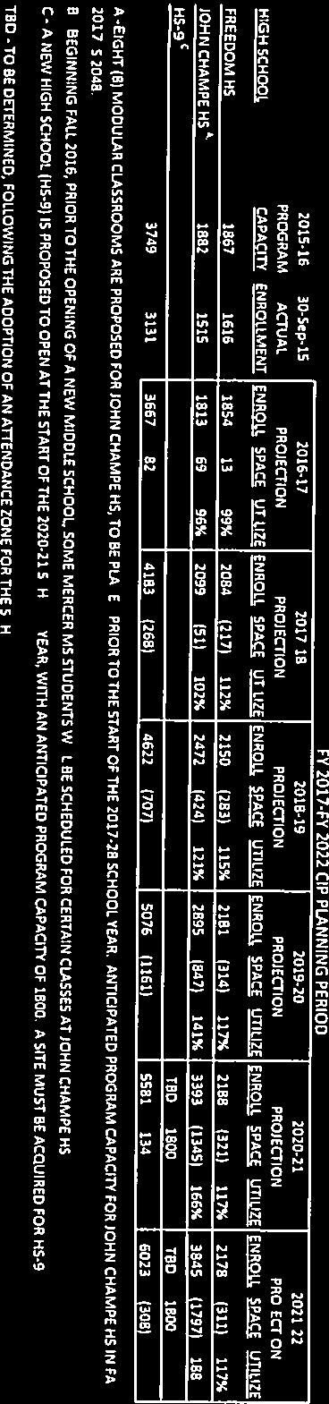
158


159 October 14, 2016 Ms. Jacqueline Marsh Department of Planning 1 Harrison Street, S.E. P. O. Box 7000 Leesburg, Virginia Re: Glascock Field at Stone Ridge; ZMAP , ZCPA , ZMOD , SPEX Dear Ms. Marsh: Loudoun Water has reviewed the referenced referral application and offers no objection to its approval. Should offsite easements be required to extend public water and/or sanitary sewer to this site, the applicant shall be responsible for acquiring such easements and dedicating them to the Authority at no cost to the County of to the Authority. Public water and sewer service would be contingent upon the developer s compliance with the Authority s Statement of Policy; Rates, Rules and Regulations; and Design Standards. Should you have any questions, please do not hesitate to contact me. Sincerely, Julie Atwell Engineering Administrative Specialist Attachment 4.S
160 COUNTY OF LOUDOUN PARKS, RECREATION AND COMMUNITY SERVICES REFERRAL MEMORANDUM To: From: CC: Jacqueline Marsh, Project Manager, Planning Department (MSC #62) Mark A. Novak, Chief Park Planner Facilities Planning and Development (MSC #78) Steve Torpy, Director Karen Sheets, Deputy Director Jeremy Payne, Deputy Director Kristen Blaylock-Reed, Chairman, PROS Board, Dulles District Jim Bonfils, Vice Chairman, Broad Run District Rick Stone, PROS Board, Blue Ridge District Kenya Savage, PROS Board, Chair At-Large Karla Etten, Open Space Member At-Large Kelly Foltman, Open Space Member At-Large Date: June 22, 2017 Subject: Glascock Field at Stone Ridge ZMAP , ZCPA , ZMOD , ZMOD and SPEX (2 nd Submission) Election District: Blue Ridge Sub Planning Area: Dulles MCPI #: , BACKGROUND: The subject properties are located along the north side of Route 50, east and west of Gum Spring Road (Route 659) within the Blue Ridge election district and Dulles sub planning area. In 2007 the Board of Supervisors approved ZMAP , to permit the rezoning of 98 acres to the PD-OP and R-16 zoning districts and allow over 1.3 million square feet of commercial floor space and up to 276 multi-family and townhouses residential units. In 2010, approval of SPEX allowed the Stone Springs Hospital Center. Several revisions to the proffers and concept plan approved with ZMAP were granted by the Board of Supervisors in February 2015, with approval of ZMAP and ZCPA In this application the applicant is seeking approval of a zoning map amendment and zoning concept plan amendment to permit several revisions to the proffers and concept development plan approved with ZMAP and ZCPA Attachment 4.T
161 Glascock Field at Stone Ridge (2 ND Submission) ZMAP , ZCPA , ZMOD , ZMOD , SPEX June 22, 2017 Page 2 of 4 Passive Park/Trail Easement 3 INOVA Dulles South Hospital Campus SITE Arcola Slave Quarters StoneSpring Emergency Center Byrne s Ridge Park Location Map PROJECT PROPOSAL: The Applicant proposes to rezone approximately 2.54 acres of Land Bay 3B from the Planned Development-Office Park ( PD-OP ) to the PD-CC-NC zoning district to allow development of community-serving retail uses. In addition, the Applicant seeks approval for the following amendments, removal of community center initially proposed for Land Bay 1D, identify a Civic Use Site in Land Bay 3B and a special exception for a community park in Land Bay D1.
 has reviewed the Applicant s responses dated May 17, 2017 to referral comments dated October 7, 2016, the revised proffer statement dated")
162 Glascock Field at Stone Ridge (2 ND Submission) ZMAP , ZCPA , ZMOD , ZMOD , SPEX June 22, 2017 Page 3 of 4 CONCEPT DEVELOPMENT PLAN COMMENTS: The Department of Parks, Recreation and Community Services (PRCS) has reviewed the Applicant s responses dated May 17, 2017 to referral comments dated October 7, 2016, the revised proffer statement dated May 4, 2017, revised Statement of Justification dated May 1, 2017 and the revised ZMAP, ZCPA, ZMOD and SPEX dated June 27, 2016 revised May 4, The following is the current issue status of the initial comments: Comment 1. The Applicant states in the Statement of Justification that the residential components of Land Bay 1A and 1A1 are to be annexed into the existing Stone Ridge Association (HOA) allowing access to existing Stone Ridge HOA community facilities. In light of this, the Applicant is requesting removal of the community center from Land Bay 1D, stating that with the
163 Glascock Field at Stone Ridge (2 ND Submission) ZMAP , ZCPA , ZMOD , ZMOD , SPEX June 22, 2017 Page 4 of 4 annexation the approved community center in Land Bay 1D is redundant. Staff has concerns on removing community center as currently approved for Land Bay 1D. While residents of Land Bays 1A and 1A1 would have access to existing Stone Ridge HOA community facilities, these facilities are located on the south side of route 50 a major arterial highway. The Applicants should provide similar facilities for residents on the north side. Applicant Response: The swimming pool facilities for the Stone Ridge HOA members are located within.47 miles of the residents of Land Bays 1A and 1A1. There are members of the Stone Ridge community that live.57 miles away from the facilities. The location and route to these facilities is typically by car for most of the residents. Therefore, the distance to the pool facilities is in keeping with current conditions throughout the community. There is a HOA-owned tot lot and multipurpose field within Land Bays 1A, as well as walking trails and the other passive amenities. Recently, the Stone Ridge Association completely renovated their existing community center facility to include a larger work out facility and upgraded gathering spaces. Issue Status: Acknowledged. Comment 2. Please provide more information on the proposed community park. It appears most of the amenities proposed are passive in use, what active uses are proposed. Applicant Response: Currently, that area is already improved with an asphalt trail and pedestrian bridges to cross the storm water management pond. The Applicant will work with the Stone Ridge HOA to determine what additional types of amenities the homeowners are interested in, such as seating areas, outdoor games or work out stations. Issue Status: Acknowledged. RECOMMENDATIONS: The Department of Parks, Recreation and Community Services (PRCS) has reviewed the Applicant s proposal and would be in general objection to the application as presented. However, defers to other referral agencies for additional comments. If you have any questions or concerns regarding these comments, please do not hesitate to contact me at or mark.novak@loudoun.gov.
 Steve Torpy, Director Karen Sheets, Deputy Director Jeremy Payne, Deputy Director Kristen Blaylock-Reed, Chairman, PROS Board,")
164 COUNTY OF LOUDOUN PARKS, RECREATION AND COMMUNITY SERVICES REFERRAL MEMORANDUM To: From: CC: Jacqueline Marsh, Project Manager, Planning Department (MSC #62) Mark A. Novak, Chief Park Planner Facilities Planning and Development (MSC #78) Steve Torpy, Director Karen Sheets, Deputy Director Jeremy Payne, Deputy Director Kristen Blaylock-Reed, Chairman, PROS Board, Dulles District Jim Bonfils, Vice Chairman, Broad Run District Rick Stone, PROS Board, Blue Ridge District Kenya Savage, PROS Board, Chair At-Large Allison Tinney, Open Space Member At-Large Kelly Foltman, Open Space Member At-Large Date: October 7, 2016 Subject: Glascock Field at Stone Ridge ZMAP , ZCPA , ZMOD , ZMOD and SPEX Election District: Blue Ridge Sub Planning Area: Dulles MCPI #: , BACKGROUND: The subject properties are located along the north side of Route 50, east and west of Gum Spring Road (Route 659) within the Blue Ridge election district and Dulles sub planning area. In 2007 the Board of Supervisors approved ZMAP , to permit the rezoning of 98 acres to the PD-OP and R-16 zoning districts and allow over 1.3 million square feet of commercial floor space and up to 276 multi-family and townhouses residential units. In 2010, approval of SPEX allowed the Stone Springs Hospital Center. Several revisions to the proffers and concept plan approved with ZMAP were granted by the Board of Supervisors in February 2015, with approval of ZMAP and ZCPA In this application the applicant is seeking approval of a zoning map amendment and zoning concept plan amendment to permit several revisions to the proffers and concept development plan approved with ZMAP and ZCPA Attachment 4.U

165 Glascock Field at Stone Ridge ZMAP , ZCPA , ZMOD , ZMOD , SPEX October 7, 2016 Page 2 of 4 Passive Park/Trail Easement 3 INOVA Dulles South Hospital Campus SITE Arcola Slave Quarters StoneSpring Emergency Center Byrne s Ridge Park Location Map PROJECT PROPOSAL: The Applicant proposes to rezone approximately 2.53 acre Land Bay 3B1 from Planned Development-Office Park ( PD-OP ) to (Planned Development Commercial Center-Community Center ( PD-CC-CC ) zoning district to allow development of community-serving retail uses. In addition, the Applicant seeks approval for the following amendments, removal of community center initially proposed for Land Bay 1D, identify a Civic Use Site in Land Bay 3B and a special exception for a community park in Land Bay D1.
 has reviewed the application an offers the follow comments: 1.")
166 Glascock Field at Stone Ridge ZMAP , ZCPA , ZMOD , ZMOD , SPEX October 7, 2016 Page 3 of 4 Concept Development Plan COMMENTS: The Department of Parks, Recreation and Community Services (PRCS) has reviewed the application an offers the follow comments: 1. The Applicant states in the Statement of Justification that the residential components of Land Bay 1A and 1A1 are to be annexed into the existing Stone Ridge Association (HOA) allowing access to existing Stone Ridge HOA community facilities. In light of this, the Applicant is requesting removal of the community center from Land Bay 1D, stating that with the annexation the approved community center in Land Bay 1D is redundant. Staff has concerns on removing community center as currently approved for Land Bay 1D. While
167 Glascock Field at Stone Ridge ZMAP , ZCPA , ZMOD , ZMOD , SPEX October 7, 2016 Page 4 of 4 residents of Land Bays 1A and 1A1 would have access to existing Stone Ridge HOA community facilities, these facilities are located on the south side of route 50 a major arterial highway. The Applicants should provide similar facilities for residents on the north side. 2. Please provide more information on the proposed community park. It appears most of the amenities proposed are passive in use, what active uses are proposed. RECOMMENDATIONS: PRCS has identified above, outstanding issues that require additional information to complete the review of this application. If you have any questions or concerns regarding these comments, please do not hesitate to contact me at or mark.novak@loudoun.gov.
168 Attachment 4.V
169
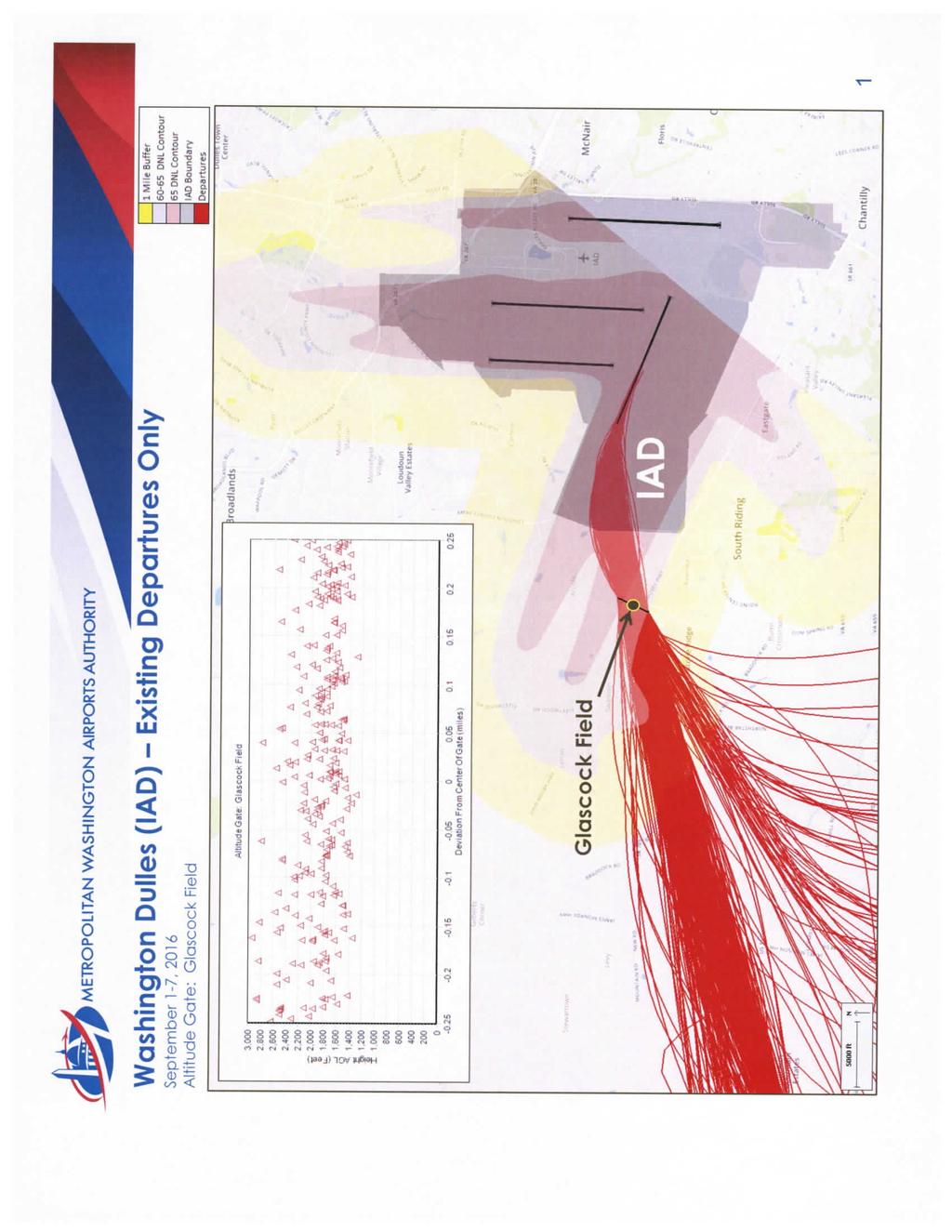
170
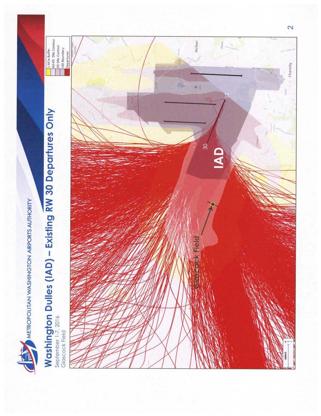
171
172 Attachment 4.W

173

174
175 June 22, 2017 Jacqueline Marsh, AICP County of Loudoun Department of Planning and Zoning MSC # 62 1 Harrison Street, S.E. P.O. Box 7000 Leesburg, Virginia Re: Glascock Field at Stone Ridge (2 nd Submission of Revised Application) Loudoun County Application Numbers ZMAP , ZCPA , ZMOD , ZMOD and SPEX Dear Ms. Marsh: We have reviewed the above noted application as requested in your May 23, 2017 transmittal. Our previous comments dated October 14, 2016 have been addressed. We have no objection to the approval of these applications. If you have any questions, please call me at (703) Sincerely, John Bassett, P.E. Transportation Engineer cc: Tony Estafanous, P. E. Attachment 4.X
176 October 14, 2016 Ms. Jacqueline Marsh County of Loudoun Department of Planning and Zoning MSC # 62 1 Harrison Street, S.E. P.O. Box 7000 Leesburg, Virginia Re: Glascock Field at Stone Ridge (1 st Submission of Revised Application) Loudoun County Application Numbers ZMAP , ZCPA , ZMOD , ZMOD and SPEX Dear Ms. Marsh: We have reviewed the above noted application as requested in your August 25, 2016 transmittal. We offer the following comments: 1. Please see the attached memorandum dated October 5, 2016 from Arun Raj, P. E., PTOE of VDOT s Traffic Engineering Section. 2. Due to the increase in projected traffic associated with this application, we recommend that the County pursue a monetary contribution from the applicant to be applied towards area transportation improvements. If you have any questions, please call me at (703) Sincerely, John Bassett, P.E. Transportation Engineer Attachment cc: Tony Estafanous, P. E. Attachment 4.Y
177 October 5, 2016 MEMORANDUM TO: FROM: CC: John Bassett Arun Raj Xuejun Fan SUBJECT: RUID # 21575, Plan# ZMAP , ZCPA , Trip Generation Update and Proposed vs Approved Comparison study - Glascock Field at Stone Ridge - Loudoun County We have completed our review of the Trip Generation Update and Proposed vs Approved Comparison study that is in accordance with the Loudoun County FSM document for the referenced development and have offer the following comment. It is to be noted that Stone Ridge Blvd at Rte 50 intersection operate at unacceptable overall intersection level of service (as well as v/c ratio >1) for both AM and PM peak hour for both year 2020 and year 2025 for both approved as well as proposed buildout conditions; however, the overall intersection level of service (as well as v/c ratio) for proposed buildout conditions for both AM and PM peak hour for both year 2020 and year 2025 are comparable to approved buildout conditions. We are retaining copy of this submittal for our records. Please call if you have any questions.
178 September 6, 2016 MEMORANDUM TO: Jacqueline Marsh MSC # 60A Planning Division, Building & Development FROM: Mark Sharrer MSC #68 Env. Health Specialist Division of Environmental Health SUBJECT: Glasscock Field at Stone Ridge ZMAP ZCPA ZMOD SPEX This Department reviewed the package provided to this office and the plat prepared by Urban Ltd. revised 2/5/15, and recommends approval with no further comments/conditions to the proposal. If further information or clarification on the above project is required, please contact Mark Sharrer at Attachment 4.Z
179 Ben I. Wales April 6, 2018 Jackie Marsh County of Loudoun Department of Planning & Zoning 1 Harrison Street, SE Leesburg, Virginia Re: Response to Third Referral Comments for Glascock Field II ZCPA Dear Jackie: This letter responds to the third referral comments received to date from the County for the abovereferenced application. Received comments are repeated below in italics, followed by the Applicant s response. We have included with this submission ten copies of the revised draft Concept Development Plan ( CDP ), draft proffers and revised Statement of Justification. Department of Planning & Zoning Community Planning A. Provision of Civic Uses Onsite Retain and commit to providing onsite community facilities for Landbay 1A and Landbay 1A1 and explore cost-reducing options to provide such facilities commensurate with the size of the community. Explore other areas onsite or adjacent to Landbay 1A to provide onsite facilities. - The northern portion of Landbay 1A appears to have land available to accommodate a community facility. - Landbay 1C provides a potential additional access point to Landbay 1A and appears to have land available to accommodate a community facility. RESPONSE: As discussed with Staff during the meeting on February 22 nd, the Applicant has determined that the community center previously proposed for the Property is not needed or feasible to serve the residents of Land Bays 1A and 1A1. It was anticipated to provide a service to the community at Glascock Field, but is no longer deemed necessary. As set out in the statement of justification, the units approved for Land Bay 1A have been annexed into the Stone Ridge HOA and those proposed for Land Bay 1A1 will be annexed into the HOA subject to zoning approval, providing all units access to a wide range of facilities, community events and services provided by the HOA. Furthermore, a county library is located within walking distance to Land Bay Cooley LLP One Freedom Square Reston Town Center Freedom Drive Reston, VA t: (703) f: (703) cooley.com v2 Attachment 5.A
180 Jackie Marsh April 6, 2018 Page Two 1A and 1A1. In light of the quality and range of community facilities available, a community facility to specifically serve the residents of Land Bay 1A and Land Bay 1A1 is not needed. Land Bay 1B has site plan approval for the development of multi-family units, which will be served by facilities provided specifically for that community. Notwithstanding the above, following discussions with Staff during a meeting on February 22 nd, the Applicant has updated the draft Proffers to include a commitment to providing a gathering space and amenity on the Property to serve residents of Land Bay 1A and Land Bay 1A1 as well other members of the Glascock community. A pavilion will be provided within Land Bay 1D, conveniently located to serve all of the residents and connected to eight-foot wide asphalt trails, benches and pedestrian bridges. The proposed pavilion and gathering area will provide an important amenity. While not an ideal solution, should annexation into the Stone Ridge HOA be considered as justification to approve the removal of onsite facilities, a commitment is necessary to ensure the residents of Landbays 1A and 1A1 have access to the Stone Ridge HOA. In addition, a contingency proffer should be developed that provides facilities to the residents should the development not be allowed accessibility to the Stone Ridge HOA facilities. RESPONSE: Comment acknowledged. Land Bay 1A has already been annexed into the Stone Ridge HOA. Land Bay 1A1 will also be annexed subject to zoning approval. If no onsite facilities are provided, commit to providing continuous, convenient, accessible, and safe bicycle/pedestrian connectivity from Landbays 1A and 1A1 to nearby public facilities and Stone Ridge HOA community facilities. RESPONSE: As discussed with Staff during the meeting, a continuous and accessible pedestrian connection is now in place between Land Bays 1A1 and 1A and Stone Ridge community amenities, as well as to the Gum Spring Library. Correctly identify Landbay 1 D as public parks & open space. RESPONSE: Please see the revised CDP. Land Bay 1D has been labeled as open space. B. Assurances with Development The tree conservation areas (TCAs) identified on Sheet 3 for ZMAP IZCPA are now identified as existing tree conservation easements, referencing the instrument number, which is helpful. However, to avoid confusion, identify the areas as TCAs as Proffer VI.C for ZMAP IZCPA remains applicable to the application and uses the TCA terminology. RESPONSE: Please see the revised CDP, which has been updated to reference the 2013 application numbers v2 Cooley LLP One Freedom Square Reston Town Center Freedom Drive Reston, VA t: (703) f: (703) cooley.com
181 Jackie Marsh April 6, 2018 Page Three Commit to pedestrian network shown on Sheet 5 in Proffer I. and depict Bike & Pedestrian improvements along western boundary of Stone Springs Boulevard. This segment does not have improvements constructed as suggested by the response letter and the commitment should be retained on the CDP. RESPONSE: Sheet 5 has been included in the proffered CDP sheets. The western boundary of Stone Springs Boulevard has a sidewalk included in the construction of the ultimate condition, as shown on the approved CPAR Label the 50-foot Management Buffer associated with the major floodplain as such; it is incorrectly identified as a "Variable Width Management Buffer". The Variable Width Management Buffer only applies to the minor floodplain (see Proffer VI.F). RESPONSE: Please see the revised CDP. The labels have been revised to address Staff s comment. Ensure that Proffer VI.E for ZMAP IZCPA remains in effect for Landbay 1A. Submission package appears to delete the proposed proffer statement, but it cannot be determined whether it is being removed because it already exists or is proposed to be removed altogether. RESPONSE: The proffer remains as originally approved in the ZMAP /ZCPA case. It was removed from the updated proffers at the request of Staff, as the area of Land Bay 1A1 would have been included in the noise study prepared for Land Bay 1A. C. Unmet Housing Needs Provide dwelling units for purchase for households earning 70% to 100% of Washington AMI in Landbay 1A1, OR Provide the aforementioned contribution amount to offset fiscal impacts of the County subsidizing the construction of the units. RESPONSE: A new proffer Proffer II.E.1.a. has been added to the draft Proffers to commit to an unmet housing need contribution for the units proposed in Land Bay 1A1. Ensure retention of Proffer 1I.E.2. regarding Unmet Housing Needs contribution as it was approved with ZMAP IZCPA RESPONSE: Comment acknowledged. This proffer is still in effect pursuant to the referenced 2013 ZMAP v2 Cooley LLP One Freedom Square Reston Town Center Freedom Drive Reston, VA t: (703) f: (703) cooley.com
182 Jackie Marsh April 6, 2018 Page Four Department of Planning and Zoning Zoning Administration A. GENERAL COMMENT 1. New Comment. Considering Land Bay 1D will be revised with the removal of a 1.10 acre portion to create Land Bay 1A1, and portions of Land Bay 3B will be revised to permit a civic use and an auxiliary pharmacy on newly created parcels, Staff recommends the Applicant include Land Bay 1D and the entirety of Land Bay 3B in the ZCPA application. As noted below in Comments 14, 21, 22, 28, 47, and 48, including these land bays in the application will minimize the complexity of administering the approved applications and allow the Applicant to adjust areas, lot calculations, etc. that are related to the current proposal. RESPONSE: Applicant concurs and has updated the CDP to reflect the addition of Land Bay 1D and Land Bay 3B. B. STATEMENT OF JUSTIFICATION 2. New Comment. Page 3. In the sixth line of Paragraph III3.b., it appears auxiliary uses should be revised to office uses. Please evaluate the sentence and revise if necessary. RESPONSE: Comment acknowledged. The SOJ has been revised to address Staff s comment. C. CONFORMANCE WITH PD-OP REQUIREMENTS (Section 4-300) 3. Initial Comment. Upon further evaluation and consultation with the Zoning Administrator and Deputy Zoning Administrator, Staff finds the most appropriate method for providing a pharmacy in Land Bay 3B1 is as an auxiliary use to permitted principal uses on a stand-alone basis in accordance with Section 4-303(CC) of the Zoning Ordinance. In this scenario, a pharmacy could be considered auxiliary to the PD-OP district development consisting of an existing hospital and existing and planned medical offices/medical campus. In accordance with Section 4-303(CC) of the Zoning Ordinance, the pharmacy must meet the threshold of not exceeding 10% of the total allowable floor area of the office park shown on the CDP. Historically, this has been interpreted to mean 10% of the total floor area of office park uses constructed at the time of site plan application for the auxiliary use. Staff is aware that retail uses have been previously approved for this office park. Therefore, Staff recommends evaluating whether the 10% threshold will be attainable at the time the Applicant makes a site plan application for the pharmacy. Should the Applicant choose to pursue development of the desired pharmacy in Land Bay 3B1, then please provide the following with the resubmission: a. Tabulation of existing office park and approved retail square footages demonstrating the proposed pharmacy will not exceed the 10% floor area threshold. Response. The Applicant has withdrawn the request to rezone Land Bay 3B1 to the PD- CC-NC zoning district and for the associated special exception. It has revised Sheet 4 of the CDP to include a table to reflect the current office floor area that has been constructed at Glascock Field and updated Sheet 3 to identify the proposed auxiliary use. The various v2 Cooley LLP One Freedom Square Reston Town Center Freedom Drive Reston, VA t: (703) f: (703) cooley.com
183 Jackie Marsh April 6, 2018 Page Five application materials have been revised to remove reference to the rezoning and special exception and the Statement of Justification has been revised to include justification for the pharmacy being an auxiliary use to the existing planned office park. Additional Comment. Please include the associated site plan application numbers for the existing (and proposed if approved but not constructed) office uses in the Development Program for PD-OP tabulation on Sheet 4 demonstrating conformance with the 10% floor area threshold of Section 4-303(CC). Also, STPL was approved for an auxiliary restaurant and gas station with kiosk. Please include the square footage of these approved auxiliary uses in the calculations demonstrating conformance with the 10% threshold. Please reference the site plan and area of auxiliary uses in the tabulation. Lastly, Staff notes the tabulation demonstrating conformance with the 10% floor area threshold is based on the total existing and proposed office uses in the PD-OP Zoning District. As noted above, in practice the auxiliary use must be 10% of the existing office floor area. Demonstration of conformance with this requirement will be required at site plan for the auxiliary use. RESPONSE: The Applicant has updated the CDP chart to include the current approved uses for all the land bays. The chart includes a computation to show the percentage of the auxiliary uses based on the existing PD-OP uses. D. CONFORMANCE WITH R-16 DISTRICT REQUIREMENTS (Section & Section 7-900) 4. Initial Comment. Section 3-604(T) Public or private community or regional park. Please clarify whether the special exception request is for a public or private community park. A Condition of Approval may also be imposed to clarify whether the community park, if approved, would be private or public. As discussed in Comment 13 below, please identify where the parking will be provided for the park on Sheet 5. Response. The Applicant seeks approval for a private community park. The intention is for the park to be accessible to the surrounding commercial and residential community. Existing and proposed pedestrian connections provide access to the park, which will be open to the public, but owned and maintained by the Stone Ridge Association. Additional Comment. Since the previous submission, the proposed amphitheater has been removed from the proposal. Additionally, Staff confirmed that approval of a park is not required to permit the surrounding commercial districts to use Park and Open Space as defined by Article 8 of the Zoning Ordinance provided adequate access easements are provided. Therefore, a SPEX for a park is not necessary to permit the proposed use. Additionally, a community park will require some parking spaces, including ADA spaces. Therefore, Staff recommends removing the SPEX request ZCPA & ZMOD Glascock Field at Stone Ridge 3rd Referral Comments November 8, 2017 Page 4 for a private community park and proposing the area for Park and Open Space. Alternatively, demonstrate on the plan the proposed private park area can accommodate parking spaces. Response: The Applicant has submitted a formal request to withdraw the special exception request. Reference to the special exception has been removed from the application materials. Additional Comment. The Applicant previously indicated the intent to permit surrounding commercial districts to use the Park and Open Space to be established in Land Bay 1D. To ensure this access is provided, please provide a formal commitment to establishing a public access easement for Land Bay 1D v2 Cooley LLP One Freedom Square Reston Town Center Freedom Drive Reston, VA t: (703) f: (703) cooley.com
184 Jackie Marsh April 6, 2018 Page Six RESPONSE: The private streets in the community have an Ingress/Egress Easement recorded in the Loudoun County records. As the intention of this gathering/park space is for the neighboring community, there is a sidewalk system from Stone Ridge through Glascock that enables the employees and residents of the Stone Ridge community as well as the Glascock community to access the pavilion, trails and bridges. A public access easement could be recorded on Alder Forest Terrace Drive. 5. Additional Comment. The Active Recreation Space is depicted on Sheet 3 of the CDP. Please provide information and/or commitments about how this space will be utilized as Recreation Space, Active as defined in Article 8 of the Zoning Ordinance. Please also provide information regarding how the townhouses proposed adjacent to the Active Recreation Area will relate to each other. Will the townhouses front on the Active Recreation Area, or will it be in the backyards? Will a fence separate the townhouse yards and the Active Recreation Area? Please provide additional information about the proposed active recreation uses and design of the site that will ensure the uses will not intrude on the adjacent townhouses and other community members will feel comfortable using the space. Response. The components of the active recreation space will be determined at the time of site plan and identified on the site plan. These active recreation facilities will meet the requirements of the Zoning Ordinance. The adjacent townhomes will front onto Adler Forest Terrace and Dogwood Glen Square. The rear yards of these units will be fenced, providing a separation between their lots and the adjacent active recreation space. Additional Comment. To ensure separation between lots and the adjacent active recreation space, Staff recommends formally committing to the installation of a fence that would provide sufficient privacy along the rear property lines of the residential units proposed in Land Bay 1A1. RESPONSE: Comment Acknowledged. The Applicant has included Proffer III.F, which requires the construction of fences along the rear property lines of the residential units proposed in Land Bay 1A1. E. ZONING ORDINANCE MODIFICATIONS 6. Modification 9 on Sheet 4: Section 4-305(B)(2), Lot Requirements, Yards, Adjacent to Agricultural and Residential Districts and Land Bays Allowing Residential Uses. Requested Modification: Permit the PD-OP and R-16 zoned districts to be located within 35 feet of each other. For Initial Comment and Response see 2nd Referral Comments. Additional Comment. Staff understands the Applicant is making this modification request due to the timing of anticipated proffered right-of-way (ROW) dedication for the extension of Glascock Field Drive, a public road, and development of the subject property. Currently, the future area of ROW to be dedicated is within the R-16 zoning district/land Bay 1B. When this ROW, which will be greater than 50 feet wide, is dedicated it will no longer be zoned R-16 and Section 4-305(B)(1) will apply, requiring a 35 foot building yard and a 25 parking yard adjacent to a road. As such, v2 Cooley LLP One Freedom Square Reston Town Center Freedom Drive Reston, VA t: (703) f: (703) cooley.com
185 Jackie Marsh April 6, 2018 Page Seven Staff can support this modification request, as it is cautionary in nature and the final result will be in conformance with the Zoning Ordinance requirement. Nonetheless, Staff recommends a condition of approval precluding the location of any residential buildings, parking, or accessory uses 50 feet south of the shared PIN and PIN property line from the western terminus of Glascock Field Drive to the western property boundary of Land Bay B1. This ZCPA & ZMOD Glascock Field at Stone Ridge 3rd Referral Comments November 8, 2017 Page 5 condition will ensure a minimum 50 foot separation between the PD-OP district and residential uses to the south should the ROW dedication for the western extension of Glascock Field Drive as agreed to in Proffer IV.A.3 not occur. Applicant Response. The Applicant appreciates Staff s support of the requested ZMOD. Land Bay 1B is not part of this application and could not be the subject of the suggested condition. However, the northern portion of Land Bay 1B includes existing Tree Conservation Easements and is within the Dulles Airport Ldn 65 noise contour and as such, its development is already restricted. Furthermore, STPL has been approved by the County. This approved site plan has not building, parking or accessory uses within 50 feet south of the further extension of Glascock Field. Additional Comment. Staff questions why the Applicant continues to request the modification request since STPL for a Montessori Daycare on PIN is conditionally approved. This site plan could not have been approved unless it was in conformance with the Zoning Ordinance. As approved, the site plan demonstrates the child care center can be accommodated on the site without the requested modification. RESPONSE: The Applicant hereby formally requests the withdrawal of ZMOD Modification 10 on Sheet 4: Section (A), Table (A) Buffer Yard and Screening Matrix. Requested Modification: Reduce the Type I Side Yard Buffer required between office (Group 6) and civic (Group 4) uses to 7 feet along the eastern property line and 5 feet along the northern property line. For Initial Comment and Response see 2nd Referral Comments. Additional Comment. The Applicant has not demonstrated how the modification will be used in the design of the project and makes no commitment to the design of Land Bay 3B1 where this modification would apply. This is a requirement of the modification criteria in Section of the Zoning Ordinance. Based on the illustrative on Sheet 9, there would be no differentiation or separation of the proposed child care or civic use and the office uses. Staff cannot support the modification request without a design commitment for the site that Staff can evaluate the adverse impact of the requested buffer elimination on the child care center. In particular, Staff cannot support the elimination of any separation of this child care center use and the adjacent office uses, which require a minimal visual and physical separation based on the types of adjacent uses. Applicant Response. Comment acknowledged. The Applicant has revised the SOJ to propose buffer yards of a reduced width, rather than their elimination. An exhibit showing the proposed child care center use and associated buffers is included in the SOJ. As discussed in the SOJ, due v2 Cooley LLP One Freedom Square Reston Town Center Freedom Drive Reston, VA t: (703) f: (703) cooley.com
186 Jackie Marsh April 6, 2018 Page Eight to unique factors associated with the Property, the proposed reduced side yard buffers are appropriate. Additional Comment. Staff questions why the Applicant continues to request the modification request since STPL for a Montessori Daycare on PIN is conditionally approved. This site plan could not have been approved unless it was in conformance with the Zoning Ordinance. As approved, the site plan demonstrates the child care center can be accommodated on the site without the requested modification. Nonetheless, Staff notes an incorrectly designated buffer on STPL The eastern buffer yard is not a front yard as identified on Sheet 13 of the site plan. It should be a side yard. As such, instead of 5 canopy trees, the buffer yard should consist of 3 canopy trees (1 canopy tree/100 lineal feet for 240 feet = 3 canopy trees) and 10 shrubs (4 shrubs/100 lineal feet for 240 feet = 10 shrubs). Please revise the site plan to correct this error. RESPONSE: As you are aware, STPL has been approved. The Applicant has included a detail on Sheet 4 that shows the property line for PIN , and the required buffer for Land Bay 3 based on the office use adjacent to the child care site. The Applicant has requested a reduction of the buffer on the northern end of the child care site to the parking area for the future office use (ZMOD ). The Applicant has also requested a reduction in the buffer located in the side yard (front of building facing the drive aisle.) The buffer reduction is necessary on the PD-OP portion of the property, not the child care site. F. REZONING PLAT 8. New Comment. Based on comments 6 and 7 above, ensure the ZMOD numbers accurately reflect the requested modification in the application materials. RESPONSE: ZMOD has been withdrawn. The Applicant has been instructed to use ZMOD for the buffer reduction request between the child care use and the adjacent office uses, discussed in response to Comment 7 above. 9. Initial Comment. On Sheet 1, under General Note 4, the note states the location of the steep slopes are depicted on Sheet 7; however, steep slopes are not depicted. Please address this discrepancy. Also, depict the location of steep slopes on Sheet 3. Response. Please see the revised CDP, which has been updated to address Staff s comment. Additional Comment. Steep slopes are depicted on Sheet 8, not Sheets 3 and 7 as stated in General Note 4. Please correct. Response: Please see the revised CDP, which has been updated to address Staff s comment. Additional Comment. Steep slopes continue to be depicted on Sheet 3. Please add reference to note. RESPONSE: On Sheet 1, General Note 4, we have added Sheet 3 to the reference for steep slopes v2 Cooley LLP One Freedom Square Reston Town Center Freedom Drive Reston, VA t: (703) f: (703) cooley.com
187 Jackie Marsh April 6, 2018 Page Nine 10. Initial Comment. On Sheet 1, General Notes 9 and 21 both reference buffer requirements. Consider combining these notes to avoid redundancy and confusion. Response. Notes 9 and 21 have been combined. Please see the revised note 9 on Sheet 1 of the CDP. Additional Comment. Please revise Note 9 to address the following: 1) it is unclear what the buffer requests in the third sentence, Any buffer requests will be made in conjunction with the site plan application, refers to. Please clarify or remove this sentence. Also, please remove the last sentence, as it repeats the intent of the first sentence, but limits buffers to only Section of the Zoning Ordinance. Other sections of also include buffer requirements that may be applicable to the property. Response: Please see the revised CDP, which has been updated to address Staff s comment. Additional Comment. Please remove the reference to Section in Note 9. The reference to Section is sufficient to include Section , as well any other buffer requirements that may be included in other section of , such as Section (E) noted below in Comment 21.e. RESPONSE: Comment acknowledged. The reference to Section in Note 9 has been removed. 11. Initial Comment. Sheet 2. Since approval of ZMAP /ZCPA , ROW for public roadways has been dedicated throughout the site. Upon dedication of public streets, the ROW is no longer within a designated zoning district or part of a land bay. Please revise the CDP Sheets 2, 3, 5, 8 and as otherwise necessary so that the zoning districts coincide with the limits of dedicated public ROW. Additionally, please include in the Rezoning/ZCPA Area Tabulations the new areas for each Land Bay with dedicated ROW subtracted. Similarly, since the old Waxpool Road alignment has been abandoned, this ROW should be added into the area for Land Bay 2. Please also revise FAR calculations in the table accordingly. Response: There are two boundary lines shown on the CDP: The Land Bay boundary line per ZMAP , which preserves the area for FAR purposes, and the Land Bay Boundary line per the applicable site plans and plats. With regard to the dedication of ROW and calculation of density, the Applicant is merely implementing the existing approvals for the Property, which were granted by the Board of Supervisors. It is unclear why an applicant would be required to dedicate ROW from a property and be punished for making such dedication with a reduction in permitted density. Notwithstanding the above, the Applicant has revised Sheet 4 to update the Rezoning/ZCPA Area Tabulations chart to remove the land dedicated for ROW purposes. Additional Comment. Article 8 of the Zoning Ordinance defines Floor Area Ratio (FAR) as A number or percentage, derived by dividing the gross floor area of the buildings on any lot by the lot area. The floor area ratio multiplied by the lot area produces the maximum amount of floor area that may be constructed on such lot. Therefore, while a gross floor area and FAR may be calculated for a land bay and demonstrated on the ZCPA plan set, the FAR will be calculated by parcel for each site plan submission. In addition, in accordance with Section 1-206(C)(5), conveyances or dedications made or committed to by the landowners as part of an approved zoning map amendment petition shall not be considered eligible for density computation under this section... However, in v2 Cooley LLP One Freedom Square Reston Town Center Freedom Drive Reston, VA t: (703) f: (703) cooley.com
188 Jackie Marsh April 6, 2018 Page Ten accordance with Section 1-206(C), FAR computations with respect to a lot from which land has been severed for the purpose of constructing or improving any public use or portion thereof, including roads shown on the adopted Comprehensive Plan, shall be based upon the lot area including the area severed for such purpose when.(c) the Board has specifically approved, by resolution, the computation of density or intensity for the lot based upon the lot area existing prior to dedication or conveyance, among additional criteria. Based on the calculations in the Rezoning/ZCPA Area Tabulations on Sheet 4, the Applicant is calculating the permitted density of the acre area of Land Bay 3B including 1.27 acres of previously dedicated ROW and the area of future Dulles West Boulevard ROW. Should the Applicant wish to include the area of future Dulles West Boulevard in the FAR computations for parcels to be created from Land Bay 3B, please include a request for a density credit for the area of public road dedication in the resubmission in accordance with Section 1-206(C)(1)(c). The entirety of Land Bay 3B would also need to be included in the ZCPA application. RESPONSE: The Applicant has revised the development summary located on Sheet 4 to remove all the ROW dedicated or reserved from the total parcel acreage. 12. New Comment. Sheets 2-5. In general, the information provided on the proffered sheets approved with ZMAP /ZCPA and in the land bays not subject to the current application should be identically depicted on the proffered sheets subject to the current application. Staff understands that land bays not subject to the application may be developed; however, the information provided on the sheets proffered with ZMAP /ZCPA should not be changed in the current plan set unless the change is part of the current application. Therefore, please ensure the information for all land bays not subject to the current application match the information provided in these land bays on the proffered sheets approved with ZMAP /ZCPA For instance, ROW dedication information is provided on Sheet 2 of the plan set approved with ZMAP /ZCPA , but it is not included in the current submission. Also, future use information is provided for land bays not subject to the current application on Sheet 2 in the ZCPA plan set that was not included on the previously approved plans. To address the difference between the conditions of certain land bays developed after approval of ZMAP /ZCPA , please add a note to the plan set stating, This plan set only depicts revisions to the land bays or portions of land bays subject to ZCPA and ZMOD For the approved development permitted on the remaining land bays or portions of land bays not subject to this application, please refer to ZMAP /ZCPA and/or subsequently approved site plans, CPAPS, and/or concept plan amendments, etc. Also, so that Staff may evaluate the current proposal holistically with the remainder of the property subject to ZMAP /ZCPA , please depict existing conditions and approved site plans on the Illustrative Plan on Sheet 8 of the plan set, which is not a proffered sheet. RESPONSE: Applicant has updated Sheets 2 and 3 to reflect the information for the Land Bays not included in this zoning as shown on the approved ZMAP /ZCPA As Sheet 2 is a certified plat, we are providing the latest instrument numbers for all the parcels, and any changes to the PIN/Tax Map. We respectfully request that we maintain a separate existing conditions and illustrative sheet. The illustrative shows all plans approved and associated with v2 Cooley LLP One Freedom Square Reston Town Center Freedom Drive Reston, VA t: (703) f: (703) cooley.com
189 Jackie Marsh April 6, 2018 Page Eleven the project that may or may not be existing. Therefore, we would like to keep Sheets 7 and 8 separated. 13. New Comment. Sheet 2. For consistency with the previously approved ZMAP /ZCPA and to ensure maximum flexibility, Staff recommends identifying general uses on the CDP (Sheet 3) for land bays subject to this application, but not on the Certified Plat (Sheet 2). RESPONSE: The general uses are now shown on the CDP (Sheet 3) and have been removed from the Certified Plat (Sheet 2). 14. New Comment. Sheet 2. PIN is identified as being 7.04 acres on Sheet 2 and in the County s records. Sheet 2 identifies three subareas of PIN that total 7.04 acres. These areas include: the area to become Land Bay 1A1 and remain zoned R-16, which is identified as 1.10 acres in size; the area to remain in Land Bay 1D and remain zoned R-16, which is identified as 5.94 acres in size; and the area of Land Bay 1C to remain zoned CLI, which is identified as 1.0 acres in size. The total of these subareas equals 8.04 acres. In addition, the area of Land Bay 1D to remain zoned R-16 is identified as being 4.94 acres in size on Sheets 3 and 5. Please correct these discrepancies. RESPONSE: Comment acknowledged. Sheet 2 has been corrected to address Staff s comment. Also, the area of Land Bay 1D per ZMAP is provided on Sheet 2. Since Land Bay 1A1 has been created from a portion of Land Bay 1D, this area is no longer relevant. As recommended in Comment 1, please include Land Bay 1D in the application and the new area of Land Bay 1D on Sheet 2, and delete the reference to Land Bay 1D per ZMAP Similar please similarly revise Sheet 6 and 7. RESPONSE: Comment acknowledged. Sheet 2, 6 and 7 have been updated per Staff s request. Finally, on Sheet 8, the references to the area of Land Bay 1D in the land bay label are unclear or incorrect. It is unclear how the Total Land Bay 1D area can equal 4.80 acres while 4.94 acres (the new area of Land Bay 1D) will remain in the R-16 zoning district. Please revise this label for clarity. RESPONSE: The label has been corrected to show Land Bay 1D area as 4.94 acres. 15. New Comment. Sheet 2. Please remove the references to the PD-CC-CC Zoning District in Land Bay 3B. RESPONSE: Comment acknowledged. The reference has been removed. 16. Initial Comment. Sheet 3, Tree Conservation Areas (TCA) were committed to in Land Bay 1D with ZMAP /ZCPA A conservation easement, Conservation Easement #6, has been recorded (Instrument #s and ) for the eastern TCA. It appears the TCAs are depicted but not labeled and that the eastern v2 Cooley LLP One Freedom Square Reston Town Center Freedom Drive Reston, VA t: (703) f: (703) cooley.com
190 Jackie Marsh April 6, 2018 Page Twelve townhouses proposed for Land Bay 1A1 are located in Conservation Easement #6. Please depict and/or label the TCAs, including conservation easement instrument numbers, and remove the proposed townhouses from the easement area. Additionally, Tree Conservation Areas (TCA) are depicted in Land Bay 3B and reference an easement. Include the Conservation Easement instrument numbers on the CDP. Response. Please see Sheet 3 of the revised CDP. The Tree Conservation Area has been labeled and instrument number has been added. Additional Comment. Tree Conservation Areas (TCA) are depicted on the ZMAP /ZCPA CDP that are not subject to the conservation easement dedicated with Instrument Number One is in the eastern portion of the open space in Land Bay 1D. Please depict this TCA on the CDP. The other is along the western edge of Land Bay 3B. Please move the overlapping modification information (which is repeated) from the TCA label. Please include additional TCA information consistently throughout the plan set. Response. Please see Sheet 3 of the revised CDP, which has been updated to depict all of the TCAs. Additional Comment. Partially addressed. Please depict the TCA in the eastern portion of the open space in Land Bay 1D on Sheet 7. On Sheet 3, please also revise TCA references as follows: a) The TCA depicted along the western edge of Land Bay 3B is labelled with bold letters and references Esmt. per ZMAP This is different than the label for the TCA in the eastern portion of the open space in Land Bay 1D, which references Approx. Tree Conservation Area and used non-bold letters. These areas are similarly identified on the plan set approved with ZMAP ; therefore, label them similarly on the current plan set or provide justification as to why they are labelled differently; b) If the TCA in Land Bay 3B has an easement, then provide the instrument number. If not, then remove the reference to the easement. Make a similar revision on Sheet 7; and c) For the TCA in Land Bay 3B, add call out arrows showing the limits of the TCA on Sheet 3 and ensure the call outs are clearly associated with the TCA label on Sheet 7. RESPONSE: The TCA easements have all been updated to accurately reflect all the recorded instrument numbers. The line weight has been changed to be consistent on Sheet 3 and Sheet Initial Comment. Sheet 3. CPAP depicts one entrance into Land Bay 1B from Glascock Field Drive. Sheet 3 depicts an additional entrance into Land Bay 1B west of the entrance shown on the approved CPAP. This entrance leads into a TCA protected with an easement dedicated with Instrument Number Please address this discrepancy. Response: Comment acknowledged. The arrow should only be showing an entrance to the north. Sheet 3 has been updated with the corrected arrow. Additional Comment. The arrows depicting the eastern entrance into Land Bay 3B have been shifted so they are entirely within Land Bay 3B. On the previously approved plan set for ZMAP v2 Cooley LLP One Freedom Square Reston Town Center Freedom Drive Reston, VA t: (703) f: (703) cooley.com
191 Jackie Marsh April 6, 2018 Page Thirteen /ZCPA , two arrows on opposite sides of the Glascock Field Drive ROW are used to depict an access point to Land Bay 3B to the north and an access point to Land Bay 1B to the south. Please ensure the arrows depicting the eastern entrances are correctly depicting access points to both land bays and consistent with the previously approved ZMAP. RESPONSE: The arrows as shown on the Land Bay 3B entrances are for Land Bay 3B only. The two arrows depict ingress and egress from the Land Bay 3B site only. These entrances have previously been installed as approved by CPAR and CPAP , consistent with ZMAP /ZCPA Initial Comment. Sheet 3 of the CDP approved with ZMAP /ZCPA depicted limits of clearing, very steep and moderately steep slopes, and jurisdictional waters and wetlands. Please similarly depict these items on Sheet 3 of the plan set, as well as SPEX plats and the illustrative as necessary. To ensure clarity of the plans, it may be beneficial to create a pedestrian circulation sheet rather than include the requested information and the pedestrian circulation on Sheet 3. RESPONSE: Comment acknowledged. The limits of clearing and grading, wetlands and moderately steep slopes have been added to Sheet 3. We have added Sheet 5, Pedestrian Network to reflect the network information. Additional Comment. Consistent with Comment 12 above, please ensure the items depicted on the CDP approved with ZMAP /ZCPA and in the land bays not subject to the current application are identically depicted on the CDP and proffered sheets subject to the current application. RESPONSE: The Applicant has updated Sheet 3 to accurately reflect what is shown on the CDP approved with ZMAP /ZCPA Initial Comment. Sheet 3. A variable width management buffer from the minor floodplain is labeled adjacent to areas of the major floodplain along the western boundary of Land Bay 3B. The CDP previously approved with ZMAP /ZCPA depicts a 50 foot management buffer adjacent to the major floodplain in this location and a variable width management buffer adjacent to the minor floodplain east of the major floodplain in Land Bays 3B and 2. ZMAP /ZCPA Proffer VI.F. also similarly identifies the management buffer widths based on major or minor floodplain. Additionally, the plat approved with Instrument # identifies a minimum 50 foot management buffer adjacent to the major floodplain along the western boundary of Land Bay 3B. Please revise the plan set (Sheets 3, 7, 8, 9) accordingly. Response: Comment acknowledged. Please see the revised Sheet 3, 6, and 7 of the revised CDP. Additional Comment. Not addressed. The 50 foot management buffer adjacent to the major floodplain in Land Bay 3B continues to be identified with a label stating Variable width v2 Cooley LLP One Freedom Square Reston Town Center Freedom Drive Reston, VA t: (703) f: (703) cooley.com
192 Jackie Marsh April 6, 2018 Page Fourteen management buffer from minor floodplain per ZMAP on Sheets 3, 6, and 7. Please correct this label to be consistent with the CPD and proffered sheets approved with ZMAP /ZCPA RESPONSE: Comment acknowledged. The variable width management buffer has been changed to reflect the same label as shown on the approved ZMAP /ZCPA CDP. 20. New Comment. Sheet 3. Arrows depicting access points to and from Land Bay 1C were depicted on the CDP and plan set approved with ZMAP /ZCPA These entrance arrows have been added to Sheets 3, 5, and 8; however, they are depicted differently than on the previously approved plan set. Since Land Bay 1C is not part of the current application, the entrance arrows should be depicted in the same manner. Otherwise, please add Land Bay 1C to the current application and provide a justification for the revised access points. RESPONSE: The arrows have been changed to reflect the approved rezoning locations. 21. New Comment. Sheet 3. Please make the following revisions to Land Bay 3B: a. Easement information is included in the portion of Land Bay 3B not subject to the ZCPA. This information was not included on the CDP approved with ZMAP /ZCPA Based on Comment 1 above, the new easement information may be included if the entirety of Land Bay 3B is included in the current application. If the new information is included, the please provide a legend similar to the legend on Sheet 7 indicating what I*EX. FLOODPLAIN ESMT. refers to. If the entire Land Bay 3B is not included, then please remove any information not previously provided on the CDP approved with ZMAP /ZCPA and include new information on the non-proffered sheets (Sheet 7, Existing Conditions and/or Sheet 8, Illustrative Plan); RESPONSE: Land Bay 3B has been added to the application. All easements are now shown with their instrument numbers. The legend on Page 7 has removed the I* notes. b. The Limits of Clearing (LOC) depicted in the portion of Land Bay 3B not subject to the ZCPA is not consistent with the LOC depicted on the CDP approved with ZMAP /ZCPA Based on Comment 1 above, the LOC may be revised if the entirety of Land Bay 3B is included in the current application. If not, then please ensure the LOC is depicted similarly to the LOC on the CDP approved with ZMAP /ZCPA ; RESPONSE: Land Bay 3B has been added to the application. The limits of clearing are shown on Sheet 3 and 7 pursuant to ZMAP /ZCPA c. Ensure modification references for PIN are 1) consistent with modification request in the SOJ and provided on Sheet 4, 2) Use call out arrows that point to property lines, and 3) are not duplicative; v2 Cooley LLP One Freedom Square Reston Town Center Freedom Drive Reston, VA t: (703) f: (703) cooley.com
193 Jackie Marsh April 6, 2018 Page Fifteen RESPONSE: Applicant has updated the modification request on the CDP and the SOJ to be consistent. d. Buffer requirements and building and parking yards are included in the portion of Land Bay 3B not subject to the ZCPA. These were not included on the CDP approved with ZMAP /ZCPA Based on Comment 1 above, the new requirements, particularly the yards since they more accurately depict the correct yard requirements, may be included if the entirety of Land Bay 3B is included in the current application. If not, then please remove any information not previously provided on the CDP approved with ZMAP /ZCPA ; RESPONSE: Land Bay 3B has been included in this application and the correct yard requirements are reflected on Land Bay 3B. e. Revise the required buffer along the eastern property line of PIN Stone Springs Boulevard is a four lane median divided road; therefore, Section (E) applies, requiring a Type 3 Front Yard Buffer; and RESPONSE: We will update the plan to reflect a Type 3 Front Yard Buffer. f. Identify the 50 yard in PIN as the Building Yard. RESPONSE: Comment acknowledged. The 50 yard line has been updated to address Staff s comment. 22. New Comment. Sheet 3. Buffer requirements (15 Front Buffer Type II (Group 2 to Group 5)) are included for Land Bay 1D, which is not subject to the current application. This information was not included on the CDP approved with ZMAP /ZCPA Based on Comment 1 above, the buffer information may be included if Land Bay 1D is included in the current application. If not, then please remove any information not previously provided on the CDP approved with ZMAP /ZCPA RESPONSE: Comment acknowledged. Land Bay 1D has been added to this application. 23. Initial Comment. Sheet 4, Lot Tabulations PD-OP. The Landscaped Open Space calculation appears to be incorrect. The buildable area of a lot is defined in Article 8 as the area of the lot remaining after required yards have been provided and landscaped open space is defined as an area which shall include appropriate grassing of the area, placement of shrubbery and trees, walkways, and appropriate grading such as to render the required open space area aesthetically pleasing. The PD-OP Landscaped Open Space calculations on Sheet 4 indicate the proposed PD-OP zoning district is acres and the non-buildable area is acres. It is unclear how more than half of the PD-OP Land Bay area would be the area of the lot remaining after the required yards have been provided. Based on the Article 8 definition of buildable area, the calculation for landscaped open space should be acres (the area of the PD-OP zoning district) minus the area of required yards multiplied by Please confirm the calculation for Landscaped Open Space is correct v2 Cooley LLP One Freedom Square Reston Town Center Freedom Drive Reston, VA t: (703) f: (703) cooley.com
194 Jackie Marsh April 6, 2018 Page Sixteen Please also confirm the Landscaped Open Space calculation for the PD-CC(NC) district has been calculated correctly. Response: Please see Sheet 4 of the CDP, which has been revised to address Staff s comment. The Applicant is no longer proposing a PD-CC(NC) zoning district. Additional Comment. Landscaped open space is calculated on the individual lot pursuant to Section 4-307(C). Since the previous submission, Land Bay 3B has been subdivided into three lots. Please provide landscaped open space for the parcels subject to the current application, PIN and PIN RESPONSE: The open space tabulation has been added for the parcels and can be found on Sheet New Comment. Sheet 4, Lot Tabulations PD-OP. Since the areas of Land Bay 3B subject to this application have been subdivided into parcels identified as PIN and PIN , please revise the lot tabulations so they are calculated on the area of each newly created lot and not the PD-OP district size in Land Bay 3B. RESPONSE: The tabulations have been updated to reflect the new parcels. 25. New Comment. Sheet 4. In the Development Program for PD-OP tabulation, please revise the last sentence in the note to state, The area of auxiliary uses shall not exceed 10% of the total allowable floor area of the office park shown on the concept development plan. RESPONSE: The note has been revised as requested. 26. New Comment. Sheet 4. A note stating, The 20 provided affordable dwelling units may be co-located with Land Bay 1B but shall still meet the total required amount has been included on Sheet 4. Neither Land Bay 1B nor Land Bay 1A, where 19 of the 20 referenced ADUs are to be located, are included in this application. Therefore, please remove the note from the plan set. RESPONSE: The note has been edited to reflect that the 1 ADU for this application may be colocated. 27. New Comment. Sheet 4. It is Staff s understanding the Applicant intends to provide Affordable Housing Units pursuant to Section of the Zoning Ordinance to satisfy the Affordable Dwelling Unit (ADU) requirements of Article 7. If this is correct, then the requirements of Section apply, allowing affordable housing units to be collocated when the requirements of Section are met. The Development Program for R-16 tabulation on Sheet 4 has been revised to remove the one required ADU from Land Bay 1A1. Conformance with Section must be demonstrated in order to substitute Affordable Housing Units for ADUs. Please demonstrate conformance with Section or revise the tabulation to include one ADU in Land Bay 1A v2 Cooley LLP One Freedom Square Reston Town Center Freedom Drive Reston, VA t: (703) f: (703) cooley.com
195 Jackie Marsh April 6, 2018 Page Seventeen RESPONSE: The Development Program tabulation on Sheet 4 has been revised to show the ADU generated by the proposed development of Land Bay 1A New Comment. Sheet 4. In the Rezoning/ZCPA area tabulations, please address the following: a. The reference to the total area of Land Bay 1A1 being 1.10 acres per ZCPA is unclear since Land Bay 1A1 is being proposed with the current application. Please revise or clarify; RESPONSE: Comment acknowledged. The reference to ZCPA has been removed. b. As noted in Comment 1, since the tabulation is demonstrating a decrease in the area of Land Bay 1D, this land bay should be included in the current application; RESPONSE: Comment acknowledged. Land Bay 1D has been included in this application. c. Remove the FAR calculation for Land Bay 1D unless the land bay is included in the current application. No FAR was calculated for Land Bay 1D in the previous approval of with ZMAP /ZCPA Moreover, density in the R-16 Zoning District is not calculated by FAR; RESPONSE: The FAR for Land Bay 1D has been removed. d. Please provide the FAR and GFA for PIN since FAR and GFA are calculated on a per lot basis. Considering the 0.55 FAR cap on Land Bay 3B, the same cap applies to the new parcels. However, the Applicant may take this opportunity with this ZCPA application to change the permitted FAR for the new parcels, provided the total approved square footage for the land bay is not increased; RESPONSE: The FAR and GFA for PIN have been shown as approved per STPL The 0.55 FAR cap for Land Bay 3B will remain. e. The total permitted floor area based on the original size of Land Bay 3B continues to be included in the tabulation. Staff again notes FAR is not calculated by land bay; it is calculated by parcel. Therefore, as the property continues to subdivide and ROW is dedicated, the permitted maximum 0.55 FAR will be calculated based on the newly created parcel areas as calculating an overall 0.55 FAR in Land Bay 3B, or FAR averaging, is not permitted by the PD-OP district regulations; and f. The Rezoning/ZCPA Area Tabulation Note states the gross floor area for each land bay will be determined at final site plan but each land bay shall not exceed the maximum FAR stated above As noted above, FAR is calculated on a per lot basis. Please revise the note to remove the reference associating FAR calculations with land bays. RESPONSE: The Land Bay Use & Area Tabulations includes the individual parcels FAR. The referenced note has been removed v2 Cooley LLP One Freedom Square Reston Town Center Freedom Drive Reston, VA t: (703) f: (703) cooley.com
196 Jackie Marsh April 6, 2018 Page Eighteen 29. New Comment. Sheet 5. Please make the following revisions to Sheet 5: a. Since a Pedestrian Circulation Plan was included as a proffered sheet approved with ZMAP /ZCPA , please ensure the information depicted in all land bays not subject to the application is consistent with the previous approval and only make revisions to the land bays included in the current application; RESPONSE: The pedestrian network sheet has been updated to reflect those areas that have been constructed, as noted. We have updated the sheet to include the requested 10 shared use path on the north side of the future Dulles West Boulevard extension through Land Bay 3B. b. If the modification referenced in the Note is no longer necessary since STPL has been approved, please remove the note. RESPONSE: Modification #9 has been removed. c. Please remove the references to required buffers from this sheet; RESPONSE: The references have been removed as requested. d. Staff questions why the Future 10 Shared Use Path along the north side of the Dulles West Boulevard was not previously extended along the portion of road crossing Land Bay 3B. Should the Applicant include the entirety of Land Bay 3B in the current application, please consider including this future shared use path. RESPONSE: Proffer IV.F.1 (Transportation, Other Road Commitments) has been updated to include a commitment to provide a 14 foot easement outside the reserved ROW for the county on the north side of that portion of Dulles West Boulevard located on Land Bay 3B as long as that easement is located on the Applicant s property. The concern is will there be enough room outside of the ROW to actually get a 14 easement on the Applicant s property. It may have to be a variable sized easement in order to accommodate the path on the Applicant s property. 30. New Comment. Sheet 6. Please provide a legend similar to the legend on Sheet 7 indicating what I*EX. FLOODPLAIN ESMT. IV* EX. LOS ESMT. and V*EX. FLOODPLAIN ESMT. refers to. RESPONSE: We have removed the I* information and replaced it with the easement and instrument numbers on Sheet 7. Therefore the legend for those items has been removed from Sheet 7. The references have been removed from Sheet 6 completely. 31. New Comment. Sheet 7. Easements are depicted as existing conditions on Sheet 7. However, the references to easements do not consistently include instrument numbers. Please provide instrument numbers for all easements identified within the areas subject to the ZCPA. RESPONSE: Instrument numbers have been included for all the easements depicted. 32. New Comment. Sheet 7. Considering Sheet 7 depicts existing conditions and is not a proffered sheet, please ensure the information depicted conveys the current condition of the v2 Cooley LLP One Freedom Square Reston Town Center Freedom Drive Reston, VA t: (703) f: (703) cooley.com
197 Jackie Marsh April 6, 2018 Page Nineteen property. For instance, the location of steep slopes and permitted wetland disturbance are depicted within land bays that have been developed. Also, please differentiate between the depiction of existing buildings and site features and buildings and site features that are approved but not constructed. RESPONSE: Sheet 7 has been updated to accurately reflect only that which is constructed. Land Bay 1A is noted to be under construction. 33. Initial Comment. Sheet 9. Please ensure the line weight and dash pattern of lines representing Land Bay Boundary and Land Bay Boundary Approved with ZMAP used in the legend and on the plan are the same. Response: Please see Sheet 8, which has been revised to address Staff s comment. Additional Comment. (Revised to Sheet 8). Not addressed. The new boundary for Land Bay 1A1 does not match the land bay boundary line type provided in the legend. Please ensure the line types for newly proposed land bays are consistent between the plan and the legend. RESPONSE: The line weight and dash pattern has been updated to reflect the same used for the approved ZMAP The line used for Land Bay 1A1 has been changed to match the legend. 34. New Comment. Sheet 8. Since the areas of Land Bay 3B subject to this application have been subdivided into parcels identified as PIN and PIN , please revise the labels to reference the individual parcel information, rather than the larger area of Land Bay 3B. Also, please revise line type used to depict the newly created lots to the parcel line type currently used within the plan. RESPONSE: All the sheets have been updated to reflect the PINs and parcel information. The line type has been updated to be consistent with the parcel boundary lines used throughout the plans. 35. New Comment. Sheet 8. A proffered sheet, Sheet 7, Open Space and Land Use Map, was included in the plan set previously approved with ZMAP /ZCPA The only sheet included in the current plan set depicting open space is Sheet 8, the Illustrative Plan, which is not proffered. This sheet depicts open space differently than the previously approved proffered sheet. Specifically, Land Bay 1D was depicted as open space, as well as the entirety of the triangle of open space in the northern portion of Land Bay 1A on the previously approved plans. It is unclear whether the current application proposes to remove the open space designation from Land Bay 1D, particularly since it is to remain as publically accessible open space. Please continue to depict open space information on a proffered sheet in the current plan set, either by adding a new sheet or using an existing sheet, such as Sheet 5, Pedestrian Network. Ensure the open space information is consistent with the previously approved plan set unless being revised with the current application v2 Cooley LLP One Freedom Square Reston Town Center Freedom Drive Reston, VA t: (703) f: (703) cooley.com
198 Jackie Marsh April 6, 2018 Page Twenty RESPONSE: Sheet 5 has been updated to depict the open space information as required for the Land Bays subject to this case. We have also made sure they are in keeping with what was shown on Sheet 7 of ZMAP /ZCPA G. PROFFERS 36. Initial Comment. Please include assigned application numbers throughout the proffer statement. The Department of Planning and Zoning has adopted a new standard with regard to application numbers. Please revise all references to ZMAP and ZCPA to include a dash after the application type as included in the above reference to the applications. Response. Comment acknowledged. All references have been updated. Additional Comment. Ensure all application references have been updated, as several application numbers, such as those in the heading and SPEX references have not been updated. Response: Comment acknowledged. All references have been updated. Additional Comment: Not addressed. Ensure all application references have been updated; the heading and CPAP references have not been updated. RESPONSE: All application references have been updated. 37. New Comment. ZMAP has been withdrawn. Please remove the reference from the heading and throughout the draft proffer statement. RESPONSE: All references to ZMAP have been removed. 38. New Comment. PIN has been subdivided. Please reference the PINs included in this application, PIN and/or PIN , in place of PIN as appropriate throughout the draft proffer statement. RESPONSE: The plans and proffers have been updated to reflect the new PIN numbers. 39. New Comment. In the 15th line of the preamble, I note the reference to the Zoning Ordinance has been deleted when referencing civic uses in Land Bay 3B. I recommend determining whether this was intentional and replacing the language if not. RESPONSE: The Zoning Ordinance language has been reinserted. 40. Initial Comment. In the 15th line of the preamble, I recommend adding, as amended through December 11, 2013, after Revised General Plan and making Revised General Plan a term of art throughout the remainder of the proffers. Response. Comment acknowledged. The preamble has been revised as requested by Staff. Additional Comment. Not addressed. I recommend revising the reference and term of art as follows, as defined in the Revised General Plan, as amended through December 11, 2013 (the Revised General Plan ) v2 Cooley LLP One Freedom Square Reston Town Center Freedom Drive Reston, VA t: (703) f: (703) cooley.com
199 Jackie Marsh April 6, 2018 Page Twenty-One RESPONSE: Comment acknowledged. The reference has been revised to address Staff s comment. 41. New Comment. Proffer 1. I recommend adding Sheet 5, Pedestrian Network, as a proffered sheet. RESPONSE: Comment acknowledged. Sheet 5 has been included as a proffered sheet. 42. New Comment. Proffer I. Please remove the reference to ZMOD since this modification request has been withdrawn. RESPONSE: ZMOD has now been reassigned to reflect the modification request for the reduction in the buffer between the child care use and the office park. 43. Initial Comment. Proffer 2.a. refers to the development of Land Bay 1D with civic uses as defined by the Revised General Plan or the Zoning Ordinance. This proffer has been revised to remove the community center use in Land Bay 1D. The proffer states uses shall include seating areas, pedestrian bridges, asphalt trails, and a water feature. In accordance with Article 8 of the Zoning Ordinance, the uses proposed in Land Bay 1D do not meet the definition of civic uses. Civic Uses are defined as, government offices, public meeting halls, libraries, art galleries or museums, post office, and churches, and like uses which generate pedestrian activity and act as visual focal points. The use described in Proffer 2.a. is more similar to a park and open space use due to the removal of the proffered community center. Similarly, the entirety of Land Bay 1D as previously approved was designated as civic space as defined by the RGP because a community center was part of the proposal for the land bay. Upon removal of the community center, the land bay no longer meets the RGP definition of civic space. Please revise the reference to the use in Land Bay 1D. The park and open space area on Land Bay 1D provided on Sheet 3 of the plan set indicates it is 4.94 acres in size. Proffer 2.a. references 5.26 acres. Please correct this discrepancy. Response. The Applicant believes that the Zoning Ordinance definition of civic uses does not preclude the proposed civic elements of Land Bay 1D. Land Bay 1D, including these elements, is currently labeled as civic space on the approved CDP. Additional Comment. Proffer II.B.2.a. is now incorrectly numbered as Proffer II.B.1.b. in the draft proffer statement. Please revise. While the Zoning Ordinance definition of civic uses does not preclude the proposed civic elements of Land Bay 1D, Land Bay 1D likely cannot accommodate civic uses as defined by the Zoning Ordinance and permitted in the R-16 Zoning District. The Article 8 definition of civic uses includes uses contained in buildings and does not include park and open space. The only civic use as defined by the Zoning Ordinance permitted by right in R-16 Zoning District is a public school. Similarly, several large scale civic uses, such as churches, fire and rescue stations, and community centers, are permitted by special exception. Considering the environmental features and commitments in Land Bay 1D, as well as its shape, Staff does not anticipate a civic use as defined by the Zoning Ordinance to be established within the land bay. Therefore, Staff v2 Cooley LLP One Freedom Square Reston Town Center Freedom Drive Reston, VA t: (703) f: (703) cooley.com
200 Jackie Marsh April 6, 2018 Page Twenty-Two recommends removing the reference to the Zoning Ordinance and coordinating with Community Planning to 1) determine whether the park and open space with amenities currently proposed satisfies the civic use definition of the Revised General Plan and/or 2) create a list of uses in the proffer statement that may be considered civic uses in order to meet the mix of uses required by the Revised General Plan. At a minimum for the proposed use, open space with seating areas, pedestrian bridges, asphalt trails, and a water feature to serve the neighboring community and public as stated in Proffer II.B.2.a. (incorrectly numbered as Proffer II.B.1.a. in the draft proffer statement), I recommend committing to providing a public access easement over Land Bay 1D to ensure it is publically accessible. Also, please identify Land Bay 1D as open space on plan set as noted in Comment 35 and as depicted on the plan set previously approved with ZMAP /ZCPA As previously noted, the park and open space area on Land Bay 1D provided on Sheet 3 of the plan set indicates it is 4.94 acres in size. Proffer II.B.2.a. (incorrectly numbered as Proffer II.B.1.a. in the draft proffer statement) references 5.26 acres. Please address this discrepancy. RESPONSE: Proffer II.B.1.a. has been corrected to reflect the accurate Proffer II.B.2.a. reference. Proffer II.B.2.a. has been updated to reflect 4.94 acres. Land Bay 1D has been updated as open space. Proffer II.B.2.a. has been updated to include a commitment to provide a gathering structure (a pavilion) to be an additional amenity to the existing eight foot asphalt trails and pedestrian bridges around the existing water feature. The Applicant will continue to work with Community Planning to make sure this use is considered appropriate to meet the definition and spirit of civic use. However, it does understand that the zoning ordinance will not allow for this area to be designated as a civic area under the R-16 designation. Therefore Land Bay 1D has been labeled as open space on the CDP. 44. New Comment. Proffer II.B.2.b. (incorrectly numbered as Proffer II.B.1.b. in the draft proffer statement). Staff recommends including and Land Bay 1A1 after 10th residential dwelling unit in Land Bay 1A in the first sentence. RESPONSE: Proffer II B.2b. has been corrected and updated to reflect the recommended change. 45. New Comment. Proffer II.B.2.c. (incorrectly numbered as Proffer II.B.1.c. in the draft proffer statement). The 2.59 acre area of Land Bay 3B has been subdivided. Please refer to this area as PIN Also, the referenced parcel is zoned PD-OP, but is it included under the heading, Proffer II.B., which addresses the R-16 Zoning District. Please ensure proffer numbering appropriately references the correct zoning districts, etc. in the draft proffer statement. RESPONSE: The PIN number has been included as requested. PIN is included under the heading as the civic reference only v2 Cooley LLP One Freedom Square Reston Town Center Freedom Drive Reston, VA t: (703) f: (703) cooley.com
201 Jackie Marsh April 6, 2018 Page Twenty-Three 46. New Comment. Proffer III.C. Staff notes the revisions to the Owners Association responsibilities, e.g. landscaping and mowing for all common areas and the inclusion of recycling services, is only applicable to the properties referenced in ZCPA Staff questions how the Owners Association documents can be updated to include only certain parcels overseen by the Owners Association. Therefore, Staff recommends evaluating whether this commitment needs to be proffered. Alternatively, if the Applicant wishes to commit to landscaping and mowing for all common areas and the inclusion of recycling services only for the properties referenced in ZCPA , then Staff recommends a separate proffer commitment outside of inclusion in the Owners Association documents. RESPONSE: The Proffer III.C. amendment has been removed. The Stone Ridge HOA currently maintains all common grounds, which maintenance includes lawn mowing and trash pick-up. The trash service currently available includes recycling. The Glascock Field Commercial Association currently is maintaining the commercial areas, which includes mowing and trash/debris pick up. All commercial trash service pick-ups for the land owners/users will be handled by the land owner/users, and therefore the Glascock Field Commercial Association would not have any trash service responsibilities for individual properties. 47. New Comment. Proffer III.E. Currently, portions of Land Bay 3B and Land Bay 1D are subject to the current application. However, this proffer commits to screening from adjacent land bays. Considering Comment 1 above, I recommend evaluating and refining the applicability of this commitment. RESPONSE: Land Bays 3B and 1D have been added to this application and therefore we have left in the Proffer language as drafted. 48. New Comment. Proffer III.E. Currently, only portions of Land Bay 3B are subject to the current application. However, this proffer commits to bicycle racks for each building in the land bay. Considering Comment 1 above, I recommend considering including the entirety of Land Bay 3B in the current application. Otherwise, I recommend revising this commitment to the parcels subject to the application as proposed with this submission. RESPONSE: Land Bay 3B has been added to this application therefore we have left the Proffer language as drafted. 49. New Comment. Proffer I.1. In the second sentence of Proffer I.1., I recommend adding the word to after This contribution shall be made prior RESPONSE: Proffer has been updated to reflect the recommended change. 50. New Comment. Revisions to Proffer V.A. include the removal of previous capital facilities calculations for Land Bays 1A and 1B. These applications are not subject to this application. Therefore, revisions to proffers related Land Bays 1A and 1B should not be included in the proffer statement. Please retain previously approved proffer language v2 Cooley LLP One Freedom Square Reston Town Center Freedom Drive Reston, VA t: (703) f: (703) cooley.com
202 Jackie Marsh April 6, 2018 Page Twenty-Four RESPONSE: The Applicant will be addressing this update with the County Attorney. In the meantime, it has removed the changes to the existing proffer, and are providing a new transportation proffer to be used with this current application. This new proffer section is a work continuing to be reviewed with the County Attorney, and we will provide the final version at our earliest convenience. The Applicant apologizes in advance for the delay. Its intention is not to reduce its commitment, but to fully address the current status of its progress, and the commitment of how the ROW acquisition and construction costs of the project get funded. 51. Initial Comment. In addition to edits recommended to the draft proffer statement provided, I also recommend including revisions to the following proffers approved with ZMAP /ZCPA : a. Proffer IV.F.2. references PIN Since approval of ZMAP /ZCPA , this parcel has been subdivided and assigned a new PIN, PIN Since the current application applies to this parcel, the proffer should be updated to reflect the current PIN. Response. The PIN number has been updated. Additional Comment. Comment Outstanding. Proffer IV.F.2. has not been included in the revised draft proffers. Response. Please see the enclosed letter, which was issued to the County by Van Metre in April 2014 in fulfillment of Proffer IV.F.2. Additional Comment. ZMAP /ZCPA Proffer IV.F.2. requires submission of similar letter prior to issuance of first zoning permit; however the referenced property was changed to Land Bay 3B. Since the referenced property triggering the proffer is different, it is considered a new proffer pursuant to the approval of ZMAP /ZCPA RESPONSE: The Applicant has included Proffer IV.F.2. in this submission, updated to reflect the new PIN number. Proffer IV.F.2 references a letter included as Exhibit E, which has been provided to address Staff s comment. Department of Transportation and Capital Infrastructure The following addresses the DTCI comments identified as outstanding in its latest referral summary. Comment 5: (Traffic Signals) Comment not addressed. DTCI reiterates its initial comment for $350,000 per signal. These applications, as proposed would increase trip generation from this site. The currently proffered cash-in-lieu contribution for these traffic signals would not cover the cost of installation and therefore would not provide adequate mitigation for the proposed uses. RESPONSE: This application is not including any changes or updates to the current proffers regarding signalization. Currently, the proffer requires the warrant analyses for any signal to be submitted at the request of the county or VDOT. If the warrants are met, then the signal will be installed by Applicant. If warrants are not met, then the Applicant will provide a cash in lieu. In the event a permit is pulled for non-residential floor area exceeding 1,000,000, then Applicant would submit a cash in lieu payment for all signals not installed or warranted at that time v2 Cooley LLP One Freedom Square Reston Town Center Freedom Drive Reston, VA t: (703) f: (703) cooley.com
203 Jackie Marsh April 6, 2018 Page Twenty-Five Comment 7: (Pedestrian Connectivity) Comment not addressed. DTCI reiterates its initial comment. Pedestrian access through the site s commercial landbays is necessary to ensure safe and adequate access. RESPONSE: The area located west along Stone Springs Boulevard and north of Glascock Field Drive will be impacted by the future expansion of this road section to a full four lane configuration. The approved CPAR shows the sidewalk located within the ROW on the west side of Stone Springs Boulevard. This sidewalk is to be constructed with Phase 2 of Stone Springs Boulevard extension. Comment 10: (Arcola Boulevard) The County has been awarded partial Smart Scale funding from VDOT for the design and construction of Arcola Boulevard from US Route 50 to Loudoun County Parkway. As such, the County may choose to move forward with the design and construction of the roadway between US Route 50 and Dulles West Boulevard utilizing these funds. DTCI acknowledges that the Applicant continues to work towards approval of CPAP and acquisition of ROW for this segment of Arcola Boulevard. The County anticipates the following schedule for construction using Smart Scale funding: Design July 2018 to December 2020 Right-of-Way Acquisition & Utility Relocation January 2021 to December 2022 Construction January 2023 to December 2024 In order to facilitate this process, the Applicant should commit to provide necessary ROW and easements for this segment of Arcola Boulevard at no cost to the County or VDOT, however DTCI would support a Capital Facilities Credit for provision of this ROW as discussed with the Applicant at a meeting on November 28, DTCI notes that structures exist within the dedication area. There may also be underground storage tanks and other infrastructure related to the existing use on the site within the dedication area. These will need to be removed prior to conveyance of ROW to the County. The Applicant should also identify any environmental issues within the dedication area that may require remediation following conveyance of the dedication area to the County. DTCI looks forwards to continued discussions with the Applicant in regards to the Applicant s potential construction of this segment of Arcola Boulevard. RESPONSE: Applicant continues to coordinate the efforts of the acquisition of the ROW for Arcola Boulevard with the county and the land owners. Existing proffer commitments concerning Arcola Boulevard are being updated to reflect the recent conversations regarding the costs and reimbursements of those costs. Comment 11: (Interparcel Access) Comment not addressed. DTCI reiterates its initial comment and could not identify any change to the plat to identify such interparcel access to the west from Glascock Field Drive v2 Cooley LLP One Freedom Square Reston Town Center Freedom Drive Reston, VA t: (703) f: (703) cooley.com
204 Jackie Marsh April 6, 2018 Page Twenty-Six RESPONSE: The original approved ZMAP /ZCPA Proffer states that the Applicant would dedicate to the County at no public cost the necessary right of way and easements as needed to extend Glascock Field Drive from the end of the cul-de-sac to the western edge of the property to allow for the future construction of this extension by others. The plans have been updated to illustrate this extension. We trust that the above suitably responds to the comments generated by the County s review of this application. Should you have any questions, please do not hesitate to contact me. Sincerely, Ben I. Wales cc. Roy Barnett, Van Metre Companies Denise Harrover, Van Metre Companies Bob Brown, J2 Engineers Cooley LLP One Freedom Square Reston Town Center Freedom Drive Reston, VA t: (703) f: (703) cooley.com v2
205 Ben I. Wales October 5 th, 2017 Jackie Marsh County of Loudoun Department of Planning & Zoning 1 Harrison Street, SE Leesburg, Virginia Re: Response to Second Referral Comments for Glascock Field II ZCPA , ZMOD and ZMOD Dear Jackie: This letter responds to the second referral comments we have received to date from the County for the above-referenced applications. Received comments are repeated below in italics, followed by the Applicant s response. We have included with this submission ten copies of the revised draft Concept Development Plan ( CDP ), draft proffers and revised Statement of Justification. Also included are four copies of a memo prepared by Wells and Associates titled, Trip Generation Update and Proposed Vs. Approved Comparison, which includes responses to second referral comments received from the Department of Transportation and Capital Infrastructure ( DTCI ). Those comments are not addressed by this letter. Department of Building & Development 1. According to the enclosed easement recorded at instrument number , it appears that the proposed lots are still located within the recorded SWM/BMP easement. Please address. It would be helpful to provide an exhibit which shows the location of the recorded easement in reference to the newly proposed townhouse lots. Response: Please see Sheet 7 of the CDP. Sheet 7 shows the SWM/BMP easement as being outside of the limits of Land Bay 1A. Since the new units are located within this Land Bay, none of the proposed lots are located within the easement. 2. Proffer IV.F.3 is unclear regarding who is responsible and when Arcola Boulevard and Dulles West Boulevard must be constructed or bonded for construction. Staff defers to the Department of Planning and Zoning. Response: The Applicant is coordinating with the County Attorney s office, DTCI Staff and Department of Planning and Zoning Staff to discuss revisions to approved proffers concerning v2 Cooley LLP One Freedom Square Reston Town Center Freedom Drive Reston, VA t: (703) f: (703) cooley.com Attachment 5.B
206 Jackie Marsh October 5th, 2017 Page Two the construction of Arcola Boulevard. Existing proffers concerning the construction of Dulles West Boulevard are not being amended as part of this application. 3. There are two labels for Land Bay 3B with different acreages on sheet 3 of the Concept Development Plan. Please address. Response: Comment acknowledged. The Applicant has revised the CDP to show Land Bay 3B as including acres. 4. The Tree Conservation Easement labeled on the sheet 3 of the Concept Development Plan appears to depict the Conservation Easement recorded at instrument number Please correct the label and show the Tree Conservation Easement recorded at instrument number which extends beyond the Conservation Easement. Response: Comment acknowledged. Please see the revised Sheet Building and Development staff agrees with the County Parks and Recreation staff that a community center should be provided on the north side of Route 50. Staff defers to the Department of Planning and Zoning. Response: Comments received from the Department of Planning and Zoning are addressed elsewhere in this letter. 6. Please correctly the label for the yard requirement for the property line which abuts the RC zoned property. The yard requirement is 50 from any residential zoning district. Since RC permits residential uses, the correct yard requirement is 50. Response: Comment acknowledged. Sheet 3 of the CDP has been revised to address Staff s comment. 7. Staff notes that the Concept Development Plan appears to show property lines continuing to the centerline of Stone Springs Boulevard even though the right-of-way has been dedicated. Please clarify the location of the property lines for the subject properties on the Concept Development Plan. Response: There are two boundary lines shown on the CDP: The Land Bay boundary line per ZMAP , which preserves the area for FAR purposes, and the Land Bay Boundary line per the applicable site plans and plats. With regard to the dedication of right-of-way and calculation of density, the Applicant is merely implementing the existing approvals for the Property, which were granted by the Board of Supervisors. It is unclear why an applicant would be required to dedicate right-of-way from a property and be punished for making such dedication with a reduction in permitted density v2 Cooley LLP One Freedom Square Reston Town Center Freedom Drive Reston, VA t: (703) f: (703) cooley.com
207 Jackie Marsh October 5th, 2017 Page Three Notwithstanding the above, the Applicant has revised Sheet 4 to update the Rezoning/ZCPA Area Tabulations chart to remove the land dedicated for right-of-way purposes. 8. Staff notes that DeHavilland Drive is misspelled on a number of pages of the Concept Development Plan and recommends that the spelling be corrected to avoid any confusion in the future. Response: Comment acknowledged. The CDP Sheets 7 and 8 have been revised to address Staff s comment. Environmental Review Team 1. Consistent with Sheet 3 (Concept Development Plan) for ZMAP /ZCPA , update Sheet 3 with the current application to identify the limits of clearing and grading; tree conservation areas (TCAs); and very steep and moderately steep slopes. Please also update the plan sheet to identify jurisdictional waters and wetlands and the minor floodplain limits for the entire property. Response: Sheet 3 has been updated to address Staff s comment. 2. The proposed single family attached units in Land Bay 1A1 (previously part of Land Bay 1D) impact a portion of a TCA shown on Sheet 3 for ZMAP /ZCPA The impacted TCA also corresponds to Conservation Easement #6, which was created as part of U.S. Army Corps of Engineers Permit #NAO and Virginia Department of Environmental Quality (DEQ) Virginia Water Protection (VWP) Individual Permit (IP) # (Instrument #s and ). ERT recommends adjusting the layout to avoid impacting the TCA and Conservation Easement. The existing Conservation Easements (1-6) should also be clearly identified and labeled on Sheet 3. Response: Comment acknowledged. The townhome lots have been relocated outside of the TCA and Conservation Easement. The Existing Tree Conservation Easement # is shown. 3. The 50-foot management buffer associated with the major floodplain is incorrectly identified as a Variable Width Management Buffer. With the previous applications, the Variable Width Management Buffer only applied to the minor floodplain (see Proffer VI.F). Response: Comment acknowledged. The 50-foot management buffer has been corrected on Sheet Proffer VI.D (Highway Noise) has been updated to add Land Bay 1A1. As the land bay is not located adjacent to an arterial or major collector road and a noise study has already been completed for Land Bay 1A, staff finds that the addition of the land bay to the proffer v2 Cooley LLP One Freedom Square Reston Town Center Freedom Drive Reston, VA t: (703) f: (703) cooley.com
208 Jackie Marsh October 5th, 2017 Page Four is not necessary. Staff notes that the noise study for Land Bay 1A required a noise barrier (fence) along Dulles South Parkway and a berm along Arcola Boulevard. Response: Comment acknowledged. The referenced proffer commitment has been removed from the enclosed draft proffers. Metropolitan Washington Airport Authority Where the community determines that residential or school uses must be allowed, measures to achieve outdoor to indoor noise level reduction of at least 25 dba should be incorporated into building codes and be considered in individual approvals. Normal residential construction can be expected to provide a noise level reduction of 20 dba, thus, the reduction requirements are often stated as 5, 10 or 15 dba over standard construction and normally assume mechanical ventilation and closed windows year round. However, the use of noise level reduction criteria will not eliminate outdoor noise problems. Response: Comment acknowledged. The proposed uses will comply with all required County standards. Loudoun County Parks, Recreation and Community Services 1. The Applicant states in the Statement of Justification that the residential components of Land Bay 1A and 1A1 are to be annexed into the existing Stone Ridge Association (HOA) allowing access to existing Stone Ridge HOA community facilities. In light of this, the Applicant is requesting removal of the community center from Land Bay 1D, stating that with the annexation the approved community center in Land Bay 1D is redundant. Staff has concerns on removing community center as currently approved for Land Bay 1D. While residents of Land Bays 1A and 1A1 would have access to existing Stone Ridge HOA community facilities, these facilities are located on the south side of route 50 a major arterial highway. The Applicants should provide similar facilities for residents on the north side. Applicant Response: The swimming pool facilities for the Stone Ridge HOA members are located within.47 miles of the residents of Land Bays 1A and 1A1. There are members of the Stone Ridge community that live.57 miles away from the facilities. The location and route to these facilities is typically by car for most of the residents. Therefore, the distance to the pool facilities is in keeping with current conditions throughout the community. There is a HOA-owned tot lot and multipurpose field within Land Bays 1A, as well as walking trails and the other passive amenities. Recently, the Stone Ridge Association completely renovated their existing community center facility to include a larger work out facility and upgraded gathering spaces. Issue Status: Acknowledged v2 Cooley LLP One Freedom Square Reston Town Center Freedom Drive Reston, VA t: (703) f: (703) cooley.com
209 Jackie Marsh October 5th, 2017 Page Five Response: Comment acknowledged. However, it is important to note that the civic use referenced under the existing approvals for Land Bay 1D was not required to be a community center. The approved proffers permit the use to be owned and operated by a non-profit organization with 501(c)(3) tax-exempt status. Therefore, it could have accommodated a variety of organizations such as a church, temple, synagogue, or could have accommodated a private member organization. There is no requirement in the existing proffers for this space to be available to residents of Glascock Field as a community building. 2. Please provide more information on the proposed community park. It appears most of the amenities proposed are passive in use, what active uses are proposed. Applicant Response: Currently, that area is already improved with an asphalt trail and pedestrian bridges to cross the storm water management pond. The Applicant will work with the Stone Ridge HOA to determine what additional types of amenities the homeowners are interested in, such as seating areas, outdoor games or work out stations. Issue Status: Acknowledged. Response: Comment acknowledged. Department of Planning & Zoning Community Planning 1. Commit to developing the residual PD-OP land in Landbay 2 and Landbay 3B with healthcare supportive uses such as specialty medical offices. Response: The Applicant is no longer proposing to rezone a portion of Land Bay 3B or requesting approval of a special exception use for a pharmacy. 2. Request an increase in the maximum floor area ratio allowed for the northern portion of Landbay 2 and Landbay 3B to 1.0. Response: The Applicant is no longer in control of Land Bay 2. The Applicant does not anticipate Land Bay 3B being developed up to an intensity of 1.0 FAR, but will retain the ability to request such an increase in density (by legislative approval) should there be sufficient demand. 3. Demonstrate the market area has capacity to support the proposed use with existing and competing projects to the Planning Commission and Board of Supervisors. Response: The Applicant is no longer proposing the special exception request for a pharmacy. 4. Maintain community center and facilities for the residential development onsite to serve landbays 1B and 1A. Response: The Applicant has determined that the community center previously proposed for the Property is not needed or feasible. It was anticipated to provide a service to the community at Glascock Field, but is no longer deemed necessary. As set out in the statement of justification, v2 Cooley LLP One Freedom Square Reston Town Center Freedom Drive Reston, VA t: (703) f: (703) cooley.com
210 Jackie Marsh October 5th, 2017 Page Six the units approved for Land Bay 1A and proposed for 1A1 will be annexed into the Stone Ridge HOA and will have access to the wide range of facilities provided by the HOA. Furthermore, a county library is located within walking distance Land Bay 1A and 1A1. In light of the quality and range of community facilities available, the community center previously envisioned for the Property is not needed. Land Bay 1B has site plan approval for the development of multi-family units, which will be served by facilities provided specifically for their community. 5. Ensure at least 5% of the land area is dedicated towards public & civic uses as defined by the Revised General Plan. Response: The Applicant believes that the required minimum land area of public and civic space is met by the proposed day care use in Land Bay 3B and the public and civic space in Land Bay 1D. The Applicant appreciates that no building or structure is proposed in Land Bay 1D, but the Comprehensive Plan s definition of civic space does not require a structure. Instead, it recommends uses that serve the immediate community and are compatible with it. In addition to the above, the following must be taken into account when considering the recommended civic use component for the proposal: Removal of the approved community facility. The Applicant appreciates that a community facility was included in the existing approval for the Property. Such a facility is no longer necessary or feasible since the units in Land Bays 1A and 1A1 will be part of the Stone Ridge HOA and the multi-family units in Land Bay 1B will be served by on-site facilities. The existing Stone Ridge HOA facilities. As discussed above, the Stone Ridge community includes a wide-range of facilities that will serve residents of Land Bays 1A and 1A1, including three pools and a community center and fitness facility. These facilities will accommodate the residents of Land Bays 1A and 1A1. Further, the units in Land Bays 1A and 1A1 will be closer to the HOA facilities than many existing homes in the community. The distance of these units to the HOA s civic uses does not diminish their availability, accessibility or value. The Applicant also appreciates that HOA s facilities are on the south side of Route 50. However, they will be accessible by pedestrians or cyclists using existing and proposed sidewalks and mixed-use trails. There are numerous examples throughout the County of residents having to cross roads to access civic uses. The need for residents of to cross Route 50 to use the HOA s civic uses does not diminish their availability, accessibility or value. The Gum Springs Library. The existing Gum Springs Library is visible from, and a short walk from, the Property. This public facility is open seven days per week. It includes a variety of facilities and services, including meeting rooms, which can accommodate up to v2 Cooley LLP One Freedom Square Reston Town Center Freedom Drive Reston, VA t: (703) f: (703) cooley.com
211 Jackie Marsh October 5th, 2017 Page Seven 150 people. These meeting rooms can be used without charge. Burden on the community. As noted above, a community facility on the Property is not necessary. Furthermore, it would be a burden on the Stone Ridge HOA. In light of the quality and availability of its existing HOA facilities and the services they provide, a separate community facility on the Property would not be justified or well used. Therefore, it would be an unnecessary cost to the community and its residents. In discussing the Business community, the Comprehensive Plan notes that proposals for business uses should consider the market area and population threshold (which should be large enough for the proposed business use to financially support itself and not depend upon that portion of the population that is already served by existing and proposed competing projects). When considering an additional community facility in the Business community, this guidance suggests that such a facility should meet a need and not depend on residents already well-served by existing facilities. In light of the above, it would be inappropriate to require a community facility on the Property. Comprehensive Plan Guidance. The Comprehensive Plan acknowledges that some developments, due to their size, cannot provide a separate community facility and that they can instead utilize off-site facilities. In this case, civic uses are being provided within the Glascock Field development, but are also available in close proximity, including the Gum Spring library, the Stone Ridge community center on Nettle Mill Square and other Stone Ridge HOA facilities. These facilities may slightly exceed the 1,500 feet distance discussed in the Comprehensive Plan, but their quality, accessibility and availability ensures that they suitably meet the intent of the Plan recommendation. In light of the above, the residential units within Land Bay 1A and Land Bay 1A1 at Glascock Field will be appropriately served by on and off-site facilities. 6. Revise Proffer II.2.a to correctly identify the commitment as park and open space improvements for Landbay 1D. Response: The SPEX request for a park has been withdrawn. 7. Identify the areas serving as parks and open space (a minimum of 10%) and their respective acreage calculations on the CDP. Response: The Open Space areas have been designated on Sheet 3 of the CDP, with the areas as shown on the Land Use Tabulations shown on Sheet 4 of the CDP. Currently, the proposal includes 11.68%, exceeding the required 10% v2 Cooley LLP One Freedom Square Reston Town Center Freedom Drive Reston, VA t: (703) f: (703) cooley.com
212 Jackie Marsh October 5th, 2017 Page Eight 8. Provide an onsite community facility suitable to serve the needs of the residential units within the development. Response: As discussed above, residents of the Property will be members of the Stone Ridge HOA and will be served by the Stone Ridge community s existing facilities. In addition, the residents will be served by the Gum Springs public library, which is in easy walking distance from the Property and include a variety of services and facilities, including meeting rooms. There is no need for a specific community facility on the Property to meet the needs of residents of Land Bay 1A and Land Bay 1A1. 9. Commit to enhancing the open space with amenities and placemaking features to accommodate neighborhood assembly and recreational activities to compliment community facilities. Response: As set out in the draft proffers, the Applicant will provide in Land Bay 1D trails around an existing water feature, associated bridges and seating. Recreational facilities will also be provided within Land Bay 1D for the residents of Land Bay 1A1. These will be in addition to the Stone Ridge HOA community facilities, which will provide for neighborhood assembly and recreation. 10. Impose a condition of approval that the community park shall be open and accessible to the public. Response: Special exception approval for a community park is no longer being requested. 11. Adjust the layout of Landbay 1A1 to avoid impacts to the TCA and Conservation Easement with development. Response: Comment acknowledged. Please see the revised CDP, which has been updated to address Staff s comment. 12. Identify and label the existing Conservation Easements (1-6) on the CDP. Response: Comment acknowledged. The CDP has been updated to reflect all existing conservation easements. 13. Provide Bike & Pedestrian improvements along western boundary of Stone Springs Boulevard Response: Stone Springs Boulevard was constructed pursuant to approved ZMAP /ZCPA and has been accepted by VDOT into the state system. All sidewalks and trails required along Stone Springs Boulevard pursuant to the aforementioned approved case have been installed. 14. Identify locations for the approved heliports v2 Cooley LLP One Freedom Square Reston Town Center Freedom Drive Reston, VA t: (703) f: (703) cooley.com
213 Jackie Marsh October 5th, 2017 Page Nine Response: The heliport locations have been added to Sheet 8 of the CDP. 15. Identify Tree Conversation Areas that are recorded by conservation easement. There are previously approved tree conservation areas that extend beyond the easement areas that should also be shown. Response: Comment acknowledged. All Tree Conservation Easements have been updated and reflected on the CDP. 16. Revise the 50-foot Management Buffer associated with the major floodplain; it is incorrectly identified as a Variable Width Management Buffer. With the previous applications, the Variable Width Management Buffer only applied to the minor floodplain (see Proffer VI.F). Response: Comment acknowledged. Please see Sheet 3 of the CDP, which has been revised to address Staff s comment. 17. Identify the limits of clearing and grading and the corresponding limits of clearing delineation that established the buffer. Response: Comment acknowledged. Please see Sheet 3 of the CDP, which has been revised to address Staff s comment. 18. Identify very steep and moderately steep slopes, jurisdictional waters and wetlands on the CDP. Response: Comment acknowledged. Please see the CDP, which has been revised to address Staff s comment. 19. Depict potential roadway access of Landbay 1A to 1C. Depict previously identified multipurpose field for Landbay 1A1. Depict previously identified community facilities for Landbay 1B. Response: Sheet 8 of the CDP has been updated to reflect the roads in Land Bay 1A, access for Land Bay 1C, the multipurpose field in Land Bay 1A and the approved facilities for Land Bay 1B. 20. For ZMOD #9 and #10, improve upon the regulation by imposing a condition of approval that outdoor storage and areas for collection of refuse or loading will not be visible from the adjacent landbay by either shielding with a wall constructed of same materials of the building and complementary landscaping or by implementation of heavy landscaping between the areas and adjacent landbay that provides an opaqueness percentage that obscures the view of such areas from the adjacent landbay v2 Cooley LLP One Freedom Square Reston Town Center Freedom Drive Reston, VA t: (703) f: (703) cooley.com
214 Jackie Marsh October 5th, 2017 Page Ten Response: The ZMODs previously identified as #9 and #10 are no longer requested. However, the enclosed draft proffers have been revised to reflect the addition of screening of the storage areas and refuse receptacles. See Proffer III(D), Building and Site Design. 23. For ZMOD #11, impose a condition of approval that requires Glascock Field Drive to be constructed as shown given the nexus between the modification and the construction of the roadway. Response: The referenced ZMOD is now identified as ZMOD #9. Glascock Drive is currently under construction pursuant to the county approved plan CPAP The road is base paved. 24. For ZMOD #12, County policies do no support elimination of a buffer between the childcare use and potential office uses; however, an improvement upon the regulation could be supported. Response: The referenced ZMOD is now identified as ZMOD #10. Comment acknowledged. The Applicant has revised the enclosed Statement of Justification to propose reduced with buffers between a child care center use and other commercial uses on Land Bay 3B. 25. Provide dwelling units for purchase for households earning 70% to 100% of Washington AMI and provide dwelling units for rental for households earning less than 30%; OR Provide the aforementioned contribution amount to offset fiscal impacts of the County subsidizing the construction of the units. Response: The Applicant intends to develop Land Bay 1B with 128 Affordable Dwelling Units. These units will meet the required ADUs for Land Bays 1A and 1A1 under the existing proffers approved with ZMAP /ZCPA and the Applicant s proposed amendments to them. The Applicant is not proposing to amend the existing proffered commitment for an ADU contribution from commercial uses developed at Glascock Field. Department of Planning and Zoning Zoning Administration 1. Page 3, Paragraph C.2. Please remove the reference to the amphitheater from the third line since it has been removed from the previously approved commitments for the R-16 Zoning District. Response: Comment acknowledged. The Statement of Justification has been revised to address Staff s comment. 2. Upon further evaluation and consultation with the Zoning Administrator and Deputy Zoning Administrator, Staff finds the most appropriate method for providing a pharmacy v2 Cooley LLP One Freedom Square Reston Town Center Freedom Drive Reston, VA t: (703) f: (703) cooley.com
215 Jackie Marsh October 5th, 2017 Page Eleven in Land Bay 3B1 is as an auxiliary use to permitted principal uses on a stand- alone basis in accordance with 4-303(CC) of the Zoning Ordinance. In this scenario, a pharmacy could be considered auxiliary to the PD-OP district development consisting of an existing hospital and existing and planned medical offices/medical campus. In accordance with 4-303(CC) of the Zoning Ordinance, the pharmacy must meet the threshold of not exceeding 10% of the total allowable floor area of the office park shown on the CDP. Historically, this has been interpreted to mean 10% of the total floor area of office park uses constructed at the time of site plan application for the auxiliary use. Staff is aware that retail uses have been previously approved for this office park. Therefore, Staff recommends evaluating whether the 10% threshold will be attainable at the time the Applicant makes a site plan application for the pharmacy. Should the Applicant choose to pursue development of the desired pharmacy in Land Bay 3B1, then please provide the following with the resubmission: a. Justification for a pharmacy being auxiliary to the existing and planned office park depicted on the approved CDP; b. Tabulation of existing office park and approved retail square footages demonstrating the proposed pharmacy will not exceed the 10% floor area threshold; c. Identification on the CDP that the proposed auxiliary use is a pharmacy; d. Notation on the CDP that the pharmacy will be provided in accordance with if a drive-through is proposed; e. Removal of rezoning and related SPEX proposal information in the application materials, CDP, and draft proffers; and f. Formal withdrawal request for ZMAP , ZMOD , SPEX , SPEX , and SPEX Response: The Applicant has withdrawn the request to rezone Land Bay 3B1 to the PD-CC-NC zoning district and for the associated special exception. It has revised Sheet 4 of the CDP to include a table to reflect the current office floor area that has been constructed at Glascock Field and updated Sheet 3 to identify the proposed auxiliary use. The various application materials have been revised to remove reference to the rezoning and special exception and the Statement of Justification has been revised to include justification for the pharmacy being an auxiliary use to the existing planned office park. 3. Initial Comment (F) Pedestrian Access. Please provide a pedestrian circulation plan in the plan set meeting the requirements of 4-206(F)(1) and demonstrating convenient and safe access from the residential neighborhoods in accordance with 4-206(F)(2)(b). Response. Please see the pedestrian circulation plan included on Sheet 3 of the revised CDP v2 Cooley LLP One Freedom Square Reston Town Center Freedom Drive Reston, VA t: (703) f: (703) cooley.com
216 Jackie Marsh October 5th, 2017 Page Twelve Additional Comment. Please depict crosswalks on the CDP to demonstrate convenient and safe access from residential neighborhoods to the proposed neighborhood center and conformance with the standards of 4-206(F). Response: The Applicant is no longer proposing a PD-CC(NC) zoning district. 4. New Comment. The Applicant indicates a pharmacy may be established within the PD- CC(NC) district. Please note, if the pharmacy has a drive through facility, then of the Zoning Ordinance applies. Response: Comment acknowledged. The Applicant is no longer seeking the rezoning to the PD- CC(NC) district, but has revised the CDP to confirm that a pharmacy developed on the Property would be subject to Section New Comment (C). The maximum height permitted in the PD-CC(NC) district is 45 feet. The PD-CC-NC Lot Tabulation on Sheet 4 of the CDP indicates the maximum height will be 60 feet. Please request a modification to permit an increased building height or revise the maximum height in the tabulation to 45 feet. Response: The Applicant is no longer seeking a rezoning to the PD-CC-(NC) district. 6. Initial Comment (T) Public or private community or regional park. Please clarify whether the special exception request is for a public or private community park. A Condition of Approval may also be imposed to clarify whether the community park, if approved, would be private or public. As discussed in Comment 13 below, please identify where the parking will be provided for the park on Sheet 5. Response. The Applicant seeks approval for a private community park. The intention is for the park to be accessible to the surrounding commercial and residential community. Existing and proposed pedestrian connections provide access to the park, which will be open to the public, but owned and maintained by the Stone Ridge Association. Additional Comment. Since the previous submission, the proposed amphitheater has been removed from the proposal. Additionally, Staff confirmed that approval of a park is not required to permit the surrounding commercial districts to use Park and Open Space as defined by Article 8 of the Zoning Ordinance provided adequate access easements are provided. Therefore, a SPEX for a park is not necessary to permit the proposed use. Additionally, a community park will require some parking spaces, including ADA spaces. Therefore, Staff recommends removing the SPEX request for a private community park and proposing the area for Park and Open Space. Alternatively, demonstrate on the plan the proposed private park area can accommodate parking spaces. Should the Applicant choose to remove the SPEX request for the private park, then please provide the following in the resubmission: a. Removal of SPEX references in the application materials, and b. Formal withdrawal request for SPEX v2 Cooley LLP One Freedom Square Reston Town Center Freedom Drive Reston, VA t: (703) f: (703) cooley.com
217 Jackie Marsh October 5th, 2017 Page Thirteen Response: The Applicant has submitted a formal request to withdraw the special exception request. Reference to the special exception has been removed from the application materials. 7 Additional Comment. The Active Recreation Space is depicted on Sheet 3 of the CDP. Please provide information and/or commitments about how this space will be utilized as Recreation Space, Active as defined in Article 8 of the Zoning Ordinance. Please also provide information regarding how the townhouses proposed adjacent to the Active Recreation Area will relate to each other. Will the townhouses front on the Active Recreation Area, or will it be in the backyards? Will a fence separate the townhouse yards and the Active Recreation Area? Please provide additional information about the proposed active recreation uses and design of the site that will ensure the uses will not intrude on the adjacent townhouses and other community members will feel comfortable using the space. Response: The components of the active recreation space will be determined at the time of site plan and identified on the site plan. These active recreation facilities will meet the requirements of the Zoning Ordinance. The adjacent townhomes will front onto Adler Forest Terrace and Dogwood Glen Square. The rear yards of these units will be fenced, providing a separation between their lots and the adjacent active recreation space. 8. Initial Comment Lot and Building Requirements. Since the single family attached dwellings will include ADUs, the development standards apply consistently throughout the development. Therefore, the duplicative standards are not required and do not need to be included in the Minimum Lot Requirements for the R-16 district on Sheet 4. Note, if a standard is not included in 7-900, then the standard in applies. Response. The duplicative requirements have been removed and only is now shown. See sheet 4. Additional Comment. Please also provide a lot tabulation for the proposed SFA units in the R-16 zoning district. Response: The requested lot tabulation has been added to Sheet 4 of the CDP. 9. New Comment. Ensure the proposed child care center can meet the requirements of 5-609(B). In particular, Staff recommends evaluating 1) the parking area and vehicular circulation pattern requirements ( 5-609(B)(2)), as required pick up and drop off spaces are in addition to the parking requirements of ; and 2) the requirement that outdoor play areas be located in a side or rear yard ( 5-609(A)(8)), as the illustrative on Sheet 9 appears to depict a situation where the play area may be south of the building, which will be considered a front yard upon dedication of the ROW for the extension of Glascock Field Drive. Should any such regulations require modification, then Staff advises the Applicant to apply for a minor special exception (SPMI) in accordance with v2 Cooley LLP One Freedom Square Reston Town Center Freedom Drive Reston, VA t: (703) f: (703) cooley.com
218 Jackie Marsh October 5th, 2017 Page Fourteen Response: A child care center has received conditional site plan approval from the County under Site Plan , Glascock Field LB 3B D-3 Montessori. 10. New Comment. The Scenic Creek Valley Buffer is depicted on the plan set as Ex. Or existing. It is unclear why this designation of existing is used. Since the County recently adopted a new FOD, the Scenic Creek Valley Buffer should be based on the new limits of the major floodplain and not on the Scenic Creek Valley Buffer depicted on a previously approved CDP or other plan. The Scenic Creek Valley Buffer should be redrawn in this plan set based on the current limits of the major floodplain and the channel scar line of the associated waterway. Response: The CDP has been revised to reflect the variable width Scenic Creek Valley Buffer on Sheet Additional Comment. Please refer to Comment 4 above. Should a private park continue to be proposed, then parking spaces, including an ADA space will be required. Response: The Applicant is no longer proposing a private park. 12. Additional Comment. Since anticipated required buffering and screening is depicted on the plan set, please revise the new notes on Sheets 3, 5, and 6 to state, Although anticipated required buffering and screening is depicted, the required buffering and screening will be determined at site plan. Response: Comment acknowledged. Please see the revised CDP. 13. Modification 1 (9 on Sheet 4): 4-205(C)(2) Lot Requirements, Yards, Adjacent to Agricultural and Residential Districts and Land Bays Allowing Residential Uses. Response: The Applicant is no longer requesting this ZMOD. 14. Modification 2 (10 on Sheet 4): 4-205(C)(3), Lot Requirements, Yards, Adjacent to Other Nonresidential Districts. Response: The Applicant is no longer requesting this ZMOD. 15. Modification 3 (11 on Sheet 4): 4-305(B)(2), Lot Requirements, Yards, Adjacent to Agricultural and Residential Districts and Land Bays Allowing Residential Uses. Requested Modification: Permit the PD-OP and R-16 zoned districts to be located within 35 feet of each other. Additional Comment. Staff understands the Applicant is making this modification request due to the timing of anticipated proffered right-of-way (ROW) dedication for the extension of Glascock Field Drive, a public road, and development of the subject property. Currently, the future area of ROW to be dedicated is within the R-16 zoning district/land Bay 1B. When this ROW, which will be greater than 50 feet wide, is dedicated it will no v2 Cooley LLP One Freedom Square Reston Town Center Freedom Drive Reston, VA t: (703) f: (703) cooley.com
219 Jackie Marsh October 5th, 2017 Page Fifteen longer be zoned R-16 and 4-305(B)(1) will apply, requiring a 35 foot building yard and a 25 parking yard adjacent to a road. As such, Staff can support this modification request, as it is cautionary in nature and the final result will be in conformance with the Zoning Ordinance requirement. Nonetheless, Staff recommends a condition of approval precluding the location of any residential buildings, parking, or accessory uses 50 feet south of the shared PIN and PIN property line from the western terminus of Glascock Field Drive to the western property boundary of Land Bay B1. This condition will ensure a minimum 50 foot separation between the PD-OP district and residential uses to the south should the ROW dedication for the western extension of Glascock Field Drive as agreed to in Proffer IV.A.3 not occur. Response: The Applicant appreciates Staff s support of the requested ZMOD. Land Bay 1B is not part of this application and could not be the subject of the suggested condition. However, the northern portion of Land Bay 1B includes existing Tree Conservation Easements and is within the Dulles Airport Ldn 65 noise contour and as such, its development is already restricted. Furthermore, STPL has been approved by the county. This approved site plan has no buildings, parking or accessory uses within 50 feet south of the future extension of Glascock Field Drive. 16. Modification 4 (12 on Sheet 4): (A), Table (A) Buffer Yard and Screening Matrix. Requested Modification: Eliminate the Type I Side Yard Buffer required between office (Group 6) and civic (Group 4) uses. Initial Comment. According to (A) of the Zoning Ordinance, the Board of Supervisors may approve modifications upon meeting certain criteria. Prior to submission of this application the Department of Planning and Zoning clarified the methodology of zoning modification request analysis to closely follow the criterion listed in As such, a complete response to each criterion must be provided in the request, including but not limited to 1) How the requested modification achieves an innovative design, improves upon the existing regulation, or otherwise exceeds the public purpose of the existing regulation; 2) How the modification is not intended for the primary purpose of achieving the maximum density on a the subject property; and 3) Materials demonstrating how the modification will be used in the design of the project. The Applicant justifies the zoning modification by stating it improves upon the existing regulation. The Applicant states proposed development of Land Bay 3B will be an integrated mixed use community comprised of compatible uses, and that the civic uses would serve the commercial and residential portions of the community. The elimination of the buffer will help to encourage pedestrian connectivity between commercial and civic uses. First, the Applicant s modification request should be refined. The requested modification references office and civic uses. The Ordinance requirement to be modified references Group 6 and Group 4 uses. While the Applicant correctly implies office uses are a Group v2 Cooley LLP One Freedom Square Reston Town Center Freedom Drive Reston, VA t: (703) f: (703) cooley.com
220 Jackie Marsh October 5th, 2017 Page Sixteen 6 use, Group 4 uses, which include Day Care Centers, Churches/Chapels, Nursery Schools, and Elementary Schools, are not necessarily civic uses. As noted above, the Zoning Ordinance does not defined a Day Care/Child Care Center as a civic use. As such, the Applicant s modification request would not apply to the Child Care Center referenced in the application materials. The Applicant should clearly state which uses the requested modification would apply too. Specific uses, rather than Land Use Groups, should be identified in the modification request so that Staff may fully evaluate the effects of the requested buffer modification. With the modification requested, the Type 1 Side Yard Buffer would be required on a property developed with a Group 4 use if a Group 6 use is developed adjacent to it. No buffer would be required on the Group 6 property. Therefore, the modification request is to eliminate a 10 foot to 25 foot wide buffer with one canopy tree and four understory tress per 100 lineal feet on the property proposed for civic uses. In other words, at a minimum this buffer could be 10 feet wide with one tree every 20 feet. It is unclear how a 10 foot wide planting strip with one tree every 20 feet on a parcel or land bay to be dedicated to civic uses improves upon a regulation requiring a minimal buffer between certain uses. It is unclear how this buffer would discourage pedestrian connectivity between commercial and civic uses or preclude the development of an integrated mixed use community. Trees, particularly along sidewalks and/or pedestrian connections, could facilitate pedestrian activity and civic engagement in a land bay to be dedicated to civic uses for the community s residents to enjoy. In addition the Applicant states the intent is to achieve an integrated community with compatible uses and pedestrian connectivity; however, Staff has no assurance that this type of development will occur. There is no commitment to the uses that will be developed in the area designated for civic uses or for office uses. There are no commitments to a design of the site overall that would ensure the areas of civic and office development would provide pedestrian connectivity. As noted above, a complete response to each criterion in (A) must be provided. Specifically, to justify the modification please demonstrate how the required buffer would negatively affect the anticipated design of Land Bay 3B, as well as how the modification is not intended for the primary purpose of achieving the maximum density in Land Bay 3B1. This should be an illustrative drawn to scale that demonstrates the proposal can be accommodated on the site while meeting all Zoning Ordinance regulations without modifications. Additionally, please provide commitments to a site design that ensures a pedestrian connected and integrated development to demonstrate how the modification will be used on the site. Please provide the specific adjacent civic and office uses this modification request would apply to, as well as commitments to these adjacent uses, so that Staff may evaluate the requested modification. Upon receipt of the information, Staff will provide an analysis of the modification request. If this information is not provided, then Staff cannot support the modification request. Applicant Response. The Applicant has revised the SOJ to provide additional justification for the requested zoning modification. This additional justification concerns the desire to v2 Cooley LLP One Freedom Square Reston Town Center Freedom Drive Reston, VA t: (703) f: (703) cooley.com
221 Jackie Marsh October 5th, 2017 Page Seventeen preserve environmental features on the northeastern portion of Land Bay 3B1, which will be possible through the approval to the proposed modification. Additional Comment. The Applicant has not demonstrated how the modification will be used in the design of the project and makes no commitment to the design of Land Bay 3B1 where this modification would apply. This is a requirement of the modification criteria in of the Zoning Ordinance. Based on the illustrative on Sheet 9, there would be no differentiation or separation of the proposed child care or civic use and the office uses. Staff cannot support the modification request without a design commitment for the site that Staff can evaluate the adverse impact of the requested buffer elimination on the child care center. In particular, Staff cannot support the elimination of any separation of this child care center use and the adjacent office uses, which require a minimal visual and physical separation based on the types of adjacent uses. Response: Comment acknowledged. The Applicant has revised the enclosed Statement of Justification to propose buffer yards of a reduced width, rather than their elimination. An exhibit showing the proposed child care center use and associated buffers is included in the Statement of Justification. As discussed in the Statement of Justification, due to unique factors associated with the Property, the proposed reduced side yard buffers are appropriate (1) Zoning Staff defers to Community Planning regarding consistency of SPEX , SPEX , and SPEX with the Comprehensive Plan. Response: The referenced special exceptions have been withdrawn (2) Zoning Staff defers to Community Planning regarding whether the level and impact of any noise, light, glare, odor or other emissions generated by the uses proposed with SPEX , SPEX , and SPEX will negatively impact the surrounding uses. Response: The referenced special exceptions have been withdrawn (3) Zoning Staff defers to Community Planning regarding whether the proposal of SPEX , SPEX , and SPEX is compatible with other existing or proposed uses in the neighborhood, and on adjacent parcels. Response: The referenced special exceptions have been withdrawn (4) Staff defers to Community Planning regarding the impacts to the environment and natural features anticipated with the proposal of SPEX , SPEX , and SPEX v2 Cooley LLP One Freedom Square Reston Town Center Freedom Drive Reston, VA t: (703) f: (703) cooley.com
222 Jackie Marsh October 5th, 2017 Page Eighteen Response: The referenced special exceptions have been withdrawn (5) Zoning Staff defers to the Community Planning regarding whether the location of the special exception uses proposed with SPEX , SPEX , and SPEX will contribute to or promote the welfare or convenience of the public. Response: The referenced special exceptions have been withdrawn (6) Zoning Staff defers to Loudoun Water regarding the adequacy of sewer and water and the DTCI regarding the adequacy of transportation infrastructure to serve the uses that would be permitted on the property if SPEX , SPEX , and SPEX are approved. Response: The referenced special exceptions have been withdrawn. 29. Initial Comment. On Sheet 1, please add the application numbers to the title and title block. In addition, revise the title blocks on each of the plan set accordingly. Response. Application numbers have been added to the cover sheet and title block. Additional Comment. The application includes additional SPEX requests. Please add the following application numbers to the application materials: SPEX , SPEX , and SPEX Response: The referenced special exceptions have been withdrawn. 30. Initial Comment. On Sheet 1, under General Note 4, the note states the location of the steep slopes are depicted on Sheet 7; however, steep slopes are not depicted. Please address this discrepancy. Also, depict the location of steep slopes on Sheet 3. Response. Please see the revised CDP, which has been updated to address Staff s comment. Additional Comment. Steep slopes are depicted on Sheet 8, not Sheets 3 and 7 as stated in General Note 4. Please correct. Response: Please see the revised CDP, which has been updated to address Staff s comment. 31. Initial Comment. On Sheet 1, General Notes 9 and 21 both reference buffer requirements. Consider combining these notes to avoid redundancy and confusion. Response. Notes 9 and 21 have been combined. Please see the revised note 9 on Sheet 1 of the CDP. Additional Comment. Please revise Note 9 to address the following: 1) it is unclear what the buffer requests in the third sentence, Any buffer requests will be made in conjunction with the site plan application, refers to. Please clarify or remove this sentence v2 Cooley LLP One Freedom Square Reston Town Center Freedom Drive Reston, VA t: (703) f: (703) cooley.com
223 Jackie Marsh October 5th, 2017 Page Nineteen Also, please remove the last sentence, as it repeats the intent of the first sentence, but limits buffers to only Section of the Zoning Ordinance. Other sections of also include buffer requirements that may be applicable to the property. Response: Please see the revised CDP, which has been updated to address Staff s comment. 32. New Comment. Sheet 2. Since approval of ZMAP /ZCPA , ROW for public roadways has been dedicated throughout the site. Upon dedication of public streets, the ROW is no longer within a designated zoning district or part of a land bay. Please revise the CDP Sheets 2, 3, 5, 8 and as otherwise necessary so that the zoning districts coincide with the limits of dedicated public ROW. Additionally, please include in the Rezoning/ZCPA Area Tabulations the new areas for each Land Bay with dedicated ROW subtracted. Similarly, since the old Waxpool Road alignment has been abandoned, this ROW should be added into the area for Land Bay 2. Please also revise FAR calculations in the table accordingly. Response: There are two boundary lines shown on the CDP: The Land Bay boundary line per ZMAP , which preserves the area for FAR purposes, and the Land Bay Boundary line per the applicable site plans and plats. With regard to the dedication of right-of-way and calculation of density, the Applicant is merely implementing the existing approvals for the Property, which were granted by the Board of Supervisors. It is unclear why an applicant would be required to dedicate right-of-way from a property and be punished for making such dedication with a reduction in permitted density. Notwithstanding the above, the Applicant has revised Sheet 4 to update the Rezoning/ZCPA Area Tabulations chart to remove the land dedicated for right-of-way purposes. 33. Initial Comment. On Sheets 2 and 3, confirm the correct property ownership is provided as several property owners are different than indicated on the plat. Additionally, Land Bay 1A has been subdivided, including PIN , and this information should be included on the plat. Similarly, an adjacent parcel south of Route 50 has been subdivided, but is not reflected on Sheet 3. Include property information for the parcel to the east of Land Bay 1A, PIN Response. Sheets 2 and 3 have been updated to accurately reflect he private roads and common areas ownership. Additional Comment. Please revise the property owner information on Sheets 2 and 3 as follows: a. Add PIN information, b. Move PIN information from the depicted ROW and label the ROW, c. Revise ownership of PIN to most current owner in Loudoun County Assessors records, and v2 Cooley LLP One Freedom Square Reston Town Center Freedom Drive Reston, VA t: (703) f: (703) cooley.com
224 Jackie Marsh October 5th, 2017 Page Twenty d. On Sheet 2, refer to condominium ownership table provided on Sheet 3 for PIN Response: Please see Sheets 2 and 3 of the CDP, which have been revised to address Staff s comment. 34. Initial Comment. On Sheet 3, provide the AIOD noise contour. Response. AIOD has been added and labeled. Please see the revise Sheet 3. Additional Comment. Please also provide the AIOD noise contour on Sheets 8 and 9. Response: Please see the revised Sheets 7 and Initial Comment. Sheet 3, Tree Conservation Areas (TCA) were committed to in Land Bay 1D with ZMAP /ZCPA A conservation easement, Conservation Easement #6, has been recorded (Instrument #s and ) for the eastern TCA. It appears the TCAs are depicted but not labeled and that the eastern townhouses proposed for Land Bay 1A1 are located in Conservation Easement #6. Please depict and/or label the TCAs, including conservation easement instrument numbers, and remove the proposed townhouses from the easement area. Additionally, Tree Conservation Areas (TCA) are depicted in Land Bay 3B and reference an easement. Include the Conservation Easement instrument numbers on the CDP. Response. Please see Sheet 3 of the revised CDP. The Tree Conservation Area has been labeled and instrument number has been added. Additional Comment. Tree Conservation Areas (TCA) are depicted on the ZMAP /ZCPA CDP that are not subject to the conservation easement dedicated with Instrument Number One is in the eastern portion of the open space in Land Bay 1D. Please depict this TCA on the CDP. The other is along the western edge of Land Bay 3B. Please move the overlapping modification information (which is repeated) from the TCA label. Please include additional TCA information consistently throughout the plan set. Response: Please see Sheet 3 of the revised CDP, which has been updated to depict all of the TCAs. 36. Initial Comment. Sheet 3, depict existing pedestrian and proposed facilities along Stone Springs Boulevard Extended, particularly in Land Bay 3B and 3B1. Response. The pedestrian network has been added to Sheet 3 of the revised CDP. Additional Comment. No pedestrian facility is depicted along the west side of Dehavilland Drive. A sidewalk is depicted on the CDP for ZMAP /ZCPA , as well as CPAP and CPAP Please depict the sidewalk on both sides of Dehavilland Drive on Sheet v2 Cooley LLP One Freedom Square Reston Town Center Freedom Drive Reston, VA t: (703) f: (703) cooley.com
225 Jackie Marsh October 5th, 2017 Page Twenty-One Additionally, no sidewalk is depicted along the west side of Stone Springs Boulevard adjacent to Land Bay 3B. Please address this missing link in the pedestrian network. Response: CPAP has been approved for Dehavilland Drive. The approved CPAP shows a sidewalk on both sides of the street. We have updated the CDP to show that commitment. Due to environmental constraints, no sidewalk was committed to on the west side of Stone Springs Boulevard with the approval of ZMAP Stone Springs Boulevard has been constructed and turned over to VDOT. The trail on the east side of Stone Springs has been constructed. 37. New Comment. Sheet 3. In Land Bay 3B, several setbacks are labeled. Technically, these setbacks are required yards. Please revise the labels to refer to yards in accordance with 4-305(B) or 4-205(B). Response: Comment acknowledged. Please see the revised Sheet 3 of the CDP. 38. New Comment. Sheet 3. CPAP depicts one entrance into Land Bay 1B from Glascock Field Drive. Sheet 3 depicts an additional entrance into Land Bay 1B west of the entrance shown on the approved CPAP. This entrance leads into a TCA protected with an easement dedicated with Instrument Number Please address this discrepancy. Response: Comment acknowledged. The arrow should only be showing an entrance to the north. Sheet 3 has been updated with the corrected arrow. 39. New Comment. Sheet 3 of the CDP approved with ZMAP /ZCPA depicted limits of clearing, very steep and moderately steep slopes, and jurisdictional waters and wetlands. Please similarly depict these items on Sheet 3 of the plan set, as well as SPEX plats and the illustrative as necessary. To ensure clarity of the plans, it may be beneficial to create a pedestrian circulation sheet rather than include the requested information and the pedestrian circulation on Sheet 3. Response: Comment acknowledged. The limits of clearing and grading, wetlands and moderately steep slopes have been added to Sheet New Comment. Sheet 3. A variable width management buffer from the minor floodplain is labeled adjacent to areas of the major floodplain along the western boundary of Land Bay 3B. The CDP previously approved with ZMAP /ZCPA depicts a 50 foot management buffer adjacent to the major floodplain in this location and a variable width management buffer adjacent to the minor floodplain east of the major floodplain in Land Bays 3B and 2. ZMAP /ZCPA Proffer VI.F. also similarly identifies the management buffer widths based on major or minor floodplain. Additionally, the plat approved with Instrument # identifies a minimum 50 foot v2 Cooley LLP One Freedom Square Reston Town Center Freedom Drive Reston, VA t: (703) f: (703) cooley.com
226 Jackie Marsh October 5th, 2017 Page Twenty-Two management buffer adjacent to the major floodplain along the western boundary of Land Bay 3B. Please revise the plan set (Sheets 3, 7, 8, 9) accordingly. Response: Comment acknowledged. Please see the revised Sheet 3, 6, and 7 of the revised CDP. 41. New Comment. Sheet 3. Note 1 refers to Figures provided above in regard to off street parking calculations. However, the parking calculations have been removed from the plan. Also, please 1) differentiate the notes from the Development Program above as the notes do not specifically relate to the residential development of the R-16 zoning district, and 2) indicate the Development Program is for the R-16 zoning district since Sheet 4 provides additional information for development of other portions of the subject property. Response: Comment acknowledged. The note regarding parking has been removed from Sheet 3 and references to parking is now covered by the Parking Tabulations on Sheet New Comment. Sheet 3. The acreage referenced in Land Bay 3B1 on Sheet 3 is 2.53 acres. The acreage referenced for Land Bay 3B1 in the Lot Tabulations for the PD-CC-NC zoning district on Sheet 4 is 2.54 acres. Please correct this discrepancy and ensure a consistent acreage is provided for Land Bay 3B1 throughout the plan set. Response: Comment acknowledged. The PD-CC(NC) rezoning has been removed from the application. 43. New Comment. Sheet 4. PD-CC(NC) tabulations. Please make the following revisions to information provided regarding the PD-CC(NC) zoning district: a. Add a reference to 4-206(E), which refers to 5-900, b. Revise the maximum proposed building height to 45 feet or request a modification to permit the maximum height to be 60 feet as indicated in the Lot Tabulations, c. Demonstrate FAR calculation for PD-CC(NC) and PD-OP districts similarly and ensure maximum permitted square footage and FAR are both provided in the Lot Tabulations, d. The maximum permitted square footage and FAR permitted provided in the Lot Tabulations, 44,244 sf/ 0.4 FAR, is different than the GFA provided for Land Bay 3B1 in the Rezoning/ZCPA Area Tabulations, 33,179 sf/0.3 FAR. It is unclear why these tabulations are different based on the information provided. Please clarify on Sheet 4 or resolve the discrepancy, and e. In the Lot Tabulations rename Landscape & Open Space to Landscaped Open Space, the term used in the Zoning Ordinance (similarly revise the PD-OP Lot Tabulations) v2 Cooley LLP One Freedom Square Reston Town Center Freedom Drive Reston, VA t: (703) f: (703) cooley.com
227 Jackie Marsh October 5th, 2017 Page Twenty-Three Response: Comment acknowledged. The PD-CC(NC) rezoning has been removed from the application. 44. New Comment. Sheet 4, Lot Tabulations PD-OP. The Landscaped Open Space calculation appears to be incorrect. The buildable area of a lot is defined in Article 8 as the area of the lot remaining after required yards have been provided and landscaped open space is defined as an area which shall include appropriate grassing of the area, placement of shrubbery and trees, walkways, and appropriate grading such as to render the required open space area aesthetically pleasing. The PD-OP Landscaped Open Space calculations on Sheet 4 indicate the proposed PD- OP zoning district is acres and the non-buildable area is acres. It is unclear how more than half of the PD-OP Land Bay area would be the area of the lot remaining after the required yards have been provided. Based on the Article 8 definition of buildable area, the calculation for landscaped open space should be acres (the area of the PD-OP zoning district) minus the area of required yards multiplied by Please confirm the calculation for Landscaped Open Space is correct. Please also confirm the Landscaped Open Space calculation for the PD-CC(NC) district has been calculated correctly. Response: Please see Sheet 4 of the CDP, which has been revised to address Staff s comment. The Applicant is no longer proposing a PD-CC(NC) zoning district. 45. New Comment. Sheet 4, Requested Modifications. Please revise the last phrase of Modification 9 to state, or loading to a minimum yard of 85 measured from the edge of the residential zoning district, (see Comment 15 for reference). Response: The Applicant is no longer seeking the referenced ZMOD. 46. New Comment. Sheet 6. A feature represented with cross-hatched areas is depicted on this sheet, but is not identified in the legend. Conversely, a symbol for Applicable Area for Proposed Green Gathering Space is included in the legend, but not represented on Sheet 6. Please ensure all symbols depicted are defined in the legend and all legend symbols are utilized on the plans. Response: Comment acknowledged. The CDP has been revised to address Staff s comment. 47. New Comment. Sheet 6. The Land Bay 3B1 label references the Development Area, but also identifies the 2.54-Acre Area to be Rezoned. These are different areas on Sheet 4. Please revise the land bay label to differentiate between the Development Envelope and the Area to be Rezoned. Response: Comment acknowledged. The CDP has been revised to address Staff s comment v2 Cooley LLP One Freedom Square Reston Town Center Freedom Drive Reston, VA t: (703) f: (703) cooley.com
228 Jackie Marsh October 5th, 2017 Page Twenty-Four 48. New Comment. Sheets 7, 8, and 9. The CDP approved with ZMAP /ZCPA labels the clubhouse, leasing office, patio, and pool to be provided in Land Bay 1B. Please label these amenities on Sheets 7, 8, and 9 of this plan set. Response: Comment acknowledged. Please see the revised Sheets 7 and 8 of the CDP. 49. New Comment. Sheet 9. Please ensure the line weight and dash pattern of lines representing Land Bay Boundary and Land Bay Boundary Approved with ZMAP used in the legend and on the plan are the same. Response: Please see Sheet 8, which has been revised to address Staff s comment. 50. Initial Comment. Please include assigned application numbers throughout the proffer statement. The Department of Planning and Zoning has adopted a new standard with regard to application numbers. Please revise all references to ZMAP and ZCPA to include a dash after the application type as included in the above reference to the applications. Response. Comment acknowledged. All references have been updated. Additional Comment. Ensure all application references have been updated, as several application numbers, such as those in the heading and SPEX references have not been updated. Response: Comment acknowledged. All references have been updated. 51. New Comment. In the 15 th line of the preamble, I recommend adding, as amended through December 11, 2013, after Revised General Plan and making Revised General Plan a term of art throughout the remainder of the proffers. Response: Comment acknowledged. The preamble has been revised as requested by Staff. 52. New Comment. In the 4 th line of Proffer I, I recommend including an and between the reference to Sheets 1, 2, 3, and 4. Response: Comment acknowledged. Proffer I has been revised to address Staff s comment. 53. New Comment. Proffer 2.a. refers to the development of Land Bay 1D with civic uses as defined by the Revised General Plan or the Zoning Ordinance. This proffer has been revised to remove the community center use in Land Bay 1D. The proffer states uses shall include seating areas, pedestrian bridges, asphalt trails, and a water feature. In accordance with Article 8 of the Zoning Ordinance, the uses proposed in Land Bay 1D do not meet the definition of civic uses. Civic Uses are defined as, government offices, public meeting halls, libraries, art galleries or museums, post office, and churches, and like uses which generate pedestrian activity and act as visual focal points. The use v2 Cooley LLP One Freedom Square Reston Town Center Freedom Drive Reston, VA t: (703) f: (703) cooley.com
229 Jackie Marsh October 5th, 2017 Page Twenty-Five described in Proffer 2.a. is more similar to a park and open space use due to the removal of the proffered community center. Similarly, the entirety of Land Bay 1D as previously approved was designated as civic space as defined by the RGP because a community center was part of the proposal for the land bay. Upon removal of the community center, the land bay no longer meets the RGP definition of civic space. Please revise the reference to the use in Land Bay 1D. The park and open space area on Land Bay 1D provided on Sheet 3 of the plan set indicates it is 4.94 acres in size. Proffer 2.a. references 5.26 acres. Please correct this discrepancy. Response: The Applicant believes that the Zoning Ordinance definition of civic use does not preclude the proposed civic elements of Land Bay 1D. Land Bay 1D, including these elements, is currently labeled as civic space on the approved CDP. 54. New Comment. Proffer II.F.2. states a bicycle rack shall be provided adjacent to each building constructed in Land Bay 3B1. Please indicates how many bicycles the bike rack will accommodate. Response: Please see Proffer III.E., which has been added to confirm that each bicycle rack will accommodate five bicycles. 55. Initial Comment. Proffer IV.H.2, I question why this proffer commitment has been revised when similar language used to describe the contribution calculation method is not revised in Proffer IV.I.2. Response. The Applicant has removed the revisions to Proffer IV.H.2. that were initially proposed with the submission of this application. Additional Comment. The Applicant is in discussions with DTCI regarding the commitments of Proffer IV.H. Therefore, Staff defers to DTCI regarding the revised language of Proffer IV.H.2., as well as Proffer IV.H.1. Response: The Applicant is continuing to discuss these proffer revisions with DTCI. 56. New Comment. Proffer VI.E. It is unclear why the Highway Noise proffer has been amended to include Land Bay 1A1. As noted by the Environmental Review Team in the first referral comments, Land Bay 1A1 is not located adjacent to an arterial or major collector roadway and a noise study has been completed for Land Bay 1A, which identified the requirement of a noise barrier along Dulles South Parkway and a berm along Arcola Boulevard. Staff recommends removing the amended proffer from the draft proffer statement as it is unnecessary. Response: Comment acknowledged. The proffer has been removed v2 Cooley LLP One Freedom Square Reston Town Center Freedom Drive Reston, VA t: (703) f: (703) cooley.com
230 Jackie Marsh October 5th, 2017 Page Twenty-Six 57. Initial Comment. In addition to edits recommended to the draft proffer statement provided, I also recommend including revisions to the following proffers approved with ZMAP /ZCPA : a. Proffer II.A. includes the maximum permitted square footage for the PD-OP and CLI zoning districts. Based on the SOJ, the nonresidential square footage is not increasing with the current request to rezone a portion of Land Bay 3B to PD- CC(CC); however, no revision is made to the overall permitted square footage in the PD-OP and CLI zoning districts. Response. Sheet 4has been changed to reflect the square footage for Land Bay 3Bbeing reduced for the PD-CC-NC portion of Land Bay 3B1. The overall square footage allowable for the site entire project has not been decrease. New Comment. Comment outstanding. Proffer II.A. states, The development of a portion of the Property zoned PD-OP (Land Bays 2, 3A, and 3B combined), together with the portion of the Property zoned CLI (Land Bay 1C) described in Proffer II.C below, shall be limited to a total of 1,310,355 square feet of gross floor area. This proffer makes no mention of Land Bay 3B1 to be rezoned to PD-CC- NC. Please revise the proffer to reference the PD-CC(NC) district and land bay. Response: The Applicant is no longer proposing the rezoning of land to the PD-CC-NC zoning district. The draft proffers have been revised to address this change. b. Proffer IV.F.2. references PIN Since approval of ZMAP /ZCPA , this parcel has been subdivided and assigned a new PIN, PIN Since the current application applies to this parcel, the proffer should be updated to reflect the current PIN. Response. The PIN number has been updated. Additional Comment. Comment Outstanding. Proffer IV.F.2. has not been included in the revised draft proffers. Response: Please see the enclosed letter, which was issued to the County by Van Metre in April 2014 in fulfillment of Proffer IV.F.2. Department of Planning and Zoning, Proffer Management 1. Preamble Please consider revising the proffer statement to add the words as amended from time to time after the Revised 1993 Zoning Ordinance of Loudoun County, Virginia, in the first sentence of the Preamble. Response: The draft proffers have been revised to address Staff s comment. 2. Proffer I Please be advised, the Date on the CDP Plan Set states May 2016, and the Plan Dates provided on the CDP are , , and Please clarify v2 Cooley LLP One Freedom Square Reston Town Center Freedom Drive Reston, VA t: (703) f: (703) cooley.com
231 Jackie Marsh October 5th, 2017 Page Twenty-Seven the proffer statement to report the correct date of the CDP as revised through XX date so that the appropriate CDP Plan Set is identified with the correct dates. Response: Proffer I has been updated and corrected. 3. Proffer I Please consider revising the proffer statement to change the word reasonable to reasonably in the second sentence of the proffer. Response: Proffer I has been updated and corrected. 4. Proffer II.E.2 The $0.10 per square foot of non-residential space contribution is only provided in the PD-OP and PD-CC-NC zoning districts. Please clarify why this nonresidential cash contribution is not also provided for the CLI zoning district on the Subject Property? Response: The Applicant is no longer proposing to rezone land to the PD-CC-NC zoning district and so no longer needs to amend Proffer II.E.2. Further, there is no CLI land included in this zoning application. 5. Proffer II.F.3 Please consider amending the last sentence in this proffer to provide The road section shall be constructed and open to traffic, but not necessarily accepted by VDOT for maintenance, prior to the issuance of the first zoning permit in Land Bay 3B1. Response: The Applicant is no longer proposing a PD-CC-NC zoning district and so no longer proposes Proffer II.F Proffer III.C Please consider revising the proffer statement to specifically provide that the obligations of the Owner s Association will also include landscaping and mowing services for all common areas, and recycling services will be provided as part of the trash removal services on the Property to the extent not provided by individual lot owners. Response: The draft proffers have been revised to address Staff s comment. 7. Proffer III.C Please be advised, the submission and approval of the Owners Association documents, and the establishment of the Owners Association itself, are all required prior to the approval of the first record plat or site plan, whichever occurs first in time. Please clarify that the accomplishment of all three things will be feasible/realistic prior to the approval of the first record plat or site plan. Response: Comment acknowledged. The additional 12 townhomes will be annexed into the existing Stone Ridge Association, Inc. The required annexation documents will be provided to the county with the Deed of Subdivision. 8. Proffer III.C The proffer provides that Land Bay 1A has been annexed into the existing Stone Ridge Association, and that Land Bay 1A1 will be annexed into the Stone Ridge v2 Cooley LLP One Freedom Square Reston Town Center Freedom Drive Reston, VA t: (703) f: (703) cooley.com
232 Jackie Marsh October 5th, 2017 Page Twenty-Eight Association. Will Land Bay 1B also be annexed into the Stone Ridge Association? Or will Land Bay 1B be subject to its own Owner s Association? Please clarify. Response: Land Bay 1B is not intended to be annexed into the Stone Ride Association. Site plan approval has been requested for the development of that Land Bay with up to 128 affordable dwelling units. 9. Proffer III.C Please clarify who is responsible for the maintenance of Land Bay 1D, the Community Park. This park is not proffered to be dedicated to the County. Staff assumes this Park will be owned and maintained by the Stone Ridge Association or another Owner s Association created for the Property. Please consider revising the proffer statement to provide for what entity will own and maintain Land Bay 1D. Response: Comment acknowledged. Please see Proffer II.B.2.b, which has been revised to discuss the ownership of the park and its maintenance. 10. Proffer IV Please consider revising the proffer statement to change all references to Dulles South Parkway or the Route 50 North Collector Road to Dulles West Boulevard. Response: Comment acknowledged. Proffer IV has been revised to address Staff s comment. 11. Proffer IV.F.3 The current proffer provides that the construction of Arcola Boulevard be provided as shown on Sheet 9 of the CDP. Sheet 9 is an illustrative plan and is not a CDP Plan sheet that the Applicant has proffered substantial conformance to. Please consider revising the proffer statement to change the reference to Sheet 3 of the CDP, which is the Concept Development Plan sheet, and a sheet the Applicant has proffered substantial conformance to. Response: Comment acknowledged. The Proffer has been revised to reference Sheet 3, rather than Sheet Proffer IV.F.3 Please consider revising the proffer to provide for a specific trigger by which the bond for the construction of improvements to Arcola Boulevard Phase I needs to be provided. As currently stated, the proffer only provides that after the bond has been approved by the County, credits can be applied for regional transportation and transit contributions to the Arcola Boulevard project. No timeframe is established for when the road should be bonded. A specific trigger for when bonding of the road should take place needs to be provided. Response: The draft proffers have been revised to reflect the timing and triggers for the Arcola Boulevard engineering, bonding and construction. 13. Proffer IV.F.3 Please clarify whether the County must request that the Owner construct Arcola Boulevard Phase I. The proffers do not provide an official means by which it is determined that the Owner will construct the Arcola Boulevard Phase I improvements. Should the County officially request that the Owner construct the Arcola Boulevard Phase v2 Cooley LLP One Freedom Square Reston Town Center Freedom Drive Reston, VA t: (703) f: (703) cooley.com
233 Jackie Marsh October 5th, 2017 Page Twenty-Nine I improvements? When should such a request be made by? Is there a specific period of time or event to trigger when this request should be made? By what other means does the Owner propose that their requirement to construct the Arcola Boulevard Phase I improvements be made? Response: The draft proffers have been revised to reflect the timing and triggers for the Arcola Boulevard engineering, bonding and construction. 14. Proffer IV.F.3 Please consider revising the proffer statement to specify that Proffer V.A is where capital facility contributions credits may be provided to the Applicant if the Applicant constructs Arcola Boulevard Phase I. Response: The draft proffers have been revised to reflect the timing and triggers for the Arcola Boulevard engineering, bonding and construction. 15. Proffer IV.F.3 Please note, the amounts of the Regional Transportation Credit ($1,192,500) and the Regional Transit Credit ($132,500) listed in this proffer do not match the actual amounts of these contributions provided in Proffer IV.H.1 ($1,170,000) and Proffer IV.I.1 ($130,000). Please revise this proffer to match the correct amounts provided in Proffer IV.H.1 and Proffer IV.I.1. Response: Comment acknowledged. Total amounts have been removed from the draft proffers and replaced with the individual unit contribution amounts. 16. Proffer IV.F.3 Staff cannot support the imposition in the proffers of a reimbursement obligation upon the County. Please consider revising the last sentence in this proffer to delete the County reimbursement obligation and replace it with a provision that would allow credit towards the Owner s non-residential regional transportation contributions and non-residential regional transit contributions (Proffers IV.H.2 and IV.I.2) that become due and payable after the Zoning Administrator has verified the Arcola Boulevard Final Construction Cost as verified by actual paid invoices for work completed on Arcola Boulevard Phase I improvements. Response: The Applicant is working with the County Attorney s office and Staff regarding the reimbursement provision referenced in the proffer. 17. Proffers IV.H 1 and 2, IV.I 1 and 2, and V.A Please note, the suspension of, or application of credits to, proffered cash contributions related to the development of Arcola Boulevard Phase I improvements should occur after a binding legal act obligating the Owner to construct the road improvements has occurred, i.e. the bonding of the road by the Owner. The simple request for the Owner to construct the road should not entitle the Owner to credits or the suspension of cash contributions related to the road unless such request obligates the Owner to construct. (Staff notes that both H.2. and I.2. contain the phrase or Owner becomes no longer obligated to construct.) v2 Cooley LLP One Freedom Square Reston Town Center Freedom Drive Reston, VA t: (703) f: (703) cooley.com
234 Jackie Marsh October 5th, 2017 Page Thirty Response: The draft proffers have been revised to reflect the timing and triggers for the Arcola Boulevard engineering, bonding and construction. 18. Proffer IV.H.2 Please be advised, although proffered per-unit cash contributions for residential construction are collected, per statute, prior to the issuance of each occupancy permit, the calculation of the per unit contributions, as adjusted per the CPI, minus any eligible credits, is calculated prior to the approval of the first zoning permit for the dwelling unit. Please consider revising the proffer statement to make this correction. Response: The Applicant is currently discussing revisions to this Proffer language with Staff and the County Attorney s office. 19. Proffer IV.H.2 Please be advised, this proffer does not quantify the non-commercial square footage to be developed on the Property as part of this rezoning application, which makes determining the total potential value of the Non-residential cash contribution provided in this proffer difficult. Response: It is not clear why the proffer would need to refer to total contribution. Glascock Field is approved with a maximum square footage of 1,310,355 square feet. The intention is that the proffer amount will be calculated with each zoning permit that is applied for, in an amount not to exceed the maximum allowed square footage. 20. Please revise the "Rezoning/ZCPA Area Tabulations Table on Sheet 4 of the CDP with the correct calculations for each Land Bay, and please consider revising the proffer statement for Proffer IV.H.2 to quantify the total amount of non-residential square footage that could be built on the Property at build-out according to the Rezoning/ZCPA Area Tabulations provided on Sheet 4 of the CDP. Sheet 4 of the CDP Plan Set contains the Rezoning/ZCPA Area Tabulations. For the non-residential land bays (Land Bays 2, 3A, 3B, and 3B1), the table provides GFA calculations based upon the total amount of acreage in each Land Bay, including land dedicated as right-of-way for the road network. This results in a higher acreage on which the gross floor area to be developed on the Property will be determined, rather than netting out the acreage to be dedicated for local roads and determining the gross floor area based upon the actual net remaining area where development can actually occur. The math is also incorrect on the area tabulations table. Response: Please see Sheet 4 of the revised CDP, which has been updated to address Staff s comment. 21. Proffer IV.H.2 Please clarify what is meant by the phrase or Owner becomes no longer obligated to construct the Arcola Boulevard Phase I Plan improvements. The proposed revisions to Proffer IV.F.3 eliminate the option for the Applicant to become no longer obligated to construct Arcola Boulevard Phase I improvements. As suggested by comment 15 above, please clarify when construction becomes an Owner obligation and what situation could occur where the Applicant would no longer be obligated to construct the Arcola Boulevard Phase I improvements? v2 Cooley LLP One Freedom Square Reston Town Center Freedom Drive Reston, VA t: (703) f: (703) cooley.com
235 Jackie Marsh October 5th, 2017 Page Thirty-One Response: The draft proffers have been revised to reflect the timing and triggers for the Arcola Boulevard engineering, bonding and construction. 22. Proffer IV.I.1 and 2 - Please be advised, although proffered per-unit cash contributions for residential construction are collected, per statute, prior to the issuance of each occupancy permit, the calculation of the per unit contributions, as adjusted per the CPI, minus any eligible credits is typically calculated prior to the approval of the first zoning permit for the dwelling unit. Please consider revising the proffer statement to make this correction. Response: Comment acknowledged. The proffer language referenced by Staff has been revised and is being discussed with representatives of DTCI. 23. Proffer V.A - Please be advised, although proffered per-unit cash contributions for residential construction are collected prior to the issuance of each occupancy permit, the calculation of the per unit contributions, as adjusted per the CPI, minus any eligible credits is typically calculated prior to the approval of the first zoning permit for the dwelling unit. Please consider revising the proffer statement to make this correction. Response: Comment acknowledged. The proffer language referenced by Staff has been revised and is being discussed with representatives of DTCI. 24. Proffer V.A - Please clarify or revise the phrase and are subsequent to the Arcola Boulevard Phase I Bond Approval date, then, the aforesaid capital facilities contribution shall be paid to the county. Response: The draft proffers have been revised to reflect the timing and triggers for the Arcola Boulevard engineering, bonding and construction. 25. Proffer VI.E - Please consider revising the proffer statement to change all references to Dulles South Parkway or the Route 50 North Collector Road to Dulles West Boulevard. Response: Comment acknowledged. The Proffer has been revised to refer to this road as Dulles West Boulevard. 26. Proffer VI.E Please be advised, Land Bay IA is already in development. A noise study has been provided per CPAP for Land Bay IA. Therefore, as a result of this noise study, noise attenuation measures should be depicted on a Site Plan or construction plan application for Land Bay IA, IAI or IB. Please confirm that the noise study conducted as part of CPAP contemplated, or would show accurate measurements pertaining to, residential uses developed in Land Bays 1B and IAI. Since Land Bay IAI was not contemplated as providing residential units until this rezoning application, the Applicant will need to demonstrate that the current noise study covers Land Bay IAI and that a new noise study would not be required for these new residential units v2 Cooley LLP One Freedom Square Reston Town Center Freedom Drive Reston, VA t: (703) f: (703) cooley.com
236 Jackie Marsh October 5th, 2017 Page Thirty-Two Response: The Applicant is no longer proposing an amendment to the approved Proffer VI.E. Staff has confirmed that a noise study is not necessary for Land Bay 1A1 since it is not adjacent to roadways. Land Bay 1B is not subject to this pending application. 27. Please provide data and calculations to verify, between the proffered cash contributions in Proffers IV.H 1 and 2, IV.I. 1 and 2, and V.A, that the total amount of cash contributions provided for the design, right-of-way acquisition and construction of Arcola Boulevard Phase I would offset the total current project cost estimate of $8,000,000 should the Owner construct the road segment. In the event the total actual cost of the Arcola Boulevard Phase I project exceeds the total value of the cash contributions from Proffers IV.H 1 and 2, IV.I. 1 and 2, and V.A that are eligible to be credited against the construction, will the Owner be responsible for the costs that exceed the value of the cash contributions? Response: The draft proffers have been revised to reflect the timing and triggers for the Arcola Boulevard engineering, bonding and construction. We trust that the above suitably responds to the comments generated by the County s review of this application. Should you have any questions, please do not hesitate to contact me. Sincerely, Ben I. Wales cc. Roy Barnett, Van Metre Companies Denise Harrover, Van Metre Companies Bob Brown, J2 Engineers v2 Cooley LLP One Freedom Square Reston Town Center Freedom Drive Reston, VA t: (703) f: (703) cooley.com


237 To: From: Subject: Mark Dreyfuss Lou Mosurak Loudoun County DTCI William L. Zeid, P.E. Michael J. Workosky, PTP, TOPS, TSOS Wells + Associates, Inc. Glascock II Comment Responses Date: September 7, 2017 INTRODUCTION This memorandum provides responses to comments provided in the DTCI comment letter, dated June 22, 2017 regarding the Glascock Field at Stone Ridge project. Additional analyses and updates are provided in the revised Glascock Field at Stone Ridge Trip Generation and Proposed vs. Approved Comparison document that accompanies this letter. SUMMARY OF DTCI COMMENTS & RESPONSES Response 1a: Acknowledged. Attachment 5.C


238 Attachment I Response 1b: The revised assessment is included with this submission, and the trip generation table has been revised. The proposed child care center would generate approximately 686 daily trips. Response 2: The revised assessment is included with this resubmission. Response 3: Acknowledged. I-2 2


239 Attachment I Response 4: The revised assessment is included in this resubmission and includes an additional section analyzing the future capacity of this intersection. I-3 3


240 Attachment I Response 5: This application is not bringing forward any of the signal proffers for reconsideration or review. Therefore, the original proffer will stand with the CPI escalator tied to Response 6: Acknowledged. I-4 4


241 Attachment I Response 7: Pedestrian access within the land bays will be addressed with each site plan. Your commercial office parks typically provide sidewalks to the adjoining roadways as well as neighboring buildings. Response 8: Acknowledged. Response 9: Proffer has been added to require bicycle racks that can accommodate up to five bicycles at any future use in the PD OP land bay. I-5 5


242 Attachment I Response 10: Applicant is currently working with DTCI and the County Attorney on the language for the Arcola Boulevard proffer. I-6 6

243 Attachment I Response 11: There is a commitment for the interparcel access as referred to in the proffer IV.A.3. We have updated the CDP to reflect the constructed road to date as well as the area to be dedicated upon request. Questions regarding this document should be directed to Wells + Associates. O:\Projects\ \6908 Glascock II\Documents\Correspondence\Glascock II Comment Response (Revised ).docx I-7 7
244 Attachment I County of Loudoun Department of Transportation and Capital Infrastructure MEMORANDUM DATE: June 22, 2017 TO: FROM: Jacqueline Marsh, Project Manager Department of Planning and Zoning Marc Dreyfuss, Senior Transportation Planner DTCI, Transportation Planning & Operations Division SUBJECT: ZMAP , ZCPA , ZMOD , ZMOD , & SPEX Glascock Field at Stone Ridge Second Referral Background This referral updates the status of comments noted in the first Department of Transportation and Capital Infrastructure (DTCI) referral on these Zoning Map Amendment (ZMAP), Zoning Concept Plan Amendment (ZCPA), Zoning Modification Request (ZMOD), and Special Exception (SPEX) applications dated October 7, 2016 and the supplemental DTCI first referral dated January 11, These applications propose to rezone approximately 2.53 acres from PD-OP (Planned Development Office Park) under the Revised 1993 Zoning Ordinance to PD-CC-NC (Planned Development Commercial Center Neighborhood Center), amend an approved zoning concept plan and proffers (ZMAP and ZCPA ) to remove a community center in Land Bay 1D and to identify a civic use site in Land Bay 3B, modify requirements for PD-CC-CC and PD-OP zoning districts, and allow development of a community park in Land Bay 1D. The subject property is located along the both sides of Stone Springs Boulevard, north of US Route 50. This update is based on DTCI review of materials received from the Department of Planning and Zoning on February 16, 2017, including (1) an Information Sheet, dated May 23, 2017; (2) a Statement of Justification prepared by the Applicant, dated May 1, 2017; (3) the Applicant s responses to DTCI first referral comments prepared by Wells and Associates, dated May 15, 2017; (4) a draft Proffer Statement prepared by the Applicant, dated May 4, 2017; (5) a Plan Set, including a Concept Development Plan (CDP) and Special Exception Plat, prepared by J2 Engineers, dated June 27, 2016 and revised through May 4, Executive Summary DTCI has no overall recommendation on these applications at this time. DTCI staff will provide a recommendation after it has reviewed the Applicant s responses to comments in this I-8
245 Attachment I ZMAP , ZCPA , ZMOD , ZMOD & SPEX Glascock Field at Stone Ridge DTCI Second Referral Comments June 22, 2017 Page 2 referral. Depending on the Applicant s responses, DTCI may have additional comments. Staff is available to meet with the Applicant to discuss the comments noted in this referral. DTCI continues to have the following general concerns regarding this application. Detailed discussion of these outstanding issues are provided in the comment section, below: The Applicant did not provide a revised TIS for review. The existing traffic signal cash-in-lieu proffer would not cover the cost of a traffic signal if installed by the County based on recent project costs. Proffered pedestrian access is limited in commercial areas. Clarification is needed regarding the construction of Arcola Boulevard. Interparcel access is not shown on the CDP. Status of Transportation Comments and Recommendations Staff comments from the first DTCI referral (October 7, 2016), as well as the Applicant s responses (quoted directly from its May 15, 2017 response letter), and comment status are provided below. 1. Initial Staff Comment (First Referral, October 7, 2016): The following are issues with the Applicant s TIS that will affect the outcome of the study and which should be remedied and included in a revised analysis for additional review: a. Initial Staff Comment (First Referral, October 7, 2016): Please clarify the buildout year for development of the proposed application. Applicant s Response (May 15, 2017): The changes included in the current application include Land Bays with buildout by year The previous traffic study and updates included scenarios of 2020 and 2025 which are both analyzed in this assessment in order to provide a comparison at each phase of development. Comment Status: Comment addressed. b. Initial Staff Comment (First Referral, October 7, 2016): The weekday trips generated by the proposed child care center are less than the combined AM and PM peak hour trips generated by this use. Please revise the trip generation table on Page 3 for accuracy. Applicant s Response (May 15, 2017): The trip generation table has been corrected in the revised assessment, and the revised trip generation table is shown below [in the response to comments]. Comment Status: Comment not addressed. The Applicant did not provide a revised assessment (TIS) with this submission. I-9
246 Attachment I ZMAP , ZCPA , ZMOD , ZMOD & SPEX Glascock Field at Stone Ridge DTCI Second Referral Comments June 22, 2017 Page 3 2. Initial Staff Comment (First Referral, October 7, 2016): Please ensure that street names used on the CDP and SPEX plats match the street names used in the draft proffer statement, trip generation study, and other application materials. Applicant s Response (May 15, 2017): The CDP and all sheets have been updated to reflect the current street names. Comment Status: Comment partially addressed. It is noted that the roadway names on the plan set have been updated, but as the Applicant did not provide a revised assessment (TIS) with this submission, DTCI is unable to confirm consistency between all related plans and documents. 3. Initial Staff Comment (First Referral, October 7, 2016): Please indicate the proposed locations of site access points along existing public roadways through the site (i.e. Stone Springs Boulevard) and planned 2010 CTP roadways (i.e., Dulles West Boulevard) on the CDP and SPEX plat. If no direct access to these roads is proposed with this applications, please note this on the CDP. Applicant s Response (May 15, 2017): The CDP and SPEX have been updated to accurately reflect the current and proposed site access points. Comment Status: Comment addressed. 4. Initial Staff Comment (First Referral, October 7, 2016): Per the approved proffer statement for ZMAP and ZCAP , a two-lane segment of Dulles West Boulevard between Arcola Boulevard and Stone Springs Boulevard is proffered to be constructed and open to traffic prior to the first occupancy permit for Land Bay 2 north of Road B (Medical Drive), with a four-lane section proffered to be constructed prior to issuance of the occupancy permit for the 1,000,000 th SF of non-residential development. As the current applications add nearly 300 vehicle trips to the roadway trips to the network in the PM peak hour (as compared to the approved development program) while decreasing the potential level of commercial development on the site, DTCI requests that the Applicant provide a supplemental analysis of the intersection of Stone Springs Boulevard / Dulles West Boulevard to identify whether the current applications will warrant construction of a four-lane section of Dulles West Boulevard at an earlier time than was previously proffered based upon the traffic study for the approved (ZMAP and ZCPA ) development program. Applicant s Response (May 15, 2017): Per conversations with Staff, an additional HCM capacity analysis has been prepared and is included in the revised assessment that analyzes the levels of service at the Dulles West Boulevard / Stone Springs Boulevard Extended intersection under 2020 and 2025 conditions assuming only a 2-lane section along Dulles West Boulevard. The results of this analysis are detailed in the revised assessment and indicate that the intersection would operation within acceptable thresholds with LOS D or better for all approaches and the overall intersection in both 2020 and I-10
247 Attachment I ZMAP , ZCPA , ZMOD , ZMOD & SPEX Glascock Field at Stone Ridge DTCI Second Referral Comments June 22, 2017 Page 4 Comment Status: Comment not addressed. The Applicant did not provide a revised assessment (TIS) with this submission. Please provide this revised TIS to DTCI staff for review and comment. 5. Initial Staff Comment (First Referral, October 7, 2016): DTCI notes that the Applicant s Trip Generation Study indicates incorporation of a traffic signal at Stone Springs Boulevard and Road B, which is proffered with ZMAP and ZCPA DTCI further notes that the Applicant has agreed to provide a cash-in-lieu contribution of $275,000 for this traffic signal. The current estimated cost of a traffic signal is $350,000. Therefore, DTCI requests that the Applicant amend Proffer IV.G. to provide a cash-in-lieu of $350,000 per signal under the currently agreed-upon conditions (i.e., that the signal is installed by others or that the signal is not warranted prior to zoning permit for the 1,000,000 th SF of non-residential uses). Applicant s Response (May 15, 2017): The current value of the original $275,000 proffer was tied to the CPI based in The current proffer amount based on the escalation is $323,093 per signal. Based on recent projects we have installed, this value is reflective of the current market prices, and therefore we proposed to leave the original value of $275,000 with the escalator as proffered. Comment Status: Comment not addressed. The $350,000 amount requested is reflective of the costs the County would typically incur if the County were to install the traffic signal. Hence, DTCI continues to recommend that the Applicant commit to a contribution of $350,000 in the event that the signal at the intersection of Stone Springs Boulevard and Medical Drive is not warranted by the triggers identified in the proffer statement. 6. Initial Staff Comment (First Referral, October 7, 2016): DTCI notes that the Applicant is proposing a regional roadway contribution of $4,500 per residential dwelling unit and a transit contribution of $500 per residential dwelling unit. Per the 2010 CTP (Chapter 8, Proffer Policy 1), the County actively seeks regional road and transit contributions from rezoning applications. Recently approved residential rezoning applications have contributed $6,000 per dwelling unit towards regional road improvements and $1,000 per dwelling unit towards transit improvements. DTCI requests the Applicant provide similar contribution amounts with the current applications for use towards future transportation improvements in the vicinity of the site. DTCI notes that regional road and transit contribution amounts have recently been reviewed for a possible increase, but that the levels noted above have not been adopted by the Board of Supervisors. As such, the recommended contribution amounts are advisory only and are not reflective of adopted County policy at this time. Applicant s Response (May 15, 2017): The Applicant appreciates the information regarding the current contribution amounts that have not been adopted by the Board. The amounts proffered in this application are the same contributions proffered with the original Glascock case and the subsequent rezoning. This same amount is used today based on the entirety of the transportation proffers associated with the Glascock project. I-11
248 Attachment I ZMAP , ZCPA , ZMOD , ZMOD & SPEX Glascock Field at Stone Ridge DTCI Second Referral Comments June 22, 2017 Page 5 Comment Status: Advisory comment only. 7. Initial Staff Comment (First Referral, October 7, 2016): The Applicant should commit to provide minimum five-foot wide sidewalks along all public and private roadways on the site to maximize pedestrian connectivity. Applicant s Response (May 15, 2017): Pursuant to the Glascock ZMAP and ZCPA Proffer Statement, dated February 17, 2015, II. Proposed Land Uses, A. PD-OP Zoning District, and B. R-16 Zoning District, the Applicant has proffered to build 5-foot wide sidewalks along the roadways Stone Springs Boulevard, Medical Drive, DeHavilland Drive and through the residential sections. Comment Status: Comment not addressed. DTCI recommends the Applicant expand its commitment to ensure that adequate pedestrian access is also provided within the commercial landbays on the site. 8. Initial Staff Comment (First Referral, October 7, 2016): DTCI requests that the Applicant commit to install crosswalks, subject to VDOT approval, at the intersection of Stone Springs Boulevard and Glascock Field Drive / Medical Drive to provide a pedestrian connection between the medical center and the related uses proposed for the PD-CC-CC portion of the site as discussed in the Applicant s Statement of Justification. Applicant s Response (May 15, 2017): Stone Springs Boulevard is in the process of being accepted by VDOT. At such time as a signal is warranted, the signal design standards include pedestrian signals for the crossing of the roadways. If approved by VDOT, these pedestrian signal and any crosswalks allowed by VDOT standards would be incorporated. At this time, there are pedestrian signals located at Route 50 and Stone Springs that would effectively and safely let pedestrians cross over to the hospital center. Comment Status: Comment addressed. 9. Initial Staff Comment (First Referral, October 7, 2016): Per 2010 CTP (Chapter 3, Pedestrian and Bicycle Facilities Policies for Roadways, Policy 10), bicycle parking facilities should be provided in shopping centers and at employment uses. DTCI requests that the Applicant commit to installation of these facilities in conjunction with the adjacent portions of the proposed development for these uses and show the locations of these facilities on the CDP. Applicant s Response (May 15, 2017): Applicant will include a proffer to require a bicycle tack is to be installed at any future use located in the PD-CC-CC location. Comment Status: Comment addressed subject to inclusion in the final proffer statement. 10. Initial Staff Comment (Supplemental First Referral Comment 1, January 11, 2017): ZMAP /ZCPA was approved by the Board of Supervisors on February 18, Proffer IV.F.3 states that the Owner shall bond and construct Arcola Boulevard I-12
249 ZMAP , ZCPA , ZMOD , ZMOD & SPEX Glascock Field at Stone Ridge DTCI Second Referral Comments June 22, 2017 Page 6 prior to issuance of the 100 th residential dwelling unit occupancy permit within Land Bay 1A, but that the Owner shall have no further obligation to bond and construct Arcola Boulevard if (1) construction plan (CPAP) approval by the County and VDOT, and (2) right-of-way (ROW) and easement acquisition are not achieved within 15 months of submission of the CPAPs, or issuance of the first zoning permit in Land Bay 1A, whichever is later in time. On April 28, 2015, the County requested the Owner to proceed with preparation of the construction plans (per ZCOR ), and the County issued the first zoning permit for Land Bay 1A on December 28, The later date is within 15 months of the submission of CPAPs for Arcola Boulevard (CPAP ). Therefore, it is DTCI s understanding that Proffer IV.F.3 will be required to be fulfilled by March 9, 2017 (15 months from the submission date of CPAP ). Given that the Owner has applied for a rezoning (ZMAP) and proffer amendment (ZCPA) related to this agreement and to Land Bay 1A, DTCI requests that the Applicant commit to extend the timeframe during which CPAP approval and ROW and easement acquisition must be obtained, through amendment of language in the draft proffer statement for the current ZMAP and ZCPA applications, in order for the Applicant to continue its efforts to bond and construct Arcola Boulevard between US Route 50 and Dulles West Boulevard. Applicant s Response (May 15, 2017): The Owner will continue to work to get the CPAP approved. The Owner is working with County Staff and DTCI on addressing the future acquisition and construction of Arcola Blvd. Comment Status: DTCI has reviewed the Applicant s draft proffer statement. It is noted that the owner has been requested to construct Phase 1 of the Arcola Boulevard project. For clarification, DTCI recommends the Applicant consider the following clarifications in the draft Proffer Statement: Provide documentation for the Arcola Boulevard Phase 1 estimated project cost for staff review. This amount is currently described in the draft Proffer Statement as $8,000,000. Describe how the difference between the estimated cost and verified final cost will be remedied should the final project cost be less than or greater than the estimated project cost. Based on the draft Proffer Statement, it appears that if the cost to construct Arcola Boulevard Phase 1 is less than the estimated cost, the Applicant will provide the difference to the County, and if the cost to construct Arcola Boulevard Phase 1 is greater than the estimated cost, the County will credit this difference. DTCI supports the Applicant s proposed to incorporate regional transportation and transit proffer amounts into the project costs in lieu of a cash contribution if the Applicant constructs this sections of Arcola Boulevard per the proffers. Correct Dulles South Parkway to its current name: Dulles West Boulevard. Remove references to unrelated legislative applications in the proffers, namely Arcola Center. New Comment Attachment I I-13
250 Attachment I ZMAP , ZCPA , ZMOD , ZMOD & SPEX Glascock Field at Stone Ridge DTCI Second Referral Comments June 22, 2017 Page Parcel PIN # , to the west of the site, currently features site access only from US Route 50, and is bounded to the northwest by the South Fork of the Broad Run and its associated major floodplain. US Route 50 is planned in the 2010 CTP (Appendix 1) as a limited-access freeway, and the approved Stone Ridge rezoning (ZMAP ) has proffered a future interchange at US Route 50 and Stone Springs Boulevard, which would impact PIN # As such, the Applicant should commit to provide an interparcel access point to PIN # to ensure adequate future access to that property For clarity, per approved proffer IV.A.3, the Applicant should depict this reservation area on the CDP and any associated SPEX plat. cc: Kathleen Leidich, Assistant Director, DTCI Lou Mosurak, Senior Coordinator, DTCI I-14
251 Ben I. Wales May 17, 2017 Jackie Marsh County of Loudoun Department of Planning & Zoning 1 Harrison Street, SE Leesburg, Virginia Re: Response to First Referral Comments for Glascock Field II ZMAP , ZCPA , SPEX , ZMOD and ZMOD Dear Jackie: This letter responds to the first referral comments we have received to date from the County for the above-referenced applications. Received comments are repeated below in italics, followed by the Applicant s response. We have included with this submission ten copies of the revised draft Concept Development Plan ( CDP ), draft proffers, a revised Traffic Impact Statement and revised Statement of Justification. Also included are four copies of a memo prepared by Wells and Associates to respond to comments received from the Department of Transportation and Capital Infrastructure ( DTCI ). Those comments are not addressed by this letter. Department of Building & Development 1. To clarify the applicant s intent, please portray the access and frontage to be used for the proposed 18 additional single family attached lots on sheet 3 of the CDP. It is unclear if the access and frontage are to be provided from existing Alder Terrace Drive. If so, parcel must be included as a part of this application. RESPONSE: Access and frontage will be provided by Alder Forest Terrace. Since this street is within a parcel that has been conveyed to the Stone Ridge Association Inc. (via Instrument Number ) and is subject to a public access easement, the Applicant does not believe that it needs to be part of this application. 2. Sheets 3 and 8 of the CDP portray the proposed the single family attached lots within an existing conservation easement. The easement prohibits the construction, maintenance, or placement of structures or fills within the easement that do not permit the natural movement of water without prior written approval by the USACE and DEQ. How are the lots buildable? Cooley LLP One Freedom Square Reston Town Center Freedom Drive Reston, VA t: (703) f: (703) cooley.com v4 Attachment 5.D
252 Jackie Marsh May 17, 2017 Page Two RESPONSE: Please see the revised Sheets 3 and 8, which show the proposed lots outside of the conservation easement. The number of proposed units has been reduced from 18 to 12 units. 3. The applicant portrays an additional 18 single family attached lots but does not portray the required off lot parking spaces. The 1993 Revised Zoning Ordinance requires the applicant to provide the spaces. Staff defers to the Department of Planning and Zoning on this issue. RESPONSE: A note has been added to Sheet 3 to confirm that parking tabulations are to be provided at the time of site plan. CPAP , which has been approved for Land Bay 1A, provides 100 off-lot parking spaces and requires only 74 off-lot spaces. The additional 26 spaces are to be used to meet the off-lot requirements for the 12 units as part of an amendment to this CPAP. 4. Sheet 4 of the CDP, there is a note within the active recreation requirements that states Total provided active recreation for Land Bay 1D will be demonstrated at site plan and may include any remaining active recreation from Land Bay 1A. The applicant must demonstrate with this application that they can meet the minimum required amount of active recreation open space so that this application would not be approving a condition that could not be met in the future. Staff defers to the Department of Planning and Zoning on this issue. RESPONSE: Comment acknowledged. As confirmed by Sheet 4 of the revised CDP, Land Bay 1A1 will generate a requirement for 5,200 square feet of active recreation space, which will be accommodated on Land Bay 1A1. 5. The applicant proposes to remove the community center from Land Bay 1D while adding an additional 18 lots. This proposal provides the future residents access to a facility that requires crossing an arterial road to use an existing facility. The applicant should consider using the existing adjacent Glascock Field HOA parcel to relocate the community center if the community center must be relocated. Otherwise, how does the applicant intend to mitigate the additional trips from Land Bays 1A1, 1A and 1D? RESPONSE: In larger subdivisions, it is not uncommon for residents to have to cross an arterial road to use an existing facility. There is not the space nor the access to relocate the facility on the HOA parcel. There are existing Stone Ridge residents that have to travel further to community amenities than residents within the application property will have to. In addition, the pedestrian networks have been coordinated and pedestrian signals installed at the intersection of Route 50 and Stone Springs Boulevard to provide easy access from the portion of the community on the north side of Route 50 to the existing community building and pool in Stone Ridge at the intersection of Millstream Drive and Stone Springs Boulevard. 6. Please clearly illustrate the proposed zoning district boundaries by portraying and labeling the zoning district lines so that staff can evaluate lots and building area. Staff defers to the Department of Planning and Zoning on this issue v4 Cooley LLP One Freedom Square Reston Town Center Freedom Drive Reston, VA t: (703) f: (703) cooley.com
253 Jackie Marsh May 17, 2017 Page Three RESPONSE: Sheet 2 of the CDP has been updated with the requested zoning district labels. 7. Previously approved proffer VI.C of ZMAP requires the applicant to provide a tree conservation area within Land Bay 3. On sheet 3 of the CDP please portray the required tree conservation areas within Land Bay 3 and proposed Land Bay 3B1. The applicant has incorrectly labeled a conservation easement recorded by the applicant and given to the U.S. Army Corp of Engineers (USACE) as a Tree Conservation Easements. [Proffer VI.C of ZMAP ] RESPONSE: The recordation of the Tree Conservation Easement has satisfied Proffer VI.C. The CDP has been revised to identify the location of the easement. In addition, staff also offers the following recommendations: 8. The existing conditions sheet 7 does not portray the existing Old Gum Springs Road prescriptive easement through parcel Staff strongly recommends that the applicant abandon the prescriptive easement prior to approval of any plan or plat proposed on parcel [Recommendation] RESPONSE: Comment acknowledged. The Gum Springs Road prescriptive easement was abandoned via LC BOS resolution on February 23, 2017 and approved by the Chief of Policy On April 11, 201 (please see enclosed memo from the Commonwealth of Virginia s Department of Transportation). 9. On sheet 3 of the CDP, Land Bay 3B1 is labeled Land Bay 3B1 Area = 2.53 acres to be rezoned PD-CC (CC) see Modification (9) on sheet 13. Please correctly reference sheet 4. [Recommendation] RESPONSE: Comment acknowledged. The label has been revised to reference Sheet Please revise the acreage of proposed Land Bay 3B1 provided in the proffers and on sheets 2 and 3 of the CDP to match. [Recommendation] RESPONSE: The proffers have been revised to reflect the correct land bay area. Department of Economic Development The proposed project adds to the economic viability of the Stone Springs Hospital Center and the emerging medical cluster in the vicinity because it seeks to provide retail and service opportunities for employees and visitors. A portion of retail space will also support currently approved commercial and residential uses, including future residents of the mixed-use community. The 2016 Retail, Entertainment and Culture Cluster Study compiled by StreetSense for Loudoun County forecasts that retail supply in the Arcola/Route 50 submarket will outpace demand if it is regional serving, which will create a highly competitive market where retailers struggle to attract a sizable enough percentage of sales. However, no issues are anticipated with the level of retail v4 Cooley LLP One Freedom Square Reston Town Center Freedom Drive Reston, VA t: (703) f: (703) cooley.com
254 Jackie Marsh May 17, 2017 Page Four proposed in the subject project because it is low intensity and intended to support the hospital and surrounding area. RESPONSE: Comment acknowledged and appreciated. The Applicant appreciates the Department of Economic Development understanding our intent to have multiple opportunities available to support Stone Springs Hospital Center. Environmental Review Team 1. Consistent with Sheet 3 (Concept Development Plan) for ZMAP /ZCPA , update Sheet 3 with the current application to identify the limits of clearing and grading; tree conservation areas (TCAs); and very steep and moderately steep slopes. Please also update the plan sheet to identify jurisdictional waters and wetlands and the minor floodplain limits for the entire property. RESPONSE: Sheet 3 has been updated to address Staff s comment. Sheet 3 of the CDP identifies Tree Conservation Easements, limits of clearing, steep slopes, wetlands and the floodplains. 2. The proposed single family attached units in Land Bay 1A1 (previously part of Land Bay ld) impact a portion of a TCA shown on Sheet 3 for ZMAP /ZCPA The impacted TCA also corresponds to Conservation Easement #6, which was created as part of U.S. Army Corps of Engineers Permit #NA and Virginia Department of Environmental Quality (DEQ) Virginia Water Protection (VWP) Individual Permit (IP) RESPONSE: Comment acknowledged and appreciated. 3. # (Instrument #s and ). ERT recommends adjusting the layout to avoid impacting the TCA and Conservation Easement. The existing Conservation Easements (1-6) should also be clearly identified and labeled on Sheet 3. RESPONSE: Comment acknowledged and appreciated. 4. Proffer Vl.D (Highway Noise) has been updated to add Land Bay 1A1. As the land bay is not located adjacent to an arterial or major collector road and a noise study has already been completed for Land Bay 1A, staff finds that the addition of the land bay to the proffer is not necessary. Staff notes that the noise study for Land Bay 1A required a noise barrier (fence) along Dulles South Parkway and a berm along Arcola Boulevard. RESPONSE: Comment acknowledged v4 Cooley LLP One Freedom Square Reston Town Center Freedom Drive Reston, VA t: (703) f: (703) cooley.com
255 Jackie Marsh May 17, 2017 Page Five Loudoun County Fire and Rescue The submitted plans do not provide enough detail to evaluate adequate access (to all sides of all structures) and circulation of emergency vehicles. Staff understands this matter can be more adequately addressed during the site plan phase of the development and respectfully requests an opportunity to provide comments at that point. RESPONSE: Applicant appreciates the opportunity to address the issues at the time of site plan submission. Division of Environmental Health This Department reviewed the package provided to this office and the plat prepared by Urban Ltd. revised 2/5/15, and recommends approval with no further comments/conditions to the proposal. RESPONSE: Applicant appreciates the recommendation of approval. Loudoun County Public Schools School Board staff has reviewed the zoning amendments for Glascock Field at Stone Ridge. No comment is being offered on the zoning modification and special exception applications. RESPONSE: Comment acknowledged. LOUDOUN WATER Loudoun Water has reviewed the referenced referral application and offers no objection to its approval. RESPONSE: Applicant appreciates the recommendation of approval. Metropolitan Washington Airport Authority The Airports Authority cannot comment on the proposed concept map amendment without additional information on the exact civic use proposed. RESPONSE: The enclosed draft proffer statement lists the proposed civic uses for Land Bay 1D to include, but not be limited to seating areas, pedestrian bridges and trails. The civic use intended for Land Bay 3B is a day care center. Loudoun County Parks, Recreation and Community Services 1. The Applicant states in the Statement of Justification that the residential components of Land Bay 1A and 1A1 are to be annexed into the existing Stone Ridge Association v4 Cooley LLP One Freedom Square Reston Town Center Freedom Drive Reston, VA t: (703) f: (703) cooley.com
256 Jackie Marsh May 17, 2017 Page Six (HOA) allowing access to existing Stone Ridge HOA community facilities. In light of this, the Applicant is requesting removal of the community center from Land Bay 1D, stating that with the annexation the approved community center in Land Bay 1D is redundant. Staff has concerns on removing community center as currently approved for Land Bay 1D. While residents of Land Bays 1A and 1A1 would have access to existing Stone Ridge HOA community facilities, these facilities are located on the south side of route 50 a major arterial highway. The Applicants should provide similar facilities for residents on the north side. RESPONSE: The swimming pool facilities for the Stone Ridge HOA members are located within.47 miles of the residents of Land Bays 1A and 1A1. There are members of the Stone Ridge community that live.57 miles away from the facilities. The location and route to these facilities is typically by car for most of the residents. Therefore, the distance to the pool facilities is in keeping with current conditions throughout the community. There is a HOA-owned tot lot and multipurpose field within Land Bays 1A, as well as walking trails and the other passive amenities. Recently, the Stone Ridge Association completely renovated their existing community center facility to include a larger work out facility and upgraded gathering spaces. 2. Please provide more information on the proposed community park. It appears most of the amenities proposed are passive in use, what active uses are proposed. RESPONSE: Currently, that area is already improved with an asphalt trail and pedestrian bridges to cross the storm water management pond. The Applicant will work with the Stone Ridge HOA to determine what additional types of amenities the homeowners are interested in, such as seating areas, outdoor games or work out stations. Virginia Department of Transportation 1. It is to be noted that Stone Ridge Blvd at Rte 50 intersection operate at unacceptable overall intersection level of service (as well as v/c ratio >1) for both AM and PM peak hour for both year 2020 and year 2025 for both approved as well as proposed buildout conditions; however, the overall intersection level of service (as well as v/c ratio) for proposed buildout conditions for both AM and PM peak hour for both year 2020 and year 2025 are comparable to approved build out conditions. RESPONSE: Comment acknowledged. 2. Due to the increase in projected traffic associated with this application, we recommend that the County pursue a monetary contribution from the applicant to be applied towards area transportation improvements. RESPONSE: The Applicant has proffered to pay a Regional Road Contribution and a Transit Contribution per residential unit and a per square foot contribution for the non-residential uses v4 Cooley LLP One Freedom Square Reston Town Center Freedom Drive Reston, VA t: (703) f: (703) cooley.com
257 Jackie Marsh May 17, 2017 Page Seven Department of Planning & Zoning Community Planning 1. Commit to developing the residual PD-OP land as healthcare supportive uses. Consider increasing the maximum floor area ratio allowed to maximize development potential of the site, to include avoiding single-story buildings and future phasing of development with structured parking (see design section). Remove the request to rezone 2.55 acres to PD-CC-CC zoning district and explore opportunities to develop a pharmacy use under PD-OP per the provisions of Section 4-307, possibly within the hospital or a future office building. Should the Applicant continue to pursue a retail district, the PD-CC-NC zoning district would be more appropriate. In addition, reduce the size of the requested zoning district to accommodate just the pharmacy use or other healthcare supportive uses. RESPONSE: The Applicant is working in concert with Stone Springs Hospital to provide services that would be complementary and supportive to the commercial and residential community. Discussions with Stone Springs Hospital have led the Applicant to seek approval, as part of this application, to allow a potential freestanding pharmacy to be located conveniently across the street from the hospital. The PD-OP site is maximized to allow for up to a.40 FAR overall. In response to Staff s suggestion, the Applicant has revised its proposal to seek the rezoning of Land Bay 3B1 to the PD-CC-NC zoning district, rather than the PD-CC-CC district. That has resulted in the need for certain special exceptions as set out on the CDP and discussed in the revised Statement of Justification. 2. Provide a justification that describes the market area to be served and an analysis of the capacity of the market area to support the proposed use with existing and competing projects. RESPONSE: As staff mentions, the intention of this change is to provide an option of a supporting service to complement the Stone Springs Hospital. One option for Land Bay 3B1 is a pharmacy. There is currently no pharmacy provider located along the north side of Route 50 between Stone Springs and the Broadlands Walgreens located near the Toll Road. We believe that the proximity to the hospital, as well as the continued growth in the Dulles South and Ashburn region, would support a pharmacy in this location. 3. Consider exploring a development pattern with multi-family units as the predominant unit type as well as increasing the proposed density to that supported by plan policy (14 du/ac) in a compact and integrated environment which maximizes the floor area approved for the subject site (see design section) v4 Cooley LLP One Freedom Square Reston Town Center Freedom Drive Reston, VA t: (703) f: (703) cooley.com
258 Jackie Marsh May 17, 2017 Page Eight RESPONSE: The current approved site plan for Land Bay 1A is for 148 townhome units. Therefore, any additional units that would be a part of the project would appropriately be townhomes. 4. List and depict the acreage calculations and land use designations on the CDP and ensure it conforms to plan policies. It appears that approximately 5.6 acres are missing from the approved acreage total shown with ZMAP RESPONSE: The land use designation can be found in the land use tabulation on Sheet 4 of the revised CDP. 5. Maintain community facilities for the residential developments in Landbay 1B and 1A. RESPONSE: Land Bay 1A and 1B will continue to be well-served by community facilities. Residents of the land bays will continue to have access to the community park. Further, members of the Stone Ridge Association will have access to the variety of buildings and facilities owned by the Association, including a tot lot, trails and the multipurpose field in Land Bay 1A. 6. Verify the acreage calculations and land use designations on the CDP. Ensure conformance to plan policies. Enhance the open space with amenities and place making features to accommodate neighborhood gathering and recreational activities to compliment community facilities. Impose a condition of approval that the community park shall be open and accessible to the public. RESPONSE: Acreages and the land use designations have been verified. Please see Sheet 4 of the revised CDP. The approved site plan for Land Bay 1A includes a multipurpose field, tot lots and connections to the asphalt trails around the existing pond. All these amenities will be available to the residents of Land Bay 1A1. In addition, residents of Land Bay 1A1 will be served by the on-site active recreation space and the community park. The community park would be open and accessible to the public. 7. Retain original CDP depictions and apply only the changes proposed with the application. Adjust the layout of Landbay 1A1 to avoid impacts to the TCA and Conservation Easement with development. Identify and label the existing Conservation Easements (1-6) on the CDP v4 Cooley LLP One Freedom Square Reston Town Center Freedom Drive Reston, VA t: (703) f: (703) cooley.com
259 Jackie Marsh May 17, 2017 Page Nine RESPONSE: The layout of Landbay 1A1 has been revised to ensure there are no impacts to the TCA and Conservation Easement. All easements are labeled on the CDP. 8. Provide architectural details of the exterior appearance of buildings; OR Commit to constructing the buildings to meet the Route 50 corridor design guidelines. RESPONSE: The existing proffers include the following landscape and architecture commitments, which were taken from the Route 50 Corridor Design Guidelines. The Applicant is not proposing to revise this commitment as part of this application. The building and site design for all structures and uses within the Property shall incorporate the following elements of the landscaping and architecture guidelines included in the Route 50 Corridor Design Guidelines dated January 4, 2007 and adopted by the County on February 20, 2007: Distinctive plantings, signage and/or public art shall be provided to create a gateway feature at the Route 50/Stone Springs Boulevard entrance to the Property. Coordinated streetscape elements (landscaping, lighting, and/or street furniture) shall be provided to reinforce the connection between uses. Parking areas adjacent to public streets shall incorporate sections of low walls, or fencing, or plantings (or any combination of the same) to define the edge of the parking area. Rooftop mechanical units shall be screened by architectural features compatible with the building façade and architecture. Building façade materials shall contribute a texture or pattern to avoid flat, monotonous surfaces. Each publicly visible elevation of a building will use similar colors, materials, windows and decorative accents. Conformance with these design elements shall be demonstrated during the site plan and building plan review process. 9. The Board will need to reconfirm whether the proposed scale of the residential is appropriate. RESPONSE: The proposed units will be of the same size and scale as the single-family attached homes currently approved for Land Bay 1A. The addition of the twelve homes to the Property has been designed as an appropriate and complementary extension of the existing neighborhood v4 Cooley LLP One Freedom Square Reston Town Center Freedom Drive Reston, VA t: (703) f: (703) cooley.com
260 Jackie Marsh May 17, 2017 Page Ten 10. Explore a design that provides a compact and integrated environment which maximizes the floor area approved for the subject site, such as a main street, mixed-use design, incorporating structured parking, and committing to connectivity of uses and buildings within the landbays. RESPONSE: The Applicant is seeking to implement modest revisions to the development approved at Glascock Field and is not revisiting the entirety of the existing approvals. The proposed development is consistent in scale and size with what is currently approved. 11. Provide a justification that meets the modification criteria for approval or demonstrate how the modifications will assist the project to meet the design policies of the plan (described above). Commit to the Route 50 design guidelines for the site. RESPONSE: Please refer to the Statement of Justification, which has been revised to include additional justification for the requested ZMODs. As discussed above, the proffers currently approved for the property include landscaping and architecture standards from the Route 50 design guidelines. The Applicant does not seek to amend this proffer language as part of this application. 12. Provide dwelling units for purchase for households earning 70% to 100% of Washington AMI and provide dwelling units for rental for households earning less than 30%; OR Provide the aforementioned contribution amount to offset fiscal impacts of the County subsidizing the construction of the units. RESPONSE: The proffers currently approved for the Property require a contribution to the County toward unmet housing need for each market-rate residential unit constructed on the Property. That proffer language will apply to the 12 units proposed for Land Bay 1A1. The Applicant is proposing a revision to the existing proffers to commit to a contribution toward unmet housing need for each square foot of commercial floor space constructed in Land Bay 3B1 (Proffer II.E.2). Department of Planning and Zoning Zoning Administration 1. On page 1, in the second paragraph of the Background section, please refer to Route 50 North Collector Road as Dulles West Boulevard, the road name used in the 2010 Countywide Transportation Plan (CTP). Additionally, please similarly revise references to Route 50 North Collector Road and Dulles South Parkway to Dulles West Boulevard throughout the application materials. RESPONSE: Comment acknowledged. The SoJ has been revised to address Staff s comment v4 Cooley LLP One Freedom Square Reston Town Center Freedom Drive Reston, VA t: (703) f: (703) cooley.com
261 Jackie Marsh May 17, 2017 Page Eleven 2. On pages 2 to 3, under C. Special Exception, please clarify the reason the special exception is being requested is because it is required. The previous approval included a commitment to provide a Community Center in Land Bay 1D. However, this Community Center required special exception approval in the R-16 zoning district. Similarly, the proposed Community Park requires special exception approval. In accordance with 4-104(B), private community parks and Community Centers are only permitted by right in an R-16 zoning district if it is a PD-H district. A public community park would require special exception approval regardless of location in a PD-H zoning district. RESPONSE: The request has been clarified under C. 2. CONFORMANCE WITH PD-CC(CC) REQUIREMENTS ( 4-200): The plan has been updated to rezone the parcel to PD-CC-NC (B) Floor Area Ratio. Please provide the proposed square footage for PD-CC(CC) Zoning District on the property in the plan set. RESPONSE: Please see the revised Sheet 2 of the CDP, which has been updated to include the maximum floor area ratio for the PD-CC-NC district (D) Vehicular Access, Community Center. The PD-CC(CC) zoning district must provide convenient and coordinated vehicular access to public roadways only via a collector road. According to the CDP approved with ZMAP /ZCPA , vehicular access to Land Bay 3B will be from Glascock Field Drive/Road C, which is not a collector road. Demonstrate conformance with this requirement on the CDP. RESPONSE: Comment acknowledged. The Applicant has revised the application to propose the rezoning of Land Bay 3B1 to the PD-CC-NC instead of the PD-CC-CC district. The PD-CC- NC district will be accessed from Glascock Field Drive (which is under construction), which is a local access road (F) Pedestrian Access. Please provide a pedestrian circulation plan in the plan set meeting the requirements of 4-206(F)(1) and demonstrating convenient and safe access from the residential neighborhoods in accordance with 4-206(F)(2)(b). RESPONSE: Please see the pedestrian circulation plan included on Sheet 3 of the revised CDP. CONFORMANCE WITH R-16 DISTRICT REQUIREMENTS ( & 7-900): Purpose. The residential density of the R-16 ADU Zoning District may not exceed 19.2 dwelling units. Since approval of ZMAP /ZCPA , right-of-way (ROW) for Glascock Field Drive (Instrument # ), Dehavilland Drive, and Medical Drive has been dedicated for public streets and PIN has been subdivided from Land Bay 1A. Recalculate the residential density taking into account the v4 Cooley LLP One Freedom Square Reston Town Center Freedom Drive Reston, VA t: (703) f: (703) cooley.com
262 Jackie Marsh May 17, 2017 Page Twelve dedication of ROW and subdivision of PIN since these actions occurred prior to the proposal to add 18 dwelling units to the R-16 zoning district. RESPONSE: The residential density of the R-16 has been updated to subtract out dedicated rightof-way and subdivided land. Please see the revised density tabulations on Sheet 4 of the CDP (T) Public or private community or regional park. Please clarify whether the special exception request is for a public or private community park. A Condition of Approval may also be imposed to clarify whether the community park, if approved, would be private or public. As discussed in Comment 13 below, please identify where the parking will be provided for the park on Sheet 5. RESPONSE: The Applicant seeks approval for a private community park. The intention is for the park to be accessible to the surrounding commercial and residential community. Existing and proposed pedestrian connections provide access to the park, which will be open to the public, but owned and maintained by the Stone Ridge Association (A) Active Recreation Space. As defined in Article 8, Recreation Space, Active is defined as defined as flat, open, well drained usable space configured in squares or greens. Active recreation space may include facilities such as ballfields, tennis courts, or swimming pools, or tot lots or other similar play areas,.. Therefore, the entire area that will be counted toward active recreation space must meet this definition, e.g. SWM/BMPs may not be included in the area. Additionally, a Tot Lot alone would not constitute the active recreation space, but it could be part of a larger square or green. Based on the Article 8 definition of Passive recreational uses, trails are considered passive, not active, recreation. Trails are permitted in active recreation space; however, trails alone do not count toward active recreation space. SBDR for Land Bay 1A provides 30,349 sf of active recreation space to meet the requirement of 28,800 sf for 129 market rate residential units. This active recreation space includes 11,529 sf of trails, which does not meet the definition for active recreation space. Therefore, according to the Article 8 definition of the Active Recreation Space, 18,820 sf of Active Recreation Space is being provided for single family attached units to be provided in Land Bay 1A. In the Active Recreation Space calculations on Sheet 4 for the additional residential units to be provided in Land Bay 1A1, the note states the Active Recreation Space may include any remaining active recreation space from Land Bay 1A. Considering the deficit of Active Recreation Space identified above, please reevaluate the provision of Active Open Space meeting the Article 8 definition in Land Bays 1A and 1A1. Lastly, in accordance with 7-903(E), Active Recreation Space is calculated only for market rate units; therefore, recalculate the required open space for the 16 new market rate units (6,200 sf), rather than the 18 units including ADUs v4 Cooley LLP One Freedom Square Reston Town Center Freedom Drive Reston, VA t: (703) f: (703) cooley.com
263 Jackie Marsh May 17, 2017 Page Thirteen RESPONSE: The Applicant has revised Sheet 4 of the CDP to confirm the calculation of active recreation space generated by the market-rate units proposed in Land Bay 1A Lot and Building Requirements. Since the single family attached dwellings will include ADUs, the development standards apply consistently throughout the development. Therefore, the duplicative standards are not required and do not need to be included in the Minimum Lot Requirements for the R-16 district on Sheet 4. Note, if a standard is not included in 7-900, then the standard in applies. RESPONSE: The duplicative requirements have been removed and only sec is now shown. See sheet 4. CONFORMANCE WITH FOD REQUIREMENTS ( ) 10. Staff advises consideration of the new floodplain limits be included in this application to avoid potential conflicts at the site plan stage of development. For more information regarding the County-wide floodplain remapping project, please contact Bill Cain, the Floodplain Management Team Leader, in the Department of Building and Development at RESPONSE: Comment acknowledged. The new floodplain limits have been included on the revised CDP. 11. Please depict limits of minor floodplain for Property on the plan set. RESPONSE: Floodplain limits for the entire property have been added to Sheet 7 of the CDP. CONFORMANCE WITH OFF-STREET PARKING REQUIREMNTS ( ) 12. The Zoning Ordinance does not prescribe a specific parking requirement for a community park. For uses not listed, the Zoning Administrator has the right to determine the required parking and loading facilities in accordance with 5-112(C)(1). As requested in Comment 8 above, please address parking facilities for the proposed community park on Sheet 5, the SPEX Plat. Additionally, the proposed community park includes an amphitheater. An amphitheater is considered a Public Assembly use, requiring.25 spaces per person in permitted occupancy approved by the Fire Marshall plus 1 space per employee. As requested in Comment 8 above, please depict where this parking will be accommodated on Sheet 5, the SPEX plat. RESPONSE: As depicted on Sheet 5 of the CDP, a green gathering space is now proposed in place of the approved amphitheater. The community park is intended to serve the surrounding v4 Cooley LLP One Freedom Square Reston Town Center Freedom Drive Reston, VA t: (703) f: (703) cooley.com
264 Jackie Marsh May 17, 2017 Page Fourteen residential and business community and is not intended to be a destination park, where parking spaces are needed. The community park will be connected to the residential and business community by sidewalks and trails. CONFORMANCE WITH TREE CANOPY AND BUFFERING ( & ) (A)(1) Canopy Requirements. Ten percent (10%) tree canopy is required for PD- CC and PD-OP districts. Include a reference to the tree canopy requirements on Sheet 4 of the plan set. RESPONSE: Comment acknowledged. Tree canopy requirements have been added to the minimum lot requirements chart on Sheet 4 of the CDP (A)(3) Canopy Requirements. Fifteen percent (15%) tree canopy is required for R-16 district. Include a reference to the tree canopy requirements on Sheet 4 of the plan set. RESPONSE: Comment acknowledged. Tree canopy requirements have been added to the minimum lot requirements chart on Sheet 4 of the CDP Buffer Yards and Screening Requirements. On Sheets 3 and 5, please state that the buffering and screening requirements will be determined at site plan as the northern portion of Land Bay 2 and Land Bay 1C are not developed RESPONSE: Comment acknowledged. Sheets 3 and 5 have been revised to address Staff s comment. ZONING ORDINANCE MODIFICATIONS Modification 1: 4-202(B) Purpose, Size and Location of Individual Districts. 16. Requested Modification: Reduce the minimum district size from six (6) acres to 2.53 acres. The Applicant s assertion that a pharmacy is not permitted in the PD-OP zoning district is incorrect. In accordance with 4-307(A)(4), a pharmacy is a permitted as accessory to a permitted use in the PD-OP zoning district as long at the pharmacy is provided in the same building and is less than 25% of the floor area of such building. Please revise the justification of the modification request accordingly. RESPONSE: This requested modification is no longer necessary since the Applicant is not proposing a PD-CC-CC zoning district v4 Cooley LLP One Freedom Square Reston Town Center Freedom Drive Reston, VA t: (703) f: (703) cooley.com
265 Jackie Marsh May 17, 2017 Page Fifteen 17. In Glascock Field at Stone Ridge, the proposed commercial area will be served by local roads, Glascock Field Drive/Medical Drive and Stone Springs Boulevard Extended. Residential uses are to be located within walking distance with multifamily units planned just to the south and across Glascock Field Drive, as well as approximately ¼ mile to the east in Land Bays 1A and 1A1. As noted in the Applicant s justification the commercial area is proposed to meet the needs of the community and prevent the need for residents and employees from traveling outside the community. As such, should the Applicant choose to pursue rezoning Land Bay 3B1 to a commercial center, the PD-CC(NC) zoning district would be more appropriate. The proposed pharmacy may require special exception approval however. Based on the options that do not require a modification available to the Applicant, Staff cannot support the modification request. Should the Applicant continue to request the modification, then please address each criteria of (A). RESPONSE: Comment acknowledged. The Applicant has revised the proposal to request the rezoning of Land Bay 3B1 to the PD-CC-NC zoning district. Modification 4: 4-305(B)(2), Lot Requirements, Yards, Adjacent to Agricultural and Residential Districts and Land Bays Allowing Residential Uses. 18. Requested Modification: Permit the PD-OP and R-16 zoned districts to be located within 35 feet of each other. Staff questions the need for this modification request. Glascock Field Drive ROW has been dedicated for a public street with Instrument # Public roads are not subject to the Zoning Ordinance. Therefore, the required 35 foot building and 25 foot parking setback required by 4-305(B)(1) in combination with the width of Glascock Field Drive may accommodate the required 50 foot building setback and 35 foot parking setback from the R-16 zoning district. Please reevaluate this zoning modification request taking into consideration the public ROW. RESPONSE: Once constructed, Glascock Field Drive will separate Land Bay 3B (to the north) and Land Bay 1B (to the south). The requested ZMOD is only necessary until such time as Glascock Field Drive is constructed across the southern boundary of Land Bay 3B; the width of Glascock Field Drive will be wider than the 50-foot yard required by the Zoning Ordinance. As depicted on the CDP, land has been dedicated by the Applicant for the construction of much of Glascock Field Drive. However, land has not yet been dedicated for the western section of this planned public street, in the location where this modification is requested. Existing proffers approved with ZMAP and ZCPA do, however, require the dedication of this outstanding right-of-way and (Proffer IV.A.3). In light of the above and the requirement to dedicate right-of-way upon receipt of request from the County, the Applicant is not able to develop Land Bay 1B in any way that would impact the ability for the dedication of right-of-way for the construction of Glascock Field Drive. The existing v4 Cooley LLP One Freedom Square Reston Town Center Freedom Drive Reston, VA t: (703) f: (703) cooley.com
266 Jackie Marsh May 17, 2017 Page Sixteen proffer, therefore, creates the separation of uses in Land Bay 3B from future residential uses in Land Bay 1B required by the Zoning Ordinance and which will ultimately be reinforced by the extension of Glascock Field Drive. Modification 2: 4-205(C)(2) Lot Requirements, Yards, Adjacent to Agricultural and Residential Districts and Land Bays Allowing Residential Uses. 19. Requested Modification: Permit buildings and parking closer than 100 feet to planned residential districts and to permit parking between buildings and residential land bays where such parking is visible from the residential use. The modification description on Sheet 4 of the CDP states the setback would be reduced to 35 feet, but it does not specify the setback would relate only to buildings and parking. The CDP description also does not address parking being visible to residential areas. Please clarify the zoning modification request and ensure it is consistent in the SOJ, CDP, and proffer statement. Staff questions the need for this modification request. Glascock Field Drive ROW has been dedicated for a public street with Instrument # Public roads are not subject to the Zoning Ordinance. Therefore, the required 35 foot setback from the road required by 4-205(C)(1)(b) in combination with the width of Glascock Field Drive may accommodate the required 100 foot setback from the R-16 zoning district. Please reevaluate this zoning modification request taking into consideration the public ROW. Regardless, the Applicant states the modification improves upon the regulation considering the 35 foot building and parking setback in Land Bay 3B1 and the 25+ foot building setback in Land Bay 1B along with the width of Road C (Glascock Field Drive), the significant separation of commercial and residential uses will otherwise address the intent of the Zoning Ordinance. This total width of this separation between buildings, however, has not been provided in the justification or on the CDP and Staff cannot evaluate the effects of the modification. Achieving the separation between commercial and residential buildings is not equivalent to a separation of buildings, parking, outdoor storage, and areas for loading and collection of refuse from the residential district or land bay as required by the Zoning Ordinance. Staff does not find this alternative method to measure and account for separation improves upon the existing regulation as asserted by the Applicant. Furthermore, the Applicant provides no justification as to why permitting commercial parking, as well as other storage and loading uses, to be visible to the residential use meets the criteria for a zoning modification. Staff cannot evaluate the effects of the reduced setback without a specific reduction and design commitments that would apply to the development of the property. RESPONSE: The Applicant has revised the enclosed Statement of Justification to provide additional justification for the requested zoning modification. This additional justification concerns the desire to preserve environmental features on the northeastern portion of land Bay 3B1, which will be possible through the approval of the proposed modification v4 Cooley LLP One Freedom Square Reston Town Center Freedom Drive Reston, VA t: (703) f: (703) cooley.com
267 Jackie Marsh May 17, 2017 Page Seventeen Modification 3: 4-205(C)(3) Lot Requirements, Yards, Adjacent to Other Nonresidential Districts. Requested Modification: Eliminate the 35 foot parking and loading area setbacks from the PD- OP zoning district. 20. The modification description on Sheet 4 of the CDP states the 35 foot setback would be eliminated for buildings, parking, loading, and outdoor storage. Please clarify the zoning modification request and ensure it is consistent in the SOJ, CDP, and proffer statement. The Applicant states the proposed modification improves upon the regulation because it will help encourage connectivity between the commercial and retail uses in the proposed integrated, mixed use community. Since the Applicant justifies the modification request by indicating a connected, integrated, and mixed use community is to be provided, then specific design commitments depicting and ensuring such a development must be provided for Staff to evaluate. Such design commitments would demonstrate how the modification will be used on the site. Additionally, the request must include a demonstration that the modification is not requested to achieve the maximum density of the site. This should be an illustrative drawn to scale that demonstrates the proposal can be accommodated on the site while meeting all Zoning Ordinance regulations without modifications. Upon receipt of the information, Staff will provide an analysis of the modification request. If this information is not provided, then Staff cannot support the modification request. RESPONSE: The Applicant has revised the enclosed Statement of Justification to provide additional justification for the requested zoning modification. This additional justification concerns the desire to preserve environmental features on the northeastern portion of land Bay 3B1, which will be possible through the approval of the proposed modification. Modification 5: (A), Table (A) Buffer Yard and Screening Matrix. Requested Modification: Eliminate the Type I Side Yard Buffer required between office (Group 6) and civic (Group 4) uses. 21. Specific uses, rather than Land Use Groups, should be identified in the modification request so that Staff may fully evaluate the effects of the requested buffer modification. With the modification requested, the Type 1 Side Yard Buffer would be required on a property developed with a Group 4 use if a Group 6 use is developed adjacent to it. No buffer would be required on the Group 6 property. Therefore, the modification request is to eliminate a 10 foot to 25 foot wide buffer with one canopy tree and four understory tress per 100 lineal feet on the property proposed for civic uses. In other words, at a minimum this buffer could be 10 feet wide with one tree every 20 feet. It is unclear how a 10 foot wide planting strip with one tree every 20 feet on a parcel or land bay to be dedicated to civic uses improves upon a regulation requiring a minimal buffer between certain uses. It is unclear how this buffer would discourage pedestrian v4 Cooley LLP One Freedom Square Reston Town Center Freedom Drive Reston, VA t: (703) f: (703) cooley.com
268 Jackie Marsh May 17, 2017 Page Eighteen connectivity between commercial and civic uses or preclude the development of an integrated mixed use community. Trees, particularly along sidewalks and/or pedestrian connections, could facilitate pedestrian activity and civic engagement in a land bay to be dedicated to civic uses for the community s residents to enjoy. In addition the Applicant states the intent is to achieve an integrated community with compatible uses and pedestrian connectivity; however, Staff has no assurance that this type of development will occur. There is no commitment to the uses that will be developed in the area designated for civic uses or for office uses. There are no commitments to a design of the site overall that would ensure the areas of civic and office development would provide pedestrian connectivity. RESPONSE: The Applicant has revised the Statement of Justification to provide additional justification for the requested zoning modification. This additional justification concerns the desire to preserve environmental features on the northeastern portion of land Bay 3B1, which will be possible through the approval of the proposed modification. I (E) ZONING MAP AMENDMENT MATTERS FOR CONSIDERATION (E)(1) Zoning Staff defers to the Community Planning Division of the Department of Planning and Zoning (Community Planning) regarding consistency with the Comprehensive Plan. RESPONSE: Comment acknowledged. Comments received from the Community Planning department are addressed elsewhere in this letter (E)(2) Staff defers to the Community Planning regarding whether the proposal is compatible with existing and permitted uses on property in the immediate vicinity, and the conservation of land values. RESPONSE: Comment acknowledged. Comments received from the Community Planning department are addressed elsewhere in this letter (E)(3) Zoning Staff defers to Loudoun Water regarding the adequacy of sewer and water and the DTCI regarding the adequacy of transportation infrastructure to serve the uses that would be permitted on the property if the rezoning request is approved. RESPONSE: Comment acknowledged. Comments received from Loudoun Water are addressed elsewhere in this letter (E)(4) The proposal includes capital facilities contributions and ADU commitments related to the newly proposed residential units v4 Cooley LLP One Freedom Square Reston Town Center Freedom Drive Reston, VA t: (703) f: (703) cooley.com
269 Jackie Marsh May 17, 2017 Page Nineteen RESPONSE: Comment acknowledged (E)(5) See Comments 11, 35, 45, and 48 for comments regarding impacts to the environment and natural features. Zoning Staff recommends the Applicant work with Comprehensive Planning Staff to identify additional design methods that would address environmental impacts of the redesign of the site. RESPONSE: Comment acknowledged. The enclosed SoJ has been revised to address Staff s comment SPECIAL EXCEPTION MATTERS FOR CONSIDERATION (1) Zoning Staff defers to Community Planning regarding consistency with the Comprehensive Plan. RESPONSE: Comment acknowledged. Comments received from the Community Planning department are addressed elsewhere in this letter (2) Zoning Staff defers to the Community Planning regarding whether the level and impact of any noise, light, glare, odor or other emissions generated by the proposed uses will negatively impact the surrounding uses. RESPONSE: Comment acknowledged. Comments received from the Community Planning department are addressed elsewhere in this letter (3) Zoning Staff defers to the Community Planning regarding whether the proposal is compatible with other existing or proposed uses in the neighborhood, and on adjacent parcels. RESPONSE: Comment acknowledged. Comments received from the Community Planning department are addressed elsewhere in this letter (4) The proposed special exception use is for a community park. Minimal construction in the form of trails and an amphitheater are proposed. As such, minimal impacts to the environment and natural features are anticipated with the proposed use. Staff notes parking will be required and will evaluate the effects of surface parking with the resubmission. RESPONSE: The Applicant does not believe that parking will be required for the community park. The park will serve members of the surrounding residential and commercial community who will access the park by the existing and proposed sidewalk and trail network (5) Zoning Staff defers to the Community Planning regarding whether the location of the proposed special exception uses will contribute to or promote the welfare or convenience of the public v4 Cooley LLP One Freedom Square Reston Town Center Freedom Drive Reston, VA t: (703) f: (703) cooley.com
270 Jackie Marsh May 17, 2017 Page Twenty RESPONSE: Comment acknowledged. Comments received from the Community Planning department are addressed elsewhere in this letter (6) Zoning Staff defers to Loudoun Water regarding the adequacy of sewer and water and the DTCI regarding the adequacy of transportation infrastructure to serve the uses that would be permitted on the property if the special exception request is approved. RESPONSE: Comment acknowledged. Comments received from Loudoun Water are addressed elsewhere in this letter. REZONING PLAT 33. On Sheet 1, please add the application numbers to the title and title block. In addition, revise the title blocks on each of the plan set accordingly. RESPONSE: Application numbers have been added to the cover sheet and title block. 34. On Sheet 1, General Notes 2 and 22 both reference stormwater management. Consider combining these notes to avoid redundancy and confusion. RESPONSE: Please see notes 2 CDP cover sheet, which has been revised to address Staff s comment. 35. On Sheet 1, under General Note 4, the note states the location of the steep slopes are depicted on Sheet 7; however, steep slopes are not depicted. Please address this discrepancy. Also, depict the location of steep slopes on Sheet 3. RESPONSE: Please see the revised CDP, which has been updated to address Staff s comment. 36. On Sheet 1, under General Note 5, please reference Sheet 6 as the sheet depicting soils information. RESPONSE: Note 5 on Sheet 1 has been revised to address Staff s comment. 37. On Sheet 1, under General Notes 5 and 6, revise here on to be one word, hereon. RESPONSE: Notes 5 and 6 on Sheet 1 have been revised to address Staff s comment. 38. On Sheet 1, under General Note 7, the note references all structures within 500 feet of the subject property depicted on the existing conditions map (Sheet 7). No structures are depicted on Sheet 7. Please address this discrepancy. RESPONSE: Structures have been added to the existing conditions Sheet of the revised CDP. Please see Sheet v4 Cooley LLP One Freedom Square Reston Town Center Freedom Drive Reston, VA t: (703) f: (703) cooley.com
271 Jackie Marsh May 17, 2017 Page Twenty-One 39. On Sheet 1, General Notes 9 and 21 both reference buffer requirements. Consider combining these notes to avoid redundancy and confusion. RESPONSE: Notes 9 and 21 have been combined. Please see the revised note 9 on Sheet 1 of the CDP. 40. On Sheet 1, under General Note 13, revise the note to reference substances. RESPONSE: Note 13 has been revised to address Staff s comment. 41. On Sheet 1, General Note 23, states the residential lots will be annexed into an existing association prior to record plan. Proffer III.C. indicates residential units will be annexed into the existing Stone Ridge Association prior to approval of the first record plat or site plan, whichever is first in time, for the Property. Please address this discrepancy or remove the note, as the proffer statement more specifically addresses both commercial and residential owners associations. RESPONSE: Land Bay 1A residential lots are already annexed into the existing Stone Ridge Association. Land Bay 1A1 will also be annexed into the Stone Ridge Association. General Note 23 has been removed. 42. On Sheets 2 and 3, it is unclear why the entire portion of Land Bay 3B currently zoned PD-OP is shaded gray when the remainder of the area subject to ZMAP /ZCPA is white. While the legend indicates it is not part of the proposed rezoning or zoning concept plan amendment, it is confusing as to whether the remainder of Land Bay 3B is also part of the current application. If Land Bay 3B will remain shaded, then include all previous commitments and information regarding the land bay, such as the location of the heliport #1 and the approximate limits of clearing. RESPONSE: The referenced shading has been removed. Please see Sheets 2 and 3 of the revised CDP. 43. On Sheets 2 and 3, revise the label for the portion of Parcel D/Land Bay 3B that is proposed to become a civic use, as PD-OP Civic is not a zoning district designation. Additionally, the Zoning Ordinance does not define a Child Care Center as a civic use. If this label is interpreted as permitting only civic uses as defined by the Zoning Ordinance, a Child Care Center would not be permitted. Also, the ZCPA proposal is to commit a acre portion of an area currently zoned PD-OP to be civic uses. Revise the proposal description on Sheet 2 to indicate the zoning district will remain the same. RESPONSE: Sheet 2 has been revised to address Staff s comment. The parcel in question will remain zoned PD-OP. The draft proffers have been revised to confirm that, for the propose of this application, a child care center is deemed a civic use, in conformance with the Comprehensive v4 Cooley LLP One Freedom Square Reston Town Center Freedom Drive Reston, VA t: (703) f: (703) cooley.com
272 Jackie Marsh May 17, 2017 Page Twenty-Two Plan. There are several examples of planned communities in Loudoun County where churches and daycares served as the primary civic uses for the overall communities. 44. On Sheets 2 and 3, confirm the correct property ownership is provided as several property owners are different than indicated on the plat. Additionally, Land Bay 1A has been subdivided, including PIN , and this information should be included on the plat. Similarly, an adjacent parcel south of Route 50 has been subdivided, but is not reflected on Sheet 3. Include property information for the parcel to the east of Land Bay 1A, PIN RESPONSE: Sheets 2 and 3 have been updated to accurately reflect the private roads and common areas ownership. 45. On Sheet 2, the legend indicates existing wetlands are depicted on the plat. However, the only wetlands depicted are offsite. Sheet 3 depicts existing wetlands on the Property. Correct this discrepancy. RESPONSE: The CDP has been revised to address Staff s comment. Existing wetlands are shown and labeled on Sheets 3 and On Sheets 3 and 5, please label Land Bay 1C. RESPONSE: Land Bay 1C has been labeled. Please see the revised CDP. 47. On Sheet 3, provide the AIOD noise contour. RESPONSE: AIOD has been added and labeled. Please see the revised Sheet Sheet 3, Tree Conservation Areas (TCA) were committed to in Land Bay 1D with ZMAP /ZCPA x. A conservation easement, Conservation Easement #6, has been recorded (Instrument #s and ) for the eastern TCA. It appears the TCAs are depicted but not labeled and that the eastern townhouses proposed for Land Bay 1A1 are located in Conservation Easement #6. Please depict and/or label the TCAs, including conservation easement instrument numbers, and remove the proposed townhouses from the easement area. Additionally, Tree Conservation Areas (TCA) are depicted in Land Bay 3B and reference an easement. Include the Conservation Easement instrument numbers on the CDP. RESPONSE: Please see Sheet 3 of the revised CDP. The Tree Conservation Area has been labeled and instrument number has been added. 49. Sheet 3, ensure references to Zoning Ordinance modification information refers to Sheets 4, not Sheet 12 or v4 Cooley LLP One Freedom Square Reston Town Center Freedom Drive Reston, VA t: (703) f: (703) cooley.com
273 Jackie Marsh May 17, 2017 Page Twenty-Three RESPONSE: Comment acknowledged. Please see the revised CDP, which has been updated to address Staff s comment. 50. Sheet 3, Modification 10 requests a reduction of the 50 foot buffer for buildings, outdoor storage, areas for collection of refuse, and loading areas to 35 feet required by 4-305(B)(2). The required parking setback is 35 feet and no modification for this setback has been requested or approved with ZMAP /ZCPA However, a 25 foot parking setback is depicted along the southern boundary of Land Bay 3B. Also, this portion of this modification request is in a part of Land Bay B3 that is not clearly depicted as being subject to the ZCPA. Address these discrepancies. As noted in Comment 18, this modification may not be necessary. RESPONSE: The CDP has been revised to address Staff s comment. 51. Sheet 3, depict access points to Land Bay 3B consistent with (E). RESPONSE: Access points have been labeled on the revised CDP. The Applicant does not propose access from Stone Springs Boulevard since it would conflict with VDOT s access and spacing criteria. 52. Sheet 3, rename Future North Collector as Dulles West Boulevard, the CTP road name, and name Stone Springs Boulevard Extended. RESPONSE: Future North Collector has been changed to Dulles West Boulevard. Please see Sheets 3 and 9 of the revised CDP. 53. Sheet 3, depict existing pedestrian and proposed facilities along Stone Springs Boulevard Extended, particularly in Land Bay 3B and 3B1. RESPONSE: The pedestrian network has been added to Sheet 3 of the revised CDP. 54. Sheet 3, include a revised development program for Land Bay 3B and 3B1, including areas, zoning districts, floor area per district, and floor area ratios by parcel and overall, etc consistent with (A). RESPONSE: A development program has been added. Please see Sheet 4 of the revised CDP. 55. Sheet 3, depict the location and nature of open space areas, including active recreation areas, perimeter landscape buffers and screening intended to mitigate impacts on adjacent properties and other areas that are to remain as open space, consistent with (F). RESPONSE: Location of open space areas have been depicted on Sheet 9. Active recreation areas will be demonstrated at the time of site plan. Perimeter landscape buffers have been labeled v4 Cooley LLP One Freedom Square Reston Town Center Freedom Drive Reston, VA t: (703) f: (703) cooley.com
274 Jackie Marsh May 17, 2017 Page Twenty-Four 56. Sheet 3, under the parking tabulations remove the reference to CLI. Also, reference the correct parking ratios for the PD-OP and PD-CC(CC) zoning districts, as neither 2/1000 sf nor 6/1000 sf are ratios that would apply to few if any permitted uses in these districts. Moreover, a small shopping center between 30,000 sf and 60,000 sf has a prescribed parking ratio of 5/1000 sf. Alternatively, remove the parking ratios and calculations and state parking calculations will be provided at site plan. RESPONSE: Parking tabulations have been removed and a note stating that parking calculations will be provided at site plan has been added to Sheet Sheet 4, under Requested Modification 13, please reference the ordinance section to be modified correctly (C)(3). RESPONSE: Modification 13 has been revised to reference section 4-205(C)(3). Please see the revised Sheet 4 of the CDP. 58. Sheet 4, when referencing the PD-OP, PD-CC(CC), and R-16 zoning district requirements in the title of each tabulation, refer to the entire ordinance section, e.g , 4-200, and 3-600, as the tabulations include more information than what is referenced by the specific section numbers provided. RESPONSE: Zoning Ordinance Section titles have been revised to reflect the entire Zoning Ordinance section. Please see Sheet 4 of the revised CDP. 59. Sheet 5, depict TCAs as approved on ZMAP /ZCPA and as discussed in Comment 48 above. RESPONSE: Please see the revised Sheet 5. TCAs have been labeled and instrument numbers have been included. 60. Sheet 5, in the Minimum Lot Requirements for R-16, please reference the correct Zoning Ordinance sections, and RESPONSE: Please see Sheet 5. The correct Ordinance sections have been referenced. 61. Sheets 6 and 7, add the location of the proposed PD-CC(CC) zoning district. RESPONSE: Location of PD-CC-NC district has been added to Sheets 6 and Sheet 7, delete the Soils Description table as this sheet depicts existing conditions and Sheet 6 depicts soils. RESPONSE: The soils description table has been deleted v4 Cooley LLP One Freedom Square Reston Town Center Freedom Drive Reston, VA t: (703) f: (703) cooley.com
275 Jackie Marsh May 17, 2017 Page Twenty-Five 63. Sheet 8, revise the reference to the area of Land Bay 3B to be designated for civic uses. It states the area is proposed to be zoned PD-OP, but it is currently in the PD-OP zoning district. RESPONSE: The label has been modified to identify the area of Land Bay 3B to remain as PD- OP zoned land. Please see the revised Sheet Sheet 8, identify whether Road A is public or private consistent with the other roadways on this sheet. RESPONSE: Road A has been renamed to Dehavilland Drive and called out as a public street. Please see Sheet 9 of the revised CDP. PROFFERS 65. Please include assigned application numbers throughout the proffer statement. The Department of Planning and Zoning has adopted a new standard with regard to application numbers. Please revise all references to ZMAP and ZCPA to include a dash after the application type as included in the above reference to the applications. RESPONSE: Comment acknowledged. All references have been updated. 66. In paragraph 1, 9th line, (and throughout the proffer statement) the land bay to be developed with up to 18 SFA units is referred to as Land Bay 1D1. The CDP, SOJ, and other references in the proffer statement identify this land bay as Land Bay 1A1. Please correct this discrepancy. RESPONSE: Comment acknowledged. All references have been corrected. 67. In paragraph 1, 11th line, the portion of Land Bay 3B to be rezoned is indicated as being 2.55 acres in size. The CDP and SOJ indicate this area to be 2.53 acres in size. Please correct this discrepancy. RESPONSE: The CDP, SOJ and Proffers have been updated to reflect the correct acreage. 68. In paragraph 1, 12th line, I caution against implying a Child Care Center is a civic use, as the Zoning Ordinance does not define a Child Care Center as a civic use. RESPONSE: Comment acknowledged. The Applicant has revised the draft proffers to confirm that for the purpose of these proffers, a child care facility is deemed a civic use. 69. In paragraph 2, 3rd line, a term of art Prior Approval is created. However, this term is not used consistently throughout the proffer statement. See the first sentence of Proffer I. which references the Prior Approved Concept Development Plan as an example v4 Cooley LLP One Freedom Square Reston Town Center Freedom Drive Reston, VA t: (703) f: (703) cooley.com
276 Jackie Marsh May 17, 2017 Page Twenty-Six RESPONSE: We have clarified the CDP that was being referenced in the first sentence of Proffer I. 70. In Proffer I, I question why sheets 5, 6, and 7 are being proffered, as they include the SPEX plat, soils, and existing conditions respectively. RESPONSE: Comment acknowledged. Sheets 5, 6 and 7 have been removed from Proffer I. 71. In Proffer, I, ensure the latest CDP revision date is referenced. RESPONSE: Comment acknowledged. The Proffer I has been revised accordingly. 72. Proffer IV. references Road A, Road B, Stone Springs Boulevard Extended, and Dulles South Parkway; however, these road names are not included in the CDP. Please address this discrepancy. RESPONSE: The road names have been updated on the CDP as well as in the Proffers. 73. Proffer IV.B. 2. References a northern entrance to Land Bay 1A. Please clearly depict this entrance on Sheet 3 of the CDP. RESPONSE: This entrance has been updated on Sheet 3 of the CDP. 74. Proffer IV.F.3. restates commitments to the construction of Arcola Boulevard made with ZMAP /ZCPA Since approval of this application, CPAP has been submitted to the County for review. Please revise this proffer to reflect the current status of the commitments related to the construction of Arcola Boulevard. Also, I recommend including a reference to Land Bay 1A1, as well as Land Bay 1A, in the commitments. Additionally, Sheet 3 of the plan set indicates Arcola Boulevard is to be constructed by others. Based on the proffer statement, Arcola Boulevard could also be constructed by the Applicant. Please revise the note. RESPONSE: Exhibit C to the proffers has been provided to reflect the current status of all transportation improvements. Applicant is currently working with Staff and DTCI to update the Arcola Boulevard proffer. The updated proffer language will be provided upon agreement by all parties as to the best method to move forward. 75. Proffer IV.H.2, I question why this proffer commitment has been revised when similar language used to describe the contribution calculation method is not revised in Proffer IV.I.2. RESPONSE: The Applicant has removed the revisions to Proffer IV.H.2 that were initially proposed with the submission of this application v4 Cooley LLP One Freedom Square Reston Town Center Freedom Drive Reston, VA t: (703) f: (703) cooley.com
277 Jackie Marsh May 17, 2017 Page Twenty-Seven 76. Proffer IV.I.2., I recommend correcting the typographical error in the 6th line, for improvements to of for Route 659 RESPONSE: Comment acknowledged. The proffer language has been corrected. 77. Proffer VII. Escalator is incorrectly numbered. Please revise to VIII. RESPONSE: Comment acknowledged. The proffer language has been corrected. 78. In addition to edits recommended to the draft proffer statement provided, I also recommend including revisions to the following proffers approved with ZMAP /ZCPA : Proffer II.A. includes the maximum permitted square footage for the PD-OP and CLI zoning districts. Based on the SOJ, the nonresidential square footage is not increasing with the current request to rezone a portion of Land Bay 3B to PD-CC(CC); however, no revision is made to the overall permitted square footage in the PD-OP and CLI zoning districts. RESPONSE: Sheet 4 has been changed to reflect the square footage for Land Bay 3B being reduced for the PD-CC-NC portion of Land Bay 3B1. The overall square footage allowable for the site entire project has not been decreased. 79. Proffer E.2. includes a contribution to unmet housing needs of $0.10 per square foot of floor area constructed in the PD-OP zoning district. Based on the SOJ, the nonresidential square footage is not increasing with the current request to rezone a portion of Land Bay 3B to PD-CC(CC); however, the unmet housing needs contribution commitment has not been revised to account for rezoning a portion of the square footage approved for PD-OP uses. RESPONSE: Comment acknowledged. Proffer II.E.2 has been revised to commit to an unmet housing need contribution for uses developed in the proposed PD-CC-NC district. 80. Proffer III.A. Should design commitments be restated and/or strengthened with this application, I recommend considering inclusion of a minimum height for the low walls, fencing, or plantings to define the edge of the parking area when it is adjacent to a public street. RESPONSE: The Applicant intends to retain the existing proffer requirements. In addition to the proffer requirements, the Applicant will need to comply with Zoning Ordinance standards that require the screening of parking spaces located between buildings in PD-OP and PD-CC-NC districts and adjacent roads. 81. Proffer IV.A.3. commits to constructing Road C in conjunction with the development of Land Bays 3B or 1B. The current proposal includes rezoning a portion of Land Bay 3B, identified as Land Bay 3B1, to PD-CC(CC). Based on access points depicted on the v4 Cooley LLP One Freedom Square Reston Town Center Freedom Drive Reston, VA t: (703) f: (703) cooley.com
278 Jackie Marsh May 17, 2017 Page Twenty-Eight previously approved CDP, Land Bay 3B1 will also require access via Road C; however, no commitment to constructing this road if Land Bay 3B1 develops first is included in the draft proffer statement. RESPONSE: The proffer has been updated to reflect the updated street name (Glascock Drive), the current status of Glascock Drive and include Land Bay 3B Proffer IV.F.2. references PIN Since approval of ZMAP / ZCPA , this parcel has been subdivided and assigned a new PIN, PIN Since the current application applies to this parcel, the proffer should be updated to reflect the current PIN. RESPONSE: The PIN number has been updated. We trust that the above suitably responds to the comments generated by the County s review of this application. Should you have any questions, please do not hesitate to contact me. Sincerely, Ben I. Wales cc. Roy Barnett, Van Metre Companies Denise Harrover, Van Metre Companies Tyler Gould, J2 Engineers Cooley LLP One Freedom Square Reston Town Center Freedom Drive Reston, VA t: (703) f: (703) cooley.com v4
279 To: From: Subject: Date: INTRODUCTION Mark Dreyfuss Lou Mosurak Loudoun County DTCI William L. Zeid, P.E. Michael J. Workosky, PTP, TOPS, TSOS Wells + Associates, Inc. Glascock II Comment Responses May 15, 2017 This memorandum provides responses to comments provided in the DTCI comment letters (Attachments I & II), dated November 3, 2016 and January 11, 2017 regarding the Glascock Field at Stone Ridge project. Additional analyses and updates are provided in the revised Glascock Field at Stone Ridge Trip Generation and Proposed vs. Approved Comparison document that accompanies this letter. SUMMARY OF DTCI COMMENTS & RESPONSES (NOVEMBER 3, 2016 LETTER) Comment 1: Response 1a: The changes included in the current application include Land Bays with buildout by year The previous traffic study and updates included scenarios of 2020 and 2025 which are both analyzed in this assessment in order to provide a comparison at each phase of development. Attachment 5.E
280 Response 1b: The trip generation table has been corrected in the revised assessment, and the revised trip generation table is shown below. Table 1 Glascock Field at Stone Ridge Trip Generation Comparison of Proposed vs. Approved Scenario Approved PD-OP General Office (0.40 FAR) ( FAR = Acres = 88,514 SF) Average Land Use AM Peak Hour PM Peak Hour Daily Trips Code Amount Units In Out Total In Out Total Weekday Approved Uses: PD-OP Office at 0.40 FAR (5.08 ac.) ,514 GFA Proposed Conditions Proposed Uses: PD-OP Child DayCare Center (2.55 ac.) Students Proposed Uses: PD-CC-CC Retail at 0.40 FAR (2.53 ac.) ,082 SF Proposed Uses: Single Family Attached (1.52 ac.) DU Subtotal Proposed Changes Net Difference In Site Trip Generation: Proposed Conditions vs. Approved Note(s): (1) Trip generation esitmates for the office use were calculated using the equations provided in the Institute of Transportation Engineers' Trip Generation Manual, 9th Edition for the weekday AM and PM peak hours and the weekday average daily traffic (ADT). (2) Trip generation based on the Institute of Transportation Engineers' Trip Generation, 9th Edition rates/equations as appropriate. Comment 2: Response 2: The CDP and all sheets have been updated to reflect the current street names. Comment 3: Response 3: The CDP and SPEX have been updated to accurately reflect the current and proposed site access points.


281 Comment 4: Response 4: Per conversations with Staff, an additional HCM capacity analysis has been prepared and is included in the revised assessment that analyzes the levels of service at the Dulles West Boulevard / Stone Springs Boulevard Extended intersection under 2020 and 2025 conditions assuming only a 2-lane section along Dulles West Boulevard. It is noted that, at the intersection, both a separate left and a separate right lane would be present on Dulles West Boulevard. The results of this analysis are detailed in the revised assessment and indicate that the intersection would operate within acceptable thresholds with LOS D or better for all approaches and the overall intersection in both 2020 and Comment 5: Response 5: The current value of the original $275,000 proffer was tied to the CPI based in The current proffer amount based on the escalation is $323,093 per signal. Based on recent projects we have installed, this value is reflective of the current market prices, and therefore we propose to leave the original value of $275,000 with the escalator as proffered.

282 Comment 6: Response 6: The Applicant appreciates the information regarding the current contribution amounts that have not been adopted by the Board. The amounts proffered in this application are the same contributions proffered with the original Glascock case and the subsequent rezoning. This same amount is used today based on the entirety of the transportation proffers associated with the Glascock project. Comment 7: Response 7: Pursuant to the Glascock ZMAP and ZCPA Proffer Statement, dated February 17, 2015, II. Proposed Land Uses, A. PD-OP Zoning District, and B. R-16 Zoning District, the Applicant has proffered to build 5-foot wide sidewalks along the roadways Stone Springs Boulevard, Medical Drive, DeHavilland Drive and throughout the residential sections. Comment 8: Response 8: Stone Springs Boulevard is in the process of being accepted by VDOT. At such time as a signal is warranted, the signal design standards include pedestrian signals for the crossing of the


283 roadways. If approved by VDOT, these pedestrian signals and any crosswalks allowed by VDOT standards would be incorporated. At this time, there are pedestrian signals located at Route 50 and Stone Springs that would effectively and safely let pedestrians cross over to the hospital center. Comment 9: Response 9: Applicant will include a proffer to require a bicycle rack is to be installed at any future use located in the PD-CC-CC location.. SUMMARY OF DTCI COMMENTS & RESPONSES (JANUARY 11, 2017 LETTER) Comment 1:
County of Loudoun. Department of Planning MEMORANDUM
 County of Loudoun Department of Planning MEMORANDUM DATE: September 3, 2013 TO: FROM: Marchant Schneider, Project Manager Land Use Review Marie Genovese, AICP, Planner III, Community Planning SUBJECT:
PROFFER STATEMENT FAIRFAX MARBLE & GRANITE SUMMIT AT DULLES ZRTD
 PROFFER STATEMENT FAIRFAX MARBLE & GRANITE SUMMIT AT DULLES ZRTD 2016-0009 December 13, 2016 Dulles Summit LLC, the owner (hereinafter, the "Owner") of the parcel described as Loudoun County Tax Map Number
County of Loudoun. Department of Planning and Zoning MEMORANDUM
 County of Loudoun Department of Planning and Zoning MEMORANDUM DATE: November 10, 2015 TO: FROM: Joe Griffiths, Project Manager Land Use Review Kelly Williams, Planner III Community Planning SUBJECT: ZRTD
LOUDOUN COUNTY BOARD OF SUPERVISORS PUBLIC HEARING. Wednesday, May 10, :00 p.m. Board Room, First Floor, Government Center AGENDA SUMMARY
 LOUDOUN COUNTY BOARD OF SUPERVISORS PUBLIC HEARING Wednesday, 6:00 p.m. Board Room, First Floor, Government Center I. CALL TO ORDER AGENDA SUMMARY II. BOARD OF SUPERVISORS PUBLIC HEARING ITEMS FOR CONSIDERATION:
PLANNING COMMISSION PUBLIC HEARING STAFF REPORT ZRTD FAIRFAX MARBLE & GRANITE
 Date of Hearing: PLANNING COMMISSION PUBLIC HEARING STAFF REPORT SUBJECT: ELECTION DISTRICT: ZRTD-2016-0009 FAIRFAX MARBLE & GRANITE Broad Run CRITICAL ACTION DATE: September 27, 2017 STAFF CONTACTS: APPLICANT:
BOARD OF SUPERVISORS BUSINESS MEETING INFORMATION ITEM. Briefing Item: Land Development Applications November 9, 2016 Public Hearing
 BOARD OF SUPERVISORS BUSINESS MEETING INFORMATION ITEM Date of Meeting: November 1, 2016 # I-1 SUBJECT: ELECTION DISTRICT: STAFF CONTACTS: Briefing Item: Land Development Applications Public Hearing Countywide
BOARD OF SUPERVISORS PUBLIC HEARING STAFF REPORT. ZMAP & SPEX , Lansdowne Continuing Care Facility. Ashburn
 Date of Hearing: May 10, 2017 #9 BOARD OF SUPERVISORS PUBLIC HEARING STAFF REPORT SUBJECT: ELECTION DISTRICT: ZMAP-2016-0004 & SPEX-2016-0071, Lansdowne Continuing Care Facility Ashburn CRITICAL ACTION
PLANNING COMMISSION BRIEFING ITEM Land Development Application July 24, 2018, Planning Commission Public Hearing
 PLANNING COMMISSION BRIEFING ITEM Land Development Application July 24, 2018, Planning Commission Public Hearing ZRTD-2017-0011, Loudoun Tech Center Date of Meeting: July 12, 2018 Election District: Staff
BOARD OF SUPERVISORS BUSINESS MEETING ACTION ITEM
 BOARD OF SUPERVISORS BUSINESS MEETING ACTION ITEM Date of Meeting: October 4, 2016 # 15a SUBJECT: ELECTION DISTRICT: CRITICAL ACTION DATE: STAFF CONTACTS: TRANSPORTATION AND LAND USE COMMITTEE REPORT:
COUNTY OF LOUDOUN DEPARTMENT OF PLANNING AND ZONING MEMORANDUM
 Attachment 1a A-1 A-2 COUNTY OF LOUDOUN DEPARTMENT OF PLANNING AND ZONING MEMORANDUM DATE: February 24, 2015 TO: FROM: Evan Harlow, Project Manager, Land Use Division Val Thomas, Planner, Zoning Administration
DEPARTMENT OF PLANNING Date of Hearing: September 9, 2015 AND ZONING STAFF REPORT BOARD OF SUPERVISORS PUBLIC HEARING
 SUBJECT: ELECTION DISTRICT: DEPARTMENT OF PLANNING Date of Hearing: AND ZONING STAFF REPORT BOARD OF SUPERVISORS PUBLIC HEARING ZMAP-2012-0017 & SPEX-2013-0007 Brambleton Business Campus Blue Ridge CRITICAL
BOARD OF SUPERVISORS BUSINESS MEETING ACTION ITEM
 BOARD OF SUPERVISORS BUSINESS MEETING ACTION ITEM Date of Meeting: October 20, 2016 # 13b SUBJECT: ELECTION DISTRICT: CRITICAL ACTION DATE: STAFF CONTACTS: TRANSPORTATION AND LAND USE COMMITTEE REPORT:
LOUDOUN COUNTY PLANNING COMMISSION AGENDA
 LOUDOUN COUNTY PLANNING COMMISSION AGENDA TUESDAY, DECEMBER 20, 2016 6:00 PM PUBLIC HEARING LOCATION: BOARD ROOM 1 st Floor, Govt. Center Citizens are encouraged to call the Department of Planning on the
PLANNING COMMISSION BRIEFING ITEM. Land Development Applications July 24, 2018, Planning Commission Public Hearing
 Date of Meeting: July 12, 2018 PLANNING COMMISSION BRIEFING ITEM Land Development Applications July 24, 2018, Planning Commission Public Hearing SPEX-2018-0006, Werden Animal Clinic Election District:
PLANNING COMMISSION PUBLIC HEARING STAFF REPORT. SPEX , Werden Animal Clinic
 Date of Hearing: July 24, 2018 PLANNING COMMISSION PUBLIC HEARING STAFF REPORT SUBJECT: ELECTION DISTRICT SPEX-2018-0006, Werden Animal Clinic Dulles CRITICAL ACTION DATE: October 20, 2018 STAFF CONTACT(S):
BOARD OF SUPERVISORS PUBLIC HEARING AGENDA SUMMARY Board Room, First Floor, Government Center Wednesday, September 13, :00 P.M.
 Loudoun County, Virginia Board of Supervisors 1 Harrison Street, S.E., 5th Floor, P.O. Box 7000, Leesburg, VA 20177-7000 Telephone (703) 777-0204 Fax (703) 777-0421 www.loudoun.gov BOARD OF SUPERVISORS
PLANNING COMMISSION PUBLIC HEARING
 DEPARTMENT OF PLANNING Date of Hearing: AND ZONING STAFF REPORT PLANNING COMMISSION PUBLIC HEARING SUBJECT: ZMAP-2015-0008, SPEX-2016-0007, Continuing Care Facility, Adult Assisted Living SPEX-2016-0008,
DEPARTMENT OF PLANNING Date of Hearing: October 12, 2016 AND ZONING STAFF REPORT BOARD OF SUPERVISORS PUBLIC HEARING
 DEPARTMENT OF PLANNING Date of Hearing: October 12, 2016 AND ZONING STAFF REPORT BOARD OF SUPERVISORS PUBLIC HEARING #14 SUBJECT: ELECTION DISTRICT: ZCPA-2016-0005, PAUL VI CATHOLIC HIGH SCHOOL SPEX-2016-0006
PLANNING COMMISSION BRIEFING ITEM. Land Development Applications May 22, 2018, Planning Commission Public Hearing
 Date of Meeting: May 10, 2018 PLANNING COMMISSION BRIEFING ITEM Land Development Applications May 22, 2018, Planning Commission Public Hearing 6. SPEX-2017-0040 & ZRTD-2017-0005, 21673 Beaumeade Circle,
# 10 Supplemental COUNTY OF LOUDOUN
 # 10 Supplemental COUNTY OF LOUDOUN DEPARTMENT OF PLANNING AND ZONING MEMORANDUM DATE: September 4, 2015 TO: FROM: SUBJECT: Loudoun County Board of Supervisors Kate McConnell, AICP, Planning and Zoning
LOUDOUN COUNTY BOARD OF SUPERVISORS PUBLIC HEARING. Wednesday, June 14, :00 p.m. Board Room, First Floor, Government Center AGENDA SUMMARY
 LOUDOUN COUNTY BOARD OF SUPERVISORS PUBLIC HEARING Wednesday, June 14, 2017 6:00 p.m. Board Room, First Floor, Government Center I. CALL TO ORDER AGENDA SUMMARY II. BOARD OF SUPERVISORS PUBLIC HEARING
RC ; Reclassification The Garrison at Stafford Proffer Amendment (formerly Stafford Village Center)
") Board of Supervisors Robert Bob Thomas, Jr., Chairman Laura A. Sellers, Vice Chairman Meg Bohmke Jack R. Cavalier Wendy E. Maurer Paul V. Milde, III Gary F. Snellings Anthony J. Romanello, ICMA CM County
Board of Supervisors Robert Bob Thomas, Jr., Chairman Laura A. Sellers, Vice Chairman Meg Bohmke Jack R. Cavalier Wendy E. Maurer Paul V. Milde, III Gary F. Snellings Anthony J. Romanello, ICMA CM County
ZRTD , Glenn Drive. M. Tyler Klein, AICP, Project Manager, Planning and Zoning John Merrithew, Acting Director, Planning and Zoning
 DEPARTMENT OF PLANNING Date of Hearing: AND ZONING STAFF REPORT # 4 BOARD OF SUPERVISORS PUBLIC HEARING SUBJECT: ELECTION DISTRICT: ZRTD-2014-0003, 22675 Glenn Drive Broad Run CRITICAL ACTION DATE: September
ZONING AMENDMENT & SUBDIVISION STAFF REPORT Date: November 3, 2016
 ZONING AMENDMENT & SUBDIVISION STAFF REPORT Date: November 3, 2016 APPLICANT NAME SUBDIVISION NAME David Shumer 5955 Airport Subdivision CITY COUNCIL DISTRICT District 6 5955 Airport Boulevard, 754 Linlen
(1) Defined Terms: For the purpose of these Transition Rules the following definitions shall apply unless otherwise stated:
 Defined Terms: For the purpose of these Transition Rules the following definitions shall apply unless otherwise stated:") Page 1 of 5 Draft Transition Rules: (1) Defined Terms: For the purpose of these Transition Rules the following definitions shall apply unless otherwise stated: (a) Plan of Development means: (i) any concept
Page 1 of 5 Draft Transition Rules: (1) Defined Terms: For the purpose of these Transition Rules the following definitions shall apply unless otherwise stated: (a) Plan of Development means: (i) any concept
At the Pleasure of the Board
 BOARD OF SUPERVISORS PUBLIC HEARING STAFF REPORT Date of Hearing: November 9, 2016 #5 SUBJECT: ELECTION DISTRICT: CRITICAL ACTION DATE: STAFF CONTACTS: Grant of Permanent Utility Easement to NOVEC, Kirkpatrick
TOWN OF WATERVILLE VALLEY NEW HAMPSHIRE SITE PLAN REVIEW REGULATIONS
 TOWN OF WATERVILLE VALLEY NEW HAMPSHIRE Effective date March 17, 1981 Revised March 16, 1982 Revised March 13, 1986 Revised March 10, 1987 Revised March 14, 2013 Revised March 8, 2016 TOWN OF WATERVILLE
PROFFER FORM. Date of Proffer Signatures: ZMA # Berkmar Business Park Tax Map and Parcel Number(s): , E and a portion of G
: , E and a portion of G") PROFFER FORM Original Proffer X Amendment Date of Proffer Signatures: 5.68Acres to be rezoned from C-1 and R-6 to NMD Pursuant to Section 33.3 of the Albemarle County Zoning Ordinance, the Owner hereby
PROFFER FORM Original Proffer X Amendment Date of Proffer Signatures: 5.68Acres to be rezoned from C-1 and R-6 to NMD Pursuant to Section 33.3 of the Albemarle County Zoning Ordinance, the Owner hereby
Medical Marijuana Special Exception Use Information
 Medical Marijuana Special Exception Use Information The Special Exception Use information below is a modified version of the Unified Development Code. It clarifies the current section 5:104 Special Exceptions
Draft Model Access Management Overlay Ordinance
 Draft Model Access Management Overlay Ordinance This model was developed using the City of Hutchinson and the Trunk Highway 7 corridor. The basic provisions of this model may be adopted by any jurisdiction
Authority: Etobicoke York Community Council Item 25.2, as adopted by City of Toronto Council on April 6, 2009 Enacted by Council: April 30, 2009
 Authority: Etobicoke York Community Council Item 25.2, as adopted by City of Toronto Council on April 6, 2009 Enacted by Council: April 30, 2009 CITY OF TORONTO BY-LAW No. 501-2009 To amend Chapters 320
PLANNING COMMISSION PUBLIC HEARING STAFF REPORT. ZCPA , Kincora Village Center
 Date of Hearing: April 24, 2018 PLANNING COMMISSION PUBLIC HEARING STAFF REPORT SUBJECT: ELECTION DISTRICT: ZCPA-2017-0008, Kincora Village Center Broad Run CRITICAL ACTION DATE: July 14, 2018 STAFF CONTACTS:
PROFFER STATEMENT EVERGREEN MEADOWS ZMAP
 PROFFER STATEMENT EVERGREEN MEADOWS ZMAP 2016-0016 March 23, 2017 Cullen B. Tilman, the owner (the Owner ) of the properties identified as Loudoun County PIN ##202-29-7105; 202-29-6183; 202-29-5218; 202-29-4625;
PLANNING COMMISSION BRIEFING ITEM Land Development Application July 24, 2018, Planning Commission Public Hearing
 ZMAP-2018-0001, Mount Sterling PLANNING COMMISSION BRIEFING ITEM Land Development Application July 24, 2018, Planning Commission Public Hearing Date of Meeting: July 12, 2018 Election District: Staff Contact:
SUBJECT PARCEL(S) Property Owner(s) TMS Number Approximate Acreage Carolina Park Development, LLC
 Property Owner(s) TMS Number Approximate Acreage Carolina Park Development, LLC") Staff Report Special Planning Commission Meeting November 19, 2014 For reference, the Zoning Code and Land Development Regulations are available online. AGENDA ITEM 5c. SKETCH PLAN APPROVAL REQUEST: Request
Staff Report Special Planning Commission Meeting November 19, 2014 For reference, the Zoning Code and Land Development Regulations are available online. AGENDA ITEM 5c. SKETCH PLAN APPROVAL REQUEST: Request
February 1, City of Verona Planning & Development 111 Lincoln Street Verona, WI 53593
 February 1, 2018 City of Verona Planning & Development 111 Lincoln Street Verona, WI 53593 Re: PUD/GDP Plan Submittal 102 Lincoln Street Verona, WI 53593 KBA Project # 1646 This PUD/GDP submittal is for
AMENDMENT NUMBER XX TO THE OFFICIAL PLAN OF THE TOWN OF MILTON. THE PREAMBLE, does not constitute part of this Amendment
 AMENDMENT NUMBER XX TO THE OFFICIAL PLAN OF THE TOWN OF MILTON PART 1 PART 2 THE PREAMBLE, does not constitute part of this Amendment THE AMENDMENT, consisting of the following text constitutes Amendment
Town of Cary, North Carolina Rezoning Staff Report 14-REZ-31 Cary Park PDD Amendment (Waterford II) Town Council Meeting January 15, 2015
 Town Council Meeting January 15, 2015") Town of Cary, North Carolina Rezoning Staff Report 14-REZ-31 Cary Park PDD Amendment (Waterford II) Town Council Meeting January 15, 2015 REQUEST To amend the Town of Cary Official Zoning Map by amending
Town of Cary, North Carolina Rezoning Staff Report 14-REZ-31 Cary Park PDD Amendment (Waterford II) Town Council Meeting January 15, 2015 REQUEST To amend the Town of Cary Official Zoning Map by amending
BOARD OF SUPERVISORS PUBLIC HEARING STAFF REPORT. ZMAP , Waterside Dulles East (a.k.a. Dulles 2000) Broad Run
 Broad Run") Date of Hearing: May 10, 2017 BOARD OF SUPERVISORS PUBLIC HEARING STAFF REPORT #5 SUBJECT: ELECTION DISTRICT: ZMAP-2016-0007, Waterside Dulles East (a.k.a. Dulles 2000) Broad Run CRITICAL ACTION DATE:
Date of Hearing: May 10, 2017 BOARD OF SUPERVISORS PUBLIC HEARING STAFF REPORT #5 SUBJECT: ELECTION DISTRICT: ZMAP-2016-0007, Waterside Dulles East (a.k.a. Dulles 2000) Broad Run CRITICAL ACTION DATE:
Special Use Permit #SUP , Youssef Home Fitness Studio Occoquan Magisterial District
 COUNTY OF PRINCE WILLIAM 5 County Complex Court, Prince William, Virginia 22192-9201 PLANNING (703) 792-7615 FAX (703) 792-4401 OFFICE Internet www.pwcgov.org Christopher M. Price, AICP Acting Director
EXCERPTS FROM HALIFAX REGIONAL MUNICIPALITY CHARTER
 EXCERPTS FROM HALIFAX REGIONAL MUNICIPALITY CHARTER Municipal planning strategy 227 The Council may adopt a municipal planning strategy for all, or part, of the Municipality and there may be separate strategies
TOTTENHAM SECONDARY PLAN
 TOTTENHAM SECONDARY PLAN AMENDMENT NO. 11 TO THE OFFICIAL PLAN OF THE TOWN OF NEW TECUMSETH The following text and schedules to the Official Plan of the Town of New Tecumseth constitute Amendment No. 11
ARTICLE 5 GENERAL REQUIREMENTS
 5.1 SUITABILITY OF THE LAND ARTICLE 5 GENERAL REQUIREMENTS 5.1.1 Land subject to flooding, improper drainage or erosion, and land deemed to be unsuitable for development due to steep slope, unsuitable
ARTICLE 887. PD 887. Valley View - Galleria Area Special Purpose District
 ARTICLE 887. PD 887. Valley View - Galleria Area Special Purpose District SEC. 51P-887.101. LEGISLATIVE HISTORY. PD 887 was established by Ordinance No. 29032, passed by the Dallas City Council on June
PUBLIC HEARING. ZMOD ASHBURN RESTAURANT PARK SIGN PLAN (Zoning Ordinance Modification)
") PUBLIC HEARING The LOUDOUN COUNTY PLANNING COMMISSION will hold a public hearing in the Board of Supervisors Meeting Room on the first floor of the County Government Center, 1 Harrison Street, S.E., Leesburg,
PUBLIC HEARING The LOUDOUN COUNTY PLANNING COMMISSION will hold a public hearing in the Board of Supervisors Meeting Room on the first floor of the County Government Center, 1 Harrison Street, S.E., Leesburg,
PINE RIDGE COMMONS PUD AMEND ORDINANCE NUMBER 99-94
 PINE RIDGE COMMONS PUD AMEND ORDINANCE NUMBER 99-94 Title page of the Planned Unit Development Document, previously attached as Exhibit A to the PUD document of Ordinance Number 99-94, the Pine Ridge commons
11 November 13, 2013 Public Hearing
 11 November 13, 2013 Public Hearing APPLICANT:. D/B/A RYAN HOMES PROPERTY OWNER: MUNDEN LAND, LLC STAFF PLANNER: Carolyn A.K. Smith REQUEST: Modification of Conditional Change of Zoning approved by the
Village of La Grange 53 S. La Grange Road, La Grange, IL Phone (708) Fax (708)
 Fax (708)") Village of La Grange 53 S. La Grange Road, La Grange, IL 60525 Phone (708) 579-2320 Fax (708) 579-0980 APPLICATION FOR PLANNED DEVELOPMENT TO THE PRESIDENT AND BOARD OF TRUSTEES VILLAGE OF LA GRANGE Application
Village of La Grange 53 S. La Grange Road, La Grange, IL 60525 Phone (708) 579-2320 Fax (708) 579-0980 APPLICATION FOR PLANNED DEVELOPMENT TO THE PRESIDENT AND BOARD OF TRUSTEES VILLAGE OF LA GRANGE Application
PLANNING COMMISSION BRIEFING ITEM. Land Development Applications May 22, 2018, Planning Commission Public Hearing P.C.
 Date of Meeting: May 22, 2018 PLANNING COMMISSION BRIEFING ITEM Land Development Applications May 22, 2018, Planning Commission Public Hearing 3. ZRTD-2018-0002, Dulles International Park Election District:
CHAPTER XVIII SITE PLAN REVIEW
 CHAPTER XVIII SITE PLAN REVIEW Section 18.1 Section 18.2 Description and Purpose. The purpose of this chapter is to provide standards and procedures under which applicants would submit, and the Township
PROPOSED AMENDMENTS TO THE DERBY ZONING REGULATIONS AUGUST 12, 2008
 ARTICLE II Definitions and word usage 195-7. Definitions and word usage. Modify the following: HOUSING FOR THE ELDERLY OLDER PERSONS Housing in accordance with and as defined in the United States Fair
SUPPLEMENTAL RESIDENTIAL DECLARATION FOR PARCEL 7-5
 OFFICIAL RECORDS OF MARICOPA COUNTY RECORDER HELEN PURCELL 20130242000 03/15/2013 04:16 ELECTRONIC RECORDING When recorded, return to: 583311-9-5-1- hoyp Gordon E. Hunt, Esq. Biskind Hunt, PLC 11201 North
SUBJECT: Official Plan and Zoning By-law Amendment Applications for 4853 Thomas Alton Boulevard
 Page 1 of Report PB-100-16 SUBJECT: Official Plan and Zoning By-law Amendment Applications for 4853 Thomas Alton Boulevard TO: FROM: Development and Infrastructure Committee Planning and Building Department
APPENDIX G: SAMPLE CROSS-ACCESS AGREEMENTS
 APPENDIX G: SAMPLE CROSS-ACCESS AGREEMENTS THIS AGREEMENT is made and entered into on this (date) by (owner's name), a corporation authorized to transact business in the State of Ohio ("OWNER") and the
SPECIAL ZONING DISTRICTS
 SPECIAL ZONING DISTRICTS 5.01 5.99 RESERVED 5.100 PLANNED DEVELOPMENTS: Purpose: This district is intended to accommodate unified design of residential, commercial, office, professional services, retail
DEPARTMENT OF PLANNING Date of Hearing: September 9, 2015 AND ZONING STAFF REPORT # 7 BOARD OF SUPERVISORS PUBLIC HEARING
 DEPARTMENT OF PLANNING Date of Hearing: AND ZONING STAFF REPORT # 7 BOARD OF SUPERVISORS PUBLIC HEARING SUBJECT: ELECTION DISTRICT: SPEX-2015-0027, Downs Park Broad Run CRITICAL ACTION DATE: September
DEED OF EASEMENT (RECLAIMED WATER,WATER AND SEWER) [AND DEED OF VACATION (RECLAIMED WATER, WATER AND SEWER)]
![DEED OF EASEMENT (RECLAIMED WATER,WATER AND SEWER) [AND DEED OF VACATION (RECLAIMED WATER, WATER AND SEWER)]](/thumbs/72/66569549.jpg "DEED OF EASEMENT (RECLAIMED WATER,WATER AND SEWER) [AND DEED OF VACATION (RECLAIMED WATER, WATER AND SEWER)]") Project Name: Loudoun Water Project Number: DEED OF EASEMENT (RECLAIMED WATER,WATER AND SEWER) [AND DEED OF VACATION (RECLAIMED WATER, WATER AND SEWER)] THIS DEED OF EASEMENT [AND VACATION] is made and
Project Name: Loudoun Water Project Number: DEED OF EASEMENT (RECLAIMED WATER,WATER AND SEWER) [AND DEED OF VACATION (RECLAIMED WATER, WATER AND SEWER)] THIS DEED OF EASEMENT [AND VACATION] is made and
ARTICLE VII. NONCONFORMITIES. Section 700. Purpose.
 ARTICLE VII. NONCONFORMITIES. Section 700. Purpose. The purpose of this chapter is to regulate and limit the development and continued existence of legal uses, structures, lots, and signs established either
PLANNED DEVELOPMENT DISTRICT STANDARDS. Cadence Site
 PLANNED DEVELOPMENT DISTRICT STANDARDS Cadence Site A Planned Development District 1. Statement of General Facts, Conditions and Objectives Property Size: Approximately 57.51 Acres York County Tax Map
Pima Country, Arizona Code of Ordinances : Residential recreation areas.
 Pima Country, Code of Ordinances 18.69.090: Residential recreation areas. A. Purpose. 1. The purpose of this section is to ensure that recreation areas are available for the use and enjoyment of subdivision
BOARD OF SUPERVISORS PUBLIC HEARING STAFF REPORT
 BOARD OF SUPERVISORS PUBLIC HEARING STAFF REPORT Date of Hearing: November 9, 2016 #11 SUBJECT: CPAM 2016-0003, PLAN AMENDMENT TO ESTABLISH SMALL AREA PLANNING AREAS AND TO MODIFY PROFFER POLICIES AND
ZONING AMENDMENT, PLANNED UNIT DEVELOPMENT & SUBDIVISION STAFF REPORT Date: August 8, 2013
 ZONING AMENDMENT, PLANNED UNIT DEVELOPMENT & SUBDIVISION STAFF REPORT Date: August 8, 2013 NAME SUBDIVISION NAME PV-Magnolia, LLC Twelve Trees Subdivision LOCATION 2860, 2862 and 2866 Pleasant Valley Road
Direct Control District No. 1 (DCD1) for The South Downtown
 for The South Downtown") Direct Control District No. 1 (DCD1) for The South Downtown Amended to September 13, 2010 13.1.3 Policies: 13.1.3.1 Linkage and Land Use a) Use of Land Uses for the DCD1 The only permitted uses in the
Direct Control District No. 1 (DCD1) for The South Downtown Amended to September 13, 2010 13.1.3 Policies: 13.1.3.1 Linkage and Land Use a) Use of Land Uses for the DCD1 The only permitted uses in the
CITY COUNCIL AGENDA MEMORANDUM
 City and County of Broomfield, Colorado CITY COUNCIL AGENDA MEMORANDUM To: Mayor and City Council From: Charles Ozaki, City and County Manager Prepared by: Anna Bertanzetti, Principal Planner David Shinneman,
WIREGRASS RANCH DRI/MPUD MASTER ROADWAY PLAN CONDITIONS OF APPROVAL PDD DRC
 WIREGRASS RANCH DRI/MPUD MASTER ROADWAY PLAN CONDITIONS OF APPROVAL DRC 1. This Master Roadway Plan (the MRP) replaces and supersedes the Roadway Alignment and Construction Phasing Plan (File No. GM06-737)
City of Philadelphia
 City Council Chief Clerk's Office 402 City Hall Philadelphia, PA 19107 BILL NO. 170678-AAA (As Amended on Floor 9/27/2018) Introduced June 22, 2017 Councilmember Quiñones Sánchez, Council President Clarke,
Request Subdivision Variance (Section 4.4(c)(1) of the Subdivision Regulations) Staff Recommendation Approval. Staff Planner Jonathan Sanders
(1) of the Subdivision Regulations) Staff Recommendation Approval. Staff Planner Jonathan Sanders") Applicant & Owner Public Hearing February 14, 2018 City Council Election District Bayside Agenda Item 4 Request Subdivision Variance (Section 4.4(c)(1) of the Subdivision Regulations) Staff Recommendation
Applicant & Owner Public Hearing February 14, 2018 City Council Election District Bayside Agenda Item 4 Request Subdivision Variance (Section 4.4(c)(1) of the Subdivision Regulations) Staff Recommendation
PLANNING COMMISSION PUBLIC HEARING STAFF REPORT ZRTD NVA DEVELOPMENT
 Date of Hearing: PLANNING COMMISSION PUBLIC HEARING STAFF REPORT SUBJECT: ELECTION DISTRICT: ZRTD-2016-0005 NVA DEVELOPMENT Broad Run CRITICAL ACTION DATE: July 18, 2017 STAFF CONTACTS: APPLICANT: Jacqueline
Bylaw No , being "Official Community Plan Bylaw, 2016" Schedule "A" DRAFT
 Bylaw No. 2600-2016, being "Official Community Plan Bylaw, 2016" Schedule "A" Urban Structure + Growth Plan Urban Structure Land use and growth management are among the most powerful policy tools at the
JUSTIFICATION STATEMENT FOR PRELIMINARY PLAN NO Preliminary Plan Justification for Chevy Chase Lake
 I. INTRODUCTION JUSTIFICATION STATEMENT FOR PRELIMINARY PLAN NO. 120150130 Preliminary Plan Justification for Chevy Chase Lake Applicant, CC Associates LLC (the Applicant ), by its attorneys, Linowes and
Staff Report: Date: Applicant: Property Identification: Acreage of Request: Current Zoning of Requested Area: Requested Action: Attached:
 Staff Report: Completed by Jeff Palmer Director of Planning & Zoning Date: November 7, 2018, Updated November 20, 2018 Applicant: Greg Smith, Oberer Land Developer agent for Ronald Montgomery ET AL Property
4 June 11, 2014 Public Hearing
 4 June 11, 2014 Public Hearing APPLICANT: FRANKLIN JOHNSTON MANAGEMENT DEVELOPMENT, L.L.C. PROPERTY OWNER: TRUSTEES OF FIRST LYNNHAVEN BAPTIST CHURCH STAFF PLANNER: Stephen J. White REQUEST: Change of
ARTICLE 2: General Provisions
 ARTICLE 2: General Provisions 2-10 Intent The basic intent of the Town of Orange s Zoning Ordinance is to implement the goals and objectives of the adopted Town of Orange Comprehensive Plan, hereafter
STAFF REPORT FOR MAJOR SUBDIVISION
 STAFF REPORT FOR MAJOR SUBDIVISION FINAL PLAT CASE NO. FA-12-002 HEARING DATE: September 5, 2012 CASE NAME: Solterra Subdivision Filing No. 12 PROCEDURE: Planning Commission ADDRESS OF MAJOR SUBDIVISION
Section 1: US 19 Overlay District
 Section 1: US 19 Overlay District Section 1.1 Intent and Purpose The purpose of the US Highway 19 Overlay District is to manage access to land development along US Highway 19 in a manner that preserves
RESOLUTION NO. B. The proposed amendment would not be detrimental to the public interest, health, safety, convenience, or welfare of the City; and
 RESOLUTION NO. RESOLUTION OF THE PLANNING COMMISSION OF THE CITY OF SANTA ROSA RECOMMENDING TO CITY COUNCIL REZONING TO MODIFY THE EXISTING POLICY STATEMENT AND ADOPT THE BAY VILLAGE HOMES DEVELOPMENT
Article 7: Residential Land Use and Development Requirements
 Article 7: Residential Land Use and Section 701: Statement of Intent (A) (B) (C) The intent of Article 7 is to develop certain land use and development requirements for the residential uses within Cumru
ARTICLE 143. PD 143.
 ARTICLE 143. PD 143. SEC. 51P-143.101. LEGISLATIVE HISTORY. PD 143 was established by Ordinance No. 17685, passed by the Dallas City Council on February 2, 1983. Ordinance No. 17685 amended Ordinance No.
BOARD OF SUPERVISORS PUBLIC HEARING
 DEPARTMENT OF PLANNING Date of Hearing: October 12, 2016 AND ZONING STAFF REPORT # 15 BOARD OF SUPERVISORS PUBLIC HEARING SUBJECT: ZOAM-2016-0009, Affordable Dwelling Unit Regulations ELECTION DISTRICT:
MIXED USE DEVELOPMENT AGREEMENT
 MIXED USE DEVELOPMENT AGREEMENT THIS MIXED USE DEVELOPMENT AGREEMENT (hereinafter "Agreement") made and entered into this day of, 2007, pursuant to Section 205-30 of the Zoning Ordinances of the City of
Draft Zoning Changes for the 2nd Planning Board Public Hearing, January 22, 2018.
 Draft Zoning Changes for the 2nd Planning Board Public Hearing, January 22, 2018. No changes were made at the 1st Public Hearing. Proposed wording for the 1 st Public Hearing in red, eliminated text in
Section 4 Master Plan Framework
 Section 4 Master Plan Framework 4.1 PURPOSE The Master Plan, as an implementation tool of the SPC District, establishes the primary framework for the overall development of the Property. Detailed site
EXHIBIT 1 PROJECT DESCRIPTION AND DESCRIPTION OF REQUESTED AREA VARIANCES REDEVELOPMENT OF 201 ELLICOTT STREET
 EXHIBIT 1 PROJECT DESCRIPTION AND DESCRIPTION OF REQUESTED AREA VARIANCES REDEVELOPMENT OF 201 ELLICOTT STREET I. PROJECT DESCRIPTION: Ciminelli Real Estate Corporation (the Applicant ) is seeking area
ADMINISTRATIVE ITEMS REPORT April 3, b. CORRECTION/ZMAP & ZMOD Evergreen Commerce Center
 ADMINISTRATIVE ITEMS REPORT April 3, 2018 # 2 ACTION ITEMS a. Budget Adjustments b. CORRECTION/ZMAP-2016-0020 & ZMOD-2016-0018 Evergreen Commerce Center c. Authorization for The County Administrator to
PLANNED UNIT DEVELOPMENT & SUBDIVISION STAFF REPORT Date: April 18, 2019
 PLANNED UNIT DEVELOPMENT & SUBDIVISION STAFF REPORT Date: April 18, 2019 DEVELOPMENT NAME SUBDIVISION NAME Springhill Village Subdivision Springhill Village Subdivision LOCATION 4350, 4354, 4356, 4358,
DECLARATION OF DRAINAGE EASEMENTS. Document No. Document Title. (Declarant) Recording Data Return Address
 Recording Data Return Address") Document No. DECLARATION OF DRAINAGE EASEMENTS Document Title (Declarant) Recording Data Return Address DOCUMENT PREPARED BY AND AFTER RECORDING RETURN TO: Parcel No. - - - - - - DECLARATION OF DRAINAGE
Document No. DECLARATION OF DRAINAGE EASEMENTS Document Title (Declarant) Recording Data Return Address DOCUMENT PREPARED BY AND AFTER RECORDING RETURN TO: Parcel No. - - - - - - DECLARATION OF DRAINAGE
19.12 CLUSTER RESIDENTIAL DISTRICT
 Chapter 19.12 CLUSTER RESIDENTIAL DISTRICT (Adopted 12/22/2003; Ordinance #0061970). Amended 7/3/17, Ordinance #079100. Section 19.12.010 - Declaration of Intent. The Cluster Residential District provides
Article 3. SUBURBAN (S-) NEIGHBORHOOD CONTEXT
 NEIGHBORHOOD CONTEXT") Article 3. SUBURBAN (S-) NEIGHBORHOOD CONTEXT this page left intentionally blank Contents ARTICLE 3. SUBURBAN (S-) NEIGHBORHOOD CONTEXT DIVISION 3.1 NEIGHBORHOOD CONTEXT DESCRIPTION...3.1-1 Section 3.1.1
Article 3. SUBURBAN (S-) NEIGHBORHOOD CONTEXT this page left intentionally blank Contents ARTICLE 3. SUBURBAN (S-) NEIGHBORHOOD CONTEXT DIVISION 3.1 NEIGHBORHOOD CONTEXT DESCRIPTION...3.1-1 Section 3.1.1
DEVELOPMENT PLAN ORDINANCE
 DEVELOPMENT PLAN ORDINANCE CITY OF GLASGOW Ordinance No. 2026 SECTION A. Section 1. INTENT AND PURPOSE The purpose of this Ordinance is to establish and define development plans, which may be utilized
Article XII. R-1 Agricultural-Low Density Residential District
 Article XII R-1 Agricultural-Low Density Residential District Section 1200. Declaration of Legislative Intent In expansion of the Declaration of Legislative Intent and Statement of Community Development
ARTICLE V AGRICULTURAL PRESERVATION AND RURAL RESIDENTIAL DISTRICT
 ARTICLE V AP AGRICULTURAL PRESERVATION AND RURAL RESIDENTIAL DISTRICT Section 500. PURPOSE It is the purpose of the AP, Agricultural Preservation and Rural Residential District, to foster the preservation
PLANNED UNIT DEVELOPMENT & SUBDIVISION STAFF REPORT Date: July 20, 2017
 PLANNED UNIT DEVELOPMENT & SUBDIVISION STAFF REPORT Date: July 20, 2017 DEVELOPMENT NAME SUBDIVISION NAME LOCATION Rangeline Crossing III Subdivision Rangeline Crossing III Subdivision 5289 Halls Mill
PALM BEACH COUNTY PLANNING, ZONING AND BUILDING DEPARTMENT ZONING DIVISION
 PALM BEACH COUNTY PLANNING, ZONING AND BUILDING DEPARTMENT ZONING DIVISION Application No.: CA-2012-00688 Control No.: 2011-00552 Applicant: Garry Bernardo Owners: Garry Bernardo Agent: Frogner Consulting,
BOARD OF SUPERVISORS BUSINESS MEETING ACTION ITEM. At the pleasure of the Board
 BOARD OF SUPERVISORS BUSINESS MEETING ACTION ITEM Date of Meeting: March 7, 2017 # 7 SUBJECT: ELECTION DISTRICT: CRITICAL ACTION DATE: STAFF CONTACTS: Tall Oaks Water and Sewer Project Service Agreement
ARTICLE XI CONDITIONAL USE PERMITS
 ARTICLE XI CONDITIONAL USE PERMITS 11.1 Purpose. The City of Hailey recognizes that certain uses possess unique and special characteristics with respect to their location, design, size, method of operation,
BOARD OF SUPERVISORS PUBLIC HEARING
 DEPARTMENT OF PLANNING Date of Hearing: September 14, 2016 AND ZONING STAFF REPORT #12 BOARD OF SUPERVISORS PUBLIC HEARING SUBJECT: ELECTION DISTRICT: ZCPA-2015-0015, Stonewall Creek Business Park SPEX-2015-0039,
Staff Planner Carolyn A.K. Smith
 Applicant Property Owner, Pamela K. & Steven A. Gray Public Hearing April 13, 2016 City Council Election District Princess Anne Agenda Item 8 Request Modification of Proffers (Modification to the proffer
TOOELE COUNTY LAND USE ORDINANCE CHAPTER 31 Page 1
 CHAPTER 31 PLANNED COMMUNITY ZONE (P-C) Section 31-1 Definitions. 31-2 Purpose. 31-3 Land use districts. 31-4 P-C zone area minimum requirements. 31-5 Permitted uses. 31-6 Conditional uses. 31-7 Planning
PLANNED UNIT DEVELOPMENT STAFF REPORT Date: October 19, 2017
 PLANNED UNIT DEVELOPMENT STAFF REPORT Date: October 19, 2017 DEVELOPMENT NAME LOCATION Custom Boat Storage 3975 Demetropolis Road (East side of Demetropolis Road, 0.2± miles South of Halls Mill Road.)
SIMPLIFIED SITE PLAN
 SIMPLIFIED SITE PLAN WHAT IS A SIMPLIFIED SITE PLAN? A simplified site plan can be an engineered, or nonengineered plan, drawn to scale, showing uses and structures, either proposed or existing, for a