BOARD OF SUPERVISORS PUBLIC HEARING STAFF REPORT
|
|
|
- Marsha Fields
- 6 years ago
- Views:
Transcription
1 BOARD OF SUPERVISORS PUBLIC HEARING STAFF REPORT Date of Hearing: November 9, 2016 #11 SUBJECT: CPAM , PLAN AMENDMENT TO ESTABLISH SMALL AREA PLANNING AREAS AND TO MODIFY PROFFER POLICIES AND GUIDELINES. ZOAM , ZONING ORDINANCE AMENDMENT TO IMPLEMENT SECTION OF THE CODE OF VIRGINIA RELATED TO REZONINGS ELECTION DISTRICT: Countywide CRITICAL ACTION DATE: At the Pleasure of the Board STAFF CONTACTS: John Merrithew, Planning and Zoning Mark Stultz, Zoning Administrator Ricky Barker, Director, Planning & Zoning PURPOSE: The purpose of Comprehensive Plan Amendment (CPAM) and Zoning Ordinance Amendment (ZOAM) is to implement policies in the General Plan establishing small area planning areas for portions of the County and to adopt new Zoning standards and procedures necessary to implement Code of Virginia Section , which effects the County s ability to accept proffered conditions with residential rezoning applications. RECOMMENDATION: At the Planning Commission s (Commission) September 27, 2016 Public Hearing, the Commission recommended approval to the Board of CPAM and ZOAM (9-0). There was no public comment at the hearing. The Commission discussed the specific impacts on its review and the issues associated with the State Code changes but made no changes to the proposal. Staff supports the Board s approval of CPAM and ZOAM for the following reasons: 1. The proposed amendments will best ensure compliance with the State Code; 2. The proposed amendments position the County to ensure continued mitigation of the impacts associated with new development within the boundaries of the small area planning areas; and 3. The amendments should minimize or eliminate the need to modify long-standing capital and fiscal planning tools.
2 Item #10, CPAM and ZOAM , Amendments to the Revised General Plan and the Revised 1993 Zoning Ordinance to Implement New Proffer Legislation Board of Supervisors Public Hearing November 9, 2016 Page 2 SUGGESTED MOTIONS: 1a. I move that the Board of Supervisors forward CPAM , Plan Amendment to Establish Small Area Planning Areas and to Modify Proffer Policies and Guidelines, to the December 6, 2016, Board of Supervisors Business Meeting for action. AND 1b. I move that the Board of Supervisors forward ZOAM , Zoning Ordinance Amendment to Implement Section of the Code of Virginia Related to Rezonings, to the December 6, 2016, Board of Supervisors Business Meeting for action. OR 2. I move that the Board of Supervisors forward CPAM , Plan Amendment to Establish Small Area Planning Areas and to Modify Proffer Policies and Guidelines and ZOAM , Zoning Ordinance Amendment to Implement Section of the Code of Virginia Related to Rezonings to the Transportation and Land Use Committee for further discussion. OR 2a. I move that the Board of Supervisors suspend the rules. AND 2b. I move that the Board of Supervisors approve CPAM , Plan Amendment to Establish Small Area Planning Areas and to Modify Proffer Policies and Guidelines, as presented in Attachment 4 of the November 9, 2016 Board of Supervisors Public Hearing Staff Report. AND 2c. I move that the Board of Supervisors approve ZOAM , Zoning Ordinance Amendment to Implement Section of the Code of Virginia Related to Rezonings, as presented in Attachment 6 of the November 9, 2016 Board of Supervisors Public Hearing Staff Report. OR 3. I move an alternate motion.
3 Item #10, CPAM and ZOAM , Amendments to the Revised General Plan and the Revised 1993 Zoning Ordinance to Implement New Proffer Legislation Board of Supervisors Public Hearing November 9, 2016 Page 3 BACKGROUND: Senate Bill 549, introduced during the 2016 General Assembly Session, amends Title 15.2 of the Code of Virginia and adds section that is applicable to residential rezonings or proffer condition amendments for new residential development filed after July 1, Rezonings or proffer condition amendments related to non-residential development are not affected under the new law. However, the new section would apply to the residential component of mixed use developments which have elements of both residential and non-residential. The new section limits the acceptance of cash proffers and off-site proffered improvements and substantially reduces the ability of County staff and officials to engage in discussion of residential rezoning applications with applicants and their representatives. Accepting or suggesting any proffer deemed to be unreasonable is prohibited by the new section and could be deemed illegal. Part A of the new section limits the categories of public facilities for which off-site proffers could possibly be deemed reasonable to the following: public transportation facilities, public safety facilities, public school facilities or public parks. Off-site proffers for items such as unmet housing needs, open space, and others, which are outlined in the County s Revised General Plan (RGP) guidelines, are by definition unreasonable under the new legislation. In addition, all cash proffers are deemed to be off-site proffers and must also meet the criteria established under the law. Part C of the new section states that any on-site or off-site proffer or proffer amendment offered voluntarily shall be deemed unreasonable unless it addresses an impact specifically attributable to a proposed new residential development or residential use applied for. It further states that an off-site proffer is deemed unreasonable unless it addresses an impact to an off-site public facility such that the new development creates a need or identifiable portion of a need for the public facility improvements in excess of existing public facility capacity at the time of the rezoning and the new residential development or use applied for receives a direct and material benefit from the proffer. This limits a locality s ability to assess any impacts other than those defined as public facilities. This new law could cause negative fiscal impacts resulting from a substantial curtailment of funds collected through cash proffers to offset the cost of capital facilities and services necessary to serve new residential development. The new section does provide exemptions from the legislation. These exemptions include: 1. An approved small area comprehensive plan in which the delineated area is designated as a revitalization area, encompasses mass transit as defined in , include mixed use development, and allows a density of at least 3.0 floor area ratio in a portion thereof; 2. An approved small area comprehensive plan that encompasses an existing or planned Metrorail station, or is adjacent to a Metrorail station located in a neighboring locality, and allows additional density within the vicinity of such existing or planned station; or 3. An approved service district created pursuant to that encompasses an existing or planned Metrorail Station.
4 Item #10, CPAM and ZOAM , Amendments to the Revised General Plan and the Revised 1993 Zoning Ordinance to Implement New Proffer Legislation Board of Supervisors Public Hearing November 9, 2016 Page 4 The Metrorail Service District created by the County on December 5, 2012 is exempt from the legislation. All residential rezoning applications filed prior to July 1, 2016 will follow the process the County currently uses for accepting proffers. The new proffer law would apply to all residential rezoning applications filed after July 1, 2016, except for those within the Metrorail Service District. As discussed, the new proffer law sets forth three exemptions under E in which the provisions do not apply. For all residential rezoning applications outside the exempted areas filed after July 1, significant changes are required to effectively address the new proffer legislation. On June 23, 2016, the Board voted 9-0 to approve a Resolution of Intent to Amend proposing an approach to implementation of the new proffer law consisting of the following: 1. A comprehensive plan amendment process to establish small area plan boundaries that encompass planned metro stations and the Suburban Policy Area and other necessary text amendments; 2. Changes to supporting documents such as service standards, the capital intensity factors and capital needs assessment; 3. A Zoning Ordinance Amendment to change relevant sections of the zoning ordinance impacted by the new proffer law; and 4. An interim approach to processing new residential rezonings that are subject a different state statue. The interim review process outlined in this report for those residential rezonings for properties within the Transition and Rural Policy areas of the Revised General Plan can be exercised without changing Article VI of the Zoning Ordinance. In an effort to improve the efficiency and transparency of the process for all applications, staff intends to report back to the Board at a later date with a proposal to recommend changes to the current development review processes. Planning Commission Review and Recommendation The Planning Commission heard the CPAM and ZOAM at its September 27, 2016 public hearing. There was no public comment. Following its discussion, the Commission voted 9-0 to recommend approval with no changes to the proposal. All documents regarding this item can be viewed online at under the application CPAM Copies are also available in the Department of Planning and Zoning. No public comments have been submitted into the LOLA system. CONTEXT: The proposed Plan Amendment and Zoning Amendments are the County s means of implementing Code of Virginia Section , which was enacted on July (Attachment 1). The legislation places new limitations on the County s ability to accept proffers to mitigate capital
5 Item #10, CPAM and ZOAM , Amendments to the Revised General Plan and the Revised 1993 Zoning Ordinance to Implement New Proffer Legislation Board of Supervisors Public Hearing November 9, 2016 Page 5 facility and off-site impacts of development. On June 23, 2016 the Board adopted a Resolution (Attachment 2) outlining the approach to be taken to implement the new legislation. The County is proposing to enact small area plans in the Suburban Policy Area that will exempt the County s principal development area from the new standards in accordance with the new legislation and retain the County s current proffer guidelines. Plan policies and Ordinance amendments reiterate in numerous locations that the proffers shall comply with Additional changes will apply the proffer standards of Code of Virginia Section (Attachment 3) to areas not exempt from Section prohibits cash and off-site proffers. State Code changes have the immediate effect of creating two rezoning review processes; the first is our current process that includes an in depth negotiation to mitigate all impacts associated with the application and the second, which limits the review to onsite impacts. The residential applications in the Transition, Joint Land Management and Rural policy areas, which are not exempt from the new legislation, will follow the modified process, described below. For applications subject to , the following application review process will be followed: 1. Nonexempt applications will be assigned a unique application identifier for residential rezoning, proffer amendment and zoning modification case: (ZRES (Rezoning Residential Nonexempt), ZRAM (Zoning Proffer Amendment Residential Nonexempt) and ZRMD (Zoning Modification residential Nonexempt). Applicant s will be briefed on the applicable provisions of the State Code, the review process and required to acknowledge their compliance with the State requirements. 2. Communication with the applicant will be limited to the County Attorney s Office and the Planning and Zoning Case Manager. 3. The Case Manager will conduct a referral meeting with relevant agencies prior to referral reports being written to verify key issues and coordinate information to be provided to the applicant. A second meeting involving the County Attorney s Office will ensure the agency comments are consistent with the State legislation. 4. Staff referral comments will identify applicable Plan policies, ordinance requirements, and environmental, transportation and other impacts. The staff review will not include discussion of potential solutions and mitigation of the impacts. The County Attorney s Office and Planning and Zoning staff review proffers to ensure they are reasonable under and enforceable. 5. Applications will be scheduled for Planning Commission hearing earlier in the process. Staff reports will focus on policy, ordinance and other issues and if proffers are provided, evaluate the extent the proffers mitigate impacts. The Commission discussion will focus on whether or not it feels the issues are suitably mitigated as presented.
6 Item #10, CPAM and ZOAM , Amendments to the Revised General Plan and the Revised 1993 Zoning Ordinance to Implement New Proffer Legislation Board of Supervisors Public Hearing November 9, 2016 Page 6 PROPOSAL: CPAM (Attachment 4) proposes amendments to the following Chapters of the Revised General Plan and the Countywide Transportation Plan: Revised General Plan: Chapter 2, Planning Approach Chapter 3, Fiscal Planning and Public Facilities Chapter 5, Green Infrastructure Chapter 6, Suburban Policy Area Chapter 9, The Towns, and Chapter 11, Implementation. Countywide Transportation Plan: Chapter 8, Funding, Proffers Revisions to General Plan Chapter 3 and Chapter 11 (proffer guidelines), directs that the County will accept proffers under two Code of Virginia sections depending on whether or not an application is subject to Section , the new proffer legislation, or is exempt from the legislation. In all cases, proffers must meet the definition of reasonable proffer set out in In areas subject to the new proffer legislation, the County will accept proffers consistent with Code of Virginia Section , which stipulates that no cash or off-site proffers will be accepted. This approach eliminates the need to adjust the capital intensity factor or capital needs assessment and other supporting documents. The prohibition on cash and off-site proffers will apply to the Transitional and Rural Policy Areas and the Joint Land Management Areas around certain towns and will only apply to residential rezonings. Revisions to General Plan Chapter 6 include establishing small area plans (Attachment 5) as a component of the Revised General Plan, add maps depicting the Small Area Plan areas and add references to the Small Area Plans where the Plan currently calls out Community Plans. This action would exempt the Suburban Policy Area from the new legislation. Revisions to General Plan Chapters 2, 5, 6, and 9 delete or revise references to proffers that may be inconsistent with the new proffer legislation and to specify all proffers must comply with For example, policies related to off-site or regional transportation improvements, regional trails, affordable housing and open space are removed or revised. Revisions to Chapter 8 of the Countywide Transportation Plan refer back to the Revised General Plan for proffer policies and guidelines to ensure consistency between the documents. ZOAM (Attachment 6) proposes changes to Article VI of the Revised 1993 Zoning Ordinance. These changes will apply to exempt and non-exempt applications and where necessary the language clarifies when Section applies.
7 Item #10, CPAM and ZOAM , Amendments to the Revised General Plan and the Revised 1993 Zoning Ordinance to Implement New Proffer Legislation Board of Supervisors Public Hearing November 9, 2016 Page , Required Notice, to provide the flexibility to allow staff to provide the public notice for applicant initiated development proposals; , Amendment to Application, to clarify the Board s the option of returning an application to the Planning Commission should new data be submitted after the Commission has completed its review; , Conditional Zoning, recommended changes in the Section establish that for applications subject to , reasonable proffers will be defined by and in accordance with Virginia Code Section and only if they are not be deemed unreasonable as defined in Section ; , Report by Planning Commission, lists the issues the Commission should consider during its review of applications. The amendment adds the stipulation that applications subject to will be reviewed primarily for onsite impacts and mitigation and its relationship to the Revised General Plan policies , Contents of a Concept Development Plan, to condition the information to comply with Other provisions within have been modified to limit any noted review, data requirements, proffers or similar standards or requirements to only those subjects or only to the extent such standards or requirements are deemed reasonable by Code of Virginia Section OUTSTANDING ISSUES: Staff has identified no issues with the proposed Plan and Ordinance amendments. The County has yet to receive an application for residential rezoning or proffer amendment that is subject to The amendments were presented to ZOAG at its September 7th and 14th meetings. ZOAG will present their comments to the Board directly. Staff s discussion with ZOAG focused on the review process and proffer limitations applicable to nonexempt applications. The ZOAG adopted the following motion: That there be a discernable process for areas subject to the new proffer legislation included in the Zoning Ordinance and not in a policy document, but the ZOAG is not wholly comfortable with references to Code of Virginia and how it will affect the processing of applications in areas not exempt. (Motion passed 5-4) The process described under the Context section of this report, to which the ZOAG is referring, reflects Board direction included in the June 23 Resolution. However, staff will be returning to the Board with a proposal to complete a broader review the legislative review processes and would recommend that staff consult with the ZOAG on that review.
8 Item #10, CPAM and ZOAM , Amendments to the Revised General Plan and the Revised 1993 Zoning Ordinance to Implement New Proffer Legislation Board of Supervisors Public Hearing November 9, 2016 Page 8 POLICY ANALYSIS: Zoning Ordinance Amendment (ZOAM) Criteria for Approval, Zoning Ordinance Section (D), states If the request is for an amendment of the text of this Ordinance, the Planning Commission shall consider the following matters: (1) Whether the proposed text amendment is consistent with the Comprehensive Plan. (2) Whether the proposed text amendment is consistent with the intent and purpose of this Ordinance. A. Plan Consistency. Whether the proposed text amendment is consistent with the Comprehensive Plan. Analysis The proposed Zoning Ordinance Amendment is necessitated by changes to the Code of Virginia Section The changes recommended by staff implement the new legislation and position the County for a more concise development review process. The small area plans will help the County refine its planning efforts. The proposed zoning ordinance amendments are in conformance with the Plan policies. B. Whether the proposed text amendment is consistent with the intent and purpose of this Ordinance. Analysis The intent of this Ordinance is defined under Section 1-102, which states: This Ordinance is enacted in order to promote the health, safety and welfare of the residents of Loudoun County and to implement the Loudoun County Comprehensive Plan. The proposed text amendments are consistent with the intent and purpose of the Ordinance and provide for the continued, orderly development of the County consistent with the Code of Virginia. The proposed zoning ordinance amendments will not negatively affect the public health, safety and welfare of residents and are adopted in conformance with the proposed changes to the Comprehensive Plan under CPAM FISCAL IMPACTS: The amendment should have minimal fiscal impact. Should the amendment be approved, land use applications within the Suburban Policy Area will continue to be reviewed under General Plan proffer guidelines. Applications in the Transition and Rural Policy Areas may not be able to mitigate all associated capital and off-site impacts. ATTACHMENTS: 1. Code of Virginia Section Copy Teste/Resolution of Intent to Amend dated June 23, Code of Virginia Section CPAM Draft Text 5. Small Areas Plan Maps 6. ZOAM Draft Text
9 Code of Virginia Title Counties, Cities and Towns Chapter 22. Planning, Subdivision of Land and Zoning Provisions applicable to certain conditional rezoning proffers A. For purposes of this section, unless the context requires a different meaning: "New residential development" means any construction or building expansion on residentially zoned property, including a residential component of a mixed-use development, that results in either one or more additional residential dwelling units or, otherwise, fewer residential dwelling units, beyond what may be permitted by right under the then-existing zoning of the property, when such new residential development requires a rezoning or proffer condition amendment. "New residential use" means any use of residentially zoned property that requires a rezoning or that requires a proffer condition amendment to allow for new residential development. "Offsite proffer" means a proffer addressing an impact outside the boundaries of the property to be developed and shall include all cash proffers. "Onsite proffer" means a proffer addressing an impact within the boundaries of the property to be developed and shall not include any cash proffers. "Proffer condition amendment" means an amendment to an existing proffer statement applicable to a property or properties. "Public facilities" means public transportation facilities, public safety facilities, public school facilities, or public parks. "Public facility improvement" means an offsite public transportation facility improvement, a public safety facility improvement, a public school facility improvement, or an improvement to or construction of a public park. No public facility improvement shall include any operating expense of an existing public facility, such as ordinary maintenance or repair, or any capital improvement to an existing public facility, such as a renovation or technology upgrade, that does not expand the capacity of such facility. For purposes of this section, the term "public park" shall include playgrounds and other recreational facilities. "Public safety facility improvement" means construction of new law-enforcement, fire, emergency medical, and rescue facilities or expansion of existing public safety facilities, to include all buildings, structures, parking, and other costs directly related thereto. "Public school facility improvement" means construction of new primary and secondary public schools or expansion of existing primary and secondary public schools, to include all buildings, structures, parking, and other costs directly related thereto. "Public transportation facility improvement" means (i) construction of new roads; (ii) improvement or expansion of existing roads and related appurtenances as required by applicable standards of the Virginia Department of Transportation, or the applicable standards of a locality; and (iii) construction, improvement, or expansion of buildings, structures, parking, and other facilities directly related to transit. 1 8/24/2016 Attachment 1
10 "Residentially zoned property" means property zoned or proposed to be zoned for either singlefamily or multifamily housing. "Small area comprehensive plan" means that portion of a comprehensive plan adopted pursuant to that is specifically applicable to a delineated area within a locality rather than the locality as a whole. B. Notwithstanding any other provision of law, general or special, no locality shall (i) request or accept any unreasonable proffer, as described in subsection C, in connection with a rezoning or a proffer condition amendment as a condition of approval of a new residential development or new residential use or (ii) deny any rezoning application or proffer condition amendment for a new residential development or new residential use where such denial is based in whole or in part on an applicant's failure or refusal to submit an unreasonable proffer or proffer condition amendment. C. Notwithstanding any other provision of law, general or special, (i) as used in this chapter, a proffer, or proffer condition amendment, whether onsite or offsite, offered voluntarily pursuant to , , , or , shall be deemed unreasonable unless it addresses an impact that is specifically attributable to a proposed new residential development or other new residential use applied for and (ii) an offsite proffer shall be deemed unreasonable pursuant to subdivision (i) unless it addresses an impact to an offsite public facility, such that (a) the new residential development or new residential use creates a need, or an identifiable portion of a need, for one or more public facility improvements in excess of existing public facility capacity at the time of the rezoning or proffer condition amendment and (b) each such new residential development or new residential use applied for receives a direct and material benefit from a proffer made with respect to any such public facility improvements. For the purposes of this section, a locality may base its assessment of public facility capacity on the projected impacts specifically attributable to the new residential development or new residential use. D. Notwithstanding any other provision of law, general or special: 1. Actions brought to contest the action of a locality in violation of this section shall be brought only by the aggrieved applicant or the owner of the property subject to a rezoning or proffer condition amendment pursuant to subsection F of In any action in which a locality has denied a rezoning or an amendment to an existing proffer and the aggrieved applicant proves by a preponderance of the evidence that it refused or failed to submit an unreasonable proffer or proffer condition amendment that it has proven was suggested, requested, or required by the locality, the court shall presume, absent clear and convincing evidence to the contrary, that such refusal or failure was the controlling basis for the denial. 3. In any successful action brought pursuant to this section contesting an action of a locality in violation of this section, the applicant may be entitled to an award of reasonable attorney fees and costs and to an order remanding the matter to the governing body with a direction to approve the rezoning or proffer condition amendment without the inclusion of any unreasonable proffer. If the locality fails or refuses to approve the rezoning or proffer condition amendment within a reasonable time not to exceed 90 days from the date of the court's order to do so, the court shall enjoin the locality from interfering with the use of the property as applied for without the unreasonable proffer. Upon remand to the local governing body pursuant to this subsection, 2 8/24/2016
11 the requirements of shall not apply. E. The provisions of this section shall not apply to any new residential development or new residential use occurring within any of the following areas: (i) an approved small area comprehensive plan in which the delineated area is designated as a revitalization area, encompasses mass transit as defined in , includes mixed use development, and allows a density of at least 3.0 floor area ratio in a portion thereof; (ii) an approved small area comprehensive plan that encompasses an existing or planned Metrorail station, or is adjacent to a Metrorail station located in a neighboring locality, and allows additional density within the vicinity of such existing or planned station; or (iii) an approved service district created pursuant to that encompasses an existing or planned Metrorail station. F. This section shall be construed as supplementary to any existing provisions limiting or curtailing proffers or proffer condition amendments for new residential development or new residential use that are consistent with its terms and shall be construed to supersede any existing statutory provision with respect to proffers or proffer condition amendments for new residential development or new residential use that are inconsistent with its terms. 2016, c /24/2016


12 Attachment 2
13

14

15
16 Same; conditions as part of a rezoning or amendment to zoning map. A. A zoning ordinance may include and provide for the voluntary proffering in writing, by the owner, of reasonable conditions, prior to a public hearing before the governing body, in addition to the regulations provided for the zoning district or zone by the ordinance, as a part of a rezoning or amendment to a zoning map; provided that (i) the rezoning itself must give rise for the need for the conditions; (ii) the conditions shall have a reasonable relation to the rezoning; (iii) the conditions shall not include a cash contribution to the locality; (iv) the conditions shall not include mandatory dedication of real or personal property for open space, parks, schools, fire departments or other public facilities not otherwise provided for in ; (v) the conditions shall not include a requirement that the applicant create a property owners' association under Chapter 26 ( et seq.) of Title 55 which includes an express further condition that members of a property owners' association pay an assessment for the maintenance of public facilities owned in fee by a public entity, including open space, parks, schools, fire departments and other public facilities not otherwise provided for in ; however, such facilities shall not include sidewalks, special street signs or markers, or special street lighting in public rights-ofway not maintained by the Department of Transportation; (vi) the conditions shall not include payment for or construction of off-site improvements except those provided for in ; (vii) no condition shall be proffered that is not related to the physical development or physical operation of the property; and (viii) all such conditions shall be in conformity with the comprehensive plan as defined in The governing body may also accept amended proffers once the public hearing has begun if the amended proffers do not materially affect the overall proposal. Once proffered and accepted as part of an amendment to the zoning ordinance, the conditions shall continue in effect until a subsequent amendment changes the zoning on the property covered by the conditions. However, the conditions shall continue if the subsequent amendment is part of a comprehensive implementation of a new or substantially revised zoning ordinance. Attachment 3
17 B. In the event proffered conditions include a requirement for the dedication of real property of substantial value or construction of substantial public improvements, the need for which is not generated solely by the rezoning itself, then no amendments to the zoning map for the property subject to such conditions, nor the conditions themselves, nor any amendments to the text of the zoning ordinance with respect to the zoning district applicable thereto initiated by the governing body, which eliminate, or materially restrict, reduce, or modify the uses, the floor area ratio, or the density of use permitted in the zoning district applicable to such property, shall be effective with respect to such property unless there has been mistake, fraud, or a change in circumstances substantially affecting the public health, safety, or welfare. C. Any landowner who has prior to July 1, 1990, proffered the dedication of real property of substantial value or construction of substantial public improvements, the need for which is not generated solely by the rezoning itself, but who has not substantially implemented such proffers prior to July 1, 1990, shall advise the local governing body by certified mail prior to July 1, 1991, that he intends to proceed with the implementation of such proffers. The notice shall identify the property to be developed, the zoning district, and the proffers applicable thereto. Thereafter, any landowner giving such notice shall have until July 1, 1995, substantially to implement the proffers, or such later time as the governing body may allow. Thereafter, the landowner in good faith shall diligently pursue the completion of the development of the property. Any landowner who complies with the requirements of this subsection shall be entitled to the protection against action initiated by the governing body affecting use, floor area ratio, and density set out in subsection B, unless there has been mistake, fraud, or a change in circumstances substantially affecting the public health, safety, or welfare, but any landowner failing to comply with the requirements of this subsection shall acquire no rights pursuant to this section. D. The provisions of subsections B and C of this section shall be effective prospectively only, and not retroactively, and shall not apply to any zoning ordinance text amendments which may have been enacted prior to March 10, Nothing contained herein shall be construed to affect any litigation pending prior to July 1, 1990, or any such litigation nonsuited and thereafter refiled. Nothing in this section shall be construed to affect or impair the authority of a governing body to: 1. Accept proffered conditions which include provisions for timing or phasing of dedications, payments, or improvements; or 2. Accept or impose valid conditions pursuant to subdivision A 3 of or other provision of law.
18 Chapter 2 Planning Approach Housing The County s primary housing objective is to assure that existing and future County residents and the workforce are served by a range of housing opportunities. An adequate supply of varied types of housing, both rental and for-sale, in locations throughout the County is a fundamental ingredient of an enduring community. The creation of sustainable housing-its design, density, location, and performance-requires that the pattern of residential development benefit the user now and over time. To accomplish this objective, a diversity of housing types in a broad range of prices should be provided. Housing opportunities should be available in all areas of the County. Housing for special needs populations incorporating a programmatic approach also should be furnished. The supply of single-family detached, attached and multi-family housing and their pricing is largely a function of market dynamics. The market determines the type of housing to be constructed, based upon demands for specific housing types and the potential return on investment for the developer. Loudoun s experience is that the market alone cannot meet all areas of housing need given current and projected job growth for the regional economy. Unmet housing needs occur across a broad segment of the County s income spectrum. The County defines unmet housing needs as the lack of housing options for households that are unable to rent or purchase due to insufficient incomes to meet current market prices. Housing diversity in type and price to address unmet needs will enhance Loudoun s economic vitality and the health of the community now and over time. As total demand for housing in Loudoun has increased over the past fifteen years, single-family attached and multi-family units have gained a greater share of the for-sale market, while single-family detached homes and lots have accounted for a decreasing share. In 1990, single-family detached units represented 65% of the County s housing stock, whereas single-family attached units constituted 19% and multi-family units constituted 14%. By 2005, single-family detached units represented 54% of all homes; single-family attached units 27%, and multi-family units, 19%. By 2005, single-family detached units and lots accounted for only 49% of sales, compared to 58% of sales in Although the types of housing offered in the market are diversifying, housing costs are high and the shortage of affordable housing for residents and the workforce is growing. The County can influence housing options and affordability by encouraging or requiring a clustered pattern of development and mixed-use communities with a diversity of housing types. To achieve this, the County should allow higher residential densities that are close to employment opportunities, schools, community centers, transit routes and other amenities where adequate water, sewer, roads, schools, open space, and recreation are, or will be in place. In and of themselves, increased densities are not the only answer to influencing the market. Flexibility in lot sizes and setback requirements, and relaxation of use restrictions are also necessary to achieve the desired product mix. The County can permit accessory and second-story apartments in existing villages and rural clusters and provide for a variety of unit types to be developed in designated Joint Land Management Areas (JLMAs) around the towns that have them. The County can form public-private partnerships to implement programs, providing incentives to influence the market. Attachment 4 Chapter 2: Planning Approach
19 A. Housing Affordability B. Unmet Housing Needs Funding Policies 1. To the extent consistent with County Proffer Policies and Proffer Guidelines as set forth in Chapters 3 and 11, developers of residential and mixed-use projects are encouraged to include funding commitments and proffers to fulfill unmet housing needs in their development proposals. 2. The County may maintain a dedicated revenue stream to fund the housing trust fund to address unmet housing needs. The fund will be evaluated annually to determine its effectiveness and efficiency. Programs and Incentives Policies 5. The County may establish additional incentives, such as density bonuses; expedited application review; reductions or waiver of permit, development, and infrastructure fees or, where otherwise anticipated in accordance with the County s Proffer Policies or Proffer Guidelines, capital facilities contributions; tax credit programs; and zoning modifications to meet housing goals and objectives. 6. The County may maintain an inventory of County-owned real property. The Board of Supervisors may consider the use of inventoried property by nonprofit, public and private sector entities as an incentive for residential development to fulfill unmet housing needs when it is consistent with other Plan policies. In using County-owned real property, the development goal is to provide 1) special needs housing and/or 2) a mix of housing types and sizes suitable for a range of households having less than 70% of Area Median Income (AMI). 7. The County promotes the recognition of good design and innovation in affordable housing by the Design Cabinet, County programs, and other channels. Infrastructure The community s infrastructure, including water and sanitation, solid waste management, roads, energy and telecommunications must complement its land use strategy. Loudoun County does not, however, completely control the provision of these vital systems. Water and wastewater are the responsibilities of the Loudoun County Sanitation Authority (LCSA), the Towns or individual property owners. Delivery of solid waste management services is in large part provided by the private sector and regulated by the state. Primary and secondary roads are primarily the Commonwealth s responsibility to build and maintain through the Virginia Department of Transportation (VDOT). Private developers provide for and maintain, through homeowner associations, private roads in their developments and, in the past have typically proffered additional funding toward improvements of the regional road network, a practice which may continue for non-residential rezonings and for rezonings on property exempt from Virginia Code enacted in Electric, gas and telecommunication services are provided by the private sector. Nevertheless, the Plan policies provide necessary guidance to these entities to ensure their expansion. Chapter 2: Planning Approach
20 Chapter 3 Fiscal Planning and Public Facilities Fiscal Planning and Budgeting Policies 1. The County is best served by seeking to meet the goals of an effective fiscal policy as stipulated in the Board of Supervisors Fiscal Policy originally adopted December 17, 1984, and as subsequently amended. 2. The County seeks to maintain an affordable real-property tax rate by balancing, on a timely basis, residential and non-residential development in conformance with the overall policies of the Revised General Plan. 3. The County will seek further revenue diversification, which will increase fiscal stability and thereby, mitigate tax burdens on Loudoun County taxpayers. 4. The County will seek the provision of necessary public facilities, utilities, and infrastructure concurrent with development through a variety of mechanisms such as proffers, user fees, impact fees, and special taxing districts. 5. Local funding sources, either as pay-as-you-go funding or bonded indebtedness, will continue to be a major funding source for County public facilities and services. 6. The County will direct the majority of public investments into currently developed communities, towns and areas of the County where development is planned according to the Comprehensive Plan and in observance of standards and levels as approved in the Board of Supervisors Adopted Service Plans and Levels and as subsequently amended. 7. Consistent with the Va. Code Sec and , the County will consider the adequacy of public facilities and services when reviewing any zoning application for more intensive use or density. To fairly implement and apply this policy, the County will consider the following: a. existing facilities; b. facilities included in the capital improvements program; c. the ability of the County to finance facilities under debt standards established by its fiscal policies; d. service level standards established by approved service plans and the effect of existing and approved development, and the proposed development, on those standards; e. service levels of the existing transportation system; the effect of existing and approved development and the proposed development on those service levels and the effect of proposed roads which are funded for construction; f. commitments to phase the proposed development to the availability of adequate services and facilities; and g. other mechanisms or analyses as the County may employ that measure the adequacy of such services and facilities for various areas or that measure the County s ability to establish adequate services and facilities. 8. Subject to and in compliance with the limitations established by Virginia Code Section , the County will consider proposals of the timely dedication of land, cash, and in-kind 1 Chapter 3: Fiscal Planning and Public Facilities
21 assistance from the development community through proffered conditions submitted in accord with Virginia Code Sections and , as applicable, in the provision of needed and/or mandated (by federal or state government) public facilities identified in the adopted Comprehensive Plan, Agency Service Plans, area management plans, the Capital Improvement Program or the Capital Needs Assessment Document. a. The County expects that such proposals of public facility and utility assistance by residential developers would be in conjunction with any rezoning request seeking approval of densities above existing zoning. b. The County will seek to ensure that an equitable and a proportionate share of public capital facility and infrastructure development costs that are directly attributable to a particular development project will be financed by the users or beneficiaries. 9. The County will fund the balance of capital facilities expenditures and operational service expenditures which are not financed through other mechanisms, according to existing Countywide Fiscal Policies adopted by the Board of Supervisors on December 17, 1984, or as subsequently amended. B. Proffers Proffers are voluntary commitments that a developer makes to the County to offset the impacts of a proposed development and which assist, among other things, in improving the public infrastructure needed to serve new residents or users of his/her development. The County applies the standards of Virginia Code Sections , , and to evaluate the reasonableness of proffered conditions and for those applications subject to Section , the County shall accept only those proffers permitted or deemed reasonable under Virginia Code Section and not deemed unreasonable under Section The proffer system is one of the tools used by the County to secure the public infrastructure needed to support new development. Subject to and in compliance with the limitations established by Virginia Code Section , proffers may include monetary contributions toward capital facilities such as schools, parks, libraries, roads and other public facilities, and also may include dedication of property for the future siting of schools, parks, trails, roads, and other facilities, and/or agreements to construct public facilities and to have them in place to serve future development. The developer submits the proffers in writing when applying for the rezoning. Once the County approves the rezoning request, the proffers become enforceable zoning regulations and run with the land until a subsequent rezoning. The County holds the signed proffer statement and reviews it for implementation during and after the development of the property. The proffer system has advantages and disadvantages. The key advantages are that it is voluntary and flexible, which allows contributions to be tailored to specific capital needs at the time. Using the proffer system as a means of partially financing and planning for public improvements has serious drawbacks. The proffer system is a reactive system based on the market and on development decisions made by individual landowners. There is uncertainty about which or when land development proposals, particularly non-residential projects, actually will be built. Since some major capital improvements proffers are tied to a threshold level of development, there is a risk that capital facility improvements will not be made in a timely fashion. In addition, because of the zoning map amendment process, proffers are negotiated on an application-by-application basis, and the resulting proffers may be limited in their flexibility and applicability due to the specific context of the individual zoning map amendment. Major capital improvements proffers in addition to roads often are tied to a threshold level of development, and proffered public facilities such as school sites may 2 Chapter 3: Fiscal Planning and Public Facilities
22 be needed by the County before they are built. The voluntary nature of the system makes it unreliable as a guaranteed source of significant levels of capital funding. Historically, Loudoun County proffers have offset only a minimal percentage of projected capital expenditures. In addition, multiple goals and the unique conditions of each project make it difficult for the County to negotiate proffers consistently from case to case and to strategically fund the Capital Improvements Program. The County will continue to use the proffer system in accordance and in compliance with the applicable authorizations and limitations set forth in the Virginia Code, but must seek alternative methods of funding needed public improvements. Proffer Policies (Also see Chapter Eleven, Proffer Guidelines, pg. 11-1) 1. Until such time as the General Assembly grants authority for other options, the County will continue to use the proffer system to assist in funding capital facilities costs associated with new development. All of the Proffer Policies set forth in this and all of the following paragraphs of this Chapter 3, including the General Public Facilities Policies and Fire and Rescue Services Policies, and all of the Proffer Guidelines of Chapter 11, shall apply and be applied by the County only subject to and in compliance with the limitations established by Virginia Code Section as applicable. In its consideration and acceptance of all proffers, the County will apply the standards of Virginia Code Sections , , and , as applicable, to evaluate the reasonableness of proffered conditions, and for those applications subject to Section , the County shall accept only those proffers permitted or deemed reasonable under Virginia Code Section and not deemed unreasonable under Section Where and to the extent permitted by law, the County will structure residential proffer guidelines on a per-unit basis, based upon the respective levels of public cost of capital facilities generated by the various types of dwelling units (i.e., singlefamily detached, single-family attached, or multi-family land development pattern). Nonresidential costs will be structured on a per-square-foot basis based upon the public cost of capital facilities appropriately attributable to such use (as defined in the Zoning Ordinance). 2. The County will consider the availability and/or capacity of public facilities in order to evaluate the service impacts of a development proposal, and, when permitted, shall consider the proposed provision of suitable new public facilities, timely site dedications, and upgrading of existing facilities in making its decision to approve or deny the proposal. 3. The County will use the Capital Intensity Factor (CIF) to determine capital costs in evaluating development proposals. The County s CIF will be reviewed and updated on a biennial basis. 4. To assist the County in an equitable and uniform evaluation of proffers, the County anticipates that developers will assist in providing capital facilities and transportation improvements according to the capital facilities contribution guidelines established in the implementation section of this Plan, and the transportation proffer policies contained in the Revised Countywide Transportation Plan (Revised CTP). To achieve the maximum permitted densities in residential communities, the Board of Supervisors anticipates evidence of participation in an open-space preservation program. (Specific capital facilities and open-space proffer guidelines are contained in Chapter Eleven of this Plan.) 5. Specific proffer guidelines may be amended through the area plan process. 6. In addition to capital facilities improvements, where permitted, the County anticipates that transportation proffers will be sufficient to mitigate the impact of traffic generated by the 3 Chapter 3: Fiscal Planning and Public Facilities
23 development throughout the road system. 7. Proffers involving cash contributions will provide for annual adjustments based on the Consumer Price Index (CPI). 8. Proffers may be phased. 9. For the purposes of evaluating proffers for public use sites, the per-acre value for land that does not require any improvements to be completed by the developer will be determined by appraisal of the market values of the site based upon comparison of properties with similar densities suggested by the Planned Land Use Designation in the Revised General Plan. The appraisal shall be paid for by the developer and provided to the County. For improved sites, the following shall be taken into consideration during proffer evaluation as applicable: a. Site-preparation improvements such as clearing and grubbing, grading, stormwater management, erosion control, and related engineering and permitting costs. b. A proportional share of improvements directly related to providing access to the site (pedestrian underpasses, construction of adjacent streets, trails, and sidewalks). c. A proportional share of project infrastructure such as stormwater management ponds, sanitary sewer lines and major off-site and on-site roadways serving the site. 10. Proffers may include additional specifically proffered improvements, as consistent with adopted service plans and levels, the Capital Needs Assessment and the Capital Improvements Plan. 11. Proffers related to adult/retirement communities will be evaluated based on Revised General Plan proffer guidelines. The Board of Supervisors may consider differences between such uses and conventional residential development (e.g., reduced numbers of school children, increased human services demand) in estimating the capital facilities needs associated with the development. 12. The County will develop a comprehensive approach to the review, approval and management of proffers that will implement the policies of this Plan. Such approach will recognize and seek to minimize adverse impacts and to maximize positive benefits to ultimate end-users and to the County as a service-provider. General Public Facilities Policies 1. The Board of Supervisors Adopted Service Plans and Levels identify the type and level of services to be provided to the community. All public facilities will be developed in observance of these Plans and Levels. 2. The County will determine the need for new public facilities and will identify suitable sites based on the Revised General Plan, appropriate area plans, land use and growth policies. The standards and levels of service for these public facilities are as prescribed in the Board of Supervisors Adopted Service Plans and Levels. 3. The County recognizes the importance of civic buildings as gathering places and for establishing community identity. Because of their importance to the community, the County will set a positive example in terms of design and development of these facilities. 4. All public facilities will observe the location and design criteria as outlined in the comprehensive plan. 5. Where permitted, the County will continue to seek private sector support for improvements or 4 Chapter 3: Fiscal Planning and Public Facilities
24 provision of current and future public facilities and sites. 6. Where permitted, the County will consider development community proposals of cash and inkind assistance for public facilities in addition to the timely provision of dedicated sites. 7. The County encourages the co-location of County facilities where they are feasible and can function effectively as multi-purpose community facilities (e.g., community meeting space, shared parking, athletic fields, and integrated design). Fire and Rescue Services Policies 1. Fire and rescue facilities will be sited in accordance with the standards and facility needs identified in the Board of Supervisors adopted Fire and Rescue Services Plan and station location/service area maps contained in the Revised General Plan and area plans. Where permitted, as part of a rezoning, the County anticipates that developers will provide sprinklers to be installed in all new residential construction that is located in excess of the travel distance requirements in the Fire and Rescue Services Plan. 3. The County will require dry hydrants or tanks to be included in all new rural subdivisions of more than five dwelling units when no alternative water source is available on site. 5 Chapter 3: Fiscal Planning and Public Facilities
25 Chapter 5 The Green Infrastructure: Environmental, Natural, and Heritage Resources B. Scenic Rivers and the Potomac River The Catoctin Creek from Waterford to the Potomac River, and Goose Creek from the Fauquier and Loudoun County lines to the Potomac River, are Scenic Rivers as designated by the Commonwealth of Virginia. The Scenic Rivers Program provides these rivers special status through legislative designation and aids in establishing appropriate protection and management standards to maintain their scenic value. The Goose Creek and Catoctin Creek Scenic River Advisory Boards, appointed by the Governor of Virginia, actively seek to preserve the integrity of these rivers and their surroundings. As an important part of the County s river and stream corridor system, protection of these Scenic Rivers will also be coordinated with the County s River and Stream Corridor Overlay District (RSCOD) policies and regulations. The County will also work to preserve the scenic character of its Potomac River shoreline by creating Loudoun s portion of the Potomac Heritage Trail. Open space easements have already been placed on much of the Potomac River shoreline east of Route 28 as part of this effort. Scenic Rivers and Potomac River Policies 1. The County will protect Scenic Rivers and the Potomac River by defining a protection area as a 300- foot no-build buffer or the RSCOD, whichever is greater. Development potential may be transferred from the no-build buffer according to density transfer guidelines provided by this Plan. The RSCOD performance standards, best management practice requirements and list of permitted uses will apply to the no-build buffer. 2. The County will define and identify the viewsheds along these waterways and establish policies to guide development in these areas in order to protect their environmental and scenic quality. 3. The County will complete and execute a plan for acquiring and managing open space corridors along the County s officially designated Scenic Rivers. 4. The County will not permit diversion of Scenic Rivers under any circumstances. 5. The County will prepare and implement corridor management plans for the County s Scenic Rivers. 6. The Zoning Ordinance will be amended so that docks will be Special Exception uses, designed and built to maintain the existing natural and scenic character of the shoreline of Scenic Rivers. 7. The County will develop and implement a Potomac River shoreline management plan, and seek to coordinate this effort with adjacent jurisdictions (local, state, regional organizations, advisory boards, and citizen groups). This Plan should include: a. The boundaries of the study area; b. A comprehensive natural resources inventory; 1 Chapter 5: The Green Infrastructure: Environmental, Natural, and Heritage Resources
26 c. Policy recommendations for river corridor management and protection; d. A process for integrating the participating groups; and e. A plan for acquiring and managing open space corridors along the Potomac River with a preference given to mechanisms such as proffers, to the extent consistent with County Proffer Policies and Proffer Guidelines as set forth in Chapters 3 and 11, other donations, and purchase in efforts to acquire land and/or easements. 8. The County will establish a strategy to expand passive recreational use of Scenic Rivers and the Potomac River. This strategy will be consistent with the overall Green Infrastructure policies and will prohibit ground-disturbing activities such as paved road and structure construction. 9. To the extent consistent with County Proffer Policies and Proffer Guidelines as set forth in Chapters 3 and 11, the County will seek proffers from developers for public access trails along the Potomac River and designated sections of Goose Creek. 10. The County will seek to complete its portion of the Potomac Heritage Trail through public and private efforts as proactively coordinated with County resources. Steep Slope and Moderately Steep Slope Policies 5. The County will encourage development rights to be sold, donated or, to the extent consistent with County Proffer Policies and Proffer Guidelines as set forth in Chapters 3 and 11, proffered from land with a 15- to-25 percent grade. Greenways and Trails Policies 4. The County will seek through public purchase, proffer, to the extent consistent with County Proffer Policies and Proffer Guidelines as set forth in Chapters 3 and 11, density transfer, donation or open-space easement, the preservation of greenways and the development of trails. Priorities for acquisition and/or development are: Airport Noise Policies 7. For areas between the Ldn aircraft noise contours, the County will require: c. Avigation Easements For all new residential dwelling units to be constructed between the Ldn aircraft noise contours. Prior to or in conjunction with the approval of a rezoning application, and to the extent consistent with County Proffer Policies and Proffer Guidelines as set forth in Chapters 3 and 11, the applicant of a parcel or parcels contained within the Ldn aircraft noise impact area associated with Washington Dulles International Airport should proffer the dedication of avigation easements to the Metropolitan Washington Airports Authority, indicating the right of flights to pass over the property, as a means to securing the long-term economic viability of Washington Dulles International Airport. 2 Chapter 5: The Green Infrastructure: Environmental, Natural, and Heritage Resources
27 1 Chapter 6 Suburban Policy Area Land Use Pattern and Design As the primary location for suburban-scale residential and nonresidential development, the manner of growth and redevelopment in the Suburban Policy Area is of vital importance. The Plan anticipates that there will be four distinct communities within the Suburban Policy Area, separated from one another by associated Green Infrastructure components and major roads. The Plan introduces the concept of Community Plans that will guide the remaining build-out of Ashburn, Dulles, Potomac, and Sterling. To initiate the community plans, the County has adopted three small area comprehensive plans (Small Area Plans) as defined in Virginia Code Section enacted in 2016, and designated the boundaries of such Small Area Plans to coincide generally with the community boundaries. Each Small Area Plan encompasses a range of development opportunities including higher density development in the vicinity of each of the three Silver Line Metrorail stations in the County. These may be further refined as part of future planning processes. The County s goal is that the principles of Smart Growth and revitalization will guide the build-out and revitalization of the Suburban Policy Area through the detailed planning of the four communities. All future development applications in the policy area will be reviewed in the context of the four large communities: Ashburn, Dulles, Potomac, and Sterling. The four communities boundaries are as follows (see Suburban Community Boundaries Map): The Ashburn Community stretches from the Potomac River north of Lansdowne and south of the Broad Run watershed boundary near Red Hill Road, and to the west extends along the Goose Creek and Beaverdam Reservoir. The Dulles Community is bounded on the north by the Broad Run watershed boundary, on the south by Braddock Road, on the east by the Fairfax County line, and on the west by the relocated Route 659. The Potomac Community includes the area north of Route 7 to the Potomac River between the Fairfax County line and the Broad Run. The Sterling Community includes the area from the Washington Dulles International Airport north to Route 7 between the Fairfax County line and the Broad Run. As each new development is absorbed into the Suburban Policy Area s built environment, it is important that it is viewed in the context of its larger community. New residential and non-residential projects should have a mix of complementary land uses and project designs that ensure the long-term sustainability, or environmental and economic health, of both the individual development and the broader community. In addition, the County seeks to answer the transit needs of the Suburban Policy Area along with its growing need for revitalization and redevelopment. The County s vision for the Suburban Policy Area is that the four large communities increase in quality and become more distinct places. Policies below address ways to improve livability through (1) protecting and enhancing elements of the Green Infrastructure, including open space; (2) ensuring compatible and complementary infill development; and (3) revitalizing existing neighborhoods in a way that protects and Chapter 6: Suburban Policy Area
28 2 enhances our existing communities. All development and redevelopment, both residential and non-residential, will implement a conservation design approach. Conservation design places a priority on preserving both sensitive environmental and manmade elements of a site. Site development will take place around these elements, incorporating them into the design. Land Use Pattern and Design Policies 1. The County s vision for the Suburban Policy Area is self-sustaining communities that offer a mix of residential, commercial, and employment uses; a full complement of public services and facilities; amenities that support a high quality of life; and a design that conforms to the County s Green Infrastructure and incorporates Conservation Design. 2. Suburban Policy Area communities will be developed as efficient, compact, mixed-use and pedestrianoriented communities with a range of residential lot sizes, in accordance with the community design policies of this Plan, will provide a measurable standard open space (active, passive, and natural) as specified in the land use matrix, and will fully integrate the County s Green Infrastructure. 3. The County, in collaboration with other governmental agencies and the private sector, will ensure through a variety of measures that all public spaces in residential and commercial areas are pedestrian friendly. These measures may include the construction, improvement, and maintenance of public squares, parks, and pedestrian malls, and the attention to street design details such as landscaping, lighting, and provision of attractive street furniture. 4. The County has adopted three Small Area Plans encompassing the suburban communities and the three Silver Line Metrorail Stations within the County. These plans, which may be redefined in the future will provide for the development of the Suburban Policy Area. The communities are Sterling, Potomac, Dulles, and Ashburn, as shown on the Suburban Community Boundaries Map. 5. All new development proposals in the Suburban Policy Area will be designed using the conservation design approach as detailed in the Revised General Plan. 6. The development phasing plan for a mixed-use project will establish a build-out relationship between the residential and non-residential components of the project that is consistent with the County s goals for the project area. 7. Alterations to approved land use projects will conform to the land use and design goals and policies of the Revised General Plan. 8. For properties up to 50 acres outside of Keynote Employment designations, the land use mix attributed to the various land uses may not be achievable due to the small size of the parcel. In such cases, an applicant for rezoning may vary from the land use mix specified in the Plan by showing that an alternative is more appropriate to the specific site. This can be accomplished by providing the County with a survey of land uses within a 1,500-foot radius of the site. 9. Development proposals proceeding through the legislative and site planning process will conform to the County s community design guidelines. The design guidelines will be implemented as a part of legislative applications (e.g., rezonings and special exceptions) and incorporated into regulatory documents such as the Zoning Ordinance, Facilities Standards Manual (FSM), and Land Subdivision and Development Ordinance (LSDO) where applicable. Chapter 6: Suburban Policy Area
29 3 10. To protect and enhance the historic character and cultural importance of the historically significant areas in the Suburban Area, the County shall work with the local communities towards the designation of County Historic and Cultural Conservation Districts. Other historically significant areas within the Suburban Area shall be identified and protected/enhanced. Pedestrian access to and from existing and future neighboring residential communities also shall be encouraged for any new development. 11. The County will discourage strip development of any type and accordingly will develop zoning performance standards to discourage this pattern of development. 12. The County will pursue state enabling legislation for the establishment of a Transfer of Development Rights (TDR) Program within suburban communities to assist in the development of open space. 13. There will be one (1) Transit-Oriented Development (TOD), one (1) Transit-Related Employment Center (TREC), one (1) Urban Center in the Suburban Policy Area, and up to three (3) Mixed-Use Office Center areas in the Route 28 Corridor. Town Centers may be considered for development west of Route 28 or south of Route 606 in the Suburban Policy Area. 14. Undeveloped or minimally developed parcels shown on the Land Use Map for non-residential uses but zoned residential will be remapped to a corresponding non-residential district. Likewise, undeveloped or minimally developed parcels shown on the Land Use Map for residential uses, will be remapped to a density of 1.0 dwelling units per acre, if not currently zoned at a higher density. (Also see Economic Development Policy 15, page 4-10.). Open Space Policies 1. In Residential Areas, a mix of open space will be provided. This mix will include active and passive and/or natural open space areas as appropriate to the scale and location of the site. Types of active recreation open space include ballfields, tennis or basketball courts, swimming pools, tot lots, golf courses, dog parks, and other areas for recreational sports or games. Types of passive open space include trails (hiking, biking, walking, or equestrian), picnic, camping, hunting, or fishing areas. Natural open space is land left in a mostly undeveloped state including forests, meadows, hedgerows, and wetlands. 2. Business and Industrial land use areas will provide open space of the following types: open space in its natural state, such as forests, wetlands, or meadows; trails and trail connections; water features or amenities. The placement of certain active recreational facilities such as lighted ballfields in Business and Industrial land use areas will be encouraged. Business and Industrial land use areas will provide public and civic space of the following types: plazas, public art, entrance features. The required open space and public & civic space will conform to the percentages required for each category of suburban area development as established in the relevant matrix. 3. Interior open space will account for at least 75 percent of the required open space in residential areas. Thus, neither the required buffer areas nor leftover spaces and parking and street landscaping can account for more than 25 percent of the open space requirement. 4. All dwelling units will have an open space area (active, passive, or natural) located within 1,500 feet. 5. All active recreation open space will be readily accessible to pedestrians and cyclists by sidewalk, path, trail, and/or bike lane. 6. Fifty percent (50%) of the open space requirement may be satisfied by the area of River and Stream Chapter 6: Suburban Policy Area
30 4 Corridor Overlay District (RSCOD). 7. The entire area of the RSCOD on a given parcel will be protected in accordance with River and Stream Corridor Resource policies, regardless of the amount applied to the open space requirement of the land use mix. 8. Residential developments in the Suburban Policy Area must have 30 percent of the land designated as open space. Up to 50 percent of the required open space, excluding RSCOD, may be obtained offsite within the same suburban community. Offsite open space can include priority open space areas, greenbelts, and components of the green infrastructure. 9. Areas included on the following list will fulfill the open-space ratio requirement of the land use mix defined for residential communities: a. Community parks that are at least three acres in size; b. Neighborhood parks that are at least 20,000 square feet in size; c. Pocket parks, landscaped gardens, and greens that are at least 2,500 square feet in size; d. Linear path systems that connect to off-site path systems. Multi-modal path systems will conform to American Association of State Highway and Transportation Officials (AASHTO) standards; e. Required perimeter buffers (not to comprise more than 25 percent of the open space); f. Community gardens at least 2,500 square feet in size; g. Tot lots that are a minimum of 5,000 square feet in size; and h. The RSCOD that does not comprise more than 50 percent of the required open space in a community; i. Equestrian trails; j. Water features such as ponds and lakes that are wet year-round. Storm water management facilities will not be included unless they are developed as year-round amenities. (e.g., with gazebos, picnic areas, or walking paths added). 10. No buffer standard reductions will be permitted without substitution for other open space on an acre-toacre basis. 11. Development will be clustered away from the Beaverdam and Goose Creek reservoirs to help establish the primary greenbelt area and to help create a contiguous network of open space as part of the Green Infrastructure. 12. The County will support and encourage private contractual exchanges of density within each of the four Suburban Communities to assist with the development of open space. 13. Density transfer, both by voluntary action and through the Open Space Preservation Program, will be promoted within each of the four communities. To the extent consistent with County Proffer Policies and Proffer Guidelines as set forth in Chapters 3 and 11, residential rezonings will be considered for voluntary participation in an open space preservation program. Infill, Redevelopment, and Revitalization Development Policies 1. The County will evaluate proposed infill development applications during the legislative and/or regulatory process based on how the proposed use functions on the site relative to the established development pattern, rather than simply based on the use itself. Evaluation criteria established to Chapter 6: Suburban Policy Area
31 5 determine the relationship of surrounding uses with the proposed infill use will include the following: a. Size of the infill parcel relative to surrounding parcels, b. Residential densities established on adjacent parcels, c. Ability of the infill parcel to provide a compatible site design with or without buffering from the existing development pattern, d. Amount of open space and impervious surface, e. Use intensity, f. Development pattern and scale, g. Road and pedestrian network, and h. Impact of noise and light generated on the site. 2. Redevelopment of existing uses will be based on the availability of adequate public facilities, transportation facilities, and infrastructure. The County desires the assemblage of small, adjacent underutilized sites to achieve a consistent and compatible development pattern. Established residential communities will be protected and enhanced through revitalization plans. 3. Infill projects that propose substantially different uses from one or more of the adjoining properties will provide for an adequate transition through buffering, fencing, and setbacks to mitigate any negative impact. 4. The Zoning Ordinance will promote the development of interim uses on vacant infill properties (i.e., which are initially interim but may become permanent such as community gardens, playgrounds, parkand-ride lots, and farmer s markets), provided that these uses are compatible with the surrounding neighborhood. 5. The County will ensure that new development projects provide inter-parcel vehicular and pedestrian access opportunities to adjacent vacant parcels so that future infill projects may be efficiently connected and served. 6. The County will work actively with residential development applicants to facilitate the integration of proposed homeowner s associations (HOAs) into an adjoining HOA to maintain economies of scale and to augment the availability of amenities. 7. Higher density development as defined in the Revised General Plan will occur in the Suburban Policy Area in the Transit-Oriented Development, Urban Center, in the Town Centers, or community cores, of the communities west of Route 28 or south of Route 606, and the Mixed-Use Office Center areas in the Route 28 Corridor. These areas will have the highest densities in the Suburban Policy Area. Town Centers should be identified through a community planning process. 8. The Community Plans will identify the needs of each specific community such as where and what type of traffic calming is needed, and target specific areas for revitalization and redevelopment. 9. Redevelopment and revitalization plans will include the recapture of the Green Infrastructure through methods such as the PDR program; the strategic purchase of infill sites for parks, athletic fields, and open space; and assisting homeowners associations to purchase open space. 10. To provide for the sensitive redevelopment of existing areas to new uses, the County desires that small lots and tracts be consolidated into larger parcels that can support a more comprehensive design and servicing approach. Chapter 6: Suburban Policy Area
32 6 11. The County will direct public investment and resources and give priority to the redevelopment and enhancement of existing infrastructure, capital facilities, and services. The County also will implement an incentive program for redevelopment of the above. 12. The County will provide incentives and resources for the revitalization of established neighborhoods to preserve the quality of life in these areas through the provision of community amenities, such as, but not limited to, pedestrian/bicycle facilities, traffic calming, street lighting, sidewalks, and improved retail and commercial establishments. 13. The County will direct public investment and resources toward completing and recapturing the Green Infrastructure in the developed areas of the four communities and providing alternative transportation modes within the four communities. 14. Loudoun County will exercise the power of eminent domain only for the development of public facilities, as defined in the State Code. Land Use Categories The Suburban Policy Area has four primary land uses: Residential, Business, Industrial, and Retail (see Planned Land Use Map). Retail policies are established in the Countywide Retail Policy Plan amendment. Within these primary land uses are subcategories. The County s overall land-development strategy is to encourage compact, mixed-use developments that provide people with the opportunity to live, work, recreate, and shop in a pedestrian-friendly environment. The exceptions are for Keynote Employment areas and General Industrial areas in the County. Because much of the Suburban Policy Area is already developed, this Plan envisions that new projects will be modest in scope and therefore will be evaluated based on their compatibility with the larger community of which they will be a part. The land use categories and policies guiding their development are described below and summarized in the matrix on pg A. Residential Residential land uses include Residential Neighborhoods and High-Density Residential uses. Town Centers, the key commercial component of the four Suburban Communities, also are detailed in this section. Housing is the principal function in Residential Neighborhoods, but business and light/flex industrial uses also are permitted to provide support services and local employment opportunities to residents. The mix of uses at the core of larger Residential Neighborhoods should include retail and personal services, public and civic uses, and elements of the Green Infrastructure. Smaller neighborhoods will focus on a public green or park, civic buildings such as a church or community center, or a small neighborhood commercial center. Residential design features must include efficient and compact site and roadway layout with adequate open space (active, passive, and natural), streetscapes that include sidewalks, street trees, pedestrian-scale lighting, pedestrian and roadway linkages to other neighborhoods and communities, and the full protection and incorporation of the Green Infrastructure. Such neighborhoods will incorporate a mix of housing types and lot sizes to provide options for a range of lifestyles and incomes, as well as a mix of land uses to allow residents the opportunity to work and shop nearby. In larger Residential Communities made up of several neighborhoods, the focus will be a compact Town Center comprising residential uses, a commercial component larger than one that would serve a single neighborhood, plus public and civic uses, parks and greens. General Residential Policies 1. The Revised General Plan indicates the preferred location for Residential Areas on the Land Use Map. Chapter 6: Suburban Policy Area
33 7 These locations may be modified when Community Plans are developed. 2. The County may permit residential rezonings at densities up to 4.0 dwelling units per acre in Residential Neighborhoods and densities between 8.0 and 24.0 dwelling units per acre in High-Density Residential Areas, in accordance with the policies specific to each type of Residential land use. 3. Residential development will continue to be located outside the adopted and projected Ldn 65+ (day/night average noise level) noise zone for Washington Dulles International Airport and the Leesburg Executive Airport. Residential development within the Route 28 Highway Improvement Transportation District will be limited to three (3) specific locations. These areas include the Old Sterling planning area, the Oak Grove area, the Eden Tract and Loudoun Village properties, and areas designated as high density residential on the Planned Land Use Map. Areas designated high density residential within the Route 28 HITD will be compatible with the densities and unit types of surrounding neighborhoods. Specific densities for the high density residential areas are as follows: a. Victoria Station-up to 10 dwelling units per acre b. Pearson Reserve-up to 8 dwelling units per acre Furthermore, the identification of specific properties precludes the use of other Revised General Plan policies, which would permit the consideration of residential development on a case-by-case basis. 1. Residential Neighborhoods Residential Neighborhoods are the largest land use component of the Sterling, Potomac, Ashburn, and Dulles Communities. The long-term livability of neighborhoods requires a systematic approach to incorporating them into the overall design of the larger communities, while retaining their distinct neighborhood identities. Residential Neighborhoods should have a variety of housing types and lot sizes, and they are to be developed in accordance with design guidelines and performance standards for efficient site layout, a pedestrian-friendly scale, adequate open space (active, passive, and natural), and the protection and incorporation of the Green Infrastructure. Design guidelines included in the implementation section of this Plan outline key design features and opportunities to be addressed in these developments (See Chapter Eleven). Residential Neighborhoods Policies 1. New Residential Neighborhoods will develop at densities up to 4.0 dwelling units per acre, depending on the availability of adequate roads, utilities, and the provision of a full complement of public services and facilities. 2. The land use mix (measured as a percentage of the land area) in a Residential Neighborhood generally will comply with the following ratios: Land Use Category* Minimum Required Maximum Permitted a. Residential 30% 60% b. Office & Light Industrial 0% 20% c. Public & Civic 10% No Maximum d. Public Parks & Open Space 30% No Maximum * Retail Policy guidance provided in Countywide Retail Plan 3. Residential Neighborhoods will incorporate fully open space at a minimum of 30 percent of the gross acreage of the property. In both residential areas, no more than 50 percent of the required open space may be located in the RSCOD. Chapter 6: Suburban Policy Area
34 8 4. Residential Neighborhoods will exhibit the following design characteristics desired by the County: a. Compact site layout to reduce trips within the neighborhood, facilitate alternative forms of transportation, preserve the Green Infrastructure, and result in reduced transportation and utilities infrastructure costs; b. Pedestrian-scale streetscape including such features as street trees, sidewalks along all street frontage, and street lighting; c. A predominantly interconnected street pattern with inter-parcel connections; d. A combination of neighborhood parks, squares, and greens located throughout the neighbor-hood within 1500 feet of all residences, and a formal civic square or other public space located in conjunction with a civic facility, Neighbor-hood Center, or other use, to create a focal point for the community; e. The location of public and civic uses such as churches and community centers in prominent sites to act as landmarks within the neighborhood; f. Off-street parking lots located to the rear of civic and business uses to ensure the building is the prominent sight from the street; g. On-street parking that may be credited toward meeting residential parking requirements; and h. A variety of lot sizes. 2. High-Density Residential Uses High-Density Residential uses accommodate a scale of human activity that is needed to develop viable, mixed-use communities and to implement key County objectives including the development of mass transit, provision of affordable housing, preservation of open space, and efficient use of public facilities and services. High-Density Residential uses will develop only in a limited number of locations that include designated areas along the Dulles Greenway, within the County s Urban Center, in Town Centers, and as a component of mixed-use Business land use areas. Densities will be highest in the Dulles Greenway corridor, where transit is anticipated. Development within Transit-Oriented Developments (TODs) along the Dulles Greenway is governed by the policies in the TOD section of this Plan. The Dulles Greenway corridor is defined as 1.5 miles on either side of the Dulles Greenway. High-Density Residential Use Policies 1. High-Density Residential uses will include residential densities between 8.0 and 24.0 dwelling units per acre in mixed-use areas of the Dulles Greenway corridor, in the Urban Center, and densities between 8.0 and 16.0 units per acre in other mixed-use Business developments based upon the availability of utilities, transportation facilities, public facilities, participation in open-space preservation efforts, and conformance to the community design and growth management policies of this Plan. 2. Properties proposed for a rezoning to High-Density Residential uses may be located only in the following areas: a. Areas designated as High-Density Residential uses on the Land Use Map. b. In conjunction with an Urban Center or Town Center in accordance with policies applicable to each center; c. As part of a Regional Office or Light Industrial use in accordance with policies applicable to each use; and Chapter 6: Suburban Policy Area
35 9 d. In other areas specifically identified in the Revised General Plan, Small Area Plans, or Community Plans. 3. The land use mix (measured as a percentage of the project land area) in a High-Density Residential area generally will comply with the following ratios: Land Use Category* Minimum Required Maximum Permitted a. High Density Residential 40% 60% b. Office, Light Industrial 0% 20% c. Public & Civic 10% No Maximum d. Public Parks & Open No 30% Space Maximum * Retail Policy guidance provided in Countywide Retail Plan 4. High-Density Residential policies will be updated by Small Area and Community Plan policies. 3. Town Centers The Plan anticipates that communities west of Route 28 or south of Route 606 may have one or more Town Centers that serve as the downtown or community core of the communities. Town Centers must be compact and designed to accommodate pedestrian and vehicular traffic with a full complement of services and amenities. Even though the potential exists to develop the Town Center and associated neighborhoods in phases, an overall concept plan should be developed so the interrelationship of its parts (residential, commercial, office, civic, public open space, and transportation network) can be evaluated. A key element of the Town Center s design is its emphasis on pedestrian movement versus automobile movement, through the use of a grid street pattern and pedestrian-scale shops. Town Center development also should include a provision for transit facilities or stops. Town Center Policies 1. A Town Center functions as the downtown of the local community with a mix of residential and business uses in a compact setting. The communities west of Route 28 or south of Route 606 may have Town Centers. The locations of Town Centers should be determined through a community planning process or established during the consideration of a land development proposal that includes a community outreach and input process. 2. The Town Center will provide for a mix of land uses including dwellings, commercial and office uses, personal and household service establishments, institutional uses, public facilities, parks, playgrounds and other similar uses meeting the needs of the adjoining neighborhoods. 3. The Town Center will range in size between 30 and 60 acres. 4. The land use mix (measured as a percentage of the land area) in a Town Center generally will comply with the following ratios: Land Use Category* Minimum Required Maximum Permitted a. High Density Residential 25% 40% b. Commercial Retail & Services* 20% 45% c. Regional Office 10% 25% d. Overall Business Uses (b & c combined) 30% 50% e. Public & Civic 10% No Maximum f. Public Parks & Open 10% No Maximum Chapter 6: Suburban Policy Area
36 10 Space * Retail Policy guidance provided in Countywide Retail Plan 5. Housing densities from 8.0 to 16.0 dwelling units per acre will be permitted in a Town Center, contingent upon the availability of utilities, roads, and public facilities and in conformance with the community design and growth management policies of this Plan. The Residential component will be subject to the design guidelines outlined in the Residential policies. 6. Business floor-area ratios will be sufficient to permit maximum use of small lots and the development of structures that support ground-floor shops and upper-level residential and office uses. 7. An overall concept development plan will be required in sufficient detail to allow evaluation of the interrelationship of the Town Center s parts (residential, commercial, office, civic, public open space, road network design, and other components). 8. Approval of a request to rezone property to permit a Town Center will be contingent on the provision of a full complement of public facilities and services, the adequacy of roads and utilities, limited impact on existing neighborhoods, and compliance of the proposal with the community-design policies and guidelines of this Plan. B. Business Business land use policies address the location and character of large-scale office and light-industrial uses in the Suburban Policy Area. The County encourages a mix of uses in most of its office and light-industrial business developments. In addition to offices, Business land uses generally may feature housing and/or commercial/retail uses, and all of the uses have a component of public/civic uses and parks and open space. A mix of uses creates an environment where individuals not only can work, but where they can live and have convenient access to services, shops, and recreation. Policies guiding retail development are found in the Countywide Retail Policy Plan Amendment. Policies in Chapter Eleven of this Plan guide the design of these developments. Business land uses include Urban Centers, Keynote Employment Centers, Regional Offices, Light Industrial uses, and Transit Nodes. Generally, such regional uses should be near the Washington Dulles International Airport, the Route 28 Highway Transportation Improvement District, the Dulles Greenway Corridor, and the Route 7 Corridor. This section also addresses parking policies relating to Business land uses. General Business Land Use Policies 1. Business land uses will be located in accordance with the Land Use Map and the goals and policies of this Plan. 2. Office and Light-Industrial uses requiring markets outside the immediate neighborhood should locate in compact nodes at intersections of major collector and arterial roads in locations designated on the Land Use Map. 3. In evaluating Business land use proposals, the following will be considered: a. The market area and population threshold (which should be large enough for the proposed business use to financially support itself and not depend upon that portion of the population that is already served by existing and proposed competing projects); b. Steps taken to mitigate the impact of parking, signs, and other associated activities on the surrounding community; Chapter 6: Suburban Policy Area
37 11 c. The available capacity of utilities and roads; d. The potential fiscal and environmental impacts of the proposal; e. The relationship of the proposed use to the land use and community design policies of the Plan; and f. Other matters that may determine how the proposal relates to County policy. 4. All Business land use developments will be located in planned-development zoning districts to ensure the design and compatibility of new development with adjacent land uses and allows flexibility in site design. 5. Business land uses will possess adequate on-site parking, storage, and loading areas as well as landscape screening of these functions from surrounding neighborhoods. Designers should seek to reduce the potential impact of building size, exterior cladding of the building, signs and other features of an employment use that may create negative visual impacts on the surrounding community. Pedestrian and vehicular circulation systems in and around the business uses will form a safe and convenient network. Outdoor lighting will be designed for effective nighttime use of the facility and to reduce off-site glare to a minimum. 6. Access to Business land use areas will provide safe and efficient movement of traffic into the centers, without impeding traffic movements also on the adjacent roadways. Generally, entrances to and exits from the centers will be made from the minor arterials serving the center to cause the least disruption to traffic on the major arterials. 7. The County s CLI commercial zoning district allows for a wide variety of commercial uses, which generate high traffic volumes and which do not promote the coordinated and efficient land use or traffic pattern envisioned by the County for the U.S. 50 Corridor. Therefore, the County will consider alternative methods for addressing the conformance issue, such as modification of the by-right and special exception uses provided in the district to those more appropriate to achieve the objectives of the Plan. 8. Business land use policies will be updated by Small Area Plan and Community Plan policies. 8a. The County may choose to apply the Business Land Use, Office and Light Industrial Land Use mix ratios on a sub-area wide basis for the sub-area depicted on the CPAM map (dated August 31, 2004) when such applications further the business and land use goals of the Revised General Plan. (1) Development proposals requesting a sub-area based application of the land use mix should include the following: (i) a sub-area concept plan that demonstrates how the Plan s land use mix goals for either a Regional Office or Light Industrial community are achieved, and (ii) an inventory of existing land uses to be considered as part of the land use mix calculations. An individual project that would consume all of a single land use from the land use matrix is discouraged. (2) Development proposals requesting a sub-area based application of the land use mix should demonstrate compatibility with the Planned Land Use community type (Regional Office or Light Industrial) that exists or has already been proposed. Chapter 6: Suburban Policy Area
38 12 Arcola Area/Route 50 Corridor Plan Introduction Residential Development Policies 1. The County may permit residential rezoning at densities up to 4.0 dwelling units per acre in the Village of Arcola and Village Perimeter Transition Area depending upon the availability of utilities, transportation infrastructure, public facilities, participation in open-space preservation efforts, and compatibility with surrounding uses. All residential proposals will offer convenient and safe access to surrounding recreation, retail and employment uses. 2. Residential development above first floor retail or employment uses is strongly encouraged in the Village of Arcola and Village Perimeter Transition Area and shall not be calculated towards the planned residential density of a project. 3. The County supports residential uses at a maximum of three stories in height. Unmet Housing Needs 1. The County encourages a variety of housing types and innovative designs to be developed in mixed-use communities to assist fulfilling unmet housing needs. 2. The County will identify options for unmet housing needs not covered by the ADU zoning ordinance and work toward an implementation plan. 3. To the extent consistent with County Proffer Policies and Proffer Guidelines as set forth in Chapters 3 and 11, developers of residential and mixed-use projects are encouraged to include proffers to fulfill unmet housing needs in their development proposals. 4. The County will explore options for the creation of programs, tools and incentives both publicly and privately developed that will fulfill unmet housing needs. 5. The County will examine the authority to establish and use the benefits of Housing Trust Funds to help fulfill unmet housing needs. 6. The County will encourage public and private initiatives to provide increased housing opportunities for residents and the local workforce. Both programmatic and design approaches will be encouraged in all projects to fulfill unmet housing needs. 7. Unmet housing policies will apply until such times as the Board adopts additional housing policy. Chapter 6: Suburban Policy Area
39 Chapter 9 The Towns The seven incorporated Towns in Loudoun County offer a window to the County s past and are a key component of its unique character today. Most were incorporated more than a century ago. The Towns became agricultural business centers, providing markets for farm products and the necessary goods and services for rural residents. The origins of several towns are also in tourism as many city dwellers traveled on the train to stay in lovely boarding houses and inns for summer vacations. Over the years, the Towns have developed as the population centers as well as the location for employment and public facilities. Today, the Towns, while still influenced by their agricultural tradition, play a more varied role that includes retail and service-based businesses, home-based businesses, educational opportunities, and telecommuting as well as serving as bedroom communities for many who commute to jobs in the region. Yet, they have largely managed to retain their charm and distinct sense of community. Leesburg serves as the County seat and is the largest of the Towns. Hamilton, Purcellville, and Round Hill are located in close proximity along the western Route 7 corridor. Middleburg is the southernmost Town and is located astride Route 50. Lovettsville is located in the northern portion of the County along Route 287 and Hillsboro, the smallest incorporated Town in the County, is located in the northwest section of the County on Route 9. (Map of Towns) Town leaders have stated common goals of preserving the built and social heritage of the Towns. While growth in and around the Towns presents a challenge to preserve the historic and social fabric, Town leaders are determined to enhance and plan for increasingly autonomous and sustainable communities. The County values the character of each of the seven incorporated Towns and will be proactive in working with the Towns to assure a vibrant future for them. The County recognizes that the health of each Town contributes to the County s overall strength and attractiveness as a place to live. To that end, the County is committed to a new era of partnership with the Towns. The County will provide resources to assist the Towns with facilities planning, economic development, and land use planning and supports an open and thorough process of working with the Towns. The following sections address general growth management, land use, transportation, public utility, and public facility strategies and policies. These sections are followed by specific discussion and policies for each Town. Growth Management The strategy of the Plan is to encourage compatible development within the Towns and the adjoining areas. The 1991 General Plan established Urban Growth Areas (UGAs) for the Towns of Leesburg, Hamilton, Purcellville, Round Hill, and Lovettsville. The UGAs would provide an expansion area around the Towns that would concentrate development in order to maintain viable communities, limit development sprawl, and ensure that public facilities adequately and efficiently serve the Towns and surrounding areas. The UGA boundaries set the limits of municipal water and sewer extension that the Towns control and mark the edge of future town limits. Since the adoption of the 1991 General Plan, residential growth has boomed in the areas around the Towns. The 1
40 towns have reassessed their ability to serve the areas in the UGAs with public water and sewer and some Towns have decided to reduce the UGAs. The following revisions to these boundaries are made through this revised Plan: Eliminate the Lovettsville UGA and concentrate development within the Town s boundaries. Reduce portions of the Hamilton and Round Hill UGAs. Reduce the Leesburg UGA in the north and southwest. Middleburg and Hillsboro have matured to their ultimate corporate limits and will not expand beyond the existing corporate limits. Along with the reassessment of boundaries, the County recognizes that the term Urban Growth Area no longer reflects the intent of either the County or the Towns. Therefore, Urban Growth Area has been changed to Joint Land Management Area (JLMA). The boundary of the JLMA, with an exception for the Town of Purcellville as set forth in Chapter 9 Public Utilities Policies, sets the limits of municipal water and sewer extension and in that respect, it continues to serve as an urban growth boundary. It defines a significant change in land use between the areas within the JLMA and that which is outside of the boundary. In the Joint Land Management Areas, there is the potential for 11,498 additional housing units, including 3,316 units in the pipeline. It is anticipated that by the end of the twenty-year planning period, 9,227 housing units will have been absorbed, and a total of 11,562 housing units will exist. At that time, the JLMAs are projected to have a population of 31,171 persons, an increase of 512 percent over the year 2000 population estimate 1. In the incorporated Towns, there is the potential for 6,816 additional housing units, including 3,385 units in the pipeline. It is anticipated that by the end of the twenty-year planning period, 5,011 housing units will have been absorbed, and a total of 18,154 housing units will exist. At that time, the incorporated Towns are projected to have a total population of 46,544 persons, an increase of 35 percent over the year 2000 population estimate 2. The County will continue to work closely with each Town on development proposals within the JLMAs in order to promote a logical, cohesive extension of the existing Town fabric. While the Towns are responsible for the planning and zoning within their boundaries, the County and the towns have agreed to joint responsibility for planning of the JLMA and the County s Zoning Ordinance applies to these areas. While this Plan calls for a remapping of the planned land uses in the County, current zoning densities will continue to apply in the JLMAs. Area plans have been adopted for Leesburg, Round Hill, and Hamilton. The jointly adopted Purcellville Urban Growth Area Management Plan (PUGAMP) has been superseded pursuant to CPAM The area plans provide more specific guidance for land use in those JLMAs. Area plans will continue to be an important planning tool for the County and the Towns. Updating these plans and keeping them current will be a priority for the County. Annexation guidelines are key implementation tools. Annexation is a logical extension of the increased role played by Towns in the provision of public facilities, services, utilities and commercial products and services. Annexation will allow system providers a larger role in managing the services and facilities in each Town. Potentially annexation could result in the enhancement of the towns tax revenues. Leesburg has an annexation agreement with the County. All Towns can work with the County on possible annexations. (See Chapter Eleven for annexation 1 With CPAM Purcellville retains its JLMA, however, further central utility extension is not anticipated except for extensions to serve Autumn Hill, ZMAP The projected housing units and population is inclusive of higher residential densities within the Purcellville JLMA that were originally envisioned by PUGAMP. 2
41 guidelines) Growth Management Policies 1. The Revised General Plan identifies Joint Land Management Areas around some of the Towns in the County to accommodate growth emanating from them and that will establish distinct boundaries between the Towns and the adjacent policy area. The County will work with Town Officials to improve coordination on land use, annexation and other matters affecting the Joint Land Management Areas. 2. New non-government development is encouraged to locate within the corporate limits of the Towns before moving into contiguous designated Town Joint Land Management Areas (JLMAs) to facilitate the compact and efficient use of resources. 3. Planning and policy documents in the JLMAs will be adopted by the County through cooperative planning efforts with the Towns, and decisions on land use applications concerning land in the JLMAs will be made by the County in consultation and collaboration with the Towns. 4. The County will coordinate with the Towns on rezonings and subdivision development within the areas surrounding the Towns and in designated JLMAs regarding the provision of utilities, public facilities, and compliance with community design, growth management, and other goals and policies stated in the Revised General Plan and applicable area plans. 5. The Board of Supervisors will establish joint Town and County committees to oversee planning efforts in the JLMAs, assign staff as required to provide technical support, and encourage a public process to invite the participation of Town and County residents. 6. The Revised General Plan seeks the creation of a greenbelt, depending on topography and physical features, around the Towns and/or their JLMAs to assist in maintaining the distinct character of each Town. Development will be limited to that permitted by the underlying zoning and will observe all Green Infrastructure policies. 7. The County will seek the implementation of a greenbelt through dedication of open-space easements, purchase of development rights, large-lot subdivisions, clustering, transfer of development potential, and other means. 8. As water and sewer are extended into a Town JLMA, annexation of the area by the Town will be encouraged by the County. 9. The County will coordinate closely with the Towns on residential subdivisions proposed outside the Town limits. 10. The County will coordinate with the Towns on development issues in order to promote fiscally balanced growth that will not unduly strain County or Town resources, including County and Town budgets, the natural environment, public facilities and utilities. Leesburg Since the mid-1700s, Leesburg has been the social, judicial, business and political hub of Loudoun County. The Town was founded in 1758 and, as the County seat, is a key part of the County s heritage. Preservation of the Town s heritage is a priority in Leesburg, and much of the core area of the Town is on the National Register and has been designated as a historic district. Leesburg has been and will continue to be attractive as an employment center, and it is a major retail and service center for Loudoun County. The County government should maintain its presence in Leesburg to contribute towards the ongoing economic stability and to honor the historic and cultural 3
42 role of the Town. In 1984, the Town entered into an annexation agreement with the County, and 4,805 acres were added to the Town. The Town is approximately eleven square miles. Since then, the Town has completed water and sewer plants that are expected to continue to meet the projected service demands of Leesburg and the JLMA. (Refer to Leesburg and JLMA Map) The estimated population of the Town is about 30,000, making it the largest town in the County. The Town of Leesburg sits on the divide between eastern and western Loudoun. It is a pass-through point for western residents who commute to jobs to the east and has become a significant crossroads for commuters from the northern part of the County and for Maryland residents. With the construction of the Dulles Greenway, Leesburg is at the terminus of a major east-west thoroughfare through Northern Virginia. The Leesburg Executive Airport is also an increasingly important transportation facility in the region serving private and corporate aircraft. Leesburg has always been a destination point for tourists and a business center as the seat of County government. Most recently, however, economic development associated with good road connections to the east, utility capacity and a growing residential population has elevated Leesburg s position as an activity center and strengthened Leesburg s interest in attracting emerging technology industries within the corporate limits and the JLMA. The combined effects of increased commuter travel and destination-oriented economic development activity are creating traffic congestion within and just outside of the Town. Town officials are considering initiatives to improve public transit and to develop more pedestrian and biking connections between residential subdivisions. The County will study development of Crosstrail Boulevard between Route 621 and Route 7 as a component of the Town s future transportation network. In terms of land use planning, the Town continues to support the Joint Land Management Area as a growth area. The County will continue to work cooperatively with Leesburg to resolve issues of concern to both the County and the Town. The Town of Leesburg/County of Loudoun Joint Review Committee will continue to facilitate the review of issues concerning both jurisdictions. Issues relating to land development, comprehensive planning, and transportation planning will also be addressed through established planning procedures between the Town and the County. Leesburg Joint Land Management Area Policies 1. The Town of Leesburg will continue to be the principal location of County Government offices and to serve as the County seat. 2. Development within the Joint Land Management Area will comply with the Leesburg Area Management Plan, the Toll Road Plan, the Annexation Area Development Policies as may be amended, and the Leesburg Town Plan. 3. Power generation plants are not compatible with existing residential areas within or near the Town JLMA, and therefore, are not allowed in the Leesburg JLMA. 4. The Revised General Plan designates a greenbelt around the Town and within the JLMA consisting of the following areas: a. Land within the 100-year floodplain of the Sycolin and Goose creeks, provided that the County s River and Stream Corridor Overlay District (RSCOD) policies also apply; b. To the west and north of the Town, where the corporate limits represent the JLMA, the greenbelt extends into the Rural Policy Area for 2,600 feet; and; c. Adjacent to the JLMA along Route 15, north of Leesburg, the greenbelt extends 2,600 feet into the Rural 4
43 Policy Area. 5. Development to the west of Route 621 will preserve and enhance the rural character of the viewsheds along Route 15 and be compatible with the Town s Historic Corridor Overlay District. 6. The Town and County will work cooperatively to create a conservation area along the Potomac River in the northeast section of the JLMA as a component of the Green Infrastructure. 7. The County will return the northern triangle and the southwestern section of the JLMA (the area west of the Toll Road and south of the Town Boundary) to the Rural Policy Area, with the exception of the small area on the west side of the Town located behind the Woodlea subdivision. 8. The southeastern portion of the JLMA will be remapped to zoning classifications that are compatible with the Land Use Map and that are compatible with the Leesburg Executive Airport. 9. The County will coordinate with the Town of Leesburg and VDOT on the feasibility of planning and building Edwards Ferry Road as a two-lane facility with a bike path. The County will work with the Town and VDOT to designate the road as a scenic by-way. 10. The County supports the future study of extending the Dulles Corridor Bus Rapid Transit (BRT)/Rail project to Leesburg. 11. The County will, in coordination with the Town of Leesburg, study the proposed design and function of Crosstrail Boulevard from Route 621 to Route The County encourages a variety of housing types and innovative designs to be developed in mixed-use communities to assist fulfilling unmet housing needs. 13. The County will identify options for unmet housing needs in the Leesburg area not covered by the ADU zoning ordinance and work toward an implementation plan. 14. To the extent consistent with County Proffer Policies and Proffer Guidelines as set forth in Chapters 3 and 11, developers of residential and mixed-use projects are encouraged to include proffers to fulfill unmet housing needs in their development proposals. 15. The County will explore options for the creation of programs, tools, and incentives both publicly and privately developed that will fulfill unmet housing needs. 16. The County will examine the authority to establish and use the benefits of Housing Trust Funds to help fulfill unmet housing needs. 17. The County will encourage public and private initiatives to provide increased housing opportunities for residents and the local workforce. Both programmatic and design approaches will be encouraged in all projects to fulfill unmet housing needs. 5
44 Chapter 11 Implementation Proffer Guidelines (Refer to Proffer Policies, Chapter Three, pg. 3-5.) The Board may accept reasonable proffered conditions as a part of an amendment to the zoning map provided they comply with the applicable provisions of the Code of Virginia, Sections , , and as described in Chapter 3. The following guidelines apply to zoning amendment applications for land areas and applications exempt from the provisions of which includes all applications for non-residential uses and all applications for land areas within the boundaries of the Small Area Plans referenced in Chapter 6, and Service Districts that encompass Silver Line Metrorail stations, where the Board may accept a broader range of reasonable proffers. For all zoning amendment applications that are subject to Section , the Board will accept only proffers that are consistent with the provisions of Section and are not deemed unreasonable under Section In no case will the County request, suggest, require, or accept proffers that are deemed unreasonable under applicable Code of Virginia provisions. A. Capital Facilities 1. To assist the County in an equitable and uniform evaluation of developer proffers and other proposals for densities above the specified base density for each planning policy area, which otherwise conform with the policies of this plan, the County anticipates developer assistance valued at 100 percent of capital facility costs per dwelling unit. 2. Estimated capital facilities costs per unit by unit type will be calculated by a Capital Facility Intensity Factor (CIF) based on the adopted service plans and levels for each type of development. The CIF will be calculated using the following formula: CIF = (Household Size x Facility Cost Per Capita) + (Students Per Household x School Cost per Student) The Board of Supervisors will review the CIF on a biennial basis. If revisions are proposed, the revisions will be subjected to Board Public Hearing. 3. The following definition of Capital Facility Proffer will be used for the purpose of evaluating proffers: A contribution consistent with county policies and service needs, in cash or in kind (land or improvement), that benefits county residents at large, which is agreed to as a condition of a rezoning. To be considered a proffer based on this definition, the following criteria need to be met: the facility proffered is dedicated to the County or to a local, state, federal or regional authority or otherwise satisfies a need identified in the County s Service Plan(s) and Levels, Capital Needs Assessment (CNA), and/or Capital Improvement Program (CIP). Facilities that are not dedicated for the exclusive use of a subdivision or group of subdivisions may be partially credited toward capital facility proffers. The partial credit is dependent on the Board of Supervisor s adopted service levels and plans, CNA and CIP, at the date of the official acceptance or at the date or reactivation of an inactive application. The measure of credit will be determined on a case-by-case basis and may not exceed what the County would expect to supply given the BOS adopted service plans and level-ofservice standards for the population served at the date of official acceptance of the application or at the date of reactivation of an inactive application. Chapter 11: Implementation
45 b. The contribution has a quantifiable value. c. The value of land contributed for public use or use as a public facility site is recognized as a capital facility proffer. Land for County facilities should be conveyed to the County or its designee. The value of land to be retained by an owners association or land developer is not recognized as a capital facility proffer. d. The contribution would not be required under existing statutes or ordinances. e. The proffer is irrevocable. f. Transportation and road improvement proffers will not be included. 4. Base density thresholds are to be specified by planning policy areas as follows: a. Rural Policy Area: The Rural Policy Area policies contained in Chapter Seven and related policies elsewhere in the plan address the County s rural strategy. Both the planned density for the Rural Policy Area and the resulting zoning pattern do not portend future zoning map amendments. In the event that planned densities are to be equivalent to potential density in the rural zoning district(s), a specified base density figure is not necessary. However, the County anticipates that residential zoning map amendment applications within existing villages and other similar applications in the rural policy area will include capital facility contributions. b. Transition Policy Area: The Transition Policy Area policies contained in Chapter Eight and related policies elsewhere in the Plan address the County s vision for a separate and distinct planning area between the Rural and Suburban Policy Areas. For subareas of the Transition Policy Area that are planned for higher densities than those permitted by zoning district regulations applicable to property in the subarea, zoning map amendments may be pursued and capital facilities proffers will be anticipated. Such contributions will be evaluated in accordance with a base density equivalent to that contained in the existing zoning district regulations applicable to the property, and in effect at the time of application for a change in zoning. c. Suburban Policy Area: The Suburban Policy Area policies contained in Chapter Six and related policies elsewhere in the Plan address the County s vision for unique communities with stringent design guidelines and performance standards. For zoning applications within the Suburban Planning Area that propose increases in residential densities, capital facilities proffers will be anticipated. Such contributions will be evaluated in accordance with a specified base density of 1.0 dwelling unit per acre or a base density equivalent to the density requirements contained in the existing zoning district regulations applicable to the property and in effect at the time of application for a change in zoning, whichever represents the lower base density. d. Joint Land Management Areas: The Joint Land Management Area policies contained in Chapter Nine and related policies elsewhere in the plan address the mutual vision of the County and the Towns with respect to the delineation of joint land management areas proximate to the Town s corporate limits. For zoning applications within designated management areas that propose increases in residential densities, capital facilities proffers will be anticipated. Such contributions will be evaluated in accordance with a specified base density of 1.0 dwelling unit per acre or a base density equivalent to the density requirements contained in the existing zoning district regulations applicable to the property and in effect at the time of application for a change in zoning, whichever represents the lower base density. 5. A developer proffering a land site as a part of an active re-zoning application shall contact Loudoun County for a list of appraisal firms approved by the County to determine the market value of land at its planned land use designation in the Revised General Plan. The developer shall contact one of the approved appraisal firms and request an appraisal. The cost of the appraisal will be paid for by the Chapter 11: Implementation
46 developer. B. Open Space In this Plan, the County has outlined a number of methods for acquiring open space. In the past, the Open Space Preservation Program was linked to increases in density. In the Revised General Plan, sufficient open space is recognized as a key component to all development regardless of density. However, where consistent with the applicable provisions of the Virginia Code Section , the Open Space Preservation Program remains in place for the highest suburban density levels from 3.5 dwelling units per acre to 4.0 dwelling units per acre. The County s program for obtaining open space comprises a toolbox approach with a number of mechanisms to ensure the adequate provision of active, passive, and natural open space in the County. 1. Open space within a development will be obtained through conservation design and clustering as detailed in this Plan and subsequent regulations. Conservation design provides for the on-site transfer of density away from environmentally sensitive or culturally significant areas (i.e., components of the green infrastructure including RSCOD). 2. Participation in the Open Space Banking Program permits up to 50 percent of required open space on an individual site to be provided off-site. 3. To achieve higher densities in residential communities, the Board of Supervisors anticipates evidence of participation in the Open Space Preservation Program according to the following guidelines: a. Residential Neighborhoods: Densities ranging from 1.0 dwelling units per acre for the Suburban Policy Area up to 4.0 dwelling units per acre may be considered by the County in accordance with the capital facilities guidelines of this Plan and may be considered by the County for voluntary participation in the Open Space Preservation Program. Residential densities above 3.5 and up to and including 4.0 dwellings per acre may be considered by the County in return for voluntary participation in the open space preservation program according to the guidelines presented below and the Density Transfer Guidelines. b. To achieve higher densities in High-Density Residential areas, the Board of Supervisors anticipates evidence of participation in the Open Space Preservation Program. Five percent of all residential units associated with densities above 4.0 dwellings per acre should result from the acquisition of an equivalent number of open space easements according to the guidelines presented below and the Density Transfer Guidelines. Offsite open space can include priority open space areas, greenbelts, and components of the green infrastructure. A land contribution on an acre-by-acre basis is desired. If the land offered does not suit the County in terms of quality or location, the County may consider cash in lieu of the land for the purchase of open space. The County will pursue the purchase of open space to provide additional active recreation, to create key trail connections, and to protect environmentally sensitive areas. The County will create a database of infill or other sites targeted for possible purchase. A per unit cash donation may be made to the County for the purchase of open space, according to policies of this Plan. Cash donations for open space will be spent in the density transfer area from which the proffer contribution is obtained. 4. Although the County does not have the authority from the state to conduct a formal Transfer of Development Rights program, the County will seek enabling legislation to do so. Until a formal program is in place, the County will guide development to desired areas through conservation design and the purchase of open space easements. The purchase of easements for additional density has been referred to as voluntary transfer of density, and not to be mistaken with a formal TDR program. Chapter 11: Implementation
47 5. The County s Purchase of Development Rights (PDR) program compensates property owners who voluntarily agree to sell the right to develop their land. The PDR program protects agricultural, natural, historic, and scenic resources and seeks to retain open space in the Suburban Policy Area. 6. Where consistent with the applicable provisions of the Virginia Code Section , cash contributions may be provided for the enhancement and/or improvement of historic features within the policy area to fulfill the open space guidelines if the County agrees to or requests the exchange. Chapter 11: Implementation
48 Countywide Transportation Plan Chapter 8 Funding 8-8 VI. Transit-Specific Funding Sources 8-13 VIII. Proffers Proffers are voluntary commitments made by a land-owner at the time that an application for a zoning map amendment is approved, and the County will not suggest, request, require or accept any proffered commitments unless and to the extent such proffers are consistent with County Proffer Policies and Proffer Guidelines as set forth in Chapters 3 and 11 of the Revised General Plan. Proffers are enforceable agreements that run with the land and are intended to offset the impacts of a proposed development. Proffers are reviewed for implementation during the site plan and subdivision processes that come after a rezoning process. Proffers, in the form of physical improvements or cash contributions, assist in improving the public infrastructure needed to serve new residents and users of new developments. Ensuring that the impacts of a project on both the regional and local transportation system are addressed is of primary importance to the County. Preferably, the County seeks physical transportation improvements in accordance with all applicable policies of the Revised General Plan. However, to the extent consistent with Proffer Policies and Proffer Guidelines, the County will consider cash contributions when construction is not practicable. In order to address the potential that a proffered improvement may be constructed by others, a cash-in-lieu clause can be considered. The development community and the County maintain the flexibility to coordinate the timing and location of improvements between projects in response to changing needs and opportunities. Generally, the County will seek to have proffered improvements up-front or phased to address the impacts of the project prior to the resulting traffic coming on-line. Dependence on proffers as a key instrument for the financing of transportation improvements can be problematic. When proffers for different components of a local system (for example, different segments of the same road) are offered by different developers, there can be no assurance that all of the segments will be built in a timely way so that the system will be fully functional when it is needed. To address these concerns, the County promotes coordination of improvements amongst developers through public/private road clubs, etc. Proffer Policies The following policies are subject to the overriding County Proffer Policies and Proffer Guidelines as set forth in Chapters 3 and 11 of the Revised General Plan. In its consideration and acceptance of all proffers, the County will apply the standards of Virginia Code Sections , , and , as applicable, to evaluate the reasonableness of proffered conditions, and for those applications subject to Section , the County shall accept only those proffers permitted or deemed reasonable under Virginia Code Section and not deemed unreasonable under Section The County will actively seek transportation fund proffers, including those for roads, transit (including transit capital and route start-up costs), and bicycle and pedestrian facilities from residential and nonresidential rezonings. 2. The County prefers proffers that provide physical transportation improvements, as warranted, in accordance with all applicable policies of the Revised General Plan. However, the County will consider cash contributions when construction is not practicable. A case-by-case analysis of the needs for road improvement construction and/or regional road contributions must be made for each project. The construction of full frontage improvements to existing roads and construction of planned new roads will be coordinated with each development project.
49 3. Private participation in the funding and/or development of the transportation system may include, but need not be limited to: a. Access improvements beyond those required by the County Land Subdivision and Development Ordinance (LSDO); b. Frontage improvements beyond those required by the LSDO; c. Appropriate right-of-way for on-site roads not required by the LSDO; d. Appropriate cross-section of a roadway to accommodate traffic beyond that generated by the project; e. Regional improvements (on and off-site) and/or contribution to a regional road improvement trust fund, if needed; f. Warrant studies and traffic signalization at intersections; g. Development and improvement phasing; h. Interparcel connections beyond those required by the LSDO; i. Design and implementation of alternative mode transportation networks; j. Sidewalks, pedestrian road crossings, bicycle trail; with accompanying public access easements and maintenance agreements for those sidewalks and/or trails constructed outside of the right of way; k. Land acquisition or contributions toward eminent domain proceedings; l. Routing and scheduling construction and industrial traffic to minimize impacts on adjoining areas; m. Contributions towards abandonment/vacation of right-of-way proceedings; n. Travel Demand Management measures; and o. Traffic calming measures. 4. When a roadway running through a property is designed for capacity in excess of that needed for the project, and County Proffer Policies and guidelines permit, the excess capacity will be credited toward anticipated regional transportation impact mitigation measures. 5. The transportation capacity to serve a project must be in service at the commencement of the project, or when phasing a project, the transportation capacity to serve each phase of the project must be in service at the commencement of that phase. 6. Bicycle and pedestrian facilities along CTP roads will be provided at the commencement of a project, regardless of whether connections from adjacent properties are already in place. 7. Transportation proffers will contain a cash-in-lieu trade-in clause that may be exercised by the County when 3rd parties actually construct a proffered road improvement. The value will be based on actual cost at the time the cashin-lieu trade-in is exercised. 8. When converting a constructed improvement to a cash-in-lieu contribution, the area in which those funds can be used will be determined by the Board of Supervisors but shall be located within the Policy Area in which the project is located. For projects located within the Suburban Policy Area, the area for which the cash-in-lieu contribution will be located will be further defined by the Suburban Community in which the project is located. 9. Where appropriate, the County will combine proffer funding from two or more funding sources (i.e. road club ) to provide expedited construction schedules for alternative transportation networks and road improvements. 10. The County will value right-of-way dedications based on County pre-zoned assessment values at the time of the zoning map amendment application in accordance with Capital Facilities Proffer guidelines. 11. Transportation improvements required by the LSDO or state regulations will not be accepted for transportation proffer credit except in accord with the Proffer Policies and Guidelines of the Revised General Plan. 12. Where transportation proffers can be accepted in the form of a cash contribution to a regional road improvement trust fund, the appropriate amount of such contribution will be guided by an analysis of acceptable levels of service based on volume to capacity ratios, the projected costs of additional road improvements, and projected funding levels throughout the plan horizon.
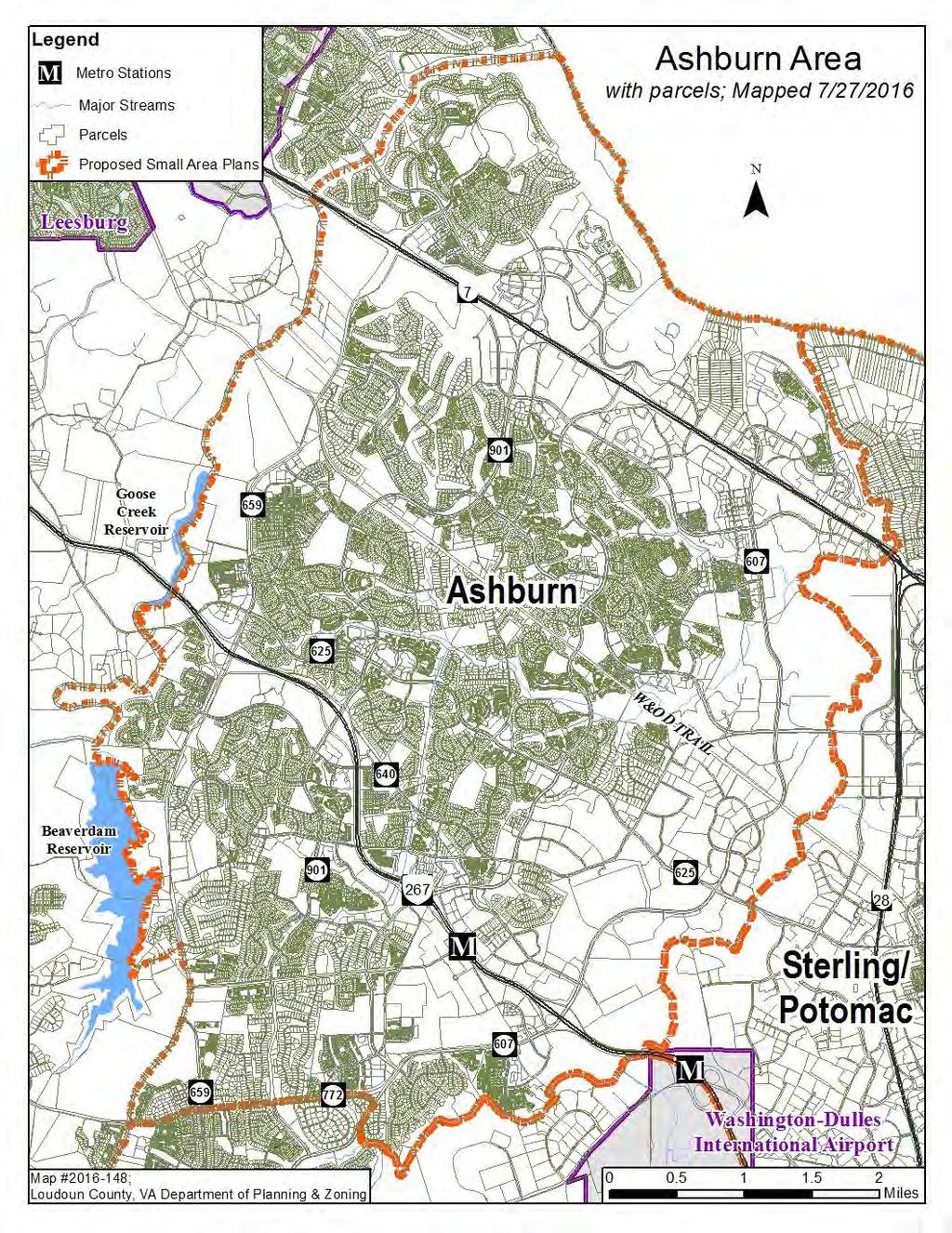
50 Attachment 5

51
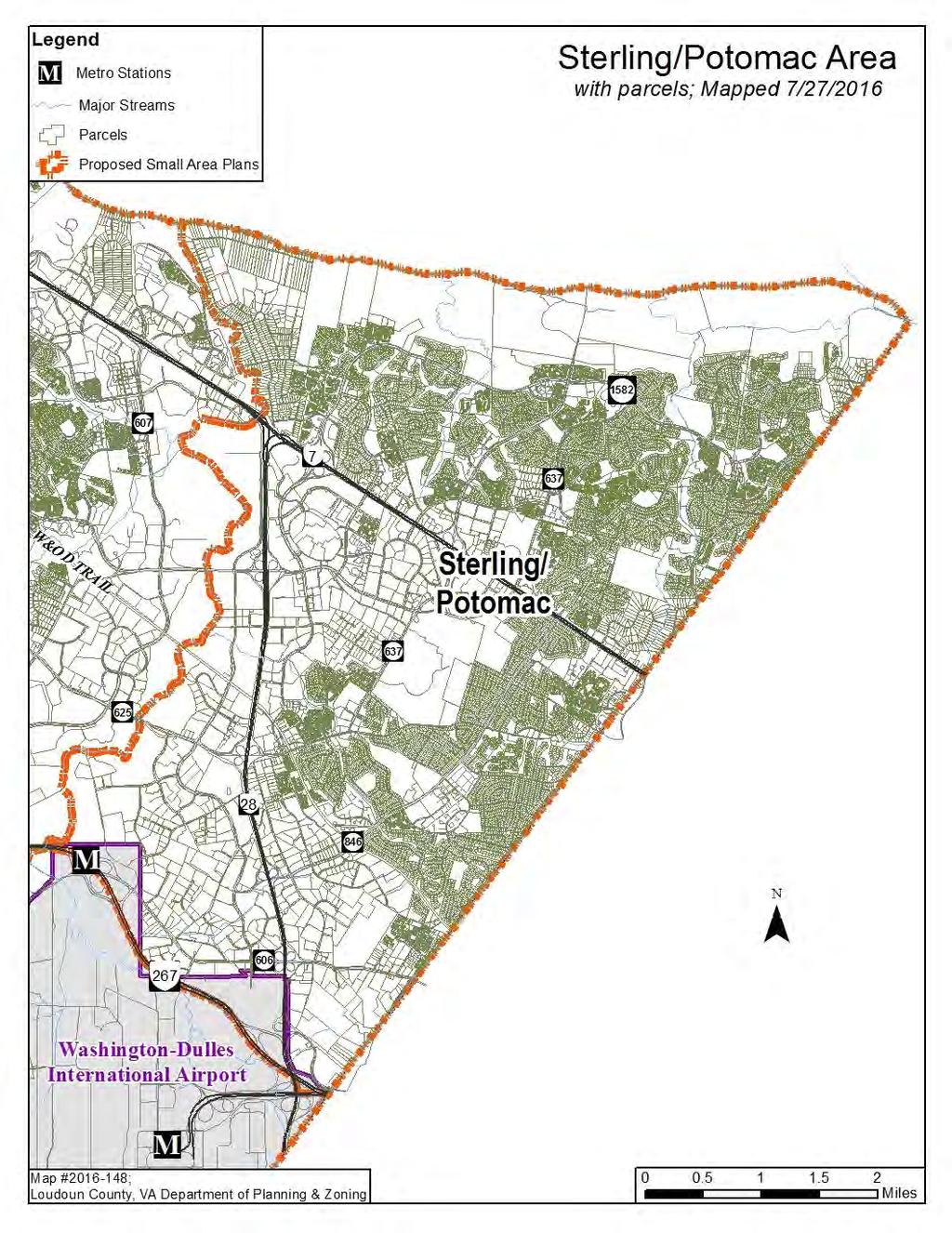
52
BOARD OF SUPERVISORS PUBLIC HEARING
 DEPARTMENT OF PLANNING Date of Hearing: October 12, 2016 AND ZONING STAFF REPORT # 15 BOARD OF SUPERVISORS PUBLIC HEARING SUBJECT: ZOAM-2016-0009, Affordable Dwelling Unit Regulations ELECTION DISTRICT:
County of Loudoun. Department of Planning and Zoning MEMORANDUM
 County of Loudoun Department of Planning and Zoning MEMORANDUM DATE: TO: FROM: Loudoun County Planning Commission Kate McConnell, AICP, Project Manager, Zoning Administration Ricky Barker, AICP, Director,
ORDINANCE NO. AN ORDINANCE OF THE CITY COUNCIL OF THE CITY OF DALY CITY REPEALING AND REPLACING CHAPTER RE: INCLUSIONARY HOUSING
 ORDINANCE NO. AN ORDINANCE OF THE CITY COUNCIL OF THE CITY OF DALY CITY REPEALING AND REPLACING CHAPTER 17.47 RE: INCLUSIONARY HOUSING The City Council of the City of Daly City, DOES ORDAIN as follows:
BOARD OF SUPERVISORS BUSINESS MEETING ACTION ITEM
 Date of Meeting: BOARD OF SUPERVISORS BUSINESS MEETING ACTION ITEM # 5 SUBJECT: ELECTION DISTRICT: CRITICAL ACTION DATE: STAFF CONTACTS: Resolutions of Intent to Amend: Revised 1993 Loudoun County Zoning
ARTICLE 3: Zone Districts
 ARTICLE 3: Zone Districts... 3-1 17.3.1: General...3-1 17.3.1.1: Purpose and Intent... 3-1 17.3.2: Districts and Maps...3-1 17.3.2.1: Applicability... 3-1 17.3.2.2: Creation of Districts... 3-1 17.3.2.3:
SECTION 1 INTRODUCTION TO THE PANAMA CITY BEACH COMPREHENSIVE GROWTH DEVELOPMENT PLAN
 1. PURPOSE SECTION 1 INTRODUCTION TO THE PANAMA CITY BEACH COMPREHENSIVE GROWTH DEVELOPMENT PLAN The purpose of the City of Panama City Beach's Comprehensive Growth Development Plan is to establish goals,
ZRTD , Glenn Drive. M. Tyler Klein, AICP, Project Manager, Planning and Zoning John Merrithew, Acting Director, Planning and Zoning
 DEPARTMENT OF PLANNING Date of Hearing: AND ZONING STAFF REPORT # 4 BOARD OF SUPERVISORS PUBLIC HEARING SUBJECT: ELECTION DISTRICT: ZRTD-2014-0003, 22675 Glenn Drive Broad Run CRITICAL ACTION DATE: September
PLANNING COMMISSION PUBLIC HEARING STAFF REPORT ZRTD FAIRFAX MARBLE & GRANITE
 Date of Hearing: PLANNING COMMISSION PUBLIC HEARING STAFF REPORT SUBJECT: ELECTION DISTRICT: ZRTD-2016-0009 FAIRFAX MARBLE & GRANITE Broad Run CRITICAL ACTION DATE: September 27, 2017 STAFF CONTACTS: APPLICANT:
ORDINANCE NO
 Introduced by: Penrose Hollins Date of introduction: October 14, 2014 ORDINANCE NO. 14-109 TO AMEND CHAPTER 40 OF THE NEW CASTLE COUNTY CODE (ALSO KNOWN AS THE UNIFIED DEVELOPMENT CODE OR UDC ), ARTICLE
CHAPTER 21.12: NONCONFORMITIES
 CHAPTER 21.12: NONCONFORMITIES 21.12.010 GENERAL PROVISIONS... 12-2 A. Purpose... 12-2 B. Authority to Continue... 12-2 C. Determination of Nonconformity Status... 12-3 D. Government Agency Property Acquisitions...
CHAPTER Committee Substitute for Committee Substitute for Senate Bill No. 2188
 CHAPTER 2004-372 Committee Substitute for Committee Substitute for Senate Bill No. 2188 An act relating to land development; amending s. 197.502, F.S.; providing for the issuance of an escheatment tax
C Secondary Suite Process Reform
 2018 March 12 Page 1 of 9 EXECUTIVE SUMMARY On 2017 December 11, through Notice of Motion C2017-1249 (Secondary Suite Process Reform) Council directed Administration to implement several items: 1. Land
ASSEMBLY, No. 266 STATE OF NEW JERSEY. 218th LEGISLATURE PRE-FILED FOR INTRODUCTION IN THE 2018 SESSION
 ASSEMBLY, No. STATE OF NEW JERSEY th LEGISLATURE PRE-FILED FOR INTRODUCTION IN THE 0 SESSION Sponsored by: Assemblyman SEAN T. KEAN District 0 (Monmouth and Ocean) Assemblyman EDWARD H. THOMSON District
EVALUATION AND APPRAISAL REPORT OF THE CITY OF FELLSMERE COMPREHENSIVE PLAN APPENDIX D HOUSING ELEMENT
 OBJECTIVE H-A-1: ALLOW AFFORDABLE HOUSING AND ADEQUATE SITES FOR VERY LOW, LOW, AND MODERATE INCOME HOUSING. The City projects the total need for very low, low, and moderate income-housing units for the
LETTER OF OPPOSITION TO SENATE BILL 1069 (WIECKOWSKI) ACCESSORY DWELLING UNITS
 ACCESSORY DWELLING UNITS") STAFF REPORT MEETING DATE: September 27, 2016 TO: FROM: City Council Cathy Capriola, Interim City Manager 922 Machin Avenue Novato, CA 94945 415/ 899-8900 FAX 415/ 899-8213 www.novato.org SUBJECT: LETTER
STAFF REPORT MEETING DATE: September 27, 2016 TO: FROM: City Council Cathy Capriola, Interim City Manager 922 Machin Avenue Novato, CA 94945 415/ 899-8900 FAX 415/ 899-8213 www.novato.org SUBJECT: LETTER
7. IMPLEMENTATION STRATEGIES
 7. IMPLEMENTATION STRATEGIES A. GENERAL APPROACH FOR IMPLEMENTATION Implementing the plan will engage many players, including the Municipality of Anchorage (MOA), the Government Hill Community Council,
PLANNING COMMISSION PUBLIC HEARING STAFF REPORT ZRTD NVA DEVELOPMENT
 Date of Hearing: PLANNING COMMISSION PUBLIC HEARING STAFF REPORT SUBJECT: ELECTION DISTRICT: ZRTD-2016-0005 NVA DEVELOPMENT Broad Run CRITICAL ACTION DATE: July 18, 2017 STAFF CONTACTS: APPLICANT: Jacqueline
H-POLICY 1: Preserve and improve existing neighborhoods. Ensure that Prince William County achieves new neighborhoods with a high quality of life.
 HOUSING Intent The intent of the Housing Plan is to provide a framework for providing for the housing needs of all residents of Prince William County. These needs are expressed in terms of quality, affordability,
EXHIBIT A. City of Corpus Christi Annexation Guidelines
 City of Corpus Christi Annexation Guidelines Purpose: The purpose of this document is to describe the City of Corpus Christi s Annexation Guidelines. The Annexation Guidelines provide the guidance and
COUNTY OF SAN MATEO Inter-Departmental Correspondence Planning and Building. Steve Monowitz, Community Development Director
 COUNTY OF SAN MATEO Inter-Departmental Correspondence Planning and Building Date: December 2, 2016 Board Meeting Date: January 10, 2017 Special Notice / Hearing: Newspaper Notice Vote Required: Majority
ORDINANCE NO AN ORDINANCE AMENDING THE CODE OF ORDINANCES OF THE CITY OF PORT ARANSAS, TEXAS, BY ADOPTING A NEW CHAPTER
 ORDINANCE NO. 2008-09 AN ORDINANCE AMENDING THE CODE OF ORDINANCES OF THE CITY OF PORT ARANSAS, TEXAS, BY ADOPTING A NEW CHAPTER TWENTY-SIX CONCERNING IMPACT FEES FOR ROADWAY FACILITIES; INCORPORATING
OFFICIAL TOWNSHIP OF MOON ORDINANCE NO.
 OFFICIAL TOWNSHIP OF MOON ORDINANCE NO. AN ORDINANCE OF THE TOWNSHIP OF MOON, ALLEGHENY COUNTY, PENNSYLVANIA, AMENDING CHAPTER 1, PART 3A OF THE MOON TOWNSHIP CODE OF ORDINANCES, TOWNSHIP MANAGER, TO REVISE
RESOLUTION NO
 RESOLUTION NO. 074532 BOARD OF SUPERVISORS, COUNTY OF SAN MATEO, STATE OF CALIFORNIA * * * * * * RESOLUTION ESTABLISHING RATES FOR AN AFFORDABLE HOUSING IMPACT FEE PROGRAM FOR NEW RESIDENTIAL AND NON-RESIDENTIAL
ORDINANCE NO
 Item 4 Attachment A ORDINANCE NO. 2017-346 AN ORDINANCE OF THE CITY COUNCIL OF THE CITY OF CALABASAS, CALIFORNIA AMENDING CHAPTER 17.22 OF THE CALABASAS MUNICIPAL CODE, AFFORDABLE HOUSING, TO BRING INTO
Page 1 of 17. Office of the City Manager ACTION CALENDAR March 28, 2017 (Continued from February 28, 2017)
") Page 1 of 17 Office of the City Manager ACTION CALENDAR March 28, 2017 (Continued from February 28, 2017) To: From: Honorable Mayor and Members of the City Council Dee Williams-Ridley, City Manager Submitted
Page 1 of 17 Office of the City Manager ACTION CALENDAR March 28, 2017 (Continued from February 28, 2017) To: From: Honorable Mayor and Members of the City Council Dee Williams-Ridley, City Manager Submitted
COUNTY OF LOUDOUN DEPARTMENT OF PLANNING AND ZONING MEMORANDUM
 COUNTY OF LOUDOUN DEPARTMENT OF PLANNING AND ZONING MEMORANDUM DATE: October 20, 2016 TO: FROM: SUBJECT: PURPOSE: Loudoun County Planning Commission Mark A. Depo, Zoning Administration Ricky Barker, Director,
CHAPTER Committee Substitute for Committee Substitute for House Bill No. 437
 CHAPTER 2013-83 Committee Substitute for Committee Substitute for House Bill No. 437 An act relating to community development; amending s. 159.603, F.S.; revising the definition of qualifying housing development
ARTICLE 1 GENERAL PROVISIONS
 ARTICLE 1 GENERAL PROVISIONS SECTION 100 TITLE This Ordinance shall be known and cited as the "Rice Township Subdivision and Land Development Ordinance." SECTION 101 AUTHORITY Rice Township is empowered
GENERAL ASSEMBLY OF NORTH CAROLINA SESSION 2017 SESSION LAW HOUSE BILL 436
 GENERAL ASSEMBLY OF NORTH CAROLINA SESSION 2017 SESSION LAW 2017-138 HOUSE BILL 436 AN ACT TO PROVIDE FOR UNIFORM AUTHORITY TO IMPLEMENT SYSTEM DEVELOPMENT FEES FOR PUBLIC WATER AND SEWER SYSTEMS IN NORTH
AN ORDINANCE AMENDING AND SUPPLEMENTING THE REVISED GENERAL ORDINANCES OF THE CITY OF BAYONNE THE, CHAPTER 33 PLANNING AND DEVELOPMENT REGULATIONS
 AN ORDINANCE AMENDING AND SUPPLEMENTING THE REVISED GENERAL ORDINANCES OF THE CITY OF BAYONNE THE, CHAPTER 33 PLANNING AND DEVELOPMENT REGULATIONS WHEREAS, pursuant to N.J.S.A. 40:48-2, the Legislature
Oregon Statutes Relevant to Quiet Water Home Owners Association
 Oregon Statutes Relevant to Quiet Water Home Owners Association 1 1 1 1 0 1 0 1 0 1 PLANNED COMMUNITIES (General Provisions).0 Definitions for ORS.0 to.. As used in ORS.0 to.: (1) Assessment means any
Indicates Council-recommended changes Introduced by: Mr. Tackett Date of introduction: June 14, 2016 SUBSTITUTE NO. 1 TO ORDINANCE NO.
 Indicates Council-recommended changes Introduced by: Mr. Tackett Date of introduction: June 14, 2016 SUBSTITUTE NO. 1 TO ORDINANCE NO. 16-067 TO AMEND NEW CASTLE COUNTY CODE CHAPTER 40 (ALSO KNOWN AS THE
LYON COUNTY TITLE 15 LAND USE AND DEVELOPMENT CODE AGREEMENTS AND INCENTIVES CHAPTERS October 19, 2017 Ordinance Draft DRAFT
 DRAFT LYON COUNTY TITLE 15 LAND USE AND DEVELOPMENT CODE AGREEMENTS AND INCENTIVES CHAPTERS 15.100 15.125 October 19, 2017 Ordinance Draft This page left blank intentionally DRAFT DRAFT Lyon County Contents
[First Reprint] ASSEMBLY, No STATE OF NEW JERSEY. 213th LEGISLATURE INTRODUCED DECEMBER 14, 2009
![[First Reprint] ASSEMBLY, No STATE OF NEW JERSEY. 213th LEGISLATURE INTRODUCED DECEMBER 14, 2009](/thumbs/96/127018551.jpg "[First Reprint] ASSEMBLY, No STATE OF NEW JERSEY. 213th LEGISLATURE INTRODUCED DECEMBER 14, 2009") [First Reprint] ASSEMBLY, No. STATE OF NEW JERSEY th LEGISLATURE INTRODUCED DECEMBER, 00 Sponsored by: Assemblyman JERRY GREEN District (Middlesex, Somerset and Union) Assemblyman FREDERICK SCALERA District
[First Reprint] ASSEMBLY, No. STATE OF NEW JERSEY th LEGISLATURE INTRODUCED DECEMBER, 00 Sponsored by: Assemblyman JERRY GREEN District (Middlesex, Somerset and Union) Assemblyman FREDERICK SCALERA District
1 ORDINANCE 4, AN ORDINANCE OF THE CITY COUNCIL OF THE CITY OF PALM 5 BEACH GARDENS, FLORIDA AMENDING CHAPTER TAXATION.
 1 ORDINANCE 4, 2013 2 3 4 AN ORDINANCE OF THE CITY COUNCIL OF THE CITY OF PALM 5 BEACH GARDENS, FLORIDA AMENDING CHAPTER 66. 6 TAXATION. BY CREATING A NEW ARTICLE VI. ENTITLED 7 ECONOMIC DEVELOPMENT AD
INCENTIVE POLICY FOR AFFORDABLE HOUSING
 INCENTIVE POLICY FOR AFFORDABLE HOUSING PREPARED BY: CITY OF FLAGSTAFF S HOUSING SECTION COMMUNITY DEVELOPMENT DIVISION OCTOBER 2009 2 1 1 W e s t A s p e n A v e. t e l e p h o n e : 9 2 8. 7 7 9. 7 6
VILLAGE OF NORTHBROOK AFFORDABLE HOUSING PLAN
 VILLAGE OF NORTHBROOK AFFORDABLE HOUSING PLAN I. AUTHORITY In 2003, the Illinois General Assembly adopted Public Act 93-0595, the Affordable Housing Planning and Appeals Act, which became effective January
Senate Bill No CHAPTER 928. An act to amend Section of the Government Code, relating to housing.
 Senate Bill No. 1818 CHAPTER 928 An act to amend Section 65915 of the Government Code, relating to housing. [Approved by Governor September 29, 2004. Filed with Secretary of State September 30, 2004.]
PUTNAM, CONNECTICUT BROOKLYN, CONNECTICUT INTERLOCAL AGREEMENT FOR QUINEBAUG REGIONAL TECHNOLOGY PARK DEVELOPMENT. Dated as, 2014
 PUTNAM, CONNECTICUT BROOKLYN, CONNECTICUT INTERLOCAL AGREEMENT FOR QUINEBAUG REGIONAL TECHNOLOGY PARK DEVELOPMENT Dated as, 2014 WORKING DRAFT STILL SUBJECT TO INTERNAL REVIEW AND MODIFICATION INTERLOCAL
Assembly Bill No. 489 Committee on Growth and Infrastructure CHAPTER...
 Assembly Bill No. 489 Committee on Growth and Infrastructure CHAPTER... AN ACT relating to the taxation of property; providing for the partial abatement of the ad valorem taxes imposed on property; directing
AN ORDINANCE BY COUNCILMEMBERS ANDRE DICKENS, KWANZA HALL, AND CLETA WINSLOW
 AN ORDINANCE BY COUNCILMEMBERS ANDRE DICKENS, KWANZA HALL, AND CLETA WINSLOW AN ORDINANCE TO AMEND THE 1982 ATLANTA ZONING ORDINANCE, AS AMENDED, CITY OF ATLANTA CODE OF ORDINANCES PART 16, SO AS TO ADD
BILL H.3653: An Act Financing the Production and Preservation of Housing for Low and Moderate Income Residents
 BILL H.3653: An Act Financing the Production and Preservation of Housing for Low and Moderate Income Residents SECTION 2 Authorizes capital spending amounts and provides line item language describing permitted
Prince George s County Zoning Ordinance and Subdivision Regulations Rewrite March 13, 2017
 Prince George s County Zoning Ordinance and Subdivision Regulations Rewrite March 13, 2017 The Maryland National Capital Park & Planning Commission 1 Worksessions Schedule Topic Date Zone Structure January
BOARD OF SUPERVISORS BUSINESS MEETING ACTION ITEM
 BOARD OF SUPERVISORS BUSINESS MEETING ACTION ITEM Date of Meeting: October 4, 2016 # 15a SUBJECT: ELECTION DISTRICT: CRITICAL ACTION DATE: STAFF CONTACTS: TRANSPORTATION AND LAND USE COMMITTEE REPORT:
GUIDELINES AND CRITERIA. For Granting Tax Abatement in the North Killeen Revitalization Area. Designated by the City of Killeen, Texas
 GUIDELINES AND CRITERIA For Granting Tax Abatement in the North Killeen Revitalization Area Designated by the City of Killeen, Texas Under Tax Code, Chapter 312 I. PURPOSE The designation of a Tax Abatement
State of California GOVERNMENT CODE. Section
 State of California GOVERNMENT CODE Section 65852.2 65852.2. (a) (1) A local agency may, by ordinance, provide for the creation of accessory dwelling units in single-family and multifamily residential
BOARD OF SUPERVISORS BUSINESS MEETING INFORMATION ITEM. Briefing Item: Land Development Applications November 9, 2016 Public Hearing
 BOARD OF SUPERVISORS BUSINESS MEETING INFORMATION ITEM Date of Meeting: November 1, 2016 # I-1 SUBJECT: ELECTION DISTRICT: STAFF CONTACTS: Briefing Item: Land Development Applications Public Hearing Countywide
Impact Fees. Section 1 Purpose and Intent.
 Impact Fees 1 Purpose and Intent 2 Definitions 3 Establishment of Impact Fees 4 Documentation Required 5 Segregated Accounts Required 6 Time Within Which To Use Impact Fees 7 Payment of Impact Fees 8 Appeals
COLDSTREAM (PC-1) INCLUSIONARY HOUSING PLAN
 INCLUSIONARY HOUSING PLAN") COLDSTREAM (PC-1) INCLUSIONARY HOUSING PLAN A. Overview The proposed affordable housing strategy for PC-1 has evolved over time to reflect changes in the marketplace, including the loss of redevelopment
COLDSTREAM (PC-1) INCLUSIONARY HOUSING PLAN A. Overview The proposed affordable housing strategy for PC-1 has evolved over time to reflect changes in the marketplace, including the loss of redevelopment
ASSEMBLY BILL No. 904
 AMENDED IN SENATE JULY, 0 AMENDED IN SENATE JUNE, 0 AMENDED IN SENATE JUNE, 0 AMENDED IN ASSEMBLY JANUARY, 0 AMENDED IN ASSEMBLY MAY 0, 0 AMENDED IN ASSEMBLY APRIL, 0 AMENDED IN ASSEMBLY MARCH, 0 california
 EXHIBIT A: Proposed Ordinance CPC-2016-1245-CA May 12, 2016 Exhibit A CPC 2016 1245 CA ORDINANCE NO. An ordinance repealing Subsections 12.24.W.43 and 12.24.W.44 of Chapter 1 of the Los Angeles Municipal
Guidelines for Implementation of the Inclusionary Housing Ordinance of the City of San José, Chapter 5.08 of the San José Municipal Code.
 Guidelines for Implementation of the Inclusionary Housing Ordinance of the City of San José, Chapter 5.08 of the San José Municipal Code. Interim Version Approved June 30, 2016 Revised July 16, 2018 This
SECTION I - INTRODUCTION
 - INTRODUCTION 1 2 - INTRODUCTIONION THE MASTER PLAN State law requires every community to have a Master Plan establishing an orderly guide to the use of lands in the community to protect public health
ADUs and You! Common types of ADUs include mother-in-law suite, garage apartments and finished basements.
 ADUs and You! Accessory Dwelling Units Town of Lyons Accessory Dwelling Units (ADUs) are a form of housing that can be an important tool for diversifying and increasing the local housing stock. Lyons lost
BOARD OF SUPERVISORS BUSINESS MEETING ACTION ITEM
 BOARD OF SUPERVISORS BUSINESS MEETING ACTION ITEM Date of Meeting: October 20, 2016 # 13b SUBJECT: ELECTION DISTRICT: CRITICAL ACTION DATE: STAFF CONTACTS: TRANSPORTATION AND LAND USE COMMITTEE REPORT:
CHAPTER Committee Substitute for House Bill No. 7065
 CHAPTER 2013-59 Committee Substitute for House Bill No. 7065 An act relating to Everglades improvement and management; amending s. 373.4592, F.S.; revising legislative findings for achieving water quality
SENATE BILL 274 CHAPTER. Tax Increment Financing and Special Taxing Districts Transit Oriented Development
 SENATE BILL C, Q lr0 CF HB 00 By: The President (By Request Administration) Introduced and read first time: January, 0 Assigned to: Budget and Taxation Committee Report: Favorable with amendments Senate
CITY OF PENSACOLA AFFORDABLE HOUSING INCENTIVE PLAN
 1. BACKGROUND CITY OF PENSACOLA AFFORDABLE HOUSING INCENTIVE PLAN The Sadowski Affordable Housing Act as approved by the Florida Legislature and codified as Chapter 420 of the Florida Statutes requires
UNOFFICIAL COPY OF HOUSE BILL 1272 A BILL ENTITLED
 UNOFFICIAL COPY OF HOUSE BILL 1272 M4 6lr0525 By: Delegates Smigiel, Kelley, Rosenberg, and Sossi Introduced and read first time: February 10, 2006 Assigned to: Environmental Matters 1 AN ACT concerning
2016 Housing Element Amendment CITY OF SAMMAMISH PLANNING COMMISSION OCTOBER 20, 2016
 2016 Housing Element Amendment CITY OF SAMMAMISH PLANNING COMMISSION OCTOBER 20, 2016 Background City adopted latest Comprehensive Plan in October 2015 (Ordinance O2015-396) Plan was challenged by property
DIVISION 9. PLANNED URBAN DEVELOPMENT CLASSIFICATION BY SPECIAL USE FOR ALL ZONING DISTRICTS Sec Statement Of Purpose: (a) Planned
 Planned") DIVISION 9. PLANNED URBAN DEVELOPMENT CLASSIFICATION BY SPECIAL USE FOR ALL ZONING DISTRICTS Sec. 12-169. Statement Of Purpose: (a) Planned developments are such substantially different character from
DIVISION 9. PLANNED URBAN DEVELOPMENT CLASSIFICATION BY SPECIAL USE FOR ALL ZONING DISTRICTS Sec. 12-169. Statement Of Purpose: (a) Planned developments are such substantially different character from
IC Chapter 15. Public Safety Communications Systems and Computer Facilities Districts
 IC 36-8-15 Chapter 15. Public Safety Communications Systems and Computer Facilities Districts IC 36-8-15-1 Application of chapter Sec. 1. This chapter applies to the following counties: (1) A county having
SB 1818 Q & A. CCAPA s Answers to Frequently Asked Questions Regarding SB 1818 (Hollingsworth) Changes to Density Bonus Law
 Changes to Density Bonus Law") SB 1818 Q & A CCAPA s Answers to Frequently Asked Questions Regarding SB 1818 (Hollingsworth) Changes to Density Bonus Law - 2005 Prepared by Vince Bertoni, AICP, Bertoni Civic Consulting & CCAPA Vice
SB 1818 Q & A CCAPA s Answers to Frequently Asked Questions Regarding SB 1818 (Hollingsworth) Changes to Density Bonus Law - 2005 Prepared by Vince Bertoni, AICP, Bertoni Civic Consulting & CCAPA Vice
Town of Bristol Rhode Island
 Town of Bristol Rhode Island Subdivision & Development Review Regulations Adopted by the Planning Board September 27, 1995 (March 2017) Formatted: Highlight Formatted: Font: 12 pt Table of Contents TABLE
AGENDA REPORT SUMMARY. Ordinance No : Density Bonus Regulations
 PUBLIC HEARING Agenda Item # 5 Meeting Date: September 12, 2017 AGENDA REPORT SUMMARY Subject: Prepared by: Approved by: Ordinance No. 2017-435: Density Bonus Regulations Jon Biggs, Community Development
STATE OF CALIFORNIA AUTHENTICATED ELECTRONIC LEGAL MATERIAL. State of California GOVERNMENT CODE. Section 65915
 STATE OF CALIFORNIA AUTHENTICATED ELECTRONIC LEGAL MATERIAL State of California GOVERNMENT CODE Section 65915 65915. (a) When an applicant seeks a density bonus for a housing development within, or for
LIHPRHA, Pub. L. No , Title VI (1990), codified at 12 U.S.C et seq.
, codified at 12 U.S.C et seq.") LIHPRHA, Pub. L. No. 101-625, Title VI (1990), codified at 12 U.S.C. 4101 et seq. TITLE VI--PRESERVATION OF AFFORDABLE RENTAL HOUSING Subtitle A--Prepayment of Mortgages Insured Under National Housing
LIHPRHA, Pub. L. No. 101-625, Title VI (1990), codified at 12 U.S.C. 4101 et seq. TITLE VI--PRESERVATION OF AFFORDABLE RENTAL HOUSING Subtitle A--Prepayment of Mortgages Insured Under National Housing
BOARD OF SUPERVISORS BUSINESS MEETING ACTION ITEM. At the pleasure of the Board
 BOARD OF SUPERVISORS BUSINESS MEETING ACTION ITEM Date of Meeting: June 23, 2016 # 7 SUBJECT: ELECTION DISTRICT: CRITICAL ACTION DATE: STAFF CONTACTS: Initiation of Amendments to Article 7 of the Revised
MIDWAY CITY Municipal Code
 MIDWAY CITY Municipal Code TITLE 9 ANNEXATION CHAPTER 9.01 PURPOSE CHAPTER 9.02 GENERAL REQUIREMENTS CHAPTER 9.03 PROPERTY OWNER INITIATION OF ANNEXATION CHAPTER 9.04 PROCEDURES FOR CONSIDERATION OF PETITION
Amendment to the Zoning and Subdivision Ordinances; Consider Repeal Cluster Development Standards
 2 Board of Supervisors Meg Bohmke, Chairman Gary F. Snellings, Vice Chairman Jack R. Cavalier Thomas C. Coen L. Mark Dudenhefer Wendy E. Maurer Cindy C. Shelton February 28, 2018 Thomas C. Foley County
This division may be cited as the Subdivision Map Act.
 CALIFORNIA CODES GOVERNMENT CODE SECTION 66410-66413.5 66410. This division may be cited as the Subdivision Map Act. 66411. Regulation and control of the design and improvement of subdivisions are vested
CHAPTER 40R LOCAL ZONING BYLAW GUIDANCE DOCUMENT
 CHAPTER 40R LOCAL ZONING BYLAW GUIDANCE DOCUMENT OVERVIEW This document has been developed by the Department of Housing and Community Development (DHCD, or the Department) to assist communities in drafting
Charter Township of Lyon P.A. 198 Industrial Facilities Tax Exemption Tax Abatement Guidelines
 1 Charter Township of Lyon P.A. 198 Industrial Facilities Tax Exemption Tax Abatement Guidelines A company that is in the planning phase of a major business attraction or expansion project that will include
BOARD OF SUPERVISORS BUSINESS MEETING ACTION ITEM. At the pleasure of the Board
 BOARD OF SUPERVISORS BUSINESS MEETING ACTION ITEM Date of Meeting: March 7, 2017 # 7 SUBJECT: ELECTION DISTRICT: CRITICAL ACTION DATE: STAFF CONTACTS: Tall Oaks Water and Sewer Project Service Agreement
Nassau County 2030 Comprehensive Plan. Housing Element (H) Goals, Objectives and Policies. Goal
 Goals, Objectives and Policies. Goal") (H) Goal Assist the private sector to provide and maintain an adequate inventory of decent, safe and sanitary housing in suitable neighborhoods at affordable costs to meet the need of the present and future
(H) Goal Assist the private sector to provide and maintain an adequate inventory of decent, safe and sanitary housing in suitable neighborhoods at affordable costs to meet the need of the present and future
Draft Ordinance: subject to modification by Town Council based on deliberations and direction ORDINANCE 2017-
 ORDINANCE 2017- Draft Ordinance: subject to modification by Town Council based on deliberations and direction AN INTERIM URGENCY ORDINANCE OF THE TOWN COUNCIL OF THE TOWN OF LOS GATOS ESTABLISHING A TEMPORARY
Draft Zoning Changes for the 2nd Planning Board Public Hearing, January 22, 2018.
 Draft Zoning Changes for the 2nd Planning Board Public Hearing, January 22, 2018. No changes were made at the 1st Public Hearing. Proposed wording for the 1 st Public Hearing in red, eliminated text in
Town of Yucca Valley GENERAL PLAN 1
 Town of Yucca Valley GENERAL PLAN 1 This page intentionally left blank. 3 HOUSING ELEMENT The Housing Element is intended to guide residential development and preservation consistent with the overall values
A Guide to the Municipal Planning Process in Saskatchewan
 A Guide to the Municipal Planning Process in Saskatchewan A look at the municipal development permit and the subdivision approval process in Saskatchewan May 2008 Prepared By: Community Planning Branch
ARTICLE I Inclusionary Affordable Housing Requirements [Adopted ; amended (Ch. III, Art. LXIII, of the General Ordinance)]
![ARTICLE I Inclusionary Affordable Housing Requirements [Adopted ; amended (Ch. III, Art. LXIII, of the General Ordinance)]](/thumbs/82/85144982.jpg "ARTICLE I Inclusionary Affordable Housing Requirements [Adopted ; amended (Ch. III, Art. LXIII, of the General Ordinance)]") Chapter 9: AFFORDABLE HOUSING [HISTORY: Adopted by the Town of Barnstable as indicated in article histories. Amendments noted where applicable.] GENERAL REFERENCES Rental property See Ch. 170. Zoning See
Chapter 9: AFFORDABLE HOUSING [HISTORY: Adopted by the Town of Barnstable as indicated in article histories. Amendments noted where applicable.] GENERAL REFERENCES Rental property See Ch. 170. Zoning See
1 #N7 AMX42TOD4BVTv1
 Introduced by: ORDINANCE NO. AN ORDINANCE OF THE CITY OF ~ASADENA AMENDING TITLE 17 (ZONING CODE) OF THE PASADENA MUNICIPAL CODE TO ALLOW THE CONVERSION OF HOTELS AND MOTELS TO AFFORDABLE HOUSING, AND
BYLAW a) To impose and provide for the payment of Off-site development levies;
 To impose and provide for the payment of Off-site development levies;") BYLAW 2018-3388 A Bylaw of the City of Weyburn, in the Province of Saskatchewan to establish an Off-Site Development Levy in respect of land that is to be subdivided, developed or redeveloped within the
BYLAW 2018-3388 A Bylaw of the City of Weyburn, in the Province of Saskatchewan to establish an Off-Site Development Levy in respect of land that is to be subdivided, developed or redeveloped within the
Buildings for Lease or Rent
 Buildings for Lease or Rent Table of Contents Page 1. Purpose 3 2. Authority & Administration 3 3. Applicability 3 4. Definitions 3 5. Requirements for Buildings for Rent or Lease 4 6. Application & Review
RECITALS. WHEREAS, the GMA requires counties to adopt county-wide planning policies in cooperation with cities within the County; and
 AN INTERLOCAL AGREEMENT FOR THE IMPLEMENTATION OF A DEMONSTRATION PROJECT TO TRANSFER DEVELOPMENT RIGHTS FROM RURAL UNINCORPORATED KING COUNTY TO THE DENNY TRIANGLE IN DOWNTOWN SEATTLE This Agreement is
Infill Development Incentive Policy
 Infill Development Incentive Policy PURPOSE It is the policy of the City of El Paso to provide incentives to promote infill development, reduce sprawl, increase the availability of attainable housing and
Cabarrus County, NC Adequate Public Facilities Ordinance. Contents
 Contents Section 15. Adequate Public Facilities Standards.... 2 Section 15-1. Introduction.... 2 Section 15-2. How to Use this Chapter.... 3 Section 15-3. Basic Terms and Definitions... 4 Section 15-4.
AGENDA REPORT SUMMARY. Jon Biggs, Community Development Director and Katy Wisinski, Assistant City Attorney
 PUBLIC HEARING Agenda Item # 9 Meeting Date: September 26, 2017 AGENDA REPORT SUMMARY Subject: Prepared by: Approved by: Density Bonus Regulations Jon Biggs, Community Development Director and Katy Wisinski,
LOUDOUN COUNTY BOARD OF SUPERVISORS PUBLIC HEARING. Wednesday, May 10, :00 p.m. Board Room, First Floor, Government Center AGENDA SUMMARY
 LOUDOUN COUNTY BOARD OF SUPERVISORS PUBLIC HEARING Wednesday, 6:00 p.m. Board Room, First Floor, Government Center I. CALL TO ORDER AGENDA SUMMARY II. BOARD OF SUPERVISORS PUBLIC HEARING ITEMS FOR CONSIDERATION:
Puyallup Downtown Planned Action & Code Changes. January 10, 2017
 Puyallup Downtown Planned Action & Code Changes January 10, 2017 Purpose & Location Purpose Promote economic development and downtown revitalization Tools: Municipal Code amendments Change development
TRANSPORTATION AND CAPITAL IMPROVEMENTS IMPACT FEES
 Effective September 1, 2016 Chapter 15.74 TRANSPORTATION AND CAPITAL IMPROVEMENTS IMPACT FEES Article I General Provisions 15.74.010 Purpose. 15.74.020 Findings. 15.74.030 Definitions. 15.74.040 Applicability.
City of Piedmont COUNCIL AGENDA REPORT
 City of Piedmont COUNCIL AGENDA REPORT DATE: May 15, 2017 TO: FROM: SUBJECT: Mayor and Council Paul Benoit, City Administrator Consideration of the 2 nd Reading of Ordinance 731 N.S. - Amending Division
Chair Mark Seifert Presiding. 1. Roll Call. 2. Approval of Agenda. 3. Recognition by Planning Commission of Interested Citizens.
 If Commissioners have any comments, concerns or questions, they should contact the staff Project Manager prior to the scheduled meeting date. Also, if you are for any reason unable to attend the meeting,
STAFF REPORT. Permit Number: Unlimited. Kitsap County Board of Commissioners; Kitsap County Planning Commission
 STAFF REPORT Permit Number: 15 00550 Unlimited DATE: March 2, 2016 TO: FROM: Kitsap County Board of Commissioners; Kitsap County Planning Commission Katrina Knutson, AICP, Senior Planner, DCD and Jeff
ARLINGTON COUNTY, VIRGINIA
 ARLINGTON COUNTY, VIRGINIA County Board Agenda Item Meeting of January 21, 2006 DATE: January 5, 2006 SUBJECT: Action on Proposed Amendments to provide for the achievement of affordable housing objectives
2003 Tax Abatement Policy Guidelines & Criteria City of Shenandoah, Texas
 2003 Tax Abatement Policy Guidelines & Criteria City of Shenandoah, Texas Adopted: May 27, 1993 Revised: May 28, 1997 Revised: March 26, 2003 Revised: May 14, 2003 PAGE -1- SECTION I: PREAMBLE This Tax
BEVERLY HILLS AGENDA REPORT
 BEVERLY HILLS Meeting Date: June 8, 2015 Item Number: i To: From: Subject: AGENDA REPORT Honorable Mayor & City Council Susan Healy Keene, AICP, Director of Community Development Ryan Gohlich, Assistant
CITY OF ALBUQUERQUE SIXTEENTH COUNCIL
 City of Albuquerque Albuquerque/Bernalillo County Government Center One Civic Plaza Albuquerque, NM 87102 Legislation Text File #: R-04-159, Version: 3 CITY OF ALBUQUERQUE SIXTEENTH COUNCIL COUNCIL BILL
 Page 1 of 8 Highlands County, Florida, Code of Ordinances >> - CODE OF ORDINANCES >> Chapter 5.4 - HOUSING >> ARTICLE II. STATE HOUSING INITIATIVES PARTNERSHIP PROGRAM >> ARTICLE II. STATE HOUSING INITIATIVES
BY AUTHORITY A BILL FOR AN ORDINANCE MAKING REVISIONS TO CHAPTERS 2 THROUGH 5 OF TITLE XI OF THE WESTMINSTER MUNICIPAL CODE
 BY AUTHORITY ORDINANCE NO. 3919 COUNCILLOR' S BILL NO. 6 SERIES OF 2018 INTRODUCED BY COUNCILLORS Seitz, De Cambra A BILL FOR AN ORDINANCE MAKING REVISIONS TO CHAPTERS 2 THROUGH 5 OF TITLE XI OF THE WESTMINSTER
ORDINANCE City of DeBary Comprehensive Plan Amendments Page 1 of 3
 ORDINANCE 01-15 AN ORDINANCE OF THE CITY COUNCIL OF DEBARY, FLORIDA, AMENDING THE CITY S COMPREHENSIVE PLAN FUTURE LAND USE ELEMENT TEXT AMENDING COMPREHENSIVE PLAN POLICY 5.406 CONCERNING THE SOUTHEAST