APPLICATION FOR ZONING CHANGE/ PUD HICKORY RIDGE
|
|
|
- Helena Wilson
- 5 years ago
- Views:
Transcription
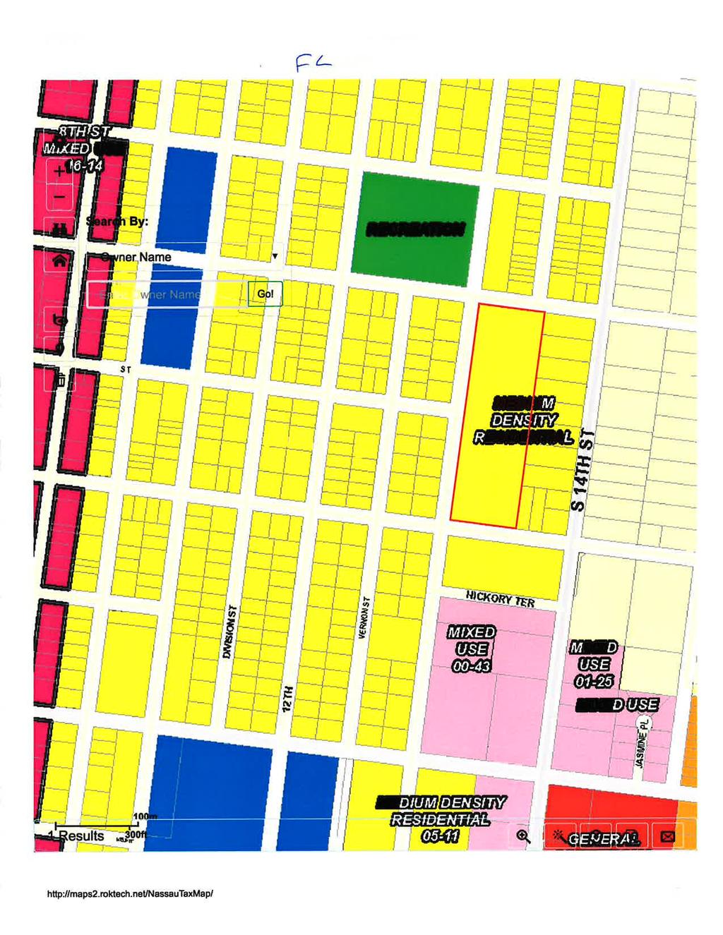
1 STAFF REPORT PAB (Zoning Change: PUD) Planning Advisory Board Hearing October 11, 2017 APPLICATION & SURROUNDING AREA INFORMATION: OWNER/APPLICANT: Simmons 9, LLC AGENT: Gillette and Associates, Inc. REQUESTED ACTION: Zoning Change for Planned Unit Development (PUD) LOCATION: S. 13 th Street between Hickory and Fir Streets CURRENT LAND USE + Medium Density Residential (MDR) Land Use + ZONING: Medium Density Residential (R-2) zoning EXISTING USES ON SITE: Vacant Land PROPERTY SIZE: 5.13 Acres Parcel ID #: ADJACENT PROPERTIES: Direction Existing Use(s) Year Built Zoning FLUM North Recreation- Elm Street REC Recreation Park Ball Fields South Affordable Housing- MU-1 Mixed Use Attached duplex units East Single Family Detached Homes R-2 Medium Density Residential West Vacant and Single Family Detached Homes R-2 Medium Density Residential *** All required application materials have been received. All fees have been paid. All required notices have been made. All copies of required materials are part of the official record and have been made available on the City s website and at the Community Development Department Office. *** SUMMARY OF REQUEST AND BACKGROUND INFORMATION: The applicant, Simmons 9, LLC, requests consideration of a Planned Unit Development Overlay (zoning change) for 5.13 acres of undeveloped land located on S. 13 th Street between Hickory Street and Fir Street. The request is made to provide flexibility from minimum site design standards and allow for increased open space areas and multiple housing types (3 duplex units and 35 single family detached homes) within a subdivision totaling 41 residential dwelling units in a garden type design. The PUD requests reduced setbacks, reduced minimum lot width, and increased lot coverage on individual housing sites in order to provide additional open space, maximize preservation of trees and to increase buffering between the subdivision and the adjoining developed homes sites fronting on S. 14 th Street. The applicant seeks to create a fee simple housing product to meet workforce housing demands within a centrally located area of the City. As part of the letter of intent for the PUD, the applicant has provided an economic analysis to demonstrate how the product would fulfill this need within the community. CONSISTENCY WITH THE COMPREHENSIVE PLAN: APPLICATION FOR ZONING CHANGE/ PUD HICKORY RIDGE Policy The approval of all development shall be subject to the availability of adequate levels of service for all facilities and services that are subject to concurrency management requirements. AND Policy The City shall ensure that the location, scale, timing, and design of development is coordinated with the availability of public facilities and services. The City seeks to ensure compact development patterns that integrate neighborhood and commercial activities and promote connectivity PAB (Zoning Change for PUD) Staff Report: Page 1 of 8
2 STAFF REPORT PAB (Zoning Change: PUD) Planning Advisory Board Hearing October 11, 2017 through the use of sidewalks, bike lanes and alternative low-speed shared-use vehicle paths in order to achieve a reduction in vehicular trips on arterial roadways. The purpose of this policy is to prevent the proliferation of urban sprawl and to achieve cost effective and energy efficient land development patterns and avoid or eliminate existing patterns that may be described as: described below. a. No Areas of urban development or uses, which are not functionally related to land uses which predominate the adjacent area; b. No Areas of urban development or uses which fail to maximize the use of existing public facilities; c. No Areas of urban development or uses which fail to use areas within which public services are currently provided; and d. No Leapfrog/scattered development or ribbon/strip commercial development patterns. Policy The City shall encourage needed redevelopment and infill development through incentives such as the following: a. Density or intensity bonuses; b. Provision of alternative site design requirements in designated redevelopment areas; c. Provision of overlay districts; d. Provision of development guidelines in designated historic districts and the community redevelopment area; and e. Expedited review processes The City encourages infill development in its already urbanized areas that provide housing near job centers, preserve open space, capitalize on existing community assets such as parks, and removes the crime associated with vacant, underutilized or abandoned properties. If approved, this infill development which is located in close proximity to the Middle and High Schools and within walking distance to recreational opportunities will be in accordance with Comprehensive Plan Objective The property is within ½ a mile of retail shopping, restaurants and a movie theater. It is also less than a mile from Nassau Baptist Health complex and slightly over one (1) mile to downtown (City Hall). The proposed development is consistent with the Comprehensive Plan s direction for compact urban development and serves to maximize the use of existing public facilities. The subject property lies in an area of existing urban development. The proposed development will rely on improved roadways on S. 13 th Street, Hickory Street, and Fir Street for access to the subdivision. Water and sewer services are available to serve the site and this proposed development. No leapfrog development is occurring. Existing uses within the general area are consistent with the proposed development request to create 35 single family detached home sites and three (3) duplex housing types. The development site which is not located in a Coastal Upland Protection Zone or special flood hazard area, and the levels of service are discussed in the following paragraphs. Policy The following level of service standards are hereby adopted, and shall be used as the basis for determining the availability of facility capacity and the demand generated by a development. Facility/Service Area Wastewater Treatment System Level of Service Standard 300 gallons per day per ERU (Equivalent Residential Unit) PAB (Zoning Change for PUD) Staff Report: Page 2 of 8
3 STAFF REPORT PAB (Zoning Change: PUD) Planning Advisory Board Hearing October 11, 2017 Solid Waste Facilities Stormwater Management Facilities Potable Water Facilities Fire-Rescue Services Average Solid Waste Generation Rate: 5.9 pounds per capita per day Policy All subdivisions, multifamily, commercial, industrial, city, and institutional projects shall provide for retention of stormwater resulting from project, unless off-site shared facilities are available. For projects within areas designated for zero discharge, storage shall accommodate a ten (10)-year, twenty-four (24)-hour storm event. For all other areas, retention shall accommodate the greater of: (a) the first one-half (1/2) inch of stormwater within the boundaries of their project, or (b) the first one (1) inch of storm flow from all roofs, sidewalks, paved surfaces, and parking areas (at 100 percent runoff), whether paved or not. The project shall also provide detention for all storm flows. Detention shall prevent peak flows after development from exceeding the peak flow prior to development. Water Allocation Level of Service: 350 gallons per day per ERU (Equivalent Residential Unit) 240-second travel time to 90% of the incidents (EMS with AED or BLS) & 480-second travel time to 90% of the incidents (ALS Response) Police and Law Response Time: 3 minutes or less for emergency calls and 7 minutes or less for Enforcement Services non-emergency calls The City has five public facilities that have adopted levels of service: Transportation, Water, Sewer, Drainage, and Solid Waste. The City s ability to maintain adopted levels of service for these utilities was confirmed at the time the City annexed the property and assigned the Medium Density Residential land use and RLM Zoning. Given the established Medium Density Residential (MDR) land use and R-2 (Medium Density Residential) zoning which allows for up to eight (8) dwelling units per acre on the subject property, the development potential of the site could have resulted in a maximum of 43 dwelling units. A concurrency determination for impacts to Nassau County roadways must be assessed under the City s current requirements contained in LDC Section All proposed developments generating more than 400 Average Daily Trips (ADT) require a traffic concurrency determination from the Northeast Regional Council. Under the proposed development scenario containing 41 dwelling units, Staff estimates that approximately 392 Average Daily Trips (ADT) could be generated by this development; resulting in 41 p.m. peak hour trips 1. Traffic impacts are likely on only State and Nassau County maintained roadways. Nassau County collects mobility fees for roadway impacts based on their adopted a mobility plan. It is expected that the City will, through its adopted Interlocal agreement with Nassau County, collect mobility fees on their behalf for projects within the City. This would be similar to the past collection of transportation impact fees which ceased in The City owns and operates three potable water treatment facilities which combined can provide 18.2 million gallons per day. Potable water customers on the average consume approximately 5 million gallons per day. The City owns and operates one sanitary sewer treatment facility which has an operation/design capacity to treat 3.5 million gallons of wastewater per day. At the adopted level of service and the proposed development density, the residential units will consume 14,350 gallons of water per day (41 units x 350 gallons per ERC per day). 1 ITE Code 210 (Single-Family Detached Housing) average PM peak hour trips = 41 (~1 trip/ dwelling unit) PAB (Zoning Change for PUD) Staff Report: Page 3 of 8
4 STAFF REPORT PAB (Zoning Change: PUD) Planning Advisory Board Hearing October 11, 2017 The City owns and operates one sanitary sewer treatment facility which has an operation/design capacity to treat 3.5 million gallons of wastewater per day. The facility s customers currently generate, on average, 1.9 million gallons per day. At the adopted level of service and the proposed development density, the site will generate 33,005 gallons of wastewater per day (41 units x 2.3 x 350 gallons per ERC per day). The Commercial facilities are calculated by an Equivalent Residential Connection (ERC) standard, which is calculated by the utilities director. The utilities director indicates that plant capacity is available for the site; however, other facilities, such as pipe and lift station capacity, will have to be evaluated, and the developer will have to pay for what improvements are necessary to accommodate any proposed development. These determinations will be made in advance of site plan review and necessary improvements will be required as a part of site plan approval. As for solid waste and drainage, the City currently has a contracted services with Advanced Disposal to dispose of solid waste city-wide, therefore the impact is not necessary as part of the preliminary plat review. Drainage impacts from any new development or redevelopment will be reviewed by the City s Technical Review Committee (TRC). The City requires storm water drainage to be retained on-site and permitting through the St. John s River Water Management District (SJRWMD). Permitting from SJRWMD is a requirement for final approval and receipt of a local development order from the TRC. All public facilities and services are currently available to the development and each service is able to maintain or exceed its level of service standards as required by Policies , , and CONSISTENCY WITH THE LAND DEVELOPMENT CODE: Planned Unit Development Overlay The Planned Unit Development (PUD) Overlay is intended to provide for more than one (1) land use within a mixed use development; allow more than one (1) housing type within a residential PUD; allow innovative arrangement of streets, lots, uses, and buildings; and to improve the efficient use of infrastructure by the clustering of homes, businesses, and other uses in a coordinated, planned development. The applicant s request for a PUD is consistent with the intention of the overlay district described in LDC section There are two proposed land uses for the development, residential and conservation. As previously stated, the applicant s intent for the request is to allow for flexible building setbacks that allow for enhanced tree preservation throughout the neighborhood. The thirty foot (30 ) Right of Way (ROW) allows for a one-way traffic circulation with one entrance access and one exit access onto Citrona Drive Standards for Planned Unit Development (PUD) Overlay A. Purpose It is the purpose of the PUD overlay district to provide flexible land use and design and to allow planned diversification and integration of uses and structures, while retaining to the City the authority to establish limitations and regulations thereon for the benefit of the public health, welfare, and safety. A PUD overlay district is intended to promote economical and efficient land use, an improved level of amenities, appropriate and harmonious variety in physical development, creative design, variety of housing types, and a better urban environment. B. A PUD overlay district shall have the following characteristics: PAB (Zoning Change for PUD) Staff Report: Page 4 of 8
5 STAFF REPORT PAB (Zoning Change: PUD) Planning Advisory Board Hearing October 11, Unified control for development purposes; 2. Unified site design, planned and developed as a whole, in a single development operation or a programmed series of development operations, including lands, buildings, structures, and uses; 3. Civic spaces in residential developments which provide opportunities for resident social interaction; 4. Commercial land uses, if any, which provide convenient service, employment, and access, and yet remain separated from residential areas by the use of landscaping and natural buffers; and 5. Conservation of natural resources as set forth in Chapter 3. C. A PUD shall provide a public benefit. At a minimum, two (2) or more of the following public benefit conditions shall result from the implementation of the proposed PUD: 1. Replacement of nonconforming development; 2. Creation of public open space, such as plazas or parks; 3. Improved waterfront protection and enhancement of views of oceanfront and riverfront areas; 4. Preservation of designated historically significant structures; 5. Replacement or rehabilitation of obsolete, blighted, or underutilized buildings; or 6. Provision of bicycle paths and walkways that provide public access to public open space or water bodies. 7. An application for a PUD shall contain comprehensive and detailed plans for development of the site, including building location, building dimensions, building elevations, location, and dimensions of accessory structures, landscaping, open space, amenities, and detailed plans for infrastructure. D. An application for a PUD shall contain comprehensive and detailed plans for development of the site, including building location, building dimensions, building elevations, location and dimensions of accessory structures, landscaping, open space, amenities, and detailed plans for infrastructure. E. An application for approval of a PUD shall include a description of the program for provision, operation, and maintenance of areas, improvements, facilities, and services intended for common use by some or all of the occupants of the PUD, but which will not be provided, operated, or maintained at general public expense. F. A PUD overlay district is permissible in the following zoning districts: R-1, RLM, R-2, R-3, MU-1, C-1, and C-2. G. A PUD overlay district is prohibited within the Coastal High Hazard Area as established in the Comprehensive Plan. H. The following general design standards shall be used in evaluating a PUD: 1. The preferred access to a PUD is an arterial or major collector street. A PUD shall be located and designed to minimize traffic impacts in established residential neighborhoods. 2. The natural topography, soils, natural vegetation, and surface water shall be preserved and utilized through the careful location and design recreation areas, open space, and drainage facilities. Open space areas shall utilize wetlands, floodplains, shorelines and other natural features. I. The following specific design requirements apply to PUD development: 1. The minimum land area for a PUD is five (5) acres, except as set forth in Section (I)(2) below. 2. Where a minimum of twenty-five (25) percent of the dwellings in a residential PUD are set aside to meet affordable housing needs, the minimum land area may be reduced to two (2) acres. 3. A residential PUD shall include two (2) or more housing types. Permissible housing types include: single-family attached, single-family detached, townhouse, duplex, triplex, and multi-family buildings. 4. Within a residential PUD, five (5) percent of the land area shall be designed and used for civic or recreational purposes. Water bodies and wetlands shall not be included within the calculation of land area set aside for civic or recreational purposes. PAB (Zoning Change for PUD) Staff Report: Page 5 of 8
6 STAFF REPORT PAB (Zoning Change: PUD) Planning Advisory Board Hearing October 11, Where residential uses are permissible in the underlying zoning district, the maximum residential density shall comply with the density standards set forth in Table Where nonresidential uses are permissible in the underlying zoning district, the maximum floor area ratio shall not exceed Within a mixed-use PUD, the following standards apply: a. A minimum of five (5) percent of the land area shall be designed and used for civic purposes; b. A maximum of fifty (50) percent of the land area shall be devoted to nonresidential uses; c. A maximum of eighty (80) percent of the land area shall be devoted to residential uses; and d. Water bodies and wetlands shall not be included within the calculation of land area set aside for civic or recreational purposes. J. The following site design standards may deviate from the standards applicable to the underlying zoning district, and, upon approval of a site plan for the PUD, shall become binding upon all development within the PUD: 1. Minimum building setbacks; 2. Maximum building height; 3. Minimum parking ratio; 4. Maximum impervious surface ratio; 5. Minimum lot width; and 6. Landscape design. The requested zoning is a PUD overlay using the underlying Medium Density Residential land use/ R-2 zoning classification. Permissible uses are provided in Table and of the Land Development Code. Section of the Land Development Code states the intent of the Planned Unit Development zoning classification as an overlay district. The written description and site plan provided by the applicant is in general compliance with the design standards provided in LDC section (A-J). The justification for obtaining alternative setbacks, reduced minimum lot width, and an allowance for an increased individual lot coverage as part of the development serves to promote creative design and a better urban environment. The applicant would like to preserve the mature trees currently on the property as an amenity for the neighborhood thus, providing a public benefit not only to this neighborhood but to the entire community. The applicant has worked to design the site to increase the total amount of dedicated open space equaling roughly 39% of the development site. The developer also seeks to treat and attenuate existing offsite stormwater flow through their onsite stormwater system. A five (5) foot sidewalk will be installed along property frontage for Hickory Street, S. 13 th Street, and Fir Street. PAB (Zoning Change for PUD) Staff Report: Page 6 of 8
7 STAFF REPORT PAB (Zoning Change: PUD) Planning Advisory Board Hearing October 11, 2017 CONCLUSION: The requested Zoning Change to allow for a Planned Unit Development (PUD) Overlay is consistent with and furthers the policies of the City s Comprehensive Plan and the Land Development Code. Staff recommends approval of the applicant s request for a Planned Unit Development Overlay to allow for the following deviations from the design requirements of the R-2 zoning district in which the property is located. Minimum Lot Requirements: (a) Minimum lot width: Thirty-six (36) feet (Single Family & Duplex) (b) Maximum height: Thirty (30) feet (Single Family & Duplex) (c) Maximum impervious area: Eighty-five percent (85%) (Single Family & Duplex) (2) Minimum Required Yard Setbacks: (a) Front (Road side): Five (5) feet; (Single Family) Front (Road side): Five (5) feet; (Duplex) (b) Side yard: Five (5) feet; (Single Family) Five (5) feet -1 side; (Duplex) Zero (0) feet other side; (Duplex) (c) Rear yard (Parkside): Five (5) feet; (Single Family) Five (5) feet; (Duplex) (d) Accessory Use (unenclosed) 3 feet for all yards (Single Family) MOTION(S) TO CONSIDER I move to recommend (approval or denial) of PAB case number to the City Commission requesting that a zoning change to allow a Planned Unit Development overly be (approved or denied) and that PAB case , as presented, (is or is not) sufficiently compliant with the Comprehensive Plan and Land Development Code to be approved at this time. Submitted by: Kelly N. Gibson, AICP Planning Manager PAB (Zoning Change for PUD) Staff Report: Page 7 of 8
 Staff Report: Page")
8 STAFF REPORT PAB (Zoning Change: PUD) Planning Advisory Board Hearing October 11, 2017 EXHIBIT A PAB (Zoning Change for PUD) Staff Report: Page 8 of 8
9

10


11


12

13
14


15
16
17 From: To: Cc: Subject: Date: Attachments: Nick Gillette Marshall, D. McCrary; Kelly Gibson Jay Mock Resubmittal - Hickory Ridge PUD Thursday, September 28, :50:52 PM Hickory Ridge Application resubmittal pdf Please find attached an updated submittal for Hickory Ridge. The revised information includes: 1. Added guest parking in alleys; 2. Added language for duplex lots to ensure that each duplex unit has 2 lots of record; 3. Slight reduction in building setbacks to ensure that if we attach the garage to the primary structure via a breezeway, we don t fail setbacks; 4. Added maximum building footprint language for tree preservation; 5. Added language and setbacks for unenclosed accessory structures (carports); 6. Added a concept house elevation from John Cotner. This is conceptual to show general housing type. The elevation is 2-story, but most houses will be 1 story but will follow the general style presented; 7. Generalized lot layout plan with generalized fence locations. A shorter fence (wood/plastic) is what is being contemplated; and 8. Economic Analysis for affordable housing. We figured it was much clearer to show how we can meet the affordable definition instead of simply stating it. It also shows the variables that affect the end result like interest rates and impact fees. We felt it was good to lay everything out so there isn t any confusion on what it takes and what we feel we can deliver on an entry-level basis. I hope this satisfies everything you are looking for. We are finalizing the tree survey but are a few weeks away. We have provided all of the tree information that we have to show how we can move building footprints around and save trees. Thanks. Nick E. Gillette, P.E. Principal/Engineer Gillette & Associates, Inc. 20 South 4 th Street Fernandina Beach, FL P

18 Civil & Environmental Engineering Mechanical & Structural Engineering Construction Management September 28, 2017 Mr. Marshall McCrary Community Development Director 204 Ash Street Fernandina Beach, Fl Re: Letter of Intent Hickory Ridge Dear Mr. McCrary: Gillette & Associates, Inc. is pleased to submit this Letter of Intent and associated application for a Planned Unit Development (PUD) named Hickory Ridge for approximately 5.1 acres located on South 13 th Street within the Fernandina Beach City Limits. The property is bordered by three rights of ways (South 13 th Street -west, Fir Streetnorth, Hickory Street-south) and scattered residential and park land. No wetlands are present on the subject property, as documented by a biologist who performed a site investigation. The subject property is currently undeveloped and carries a Future Land Use Map designation of Medium Density Residential (MDR) and a zoning designation of R-2. The attached application requests a PUD overlay for 41 residential units and open space. This request complies with the underlying density of MDR. The subject property is located adjacent to an attached affordable housing development, scattered single family development, City park and recreational land, and mixed use development one block to the south. The subject property is of sufficient size where creative design, including buffering where necessary, can be achieved for an infill type development in accordance with Comprehensive Plan Objective This property also has the opportunity to provide a workforce housing element that is only available in a limited capacity within the City and would meet Comprehensive Plan Objectives , , , and Water and sewer are available adjacent to the subject site. The PUD will provide for multiple housing group types while also providing a unique garden type design. The existing R-2 zoning designation is a rigid residential zoning district that does not allow for this type of design flexibility. A reduction in setbacks is being requested in order to provide for additional tree preservation on site and allow for flexible housing product. In order to ensure the tree preservation goal is accomplished, a maximum building footprint of 1,100 sf is being proposed for the primary structure. A maximum 280 SF structure is being proposed for a garage element that is separate from the primary structure. This equates to a maximum aggregate building coverage of 1,380 SF per lot. The total open space that is proposed to be dedicated and maintained by the Homeowners Association for the development is 2.0 acres or 39% of the site. If maximum buildout occurred on every lot in accordance with the proposed maximum lot coverage, an additional 0.38 acres of open space will be present on the 41 lots in aggregate. This would achieve an overall open space yield of over 46% for the entire site. It is highly unlikely full lot coverage will be achieved for each lot within the proposed development, resulting in open space in excess of 46% of the total site. In order to provide guest parking, parking stalls have been added to each alleyway. Sidewalks will also be installed on the public rights of ways that abut the development. It is the intent to add natural gas to the project and the houses will be served by underground power internal to the development. GILLETTE & ASSOCIATES, INC. 20 S. 4 TH STREET., AMELIA ISLAND FLORIDA P (904) F (904)
19 In an effort to provide workforce housing, an economic analysis is presented below. This analysis is dependent on current economic conditions, which can change rapidly, but shows the good faith effort of this application to provide much needed workforce housing: Economic Analysis: Based on the Nassau County Economic Development Board website, the median annual household income is $57,266 for the City of Fernandina Beach. This equates to $4,772 per month. Families spending more than 30% of their monthly gross income on rent are considered overburdened. This equates to a 30% threshold of $1,431 per month that can be spent on rent without being overburdened. We believe in the current interest rate environment and with the existing local economy, this project will offer families the option to purchase a single family dwelling unit and not be overburdened in accordance with the afore-mentioned definition. An illustrative breakdown below of the entry level product within the development is described below: Total Purchase Price: $189,000 FHA Loan Amount: $ Current interest rate on 30-year mortgage: 4.125% Total Monthly payment: $895/month Private Mortgage Insurance (0.75% of loan amount): $115/month Real Estate taxes (assumes 80% value and homestead exemption): $165/month Insurance: $75/month Total Monthly Cost: $1,250/month Please note that the purchase price above includes the following municipal impact fees: $3,280 water/sewer fees; $3,268 school impact fee; $3,059 municipal impact fees; $2,500 General and subcontractor building permit fees Total building permit cost with impact fees: $12,107 This PUD is a real attempt at creating fee simple workforce housing in an area that is centrally located within the City. It is also consistent with surrounding development patterns and limits building footprint size in order to preserve existing site characteristics. Traditional zoning would not afford these options and would create much of the same development patterns that is present in the surrounding area. We believe this centralized development plan will also provide stability for housing prices in an area that has seen severe pricing declines in the past. Also attached is information that describes the housing product proposed within the development. This is a general description of the architectural style proposed to be constructed, but may change based on buyer input. We look forward to working with the City Staff and Board members on this project and feel it will be an asset to the community. Sincerely, Nick E. Gillette, P.E. Principal/Engineer Gillette & Associates, Inc. 20 SOUTH 4TH STREET AMELIA ISLAND, FLORIDA PHONE: (904) FAX : (904)
20
21
22
23 EXHIBIT C ( HICKORY RIDGE ) I. General Conditions: The HICKORY RIDGE PUD consists of approximately 5.13 acres of land that is located between South 13 th Street, Hickory Street and Fir Street in Fernandina Beach, Florida. The Hickory Ridge PUD will consist of forty one (41) total residential units. These units will be a mix of single family and duplex housing products to provide two different housing types. Open space will also be provided as part of the PUD. A. The Hickory Ridge PUD will be developed as delineated on the Preliminary Development Plan (attached hereto as Exhibit B ). The Hickory Ridge PUD Preliminary Development Plan incorporates by reference the terms of these PUD Conditions and the Developer s statements made in the related rezoning application, which collectively set forth the Developer s written plan of development for the Hickory Ridge PUD, and which are intended to clearly demonstrate that approval of the Hickory Ridge PUD will benefit the community as a whole and fulfill the applicable policies of the Fernandina Beach Comprehensive Plan, and Ordinance , as amended, the Fernandina Beach Zoning Code (the Zoning Code ). B. The Developer may, at their discretion, develop the Hickory Ridge PUD in phases. C. All commons areas in the Hickory Ridge Subdivision will be constructed to serve the entire Hickory Ridge Subdivision and will be owned and controlled by one Homeowner s Association (HOA). D. Within one (1) year after approval by the Fernandina Beach City Commission of the Hickory Ridge PUD Preliminary Development Plan, the Developer shall submit a final development plan for the Project to the Technical Review Committee for review. Upon expiration of the Hickory Ridge PUD, the zoning shall revert to R-2 zoning. E. The Developer may, at their discretion, simultaneously submit engineering plans for the Project as a whole for approval by the Technical Review Committee. The City Commission, upon request from the Developer and for good cause shown, may extend the one (1) year time period for submitting the final development plan. Such extension shall not exceed one (1) year.
24 F. The location and size of all lots, roads, project entrances, recreation/open space and other areas shown on the Hickory Ridge PUD Preliminary Development Plan is conceptual such that the final location of any roads, project entrances, recreation/open space and other areas will be depicted on the final development plan and the final engineering plans so long as the changes do not constitute a Major Amendment to the PUD. However, a significant change to the location/size of the proposed open space or significant change to the location of roadways or transportation improvements will be considered a substantial deviation and will require approval from the Planning Advisory Board. II. Specific Conditions: A. Open Space and Common Areas. 1. Open space areas shall be provided for the project. The location of these areas is indicated on the Hickory Ridge Preliminary Development Plan. All common area open space for the applicable phase of the project shall be included in the final development plan of the Project. 2. Any active recreational facilities and accessory structures in the Project shall be subject to site plan approval by the Technical Review Committee and shall be constructed within the upland portion of the open space provided in the Preliminary Development Plan. 3. As shown on the Site Data Table in the Hickory Ridge Preliminary Development Plan, the Developer has committed approximately 2.0 acres of the Hickory Ridge PUD for use as active recreation and/or open space, and such calculation has been made in accordance with the requirements of the Zoning Code. Retention facilities may also be placed within this open space area. It is anticipated that dry retention facilities will be used throughout the entire development which will enhance tree preservation. 4. The open space areas and related maintenance and use restrictions shall be evidenced by recorded deed restrictions or recorded Declaration(s) of Covenants and Restrictions (collectively, the Covenants and Restrictions ). All privately owned open space shall continue to conform to its intended use as shown in the final development plan and final engineering plans for the project. Page 2 9/28/2017 2
25 5. The Hickory Ridge PUD shall be subject to the Recreation Impact Fees for Regional Parks unless cash and land or a combination thereof contributions are given to Fernandina Beach to satisfy concurrency requirements. The construction of onsite amenities and active recreation areas within the Hickory Ridge Subdivision will qualify for local park impact fee credits due to the provision local parks for the use by the residents. B. Administration of Community Space and Facilities: 1. The Developer will administer common open space through the Hickory Ridge HOA and shall conform to the following requirements: a. The Developer shall establish the applicable association or nonprofit corporation prior to the sale of any lots or units by the Developer to any third party within the Hickory Ridge PUD. b. Membership in the association or nonprofit corporation shall be mandatory for all property owners within the Hickory Ridge PUD and the Hickory Ridge Subdivision governed by such entity. c. The Developer may elect to form separate and/or multiple property owners and/or homeowners association within the Hickory Ridge PUD and Subdivision. If so, the Developer shall establish a master property owners and/or homeowners association for the Hickory Ridge Subdivision that shall be responsible for the maintenance of master drainage and open space areas, subject to the conditions set forth herein. All improvements including roads, master drainage facilities, storm sewers, etc. shall be completed and approved by Fernandina Beach before being transferred to any homeowners organization or dedicated to the City of Fernandina Beach, as applicable. d. The applicable association or nonprofit corporation shall manage all common areas, recreational and open space and recreational facilities that are not otherwise dedicated to the public and that are within the lands that are subject to Page 3 9/28/2017 3
26 the jurisdiction of such association or nonprofit corporation; shall provide for the maintenance, administration and operation of such portions of the Hickory Ridge PUD and any other lands located within the Hickory Ridge PUD that is not publicly or privately owned; and shall secure adequate liability insurance governing such areas owned or operated by such association or nonprofit corporation. C. Stormwater Facilities: 1. The Hickory Ridge PUD shall be served by a stormwater system, which shall adhere to the applicable standards of the St. Johns River Water Management District and City of Fernandina Beach for residential stormwater systems. If the Developer is able to treat and attenuate existing offsite stormwater flow through the onsite stormwater system, the project will get credited any applicable stormwater impact fees based on the offsite stormwater flow that is accommodated by the development. 2. All St. Johns River Water Management and Fernandina Beach permits for stormwater facilities shall be obtained by the Developer. The developer shall obtain an operating permit for these facilities. D. Residential Development Standards: 1. The Hickory Ridge PUD shall include not more than forty one (41) dwelling units. This includes a mix of single family and duplex units as depicted on the Preliminary Development Plan (Exhibit B ). Each duplex unit is considered to be two (2) lots of record for individual conveyance. Below are the site development standards: (1) Minimum Lot Requirements: (a) Minimum lot width: Thirty Six (36) feet (Single Family & Duplex) (b) Maximum height: Thirty (30) feet (Single Family & Duplex) Page 4 9/28/2017 4
27 (d) Maximum impervious area: Eighty-five percent (85%) (Single Family & Duplex) (2) Minimum Required Yard Setbacks: (a) Front (Road side): Five (5) feet; (Single Family) Front (Road side): Five (5) feet; (Duplex) (b) Side yard: Five (5) feet; (Single Family) Five (5) feet -1 side; (Duplex) Zero (0) feet other side; (Duplex) (c) Rear yard (Parkside): Five (5) feet; (Single Family) Five (5) feet; (Duplex) (d) Accessory Use (unenclosed) 3 feet for all yards (Single Family) 2. All screened pool enclosures, whether attached, semi-attached or detached from the principal building, shall adhere to a minimum yard setback requirement of three (3) feet and shall not be located in the front yard. 3. Accessory uses shall be permitted and shall not exceed 625 square feet of enclosed ground floor area. Permitted accessory uses include those identified in Table of the Land Development Code, as amended, for the R-2 zoning classification, with the exception of Home Occupation. The building setbacks for all accessory uses, except as described above in Section II (D)(1)(2)(d), shall match the principal structure setbacks described in Section II(D)(1) of this document. Maximum building height for accessory structures shall be 25 feet. E. Home Occupations: Home occupations shall be permitted with special exception (subject to supplemental standards), as granted individually by the City of Fernandina Beach. F. Off-Street Parking & Loading: Residential development within the Hickory Ridge PUD shall be subject to the applicable off-street parking and loading required for such use, pursuant to Section of the Land Development Code. This includes 2 off-street parking spaces per unit. Page 5 9/28/2017 5
28 G. Signage: 1. The Hickory Ridge PUD may have project identification signage at all external entrances to the Hickory Ridge PUD. External entrance project identification signs shall not exceed fifty (50) square feet on each face. All project signs will be designed as ground-mounted signs or integrated into or mounted on landscape features such as walls and fences. All lighting of signs will be sign mounted or ground mounted units projecting onto the sign. The signs at each external project entrance or recreational area will be single faced or double faced and the external entrance signage may include one (1) separate sign, one (1) on each side of the entrance, not to exceed a total number of two (2) signs for the entire development. 2. Each open area within the Hickory Ridge PUD shall also be entitled to identification signage. Open space area identification signage shall not exceed ten (10) square feet on each sign face. 3. The location of signage shall be delineated on the site plan submitted to the Development Review Committee for approval. 4. Traffic and street name signage may include aesthetic framing. However, any applicable FDOT/Fernandina Beach standards for sign face, elevations, etc. shall be maintained by the Developer and/or homeowners association as appropriate. 5. There is no other specific reserved signage approvals requested for the Hickory Ridge PUD. Home occupations, which are approved as a supplemental use as detailed herein, shall not be allowed any signage rights. Page 6 9/28/2017 6
29 H. Sidewalks and Street Lights: 1. If acceptable to City Staff and the City Commission, the Developer will install a 5-foot wide sidewalk along the property frontage for Hickory Street, South 13 th Street, and Fir Street. 2. Streetlights shall be provided along all alleys, as determined to be necessary. The Developer shall submit a lighting plan, demonstrating the location of streetlights, with final engineering plans for approval by the Technical Review Committee. I. Amenities: 1. Developer will dedicate and/or construct the following amenities within the Hickory Ridge Subdivision: a. Buffers shown on the Preliminary Development Plan Developer may, at its option, construct additional amenities. All amenities constructed within the Hickory Ridge Subdivision, when operational, are intended to serve all homeowners within the Hickory Ridge subdivision. J. Visual Screen/Buffer: A visual screen/buffer shall be provided along all property boundaries, except where driveways or utility connections are shown, as depicted on the Preliminary Development Plan (Exhibit B ). The buffer/screen may include a wood, wood composite, masonry wall, or vinyl fence, existing or planted landscaping, earth mounds or combination thereof so long as such measures shall provide at the time of installation a minimum of 85 percent opacity for that area between the finished grade level at the common boundary line and eight (8) feet above such level and horizontally along the length of all common boundaries. K. Construction Standards: 1. Except as specifically provided herein, all development in the Hickory Ridge PUD shall be in accordance with Fernandina Beach s land development standards, and any applicable State Page 7 9/28/2017 7
30 standards, in effect at the time of submittal of the Final Development Plans and/or Plat of record and any applicable utility providers standards with respect to any water, sewer, or electrical utilities for the Hickory Ridge PUD served by the City of Fernandina Beach or any other utility provider. 2. All utilities shall be located underground. L. Temporary Uses: 1. One temporary rental office shall be allowed on the premises during construction. 2. The Developer, or its designated successor, assign or designee, will be required to maintain a copy of the approved Planned Unit Development Ordinance, including the Final Development Plan and PUD Conditions in any sales office located upon the Hickory Ridge PUD, which is available for inspection by project residents, including the posting for public viewing of the Final Development Plan in any sales office. 3. The siting of temporary construction trailers shall be allowed on the Hickory Ridge PUD during construction. The temporary construction trailers must be removed within thirty (30) days of completion of the improvements, for which the temporary construction trailers are being utilized, provided the right to temporary construction trailers shall continue until buildout of the project. M. Alterations: Changes in the location of the road(s), project entrances, stormwater system improvements, and to the boundaries, size and configuration of lots and Recreation/Open Space areas, as depicted on the Hickory Ridge PUD Preliminary Development Plan to accommodate environmental, permitting and design factors, conditions and requirements of the Developer is allowed, so long as the change does not constitute a Major Amendment to the PUD, provided the integrity of the original application is maintained and provided the same shall be finalized by the Developer during final engineering plan approval for the applicable phase of development. The Fernandina Beach Land Development Code will govern all applicable procedures for changes to the PUD. Page 8 9/28/2017 8
31 N. Ownership and Maintenance: 1. The Hickory Ridge PUD and related uses/facilities associated therewith (other than individual lots), will be owned, maintained and or operated as follows: a. Any areas associated with the development (i.e., recreation/open space areas, signage, landscape, stormwater systems, etc.) will be managed through a homeowners association(s) and/or a property owners association(s). b. To ensure that all of the recreation and open space areas described in these PUD Conditions and depicted in the approved Hickory Ridge Preliminary Development Plan for any phase of the project will be used as intended, the Covenants and Restrictions described above will contain provisions consistent with terms of these PUD Conditions and any deed from the Developer to third party purchasers in the project will incorporate such Covenants and Restrictions by reference to the Covenants and Restrictions in each deed. c. Such deed restrictions created by the Covenants and Restrictions shall run with the land in order to protect both present and future property owners within the Hickory Ridge PUD. The deed restrictions created by the Covenants and Restrictions shall prohibit the partition of any open space areas. The water/sanitary sewer improvements will be the responsibility of the private utility company, which provides service for this area, which is currently the City of Fernandina Beach. O. Access: 1. Access to and from the Hickory Ridge PUD will be provided from Hickory Street, South 13 th Street, and First Street as shown on the Preliminary Development Plan. 2. The location of all external and internal project entrances, accesses and roadways may change based on environmental, permitting and design factors, conditions and requirements Page 9 9/28/2017 9
32 of the Developer, so long as the changes do not constitute a Major Amendment to the PUD. The Developer will finalize the location of all external project entrances, accesses and roadways during the final engineering approval for the applicable phase of development. The Fernandina Beach Land Development Code will govern all applicable procedures for changes to the PUD. 3. Model home building permits will be issued upon installation of all necessary water mains and fire hydrants, and stabilization of all roadways internal to the development, and plat recording. Up to 10% of the total lots for each phase of the development may be issued as model lots; however, Certificates of Occupancy will not be issued for these models until all improvements for that phase are complete. 4. Each dwelling unit or other permitted use shall be provided access, either directly or indirectly, by a public right-of-way, private vehicular or pedestrian way or commonly owned easement. 5. City owned vehicles shall be permitted access on privately owned roads, easements and common open spaces in order to perform basic City services such as fire and police protection, emergency service needs of PUD residents, and site inspection by Fire-Rescue, Community Development, Engineering and Code Enforcement departments to monitor adherence to City regulations and the conditions contained herein. 6. The proposed rights of ways are to be a minimum of 30 feet in width and shall be dedicated to the City of Fernandina Beach for use and maintenance upon completion and acceptance by the City. The right of way reduction beyond typical City standards is proposed to accomplish the following: a. Alley design resulting in less impervious area; b. Introduction of more open space into the development; and c. Greater tree retention due to less impacted area All roads will be constructed to City standards and will be subject to traditional testing and Page 10 9/28/
33 inspections methods commonly performed by the City and described within the City Land Development Code. P. Notification: The Applicant shall incorporate into the covenants and restrictions notification to all property owners that they are living in a Planned Unit Development (PUD). III. Justification for Planned Unit Development Classification for this Project and Approval of the Preliminary Development Plan: The proposed project allows for development of the Hickory Ridge PUD for mixed residential uses in a manner that warrants flexibility in the application of land use controls for Fernandina Beach, Florida consistent with the intent of Section of the Fernandina Beach Land Development Code. The project design is also in harmony with the general purpose and intent of the Fernandina Beach Comprehensive Plan. The design and layout of the Hickory Ridge Planned Unit Development (PUD) requirements: 1. Does not increase the density provided within the existing Future Land Use Map designation of Medium Density Residential; 2. Provides workforce housing within the City of Fernandina Beach in keeping with surrounding land uses; 3. Provides additional buffering beyond what is required between the proposed development and existing development; 4. Cluster development allows greater tree retention then existing R-2 single family development would provide; 5. Garden style type development allows for units to abut open space areas; 6. Is located within walking distance to three (3) existing schools; 7. Is located within an area with adequate infrastructure and similar residential uses; Page 11 9/28/
Exhibit "A" have applied for a re-zoning and re-classification of that property from OPEN RURAL (OR) to that of a PLANNED UNIT DEVELOPMENT (PUD); and
 to that of a PLANNED UNIT DEVELOPMENT (PUD); and") I NSTR # 200632845 OR BK 61439 PGS 0728-0750 RECORDED 06/24/2066 12:25:50 PR JOHN Q. CRAWFOKD CLERK OF CIRCUIT COURT NASSAU COUNTY, FLORIDA RECORDING FEES 1.37.80 ORDINANCE NO. 2006-65 AN ORDINANCE AMENDING
I NSTR # 200632845 OR BK 61439 PGS 0728-0750 RECORDED 06/24/2066 12:25:50 PR JOHN Q. CRAWFOKD CLERK OF CIRCUIT COURT NASSAU COUNTY, FLORIDA RECORDING FEES 1.37.80 ORDINANCE NO. 2006-65 AN ORDINANCE AMENDING
In order to permit maximum applicability of the PUD District, PUD-1 and PUD-2 Districts are hereby created.
 ARTICLE III. PUD ned Unit Development Overlay District 205-128. Purpose. The PUD ned Unit Development Overlay District is intended to provide flexibility in the design of planned projects; to encourage
The following regulations shall apply in the R-E District:
 "R-E" RESIDENTIAL ESTATE DISTRICT (8/06) The following regulations shall apply in the R-E District: 1. Uses Permitted: The following uses are permitted. A Zoning Certificate may be required as provided
Salem Township Zoning Ordinance Page 50-1 ARTICLE 50.0: PUD PLANNED UNIT DEVELOPMENT
 Salem Township Zoning Ordinance Page 50-1 ARTICLE 50.0 PLANNED UNIT DEVELOPMENT Section 50.01 Purpose The provisions of this Article provide enabling authority and standards for the submission, review,
CHAPTER 14 PLANNED UNIT DEVELOPMENTS
 9-14-1 9-14-1 CHAPTER 14 PLANNED UNIT DEVELOPMENTS SECTION: 9-14-1: Purpose 9-14-2: Governing Provisions 9-14-3: Minimum Area 9-14-4: Uses Permitted 9-14-5: Common Open Space 9-14-6: Utility Requirements
SECTION 10.7 R-PUD (RESIDENTIAL PLANNED UNIT DEVELOPMENT) ZONE
 ZONE") Article X Zones 10-20 SECTION 10.7 R-PUD (RESIDENTIAL PLANNED UNIT DEVELOPMENT) ZONE A. PURPOSE AND INTENT: The R-PUD Residential PUD Zone is intended to provide alternative, voluntary zoning procedures
Article X Zones 10-20 SECTION 10.7 R-PUD (RESIDENTIAL PLANNED UNIT DEVELOPMENT) ZONE A. PURPOSE AND INTENT: The R-PUD Residential PUD Zone is intended to provide alternative, voluntary zoning procedures
Glades County Staff Report and Recommendation Unified Staff Report for Small Scale Plan Amendment and Rezoning
 Glades County Staff Report and Recommendation Unified Staff Report for Small Scale Plan Amendment and Rezoning CASE NUMBERS: COMP17-02 and RZ17-02 DATE of STAFF REPORT: May 1, 2017 CASE TYPE: Application
CITY OF OCOEE LAND DEVELOPMENT CODE SUFFICIENCY TABLE WITH NOTES
 CITY OF OCOEE LAND DEVELOPMENT CODE SUFFICIENCY TABLE WITH NOTES The Sufficiency Table is a checklist to help identify the types of information and documentation needed for various types of projects. The
FUTURE LAND USE. City of St. Augustine Comprehensive Plan EAR-Based Amendments
 FUTURE LAND USE City of St. Augustine Comprehensive Plan EAR-Based Amendments Future Land Use Element FLU Goal To create an environment within the City and adjacent areas in which its residents have the
PLANNED UNIT DEVELOPMENT (PUD)
") SECTION 38.01. ARTICLE 38 PLANNED UNIT DEVELOPMENT (PUD) Purpose The purpose of this Article is to implement the provisions of the Michigan Zoning Enabling Act, Public Act 110 of 2006, as amended, authorizing
SECTION 38.01. ARTICLE 38 PLANNED UNIT DEVELOPMENT (PUD) Purpose The purpose of this Article is to implement the provisions of the Michigan Zoning Enabling Act, Public Act 110 of 2006, as amended, authorizing
THE REDEVELOPMENT PLAN
 PAGE 37 THE REDEVELOPMENT PLAN FUTURE LAND USE The Silver Terrace Redevelopment Area is currently designated as Redevelopment Area #4 on the City of Delray Beach Future Land Use Map (FLUM). This designation
CHAPTER34 PRUD - PLANNED RESIDENTIAL UNIT DEVELOPMENT
 CHAPTER34 PRUD - PLANNED RESIDENTIAL UNIT DEVELOPMENT 17-34-1 17-34-2 17-34-3 17-34-4 17-34-5 17-34-6 17-34-7 17-34-8 17-34-9 Purpose Planned Residential Unit Development Defined Planned Residential Unit
ORDINANCE NOW THEREFORE, BE IT ENACTED BY THE CITY COMMISSION OF THE CITY OF WINTER GARDEN, FLORIDA, AS FOLLOWS:
 ORDINANCE 12-02 AN ORDINANCE OF THE CITY OF WINTER GARDEN, FLORIDA, AMENDING ARTICLE V OF CHAPTER 118 OF THE WINTER GARDEN CODE OF ORDINANCES ENTITLED PLANNED UNIT DEVELOPMENTS CREATING URBAN VILLAGE PLANNED
Appendix J - Planned Unit Development (PUD)
") Appendix J - Planned Unit Development (PUD) Intent and Purpose The purpose of the PUD is: 1. To provide development that is consistent with the Comprehensive Land Use Plan and promote the goals and objectives
Appendix J - Planned Unit Development (PUD) Intent and Purpose The purpose of the PUD is: 1. To provide development that is consistent with the Comprehensive Land Use Plan and promote the goals and objectives
SPECIAL ZONING DISTRICTS
 SPECIAL ZONING DISTRICTS 5.01 5.99 RESERVED 5.100 PLANNED DEVELOPMENTS: Purpose: This district is intended to accommodate unified design of residential, commercial, office, professional services, retail
RP-2, RP-3, RP-4, AND RP-5 PLANNED RESIDENTIAL DISTRICTS
 6.10 - RP-2, RP-3, RP-4, AND RP-5 PLANNED RESIDENTIAL DISTRICTS 6.10.1 GENERAL DESCRIPTION: 6.10.1.1 The regulations established in this Section are intended to provide optional methods of land development
ORDINANCE WHEREAS, the adoption of this Ordinance shall not be construed as an admission that the aforesaid claim has merit or is correct; and
 ORDINANCE 12-24 AN ORDINANCE OF THE CITY OF WINTER GARDEN, FLORIDA, REPEALING ORDINANCE 12-02 AND REPLACING IT WITH THE AMENDMENTS TO ARTICLE V OF CHAPTER 118 OF THE WINTER GARDEN CODE OF ORDINANCES CONTAINED
PLANNED UNIT DEVELOPMENT & SUBDIVISION STAFF REPORT Date: April 18, 2019
 PLANNED UNIT DEVELOPMENT & SUBDIVISION STAFF REPORT Date: April 18, 2019 DEVELOPMENT NAME SUBDIVISION NAME Springhill Village Subdivision Springhill Village Subdivision LOCATION 4350, 4354, 4356, 4358,
ARTICLE 14 PLANNED UNIT DEVELOPMENT (PUD) DISTRICT
 DISTRICT") ARTICLE 14 PLANNED UNIT DEVELOPMENT (PUD) DISTRICT Section 14.01 Intent. It is the intent of this Article to allow the use of the planned unit development (PUD) process, as authorized by the Michigan Zoning
ARTICLE 14 PLANNED UNIT DEVELOPMENT (PUD) DISTRICT Section 14.01 Intent. It is the intent of this Article to allow the use of the planned unit development (PUD) process, as authorized by the Michigan Zoning
(a) Commercial uses on Laurel Avenue, abutting the TRO District to the
 Commercial uses on Laurel Avenue, abutting the TRO District to the") 32X Zoning Code 150.36 TRANSITIONAL RESIDENTIAL OVERLAY DISTRICT. (A) Intent and purpose. (1) It is the intent of the Transitional Residential Overlay District (hereinafter referred to as the "TRO District")
32X Zoning Code 150.36 TRANSITIONAL RESIDENTIAL OVERLAY DISTRICT. (A) Intent and purpose. (1) It is the intent of the Transitional Residential Overlay District (hereinafter referred to as the "TRO District")
Cover Letter with Narrative Statement
 Cover Letter with Narrative Statement March 31, 2017 rev July 27, 2017 RE: Rushton Pointe Residential Planned Unit Development Application for Public Hearing for RPUD Rezone PL2015 000 0306 Mr. Eric Johnson,
PLANNED UNIT DEVELOPMENTS (Ordinance No.: 3036, 12/3/07; Repealed & Replaced by Ordinance No.: 4166, 10/15/12)
") 159.62 PLANNED UNIT DEVELOPMENTS (Ordinance No.: 3036, 12/3/07; Repealed & Replaced by Ordinance No.: 4166, 10/15/12) A. PURPOSE 1. General. The Planned Unit Development (PUD) approach provides the flexibility
159.62 PLANNED UNIT DEVELOPMENTS (Ordinance No.: 3036, 12/3/07; Repealed & Replaced by Ordinance No.: 4166, 10/15/12) A. PURPOSE 1. General. The Planned Unit Development (PUD) approach provides the flexibility
UPPER MOUNT BETHEL TOWNSHIP NORTHAMPTON COUNTY, PENNSYLVANIA
 UPPER MOUNT BETHEL TOWNSHIP NORTHAMPTON COUNTY, PENNSYLVANIA JOINDER DEED / LOT CONSOLIDATION TOWNSHIP REVIEW PROCESS When accepting proposed Joinder Deeds / Lot Consolidations, review the Joinder Deed
Condominium Unit Requirements.
 ARTICLE 19 CONDOMINIUM REGULATIONS Section 19.01 Purpose. The purpose of this Article is to regulate projects that divide real property under a contractual arrangement known as a condominium. New and conversion
Draft Zoning Changes for the 2nd Planning Board Public Hearing, January 22, 2018.
 Draft Zoning Changes for the 2nd Planning Board Public Hearing, January 22, 2018. No changes were made at the 1st Public Hearing. Proposed wording for the 1 st Public Hearing in red, eliminated text in
ARTICLE 12 PLANNED UNIT DEVELOPMENT DISTRICTS (PUDS) Sec Intent CHARTER TOWNSHIP OF BRIGHTON ZONING ORDINANCE
 Sec Intent CHARTER TOWNSHIP OF BRIGHTON ZONING ORDINANCE") ARTICLE 12 PLANNED UNIT DEVELOPMENT DISTRICTS (PUDS) Sec. 12-01 Intent 1 2 (a) The intent of this Article is to permit the coordinated development on larger sites, protect significant natural features
ARTICLE 12 PLANNED UNIT DEVELOPMENT DISTRICTS (PUDS) Sec. 12-01 Intent 1 2 (a) The intent of this Article is to permit the coordinated development on larger sites, protect significant natural features
Washington County, Minnesota Ordinances
 Washington County, Minnesota Ordinances Ordinance No. 153 Text Amendment to the Washington County Development Code - Chapter One, Section 2 and Chapter Two, Part 1, Part 2, Part 3, of the Development Code
Plan nt Plan Filing and
 PARISH OF ASCENSION OFFICE OF PLANNING AND DEVELOPMENT PLANNING DEPARTMENT APPENDIX VI PLANNED UNIT DEVELOPMENT (PUD) CODE Contents: 17-601. General Purpose: Procedures... 3 17-602. General Character:...
NORMAN, OKLAHOMA OWNER: RCB BANK APPLICATION FOR 2025 PLAN CHANGE PLANNED UNIT DEVELOPMENT PRELIMINARY PLAT. 12 December 2011 Revised 5 January 2012
 THE VILLAGE AT OAKHURST ADDITION NORMAN, OKLAHOMA OWNER: RCB BANK APPLICATION FOR 2025 PLAN CHANGE PLANNED UNIT DEVELOPMENT PRELIMINARY PLAT 12 December 2011 Revised 5 January 2012 PREPARED BY: THE RIEGER
4.2 RESIDENTIAL ZONING DISTRICTS
 4.2 RESIDENTIAL ZONING DISTRICTS A. Purpose: To define regulations and standards for each residential zoning district in the City. The following sections identify uses, regulations, and performance standards
Approved 58 Unit Residential Condo Development for Sale. For Sale: Price Upon Request
 Approved 58 Unit Residential Condo Development for Sale 185 Thorpe Street Fairfield, 06824 For Sale: Price Upon Request u u u u Approved 58 Unit Residential Condo Development For Sale on 6.7 Acres in Fairfield
ARTICLE 15 - PLANNED UNIT DEVELOPMENT
 Section 15.1 - Intent. ARTICLE 15 - PLANNED UNIT DEVELOPMENT A PUD, or Planned Unit Development, is not a District per se, but rather a set of standards that may be applied to a development type. The Planned
TOOELE COUNTY LAND USE ORDINANCE CHAPTER 31 Page 1
 CHAPTER 31 PLANNED COMMUNITY ZONE (P-C) Section 31-1 Definitions. 31-2 Purpose. 31-3 Land use districts. 31-4 P-C zone area minimum requirements. 31-5 Permitted uses. 31-6 Conditional uses. 31-7 Planning
A. Preserve natural resources as identified in the Comprehensive Plan.
 1370.08 Conservation Residential Overlay District. Subd. 1 Findings. The City finds that the lands and resources within the Conservation Residential Overlay District are a unique and valuable resource
1. Cuyler-Brownsville planned neighborhood conservation (P-N-C) districtphase I (section ). (2) Single-family semiattached dwellings;
 districtphase I (section ). (2) Single-family semiattached dwellings;") Sec. 8-3035. Planned unit development multifamily (PUD-M). A. Purpose. The PUD-M district is intended to allow a variety of residential development including single-family residential, two-family residential,
Sec. 8-3035. Planned unit development multifamily (PUD-M). A. Purpose. The PUD-M district is intended to allow a variety of residential development including single-family residential, two-family residential,
ARTICLE 5 GENERAL REQUIREMENTS
 5.1 SUITABILITY OF THE LAND ARTICLE 5 GENERAL REQUIREMENTS 5.1.1 Land subject to flooding, improper drainage or erosion, and land deemed to be unsuitable for development due to steep slope, unsuitable
Town of Cary, North Carolina Rezoning Staff Report 12-REZ-27 Morris Branch Town Council Public Hearing January 24, 2013
 Town of Cary, North Carolina Rezoning Staff Report 12-REZ-27 Morris Branch Town Council Public Hearing January 24, 2013 REQUEST To amend the Town of Cary Official Zoning Map to rezone approximately 9.0
Staff Report: Date: Applicant: Property Identification: Acreage of Request: Current Zoning of Requested Area: Requested Action: Attached:
 Staff Report: Completed by Jeff Palmer Director of Planning & Zoning Date: November 7, 2018, Updated November 20, 2018 Applicant: Greg Smith, Oberer Land Developer agent for Ronald Montgomery ET AL Property
PALM BEACH COUNTY PLANNING, ZONING AND BUILDING DEPARTMENT ZONING DIVISION
 PALM BEACH COUNTY PLANNING, ZONING AND BUILDING DEPARTMENT ZONING DIVISION Application No.: CA-2012-00688 Control No.: 2011-00552 Applicant: Garry Bernardo Owners: Garry Bernardo Agent: Frogner Consulting,
Chapter 100 Planned Unit Development in Corvallis Urban Fringe
 100.100 Scope and Purpose. Chapter 100 Planned Unit Development in Corvallis Urban Fringe (1) All applications for land divisions in the Urban Residential (UR) and Flood Plain Agriculture (FPA) zones within
Site Plan Application
 Site Plan Application City of St. Pete Beach Community Development Department 155 Corey Avenue St. Pete Beach, Florida 33706 (727) 367-2735 www.stpetebeach.org Case Number: PROPERTY OWNER: Name: Address:
PERMITTED USES: Within the MX-1 Mixed Use Neighborhood District the following uses are permitted:
 6.25 MX-1 - MIXED USE NEIGHBORHOOD 6.25.1 INTENT: The purpose of the MX-1 Mixed Use Neighborhood District is to accommodate the development of a wide-range of residential and compatible non-residential
Chapter 22 PLANNED UNIT DEVELOPMENT.
 Chapter 22 PLANNED UNIT DEVELOPMENT. Sec. 22.1 INTENT. The use of land and the construction and use of buildings and other structures as Planned Unit Developments in Georgetown Township may be established
CHECKLIST FOR DEVELOPMENT REVIEW
 CHECKLIST FOR DEVELOPMENT REVIEW Petitions and related documents and plans for land development or other proposals regulated by Title 16 of the Municipal Code (Development Ordinance) and Title 17 of the
ARTICLE 13 CONDOMINIUM REGULATIONS
 ARTICLE 13 CONDOMINIUM REGULATIONS Section 13.01 Purpose. The purpose of this Article is to regulate projects that divide real property under a contractual arrangement known as a condominium. New and conversion
Exhibit D. Tallow Ridge PUD. Written Description. Date: January 5, E. City Development Number:
 Exhibit D Tallow Ridge PUD Written Description Date: January 5, 2016 I. SUMMARY DESCRIPTION OF THE PROPERTY A. Current Land Use Designation: RR B. Current Zoning District: PUD C. Requested Zoning District:
Chapter Planned Residential Development Overlay
 Chapter 19.29 Planned Residential Development Overlay Sections 010 Purpose 020 Scope 030 Definitions 030 Minimum Size 040 Allowable Uses 050 Minimum Development Standards 060 Density Bonus 070 Open Space
Planning Department Oconee County, Georgia
 Planning Department Oconee County, Georgia STAFF REPORT REZONE CASE #: 6985 DATE: October 31, 2016 STAFF REPORT BY: Andrew C. Stern, Planner APPLICANT NAME: Williams & Associates, Land Planners PC PROPERTY
PLANNED RESIDENTIAL DEVELOPMENT (PRD)
") PLANNED RESIDENTIAL DEVELOPMENT SECTION 10. PLANNED RESIDENTIAL DEVELOPMENT (PRD) 10.1 Purpose Planned Residential Development allows by special permit from the Board an alternative pattern of residential
PLANNED RESIDENTIAL DEVELOPMENT SECTION 10. PLANNED RESIDENTIAL DEVELOPMENT (PRD) 10.1 Purpose Planned Residential Development allows by special permit from the Board an alternative pattern of residential
ARTICLE 23 CONDOMINIUM STANDARDS
 ARTICLE 23 CONDOMINIUM STANDARDS Section 23.01 Intent. The intent of this Article is to provide regulatory standards for condominiums and site condominiums similar to those required for projects developed
PLANNED DEVELOPMENT DISTRICT STANDARDS. Cadence Site
 PLANNED DEVELOPMENT DISTRICT STANDARDS Cadence Site A Planned Development District 1. Statement of General Facts, Conditions and Objectives Property Size: Approximately 57.51 Acres York County Tax Map
CONDOMINIUM REGULATIONS
 ARTICLE 37 CONDOMINIUM REGULATIONS SECTION 37.01. Purpose The purpose of this Article is to regulate projects that divide real property under a contractual arrangement known as a condominium. New and conversion
6. RESIDENTIAL ZONE REGULATIONS
 6. RESIDENTIAL ZONE REGULATIONS PART 6A PURPOSE OF CHAPTER (1) The purpose of this Chapter is to provide detailed regulations and requirements that are relevant only to residential zones and specific residential
City of Sanibel. Planning Department STAFF REPORT
 City of Sanibel Planning Department STAFF REPORT Planning Commission Meeting: July 23, 2013 Planning Commission Agenda Item: No 7b. Application Number: 13-7438DP Applicant Name: Attorney Beverly Grady
Midwest City, Oklahoma Zoning Ordinance
 2010 Midwest City, Oklahoma Zoning Ordinance 9/2/2010 Table of Contents Section 1. General Provisions... 5 1.1. Citation... 5 1.2. Authority... 5 1.3. Purpose... 5 1.4. Nature and Application... 5 1.5.
Be linked by an internal circulation system (i.e., walkways, streets, etc.) to other structures within the IPUD;
 to other structures within the IPUD;") 2. HALIFAX ACTIVITY CENTER A. DESCRIPTIONS OF FUTURE LAND USE DESIGNATIONS Each of the future land use designations specified by Phase I of the Halifax Activity Center Plan, and the relationship of these
2. HALIFAX ACTIVITY CENTER A. DESCRIPTIONS OF FUTURE LAND USE DESIGNATIONS Each of the future land use designations specified by Phase I of the Halifax Activity Center Plan, and the relationship of these
AMENDED ZONING BY-LAW ARTICLE SENIOR LIVING COMMUNITY
 AMENDED ZONING BY-LAW ARTICLE 13.5 - SENIOR LIVING COMMUNITY ARTICLE : To see if the Town will vote to amend the Zoning Bylaw as follows: 2. By deleting existing Section 13.5, Senior Living Community,
ARTICLE XXI GENERAL SITE DEVELOPMENT PLAN REQUIREMENTS
 1 2 3 4 5 6 7 8 9 10 11 12 13 14 15 16 17 18 19 20 21 22 23 24 25 ARTICLE XXI GENERAL SITE DEVELOPMENT PLAN REQUIREMENTS Section 21.1 Purpose and Intent... 2 Section 21.2 Administrative Site Plan Review
Town of Cary, North Carolina Rezoning Staff Report 14-REZ-31 Cary Park PDD Amendment (Waterford II) Town Council Meeting January 15, 2015
 Town Council Meeting January 15, 2015") Town of Cary, North Carolina Rezoning Staff Report 14-REZ-31 Cary Park PDD Amendment (Waterford II) Town Council Meeting January 15, 2015 REQUEST To amend the Town of Cary Official Zoning Map by amending
Town of Cary, North Carolina Rezoning Staff Report 14-REZ-31 Cary Park PDD Amendment (Waterford II) Town Council Meeting January 15, 2015 REQUEST To amend the Town of Cary Official Zoning Map by amending
PLANNED UNIT DEVELOPMENTS
 PLANNED UNIT DEVELOPMENTS SECTION 9.01 DESCRIPTION AND PURPOSE. A. The purpose of a planned unit development (PUD) is to permit greater flexibility in development than is generally possible under standard
BY THE CITY COMMISSION ORDINANCE NO.:
 BY THE CITY COMMISSION ORDINANCE NO.: 2005-0868 AN ORDINANCE BY THE CITY COMMISSION OF THE CITY OF DADE CITY, FLORIDA CREATING A DEVELOPMENT REVIEW PROCEDURES ORDINANCE; PROVIDING FOR INTENT, PURPOSE,
4. facilitate the construction of streets, utilities and public services in a more economical and efficient manner;
 PVPC MODEL BYLAW BY-RIGHT CLUSTER ZONING BYLAW Prepared by Pioneer Valley Planning Commission Revised: October 2001 1.00 Development 1.01 Development Allowed By Right Development in accordance with this
b) Tangerine Corridor Overlay District 1) Tangerine Corridor District Regulations
 Tangerine Corridor Overlay District 1) Tangerine Corridor District Regulations") Attachment 1 Tangerine Road Corridor Overlay District Section 27.10.D.3.f.vi.b Initiation of Code Amendment September 2, 2014, Planning and Zoning Commission b) Tangerine Corridor Overlay District 1) Tangerine
Attachment 1 Tangerine Road Corridor Overlay District Section 27.10.D.3.f.vi.b Initiation of Code Amendment September 2, 2014, Planning and Zoning Commission b) Tangerine Corridor Overlay District 1) Tangerine
AN ORDINANCE TO AMEND SECTION OF THE RAPID CITY MUNICIPAL CODE TO ALLOW FOR ADMINISTRATIVE DISSOLUTION OF PLANNED DEVELOPMENTS
 Ordinance No. 6231 AN ORDINANCE TO AMEND SECTION 17.50.050 OF THE RAPID CITY MUNICIPAL CODE TO ALLOW FOR ADMINISTRATIVE DISSOLUTION OF PLANNED DEVELOPMENTS WHEREAS, the City of Rapid City has adopted a
DIVISION 7. R-6 AND R-6A RESIDENTIAL ZONES* The purpose of the R-6 residential zone is:
 Date of Draft: March 6, 2015 DIVISION 7. R-6 AND R-6A RESIDENTIAL ZONES* Sec. 14-135. Purpose. The purpose of the R-6 residential zone is: (a) To set aside areas on the peninsula for housing characterized
FINAL DRAFT 12/1/16, Rev. to 7/18/17
 FINAL DRAFT 12/1/16, Rev. to 7/18/17 (As Adopted 8/8/17 Effective 9/1/17) SHELTON PLANNING AND ZONING COMMISSION Proposed Amendments to Zoning Regulations I. Amend Section 23 PERMITTED USES by inserting
STAFF REPORT. Guttman Development Group, LLC. PUD-R (Residential Planned Unit Development Plan)
") P a g e 1 STAFF REPORT CASE: APPLICANT: LOCATION: ZONED: REQUEST: ZC09-2017 Guttman Development Group, LLC 4990 Wilmington Pike PUD-R (Residential Planned Unit Development Plan) A Major Change to an Approved
P a g e 1 STAFF REPORT CASE: APPLICANT: LOCATION: ZONED: REQUEST: ZC09-2017 Guttman Development Group, LLC 4990 Wilmington Pike PUD-R (Residential Planned Unit Development Plan) A Major Change to an Approved
ZONING ORDINANCE: OPEN SPACE COMMUNITY. Hamburg Township, MI
 ZONING ORDINANCE: OPEN SPACE COMMUNITY Hamburg Township, MI ARTICLE 14.00 OPEN SPACE COMMUNITY (Adopted 1/16/92) Section 14.1. Intent It is the intent of this Article to offer an alternative to traditional
Article 7: Residential Land Use and Development Requirements
 Article 7: Residential Land Use and Section 701: Statement of Intent (A) (B) (C) The intent of Article 7 is to develop certain land use and development requirements for the residential uses within Cumru
Planned Unit Development (PUD). Sections:
. Sections:") Chapter 19.07. Planned Unit Development (PUD). Sections: 19.07.01. Purpose. 19.07.02. PUD Definition and Design Compatibility. 19.07.03. General PUD Standards. 19.07.04. Underlying Zones. 19.07.05. Permitted
Chapter 19.07. Planned Unit Development (PUD). Sections: 19.07.01. Purpose. 19.07.02. PUD Definition and Design Compatibility. 19.07.03. General PUD Standards. 19.07.04. Underlying Zones. 19.07.05. Permitted
Plans shall be drawn at a readable scale, signed, and sealed by a Florida Registered Engineer. The application package shall include:
 CHAPTER 400. SECTION 403. PERMIT TYPES AND APPLICATIONS SITE DEVELOPMENT 403.3. Preliminary Site Plans (PSP) A. Intent and Purpose PSPs are used to identify existing site conditions and demonstrate general
Proposed Overland Park Kansas Ordinance RE-1 Residential Estates Community
 18.171 RE-1 Residential Estate Community 18.171.010 Statement of intent. The zoning of property as RE-1, (Residential Estates Community, 1 dwelling unit per Gross acre density), is intended to provide
ORDINANCE NO The Town Council of the Town of Yucca Valley does ordain as follows:
 ORDINANCE NO. 141 AN ORDINANCE OF THE TOWN COUNCIL OF THE TOWN OF YUCCA VALLEY, CALIFORNIA, AMENDING TITLE 8, DIVISION 12, CHAPTER 1 RELATING TO DEFINITIONS AND TITLE 8, DIVISION 8, CHAPTER 3, RELATING
Section 1: US 19 Overlay District
 Section 1: US 19 Overlay District Section 1.1 Intent and Purpose The purpose of the US Highway 19 Overlay District is to manage access to land development along US Highway 19 in a manner that preserves
SITE DEVELOPMENT PLAN REQUIREMENTS CHECKLIST
 SITE DEVELOPMENT PLAN REQUIREMENTS CHECKLIST Completed DRC Application for Review Required for Application Process DRC Processing Fee 1 Commercial $2,500.00 Fire Department Review Fee 150.00 Total $2,650.00
Staff Report: Date: Applicant: Property Identification: Acreage of Request: Current Zoning of Requested Area: Requested Action: Attached:
 Staff Report: Completed by Jeff Palmer Director of Planning & Zoning Date: November 7, 2018 Applicant: Greg Smith, Oberer Land Developer agent for Ronald Montgomery ET AL Property Identification: Frontage
M E M O R A N D U M. Meeting Date: October 23, Item No. F-1. Planning and Zoning Commission. Daniel Turner, Planner I
 M E M O R A N D U M Meeting Date: October 23, 2017 Item No. F-1 To: From: Subject: Planning and Zoning Commission Daniel Turner, Planner I PUBLIC HEARING: Consider a recommendation of a of Planned Development
A. Location. A MRD District may be permitted throughout the County provided it meets the standards established herein.
 752. Multi-Residential District (MRD) The Multi-Residential (MRD) District is intended to provide opportunities for rural, suburban and urban density mixed-residential developments consistent with the
FREQUENTLY USED PLANNING & ZONING TERMS
 City Of Mustang FREQUENTLY USED PLANNING & ZONING TERMS Abut: Having property lines, street lines, or zoning district lines in common. Accessory Structure: A structure of secondary importance or function
Community Development Department 333 Broadalbin Street SW, P.O. Box 490 Albany, OR 97321
 SUMMARY Community Development Department 333 Broadalbin Street SW, P.O. Box 490 Albany, OR 97321 STAFF REPORT Application for Tentative Partition Plat Review Planning File PA-06-17 Phone: 541-917-7550
1. Multi-family dwellings, including town homes, apartments, or condominiums.
 Sec. 4-6.67 Planned Unit Development (PUD-M). a. Definition. A planned multi-family zoning district of three acres or more, consisting of townhouses, apartments, condominiums, single-family detached, single-family
Financial Impact Statement There are no immediate financial impacts associated with the adoption of this report.
 STAFF REPORT Planning and Development Department Subject: Application by RYC Property to rezone a portion of lands on John Murray Dr. and Megan Lynn Dr. from R2 to R3 and to enter into a Development Agreement
Chapter Plat Design (LMC)
") Chapter 18.14 Plat Design (LMC) Sections: 18.14.010 Lot width 18.14.020 Right-of-way requirements 18.14.030 Pipe stem lots 18.14.040 Division resulting in minimum lot sizes 18.14.050 Flood prone and bad
Chapter 18.14 Plat Design (LMC) Sections: 18.14.010 Lot width 18.14.020 Right-of-way requirements 18.14.030 Pipe stem lots 18.14.040 Division resulting in minimum lot sizes 18.14.050 Flood prone and bad
Cluster Development Princeton Township, Mercer County
 Cluster Development Princeton Township, Mercer County Division 9 Residential Clusters Section 10B-189 Statement of purposes. The township committee to implement the goals and objectives of the Princeton
REPORT OF THE PLANNING AND DEVELOPMENT DEPARTMENT FOR APPLICATION FOR REZONING ORDINANCE TO PLANNED UNIT DEVELOPMENT SEPTEMBER 22, 2016
 BEL REPORT OF THE PLANNING AND DEVELOPMENT DEPARTMENT FOR APPLICATION FOR REZONING ORDINANCE 2016-576 TO PLANNED UNIT DEVELOPMENT SEPTEMBER 22, 2016 The Planning and Development Department hereby forwards
SUBDIVISION & PLANNING APPROVAL STAFF REPORT Date: December 1, 2016
 SUBDIVISION & PLANNING APPROVAL STAFF REPORT Date: December 1, 2016 APPLICANT NAME SUBDIVISION NAME DEVELOPMENT NAME LOCATION Board of Water and Sewer Commissioners of the City of Mobile Halls Mill Road
EXHIBIT D. Planned Unit Development Written Description April 13, 2016 Rouen Cove Phase II PUD
 1 EXHIBIT D Planned Unit Development Written Description April 13, 2016 Rouen Cove Phase II PUD Development # 8986.001 Developer: Curtis L. Hart Hart Resources LLC 8051 Tara Lane Jacksonville, Florida
SITE PLAN REVIEW PROCEDURES SECTION DEVELOPMENTS REQUIRING SITE PLAN APPROVAL
 SECTION 22.01 PURPOSE ARTICLE XXII PROCEDURES The purpose of this Article is to establish uniform requirements of procedure for all developments in the Township. Certain specific types of minor development
Article Optional Method Requirements
 Article 59-6. Optional Method Requirements [DIV. 6.1. MPDU DEVELOPMENT IN RURAL RESIDENTIAL AND RESIDENTIAL ZONES Sec. 6.1.1. General Requirements... 6 2 Sec. 6.1.2. General Site and Building Type Mix...
PLANNING COMMISSION STAFF REPORT. Merrimac PLNSUB Planned Development 38 West Merrimac November 9, Request. Staff Recommendation
 PLANNING COMMISSION STAFF REPORT Merrimac PLNSUB2011-00374 Planned Development 38 West Merrimac November 9, 2011 Planning and Zoning Division Department of Community and Economic Development Applicant:
EXCERPT Planned Residential Development (PRD)
") LAND DEVELOPMENT CODE ESTABLISHING ZONING DISTRICTS AND REGULATIONS FOR LAND DEVELOPMENT AND SUBDIVISION IN THE CITY OF HATTIESBURG, MISSISSIPPI ORDINANCE NO. 2330 ADOPTED DECEMBER 05, 1989 EXCERPT Planned
LAND DEVELOPMENT CODE ESTABLISHING ZONING DISTRICTS AND REGULATIONS FOR LAND DEVELOPMENT AND SUBDIVISION IN THE CITY OF HATTIESBURG, MISSISSIPPI ORDINANCE NO. 2330 ADOPTED DECEMBER 05, 1989 EXCERPT Planned
Chapter SPECIAL USE ZONING DISTRICTS
 Chapter 20.20 Sections: 20.20.010 Urban Transition (U-T) Zoning District 20.20.020 Planned Development (P-D) Zoning Districts 20.20.010 Urban Transition (U-T) Zoning District A. Purpose. The purpose of
ZONING AMENDMENT & SUBDIVISION STAFF REPORT Date: November 3, 2016
 ZONING AMENDMENT & SUBDIVISION STAFF REPORT Date: November 3, 2016 APPLICANT NAME SUBDIVISION NAME David Shumer 5955 Airport Subdivision CITY COUNCIL DISTRICT District 6 5955 Airport Boulevard, 754 Linlen
9. REZONING NO Vicinity of the northwest corner of 143 rd Street and Metcalf Avenue
 9. REZONING NO. 2002-15 Vicinity of the northwest corner of 143 rd Street and Metcalf Avenue 1. APPLICANT: Andrew Schlagel is the applicant for this request. 2. REQUESTED ACTION: The applicant is requesting
Form 11.A.9.17 INSTRUCTIONS FOR APPLICATION FOR PLAT WAIVER (Art. 11.A.8)
") Form 11.A.9.17 INSTRUCTIONS FOR APPLICATION FOR PLAT WAIVER (Art. 11.A.8) All questions in each part must be completed. When a question is not applicable to the property, enter "N/A" or other phrase indicating
Form 11.A.9.17 INSTRUCTIONS FOR APPLICATION FOR PLAT WAIVER (Art. 11.A.8) All questions in each part must be completed. When a question is not applicable to the property, enter "N/A" or other phrase indicating
Draft Model Access Management Overlay Ordinance
 Draft Model Access Management Overlay Ordinance This model was developed using the City of Hutchinson and the Trunk Highway 7 corridor. The basic provisions of this model may be adopted by any jurisdiction
16 February 9, 2011 Public Hearing APPLICANT: GEO I, L.L.C.
 16 February 9, 2011 Public Hearing APPLICANT: GEO I, L.L.C. PROPERTY OWNER: GEO I, L.L.C., DONALD K. PILAND, AND BOOTSIE LORAINE TERRY STAFF PLANNER: Faith Christie REQUEST: Conditional Change of Zoning
ARTICLE VII. NONCONFORMITIES. Section 700. Purpose.
 ARTICLE VII. NONCONFORMITIES. Section 700. Purpose. The purpose of this chapter is to regulate and limit the development and continued existence of legal uses, structures, lots, and signs established either
PINE RIDGE COMMONS PUD AMEND ORDINANCE NUMBER 99-94
 PINE RIDGE COMMONS PUD AMEND ORDINANCE NUMBER 99-94 Title page of the Planned Unit Development Document, previously attached as Exhibit A to the PUD document of Ordinance Number 99-94, the Pine Ridge commons
CHAPTER 5 RULES, RATES AND CHARGES FOR THE STORMWATER UTILITY SERVICE 1
 Change 8, April 1, 2008 19-47 CHAPTER 5 RULES, RATES AND CHARGES FOR THE STORMWATER UTILITY SERVICE 1 SECTION 19-501. Rules, rates, and charges adopted. 19-502. Findings. 19-503. Definitions. 19-504. Determination