Report to the Plan Commission October 5, 2009
|
|
|
- Lorena Nicholson
- 5 years ago
- Views:
Transcription

1 Report to the Plan Commission Legistar I.D. #15795 & Mineral Point Road & 902 CTH M Rezoning, Demolition Permit, Prelim. & Final Plats Report Prepared By: Timothy M. Parks, Planner Planning Division Requested Actions: Approval of a request to rezone approximately acres generally located at 8501 Mineral Point Road from Temp. A (Agriculture District) to A, RDC (Research and Development Center District) and PUD-GDP (Planned Unit Development, General Development Plan) with a master plan to guide future development; approval of a demolition permit to allow a single-family residence at 902 CTH M to be razed, and; approval of a preliminary plat and a final plat creating 31 lots for proposed business park and mixed-use neighborhood center and 7 outlots for public parkland, private stormwater management and open space, and future development. Applicable Regulations & Standards: Section (9) provides the process for zoning map amendments; Section (6) of the Zoning Ordinance provides the requirements and framework for Planned Unit Developments; Section (12) provides the guidelines and regulations for the approval of demolition permits. The subdivision process is outlined in Section (5)(b) of the Subdivision Regulations. Summary Recommendation: The Planning Division recommends that the Plan Commission forward Zoning Map Amendments and the preliminary and final plats of Pioneer to the Common Council with recommendations of approval, and approve the demolition of a single-family residence at 902 CTH M, all subject to input at the public hearing and the conditions from reviewing agencies beginning on page 10 of this report. Background Information Applicant & Property Owner: Surveyor: University of Wisconsin Board of Regents; 1860 Van Hise Hall, 1120 Linden Drive; Madison; Mark Bugher, representative. Dave Jenkins, Jenkins Survey & Design, Inc.; 161 Horizon Drive, Suite 101; Verona. Proposal: The Pioneer development calls for the acre site to be subdivided into 31 lots and 7 outlots, including 26 lots to be developed with office-commercial and light industrial uses, 3 lots to be developed as part of a future mixed-use neighborhood town center and 2 lots for future high-density residential uses. The plat will create 5 outlots for private stormwater management and open space, 1 outlot to be dedicated to the City for a park, and a acre outlot for future development north of Watts Road, which will be extended west through the site from CTH M. The 26 commercial-industrial lots will comprise acres, which are proposed be zoned RDC (Research and Development Center District), while the mixed-use center will occupy 12.9 acres to be zoned PUD- GDP. The acre outlot for future development north of Watts Road will be zoned A (Agriculture District). Finally, the plat will be used to dedicate right of way for the planned widening of Mineral Point Road (CTH S) and CTH M, the improvement of the Mineral Point Road-Junction Road-CTH M intersection, and the extension of Pleasant View Road between Mineral Point Road and Valley View Road (at CTH M).
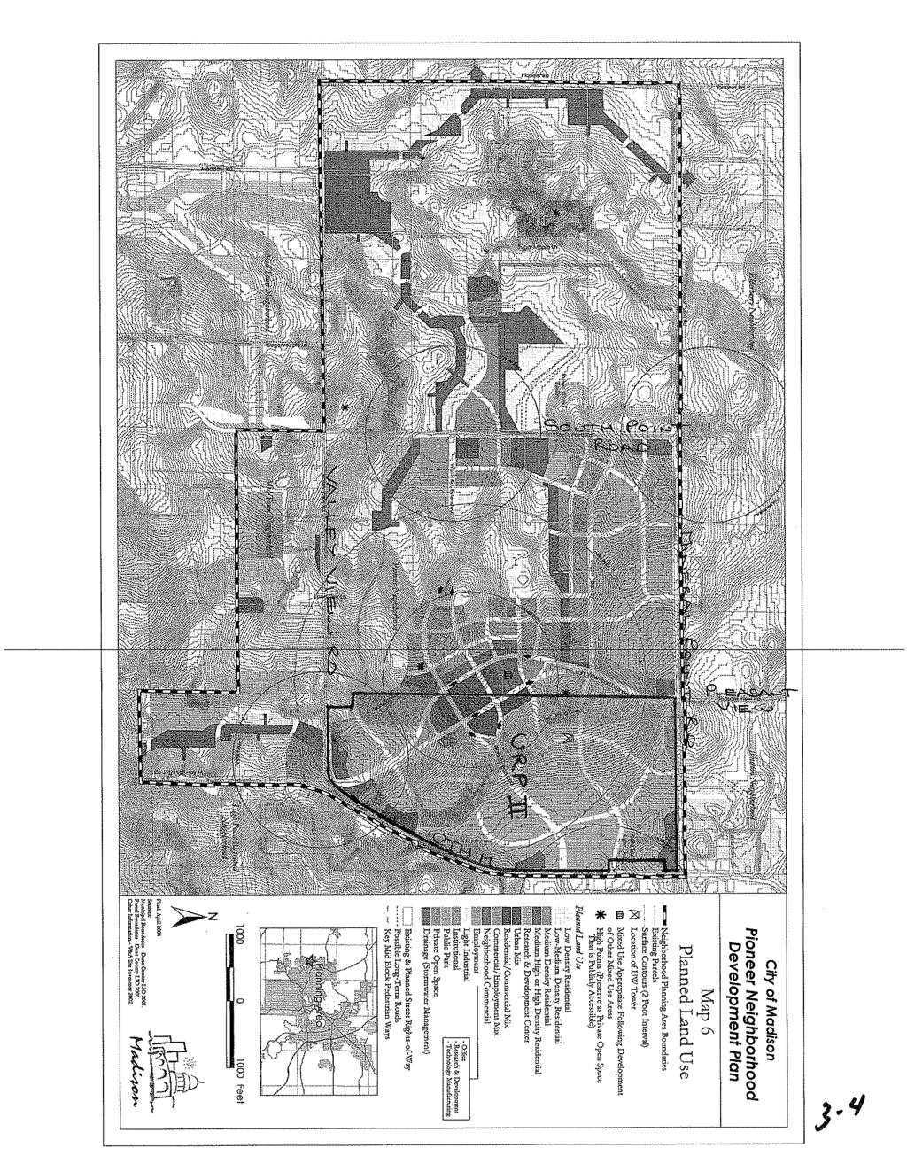
2 Page 2 Parcel Location: Approximately acres of land located in the southwestern quadrant of Mineral Point Road (CTH S) and CTH M, Aldermanic District 9; Middleton-Cross Plains School District and Madison Metropolitan School District. Existing Conditions: Most of the overall acre site is undeveloped. However, the site includes two agricultural accessory buildings and a television broadcast tower with accessory base maintenance and operations buildings located on the northern half of the site, and a vacant single-family residence located on the southern half of the site adjacent to CTH M. Surrounding Land Use and Zoning: North: University of Wisconsin West Madison Agricultural Research Station, zoned Temp. A (Agriculture District); Steve s Liquor s, zoned C2 (General Commercial District); South: Undeveloped lands in the Town of Middleton; single-family residences in the Linden Park subdivision, zoned R2T (Single-Family Residence District); East: North of Watts Road, the site is located opposite a variety of retail and office uses in the C2, C3 and C3L Commercial Districts and in Planned Unit Development zoning. South of Watts Road, the site is located opposite Cortland Pond Apartments, zoned R4 (General Residence District), The Bishop O Connor Catholic Pastoral Center and undeveloped land, zoned A, and single-family residences in the Applewood Hill subdivision in the Town of Middleton; West: Undeveloped lands in the Town of Middleton and the City of Madison, zoned Temp. A. Adopted Land Use Plan: The Pioneer Neighborhood Development Plan generally recommends the portion of the subject property to be zoned RDC for future employment uses with the exception of land in the southeastern portion of the site adjacent to CTH M, which is recommended for residential/ commercial mix and medium-density residential development. The portion of the site to be zoned PUD- GDP is recommended for urban mix and high-density residential uses. Areas shown on the subdivision plat for use as private stormwater management and open space are generally shown on the Pioneer NDP as either private open space or drainage/ stormwater management. Environmental Corridor Status: There are two mapped environmental corridors on the subject site. One of the corridors is located at the southern end of the acre site adjacent to Valley View Road, which is generally proposed for use as private stormwater management and open space for the development (Outlot 1). The second corridor is located south of Watts Road adjacent to the CTH M right of way, a portion of which is also proposed private stormwater management and open space. However, the mapped corridor appears to also include a proposed development lot (Lot 26), which will be located between Outlot 6 and extended Watts Road. Staff recommends a condition of approval that the applicant work with the Planning Division and Capital Area Regional Planning Commission to revise the environmental corridor map to reflect the proposed boundaries of Outlots 1 and 6 prior to recording the final plat. The corridor map otherwise reflects the presence of woodlands and areas of steep slope greater than 12% primarily on the southern portion of the overall site.
3 Page 3 Public Utilities and Services: The subject is located entirely in the Central Urban Service Area and the proposed development will generally be served by a full range of urban services, with the exception of transit service. Regarding transit service, Tim Sobota of Metro Transit has submitted the following comments: Metro Transit operates regular bus service along Watts Road as far west as the CTH M intersection seven days a week. Weekday trips on Route 73 connect between the West Transfer Point and the Middleton Transfer Point, while Route 63 weekend and holiday service operates between the West Transfer Point and the Prairie Towne Center development north of Mineral Point Road. The current bus stop locations on Watts Road at Plaza Drive are relatively adjacent to where Lot 24 is identified on the development plan maps, but other parcels in the overall southern phase of development would be greater than three quarters of a mile from this transit service making them correspondingly less attractive for bus riders and ineligible for complementary paratransit service. There is no present source of funding allocated for extension/addition of transit service to the Pioneer neighborhood or this plat area, beyond what is already provided east of CTH M described above. Any new service to this area would require City budget approvals and review by the Transit and Parking Commission. Metro Transit presented a proposal for a conceptual transit service extension plan serving the Pioneer neighborhood to the Transit and Parking Commission on February 10, This service represented a new bus route operating out of the West Transfer Point and having up to sixty minutes to travel to and through the Pioneer neighborhood area before returning back to the West Transfer Point. The exact corridor to access the Pioneer neighborhood was not identified (i.e. Mineral Point Road versus Watts Road), nor was a circulation path within the plat area (dependent upon phasing of local street construction/ connections). The cost of such service would generally be dependent upon how many of these hour-long roundtrips were made each day. Zoning Summary: Proposed RDC (Research & Development Center District) and PUD-GDP zoning. Requirements Required Proposed Lot Area 6,000 sq. ft. All proposed lots will exceed Lot Width 50 All proposed lots will exceed Front Yard 10 w/ 50% of bldg. bet To be det. w/ individual bldgs. Side Yards 10 ; may be 0 for shared wall To be det. w/ individual bldgs. Rear Yard 10 ; may be 0 for shared wall To be det. w/ individual bldgs. Floor Area Ratio 0.35 mn.; 0.2 for 1 st phase; no mx. To be det. w/ individual bldgs. Building Height N/A --- Impervious Surface Ratio 0.85 maximum To be det. w/ individual bldgs. No. Parking Stalls To be det. w/ individual bldgs. --- Accessible Stalls To be det. w/ individual bldgs. --- Loading To be det. w/ individual bldgs. --- No. Bike Parking Stalls To be det. w/ individual bldgs. --- Other Critical Zoning Items Yes: Utility Easements, Barrier Free No: Urban Design, Floodplain, Wellhead Protection, Adjacent to Park Prepared by: Pat Anderson, Asst. Zoning Administrator
4 Page 4 Previous Approval On June 7, 2005, the Common Council conditionally approved the preliminary plat of University Research Park Pioneer to allow the future creation of 29 lots for office, light industrial and mixed-use development and 8 outlots for public parkland, private stormwater management and open space, and future development. Among the conditions of approval was a requirement that the property be rezoned concurrent with a final plat application for the site, which is currently zoned Temp. A. At the time of the preliminary plat approval, the RDC Research and Development Center zoning district intended to provide the zoning framework for most of the University Research Park Pioneer (II) development did not exist. The RDC zoning district was drafted specifically for the research park. Other conditions required the applicant to work with the City to address various transportation-related issues raised during the 2004 adoption of the Pioneer Neighborhood Development Plan. Since the preliminary plat for this site was approved in 2005, a number of the follow-up studies first identified as outstanding as part of the neighborhood plan s adoption and later during the approval of the preliminary plat have completed. In addition, the City has developed detailed plans for the improvement of CTH M, Mineral Point Road (CTH S), Valley View Road, Pleasant View Road and the intersection of CTH M, Mineral Point Road and Junction Road, and is in the process of securing funding to begin implementing those improvements through and adjacent to the subject site beginning next year through The 2005 preliminary plat approval has since expired, as a final plat was not submitted within the time required by State and City subdivision regulations. Project Review The University of Wisconsin Board of Regents is requesting approval of a zoning map amendment to rezone a acre parcel generally located on the west side of CTH M between Mineral Point Road (CTH S) and Valley View Road from Temp. A (Agriculture) to A, RDC (Research and Development Center District) and PUD-GDP (Planned Unit Development, General Development Plan) and approval of the preliminary and final plats of the Pioneer subdivision, containing creating 31 lots for a proposed business park and mixed-use neighborhood center and 7 outlots for public parkland, private stormwater management and open space, and future development. The application also requests approval of a demolition permit to allow a single-family residence located at 902 CTH M on the southern portion of the property to be razed to accommodate the future development. Background & Existing Conditions The site will occupy most of the approximately one-mile long frontage of CTH M between Mineral Point Road and Valley View Road with the exception of a series of 8 small parcels located on the west side of CTH M just south of Mineral Point Road, which are developed with a myriad of small residences and accessory buildings located in the Town of Middleton. The site also includes approximately a half-mile of frontage along Mineral Point Road extending between Pleasant
5 Page 5 View Road and the CTH M-Junction Road intersection, and approximately 1,150 feet of frontage along Valley View Road on the south. The topography of the site generally falls from west to east across the property towards CTH M from a ridgeline and two highpoints located adjacent to the western property line, with between 50 and 100 feet of grade change present across the site, including a number of areas with grades greater than 12%, particularly on the southern half of the acre property. The highpoints located along and adjacent to the western line of the site afford long views of the State Capitol and Lake Mendota. The site is also characterized by areas of dense woodlands, including the southern portion of the western property line, an area north of Valley View Road, and along CTH M adjacent to the single-family residence to be demolished as part of the development. Most of the rest of the site is undeveloped and used by the University of Wisconsin for agricultural research and cultivation with the exception of the University s Communication Tower, which is located approximately 400 feet east of the western property line and 1,600 feet south of Mineral Point Road. In addition to the 1,423-foot tall transmission tower and supporting guy wires, the communications facility includes three maintenance and operations buildings and a grouping of satellite dishes located at the base of the tower. Two other accessory buildings associated with the agricultural uses are also present on the northern portion of the overall site. Pioneer will be located in a still-emerging area of the west side that generally includes urban development east of the site, while lands west are still primarily agricultural or rural residential in character. Lands east of the subject site and north of Watts Road are developed with myriad of commercial uses, including the West Side Club, a Mobil gas station, Aldi grocery store, two bank/office buildings and an automotive repair business, while lands south of Watts Road are developed with an apartment complex and athletic fields associated with the Bishop O Connor Catholic Pastoral Center and with single-family residences in the Applewood Hill subdivision in the Town of Middleton. With the exception of a single-family residence on a Town parcel located immediately west of the site on the north side of Valley View Road, the majority of the lands otherwise surrounding the site are currently undeveloped agricultural parcels either in the Town of Middleton or City that include a scattering of residences. The subject site is located within the limits of the Pioneer Neighborhood Development Plan, which was adopted by the City in 2004 to guide development in an area bounded by CTH M on the east, Mineral Point Road on the north, Valley View Road generally on the south and Pioneer Road and the planned future City limits on the west. In addition to land use, infrastructure and transportation recommendations customary in City neighborhood development plans, the Pioneer Neighborhood Development Plan places a distinct emphasis on physical design within the neighborhood planning area. Overall, the plan calls for the creation of a high-density, pedestrian-oriented neighborhood that includes employment, light industry, diverse residential stock and neighborhood-supporting uses in a highly integrated, walkable urban environment. Most of the site is recommended in the neighborhood development plan as a research and development center to be generally located between a southerly extension of Pleasant View Road and CTH M. Goals of the Pioneer Neighborhood Development Plan include the creation of a new urban model for business parks. Among the urban design-related recommendations included in the neighborhood plan for employment districts are the creation of compact, walkable job centers that feature buildings with strong street orientations and parking primarily located in the side or rear. Large surface parking lots, particularly adjacent to public streets, are discouraged in favor of shared and structured parking.
6 Page 6 In addition to the primary employment uses envisioned for the subject site, a portion of the University Research Park II site is recommended to be developed as part of a significant urban mixed-use center envisioned to anchor the Pioneer neighborhood. The urban mixed-use center will be centered on the future intersection of Watts and Pleasant View roads, which will split into two one-way couplets at the edge of the mixed-use center (as shown on the attached land use plan). The neighborhood development plan calls for the urban mixed-use center to be developed with a mix of retail, restaurant and service uses to serve future employees and residents of the neighborhood, as well as high-density residential development both in and immediately surrounding the center. Residential densities within the urban mixed-use center and on surrounding blocks is recommended to exceed 60 units an acre before transitioning to lower densities between 25 and 60 units an acre in the blocks to the west. Buildings in the urban mixed-use center and collar high-density residential zones will range in height from 2 to 6 stories and are encouraged to be urban in character and placed close to the sidewalk to create a sense of street enclosure. The neighborhood plan recommends that street widths in the neighborhood center be limited in an effort to encourage pedestrian activity, and public squares and gardens are recommended to create gathering spaces within the neighborhood center. Finally, a small portion of the proposed research park development located along the CTH M frontage opposite Applewood Drive referred to as the Hoopes property is recommended in the Pioneer Neighborhood Development Plan for a combination of residential/ commercial development and medium-density residential development intended to serve the adjacent research and development uses. These land use recommendations predated the May 2006 acquisition of the 8.3-acre Hoopes property and residence by the University, which now proposes to incorporate this land into the research and development component of the overall development. Project Summary Access to the Pioneer development will be primarily provided by the extension of Watts Road west from its current terminus at CTH M to provide arterial east-west access through the development and the extension of Pleasant View Road south from its current terminus at Mineral Point Road to connect to CTH M at Valley View Road. The proposed Pleasant View Road extension will be constructed by the City of Madison in 2010 and will include the construction of a roundabout at a new intersection of Valley View Road, CTH M and extended Pleasant View. A second roundabout is planned at the intersection of Pleasant View and Mineral Point roads. In addition to the City s planned extension of Pleasant View Road and the University s future extension of Watts Road, access to the development will be provided by three local streets to be dedicated with this plat, which will provide access to many of the proposed development lots. The final plat of Pioneer will also dedicate rights of way around the perimeter of most of the acre site for the widening of Mineral Point Road and CTH M, and the improvement of the Mineral Point Road-Junction Road-CTH M intersection. Twenty-six of the 31 proposed lots will be developed with office-commercial and light industrial uses in the RDC Research and Development Center zoning district, while the remaining 5 lots will be zoned PUD-GDP and will be developed as part of the urban mixed-use neighborhood center or surrounding high-density residential called for in the Pioneer Neighborhood Development Plan. The RDC zoning district was adopted in 2005 to provide an aesthetically attractive urban working environment intended primarily for high-technology, research and development, testing, and certain specialized manufacturing establishments, in addition to professional offices and business incubators and many of the design standards and bulk and mass requirements in the district are influenced by the
7 Page 7 recommendations of the Pioneer Neighborhood Development Plan. The uses permitted in the RDC largely follow the uses permitted in the RPSM Research Park Specialized Manufacturing zoning district. However, the RDC district includes a number of design standards that are intended to create an office campus with more compact, urban development characteristics than are permissible in the O-Office or RPSM districts. The RDC district emphasizes buildings that are oriented toward the streets with parking on the street, to the side and behind buildings and includes standards that require at least 50% of buildings to be located within feet of a street property line. The district includes a minimum floor area ratio (FAR) of 0.35 and does not set a maximum FAR. The RDC district requires advance planning for individual sites to maximize the potential for future onsite building expansion at the time of site plan approval to accommodate additional development on the site and structured parking at strategic locations. A master plan is required at the time RDC zoning is conferred on a property to demonstrate a unified and organized arrangement of buildings and service facilities within the district and to serve as a guide for how future development within the district may be implemented. An architectural review committee is also required for RDC-zoned developments to review each new development in the project against standards adopted as part of deed or plat restrictions approved by the Plan Commission prior to development occurring. (In the event no deed or plat restrictions have been approved establishing the architectural review committee prior to building construction being proposed, the Urban Design Commission will review new projects.) The University has submitted a master plan to coincide with the rezoning and subdivision requests that provides a conceptual layout for how both the areas to be zoned RDC and PUD-GDP may be built out. In general, the development concept shows five buildings fronting Watts Road to be developed on Lots 12, and 31 and three buildings fronting CTH M (Junction Road) on Lots The remainder of the buildings to be developed in RDC zoning are conceptually oriented to internal local streets within the plat. Development fronting Pleasant View Road outside the urban mixed-use PUD appears limited on the concept plan to four buildings that will have corner frontage onto Pleasant View at the intersection with Street C. In all, the conceptual master plan shows 23 buildings constructed on the 26 lots to be zoned RDC, with the remaining 3 lots, Lots 1, 6 and 11, not currently accounted for in the plan due to their size, orientation and/or location. The proposed general development plan for the portion of the urban mixed-use center to be located on the site conceptually calls for mixed-use buildings fronting both Watts and Pleasant View roads on Lots 8-10 with parking shown behind the buildings on the interior of those lots. High-density residential buildings are shown on Lots 7 and 14, with the potential buildings on Lot 7 forming a bookend for the mixed-use center along the edge of the one-way street return. The buildings on Lot 14 are proposed to front onto a proposed park space at the southeasterly corner of Watts and Pleasant View to be dedicated to the City as Outlot 3. The zoning text submitted for the PUD-GDP calls for buildings in the urban mixed-use area to be a minimum of two and a maximum of six stories in height, with a maximum setback of 15 feet proposed along both Watts and Pleasant View. Residential densities in the PUD will range between 26 and 60 units an acre, with a maximum floor area ratio of 4.0 proposed. The zoning text calls for retail, office and services on the first floor of the mixed-use buildings, with residential, office or research uses to be located on the upper floors. For Lots 7 and 14, the zoning text calls for the same minimum and maximum densities and building heights, with a reduced list of permitted uses and slightly higher building setbacks proposed. In addition to establishing an architectural review committee to review new construction, the RDC district also includes specific design-related provisions for the treatment of accessory off-street parking and loading facilities, outdoor storage areas, landscaping and signage. RDC zoning also requires the establishment of a transportation management association for the district. A Transportation Demand
8 Page 8 Management Plan approved by the City Traffic Engineer is required for the RDC district and individual lots are required to provide a Transportation Demand Management (TDM) Plan approved by the Traffic Engineer that is consistent with the Plan for the district. The University submitted a TDM first prepared in October 2006, which has been reviewed by Planning Division and Traffic Engineering Division staff. The research park TDM is based on Best Workplaces for Commuters information, which is a nationally recognized leader in the TDM field that recommends a comprehensive set of strategies to encourage higher vehicle commuting, especially during peak travel periods. The research park TDM provides a broad framework for the overall development that includes the creation and funding of a development-wide Transportation Management Association (TMA), the promotion of ridesharing and ride-matching with supporting guaranteed ride home service, the provision of facilities for pedestrian and bicycling commuters in individual buildings, inclusion of an internal trail system, and recommendations for alternative work schedules and telecommuting. The TDM also references efforts to have Metro Transit service extended through the overall development with the promotion of subsidized bus passes also included. The applicant s TDM includes a goal of providing information and building awareness about commuting alternatives throughout the overall development. In addition to the public park proposed on Outlot 3, the development includes private open spaces on Outlots 2 and 5 and combined stormwater management and open space tracts on Outlots 1, 4 and 6. Outlot 2 will be a 7.87-acre tract located along the western edge of the development, which is currently densely wooded. The master plan suggests that this tract will remain heavily wooded as part of the development with the exception of a walking path shown. The area comprising Outlot 5 is also largely wooded presently and will remain so according to the plan. The master plan highlights a network of public and private walking paths that will be used to connect the open spaces to be located throughout the development, including the public path proposed in the Pioneer Neighborhood Development Plan, to cross the neighborhood to connect public paths in the Town of Middleton to Elver Park and the Ice Age Trail, which will cross Outlots 1 and 4. The final plat proposes the creation of 50- to 100-foot wide easements for stormwater management and the proposed pedestrian walkways throughout the interior of the development. The construction, maintenance and right of use for the various paths and trails located throughout the development will be subject to additional discussion between the developer and City staff prior to the recording of the final plat. The 26 RDC-zoned commercial-industrial lots will comprise approximately acres of the acre site, while the 5 mixed-use center/ residential PUD lots will comprise about 12.9 acres. These two areas together comprise the first phases of the University research Park II development. The remainder of the subject site north of Watts Road will be zoned permanent A zoning and will be designated as a acre outlot for future development Outlot 7, which will continue to house the 1,423-foot tall transmission tower facility and University agricultural uses in the interim. The University anticipates the eventual relocation of both of these uses from the site. Once those uses have been relocated and most of the first phase of the research park south of Watts Road has been built out, the applicant indicates that Outlot 7 will be primarily developed as a second phase of the research park development. The conceptual plan submitted with the current rezoning and subdivision approvals shows that as many as 30 additional development sites may be created in the future on the portion of the site located between Watts Road and Mineral Point Road.
9 Page 9 Analysis & Conclusion In general, the Planning Division believes that the various standards for approval can be met with the Pioneer development. Staff believes that the proposed subdivision and rezoning of approximately acres of the University of Wisconsin s acre property for the first phases of the development is consistent with the recommendations for most of the subject site contained in the Pioneer Neighborhood Development Plan regarding land use, circulation and overall development layout. The subdivision of the site will also dedicate various rights of way to the City that will facilitate implementation of a number of roadway improvement and capacity expansion projects needed to serve the future development of the Pioneer neighborhood and greater west side. The only deviation from the neighborhood plan s recommendations regards the proposed development of the former Hoopes property in the southeastern corner of the overall site with research and development center uses instead of the medium-density residential and residential-commercial uses previously recommended. However, staff feels that incorporation of the Hoopes property into the research and development district is appropriate now that all of the property is under common ownership. Given that limited retail and service uses are permitted on the first floor of RDC-zoned buildings, there is still potential for retail service uses serving the research park to be developed at this entrance to the development. Staff also believes that the demolition permit standards can be met to allow the demolition of the singlefamily residence at 902 CTH M. While staff has not toured the residence, the two-story structure appears to be in average to below-average condition based on the materials provided by the applicant. The structure is currently located on the edge of the existing right of way of CTH M and within the right of way to be dedicated with the final plat for the planned expansion of the that roadway in The applicant has indicated in discussions with staff that relocation of the structure is not feasible due to its condition and location at the top of a bluff and within an area of dense vegetation. The preservation of the residence is also not consistent with the future uses of the site recommended in the Pioneer Neighborhood Development Plan. Finally, the acting preservation planner, Rebecca Cnare, indicates that the residence has no historic value and that the Landmarks Commission did not raise any concerns with the proposed demolition when it was informally discussed at a meeting earlier this year. The RDC Research and Development Center zoning proposed should facilitate the development of office, research and development, and light industrial uses similar to the uses present in the existing University Research Park I development while providing a framework to encourage implementation of the urban design recommendations contained in the Pioneer Neighborhood Development Plan, which place a strong emphasis on the creation of a compact, walkable employment center adjacent to a highdensity urban mixed-use center, which together form the nexus of the Pioneer neighborhood. As noted earlier in this report, RDC zoning was conceived to provide a more compact, urban variation of RPSM zoning that would facilitate the development pattern encouraged in the Pioneer Neighborhood Development Plan while facilitating the development of land uses present in the City s established business parks. Similarly, staff believes that the proposed PUD-GDP zoning document will establish the parameters necessary to implement the portion of the neighborhood urban mixed-use center to be located on the subject site. The overall conceptual master plan submitted with the zoning and plat approvals suggests that buildings throughout the acre first phase will generally be placed close to the street, with parking to be located in the side and rear yards as recommended in the neighborhood plan and generally required in the RDC zoning. The development also provides a comprehensive
10 Page 10 network of sidewalks and off-street paths intended to connect the various corners of the research park with the retail, service and residential uses that will be developed as part of the neighborhood mixeduse center. The general direction of the new research park appears consistent with the goals and objectives in the adopted neighborhood plan. Planning staff encourages the University to explore opportunities to further intensify the overall density of the development through the use of shared and structured parking that could make additional land available for development. Although the conceptual master plan illustrates that many of the public street frontages throughout the development will be occupied with building walls, staff encourages the developer to increase building coverage wherever possible. In particular, staff recommends that the University explore opportunities to increase building frontage along both sides of Pleasant View Road between the stormwater management and open space on Outlots 1 and 4 and the southern edge of the urban mixed-use center at Watts Road, which staff believes will strengthen the street wall and increase pedestrian activity along the southerly approach to the mixed-use center. Staff recommends that the applicant revisit the master plan to identify opportunities to increase the density of development on the 26 lots to be zoned RDC through the possible reorientation of buildings and the potential use of shared and/ or structured parking. The revised conceptual master plan should be presented for Plan Commission approval concurrent with the Commission s required approval of the restrictive covenants for the RDC-zoned lots. Finally, the Transportation Demand Management Plan (TDM) has been reviewed by staff from the Planning Division and Traffic Engineering Division. Staff believes overall that the TDM does a good job in establishing the basis for a TDM program and Transportation Management Association (TMA). The final TDM plan should be approved by the City Traffic Engineer and Planning Division Director and should be updated in Section 5 to clarify that employers with more than 20 or more employees will be required to develop and maintain a trip reduction program in conformance with the development-wide TDM, though participation by individual employees would be voluntary. The final TDM plan should also indicate when the TMA for the overall development will be formed. The TDM plan should also be updated to include a current description of the guaranteed ride home service to state that the program operated by Rideshare Etc. offers up to 6 taxi vouchers per year at a maximum value of $75 per voucher. The cost benefit calculations should also be updated. In practice, cost estimates for services like transit passes, telework set-ups, and guaranteed ride home programs vary widely depending on usage and level of intensity. It is acknowledged in the applicant s TDM plan that the proposed plan has been developed absent customer-oriented data, but there is intent to conduct transportation surveys once occupancy begins. Obtaining this employee feedback may also be used in determining the intensity level of specific strategies and refining the TDM cost and benefit calculations. For example, there are several subsidized transit programs in the Madison area that provide the full cost of a monthly pass. Increasing the Metro Transit subsidy from $30 to $55 would make it free for the user and may attract an increase in participation that is competitive in this market. The TDM plan should indicate that employee surveying will include a diary-type of question to ask how employees commute to work, which can provide the information needed to calculate the average vehicle occupancy. Determining average vehicle occupancy establishes a baseline of employee mode choice, which can be used to evaluate the results in future years. The employee surveys should include a listing of the proposed incentives that asks for employee feedback about their attractiveness to gauge interest. As part of offering the incentives, draft eligibility criteria can be established with a verification process for receiving the incentives as part of the duties of the TDM coordinator.
11 Page 11 In conclusion, the Planning Division believes that the proposed zoning map amendment and subdivision conforms to the recommendations of the Pioneer Neighborhood Development Plan and will result in the development of a research and development center that will be a significant asset to the City of Madison and the region as a whole. The University has done a good job working with staff from the City Engineering Division, Traffic Engineering Division, Planning Division and other agencies to develop the final plat and master plan. With the changes noted in the Recommendations section that follows, the Planning Division recommends that Plan Commission and Common Council approve the project. Staff Recommendations, Conditions of Approval & General Ordinance Requirements Major/Non-Standard Conditions are shaded Planning Division Recommendation (Contact Timothy M. Parks, ) The Planning Division recommends that the Plan Commission forward Zoning Map Amendments , rezoning land generally addressed as 8501 Mineral Point Road from Temp. A (Agriculture District) to A, RDC (Research and Development Center District) and PUD-GDP, and the preliminary and final plats of Pioneer to the Common Council with recommendations of approval, and approve the demolition of a single-family residence at 902 CTH M, all subject to input at the public hearing and the following conditions: 1. That the applicant work with Planning Division staff prior to recording of the PUD-GDP and final plat for the development to revise the general development plan as follows: 1a. revise the PUD legal description to only describe the approximately 12.9 acres to be zoned PUD-GDP; 1b. provide an additional graphic depicting only the PUD-GDP-zoned area and revise the map on page 7 of the general development plan to highlight the boundaries of the PUD zoning district; 1c. for clarity, please revise the map on page 5 to note the project site shown is the entire University Research Park II site, not just the PUD and revise the map on page 4 to note the highlighted area is the portion of the development to be zoned PUD-GDP; 1d. clarify the proposed future use of the triangular parcels created by the one-way couplets (Lots 6 and 11) and revise the conceptual master plan for the development accordingly. 2. That the applicant work with staff from the Planning Division and City Engineering Division prior to recording of the final plat to develop detailed plans for the construction of the private path network located throughout the development, including details on the proposed width of the paths and the materials that will be used. The applicant shall also work with staff on easement/ plat language to address the future maintenance and right of use of the non-city paths throughout the development. 3. That prior to issuance of any permits to construct a new building on the development site, the developer shall submit a restrictive covenant for approval by the Plan Commission following review by the Planning Division that includes specific details on the architectural review committee that will be responsible for reviewing projects on all RDC-zoned lots. The restrictive covenant shall include any proposed land use restrictions, details about the specific design criteria that will govern the RDC-zoned lots, and reference to general conformance with the approved conceptual/ master plan and Transportation Demand Management Plan (including the annual reporting requirements for all non-residential parcels.
12 Page That the applicant revisit the master plan to identify opportunities to increase the density of development on the 26 lots to be zoned RDC through the possible reorientation of buildings and the potential use of shared and/ or structured parking. The revised conceptual master plan should be presented for Plan Commission review concurrent with the Commission s required approval of the restrictive covenants for the RDC-zoned lots. 5. That prior to final approval of the zoning map amendment and approval of the restrictive covenants for the plat, the applicant receive final approval of the Transportation Demand Management Plan from the Planning Division Director and City Traffic Engineer. 6. That the applicant work with the Planning Division and Capital Area Regional Planning Commission to revise the environmental corridor map to reflect the proposed boundaries of Outlots 1 and 6 prior to recording the final plat. 7. That a tree preservation and management plan for the overall development be approved by the Planning Division Director prior to commencement of any grading activities on the site. 8. A reuse and recycling plan approved by the Recycling Coordinator is required by ordinance prior to the issuance of a wrecking permit for the single-family residence at 902 CTH M. The following conditions of approval have been submitted by reviewing agencies: City Engineering Division (Contact Janet Dailey, ) 9. For the demolition of 902 CTH M, the applicant shall abandon or remove the septic system in accordance with Madison-Dane County Public Health s specification. The applicant shall provide verification/evidence that the septic system abandonment is complete with letter from Public Health. 10. Coordinate right-of-way at Outlots 1 & 4 with Pleasant View Road project, City Project 53W Coordinate right-of-way at Street D with Pleasant View Road project, City Project 53W Show grading easements for Valley View Road, Pleasant View Road, Mineral Point Road and CTH M and coordinate with City Engineering. 13. The University of Wisconsin and the City of Madison are working cooperatively on a project to construct Pleasant View Road through the Plat. This project includes roundabouts at the intersection of CTH M, Valley View Road and proposed Pleasant View Road and a roundabout at Mineral Point Road and Pleasant View Road. Two pedestrian/ bike underpasses, one under CTH M south of Valley View Road and one under Pleasant View Rd south of Valley View Road is being proposed. The City is also working on a project to construct a grade separated intersection at Mineral Point Road and Junction Road. The City intends to assess the cost to construct Pleasant View Road less Federal aids to the abutting properties. The City intends to assess a portion of the cost to construct both roundabouts to the benefiting properties as well as future traffic signals at the Watts Road and Pleasant View Road intersections. The City also intends to assess a portion of CTH M and a portion of Mineral Point Road to the abutting properties fronting on the projects. The City intends to assess 50% of the cost of the two pedestrian/ bike underpasses to the Plat either as an assessment or a direct charge. In
13 Page 13 addition, it is anticipated that a portion of the cost to construct the Mineral Point Road and Junction Road intersection will be assessed to the benefiting properties using trip generation methodology. The University of Wisconsin is dedicating lands in the Plat for these improvements and is dedicating required lands north of Mineral Point Road and outside of the Plat as required to facilitate the above improvements. Reference to the assessments shall be included in the Development Agreement. 14. The developer and the City shall construct a north-south pedestrian/ bike path that will tie into a larger path network being planned by the City generally following CTH M from the Mineral Point Road and Junction Road intersection south toward the City of Verona. In addition, the City is proposing a pedestrian/ bike path heading west from the above path north of Valley View Road. These shall be public bike paths. Numerous other paths are proposed by the UW and shall be constructed and maintained by the UW Research Park. Additional easements may be required consistent with previous discussions with the University to facilitate these pathways as required by the City Engineer. 15. The developer may be responsible for a portion of the cost to relocate compensable utility infrastructure as required to facilitate the required improvements as determined by the City Engineer after consultation with the developer and the developer shall dedicate additional utility easements for the relocation of private utilities if required by the City Engineer after consultation with the developer. 16. The area dedicated at the northeast corner of CTH M and Pleasant View Road for stormwater shall be revised to match the latest design available from City Engineering. 17. Many of the areas proposed for private and public improvements shall require a maintenance agreement from the owner. 18. Subject to Storm and/or Sanitary Sewer Impact Fees for Upper Badger Mill Creek and Valley View. Other sewer charges will be due for frontage along Mineral Point Road. 19. The southern portion of the plat will be subject to the Valley View Impact Fee District. 20. Coordinate proposed new street names with Engineering Mapping for the Watts Road and Pleasant View Road couplets. 21. The desirable final plat recording date is on or before December 1, 2009 to maintain the funding and letting schedule for the street improvement work. 22. The developer shall enter into a City/Developer agreement for the installation of public improvements required to serve this plat. The developer shall be required to provide deposits to cover City labor and materials and surety to cover the cost of construction. The developer shall meet with the City Engineer to schedule preparation of the plans and the agreement. The City Engineer will not sign off on this plat without the agreement executed by the developer. 23. The developer shall construct Madison standard street improvements for all streets within the plat.
14 Page An erosion control plan and land disturbing activity permit shall be submitted to the City Engineering Division for review and approval prior to grading or any other construction activities. The Preconstruction Meeting for Public Improvements shall not be scheduled prior to issuance of this permit. The applicant shall demonstrate compliance with Section and of the Madison General Ordinances regarding permissible soil loss rates. The erosion control plan shall include Universal Soil Loss Equation (USLE) computations for the construction period. Measures shall be implemented in order to maintain a soil loss rate below 7.5-tons per acre per year. 25. The following notes shall be included on the final plat: 25a. All lots within this plat are subject to public easements for drainage purposes which shall be a minimum of 6-feet in width measured from the property line to the interior of each lot except that the easements shall be 12 feet in width on the perimeter of the plat. For purposes of 2 or more lots combined for a single development site, or where 2 or more lots have a shared driveway agreement, the public easement for drainage purposes shall be a minimum of 6 feet in width and shall be measured only from the exterior property lines of the combined lots that create a single development site, or have a shared driveway agreement, except that the easement shall be 12 feet in width along the perimeter of the plat. Easements shall not be required on property lines shared with greenways or public streets. No buildings, driveways, or retaining walls shall be placed in any easement for drainage purposes. Fences may be placed in the easement only if they do not impede the anticipated flow of water. 25b. The intra-block drainage easements shall be graded with the construction of each principle structure in accordance with the approved storm water drainage plan on file with the City Engineer and the Zoning Administrator, as amended in accordance with the Madison General Ordinances. 26. Prior to the issuance of building permits, the developer shall submit a master stormwater drainage plan to the City Engineering Division for review and approval which shows lot corner elevations to the nearest 0.25-foot. For purposes of the plan, it shall be assumed that grading shall be done on a straight line grade between points unless other information is provided. The proposed slope between points shall always be greater than or equal to.0075 ft/ft. If a break in grade is required between lot corners a shot shall be taken at that break in grade to provide the Engineer with enough information to interpret the plan. The Developer shall also show proposed drainage arrows on the plan to indicate the proposed direction of drainage. The master storm water drainage plan shall be submitted to City Engineering in digital format with elevations/grades/contours shown on the recorded plat map of the development. The digital record shall be provided using the state plane coordinate system NAD 27. No building permits shall be issued prior to City Engineering s approval of this plan. The following note shall accompany the master storm water drainage plan: For purposes of this plan, it is assumed that grading shall be a straight line grade between points unless otherwise indicated. All slopes shall be 0.75% or steeper. Grade breaks between lot corners are shown by elevation or through the use of drainage arrows. 27. Prior to approval, this project shall comply with Chapter 37 of the Madison General Ordinances regarding stormwater management. Specifically, this development is required to detain the 2, 10 & 100-year storm events; control 80% TSS (5 micron particle); provide substantial thermal control, and; provide infiltration in accordance with NR-151. Stormwater management plans shall be submitted and approved by City Engineering prior to signoff.
15 Page This site is greater than one acre and the applicant is required by State Statute to obtain a Notice of Intent Permit (NOI) from the Wisconsin Department of Natural Resources. 29. A minimum of two working days prior to requesting City Engineering Division signoff on the plat, the applicant shall contact Janet Dailey to obtain the final stormwater utility charges that are due and payable prior to sub-division of the properties. The stormwater utility charges (as all utility charges) are due for the previous months of service. All charges shall be cleared prior to the land division (and subsequent obsolesces of the existing parcel). 30. All outstanding Madison Metropolitan Sewerage District (MMSD) and City of Madison sanitary sewer connection charges are due and payable prior to City Engineering Division signoff, unless otherwise collected with a Developer's/ Subdivision Contract. Contact Janet Dailey ( ) to obtain the final MMSD billing a minimum of two working days prior to requesting City Engineering signoff. Traffic Engineering Division (Contact John Leach, ) 31. The developer shall put the following note on the face of the plat: All the lots within this subdivision are subject to impact fees that are due and payable within fourteen days of the issuance of building permit(s). Note: The final sign-off may be delayed until the transportation impact fees are negotiated or approved by the Common Council. 32. Prior to approval, the applicant shall prepare and provide a master ped-bike plan for the plat that is consistent with the City s area wide plans and the plat s specific provisions, to be reviewed and approved by the Traffic Engineer. The applicant may need to modify the right of way to accommodate the ped-bike plan. 33. The applicant shall execute and return declaration of conditions and covenants for streetlights and traffic signals prior to sign off. The applicant will need to provide a deposit for their reasonable and proportionate share of traffic signal costs. 34. Utility easements shall be provided as follows: Running along the southerly property line of Outlot 7, there shall be a 12-foot front utility easement running along Watts Road from CTH M westerly to Pleasant View Road. The applicant shall show a detail drawing of the 12-foot utility easement dimensions and lot lines on the face of the plat. 35. The developer will need to demonstrate/provide how private streetlights will be installed and maintained in the public alleys. The final plat shall provide the following note on the face of the plat: "The City will not install lighting in the alleys, but the developer or property owners may request the City to approve a private light(s) in the alley right of way. Such private light(s) to be operated and maintained by private interests." 36. Public signing and marking related to the development may be required by the City Traffic Engineer for which the developer shall be financially responsible.
16 Page 16 Zoning Administrator (Contact Pat Anderson, ) 37. Provide a reuse/recycling plan, to be reviewed and approved by the City s Recycling Coordinator, George Dreckmann, prior to a demolition permit for 902 CTH M being issued. Sec 28.12(12)(e) of the Madison Zoning Ordinance requires the submittal of documentation demonstrating compliance with the approved reuse and recycling plan. Please note, the owner must submit documentation of recycling and reuse within 60 days of completion of demolition. 38. Future development shall meet applicable building and zoning ordinances following applicable processes. 39. The Plan Commission does not grant signage approvals. Signage must be reviewed for compliance with Chapter 31 of the Madison General Ordinances. The Zoning Section of the Department of Planning and Community and Economic Development must issue sign permits prior to sign installation. Parks Division (Contact Tom Maglio, ) This agency did not submit comments for this request. Fire Department (Contact Scott Strassburg, ) 40. Fire access shall be provided on each lot if code compliance access cannot be accomplished by use of public streets only. Water Utility (Contact Dennis Cawley, ) 41. All public water mains and water service laterals, except for those proposed to be installed as part of the Pleasant View Road project, shall be installed by standard City of Madison Subdivision Contract. The Water Utility will not need to sign off on the final plans, but will need a copy of the approved plans. 42. All operating private wells shall be identified and permitted by the Water Utility in accordance with MGO All unused private wells shall be abandoned in accordance with MGO Metro Transit (Contact Tim Sobota, ) This agency submitted comments included in the Public Utilities and Services portion of the General Information section above. They submitted no conditions of approval.
17
Requested Action: Approval of a final plat creating 25 single-family lots and 1 outlot for stormwater management.
 PLANNING DIVISION STAFF REPORT PREPARED FOR THE PLAN COMMISSION Project Address: Application Type: Final Plat Prepared By: Reviewed By: Summary Timothy M. Parks, Planning Division Report includes comments
Department of Planning & Development Planning Unit
 Department of Planning & Development Planning Unit Website: www.cityofmadison.com Madison Municipal Building 215 Martin Luther King, Jr. Boulevard P.O. Box 2985 Madison, Wisconsin 53701-2985 TDD 608 266-4747
Department of Planning & Community & Economic Development Planning Division
 Department of Planning & Community & Economic Development Planning Division Website: www.cityofmadison.com Madison Municipal Building 215 Martin Luther King, Jr. Boulevard P.O. Box 2985 Madison, Wisconsin
Report to the Plan Commission October 1, 2012
 Report to the Plan Commission Legistar I.D. #27437 5922 Lien Road Re-approving PUD-GDP Zoning Requested Action: Approval of a request to rezone parcels generally addressed as 5922 Lien Road from Planned
Report to the Plan Commission February 4, 2013
 Report to the Plan Commission Legistar I.D. #28789 Conditional Use Requested Actions: Approval of a conditional use for a structure exceeding 10,0000 square feet of total floor area and an accessory building
Applicable Regulations & Standards: The subdivision process is outlined in Section 16.23(5)(b) of the Subdivision Regulations.
(b) of the Subdivision Regulations.") PLANNING DIVISION STAFF REPORT PREPARED FOR THE PLAN COMMISSION Project Address: Application Type: Final Plat Legistar File ID # 33674 Prepared By: Summary Timothy M. Parks, Planning Division Report includes
PLANNING DIVISION STAFF REPORT PREPARED FOR THE PLAN COMMISSION Project Address: Application Type: Final Plat Legistar File ID # 33674 Prepared By: Summary Timothy M. Parks, Planning Division Report includes
Report to the Plan Commission March 4, 2013
 Report to the Plan Commission Legistar Preliminary Plat & Final Plat Requested Action: Approval of a preliminary plat creating a total of 25 single-family residential lots and 2 outlots for stormwater
PREPARED FOR THE URBAN DESIGN COMMISSION AND PLAN COMMISSION
 PLANNING DIVISION STAFF REPORT PREPARED FOR THE URBAN DESIGN COMMISSION AND PLAN COMMISSION Project Address: Application Type: Prepared By: Demolition Permit and Conditional Use Kevin Firchow, AICP, Planning
Department of Planning & Community & Economic Development Planning Division
 Department of Planning & Community & Economic Development Planning Division Travis Schreiber Vierbicher Associates 999 Fourier Drive #201 Madison, WI 53717 Website: www.cityofmadison.com Madison Municipal
Department of Planning & Development Planning Unit
 Department of Planning & Development Planning Unit Website: www.cityofmadison.com Madison Municipal Building 215 Martin Luther King, Jr. Boulevard P.O. Box 2985 Madison, Wisconsin 53701-2985 TDD 608 266-4747
Report to the Plan Commission December 19, 2011
 Report to the Plan Commission Legistar I.D. #24825, Extraterritorial Certified Survey Map Requested Action: Consideration of a two-lot Certified Survey Map (CSM) of the Keryluk-Wee property located at,,
Report to the Plan Commission August 20, 2012
 Report to the Plan Commission Legistar I.D. #27376 5692-5696 Monona Drive Conditional Use Requested Action: Approval of a conditional use for an outdoor eating area for a restaurant and an accessory parking
Zoning Map Amendment, Demolition Permit and Preliminary Plat (Amended Request) Legistar File ID # 31820, and 31683
 Legistar File ID # 31820, and 31683") PLANNING DIVISION STAFF REPORT PREPARED FOR THE PLAN COMMISSION Project Address: Application Type: Zoning Map Amendment, Demolition Permit and Preliminary Plat (Amended Request) Legistar File ID # 31820,
PLANNING DIVISION STAFF REPORT PREPARED FOR THE PLAN COMMISSION Project Address: Application Type: Zoning Map Amendment, Demolition Permit and Preliminary Plat (Amended Request) Legistar File ID # 31820,
Department of Planning & Development Planning Unit
 Department of Planning & Development Planning Unit Website: www.cityofmadison.com Madison Municipal Building 215 Martin Luther King, Jr. Boulevard P.O. Box 2985 Madison, Wisconsin 53701-2985 TDD 608 266-4747
PLANNING DIVISION STAFF REPORT February 10, Summary PREPARED FOR THE PLAN COMMISSION. Zoning Map Amendment and Preliminary Plat
 PLANNING DIVISION STAFF REPORT PREPARED FOR THE PLAN COMMISSION Project Address: Application Type: Legistar File ID # 32565 and 32284 Prepared By: Reviewed By: Summary Zoning Map Amendment and Preliminary
Please contact Janet Dailey of the City Engineering Division at if you have questions regarding the following thirty-eight (38) items:
 items:") Planning Division Dan Day D Onofrio Kottke & Associates 7530 Westward Way Madison, Wisconsin 53717 RE: Approval of a request to rezone land generally addressed as 10203 Mineral Point Road from SR-C1 (Suburban
Planning Division Dan Day D Onofrio Kottke & Associates 7530 Westward Way Madison, Wisconsin 53717 RE: Approval of a request to rezone land generally addressed as 10203 Mineral Point Road from SR-C1 (Suburban
Department of Planning & Community & Economic Development Planning Division
 Department of Planning & Community & Economic Development Planning Division Website: www.cityofmadison.com Madison Municipal Building 215 Martin Luther King, Jr. Boulevard P.O. Box 2985 Madison, Wisconsin
The City Engineering Division has reviewed the subject development and has the following comments.
 DATE: April 11, 2007 TO: FROM: SUBJECT: Plan Commission Larry D. Nelson, P.E., City Engineer 5756 Portage Road Certified Survey Map The City Engineering Division has reviewed the subject development and
The City Engineering Division has reviewed the subject development and has the following comments.
 DATE: January 15, 2008 TO: FROM: SUBJECT: Plan Commission Larry D. Nelson, P.E., City Engineer 5302 Voges Road Certified Survey Map The City Engineering Division has reviewed the subject development and
PLANNED UNIT DEVELOPMENT & SUBDIVISION STAFF REPORT Date: April 18, 2019
 PLANNED UNIT DEVELOPMENT & SUBDIVISION STAFF REPORT Date: April 18, 2019 DEVELOPMENT NAME SUBDIVISION NAME Springhill Village Subdivision Springhill Village Subdivision LOCATION 4350, 4354, 4356, 4358,
Report to the Plan Commission January 11, 2010
 Report to the Plan Commission Legistar I.D. #16769 6701-6921 McKee Rd./ 3210 Maple Grove Dr. PUD Rezoning Report Prepared By: Timothy M. Parks, Planner Planning Division Requested Action: Approval of a
Approval of a conditional use to allow construction of a rehabilitation hospital at 5115 N. Biltmore Lane in the American Center.
 Department of Planning & Community & Economic Development Planning Division Katherine Cornwell, Director Madison Municipal Building, Suite LL-100 215 Martin Luther King, Jr. Boulevard P.O. Box 2985 Madison,
Staff Report: Date: Applicant: Property Identification: Acreage of Request: Current Zoning of Requested Area: Requested Action: Attached:
 Staff Report: Completed by Jeff Palmer Director of Planning & Zoning Date: November 7, 2018, Updated November 20, 2018 Applicant: Greg Smith, Oberer Land Developer agent for Ronald Montgomery ET AL Property
Please contact Janet Dailey of the City Engineering Division at if you have questions regarding the following twenty-six (26) items:
 items:") Planning Division Dan Day D Onofrio Kottke & Associates 7530 Westward Way Madison, Wisconsin 53717 RE: Approval of a final plat creating 18 single-family lots, 4 lots for future mixed-use development,
Planning Division Dan Day D Onofrio Kottke & Associates 7530 Westward Way Madison, Wisconsin 53717 RE: Approval of a final plat creating 18 single-family lots, 4 lots for future mixed-use development,
5851 Gemini Drive and 841 Jupiter Drive Amended Planned Development (PD) District- General Development Plan and Specific Implementation Plan
 District- General Development Plan and Specific Implementation Plan") PLANNING DIVISION STAFF REPORT PREPARED FOR THE URBAN DESIGN COMMISSION AND PLAN COMMISSION Project Address: Application Type: Legistar File ID # 32271 Prepared By: Summary 5851 Gemini Drive and 841 Jupiter
PLANNING DIVISION STAFF REPORT PREPARED FOR THE URBAN DESIGN COMMISSION AND PLAN COMMISSION Project Address: Application Type: Legistar File ID # 32271 Prepared By: Summary 5851 Gemini Drive and 841 Jupiter
Report to the Plan Commission February 20, 2012
 Report to the Plan Commission Legistar ID #24620 & 25091 6002 Cottage Grove Road, 5901-5939 Sharpsburg Drive and 857 Jupiter Drive et al PUD Rezoning Preliminary Plat Requested Actions: ID 24620 Approval
SECTION 16. "PUD" PLANNED UNIT DEVELOPMENT OVERLAY DISTRICT
 SECTION 6. "PUD" PLANNED UNIT DEVELOPMENT OVERLAY DISTRICT Subsection. Purpose. This district is established to achieve the coordinated integration of land parcels and large commercial and retail establishments
ARTICLE 23 CONDOMINIUM STANDARDS
 ARTICLE 23 CONDOMINIUM STANDARDS Section 23.01 Intent. The intent of this Article is to provide regulatory standards for condominiums and site condominiums similar to those required for projects developed
9. REZONING NO Vicinity of the northwest corner of 143 rd Street and Metcalf Avenue
 9. REZONING NO. 2002-15 Vicinity of the northwest corner of 143 rd Street and Metcalf Avenue 1. APPLICANT: Andrew Schlagel is the applicant for this request. 2. REQUESTED ACTION: The applicant is requesting
PLANNING DIVISION STAFF REPORT December 16, Summary. Background Information PREPARED FOR THE PLAN COMMISSON. Legistar File ID # 32125
 PLANNING DIVISION STAFF REPORT Project Address: Application Type: Legistar File ID # 32125 Prepared By: 644 North Frances Street Conditional Use PREPARED FOR THE PLAN COMMISSON Heather Stouder, AICP, Planning
Draft Model Access Management Overlay Ordinance
 Draft Model Access Management Overlay Ordinance This model was developed using the City of Hutchinson and the Trunk Highway 7 corridor. The basic provisions of this model may be adopted by any jurisdiction
In order to permit maximum applicability of the PUD District, PUD-1 and PUD-2 Districts are hereby created.
 ARTICLE III. PUD ned Unit Development Overlay District 205-128. Purpose. The PUD ned Unit Development Overlay District is intended to provide flexibility in the design of planned projects; to encourage
PERMITTED USES: Within the MX-1 Mixed Use Neighborhood District the following uses are permitted:
 6.25 MX-1 - MIXED USE NEIGHBORHOOD 6.25.1 INTENT: The purpose of the MX-1 Mixed Use Neighborhood District is to accommodate the development of a wide-range of residential and compatible non-residential
Bylaw No , being "Official Community Plan Bylaw, 2016" Schedule "A" DRAFT
 Bylaw No. 2600-2016, being "Official Community Plan Bylaw, 2016" Schedule "A" Urban Structure + Growth Plan Urban Structure Land use and growth management are among the most powerful policy tools at the
PLANNING DIVISION REPORT DEPARTMENT OF PLANNING AND COMMUNITY AND ECONOMIC DEVELOPMENT Of July 1, 2008
 PLANNING DIVISION REPORT DEPARTMENT OF PLANNING AND COMMUNITY AND ECONOMIC DEVELOPMENT Of RE: I.D. # 10651: Zoning Map Amendment ID 3371, Rezoning from R2T, R2Y & R2Z to R2T; I.D. #11131, Approval of the
ARTICLE 15 - PLANNED UNIT DEVELOPMENT
 Section 15.1 - Intent. ARTICLE 15 - PLANNED UNIT DEVELOPMENT A PUD, or Planned Unit Development, is not a District per se, but rather a set of standards that may be applied to a development type. The Planned
ARTICLE FIVE FINAL DRAFT
 ARTICLE FIVE 021218 FINAL DRAFT Sec. 503.6 Open Space Preservation Option Open Space Preservation Option Open Space Preservation developments may be approved in the AR, R-1, R-2 and R-3 zoning districts,
TOWNSHIP ZONING ORDINANCE PETERS TOWNSHIP PLANNING DEPARTMENT JUNE, E. McMURRAY ROAD McMURRAY, PA 1531 (724)
") EXECUTIVE PROPOSED SUMMARY PETERS Summary: Peters Township Zoning Ordinance TOWNSHIP ZONING ORDINANCE JUNE, 2017 PETERS TOWNSHIP PLANNING DEPARTMENT 610 E. McMURRAY ROAD McMURRAY, PA 1531 (724) 942-5005
EXECUTIVE PROPOSED SUMMARY PETERS Summary: Peters Township Zoning Ordinance TOWNSHIP ZONING ORDINANCE JUNE, 2017 PETERS TOWNSHIP PLANNING DEPARTMENT 610 E. McMURRAY ROAD McMURRAY, PA 1531 (724) 942-5005
Appendix J - Planned Unit Development (PUD)
") Appendix J - Planned Unit Development (PUD) Intent and Purpose The purpose of the PUD is: 1. To provide development that is consistent with the Comprehensive Land Use Plan and promote the goals and objectives
Appendix J - Planned Unit Development (PUD) Intent and Purpose The purpose of the PUD is: 1. To provide development that is consistent with the Comprehensive Land Use Plan and promote the goals and objectives
ARTICLE 12 PLANNED UNIT DEVELOPMENT DISTRICTS (PUDS) Sec Intent CHARTER TOWNSHIP OF BRIGHTON ZONING ORDINANCE
 Sec Intent CHARTER TOWNSHIP OF BRIGHTON ZONING ORDINANCE") ARTICLE 12 PLANNED UNIT DEVELOPMENT DISTRICTS (PUDS) Sec. 12-01 Intent 1 2 (a) The intent of this Article is to permit the coordinated development on larger sites, protect significant natural features
ARTICLE 12 PLANNED UNIT DEVELOPMENT DISTRICTS (PUDS) Sec. 12-01 Intent 1 2 (a) The intent of this Article is to permit the coordinated development on larger sites, protect significant natural features
Community Development
 Land Use Petition RZ-16-002 Date of Staff Recommendation Preparation: April 15, 2016 (CEL) Date of Planning Commission Recommendation: May 3, 2016 PROJECT LOCATION: DISTRICT/SECTION/LANDLOT(S): ACREAGE
MEMORANDUM. DATE: November 9, 2016 PC Agenda Item 3.C
 MEMORANDUM DATE: November 9, 2016 PC Agenda Item 3.C TO: FROM: SUBJECT: Planning Commission Eric Zweber, AICP, Interim City Planner Planning Case #16-029 Public Hearing Required Applicant: Bremer Bank,
CHAPTER 14 PLANNED UNIT DEVELOPMENTS
 9-14-1 9-14-1 CHAPTER 14 PLANNED UNIT DEVELOPMENTS SECTION: 9-14-1: Purpose 9-14-2: Governing Provisions 9-14-3: Minimum Area 9-14-4: Uses Permitted 9-14-5: Common Open Space 9-14-6: Utility Requirements
TOOELE COUNTY LAND USE ORDINANCE CHAPTER 31 Page 1
 CHAPTER 31 PLANNED COMMUNITY ZONE (P-C) Section 31-1 Definitions. 31-2 Purpose. 31-3 Land use districts. 31-4 P-C zone area minimum requirements. 31-5 Permitted uses. 31-6 Conditional uses. 31-7 Planning
PLANNING DIVISION STAFF REPORT August 25, Summary. Background Information PREPARED FOR THE PLAN COMMISSION
 PLANNING DIVISION STAFF REPORT PREPARED FOR THE PLAN COMMISSION Project Address: Application Type: Legistar File ID #: 34913 Prepared By: 1030 Vilas Avenue and 315 South Mills Street Demolition and Conditional
Staff Report: Date: Applicant: Property Identification: Acreage of Request: Current Zoning of Requested Area: Requested Action: Attached:
 Staff Report: Completed by Jeff Palmer Director of Planning & Zoning Date: November 7, 2018 Applicant: Greg Smith, Oberer Land Developer agent for Ronald Montgomery ET AL Property Identification: Frontage
4.2 RESIDENTIAL ZONING DISTRICTS
 4.2 RESIDENTIAL ZONING DISTRICTS A. Purpose: To define regulations and standards for each residential zoning district in the City. The following sections identify uses, regulations, and performance standards
ZONING AMENDMENT & SUBDIVISION STAFF REPORT Date: November 3, 2016
 ZONING AMENDMENT & SUBDIVISION STAFF REPORT Date: November 3, 2016 APPLICANT NAME SUBDIVISION NAME David Shumer 5955 Airport Subdivision CITY COUNCIL DISTRICT District 6 5955 Airport Boulevard, 754 Linlen
Cover Letter with Narrative Statement
 Cover Letter with Narrative Statement March 31, 2017 rev July 27, 2017 RE: Rushton Pointe Residential Planned Unit Development Application for Public Hearing for RPUD Rezone PL2015 000 0306 Mr. Eric Johnson,
Staff Report for Council Public Meeting
 Agenda Item 3.3 Staff Report for Council Public Meeting Date of Meeting: September 27, 2017 Report Number: SRPRS.17.134 Department: Division: Subject: Planning and Regulatory Services Development Planning
ARTICLE 14 PLANNED UNIT DEVELOPMENT (PUD) DISTRICT
 DISTRICT") ARTICLE 14 PLANNED UNIT DEVELOPMENT (PUD) DISTRICT Section 14.01 Intent. It is the intent of this Article to allow the use of the planned unit development (PUD) process, as authorized by the Michigan Zoning
ARTICLE 14 PLANNED UNIT DEVELOPMENT (PUD) DISTRICT Section 14.01 Intent. It is the intent of this Article to allow the use of the planned unit development (PUD) process, as authorized by the Michigan Zoning
PLANNING DIVISION STAFF REPORT March 23, Summary PREPARED FOR THE PLAN COMMISSION
 PLANNING DIVISION STAFF REPORT PREPARED FOR THE PLAN COMMISSION Project Address: Application Type: Various Addresses Both sides of Felland Road north of Lien Road, including 1710 Arial Spring Tr., 5825
PLANNING COMMISSION REPORT Regular Agenda Public Hearing Item
 PC Staff Report 11/12/12 Item No. 2B- 1 PLANNING COMMISSION REPORT Regular Agenda Public Hearing Item ITEM NO. 2B: A TO GPI; 110 ACRES; E OF K-10 & N OF W 6 TH ST (MKM) : Consider a request to rezone approximately
Rapid City Planning Commission
 Rapid City Planning Commission Initial Planned Development Overlay Project Report March 9, 2017 Item #15 Applicant Request(s) Case # 17PD007 Initial Planned Development Overlay to allow a residential development
Approval of Takoma Amended Joint Development Agreement
 Planning, Program Development and Real Estate Committee Item IV- A October 10, 2013 Approval of Takoma Amended Joint Development Agreement Washington Metropolitan Area Transit Authority Board Action/Information
Glades County Staff Report and Recommendation Unified Staff Report for Small Scale Plan Amendment and Rezoning
 Glades County Staff Report and Recommendation Unified Staff Report for Small Scale Plan Amendment and Rezoning CASE NUMBERS: COMP17-02 and RZ17-02 DATE of STAFF REPORT: May 1, 2017 CASE TYPE: Application
PLAINFIELD CHARTER TOWNSHIP COMMUNITY DEVELOPMENT DEPARTMENT PLANNING, ZONING & BUILDING SERVICES MEMORANDUM
 PLAINFIELD CHARTER TOWNSHIP COMMUNITY DEVELOPMENT DEPARTMENT PLANNING, ZONING & BUILDING SERVICES 6161 BELMONT AVENUE N.E. BELMONT, MI 49306 PHONE 616-364-1190 FAX: 616-364-1170 www.plainfieldchartertwp.org
Watertown City Council
 City of Watertown Watertown City Council 2/14/2017 Agenda Item: Riverpointe Subdivision 2 nd Replat Request for Action: Sketch Plan Department: Planning Request for Action Request: Paxmar, LLC (Applicant)
Guidelines for the Approval of New Homes Sales Offices (Building Permits, Agreements, Securities)
") Guidelines for the Approval of New Homes Sales Offices (Building Permits, Agreements, Securities) ENCLOSURES: Site Plan Application Building Permit Application Grading and Drainage Approval Requirements
Guidelines for the Approval of New Homes Sales Offices (Building Permits, Agreements, Securities) ENCLOSURES: Site Plan Application Building Permit Application Grading and Drainage Approval Requirements
PLANNED DEVELOPMENT DISTRICT STANDARDS. Cadence Site
 PLANNED DEVELOPMENT DISTRICT STANDARDS Cadence Site A Planned Development District 1. Statement of General Facts, Conditions and Objectives Property Size: Approximately 57.51 Acres York County Tax Map
Larimer County Planning Dept. Procedural Guide for 1041 PERMITS
 - Larimer County Planning Dept. Procedural Guide for 1041 PERMITS PLEASE NOTE: A PRE-APPLICATION CONFERENCE IS REQUIRED PRIOR TO SUBMITTING THIS APPLICATION. PURPOSE: State Statutes allow local governments
8Land Use. The Land Use Plan consists of the following elements:
 8Land Use 1. Introduction The Land Use Plan consists of the following elements: 1. Introduction 2. Existing Conditions 3. Opportunities for Redevelopment 4. Land Use Projections 5. Future Land Use Policies
TOTTENHAM SECONDARY PLAN
 TOTTENHAM SECONDARY PLAN AMENDMENT NO. 11 TO THE OFFICIAL PLAN OF THE TOWN OF NEW TECUMSETH The following text and schedules to the Official Plan of the Town of New Tecumseth constitute Amendment No. 11
REPORT TO THE SHELBY COUNTY PLANNING COMMISSION From the Department of Development Services Planning Services. February 4, 2019
 REPORT TO THE SHELBY COUNTY PLANNING COMMISSION From the Department of Development Services Planning Services February 4, 2019 Case No. Request for Rezoning Approval From E-1 to E-2 SD This is a request
PLANNED UNIT DEVELOPMENTS (Ordinance No.: 3036, 12/3/07; Repealed & Replaced by Ordinance No.: 4166, 10/15/12)
") 159.62 PLANNED UNIT DEVELOPMENTS (Ordinance No.: 3036, 12/3/07; Repealed & Replaced by Ordinance No.: 4166, 10/15/12) A. PURPOSE 1. General. The Planned Unit Development (PUD) approach provides the flexibility
159.62 PLANNED UNIT DEVELOPMENTS (Ordinance No.: 3036, 12/3/07; Repealed & Replaced by Ordinance No.: 4166, 10/15/12) A. PURPOSE 1. General. The Planned Unit Development (PUD) approach provides the flexibility
PLANNED UNIT DEVELOPMENT (PUD) AREA PLAN/REZONING REVIEW PROCEDURE
 AREA PLAN/REZONING REVIEW PROCEDURE") PLANNED UNIT DEVELOPMENT (PUD) AREA PLAN/REZONING REVIEW PROCEDURE Professional inquiries will be made to our Township Planning Consultant, Township Engineer, and Township Attorney to get their opinions
PLANNED UNIT DEVELOPMENT (PUD) AREA PLAN/REZONING REVIEW PROCEDURE Professional inquiries will be made to our Township Planning Consultant, Township Engineer, and Township Attorney to get their opinions
Medical Marijuana Special Exception Use Information
 Medical Marijuana Special Exception Use Information The Special Exception Use information below is a modified version of the Unified Development Code. It clarifies the current section 5:104 Special Exceptions
DAUPHIN CREEK ESTATES SUBDIVISION
 # 12 SUB-000076-2017 DAUPHIN CREEK ESTATES SUBDIVISION Engineering Comments: FINAL PLAT COMMENTS (should be addressed prior to submitting the FINAL PLAT for review and/or signature by the City Engineer):
19.12 CLUSTER RESIDENTIAL DISTRICT
 Chapter 19.12 CLUSTER RESIDENTIAL DISTRICT (Adopted 12/22/2003; Ordinance #0061970). Amended 7/3/17, Ordinance #079100. Section 19.12.010 - Declaration of Intent. The Cluster Residential District provides
Planning Department Oconee County, Georgia
 Planning Department Oconee County, Georgia STAFF REPORT REZONE CASE #: 6985 DATE: October 31, 2016 STAFF REPORT BY: Andrew C. Stern, Planner APPLICANT NAME: Williams & Associates, Land Planners PC PROPERTY
4. facilitate the construction of streets, utilities and public services in a more economical and efficient manner;
 PVPC MODEL BYLAW BY-RIGHT CLUSTER ZONING BYLAW Prepared by Pioneer Valley Planning Commission Revised: October 2001 1.00 Development 1.01 Development Allowed By Right Development in accordance with this
PIN , Part 1, Plan SR-713 in Lot 2, Concession 5, Township of McKim (1096 Dublin Street, Sudbury)
") STAFF REPORT Applicant: Dalron Construction Limited Location: PIN 02124-0103, Part 1, Plan SR-713 in Lot 2, Concession 5, Township of McKim (1096 Dublin Street, Sudbury) Official Plan and Zoning By-law:
STAFF REPORT Applicant: Dalron Construction Limited Location: PIN 02124-0103, Part 1, Plan SR-713 in Lot 2, Concession 5, Township of McKim (1096 Dublin Street, Sudbury) Official Plan and Zoning By-law:
Report to the Plan Commission May 4, 2009
 Report to the Plan Commission Legistar I.D. #14544 2101-2115 East Springs Drive Conditional Use Planned Commercial Site Report Prepared By: Kevin Firchow, AICP Planning Division Requested Action: Approval
Chapter 100 Planned Unit Development in Corvallis Urban Fringe
 100.100 Scope and Purpose. Chapter 100 Planned Unit Development in Corvallis Urban Fringe (1) All applications for land divisions in the Urban Residential (UR) and Flood Plain Agriculture (FPA) zones within
1. APPLICANT: Polsinelli, Shalton & Welte is the applicant for this request.
 5. REVISED PRELIMINARY PLAN APPROVAL - THE RETREAT AT MAPLECREST - Vicinity of the northeast corner of 159 th Street and U.S. 69 Highway 1. APPLICANT: Polsinelli, Shalton & Welte is the applicant for this
Town of Cary, North Carolina Rezoning Staff Report 14-REZ-31 Cary Park PDD Amendment (Waterford II) Town Council Meeting January 15, 2015
 Town Council Meeting January 15, 2015") Town of Cary, North Carolina Rezoning Staff Report 14-REZ-31 Cary Park PDD Amendment (Waterford II) Town Council Meeting January 15, 2015 REQUEST To amend the Town of Cary Official Zoning Map by amending
Town of Cary, North Carolina Rezoning Staff Report 14-REZ-31 Cary Park PDD Amendment (Waterford II) Town Council Meeting January 15, 2015 REQUEST To amend the Town of Cary Official Zoning Map by amending
TOWN OF RIB MOUNTAIN
 TOWN OF RIB MOUNTAIN Application for Site Plan or Special Use Review / Approval PETITIONER: MAILING ADDRESS: TELEPHONE NUMBER: SIGNATURE DATE PROPERTY OWNER: * MAILING ADDRESS: TELEPHONE NUMBER: SIGNATURE
Enclosed are amended PUD documents for The Grove at Shoal Creek Proposed by
 Enclosed are amended PUD documents for The Grove at Shoal Creek Proposed by The Bull Creek Road Coalition (BCRC) was formed in 2012 and is made up of residents in the six neighborhoods surrounding the
Rapid City Planning Commission Conditional Use Permit Project Report
 Rapid City Planning Commission Conditional Use Permit Project Report September 21, 2017 Applicant Request(s) Case # 17UR020 Conditional Use Permit to allow a mini-storage facility Companion Case(s) # Item
Initial Subdivision Applications Shall Include the Following:
 Initial Subdivision Applications Shall Include the Following: 1) Subdivision Application Form: completely filled out (12 copies) 2) Plat: The Plat must adhere to the requirements set forth in the Town
PLANNED UNIT DEVELOPMENT STAFF REPORT Date: October 19, 2017
 PLANNED UNIT DEVELOPMENT STAFF REPORT Date: October 19, 2017 DEVELOPMENT NAME LOCATION Custom Boat Storage 3975 Demetropolis Road (East side of Demetropolis Road, 0.2± miles South of Halls Mill Road.)
Town of Cary, North Carolina Rezoning Staff Report 12-REZ-27 Morris Branch Town Council Public Hearing January 24, 2013
 Town of Cary, North Carolina Rezoning Staff Report 12-REZ-27 Morris Branch Town Council Public Hearing January 24, 2013 REQUEST To amend the Town of Cary Official Zoning Map to rezone approximately 9.0
PROPOSED AMENDMENTS TO THE DERBY ZONING REGULATIONS AUGUST 12, 2008
 ARTICLE II Definitions and word usage 195-7. Definitions and word usage. Modify the following: HOUSING FOR THE ELDERLY OLDER PERSONS Housing in accordance with and as defined in the United States Fair
PLANNING COMMISSION STAFF REPORT
 PLANNING COMMISSION STAFF REPORT REZONING CASE: RZ-15-002 REPORT DATE: January 26, 2016 CASE NAME: Thursday Lunch Club Rezoning PLANNING COMMISSION DATE: February 17, 2016 ADDRESS OF REZONING PROPOSAL:
PLANNING COMMISSION REPORT Regular Agenda -Public Hearing Item
 PDP-13-00518 Item No. 3B- 1 PLANNING COMMISSION REPORT Regular Agenda -Public Hearing Item PC Staff Report 2/24/14 ITEM NO. 3B PRELIMINARY DEVELOPMENT PLAN FOR HERE @ KANSAS; 1101 INDIANA ST (SLD) PDP-13-00518:
ARTICLE 3: Zone Districts
 ARTICLE 3: Zone Districts... 3-1 17.3.1: General...3-1 17.3.1.1: Purpose and Intent... 3-1 17.3.2: Districts and Maps...3-1 17.3.2.1: Applicability... 3-1 17.3.2.2: Creation of Districts... 3-1 17.3.2.3:
Introduction. General Development Standards
 Introduction The development standards will set the zoning regulations for the East Park development. This section will illustrate lot standards, approximate open space locations and road standards. The
NORMAN, OKLAHOMA OWNER: RCB BANK APPLICATION FOR 2025 PLAN CHANGE PLANNED UNIT DEVELOPMENT PRELIMINARY PLAT. 12 December 2011 Revised 5 January 2012
 THE VILLAGE AT OAKHURST ADDITION NORMAN, OKLAHOMA OWNER: RCB BANK APPLICATION FOR 2025 PLAN CHANGE PLANNED UNIT DEVELOPMENT PRELIMINARY PLAT 12 December 2011 Revised 5 January 2012 PREPARED BY: THE RIEGER
SUBJECT: Application for Planned Unit Development and Rezoning 1725 Winnetka Road
 TO: FROM: CHAIRMAN BILL VASELOPULOS AND MEMBERS OF THE PLAN & ZONING COMMISSION STEVE GUTIERREZ DIRECTOR OF COMMUNITY DEVELOPMENT MEETING DATE: September 5, 2017 SUBJECT: Application for Planned Unit Development
Ashcroft Homes Trim Road Development Planning Rationale
 18 Antares Drive Ottawa, ON K2E 1A9 Ashcroft Homes Trim Road Development Planning Rationale Proposed Site Plan & Zoning Amendment Applications File No: D02-02-17-0129 & D07-12-17-0175 August 2018 Planning
Washington County, Minnesota Ordinances
 Washington County, Minnesota Ordinances Ordinance No. 153 Text Amendment to the Washington County Development Code - Chapter One, Section 2 and Chapter Two, Part 1, Part 2, Part 3, of the Development Code
PLANNED UNIT DEVELOPMENT & SUBDIVISION STAFF REPORT Date: November 17, 2016
 PLANNED UNIT DEVELOPMENT & SUBDIVISION STAFF REPORT Date: November 17, 2016 DEVELOPMENT NAME SUBDIVISION NAME LOCATION Autonation Ford of Mobile Autonation Ford of Mobile Subdivision 901, 909, and 925
Section 4 Master Plan Framework
 Section 4 Master Plan Framework 4.1 PURPOSE The Master Plan, as an implementation tool of the SPC District, establishes the primary framework for the overall development of the Property. Detailed site
AN ORDINANCE REGULATING AND CONTROLLING SHARED PARKING IN THE CITY OF MADISON, MISSISSIPPI March 22, 2006
 AN ORDINANCE REGULATING AND CONTROLLING SHARED PARKING IN THE CITY OF MADISON, MISSISSIPPI March 22, 2006 Introduction Cumulative parking requirements for mixed-use occupancies or shared facilities may
DIVISION 7. R-6 AND R-6A RESIDENTIAL ZONES* The purpose of the R-6 residential zone is:
 Date of Draft: March 6, 2015 DIVISION 7. R-6 AND R-6A RESIDENTIAL ZONES* Sec. 14-135. Purpose. The purpose of the R-6 residential zone is: (a) To set aside areas on the peninsula for housing characterized
Initial Project Review
 Pierce County Department of Planning and Land Services, 2401 South 35th Street, Tacoma, WA (253) 798-7037 Initial Project Review Major Amendment to Preliminary Plat: Hawks Ridge Division 1 Application
1. Allow a workable, interrelated mix of diverse land uses;
 5-24 PUD Planned Unit Development 5-24.1 Purpose A. The Planned Unit Development (PUD) District is intended to encourage flexible and innovative design in the development of appropriate sites as integrated
Financial Impact Statement There are no immediate financial impacts associated with the adoption of this report.
 STAFF REPORT Planning and Development Department Subject: Application by RYC Property to rezone a portion of lands on John Murray Dr. and Megan Lynn Dr. from R2 to R3 and to enter into a Development Agreement
Economic Empowerment District (draft) Enhanced Factsheet
 Enhanced Factsheet") Economic Empowerment District (draft) Enhanced Factsheet Contents PURPOSE... 1 APPLICABILIT... 1 Classification... 1 EED Designation Criteria... 1 ZONING DESIGNATION & DEVELOPMENT REVIEW PROCESS... 2 Zoning
Economic Empowerment District (draft) Enhanced Factsheet Contents PURPOSE... 1 APPLICABILIT... 1 Classification... 1 EED Designation Criteria... 1 ZONING DESIGNATION & DEVELOPMENT REVIEW PROCESS... 2 Zoning
Community Development
 Land Use Petition RZ-15-010 Concurrent Variance VC-15-010-01 Date of Staff Recommendation Preparation: August 14, 2015 Date of Planning Commission Recommendation: September 1, 2015 PROJECT LOCATION: DISTRICT/SECTION/LANDLOT(S):