Report to the Plan Commission January 11, 2010
|
|
|
- Angel Owen
- 5 years ago
- Views:
Transcription

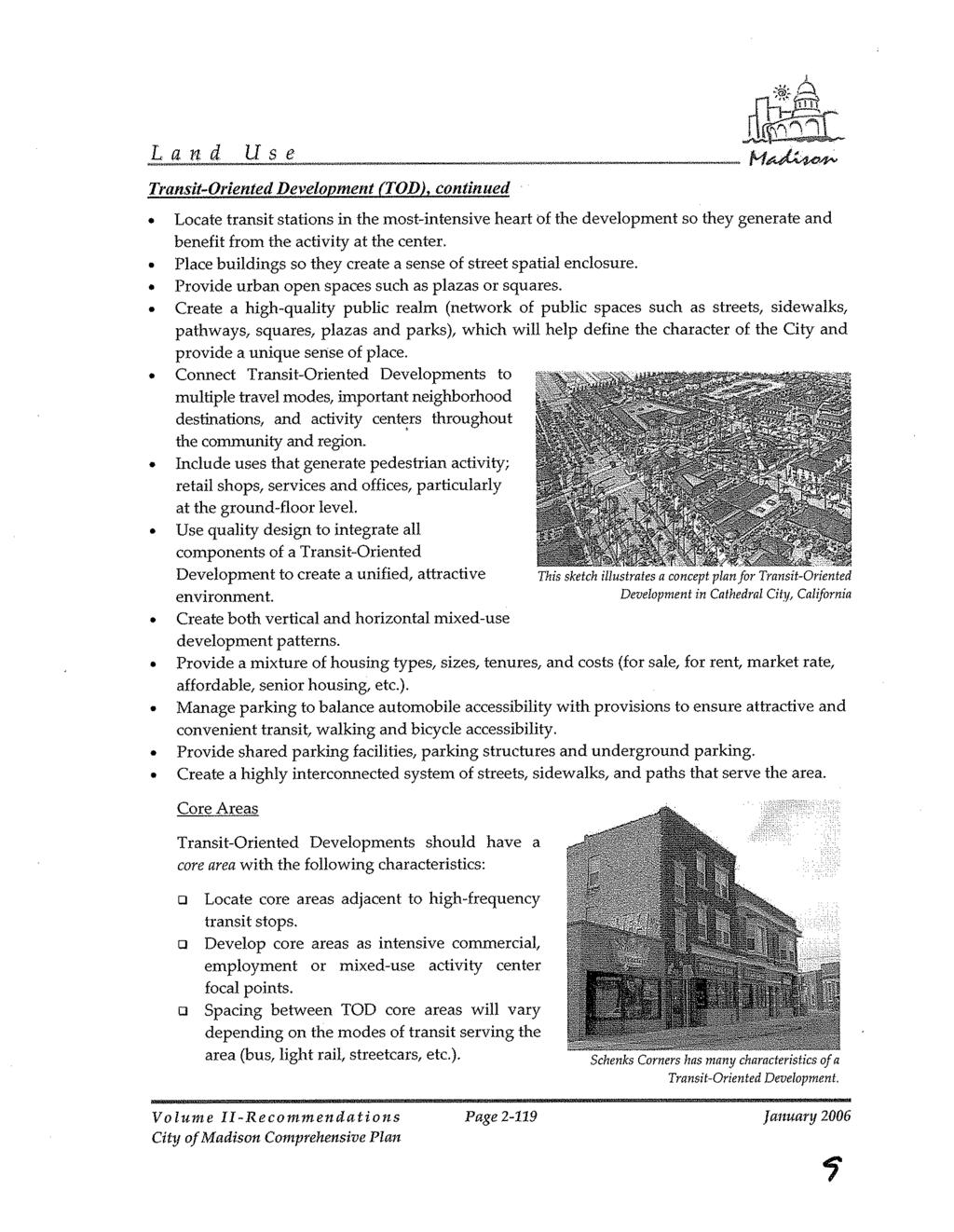
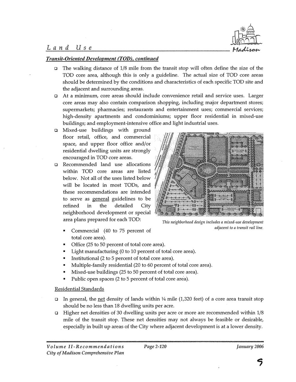
1 Report to the Plan Commission Legistar I.D. # McKee Rd./ 3210 Maple Grove Dr. PUD Rezoning Report Prepared By: Timothy M. Parks, Planner Planning Division Requested Action: Approval of a request to rezone and 3210 Maple Grove Drive from Temp. A (Agriculture District), R1 (Single-Family Residence District) and Planned Unit Development-General Development Plan (PUD-GDP) to PUD-GDP to allow the future construction of 190 apartments in 5 residential buildings & 39,000 square feet of retail in 6 commercial buildings. Applicable Regulations & Standards: Section (9) provides the process for zoning map amendments; Section (6) of the Zoning Ordinance provides the requirements and framework for Planned Unit Developments. Summary Recommendation: The Planning Division recommends that the Plan Commission recommend that Zoning Map Amendment 3463, rezoning and 3210 Maple Grove Drive from Temp. A, R1 and PUD-GDP to PUD-GDP, be referred following the public hearing to address the issues identified in the body of this report. Alternately, the Plan Commission may forward the subject zoning map amendment to the Common Council with a recommendation to only approve PUD-GDP zoning for the portion of the site to be developed with the 80-unit senior apartment complex, conditioned on approving a general development plan for the remainder of the 14-acre site prior to or concurrent with specific implementation plan approval for the 80-unit senior apartment complex. Background Information Applicant & Property Owner: Alex Weis, Livesey Company; 1818 W. Beltline Highway; Madison. Proposal: The applicant and property owner is requesting approval of a general development plan to allow the future construction of 190 apartments in 5 residential buildings & 39,000 square feet of retail in 6 commercial buildings. Eighty of the proposed multi-family dwelling units will be housed in a single building located on the westerly portion of the McKee Road frontage. The developer of those 80 units, which will be age-restricted, will be requesting approval of Section 42 affordable housing tax credits for the project from the Wisconsin Housing & Economic Development Authority in the first quarter of this year. The remaining residential units will be located in 4 buildings to be developed and operated by a separate multi-family residential developer, while the retail/ commercial component of the planned unit development will be developed by the applicant. The portion of the proposed development located along Maple Grove Drive will require future approval of a demolition permit to allow the existing onestory institutional building at to be razed. The building is currently occupied by Lakeshore Church Implementation of the overall planned unit development will occur in phases commencing in fall 2010, with no completion date for the project identified by the applicant.
2 Page 2 Parcel Location: An approximately 14-acre site located in the southwestern quadrant of McKee Road (CTH PD) and Maple Grove Drive; Aldermanic District 7; Madison Metropolitan and Verona Area school districts. Existing Conditions: The site is mostly undeveloped with the exception of the one-story building at occupied by a church. Surrounding Land Use and Zoning: North: Chester Creek Townhomes, zoned PUD-SIP; Family Video, zoned C1 (Limited Commercial District) and C2 (General Commercial District); South: Two-family residences and Stone Creek Apartments on the north side of East Pass, zoned R5 (General Residence District); West: Four- and six-unit apartment and condominium buildings along Stonecreek Drive, zoned R4 (General Residence District); East: Walgreen s, Copp s and multi-tenant retail/ commercial, and Westin Place Apartments, all zoned PUD-SIP. Adopted Land Use Plan: The Cross Country Neighborhood Development Plan recommends the four parcels at for commercial-offices uses related to the 1995 approval of that site for a medical-office campus. That portion of the site was previously recommended for medium-density residential uses. The portion of the subject site is recommended for mediumdensity residential uses. The Comprehensive Plan generally identifies the entire subject site for future neighborhood mixed-use development. The neighborhood mixed-use recommendation also encompasses the commercially developed properties on the other three corners of the McKee Road/ Maple Grove Drive intersection. The intersection is also generally identified in the Comprehensive Plan for future transit-oriented development. Environmental Corridor Status: This property is not located within a mapped environmental corridor. Public Utilities and Services: This property is served by a full range of urban services. Metro Transit operates limited peak hour transit service on weekdays along Stone Creek Drive and East Pass, west and south of this project. All-day and weekend transit service is approximately a half-mile north on Carnwood Road at McKenna Boulevard. Zoning Summary: The subject site is proposed to be rezoned PUD-GDP, which will be reviewed in the following sections. Subsequent rezonings of the site to PUD-SIP and a demolition permit to allow the existing church to be demolished will be required prior to the commencement of development. Other Critical Zoning Items Yes: Urban Design, Utility Easements, Barrier Free No: Floodplain, Wellhead Protection, Landmarks, Waterfront Development Prepared by: Pat Anderson, Asst. Zoning Administrator
3 Page 3 Previous Approvals On December 19, 1995, the Common Council approved a request to rezone approximately 36 acres located at the southwestern corner of McKee Road and Maple Grove Drive from Temp. A to R4 and R5 (General Residence Districts) and PUD-GDP and the preliminary plat of the East Pass Addition to Country Grove subdivision, which created the four PUD-GDP-zoned lots along McKee Road for future medical-office development as well as various lots to the south and west for primarily multi-family residential development. The final plat of East Pass Addition to Country Grove was approved by the Council on July 2, 1996 and was recorded on July 24, The final plat includes a 30-foot building line parallel to McKee Road and a restriction limiting the McKee Road frontage to one driveway access. Project Review The applicant is requesting approval to rezone approximately 14 acres located in the southwestern quadrant of McKee Road (CTH PD) and Maple Grove Drive from Temp. A (Agriculture District), R1 (Single-Family Residence District) and PUD-GDP to PUD-GDP to allow the future construction of 190 apartments in 5 residential buildings and 39,000 square feet of retail in 6 commercial buildings. Background The 14-acre site is comprised of five parcels, including four parcels addressed as McKee Road that were previously zoned PUD-GDP in 1995 to accommodate the development of a Dean Medical campus. The approved zoning text for the GDP called for the four parcels to be developed primarily with health-related uses, including medical, dental and optical clinics with accessory offices and laboratories; pharmacies; day care facilities, and; veterinary clinics. However, development of the health campus did not proceed past the GDP approval and the land, which is generally undeveloped, was purchased by the applicant in The lone improvement existing on these four parcels is Mader Drive, an approximately 30-foot wide private drive, which extends east from Stonecreek Drive to provide access to the Stone Creek Apartment development located to the south. The fifth parcel comprising the site is addressed and is developed with a small one-story concrete block building and surface parking lot, which was originally developed by the Verona Area School District as a kindergarten education building in R1 zoning. The former school building is currently occupied by Lakeshore Church. The remainder of the 3.25-acre parcel is undeveloped and is zoned Temp. A. The L-shaped site is characterized by a significant grade change that falls from the northeastern corner of the site adjacent to the McKee/ Maple Grove intersection to the southwestern corner near Mader Drive and Stonecreek Drive, where approximately 30 feet of grade change exists, and the southeastern corner along Maple Grove Drive near East Pass, where approximately 22 feet of grade change is present. The site is primarily open grassland with the exception of a modest tree line located along the side and rear property lines of the church/school parcel along Maple Grove Drive and an area of under growth located between the church/ school parcel and McKee Road. In addition to the 196-unit Stone Creek Apartments complex south of the site, the surrounding area is characterized by a variety of primarily multi-family residential uses located to the north, south and west, including a series of four- and six-unit multi-family buildings located on both sides of Stonecreek Drive and the south side of East Pass. Land to the east of the site across Maple Grove Drive is developed
4 Page 4 with a shopping center, including a Walgreen s located at the corner of McKee Road, a Copp s grocery store located further to the south, and a multi-tenant retail building fronting Maple Grove located in between. Additional commercial uses are located at the northeastern and northwestern corners of the McKee-Maple Grove intersection, including a PDQ gas station and convenience store, Jiffy Lube and Family Video. The land further to the south on the east side of Maple Grove at Westin Drive is developed with the 19-unit Westin Place Apartments. With rare exception, most of the surrounding development was built within the last 20 years. The subject site is located on the northernmost edge of the Cross Country Neighborhood Development Plan, which was adopted in 1993 to guide development in the portion of the City bounded by McKee Road on the north, Verona on the west, Cross Country and Nesbitt roads on the south and Fitchburg on the east. The four PUD-GDP parcels are currently identified in the Cross Country NDP for commercialoffice owing to the earlier approval for the Dean campus. Originally, the plan recommended this portion of the site be developed with medium-density residential uses. The parcel located along Maple Grove Drive occupied by the church and former school is recommended in the neighborhood development plan for medium-density residential uses. The plan recommends that medium-density residential uses be developed at an average density of 16 units an acre. The land use recommendation for the subject site was revised in 2006 with the adoption of the City s Comprehensive Plan, which recommends all five parcels and the existing commercially developed properties located on the other three quadrants of the McKee Road/ Maple Grove Drive intersection for transit-oriented neighborhood mixed-use development. In general, neighborhood mixed-use areas are intended to include commercial spaces primarily focused towards serving surrounding neighborhoods, with any residential uses generally not to exceed 40 dwelling units per acre. The scale of buildings in neighborhood mixed-use areas should generally be between two and four stories in height, though building heights, as well as intensity of use and residential densities can vary as established in an adopted neighborhood or special area plan. General Development Plan The general development plan for the subject site includes three fairly distinct components that will likely be developed by at least three different parties. The three elements of the proposed planned unit development will share access and internal circulation within the 14-acre site, and will at least partially share stormwater management facilities. Three points of access are proposed to serve the site, including a full access driveway from Maple Grove Drive, a partial access driveway from McKee Road, and the extension of Mader Drive into the site. The access from McKee Road will be located about midway between Stonecreek and Maple Grove drives, and will include ingress and egress to and from eastbound McKee Road and ingress from westbound McKee. However, no westbound turn movement from the site onto McKee is proposed by the applicant based on verbal recommendations from City staff. Because McKee Road is also County Trunk Highway PD, approval of the proposed access from the Dane County Department of Public Works, Highways & Transportation will be required prior to final staff approval and recording of the general development plan. The full access driveway from Maple Grove Drive will be located approximately midway along the site s frontage along that street and roughly equidistant from two full access driveways located on the east side of Maple Grove, which serve the Walgreen s and Copp s stores opposite the site. The location of the driveway was carefully considered by City staff during discussions with the applicant prior to the submittal of the rezoning application. The location of the driveway was ultimately recommended by City
5 Page 5 staff to be located as it is shown in an effort to reduce turning conflicts on the section of Maple Grove between McKee Road and Westin Drive/ East Pass, as opposed to having the proposed access be located opposite one of the existing driveway entrances on the east side of Maple Grove. Lastly, Mader Drive will be extended a short distance into the site before turning north through the surface parking lot that will occupy most of the center of the development site and then east to connect to the Maple Grove Drive entrance. The driveway into the site from McKee Road will be indirectly connected to Mader Drive through the parking area and on the west side of a proposed stormwater management facility that will occupy the southwestern corner of the site. The first land use component of the proposed planned unit development will be a three-story, 80-unit multi-family development that will occupy the western third of the McKee Road frontage west of the McKee Road drive entrance. The general development plan proposes an H-shaped building that will generally parallel McKee Road and include parking for approximately 100 cars beneath the building. Surface parking for 40 vehicles will be located in a courtyard area between the two main wings of the building (14 stalls) and opposite the south wall of the southern wing adjacent to the stormwater management area (26). Though specific architectural plans for the apartment building have not been provided, the main entrance to the building and a covered drop-off zone will be located along the eastern wall of the connecting wing. A landscaped area for building residents will be provided in the courtyard west of the connecting wing. The developer of the 80-unit apartment building, Ryan Construction, has indicated that the project will be restricted to persons 55 years of age and older and will include a mix of low-income and market-rate independent living units. The developer will be requesting approval of Section 42 affordable housing tax credits for the project from the Wisconsin Housing & Economic Development Authority. If their tax credit application is approved, a specific implementation plan for this component of the larger PUD will be submitted for approval in advance of construction commencing in the fall of this year. East of the proposed 80-unit senior apartment, the applicant and property owner proposes to develop 39,000 square feet of retail in 6 one-story commercial buildings, which will occupy the portion of the 14- acre site located north of the Maple Grove Drive project access. The 6 retail buildings will include a 15,000 square-foot building in the northeastern corner of the site adjacent to the McKee/ Maple Grove intersection (Building A), two 4,000 square-foot buildings along the McKee frontage (B1 & B2), a 4,800 square-foot building at the corner of McKee Road and the McKee driveway into the site (C), and a 5,400 square-foot building along the east side of the driveway from McKee Road near the center of the site (D). Building B1 is shown on one of the plans as a potential restaurant, while the other four buildings are identified as retail. An outdoor seating area is shown along the northern wall of Building A adjacent to McKee Road. The last building is a 6,000 square-foot optional retail building to be located east of Building D along the north side of the Maple Grove entrance drive. The area of the optional building and space to the west will otherwise serve as a greenspace for the development. Parking for the retail component will be provided in approximately 225 surface stalls at full build-out (5.8 stalls per 1,000 square feet of space) that will primarily be located north of the driveway from Maple Grove Drive and generally within the envelope created by the 6 commercial buildings. A one-way drive aisle is proposed between Buildings B1 and B2 and the northern property line, which will serve the restaurant in Building B1 (a pickup window is shown along the north wall on the colored master plan sheet). Although specific architectural details have not been provided at this stage in the planned unit development approval process, the applicant indicates that the six one-story commercial buildings will
6 Page 6 be designed with similar roof pitches and tower-like elements intended to enhance the height of the buildings. Entrances to individual tenant spaces will face the interior parking area. The last element of the proposed planned unit development will be a four-building, 110-unit market-rate apartment complex to be located south of the Maple Grove Drive entrance into the site. Three of the proposed buildings in this complex will abut Maple Grove Drive and will be three-story, 28-unit buildings with parking for 25 vehicles under each building. The fourth building is proposed as a two-story, 26-unit building located east of the northerly extension of Mader Drive into the site. Under-building parking for 32 cars will be provided in the fourth building. Surface parking for approximately 136 vehicles will be provided adjacent to the four apartment buildings, with 2.1 parking spaces total provided for the 110 units. The application materials and a conceptual massing diagram suggest that these buildings will be residential in appearance and will include private balconies or patios for individual units. The applicant indicates that the 80-unit apartment building proposed along the western third of the McKee Road frontage will occupy 4.55 acres of the site, resulting in a density of approximately 17.6 units an acre. The 110-unit, four-building market-rate apartment complex proposed along the southern half of the Maple Grove Drive frontage will occupy 3.77 acres, which results in a density of 29.2 units per acre. The density of the overall planned unit development equals 13.6 units per acre when the entire 14-acre site is considered. In addition to the greenspace in the retail section of the development described above, which is located along the north side of the drive entrance from Maple Grove Drive, the general development plan identifies three landscape features to be located generally between the buildings fronting Maple Grove. A large stormwater management area to serve the northerly half of the development will be provided along the north side of Mader Drive south of the senior housing development, while smaller bioretention areas to serve the southern portion of the site are shown adjacent to the two southernmost apartment buildings. Additionally, the general development plan identifies a series of sidewalks and walkways throughout most of the site that appear intended to connect the three components of the development with one another. Analysis On a 5-3 vote, the Urban Design Commission recommended final approval of the general development plan on December 16, 2009 (see attached reports). The approximately 14-acre general development plan site is located within the boundaries of the 1993 Cross Country Neighborhood Development Plan, which as noted earlier, identifies the McKee Road frontage of the site for office-commercial uses and most of the Maple Grove Drive frontage for mediumdensity residential uses. The McKee Road frontage was also recommended for medium-density residential development prior to the plan being amended in 1998 to reflect a 1995 zoning approval for health-related offices and facilities on that portion of the site. Among the land use objectives and policies in the Cross Country Neighborhood Development Plan include the creation of compact commercial areas to serve as a focus for neighborhood activity and a centralized convenience shopping and service center for residents. Shops, dwellings and workplaces are encouraged to be in close proximity to one another. Overall, the land use pattern in the neighborhood should encourage the development and use of mass transit while reducing the reliance on private autos.
7 Page 7 Many of these neighborhood development plan objectives and policies were incorporated into the 2006 Comprehensive Plan, which designated the subject site for neighborhood mixed-use development. The neighborhood mixed-use (NMU) recommendation was also applied to portions of the other three quadrants of the McKee-Maple Grove intersection, though properties in those three quadrants were already developed. Areas recommended for mixed-use development in the Comprehensive Plan are generally recommended for development as activity centers that include both residential and nonresidential uses, with mixed-use buildings encouraged but not required. Neighborhood mixed-use areas are intended to provide surrounding neighborhoods and districts with convenience shopping and service uses, as opposed to the larger community and regional mixed-use areas in the plan, which are intended to serve larger populations and can be developed at higher densities. In the case of areas recommended for neighborhood mixed-use development, the Comprehensive Plan recommends that new buildings be developed between two and four stories in height, with one-story buildings generally permitted only in limited circumstances. Buildings should be well-designed and placed close to the sidewalk and street, with parking placed behind or beneath buildings, and land uses within mixed-use sites should be well-integrated with one another. The gross square-footage of commercial buildings should generally not exceed 10,000 square feet, while residential densities should not exceed 40 units an acre unless a higher density is recommended in a neighborhood or special area plan (Comprehensive Plan, pages 2-86 & 2-87, which are attached at the end of this report). In addition, the Comprehensive Plan identifies the McKee-Maple Grove intersection as a transitoriented development (TOD) node. General standards for TODs in the Comprehensive Plan call for a compact, mixed-use development pattern that focuses the highest density and intensity of development on high-capacity transit stops and recommends the creation of both horizontal and vertical mixed-use. TODs are recommended to include a variety of land uses within walking distance of transit facilities, including a mix of housing, retail, service and employment. Buildings should be placed in a fashion that creates a sense of spatial enclosure and a high-quality public realm, and include uses that generate pedestrian activity. TOD sites should include a highly interconnected system of streets, sidewalks and paths that serve the area. Parking in TODs should be managed to balance automobile accessibility with the need to provide an attractive and convenient environment for pedestrians, bikes and transit users, with the sharing of parking between uses and the use of structured and underground recommended. The intensity of development of a particular TOD node will vary by location and form of transit service present (Comprehensive Plan, pages , which are attached at the end of this report). In the case of the subject site, Metro Transit service is currently limited to weekday peak-period bus service to the west and south on Stonecreek Drive and East Pass. However, Metro staff has indicated that future transit service expansions and/or restructuring could be routed along Maple Grove Drive to points south of McKee Road, which would result in transit service more directly serving the subject site. To this end, Metro is requesting that the proposed development provide a bus loading pad along its Maple Grove Drive frontage as a condition of approval. Planning Division staff is concerned that the proposed planned unit development does not represent the type of integrated mixed-use development that the Comprehensive Plan recommends for the site in its current iteration. While the general development plan for the approximately 14-acre site includes a mix of residential and commercial uses, staff believes that the conceptual plan for the site calls for those uses to be somewhat segregated and independent from one another. Although the 80-unit senior living apartment complex, 39,000 square-foot retail center and four-building, 110-unit multi-family complex will share access from perimeter streets, internal circulation and stormwater management facilities, there is little otherwise to suggest that the development represents the type of mixed-use development intended by the Comprehensive Plan. Whereas the Comprehensive Plan recommends
8 Page 8 attractive, compact, pedestrian- and transit oriented mixed-use development, staff feels that the proposed development instead suggests a more suburban development pattern discouraged by the plan. As a result, the Planning Division feels that some design modifications may be required before it can be found that the proposed planned unit development meets the standards for approval, including that the proposed rezoning conforms to the recommendations of the Comprehensive Plan. Planning Division staff believes that the applicant should explore ways to improve circulation through the planned unit development. As currently shown, Mader Drive will connect indirectly to the project s sole access from Maple Grove Drive through a parking area primarily adjacent to two apartment buildings. Staff sees this proposed alignment of Mader Drive and the proposed alignment of the northsouth drive from McKee Road through the site as a missed opportunity to break down the large City block bounded by McKee Road, Stonecreek Drive, East Pass and Maple Grove Drive, which contains approximately 24 acres of total land area and over 4,000 lineal feet of uninterrupted street frontage, including some block lengths of approximately 1,000 feet. Planning staff recommends that the applicant provide a more direct connection between a realigned Mader Drive and the north-south private drive that will extend into the site from McKee Road, which would further enhance multi-modal circulation through and around this large, densely developed block and provide greater opportunities to orient both existing and proposed development to street frontages more in keeping with the highly integrated, urban mixed-use development pattern generally recommended for this site by the Comprehensive Plan and Cross Country Neighborhood Development Plan. The character of a realigned Mader Drive and the unnamed north-south drive could be enhanced by the inclusion of parallel or angled parking on both sides instead of the numerous 90-degree stalls currently shown, as well as the inclusion of bike lanes and other streetscaping features to make those drives read more like streets and less like aisles through a surface parking lot. Staff believes that the applicant also needs to clarify how the proposed buildings, particularly those containing commercial uses, will address the public streets on the northern and eastern edges of the development. Staff feels it is of paramount importance that each of the buildings abutting McKee Road and Maple Grove Drive include the provision of active, usable entrances accessed either directly from the public sidewalk or from courtyards located between buildings, though the orientation of the buildings along Mader Drive and the unnamed north-south drive should also be carefully considered. Buildings throughout the project should include architectural features that identify the street-side walls of those buildings as the front walls and doors of those buildings. While staff recognizes that many of the patrons of these buildings will arrive by car, the individual buildings shall be designed to be as oriented to the adjacent streets as they are to the internal parking lots shown. To address this, staff recommends that language be included in the zoning text for the general development plan, which establishes the basic expectation that individual buildings will be oriented to and have access from abutting streets as part of the specific implementation plans for those buildings. Staff also recommends that the applicant also explore turning the southernmost 28-unit building to parallel Maple Grove Drive instead of the rears of the two adjacent East Pass duplexes, and explore the articulation of the northernmost wall of the 80-unit senior apartment building to reduce the potential presence of a long monotonous street wall, which will occupy nearly half of the site s McKee Road frontage. Such articulation should include the use of vertical sections, changes in building materials and the incorporation of a usable first floor entrance from the McKee Road sidewalk. Final details of all of the buildings proposed throughout the planned unit development will be considered as part of the
9 Page 9 approval of future specific implementation plans for individual buildings prior to the issuance of building permits. Finally, full implementation of the proposed planned unit development will require the demolition of the small one-story concrete block institutional building located at. However, the applicant has not requested approval of a demolition permit with the current application and as a result, no permission to demolish the former school and current church will be granted with this PUD-GDP rezoning request. Instead, approval to demolish the building using the demolition standards in Section (12) will be required as part of the approval of a specific implementation plan for this portion of the overall site. However, staff acknowledges the general intent to demolish this structure as part of the approval of the proposed general development plan. Conclusion The applicant is requesting approval of a general development plan to guide the future development of an approximately 14-acre site located in the southwestern quadrant of McKee Road (CTH PD) and Maple Grove Drive with a mix of multi-family residential and retail-service uses in approximately 11 buildings. The parcel is one of two remaining developable parcels along the McKee Road corridor in the City of Madison in addition to portions of Meriter Hospital s property located further to west. The site is also one of the few remaining substantial developable parcels in the Cross Country neighborhood planning area. While the Planning Division is generally supportive of the mix of uses contained within the proposed planned unit development, staff believes that the general development plan could be improved to better implement the neighborhood mixed-use and transit-oriented development recommendations for the subject site in the Comprehensive Plan and the compact neighborhood activity center development form generally recommended by the Cross Country Neighborhood Development Plan. The proposed planned unit development contains a mix of uses, however the layout of the planned development separates the multi-story apartment buildings from the retail by placing them on the western and southern ends of the site with exclusively one-story retail buildings placed along McKee Road and Maple Grove Drive. While the Comprehensive Plan notes that not every building in a mixed-use district needs to include both residential and non-residential uses, and that one-story buildings may be appropriate in limited circumstances, but are not encouraged, this proposed planned unit development includes no truly mixed-use buildings and no retail buildings greater than one story. The integration of second floor uses in some of the retail buildings, and/or the incorporation of some retail spaces and/or live-work units within the northernmost apartment buildings could help to further integrate the residential and retail uses within this planned neighborhood mixed use development. Examples of similar developments that have been able to accomplish the intent of the Comprehensive Plan include the Sequoya Commons development at the corner of Midvale Boulevard and Tokay Boulevard, and the Courtland Commons development at the intersection of Watts Road and Commerce Drive. Planning staff generally support the location of buildings in relationship to Maple Grove Drive and McKee Road as all of the buildings are located along the street frontage with no parking located between the buildings and the streets. However, the primary building orientation is toward the center of the site and toward the surface parking lots serving the retail development. Staff believes that the retail buildings must have an equivalent orientation toward the McKee Road and Maple Grove Drive sides of the building with direct access provided from the sidewalks to the retail buildings, to the extent possible. While staff has some concern with the proposed restaurant drive-service window along McKee Road,
10 Page 10 staff does not see a better location for a drive-thru service window if such a facility is to be located as part of this development. Staff is aware of the considerable grade change that exists from northeast to south across the entire site and the potential development challenges they may present. However, staff feels that this topographical character of the site should compel a more innovative development proposal in keeping with the recommendations of the Comprehensive Plan and Cross Country Neighborhood Development Plan. In order to create more of an urban mixed-use development pattern on this site, staff recommends that the general development plan be revised in regard to both the circulation pattern through and around the site and the orientation of some of the proposed buildings. At a minimum, staff believes that the alignment of extended Mader Drive and the north-south drive intersect more directly, which staff feels will result in improved connectivity between the proposed uses as well as the surrounding neighborhood, especially if Mader Drive and the unnamed north-south drive are designed to be more street-like and less like parking lot aisles. In closing, Planning staff recommends that the Plan Commission refer consideration of the general development plan to allow the applicant an opportunity to address the concerns expressed in the preceding sections. However, as an alternative, the Plan Commission could forward the portion of the rezoning request relating to the 80-unit senior apartment complex to the Common Council with a recommendation of approval so that component of the planned unit development can proceed with its application to the Wisconsin Housing & Economic Development Authority for tax credits in the current round of applications. [The Zoning Code allows the Plan Commission to recommend approval of a zoning map amendment to the Common Council for a smaller area than requested by the applicant (MGO (10)(f)4).] Staff recommends that should the Commission choose to recommend approval of only a portion of the proposed planned unit development, it should consider conditioning such an approval on the applicant addressing the concerns raised about the remainder of the planned unit development prior to or concurrent with the consideration of a specific implementation plan for the 80-unit senior apartment complex, since implementation of that component will likely affect how the remainder of the 14-acre overall site is developed. Staff Recommendations, Conditions of Approval & General Ordinance Requirements Major/Non-Standard Conditions are shaded Planning Division Recommendation (Contact Timothy M. Parks, ) The Planning Division recommends that the Plan Commission forward Zoning Map Amendment 3463, rezoning and from Temp. A, R1 and PUD-GDP to PUD-GDP, to the Common Council with a recommendation of referral so that the issues raised about the general development plan in the preceding sections can be addressed by the applicant. Alternately, the Plan Commission may forward the subject zoning map amendment to the Common Council with a recommendation to only approve PUD-GDP zoning for the portion of the site to be developed with the 80-unit senior apartment complex. Staff recommends that the Plan Commission condition such an approval on approving a general development plan for the remainder of the 14-acre
11 Page 11 site prior to or concurrent with specific implementation plan approval for the 80-unit senior apartment complex. Should the Plan Commission find that the standards of approval for planned unit developments and zoning map amendments are met for either the entire subject site or a portion thereof, the following conditions should be forwarded to the Common Council with its recommendation of approval: 1. That the approval of this PUD-GDP grants no specific authority to demolish or remove the one-story building at. However, the general intent to demolish this structure is recognized as part of the approval of the general development plan. Specific approval to demolish this structure shall be granted as part of the review of a specific implementation plan for this portion of the site using the standards for approval of demolition permits in Section (12) of the Zoning Ordinance. The future application to demolish this building shall include photographs of the interior and exterior of the building as well as a written assessment of its condition and the potential for any buildings to be relocated to other sites. 2. That the applicant work with the Planning Division and Zoning Administrator prior to final approval and recording of the planned unit development zoning to develop an enumerated list of permitted commercial and residential uses for the zoning text. [Staff believes that it would be best going forward to approve PUD zoning texts with such use lists so as to avoid references to the Zoning Code, which is currently being rewritten and will likely have different, more contemporary use lists.] 3. That the zoning text for the general development plan be revised per Planning Division approval prior to recording to state that individual commercial buildings will be designed to be as oriented to or more oriented to the adjacent public and private streets than to the internal parking lots through the inclusion of architectural features including but not limited to vision glass, usable entrances and fully screened utility and mechanical facilities along all street-side elevations. Enforcement of this requirement will occur as part of the specific implementation plan approval for individual commercial buildings. 4. Note: Implementation of the planned unit development will likely require subdivision of the subject parcel by a final plat or Certified Survey Map proceeded by a preliminary plat or amended general development plan that outlines the proposed layout of the subdivision. The following conditions have been submitted by reviewing agencies: City Engineering Division (Contact Janet Dailey, ) 5. The conditional approval for build out will require public right of way dedications as well as other probable public easement rights conveyed to facilitate this development. It is understood this is to be accomplished by the submittal, approval and recording of either a Certified Survey Map (CSM) or Subdivision Plat. The site plan appears to include only portions of platted lots as well, which presumably the CSM or Plat will also resolve. 6. The applicant shall dedicate additional right of way along Maple Grove Drive to facilitate the new intersection with the proposed driveway as required by the City Engineer. 7. The applicant shall dedicate right of way along Maple Grove Drive for sidewalk and tree terrace as required by the City Engineer.
12 Page The applicant shall make improvements to Maple Grove Drive to facilitate ingress and egress to the proposed driveway. 9. The applicant shall make improvements to McKee Road to facilitate ingress and egress to the proposed driveway. 10. Site drainage must be safely passed to adjacent right of ways. Proposed Buildings H and I cannot discharge to adjacent private property. 11. The proposed development shall require extending public storm sewer and public sanitary sewer. 12. The construction of this development will require removal and replacement of sidewalk, curb and gutter and possibly other parts of the City s infrastructure. The applicant shall enter into a City/ Developer agreement for the improvements required for this development. The applicant shall be required to provide deposits to cover City labor and materials and surety to cover the cost of construction. The applicant shall meet with the City Engineer to schedule the development of the plans and the agreement. The City Engineer will not sign off on this project without the agreement executed by the developer. The developer shall sign the Developer s Acknowledgement prior to the City Engineer signing off on this project. (Per MGO 16.23(9)c) 13. The applicant shall construct sidewalk along Maple Grove Drive according to a plan approved by the City Engineer. (Per MGO 16.23(9)(d)(6) 14. The applicant shall close all abandoned driveways by replacing the curb in front of the driveways and restoring the terrace with grass. 15. The applicant shall replace all sidewalk and curb and gutter that abuts the property, which is damaged by the construction or any sidewalk and curb and gutter that the City Engineer determines needs to be replaced because it is not at a desirable grade regardless of whether the condition existed prior to beginning construction. 16. All work in the public right of way shall be performed by a City-licensed contractor. (Per MGO 16.23(9)(c)5) and MGO 23.01) 17. All street tree locations and tree species within the right of way shall be reviewed and approved by City Forestry. Please submit a tree planting plan in PDF format to Dean Kahl, of the City Parks Department - dkahl@cityofmadison.com or The applicant shall demonstrate compliance with Section and of the Madison General Ordinances regarding permissible soil loss rates. The erosion control plan shall include Universal Soil Loss Equation (USLE) computations for the construction period. Measures shall be implemented in order to maintain a soil loss rate below 7.5-tons per acre per year. 19. If the lots within this site plan are interdependent upon one another for stormwater runoff conveyance, and/or a private drainage system exists for the entire site an agreement shall be provided for the rights and responsibilities of all lot owners. Said agreement shall be reviewed and placed on file by the City Engineer, referenced on the site plan, and recorded at the Dane County Register of Deeds.
13 Page Prior to approval, this project shall comply with Chapter 37 of the Madison General Ordinances regarding stormwater management. Specifically, this development is required to: detain the 2, 10, & 100-year storm events; control 80% TSS (5 micron particle) off of new paved surfaces; provide infiltration in accordance with Chapter 37 of the Madison General Ordinances; provide substantial thermal control; provide oil & grease control from the first 1/2 of runoff from parking areas, and; complete an erosion control plan and complete weekly self-inspection of the erosion control practices and post these inspections to the City of Madison website as required by Chapter 37 of the Madison General Ordinances. 21. The plan set shall be revised to show more information on proposed drainage for the site. This shall be accomplished by using spot elevations and drainage arrows or through the use of proposed contours. It is necessary to show the location of drainage leaving the site to the public right of way. It may be necessary to provide information off the site to fully meet this requirement. 22. The applicant shall submit, prior to plan sign-off, digital PDF files to the City Engineering Division. The digital copies shall be to scale, shall have a scale bar on the plan set, and shall contain the following items: building footprints; internal walkway areas; internal site parking areas; lot lines and right-of-way lines; street names, stormwater management facilities and; detail drawings associated with stormwater management facilities (including if applicable planting plans). 23. The applicant shall submit prior to plan sign-off, electronic copies of any Stormwater Management File including: SLAMM DAT files; RECARGA files; TR-55/HYDROCAD/etc., and; sediment loading calculations. If calculations are done by hand or are not available electronically the hand copies or printed output shall be scanned to a PDF file and provided. 24. All outstanding Madison Metropolitan Sewerage District (MMSD) and City of Madison sanitary sewer connection charges are due and payable prior Engineering Division sign-off, unless otherwise collected with a Developer's / Subdivision Contract. Contact Janet Dailey ( ) to obtain the final MMSD billing a minimum of two working days prior to requesting City Engineering Division signoff. (Per MGO 16.23(9)(d)(4)) 25. The site plan shall be revised to show all existing public sanitary sewer facilities in the project area as well as the size, invert elevation, and alignment of the proposed service. Traffic Engineering Division (Contact John Leach, ) 26. The applicant will need to submit a traffic impact study to as determined by the Traffic Engineering Division. The traffic impact study will need to be reviewed and approved by the Traffic Engineering Division. The applicant has been working with Traffic Engineering staff to develop the Traffic Impact Study. 27. In order to provide adequate capacity, the applicant shall dedicate additional 10 feet of right of way along Maple Grove Drive frontage beginning from the southerly right of way line of McKee Road southerly along the westerly right of way line to the southerly extended curb line of the proposed driveway approach for Mader Drive (Private Street). The applicant will need to start a 150-foott taper from Maple Grove Drive driveway southerly. This dedication is required for the orderly development of this land use and to provide transportation accommodations to serve this development. The exact dedication and street improvement requirements shall be reviewed and approved by the City Traffic Engineer.
14 Page The developer shall enter into a subdivision contract/ developer s agreement and make improvements to Maple Grove Drive and McKee Road (CTH PD) as determined by the City Traffic Engineer and City Engineer. 29. The applicant shall be responsible for securing all proper permits and approvals from any municipality or government unit having jurisdiction with the project. In particular, the applicant shall submit site plans for review and approval to the Dane County Department of Public Works, Highways & Transportation. The applicant shall return a set of site plans or a letter with Dane County s approved copies to the City of Madison Traffic Engineering Division. 30. A special design Street Type Entrance at McKee Road will need to designed and reviewed and approved by Traffic Engineering staff. The Maple Grove Drive entrance shall be a Class 4 driveway approach with a maximum width of 40 feet. 31. When the applicant submits final plans for approval, the applicant shall show the following: items in the terrace as existing (e.g., signs and street light poles), type of surfaces, existing property lines, addresses, one contiguous plan (showing all easements, all pavement markings, building placement, and stalls), adjacent driveway approaches to lots on either side and across the street, signage, percent of slope, vehicle routes, dimensions of radii, aisles, driveways, stalls including the 2-foot overhang, and a scaled drawing at 1" = 20'. 32. The applicant shall note Mader Drive (Private Street) on the PUD-GDP. The applicant shall note the following for private street signs: The applicant shall install private street name and other signs that comply with Madison General ordinances 10.34(3). The applicant shall show detail drawing of signs and installation that comply with M.G.O. a. Sign Installation. Street name signs shall be installed five (5) feet behind the property line on private property on the right hand side of the private street approach to the public street. Signs may be mounted on wood posts, drive posts or on two (2) inch (I.D.) steel pipe mounted on a concrete stub buried in the ground. At all private-public street intersections, the property owner shall install and maintain a regulation stop sign (minimum 24 x 24 ) and a Private Drive sign (minimum 18 x 18 ) mounted on the street name sign post seven (7) feet above ground (measured to the bottom of the sign). Street name signs shall be mounted no less than nine (9) feet, nor more than ten (10) feet above ground (measured to the bottom of the sign). 33. All existing driveway approaches on which are to be abandoned shall be removed and replaced with curb and gutter and noted on the plan. 34. When a final plat or CSM is submitted for approval, the developer shall note on the face the joint driveway ingress/egress and easements. 35. The applicant will need to submit a pavement marking and signage plan to be review and approved by Traffic Engineering staff for the PUD (GDP-SIP) submittal. All signs at the approaches shall be installed behind the property line. All directional/regulatory signage and pavement markings on the site shall be shown and noted on the plan.
15 Page A traffic signal/street light declaration of conditions and covenants shall be executed and returned with a future plat or CSM submittal. The development shall acknowledge on their proportionate share of traffic signal assessments. The developer shall further agree in writing to not oppose their proportionate share of the traffic signal assessments as part of the City s Special Assessment districts for traffic signals. 37. The developer shall post a deposit and reimburse the City for all costs associated with any modifications to traffic signals, street lighting, signing and pavement marking, and conduit and handholes, including labor, engineering and materials for both temporary and permanent installations. 38. Public signing and marking related to the development may be required by the City Traffic Engineer for which the developer shall be financially responsible. Zoning Administrator (Contact Pat Anderson, ) 39. Bike parking shall comply with MGO Section 28.11: Provide one bike parking stall for each apartment and one bike stall for each 10 surface parking stalls provided in a safe and convenient locations on an impervious surface to be shown on the final plan. The bike racks shall be securely anchored to the ground or building to prevent the racks from moving. Note: A bike-parking stall is 2 by 6 with a 5-foot access area. Structures that require a user-supplied locking device shall be designed to accommodate U-shaped locking devices. 40. Parking and loading shall comply with City of Madison General Ordinances Section (4): Provide (1) 10 x 35 loading areas with 14-foot vertical clearance to be shown on the plan. Work with Zoning staff to determine location. 41. Parking requirements for persons with disabilities must comply with MGO Section (3)6.(m) which includes all applicable State accessible requirements, including but not limited to: a.) Provide minimum of 5 accessible stalls striped per State requirements. A minimum of one of the stalls shall be a van accessible stall 8 wide with an 8 striped out area adjacent. b.) Show signage at the head of the stalls. Accessible signs shall be a minimum of 60 between the bottom of the sign and the ground. c.) Show the accessible path from the stalls to the buildings. Parking stalls shall not block the entry to the elevators. The stalls shall be as near the accessible entrance as possible. Show ramps, curbs, or wheel stops where required. 42. Identify useable open space areas and area calculations for the residential dwelling units. 43. Lighting is required and shall be in accordance with MGO Section : Provide a plan showing at least.5 foot candle on any surface on any lot and an average of.75 footcandles. The maximum light trespass shall be 0.5 footcandle at 10 feet from the adjacent lot line. (See City of Madison Lighting Ordinance). 44. Off-street parking requirement shall comply with MGO Sections (12) and 28.11: Parking lot plans with greater than twenty (20) stalls, landscape plans must be stamped by a registered landscape architect. Provide a landscape worksheet with the final plans that shows that the landscaping provided meets the point and required tree ordinances. In order to count toward required points, the landscaping shall be within 15 and 20 of the parking lot depending on the type
16 Page 16 of landscape element. (Note: The required trees do not count toward the landscape point total.) Planting islands shall consist of at least 75% vegetative cover, including trees, shrubs, ground cover, and/or grass. Up to 25% of the island surface may be brick pavers, mulch or other nonvegetative cover. All plant materials in islands shall be protected from vehicles by concrete curbs. 45. Signage approvals are not granted by the Plan Commission. Signage must be approved by the Urban Design Commission or staff. for compliance with MGO Section 31, Sign Code, and MGO Section 33, the Urban Design ordinance. Sign permits must be issued by the Zoning Section of the Department of Planning and Community and Economic Development prior to sign installations. Parks Division (Contact Tom Maglio, ) 46. Final park dedication and development fees will be determined when specific implementation plans are submitted for the two residential components of the project. Park impact fees will be due prior to signoff of those SIPs and/or the issuance of building permits. Park impact fees for the 190 multifamily units, including the 80 age-restricted units, will be based on the fees due and payable in the year the SIP is approved and/ or building permits are issued. Fire Department (Contact Scott Strassburg, ) 47. Provide fire apparatus access as required by MGO 34.19, as follows: a.) The site plans shall clearly identify the location of all fire lanes. b.) Provide an aerial apparatus access fire lane that is at least 26-feet wide, with the near edge of the fire lane within 30-feet of the structure, and parallel to one entire side of the structure, if any part of the building is over 30 feet in height. c.) Provide a fire lane that extends to within 150-feet of all exterior portions of the structure, or it can be extended to within 250-feet if the building is fully sprinklered. 48. All portions of the exterior walls of newly constructed public buildings and places of employment and open storage of combustible materials shall be within 500 feet of at least two fire hydrants. Distances are measured along the path traveled by the fire truck as the hose lays off the truck. See MGO for additional information. City Assessor s Office (Contact Maureen Richards, ) This agency did not submit comments for this request. Water Utility (Contact Dennis Cawley, ) 49. The proposed public water distribution design is unacceptable to the Madison Water Utility. Each parcel will require a separate water service lateral connection to a public water main. The Water Utility will need to sign off the final plans, but not need a copy of the approved plans. 50. All wells located on this property shall be abandoned if no valid well operation permit has been obtained from the Madison Water Utility.
17 Page 17 Metro Transit (Contact Tim Sobota, ) 51. The applicant shall install and maintain a concrete passenger boarding pad on the west side of Maple Grove Drive, south of McKee Road. The concrete pad shall occupy the full distance of the terrace, measure a minimum of 10 feet in width parallel to the street, and lie flush between the sidewalk and the top of curb. Future transit service expansions or restructuring could be routed along Maple Grove Drive to points south of McKee Road creating the possible need for the concrete boarding pad location and bus stop identified above at this major intersection. The applicant shall include the location of these passenger amenities on the final documents filed with their permit application so that Metro Transit may review and approve the design.
18
19
20
21
22
Approval of a conditional use to allow construction of a rehabilitation hospital at 5115 N. Biltmore Lane in the American Center.
 Department of Planning & Community & Economic Development Planning Division Katherine Cornwell, Director Madison Municipal Building, Suite LL-100 215 Martin Luther King, Jr. Boulevard P.O. Box 2985 Madison,
5851 Gemini Drive and 841 Jupiter Drive Amended Planned Development (PD) District- General Development Plan and Specific Implementation Plan
 District- General Development Plan and Specific Implementation Plan") PLANNING DIVISION STAFF REPORT PREPARED FOR THE URBAN DESIGN COMMISSION AND PLAN COMMISSION Project Address: Application Type: Legistar File ID # 32271 Prepared By: Summary 5851 Gemini Drive and 841 Jupiter
PLANNING DIVISION STAFF REPORT PREPARED FOR THE URBAN DESIGN COMMISSION AND PLAN COMMISSION Project Address: Application Type: Legistar File ID # 32271 Prepared By: Summary 5851 Gemini Drive and 841 Jupiter
The City Engineering Division has reviewed the subject development and has the following comments.
 DATE: May 27, 2008 TO: FROM: SUBJECT: Plan Commission Larry D. Nelson, P.E., City Engineer 1126 Huxley Street and 1910 Roth Street Demolition The City Engineering Division has reviewed the subject development
PREPARED FOR THE URBAN DESIGN COMMISSION AND PLAN COMMISSION
 PLANNING DIVISION STAFF REPORT PREPARED FOR THE URBAN DESIGN COMMISSION AND PLAN COMMISSION Project Address: Application Type: Prepared By: Demolition Permit and Conditional Use Kevin Firchow, AICP, Planning
Report to the Plan Commission February 4, 2013
 Report to the Plan Commission Legistar I.D. #28789 Conditional Use Requested Actions: Approval of a conditional use for a structure exceeding 10,0000 square feet of total floor area and an accessory building
Please contact Janet Dailey of the City Engineering Division, at if you have questions regarding the following twenty-four (24) items:
 items:") Planning Division J. Randy Bruce Knothe & Bruce Architects, LLC 7601 University Avenue, Suite 201 Middleton, Wisconsin 53562 RE: Approval of a request to rezone a portion of from C2 (General Commercial
Planning Division J. Randy Bruce Knothe & Bruce Architects, LLC 7601 University Avenue, Suite 201 Middleton, Wisconsin 53562 RE: Approval of a request to rezone a portion of from C2 (General Commercial
Report to the Plan Commission August 20, 2012
 Report to the Plan Commission Legistar I.D. #27376 5692-5696 Monona Drive Conditional Use Requested Action: Approval of a conditional use for an outdoor eating area for a restaurant and an accessory parking
Department of Planning & Community & Economic Development Planning Division
 Kirk Keller Plunkett Raysich Architects LLP 2310 Crossroads Dr., Suite 2000 Madison, WI 53718 RE: Department of Planning & Community & Economic Development Planning Division Website: www.cityofmadison.com
Report to the Plan Commission May 4, 2009
 Report to the Plan Commission Legistar I.D. #14544 2101-2115 East Springs Drive Conditional Use Planned Commercial Site Report Prepared By: Kevin Firchow, AICP Planning Division Requested Action: Approval
Report to the Plan Commission October 1, 2012
 Report to the Plan Commission Legistar I.D. #27437 5922 Lien Road Re-approving PUD-GDP Zoning Requested Action: Approval of a request to rezone parcels generally addressed as 5922 Lien Road from Planned
The City Engineering Division has reviewed the subject development and has the following comments.
 DATE: April 11, 2007 TO: FROM: SUBJECT: Plan Commission Larry D. Nelson, P.E., City Engineer 5756 Portage Road Certified Survey Map The City Engineering Division has reviewed the subject development and
Requested Action: Approval of a final plat creating 25 single-family lots and 1 outlot for stormwater management.
 PLANNING DIVISION STAFF REPORT PREPARED FOR THE PLAN COMMISSION Project Address: Application Type: Final Plat Prepared By: Reviewed By: Summary Timothy M. Parks, Planning Division Report includes comments
Department of Planning & Development Planning Unit
 Department of Planning & Development Planning Unit Website: www.cityofmadison.com Madison Municipal Building 215 Martin Luther King, Jr. Boulevard P.O. Box 2985 Madison, Wisconsin 53701-2985 TDD 608 266-4747
Report to the Plan Commission October 5, 2009
 Report to the Plan Commission Legistar I.D. #15795 & 16102 8501 Mineral Point Road & 902 CTH M Rezoning, Demolition Permit, Prelim. & Final Plats Report Prepared By: Timothy M. Parks, Planner Planning
Department of Planning & Community & Economic Development Planning Division
 Department of Planning & Community & Economic Development Planning Division Travis Schreiber Vierbicher Associates 999 Fourier Drive #201 Madison, WI 53717 Website: www.cityofmadison.com Madison Municipal
PLANNING DIVISION STAFF REPORT August 25, Summary. Background Information PREPARED FOR THE PLAN COMMISSION
 PLANNING DIVISION STAFF REPORT PREPARED FOR THE PLAN COMMISSION Project Address: Application Type: Legistar File ID #: 34913 Prepared By: 1030 Vilas Avenue and 315 South Mills Street Demolition and Conditional
Department of Planning & Community & Economic Development Planning Division
 Department of Planning & Community & Economic Development Planning Division Website: www.cityofmadison.com Madison Municipal Building 215 Martin Luther King, Jr. Boulevard P.O. Box 2985 Madison, Wisconsin
Zoning Map Amendment, Demolition Permit and Preliminary Plat (Amended Request) Legistar File ID # 31820, and 31683
 Legistar File ID # 31820, and 31683") PLANNING DIVISION STAFF REPORT PREPARED FOR THE PLAN COMMISSION Project Address: Application Type: Zoning Map Amendment, Demolition Permit and Preliminary Plat (Amended Request) Legistar File ID # 31820,
PLANNING DIVISION STAFF REPORT PREPARED FOR THE PLAN COMMISSION Project Address: Application Type: Zoning Map Amendment, Demolition Permit and Preliminary Plat (Amended Request) Legistar File ID # 31820,
Report to the Plan Commission December 19, 2011
 Report to the Plan Commission Legistar I.D. #24825, Extraterritorial Certified Survey Map Requested Action: Consideration of a two-lot Certified Survey Map (CSM) of the Keryluk-Wee property located at,,
PLANNING UNIT REPORT DEPARTMENT OF PLANNING AND DEVELOPMENT of April 24, 2006
 PLANNING UNIT REPORT DEPARTMENT OF PLANNING AND DEVELOPMENT of RE: I.D. # 03279: Zoning Map Amendment I.D. 3179 to Rezone from PUD- SIP to Amended PUD-SIP 1. Requested Actions: Approval of a request to
Applicable Regulations & Standards: The subdivision process is outlined in Section 16.23(5)(b) of the Subdivision Regulations.
(b) of the Subdivision Regulations.") PLANNING DIVISION STAFF REPORT PREPARED FOR THE PLAN COMMISSION Project Address: Application Type: Final Plat Legistar File ID # 33674 Prepared By: Summary Timothy M. Parks, Planning Division Report includes
PLANNING DIVISION STAFF REPORT PREPARED FOR THE PLAN COMMISSION Project Address: Application Type: Final Plat Legistar File ID # 33674 Prepared By: Summary Timothy M. Parks, Planning Division Report includes
PLANNING DIVISION STAFF REPORT December 16, Summary. Background Information PREPARED FOR THE PLAN COMMISSON. Legistar File ID # 32125
 PLANNING DIVISION STAFF REPORT Project Address: Application Type: Legistar File ID # 32125 Prepared By: 644 North Frances Street Conditional Use PREPARED FOR THE PLAN COMMISSON Heather Stouder, AICP, Planning
The City Engineering Division has reviewed the subject development and has the following comments.
 DATE: January 15, 2008 TO: FROM: SUBJECT: Plan Commission Larry D. Nelson, P.E., City Engineer 5302 Voges Road Certified Survey Map The City Engineering Division has reviewed the subject development and
Report to the Plan Commission March 4, 2013
 Report to the Plan Commission Legistar Preliminary Plat & Final Plat Requested Action: Approval of a preliminary plat creating a total of 25 single-family residential lots and 2 outlots for stormwater
Report to the Plan Commission February 20, 2012
 Report to the Plan Commission Legistar ID #24620 & 25091 6002 Cottage Grove Road, 5901-5939 Sharpsburg Drive and 857 Jupiter Drive et al PUD Rezoning Preliminary Plat Requested Actions: ID 24620 Approval
Department of Planning & Development Planning Unit
 Department of Planning & Development Planning Unit Website: www.cityofmadison.com Madison Municipal Building 215 Martin Luther King, Jr. Boulevard P.O. Box 2985 Madison, Wisconsin 53701-2985 TDD 608 266-4747
Department of Planning & Community & Economic Development Planning Division
 Department of Planning & Community & Economic Development Planning Division Website: www.cityofmadison.com Madison Municipal Building 215 Martin Luther King, Jr. Boulevard P.O. Box 2985 Madison, Wisconsin
DEVELOPMENT DEPARTMENT STAFF REPORT THE PARK AT 5 TH
 DEVELOPMENT DEPARTMENT STAFF REPORT ARB Meeting Date: July 3, 2018 Item #: _PZ2018-293_ THE PARK AT 5 TH Request: Site Address: Project Name: Parcel Number: Applicant: Proposed Development: Current Zoning:
Demolition Permit and Conditional Use, and Preliminary and Final Plats
 PLANNING DIVISION STAFF REPORT PREPARED FOR THE URBAN DESIGN COMMISSION AND PLAN COMMISSION Project Address: Application Type: Legistar File ID # 34164 and 34331 Prepared By: Summary Demolition Permit
PLANNING DIVISION STAFF REPORT February 10, Summary PREPARED FOR THE PLAN COMMISSION. Zoning Map Amendment and Preliminary Plat
 PLANNING DIVISION STAFF REPORT PREPARED FOR THE PLAN COMMISSION Project Address: Application Type: Legistar File ID # 32565 and 32284 Prepared By: Reviewed By: Summary Zoning Map Amendment and Preliminary
PLANNED UNIT DEVELOPMENT & SUBDIVISION STAFF REPORT Date: April 18, 2019
 PLANNED UNIT DEVELOPMENT & SUBDIVISION STAFF REPORT Date: April 18, 2019 DEVELOPMENT NAME SUBDIVISION NAME Springhill Village Subdivision Springhill Village Subdivision LOCATION 4350, 4354, 4356, 4358,
Condominium Unit Requirements.
 ARTICLE 19 CONDOMINIUM REGULATIONS Section 19.01 Purpose. The purpose of this Article is to regulate projects that divide real property under a contractual arrangement known as a condominium. New and conversion
ARTICLE 15 - PLANNED UNIT DEVELOPMENT
 Section 15.1 - Intent. ARTICLE 15 - PLANNED UNIT DEVELOPMENT A PUD, or Planned Unit Development, is not a District per se, but rather a set of standards that may be applied to a development type. The Planned
Draft Model Access Management Overlay Ordinance
 Draft Model Access Management Overlay Ordinance This model was developed using the City of Hutchinson and the Trunk Highway 7 corridor. The basic provisions of this model may be adopted by any jurisdiction
ARTICLE IV: DEVELOPMENT STANDARDS
 ARTICLE IV: DEVELOPMENT STANDARDS IV-53 409 PRIVATE STREETS A private street means any way that provides ingress to, or egress from, property by means of vehicles or other means, or that provides travel
M-43 CORRIDOR OVERLAY ZONE
 ARTICLE 26.00 M-43 CORRIDOR OVERLAY ZONE Section 26.01 Findings A primary function of the M-43 state highway is to move traffic through the Township and to points beyond. As the primary east-west arterial
Rezoning Petition Final Staff Analysis May 21, 2018
 Rezoning Petition 2017-182 Final Staff Analysis May 21, 2018 REQUEST LOCATION Current Zoning: R-3 (single family) and no zoning (current NC State right-of-way) Proposed Zoning: B-2(CD) (general business,
PLANNING COMMISSION REPORT Regular Agenda -Public Hearing Item
 PDP-13-00518 Item No. 3B- 1 PLANNING COMMISSION REPORT Regular Agenda -Public Hearing Item PC Staff Report 2/24/14 ITEM NO. 3B PRELIMINARY DEVELOPMENT PLAN FOR HERE @ KANSAS; 1101 INDIANA ST (SLD) PDP-13-00518:
PLANNED UNIT DEVELOPMENT & SUBDIVISION STAFF REPORT Date: July 20, 2017
 PLANNED UNIT DEVELOPMENT & SUBDIVISION STAFF REPORT Date: July 20, 2017 DEVELOPMENT NAME SUBDIVISION NAME LOCATION Rangeline Crossing III Subdivision Rangeline Crossing III Subdivision 5289 Halls Mill
9. REZONING NO Vicinity of the northwest corner of 143 rd Street and Metcalf Avenue
 9. REZONING NO. 2002-15 Vicinity of the northwest corner of 143 rd Street and Metcalf Avenue 1. APPLICANT: Andrew Schlagel is the applicant for this request. 2. REQUESTED ACTION: The applicant is requesting
ARTICLE 13 CONDOMINIUM REGULATIONS
 ARTICLE 13 CONDOMINIUM REGULATIONS Section 13.01 Purpose. The purpose of this Article is to regulate projects that divide real property under a contractual arrangement known as a condominium. New and conversion
WESTMINSTER PARK SUBDIVISION
 WESTMINSTER PARK SUBDIVISION Engineering Comments: FINAL PLAT COMMENTS (should be addressed prior to submitting the FINAL PLAT for review and/or signature by the City Engineer): A. Provide all of the required
ZONING AMENDMENT & SUBDIVISION STAFF REPORT Date: November 3, 2016
 ZONING AMENDMENT & SUBDIVISION STAFF REPORT Date: November 3, 2016 APPLICANT NAME SUBDIVISION NAME David Shumer 5955 Airport Subdivision CITY COUNCIL DISTRICT District 6 5955 Airport Boulevard, 754 Linlen
SITE DEVELOPMENT PLAN REQUIREMENTS CHECKLIST
 SITE DEVELOPMENT PLAN REQUIREMENTS CHECKLIST Completed DRC Application for Review Required for Application Process DRC Processing Fee 1 Commercial $2,500.00 Fire Department Review Fee 150.00 Total $2,650.00
PLAN COMMISSION APPLICATION CITY OF MIDDLETON 7426 HUBBARD AVE. MIDDLETON, WI (608) FAX (608)
 FAX (608)") PLAN COMMISSION APPLICATION CITY OF MIDDLETON 7426 HUBBARD AVE. MIDDLETON, WI. 53562 (608) 821-8370 FAX (608) 827-1080 Plan Commission usually meets the 2 nd and 4 th Tuesdays of each month at 7 p.m. in
PLAN COMMISSION APPLICATION CITY OF MIDDLETON 7426 HUBBARD AVE. MIDDLETON, WI. 53562 (608) 821-8370 FAX (608) 827-1080 Plan Commission usually meets the 2 nd and 4 th Tuesdays of each month at 7 p.m. in
CONDOMINIUM REGULATIONS
 ARTICLE 37 CONDOMINIUM REGULATIONS SECTION 37.01. Purpose The purpose of this Article is to regulate projects that divide real property under a contractual arrangement known as a condominium. New and conversion
Department of Planning & Development Planning Unit
 Department of Planning & Development Planning Unit Website: www.cityofmadison.com Madison Municipal Building 215 Martin Luther King, Jr. Boulevard P.O. Box 2985 Madison, Wisconsin 53701-2985 TDD 608 266-4747
MEMORANDUM. DATE: August 31, Honorable Mayor and City Councilmembers Patrick Klaers, City Administrator. Matthew Bachler, Associate Planner
 NEW BUSINESS 8B MEMORANDUM DATE: August 31, 2015 TO: FROM: Honorable Mayor and City Councilmembers Patrick Klaers, City Administrator Matthew Bachler, Associate Planner SUBJECT: Planning Case #15-016 Applicant:
Hamilton County Regional Planning Commission
 Hamilton County Regional Planning Commission March 1, 2012 Colerain Township Staff Report Zone Map Amendment: Case No.: ZA2012-01 Joseph Toyota Prepared By: Amy Bancroft, Land Use Planner ACTION REQUESTED:
Re: Case # ZP Preplanning Application for 8 townhomes at 1526 Ingalls Street in Lakewood, CO.
 Planning Department Civic Center North 480 South Allison Parkway Lakewood, Colorado 80226-3127 303.987.7505 303.987.7057 TTY/TDD Lakewood.org/Planning February 27, 2017 Nathan Taylor 601 S Jason Street
Cover Letter with Narrative Statement
 Cover Letter with Narrative Statement March 31, 2017 rev July 27, 2017 RE: Rushton Pointe Residential Planned Unit Development Application for Public Hearing for RPUD Rezone PL2015 000 0306 Mr. Eric Johnson,
DEVELOPMENT DEPARTMENT STAFF REPORT STAFF REPORT MCDONALD S ZONING MAP AMENDMENT AND CONCURRENT VARIANCES
 DEVELOPMENT DEPARTMENT STAFF REPORT Meeting Date: October 12, 2017 Item #: _PZ2017-172_ STAFF REPORT MCDONALD S ZONING MAP AMENDMENT AND CONCURRENT VARIANCES Request: Rezone property from MU-BC to CC,
Site Plan Application
 Site Plan Application City of St. Pete Beach Community Development Department 155 Corey Avenue St. Pete Beach, Florida 33706 (727) 367-2735 www.stpetebeach.org Case Number: PROPERTY OWNER: Name: Address:
PLANNED UNIT DEVELOPMENT & SUBDIVISION STAFF REPORT Date: November 17, 2016
 PLANNED UNIT DEVELOPMENT & SUBDIVISION STAFF REPORT Date: November 17, 2016 DEVELOPMENT NAME SUBDIVISION NAME LOCATION Autonation Ford of Mobile Autonation Ford of Mobile Subdivision 901, 909, and 925
Staff Report: Date: Applicant: Property Identification: Acreage of Request: Current Zoning of Requested Area: Requested Action: Attached:
 Staff Report: Completed by Jeff Palmer Director of Planning & Zoning Date: November 7, 2018, Updated November 20, 2018 Applicant: Greg Smith, Oberer Land Developer agent for Ronald Montgomery ET AL Property
Rezoning Petition Pre-Hearing Staff Analysis April 17, 2017
 Rezoning Petition 2017-041 Pre-Hearing Staff Analysis April 17, 2017 REQUEST Current Zoning: R-5 (single family residential), R-22MF (multifamily residential), and I-1 (light industrial) Proposed Zoning:
Rezoning Petition Pre-Hearing Staff Analysis April 15, 2019
 Rezoning Petition 2018-132 Pre-Hearing Staff Analysis April 15, 2019 REQUEST Current Zoning: R-3 (single family residential) Proposed Zoning: MUDD-O (mixed use development, optional) with five-year vested
January 7, Sarah Smith Community Development Director City of Mound 5341 Maywood Road Mound, MN Dear Ms. Smith,
 January 7, 2019 Sarah Smith Community Development Director City of Mound 5341 Maywood Road Mound, MN 55364 Dear Ms. Smith, We are pleased to present the enclosed concept plan and requisite attachments
SEE PAGE 4 FOR 2018 CALENDAR OF MEETINGS CITY OF BROOKFIELD PLAN COMMISSION AND PLAN REVIEW BOARD PROCEDURES AND APPLICATION CHECKLIST
 SEE PAGE 4 FOR 2018 CALENDAR OF MEETINGS CITY OF BROOKFIELD PLAN COMMISSION AND PLAN REVIEW BOARD PROCEDURES AND APPLICATION CHECKLIST Procedures Form PLN-60; Rev. 2-6-18 All individuals requesting to
Please contact Janet Dailey of the City Engineering Division at if you have questions regarding the following thirty-eight (38) items:
 items:") Planning Division Dan Day D Onofrio Kottke & Associates 7530 Westward Way Madison, Wisconsin 53717 RE: Approval of a request to rezone land generally addressed as 10203 Mineral Point Road from SR-C1 (Suburban
Planning Division Dan Day D Onofrio Kottke & Associates 7530 Westward Way Madison, Wisconsin 53717 RE: Approval of a request to rezone land generally addressed as 10203 Mineral Point Road from SR-C1 (Suburban
Article 3. SUBURBAN (S-) NEIGHBORHOOD CONTEXT
 NEIGHBORHOOD CONTEXT") Article 3. SUBURBAN (S-) NEIGHBORHOOD CONTEXT this page left intentionally blank Contents ARTICLE 3. SUBURBAN (S-) NEIGHBORHOOD CONTEXT DIVISION 3.1 NEIGHBORHOOD CONTEXT DESCRIPTION...3.1-1 Section 3.1.1
Article 3. SUBURBAN (S-) NEIGHBORHOOD CONTEXT this page left intentionally blank Contents ARTICLE 3. SUBURBAN (S-) NEIGHBORHOOD CONTEXT DIVISION 3.1 NEIGHBORHOOD CONTEXT DESCRIPTION...3.1-1 Section 3.1.1
DAUPHIN CREEK ESTATES SUBDIVISION
 # 12 SUB-000076-2017 DAUPHIN CREEK ESTATES SUBDIVISION Engineering Comments: FINAL PLAT COMMENTS (should be addressed prior to submitting the FINAL PLAT for review and/or signature by the City Engineer):
TOOELE COUNTY LAND USE ORDINANCE CHAPTER 31 Page 1
 CHAPTER 31 PLANNED COMMUNITY ZONE (P-C) Section 31-1 Definitions. 31-2 Purpose. 31-3 Land use districts. 31-4 P-C zone area minimum requirements. 31-5 Permitted uses. 31-6 Conditional uses. 31-7 Planning
Please contact Janet Dailey of the City Engineering Division at if you have questions regarding the following twenty-six (26) items:
 items:") Planning Division Dan Day D Onofrio Kottke & Associates 7530 Westward Way Madison, Wisconsin 53717 RE: Approval of a final plat creating 18 single-family lots, 4 lots for future mixed-use development,
Planning Division Dan Day D Onofrio Kottke & Associates 7530 Westward Way Madison, Wisconsin 53717 RE: Approval of a final plat creating 18 single-family lots, 4 lots for future mixed-use development,
Residential Major Subdivision Review Checklist
 Residential Major Subdivision Review Checklist Plan Submittal Requirements: 2 full sets of stamped plans Electric submittal - all plans contained in a single PDF 3 full sets if commercial kitchen or dining
SECTION 10.7 R-PUD (RESIDENTIAL PLANNED UNIT DEVELOPMENT) ZONE
 ZONE") Article X Zones 10-20 SECTION 10.7 R-PUD (RESIDENTIAL PLANNED UNIT DEVELOPMENT) ZONE A. PURPOSE AND INTENT: The R-PUD Residential PUD Zone is intended to provide alternative, voluntary zoning procedures
Article X Zones 10-20 SECTION 10.7 R-PUD (RESIDENTIAL PLANNED UNIT DEVELOPMENT) ZONE A. PURPOSE AND INTENT: The R-PUD Residential PUD Zone is intended to provide alternative, voluntary zoning procedures
Community Development
 Land Use Petition RZ-16-002 Date of Staff Recommendation Preparation: April 15, 2016 (CEL) Date of Planning Commission Recommendation: May 3, 2016 PROJECT LOCATION: DISTRICT/SECTION/LANDLOT(S): ACREAGE
CITY PLAN COMMISSION STAFF REPORT
 CITY PLAN COMMISSION STAFF REPORT SUBJECT: Request for a Change of Zoning and Preliminary Development Plan FROM: Mara Perry, Director of Planning & Development MEETING DATE: November 6, 2017 PETITION:
City of East Orange. Department of Policy, Planning and Development LAND USE APPLICATION & SITE PLAN REVIEW CHECKLIST
 Department of Policy, Planning and Development LAND USE APPLICATION & SITE PLAN REVIEW CHECKLIST COMPLETE: Applicant Information: Type of Proposal: OFFICE USE ONLY: New Residential Case #: Date: New Accessory
PLANNED UNIT DEVELOPMENT STAFF REPORT Date: October 19, 2017
 PLANNED UNIT DEVELOPMENT STAFF REPORT Date: October 19, 2017 DEVELOPMENT NAME LOCATION Custom Boat Storage 3975 Demetropolis Road (East side of Demetropolis Road, 0.2± miles South of Halls Mill Road.)
PLANNING COMMISSION STAFF REPORT. Merrimac PLNSUB Planned Development 38 West Merrimac November 9, Request. Staff Recommendation
 PLANNING COMMISSION STAFF REPORT Merrimac PLNSUB2011-00374 Planned Development 38 West Merrimac November 9, 2011 Planning and Zoning Division Department of Community and Economic Development Applicant:
SECTION 16. "PUD" PLANNED UNIT DEVELOPMENT OVERLAY DISTRICT
 SECTION 6. "PUD" PLANNED UNIT DEVELOPMENT OVERLAY DISTRICT Subsection. Purpose. This district is established to achieve the coordinated integration of land parcels and large commercial and retail establishments
PUD Zoning Framework
 PUD Zoning Framework PUD Zoning Framework Purpose Development Review Process Site Plan Review Process Planned Unit Developments (PUD) are tools for dealing with special situations or accomplishing certain
ARTICLE 24 PRIVATE ROAD, SHARED PRIVATE DRIVEWAY AND ACCESS EASEMENT STANDARDS
 ARTICLE 24 PRIVATE ROAD, SHARED PRIVATE DRIVEWAY AND ACCESS EASEMENT STANDARDS SECTION 24.00 INTENT AND PURPOSE The standards of this Article provide for the design, construction and maintenance of private
Bowie Marketplace Residential Detailed Site Plan Statement of Justification January 13, 2017 Revised February 2, 1017
 Bowie Marketplace Residential Detailed Site Plan Statement of Justification January 13, 2017 Revised February 2, 1017 Submitted on behalf of: BE Bowie LLC 5410 Edson Lane, Suite 220 Rockville, MD 20852
ZONING AMENDMENT, PLANNED UNIT DEVELOPMENT & SUBDIVISION STAFF REPORT Date: August 8, 2013
 ZONING AMENDMENT, PLANNED UNIT DEVELOPMENT & SUBDIVISION STAFF REPORT Date: August 8, 2013 NAME SUBDIVISION NAME PV-Magnolia, LLC Twelve Trees Subdivision LOCATION 2860, 2862 and 2866 Pleasant Valley Road
CONDITIONAL USE PERMIT (CUP)
") CONDITIONAL USE PERMIT (CUP) LAND DEVELOPMENT APPLICATION FORM DEPARTMENT OF PLANNING 300 East Main Street, Sun Prairie, WI 53590-2227 (608)825-1107 FAX (608)825-1194 Applications will not be processed
CONDITIONAL USE PERMIT (CUP) LAND DEVELOPMENT APPLICATION FORM DEPARTMENT OF PLANNING 300 East Main Street, Sun Prairie, WI 53590-2227 (608)825-1107 FAX (608)825-1194 Applications will not be processed
Appendix1,Page1. Urban Design Guidelines. Back to Back and Stacked Townhouses. DRAFT September 2017
 Appendix1,Page1 Urban Design Guidelines DRAFT September 2017 Back to Back and Stacked Townhouses Appendix1,Page2 Table of Contents 1 Introduction 1 1.1 Purpose 1 1.2 Urban Design Objectives 1 1.3 Building
Medical Marijuana Special Exception Use Information
 Medical Marijuana Special Exception Use Information The Special Exception Use information below is a modified version of the Unified Development Code. It clarifies the current section 5:104 Special Exceptions
City of Grande Prairie Development Services Department
 City of Grande Prairie Development Services Department COUNTRYSIDE SOUTH OUTLINE PLAN Prepared by: GPEC Consulting Ltd. #202, 10712-100th Street Grande Prairie, AB Council Resolution of August 20, 2001
DETAILED GRADING PLAN CHECKLIST (TEARDOWN/REDEVELOPMENT)
") GENERAL DETAILED GRADING PLAN CHECKLIST (TEARDOWN/REDEVELOPMENT) ADDRESS: PERMIT #: DATE: 1. Plan is signed and sealed by an Illinois registered professional engineer including date signed and license
GENERAL DETAILED GRADING PLAN CHECKLIST (TEARDOWN/REDEVELOPMENT) ADDRESS: PERMIT #: DATE: 1. Plan is signed and sealed by an Illinois registered professional engineer including date signed and license
a. provide for the continuation of collector streets and thoroughfare streets between adjacent subdivisions;
 Section 7.07. Intent The requirements of this Section are intended to provide for the orderly growth of the Town of Holly Springs and its extra-territorial jurisdiction by establishing guidelines for:
4.2 RESIDENTIAL ZONING DISTRICTS
 4.2 RESIDENTIAL ZONING DISTRICTS A. Purpose: To define regulations and standards for each residential zoning district in the City. The following sections identify uses, regulations, and performance standards
ARTICLE 887. PD 887. Valley View - Galleria Area Special Purpose District
 ARTICLE 887. PD 887. Valley View - Galleria Area Special Purpose District SEC. 51P-887.101. LEGISLATIVE HISTORY. PD 887 was established by Ordinance No. 29032, passed by the Dallas City Council on June
TENTATIVE MAP APPLICATION GUIDE (BCC 20-1)( 20-2 to )( to 20-91)( to )
( 20-2 to )( to 20-91)( to )") Butte County Department of Development Services PERMIT CENTER 7 County Center Drive, Oroville, CA 95965 Planning Division Phone 530.552.3701 Fax 530.538.7785 Email dsplanning@buttecounty.net FORM NO PLG-05
Butte County Department of Development Services PERMIT CENTER 7 County Center Drive, Oroville, CA 95965 Planning Division Phone 530.552.3701 Fax 530.538.7785 Email dsplanning@buttecounty.net FORM NO PLG-05
DEVELOPMENT STANDARDS FOR RESIDENTIAL PROJECTS RESIDENTIAL BUILDING TYPES: APPROPRIATE ZONES AND DENSITIES 2-1
 2 DEVELOPMENT STANDARDS FOR RESIDENTIAL PROJECTS RESIDENTIAL BUILDING TYPES: APPROPRIATE ZONES AND DENSITIES 2-1 This Chapter presents the development standards for residential projects. Section 2.1 discusses
Urban Design Brief. Proposed Medical / Dental Office 1444 Adelaide Street North. Vireo Health Facility Ltd.
 Urban Design Brief Proposed Medical / Dental Office Vireo Health Facility Ltd. November 27, 2013 TABLE OF CONTENTS Page No. INTRODUCTION... 1 SECTION 1 LAND USE PLANNING CONTEXT... 1 1.1 The Subject Lands...
Planning Division. January 8, David Nelson Ruedebusch Development and Construction, Inc Dovetail Dr. Madison, Wisconsin 53704
 Planning Division David Nelson Ruedebusch Development and Construction, Inc. 4605 Dovetail Dr. Madison, Wisconsin 53704 RE: Approval of a revised preliminary and final Royster Corners plat to subdivide
DEVELOPMENT DEPARTMENT STAFF REPORT STAFF REPORT DRESDEN DRIVE TOWNHOMES DCI
 DEVELOPMENT DEPARTMENT STAFF REPORT Meeting Date: September 13, 2018 Item #: PZ2018-319 STAFF REPORT DRESDEN DRIVE TOWNHOMES DCI Request: Project Name: Development of Community Compact (DCI) and six concurrent
Community Development Department 333 Broadalbin Street SW, P.O. Box 490 Albany, OR 97321
 SUMMARY Community Development Department 333 Broadalbin Street SW, P.O. Box 490 Albany, OR 97321 STAFF REPORT Application for Tentative Partition Plat Review Planning File PA-06-17 Phone: 541-917-7550
CHARTER TOWNSHIP OF GRAND RAPIDS COUNTY OF KENT, MICHIGAN. At a regular meeting of the Township Board of the Charter Township of Grand Rapids, held
 For second reading by Township Board on 9/15/15 CHARTER TOWNSHIP OF GRAND RAPIDS COUNTY OF KENT, MICHIGAN At a regular meeting of the Township Board of the Charter Township of Grand Rapids, held in the
7 August 14, 2013 Public Hearing
 7 August 14, 2013 Public Hearing APPLICANT & OWNER: STAFF PLANNER: Stephen J. White REQUEST: Conditional Use Permit (motor vehicle sales) ADDRESS / DESCRIPTION: 4717 Hollis Road / 4740 Shore Drive GPIN:
SUBDIVISION, PLANNED UNIT DEVELOPMENT, ZONING AMENDMENT, & SIDEWALK WAIVER STAFF REPORT Date: July 19, 2018
 SUBDIVISION, PLANNED UNIT DEVELOPMENT, ZONING AMENDMENT, & SIDEWALK WAIVER STAFF REPORT Date: July 19, 2018 NAME SUBDIVISION NAME LOCATION West Mobile Properties, LLC U.S. Machine Subdivision 556, 566,
Washington County, Minnesota Ordinances
 Washington County, Minnesota Ordinances Ordinance No. 153 Text Amendment to the Washington County Development Code - Chapter One, Section 2 and Chapter Two, Part 1, Part 2, Part 3, of the Development Code
PERMITTED USES: Within the MX-1 Mixed Use Neighborhood District the following uses are permitted:
 6.25 MX-1 - MIXED USE NEIGHBORHOOD 6.25.1 INTENT: The purpose of the MX-1 Mixed Use Neighborhood District is to accommodate the development of a wide-range of residential and compatible non-residential
ARTICLE 14 PLANNED UNIT DEVELOPMENT (PUD) DISTRICT
 DISTRICT") ARTICLE 14 PLANNED UNIT DEVELOPMENT (PUD) DISTRICT Section 14.01 Intent. It is the intent of this Article to allow the use of the planned unit development (PUD) process, as authorized by the Michigan Zoning
ARTICLE 14 PLANNED UNIT DEVELOPMENT (PUD) DISTRICT Section 14.01 Intent. It is the intent of this Article to allow the use of the planned unit development (PUD) process, as authorized by the Michigan Zoning
CHAPTER XVIII SITE PLAN REVIEW
 CHAPTER XVIII SITE PLAN REVIEW Section 18.1 Section 18.2 Description and Purpose. The purpose of this chapter is to provide standards and procedures under which applicants would submit, and the Township
Contents. Developer. Planners & Engineers. Architect. General Implementation Plan. A T. Wall Properties Urban Village in Middleton, Wisconsin
 A T. Wall Properties Urban Village in Middleton, Wisconsin General Implementation Plan Re-submitted for consideration at the February 12, 2008 Plan Commission Meeting Developer Planners & Engineers Architect
Policy and Standards for Public Local Residential Streets And Private Streets
 Appendix A City of Toronto Development Infrastructure Policy & Standards Policy and Standards for Public Local Residential Streets And Private Streets November 2005 Policy and Standards For Public Local
Chapter Plat Design (LMC)
") Chapter 18.14 Plat Design (LMC) Sections: 18.14.010 Lot width 18.14.020 Right-of-way requirements 18.14.030 Pipe stem lots 18.14.040 Division resulting in minimum lot sizes 18.14.050 Flood prone and bad
Chapter 18.14 Plat Design (LMC) Sections: 18.14.010 Lot width 18.14.020 Right-of-way requirements 18.14.030 Pipe stem lots 18.14.040 Division resulting in minimum lot sizes 18.14.050 Flood prone and bad