Conditional Use Permit Report South Anna Magisterial District PC Meeting Date: January 21, Overview. Request
|
|
|
- Coral Blankenship
- 5 years ago
- Views:
Transcription


1


2

 GPINs 7841-42-7259 General Land Use Plan Agricultural Major Thoroughfare Plan Greenwood Church Road 60 Minor Collector and Scenic Road Suburban")


3 CUP-1O-15, NATIONAL COMMUNICATION TOWERS Conditional Use Permit Report South Anna Magisterial District PC Meeting Date: January 21, 2016 Overview Request To permit a 199 telecommunications tower Zoning A-i. Agricultural District Acreage acres CUP Acreage 0.23 acres Location on the south line of Greenwood Church Road (State Route 657) approximately 550 feet east of its intersection with Hollows Drive (State Route 1347) GPINs General Land Use Plan Agricultural Major Thoroughfare Plan Greenwood Church Road 60 Minor Collector and Scenic Road Suburban Service Area Outside Case Planner Gretchen Biernot Executive Summan This is a request for a 199-foot telecommunications tower located within the Hollows Golf Course, approximately from Greenwood Church Road. The applicant indicates that the proposed tower will provide cellular phone and high speed internet service to the surrounding community where currently there is a large service coverage gap as demonstrated by propagation studies provided by the applicant. This proposal has raised tremendous interest from the community, both in support and in opposition to the request. Staff Recommendation APPROVAL subject to the conditions as outlined in the staff report.

4 Planning Analysis National Communication Towers, Inc. is requesting a 198 telecommunications tower with a 1 lightning rod that is designed to allow collocations for four or more users. Letters of intent have been provided from Verizon Wireless and Last Mile Broadband. The 199 tower has been designed and located to maximize coverage in the surrounding area. Towers exceeding 200 in height automatically require lighting by the FAA. A condition is recommended to ensure the height does not require lighting. The monopole tower will have a galvanized finish, which will be a metallic, silver-gray color. To illustrate the visual impact of the tower. the applicant raised a balloon to 199 at the proposed location in December From this balloon test. the applicant generated photo simulations of the proposed tower as observed from nine different locations in the surrounding area. While the distance from many neighboring properties and mature trees do help to reduce the visibility, the tower will be noticeable from properties towards the north and along Greenwood Church Road. One resident, whose house happens to be closest to the tower, requested another balloon test from the applicant, which was held on December 16, Photo simulations from both balloon tests are attached to this report. Residents have raised concerns about the accuracy of the photo simulations. However, staff was not made aware of either of the balloon tests, and therefore cannot assess the validity of this concern. Sketch Plan The sketch plan submitted shows a 100 x 100 lease area containing a 70 x 70 tower compound located approximately 742 from Greenwood Church Road. Access to the site will be provided by a 12 access road within the 30 ingress/egress/utility easement, which runs through the clubhouse parking lot. The 12 travelway within the parking area will require the removal of two parking spaces. The applicant has agreed to a condition that the language of the easement will state that use of the parking area within the easement will not be impeded with the exception of necessary maintenance of underground utilities. Beyond the parking area, the 12 access road continues as a gravel road to the tower compound. A maximum of 6-8 trips to the site is anticipated monthly. The compound and all equipment is proposed to be screened with a 6 wooden fence that includes a 14 wide gate. Many mature trees as tall as 60 surround the proposed tower compound. However, the staff would note that the trees beyond the CUP area are not protected, and the property owner could remove the trees from the property at any time. The applicant s engineer has certified that the tower will be designed to fall within a radius of 45 from the base of the tower, which more than meets the setback for the tower. The certification of the fall radius has been provided with this application. The nearest dwelling is located approximately 980 to the north. Comprehensive P/api! Compatibilfly with Surrounding Area The Comprehensive Plan encourages opportunities to optimize infrastructure that serves residents and businesses with wireless technology while ensuring that impacts to neighboring properties are minimized. The Zoning Ordinance requires minimum setbacks at 110% of the tower s fall radius from adjacent properties and roads to ensure the safety of neighboring residents. As previously noted, the applicant s engineer has certified that the minimum requirements will be met. The applicant s means of reducing the visibility of the tower above the treeline has been to choose a galvanized finish for the tower, which not only protects the steel of the tower from corrosion but also blends more naturaljy 7

5 with the changing colors of the sky. However, the proposed tower is not located so that existing trees adequately shield the tower from nearby homes and Greenwood Church Road, which is designated as a scenic road within the Comprehensive Plan. To lessen the visual impact and comply with the Ordinance specifications, staff recommends that the antennae arrays located on the tower be a flat panel design for a less intrusive appearance. A photograph of an existing tower with flat panel, flush mounted arrays is attached to this report. In addition, the Comprehensive Plan also advises that telecommunications facilities avoid any interference with County communication networks. The applicant has stated in their application that the facility will produce no interference with other types of communication. Citizen Input The applicant held a community meeting on December 2,2015, at the Hollows Golf Course clubhouse. Several residents in attendance supported the new tower by expressing the need for improved cell phone and Internet service. Many other residents voiced opposition to the tower due to visual impacts to the area and to the scenic views from their homes. Staff has also received many letters in support and in opposition to the proposed tower, which are attached to this report. Agency Analysis There were no substantive comments from any of the reviewing agencies. In accordance with Article 6, Division 3, Section , the site shall be developed and maintained in substantial conformity with the sketch plan titled, Hollows Cell Tower, dated October 29, 2015, revised December 21, 2015, and prepared by Sekiv Solutions. A site plan, prepared in accordance with the requirements of Chapter 26, Article 6, Division 2, of the Hanover County Zoning Ordinance, shall be submitted for review and approval prior to commencement of the requested use. Staff s Recommended Conditions Staff recommends the following conditions: 1. The tower shall be limited to a height of 199. Any telecommunication arrays located on the tower shall be of a flat panel design and flush mounted. 2. The deed of easement for the 30 wide ingress/egress/utility easement shall contain language which states that the easement will not impede the use of the existing parking spaces other than what may be required for the installation of or maintenance of underground utilities. 3. If the use of the tower ceases and the tower remains unused for a period of eighteen (18) months, the unused tower and associated and unused accessories shall be removed from the property. 3

6 4. The applicant shall provide certification, indicating the tower height and design, structure, illustrations of location and type of antennas which could be accommodated, and total anticipated capacity of the structure, and demonstrating to the satisfaction of the building official that all structural requirements and other safety considerations set forth in the Virginia Uniform Statewide Building Code and the standards adopted by the Electronics Industries Association, or any amendments thereof, can be met. This information shall be submitted and approved prior to Building Permit issuance. 5. Lighting, beacons, and/or other safety devices shall be prohibited. The tower shall be limited to a height of 199 or to a height that would not require lighting by the Federal Communications Commission or the Federal Aviation Administration, whichever is less. 6. No advertising material or signs shall be allowed on the tower. 7. A reclamation plan for the property shall be submitted and approved in conjunction with site plan review. 8. All equipment and tower facilities shall be screened with a minimum six (6) foot high wooden fence in accordance with Section of the Zoning Ordinance. 9. The operation of any equipment utilizing the tower shall not interfere with County s communications system. Any interference shall be corrected at the expense of the owner of the equipment causing the interference. 10. The applicant shall provide verification, through field measurements, that the operation of the communications facilities on site is within accepted maximum permissible exposure limits for electromagnetic radiation as established by the American National Standards Institute (ANSI) and the Institute of Electrical and Electronics Engineers (IEEE) and accepted by the Federal Communications Commission (FCC). 11. All development and use of the Property shall comply with all federal, State and local statutes, ordinances and regulations. GJWB/HTE Attachments Maps (land use, vicinity, zoning, aerial) El Historical Commission Recommendation El Approved Proffers/Elevations/Conceptual Plan El County Traffic Study Application Materials E Agency Review Comments El 527 Traffic Study E Citizen Correspondence E Photographs E Proffers/Conceptual Plan 4


7 Hanover County, Virginia Land Use Map Legend Agricultural Rural Village Suburban Transilional Suburban General Suburban High Multi-Family Commercial Mulli-Use Mixed-Use (LC/HR) Mixed-Use (HCILR) Business-Industrial Industrial Limited Industrial Planned Business Destination Commerce Flood Plain CUP-I 0-15 National Communication Towers Agricultural Land Use GPIN South Anna Magisterial District 41 1 inch= 1,317 feet


")


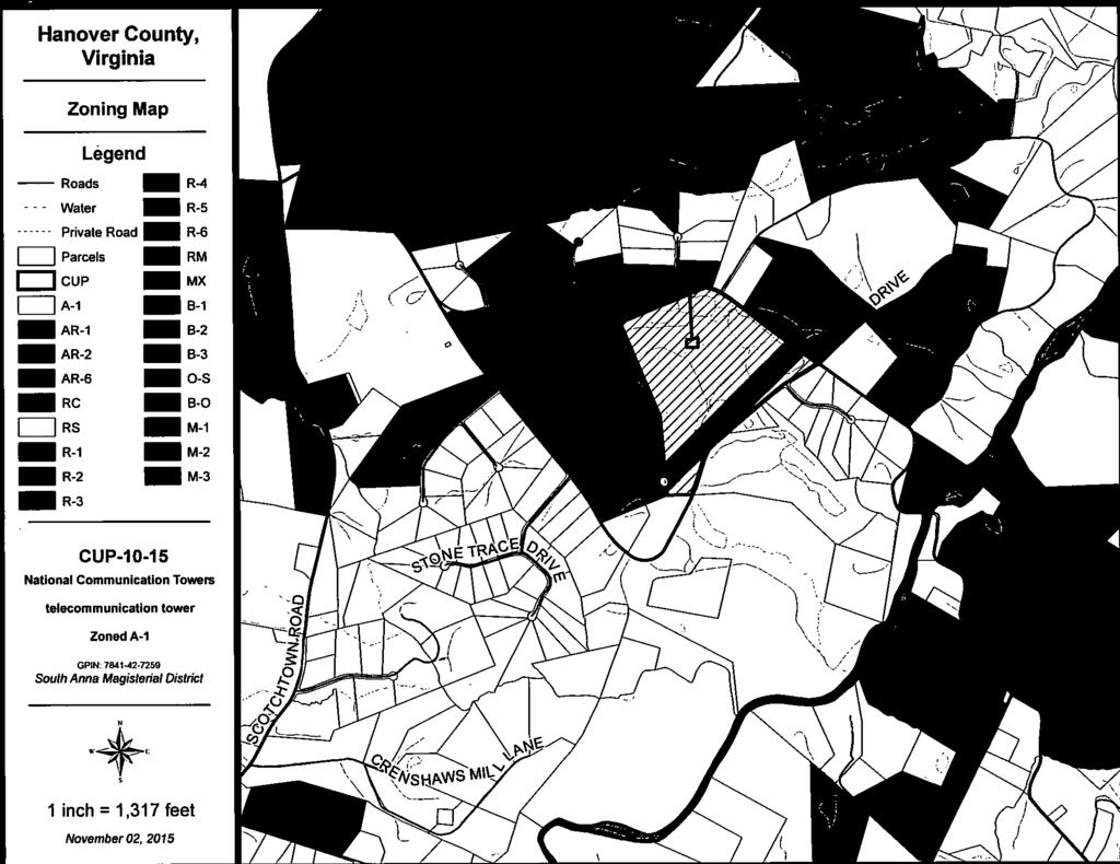
8 Hanover County, Virginia General Parcel Map Legend Roads Water Trees Private Road Structures Parcels I) CUP-I 0-15 National Communication Towers telecommunication tower Zoned A-I GPIN: South Anna Magisterial District 1 inchl3l7feet November02, 2015


9 4 DEEDIIEIDEUD - g UI IE1LJHHIEIIIII Xg,cs1.


10 CUP-I 0-15 National Communication Towers 2013 Aerial n.e Feet


11 L.g.nd tns Lacatan? fl,src,ct f

 EXAMPLE")

12 4 L 4ls/ is EXAMPLE FLUSH MOUNTED ANTENNA (Location: Atlee Community Church, Verdi Lane) EXAMPLE STANDARD ANTENNA (Location: Lee Davis Road at Lee Park Road)


13 r r \ wjmlz.tao&!1 L j1iipii1flh11iii I L r - Li r - - ozr FJ:O.1 in/tal COLP PROPERTIES. INC L&d ErA 2flR Pc;e L S# 78I? J2 21W Zoned: A! e FLWflWENTAL &W A9OMROES PC aook Poq 7531 Ic, 98,0.1; 194l 42 72!S ff14511 O,..n.oad Ch.,,oF, Al \ \ Co >r 0 0 p Go 9 4 FENCO ArID GATE OETAIL 0\I2nhJl5 DAlE OCT we 0 e tatlill 0082 F0l2;8eL C D0..9.ISCATflI 1O15 CC s3zr4 sr,la sa,.fle Ill 0lC.nC. 1A22121 I,.nl 1828 Cl OTTII.Os inc,gsilaglea HOLLOWS CELL TOWP H4W3V1R VA CON D mo N A L USE PEPMET PLAN 2 1EIONOPOLE ELEVAUOOI SCHEMATIC SITE PEAN a, 180. Zn cup to
c,, C-23-16(c), BLUE RIDGE CUSTOM HOMES Residential Rezoning Report South Anna Magisterial District PC Meeting Date: March 16, 2017 C (ø
, BLUE RIDGE CUSTOM HOMES Residential Rezoning Report South Anna Magisterial District PC Meeting Date: March 16, 2017 C (ø") C-23-16(c), BLUE RIDGE CUSTOM HOMES Residential Rezoning Report South Anna Magisterial District PC Meeting Date: March 16, 2017 Overview c,, JckFQ C (ø Current Zoning A-i, Agricultural District Requested
C-23-16(c), BLUE RIDGE CUSTOM HOMES Residential Rezoning Report South Anna Magisterial District PC Meeting Date: March 16, 2017 Overview c,, JckFQ C (ø Current Zoning A-i, Agricultural District Requested
Request Conditional Use Permit (Communication Tower) Staff Recommendation Approval. Staff Planner Emily Bazemore
 Staff Recommendation Approval. Staff Planner Emily Bazemore") Applicant Property Owner Columbia Club of Virginia Beach Public Hearing July 11, 2018 City Council Election District Beach Agenda Item 5 Request Conditional Use Permit (Communication Tower) Staff Recommendation
Applicant Property Owner Columbia Club of Virginia Beach Public Hearing July 11, 2018 City Council Election District Beach Agenda Item 5 Request Conditional Use Permit (Communication Tower) Staff Recommendation
CUP-14-93, AM. 1-17, SAINT SERAPHIM OF $AROV ORTHODOX CHURCH
 CUP-14-93, AM. 1-17, SAINT SERAPHIM OF $AROV ORTHODOX CHURCH Conditional Use Permit Amendment Report South Anna Magisterial District, PC Meeting Date: June 15, 2017 IRG C Overview Request To amend the
TYPE II LAND USE APPLICATION Telecommunications Tower: Collocation
 LAND MANAGEMENT DIVISION Date Received: TYPE II LAND USE APPLICATION Telecommunications Tower: Collocation PUBLIC WORKS DEPARTMENT 3050 N. DELTA HWY, EUGENE OR 97408 Planning: 682-3577 For Office Use Only
sofl C-16-16(c), AM. 1-17, C. DENTON AND LAURA BAKER
, AM. 1-17, C. DENTON AND LAURA BAKER") Minor not C-16-16(c), AM. 1-17, C. DENTON AND LAURA BAKER Commercial Rezomng Amendment Report - Beaverdam Magisterial District Board Meeting Date: March 22, 2017 Overview IRGI Op sofl Amendment Request
Minor not C-16-16(c), AM. 1-17, C. DENTON AND LAURA BAKER Commercial Rezomng Amendment Report - Beaverdam Magisterial District Board Meeting Date: March 22, 2017 Overview IRGI Op sofl Amendment Request
ALBEMARLE COUNTY PLANNING STAFF REPORT SUMMARY
 ALBEMARLE COUNTY PLANNING STAFF REPORT SUMMARY Project Name: SDP2010-94 Hillsdale Farm/Cosner Property (AT&T CV427 Tier II) - Final Planning Commission Public Hearing: March 1, 2011 Owners: Kimco, LC Acreage:
C-22-16(c), HOl H. NGAI AND LYNDA M. PUUNG-NGAI
, HOl H. NGAI AND LYNDA M. PUUNG-NGAI") Major C-22-16(c), HOl H. NGAI AND LYNDA M. PUUNG-NGAI cco Residential Rezoning Report Henry Magisterial District Board Meeting Date: March 22, 2017 Or%d1 c 4 IPG\ Of SIJ? Overview Current Zoning A-i, Agricultural
Major C-22-16(c), HOl H. NGAI AND LYNDA M. PUUNG-NGAI cco Residential Rezoning Report Henry Magisterial District Board Meeting Date: March 22, 2017 Or%d1 c 4 IPG\ Of SIJ? Overview Current Zoning A-i, Agricultural
Planning and Zoning Staff Report Maverick Towers Van Wassenhove, PH
 Planning and Zoning Staff Report Maverick Towers Van Wassenhove, PH2018-17 Hearing Date: April 19, 2018 Development Services Department Applicant: Maverick Towers - Nadine Bostwick Owner: Paul Van Wassenhove
PLANNING COMMISSION AGENDA Tuesday, March 23, 2010, 7:00 pm
 City of Milton Deerfield Professional Centre 13000 Deerfield Parkway Building 100, Suite 107 C Milton, GA 30004 1. Invocation 2. Pledge of Allegiance 3. Call to Order 4. Public Comment PLANNING COMMISSION
8 March 12, 2014 Public Hearing
 8 March 12, 2014 Public Hearing APPLICANT: NEW CINGULAR WIRELESS PCS, L.L.C. PROPERTY OWNER: CYPRESS POINT ENTERPRISES, INC. STAFF PLANNER: Ray Odom REQUEST: A. Conditional Change of Zoning (from PD-H2
New Cingular Wireless Telecommunication Tower at County Road 48, Milner Conditional Use Permit
 New Cingular Wireless Telecommunication Tower at 39415 County Road 48, Milner ACTIVITY #: Conditional Use Permit PP2012-023 HEARING DATES: Planning Commission (PC): August 16, 2012 at 6:00pm PETITIONER:
PROPOSED ORDINANCE NO TOWNSHIP OF WHITEMARSH MONTGOMERY COUNTY, PENNSYLVANIA ORDINANCE NO.
 PROPOSED ORDINANCE NO. 2014-16 TOWNSHIP OF WHITEMARSH MONTGOMERY COUNTY, PENNSYLVANIA ORDINANCE NO. AN ORDINANCE OF THE TOWNSHIP OF WHITEMARSH, MONTGOMERY COUNTY, PENNSYLVANIA; PROVIDING FOR THE AMENDMENT
TITLE 33 REGULATION OF WIRELESS TELECOMMUNICATIONS FACILITIES
 CITY OF STURGIS ORDINANCES TITLE 33-1 TITLE 33 REGULATION OF WIRELESS TELECOMMUNICATIONS FACILITIES (Title 33 established effective 8/4/07, Ordinance 2007-17) Chapters: 33.01: General Provisions 33.02:
Pagosa Lakes Telecommunication Facility Development Plan Rezoning in the PUD zone, located at 1311 Lake Forest Cir.
 Archuleta County Development Services Planning Department 1122 HWY 84 P. O. Box 1507 Pagosa Springs, Colorado 81147 970-264-1390 Fax 970-264-3338 MEMORANDUM TO: Archuleta County Planning Commission FROM:
Frank A Ford Etals, C/O Ford Group 9 LLC. Scott Ashley, AICP, Planning Manager
 Page 1 of 49 GROWTH AND RESOURCE MANAGEMENT DEPARTMENT PLANNING AND DEVELOPMENT SERVICES DIVISION CURRENT PLANNING ACTIVITY 123 W. Indiana Avenue, Room 202, DeLand, FL 32720 (386) 943-7059 PUBLIC HEARING:
MONTEREY COUNTY PLANNING COMMISSION
 MONTEREY COUNTY PLANNING COMMISSION Meeting: June 11, 2003 @ 9:30 AM Agenda Item: D2 Project Description: Use Permit (Associated Tagline/Sprint #PLN000669) for the construction of a 50 Ft. monopole with
Planning and Zoning Staff Report Vallivue School District - PH
 Hearing Date: April 19, 2018 Planning and Zoning Staff Report - PH2018-16 Development Services Department Applicant: Nate Bondelid Owner: Staff: Dan Lister, Planner II (208) 455-5959 dlister@canyonco.org
Town of York, Maine. Table of Contents. 1.1 Title and Effective Date pg Authority pg Purpose pg Applicability pg 2
 Table of Contents 1.1 Title and Effective Date pg 2 1.2 Authority pg 2 1.3 Purpose pg 2 1.4 Applicability pg 2 1.5 Approval Authority pg 3 1.6 Technical Assistance pg 3 1.7 Locations for WCFs pg 3 1.8
ARTICLE VI. SPECIAL EXCEPTION REGULATIONS
 ARTICLE VI. SPECIAL EXCEPTION REGULATIONS SECTION 601. GENERAL DESCRIPTION Special exceptions are deemed to be permitted uses in their respective districts, subject to the satisfaction of the requirements
TOWN OF RUTLAND Ordinance No. 12.5
 TOWN OF RUTLAND Ordinance No. 12.5 AN ORDINANCE RELATING TO CHANGES TO ZONING DISTRICT BOUNDARIES AND CONDITIONAL USE PERMITS REQUESTED TO ALLOW THE CONSTRUCTION AND OPERATION OF COMMUNICATION TOWERS The
RESOLUTION DISAPPROVING APPEAL NO
 RESOLUTION DISAPPROVING APPEAL NO. 2017-01 WHEREAS, Strategis LLC, 2530 Superior Avenue #303, Cleveland, OH 44114, as agent for Crown Castle and Verizon Wireless, Appellant, on December 7, 2016, filed
PLANNING COMMISSION REPORT Regular Agenda Public Hearing Item CONDITIONAL USE PERMIT FOR VERIZON WIRELESS; 1287 E 1200 RD (SLD)
") PC Staff Report 9/26/2016 CUP-16-00312 Item No. 5-1 PC Staff Report 9/26/2016 ITEM NO. 5 PLANNING COMMISSION REPORT Regular Agenda Public Hearing Item CONDITIONAL USE PERMIT FOR VERIZON WIRELESS; 1287
PC Staff Report 9/26/2016 CUP-16-00312 Item No. 5-1 PC Staff Report 9/26/2016 ITEM NO. 5 PLANNING COMMISSION REPORT Regular Agenda Public Hearing Item CONDITIONAL USE PERMIT FOR VERIZON WIRELESS; 1287
LAND OWNER OF SITE ADDRESS PHONE NUMBER FAX NUMBER. APPLICANT (if other than owner) ADDRESS PHONE NUMBER FAX NUMBER
 ADDRESS PHONE NUMBER FAX NUMBER") TELECOMMUNICATION TOWER CONDITIONAL USE PERMIT APPLICATION FOR WALWORTH COUNTY - $1025 The undersigned hereby applies to the Walworth County Zoning Agency (Walworth County Land Use and Resource Management
TELECOMMUNICATION TOWER CONDITIONAL USE PERMIT APPLICATION FOR WALWORTH COUNTY - $1025 The undersigned hereby applies to the Walworth County Zoning Agency (Walworth County Land Use and Resource Management
C-24-16, RICHARD KENNETH JOHNSON
 C-24-16, RICHARD KENNETH JOHNSON Residential Rezoning Report 2017 Overview Of SU? Current Zoning A-i, Agricultural District Requested Zoning AR-6(c), Agricultural District with conditions Requested Density
$E-7-16, GAYLE A. AND JEFFREY S. STONEMAN
 Minor $E-7-16, GAYLE A. AND JEFFREY S. STONEMAN Special Exception Report Beaverdam Magisterial District Board Meeting Date: November 22, 2016 1tF c: Overview F SUt. Request To permit a commercial dog kennel
COMMUNICATION TOWERS ORDINANCE No. 31
 COMMUNICATION TOWERS ORDINANCE No. 31 ARTICLE 1: AUTHORITY AND JURISDICTION Authority Pursuant to the authority granted by 1967 SDCL 11-2 as amended; the following regulations are hereby adopted by the
Division 16.Telecommunication Tower Standards
 Division 16.Telecommunication Tower Standards Section 17-311. Telecommunication towers and antennas: general provision. The Director shall have the authority to regulate the construction and operation
PROTOCOL FOR ESTABLISHING TELECOMMUNICATION FACILITIES
 Town of Mono Procedure ESTABLISHING TELECOMMUNICATION FACILITIES PLANNING DEPARTMENT Approved by Council: December 20, 2002 by Resolution #9-23-2002 PROTOCOL FOR ESTABLISHING TELECOMMUNICATION FACILITIES
CUP-14-93, AM. 1-17, SAINT SERAPHIM OF SAROV ORTHODOX CHURCH Z -< Conditional Use Permit Amendment Report South Anna Magisterial District
 CUP1493, AM. 117, SANT SERAPHM OF SAROV ORTHODOX CHURCH Z < Conditional Use Permit Amendment Report South Anna Magisterial District >o Board Meeting Date. July 26, 2017 W, Overview Request To amend the
STAFF REPORT #
 STAFF REPORT #15-4000-0001 A Conditional Use PLANNING COMMISSION MEETING DATE: March 19, 2015 1. APPLICATION: A public hearing regarding a request for a conditional use permit for the installation of a
Planning and Development Department 156 CHURCH STREET, HENDERSON, NC (252) / FAX Staff Report 9/12/2013
 / FAX Staff Report 9/12/2013") Planning and Development Department 156 CHURCH STREET, HENDERSON, NC 27536 (252) 738-2080 / FAX 738-2089 Staff Report 9/12/2013 Owner: Christine, Carl, and Joe Samford Applicant: Nexsen Pruet, PLLC Thomas
Planning and Development Department 156 CHURCH STREET, HENDERSON, NC 27536 (252) 738-2080 / FAX 738-2089 Staff Report 9/12/2013 Owner: Christine, Carl, and Joe Samford Applicant: Nexsen Pruet, PLLC Thomas
County Of Lincoln, North Carolina Planning & Inspections Department
 County Of Lincoln, North Carolina Planning & Inspections Department Lincoln County Board of Commissioners Agenda Item Memorandum DateSubmitted: October22,2013 DepartmentMakingRequest: PlanningandInspections
Telecommunications Development Permit Application Package
 Telecommunications Development Permit Application Package POLICY POL#308 Title: Policy Guidelines to Evaluate Commercial Communications Facilities Legal References: Radio Communication Act Municipal Government
BOARD OF ZONING ADJUSTMENT STAFF REPORT Date: July 9, 2018
 BOARD OF ZONING ADJUSTMENT STAFF REPORT Date: July 9, 2018 CASE NUMBER 6185/1339 APPLICANT NAME LOCATION VARIANCE REQUEST Branch Towers III, LLC 1857 Duval Street (South side of Duval Street, 560 + West
MODEL WIRELESS TELECOMMUNICATIONS ORDINANCE for Siting of "Small Cell" Telecommunication Infrastructure in Public Rights-Of-Way
 MODEL WIRELESS TELECOMMUNICATIONS ORDINANCE for Siting of "Small Cell" Telecommunication Infrastructure in Public Rights-Of-Way This document is intended for use by towns and villages that have existing
CITY OF WAYNESBORO PLANNING COMMISSION Regular Meeting, Tuesday, August 19, 2014
 CITY OF WAYNESBORO PLANNING COMMISSION Regular Meeting, Tuesday, August 19, 2014 7:00 pm Council Chambers, Charles T. Yancey Municipal Building 503 West Main Street PLANNING COMMISSIONERS Terry R. Short,
BEFORE THE LAND USE HEARINGS OFFICER OF CLACKAMAS COUNTY, OREGON
 BEFORE THE LAND USE HEARINGS OFFICER OF CLACKAMAS COUNTY, OREGON Regarding an Application for a Conditional Use ) Case File No. Permit to Establish a Wireless Telecommunications ) Facility and Design Review
T-MOBILE DAVID WILKINS MESSINA & HARRIS, INC.
 APPLICATION NUMBER 5368 A REQUEST FOR HEIGHT, SETBACK, AND BUFFER SEPARATION VARIANCES TO ALLOW THE CONSTRUCTION OF A 70 MONOPOLE TELECOMMUNICATIONS TOWER, SETBACK 6.89 FROM A LEASE PARCEL LINE, AND 6.89
2. The AT&T WCF shall consist of a stealth design (faux saguaro cactus) with a maximum height of 30 feet above adjacent grade;
 with a maximum height of 30 feet above adjacent grade;") AGENDA ITEM # DATE: October 24, 2011 COAC NUMBER: 11-4698 CITY OF GOODYEAR CITY COUNCIL ACTION FORM SUBJECT: Special Use to allow the installation of a proposed AT&T Wireless Communication Facility to
AGENDA ITEM # DATE: October 24, 2011 COAC NUMBER: 11-4698 CITY OF GOODYEAR CITY COUNCIL ACTION FORM SUBJECT: Special Use to allow the installation of a proposed AT&T Wireless Communication Facility to
REPRESENTATIVE: Centerline Solutions Table Mountain Parkway Golden, CO 80403
 COMMISSIONERS: DARRYL GLENN (PRESIDENT) MARK WALLER (PRESIDENT PRO TEMPORE) STAN VANDERWERF LONGINOS GONZALEZ PEGGY LITTLETON PLANNING AND COMMUNITY DEVELOPMENT DEPARTMENT CRAIG DOSSEY, EXECUTIVE DIRECTOR
Planning and Development Department 156 CHURCH STREET, HENDERSON, NC (252) / FAX Staff Report 8/8/2013
 / FAX Staff Report 8/8/2013") Planning and Development Department 156 CHURCH STREET, HENDERSON, NC 27536 (252) 738-2080 / FAX 738-2089 Staff Report 8/8/2013 Owner: Christine, Carl, and Joe Samford Applicant: Nexsen Pruet, PLLC Thomas
Planning and Development Department 156 CHURCH STREET, HENDERSON, NC 27536 (252) 738-2080 / FAX 738-2089 Staff Report 8/8/2013 Owner: Christine, Carl, and Joe Samford Applicant: Nexsen Pruet, PLLC Thomas
TELECOMMUNICATIONS TOWER AND VARIANCE STAFF REPORT
 TELECOMMUNICATIONS TOWER AND VARIANCE STAFF REPORT City County Planning Commission 1141 State Street Bowling Green, Kentucky 42101 (270) 842 1953 Summary: The applicants have filed an application for approval
Dane County Planning & Development Division of Zoning
 Dane County Planning & Development Division of Zoning CONDITIONAL USE PERMIT (CUP) APPLICATION REQUIREMENTS FOR COMMUNICATION TOWERS In order to make a Conditional Use Permit (CUP) application in Dane
Board of Adjustment Staff Report Meeting Date: June 1, 2017
 Board of Adjustment Staff Report Meeting Date: June 1, 2017 Subject: Applicant: Agenda Item Number: Summary: Recommendation: Prepared by: Phone: E-Mail: Administrative Permit Case Number Powning Family
APPLICATION FOR WAIVER OF MINIMUM REQUIRED SETBACKS/SEPARATION
 APPLICATION FOR WAIVER OF MINIMUM REQUIRED SETBACKS/SEPARATION This application must be typed or printed in black ink and submitted with four (4) copies, with all required attachments, to: Planning and
RESOLUTION PC NOW THEREFORE, the Planning Commission of the City of Duarte resolves as follows:
 RESOLUTION PC 18-09 A RESOLUTION OF THE PLANNING COMMISSION OF THE CITY OF DUARTE APPROVING CONDITIONAL USE PERMIT 14-02, FOR THE USE AND OPERATION OF A WIRELESS COMMUNICATION FACILITY FOR VERIZON WIRELESS,
STAFF S REQUEST ANALYSIS AND RECOMMENDATION 08SN0275. New Cingular Wireless PCS, LLC (AT&T) Bermuda Magisterial District East line of Allied Road
 Bermuda Magisterial District East line of Allied Road") ugust 19, 2008 CPC September 24, 2008 BS FF S QU NLYSIS ND COMMNDTION 08SN0275 New Cingular Wireless PCS, LLC (T&T) Bermuda Magisterial District ast line of llied oad QU: Conditional Use to permit a communications
ugust 19, 2008 CPC September 24, 2008 BS FF S QU NLYSIS ND COMMNDTION 08SN0275 New Cingular Wireless PCS, LLC (T&T) Bermuda Magisterial District ast line of llied oad QU: Conditional Use to permit a communications
3 NOVEMBER 9, 2011 Public Hearing APPLICANT:
 REQUEST: Conditional Change of Zoning (B-2 & I-1 to Conditional A-18) 3 NOVEMBER 9, 2011 Public Hearing APPLICANT: S.L. NUSBAUM REALTY COMPANY PROPERTY OWNER: USF PROPCO II, LLC STAFF PLANNER: Leslie Bonilla
AN ORDINANCE TO REGULATE THE INSTALLATION OF COMMUNICATION ANTENNA(S) WITHIN THE PUBLIC-RIGHT-OF-WAY
 WITHIN THE PUBLIC-RIGHT-OF-WAY") TOWNSHIP OF FAIRFIELD ORDINANCE #2018-02 AN ORDINANCE TO REGULATE THE INSTALLATION OF COMMUNICATION ANTENNA(S) WITHIN THE PUBLIC-RIGHT-OF-WAY WHEREAS, the Mayor and Council ofthe Township of Fairfield
TOWNSHIP OF FAIRFIELD ORDINANCE #2018-02 AN ORDINANCE TO REGULATE THE INSTALLATION OF COMMUNICATION ANTENNA(S) WITHIN THE PUBLIC-RIGHT-OF-WAY WHEREAS, the Mayor and Council ofthe Township of Fairfield
C-16-16(c), LAURA S. AND C. DENTON BAKER (GAYLE A. AND JEFFREY S. STONEMAN)
, LAURA S. AND C. DENTON BAKER (GAYLE A. AND JEFFREY S. STONEMAN)") Minor not C-16-16(c), LAURA S. AND C. DENTON BAKER (GAYLE A. AND JEFFREY S. STONEMAN) Commercial Rezoning Report... Beaverdarn Magisterial District PC Meeting Date: October 20, 2016 Overview Current Zoning
Minor not C-16-16(c), LAURA S. AND C. DENTON BAKER (GAYLE A. AND JEFFREY S. STONEMAN) Commercial Rezoning Report... Beaverdarn Magisterial District PC Meeting Date: October 20, 2016 Overview Current Zoning
The minutes of the October 7, 201 4, meeting were approved on a m otion by Martin, seconded by Woleslagel, passed unanimously.
 1 MINUTES CITY PLANNING COMMISSION TUESDAY, OCTOBER 21, 2014 5:00 p.m. CITY COUNCIL CHAMBERS 125 EAST AVENUE B 1. The Planning Commission meeting was called to order with the following members present:
PRESENT: SAMUEL W. HAYES CHAIRMAN AT-LARGE BUTCH CUNNINGHAM DIST #4 EVERETTE PROSISE DIST #1. DEAN McCRAY DIST #2 GAYLE KIRKLAND DIST #5
 VIRGINIA: MINUTES OF THE REGULAR MEETING OF THE DINWIDDIE COUNTY PLANNING COMMISSION HELD IN THE BOARD MEETING ROOM OF THE PAMPLIN ADMINISTRATION BUILDING ON THE 9 th DAY OF OCTOBER 20 1 3 AT 7:00 P.M.
BEFORE THE HEARINGS EXAMINER FOR THURSTON COUNTY
 BEFORE THE HEARINGS EXAMINER FOR THURSTON COUNTY In the Matter of the Application of ) NO. SUPT 020642 ) T-Mobile ) FINDINGS, CONCLUSIONS ) AND DECISION For Approval of a Special Use Permit ) ) SUMMARY
John Machado et al (PLN040304)
") PLANNING COMMISSION COUNTY OF MONTEREY, STATE OF CALIFORNIA RESOLUTION NO. 04051 A.P. # 207-022-017-000 In the matter the application John Machado et al (PLN040304) FINDINGS & DECISION for a Use in accordance
PLANNING COMMISSION COUNTY OF MONTEREY, STATE OF CALIFORNIA RESOLUTION NO. 04051 A.P. # 207-022-017-000 In the matter the application John Machado et al (PLN040304) FINDINGS & DECISION for a Use in accordance
CPA-2-15, ROGERS-CHENAULT INC.
 CPA-2-15, ROGERS-CHENAULT NC. Comprehensive Plan Amendment Report Beaverdam Magisterial District -c PC Meeting Date: November 19, 2015 0g Cost Overview Request Location Case Planner A proposed amendment
CHARTER TOWNSHIP OF VAN BUREN PLANNING COMMISSION JANUARY 10, 2018 MINUTES
 CHARTER TOWNSHIP OF VAN BUREN PLANNING COMMISSION JANUARY 10, 2018 MINUTES Chairperson Thompson called the meeting to order at 7:30 p.m. ROLL CALL: Present: Kelley, Atchinson, Budd, Jahr, Franzoi and Thompson.
4 June 11, 2014 Public Hearing
 4 June 11, 2014 Public Hearing APPLICANT: FRANKLIN JOHNSTON MANAGEMENT DEVELOPMENT, L.L.C. PROPERTY OWNER: TRUSTEES OF FIRST LYNNHAVEN BAPTIST CHURCH STAFF PLANNER: Stephen J. White REQUEST: Change of
1 September 9, 2015 Public Hearing
 1 September 9, 2015 Public Hearing APPLICANT & PROPERTY OWNER: HOLLOMON- BROWN FUNERAL HOME, INC. STAFF PLANNER: Carolyn A.K. Smith REQUEST: Change of Zoning (R-5D Residential District to Conditional O-2
CHARLESTON NATIONAL COMMUNITY ASSOCIATION ARCHITECTURAL REVIEW COMMITTEE (ARC) POLICIES AUGUST 10, 2016
 POLICIES AUGUST 10, 2016") CHARLESTON NATIONAL COMMUNITY ASSOCIATION ARCHITECTURAL REVIEW COMMITTEE (ARC) POLICIES AUGUST 10, 2016 Article X, Section 1, of the Covenants and Restrictions of the Association states that the Architectural
CHARLESTON NATIONAL COMMUNITY ASSOCIATION ARCHITECTURAL REVIEW COMMITTEE (ARC) POLICIES AUGUST 10, 2016 Article X, Section 1, of the Covenants and Restrictions of the Association states that the Architectural
SHIAWASSEE COUNTY ZONING ORDINANCE Article 4 Specific Use Regulations
 SHIAWASSEE COUNTY ZONING ORDINANCE Article 4 Specific Use Regulations Section 4.3.76 Wind Energy Conversion Systems 1. Purpose A. Through this section it is hereby set forth that Shiawassee County promotes
MINUTE ORDER. BONNER COUNTY PLANNING and ZONING COMMISSION PUBLIC HEARING MINUTES JULY 23, 2015
 MINUTE ORDER BONNER COUNTY PLANNING and ZONING COMMISSION PUBLIC HEARING MINUTES JULY 23, 2015 CALL TO ORDER: Chair Roger Daar called the Bonner County Planning and Zoning Commission hearing to order at
Application for Personal Wireless Service Facility
 FOR OFFICE USE ONLY Application # SIGN # (if an SP) Fee Amount $ Date Paid By who? Receipt # Ck# by: ZONING ORDINANCE SECTION Application for Personal Wireless Service Facility Applicant (who should we
Tuss and Lisa Taylor. Agriculture
 ZONE CHANGE STAFF REPORT CCPC City-County Planning Commission warrenpc.org (270) 842-1953 1141 State Street Bowling Green, KY 42101 DOCKET/CASE/APPLICATION NUMBER 2018-29-Z-CO PUBLIC HEARING DATE July
CITY COUNCIL AGENDA MEMORANDUM
 City and County of Broomfield, Colorado CITY COUNCIL AGENDA MEMORANDUM To: Mayor and City Council From: Charles Ozaki, City and County Manager Prepared by: Anna Bertanzetti, Principal Planner David Shinneman,
WHEREAS, the Board of County Commissioners of Pasco County on August 29, 2017, held a public
 BY THE BOARD OF COUNTY COMMISSIONERS RESOLUTION NO. 17-75RZ RESOLUTION CONSTITUTING CONDITIONAL USE PERMIT AUTHORIZING THE USE OF PROPERTY DESCRIBED IN CONDITIONAL USE APPLICATION NO. CU17-26 FOR A 145-
BEFORE THE BOARD OF COMMISSIONERS OF LANE COUNTY, OREGON
 BEFORE THE BOARD OF COMMISSIONERS OF LANE COUNTY, OREGON ORDINANCE NO: 13-05 IN THE MATTER OF AMENDING LANE CODE CHAPTER 10 TO ADOPT AMENDMENTS TO THE SPRINGFIELD DEVELOPMENT REGULATIONS FOR APPLICATION
May 12, Chapter RH HILLSIDE RESIDENTIAL ZONES REGULATIONS Sections:
 May 12, 2017 Chapter 17.13 RH HILLSIDE RESIDENTIAL ZONES REGULATIONS Sections: 17.13.010 Title, intent, and description. 17.13.020 Required design review process. 17.13.030 Permitted and conditionally
APPLICATION FOR MINOR VARIANCE. Township of South-West Oxford Committee of Adjustment MEETING: February 3, 2015 REPORT NUMBER:
 Community and Strategic Planning P. O. Box 1614, 21 Reeve Street Woodstock Ontario N4S 7Y3 Phone: 519-539-9800 Fax: 519-421-4712 Web site: www.oxfordcounty.ca Our File: A 01-15 APPLICATION FOR MINOR VARIANCE
PLANNING COMMISSION STAFF REPORT
 PLANNING COMMISSION STAFF REPORT APPLICATION: CUP2016-16/WFE2016-01/WFE2016-02/ GPC2016-01 AGENDA ITEM: PH-2 PREPARED BY: Barbara Lynch Senior Planner MEETING DATE: September 14, 2016 SUBJECT: REQUEST:
COUNTY OF CLEVELAND, NORTH CAROLINA AGENDA FOR THE PLANNING BOARD MEETING. January 22, :00 PM. Commissioners Chamber
 COUNTY OF CLEVELAND, NORTH CAROLINA AGENDA FOR THE PLANNING BOARD MEETING January 22, 2019 6:00 PM Commissioners Chamber Call to order and Establishment of a Quorum Invocation and Pledge of Allegiance
ARTICLE II: CELLULAR ANTENNA TOWERS
 Kenton County Planning Commission 8 ARTICLE II: CELLULAR ANTENNA TOWERS SECTION 2.0 PRE-APPLICATION CONFERENCE: Applicants must contact Staff and request a pre-application conference. This meeting will
MEMPHIS AND SHELBY COUNTY OFFICE OF PLANNING AND DEVELOPMENT. CASE NUMBER: S.U.P L.U.C.B. MEETING: April 8, 2010
 MEMPHIS AND SHELBY COUNTY OFFICE OF PLANNING AND DEVELOPMENT STAFF REPORT 8 CASE NUMBER: S.U.P 10-209 L.U.C.B. MEETING: April 8, 2010 LOCATION: South side of Quince Road; +/-350.57 feet east of Kirby Road
PREAMBLE. That the Gratiot County Zoning Ordinance be amended as follows:
 Amendment of Gratiot County Zoning Ordinance AN ORDINANCE TO AMEND THE GRATIOT COUNTY ZONING ORDINANCE REQUIREMENTS FOR SOLAR ENERGY SYSTEMS AND SOLAR FARMS FOR THE COUNTY-ZONED TOWNSHIPS OF ELBA, HAMILTON,
This is a conditional use permit request to establish a commercial wind energy conversion system.
 Public Works 600 Scott Boulevard South Hutchinson, Kansas 67505 620-694-2976 Road & Bridge Planning & Zoning Noxious Weed Utilities Date: March 28, 2019 To: From: Reno County Planning Commission Russ Ewy,
Hanover County Board of Supervisors
 Hanover County Board of Supervisors May 24, 2017 Hanover: People, Tradition & Spirit C-2-05(c), AM. 1-17 Jennifer & Ryan Jones (Iron Hill Subdivision) South Anna Magisterial District Request Location Zoning
City of Independence
 City of Independence Request for a Text Amendment to the Zoning Ordinance to Allow Solar Gardens in the AG-Agriculture Zoning District To: From: Planning Commission Mark Kaltsas, City Planner Meeting Date:
PLANNING COMMISSION REPORT Regular Agenda Public Hearing Item
 CUP-15-00474 Item No. 5-1 PC Staff Report 11/16/15 ITEM NO. 5 PLANNING COMMISSION REPORT Regular Agenda Public Hearing Item CONDITIONAL USE PERMIT FOR PUBLIC WHOLESALE WATER SUPPLY DISTRICT NO. 25; E 1300
TITLE XV: LAND USAGE 150.BUILDING REGULATIONS 151.FLOOD DAMAGE PREVENTION 153.[RESERVED] 154.COMPREHENSIVE PLAN 155.SUBDIVISION AND ZONING CODE
![TITLE XV: LAND USAGE 150.BUILDING REGULATIONS 151.FLOOD DAMAGE PREVENTION 153.[RESERVED] 154.COMPREHENSIVE PLAN 155.SUBDIVISION AND ZONING CODE](/thumbs/86/94109177.jpg "TITLE XV: LAND USAGE 150.BUILDING REGULATIONS 151.FLOOD DAMAGE PREVENTION 153.[RESERVED] 154.COMPREHENSIVE PLAN 155.SUBDIVISION AND ZONING CODE") 1 TITLE XV: LAND USAGE Chapter 150.BUILDING REGULATIONS 151.FLOOD DAMAGE PREVENTION 152.SIGN AND BILLBOARD REGULATIONS 153.[RESERVED] 154.COMPREHENSIVE PLAN 155.SUBDIVISION AND ZONING CODE 2006 S-2 1 2
1 TITLE XV: LAND USAGE Chapter 150.BUILDING REGULATIONS 151.FLOOD DAMAGE PREVENTION 152.SIGN AND BILLBOARD REGULATIONS 153.[RESERVED] 154.COMPREHENSIVE PLAN 155.SUBDIVISION AND ZONING CODE 2006 S-2 1 2
Request Modification of Proffers Modification of Conditions (Bulk Storage Yard) Staff Recommendation Approval. Staff Planner Marchelle Coleman
 Staff Recommendation Approval. Staff Planner Marchelle Coleman") Applicant & Property Owner Public Hearing October 10, 2018 City Council Election District Princess Anne Agenda Item 6 Request Modification of Proffers Modification of Conditions (Bulk Storage Yard) Staff
Applicant & Property Owner Public Hearing October 10, 2018 City Council Election District Princess Anne Agenda Item 6 Request Modification of Proffers Modification of Conditions (Bulk Storage Yard) Staff
Larimer County Planning Dept. Procedural Guide for 1041 PERMITS
 - Larimer County Planning Dept. Procedural Guide for 1041 PERMITS PLEASE NOTE: A PRE-APPLICATION CONFERENCE IS REQUIRED PRIOR TO SUBMITTING THIS APPLICATION. PURPOSE: State Statutes allow local governments
T. S. Dye & Colleagues, Archaeologists, Inc.
 T. S. Dye & Colleagues, Archaeologists, Inc. 735 Bishop St., Suite 315, Honolulu, Hawai i 96813 Mr. Douglas Oringer Hawaii Environmental Consultants, LLC 2051 Young Street, Suite #216 Honolulu, HI 96826
Staff Report. Conditional Use Permit: Williams Tree and Stump Removal. Application Number: Tax Parcel Numbers:
 Pierce County Department of Planning and Land Services, 2401 South 35th Street, Tacoma, WA (253) 798-7037 Staff Report Conditional Use Permit: Williams Tree and Stump Removal Application Number: 836154
17.13 RH HILLSIDE RESIDENTIAL ZONES REGULATIONS SECTIONS:
 Effective April 14, 2011 Chapter 17.13 RH HILLSIDE RESIDENTIAL ZONES REGULATIONS SECTIONS: 17.13.010 Title, Intent, and Description 17.13.020 Required Design Review Process 17.13.030 Permitted and Conditionally
COUNTY OF ALBEMARLE STAFF REPORT SUMMARY
 COUNTY OF ALBEMARLE STAFF REPORT SUMMARY Project Name: SP201100027 Panorama Events Planning Commission Public Hearing: May 8, 2012 Owner/s: Panorama Farms, Inc. Acreage: 706.51 acres Staff: Scott Clark,
Request Conditional Use Permit (Home Occupation Firearm Sales) Staff Planner Jimmy McNamara
 Staff Planner Jimmy McNamara") Applicant Property Owner Benjamin D. Lindborg Public Hearing November 9, 2016 City Council Election District Bayside Agenda Item 8 Request Conditional Use Permit (Home Occupation Firearm Sales) Staff Planner
Applicant Property Owner Benjamin D. Lindborg Public Hearing November 9, 2016 City Council Election District Bayside Agenda Item 8 Request Conditional Use Permit (Home Occupation Firearm Sales) Staff Planner
Staff Recommendation Approval. Staff Planner Robert Davis
 Applicant Property Owner Reed Enterprises, Inc. Public Hearing November 8, 2017 City Council Election District Princess Anne Agenda Item D1 Request Conditional Use Permit (Bulk Storage Yard) Modification
CHAPTER 6 RESIDENTIAL DISTRICTS LOW DENSITY RESIDENTIAL DISTRICT (R-1)
") TYPE OF DISTRICT: TRADITIONAL CHAPTER 6 RESIDENTIAL DISTRICTS LOW DENSITY RESIDENTIAL DISTRICT (R-1) ARTICLE 1: LOW DENSITY RESIDENTIAL DISTRICT (R-1) SECTION 6-1.01: PURPOSE The regulations of the R-1
TYPE OF DISTRICT: TRADITIONAL CHAPTER 6 RESIDENTIAL DISTRICTS LOW DENSITY RESIDENTIAL DISTRICT (R-1) ARTICLE 1: LOW DENSITY RESIDENTIAL DISTRICT (R-1) SECTION 6-1.01: PURPOSE The regulations of the R-1
ZONING RESOLUTION OF BLOUNT COUNTY, TENNESSEE
 ZONING RESOLUTION OF BLOUNT COUNTY, TENNESSEE Article 1. ENACTMENT. Section 1.1. Title. This Resolution shall be titled Zoning Resolution of Blount County, Tennessee, hereinafter referred to as Resolution.
Zoning Regulations. Blount County, Tennessee
 Zoning Regulations Blount County, Tennessee June 15, 2000 Zoning Regulations Blount County, Tennessee June 15, 2000 Containing the text of resolutions from Resolution 00-06-010, a resolution adopting zoning
Request Conditional Use Permit (Bulk Storage Yard) Conditional Rezoning (R-10 Residential to Conditional I-1 Light Industrial)
 Conditional Rezoning (R-10 Residential to Conditional I-1 Light Industrial)") Applicant and Property Owner Public Hearing December 12, 2018 City Council Election District Beach Agenda Item 6 Request Conditional Use Permit (Bulk Storage Yard) Conditional Rezoning (R-10 Residential
Applicant and Property Owner Public Hearing December 12, 2018 City Council Election District Beach Agenda Item 6 Request Conditional Use Permit (Bulk Storage Yard) Conditional Rezoning (R-10 Residential
Ordinance #68. Highlighted items in bold and underline font to be added. Highlighted items in strikethrough font to be removed.
 Ordinance #68 AN ORDINANCE ENTITLED, AN ORDINANCE AMENDING ARTICLE II DEFINITIONS AND CHAPTER 5.22 (WIND ENERGY SYSTEMS) OF ARTICLE V GENERAL REQUIREMENTS OF ORDINANCE 65 AN ORDINANCE AMENDING ORDINANCE
Major Impact Review for Solar Energy System, Large River Frontage Road, New Castle - Garfield County File Number MIPA
 March 23, 2016 Clean Energy Collective c/o Richard Miller 361 Centennial Parkway, Third Floor Louisville, CO 80027 Reference: Major Impact Review for Solar Energy System, Large 35960 River Frontage Road,
Wind Energy Conversion System Ordinance No. 467
 Wind Energy Conversion System Ordinance No. 467 AN ORDINANCE ESTABLISHING A PERMITTING PROCESS FOR WIND ENERGY CONVERSION SYSTEMS ADOPTED BY THE Big Timber City Council on this day of, 2006. ADOPTED BY
Check all that apply: Major Facility Major Modification Collocation Substantial Change
 Community Development Department 14000 City Center Dr., Chino Hills, CA 91709 (909) 364-2780 Fax (909) 364-2795 www.chinohills.org CUP No.: TDA No.: Submittal Date: CONDITIONAL USE PERMIT FOR WIRELESS
Condominium Unit Requirements.
 ARTICLE 19 CONDOMINIUM REGULATIONS Section 19.01 Purpose. The purpose of this Article is to regulate projects that divide real property under a contractual arrangement known as a condominium. New and conversion
ARTICLE XI CONDITIONAL USE PERMITS
 ARTICLE XI CONDITIONAL USE PERMITS 11.1 Purpose. The City of Hailey recognizes that certain uses possess unique and special characteristics with respect to their location, design, size, method of operation,
ARTICLE 5.0 SCHEDULE OF REGULATIONS
 ARTICLE 5.0 SCHEDULE OF REGULATIONS Section 5.101 Table of Dimensional Standards by District. Dimensional Standards AG AG with sewer Districts Rural Residential Business Other SF SF with sewer R-1 R-1
O-1 Zoning for Chesterfield County
 O-1 Zoning for Chesterfield County Sec. 19-129. - Purpose and intent of district. The purpose and inten of the Neighborhood Office (O-1) District is to permit limited professional and administrative offices
An implementation document is forthcoming. - A1-1 -
 OFF-STREET PARKING GUIDELINES FOR MULTI-FAMILY RESIDENTIAL PROJECTS APPROVED BY SPECIAL EXCEPTION IN THE ROSSLYN-BALLSTON AND JEFFERSON DAVIS METRO CORRIDORS 12/01/2017 This is a draft of the guidelines
SPECIAL ZONING DISTRICTS
 SPECIAL ZONING DISTRICTS 5.01 5.99 RESERVED 5.100 PLANNED DEVELOPMENTS: Purpose: This district is intended to accommodate unified design of residential, commercial, office, professional services, retail