REDEVELOPMENT PLAN FOR BLOCK 41, LOTS 14, 36, 37.01, 37.02, 37.03, 38.02, 38.03, 38.04, AND TOWNSHIP OF ROBBINSVILLE, MERCER COUNTY, NEW JERSEY
|
|
|
- Josephine Rogers
- 5 years ago
- Views:
Transcription
1 REDEVELOPMENT PLAN FOR BLOCK 41, LOTS 14, 36, 37.01, 37.02, 37.03, 38.02, 38.03, 38.04, AND TOWNSHIP OF ROBBINSVILLE, MERCER COUNTY, NEW JERSEY October 2011 Prepared by: Cofone Consulting Group, LLC 125 Half Mile Road Suite 200 Red Bank, NJ The original of this report was signed and sealed in accordance with N.J.S.A. 45:14A-12. Christine A. Cofone, AICP, PP New Jersey Professional Planner License #5517 Justin E. Auciello, AICP, PP New Jersey Professional Planner License #6023
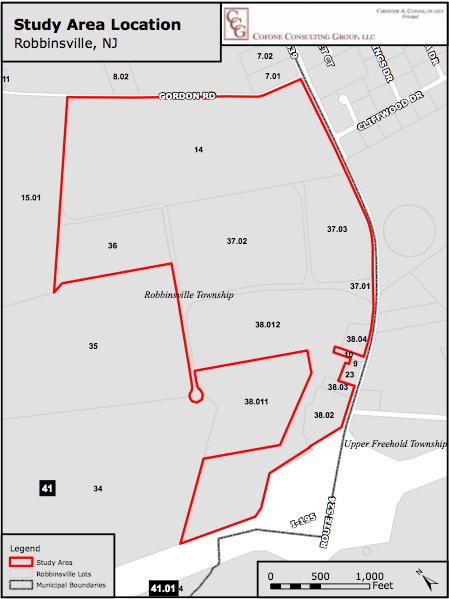
2 1 INTRODUCTION... 2 BASIS FOR THE PLAN... 2 OVERVIEW OF PLAN... 3 LOCATION OF REDEVELOPMENT AREA VISION, GOALS, & CONTEXT... 6 REDEVELOPMENT PLAN VISION LAND USE, DEVELOPMENT YIELD, BULK AND PARKING... 7 LAND USES... 7 BULK REQUIREMENTS... 8 PARKING AND LOADING SITE PLANNING AND DESIGN INTENT SIGNAGE LIGHTING FENCES PLAN CONSISTENCY REVIEW RELATIONSHIP TO ROBBINSVILLE ZONING CODE RELATIONSHIP TO MASTER PLAN AND LOCAL GOALS RELATIONSHIP TO ADJACENT MUNICIPALITIES RELATIONSHIP TO THE MERCER COUNTY MASTER PLAN RELATIONSHIP TO THE STATE DEVELOPMENT AND REDEVELOPMENT PLAN REDEVELOPMENT ACTIONS/GENERAL PROVISIONS PROPERTIES TO BE ACQUIRED RELOCATION DEFINITIONS SITE PLAN AND SUBDIVISION REVIEW DEVIATION REQUESTS BONDING AND DEVELOPER S AGREEMENT OTHER PROVISIONS APPENDIX A List of Figures FIGURE 1: LOCATION OF REDEVELOPMENT AREA... 3 FIGURE 2: REGIONAL PERSPECTIVE... 4 Township of Robbinsville October 2011
3 1 Introduction BASIS FOR THE PLAN This Redevelopment Plan has been prepared for an assemblage of properties designated as Block 41, Lots 14, 36, 37.01, 37.02, 37.03, 38.02, 38.03, 38.04, and , within or adjacent to Matrix Business Park at 7A, in the Township of Robbinsville, Mercer County, New Jersey. In this Plan, the subject properties will generally be referred to as the Redevelopment Area or Plan Area. Matrix Business Park at 7A (sometimes referred to herein as the Business Park ) consists of approximately 434 acres of land, most of which is vacant. The Business Park is currently operating under a General Development Plan ( GDP ) to ultimately accommodate approximately 5.3 million square feet of distribution and light industrial space. The Redevelopment Area is zoned Planned Commercial District ( PCD ) and located in the southeastern portion of the Township. The Plan Area generally consists of a significant amount of vacant land west of Old York Road and south of Gordon Road, two commercially zoned residential parcels fronting on Old York Road, and a vacant commercial parcel encumbered by an easement for a JCP&L substation adjacent to the Interstate 195 westbound on ramp and Old York Road. The Township of Robbinsville Governing Body adopted Resolution No , titled Resolution Authorizing the Planning Board to Undertake a Preliminary Investigation to Determine Whether a Planned Commercial Development Zoned Area in the Southeastern Area of the Township Meets the Criteria for Designation as an Area in Need of Redevelopment, in accordance with the criteria specified at N.J.S.A. 40A:12A-5. Resolution No defines the Study Area as Block 41, Lots 14, 36, 37.01, 37.02, 37.03, 38.02, 38.03, 38.04, and The Township of Robbinsville Planning Board accepted responsibility to undertake a redevelopment study pursuant to Resolution No. PB in accordance with the Governing Body s mandate pursuant to Resolution No The Township retained the Cofone Consulting Group to conduct the Redevelopment Area Investigation. Based upon a comprehensive analysis of the Study Area and the application of the requisite statutory criteria pursuant to the LRHL to each parcel within the Study Area, there was sufficient evidence to conclude that the Study Area should be designated as an Area in Need of Redevelopment. The Planning Board held a public hearing on the investigation on July 27, 2011, and the Board recommended that the study area be designated as an Area in Need of Redevelopment as memorialized by Resolution dated September 21, The Governing Body, as memorialized by Resolution dated September 22, 2011, designated the Redevelopment Area as an Area in Need of Redevelopment in accordance with the LRHL.
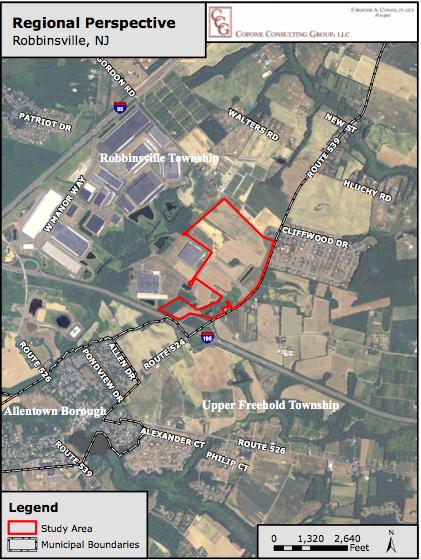
4 OVERVIEW OF PLAN The intent of the Plan is to allow for the continued build-out of Matrix Business Park at 7A in accordance with the existing requirements of the Plan Area s underlying zoning classification, the PCD ( Planned Commercial Development ) Zone (a copy of which is attached hereto as Appendix A), and the existing GDP approval, while allowing greater flexibility to develop the Park in current market conditions. Accordingly, the Plan incorporates the requirements of the PCD Zone, as well as the design standards of the Township s Land Development Ordinance except where explicitly stated in this Plan to the contrary, in which case this Plan shall supersede the requirements of the PCD Zone and the Township s Land Development Ordinance. The Plan aims to facilitate economic development within the remainder of the Matrix Business Park through the use of zoning techniques to increase the usability and therefore competitiveness of the Plan Area, including, but not limited to, further enabling the development of renewable energy facilities, data centers and research and development uses, eliminating intensity controls for single lots (applying tract wide standards instead), and allowing for greater lighting intensities and parking within internal roadways, among other elements. The Plan sets forth standards for land use, circulation, open space, parking, and design. Some Plan elements are fixed, while others are flexible in keeping with overall Plan goals and objectives. LOCATION OF REDEVELOPMENT AREA The Township of Robbinsville contains a total area of 20.5 square miles within the southeastern portion of Mercer County. It is bordered by Upper Freehold, East Windsor, and Millstone to the east; Allentown and Upper Freehold to the south; Robbinsville and West Windsor to the west; and West Windsor and East Windsor to the north. The general area is dominated by the Matrix Business Park at 7A, which contains a few warehousing, office, and light industrial buildings generally to the south of Gordon Road, west of Old York Road, and north of Interstate 195. The Matrix Business Park at 7A consists of approximately 434 acres of land, most of which is vacant. The property is currently operating under a General Development Plan ( GDP ) to ultimately accommodate approximately 5.3 million square feet of distribution and light manufacturing space. Existing Land Uses There are also a few scattered residential properties along the western portion of Old York Road. Along the eastern portion of Old York Road, across from the northern portion of the Study Area, is a residential development, and across from the southern portion of the Study Area exists residential uses and agricultural uses. On the northern portion of Gordon Road, there are scattered residential parcels and agricultural lands. See Figure 2, Regional Perspective.
5
6
7 2 Vision, Goals, & Context REDEVELOPMENT PLAN VISION The following is a summary of the key Redevelopment Plan goals and objectives. Provide for the type of redevelopment that can reignite economic development within the Matrix Business Park and further serve as a stimulus for future revitalization efforts within the community. Establish an appropriate scheme for redevelopment that will hasten the revitalization of the Plan Area. Implement the vision of the Plan Area as articulated in the Township s historical master planning documents. Recognize the importance of the Plan Area as an economic engine for the larger community. Create a unified business park that recognizes the locational attributes of its placement within the Township. Develop a mixture of non-residential uses that will serve as a catalyst for increased activity and interest in the general area, in addition to being consistent with smart growth principles and important for potential employment opportunities and tax ratable and economic growth. Allow flexibility in bulk and design standards to provide a stabilizing influence to justify the redevelopment of the Plan Area; and Promote the siting of renewable energy facilities throughout the Plan Area.
8 3 Land Use, Bulk, and Parking LAND USES PERMITTED PRINCIPAL USES The land uses currently permitted in the underlying PCD Zone shall continue within the Plan Area, subject to the following: Offices shall be permitted as subject to the bulk requirements for Type 2 uses Data centers shall be permitted as a Type 2 use Research and Development uses shall be permitted as a Type 2 use Mixed Uses Any combination of permitted Type 2 uses shall be permitted in a building as a permitted Type 2 use Renewable energy facilities (e.g., solar farms, solar panels, etc.), specifically excluding wind turbines. PERMITTED CONDITIONAL USES The land uses permitted conditionally in the underlying PCD Zone shall continue within the Plan Area. PERMITTED ACCESSORY USES The accessory uses currently permitted in the underlying PCD Zone shall continue with in the Plan Area, subject to the following: Renewable energy facilities (e.g., solar farms, solar panels, etc.) shall be permitted as accessory uses DEFINITIONS As used herein, the term Data Center shall mean a centralized repository for the storage, management, and dissemination of data and information. It houses critical computer systems and associated components for companies and organizations. Often data centers referred to as collocation data centers, which means that several businesses may rent space to house their servers and in a common location. However, each company s equipment is generally secured within a delineated area. A data center generally includes environmental controls (air conditioning, fire suppression, etc), redundant/backup power supplies, redundant data communications connections, and high security. A data center may include office space for the temporary accommodation of workers displaced from their primary place of business.
9 BULK REQUIREMENTS Except as provided below, all bulk requirements of the PCD Zone shall apply, including standards for both Type 1 and Type 2 uses, as applicable. Floor Area Ratio (FAR) FAR controls shall be eliminated for single lots. The underlying PCD zone contains a tract-wide maximum average requirement for FAR and this requirement shall continue to apply to the Redevelopment Area and shall not be increased as a result of this provision. Impervious and Building Coverage Impervious and building coverage controls shall be eliminated for single lots. The underlying PCD zone contains a tract-wide maximum average requirement for impervious and building coverage controls and these requirements shall continue to apply to the Redevelopment Area and shall not be increased as a result of this provision. Gross Square Footage Cap on Office Uses The 2% cap on office uses for Type 2 uses shall be eliminated. Type 2 bulk requirements shall apply to office uses regardless of whether the office use is stand-alone or part of (or accessory to) another principal permitted Type 2 use. Uses Per Lot Multiple buildings on single lots shall be allowed and the minimum distances between individual buildings shall be in accordance with the 2006 International Fire Code, New Jersey Edition, which requires at least a 30-foot separation between buildings. However, in the event that an applicant is seeking to reduce building separation, an increase in the fire resistance rating of walls may be sufficient, subject to review by the Township Fire Marshall. Covered walkways that are either closed or not enclosed shall not be subject to the minimum distance requirements. Frontage Lots within the Redevelopment area need not front on a public or private street. Requirements for Renewable Energy Facilities The minimum setback for renewable energy facilities from lot lines shall be 25 feet from internal business park lot lines and 80 feet from any residential zone district. Notwithstanding the foregoing, the setback along any lot line that abuts a state or federal highway shall be 10 feet. Pursuant to the Municipal Land Use Law (MLUL) at NJSA 40:55D-4, renewable energy facilities are deemed as inherently beneficial
10 uses. Solar panels are also exempt from the calculation of an impervious surface or impervious cover under the MLUL at NJSA 40:55D PARKING AND LOADING Unless otherwise noted, the requirements in the Township s Land Development Ordinance shall apply. Parking and Loading Requirements Data Center: 1 space per 2,500 square feet of gross floor area. Shared parking and loading across lot lines is permitted. Parking and Loading Location Parking is permitted along all internal driveways. Parking and loading setbacks from internal lot lines are not required. Truck parking and loading areas do not need to be separate from automobile parking areas but the project engineers must consider safety during the design phase.
11 4 Site Planning and Design INTENT Recognizing the completely non-residential nature of the Plan Area and need for flexibility and safety, this section sets forth standards for the Plan Area that are designed to foster a functional and aestheticallypleasing site. Unless otherwise noted, the site planning and design standards as contained within the Township s Land Development Ordinance shall apply. SIGNAGE General Signage Requirements The following signage requirements shall apply within the Plan Area: Three (3) freestanding signs shall be permitted for each building. Two (2) façade signs, at a maximum of 200 square feet each, shall be permitted for each tenant within a building. LIGHTING General Lighting Requirements The permitted lighting intensity shall be increased to an average of not more than two (2) foot candles throughout parking lots and access drives. The maximum permitted foot candles at any property line shall be increased to.5 foot candles. FENCES The maximum height for fences in all yards shall be six (6) feet.
12 5 Plan Consistency Review RELATIONSHIP TO ROBBINSVILLE ZONING CODE This Redevelopment Plan incorporates all provisions of the Land Development Code of the Township of Robbinsville regulating development in the area addressed by this Redevelopment Plan except where explicitly stated in this Plan to the contrary, in which case this Plan shall supersede the requirements of the Township s Land Development Code. Final adoption of this Plan by the Township Council shall be considered an amendment of the Township of Robbinsville Zoning Map. RELATIONSHIP TO MASTER PLAN AND LOCAL GOALS The Township last adopted a comprehensive Master Plan in The 2000 Master Plan recognizes the need to balance economic development and land preservation, although it states the policy is dictated by a number of salient factors, including growth trends, infrastructure needs, and real estate markets (2000 Master Plan, Page 1). Since the adoption of the 2000 Master Plan, the Township also adopted two Master Plan Reexamination Reports in 2007 and The 2000 Master Plan contains a variety of goals and objectives to guide the future development of the Township. Specific to the context of the Redevelopment Area, certain goals and objectives are as follows: Take all steps that are available to direct growth in a way that discourages sprawl type of development (Page I-1). Encourage the development of new businesses, and the expansion of existing businesses, in appropriate areas, which result in jobs that can be filled by the residents of the Township (Page I-2). The Land Use Plan Element of the 2000 Master Plan identifies the Redevelopment Area as within one of the six commercial areas in the Township. The Exit 7A/PCD District is described as follows: The PCD District, located near Exit 7A of the Turnpike, has been established for office/warehouse use, due to that proximity to the interstate highways and to its separation from the residential community (Page II-26). The Exit 7A/PCD District use category is further defined as the area situated in the area east of the N.J. Turnpike, south of Gordon Road and west of Old York Road, and north of the Allentown border (Page II- 36). The 2000 Master Plan recognizes that at the time of the drafting of the report, development had begun on the Northeast Business Park by way of a General Development Plan for the approximately 350 acre western portion of the Exit 7A/PCD District use category (Id). The 2000 Master Plan also recognizes that the remaining 400 +/- acres in the district currently has no development approvals (Id).
13 The Township Planning Board granted a general development plan approval via Resolution PA for development on acres of land. The 2000 Master Plan recognizes the 400 +/- acres of land within the Exit 7A/PCD District, which currently encapsulates the Redevelopment Area, accordingly: This area is viewed as an appropriate location for future economic development, given the availability of such a large tract of undeveloped land, with well-established regional highway connections to the N.J. Turnpike and 1-195, and with the recent extension of sewer and water to the area. The absence of significant development limitations in the form of environmental features and adjacent land uses also suggests commercial suitability (Id). The Township adopted a Periodic Reexamination of the Master Plan and Land Use Element Amendment in 2007, which reexamined all elements of the 2000 Master Plan. Among the global findings within the 2007 Master Plan Reexamination, a major need identified is to continue the need to balance residential and commercial development, since there was a growing disconnect between the uses between 2000 and 2005: While residential development surged over the past five years, the amount of nonresidential development decreased by approximately 92% between 2000 and (Pages 13/14) The 2007 Master Plan Reexamination recognizes the ongoing redevelopment efforts in the Township as helping to offset the residential surge in the future. The most recent Periodic Reexamination of the Master Plan was completed in 2007 (revised to January 2009). The document focuses specifically on two areas within the Township, does not suggest any changes to the 2000 document, and lastly does not reference any of the parcels within the study area. For the foregoing reasons, this Plan is consistent with, and designed to effectuate the Township Master Plan. RELATIONSHIP TO ADJACENT MUNICIPALITIES The Redevelopment Area is situated in the eastern section of the County of Mercer. The nearest border to an adjacent municipality, Upper Freehold, is directly across from Old York Road. Given the Plan Area s physical separation from the properties within Upper Freehold, the Redevelopment Plan will have little or no impact on said community. RELATIONSHIP TO THE MERCER COUNTY MASTER PLAN In the Mercer County Master Plan, the area is shown as commercial. Therefore, there is no conflict with the County Master Plan.
14 RELATIONSHIP TO THE STATE DEVELOPMENT AND REDEVELOPMENT PLAN The entire Study Area is located within the Suburban Planning Area (PA-2), as defined by the New Jersey State Development and Redevelopment Plan ( SDRP ). The redevelopment of the area into an active warehousing and office park, inclusive of renewable energy, within an area proximate to highways, meets the intent of the Suburban Planning Area: Provide for much of the state s future development; Promote growth in Centers and other compact forms; Protect the character of existing stable communities; Protect natural resources; Redesign areas of sprawl; Reverse the current trends towards future sprawl; and Revitalize cities and towns.
15 6 Redevelopment Actions/General Provisions PROPERTIES TO BE ACQUIRED The Township of Robbinsville shall not acquire, by the use of eminent domain or otherwise, any privately owned land within the Plan Area in order to effectuate this Redevelopment Plan. RELOCATION Implementation of the Redevelopment Plan does not require the displacement or relocation of any residents or businesses within the Plan Area. DEFINITIONS Except for those words defined with this Redevelopment Plan, words that appear in this document shall be defined in accordance with the definitions that appear in the Township s land use ordinances, or, where these ordinances do not provide a definition, in accordance with the definitions in the Municipal Land Use Law. SITE PLAN AND SUBDIVISION REVIEW Prior to commencement of site plan construction, a site plan, prepared in accordance with the requirements of the Municipal Land Use Law (N.J.S.A. 40:55D-1 et seq.), shall be submitted by the applicants for review and approval by the Robbinsville Planning Board. Any subdivision of lots and parcels of land within the Redevelopment Area shall be in accordance with the requirements of this Redevelopment Plan and the subdivision ordinance of the Township of Robbinsville. DEVIATION REQUESTS The Robbinsville Planning Board may grant deviations from the provisions of this Redevelopment Plan where, by reason of exceptional narrowness, shallowness or shape of a specific piece of property, or by reason of exceptional topographic conditions or physical features uniquely affecting a specific piece of property, or by reason of an extraordinary and exceptional situation uniquely affecting a specific piece of property or the structures lawfully existing thereon, the strict application of any provision of this Redevelopment Plan would result in practical difficulties to, or exceptional and undue hardship upon, the developer of such property. The Robbinsville Planning Board may also grant deviations from the provisions of this Redevelopment Plan if the purposes of this Redevelopment Plan would be advanced by such deviation and the benefits of the deviation would outweigh any detriments. No relief may be granted under the terms of this section unless such deviation or relief can be granted without substantial detriment
16 to the public good and without substantial impairment of the intent and purpose of the Redevelopment Plan. An application for a deviation from the requirements of this Redevelopment Plan shall provide public notice of such application in accord with the requirements of public notice as set forth in N.J.S.A. 40:55D- 12.a. and b. BONDING AND DEVELOPER S AGREEMENT The posting of a restoration bond shall satisfy the performance guaranty requirement set forth in Ordinance Section A Developer s Agreement shall not be required pursuant to Ordinance Section M.
17 7 Other Provisions In accordance with N.J.S.A. 40A:12A-1 et seq., known as The Local Redevelopment and Housing Law, the following statements are made: The Redevelopment Plan herein has delineated a definite relationship to local objectives as to appropriate land uses, density of population, and improved traffic and public transportation, public utilities, recreation and community facilities and other public improvements. The Plan has laid out various programs and strategies needed to be implemented in order to carry out the objectives of this Plan. The Redevelopment Plan lays out the proposed land uses and building requirements for the Redevelopment Area. Privately owned lots within the Redevelopment Area are not subject to acquisition by the Township of Robbinsville as part of the redevelopment effort. The Redevelopment Plan is substantially consistent with the Master Plan for the Township of Robbinsville. The Plan also complies with the goals and objectives of the New Jersey State Development and Redevelopment Plan. If any section, paragraph, division, subdivision, clause or provision of this Redevelopment Plan shall be adjudged by the courts to be invalid, such adjudication shall only apply to the section, paragraph, division, subdivision, clause or provision so judged, and the remainder of this Redevelopment Plan shall be deemed valid and effective. As of the date of the adoption of the resolution finding the area to be in need of redevelopment, there are no housing units affordable to low and moderate income households that are to be removed as a result of implementation of the redevelopment plan.
18 8 Appendix A PCD Planned Commercial Development Zone Amended by Ord. No ; Ord. No ; Ord. No ; by Ord. No ] A. Preamble. This zone recognizes the need for large tract development for office, warehouse, light manufacturing and "flex" (office/warehouse buildings) in the Township. Also permitted are uses which are intended to provide attendant services for employees, suppliers and visitors of the primary uses. Due to the nature of these uses, the same must be situated in proximity to major arterial roads and highways. The zone also recognizes that there are several isolated residential properties physically located in the zone district, which residences are located in such a way as to preclude a separate zone district being created. The intent is to allow the existing residential properties to continue to exist as the same subject to certain bulk requirements, which shall only be applicable to properties which exist as residences at the time of the adoption of this section. B. Definitions. As used in this section, the following terms shall have the meanings indicated: AVERAGING The development regulation which permits the developer the right to develop portions of the planned development at ratios greater than the overall permitted kcoverage ratios and floor area ratios so long as the development of the entire area of the planned development does not exceed the overall permitted coverage and floor area ratios. COLLECTOR STREET A street which is proposed as a collector street and which meets the standards set forth and the procedures for dedication in Subsection G(2)(a)for collector streets. FLOOR AREA RATIO (FAR) The sum of the area of all floors of buildings compared to the total area of the site.
19 GENERAL DEVELOPMENT PLAN A plan containing the elements set forth in Subsection H(2)(b) of this section. Editor's Note: The former definition of "improvement coverage," which immediately followed this definition, was repealed by Ord. No LIGHT MANUFACTURING AND ASSEMBLY The manufacturing of products by the assembly or fabrication of components, including the incidental machining, painting, finishing, testing or packaging prior to wholesale or retail distribution; excluding, however, any outdoor light manufacturing or assembly. MODULAR OFFICE-DISTRIBUTION A multitenanted office-distribution structure with components not less than 5,000 square feet per modular unit. The office component of any module shall not be less than 10% nor greater than 50% of any module. PLANNED COMMERCIAL DEVELOPMENT ZONE That area designated on the Robbinsville Township Zoning Map as "PCD Zone." The PCD Zone shall include the area bounded on the west by the New Jersey Turnpike, on the north by Gordon Road, on the east by the Monmouth/Mercer County border and on the south by I-195. An applicant meeting the requirements of this section may develop its property located within the PCD Zone as a planned development pursuant to a general development plan application, or by an application for site plan approval, with or without an application for general development plan approval. PLANNED COMMERCIAL DEVELOPMENT A minimum tract area as specified by ordinance to be developed according to a plan as a single entity containing one or more structures with appurtenant common areas to accommodate those uses specified in this section. SECTION 1 TRACT AREA
20 The gross area of land within the planned development tract area which consists of or is designated to consist of the Type 1 uses as set forth in Subsection D of this section. SECTION 2 TRACT AREA The gross area of land within the planned development tract area which consists of or is designated to consist of the Type 2 uses as set forth in Subsection D of this section. TECHNICAL COORDINATING COMMITTEE The Technical Coordinating Committee as contemplated in N.J.S.A. 40:55D-45, and shall be deemed to be the Technical Review Committee as defined and established in , Technical Review Committee. TRACT AREA The gross area of land which consists of lots having one or more common boundaries. The intent of this section is that separation of lots or portions of the tract by dedicated streets shall not be deemed to destroy the continuity of the acreage which is the subject of an application for planned development. C. General provisions. (1) PCD Zone criteria. Within those areas specifically designated on the Zoning Map of Robbinsville Township as within the PCD Zone, any application for development shall be made in accordance with the regulations and procedures detailed in this chapter, provided the proposal meets with all of the criteria of Type 1 or Type 2 uses as defined in Subsection D of this section. Development of Type 1 uses, Type 2 uses, or a combination of Type 1 and Type 2 uses, may be approved pursuant to an application for site plan approval, with or without an application for general development plan approval. (2) PCD alternate criteria. Planned development within the PCD Zone shall be a permitted alternate form of development on tracts with a gross area of at least 350 acres. Application for this alternative shall be made in accordance with the regulations and procedures described in Subsection H of this section pertaining to a planned development, provided that the proposal meets all of the following minimum criteria:
21 (a) The area of the tract upon which planned development is proposed is 350 acres or larger. (b) The tract is located within an existing sewer service area and is served or is capable of being served by public sewer. (c) The tract is served or is capable of being served by public water. (d) The tract is to be developed according to a general development plan as a single entity to accommodate nonresidential uses as permitted in Subsection D of this section and is proximate to regional interstate highways. D. Permitted uses. Only the following building types or uses shall be permitted within the PCD Zone: (1) Principal permitted uses. (a) Type 1 principal permitted uses: [1] General business, corporate, and professional offices, including administrative, sales, executive, research and development, high technology and other general or corporate business uses. [2] Retail and related uses sited for the convenience of the employees within the PCD Zone in conjunction with a general development plan for a planned commercial development. Such retail uses shall be limited to: [a] Banks and financial institutions. [b] Restaurants, provided there is no drive-through service or service in vehicles. An employee cafeteria or lunch room whose location is within a building and whose operation is solely
22 accessory to a permitted nonretail use shall not be construed to be a restaurant under this section. [c] Supermarkets, delicatessens and similar food service establishments. [d] Video rental stores. [e] Dry-cleaning pickup/dropoff service only. Actual dry cleaning of garments shall not be conducted within the PCD. [f] Pharmacies. [g] Card and gift shops. [h] Barber/beauty shops. [i] Post offices. [j] Florist shops. [3] Hotel and conference centers, including professional meeting and training facilities (i.e., classrooms, auditoriums, amphitheaters), recreational and athletic facilities, dining and banquet facilities and accessory retail or other service facilities incidental to said use. [4] Fully enclosed establishments for the sale and repair of office-related equipment. [5] Research and development uses, including, but not limited to, computer centers and data processing facilities.
23 [6] Municipal facilities, including municipal garages. [7] Day-care facilities associated with permitted uses. [8] Public purpose recreation uses including facilities for cultural activities and associated public purpose uses. [9] Health clubs and racquet clubs. [10] Agricultural uses. [11] Mixed-use building. Within a mixed-use building, retail uses shall not exceed 5% of the floor area of any individual Type 1 use building. Plan averaging of retail floor area shall also be permitted as part of a general development plan; provided, however, that the total retail floor area shall not exceed 10% of the floor area of all Type 1 uses in the plan. All retail uses shall be integrated into the overall campus style design of the PCD development. The Planning Board shall have the power to limit the extent and location of freestanding and all other retail uses. (b) Type 2 principal permitted uses: [1] General warehouse uses, warehouse showrooms, and retail outlets which are solely incidental to a warehouse use. This section shall not be construed so as to permit retail-warehouse or warehouse-type uses whose primary function is direct on-site retail sales to the public. [2] Light manufacturing and assembly uses. [3] Office uses up to 2% of the gross square footage of a permitted Type 2 use. Office uses over 2% of the gross square footage of a permitted Type 2 building shall be deemed Type 1 uses.
24 [4] Modular office-distribution uses. [5] Public purpose recreation uses, including facilities for cultural activities and associated public purpose uses. [6] Health clubs and racquet clubs. [7] Agricultural uses. [8] Freight forwarding warehouse. [Added by Ord. No ] (2) Accessory uses. (a) Parking decks and/or garages and loading facilities incidental to and supportive of the principal uses in this zone, not to exceed three stories. (b) Recreational facilities for use of the tenants or employees of the principal uses. (c) All uses which are customarily incidental to and supportive of the principal uses, or combination thereof, listed in Subsection D(1) above. (d) Signs and directories. (e) Note: Accessory uses, except for parking areas, shall not occupy a floor area greater than 30% of the floor area dedicated to the principal use or combination of principal uses to which the accessory use or uses relate. Accessory uses may be located within the same building as the principal use or in a separate accessory structure.
25 E. Conditional uses. (1) Single-family residences; see J. F. Development standards. Notwithstanding any provisions elsewhere in this section or in any ordinance of Robbinsville Township, planned commercial developments are subject only to the standards and provisions contained in this Subsection F. (1) Bulk standards, general commercial uses. (a) Lot dimensions, minimum required. [1] Area: [a] Type 1 uses: three acres; seven acres for a hotel or conference center. [b] Type 2 uses: three acres. [2] Width: 300 feet. [3] Depth: 300 feet. (b) Yard dimensions, minimum required principal building setbacks. [1] Front yard: 80 feet.
26 [2] Side yard: 25 feet each. [3] Rear yard: 25 feet. (c) Height of buildings, maximum permitted. [1] Three stories or 45 feet. [2] Note: Rooftop screening of utilities shall not be included in the measurement of maximum height. The use of rooftop penthouses shall be limited to passive commercial uses such as the housing of equipment. (d) Maximum coverage. [1] Type 1 uses as part of the planned development with general development plan approval: [Amended by Ord. No ] [a] Building coverage for principal buildings shall be permitted to a maximum of 18% of the total Section 1 tract area of the planned development. Total lot coverage shall be permitted to a maximum of 50% of the total Section 1 tract area of the planned development. Total floor area ratio shall be permitted to a maximum of 18% of the Section 1 tract area of the planned development. [b] Averaging of building coverage, total floor area ratio and total lot coverage over the total Section 1 tract area of a planned development shall be permitted; provided, however, that no one lot of the planned development shall exceed an FAR of 23%, a maximum building coverage of 23% and a maximum lot coverage of 55%. [c] Building coverage for hotel or conference center uses shall be permitted to a maximum of 30% of the lot. Total lot coverage shall be permitted to a maximum of 50% of a lot used for hotel or conference center development. Total floor area ratio for a lot used for hotel or conference center shall be permitted to a maximum of 30%.
27 [2] Type 2 uses as part of a planned development with general development plan approval: [a] Building coverage for principal buildings shall be permitted to a maximum of 32% of the total Section 2 tract area of the planned development. Total lot coverage shall be permitted to a maximum of 52% of the total Section 2 tract area of the planned development. Total FAR shall be permitted to a maximum of 32% percent of the total Section 2 tract area of the planned development. [Amended by Ord. No ] [b] Averaging of building coverage, total lot coverage and FAR shall be permitted over the total Section 2 tract area of a planned development; provided, however, that no one lot of the planned development shall exceed an FAR of 42%, maximum building coverage of 42% and maximum total lot coverage of 62%. [Amended by Ord. No ] [c] Notwithstanding the above, no more than 42% of the Section 2 tract area may be developed as modular office-distribution uses. (e) Following are the bulk and coverage standards applicable to planned commercial developments in the PCD Zone with general development plan approval: [Amended by Ord. No ]
28 Uses Type 1 Type 2 Lot area 3 acres 3 acres Lot width 300 feet 300 feet Lot depth 300 feet 300 feet Front yard setback 80 feet 80 feet Side yard setback 25 feet each 25 feet each Rear yard setback 25 feet 25 feet Building height 3 stories or 45 feet 3 stories or 45 feet Maximum lot coverage of tract 50% 52% Floor area ratio for tract 18% 32% Maximum FAR and building coverage of site with averaging 55% 62% (f) Bulk standards for Type 1 uses for non-general development plan approval properties shall be the same as those set forth in SubsectionF(1)(a) through (e). Maximum lot coverage of site with averaging 55% 62% Hotel/conference center FAR 30% Hotel/conference center MIC 50% (g) Bulk standards, Type 2 uses for nongeneral development plan approval properties: Hotel/conference center building height 6 stories or 80 feet 6 stories or 80 feet
29 [1] Lot area: 20 acres. [2] Lot width: 750 feet. [3] Lot depth: 750 feet. [4] Building setback (West Manor Way, Old York Road or Gordon Road): 175 feet. [5] Front yard setback (interior road): 90 feet. [6] Side yard setback: 25 feet. [7] Rear yard setback: 25 feet. [8] Maximum FAR: 42%. [9] Maximum lot coverage: 62%. (h) A building transition setback of not less than 150 feet, as specified herein, and measured from the property line shall be established adjacent to any residential zone district, except along a line that coincides with state or federal highway, the New Jersey Turnpike or an approved preservation area. No building shall be located within the transition setback. The transition setback shall include a minimum landscaped width of 80 feet between the property line and any parking area. (i) Vehicular access points to the surrounding road system shall be limited to West Manor Way and Old York Road. All driveways and/or internal roads shall be designed to direct traffic (particularly truck traffic) to and from the I-195 interchanges.
30 (j) Traffic calming elements shall be installed to discourage speeding or inappropriate truck traffic along West Manor Way, Gordon Road, and Old York Road. (k) Each site plan shall contribute its pro rata share to all traffic infrastructure improvements necessary to promote the Master Plan goals and objectives for the development of the PCD Zone District. (l) The maximum limitation on FAR and MIC set forth in the regulations for the planned commercial development option may be increased in accordance with (m) Any planned commercial development plan, with general development plan approval, or major subdivision plan that is not part of a general development plan approval, which proposes FAR, lot coverage, and building coverage averaging shall vest that authority as provided to the Planning Board by virtue of N.J.S.A. 40:55D-39c(5) to require the appropriate restrictions as to preservation of open space so as to preserve the average density reflected in the proposed plan. [Amended by Ord. No ] G. Design standards. (1) Minimum off-street parking and loading requirements.
31 Nonresidential Land Uses Required Off-Street ParkingSpaces Per Indicated Area Assembly operations 1 per 800 square feet GFA Bar 1 per 2 seats Bowling alley 4 per alley Car wash 10 per washing lane Church/synagogue 1 per 3 seats Fiduciary institutions 1 per 300 square feet GFA Finishing operations 1 per 800 square feet GFA Hotel 7 per guest room plus 10 per 1,000 square feet GFA Industrial 1 per 800 square feet GFA Library 1 per 300 square feet GFA Manufacturing 1 per 800 square feet GFA Medical center 1 per 250 square feet GFA Neighborhood convenience center: Under 400,000 square feet GFA Nightclub 4 per 1,000 square feet GFA 1 per 3 seats
32 (a) Site plans can include provisions for shared parking facilities with other sites, so long as the aggregate parking provided meets the standards set out in Subsection G(1) above.
33 (b) The size of a parking space shall be nine feet by 18 feet. (c) Areas provided for loading and unloading of delivery trucks and other vehicles, and for servicing of buildings by refuse collection, and other service vehicles shall be adequate in size, and shall be so arranged that they may be used without blockage or interference with the use of accessways or automobile parking facilities. Size, number and other criteria regarding loading and unloading areas for delivery trucks and other vehicles shall be as set forth in this chapter. (d) All parking, loading, access and service areas shall be adequately illuminated at night. All lighting, including sign lighting, shall be arranged so as to protect the highway and adjoining property and roads from direct glare or hazardous interference of any kind. Lighting shall be designed with regard to height and illumination so as to minimize the impact on the residents of any surrounding dwelling units. Areas provided for truck parking shall be visually screened by landscaping from collector streets. (e) The Planning Board may permit a thirty-percent reduction of the required number of parking spaces required to be constructed in connection with any individual site plan if the applicant can prove that it is unlikely that there will be a sufficient parking demand to warrant full compliance and the site plan contains an area reserved for future parking expansion if and when needed. (f) No street side parking shall be permitted on internal roads in the area of a planned development. (g) Parking shall be permitted in setback areas; provided, however, that any parking within a setback area shall be located no more than 40 feet from the interior building setback line. Parking setbacks shall be as follows: [1] Interior street line: 40 feet. [2] Side/rear lot line: 20 feet. [3] Exterior street lines (along Gordon Road, Old York Road, West Manor Way): 80 feet. (2) Streets.
34 (a) Collector streets shall be designed to accommodate through traffic in the planned development to and from surrounding areas. (b) Minor streets shall be so planned and identified so as to discourage through traffic. (c) The right-of-way width on all streets shall be measured from lot line to lot line and shall meet the following minimum widths: [1] Collector streets: 66 feet. [2] Streets other than collector streets: 60 feet. [3] Right-of-way widths for internal roads and alleys in a planned development may be proposed at less than 60 feet, but not less than 50 feet, but shall in all cases be of sufficient width and design to safely accommodate the reasonably anticipated traffic, parking, and loading needs where applicable, as well as access for fire-fighting equipment. (d) All improvements which are not both proposed for dedication and accepted by Robbinsville Township shall be regarded as nonpublic improvements. The maintenance or improvement of nonpublic improvements shall be the responsibility of the developer or its successors in interest. (e) Street intersections shall be as nearly at right angles as is possible and in no case shall be less than 80. (f) A cul-de-sac shall be no more than 2,000 feet in length. (g) The pavement standard for streets within a PCD shall be in accordance with the standards set forth in this chapter.
35 (h) T-type intersections shall be offset a minimum of 150 feet. (i) Sidewalks shall be required where necessary and appropriate to provide adequate pedestrian access from parking facilities to proposed buildings, and curbing shall be required for all paved areas. (j) Access to minor arterial roads and collector streets identified in the Township Master Plan shall be arranged to minimize the disturbance of the traffic flow by limiting access locations. (3) Drainage. Storm drainage standards shall be as set forth in this chapter. (4) Landscaping. Landscaping standards shall be as set forth in this chapter. (5) Recycling. Recycling shall be provided in accordance with Chapter 220, Article I, Recycling, of the Robbinsville Township Code. (6) Planned commercial development tract layout. The tract shall be designed utilizing a campus style layout. The developer shall employ design techniques to create an integrated, park-like development having a desirable visual environment. (7) All other design standards. Any design standards or criteria other than those specifically enumerated herein shall be as set forth in this chapter. (8) Architectural standards. (a) The design of warehouse development(s) should integrate the disciplines of landscape architecture, architecture and engineering. (b) Strong site development identity should be unified by a consistent treatment; in particular, extensive landscape treatment should be used.
36 (c) Building orientation should be consistent throughout whole site development and favor streets and the public right-of-way. (d) General architectural treatment of buildings should be complementary as to materials, texture and color, in particular for adjacent structures. (e) Building structures should follow design guidelines noted as part of these standards. (f) Architectural feature(s) and focal points should be easily discernible from the street and/or public rightof-way. They should not be concealed or obscured by parking or ancillary structures. (g) Extensive parking areas, truck yards, and loading docks should be screened from view from the street/public right-of-way by use of landscape, architecture feature(s) for fence(s). Fence(s) should complement design of building and be consistent with the general architectural character. (h) If proposed, picnic areas and other recreational facilities shall be properly integrated into the design of the site development or individual lot. Consideration should be made to locate such areas/facilities away from the main entrance(s) to the building. Roofed shelters as part of these areas shall be encouraged when appropriate. (9) Building design standards. (a) Main entrance and feature(s) should be placed (arranged) to create focal points oriented toward corner(s) and/or the center of street facade. (b) Facades facing a street or public right-of-way should be segmented by offsets, reliefs, and/or features of appropriate scale to visually break long elevations into a series of favorable scaled elements in relation to a normal urban scale. These elevations should not extend beyond a maximum of 300 feet between relieves. Blank wall segments without relief or discernible pattern treatment should be not greater than 30 feet. Specifically designed landscape treatment(s) along blank wall segments can be considered an acceptable option to a discernible pattern treatment on the wall.
37 (c) Each facade of the building should be designed to complement adjoining facades in close proximity. Preferred facade materials and combinations can include concrete (tilt-up/precast), brick and/or architectural textured concrete masonry units. Other exterior products may be used, assuming the composition of the design and materials create a unique facade treatment which reflect an honest expression of the use and size of the project. For example, architectural insulated metal panels may be used as a limited design treatment, but must be used carefully to create a compatible composition with the major facade material(s). (d) Material color and texture range must be considered in the facade composition. The color and texture range (field, bands and accents) provides an opportunity to segment the facades and soften the scale of large buildings; therefore, they should be used with care and purpose. Color can be applied to the surface of the facade material or be integral to that material, but it is important that consideration should be given to the wearability of any finish(es). Color compatibility in glass, frames, doors, etc., are also an important consideration for the final design. Color can also be used to enhance the three-dimensionality and apparent depth of facade treatments. Texture treatment should be clearly discernible from curbside through its composition and shadow effect. It should add to the sculptural composition of the wall and accent its three-dimensionality. Joint treatment that is part of the architectural composition of the facade should also be clearly visible from such a distance and may need to be treated architecturally to create such an effect. (e) Rooftop equipment should be placed away from all facades in an effort to minimize its visual impact as seen from the adjoining street or public right-of-way. Careful attention should be given to its orientation and color when locating rooftop equipment. Rooftop equipment should be considered as part of the architectural composition of the building. If inevitable, rooftop equipment located close to building facade should be screened. Such screen should completely block the equipment from the adjoining street or public right-of-way view and be consistent and integral to the architectural composition of the building. (f) Signage and logo(s) placement should be considered in the concept phase of the project as part of the architectural composition of the building. Signage and logo(s) need to identify the project, be subtle and provide visitor/fire department clear direction to the primary and secondary points of entry. H. Application and review procedure. (1) PCD Zone, general development plan.
Jacobs Landing Rehabilitation Plan
 Jacobs Landing Rehabilitation Plan Township of Woodbridge Prepared by: Township of Woodbridge Department of Planning & Development June 2015 ADOPTED by Township of Woodbridge Planning Board ADOPTED by
UPPER MOUNT BETHEL TOWNSHIP NORTHAMPTON COUNTY, PENNSYLVANIA
 UPPER MOUNT BETHEL TOWNSHIP NORTHAMPTON COUNTY, PENNSYLVANIA JOINDER DEED / LOT CONSOLIDATION TOWNSHIP REVIEW PROCESS When accepting proposed Joinder Deeds / Lot Consolidations, review the Joinder Deed
Olsen Towers Rehabilitation Plan
 Olsen Towers Rehabilitation Plan June 2016 ENDORSED by Township of Woodbridge Planning Board ADOPTED by Township of Woodbridge Council Olsen Towers Rehabilitation Plan Township of Woodbridge Prepared by
ARTICLE 15. RULES, REGULATIONS AND DEFINITIONS
 ARTICLE 15. RULES, REGULATIONS AND DEFINITIONS Section 1. Interpretation and Construction: The following rules and regulations regarding interpretation and construction of the Ulysses-Grant County, Kansas,
The following regulations shall apply in the R-E District:
 "R-E" RESIDENTIAL ESTATE DISTRICT (8/06) The following regulations shall apply in the R-E District: 1. Uses Permitted: The following uses are permitted. A Zoning Certificate may be required as provided
SECTION 23 PLANNED RESIDENTIAL DEVELOPMENT FOR ELDERLY PERSONS
 SECTION 23 PLANNED RESIDENTIAL DEVELOPMENT FOR ELDERLY PERSONS 23.1 General: In order to provide for the special needs of elderly and handicapped persons who may require multifamily type living accommodations,
8.5.1 R1, Single Detached Residential District
 8.5.1 R1, Single Detached Residential District The purpose of this district is to provide for residential development in the form of single detached dwellings. Dwelling, Single Detached Home Business,
TOWNSHIP OF UPPER MACUNGIE LEHIGH COUNTY, PENNSYLVANIA. ORDINANCE NO [To be considered for Adoption June 1, 2017]
![TOWNSHIP OF UPPER MACUNGIE LEHIGH COUNTY, PENNSYLVANIA. ORDINANCE NO [To be considered for Adoption June 1, 2017]](/thumbs/91/106428876.jpg "TOWNSHIP OF UPPER MACUNGIE LEHIGH COUNTY, PENNSYLVANIA. ORDINANCE NO [To be considered for Adoption June 1, 2017]") TOWNSHIP OF UPPER MACUNGIE LEHIGH COUNTY, PENNSYLVANIA ORDINANCE NO. 2017 05 [To be considered for Adoption June 1, 2017] AN ORDINANCE OF THE BOARD OF SUPERVISORS OF THE TOWNSHIP OF UPPER MACUNGIE, LEHIGH
TOWNSHIP OF UPPER MACUNGIE LEHIGH COUNTY, PENNSYLVANIA ORDINANCE NO. 2017 05 [To be considered for Adoption June 1, 2017] AN ORDINANCE OF THE BOARD OF SUPERVISORS OF THE TOWNSHIP OF UPPER MACUNGIE, LEHIGH
PROPOSED AMENDMENTS TO THE DERBY ZONING REGULATIONS AUGUST 12, 2008
 ARTICLE II Definitions and word usage 195-7. Definitions and word usage. Modify the following: HOUSING FOR THE ELDERLY OLDER PERSONS Housing in accordance with and as defined in the United States Fair
Scattered Sites Redevelopment Plan
 Scattered Sites Redevelopment Plan Township of Woodbridge Middlesex County, New Jersey Prepared by: Township of Woodbridge Department of Planning & Development January 2017 Amended September 2018 ENDORSED
Section 7.22: Multifamily Assisted Housing in AA-30 Residential Zone (MAHZ) [Note: an additional line will be added to the Table in Article 3, 3.1.
 [Note: an additional line will be added to the Table in Article 3, 3.1.") Section 7.22: Multifamily Assisted Housing in AA-30 Residential Zone (MAHZ) [Note: an additional line will be added to the Table in Article 3, 3.1.1A] 7.22.1 Purpose The purpose of this Special Regulation
Section 7.22: Multifamily Assisted Housing in AA-30 Residential Zone (MAHZ) [Note: an additional line will be added to the Table in Article 3, 3.1.1A] 7.22.1 Purpose The purpose of this Special Regulation
CUDAHY MUNICIPAL CODE
 CUDAHY MUNICIPAL CODE 20.80.010 Accessory uses may be developed as permitted in this zoning code provided such uses are located on the same lot or parcel of land and are incidental to, and do not substantially
CHAPTER 14 PLANNED UNIT DEVELOPMENTS
 9-14-1 9-14-1 CHAPTER 14 PLANNED UNIT DEVELOPMENTS SECTION: 9-14-1: Purpose 9-14-2: Governing Provisions 9-14-3: Minimum Area 9-14-4: Uses Permitted 9-14-5: Common Open Space 9-14-6: Utility Requirements
ARTICLE 23 CONDOMINIUM STANDARDS
 ARTICLE 23 CONDOMINIUM STANDARDS Section 23.01 Intent. The intent of this Article is to provide regulatory standards for condominiums and site condominiums similar to those required for projects developed
Article 3. SUBURBAN (S-) NEIGHBORHOOD CONTEXT
 NEIGHBORHOOD CONTEXT") Article 3. SUBURBAN (S-) NEIGHBORHOOD CONTEXT this page left intentionally blank Contents ARTICLE 3. SUBURBAN (S-) NEIGHBORHOOD CONTEXT DIVISION 3.1 NEIGHBORHOOD CONTEXT DESCRIPTION...3.1-1 Section 3.1.1
Article 3. SUBURBAN (S-) NEIGHBORHOOD CONTEXT this page left intentionally blank Contents ARTICLE 3. SUBURBAN (S-) NEIGHBORHOOD CONTEXT DIVISION 3.1 NEIGHBORHOOD CONTEXT DESCRIPTION...3.1-1 Section 3.1.1
619. Planned Development District (PD)
") 619. Planned Development District (PD) Intent. The purpose of the Planned Development District (sometimes hereinafter referred to as PD) is to provide opportunities to create more desirable environments
619. Planned Development District (PD) Intent. The purpose of the Planned Development District (sometimes hereinafter referred to as PD) is to provide opportunities to create more desirable environments
Redevelopment Plan Nutley HLR/Phase 1 Prepared for the Township of Nutley, Essex County NJ
 Redevelopment Plan Nutley HLR/Phase 1 Prepared for the Township of Nutley, Essex County NJ Original Drafts prepared by PHILLIPS PREISS GRYGIEL LLC Planning & Real Estate Consultants September 2015 June
a. To insure compatible relationships between land use activities;
 PART B SECTION VIII INSTITUTIONAL DISTRICTS Article 1 Planned Institutional District 1. Purpose and Intent: It is the purpose and intent of this district to permit and encourage the orderly, cooperative
ORDINANCE NO
 ORDINANCE NO. 2015-14 AN ORDINANCE OF THE TOWNSHIP OF MANALAPAN, COUNTY OF MONMOUTH, STATE OF NEW JERSEY, AMENDING AND SUPPLEMENTING CHAPTER 95, "DEVELOPMENT REGULATIONS", SECTION 95-5.6, "OVERLAY DISTRICTS",
ORDINANCE NO. Be it ordained by the City Council of the City of Abilene, Texas:
 ORDINANCE NO. An ordinance repealing Chapter 23, Subpart B of the Code of the City of Abilene, Texas, entitled Mobile Homes and Vacation Travel Trailers; stating the authority; setting forth the scope
Chapter 17-2 Residential Districts
 Chapter 17-2 Residential Districts 17-2-0100 District Descriptions...2-1 17-2-0200 Allowed Uses...2-2 17-2-0300 Bulk and Density Standards...2-5 17-2-0400 Character Standards...2-18 17-2-0500 Townhouse
DEVELOPMENT DEPARTMENT STAFF REPORT THE PARK AT 5 TH
 DEVELOPMENT DEPARTMENT STAFF REPORT ARB Meeting Date: July 3, 2018 Item #: _PZ2018-293_ THE PARK AT 5 TH Request: Site Address: Project Name: Parcel Number: Applicant: Proposed Development: Current Zoning:
Draft Model Access Management Overlay Ordinance
 Draft Model Access Management Overlay Ordinance This model was developed using the City of Hutchinson and the Trunk Highway 7 corridor. The basic provisions of this model may be adopted by any jurisdiction
ARTICLE 15 - PLANNED UNIT DEVELOPMENT
 Section 15.1 - Intent. ARTICLE 15 - PLANNED UNIT DEVELOPMENT A PUD, or Planned Unit Development, is not a District per se, but rather a set of standards that may be applied to a development type. The Planned
Washington County, Minnesota Ordinances
 Washington County, Minnesota Ordinances Ordinance No. 153 Text Amendment to the Washington County Development Code - Chapter One, Section 2 and Chapter Two, Part 1, Part 2, Part 3, of the Development Code
TOWNSHIP OF EVESHAM ORDINANCE NO
 TOWNSHIP OF EVESHAM ORDINANCE NO. 14-6-2018 ORDINANCE OF THE TOWNSHIP OF EVESHAM AMENDING CHAPTER 160, THE ZONING CODE OF THE TOWNSHIP OF EVESHAM TO CREATE A NEW ZONE TO BE KNOWN AS THE WORKFORCE AFFORDABLE
the conditions contained in their respective Orders until January 1, 2025, at the discretion of the Director of Planning, Property and Development.
 Part 4: Use Regulations Temporary Uses and Structures Purpose the conditions contained in their respective Orders until January 1, 2025, at the discretion of the Director of Planning, Property and Development.
DEVELOPMENT DEPARTMENT STAFF REPORT STAFF REPORT DRESDEN DRIVE TOWNHOMES DCI
 DEVELOPMENT DEPARTMENT STAFF REPORT Meeting Date: September 13, 2018 Item #: PZ2018-319 STAFF REPORT DRESDEN DRIVE TOWNHOMES DCI Request: Project Name: Development of Community Compact (DCI) and six concurrent
Anacortes, WA. 718 commercial ave. FOR lease. 2,320 +/- sf retail space in a 10,820 +/- sf building. Located in historic downtown Anacortes
 718 commercial ave Anacortes, WA FOR lease 2,320 +/- sf retail space in a 10,820 +/- sf building Located in historic downtown Anacortes Frontage on Commercial Ave alongside four other retail spaces Zoned
Indicates Council-recommended changes Introduced by: Mr. Tackett Date of introduction: June 14, 2016 SUBSTITUTE NO. 1 TO ORDINANCE NO.
 Indicates Council-recommended changes Introduced by: Mr. Tackett Date of introduction: June 14, 2016 SUBSTITUTE NO. 1 TO ORDINANCE NO. 16-067 TO AMEND NEW CASTLE COUNTY CODE CHAPTER 40 (ALSO KNOWN AS THE
Chapter 1107: Zoning Districts
 Chapter 1107: Zoning Districts 1107.01 Establishment of Zoning Districts (a) Districts Established In order to carry out the purpose of this code, the City is hereby divided into the zoning districts established
TOWNSHIP OF EAST HEMPFIELD. Lancaster County, Pennsylvania ORDINANCE NO.
 TOWNSHIP OF EAST HEMPFIELD Lancaster County, Pennsylvania ORDINANCE NO. AN ORDINANCE AMENDING THE CODE OF THE TOWNSHIP OF EAST HEMPFIELD BY MAKING MISCELLANEOUS AMENDMENTS TO THE ZONING ORDINANCE, INCLUDING
Cover Letter with Narrative Statement
 Cover Letter with Narrative Statement March 31, 2017 rev July 27, 2017 RE: Rushton Pointe Residential Planned Unit Development Application for Public Hearing for RPUD Rezone PL2015 000 0306 Mr. Eric Johnson,
Article 7: Residential Land Use and Development Requirements
 Article 7: Residential Land Use and Section 701: Statement of Intent (A) (B) (C) The intent of Article 7 is to develop certain land use and development requirements for the residential uses within Cumru
FOR SALE > MULTIFAMILY/COMMERCIAL REDEVELOPMENT OPPORTUNITY
 FOR SALE > MULTIFAMILY/COMMERCIAL REDEVELOPMENT OPPORTUNITY 2220 W. Cary Street RICHMOND, VA 23220 CURRENT PROPERTY ILLUSTRATION CONCEPTUAL ONLY (NOT PROPOSED) Property Information Zoning: R-63, Multifamily
Sedro woolley, WA 720 MURDOCK ST. FOR sale. 14,500 +/- sf office building with 8,500 +/- sf unfinished basement space on 0.
 720 MURDOCK ST Sedro woolley, WA FOR sale 14,500 +/- sf office building with 8,500 +/- sf unfinished basement space on 0.27 +/- AC Former City Hall built in 1930 Located in the Downtown Sedro Woolley core
Approved 58 Unit Residential Condo Development for Sale. For Sale: Price Upon Request
 Approved 58 Unit Residential Condo Development for Sale 185 Thorpe Street Fairfield, 06824 For Sale: Price Upon Request u u u u Approved 58 Unit Residential Condo Development For Sale on 6.7 Acres in Fairfield
SUBDIVISION DESIGN PRINCIPLES AND STANDARDS
 SECTION 15-200 SUBDIVISION DESIGN PRINCIPLES AND STANDARDS 15-201 STREET DESIGN PRINCIPLES 15-201.01 Streets shall generally conform to the collector and major street plan adopted by the Planning Commission
City of Reno October 30, 2012 Draft Midtown Zoning Text Amendments 1
 Section 18.08.405 Regional Center and Transit Corridor Overlay Districts (i) SVTC South Virginia Street Transit Corridor Overlay Zoning District. (1) Applicability. This Section 18.08.405(l)'s standards
NOW, THEREFORE BE IT ORDAINED,
 ORDINANCE 2087 AN ORDINANCE OF THE BOROUGH OF SOUTH PLAINFIELD, COUNTY OF MIDDLESEX, AND STATE OF NEW JERSEY, AMENDING AND SUPPLEMENTING CHAPTER 540, ENTITLED ZONING, OF THE CODE OF THE BOROUGH OF SOUTH
-MENDOCINO COUNTY PLANNING AND BUILDING SERVICES- DIVISION OF LAND REGULATIONS TITLE 17
 ARTICLE VI -- GENERAL REGULATIONS AND PROVISIONS Sec. 17-50. Sec. 17-51 General Plan. Sec. 17-52 Lot and Block Design and Configuration. Sec. 17-53 Lot Access. Sec. 17-54 Private Roads. Sec. 17-55 Water
Composition of traditional residential corridors.
 Page 1 of 7 St. Petersburg, Florida, Code of Ordinances >> PART II - ST. PETERSBURG CITY CODE >> Chapter 16 - LAND DEVELOPMENT REGULATIONS >> SECTION 16.20.060. CORRIDOR RESIDENTIAL TRADITIONAL DISTRICTS
3.1. OBJECTIVES FOR RESIDENTIAL LAND USE DESIGNATIONS GENERAL OBJECTIVES FOR ALL RESIDENTIAL DESIGNATIONS
 3. RESIDENTIAL LAND USE DESIGNATIONS INTRODUCTION The Residential land use designations provide for housing and other land uses that are integral to, and supportive of, a residential environment. Housing
ARTICLE V - DIVISION 10 RM-10 RESIDENTIAL MULTIFAMILY DISTRICT
 Development Services ARTICLE V - DIVISION 10 RM-10 RESIDENTIAL MULTIFAMILY DISTRICT Sec. 29-421. Purpose and Intent. (a) The RM-10 Residential Multifamily District is intended for areas affected by the
City of Rochester. Planned Development District No. 12 [Adopted by Ord. No ]
![City of Rochester. Planned Development District No. 12 [Adopted by Ord. No ]](/thumbs/83/87498370.jpg "City of Rochester. Planned Development District No. 12 [Adopted by Ord. No ]") City of Rochester Planned Development District No. 12 [Adopted 5-11-2010 by Ord. No. 2010-153] A. Purpose. (1) The Eastman Business Park Planned Development District (PD #12) encompasses over 160 acres
City of Rochester Planned Development District No. 12 [Adopted 5-11-2010 by Ord. No. 2010-153] A. Purpose. (1) The Eastman Business Park Planned Development District (PD #12) encompasses over 160 acres
PERMITTED USES: Within the MX-1 Mixed Use Neighborhood District the following uses are permitted:
 6.25 MX-1 - MIXED USE NEIGHBORHOOD 6.25.1 INTENT: The purpose of the MX-1 Mixed Use Neighborhood District is to accommodate the development of a wide-range of residential and compatible non-residential
ARTICLE 24 SITE PLAN REVIEW
 ARTICLE 24 SITE PLAN REVIEW 24.1 PURPOSE: The intent of these Ordinance provisions is to provide for consultation and cooperation between the land developer and the Township Planning Commission in order
ARTICLE 143. PD 143.
 ARTICLE 143. PD 143. SEC. 51P-143.101. LEGISLATIVE HISTORY. PD 143 was established by Ordinance No. 17685, passed by the Dallas City Council on February 2, 1983. Ordinance No. 17685 amended Ordinance No.
CITY OF MERCED SMALL LOT SINGLE-FAMILY HOME DESIGN GUIDELINES
 CITY OF MERCED SMALL LOT SINGLE-FAMILY HOME DESIGN GUIDELINES Development Services Department Planning and Permitting Adopted August 15, 2005 SMALL LOT SINGLE FAMILY HOME GUIDELINES A. Purpose and Applicability.
Staff Report: Date: Applicant: Property Identification: Acreage of Request: Current Zoning of Requested Area: Requested Action: Attached:
 Staff Report: Completed by Jeff Palmer Director of Planning & Zoning Date: November 7, 2018, Updated November 20, 2018 Applicant: Greg Smith, Oberer Land Developer agent for Ronald Montgomery ET AL Property
AN ORDINANCE TO AMEND SECTION OF THE RAPID CITY MUNICIPAL CODE TO ALLOW FOR ADMINISTRATIVE DISSOLUTION OF PLANNED DEVELOPMENTS
 Ordinance No. 6231 AN ORDINANCE TO AMEND SECTION 17.50.050 OF THE RAPID CITY MUNICIPAL CODE TO ALLOW FOR ADMINISTRATIVE DISSOLUTION OF PLANNED DEVELOPMENTS WHEREAS, the City of Rapid City has adopted a
Midwest City, Oklahoma Zoning Ordinance
 2010 Midwest City, Oklahoma Zoning Ordinance 9/2/2010 Table of Contents Section 1. General Provisions... 5 1.1. Citation... 5 1.2. Authority... 5 1.3. Purpose... 5 1.4. Nature and Application... 5 1.5.
PLANNED UNIT DEVELOPMENTS (Ordinance No.: 3036, 12/3/07; Repealed & Replaced by Ordinance No.: 4166, 10/15/12)
") 159.62 PLANNED UNIT DEVELOPMENTS (Ordinance No.: 3036, 12/3/07; Repealed & Replaced by Ordinance No.: 4166, 10/15/12) A. PURPOSE 1. General. The Planned Unit Development (PUD) approach provides the flexibility
159.62 PLANNED UNIT DEVELOPMENTS (Ordinance No.: 3036, 12/3/07; Repealed & Replaced by Ordinance No.: 4166, 10/15/12) A. PURPOSE 1. General. The Planned Unit Development (PUD) approach provides the flexibility
The purpose of this Chapter is to establish rules, regulations, standards and procedures for approval of subdivisions of land to promote and ensure:
 CHAPTER 7 SUBDIVISION SECTION 7.1 PURPOSE The purpose of this Chapter is to establish rules, regulations, standards and procedures for approval of subdivisions of land to promote and ensure: A. Conformity
BE IT ORDAINED by the Township Council of the Township of West Windsor, County of
 ORDINANCE 2017-30 AN ORDINANCE AMENDING THE REDEVELOPMENT PLAN FOR PRINCETON JUNCTION BY MODIFYING PROVISIONS PERTAINING TO DISTRICT RP- 5 WHEREAS, by Resolution adopted on December 19, 2005, the governing
THE CITY COUNCIL OF NORTH ROYALTON, OHIO
 THE CITY COUNCIL OF NORTH ROYALTON, OHIO ORDINANCE NO. 16-113 INTRODUCED BY: Nickell, Kasaris, Antoskiewicz AN ORDINANCE AMENDING THE CODIFIED ORDINANCES OF THE CITY OF NORTH ROYALTON, PART 12 PLANNING
ORDINANCE City of DeBary Comprehensive Plan Amendments Page 1 of 3
 ORDINANCE 01-15 AN ORDINANCE OF THE CITY COUNCIL OF DEBARY, FLORIDA, AMENDING THE CITY S COMPREHENSIVE PLAN FUTURE LAND USE ELEMENT TEXT AMENDING COMPREHENSIVE PLAN POLICY 5.406 CONCERNING THE SOUTHEAST
DEVELOPMENT DEPARTMENT STAFF REPORT DRESDEN HEIGHTS PHASE II DCI
 DEVELOPMENT DEPARTMENT Meeting Date: January 10, 2019 Item #: PZ2019-393 Project Name: Applicant and Owner: Proposed Development: Requests: STAFF REPORT DRESDEN HEIGHTS PHASE II DCI Dresden Heights Phase
Be linked by an internal circulation system (i.e., walkways, streets, etc.) to other structures within the IPUD;
 to other structures within the IPUD;") 2. HALIFAX ACTIVITY CENTER A. DESCRIPTIONS OF FUTURE LAND USE DESIGNATIONS Each of the future land use designations specified by Phase I of the Halifax Activity Center Plan, and the relationship of these
2. HALIFAX ACTIVITY CENTER A. DESCRIPTIONS OF FUTURE LAND USE DESIGNATIONS Each of the future land use designations specified by Phase I of the Halifax Activity Center Plan, and the relationship of these
DIVISION 1 PURPOSE OF DISTRICTS
 ARTICLE 2 ZONING DISTRICTS AND MAP DIVISION 1 PURPOSE OF DISTRICTS Section 2.101 Zoning Districts. For the purpose of this Ordinance, the City of Richmond is hereby divided into districts as follows: DISTRICT
Chapter SPECIAL USE ZONING DISTRICTS
 Chapter 20.20 Sections: 20.20.010 Urban Transition (U-T) Zoning District 20.20.020 Planned Development (P-D) Zoning Districts 20.20.010 Urban Transition (U-T) Zoning District A. Purpose. The purpose of
ARTICLE VI. SUBDIVISION STANDARDS, PUBLIC
 ARTICLE VI. SUBDIVISION STANDARDS, PUBLIC IMPROVEMENTS, AND DESIGN REQUIREMENTS ARTICLE VI. SUBDIVISION STANDARDS, PUBLIC IMPROVEMENTS, AND DESIGN REQUIREMENTS DIVISION 1. GENERAL PROVISIONS Sec. 21-6100.
Article XII. R-1 Agricultural-Low Density Residential District
 Article XII R-1 Agricultural-Low Density Residential District Section 1200. Declaration of Legislative Intent In expansion of the Declaration of Legislative Intent and Statement of Community Development
 Page 1 of 8 Laguna Beach Municipal Code Up Previous Next Main Collapse Search Print No Frames Title 25 ZONING Chapter 25.10 R-1 RESIDENTIAL LOW DENSITY ZONE 25.10.002 Intent and purpose. This zone is intended
Proposed Overland Park Kansas Ordinance RE-1 Residential Estates Community
 18.171 RE-1 Residential Estate Community 18.171.010 Statement of intent. The zoning of property as RE-1, (Residential Estates Community, 1 dwelling unit per Gross acre density), is intended to provide
ARTICLE 3: RESIDENTIAL DISTRICTS
 ARTICLE 3: RESIDENTIAL DISTRICTS SECTION 2.3.010 DISTRICTS 1) Purpose Roseburg s residential Zoning Districts are primarily intended to create, maintain and promote a variety of housing opportunities for
(a) Commercial uses on Laurel Avenue, abutting the TRO District to the
 Commercial uses on Laurel Avenue, abutting the TRO District to the") 32X Zoning Code 150.36 TRANSITIONAL RESIDENTIAL OVERLAY DISTRICT. (A) Intent and purpose. (1) It is the intent of the Transitional Residential Overlay District (hereinafter referred to as the "TRO District")
32X Zoning Code 150.36 TRANSITIONAL RESIDENTIAL OVERLAY DISTRICT. (A) Intent and purpose. (1) It is the intent of the Transitional Residential Overlay District (hereinafter referred to as the "TRO District")
4.2 RESIDENTIAL ZONING DISTRICTS
 4.2 RESIDENTIAL ZONING DISTRICTS A. Purpose: To define regulations and standards for each residential zoning district in the City. The following sections identify uses, regulations, and performance standards
REPORT OF THE PLANNING AND DEVELOPMENT DEPARTMENT FOR APPLICATION FOR REZONING ORDINANCE TO PLANNED UNIT DEVELOPMENT SEPTEMBER 22, 2016
 BEL REPORT OF THE PLANNING AND DEVELOPMENT DEPARTMENT FOR APPLICATION FOR REZONING ORDINANCE 2016-576 TO PLANNED UNIT DEVELOPMENT SEPTEMBER 22, 2016 The Planning and Development Department hereby forwards
SECTION 3.1 ZONING DISTRICTS ESTABLISHED
 ARTICLE 3. ZONING DISTRICTS SECTION 3.1 ZONING DISTRICTS ESTABLISHED The City of Cedar Hill, Texas is hereby divided into the following zoning districts. The use, height and area regulations as set out
MARK BELLMAWR, LLC - # RESOLUTION
 RESOLUTION OF FINDINGS AND CONCLUSIONS OF THE ZONING BOARD OF ADJUSTMENT OF THE BOROUGH OF BELLMAWR FOR USE VARIANCE, BULK VARIANCE AND PRELIMINARY AND FINAL MAJOR SITE PLAN APPROVAL MARK BELLMAWR, LLC
Cluster Development Princeton Township, Mercer County
 Cluster Development Princeton Township, Mercer County Division 9 Residential Clusters Section 10B-189 Statement of purposes. The township committee to implement the goals and objectives of the Princeton
COMMERCIAL ZONING DISTRICTS (Amended 11/13/14) Part I. C-1 Restricted Commercial District
 Part I. C-1 Restricted Commercial District") ARTICLE XI. COMMERCIAL ZONING DISTRICTS (Amended 11/13/14) Part I. C-1 Restricted Commercial District Section 152: Purpose This district is designed to accommodate commercial uses which act as a transition
ARTICLE XI. COMMERCIAL ZONING DISTRICTS (Amended 11/13/14) Part I. C-1 Restricted Commercial District Section 152: Purpose This district is designed to accommodate commercial uses which act as a transition
Bunker Hill Part II Urban Design. Specific Plan. Case No. CPC SP TABLE OF CONTENTS
 Bunker Hill Part II Urban Design Specific Plan Case No. CPC-2011-684-SP TABLE OF CONTENTS Section 1. Section 2. Section 3. Section 4. Section 5. Section 6. Section 7. Section 8. Section 9. Section 10.
DRAFT -- PROPOSED EXPANSION AND REVISIONS TO DIVISION 24. SPECIAL DISTRICT--COLLEGE AND UNIVERSITY NEIGHBORHOODS DISTRICT
 DRAFT -- PROPOSED EXPANSION AND REVISIONS TO DIVISION 24. SPECIAL DISTRICT--COLLEGE AND UNIVERSITY NEIGHBORHOODS DISTRICT Sec. 28-831. Purpose. The college and university neighborhoods district purposes
CHAPTER 8. REVISION HISTORY
 CHAPTER 8. REVISION HISTORY CHAPTER 8. RESIDENTIAL DISTRICTS Ordinance # Plan Commission Town Council Approval Date Adoption Date Description 2002-14 09-24-02 11-14-02 Adoption of Chapter 8. 2010-20 09-27-10
SECTION 73 CHESTER VILLAGE DISTRICT REGULATIONS
 SECTION 73 CHESTER VILLAGE DISTRICT REGULATIONS 73.1 AUTHORITY 73.1.1 Authority and Uniformity. It is the intention of the Commission to adopt use regulations and design standards for the area known as
CHAPTER 2 RELATIONSHIP WITH OTHER LAWS.
 CHAPTER 2 General Provisions 12-2-1 Minimum Requirements 12-2-2 Relationship with Other Laws 12-2-3 Effect on Existing Agreements 12-2-4 Scope of Regulations 12-2-5 Building Permit 12-2-6 Nonconforming
CHAPTER MFR 22 Multi-Family Residential
 CHAPTER 19.28 MFR 22 Multi-Family Residential Sections: 19.28.010 PURPOSE 19.28.020 PERMITTED USES 19.28.030 USES SUBJECT TO A CONDITIONAL USE PERMIT 19.28.040 PERMITTED ACCESSORY USES 19.28.050 PROHIBITED
ARTICLE 10 SPECIAL PURPOSE DISTRICTS
 ARTICLE 10 SPECIAL PURPOSE DISTRICTS Sec. 29.1000. SPECIAL PURPOSE DISTRICTS. (1) Purpose. Each Special Purpose District will appear on the City's Zoning Map as a Base Zone. The Special Purpose Districts
DEVELOPMENT DEPARTMENT STAFF REPORT STAFF REPORT EASTSIDE CHAMBLEE LINK DCI
 DEVELOPMENT DEPARTMENT STAFF REPORT Public Hearing Date: April 12, 2018 Item #: PZ-2018-248 STAFF REPORT EASTSIDE CHAMBLEE LINK DCI Request: Development of Community Compact (DCI), ten concurrent variances,
CITY OF NAPLES STAFF REPORT
 Meeting of 05/13/15 Conditional Use Petition 15-CU3 CITY OF NAPLES STAFF REPORT To: Planning Advisory Board From: Planning Department Subject: Conditional Use Petition 15-CU3 Petitioner: Hazelden Betty
ARTICLE 3 DEFINITIONS
 Sections: 3-1 Rules of Construction 3-2 Definitions ARTICLE 3 DEFINITIONS SECTION 3-1 RULES OF CONSTRUCTION 3-101. a. The language set forth in these regulations shall be interpreted in accordance with
PLANNED DEVELOPMENT DISTRICT STANDARDS. Cadence Site
 PLANNED DEVELOPMENT DISTRICT STANDARDS Cadence Site A Planned Development District 1. Statement of General Facts, Conditions and Objectives Property Size: Approximately 57.51 Acres York County Tax Map
Chapter CC COMMUNITY COMMERCIAL ZONES REGULATIONS
 Effective April 14, 2011 Chapter 17.35 CC COMMUNITY COMMERCIAL ZONES REGULATIONS SECTIONS: 17.35.010 Title, Intent, and Description 17.35.020 Required Design Review Process 17.35.030 Permitted and Conditionally
Section 4 Master Plan Framework
 Section 4 Master Plan Framework 4.1 PURPOSE The Master Plan, as an implementation tool of the SPC District, establishes the primary framework for the overall development of the Property. Detailed site
Planning Department Oconee County, Georgia
 Planning Department Oconee County, Georgia STAFF REPORT REZONE CASE #: 6985 DATE: October 31, 2016 STAFF REPORT BY: Andrew C. Stern, Planner APPLICANT NAME: Williams & Associates, Land Planners PC PROPERTY
FOR SALE OR LEASE INDUSTRIAL BUILDING WITH DEVELOPMENT SITES 999 WILLOW GROVE ST HACKETTSTOWN, NEW JERSEY
 INDUSTRIAL BUILDING WITH DEVELOPMENT SITES 999 WILLOW GROVE ST HACKETTSTOWN, NEW JERSEY AVAILABLE FOR SALE :: HACKETTSTOWN :: NEW JERSEY 12.5 Acres site with acreage for 2 potential development sites 2
Chapter COMMERCIAL ZONING DISTRICTS
 Chapter 20.10 Sections: 20.10.010 Purpose of the Commercial Zoning Districts 20.10.020 Land Use Regulations for Commercial Zoning Districts 20.10.030 Development Standards and Guidelines for Commercial
Chapter MIXED USE ZONING DISTRICTS
 Page 1 of 12 Page 1/12 Chapter 17.18 MIXED USE ZONING DISTRICTS Sections: 17.18.010 Purposes. 17.18.020 Permitted, conditional and prohibited uses. 17.18.030 Bulk, 17.18.010 Purposes. A. Mixed Use Districts.
DISTRICT COUNCIL FOR PRINCE GEORGE S COUNTY, MARYLAND OFFICE OF ZONING HEARING EXAMINER SPECIAL EXCEPTION 4658 DECISION
 DISTRICT COUNCIL FOR PRINCE GEORGE S COUNTY, MARYLAND OFFICE OF ZONING HEARING EXAMINER SPECIAL EXCEPTION 4658 DECISION Application: Three Chair Barber Shop Applicants: Danta L. & Felicia B. Wright/Fort
CHAPTER 1282 I-1 (WAREHOUSING AND ASSEMBLING)
") CHAPTER 1282 I-1 (WAREHOUSING AND ASSEMBLING) 1282.01 PURPOSE: The I-1 (Warehousing and Assembling) Zoning District has been established to permit warehousing; low to moderate intensity assembling, processing,
CHAPTER 1282 I-1 (WAREHOUSING AND ASSEMBLING) 1282.01 PURPOSE: The I-1 (Warehousing and Assembling) Zoning District has been established to permit warehousing; low to moderate intensity assembling, processing,
DRAFT. Amendment to the Master Plan Land Use Element for Block 5002, Lot Township of Teaneck, Bergen County, New Jersey.
 DRAFT Amendment to the Master Plan Land Use Element for Block 5002, Lot 18.01 Township of Teaneck, Bergen County, New Jersey Prepared for: Township of Teaneck Planning Board Prepared by: Janice Talley,
Section 1. Appendix A, "Zoning" of the Code of the City of Charlotte is hereby amended as follows:
 Petition No. 2009-078 Petitioner: Charlotte-Mecklenburg Planning Commission ORDINANCE NO. AN ORDINANCE AMENDING APPENDIX A OF THE CITY CODE ZONING ORDINANCE Revised 12-10-09 BE IT ORDAINED BY THE CITY
ARTICLE 2: General Provisions
 ARTICLE 2: General Provisions 2-10 Intent The basic intent of the Town of Orange s Zoning Ordinance is to implement the goals and objectives of the adopted Town of Orange Comprehensive Plan, hereafter
THE COUNTY BOARD OF SUPERVISORS OF THE COUNTY OF DOUGLAS DOES ORDAIN AS FOLLOWS:
 8.1 SUBDIVISION CONTROL ORDINANCE THE COUNTY BOARD OF SUPERVISORS OF THE COUNTY OF DOUGLAS DOES ORDAIN AS FOLLOWS: SECTION I. GENERAL INTERPRETATION This ordinance shall not repeal, impair or modify private
ORDINANCE NO. 41. PRIVATE ROAD ORDINANCE As Amended Through April 10, 2008
 ORDINANCE NO. 41 PRIVATE ROAD ORDINANCE As Amended Through April 10, 2008 An Ordinance to protect the health, safety, and general welfare of the inhabitants of Port Sheldon Township. The Township of Port
Director, Community Planning, Toronto and East York District
 STAFF REPORT September 1, 2005 To: From: Subject: Toronto and East York Community Council Director, Community Planning, Toronto and East York District Further Report Applications to amend Official Plan
Zoning Regulations of the Town of Redding Connecticut
 Zoning Regulations of the Town of Redding Connecticut Statutory zoning authority was adopted for the Town of Redding, and a Zoning Commission established as provided by law, at a Town Meeting held May
The following information is for use by the Lincoln County Planning Board at their meeting/public hearing on February 3, 2014.
 LINCOLN COUNTY PLANNING & INSPECTIONS DEPARTMENT 302 NORTH ACADEMY STREET, SUITE A, LINCOLNTON, NORTH CAROLINA 28092 704-736-8440 OFFICE 704-736-8434 INSPECTION REQUEST LINE 704-732-9010 FAX To: Planning