Copyright (2010) by P.W.R.I All rights reserved. No part of this book may be reproduced by any means, nor transmitted, nor translated into a machine
|
|
|
- Melinda Stone
- 5 years ago
- Views:
Transcription


1
2 Copyright (2010) by P.W.R.I All rights reserved. No part of this book may be reproduced by any means, nor transmitted, nor translated into a machine language without the written permission of the Chief Executive of P.W.R.I.
3 ISSN Technical Note of PWRI No Progress Report on Flood Hazard Mapping in Asian Countries February 2010 International Centre for Water Hazard and Risk Management (ICHARM), Public Works Research Institute (PWRI)
4 Technical Note of PWRI No Progress Report on Flood Hazard Mapping in Asian Countries By Dr. Shigenobu Tanaka Mr. Daisuke Kuribayashi ICHARM conducted the JICA training course Flood Hazard Mapping as a region-focused training course for East and Southeast Asia from FY2004 to FY2008. The training course aimed at flood damage mitigation by enhancing the technical level of flood countermeasures and promoting flood hazard mapping. In addition to that, ICHARM hold three follow-up seminars in 2007, 2008 and The seminars were expected to be opportunities for former trainees to enhance knowledge and skills related to flood hazard mapping and strengthen the network between former trainees as well as between them and ICHARM. This is a report to describe the contents of the seminars and progress related to flood hazard mapping in Asian countries. Key Word:Flood hazard map, Follow-up, Progress report
5 Progress Report on Flood Hazard Mapping in Asian Countries -Content- Chapter 1 Background and Objectives Flood Hazard Map (FHM) as a flood countermeasure Relationship with JICA Training course Flood Hazard Mapping Significance of Follow-up seminars 3 Chapter 2 Seminar overview First follow-up seminar Seminar overview Seminar results 2.2 Second follow-up seminar Seminar overview Seminar results 2.3 Third follow-up seminar 12 Chapter 3 Progress of FHM-related activities in Asian countries Current status of flood hazard mapping Current efforts in flood hazard mapping in each country Needs for FHMs Conclusion For Community based flood hazard map activities- 25 Chapter 4 Conclusion 27 - Acknowledgements -
6 Appendix Appendix 2-1 Appendix 2-2 Appendix 2-3 Appendix 2-4 Appendix 2-5 Appendix 2-6 Appendix 2-7 Program of the first seminar Participant List of the first seminar Article of local newspapers Program of the second seminar Participant List of the second seminar Program of the third seminar Participant List of the third seminar Appendix 3-1 Contents of Progress Report
 as a flood countermeasure The Asia monsoon region, such as Southeast Asia, annually suffers from frequent floods, and human lives and property are damaged to a considerable")


7 Chapter 1 Background and Objectives 1.1 Flood Hazard Map (FHM) as a flood countermeasure The Asia monsoon region, such as Southeast Asia, annually suffers from frequent floods, and human lives and property are damaged to a considerable extent. Although structural measures, such as levees, are effective to mitigate such flood damage, it is equally important to distribute flood-related information to residents in the form of flood hazard maps (FHM) in normal times. Flood hazard maps can inform residents of past inundations, anticipated inundation areas, evacuation routes and sites and other relevant information, which are all useful to prepare for future flood events. In developing countries that are struggling to make progress in implementation of structural flood countermeasures due to lack of financial and human resources, this type of non-structural measures is particularly effective and should be promptly put into use to alleviate flood damage. Flood hazard maps are produced principally to mitigate human loss during flooding due to levee breaches and other causes. They typically provide such information as anticipated inundation areas and depths as well as evacuation sites and their phone numbers (Figure 1-1). In Japan, local municipalities produce and distribute their own local flood hazard maps produced based on anticipated inundation area maps prepared by the Ministry of Land, Infrastructure, Transport and Tourism (MLIT). As of November 2009, a total of 993 municipalities have produced and published local flood hazard maps (according to the Hazard Map Survey conducted in November 2009 posted at the MLIT Hazard Map Portal Site (available in Japanese at However, there are issues to be addressed. Even though a local government has provided flood hazard maps to every household, their effective use is left totally up to residents. In many cases, the mere distribution of the maps does not lead to the expected results. Residents still need to be informed of how they can effectively use them. Figure 1-1 Flood hazard map (Kurihashi, Saitama Prefecture) 1
 has been engaged in a wide range of activities organized around the centre s three principal pillars research, training, and information networking.")
8 1.2 Relationship with JICA Training course Flood Hazard Mapping Established in March 2006 as an integral part of the Public Works Research Institute (PWRI), the International Centre for Water Hazard and Risk Management (ICHARM) has been engaged in a wide range of activities organized around the centre s three principal pillars research, training, and information networking. ICHARM first started conducting the Flood Hazard Mapping training course as a region-focused training course for East and Southeast Asia in Photo 1-1 Group discussion in Flood cooperation with the Japan International Cooperation Agency Hazard Mapping Training Course (JICA). It was in 2004 when it was still the Secretariat for Preparatory Activities of ICHARM, the centre s predecessor. The training course was conducted for five years from FY2004 to The training course aimed at flood damage mitigation by enhancing the technical level of flood countermeasures and promoting flood hazard mapping in Southeast Asian countries. Table 1-1 shows the outline of this five-year training course. The PWRI Technical Note No should be referred to for a more detailed description of the course. Table 1-1 Outline of the Region-focused Training Course Flood Hazard Mapping Course title Implementing organizations Target countries No. of trainees Training periods No. of trainees Region-focused Training Course Flood Hazard Mapping Japan International Cooperation Agency (JICA) International Centre for Water Hazard and Risk Management (ICHARM) of the Public Works Research Institute (PWRI) Eight countries (China, Cambodia, Indonesia, Laos, Vietnam, Thailand, the Philippines, Malaysia) Two trainees per country Fiscal year Training periods(no. of weeks) No. of trainees FY2004 Jan.31-Feb.18, 2005 (3) 16 FY2005 Nov.17-Dec.2, 2005 (4) 16 FY2006 Oct.30-Dec.1, 2006 (5) 16 FY2007 Oct.29-Nov.30, 2007 (5) 20 (including two from a counterpart training course) Target population Language FY2008 Oct.27-Nov.28, 2008, (5) 10 Technical managers or engineers in flood or river management English 2

9 1.3 Significance of follow-up seminars One of the ultimate objectives of the training program was to reduce damage in flood-prone areas in the participating countries. The program was designed to achieve this objective by requiring the trainees to develop action plans for their countries as the final training project. They are expected to implement such action plans and promote production and dissemination of flood hazard maps in their countries. Despite such expectations, it was easily predicted that the trainees would face a number of challenges in the process of producing and disseminating flood hazard maps in their countries. They would need to develop plans to produce efficient, effective flood hazard maps. They would have to make difficult decisions in selecting knowledge and technologies suited for their countries needs and conditions and still modify them if necessary. They would need to come up with systems to gain public support for and participation in flood hazard mapping projects. To address such challenges, discussion and information sharing with other experts facing similar challenges were thought to be very effective. An average of 16 trainees participated in training each year. If the trainees of the same year could continue maintain their network, it was expected to help them exchange information, overcome challenges they would face, and effectively promote efforts related to flood hazard maps. If the trainees could build networks with others of different years, it would help them even more. Figure 1-2 Relationship between the training and follow-up seminars The concept of follow-up seminars was devised to facilitate such opportunities as shown in Figure 1-2. Former trainees and other experts working in relevant areas to flood hazard mapping were invited to participate in the seminars, where they made presentations and discussions about 3
10 successful cases and new challenges. The seminars were expected to be opportunities for former trainees to enhance knowledge and skills related to flood hazard mapping and strengthen the network between former trainees as well as between them and ICHARM. Three follow-up seminars were held in total (Table 1-2). Table 1-2 Venues and dates of the past follow-up seminars Venue Date Co-organizer First seminar Kuala Lumper (Malaysia) Department of Irrigation and Drainage (DID), Malaysia. Second seminar Guangzhou (China) Office of State Control and Drought Relief Headquarter of China (OSFDH) Third seminar Manila (the Philippines) Philippine Atmospheric, Geophysical and Astronomical Services Administration (PAGASA) The following reports on the three follow-up seminars held previously. In the third seminar, the participants reported the latest situations of FHMs in each country and discussed issues and challenges about together. 4

, and the Department of Irrigation and Drainage (DID), Malaysia. Appendix 2-1 is the seminar program.")

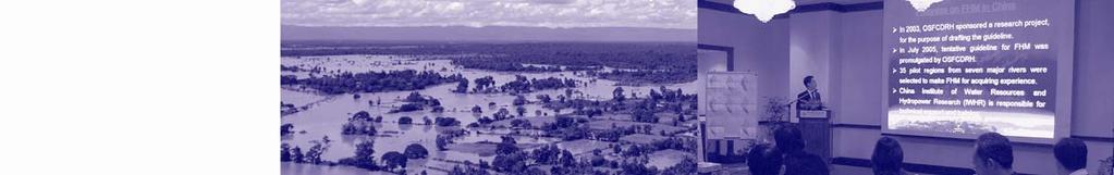
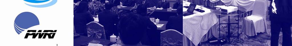
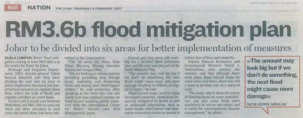
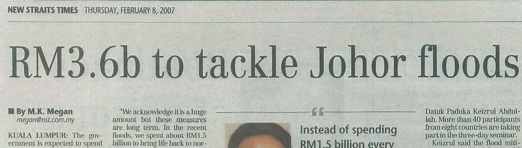
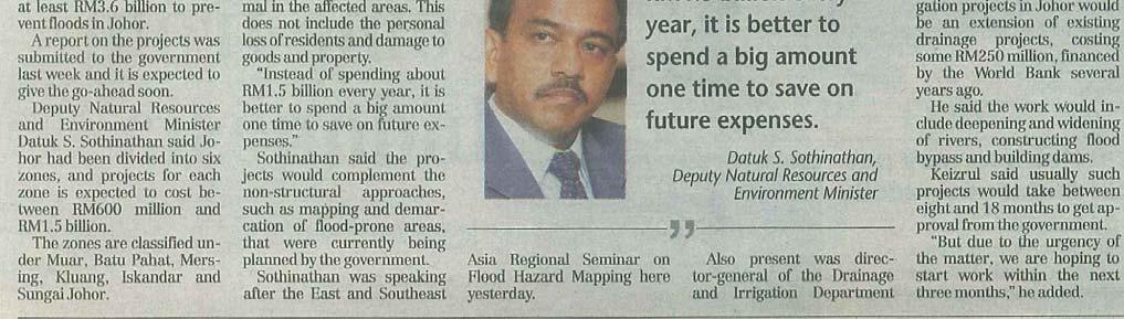
11 Chapter 2 Seminar overview 2.1 First follow-up seminar Seminar overview The first follow-up seminar was held on 7-9 February 2007 at Renaissance Hotel in Kuala Lumper, Malaysia, as a joint effort by ICHARM, the Japan International Cooperation Agency (JICA), and the Department of Irrigation and Drainage (DID), Malaysia. Appendix 2-1 is the seminar program. The seminar invited former trainees of the flood hazard mapping training course held in the fiscal years Photo 2-1 Greeting by Mr. Y. B. Datok S. Sothinathan, deputy minister of the Natural Resources and Environment Ministry, Malaysia of 2004, 2005 and They had to be involved in promotion of flood hazard mapping in their home countries after the training. The seminar offered an opportunity for them to report on activities to produce and disseminate flood hazard maps, share knowledge and experience on successful cases and issues they were facing, and discuss solutions to such issues. In addition, opinions and requests were collected to improve the flood hazard mapping training course for Photo 2-2 Greeting by Mr. Yoshinobu Ikura, prospective trainees. deputy director of the JICA Malaysia Office Seventeen former trainees from Cambodia, China, Vietnam, Indonesia, Laos, Malaysia, the Philippines, and Thailand joined the seminar in addition to over 10 engineers from DID. Appendix 2-2 is the list of the seminar participants, including two special lecturers, Dr. Manzul Hazalika of the Asian Institute of Technology (AIT) and Dr. Arun B. Shrestha of the International Centre for Integrated Mountain Development (ICIMOD). The seminar began with greetings by Mr. Y. B. Photo 2-3 Presentation & Discussion Datok S. Sothinathan, deputy minister of the Natural Resources and Environment Ministry, Mr. Yoshinobu Ikura, deputy director of the JICA Malaysia Office, Mr. Keizrul bin Abdullah, director of DID. Local media showed high interest in the seminar and sent more than 20 staff members to the opening ceremony. 5

12 In a press conference after the seminar, the deputy minister commented on investment in flood countermeasures, saying Instead of spending RM 1.5 billion every year, it is better to spend a big amount one time to save on future expenses. His comment was reported in local morning newspapers, including THE STAR and NEW STRAITS TIMES (see appendix 2-3), which reflected rising public interest in reduction of flood damage nationwide due to major flood Photo 2-4 Presentation & Discussion events between December 2006 and January 2007 in Johor Province, located in southern Malay Peninsula. His remark is a proof that the nation is reaching quite a high level of awareness in strengthening flood countermeasures. Such awareness is expected to lead to dissemination of flood hazard maps as a complementary tool to structural measures Seminar results According to participants reports, in China, Thailand and Malaysia, anticipated inundation area maps and flood hazard maps were produced for pilot districts selected for flood hazard mapping. In the Philippines, community-based flood hazard mapping were attempted. Flood hazard maps were produced through meetings and interviews with residents living in flood-prone areas to reflect their needs in the maps. A similar project was going on in Malaysia. These implementing efforts were also uncovered many challenges to be addressed to further promote flood hazard mapping. Reports explained that there were areas still lacking topographical data necessary for inundation analysis or characterized by low disaster awareness among residents. Even after producing flood hazard maps, it was reported to be sometimes very difficult to release the maps for the general public because of the opposition from local residents and land owners or lack of appropriate legal frameworks. On-going projects in the Philippines and Malaysia could be model cases which presented possible solutions to those problems through public involvement in flood hazard mapping. Furthermore, participants reports revealed different views to floods between Japan and other countries. For example, among Malaysian respondents to public questionnaire, 52% answered that they would protect private cars rather than people in case of flooding. In the seminar, participants also voiced their requests to ICHARM. Many of them hoped for technical support for flood hazard mapping, such as flood analysis and GIS. Based on such feedback, ICHARM improved the 2007 training course and launched Flood Hazard Map Help Desk at the ICHARM website in June 2007 for inquiries on flood hazard mapping. 6

13 Photo 2-5 Group photo 7
 with support from the")


14 2.2 Second follow-up seminar Photo 2-6 Group Photo Seminar overview The second follow-up seminar was held on 30 January to 1 February 2008 at Fontaine Bleau Hotel in Guangdong, China. ICHARM co-hosted the seminar with the Office of State Control and Drought Relief Headquarter of China Photo 2-7 Opening Ceremony (OSFDH) with support from the Japan International Cooperation Agency (JICA). Appendix 2-4 shows the seminar program. As listed in appendix 2-5, ICHARM invited 12 people for this seminar from seven countries including Cambodia, China, Indonesia, Laos, Malaysia, the Philippines, Thailand and Vietnam (unfortunately, the Vietnamese participant was absent due to other obligations). They were selected from former trainees Photo 2-8 Presentation and Discussion in the past four years. The opening ceremony was held on the first day of the seminar. Seminar participants were welcomed and greeted by Mr. TIAN Yitang, vice director of SFDH, Mr. WANG Jiancheng, vice 8
.")
.")
15 director of the Guangdong Bureau of Water Resource (GBWR), Mr. Minoru Okada, deputy director of the JICA China Office. The ceremony was followed by presentations and discussions. On the second day, participants attended a lecture by Dr. Mansul Hazalika of the Asian Institute of Technology (AIT). After that, they took a field trip to the flood control system of the North Pearl River to see levees, water gates, dams and other structures. On the final day, a round-table discussion was held after a special lecture by Dr. Li Na, senior engineer of the China Institute of Water Resources and Hydropower Research (IWHR). In the afternoon, IWHR presented a pilot project of flood hazard mapping in China, and ICHARM staff answered questions asked by participants about flood hazard Photo 2-9 Presentation and Discussion mapping. To end the seminar, Dr. CHENG Xiaotao, director of IWHR, made closing remarks, and the participants were awarded with the certificate of seminar participation. Photo 2-10 Closing remarks by Dr. CHENG Xiaotao Seminar results One of the important points in the second follow-up seminar was to find how much progress each country had made in flood hazard mapping projects since the first seminar and what problems they were facing. China and Malaysia reported the most progress from the previous year. Both countries increased the number of areas with flood hazard maps (China: over 200 locations in 36 areas, Malaysia: several types of map in two areas). They also improved flood simulation necessary to produce anticipated inundation area maps by setting more realistic conditions based on local conditions and past flood records. Furthermore, they were promoting data collection and preparation essential in flood hazard mapping. However, in both countries, flood hazard maps were only for administrative purposes and were not made available for the public. In Cambodia and Indonesia, flood hazard mapping projects with overseas research institutes were in progress at pilot locations, and anticipated inundation area maps were not produced for those locations. Joint projects of this kind should be a promising option for countries that face financial as well as technical difficulty preparing flood hazard maps independently. Thailand was another country in which former training course participants were earnestly 9
16 promoting flood hazard mapping. Anticipated inundation area maps had already been produced for pilot locations and were going to be posted on large sign boards which would be installed in different places around the locations. In the Philippines, flood hazard mapping continued being implemented on a community basis. Flood simulation and other advanced techniques had not been employed yet, but there were high expectations that public involvement would result in flood hazard maps that would meet community needs. Laos was working on data collection and database development for flood hazard mapping, although the efforts had not yet result in tangible achievement. On the final day of the seminar, all participants attended the round-table discussion and talked about the practical use of flood hazard maps. The discussion topics are listed as follows: 1. Components currently deeded most necessary in flood hazard mapping (besides inadequate topographical data) - GIS training - Institutional frameworks - Financial resources and expertise - Guidelines, manuals, hydrological data - Flexibility in selecting community-based or more technically advanced flood hazard maps - Selection of community-based flood hazard mapping to cope with lack of data (to a certain extent) - Methods to improve disaster awareness at the community level - Cooperation among stakeholders and relevant organizations - Production of flood hazard maps and improvement in administrative issues related to policy making, legal frameworks, legal incentives, policy makers, etc. - Needs classification for flood hazard maps and development of flood hazard maps to meet specific needs - Evacuation plans 2. Necessary reference sources and tools - Dissemination of (international) guidelines and knowledge - Basic information on flood hazard mapping for policy makers - Results and research papers on application of run-off modeling and inundation modeling - Training for leaders - Comparison of results based on different simulation models 3. Necessary technical advice -How to acquire necessary information such as GIS data, data source, requirement, etc. 10
 -Methods to define the return period of an inundation/flooding To further improve flood hazard mapping, seminar")

17 -Numerical models -Prediction methods for landslides, debris flows and flash floods and training to learn such methods -Improvement in executable, existing data based on on-site investigation (GPS can be a helpful tool) -Methods to define the return period of an inundation/flooding To further improve flood hazard mapping, seminar participants commonly voiced the necessity for developing flood hazard mapping guidelines in addition to database development and acquisition of advanced mapping techniques. ICHARM promised to work on those issues to improve the training course. Photo2-11 Field survey to flood control system of the North Pearl River Photo2-12 Welcome board 11
. Appendix Photo 2-13 greeting by Hon. Estrella F.")


18 2.3 Third follow-up seminar The third follow-up seminar was held in February 2009 at Edsa Shangri-la Hotel in Manila, the Philippines. The seminar was co-hosted by ICHARM, JICA and the Philippine Atmospheric, Geophysical and Astronomical Services Administration (PAGASA). Appendix Photo 2-13 greeting by Hon. Estrella F. Alabastro 2-6 is the seminar program. It was attended by 31 participants selected from former trainees in the past five training course at ICHARM as listed in appendix 2-7. They were from 10 different countries including Bangladesh, China, Indonesia, Nepal, Laos, Malaysia, the Philippines, Thailand, Vietnam and Japan. The diversity of the participants nationalities and viewpoints made discussions interesting and insightful. This seminar was a special occasion particularly Photo 2-14 Special lecture by Dr. for ICHARM staff because they were meeting again Susan R. Espinueva with Dr. Prisco D. Nilo, director of PAGASA, and Dr. Susan R. Espinueva again, whom they had met in November 2004 on their tour to potential target countries for this flood hazard mapping training course at the planning stage. On the first day, the opening ceremony was held in the presence of honorable guests. Participants sang the Filipino national anthem and were greeted by Dr. Prisco D. Nilo, director of the Department of Science Photo 2-15, 16 Images of local TV News (Up: Dr. and Technology of PAGASA, and Dr. Jayawardena Susan, Under: Dr. Jayawardena Amithirigala) Amithirigala, research and training advisor of ICHARM. A few other guests, including Mr. Norio Matsuda (manager of JICA Philippine Office), Mr. Hirosato Yoshino (second secretary of the Japanese Embassy), and Hon. Estrella F. Alabastro (secretary of the Department of Science and Technology of PAGASA), also spoke at the ceremony. The seminar on the first day was televised in a local news program. 12


19 The opening ceremony was followed by a special lecture by Dr. Susan R. Espinueva of PAGASA on Community-Based Early Warning System. She concluded her lecture by saying, The success of an early warning system is implicit in the operative capability and the response of the community which operates it. Her remark was of great importance especially to ICHARM, because the concept was exactly in line with the promotion of Photo 2-17 Problem analysis of Project Cycle Local Practices, one of ICHARM s focus areas. It Management certainly reminded them of the crucial role of the community in disaster management. After the lecture, seminar participants from different countries made 15-minute presentations on progress and issues on flood hazard mapping in their countries and had discussions based on them. (See Chapter 3 for more information on the presentations.) On the second day, in the morning session, Photo 2-18 Presentation by Ms. participants were divided into four groups and tried Anabelle L. Cayabyab Problem Analysis to clarify their issues related to flood hazard mapping. Problem Analysis was a part of the Project Cycle Management exercise. In the afternoon, they visited Kawit City in Cavite Province, located south of Metro Manila, and attended a presentation by Ms. Anabelle L. Cayabyab on community-based flood hazard mapping activities led by JICA. Her presentation revealed that the community was involved in not only hazard mapping itself but also activities to enhance disaster preparedness on a local basis, including the Town Watching exercise as part of the mapping process. Deputy Mayor Orange was also present at the presentation. He greeted the audience and briefly explained the city s efforts in flood hazard mapping. Seminar participants also learned that community leaders felt grateful for the flood hazard mapping activities. It was a pleasant surprise to find out that flood hazard mapping had made more progress in the Philippines than expected. Following the field trip to Kawit City, the director of PAGASA invited the seminar participants to a welcome party at PAGASA. The occasion helped seminar participants including ICHARM staff deepen the friendship and partnership. On the final day, ICHARM staff explained about a flood hazard mapping guideline on which the centre was working. Also, the seminar confirmed the current status of flood hazard mapping and the achievement goal for each country. Finally, five primary issues on flood hazard mapping were given to participants for discussions, which helped them learn more about and gain better 13

 Figure 2-1 Flood Hazard Map in Brgy.")

20 understanding of FHM. (See Chapter 3 for more information on the discussions.) Figure 2-1 Flood Hazard Map in Brgy. Potol-Magdalo, Kawit Photo 2-19 Overall discussion Photo 2-20 Dr. Jayawardena shakes hands with Ms. Paridah, moderator of the discussion 14

21 The seminar ended successfully with the closing ceremony. Each participant was awarded with a certificate for completing the seminar by PAGASA Director Nilo, ICHARM Advisor Jayawardena and ICHARM Team Leader Shigenobu Tanaka. Ms. Li Na and Ms. Paridah were additionally prized with a special present by ICHARM for their contributions to the seminar as moderators. Photo 2-21 The participants pose for photos after the opening ceremony. 15
22 Chapter 3 Progress of FHM-related activities in Asian countries 3.1 Current status of flood hazard mapping Before the third seminar, ICHARM requested each participant to make a Progress Report to understand the current status of flood hazard mapping in each country and to make a brief presentation on the report at the seminar. The contents of the report are shown Appendix 3-1. Each presentation needed to categorize the current flood hazard maps by types A-G shown in Table 3-1. Table3-2 in the next page shows each image. Table 3-1 FHM category according to difficulty of production Type A Type B Type C Type D Type E Type F Type G Location map not including elevation data Location map including elevation data Past inundation area of a single past flood (ex: maximum flood) Past inundation areas of several large floods with corresponding rainfall Past inundation area based on simulation (ex; design flood is the biggest past flood) Inundation area of the design flood bigger than past floods Indication forecast by real time analysis Seminar participants were also asked to make comments on the following items. Comparison between the design return periods of structures and that of FHMs Whether residents are involved in the development of FHMs or not Table 3-3 shows that all the participating countries except Bangladesh had developed some kind of flood hazard maps including JICA-led hazard maps. In Malaysia, type-c FHMs using past inundation depth data were made all over the country. Also, type-f FHMs using hydrological simulation were in progress in seven basins. In China, the Office of State Flood Control and Drought Relief Headquarters (OSFCH) designated the years as the second phase to produce effective FHMs. They developed over 300 FHMs of mainly type E or F in the first phase and also held two domestic flood hazard mapping seminars. In the Philippines, 165 FHMs of 1/50,000 had already been produced for 236 areas all over the country. Over 10 FHMs of 1/10,000 were in progress as the PAGASA-UNDP READY PROJECT. In Thailand, every type of FHMs had already been made. Hydrological and topographical data were available in Thailand and accurate enough for making FHMs. 16

 Map without inundation analysis but including past inundation")


23 Map without inundation area Table 3-2 List of Maps according to the level A: Location map not including elevation data B: Location map including elevation data Map showing past inundation areas C: Past inundation area of a single past flood (ex: maxinum flood) Map without inundation analysis but including past inundation area Map predictable inundation area D: Past inundation areas of several large floods with corresponding rainfall E: Past inundation area based on simulation (ex; design flood is the biggest past flood) Map based on inundation analysis F: Inundation area of the design flood bigger than past floods G: Indication forecast by real time analysis 17
24 Country Type of FHMs Area/City Bangladesh Malaysia Indonesia G (Inundation map, large scale) B (large scale) A (medium scale) A +B C 1. Entire country 2. Dhaka city Table 3-3 Types of the current flood hazard maps in the participant country Design Structures Return Period 25 to 50 year N/A Entire country 25 to 50 year N/A Entire country & up to district level Entire country D none yet F G G entire country (up to year 2000) also available 2006 and 2007 floods Damansara catchment ready, 5 river basins expected by end of the year Target for Klang River and Muda River enof this year or next year Jakrta (Ciliwung basin) C Java, Kalimantan, Sumatra Island C Wenzhou,Guangzhou 25 to 50 year N/A FHM Reasons -Only used for flood forecasting and warning -Not yet plan to produce for residents as FHM -Not revised recently -No plan yet to be used as FHM -Not updated -Not used for FHM yet -Only used as administrative map Urban- 100 years Simulated- 100 years based on topographical data Not yet Rural (agriculture) - 25 years Canal:100 Rivers:100 Pond:25 Macro drain:10 Micro drain:5 If simulated not available -maximum flood will be used 1,2,5,10,25,50,100 for the states of Pahang, Kelantan and Johor, Koa Tinggi on the way for dissemination can be derived as rainfall data can be extracted Due to land constraint, it would be still have inundated area Residents are Involved in the Development of FHMs No No No It is start with 2 sub district (Kewrahan) involving community participation, will be used a same method for the whole Jakrta. Local people are involved at field survey stage. China (Cities) China (Reservoirs) China (Flood Detention D E F Shanghai, Baoding,Wuzhou Shanghai,Chengdu,Guangzhou,Foshan,Yiyang Shanghai,Chengdu,Wenzhou,Baoding,Guangzhou, Foshan,Wuzhou,Yiyang,Lianyungang F Danjiangkou, Feilaixia, Yuecheng,Guanshan / F Jinjiang,Pajiang,Pangtoupao, Huangdunhu,Linanyuan,Wenanwa 50~200 (requested by FHM guideline) 5,10,20,50,100 for flood or heavy rain Inundation map, Dam failure flood risk map, Maximum discharge flow for downstream areas / Designed flood division discharge quantity Needs Regulations of the FHM Guidelines Local Condition for FHM (Data,Budget,Technical) 18 18
25 Country Type of FHMs Area/City Areas) Design Structures Return Period FHM Reasons Residents are Involved in the Development of FHMs China (Embankment Protective areas) F Beijing Embankment Protective areas, Left bank Protective areas of Yihe River,etc. 50~100 Inundation map of designed flood flooding at different dike broken locations Philippines B Entire country C D- E Manila, Bataang Taguig, Ilo Damau, Butuwan, Ilo, Walangapo, Ligan,Palangbaan, Cavite, Armock, Anhelas Tarlac, Abno, Cavite, Ormo, Camaguin, Loaog 25 B Entire country a lot of formal information available No C Past flood event area Inform and revise with historical data from residential stakeholder. Verification Procedure Thailand E Lampang municipality 500,100,50,25 10,20,50 Data and budget available, High technology Verification Procedure F Nan municipality Data and budget available, High technology Verification Procedure G Pasak basin Data and budget available, High technology Verification Procedure 19 19


 started FHM as a pilot project.")

26 3.2 Current efforts in flood hazard mapping in each country The following are excerpts from the participants reports. In Bangladesh, where annually 22%, over 60% in worst cases, of the national land is flooded, little effort has been made in flood hazard mapping, and no legal framework has been established concerning flood hazard mapping. But during the flood season, every day the Flood Forecasting and Warning Centre makes 24 hour and 48 hour forecasted inundation maps and produces flood reports based on those maps. The reports provide information on whether the water level has crossed the danger level or not and if it has, how much. They are also posted on the website ( China has been active in flood hazard mapping. In 2004, the Office of State Flood Control and Drought Relief Headquarters (OSFCH) started FHM as a pilot project. They designated the years as the first phase and as the second to produce effective flood hazard maps for various parts of the country. They developed over 300 hazard maps of type E or F in the first phase and also held two flood hazard mapping seminars by themselves. However, no flood hazard maps have been made available for public use. Malaysia has produced flood hazard maps to cover the entire national land based on past inundation records, although the maps for Kota Tinggi Province are the only ones with inundation depths. They have also produced flood hazard maps based on hydrological simulation for the Damansara basin and are currently working on the same kind of maps for other six river basins. They are planning to Figure 3-1 Forecasted inundation map in Bangladesh Figure 3-2 Example of FHM in China Figure 3-3 Example of FHM in Malaysia 20


27 produce 30 flood hazard maps by Indonesia has been promoting the production of type-g flood hazard maps, having recognized the importance of this type due to the 2007 flood in Jakarta. They have developed flood hazard maps for design floods of different return periods of 1, 2, 5, 10, 25, 50 and 100 years. Like China, however, Indonesia has not made such maps available for public use. In Laos, a fewer number of people are killed in flooding because it occurs very slowly. However, they have produced flood risk maps for one of its six river basins and are developing for two others. After the 2007 flood in the Xedone River basin, flood hazard maps were produced for that basin. Figure 3-4 Example of FHM in Indonesia Figure 3-5,6 Example of FHM in the Xedone River basin in Laos (Left: Flood depth, Right: Flood duration) 21


28 In Nepal, JICA-led flood hazard mapping projects started in Flood hazard maps have so far been produced for nine river basins. Despite this active production of the maps, the country has neither made them available for the public nor highly recognized their effectiveness in disaster management from the outset. In the Philippines, flood hazard mapping projects are led by PAGASA and the Mines and Geo-sciences Bureau of Department of Environment and Natural Resources (MGB). They have divided the country into 236 zones to produce 1:50,000-scale flood hazard maps and already completed mapping for 165. They have also developed 1:10,000-scale flood hazard maps for more than 10 zones in the PAGASA-UNDP READY PROJECT. Thailand has been active in flood hazard mapping and developed all types of flood hazard maps except type D. They think that at least type-f maps are necessary to issue effective flood warnings. All hydrological data necessary for flood hazard mapping are available for all the basins in the country, and DEM data are being prepared for the entire national land. Thailand has already equipped with knowledge and technologies for hazard mapping at a substantial level, and what it needs now is policies for the activity. There are no legal framework and government agencies to promote it. Figure 3-7 Example of JICA-led FHM in Rupandehi district, Nepal Figure 3-8 Example of FHM in Olongapo City in the Philippines Figure 3-9 Example of FHM in Olongapo City in the Philippines 22
29 3.3 Needs for FHMs To understand the needs for FHMs, the participants were engaged in discussions on the below five themes on the seminar s final day. The following are brief summaries of the discussions. Theme 1: What kind of Flood Hazard Map do you need? We should aim to produce simple flood hazard maps so that they will be easy to read and understand. (Philippines) We need flood hazard maps that show inundation areas simulated based on floods with different return periods and inundation depths based on past flood records. (Philippines) Different types of flood hazard maps should be produced depending on purposes and organizations responsible for mapping. Hazard map easy to make like Type A or C (China) Prefectural and municipal offices uses flood hazard maps produced based on both past records and simulation results. However, simpler versions are more effective at the local level. (Indonesia) Flood hazard maps should be produced based on needs of local residents. Two maps or more may be produced even within a single area to meet different needs. (Thailand) GIS analysis is effective even at the community level. In some cases, multiple flood hazard maps are produced for a single area. They should be integrated into one. Types B and C are good enough for less populated local areas. More scientific maps, types G and F, are needed for urban areas. (Laos) Type C is simple and satisfactory. Type G is necessary for early forecasting and warning. Theme 2: Why do you need such FHM? In many cases, to reduce the impacts of floods. Flood hazard maps are also useful to some degree in development planning and land use planning. (Philippines) Flood hazard maps should be closely linked with structural measures. With the design flood set at a return period of only 25 years, structural measures can give a wrong sense of safety to those concerned and local communities. (Philippines) Because flood hazard maps are inexpensive and largely available. We need them for policy development, and donor organizations also need information provided by them to carry out projects. (Nepal) Our flood control structures are old. We need supplementary tools. (Indonesia) To provide people with flood forecasts and warnings that are simple, easy to understand 23
30 and trustworthy. (Thailand) Flood hazard maps are necessary for people to know anticipated inundation areas in all river basins and communities in flood-prone areas, as well as for the government to make development plans. (Vietnam) Theme 3: How do you use FHM? How do you improve the use of FHM? To identify locations and types of buildings in flood-prone areas. (Philippines) To plan land use. (Laos) Flood hazard maps should be linked with flood fighting. They can be used to identify areas that require monitoring during the typhoon season. To identify who will be most affected in which area. To use in land use planning to properly locate housing areas and farmland. To assess vulnerability in relation to use of existing infrastructure. Many levees have been built in Bangladesh, but they are easily erodible. The government and communities should be informed of possible consequences of development on the environment. Flood hazard maps should be used to keep a balance between development and environmental conservation. Flood hazard maps are necessary for community leaders to manage flood evacuation drills. Theme 4: What kind of information should be included in a training material? Basic information about rivers. Instructions about how to conduct a field investigation and how to read maps with contours. Basic information about technologies such as HEC-HMS. Training should be separately prepared depending on needs and conditions of target countries or regions; for example, training for local communities, training for developing countries, training for areas with adequate or inadequate data. Information on how to prepare, improve or modify data. Information on how to effectively distribute flood hazard maps to residents in addition to how to produce them. Multiple training modules should be available for users to choose depending on their level. Users should be informed in advance of disadvantages brought by flood hazard maps. Theme 5: About Community-based activities The community-based approach is effective when little hydrological data are available. However, technological advice from experts is necessary. Since we are fundamentally serving for residents, we need to keep this approach in mind as a valid option. It takes a lot of time to produce technologically sound flood hazard maps. We should be 24
31 always aware that community-based flood hazard maps can be a quick solution that also costs a lot less. Community-based hazard maps are hard to produce for areas where houses are scattered around. Younger residents are usually not willing to participate in such activities. The elderly and retired are sole participants in many cases. In China, local residents participate in field investigations for flood hazard mapping. In particular, elderly people who have experienced floods can give advice to engineers. Public involvement is crucial. There are volunteers who issue warnings at emergencies in every community. For example, if a typhoon warning is issued, fishermen will volunteer to let other people know about the warning. A best way to get cooperation from people is to interview them and collect information right after a disaster. If they are well aware of hazards and flood risk, they are often willing to participate in and support such activities. 3.4 Conclusion For Community based flood hazard map activities- One of the results revealed in the third seminar was that each participating country had reached quite a high level of flood hazard mapping with support from JICA or other organizations. However, participants voiced the needs for FHMs which are easy for residents to understand. In other words, they were thinking that FHMs which require advanced hydrological or topographical data are not always necessary. Considering the increased level of flood hazard mapping, what those countries needed next was to find out how they could effectively use flood hazard maps to reduce flood damage. In reality, no participating country had any legal system for distributing FHMs from governments to residents. This means that even though maps had been produced, they had not been available for people. However, in some cases, residents realized that they could make their own maps by themselves with their knowledge. In this context, Dr. Susan s special lecture about community-based disaster management and the subsequent field trip were effective. They emphasized the importance of community-based evacuation planning combining flood hazard maps and a flood forecasting and warning system. They were good concrete examples and gave the seminar participants a clear image of what should be done. We hope that more countries will start to implement such projects. Community-based flood hazard mapping has great advantages compared with regular mapping. Generally, flood hazard maps are produced in the following procedure: Step 1) Collection of hydrological and topographical data, Step 2) Inundation simulation, Step 3) Production of anticipated inundation area maps, Step 4) Distribution and explaining about flood hazard maps to residents. However, with community participation, these four steps can be conducted almost 25
32 simultaneously, and residents may be able to increase disaster awareness several times (Figure 3-10). In the third seminar, in which the program and field trips were organized from a viewpoint of community involvement, the seminar participants looked closely at community-based flood hazard mapping activities. This experience must have had them reflect on use of flood hazard maps in developing countries. Each step takes time and effort. Standard flood hazard mapping (Delay or cessation is highly possible.) 1. Collection of hydrological & topographical data. Are the data reliable? 2. Inundation simulation Is the simulation model reliable? 3. Production of anticipated inundation area maps Are the results reliable? 4. Distribution and explain to residents Are there any complains about decrease in asset value? Any increase in residents disaster awareness? Community-based flood hazard mapping (Production, dissemination & disaster awareness raising can be done simultaneously.) Hydrological & topographical data are not always necessary. Inundation simulation is not always necessary if past inundation records are available. Residents led by disaster management leaders conduct Town Watching to check potentially dangerous places and evacuation sites. This will increase the sense of involvement, the sense of community and also their disaster awareness. Mapping Town Watching findings is not always necessary. Figure 3-10 Comparison between standard and community-based flood hazard mapping 26
33 Chapter 4 Conclusion The third seminar was held as the concluding meeting of the five-year training program on flood hazard mapping. Enthusiastic discussions among the participants led the meeting to produce significant results. Flood hazard maps is the general term for maps conveying information on flood hazards. In fact, they vary widely among countries depending on flood characteristics and historical and social backgrounds. We, the seminar organizers, are aware that each country has different needs and conditions because of that and did not intend to hold the seminar to show a universal way of producing and using flood hazard maps. We only hoped that the seminar can provide hints to improve flood hazard mapping projects in the participating countries by discussing differences in how they are working on such projects. The first three of the five-year flood hazard mapping training program emphasized its technical aspects, and little was introduced in terms of its use. That was also the case with the first two follow-up seminars. However, we came to understand the importance of communities role in disaster management when conducting other training courses such as the UN/ISDR Comprehensive Tsunami Disaster Prevention Training Course. We realized that community-based flood hazard mapping can be much more effective and efficient in disaster management than acquiring only flood hazard mapping skills. At emergencies such as disasters, people often cannot count on national and local governments for protection. They will have only themselves to protect themselves from disasters. However, what each individual can do is limited. That is why the role of community is emphasized in disaster management. We at ICHARM will continue research on community-based flood hazard mapping and apply research findings to the new training course, Local Emergency Operation Plan with Flood Hazard Map, and development of a Flood Hazard Mapping Guidelines, which should be useful even in developing countries. 27
34 - Acknowledgements - ICHARM is greatly indebted to many people and organizations for the successful operation of these follow-up seminars. Participants arranged their busy schedules to spare considerable time for making reports and joining seminars. We would like to give special thanks to each co-organizer, the Department of Irrigation and Drainage (DID) of Malaysia, the Office of State Control and Drought Relief Headquarter of China (OSFDH), and the Philippine Atmospheric, Geophysical and Astronomical Services Administration (PAGASA) for their tremendous efforts and cooperation dedicated to the seminars. We could never thank them enough for all they did. 28
35 Appendix 2-1 Program of the first seminar
36 EAST & SOUTHEAST ASIA REGIONAL SEMINAR ON FLOOD HAZARD MAPPING, KUALA LUMPUR 7-9 FEBRUARY 2007 In Function Room 9-10, Renaissance Kuala Lumpur Hotel, Kuala Lumpur In Opening Ceremony, Presentation, Dinner party and Excursion, facilitated by DID In Discussion and Cocktail Reception, facilitated by ICHARM Time Day 1: Wednesday, 7 February 2007 Participants 08:00-09:30 Registration Opening Ceremony 9:30-9:45 Welcoming Address VIP Malaysia Y.Bhg. Datuk Ir. Hj Keizrul Bin Abdullah, Director General of DID ICHARM 9:45-9:55 Opening Address 1 by DID Hiroshi Umezaki, Resident Representative, JICA Malaysia Office JICA 9:55-10:15 Opening Address 2 by Ex-trainees Y.B. Datok S. Sothinathan, Deputy Minister of Natural Resources and Environment Malaysia HTC 10:15-10:30 10:30-11:30 Coffee Break (Press Conference) Invited Lecturers: Capacity Building in Applications of Geoinformatics in Flood Hazard mapping ICHARM, Local & Manzul Kumar Hazarika from AIT Thailand Int. Ex-trainees, 11:30-13:00 Lunch 14 DID Selectees 13:00-13:15 Flood Early Warning System in the Philippine Eastern Seaboard: Province of Surigao del Sur including HTC, and Hilario De Guzman Esperanza from Philippines Lecturer/s 13:15-13:30 Flood Hazard Mapping in Cambodia Tong Seng from Cambodia 13:30-13:45 Presentation by ex-trainees of Flood Hazard Mapping training course Pheng Seangmeng from Cambodia 13:45-14:00 Presentation by ex-trainees of Flood Hazard Mapping training course Chanthachith Amphaychith from Lao PDR 14:00-14:15 Presentation by ex-trainees of Flood Hazard Mapping training course Papon Ruksee from Thailand 14:15-14:30 Flood hazard map of Lampang municipality, Thailand Somchit Amnatsan from Thailand 14:30-15:15 Discussion 15:15-15:45 15:45-16:00 Coffee Break Progress and Pilot Practice of Flood Hazard Mapping in China Luo Xiaoqing from China 16:00-16:15 Flood Hazard Mapping in China Deng Yu Mei from China 16:15-16:30 Presentation by ex-trainees of Flood Hazard Mapping training course Pham Hong Nga from Vietnam 16:30-16:45 Flood Hazard Mapping in the Philippine Eastern Seaboard: Province of Surigao del Norte Socrates Ferido Paat, Jr from Philippines 16:45-17:00 Community Based Flood Warning in Camiguin Island, Philippines Grecile Christopher R.Damo from Philippines 17:00-18:00 Discussion 19:00-20:30 Cocktail Reception by ICHARM, PWRI, Japan Time Day 2: Thursday, 8 February :00-9:30 Presentation by ICHARM ICHARM, Local & Shigenobu Tanaka, Team Leader of International Technical Exchange Team, ICHARM Int. Ex-trainees, 9:30-10:00 Presentation by Director, HTC Kuala Lumpur 14 DID Selectees 10:00-10:15 Coffee Break including HTC, and 10:15-10:30 Presentation by ex-trainees of Flood Hazard Mapping training course Lecturer/s Subejo from Indonesia 10:30-10:45 Presentation by ex-trainees of Flood Hazard Mapping training course Hj. Jalil bin Hassan from Malaysia 10:45-11:00 Presentation by ex-trainees of Flood Hazard Mapping training course Pn. Paridah Anun and Md. Anuar from Malaysia 11:00-11:15 Presentation by ex-trainees of Flood Hazard Mapping training course Hj. Ariffin bin Mahamud and Cik Hazalizah binti Hamzah from Malaysia 11:15-12:00 Discussion 12:00-13:30 Lunch 13:30-18:00 Excursion to the nearest FHM applied area (Taman Tun Dr. Ismail Jaya) 20:00-22:00 Dinner party by Government of Malaysia Depend on DID Time 9:00-10:00 Day 3: Friday, 9 February 2007 Invited Lecturers: Flash floods in the Himalayas and vulnerability analysis ICHARM, DID Arun B. Shrestha from ICIMOD Nepal Ex-trainees, HTC 10:00-10:30 10:30-11:40 Coffee Break Round Table Discussion & Seminar conclusion and recommendation 11:40-12:00 Closing Address by ICHARM
37 Appendix 2-2 Participant list of the first seminar


38 List of Attendance for the Follow-up Seminar in Malaysia No. Country Sex FAMILY / First name No. Country Sex FAMILY / First name 1 Cambodia 2004 Mr. TONG Seng 10 Malaysia 2005 Ms. HAZALIZA Binti Hamzah 2 Cambodia 2005 Mr. PHENG Seangmeng 11 Malaysia 2006 Mr. ARIFFIN Mahamud 3 China 2004 Ms. DENG Yumei 12 Malaysia 2006 Mr. ANUAR Md Ali 4 China 2005 Mr. LUO Xiaoqing 13 Philippines 2004 Mr. DAMO Grecile Christopher RIGODON 5 Indonesia 2005 Mr. SUBEJO 14 Philippines 2004 Mr. PAAT Socrates, Jr. FERIDO 6 Laos 2005 Mr. Chanthachth AMPHAYCHITH 15 Philippines 2005 Mr. ESPERANZA Hilario de Guzuman 7 Malaysia 2004 Mr. ABD JALIL Bin Hassan 16 Thialand Mr. Mr. AMNATSAN Somchit 8 Malaysia 2004 Ms. PARIDAH ANUN Bt. Tahir 17 Thialand Mr. Papon Ruksee 9 Malaysia 2005 Mr. Miklin Bin ATIONG 18 Vietnam 2004 Ms. PHAM Hong Nga
39 Appendix 2-3 Article of local newspapers
40
41 Appendix 2-4 Program of the second seminar
42
43
44
45 Appendix 2-5 Participant list of the second seminar
46 List of Attendance for the Follow-up Seminar in China No. Name of participant Country Position Address/Organization year 1 Mr. Tong Seng Cambodia Vice Chief Department of Hydrology and River Works, Ministry of Water Resources and Meteorology Mr. Preap Sameng Cambodia Official 3 Mr. Dudi Gardesi Asikin Indonesia Department of Hydrology and River Works, Ministry of Water Resources and Meteorology Department of Public Works, Government of Special Capitol Territory of Jakarta Province Mr. Thiangthammavong Sangkhane Lao PDR Director of Secretariat Lao National Mekong Committee Secretariat (LNMCS), Prime Minister's Office Ms. Paridah Anun Bin. Tahir Malaysia Senior Assistant Director Department of Irrigation and Drainage, Ministry of Natural Resources and Environment Mr. Anuar Md. Ali Malaysia Civil Engineer Department of Irrigation and Drainage, Ministry of Natural Resources and Environment Mr. Grecile Christopher R. Damo Philippines Department of Public Works and Highways Mr. Hirario De Guzman Esperanza Philippines Engineer III Department of Science & Technology, Philippine Atmospheric Geophysical and Astronominal Services Administration(PAGASA) Ms. Jimenez Elda Gerada Philippines Municipal Engneer Local Government of the Municipality of Pateros Mr. Amnatsan Somchit Thailand Chief The Royal Irrigation Department Dr. MANZUL KUMAR HAZARIKA Thailand Asian Institute of Technology - 12 Ms. Pham Hong Nga Vietnam Lecturer 13 Mr. Lai Tuan Anh Vietnam Lecturer Hanoi Water Resources University, Ministry of Agriculture and Rural Development Hanoi Water Resources University, Ministry of Agriculture and Rural Development Dr. LI Na China China Institute of Water Resource and Hydropower Research - 15 Ms. Yumei Deng China Deputy Director Office of State Flood Control and Drought Relief Headquater, Ministry of Water Resources Mr. Chunpeng Sun China Technical Staff Department of Water Resources,Ministry of Public Works Mr. Luo Xiaoqing China Civil Servant Office of State Flood Control and Drought Relief Headquater, Ministry of Water Resources Mr. Wang Jinxing China Bureau of Hydrology, Ministry of Water Resources Ms. Xu Jing China Engineer 20 Ms. Du Xiaohe China Engineer 21 Mr. Huang Xianlong China Engineer 22 Mr. Xu Xianbiao China Senior Engineer Office of State Flood Control and Drought Relief Headquater, Ministry of Water Resources Department of Water Hazard Research, China Institute of Water Resource and Hydropower Research (IWHR) Office of State Flood Control and Drought Relief Headquater, Ministry of Water Resources Office of State Flood Control and Drought Relief Headquarter, Ministry of Water Resources Mr. Akira TERAKAWA Japan Deputy Director ICHARM, Public Works Research Institute - 24 Mr. Shigenobu TANAKA Japan Team Leader ICHARM, Public Works Research Institute - 25 Mr. Toshikazu TOKIOKA Japan Researcher ICHARM, Public Works Research Institute - 26 Dr. Rabindra OSTI Japan Researcher ICHARM, Public Works Research Institute - 27 Mr. Ken Yoneyama Japan Engineer CTI Engineering - 28 Mr. Toshinori MORITA Japan Engineer CTI Engineering -
47 Appendix 2-6 Program of the third seminar
48 Schedule of "East & Southeast Asia Regional Seminar on Flood Hazard Mapping, 2009" Veneu: Kamia 1 & 2 of GARDE WI G FU CTIO ROOM, Edsa Shangri-la Hotel 7:30-7:50 Registration 8:00-8:40 Opening Ceremony: (MC: Ms. Venus Valdemoro, PAGASA) Philippine National Anthem: PAGASA 8:30-9:00 Mr. Kuribayashi, ICHARM 8:30-9:10 Lecture Mr. Tanaka, ICHARM Explanation of Project Cycle Management (PCM) 9:00-10:30 Participants 9:10-10:00 Problem analysis Participants Message: Mr. Hirosato Yoshino, Second Secretary, Embassy of Japan Problem analysis using PCM (4 groups) (4 groups) Group Photo 10:00-10:20 Break 8:40-9:10 Break 10:20-11:50 9:10-9:35 Orientation of the Seminar Mr. Tanaka, ICHARM Explanationon "Guideline of FHM" 9:35-10:15 Invited Lecture Community-based Early Warning System 10:15-11:25 Advanced Example of FHM Dr. Susan R. Espinueva 10:15-10:35 China Dr. Li Na, IWHR 10:30-11:00 Break 10:35-10:55 Malaysia Ms. Paridah Anun Bin. Tahir 11:00 Departure to the Cavite Province 10:55-11:25 Discussion 11:50-13:30 Lunch & Break 11:25-13:00 Lunch (in the Hotel with local participants) Excursion in the Cavite ProvincePAGASA 13:30-15:45 Discussion All participants & Break 13:00-17:10 Presentation on FHM related activities Dr. Li Na 13:00-13:15 Bangladesh Mr. ISLAM MD. AMINUL Ms. Paridah Anun Bin. Tahir 13:15-13:30 China Ms. XU JING 13:00-13:45 Indonesia Mr. Dudi Gardesi Asikin 13:45-14:00 Lao Mr. Oudomsack PHILAVONG 14:00-14:20 Discussion 14:20-14:40 Break 14:40-14:55 Malaysia Mr. Anuar B. Md. Ali (absent) 14:55-15:10 Napal Mr.Mitra Baral 15:10-15:25 Philippines Mr. Oscar D. Cruz 15:25-15:45 Discussion 15:45-16:05 Break 15:45-16:00 Break 16:05-16:20 Thailand (1) Mr. Paitoon Naktae 16:00-16:30 16:20-16:35 Thailand (2) Mr. Somchit Amnatsan Closing Ceremony Dr. Jayawardena 16:35-16:50 Viet Num Mr. Nguyen Hiep Certification Dr. Prisco D. Nilo 16:50-17:10 Discussion 2/17/2008 (Tue) 2/18/2008 (Wed) 2/19/2008 (Thu) 1st day 2nd day 3rd day Welcome Remarks: Dr. Prisco D. Nilo, Administrator, PAGASA, DOST Welcome Remarks: Dr. Jayawardena Amithirigala, Research & Training Advisor, ICHARM Message: Mr. Norio Matsuda, Chief Representative, JICA Keynote Address: Honorable Estrella F. Alabastro, Secretary, DOST 17:10-17:25 Introduction of Excursion PAGASA 19:00- Reception Party PAGASA Science Garden hosted by PAGASA Moderator: ICHARM
49 Appendix 2-7 Participant list of the third seminar
50 List of Participant No. Name of participant Country Position Address/Organization 1 Ms. XU JING China Vice director of the division Office of the state flood control headquarters the second flood defending division, Ministry of water resources Trainee of 2006 FHM course 2 Dr. Li Na China Director of Flood management and Disaster Mitigation Policy Research Section China Institute of Water Resources and Hydropower Research (IWHR), Department of Water Hazard Research Invited lecturer 3 Mr. Dudi Gardesi Asikin Indonesia 4 Mr. Mitra Baral Nepal Engineer Head Section of Water Pollution Control Sub Department of Environmental Engineering and Utility Management Department of Public Works Provincial Government of Special Territory Area of Jakarta Water Induced Disaster Prevention Division Office No.3, Department of Water Induced Disaster Prevention Trainee of 2007 FHM course Trainee of 2007 Master course 5 Mr. Paitoon Naktae Thailand Safety standard sub-bureau, Disaster Prevention Senior Engineering, Chief of Measure bureau Trainee of Safety standard sub-bureau Department of Disaster prevention and 2007 FHM course mitigation, Ministry of Interior 6 Mr. Somchit Amnatsan Thailand Chief of water management branch Chief of Water Planning and Solution Branch, Regional Irrigation Office 2, Royal Irrigation Department, Ministry of Agriculture and Cooperatives Trainee of 2005 FHM course 7 Ms. Paridah Anun BT. Tahir Malaysia Senior Assistant Director 8 Mr. Anuar B. Md. Ali Malaysia Assistant Director Department of Irrigation and Drainage, Ministry of Natural Resources and Environment Flood Mitigation Division Department of Irrigation and Drainage Trainee of 2004 FHM course Trainee of 2006 FHM course 9 Mr. Oudomsack PHILAVONG Lao Acting Chief, Date&information Division Lao National Mekong Committee Water Resources & Environment Administration Trainee of 2007 FHM course 10 Mr. ISLAM MD. AMINUL Bangladesh Assistant Engineer Design Circle-2, Bangladesh Water Development Board Trainee of 2007 Master course 11 Mr. Nguyen Hiep Viet Nam Director of Dike Management, Flood and Storm Control Ministry of Agriculture and Rural Development Trainee of 2006 FHM course 12 Mr. Vu Duc Long Viet Nam Typhoon Committee Department and Ministry: National Center for Hydro-Meteorological, Forecasting Invited Participant from IDI 13 Ms. Do Quynh Hoa Viet Nam Typhoon Committee 14 Mr. Socrates F.Paat, Jr. Philippines PAGASA Trainee of 2004 FHM course 15 Mr. Hilario G. Esperanza Philippines PAGASA 16 Mr. Oscar D. Cruz Philippines PAGASA, Task Leader for Flood Hazard Mapping Component under the UNDP Ready Project Trainee of 2005 FHM course 17 Ms. Ma. Cecilia Monteverde Philippines PAGASA, involved in flood hazard mapping activities 18 Mr. Grecile Christopher Damo Philippines Department of Public Works and Highways 19 Mr. Richelieu Felipe Irisari Lim Philippines Department of Public Works and Highways 20 Ms. Elda Gerada Jimenez Philippines LGU Pateros Trainee of 2004 FHM course Trainee of 2006 FHM course Trainee of 2005 FHM course 21 Mr. Salvio Lasema Philippines Supervising Science Research Specialist 22 Ms. Annabel L.Cayabyab Philippines Provincial Environment and Natural Research Officer - Cavite Province 23 Mr. Rodelio Cruz Philippines LGU, Province of Cavite 24 Dr. Jayawardena Amithirigala Japan Research & Training Advisor ICHARM 25 Mr. Shigenobu Tanaka Japan Team Leader ICHARM 26 Mr. Katsuhito Miyake Japan Single ICHARM from 17th Feb 27 Mr. Daisuke Kuribayashi Japan Senior Researcher ICHARM 28 Mr. Hideo Yamashita Japan Researcher ICHARM 29 Dr. Rabindra Osti Nepal Specialist Researcher ICHARM 30 Mr. Ken Yoneyama Japan Senior Researcher CTI Engineering Co., Ltd 31 Mr. Toshinori Morita Japan Researcher CTI Engineering Co., Ltd
51 Appendix 3-1 Contents of Progress Report
52 Contents of Progress Report 1. Objectives of this report : This Progress Report will be prepared by each participant as materials for discussion during the seminar and the research of Flood Hazard Map (FHM) by ICHARM. The content of this report consists of two items as follows; please write each item based on not only your own ideas/opinions but also the official standpoint/data at present (Official Web site is best!). 2. Note: (1) Volume: maximum 12 page A4 size page using font size 12 including photos/graphs. (2) Presentation: 15-minute ppt presentation for only Item A: FHM-related situation in your country by each participant is scheduled on 17 th February. 3. Content: Item A: FHM-related situation in your country A-(1) Current/target situation of FHM in your country (by using official information/data and your opinions) (1)-1 Please select current stage of FHM in your country/region/city from the 7 types (Map-A,B,..G) of map shown in Table 1. (Please refer Table 2 as a selection flow.) (1)-2 Please describe the outline of current situation of FHM in your country. (How many FHMs or related projects do you have in your country? Etc.) (1)-3 (If you have FHMs,) Please write maximum 3 good practices. (Please make sure Where? Why? When? By Who? To Whom? How?) (1)-4 Please select target/necessary stage of FHM in your country/ region/city from the 7 types (Map-A,B,..G) of map shown in Table 1, and describe the reason. (Please refer Table 2 as a selection flow. Which type of FHM do you think is necessary in your country? Which type of FHM is desirable? And why?) A-(2) For making of FHM (2)-1 Institutional situation for making FHM (Is there any FHM-related law? Or governmental system? If yes, which organizations
53 do take responsibilities for making FHM?) (2)-2 Hydrological/topographical data situation for making FHM (If the situation is different by a basin and a river, please clarify the data source.) (2)-3 Problems for making FHM in your country A-(3) For disseminating/use of FHM (3)-1 Institutional situation for disseminating/use FHM (Is there any FHM-related law? Or governmental system? If yes, which organizations do take responsibilities for disseminating FHM?) (3)-2 Problems for disseminating/use of FHM in your country (3)-3 Other how to use FHM in your country (If you have any idea for use of FHM except for types of Table 1, please describe your ideas.) Item B: For improvement of FHM research by ICHARM (This item is not included in the presentation) B-(1) For efficient/effective disaster preventions (1)-1 Saturation level of TV, Radio, Internet and Newspaper in your country (by using official information/data) (1)-2 The flow of information related to evacuation in flood (Who issues the flood alert and evacuation order in your country? For example in Japan, in flood time the Japan Meteorological Agency (governmental agency) issues forecast of heavy rain and municipalities (city/town) issue evacuation recommendation / order.) (1)-3 Please describe how high the awareness level for disaster prevention by residents in your country is. (For example in Japan, some communities organize Voluntary Disaster Prevention Organization and act for awareness for disaster such as evacuation drills.) B-(2) Flood Hazard Map Manual" made by ICHARM Please suggest improving the Flood Hazard Map Manual" made by ICHARM to become useful in your country. Is the manual applicable in your country or not?
 Map without inundation analysis but")
 F: Inundation area of the design flood bigger than past floods G: Indication forecast by real time")
54 Map without inundation area Table 1 List of Maps according to the level A: Location map not including elevation data B: Location map including elevation data Map showing past inundation areas Map predictable inundation area C: Past inundation area of a single past flood (ex: maxinum flood) Map without inundation analysis but including past inundation area D: Past inundation areas of several large floods with corresponding rainfall Map based on inundation analysis E: Past inundation area based on simulation (ex; design flood is the biggest past flood) F: Inundation area of the design flood bigger than past floods G: Indication forecast by real time analysis 2
Third East & Southeast Asia Regional Seminar on Flood Hazard Mapping in Philippines
 Third East & Southeast Asia Regional Seminar on Flood Hazard Mapping in Philippines 1. Outline ICHARM co-hosted the 3 rd East & Southeast Asia Regional Seminar on Flood Hazard Mapping on 17-19 February
LAO PEOPLE S DEMOCRATIC REPUBLIC PEACE INDEPENDENCE DEMOCRACY UNITY PROSPERITY. Concluding Report
 LAO PEOPLE S DEMOCRATIC REPUBLIC PEACE INDEPENDENCE DEMOCRACY UNITY PROSPERITY Concluding Report On JICA Region-Focused Training Course on Flood Hazard Mapping JFY 2006 From 29 th, October to 2 nd, December
Action Plan toward Effective Flood Hazard Mapping in Lao PDR
 Title: Action Plan toward Effective Flood Hazard Mapping in Lao PDR Contents: A/ The role of flood hazard maps to mitigate flood damages in Lao PDR A-1. the flood status in Lao PDR A-2. the outline of
The Characteristics of Land Readjustment Systems in Japan, Thailand, and Mongolia and an Evaluation of the Applicability to Developing Countries
 ISCP2014 Hanoi, Vietnam Proceedings of International Symposium on City Planning 2014 The Characteristics of Land Readjustment Systems in Japan, Thailand, and Mongolia and an Evaluation of the Applicability
The Added Value of Geospatial Information in Disaster and Risk Management: A Case Study on the 2009 Flooding in Namibia
 The Added Value of Geospatial Information in Disaster and Risk Management: A Case Study on the 2009 Flooding in Namibia Summary Tessa Anne Belinfante, M.Sc. VU University Amsterdam Objective and Approach
Part 1. Estimating Land Value Using a Land Residual Technique Based on Discounted Cash Flow Analysis
 Table of Contents Overview... v Seminar Schedule... ix SECTION 1 Part 1. Estimating Land Value Using a Land Residual Technique Based on Discounted Cash Flow Analysis Preview Part 1... 1 Land Residual Technique...
Surabaya River Improvement Project (II-1)
") Indonesia 1. Project Profile and Japan s ODA Loan (1) Background Surabaya River Improvement Project (II1) Report Date: June 2 Field Survey: February 2 When this project was planned in 199, the city of
Indonesia 1. Project Profile and Japan s ODA Loan (1) Background Surabaya River Improvement Project (II1) Report Date: June 2 Field Survey: February 2 When this project was planned in 199, the city of
Personal Data Protection Act 2012
 Personal Data Protection Act 2012 Proposed Advisory Guidelines for the Real Estate Agency Sector On 23 January 2014, the Personal Data Protection Commission ( PDPC ) issued two sets of proposed advisory
Inter-regional Seminar on Flood Hazard Mapping and Its Use for Community Disaster Planning in the Caribbean and Central America
 Inter-regional Seminar on Flood Hazard Mapping and Its Use for Community Disaster Planning in the Caribbean and Central America Barbados February 16 17, 2004 FINAL Seminar Report Prepared for The Caribbean
Executive Summary of the Direct Investigation Report on Monitoring of Property Services Agents
 Executive Summary of the Direct Investigation Report on Monitoring of Property Services Agents Introduction As the Housing Authority ( HA ) s executive arm, the Housing Department ( HD ) is responsible
Ex-Ante Evaluation (for Japanese ODA Loan)
") Ex-Ante Evaluation (for Japanese ODA Loan) 1. Project name Country: Republic of the Union of Myanmar (Myanmar) Project name: Housing Finance Development Project L/A signing date: March 29, 2018 Approved
Ex-Ante Evaluation (for Japanese ODA Loan) 1. Project name Country: Republic of the Union of Myanmar (Myanmar) Project name: Housing Finance Development Project L/A signing date: March 29, 2018 Approved
In whose interests? : The Politics of Land Titling Background Paper By Liisa Rusanen May Introduction: What is land titling?
 In whose interests? : The Politics of Land Titling Background Paper By Liisa Rusanen May 2005 Introduction: What is land titling? Access to land who has it and how it is distributed and enforced is an
Tenant s Scrutiny Panel and Designated Persons and Tenant s Complaints Panel
 Meeting: Social Care, Health and Housing Overview and Scrutiny Committee Date: 21 January 2013 Subject: Report of: Summary: Tenant s Scrutiny Panel and Designated Persons and Tenant s Complaints Panel
ARCASIA Committee Social Responsibility (ACSR) Handover Report
 Handover Report") ARCASIA Committee Social Responsibility (ACSR) Handover Report ARCASIA Office Bearers & Committee Chairs Meeting Bangkok Thailand 17 January 2015 Established: ARCASIA Forum 16 Danang, Vietnam, August 2011
ARCASIA Committee Social Responsibility (ACSR) Handover Report ARCASIA Office Bearers & Committee Chairs Meeting Bangkok Thailand 17 January 2015 Established: ARCASIA Forum 16 Danang, Vietnam, August 2011
Ecuador and last year in Guangzhou, China emphasizing the sub-theme Innovative Governance, Open Cities.
 Expression of Interest 18th December 2018 GLOBAL OBSERVANCE OF THE ANNUAL WORLD CITIES DAY 2019 1. Introduction The United Nations has designated every 31 of October as World Cities Day (WCD). UN-Habitat
Securing Land Rights for Broadband Land Acquisition for Utilities in Sweden
 Securing Land Rights for Broadband Land Acquisition for Utilities in Sweden Marija JURIC and Kristin LAND, Sweden Key words: broadband, land acquisition, cadastral procedure, Sweden SUMMARY The European
iproperty Hong Kong proudly announces partnership with Shenzhen Zunhao, Guangzhou Daily and China Post
 iproperty Hong Kong proudly announces partnership with Shenzhen Zunhao, Guangzhou Daily and China Post Powerful Media Network and Innovative Marketing Solutions Facilitate Developers Step into China Market
INTERNAL AUDIT DIVISION AUDIT REPORT 2013/098. Audit of the United Nations Human Settlements Programme operations in Bangladesh
 INTERNAL AUDIT DIVISION AUDIT REPORT 2013/098 Audit of the United Nations Human Settlements Programme operations in Bangladesh Overall results relating to effective and efficient implementation of activities
Comparative Study on Affordable Housing Policies of Six Major Chinese Cities. Xiang Cai
 Comparative Study on Affordable Housing Policies of Six Major Chinese Cities Xiang Cai 1 Affordable Housing Policies of China's Six Major Chinese Cities Abstract: Affordable housing aims at providing low
Absent: Major Chris Hanson, Volk Field John Ross, Jackson County Emergency Management; Paul Wydeven, Wisconsin Department of Transportation
 Monroe County/Fort McCoy Joint Land Use Study (JLUS) Technical Advisory Group (TAG) December 8, 2011, 2:00 4:00 p.m. Angelo Town Hall, 14123 Co. Hwy. I, Sparta, WI Meeting Minutes Attendance: Bryan Law,
Research report Tenancy sustainment in Scotland
 Research report Tenancy sustainment in Scotland From the Shelter policy library October 2009 www.shelter.org.uk 2009 Shelter. All rights reserved. This document is only for your personal, non-commercial
TENANT PARTICIPATION STRATEGY
 TENANT PARTICIPATION STRATEGY 2016-2020 Section Operations Date Policy Approved by Board 16 March 2016 Review Period Annual Review Due 16 March 2017 Version 3.00 Table of Contents... 0 STRATEGY CHANGE
1. Survey Introduction
 1. Survey Introduction CITIZEN PREPAREDNESS QUESTIONNAIRE The City of Los Angeles Department of Public Works, Bureau of Engineering has embarked on a planning process to reduce the adverse impacts of flood
HOUSING PROGRAMME FOR LOW INCOME PEOPLE IN PERU
 HOUSING PROGRAMME FOR LOW INCOME PEOPLE IN PERU Rodolfo Santa María June, 2011 Rodolfo Santa María is an Architect with a vast experience in housing matters, specialized on Urban Planning, Sustainable
Quality Improvement of the Real Estate Cadastre in Serbia
 , Serbia Key words: quality improvement, real estate information, quality assurance, Serbia SUMMARY The concept of cadastral modernization in the Republic of Serbia was defined in 1992, and it is being
REPORT 2014/050 INTERNAL AUDIT DIVISION. Audit of United Nations Human Settlements Programme operations in Sri Lanka
 INTERNAL AUDIT DIVISION REPORT 2014/050 Audit of United Nations Human Settlements Programme operations in Sri Lanka Overall results relating to the effective and efficient implementation of the UN-Habitat
Progress on the government estate strategy
 Report by the Comptroller and Auditor General Cabinet Office Progress on the government estate strategy HC 1131 SESSION 2016-17 25 APRIL 2017 4 Key facts Progress on the government estate strategy Key
Practitioner Article Tenancy Sustainment not just the latest buzz word!
 Practitioner Article Tenancy Sustainment not just the latest buzz word! Written by Janice Conner, Housing Services Manager, Link Housing Association Ltd March 2011 www.shelter.org.uk. All rights reserved.
Trip Rate and Parking Databases in New Zealand and Australia
 Trip Rate and Parking Databases in New Zealand and Australia IAN CLARK Director Flow Transportation Specialists Ltd ian@flownz.com KEYWORDS: Trip rates, databases, New Zealand developments, common practices
ACSR Final Report. Handover Meeting
 ACSR Final Report at Handover Meeting 17 th January 2015 Bangkok Thailand ACSR Chair: Ar. Joseph Kwan, MH ACSR Report 2011-2014 ARCASIA Committee on Social Responsibility Timeline August 2011 Progress
Conservation Easement Stewardship
 Conservation Easement Stewardship Anne Murphy Minnesota Land Trust February 24, 2011 Overview for Today 1. Introduction 2. Stewardship Obligations and Costs 3. Voluntary Easement Compliance 4. Cost Analysis
Proposal to Restructure
 ~ Public Disclosure Authorized Public Disclosure Authorized Public Disclosure Authorized Public Disclosure Authorized Date: November 10,2008 Country: Ukraine Project Name: Rural Land Titling and Cadastre
Certificate in Financial Management
 Certificate in Financial Page 1 of 11 Why Attend Most strategic and operational business decisions rely on a fundamental knowledge of financial management. Speaking and understanding the language of finance
Outstanding Achievement In Housing In Wales: Finalist
 Outstanding Achievement In Housing In Wales: Finalist Cadwyn Housing Association: CalonLettings Summary CalonLettings is an innovative and successful social lettings agency in Wales. We have 230+ tenants
A Diagnostic Checklist for Business Inspection
 A Diagnostic Checklist for Business Inspection Government inspections are essential and welfare improving if carried out efficiently and with accountability and transparency. However they often impose
Profile of Dr. Shigeru MORICHI
 Profile of Dr. Shigeru MORICHI 1. Date and Place of Birth: Date of Birth: Sep. 29, 1943 Place of Birth: Kyoto City 2. Nationality: Japanese 3. Present Position: Senior Professor, National Graduate Institute
Seventh Session of the United Nations Committee of Experts on Global Geospatial Information Management
 Report of the Forum P a g e 1 Seventh Session of the United Nations Committee of Experts on Global Geospatial Information Management Report of the Forum Secure Land Rights and Smart Cities - Making It
Participants of the Ministerial Meeting on Housing and Land Management on 8 October 2013 in Geneva
 Summary At its meeting on 2 April 2012, the Bureau of the Committee on Housing and Land Management of the United Nations Economic Commission for Europe agreed on the need for a Strategy for Sustainable
World Habitat Day was established in 1985 by the United Nations General Assembly through Resolution 40/202, and was first celebrated in 1986.
 Expression of Interest 29 th January 2019 GLOBAL OBSERVANCE OF THE ANNUAL WORLD HABITAT DAY 2019 1. Introduction UN-Habitat is the United Nations programme working towards a better urban future. Its mission
Market Value Assessment and Administration
 Market Value and Administration This technical document is part of a series of draft discussion papers created by Municipal Affairs staff and stakeholders to prepare for the Municipal Government Act Review.
WHEN THE APPRAISER BECOMES THE APPRAISED
 WHEN THE APPRAISER BECOMES THE APPRAISED NAME: David Quinn TITLE: Chief Quality Officer ORGANIZATION: MOSAIC Technologies Group, Inc BRIEF CAREER HISTORY FOR CONTEXT Federal government civilian employee
FIG/FAO International Seminar on State and Public Land Management
 FIG/FAO International Seminar on State and Public Land Management State Land Distribution for the Poor: State Land Identification, Mapping, Classification and Registration By Dr. Sareth Boramy Deputy General
Extending the Right to Buy
 Memorandum for the House of Commons Committee of Public Accounts Department for Communities and Local Government Extending the Right to Buy MARCH 2016 4 Key facts Extending the Right to Buy Key facts 1.8m
Training the Next Generation of Appraisers The S.T.A.R.T. Program - Standards to Assure Responsible Training:
 Training the Next Generation of Appraisers The S.T.A.R.T. Program - Standards to Assure Responsible Training: An Industry Solution to the Declining Number of Appraisers Entering the Profession and Practical
STATUS REPORT
 Working Group 3 Land Administration STATUS REPORT 2006-2009 2009 Prof Ian Williamson (Chair) Mr Ahmad Fauzi Nordin (Vice Chair) Assoc. Prof Abbas Rajabifard (Vice Chair) 18th UNRCC-AP Conference Bangkok
CHAPTER I INTRODUCTION. expansion as a whole, but also balanced economic and social development
 CHAPTER I INTRODUCTION The region-based national development not only requires economic expansion as a whole, but also balanced economic and social development throughout the country. Furthermore, it is
Certified Crisis Management Professional. Contents are subject to change. For the latest updates visit
 Certified Crisis Management Page 1 of 8 Why Attend This course provides participants with concrete crisis management solutions and strategies, while giving insight into the delivery of effective Crisis
Philippine Capabilities 2013
 KMC MAG GROUP Real Estate Firm Philippine Capabilities 2013 Copyright KMC MAG Group CONTENTS 1. About KMC 3-6 2. 7-8 3. 9-10 4. 11 Copyright KMC MAG Group KMC MAG Group, Inc. is an award-winning real estate
The importance of changes in land surveyors education
 András OSSKÓ Key words: land administration, roles of land surveyors, extended education, lifelong learning SUMMARY It s a world wide experience, especially in developed countries that the interest in
RESIDENTIAL LANDLORDS ASSOCIATION A RESPONSE TO THE HACKITT REVIEW FOR THE HOUSING, COMMUNITIES AND LOCAL GOVERNMENT SELECT COMMITTEE
 RESIDENTIAL LANDLORDS ASSOCIATION A RESPONSE TO THE HACKITT REVIEW FOR THE HOUSING, COMMUNITIES AND LOCAL GOVERNMENT SELECT COMMITTEE 1.0 ABOUT THE RESIDENTIAL LANDLORDS ASSOCIATION 1.1 The Residential
Digitalization Crucial for Team Based Work and Production Distribution at the National Land Survey of Sweden
 Digitalization Crucial for Team Based Work and Production Distribution at the National Land Survey of Sweden Emil LJUNG, Sweden Key words: Production Distribution, Land Management, Digitalization, Sweden,
Developing a Performance Review Questionnaire for Hong Kong Cadastral Survey System
 Developing a Performance Review Questionnaire for Hong Kong Cadastral Survey System Haodong ZHANG and Conrad TANG, Hong Kong SAR, CHINA Key words: Fit-for-Purpose, Cadastral Surveying, Land Administration,
Presentation. Agenda Item # 1. Meeting Date February 3, Erkin Ozberk, Planner. Prepared By. Brian T. Kenner City Manager.
 Agenda Item # 1 Presentation Meeting Date February 3, 2014 Prepared By Approved By Erkin Ozberk, Planner Brian T. Kenner City Manager Discussion Item Background Update on Montgomery County s Zoning Code
Data Verification. Professional Excellence Bulletin [PP-14-E] February 1995
![Data Verification. Professional Excellence Bulletin [PP-14-E] February 1995](/thumbs/90/101597168.jpg "Data Verification. Professional Excellence Bulletin [PP-14-E] February 1995") Professional Excellence Bulletin [PP-14-E] February 1995 Although obviously a cornerstone of appraisal practice, data verification has not been considered a major problem to real estate appraisers in the
Professional Excellence Bulletin [PP-14-E] February 1995 Although obviously a cornerstone of appraisal practice, data verification has not been considered a major problem to real estate appraisers in the
CIRCULAR On strategic environmental assessment, environmental impact assessment, and environmental protection plans (*)
") Issue nos 09-10/June 2015 OFFICIAL GAZETTE 17 THE MINISTRY OF NATURAL RESOURCES AND ENVIRONMENT THE SOCIALIST REPUBLIC OF VIETNAM Independence - Freedom - Happiness No. 27/2015/TT-BTNMT Hanoi, May 29,
Issue nos 09-10/June 2015 OFFICIAL GAZETTE 17 THE MINISTRY OF NATURAL RESOURCES AND ENVIRONMENT THE SOCIALIST REPUBLIC OF VIETNAM Independence - Freedom - Happiness No. 27/2015/TT-BTNMT Hanoi, May 29,
Economic and Social Council 6 July 2018
 1 ADVANCE UNEDITED VERSION UNITED NATIONS E/C.20/2018/12/Add.1 Economic and Social Council 6 July 2018 Committee of Experts on Global Geospatial Information Management Eighth session New York, 1-3 August
Briefing paper A neighbourhood guide to viability
 Briefing paper A neighbourhood guide to viability 2 Introduction Community Led Design and Development is a programme funded by the Department for Communities and Local Government s Tenant Empowerment Programme
File Reference No Re: Proposed Accounting Standards Update, Leases (Topic 842): Targeted Improvements
: Targeted Improvements") Deloitte & Touche LLP 695 East Main Street Stamford, CT 06901-2141 Tel: + 1 203 708 4000 Fax: + 1 203 708 4797 www.deloitte.com Ms. Susan M. Cosper Technical Director Financial Accounting Standards Board
Deloitte & Touche LLP 695 East Main Street Stamford, CT 06901-2141 Tel: + 1 203 708 4000 Fax: + 1 203 708 4797 www.deloitte.com Ms. Susan M. Cosper Technical Director Financial Accounting Standards Board
Joint Ownership And Its Challenges: Using Entities to Limit Liability
 Joint Ownership And Its Challenges: Using Entities to Limit Liability AUSPL Conference 2016 Atlanta, Georgia May 5 & 6, 2016 Joint Ownership and Its Challenges; Using Entities to Limit Liability By: Mark
Assets, Regeneration & Growth Committee 17 March Development of new affordable homes by Barnet Homes Registered Provider ( Opendoor Homes )
") Assets, Regeneration & Growth Committee 17 March 2016 Title Report of Wards Status Urgent Key Enclosures Officer Contact Details Development of new affordable homes by Barnet Homes Registered Provider
Assets, Regeneration & Growth Committee 17 March 2016 Title Report of Wards Status Urgent Key Enclosures Officer Contact Details Development of new affordable homes by Barnet Homes Registered Provider
Assessment of mass valuation methodology for compensation in the land reform process in Albania
 1 Assessment of mass valuation methodology for compensation in the land reform process in Albania Fatbardh Sallaku Agricultural University of Tirana, Department of AgroEnvironmental & Ecology Agim Shehu
Real Estate Technology
 The State of Real Estate Technology Commercial and multifamily real estate industries still rely on antiquated technology for critical business processes February 2018 Executive Summary In recent years,
A FIRST ATTEMPT FOR USING VOLUNTEERED GEOGRAPHIC INFORMATION AND CROWD SOURCING TECHNIQUES IN CADASTRE
 A FIRST ATTEMPT FOR USING VOLUNTEERED GEOGRAPHIC INFORMATION AND CROWD SOURCING TECHNIQUES IN CADASTRE Sofia Basiouka National Technical University of Athens PhD student s.basiouka@gmail.com Chryssy Potsiou
How to Read a Real Estate Appraisal Report
 How to Read a Real Estate Appraisal Report Much of the private, corporate and public wealth of the world consists of real estate. The magnitude of this fundamental resource creates a need for informed
The capitalization rate is essential to any analysis through the income
 FEATURES An Argument for Establishing a Standard Method of Capitalization Derivation by Eric T. Reenstierna, MAI The capitalization rate is essential to any analysis through the income capitalization approach.
Mini-Thesis Siam University (International Master of Business Administration), Bangkok, Thailand 2015 CHAPTER IV
, Bangkok, Thailand 2015 CHAPTER IV") CHAPTER IV 4. Land Issues: 4.1 Land Ownership: In Vietnam, land cannot be owned either by individuals or by entities, whether they are Vietnamese or foreign. The Constitution provides that land is owned
CHAPTER IV 4. Land Issues: 4.1 Land Ownership: In Vietnam, land cannot be owned either by individuals or by entities, whether they are Vietnamese or foreign. The Constitution provides that land is owned
TIMOR-LESTE EXPROPRIATIONS LEGAL FRAMEWORK APPROVED
 TIMOR-LESTE EXPROPRIATIONS LEGAL FRAMEWORK APPROVED INTRODUCTION After approximately 8 years of discussions, the Timor-Leste Parliament recently approved the Country s Expropriations Law (the Law ) by
FLOOD HAZARD AREA LAND USE MANAGEMENT
 FLOOD HAZARD AREA LAND USE MANAGEMENT Introduction Guidance For Selection of Qualified Professionals and Preparation of Flood Hazard Assessment Reports This document is intended to provide guidance for
Connecting Conservation and Community
 1 Executive Summary: Jackson Hole Land Trust Community Assessment with Flitner Strategies Connecting Conservation and Community Background & History: Six years ago, the Jackson Hole Land Trust (JHLT) partnered
How To Organize a Tenants' Association
 How To Organize a Tenants' Association Before You Begin Once again: * you have no heat and hot water. * the building's front door lock is broken, and a neighbor was mugged in the lobby. * you asked the
Registered Interpreter Frequently Asked Questions (FAQs)
") Registered Interpreter Frequently Asked Questions (FAQs) Why is CMMI Institute implementing this? Quality concerns that have been escalated to the CMMI Institute include: 1) some interpreters have no knowledge
Registered Interpreter Frequently Asked Questions (FAQs) Why is CMMI Institute implementing this? Quality concerns that have been escalated to the CMMI Institute include: 1) some interpreters have no knowledge
Building Integrated Land Information Systems and Development of NSDI
 Stig JÖNSSON, Sweden Key words: Land administration, land information systems, property formation, spatial data infrastructure, Inspire, institutional cooperation SUMMARY Lantmäteriet the Swedish agency
Acquisition of investment properties asset purchase or business combination?
 Acquisition of investment properties asset purchase or business combination? Our IFRS Viewpoint series provides insights from our global IFRS team on applying IFRSs in challenging situations. Each edition
Negotiating a Lease Renewal for Your Dental Practice
 continuing education Negotiating a Lease Renewal for Your Dental Practice by Jeff Grandfield and Dale Willerton Dale Willerton, top, and Jeff Grandfield are commercial lease consultants. They are professional
REPORT - RIBA Student Destinations Survey 2014
 REPORT - RIBA Student Destinations Survey 2014 There needs to be a stronger and more direct link between the architectural profession and the study of it as a subject at university. It is a profession
REGISTRATION OF PROPERTIES IN STRATA
 REGISTRATION OF PROPERTIES IN STRATA REPORT ON THE WORKING SESSIONS INTRODUCTION A cadastre is usually, and in most countries, a parcel-based, and up-to-date land information system containing records
HOUSING AFFORDABILITY AMONG POTENTIAL BUYERS IN THE CITY OF KUALA LUMPUR, MALAYSIA
 HOUSING AFFORDABILITY AMONG POTENTIAL BUYERS IN THE CITY OF KUALA LUMPUR, MALAYSIA Abstract- This paper investigates housing affordability problem in Malaysia. It reveals the state of income, purchase
LeaseCalcs: The Great Wall
 LeaseCalcs: The Great Wall Marc A. Maiona June 22, 2016 The Great Wall: Companies reporting under IFRS are about to hit the wall due to new lease accounting standards. Every company that reports under
Subject. Date: January 12, Chair and Members of Planning and Development Committee 2016/02/01
 Originator s files: Date: January 12, 2016 CD 06 AFF To: From: Chair and Members of Planning and Development Committee Edward R. Sajecki, Commissioner of Planning and Building Meeting date: 2016/02/01
An Audit Report on PROPERTY MANAGEMENT AND TENANT SERVICES. January 2019 Project #
 An Audit Report on PROPERTY MANAGEMENT AND TENANT SERVICES January 2019 Project # 20190201 Executive Summary Property Management provides management and tenant services for approximately 88 state agencies
Chapter 24 Saskatchewan Housing Corporation Housing Maintenance 1.0 MAIN POINTS
 Chapter 24 Chapter 24 Saskatchewan Housing Corporation Housing Maintenance 1.0 MAIN POINTS The Saskatchewan Housing Corporation s maintenance of the 18,300 housing units it owns is essential to preserve
WESTERN SPECIALTY CONTRACTORS. Property Inspections. The Critical First Step
 WESTERN SPECIALTY CONTRACTORS Property Inspections The Critical First Step How to Use a Building Component Inventory to Provide Clients More Value Are you preparing to launch a new or revamped maintenance
Meeting the Changing National Geospatial Information Needs. Palitha Udayakantha Surveyor General - Sri Lanka
 Meeting the Changing National Geospatial Information Needs Palitha Udayakantha Surveyor General - Sri Lanka Sri Lanka Location Latitude 5 55 10-9 50 6 North Longitude 79 31 19-81 52 36 East Area 65610
Information Quality - A Critical Success Factor How to make it all right!
 Information Quality - A Critical Success Factor How to make it all right! Anders Svensson, Sweden Key words: Cadastre, information quality, property information, property boundaries SUMMARY Sweden has
ABSTRACT. Keywords: Adaptive behavior, Wind flow, Energy-saving, Energy consumption, Coastal areas
 The 7 th International Seminar on Sustainable Environment & Architecture, 2-21 November 26, Hasanuddin University Makassar Indonesia USAGE OF AIR-CONDITIONERS AND WINDOWS IN RESIDENTIAL AREAS IN JOHOR
ASX LISTING RULES Guidance Note 23
 QUARTERLY CASH FLOW REPORTS The purpose of this Guidance Note The main points it covers To assist listed entities subject to the quarterly cash flow reporting regime in Listing Rules 4.7B and 5.5 and Appendices
CONCEPT NOTE EFFECTIVE LAND ADMINISTRATION IN AFRICA TRAINING WORKSHOP
 CONCEPT NOTE EFFECTIVE LAND ADMINISTRATION IN AFRICA TRAINING WORKSHOP Innovative Concepts, Tools and Practices for Effective Land Administration Land Conference Pre-Conference Workshop Advocating & Implementing
Current Situation and Issues
 Handout 13: Impervious and Gross Area Charges The purpose of this handout is to frame the issues around the gross and impervious parcel area based charges. Current Situation and Issues Current Structure
Functional system for cadastral plans
 , Republic of Macedonia Key words: Cadastre, Digital plans, Data, System SUMMARY The analysis shows that the real estate market in Republic of Macedonia grows daily. With the expansion of this market increases
THE TOWN OF BANCROFT REQUEST FOR PROPOSAL (RFP) COMMERCIAL REAL ESTATE BROKERAGE SERVICES
 COMMERCIAL REAL ESTATE BROKERAGE SERVICES") THE TOWN OF BANCROFT REQUEST FOR PROPOSAL (RFP) 2016-02 COMMERCIAL REAL ESTATE BROKERAGE SERVICES Proposals will be received at the Town of Bancroft Municipal Office, 24 Flint Ave., Bancroft, Ontario,
THE TOWN OF BANCROFT REQUEST FOR PROPOSAL (RFP) 2016-02 COMMERCIAL REAL ESTATE BROKERAGE SERVICES Proposals will be received at the Town of Bancroft Municipal Office, 24 Flint Ave., Bancroft, Ontario,
Büromarktüberblick. Market Overview. Big 7 3rd quarter
 Büromarktüberblick Office Market Overview Big 7 3rd quarter Deutschland Gesamtjahr 2017 2016 Erschieneninim Published October April 2017 2017 Will the office lettings market achieve a new record volume?
Residential New Construction Attitude and Awareness Baseline Study
 Residential New Construction Attitude and Awareness Baseline Study Real Estate Appraiser Survey Report on Findings Prepared for the New Jersey Residential New Construction Working Group January 2001 Roper
Summary of Tower Road Property Planning and Maintenance
 Issue Background Findings Conclusions Recommendations Responses Attachments Summary of Tower Road Property Planning and Maintenance Tower Road Property Needs Master Planning and Maintenance Plans Issue
PART 2.7 DEPARTMENT OF GOVERNMENT SERVICES REAL ESTATE REGULATION
 PART 2.7 DEPARTMENT OF GOVERNMENT SERVICES REAL ESTATE REGULATION Executive Summary The Financial Services Regulation Division (the Division) within the Consumer and Commercial Affairs Branch of the Department
What We Heard Report Summary: Indigenous Housing Capital Program
 What We Heard Report Summary: Indigenous Housing Capital Program Alberta Seniors and Housing DATE: June, 2018 VERSION: 1.0 ISBN 978-1-4601-4065-9 Seniors and Housing What We Heard Report Summary 1 Background
Delivering Affordable Sustainable Housing. Community Land
 Delivering Affordable Sustainable Housing Community Land Trust Fund What is a Community Land Trust? It is often difficult for people to find affordable accommodation in their local community. Community
Urban Land Policy and Housing for Poor and Women in Amhara Region: The Case of Bahir Dar City. Eskedar Birhan Endashaw
 Urban Land Policy and Housing for Poor and Women in Amhara Region: The Case of Bahir Dar City Bahir Dar University, Institute Of Land Administration Eskedar Birhan Endashaw Session agenda: Land Policy
LAND ISSUES AND GEO-INFORMATION: RESPONDING POST DISASTER EARTHQUAKES IN NEPAL
 LAND ISSUES AND GEO-INFORMATION: RESPONDING POST DISASTER EARTHQUAKES IN NEPAL ARBIND MAN TULADHAR FACULTY OF GEO-INFORMATION SCIENCE AND EARTH OBSERVATION (ITC), UNIVERSITY OF TWENTE, THE NETHERLANDS,
PROPERTY DEVELOPMENT 2016 MASTER CLASS
 PROPERTY DEVELOPMENT 2016 MASTER CLASS The 2016 Master Class will be a comprehensive two day intensive course facilitated by Ben Payne with leading industry experts to take you through all the aspects
NATIONAL PLANNING AUTHORITY. The Role of Surveyors in Achieving Uganda Vision 2040
 NATIONAL PLANNING AUTHORITY The Role of Surveyors in Achieving Uganda Vision 2040 Key Note Address By Dr. Joseph Muvawala Executive Director National Planning Authority At the Annual General Meeting and