MONTGOMERY COUNTY PLANNING DEPARTMENT THE MARYLAND-NATIONAL CAPITAL PARK AND PLANNING COMMISSION
|
|
|
- Calvin Ferguson
- 5 years ago
- Views:
Transcription


1 MONTGOMERY COUNTY PLANNING DEPARTMENT THE MARYLAND-NATIONAL CAPITAL PARK AND PLANNING COMMISSION Wheaton Woods, Preliminary Plan No MCPB Item No. Date: Lori Shirley, Planner Coordinator, Area 2 Division, Lori.Shirley@montgomeryplanning.org, Steve Findley, Planner Coordinator, Area 2 Division, Steve.Findley@montgomeryplanning.org, Khalid Afzal, Planning Supervisor, Area 2 Division, Khalid.Afzal@montgomeryplanning.org, Glenn Kreger, Chief, Area 2 Division, Glenn.Kreger@montgomeryplanning.org, Completed: 2/11/16 Description Request to resubdivide an existing recorded lot (Parcel A) into six lots (five new singlefamily lots and the existing lot for Wheaton Woods community pool); 4.08 acres in the R-90 Zone, Aspen Hill Master Plan area; Located at 4610 Landgreen Street, approximately 300 feet west of its intersection with Marianna Drive; Applicant: Sitka Properties, LLC; Application acceptance date: October 20, Summary Staff recommends approval of Preliminary Plan No and the Preliminary Forest Conservation Plan, with conditions. The Applicant requests a design exception from MCDOT to allow a modified 44-foot right-of-way Tertiary Residential Street Standard for Landgreen Street extended; and a waiver to lot frontage criterion of the resubdivision controls; Staff supports both the design exception and street frontage waiver request. The Applicant has requested to not be required to upgrade existing off-site sidewalks on Landgreen Street per Section (n) of the Subdivision Ordinance; Staff does not support this request. Staff is recommending upgrade of the existing sidewalk only on the south side. The Preliminary Forest Conservation Plan includes variances for impacts to three specimen trees on the Subject Property and one off-site specimen tree.
2 PRELIMINARY PLAN RECOMMENDATION AND CONDITIONS Staff recommends approval of Preliminary Plan No subject to the following conditions: 1. Approval is limited to a total of six lots comprising five lots for single-family detached dwellings and one lot for the existing Wheaton Woods community pool. 2. The Applicant must comply with the conditions of approval of Special Exception No The Applicant must dedicate a 44-foot-wide right-of-way for the proposed extension of the reclassified Tertiary Landgreen Street (and the proposed cul-de-sac) as a modified Tertiary Residential Street. 4. The Applicant must construct all road improvements within the right-of-way shown on the approved Preliminary Plan per the applicable modified Road Code design standards. 5. The Applicant must satisfy the Transportation Adequate Public Facilities-Policy Area Review test by making a Transportation Policy Area Review (TPAR) payment, equal to 25% of the applicable development impact tax, to the Montgomery County Department of Permitting Services (MCDPS). 6. No clearing, grading, or recording of record plats may occur prior to Certified Preliminary Plan approval. 7. Prior to submission of a record plat, the Applicant must obtain approval of a Final Forest Conservation Plan (FFCP) from the Planning Department. The FFCP must be consistent with the approved Preliminary Forest Conservation Plan (PFCP). 8. Prior to demolition, clearing, or grading, the Applicant must record a Category I Conservation Easement as shown on the FFCP in the Montgomery County Land Records by deed. The deed must be in a form approved by the Maryland-National Capital Park and Planning Commission (M-NCPPC) Office of the General Counsel, and the Liber Folio for the easement must be referenced on the record plat. 9. Prior to any land disturbing activities occurring on-site, a financial security agreement reviewed and approved by the Associate General Counsel Office of the M-NCPPC must be obtained for the planting requirements and invasive management work specified on the FFCP. 10. The Sediment and Erosion Control Plan and Stormwater Management Plan must be consistent with the limits of disturbance and the associated tree/forest preservation measures of the FFCP. 2
3 11. The Applicant must comply with all tree protection and tree save measures shown on the approved FFCP. Additional tree save measures not specified on the FFCP may be required by the M-NCPPC s forest conservation inspector at the pre-construction meeting. 12. The Planning Board has accepted the recommendations of the Montgomery County Department of Permitting Services (MCDPS) Water Resources Section in its stormwater management concept approval letter, dated January 15, 2016, and hereby incorporates them as conditions of approval. The Applicant must comply with each of the recommendations as set forth in the letter, which may be amended by MCDPS- Water Resources Section, provided that the amendments do not conflict with other conditions of the Preliminary Plan approval. 13. The Planning Board has accepted the recommendations of the Montgomery County Department of Transportation (MCDOT) in its letter dated November 5, 2015, except recommendation #2, and as amended on November 30, 2015, and hereby incorporates them as conditions of approval. The Applicant must comply with each of the recommendations as set forth in these letters (except recommendation #2), which may be further amended by MCDOT, provided that the amendments do not conflict with other conditions of the Preliminary Plan approval. 14. Prior to issuance of the building permit for the fourth dwelling unit, the Applicant must widen the existing four-foot wide sidewalk on the south side of Landgreen Street between the property line and Marianna Drive to a minimum width of five feet per the current County standards. 15. The Certified Preliminary Plan must contain the following note: Unless specifically noted on this plan drawing or in the Planning Board conditions of approval, the dwelling units footprints, dwelling units heights, on-street parking, site circulation, and sidewalks shown on the Preliminary Plan are illustrative. The final locations of the dwelling units, accessory structures and hardscape will be determined at the time of building permit review for each dwelling unit. Please refer to the zoning data table for development standards such as setbacks, building restriction lines, building height and lot coverage. Other limitations for site development may also be included in the conditions of the Planning Board s approval. 16. Show the required off-site sidewalk improvements on the south side of Landgreen Street for a minimum five-foot-wide sidewalk on the Certified Preliminary Plan. 3
4 17. The Subject Property is within the Wheaton High School cluster area. The Applicant must make a School Facilities Payment to MCDPS at the middle and high school-levels at the single-family detached unit rate for all units for which a building permit is issued and a School Facilities Payment is applicable. The timing and amount of the payment will be in accordance with Chapter 52 of the Montgomery County Code. 18. The Adequate Public Facility (APF) review for the Preliminary Plan will remain valid for eighty-five (85) months from the date of mailing of the Planning Board Resolution. 4

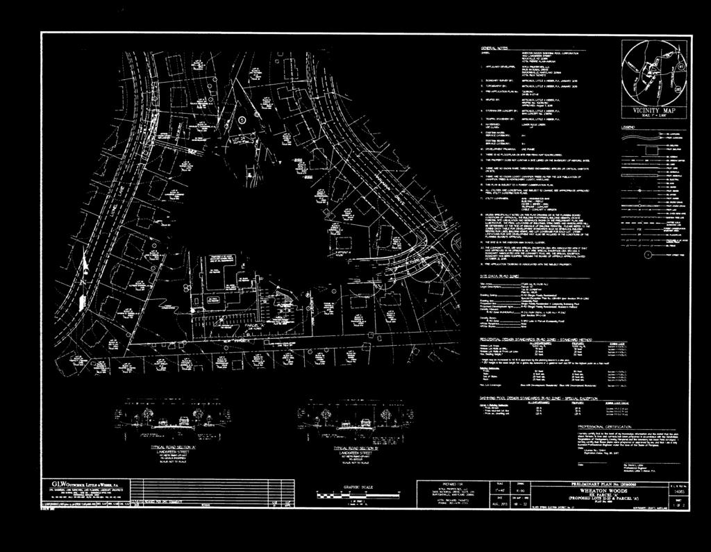
5 SECTION 1: CONTEXT AND PROPOSAL SITE DESCRIPTION The Subject Property (or the Property) is located in the Aspen Knolls subdivision in Aspen Hill. It is surrounded by single-family detached units built in the 1960 s on lots ranging from 7,500 to 24,500 square feet. Brookhaven Elementary School is directly to the north of the Subject Property and the Aspen Hill Public Library is to the east, all of which (including the property) are within the R-90 Zone. Aspen Hill Road is to the southeast. The Subject Property Figure 1 Subject Property and the Surrounding Area The 4.08-acre Property, identified as Parcel A, is located at the western terminus of Landgreen Street approximately 300 feet west of its intersection with Marianna Drive. A portion of the Property is developed as the Wheaton Woods Community Swimming Pool. The pool facility has two in-ground concrete pools, a bathhouse, paved recreation areas, tot lots, open fields and picnic area, integrated paved parking lots and storage buildings. It is enclosed by a woven-wire fence. 5

6 The Subject Property is located in the Lower Rock Creek Watershed. It contains multiple mature trees around the perimeter and clustered throughout the northern portion. There are no historic resources, streams, or wetlands on-site. Figure 2: Aerial photo of the Subject Property PROJECT DESCRIPTION The Applicant proposes to resubdivide the Property into six lots: five new lots for single-family detached dwelling units located in the north and northeast part, and a sixth lot for the existing community pool (Attachment 1). The entrance to the Property is from Landgreen Street, which has a 60-foot right-of-way and will be extended into the Property with a 44-foot-wide right-ofway to terminate in a cul-de-sac. The Project will have five-foot-wide sidewalks with six-foot wide green panels on both sides of Landgreen Street extended. The designation of Landgreen Street as a Tertiary Residential Street of 44-foot wide right-of-way (ROW) with sidewalks on both sides requires a design exception to the County s Tertiary Residential Street Standard (MC ) since the typical right-of-way for a standard Tertiary Residential Street with sidewalks on both sides is 50 feet wide. All six lots will have frontage and vehicular access on Landgreen Street extended. The new boundary of the community pool lot is consistent with the boundary established in a recent amendment to the Special Exception (No. 434) in anticipation of the current application. An existing storage building for the pool facility will be removed since it will be outside the new boundary of the Community Pool lot (Attachment 2). 6

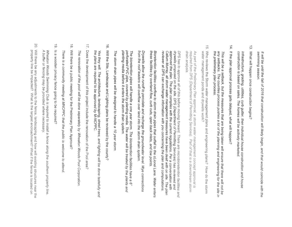
7 Figure 3: Proposed Preliminary Plan of Subdivision Previous Approvals Pre-Preliminary Plan No In November 2013, the Planning Board reviewed Pre-Preliminary Plan No for the Subject Property. At that time, the Applicant sought non-binding advice on three issues regarding the resubdivision of the Subject Property into six lots. The three issues were: 1) whether the Community Pool lot, a non-residential use, was subject to the resubdivision criteria; 2) street frontage--one of the new lots would create the smallest street frontage in the neighborhood; and 7
8 3) whether to require the Applicant to upgrade the existing four-foot wide sidewalks on both sides of existing Landgreen Street. Regarding issue 1, The Board agreed with Staff s finding and recommendation that the community pool lot was not subject to the resubdivision criteria, as stated on Page 3 of the Pre- Preliminary Plan Staff Report dated : In accordance with the Planning Board s previous interpretation and policy on other such cases, the proposed community use lot is not subject to the resubdivision criteria stated in Section 50-29(b)(2), because it is for an existing non-residential use; therefore, it is not included in the resubdivision analysis. The proposed five lots are subject to the resubdivision criteria. Regarding issue 2, the Board agreed with Staff s recommendation that, a cul-de-sac being the only viable option for street extension into the new development, it was not possible to create all new lots similar in shape and frontage to the existing lots in the neighborhood because none of the existing lots were on a cul-de-sac. Therefore, this practical difficulty justified a lack of full conformance to the resubdivision criteria for frontage and size of the proposed lots. Regarding issue 3, the Planning Staff disagreed with the MCDOT s recommendation to require sidewalks on both sides of Landgreen Street. Given the size of the proposed development, it was not necessary to upgrade sidewalks on both sides of the street, and that the cost of reconstructing the two sidewalks could be excessive. The Board did not reach a consensus on this issue. It discussed various options to provide improved sidewalk/s that met the ADA accessibility requirement without having to rebuild the entire length of both sidewalks including: a contribution to the County s sidewalk improvement program; adding small areas of additional pavement to the south sidewalk to make it ADA accessible; and widening the sidewalk on the south side only because it was in worse condition than the sidewalk on the north side of the street. Special Exception 434 On July 30, 1956, Board of Appeals granted Special Exception 434 for a community pool on the Subject Property. On September 21, 2004, the Board granted an administrative modification of the special exception to allow changes to several physical and operational characteristics. On October 21, 2013, the Board approved a modification to the Special Exception property boundary in anticipation of the resubdivision of the subject property, which is the subject of this Application (Attachment 3). 8
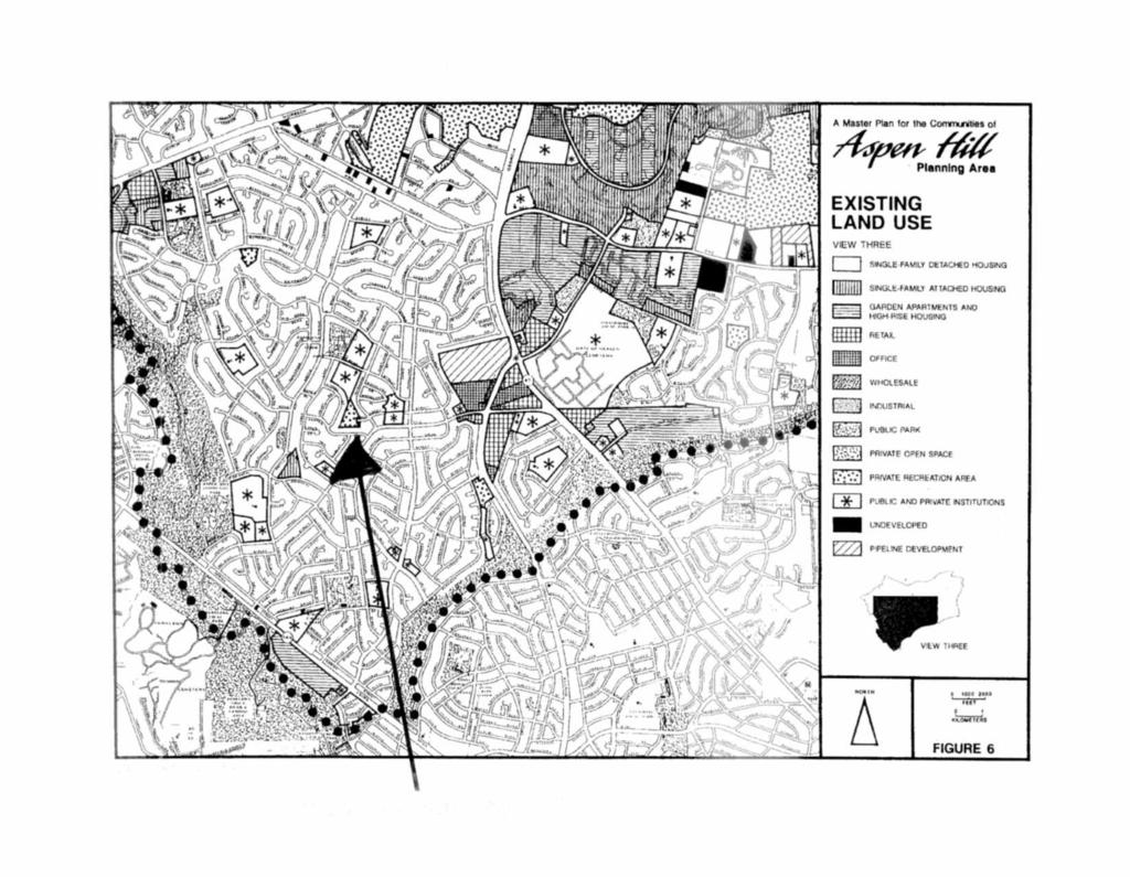
9 ANALYSIS AND FINDINGS Master Plan Conformance The Subject Property is located in the 1994 Aspen Hill Master Plan area (Attachment 4). The Master Plan does not have specific recommendations for the site. However, the proposed subdivision is consistent with the Plan s vision of maintaining Aspen Hill s primarily suburban, residential character. The Applicant s proposal also supports several of the Master Plan s land use objectives (page 21): To encourage the protection, enhancement and continuation of current land use patterns. To protect and reinforce the integrity of existing residential neighborhoods. To preserve and increase the housing resources in support of Montgomery County housing policies. The proposed development will increase Aspen Hill s housing stock while maintaining the suburban character of the existing neighborhood. The proposed lot sizes are compatible with those in the surrounding residential community, and the resubdivision represents a logical continuation of the existing neighborhood. Staff finds the proposed Preliminary Plan is in substantial conformance with the land use recommendations of the 1994 Aspen Hill Master Plan. DEVELOPMENT STANDARDS Pursuant to Section Residential 90 Zone (R-90) of the current Zoning Ordinance, the applicable development standards for a Standard Method development of the Subject Property are as follows: 9
10 Table 1: Development Standards, R-90 Zone DEVELOPMENT STANDARD Required Proposed Minimum Lot Area: 9,000 sq. ft. 9,000 sq. ft. Minimum Lot Width at Front Building Restriction Line: 75 feet 75 feet Minimum Lot Frontage: 25 feet 25 feet Minimum Setbacks: Front: 30 feet 30 feet Side: 8 feet 8 feet Sum of sides: 25 feet 25 feet Rear: 25 feet 25 feet Maximum Building Height 1 : 30 feet 30 feet Maximum Building Coverage: 30% 30% 2 Resubdivision Resubdivision of residential lots are subject to review criteria specified in Section 50-29(b)(2) of the Subdivision Regulations, which require the comparison of new lots with existing lots in a delineated neighborhood to ensure that the new lots are of the same character as the existing lots in the neighborhood. Therefore, this Application must meet the seven criteria specified in Section 50-29(b)(2), which states: Lots on a plat for the resubdivision of any lot, tract or other parcel of land that is part of an existing subdivision previously recorded in a plat book shall be of the same character as to street frontage, alignment, size, shape, width, area, and suitability for residential use as other lots within the existing block, neighborhood, or subdivision. The Applicant prepared a Neighborhood Exhibit (Figure 4) of the existing Aspen Knolls subdivision for comparison purposes of the resubdivision criteria in relation to the proposed five residential lots. 1 Thirty feet height is the mean height for a gable, hip, mansard or a gambrel roof and 35 feet is to the highest point on a flat roof. 2 Section Residential 90 Zone (R-90) B.1.b. Specification for Lot and Density requires that development with a detached house building type may have to satisfy Section B., Residential Infill Compatibility. 10

11 Figure 4: Neighborhood Boundary for resubdivision criteria comparison The proposed resubdivision meets six of the resubdivision criteria as follows: 1. Alignment--The proposed lots are oriented directly to the street similar to a majority of existing lots in the defined neighborhood although other orientations do occur in the neighborhood. 2. Size--The proposed lots range in size from 9,167 square feet to 22,070 square feet; existing lots in Aspen Knolls range from 9,000 square feet to 24,471 square feet. 11
12 3. Shape--The proposed lots are slightly irregular with three of the five as wedge-shaped around the cul-de-sac (Lots 23, 24 and 25); the existing lots in the neighborhood are a mix of corner, irregular, rectangular and wedge-shaped lots. 4. Width--The proposed lots range from 75 feet to 122 feet wide; lots in the defined neighborhood have widths that range from 75 to 160 feet. 5. Area The proposed lots have a building area ranging from +2,812 square feet to +11,109 square feet. The surrounding neighborhood lots range from +2,261 to +13,023 square feet. 6. Suitability--The proposed lots are suitable for residential use. The proposed resubdivision is a logical extension of the existing residential neighborhood s character. 7. Street Frontage - The proposed resubdivision does not meet the street frontage criteria. Proposed Lots 21, 22, and 25 have street frontages of 122, 96, and 60 feet, respectively, and are within the range of the lots in the defined neighborhood (+60 feet to +262 feet). Proposed Lots 23 and 24 have street frontages of 44 and 32 feet, respectively, and do not meet the resubdivision criteria. The Applicant is therefore requesting a waiver pursuant to Section 50-38(a)(1) of the Subdivision Ordinance as discussed below (and in Attachment 5). 12

13 Figure 5: Waiver Request for Street Frontage exhibit - Lots 23 and 24 Subdivision Waiver The proposed resubdivision cannot meet the street frontage criteria because of the shape of the Subject Property, its location within an existing neighborhood with access only from one public street which terminates at the property, and the size and configuration of the revised lot for the existing community pool. Since all new lots are required to have frontage on a public street, the extension of the existing Landgreen Street into the Subject Property with a cul-desac is the only feasible way to provide adequate public access and meet all other relevant fire and safety requirements. And since cul-de-sacs have wedge-shaped lots at the terminus (for Lots 23, 24 and 25 in this case), it is impossible for all new residential lots around the proposed cul-de-sac to have similar frontages as the lots in the neighborhood which does not does not have cul-de-sacs. Therefore, the Applicant has requested a waiver of the resubdivision analysis 13
14 required by Section 50-29(b)(2). The Planning Board has the authority to grant such a waiver pursuant to Section 50-38(a)(1) of the Subdivision Regulations, which states: The Board may grant a waiver from the requirements of this Chapter upon a determination that practical difficulties or unusual circumstances exist that prevent full compliance with the requirements from being achieved, and that the waiver is: 1) the minimum necessary to provide relief from the requirements; 2) not inconsistent with the purposes and objectives of the General Plan; and 3) not adverse to the public interest. The location of the property with only one access point and the Applicant s desire to retain the existing community pool makes a cul-de-sac the only viable layout to create the new subdivision. The lack of other feasible options that could resolve the lot frontage issue presents a practical difficulty for the Applicant. Granting a waiver for the frontage criterion for two of the five lots is the minimum waiver necessary to provide relief from the requirements. The waiver request is not inconsistent with the purposes and objectives of the General Plan (as amended by the applicable master plan) and is not adverse to the public interest because the proposal will be developed in accordance with the Zoning Ordinance (single-family development is permitted in the R-90 Zone), and the proposed development is in substantial conformance with the Master Plan. Therefore, Staff recommends approval of the waiver request because practical difficulties exist at the Subject Property that make it impossible for the Applicant to meet the strict application of the street frontage requirement. Design Exception Section 50-25(b) requires continuation of any existing roads in accordance with the road construction code, unless otherwise determined by the Board. Existing Landgreen Street is a Secondary Street with a 60-foot-wide right-of-way. The Applicant proposes to modify the road section for Landgreen Street extended to be a modified 44-foot-wide right-of-way Tertiary Residential Street (Std, Detail MC ), with five-foot-wide sidewalks and six-foot green panels on both sides of the road. The Applicant originally proposed a 44-foot-wide Tertiary Street, which required sidewalk only on one side. Both the MCDOT and the Staff requested sidewalks on both sides of the street, which would be a Tertiary Street with minimum 50-footwide right-of-way. However, this increased right-of-way width would reduce lot sizes and push building restriction lines into the proposed lots such that three of the proposed lots would not be feasible. In addition, the Applicant argued, and staff agreed, that a 50-foot right-of-way was not necessary for five new lots and the existing community pool on a cul-de-sac. Therefore, the Applicant has requested a design exception for the 44-foot Tertiary Standard in order to meet the staff recommendation of sidewalks on both side of Landgreen Street extended without negatively impacting the proposed layout. The MCDOT has accepted the modified Tertiary Street section and approved the design exception request (see attached letter dated November 30, 2015, in Attachment 10). 14
15 Although the current Landgreen Street was created as a 60-foot wide Secondary Street (a Tertiary Road classification with a 60-foot right-of-way was not available then), the more appropriate classification for this street is today s Tertiary Road classification (created by the County Council in 1970 per Bill 42-70). MCDOT has therefore asked that the Planning Board reclassify the existing Landgreen Street between the Subject Property and Marianna Drive as a Tertiary Street. This reclassification will not have any material impact on the functioning or the dedicated right-of-way of the street. It is only to create a consistent classification between the existing and the proposed extension since the current right-of-way of Landgreen Street is more appropriate as a Tertiary Street rather than a Secondary Street. ADEQUATE PUBLIC FACILITIES Schools The Subject Property is located in the Wheaton High School Cluster. Both the middle and high school levels have inadequacies. The Applicant must make a required payment based on the unit-type rate, to mitigate these inadequacies, prior to the issuance of building permits. Transportation Transportation Adequate Public Facilities Test For the Local Area Transportation Review (LATR) test, the proposed five new single-family detached units will generate five trips within the AM peak-period (6:30 to 9:30 a.m.) and six trips within the PM peak-period (4:00 to 7:00 p.m.). A traffic study is not required to satisfy LATR because the proposed land use generates fewer than 30 peak-hour trips within the weekday AM and PM peak periods. For the TPAR test, the Subject Property is located in the Aspen Hill Policy Area that has inadequate roadway capacity and adequate transit capacity. The TPAR must be satisfied by paying the Montgomery County Department of Permitting Services (MCDPS) 25% of the Development Impact Tax per unit for five new single-family detached units. Master-Planned Roadway and Bikeway Landgreen Street is not a designated street in the 1994 Aspen Hill Master Plan. Marianna Drive and the segment of Landgreen Street between the Subject Property and Marianna Drive are 60- foot wide Secondary Residential Streets. Landgreen Street extension within the Subject Property is proposed to be a Tertiary Residential Street, which can support up to 75 houses (or an equivalent of 83 peak-hour trips). The existing and proposed uses generate less than 50 peak-hour trips (community pool club has 40 parking spaces and the proposed five new houses generate only six new peak-hour trips). Therefore, the street layout is adequate to serve the proposed development. 15
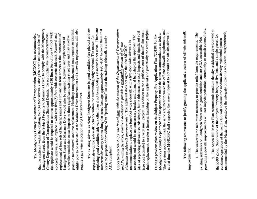
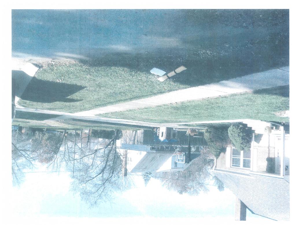
16 Public Transit Service The closest Ride On route is route 26 that operates along Aspen Hill Road with 30-minute headways between the Glenmont Metrorail Station and the Montgomery Mall Transit Center on weekdays and weekends. The nearest bus stop is at the intersection of Aspen Hill Road and Marianna Drive, a walking distance of approximately 750 feet from the Subject Property. Pedestrian Facilities-Sidewalks Currently, the off-site segment of Landgreen Street between the Subject Property and Marianna Drive has four-foot wide sidewalks and 11-foot wide green panels. The intersection of Landgreen Street and Marianna Drive has marked crosswalks and handicap ramps across Landgreen Street, but no crosswalks across Marianna Drive. The existing Landgreen Street between the Subject Property and Marianna Drive is 290 feet long with substandard four-foot wide sidewalks. As discussed on pages 7 and 8 of this report, the Planning Board discussed the sidewalk issue during the Pre-Preliminary Plan presentation of this proposal in November Although the Board did not reach consensus on this issue, it did not accept the Applicant s position that it not be required to upgrade the sidewalks. The Applicant is still maintaining that improving these sidewalks to current standards is financially prohibitive for the Pool s Board of Directors, who own and operate the community pool (Attachment 6). MCDOT, in the review of this Application, has again recommended the Applicant upgrade the existing sidewalks on both sides of the street. Staff is recommending that the Applicant upgrade the existing sidewalk only on the south side of the street to be five feet wide (south side because the sidewalk on the north side is in better condition than the one on the south side). Upgrades to this sidewalk are necessary to make the pedestrian facility adequate, safe and efficient. In addition, the south side is also preferable because a utility pole is located in the northwest corner of the Landgreen Street/Marianna Drive intersection, which may hinder installation of an upgraded handicap ramp to cross Marianna Drive, if required by MCDOT. If the Planning Board accepts Staff s recommendation that the Applicant upgrade the off-site sidewalk on the south side of Landgreen Street, it will require a tree variance for possible impacts to two specimen trees in the green panel as described on page 19 of this report. ENVIRONMENT Environmental Guidelines The Property contains no streams or their buffers, wetlands or their buffers, steep slopes, 100- year floodplains, or known habitats of rare, threatened, and endangered species. The proposed Preliminary Plan is in compliance with the Environmental Guidelines. 16
17 Preliminary Forest Conservation Plan There is no forest on-site (Attachment 7). The land use, zoning and net tract area yield an afforestation requirement of 0.64 acres of forest planting. The Applicant proposes to provide the planting requirement on-site, in the area labeled Reforestation Area #1. This area must be placed in a Category I Forest Conservation Easement. Forest Conservation Variance Section 22A-12(b) (3) of the Montgomery County code identifies certain individual trees as high priority for retention and protection. Any impact to these trees, including removal of the subject tree or disturbance within the tree s critical root zone (CRZ) requires a variance. An Applicant for a variance must provide certain written information in support of the required findings in accordance with Section 22A-21 of the County code. The code requires no impact to trees that: measure 30-inches or greater, dbh; are part of an historic site or designated with an historic structure; are designated as a national, State, or County champion tree; are at least 75 percent of the diameter of the current State champion tree of that species; or trees, shrubs, or plants that are designated as Federal or State rare, threatened, or endangered species. Variance Request The Applicant submitted a revised variance request on December 7, 2015, because; the proposed development will create an impact to the CRZ of three trees (numbered 4, 13, and 35) that are considered high-priority for retention under Section 22A-12(b) of the County code and a fourth tree (numbered 10) will be removed (Figure 6). The other three trees will be saved. A copy of the variance request letter, specifying the amount of CRZ disturbance for the trees to be saved, is appended to this letter (Attachment 8). The Applicant has provided the following justification of the variance request: The R-90 zoned property is only accessible from Landgreen Street. Standards for the public road needed to serve the proposed lots, including road width, turnaround requirements for fire and rescue services, sidewalks, utilities, etc., create a road footprint that cannot be accommodated without removal of specimen tree number 10 and impacts to the CRZ of specimen tree number 13, and pushes lot lines and grading impacts necessary for construction into the CRZ of tree number 4. One additional variance tree, number 35, is affected by the extension of a utility line connection up Landgreen Street. This tree is off-site and will be impacted minimally on one side of the CRZ to install the sewer line connection located in the right-of-way of existing Landgreen Street. Denying the variance would push the road far enough into the developable portion of the site to imperil the feasibility of buildable lots as well as denying a utility line connection needed to serve the development. Staff believes that denial of the variance would constitute a hardship. This finding must be met when determining whether or not to consider a variance for the project. Based on this finding, Staff finds that the variance can be considered. Section 22A- 21 of the County code sets forth the findings that must be made by the Planning Board or 17
18 Planning Director, as appropriate, in order for a variance to be granted. Staff has made the following determinations, as the Director s designee, that granting the requested variance: 1. Will not confer on the applicant a special privilege that would be denied to other applicants. Impacts to specimen trees are minimal and confined to the center of the developable portion of the Subject Property, and the proposed development is consistent with the zoning. Proposed impacts to the trees subject to the variance requirement cannot be avoided. Therefore, Staff finds that the granting of this variance is not a special privilege that would be denied to other applicants. 2. Is not based on conditions or circumstances which are the result of the actions by the Applicant. The requested variance is not based on conditions or circumstances, which are the result of actions by the Applicant, but on environmental, engineering and site constraints. 3. Is not based on a condition relating to land or building use, either permitted or nonconforming, on a neighboring property. The requested variance is not the result of land or building use on a neighboring property. 4. Will not violate State water quality standards or cause measurable degradation in water quality. Three of the trees are not being removed and will continue to provide water quality functions as at pre-development. The tree to be removed will be mitigated by the planting of replacement trees that will, in time, replace the lost water quality functions of the tree being removed. Therefore, the Applicant s Preliminary Plan will not violate State water quality standards or cause a measurable degradation in water quality. County Arborist s Recommendation on the Variance In accordance with Montgomery County Code Section 22A-21(c), the Planning Department referred a copy of the variance request to the County Arborist in the Montgomery County Department of Environmental Protection (MCDEP) for a recommendation on the variance and recommended approval with mitigation (Attachment 9). 18

19 Figure 6: PFCP - Variance trees exhibit Possible Additional Variance If the Planning Board accepts Staff s recommendation that the Applicant upgrade the off-site sidewalk on the south side of Landgreen Street to five feet wide from the Subject Property s east boundary to Marianna Drive, it will require an additional Variance. There are two specimen trees in the green panel on the south side of Landgreen Street that will be impacted. These offsite improvements will require an adjustment to the PFCP s limits-of-disturbance which will increase its net tract area and thereby, increase the Applicant s forest conservation requirement proposed to be met on the Subject Property in a Category I easement. Any adjustment to the Category I easement will be incorporated into the FFCP. Stormwater Management The Applicant received approval of their stormwater management concept from the Montgomery County Department of Permitting Services, Water Resources Section on January 15, 2016 (Attachment 10). The concept proposes to meet required stormwater management goals using a combination of ESD approaches including dry wells, micro-bioretention and landscape infiltration. 19
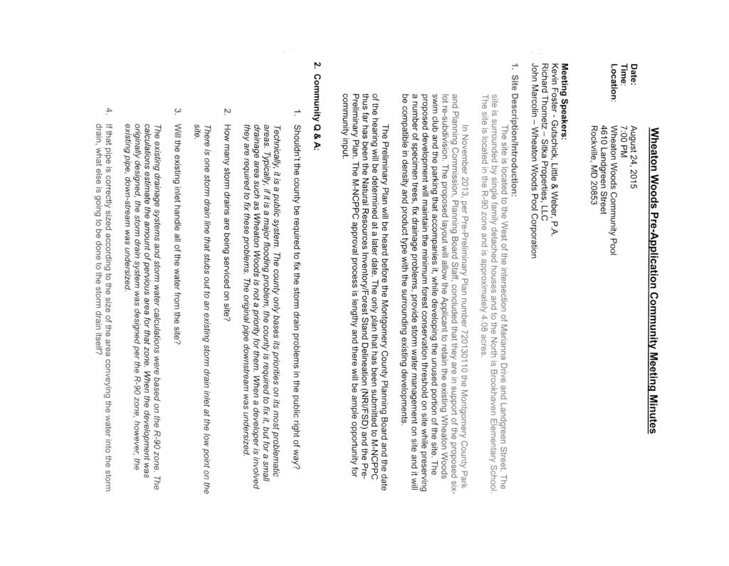
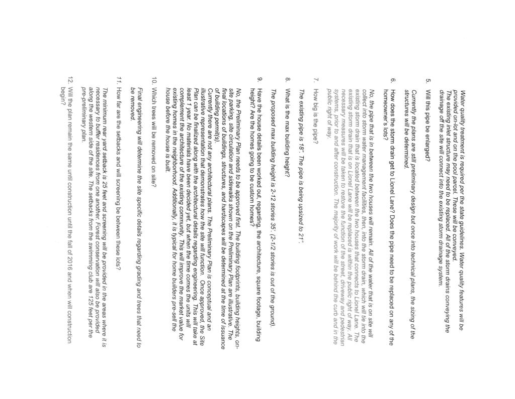
20 COMMUNITY OUTREACH The Applicant has complied with all the submittal and noticing requirements. A community meeting was held on August 24, 2015 at the Wheaton Woods Community Pool. A summary of this meeting is in Attachment 11. Staff has not received any written correspondence or any phone calls about the proposed Preliminary Plan up until the time of completion of the Staff Report. CONCLUSION Based on the review by Staff and other relevant agencies (Attachment 10), and the analysis contained in this report, Staff finds the proposed Preliminary Plan meets the requirements and standards of all applicable sections of Chapter 50 of the Montgomery County Code, and the Zoning Ordinance. Access and public facilities will be adequate to support the proposed density and uses. The proposed development will further the goals of the Aspen Hill Master Plan by adding more housing stock to the predominantly residential area. In addition, Staff recommends the Board grant the requested waiver to the frontage requirement of the resubdivision criteria for Lots 23 and 24. Staff also recommends the Board accept design exception approved by MCDOT for a modified Tertiary Street Standard MC with a 44-foot-wide right-of-way, and that the Board reclassify the existing Landgreen Street between the Subject Property and Marianna Drive as a Tertiary Street. Staff recommends approval of Preliminary Plan subject to the conditions stated at the beginning of this report. Attachments: Attachment 1 - Statement of Justification Attachment 2 Preliminary Plan Attachment 3 Special Exception 434 modification Attachment 4 Aspen Hill Master Plan pages 21, 22 and 25 Attachment 5 Street Frontage waiver request Attachment 6 Off-site Sidewalks waiver request Attachment 7 Preliminary Forest Conservation Plan Attachment 8 Applicant s Tree Variance request Attachment 9 County Arborist s recommendation Attachment 10 Agency Approval letters Attachment 11 Community meeting notice 20
21 ATTACHMENT 1 STATEMENT OF JUSTIFICATION WHEATON WOODS PROPERTY PRELIMINARY PLAN No Prepared for: Sitka Properties, LLC 3905 National Drive, Suite 105 Burtonsville, MD Prepared by: Gutschick, Little & Weber, P.A National Drive, Suite 250 Burtonsville, MD 20866
22 Introduction On behalf of our client Sitka Properties, LLC (the applicant) we are submitting Wheaton Woods (the subject property) for Preliminary Plan review and approval by the Maryland National Capital Planning Commission. This Preliminary Plan is being submitted following the Pre-Application Plan (Plan No ) and with the approved Natural Resources Inventory and Forest Stand Delineation Plan (NRI /FSD Plan No ). The subject property, existing Wheaton Woods, Parcel A, is located at the terminus of Landgreen Street, 300 feet west of the intersection of Landgreen Street and Marianna Drive in Rockville, Maryland, a community in the south east portion of Montgomery County. The proposed development will consist of five (5) single family detached houses and the extension of Landgreen Street terminating in a cul-de-sac. The development will be located on excess land owned by the community pool and a separate parcel will be created to retain the existing pool complex and the parking area that accompanies the pool. Property Description The existing 4.08 acre parcel is partially developed with the Wheaton Woods Community Swimming Pool, including multiple pools, bathhouse, storage buildings, paved recreation areas, tot-lots, picnic area, accompanying surface parking and open recreational lawn area as approved under Special Exception (No. CBA434). The Subject Property is located within the 1994 Aspen Hill Master Plan and is surrounded by eclectic collection single family detached houses of varying ages, sizes and styles. Currently, the westernmost segment of Landgreen Street dead-ends at the Subject Property and provides access to Wheaton Woods Swim Club. The subject property is well maintained with minimal understory vegetation and several specimen trees exist on-site. This property is located in the Lower Rock Creek Watershed. The land gently slopes to a low point on the property, where an existing storm drain inlet collects storm water flowing off of the site. It was identified during the downstream, storm drain analysis, that an existing off-site storm drain is undersized in Lionel Lane and will be addressed during the subdivision process. Description of Proposed Use The Applicant proposes the unused portion of the property be developed using the existing R-90 zoning which allows 4.8 dwelling units per acre. The base density permitted with a 4.08 acre parcel is 19 homes (4.08 X 4.8 = 19.58). The proposed Preliminary Plan is for re-subdivision of existing 4.08 Ac. Parcel A (Wheaton Woods Community Pool) into five (5) proposed single family lots and one (1) proposed parcel to retain the existing community swimming pool. The lots will average 13,000 square feet, which is close to the average for the adjoining lots.
23 The proposed development will be accessible with the extension of public, 60 wide right-of-way, Landgreen Street into the subdivision. The proposed public road extension of Landgreen Street will be a transition from the existing 60 wide right-of-way residential street at the current terminus point to a 44 wide right-of-way tertiary residential street at the cul-de-sac terminus. +18,730 square feet will be dedicated to public right of way for the extension of Landgreen Street. The applicant is requesting the Planning Board approve the use of a 44 wide tertiary residential street per Section 50-26(f)(1) of the Montgomery County Subdivision Regulation. Given the small number of houses served and the particularly difficult shape of the existing property, the use of a 44 wide right-ofway tertiary street is appropriate in this location. The Montgomery County Department of Transportation also supports the use of a 44 wide tertiary street for Landgreen Street. The proposed homes are oriented toward the street and the units will be a maximum of 35 tall as allowed in the R-90 Zone. A proposed five wide sidewalk will serve the proposed lots, and the Department of Transportation has approved a design exception to allow a sidewalk on both side of Landgreen Street. As required by Montgomery County ESD or Environmental Site Design stormwater management treatment will be provided for the Wheaton Wood development as shown on our Stormwater Management Concept Plan. During initial site analysis for the property a storm drain pipe located off-site in Lionel Lane was identified as being undersized and causing upstream drainage/flooding problems. This pipe is proposed to be replaced as part of this development and this should improve the existing drainage problems. A Natural Recourses Inventory/ Forest Stand Delineation has been approved for the property and shows that no forest exists on site but multiple large trees exist on and around the subject property. A Preliminary Forest Conservation Plan has been submitted as part of the Wheaton Wood Preliminary Plan. A variance request for removal of one (1) tree and disturbance of two (2) existing trees is included with this proposal. All forest conservation requirements are proposed to be provided on-site. Zoning Ordinance and Aspen Hill Master Plan Goals and Recommendations Although generally silent on specific recommendation for the Subject Property, the Aspen Hill Master Plan reconfirms R-90 Zoning for the property, page 38: This Plan supports the retention and reconfirmation of existing zoning for all developed, underdeveloped and undeveloped land in the Aspen Hill Planning Area. In general, the Aspen Hill Master Plan recommends sustaining and enhancing residential neighborhoods and housing policy, page 29: To encourage the protection, enhancement and continuation of current land use patterns.
24 To protect and reinforce the integrity of existing residential neighborhoods. To preserve and increase the housing resources in support of Montgomery County housing policies The proposed Preliminary Plan follows this recommendation by creating 5 lots ranging in size from 9,167 square feet to 22,070 square feet and 1 parcel to retain the existing community swimming pool. This plan will provide additional housing stock in a desirable area of Montgomery County while enhancing a valuable community resource and important part of the Aspen Hill residential fabric. The proposed lot sizes will be compatible with the surrounding single family detached homes in the neighborhood and adding a cul-de-sac to the end of Landgreen Street will provide a safe turn-around for fire rescue vehicles. Montgomery County Code. Chapter 50- Subdivision of Land The proposed development of the site meets the following requirements of the Montgomery County Code, Chapter 50 Subdivision of Land. Below are selected excerpts from the Montgomery County Code (shown in italics) and an explanation of how the Application satisfies these goals, objectives, and recommendations: Section 50 2 Purposes of the Chapter: (a) The harmonious development of the district. The proposed development s density, housing type, a nd lot size are appropriate for the site and will enhance the community identity as it is compatible with the existing fabric of the surrounding properties. The proposed development is unique in that it will be the only cul-de-sac within this community. The terminal street location and being that it is the last property to develop, dictated the use of a cul-de-sac. (See re-subdivision criteria discussion below) (b) Coordination of roads within the subdivision with other existing, planned or platted roads or with other features or the district or with the commission s general plan or with any road plan adopted or approved by the commission as a part of the commission s general plan The proposed extension of Landgreen Street as a public street with a public terminus to allow turnaround of public vehicles is consistent with Montgomery County Road Code and the General Plan.
25 (c) Adequate open spaces for traffic, recreation, light and air, by dedication, or otherwise. With the extension of Landgreen Street into the proposed development adequate space has been, provided in the public right of way for traffic. Adequate space has also been provided within the proposed development for recreation and storm water management. (d) Reservation of lands for schools and other public buildings and for parks, playground and other public purposes. No reservation of lands for schools, other public buildings, parks, playgrounds, or other public purposes is required. (e) The conservation of or production of adequate transportation, water, drainage and sanitary facilities. The proposed 5 lot development will not have a detrimental effect on the adequate existing transportation facilities of the surrounding area. The proposed development is served by existing public water and sewer. The proposed storm water management system is a combination of Environmental Site Design features to provide water quality treatment, storm water management and drainage. The replacement of an undersized off-site storm drain will enhance the overall area storm drain system. (f) The preservation of the location of and the volume of flow of water in and other characteristics of natural streams and other waterways. There will be no increase of volume of flow to the existing streams and wetlands based on the new Environmental Site Design guidelines. The location of the flow of water will not be altered from the current flow except in areas of development. (g) The avoidance of population congestion. The proposed development s low density residential character is consistent with the adopted Master Plan and is comprised of only five lots. (h) The avoidance of such scattered or premature subdivision or development of land as would involve danger or injury to health, safety or welfare by reason of the lack of water supply, drainage, transportation or other public services or necessitate an excessive expenditure of public funds for the supply of such services. The proposed development is served by adequate existing public utilities. The proposed development does not detrimentally impact the existing transportation of the surrounding area, or necessitate the expenditure of public funds for the supply of such services.
26 (i) Conformity of resubdivided lots to the character of lots within the existing subdivision with respect to area, frontage, and alignment to existing lots and streets. The proposed lots will be in character as to area and alignment to other lots within the subdivision. (See Surrounding Neighborhood Exhibit). Three of the five proposed lots will have similar frontage and the surrounding subdivision, but two lots fronting on the cul-de-sac will require a waiver of the lot frontage requirement. (See resubdivision criteria discussion below). (j) Control of subdivision or building (except for agricultural purposes) in flood plain areas of streams and drainage courses, other environmentally sensitive areas, and on unsafe land areas. The proposed development does not contain a flood plain, stream, or any wetlands. Impacts to environmentally sensitive features are limited to the disturbance of two mature trees and the removal of one mature tree. (k) Preservation of outstanding cultural features and historic sites or structures. There are no cultural or historic features on the site. (l) Other benefits to health, comfort, safety or welfare of the present and future population of the regional district. The proposed development serves to enhance and imitate the existing sense of community identity for both current and future residents by creating lots of similar size and appearance as the surrounding lots. The proposed development will be compatible in terms of both use and design with the existing single-family detached development which surrounds the property. The proposed single-family detached development is in accordance with the Master Plan and therefore promotes the health, safety, welfare and morals of the existing community and the County as a whole. The proposed design will not overburden existing public facilities. The proposed development will use existing public water and sewer systems and will not affect the capacity of the public water and sewer system. The development will be served by an extension of the existing roadway system, and is conveniently located near access to public transportation. Public schools in the vicinity of the site have adequate capacity to serve the generation of students that will be attributable to the additional proposed five lots. The proposed development will allow an important community feature (Wheaton Woods Swim Club) to continue serving the community. (m) Preservation of forests, significant trees, and environmentally sensitive areas. The Applicant has carefully located the proposed houses to maximize the preservation of existing mature trees throughout the site considering the Master Plan recommendation for low density residential development and is designed to minimize impacts on their critical root zones.
27 (n) Coordination of sidewalks within the subdivision and within adjacent subdivisions and existing public sidewalks. The proposed development will provide sidewalks as required and will connect to existing sidewalks in Landgreen Street. (See Pre-Preliminary Plan discussion ) As was previously supported by M-NCPPC staff during the Pre-Preliminary Plan review, the applicant is requesting a waiver of the MCDOT requirement to replace existing and functioning 4 wide concrete sidewalks on both sides of Landgreen Street from the Subject Property to Marinna Drive with new 5 wide concrete sidewalks. With the scope of development limited to five (5) lots, the requirement to replacement this amount of off-site sidewalk goes beyond reasonable and is a significant financial hardship on the applicant especially since no relationship has been established between the size of the proposed development and the quantity of off-site sidewalk required for replacement. Section 50-29(b)(2) Resubdivision. Lots on a plat for the resubdivision of any lot, tract or other parcel of land that is a part of an existing subdivision previously recorded in a plat book shall be of the same character as to street frontage, alignment, size, shape, width, area, and suitability for residential use as other lots within the existing block, neighborhood, or subdivision. As required by the above referenced section, the proposed development will be evaluated to compare the subdivision criteria of street frontage, alignment, size, shape, width, area, and suitability for residential use as other lots in the surrounding neighborhood. During the previous Pre-Preliminary Plan (No ) review, M-NCPPC staff identified a surrounding neighborhood, and to simplify review we have accepted that neighborhood for our re-subdivision criteria review. (See Surrounding Neighborhood Exhibit). As previously discussed during the review of Pre-Preliminary Plan No , the proposed lots, generally meet six of the seven re-subdivision criteria, as follows: The proposed lots range in size from +9,167 SF to +22,070 SF and the neighborhood lots range from +9,000 SF to +24,471 SF. The proposed lots are generally wedge or slightly irregularly shaped, and the neighborhood lots are a mixture of irregular, wedge, rectangular and corner lots. The proposed lots have a width from +75 feet to +122 and the neighborhood lots range from +75 feet to +160 feet. The proposed lots have a building area of +2,812 SF to +11,109 SF and the neighborhood lot range from +2,261 SF to +13,023 SF. The proposed lots have straight orientation to the street and the neighborhood lots have mostly straight orientation to the street, but others orientations occur as well. The proposed lots are all suitable for residential use, and all of the neighborhood lots are also suitable for residential use. The remaining re-subdivision criteria to be evaluated includes street frontage. The existing neighborhood lots have street frontage that ranges from +60 feet to +262 feet.
28 Proposed Lots 21, 22, and 25 have street frontages of +122 feet, +96 feet and +60 feet and fit within the range of the surrounding neighborhood lots. Proposed Lots 23 and 24 have street frontages of +44 feet and +32 feet and do not meet the re-subdivision criteria. Given that with this land-locked parcel a cul-de-sac was the only way to provide public street access that is required for SFD lots, and these are the only cul-de-sac lots in the neighborhood, there is no practical way to make these two cul-de-sac lots have similar street frontage to non-cul-de-sac lots. Therefore the applicant is requesting a waiver of the subdivision criteria for street frontage. After completing a full design analysis of the site and incorporating on-site requirements including storm water management, forest conservation, existing environmental features, and surrounding neighborhood compatibility, the Applicant was able to develop a layout which meets the goals and recommendations of the Montgomery County Zoning Ordinance and the Aspen Hill Master Plan.
29 ATTACHMENT 2
30 ATTACHMENT 3
31
32
33
34 ATTACHMENT 4
35

36
37 ATTACHMENT 5

38 ATTACHMENT 6
39
40
41

42
43
44
45
46 ATTACHMENT 7 #28 #27 #5 #6 #26 #7 #4 #8 #9 #16 #25 #15 #24 #10 #23 #2 #1 #35 #11 #3 #87 #12 #13 #87 #29 #14 #30 2C #22 #19 #21 #20 #33 #34 #18 #17 #32 #31 (Ex. Parcel A.= 4.08 Ac; Offsite Disturbance= 0.16 Ac.) DEVELOPER'S CERTIFICATE Conservation Plan No. including, financial bonding, forest planting, maintenance and all other applicable agreements. Developer's Name: Sitka Properties, LLC Richard Thometz REFORESTATION CALCULATIONS Total reforestation provided on-site...= Total reforestation required off-site...= Address: 3905 National Drive, Suite 105 Burtonsville, MD Phone: Signature: Richard Thometz
47 ATTACHMENT 8 December 7, 2016 Forest Conservation Program Manager Maryland National Park & Planning Commission 8787 Georgia Avenue Silver Spring, Maryland Re: Wheaton Woods - Variance Request On behalf of our client, Sitka Properties, we are requesting a variance of Section 22A-12.(b)(3)(c) of the Montgomery County Code. (3) The following trees, shrubs, plants, and specific areas are priority for retention and protection and must be left in an undisturbed condition unless the Planning Board or Planning Director, as appropriate, finds that the applicant qualifies for a variance under Section 22A-21: (C) Any tree with a diameter, measured at 4.5 feet above the ground, of: (i) 30 inches or more; or (ii) 75% or more of the diameter, measured at 4.5 feet above ground, of the current State champion tree of that species. Section of the Maryland State Code grants the authority to Montgomery County (local authority) for approval of the variances, and Section 22A-21 Variance, of the Montgomery County Code establishes the criteria to grant a variance. The subject property, Aspen Knolls, Parcel A, is located to the West of the intersection of Landgreen Street and Marianna Drive in Rockville, Maryland, a community in the south east portion of Montgomery County. The site is currently, not forested. Existing single family houses abut the property to the West, East and South of the site. To the North of the site is Brookehaven Elementary School. The applicant is requesting a variance to affect the following trees that measures 30 or greater in diameter at breast height (dbh): Request to remove the following tree: Tree # dbh Red Oak Good Condition Request to impact the critical root zones of three trees: Tree # dbh Southern Red Oak, Good Condition Tree # dbh White Pine, Fair Condition Tree #35 36 dbh Red Maple, Good Condition
48 TREE # TREE TYPE % DISTURBED REASON 4 Southern Red Oak 22% Grading and house construction 13 White Pine 11% Curb installation and grading 35 Red Maple 15% Sewer installation on Landgreen St. Section 22A-21 (b) lists the criteria for the granting of the variance requested herein. The following narrative explains how the requested variance is justified under the set of circumstances described above. 1. Describe the special conditions peculiar to the property which would cause the unwarranted hardship: The site is not categorized as a forested area; however there are several specimen trees scattered throughout the site. Because numerous large trees are located in the only developable area of the site, the critical root zones will have a significant impact on the developability of the site. The subject property is the last remaining undeveloped area in the neighborhood and is landlocked with its only access being Landgreen Street. The property is zoned R-90 which allows single-family detached homes, and single family detached homes require frontage on a public street, therefore to develop the site an extension of Landgreen Street is required. Since there is nowhere for Landgreen Street to exit the site, it will require a cul-de-sac terminus. The major impacts to specimen trees will be caused by construction of the public road and utility installation to serve the proposed single-family detached homes. If the applicant were denied the ability to build the public road and therefore not build single-family homes, it would be an unwarranted hardship on the developer, not allow the same enjoyment of his property as other surrounding previous property owners to development single family homes. Removal of Trees #10: The removal of tree #10 could not be avoided because it is located in the middle of buildable area of the site and directly in the path of Landgreen Street. The Montgomery County street design standards necessitate the removal to allow construction of street utilities, grading, and required storm water management features. Impacting Critical Root Zones (CRZ) of Tree #4, 13 & 35: Tree #4 will have minimal grading impacts to one side of the outer CRZ area to clear, grade and construct the house on Lot 24. Tree #13 will be minimally impacted on one side of the outer CRZ to clear, grade and construct the curb for the construction of Landgreen Street and the tie-in to the Wheaton Woods Swimming Pool parking lot. Tree #35 is located off site and will be impacted minimally on one side of the outer CRZ to install the sewer connection located in the Right of Way for Landgreen Street. Prior to construction, root pruning, temporary tree protection fencing and signage, and other protective measures deemed necessary by the arborist will be employed to minimize the effects of construction. 2. Describe how enforcement of these rules will deprive the landowner of rights commonly enjoyed by others in similar areas: Not granting the variance would cause undue hardship on the applicant because there would be very limited buildable area on the property, and therefore will deny the applicant ability to full use the property. The applicant has followed the requirements of the zoning regulations. The proposed use is compatible with the surrounding properties. Nearby developments have been allowed to develop in this manner and therefore the Applicant would be denied the ability to utilize the property. The inability to remove the subject trees would make the property a virtually unbuildable parcel, and is an unwarranted
49 hardship to the applicant. By enforcement of this chapter, it will deprive the landowner the rights to build on the property. Granting of the variance will ultimately allow the property to be developed. 3. Verify that State water quality standards will not be violated or that a measurable degradation in water quality will not occur as a result of the granting of the variance: The variance will not violate state water quality standards or cause measurable degradation in water quality. All proposed land development activities will require sediment control and or storm water management plan approvals by Montgomery County. This approval, of SWM Concept #278596, will confirm that the goals and objective of the current state and county water quality standards have been met for the proposed development, on site. The slopes on the site will be graded at 3:1 to improve the stability of the existing steep slopes. This combined with the creation of Category 1 easements on the site and in addition to bioretention planter box areas will improve the existing water quality on the site. 4. Provide any other information appropriate to support the request: The variance request is not based on conditions or circumstances which result from the actions of the applicant. The applicant did not create the utility line easements, the steep slopes, or plant the trees. As mentioned above, great care has been taken to locate development in the buildable area of the site while trying to minimize disturbance to some of the significant and specimen trees within the site. The applicant recognizes the value and need for mature trees and has selected areas to locate the houses that would impact the trees the least amount. Special attention will be given to any construction work that may impact the critical root zones of specimen trees that can be saved. In particular: The Applicant believes that the information set forth above is adequate to justify the requested variance to impact the critical root zone of four specimen trees on the subject property. Furthermore, the Applicant's request for a variance complies with the "minimum criteria" of Section 22A-21 (d) for the following reasons: 1. This Applicant will receive no special privileges or benefits by the granting of the requested variance that would not be available to any other applicant. 2. The variance request is not based on conditions or circumstances which result from the actions of the applicant. The applicant did not create the existing site conditions, including the random location of the specimen trees. 3. The variance is not based on a condition relating to the land or building use, either permitted or nonconforming on a neighboring property. 4. Loss of the requested trees will not violate State water quality standards or cause measurable degradation in water quality. If you have any further questions or concerns, please do not hesitate to contact me. Sincerely, Kevin Foster Landscape Architect


 of the Forest Conservation Law states that a variance must not be granted if granting the request: 1.")
50 ATTACHMENT 9 DEPARTMENT OF ENVIRONMENTAL PROTECTION Isiah Leggett County Executive Lisa Feldt Director January 21, 2016 Casey Anderson, Chair Montgomery County Planning Board Maryland National Capital Park & Planning Commission 8787 Georgia Avenue Silver Spring, Maryland RE: Wheaton Woods, DAIC , NRI/FSD application accepted on 7/22/2015 Dear Mr. Anderson: All applications for a variance from the requirements of Chapter 22A of the County Code submitted after October 1, 2009 are subject to Section 22A-12(b)(3). Accordingly, given that the application for the above referenced request was submitted after that date and must comply with Chapter 22A, and the Montgomery County Planning Department ( Planning Department ) has completed all review required under applicable law, I am providing the following recommendation pertaining to this request for a variance. Section 22A-21(d) of the Forest Conservation Law states that a variance must not be granted if granting the request: 1. Will confer on the applicant a special privilege that would be denied to other applicants; 2. Is based on conditions or circumstances which are the result of the actions by the applicant; 3. Arises from a condition relating to land or building use, either permitted or nonconforming, on a neighboring property; or 4. Will violate State water quality standards or cause measurable degradation in water quality. Applying the above conditions to the plan submitted by the applicant, I make the following findings as the result of my review: 1. The granting of a variance in this case would not confer a special privilege on this applicant that would be denied other applicants as long as the same criteria are applied in each case. Therefore, the variance can be granted under this criterion. 2. Based on a discussion on March 19, 2010 between representatives of the County, the Planning Department, and the Maryland Department of Natural Resources Forest Service, the disturbance of trees, or other vegetation, as a result of development activity is not, in and of itself, interpreted as a condition or circumstance that is the result of the actions by the applicant. Therefore, the variance can be granted under this criterion, as long as appropriate mitigation is provided for the resources disturbed. 255 Rockville Pike, Suite 120 Rockville, Maryland FAX montgomerycountymd.gov/ TTY
51 Casey Anderson January 21, 2016 Page 2 3. The disturbance of trees, or other vegetation, by the applicant does not arise from a condition relating to land or building use, either permitted or nonconforming, on a neighboring property. Therefore, the variance can be granted under this criterion. 4. The disturbance of trees, or other vegetation, by the applicant will not result in a violation of State water quality standards or cause measurable degradation in water quality. Therefore, the variance can be granted under this criterion. Therefore, I recommend a finding by the Planning Board that this applicant qualifies for a variance conditioned upon the applicant mitigating for the loss of resources due to removal or disturbance to trees, and other vegetation, subject to the law based on the limits of disturbance (LOD) recommended during the review by the Planning Department. In the case of removal, the entire area of the critical root zone (CRZ) should be included in mitigation calculations regardless of the location of the CRZ (i.e., even that portion of the CRZ located on an adjacent property). When trees are disturbed, any area within the CRZ where the roots are severed, compacted, etc., such that the roots are not functioning as they were before the disturbance must be mitigated. Exceptions should not be allowed for trees in poor or hazardous condition because the loss of CRZ eliminates the future potential of the area to support a tree or provide stormwater management. Tree protection techniques implemented according to industry standards, such as trimming branches or installing temporary mulch mats to limit soil compaction during construction without permanently reducing the critical root zone, are acceptable mitigation to limit disturbance. Techniques such as root pruning should be used to improve survival rates of impacted trees but they should not be considered mitigation for the permanent loss of critical root zone. I recommend requiring mitigation based on the number of square feet of the critical root zone lost or disturbed. The mitigation can be met using any currently acceptable method under Chapter 22A of the Montgomery County Code. In the event that minor revisions to the impacts to trees subject to variance provisions are approved by the Planning Department, the mitigation requirements outlined above should apply to the removal or disturbance to the CRZ of all trees subject to the law as a result of the revised LOD. If you have any questions, please do not hesitate to contact me directly. Sincerely, Laura Miller County Arborist cc: Amy Lindsey, Planner Coordinator
52 ATTACHMENT 10
53
54

55
56
57
58
59
60
61
62 ATTACHMENT 11
63
64
MONTGOMERY COUNTY PLANNING DEPARTMENT THE MARYLAND-NATIONAL CAPITAL PARK AND PLANNING COMMISSION
 MONTGOMERY COUNTY PLANNING DEPARTMENT THE MARYLAND-NATIONAL CAPITAL PARK AND PLANNING COMMISSION MCPB Item No. Date: 12/4/14 Preliminary Plan No. 120140200, Northwood Knolls Description Patrick Butler,
MONTGOMERY COUNTY PLANNING DEPARTMENT THE MARYLAND-NATIONAL CAPITAL PARK AND PLANNING COMMISSION
 MONTGOMERY COUNTY PLANNING DEPARTMENT THE MARYLAND-NATIONAL CAPITAL PARK AND PLANNING COMMISSION MCPB Item No. 8 Date: 03-07-13 Sonoma, Preliminary Plan, 120130040 Melissa Williams, Senior Planner, Melissa.williams@montgomeryplanning.org,
MONTGOMERY COUNTY PLANNING DEPARTMENT THE MARYLAND-NATIONAL CAPITAL PARK AND PLANNING COMMISSION
 MONTGOMERY COUNTY PLANNING DEPARTMENT THE MARYLAND-NATIONAL CAPITAL PARK AND PLANNING COMMISSION MCPB Item No. 3 Date: 01-31-13 Preliminary Plan 120090300, Boyds Highlands Calvin Nelson, Jr. Planner Coordinator,
MONTGOMERY COUNTY PLANNING DEPARTMENT THE MARYLAND-NATIONAL CAPITAL PARK AND PLANNING COMMISSION
 MONTGOMERY COUNTY PLANNING DEPARTMENT THE MARYLAND-NATIONAL CAPITAL PARK AND PLANNING COMMISSION MCPB Item No. Date: 12/6/12 Limited Site Plan Amendment, 82000018D, DANAC Stiles Property, Lot 6 of Block
MONTGOMERY COUNTY PLANNING DEPARTMENT THE MARYLAND-NATIONAL CAPITAL PARK AND PLANNING COMMISSION
 MONTGOMERY COUNTY PLANNING DEPARTMENT THE MARYLAND-NATIONAL CAPITAL PARK AND PLANNING COMMISSION MCPB Item No.: Date: 06-21-12 The Plantations, Preliminary Plan -120090240 Benjamin Berbert, Senior Planner,
MONTGOMERY COUNTY PLANNING BOARD
 MONTGOMERY COUNTYPLANNING BOARD T H E MARYLAND-NATIONAL CAPITAL PARK A N D P L A N N I N G C O M M I S S I O N MCPB NO. 10-100 Preliminary Plan No. 120100210 Date of Hearing: July 1, 2010 MONTGOMERY COUNTY
RECOMMENDATION: Approval subject to the following conditions:
 RECOMMENDATION: Approval subject to the following conditions: 1) Approval under this preliminary plan is limited to 2 lots for 2 dwelling units 2) The record plat must note that the preliminary plan is
MONTGOMERY COUNTY PLANNING DEPARTMENT THE MARYLAND-NATIONAL CAPITAL PARK AND PLANNING COMMISSION
 MONTGOMERY COUNTY PLANNING DEPARTMENT THE MARYLAND-NATIONAL CAPITAL PARK AND PLANNING COMMISSION MCPB Item No. Hearing Date: 10/8/15 Howard Hughes Medical Institute, Limited Amendment of the Preliminary
MONTGOMERY COUNTY PLANNING DEPARTMENT THE MARYLAND-NATIONAL CAPITAL PARK AND PLANNING COMMISSION
 MONTGOMERY COUNTY PLANNING DEPARTMENT THE MARYLAND-NATIONAL CAPITAL PARK AND PLANNING COMMISSION MCPB Item No. Date: 1-17-13 Preliminary Plan 120110180 - Parmjit & Saini Estates Katherine Holt, Senior
MONTGOMERY COUNTY PLANNING BOARD
 APR :7 20m MONTGOMERY COUNTY PLANNING BOARD THE MARYLAND-NATIONAL CAPITAL PARK AND PLANNING COMMISSION MCPB No. 10-172 Date of Hearing: December 9, 2010 MONTGOMERY COUNTY PLANNING BOARD RESOLUTION WHEREAS,
Bowie Marketplace Residential Detailed Site Plan Statement of Justification January 13, 2017 Revised February 2, 1017
 Bowie Marketplace Residential Detailed Site Plan Statement of Justification January 13, 2017 Revised February 2, 1017 Submitted on behalf of: BE Bowie LLC 5410 Edson Lane, Suite 220 Rockville, MD 20852
ZONING AMENDMENT, PLANNED UNIT DEVELOPMENT & SUBDIVISION STAFF REPORT Date: August 8, 2013
 ZONING AMENDMENT, PLANNED UNIT DEVELOPMENT & SUBDIVISION STAFF REPORT Date: August 8, 2013 NAME SUBDIVISION NAME PV-Magnolia, LLC Twelve Trees Subdivision LOCATION 2860, 2862 and 2866 Pleasant Valley Road
CREEKSIDE TOWNHOMES Chevy Chase, Maryland Site Plan No Preliminary Plan No
 +1 (301) 656 5901 info@nova-habitat.com CREEKSIDE TOWNHOMES Chevy Chase, Maryland Site Plan No. 820160050 Preliminary Plan No. 120160130 Application Statement of Justification October 28, 2015 Nova-Habitat,
DANAC Stiles Property. Preliminary Plan A
 DANAC Stiles Property Preliminary Plan 11996112A Vicinity Located in the LSC North District of the GSSC Master Plan. Adjacent Uses North: Single-family attached townhouses, R-60 zone; East: Office building,
MONTGOMERY COUNTY PLANNING DEPARTMENT THE MARYLAND-NATIONAL CAPITAL PARK AND PLANNING COMMISSION
 MONTGOMERY COUNTY PLANNING DEPARTMENT THE MARYLAND-NATIONAL CAPITAL PARK AND PLANNING COMMISSION MCPB Item No. Date: 05-30-13 Pre-Preliminary Plan No. 720130040: Potomac Highlands Callum Murray, supervisor,
MONTGOMERY COUNTY PLANNING DEPARTMENT THE MARYLAND-NATIONAL CAPITAL PARK AND PLANNING COMMISSION
 MONTGOMERY COUNTY PLANNING DEPARTMENT THE MARYLAND-NATIONAL CAPITAL PARK AND PLANNING COMMISSION MCPB Item No. 3 Date: 05/28/15 Ingleside, Preliminary Plan No. 120140140 Ryan Sigworth AICP, Senior Planner
MONTGOMERY COUNTY PLANNING DEPARTMENT THE MARYLAND-NATIONAL CAPITAL PARK AND PLANNING COMMISSION
 MONTGOMERY COUNTY PLANNING DEPARTMENT THE MARYLAND-NATIONAL CAPITAL PARK AND PLANNING COMMISSION MCPB Item No. 6 Date: 9-27-18 Seneca Farms, Preliminary Plan No. 120170240 Jonathan Casey, Senior Planner,
7-l MoNtcoupnv CouNtv PreNNrNc Boeno,I 'tne ITaRYLAND-NATIoNAL CAPITAL PARI< AND PLANNING con{n{ission
 7-l MoNtcoupnv CouNtv PreNNrNc Boeno,I 'tne ITaRYLAND-NATIoNAL CAPITAL PARI< AND PLANNING con{n{ission MCPB No. 16-023 Preliminary Plan No. '120160110 Date of Hearing: March 3, 2016 ltar 17 frft, RESOLUTlON
MONTGOMERY COUNTY PLANNING DEPARTMENT THE MARYLAND-NATIONAL CAPITAL PARK AND PLANNING COMMISSION
 MONTGOMERY COUNTY PLANNING DEPARTMENT THE MARYLAND-NATIONAL CAPITAL PARK AND PLANNING COMMISSION MCPB Item No. 5 Date: 12-15-16 Bradford s Landing, Preliminary Plan, 120170060 Description Sandra Pereira,
MONTGOMERY COUNTY PLANNING DEPARTMENT THE MARYLAND-NATIONAL CAPITAL PARK AND PLANNING COMMISSION
 MONTGOMERY COUNTY PLANNING DEPARTMENT THE MARYLAND-NATIONAL CAPITAL PARK AND PLANNING COMMISSION MCPB Item No.: Date: 07-28-16 Lake Normandy Estates: Pre-Preliminary Plan No. 720160020 Ryan Sigworth AICP,
PLANNED UNIT DEVELOPMENT & SUBDIVISION STAFF REPORT Date: April 18, 2019
 PLANNED UNIT DEVELOPMENT & SUBDIVISION STAFF REPORT Date: April 18, 2019 DEVELOPMENT NAME SUBDIVISION NAME Springhill Village Subdivision Springhill Village Subdivision LOCATION 4350, 4354, 4356, 4358,
Planning Department Oconee County, Georgia
 Planning Department Oconee County, Georgia STAFF REPORT REZONE CASE #: 6985 DATE: October 31, 2016 STAFF REPORT BY: Andrew C. Stern, Planner APPLICANT NAME: Williams & Associates, Land Planners PC PROPERTY
Staff Report: Date: Applicant: Property Identification: Acreage of Request: Current Zoning of Requested Area: Requested Action: Attached:
 Staff Report: Completed by Jeff Palmer Director of Planning & Zoning Date: November 7, 2018, Updated November 20, 2018 Applicant: Greg Smith, Oberer Land Developer agent for Ronald Montgomery ET AL Property
ARTICLE 15 - PLANNED UNIT DEVELOPMENT
 Section 15.1 - Intent. ARTICLE 15 - PLANNED UNIT DEVELOPMENT A PUD, or Planned Unit Development, is not a District per se, but rather a set of standards that may be applied to a development type. The Planned
Montgomery Village - South Valley Park: Subdivision Regulation Waiver SRW , and Site Plan No
 Montgomery Village - South Valley Park: Subdivision Regulation Waiver SRW - 201402, and Site Plan No. 820140070 12 SUBDIVISION REGULATION WAIVER RECOMMENDATION AND CONDITIONS OF APPROVAL Staff recommends
Staff Report: Date: Applicant: Property Identification: Acreage of Request: Current Zoning of Requested Area: Requested Action: Attached:
 Staff Report: Completed by Jeff Palmer Director of Planning & Zoning Date: November 7, 2018 Applicant: Greg Smith, Oberer Land Developer agent for Ronald Montgomery ET AL Property Identification: Frontage
PLANNED UNIT DEVELOPMENT & SUBDIVISION STAFF REPORT Date: November 17, 2016
 PLANNED UNIT DEVELOPMENT & SUBDIVISION STAFF REPORT Date: November 17, 2016 DEVELOPMENT NAME SUBDIVISION NAME LOCATION Autonation Ford of Mobile Autonation Ford of Mobile Subdivision 901, 909, and 925
O-I (Office-Institutional) and AG-1(Agricultural)
 and AG-1(Agricultural)") PROPERTY INFORMATION ADDRESS 3503 and 3505 Bethany Bend DISTRICT, LAND LOTS 2/1 973 and 974 OVERLAY DISTRICT State Route 9 PETITION NUMBERS EXISTING ZONING O-I (Office-Institutional) and AG-1(Agricultural)
PROPERTY INFORMATION ADDRESS 3503 and 3505 Bethany Bend DISTRICT, LAND LOTS 2/1 973 and 974 OVERLAY DISTRICT State Route 9 PETITION NUMBERS EXISTING ZONING O-I (Office-Institutional) and AG-1(Agricultural)
TULSA PARK ESTATES SUBDIVISION, RESUBDIVISION OF LOT 6
 TULSA PARK ESTATES SUBDIVISION, RESUBDIVISION OF LOT 6 Engineering Comments: FINAL PLAT COMMENTS (should be addressed prior to submitting the FINAL PLAT for review and/or signature by the City Engineer):
MONTGOMERY COUNTY PLANNING DEPARTMENT
 MONTGOMERY COUNTY PLANNING DEPARTMENT THE MARYLAND-NATIONAL CAPITAL PARK AND PLANNING COMMISSION MCPB Item No. Date: 6/2/208 Washington Science Center-6000 Executive Boulevard, Limited Major Site Plan
Article 7: Residential Land Use and Development Requirements
 Article 7: Residential Land Use and Section 701: Statement of Intent (A) (B) (C) The intent of Article 7 is to develop certain land use and development requirements for the residential uses within Cumru
ARTICLE 23 CONDOMINIUM STANDARDS
 ARTICLE 23 CONDOMINIUM STANDARDS Section 23.01 Intent. The intent of this Article is to provide regulatory standards for condominiums and site condominiums similar to those required for projects developed
WHEREAS, the staff of The Maryland-National Capital Park and Planning Commission recommended APPROVAL of the application with conditions; and
 R E S O L U T I O N WHEREAS, Redeemed Christian Church of God is the owner of a 2.83-acre parcel of land known as Lot 9, Lot 19, P/O Lot 1 and P/O Lot 18, Block B, Plat Book A, Plat 5, said property being
PLANNED UNIT DEVELOPMENT & SUBDIVISION STAFF REPORT August 18, 2016
 PLANNED UNIT DEVELOPMENT & SUBDIVISION STAFF REPORT August 18, 2016 DEVELOPMENT NAME SUBDIVISION NAME Mullinax Ford Subdivision Mullinax Ford Subdivision LOCATION CITY COUNCIL DISTRICT District 6 Southeast
BEAR CREEK TOWNSHIP EMMET COUNTY, MICHIGAN. PRIVATE ROAD ORDINANCE Ordinance No. 11A-99. (to replace prior Private Road Ordinance No.
 BEAR CREEK TOWNSHIP EMMET COUNTY, MICHIGAN PRIVATE ROAD ORDINANCE Ordinance No. 11A-99 (to replace prior Private Road Ordinance No. 11-99) An Ordinance to protect the health, safety, and general welfare
ZONING AMENDMENT, PLANNED UNIT DEVELOPMENT & SUBDIVISION STAFF REPORT Date: September 15, 2011
 ZONING AMENDMENT, PLANNED UNIT DEVELOPMENT & SUBDIVISION STAFF REPORT Date: September 15, 2011 NAME SUBDIVISION NAME LOCATION Stratford, L.L.C. Grelot Office Park Subdivision North side of Grelot Road,
DEVELOPMENT DEPARTMENT STAFF REPORT THE PARK AT 5 TH
 DEVELOPMENT DEPARTMENT STAFF REPORT ARB Meeting Date: July 3, 2018 Item #: _PZ2018-293_ THE PARK AT 5 TH Request: Site Address: Project Name: Parcel Number: Applicant: Proposed Development: Current Zoning:
ELK RAPIDS TOWNSHIP ANTRIM COUNTY, MICHIGAN ORDINANCE NO
 ELK RAPIDS TOWNSHIP ANTRIM COUNTY, MICHIGAN ORDINANCE NO. 3-2011 AN ORDINANCE TO REPLACE THE SUBDIVISION CONTROL ORDINANCE WITH A NEW SUBDIVISION DEVELOPMENT ORDINANCE, IN ACCORD WITH THE LAND DIVISION
ZONING AMENDMENT & SUBDIVISION STAFF REPORT Date: July 9, 2015
 ZONING AMENDMENT & SUBDIVISION STAFF REPORT Date: July 9, 2015 APPLICANT NAME 2513 Dauphin Street, Inc. SUBDIVISION NAME Audubon Place Extension No. 3, Resubdivision of Lots 1-5 LOCATION 2513 Dauphin Street
MONTGOMERY COUNTY PLANNING DEPARTMENT THE MARYLAND-NATIONAL CAPITAL PARK AND PLANNING COMMISSION
 MONTGOMERY COUNTY PLANNING DEPARTMENT THE MARYLAND-NATIONAL CAPITAL PARK AND PLANNING COMMISSION Colesville Senior Living Facility, Limited Preliminary Plan Amendment, 12016011A MCPB Consent Item Date:
PLANNED UNIT DEVELOPMENT (East), PLANNED UNIT DEVELOPMENT (West) STAFF REPORT Date: September 18, 2014
, PLANNED UNIT DEVELOPMENT (West) STAFF REPORT Date: September 18, 2014") PLANNED UNIT DEVELOPMENT (East), PLANNED UNIT DEVELOPMENT (West) STAFF REPORT Date: September 18, 2014 DEVELOPMENT NAME LOCATION McGowin Park, LLC PLANNED UNIT DEVELOPMENT (East) 1401 Satchel Paige Drive
PLANNED UNIT DEVELOPMENT (East), PLANNED UNIT DEVELOPMENT (West) STAFF REPORT Date: September 18, 2014 DEVELOPMENT NAME LOCATION McGowin Park, LLC PLANNED UNIT DEVELOPMENT (East) 1401 Satchel Paige Drive
WESTMINSTER PARK PLACE SUBDIVISION
 WESTMINSTER PARK PLACE SUBDIVISION Engineering Comments: FINAL PLAT COMMENTS (should be addressed prior to submitting the FINAL PLAT for review and/or signature by the City Engineer): A. Provide all of
ARTICLE 14 PLANNED UNIT DEVELOPMENT (PUD) DISTRICT
 DISTRICT") ARTICLE 14 PLANNED UNIT DEVELOPMENT (PUD) DISTRICT Section 14.01 Intent. It is the intent of this Article to allow the use of the planned unit development (PUD) process, as authorized by the Michigan Zoning
ARTICLE 14 PLANNED UNIT DEVELOPMENT (PUD) DISTRICT Section 14.01 Intent. It is the intent of this Article to allow the use of the planned unit development (PUD) process, as authorized by the Michigan Zoning
DEVELOPMENT DEPARTMENT STAFF REPORT DRESDEN HEIGHTS PHASE II DCI
 DEVELOPMENT DEPARTMENT Meeting Date: January 10, 2019 Item #: PZ2019-393 Project Name: Applicant and Owner: Proposed Development: Requests: STAFF REPORT DRESDEN HEIGHTS PHASE II DCI Dresden Heights Phase
ARTICLE FIVE FINAL DRAFT
 ARTICLE FIVE 021218 FINAL DRAFT Sec. 503.6 Open Space Preservation Option Open Space Preservation Option Open Space Preservation developments may be approved in the AR, R-1, R-2 and R-3 zoning districts,
SUBDIVISION, PLANNED UNIT DEVELOPMENT, ZONING AMENDMENT, & SIDEWALK WAIVER STAFF REPORT Date: July 19, 2018
 SUBDIVISION, PLANNED UNIT DEVELOPMENT, ZONING AMENDMENT, & SIDEWALK WAIVER STAFF REPORT Date: July 19, 2018 NAME SUBDIVISION NAME LOCATION West Mobile Properties, LLC U.S. Machine Subdivision 556, 566,
PLANNING & COMMUNITY DEVELOPMENT DEPARTMENT STAFF REPORT
 PLANNING & COMMUNITY DEVELOPMENT DEPARTMENT STAFF REPORT DATE: TO: Hearing Officer SUBJECT: Minor Variance #11876 LOCATION: APPLICANT: ZONING DESIGNATION: GENERAL PLAN DESIGNATION: CASE PLANNER: STAFF
FINAL DRAFT 12/1/16, Rev. to 7/18/17
 FINAL DRAFT 12/1/16, Rev. to 7/18/17 (As Adopted 8/8/17 Effective 9/1/17) SHELTON PLANNING AND ZONING COMMISSION Proposed Amendments to Zoning Regulations I. Amend Section 23 PERMITTED USES by inserting
R E S O L U T I O N. a. Remove Table B from the plan.
 R E S O L U T I O N WHEREAS, Werrlein Property is the owner of a 0.3902-acre parcel of land in the 5th Election District of Prince George s County, Maryland, being zoned One-Family Detached Residential
ZONING AMENDMENT & SUBDIVISION STAFF REPORT Date: November 3, 2016
 ZONING AMENDMENT & SUBDIVISION STAFF REPORT Date: November 3, 2016 APPLICANT NAME SUBDIVISION NAME David Shumer 5955 Airport Subdivision CITY COUNCIL DISTRICT District 6 5955 Airport Boulevard, 754 Linlen
CITY OF FERNDALE HEARING EXAMINER
 CITY OF FERNDALE HEARING EXAMINER RE: Planned Unit Development ) 16001-PUD Preliminary Plat ) 16018-SE Plat Variance ) 16002-VAR Application by ) ) MD General, L.L.C. ) FINDINGS OF FACT, Malloy Heights
DAUPHIN CREEK ESTATES SUBDIVISION
 # 12 SUB-000076-2017 DAUPHIN CREEK ESTATES SUBDIVISION Engineering Comments: FINAL PLAT COMMENTS (should be addressed prior to submitting the FINAL PLAT for review and/or signature by the City Engineer):
Community Development Department 333 Broadalbin Street SW, P.O. Box 490 Albany, OR 97321
 SUMMARY Community Development Department 333 Broadalbin Street SW, P.O. Box 490 Albany, OR 97321 STAFF REPORT Application for Tentative Partition Plat Review Planning File PA-06-17 Phone: 541-917-7550
PALM BEACH COUNTY PLANNING, ZONING AND BUILDING DEPARTMENT ZONING DIVISION
 PALM BEACH COUNTY PLANNING, ZONING AND BUILDING DEPARTMENT ZONING DIVISION Application No.: CA-2012-00688 Control No.: 2011-00552 Applicant: Garry Bernardo Owners: Garry Bernardo Agent: Frogner Consulting,
DRAFT FOR PUBLIC HEARING (rev. March, 2016)
") Chapter 200. ZONING Article VI. Conservation/Cluster Subdivisions 200-45. Intent and Purpose These provisions are intended to: A. Guide the future growth and development of the community consistent with
Chapter 200. ZONING Article VI. Conservation/Cluster Subdivisions 200-45. Intent and Purpose These provisions are intended to: A. Guide the future growth and development of the community consistent with
GROSVENOR-STRATHMORE METRO STATION MANDATORY REFERRAL APPLICATION NORTH BETHESDA, MD
 GROSVENOR-STRATHMORE METRO STATION MANDATORY REFERRAL APPLICATION NORTH BETHESDA, MD Submission by: Fivesquares JDA at Grosvenor Metro, LLC On behalf of Washington Metropolitan Area Transit Authority 1
PLANNED UNIT DEVELOPMENT & ZONING AMENDMENT STAFF REPORT Date: December 21, 2017
 # 14 PUD-000324-2017 & ZON-000326-2017 PLANNED UNIT DEVELOPMENT & ZONING AMENDMENT STAFF REPORT Date: December 21, 2017 APPLICANT NAME DEVELOPMENT NAME LOCATION Dewberry/Preble-Rish Longleaf Gates Subdivision,
# 1 HOLDOVER Revised SUB CANAL SUBDIVISION
 CANAL SUBDIVISION Engineering Comments: Label each Lot showing the required minimum finished floor elevation (MFFE). It appears that Lots 2, 3 & 4 are located in the AE Flood Zone; add a note to the plat
McGowin Park, LLC. B-3, Community Business District
 # 10, 11, 12 SUB2014-00024 ZON2014-00500 ZON2014-00501 SUBDIVISION, PLANNED UNIT DEVELOPMENT (East), PLANNED UNIT DEVELOPMENT (West) STAFF REPORT Date: April 3, 2014 DEVELOPMENT NAME LOCATION McGowin Park,
TURTLE CREEK SUBDIVISION, PHASE THREE
 TURTLE CREEK SUBDIVISION, PHASE THREE Engineering Comments: Must comply with the Mobile County Flood Damage Prevention Ordinance. Development shall be designed to comply with the storm water detention
Community Development
 Land Use Petition RZ-16-002 Date of Staff Recommendation Preparation: April 15, 2016 (CEL) Date of Planning Commission Recommendation: May 3, 2016 PROJECT LOCATION: DISTRICT/SECTION/LANDLOT(S): ACREAGE
MONTGOMERY COUNTY PLANNING DEPARTMENT THE MARYLAND-NATIONAL CAPITAL PARK AND PLANNING COMMISSION
 MONTGOMERY COUNTY PLANNING DEPARTMENT THE MARYLAND-NATIONAL CAPITAL PARK AND PLANNING COMMISSION MCPB Consent Item Date: 12/19/13 * Consent Item Barton Property: Preliminary Plan Amendment No. 12011021A
Condominium Unit Requirements.
 ARTICLE 19 CONDOMINIUM REGULATIONS Section 19.01 Purpose. The purpose of this Article is to regulate projects that divide real property under a contractual arrangement known as a condominium. New and conversion
KEIZER COMMUNITY DEVELOPMENT DEPARTMENT STAFF RECOMMENDATION Subdivision Case No
 KEIZER COMMUNITY DEVELOPMENT DEPARTMENT STAFF RECOMMENDATION Subdivision Case No. 2014-01 TO: FROM: Cynthia Domas, Keizer Hearings Officer Sam Litke, Senior Planner SUBJECT: Subdivision Case No. 2014-01
610 LAND DIVISIONS AND PROPERTY LINE ADJUSTMENTS OUTSIDE A UGB
 ARTICLE VI: LAND DIVISIONS AND PROPERTY LINE ADJUSTMENTS VI-21 610 LAND DIVISIONS AND PROPERTY LINE ADJUSTMENTS OUTSIDE A UGB 610-1 Property Line Adjustments (Property Line Relocation) A property line
the conditions contained in their respective Orders until January 1, 2025, at the discretion of the Director of Planning, Property and Development.
 Part 4: Use Regulations Temporary Uses and Structures Purpose the conditions contained in their respective Orders until January 1, 2025, at the discretion of the Director of Planning, Property and Development.
MONTGOMERY COUNTY PLANNING DEPARTMENT THE MARYLAND-NATIONAL CAPITAL PARK AND PLANNING COMMISSION
 MONTGOMERY COUNTY PLANNING DEPARTMENT THE MARYLAND-NATIONAL CAPITAL PARK AND PLANNING COMMISSION MCPB Item No. Date: 10-03-13 Preliminary Plan Amendment No. 11999034B Alvermar Woods, Lot 17 (In Response
M-43 CORRIDOR OVERLAY ZONE
 ARTICLE 26.00 M-43 CORRIDOR OVERLAY ZONE Section 26.01 Findings A primary function of the M-43 state highway is to move traffic through the Township and to points beyond. As the primary east-west arterial
REPORT TO THE SHELBY COUNTY PLANNING COMMISSION From the Department of Development Services Planning Services. February 4, 2019
 REPORT TO THE SHELBY COUNTY PLANNING COMMISSION From the Department of Development Services Planning Services February 4, 2019 Case No. Request for Rezoning Approval From E-1 to E-2 SD This is a request
APPLICANT NAME SUBDIVISION NAME DEVELOPMENT NAME LOCATION. CITY COUNCIL DISTRICT Council District 4 PRESENT ZONING PROPOSED ZONING
 SUBDIVISION, PLANNED UNIT DEVELOPMENT, PLANNING APPROVAL, ZONING AMENDMENT, & SIDEWALK WAIVER REQUEST STAFF REPORT Date: February 17, 2010 APPLICANT NAME SUBDIVISION NAME DEVELOPMENT NAME LOCATION David
Chapter Planned Residential Development Overlay
 Chapter 19.29 Planned Residential Development Overlay Sections 010 Purpose 020 Scope 030 Definitions 030 Minimum Size 040 Allowable Uses 050 Minimum Development Standards 060 Density Bonus 070 Open Space
E L M E R B O R O U G H L A N D U S E B O A R D APPLICATION COVER SHEET (to be completed for all applications and appeals)
") E L M E R B O R O U G H L A N D U S E B O A R D APPLICATION COVER SHEET (to be completed for all applications and appeals) 1. Name(s): 2. Address: 3. Telephone Number(s): 4. E-mail: 5. Owner Name(s) (if
E L M E R B O R O U G H L A N D U S E B O A R D APPLICATION COVER SHEET (to be completed for all applications and appeals) 1. Name(s): 2. Address: 3. Telephone Number(s): 4. E-mail: 5. Owner Name(s) (if
I. Requirements for All Applications. C D W
 108-16.1. Application checklists. Checklist for Required Submissions to the Planning Board or Zoning Board of Adjustment of Monroe Township All required submissions are to be made to the Administrative
Initial Project Review
 Pierce County Department of Planning and Land Services, 2401 South 35th Street, Tacoma, WA (253) 798-7037 Initial Project Review Major Amendment to Preliminary Plat: Hawks Ridge Division 1 Application
Medical Marijuana Special Exception Use Information
 Medical Marijuana Special Exception Use Information The Special Exception Use information below is a modified version of the Unified Development Code. It clarifies the current section 5:104 Special Exceptions
Community Development
 Land Use Petition RZ-15-010 Concurrent Variance VC-15-010-01 Date of Staff Recommendation Preparation: August 14, 2015 Date of Planning Commission Recommendation: September 1, 2015 PROJECT LOCATION: DISTRICT/SECTION/LANDLOT(S):
DISTRICT COUNCIL FOR PRINCE GEORGE S COUNTY, MARYLAND OFFICE OF ZONING HEARING EXAMINER SPECIAL EXCEPTION 4658 DECISION
 DISTRICT COUNCIL FOR PRINCE GEORGE S COUNTY, MARYLAND OFFICE OF ZONING HEARING EXAMINER SPECIAL EXCEPTION 4658 DECISION Application: Three Chair Barber Shop Applicants: Danta L. & Felicia B. Wright/Fort
Town of Cary, North Carolina Rezoning Staff Report 14-REZ-31 Cary Park PDD Amendment (Waterford II) Town Council Meeting January 15, 2015
 Town Council Meeting January 15, 2015") Town of Cary, North Carolina Rezoning Staff Report 14-REZ-31 Cary Park PDD Amendment (Waterford II) Town Council Meeting January 15, 2015 REQUEST To amend the Town of Cary Official Zoning Map by amending
Town of Cary, North Carolina Rezoning Staff Report 14-REZ-31 Cary Park PDD Amendment (Waterford II) Town Council Meeting January 15, 2015 REQUEST To amend the Town of Cary Official Zoning Map by amending
Draft Model Access Management Overlay Ordinance
 Draft Model Access Management Overlay Ordinance This model was developed using the City of Hutchinson and the Trunk Highway 7 corridor. The basic provisions of this model may be adopted by any jurisdiction
ARTICLE IV: DEVELOPMENT STANDARDS
 ARTICLE IV: DEVELOPMENT STANDARDS IV-53 409 PRIVATE STREETS A private street means any way that provides ingress to, or egress from, property by means of vehicles or other means, or that provides travel
GWINNETT COUNTY CSO CONSERVATION SUBDIVISION OVERLAY DISTRICT REQUIREMENTS
 GWINNETT COUNTY CSO CONSERVATION SUBDIVISION OVERLAY DISTRICT REQUIREMENTS Section 1316. CSO Conservation Subdivision Overlay District. 1. Purposes. The purposes of this overlay district are as follows:
MONTGOMERY COUNTY PLANNING DEPARTMENT THE MARYLAND-NATIONAL CAPITAL PARK AND PLANNING COMMISSION
 MONTGOMERY COUNTY PLANNING DEPARTMENT THE MARYLAND-NATIONAL CAPITAL PARK AND PLANNING COMMISSION MCPB Consent Item Date: 11-2-17 Washington Adventist Hospital, Site Plan Amendment No. 82008021F Rhoda Hersson-Ringskog,
Article Optional Method Requirements
 Article 59-6. Optional Method Requirements [DIV. 6.1. MPDU DEVELOPMENT IN RURAL RESIDENTIAL AND RESIDENTIAL ZONES Sec. 6.1.1. General Requirements... 6 2 Sec. 6.1.2. General Site and Building Type Mix...
SECTION 7000 LAND DEVELOPMENT REQUIREMENTS
 SECTION 7000 LAND DEVELOPMENT REQUIREMENTS 7000 LAND DEVELOPMENT REQUIREMENTS... 1 7001 LEGISLATIVE AUTHORITY... 1 7001.1 LAND DEVELOPMENT... 1 7001.1.1 Title 40, Idaho Code... 1 7001.1.2 Idaho Code 40-1415
4027 and 4031 Ellesmere Road Zoning Amendment and Draft Plan of Subdivision Applications - Request for Direction Report
 STAFF REPORT ACTION REQUIRED 4027 and 4031 Ellesmere Road Zoning Amendment and Draft Plan of Subdivision Applications - Request for Direction Report Date: August 22, 2013 To: From: Wards: Reference Number:
SECTION 10.7 R-PUD (RESIDENTIAL PLANNED UNIT DEVELOPMENT) ZONE
 ZONE") Article X Zones 10-20 SECTION 10.7 R-PUD (RESIDENTIAL PLANNED UNIT DEVELOPMENT) ZONE A. PURPOSE AND INTENT: The R-PUD Residential PUD Zone is intended to provide alternative, voluntary zoning procedures
Article X Zones 10-20 SECTION 10.7 R-PUD (RESIDENTIAL PLANNED UNIT DEVELOPMENT) ZONE A. PURPOSE AND INTENT: The R-PUD Residential PUD Zone is intended to provide alternative, voluntary zoning procedures
Special Use Permit - Planned Unit Development Checklist. Property Address:
 Special Use Permit - Planned Unit Development Checklist Special Use Permit Number. Parcel Code/s #28-11- - - Property Address: Applicant: ARTICLE VIII Ordinance Reference - Section 8.1.2 Permit Procedures:
SECTION 16. "PUD" PLANNED UNIT DEVELOPMENT OVERLAY DISTRICT
 SECTION 6. "PUD" PLANNED UNIT DEVELOPMENT OVERLAY DISTRICT Subsection. Purpose. This district is established to achieve the coordinated integration of land parcels and large commercial and retail establishments
Residential Major Subdivision Review Checklist
 Residential Major Subdivision Review Checklist Plan Submittal Requirements: 2 full sets of stamped plans Electric submittal - all plans contained in a single PDF 3 full sets if commercial kitchen or dining
HERON LANDING SUBDIVISION
 HERON LANDING SUBDIVISION Engineering Comments: Per FEMA guidelines, any development greater than 5 acres in size or subdivision 50 lots in size, requires a flood study. Width of drainage easement to be
Napa County Planning Commission Board Agenda Letter
 Agenda Date: 9/20/2017 Agenda Placement: 8C Napa County Planning Commission Board Agenda Letter TO: FROM: Napa County Planning Commission Charlene Gallina for David Morrison - Director Planning, Building
AUTUMNDALE SUBDIVISION, RESUBDIVISION OF LOTS
 AUTUMNDALE SUBDIVISION, RESUBDIVISION OF LOTS 100-102 Engineering Comments: Road shall be constructed per City standards and according to the City s street acceptance process. Cul-de sac approval subject
Cover Letter with Narrative Statement
 Cover Letter with Narrative Statement March 31, 2017 rev July 27, 2017 RE: Rushton Pointe Residential Planned Unit Development Application for Public Hearing for RPUD Rezone PL2015 000 0306 Mr. Eric Johnson,
ZONING AMENDMENT & SUBDIVISION STAFF REPORT Date: June 18, 2015
 ZONING AMENDMENT & SUBDIVISION STAFF REPORT Date: June 18, 2015 APPLICANT NAME SUBDIVISION NAME EAA LLC / Eryka Rogers Aaiden Place Subdivision LOCATION 2480 Government Boulevard (North side of Government
MONTGOMERY COUNTY PLANNING DEPARTMENT THE MARYLAND-NATIONAL CAPITAL PARK AND PLANNING COMMISSION
 MONTGOMERY COUNTY PLANNING DEPARTMENT THE MARYLAND-NATIONAL CAPITAL PARK AND PLANNING COMMISSION MCPB Item No.: Date: 11-12-15 15931 Frederick Road (CarMax) Annexation Request ANX2015-00145 Patrick Butler,
COUNTY OF SAN MATEO PLANNING AND BUILDING DEPARTMENT
 COUNTY OF SAN MATEO PLANNING AND BUILDING DEPARTMENT DATE: October 20, 2016 TO: FROM: Zoning Hearing Officer Planning Staff SUBJECT: Consideration of a Non-Conforming Use Permit, pursuant to Sections 6135
RC ; Reclassification The Garrison at Stafford Proffer Amendment (formerly Stafford Village Center)
") Board of Supervisors Robert Bob Thomas, Jr., Chairman Laura A. Sellers, Vice Chairman Meg Bohmke Jack R. Cavalier Wendy E. Maurer Paul V. Milde, III Gary F. Snellings Anthony J. Romanello, ICMA CM County
Board of Supervisors Robert Bob Thomas, Jr., Chairman Laura A. Sellers, Vice Chairman Meg Bohmke Jack R. Cavalier Wendy E. Maurer Paul V. Milde, III Gary F. Snellings Anthony J. Romanello, ICMA CM County
ZONING AMENDMENT, PLANNED UNIT DEVELOPMENT & SUBDIVISION STAFF REPORT Date: March 5, 2009
 ZONING AMENDMENT, PLANNED UNIT DEVELOPMENT & SUBDIVISION STAFF REPORT Date: March 5, 2009 NAME SUBDIVISION NAME LOCATION Kentress Morrisette Booker T. Washington Highlands Subdivision, First Addition,
COMMUNITY DEVELOPMENT DEPARTMENT 333 Broadalbin Street SW, P.O. Box 490 Albany, OR 97321
 COMMUNITY DEVELOPMENT DEPARTMENT 333 Broadalbin Street SW, P.O. Box 490 Albany, OR 97321 Ph: 541-917-7550 Fax: 541-917-7598 www.cityofalbany.net STAFF REPORT Application for Site Plan Review SP-07-18 and
MONTGOMERY COUNTY PLANNING DEPARTMENT THE MARYLAND-NATIONAL CAPITAL PARK AND PLANNING COMMISSION
 MONTGOMERY COUNTY PLANNING DEPARTMENT THE MARYLAND-NATIONAL CAPITAL PARK AND PLANNING COMMISSION MCPB Item No. Date: 10-11-12 Subdivision Review Waiver SRW 2011001: Big Woods Road Richard Weaver, Acting