Upper Milford Township Open Space Plan
|
|
|
- Clementine Barker
- 5 years ago
- Views:
Transcription


1 Upper Milford Township Open Space Plan Natural Areas and Working Farms Action Plan LEHIGH COUNTY, PA Page 1
2 This page left intentionally blank. Page 2
3
4 Table of Contents Page CHAPTER NO. 1: PREFACE 7 Why Open Space Matters 8 Table 1 1 Upper Milford Township Millage Rate Comparison for CHAPTER NO. 2: DEFINITIONS 9 Definitions CHAPTER NO. 3: INTRODUCTION 13 Plan Purpose 14 Relationship to Other Township Plans and Ordinances 14 Plan Content Public Input 15 CHAPTER NO. 4: IMPORTANCE OF NATURAL AREA CONSERVATION 17 Importance of Natural Area Conservation 18 Preserved Open Space serves to: 18 Pennsylvania Highlands 19 Figure 4 1 Biological Resources 19 Figure 4 2 Water Resources 19 Figure 4 3 Forest Resources 19 Figure 4 4 Agricultural Resources 19 Figure 4 5 Composite Resource Value 20 Map 4 1 Schuylkill River Watershed 21 CHAPTER NO. 5: COMMUNITY BACKGROUND 23 Regional Influences 24 Map 5 1 Lehigh County Municipal Borders 25 Population, Housing and Employment 26 Table 5 1 Housing Stock Trends; Lehigh Valley Planning Commission 26 Table 5 2 Number of Developments Approved by Upper Milford Township 27 Table 5 3 * 2003 LVPC Population Forecasts 27 Table 5 4 * U.S. Census Bureau 27 CHAPTER NO. 6: DEVELOPED AND PRESERVED LAND 29 Existing Land Uses 30 Table No. 6 1 Land Use 30 Table No. 6 2 Parks and Recreation Land Use Map of Lenape Park and Proposed Acquisitions 32 Lenape Park 33 Map of Jasper Park and Proposed Acquisitions 34 Jasper Park Map of Churchview Park 37 Churchview Park 38 Map of Fulmer Tract Park and Proposed Acquisitions 39 Fulmer Tract Park 40 Map of Township Wetland 41 Township Wetland 42 Page 4
5 CHAPTER NO. 7: EXISTING NATURAL FEATURES 43 Watersheds 44 Figure 7 1 Little Lehigh Creek Watershed (Lehigh County Conservation Dist) 45 Figure 7 2 Saucon Creek Watershed (L.C.C.D.) 46 Figure 7 3 Perkiomen Creek Watershed (L.C.C.D.) 47 Floodplain Areas 48 Wetlands 48 Greenways 49 Scenic Areas 49 Natural Areas Inventory 50 Map 9 Urban Development on Prime Agricultural Soils Year Map 10 Agricultural Easement Purchases / Agricultural Security Area 52 Map 11 Farmland Preservation Plan 53 APTER NO. 8: GOALS AND RECOMMENDATIONS 55 Goals 56 Goal for Preserving Open Space 56 Goal for Improving and Protection of Natural Features 57 Goal for Implementing Conservation-Oriented Subdivision Design 57 Recommendations 57 Recommendations for Preserving More Open Space Table 8 1 Farm Preservation Land Ranking System 61 Table 8 2 Natural Resources Land Ranking System 62 Recommendations to Improve Protection of Natural Features Table 8 3 Guidelines for Protecting Important Natural Features Recommendations to Implement Conservation-Oriented Subdivision Design CHAPTER NO. 9: IMPLEMENTATION 71 Table No. 9 1 Summary of Recommendations 72 Implementation Techniques 73 Ways to Preserve Open Space Local Funding Sources Table 9 2 Agricultural Land Preservation - Lehigh County 76 CHAPTER NO. 10: MAPS 79 Map No Upper Milford Township Wetlands and Streams 80 Map No Upper Milford Township Floodplains 81 Map No Upper Milford Township Woodlands 82 Map No Upper Milford Township Steep Slopes 83 Map No Upper Milford Township Natural Areas Inventory Sites 84 Map No Lehigh Valley Planning Commission Natural Resource Plan 85 CHAPTER NO. 11: RESOURCES 87 Listing of resources used to create plan. 88 Overview of Funding Programs in Nearby Counties CHAPTER NO. 12: NEXT STEPS 91 Board of Supervisors Vision and Next Step Statement Page 5
6 This page left intentionally blank. Page 6
7 Chapter No. 1 PREFACE Page 7
8 Why Open Space Matters? New homes in Upper Milford Township reflect this community's attractiveness as a place to live. Selling land for development also provides revenue for people - often older people, whose main financial asset for retirement is their real estate. However, new development could change the character of Upper Milford by gradually, but steadily, displacing the open space for which the Township is noted. People commonly misperceive that residential development pays for itself by expanding the tax base. In reality, all but the most expensive homes typically create a demand for schools and other public services that exceeds the tax revenues these new homes generate. Public school expenses are the main cause of this negative fiscal impact. Because they create positive fiscal impacts, farmland and open space help offset the budget shortfall that new homes create. In the words of the American Farmland Trust, open space saves money because "cows don't go to school". In 1997, a Pennsylvania University analysis found that residential development in Bedminster Township, Bucks County costs an average of $1.12 in services annually for every $1.00 it produces in municipal and school tax revenues. The same study found new homes in Buckingham Township; Bucks County cost $1.04 for every tax dollar returned. A similar negative impact occurred in all eight municipalities across the State that this study examined. In 2001, the American Farmland Trust reported results from 83 separate studies in 18 different states. In all 83 cases, including 11 from Pennsylvania, residential development cost more than the taxes it generated-an average of $1.15 in costs per $1.00 of local and school tax revenues. Conversely, open space paid back more than it required in expenditures-an average of $0.36 in service costs was needed for each $1.00 in tax revenues generated. Taxes Paid on $100,000 Assessed Property Value Township 2008 School 2008 County 2008 Total 2008 Township Cost Millage Cost Millage Cost Millage Cost Millage Upper Milford $ $ 4, $ 1, $ 5, Lower Macungie $ $ 4, $ 1, $ 5, Lower Milford $ $ 4, $ 1, $ 5, Upper Saucon $ $ 4, $ 1, $ 5, Washington $ $ 6, $ 1, $ 7, Table 1 1 Upper Milford Township Millage Rate Comparison for 2008 Upper Milford will continue to add population and new businesses. Most residents recognize that some development is inevitable and is a sign of a prosperous area. In conjunction with zoning and comprehensive planning, implementing this Open Space Plan would give the Township a chance to direct the pace and direction of local growth. As a result, some valuable farmlands, woodlands, hillsides and creek valleys could be saved while still leaving enough land for new individuals and families who desire to become part of the Upper Milford Township community. Page 8
9 Chapter No. 2 DEFINITIONS Page 9
10 DEFINITIONS Act 319 & 515 Act 319 or 515 is a preferential tax assessment for working farm and forested land; land can be removed from this program, but is subject to a seven year rollback of property taxes. Owners of agricultural, forest, water supply or open space land agree to keep this land in its present use for ten years; for this, owners receive tax assessment based on the use of the land instead of its market value. Neither of these programs actually preserve the land; this is simply a tax incentive for owners to keep their land in its current state. Agricultural Security Area (ASA) Inclusion of a property in an agricultural security area protects the owner from a municipality passing ordinances which unreasonably restrict farming structures or practices, and prevents normal farming practices from being declared nuisances in an ordinance that would restrict those activities. Properties are also protected from condemnation by requiring condemnation to be reviewed by a state board. Inclusion in an Agricultural Security Area does not preserve a property. Inclusion in an Agricultural Security Area is a requirement of application to the county s agricultural preservation program. Denial of inclusion into an Agricultural Security Area would effectively prevent the ability of an owner of farmland to obtain funding for preservation for their agricultural land. Conservation Easement This is a voluntary agreement between a landowner and either a government or land trust. The agreement voluntarily restricts the property for conservation purposes and applies to current and future owners of the land in perpetuity. The terms of the agreement are negotiated between the easement holder and the landowner. Conservation easements can be sold or donated, and are enforceable by a third party. Deed Restriction Conditions that the owner sets forth on the use of the property, such as number of buildings or uses allowed. These conditions will continue forward in time and be present on the deed of the property, unless removed. Deed restrictions may not be enforceable by a third party, and as such are less desirable and protective than a conservation easement. Easement A legal agreement usually between a landowner and a local government, state agency or nonprofit land trust which restricts certain rights associated with ownership of the land. In the case of open space preservation, this would customarily take the form of restrictions on future development of the land. The terms of the easement are negotiated between the landowner and the holder of the easement. There are tax benefits available for donation and sale of easements. A property owner retains use of the property when there is an easement placed on it. This enables a property owner to receive cash or tax benefits and at the same time continue to use and own their land. Placement of an easement does not require public access to the land. Fee Simple Acquisition Outright purchase of land, as in the sale of a home. Open Space The purposes include the provision of recreation land, as well as the conservation of scenic resources, historic sources, natural resources, farmland, forest lands and areas for pure and adequate water supply. Page 10
11 Natural Area The conservation of scenic resources, natural resources, forest lands and areas for pure and adequate water supply. Restrictive Covenant This is a private agreement regarding the restriction of uses on a piece of property. This agreement is placed on the owner and is generally difficult to enforce upon future owners. Working Farms Normal Agricultural Operation The customary and generally accepted activities, practices and procedures that farmers adopt, use or engage in year after year in the production AND preparation for market or poultry, livestock and their products and in the production and harvesting of agricultural, agronomic, horticultural, silvicultural and agricultural crops and commodities and is: 1. not less than ten contiguous acres in area; or 2. less than ten contiguous acres in area but has an anticipated yearly gross of at least $10,000. Page 11
12 This page left intentionally blank. Page 12
13 Chapter No. 3 INTRODUCTION Page 13
14 Why Open Space Matters? PLAN PURPOSE Upper Milford Township's Park, Recreation, Open Space and Environmental Plan, Southwestern Comprehensive plan and its land regulatory ordinances feature open space conservation as important objectives. The Township recognizes that its undeveloped lands and sensitive natural features are community assets. Planning ahead to ensure an appropriate balance between growth and the natural environment is the motivation behind this Open Space Plan. RELATIONSHIP TO OTHER TOWNSHIP PLANS AND ORDINANCES This Open Space Plan is part of an ongoing effort to keep policies and regulations related to growth and conservation up to date. Upper Milford Township adopted the Southwestern Comprehensive Plan on April 7 th, 2005 in conjunction with five other municipalities. The Upper Milford Township adopted the Park, Recreation, Open Space and Environmental Plan on February 5 th, The Board of Supervisors enacted the Upper Milford Township Zoning Ordinance in 1985 and is in the process of amending the Zoning Ordinance. The Township's Subdivision and Land Development Ordinance was adopted in 1985 and is in the process of amending the Subdivision and Land Development Ordinance. The Township s Act 537 Wastewater Facilities Plans was approved by PA Department of Environmental Protection in January of Protection plan; Emmaus Wellhead and Leibert s Creek Watershed Assessment Plan. PLAN CONTENT The Upper Milford Township Open Space Plan includes this Introduction and the following six major parts: (1) Community Background - an overview of how the Township's regional context and demographic trends continue to shape growth and conservation in Upper Milford. (2) Developed and Preserved Land - an inventory of existing land use, including developed areas, sites proposed for new development, and land already preserved. (3) Existing Natural Features - an overview of the Township's environmental characteristics, such as woodlands, steep slopes, floodprone lands and prime agricultural soils, along with an overview of how these resources are protected under existing federal, state and municipal regulations. (4) Goals and Recommendations - a description of the goals and specific actions proposed to help preserve more open space and better protect vulnerable natural features. (5) Implementation - a strategy for carrying out the Plan's recommendations according to specific phases, plus a description of most applicable open preservation techniques, including potential funding options. (6) The Next Steps - a list of the immediate policy questions that need to be answered about how to establish and fund a potential Open Space Preservation Program in Upper Milford Township. The following important background information is collected and mapped to support the policies and recommendations in this Plan. While some of this background data is new, relevant information has also been imported from existing sources: Page 14
15 The location of current development, soon to be developed areas and remaining developable areas. Information on existing preserved open space and unique natural features including steep slopes, flood-prone areas and woodlands, among others. A description of key population and housing trends in Upper Milford Township. An inventory of existing preserved lands. An analysis of natural features protection under the Upper Milford Township Zoning Ordinance, and the Upper Milford Township Subdivision and Land Development Ordinance. PUBLIC INPUT This Open Space Plan was prepared under the direction of the Upper Milford Township Board of Supervisors by the Open Space Committee. Prior to the formation of the official Open Space Committee there was an Ad Hoc Committee formed of residents of the Township that have a concern for Open Space. The Ad Hoc Committee created and submitted a draft plan; the plan served as a basis to form an official Open Space Committee and continuation of the goal of creating an Open Space Plan for Upper Milford Township. The Open Space Committee is comprised of five residents-at-large and a member from the Planning Commission, Environmental Advisory Council, Agricultural Security Board and the Recreation Commission. Page 15
16 This page left intentionally blank. Page 16
17 Chapter No. 4 IMPORTANCE OF NATURAL AREA CONSERVATION: Page 17
18 Importance of Natural Area Conservation: The Open Space Committee had several discussions on the types of open space that should be preserved. The committee agreed that areas with important natural features and agricultural areas would be the focus of preservation. The rate of development in the Lehigh Valley is increasing. With this increase have come problems from traffic, air and water pollution. We must plan to offset the growth of these negative impacts by preserving clean air, clean water, and natural areas. Included in our priorities for conservation are: water resources and watersheds, forests and working farms, wildlife habitat, floodplains and steep slopes, scenic areas visible from public right of way, historic, geologic, and botanic sites of interest and natural areas that connect communities. Preserved Open Space serves to: (Pennsylvania Land Trust Association) Avoid some costs associated with poorly planned development, such as increased school taxes and crowded classrooms. Protect drinking water quality. Recharge groundwater and aquifers. Protect our lakes, rivers, streams and fish populations. Provide habitat for wildlife game and non-game species alike. Help lessen pollution by absorbing contaminants from our air and water. Cool communities in the summer months. Absorb storm water and reduce flooding caused by additional impervious land cover. Provide the foundation for a healthy ecosystem on which we all depend. Provide recreational, educational, aesthetic and other quality of life benefits to communities. A 2003 survey of township residents showed that 72 % of residents wished the township would do more to protect open space, 76 % wanted more preservation of farmland and 71 % wanted more protection of sensitive areas. The survey is available at the Township should anyone have questions or would like to see the survey. Page 18


19 The Pennsylvania Highlands encompasses all of Upper Milford Township. The Highlands is recognized as a critical natural area which is vital to the protection of drinking water for millions of people. This vital natural area should be considered whenever development is planned or conservation is possible. The area encompasses all of Upper Milford Township and therefore indicates the regional and national importance of preserving natural resource areas in Upper Milford Township. More information can be found at The natural resources of the Highlands have been critically important throughout the history of Pennsylvania and the United States. Water, minerals, and working lands here served as the backbone of colonial settlements and the American Revolution and fueled the Industrial Revolution. Today, the entire Highlands region has been designated nationally significant through an act of Congress, the Highlands Conservation Act. Figure 4 1 Biological Resources Figure 4 2 Water Resources Figure 4 3 Forest Resources Figure 4 4 Agricultural Resources Page 19


20 Four-State Highlands Regions Facts 3.5 Million acres in Pennsylvania, New Jersey, New York and Connecticut Deemed nationally significant by the Highlands Conservation Act passed by Congress in November 2004 Less than a two-hour drive from a number of cities, including New Haven, New York City and Philadelphia Hosts 14-plus million recreational visits annually, more than Yellowstone National Park Provides drinking water to over 15 million people Provides habitat to over 100 plants and almost 50 animals listed on Federal or State endangered or threatened species lists 1,860 miles of cold-water trout streams The Pennsylvania Highlands Atlas Executive Summary Figure 4 5 Composite Resource Values Original maps with more details can be found at: Page 20

21 Schuylkill River Watershed Figure 4 6 Schuylkill River Watershed Page 21
22 This page left intentionally blank. Page 22
23 Chapter No. 5 COMMUNITY BACKGROUND Page 23
24 Regional Influences Upper Milford Township, founded in 1738, is located in the southwest corner of Lehigh County. The Township is bordered by Salisbury and Upper Saucon Townships to the northeast; Lower Milford Township to the southeast; Hereford Township, Berks County to the southwest; Lower Macungie Township and Macungie Borough to the northwest; and Emmaus Borough is carved out of the Township to the north. It is approximately 18.1 square miles, or 11,370 acres large, bisected by Routes 100 and 29 and the Northeast Extension (Rt. 476) of the Pennsylvania Turnpike. Most residents reside in single-family dwellings spread throughout the Township, separated by steep, wooded slopes or open agricultural farmland. Small concentrations of homes are in the villages of Zionsville, Shimerville, Vera Cruz, Old Zionsville and Powder Valley. Most business can be found along State Routes 29 and 100. The wooded south mountain ridge is a predominate natural feature in the rolling landscape of Upper Milford Township. Page 24

25 Map No. 5 1 Lehigh County Municipal Borders; UMT and Surround Municipalities Page 25
26 Population, Housing and Employment According to the U.S. Census Bureau, the Upper Milford Township population growth slowed in the 1990s. In 1990, the U.S. Census tabulated 6,304 residents in the Township, which showed a 24% increase of 1,209 residents from the 1980 Census. In 1990, one-quarter of working age residents (16 years of age or older) traveled 30 minutes or more to work. Only 225 residents worked in the Township and only 120 residents worked at home. Eleven percent (11%) of the population was over the age of 65. Children and teens made up 29% (1,846) of Township residents. In 2000, the Township population increased by 585 residents or only 9%. The male to female ratio has remained almost split, 50/50. In 2000, 2,514 households were counted with 90% being owneroccupied. The average household size is 2.81 persons. The Township continues to maintain a working age population with only 12% being 65 or older. Children and teens make up 26.7 % (1,843) of Township residents, a decline in the overall number of children in the Township. It is anticipated the Township resident population in the first decade of the 21 st century will show an increase in growth. Land development plans for residential subdivisions have increased in the past few years. Due to the current economic slump it is anticipated that residents would consider selling their development rights and preserving their properties. On February 23, 2003, the Lehigh Valley Planning Commission (LVPC) released Municipal Population Increase Forecasts for Lehigh and Lehigh Counties. Bruce Newling s population forecast method estimates population growth based on an inverse relationship between population growth over a specific period of time and population density. In refining this forecast, the LVPC s calculations are based on zero urban population growth, subdivision activity, agricultural easements, and security areas and natural resources. The latter two (2) particularly impact Upper Milford Township, which contains several large farms under agricultural easements or county ownership (Seem Seed Farm) and limiting natural features. Housing Stock Trends: Change Area Number % Upper Milford 2,576 2, The next survey to be completed will not be until 2010; as seen here from there was a 15.9 % increase in housing and there has been even more since Table 5 1 Housing Stock Trend - Lehigh Valley Planning Commission Page 26
27 Year No. Major Developments Approved Major Developments Total Lots Approved No. of Minor Developments Approved Minor Developments Total Lots Approved * to date Totals 4 186* *7 Lots are in Hereford Township Table 5 2 Number of Developments Approved by Upper Milford Township POPULATION FORECAST Census 2010 Forecast 2020 Forecast 2030 Forecast Change % Change Upper Milford Twp. 6,889 7,161 7,370 7, Lower Milford Twp. 3,617 3,924 4,246 4, Lower Macungie Twp. 19,220 23,374 27,898 32,966 13, Emmaus Borough 11,313 11,313 11,313 11, Macungie Borough 3,039 3,039 3,039 3, Lehigh County 312, , , ,460 50, Table 5 3 * 2003 LVPC Population Forecasts According to these estimates, Upper Milford Township may see a slow rate of population growth compared to neighboring Townships and even the County as a whole. POPULATION GROWTH , UPPER MILFORD TOWNSHIP Subject Change % Change Total Population 5,013 6,304 6,889 1, Age under 19 1,601 1,846 1, Age ,004 3,906 4,201 1, Age Median Age Total Households 1,644 2,196 2, Average Household Size (0.13) (4.2) Total Housing Units 2,222 2, Table 5 4 * U.S. Census Bureau Page 27
28 This page left intentionally blank. Page 28
29 Chapter No. 6 DEVELOPED AND PRESERVED LAND Page 29
30 Existing Land Use A majority of the Township is zoned Rural Agricultural (R-A). South Mountain is zoned a South Mountain Conservation (SM-C) District. Small, concentrated, commercial districts dot the Route 100/29 corridor. Rural-Suburban Residential (RS-R), Suburban Residential (S-R), Commercial (C), and Industrial (I) Zones tightly congregate the northwestern corner of the Township, adjacent to Upper Macungie Township and Emmaus Borough municipal boundaries. Land Use Change Type Acres % Acres % Acres % Agriculture/Vacant 6, , (1,035.7) (15.0) Residential 3, , Transportation/Utilities/Communication Wholesale/Warehousing Public/Quasi-Public Commercial Parks and Recreation Industrial TOTAL 11, , Table 6 1 Lehigh Valley Planning Commission, Estimate Existing Land Use 2000 The following chart illustrates the specific properties used to determine the Parks and Recreation Land Use calculation: Parks and Recreation Land Use Site Name Acreage Acreage Type of Park Ownership Total Active Recreatio n Public Use Private Use Township Owned: Churchview Park Community County Fulmer Tract Open Space Township Jasper Park Community Township Lenape Park Neighborhood Park Township Neighborhood Park Township King s Highway School Total Acreage Privately Owned: Burkhart Preserve Land Preserve (conservancy Private nonprofit owned) Indian Creek Regular Course Private for Profit Golfcourse LCCD Project County Natural Area County Milford Bible Camp Church Camp Private Non- Profit Page 30
31 Mystic Chain Park Open Space Private Non- Profit Upper Milford Field and Sportsmen Club Private Non- Profit Stream Upper Milford County Natural Area County South Mountain Property Victory Valley Camp Church Camp Private Non- Profit Total Acreage Table 6 2 LVPC, Inventory of Parks and Other Outdoor Recreation Sites; May 2002 Table modified to include the column for Public Use and Private Use also to separate Township and Private; Shimerville Recreation was removed from the original table because that use is no longer available. Also modified to separate Township owned. Page 31
32 Page 32
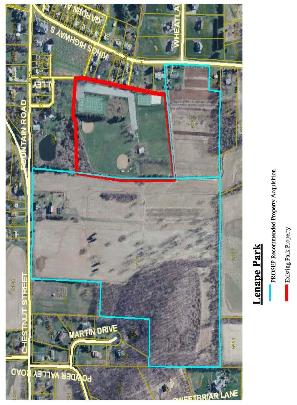
33 Existing Park Lands Lenape Park Location: Address: Description: Access: Watershed: Boundaries: Old Zionsville 6102 Kings Highway South, Zionsville, PA Lenape Park is classified as a community park, which also provides neighborhood park amenities for the village Old Zionsville. The facility is well equipped, providing Township residents with a diversity of recreational facilities. Kings Highway South Hosensack Creek, Cold Water Fishery North Residences fronting Kings Highway Northwest Old Zionsville United Church of Christ Cemetery West Residences fronting Fountain Road South Open Farmland East Open Farmland A dense hedgerow planting borders the park to the west and south. A buffer planting of evergreen trees and flowering crab apple trees line the eastern border. Forsythia shrubs and split-rail fencing border a portion of the northern property line. Land acquisition recommendations that are in this document are derived from the Park, Recreation and Open Space Plan (PROSEP) which was adopted by Upper Milford Township in Recommendations for Land Acquisition: Parcel One: This parcel is located east of the park. A single-family residence faces Kings Highway with the remaining land used for growing produce for a local market stand. Its frontage on Kings Highway could provide a much improved access into the park, although this would require major driveway improvements to connect to the existing parking areas. The land could be used to expand recreational fields in the future. In addition, by acquiring this parcel, the Township secures potential future use of the land for a community septic system absorption area. This could potentially save local residents huge expenses over the installation of a sewage system that would connect to Lehigh County Authority and the City of Allentown. The existing home could be subdivided from the parent tract and then rented, used by the township or sold. Parcel Two: Schreiber Property. Preliminary testing reveals the possibility of soil contamination from historic pesticide uses that may render this property as unsuitable for public uses. Page 33
34 Page 34
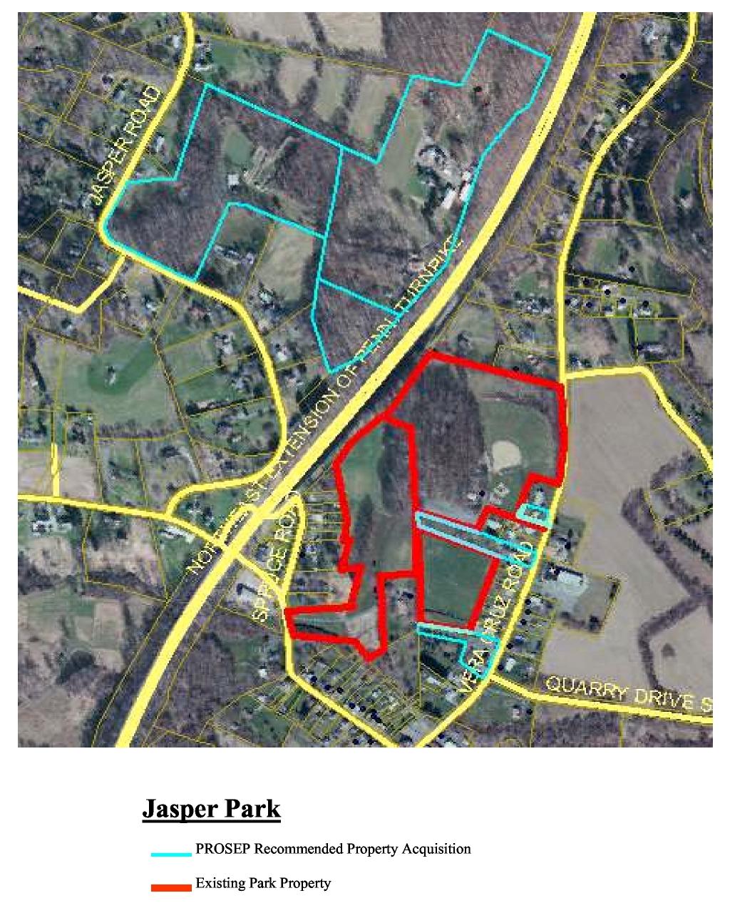
35 Jasper Park Description: Location: Jasper Park is a community park, which also provides neighborhood park amenities for the village of Vera Cruz. The facility is well equipped, providing Township residents with a complete complement of recreational facilities. Large mature trees shade over half the site. Vera Cruz Address: 4960 Vera Cruz Rd North, Emmaus, PA Access: Watershed: Boundaries: Vera Cruz Road Leibert Creek, High Quality Cold Water Fishery North Residences fronting Vera Cruz Road West PA Turnpike Northeast Extension South Residences fronting Vera Cruz Road and Main Road West East Residences fronting Vera Cruz Road and park access drive A mature woodland dominates much of the site. An open hedgerow and cleared woodlands provide spaces for pavilions, restroom facilities, and concession building. A baseball field and play area are located in a clearing northeast of the woods. The northern and eastern boundaries are defined primarily by fragments of private property structures and plantings. A stone and mature vegetated hedgerow delineates the soccer fields from the adjacent park land and residences fronting Main Road West. A pine tree buffer screens the southern edge of the soccer field to adjacent parcels fronting Vera Cruz and Main Roads. Recommendations for Land Acquisition: Parcel One: This parcel is located at the southern end of the existing soccer fields. Purchase a portion of this parcel to increase necessary green space. A maintenance/service access easement from Vera Cruz Road to this parcel would be recommended; however, paved access to this area would not be suggested. Purchase of the entire parcel includes the former Township Recreation Hall would require major road improvements offsetting any benefit to a second vehicular entrance. Parcel Two: The rear portion of this parcel is informally used by the park, as it currently divides the parking area from the soccer fields. Recommend purchase of the rear section of this parcel to secure contiguous land ownership. Parcel Three: This parcel is directly north of the existing park entrance and drive. The parcel provides necessary space to widen the entrance drive and provide a greater park presence from Vera Cruz Road. A widening of the park entrance would accommodate space for pedestrians and future connections to the Fulmer Tract across the Road. A larger sign could be placed on Vera Cruz Road with the additional road frontage. The area behind the building could provide an area for tennis and basketball courts. Parcel Four: The Pennsylvania Turnpike blasted through the center of the Jasper Quarries years ago, leaving a portion of this archaeological site on the west side of the now sunken highway. Two Page 35
36 (2) parcels, not physically connected to the park, do have a strong historical connection to the park, and should be acquired to protect this valuable resource from further irrevocable damage. The site would be an ideal archaeological site, with limited access to study by permit only. Recommend the purchase of archaeological area only. Parcel Five: The Township should contact the Upper Milford Field and Stream Association pertaining to future preservation of this tract. This parcel is adjacent to Parcel Four and includes additional woodland. Either a conservation easement or direct land purchase should be considered in keeping this property from further development or subdivision. Page 36
37 Page 37
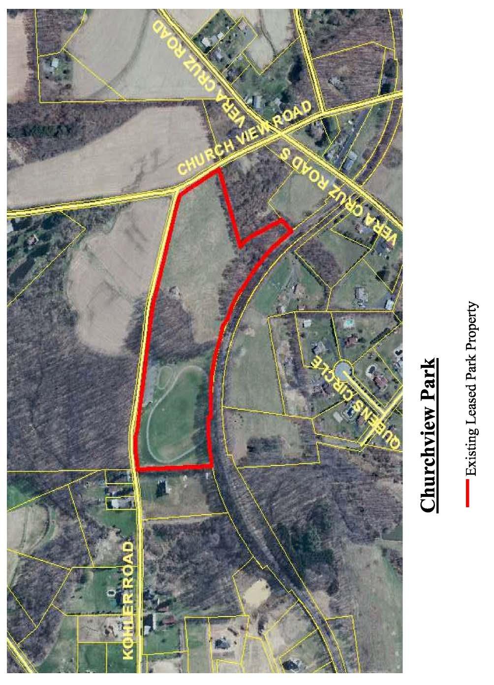
38 Churchview Park Description: Location: Address: Ownership: Access: Watershed: Boundaries: Churchview Park is a specialty park, providing an asphalt paved loop trail for cyclists and walkers. Intersection of Kohler Road and Churchview Road 4602 Kohler Road, Zionsville PA Lehigh County, under lease by Upper Milford Township for 99 years (lease originated June 1994) Kohler Road Hosensack Creek, High Quality, Cold Water Fishery North Churchview road, across from open farmland (Seem Seed Farm) West Kohler Road, across from open farmland and woodland South Large Track Residential East Railroad Line No recommendations for purchasing additional land. Page 38
39 Page 39
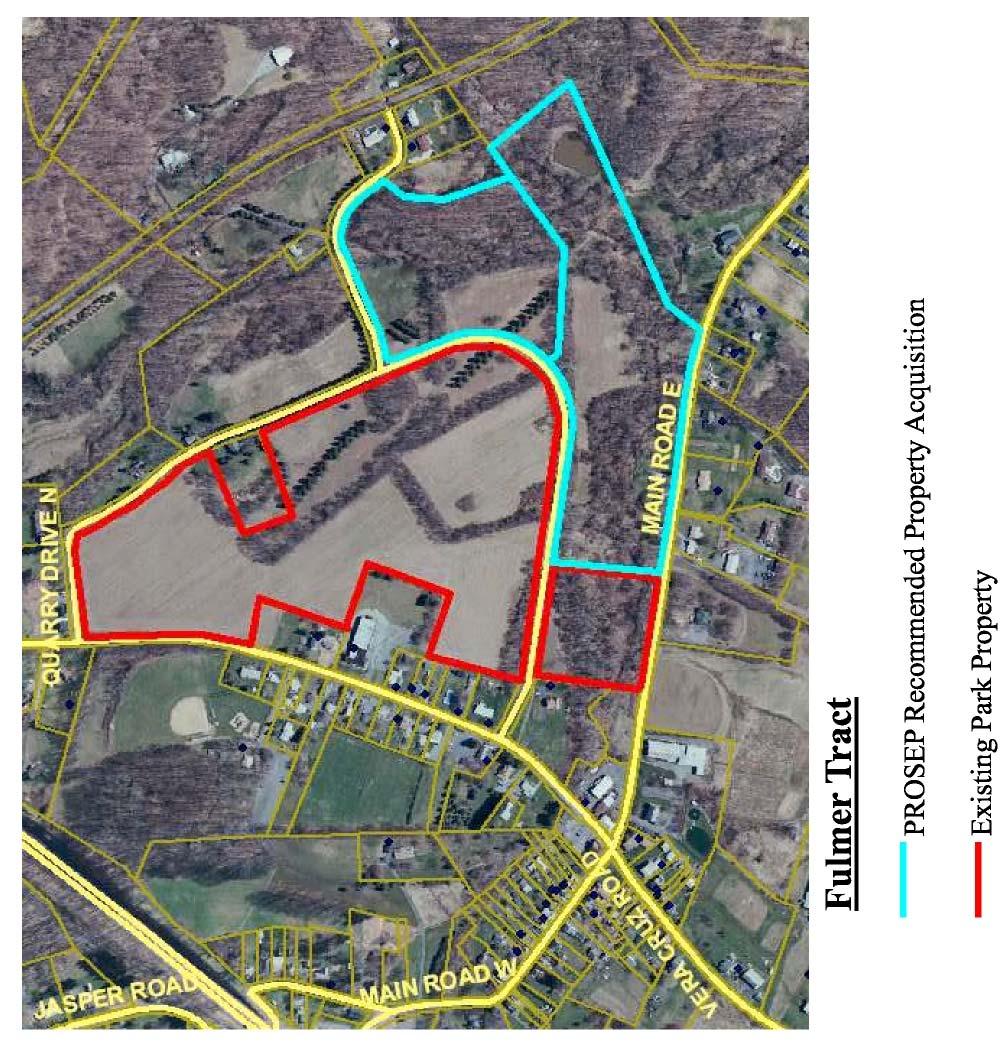
40 Fulmer Tract Park Description: Undeveloped Park, located at the northern edge of Vera Cruz. In 1997, Harold G. Fulmer donated almost 35 acres to the Township for preservation. Location: Intersection of Vera Cruz Road and Quarry Road Address: 3620 Quarry Road North, Emmaus, PA Access: Watershed: Boundaries: Vera Cruz Road and Quarry Road Leibert Creek, High Quality Cold Water Fishery North - Quarry Road with residences and woodland across West Vera Cruz Road and residences fronting Vera Cruz Road South Main Road East, pond and residence East woodland, stream Recommendations for Land Acquisition: Parcel One: This parcel is located along Main Road East and includes a significant portion of Leibert Creek and the original dam. The property contains a home, trailer, and outbuildings. Interpretation of the ice industry in Vera Cruz can be told through the remnants of the dam. The house could be leased to a park caretaker or museum or nature center or others. The Fulmer Tract is very critical in defining the village edge. Parcel Two: This parcel joins Parcel One and includes Leibert Creek. This parcel is currently undeveloped. Page 40
41 Page 41
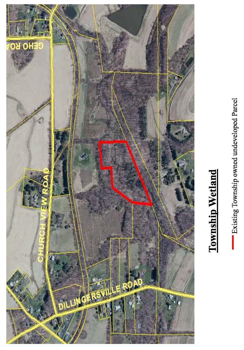
42 Township Wetland Description: Undeveloped open space. A land-locked parcel, covered in woodland and dense vegetation with a small stream passing through the center. Location: Eastern Township boundary, south of Conservation District Demonstration project on the Seem Seed Farm lands Address: Access: Watershed: Boundaries: 4191 Dillingersville Road, Zionsville, PA None Hosensack Creek, Cold Water Fishery Surrounding woodland and active farmland Recommendations for Land Acquisition: 1. Considering the Township s current liability and future maintenance costs, selling this parcel to an adjacent land owner, with the understanding it will never be developed, is an option to be explored. As part of the negotiation, the buyers may enter into a conservation easement for their entire parcel with Lehigh County. The monies from the sale of this parcel can be used to purchase other lands more critical to its park, recreation, and open space programs in Upper Milford. 2. In order to maintain the property, the Township should explore acquisition of land and/or access easements from the Conservation District Demonstration Park to the Township site. Much of this area is wetland and requires careful planning to not damage sensitive wetland habitats. In addition, access and parking to the Demonstration Project is currently deteriorated and would require improvements to facilitate expanded use. Page 42
43 Chapter No. 7 EXISTING NATURAL FEATURES Page 43
44 Existing Natural Features Watersheds Upper Milford Township is divided by two (2) major watersheds, the Lehigh (approximately 60%) and the Schuylkill River (40%). These watersheds are subdivided into eight (8) major stream watersheds, many of which are headwaters to the contributing stream. Major Watershed - Lehigh Sub area Little Lehigh Creek The Little Lehigh Creek provides the City of Allentown with the majority of its daily water supply. 1. Leibert Creek The headwaters start east of Shimerville and traverses around Vera Cruz, through Leibert s Gap to the Little Lehigh. Leibert Creek flows through portions of Jasper Park and the Fulmer Tract. 2. Swabia Creek A branch of Swabia Creek begins in Upper Milford Township west of Route 100, near Macungie Borough. 3. Mountain Creek The headwaters of Mountain Creek, which filters through Lower Macungie Township and Macungie Borough, starts in the western edge of Upper Milford, near Sweetwood Drive. This watershed provides drinking water for Macungie Borough residents. A large parcel of woodland is currently owned by the Borough to protect this resource. Mountain Creek spills into Swabia Creek which then connects to the Little Lehigh Creek. Mountain Creek is not specifically state designated; however, it is a tributary to Swabia Creek. 4. Miller Creek The headwaters of Miller Creek begin near the Route 100/29 split on the north side of South Mountain and proceed north. Sub area Saucon Creek 1. Saucon Creek The headwaters to two (2) branches of the Saucon Creek start on either side of Brunner Road, near Mountain Drive. The Saucon Creek continues into Upper and then Lower Saucon Townships before spilling into the Lehigh River. Major Watershed Schuylkill River Sub area Perkiomen Creek 1. Perkiomen Creek The headwaters of the Perkiomen Creek flow from and back to Hereford Township after making a u-turn in the southwest corner of Upper Milford. The creek follows Sigmund Road, Yeakel's Mill Road, and Route 100/29 Chestnut Street. The Perkiomen Creek proceeds through Hereford Township, Berks County to Montgomery County where it eventually flows into the Schuylkill River, near Valley Forge Park. 2. Hosensack Creek The headwaters of Hosensack Creek branch south of Zionsville and Dillinger Station, traversing south along the Township border and into Lower Milford Township near Scout Road. Lenape and Churchview Parks contribute to this watershed. 3. Indian Creek The headwaters of Indian Creek begin near Indian Creek and Schantz Roads, just west of Shimerville. The watershed encompasses a large portion of the Township. The Indian Creek eventually flows into the Perkiomen in Upper Hanover Township, Montgomery County. Page 44

45 Figure 7 1 Little Lehigh Creek Watershed; Map Page 45

46 Figure 7 2 Saucon Creek Watershed; Map Page 46

47 Figure 7 3 Perkiomen Creek Watershed; Map Page 47
48 Water Quality Upper Milford Township includes the headwaters (the start of a stream) for several streams and rivers. Most of these have been state classified as high-quality, cold-water fishery streams. The high quality status is significant in realizing the importance the surrounding local land has on regional water quality. 1. Leibert Creek high quality cold water fishery (HQ-CWF). 2. Hosensack Creek cold water fishery (CWF). 3. Saucon Creek cold water fishery (CWF). 4. Swabia Creek high quality cold water fishery (HQ-CWF). 5. Mountain Creek high quality cold water fishery (HQ-CWF). 6. Perkiomen Creek high quality cold water fishery (HQ-CWF) 7. Indian Creek cold water fishery (CWF). (Currently under review for HQ-CWF designation.) 8. Miller Creek - high quality cold water fishery (HQ-CWF) Flood Plain Areas Understanding how floodplains enhance water quality and foster healthy habitats, justifies preservation and proper management of these areas. Floodplain areas within the Township have been identified on the primary conservation areas map. The Upper Milford Township Zoning Ordinance currently restricts development within 50 feet of any waterbody. A floodplain includes the stream channel, the floodway, and the adjacent fringe. The floodplain is based on watershed area, stream size, and surrounding topography. A functioning flood plain stores and conveys flood waters, recharges groundwater, and provides natural wildlife habitat. Floodplain vegetation filters debris, slows water flow rates, absorbs water, and reduces erosion, which is critical to surface runoff water quality. The existing Township ordinances strictly limit development in these areas. The Federal Emergency Management Agency (FEMA) has mapped the 100 year flood plain along stream corridors. Wetlands National Wetlands Inventory (NWI) developed by the U.S. Department of Interior is a starting point for wetland determination. NWI mapping uses sterio-photography to delineate these areas which are incomplete. Locating wetland limits or boundaries is critical in preventing development from damaging these sensitive habitats. The primary conservation areas include the NWI delineated wetlands. Wetland determination finds areas that are wet lands. Wetlands are typically found in low areas or adjacent to streams or ponds. Areas of high water table, slopes where groundwater springs emerge, perimeters of streams or ponds, flat areas, or abandoned ditches or stream channels are all potential wetland habitats. The wetlands shown on the primary conservation areas plan are large scale and do not include all the wetland areas in the Township nor do they clearly define their limits. Each applicant must provide field determined delineated wetlands on their plans to prevent disturbance. Wetland delineation only provides the basic outline of a wetland area and does not include the upland watershed to this wetland area. The upland watershed often provides the water resource creating the wetland. Changes in upland topography, stormwater runoff, and vegetation can significantly impact a wetland without directly disturbing the delineated wetland. Buffers surrounding wetlands should be maintained to transition development to the natural wetland area. Post-development conditions should recreate overland flows and discharge quantities into the wetland buffer zone to minimize development impacts. Page 48
49 Ideally, a buffer is a vegetative buffer, filtering the surface runoff before entering the wetland. Vegetative buffers should not be mowed lawn or manicured landscapes, but rather large meadows or young woodlands managed to eradicate invasive plants and foster native plant propagation. The buffer also filters out invasive plants, protecting the wetland habitat from non-native invasive plants. Greenways In 1998, the Commonwealth of Pennsylvania ordered a PA Greenways Study under Executive Order A February 2003 update identified spine greenways or linear trails which covered 50 miles in length and included two (2) or more counties. These spines provide state-wide linkages, which municipalities can implement local system connections. In 1999, Lehigh County completed a Natural Areas Inventory. The Department of Conservation and Natural Resources (DCNR) plans to develop a county-wide greenway plan in 2004 for Lehigh County. The website is a clearing house of information for local communities concerning greenway networks across the state. Upper Milford Township is partly in the Schuylkill River Watershed and Greenway, 1 of 21 state designated greenways/trails. The Delaware and Lehigh Canal corridor is a second greenway. The Township s watershed contributes to this historic transportation route. Upper Milford Township should identify Township greenway corridors and their long-term potential connections to statewide greenways. Scenic Areas Several scenic areas were identified in the 1990 Upper Milford Township Comprehensive Plan. Many of these areas remain areas of landscape beauty. A recent windshield survey of the Township revealed the following scenic areas: 1. Powder Valley and the southern portion of Indian Creek along Powder Valley Road 2. Corning Road, from the Lower Milford Township boundary to the intersection of Pine Tree Road. 3. Old Zionsville village area 4. Zionsville village area and Rock Road 5. Geissinger Road from Kings Highway to Carl s Hill Road 6. Vera Cruz Village Area 7. Indian Creek Road from Chestnut Street to Schantz Road 8. Kohler Road 9. Seem Seed Farm area German Road, Churchview Road, Vera Cruz Road 10. Dillinger Station Geho and Churchview Roads 11. Acorn Drive from Bleiler Road to the Lower Milford Township line 12. Brunner Road from the Upper Saucon Township line to South 5th Street 13. South 5th Street, from Main Road East to South Mountain Drive. 14. Kings Highway North from Macungie Borough line to Chestnut Street Intersection 15. Beck Road between Kings Highway and Chestnut Street 16. Scout Road These areas depict typical landscape characters in Upper Milford Township. From wooded stream valleys to expansive views of rolling farm fields to small village centers, the landscape of Upper Milford is unique. These areas can be impacted by uncontrolled development. Care should be taken to preserve these areas by locating any proposed development out of view or within character to its surroundings. Page 49
50 Scenic Drive Several areas have been noted on the Scenic Areas and Views plan as areas of particular scenic value. Combined with scenic views and identified cultural resources, a scenic driving tour would connect many points of interest, educating residents about their community. An increased awareness of areas with scenic and cultural value will encourage support for preservation efforts. Natural Areas Inventory The Lehigh Valley Planning Commission prepared a Natural Areas Inventory in April 1999, identifying significant natural resources in Lehigh and Lehigh Counties. Two sites of statewide significance were identified in Upper Milford Township and a third in neighboring Lower Milford Township. 1. Indian Creek Floodplain (County Ranked No. 3) includes both Upper Milford and Lower Macungie Township. Evidence of PA Endangered animal species was observed in The plan recommends surveys are completed to define the extent of habitation. 2. Macungie Watershed (County Ranked No. 4) includes both Upper Milford and Lower Macungie Township. Fair to good quality Northern Appalachian Circumneutral Seeps Natural Community, supporting several species of state concern. 3. Hosensack Marsh (County Ranked No. 1) is in Lower Milford Township. Marsh and shrub swamp support fair to good quality population of PA-Endangered animal species. This is of importance to Upper Milford Township, as Hosensack Creek is supplied from Upper Milford Township. All sites ranked 1 or 2 were recommended for immediate protection and or management of the site and the surrounding lands. Conservation easements and/or land acquisition of privately-owned lands are suggested. Page 50

51 Page 51

52 Page 52

53 Page 53
54 This page left intentionally blank. Page 54
55 Chapter No. 8 GOALS AND RECOMMENDATIONS Page 55
56 GOALS The goals of this plan, as listed below, describe the Township's ambitions: Protect agricultural lands. Improving protection of natural features, including the quality of surface water, groundwater and wildlife habitat. Exploring the possibilities of requiring conservation-oriented design in the Upper Milford Township Subdivision and Land Development Ordinance. The goals result from: Upper Milford Township Open Space Committee meetings; Park, Recreation, Open Space, Environmental Plan for Upper Milford Township; Goals and recommendations in the Southwestern Comprehensive Plan; Results of the public survey the Township conducted in 2003; Interviews with municipal officials, business persons, farmers and other Township residents; The mapping and analysis of existing conditions summarized in the previous chapters; Fieldwork conducted in the Township; and Research on how other counties and municipalities have approached open space preservation. Goal for Preserving Open Space Add to the amount of land in Upper Milford Township now preserved by: a) Implementing a land preservation program wherein municipal funds are prudently spent within clear guidelines.* b) Maximizing the use of available federal, state, county and private funds. c) Encouraging voluntary land preservation through local and national land conservancies and/or land conservation programs. *The primary method used would be purchase of development rights but would not exclude direct purchase of the land (i.e. fee simple acquisition) if the situation warrants it. Page 56
57 Goal for Improving the Protection of Natural Features: a) Strengthening applicable zoning regulations, and subdivision and land development regulations where needed. b) Working with local conservancies and the Joint Borough of Emmaus and Upper Milford Township Environmental Advisory Council to enhance environmental education and raise public awareness about the need for conservation. Goal for Implementing Conservation-Oriented Subdivision Design a) Facilitate open space preservation in areas being developed by considering zoning ordinance and subdivision and land development ordinance amendments that would mandate the use of conservation-oriented subdivision design techniques (i.e. mandatory open space dedication, open space development zoning, dedication of land for trails, etc.). RECOMMENDATIONS The recommendations described in this chapter are the heart of this Open Space Plan. They are the actions proposed to address the needs and fulfill the goals identified above. Like the goals, the recommendations are grouped into the following categories: Preserving more open space Improving protection of natural features Implementing conservation-oriented subdivision design The main ideas and assumptions behind the recommendations are as follows: a) To help maintain its unique character and rural heritage, Upper Milford Township should be proactive in identifying and acting upon preservation opportunities. b) Public parks and open spaces must be augmented with permanently preserved private land if the Township hopes to protect farmland, waterways, woodlands and other environmental amenities, in any significant way. c) Conservation easements, mandatory dedication, donations and other means of preserving land should be emphasized over fee simple acquisition. d) Federal, state, county and private funds to supplement municipal funding will be essential to fully implement this plan. e) Municipal regulations and strict development criteria will be needed to conserve natural features on properties slated for development. f) The Township must determine its preservation priorities based on fair and objective criteria. g) The Township's preservation criteria should place primary emphasis on environmentally sensitive areas and existing agricultural uses. h) Use of condemnation may be reserved to preserve the public s interest. i) Appraisals should be used to establish fair market value before any funds are expended for preservation. j) A standardized systematic approach is required to administer and implement an open space preservation program equitably and effectively. Page 57
58 Recommendations for Preserving More Open Space The following recommendations suggest how Upper Milford Township could set up and administer an open space preservation program. A numerical ranking system is proposed for evaluating potential applications under the program. Target areas are identified showing where initial preservation efforts could be focused. 1. Establish and administer Upper Milford Township Open Space Preservation Program in accordance with the following procedures. Relying on Conservation Easements Upper Milford Township should remain open to receiving donated land or perhaps buying land in fee simple if appropriate opportunities arise. However, the Township should expect to rely mainly on buying conservation easements to preserve land under this program. Conservation easements are legally enforceable contracts, under which landowners sell or donate the right to develop their land. Conservation easements can be donated, but more often the landowner granting the easement expects to be compensated financially. A conservation easement "runs with the land" and must be observed by any new owner of the affected property. Setting Up the Program The Upper Milford Township Supervisors would authorize the Open Space Committee to announce, advertise and otherwise publicize that the Open Space Committee is accepting applications for the program from people who own land in the Township. Accepting and Evaluating Applications Interested landowners would submit an application for the program that includes the following information: name and phone number of the land owner address of subject property total acreage of property and total acreage of proposed easement deed reference (book and page) County/Township tax parcel numbers name of any lien or mortgage holder, and amount of lien or mortgage a United States Geological Survey (USGS) topographic map showing the location of the property a tax map showing the location of the property a list of structures on the property information on any applicable agreements to sell and/or applications to subdivide the property The Open Space Committee would then schedule a visit to the view the property and subsequently evaluate the property according to the numeric ranking system such as one of those presented below. Numerical scores for specific properties would be determined by consensus of the members Page 58
59 at Open Space Committee meetings. All results would be reported to the Upper Milford Township Board of Supervisors. Determining Value Based on the total funds the Township has available for this program, the Open Space Committee would order appraisals on a certain number of properties. The order of the appraisals would follow the order of numeric rankings given to the various applications. The highest scoring property gets appraised first, and so on. Appraisals would be conducted by a State Certified General Real Estate Appraiser, who would be selected and paid by the Township. The appraisal report would estimate the market value of the property both with and without the proposed easement. The value of the easement would be the difference between these two estimated values. All results would be reported to the Upper Milford Township Board of Supervisors. Making Offers Upon authorization from the Upper Milford Township Board of Supervisors, the Open Space Committee, on behalf of the Township, could elect to make offers to purchase conservation easements from one or more landowners who applied for the program. The order of offers would follow the order of the numeric rankings. The total number of offers made would be based on the amount of available funding. The offer price for a specific easement could be less than the appraised value of the easement but could not exceed the appraised value. Accepting Offers Within a prescribed period, landowners who receive an offer must either: a) accept the offer; b) reject the offer (and drop out of the program); or c) announce they intend to submit an independent appraisal they pay for themselves. As authorized by the Board of Supervisors, the Open Space Committee would have the option to revise its offer based on the independent appraisal. If an offer is accepted, a legal agreement would be executed between Upper Milford Township and the landowner. Settlement At a real estate settlement, the landowner would sign an easement that is legally recordable and Upper Milford Township would pay the agreed purchase price to the landowner. The agreed purchase price could be paid as a lump sum or by installments, whichever is mutually acceptable to 'the Township and the landowner. Page 59
60 Enforcing the Easement The Township could convey the easement to a land trust, a conservancy or a related entity. Otherwise, the Township would retain the easement itself and be responsible for enforcing the terms of the easement. At least once a year, the Township Official would determine if the landowner is complying with the terms of the easement. If the Township Official determines the landowner is not complying, the Board of Supervisors would be notified. At that point, the Township would take appropriate action. The terms of the easement should not prohibit the following activities provided these activities comply with Township zoning regulations, and Township subdivision and land development regulations: Sale of agricultural products produced on the property. Construction of ancillary structures limited in coverage to a certain percentage of the property. Use of the property for allowable home occupations. Subdivision of less than two acres (or the minimum acreage required by the Township's zoning or subdivision regulations) for the construction and use of the landowner's principal residence or a family member's principal residence (one time only). Cooperating with the Lehigh County Farmland Preservation Program and the Area's Non- Profit Conservancies Under this program, Upper Milford Township could also consider using municipal funds to assist Lehigh County purchase conservation easements on farmland in Upper Milford Township. The Township should work with Lehigh County and the non-profit conservancies to preserve lands that none of these entities would be able to preserve alone. Legal interest in an easement can be shared by two or more entities. However, subject to advice from the Township solicitor, it may be simplest for the Township to convey the easement (and enforcement responsibilities) to the Lehigh County Agricultural Preservation Board if a farmland easement is ever jointly purchased in this manner. The same procedures and provisos could also apply to an easement the Township may consider purchasing jointly with a land trust, conservancy or related entity. Use a numerical ranking system similar to the following to evaluate the suitability of properties for potential preservation. 2. To ensure any open space preservation program is administered fairly, the Township could use a numerical ranking system similar to one of the following. Page 60
61 Table 8 1 Farm Preservation Land Ranking System CRITERIA POINTS FARMLAND (Maximum of 12 Points) At least 75 % of the property is now used for harvested crop land or animal husbandry 12 At least 50 % of the property is now used for harvested crop land or animal husbandry 10 IMMINENT DEVELOPMENT (Maximum of 10 points) Property is part of a subdivision or land development proposal with preliminary or final 10 approval Property is part of a subdivision or land development proposal submitted within the past 8 five years PARCEL SIZE (Maximum of 10 Points) Property is at least 25 acres in area 10 Property is at least 15 acres in area 8 ZONING (Maximum of 10 Points) Property is in the A; Agricultural Zoning District 10 Property is in the RS-R; Rural-Suburban Residential 8 Property is in the R-A; Rural Agricultural District 8 Property is in the S-R; Suburban Residential 5 WOODLAND VALUE (Maximum of 10 Points) At least 65 % of the property is wooded 10 At least 50 % of the property is wooded 8 OPEN SPACE CONNECTION POTENTIAL (Maximum of 10 Points) Property is adjacent to another existing or proposed preserved property 10 Property is within ¼ mile of another existing or proposed preserved property 8 FARMLAND CONNECTION POTENTIAL (Maximum of 10 Points) Property is adjacent to two more properties that are at least 50 % used for crop land or 10 animal husbandry Property is adjacent to one property that is at least 50 % used for crop land or animal 8 husbandry DEVELOPMENT POTENTIAL - STEEP SLOPES (Maximum of 10 Points) At least 65 % of the property is free of slopes 15 % or greater 10 At least 50 % of the property is free of slopes 15 % or greater 8 DEVELOPMENT POTENTIAL WETLANDS OR FLOODPLAINS (Maximum of 10 Points) At least 70 % of the property is free of hydric soils or 100-year floodplains 10 At least 55 % of the property is free of hydric soils or 100-year floodplains 8 SCENIC VALUE (Maximum of 10 Points) Property provides a view of a broad scenic vista 5 Property provides a view of a particular scenic location 3 HISTORIC VALUE (Maximum of 10 Points) Property is listed on the National Register of Historic Places or a local historic survey 3 Property contains a pre-1940 house or barn 2 TOTAL POSSIBLE POINTS 100 Page 61
62 Table 8 2 Natural Resources Land Ranking System CRITERIA POINTS WATERSHED PROTECTION (MAXIMUM 40 POINTS) Wetlands 5 Stream (s) 5 Flood plain 5 Property is within 300 feet of wetlands or stream (buffer) 4 Riparian Woodlands 4 Property contains groundwater recharge area or surface watershed area for public water 5 supply. Steep slopes (>15% slope) 4 Moderate slopes (>5%, <15% slope) 4 Severe limitation for septic system (unless sewer is available to property) 4 HABITAT AND LINKAGES (MAXIMUM 25 POINTS) Habitat for breeding, feeding or wintering area for species of concern present on 5 property. Above criteria not present on property but on an adjacent property. 2 Property is at least 25 acres in area. 5 Property is ranked on the Lehigh Valley Comprehensive Plan as: Very High Conservation Priority 6 High Conservation Priority 5 Medium Conservation Priority 4 Adjacent to existing public or conserved open space, or could have an active linkage 5 (i.e. conservation easement or trail) Within 300 feet of public or conserved open space but not adjacent. 2 Woodlands 5 acres or more 4 VIEWSHED AND HISTORIC SIGNIFICANCE (MAXIMUM OF 15 POINTS) Has public access to and provides a significant view from property. 5 Property is part of a significant view shed. 5 Property includes structures of historical significance. 5 Property located adjacent to above criterion but does not have criterion on site. 5 TOTAL POSSIBLE POINTS 80 OTHER FACTORS CONSIDER (1 POINT EACH) Economic: acquisition of conservation easement or restriction on future development below or at market value. (Yes / No) Accessibility by roadway. (Yes / No) Barrier potential. (Yes / No) Suitability for recreation (active / passive) (Yes / No) Availability of additional state and county funds. (Yes / No) Road Frontage (Yes / No) Development Pressure (Yes / No) Cold water fisheries or exceptional value streams. (Yes / No) 3. The Open Space Committee will also request from the applicant the availability of a walk through of the property. The walk through will enable the Open Space Committee the ability to evaluate the properties with one of the above ranking systems. Page 62
63 4. Use public information to increase future participation in the Upper Milford Township Open Space Preservation Program. People will only consider participating in a land preservation program if they understand their options and what these options mean to them. Municipal officials and other residents can make informed judgments about whether to spend municipal revenues on open space preservation only if they are clear about what it is likely to mean for both landowners and the municipality. The Township should use the following information to help ensure residents understand the basic facts about open space preservation and conservation easements. Property rights are often compared to a bundle of sticks with each stick representing a different right, such as the right to develop your land. Selling or donating development rights means giving up one of these sticks. The landowner retains all the other sticks and still owns the land after giving up development rights. Landowners transfer their development rights to someone else by granting a legally enforceable conservation easement. The easement can pertain to all, or to just a portion, of a person's property. These easements typically stipulate that the affected land shall remain undeveloped forever. The easement is attached to the property deed and its restrictions are transferred to the new owner if a property that is under a conservation easement is ever sold. The IRS Code allows people who donate conservation easements to deduct the value of the easement in calculating their federal income tax, subject to certain limits. The value of the easement is the difference between the appraised values of the property before the easement and after the easement. Whether the landowner donates a conservation easement or sells it for a fee, the reduced value of a property for which development rights were given up can be used to justify a reduced property assessment. The landowner can thereby save each year on real estate taxes. The entity that receives the donated or sold conservation easement is said to "hold" the easement. That entity is responsible for enforcing it. Enforcement of a conservation easement is usually done by periodic monitoring of the affected property. Subject to any special terms that may be part of the easement, the landowner is allowed to continue all regular activities on the eased property (such as farming, mowing, etc) even though a conservation easement is now in place. There is no restriction on selling land with a conservation easement on it to someone else. Recommendations to Improve Protection of Natural Features An open space preservation program should be augmented with effective development regulations. The following recommendations identify how Upper Milford Township can further protect natural features on properties being developed. There are development practices that can provide landowners with needed income while still conserving unique natural areas, sensitive environment resources and the Township's overall low-density character. 1. Make greater use of zoning and subdivision regulations to enhance environmental Page 63
64 protection. Land varies greatly in the amount of development it can physically support. Floodprone areas and very steep slopes should remain undeveloped. Other lands are suited for moderate or intense development. Upper Milford Township regulates development of steep slopes, woodlands and other natural features as described earlier. Still, the Township will benefit from using the following guidelines in reviewing development proposals. Page 64
65 Table 8 3 Guidelines For Protecting Important Natural Features NATURAL FEATURES POTENTIAL PROBLEMS (Type & Description) IF NOT PROTECTED Steep Slopes - Steep slopes of 15% have 15 feet of vertical change for every 100 feet of horizontal distance. Very steep slopes of 25% rise vertically 25 feet for every 100 feet. Steep slopes are sometimes wooded and found along Creeks. Difficulty of maintaining and snowplowing steep roads. Higher costs of buildings. High rate of septic system failures. Increased erosion and runoff. Winter driving hazards from steep roads and driveways. 1. Disturbance of scenic areas. 2. Increased costs to extend public water and sewer lines. STRATEGIES FOR PROTECTION Site houses on the most suitable land, while keeping steep slopes in open space. Keep natural vegetation intact. Enforce all municipal regulations that protect steep slopes. Groundwater - Groundwater ispolluted groundwater. stored underground after enteringdry wells. through the soil or seeping from creeks. Maintaining the quality of this water is important because both private wells and public water systems depend on groundwater. Continue to control the percentage of lots covered by buildings and paving. Ensure septic systems are designed and operated properly. Monitor underground storage tanks for leaks. Avoid polluted storm water runoff. Avoid high volume withdrawals of groundwater. Explore the feasibility of having a groundwater/hydrological study completed. Floodplains - Areas that areincreased flooding in other areas. Prohibit construction of new structures within prone to flooding include bothloss of potential public recreation the 100-year floodway (which is the actual legally designated floodplains andarea. Threats to important wildlife main flood channel) and along the adjacent land along drainage channels. and bird habitats. 100-year flood-fringe. Prohibit construction within 100 feet of the centerline of a stream (depending on stream size). Seek to preserve buffers of natural vegetation immediately adjacent to creeks and drainageways. Seek to preserve more land along local streams and drainageways. Wooded Areas - Concentrated areas of mature tree growth are found throughout the region's steeply sloped lands and in other Increased surface temperatures. Loss of important bird and wildlife habitats. Loss of hunting areas. Restrict cutting of trees during building to the building envelope and immediately adjacent areas. Seek to preserve tree stands in public or private open space. Seek replanting of scattered locations. Loss of air purification. trees that must be cut down. Increased erosion and runoff. Loss of scenic resources. Noise and incompatible development may become more noticeable. Shallow Depth to Bedrock -Higher construction costs. Minimize building in these areas. Areas with shallow soils and bedrock close to the surface are frequently found in steeply sloped locations. Page 65
66 Waterways - ProtectingLoss of potential public recreation Prevent soil erosion to avoid sedimentation of waterways from pollutants areas. Threats to important bird, fish creeks and drainageways. Work with soil involve controlling directand wildlife habitats. conservation authorities and farmers to keep discharges and maintaining Increased erosion and animals out of streams. Consider areas along vegetative stream buffers. flooding. creeks and drainageways for public greenways. Minimize runoff of pesticides, grease and industrial wastes. Minimize direct runoff from parking lots. Require buildings and paving to be setback from creek banks and significant drainageways by at least 50 feet. In Upper Milford, the stream setback is 25 feet except for the Delaware River and Lehigh River. Control the peak rates of storm water runoff from development to avoid increased flooding. Natural Drainage Channels Increased flooding. Smaller natural channels thaterosion of soil. carry storm water to local creeks during heavy storms exist throughout the regions. Preserve adequate width along channels in open space. Prevent erosion. Hydric Soils - Hydric soils, often Flooded basements. Disturbance of Continue to enforce local, state and federal located in wetland areas, have anatural drainage and groundwater wetland regulations. Place on-lot septic shallow depth to the seasonallyrecharge. high water table. Poor foundation stability. systems and buildings outside hydric soil areas. Retain a professional to prepare sitespecific wetlands Failed on-lot septic systems. maps. Source: URDC NOTE: In addition to the protection strategies noted above, Upper Milford Township should consult the Lehigh County Natural Areas Inventory to be aware of locations in the Township identified as unique natural habitat. This document is available from the Lehigh Valley Planning Commission in Allentown, PA. Page 66
67 2. Enhance wellhead protection efforts through regulation and other techniques. Water available for wells is located in underground rock or soil layers called aquifers. The surface areas from which water seeps into aquifers are known as recharge areas. The quantity of water that seeps into aquifers depends on what soils and what impervious surfaces exist in the recharge areas. The quality of the water depends on the presence or absence of contamination above the aquifers. In eastern Pennsylvania, the primary sources of groundwater pollution (wellhead contamination) are: Underground or above ground storage tanks Industrial waste sites and other landfills Agricultural fertilizers and pesticides On-lot sewage systems It can be difficult to determine the path that groundwater takes between the surface and the aquifer. A professional geologist is best qualified to define the extent of the surface area from which a specific public water supply is recharged. Once the groundwater protection (wellhead protection) area is defined, protective strategies can be put in place. Since the quality of groundwater depends on nearby uses of land, groundwater can be protected by regulating development through zoning and subdivision ordinances. Regulations that govern impervious surfaces, industrial uses and on-site septic systems are particularly important. Zoning techniques that reduce density and maintain open space are also beneficial, including agricultural zoning, open space subdivisions (clustering) and transfer of development rights. Wellhead protection districts are specially created overlay districts around wells or well fields that afford extra protection for groundwater sources. Within wellhead protection districts, certain land uses may be prohibited entirely. Other uses may be permitted under special conditions, and only with the approval of the zoning hearing board or governing body. The extent of a wellhead protection district can be determined from hydrogeologic analysis, or be based on a specific, predetermined radius around the applicable well(s). Wellhead protection districts are now being considered in many municipalities. The Emmaus Water System has identified the Leibert Creek Basin as a groundwater source for its municipal water supply. In addition to regulation, ways to protect groundwater resources include public education about farming practices, recycling, regular septic system maintenance and the proper disposal of toxic or hazardous household waste. Page 67
68 Recommendations to Implement Conservation-Oriented Subdivision Design The following recommendations address ways to ensure that approved residential subdivisions are designed and built with respect for the natural environment and rural heritage of Upper Milford Township. 1. Consider amending the A Agricultural, R-A and RS-R; Rural-Suburban Residential Zoning to require developers to use more open space oriented subdivision design. "Clustering", "Open Space Subdivisions", "Lot Averaging" and "Conservation Zoning" are various names for related design techniques that conserve open space within residential subdivisions. Many Pennsylvania municipalities have adopted variations of these subdivision regulations to help conserve common open space and protect sensitive natural features like steep slopes, woodlands, wetlands and stream corridors. In comparison, conventional subdivision design usually results in little or no preserved open space because the entire tract is subdivided into building lots and roads. Often most of the building lots in a conventional subdivision are virtually the same size and shapehence the nickname "Cookie Cutter Subdivisions". The goal of open space subdivisions design is to place homes on the most suitable portions of a tract, with the important natural areas being preserved, such as lands along creeks. This option allows developers flexibility in site layout. For example, developers can make better use of site topography and avoid soils that are not suitable for septic systems. Open space related subdivision design also permits the developer to group building lots together, thereby reducing road lengths, grading and utility extensions-each of which saves on construction costs. Sometimes, developers are allowed to build a few additional homes in exchange for preserving land in its natural state. Several alternatives exist concerning the long term maintenance of the preserved open space, including ownership by a homeowners association, the Township, the State or a land conservancy. Alternatively, the open space can be distributed among private lots so that the open space portion of each of these lots is deed restricted for permanent conservation. 2. Encourage developers to use voluntary design guidelines in addition to any conservation oriented design techniques mandated in new zoning and/or subdivision ordinance amendments. Upper Milford Township could encourage developers to use the following guidelines on how best to design and locate residential structures, adjacent open space and complementary landscaping. The guidelines are divided into four topics: site planning, architecture, landscape architecture and signage. All four sections should be used as a guide for planning commission members and other Township officials when reviewing new development proposals. Page 68
69 Site Planning Orient uses to minimize objectionable views, such as service areas and the backs of buildings, from roadways and from scenic overlooks, Match scale and character of buildings and other uses to the scale and character of the site and the surrounding environs, Maximize joint use driveways, Minimize impervious cover, Provide scenic overlooks whenever possible, Provide landscaping along the perimeter of parking areas, Place utilities underground, Minimize the grading by the use of retaining walls, building orientation and running with contours, Avoid placing buildings on cleared ridgelines to protect views, and Use curved driveways when developing in wooded areas to obscure the view of the house from the road. Architecture Minimize the height of the proposed structure, especially on ridgelines and in very visible locations, Reduce the building mass by breaking up the building into smaller components, Use indigenous building materials, such as stone, Use compatible, earth tone colors that blend with the existing environment, Design structures to fit the topography rather than excessively grading the site, and Use pitched roof design features. Landscape Architecture Minimize removal of existing trees, especially on ridgelines, Establish vegetative buffers adjacent to roadways, Screen objectionable views, Maximize parking lot landscaping, and Use indigenous plant materials. Signage Use materials that are compatible with the proposed or existing buildings and landscape elements, Locate signs on the building in consistent sign bands, Group signs on one sign structure, Avoid bright colors and internally illuminated signs, 3. Consider requiring developers to identify conservation areas before delineating development areas. Although steep slopes, floodplains and wetlands are usually noted on the site plans, little consideration is sometimes given to other elements like a grand oak tree, a wildflower meadow or an orchard; features that can be preserved to help maintain rural character. By conducting a more intensive analysis of the site, developers should be able to achieve adequate densities without sacrificing these environmental amenities. The following four steps are a sequential approach Page 69
70 towards more conservation-oriented design based on the recommendations of noted conservationist Mr. Randall Arendt, formerly of The Natural Lands Trust. a) Identify Primary and Secondary Conservation Areas -First, identify primary conservation areas such as sensitive natural areas: steep slopes over 25%, 100-year floodplains, streams and their buffers, and habitats of rare, threatened and endangered species. b) Other conservation areas may include scenic views, locally important vegetation, unique geologic features and wet soils, among other areas. c) Identify Locations for Development - Next; locate potential development areas which include the remaining land left over after the primary and secondary conservation areas are identified. Carefully consider siting new homes with views of the open space areas. Reduce the lot sizes to accommodate for the number of homes that would have been originally provided under conventional development. d) Layout Roads and Trails -Show a road alignment that would most efficiently access all new homes. Also consider developing trails that could link residents with each other and with the open space areas. e) Delineate Lot Lines -The final step involves delineating the boundaries of each lot, a step often done first in traditional design. 4. Investigate the feasibility of using transfer of development rights in Upper Milford Township Transfer of development rights (TDR) shifts development away from sensitive environmental lands to areas more suitable for higher density. Under a TDR program, property owners in the areas where conservation is to be encouraged (sending areas) sell their development rights to landowners who use them in areas where development is to be concentrated (receiving areas). In this way, a municipality conserves natural areas or other open space in exchange for allowing higher density than otherwise permitted on a tract already zoned for development. The buyer and seller of the development rights negotiate a mutually agreeable price on their own. Under one popular variation, the applicant then submits a "yield plan" to the municipality to show how many homes would be possible under conventional zoning on the tract to be preserved. The number of homes possible under the "yield plan" is the number of extra homes the municipality permits the developer to construct in the receiving area. Page 70
71 Chapter No. 9 IMPLEMENTATION Page 71
72 SUMMARY OF RECOMMENDATIONS The following table summarizes each recommendation described in detail elsewhere in this plan. Suggested phasing and who should be primarily responsible for overseeing the implementation of each recommendation are suggested. Potential partners and funding sources are listed as appropriate. Table 9 1 Summary of Recommendations Summary of Recommendations Short Range (1 st through 3 rd Year) Longer Range (4 th Year & Beyond) Summary of Recommendations on Preserving Open Space: 1. Establish and administer Upper Milford Township Open Space Program. 2. Conduct Public Education to create support of open space and natural land preservation. 3. Use a numerical ranking system to evaluate potential preservation properties. 4. Use public information to increase future participation in the Upper Milford Township Open Space Program. On- Going Primary Responsibility X X Open Space Committee w/approval from Board of Supervisors X X X Open Space Committee w/approval from Board of Supervisors X X X Open Space Committee w/approval from Board of Supervisors X X X Open Space Committee w/approval from Board of Supervisors Potential Partners Lehigh County area land conservancies Lehigh County area land conservancies, EAC, Farmer s Market Lehigh County Agricultural Advisory Board Lehigh County area land conservancies, EAC, Farmer s Market Summary of Recommendations on Improving Protection of Natural Features 1. Make greater use of zoning and subdivision regulations to enhance environmental protection. X X X Planning Commission w/approval from Board of Supervisors 2. Enhance wellhead and source water protection efforts through regulation and other techniques. X X X Planning Commission w/approval from Board of Supervisors Summary of Recommendations on Implementing Conservation-Oriented Subdivision Design 1. Consider amending the A- X X Planning Commission Agricultural and RS-R; Rural- w/approval from Suburban Residential to require Board of Supervisors developers to use more open spaceoriented subdivision design. 2. Consider requiring developers to identify conservation areas before delineating development areas. X Planning Commission w/approval from Board of Supervisors Lehigh Valley Planning Commission, UMT PC Lehigh Valley Planning Commission, EAC, Emmaus Borough Lehigh Valley Planning Commission, UMT PC, EAC Lehigh Valley Planning Commission, UMT PC Page 72
73 Implementation Techniques There are a variety of effective techniques for preserving open space. The below list of funding options is not all inclusive, this section will be reviewed by the Open Space Committee on an ongoing basis and will make recommendations accordingly. These suggestions can be grouped into three main categories, as follows: Ways to Preserve Open Space Local Funding Sources Lehigh County and PA State Grants Ways to Preserve Open Space: 1. Donations - Land frequently is acquired through donations from private owners, organizations and corporations. Local governments should encourage land donations by pointing out benefits of such actions, such as public relations values and federal income and estate tax benefits. Prior to accepting a donation, a municipality should consider two things: first, it should analyze the location of the parcel and the anticipated development and maintenance costs. If the location is poor and/or projected costs will be excessive, the municipality should strongly consider accepting a fee rather than the land. Second, if the land is found to be suitable, the municipality should encourage the donor to provide an endowment fund along with the land to assist with development and/or maintenance costs. In addition to land, corporations and other private parties can also be solicited for cash donations. 2. Conservation Easements - Conservation easements are used to preserve land at a relatively low cost without acquiring it. With a conservation easement, the land remains privately owned. The easement involves the property owner voluntarily agreeing to donate or sell the right to develop his or her land. The property owner agrees to place a restriction in the deed of the property, which then becomes binding on all future owners of the land. Most conservation easements prohibit the construction of new buildings and cutting down woods. Often, the granting of a conservation easement can provide property owners with several tax benefits. 3. Pedestrian Easements - A conservation easement can also be combined with a "pedestrian easement" to allow the public the right to walk, hike and ride bicycles along a specific area, provided users follow pre-established rules. These easements can be particularly useful in connecting two or more greenway segments. 4. Purchase and Lease-Back or Resale - In certain cases, it is appropriate for a municipality to purchase land in fee simple, place restrictions on the deed prohibiting certain uses (e.g., residential development) and lease it back to interested parties. One advantage of this method is that the municipality can purchase land for future use (before the price increases, perhaps prohibitively so) and, through leasing, recoup some or the entire purchase price. In this way, land is maintained in open space and can be developed as a park when future demand warrants. Resale of some or all of the land (after placement of deed restrictions) would maintain open space while also relieving the municipality of maintenance obligations and returning the land to the tax rolls. Page 73
74 5. Mandatory Dedication - The Pennsylvania Municipalities Planning Code (Act 247, as amended) enables municipalities to require that residential developers dedicate land, or fees in lieu of land, for public recreation. Municipalities must have an adopted recreation plan and an adopted ordinance relating to mandatory dedication before land or fees can be accepted. The amount of land required must be related to the demand for recreation land typically created by new development. The required fee should reflect the fair market value of the amount of land for which the fee is being substituted. Upper Milford Township has mandatory dedication regulations, under which land or fees can be dedicated based on a mutual determination by the developer and the Township. The Township Board of Supervisors set the Open Space Fee by Resolution. 6. Fee Simple Acquisition - The most direct means of obtaining open space is through fee simple purchase. The main advantage of this procedure is that an entire parcel of land belongs to the organization purchasing the land. In many situations, fee simple acquisition is the most appropriate manner by which to preserve land. However, the expense of fee simple purchase can sometimes exceed available funding sources. 7. Condemnation Use of condemnation may be reserved to preserve the public s interest. Condemnation is a tool provided by the state which gives the Township the right to acquire land deemed of particular importance. This method is not recommended as it often creates an adverse relationship between owner and Township. The Township is the community of residents and should not be treated as a them verses us. Every effort must be made to work directly with property owners to reach an amiable solution. Page 74
75 Local Municipal Funding Potential Options 1. General Revenue Funds - Upper Milford Township could use general revenue funds for open space purposes. Specific portions of each year's overall tax revenue could be earmarked for open space and preservation. 2. Bond Issues - Bond funds are monies borrowed to fund a specific purpose project. Bonds can either be general obligation bonds, which are paid back from a municipality's general revenues, or they can be revenue bonds, which are retired from revenues generated by specific improvements. A bond issue can be appropriate to fund projects with a long life expectancy. Payments are spread over the many years during which project benefits will be enjoyed. The total cost of a project funded through a bond is higher, however, because of interest charges and bond placement costs. The key is to time a bond issue when interest rates are lowest. 3. Bank Loans - Bank loans are like bond funding except they are typically used where smaller amounts of money and quicker repayment schedules are involved. As with bond funding, the key is to time the loan when rates are lowest. The other difference is that bank loans are simpler because they are paid off directly by the municipality. In the case of municipal bonds, the debt is resold to private investors (via underwriters) as tax-free securities. 4. Installment Purchase - Many communities have found that they can significantly extend their acquisition dollars through a unique approach that involves installment payment programs. In this approach, communities acquire the land or easement now in exchange for a contract which pays the seller taxfree, annual interest payments with a balloon payment at the end of 10, 20 or 30 years. At the same time, the community purchases zero-coupon bonds, often.for 15 or 20 cents on the dollar that provides the balloon payment at the end of the contract. The seller thereby receives an annual, tax-free income stream, defers capital gains taxes and owns a contract that can be resold on the bond market if they ever need to 'cash-out' sooner. The community gains by stretching its dollars farther, protecting significantly more acreage than it otherwise could and offering landowners a financially attractive alternative to the "all-cash at closing" approach. 5. Rollback Taxes - The allocation of a percentage of rollback taxes obtained via the sale of lands enrolled in Acts 319 and 515 for the purpose of open space and farmland preservation in Upper Milford Township. 6. Increase in the Mandatory Dedication Fee - Upper Milford Township Subdivision and Land Development Ordinance requires developers to dedicate land or fees for recreation and open space. The amount of land or fees required is based on the number of dwelling units proposed. Page 75
76 Other Funding Source Options to Assist in Local Programs 1. Lehigh County Farmland Preservation Program The Bureau of Agricultural Land Preservation works with the nine member Lehigh County Agricultural Land Preservation Board to preserve farmland within Lehigh County. The preservation of farmland is accomplished through the purchase of agricultural conservation easements (also known as the purchase of development rights) on eligible Lehigh County farm properties. AGRICULTURAL LAND PRESERVATION LEHIGH COUNTY Preserved Farmland by Township Township Number of Farms* Acreage Preserved** Lynn 69 5, Weisenberg 44 3, Lower Milford 36 2, Heidelberg 30 2, Upper Macungie Lowhill Lower Macungie Washington Upper Milford Upper Saucon North Whitehall South Whitehall Albany Twp., Berks County (land assessed in Lehigh County) Alburtis Borough*** Springfield Twp., Bucks Co (land assessed in Lehigh County) Total , *This indicates the total number of farms where the majority of the farm lies within the township boundaries. **The Acreage Preserved column shows the total preserved acreage in the township. Some preserved farms straddle township boundaries. ***This acreage is part of a farm preserved in Lower Macungie Township. Table 9 2 Agricultural Land Preservation - Lehigh County Price Paid for Easements Lehigh County landowners have received $1,000-$6,000 per acre for the sale of their development rights. This price is determined by appraisal. Unfortunately, because of funding limitations, only a limited number of farms can be preserved each year. The Township could assist the County in this type of Page 76
77 preservation by offering to subsidize the payments per acre offered by the County which may enable more farms to be preserved. Once a year, the Lehigh County Agricultural Land Preservation Board establishes a price/acre easement purchase cap based on the availability of funds and the amount of interest in the program. Currently, June 2008, the Lehigh County easement purchase cap is $6,000/acre. During the year 2007, the overall price paid per acre was $5,591. This information is from the Lehigh County Conservation District. 2. Lehigh Valley Green Future Fund Lehigh County voters approved a referendum question asking the voters if they support the County issuing a $30 million bond to help fund farmland preservation, protection of environmentally sensitive areas, county parks and municipal parks. a. Amount set aside for Upper Milford Township $377,000; this amount is based on population of the Township. b. This is a 50 / 50 match; it can be ¼ Township and ¼ Partner; ½ County or straight ½ Township and ½ County c. Ten year time period to use the money; the end of the ten years will expire in Pennsylvania DCNR Community Conservation Partnership (Keystone) Grant Program - This program is the primary source of State aid for parks, recreation and open space initiatives in Pennsylvania. Applications are accepted each fall for 50/50 matching grants through the Pennsylvania Department of Conservation and Natural Resources (DCNR). It is a highly competitive program where typically the value of total funds requested significantly exceeds grant funding available. Major funding categories are as follows: Planning and Technical Assistance Planning Projects Comprehensive Recreation, Park and Open Space Plans Conservation Plans County Natural Area Inventories Feasibility Studies Greenways and Trails Plans Rails-to-Trails Plans Master Site Plans Rivers Conservation Plans Technical Assistance Projects Education and Training Circuit Rider Peer-to-Peer Acquisition Projects Page 77
78 Park and Recreation Areas Greenways, Trails and Rivers Conservation Rails-to-Trails Natural and Critical Habitat Areas Development Projects Park and Recreation Areas Greenways and Trails Rails-to-Trails Rivers Conservation Federally Funded Projects Land and Water Conservation Fund (LWCF) Projects Pennsylvania Recreational Trails 5. Pennsylvania Community Revitalization Program - This program provides wide discretion to many State legislators to award limited amounts of State funds for worthy projects in their home district. However, because the money can be used for such a wide variety of community-oriented uses, it cannot be counted upon as a regular source for park, recreation and open space funds. There are no specific guidelines regarding what types of projects can be funded, who may apply or the maximum amount that can be provided. The application process varies form district to district. State legislators can seek the grants annually. Traditionally, the best time to submit a request has been between January and June when the annual Pennsylvania State budget is being formulated. 6. Pennsylvania Source Water Assessment and Protection (SWAP) Program - Under this PA Department of Environmental Protection (DEP) Program, municipalities, groups of municipalities and community water systems are eligible for grants for wellhead protection (up to $50,000) and watershed protection (up to $200,000). Qualifying activities include contaminant source inventories, development of protection ordinances, public education, and emergency response enhancement planning and related initiatives. Grants are available through the DEP Grants Center. State grant amounts must be matched with a 20% local contribution. This is the program that Emmaus and Upper Milford Township used to establish the Leibert Creek Assessment and the Emmaus Wellhead Protection Program which is currently one of the administrative tasks of the Joint Environmental Advisory Council (EAC). Page 78
79 Chapter No. 10 MAPS Page 79
80 Map No Upper Milford Township Wetlands and Streams Page 80
81 Map No Upper Milford Township Floodplains Page 81

82 Map No Upper Milford Township Woodlands Page 82
83 Map No Upper Milford Township Steep Slopes Page 83

84 Map No Upper Milford Township Natural Areas Inventory Sites Page 84
ARTICLE XI - CONSERVATION SUBDIVISIONS
 ARTICLE XI - CONSERVATION SUBDIVISIONS Section 1101: Purpose and Intent. This Article is intended to provide for residential subdivisions that are designed based first and foremost on the preservation
Palmerton Area Comprehensive Plan
 DRAFT Palmerton Area Comprehensive Plan Bowmanstown Borough, Lower Towamensing Township, Palmerton Borough and Towamensing Township Carbon County, Pennsylvania Draft - With Minor Revisions - March 2008
Central Pennsylvania Conservancy Project Selection Criteria Form
 Central Pennsylvania Conservancy Project Selection Criteria Form The following criteria guide the actions of the Central Pennsylvania Conservancy s Land Protection Committee and Board of Directors in selecting
Southwestern Lehigh County Comprehensive Plan
 Draft Southwestern Lehigh County Comprehensive Plan Alburtis, Emmaus and Macungie Boroughs and Lower Milford, Lower Macungie and Upper Milford Townships As Last Revised - August 2004 With Minor Revisions
DRAFT FOR PUBLIC HEARING (rev. March, 2016)
") Chapter 200. ZONING Article VI. Conservation/Cluster Subdivisions 200-45. Intent and Purpose These provisions are intended to: A. Guide the future growth and development of the community consistent with
Chapter 200. ZONING Article VI. Conservation/Cluster Subdivisions 200-45. Intent and Purpose These provisions are intended to: A. Guide the future growth and development of the community consistent with
IRS FORM 8283 SUPPLEMENTAL STATEMENT DONATION OF CONSERVATION EASEMENT
 Name(s) shown on income tax return Identifying Number Robert T. Landowner 021-34-1234 Susan B. Landowner 083-23-5555 IRS FORM 8283 SUPPLEMENTAL STATEMENT DONATION OF CONSERVATION EASEMENT On November 12,
OPEN SPACE & RECREATION PLAN
 OPEN SPACE & RECREATION PLAN HOPEWELL TOWNSHIP Cumberland County, New Jersey Prepared by: Hopewell Township Environmental Commission Final October 2011 (THIS PAGE INTENTIONALLY LEFT BLANK) PUBLIC MEETINGS
FRESHWATER WETLANDS PROTECTION IN NEW JERSEY Tools for Municipal Action
 FRESHWATER WETLANDS PROTECTION IN NEW JERSEY Tools for Municipal Action The Freshwater Wetlands Protection Act INTENT OF FRESHWATER WETLANDS LAW The New Jersey legislature passed the Freshwater Wetlands
4. facilitate the construction of streets, utilities and public services in a more economical and efficient manner;
 PVPC MODEL BYLAW BY-RIGHT CLUSTER ZONING BYLAW Prepared by Pioneer Valley Planning Commission Revised: October 2001 1.00 Development 1.01 Development Allowed By Right Development in accordance with this
Land Use. Land Use Categories. Chart 5.1. Nepeuskun Existing Land Use Inventory. Overview
 Land Use State Comprehensive Planning Requirements for this Chapter A compilation of objectives, policies, goals, maps and programs to guide the future development and redevelopment of public and private
Article XII. R-1 Agricultural-Low Density Residential District
 Article XII R-1 Agricultural-Low Density Residential District Section 1200. Declaration of Legislative Intent In expansion of the Declaration of Legislative Intent and Statement of Community Development
EAST GOSHEN TOWNSHIP CHESTER COUNTY, PENNSYLVANIA ORDINANCE NO.
 EAST GOSHEN TOWNSHIP CHESTER COUNTY, PENNSYLVANIA ORDINANCE NO. AN ORDINANCE AMENDING THE EAST GOSHEN TOWNSHIP ZONING ORDINANCE OF 1997, AS AMENDED, WHICH IS CODIFIED IN CHAPTER 240 OF THE EAST GOSHEN
GWINNETT COUNTY CSO CONSERVATION SUBDIVISION OVERLAY DISTRICT REQUIREMENTS
 GWINNETT COUNTY CSO CONSERVATION SUBDIVISION OVERLAY DISTRICT REQUIREMENTS Section 1316. CSO Conservation Subdivision Overlay District. 1. Purposes. The purposes of this overlay district are as follows:
CHAPTER 3 PRELIMINARY PLAT
 10-3-1 10-3-3 SECTION: CHAPTER 3 PRELIMINARY PLAT 10-3-1: Consultation 10-3-2: Filing 10-3-3: Requirements 10-3-4: Approval 10-3-5: Time Limitation 10-3-6: Grading Limitation 10-3-1: CONSULTATION: Each
General Development Plan Background Report on Agricultural Land Preservation
 General Development Plan 2008 Background Report on Agricultural Land Preservation February 2008 I. Introduction Anne Arundel County has been an agricultural community for over 350 years, beginning with
Existing Land Use. Typical densities for single-family detached residential development in Cumberland County: 1
 Existing Land Use A description of existing land use in Cumberland County is fundamental to understanding the character of the County and its development related issues. Economic factors, development trends,
8Land Use. The Land Use Plan consists of the following elements:
 8Land Use 1. Introduction The Land Use Plan consists of the following elements: 1. Introduction 2. Existing Conditions 3. Opportunities for Redevelopment 4. Land Use Projections 5. Future Land Use Policies
Chapter 3 Community Background Existing Protected Lands
 Chapter 3 Community Background Existing Protected Lands Victory Fields and McCarthy Park Types of Protected Land in the Township Whitemarsh has a substantial amount of protected land throughout the Township.
Georgia Conservation Tax Credit Program Frequently Asked Questions
 Georgia Conservation Tax Credit Program Frequently Asked Questions What are the minimum requirements for eligibility under the Georgia Conservation Tax Credit Program (GCTCP)? Individual and corporate
FINAL DRAFT 12/1/16, Rev. to 7/18/17
 FINAL DRAFT 12/1/16, Rev. to 7/18/17 (As Adopted 8/8/17 Effective 9/1/17) SHELTON PLANNING AND ZONING COMMISSION Proposed Amendments to Zoning Regulations I. Amend Section 23 PERMITTED USES by inserting
Land Use. Existing Land Use
 8 Land Use 8.1 Land Use Chapter Purpose and Contents This element includes a brief summary of existing land use conditions and trends followed by a series of goals, objectives, and recommendations to guide
Article 7: Residential Land Use and Development Requirements
 Article 7: Residential Land Use and Section 701: Statement of Intent (A) (B) (C) The intent of Article 7 is to develop certain land use and development requirements for the residential uses within Cumru
2014 Plan of Conservation and Development
 The Town of Hebron Section 1 2014 Plan of Conservation and Development Community Profile Introduction (Final: 8/29/13) The Community Profile section of the Plan of Conservation and Development is intended
ARTICLE FIVE FINAL DRAFT
 ARTICLE FIVE 021218 FINAL DRAFT Sec. 503.6 Open Space Preservation Option Open Space Preservation Option Open Space Preservation developments may be approved in the AR, R-1, R-2 and R-3 zoning districts,
RARITAN TOWNSHIP OPEN SPACE PLAN. Table 1. Public and Non-Profit Owned Parkland/Open Space as of 1/7/18. Ownership Acres Sq. Mi. %
 RARITAN TOWNSHIP OPEN SPACE PLAN I. Existing Raritan Township Parkland/Open Space There are currently 2,436 acres of parkland/open space in Raritan Township including lands owned by the State, Hunterdon
Conservation Easement Stewardship
 Conservation Easements are effective tools to preserve significant natural, historical or cultural resources. Conservation Easement Stewardship Level of Service Standards March 2013 The mission of the
Draft Zoning Changes for the 2nd Planning Board Public Hearing, January 22, 2018.
 Draft Zoning Changes for the 2nd Planning Board Public Hearing, January 22, 2018. No changes were made at the 1st Public Hearing. Proposed wording for the 1 st Public Hearing in red, eliminated text in
Open Space. Introduction. Vision. Defining Open Space. Midway City 2017 General Plan
 Open Space Midway City 2017 General Plan Introduction The importance of preserving open space to meet the goals and objectives of the General Plan cannot be overstated. Indeed, references to preserving
Comprehensive Plan 2030
 Introduction Land use, both existing and future, is the central element of a Comprehensive Plan. Previous chapters have discussed: Projected population growth. The quality housing available in the Township
Conservation Design Subdivisions
 Conservation Design Subdivisions An excerpt from the Rules and Regulations Governing Division of Land in Sheridan County, Wyoming, November 5, 2010 Sheridan County Public Works Department 224 S. Main Street
Open Space Model Ordinance
 Open Space Model Ordinance Section I. Background Open space development has numerous environmental and community benefits, including: 1) Reduces the impervious cover in a development. Impervious cover
OPEN SPACE PRESERVATION. Reflections on the Value of Acquiring Property for Preservation Purposes
 OPEN SPACE PRESERVATION Reflections on the Value of Acquiring Property for Preservation Purposes What is open space and what does it do? The Town Plan of Conservation and Development defines it as follows:
Interpretation of Conservation Purpose INTERNAL REVENUE GUIDANCE AS TO WHAT CONSTITUES A CONSERVATION PURPOSE
 Interpretation of Conservation Purpose INTERNAL REVENUE GUIDANCE AS TO WHAT CONSTITUES A CONSERVATION PURPOSE 170(h)(4)(A) of Title 26, Internal Revenue Code, Subtitle A of the United States Code gives
Chapter 100 Planned Unit Development in Corvallis Urban Fringe
 100.100 Scope and Purpose. Chapter 100 Planned Unit Development in Corvallis Urban Fringe (1) All applications for land divisions in the Urban Residential (UR) and Flood Plain Agriculture (FPA) zones within
SECTION V: LAND USE PLANNING AND ACQUISITION
 SECTION V: LAND USE PLANNING AND ACQUISITION A. Philosophy and Guiding Principles The City s park system has evolved over more than a century, with acquisition of park parcels gradually building a system
Resource Protection Area Map Update - Frequently Asked Questions
 DEPARTMENT OF ENVIRONMENTAL SERVICES Office of Sustainability and Environmental Management 2100 Clarendon Boulevard, Suite 705, Arlington, VA 22201 TEL 703-228-4488 FAX 703-228-7134 TTY 703-228-4611 www.arlingtonva.us
Larimer County Planning Dept. Procedural Guide for 1041 PERMITS
 - Larimer County Planning Dept. Procedural Guide for 1041 PERMITS PLEASE NOTE: A PRE-APPLICATION CONFERENCE IS REQUIRED PRIOR TO SUBMITTING THIS APPLICATION. PURPOSE: State Statutes allow local governments
Town of Falmouth s Four Step Design Process for Subdivisions in the Resource Conservation Zoning Overlay District
 Town of Falmouth s Four Step Design Process for Subdivisions in the Resource Conservation Zoning Overlay District All subdivisions shall be designed in accordance with the following four-step process.
Warren County, New Jersey
 679 Washington Street w P.O. Box 768 Hackettstown, New Jersey 07840 (908) 850-1216 m Fax (908) 850-1334 MASER SOSINSKI & ASSOCIATES, F?A. Township of Washington Warren County, New Jersey PROTECTED OPEN
204 Minor Subdivision & Large Lot Division
 204 Minor Subdivision & Large Lot Division 204.01 Purpose and Intent 204.05 General Procedures 204.10 Large Lot Division 204.02 Comprehensive Land Use 204.06 Submittal Requirements Plan Policies 204.07
Conceptual Scheme SE W4
 December 2012 1. PURPOSE 1.1. The purpose of a Conceptual Scheme (CS) is as follows: a) To provide a framework for the subsequent subdivision and/or development of land within the Country Residential Policy
Innovative Local Government Land Conservation Techniques
 Innovative Local Government Land Conservation Techniques Three new successful land conservation programs used in Maryland by Baltimore and Carroll Counties are worthy of further examination. Baltimore
ARLINGTON COUNTY, VIRGINIA. County Board Agenda Item Meeting of June 17, 2017
 ARLINGTON COUNTY, VIRGINIA County Board Agenda Item Meeting of June 17, 2017 DATE: June 9, 2017 SUBJECT: Request to authorize advertisement of public hearings by the Planning Commission and County Board
METROPOLITAN COUNCIL 390 North Robert Street, St. Paul, MN Phone (651) TDD (651)
 TDD (651)") METROPOLITAN COUNCIL 390 North Robert Street, St. Paul, MN 55101 Phone (651) 602-1000 TDD (651) 291-0904 DATE: December 26, 2012 TO: Metropolitan Parks and Open Space Commission FROM: Jan Youngquist, AICP;
METROPOLITAN COUNCIL 390 North Robert Street, St. Paul, MN 55101 Phone (651) 602-1000 TDD (651) 291-0904 DATE: December 26, 2012 TO: Metropolitan Parks and Open Space Commission FROM: Jan Youngquist, AICP;
Clean and Green LEBANON COUNTY UNDERSTANDING THE PROGRAM
 LEBANON COUNTY UNDERSTANDING THE Clean and Green PROGRAM When a county implements a Clean and Green program, it places two values on each parcel of land that qualifies. These values are known as the Fair
BLAIR COUNTY. UNDERSTANDING THE Clean and Green PROGRAM. COUNTY OF BLAIR Blair County Courthouse 423 Allegheny Street Hollidaysburg, PA
 BLAIR COUNTY UNDERSTANDING THE Clean and Green PROGRAM When a county implements a Clean and Green program, it places two values on each parcel of land that qualifies. These values are known as the Fair
STAFF REPORT. Permit Number: Porter. Kitsap County Board of Commissioners; Kitsap County Planning Commission
 STAFF REPORT Permit Number: 15 00461 Porter DATE: November 9, 2015 TO: FROM: Kitsap County Board of Commissioners; Kitsap County Planning Commission Katrina Knutson, AICP, Senior Planner, DCD and Jeff
Article 3 - Rural Districts
 rticle 3 - Rural Districts Div. 3.1. -40: griculture 40 (OI Only) 3-2 3.1.1. Intent... 3-2 3.1.2. Lot Dimensions... 3-2 3.1.3. uilding Placement... 3-3 3.1.4. uilding Height... 3-3 Div. 3.2. -20: griculture
( ) Ordinance. Environmental Resources Management
 Ordinance. Environmental Resources Management") PALM BEACH COUNTY BOARD OF COUNTY COMMISSIONERS AGENDA ITEM SUMMARY Agenda Item #:5 I/" 3 Meeting Date: April 1,2008 ( ) Consent Department Submitted By: Submitted For: ( ) Ordinance Environmental Resources
PALM BEACH COUNTY BOARD OF COUNTY COMMISSIONERS AGENDA ITEM SUMMARY Agenda Item #:5 I/" 3 Meeting Date: April 1,2008 ( ) Consent Department Submitted By: Submitted For: ( ) Ordinance Environmental Resources
CITY OF FORT COLLINS NATURAL AREAS AND CONSERVED LANDS EASEMENT POLICY
 CITY OF FORT COLLINS NATURAL AREAS AND CONSERVED LANDS EASEMENT POLICY Adopted January 3, 2012 PURPOSE: The purpose of the policy statement is to clarify the policies and procedures of the City of Fort
Torch Lake Township Antrim County, Michigan
 Torch Lake Township Antrim County, Michigan Farmland and Open Space Development Rights Ordinance Ordinance No. 04-01 Effective September 3, 2004 AN ORDINANCE creating a farmland and open space protection
Guidelines for Construction of Recreational Buildings and Improvements Greater than 1000 Square Feet Outside Acceptable Development Areas
 Guidelines for Construction of Recreational Buildings and Improvements Greater than 1000 Square Feet Outside Acceptable Development Areas The following guidelines are established by the Easement Committee
4. If any perennial surface water passes through or along the property lines of the acreage, a minimum of 200 feet or frontage should be required.
 b. Provide adequate acreage for appropriate productive use of rural residential land, such as small numbers of livestock, large gardens, etc. 3. Minimum of 200 feet of frontage on an improved county or
Planning Justification Report
 Planning Justification Report, Township of Puslinch FARHI HOLDINGS CORPORATION Updated January 27, 2017 Zelinka Priamo Ltd. Page i TABLE OF CONTENTS Page No. 1.0 1.1 1.2 1.3 2.0 2.1 2.2 2.3 2.4 2.5 3.0
MONTGOMERY COUNTY PLANNING DEPARTMENT THE MARYLAND-NATIONAL CAPITAL PARK AND PLANNING COMMISSION
 MONTGOMERY COUNTY PLANNING DEPARTMENT THE MARYLAND-NATIONAL CAPITAL PARK AND PLANNING COMMISSION MCPB Item No. Hearing Date: 10/8/15 Howard Hughes Medical Institute, Limited Amendment of the Preliminary
CHAPTER 12. BE IT ENACTED by the Senate and General Assembly of the State of New Jersey:
 CHAPTER 12 AN ACT concerning the constitutional dedication of corporation business tax revenues for certain environmental purposes, supplementing Title 13 of the Revised Statutes, and amending P.L.1999,
Diamond Falls Subdivision PROPOSED YELLOWSTONE COUNTY BOARD OF PLANNING FINDINGS OF FACT
 Diamond Falls Subdivision PROPOSED YELLOWSTONE COUNTY BOARD OF PLANNING FINDINGS OF FACT The City/County Planning Staff has prepared the Findings of Fact for the Diamond Falls Subdivision. These findings
BEFORE THE HEARING EXAMINER FOR THURSTON COUNTY
 COUNTY COMMISSIONERS Cathy Wolfe District One Diane Oberquell District Two Robert N. Macleod District Three HEARING EXAMINER BEFORE THE HEARING EXAMINER FOR THURSTON COUNTY In the Matter of the Application
Community Development Committee
 Community Development Committee For the Metropolitan Council meeting of February 13, 2013 Committee Report Business Item 2013-29 ADVISORY INFORMATION Date Prepared: January 25, 2013 Subject: Rice Creek
Chesapeake Bay Preservation Area (CBPA) Map Update. Presentation to the County Board July 15, 2017
 Map Update. Presentation to the County Board July 15, 2017") Chesapeake Bay Preservation Area (CBPA) Map Update Presentation to the County Board July 15, 2017 Chesapeake Bay Program Comprehensive Plan Chesapeake Bay Preservation Ordinance (1992) (Chapter 61, Arlington
Chesapeake Bay Preservation Area (CBPA) Map Update Presentation to the County Board July 15, 2017 Chesapeake Bay Program Comprehensive Plan Chesapeake Bay Preservation Ordinance (1992) (Chapter 61, Arlington
Town of. River Falls. Land Use Element Vierbicher Associates, Inc
 Town of River Falls 2005 Vierbicher Associates, Inc Contents Contents s. 66.1001(2)(h) Wis. Stats................................................. ii Introduction................................................................
HISTORIC PERKIOMEN BRIDGE HOTEL
 HISTORIC PERKIOMEN BRIDGE HOTEL 1 E. MAIN STREET COLLEGEVILLE, PA 19486 Monika Polakevic Senior Advisor 215.757.2500 x108 monika.polakevic@svn.com Chichi E. Ahia Executive Director/ Principal 215.757.2500
Understanding the Clean and Green Program
 Understanding the Clean and Green Program Perry County, Pennsylvania DISCLAIMER: The material contained in this document is intended to provide only general information concerning the Pennsylvania Farmland
Village of Perry Zoning Ordinance Update Draft Diagnostic Report
 Village of Perry Zoning Ordinance Update Draft Diagnostic Report Background The Village of Perry began work on a new comprehensive plan in 2014. After a year of committee meetings and public outreach,
DESCRIPTION OF A LAND TRUST
 DESCRIPTION OF A LAND TRUST What is a land trust? Land trusts are non-profit organizations that work hand-in-hand with landowners to protect our valuable natural resources. Land trusts have become increasingly
Public Notice U.S. ARMY CORPS OF ENGINEERS, GALVESTON DISTRICT AND TEXAS COMMISSION ON ENVIRONMENTAL QUALITY
 Public Notice U.S. Army Corps Permit Application No: SWG-2016-00384 Of Engineers Date Issued: 27 December 2018 Galveston District Comments Due: 29 January 2019 U.S. ARMY CORPS OF ENGINEERS, GALVESTON DISTRICT
Request to Advertise: Chesapeake Bay Preservation Area (CBPA) Map Update. June 20, 2017
 Map Update. June 20, 2017") Request to Advertise: Chesapeake Bay Preservation Area (CBPA) Map Update June 20, 2017 Outline Context Past County Board actions Why update the CBPA Map? What and Why - Resource Protection Areas Property
Request to Advertise: Chesapeake Bay Preservation Area (CBPA) Map Update June 20, 2017 Outline Context Past County Board actions Why update the CBPA Map? What and Why - Resource Protection Areas Property
Title 5: ADMINISTRATIVE PROCEDURES AND SERVICES
 Title 5: ADMINISTRATIVE PROCEDURES AND SERVICES Chapter 353: LAND FOR MAINE'S FUTURE Table of Contents Part 15-A. LAND FOR MAINE'S FUTURE... Section 6200. FINDINGS... 3 Section 6201. DEFINITIONS... 3 Section
A. Land Use Relationships
 Chapter 9 Land Use Plan A. Land Use Relationships Development patterns in Colleyville have evolved from basic agricultural and residential land uses, predominate during the early stages of Colleyville
Appendix J Agricultural Land Preservation in Other States
 Appendix J Agricultural Land Preservation in Other States Appendix J Agricultural land preservation in other states Many states across the U.S. are working to protect agricultural land from development.
Conservation Design Development Amendment to Zoning Ordinance as adopted by Town Council December 8, 2010
 Conservation Design Development Amendment to Zoning Ordinance as adopted by Town Council December 8, 2010 Definitions Add: Cluster- A site planning technique that concentrates buildings in specific areas
FARMLAND AMENITY PROTECTION. A Brief Guide To Conservation Easements
 FARMLAND AMENITY PROTECTION A Brief Guide To Conservation Easements The purpose of this guide is to help landowners access their land amenity value and to provide direction to be compensated for this value.
2016 Rural and Critical Land Preservation Program Annual Report
 2016 Rural and Critical Land Preservation Program Annual Report Preserving our greenways, waterways, and way of life BEAUFORT COUNTY OPEN LAND TRUST Rural and Critical Land Preservation Program KEEPING
Napa County Planning Commission Board Agenda Letter
 Agenda Date: 9/20/2017 Agenda Placement: 8C Napa County Planning Commission Board Agenda Letter TO: FROM: Napa County Planning Commission Charlene Gallina for David Morrison - Director Planning, Building
A. Preserve natural resources as identified in the Comprehensive Plan.
 1370.08 Conservation Residential Overlay District. Subd. 1 Findings. The City finds that the lands and resources within the Conservation Residential Overlay District are a unique and valuable resource
Open Space Preservation Program
 Open Space Preservation Program Open Space Purchase of Development Right Program Deadline: June 1, 2016 at 11:00 a.m. Ingham County Purchasing Department c/o Farmland and Open Space Preservation Board
PLANNING FOR OUR FUTURE
 PLANNING FOR OUR FUTURE ELLSWORTH TOWNSHIP LAND USE AND POLICY PLAN The purpose of this Plan is to serve as a guide for the Township Trustees, Zoning Commission, Board of Zoning Appeals, developers, employers,
LEGISLATIVE PURPOSES. 2. Provide sources of agricultural products within the state for the citizens of the state
 LEGISLATIVE PURPOSES 1. Assist in sustaining the farming community 2. Provide sources of agricultural products within the state for the citizens of the state 3. Control the urban expansion which is consuming
TOWNSHIP OF SALISBURY LEHIGH COUNTY, PENNSYLVANIA. PLANNING COMMISSION MEETING MINUTES September 12, 2017 START TIME 7:30 PM
 TOWNSHIP OF SALISBURY LEHIGH COUNTY, PENNSYLVANIA PLANNING COMMISSION MEETING MINUTES September 12, 2017 START TIME 7:30 PM The regularly scheduled public meeting of the Salisbury Township Planning Commission
-Terry Tempest Williams (author) This year the Pine Creek Valley Watershed Association ( Pine Creek ) celebrates its 20 th anniversary.
 This year the Pine Creek Valley Watershed Association ( Pine Creek ) celebrates its 20 th anniversary.") I know of no movement... as convincing, as effective, as compassionate as the land trust movement. It is like water, seeping into the most unexpected places; rising, falling, rising, falling, filling the
I know of no movement... as convincing, as effective, as compassionate as the land trust movement. It is like water, seeping into the most unexpected places; rising, falling, rising, falling, filling the
Bylaw No , being "Official Community Plan Bylaw, 2016" Schedule "A" DRAFT
 Bylaw No. 2600-2016, being "Official Community Plan Bylaw, 2016" Schedule "A" Urban Structure + Growth Plan Urban Structure Land use and growth management are among the most powerful policy tools at the
To achieve growth, property development, redevelopment and an improved tax base in the cities and boroughs in the Lehigh Valley.
 Most growth in property valuation is in townships. Between 1991 and 2004, the assessed valuation of the townships in the Lehigh Valley increased by more than $2.8 billion, an increase of 41%. At the same
1. Future Land Use FLU6.6.8 Land uses within the Rural Service Area portion of the Wekiva Study Area shall be limited to very low and low intensity
 1. Future Land Use FLU6.6.8 Land uses within the Rural Service Area portion of the Wekiva Study Area shall be limited to very low and low intensity uses to the greatest extent possible. Existing land uses
Chapter Planned Residential Development Overlay
 Chapter 19.29 Planned Residential Development Overlay Sections 010 Purpose 020 Scope 030 Definitions 030 Minimum Size 040 Allowable Uses 050 Minimum Development Standards 060 Density Bonus 070 Open Space
GOVERNMENT CODE SECTION GOVERNMENT CODE SECTION 65302
 GOVERNMENT CODE SECTION 65300 65300. Each planning agency shall prepare and the legislative body of each county and city shall adopt a comprehensive, long-term general plan for the physical development
More than 2,300 acres.
 FUNDING LAND CONSERVATION PRESERVING LAND Northampton County Townships Find Formula That Works for Land Conservation Many rural townships, feeling the pressure to develop open space, want to be able to
LAND USE Inventory and Analysis
 LAND USE Inventory and Analysis The land use section is one of the most important components of the comprehensive plan as it identifies the location and amount of land available and suitable for particular
Understanding the Clean and Green Program
 Understanding the Clean and Green Program Venango County, Pennsylvania DISCLAIMER: The material contained in this booklet is intended to provide only general information concerning the Pennsylvania Farmland
Submittal of the Minutes from the March 9, 2011, April 5, 2011, and April 19, 2011 Cabinet Meetings.
 AGENDA BOARD OF TRUSTEES OF THE INTERNAL IMPROVEMENT TRUST FUND JUNE 16, 2011 Attachments to the items below can be viewed at the following link: http://www.dep.state.fl.us/secretary/cab/public_notices.htm
ANN ARBOR GREENBELT DISTRICT STRATEGIC PLAN 2013
 ANN ARBOR GREENBELT DISTRICT STRATEGIC PLAN 2013 Approved by: Greenbelt Advisory Commission April 4, 2013 Prepared for: City of Ann Arbor Community Services Area & Greenbelt Advisory Commission 301 E.
OPEN SPACE RESIDENTIAL DEVELOPMENT (OSRD) MODEL SITE PLAN BYLAW
 MODEL SITE PLAN BYLAW") OPEN SPACE RESIDENTIAL DEVELOPMENT (OSRD) MODEL SITE PLAN BYLAW 1) PURPOSE AND INTENT a) The Primary Purposes for OSRD are the following: i) To allow for greater flexibility and creativity in the design
OPEN SPACE RESIDENTIAL DEVELOPMENT (OSRD) MODEL SITE PLAN BYLAW 1) PURPOSE AND INTENT a) The Primary Purposes for OSRD are the following: i) To allow for greater flexibility and creativity in the design
PENINSULA TOWNSHIP DONATION of DEVELOPMENT RIGHTS ORDINANCE (DDR, No. 45)
") PENINSULA TOWNSHIP DONATION of DEVELOPMENT RIGHTS ORDINANCE (DDR, No. 45) THE TOWNSHIP OF PENINSULA, GRAND TRAVERSE COUNTY, MICHIGAN ORDAINS: Section 101 General Provisions A. Title: This Ordinance shall
PENINSULA TOWNSHIP DONATION of DEVELOPMENT RIGHTS ORDINANCE (DDR, No. 45) THE TOWNSHIP OF PENINSULA, GRAND TRAVERSE COUNTY, MICHIGAN ORDAINS: Section 101 General Provisions A. Title: This Ordinance shall
Letter of Intent May 2017 (Revised November 2017)
") THE BEACH AT WOODMOOR LETTER OF INTENT MAY 2017 (REVISED NOVEMBER 2017) OWNER/APPLICANT: CONSULTANT: Lake Woodmoor Holdings LLC N.E.S. Inc. 1755 Telstar Drive, Suite 211 619 North Cascade Avenue Colorado
THE BEACH AT WOODMOOR LETTER OF INTENT MAY 2017 (REVISED NOVEMBER 2017) OWNER/APPLICANT: CONSULTANT: Lake Woodmoor Holdings LLC N.E.S. Inc. 1755 Telstar Drive, Suite 211 619 North Cascade Avenue Colorado
SUBURBAN AND URBAN RESIDENTIAL LAND USE
 SUBURBAN AND URBAN RESIDENTIAL LAND USE GOAL 1 DISCOURAGE URBAN AND SUBURBAN DEVELOPMENT OUTSIDE INCORPORATED AREAS IN WHITMAN COUNTY, EXCEPT WITHIN DESIGNATED UNINCORPORATED COMMUNITIES, AND THOSE AREAS
A favorable recommendation to the City Council is requested.
 To: Sycamore Plan Commission From: Brian Gregory, City Manager Date: November 9, 2017 Re: November 13, 2017 Plan Commission Meeting The Plan Commission has one action item and three workshop items. I.
Hinesburg Natural Resources/Land Conservation Trust Fund. Introduction
 Hinesburg Natural Resources/Land Conservation Trust Fund Introduction The Hinesburg Land Trust requests funding to conserve the 307 acre Lafreniere Farm located 8472 Route 116 in Hinesburg. The property
CCC XXX Rural Neighborhood Conservation (NC)
") CCC 33.10.XXX Rural Neighborhood Conservation (NC) Purpose: Maintain low density rural residential areas and associated uses commonly found in rural areas consistent with the local character of the distinctive
CCC 33.10.XXX Rural Neighborhood Conservation (NC) Purpose: Maintain low density rural residential areas and associated uses commonly found in rural areas consistent with the local character of the distinctive
RENITA HURDSMAN BEAR RIVER STATE PARK LAND EXCHANGE PROPOSAL
 DETAILED ANALYSIS RENITA HURDSMAN BEAR RIVER STATE PARK LAND EXCHANGE PROPOSAL June 1, 2006 Prepared by the Office of State Lands and Investments Herschler Building, 3W 122 West 25 th Street Cheyenne,
Midway City Council 4 December 2018 Regular Meeting. Ordinance / General Plan Amendment
 Midway City Council 4 December 2018 Regular Meeting Ordinance 2018-23 / General Plan Amendment CITY COUNCIL MEETING STAFF REPORT DATE OF MEETING: December 4, 2018 DOCUMENT: NAME OF APPLICANT: AGENDA ITEM:
Grand Mesa, Uncompahgre and Gunnison National Forests Region 2, USDA Forest Service
 Decision Memo Taylor River Land Exchange Under the General Exchange Act of March 20, 1922 as Amended, The Federal Land Policy and Management Act of 1976 as Amended and the Federal Land Exchange Facilitation