C Community Development Committee
|
|
|
- Susanna McCormick
- 5 years ago
- Views:
Transcription
1 C Community Development Committee REVISED SW For the Metropolitan Council meeting of August 22, 2007 ADVISORY INFORMATION Date Prepared: August 20, 2007 Land exchange request of 2.89 acres to replace 1.48 acres on Nicollet Island in Central Mississippi Riverfront Regional Park, Minneapolis Park & Subject: Recreation Board Recommendation: That the Metropolitan Council deny the April 30, 200, request of the Minneapolis Park and Recreation Board (MPRC) that the Metropolitan Council release the restrictive covenant on the 1.48-acre Grove Street Nicollet Island parcel in exchange for the MPRB obtaining title to and placing a restrictive covenant on a 2.89-acre parcel located on the West Bank of the Mississippi Riverfront North of Plymouth Avenue because the 2.89-acre parcel: 1. is subject to a dedication for park and walkways purposes; and 2. does not appear to be sufficient to satisfy the equally valuable land provision of Strategy 5(b) of the 2030 Regional Parks Policy Plan. Recommendation: That the Metropolitan Council that the Chair and Regional Administrator be authorized to negotiate, and execute, with the Minneapolis Park and Recreation Board (MPRB) an agreement whereby the Metropolitan Council would release the restrictive covenant on the 1.48-acre Grove Street Nicollet Island parcel only after: 1. the Council s restrictive covenants are recorded against the 2.89-acre parcel located on the West Bank of the Mississippi Riverfront North of Plymouth Avenue, and 2. the MPRB provides a binding commitment, within thirty (30) days, to provide additional acreage not currently encumbered as open space, that is deemed by the Chair as acceptable for inclusion in the regional park system and sufficient to satisfy and equally valuable land provision of Strategy 5(b) of the 2030 Regional Parks Policy Plan, and which will be subject to the Council s restrictive covenant, by no later than March 1, Q:\council_meetings\2007\082207\0822_2007_147SW revised.doc 1
2 C Community Development Committee Item: SW For the Metropolitan Council meeting of August 22, 2007 ADVISORY INFORMATION Date Prepared: August 20, 2007 Land exchange request of 2.89 acres to replace 1.48 acres on Nicollet Island in Central Mississippi Riverfront Regional Park, Minneapolis Park & Subject: Recreation Board Summary of Committee Discussion: The Committee heard from the following persons who spoke in favor of the recommendations: - Brian Rice, Counsel for the Mpls Park & Recreation Board - Michael Collin, President of DeLaSalle High School - John Derus, Citizen - Eric Galatz, Counsel for DeLaSalle High School - Judy Vlasik, Parent of two DeLaSalle High School students who play soccer The Committee heard from the following persons who spoke against the recommendations: - Irene Jones, Friends of the Mississippi Riverfront - Tom Basting, Counsel for Friends of the Riverfront (Exhibit 1: Summary of Appraiser s Report and Exhibit 2: Application of Strategy 5(b) Under Met Council s 3 Criteria) - Arlene Fried, Minneapolis Park Watch (Exhibit 3: August 20, 2007 letter to Members of Met Council s Community Development Committee) - Paul Labovitz, National Park Service Supt. of Miss. National River and Recreation Area - John Anfinson, National Park Service staff - Edna Brazaitis, Friends of the Riverfront - Sharon Stevens, Sierra Club of Minnesota - State Representative Phyllis Kahn (Exhibit 4: Undated letter to Metropolitan Council, Community Development Committee) The Committee had two questions of staff: 1. Claims had been made that the Mpls Park Board did not have fee title ownership to the 2.89-acre parcel and that the parcel was subject to an existing dedication. Staff counsel replied that the proposed action before the Metropolitan Council was conditioned on the Mpls Park Board obtaining fee title to the 2.89-acre parcel and placing a restrictive covenant on it by March 1, If the Park Board was unable to obtain title to the land, then there would be no basis for the Council and the Park Board to place a restrictive covenant on it and the release of the restrictive covenant on the 1.48-acre parcel would not occur. Q:\council_meetings\2007\082207\0822_2007_147SW revised.doc 2
3 2. Was a similar appraisal technique done on the 2.89-acre parcel and the 1.48-acre parcel? Staff replied that it appeared that different appraisal techniques and assumptions were used since they were done by different persons. Staff concluded that the Park Policy doesn t use market value appraisals as the basis to determine whether an exchange meets the policy requirements. In this case the 2.89-acre parcel had equal or better natural resource and recreational values because the 2.89-acre parcel was river frontage while the 1.48-acre parcel was not; the 2.89 acre parcel provided space for a river-oriented trail while the 1.48-acre parcel did not include a river oriented trail but was near it; and finally the 2.89-acre parcel was almost twice as large as the 1.48-acre parcel. The Committee unanimously approved the following recommendations. Recommendations: 1. That the Metropolitan Council release the restrictive covenant on the 1.48-acre Grove Street Nicollet Island parcel in exchange for the Minneapolis Park & Recreation Board obtaining title and placing a restrictive covenant on the 2.89-acre West River Road property as shown on Figure That the Metropolitan Council request the Minneapolis Park & Recreation Board to implement the land exchange by March 1, 2008 so the restrictive covenant violation is remedied in a timely manner. Q:\council_meetings\2007\082207\0822_2007_147SW revised.doc 3
4 Exhibit 1: Summary of Appraiser s Report submitted by Counsel for Friends of the Riverfront Q:\council_meetings\2007\082207\0822_2007_147SW revised.doc 4
5 Exhibit 2: Application of Strategy 5(b) Under Met Council s 3 Criteria submitted by Counsel for Friends of the Riverfront Q:\council_meetings\2007\082207\0822_2007_147SW revised.doc 5

6 Exhibit 3: August 20, 2007 letter to Members of Met Council s Community Development Committee submitted by Arlene Fried, Minneapolis Parks Watch Q:\council_meetings\2007\082207\0822_2007_147SW revised.doc 6
7 Q:\council_meetings\2007\082207\0822_2007_147SW revised.doc 7

8 Exhibit 4: Undated letter to Metropolitan Council, Community Development Committee submitted by State Representative Phyllis Kahn Q:\council_meetings\2007\082207\0822_2007_147SW revised.doc 8
9 C Community Development Committee Meeting Date: August 20, 2007 Executive Summary Item: SW ADVISORY INFORMATION Date: August 14, 2007 Subject: Land exchange request of 2.89 acres to replace 1.48 acres on Nicollet Island in Central Mississippi Riverfront Regional Park, Minneapolis Park & Recreation Board District(s), Member(s): District 7, Annette Meeks and District 8, Lynette Wittsack Policy/Legal Reference: Park Policy Strategy 5(b) Staff Prepared/Presented: Arne Stefferud, Planning Analyst Parks ( ) Division/Department: Community Development/Regional Systems Planning and Growth Strategy, Parks Proposed Action/Motion 1. That the Metropolitan Council release the restrictive covenant on the 1.48-acre Grove Street Nicollet Island parcel in exchange for the Minneapolis Park & Recreation Board obtaining title and placing a restrictive covenant on the 2.89-acre West River Road property as shown on Figure That the Metropolitan Council request the Minneapolis Park & Recreation Board to implement the land exchange by March 1, 2008 so the restrictive covenant violation is remedied in a timely manner. Issue(s) Is an exchange of 1.48 acres on Nicollet Island in Central Mississippi Riverfront Regional Park proposed to be replaced with 2.89 acres of land within the master plan boundary of the Above the Falls Regional Park consistent with Strategy 5(b) of the 2030 Regional Parks Policy Plan? The Metropolitan Parks and Open Space Commission considered this issue and the staff recommendation at its August 7, 2007 meeting but did not adopt the motion by a vote of 3 to 4. Overview and Background The Minneapolis Park & Recreation Board ( Mpls Park Board ) has submitted a request in which 1.48 acres of regional park land on Nicollet Island in Central Mississippi Riverfront Regional Park would be replaced with 2.89 acres of land owned by the City of Minneapolis* on the west bank of the Mississippi River north of Plymouth Avenue as part of the Above the Falls Regional Park. (See Figure 1: Parcels Proposed for Exchange Map in the attached July 30, 2007 memorandum to the Metropolitan Parks and Open Space Commission). Q:\council_meetings\2007\082207\0822_2007_147SW revised.doc 9
10 * When the Mpls Park Board submitted its request, the Council was informed that the 2.89-acre parcel was owned by the City of Minneapolis. At the Metropolitan Parks and Open Space Commission s August 7 meeting, representatives of the Mpls Park Board indicated the property was owned by the City of Minneapolis. On August 10, Council staff conducted an electronic search of Hennepin County property records. That search indicated the property was owned by the City of Minneapolis. However, in an August 13, to Council staff, a Mpls Park Board representative stated that we [the Mpls Park Board] do now own the land along the Miss. River, just north of Plymouth Ave. bridge. The 1.48-acre parcel currently has three tennis courts on it that violate the restrictive covenant agreement between the Council and the Mpls Park Board. The proposed end use of the 1.48-acre parcel as an athletic field currently is the subject of litigation, and an organization of Nicollet Island residents and park users has filed with the Council a Notice of Intervention under the Minnesota Environmental Rights Act ( MERA ). (See Attachment 2: May 21, 2007 letter from Lisa Hondros and Attachment 3: Verified Pleading under MERA by Friends of the Riverfront at the end of this memorandum). This analysis does not consider the proposed athletic field issues that are the subject of the litigation but instead responds to the Mpls Park Board s land exchange request and addresses, from a regional parks policy perspective, the merits of replacing the acre parcel with a 2.89-acre parcel as a way to remediate the restrictive covenant violation of the tennis courts on the 1.48-acre parcel. The MERA issues are addressed in the attached memorandum dated July 30, 2007 to the Metropolitan Parks and Open Space Commission. At the Metropolitan Parks and Open Space Commission s August 7, 2007 meeting the following persons spoke in opposition to the proposed land exchange: 1. Paul Labovitz, Superintendent of Mississippi National River and Recreation Area 2. Irene Jones, Friends of the Mississippi River (Exhibit A: letter dated August 7, 2007 to Glen Skovholt from Irene Jones) 3. Bonnie McDonald, Preservation Alliance of Minnesota and National Trust for Historic Preservation (Exhibit B: letter dated Aug. 6, 2007 to Glen Skovholt from Christina Morris) 4. State Representative Phyllis Kahn (Exhibit C: letter dated Aug. 6, 2007 to Metropolitan Parks and Open Space Commission from State Representative Kahn) 5. Edna Burzaitis, Sierra Club (Exhibit D: photo/map Location of Illegal DeLaSalle Everyday School Parking and Exhibit E: photo 28 Cars in a 15 Space Lot Ordinary School Day ) 6. Arlene Fried, Minneapolis Park Watch 7. Lisa Hondros, Friends of the Mississippi Riverfront (Exhibit F: February 16, from Arne Stefferud to Ann Beckman and Exhibit G: January 29, 2005 letter to Whom it May Concern from P. Victor Grambsch) The following persons spoke at the meeting in support of the proposed land exchange: 1. Roger Scherer, Metropolitan Council District 1 2. Eric Galatz, attorney representing DeLaSalle High School 3. John Derus, member of DeLaSalle Board of Trustees 4. Christine Vickin, parent of DeLaSalle student 5. Nicki Carlson, parent of DeLaSalle student Q:\council_meetings\2007\082207\0822_2007_147SW revised.doc 10
11 6. Judy Valsik, parent of DeLaSalle student The 2030 Regional Parks Policy Plan states that the Council may permit the conversion of regional parks system lands to other uses if specified criteria are met. Strategy 5(b) of the Parks Policy Plan (pp ) states: Strategy 5(b): Conversion of regional parks system lands to other uses Lands in the regional parks system will only be converted to other uses if approved by the Metropolitan Council through an equally valuable land or facility exchange as defined below. Equally valuable land is defined in this context as land that is contiguous to the regional parks system unit containing the land proposed to be exchanged (that is, only add and take away land in the same park/trail unit) and/or, the land has comparable or better natural resource characteristics and could provide comparable or better recreation opportunities as what is being exchanged. In exceptional circumstances, the Metropolitan Council may accept as equally valuable land the addition of land to another unit of the regional parks system where that replacement land has comparable or better natural resource characteristics and comparable or better recreation opportunities than the land being converted and all other provisions of this policy can be met. Equally valuable facility is defined as an exchange of land for facilities when recreational benefits and/or natural resource benefits are increased as a result of the exchange. For example, some land in a regional trail corridor may be exchanged to widen a highway if a highway department constructs a trail overpass or underpass of the widened road at no cost to the regional park implementing agency. Regional parks system lands are protected through restrictive covenants when land is acquired. These covenants ensure that the land is used only for regional parks system purposes and cannot be broken or amended unless the Metropolitan Council approves. The only restrictive covenant amendments approved by the Council in which no land was exchanged were for small strips of land needed for public highway improvements. The land was needed to make roads safer and there was no alternative. In addition, such projects improved access to the adjacent regional parks system unit. The Metropolitan Council will consider land exchanges for other uses if the criteria listed below have been met so as not to harm the regional parks system. The following criteria will be used to determine whether regional parks system land may be exchanged for other parkland. For those changes that represent a potential system impact, the Council will use a process comparable to the 90-day review period for plan amendments with a potential impact on the regional system. For conversions such as small exchanges of land to provide right-of-way for access, an expedited review comparable to the 10-day waiver will be used. Council staff applied this strategy and its listed criteria to the Mpls Park Board s land exchange request and concluded replacing the 1.48-acre parcel with the 2.89-acre parcel is consistent with Strategy 5(b). As part of its deliberations, the Commission and others suggested several issues should be analyzed or clarified. The following are responses to those questions: Q:\council_meetings\2007\082207\0822_2007_147SW revised.doc 11
12 QUESTION 1: Who owns the 2.89-acre parcel proposed to replace the 1.48-acre parcel? When the Mpls Park Board made its land exchange request, the 2.89 acre parcel was owned by the City of Minneapolis and Council staff were told that the Mpls Park Board intended to obtain the property from the City. As recently as August 10, an examination of property tax records indicated the 2.89-acre parcel was owned by the City of Minneapolis. A Mpls Park Board representative recently informed staff that the Mpls Park Board has acquired ownership of the 2.89-acre parcel. The fact that the Minneapolis Park Board owns the 2.89-acre parcel does not affect Council staff s recommendation because, from a regional park perspective, the important element of this proposed exchange is the restrictive covenant that would commit the 2.89-acre parcel to the regional park system. A similar situation recently occurred in the City of Bloomington (Agenda Item ). In that case the City proposed a land exchange in which a small amount of regional park land needed for street improvements was replaced with City-owned land located within the boundary of the Hyland-Bush-Anderson Lakes Park Preserve. The Metropolitan Parks and Open Space Commission concluded the Bloomington land exchange was consistent with the requirements of park policy Strategy 5(b), and the Council approved that exchange. QUESTION 2: Would the exchange result in a net loss to the Regional Park System land base? Some questioned whether this land exchange would provide a net acreage benefit to the Regional Park System because the 2.89-acre parcel is within the Council-approved boundary of the Above the Falls Regional Park. Strategy 5(b) of the 2030 Regional Parks Policy Plan and the Counciladopted criteria under which land exchanges are considered do not require either a net acreage increase or a no net loss of acreage of the Regional Park System when land exchanges occur. The Council has approved similar land exchanges in the past under Strategy 5(b). For example, in 2004 (Agenda Item ) 12.2 acres of regional park land were exchanged for 15.5 acres of MnDOT-owned land to accommodate a MnDOT highway project. In addition to other considerations, MnDOT also provided funds to acquire a 17-acre parcel that was not yet part of the regional park system but was located within the approved boundary of Lake Minnetonka Regional Park. The 2030 Regional Parks Policy Plan calls for equally valuable land and/or recreation facilities as defined in Strategy 5(b): Equally valuable land is defined in this context as land that is contiguous to the regional parks system unit containing the land proposed to be exchanged (that is, only add and take away land in the same park/trail unit) and/or, the land has comparable or better natural resource characteristics and could provide comparable or better recreation opportunities as what is being exchanged. In exceptional circumstances, the Metropolitan Council may accept as equally valuable land the addition of land to another unit of the regional parks system where that replacement land has comparable or better natural resource characteristics and comparable or better recreation opportunities than the land being converted and all other provisions of this policy can be met. (emphasis added) Q:\council_meetings\2007\082207\0822_2007_147SW revised.doc 12
13 The land exchange policy does not require a no net loss of park land because Council approval of a master plan boundary of a park does not create regional park land within the boundary; nor does mere acquisition of the land. Potential park land becomes a part of the regional park system when a restrictive covenant is placed on the land. Furthermore, although the 2.89-acre parcel currently is included within an approved master plan boundary, that fact does not necessarily guarantee the property actually will become part of the regional park system in the future because the Council has amended park boundaries to exclude land once proposed for acquisition. A recent example occurred in May of this year when the Council approved the Cedar Lake Farm Regional Park Acquisition Master Plan (Agenda Item ) but in doing so amended the park boundary by excluding a 2.8-acre parcel. Consequently, even though the 2.89-acre parcel is within the approved master plan boundary for the Above the Falls Regional Park, the parcel is eligible as replacement land for the 1.48-acre parcel under park policy Strategy 5(b) because the Council and the Mpls Park Board have not placed a restrictive covenant on the parcel. Finally, if 2.89 acres is added to the regional park system land base and protected with a restrictive covenant and if 1.48 acres is removed from the park system land base, the net effect is a gain of 1.41 acres. Some indicated the 2.89-acre parcel only can be developed for park uses suggesting the regional park system would not realize a real benefit from the exchange. The land currently is zoned for industrial use. Even with the restrictions of the Mississippi River Critical Area, the land could be acquired by adjacent industrial land owners and used for private purposes. An example of this occurred in 2006 when the Kondirator Corporation acquired the 3.3-acre Holcim Cement site in Minneapolis. The Holcim Cement site also is located within the approved master plan boundary for the Above the Falls Regional Park. QUESTION 3: Should the Council consider the appraised value of the 1.48-acre parcel? Opponents to the proposed land exchange stated that the 1.48-acre parcel was appraised at $2,050,000 in April 2006, and some questioned whether the two properties have equal monetary value. The 2006 appraisal was a Market Value Appraisal of a 1.69-acre parcel that includes the 1.48-acre site containing the three tennis courts. The appraisal noted that the highest and best use of the property is condominium/townhome use and assumed the land can be developed with a 34-unit condominium/townhome project. The appraisal also noted that the parcel is subject to a restrictive covenant. Strategy 5(b) of the 2030 Regional Parks Policy Plan and its criteria do not require that exchanged lands have equal monetary or market value, and the Council has not used appraisals when it considered land exchange requests in the past because Strategy 5(b) requires the Council to consider whether the replacement land has equal or better recreational opportunities or natural resource value. Applying the Council s approved criteria, staff concluded from its analysis that the 2.89-acre parcel has equal or better recreational and natural resource value than the 1.48-acre parcel for the following reasons: The 2.89-acre parcel is river frontage and has better natural resource values than the acre parcel which is surrounded by streets and a railroad track located away from the river. Q:\council_meetings\2007\082207\0822_2007_147SW revised.doc 13
14 The 2.89-acre parcel can accommodate a river-oriented trail system the primary recreational feature of all regional park land adjacent to the Mississippi River while the 1.48-acre parcel does not accommodate the river-oriented trail system. In addition to its riverfront location, the 2.89-acre parcel has almost twice as much acreage as the 1.48-acre parcel. QUESTION 4: Did the Council approve the construction of a future athletic field and tennis courts on Nicollet Island when it approved the development master plan for Central Mississippi Riverfront Regional Park? The Council did not approve the construction of a future athletic field and tennis courts. The Council s review of the master plan and subsequent approval of that plan in May 1983 did not include approval of an agreement between the Mpls Park Board and the Minneapolis Community Development Agency. Rather the review of that agreement specifically included the following comment from then chief legal counsel John Hoeft: Paragraph 1.02 of the agreement requires the [Mpls] park board to use its best efforts to construct an outdoor stadium and two tennis courts adjacent to DeLaSalle High School and enter into an agreement with DeLaSalle for their use of the facilities. At a minimum, no regional [park] funds could be used for this construction because the construction of a football field and tennis courts as a neighborhood recreational facility would not be consistent with regional park uses and would not be considered regional park development. Similarly regional park funds could not be used to acquire the land upon which the facility is located. (emphasis added) QUESTION 5: What did legislation in 1981, 1982 and 1983 authorize or permit? The 1981 legislation (1981 Minn. Laws ch. 304, sec. 2) appropriated $12.49 million of State bonds to finance capital improvement grants for the regional park system consistent with the Council s regional parks capital improvement program. The following rider language from the appropriation refers to Nicollet Island: With respect to grants for acquisition in the central riverfront regional park, the [metropolitan] council shall, to the maximum extent possible, require acquisition of non fee interest in the housing out parcel on Nicollet Island where consistent with continued housing use and the overall development of the park. The 1982 legislation (1982 Minn. Laws ch. 577, sec. 15) described the location of the housing out parcel on Nicollet Island as shown on the map below. Q:\council_meetings\2007\082207\0822_2007_147SW revised.doc 14
) included the same rider language for regional park capital improvement grants financed with State bonds as the 1981 legislation with regard to acquisition grants for Nicollet Island.")
15 The 1983 legislation (1983 Minn. Laws ch. 344, sec. 4(e)) included the same rider language for regional park capital improvement grants financed with State bonds as the 1981 legislation with regard to acquisition grants for Nicollet Island. The housing out parcel as described and shown on the map above included the 1.48-acre parcel (highlighted on the map), but the Mpls Park Board acquired fee title to this land in 1986 not a non fee interest as the land was the former site of Twin City Tile and Marble. There was no housing use on the parcel. As noted above, the 1981 and 1983 legislation directed the Council to require acquisition of non fee interest on Nicollet Island where consistent with continued housing use and the overall development of the park. Q:\council_meetings\2007\082207\0822_2007_147SW revised.doc 15
16 QUESTION 6: Are parking lots associated with DeLaSalle High School and other areas on Nicollet Island being considered? Opponents of the proposed land exchange who spoke at the Commission meeting and submitted statements raised concerns that parking lots shown for DeLaSalle High School were not accurately depicted on Figure 5 of the July 30 memorandum to the Metropolitan Parks and Open Space Commission. Exhibit D: photo/map Location of Illegal DeLaSalle Everyday School Parking and Exhibit E: photo 28 Cars in a 15 Space Lot Ordinary School Day were submitted with statements that the parking associated with the proposed athletic field will not be adequate. The statements about inadequate or improper parking on the island relate to issues associated with the proposed athletic field or current uses of land on the island. Those issues are not germane to the land exchange request or relevant to the matter pending before the Council: whether the Council should approve the Mpls Park Board s request to replace a 1.48-acre parcel of regional park land on Nicollet Island in Central Mississippi Riverfront Regional Park with a 2.89-acre parcel located on the west bank of the Mississippi River. Q:\council_meetings\2007\082207\0822_2007_147SW revised.doc 16
17 Exhibit A: letter dated August 7, 2007 to Glen Skovholt from Irene Jones Q:\council_meetings\2007\082207\0822_2007_147SW revised.doc 17
18 Q:\council_meetings\2007\082207\0822_2007_147SW revised.doc 18
19 Exhibit B: letter dated Aug. 6, 2007 to Glen Skovholt from Christina Morris Q:\council_meetings\2007\082207\0822_2007_147SW revised.doc 19
20 Q:\council_meetings\2007\082207\0822_2007_147SW revised.doc 20
21 Q:\council_meetings\2007\082207\0822_2007_147SW revised.doc 21

22 Exhibit C: letter dated Aug. 6, 2007 to Metropolitan Parks and Open Space Commission from State Representative Kahn Q:\council_meetings\2007\082207\0822_2007_147SW revised.doc 22

23 Exhibit D: photo/map Location of Illegal DeLaSalle Everyday School Parking Q:\council_meetings\2007\082207\0822_2007_147SW revised.doc 23

24 Exhibit E: photo 28 Cars in a 15 Space Lot Ordinary School Day Q:\council_meetings\2007\082207\0822_2007_147SW revised.doc 24

25 Exhibit F: February 16, from Arne Stefferud to Ann Beckman Q:\council_meetings\2007\082207\0822_2007_147SW revised.doc 25

26 Exhibit G: January 29, 2005 letter to Whom it May Concern from P. Victor Grambsch Q:\council_meetings\2007\082207\0822_2007_147SW revised.doc 26
27 DATE: July 30, 2007 METROPOLITAN COUNCIL 390 North Robert Street, St. Paul, Minnesota Phone (651) TDD (651) TO: Metropolitan Parks and Open Space Commission FROM: Arne Stefferud, Planning Analyst--Parks ( ) SUBJECT: ( ) Land exchange request of 2.89 acres to replace 1.48 acres on Nicollet Island in Central Mississippi Riverfront Regional Park, Minneapolis Park & Recreation Board INTRODUCTION: The Minneapolis Park & Recreation Board ( Mpls Park Board ) has submitted a request in which 1.48 acres of regional park land on Nicollet Island in Central Mississippi Riverfront Regional Park would be replaced with 2.89 acres of land owned by the City of Minneapolis on the west bank of the Mississippi River north of Plymouth Avenue as part of the Above the Falls Regional Park. (See Figure 1: Parcels Proposed for Exchange Map below and Attachment 1, April 30 letter from Judd Reitkerk requesting approval of land exchange). The 1.48-acre parcel currently has three tennis courts on it that violate the conditions of the restrictive covenant agreement between the Metropolitan Council and the Mpls Park Board. The proposed end use of the 1.48-acre parcel as an athletic field currently is the subject of litigation, and an organization of Nicollet Island residents and park users has filed with the Council a Notice of Intervention under the Minnesota Environmental Rights Act ( MERA ). (See Attachment 2: May 21, 2007 letter from Lisa Hondros and Attachment 3: Verified Pleading under MERA by Friends of the Riverfront) This analysis does not consider the proposed athletic field issues that are the subject of the litigation but instead addresses, from a regional parks policy perspective, the merits of replacing the 1.48-acre parcel with a 2.89-acre parcel as a way to remediate the restrictive covenant violation of the tennis courts on the acre parcel. The MERA issues are addressed in this memorandum. Regardless of the outcome of the litigation on the end use of the 1.48-acre parcel, this memorandum recommends that an exchange of land to replace the 1.48-acre parcel with the 2.89-acre parcel is consistent with Strategy 5(b): Conversion of Regional Park System Lands to Other Uses in the 2030 Regional Park Policy Plan. Q:\council_meetings\2007\082207\0822_2007_147SW revised.doc 27
28 Figure 1: Parcels Proposed for Exchange Map 1.48 acre parcel shown in red replaced with 2.89 acre parcel shown in yellow 2.89 Acre Parcel 1.48 Acre Parcel Q:\council_meetings\2007\082207\0822_2007_147SW revised.doc 28
29 AUTHORITY TO REVIEW: Regional park land proposed to be converted to another use can only be converted if the Metropolitan Council agrees to the conversion under the conditions in Park Policy Strategy 5(b), and agrees to release a restrictive covenant agreement on the land proposed to be converted. Park Policy Strategy 5(b) requires an exchange of equally valuable land and/or facilities to occur as a condition of approving the land use conversion and releasing the restrictive covenant. ANALYSIS: Background on 1.48-acre parcel Beginning in 1979, the Metropolitan Council has provided grants to acquire and develop the 156-acre Central Mississippi Riverfront Regional Park. The park encompasses Nicollet Island except for DeLaSalle High School and a residential outparcel. Together they encompass acres. An updated acquisition master plan and a development master plan for the park were approved by the Metropolitan Council in May 1983 (Referral No and Referral Report No ). The updated acquisition plan included the acquisition of 4.04 acres of land on the northern end of Nicollet Island that contained homes. Under an agreement between the Minneapolis Community Development Agency and the Mpls Park Board approved in May 1983, the Mpls Park Board purchased this land for $1 per parcel and then leased it back to the Minneapolis Community Development Agency for $1/parcel per year for 99 years. The homes on this land were then rehabilitated by individuals. In regard to the agreement between the Mpls Park Board and the Minneapolis Community Development Agency, the Metropolitan Council s then chief legal counsel John Hoeft had the following comment in the Council s review of the park s master plan in 1983 cited above: Paragraph 1.02 of the agreement requires the [Mpls] park board to use its best efforts to construct an outdoor stadium and two tennis courts adjacent to DeLaSalle High School and enter into an agreement with DeLaSalle for their use of the facilities. At a minimum, no regional [park] funds could be used for this construction because the construction of a football field and tennis courts as a neighborhood recreational facility would not be consistent with regional park uses and would not be considered regional park development. Similarly regional park funds could not be used to acquire the land upon which the facility is located. (emphasis added) Central Mississippi Riverfront Regional Park also encompasses land on both banks of the Mississippi River between Plymouth Avenue downstream to the I-35W bridge. About 85 acres upstream of the Central Mississippi Riverfront Park is another regional park called Above the Falls Park. The Council approved an acquisition and development concept master plan for the Above the Falls Park on February 13, DeLaSalle High School and the Mpls Park Board have entered into a reciprocal use agreement in which an athletic field for football/soccer plus bleachers for 750 fans would be built north of the high school. The 1.48-acre parcel of Mpls Park Board land is proposed for the northern half of the field. This parcel was acquired with Council grant The grant was financed with State bonds. The cost of acquiring this parcel which included the relocation of the business on it (Twin City Tile and Marble) was $1,065,000. The acquisition occurred in Q:\council_meetings\2007\082207\0822_2007_147SW revised.doc 29
30 In compliance with the requirements of Metropolitan Council grant 7902, the Mpls Park Board and the Council entered into a restrictive covenant agreement on September 2, 1992 regarding the 1.48-acre parcel and other land in Central Mississippi Riverfront Regional Park. The restrictive covenant states in part: No sale, lease, mortgage or other conveyance, nor the creation of any easement, restriction or other encumbrance against the above-described real property shall be valid for any purpose unless the written approval of the Metropolitan Council or its successors is duly filed and recorded at the time of the filing and recording of the instrument to which such approval pertains, nor shall said real property be used for any purpose except regional recreation open space purposes as those purposes are from time to time defined by the Metropolitan Council or its successors unless the Metropolitan Council or its successors shall consent to such other use or uses by instrument in writing duly filed and recorded and designating the nature, extent and duration of the use for which such consent is given. (emphasis added) The 2030 Regional Parks Policy Plan (Park Policy Strategy 1(a)) and state law (Minnesota Statutes section , subdivision 14) define regional recreation open space as: land and water areas, or interests therein, and facilities determined by the Metropolitan Council to be of regional importance in providing for a balanced system of public outdoor recreation for the metropolitan area, including but not limited to park reserves, major linear parks and trails, large recreation parks, and conservatories, zoos and other special use facilities. The 2030 Regional Parks Policy Plan and state law are intended to provide the region with natural resource-related recreational opportunities. In 1996, the Mpls Park Board constructed three tennis courts on the 1.48-acre parcel. As noted earlier in the review of the Mpls Park Board/MCDA agreement, constructing tennis courts on land purchased with a Council grant intended for regional recreation open space purposes violates the restrictive covenant. A map of the 1.48-acre parcel titled Figure 2: Nicollet Island Grove Street Parcel illustrates the parcel and the outline of the three tennis courts currently on the land. Q:\council_meetings\2007\082207\0822_2007_147SW revised.doc 30
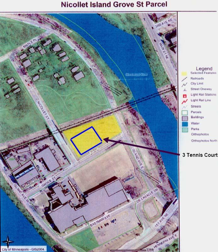
31 Figure 2: Q:\council_meetings\2007\082207\0822_2007_147SW revised.doc 31

32 A schematic drawing of the proposed athletic field titled Figure 3: Design Images, View from the Northeast illustrates the proposed field in relation to the high school. The 1.48-acre parcel is the right half of field. Figure 3: Q:\council_meetings\2007\082207\0822_2007_147SW revised.doc 32
.")
33 Background on 2.89-acre parcel proposed to replace the 1.48-acre parcel The City of Minneapolis owns the 2.89 acres proposed to be exchanged for the 1.48-acre parcel. It was acquired from the Canadian Pacific Railroad in the early 1970 s. The address of the parcel is 1-17th Avenue North. The land is included within the Council-approved boundary for the Above the Falls Regional Park (Referral No ). The Council approved that master plan on February 13, A map of the parcel titled Figure 4: West River Road Property illustrates the location of this parcel. Figure 4: Q:\council_meetings\2007\082207\0822_2007_147SW revised.doc 33
34 Metropolitan Council Park Policy Strategy 5(b) Park Policy Strategy 5(b) contains the issues to be considered in determining whether or not the Council should approve the proposed exchange and release the restrictive covenant on the 1.48-acre parcel: Strategy 5(b): Conversion of regional parks system lands to other uses Lands in the regional parks system will only be converted to other uses if approved by the Metropolitan Council through an equally valuable land or facility exchange as defined below. Equally valuable land is defined in this context as land that is contiguous to the regional parks system unit containing the land proposed to be exchanged (that is, only add and take away land in the same park/trail unit) and/or, the land has comparable or better natural resource characteristics and could provide comparable or better recreation opportunities as what is being exchanged. In exceptional circumstances, the Metropolitan Council may accept as equally valuable land the addition of land to another unit of the regional parks system where that replacement land has comparable or better natural resource characteristics and comparable or better recreation opportunities than the land being converted and all other provisions of this policy can be met. Equally valuable facility is defined as an exchange of land for facilities when recreational benefits and/or natural resource benefits are increased as a result of the exchange. For example, some land in a regional trail corridor may be exchanged to widen a highway if a highway department constructs a trail overpass or underpass of the widened road at no cost to the regional park implementing agency. Regional parks system lands are protected through restrictive covenants when land is acquired. These covenants ensure that the land is used only for regional parks system purposes and cannot be broken or amended unless the Metropolitan Council approves. The only restrictive covenant amendments approved by the Council in which no land was exchanged were for small strips of land needed for public highway improvements. The land was needed to make roads safer and there was no alternative. In addition, such projects improved access to the adjacent regional parks system unit. The Metropolitan Council will consider land exchanges for other uses if the criteria listed below have been met so as not to harm the regional parks system. The following criteria will be used to determine whether regional parks system land may be exchanged for other parkland. For those changes that represent a potential system impact, the Council will use a process comparable to the 90-day review period for plan amendments with a potential impact on the regional system. For conversions such as small exchanges of land to provide right-of-way for access, an expedited review comparable to the 10-day waiver will be used. (pp ) Q:\council_meetings\2007\082207\0822_2007_147SW revised.doc 34
35 Analyzing land exchange against Park Policy In order to determine whether the proposed exchange is consistent with this policy, the following questions are considered: 1. How well can the park system unit (Central Mississippi Riverfront Regional Park) continue to meet Council site and site attribute standards established for the particular type of park system unit (regional park, park reserve, trail or special recreation feature)? The 2030 Regional Parks Policy Plan contains the following policy strategy regarding site attributes for the regional park system. Strategy 1(a): Siting criteria for units of the regional parks system Future Metropolitan Council designation of lands for the regional parks system should primarily stress lands with important natural resource features, lands that include or provide access to water bodies and lands with natural resource features that enhance outdoor recreation. Geographic balance or proportionate distribution tied to population distribution patterns can be given weight when natural resource features can be provided through restoration. (p. 8) The 2030 Regional Parks Policy Plan (p. 46) also contains the following regarding site attributes for regional parks as a park type. Regional Parks Areas selected for regional parks should contain a diversity of nature-based resources, either naturally occurring or human-built. The recreational quality of a regional park is measured by the presence or absence of outstanding resources and the ability to provide adequately for a wide range of natural resource-related recreational opportunities. Access to water bodies suitable for recreation such as swimming, boating and fishing is particularly important and most of the regional parks are focused on lakes, rivers or streams. A regional park should be large enough to accommodate a variety of activities, preserve a pleasant natural aspect, and buffer activity areas from each other and from surrounding areas. This is interpreted as 200 to 500 acres of land. Occasionally, because of the quality of the resource, an exception may be made and a regional park may be as small as 100 acres. Experience has shown this to be the minimum size acceptable for the range and type of activities expected to be accommodated. The implementation potential is also important in selecting a candidate for regional park status. Implementation potential is measured by the reasonable availability of the site, by the opportunity to acquire and protect key resources, by the support of the host community and other local groups and by the interest of the regional park implementing agency that will own and operate the park. The Metropolitan Council approved an acquisition master plan for the Central Mississippi Riverfront Regional Park in 1978 (Referral No. 2839B) because it was consistent with the policies of the Recreation Open Space Policy Plan, particularly in providing regional recreation opportunity within the fully developed area of downtown Minneapolis. The Council s approval of the acquisition master plan also stipulated that, The Minneapolis Park and Recreation Board submit, as soon as possible, a more detailed acquisition schedule, including methods for conveying existing public-owned land to regional recreation purposes/and Park Board ownership. Q:\council_meetings\2007\082207\0822_2007_147SW revised.doc 35
36 In May 1983, the Metropolitan Council reviewed and approved a development master plan for the park and an increase to acquisition grant 7902 for the park (Referral No ). That Council action considered the non-regional park uses on the island (single and multi-family residential, DeLaSalle High School and conversion of the former Island Sash and Door Company building into a restaurant/inn). Furthermore, 1981 Minnesota Laws, Chapter 304, Section 2, placed the following condition on grants for acquiring land for the park: With respect to grants for acquisition in the central riverfront regional park, the [Metropolitan] council shall, to the maximum extent possible, require acquisition of non fee interest in the housing out parcel on Nicollet Island where consistent with continued housing use and the overall development of the park. Based on the requirement of this legislation, and the Council approval of the park s mixed uses in the development master plan, staff concludes that the loss of 1.48 acres for the proposed athletic field will not diminish the park s ability to meet regional park site and site attribute standards. In addition, as noted in the introduction to this memorandum, regardless of whether or not the proposed athletic field is built, the three tennis courts on the 1.48-acre parcel are in violation of the restrictive covenant on that land. If the tennis courts remain as the end use of the land instead of the football field, the regional park remaining can meet park site and site attribute standards. But, the land must be replaced in order to mitigate the covenant violation. 2. Can the park system unit (Central Mississippi Riverfront Regional Park) continue to function as the Council intended? In order to respond to that question, the proposed athletic field was compared to the master plan the Council has approved. The most recent plan the Council approved for this part of the park was the 1983 plan cited previously. However, in reviewing the findings of the Environmental Assessment Worksheet for this project, reference was made to The Nicollet Island Master Plan prepared in The Nicollet Island Plan was never submitted to the Metropolitan Council and consequently never considered by the Council for approval. The Nicollet Island plan proposed tennis courts or multi-use recreational space to accommodate for active uses such as softball games in the 1.48-acre parcel. As noted earlier, the tennis courts would not have been considered a regional park facility under the review of the 1983 master plan. The courts were constructed on this parcel and are in violation of the restrictive covenant agreement. The answer as to whether the regional park can continue to function with the creation of the proposed athletic field is subject to wide interpretation. On the one hand, an athletic practice field on the north side of DeLaSalle High School currently exists as part of the high school/residential outparcel area. The practice field and the tennis courts are shown on the following Figure 5: Aerial photo of DeLaSalle High School athletic practice field and Mpls. Park Board tennis courts. There are also bike/hike trails in the area, which are also shown in the photograph. The 1996 Nicollet Island master plan proposed extending the bike/hike trail south along East Island Avenue on a 6-foot bituminous circumferential trail due to the physical constraints of other land uses and the current location of the streets. The trail could be constructed on the east side of East Island Avenue. Q:\council_meetings\2007\082207\0822_2007_147SW revised.doc 36
37 Figure 5: Aerial photo of DeLaSalle High School athletic practice field and Mpls. Park Board tennis courts Existing bike/hike trails Mpls. Park Bd. 3 Tennis Courts on 1.48-acre De LaSalle H.S. athletic practice field De LaSalle H.S. building De LaSalle H.S parking lots Q:\council_meetings\2007\082207\0822_2007_147SW revised.doc 37
38 The debate regarding the proposed athletic field centers in part on the scale of the proposed field, which is larger than the current field. With the associated bleachers, the field and bleachers would run in a general north/south direction and consume the 1.48-acre parcel and cross over Grove Street as shown below in Figure 6: General Boundary of Area proposed for athletic field and bleachers below. Figure 6: General Boundary of Area Proposed for Athletic Field and Bleachers General boundary area of proposed athletic field and bleachers Q:\council_meetings\2007\082207\0822_2007_147SW revised.doc 38
39 The field and associated bleachers would not significantly affect the circumferential trail around the northern end of Nicollet Island called for in the 1983 master plan and proposed again in the 1996 Nicollet Island plan. Trails to the north that cross the island from east to west as shown in the photographs would not be affected either. The athletic field proposal includes a 4-foot wide pathway along the northern edge of the field and adjacent to the active railroad tracks to replace the pedestrian utilization of Grove Street. But, that pathway s width as stated in the EAW should be widened to meet Americans with Disabilities Act requirements. Because the proposed athletic field does not change the circumferential recreational trails called for in this part of the regional park, staff concludes that the park can continue to function as planned if the athletic field is constructed as proposed. 3. What will happen to use of the park system unit? The existing circumferential trails would remain regardless of the end use of the 1.48-acre parcel. Based on the analysis in point 2, the use of the park will not change substantially. The park includes land and recreational amenities beyond the northern end of Nicollet Island. Access to those amenities via the trail system is unchanged regardless of the end use of the 1.48-acre parcel. 4. Will environmental features (wildlife habitat, water quality) be adversely affected? Can they (environmental features) be protected with the new use? The Environmental Assessment Worksheet for the proposed athletic field included concerns about runoff from the field and any adjacent parking. The Council submitted the following comments on November 15, 2005 regarding the Environmental Assessment Worksheet for that proposed project. As proposed, the project would most likely result in an increase in surface water runoff to the Mississippi River. While some impervious surface will be eliminated, an extensive drain tile system is proposed to be installed beneath the playing field. All site irrigation and rainfall would be expected to infiltrate into the tile system and be routed to the City s existing storm water system. The Council recommends the incorporation of Low Impact Development (LID) techniques like rainwater gardens and infiltration trenches through which this flow could first be routed, to help reduce surface water runoff volumes and rates (to the Mississippi River) to the degree possible. The Metropolitan Council s Urban Small Sites BMP Manual includes detailed information on 40 best management practices that make sense in an urban small-site, cold-climate setting. Additional environmental issues raised by opponents to construction of an athletic field on Nicollet Island are the subject of pending litigation which will address or resolve those issues. 5. Can any loss of site or function be made up through acquisition of a site with comparable characteristics adjacent to or in the immediate area of the current location? Is there a need to replace for comparable uses in a comparable location? Would the system benefit from a different park system unit in a different location? Does the park system unit benefit from a facility in exchange for land? As noted the 1.48-acre parcel currently contains three tennis courts. The 1996 Nicollet Island master plan proposed location of the courts there. However, the Metropolitan Council never reviewed that plan. Had the Council reviewed the 1996 Nicollet Island Plan the proposed tennis courts would have been in violation with the restrictive covenant on that land. Either the tennis courts would need to be removed or the covenant would need to be released in exchange for other equally valuable land. Q:\council_meetings\2007\082207\0822_2007_147SW revised.doc 39
40 The 2.89-acre parcel proposed as an exchange in this case would extend the trail system along West River Parkway upriver from Central Mississippi Riverfront Regional Park. Figures 7 and 8 below illustrate the trails, rain gardens, plaza and picnic areas proposed for this land, which is consistent with the Councilapproved master plan for the Above the Falls Regional Park. Q:\council_meetings\2007\082207\0822_2007_147SW revised.doc 40
")
41 Figure 7: Northern half of 2.89-acre parcel proposed for exchange. Illustration shows the master plan recreational amenities for this land (From Above the Falls Phase One- West Bank, page 37) Q:\council_meetings\2007\082207\0822_2007_147SW revised.doc 41
")
42 Figure 8: Southern half of 2.89-acre parcel proposed for exchange. Illustration shows the master plan recreational amenities for this land (From Above the Falls Phase One- West Bank, page 40) Q:\council_meetings\2007\082207\0822_2007_147SW revised.doc 42
43 6. Will all costs of relocation be covered by nonregional recreation funds? This question is not applicable in this case. If the tennis courts are removed and an athletic field is constructed on the 1.48-acre parcel, the tennis courts likely will be replaced on other Mpls Park Board land but not on regional park land. The cost of replacing the courts will be borne by DeLaSalle High School. 7. Are there mitigating measures that may be preferable to land exchange, particularly with respect to minor conversions? Is the need for the conversion, as in the instance of transportation improvements, generated by the recreational park system unit? There are no mitigating measures preferable to a land exchange in this case since the tennis courts are currently in violation of the restrictive covenant. If an athletic field is constructed it would be in violation of the restrictive covenant. In order for the restrictive covenant to be removed on the 1.48-acre parcel, replacement land must be provided to remediate the restrictive covenant violation from the tennis courts or to accommodate an athletic field or other use of the parcel. Issues with respect to the alternative use: 1. What are the land area needs of the proposed project? With regard to the tennis courts, they consumed about half of the 1.48-acre parcel as shown in Figures 2 and 5. As noted above, the athletic field and associated bleachers would consume all of the 1.48 acres of land currently under a restrictive use covenant as shown in Figure What are the specific site requirements for the proposed project and how unique is it to the area proposed for conversion? The specific site requirements for the tennis courts, which currently occupy a portion of the 1.48-acre parcel, are shown on Figures 2 and 5. The specific site requirements for the proposed athletic field are the subject of pending litigation and may be subject to modification, and therefore not reviewed in this analysis. 3. What is the duration of the proposed projects? The joint use agreement for the athletic field has a term of 30 years with two possible extensions of 20 years each for a total maximum term of 70 years. 4. Is the proposed project consistent with Council policies? Neither the three existing tennis courts nor the proposed athletic field is consistent with the terms of the restrictive covenant on the 1.48-acre parcel. Replacing this land with 2.89 acres of river frontage to be developed as part of the Council-approved master plan for the Above the Falls Regional Park meets the requirements of Equally Valuable Land and Equally Valuable Facility in Park Policy Strategy 5(b). Q:\council_meetings\2007\082207\0822_2007_147SW revised.doc 43
44 5. Is the proposed project of greater benefit to the region than continuance of the regional park system unit? As discussed above the proposed project (land exchange) would have negligible impact on continuance of the regional park system on Nicollet Island and would provide considerable benefit to the Above the Falls Regional Park. ADDITIONAL CONSIDERATIONS According to section 16B.09, subdivision 1 of the Minnesota Environmental Rights Act ( MERA ), any person, association, or organization having members who reside in Minnesota may intervene in any administrative, licensing, or similar proceeding by filing a verified pleading asserting that the proceeding involves conduct that has caused or is likely to cause pollution, impairment, or destruction of the air, water, land or other natural resources located within the state. Pursuant to MERA, Friends of the Riverfront ( Friends ), an organization that objects to construction of the proposed athletic facility, submitted a verified Notice of Intervention in response to Mpls Park Board s land exchange request. (See Attachment 2: May 21, 2007 letter from Lisa Hondros and Attachment 3: Verified Pleading under MERA by Friends of the Riverfront). Assuming without deciding that the Metropolitan Council s consideration of the Mpls Park Board s request constitutes a proceeding subject to MERA, the land exchange request does not involve conduct that has caused or is likely to cause pollution, impairment or destruction of the air, water, land or other natural resources located within the state. Contrary to Friend s assertion or suggestion, the Mpls Park Board s request does not seek approval for the construction of an athletic field, and a Council decision granting the land exchange request would not condition the exchange on the eventual construction of an athletic field. The Mpls Park Board merely requests approval to exchange land pursuant to the Council s adopted 2030 Regional Parks Policy Plan and still will need to acquire the 2.89-acre parcel from the City of Minneapolis. An exchange of land, in and of itself, cannot cause pollution, impairment, or destruction of natural resources. Therefore, MERA does not preclude the Council from granting the Mpls Park Board s land exchange request. Whether construction of the proposed athletic facility on Nicollet Island might violate MERA is an issue that will be decided in the pending litigation between Friends and the City of Minneapolis and DeLaSalle High School. The MERA issues are beyond the scope of the Council s purview in this instance. CONCLUSIONS: 1. The 1.48-acre parcel on Nicollet Island currently is used for three tennis courts. This use violates the restrictive covenant agreement on that parcel between the Metropolitan Council and the Minneapolis Park & Recreation Board. 2. Exchanging the 1.48-acre parcel for the 2.89 acres of riverfront land shown in Figures 4, 7 and 8 would mitigate the effects of the tennis courts and meets the requirements of Equally Valuable Land and Equally Valuable Facility in Park Policy Strategy 5(b). 3. Regardless of the outcome of litigation regarding the proposed construction of an athletic facility on Nicollet Island, exchanging the 2.89-acre riverfront property for the 1.48-acre parcel on Nicollet Island would benefit the Above the Falls Regional Park. Q:\council_meetings\2007\082207\0822_2007_147SW revised.doc 44
45 RECOMMENDATION: (1) That the Metropolitan Council release the restrictive covenant on the 1.48-acre Grove Street Nicollet Island parcel in exchange for the Minneapolis Park & Recreation Board obtaining title and placing a restrictive covenant on the 2.89-acre West River Road property as shown on Figure 1. (2) That the Metropolitan Council request the Minneapolis Park & Recreation Board to implement the land exchange by March 1, 2008 so the restrictive covenant violation is remedied in a timely manner. Q:\council_meetings\2007\082207\0822_2007_147SW revised.doc 45
46 Attachment 1: Electronic version. Original on file at Metropolitan Council office Q:\council_meetings\2007\082207\0822_2007_147SW revised.doc 46
47 Q:\council_meetings\2007\082207\0822_2007_147SW revised.doc 47
48 Q:\council_meetings\2007\082207\0822_2007_147SW revised.doc 48

49 Attachment 2: Electronic version. Original on file at Metropolitan Council office Q:\council_meetings\2007\082207\0822_2007_147SW revised.doc 49

50 Q:\council_meetings\2007\082207\0822_2007_147SW revised.doc 50
51 Q:\council_meetings\2007\082207\0822_2007_147SW revised.doc 51
52 Q:\council_meetings\2007\082207\0822_2007_147SW revised.doc 52
53 Q:\council_meetings\2007\082207\0822_2007_147SW revised.doc 53

54 Attachment 3: Electronic version. Original on file at Metropolitan Council office Q:\council_meetings\2007\082207\0822_2007_147SW revised.doc 54
55 Q:\council_meetings\2007\082207\0822_2007_147SW revised.doc 55
56 Q:\council_meetings\2007\082207\0822_2007_147SW revised.doc 56
METROPOLITAN COUNCIL 390 North Robert Street, St. Paul, Minnesota Phone (651) TDD (651)
 TDD (651)") DATE: July 30, 2007 METROPOLITAN COUNCIL 390 North Robert Street, St. Paul, Minnesota 55101-1805 Phone (651) 602-1000 TDD (651) 291-0904 TO: Metropolitan Parks and Open Space Commission FROM: Arne Stefferud,
DATE: July 30, 2007 METROPOLITAN COUNCIL 390 North Robert Street, St. Paul, Minnesota 55101-1805 Phone (651) 602-1000 TDD (651) 291-0904 TO: Metropolitan Parks and Open Space Commission FROM: Arne Stefferud,
Community Development Committee
 C Date Prepared: Subject: Community Development Committee For the Metropolitan Council meeting of December 9, 2009 December 8, 2009 Committee Report SW Item: 2009-444 ADVISORY INFORMATION Rice Creek Chain
METROPOLITAN COUNCIL 390 North Robert Street, St. Paul, MN Phone (651) TDD (651)
 TDD (651)") METROPOLITAN COUNCIL 390 North Robert Street, St. Paul, MN 55101 Phone (651) 602-1000 TDD (651) 291-0904 DATE: March 21, 2008 TO: Metropolitan Parks and Open Space Commission FROM: Arne Stefferud, Planning
METROPOLITAN COUNCIL 390 North Robert Street, St. Paul, MN 55101 Phone (651) 602-1000 TDD (651) 291-0904 DATE: March 21, 2008 TO: Metropolitan Parks and Open Space Commission FROM: Arne Stefferud, Planning
METROPOLITAN COUNCIL 390 North Robert Street, St. Paul, MN Phone (651) TDD (651)
 TDD (651)") METROPOLITAN COUNCIL 390 North Robert Street, St. Paul, MN 55101 Phone (651) 602-1000 TDD (651) 291-0904 DATE: April 27, 2011 TO: Metropolitan Parks and Open Space Commission FROM: Arne Stefferud, Planning
METROPOLITAN COUNCIL 390 North Robert Street, St. Paul, MN 55101 Phone (651) 602-1000 TDD (651) 291-0904 DATE: April 27, 2011 TO: Metropolitan Parks and Open Space Commission FROM: Arne Stefferud, Planning
METROPOLITAN COUNCIL 390 North Robert Street, St. Paul, MN Phone (651) TDD (651)
 TDD (651)") METROPOLITAN COUNCIL 390 North Robert Street, St. Paul, MN 55101 Phone (651) 602-1000 TDD (651) 291-0904 DATE: November 23, 2009 TO: Metropolitan Parks and Open Space Commission FROM: Jan Youngquist, Senior
METROPOLITAN COUNCIL 390 North Robert Street, St. Paul, MN 55101 Phone (651) 602-1000 TDD (651) 291-0904 DATE: November 23, 2009 TO: Metropolitan Parks and Open Space Commission FROM: Jan Youngquist, Senior
Community Development Committee
 Community Development Committee For the Metropolitan Council meeting of February 13, 2013 Committee Report Business Item 2013-29 ADVISORY INFORMATION Date Prepared: January 25, 2013 Subject: Rice Creek
Business Item No xxx
 Business Item No. 2015-xxx Metropolitan Parks and Open Space Commission Meeting date: October 6, 2015 For the Community Development Committee meeting of October 19, 2015 For the Metropolitan Council meeting
Metropolitan Parks and Open Space Commission
 Business Item No. 2015-xxx Metropolitan Parks and Open Space Commission Meeting date: October 6, 2015 For the Community Development Committee meeting of October 9, 2015 For the Metropolitan Council meeting
Community Development Committee Meeting date: August 15, 2016 For the Metropolitan Council meeting of August 24, 2016
 Business Item No. 2016-160 Community Development Committee Meeting date: August 15, 2016 For the Metropolitan Council meeting of August 24, 2016 Subject: Park Acquisition Opportunity Fund Grant for Rush
METROPOLITAN COUNCIL 390 North Robert Street, St. Paul, MN Phone (651) TDD (651)
 TDD (651)") METROPOLITAN COUNCIL 390 North Robert Street, St. Paul, MN 55101 Phone (651) 602-1000 TDD (651) 291-0904 DATE: December 3, 2012 TO: Metropolitan Parks and Open Space Commission FROM: Arne Stefferud, Manager
METROPOLITAN COUNCIL 390 North Robert Street, St. Paul, MN 55101 Phone (651) 602-1000 TDD (651) 291-0904 DATE: December 3, 2012 TO: Metropolitan Parks and Open Space Commission FROM: Arne Stefferud, Manager
Joint Report of the Transportation and Management Committees For the Metropolitan Council meeting of March 21, 2018
 Committee Report Business Item No. 2018-60 JT Joint Report of the Transportation and Management Committees For the Metropolitan Council meeting of March 21, 2018 Subject: Southwest LRT (Green Line Extension)
Subject: Park Acquisition Opportunity Fund Grant for Request for Nokomis-Minnesota River Regional Trail from Three Rivers Park District
 Commission Report Business Item No. 2015-311 Metropolitan Parks and Open Space Commission For the Metropolitan Council meeting of December 9, 2015 Subject: Park Acquisition Opportunity Fund Grant for Request
Georgia Conservation Tax Credit Program Frequently Asked Questions
 Georgia Conservation Tax Credit Program Frequently Asked Questions What are the minimum requirements for eligibility under the Georgia Conservation Tax Credit Program (GCTCP)? Individual and corporate
Open Space Model Ordinance
 Open Space Model Ordinance Section I. Background Open space development has numerous environmental and community benefits, including: 1) Reduces the impervious cover in a development. Impervious cover
Implementation Tools for Local Government
 Information Note #5: Implementation Tools for Local Government This Information Note is a guide only. It is not a substitute for the federal Fisheries Act, the provincial Riparian Areas Regulation, or
Business Item Community Development Committee Item:
 Business Item Community Development Committee Item: 2008-124 C Meeting date: July 21, 2008 ADVISORY INFORMATION Date: May 21, 2008 Subject: Flexible Residential Development Ordinance Guidelines District(s),
WILLIAMSON ACT CONTRACTS GUIDELINES
 NEVADA COUNTY COMMUNITY DEVELOPMENT AGENCY PLANNING DEPARTMENT ERIC ROOD ADMINISTRATION BUILDING 950 Maidu Avenue Nevada City, California 95959-8617 Phone: (530) 265-1222 FAX : (530) 265-9851 WILLIAMSON
METROPOLITAN COUNCIL 390 North Robert Street, St. Paul, MN Phone (651) TDD (651)
 TDD (651)") METROPOLITAN COUNCIL 390 North Robert Street, St. Paul, MN 55101 Phone (651) 602-1000 TDD (651) 291-0904 DATE: December 26, 2012 TO: Metropolitan Parks and Open Space Commission FROM: Jan Youngquist, AICP;
METROPOLITAN COUNCIL 390 North Robert Street, St. Paul, MN 55101 Phone (651) 602-1000 TDD (651) 291-0904 DATE: December 26, 2012 TO: Metropolitan Parks and Open Space Commission FROM: Jan Youngquist, AICP;
SETTLEMENT AGREEMENT. and Department of Transportation and Public Facilities (collectively, the State ), hereby
, hereby") SETTLEMENT AGREEMENT Ahtna, Inc. ( Ahtna ) and the State of Alaska, Department of Natural Resources and Department of Transportation and Public Facilities (collectively, the State ), hereby agree to the
SETTLEMENT AGREEMENT Ahtna, Inc. ( Ahtna ) and the State of Alaska, Department of Natural Resources and Department of Transportation and Public Facilities (collectively, the State ), hereby agree to the
The Philadelphia Code. In order to be eligible for any floor area bonuses pursuant to this section:
 1 of 16 2/17/2015 2:47 PM The Philadelphia Code 14-702. Floor Area and Height Bonuses. 225.1 (1) Purpose. The intent of the floor area bonus provisions is to encourage certain types of development and
Administrative Penalty Order (APO) Plan for Buffer Law Implementation
 Plan for Buffer Law Implementation") Administrative Penalty Order (APO) Plan for Buffer Law Implementation June 28, 2017 This document was adopted by the Board of Water and Soil Resources (BWSR) pursuant to Minn. Stat. 103B.101, subd. 12(a)
Administrative Penalty Order (APO) Plan for Buffer Law Implementation June 28, 2017 This document was adopted by the Board of Water and Soil Resources (BWSR) pursuant to Minn. Stat. 103B.101, subd. 12(a)
SECTION 900 PARKS AND SCHOOLS
 SECTION 900 PARKS AND SCHOOLS Page 901.00 GENERAL POLICY 901.01 Reservations of Land for Public Use...................... 900-1 902.00 PARKS AND RECREATION 902.01 Parks in General.......................................
METROPOLITAN COUNCIL 390 North Robert Street, St. Paul, MN Phone (651) TDD (651)
 TDD (651)") METROPOLITAN COUNCIL 390 North Robert Street, St. Paul, MN 55101 Phone (651) 602-1000 TDD (651) 291-0904 DATE: October 24, 2011 TO: Metropolitan Parks and Open Space Commission FROM: Arne Stefferud, Planning
METROPOLITAN COUNCIL 390 North Robert Street, St. Paul, MN 55101 Phone (651) 602-1000 TDD (651) 291-0904 DATE: October 24, 2011 TO: Metropolitan Parks and Open Space Commission FROM: Arne Stefferud, Planning
Conservation Easement Stewardship
 Conservation Easements are effective tools to preserve significant natural, historical or cultural resources. Conservation Easement Stewardship Level of Service Standards March 2013 The mission of the
ADMINISTRATIVE CODE BOARD OF COUNTY COMMISSIONERS
 ADMINISTRATIVE CODE BOARD OF COUNTY COMMISSIONERS CATEGORY: Development/Planning/Zoning TITLE: Vacation of Plats or Easements created through the platting process in accordance with Chapter 177, Florida
CITY OF FORT COLLINS NATURAL AREAS AND CONSERVED LANDS EASEMENT POLICY
 CITY OF FORT COLLINS NATURAL AREAS AND CONSERVED LANDS EASEMENT POLICY Adopted January 3, 2012 PURPOSE: The purpose of the policy statement is to clarify the policies and procedures of the City of Fort
6.5 LAND AND WATER CONSERVATION FUND ACT SECTION
 along the Trinity River Corridor are given the opportunity to review and comment upon them. The proposed project would be required to obtain a CDC from the floodplain/cdc administrators of Dallas and Irving.
THREE RIVERS PARK DISTRICT BOARD OF COMMISSIONERS
 1. OPENING BUSINESS A. Call to Order B. Pledge of Allegiance C. Roll Call 2. APPROVAL OF AGENDA THREE RIVERS PARK DISTRICT BOARD OF COMMISSIONERS SPECIAL MEETING Administrative Center - Board Room 3000
Lessard Sams Outdoor Heritage Council
 Lessard Sams Outdoor Heritage Council MEMO: Agenda Item # 10 DATE: December 11, 2014 SUBJECT: PRESENTER: 2015 Legislative Appropriation Recommendation Bill Heather Koop, LSOHC staff Background: On October
PBV Request Ramsey Apartments Ramsey
 Committee Report Business Item No. 2015-241 Community Development Committee For the Metropolitan Council meeting of December 14, 2016 Subject: Project Based Voucher Award Recommendations Proposed Action
MIDWAY CITY Municipal Code
 MIDWAY CITY Municipal Code TITLE 9 ANNEXATION CHAPTER 9.01 PURPOSE CHAPTER 9.02 GENERAL REQUIREMENTS CHAPTER 9.03 PROPERTY OWNER INITIATION OF ANNEXATION CHAPTER 9.04 PROCEDURES FOR CONSIDERATION OF PETITION
Park Acquisition Opportunity Fund Grant Rules Adopted by the Metropolitan Council on May 28, 2014 as an Amendment to 2030 Regional Parks Policy Plan
 Park Acquisition Opportunity Fund Grant Rules Adopted by the Metropolitan Council on May 28, 2014 as an Amendment to 2030 Regional Parks Policy Plan In 2001, the Metropolitan Council established a Park
CURRENT THROUGH PL , APPROVED 11/11/2009
 CURRENT THROUGH PL 111-98, APPROVED 11/11/2009 TITLE 10. ARMED FORCES SUBTITLE A. GENERAL MILITARY LAW PART IV. SERVICE, SUPPLY, AND PROCUREMENT CHAPTER 159. REAL PROPERTY; RELATED PERSONAL PROPERTY; AND
DECLARATION OF LAND USE RESTRICTIVE COVENANTS FOR LOW-INCOME HOUSING TAX CREDITS 2019 ALLOCATION YEAR
 DECLARATION OF LAND USE RESTRICTIVE COVENANTS FOR LOW-INCOME HOUSING TAX CREDITS 2019 ALLOCATION YEAR THIS DECLARATION OF LAND USE RESTRICTIVE COVENANTS ( AGREEMENT or LURA ) dated as of, by, a, and its
Assistant: Gina Guthmiller
 msavin@fredlaw.com p: 612.492.7442 f: 612.492.7077 Assistant: Gina Guthmiller 612.492.7515 INTRODUCTION Mark Savin is an officer in Fredrikson & Byron s Condemnation & Eminent Domain and Litigation Groups.
Buffer and Soil Loss Statutes, as amended in 2017 by Laws of Minnesota 2017, Chapter 93 (S.F. 844)
") Buffer and Soil Loss Statutes, as amended in 2017 by Laws of Minnesota 2017, Chapter 93 (S.F. 844) May 30, 2017 103B.101 BOARD OF WATER AND SOIL RESOURCES Subd. 12. Authority to issue penalty orders. (a)
Buffer and Soil Loss Statutes, as amended in 2017 by Laws of Minnesota 2017, Chapter 93 (S.F. 844) May 30, 2017 103B.101 BOARD OF WATER AND SOIL RESOURCES Subd. 12. Authority to issue penalty orders. (a)
Proposed Brownfield Area
 NOTICE OF BROWNFIELD AREA DESIGNATION PUBLIC HEARING The Board of County Commissioners of Indian River County, Florida gives notice of its intent to consider adopting a resolution establishing a Brownfield
MITIGATION POLICY FOR DISTRICT-PROTECTED LANDS
 MITIGATION POLICY FOR DISTRICT-PROTECTED LANDS Approved by the District Board of Directors on July 18, 2017 The following Mitigation Policy is intended to inform the evaluation of environmental mitigation-related
2015 Reinvest in Minnesota (RIM) Reserve Wetlands Program
 Reserve Wetlands Program") 2015 Reinvest in Minnesota (RIM) Reserve Wetlands Program Eligibility Guidance Document 1/16/15 The purpose of the RIM Wetlands Program is to identify and enroll under permanent easement lands that contain
2015 Reinvest in Minnesota (RIM) Reserve Wetlands Program Eligibility Guidance Document 1/16/15 The purpose of the RIM Wetlands Program is to identify and enroll under permanent easement lands that contain
Subject-To Addendum to One to Four Family Residential Contract (Resale)
") Buyer: Seller: Property: Subject-To Addendum to One to Four Family Residential Contract (Resale) This Addendum is included and incorporated in the above referenced Contract as if recited verbatim therein.
Buyer: Seller: Property: Subject-To Addendum to One to Four Family Residential Contract (Resale) This Addendum is included and incorporated in the above referenced Contract as if recited verbatim therein.
Please review the Draft PTF Grant Manual with the above background information in mind. AGC
 Board of Trustees Anna G. Chisholm, PTF Program Administrator 3.15.2017 Proposed Updates to the PTF Grant Manual The PTF Grant Manual was last updated in 2006 and many details of the easement process have
CONDITIONAL USE PERMIT Application Packet
 CONDITIONAL USE PERMIT Application Packet Community Development Department 1020 East Pioneer Road, Draper, UT 84020 (801) 576-6539 Fax (801) 576-6526 Dear Applicant, This application packet has been developed
HOUSING ELEMENT I. GOALS, OBJECTIVES AND POLICIES
 HOUSING ELEMENT I. GOALS, OBJECTIVES AND POLICIES GOAL 1: IN ORDER TO ACHIEVE A BALANCED HOUSING SUPPLY (AND A BALANCED POPULATION AND ECONOMIC BASE), EVERY EFFORT SHOULD BE MADE TO PROVIDE A BROAD RANGE
ORDINANCE NO The Board of Supervisors of the County of San Joaquin ordains as follows:
 ORDINANCE NO. 4308 AN ORDINANCE ADDING CHAPTER 9-1080 OF DIVISION 10 OF TITLE 9 OF THE ORDINANCE CODE OF SAN JOAQUIN COUNTY PERTAINING TO AGRICULTURAL MITIGATION. The Board of Supervisors of the County
DRAFT PARK COUNTY US HIGHWAY 89 SOUTH EAST RIVER ROAD OLD YELLOWSTONE TRAIL ZONING DISTRICT REGULATIONS
 Formatting: Changes recommended by the Board and accepted by the County Commission are formatted in RED: Changes made by the Park County Commission are formatted in YELLOW highlight: and changes made by
CHAPTER 3: IDENTIFYING SECTION 4(f) PROPERTIES
 PROPERTIES") CHAPTER 3: IDENTIFYING SECTION 4(f) PROPERTIES Section 4(f) and its provisions state that publicly owned parks, recreation areas, wildlife and waterfowl refuges, and publicly and privately owned historic
CHAPTER 3: IDENTIFYING SECTION 4(f) PROPERTIES Section 4(f) and its provisions state that publicly owned parks, recreation areas, wildlife and waterfowl refuges, and publicly and privately owned historic
AQUATIC FACILITY GUIDELINES
 AQUATIC FACILITY GUIDELINES WHEREAS, the Board of Commissioners of the Downers Grove Park District is cognizant of the fact that a significant number of residents desires that the District undertake construction
DESCRIPTION OF THE DISTRICT
 DESCRIPTION OF THE DISTRICT The project plan for City of Wausau, Tax Increment District #11 has been prepared in compliance with Wisconsin Statutes Chapter 66.1105(4). The plan establishes the need for
Responsibilities of the Grant Recipient LAND AND WATER CONSERVATION FUND PROGRAM
 Responsibilities of the Grant Recipient LAND AND WATER CONSERVATION FUND PROGRAM STATE OF NEW HAMPSHIRE Department of Resources and Economic Development DIVISION of PARKS and RECREATION State of New Hampshire
Guidelines to Allocate Funds for Metropolitan Highway Rights of Way
 Guidelines to Allocate Funds for Metropolitan Highway Rights of Way Metropolitan Council 390 Robert Street North St. Paul, Minnesota 55101-1805 Telephone (651) 602-1140 Updated October 2015 GUIDELINES
Chapter 10 Local Protection Measures
 The DPC fully supports the protection of private property rights and the DPC will work to ensure that there will be no negative impacts stemming from NHA activities on private property, should the designation
ARLINGTON COUNTY, VIRGINIA. County Board Agenda Item Meeting of June 17, 2017
 ARLINGTON COUNTY, VIRGINIA County Board Agenda Item Meeting of June 17, 2017 DATE: June 9, 2017 SUBJECT: Request to authorize advertisement of public hearings by the Planning Commission and County Board
PLANNED UNIT DEVELOPMENTS (Ordinance No.: 3036, 12/3/07; Repealed & Replaced by Ordinance No.: 4166, 10/15/12)
") 159.62 PLANNED UNIT DEVELOPMENTS (Ordinance No.: 3036, 12/3/07; Repealed & Replaced by Ordinance No.: 4166, 10/15/12) A. PURPOSE 1. General. The Planned Unit Development (PUD) approach provides the flexibility
159.62 PLANNED UNIT DEVELOPMENTS (Ordinance No.: 3036, 12/3/07; Repealed & Replaced by Ordinance No.: 4166, 10/15/12) A. PURPOSE 1. General. The Planned Unit Development (PUD) approach provides the flexibility
2017 ANNUAL REPORT OF THE UNITED EFFORT PLAN TRUST INTRODUCTION
 2017 ANNUAL REPORT OF THE UNITED EFFORT PLAN TRUST INTRODUCTION This is the 2017 Annual Report of the United Effort Plan Trust ( Trust ), prepared by the Board of Trustees ( Board ) in accordance with
Economic Non-Viability Application
 A guide to the Design Review Process Economic Non-Viability Application Planning Services Department, 50 West 13th Street, Dubuque, IA 52001-4864 (563) 589-4210 e-mail: planning @cityofdubuque.org Application
Draft Zoning Changes for the 2nd Planning Board Public Hearing, January 22, 2018.
 Draft Zoning Changes for the 2nd Planning Board Public Hearing, January 22, 2018. No changes were made at the 1st Public Hearing. Proposed wording for the 1 st Public Hearing in red, eliminated text in
City of Lake Elmo Planning Commission Meeting Minutes of January 14, 2013
 City of Lake Elmo Planning Commission Meeting Minutes of January 14, 2013 Chairman Williams called to order the workshop of the Lake Elmo Planning Commission at 7:00pm COMMISSIONERS PRESENT: Fliflet, Obermueller,
TRANSFER OF DEVELOPMENT RIGHTS (TDR) ORDINANCE Revised November 2013
 ORDINANCE Revised November 2013") ARTICLE III Transfer of Development Rights (TDR) Program Part 301 Establishment and Purpose. 165-301.01. Purpose. Pursuant to the authority granted by 15.2-2316.1 and 2316.2 of the Code of Virginia, there
ARTICLE III Transfer of Development Rights (TDR) Program Part 301 Establishment and Purpose. 165-301.01. Purpose. Pursuant to the authority granted by 15.2-2316.1 and 2316.2 of the Code of Virginia, there
PRE-APPLICATION FREQUENTLY ASKED QUESTIONS (FAQ) GENERAL PURCHASE OF DEVELOPMENT RIGHTS (PDR) FAQs
 GENERAL PURCHASE OF DEVELOPMENT RIGHTS (PDR) FAQs") PRE-APPLICATION FREQUENTLY ASKED QUESTIONS (FAQ) Q: Question #26 asks me to describe how protecting my land will buffer and enhance important public natural areas. What types of natural areas do you mean?
PRE-APPLICATION FREQUENTLY ASKED QUESTIONS (FAQ) Q: Question #26 asks me to describe how protecting my land will buffer and enhance important public natural areas. What types of natural areas do you mean?
Town of Cary, North Carolina Rezoning Staff Report 14-REZ-31 Cary Park PDD Amendment (Waterford II) Town Council Meeting January 15, 2015
 Town Council Meeting January 15, 2015") Town of Cary, North Carolina Rezoning Staff Report 14-REZ-31 Cary Park PDD Amendment (Waterford II) Town Council Meeting January 15, 2015 REQUEST To amend the Town of Cary Official Zoning Map by amending
Town of Cary, North Carolina Rezoning Staff Report 14-REZ-31 Cary Park PDD Amendment (Waterford II) Town Council Meeting January 15, 2015 REQUEST To amend the Town of Cary Official Zoning Map by amending
Appendix B Real Estate Plan
 Appendix B Real Estate Plan B-1 REAL ESTATE PLAN Prepared for U.S. Army Corps of Engineers Southwestern Division Little Rock District As of May 1, 2013 Prepared by Ronald Bridges Real Estate Division ANY
EXHIBIT A. City of Corpus Christi Annexation Guidelines
 City of Corpus Christi Annexation Guidelines Purpose: The purpose of this document is to describe the City of Corpus Christi s Annexation Guidelines. The Annexation Guidelines provide the guidance and
PROJECT SCORING GUIDANCE. Introduction: National Proiect Selection:
 FOREST LEGACY PROGRAM PROJECT SCORING GUIDANCE Introduction: This document provides guidance to the National Review Panel on how to score individual Forest Legacy Program (FLP) projects, including additional
MINUTE ORDER BONNER COUNTY COMMISSIONERS PUBLIC HEARING MINUTES AUGUST 6, 2015
 MINUTE ORDER BONNER COUNTY COMMISSIONERS PUBLIC HEARING MINUTES AUGUST 6, 2015 CALL TO ORDER: Chair Cary Kelly called the Bonner County Commissioners hearing to order at 1:00 p.m. in the 3rd floor meeting
RENEWAL DECISION Usibelli Coal Mine, Inc. ADL Surface Lease AS (e)
") STATE OF ALASKA DEPARTMENT OF NATURAL RESOURCES DIVISION OF MINING, LAND AND WATER RENEWAL DECISION Usibelli Coal Mine, Inc. Surface Lease AS 38.05.070(e) : Per AS 38.05.070(e), the Department of Natural
STATE OF ALASKA DEPARTMENT OF NATURAL RESOURCES DIVISION OF MINING, LAND AND WATER RENEWAL DECISION Usibelli Coal Mine, Inc. Surface Lease AS 38.05.070(e) : Per AS 38.05.070(e), the Department of Natural
Staff Report. Street Vacation. Salt Lake City Planning Commission. Ashley Scarff, (801) or Date: April 10 th, 2019
 or Date: April 10 th, 2019") Staff Report PLANNING DIVISION DEPARTMENT of COMMUNITY & NEIGHBORHOODS To: From: Salt Lake City Planning Commission Ashley Scarff, (801) 535-7660 or ashley.scarff@slcgov.com Date: April 10 th, 2019 Re:
Staff Report PLANNING DIVISION DEPARTMENT of COMMUNITY & NEIGHBORHOODS To: From: Salt Lake City Planning Commission Ashley Scarff, (801) 535-7660 or ashley.scarff@slcgov.com Date: April 10 th, 2019 Re:
TOWN OF WHITBY REPORT RECOMMENDATION REPORT
 TOWN OF WHITBY REPORT RECOMMENDATION REPORT REPORT TO: Planning and Development Committee REPORT NO: PL 4-08 DATE OF MEETING: January 21, 2008 FILE NO(S): MI-01-07 (SW- 2002-03) PREPARED BY: Planning Department
3.3 Acquisitions and Displacements/Relocations
 Chapter 3 Social Effects 3.3 Acquisitions and Displacements/Relocations This section discusses property displacements, relocations, and acquisitions (partial or full) that might occur due to implementation
ACCESSORY SECOND UNIT PERMIT Application Packet
 ACCESSORY SECOND UNIT PERMIT Application Packet Contents Description & List of Requirements Permit Application Draft Deed Restriction Municipal Code Section 16.333 ACCESSORY SECOND UNIT PERMIT Description
COUNTY COUNCIL OF PRINCE GEORGE'S COUNTY, MARYLAND, SITTING AS THE DISTRICT COUNCIL ORDER OF APPROVAL OF REVISED SITE PLAN CONDITIONS
 Case No. SP-04049 Applicant: PPC/CHP Maryland Limited Partnership COUNTY COUNCIL OF PRINCE GEORGE'S COUNTY, MARYLAND, SITTING AS THE DISTRICT COUNCIL ORDER OF APPROVAL OF REVISED SITE PLAN CONDITIONS IT
Transfer of Development Rights
 Ordinance Transfer of Development Rights King County s (WA) 2008 ordinance establishes a transfer of development rights program. The ordinance: Sets eligibility criteria for sending and receiving sites
CHAPTER 3 PRELIMINARY PLAT
 10-3-1 10-3-3 SECTION: CHAPTER 3 PRELIMINARY PLAT 10-3-1: Consultation 10-3-2: Filing 10-3-3: Requirements 10-3-4: Approval 10-3-5: Time Limitation 10-3-6: Grading Limitation 10-3-1: CONSULTATION: Each
Chapter 20. Development Rights in the Rural Areas Zoning District in Albemarle County
 Chapter 20 Development Rights in the Rural Areas Zoning District in Albemarle County 20-100 Introduction This chapter reviews the regulations and many of the key issues pertaining to development rights
DESIGN PUBLIC HEARING
 DESIGN PUBLIC HEARING October 25, 2016 AT STEVENS MEMORIAL LIBRARY 345 MAIN STREET NORTH ANDOVER, MASSACHUSETTS 7:00 PM FOR THE PROPOSED Chickering Road (Route 125) & Massachusetts Avenue Intersection
MEETING MINUTES. Commission Members Absent: Amanda Azous at large, position 6, Christa Campbell, at large, position 7
 MEETING MINUTES Land Bank Commission Meeting September 21, 2018 Craft Room @ Mullis Community Senior Center San Juan Island, WA Commission Members in Attendance: Jim Skoog, District 1, position 1 Brian
SPECIFIC RESPONSES TO AREA COMMISSION OPPOSITION :
 SPECIFIC RESPONSES TO AREA COMMISSION OPPOSITION 3-14-19: Area Commission reasons for opposition in black APPLICANT S RESPONSE IN RED. The comprehensive planning and design of stream restoration efforts
Jason Smith, Manager of Development Services Infill Development Draft Official Community Plan Amendment and Policy
 Council Agenda Information Regular Council March 06, 2018 VILLAGE OF ANMORE REPORT TO COUNCIL Date: Submitted by: Subject: Jason Smith, Manager of Development Services Infill Development Draft Official
ZONING BOARD OF APPEALS MINUTES JUNE 14, Chairman Garrity thanked ZBA Member Michael Waterman for his many years of service on the ZBA.
 ZONING BOARD OF APPEALS MINUTES JUNE 14, 2011 The meeting was called to order by Chairman Richard Garrity at 7:30 p.m. Board Members Gregory Constantino, Barbara Fried, Edward Kolar, Mary Ozog, Dale Siligmueller
6.5 LAND AND WATER CONSERVATION FUND ACT SECTION
 6.3.7 Recommended Determination Findings for Public Parks and Recreational Areas A direct use of and temporary use of 2.5 acres of Elm Fork Greenbelt (750 square feet of actual ground space with the balance
SECTION 7000 LAND DEVELOPMENT REQUIREMENTS
 SECTION 7000 LAND DEVELOPMENT REQUIREMENTS 7000 LAND DEVELOPMENT REQUIREMENTS... 1 7001 LEGISLATIVE AUTHORITY... 1 7001.1 LAND DEVELOPMENT... 1 7001.1.1 Title 40, Idaho Code... 1 7001.1.2 Idaho Code 40-1415
Conservation Easements: Amendments &Violations
 Conservation Easements: Amendments &Violations New Jersey Land Conservation Rally March 16, 2016 James Wyse, Coughlin Duffy LLP Judeth Yeany, Green Acres Program, DEP Session Outline Introduction and overview
LAKE OF THE WOODS COUNTY WETLAND CONSERVATION ORDINANCE OF 2002
 Ordinance # LAKE OF THE WOODS COUNTY WETLAND CONSERVATION ORDINANCE OF 2002 ARTICLE 1 TITLE AND PURPOSE Section 1.1. Title This Ordinance shall be known, cited and referred to as the Lake of the Woods
MUNICIPALITY OF ANCHORAGE
 MUNICIPALITY OF ANCHORAGE ANCHORAGE PARKS & RECREATION Memorandum PRC 09-13 DATE: March 2, 2009 TO: FROM: SUBJECT: Parks & Recreation Commission Monique Anderson, Parks Superintendent PRC 09-13 Van Buren/
BYLAWS OF PRAIRIE PATHWAYS II CONDOMINIUM OWNER S ASSOCIATION, INC.
 BYLAWS OF PRAIRIE PATHWAYS II CONDOMINIUM OWNER S ASSOCIATION, INC. ARTICLE I: Plan of Administration Condominium Unit Ownership / Description of Real Property Certain property located in the Village of
MINUTES OF A REGULAR MEETING ZONING BOARD OF ADJUSTMENT OF THE BOROUGH OF MOUNTAIN LAKES February 24, 2016
 MINUTES OF A REGULAR MEETING ZONING BOARD OF ADJUSTMENT OF THE BOROUGH OF MOUNTAIN LAKES February 24, 2016 Chair Chris Richter called the meeting to order and announced: Adequate notice of this meeting
City of Cedar Hill Gated Community, Private Street Development Guide
 City of Cedar Hill Gated Community, Private Street Development Guide Definitions: Private Street - A private vehicular access way shared by and serving two or more lots, which is not dedicated to the public
Submittal Requirements: Subdivision Plat (Final)
") s Planning and Zoning Submittal Requirements: Subdivision Plat (Final) 1. Application form, APO fees, and filing fee. Transportation Development Review Fee please contact Engineering at (970) 221-6605
s Planning and Zoning Submittal Requirements: Subdivision Plat (Final) 1. Application form, APO fees, and filing fee. Transportation Development Review Fee please contact Engineering at (970) 221-6605
CITY OF RENO REDEVELOPMENT RENO CITY COUNCIL CHAMBER ONE EAST FIRST STREET RENO, NV Wednesday, June 13, :00 P.M.
 A.0 ROLL CALL (For Possible Action) CITY OF RENO REDEVELOPMENT RENO CITY COUNCIL CHAMBER ONE EAST FIRST STREET RENO, NV 89501 Wednesday, June 13, 2012 12:00 P.M. A.1 PUBLIC COMMENT - This item is for either
II. What Type of Development Requires Site Plan Review? There are five situations where a site plan review is required:
 I. What is a Site Plan Review? Site Plan Review is a process where the construction of new buildings, new additions, and certain types of canopies and/or tax-exempt institutions are reviewed by the City
Instructions for Applying for a State Deed
 Instructions for Applying for a State Deed State Deed Application Form, Conditional Use Deed and School Forest Deed Supplements The State Deed Application Form is required for all applications for state
Land Asset Management Policy
 Page 1 Land Asset Management Policy The following policy is based on the needs and land assets of Beltrami County, and Minnesota Statutes. Purpose This policy is to assist Beltrami County in maintaining
REGULAR MEETING AGENDA
 REGULAR MEETING AGENDA FORT COLLINS CITY COUNCIL September 6, 2005 Doug Hutchinson, Mayor City Council Chambers Karen Weitkunat, District 2, Mayor Pro Tem City Hall West Ben Manvel, District 1 300 LaPorte
RIM 201. BWSR Academy 2013
 RIM 201 BWSR Academy 2013 presented by. The Easement Witches History Citizen Commission to Promote Hunting and Fishing in MN, (established by Gov. Perpich) proposes the concept of RIM in 1984 Reinvest
AGENDA STATEMENT NO BUSINESS OF THE PLANNING COMMISSION City of Victoria, Minnesota STAFF REPORT. Casco Ventures (Developer)
") AGENDA STATEMENT NO. 17-1 BUSINESS OF THE PLANNING COMMISSION City of Victoria, Minnesota STAFF REPORT TO: Planning Commission PREPARED BY: Erin Smith, Senior Planner RE: Waterford Landing Project Rezoning
AGENDA STATEMENT NO. 17-1 BUSINESS OF THE PLANNING COMMISSION City of Victoria, Minnesota STAFF REPORT TO: Planning Commission PREPARED BY: Erin Smith, Senior Planner RE: Waterford Landing Project Rezoning
18 Sale and Other Disposition of Regional Lands Policy
 Clause 18 in Report No. 7 of Committee of the Whole was adopted, without amendment, by the Council of The Regional Municipality of York at its meeting held on April 19, 2018. 18 Sale and Other Disposition
RESEARCH BRIEF. Jul. 20, 2012 Volume 1, Issue 12
 RESEARCH BRIEF Jul. 2, 212 Volume 1, Issue 12 Do Agricultural Land Preservation Programs Reduce Overall Farmland Loss? When purchase of development rights () programs are in place to prevent farmland from
Release: 1. CPPDSM4011A List property for lease
 Release: 1 CPPDSM4011A List property for lease CPPDSM4011A List property for lease Modification History Not Applicable Unit Descriptor Unit descriptor This unit of competency specifies the outcomes required
UNIFORM RULE 5. Administration of Williamson Act Contracts
 UNIFORM RULE 5 Administration of Williamson Act Contracts I. PROCEDURE TO ESTABLISH AN AGRICULTURAL PRESERVE AND WILLIAMSON ACT CONTRACT See Appendices 1 and 2 for the following forms: Application Form
January 22, Contact Chance Sparks, AICP, CNUa, Director of Planning
 Zoning Board of Adjustments Agenda Item Report January 22, 2015 Agenda Item F1 Contact Chance Sparks, AICP, CNUa, Director of Planning 512-312-0084 csparks@ci.buda.tx.us SUBJECT: HOLD A PUBLIC HEARING
content chapter Section 6(f) Land and Water Conservation Fund Areas 23.1 Summary of Key Legislation, Regulations, and Guidance 23.
 Land and Water Conservation Fund Areas 23.1 Summary of Key Legislation, Regulations, and Guidance 23.") chapter 23 Section 6(f) Land and Water Conservation Fund Areas content 23.1 Summary of Key Legislation, Regulations, and Guidance 23.2 Agency Roles 23.3 General Methodology for Evaluation 23.4 Format and
chapter 23 Section 6(f) Land and Water Conservation Fund Areas content 23.1 Summary of Key Legislation, Regulations, and Guidance 23.2 Agency Roles 23.3 General Methodology for Evaluation 23.4 Format and