CITY OF LITCHFIELD PARK
|
|
|
- Paul Stokes
- 5 years ago
- Views:
Transcription
1 CITY OF LITCHFIELD PARK PLANNING AND ZONING COMMISSION Regular Meeting Tuesday, September 9, :00 p.m. Church at Litchfield Park Souers Hall 300 N. Old Litchfield Road Litchfield Park, Arizona Members of the Litchfield Park Planning and Zoning Commission may attend either in person or by telephone conference call. I. Call to Order II. III. IV. Pledge of Allegiance Call to the Community (This is the time for citizens who would like to address the Commission on any non-agenda item. Action taken as a result of public comment will be limited to asking Staff to review the matter, asking that the matter be put on a future agenda, or responding to criticism.) General Plan Amendment Application and Concurrent Rezoning Application Study Sessions A General Plan Major Amendment (GPA #14-01, amended) and Rezoning (ZA #14-02) Proposed for the Northwest Corner of Village Parkway and Litchfield Road (applicant applications are available for viewing at City Hall and on the City s web site The Commission will hold a study session to review and discuss a proposed General Plan Amendment (GPA#14-01, amended) requesting to change the General Plan land use designation from Resort, Golf Course, and Open Space to Medium Density Residential and a Rezoning request to change the zoning from Planned Development with an underlying zoning of Low Density Multi Family, Neighborhood Commercial, and Resort and Open Space to Planned Development with underlying zoning of Residential Cluster (RC) for 31.1 acre property located at the northwest corner of Litchfield Road and Village Parkway. 1. Staff Report 2. Applicant Presentation 3. Discussion 4. Public Comments Information B General Plan Major Amendment (GPA #14-05, amended) and Rezoning (ZA#14-03) Proposed for the Northwest Corner of Litchfield and Camelback Roads (applicant applications are available for viewing at City Hall and on the City s web site The Commission will hold a study session to review and discuss a proposed General Plan Amendment (GPA#14-05, amended) requesting to change the General Plan land use designation from Mixed Use (Public Facility/Residential) to Commercial and Mixed Use (Residential/Public Facility/Agritourism) on property located at the northwest corner of Litchfield and Camelback Roads and a Rezoning request to change the zoning on 64 acres of that property from Neighborhood Commercial (NC) and Residential Estate (RE) to Planned Development (PD) with underlying zoning of Agritourism and Community Commercial (CS). 1. Staff Report 2. Discussion 3. Public Comments
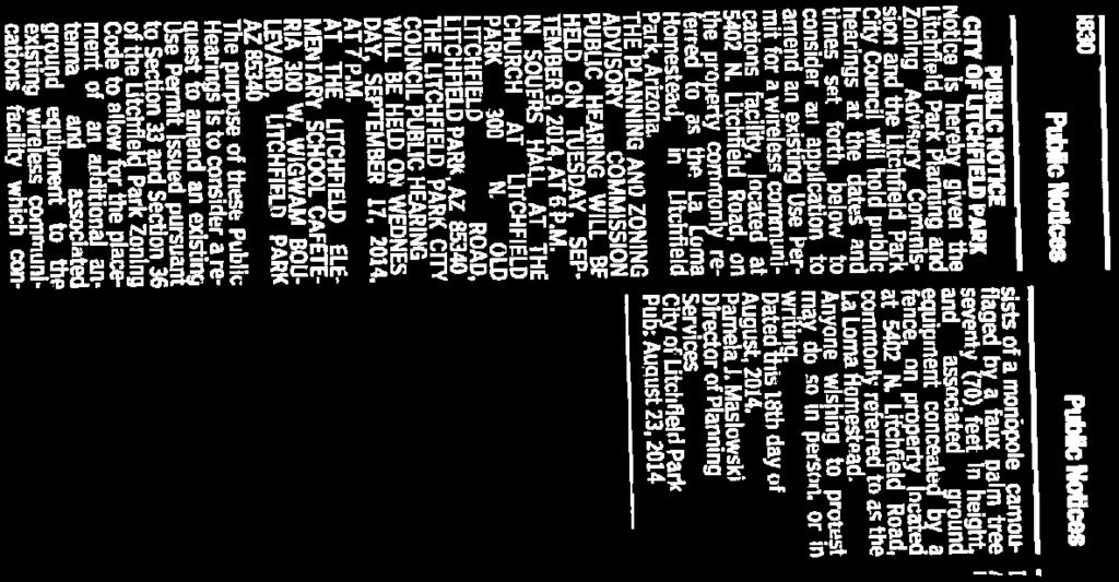
2 V. Business A. Public Hearing: Use Permit Application for the Placement of an AT&T Wireless Communications Facility on the Grounds of the Wigwam Resort, Located at 300 E. Wigwam Boulevard Information The applicant was unable to hold the Citizen Review meetings before the scheduled date of this Public Hearing as is required by both State Statute and City Zoning Code, and has requested that the Public Hearing be continued to a future meeting date to provide time to hold that Citizen Review meeting. B. Public Hearing: Use Permit Application for the Placement of Additional Antennas and Associated Ground Equipment at an Existing Wireless Communications Facility Located at 5402 N. Litchfield Road, Commonly Referred to as the La Loma Homestead Information Staff R eport Applicant Presentation 3. Public Comment Citizens may ask questions or speak for or against an application for a Use Permit to allow for the placement of additional antennas and associated ground equipment at an existing wireless communications facility which currently consists of a monopole camouflaged by a faux palm tree seventy (70) feet in height and associated ground equipment concealed by a fence, on property located at 5402 N. Litchfield Road, commonly referred to as the La Loma Homestead. C. Use Permit Application for the Placement of Additional Antennas and Associated Ground Equipment at an Existing Wireless Communications Facility Located at 5402 N. Litchfield Road, Commonly Referred to as the La Loma Homestead Information Action Discussion and possible recommendation to City Council to approve an application for a Use Permit to allow for the placement of additional antennas and associated ground equipment at an existing wireless communications facility which currently consists of a monopole camouflaged by a faux palm tree seventy (70) feet in height and associated ground equipment concealed by a fence, on property located at 5402 N. Litchfield Road, commonly referred to as the La Loma Homestead. D. Public Hearing: Proposed Zoning Code Amendment Related to Sign Regulations Information 1. Staff Report 2. Public Comments Citizens may ask questions or speak for or against a proposed amendment to the City of Litchfield Park Zoning Code repealing the current Section 35 Signs and adding new Section 35 Signs to add/revise definitions for A-Frame Sign, Awning Sign, Banner Sign, Billboard, Building Front Footage, Business Front Footage, City/Church/Civic Special Event Sign, Commercial Special Event Sign, Development Sign, Drive-Thru/Menu Board, Freestanding Sign, Garage Sale/Yard Sale Sign, Identification Sign, Ideological Sign, Illegal Sign, Indirect Lighting, Internal Lighting, Lighting, Multi-Family Complex Sign, Multi-Tenant Building or Complex, Permanent Sign, Political Sign, Portable Sign, Prohibited Sign, Public Right-of-Way or R-O-W, Quasi-Governmental, Real Estate Sign, Reader Panel Sign, Sign Copy, Sign Area, Sign Height, Sign Walker, Structural Member, Subdivision Sign, Temporary Sign, Window Sign-Neon, and Window Sign; to add new subsections setting forth: the purpose and objectives for sign regulations; general sign standards and requirements; standards and requirements for Comprehensive Sign Programs; standards and requirements for signs in Residential, Public Facility (PF), Community Commercial (CS), Neighborhood Commercial (NC), Regional Commercial (RS), Resort (R), and General Industrial (I) Zoning Districts; requirements for temporary signage in all zoning districts; standards and requirements for flag poles; and requirements and procedures for maintenance and enforcement.
3 E. Proposed Zoning Code Amendment Related to Sign Regulations Discussion and possible recommendation to City Council for approval of a proposed amendment to the City of Litchfield Park Zoning Code repealing the current Section 35 Signs to add/revise definitions for A-Frame Sign, Awning Sign, Banner Sign, Billboard, Building Front Footage, Business Front Footage, City/Church/Civic Special Event Sign, Commercial Special Event Sign, Development Sign, Drive-Thru/Menu Board, Freestanding Sign, Garage Sale/Yard Sale Sign, Identification Sign, Ideological Sign, Illegal Sign, Indirect Lighting, Internal Lighting, Lighting, Multi-Family Complex Sign, Multi-Tenant Building or Complex, Permanent Sign, Political Sign, Portable Sign, Prohibited Sign, Public Right-of-Way or R-O-W, Quasi-Governmental, Real Estate Sign, Reader Panel Sign, Sign Copy, Sign Area, Sign Height, Sign Walker, Structural Member, Subdivision Sign, Temporary Sign, Window Sign-Neon, and Window Sign; to add new subsections setting forth: the purpose and objectives for sign regulations; general sign standards and requirements; standards and requirements for Comprehensive Sign Programs; standards and requirements for signs in Residential, Public Facility (PF), Community Commercial (CS), Neighborhood Commercial (NC), Regional Commercial (RS), Resort (R), and General Industrial (I) Zoning Districts; requirements for temporary signage in all zoning districts; standards and requirements for flag poles; and requirements and procedures for maintenance and enforcement. F. Board of Adjustment/Design Review Board Update Information Action Information There were no Design Review Board or Board of Adjustment Meetings held in August VI. G. Topics for Referral to City Council Discussion of and possible referral of new topics to the City Council. H. Minutes Possible approval of the minutes of the May 13 and July 8, 2014 Planning and Zoning Commission Meetings. Executive Session An Executive Session may be called during the public meeting on any item on this agenda pursuant to (i) A.R.S (A) (3) for the purpose of receiving legal advice. Information Action Information Action Action VII. Staff Report on Current Events Information VIII. Commissioners Reports on Current Events This is the time Commissioners may present a brief summary on current events. The Commission may not propose, discuss, deliberate or take any legal action on the information presented, pursuant to A.R. S Information IV. Adjournment Action Jeff Raible, Chairman Persons with special accessibility needs should contact City Hall, at least 48 hours prior to the meeting.
4 Meeting Date: September 9, 2014 To: From: Subject: Planning and Zoning Advisory Commission Jason Sanks, Planning Consultant GP14-01 and ZA Acres at the NWC of Litchfield Road and Village Parkway Study Session Staff has prepared a Study Session staff report for the purpose of establishing discussion points for each case. The intent of the report is to facilitate dialogue on the applications and offer the Planning and Zoning Advisory Commission, staff, and the applicant the ability to share information in a public forum. The public will also be able to provide input at the end of the discussion. As mentioned in the Citizen Review Meeting and prior Study Session meetings, the following considerations should be taken into account while considering a change in land use on the General Plan: Financial impacts on the City of Litchfield Park (revenues/expenses) Engineering impacts (sewer, water, traffic, environmental) Economic Development impacts (sales tax generation) Planning (good land use principles) In an effort to study the requests in greater detail and to gather public comment on the applications, the following efforts have been made to date: Preparation and presentation of the Retail Market Feasibility Study Neighborhood Meetings hosted by the applicants Citizen Review Meetings hosted by the City of Litchfield Park Financial Impact Analysis prepared by the City s Finance Director Study Sessions with the PZ Advisory Commission Multiple channels for public comment on the applications GPA14-01 (JDM proposal) Parcel A The 31 acre property has been downsized to 28 acres and is located at the northwest corner of Litchfield Road and Village Parkway, within the Village at Litchfield Greens Planned Development. Most of the property is designated as Resort, although there are five acres of Commercial and a few acres of Open Space and Golf Course (Heritage Red Course). The last approval on the property was for a project known as Awenasa, a condominium project tied to the Wigwam that was an effort to provide the resort overflow rooms. That project did not include any of the Commercial, Open Space, and Golf course designated land that is in the current proposal.
5 The last PZ Study Session for this case was August 12, The Commission reviewed the request to reduce the density on the project and staff updated everyone on the Cachet Homes proposal to provide a mix of housing types. The property is approximately 28 acres and the proposal includes 180 units with three different housing types resulting in a density of 6.4 dwelling units per acre. The plan proposes single family detached homes on the west side of the development, with a mix of townhomes and condominiums as the project extends east to Litchfield Road. All units will be for sale. Staff has received the rezoning application which provides the proposed site plan and building elevations. Since the Cachet proposal is only 28 acres, the General Plan amendment application will need to be reconciled to the smaller acreage (28 versus 31) to maintain consistency. Staff was pleased to see that the reduced acreage in the site plan would allow more land designated Open Space and Golf Course to remain. In addition to the single family detached homes that are proposed, there are also townhome and condominium buildings. Santa Barbara architecture is proposed with a single color palette. Generally, the density of the project increases from west to east. Discussion points should include: Traffic impact on Village Parkway and Litchfield Road, possible modifications needed. Centralized amenity appears a bit tight on space. The narrative notes that it will include a pool and fitness facility. No children s play equipment is shown. Drainage and retention for this site is unresolved at this time. The current site plan indicates no onsite retention. Units should front onto Village Parkway rather than back to it. The single family homes indicate walls will be present along the parkway. Additional pedestrian connections and transparency are needed. Pedestrian connections should be ungated for ease of movement. A Wall Plan for the development is needed to understand perimeter relationship with surrounding properties. A Village Parkway Streetscape Exhibit is desired to clearly demonstrate the relationship of the residential units to Village Parkway. The development should have a stronger pedestrian connection and presence at the intersection of Village Parkway and Litchfield Road. Impact of additional residents on open space and public facilities Removal of commercial land use and future retail sales tax generation, the Rick Hill Retail Study identifies commercial land use as viable Slight encroachment on open space and golf course Cost of services to new residences Financial Impact Analysis Luke Air Force Base indicates that a 6 DU/acre maximum density is preferred for this development. The proposal stands at 6.4 currently. Maintenance Building for golf course location Development Agreement (DA) impacts need to be reviewed and an amendment to the existing DA needs to be filed by the applicant.
6 Meeting Date: September 9, 2014 To: From: Planning and Zoning Advisory Commission Jason Sanks, Planning Consultant Subject: GPA14-05 ZA14-03: NWC Litchfield and Camelback Roads Study Session Staff has prepared a Study Session staff report for the purpose of establishing discussion points for each case. The intent of the report is to facilitate dialogue on the applications and offer the Planning and Zoning Advisory Commission, staff, and the applicant the ability to share information in a public forum. The public will also be able to provide input at the end of the discussion. As mentioned in the Citizen Review Meeting and prior Study Session meetings, the following considerations should be taken into account while considering a change in land use on the General Plan: Financial impacts on the City of Litchfield Park (revenues/expenses) Engineering impacts (sewer, water, traffic, environmental) Economic Development impacts (sales tax generation) Planning (good land use principles) In an effort to study the requests in greater detail and to gather public comment on the applications, the following efforts have been made to date: Preparation and presentation of the Retail Market Feasibility Study Neighborhood Meetings hosted by the applicants Citizen Review Meetings hosted by the City of Litchfield Park PZ Study Sessions on May 20, 2014 and August 12, 2014 Financial Impact Analysis prepared by the City s Finance Director Multiple channels for public comment on the applications GPA14-05 (Sun Health Services proposal) This property was last reviewed at Study Session on August 12, At that time, the Commission reviewed the proposed Commercial designation request on the 32 acres along Camelback Road and the 28 acres of Agritourism related uses along Litchfield Road. Staff explained to the Commission that Agritourism is not specifically identified in the General Plan, so the intention is to initiate a change in the designation of Mixed Use Public Facility / Residential land use designation to read Mixed Use Public Facility / Residential / Agritourism. Also at the August 12, 2014 Study Session, the Commission reviewed the draft Agritourism zoning district which provides development standards and use restrictions that will guide the development. Since the time of that Study Session, the applicant has provided a rezoning application for the commercial property and Agritourism facility. These applications provide the conceptual site
7 planning details needed to more closely evaluate both requests. It is important to note that nearly two-thirds of the property proposed with the Commercial designation is already zoned commercial and partially developed with medical offices. Agritourism Description Agritourism is a growing industry in the United States and several facilities around the Phoenix area are already operating. The trend towards healthier living, locally grown and less processed foods, has contributed to the interest in these types of facilities. Typical agritourism uses may include crop growing, harvesting, processing, farmers markets, farm stands, general retail and services, plant nurseries, U-pick, tours, on-farm classes, fairs, festivals, pumpkin patches, Christmas tree farms, social/corporate events, orchard dinners, youth camps, barn dances, restaurants, barn dances, winery, distillery, microbrewery, health spa, and community garden to the extent such uses further the agritourism use. Staff finds that the incorporation of an agritourism facility on the Sun Health property will be an amenity to not only the residents onsite, but everyone in Litchfield Park and overall West Valley. Z14-03 (Sun Health Services proposal for La Loma Agri-Village) The applicant s submittal of the rezoning request is consistent with the companion major General Plan Amendment request. Commercial zoning is requested for the 32 acres along Camelback Road and Agritourism zoning (new district) for the 28 acres extending north along Litchfield Road. The general intent for the development request, as outlined in the applicant s introduction, is to maintain consistency with their stewardship obligations of healthy living on the property that was gifted to them by the Denny family. Staff finds the proposed expansion of medical offices, accessory commercial uses, and infusion of Agritourism related uses to be consistent with this vision. The applicant seeks to include a Planned Development overlay without specific relief from development standards, but rather establish an understanding for onsite/offsite improvements as regulated by the City s Subdivision Ordinance. The applicant finds that the rural character of the facility would be compromised by a strict enforcement of typical paving standards for walkways and parking areas. The intent is to minimize paving to the extent possible, therefore protecting the rural feel of the development. Staff is supportive of this request to the extent it does not generate any excessive dust and maintains handicap accessibility. The details of the development will occur through future site planning and Design Review applications. Water and sewer services to the site are provided by Liberty Utilities. Per the neighborhood meeting discussion on September 2, 2014, Sun Health is actively seeking water service for the proposed agricultural growing operation. All drainage for on-site and off-site runoff will be provided onsite. Access to the site will need to be coordinated with the proposed developers of the property on the northeast corner of Camelback and Litchfield Roads. Currently, KHOV homebuilders and Fry s grocery are looking to develop the near 80 acre piece of land. As recently as last week the various teams met with Woody Scoutten to discuss a coordinated effort to align driveway access points. The site plan for the commercial property indicates a conglomeration of professional offices buildings in a curvilinear layout along Camelback Road. The site plan is
8 conceptual in layout, with a final design to be determined through a future Design Review Board application. Staff is supportive of the conceptual design as proposed The site plan for the Agritourism property is unique with a mix of uses as anticipated. The concentration of buildings and gathering areas is located on the northern portion of the site, near the historic Rancho La Loma property. Figure 7 of the zoning submittal outlines the numerous proposed uses for the property along with the conceptual site layout. Some uses will require a future Use Permit application, per the draft Agritourism zoning district. Most of the events would occur near the La Loma garden Pond, with the conglomeration of buildings extending to the south and east along the canal. Discussion points may include: Integration of proposed private uses near the City owned property to the north. Some improvements are proposed on the City property (parking, pond, nursery, grove). A pedestrian under (or over) pass to the northeast corner of Camelback and Litchfield Road is required by Development Agreement. Is this something still considered necessary with this development proposal? Pedestrian crossings on Litchfield and Camelback Roads will be an important means of connecting the Agritourism facility to the rest of Litchfield Park. The Rancho La Loma needs property maintenance. This development may generate more interest in preserving the property s buildings and mature landscaping. Driveway access points will need to be aligned with the northeast corner of the same intersection. Design considerations or theming for the buildings to guide future Design Review applications.
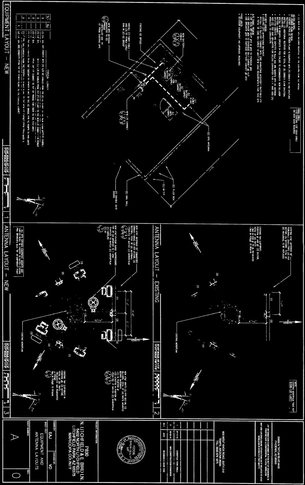
9 Meeting Date: September 9, 2014 To: From: Subject: Planning and Zoning Advisory Commission Jason Sanks, Planning Consultant 5402 N. Litchfield Rd. Use Permit AT&T modifications to an existing 65 monopalm The Use Permit for the existing monopalm at 5402 N. Litchfield Park Road was originally approved by the Planning and Zoning Advisory Commission on August 19, The proposed modifications to the monopalm require a new Use Permit approval. The currently approved antenna array has two antennas on each sector (total of 6) as shown on page A-2 of the submittal. The proposed modification to the monopalm includes the removal of all six antennas and their replacement with three antennas on the existing sectors (total of 9). Per the exhibits provided, the sectors were originally intended to handle the proposed 9 antennas. Some additional changes are proposed to the ground equipment that is fully screened and protected by an 8 wall (6 block, 2 wrought iron). Only the proposed GPS antenna will be visible above the 8 wall. Section of the Zoning Ordinance states that the purpose of use permits is to: a. Allow certain uses that would otherwise not be permitted in a zoning district due to negative impacts on adjacent uses and the community, so long as those uses comply with conditions of the use permit. b. Provide the process for periodic review of use permits to assure conformity of such uses to the public welfare. In the case of this monopalm, Staff and the Planning and Zoning Advisory Commission found in 2009 that this installation location met the requirements of protecting the nearby community and that the facility would not have a negative impact on the neighbors. Since that time, no known complaints have been received on this installation. The proposed modifications to the existing monopalm are minor in nature and will not have any substantial additional visual impact on nearby neighborhoods as the antennas will maintain the same proximity to the center of the monopalm by being mounted on the existing sectors. For reference, the sectors are 4 wide and offset 2 6 from the monopalm. The new antennas will be painted to match the monopalm and help obscure their appearance within the palm fronds. As technology drives the increased use of mobile devices and data needs, the community seeks to balance aesthetic standards with the provision of technology services that
10 minimize negative impacts on our neighborhoods. Staff finds that upgrading an existing monopalm to increase service levels in the community is preferable to construction of a new monopalm. Staff Recommendation Staff recommends approval of the Use Permit for the modified monopalm at 5402 N. Litchfield Road, subject to the exhibits provided by the applicant, with the condition provided below. 1) AT&T and the monopalm owner shall maintain the facility in its original condition and replace palm fronds that are lost due to wear and tear over time.
11
12

13

14


15


16


17


18


19

20


21

22

23 Meeting Date: September 9, 2014 To: From: Subject: Planning and Zoning Advisory Commission Jason Sanks, Planning Consultant Zoning Code Update Section 35 Signs Staff was tasked with drafting an update to the City's Sign Code. Specifically, we were to focus on temporary signage, include references to new technology where applicable (L.E.D. signage), upgrade the appearance of wall signs, and minimize the impact on existing non-residential requirements. Staff reviewed multiple other Cities' and Towns' codes to ascertain what level of requirements and restrictions were being used in Arizona. Staff reorganized the existing code and then drafted additional sections in an effort to meet the future needs of the City of Litchfield Park. Current Section 35: Signs The current Sign code section is divided up into 35 separate sections. Staff found that the organization of these separate sections was confusing and did not follow a logical progression of ideas, concepts or requirements. One such illustration of this would be the section on definitions of terms. Typically the definition section of a code is located near the beginning after the purpose statement or at the very end. In the current iteration of the code the definition section is located in the middle. Aside from the problems with the organization of the code, there are also key requirements found in many other codes that are not addressed within the City's code. Some of the missing or inadequate covered requirements include temporary signs, residential signage, A-Frame signs, sign walkers, encroachment of signs, and conditions for allowing/disallowing encroachment. Other sections of the Sign Code have been updated or modified, building upon existing text. Updated Section 35 Signs Staff reorganized the code into 18 main sections. The previous code sections were updated and modified in order to be placed within the new sections. The reorganization of sections was based on content and type of requirements.
24 Some changes and clarifications were requested by the Commission at the August 12, 2014 Regular meeting. Staff found other items within the draft that needed clarification or additions. Those items are listed as: Added a definition for Neon Signs, Window and noted the exception to the Commercial sign matrix for Window Signage. Simplified definition for Billboard Signs. Deleted the definition of Prohibited Sign as the term is not used in the code. The term Illegal Signs is referred to instead. Slight modifications made to Sign Walker regulations. Section numbering was cleaned up. As presented, Staff finds that the current draft is ready for Planning and Zoning Advisory Commission action. Staff Recommendation Staff recommends approval of Section 35 Signs.
25 PZ Public Hearing SECTION 35 SIGNS Subsections: Purpose and Objectives Definitions General Requirements Comprehensive Sign Program Residential and Public Facility Sign Standards Commercial Sign Standards Resort Sign Standards Temporary Signage Flag Pole Requirements Nonconforming Signs Abandoned, Illegal, Prohibited or Inadequately Maintained Signs Revocation of Permit Liability Removal of Signs Placed in the Public Right-of-Way Removal of Political Signs Placed in the Public Right-of-Way Emergency Removal or Repair Violation; Penalty Purpose and Objectives The purpose of this section is to establish regulations for signs within the city to enable communication through signs consistent with the need to regulate aesthetics and avoid clutter and the protection of free speech, to protect safety of the traveling public and to promote economic development in commercial districts. The objectives on which the provisions and specifications regulating signs are founded are: a. Preserving the city s character, scenic appeal and uncluttered appearance b. Adopting balanced regulations that represent a reasonable and defensible compromise between prohibiting signs altogether and proliferation of signs of all sizes, shapes and colors, particularly along major thoroughfares. c. Encouraging the use of Comprehensive Sign Programs, where applicable, to provide flexibility that will encourage creativity and quality in signage design appropriate to the character of Litchfield Park, as well as to provide adequate identification and information, and to promote traffic safety Definitions a. Terms Defined A-Frame Sign: A temporary sign supported by its own frame in the shape of an "A" when in use, or an upside down T ; also referred to as a sandwich or tent sign. A-Frame sign does not include signs not visible from streets or public rights-of-way. 1
26 Abandoned Sign: A sign that pertains to a business, use, time or event which no longer exists or when the purpose for which the permit for the sign was approved has been fulfilled or no longer exists. Awning Sign: A structure often made of plastic or canvas that serves as a shelter or projection over a storefront, window, door or deck that displays the name and/or logo of a commercial business. Banner: Any sign of lightweight fabric or similar material that is permanently or temporarily mounted to a pole or a building by a permanent or temporary frame at one or more edges. Banner includes pennants and streamers. Banner does not include national flags, state or municipal flags, or the official flag of any institution or business. Billboard Sign: A sign which is intended to advertise a business, commodity, service, entertainment, product, or attraction sold, offered, or existing elsewhere than on the property where the sign is located. Building Front Footage: The maximum dimension of the building front measured on a straight line parallel to any fronting street. Business Front Footage: The lineal distance of the building space occupied by the particular business measured on a straight line parallel to the face of the building in which the main entrance into that particular business is located. City, Church, Civic Organization Special Event Sign: A temporary sign used primarily to promote a special event to be held in the City by the City, a church or civic organization. Commercial Special Event Sign: Temporary sign to advertise commercial special event. Commercial Special Event: Seasonal sale, holiday sale, weekend/clearance sales and similar temporary non-recurring events. Contractor or Subcontractor Sign: A temporary sign which identifies the firm, business, person(s), or entity responsible for the work or activity in progress at the location of the sign. Development Sign: A temporary sign which identifies a development in progress, or one in prospect, and which displays the name of a development, the developer s name and contact information, and information regarding the designer and contractor for the site to which it is placed. Directional Sign: A sign whose purpose is to indicate the route to be followed in traveling to the destination named on the sign. Directory Sign: A sign whose purpose is to indicate the route to be followed to a specific business or place within a multiple-tenant commercial building or complex. 2
27 Drive-Thru/Menu Board: Reader panel sign that contains menus for a drive-thru restaurant. Entryway Sign: A freestanding sign identifying the entrance to a resort facility, a subdivision, a townhouse complex or a commercial plaza or district. Fascia: A parapet-type wall (see definition for parapet) used as part of the facade of a flat-roofed building and projecting not more than six feet from the building face immediately adjacent thereto and enclosing at least three sides of the projecting flat roof. Freestanding Sign: A sign mounted or erected on its own self-supporting structure that is detached from any building, fence or wall. Garage Sale/Yard Sale Sign: A sign displayed on the date when a garage sale, yard sale, moving sale, estate sale or similar event involving the occasional sale of used goods on residential property. Grand Opening Sign: A sign introducing, promoting, and/or announcing a new business, store, shopping center, office, or an established business that has new ownership or management. Ground Level: The finished grade of existing sidewalks or where there is no sidewalk, six inches above the street grade. In native terrain, ground level is the mean level of the area immediately around the sign. Identification Sign: A sign that only includes the name of a business with no additional message. Ideological Sign: A sign other than a political sign which expresses, conveys, or advocates a non-commercial message that is not related to the advertisement of any product or service or the identification of any business. Illegal Sign: Any sign except the following: a. A sign allowed by this section and not requiring a permit; b. A sign allowed by this section for which a valid permit has been issued and is in force; c. A sign whose permit renewal is delinquent for fourteen days or more. Indirect Lighting: A source of external illumination, either to back light the sign, or located a distance away from the sign, but which is, itself, not visible from any normal position of view. Internal Lighting: A source of illumination entirely within the sign which makes the contents of the sign visible at night by the light being transmitted through a translucent material but wherein the source of the illumination is not visible. Lighting: The method of illuminating a sign for visibility. Maintenance: The replacing or repairing of a part of a sign without changing the wording, location, composition, or color of said sign. 3
28 Monument Sign: A visually prominent, non-movable sign, not attached to a building, which identifies a single or multiple building development. Multifamily Complex Sign: A monument sign used to identify name of multi-family development. Multi-Tenant Building or Complex: A structure or structures which houses or is intended to house a variety of separate residential living units or commercial activities. Nonconforming Sign: A sign which does not conform to the provisions of this code but which, when first constructed, was legally established. Off-premises Sign: A sign related to a use or structure on property other than the property on which the sign is located. On-premises Sign: A sign related to a use or structure on the same property as that on which the sign is located. Open House: A sign inviting the public for a walk-through inspection of property which is for sale or for lease. Parapet Wall: A wall extending above the plate line of a building. Permanent Sign: A sign which is intended to be displayed for an indefinite or long-lasting period. Plate Line: The point at which any part of the main roof structure first touches or bears upon an external wall. Political Sign: A sign designed, used or intended to induce voters to vote for either the election or defeat of a candidate for nomination or election to any public office, or which identifies or expresses a position, conveys a message concerning, or advocates a position on an issue in an upcoming election and includes without limitation banners, campaign signs, posted handbills and notice of any kind. Portable Sign: Any sign not permanently attached to the ground or other permanent structure; signs converted to A-Frames; menu and sandwich board signs; balloons used as signs; umbrellas for advertising; does not include signs attached to or painted on vehicles parked and visible from the public right-of-way, unless said vehicle is used in the normal day-to-day operations of the business. Public Right-of-Way or ROW: Land which by deed, conveyance, agreement, easement, dedication, usage or process of law is reserved for or dedicated to the general public for street, highway, alley, public utility, pedestrian walkway or landscape purposes. 4
 Real Estate Sign: A sign located at the property or premises advertising the sale,")
29 Quasi-Governmental: An agency or business supported by the local, county, state or federal government but managed privately; an agency or business that, by general practice, possesses some of the legal characteristics of both the government and private sectors. (E.g. a quasigovernmental health-care agency) Real Estate Sign: A sign located at the property or premises advertising the sale, lease or rental of the property or premises upon which the sign is located. Reader Panel Sign: An onsite sign which is designed to permit immediate change of copy. Setback: The shortest straight line distance in feet from the nearest property or lot boundary to a main or accessory building, structure, sign, or the like located on the same property or lot. Shingle Sign: A sign which identifies a business or activity whose front is under an extended roof (e.g. an overhang), a covered walkway, a covered porch, or the like. Sign Copy: a. Any device for visual communication that is used for the purpose of bringing the subject thereof to the attention of the public, but not including any flag, badge, or insignia of any local, state, or federal governmental agency. b. The term "sign" shall mean and include any display of any letter, numeral, figure, emblem, picture, outline, character, announcement or means whereby the same are made visible and for the purpose of attracting attention to make anything known, whether such display be made on, attached to, or as a part of, a structure, surface or thing including, but not limited to, the ground or any rock, tree, or other natural object, which display is visible beyond the boundaries of the lot or parcel of property on or over which the display appears. Sign Area: Sign area is the sum of the areas of all permitted signs, except directional signs, street addresses or safety signs (e.g., stop engine, no smoking). Sign area shall be measured as follows: a. For sign copy mounted or painted on a background panel or area distinctively painted, textured or constructed, the Sign area is the area within the outside dimensions of the background panel or surface. Example Sign Copy Area Y X b. For sign copy consisting of individual letters and/or graphics affixed to a wall or portion of a building that has not been painted, textured, or otherwise altered to provide a 5

30 distinctive background for the sign copy, the sign area is the area within the smallest rectangle that will enclose the sign copy. Sign area shall not include any architectural enhancements, decorative embellishments or support structures so long as said support structures, decorative embellishments or architectural enhancements are appropriately scaled to the size of the copy as determined by the Design Review Board and shall not extend more than two feet (2 ) above the height of the measurable sign area. Example Sign Copy Area X Y CITY NATIONAL BANK c. Unless modified as part of a Comprehensive Sign Program, for sign copy mounted or painted on an internally-illuminated sign or internally-illuminated element of a building, the entire internally-illuminated surface or architectural element that contains sign copy will be counted as sign area. Example Illuminated Sign Copy Area X Y d. Unless modified as part of a Comprehensive Sign Program, number of sign faces: 1. One Area of the single face only. 2. Two If the interior angle between the two sign faces is forty-five (45) degrees or less, the sign area is the area of one face only; if the angle between the sign faces exceeds forty-five (45) degrees, the sign area is the sum of the areas of the two faces. 3. Three or more For any sign containing three or more faces, the sign area shall be measured as the sum of areas of the all the sign faces. 6
31 Example Sign Copy Area Greater than 45⁰ Up to 45⁰ Two (2) Faces One (1) Faces e. Unless modified as part of a Comprehensive Sign Program, three dimensional, sculptural or other non-planar signs Sign area will be the sum of the areas of the vertical faces of the smallest polyhedron that will encompass the sign structure. Example Dimensional Sign Copy Area f. Unless modified as part of a Comprehensive Sign Program, signs having more than one component (e.g., a service station identification/price sign combination mounted on a common base), the sign area is the area of the rectangle enclosing all components of the sign. Example Fuel Price Sign Copy Area Width G A S I T U P R E G 55 9 Height 7
32 Sign Height: Sign height is defined as follows: a. Freestanding Sign: Sign height is the distance from the top of the measurable sign area, to the top of curb of the public road nearest the sign, or to the crown of public road nearest the sign if no curb exists. Non-illuminated architectural embellishments may extend an additional 18 in height from the highest point of sign copy. Example Freestanding Maximum Sign Height Height Top of Curb b. Wall or Fascia Mounted Signs: Sign height is the distance measured from a point perpendicular to the top of the midpoint of the sign structure, to the top of the finished floor of the ground floor level directly below the midpoint of the sign. Mid Point of Sign Example Midpoint of Sign Mid Point of Sign SIGN Height Finished Grade Beneath Center of Sign Structural Member: A support that is a constituent part of any structure or building. Subcontractor Sign: A temporary sign which identifies the firm, business, person(s), or entity responsible for work or activity in progress at the location of the sign. Subdivision Sign: A monument sign or individual letters mounted on a wall to identify a residential subdivision. Temporary Sign: A sign displayed that is not permanently anchored to the ground, to a structure, or permanently affixed to a permanent sign that relates to an infrequent or sporadic activity or use. Temporary signs include, but are not limited to, open house signs, political signs, development signs, and yard sale signs. 8
33 Traffic Directional Sign: Those signs whose purpose and placement are solely to define and streamline the flow of vehicular and pedestrian traffic so as to minimize congestion and promote safety. Wall Sign: A sign attached to, painted on or erected against a wall of a building or structure with the face of the sign in the plane of the wall or on a surface parallel to the face of the wall and which may only be used to identify the business. Window Sign: A sign visible through and/or affixed in any manner to a window or exterior glass door that is intended to be viewable from the exterior (beyond the sidewalk immediately adjacent to the window), including signs located inside a building but visible primarily from the outside of the building. Window Sign, Neon: An illuminated tubular neon sign, not larger than four square feet in area, visible through and/or affixed in any manner to a window or exterior glass door that is intended to be viewable from the exterior (beyond the sidewalk immediately adjacent to the window), including signs located inside a building but visible primarily from the outside of the building. Yard Sale Sign: A sign displayed on the date when a garage sale, yard sale, moving sale, estate sale or similar event involving the occasional sale of used goods on residential property General Requirements a. Sign Permit A sign permit approved by the city shall be required prior to any sign, other than those specifically exempted herein, being erected, exhibited, re-erected, altered in any material way, or relocated in the city. 1. Illuminated Signs: Signs which are to be illuminated electrically shall require a separate electrical permit in conformity with the electrical code of the city. 2. Permit Exceptions: A permit is not required for the following signs or sign alterations, but all such signs and alterations shall be subject to all pertinent provisions of this section: A. Signs required by this section and listed herein. B. Repainting without changing wording, composition or colors or minor nonstructural repairs except electrical repair. C. Relocation of sign as required by city. D. Window signs, non-illuminated, and having an area of four square feet or less. E. Real estate signs no larger than four square feet exhibited or placed by the proprietors of properties or premises on the properties or premises advertised. In addition, one real estate sign, no larger than four square feet may be exhibited or placed on each street on which the parcel of land or premises for sale abuts. 9
34 3. Permit Application and Expiration A. To obtain a permit, the applicant shall file an application on a form furnished by the city. The application shall contain the location by street and number of the proposed signs and the name and address of the sign contractor. All applications shall be accompanied by the written consent of the owner, lessee, agent, or trustee having charge of the property on which the sign is posted. B. Every permit issued under this section shall expire and become null and void if the work authorized by such permit is not completed within 90 days from the date of such permit. Before such work can be recommenced, a new permit shall be obtained and the fee for the new permit shall be 1/2 of the fee required for a new permit for such work, provided no changes have been or will be made in the original plans and specifications for such work. 4. Permit Fees Application and fees: A. All applications for a sign permit shall be submitted with a fee established by the council. B. The fee will be refunded to the applicant if the application for permit is denied. 5. Requirement of Plans A. The original and one copy of plans and specifications shall be submitted with the application for each sign larger than four square feet. Such plans shall show the size of the sign, the method of attachment or support, locations and materials to be used, and the name and address of the person who designed, and set the specifications for such sign. Plans for supports for any sign subject to excessive stresses, as determined by the city engineer or building inspector, shall be accompanied by structural computations. Sufficient data shall be submitted to show that supporting surfaces and other members of an existing building to which the sign is to be attached are in good condition and are adequately strong to support the load, including the proposed sign. B. One copy of such plans and specifications shall be returned to the applicant at the time the permit is granted and shall indicate the permit number and date of issuance. 6. Sign Permit The Zoning Administrator or designee is authorized to issue sign permits in accordance with this section. b. Code Limitations Nothing contained herein shall prevent the erection, construction and maintenance of official traffic, fire or police signs, signals, devices and markings of the state of Arizona and/or the city or other public authorities or the posting of notices required by law. 10
35 c. Conflicting Provisions In the event a provision in this section conflicts with another provision or another code then the more restrictive provision shall apply. d. Procedures and Enforcement of Code The Zoning Administrator is authorized to enforce this section pursuant to the procedures set forth in this section and applicable law. e. Design and Construction 1. Building Code In addition to the requirements of this section, all signs shall conform to the requirements of the building codes of the city. 2. Permanent Sign Materials All permanent signs shall be constructed using structural members of materials subject to approval of the Zoning Administrator or designee. Nonstructural trim may be of wood, metal, approved plastics or any combination thereof. 3. Materials for Temporary Signs Materials proposed to be used in constructing temporary signs shall be stated in the application for the sign permit. Adequacy of the material proposed from the standpoints of stability and safety and of composition and color shall be subject to approval by the Zoning Administrator or designee. f. Lighting and Movement 1. All wall mounted signs shall be constructed with reverse pan channel letters and may be backlit with no visible lighting source. The reverse pan channel letters shall be constructed of metal with no translucent material on the outward face of the letter. 1. All free-standing monument signs shall be internally illuminated with no visible lighting source unless otherwise approved by the Design Review Board through a Comprehensive Sign Program. 2. No single light source element, which exceeds 15 watts (or its equivalent), shall be used in connection with a sign or to illuminate a sign in a way that exposes the face of the bulb light or lamp when viewed from a public street or adjacent residential use, 3. Illumination resulting from all signs and lighting on any one property in a nonresidential zone shall be shielded so that the light source elements (light bulbs) are not directly visible from property in a residential zone that is adjacent to or across a street from the property in the non-residential zone. 4. No internally illuminated sign, other than reverse pan channel and backlit, shall be allowed on property in a residential zone. Lighting from all light sources operated for the purposes of sign illumination on property in a residential zone shall be shielded from other property in the residential zone. 5. Other signs including ground directional signs less than four square feet may be internally illuminated or externally illuminated. Exterior illumination shall be top mounted and shielded to aim downward only. 6. A sign or signs or any part thereof which moves or may be moved by any means shall be prohibited. 11
36 g. Location 1. Obstruction of Exits No sign shall be installed so as to obstruct any door, window or fire escape of any building or to interfere in any way with a person s moving freely through any one of them. 2. Traffic Hazards No sign shall be erected in such a way as: A. To interfere with or to confuse traffic; B. To create any traffic hazard; or C. To obstruct the vision of motorists. 3. Construction over Public Property No sign shall be erected in a manner which projects over any public sidewalk, street, alley, or public place without the city s express approval for a limited time. h. Maximum Size, Height, and Number of Signs, and Minimum Setbacks The permissible areas, height, setbacks, and number of signs depend upon the type, purpose and location of the proposed sign(s) and such criteria as are defined herein in those sections and subsections pertaining to the particular sign. i. Signs not specifically authorized herein, temporary or permanent, are prohibited, including, but not limited to the following: 1. Change-panel signs. 2. Advertising flags. 3. Neon, projected image and laser image signs except as otherwise permitted in this section 4. Roof signs, or signs that project above the highest point of the roofline, parapet, or fascia of the building. 5. Signs emitting sound. 6. Animated, moving, or flashing sign, including televisions or signs with streaming video. 7. Billboard signs. 8. Non-electrically illuminated signs. 9. Non-public signs in public right-of-way or on public property, except as otherwise permitted in this section. 10. Off-premises signs, except as otherwise allowed for in this section. 11. Banners, pennants, streamers, flags, searchlights, strobe lights, beacons, inflatable signs, balloons (fixed or otherwise), placards, posters, paintings, etc. visible from off premises except as otherwise allowed for in this section. 12. Signs imitating an official traffic control sign and any sign or device obscuring such traffic control signs or devices. 13. Temporary, portable, mobile (except for sign walkers), or A-frame signs except as otherwise permitted in this section. j. Inspections and Maintenance 1. Inspections 12
37 Unless waived by the Zoning Administrator, all signs shall be subject to the following inspections: A. Footing inspection on all freestanding signs; B. Electrical inspection on all illuminated signs; C. Inspection of braces, anchors, supports and connections on all signs; D. Inspection to ensure that the sign has been constructed according to an approved application and sign permit. 2. Inspection Markings All signs shall be marked with the permit number. This marking shall be permanently placed by the fabricator of the sign. The permit number shall be assigned and recorded on the permit at the time the permit is issued. The permit number shall be shown on the face of the sign, preferably in the lower right-hand corner, and shall be in numbers between two and one-half and four inches high. 3. Maintenance Failure to maintain signage in compliance with this section or an approved sign program constitutes a violation of this section.. A. Any sign or component of a sign which is in a damaged or deteriorated condition and constitutes a danger or hazard to public safety, or a visual blight shall be promptly repaired or replaced. Surface materials and components shall be kept free of chipping, peeling, fading, cracks, holes, buckles, warps, splinters, or rusting visible from an adjacent property or street. Illuminated signs shall be maintained in good operating condition including prompt removal and replacement of all defective bulbs, light emitting diodes, fluorescent tubes, neon or other inert gas light segments, damaged or deteriorated electrical wiring, and malfunctioning control devices and related circuitry. B. All signs are subject to the following: 1. Footing inspection on all freestanding signs; 2. Electrical inspection on all illuminated signs; 3. Inspection of braces, anchors, supports and connections on all signs; 4. Inspection to ensure that the sign has been constructed according to an approved application and sign permit. C. Abandoned Signs: Abandoned signs shall be removed. When a sign is removed, the structure behind the sign shall be restored to its original condition and color. No additional sign permits will be issued until this is completed. Any on-site sign or abandoned sign, including its supporting structure, which no longer identifies the current occupancy of the premises upon which such sign is located or otherwise fails to serve its original purpose, shall be deemed a public nuisance after a six month lapse and shall be removed by the owner of the land or building upon which such sign is located.. 13
38 k. Requirement for Conformity It shall be illegal for a sign to be placed or maintained in the city, except as provided in this code. 1. The violation of any provision of this section or failure to comply with any order or regulations made hereunder shall constitute a misdemeanor. l. Sign Walkers. Sign walkers shall be permitted, subject to the following regulations: 1. Location: sign walkers shall be located only: A. At least 30 feet from a street intersection or driveway intersection measured from the back of the curb or edge of pavement if no curb exists. B. At least 5 feet from the street measured from the back of curb or edge of pavement if no curb exists. C. Sign walkers shall yield right-of-way to pedestrians, bicycles and all others traveling or located on the sidewalks. D. At grade level. 2. Prohibited locations: sign walkers shall not be located: A. In raised or painted medians. B. In parking aisles or stalls. C. In driving lanes or driveways. D. On fences, boulders, planters, other signs, vehicles, utility facilities, or any structure. E. Within a minimum distance of 20 feet from any other sign walker. F. In a manner that results in sign walkers physically interacting with motorists, pedestrians, or bicyclists. 3. Display. Signs shall be: A. Displayed only during the hours the business is open to conduct business. B. Held, worn or balanced at all times. 4. Elements prohibited. The following shall be prohibited: A. Any form of illumination, including flashing, blinking, or rotating lights; B. Animation on the sign itself; C. Mirrors or other reflective materials; D. Attachments, including, but not limited to, balloons, ribbons, speakers Comprehensive Sign Program The Comprehensive Sign Program affords flexibility that will encourage creativity and quality in signage design appropriate to the character of Litchfield Park, as well as to provide adequate identification and information, and to promote traffic safety. All new construction or developments (residential and non-residential) shall be required to submit a Comprehensive Sign Program. a. Consistent Themes: For all commercial projects under one ownership or controlled by a single development, a uniform standard in design and materials quality for signage apply. 14
39 b. Flexibility: The Comprehensive Sign Program may allow greater flexibility in sign location, number, area or proportion of sign types within the total maximum aggregate allowed; as well as height, illumination and any other standards contained herein consistent with applicable district standards, project scale, sign elements, design enhancements and visual improvements. c. Building Wall Mounted: Under the Comprehensive Sign Program, wall signs may have a maximum area not to exceed 0.75 square feet for each lineal foot of the building frontage or sixty four square feet in area, whichever is less. d. Approval: All Comprehensive Sign Program submittals shall be reviewed and approved by the Design Review Board. e. Evaluation Criteria: In reviewing a Comprehensive Sign Program, the Design Review Board evaluation shall include, but not be limited to, consideration of the following criteria: visibility and readability for sign function, location relative to traffic movement and access points, size of development, design compatibility with architectural and/or natural features of the project, context of the surrounding area and landscape enhancements. The program shall propose, and the Design Review Board shall consider for approval, proportionate substitutions or trade-offs of signage and project enhancements. f. Design Elements: The Comprehensive Sign Program shall require that certain design elements be considered and addressed. The consideration and inclusion of other design elements is encouraged to enhance the quality of the signage program and to conform to village planning concepts of the City of Litchfield Park. Comprehensive Sign Program preparation should include investigation of new lighting technologies and methods for incorporation, where practicable, to reduce unwanted light emission from signage. 1. The design elements that must be described and illustrated include: A. Type and style of lettering and numbering; B. Size of lettering and numbering; C. Size of any logotype and/or graphic representation, which shall be included in total signage area calculations; D. Color of sign elements, including color of sign background; E. Composition of sign elements; F. Lighting: internal, external with manufacturer specifications pertaining to lumens; G. Sign materials; H. Construction details; I. Placement of sign on building; J. Location of monument sign(s) on the site; K. Relation of sign to other development signage. 2. In addition to the otherwise permitted signage, the Design Review Board may approve a project identification monument sign at the corner of two arterial streets or principal entry into a project; such sign shall not include tenant names and shall not exceed eight feet in height or sixty-four square feet in area. 15
40 g. Monument Signage: One monument sign, not more than eight feet in height and width with a maximum of one identification panel for each tenant is allowed on each arterial road frontage. Where arterial street frontage is five hundred (500) feet or more, an additional monument sign is allowed for every additional two hundred-fifty (250) linear feet of arterial street frontage. An additional ten square feet of sign area may be approved for every one foot of height below eight feet. Location of all monument signs must be approved by the City Engineer as not to interfere with vehicular sight visibility along the adjacent public streets and ingress and egress to adjacent streets or private property. h. Major Tenant Signage (within a Comprehensive Sign Program): 1. Any single building tenant occupying more than ten thousand square feet gross leasable area shall be allowed a wall sign maximum area of one and one-half square feet for each linear foot of the building frontage upon which the sign is displayed, or two hundred fifty square feet in area, whichever is less. 2. Allowable major tenant signage may include three individual franchise identification signs and two product service signs, each not exceeding thirty square feet. i. Program Submittal Requirements: Consideration of the Comprehensive Sign Program includes a two-stage review process: the first conducted by staff; the second, by the Design Review Board. 1. Submittal of three copies of a written presentation, in a bound format, containing all the required elements. 2. Following review and comments by staff, the applicant shall prepare a completed revised package for consideration by the Design Review Board. 3. A minimum of ten copies shall be submitted to the City's Planning Department a minimum two weeks before meeting will be scheduled. 4. City staff review and transmittal, with findings, shall accompany the program submitted to the Design Review Board for determination that the sign program has met a higher design standard. 5. The Design Review Board shall review the submittal and approve, approve with stipulations or deny the application. 6. Decisions of the Design Review Board are appealable to the City Council Residential and Public Facility Sign Standards Signs regulations govern Residential and Public Facility Districts and residential and public facility uses in planned development (PD) districts unless the signs are governed by a comprehensive sign program pursuant to Section Any new development shall be required to submit a comprehensive sign program to be reviewed and approved by the design review board. Subdivision Signs Single Family Design Location Monument style or individual letters mounted on Freestanding Wall Monument style signage shall be located within a landscaped area of 2 sf per 1 sf of sign area. 16
41 Size/Area Height Approval 40 sf 6' maximum Final location approved by City Zoning Administrator or designee Apartments and Condominium Signs Reader Panel Design Location Size/Area Height Approval Uses Number Size/Area Height Lighting Prohibited Content Monument for nonresidential uses within a residential district Uses Number Size/Area Height Content Approval Multi-Family One (1) Freestanding sign located within a landscaped area of 2 sf per 1 sf of sign area. Wall mounted sign permitted as an alternative. 5' setback from property line 40 sf for freestanding sign 24 sf for wall mounted sign. Must be located below roofline. 60 sf with Design Review Board approval of a Comprehensive Sign Program 6' maximum Final location approved by City Zoning Administrator or designee All Residential and Public Facility Districts Municipal, Religious, Academic Institution, Fraternal Organizations and Quasi- Government One (1) reader panel sign permitted 20 sf 4' maximum External illumination is allowed. Light source must be shielded from direct view. No advertising of daily/weekly deals is allowed. All Residential and Public Facilities Districts Municipal, Religious, Academic Institution, Fraternal Organizations and Quasi- Government One (1) per street side 24 sf 6' maximum May include name and hours, shall include address. No Advertising. New signs subject to Design Review Board Approval Commercial Sign Standards Signs regulations govern Neighborhood Commercial (NC), Community Commercial (CS) and Regional Commercial (RS) Districts, and those uses in Planned Development (PD) Districts, unless the signs are governed by a comprehensive sign program pursuant to Section Any new development shall be required to submit a comprehensive sign program to be reviewed and approved by the design review board. A-Frame Signs General Requirements All Commercial Developments 1. Permitted w/ ZA approved permit which expires 1 year from date of issuance and must be renewed 17
42 Number Area Size Location Design Lighting 2. Displayed only during posted open hours 3. At grade & on the property of business advertised 4. Designed and constructed to withstand 30 MPH gusts of wind 5. Must be maintained - no chipping paint, cracks, gouges, missing letters, etc. 1 per business permitted with Zoning Administrator or designee approved permit 6 sq ft maximum 2' width & 3' height Prohibited: 1. Parking aisles or stalls, driving lanes, on trails 2. Fences, boulders, trees, planters, other signs, vehicles, utility facilities, or any structure 3. W/in a min. 20' of A-Frame signs and of any access drive or street intersection 4. Min. 3' clearance for pedestrians on all walkways 1. Min. 1/2" high density exterior grade compressed wood, i.e. Omega or Medium 2. Density Overlay Board 3. Water Resistant Coating/Impervious to adverse weather conditions 4. Cut Vinyl Graphics (zip tracks may be used) 5. No attachments (Balloons, ribbons, speakers, etc.) 6. Similar materials may be approved by the ZA Prohibited: Any form of illumination - including flashing, blinking, rotating lights, no Animation or reflective materials Awning Signs Neighborhood Commercial Community & Regional Commercial Size/Area 20% maximum of front awning face. 20% maximum of front awning face Name, and/or logo. Shall not include an Name, and/or logo. Shall not include an Content additional advertising. additional advertising. Sign Calculations 50% of awning sign area shall be included in aggregate sign calculations. Directional Signs Neighborhood Commercial Community & Regional Commercial Size/Area 6 sf 6 sf Height 4' 4' Maximum 25% of total center allowable sign area. Does not count against site's allowable aggregate signage. 25% of total center allowable sign area. Does not count against site's allowable aggregate signage. Location Outside of Visibility Triangles. Outside of Visibility Triangles. Lighting Internal or external illumination allowed. All lighting sources must be shielded from view view Allowances Use, number, and location approved only through comprehensive sign program and comply with other requirements. Internal or external illumination allowed. All lighting sources must be shielded from Use, number, and location approved only through comprehensive sign program and comply with other requirements. Directory Signs Neighborhood Commercial Community & Regional Commercial Size/Area 24 sf max (does not count toward site's total 24 sf max (does not count toward site's total aggregate allowable signage) aggregate allowable signage) Height 6' 6' Lighting May be illuminated subject to Section May be illuminated subject to Section Purpose Used to Identify the location of buildings, Used to Identify the location of buildings, offices or businesses within a complex. offices or businesses within a complex. Allowances Use, number, and location approved only through comprehensive sign program and comply with other requirements. Use, number, and location approved only through comprehensive sign program and comply with other requirements. - 18
43 Drive-Thru Restaurant Menu Boards Number Neighborhood Commercial -NA- Community & Regional Commercial One (1) Preview and one (1) ordering/menu board per vehicle queuing lane. Setback -NA- 45' from street side Visibility -NA- Front of the boards shall not be visible from any public street. Size/Area -NA- 24 sf (does not count toward site's total allowable aggregate signage) Height -NA- 6' Design -NA- Freestanding menu boards shall have a monument style base matching the architecture and construction materials of the building Landscaping -NA- 2 sf for each sf of sign area Lighting -NA- Internal and/or external illumination is allowed. Light sources must be shielded from view. Monument Neighborhood Commercial Community & Regional Commercial One monument per development, except as One monument per development, except as permitted otherwise. permitted otherwise. Number One (1) per arterial frontage for Multiple For Multiple building developments or building developments or commercial commercial centers 1 additional sign centers Size/Area 24 sf for single building/tenant 24 sf for Multi-tenant/building Separation - Height Max of 6' Content Exceptions Name and/or logo of business and shall include address Individual buildings/pads shall not be considered separate developments for signage purposes. 24 sf for single building/tenant 60 sf for Multiple building commercial Center, approved by the DRB Additional Freestanding signs may be placed along street frontage with a Comprehensive Sign Program. Minimum 300' between signs, max 24 sf in area and may be either a Center ID sign or a Multi- Tenant ID Sign. Max of 6' or 24 sf for single building or single tenant Name and/or logo of business and shall include address Individual buildings/pads shall not be considered separate developments for signage purposes. Signage Calculations Monument sign(s) for multi-tenant, multibuilding or Commercial Center Developments shall not count toward individual businesses/major tenants if their name is not part of center ID. Monument sign(s) for multi-tenant, multibuilding or Commercial Center Developments shall not count toward individual businesses/major tenants if their name is not part of center ID. Reader Panel Signs Neighborhood Commercial Community & Regional Commercial Municipal, religious, academic institutions, Municipal, religious, academic institutions, Additional Uses fraternal organizations or quasi-government fraternal organizations or quasi-government Permitted uses uses Number One (1) freestanding reader panel One (1) freestanding reader panel Size/Area 20 sf 32 sf 19
44 Height 4' 6' Lighting No Scrolling or flashing No Scrolling or flashing Sign Area Sign area will be included in the total site Sign area will be included in the total site aggregate signage calculation. aggregate signage calculation. Sign Design Change panel and Marquee signs and service Change panel and Marquee signs and station price signs shall be allowed. service station price signs shall be allowed. Shingle Signs Neighborhood Commercial Community & Regional Commercial Number One (1) shingle sign per business One (1) shingle sign per business Height 8' clearance minimum 8' clearance minimum Size/Area 3 sf maximum 4 sf maximum Content Name and/or logo of business. No Name and/or logo of business. No Placement additional advertising allowed. Placed perpendicular to the building immediately adjacent to the business. additional advertising allowed. Placed perpendicular to the building immediately adjacent to the business. Wall Mounted Signs Neighborhood Commercial Community & Regional Commercial Size/Area 0.67 sf / 1 linear foot 0.67 sf / 1 linear foot 32 sf maximum each 50 sf maximum Location May be placed on any side of the building May be placed on any side of the building business is located business is located Setback If > 300' from Arterial 1.5 sf / 1 linear foot If > 300' from Arterial 1.5 sf / 1 linear foot permitted with a Maximum 160 sf permitted with a Maximum 250 sf Maximum Aggregate Single Tenant = 250 sf Single Tenant = 120 sf Multi-Tenant = 1 sf / 1 linear foot on Multi-Tenant = 240 sf Arterials Placement Requirements Lighting Horizontal length < 50% of width of building. 36+ in. between top of sign and top of building. Subject to lighting standards in Section Horizontal length < 50% of width of building. 36+ in. between top of sign and top of building. Subject to lighting standards in Section Window Signage Neighborhood Commercial Community & Regional Commercial Size/Area 20% of total window area through which 25% of total window area through which sign will be visible sign will be visible Location Signs may be displayed within 3' behind the window. Sign copy shall be limited to business identification and a graphic symbol or any combination thereof. In no case shall product signs be allowed. Signs may be displayed within 3' behind the window. Sign copy shall be limited to business identification and a graphic symbol or any combination thereof. In no case shall product signs be allowed Resort Sign Standards Sign regulations govern Resort Districts and resort uses in Planned Development (PD) Districts. Any new development shall be required to submit a comprehensive sign program to be reviewed and approved by the design review board. Location & Size/Area 1. Resort identification signs may be located at each primary entrance to the resort from a Major or Minor arterial or collector street. The maximum height shall be 8 feet and the maximum sign area shall be seventy (70) square feet, aggregate per entry. Dual entrance monuments are permitted if total sign area does not exceed seventy (70) square feet. 20
45 Lighting General Requirements 2. Use identification monuments, for businesses that are located within the resort shall be allowed smaller monument signs not to exceed four feet (4 ) in height and eight (8) square feet in area per sign face. These business identification monuments may be 4- sided or three-dimensional (3D). 3. Wall signs are permitted for individual uses within the resort not to exceed sixty (60) square feet in area. Signs shall be illuminated by backlit or indirect lighting. 1. No moving or animated signs shall be permitted. Changeable copy is permitted within the allowable sign area. 2. Traffic and directional signs within the site shall not exceed 8 square feet in area, aggregate, and shall not exceed 5 feet in height. 3. Signs mounted on an exterior wall of any structure that are not identification signs shall contain only building identification (i.e. numbers or letters) as necessary for emergency access with a maximum area of 24 square feet. 4. Signs placed at resort pedestrian gate entrances and exits shall be allowed and shall contain directions for entrance/exit, deliveries, and any restrictions and shall not exceed 4 square feet in area maximum. 5. Resorts may also obtain temporary special event banners as defined within the temporary sign section below. 6. Total quantity and aggregate size of internal direction and identification signs shall be approved by the Design Review Board as part of the Comprehensive Sign package Temporary Signage Temporary signs located in any Zoning District shall comply with the following regulations: a. Safety-related signs (alerting motorists or pedestrians to potential hazards such as road construction, work in progress, open excavation, detours and the like) are required; flashing light signs required during period of low visibility. b. Permits for temporary signs may be issued or renewed by the Zoning Administrator or designee for a period not to exceed one year (except subdivision signs until last residence is sold) in all zones unless otherwise specified. c. "No Trespassing" signs are permitted in all districts without permit, may be freestanding, and not to exceed four square feet not in R-O-W or within one hundred feet of similar sign on same parcel. d. Rights-of-way (R-O-W or ROW) as used in this section means those lands or easements, whether improved or unimproved, dedicated to or owned by the city, state or other government entity for use by the public for public access or transportation. e. Prohibited Temporary Signs: Same as prohibited permanent signs and vehicle-mounted or transported (other than bumper sticker or mounted on taxi, busses or other public transportation); attached to utility poles f. No temporary sign shall block a public right-of-way or sidewalk, nor be placed in a location to be a hazard or obstruct visibility. Sign Type Development Signs Temporary Signs are permitted subject to the following regulations: Number Area Setbacks Height General One sign is permitted per The sign shall not exceed 32 Minimum setback for the Sign shall not exceed 6 feet in Requirements 21
46 Political Signs on Private Property Political Signs in ROW abutting street to the development 12 signs for each property address. No Restriction square feet sign shall be 5 feet 16 square feet Not allowed in a location where it would be a hazard or 16 square feet if in a residential zone. 32 square feet if in a other zones obstructs vision Not allowed in a location where it would be a hazard or obstructs vision height to the top of the placard or framing 8 Must be removed within 15 days after election. No permit required 3 May not be placed more than 60 days before election & must be removed within 30days after election Development Signs (Developer, Contractor, and Subcontractor Identification) Temporary Special Event One sign permitted per major entry or abutting street) Sign area shall not exceed 16 square feet Minimum setback for the sign shall be 15 feet Sign shall not exceed 6 feet in height Zoning Administrator or designee may approve signs for special events on a temporary basis. The Zoning Administrator or designee has the authority to approve design standards including number of signs, size, height and setback. The temporary special use signs may be approved for a timeframe of 30-days and under special circumstances may be renewable once for an additional 30-days. Yard Sale Six yard sale signs shall be permitted Off Premises Open House Directional Signage One sign for each change of direction, plus one sign per mile of arterial/collector roadway, not to exceed 5 signs total Sign area shall not exceed 4 square feet per sign Sign area shall not exceed 4 square feet per sign Signs shall be placed a minimum of 2 feet from any curb Signs shall be placed a minimum of 2 feet from any curb Maximum height for each sign shall be 2.5 feet Not allowed in a commercial tourism, commercial resort and hotel political sign free zone adopted by City Council resolution Signs shall only be displayed while the sales person is attending the open house and shall be removed at the end of the day Flag Pole Requirements a. Flags poles shall not exceed the maximum building height allowed in each zoning district and shall be located and constructed that if it should collapse, its reclining length would be contained on the property for which it was installed. b. Unless specifically permitted by the Zoning Administrator or designee, no more than one (1) flag may be flown or hung on any one (1) site, structure, or pole; provided, however, that 22
47 one (1) State of Arizona and one (1) foreign national flag may be flown in addition to the one (1) permitted flag on such site, structure, or pole. c. The maximum size of any corporate flags shall not exceed fifteen (15) square feet, with no single dimension to exceed six (6) feet. d. A sign permit is required to display any corporate flag and must be included as part of the total aggregate sign area. e. Display of the United States flag must meet all requirements of the United States Flag Code, including national and local lighting standards. f. A model home complex may use flags in addition to the United States flag and State of Arizona flag, in the following manner: 1. There can be no more than two (2) flags on the lot of one model home and one (1) flag on each additional lot with a model home located upon it, not to exceed five (5) total flags. 2. The maximum size of any model home flag shall not exceed eight (8) square feet. 3. Model home flags shall not be illuminated. 4. Flagpole shall not exceed twenty-five (25) feet in height. g. Permits are required for sign poles. No sign permits are required for flags unless otherwise noted. h. The maximum size of a United States flag, State of Arizona flag or foreign national flag shall be sixty (60) square feet. This limit does not apply to a United States flag or State of Arizona flag flown on a national or state holiday Nonconforming Signs Nonconforming signs are any signs which do not conform to the provisions of this code, but which, when first constructed, were legally allowed by the political subdivision then having control over signs. a. Reasonable repairs and alterations may be made to nonconforming signs. However, in the event any such sign is damaged after January 1, 1989, the cost of repair of which exceeds fifty percent of the cost to replace it, such cost to be determined by a competent appraiser, or in the event such sign is removed by any means, including an act of God, such sign may be restored, reconstructed, altered or repaired only to conform with the provisions of this code Abandoned, Illegal, Prohibited or Inadequately Maintained Signs a. The Zoning Administrator or designee shall notify the owner of any abandoned, illegal, prohibited or inadequately maintained sign to correct a violation of this section or to remove the sign within three days of receipt of such notice. b. A copy of such notice shall also be sent to the owner of the property on which the offending sign is located. d. The notice shall state clearly and briefly the manner in which the sign is in violation of the city s code citing, as may be appropriate, the section and paragraph of the code violated. Also, as may be appropriate, or if not evident from the violation cited, the notice shall state briefly what action is required of the owner of the sign to correct the violation. e. In the event corrective action is not undertaken or an appeal is not made to the city by the owner of the sign against the decision within the three-day period, the Zoning Administrator or designee shall serve or cause to be served a complaint on such sign owner. 23
48 f. The complaint shall contain at least: 1) date, time and place and the section(s) of the code of the alleged violation, 2) the date, time and place for the defendant to appear, 3) an affirmation signed by the Zoning Administrator or designee that the violation exists Revocation of Permit The Zoning Administrator or designee has the authority to revoke any permit if the sign authorized by the permit has been constructed or is being maintained in a manner inconsistent with the permit. a. Notice of the zoning administrator s decision to revoke a sign permit shall be served upon the holder of the permit; a) by personally delivering a copy of the notice to the holder of the permit, or to one of its officers; or b) by leaving a copy of this notice with any person in charge of the premises; or c) in the event that no such person can be found, by affixing a copy of the notice in a conspicuous position at an entrance to the premises and by depositing in the United States mail, certified, another copy of the notice addressed to the last known post office address of the holder of the permit. b. The notice shall state the reasons and grounds for revoking the permit, specifying the deficiencies or defects in such sign in a reasonable and definitive manner and the violations charged. Such notice shall specify what repairs, if any, will make such an installation conform to the requirements of this section and shall specify that the sign must be removed or made to conform to the provisions of this code within the notice period provided herein. This notice shall be known as a non-compliance notice. c. The holder of the permit may appeal the decision of the Zoning Administrator to the board of adjustment. This appeal must be filed within 14-days of the date the notice was served. d. If no appeal has been filed by the end of the 14-day appeal period, then the permit is revoked and the sign is illegal. The Zoning Administrator then shall initiate the procedure for the removal of the illegal sign Liability a. The provisions of this code shall not be construed to relieve or to limit, in any way, the responsibility or liability of any person, firm or corporation which erects or owns any sign for personal injury or property damage caused by or attributed to a sign, nor shall the provisions of this code be construed to impose upon the city, its officers or employees any responsibility or liability by reason of the approval of any sign under the provisions of this code Removal of Non-Political Signs Placed in the Public Right-of-Way a. The zoning administrator shall remove or arrange for the removal of any sign, banner or poster of any kind placed in a public right-of-way by any non-governmental entity without the city s express approval, as provided herein. b. Before removing any sign placed in a public right-of-way, the zoning administrator shall take a photograph or arrange for a photograph to be taken of the sign and its location. c. The owner of the sign shall be notified of the removal if contact information is available. d. The sign shall be returned to the owner or the owner s agent upon payment of: 1. Cost to the city of removing and impounding the sign, plus 2. A Recovery Fee set by the city, plus 3. Per Diem storage charge, also set by the city. 24
49 35.15 Removal of Political Signs Placed in the Public Right-of-Way a. If the city deems that the placement of a political sign constitutes an emergency, the Zoning Administrator or designee may immediately relocate the sign. The candidate or campaign committee that placed the sign shall be notified within twenty-four hours after the relocation. b. If a political sign is placed in violation of Arizona State Statutes or of this section, and the placement is not deemed to constitute an emergency, the Zoning Administrator or designee may notify the candidate or campaign committee that placed the sign of the violation. If the sign remains in violation at least twenty-four hours after the jurisdiction notified the candidate or campaign committee, the city may remove the sign. The Zoning Administrator or designee shall contact the candidate or campaign committee contact and shall retain the sign for at least ten business days to allow the candidate or campaign committee to retrieve the sign without penalty Emergency Removal or Repair a. The Zoning Administrator or designee is authorized to cause the immediate removal or repair of any sign or signs found to be unsafe or defective to the extent that it creates an immediate and emergency hazard to persons or property. b. Notice: If the Zoning Administrator or designee has determined that a hazard to persons or property exists, then actual notice to the property owner or lessee shall not be required. The Zoning Administrator or designee shall make a reasonable effort to notify the property owner or lessee that the unsafe or defective sign must be removed or repaired immediately. c. All the actual cost and expense of any such removal or repair shall be borne by the owner of such sign and by the owner of the premises on which the sign is located; each of them shall be jointly and severally liable therefore, and an action for recovery thereof may be brought by the city upon proper certification of such cost and/or expense by the Zoning Administrator Violation; Penalty Any person found guilty of violating any provision of this Section 35 shall be guilty of a class 1 misdemeanor, and upon conviction thereof shall be punished by a fine not to exceed two thousand five hundred dollars or by imprisonment for a period not to exceed six months, or both such fine and imprisonment. Each day that a violation continues shall be a separate offense punishable as described in this subsection. (Ord ) 25
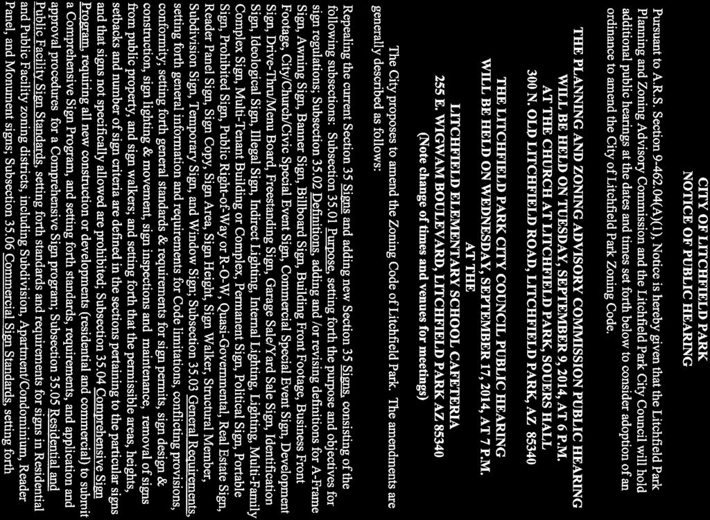
50

51


52
CHAPTER 154: SIGNS. Section
 CHAPTER 154: SIGNS Section 154.01 Permit required 154.02 Where prohibited 154.03 Street decorations 154.04 Approval by state 154.05 Purpose 154.06 Definitions 154.07 General sign and street graphics regulations
CITY OF LITCHFIELD PARK. Members of the Litchfield Park City Council may attend either in person or by telephone conference call.) I.
 I.") CITY OF LITCHFIELD PARK CITY COUNCIL Special Council Meeting Wednesday, October 1, 2014 7:00 PM Litchfield Library Community Room 101 W. Wigwam Blvd. Litchfield Park, Arizona 85340 Members of the Litchfield
CITY OF LITCHFIELD PARK CITY COUNCIL Special Council Meeting Wednesday, October 1, 2014 7:00 PM Litchfield Library Community Room 101 W. Wigwam Blvd. Litchfield Park, Arizona 85340 Members of the Litchfield
1. Animated: A sign or part of a sign that moves or appears to move.
 ZONING ORDINANCE, ARTICLE 16, SIGNS PAGE 16:1 ARTICLE 16 SIGNS 3-360 Purpose and Intent The purpose of this article is to promote and protect the public health, safety, and welfare by regulating outdoor
Article 9 Signs and Billboards
 Article 9 Signs and Billboards Section 9.01 Intent and Purpose The intent of this article is to regulate the type, number, physical dimensions, erection and placement of signs in Arbela Township. The purpose
City of Jasper Sign Ordinance
 City of Jasper Sign Ordinance DIVISION 4. SIGNS Sec. 230 Permits Required (a) A sign permit shall be obtained from the Sign Administrator prior to the erection or placement of a sign, except those signs
No sign shall interfere with vehicular or pedestrian safety in any manner.
 Chapter 1170 Signs 1170.01 PURPOSE AND INTENT The purpose of these sign regulations is to encourage the proper development and use of signage and to permit and regulate signs in such a way as to support
Excerpt from Town of West Greenwich, RI Zoning Ordinance Amended by Town Council September 12, 2007, and September 10, 2008
 ARTICLE IV SIGN REGULATIONS Section 1. Purpose and intent. The purpose of this Article is to: A. Improve pedestrian and traffic safety; B. Encourage the effective use of signs as a means of communication
CHAPTER 13 SIGNS 13-1
 SECTION 13.1 PURPOSE AND INTENT The purpose of this Chapter is to promote traffic safety, public safety, and the conservation of property values through the application of reasonable controls over the
Section XXIV Signs (including Banners, Flags, and Temporary Signs)
") Section XXIV Signs (including Banners, Flags, and Temporary Signs) A. Guiding Principle Allow for adequate information to be conveyed without compromising the rural character of Rochester. B. Specific
Section XXIV Signs (including Banners, Flags, and Temporary Signs) A. Guiding Principle Allow for adequate information to be conveyed without compromising the rural character of Rochester. B. Specific
Sign, Canopy: A sign attached to the underside of a canopy.
 SECTION 15 SIGNS 15.1 Purpose: The requirements established herein are designed to regulate sign structures in order to insure light, air, and open space; to reduce hazards at intersections; to prevent
Signs along highways shall meet all of the requirements of the zoning districts in which they are located.
 SECTION 39 SIGNS 39.1 INTENT 39.1.1 The intent of this section is to regulate signs as defined hereinafter, to protect the safety of users of the streets and highways, to assure compatibility with uses
Zoning Ordinance Chapter 9
 CHAPTER 9 SIGNAGE SECTION 9.0 PURPOSE A. The purpose of this Ordinance is to establish comprehensive provisions that will eliminate confusing, distracting and unsafe signs located on private property;
ARTICLE 20 SIGN REGULATIONS
 ARTICLE 20 SIGN REGULATIONS Section 20.01 Purpose The purpose of this Article is to regulate the size, placement, and general appearance of all privately owned signs and billboards in order to promote
ARTICLE V SIGN REGULATIONS
 ARTICLE V SIGN REGULATIONS Section 5-1. Purpose The purpose of this Article is to protect the dual interest of the public and the advertiser. The regulations herein are designed to protect public safety
ARTICLE 20 SIGNS. SIGN, AREA: The entire area of all sign faces, cumulatively, including sign faces on which no copy is currently displayed.
 ARTICLE 20 SIGNS 7 TCC 1-20 (a) Purpose. The purpose of the article is to provide regulation and control of the location, size, content and placement of signs throughout the County in order to promote
ARTICLE V SUPPLEMENT REGULATIONS
 ARTICLE V SUPPLEMENT REGULATIONS SECTION 5.1 PURPOSE It is the purpose of this article of this ordinance to provide regulations and requirements that supplement the provisions contained under the respective
ARTICLE 9: Sign Standards
 ARTICLE 9: Sign Standards... 9-1 17.9.1: General...9-1 17.9.1.1: Purpose and Intent... 9-1 17.9.1.2: Applicability... 9-1 17.9.1.3: Severability... 9-1 17.9.1.4: Prohibited Signs... 9-2 17.9.2: Types of
TITLE NINE - SUPPLEMENTAL REGULATIONS Chapter Signs. CHAPTER 1179 Signs. (1) Promote attractive and high value residential districts.
 Promote attractive and high value residential districts.") Village of Boston Heights OH, Planning and Zoning Code, Sign Regulations 1 TITLE NINE - SUPPLEMENTAL REGULATIONS Chapter 1179. Signs. CHAPTER 1179 Signs 1179.01 Purposes 1179.02 Definitions 1179.03 General
Village of Boston Heights OH, Planning and Zoning Code, Sign Regulations 1 TITLE NINE - SUPPLEMENTAL REGULATIONS Chapter 1179. Signs. CHAPTER 1179 Signs 1179.01 Purposes 1179.02 Definitions 1179.03 General
DRAFT PARK COUNTY US HIGHWAY 89 SOUTH EAST RIVER ROAD OLD YELLOWSTONE TRAIL ZONING DISTRICT REGULATIONS
 Formatting: Changes recommended by the Board and accepted by the County Commission are formatted in RED: Changes made by the Park County Commission are formatted in YELLOW highlight: and changes made by
IOSCO TOWNSHIP ZONING ARTICLE 11 SIGNS
 IOSCO TOWNSHIP ZONING ARTICLE 11 SIGNS INDEX Section 11.1 Section 11.2 Section 11.3 Section 11.4 Section 11.5 Section 11.6 Section 11.7 Section 11.8 Section 11.9 Intent and Purpose Definitions General
SIGNS MASTER SIGN PROGRAM
 SIGNS MASTER SIGN PROGRAM How to apply for a Master Sign Program What is the purpose of a Master Sign Program? A Master Sign Program (MSP) is used to create standard sign design guidelines for projects
ORDINANCE NO
 TOWNSHIP OF ANDOVER, COUNTY OF SUSSEX, STATE OF NEW JERSEY ORDINANCE NO. 2014-04 AN ORDINANCE OF THE TOWNSHIP OF ANDOVER, COUNTY OF SUSSEX, AND STATE OF NEW JERSEY TO AMEND CHAPTER 190, ZONING, ARTICLE
HUERFANO COUNTY SIGN REGULATIONS SECTION 14.00
 TABLE OF CONTENTS Section Title Page 14.01 SIGN CODE... 14-1 14.01.01 Intent and Purpose... 14-1 14.02 GENERAL PROVISIONS... 14-1 14.02.01 Title... 14-1 14.02.02 Repeal... 14-1 14.02.03 Scope and Applicability
ARTICLE XII Sign Regulations
 Application # Zoning District Date received Village Of Cuba Fee Paid 17 East Main Street Planning Board Approval Cuba,NY 14727 Date Issued 585-968-1560 Instructions: 1 Application MUST be submitted 48
Chapter SIGNS. Sections: Specific Standards by Zoning District Specific Standards by Use
 Chapter 20.62 SIGNS Sections: 20.62.010 Purpose 20.62.020 Applicability 20.62.030 General Standards 20.62.040 Specific Standards by Zoning District 20.62.050 Specific Standards by Use 20.62.010 Purpose
Composition of traditional residential corridors.
 Page 1 of 7 St. Petersburg, Florida, Code of Ordinances >> PART II - ST. PETERSBURG CITY CODE >> Chapter 16 - LAND DEVELOPMENT REGULATIONS >> SECTION 16.20.060. CORRIDOR RESIDENTIAL TRADITIONAL DISTRICTS
Article 18. Sign Regulations
 Article 18. Sign Regulations Section 18.01 Purpose and Intent Section 18.02 Use Regulations Section 18.03 Classification of Signs Section 18.04 Structural Types Section 18.05 General Standards Section
ARTICLE 11. NAMEPLATES AND SIGNS Signs in all districts.
 //Culpeper County, Virginia/CODE OF ORDINANCES COUNTY OF CULPEPER, VIRGINIA Codified through Ordinance of November 7, 2007. (Supplement No. 3)/APPENDIX A ZONING ORDINANCE*/ARTICLE 11. NAMEPLATES AND SIGNS
CHAPTER 5 ZONING SECTION 5.1 PURPOSE
 CHAPTER 5 ZONING SECTION 5.1 PURPOSE The purpose of this Chapter is to regulate the nature and extent of uses of land, and of buildings and structures thereon, in order to promote the purposes of this
ARTICLE I. IN GENERAL. To encourage the effective use of signs as a means of communication in the city;
 ARTICLE I. IN GENERAL Section 46-1. Applicability. All signs erected or maintained after March 1, 2013; except official, traffic, street signs, and those signs which are displayed inside of a business
Larimer County Planning & Building Dept. Procedural Guide for NON-RESIDENTIAL DISTRICT SIGNAGE Information and Requirements
 Larimer County Planning & Building Dept. Procedural Guide for NON-RESIDENTIAL DISTRICT SIGNAGE Information and Requirements December 28, 2010 PURPOSE: The purpose of the Sign Code is to protect the health,
SECTION 10 SIGN REGULATIONS
 ZONING ORDINANCE SECTION 10 SIGN REGULATIONS 10.1 INTENT The purpose of these regulations is to control the location, number, size, placement, and other features of signs in the City of Chaska in order
Temporary Sign By-law
 THE CORPORATION OF THE TOWN OF WHITBY Temporary Sign By-law Being a By-law to regulate temporary signs and other temporary advertising devices By-law #5696-05 Consolidated Version As Amended by By-laws:
Lone Tree Landing Hillcrest Ave & Lone Tree Way Antioch, CA
 Lone Tree Landing Hillcrest Ave & Lone Tree Way Antioch, CA Sign Criteria Multi Tenant and Freestanding Commercial Prepared By: Charity Bowman June 3, 2008 United Sign Systems 5201 Pentecost Drive Modesto,
CITY OF LITCHFIELD PARK
 CITY OF LITCHFIELD PARK PLANNING AND ZONING COMMISSION Regular Meeting Tuesday, January 12, 2016 7:00 p.m. Litchfield Park Branch Library Community Room 101 W. Wigwam Boulevard Litchfield Park, Arizona
ARTICLE XII SIGNAGE REGULATIONS
 ARTICLE XII Section 1. Section 2. Section 3. Section 4. Section 5. PURPOSE OF SIGNAGE REGULATIONS SIGN DEFINITIONS GENERAL SIGN STANDARDS SIGN STANDARDS BY TYPE PERMANENT SIGN STANDARDS Section 6. PROHIBITED
ARLINGTON COUNTY, VIRGINIA
 ARLINGTON COUNTY, VIRGINIA County Board Agenda Item Meeting of April 25, 2009 DATE: April 14, 2009 SUBJECTS: A. Amendments to the Arlington County Zoning Ordinance, Section 20. (Appendix A), CP-FBC Columbia
MASTER SIGN PROGRAM SERRA CENTER COLMA, CALIFORNIA. Approved by the Town of Colma City Council on March 22, 2017
 MASTER SIGN PROGRAM SERRA CENTER COLMA, CALIFORNIA Approved by the Town of Colma City Council on March 22, 2017 A. INTRODUCTION 1. The intent of this sign program is to provide the guidelines necessary
Condominium Unit Requirements.
 ARTICLE 19 CONDOMINIUM REGULATIONS Section 19.01 Purpose. The purpose of this Article is to regulate projects that divide real property under a contractual arrangement known as a condominium. New and conversion
CHAPTER 7. SIGNS TABLE OF CONTENTS ARTICLE 1. GENERAL Sec INTENT Sec NUMBER OF SIGNS AND SURFACE AREA...
 CHAPTER 7. SIGNS TABLE OF CONTENTS ARTICLE 1. GENERAL... 2 Sec. 7.1.1. INTENT.... 2 Sec. 7.1.2. NUMBER OF SIGNS AND SURFACE AREA.... 2 Sec. 7.1.3. DEFINITIONS.... 4 ARTICLE 2. REQUIREMENTS... 8 Sec. 7.2.1.
CHAPTER 5. Signs. It is further the intent of this section to prohibit signs which:
 CHAPTER 5 Signs 12-5-1 Purpose 12-5-2 Permitted Signs 12-5-3 Prohibited Signs 12-5-4 Computation of Number and Square Footage of Signs 12-5-5 District Regulations 12-5-6 Maintenance and Removal 12-5-7
HARTSELLE ZONING ORDINANCE - SECTION 27 SIGN REGULATIONS. (See CBD Sign Ordinance for Additional Downtown Standards)
") HARTSELLE ZONING ORDINANCE - SECTION 27 SIGN REGULATIONS (See CBD Sign Ordinance for Additional Downtown Standards) Section 27.1 Purpose and Intent It is the purpose of this Article to provide regulations
HARTSELLE ZONING ORDINANCE - SECTION 27 SIGN REGULATIONS (See CBD Sign Ordinance for Additional Downtown Standards) Section 27.1 Purpose and Intent It is the purpose of this Article to provide regulations
ARTICLE 8 SIGNS Section 8.1 Intent Section 8.2 Definitions Advertising Sign Attached Sign Billboard Business Sign
 ARTICLE 8 SIGNS Signs are permitted in accordance with regulations listed below and in accordance with other applicable regulations of this Ordinance. Section 8.1 Intent The purpose of this Article is
CHAPTER 10 SIGN REGULATIONS
 CHAPTER 10 SIGN REGULATIONS 4-10-1 Definitions 4-10-2 Exempt Signs 4-10-3 Prohibited Signs 4-10-4 Permitted Signs in Residential Zoning Districts and Uses 4-10-5 Permitted Signs in Business Zoning Districts
Except as authorized in section with respect to non-conforming signs, all signs shall be in compliance with the provisions of this chapter.
 ARTICLE XV. SIGNS DIVISION 1. GENERAL SIGN REGULATIONS 155.300. General signs regulations. Purpose: a. The purpose of Article XV is to establish reasonable and impartial regulations for all signs in order
Orange Township Zoning Resolution Effective May 1, 2013
 ARTICLE XXII - SIGN AND BILLBOARD REGULATION SECTION 22.01 - PURPOSE: The purpose of this sign regulation is to promote and protect the public health by regulating existing and proposed outdoor signs of
ARTICLE 15. RULES, REGULATIONS AND DEFINITIONS
 ARTICLE 15. RULES, REGULATIONS AND DEFINITIONS Section 1. Interpretation and Construction: The following rules and regulations regarding interpretation and construction of the Ulysses-Grant County, Kansas,
CITY PLANNING COMMISSION COMPREHENSIVE PLAN AND REVIEW CRITERIA
 Page 3 CITY PLANNING COMMISSION COMPREHENSIVE PLAN AND REVIEW CRITERIA COMPREHENSIVE PLAN: The City Planning Commission uses the Comprehensive Plan as a guide in all land use matters. The Plan is available
6. Wall signs shall not extend above the second story windowsill or extend above the roofline, whichever is lower.
 GENERAL ZONING 17.47 (4) (d) (4) 4. At the base of each ground sign shall be a landscaped area of the same size as the area of the copy. Where a ground sign is located within a paved area, then the landscaped
CHAPTER 14. SIGNS AND GROUND SIGNS
 CHAPTER 14. SIGNS AND GROUND SIGNS Contents Section 1400 - Purpose... 1 Section 1405 Definitions... 2 Section 1410 General Provisions... 4 Section 1415 Permits... 5 Section 1420 Prohibited Characteristics
ARTICLE 14 PLANNED UNIT DEVELOPMENT (PUD) DISTRICT
 DISTRICT") ARTICLE 14 PLANNED UNIT DEVELOPMENT (PUD) DISTRICT Section 14.01 Intent. It is the intent of this Article to allow the use of the planned unit development (PUD) process, as authorized by the Michigan Zoning
ARTICLE 14 PLANNED UNIT DEVELOPMENT (PUD) DISTRICT Section 14.01 Intent. It is the intent of this Article to allow the use of the planned unit development (PUD) process, as authorized by the Michigan Zoning
ORDINANCE # 99-2 USES IN THE 1-1 DISTRICT THROUGH MODIFICATION; BY
 ORDINANCE # 99-2 AN ORDINANCE AMENDING THE HERNANDO COUNTY CODE OF ORDINANCES, APPENDIX A, ZONING ORDINANCE; BY AMENDING APPENDIX A, ARTICLE I, SECTION 3. DEFINITIONS THROUGH MODIFICATION; BY AMENDING
Guilford Planning and Zoning Sign Permit Application Permanent Sign. (Submit Three copies plus fee of $50.00 per sign)
") Date Entered: Application ID # Customer ID # Parcel Id # Guilford Planning and Zoning Sign Permit Application Permanent Sign (Submit Three copies plus fee of $50.00 per sign) Name of Business, Organization
Date Entered: Application ID # Customer ID # Parcel Id # Guilford Planning and Zoning Sign Permit Application Permanent Sign (Submit Three copies plus fee of $50.00 per sign) Name of Business, Organization
DEVELOPMENT DEPARTMENT STAFF REPORT THE PARK AT 5 TH
 DEVELOPMENT DEPARTMENT STAFF REPORT ARB Meeting Date: July 3, 2018 Item #: _PZ2018-293_ THE PARK AT 5 TH Request: Site Address: Project Name: Parcel Number: Applicant: Proposed Development: Current Zoning:
Chapter 10 Signs CHAPTER 10 SIGNS
 CHAPTER 10 SIGNS Section 1000.00 Section 1000.01 Signs Purpose The purpose of this Chapter is to promote and protect the public health, convenience and safety by regulating existing and proposed signs
Town of Siler City - Unified Development Ordinance ARTICLE XII - Density and Dimensional Regulations
 ARTICLE XII - Density and Dimensional Regulations 167 Minimum Lot Size Subject to the provisions of 173 (Cluster Subdivisions) and all lots in the following zones shall have at least the amount of square
General Plan. Amendment Application Meeting April 28, GPAs #14-01 and # JDM Proposals
 General Plan Amendment Application Meeting April 28, 2014 GPAs #14-01 and #14-02 JDM Proposals Northwest Corner of Litchfield Rd. & Village Parkway Northwest Corner of Litchfield Rd. & Wigwam Blvd. 1 TO
ARTICLE 13 CONDOMINIUM REGULATIONS
 ARTICLE 13 CONDOMINIUM REGULATIONS Section 13.01 Purpose. The purpose of this Article is to regulate projects that divide real property under a contractual arrangement known as a condominium. New and conversion
CONDOMINIUM REGULATIONS
 ARTICLE 37 CONDOMINIUM REGULATIONS SECTION 37.01. Purpose The purpose of this Article is to regulate projects that divide real property under a contractual arrangement known as a condominium. New and conversion
PROPOSED REVISIONS TO THE MARLBOROUGH ZONING REGULATIONS
 PROPOSED REVISIONS TO THE MARLBOROUGH ZONING REGULATIONS PROPOSED REVISIONS TO ARTICLE 4, DEFINITIONS: The definition of Commercial Zone is hereby inserted into Article 4 of the Marlborough Commercial
SPECIAL ZONING DISTRICTS
 SPECIAL ZONING DISTRICTS 5.01 5.99 RESERVED 5.100 PLANNED DEVELOPMENTS: Purpose: This district is intended to accommodate unified design of residential, commercial, office, professional services, retail
SECTION 10 SIGN REGULATIONS
 ZONING ORDINANCE SECTION 10 SIGN REGULATIONS 10.1 INTENT The purpose of these regulations is to facilitate effective communications between citizens and their physical environment while protecting and
Signs. Chapter VII VII - 1. Chapter VII Signs. 1. Intent. 2. Definitions
 Chapter VII Signs 1. Intent The purpose of this Ordinance shall be to coordinate the type, placement, and scale of signs within the different zoning districts to recognize the commercial communication
ARTICLE 9 SIGNS. Accordingly, it is deemed necessary and in the public interest to regulate signs. To this end, this Article:
 ARTICLE 9 SIGNS 9.00 PREAMBLE 9.00-A Principles The provisions of this Article recognize that: 1. There is a significant relationship between the manner in which signs are displayed and public safety and
ZONING ORDINANCE: OPEN SPACE COMMUNITY. Hamburg Township, MI
 ZONING ORDINANCE: OPEN SPACE COMMUNITY Hamburg Township, MI ARTICLE 14.00 OPEN SPACE COMMUNITY (Adopted 1/16/92) Section 14.1. Intent It is the intent of this Article to offer an alternative to traditional
PERMITTED USES: Within the MX-1 Mixed Use Neighborhood District the following uses are permitted:
 6.25 MX-1 - MIXED USE NEIGHBORHOOD 6.25.1 INTENT: The purpose of the MX-1 Mixed Use Neighborhood District is to accommodate the development of a wide-range of residential and compatible non-residential
New Lawrence, Kansas Sign Code. Frequently Asked Questions (FAQs)
") New Lawrence, Kansas Sign Code (Adopted by Ord. No. 9391 in City Code Chapter V, Art. 18, Effective 9/11/17, and Amended by Ord. No. 9439 on 3/6/18) Planning & Development Services Building Safety Division
New Lawrence, Kansas Sign Code (Adopted by Ord. No. 9391 in City Code Chapter V, Art. 18, Effective 9/11/17, and Amended by Ord. No. 9439 on 3/6/18) Planning & Development Services Building Safety Division
Sign Ordinance Taken from Sections of Zoning Text & Municipal Code
 Sign Ordinance Taken from Sections of Zoning Text & Municipal Code TABLE OF CONTENTS Definitions (from ARTICLE III of Zoning Text) 2 Sign Regulations (from ARTICLE V & ARTICLE VII) 5 407. Planned Unit
Special Use Permit - Planned Unit Development Checklist. Property Address:
 Special Use Permit - Planned Unit Development Checklist Special Use Permit Number. Parcel Code/s #28-11- - - Property Address: Applicant: ARTICLE VIII Ordinance Reference - Section 8.1.2 Permit Procedures:
ARTICLE VI. SPECIAL EXCEPTION REGULATIONS
 ARTICLE VI. SPECIAL EXCEPTION REGULATIONS SECTION 601. GENERAL DESCRIPTION Special exceptions are deemed to be permitted uses in their respective districts, subject to the satisfaction of the requirements
ORDINANCE NO
 ORDINANCE NO. 17-029 AN ORDINANCE OF THE CITY COMMISSION OF THE CITY OF FORT PIERCE, FLORIDA AMENDING THE PROVISIONS OF FORT PIERCE CODE OF ORDINANCES CHAPTER 15 SIGNS AND BILLBOARDS, SEC 1 DEFINITIONS
SCHEDULE B. Comprehensive Mixed Use Sign and Awning Package Replacing Section VI.P.3 of the Redevelopment Plan As amended January 22, 2013
 SCHEDULE B Comprehensive Mixed Use Sign and Awning Package Replacing Section VI.P.3 of the Redevelopment Plan As amended January 22, 2013 3. Mixed Use District a. All dwellings shall clearly display the
Chapter 24 SIGNS. C. To provide for the enforcement of the provisions of this Zoning Resolution.
 Chapter 24 SIGNS 24.01 PURPOSE The purpose of this Chapter is to promote and protect the public health, welfare, and safety by regulating existing and proposed signs. It is intended to create a more attractive
ARTICLE 2: General Provisions
 ARTICLE 2: General Provisions 2-10 Intent The basic intent of the Town of Orange s Zoning Ordinance is to implement the goals and objectives of the adopted Town of Orange Comprehensive Plan, hereafter
ORDINANCE NO AN ORDINANCE OF THE CITY OF REDLANDS AMENDING SECTION OF THE REDLANDS MUNICIPAL CODE RELATING TO SIGNS
 City of Redlands Sign Code February 5, 2004 ORDINANCE NO. 2552 AN ORDINANCE OF THE CITY OF REDLANDS AMENDING SECTION 15.36 OF THE REDLANDS MUNICIPAL CODE RELATING TO SIGNS THE CITY COUNCIL OF THE CITY
County Council Of Howard County, Maryland
 Introduced Public Hearing Council Action Executive Action Effective Date County Council Of Howard County, Maryland 0 Legislative Session Legislative Day No.. Bill No. -0 Introduced by the Chairperson at
CHAPTER 214: SIGNS PURPOSE.
 CHAPTER 214: SIGNS SIGNS. 214.245 Purpose 214.246 Prohibited Signs 214.247 Exemptions 214.248 General Standards 214.249 Open Space Districts 214.250 Residence Districts 214.251 Professional Business Districts
The following regulations shall apply in the R-E District:
 "R-E" RESIDENTIAL ESTATE DISTRICT (8/06) The following regulations shall apply in the R-E District: 1. Uses Permitted: The following uses are permitted. A Zoning Certificate may be required as provided
VINEYARD & VENTURA SHOPPING CENTER
 Exhibit "_" VINEYARD & VENTURA SHOPPING CENTER 2600 E. Vineyard Blvd. OXNARD, CA MASTER SIGN PROGRAM July 24, 2013 LESSOR OXNARD VINEYARDS, LLC LESSEE \\TWLA-SERVER\Projects\Vineyard & Ventura\Project
Uniform Sign Plan (USP) Village Square 88-USP-004
 Village Square 88-USP-004") Uniform Sign Plan (USP) Village Square 88-USP-004 A sign permit application must be submitted and a permit issued prior to installation of a sign. USP identifier: Also known as Cary Village Square Location:
Uniform Sign Plan (USP) Village Square 88-USP-004 A sign permit application must be submitted and a permit issued prior to installation of a sign. USP identifier: Also known as Cary Village Square Location:
Chapter SPECIAL USE ZONING DISTRICTS
 Chapter 20.20 Sections: 20.20.010 Urban Transition (U-T) Zoning District 20.20.020 Planned Development (P-D) Zoning Districts 20.20.010 Urban Transition (U-T) Zoning District A. Purpose. The purpose of
ORDINANCE # 455. NOW, THEREFORE, BE IT ORDAINED by the Mayor and Board of Aldermen of the City of Forest as follows:
 ORDINANCE # 455 ORDINANCE OF THE MAYOR AND BOARD OF ALDERMEN OF THE CITY OF FOREST, MISSISSIPPI ENACTING REGULATIONS OF SIGNS WITHIN THE CITY AND RELATED MATTERS WHEREAS, the Mayor and Board have considered
Statement of purpose. The purposes of this section are as follows: To provide for signs as a means of effective visual communication.
 425-44. Signs. A. Statement of purpose. The purposes of this section are as follows: (1) (2) (3) (4) (5) (6) (7) (8) (9) (10) To provide for signs as a means of effective visual communication. To promote
Cover Letter with Narrative Statement
 Cover Letter with Narrative Statement March 31, 2017 rev July 27, 2017 RE: Rushton Pointe Residential Planned Unit Development Application for Public Hearing for RPUD Rezone PL2015 000 0306 Mr. Eric Johnson,
10. Canopy means a fixed shelter that may be supported from the exterior wall of a building or from the ground or some combination thereof. 11.
 Chapter 19.33 SIGNS 19.33.010 Statement of Purpose. 19.33.030 Definitions. 19.33.040 General Provisions. 19.33.050 Residential Zones 19.33.055 Historic Business District 19.33.060 Historic Business, Local
ARTICLE XVII SIGNS ADOPTED JANUARY 12, 2004/Amendments through
 ARTICLE XVII SIGNS 17.0 Purpose. To regulate the erection and placement of signs within the Town in order to provide safe operating conditions for pedestrian and vehicular traffic without unnecessary and
The following jurisdictions prohibit real estate signs on public property:
 Sign Ordinance Guidelines The following sign ordinance summaries can serve as a guide for REALTORS when selling homes in or near SILVAR s jurisdiction. For complete information on sign ordinances, please
Shenandoah, Texas Chapter 90, Sign Ordinance
 2017 Shenandoah, Texas Chapter 90, Sign Ordinance February 22, 2017 Section 11.0 Signs 11.1 General 11.1.1 Purposes (a) (b) (c) (d) (e) The purposes of these sign regulations are: 11.1.2 Applicability
PD No. 15 Authorized Hearing
 PD No. 15 Authorized Hearing Community Meeting No. 2 February 19, 2019 6:30 p.m. Hyer Elementary School Cafetorium 8385 Durham St Andrew Ruegg Senior Planner PD No. 15 Authorized Hearing On September 7,
ARTICLE 9 SIGNS. Accordingly, it is deemed necessary and in the public interest to regulate signs. To this end, this Article:
 ARTICLE 9 SIGNS 9.00 PREAMBLE 9.00-A Principles The provisions of this Article recognize that: 1. There is a significant relationship between the manner in which signs are displayed and public safety and
ARLINGTON COUNTY, VIRGINIA
 ARLINGTON COUNTY, VIRGINIA County Board Agenda Item Meeting of June 16, 2012 DATE: June 7, 2012 SUBJECT: SP #397 SITE PLAN AMENDMENT to revise condition #31 to modify the retail transparency requirement
1. Approval of Plans and Specifications/Architectural Review Procedure.
 COMMERCE CROSSING Protective Covenants WHEREAS, the undersigned City of Kaukauna, a Wisconsin Municipal Corporation, hereinafter City, is the owner of the following described lands collectively known as
CHAPTER 19 SIGNS AND BILLBOARDS
 CHAPTER 19 SIGNS AND BILLBOARDS (See also, 27-901, Signs ) PART 1 SIGNS 19-101. Purpose 19-102. Definitions 19-103. General Sign Types 19-104. General Provisions 19-105. Exempt Signs 19-106. Prohibited
DEVELOPMENT DEPARTMENT STAFF REPORT STAFF REPORT DRESDEN DRIVE TOWNHOMES DCI
 DEVELOPMENT DEPARTMENT STAFF REPORT Meeting Date: September 13, 2018 Item #: PZ2018-319 STAFF REPORT DRESDEN DRIVE TOWNHOMES DCI Request: Project Name: Development of Community Compact (DCI) and six concurrent
ARTICLE 41 SIGNS SECTION 4101 PURPOSE
 ARTICLE 41 SIGNS SECTION 4101 PURPOSE This article establishes uniform regulations governing the size, character and location of signs in Butler Township. Such regulations are intended to: 1) provide for
PLANNED UNIT DEVELOPMENT & SUBDIVISION STAFF REPORT Date: July 20, 2017
 PLANNED UNIT DEVELOPMENT & SUBDIVISION STAFF REPORT Date: July 20, 2017 DEVELOPMENT NAME SUBDIVISION NAME LOCATION Rangeline Crossing III Subdivision Rangeline Crossing III Subdivision 5289 Halls Mill
Staff Report: Date: Applicant: Property Identification: Acreage of Request: Current Zoning of Requested Area: Requested Action: Attached:
 Staff Report: Completed by Jeff Palmer Director of Planning & Zoning Date: November 7, 2018, Updated November 20, 2018 Applicant: Greg Smith, Oberer Land Developer agent for Ronald Montgomery ET AL Property
A. ARTICLE 18 - SIGNS
 1800. 1801.A. ARTICLE 18 - SIGNS SECTION 1800 INTENT A. Edgmont Township recognizes that signs perform an important function in identifying properties, businesses, services, events, and other matters of
ARTICLE V SECTION 517. SIGNS.
 SECTION 517. SIGNS. A. Intent. 1. In addition to 103 of this Ordinance, the purpose of this Article is to promote the public health, safety and general welfare through reasonable, consistent and non-discriminatory
TITLE XV: LAND USAGE 150.BUILDING REGULATIONS 151.FLOOD DAMAGE PREVENTION 153.[RESERVED] 154.COMPREHENSIVE PLAN 155.SUBDIVISION AND ZONING CODE
![TITLE XV: LAND USAGE 150.BUILDING REGULATIONS 151.FLOOD DAMAGE PREVENTION 153.[RESERVED] 154.COMPREHENSIVE PLAN 155.SUBDIVISION AND ZONING CODE](/thumbs/86/94109177.jpg "TITLE XV: LAND USAGE 150.BUILDING REGULATIONS 151.FLOOD DAMAGE PREVENTION 153.[RESERVED] 154.COMPREHENSIVE PLAN 155.SUBDIVISION AND ZONING CODE") 1 TITLE XV: LAND USAGE Chapter 150.BUILDING REGULATIONS 151.FLOOD DAMAGE PREVENTION 152.SIGN AND BILLBOARD REGULATIONS 153.[RESERVED] 154.COMPREHENSIVE PLAN 155.SUBDIVISION AND ZONING CODE 2006 S-2 1 2
1 TITLE XV: LAND USAGE Chapter 150.BUILDING REGULATIONS 151.FLOOD DAMAGE PREVENTION 152.SIGN AND BILLBOARD REGULATIONS 153.[RESERVED] 154.COMPREHENSIVE PLAN 155.SUBDIVISION AND ZONING CODE 2006 S-2 1 2