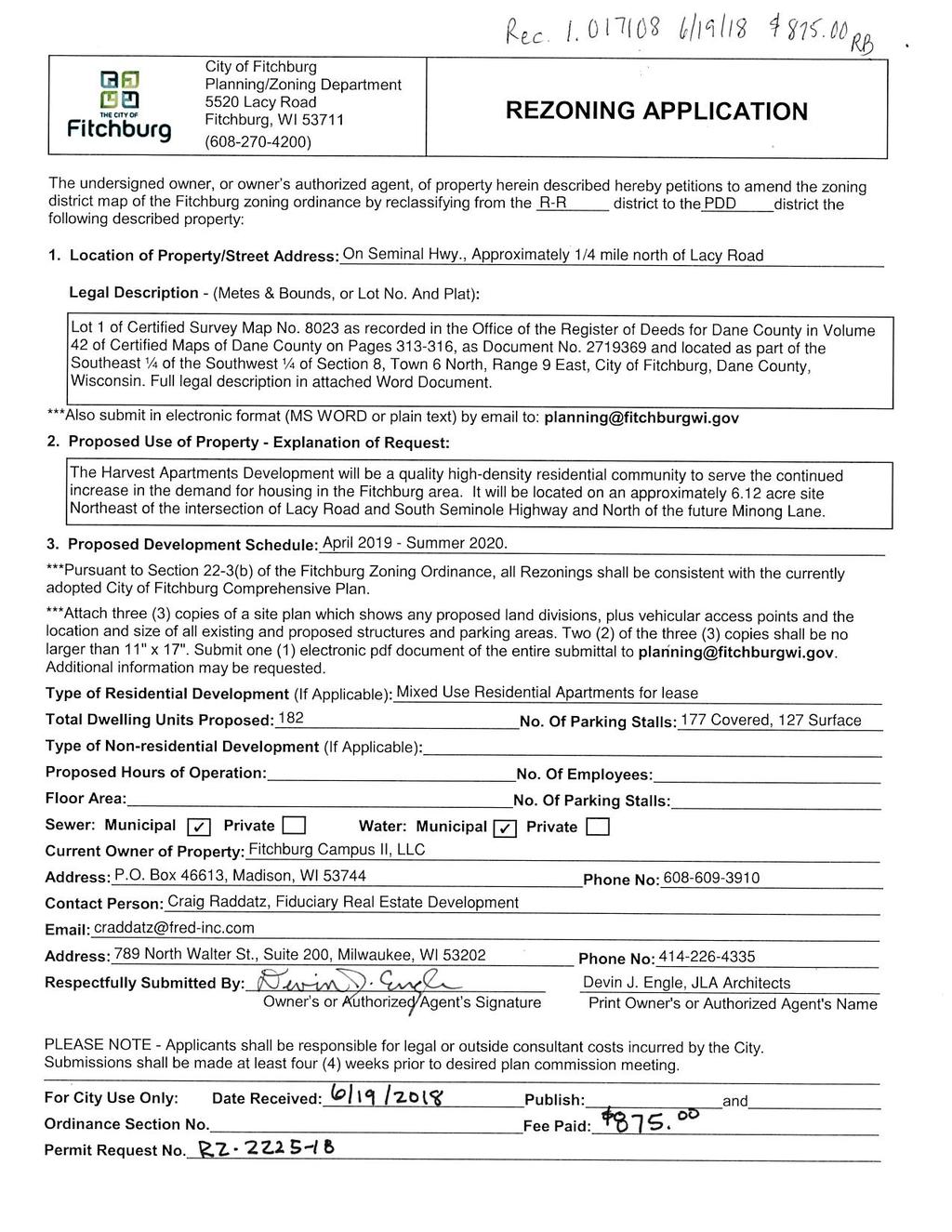
Northerly portion of Lot 1 CSM 8023
|
|
|
- Bernard Butler
- 5 years ago
- Views:
Transcription
1
2 Northerly portion of Lot 1 CSM 8023 A part of Lot 1 Certified Survey Map no. 8023, recorded on November 16, 1995 in Volume 42 of Certified Survey Maps on Pages , as Document no , being a part of the Southeast Quarter of the Southwest Quarter of Section 8, Town 6 North, Range 9 East, City of Fitchburg, Dane County, Wisconsin. Commencing at the South Quarter corner of said Section 8, Thence North 01 degrees 38 minutes 21 seconds East along the East line of the Southwest Quarter of said Section 8, a distance of feet to the Point of Beginning; thence North 88 degrees 25 minutes 49 seconds West, feet; thence North 78 degrees 55 minutes 03 seconds West, feet to the easterly Right-of-Way of South Seminole Highway; thence along said easterly Right-of-Way of South Seminole Highway Way North 11 degrees 04 minutes 57 seconds East, feet to the North line of the Southeast Quarter of the Southwest Quarter of said Section 8, also being the North line of said CSM no. 8023; thence along said North line of the Southeast Quarter of the Southwest Quarter North 89 degrees 07 minutes 24 seconds East, feet to the aforesaid East line of the Southwest Quarter of Section 8, also being the East line of said CSM no. 8023; thence along said East line of the Southwest Quarter South 01 degrees 38 minutes 21 seconds West, feet back to the Point of Beginning.

3 T H E H A R V E S T A P A R T M E N T S F I T C H B U R G, W I S C O N S I N G E N E R A L I M P L E M E N T A T I O N P L A N JUNE 19, 2018


4 CONTENTS: PAGE 3 PAGE 4 PAGE 5 PAGE 6 PAGE 7 PAGE 10 PAGE 11 PAGE 13 PAGE 14 PAGE 15 APPENDIX A APPENDIX B APPENDIX C PROJECT LOCATION & GENERAL DESCRIPTION LEGAL DESCRIPTION RATIONALE FOR A PLANNED DEVELOPMENT DISTRICT ECONOMIC & SOCIAL IMPACTS CONSISTENCY WITH COMPREHENSIVE PLAN LAND USE SITE DESIGN & ZONING STANDARDS ENVIRONMENTAL BENEFITS OF PLANNED DEVELOPMENT ZONING ORGANIZATIONAL STRUCTURE PROJECT IMPLEMENTATION/ NEIGHBORHOOD INPUT GIP Lot 1- Architectural Site Plan GIP Preliminary Grading & Utility Plans GIP Landscape Plan PROJECT TEAM: FIDUCIARY REAL ESTATE DEVELOPMENT, INC JLA ARCHITECTS + PLANNERS 789 North Water Street - Suite Crossroads Drive - Suite 2300 Milwaukee, Wisconsin Madison, Wisconsin Contact: Craig Raddatz Contact: Ed Cormier WYSER ENGINEERING NEW EDEN LANDSCAPE ARCHITECTURE 312 East Main Street 131 West Seeboth Street, Suite 240 Mount Horeb, Wisconsin Milwaukee, Wisconsin Contact: Wade Wyse Contact: Rosheen Styczinski JUNE 19, 2018

5 PROJECT LOCATION & GENERAL DESCRIPTION The Harvest Apartments Development will be a quality high-density residential community to serve the continued increase in demand for housing in the Fitchburg area over the next five years and beyond. It will be located on approximately 6.12 acres, Northeast of the intersection of Lacy Road and South Seminole Highway and North of the future Minong Lane. Surrounding Context The project site is surrounded by the future Blackhawk Church site to the North, future single-family housing to the East, future multi-family townhomes to the South and planned business district to the West across South Seminole Highway. A high-power overhead ATC line runs North-South within an easement along the East property line. Existing Topography & Wetlands The project site has a minimal change in elevation of about 10 feet from West (low) to East. At the time of development, a regional storm water basin will be constructed South of the site that will include a culvert to drain the site in the Southwest corner. There are no wetlands within the boundary of the parcel. Existing Vegetation The project site is currently in agricultural production with no other significant trees or vegetation. 3 JUNE 19, 2018
6 LEGAL DESCRIPTION Lot 1 of Certified Survey Map No as recorded in the Office of the Register of Deeds for Dane County in Volume 42 of Certified Maps of Dane County on Pages , as Document No and located as part of the Southeast ¼ of the Southwest ¼ of Section 8, Town 6 North, Range 9 East, City of Fitchburg, Dane County, Wisconsin, further described as follows: Beginning at the South Quarter Corner of Section 8 thence South 88 36ʹ45ʺ West along the south line of the Southwest Quarter of Section 8, to the east Right-of-Way line of the Wisconsin & Calumet Railroad; thence North 03 00ʹ35ʺ West along said east Right-of-Way line, to the north line of the Southeast Quarter of the Southwest Quarter of Section 8; thence North 88 43ʹ26ʺ East along said north line, to the east line of the Southwest Quarter of Section 8; thence South 01 14ʹ34ʺ West along said east line, to the Point of Beginning. Containing 1,580,720 square feet ( acres) more or less. Subject to South Seminole Highway and Lacy Road Right-of-Way. Subject to all easements of record. 4 JUNE 19, 2018
7 RATIONALE FOR A PLANNED DEVELOPMENT DISTRICT At the City Plan Commission s January 16, 2018 meeting, it was expressed that the Plan Commission is in favor of the Developer utilizing the City s PD Planned Development District for this project. Specifically, in order to accomplish the goals of providing a quality highdensity infill development with first class amenities, we reference the City s Ordinance with the following reasons: Section Permitted Uses (3): Only permits up to 8 units per building. While we realize dwelling structures having greater than eight dwelling units are allowed as a Conditional Use (per (6)), we desire the long-term stability afforded under a permanent zoning classification. Section Dimensional Standards (1): Does not allow more than two multiple family dwelling unit structures per lot. We are proposing three multiple family dwelling unit structures on one lot. To make this an integrated, vibrant community, we must have the design flexibility afforded in the PD zoning for the drives, parking lots, and walking connections between buildings. Section Dimensional Standards (2) b: Requires a minimum of 2,000 square feet of lot area per each Efficiency unit, 2,200 square feet of lot area per each 1 bedroom unit, 2,400 square feet per each 2 bedroom unit, and 2,700 square feet per each 3 bedroom unit, with the provision that each structured parking space reduces the minimum lot area by 500 square feet. With our proposed unit mix and total unit count of 182 units, this standard would require a parcel of a size greater than the 6.12 acres that is planned per this GIP. Section Dimensional Standards (2) c: Restricts lot sizes to a maximum of 90,000 square feet. This project is planned as a singleparcel development of approximately 6.12 acres just over 266,500 square feet. Section Dimensional Standards (4): Sets the minimum front setback at 30 feet. In keeping with the City s desire to provide a more quasi-urban feel to multi-family residential developments and to help accommodate efficient, tried & true dimensional standards in building & site design, we propose a 15 foot minimum setback. Section Dimensional Standards (6): Sets the minimum street side setback at 25 feet. In keeping with the City s desire to provide a more quasi-urban feel to multi-family residential developments and to help accommodate efficient, tried & true dimensional standards in building & site design, we propose a 15 foot minimum setback. Section Dimensional Standards (8): Restricts the maximum building height to 45 feet. We are planning 3-stories of residential uses over an underground parking structure for each building. Although we have not yet developed the architectural building elevations, the maximum building height will likely be exceeded. 5 JUNE 19, 2018
8 ECONOMIC & SOCIAL IMPACTS We believe that this project will have positive economic & social impacts on the area. Property Values and Tax Revenue At total completion, it is estimated that this project would cost approximately $27,000,000. At this value, using the City s 2017 property tax rate the following tax receipts to the community could be realized annually: Dane County: $83,000 City of Fitchburg: $235,000 Verona Area School District: $345,000 Madison Area Tech. College: $28,000 Total Projected Annual Property Tax: $691,000 In addition to the value of this specific project, the surrounding properties could realize an increase in values because of this project - thus creating additional tax revenues. The fee in lieu of Street Frontage for Parks per Ordinance 24-15(e), (3) shall be calculated at the time of Final Plat. Social Impacts Although social impacts cannot be predicted or quantified, we believe that this project will also have a positive social impact on the area. The addition of this quality residential community should improve the perceived image of the immediate area. The addition of this quality residential community will help to keep existing residents in Fitchburg and bring new residents into Fitchburg. The addition of this quality residential community could serve as a catalyst for other uses - such as retail & commercial - to locate in the immediate area. The addition of this quality residential community could serve as an example for future development - creating higher standards in design & quality. Impact Fees This project should generate the following estimated Impact Fees to the City (2018 fees listed): Park Improvement Fee 182 units x $160 = $29,120 Fire Protection Fee 140 ST / 1BR x $311 = $43, BR / 3BR x $466 = $19,572 Water Impact Fee: 182 units x $800 = $145,600 Total Projected Impact Fees: $237,832 Additionally, per Ordinances 24-2(d)(2)(a) and 24-2(d)(2)(e), there shall be a Parkland Dedication of 2,900 square feet per dwelling unit and a fee in-lieu of $4,330 per dwelling unit in deficit. 182 units x 2,900 sf = 527,800 sf (12.12 acres) 182 units x $4,330 = $788,060 fee in lieu of parkland dedication 6 JUNE 19, 2018
9 CONSISTENCY WITH COMPREHENSIVE PLAN This project complies with the City of Fitchburg's Comprehensive Plan. Specifically, the following is an analysis of how this project meets or advances the goals, objectives, and policies outlined in the Comprehensive Plan. Land Use Goal 1: This project preserves and enhances the natural and agricultural resources of the City as follows: Objective 1: This project is consistent with the long term urban growth map and related phasing plan. (2) This project will be served by gravity flow sanitary sewer (3) This project is being developed within the urban growth boundary and thus not replacing high quality agricultural lands. (5) This project (growth) is consistent with the neighborhood plan. Objective 3: Objective 4: Objective 5: This is a compact development that will have a logical and sustainable mix of uses and will preserve open space and natural areas within the surrounding area by utilizing higher density design. (1) This project provides in-demand residential rental units. (2) This project fits in well with the existing and planned infrastructure and land uses. This project falls within the North Stoner Prairie Neighborhood Plan. (1) This project is consistent with the North Stoner Prairie Neighborhood Plan based on it s location and recommended future land use. Utilities and infrastructure are being extended to this project in an efficient manner. Objective 2: This project is protecting environmental resources by using high density, sustainable development, and revitalization of underutilized land. (2) This project is not within or near identified wetlands. (7) This project is not within or near identified floodplains Land Use Goal 2: This project is a compact urban community that is visually and functionally distinct from the rural and agricultural community. Objective 1: This is a project that is a significant reinvestment in the community as a redevelopment of underutilized land. (1) This is a redevelopment of land in accord with the North Stoner Prairie Neighborhood Plan and Future Land Use map. (1) This project is within the urban growth area. (3) This high-density project is located at the future intersection of two minor collector streets consistent with proposed functional roadway classifications. Objective 7: This project is within the urban service area. (3) This project is within the urban service area. Objective 8: This project is consistent with the amended map and the North Stoner Prairie Neighborhood Plan High Density Residential and Future Urban Growth Neighborhood. (1) PDD zoning is consistent with the High Density Residential land use designation and land use recommendation of the North Stoner Prairie Neighborhood Plan. 7 JUNE 19, 2018
10 Natural Resources Goal 1: This project will protect the natural environment. Objective 3: This project will protect natural resources (1) This project will meet all current City storm water control requirements. (2) This project will meet all current City erosion control requirements. (3) This project will meet all current Floodplain and Wetland ordinances. There are no floodplains or wetlands within the project boundary. (5) This project is not developed on private septic. Housing Goal 1: This project will provide a much in-demand housing choice: Market-rate rental units. Objective 1: After engaging nationally recognized residential experts Tracy Cross and Associates of Schaumburg, IL to perform a market study of alternative uses, they proposed a first-class apartment home community. The three stories over underground parking, with 55 to 65 unit buildings, feature average residences of 862 square feet and average rent of $1,242 per month. This market study and our business experiences of 25 years owning and managing in-excess of 6,500 apartment residences have determined this will be highly demanded, bring quality residents, and be a benefit to the City of Fitchburg. (1) This project is an efficient use of land in the urban service area and provides for multi-modal friendly densities. (2) This project adds variety to the Stoner Prairie Neighborhood. (4) This project will meet the demand of new employees within the Fitchburg/Verona area which is experiencing a significant influx of $45,000-$80,000/year jobs. Housing Goal 2: This project makes efficient use of land for housing. Objective 1: This project is a compact neighborhood. (1) This project creates compactness and efficiency which helps preserve rural land resources. (2) This project will provide a variety of housing types by offering studio, one-bedroom, one-bedroom plus, two-bedroom, and two-bedroom plus units as well as various open space uses. (4) This infill project makes wise use of underutilized land in the current urban service area, where service provisions already occur. (5) We are proposing higher but livable residential density, which promotes wise use of the land resource and reduces land located elsewhere required to meet housing demand. This helps to preserve agricultural and other open space land outside the urban service area. (6) By utilizing the PDD design review process, the City will be allowed to ensure sound sustainable housing design. Objective 2: This residential development is occurring in an area with existing infrastructure and sewer. (1) This residential housing project is located in an area served by full urban services, including sanitary sewers and public water within convenient access to community facilities, employment centers, and to arterial highways. (2) This project is not a non-sewer development. Utilities Goal 2: Existing urban services will be extended within the urban development boundary area as part of this project. Objective 1: This project will improve the condition of the existing sanitary sewer and water infrastructure. 8 JUNE 19, 2018
11 (4) Our entire project will be served with gravity flow sanitary sewer. (7) This project is not located with direct access to major streets and roadways. Objective 2: This project is being developed within the existing urban service area and adjacent to existing public infrastructure. (1) Utilities will not be extended across substantial vacant land. (2) Water and sewer will be extended concurrently with new streets. (3) Utilities will not be placed in wetlands or other environmentally sensitive areas. Transportation Goal 1: This project is part of a coordinated land use and transportation system. Objective 1: This project is a compact, urban development. (1) This project features buildings closer to the sidewalks, street trees, street lighting, lower parking ratios, structured parking, and parking behind buildings. Transportation Goal 2: In conjunction with this project, a safe and efficient transportation system will be provided for the neighborhood. Objective 2: In conjunction with this project, proper traffic management and travel time reliability will be improved in the neighborhood. (2) The pattern of streets and sidewalks in the project area will maximize the connectivity of land uses within the neighborhood and to areas outside the neighborhood. (4) The streets in this project area are interconnected to preserve mobility and avoid travel delays. (6) This project is not located with direct access to major streets and roadways. 9 JUNE 19, 2018
12 LAND USE When complete, this project will contain multi-family residential uses. This 6.12 acre parcel will be consistent with the City's Comprehensive Plan with a High Density Multi-Family Residential Use. It will have 182 residential apartment units along with their associated common amenity spaces. At the time of this General Implementation Plan, the mix of residential units is as follows: Studio Units: 5% 1 or 1 Bedroom+Den Units: 72% 2 or 2 Bedroom+Den Units: 23% Within each unit type there will be a variety of unit sizes - with an average unit size of approximately 862 square feet. This mix of unit types & sizes will serve a variety of potential residents. HIGH DENSITY MULTI- FAMILY RESIDENTIAL In addition to the residential units themselves, the project will contain various common space amenities integrated within the buildings or around the site. At the time of this General Implementation Plan, the anticipated common amenities are: Pool with sundeck Fire Pit patio area Dog Run Area Grilling & Picnic Areas Fitness Center Clubroom with Kitchenette Connection to Walking Paths Other Green and/or Open Space for passive and active activities Note: The unit mix and common space amenities will be developed as the project's design is further developed. Final unit mix and specific common space amenities will be provided in the subsequent Specific Implementation Plans for this project. 10 JUNE 19, 2018

13 SITE DESIGN & ZONING STANDARDS The Masterplan of The Harvest Apartments has been thoughtfully designed to address numerous site challenges including existing topography and project identity. See the image to the right as well as Appendix 'A' of this document for the Architectural Site Plan. Masterplan Design Highlights: The buildings are located & orientated to address the street edge and to help define the public realm. Surface parking is kept to the interior of the site to reduce its visual impact from the public streets. The existing ATC easement will be maintained as open green space that can be utilized as an active & passive activity area for the residents. Off Street Parking: The City s typical parking requirement is two parking stalls per residential dwelling unit. Based on our extensive experience in owning & managing large multi-family communities, and considering the above-mentioned unit mix, we find that this requirement would be excessive. Therefore, we are proposing a minimum of 1.5 parking stalls per dwelling unit. We believe that providing this level of parking will be appropriate for this project, will allow the site to have less impervious area, and will minimize the visual impact of surface parking lots on the site and the surrounding areas. Off Street Bicycle Parking: In addition to off-street vehicular parking, we are proposing a minimum of 1.0 bicycle parking stalls per dwelling unit. Exterior stalls will be centrally located near the pool and picnic area. For long-term storage, bike hooks are proposed above each Lower Level parking stall. Storm Water Management Overview: Storm water management for this site will be satisfied with the construction of a regional storm water basin that will be located south of this site, just North of Lacy Road. It will include a culvert to drain the site in the southwest corner. All City of Fitchburg ordinance requirements will be met in the regional management areas. Maintenance of all storm sewer structures and pipes within the development parcel will be the responsibility of the property Owner. 11 JUNE 19, 2018
14 Landscape Design: The new landscape design for this project will meet all City of Fitchburg landscape design requirements. Please see Appendix 'C' of this document for the Preliminary Landscape Plan. This plan will be further developed and additional detail and information will be provided with the subsequent Specific Implementation Plan submittals. Refuse & Recycling Storage & Removal: Each building within the development will have refuse & recycling rooms located on the Lower Level near the overhead door entrance. A private waste management company will be contracted to provide recycling & refuse services as appropriate for the development. General Implementation Plan Data At the time of this General Implementation Plan, the Masterplan Data is as follows. This data is subject to change as the design of the project proceeds. However, final Masterplan Data that meets the Planned Development Zoning Standards below will be provided in the subsequent Specific Implementation Plans for this project. THE HARVEST APARTMENTS - CONCEPTUAL MASTERPLAN DATA JUNE 19, 2018 BUILDING PARKING NAME USE FOOTPRINT FLOOR AREA UNITS COVERED SURFACE TOTAL RATIO A1 Multi-Family 22,132 S.F. 63,802 S.F / UNIT A2 Multi-Family 22,132 S.F. 63,802 S.F / UNIT A3 Multi-Family 22,132 S.F. 63,802 S.F / UNIT TOTALS 66,396 S.F. 191,406 S.F / UNIT Planned Development Zoning Standards Under the proposed Planned Development Zoning, the project shall meet the following Zoning Standards: Residential Density: 32 units per acre (maximum) Building Height: Maximum of 3 Stories and Maximum 50 feet (to mid-point of roof) Front and Side Street Setback: THE HARVEST APARTMENTS BICYCLE PARKING AS OF JUNE 19, 2018 BUILDING BICYCLE PARKING MARK UNITS COVERED SURFACE TOTAL RATIO BUILDING A PER UNIT BUILDING A PER UNIT BUILDING A PER UNIT TOTALS PER UNIT 15' (minimum) Exterior Stairs, Entry Stoops, Planters, and overhangs are permitted to encroach within this Setback Side Yard Setback: 15' (minimum) Exterior Stairs, Entry Stoops, Planters, and overhangs are permitted to encroach within this Setback Rear Yard Setback: 20' (minimum) Exterior Stairs, Entry Stoops, Planters, and overhangs are permitted to encroach within this Setback Building Coverage: 35% of Parcel Area (maximum) Floor Area Ratio: 1.00 (maximum) Impervious Surface Ratio: 65% of Parcel Area (maximum) Off-Street Parking: 1.5 Auto Spaces per Dwelling Unit (minimum) Off-Street Bicycle Parking: 1.0 Bike Spaces per Dwelling Unit (minimum) THE HARVEST APARTMENTS ZONING REQUIREMENT VALUES AS OF JUNE 19, 2018 (SUBJECT TO CHANGE) ZONING REQUIREMENT CURRENT DESIGN VALUE CALCULATIONS SITE DENSITY Units/Acre 182 Units / AC. = BUILDING COVERAGE 24.9% of Parcel 66,396 S.F. / 266,789 S.F. = 24.9% LANDSCAPE AREA 49.8% of Parcel 132,758 S.F. / 266,789 S.F. = 49.8% IMPERVIOUS SURFACE 50.2% of Parcel 134,031 S.F. / 266,789 S.F. = 50.2% FLOOR AREA RATIO 71.7% of Parcel 191,406 S.F. / 266,789 S.F. = 71.7% 12 JUNE 19, 2018
15 ENVIRONMENTAL BENEFITS OF PLANNED DEVELOPMENT ZONING The Environmental Benefits of using Planned Development District Zoning for this project come from the greater flexibility in both density & zoning standards that is allowed under PDD Zoning than would be allowed under the City's High Density Residential Zoning. Reduction of Sprawl Because of PDD Zoning, more units can be developed on this site. Therefore, this development can help meet the increasing need for residential units on less land area than would be otherwise required under the City's High Density Residential Zoning. Less Impervious Surface Area Because of PDD Zoning, there is greater flexibility in the amount of vehicular parking that must be provided on site. In our Development Team's experience, the parking requirements of the City's High Density Residential Zoning District are excessive for this project - and would result in more impervious surface area across the site than what our plan proposes. Utilizing PDD Zoning for this project will decrease water run-off and allow additional landscape/ water infiltration areas. Enhanced Public Realm With PDD Zoning, the site can be designed to enhance the character and visual aesthetics of the public realm. Under PDD Zoning, the building setbacks can be reduced to allow the buildings to be located & orientated to address the street edge and to help define the public realm. This also provides additional land area behind the buildings - so surface parking can be kept to the interior of the site and reduces its visual impact on the public streets. 13 JUNE 19, 2018
16 ORGANIZATIONAL STRUCTURE This project will be professionally owned and managed by an entity controlled by Fiduciary Real Estate Development, Inc. At Fiduciary, we have a long track-record of successful property development & management throughout Wisconsin - including Fitchburg. We take pride in our great reputation, and the relationships we have with our employees, our residents, and the communities in which we are located. Supervision We have the most experienced, well-trained supervisory employees. We have corporate reviews for each property on a bi-monthly basis and are updated daily on emergency maintenance issues. Each Regional Supervisor oversees 3 to 5 properties and visits each property at least once per week. This keeps them in touch with their properties and holds each on-site Property Manager accountable. Each on-site Property Manager conducts a daily staff meeting and is the key contact person for each property. We maintain continual maintenance personnel contact so we are on top of all existing or potential maintenance issues. We implement thorough bi-monthly property inspections for each property. Training We implement a proven training program for our employees to make sure everyone knows their role and performs their responsibilities as expected. We maintain a 300-page manual for property management. It is a 'living document' that is updated at semi-annual manager meetings. We employ onsite training by both Regional supervisor and property managers. Applicant Screening To help ensure that we are attracting quality residents, we obtain the following information from prospective residents: Criminal background checks Credit checks Recommendations/Referrals of previous landlords Income qualifications & verifications Track-Record of Success We have a long track-record of successful property development & management. The key to our long-term success of multi-family residential communities is the continual reinvestment in the properties. We continually evaluate the need to upgrade & improve our properties - to maintain them as highly desirable communities that attract quality residents. For example, in the past five years at our Valley View Apartment project in Fitchburg, we have spent $1,400,000 on roofing, siding, pool improvements, a Wi-Fi Café, and a Fitness Center. This year we are working on upgrading individual units and common area carpets. According to Kathy Nettesheim, Vice President of Property Management, another key to success is having excellent relationships with the communities in which we are located. We have found that the City of Fitchburg is one of the best communities that we work with our communication is often and thorough. 14 JUNE 19, 2018
17 PROJECT IMPLEMENTATION The construction of the Harvest Apartments is anticipated to maintain the following schedule in one single phase with completion in the Summer of 2020: Phase Buildings Schedule Phase 1 'A3' Anticipated Construction Start April 2019 Phase 1 'A1' Anticipated Construction Start June 2019 Phase 1 A2 Anticipated Construction Start September 2019 NEIGHBORHOOD INPUT On January 11, 2018, we held a neighborhood meeting in the basement of the Senior Center. Follow up group meetings were held at the Fitchburg Library on January 30, February 1, and February 5. After these meetings, we kept the conversation with the neighborhood open by holding meetings upon individual requests from February through May. However, the residential market demand will ultimately drive the overall schedule and could speed-up or slow down the timeline for full build-out. 15 JUNE 19, 2018
18 A P P E N D I X ' A ' G E N E R A L I M P L E M E N T A T I O N P L A N L O T 1 A R C H I T E C T U R A L S I T E P L A N JUNE 19, 2018

19
20 A P P E N D I X ' B ' G E N E R A L I M P L E M E N T A T I O N P L A N P R E L I M I N A R Y G R A D I N G & U T I L I T Y P L A N S JUNE 19, 2018
21
22
23 A P P E N D I X ' C ' G E N E R A L I M P L E M E N T A T I O N P L A N L A N D S C A P E P L A N JUNE 19, 2018


 THE HARVEST APARTMENTS SIGN SIGN LAWN GENERAL IMPLEMENTATION PLAN DECIDUOUS STREET")

24 EVERGREEN TREES FOR SCREENING, TYP. NORTH 0 30' LAWN 'A1' 3-STORIES 62 UNITS OPTIONAL EMERGENCY ACCESS ONLY NO RESIDENT TRAFFIC (REDUCES PARKING COUNT BY 5 SPACES) 7 7 DECIDUOUS ORNAMENTAL & SHADE TREES, TYP. 11 ENTRY 7 9 LOADING 7 POTENTIAL DOG RUN MADISON : MILWAUKEE JLA PROJECT NUMBER: jla-ap.com S E M I N O L E H I G H W A Y SIGN LAWN 14 LOADING PASSIVE GREEN SPACE FIRE PIT ENTRY 'A3' 3-STORIES 58 UNITS LOADING 6 9 FITNESS CENTER GRILLING & PICNIC AREA 20x40 POOL ENTRY CLUB ROOM LEASING OFFICE ENTRY ENTRY 'A2' 3-STORIES 62 UNITS NARROW, UPRIGHT EVERGREEN AND DECIDUOUS TREES AND SHRUBS FOR SCREENING ALONG EASEMENT, TYP. OVERHEAD ELECTRICAL EASEMENT (100') THE HARVEST APARTMENTS SIGN SIGN LAWN GENERAL IMPLEMENTATION PLAN DECIDUOUS STREET TREES, TYP. M I N O N G L A N E PROGRESS DOCUMENTS These documents reflect progress and intent and may be subject to change, including additional detail. These are not final construction documents and should not be used for final bidding or construction-related purposes. 1 LANDSCAPE PLAN L100 SCALE: 1" = 30' TREE LIST: DATE OF ISSUANCE JUNE 19, 2018 REVISION SCHEDULE Mark Description Date SHEET TITLE LANDSCAPE PLAN 7/11/2017 9:54:17 AM SHEET NUMBER L100
ARTICLE 23 CONDOMINIUM STANDARDS
 ARTICLE 23 CONDOMINIUM STANDARDS Section 23.01 Intent. The intent of this Article is to provide regulatory standards for condominiums and site condominiums similar to those required for projects developed
February 1, City of Verona Planning & Development 111 Lincoln Street Verona, WI 53593
 February 1, 2018 City of Verona Planning & Development 111 Lincoln Street Verona, WI 53593 Re: PUD/GDP Plan Submittal 102 Lincoln Street Verona, WI 53593 KBA Project # 1646 This PUD/GDP submittal is for
Introduction. General Development Standards
 Introduction The development standards will set the zoning regulations for the East Park development. This section will illustrate lot standards, approximate open space locations and road standards. The
A. Location. A MRD District may be permitted throughout the County provided it meets the standards established herein.
 752. Multi-Residential District (MRD) The Multi-Residential (MRD) District is intended to provide opportunities for rural, suburban and urban density mixed-residential developments consistent with the
In order to permit maximum applicability of the PUD District, PUD-1 and PUD-2 Districts are hereby created.
 ARTICLE III. PUD ned Unit Development Overlay District 205-128. Purpose. The PUD ned Unit Development Overlay District is intended to provide flexibility in the design of planned projects; to encourage
Appendix1,Page1. Urban Design Guidelines. Back to Back and Stacked Townhouses. DRAFT September 2017
 Appendix1,Page1 Urban Design Guidelines DRAFT September 2017 Back to Back and Stacked Townhouses Appendix1,Page2 Table of Contents 1 Introduction 1 1.1 Purpose 1 1.2 Urban Design Objectives 1 1.3 Building
Staff Report: Date: Applicant: Property Identification: Acreage of Request: Current Zoning of Requested Area: Requested Action: Attached:
 Staff Report: Completed by Jeff Palmer Director of Planning & Zoning Date: November 7, 2018, Updated November 20, 2018 Applicant: Greg Smith, Oberer Land Developer agent for Ronald Montgomery ET AL Property
PD No. 15 Authorized Hearing
 PD No. 15 Authorized Hearing Community Meeting No. 2 February 19, 2019 6:30 p.m. Hyer Elementary School Cafetorium 8385 Durham St Andrew Ruegg Senior Planner PD No. 15 Authorized Hearing On September 7,
THE REDEVELOPMENT PLAN
 PAGE 37 THE REDEVELOPMENT PLAN FUTURE LAND USE The Silver Terrace Redevelopment Area is currently designated as Redevelopment Area #4 on the City of Delray Beach Future Land Use Map (FLUM). This designation
ORDINANCE NO (As Amended)
") ORDINANCE NO. 01-2015 (As Amended) To Amend the Official Zoning Map of the City of Worthington, Ohio, to Change Zoning of Certain Land from the C-3 District (Institutions and Office), AR-4.5 District (Low
ORDINANCE NO. 01-2015 (As Amended) To Amend the Official Zoning Map of the City of Worthington, Ohio, to Change Zoning of Certain Land from the C-3 District (Institutions and Office), AR-4.5 District (Low
CITY OF KAMLOOPS BYLAW NO A BYLAW TO AMEND THE ZONING BYLAW OF THE CITY OF KAMLOOPS
 67 68 CITY OF KAMLOOPS BYLAW NO. 5-1-2796 A BYLAW TO AMEND THE ZONING BYLAW OF THE CITY OF KAMLOOPS The Municipal Council of the City of Kamloops, in open meeting assembled, enacts as follows: 1. This
Open Space Model Ordinance
 Open Space Model Ordinance Section I. Background Open space development has numerous environmental and community benefits, including: 1) Reduces the impervious cover in a development. Impervious cover
4. facilitate the construction of streets, utilities and public services in a more economical and efficient manner;
 PVPC MODEL BYLAW BY-RIGHT CLUSTER ZONING BYLAW Prepared by Pioneer Valley Planning Commission Revised: October 2001 1.00 Development 1.01 Development Allowed By Right Development in accordance with this
Proposed Overland Park Kansas Ordinance RE-1 Residential Estates Community
 18.171 RE-1 Residential Estate Community 18.171.010 Statement of intent. The zoning of property as RE-1, (Residential Estates Community, 1 dwelling unit per Gross acre density), is intended to provide
Financial Impact Statement There are no immediate financial impacts associated with the adoption of this report.
 STAFF REPORT Planning and Development Department Subject: Application by RYC Property to rezone a portion of lands on John Murray Dr. and Megan Lynn Dr. from R2 to R3 and to enter into a Development Agreement
REPORT TO THE SHELBY COUNTY PLANNING COMMISSION From the Department of Development Services Planning Services. February 4, 2019
 REPORT TO THE SHELBY COUNTY PLANNING COMMISSION From the Department of Development Services Planning Services February 4, 2019 Case No. Request for Rezoning Approval From E-1 to E-2 SD This is a request
P. H. Robinson Consulting Urban Planning, Consulting and Project Management
 PLANNING RATIONALE REPORT FOR SITE PLAN AND DRAFT PLAN OF CONDOMINIUM APPLICATIONS 73-75 HARVEY STREET CITY OF OTTAWA PREPARED BY: P H ROBINSON CONSULTING AUGUST 2012 1 This report has been prepared on
Washington County, Minnesota Ordinances
 Washington County, Minnesota Ordinances Ordinance No. 153 Text Amendment to the Washington County Development Code - Chapter One, Section 2 and Chapter Two, Part 1, Part 2, Part 3, of the Development Code
January 7, Sarah Smith Community Development Director City of Mound 5341 Maywood Road Mound, MN Dear Ms. Smith,
 January 7, 2019 Sarah Smith Community Development Director City of Mound 5341 Maywood Road Mound, MN 55364 Dear Ms. Smith, We are pleased to present the enclosed concept plan and requisite attachments
Chapter Planned Residential Development Overlay
 Chapter 19.29 Planned Residential Development Overlay Sections 010 Purpose 020 Scope 030 Definitions 030 Minimum Size 040 Allowable Uses 050 Minimum Development Standards 060 Density Bonus 070 Open Space
Parkland-Spanaway-Midland LUAC - Agenda
 1. 6:30 P.M. Parkland-Spanaway-Midland LUAC - Agenda Documents: 8 2 17 PSMAC Agenda.pdf 2. Parkland-Spanaway-Midland LUAC Initial Project Review Documents: Lincoln Court PP IPR PSMAC-RJ.pdf Department
ARTICLE FIVE FINAL DRAFT
 ARTICLE FIVE 021218 FINAL DRAFT Sec. 503.6 Open Space Preservation Option Open Space Preservation Option Open Space Preservation developments may be approved in the AR, R-1, R-2 and R-3 zoning districts,
PLANNED UNIT DEVELOPMENT & SUBDIVISION STAFF REPORT Date: April 18, 2019
 PLANNED UNIT DEVELOPMENT & SUBDIVISION STAFF REPORT Date: April 18, 2019 DEVELOPMENT NAME SUBDIVISION NAME Springhill Village Subdivision Springhill Village Subdivision LOCATION 4350, 4354, 4356, 4358,
UPPER MOUNT BETHEL TOWNSHIP NORTHAMPTON COUNTY, PENNSYLVANIA
 UPPER MOUNT BETHEL TOWNSHIP NORTHAMPTON COUNTY, PENNSYLVANIA JOINDER DEED / LOT CONSOLIDATION TOWNSHIP REVIEW PROCESS When accepting proposed Joinder Deeds / Lot Consolidations, review the Joinder Deed
PLANNED DEVELOPMENT DISTRICT STANDARDS. Cadence Site
 PLANNED DEVELOPMENT DISTRICT STANDARDS Cadence Site A Planned Development District 1. Statement of General Facts, Conditions and Objectives Property Size: Approximately 57.51 Acres York County Tax Map
PLANNING COMMISSION REPORT Regular Agenda -Public Hearing Item
 PDP-13-00518 Item No. 3B- 1 PLANNING COMMISSION REPORT Regular Agenda -Public Hearing Item PC Staff Report 2/24/14 ITEM NO. 3B PRELIMINARY DEVELOPMENT PLAN FOR HERE @ KANSAS; 1101 INDIANA ST (SLD) PDP-13-00518:
PLANNED UNIT DEVELOPMENTS (Ordinance No.: 3036, 12/3/07; Repealed & Replaced by Ordinance No.: 4166, 10/15/12)
") 159.62 PLANNED UNIT DEVELOPMENTS (Ordinance No.: 3036, 12/3/07; Repealed & Replaced by Ordinance No.: 4166, 10/15/12) A. PURPOSE 1. General. The Planned Unit Development (PUD) approach provides the flexibility
159.62 PLANNED UNIT DEVELOPMENTS (Ordinance No.: 3036, 12/3/07; Repealed & Replaced by Ordinance No.: 4166, 10/15/12) A. PURPOSE 1. General. The Planned Unit Development (PUD) approach provides the flexibility
New Zoning Ordinance Program
 City of Goleta New Zoning Ordinance Program Module 3: Regulations Applying to Multiple Districts General Site Regulations Landscaping Parking and Loading June 09, 2014 New Zoning Ordinance Program By:
Planning Department Oconee County, Georgia
 Planning Department Oconee County, Georgia STAFF REPORT REZONE CASE #: 6985 DATE: October 31, 2016 STAFF REPORT BY: Andrew C. Stern, Planner APPLICANT NAME: Williams & Associates, Land Planners PC PROPERTY
SUBJECT: Application for Planned Unit Development and Rezoning 1725 Winnetka Road
 TO: FROM: CHAIRMAN BILL VASELOPULOS AND MEMBERS OF THE PLAN & ZONING COMMISSION STEVE GUTIERREZ DIRECTOR OF COMMUNITY DEVELOPMENT MEETING DATE: September 5, 2017 SUBJECT: Application for Planned Unit Development
Article Optional Method Requirements
 Article 59-6. Optional Method Requirements [DIV. 6.1. MPDU DEVELOPMENT IN RURAL RESIDENTIAL AND RESIDENTIAL ZONES Sec. 6.1.1. General Requirements... 6 2 Sec. 6.1.2. General Site and Building Type Mix...
Rapid City Planning Commission
 Rapid City Planning Commission Initial Planned Development Overlay Project Report March 9, 2017 Item #15 Applicant Request(s) Case # 17PD007 Initial Planned Development Overlay to allow a residential development
REPORT TO THE CHIEF ADMINISTRATIVE OFFICER FROM THE DEVELOPMENT, ENGINEERING, AND SUSTAINABILITY DEPARTMENT
 April 19, 2018 REPORT TO THE CHIEF ADMINISTRATIVE OFFICER FROM THE DEVELOPMENT, ENGINEERING, AND SUSTAINABILITY DEPARTMENT ON REZONING APPLICATION NO. REZ00631 DEVELOPMENT PERMIT APPLICATION NO. DPM00627
3390, 3392, 3394, 3396 and 3398 Bayview Avenue - Official Plan Amendment, Zoning By-law Amendment Application - Preliminary Report
 STAFF REPORT ACTION REQUIRED 3390, 3392, 3394, 3396 and 3398 Bayview Avenue - Official Plan Amendment, Zoning By-law Amendment Application - Preliminary Report Date: March 14, 2016 To: From: Wards: Reference
CHAPTER 14 PLANNED UNIT DEVELOPMENTS
 9-14-1 9-14-1 CHAPTER 14 PLANNED UNIT DEVELOPMENTS SECTION: 9-14-1: Purpose 9-14-2: Governing Provisions 9-14-3: Minimum Area 9-14-4: Uses Permitted 9-14-5: Common Open Space 9-14-6: Utility Requirements
Condominium Unit Requirements.
 ARTICLE 19 CONDOMINIUM REGULATIONS Section 19.01 Purpose. The purpose of this Article is to regulate projects that divide real property under a contractual arrangement known as a condominium. New and conversion
TRANSIT-ORIENTED DEVELOPMENT PLAN EXISTING CONDITIONS REPORT LAWRENCE TO BRYN MAWR MODERNIZATION
 TRANSIT-ORIENTED DEVELOPMENT PLAN EXISTING CONDITIONS REPORT LAWRENCE TO BRYN MAWR MODERNIZATION March 2018- FINAL DRAFT SITE SPECIFIC DEVELOPMENT CONCEPTS SITE SPECIFIC DEVELOPMENT CONCEPTS This report
8.5.1 R1, Single Detached Residential District
 8.5.1 R1, Single Detached Residential District The purpose of this district is to provide for residential development in the form of single detached dwellings. Dwelling, Single Detached Home Business,
Initial Subdivision Applications Shall Include the Following:
 Initial Subdivision Applications Shall Include the Following: 1) Subdivision Application Form: completely filled out (12 copies) 2) Plat: The Plat must adhere to the requirements set forth in the Town
CONDOMINIUM REGULATIONS
 ARTICLE 37 CONDOMINIUM REGULATIONS SECTION 37.01. Purpose The purpose of this Article is to regulate projects that divide real property under a contractual arrangement known as a condominium. New and conversion
Staff Report: Date: Applicant: Property Identification: Acreage of Request: Current Zoning of Requested Area: Requested Action: Attached:
 Staff Report: Completed by Jeff Palmer Director of Planning & Zoning Date: November 7, 2018 Applicant: Greg Smith, Oberer Land Developer agent for Ronald Montgomery ET AL Property Identification: Frontage
Cover Letter with Narrative Statement
 Cover Letter with Narrative Statement March 31, 2017 rev July 27, 2017 RE: Rushton Pointe Residential Planned Unit Development Application for Public Hearing for RPUD Rezone PL2015 000 0306 Mr. Eric Johnson,
FACTS & HIGHLIGHTS. The community will attract young professionals and provide a housing option for empty nesters.
 PROJECT DESCRIPTION The proposed project is located on approximately 34 acres at the south east corner of Moorland Road and Greenfield Avenue in New Berlin, WI, as shown on the enclosed concept site plan.
Article 3. SUBURBAN (S-) NEIGHBORHOOD CONTEXT
 NEIGHBORHOOD CONTEXT") Article 3. SUBURBAN (S-) NEIGHBORHOOD CONTEXT this page left intentionally blank Contents ARTICLE 3. SUBURBAN (S-) NEIGHBORHOOD CONTEXT DIVISION 3.1 NEIGHBORHOOD CONTEXT DESCRIPTION...3.1-1 Section 3.1.1
Article 3. SUBURBAN (S-) NEIGHBORHOOD CONTEXT this page left intentionally blank Contents ARTICLE 3. SUBURBAN (S-) NEIGHBORHOOD CONTEXT DIVISION 3.1 NEIGHBORHOOD CONTEXT DESCRIPTION...3.1-1 Section 3.1.1
Approved 58 Unit Residential Condo Development for Sale. For Sale: Price Upon Request
 Approved 58 Unit Residential Condo Development for Sale 185 Thorpe Street Fairfield, 06824 For Sale: Price Upon Request u u u u Approved 58 Unit Residential Condo Development For Sale on 6.7 Acres in Fairfield
Box Elder County Land Use Management & Development Code Article 3: Zoning Districts
 Chapter 3-6 Mobile Homes, Mobile Home Subdivisions, & Recreational Vehicle Parks Box Elder Zoning Ordinance as Adopted October 2007 Sections. 3-6-010. Purpose and Intent. 3-6-020. Conditional Use Permit
City of Grande Prairie Development Services Department
 City of Grande Prairie Development Services Department COUNTRYSIDE SOUTH OUTLINE PLAN Prepared by: GPEC Consulting Ltd. #202, 10712-100th Street Grande Prairie, AB Council Resolution of August 20, 2001
1417, , 1427 & 1429 Yonge Street - Official Plan Amendment and Zoning Amendment Applications - Preliminary Report
 STAFF REPORT ACTION REQUIRED 1417, 1421-1425, 1427 & 1429 Yonge Street - Official Plan Amendment and Zoning Amendment Applications - Preliminary Report Date: March 24, 2015 To: From: Wards: Reference Number:
Rezoning Petition Final Staff Analysis July 16, 2018
 Rezoning Petition 2018-041 Final Staff Analysis July 16, 2018 REQUEST LOCATION Current Zoning: R-5 (single family residential, and UR-2(CD) (urban residential, conditional) Proposed Zoning: UR-2(CD) (urban
ARTICLE 50. PD 50. Unless otherwise stated, the definitions and interpretations in Chapter 51 apply to this
 ARTICLE 50. PD 50. SEC. 51P-50.101. LEGISLATIVE HISTORY. PD 50 was established by Ordinance No. 13428, passed by the Dallas City Council on November 8, 1971. Ordinance No. 13428 amended Ordinance No. 10962,
ARTICLE 14 PLANNED UNIT DEVELOPMENT (PUD) DISTRICT
 DISTRICT") ARTICLE 14 PLANNED UNIT DEVELOPMENT (PUD) DISTRICT Section 14.01 Intent. It is the intent of this Article to allow the use of the planned unit development (PUD) process, as authorized by the Michigan Zoning
ARTICLE 14 PLANNED UNIT DEVELOPMENT (PUD) DISTRICT Section 14.01 Intent. It is the intent of this Article to allow the use of the planned unit development (PUD) process, as authorized by the Michigan Zoning
CHECKLIST FOR DEVELOPMENT REVIEW
 CHECKLIST FOR DEVELOPMENT REVIEW Petitions and related documents and plans for land development or other proposals regulated by Title 16 of the Municipal Code (Development Ordinance) and Title 17 of the
Address: 2025 Agassiz Road Applicant: Cristian Anca. RM5 Medium Density Multiple Housing
 REPORT TO COUNCIL Date: February 20, 2017 RIM No. 1250-30 To: From: City Manager Community Planning Department (TB) Application: Z16-0052 Owner: Exceling Investments Inc. No. BC1062096 Address: 2025 Agassiz
PLANNED UNIT DEVELOPMENTS
 PLANNED UNIT DEVELOPMENTS SECTION 9.01 DESCRIPTION AND PURPOSE. A. The purpose of a planned unit development (PUD) is to permit greater flexibility in development than is generally possible under standard
THE WHEELER BUILDING SUBDIVISION
 THE WHEELER BUILDING SUBDIVISION Engineering Comments: FINAL PLAT COMMENTS (should be addressed prior to submitting the FINAL PLAT for review and/or signature by the City Engineer): A. Provide all of the
Town of Cary, North Carolina Rezoning Staff Report 14-REZ-31 Cary Park PDD Amendment (Waterford II) Town Council Meeting January 15, 2015
 Town Council Meeting January 15, 2015") Town of Cary, North Carolina Rezoning Staff Report 14-REZ-31 Cary Park PDD Amendment (Waterford II) Town Council Meeting January 15, 2015 REQUEST To amend the Town of Cary Official Zoning Map by amending
Town of Cary, North Carolina Rezoning Staff Report 14-REZ-31 Cary Park PDD Amendment (Waterford II) Town Council Meeting January 15, 2015 REQUEST To amend the Town of Cary Official Zoning Map by amending
ARTICLE 13 CONDOMINIUM REGULATIONS
 ARTICLE 13 CONDOMINIUM REGULATIONS Section 13.01 Purpose. The purpose of this Article is to regulate projects that divide real property under a contractual arrangement known as a condominium. New and conversion
ARTICLE 12 PLANNED UNIT DEVELOPMENT DISTRICTS (PUDS) Sec Intent CHARTER TOWNSHIP OF BRIGHTON ZONING ORDINANCE
 Sec Intent CHARTER TOWNSHIP OF BRIGHTON ZONING ORDINANCE") ARTICLE 12 PLANNED UNIT DEVELOPMENT DISTRICTS (PUDS) Sec. 12-01 Intent 1 2 (a) The intent of this Article is to permit the coordinated development on larger sites, protect significant natural features
ARTICLE 12 PLANNED UNIT DEVELOPMENT DISTRICTS (PUDS) Sec. 12-01 Intent 1 2 (a) The intent of this Article is to permit the coordinated development on larger sites, protect significant natural features
Hamilton County Regional Planning Commission
 Hamilton County Regional Planning Commission March 1, 2012 Colerain Township Staff Report Zone Map Amendment: Case No.: ZA2012-01 Joseph Toyota Prepared By: Amy Bancroft, Land Use Planner ACTION REQUESTED:
PLANNING & ZONING DEPARTMENT Town Hall Annex, 66 Prospect St., Ridgefield, CT Fax
 PLANNING & ZONING DEPARTMENT Town Hall Annex, 66 Prospect St., Ridgefield, CT 06877 203-431-2766 Fax 203-431-2737 ADOPTED AMENDMENT TO THE ZONING REGULATIONS NEW Section 5.6 Neighborhood Business Zone
Community Development
 Land Use Petition RZ-16-002 Date of Staff Recommendation Preparation: April 15, 2016 (CEL) Date of Planning Commission Recommendation: May 3, 2016 PROJECT LOCATION: DISTRICT/SECTION/LANDLOT(S): ACREAGE
Staff Report PLANNED DEVELOPMENT. Salt Lake City Planning Commission. From: Lauren Parisi, Associate Planner; Date: December 14, 2016
 Staff Report PLANNING DIVISION COMMUNITY & NEIGHBORHOODS To: Salt Lake City Planning Commission From: Lauren Parisi, Associate Planner; 801-535-7932 Date: December 14, 2016 Re: 1611 South 1600 East PLANNED
Truax Park Apartments
 Truax Park Apartments Master Planning and Site Development Study Prepared by The Community Development Authority of the City of Madison In association with SMITH & SMITH ASSOCIATES, Inc CONSTRUCTION COST
19.12 CLUSTER RESIDENTIAL DISTRICT
 Chapter 19.12 CLUSTER RESIDENTIAL DISTRICT (Adopted 12/22/2003; Ordinance #0061970). Amended 7/3/17, Ordinance #079100. Section 19.12.010 - Declaration of Intent. The Cluster Residential District provides
O-I (Office-Institutional) and AG-1(Agricultural)
 and AG-1(Agricultural)") PROPERTY INFORMATION ADDRESS 3503 and 3505 Bethany Bend DISTRICT, LAND LOTS 2/1 973 and 974 OVERLAY DISTRICT State Route 9 PETITION NUMBERS EXISTING ZONING O-I (Office-Institutional) and AG-1(Agricultural)
PROPERTY INFORMATION ADDRESS 3503 and 3505 Bethany Bend DISTRICT, LAND LOTS 2/1 973 and 974 OVERLAY DISTRICT State Route 9 PETITION NUMBERS EXISTING ZONING O-I (Office-Institutional) and AG-1(Agricultural)
Organized with a "core" curriculum (the first five modules) and "electives" (the remaining modules in the program.
 and electives (the remaining modules in the program.") Introduction Sponsored by The North Carolina Chapter - American Planning Association These materials are the result of an effort by volunteer members of the North Carolina Chapter of the American Planning
Introduction Sponsored by The North Carolina Chapter - American Planning Association These materials are the result of an effort by volunteer members of the North Carolina Chapter of the American Planning
Site Plan Application
 Site Plan Application City of St. Pete Beach Community Development Department 155 Corey Avenue St. Pete Beach, Florida 33706 (727) 367-2735 www.stpetebeach.org Case Number: PROPERTY OWNER: Name: Address:
CITY OF ALBERT LEA PLANNING COMMISSION ADVISORY BOARD
 CITY OF ALBERT LEA PLANNING COMMISSION ADVISORY BOARD 9/1/2015, 5:30 p.m. City Council Chambers AGENDA A. CALL TO ORDER AND ROLL CALL B. APPROVAL OF THE AGENDA C. APPROVAL OF MINUTES 1. PC Minutes from
PLAINFIELD CHARTER TOWNSHIP COMMUNITY DEVELOPMENT DEPARTMENT PLANNING, ZONING & BUILDING SERVICES MEMORANDUM
 PLAINFIELD CHARTER TOWNSHIP COMMUNITY DEVELOPMENT DEPARTMENT PLANNING, ZONING & BUILDING SERVICES 6161 BELMONT AVENUE N.E. BELMONT, MI 49306 PHONE 616-364-1190 FAX: 616-364-1170 www.plainfieldchartertwp.org
Planned Residential Development ( PRD ) Application
 Application") FOR PLANNING USE ONLY Application # PRD Application Fee $ Receipt No. Filing Date Completeness Date Planned Residential Development ( PRD ) Application A. PROJECT INFORMATION 1. Project Name: 2. Address
FOR PLANNING USE ONLY Application # PRD Application Fee $ Receipt No. Filing Date Completeness Date Planned Residential Development ( PRD ) Application A. PROJECT INFORMATION 1. Project Name: 2. Address
Control % of fourplex additions on a particular street. Should locate to a site where there are other large buildings
 Fourplex Ensure privacy of adjacent back yards window Location on the edge of neighbourhood is more Consistent design to blend in with existing street placement: minimal overlook Closer to arterial road
i. The only permitted uses shall be a maximum of two (2) multiple dwellings and related accessory uses;
 multiple dwellings and related accessory uses;") Presented To: Planning Committee Request for Decision Application for rezoning in order to permit 80 dwelling units, comprising two (2) six-storey multiple dwellings with 40 units, Paris Street, Sudbury
Presented To: Planning Committee Request for Decision Application for rezoning in order to permit 80 dwelling units, comprising two (2) six-storey multiple dwellings with 40 units, Paris Street, Sudbury
Policy and Standards for Public Local Residential Streets And Private Streets
 Appendix A City of Toronto Development Infrastructure Policy & Standards Policy and Standards for Public Local Residential Streets And Private Streets November 2005 Policy and Standards For Public Local
SECTION 7000 LAND DEVELOPMENT REQUIREMENTS
 SECTION 7000 LAND DEVELOPMENT REQUIREMENTS 7000 LAND DEVELOPMENT REQUIREMENTS... 1 7001 LEGISLATIVE AUTHORITY... 1 7001.1 LAND DEVELOPMENT... 1 7001.1.1 Title 40, Idaho Code... 1 7001.1.2 Idaho Code 40-1415
SUBJECT: Official Plan and Zoning By-law Amendment Applications for 4853 Thomas Alton Boulevard
 Page 1 of Report PB-100-16 SUBJECT: Official Plan and Zoning By-law Amendment Applications for 4853 Thomas Alton Boulevard TO: FROM: Development and Infrastructure Committee Planning and Building Department
FINAL DRAFT 12/1/16, Rev. to 7/18/17
 FINAL DRAFT 12/1/16, Rev. to 7/18/17 (As Adopted 8/8/17 Effective 9/1/17) SHELTON PLANNING AND ZONING COMMISSION Proposed Amendments to Zoning Regulations I. Amend Section 23 PERMITTED USES by inserting
TOWN OF ORO VALLEY PLANNING & ZONING COMMISSION MEETING DATE: December 6, 2011
 PLANNING & ZONING COMMISSION MEETING DATE: December 6, 2011 TO: FROM: SUBJECT: PLANNING & ZONING COMMISSION Matt Michels, Senior Planner mmichels@orovalleyaz.gov; tel. 229-4822 Public Hearing: Rancho de
PLANNING RATIONALE REPORT
 PLANNING RATIONALE REPORT Zoning By-law Amendment Application 2920 Danbury Way Prepared for: Bravar Custom Builders Inc. and Village View Estates Ltd. by: 6393 Roslyn Street Ottawa (Orleans), Ontario K1C
The Planning Commission. DATE: July 19, 2016
 TO: FROM: The Planning Commission MPC Staff DATE: SUBJECT: Petition of Chatham Savannah Authority for the Homeless Cindy Kelley, Agent Saffold Properties L.P. (John Saffold), Owner Aldermanic District:
MEMORANDUM. I1 District Industrial Living Overlay District 110,703 square feet / 2.54 acres
 Department of Community Planning & Economic Development 250 South 4th Street, Room 300 Minneapolis, MN 55415-1385 MEMORANDUM To: City Planning Commission, Committee of the Whole Prepared By: Peter Crandall,
Rapid City Planning Commission Rezoning Project Report
 Rapid City Planning Commission Rezoning Project Report June 7, 2018 Item #4 Applicant Request(s) Case #18RZ015 Rezoning request from General Commercial District to Medium Density Residential District Companion
DIVISION 7. R-6 AND R-6A RESIDENTIAL ZONES* The purpose of the R-6 residential zone is:
 Date of Draft: March 6, 2015 DIVISION 7. R-6 AND R-6A RESIDENTIAL ZONES* Sec. 14-135. Purpose. The purpose of the R-6 residential zone is: (a) To set aside areas on the peninsula for housing characterized
Chapter Plat Design (LMC)
") Chapter 18.14 Plat Design (LMC) Sections: 18.14.010 Lot width 18.14.020 Right-of-way requirements 18.14.030 Pipe stem lots 18.14.040 Division resulting in minimum lot sizes 18.14.050 Flood prone and bad
Chapter 18.14 Plat Design (LMC) Sections: 18.14.010 Lot width 18.14.020 Right-of-way requirements 18.14.030 Pipe stem lots 18.14.040 Division resulting in minimum lot sizes 18.14.050 Flood prone and bad
Urban Design Brief Dundas Street. London Affordable Housing Foundation. November Zelinka Priamo Ltd.
 Urban Design Brief 1039-1047 Dundas Street London Affordable Housing Foundation November 2017 Zelinka Priamo Ltd. TABLE OF CONTENTS Page No. INTRODUCTION... 3 SECTION 1 LAND USE PLANNING CONTEXT... 3 1.1
VILLAGE OF ORLAND PARK
 14700 Ravinia Avenue Orland Park, IL 60462 www.orlandpark.org Ordinance No: File Number: 2016-0865 ORDINANCE REZONING CERTAIN REAL ESTATE FROM E-1 ESTATE RESIDENTIAL DISTRICT TO COR MIXED USE DISTRICT
(a) Commercial uses on Laurel Avenue, abutting the TRO District to the
 Commercial uses on Laurel Avenue, abutting the TRO District to the") 32X Zoning Code 150.36 TRANSITIONAL RESIDENTIAL OVERLAY DISTRICT. (A) Intent and purpose. (1) It is the intent of the Transitional Residential Overlay District (hereinafter referred to as the "TRO District")
32X Zoning Code 150.36 TRANSITIONAL RESIDENTIAL OVERLAY DISTRICT. (A) Intent and purpose. (1) It is the intent of the Transitional Residential Overlay District (hereinafter referred to as the "TRO District")
ZONING AMENDMENT & SUBDIVISION STAFF REPORT Date: November 3, 2016
 ZONING AMENDMENT & SUBDIVISION STAFF REPORT Date: November 3, 2016 APPLICANT NAME SUBDIVISION NAME David Shumer 5955 Airport Subdivision CITY COUNCIL DISTRICT District 6 5955 Airport Boulevard, 754 Linlen
GWINNETT COUNTY CSO CONSERVATION SUBDIVISION OVERLAY DISTRICT REQUIREMENTS
 GWINNETT COUNTY CSO CONSERVATION SUBDIVISION OVERLAY DISTRICT REQUIREMENTS Section 1316. CSO Conservation Subdivision Overlay District. 1. Purposes. The purposes of this overlay district are as follows:
9. REZONING NO Vicinity of the northwest corner of 143 rd Street and Metcalf Avenue
 9. REZONING NO. 2002-15 Vicinity of the northwest corner of 143 rd Street and Metcalf Avenue 1. APPLICANT: Andrew Schlagel is the applicant for this request. 2. REQUESTED ACTION: The applicant is requesting
Planned Residence District (PR) To review a plan to construct 11 single family homes on approximately 4.01 acres.
 To review a plan to construct 11 single family homes on approximately 4.01 acres.") STAFF REPORT PLANNING & ZONING COMMISSION Village Green Municipal Building, Council Chambers 47 Hall Street Wednesday, March 13, 2019 7:00 P.M. 1. FINAL DEVELOPMENT PLAN REVIEW Applicant: Romanelli and
STAFF REPORT PLANNING & ZONING COMMISSION Village Green Municipal Building, Council Chambers 47 Hall Street Wednesday, March 13, 2019 7:00 P.M. 1. FINAL DEVELOPMENT PLAN REVIEW Applicant: Romanelli and
FREQUENTLY USED PLANNING & ZONING TERMS
 City Of Mustang FREQUENTLY USED PLANNING & ZONING TERMS Abut: Having property lines, street lines, or zoning district lines in common. Accessory Structure: A structure of secondary importance or function
Conditional Use Application for the proposed 222 South Bedford Apartment Building Demolition Permit and Rezoning of DR2 portion of site
 LETTER OF INTENT 222 South Bedford Street To: From: Re: City of Madison Planning Department and Plan Commission 215 Martin Luther King Jr. Blvd. LL110 Madison, WI 53703 Brad Binkowski & Anne Morrison Urban
DEVELOPMENT AGREEMENT APPLICATION
 151-11172 LYNNETT ROAD, SPRYFIELD DEVELOPMENT AGREEMENT APPLICATION JULY 28, 2016 1 Spectacle Lake Drive Dartmouth, NS B3B 1X7 Phone: 902-835-9955 Fax: 902-835-1645 www.wspgroup.com 151-11172 July 28,
BEFORE THE HEARING EXAMINER FOR THURSTON COUNTY
 COUNTY COMMISSIONERS Cathy Wolfe District One Diane Oberquell District Two Robert N. Macleod District Three HEARING EXAMINER BEFORE THE HEARING EXAMINER FOR THURSTON COUNTY In the Matter of the Application
Frequently Asked Questions
 Frequently Asked Questions Q: What is The Ridge at Hangman? A: The Ridge at Hangman is a 930 acre Planned Unit Development residential community surrounding the Hangman Valley Golf Course that will contain
PLANNING COMMISSION REPORT Regular Agenda Non Public Hearing Item
 PC Staff Report 3/23/15 FDP-14-00551 Item No. 2-1 PLANNING COMMISSION REPORT Regular Agenda Non Public Hearing Item PC Staff Report 3/23/15 ITEM NO. 2: FINAL DEVELOPMENT PLAN FOR HUTTON FARMS WEST PHASE
619. Planned Development District (PD)
") 619. Planned Development District (PD) Intent. The purpose of the Planned Development District (sometimes hereinafter referred to as PD) is to provide opportunities to create more desirable environments
619. Planned Development District (PD) Intent. The purpose of the Planned Development District (sometimes hereinafter referred to as PD) is to provide opportunities to create more desirable environments
DRAFT Plan Incentives. Part A: Basic Discount
 DRAFT 2030 Plan Incentives July 26, 2006 Part A: Basic Discount In order for a development to be eligible for any 2030 Land Resource Management Plan Discounts it must be located in the Urban Corridor and
BEFORE THE HEARINGS EXAMINER FOR THE CITY OF BREMERTON
 BEFORE THE HEARINGS EXAMINER FOR THE CITY OF BREMERTON In the Matter of the Application of ) NO. PL03-0017 ) Rainier Vista Bill Bakker ) ) FINDINGS, CONCLUSIONS For Approval of a Preliminary Plat. ) AND
320 Maple Mixed Use PDR Narrative Fort Collins, CO Project # 1525
 320 Maple Mixed Use PDR Narrative Fort Collins, CO Project # 1525 July 28, 2015 (a) What are you proposing/use? A 47,00 S.F., 3-story, mixed used project with 30 for-sale condo residential units and 2