APPRAISAL OF REAL PROPERTY FOR Vacant Commercial Land HIGHWAY 42 LAND LOT 101, 7 TH LAND DISTRICT MCDONOUGH, HENRY COUNTY, GEORGIA
|
|
|
- Buddy Edward Golden
- 5 years ago
- Views:
Transcription
1 APPRAISAL OF REAL PROPERTY FOR Vacant Commercial Land HIGHWAY 42 LAND LOT 101, 7 TH LAND DISTRICT MCDONOUGH, HENRY COUNTY, GEORGIA AS OF: November 6, 2007 PREPARED FOR: Mr. Ronnie Burch The First State Bank P.O. 928 Stockbridge, Georgia PREPARED BY FLETCHER & COMPANY REAL ESTATE APPRAISALS AND CONSULTATION P.O. BOX 884 GRIFFIN, GA (770)

2 November 7, 2007 Mr. Ronnie Burch First State Bank P.O. Box 928 Stockbridge, Georgia Dear Mr. Burch: RE: Summary Appraisal Report Vacant Commercial Land Highway 42 Land Lot 101, 7 th Land District McDonough, Henry County, Georgia In accordance with your request I have personally inspected the above captioned property for the purpose of estimating the Market Value in the Fee Simple Interest. The effective date of this appraisal is November 6, Submitted herewith is my report containing pertinent facts and data gathered in my investigation. The method of appraising is detailed in the attached narrative report. As of November 6, 2007, it is my opinion that the Market Value with Fee Simple Interest in the subject property is: One Million Seven Hundred Seventy Seven Thousand Dollars $1,777,000 The undersigned appraiser states that his employment was not conditioned upon his producing a specific value or a value within a given range. Further employment or the payment of the fee is not dependent upon producing specified values. It has been a pleasure to serve you in this matter. Respectfully submitted, FLETCHER & COMPANY Ondra L. Lee Ken A. Fletcher State of Georgia State of Georgia Registered Appraiser # Certified General Appraiser #596 2
3 Table of Contents SUMMARY OF SALIENT FACTS & CONCLUSIONS... 5 INTRODUCTION. 6 ASSUMPTIONS & LIMITING CONDITIONS... 7 CERTIFICATION.. 9 APPRAISER COMPETENCY. 10 DEFINITIONS ASSIGNMENT DESCRIPTION PROPERTY IDENTIFICATION.. 15 APPRAISAL OBJECTIVE & PROPERTY RIGHTS INTENDED USE AND INTENDED USERS EFFECTIVE DATE OF APPRAISAL/REPORT DATE STATEMENT OF OWNERSHIP AND SALES HISTORY THE SCOPE OF WORK 17 IDENTIFICATION OF PROPERTY.. 19 PROPERTY DATA.. 20 DESCRIPTION OF SITE. 20 PHOTOGRAPHS OF SUBJECT PROPERTY 22 AREA & NEIGHBORHOOD OVERVIEW 24 INTRODUCTION POPULATION.. 24 AREA BUSINESS & RELATED ECONOMIC TRENDS 26 MARKET ANALYSIS. 27 LOCATION MAPS FOR SUBJECT PROPERTY.33 DEMOGRAPHIC & ECONOMIC PROFILE.25 HIGHEST AND BEST USE.. 37 LAND AS IF VACANT VALUATION.. 39 THE VALUATION PROCESS.. 40 APPROACH TO VALUE SALES COMPARISON APPROACH EXPLANATION OF ADJUSTMENTS
4 RECONCILIATION AND FINAL ESTIMATE.. 46 CONCLUSION. 46 ADDENDA SUPPORTING DOCUMENTS FOR SUBJECT PROPERTY. 48 EXHIBIT A ENGAGEMENT LETTER 49 EXHIBIT B LEGAL DESCRIPTION & PLAT. 56 EXHIBIT C FLOOD MAP 62 EXHIBIT D COUNTY TAX ASSESSMENT EXHIBIT E ZONING MAP & ORDINANCE.. 66 SUPPORTING DOCUMENTS FOR COMPARABLE PROPERTIES EXHIBIT F PROFILES FOR LAND SALES.. 74 EXHIBIT G LOCATION MAP FOR LAND SALES. 78 APPRAISER QUALIFICATIONS RESUME & LICENSE FOR KEN A. FLETCHER RESUME & LICENSE FOR ONDRA L. LEE. 83 4
5 Summary of Salient Facts and Conclusions Intended User of Appraisal: Property Type: First State Bank Vacant Commercial Land Property Address: Highway 42 McDonough, Henry County, Georgia Parcel ID: Owner: Purchaser: John D. McGarity & Marvin D. Hall None Site Size: Acres +/- Lot 1: 5.97 Acres +/- Lot 2: 8.65 Acres +/- Lot 3: 1.50 Acres +/- Improvements: Zoning: Interest Appraised: None C-2, Commercial Fee Simple Effective Date of Appraisal: November 6, 2007 Date of Report November 7, 2007 Final Estimate of Value: $1,777,000 5
6 Introduction 6
7 Assumptions and Limiting Conditions The appraisal is made subject to the following conditions and assumptions: 1. Any legal description or plats reported herein are assumed to be accurate. Any sketches, plats or drawings included in this report are included to assist the reader in visualizing the property. I have made no survey of the property and assume no responsibility in connection with such matters. 2. No responsibility is assumed for matters legal in nature. Title is assumed to be good and marketable and in fee simple unless discussed otherwise in this report. The property is appraised as free and clear of existing liens, assessments and encumbrances, except as noted in the attached report. 3. The appraiser does not assume responsibility for sub-surface soil conditions. No geological reports have been furnished to the appraiser. 4. Unless otherwise noted, it is assumed that there are no encroachments, zoning or restriction violations affecting the subject property. 5. The property is assumed to be under competent and aggressive management. 6. Information, estimates, and opinions used in this appraisal are obtained from sources considered reliable; however, no liability for them can be assumed by the appraiser. 7. The value estimates reported herein apply to the entire property and any proration or division of the total into fractional interests will invalidate the value estimate, unless such proration or division of interests is set forth in the report. 8. This report may not be used for any purpose other than as stated in the report, by any other than the client without previous consent of the appraiser and his client and then only with proper qualifications. 9. The appraiser assumes the reader or user of this report has been provided with copies of all leases and amendments, if any, encumbering this property. 10. Neither all nor any part of the contents of this report shall be conveyed to the public through advertising, public relations, news sales or other media, without the prior written consent and approval of the author. This pertains particularly to valuation conclusions, the identity of the appraiser or firm with which he is associated. 11. The final value estimate has been concluded on the basis that the property is environmentally compliant. Further the acreage was based on information provided by the owner and/or public records. If the actual acreage or 7
8 developable unit is different than the amounts used in this report, the appraiser reserves the right to modify this report. 12. The final value estimate has been concluded on the basis that the subject is not subject to flooding. For an official determination a certified survey is recommended. 13. The financial probability of commercial and/or residential development has not been performed. 8
9 Certification I certify that, to the best of my knowledge and belief: - The statements of fact contained in this report are true and correct. - Ken A. Fletcher visited and inspected the subject property and the comparables used in the report under review. - The reported analyses, opinions, and conclusions in this review report are limited only by the assumptions and limiting conditions stated in this review report, and are my personal, unbiased professional analyses, opinions, and conclusions. - I have no present or prospective interest in the property that is the subject of this report, and I have no personal interest or bias with respect to the parties involved. I have no bias with respect to the property that is the subject of this report. - My engagement in this assignment or in any future assignment is not contingent upon developing or reporting predetermined results. - My compensation is not contingent upon the reporting of a predetermined value or direction in value that favors the cause of the client, the amount of the value estimate, the attainment of a stipulated result, or the occurrence of a subsequent event. - My analyses, opinions, and conclusions were developed, and this review report was prepared in conformity with the Georgia Real Estate Appraiser Classification and Regulation Act and the rules and regulations of the Georgia Real Estate Appraisers Board. Ken Fletcher CG # I certify that I provided significant technical support in the completion of this appraisal to include gathering market data and inspection of subject property. Ondra L. Lee Registered Appraiser #
10 Appraiser Competency - Ken A. Fletcher is experienced in the valuation of commercial, retail, office, industrial, land acquisition and development, multi-family, condemnation, recreational and special purpose properties. For additional information on the competency of the appraiser, please review the Qualifications of Appraiser in this report. The appraiser has extensive experience in appraising commercial land tracts similar to the subject property and is considered to be competent in performing an appraisal on the subject property. The appraiser is also considered to be competent in the area of which the subject property is located. - Ondra L. Lee is experienced in the valuation of commercial, retail, office, industrial, land acquisition and development, and multi-family. For additional information on the competency of the appraiser, please review the Qualifications of Appraiser in this report. The appraiser has extensive experience in appraising commercial land tracts similar to the subject property and is considered to be competent in performing an appraisal on the subject property. The appraiser is also considered to be competent in the area of which the subject property is located. 10
11 Market Value Market Value is defined as: Definitions The most probable price which a property should bring in a competitive and open market under all conditions requisite to a fair sale, the buyer and seller each acting prudently and knowledgeably, and assuming the price is not affected by undue stimulus. Implicit in this definition are the consummation of a sale as of a specified date and the passing of title from seller to buyer under conditions whereby: 1. buyer and seller are typically motivated; 2. both parties are well informed or well advised, and acting in what they consider their best interests; 3. a reasonable time is allowed for exposure in the open market; 4. payment is made in terms of cash in United States dollars or in terms of financial arrangements comparable thereto; and 5. the price represents the normal consideration for the property sold unaffected by special or creative financing or sales concessions granted by anyone associated with the sale. 2 Fee Simple Interest or Estate Absolute ownership unencumbered by any other interest or estate, subject only to the limitations imposed by the governmental powers of taxation, eminent domain, police power, and escheat. 3 Real Property All interests, benefits, and rights inherent in the ownership of physical real estate; the bundle of rights with which the ownership of the real estate is endowed. In some states, real property is defined by statute and is synonymous with real estate. See also personal property; real estate.4 Improvements Buildings or other relatively permanent structures or developments located on, or attached to, land. 5 2 Uniform Standards of Professional Appraisal Practice, 2006 Edition (The Appraisal Foundation), p. 194 (as published in Title XI of the Financial Institutions Reform, Recovery, and Enforcement Act (FIRREA) of 1989). 3 The Dictionary of Real Estate Appraisal, 4th Ed., (Chicago Appraisal Institute, 2002), p Ibid, Ibid,
12 Personal Property Identifiable tangible objects that are considered by the general public as being personal -for example, furnishings, artwork, antiques, gems and jewelry, collectibles, machinery and equipment; all tangible property that is not classified as real estate. 6 Intangible Personal Property Property that has no physical existence beyond merely representational, nor any extrinsic value; includes rights over tangible real and personal property, but not rights of use and possession. Its value lies chiefly in what it represents. Examples include corporate stock, bonds, money on deposit, goodwill, restrictions on activities (for example, patents and trademarks), and franchises. Note: Thus, in taxation, the rights evidenced by outstanding corporation stocks and bonds constitute intangible property of the security holders because they are claims against the assets owned and income received by the corporation rather than by the stockholders and bondholders; interests in partnerships, deeds, and the like are not ordinarily considered intangible property for tax purposes because they are owned by the same persons who own the assets and receive the income to which they attach. 7 Goodwill The intangible asset that arises as a result of a name, reputation, customer patronage, location, products, and similar factors that have not been separately identified and/or valued but that generate economic benefits. 8 Exposure Time The estimated length of time the property interest being appraised would have been offered on the market prior to a hypothetical consummation of a sale at market value on the effective date of the appraisal.9 It is our opinion that the estimated exposure time for the subject property prior to the effective date of this report would have been less than twelve months. 6 Uniform Standards of Professional Appraisal Practice, 2006 Edition (The Appraisal Foundation), p.4. 7 The Dictionary of Real Estate Appraisal, 4th Ed., (Chicago Appraisal Institute, 2002), p The Dictionary of Real Estate Appraisal, 4th Ed., (Chicago Appraisal Institute, 2002), p Uniform Standards of Professional Appraisal Practice, 2006 Edition (The Appraisal Foundation), p
13 Marketing Time An opinion of the amount of time it might take to sell a real or personal property interest at the concluded market value level during the period immediately after the effective date of an appraisal. 10 With regard to marketability, primary consideration has been given to the subject's overall location, features, the socioeconomic characteristics of the area, and probable near-term and long-term market demand for the property. The marketing time for the appraised is based on a review of real estate sales, some of which are provided later in this report, together with conversations with brokers and other real estate professionals in the subject market. The estimated marketing time for the subject property is estimated to be 18 months based on current market conditions. There have been two sales out of the original tract since 2001, which include a 2.6 acre tract (July 2001) and a 1.25 acre tract (May 2006). If the estimated marketing time is estimated to be more than 12 months, it is required to apply an appropriate discount. With a slow down in the general market area, a discount of 10% is appropriate for the subject property. 10 Uniform Standards of Professional Appraisal Practice, 2006 Edition (The Appraisal Foundation), p
14 Assignment Description 14


15 Property Identification The subject property consists of (3) commercial lots, which contain a total of approximately Acres +/-. The subject property is located on Highway 42 in McDonough, Georgia. The total site contains a total of approximately Acres +/- (Lot 1: 5.97 Acres +/-, Lot 2: 8.65 Acres +/-, and Lot 3: 1.50 Acres +/-) and is zoned C-2, Commercial. Below is a copy of the tax map. Appraisal Objective and Property Rights The objective of this appraisal is to estimate the current fee simple market value of the real estate. Intended Use and Intended Users Per Standard Rule 1-2 of USPAP, the intended use and users of the appraisal must be stated. First State Bank requested the market value of the Fee Simple Interest in the subject property for collateral evaluation purposes. The intended user of the report would be First State Bank. All information contained within this report is confidential between the client and the undersigned appraiser(s). Any information contained in this report cannot be released to a third party without written permission from the client only. Effective Date of the Appraisal / Report Date The final estimate of market value represents our opinion estimates as of November 6, 2007, the most recent date of the real estate inspection. The report date is November 7,
16 Statement of Ownership and Sales History Standards Rule 1-5 of USPAP requires an analysis of all agreements of sale, options, or listings, and at least a three-year sales history of the subject property. According to Henry County Deed Book 6520, Page 206, the subject property was purchased by the present owners, John D. McGarity and Marvin D. Hall on October 14, 2003 for $1,577,200. Since this transaction, a portion of the subject tract, acres +/- was sold off of the original tract for $170,000 on May 12, A portion of the subject tract, 8.65 acres +/-, is listed on the market for $1,427,250 or $150,000 per acre with Rucker and Company. This portion of the subject property has been listed with Rucker and Company for approximately 5 months. The entire subject property has been listed for approximately five years. The remainder of the subject property is presently listed with McGarity Realty. The 1.5 acre tract is listed for $300,000 and the 5.83 acre tract is listed for $874,500 or $150,000 per acre. A title search is recommended for official determination. 16
17 The Scope of Work According to Advisory Opinion 28 of USPAP, an appraisal must 1) identify the problem to be solved; 2) determine and perform the scope of work necessary to develop credible assignment results; and 3) disclose the scope of work in the report. 1 The primary purpose of the appraisal is to meet the requirements of Title XI of the Federal Financial Institutions Reform, Recovery, and Enforcement Act ( FIRREA ) of 1989 with respect to real estate-related financial transactions as we understand these requirements. First State Bank requested an appraisal to assist it with collateral valuation of the subject property. This Summary appraisal report covers the necessary collection and analysis of data, property inspections and the application of accepted approaches to value. This report sets forth the rationale, assumptions, conditions and significant facts upon which the final value is based. All of the generally accepted approaches to value have been considered within this report. Our analysis has determined the highest and best use of the property is for future commercial use. Therefore, the Sales Comparison Approach has been performed in this report. There are no improvements of contributing value in order to utilize the Cost Approach and no income, real or potential, in order to utilize the Income Approach. Therefore, the Sales Comparison Approach best reflects the value of the subject property. The Cost Approach and the Income Approach have not been performed and are considered not to be applicable. The following is a brief discussion of the various inspections and analysis and data collection and analysis considered and utilized in arriving at a conclusion of value. 1. An inspection and analysis of area and neighborhood factors which would have an impact on the subject property. 2. An inspection and analysis of the physical features of the subject property and any factors which would have a positive or negative influence on value. 3. Property consideration of the present zoning and a discussion of highest and best use of the subject. 4. The collection, analysis, and verification of market data considered pertinent to arriving at the value estimates made by the Sales Comparison, Cost and Income Approach (when applicable). 5. The value indications for the three approaches are then reconciled into a final estimate of value. 17
18 1 Ibid. P An inspection and analysis of the physical features of the subject property and any factors which would have a positive or negative influence on value. 7. Property consideration of the present zoning and a discussion of highest and best use of the subject. 8. The collection, analysis, and verification of market data considered pertinent to arriving at the value estimates made by the Sales Comparison, Cost and Income Approach (when applicable). 9. The value indications for the three approaches are then reconciled into a final estimate of value. The appraisal has been prepared in accordance with Uniform Standards of Professional Appraisal Practice requirements (USPAP). 18
19 Identification of Property 19
20 Property Data Description of Site Location: Highway 42 McDonough, Henry County, Georgia Land Area: Shape: Acres +/- Total. Lot 1: 5.97 Acres +/- Lot 2: 8.65 Acres +/- Lot 3: 1.50 Acres +/- See attached plat provided by the client. The appraiser reserves the right to modify the concluded value if the actual size from a new survey is found to vary significantly from the size derived from the survey provided by the Owner at the time of inspection. See attached plat for shape of subject lots. Frontage: The subject property has frontage on Highway 42 as well as some frontage on Huntington Drive and Chase Drive. Topography: Utilities: Environmental: Flood Plain: The site is best described as rough graded and basically level to street grade except for the northernmost portion along the creek. Water, Gas, Sewer, and Electricity available. There were no visible signs of hazards from the visit to the site. This report assumes that there are no environmental hazards present that would impact the value of the property. A portion of the subject acre tract (northern portion along the creek) is located in a 100 year flood zone according to FLOODSCAPE Flood Map 13151C0159C dated May 16, 2006, the subject property is not located in a 100- year floodplain. For official determination, a certified survey is recommended. 20
21 Easements: Real Estate Taxes: The appraiser is not aware of any detrimental easements or encroachments encumbering the site other than typical utility and access easements. The subject is identified by Henry County Tax Assessor s Office with a Parcel Number. The following table details the subject s current assessment and taxes payable to the city and county Property Assessment Data Land Size Tax Appraisal Data Tax Asessed Millage Rate Property Parcel No. SF Acres Land Improvements Total 40% City & County Taxes $ 1,456, $ - $ 1,456, $ 582, $ 21, Total ,456, $ - $ 1,456, $ 582, $ 21, Zoning: Description of Improvement The subject site is zoned C-2, Commercial. The subject property is also located in the Walnut Creek Watershed Protection District. For official zoning and allowances, a letter of permissible uses must be obtained from the City of McDonough Planning and Zoning Department. The excerpt from the City of McDonough Zoning Ordinance is located in the Addenda section of this report. None of Contributing Value 21


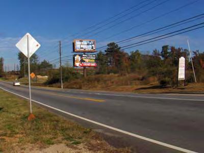


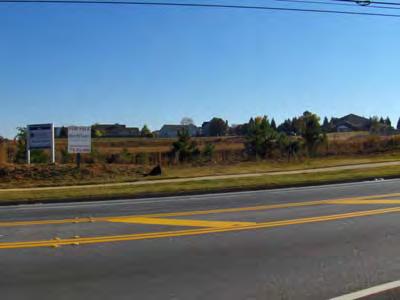
22 Photographs of Subject Property 22
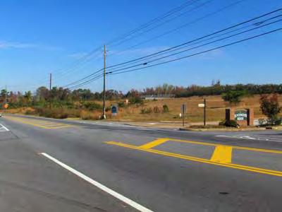
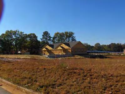
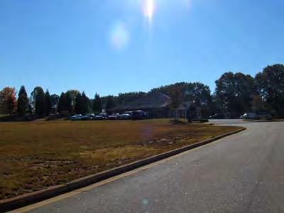
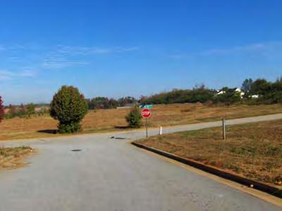
23 Photographs of Subject Property 23
24 Area & Neighborhood Overview Introduction The purpose of this analysis is to review historic and projected economic and demographic data to determine whether McDonough, Henry County, and the subject neighborhood will experience future economic stability, or decline. The appraised property is located at Highway 42 in McDonough, Georgia. McDonough is anchored by Interstate 75, State Routes 23 and SR 155 and is located in the westcentral part of Georgia. Henry County is bordered by Clayton, Rockdale, Fayette, Butts, and Newton counties. Henry County lies 30 miles south of downtown Atlanta and 50 miles northwest of Macon. McDonough s location on Interstate 75 gives good access to routes North, South, East and West. Population: In 1990, Henry County s population was 58,741; in 2000 the population had grown to 119,341, indicating a compound annual growth rate of 5.07% between 1990 and The year-end 2006 population estimate was 178,033, indicating a compound annual increase of 8.20% between 2000 and The following table illustrates historical population trends for Henry County and the State of Georgia. Between 2000 and 2006, the population in Henry County grew at an estimated annual compound rate of 5.49%, while the State of Georgia grew at a rate of 2.10% for the same period. The city of McDonough grew at an astonishing 8.27% for the same period. Given the recent compound increase in the population base for Henry County, the population growth trends foreshadow a healthy economic climate through the near future. The highest concentrated age group of the county s inhabitants is between the ages of 0 and 19, or 30.5%. In terms of household size, at the end of 2000 the number of households stood at 57,814 in Henry County with an average household size of 2.89 persons. 24
25 A demographic profile for Henry County appears in the chart below. Source: US Census Bureau 2000 & 2005 Data - May not add due to rounding. As the year end 2000 statistics indicates that 60.5% of the households in Henry County earned over $50,000 per annum. As indicated in the table above, Henry County was substantially above the state of Georgia in median household income. 25


26 Area Business and Related Economic Trends According to the US Census Bureau, the number of employed people in Henry County in 2005 was 81,057, resulting in an unemployment rate of 7.7% or 6,735 persons. A comparison of the major components of the economic base for 2005 is presented in the table below. In summary, Henry County has experienced exponential growth over the past ten years. The nationwide slowing trend in the residential area has affected Henry County as well. Henry County has seen residential sales slow in the past year. New commercial development has also slowed however older and smaller properties seems to be a good market at this time due to some downsizing. Uncertainty in the market will continue for at least the next several months. Commercial activity has remained fairly strong in the Henry County as well as statewide. 26
27 Market Analysis Henry County has experienced a tremendous growth in population and in return residential and commercial development has significantly increased over the past five years. The county has recently been ranked as one of the fastest growing counties in the state as well as the nation. The growth of the county started in McDonough and Stockbridge and has spread in all directions of the county over the past five years. Henry County is partly responsible for the regions development boom. Other counties in the region that are considered sub markets of Atlanta have experienced a considerable amount of residential and commercial development over the past four years. Less populated counties were starting to experience an over supply of new construction, however, Henry County and the metro Atlanta area as a whole has seen a slowing economy over the past year which in turn has led to a slow down is residential growth. Henry county is accessible by approximately 8-10 exits off I-75 and I-675 and is located approximately miles south of the central business district of Atlanta, which has been a major factor for the substantial growth of the county. The development trend in the county seems to be stable into the foreseeable future. A new commercial retail development has just begun construction near the intersection of Highway 81 and Highway 20 on the west side of I-75. This development is currently anchored by JC Penney s and Kohls. Commercial activity in this area has been substantial over the past three years. Supply and demand for commercial property appear to be shifted a little towards supply than demand at the current time. Occupancy levels for most retail and office use are 85% or better, even with the development of many small strip centers and office parks throughout the county. The absorption of commercial real estate around the interstate and major thoroughfares has been impressive over the past three years in Henry County. As vacant land is becoming scarce around these major thoroughfares and interstate intersections, the price of vacant commercial land has doubled over the past three years in these areas. The demand for these tracts has created a price increase in commercial land throughout the county; however, market demand in the general market area appears to be slowing in the past few months. Certain areas in Henry County are still very viable; whereas the subject neighborhood appears to be less marketable. 27
28 Demographic & Economic Profile 28
29 Graphic Profile - Appraisal Version Prepared by Highway 42, McDonough, Georgia Latitude: Longitude: Site Type: Radius Radius: 1.0 mile Households 2007 Households by Income $100K-$150K (20.1%) $150K+ (13.4%) $75K-100K (28.4%) <$15K (2.0%) $15K-$25K (1.4%) $25K-35K (4.3%) $35K-$50K (10.2%) $50K-75K (20.3%) Population by Age 2007 Employed 16+ by Occupation (13.1%) (9.0%) (19.2%) 65+ (8.1%) <5 (8.7%) Admin Support (16.5%) Construction (6.7%) Maintenance/Repair (5.9%) Production (2.7%) Transportation (4.3%) Sales (13.8%) Mgmt/Business. (20.9%) (12.8%) 5-19 (23.2%) Services (8.9%) Professional (20.3%) (6.0%) 2007 Owner Occupied HUs by Value $ K (5.8%) $ K (43.7%) $ K (1.2%) $500K+ (1.8%) <$100K (8.4%) $ K (39.1%) Source: U.S. Bureau of the Census, 2000 Census of Population and Housing. ESRI forecasts for 2007 and ESRI On-demand reports and maps from Business Analyst Online. Order at or call /08/ Page 1 of 1
30 Graphic Profile - Appraisal Version Prepared by Highway 42, McDonough, Georgia Latitude: Longitude: Site Type: Radius Radius: 5.0 mile Households 2007 Households by Income $100K-$150K (19.4%) $150K+ (10.3%) <$15K (5.0%) $75K-100K (20.7%) $15K-$25K (3.8%) $25K-35K (6.6%) $50K-75K (21.9%) $35K-$50K (12.3%) Population by Age 2007 Employed 16+ by Occupation (14.0%) (9.4%) 65+ (8.2%) <5 (8.4%) Admin Support (17.2%) Construction (6.4%) Farm/Fish (0.1%) Maintenance/Repair (6.0%) Production (4.0%) Transportation (6.8%) (17.9%) Mgmt/Business. (16.5%) Sales (11.5%) (13.5%) 5-19 (22.7%) Services (11.4%) Professional (20.0%) (6.0%) 2007 Owner Occupied HUs by Value $ K (33.2%) $ K (7.6%) $ K (3.0%) $500K+ (4.1%) <$100K (10.9%) $ K (41.1%) Source: U.S. Bureau of the Census, 2000 Census of Population and Housing. ESRI forecasts for 2007 and ESRI On-demand reports and maps from Business Analyst Online. Order at or call /08/ Page 1 of 1
31 Market Profile - Appraisal Version Prepared by Highway 42, McDonough, Georgia Latitude: Longitude: Radius: 1.0 mile Radius: 3.0 mile Radius: 5.0 mile Top 3 Tapestry Segments 1. Up and Coming Families Up and Coming Families Up and Coming Families 2. Aspiring Young Familie Aspiring Young Familie Aspiring Young Familie 3. Family Foundations Sophisticated Squires 2007 Consumer Spending shows the amount spent on a variety of goods and services by households that reside in the market area. Expenditures are shown by broad budget categories that are not mutually exclusive. Consumer spending does not equal business revenue. Apparel & Services: Total $ $4,668,771 $31,747,026 $70,266,242 Average Spent $3, $2, $2, Spending Potential Index Computers & Accessories: Total $ $496,167 $3,323,098 $7,290,416 Average Spent $ $ $ Spending Potential Index Education: Total $ $2,317,876 $16,624,308 $36,560,219 Average Spent $1, $1, $1, Spending Potential Index Entertainment/Recreation: Total $ $6,607,008 $43,652,240 $98,149,784 Average Spent $4, $3, $4, Spending Potential Index Food at Home: Total $ $9,026,465 $62,495,218 $136,947,556 Average Spent $6, $5, $5, Spending Potential Index Food Away from Home: Total $ $6,341,202 $43,279,267 $95,231,962 Average Spent $4, $3, $4, Spending Potential Index Health Care: Total $ $6,730,527 $46,471,829 $103,879,127 Average Spent $4, $3, $4, Spending Potential Index HH Furnishings & Equipment: Total $ $4,382,816 $28,399,580 $64,261,464 Average Spent $3, $2, $2, Spending Potential Index Investments: Total $ $2,817,591 $18,570,338 $44,717,437 Average Spent $2, $1, $1, Spending Potential Index Retail Goods: Total $ $48,914,426 $329,603,941 $732,874,151 Average Spent $35, $27, $30, Spending Potential Index Shelter: Total $ $29,451,700 $195,159,503 $435,089,652 Average Spent $21, $16, $18, Spending Potential Index TV/Video/Sound Equipment: Total $ $2,161,058 $14,847,007 $32,525,054 Average Spent $1, $1, $1, Spending Potential Index Travel: Total $ $3,555,280 $23,405,370 $53,358,045 Average Spent $2, $1, $2, Spending Potential Index Vehicle Maintenance & Repairs: Total $ $2,049,259 $13,807,867 $30,369,433 Average Spent $1, $1, $1, Spending Potential Index Data Note: The Spending Potential Index represents the amount spent in the area relative to a national average of 100. Source: Expenditure data are derived from the 2002, 2003 and 2004 Consumer Expenditure Surveys, Bureau of Labor Statistics ESRI On-demand reports and maps from Business Analyst Online. Order at or call /08/ Page 8 of 8
32 Location Maps of Subject Property 32

33 Aerial Map for Neighborhood 33


34 Site Map Lat: Prepared By: Latitude Lon: November 6, 2007 Longitude ESRI On-demand reports and maps from Business Analyst Online. Order at or call Page 1 of 1 34

35 2007 Population Density Map by Census Block Group Highway 42, McDonough, Georgia Prepared by Latitude: November 8, 2007 Longitude: About Your Map... This map shows 2007 Population Density Map by Census Block Group. The map divides the range of values into equal-sized categories. This method is best applied to familiar data ranges such as percentages ESRI On-demand reports and maps from Business Analyst Online. Order at or call Page 1 of 1 35


36 Highway 42, McDonough, Georgia Traffic Map Prepared by Latitude: November 8, 2007 Longitude: Source: 2007 MPSI Systems Inc. d.b.a. DataMetrix 2007 ESRI, MPSI On-demand reports and maps from Business Analyst Online. Order at or call Page 1 of 1 36
37 Highest and Best Use Highest and Best Use is a real estate valuation principle that dictates that the market trends to put property to its most profitable use, and that use which provides the greatest benefits of ownership. The Appraisal of Real Estate, 12th Edition, defines highest and best use as: The reasonably probable and legal use of vacant land or an improved property, which is physically possible, appropriately supported, financially feasible, and that results in the highest value. Because the principle of highest and best use reflects the actions of the market, generally accepted professional appraisal practice requires that the subject property must be valued under this premise. If the property being appraised is improved with a structure, two highest and best use analyses are required; the highest and best use of the land as though vacant, and the highest and best use of the total property as developed. The highest and best use analysis is developed using the following four criteria. The highest and best use must be Legally Permissible, Physically Possible, Financially Feasible, and Maximally Productive. Land as if Vacant Physically Possible As previously mentioned, subject property contains a total of acres +/-. The subject property consists of (3) commercial lots; Lot 1: 5.97 Acres +/-, Lot 2: 8.65 Acres +/-, and Lot 3: 1.50 Acres +/- Many uses would be physically possible including various commercial uses. Legally Permissible - In estimating the highest and best use of a property, the legally permissible uses are typically determined by the zoning constraints of the jurisdiction in which the property is located. The subject parcel is located within the Henry County and is under the jurisdiction of the City of McDonough. The property is zoned C-2, Commercial. The subject is located in a neighborhood that is predominately composed of residential properties with some commercial properties nearby. According to the City of McDonough s Planning and Zoning Department, future use as commercial use is considered a legal and conforming use and is compatible with the surrounding land uses. For official zoning and allowances, a letter of permissible uses must be obtained from the City of McDonough s Planning and Zoning Department. Financially Feasible and Maximally Productive Uses - After determining which uses are physically possible and legally permissible, it is necessary to determine what potential uses are economically feasible. A use that produces an overall positive return, be it cash flow or return on investment, is economically feasible. From the list of economically feasible uses, the one use that produces the greatest return is chosen. This is the maximally productive 37
38 use and, therefore, is the highest and best use of the property. This thought process could be described as a detailed process of elimination. Maximally Productive Of all the financially feasible uses, each use is analyzed to determine which use will return the highest profit or which use will be the maximally productive use. Highest and Best Use as if Vacant - Of the available alternative uses that are physically and legally acceptable, the best alternative use for the subject site as if vacant would be to hold undeveloped until construction of commercial development is determined financially productive. 38
39 Valuation 39
40 The Valuation Process The valuation process is the orderly program in which data used to estimate the value of the subject property are acquired, classified, analyzed, and presented. The first step in the process is to define the appraisal problem, i.e., identify the real estate, the effective date of value estimate, the property rights being appraised, and the type of value sought. Once this has been accomplished, the Appraiser collects and analyzes the factors that affect the market value of the subject property. These factors are addressed in the area and neighborhood analysis, the site and improvement analysis, and the highest and best use analysis, and in the application of the three approaches to value: The sales comparison approach, the cost approach, and the income capitalization approach. The sales comparison approach is used to estimate the value of the land as though vacant and/or the property as improved. The Appraiser gathers data on sales of comparable properties and analyzes the nature and conditions of each sale, making logical adjustments for dissimilar characteristics. Typically, a common denominator is found. For land value, the unit of comparison is usually price per square foot or per acre. The second approach applied is the cost approach to value. Accrued depreciation is deducted from the new cost of the improvements and this figure is added to the land value to indicate the value of the whole property. The third approach applied is the income capitalization approach and is predicated on the assumption that a definite relationship exists between the amount of income a property can earn and its value. In other words, value is created by the expectation of benefits to be derived in the future. In this approach, the anticipated annual net income of the subject property is processed to produce an indication of value. Net income is the income generated before payment of any debt service. Income is converted into value through capitalization, in which net income is divided by a capitalization rate. Factors such as risk, time, interest on capital invested, and recapture of the depreciating assets are considered in selecting the capitalization rate. The final step in the valuation process is the reconciliation or correlation of the value indications. In the reconciliation, the Appraiser considers the relative applicability of each approach used, examines the ranger of the value indications, and gives most weight to the approach that appears to produce the most reliable solution to the appraisal problem. The purpose of the appraisal, the type property, and the adequacy and reliability of each approach to value are all taken into consideration. To apply the three approaches to value, information pertaining to the fair market value of the subject property must be derived from the market because the Appraiser seeks to anticipate the actions of buyers and sellers in the market. 40
41 Approach To Value Our analysis has determined the highest and best use of the property is for future commercial use. Therefore, the Sales Comparison Approach has been performed in this report. There are no improvements of contributing value in order to utilize the Cost Approach and no income, real or potential, in order to utilize the Income Approach. Therefore, the Sales Comparison Approach best reflects the value of the subject property. The Cost Approach and the Income Approach have not been performed and are considered not to be applicable. 41
42 Land Analysis Sales Comparison Approach Acres +/- Whole Tract The land will be valued as though vacant and available for highest and best use. The subject site consists of a total of Acres +/-. Comparable sales of similar properties were identified for comparison to the subject. A comparative analysis is set forth as follows. for comparison to the subject. A comparative analysis is set forth ` as follows. comparison to the subject. A comparative analysis is set forth as follows: INPUT DATA: Property or Comparable Subject Land Comp 1 Land Comp 2 Land Comp 3 Land Comp 4 Location Highway 42 Corner of Old Jackson Road and Highway 81 Out Parcel out of Highway 20 East of McDonough Pkwy Highway 42 and Huntington Place Court Georgia Highway 155 McDonough, GA Henry County, GA McDonough, GA McDonough, GA Henry County, GA Land Size Primary (Acres): Acres +/- 7.5 Acres (Square Feet): 702, , ,058 54,450 43,586 Zoning/Use: C-2, Comm C-2 Commercial C-2 C-1, Comm Sale Date: Oct-06 Jul-06 May-06 May-06 Transaction Price: $1,200,000 $993,800 $170,000 $135,000 Price Per Acre $160,000 $200,363 $136,000 $134,919 O RDERED ADJUSTMENTS: Financing 0% 0% 0% 0% Adjusted Indicated Price/AC $0 $0 $0 $0 Conditions of Sale 0% 0% 0% 0% Adjusted Indicated Price/AC $0 $0 $0 $0 Market Conditions -10% -10% -10% -10% Adjusted Indicated Price/AC $144,000 $180,326 $122,400 $121,427 O THER ADJUSTMENTS: Location -20% -25% 0% 0% Size 0% 0% -5% -5% Shape 0% 0% 0% 5% Zoning 0% 0% 0% 0% Available Utilities 10% 0% 0% 0% Topo/Site Conditions 0% 0% 0% 0% Frontage/Divisibility 0% 0% 5% 5% Net Adjustments -10% -25% 0% 5% Adjusted Value $128,000 $130,235 $122,400 $128,173 S ITE S IZE (AC) /- $128,000 $2,063,360 Rounded $2,063,000 $2,063,000 42
43 Explanation of Adjustments Cash Equivalency - All of the sales were cash or cash equivalency sales that did not require cash equivalent adjustments. Conditions of Sale No condition of sale adjustments were made to the comparable sales. Market/Time - The time adjustment represents a dollar/percentage change (plus or minus) applied to the sale for appreciation and/or depreciation in land values within the area. The land sales range in date from May 2006 to October There have been few commercial land sales similar to the subject property in the subject neighborhood in recent past; therefore marketing time was expanded beyond one year for comparability. Market conditions for the subject market area are slowing down after many years of a strong market. A downward adjustment is necessary for marketing conditions. Location - Location adjustments are made to comparable sales to recognize perceived value differences in relation to neighborhood influences, access to commercial services, location aesthetics, commercial density, overall exposure and visibility, and overall market demand. Sales 1 and 2 are considered to be superior to the subject property as to location, and a downward adjustment is necessary for this factor. Size - Smaller parcels tend to sell for higher prices per square foot than larger parcels due to a higher demand for smaller parcels. The subject tract consists of a total of acres +/- and the subject tract could be easily divided into smaller acreage tracts. Sales 3 and 4 are much smaller in size than the subject tract and a downward adjustment is necessary for this factor. Shape - Tracts that may be irregular in shape in a way that limits the divisibility and/or overall utility will create a negative impact on value. Lots that are irregular in shape tend to be less desirable to the market. All sales, with the exception of sale 4, are of a typical shape and therefore did not require an adjustment. Sale 4 is irregular in shape and is slightly inferior to the subject tract as to this factor. An upward adjustment is necessary for this factor.. Zoning The zoning dictates what type of improvements and uses are allowed within the site. If a tract has a zoning that significantly limits the use of the site, the tract is obviously worth less. On the other hand, if the zoning of the tract allows majority of commercial uses, the value is more. All Sales have comparable zoning requirements and did not receive adjustments. Available Utilities If a tract does not have sewer available, the tract is limited in use since high water use businesses such as restaurants, carwashes, and large developments would not be allowed. By not having sewer, the density of 43
44 the tract is also limited since septic drain fields will have to be installed causing less developable land. All sales have comparable access to utilities available to the subject site except for Sale 1. Sale 1 does not have sewer available, and is considered inferior to the subject as to this factor. An upward adjustment is necessary for this factor. Access The subject is located on Highway 42 in McDonough, Georgia. The above comparable sales are considered similar to the subject property as to access, and no adjustments are necessary. Topography/Site Conditions The topography of a tract can be crucial for a tract. If a tract has a steep grade or rolling topo, grading costs can multiply and therefore a developer could not pay the same for the land as other competing tracts to compensate for the additional grading costs. Site Conditions are also crucial for commercial development. Any low or flood areas could affect the density, parking, and building size that could be constructed for a development. A developer typically pays for the developable land of a site that has poor site conditions. The Sales all have similar topography to the subject requiring no adjustments. Frontage/Divisibility - Frontage can make a significant difference in value. If a land tract has above average frontage and can be further subdivided into smaller tracts from existing road frontage with very little development costs, the value can be much higher. Also a tract with frontage on multiple roads is desirable due to access. The subject property has frontage on multiple streets and is divisible into smaller acreage tracts. The subject property is considered superior to the above comparable sales 3 and 4 as to frontage as well as divisibility. An upward adjustment is necessary for this factor. Land Value Conclusion Based on the sales above and giving consideration for location size, zoning, available utilities, topography, and frontage, the appraiser has concluded that a value of $128,000 per acre is appropriate for the subject tract, which is shown in the adjustment grid on the following page. The total value rendered for the subject land via Sales Comparison Approach is $2,063,000. Consideration was given to divisibility of the subject property into small acreage tracts without development costs Acres $128,000/SF = $2,063,360 Called = $2,063,000 44
45 Discount Rate The Discount Rate represents the investor s opinion of time value of his investment given the risk associated with the investment. These risks include real interest rate, estimate of impact of inflation, an estimate of security, and an estimate of liquidity risk associated with market conditions at the date of resale. In arriving at an appropriate discount rate for the subject property, the appraiser has considered the following: Real Interest Rate : 3% to 3.5% Estimate for Inflation: 4% to 5% Estimate for Security: 2% to 5% Illiquidity: 1% to 2% An overall built-up rate implies a yield rate between 10% and 15.5 %. Considering the risk associated with the subject property and based on current market conditions, a discount rate of 10% is selected. $2,063,000 x.8612 (Present Value Factor) = $1,776,655 Called = $1,777,000 The estimated value is based on an estimated 18 month marketing period at a 10% discount rate. 45
46 RECONCILIATION AND FINAL ESTIMATE Summary of Value Conclusions Sales Comparison Approach Acres +/- Reconciled Market Value of Real Estate $1,777,000 The Sales Comparison Approach is generally the most reliable indicator of value since it typically reflects actions of buyers and sellers in the market place, especially in an active market. Conclusion: The Sales Comparison Approach was the only method utilized as explained earlier in this report. The Sales Comparison Approach produced an estimate of value of $1,777,000 for the subject property. As of November 6, 2007 it is my opinion that the Market Value with Fee Simple Interest in the subject property is as follows: One Million Seven Hundred Seventy Seven Thousand Dollars $1,777,000 46
47 Addenda 47
48 Supporting Documents For Subject Property 48
49 Exhibit A Engagement Letter 49
50 BLANK
51 51
52 52
53 53
54 54
55
56 Exhibit B Subject Legal Description & Plat 56
57 57
58 58
59 59
60 60
61 61
62 Exhibit C Flood Map 62

63 PROPERTY ADDRESS: Lat: , Lon: FLOODSCAPE Map Number 13151C0159C Effective Date May 16, 2006 Flood Legend High flood risk Moderate flood risk Low flood risk This report makes no representations or warranties concerning its content, accuracy or completeness. STDBonline.com Powered by FloodSource FLOOD SourceProse Corporation. All rights reserved. Protected by U.S. Patent Numbers , , , and
64 Exhibit D County Tax Assessment 64
65 Henry County Record Search Page 1 of 1 11/6/2007 Recent Sales in Area Previous Parcel Next Parcel Return To Main Search Page Henry Home Owner Name MCGARITY JOHN D & Today's November 06, 2007 Mailing Address HALL MARVIN D Parcel Number BEN HORTON DR Millage Group CITY-MCD (City/McDonough) MCDONOUGH, GA Total Millage Location Address 562 N HIGHWAY 42 Property Usage COMMERCIAL (1000) Class Code (Not Zoning) C5-C Total Acres Landlot and District Parcel Map Land Value January 1, 2007 Value Information Building Value Misc Value Total Value 1,456, ,456,900 Exemptions Land Use Land Information Number of Units Unit Type Zoning COMMERCIAL (001000) AC PD Short Legal Building Data Building # Type Total Area Heated Area Bed Rooms Baths No buildings associated with this parcel. Wall Height Effective Year Built Actual Year Built Sale Date Miscellaneous Data Description Length Width Units Year Built Deed Book No records associated with this parcel. Sale Information Price Instrument Reason Grantor Grantee $1,577,200 WARRANTY DEED $1,836,220 QUIT CLAIM $628, $256,530 WARRANTY DEED HIGHWAY 42 NORTH LLC MCGARITY SANDRA B & MARCUS TRIVETTE SUN KUANG CHING MCGARITY JOHN D & HALL MARVIN D HIGHWAY 42 NORTH LLC MCGARITY SANDRA B & TRIVETTE MARCUS $0 QUIT CLAIM CORRECTIVE SUN KUANG CHING WARRANTY DEED HAMILTON GEORGE SUN KUANG CHIN The Henry County Board Assessor's Office makes every effort to produce the most accurate information possible. No warranties, expressed or implied, are provided for the data herein, its use or interpretation. The assessment information is from the last certified taxroll. All data is subject to change before the next certified taxroll. Website Updated: July 25, 2007 Recent Sales in Area Previous Parcel Next Parcel Return To Main Search Page 2005 by the County of Henry, GA Website design by qpublic.net Henry Home 65
66 Exhibit E Zoning Map and Zoning Ordinance 66
67 CHAPTER C-2 CENTRAL COMMERCIAL DISTRICT Page 1 of 2 11/7/2007 CHAPTER C-2 CENTRAL COMMERCIAL DISTRICT Sections: Purpose and permitted uses Special uses Purpose and permitted uses. A. The C-2 Central Commercial District is intended to protect and promote suitable areas for business and commercial uses which benefit from proximity to each other, to encourage the eventual elimination of uses inappropriate to a central business area, and to encourage the intensive development of a central business center for the city. B. Within any C-2 Central Commercial District, the following uses shall be permitted unless one or more of these uses are otherwise prohibited, not authorized, limited, or restricted by the city council when acting upon a zoning application and/or rezoning of a parcel(s) of property: 1. Bakeries, where the products are sold exclusively at retail on the premises. 2. Banks and other financial institutions. 3. Billiard or pool halls. 4. Bus terminals and taxicab stands. 5. Dry cleaning, pressing and laundry pick-up stations and dry cleaning plants, excluding drive-through window services, having not more than 2,000 square feet of floor space and no emission of steam. 6. Newspaper offices and printing plants incidental to such offices. 7. Off-street parking lots and parking garages provided that a landscape strip of at least five feet is provided along all property lines in addition to any other buffers required by this title. 8. Pawn shops. 9. Personal service establishments, such as barber and beauty shops, shoe repair shops, and laundromats; 10. Public works and public utility facilities such as distribution lines, transformer stations, transmission lines and towers, water tanks and towers, pumping stations, telephone exchanges, but not service or storage yards. 11. Radio and television stations, studios and offices, excluding transmission towers. 12. Restaurants, grills, delicatessens and similar eating establishments, excluding drive-ins. 13. Retail stores or shops, including the making of products sold at retail on the premises, provided that such manufacturing is incidental to the retail business or service, occupies less than 30 percent of the total floor area, and employs not more than five operators. Specifically excluded are automobile, boat and farm implement 67
68 CHAPTER C-2 CENTRAL COMMERCIAL DISTRICT Page 2 of 2 11/7/2007 sales and food stores involving the dressing and killing of animals or fowl. 14. Fuel stations (pumps only) with convenience store or specialty retail, provided that: a. All pumps and canopies shall be located at least 20 feet from any public right-of-way; b. All buildings and appurtenances shall be located at least 100 feet from any residential district line with a landscaped buffer of 25 feet included therein; and c. All fuel is stored underground outside any public right-of-way. 15. Stamp redemption stores. 16. Tailor, dressmaking and millinery shops. 17. Telephone and telegraph offices. 18. Theaters, indoor. 19. Florist shop. 20. Sign companies, with no outside construction or heavy manufacturing. 21. Automobile repair garages limited to minor routine maintenance with no overnight storage of any vehicles. 22. Business and profession offices; including medical, dental, legal, financial, architectural, engineering, real estate, insurance and manufacturing representatives, provided no goods are offered for sale at retail. 23. Pharmacies. 24. Fitness centers. (Zoning Ord. 830, 1979; Ord. No B, XXVIII, ; Ord. No (D), 5, ) Special uses. Within any C-2 Central Commercial District, the following uses may be allowed upon obtaining a special use permit from the city council: A. Churches. B. Schools. C. Public buildings. D. Ambulance service, provided there is no outside storage of vehicles, supplies, or equipment. E. Day care center when property abuts an established or emerging village activity center node. (Ord. No B, XXIX, ) 68
69 ARTICLE VIII. SCHEDULE OF Page 46 of 78 11/8/ Appeals. Decisions made by the enforcer may be appealed to the Henry County Board of Commissioners. Notice of the appeal must be filed with the board of commissioners within ten (10) days of the decision rendered by the enforcer. The notice of appeal shall contain a written statement specifying the errors made by the enforcer and the specific relief requested by the party appealing. A public hearing will be conducted by the board of commissioners at either a regular or special called meeting of the board. Written notice of the time and place of the hearing shall be given to the party appealing at least three (3) days prior to the date of the hearing. 12. Amendments. These regulations and the watershed district map may from time to time be amended in accordance with procedures and requirements in the general statutes. 13. Assessment relief. Assessors and boards of assessors shall consider the requirements of these regulations in determining the fair market value of land. 14. Separability and abrogation. All sections and subsections of this ordinance are considered separate and distinct. Should any section, subsection, paragraph or part of this section be declared by a court of jurisdiction to be invalid for any reason, it shall not invalidate any other section, subsection, paragraph or part of this section. (Ord. No , ; Ord. No , 1--6, ; Ord. No , 1--4, ) Editor's note: Ord. No , adopted Dec. 20, 1994, repealed and which pertained to the Towaliga and Tussahow Watershed Protection Districts and derived from Ord. No , 1--9, adopted Oct. 20, Ord. No added a new herein set out as enacted. Cross references: Towaliga Watershed Protection District, et seq. Sec Reserved. Note: See the editor's note following Sec WWPD: Walnut Creek Watershed Protection District. (a) Purpose. The purpose of this district is to protect the Walnut Creek Watershed which has unique importance for public water consumption, environmental protection, and development for Henry County and the City of McDonough. This district is to apply development standards that will maintain a high quality of surface water (creeks, streams, and springs) and underground water resources of the Walnut Creek Basin. The regulations of this district are appended to residential, commercial, and industrial districts containedwithin the Henry County Zoning Ordinance [this chapter] (adopted June 3, 1986, as amended). (b) Definitions and Interpretations. The following definitions and rules of construction shall apply to this section: (1) The Walnut Creek Watershed Protection District is hereinafter referred to as the WWPD. (2) The WWPD is described and designated as including tracts and parcels of land that lie within the 6th and 7th Districts of Henry County, Georgia, as delineated on the Walnut Creek Watershed Map which is made part of this section. The WWPD includes Walnut Creek and tributaries, including Birch Creek and Crittle Creek. 69
70 ARTICLE VIII. SCHEDULE OF Page 47 of 78 11/8/2007 (3) Any setback measurements referred to in this section shall be measured from the bank of any creek, stream or spring or the normal pool elevation of any reservoir that is located within the WWPD. (4) Protection areas: Within the WWPD are areas with certain land use designations. They are reservoir protection area and watershed protection area: a. Reservoir protection area: An area seven hundred fifty (750) feet in width surrounding the existing property owned by the City of McDonough on which is located the City of McDonough reservoir. Said area shall be measured from the normal pool elevation seven hundred twenty-three (723.0) feet contour above mean sea level) at the reservoir on said property. b. Watershed protection area: Includes all land area within the WWPD, exclusive of those properties contained within and subject to regulations of the reservoir protection area. The watershed protection area contains specific land use regulations contained herein. (5) The words "surface water" as herein used shall mean and include any river, creek, stream, reservoir or body of water located within the WWPD. (6) The word "toxic" as herein used shall mean any chemical or substance that has been defined as toxic by the Environmental Protection Agency of the United States (EPA); Environmental Protection Division (EPD) of the Georgia Department of Natural Resources; or the Georgia Department of Agriculture. (7) The words "underground water" as herein used shall mean and include any water located underground or below the land surface within the WWPD. (8) The words "vegetative buffer" as herein used shall mean an area of natural vegetation or of planted trees, shrubs, flowers, grass or any combination thereof. (c) Preexisting Conditions. All parcels or tracts of land within the WWPD or the reservoir protection area which do not conform to the minimum standards or permitted uses of this section shall be governed by the Henry County Zoning Ordinance as adopted June 3, 1986, as it applies to substandard lots of record (article IV, section 413) [section ]; exceptions, modifications and encroachments (article V); and nonconformances (article VII), except that existing uses shall not be subject to the provisions of sections 704 and 705 ofsaid zoning ordinance [sections and ]. No property owner in said district or area, nor his successors in title, who is engaged in a use which is rendered nonconforming by this section shall be required to limit, restrict, amortize, or discontinue such use within the boundaries of his property. Nothing in this section shall require any change in development or proposed use of properties which are presently under development and for which a development plan or preliminary plat has been submitted and approved as of the effective date of this section. All parcels or tracts of land within said district or area shall be subject to the rules and regulations of the Henry County Health Department. (d) Permitted Uses and Specifications. Within the WWPD those permitted uses, conditional uses, conditional exceptions, accessory uses, and space limits, within the districts provided within the Henry County Zoning Ordinance shall be allowed with additional requirements provided within this section: TABLE INSET: RA: R-A: R-1-A: Residential-agricultural district Single-family residence district Single-family residence district 70
71 ARTICLE VIII. SCHEDULE OF Page 48 of 78 11/8/2007 R-2: R-3: RD: RM: RMH: OI: C-1: C-2: C-3: M-1: M-2: PD: FP: Single-family residence district Single-family residence district Two-family residence district Multiple-family residence district Mobile home development district Office/institutional district Neighborhood commercial district General commercial district Heavy commercial district Light manufacturing district Heavy manufacturing district Planned development district Flood protection district (1) Watershed protection area--additional requirements. The following additional requirements and limitations shall apply to all zoning districts within the watershed protection area: a. Residential. Single-family residential lots created after the adoption of this section within the RA, R-1, R-1-A and R-2 districts, and two-family residential dwelling on lots within the RD district, and RMH mobile home subdivision lots, shall have a minimum setback for the septic nitrification field of one hundred (100) feet from any surface water. This requirement shall not apply if any lot or structures within these districts that are connected to a public sanitary sewer and water system. Residential development within the R-3, RM, and RMH districts for mobile home park development as provided by Article IX of the Henry County Zoning Ordinance, shall be served by a public sanitary sewer system and public water system. b. Commercial. Commercial development on any lot created after the adoption of this section within any OI, C-1, C-2, or C-3 district within the watershed protection area shall have a minimum lot area of one (1.0) acre where a septic tank system is used. The minimum lot width shall be as provided by the Henry County Zoning Ordinance, Article VIII, Schedule of District Regulations. The minimum setback of nitrification fields from any surface water shall be a minimum of one hundred fifty (150) feet. The Henry County HealthDepartment must approve the use of septic tanks for specific types of office or commercial use. Where a public sanitary sewer and public water system is available to serve developments in any OI, C-1, C-2, or C-3 district within the watershed protection area, the minimum lot area shall be as provided by Article VIII of the Henry County Zoning Ordinance. c. Industrial. Industrial development within the M-1 district on any lot created after the adoption of this section within the watershed protection area shall have a minimum lot area of one (1.0) acre where a septic tank system is used. The minimum setback of nitrification fields from any surface water shall be one hundred fifty (150) feet. The Henry County Health Department must approve the use of septic tanks for specific types of industrial use. The 71
72 ARTICLE VIII. SCHEDULE OF Page 49 of 78 11/8/2007 production, use, or storage of toxic chemicals or substances shall besubject to applicable state and federal regulations. Where a public sanitary sewer system and public water system is available to serve development in an M-1 district within the watershed protection area, the minimum lot area shall be thirty thousand (30,000) square feet as provided by Article VIII of Henry County Zoning Ordinance. Industrial developments within an M-2 district within the watershed protection area shall be served by a sanitary sewer system. The production, use, or storage of toxic chemicals or substances shall be subject to applicable state and federal regulations. d. Agricultural activity. Agricultural activity is permitted within areas zoned RA within the watershed protection area, and subject to State of Georgia regulations concerning pesticide use, and use of other toxic chemicals or substances. e. Public uses. Public owned recreation parks, public buildings and facilities which use septic tank systems shall have nitrification fields located at least one hundred fifty (150) feet from any surface water. f. A vegetative buffer shall be maintained for a distance of one hundred (100) feet from any surface water. (2) Reservoir protection area--additional requirements. The following additional requirements and limitations shall apply to permitted and conditional uses within the reservoir protection area. (Ord. No , 1--4, ) a. Residential. Only single-family residential dwellings shall be permitted. All septic tank nitrification fields shall be set back a minimum of one hundred fifty (150) feet from the normal pool elevation (seven hundred twenty three (723.0) feet above mean sea level) of the reservoir and a minimum of one hundred fifty (150) feet from any other surface water. The impervious surface area of any lot shall be limited to twenty-five (25) percent of existing use, whichever is greater. b. Commercial development. None permitted. c. Industrial development. None permitted. d. Agricultural activity. Agricultural activity is permitted within areas zoned RA within reservoir protection area, and subject to state regulations concerning pesticide use, and use of other toxic chemicals or substances. e. Public use. Public owned recreation parks, public buildings, and facilities which use septic tank systems shall have nitrification fields located at least one hundred fifty (150) feet from the normal pool elevation of the reservoir and a minimum of one hundred fifty (150) feet from any other surface water. f. A vegetative buffer shall be maintained for a distance of one hundred fifty (150) feet from the normal pool elevation of the reservoir (seven hundred twenty three (723.0) feet above mean sea level). Editor's note: Ord. No , enacted Mar. 21, 1989, provided for amendment of the county zoning ordinance, but did not specify the manner of such amendment, hence, amendment of of this chapter and codification of 1--4 of such ordinance as a new was at the discretion of the editor. 72
73 Supporting Documents For Comparable Sales 73
74 Exhibit F Profiles for Commercial Land Sales 74

75 Land Sale 1 Property Identification 1. Property Type: Vacant Commercial Land 2. Property Description: Commercial Land 3. Address: Corner of Old Jackson Road and Hwy 81 Henry County, Georgia 4. Tax ID: Sale Data 5. Grantor: Sheila D. Donner & Virginia C. Thomas Grantee: Eagles Landing Family Practice 6. Sale Price: $1,200, Price Per Acre/SF: $160,000/$ Sale Date: 10/24/ Deed Book/Page: 9695/ Verification: GSCCCA/Henry Co Tax Assessors Office 11. Condition of Sale: Arm's Length 12. Financing: All Cash to Seller Property Data 13. Land Area: 7.5 Acres or 326,700 SF 14. Zoning: C Utilities: Water and Electricity Comments: Land Lot 171, 7th 16. Land District This sale tract is comprised of (6) parcels 75

76 Land Sale 2 Property Identification 1. Property Type: Vacant Land 2. Property Description: Commercial Out Parcel 3. Address: Highway 20 East of McDonough Parkway McDonough, GA 4. Tax ID: Sale Data 5. Grantor: Nortia V. Davis Grantee: Mellina 2, LLC 6. Sale Price: $993, Price Per SF: $200,362$ Sale Date: 07/20/ Deed Book/Page: 9391/ Verification: GSCCCA/Henry Co Tax Assessors Office 11. Condition of Sale: Arm's Length 12. Financing: All Cash to Seller Property Data 13. Land Area: 4.96 Acres or 216,057 SF 14. Zoning: Commercial 15. Utilities: All Available 16. Comments: Land Lots 156 & 157, 7 th Land District 76
77 Land Sale 3 Property Identification 1. Property Type: Vacant Land 2. Property Description: Commercial Land 3. Address: Highway 42 and Huntington Place Court McDonough, GA 4. Tax ID: pt Sale Data 5. Grantor: John D. McGarity and Marvin D. Hall Grantee: Locust Grove Family Medicine, P.C. 6. Sale Price: $170, Price Per Acre/SF: $136,000/$ Sale Date: May 12, Deed Book/Page: 9193/ Verification: GSCCCA Henry Co. Tax Assessor 11. Condition of Sale: Arm's Length 12. Financing: All Cash to Seller Property Data 13. Land Area: Acres or 54,450 SF 14. Zoning: Commercial /Walnut Creek Watershed Protection District 15. Utilities: All Available 16. Comments: Land Lot 101, 7 th Land District. This parcel was reportedly purchased for the construction of medical office. Basically triangular in shape. This sale has frontage on Highway 42 and on Huntington Place Court. 77
78 Land Sale 4 Property Identification 1. Property Type: Vacant Commercial Land 2. Property Description: Commercial Land 3. Address: GA Highway 155 Henry County, GA 4. Tax ID: Sale Data 5. Grantor: DL & Dianne McBrayer Grantee: Kelvin and Adrian Irvin 6. Sale Price: $135, Price Per Acre/SF: $134,919/$ Sale Date: May 1, Deed Book/Page: 9190/ Verification: GSCCCA Henry Co. Tax Assessor 11. Condition of Sale: Arm's Length 12. Financing: All Cash to Seller Property Data 13. Land Area: Acres +/- Or 43,586 SF 14. Zoning: C-1, Commercial 15. Utilities: All Available 16. Comments: Land Lot 27, 7 th Land District. 78
79 Exhibit G Location Map for Land Sales 79

80 Comparable Land Sales Map 80
81 Appraiser Qualifications 81
82 KEN A. FLETCHER Certified General Appraiser Appraisal Service Since 1971 Appraisal of properties for: First Bank of Pike United Bank Peachtree Bank of Gwinnett First National Bank of Griffin Southern Community Bank First National Bank of Barnesville Georgia Power Company United Community Bank First Liberty Building & Loan BB & T Security Bank Regions Bank Spalding County West Central Georgia Bank of Thomaston Horizon Bank Georgia Banking Company City of Griffin Colony Bank and Trust Main Street Bank McIntosh State Bank Neighborhood Community Bank First Georgia Bank Bank of Coweta Heritage Bank First City Bank Park Avenue Bank Farmers and Merchants Community Bank Attorneys: Larry Evans Griffin Drew Whalen Griffin John Newton Griffin Tim Cramer Griffin Sid Esary Griffin John Carlisle Griffin Dick Mullins Griffin Jack Park Griffin Hal Sturdivant Griffin John M. Cogburn Griffin Sam Sullivan Griffin Smith, Welch & Brittain McDonough Wade Crumbley - McDonough Accountants CPA: P. Lewis Robinson McDonough Alton Knight Griffin Paul Cook Griffin M. Barry Erwin Griffin C. Randall Howell Griffin Steve Manley Acquisition Services Qualified as Valuation Expert Witness: Superior Court of Spalding, Pike, Fayette, Lamar, Henry, Rockdale, Fulton, and Upson Counties. U. S. Bankruptcy Court, Savannah, Newnan, and Atlanta, Georgia. U. S. Tax Court Northern District Atlanta Education: Graduate of the University of Georgia 1970 Degree: BBA Major: Real Estate and Urban Development Licensed Real Estate Broker State of Georgia Certified General Real Estate Appraiser No


83 KEN A. FLETCHER APPRAISER LICENSES 83
84 ONDRA L. LEE Appraiser Partial Client List LENDING INSTITUTIONS: United Bank First National Bank of Griffin First National Bank of Barnesville First Choice Community Bank BB & T Regions Bank West Central Georgia Bank of Thomaston Georgia Banking Company Colony Bank and Trust Heritage Bank ATTORNEYS: Drew Whalen Griffin, Ga Sam Sullivan Griffin Ga Smith, Welch & Brittain McDonough, Ga Southern Community Bank Georgia Power Company Security Bank Spalding County City of Griffin United Community Bank Bank of Coweta First City Bank McIntosh State Bank Park Avenue Bank Allan Connell Thomaston, Ga David Dunaway Thomaston, Ga Newton Galloway Griffin, Ga ACCOUNTANTS: Robinson, Whaley, Hammonds, & Allison McDonough, Ga Alton Knight Griffin, Ga EDUCATION: Graduate of Monroe Academy 1990 Graduate of Real Estate 2000 Appraisal School 90 hrs licensed in 2003 Income Capitalization Courses 60 hrs Additional hours of various Appraisal Courses; USPAP, Math & Georgia Appraisal Law State of Georgia Registered Real Property Appraiser No


85 ONDRA L. LEE APPRAISER LICENSES 85
APPRAISAL OF REAL PROPERTY OF THE GEORGIAN PARK CARWASH 200 NEWGATE ROAD PEACHTREE CITY, FAYETTE COUNTY, GEORGIA
 APPRAISAL OF REAL PROPERTY OF THE GEORGIAN PARK CARWASH 200 NEWGATE ROAD PEACHTREE CITY, FAYETTE COUNTY, GEORGIA AS OF: September 7, 2007 PREPARED FOR Kelly Ingram The Bank of Atlanta Two Midtown Plaza
A Demonstration Appraisal Report. Of a. Located at. Date of Appraisal. Prepared for. Prepared by
 A Demonstration Appraisal Report Of a Located at Date of Appraisal Prepared for Prepared by International Association of Assessing Officers Professional Designation Subcommittee 314 West 10 th Street Kansas
A Demonstration Appraisal Report. Of a. Located at. Date of Appraisal. Prepared for. Prepared by
 A Demonstration Appraisal Report Of a Located at Date of Appraisal Prepared for Prepared by International Association of Assessing Officers Professional Designation Subcommittee 314 W. 10 th Street Kansas
To all Appraisers: Brief Overview:
 To all Appraisers: As the appraisal industry continues to change, the demand for alternative valuation solutions grows. That is why is excited to announce the addition of a new product - the Desktop Appraisal
RESTRICTED APPRAISAL REPORT
 Restricted Use Appraisal Report Thomas J. Schulte & Associates Page #1 RESTRICTED APPRAISAL REPORT SUBJECT ASSIGNMENT Property City: Zip Code: County: Legal Description: Assessor's Parcel #: Tax Year:
How to Read a Real Estate Appraisal Report
 How to Read a Real Estate Appraisal Report Much of the private, corporate and public wealth of the world consists of real estate. The magnitude of this fundamental resource creates a need for informed
APPRAISAL OF REAL PROPERTY FOR PROPOSED TACO BELL RESTAURANT 1610 HUDSON BRIDGE ROAD STOCKBRIDGE, HENRY COUNTY, GEORGIA
 APPRAISAL OF REAL PROPERTY FOR PROPOSED TACO BELL RESTAURANT 1610 HUDSON BRIDGE ROAD STOCKBRIDGE, HENRY COUNTY, GEORGIA AS OF: OCTOBER 23, 2007 PREPARED FOR: MR. SCOTT MCCARTER FIRST NATIONAL BANK OF GRIFFIN
EvaluePro Real Estate Restricted Appraisal Report
 EvaluePro Real Estate Restricted Appraisal Report EvaluePro Highlights Property Street: 1000 Main Street City: Anytown State: NC Zip: 12345 Property Owner: Mr. & Mrs. Property Owner Estimated Market Value:
Anatomy Of An Appraisal
 Anatomy Of An Appraisal Leslie A. Fields The most important thing to know about an appraisal report is how to review and critique it. Leslie A. Fields a partner with the Law Firm of Faegre & Benson LLP,
APPRAISAL REPORT. Vacant Commercial Land SW 268 th Street Miami, FL Cruz Appraisals, Inc SW 72 nd Street, Suite 263 Miami, FL 33173
 APPRAISAL REPORT Prepared for Mr Jorge Palomeras Jpal Marketing Corporation Property Appraised Vacant Commercial Land 12711 SW 268 th Street Miami, FL 33032 Date of Valuation October 6, 2017 Prepared by
Copyright, 1999, 2002, 2004, Freddie Mac. All Rights Reserved.
 Page 1 of 13 Engineering Requirements/Chapter 12: Appraiser and Appraisal Requirements/12.1: General requirements 12.1: General requirements For all multifamily purchase programs and products, the Seller/Servicer
REED APPRAISAL COMPANY REAL PROPERTY APPRAISERS AND CONSULTANTS
 REAL PROPERTY APPRAISERS AND CONSULTANTS 100 SOUTH KENTUCKY AVENUE #230 ip.o. BOX 1645 ilakeland, FLORIDA 33802-1645 OFFICE: (863) 688-6718 ifax: (863) 688-5993iEMAIL: stan@reedappraisalco.com TO: Henry
As Of: Prepared For: Prepared By:
 of 216 SW 131st St As Of: 06/11/11 Prepared For: Prime Pacific Bank 2502 196th St SW Lynnwood WA 98036 Prepared By: Cynthia A. Nagle, CREA 922 N Cedar St Tacoma, WA 98406 RESTRICTED APPRAISAL REPORT Restriction
APPRAISAL REPORT OF THE REAL PROPERTY LOCATED AT. Enterprise Rd Dillon, SC Ronnie Gardner. March 1, 2018
 APPRAISAL REPORT OF THE REAL PROPERTY LOCATED AT Dillon, SC 29536 for as of March 1, 2018 by David McLaurin 105 West Harrison Street Dillon, SC 29536 IDENTIFICATION NEIGHBORHOOD SITE MARKET DATA ANALYSIS
Uniform Agricultural Appraisal Report
 File No. Uniform Agricultural Appraisal Report Prepared For: Intended User: Prepared By: Date Prepared: UAAR Agri management Uniform Agricultural Appraisal Report File No # Property Identification Owner/Occupant:
RAINS COUNTY APPRAISAL DISTRICT
 RAINS COUNTY APPRAISAL DISTRICT 2017 MASS APPRAISAL SUMMARY REPORT mass appraisal report 2017 uspap_appr_report RAINS COUNTY APPRAISAL DISTRICT 2017 MASS APPRAISAL SUMMARY REPORT Identification of Subject:
Appraisal and Market Analysis of Indoor Waterpark Resorts
 Appraisal and Market Analysis of Indoor Waterpark Resorts By David J. Sangree, MAI, CPA, ISHC An appraisal of an indoor waterpark resort is similar to other appraisals in that it is a professional appraiser
LAND APPRAISAL REPORT
 IDENTIFICATION LAND APPRAISAL REPORT Page #1 File No. Borrower None Census Tract * Map Reference 462820011000315 Property Address NWC Gaar and Pleasant View Roads City Richmond County Wayne State IN Zip
Mike Dalton Jr. and Associates. Christina Adams INVOICE NUMBER Mike Dalton Jr. and Associates 8191 Wethersfield Drive. PB125 Germantown, TN 38138
 Mike Dalton Jr. and Associates FROM: INVOICE Christina Adams INVOICE NUMBER Mike Dalton Jr. and Associates 8191 Wethersfield Drive Germantown, TN 38138 DATE 08/14/2016 Telephone Number: (901) 674-0239
BADGER Appraisals, LLC
 BADGER Appraisals, LLC PO Box 2222 Appleton, WI 54912 T (920) 687-9000 / F (920) 687-9244 info@badgerappraisals.com www.badgerappraisals.com Appraisal Service Brown * Calumet * Outagamie * Winnebago APPRAISAL
AN APPRAISAL OF Acre Residential Site Northwest Corner Pleasant View Road & Gaar Road Richmond, Indiana 47374
 AN APPRAISAL OF 3.75 Acre Residential Site Northwest Corner Pleasant View Road & Gaar Road Richmond, Indiana 47374 American United Appraisal Company, Inc. Real Estate Appraisers Jay E. Allardt, SRA August
WYOMING DEPARTMENT OF REVENUE CHAPTER 7 PROPERTY TAX VALUATION METHODOLOGY AND ASSESSMENT (DEPARTMENT ASSESSMENTS)
") CHAPTER 7 PROPERTY TAX VALUATION METHODOLOGY AND ASSESSMENT (DEPARTMENT ASSESSMENTS) Section 1. Authority. These Rules are promulgated under the authority of W.S. 39-11-102(b). Section 2. Purpose of Rules.
CHAPTER 7 PROPERTY TAX VALUATION METHODOLOGY AND ASSESSMENT (DEPARTMENT ASSESSMENTS) Section 1. Authority. These Rules are promulgated under the authority of W.S. 39-11-102(b). Section 2. Purpose of Rules.
Individual Cooperative Interest Appraisal Report
 PURPOSE Individual Cooperative Interest Appraisal Report The purpose of this appraisal report is to provide the client with a credible opinion of the defined value of the subject property, given the intended
BADGER Appraisals, LLC
 BADGER Appraisals, LLC PO Box 2222 Appleton, WI 54912 T (920) 687-9000 / F (920) 687-9244 info@badgerappraisals.com www.badgerappraisals.com Residential Appraisal Service Brown * Calumet * Outagamie *
VALUE FINDING APPRAISAL REPORT
 RE 90 Rev. 01-2014 VALUE FINDING APPRAISAL REPORT (Compensation not to exceed $65,000) COUNTY John Doe 2880 Lancaster-Newark Rd. (SR 37), Pleasant Twp., 43030 Owner Mailing Address of Owner East side of
619 STANDARD 2: REAL PROPERTY APPRAISAL, REPORTING
 619 STANDARD 2: REAL PROPERTY APPRAISAL, REPORTING 620 In reporting the results of a real property appraisal, an appraiser must communicate each analysis, 621 opinion, and conclusion in a manner that is
MODULE 7-A: APPRAISALS, BPOS AND USPAP
 MODULE 7-A: APPRAISALS, BPOS AND USPAP LEARNING OBJECTIVES One of the most challenging aspects of the real estate business is the development of prices or values of the rights to real estate. Buyers and
Industrial and Commercial Real Estate Appraisal Procedures
 Property Valuation Thought Leadership Industrial and Commercial Real Estate Appraisal Procedures John C. Ramirez The application of the asset-based approach to business valuation often involves the appraisal
APPRAISAL REPORT OF GROSS ACRES/17.72± USABLE ACRES OF VACANT COMMERCIAL LAND
 APPRAISAL REPORT OF 20.22 GROSS ACRES/17.72± USABLE ACRES OF VACANT COMMERCIAL LAND LOCATED AT NORTHWEST CORNER OF LAND O LAKES BOULEVARD & SUNTERRA DRIVE LAND O LAKES, FLORIDA 34638 Job No.: 14-0227 Prepared
ILLINOIS HOUSING DEVELOPMENT AUTHORITY APPRAISAL SCOPE AND GUIDELINES December 2015
 ILLINOIS HOUSING DEVELOPMENT AUTHORITY APPRAISAL SCOPE AND GUIDELINES December 2015 As part of the Common Application for Multifamily Financing, the Illinois Housing Development Authority (IHDA) requires
MARKET VALUE ESTIMATE. April 6, Land, Commercial Lots Southpark Subdivision Six Commercial Lots /- S. Harrison Street Olathe, Kansas 66061
 MARKET VALUE ESTIMATE April 6, 2018 Land, Commercial Lots Southpark Subdivision Six Commercial Lots 14600+/- S. Harrison Street Olathe, Kansas 66061 An Appraisal Report prepared for Job No. 5035726 Bliss
Appraisal Review: Analyzing the 1004
 Appraisal Review: Analyzing the 1004 1 LIVE ONLINE PARTICIPANT GUIDE Version: 8.12 Table of Contents The Purpose of the Appraisal... 3 Define Market Value... 3 Scenario 1 (John Johnson report) - 1004 Uniform
Chapter 35. The Appraiser's Sales Comparison Approach INTRODUCTION
 Chapter 35 The Appraiser's Sales Comparison Approach INTRODUCTION The most commonly used appraisal technique is the sales comparison approach. The fundamental concept underlying this approach is that market
concepts and techniques
 concepts and techniques S a m p l e Timed Outline Topic Area DAY 1 Reference(s) Learning Objective The student will learn Teaching Method Time Segment (Minutes) Chapter 1: Introduction to Sales Comparison
INVOICE $ $ $ $ $ $ Date: File No. Case No. 05/24/07 APN Prepared for:
 INVOICE Date: 05/24/07 File No. APN 933-050-026 Prepared for: SHULMAN, HODGES & BASTIAN LLP 26632 TOWNE CENTER DRIVE #300 FOOTHILL RANCH, CA 92610 Property Appraised: BRIONES/KOKEE APN: 933-050-026 (VIA
Avoiding Common Errors in Appraisals for Financial
 Avoiding Common Errors in Appraisals for Financial Institutions Panelists: Brian Bailey, CCIM, Senior Financial Analyst Commercial Real Estate, Federal Reserve Bank of Atlanta James Murrett, MAI, Director
GENERAL ASSESSMENT DEFINITIONS
 21st Century Appraisals, Inc. GENERAL ASSESSMENT DEFINITIONS Ad Valorem tax. A tax levied in proportion to the value of the thing(s) being taxed. Exclusive of exemptions, use-value assessment laws, and
LOCAL IMPROVEMENT DISTRICT APPRAISER PRESENTATION. November 2017
 LOCAL IMPROVEMENT DISTRICT APPRAISER PRESENTATION November 2017 SPECIAL BENEFIT STUDY WHY? A special benefit study is a tool consistently used with LID projects. Municipality retains an expert consultant
Case 9:15-cv DMM Document Entered on FLSD Docket 11/22/2017 Page 1 of 12
 Case 9:15-cv-80946-DMM Document 181-5 Entered on FLSD Docket 11/22/2017 Page 1 of 12 APPRAISAL OF A 1.31 ACRE SITE LOCATED AT: XXX 77th Trl N (long legal description/see page #1) Palm Beach Gardens, FL
BUSI 330 Suggested Answers to Review and Discussion Questions: Lesson 1
 BUSI 330 Suggested Answers to Review and Discussion Questions: Lesson 1 1. The three characteristics necessary to gain professional recognition are: Integrity, Competence, and Provide Quality Work. Students
Special Purpose Properties. Special Valuation Considerations
 Special Purpose Properties Special Valuation Considerations 2017 Case Study in Ottawa: New Automobile Dealership Many brand-specific specialties Cost: $4,000,000 (including land and a developer fee) Sales
UPDATED MARKET VALUE APPRAISAL. Day Care/Senior Center Property and Excess Parcel Governors Drive Olympia Fields, Illnois.
 J _,i UPDATED MARKET VALUE APPRASAL Day Care/Senior Center Property and Excess Parcel 20080 Governors Drive Olympia Fields, llnois _ as of: March 16, 2007 Prepared for: Mr. Steve Townsend, Vice President
Appraiser Qualifications Board
 Appraiser Qualifications Board Course Analysis Course Name Provider Date of Approval Course Expiration Date This detailed breakdown of the subject content of this course is provided by the AQB as part
WATERFRONT LOCAL IMPROVEMENT DISTRICT OVERVIEW. November 2017
 WATERFRONT LOCAL IMPROVEMENT DISTRICT OVERVIEW November 2017 LOCAL IMPROVEMENT DISTRICT Funding tool by which property owners financially contribute to a project that will increase the value of their property
Uniform Residential Appraisal Report (URAR) Model Appraisal
 Model Appraisal") Basic Appraisal Procedures Residential Applications & Model Appraisals 15-13 Uniform Residential Appraisal Report (URAR) Model Appraisal On the following pages are examples of a completed Fannie Mae/Freddie
Basic Appraisal Procedures Residential Applications & Model Appraisals 15-13 Uniform Residential Appraisal Report (URAR) Model Appraisal On the following pages are examples of a completed Fannie Mae/Freddie
Dear Valuation Professional
 Dear Valuation Professional First American Mortgage Solutions LLC has a new product offering that we would like you to consider adding to your list of services with us - (Property Assessment Collateral
APPRAISAL OF REAL PROPERTY LOCATED AT: FOR: AS OF: BY:
 APPRAISAL OF REAL PROPERTY LOCATED AT: 489 MEADOWS EDGE COURT DEED BOOK 2896, PAGE 2759 CLEMMONS, NC 27012 FOR: ESTATE OF WILLIAM C. McINTOSH % BAILEY & THOMAS P.O. BOX 52 WINSTON-SALEM, NC 27102 AS OF:
[Code of Federal Regulations] [Title 12, Volume 5] [Revised as of January 1, 2004] From the U.S. Government Printing Office via GPO Access
![[Code of Federal Regulations] [Title 12, Volume 5] [Revised as of January 1, 2004] From the U.S. Government Printing Office via GPO Access](/thumbs/80/82487200.jpg "[Code of Federal Regulations] [Title 12, Volume 5] [Revised as of January 1, 2004] From the U.S. Government Printing Office via GPO Access") [Code of Federal Regulations] [Title 12, Volume 5] [Revised as of January 1, 2004] From the U.S. Government Printing Office via GPO Access TITLE 12--BANKS AND BANKING CHAPTER V--OFFICE OF THRIFT SUPERVISION,
[Code of Federal Regulations] [Title 12, Volume 5] [Revised as of January 1, 2004] From the U.S. Government Printing Office via GPO Access TITLE 12--BANKS AND BANKING CHAPTER V--OFFICE OF THRIFT SUPERVISION,
California Real Estate License Exam Prep: Unlocking the DRE Salesperson and Broker Exam 4th Edition
 California Real Estate License Exam Prep: Unlocking the DRE Salesperson and Broker Exam 4th Edition ANSWER SHEET INSTRUCTIONS: The exam consists of multiple choice questions. Multiple choice questions
APPRAISAL OF REAL PROPERTY
 Main File No. Busick 1706 Page #1 APPRAISAL OF REAL PROPERTY LOCATED AT Burnsville, NC Deed Book 725 Page 505 FOR 8777 Holiday Springs Rd Rockledge, FL 32955 OPINION OF VALUE 660,000 AS OF 06/26/2017 BY
BUSI 452 Case Studies in Appraisal II
 BUSI 452 Case Studies in Appraisal II PURPOSE AND SCOPE The Case Studies in Appraisal II course (BUSI 452) is a continuation of BUSI 442. This course is intended to introduce further practical applications
Sales Associate Course
 Sales Associate Course Chapter Sixteen Appraisal 1 2 Appraiser Specific amount Impartial (non biased) Defendable Estimate (Opinion) of value Fee based on time and difficulty Must follow Uniform Standards
1057 Canton RD Marietta, GA 30066
 1057 Canton RD Marietta, GA 30066 +/- 1.49 Acres Presently Zoned LI $350,000 With all utilities available. Very little lot prep necessary for most uses. Two Level steppes descending from the street level.
Uniform Agricultural Appraisal Report
 File No. Uniform Agricultural Appraisal Report Prepared For: Intended User: Prepared By: Date Prepared: Uniform Agricultural Appraisal Report Executive Summary USE OF APPRAISAL CLIENT/OWNER INSPECTION
Summary of Assignment. Identification of Property and Appraisal
 Summary of Assignment My assignment is to review an appraisal of the Athow Property owned by Lewis and Janice Athow. The property is located near the mouth of the Dungeness River in Clallam County, Washington
FIRST AMENDMENT TO LEASE
 Attachment 1 FIRST AMENDMENT TO LEASE THIS FIRST AMENDMENT TO LEASE, dated, 2013 ( First Amendment ), by and between the State of California, acting by and through its Department of General Services, (hereinafter
UNDERSTANDING HOW USPAP APPLIES TO REAL PROPERTY APPRAISAL PRACTICE USPAP Matrix
 UNDERSTANDING HOW USPAP APPLIES TO REAL PROPERTY APPRAISAL PRACTICE - 2014-2015 USPAP Matrix This matrix assumes an Appraisal Report Format under S. R. 2-2(a). *Last updated 9/11/14* GENERAL Violation
City of Hammond Purchasing Department. RFP # Invitation to Bid for. "Sale of City-Owned Property"
 City of Hammond Purchasing Department RFP # 14 19 Invitation to Bid for "Sale of City-Owned Property" Bids Shall Be Received by the Purchasing Department City of Hammond 310 East Charles Street P.O. Box
Guide to Appraisal Reports
 Guide to Appraisal Reports What is an appraisal? An appraisal is an independent valuation of real property prepared by a qualified Appraiser and fully documented in a report. Based on a series of appraisal
Real Estate Appraisal
 Market Value Chapter 17 Real Estate Appraisal This presentation includes materials from Ling and Archer, 4 th edition, Real Estate Principles The highest price a property will bring if: Payment is made
Source: Reg. Y, 55 FR 27771, July 5, 1990, unless otherwise noted.
 Subpart G Appraisal Standards for Federally Related Transactions Source: Reg. Y, 55 FR 27771, July 5, 1990, unless otherwise noted. 225.61 Authority, purpose, and scope. (a) Authority. This subpart is
MARKET RENTAL ANALYSIS OF A: MEDICAL OFFICE SPACE LOCATED AT XXXXXXXX SUITE XXXX NEW YORK, NEW YORK DATE OF RENTAL VALUE: DECEMBER 3, 2014
 MARKET RENTAL ANALYSIS OF A: MEDICAL OFFICE SPACE LOCATED AT XXXXXXXX SUITE XXXX NEW YORK, NEW YORK 10017 DATE OF RENTAL VALUE: DECEMBER 3, 2014 DATE OF REPORT: DECEMBER 10, 2014 PREPARED FOR: XXXXXXXXXXXXXX
Basic Appraisal Procedures
 Hondros Learning Basic Appraisal Procedures Timed Outline Topic Area Reference(s) Learning Objectives The student will be able to identify and/or apply: Teaching Method Time Segment (Minutes) Day 1 Chapter
2009 QBS Request for Statement of Interest (SOI) On Call Appraisal Services
 On Call Appraisal Services") 2009 QBS Request for Statement of Interest (SOI) On Call Appraisal Services The Kane County Division of Transportation is in need of professional services from an appraisal firm to provide appraisals for
2009 QBS Request for Statement of Interest (SOI) On Call Appraisal Services The Kane County Division of Transportation is in need of professional services from an appraisal firm to provide appraisals for
REPORTING GUIDELINES FOR REAL ESTATE APPRAISAL REPORTS
 Property Tax Valuation Reporting REPORTING GUIDELINES FOR REAL ESTATE APPRAISAL REPORTS Robert F. Reilly and Robert P. Schweihs 43 INTRODUCTION Appraisal reports become important documents in property
Appraisal Stream Restricted Use Residential Appraisal Report
 Appraisal Stream Restricted Use Residential Appraisal Report File No. 769kemplin This report is limited to the sole and exclusive use of the client. The appraiser's opinions and conclusions set forth in
Demonstration Appraisal Report Utilizing a Form Report
 Demonstration Appraisal Report Utilizing a Form Report National Association of Independent Fee Appraisers 330 North Wabash Avenue, Suite 2000 Chicago, IL 60611 Phone: (312) 321-6830 Fax: (312) 673-6652
APPRAISAL OF REAL PROPERTY LOCATED AT: FOR: AS OF: BY:
 APPRAISAL OF REAL PROPERTY LOCATED AT: 627/631 NW 14 STREET SEE ADDENDUM FOR COMPLETE LEGAL DESCRIPTION FLORIDA CITY, FL 33034 FOR: 1261 HOMESTEAD ROAD LEHIGH ACRES, FL 33936 AS OF: 10/20/2014 BY: LINDA
HIGHEST & BEST USE CHALLENGES AND SUPPORTING ADJUSTMENTS 6/11/2018 KEN MROZEK, MAI, SRA, ASA HIGHEST AND BEST USE CHALLENGES AND
 HIGHEST & BEST USE CHALLENGES AND SUPPORTING ADJUSTMENTS KEN MROZEK, MAI, SRA, ASA KEN MROZEK, MAI, SRA, ASA Appraiser for 15 years Commercial and Residential Appraisals Partner and President of ARC Appraisals
APPRAISAL REVIEW REPORT. April 7, Yasmi Govin, Director of Business and Property Management Broward County Aviation Department
 Public Works Department Facilities Management Division REAL PROPERTY SECTION 115 S. Andrews Avenue, Room 501 Fort Lauderdale, Florida 33301 954-357-6808 FAX 954-357-6292 APPRAISAL REVIEW REPORT April 7,
William K. Boyd, Inc.
 Real Estate Appraisers & Consultants Main Office 1564 Lakeview Drive Sebring, FL 33870 Satellite Office 410 Northwest 2 nd St Okeechobee, FL 34972 Phone: 863 385-6192 Fax: 866-384-0258 November 22, 2017
APPRAISAL REPORT. NNA Canal St Coeur d' Alene ID PREPARED FOR. Prestige Realty of North Idaho 805 E Sherman Ave CDA, ID AS OF
 APPRAISAL REPORT OF NNA Canal St Coeur d' Alene ID 83814 PREPARED FOR Prestige Realty of North Idaho 805 E Sherman Ave CDA, ID 83814 AS OF July 21, 2008 PREPARED BY 12536 Kensington Ave Hayden Lake, ID
APPRAISAL REPORT 7.64 ACRE SHOVEL READY SITE 24 ASPEN PARK BOULEVARD TOWN OF DEWITT ONONDAGA COUNTY, NEW YORK
 APPRAISAL REPORT 7.64 ACRE SHOVEL READY SITE 24 ASPEN PARK BOULEVARD TOWN OF DEWITT ONONDAGA COUNTY, NEW YORK APPRAISAL REPORT 7.64 ACRE SHOVEL READY SITE 24 ASPEN PARK BOULEVARD TOWN OF DEWITT ONONDAGA
Land / Site Valuation A Basic Review. Leslie G. Pruitt Certified General Appraiser
 Land / Site Valuation A Basic Review Leslie G. Pruitt Certified General Appraiser Whose is the land, it is to the sky and the depth Whose is the land, it is to the sky and the depth This ancient maxim
2. Is the information in the contract section complete and accurate? Yes No Not Applicable If Yes, provide a brief summary.
 The purpose of this appraisal field review report is to provide the lender/client with an opinion on the accuracy of the appraisal report under review. Property Address City State Zip Code Borrower Owner
OHIO DEPARTMENT OF TRANSPORTATION OFFICE OF REAL ESTATE
 OHIO DEPARTMENT OF TRANSPORTATION OFFICE OF REAL ESTATE DATE: April 3, 2017 TO: FROM: RE: Users of the Real Estate Manual Jared Miller, Manager Appraisal Unit Changes and Updates to the Real Estate Manual
AG-AMERICA COMMERCIAL FARM AND RANCH COLLATERAL VALUATION GUIDE
 AG-AMERICA COMMERCIAL FARM AND RANCH COLLATERAL VALUATION GUIDE Table of Contents CHAPTER CV101 COLLATERAL VALUATION STANDARDS AND GUIDES... 1 CV101.1 Overview... 1 General Guidance on Terms:... 1 CHAPTER
Chapter 7. Valuation Using the Sales Comparison and Cost Approaches. Copyright 2010 by The McGraw-Hill Companies, Inc. All rights reserved.
 Chapter 7 Valuation Using the Sales Comparison and Cost Approaches McGraw-Hill/Irwin Copyright 2010 by The McGraw-Hill Companies, Inc. All rights reserved. Decision Making in Commercial Real Estate Centers
5976 Okeechobee Boulevard, West Palm Beach, Palm Beach County, Florida PO As of July 19, 2015
 REAL ESTATE APPRAISAL REPORT Of 5976 Okeechobee Boulevard, West Palm Beach, Palm Beach County, Florida PO 151223 As of July 19, 2015 Prepared For Town of Palm Beach 360 S. County Road Palm Beach, FL 33480
Guide Note 6 Consideration of Hazardous Substances in the Appraisal Process
 Guide Note 6 Consideration of Hazardous Substances in the Appraisal Process Introduction The consideration of environmental conditions along with social, economic, and governmental conditions is fundamental
APPRAISAL OF 1117 MONROE STREET, VICKSBURG, MS 39180
 APPRAISAL OF 1117 MONROE STREET, VICKSBURG, MS 39180 CLIENT/INTENDED USER: GLENN TRIPLETT INTENDED USE/USER: TO ASSIST THE CLIENT IN MAKING A PURCHASING DECISION. THIS REPORT IS NOT INTENDED FOR ANY OTHER
Published in Spring 1986 Issue The Real Estate Appraiser & Analyst Society of Real Estate Appraisers 1
 (1) Published in Spring 1986 Issue The Real Estate Appraiser & Analyst Society of Real Estate Appraisers 1 Alternative Valuation Methods for Leasehold Properties By Tony Sevelka, AACI, SREA, MAI, CRE Introduction
Cindy Campbell Owner: St. Croix County 1101 Carmichael Rd Hudson, WI TO: FROM:
 DATE: 03/13/2013 TO: FROM: Cindy Campbell Owner: St. Croix County 1101 Carmichael Rd Hudson, WI 54016 LuAnne N. Larson P. O. Box 37 Hudson, WI 54016 RE: 46 222nd Avenue, Somerset, WI 54025 Dear Ms. Campbell:
RESIDENTIAL APPRAISAL SUMMARY REPORT
 SUBJECT ASSIGNMENT MARKET AREA DESCRIPTION Property City: Zip Code: County: Legal Description: Assessor's Parcel #: Tax Year: R.E. Taxes: $ Special Assessments: $ Borrower (if applicable): Current Owner
Land, Agricultural Improvements, CAFO, Rural Residence, Farm
 *--FSA Appraisal Guidelines Land, Agricultural Improvements, CAFO, Rural Residence, Farm The following information elements and content descriptions are provided as guidelines to assist lenders and appraisers
Colorado Appraisal Consultants
 Colorado Appraisal Consultants SUBJECT Individual Condominium Unit Appraisal Report File # The purpose of this summary appraisal report is to provide the lender/client with an accurate, and adequately
EMPLOYEE RELOCATION COUNCIL SUMMARY APPRAISAL REPORT
 EMPLOYEE RELOCATION COUNCIL SUMMARY APPRAISAL REPORT Client: Client File #: Client Address: Suite #: Homeowner: Subject Property Address: County: Appraiser Company Name: TOMAINO APPRAISAL Appraiser File
Individual Condominium Unit Appraisal Report
 The purpose of this summary appraisal report is to provide the lender/client with an accurate, and adequately supported, opinion of the market value of the subject property. SUBJECT Property Address Unit
Unit 16. Real Estate Appraisal
 Unit 16 Real Estate Appraisal How to Maximize this Unit Have your book open to the Unit Have your recorder (iphone voice command recommended) ready to record, with proper title prepared. Read through the
VHDA Low Income Housing Tax Credit Manual Version: K. Appraisal Guidelines
 VHDA Low Income Housing Tax Credit Manual Version: 2018.1 K. Appraisal Guidelines VHDA LIHTC Program Page 119 Last Modified: 11/30/2017 Appraisal Information Appraisals are required to be submitted with
Table of Contents. Chapter 1: Introduction (Mobile Technology Evolution) 1
 1") Chapter 1: Introduction (Mobile Technology Evolution) 1 I. WHY APPRAISAL IS IMPORTANT (p. 3) II. DEFINITION OF APPRAISAL (p. 4) A. Opinion (p. 4) B. Value (p. 5) C. Appraisal Art or Science? (p. 5) D.
Chapter 1: Introduction (Mobile Technology Evolution) 1 I. WHY APPRAISAL IS IMPORTANT (p. 3) II. DEFINITION OF APPRAISAL (p. 4) A. Opinion (p. 4) B. Value (p. 5) C. Appraisal Art or Science? (p. 5) D.
Integra Realty Resources Memphis. Appraisal of Real Property
 Integra Realty Resources Memphis Appraisal of Real Property Retail Property 1219 1295 Main Street Southaven, Desoto County, Mississippi 38671 Prepared For: Presidential Bank Effective Date of the Appraisal:
State of Mexicali Ad Valorem Taxation of Property Statutes, Rules and Regulations
 STATUTES CODE OF MEXICALI OF 2000, TITLE 50 REVENUE AND TAXATION, CHAPTER 7 AD VALOREM TAXATION OF PROPERTY Sec. 50-7-1. Legislative intent The intent and purpose of the tax laws of this state are to have
Guide Note 15 Assumptions and Hypothetical Conditions
 Guide Note 15 Assumptions and Hypothetical Conditions Introduction Appraisal and review opinions are often premised on certain stated conditions. These include assumptions (general, and special or extraordinary)
BUSI 330 Suggested Answers to Review and Discussion Questions: Lesson 10
 BUSI 330 Suggested Answers to Review and Discussion Questions: Lesson 10 1. The client should give you a copy of their income and expense statements for the last 3 years showing their rental income by
January 11, 2017 MEMORANDUM. Issue. Background. Commissioner s Recommendation
 State Board of Regents Board of Regents Building, The Gateway 60 South 400 West Salt Lake City, Utah 84101-1284 TAB Q Phone 801.321.7101 Fax 801.321.7199 TDD 801.321.7130 www.higheredutah.org January 11,
ZELL & ASSOCIATES Real Estate Appraisers and Counselors
 ZELL & ASSOCIATES Real Estate Appraisers and Counselors A Complete Appraisal Report of: 7.47 Acres of Land Known as the: SE Division Property Located At: 15004 SE Division Street Portland OR, 97236 Prepared
PINECREST ACADEMY OF NEVADA
 NOTICE OF PUBLIC MEETING of the Board of Directors of PINECREST ACADEMY OF NEVADA tice is hereby given that the Board of Directors of Pinecrest Academy of Nevada, a public charter school, will conduct
Real Property Appraisal Summary Report of an Existing Office Condominium Unit
 Real Property Appraisal Summary Report of an Existing Office Condominium Unit Located at: Morlake Executive Suites Condominium Complex 114 Morlake Drive, Suite 202 Mooresville, Iredell County, North Carolina,
TABLE OF CONTENTS. Borrower/Client. File No. Property Address th Ave. Lender. City of Fulton. City of Fulton. Invoice...
 File No. 03-30-12-03 5000 16th Ave City Fulton County Whiteside State IL Zip Code TABLE OF CONTENTS Invoice... 1 Summary of Salient Features... 2 USPAP Identification... 3 GP Land... 4 Additional Comparables