Section 7 Subdivision
|
|
|
- Kathryn Hodge
- 5 years ago
- Views:
Transcription
1 78 Section 7 Subdivision
2 79 Palmerston North City Council District Plan March 2010 Proposed Draft Amendments to Section 7: Subdivision Note: new text to be added to the District Plan is shown as coloured underlined and text to be removed is shown in coloured strikethrough. Section 7: Subdivision Table of Contents 7.1 Introduction Resource Management Issues Objectives and Policies Objective Policies Objective Policies Objective Policies... X-XX Objective 4... X-XX Policies... X-XX Objective 5... X-XX Policies... X-XX Objective 6... X-XX Policies... X-XX Objective 7... X-XX Policies... X-XX 7.4 Methods... X-XX 7.5 Principal Reasons... X-XX 7.6 Environmental Results Anticipated... X-XX 7.7 Residential Zone... X-XX Rules: Controlled Activities... X-XX R Controlled Activities... X-XX R Performance Conditions for Controlled Activities... X-XX Rules: Discretionary Activities (Restricted)... X-XX R Discretionary Activities (Restricted)... X-XX R Performance Conditions for Discretionary Activity (Restricted)... X-XX R Any Subdivision that seeks access to a State Highway or a Limited Access Road... X-XX R Subdivision within the Napier Road Residential Area... X-XX Rules: Discretionary Activities (Unrestricted)... X-XX R Discretionary Activities (Unrestricted)... X-XX Rules: Non-Complying Activities... X-XX R Non-Complying Activities... X-XX 7.8 Business Zones... X-XX Rules: Controlled Activities... X-XX R Controlled Activities... X-XX R Performance Conditions for Controlled Activities... X-XX Rules: Discretionary Activities (Restricted)... X-XX R Any Subdivision that seeks access to a State Highway or a Limited Access Road... X-XX R Essential Services... X-XX Rules: Discretionary Activities (Unrestricted)... X-XX R Discretionary Activities (Unrestricted)... X-XX 7.9 Industrial Zone & North East Industrial Zone... X-XX Rules: Controlled Activities... X-XX R Controlled Activities... X-XX R Performance StandardsConditions for Controlled Activities... X-XX Rules: Restricted Discretionary Activities (Restricted)... X-XX R Restricted Discretionary Activities (Restricted)... X-XX R Performance StandardsConditions for Restricted Discretionary Activitiesy (Restricted)... X-XX
3 80 Palmerston North City Council District Plan March 2010 R R R Any Subdivision that seeks access to a State Highway or a Limited Access Road... X-XX Any subdivision which is not a Non-Complying Activity and which does not comply with the Controlled Activity Performance StandardCondition (R (d)(ii)) Essential Services... X-XX Subdivision within the Napier Road Industrial Precinct... X-XX Rules: Discretionary Activities (Unrestricted)... X-XX R Discretionary Activities (Unrestricted)... X-XX R Any subdivision seeking access to Richardsons Line, Setters Line or Roberts Line before the road is upgraded to full industrial standard... X-XX R Any subdivision within the North East Industrial Zone Extension Area that cannot comply with Rule (d)... X-XX Rules: Non Complying Activities... X-XX R Non Complying Activities... X-XX 7.10 Institutional Zone... X-XX Rules: Controlled Activities... X-XX R Controlled Activities... X-XX R Performance Conditions for Controlled Activities... X-XX Rules: Discretionary Activities (Restricted)... X-XX R Any Subdivision that seeks access to a State Highway or Limited Access Road... X-XX R Essential Services... X-XX Rules: Discretionary Activities (Unrestricted)... X-XX R Discretionary Activities (Unrestricted)... X-XX 7.11 Airport Zone... X-XX Rules: Controlled Activities... X-XX R Controlled Activities... X-XX Rules: Discretionary Activities (Unrestricted)... X-XX R Discretionary Activities (Unrestricted)... X-XX 7.12 Recreation, Conservation and Amenity, Racecourse and Showgrounds Zones... X-XX Rules: Controlled Activities... X-XX R Controlled Activities... X-XX Rules: Discretionary Activities (Unrestricted)... X-XX R Discretionary Activities (Unrestricted)... X-XX 7.13 Caccia Birch Zone... X-XX Rules: Controlled Activities... X-XX R Controlled Activities... X-XX Rules: Discretionary Activities (Unrestricted)... X-XX R Discretionary Activities (Unrestricted)... X-XX 7.14 Race Training Zone... X-XX Rules: Controlled Activities... X-XX R Controlled Activities... X-XX Rules: Discretionary Activities (Restricted)... X-XX R Discretionary Activities (Restricted)... X-XX R Performance Conditions for Discretionary Activities (Restricted)... X-XX R Any Subdivision that seeks access to a State Highway or a Limited Access Road... X-XX Rules: Discretionary Activities (Unrestricted)... X-XX R Discretionary Activities (Unrestricted)... X-XX 7.15 Flood Protection Zone... X-XX Rules: Controlled Activities... X-XX R Controlled Activities Rules: Restricted Discretionary Activities... X-XX R Any Subdivision for the purpose of Accommodating Horticulture, Cropping and Grazing Activities... X-XX Rules: Non-Complying Activities... X-XX R Non-Complying Activities... X-XX 7.16 Rural Zone... X-XX Rules: Controlled Activities... X-XX R Controlled Activities... X-XX R Performance StandardsConditions for Controlled Activities... X-XX
4 81 Palmerston North City Council District Plan March Rules: Restricted Discretionary Activities (Restricted)... X-XX R Any Subdivision within the Aokautere Rural Residential Area, the Moonshine Valley Rural Residential Area and the Rural Residential Overlay... X-XX R Any Subdivision that seeks access to a State Highway or Limited Access RoadX-XX R Any Subdivision that seeks access to a Restricted Access Road... X-XX R Any Subdivision that does not comply with Controlled Activity Performance Condition R (g) Earthworks Rule (a)... X-XX Rules: Discretionary Activities (Unrestricted)... X-XX R Any Cross Lease, Company Lease or Unit Subdivision Discretionary Activities (Unrestricted)... X-XX R Any Subdivision which does not comply with the Controlled Activity Performance Standards (Rule ) for Existing Buildings, Lot Area (R (iii) only), Access, Esplanade Reserves, Intensive Farming Buffer Zone and Roads... X-XX R Any Subdivision within the Aokautere Rural Residential Area, the Moonshine Valley Rural Residential Area and the Rural Residential Overlay (as shown on Planning Maps) which does not comply with the Restricted Discretionary Activity Performance Standards (Rule ) for Existing Buildings, Natural Hazards and On-Site Services, Esplanade Reserves and Intensive Farming Buffer ZoneX-XX R Any Subdivision (excluding Boundary Adjustments or a Company Lease where no additional allotments are created) within the Tararua Ranges Landscape Protection Area (Map 9.1)... X-XX 7.s-16.4 Rules: Non-Complying Activities... X-XX R Non-Complying Activities... X-XX 7.17 All Zones... X-XX Rules: Restricted Discretionary Activities... X-XX R Any Subdivision within Flood Prone Areas identified on Planning Maps... X-XX R Any Subdivision within the National Grid Subdivision Corridor... X-XX R Any Subdivision within 100 m of the Turitea (Linton) National Grid Substation and 25 m of the Bunnythorpe National Grid Substation... X-XX Rules: Non Complying Activities... X-XX R Any subdivision that does not comply with Performance Standard R X-XX
5 82 Palmerston North City Council District Plan July SUBDIVISION 7.1 Introduction The Nature of Subdivision The control of subdivision of land is one of the functions of the City Council under Section 31 of the Resource Management Act Subdivision is essentially a process to enable the separate ownership of land and the registration of interests in land. The registration of those interests, essentially, does not alter the way land is used. Subdivision of land is defined by the Resource Management Act 1991 as: 218. Meaning of subdivision of land - In this Act, the term subdivision of land means - (a) The division of an allotment - (ii) (iii) (iv) (v) By an application to a District Land Registrar for the issue of a separate certificate of title for any part of the allotment; or By the disposition by way of sale or offer for sale of the fee simple to part of the allotment; or By a lease of part of the allotment which, including renewals, is or could be for a term of more than 35 years; or By the grant of a company lease or cross lease in respect of any part of the allotment; or By the deposit of a unit plan, or an application to a District Land Registrar for the issue of a separate certificate of title for any part of a unit on a unit plan; or (b) An application to a District Land Registrar for the issue of a separate certificate of title in circumstances where the issue of that certificate of title is prohibited by Section 226, - and the term subdivide land has a corresponding meaning. This definition includes all forms of division of an allotment, including cross lease, unit title and company lease. Section 11 of the Resource Management Act 1991 provides (subject to some exceptions) that no person may subdivide land unless the subdivision is expressly allowed by a rule in a District Plan and in any relevant Proposed District Plan or a resource consent and a survey plan has, in accordance with Part X of the Resource Management Act 1991, been deposited by a District Land Registrar. By contrast, Section 9 of the Resource Management Act 1991 relating to the use of land provides that no person may use land in a manner that contravenes a rule in a District Plan unless the activity is allowed by a resource consent or is an existing use. So that while a subdivision is not allowed unless there is a rule in the District Plan or a resource consent is obtained, a land use is allowed unless the District Plan intervenes. In nearly all cases, a proposal to create separate titles will require physical development work, including the clearance of vegetation, the carrying out of earthworks, the construction of roads and accessways and the installation of utility services.
6 83 Palmerston North City Council District Plan July 2005 Many, if not all, of these individual elements of physical change are uses of land as defined in Section 9 of the Resource Management Act 1991 and will generally be allowed as Permitted Activities subject to performance standardsconditions. The need to obtain a subdivision consent enables the Council to control the uses of land that relate to the physical aspects of the subdivision to avoid or remedy adverse effects on the environment. However, the use of the subdivided land must comply with the relevant controls for the zone in which the land is situated. The subdivision process, then, is a hybrid of subdivision consent and Permitted Activities, the control of which is expressed through subdivision rules and standardsconditions. The Effects of Subdivision Subdivision is often accompanied or preceded by disturbance of land, removal of vegetation, trees, groups of trees, notable and protected trees and other changes to the natural and physical environment. Once subdivision is complete, the newly created parcels are generally able to be used in a more intensive manner either singly or cumulatively than was the case prior to subdivision. Subdivision may enable some activities to take place that otherwise would not have been allowed, for example, additional dwellings in a rural area. Subdivision also gives rise to certain expectations of use and development. Subdivision therefore has mainly indirect effects as it facilitates the change of use of land. The effects of subdivision include: the loss of productive land through urbanisation and inappropriate rural development the consequential effects of re-contouring, ground and vegetation disturbance, altered run off patterns and altered landscape the physical effects from construction of roads and services and the erection of buildings and other construction effects effects on natural character, natural resources, water quality effects on cultural and heritage sites, Tangata Whenua values, amenity values and social and economic conditions effects on the safe and efficient functioning of network utilities, such as the National Grid the cumulative effects on the roading network, of additional vehicle access crossing points, in terms of impacts on traffic flows and patterns, road safety and in the case of the primary road network, the efficient movement of traffic. reverse sensitivity effects where new, sensitive land uses lead to constraints on existing land use activities. While the above are generally seen as adverse effects, subdivision does have positive effects as it facilitates the provision of housing, social and community facilities, industry, commerce and primary production by enabling ownership of and investment in land and buildings. If the adverse effects are avoided, or mitigated and the subdivision is carried out in a sustainable way the overall effects are likely to be beneficial. However, in some cases, it is necessary to prevent subdivision or strictly control it in order to avoid adverse effects.
7 84 Palmerston North City Council District Plan July Resource Management Issues The following resource management issues were identified with regard to subdivision: 1. The control of subdivision as a tool to promote the sustainable use of land, particularly rural land. Unless subdivision is controlled it will lead to the unsustainable use of land, particularly rural land, where inappropriate land fragmentation will reduce the overall productive capability of rural areas and result in the loss of versatile soils for use as production land. Explanation The RMA mandates Council to incorporate provisions in District Plans to assist in achieving sustainable land use and to avoid, remedy or mitigate the adverse effects of use, development on natural and physical resources land, including the protection of land. The need to intervene through regulation in the form of District Plan subdivision controls, arises from the purpose and principles of the Resource Management Act 1991 and in part from the Objectives and Policies of the Manawatu-Wanganui Regional Council s One Plan. The One Plan Regional Policy Statement directsasks territorial local authorities to consider the benefits of retaining Class I and 2 versatile soils for use as production land, when providing for urban growth and rural residential subdivision, and in their assessment of how best to achieve sustainable management, to incorporate provisions in District Plans to assist in achieving sustainable land use and to avoid, remedy or mitigate the adverse effects of development. As subdivision provides a framework for development, the District Plan subdivision controls, need to have regard to: Minimising loss of Retaining the versatility of productive capabilityuse of land and elite soil resources; The benefits of the retention of Class 1 and 2 versatile soils for use as production land, in planning and providing for urban growth and controlling rural residential subdivision; Avoiding ad-hoc rural residential subdivision and risks in terms of rural land fragmentation and maintaining a consolidated urban form; The risk to the City s reticulated infrastructure network of ad-hoc service connections from new rural residential subdivisions, in terms of diminished network capacity, operational efficiency and the premature conversion of rural land to urban use; The provision of services (water, stormwater and wastewater treatment systems) and infrastructure to the level and standard prescribed in Council s Engineering Standards for Subdivision and the requirements of the One Plan, in the case of on-site domestic wastewater treatment systems in rural areas; Management of activities on hazard prone land; Retaining significant indigenous vegetation, bush, trees and groups of trees; Management of riparian land; Management of the adverse effects of discharges; The need to avoid, remedy or mitigate the adverse effects of development on Outstanding Natural Features and Landscapes (ONFL s), cultural and heritage areas, landscape protection areas and amenity values;. Management of reverse sensitivity effects associated with complaints from new sensitive land uses located in proximity to existing, lawfully established activities or operations.
8 85 Palmerston North City Council District Plan July The management of the physical development aspects of subdivision. Explanation The physical development aspects of subdivision and the resultant land use have the potential to cause adverse effects including: The acceleration and worsening of material damage to land or structures caused by natural hazards; Construction effects of ground disturbance and new works causing dust, increased stormwater runoff and sedimentation of waterways; The loss of natural character through re-contouring, vegetation and tree removal, effects on natural features and landscapes, cultural and heritage resources, and water quality; Adverse effects on the ability of the roading network to operate safely and efficiently. 3. Provision for controlled urban growth and provision for a variety of urban allotments for residential, commercial, industrial and special purposes. Explanation Uncontrolled urban growth can have adverse effects on natural and physical resources, including productive soils, utility services, and roading. Infill subdivision has beneficial effects in that it contributes to a more compact City, reduces the need for the conversion of rural land on the fringe of the City and generally makes more efficient use of existing services and assists in a reduction of travel by private car. However, not all aspects of infill development are seen as beneficial, including potential overtaxing of existing infrastructure, loss of amenity values and undesirable high densities.
9 86 Palmerston North City Council District Plan January 2007 Subdivision controls need to be devised that will: Maintain options for future City expansion; Maximise consolidation opportunities without adversely affecting the amenity of existing areas; Provide a variety of allotments for future land uses; Manage additions to and the expansion of roading and essential services. Provision of essential services to new urban allotments that integrate with the existing reticulated City services. 4. The recognition of natural hazards in the design and implementation of subdivisions. Explanation The limitations of land and the possible effects of natural hazards need to be taken into account in the design and implementation of subdivisions. Proposals for the subdivision of land should be assessed against a background of past history, current knowledge and future possibilities relating to natural hazards. The ability to refuse subdivision or to impose conditions is a critical factor in the avoidance or mitigation of the adverse effects of natural hazards. The Flood Protection Zone, particularly the Te Matai Road area, is the main repository of the City s versatile Class 1 soils. To promote greater utilisation of this land resource and also meet industry demand for appropriately sized lots, smaller lot subdivision is provided for as a Restricted Discretionary Activity in the Flood Protection Zone for horticultural activities, subject to obtaining the written consent of the Manawatu-Wanganui Regional Council. Subdivision for the purpose of residential occupancy is not permitted and Consent Notices will be registered against the certificate of title. 5. The potential adverse effects of subdivisions in rural areas and the resulting land uses. Explanation Existing zoning patterns and subdivision controls for the rural area must are reasonably acceptable in terms of the promoteion of sustainable management. The need to intervene through regulation in the form of District Plan subdivision controls arises in part from the purpose and principles of the Resource Management Act 1991 and in part from the Objectives and Policies of the Regional Policy Statement. The basic subdivision controls necessary are controls to avoid the unnecessary inappropriate fragmentation of higher quality rural land into parcels that will compromise their future use for primary production and will potentially lead to an irreversible change of use, predominantly to smaller, primarily residentially-used properties. The specification of a minimum lot size standard will ensure that lots are appropriately sized for a range of primary production activities and will sustain the productive capability of land. The District Plan makes On the other hand, specific provision for rural-residential subdivision use of on some of the City s less versatile rural land of low potential will to meet satisfy a demand for rural living, Aand to help reduce pressure to subdivide higher quality land, for residential purposes. An Overlay for rural residential subdivision identifies areas suitable for rural residential development, to avoid a proliferation of rural residential activities throughout the Rural Zone and reverse sensitivity issues for farming and horticultural enterprises. Reverse sensitivity effects are also recognised in the Plan in relation to the Palmerston North Airport and other significant regional and district infrastructure and nearby residential activities (including such activities in the Rural Zone). Reverse sensitivity issues should be avoided or mitigated at the time of subdivision consent through the imposition of conditions or the decline of consent. In the Rural Zone lots for residential occupancy are required to be self-serviced in terms of a wastewater system, a stormwater drainage system, water supplies for fire-fighting, and electricity services. Specific controls are necessary in relation to these on-site services to avoid, remedy or mitigate any adverse effects on the environment and to protect public health, in the case of on-site wastewater systems.
10 87 Palmerston North City Council District Plan January 2007 Network utilities are often located in the rural environment on account of their special technical and locational requirements. Recognition of operational requirements at the time of subdivision consent, and in setting conditions on subdivision applications, will protect existing network utilities from reverse sensitivity effects, provide for their continued reliable and secure operation and ongoing maintenance, while ensuring the health and safety of the people and communities that they serve. 6. The physical development aspects of subdivision have the potential to cause adverse effects on the ability of the roading network to operate safely and efficiently. 7. The uncoordinated and inefficient provision of infrastructure and the effects that has on urban form and the sustainable and efficient operation of Council s infrastructure networks. Explanation Ad-hoc subdivision developments that have regard only for their own purpose can lead to a lack of road connectivity and the inefficient progression and provision of essential services. Policies and rules need to be in place so that additional roads and essential services are developed to an appropriate urban standard, in an efficient and logical manner, and that they integrate well into the City s infrastructure.
11 88 Palmerston North City Council District Plan July Objectives and Policies Introduction This part of the Subdivision Section, in contrast to the approach elsewhere in the Plan, contains very specific and focused policies. This largely reflects the nature of subdivisional activity particularly its dependence on infrastructural services and the fact that it is a process which ultimately leads to the creation of a new certificate of title. These policies will provide specific and focused guidance to those considering application for resource consents, particularly with regard to the appropriateness or otherwise of granting consent and the type of condition, if any, to be attached to any consent. Objective 1 To ensure that subdivision of land and buildings in urban areas is consistent with integrated management of the use, development and protection of land and other natural and physical resources. Policies 1.1 To enable the subdivision of land and buildings for residential, commercial, industrial and other purposes generally in accordance with existing land use patterns, and to promote sustainable management of the City s resources by ensuring that the land within the urban area is fully utilised, consistent with maintaining amenity values. Explanation A consolidated and mature pattern of existing urban land uses has been established within the City. The North East Industrial Zone is incorporated in the Plan to extend the City s urban area and to provide specifically for industrial growth. It is expected that subdivision of land for residential, commercial, industrial and general purposes will continue within the urban area. Policy 1.1 is intended to ensure that orderly growth takes place in the interests of sustainable management of natural and physical resources, within the existing urban area by way of consolidation. This policy reinforces the convenient community objective by making provision for subdivision to facilitate further use of land within the urban area. Policy 1.1 in part addresses Resource Management Issue recognising that subdivision is a tool to promote sustainable management of natural and physical resources and also addresses Resource Management Issue relating to the need to provide for controlled growth in a sustainable manner. 1.2 To avoid ensure that subdivision activity for urban purposes outside existing urban areas only occurs following an appropriate assessment of all environmental effects. Explanation Urban growth studies have shown that sometime in the future there will be a need for outward growth of the urban area. Where urbanisation is proposed outside the recognised zoning pattern such proposals must be fully assessed as to their effect on the established pattern of development and the need for further expansion. By requiring proposals for urban development that are outside the zones proposed in the District Plan, Policy 1.2 addresses Resource Management Issue and in respect of the use of rural land for non-rural purposes and Resource Management Issue in respect of the need for controlled urban growth.
12 89 Palmerston North City Council District Plan July To ensure that all proposed new lots have been designed to allow development and use without any adverse effects on the environment which cannot be adequately avoided, remedied or mitigated. Explanation This policy recognises that land uses require appropriately designed allotments if adverse effects are to be avoided and/or mitigated. The policy will ensure that when the Council is exercising its discretion to approve and/or impose conditions on subdivisions that the design and arrangementmanagement of lots is suitable for the expected land uses in the zone concerned and that nothing in the subdivision will compromise the utilisation of the lot in an efficient and sustainable manner. This policy addresses Resource Management Issue and in part Resource Management Issue To avoid the intensive urban subdivision of land which is subject to significant physical limitations and/or natural hazards. Explanation Parts of the City have limitations such as flooding and soil stability on urban use. This policy, in conjunction with the zoning pattern, envisages that subdivision standards and resource consent conditions are used to manage in part this aspect of urban development. This Policy addresses Resource Management Issue To enable the subdivision of rural land where the following matters have been recognised and provided for: 1. The land proposed to be subdivided should be suitable for subdivision with: (a) (b) (c) (d) (e) (f) the efficient servicing and development of the land; earthquake fault lines; liability to erosion, subsidence, slippage or inundation from any source; the stability of the land and its suitability to provide a foundation for the erection of buildings (if necessary, and the reconstruction of the land for that purpose); any other natural hazard; safety, health and amenity. 2. Adequate provision should be made for water supply, waste disposal, drainage, the disposal of sewage, and the supply of electricity. 3. The subdivision does not lead to any significant obstruction to, or other interference with, the free movement of traffic on roads in the City, and in particular on State Highways, Major Arterial and Minor Arterial Roads. 4. Whether there are any adverse effects of the subdivision on the special characteristics of registered historic sites, sites of importance to Tangata Whenua, spawning rivers and other areas of amenity, ecological or cultural significance (e.g. trees, groups of trees, notable and protected trees, sites, vegetation and habitats) are identified and avoided or mitigated. 5. Whether there are any significant adverse effects of the subdivision on the landscape character of the area, and in particular skyline ridges, knolls, rock outcrops and special landform features, watercourses, wetlands and native vegetation are identified and avoided or mitigated.
13 90 Palmerston North City Council District Plan July Allotments of less than 4 hectares (except those for rural-residential purposes) should not be approved where: (a) (b) allotment sizes unduly restrict the range of productive options for the use of the land; allotments are unable to accommodate the likely use in accordance with the other requirements of the District Plan, or a range of other activities if the likely use does not occur; 1. the proposed subdivision will have a significant adverse effect on the viability of any existing productive use of the land concerned and any such adjoining uses; (d) (e) the proposed subdivision will result in the significant loss of the productive capability of elite soils; the subdivision causes a demand to be made for an extension or upgrading of any service or road, where that extension or upgrading is not in the economic interest of the City. Explanation The subdivision of rural land is important for the local economy and the efficient management of the natural and physical resources of the rural area. This policy enables subdivision to be undertaken within a reference framework designed to avoid or mitigate significant adverse effects that might otherwise arise. The Kahuterawa and Turitea Streams are classified Class F Water (being water for fishery purposes) in the Manawatu Catchment Water Quality Plan. This is because of their importance as brown trout spawning and rearing streams. Any activity within the floodplain of these streams that may affect these values may require a resource consent from either horizons.mw or the Palmerston North City Council. 1.6 To enable the subdivision of rural land for rural-residential purposes provided that: 1. The subdivision does not cause demand to be made for an extension or upgrading of any service or road, where that extension or upgrading is not in the economic interest of the City. 2. The subdivision does not result in, or lead to, a concentration of urban activities in the rural area. 3. The sewage effluent from all lots can be satisfactorily disposed of. 4. The effects of the subdivision on the special characteristics of registered historic sites, sites of importance to Tangata Whenua, spawning rivers and other areas of amenity, ecological or cultural significance (e.g. trees, groups of trees, notable and protected trees, sites, vegetation and habitats) are identified and avoided or mitigated. 4. Any significant adverse effects of the subdivision on the landscape character of the area, and in particular skyline ridges, knolls, rock outcrops and special landform features, watercourses, wetlands and native vegetation are recognised and avoided or mitigated. 5. Actual and potential reverse sensitivity effects in relation to nearby activities, activities allowed by zoning, or anticipated urban growth, are avoided or can be adequately mitigated.
14 91 Palmerston North City Council District Plan April 2008 Explanation Past District Schemes have made provision for rural-residential subdivision in substantial parts of the City, predominantly south of the Manawatu River. This policy continues that previous provision and identifies the matters that may give rise to adverse effects if there were no controls. The Kahuterawa and Turitea Streams are classified Class F Water (being water for fishery purposes) in the Manawatu Catchment Water Quality Plan. This is because of their importance as brown trout spawning and rearing streams. Any activity within the floodplain of these streams that may affect these values may require a resource consent from either horizons.mw or the Palmerston North City Council. Reverse sensitivity effects occur when there are incompatible activities in close proximity, and one has the potential to unduly affect the operation of another. Reverse sensitivity effects are recognised in the Plan in relation to the Palmerston North Airport and nearby residential activities (including such activities in the Rural Zone). The proliferation of rural residential activities in and adjacent to areas of the City that may be needed for future urban growth, including industrial growth, may result in reverse sensitivity issues which could have been avoided or mitigated at the time that subdivision consents were sought To permit the subdivision of residential land into allotments of less than 350 m 2 where it can be demonstrated that a dwelling can be contained within the site having regard to the Objectives and Policies and, in particular, Rule of the Residential Zone To ensure that subdivision does not impair or destroy the cultural heritage values associated with the Savage Crescent Conservation Area. Explanation The Savage Crescent Conservation Area has been identified as being of significant cultural heritage value both locally and nationally. One of the essential contributing factors to the area s significance is its relatively intact subdivisional arrangement. To ensure that this important characteristic is sustained, the Council considers that the further resubdivision of existing sites within the Savage Crescent Conservation Area should be appropriately managed so as to ensure that this identifiable pattern is neither compromised nor destroyed (also refer Section 10 - Residential Zone for associated provisions relating to the demolition or removal of existing dwellings, or the construction of additional dwellings within this area) To ensure that all subdivisions in the Napier Road Industrial Precinct: a) Comply with Structure Plan 12.1 to ensure that identified infrastructure corridors and planted buffer areas are protected and that their future function is not compromised. b) Take into account the need for the area to develop as an integrated and efficient industrial precinct that specifically provides for small to medium sized industrial activities. c) Evaluate landscape provisions for the area at the time of subdivision and have appropriate conditions attached relating to planting and landscape requirements for the area being subdivided (planted buffer areas and remnant river terrace). d) As a matter of priority (particularly the first subdivision) provide works and services that provide effective protection from the effects of a 0.2% annual exceedence probability flood event (1 in 500 year flood). e) As a matter of priority (particularly the first subdivision) provide works and services that enable the effective collection and disposal of stormwater likely to be generated from the entire Napier Road Industrial Precinct and total stormwater catchment area that drains to the west and northwest corner of the Napier Road Industrial Precinct. NOTE TO PLAN USERS: 1. See Objective 3 for specific guidance on subdivision in rural areas.
15 92 Palmerston North City Council District Plan January 2007 Objective 2 To ensure that subdivision is carried out in a manner which recognises and gives due regard to the natural and physical characteristics of the land and its future use and development, and avoids, remedies or mitigates any adverse effects on the environment. Policies 2.1 To require lots to have areas and dimensions to meet the needs of users and to sustain the land resource by ensuring that: 1. Lots have the necessary area and dimensions to enable the siting and construction of a dwelling and accessory buildings, the provision of private outdoor space, service courts, vehicle access and parking in accordance with the Permitted Activity Performance StandardsConditions of the relevant zone. 2. Lots have the appropriate area and dimensions to enable the siting and functioning of the proposed buildings and land uses in accordance with the Permitted Activity Performance StandardsConditions of the relevant zone. 2.2 To ensure that all new lots have safe and adequate vehicle access from the roading network by providing that: 1. Every lot is to have access from a formed existing road, or a new road to be formed, to enable vehicles to enter the site with the dimensions of the access sufficient to accommodate the level of vehicle usage anticipated. The access should be designed to enable vehicles to turn within the lot and to leave it in a forward direction. 2. The construction is to be to a standard and of materials to support the anticipated traffic, require minimum maintenance and to control and dispose of stormwater runoff. 3. Any allotment with frontage to a Major or Minor Arterial road which has no alternative means of access to an existing public road in the local network, shall have access arrangements approved by Council, in terms of an Access Management Structure Plan. 2.3 To ensure safe and efficient movement of people, vehicles and goods with minimum adverse effect on the environment by providing that: 1. The layout of roads shall, as appropriate for their position in the roading hierarchy, ensure that people, vehicles and goods can move safely, efficiently and effectively, minimise any adverse effect on the environment, make provision for network utility systems and make provision for amenity values. 2. The road structure shall be able to: withstand the anticipated loads for the design life of the road; transfer applied loads so as not to adversely aeffect the underlying subgrade or services; 3. The road network stormwater control system shall protect the road, road users and adjoining land from the adverse effects of water and minimise any adverse effect on the environment. 4. The layout of the road network shall:
16 93 Palmerston North City Council District Plan January 2007 provide adequate vehicular access to each lot; link to, and provide for, and be compatible with the existing road network and future roading networks, taking into account orderly and integrated patterns of development and adjoining developments; provide for the safe movement of both vehicular and non-vehicular traffic; and provide adequate access for emergency vehicles. 5. The structure of a road shall: have a design life of at least 25 years based on Equivalent Design Axle, or equivalent design methods; be constructed from materials suitable for the intended use; maintain adequate surface smoothness; and be protected from the adverse effects of surface and ground water. 6. The road network stormwater control system shall: have a design life of at least 80 years; adequately convey water to an approved discharge point; avoid the likelihood of leakage and infiltration and the penetration of roots; avoid the likelihood of blockages; and provide reasonable access for maintenance. 7. Urban roads are to be well lit by specifically designed street lighting, are to be constructed to such standards and in such materials as will result in minimum maintenance having regard to the anticipated levels and types of traffic. 2.4 To improve land utilisation, to safeguard people, property and the environment from the adverse effects of unstable land by ensuring that: 1. Disturbance to the natural land form, existing vegetation (e.g. trees, groups of trees, notable and protected trees, vegetation or habitats), natural drainage and significant natural features is minimised and historic and cultural features are protected commensurate with achieving an efficient and aesthetically pleasing subdivision design and site layout. 2. Earthworks withstand and remain stable under anticipated loads. 3. When land is subdivided that the resultant lots contain safe and adequate building sites and have roading and access suitable for activities. 4. Planning and design of earthworks is carried out after thorough investigation of the nature of the existing land, its ability to support the construction proposed and its general suitability for subdivision. 5. Earthworks are to be designed and constructed to: provide safe and adequate building platforms and foundation for roads and services; provide for the adequate control of stormwater;
17 94 Palmerston North City Council District Plan January 2007 avoid the likelihood of erosion and instability; not unnecessarily alter the natural landscape; remain safe and stable for the duration of the intended land use; not unnecessarily rely on artificial or human-built structures for stability; and where such structures are employed these shall remain safe and stable for the duration of the intended land use; cater for the natural groundwater flows and be geotechnically sound; avoid contamination of ground water; avoid lowering ground water levels; avoid or mitigate the diversion of ground water flows. 6. In Aokautere, earthworks, and in particular the restructuring of land, are to be the subject of specific design by a registered engineer experienced in soil mechanics or geotechnical matters and shall take into account the predicted improvements to soil slope and stability which will be achieved and the impact on existing vegetation and landscape values. 2.5 To avoid, remedy or mitigate the adverse effects of land development by ensuring as far as possible that the carrying out of land clearance, earthworks and other construction activity does not result in: a dust nuisance or the discharge of other contaminants to the air; the migration of silt, soil and roading material to waterways or adjoining properties; damage to property from stormwater runoff. Explanation The carrying out of land clearance, earthworks and road construction can cause adverse effects on the neighbouring environment including damage to property from uncontrolled stormwater runoff, dust nuisance from earth moving and exposed surfaces and the pollution and/or siltation of waterways with silt, soil and other deleterious material. This policy will achieve the objective of avoiding, remedying or mitigating adverse effects by ensuring that the development effects of subdivisions are recognised and dealt with by conditions of consent. 2.6 To avoid, remedy and/or mitigate the adverse effects caused by alterations to the natural land form and removal of vegetation (e.g. trees, groups of trees, notable and protected trees, vegetation or habitats) and to enhance the amenities of the natural and built environment by requiring that: 1. Road berms and new allotments are topsoiled following earthworks and road berms sown in grass and planted. 2. Public open space is formed, topsoiled, landscaped and planted to a level commensurate with its purpose and ease of maintenance. 3. Earthworks are designed, built, and landscaped to avoid and/or mitigate adverse effects on the amenities of adjoining existing or potential residentially zoned areas.
18 95 Palmerston North City Council District Plan January To safeguard people from injury or illness caused by infection or contamination resulting from sewage or industrial liquid waste; and to safeguard the environment from adverse effects of sewage disposal by ensuring: 1. The removal of sewage and industrial liquid waste to treatment systems and/or final discharge points. 2. The provision of structures and systems able to accommodate the anticipated flows and withstand the anticipated loads. 3. The layout of the sewerage network: adequately services each lot; connects into the existing City Council reticulated sewerage system and conveys sewage through public service corridors in urban areas; utilises gravity operation where feasible; and does not unduly restrict the location of any future buildings. 4. The structure of the sewerage network: has a design life of at least 80 years; is constructed from materials suitable for the intended use; ensures safety in operation, avoiding the likelihood of leakage and infiltration and the penetration of roots; and avoids the likelihood of blockage. 5. All allotments in urban areas are to be provided with a connection to the City Council reticulated sewage system. 6. In rural areas, including the areas identified on the Planning Maps for rural residential subdivision, if such a system is not available, sewage willmay be disposed of on-site in accordance with Clause G13 of the Building Code as set out in the First Schedule to the Building Regulations 1992 (and subsequent amendments)and the requirements of the One Plan for on-site domestic wastewater treatment systems, in particular the Manual for On-site Wastewater Systems Design and Management (Manawatu-Wanganui Regional Council, 2010). And the size, shape and arrangement of allotments: recognises the physical constraints of the site; is capable of disposing the anticipated wastewater loads on-site; permits appropriate access for maintenance and servicing. 2.8 To provide water for consumption, health and hygiene and fire- fighting, by requiring that: 1. The water reticulation network ensures an adequate supply of potable water, makes provision for fire fighting requirements, accommodates the anticipated flows and withstands the anticipated pressures and loads.
19 96 Palmerston North City Council District Plan January The layout of the water reticulation network: adequately services each lot; connects into the existing City Council reticulated water system through public service corridors in urban areas; is compatible with other utility systems; avoids the likelihood of potable water contamination; permits appropriate access for fire- fighting. 3. The structure of the water reticulation network: has a design life of at least 70 years; is constructed from materials suitable for the intended use; avoids the likelihood of leakage; avoids the likelihood of potable water contamination; if carrying non-potable water, is clearly identified as such; provides appropriate access to the system for fire- fighting purposes. 4. All allotments in urban areas are provided with a connection to the City Council reticulated water supply system, for estimated domestic, commercial and industrial consumption. 5. In rural areas, where a reticulated water supply is not available, properties will may be supplied with water and fire safety requirements met from rainwater tanks, bores, wells or specially constructed storage tanks. 2.9 To safeguard people, property and the environment from the adverse effects of surface water by ensuring that: 1. The layout and functioning of the stormwater drainage system: adequately services its catchment; adequately services each lot, road area or other land area falling to the point of entry into the drainage system; caters for a 1% annual exceedence probability rainfall event (100 year flood) using a system appropriate for the intended land use; ensures gravity operation; links with the existing stormwater drainage network; does not unduly restrict the location of any future building; and ensures that stormwater disposal from the subdivision would not increase the risk of inundation in urban areas. 2. The structure of the stormwater drainage system: has a design life of at least 80 years; is constructed from materials suitable for the intended use;
20 97 Palmerston North City Council District Plan January 2007 ensures safety in operation; avoids the likelihood of leakage and infiltration and the penetration of roots; avoids the likelihood of blockages; if in pipes or lined channels, avoids the likelihood of penetration by roots or the unintended entry of groundwater. 3. In urban areas, all allotments are to be connected to a Council approved stormwater drainage system. 4. In rural areas, stormwater runoff from new subdivisions and subsequent uses should be discharged to existing water courses in a manner which will not damage property or cause erosion of any river bank or bed, or increase sedimentation of any river bed To make appropriate provision to and within subdivisions for connections to electricity, gas and telecommunications facilities in an efficient, cost-effective manner by ensuring that: 1. The supply of electricity and the provision for telephone services is made by means of an underground system in urban areas and other areas where overhead reticulation will have an adverse effect on the environment, except where this is technically impractical or impossible. 2. Adequate provision is to be made for street lighting to all new urban roads or roads upgraded as part of the subdivision approval. 3. Appropriate arrangements are to be made so that individual connections to telephone and gas (in respect of urban lots only) services can be made if required with a minimum of disturbance to subdivisional construction To ensure that sufficient land for public open space and reserves is set aside in convenient locations and is of a quality to meet the needs of the community by ensuring that: Explanation 1. Reserves have sufficient road frontage so that users are visible to the general public for safety reasons. 2. Reserves are located so that they are easily accessible to the general public and to those with special needs. 3. Reserves have a terrain and are of a type and size that is useable for a number of recreation activities. The physical development aspects of subdivision have the potential to cause adverse effects on the environment. Also, the community expects a good standard of roading, services and built environment for residential, business and industrial development. Water is an essential commodity for industry, public health and fire- fighting. Stormwater drainage systems are necessary to control flooding and drain low lying areas. Sewerage systems are an essential public health service and are also important for industrial uses. Alterations to existing landform through earthworks, particularly in greenfields development, can have adverse effects on the amenities of adjoining residential areas or those areas that may later be developed for residential use. These effects can include the adverse visual effect of large embankments, and other earthworks. Policy 2.6 requires these effects to be addressed at the subdivisional approval stage. Policy 2.6 in part addressees Issues and The detailed policy requirements are necessary to ensure that appropriate conditions are imposed on subdivisions to achieve a satisfactory result for the residents and occupiers of new sites and to avoid
21 98 Palmerston North City Council District Plan January 2007 and mitigate adverse environmental effects. Objective 3 Note: Environment Court Order reference RMA No 372/97 deletes references to previous proposed financial contributions To ensure that subdivision of land and buildings in rural areas is consistent with integrated management of the use, development and protection of land and other natural and physical resources and retains the productive capability of rural land protects Class 1 and Class 2 versatile soils for use as production land enables small landholdings for intensive horticulture activities in the Flood Protection Zone provides for limited rural residential development on land which contains less versatile soils maintains the low density development pattern in the Moonshine Valley Rural Residential Area. provides for efficient and effective on-site services and regular maintenance avoids connection to the City s reticulated infrastructure network and consequential impacts on network efficiency and the extension and / or upgrade of the infrastructure network, including the road network preserves or enhances rural character. Policies 3.1 To enable the subdivision of rural land into allotments of 20 hectares or more, where the following matters have been recognised and provided for: 1. The land proposed to be subdivided must be appropriate for subdivision, taking into account: (a) (b) (c) (d) (e) (f) (g) (h) efficient and effective on-site servicing; earthquake fault lines; the potential for erosion, subsidence, slippage, flooding or inundation from any source; the stability of the land and its suitability to provide a foundation for the erection of buildings, vehicle access and parking areas (if necessary, and the reconstruction of the land for that purpose); flood hazard avoidance within Flood Prone Areas or mitigation to protect against a 0.5% AEP flood event; any other natural hazard; safety, health and amenity; setbacks from high voltage electricity transmission lines.
22 99 Palmerston North City Council District Plan January Adequate provision must be made on-site, for water supply, waste disposal, stormwater drainage, the disposal of sewage, and the supply of electricity, where residential occupancy is proposed. 3. The avoidance of significant obstruction to, or other interference with, the free movement of traffic on roads in the City, and in particular on State Highways, Major Arterial and Minor Arterial Roads. 4. The identification and avoidance or mitigation of adverse effects of the subdivision on the special characteristics of archaeological and registered historic sites, sites of importance to Tangata Whenua, spawning rivers and other areas of amenity, ecological or cultural significance (e.g. trees, groups of trees, notable and protected trees, sites, vegetation and habitats). 5. The identification and avoidance or mitigation of significant adverse effects of the subdivision on the landscape character of the area, and in particular skyline ridges, knolls, rock outcrops; and special landform features, watercourses, wetlands and native vegetation. 6. The subdivision and subsequent development must not require reticulated network services or an extension or upgrading of any other service or road, except where it is in the economic interest of the City and will not comprise the efficient functioning of the City infrastructure networks. 7. The subdivision does not create significant adverse effects on the characteristics and values of regionally Outstanding Natural Features and Landscapes, being the land area spatially identified on the Map 9.1: The Tararua Ranges Landscape Protection Area. 3.2 To avoid the subdivision of rural land into allotments of less than 20 hectares (excluding subdivisions for rural-residential purposes in areas identified for that purpose on the planning maps, and subdivisions to create an allotment for an existing surplus dwelling), unless it is demonstrated that: (a) the subdivision of rural land and associated buildings is for the purpose of supporting an existing farm, forestry or horticultural enterprise associated with the production (but not processing) of primary products, livestock grazing or cropping, and it is demonstrated that: (ii) (iii) the size, shape and arrangement of allotment(s) is a practical size for rural land use activities and does not unduly restrict the range of options for the use of production land; the existing farm, forestry or horticultural enterprise can continue to operate efficiently, at the subdivided scale; the subdivision and subsequent development will not result in significant adverse effects on the operation and viability of any adjoining farm, forestry or horticultural activity or other lawfully established land-based activity; (iv) the land and buildings have greater potential for the production of primary products, forestry or crops, as a result of the proposed subdivision; (v) the subdivision and subsequent development avoids the over capitalisation of rural land associated with the construction of future dwellings and buildings used for a non-rural purpose, and maintains the sustainability of the rural land resource;
23 100 Palmerston North City Council District Plan January 2007 (vi) the subdivision layout and design protects Class 1 and Class 2 versatile soils for use for primary production and maintains the availability of the versatile land resource, for use by future generations; (vii) the subdivision and subsequent development will not require connection to the City s reticulated infrastructural network or an extension or upgrading of any service or road, except where it is in the economic interest of the City and will not comprise the efficient functioning of the City infrastructure networks; (viii) the subdivision of rural land and associated buildings is being undertaken for an important ancillary rural activity, with a demonstrable functional need to be located in rural areas, and the activity will not constrain the operation and viability of existing primary production and / or other lawfully established land-based activities. 3.3 To enable subdivision of land with versatile Class 1 and Class 2 soils in the Flood Protection Zone into allotments of 2 hectares, where the subdivision is for the purpose of creating a new allotment for horticulture, cropping and grazing activities, and where it is demonstrated that: (a) (b) (c) the area and dimensions of the new allotment are adequate to accommodate the proposed activity and will not compromise the range of options for the future use of the versatile soils resource; the subdivision layout and design of the allotment will avoid, remedy or mitigate the potential for adverse effects on activities on the environment. no building for residential occupancy will be erected on the newly created allotment. 3.4 To enable the subdivision of rural land into allotments of between 1-2 hectares, where the subdivision is for the purpose of creating a new allotment for an existing surplus dwelling, and where it is demonstrated that: (a) (b) the area and dimensions of the new allotment can accommodate the existing on-site services (and drainage areas) and provide for efficient access for maintenance purposes; the subdivision layout and design of the allotment will avoid, remedy or mitigate the potential for adverse effects on the environment. Explanation The subdivision of rural land is important for the local economy and the efficient management of the natural and physical resources in rural areas. Objective 3 and the associated policies enables consenting of rural subdivisions to be undertaken within a reference framework, designed to avoid or mitigate significant adverse effects, that might otherwise arise. Efficient land use requires appropriately sized allotments, if adverse effects of subdivision are to be avoided and / or mitigated. Policy 3.2 seeks to avoid the creation of rural blocks that that are too small for practical rural use, and their future use for rural residential purposes or non-rural activities. To protect rural land for primary sector production and sustain the ongoing productive capability of Class 1 and Class 2 versatile soils, rural subdivision is controlled through a minimum lot size standard. This Performance Standard will avoid fragmentation of rural land into lots which are inefficient and unsustainable in terms of their productive capability, economic viability and utility. It will ensure that allotments are large enough to support rural land use activities, such as livestock grazing. Larger landholdings have more utility value and transferability of use to other primary sector production systems or management arrangements, if circumstances or market conditions warrant land-use change. These policies address Resource Management Issue and and give effect to the Council s Rural Residential Land Use Strategy (Palmerston North City Council 2012).
24 101 Palmerston North City Council District Plan January 2007 Subdivision is enabled in the Flood Protection Zone to facilitate the use of high quality versatile soils for horticulture activities and meet industry demand for smaller sized lots, between 1 and 2 hectares. The Flood Protection Zone, particularly the Te Matai Road area, is the main repository of the City s versatile Class 1 soils. Residential occupancy is not permitted in the Flood Protection Zone and Consent Notices will also be registered against the certificate of title, to inform future purchasers of this fact. Subdivision consents will only be approved where the written consent of the Manawatu-Wanganui Regional Council is obtained. In circumstances where the horticulture or cropping activity or site-specific factors exacerbate flood hazard risk, Council will consider exercising its power under s 106 of the Resource Management Act 1991, to a decline subdivision consent. Subdivision is enabled to create a small lot for a surplus dwelling, for example, a farmhouse that is no longer required as part of the farm operations or for the permitted use of the property, provided an existing residential dwelling and remains on the balance of the property. Policy 3.3 provides considerable flexibility in terms of the design of the lot, to allow for site-specific circumstances, with the proviso that the lot area is not less than 1 hectare and not more than 2 hectares. This is considered an appropriate lot size to accommodate areas for on-site domestic wastewater treatment and drainage purposes and minimise reverse sensitivity effects for existing, established activities on adjacent land. Rural subdivision and consequential land development activities can result in adverse visual or landscape effects. A Landscape Protection Area has been identified and is spatially defined in Map 9.1, in order to protect regionally significant natural features and landscapes, notably the Tararua Ranges and the Manawatu Gorge, which are listed and described in Table F1, Schedule F of the One Plan. The Tararua Ranges is characteristically, the skyline landscape and comprises the series of highest ridges and hilltops along the full extent of the Ranges, including within the Forest Parks. The Manawatu Gorge is described as from Ballance Bridge to the confluence of the Pohangina and Manawatu Rivers, including the adjacent Scenic Reserve, and therefore only a small portion of this outstanding landscape lies within the City s boundary. Subdivision within the Tararua Ranges Landscape Protection Area as identified on Map 9.1, needs to be appropriately managed to avoid significant adverse cumulative effects on the essential characteristics and values of these natural features and landscapes and ensure the visual integrity and coherence of these landscapes, is protected. 3.5 To enable the subdivision of rural land into small allotments for rural-residential purposes in the areas identified for that purpose on the Planning Maps, where it is demonstrated that: (a) The subdivision avoids Class 1 and Class 2 versatile soils and maintains the availability of versatile soil resources for use, by future generations; (b) The subdivision does not result in, or contribute to, a concentration of urban activities in the rural area; (c) The subdivision does not compromise the Council s urban growth plans and strategies; (d) The proposed subdivision is capable of being efficiently and effectively serviced by on-site water and wastewater services and the wastewater treatment system meets the requirements of the Manawatu-Wanganui Regional Council s One Plan and Manual for On-site Wastewater Systems Design and Management (Manawatu- Wanganui Regional Council (2010); (e) The subdivision does not create additional demands for an extension or upgrade of any service or road, where that extension or upgrading is not in the economic interest of the City, nor result in network in-efficiencies for the City s integrated water, wastewater and road networks; (f) The adverse effects of flooding and stormwater are avoided or mitigated, including the management of the effects of specific flood hazard mitigation measures on people, property, infrastructure and the natural environment; (g) The subdivision achieves sustainable and efficient land transport connectivity and integration with the surrounding development pattern and land use activities; (h) The subdivision avoids ribbon development along road corridors and the need for additional access points along state highways and arterial roads;
25 102 Palmerston North City Council District Plan January 2007 Explanation The subdivision identifies and protects the special characteristics of any archaeological and registered historic sites, sites of importance to Tangata Whenua; spawning rivers and (j) Any adverse effects of the subdivision on other areas of amenity, ecological or cultural significance (e.g. trees, groups of trees, notable and protected trees, sites, vegetation and habitats) are avoided, remedied or mitigated; (k) The subdivision does not create significant adverse effects on the characteristics and values of regionally Outstanding Natural Features and Landscapes, as defined on Map 9.1 The Tararua Ranges Landscape Protection Area; (l) Any significant adverse effects of the subdivision on the landscape character of the area, and in particular hilltops and ridges, knolls, rock outcrops and special landform features; watercourses, wetlands and native vegetation are avoided, remedied or mitigated; (m) The subdivision preserves rural character and amenity, and in particular maintains the openness of the rural landscape and visual amenity through the sensitive placement of building sites within the topography, landscaping and planting; (n) Actual and potential reverse sensitivity effects in relation to existing land use activities, including existing strategic infrastructure and network utilities, activities allowed by zoning, or areas anticipated for urban growth, are avoided or can be adequately mitigated. Past District Plans and District Schemes have made provision for rural-residential subdivision in areas predominantly south of the Manawatu River. This policy continues that provision and identifies the matters that may give rise to adverse effects, if there were no controls. Rural residential areas differ from other types of residential environments provided within Palmerston North. Characteristically these areas have larger-sized lots and no reticulated network services, such as water, wastewater and stormwater infrastructure. In these areas, the provision of water and wastewater services is the responsibility of the property owner. A Consent Notice or Advice Note will be registered on the certificate of title to inform future purchasers of the requirements of the Manawatu-Wanganui Regional Council to regularly maintain wastewater disposal systems and to keep maintenance records. Three distinct areas are provided for rural residential living: the Aokautere Rural Residential Area, the Moonshine Valley Rural Residential Area and the Rural Residential Overlay Area. These areas are illustrated on the Planning Maps and have specific subdivision provisions, reflecting the natural and physical character of the environment, structuring elements and development patterns, and land development issues. The Aokautere and Moonshine Valley Rural Residential Areas are defined settlement areas, while the Rural Residential Overlay covers parts of the Rural Zone, having less versatile soils and access to roads with good geometry and sufficient design capacity, to accommodate the expected development yield. Rural residential subdivision and subsequent development has the potential to generate reverse sensitivity effects for existing agricultural activities. Reverse sensitivity effects occur when there are incompatible activities in close proximity, and one has the potential to unduly affect the operation of another. Reverse sensitivity effects are recognised in the Plan in relation to the Palmerston North Airport and nearby residential activities (including such activities in the Rural Zone) and in relation to consented renewable energy generation activities (Wind Farms) and noise sensitive activities, like residential dwellings and schools. The proliferation of rural residential activities in and adjacent to areas of the City that may be needed for future urban growth, including industrial growth, may also result in reverse sensitivity issues and needs careful management at the time of subdivision consent, to avoid or mitigate adverse effects. A number of rural roads are identified as Restricted Access Roads in the District Plan (see Appendix 20A and Figure 20A.5). The standard of roading and operating characteristics of these roads pose a particular constraint, in terms of further development. The Restricted Access Road provisions (R ) enable Council to consider at the time of subdivision consent, the access arrangements, the effects of additional vehicle movements created by the subdivision, and whether the proposed activities
26 103 Palmerston North City Council District Plan January 2007 are appropriate for the environment, in terms of traffic safety and/or efficiency, Where demands are created for road improvements / or road upgrades to service the subdivision, the Council will consider whether such expenditure aligns with Council s infrastructure investment plans, sustainability and transport goals, in determining whether or not the consent will be granted. Other roads are classified as Restricted Access Roads because of their potential future function as strategic arterial roads. These roads require access management controls and corridor protection measures in order to protect their intended future function in the road hierarchy and to comply with the Regional Land Transport Strategy. Rural residential subdivision and land development can exacerbate flood hazard risk if not appropriately managed with subdivision conditions imposed at the subdivision consent stage. This policy seeks to avoid or mitigate the effects of flooding and stormwater flows at times of high rainfall, on people, property, infrastructure and the environment. Subdivision for rural lifestyle lots can result in adverse visual or landscape effects, including land use changes and altered land form patterns. A Landscape Protection Area has been identified to protect the regionally significant outstanding natural feature and landscape of the Tararua Ranges, and encompasses the pattern of highest ridges and hilltops, which characterise a skyline landscape. (Refer Map 9.1: Tararua Landscape Protection Area). Subdivision within the Tararua Ranges Landscape Protection Area needs to be appropriately managed to ensure the essential values and characteristics of this natural feature and landscape and the visual integrity and coherence of the skyline landform, is protected. 3.6 To avoid subdivision within the Moonshine Valley Rural Residential Area into allotments less than 1.5 hectares in area. Explanation The Moonshine Valley Rural Residential Area has been identified as a special character area. Moonshine Valley is a distinctive, relatively incised and contained valley landscape, comprising a broad valley floor, sloping sides with contour level changes and reserve corridors. It has important natural character and landscape values and significant ecology and biodiversity. These values and characteristics of Moonshine Valley are documented in the report Moonshine Valley Visual Landscape Assessment (Palmerton North City Council 2011) and the Palmerston North Landscape Inventory (Palmerston North City Council 2011). The essential contributing factors to the area s special character are its relatively uniform subdivisional arrangement (multiple parcels of a similar 1.5 ha size) and its natural streetscape character, which creates a unique and distinct sense of place. The low density development pattern and the natural character of Moonshine Valley Road environs especially, contributes to the high visual amenity of Moonshine Valley, overall. To ensure that these important and defining characteristics are retained and subsequent development does not create adverse effects on the special character and identity of Moonshine Valley, subdivision within the Moonshine Valley Rural Residential Area, not complying with the specified minimum lot area, will be consented as a Non-Complying Activity. Objective 4 To ensure that the subdivision process secures the provision of esplanade reserves and esplanade strips in appropriate areas. Policies 4.1 To require 20 metre wide esplanade reserves along rivers whose beds have an average width of three metres or more in respect of new allotments under 4 hectares, subject to 4.3 below. 4.2 To require 20 metre wide esplanade reserves along the following rivers and streams in respect of new allotments of 4 hectares or more, subject to 4.3 below: Manawatu River Pohangina River Turitea Stream (from the Manawatu River to the City s water supply area)
27 104 Palmerston North City Council District Plan January 2007 Mangaone Stream Kahuterawa Stream (from the Manawatu River to a point opposite the present end of the formation of the Kahuterawa Road). 4.3 To enable waivers and reductions in width of esplanade reserves and the use of esplanade strips in place of esplanade reserves when land is subdivided, provided that: 1. The purpose of esplanade reserves and esplanade strips specified in Section 229 of the Act is achieved; 2. It is not appropriate to set aside or create an esplanade reserve or esplanade strip of the specified width by reason of particular circumstances, including the following (but not by way of limitation) security of plant, machinery, stock or other property public safety farm management hardship subdivisions where no additional allotments are created, and subdivisions where allotments less than 4 hectares are to be held together with other land and the resultant area exceeds 4 hectares. 3. The following matters are recognised and provided for: (a) (b) (c) (d) (e) ecological values, including riparian vegetation, water quality, potential for erosion and the impact of flooding and the enhancement of aquatic and terrestrial habitat; and social values, including values for public access to and along rivers and lakes, and the need for public access to and along water bodies; and enhancement of landscape, recreational and/or wilderness experiences; and the protection of archaeological and registered historic sites, waahi tapu, provision of access to areas of importance to Tangata Whenua; and the value for education and interpretation with regard to the functioning of natural ecosystems; and
28 105 Palmerston North City Council District Plan March 2010 (f) (g) the reduction of downstream risks and costs to landowners and communities; and the benefits and costs of provision and maintenance of esplanade reserves and esplanade strips, including the costs of compensation for any increased width of reserve. 4.4 To encourage subdividers to plan esplanade reserves and/or esplanade strips as an integral part of the subdivision of land fronting to or containing significant rivers. Explanation These policies adopt the statutory requirement for the provision of esplanade reserves along rivers in respect of allotments under four hectares in area, but requires esplanade reserves to be provided (as permitted by the Resource Management Act) along major rivers where allotments are four hectares or more in area. In both cases, the policies recognise that there will be a need for flexibility and it therefore sets out the circumstances and matters to be considered when subdividers seek to depart from the standards established in the policies. Objective 5 To ensure that the layout of subdivision and associated infrastructure for the North East Industrial Zone is of a high quality standard and provides a suitable framework for the achievement of the Objectives and the Environmental Results Anticipated for the Zone as a whole. Policies 5.1 To take into account the need for the area to develop as an integrated and efficient industrial area, and to have regard to the general layout shown in the Structure Plan for the Zone in Map To assess subdivision proposals in terms of consistency with the Design Guide for the existing North East Industrial Zone. 5.3 To evaluate framework landscape provisions for the area at the time of subdivision, and to attach conditions to subdivision consents relating to planting and landscape requirements for the area being subdivided. 5.4 To ensure that subdivision of a site within the Scheduled North East Industrial Zone Site occurs in a manner integrated with existing North East Industrial Zone subdivision and development. 5.5 To ensure all necessary infrastructure and servicing detail, including roading and hazard management, for a site within a Scheduled North East Industrial Zone Site is provided at the time of subdivision application. 5.4 To ensure that subdivision proceeds in a manner that provides for a logical, planned and integrated extension of the urban boundary within the North East Industrial Zone Extension Area. 5.5 To require all subdivisions in the North East Industrial Zone Extension Area to comply with Structure Plan Map 7.2 and ensure that: - Identified infrastructure corridors, an integrated roading network, and planted buffer areas are provided and that their future function is not compromised. - The area develops in an integrated, efficient and connected way and occurs in a manner integrated with existing North East Industrial Zone subdivision and development.
29 106 Palmerston North City Council District Plan March To require a Comprehensive Development Plan for each stage of subdivision in the North East Industrial Zone Extension Area that addresses and ensures that design, layout and servicing is in accordance with the North East Industrial Zone Structure Plan (Map 7.2) and does not restrict future development opportunities within the Area. 5.7 To ensure that infrastructure and services to the North East Industrial Zone Extension Area are provided in a way that enables or facilitates future development opportunities and capacity requirements in the Area. 5.8 To have stormwater management measures in place in advance of industrial development within the North East Industrial Zone Extension Area. 5.9 To demonstrate that an integrated approach to the provision of stormwater management that recognises the capacity of existing systems and natural drainage patterns within the North East Industrial Zone Extension Area To require the use of sustainable urban drainage systems and low impact design systems throughout the North East Industrial Zone Extension Area To ensure stormwater management contributes to the visual amenity of the development within the North East Industrial Zone Extension Area. Explanation The North East Industrial Zone area provides an opportunity to create an attractive and integrated industrial park. In addition to the other objectives and policies in the subdivision section which apply to all areas of the City, the objective and policies for the North East Industrial Zone require additional consideration of access, general area layout, large-scale landscape works and open-space provision including open space for stormwater management. This section of the Plan includes a general sstructure pplan for the Zone as Map 7.2. There is also a Design Guide which has been developed for the areaexisting North East Industrial Zone. These provisions are indicative of tthe Structure Plan communicates Council s expectations for the area and they provides an indication clear direction ofregarding the expected layout and character for the area and reasons for significant departures from them will need to be explained by applicants, prior to evaluation of applications. Broad planting and landscape conditions are applied for this area at the time of subdivision, as appropriate provisions may not be able to be put in place under the requirements for permitted activities at a later date. Mechanisms to ensure that these conditions remain in place in the long term will be required as part of the consent. Where an area within the North East Industrial Zone Extension Area is to be subdivided or is to be used for industrial purposes and adjoins an area still occupied by a dwelling established at the time that these provisions were notified, a planted setback is required along the boundary. Planting of the necessary road setback will be required at the time that the use of those lots changes to industrial use. The extension to the North East Industrial Zone to some adjoining sites is suitable, subject to certain development issues being addressed. The specific detail for servicing sites and mitigating hazard issues is most appropriately addressed at the time of subdivision or land development. Such specific detail is necessary to address the development of the site as a whole, rather than each specific allotment, and thereby provide Council with certainty that these issues are managed in an efficient and effective manner. Objective 6 To enable the development of small and medium sized industrial activities within the Midhurst Street Industrial Area (which is a greenfields development) in a coordinated and integrated fashion and to ensure that appropriate access, and services are in place at the earliest stage of development and ensuring that adverse effects on other activities in the vicinity are avoided, remedied or mitigated.
30 107 Palmerston North City Council District Plan January 2010 Policies 6.1 To enable the establishment of industries requiring small and medium sized lots within the Midhurst Street Industrial Area. 6.2 To ensure that development is undertaken in an integrated manner and in accordance with the Midhurst Street Industrial Area Structure Plan. A piecemeal approach to subdivision is not appropriate but staged development is acceptable. 6.3 To ensure that any potential adverse effects on the operation of Palmerston North Airport are avoided, remedied or mitigated. 6.4 To ensure as a matter of priority that at the time of subdivision of land in the Midhurst Street Industrial Area (particularly the first subdivision) that the applicant provides works and services that enable the effective collection and disposal of stormwater likely to be generated from the entire Midhurst Street Industrial Area when developed. 6.5 To ensure as a matter of priority that at the time of subdivision of land in the Midhurst Street Industrial Area (particularly the first subdivision) works and services are carried out so that an intersection is formed at the point of access with Kelvin Grove Road and any associated improvements to Kelvin Grove Road in the vicinity are made so that the efficiency and safety of the roading network is not adversely affected by development of the entire Midhurst Street Industrial Area. Explanation The Midhurst Street Industrial Area will provide land for short term growth of small and medium sized industrial activities complimenting the North East Industrial Zone. It is important that the site is developed in a coordinated manner generally in accordance with the Structure Plan. It is also important that potential conflicts with safety issues at Palmerston North Airport are addressed. Objective 7 To ensure that development of the Napier Road Residential Area precedes in a manner that: provides for and protects sustainable and efficient land transport connectivity and integrated development is sensitively designed to enable a safe and appropriate interface with the adjoining conservation and amenity zone and state highway network avoids or mitigates the adverse effects of flooding and stormwater, including managing the effects of the associated flood hazard avoidance or mitigation measures minimises any adverse landscape effects on the surrounding rural environment and landscape features of the site enhances and restores the natural features of the site, with sensitive integration of stormwater design and the ecological functioning of the oxbow wetland provides for an integrated extension of the urban boundary and contributes towards the City s short term residential growth Policies 7.1 To prevent subdivision until a road is constructed and vested with Council that links the site to James Line 7.2 To ensure that development is undertaken in an integrated manner and generally in accordance with the Napier Road Residential Area Structure Plan (Refer Map 7.5)
31 108 Palmerston North City Council District Plan January To ensure that all necessary stormwater and flooding infrastructure, and earthworks required to maintain flood mitigation, are in place and approved to engineering standard as a matter of priority at the time of subdivision, with ongoing controls in place to ensure the integrity of flood risk measures and stormwater mitigation, particularly on adjoining landowners 7.4 To protect the landscape and ecological values of the Oxbow Wetland and Escarpment while providing for sensitively designed stormwater disposal for the area and passive recreational use 7.5 To require a Comprehensive Reserve Development Plan to be lodged at the time of subdivision for the oxbow wetland and escarpment areas as defined on the Structure Plan 12.2 for the site 7.6 To require a Comprehensive Landscape and Engineering Plan for the noise bund to be lodged at the time of subdivision 7.7 To ensure that the water supply for the residential development has sufficient capacity and pressure to meet the needs of all development including New Zealand Fire Services requirements. Explanation The Napier Road Residential Area (NRRA) will provide land for short term residential Greenfield growth. Challenges for developing the site include ensuring an attractive interface to SH 3 and entrance to the east of the City, ensuring sustainable, efficient and safe land transport connections, ensuring that appropriate controls are in place to manage flooding and stormwater effects, and providing for the on going restoration and ecological enhancement of the oxbow and escarpment features of the site, while providing for passive recreational access. The NRRA also provides an opportunity for a unique residential development, with sensitive integration and management of the landscape and ecological features of the site, the oxbow wetland and escarpment. The structure plan for the site sets out the urban design and general layout outcomes for the site.
32 109 Palmerston North City Council District Plan March 2010 Objective 8 To avoid subdivision within the Braeburn Industrial Area to ensure land and any on-site self-serviced infrastructure remains in single ownership and does not provide for the wider industrial land demand of the City. Policies 8.1 To avoid the subdivision of land that is inconsistent with the objectives and policies of the Braeburn Industrial Area contained in the Industrial Zone section of the Plan. 8.2 To avoid any subdivision of land that will facilitate multiple ownership and or use of any self-serviced on-site infrastructure. 8.3 To avoid any subdivision of land that will enable the Braeburn Industrial Area to meet the wider industrial land demands of the City. 8.4 To avoid any subdivision of land that will compromise the opportunity for the Braeburn Industrial Area to easily transition to multiple ownership in the future. Explanation The Braeburn Industrial Area provides additional land for the future expansion of Fonterra Co-Operative Group s (Fonterra) operations at Longburn. The purpose of the Braeburn Industrial Area is to primarily provide for dairy related industrial activities to support the on-going operational and growth needs of Fonterra at Longburn. The Braeburn Industrial Area planning framework provides for a narrow range of dairy related industrial activities that recognise the specific needs of Fonterra while ensuring the Area is not used to meet the wider industrial land and development needs of the City. The intent of the objective is to ensure the land remains in single ownership and does not provide for the industrial land demand of the wider City. Fonterra provides its own on-site services independent of the Council s reticulated network. Considering the established nature of the existing activity; the scale of existing and planned dairy related industrial activity; and the specific infrastructure needs of the activity on-site servicing is appropriate in this circumstance. With respect to water, wastewater and stormwater, the Braeburn Industrial Area may is likely to be selfserviced and not connected to the Council s reticulated network (essential services). The Council is comfortable with on-site servicing of the Braeburn Industrial Area while those services are under the control of one owner and use of the site is for a narrow range of industrial activities. However, urban expansion meeting industrial land demand for the wider City that involves a range of industrial activities and owners is best facilitated through reticulated services that are vested in Council. This is the only tenable long term solution for significant urban expansion that involves multiple land owners and a wide range of industrial activities. While the road network may be in private ownership it is important that it is designed and constructed to Council s engineering standards for land development. 7.4 Methods General The principal methods used to implement the policies are District Plan Rules and hazard planning maps. In some cases reliance on the provisions of the statute itself will implement policies. For instance, Section 106 in respect of refusal of consent or the imposition of conditions in respect of natural hazards and Section 220 in respect of the imposition of certain subdivision conditions. The provision of a document Engineering Standards For Subdivision which illustrates good subdivisional engineering practice is also most useful in the control of subdivision. It provides sound technical standards which, where appropriate, can be incorporated by reference in conditions of consent.
33 110 Palmerston North City Council District Plan March 2010 Subdivision rules have been derived for each zone and consist mainly of Performance Standards Conditions and the categorisation of activities. Objective 1 and Policies The policies which have been derived from Objective 1 will be implemented by rules relating to subdivision standards and consent processes. These policies also provide a framework for assessing resource consent applications. Objective 2 and Policies 2.1 to 2.11 Policies 2.1 to 2.11 which have been derived from Objective 2 deals with the physical development aspects of subdivision and will be implemented in part by rules relating to subdivision standards and in part by imposing conditions on resource consents. The implementation of policies will be assisted by the provision of a code of practice - Engineering Standards for Subdivision. This document is not itself enforceable but sets out one means of compliance with Policies 2.1 to 2.10 and the Council will have regard to its contents when imposing conditions on subdivision consents. Objective 3 and Policies Note: Environment Court Order reference RMA No 372/97 deletes references to previous proposed financial contributions This Objective and associated policies provide a framework for assessing resource consent applications for subdivision in rural areas and seek to ensure that the productive potential of the City s rural land and versatile soil resource is maintained and that rural residential developments are appropriately designed and serviced, to avoid, remedy or mitigate adverse effects on the environment and reverse sensitivity effects. The policies which have been derived from Objective 3 will be implemented by rules relating to subdivision standards and through consent processes. Objective 4 and Policies Policies will be implemented by rules setting standards for the provision of esplanade reserves in respect of Policies Policy 4.4 will be implemented by providing information on esplanade reserves and esplanade strips. Objective 5 and Policies Policies will be implemented at the time that subdivision applications for land within the North East Industrial Zone or on Scheduled North East Industrial Zone Sites are made. Structure Plan Map 7.2 in the Plan and the Design Guide are relevant to the evaluation of such applications. Note the Design Guide does not apply to the North East Industrial Zone Extension Area, but subdivision is required to give effect to Structure Plan 7.2, and associated cross sections and road layouts. The rules that apply to other areas generally also apply in this zone, but with the additional specification of a minimum lot size for controlled activity and restricted discretionary activity subdivisions and in relation to servicing and hazard management on Scheduled North East Industrial Zone Sitesin the North East Industrial Zone Extension Area.
34 111 Palmerston North City Council District Plan March Principal Reasons The principal reasons for adopting the objectives, policies and methods of implementation in respect of subdivision are: 1. Workable and constructive subdivision provisions which have due regard for the effects of subdivision but allow for growth and development are necessary to minimise compliance costs for both the Council and subdividers. A significant cost of new development is the time required to obtain consent. 2. To be allowed under the Act, subdivision must be expressly provided for in a rule in a District Plan or by the grant of a resource consent, unless it falls within one of the exception categories of Section 11 of the Act. 3. This means that if a District Plan made no provision for subdivision, every application for a subdivision consent would need to be treated as a non-complying activity. Consent could only be granted if the statutory test of Section 104D was met. That is, if the effects of the application were no more than minor or the application was not contrary to the objectives and policies of the Plan. 4. Given the importance of subdivision, this no provision approach would clearly be inconvenient for applicants and unsatisfactory for the Council in administering its plan. Subdivision is an important instrument in resource management and although it can have adverse effects, if managed correctly its overall effects are beneficial. It would be virtually impossible to prepare a District Plan without some objectives and policies relating to subdivision. 5. The objectives and policies included in the Plan in respect of subdivision provide an essential resource management framework which enables subdivision, but at the same time ensures that measures are in place to manage environmental effects. 6. There would appear to be few, if any, alternatives to using District Plan rules to give effect to policies. The previous power to make by-laws regarding minimum frontage and area for allotments contained in the Local Government Act 1974 was repealed by the Resource Management Act. This in itself is a very strong indicator towards the use of the control mechanisms of the Act, in preference to any alternative method. 7. Some powers to make by-laws for minimum frontages and areas are available under the Health Act 1956, but these are seen as being relevant to the protection of the health and welfare of those inhabiting buildings on the lots, rather than addressing the question of impacts on surrounding areas. 8. Because of the difficulty in imposing discretionary conditions on Permitted Activities, that category has not been used for subdivision. 9. The Controlled Activity category has been used wherever it can be reasonably concluded that adverse effects can be avoided or mitigated through standards and conditions. The Controlled Activity category gives certainty to the activity of subdivision but allows conditions to be imposed for purposes specified in the Plan. Consent may be refused if the land proposed to be subdivided is not suitable for subdivision due to natural hazards. Generally, applications for consent will be non-notified. 10. The Discretionary Activity category has been used where the avoidance or mitigation of adverse effects is less certain, or a departure from standards is sought. Where appropriate the Council has restricted its discretion to specified matters in accordance with the Act. This enables greater certainty and for the Plan to direct that applications may be non-notified in appropriate cases. 11. In a number of single purpose zones, subdivision has been specified as a noncomplying activity because of the special nature of activities in those zones.
35 112 Palmerston North City Council District Plan July It is not practical or desirable to include all the technical compliance details for the physical development aspects of subdivision in the District Plan. Using a separate code of Engineering Standards for Subdivision as a preferred means of compliance with the ability to incorporate its contents by reference into subdivision consent conditions, where appropriate, is a convenient and efficient method of dealing with a complex relationship. 13. Note: Environment Court Order reference RMA No 372/97 deletes references to previous proposed financial contributions 134. Rules requiring the provision of esplanade reserves closely follow the statutory regime, but provision is made by way of resource consent for departure from the requirements. Subdivision is seen as an uneven method of acquiring esplanade reserves and is only one means of protecting the margins of rivers and maintaining public access to those areas. The rules, however, are necessary given the Matters of National Importance in Section 6 of the Act. 7.6 Environmental Results Anticipated 1. The consolidation of development within existing urban boundaries is promoted. 2. The productive potential of the City s land and soil resource is maintained. 3. The significant adverse effects of land development are avoided or mitigated. 4. An appropriate level and standard of roading, services and reserves is maintained. 5. Note: Environment Court Order reference RMA No 372/97 deletes references to previous proposed financial contributions 56. The margins of major rivers will receive more protection and public access to them will be improved.
36 113 Palmerston North City Council District Plan January Residential Zone Rules: Controlled Activities NOTE TO PLAN USERS: Section 5.5 of the District Plan contains the information requirements required to be submitted with each subdivision application. R Controlled Activities (1) Any subdivision, except a subdivision provided for in Rule (2) or Rule (3) below, which complies with the Performance Conditions in Rule below and which is not specified in Rule as a Discretionary Activity (Restricted), Rule as a Discretionary Activity (Unrestricted), or Rule as a Non-Complying Activity is a Controlled Activity in respect of: Those matters described in Sections 108 and 220 of the Resource Management Act (2) Any cross lease, company lease or unit title subdivision around existing buildings or buildings under construction which does not result in the creation of any new undeveloped separately disposable lot, cross lease, or company area or any unit, and which complies with the Performance Conditions (e) and (f) in Rule below and which is not specified in Rule as a Discretionary Activity (Restricted), Rule as a Discretionary Activity (Unrestricted), or Rule as a Non-Complying Activity is a Controlled Activity in respect of: Those matters described in Sections 108 and 220 of the Resource Management Act The size, shape and arrangement of cross lease and company lease areas, units and access. (3) Any subdivision for the purpose of accommodating any network utility where the maximum area of the allotment does not exceed 200 m 2 is a Controlled Activity in respect of: The size, shape and arrangement of the lot and access. Those matters described in Sections 108 and 220 of the Resource Management Act 1991, provided the network utility concerned is a Permitted Activity or a resource consent has been granted. R Performance Conditions for Controlled Activities (a) Existing Buildings Where any land proposed to be subdivided contains existing buildings there shall be no increase in the degree of non-conformity with any Permitted Activity standard for the Residential Zone. (b) Minimum Lot Area In the Aokautere Development Area (refer Map 10.1), but excluding the Parklands Area, each lot shall contain a contiguous area of at least 400 m 2 of developable land.
37 114 Palmerston North City Council District Plan January 2007 (ii) (iii) (c) In the Aokautere Parklands Area each lot shall contain a contiguous area of at least 1300 m 2 of developable land. Outside the Aokautere Development Area (refer Map 10.1) 350 m 2, provided that the average area of lots available for residential purposes in subdivisions with more than six such lots shall not be less than 600 m 2. In calculating the average lot area, no lots over 1000 m 2 in area shall be included. Shape Factor Where subdivisions will result in more than six allotments intended for residential purposes, each allotment shall be able to contain a circle of 18 metres in diameter. In the Aokautere Development Area, the required circle shall be entirely comprised in Developable Land. (d) (ii) (iii) Access Access to lots from a public road may be provided by way of either: an access leg at least 3 metres wide forming part of the lot; or a shared access consisting of up to six strips lying adjacent to one another and giving access to no more than five other lots, and in respect of which reciprocal rights-of-way are granted or reserved; or an access lot or strip held in common ownership with the lot and up to five other lots; or any right-of-way running with and appurtenant to the land in which the lot is comprised. No two or more access strips to lots may lie adjacent to one another unless easements are granted over each access strip in a manner which enables joint use of a single driveway, and a single point of access to a public road. The width of shared access shall be as follows: Number of Sites Minimum Width of Access metres metres (iv) (e) (ii) Access shall comply with Rule of the Transportation Section. Essential Services All essential services must be available for connection within 30 metres of the nearest point of the land being subdivided. (a) All new lots must have sewer, stormwater and water supply services that are connected to essential services (b) All new essential services proposed in a subdivision must be located in public service corridors either where they are to vest in Council or service in excess of 6 lots. Explanation The intent of performance condition (ii) is to ensure that in extending new sewer, stormwater and water supply services to a new subdivision they must connect to essential services and must be located through a public service corridor, which will be vested in Council. Please
38 115 Palmerston North City Council District Plan January 2007 refer to Diagram 7.3A and 7.3B for examples of how this will be applied. Where a new essential service is not located in a public service corridor, Council is concerned about its ability in the future to maintain that service. At some stage the service (pipe) will need to be fixed or replaced. If the pipe, which is covered by an easement, runs through a number of private properties, access to the easement may be difficult and quite often private landowners will have constructed fences, gardens etc. over the easement thus impeding replacement of the pipe. Although an easement is in place on the title, landowners are seldom aware of the development restrictions related to such easements and these areas still get developed. Council has continual problems with structures, fences, gardens, driveways etc. over easements and when maintenance is required, the costs to Council and the landowners are increased. Additionally, where services are to be connected into the City Council reticulated systems, it is necessary to ensure these connections are efficient and sustainable. This is influenced by how services are connected. The location of services is vital to the long term efficiency of the City infrastructure networks. The provision and location of essential services through a public corridor will ensure a well managed network and will ensure logical and orderly development outcomes in urban areas avoiding premature development before the necessary infrastructure is in place to service it. NOTE TO PLAN USERS: It is advised that the applicant contact the appropriate power, telecommunication and gas companies to determine the feasibility of connecting to their services. (f) Esplanade Reserves In respect of lots less than 4 hectares in area, an esplanade reserve at least 20 metres wide shall be set aside from such lots along the bank of any river whose bed has an average width of 3 metres or more where the river flows through or adjoins the lot concerned. (g) Pacific Drive Extension Area All subdivisions in the Pacific Drive Extension area shown on Map 7.1B Pacific Drive Extension Area, with a lot size below 3000 square metres shall ensure that a water supply is able to be connected to, which at the time of subdivision is able to provide and maintain an adequate supply of potable water that: (ii) (iii) (iv) (v) (vi) (vii) Makes provision for fire fighting requirements for residential areas; Accommodates the anticipated flows and demands on the supply; and withstand the anticipated pressure and loads. Is able to service each lot to be created; Is compatible with other utility systems; Avoids the likelihood of potable water contamination; Permits appropriate access for fire fighting; Has a design life of at least 70 years; (viii) Avoids the likelihood of leakage. NOTE TO PLAN USERS: 1. Restructuring of land in Aokautere to create more stable land can only be undertaken at the time of subdivision in accordance with Rule in the Natural Hazards Section. 2. For any subdivision applications identified on map (Areas in which minimum floor levels apply) please refer to the residential section, Rule and associated explanations. This rule relates to minimum floor levels in Amberley Avenue, Escort Grove, Rangitane Park and Racecourse Road Areas. (h) Roads Any proposed new road must be constructed in accordance with Appendix 20B in Section 20.
39 116 Palmerston North City Council District Plan January 2007 NOTE TO PLAN USERS: For any subdivision applications in areas identified as being within the National Grid Subdivision Corridor or within 100 m of the Turitea (Linton) National Grid Substation and 25 m of the Bunnythorpe National Grid Substation, as identified on the Planning Maps, that is not a subdivision for the purposes of accommodating a network utility, also refer to Rule and Rule
40 117 Palmerston North City Council District Plan March 2010 Earthworks Any earthworks undertaken on the land being subdivided shall comply with Rule (b) for Permitted Activity standards. NOTE: The Exemptions of Rule apply Rules: Discretionary Activities (Restricted) R Discretionary Activities (Restricted) (1) A subdivision in the Aokautere Parklands Area which creates unserviced lots and where lots have a minimum area of 5000 m2 and contain at least 1300 m2 of contiguous developable land; and (2) Any cross lease, company lease or unit title subdivision that is not provided for by Rule (2) as a Controlled Activity; and (3) Any subdivision which is not a Non-Complying Activity and which does not comply with the Controlled Activity Performance Conditions (Rule ) for Existing Buildings, Minimum Lot Area, Shape Factor, Access, or Earthworks; are Discretionary Activities (Restricted) with regard to: The size, shape and arrangement of lots, cross lease and company lease areas, units and access. Those matters described in Sections 108 and 220 of the Resource Management Act In reference to earthworks, the potential effects on: Landscape and visual impact Effects on adjoining properties including amenity values Impact on flood plains and flood flows Increase in hazard risk and effects on land stability Effects of erosion and sedimentation Effects on overland flow paths Effects on the National Grid (4) Any subdivision which is not a Non-Complying Activity and which does not comply with the Essential Services Performance Condition Rule (e)(ii) is a Discretionary Activity (Restricted) with regard to: the ability for Council to maintain and access the pipe in the future the cumulative effect of additional connections into the main trunk services the integration of the services into the existing City network and its effect on efficient and orderly development within urban areas Those matters described in Sections 108 and 220 of the Resource Management Act Subdivisions listed in Rules (1)-(4) are Discretionary Activities (Restricted) provided they comply with the Performance Conditions in Rule with the exception that Rule (1), Unserviced Parkland Lots, does not have to comply with Rule (a) (Essential Services) below. Non-Notification: (except for discretionary restricted activities that do not comply with Rule (d)(iii) width of shared access, and Rule earthworks): No such application shall be notified.
41 118 Palmerston North City Council District Plan March 2010 (ii) Consents will not be required from any affected party. Explanation The exemption from the non-notification clause for discretionary restricted activities that do not comply with Rule (d)(iii) and Rule enables the Council to have the discretion to seek the involvement of affected parties where subdivision proposals do not comply with the standards for the width of shared access arrangements, or earthworks provisions.. Where circumstances warrant, the input of affected parties ensures that any adverse effects on the environment are appropriately avoided, remedied or mitigated. R Performance Conditions for Discretionary Activity (Restricted) (a) Essential Services All essential services must be available for connection within 30 metres of the nearest point of the land being subdivided. NOTE TO PLAN USERS: It is advised that the applicant contact the appropriate power, telecommunication and gas companies to determine the feasibility of connecting to their services. (b) Esplanade Reserves In respect of lots less than 4 hectares in area, an esplanade reserve at least 20 metres wide shall be set aside from such lots along the bank of any river whose bed has an average width of 3 metres or more where the river flows through or adjoins the lot concerned. R Any Subdivision that seeks access to a State Highway or a Limited Access Road (1) Any subdivision in the Residential Zone that creates allotments requiring vehicular or foot access to a road listed in Appendix 20A of the Transportation Section as a State Highway or a Limited Access Road, provided it complies with the Performance Conditions for Controlled Activities (see note 2): (a) it complies with the Performance Conditions for Controlled Activities (R and R ) (see Note 2), or (b) the subdivision is already being assessed as a Discretionary Activity (Restricted) under R and R and it complies with the requirements for those rules (see Note 3), or (c) is not a Non-Complying Activity (R ). shall be a Discretionary Activity (Restricted) with regard to: The approval of Transit New Zealand, as road controlling authority for State Highways and Limited Access Roads; or the Palmerston North City Council for any Limited Access Roads not controlled by Transit New Zealand being obtained. Location and design of access onto the State Highway network or Limited Access Road. Non-Notification No such application shall be notified.
42 119 Palmerston North City Council District Plan January 2010 NOTES TO PLAN USERS 1. This rule applies only to subdivision applications that will require access to a State Highway or Limited Access Road. 2. Where the subdivision application complies with the requirements of R and R , the proposal will be assessed under the requirements of those rules and, in relation to access to the State Highway or Limited Access Road, the requirements of R Where the subdivision is being assessed as a Discretionary Activity (Restricted) under R , and the subdivision seeks access to a road listed in Appendix 20A of the Transportation Section as a State Highway or a Limited Access Road, it shall be assessed under the requirements of both R and R The approach adopted by the Council is to decline subdivision resource consent applications where the approval of the relevant road controlling authority (Transit New Zealand or Palmerston North City Council) cannot be obtained. R Subdivision Within the Napier Road Residential Area Subdivision within the Napier Road Residential Area, that is not specified in Rule or Rule and complies with the performance conditions below is a discretionary activity (restricted). Note to Plan Users: Not withstanding the activity status set out in Rule , all subdivision that occurs prior to the provision of a road constructed and vested in Council that links the site to James Line via Rosalie Terrace shall be a NON-COMPLYING Activity and subject to R (4). Once the requirements of Rule (4) have been met, subdivision within the Napier Road Residential Area will be a discretionary activity (restricted) and Rule will apply Performance Conditions: (a) Controlled Activity Performance Conditions Compliance with R (a) (e) (b) Flood Protection That each allotment created has a building site above the 0.2% AEP flood extent plus 500mm freeboard and that a consent notice is imposed on titles for individual land owners. Access to occupied structures shall also be above the 0.2% AEP flood extent. Matters of Discretion In addition to the relevant performance conditions for Rule the Council will restrict its discretion to the following matters: Those matters described in Sections 106, 108 and 220 of the Resource Management Act 1991 The size, shape and arrangement of lots, cross lease and company lease areas, units and access Landscape effects of the Noise bund Stability and Integrity of the Noise bund construction Effects of flood avoidance or mitigation in terms of the ensuring satisfactory ground levels and stability of earthworks Effects of structures within the oxbow that exacerbate flooding and runoff to
43 120 Palmerston North City Council District Plan January 2010 adjoining sites Reverse sensitivity effects Restoration and preservation of the Oxbow and Escarpment, ecologically, as a recreational feature and as a stormwater conduit Lodgement of a Comprehensive Reserve Management Plan for the oxbow and escarpment Lodgement of a Comprehensive Landscape and Engineering Plan for the noise bund Design and layout of the subdivision in accordance with the Structure Plan for the Napier Road Residential Area (Refer Map 7.5) Assessment Criteria In considering an application and determining whether to grant consent and what conditions to impose, the Council will have regard to the following assessment criteria in assessing the matters for discretion: Restoration and preservation of the Oxbow and Escarpment, ecologically, as a recreational feature and as a stormwater conduit shall be addressed through the implementation of a Comprehensive Reserve Management Plan, which shall be prepared: (ii) by a suitably qualified landscape architect and drainage engineer in consultation with Council experts; to the satisfaction of the PNCC Parks and Property Manager and Water and Waste Manager; And shall cover, but not be limited to: (iii) (iv) (v) Restoration and enhancement design ensures a natural look with long grasses, not mown on the embankment side, with a mown and managed look on the road reserve side. Inclusion of stormwater treatment devices. Pedestrian access, including possible pedestrian access between the upper and lower terrace Landscape effects of the Noise bund and Stability and Integrity of the Noise bund construction shall be addressed through the implementation of a Comprehensive Landscape and Engineering Plan, which shall be prepared: (ii) (iii) by a suitably qualified landscape architect and acoustic engineer in consultation with the New Zealand Land Transport Agency to the satisfaction of the Principal Planner in consultation with Senior Landscape Architect And shall cover, but not be limited to: consideration of the long term stability of the bund (ii) design of bund in regard to its ability to grow and maintain vegetation and to be visually appealing (iii) the use of fencing to assist with visual, noise, safety and bund management effects (iv) enhancement of the Napier Road entrance to the City Non-Notification No such applications shall be notified
44 121 Palmerston North City Council District Plan January Rules: Discretionary Activities (Unrestricted) R Discretionary Activities (Unrestricted) (1) Any subdivision which is not a Controlled Activity or a Discretionary Activity (Restricted) or a Non-complying Activity is a Discretionary Activity (Unrestricted). (2) All subdivisions, excluding boundary adjustments, within the Savage Crescent Conservation Area Rules: Non-Complying Activities R Non-Complying Activities The following subdivisions are non-complying activities: (1) All subdivisions in the Petersons Road, Hewitts Road, and Aokautere Village residential areas identified on Map 7.1 (2) All subdivisions in the Residential Zone situated within the Air Noise Zone identified on Map , except subdivisions for the purpose of accommodating any network utility and boundary adjustments. (3) All subdivisions in the Pacific Drive Extension area shown on Map 7.1B Pacific Drive Extension Area, not complying with Rule (g). (4) Notwithstanding the activity status set out in Rule , subdivision that occurs before a road link to James Line from Rosalie Terrace being constructed and vested with Council shall be a Non-complying Activity. Explanation Presently, the drainage, sewage disposal and water supply systems servicing the small residential enclaves situated at the junction of Aokautere Drive and Petersons Road, and the junction of Tennent Drive and Hewitts Road only have the capacity to service those residential lots already in existence. The residential enclave situated adjacent to the junction of Aokautere Drive, Fitzherbert East Road and the Pahiatua Track, on the other hand, is currently without any form of reticulated public services. In order to avoid the potential adverse effects which result from further subdivision within these areas, and to reduce the likelihood of corresponding pressure being exerted on the Council in future to either provide or extend reticulated services, the Council considers that further subdivision, exclusive of boundary adjustments, within these areas should be restricted. The Air Noise Zone identified in Map defines an area around Palmerston North Airport within which the current or future daily amount of aircraft noise exposure is of such a high level as to warrant prohibition of noise sensitive activities, for example new dwellings, schools, and hospitals. As the subdivision process facilitates the establishment of such land use activities, it is necessary that the Council be able to undertake a comprehensive effects assessment of subdivision proposals to ensure that the objectives and policies of the District Plan with respect to air noise controls will not be subsequently compromised, and in particular active discouragement to subdivision of land for the purpose of residential occupancy. The Napier Road Residential Area has only one direct access point via Rosalie Terrace. It is desirable that the site have greater connectivity to the wider roading network to ensure a better connected and efficient development for all modes of transport from the site. Subdivision shall be avoided until a connection from Rosalie Terrace to James Line is constructed.
45 122 Palmerston North City Council District Plan January Business Zones Rules: Controlled Activities NOTE TO PLAN USERS: Section 5.5 of the District Plan contains the information requirements required to be submitted with each subdivision application. R Controlled Activities (1) Any subdivision which complies with the Performance Conditions in Rule below is a Controlled Activity in respect of: The size, shape and arrangement of lots, cross lease areas, company lease areas, units and access. Those matters described in Sections 108 and 220 of the Resource Management Act (2) Any subdivision for the purpose of accommodating any network utility where the maximum area of the allotment does not exceed 200 m 2 is a Controlled Activity in respect of: The size, shape and arrangement of the lot and access. Those matters described in Sections 108 and 220 of the Resource Management Act 1991, provided the network utility concerned is a Permitted Activity or a resource consent has been granted. R Performance Conditions for Controlled Activities (a) Existing Buildings Where any land proposed to be subdivided contains existing buildings there shall be no increase in the degree of non-conformity with any Permitted Activity standard for the Business Zone, in which the proposed site(s) are located. (b) Size, Shape and Arrangement of Lots Except as provided in (a) above subdivisions must result in an arrangement of lots, cross lease and company lease areas and units capable of accommodating buildings and uses in accordance with the Permitted Activity Conditions for the Business Zone, in which the site(s) are located.
46 123 Palmerston North City Council District Plan January 2007 (c) Access Subdivisions must provide for service access and off-street parking in accordance with the Permitted Activity Conditions for the Business Zone, in which the site(s) are located. Access shall comply with Rule of the Transportation Section (d) (ii) Essential Services All essential services must be available for connection within 30 metres of the nearest point of the land being subdivided. (a) All new lots must have sewer, stormwater and water supply services that are connected to essential services (b) All new essential services proposed in a subdivision must be located in public service corridors either where they are to vest in Council or service in excess of 6 lots. Explanation The intent of performance condition (ii) is to ensure that in extending new sewer, stormwater and water supply services to a new subdivision they must connect to essential services and must be located through a public service corridor, which will be vested in Council. Please refer to Diagram 7.3A and 7.3B for examples of how this will be applied. Where a new essential service is not located in a public service corridor, Council is concerned about its ability in the future to maintain that service. At some stage the service (pipe) will need to be fixed or replaced. If the pipe, which is covered by an easement, runs through a number of private properties, access to the easement may be difficult and quite often private landowners will have constructed fences, gardens etc. over the easement thus impeding replacement of the pipe. Although an easement is in place on the title, landowners are seldom aware of the development restrictions related to such easements and these areas still get developed. Council has continual problems with structures, fences, gardens, driveways etc. over easements and when maintenance is required, the costs to Council and the landowners are increased. Additionally, where services are to be connected into the City Council reticulated systems, it is necessary to ensure these connections are efficient and sustainable. This is influenced by how services are connected. The location of services is vital to the long term efficiency of the City infrastructure networks. The provision and location of essential services through a public corridor will ensure a well managed network and will ensure logical and orderly development outcomes in urban areas avoiding premature development before the necessary infrastructure is in place to service it. NOTE TO PLAN USERS: It is advised that the applicant contact the appropriate power, telecommunication and gas companies to determine the feasibility of connecting to their services. (e) Roads Any proposed new road must be constructed in accordance with Appendix 20B in Section 20. NOTE TO PLAN USERS: For any subdivision applications in areas identified as being within the National Grid Subdivision Corridor or within 100 m of the Turitea (Linton) National Grid Substation and 25 m of the Bunnythorpe National Grid Substation, as identified on the Planning Maps, that is not a subdivision for the purposes of accommodating a network utility, also refer to Rule and Rule
47 124 Palmerston North City Council District Plan January Rules: Discretionary Activities (Restricted) R Any Subdivision that seeks access to a State Highway or a Limited Access Road 1. Any subdivision in the Inner Business, Outer Business or Local Business Zone that creates allotments requiring vehicular or foot access to a road listed in Appendix 20A of the Transportation Section as a State Highway or a Limited Access Road, provided it complies with the Performance Conditions for Controlled Activities (see note 2). shall be a Discretionary Activity (Restricted) with regard to: The approval of Transit New Zealand, as road controlling authority for State Highways and Limited Access Roads; or the Palmerston North City Council for any Limited Access Roads not controlled by Transit New Zealand being obtained. Location and design of access onto the State Highway network or Limited Access Road. Non-Notification No such application shall be notified. NOTE TO PLAN USERS 1. This rule applies only to subdivision applications that will require access to a State Highway or Limited Access Road. 2. Where the subdivision application complies with the requirements of R and R , the proposal will be assessed under the requirements of those rules and, in relation to access to the State Highway or Limited Access Road, the requirements of R The approach adopted by the Council is to decline subdivision resource consent applications where the approval of the relevant road controlling authority (Transit New Zealand or Palmerston North City Council) cannot be obtained. R Essential Services (1) Any subdivision which does not comply with the Essential Services Performance Condition in Rule (d)(ii) is a Discretionary Activity (Restricted) with regard to: the ability for Council to maintain and access the pipe in the future. the cumulative effect of additional connections into the main trunk services. the integration of the services into the existing City network and its effect on efficient and orderly development within urban areas. Those matters described in Sections 108(1) and 220 of the Resource Management Act 1991 Non-Notification No such application shall be notified.
48 125 Palmerston North City Council District Plan January Rules: Discretionary Activities (Unrestricted) R Discretionary Activities (Unrestricted) (1) Any subdivision which is not a Controlled Activity or a Discretionary Activity (Restricted) is a Discretionary Activity (Unrestricted). 7.9 Industrial Zone and North East Industrial Zone Rules: Controlled Activities NOTE TO PLAN USERS: Section 5.5 of the District Plan contains the information requirements required to be submitted with each subdivision application. R Controlled Activities (1) Any subdivision which complies with the Performance StandardsConditions in Rule below and which is not specified in Rule as a Discretionary Activity (Restricted) is a Controlled Activity in respect of: The size, shape and arrangement of lots, cross lease areas, company lease areas, units and access. Those matters described in Sections 108 and 220 of the Resource Management Act In the North East Industrial Zone, the establishment of buffer areas. (2) Any subdivision for the purpose of accommodating any network utility where the maximum area of the allotment does not exceed 200 m 2 is a Controlled Activity in respect of: The size, shape and arrangement of the lot and access. Those matters described in Sections 108 and 220 of the Resource Management Act 1991, provided the network utility concerned is a Permitted Activity or a resource consent has been granted. Non-Notification Notice of applications for controlled activities (Rule ) need not be served on any persons who, in the Council s opinion may be adversely affected by the activity. The following activity addressed in this section must not be publicly notified: Rule (ii) The following activity addressed in this section must not be limited notified: Rule NOTE TO PLAN USERS: Pursuant to section 93(1) of the Resource Management Act 1991, applications for controlled activities need not be publicly notified unless the applicant so requests(section 94C(1)) or unless the Council considers tha special circumstances exist and determines, in its discretion, to notify the application (section 94C(2)). The non-notification provision relating to Rule provides that notice of applications for controlled activities need not be served on any affected parties (limited notification).
49 126 Palmerston North City Council District Plan March 2010 R Performance StandardsConditions for Controlled Activities (a) Existing Buildings Where any land proposed to be subdivided contains existing buildings there shall be no increase in the degree of non-conformity with the Permitted Activity Performance Standards Conditions for the Industrial Zone. (b) the Permitted Activity Performance StandardsConditions for subdivisions located in the Industrial Zone; or the performance standardsconditions prescribed for permitted and controlled activities for subdivisions located within the North East Industrial Zone. Size and Arrangement of Lots In the North East Industrial Zone, the minimum area of each lot (including lots in (a) above) except lots for access, utilities or reserves, shall be 2 hectares. Except as provided in (a) above subdivisions must result in an arrangement of lots, cross lease areas, company lease areas and units of sufficient area capable of accommodating buildings and uses in accordance with the Permitted Activity Conditions for the Industrial Zone and the North East Industrial Zone. (c) Access Subdivisions must provide for service access and off-street parking in accordance with the Permitted Activity Performance StandardsConditions for the Industrial Zone and the North East Industrial Zone, provided that the width of any access must not be less than 6 metres. Access shall comply with Rule of the Transportation Section. NOTE TO PLAN USERS: Any subdivision located within the North East Industrial Zone or the North East Industrial Zone Extension Area that proposes to have access onto Richardsons Line, or onto, but not at one central point across, Settlers Line or Roberts Line (North) before the road or associated intersection is upgraded to a full industrial standard that meets Council s engineering standards for land development is to be assessed as a Non-ComplyingRestricted Discretionary Activity as per Rule (d) (ii) Essential Services All essential services must be available for connection within 30 metres of the nearest point of the land being subdivided. (a) All new lots must have sewer, stormwater and water supply services that are connected to essential services. (b) All new essential services proposed in a subdivision must be located in public service corridors either where they are to vest in Council or service in excess of 6 lots. (c) All new lots in the North East Industrial Zone Extension Area must provide innovative / low-impact stormwater designs under the requirement for a Comprehensive Development Plan in Rule (3) and subject to assessment criteria in Rule (3) (a)(vi).
50 127 Palmerston North City Council District Plan March 2010 Explanation The intent of performance standardcondition (d)(ii) is to ensure that in extending new sewer, stormwater and water supply services to a new subdivision they must connect to essential services and must be located through a public service corridor, which will be vested in Council. Please refer to Diagram 7.3A and 7.3B for examples of how this will be applied. Where a new essential service is not located in a public service corridor, Council is concerned about its ability in the future to maintain that service. At some stage the service (pipe) will need to be fixed or replaced. If the pipe, which is covered by an easement, runs through a number of private properties, access to the easement may be difficult and quite often private landowners will have constructed fences, gardens etc. over the easement thus impeding replacement of the pipe. Although an easement is in place on the title, landowners are seldom aware of the development restrictions related to such easements and these areas still get developed. Council has continual problems with structures, fences, gardens, driveways etc. over easements and when maintenance is required, the costs to Council and the landowners are increased. Additionally, where services are to be connected into the City Council reticulated systems, it is necessary to ensure these connections are efficient and sustainable. This is influenced by how services are connected. The location of services is vital to the long term efficiency of the City infrastructure networks. The provision and location of essential services through a public corridor will ensure a well managed network and will ensure logical and orderly development outcomes in urban areas avoiding premature development before the necessary infrastructure is in place to service it. NOTE TO PLAN USERS: It is advised that the applicant contact the appropriate power, telecommunication and gas companies to determine the feasibility of connecting to their services. (e) Esplanade Reserves In respect of lots less than 4 hectares in area, an esplanade reserve at least 20 metres wide shall be set aside from such lots along the bank of any river whose bed has an average width of 3 metres or more where the river flows through or adjoins the lot concerned. (f) Buffer Screen Planting within Setback Areas In the existing North East Industrial Zone, buffer areas are to be established along those boundaries of proposed lots adjoining Railway Road, Roberts Line, Richardsons Line and Setters Line (North) in accordance with Rule 12A These buffer areas shall be planted to adequate depth and height, as outlined in the North East Industrial Design Guide, and in a way that will provide visual screening to residents in the Rural Zone and to road users. In the North East Industrial Zone Extension Area, buffer screen planting within building setback areas must be provided along those boundaries of proposed lots adjoining Railway Road and Rural Zone land. Buffer screen planting areas must be planted to adequate depth and height as required in Rule 12A.6.2, and in a way that will provide visual screening to residents in the Rural Zone and road users of Railway Road. (g) Roads Any proposed new road must be constructed in accordance with Appendix 20B in Section 20. (h) Earthworks In the North East Industrial Zone, any earthworks undertaken on the land being subdivided shall comply with Rule (c) for Permitted Activity standards. NOTE: The Exemptions of Rule apply.
51 128 Palmerston North City Council District Plan March Rules: Restricted Discretionary Activities (Restricted) R Restricted Discretionary Activities (Restricted) (1) Any subdivision which does not comply with the Controlled Activity Performance StandardsConditions for Existing Buildings, Minimum Lot Area, Shape Factor, Access, or Earthworks, provided it complies with the standard in R below, (2) Or any subdivision in the Midhurst Street Industrial Area (3) Or any subdivision ofin the Scheduled North East Industrial Zone Sites or any subdivision of North East Industrial Zone Extension Area (4) Or the any subdivision of the Railway Road Industrial Enclave, is a Restricted Discretionary Activity with regard to: The size, shape and arrangement of lots, cross lease areas, units and access. Those matters described in Sections 108 and 220 of the Resource Management Act In the North East Industrial Zone, the ability for sites to be able to accommodate activities that comply with all of the relevant performance standardsconditions for that zone. In the North East Industrial Zone, with reference to earthworks, the potential effects on: o o o o o o o Landscape and visual impact Effects on adjoining properties including amenity values Impact on flood plains and flood flows Increase in hazard risk and effects on land stability Effects of erosion and sedimentation Effects on overland flow paths Effects on the National Grid In the North East Industrial Zone Extension Area: o o o o o o o o o o o o Urban Design Landscaping Enhancement and management of surface water flows and overland flow paths Integration of essential surfaces Natural hazards Future development opportunities Visual amenity Effects on the capacity of Council infrastructure Safe and efficient operation of the road network Connectivity Infrastructure and physical resources of regional and national significance Hydraulic neutrality with regards to stormwater runoff (2) The Midhurst Street Industrial Area in addition to the matters above, the following: (ii) (iii) The extent to which the subdivision plan conforms with the structure plan for the Midhurst Street Industrial Area. The extent to which the services are within public service corridors or can be conveniently accessed by the Palmerston North City Council. The extent to which the subdivision provides for coherent and integrated internal roading network and roading and services sufficient to ensure the entire Midhurst Street Industrial Area is appropriately serviced, including provision for connectivity to other land.
52 129 Palmerston North City Council District Plan March 2010 (iv) (v) (vi) (vii) The extent to which the subdivision provides for appropriate means of collection and disposal of stormwater likely to be generated following development of the entire Midhurst Street Industrial Area. The extent to which appropriate access is provided taking into account the requirements of Rule of the Transportation Section, including connection to Kelvin Grove Road as required in Rule (x)(c). The imposition of consent notices to inform future purchasers of constraints on use and development in the District Plan to protect the operational capability of the Palmerston North Airport. In addition, the imposition of consent notices to ensure amenity planting is established and maintained. The extent to which the subdivision provides for retention of the ephemeral stream as an open swale and the extent that is designed and planted to improve biological processes and local amenity. (viii) The extent to which the subdivision adequately maintains and enhances local amenity, provides for pedestrian access, street tree planting, amenity planting at the entrance from Kelvin Grove Road and provides amenity planting adjacent to the Linklater Block as shown in the Structure Plan. (ix) (x) (ii) (iii) (iv) (v) (vi) (vii) The extent to which the application provides for works and services to provide an intersection at the access point with Kelvin Grove Road as well as improvements to Kelvin Grove Road necessary to ensure traffic safety and efficiency is not adversely affected as a result of development of the entire Midhurst Street Industrial Area. With regard to earthworks activities, the potential effects on o o o o o o Landscape and visual impact Effects on adjoining properties including amenity values Impact on flood plains and flood flows Increase in hazard risk and effects on land stability Effects of erosion and sedimentation Effects on overland flow paths On a Scheduled North East Industrial Zone Site in addition to the matters in Rule and those above, the following: The extent to which the subdivision plan conforms with the structure plan for the North East Industrial Zone. The extent to which the services are within public service corridors or can be conveniently accessed by the Palmerston North City Council. The extent to which the subdivision provides for coherent and integrated internal roading network and services sufficient to ensure the entire Scheduled North East Industrial Zone Site is appropriately serviced, including provision for connectivity to other land. The extent to which the subdivision provides for an appropriate means of collection and disposal of stormwater likely to be generated following development of the entire Scheduled North East Industrial Zone Site. The extent to which the subdivision ensures flood hazard mitigation to the greater of either the 0.5% AEP event or the 1% AEP event plus global warming to The extent to which appropriate access is provided taking into account the requirements of Rule of the Transportation Section. The extent to which the subdivision plan provides for designed services that can service the development of the entire site. (viii) The extent to which the subdivision is capable of effectively and efficiently accommodating development that meets the objectives and policies for the North East Industrial Zone including those policies specific to Scheduled North East Industrial Zone Sites as well as the assessment criteria for North East Industrial Zoned Sites as specified in Rule 12A.8.4.
53 130 Palmerston North City Council District Plan March 2010 (3) In the North East Industrial Zone Extension Area in addition to the matters in Rule and and those above (Rule ), the following performance standards and assessment criteria apply: Performance Standards (a) All subdivision in the North East Industrial Zone Extension Area must provide (as part of the subdivision consent application) a Comprehensive Development Plan that details how the design, layout and servicing of the Area is in accordance with the North East Industrial Zone Structure Plan (Map 7.2). The Comprehensive Development Plan must describe the following: A Context Plan: (a) Describing the development context of neighbouring sites and the adjacent existing industrial area as a whole. (b) Showing the arrangement of lots, activities, buildings, and public open space and landscape planting including that anticipated by the North East Industrial Zone Structure Plan (Map 7.2). (ii) A site analysis which identifies important existing conditions on the site. This will include contours, any important landscape features and the following technical analysis: (a) A report from one or more chartered professional engineers, or other suitably qualified persons, experienced in soil mechanics, geotechnical engineering or land contamination, as relevant, identifying geo-physical features and characteristics of the land, including potential erosion, falling debris, subsidence, slippage, alluvium or likely presence of hazardous contaminants, and the likely risks that those features or characteristics present for the land, adjoining land, or any structure likely to be constructed on the land. This report must also contain or be accompanied by: - any recommendations as to the design and construction of foundations that are appropriate to mitigate any characteristic or feature identified; - an assessment on how fill should be placed onto the land based on the sub-surface conditions; - any recommendations as to the necessary remediation of contaminated land; - a copy of any site investigations including bore logs; and - a certificate form the engineer or other qualified expert confirming that the analysis undertaken is in accordance with professional standards, appropriate to the risks identified and of sufficient quality in order to be relied upon as a comprehensive hazards assessment. (b) A report from a hydraulic engineer identifying the characteristics of the land including potential avulsion or inundation and the likely risks that those features or characteristics present for the land and its future use. This report must also contain any recommendation as to the location, design and construction of foundations that are appropriate to mitigate any characteristic or feature identified. A copy of any site investigations including bore logs must accompany the report. The report must also demonstrate how the proposed stormwater detention / retention measures will ensure hydraulic neutrality is achieved and ensure that there is no increase in stormwater effects on surrounding areas. (iii) A Development Scheme Plan, describing the proposed site planning and design. This will include the following:
54 131 Palmerston North City Council District Plan March 2010 Explanation (a) The proposed layout and design (b) Allotments to be developed, their location and area (c) Indication of the intended activities and their location (d) Proposed access points to allotments (e) Any water course reserve areas, their proposed treatment and their potential to be integrated into an innovative and/or low-impact stormwater design (f) Location of on-site buffer screen landscaping (g) Location and type of street landscaping and street edge amenity planting treatments including footpaths, areas of planting, and integration with stormwater management (h) The use of on-site sustainable urban drainage systems and low impact design systems to manage the retention of stormwater Infrastructural network servicing provision, including how the proposed infrastructure will provide for future staged development of the North East Industrial Zone Extension Area. (j) How the proposed road layout and design ensures connectivity to property and roads that have been developed or have the potential to be developed in the future. (iv) Programme and time frame for development, including a staging plan. (v) An urban design statement to explain how the proposed subdivision design relates to the site, its surroundings, and how it creates a high amenity industrial area. The urban design statement shall include: (a) Design rationale, which provides the reasoning for the intended approach and describes how the relevant issues identified have been responded to. (b) How the proposed subdivision gives effect to the North East Industrial Zone Structure Plan (Map 7.2). (c) How the planning and design of the proposed subdivision relates to the relevant objectives and policies of the District Plan. These issues will be considered to the extent that they are relevant in each situation. The degree of emphasis given to each will depend on specific context, with the intention of achieving a well-planned, coordinated and connected industrial area. The extent of documentation required will be that necessary to describe the planning and design intention and demonstrate that the relevant matters are addressed by the Comprehensive Development Plan. That will vary from subdivision to subdivision depending on the type of development, prominence of the site and the size of the area covered. It might include, but will not necessarily be limited to: Context plan, describing the development context of neighbouring sites and the adjacent existing industrial area as a whole, showing the arrangement of lots, activities, public open space and landscape planting. Site and context analysis which identifies important existing conditions. Indication of the intended activities and their location. Design rationale, which provides the reasoning for the intended approach and describes how the relevant issues identified have been responded to. There is no one optimal way of scoping and presenting the information for a Comprehensive Development Plan. The amount of information and type of approach will relate to the size and complexity of the subdivision. Confirmation of relevant issues and precise information requirements should be discussed with the PNCC consents team early in the Comprehensive Development Plan formulation process.
55 132 Palmerston North City Council District Plan March 2010 Determination Clause In determining whether to grant consent and what conditions (if any) to impose, the Council will, in addition to the City View Objectives and Policies in Section 2, and the objectives and policies of Section 7 Subdivision, assess any application in terms of the following: Assessment Criteria: North East Industrial Zone Extension Area (a) (ii) (iii) (iv) (v) (vi) (vii) Subdivision design and layout The extent to which the design and layout of the subdivision gives effect to the North East Industrial Zone Structure Plan (Map 7.2). How the proposed subdivision, road layout and design relates to adjoining sites and areas and whether it ensures connectivity to property and roads that have been developed or have the potential to be developed in the future. The extent to which the subdivision and proposed road layout integrates with the existing North East Industrial Zone. The continuity and coherence of street trees, public open space landscaping, and the extent to which they have been integrated into the design and layout of the subdivision and the wider industrial area. The extent to which the proposed subdivision incorporates and utilises identified water course reserves for stormwater management and as a design feature which provides increased amenity within the industrial area. Whether proposed stormwater detention / retention measures ensure hydraulic neutrality is achieved and that there is no increase in stormwater effects on surrounding areas. The extent to which paving, street landscaping and lighting treatments give effect to the hierarchy of street types established by the Structure Plan, and establish a consistent treatment along any street. (viii) The extent to which site contouring complements important natural features, while at the same time providing as appropriate for enhanced amenity and site functionality including stormwater management and noise control. (ix) (x) (b) (ii) The extent to which the proposed subdivision is capable of effectively and efficiently accommodating development that meets the objectives and policies of the North East Industrial Zone including those policies specific to the North East Industrial Zone Extension Area. The extent which deviations from the Structure Plan will result in an alternative coordinated, coherent and high quality outcome that will satisfy its objectives to an equal or greater extent. Visual Amenity The extent to which the subdivision contributes to the realisation of a consistent and coordinated landscape treatment in all public areas throughout the Zone, in particular that street trees have been provided at an appropriate scale in relation to the size and significance of the related street. The extent to which the design of the proposed subdivision facilitates the creation of high quality attractive public open spaces, including streetscapes.
56 133 Palmerston North City Council District Plan March 2010 (iii) (iv) (v) (vi) The extent to which the subdivision provides for street tree planting in accordance with the North East Industrial Zone Structure Plan (Map 7.2), and that this and associated buffer screen landscaping is achieved in a way that safely and security is maintained at entrances and intersections, road edges, and other publicly accessible areas. The extent to which frontage setbacks and landscape treatments along the edges of Roberts Line and Railway Road contribute to a memorable and cohesive road edge, with a landscape quality appropriate to a main city entrance route. The extent to which the subdivision provides for the establishment and maintenance of landscape buffers adjacent to Railway Road and Rural Zone properties, as outlined in the North East Industrial Zone Structure Plan (Map 7.2). The extent to which Railway Road and Rural Zone boundary setbacks provide for vegetation of sufficient depth and height when mature to screen industrial buildings from the Rural Zone and road users. (c) (ii) (iii) (iv) (xi) Integration of Essential Services The degree to which the subdivision provides for the integration of essential services into the existing City network in a manner which is orderly and efficient and that facilitates future development and capacity requirements. The extent to which stormwater is managed utilising natural systems including water course reserve areas and utilising permeable surfaces, swales and appropriate vegetation. The extent to which innovative and / or low-impact stormwater design is integrated where appropriate and geo-technically feasible, and is designed in a way that contributes to the visual amenity of the industrial area. Whether the Council has the ability to maintain and access infrastructure and services in the future. The extent to which the proposed subdivision provides for coherent and integrated internal roading network and services sufficient to ensure the entire North East Industrial Zone Extension Area is appropriately serviced. (d) (ii) (iii) (iv) (v) Natural Hazards The extent to which natural hazard risks are identified and the effects are avoided or mitigated. The extent to which subdivision considers and implements the findings of the geotechnical report to address land stability issues and recommended mitigation measures. The effect any earthworks will have on natural hazard risk and/or land stability, including effects on overland flow paths, and sedimentation. The extent to which flood hazard avoidance and stormwater management is provided to ensure the protection of development in a 0.5% Annual Exceedence Probability flood event and ensure the hydraulic neutrality of the industrial area. The extent to which the proposed subdivision provides for appropriate means of minimising the generation of runoff and provides for the collection and disposal of stormwater likely to be generated following development of the site, including how the proposed infrastructure will provide for future staged development of the entire North East Industrial Zone Extension Area.
57 134 Palmerston North City Council District Plan March 2010 (e) (ii) (iii) (iv) Safe and Efficient Operation of the Roading Network Whether any adverse effects of the proposed subdivision on the safe and efficient operation of the roading network can be effectively mitigated. Whether Richardsons, Setters Line or Roberts Line have been upgraded to a full industrial standard that meets Council s engineering standards for land development. The extent to which appropriate access is provided taking into account the requirements of Rule of the Transportation Section. To have particular regard to pedestrians and cyclists. (f) On-going operational capability of the Palmerston North Airport The extent to which future purchasers need to be informed of constraints on the use and development in the District Plan to protect the operational capacity of the Palmerston North Airport. NOTE TO PLAN USERS: Rule (3) 1. All subdivisions must supply a Comprehensive Development Plan as required by Rule (3) of the District Plan. 2. Additional consents may be required from the Manawatu-Wanganui Regional Council, for activities including land disturbance and vegetation clearance. Plan users are encouraged to contact the Regional Council directly for information about One Plan requirements. 3. All subdivisions must comply with the National Environmental Standard for Assessing and Managing Contaminants in Soil. 4. It is advised that the applicant contact the appropriate power, telecommunications and gas companies to determine the feasibility of connecting to their services. (4) In the Railway Road Industrial Enclave in addition to the matters above: (ii) The extent to which any proposed access arrangement provides for the safe and efficient operation of the road network. The extent to which the proposed allotments are capable of accommodating permitted activities in accordance with the performance standards. Non-Notification (except for discretionary restricted activities that do not comply with Rule (h) earthworks): (ii) No such application shall be notified. Consents will not be required from any affected party. R Performance StandardsConditions for Restricted Discretionary Activitiesy (Restricted) (a) Essential Services All essential services must be available for connection within 30 metres of the nearest point of the land being subdivided, except for subdivision of a Scheduled North East Industrial Zoned Site where servicing from adjoining land not within a public corridor is to be used.
58 135 Palmerston North City Council District Plan March 2010 NOTE TO PLAN USERS: It is advised that the applicant contact the appropriate power, telecommunication and gas companies to determine the feasibility of connecting to their services. The preference of Council is for essential services to be provided within 30 metres of the nearest point of land being subdivided. Council will only consider the extension or provision of services located outside of a public corridor within a Scheduled North East Industrial Zoned Site where servicing from adjoining land not within a public corridor is to be used. (b) Esplanade Reserves In respect of lots less than 4 hectares in area, an esplanade reserve at least 20 metres wide shall be set aside from such lots along the bank of any river whose bed has an average width of 3 metres or more where the river flows through or adjoins the lot concerned. (c) Subdivision below 2 ha in the North East Industrial Zone or on a Scheduled North East Industrial Zoned Site Site or in the North East Industrial Zone Extension Area, for the purposes of excising from sites lawfully established activities. Lots below 2 ha in the North East Industrial Zone or the North East Industrial Zone Extension Area may be created as a restricted discretionary activity for the purposes of creating lots around lawfully established landuse activities in existence prior to [insert operative date of plan change]. The balance lot shall have a minimum area of 2 ha. (d) Lots in the Midhurst Street Industrial Area The maximum site area of each lot shall be 7500m² except for access, utilities, reserves, or a balance lot. R Any Subdivision that seeks access to a State Highway or a Limited Access Road (1) Any subdivision in the Industrial Zone or North East Industrial Zone that creates allotments requiring vehicular of foot access to a road listed in Appendix 20A of the Transportation Section as a State Highway or a Limited Access Road, provided it complies with the Performance StandardsConditions for Controlled Activities (see Note 2), or (2) Any subdivision in the Industrial Zone or North East Industrial Zone that is already being assessed as a Restricted Discretionary Activity (Restricted) under R and R and requires access to a road listed in Appendix 20A of the Transportation Section as a State Highway or a Limited Access Road (see Note 3), shall be a Restricted Discretionary Activity (Restricted) with regard to: The approval of thetransit New Zealand Transport Agency, as road controlling authority for State Highways and Limited Access Roads; or the Palmerston North City Council for any Limited Access Roads not controlled by the Transit New Zealand Transport Agency being obtained. Location and design of access onto the State Highway network or Limited Access Road. Non-Notification No such application shall be notified provided that in the Council s opinion, no special circumstances exist and provided the applicant has not requested that the application be publicly notified.
59 136 Palmerston North City Council District Plan March 2010 NOTE TO PLAN USERS 1. This rule applies only to subdivision applications that will require access to a State Highway or Limited Access Road. 2. Where the subdivision application complies with the requirements of R and R , the proposal will be assessed under the requirements of those rules and, in relation to access to the State Highway or Limited Access Road, the requirements of R Where the subdivision is being assessed as a Restricted Discretionary Activity (Restricted) under R , and the subdivision seeks access to a road listed in Appendix 20A of the Transportation Section as a State Highway or a Limited Access Road, it shall be assessed under the requirements of both R and R The approach adopted by the Council is to decline subdivision resource consent applications where the approval of the relevant road controlling authority (Transit the New Zealand Transport Agency or Palmerston North City Council) cannot be obtained. R Any subdivision which is not a Non-Complying Activity and which does not comply with the Controlled Activity Performance Condition Standard (Rule (d)(ii)) Essential Services are Restricted Discretionary Activities (Restricted) with regard to: the ability for Council to maintain and access the pipe in the future the cumulative effect of additional connections into the main trunk services the integration of the services into the existing City network and its effect on efficient and orderly development within urban areas Those matters described in Sections 108 and 220 of the Resource Management Act Non-Notification No such application shall be notified. R Subdivision within the Napier Road Industrial Precinct (1) Any subdivision within the Napier Road Industrial Precinct (as shown on Structure Plan 12.1) that is not specified in Rule or and complies with the performance standardsconditions below is a Restricted Discretionary Activity (Restricted) with regard to: The size, shape and arrangement of lots, cross lease areas, units and access. Those matters described in Sections 106, 108 and 220 of the Resource Management Act The ability for sites to be able to accommodate activities that comply with all of the relevant performance standardsconditions of R The design and layout of the subdivision in accordance with Structure Plan 12.1 in relation to: Provision, design and location of the identified local roading network Establishment of Planted Buffer Areas The design and level of Flood Protection The design of stop-banks or engineered floodwalls established as part of the required flood protection measures
60 137 Palmerston North City Council District Plan March 2010 The re-vegetation of the adjoining remnant river terrace and visual effects associated with the altered elevation of the remnant river terrace The approval of New Zealand Transport AgencyTransit New Zealand as the road controlling authority for Napier Road (State Highway 3) Location and design of access onto Napier Road (State Highway 3). Access to the stormwater detention pond Performance StandardsConditions (a) Existing Buildings Where any land proposed to be subdivided contains existing buildings there shall be no increase in the degree of non-conformity with the Permitted or Controlled Activity performance standardsconditions for the Industrial Zone. (b) (ii) Size and Arrangement of Lots Except as provided in (a) above subdivisions must result in an arrangement of lots, cross lease areas, company lease areas and units of sufficient area capable of accommodating buildings and uses in accordance with the Permitted and Controlled Activity performance standardsconditions for the Industrial Zone. All subdivisions must not result in an average lot size of greater than 5000m2, excluding lots for access, utilities or reserves. Explanation The Napier Road Industrial Precinct was included within the District Plan to specifically provide for small to medium sized industrial development. The above rule is intended to provide sufficient flexibility with regards to the size and shape of industrial lots within the Napier Road Industrial Precinct whilst avoiding subdivisions that may compromise the primary intention of the Industrial Precinct to provide for small to medium sized industrial development. In controlling the average lot size within the Napier Road Industrial Precinct, the above rule will also ensure the scale and intensity of activities undertaken within the Napier Road Industrial Precinct will not adversely affect the visual appearance of the landscape character of Napier Road as a key entrance into the City, the amenity values of existing dwellings located in close proximity to the Napier Road Industrial Precinct or the land identified as a future urban growth zone within Council s Urban Growth Strategy. (c) Access Compliance with Rule (c) (d) Essential Services All essential services shall be available for connection within 30 metres of the nearest point of the land being subdivided. (e) Planted Buffer Areas Planted buffer areas are to be established along those boundaries of proposed lots that front or adjoin Napier Road, Lot 5 DP and Lot 4 DP in accordance with Rule (b). These planted buffer areas shall be planted to an adequate width and height and constructed at an adequate gradient, as outlined within rule (b). (f) Re-vegetation of the Remnant River Terrace within the Napier Road Industrial Precinct Any subdivision that will require or result in the recontouring of the remnant river terrace identified on Structure Plan 12.1 will be required to re-vegetate the terrace in appropriate native species
61 138 Palmerston North City Council District Plan March 2010 Explanation The embankment located along the north western boundary of the Napier Road Industrial Precinct is part of the remnant river terrace which runs parallel to Napier Road from the outskirts of Palmerston North through to Ashhurst. The river terrace is a distinct feature of the local landscape. Recontouring of the river terrace is likely to be required to provide a reliable stable embankment adjacent to future industrial buildings. Should the river terrace be altered, re-vegetation of the recontoured river terrace will be required to mitigate the adverse visual effects associated with the altered elevation of the river terrace. (g) Flood Protection Flood mitigation measures shall be established that will prevent inundation from a 0.2% annual exceedence probability flood event (1 in 500 year flood). (ii) (iii) (iv) (h) The flood mitigation measures shall include a minimum floor level of 37.56m on the industrial lots and a minimum ground level at the road boundary of 37.26m in terms of MSL Moturiki Datum 1953 such that the Napier Road Industrial Precinct is capable of achieving a gravity flow stormwater system towards the proposed stormwater Detention Pond shown on Structure Plan Flood mitigation measures shall include perimeter stop-banking or engineered floodwalls to RL 38.1 in terms of MSL Moturiki Datum Should engineered floodwalls be constructed as an alternative to perimeter stop-banking they must provide a minimum factor of safety of 1.5 against any structural failure mode (including sliding, overturning or foundation failure). The engineered floodwall shall be designed and constructed in accordance with the relevant New Zealand Standards and to the satisfaction of the Palmerston North City Council. Stormwater Detention Area The stormwater detention pond to be constructed as part of the development of the Napier Road Industrial Precinct whose general location is indicated on Napier Road Industrial Precinct Structure Plan 12.1 shall have street frontage and practical access for maintenance purposes. Assessment Criteria In determining whether to grant consent (and the conditions if any that should be imposed) Council reserves it discretion to an assessment of the extent to which the application meets the objectives and policies of the Subdivision Section and the following: (a) (b) (c) (d) (e) The degree to which the subdivision is consistent with the Napier Road Industrial Precinct Structure Plan 12.1 in relation to the provision of Planted Buffer Areas and the identified local roading network. Whether the local roading network is designed and constructed in accordance with Councils Engineering Subdivision Standards. The extent to which the existing access to Napier Road is upgraded and designed and constructed in accordance with the Transit New Zealand Transport Agency s requirements and is of a standard sufficient to accommodate traffic generated by the future industrial development of the entire Napier Road Industrial Precinct. The extent to which the Napier Road Industrial Precinct develops as an integrated and efficient industrial precinct that specifically provides for small to medium sized industrial activities. In particular, ensuring infrastructure and access are addressed at the earliest opportunity and in a way that ensures all future development can be accommodated. The extent to which the Planted Buffer Areas provide effective visual screening to the occupiers of Lots 4 and 5 DP and visual enhancement of the landscape character
62 139 Palmerston North City Council District Plan March 2010 (f) (g) (h) (j) and amenity values of Napier Road and the land identified as a future urban growth zone within Council s Urban Growth Strategy. The effectiveness of the initial establishment and maintenance of the Planted Buffer Areas. The extent to which the remnant river terrace is re-vegetated to mitigate the adverse visual effects associated with the altered elevation of the river terrace. That all buildings and structures are provided with flood mitigation measures that will prevent inundation from a 0.2% annual exceedence probability flood event (1 in 500 year flood) That a stormwater system is designed and installed sufficient to manage stormwater generated by the future industrial development of the entire Napier Road Industrial Precinct and total catchment area that drains to the west and northwest corner of the Napier Road Industrial Precinct.. The extent to which the design of the stop-banks or engineered floodwalls and planted buffer areas ensure the successful establishment of appropriate planting and minimises the visual impact of the stop-banks or engineered floodwalls, while also ensuring the stop-banks or engineered floodwalls retain their primary water retentive function Rules: Discretionary Activities (Unrestricted) R Discretionary Activities (Unrestricted) Any subdivision which is not a Controlled Activity, Restricted Discretionary Activity (Restricted) or Non-Complying Activity is a Discretionary Activity (Unrestricted). R Any Subdivision in the North East Industrial Zone that seeks access to Richardsons Line, Setters Line or Roberts Line. Any subdivision in the North East industrial Zone that creates allotments seeking access to Richardsons Line, Setters Line or Roberts Line before the road is upgraded to a full industrial standard that meets Council s standards for land development is a Discretionary. In determining to grant consent and what conditions if any to impose, the Council will, in addition to City View Objectives in section 2 and the North East Industrial Zone objectives and policies, assess any application in terms of the following assessment criteria: Assessment Criteria Whether any adverse effects of the proposed access on the safe and efficient operation of the roading network can be effectively mitigated. (ii) The extent to which appropriate access is provided taking into account the requirements of Rule (iii) Whether the road or part of the road or intersection requires upgrading to full industrial standard that meets Council s engineering standards for land development. (iv) Whether the approval of the Palmerston North City Council as the roading controlling authority has been obtained. R Any Subdivision within the North East Industrial Zone Extension Area that cannot comply with Rule (d) Any subdivision within the North East Industrial Zone Extension Area that cannot comply with Rule (d) is a Discretionary Activity.
63 140 Palmerston North City Council District Plan March 2010 In determining to grant consent and what conditions if any to impose, the Council will, in addition to City View Objectives in section 2 and the North East Industrial Zone objectives and policies, assess any application in terms of the following assessment criteria: Assessment Criteria Whether agreement has been reached with the Palmerston North City Council to extend or make available essential services within 30 metres of the nearest point of the land being developed. (ii) Whether sewer, stormwater and water supply services are connected to essential services and located through a public service corridor. (iii) Assessment criteria contained in Rule 12A.6.2(k). (iv) Those matters described in Sections 108 of the Resource Management Act Explanation The primary purpose of Rule and is to enable the Council to control when and how it will roll-out infrastructure provision to support development of the Extension Area. This rule enables the Council to enter into negotiations with development interests to: - Establish priorities for infrastructure investment; - Determine how and where infrastructure investment will occur; and - Align the roll-out of infrastructure with market demand. Richardsons Line, Setters Line and parts of Roberts Line are under strength rural roads not suitable for heavy industrial traffic that may be generated by the North East Industrial Zone. In addition, there are potential safety issues at intersections with these roads unless appropriate upgrading is provided. NOTE TO PLAN USERS Where the subdivision is being assessed as a Discretionary Activity under R or it must also be assessed under the requirements of R (3) Rules: Non Complying Activities R Non Complying Activities (1) Any subdivision in the North East Industrial Zone or on a Scheduled North East Industrial Zone Site that proposes to obtain access from Richardsons Line or from, but not at one central point across, Setters Line (North End) is a Non Complying Activity. (1) Any subdivision within the Napier Road Industrial Precinct that does not comply with Rule (e), (f), (g) or (h). (2) Any subdivision within the Napier Road Industrial Precinct that does not comply with Rule (b) (ii) relating to average lot size. (3) Any subdivision in the North East Industrial Zone Extension Area seeking access to Railway Road. (4) Any subdivision in the Braeburn Industrial Area is a Non-Complying Activity. With respect to R (2)(3), in determining whether to grant consent and what conditions, if any, to impose, the Council will, in addition to the objectives and policies of the Subdivision Section assess any application in terms of the following: (a) (b) To recognise the need to provide flexibility with regards to the size and shape of industrial lots within the Napier Road Industrial Precinct whilst avoiding subdivisions that may compromise the primary intention of the Napier Road Industrial Precinct to specifically provide for small to medium sized industrial development. To ensure subdivision within the Napier Road Industrial Precinct does not result in development that will adversely affect the visual appearance of the landscape character
64 141 Palmerston North City Council District Plan March 2010 of Napier Road and the amenity values of the land identified as a future urban growth zone within Council s Urban Growth Strategy or existing dwellings located in close proximity to the Napier Road Industrial Precinct Institutional Zone Rules: Controlled Activities NOTE TO PLAN USERS: Section 5.5 of the District Plan contains the information requirements required to be submitted with each subdivision application. R Controlled Activities (1) Any subdivision which complies with the Performance Conditions in R below and which is not specified in R below as a Discretionary Activity (Unrestricted) is a Controlled Activity in respect of: The size, shape and arrangement of lots, cross lease areas, company lease areas, units and access. Those matters described in Sections 108 and 220 of the Resource Management Act 1991.
65 142 Palmerston North City Council District Plan January 2007 (2) Any subdivision for the purpose of accommodating any network utility where the maximum area of the allotment does not exceed 200 m 2 is a Controlled Activity in respect of: The size, shape and arrangement of the lot and access. Those matters described in Sections 108 and 220 of the Resource Management Act 1991, provided the network utility concerned is a Permitted Activity or a resource consent has been granted. R Performance Conditions for Controlled Activities (a) Existing Buildings Where any land proposed to be subdivided contains existing buildings there shall be no increase in the degree of non-conformity with any Permitted Activity standard for the Institutional Zone. (b) Size, Shape and Arrangement of Lots Except as provided in (a) above, subdivisions must result in an arrangement of lots, cross lease and company lease areas and units able to accommodate buildings and uses in accordance with the Permitted Activity Conditions for the Institutional Zone. (c) Access Subdivisions must provide for service access and off-street parking where required by the Permitted Activity Conditions for the Institutional Zone. Access shall comply with Rule of the Transportation Section. Subdivisions shall not have frontage or access to the Pahiatua Track. (d) (ii) Essential Services All essential services must be available for connection within 30 metres of the nearest point of the land being subdivided. (a) All new lots must have sewer, stormwater and water supply services that are connected to essential services (b) All new essential services proposed in a subdivision must be located in public service corridors either where they are to vest in Council or service in excess of 6 lots. Explanation The intent of performance condition (ii) is to ensure that in extending new sewer, stormwater and water supply services to a new subdivision they must connect to essential services and must be located through a public service corridor, which will be vested in Council. Please refer to Diagram 7.3A and 7.3B for examples of how this will be applied. Where a new essential service is not located in a public service corridor, Council is concerned about its ability in the future to maintain that service. At some stage the service (pipe) will need to be fixed or replaced. If the pipe, which is covered by an easement, runs through a number of private properties, access to the easement may be difficult and quite often private landowners will have constructed fences, gardens etc. over the easement thus impeding replacement of the pipe. Although an easement is in place on the title, landowners are seldom aware of the development restrictions related to such easements and these areas still get developed.
66 143 Palmerston North City Council District Plan January 2007 Council has continual problems with structures, fences, gardens, driveways etc. over easements and when maintenance is required, the costs to Council and the landowners are increased. Additionally, where services are to be connected into the City Council reticulated systems, it is necessary to ensure these connections are efficient and sustainable. This is influenced by how services are connected. The location of services is vital to the long term efficiency of the City infrastructure networks. The provision and location of essential services through a public corridor will ensure a well managed network and will ensure logical and orderly development outcomes in urban areas avoiding premature development before the necessary infrastructure is in place to service it. NOTE TO PLAN USERS: It is advised that the applicant contact the appropriate power, telecommunication and gas companies to determine the feasibility of connecting to their services. (e) Esplanade Reserves In respect of lots less than 4 hectares in area, an esplanade reserve at least 20 metres wide shall be set aside from such lots along the bank of any river whose bed has an average width of 3 metres or more where the river flows through or adjoins the lot concerned. (f) Roads Any proposed new road must be constructed in accordance with Appendix 20B in Section 20. Activities (Restricted) Rules: Discretionary Activities (Restricted) R Any Subdivision that seeks access to a State Highway or a Limited Access Road (1) Any subdivision in the Institutional Zone that creates allotments requiring vehicular or foot access to a road identified in Appendix 20A of the Transportation Section as a State Highway or a Limited Access Road, provided it complies with the Performance Conditions for Controlled Activities (see Note 2). shall be a Discretionary Activity (Restricted) with regard to: The approval of Transit New Zealand, as road controlling authority for State Highways and Limited Access Roads; or the Palmerston North City Council for any Limited Access Roads not controlled by Transit New Zealand being obtained. Location and design of access onto the State Highway network or Limited Access Road. Non-Notification No such application shall be notified. NOTE TO PLAN USERS 1. This rule applies only to subdivision applications that will require access to a State Highway or Limited Access Road. 2. Where the subdivision application complies with the requirements of R and R , the proposal will be assessed under the requirements of those rules and, in relation to access to the State Highway or Limited Access Road, the requirements of R
67 144 Palmerston North City Council District Plan January The approach adopted by the Council is to decline subdivision resource consent applications where the approval of the relevant road controlling authority (Transit New Zealand or Palmerston North City Council) cannot be obtained. R Essential Services (1) Any subdivision which does not comply with the Essential Services performance Condition in Rule (d)(ii) is a Discretionary Activity (Restricted) with regard to: the ability for Council to maintain and access the pipe in the future. the cumulative effect of additional connections into the main trunk services. the integration of the services into the existing City network and its effect on efficient and orderly development within urban areas. Those matters described in Sections 108(1) and 220 of the Resource Management Act Non-Notification: No such application shall be notified Rules: Discretionary Activities (Unrestricted) R Discretionary Activities (Unrestricted) (1) Any subdivision which is not a Controlled Activity or a Discretionary Activity (Restricted) is a Discretionary Activity (Unrestricted) Airport Zone Rules: Controlled Activities NOTE TO PLAN USERS: Section 5.5 of the District Plan contains the information requirements required to be submitted with each subdivision application. R Controlled Activities (1) Any subdivision for the purpose of accommodating any network utility where the maximum area of the allotment does not exceed 200 m 2 is a Controlled Activity in respect of: The size, shape and arrangement of the lot and access. Those matters described in Sections 108 and 220 of the Resource Management Act 1991, provided the network utility concerned is a Permitted Activity or a resource consent has been granted Rules: Discretionary Activities (Unrestricted) R Discretionary Activities (Unrestricted) (1) All subdivisions, except subdivisions for accommodating any network utility in accordance with Rule (1), are Discretionary Activities (Unrestricted).
68 145 Palmerston North City Council District Plan January Recreation, Conservation and Amenity, Racecourse and Showgrounds Zones Rules: Controlled Activities NOTE TO PLAN USERS: Section 5.5 of the District Plan contains the information requirements required to be submitted with each subdivision application. R Controlled Activities (1) Any subdivision for the purpose of accommodating any network utility where the maximum area of the allotment does not exceed 200 m 2 is a Controlled Activity in respect of: The size, shape and arrangement of the lot and access. Those matters described in Sections 108 and 220 of the Resource Management Act 1991, provided the network utility concerned is a Permitted Activity or a resource consent has been granted Rules: Discretionary Activities (Unrestricted) R Discretionary Activities (Unrestricted) (1) All subdivisions, except subdivisions for accommodating any network utility in accordance with Rule (1) above, are Discretionary Activities (Unrestricted). (2) Any subdivision within the Napier Road Residential Area Matters of Discretion relating to R (2) Restoration and preservation of the Oxbow and Escarpment, ecologically, as a recreational feature and as a stormwater conduit Lodgement of a Comprehensive Reserve Management Plan for the oxbow and escarpment Design and layout of the subdivision in accordance with the Structure Plan for the Napier Road Residential Area (Refer Map 7.5) Assessment Criteria In considering an application and determining whether to grant consent and what conditions to impose, the Council will have regard to the following assessment criteria in assessing the matters for discretion: Restoration and preservation of the Oxbow and Escarpment, ecologically, as a recreational feature and as a stormwater conduit shall be addressed through the implementation of a Comprehensive Reserve Management Plan, which shall be prepared: (ii) by a suitably qualified landscape architect and drainage engineer in consultation with Council experts; to the satisfaction of the PNCC Parks and Property Manager and Water and Waste Manager;
69 146 Palmerston North City Council District Plan January 2010 And shall cover, but not be limited to: (iii) (iv) (v) Restoration and enhancement design ensures a natural look with long grasses, not mown on the embankment side, with a mown and managed look on the road reserve side. Inclusion of stormwater treatment devices. Pedestrian access, including possible pedestrian access between the upper and lower terrace 7.13 Caccia Birch Zone Rules: Controlled Activities NOTE TO PLAN USERS: Section 5.5 of the District Plan contains the information requirements required to be submitted with each subdivision application. R Controlled Activities (1) Any subdivision for the purpose of accommodating any network utility where the maximum area of the allotment does not exceed 200 m 2 is a Controlled Activity in respect of: The size, shape and arrangement of the lot and access. Those matters described in Sections 108 and 220 of the Resource Management Act 1991, provided the network utility concerned is a Permitted Activity or a resource consent has been granted Rules: Discretionary Activities (Unrestricted) R Discretionary Activities (Unrestricted) (1) All subdivisions, except subdivisions for accommodating any network utility in accordance with Rule (1) above, are Discretionary Activities (Unrestricted).
70 147 Palmerston North City Council District Plan January Race Training Zone Rules: Controlled Activities NOTE TO PLAN USERS: Section 5.5 of the District Plan contains the information requirements required to be submitted with each subdivision application. R Controlled Activities (1) Any subdivision for the purpose of accommodating any network utility where the maximum area of the allotment does not exceed 200 m 2 is a Controlled Activity in respect of: The size, shape and arrangement of the lot and access. Those matters described in Sections 108 and 220 of the Resource Management Act 1991, provided the network utility concerned is a Permitted Activity or a resource consent has been granted Rules: Discretionary Activities (Restricted) R Discretionary Activities (Restricted) (1) Any subdivision which complies with the Performance Conditions in Rule below and which is not specified in R (1) above as a Controlled Activity or R (1) below as a Discretionary Activity (Unrestricted) is a Discretionary Activity (Restricted) with regard to: The size, shape and arrangement of lots, cross-lease and company lease areas, units and access to any road other than a State Highway or Limited Access Road. Those matters described in Sections 108 and 220 of the Resource Management Act Non-Notification (ii) No such application shall be notified. Consents will not be required from any affected party. R Performance Conditions for Discretionary Activities (Restricted) (a) Existing Buildings Where any land proposed to be subdivided contains existing buildings there shall be no increase in the degree of non-conformity with the Permitted Activity Conditions for the Race Training Zone. (b) Size and Arrangement of Lots Except as provided in (a) above, subdivisions must result in an arrangement of lots of sufficient area capable of accommodating buildings and uses in accordance with the Permitted Activity Conditions for the Race Training Zone. 7-69
71 148 Palmerston North City Council District Plan March 2005 (c) Esplanade Reserves In respect of lots less than 4 hectares in area, an esplanade reserve at least 20 metres wide shall be set aside from such lots along the bank of any river whose bed has an average width of 3 metres or more where the river flows through or adjoins the lot concerned. R Any Subdivision that seeks access to a State Highway or a Limited Access Road (1) Any subdivision in the Race Training Zone that creates allotments requiring vehicular or foot access to a road listed in Appendix 20A of the Transportation Section as a State Highway or a Limited Access Road (see Note 2), or (2) Any subdivision in the Race Training Zone that is already being assessed as a Discretionary Activity (Restricted) under R and R and requires access to a road listed in Appendix 20A of the Transportation Section as a State Highway or a Limited Access Road (see Note 3), shall be a Discretionary Activity (Restricted) with regard to: The approval of Transit New Zealand, as road controlling authority for State Highways and Limited Access Roads; or the Palmerston North City Council for any Limited Access Roads not controlled by Transit New Zealand being obtained. Location and design of access onto the State Highway network or Limited Access Road. Non-Notification No such application shall be notified. NOTE TO PLAN USERS 1. This rule applies only to subdivision applications that will require access to a State Highway or Limited Access Road. 2. Where the subdivision application complies with the requirements of R , the proposal will be assessed under the requirements of that rule and, in relation to access to the State Highway or Limited Access Road, the requirements of R Where the subdivision is being assessed as a Discretionary Activity (Restricted) under R , and the subdivision seeks access to a road listed in Appendix 20A of the Transportation Section as a State Highway or a Limited Access Road, it shall be assessed under the requirements of both R and R The approach adopted by the Council is to decline subdivision resource consent applications where the approval of the relevant road controlling authority (Transit New Zealand or Palmerston North City Council) cannot be obtained Rules: Discretionary Activities (Unrestricted) R Discretionary Activities (Unrestricted) (1) Any subdivision which is not a Controlled Activity or a Discretionary Activity (Restricted) is a Discretionary Activity (Unrestricted). 7-70
72 149 Palmerston North City Council District Plan March Flood Protection Zone Rules: Controlled Activities NOTE TO PLAN USERS: Section 5.5 of the District Plan contains the information requirements required to be submitted with each subdivision application. R Controlled Activities (1) Any subdivision for the purpose of accommodating any network utility where the maximum area of the allotment does not exceed 200 m 2 is a Controlled Activity in respect of: The size, shape and arrangement of the lot and the access thereto. Those matters described in Sections 108 and 220 of the Resource Management Act 1991, provided the network utility concerned is a Permitted Activity or a resource consent has been granted Rules: Restricted Discretionary Activities R Restricted Discretionary Activities (1) Any subdivision within the Flood Protection Zone, for the purpose of accommodating horticulture, cropping and grazing activities, that complies with the Performance Standards below, is a Restricted Discretionary Activity, in regard to the following matters: The size, shape and arrangement of the lots and access Those matters described in Sections 108 and 220 of the Resource Management Act 1991 Access The avoidance or mitigation of any natural hazard Performance Standards (a) Occupied Structures There must be no occupied structure on the newly subdivided allotment. (b) Minimum Lot Size 2 hectares, excluding lots for access, utilities or reserves. (c) Esplanade Reserves In respect of lots less than 4 hectares in area, an esplanade reserve 20 metres in width shall be set aside from such lots along the bank of any river whose bed has an average width of 3 metres of more where the river flows through or adjoins the lot concerned. (ii) In respect of lots with areas of 4 hectares or greater, an esplanade reserve at least
73 150 Palmerston North City Council District Plan March 2010 metres wide shall be set aside from such lots along the banks of the following rivers: Manawatu River Mangaone Stream Unless a waiver is made in accordance with Policy 4.3 of the Subdivision Section. Determination Clause In considering an application and determining whether to grant consent and what conditions to impose, the Council will have regard to the City View and Subdivision objectives and policies. The Council will require a condition to be imposed on any resource consent specifying that there must be no occupied structure on the site and requiring that a Consent Notice be attached to the certificate of title specifying that occupied structures are not permitted on the allotment. Explanation This rule is included within the District Plan to provide for horticulture activities on the City s versatile soils, most of which are located within the Flood Protection Zone, particularly the Te Matai Road area. The rule is intended to provide flexibility with regards to the size and shape of horticultural lots whilst avoiding subdivisions and establishment of activities, particularly occupied structures, which will compromise the primary intent of the Flood Protection Zone. Subdivision for the sole purpose of residential occupancy is not permitted and strictly avoided through the issue of a Consent Notice, to such effect on the new certificate of title, The 2 hectare minimum lot area recognises and gives due regard to the current pattern and intensity of horticultural land use activities and meets the specific needs of the horticultural sector, for smaller horticultural blocks, while facilitating further use of the City s most versatile soil resources. In the circumstance where the proposed horticulture or cropping activity, any associated non-habitable structure or site-specific factors exacerbate flooding hazard, Council will consider exercising its power under section 106 of the Resource Management Act 1991 to decline a subdivision application. NOTE TO PLAN USERS: 1. Development of land within the Flood Protection Zone (including the Flygers Line Floodway) must be undertaken in accordance with Section 22 Natural Hazards. Development can only be undertaken in accordance with Rule , Rule and Rule The approach adopted by the Council is to decline a subdivision resource consent application where the written consent of the Manawatu-Wanganui Regional Council cannot be obtained Rules: Non-Complying Activities R Non-Complying Activities (1) Any subdivision, (except subdivisions for accommodating any network utility in accordance with Rule (1) above), which does not comply with the Performance Standards of Rule above, or is within the Flygers Line Floodway (Map 22.7), are Nnon-Ccomplying Aactivities. Determination Clause The assessment criteria contained in the One Plan, Policy 10-2 (a) and (b), will be considered by the Council in addition to the City View and the Subdivision Section objectives and policies in determining whether to grant consent and what conditions to impose, if any, in relation to any application for a Non-Complying Activity. 7-72
74 151 Palmerston North City Council District Plan March 2010 NOTES TO PLAN USERS: 1. Development of land within the Flood Protection Zone must be undertaken in accordance with Section 22 - Natural Hazards. 2. The approach adopted by the Council is to decline subdivision resource consent applications where the written consent of the Manawatu-Wanganui Regional Council cannot be obtained Rural Zone Rules: Controlled Activities NOTE TO PLAN USERS: Section 5.5 of the District Plan contains the information requirements required to be submitted with each subdivision application. R Controlled Activities (1) Any subdivision which complies with the Performance StandardsConditions in Rule , below, and is not specified as a Restricted Discretionary Activity in Rule , a Discretionary Activity (Unrestricted) in Rule ,.1 (1) or a Non- Complying Activity in Rule (2), below, is a Controlled Activity in respect of: The size, shape and arrangement of lots and the access thereto. Those matters described in Sections 108 and 220 of the Resource Management Act The suitability of the lots for the erection of dwellings and other buildings, and for the on-site disposal of waste water. The avoidance or mitigation of natural hazards. (2) Any subdivision for the purpose of accommodating any network utility where the maximum area of the allotment does not exceed 200 m 2 is a Controlled Activity in respect of: The size, shape and arrangement of the lot and access. Those matters described in Sections 108 and 220 of the Resource Management Act 1991, provided the network utility concerned is a Permitted Activity or a resource consent has been granted. R Performance StandardsConditions for Controlled Activities (a) Existing Buildings Where any land proposed to be subdivided contains existing buildings, there shall be no increase in the degree of non-conformity with any Permitted Activity performance standardcondition for the Rural Zone. (b) Minimum Lot Area 4 20 hectares minimum, 7-73
75 152 Palmerston North City Council District Plan March 2010 (ii) For a surplus dwelling: 1 hectare minimum 2 hectares maximum provided the surplus dwelling existed prior to [insert operative date of the plan change decision] and at least one additional residential dwelling existed, prior to [insert operative date of the plan change], and remains on the balance of the property. provided subdivisions for Rural-Residential purposes in the areas identified for that purpose, on the Planning Maps, and complying with the following minimum lot areas are Controlled Activities: Within the Aokautere Rural-Residential Area - A minimum site area of 3,500m 2. This shall include 3,500m 2 of contiguous land where any part does not have a slope exceeding 11 degrees, as measured between two points no more than 10 metres apart, which is able to accommodate all of the following: A residential building platform Vehicle access to the residential building platform A minimum area of 800m 2 for the purposes of accommodating an on-site effluent disposal system. (ii) Within the Moonshine Valley Area hectares. This shall include 5000m 2 of contiguous land where any part does not have a slope exceeding 11 degrees, as measured between two points no more than 10 metres apart, which is able to accommodate all of the following. A residential building platform Vehicle access to the residential building platform A minimum area of 800m 2 for the purposes of accommodating an on-site effluent disposal system. (iii) In other areas 1 hectare. TFor the purpose of and (ii) above, this shall include 5000m 2 of contiguous land where any part does not have a slope exceeding 11 degrees, as measured between two points no more than 10 metres apart, which is able to accommodate all of the following: A residential building platform Vehicle access to the residential building platform A minimum area of 800m 2 for the purposes of accommodating an on-site effluent disposal system. NOTES TO PLAN USERS: 1. Not withstanding this rule, Council may exercise its power under Section 106 of the Resource Management Act, to decline consent to a proposed subdivision if land in respect of which a consent is sought is found to be subject to, or likely to be subject to, the effects of any natural hazard and the effects of any identified hazard are not able to be effectively avoided, remedied or mitigated by R (b) and -(iii) or conditions of consent. NOTE TO PLAN USERS: 2. Restructuring of land in Aokautere to create more stable land can only be undertaken at the time of subdivision in accordance with Rule in the Natural Hazards Section. 3. Plan users are encouraged to check the Manawatu-Wanganui Regional Council s One Plan to determine if any additional consents will be required from the Regional Council, particularly in respect of on-site domestic wastewater treatment systems, The expectation is that where a Discharge to Land Consent is required for on-site services, 7-74
76 153 Palmerston North City Council District Plan March 2010 that this consent is sought and approved by the Regional Council, prior to lodging an application for subdivision resource consent, in accordance with Council s document Engineering Standards For Land Development. 4. In respect of on-site servicing, it is advised that that the Manawatu-Wanganui Regional Council has specific requirements in respect of any dwelling and associated on-site wastewater treatment systems (including discharge area). Landowners are required to regularly maintain systems and keep maintenance records for future monitoring and compliance assessment in accordance with the Regional Council s One Plan. 5. A resource consent granted pursuant to this rule will include a condition requiring that a Consent Notice be attached to the certificate of title, to advise land owners of the requirements of the Manawatu-Wanganui Regional Council s One Plan, and the obligations of the owner to install, operate, and maintain systems, and to keep records, for the purpose of compliance with Section 15 of the Resource Management Act All subdivisions must comply with the National Environmental Standard for Assessing and Managing Contaminants in Soil. 7. Any subdivision and development that is located on any Site of Cultural Heritage Value, as listed in Section 17 of the District Plan, must also comply with Rule Plan users are encouraged to refer to Section 22 - Natural Hazards, where a subdivision is located within or partially within a Flood Prone Area (as shown on the Planning Maps). Development can only be undertaken in accordance with Rule For any subdivision applications, in areas identified on the Planning Maps as Flood Prone Areas, also refer to Rule Explanation Rural subdivision is an important aspect of farming enterprise. It can generate significant benefits by enabling the establishment of new economic activity and enterprise, and farm consolidation. It can also lead to consequential direct, indirect and cumulative effects and hence the need to control subdivision and development to sustainably manage rural land and soil resources, and to manage any adverse effects on the environment. To meet the requirements of the Resource Management Act 1991, it is important that options for the future use of production land are retained so that the reasonably foreseeable needs of future generations can be met and the life-supporting capacity of land and soil resources are sustained. In Palmerston North, rural land is becoming increasingly fragmented through subdivision, which has longer term implications for the efficient and sustainable use of good quality production land and primary production. The further subdivision of existing land parcels into smaller blocks, often for the purpose of residential occupancy, has the potential to reduce the supply of large blocks for primary production and contribute to rural land price inflation and reverse sensitivity effects on established activities. A 20 hectare minimum lot area Performance Standard is defined for Controlled Activity subdivision to preserve the productive capability of rural land and versatile soil resources and in the interests of sustainable management of natural and physical resources. 20 hectares is considered a reasonable, practical size for a rural landholding with some utility for future production options, for example, as a dairy support block for livestock grazing. It will avoid or mitigate adverse effects of inappropriate subdivision within rural areas, particularly the conversion of production land to rural residential use. Council s intent is that rural subdivision applications which do not comply with the specified lot area, will be assessed as Non-Complying Activities under Rule (3). The Rural-Residential zones cover much of Tthe elevated land on the eastern side of the Ccity, some of which has the potential for instability (refer section 22.9 Land Instability Hazards). As a consequence, Council, in considering applications for the subdivision of rural residential land, has a duty to carefully consider whether its obligations under section 106 of the Resource Management Act are satisfied prior to granting a consent for subdivision. To facilitate this, R (b)(i-iii) is intended to act as a screening mechanism for proposed ruralresidential subdivisions by requiring that applications identify a defined quantum of land, with a slope of 7-75
77 154 Palmerston North City Council District Plan March 2010 less than 11 degrees, which is capable of accommodating a residential building platform, access to that building platform and an area for effluent disposal. In meeting this condition Council will generally be satisfied that a proposed rural-residential lot is capable of consequential development. However, notwithstanding this requirement, Oother factors may exist within a site that may precipitate instability or increase its susceptibility to other natural hazards. For example: location within a Flood Prone Area, the presence of highly saturated soils; the proximity of the site to a receding or unstable cliff face; the proximity of the site to a waterbody, etc. In circumstances where these factors or other potential natural hazards are likely to compromise the utility of the areas identified under R (b)(iiii), Council will consider exercising its power under section 106 of the Resource Management Act to decline a subdivision application. (c) Access Access to lots from a public road may be provided by way of either: an access leg at least 5 metres wide forming part of the lot; or a shared access consisting of up to four strips lying adjacent to one another and giving access to no more than three other lots, and in respect of which reciprocal rights-of-way are granted or reserved; or an access lot or strip held in common ownership with the lot and up to three other lots; or any right-of-way running with and appurtenant to the land in which the lot is comprised. (ii) (iii) No two or more access strips to lots may lie adjacent to one another unless easements are granted over each access strip in a manner which enables joint use of a single driveway, and a single point of access to a public road. The width of shared access shall be at least 6 metres. (iv) Access shall comply with Rule (v) Where any subdivision creates allotments requiring vehicle access onto a Major or Minor Arterial road, and no alternative legal access to a public road exists, access shall be provided in accordance with an Access Management Structure Plan approved by Council s Roading Manager. Explanation An Access Management Structure Plan is required to be provided and authorised by Council at the time of subdivision consent. The Access Management Structure Plan will seek to optimise vehicle access in terms of road safety and efficiency and specify conditions and arrangements for the vehicle crossing. This Performance Standard is necessary to protect the safe and efficient function of the regional strategic and arterial road network and is consistent with the Regional Land Transport Strategy. The access controls may address, for example, the location and number of the vehicle crossing points, design and construction details. (d) Esplanade Reserves In respect of lots less than 4 hectares in area, an esplanade reserve 20 metres in width shall be set aside from such lots along the bank of any river whose bed has an average width of 3 metres orf more where the river flows through or adjoins the lot concerned. (ii) In respect of lots with areas of 4 hectares or greater, an esplanade reserve at least 20 metres wide shall be set aside from such lots along the banks of the following rivers: Manawatu River Pohangina River Turitea Stream (from the Manawatu River to the City s water supply area) 7-76
78 155 Palmerston North City Council District Plan March 2010 Mangaone Stream Kahuterawa Stream (from the Manawatu River to a point opposite the present end of the formation of Kahuterawa Road) (ii) (e) In respect of the requirements of the above clause, the reduction or waiving of esplanade reserves; or the use of esplanade strips will be considered on the basis of Policy 4.3. Intensive Farming Buffer Zone No Rural-Residential subdivision shall be approved so as to result in a site for a new dwelling within 500 metres of any land or buildings associated with an existing intensive farming or existing intensive pig farming operation. (f) Roads Any proposed new road must be constructed in accordance with Appendix 20B in Section 20 Transportation. (g) Earthworks Any earthworks undertaken on the land being subdivided shall comply with Rule (a) for Permitted Activity standards. NOTE TO PLAN USERS: 1. Also refer Section 6 - General, Rule (a) for Permitted Activity standards for earthworks. Note tthe eexemptions of Rule apply. (g) Wind Farm Separation Distance No rural subdivision shall be approved, so as to result in a site for a new residential dwelling within 1.5 km of any wind turbine on a site for which a Wind Farm resource consent has been granted. Explanation Council considers that it is important to control subdivision and consequential land use and development, where the subdivision is in proximity to a consented Wind Farm and the new lots may be used for residential activities. The interface area around Wind Farms has been identified as being highly sensitive to the effects of Wind Farm noise, based on expert advice, and hence a separation distance for residential buildings is required to be complied with. This subdivision performance standard is in accordance with the recommended setback for residential buildings and consistent with the other requirements and provisions for the area, to which the subdivision relates (refer to R (b) (c)). The performance standard also accords with Section 6 of the Resource Management Act 1991 which refers to avoiding inappropriate subdivision, use and development. The Council in exercising its functions under the Resource Management Act 1991, must consider and be satisfied that all of its statutory obligations are satisfied, prior to granting a consent for subdivision. 7-77
79 156 Palmerston North City Council District Plan March Rules: Restricted Discretionary Activities (Restricted) R Any Subdivision within the Aokautere Rural Residential Area, the Moonshine Valley Rural Residential Area and the Rural Residential Overlay (as shown on the Planning Maps) that complies with the Performance Standards below, is a Restricted Discretionary Activity, with regard to the following matters: Those matters described in Sections 106 and 220 of the Resource Management Act 1991 Subdivision design and layout; size, shape and arrangement of lots; the location and design of access; and connectivity Provision of on-site services, suitability of the lots for the on-site disposal of wastewater Landscape and amenity values Reverse sensitivity effects Effects on Council s infrastructure network Effects on the safe and efficient operation of the road network Effects on Strategic Infrastructure and physical resources of national, regional or district importance, including the National Grid Outcomes of any consultation with the Manawatu-Wanganui Regional Council and /or any consent approvals required from the Manawatu-Wanganui Regional Council Performance Standards (a) Existing Buildings Where any land proposed to be subdivided contains existing buildings, there shall be no increase in the degree of non-conformity with any Permitted Activity performance standards for the Rural Zone. (b) (ii) (iii) Minimum Lot Area In the Aokautere Rural Residential Area 5000 m 2, excluding lots for access, utilities or reserves. In the Moonshine Valley Rural Residential Area ha, excluding lots for access, utilities or reserves. In the Rural Residential Overlay Area - 1 ha, excluding lots for access, utilities or reserves. NOTES TO PLAN USERS: 1. It is advised that the applicant contact the appropriate power, telecommunication and gas companies to determine the feasibility of connecting to their services. (c) Natural Hazards and On-Site Services All subdivisions must submit a geotechnical report and statement of professional opinion from a registered engineer experienced in soils mechanics or geotechnical engineering that certifies that the land is suitable for building construction, with regard to: 7-78
80 157 Palmerston North City Council District Plan March 2010 (ii) (iii) the proposed residential building platform and associated facilities; the vehicle access to the residential building platform; and the area for on-site wastewater disposal system (and discharge area). Explanation It is essential that all new residential allotments are capable of use and consequent development. A new lot must contain a safe and adequate building site for establishing a residential dwelling and associated buildings, such as a garage. It must also have stable foundations for road access, parking and for an on-site wastewater disposal system. Given the topographical and geological characteristics of many rural residential areas and the proneness of sloping land to erosion and/or landslip hazard, the Council requires all applicants to submit a Geotechnical Report and a Statement, (prepared in accordance with Schedule 2A of NZS 4404:2010 Land Development and Subdivision Infrastructure), on the suitability of land for building construction. Council s Policy document Development of Land which is, or is likely to be, subject to Erosion, authored by Tonkin & Taylor (2005), provides helpful guidance on the level of technical investigation, assessment and design requirements associated with the various Land Classes: A, B, C, D and E (refer to Table 4.1). The expectation is that the level of technical investigation required is commensurate to the relative potential of erosion or landslip hazard at the site. NOTES TO PLAN USERS: 1. In respect of on-site servicing, it is advised that that the Manawatu-Wanganui Regional Council has specific requirements in respect of any dwelling and associated on-site wastewater treatments systems (including discharge area). Landowners are required to regularly maintain systems and keep maintenance records for future monitoring and compliance assessment in accordance with the Regional Council s One Plan. 2. A resource consent granted pursuant to this rule will include a condition requiring that a Consent Notice be attached to the certificate of title, to advise land owners of the requirements of the Manawatu-Wanganui Regional Council s One Plan, and the obligations of the owner to install, operate, and maintain systems, and to keep records, for the purpose of compliance with Section 15 of the Resource Management Act (d) Esplanade Reserves In respect of lots less than 4 hectares in area, an esplanade reserve at least 20 metres in width shall be set aside from such lots along the bank of any river whose bed has an average width of 3 metres or more where the river flows through or adjoins the lot concerned. (e) Intensive Farming Buffer Zone No rural residential subdivision shall be approved so as to result in a site for a new dwelling within 500 metres of any land or buildings associated with an existing intensive farming or existing intensive pig farming operation. Determination Clause In considering an application and determining whether to grant consent and what conditions to impose, the Council will have regard to the City View Objectives in Section 2 and Subdivision objectives and policies, and the following assessment criteria: Assessment Criteria (a) Subdivision design and layout and access The extent to which the subdivision design and layout responds to the context of the site and the wider development context in terms of: 7-79
81 158 Palmerston North City Council District Plan March 2010 (a) (b) (c) (d) (e) incorporating existing land uses; gives due regard to the natural and physical characteristics of the land; minimising the impact of any planned building sites on existing visual amenity qualities, particularly sightlines and views to regionally outstanding natural features and landscapes; provides for a low density form of rural residential development, at a scale and pattern that that is in keeping with the surrounding area; preserving the rural character, landscape and amenity of the surrounding rural environment. (ii) (iii) (iv) (v) (vi) (vii) (b) (ii) (c) (ii) (iii) (iv) The extent to which the subdivision design and layout creates a distinctive sense of place and contributes to and /or enhances the overall rural character and amenity of the area. The extent to which the subdivision promotes an appropriate scale of development at the interface with adjoining rural sites and addresses reverse sensitivity effects for activities permitted in the Rural Zone and other lawfully established activities. The extent to which the subdivision design and layout provide a safe, living environment and whether the layout applies Crime Prevention through Environmental Design (CPTED) principles. The extent to which the layout takes into consideration the shape, orientation and aspect of sections, to create building sites which have a northward orientation and ability for passive solar gain. The extent to which all lots within the subdivision have safe and adequate vehicle access, taking into account the requirements of Rule of Section 20 Transportation. The extent to which the subdivision promotes an integrated and legible road hierarchy that supports safe and efficient connections, within the subdivision and to the adjoining the rural area, and promotes walking and cycling. On-site services Whether a Discharge to Land Consent(s) have been applied for and granted by the Manawatu-Wanganui Regional Council. The extent to which the water, wastewater and stormwater is appropriately managed within the subdivision to ensure the protection of rural residential development from any adverse impacts. Landscape and amenity values The extent to which the overall design of the proposed subdivision facilitates the creation of a high quality rural residential environment. The extent to which the subdivision recognises and responds to the natural environment and values, and enhances or maintains biodiversity and ecological values. The extent to which the subdivision recognises and protects existing green corridors plantings, indigenous vegetation and bush remnants, neighbourhood and drainage reserves, and wetlands. The extent to which earthworks and vegetation clearance will affect adjoining properties 7-80
82 159 Palmerston North City Council District Plan March 2010 and result in adverse visual amenity, and how these effects will be managed. (v) (vi) (vii) The extent to which the character and amenity of the adjoining land is maintained. The extent to which the subdivision will affect the views from adjoining residences, to natural features and landscapes, and how these effects are managed. The extent to which any subdivision would lead to the creation of buildings sites and structures being highly visible against the highest ridges and hilltops of the Tararua Ranges. (viii) The extent to which road design and landscape treatments contribute to the overall rural residential character of the area and provides connections to reserves, where appropriate. (d) Effects on Council infrastructure network Whether the subdivision will lead to an increase in demand for infrastructure services or extensions and upgrades that are not in the economic interests of the City or would adversely impact the efficient operation and functioning of the City s infrastructure networks or result in network inefficiencies. (e) Urban growth Whether the subdivision is appropriate in terms of the location (the scale, form and character of development proposed) and whether a consent, if granted, would undermine the Council s Residential Growth Strategy and planned infrastructure investment, having regard to cumulative or precedent effects on the efficient and orderly development of urban areas. (f) Safe and efficient operation of the roading network Whether the local road network is designed and constructed in accordance with Council s Engineering Standards for Subdivision. (g) Strategic infrastructure and the National Grid Whether any adverse effects of the subdivision on nearby existing or designated infrastructure, (including requirements for designations or planned infrastructure), will be effectively mitigated. Explanation Subdivision for rural residential development is a Restricted Discretionary Activity to ensure that rural residential development achieves a high quality environment and connectivity with the wider rural area and promotes the sustainable management of natural and physical resources. All rural residential sites are required to be independently serviced with water, wastewater, including supplies for firefighting and electricity, except lots for access, utilities, and reserves. To ensure on-site wastewater treatment systems are consented, built and serviced regularly, a consent notice will be registered against the certificate of title, to inform future purchasers of the consenting and monitoring requirements of the Manawatu-Wanganui Regional Council. Rural residential construction and development can create adverse effects on the environment in terms of surface and ground water quality. In particular circumstances, rural residential development can also have adverse impacts on rural character and amenity values and increase the potential for reverse sensitivity effects, particularly for farmers undertaking rural production activities. The purpose of the Restricted Discretionary Activity rule is to ensure that any potential effects of subdivision and development are comprehensively assessed and that appropriate conditions are imposed on subdivisions to achieve appropriate outcomes for existing rural enterprises and future occupiers of the new sites, and to avoid or mitigate adverse environmental effects. The Moonshine Valley Rural Residential Area has been identified as a special character area, principally because of it's relatively uniform development pattern and its open, natural streetscape appearance, but 7-81
83 160 Palmerston North City Council District Plan March 2010 also its high natural character and amenity values, and its unique ecology and important biodiversity. Given the spatial and visual coherence of the existing development pattern and streetscape within Moonshine Valley, it is Councils intent that subdivision applications which do not comply with the 1.5 ha minimum lot size rule, will be assessed as a Non-Complying Activity. The values and characteristics of Moonshine Valley are documented in the report Moonshine Valley Visual Landscape Assessment (Palmerton North City Council 2011) and the Palmerston North Landscape Inventory (Palmerston North City Council 2011). Non-Notification No such application shall be publicly notified. NOTES TO PLAN USERS: 1. Notwithstanding this rule, Council may exercise its power under Section 106 of the Resource Management Act 1991, to decline consent to a proposed subdivision if land in respect of which a consent is sought is found to be subject to, or likely to be subject to, the effects of any natural hazard and the effects of any identified hazard are not able to be effectively avoided, remedied or mitigated by conditions of consent. 2. Restructuring of land in Aokautere to create more stable land can only be undertaken at the time of subdivision in accordance with Rule in Section 22 - Natural Hazards. 3. Plan users are encouraged to check the Manawatu-Wanganui Regional Council s One Plan to determine if any additional consents are required from the Regional Council in respect of on-site domestic wastewater treatment systems. Where a Discharge to Land Consent is required for on-site services, it is Council s expectation that this consent is sought and approved by the Manawatu-Wanganui Regional Council, prior to lodging an application for subdivision resource consent, as prescribed in the Council s document Engineering Standards For Land Development. 4. All subdivisions must comply with the National Environmental Standard for Assessing and Managing Contaminants in Soil. 5. Any subdivision and development that is located on any Object or Site of Cultural Heritage Value, as listed in Section 17 of the District Plan, must also comply with Rule For any subdivision and development that is located near to the National Grid, as shown on the Planning Maps, also refer to Section 23 - Utilities. 7. It is advised that the applicant contact the appropriate power, telecommunication and gas companies to determine the feasibility of connecting to their services. R Any Subdivision that seeks access to a State Highway or a Limited Access Road (1) Any subdivision in the Rural Zone that creates allotments requiring vehicular or foot access to a road identified in Appendix 20A of the Transportation Section as a State Highway or a Limited Access Road, provided it complies with the Performance StandardsConditions for Controlled Activities (see Note 2). shall be a Restricted Discretionary Activity (Restricted) with regard to: The written approval of the Transit New Zealand Transport Agency, as road controlling authority for State Highways and Limited Access Roads; or the Palmerston North City Council for any Limited Access Roads not controlled by thetransit New Zealand Transport Agency being obtained. 7-82
84 161 Palmerston North City Council District Plan March 2010 The safe and efficient function of State Highways and Limited Access Roads. Location and design of access onto the State Highway network or Limited Access Road. Whether alternative legal access to a public road exists. Non-Notification No such application shall be publicly notified. NOTES TO PLAN USERS: 1. This rule applies only to subdivision applications that will require access to a State Highway or Limited Access Road. Appendix 20A.7 in Appendix 20A lists the Limited Access Roads within Palmerston North. 2. Where the subdivision application complies with the requirements of R and R , the proposal will be assessed under the requirements of those rules and, in relation to access to the State Highway or Limited Access Road, the requirements of R The approach adopted by the Council is to decline subdivision resource consent applications where the written approval of the relevant road controlling authority (Theransit New Zealand Transport Agency or Palmerston North City Council) cannot be obtained. 4. Limited Access Roads are roads which have been formally declared as a Limited Access Road by a Road Controlling Authority, under the relevant provisions of the Transit New Zealand Act 1989 (in the case of the New Zealand Transport Agency) and/or the Local Government Act 2002, in the case of Council controlled roads. 5. Most of the State Highways running through the City s rural areas are Limited Access Roads. This means that the New Zealand Transport Agency has control over the number and location of vehicle crossings. Written approval needs to be sought from the Agency for subdivisions which adjoin or have frontage to a State Highway or Limited Access Road for any allotments requiring access onto these roads. R Any Subdivision that seeks access to a Restricted Access Road (1) Any subdivision that creates allotments requiring vehicular access to a Restricted Access Road as identified in Appendix 20A and Figure 20A.5 of the Transportation Section provided it complies with the Pperformance Standardsconditions for Ccontrolled Aactivities under Rule with the exception of Rule (c) Access,. sshall be a Restricted Discretionary Activity (Restricted) with regard to: The written approval of the Palmerston North City Council, as road controlling authority for Restricted Access Roads, being obtained. Location and design of access onto the Restricted Access Road. The ability of the road identified in the Roading Hierarchy (Appendix 20A) of the District Plan to adequately to meet the additional demand created by the subdivision including the cumulative effect of additional accesseseffects on traffic safety and convenience. 7-83
85 162 Palmerston North City Council District Plan March 2010 Roading infrastructure or upgrades required to service the subdivision and alignment with Council s roading programme in Council s Long Term Plan. Those matters described in Sections 108 and 220 of the Resource Management Act Non-Notification No such application shall be publicly notified. NOTE TO PLAN USERS: 1. Restricted Access Roads are listed in Appendix 20A of the Transportation Section and shown on Figure 20A.5. Explanation This rule applies to the subdivision of land with frontage to a Restricted Access Road (refer to Appendix 20A and Figure 20A.5). These roads are potentially inappropriate for further development, in terms of their demanding or complex geometry and access deficiencies and/or because of their potential strategic importance for the City as a future Major Arterial route. Examples of access deficiencies include poor sight distances and visual obstructions; narrow, winding and/or metalled roads with demanding geometry; and substandard vehicle accessways, in term of geometry and construction. Subdivisions requiring access onto a Restricted Access Road need specific consideration and assessment at the time of subdivision consent to optimise the location and number of access points and / or reduce road safety risks. Consideration will also be given to the subsequent use and development of newly subdivided land, and whether access arrangements have adverse effects on road network infrastructure or comprise the safety and efficient operation of potential future City-wide arterial roads, including a future river crossing. Conditions may be imposed in respect of the location, number, design and construction of vehicle access crossing points, associated with a particular subdivision. R Any Subdivision that does not comply with Rule (a), Controlled Activity Performance Condition R (g) Earthworks. (1) Any Subdivision in the Rural Zone that is not a Discretionary Activity (Unrestricted) or a Non-Complying Activity and that does not comply with Rule (a)controlled Activity Performance Condition R (g) Earthworks, shall be a Restricted Discretionary Activity (Restricted) with regard to: Landscape and visual impact Effects on adjoining properties including amenity values Impact on flood plains and flood flows Increase in hazard risk and effects on land stability Effects of erosion and sedimentation Effects on overland flow paths Effects on the National Grid Those matters described in Sections 108 and 220 of the Resource Management Act Non-Notification No such application shall be publicly notified. 7-84
86 163 Palmerston North City Council District Plan March 2010 NOTEsS TO PLAN USERS: 1. Where the subdivision is being assessed as a Restricted Discretionary Activity (Restricted) under R , and the subdivision seeks access to a road listed in Appendix 20A of the Transportation Section as a State Highway or a Limited Access Road, it shall also be assessed under the requirements of R or R Also refer to rules in Section 22 - Natural Hazards Rules: Discretionary Activities (Unrestricted) R Discretionary Activities (Unrestricted) (1) Any cross lease, company lease or unit subdivision is a Discretionary Activity (Unrestricted). (2) Any subdivision which is not a Controlled Activity (or a Non-Complying Activity) is a Discretionary Activity (Unrestricted). (2) Any subdivision which does not comply with the Controlled Activity Performance Standards (Rule ) for Existing Buildings, Lot Area (R (iii) only), Access, Esplanade Reserves, Intensive Farming Buffer Zone and Roads, is a Discretionary Activity. (3) Any subdivision within the Aokautere Rural Residential Area, the Moonshine Valley Rural Residential Area and the Rural Residential Overlay (as shown on the Planning Maps) which does not comply with the Restricted Discretionary Activity Performance Standards (Rule ) for Existing Buildings, Natural Hazards and On-site Services, Esplanade Reserves, Intensive Farming Buffer Zone is a Discretionary Activity. R Any Subdivision (excluding boundary adjustments or a company lease where no additional allotments are created) within the Tararua Ranges Landscape Protection Area (Map 9.1) is a Discretionary Activity. Determination Clause In determining whether to grant consent and what conditions to impose, the Council will, in addition to the City View Objectives in Section 2 and objectives and policies of the Subdivision Section, assess any application in terms of the following assessment criteria: Assessment Criteria The extent to which the location, layout and design of the subdivision including access, services and any building platform, avoids significant adverse cumulative effects on the characteristics and values of the Tararua Ranges and the Manawatu Gorge Outstanding Natural Features and Landscapes, as defined in Map 9.1. In particular, Explanation a. The layouts should minimise the visual or landscape impact of any building platform on ridges and hilltops. b. With regard to roads and accessways and boundary fencing, that these are located away from away from visually exposed faces, with public views. The provision of this Discretionary Activity rule will ensure that rural subdivisions which do not comply 7-85
87 164 Palmerston North City Council District Plan March 2010 with the Controlled Activity performance standards (other than lot area performance standard) are appropriately assessed to ensure any adverse effects on the environment are appropriately avoided, remedied or mitigated and do not compromise the primary intent of the Rural Zone, to provide for primary production activities. The creation of undersized lot (s) may result in the loss of the productive capability of rural land including any versatile soils, may impact on the viability of an existing productive use of the land and adjacent land use activities. Hence, it is Council s intention that subdivision applications which do not comply with the lot area performance standard will be assessed as a Non-Complying Activity Rules: Non-Complying Activities R Non-Complying Activities (1) Any subdivision not provided for as a Controlled, Restricted Discretionary Activity or Discretionary (Restricted and Unrestricted) Activity in any zone shall be a Non-Complying Aactivity. (2) All subdivisions in the Rural Zone situated within the Air Noise Zone identified on Map are Nnon-Ccomplying Aactivities, except subdivisions for the purposes of accommodating any network utility and boundary adjustments. Explanation The Air Noise Zone identified in Map defines an area around Palmerston North Airport within which the current or future daily amount of aircraft noise exposure is of such a high level as to warrant prohibition of noise sensitive activities, such as new dwellings, schools, hospitals and other noise sensitive activities. As the subdivision process facilitates the establishment of such activities, it is necessary that the Council be able to undertake a comprehensive effects assessment of subdivision proposals to ensure that the objectives and policies of the District Plan with respect to air noise controls will not be compromised, and in particular active discouragement to subdivision of land for the purpose of residential occupancy. (3) Any subdivision which does not comply with the Controlled Activity Performance Standards for Lot Area (Rule (b) and (ii), is a Non-Complying Activity. (4) Any subdivision which does not comply with the Restricted Discretionary Activity Performance Standard for Minimum Lot Area (Rule (b), (ii) and (iii)), is a Non-Complying Activity. Explanation Council will undertake a comprehensive assessment of subdivision proposals which do not comply with the lot area performance standards specified for a rural production lot or a rural residential lot. The rural area contains large areas of high quality production land and versatile soils which are an important natural and physical resource and finite. Hence specific plan provisions are required to ensure that subdivision of rural land and buildings is carried out in a sustainable manner. Historic trends with subdivision show that there is inappropriate rural land fragmentation and that a continuation of the current regulatory approach will not protect the rural land resource over the longer term, in terms of retaining the productive capability of rural land and sustainable primary production. While there are many variables that determine the productive capability of a rural landholding, larger lot sizes will help sustain the rural land resource and high quality soils for use as production land over the longer term, and avoid inappropriate subdivision and land use, particularly for non rural or residential purposes. The minimum lot area of 20 hectares is considered suitable as a rural production lot and is capable of accommodating activities consistent with those anticipated within the Rural Zone. Undersized rural blocks will generally be approved where there is no loss of the productive capability of land and versatile soils are protected, where significant adverse effects on the viability of an existing productive use of the land and adjacent land use activities are avoided, and subdivision does not compromise the objectives and policies of the Rural Zone. Provision of this non-complying activity rule enables Council to evaluate subdivision applications with 7-86
88 165 Palmerston North City Council District Plan March 2010 undersized lots on its merits, and set conditions appropriate to its future use and development and to avoid, remedy or mitigate any adverse effects on the environment. For non-complying rural residential subdivisions and integrated developments, the assessment criteria listed in Rule will be used as a guide. The Moonshine Valley Rural Residential Area has been identified as a special character area due to its characteristic development pattern and streetscape, the high natural character and amenity values and important ecology and biodiversity. The subdivision lot area specified for Moonshine Valley is to protect these values and ensure lots are appropriately designed to avoid adverse effects on the development character and significant natural values and environmental qualities. Provision of this non-complying activity rule will enable Council to assess any application on its merits and set conditions which are appropriate to ensure any adverse effects on the environment are avoided, remedied or mitigated All Zones Rules: Restricted Discretionary Activities R Any Subdivision within a Flood Prone Area identified on the Planning Maps is a Restricted Discretionary Activity, with regard to: Flood Hazard Avoidance or Mitigation Functional Necessity The matters described in sections 108 and 220 of the Resource Management Act 1991 Effects on adjoining properties from the displacement of floodwaters Provided it complies with the following Performance Standard: Performance Standard (a) Flood Hazard Avoidance or Mitigation Compliance with Restricted Discretionary Activity Performance Standards of Rule (a) and (b). Determination Clause In determining whether to grant consent and what conditions if any to impose, Council will in addition to the City View objectives in Section 2 and the Natural Hazard objectives and policies, assess any application in terms of the following assessment criteria: Assessment Criteria (a) (ii) (iii) Flood Hazard Avoidance or Mitigation The extent to which flood hazard avoidance has been investigated as a preference to flood hazard mitigation; The extent to which any more than minor adverse effects on the effectiveness of existing flood hazard avoidance or mitigation measures, including works and structures within River and Drainage Schemes operated by the Manawatu-Wanganui Regional Council, natural landforms that protect against inundation, and overland stormwater flow paths, are avoided; The extent to which adverse effects on existing structures and activities are avoided or mitigated; 7-87
89 166 Palmerston North City Council District Plan March 2010 (iv) (v) (vi) (b) (ii) (iii) The likelihood and consequences of the proposed flood hazard mitigation measures failing; The consequential effects of meeting the requirements of Rule Performance Standard (b), above, including but not limited to landscape and natural character and urban design, and the displacement of floodwaters onto adjoining properties; The proposed ownership of, and responsibility for maintenance of, the flood hazard mitigation measures including the appropriateness and certainty of the maintenance regime. Functional Necessity The extent to which alternative locations for new occupied structures or activities have been considered; The extent to which new occupied structures or activities cannot be reasonably located in an alternative location; The extent to which there is a functional necessity to locate occupied structures or activities within a Flood Prone Area. NOTES TO PLAN USERS: 1. Subdivision of land within a Flood Prone Area, identified on Map 22.8 Flood Prone Areas, must be undertaken in accordance with Section 22 - Natural Hazards. Land use and development can only be undertaken in accordance with Rule The approach adopted by the Council is to decline subdivision resource consent applications where the written consent of the Manawatu-Wanganui Regional Council cannot be obtained. R Any Subdivision Within the National Grid Subdivision Corridor Any Subdivision within the National Grid Corridor identified on the Planning Maps shall be a Restricted Discretionary Activity, with regard to: The size, shape and arrangement of lots, cross lease and company lease areas, units and access Those matters described in Sections 108 and 220 of the Resource Management Act 1991 Effects on and from the National Grid, including provision for the on-going operation, maintenance, development, and planned upgrade of the National Grid, and access to the National Grid Whether the design and construction of the subdivision allows for earthworks, and future buildings and structures to be situated in a complying position and an ability to comply with the safe separation distance requirements of the New Zealand Electrical Code of Practice for Electrical Safe Distances (NZECP34:2001) The risk of electrical hazards affecting public or individual safety, and the risk of property damage Technical advice provided by the operator of the National Grid 7-88
90 167 Palmerston North City Council District Plan March 2010 The nature and location of any vegetation to be planted in the vicinity of National Grid Lines. Provided it complies with the following Performance Standard: Performance Standard: (a) Every allotment shall be capable of containing within its net site area a building platform for a principal building which is located entirely outside of the National Grid Yard. Explanation Rule (1) seeks to promote the design of subdivisions and land use development in a manner that enables the efficient use of land around transmission lines without introducing sensitive activities or structures that would inhibit the operation, access, maintenance or upgrade of the National Grid, including any support structures. Notes to Plan User: 1. In addition to the above, all activities (whether listed or not) located under or adjacent to transmission lines must comply with the New Zealand Electrical Code for Electrical Safe Distances (NZECP34:2001) and Electricity (Hazards from Trees) Regulations Compliance with the District Plan does not ensure compliance with the Code. 2. In order to establish safe clearance distances, consultation with Transpower NZ may be necessary. 3. Rules relating to earthworks activities within the Transmission Line Buffer Corridor are set out in Section 6 General (Earthworks) of the District Plan. R Any Subdivision in proximity to a National Grid Substation Any Subdivision within 100 m of the Turitea (Linton) National Grid Substation and 25 m of the Bunnythorpe National Grid Substation is a Restricted Discretionary Activity, with regard to: The extent to which the subdivision may adversely affect the efficient operation, maintenance, upgrading and development of the substation; The extent to which the proposed subdivision design and layout enables appropriate separation distances between future sensitive activities, development and the substation; Technical advice provided by the National Grid Operator Location, height, scale, orientation and use of the proposed building platform or structure as it relates to the National Grid Any other measures proposed to avoid or mitigate potential adverse effects, including reverse sensitivity effects, on the substation. 7-89
91 168 Palmerston North City Council District Plan March 2010 Explanation Rule (2) seeks to promote the design of subdivisions and land use development in a manner that enables the efficient use of land around substations without introducing sensitive activities or structures that would inhibit the operation, access, maintenance or upgrade of the substation. Non-Notification (ii) No such application shall be publically notified. Transpower New Zealand Ltd. will be considered an affected party unless written approval from them is provided Rules: Non-Complying Activities R Any Subdivision that Does Not Comply with the Performance Standard of R , shall be a Non-Complying Activity Notification For the purposes of notification, Transpower New Zealand Ltd shall be an affected person. 7-90
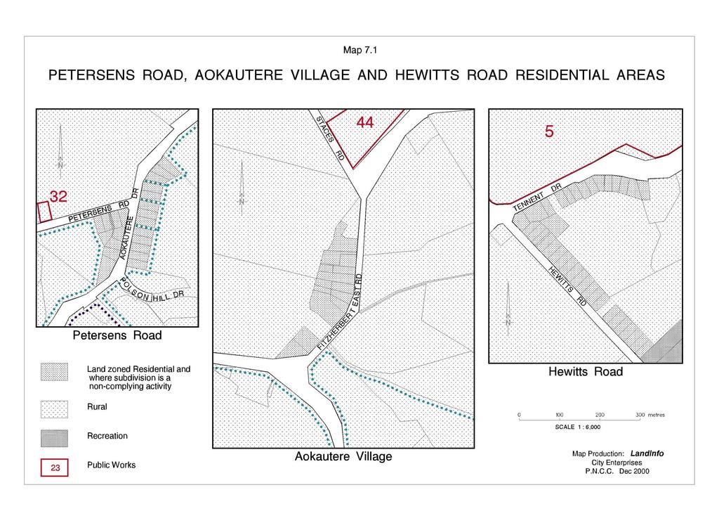
92 169
93 170

94 Delete Map 7.2 Below 171

95 Insert New North East Industrial Zone Structure Plan Maps
96 173
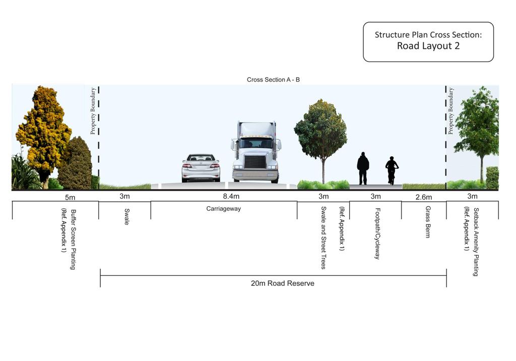
97 174
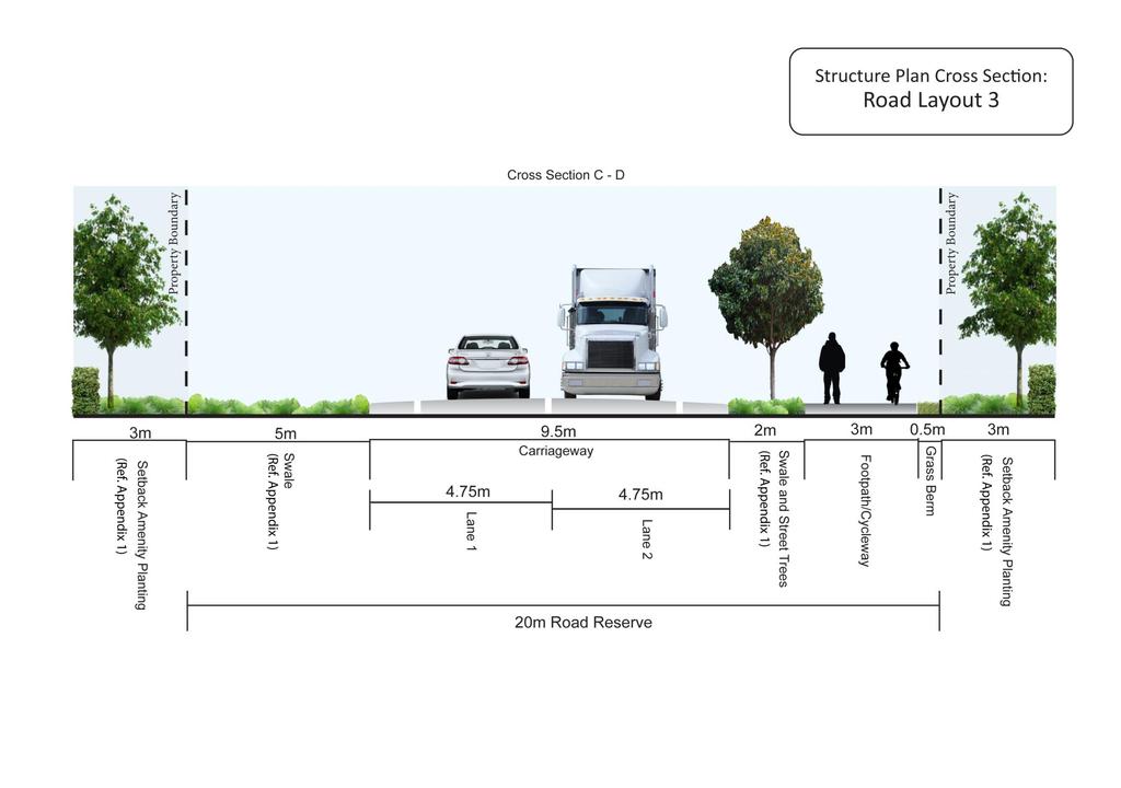
98 175
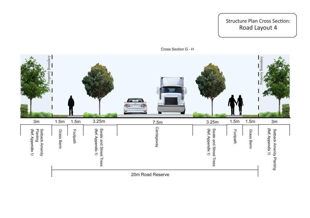
99 176

100 177 January 2007

101 178 January 2007
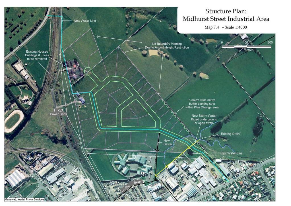
102 179
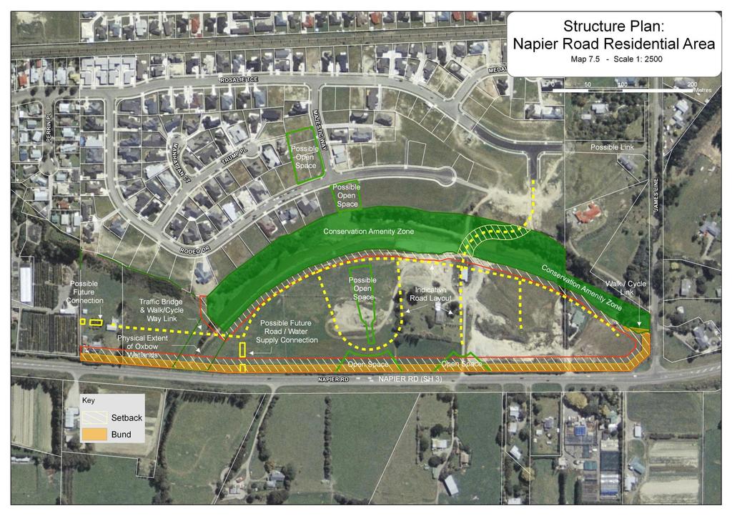
103 180

104 181 EXPLANATORY DIAGRAM NATIONAL GRID YARD PPC15G Network Utilities s32 Report July
PART SIXTEEN - SUBDIVISION AND DEVELOPMENT
 16.1 24 July 2010 PART SIXTEEN - SUBDIVISION AND DEVELOPMENT 1. INTRODUCTION Council has the statutory responsibility to control subdivision of land and the effects of land use throughout the District.
Gisborne District Council
 12.0 SUBDIVISION... 1 12.1 INTRODUCTION... 1 12.2 ISSUE... 1 12.3 OBJECTIVE (SUBDIVISION)... 1 12.4 POLICIES (SUBDIVISION)... 2 12.5 METHODS OF IMPLEMENTATION... 4 12.5.1 REGULATION... 4 12.6 RULES FOR
Volume Three Appendix 7. Scheme Plan and other subdivision requirements
 Volume Three Appendix 7 Appendix 7 Scheme Plan and other subdivision requirements Any application for subdivision consent must be accompanied by a Scheme Plan that contains the information set out in this
Section Three, Part 9 - Subdivision
 PART 9 SUBDIVISION SUBDIVISION AND DEVELOPMENT OF LAND 9.1 INTRODUCTION This part of the District Plan sets out the provisions in respect of the subdivision and development of land in the urban part of
Section 12A Purpose of Subdivision Provisions
 Section 12A 12A Purpose of Subdivision Provisions Subdivision is primarily about creating land parcels that define and redefine property rights and, in most instances, the creation of new parcels of land
15.1 Introduction. Waipa District Plan. Section 15 - Infrastructure, Hazards, Development and Subdivision. Page Version - 1 November 2016 Page 1 of 56
 15.1 Introduction 15.1.1 How and where development and subdivision occurs is critical to the sustainable management of the District s natural and physical resources. This section of the Plan focuses on
Figure 1 below shows the subdivision process. [Ministry for the Environment Quality Planning website]
![Figure 1 below shows the subdivision process. [Ministry for the Environment Quality Planning website]](/thumbs/87/97093311.jpg "Figure 1 below shows the subdivision process. [Ministry for the Environment Quality Planning website]") 13 SUBDIVISION CONTEXT The Far North District Council is responsible for issuing two types of resource consents land use consents and subdivision consents. In many cases both types of consents must be
13 SUBDIVISION CONTEXT The Far North District Council is responsible for issuing two types of resource consents land use consents and subdivision consents. In many cases both types of consents must be
E38. Subdivision - Urban
 E38. Subdivision - Urban E38.1. Introduction Subdivision is the process of dividing a site or a building into one or more additional sites or units, or changing an existing boundary location. Objectives,
PAPAKAINGA DISTRICT WIDE ACTIVITY
 SECTION 13.1 PAPAKAINGA DISTRICT WIDE ACTIVITY 13.1.1 INTRODUCTION The Resource Management Act 1991 introduced specific and new obligations for those exercising functions and powers under the Act to provide
DRAFT PROPOSED CHAPTER 21 SPECIFIC PURPOSE - FLAT LAND RECOVERY ZONE
 DRAFT PROPOSED CHAPTER 21 SPECIFIC PURPOSE - FLAT LAND RECOVERY ZONE Note: The Specific Purpose (Flat Land Recovery) Zone is a "holding" zone that will be subject to a later plan change to confirm the
9.3.5 Dual occupancy code
 9.3.5 Dual occupancy code 9.3.5.1 Application (1) This code applies to accepted development and assessable development identified as requiring assessment against the Dual occupancy 1 code by the tables
Activities which do not satisfy the General Rules and are not provided for as Restricted Discretionary activities... 9
 16.0 PAPAKAINGA AND MARAE SETTLEMENTS... 1 16.1 INTRODUCTION... 1 16.2 ISSUES... 1 16.3 OBJECTIVE (PAPAKAINGA)... 2 16.4 POLICIES (PAPAKAINGA)... 2 16.5 OBJECTIVE (SURROUNDING ENVIRONMENT)... 2 16.6 POLICIES
Flinders Avenue, Lara Planning Scheme Amendment Combined Application for Rezoning and Multi-Lot Subdivision Reference : Decembe
 143-179 Flinders Avenue, Lara Planning Scheme Amendment Combined Application for Rezoning and Multi-Lot Subdivision Reference: 14134-03 TGM Group Geelong Melbourne Ballarat 1/27-31 Myers Street (PO Box
Division 4 Large Lot Residential Zone: Assessment Criteria and Assessment Tables
 Division 4 Large Lot Residential Zone: Assessment Criteria and Assessment Tables 4.4.1 Large Lot Residential Zone The provisions in this division relate to the Large Lot Residential Zone as follows overall
Division 5 Residential Low Density Zone: Assessment Criteria and Assessment Tables
 Division 5 Residential Low Density Zone: Assessment Criteria and Assessment Tables 4.5.1 Residential Low Density Zone The provisions in this division relate to the Residential Low Density Zone as follows
Section 11 Land Subdivision #
 Section 11 Land Subdivision # 11.1 General Features 11-1 11.1.1 Land Ownership 11-1 11.1.2 Subdivision Patterns 11-1 11.2 Legislative Considerations 11-2 11.2.1 Resource Management Act 11-2 11.3 Management
RURAL SETTLEMENT ZONE - RULES
 Chapter 38 RURAL SETTLEMENT ZONE - RULES INTRODUCTION This Chapter contains rules managing land uses in the. The boundaries of this zone are shown on the planning maps. There is limited opportunity for
PALMERSTON NORTH CITY SECTIONAL DISTRICT PLAN REVIEW PROPOSED PLAN CHANGE 2: CLIFF PROTECTION LINE
 PALMERSTON NORTH CITY SECTIONAL DISTRICT PLAN REVIEW PROPOSED PLAN CHANGE 2: CLIFF PROTECTION LINE PART I DESCRIPTION OF PROPOSED PLAN CHANGE This proposed Plan Change seeks to amend the Cliff Protection
Explanation The policies ensure that land is suitable for subdivision and will not increase risks to people, the environment and property.
 23 Subdivision 23.1 Purpose a) Subdivision is essentially the process of dividing a parcel of land or a building into one or more further parcels, or changing an existing boundary location. Subdivision
RULE C2 ZONE STANDARDS - SUBDIVISION
 RULE C SUBDIVISION 1 RULE C2 ZONE STANDARDS - SUBDIVISION NB Words outlined in bold type below have a specific definition contained in Chapter 2 (Definitions). 2.1 STANDARDS RESIDENTIAL ZONE (Refer Part
PART 9 TOWNSHIP AREAS
 Part 9 Township Areas PART 9 TOWNSHIP AREAS Division 1 Preliminary 9.1 Township Areas Provisions (1) The following provisions in this part comprise the Township Areas Code compliance with the Township
Division 16 Bundamba Racecourse Stables Area Zone: Assessment Criteria and Assessment Tables
 Division 16 Bundamba Racecourse Stables Area Zone: Assessment Criteria and Assessment Tables 4.16.1 Bundamba Racecourse Stables Area Zone The provisions in this division relate to the Bundamba Racecourse
Section Three, Part 8 Reserves and Community Services
 PART 8 RESERVES AND COMMUNITY SERVICES RESERVES, RECREATION AND COMMUNITY FACILITIES/SERVICES 8.1 INTRODUCTION This part of the District Plan sets out the provisions for reserves and areas of community
TOTTENHAM SECONDARY PLAN
 TOTTENHAM SECONDARY PLAN AMENDMENT NO. 11 TO THE OFFICIAL PLAN OF THE TOWN OF NEW TECUMSETH The following text and schedules to the Official Plan of the Town of New Tecumseth constitute Amendment No. 11
MAKING THE MOST EFFECTIVE AND SUSTAINABLE USE OF LAND
 165 SOC146 To deliver places that are more sustainable, development will make the most effective and sustainable use of land, focusing on: Housing density Reusing previously developed land Bringing empty
Guide to Subdivision and Land Development
 Guide to Subdivision and Land Development Fraser Thomas Ltd......is an engineering and surveying consulting firm based in Highbrook which has provided Surveying, Engineering, Planning and Resource Management
Presentation to the Real Estate Institute of New Zealand 28 October 2016
 Presentation to the Real Estate Institute of New Zealand 28 October 2016 Disclaimer This presentation provides a high level overview of specific parts of the Proposed Auckland Unitary Plan Decisions Version
16.1 Introduction Resource Management Issues Objectives And Policies Rules: Permitted Activities 3
 SECTION 16: CACCIA BIRCH CONTENTS 16.1 Introduction 1 16.2 Resource Management Issues 1 16.3 Objectives And Policies 1 16.5 Rules: Permitted Activities 3 R16.5.1 Permitted Activities 3 16.6 Rules: Controlled
Riverton Properties Ltd Proposed Special Housing Area
 Riverton Properties Ltd Proposed Special Housing Area Housing Accords and Special Housing Areas Act 2013 Expression of Interest 1 This Expression of Interest is made on behalf of Riverton Properties Ltd,
SUBDIVISION, DEVELOPMENT AND EARTHWORKS
 PROPOSED CHAPTER 8 SUBDIVISION, DEVELOPMENT AND EARTHWORKS Chapter 8 Subdivisions - Proposed Changes to delete all draft provisions under the Residential Established New Neighbourhood Zone and replace
APPLICATION FOR RESOURCE CONSENT OR FAST-TRACK RESOURCE CONSENT
 Office Use Only Application Number: APPLICATION FOR RESOURCE CONSENT OR FAST-TRACK RESOURCE CONSENT (Or Associated Consent Pursuant to the Resource Management Act 1991 (RMA)) (If applying for a Resource
Financial Impact Statement There are no immediate financial impacts associated with the adoption of this report.
 STAFF REPORT Planning and Development Department Subject: Application by RYC Property to rezone a portion of lands on John Murray Dr. and Megan Lynn Dr. from R2 to R3 and to enter into a Development Agreement
GUIDE TO SUBDIVISION & LAND DEVELOPMENT
 GUIDE TO SUBDIVISION & LAND DEVELOPMENT The Fraser Thomas Difference: Fraser Thomas Ltd is an engineering and surveying consulting firm based in Highbrook, and has been providing; Surveying, Engineering,
Resource Consent Application Form
 Resource Consent Application Form Section 88 of the Resource Management Act 1991. This form provides us with your contact information and details about your proposal. Please print clearly and complete
H5. Residential Mixed Housing Urban Zone
 H5. Residential Mixed Housing Urban Zone [ENV-2016-AKL-000197: Robert Adams] Addition sought H5.1. Zone description The Residential Mixed Housing Urban Zone is a reasonably high-intensity zone enabling
H4. Residential Mixed Housing Suburban Zone
 H4. Residential Mixed Housing Suburban Zone H4.1. Zone description The Residential Mixed Housing Suburban Zone is the most widespread residential zone covering many established suburbs and some greenfields
9.3.6 Dwelling house code
 9.3.6 Dwelling house code 9.3.6.1 Application (1) This code applies to accepted development assessable development identified as requiring assessment against the Dwelling house 3 code by the tables of
North Qu Appelle No. 187 Bylaw Basic Planning Statement - Table of Contents
 - Table of Contents Section1 Introduction 2 Section 2 - The Rural Municipality of North Qu Appelle No. 187 3 Section 3 Municipal Goals.... 3 Section 4 Agriculture and Natural Resources.. 4 Section 5 Residential
Bylaw No The Corman Park Saskatoon Planning District Official Community Plan Bylaw, 2010
 Bylaw No. 8844 The Corman Park Saskatoon Planning District Official Community Plan Bylaw, 2010 Codified to Bylaw No. 9446 May 23, 2017 BYLAW NO. 8844 The Corman Park Saskatoon Planning District Official
H18. Future Urban Zone
 H18. Future Urban Zone H18.1. Zone description The Future Urban Zone is applied to greenfield land that has been identified as suitable for urbanisation. The Future Urban Zone is a transitional zone. Land
Subdivision & Development Subdivision and Development Explanatory Statement Significant Issues... 3
 Section Contents Subdivision & Development... 2 12. Subdivision and Development... 2 Explanatory Statement... 2 12.1 Significant Issues... 3 12.2 Objectives and Policies... 4 12.3 Rules... 6 12.4 Activity
Corman Park - Saskatoon Planning District Official Community Plan
 1 Corman Park - Saskatoon Planning District Official Community Plan CONSOLIDATED: October, 2017 2 Table of Contents Bylaw Amendments... 3 Section 1: Foundations... 4 Section 2: Future Growth Sector Objectives
A. ARTICLE 16 - STEEP SLOPE CONSERVATION DISTRICT
 1600. 1601.A. ARTICLE 16 - STEEP SLOPE CONSERVATION DISTRICT SECTION 1600 PURPOSE The purpose of this Article is to expand upon the Community Development Objectives associated with environmental protection
4. If any perennial surface water passes through or along the property lines of the acreage, a minimum of 200 feet or frontage should be required.
 b. Provide adequate acreage for appropriate productive use of rural residential land, such as small numbers of livestock, large gardens, etc. 3. Minimum of 200 feet of frontage on an improved county or
H5. Residential Mixed Housing Urban Zone
 H5. Residential Mixed Housing Urban Zone H5.1. Zone description The Residential Mixed Housing Urban Zone is a reasonably high-intensity zone enabling a greater intensity of development than previously
Division 6 Residential Medium Density Zone: Assessment Criteria and Assessment Tables
 Division 6 Residential Medium Density Zone: Assessment Criteria and Assessment Tables 4.6.1 Residential Medium Density Zone The provisions in this division relate to the Residential Medium Density Zone
H4. Residential Mixed Housing Suburban Zone
 H4. Residential Mixed Housing Suburban Zone H4.1. Zone description The Residential Mixed Housing Suburban Zone is the most widespread residential zone covering many established suburbs and some greenfields
I Harris. Melbourne. John Quirk, Member. Merits Review of Refusal
 VICTORIAN CIVIL AND ADMINISTRATIVE TRIBUNAL ADMINISTRATIVE DIVISION PLANNING AND ENVIRONMENT LIST VCAT REFERENCE NO. P382/2005 PERMIT APPLICATION NO. YR-2004/1272 CATCHWORDS 4 lot subdivision of large
ARTICLE 7: PLOT PLANS AND SITE PLAN REQUIREMENTS AND REVIEW
 ARTICLE 7: PLOT PLANS AND SITE PLAN REQUIREMENTS AND REVIEW Section 7.0 - Purpose The purpose of this article is to specify the documents and/or drawings required for a Site Plan Review or a Plot Plan
Special Use Permit - Planned Unit Development Checklist. Property Address:
 Special Use Permit - Planned Unit Development Checklist Special Use Permit Number. Parcel Code/s #28-11- - - Property Address: Applicant: ARTICLE VIII Ordinance Reference - Section 8.1.2 Permit Procedures:
SCHEDULE 12 TO THE URBAN GROWTH ZONE. Shown on the planning scheme map as UGZ12. Kororoit Precinct Structure Plan
 SCHEDULE 12 TO THE URBAN GROWTH ZONE Shown on the planning scheme map as UGZ12. Kororoit Precinct Structure Plan 1.0 The plan Map 1 below shows the future urban structure proposed in the Kororoit Precinct
Development Control Policy Subdivision of rural land
 Development Control Policy 3.4 - Subdivision of rural land January 2011 Draft for public comment This policy supersedes Development Control Policy 3.4 Subdivision of Rural Land (February 2008). The Western
Division 8 General Urban (T4) Zone: Assessment Criteria and Assessment Tables
 Zone: Assessment Criteria and Assessment Tables") Division 8 General Urban (T4) Zone: Assessment Criteria and Assessment Tables 15.8.1 General Urban (T4) Zone The provisions in this division relate to the General Urban (T4) Zone as follows overall outcomes
Division 8 General Urban (T4) Zone: Assessment Criteria and Assessment Tables 15.8.1 General Urban (T4) Zone The provisions in this division relate to the General Urban (T4) Zone as follows overall outcomes
RESIDENTIAL AND RECREATIONAL
 Energy, Mines & Resources Land Management Branch 320-300 Main Street Whitehorse, Yukon Y1A 2B5 667-5215 Fax 667-3214 www.emr.gov.yk.ca RESIDENTIAL AND RECREATIONAL Lot Enlargement Policy OBJECTIVE To facilitate
1 Extraordinary Council meeting Doc No.: RDC March 2018 NOTICE OF AN EXTRAORDINARY MEETING OF COUNCIL
 1 Extraordinary Council meeting File No: 01-15-010\25 NOTICE OF AN EXTRAORDINARY MEETING OF COUNCIL to be held on Thursday, 15 March 2018 at 2pm in the Council Chamber, Rotorua Lakes Council Chairperson:
MIDWAY CITY Municipal Code
 MIDWAY CITY Municipal Code TITLE 9 ANNEXATION CHAPTER 9.01 PURPOSE CHAPTER 9.02 GENERAL REQUIREMENTS CHAPTER 9.03 PROPERTY OWNER INITIATION OF ANNEXATION CHAPTER 9.04 PROCEDURES FOR CONSIDERATION OF PETITION
Longreach Developments Limited
 1 APPLICATION FOR RESOURCE CONSENT UNDER SECTION 88 OF THE RESOURCE MANAGEMENT ACT 1991 TO: THAMES COROMANDEL DISTRICT COUNCIL Longreach Developments Limited c/- Brown and Company, PO Box 91-839, Auckland
5. That the Owner shall agree that all development Blocks shown within the Draft Plan will be connected to full municipal services.
 Conditions Relating to Draft Plan of Subdivision Approval East Fonthill 26T 01014 (Draft Plan dated December 1, 2013, and revised August 28, 2014), the Town of Pelham 1. This approval applies to the Draft
Residential Project Convenience Facilities
 Standards for Specific Land Uses 35.42.220 E. Findings. The review authority shall approve a Land Use Permit in compliance with Subsection 35.82.110.E (Findings required for approval) or a Conditional
Multi-unit residential uses code
 9.3.11 Multi-unit residential uses code 9.3.11.1 Application (1) This code applies to assessable development identified as requiring assessment against the Multi-unit residential uses code by the tables
H6 Residential Terrace Housing and Apartment Buildings Zone
 H6. Residential Terrace Housing and Apartment Buildings Zone [CIV-2016-404-002333: Franco Belgiorno-Nettis]-Note: The properties affected by this appeal are identified on the Auckland Unitary Plan viewer.
UPPER MOUNT BETHEL TOWNSHIP NORTHAMPTON COUNTY, PENNSYLVANIA
 UPPER MOUNT BETHEL TOWNSHIP NORTHAMPTON COUNTY, PENNSYLVANIA JOINDER DEED / LOT CONSOLIDATION TOWNSHIP REVIEW PROCESS When accepting proposed Joinder Deeds / Lot Consolidations, review the Joinder Deed
Condition. The gross floor area of all buildings must not exceed 250 square metres.
 32.03 LOW DENSITY RESIDENTIAL ZONE 23/09/2011 Shown on the planning scheme map as LDRZ with a number (if shown). Purpose To implement the State Planning Policy Framework and the Local Planning Policy Framework,
Objectives The objectives are as listed in the relevant underlying zones and Auckland wide provisions, except as specified below:
 6.35 Drury 1 Precinct description The precinct has an area of 84.62 ha and is bordered by Drury Creek in the north, southern motorway to the east SH22(Karaka road) to the south and Jesmond road to the
CITY OF FORT COLLINS NATURAL AREAS AND CONSERVED LANDS EASEMENT POLICY
 CITY OF FORT COLLINS NATURAL AREAS AND CONSERVED LANDS EASEMENT POLICY Adopted January 3, 2012 PURPOSE: The purpose of the policy statement is to clarify the policies and procedures of the City of Fort
A. Preserve natural resources as identified in the Comprehensive Plan.
 1370.08 Conservation Residential Overlay District. Subd. 1 Findings. The City finds that the lands and resources within the Conservation Residential Overlay District are a unique and valuable resource
HYDRAULIC SERVICES BY - LAW
 Repeal HOBART CITY COUNCIL HYDRAULIC SERVICES BY - LAW BY-LAW 4 OF 2008 BY-LAW MADE UNDER SECTION 145 OF THE LOCAL GOVERNMENT ACT 1993 AND SECTION 67 A OF THE SEWERS AND DRAINS ACT 1954 FOR THE PURPOSE
By-Law of The Corporation of the City of Oshawa
 By-Law 85-2006 of The Corporation of the City of Oshawa being a by-law to control the dumping of fill, removal of topsoil and alteration of grades. WHEREAS s. 142 of the Municipal Act, 2001, S.O. 2001,
ThoMSON. SURVE LI MI re D. 8844*ati,J{ 5 ; 2 '. r 1
 Z 0 n. *013* ThoMSON SURVE LI MI re D 2(9062-4 Our reference: 9310.1(FNDC) 30 April 2018 Resource Consents Department Far North District Council JB Centre Kerikeri Road 8844*ati,J{ 5 ; 2 '. r 1 RE: Potter
RURAL GENERAL RG 1. PERMITTED USES DISCRETIONARY USES
 RURAL GENERAL RG PURPOSE: To protect the agricultural land base of the municipality while allowing nonagricultural developments which complement the area's economy. 1. PERMITTED USES DISCRETIONARY USES
3.1. OBJECTIVES FOR RESIDENTIAL LAND USE DESIGNATIONS GENERAL OBJECTIVES FOR ALL RESIDENTIAL DESIGNATIONS
 3. RESIDENTIAL LAND USE DESIGNATIONS INTRODUCTION The Residential land use designations provide for housing and other land uses that are integral to, and supportive of, a residential environment. Housing
CHAPTER XVIII SITE PLAN REVIEW
 CHAPTER XVIII SITE PLAN REVIEW Section 18.1 Section 18.2 Description and Purpose. The purpose of this chapter is to provide standards and procedures under which applicants would submit, and the Township
Application for Resource Consent (Subdivision) Section 88, Resource Management Act 1991 Form 9
 Section 88, Resource Management Act 1991 Form 9") Email: applications@waidc.govt.nz www.waikatodistrict.govt.nz Telephone (all hours) 07 824 8633 Call Free 0800 492 452 District Office 15 Galileo Street Private Bag 544 Ngaruawahia 3742 Application for
Email: applications@waidc.govt.nz www.waikatodistrict.govt.nz Telephone (all hours) 07 824 8633 Call Free 0800 492 452 District Office 15 Galileo Street Private Bag 544 Ngaruawahia 3742 Application for
STAFF REPORT. Financial Impact Statement There are no immediate financial impacts associated with the adoption of this report.
 STAFF REPORT Planning and Development Department Subject: Cottage Country Unsubstantial Amendment to Development Agreement To: CAO for Planning Advisory Committee, December 13, 2016 Date Prepared: December
Community Facilities (CF) Zone Residential; community centre; post office; bed and breakfast
 Zone Residential; community centre; post office; bed and breakfast") Applicant Land Owner Proposal Municipality of the County of Kings Report to the Centreville Area Advisory Committee Application to Amend the Zoning Map of the Land Use By-law (File 16-18) Date: Wednesday,
Applicant Land Owner Proposal Municipality of the County of Kings Report to the Centreville Area Advisory Committee Application to Amend the Zoning Map of the Land Use By-law (File 16-18) Date: Wednesday,
Environmental Planning and Assessment Act 1979
 New South Wales State Environmental Planning Policy (Sydney Region Growth Centres) Amendment (East Leppington Precinct) 2013 under the Environmental Planning and Assessment Act 1979 Her Excellency the
ARTICLE 24 SITE PLAN REVIEW
 ARTICLE 24 SITE PLAN REVIEW 24.1 PURPOSE: The intent of these Ordinance provisions is to provide for consultation and cooperation between the land developer and the Township Planning Commission in order
LAND USE AND ZONING OVERVIEW
 OVERVIEW OF PLANNING POLICIES LAND USE AND ZONING OVERVIEW The Minneapolis Plan for Sustainable Growth and Other Adopted Plans Community Planning and Economic Development Development Services Division
Application for Outline Plan / Outline Plan Waiver Section 176A, Resource Management Act
 Email: applications@waidc.govt.nz www.waikatodistrict.govt.nz Telephone (all hours) 07 824 8633 Call Free 0800 492 452 District Office 15 Galileo Street Private Bag 544 Ngaruawahia 3742 Application for
Open Space Model Ordinance
 Open Space Model Ordinance Section I. Background Open space development has numerous environmental and community benefits, including: 1) Reduces the impervious cover in a development. Impervious cover
SUBURBAN AND URBAN RESIDENTIAL LAND USE
 SUBURBAN AND URBAN RESIDENTIAL LAND USE GOAL 1 DISCOURAGE URBAN AND SUBURBAN DEVELOPMENT OUTSIDE INCORPORATED AREAS IN WHITMAN COUNTY, EXCEPT WITHIN DESIGNATED UNINCORPORATED COMMUNITIES, AND THOSE AREAS
State Environmental Planning Policy No 53 Metropolitan Residential Development
 1999 No 523 New South Wales State Environmental Planning Policy No 53 Metropolitan Residential Development under the Environmental Planning and Assessment Act 1979 His Excellency the Governor, with the
4. facilitate the construction of streets, utilities and public services in a more economical and efficient manner;
 PVPC MODEL BYLAW BY-RIGHT CLUSTER ZONING BYLAW Prepared by Pioneer Valley Planning Commission Revised: October 2001 1.00 Development 1.01 Development Allowed By Right Development in accordance with this
Township of Tay Official Plan
 Township of Tay Official Plan Draft for Consultation (v.3) March 2016 Contents 1. INTRODUCTION... 1 1.1 Content, Title and Scope... 1 1.2 Basis and Purpose of this Plan... 1 1.3 Plan Structure... 2 2.
PLANNING SUBMISSION & CLAUSE 56 ASSESSMENT RESIDENTIAL SUBDIVISION OF LAND 1525 POUND ROAD, CLYDE NORTH (LOT 2 PS F, SIENNA PARK ESTATE)
") PLANNING SUBMISSION & CLAUSE 56 ASSESSMENT RESIDENTIAL SUBDIVISION OF LAND 1525 POUND ROAD, CLYDE NORTH (LOT 2 PS 327975F, SIENNA PARK ESTATE) DFC (PROJECT MANAGEMENT) PTY LTD (A DENNIS FAMILY CORPORATION
PLANNING SUBMISSION & CLAUSE 56 ASSESSMENT RESIDENTIAL SUBDIVISION OF LAND 1525 POUND ROAD, CLYDE NORTH (LOT 2 PS 327975F, SIENNA PARK ESTATE) DFC (PROJECT MANAGEMENT) PTY LTD (A DENNIS FAMILY CORPORATION
Site Alteration By-law
 Site Alteration By-law C.P.-1363-381 Consolidated October 17, 2017 As Amended by: By-law No. Date Passed at Council C.P.-1363(a)-29 January 15, 2001 C.P.-1363(b)-53 February 5, 2001 C.P.-1363(c)-13 December
Part 1 Objective of the Planning Proposal. Part 2 Explanation of the Provisions. Lake Macquarie City. Local Government Area:
 Planning Proposal - Administrative Amendment No. 9 to Lake Macquarie Local Environmental Plan Part 4 - Principal Development Standards (PP-2015-005-00) As Published 2 October 2015 Local Government Area:
A. Maintenance. All legally established, nonconforming structures can be maintained (e.g., painting and repairs);
;") Chapter 24.50 NONCONFORMING USES, STRUCTURES AND LOTS Sections: 24.50.010 Nonconforming uses, structures, and lots Purpose. 24.50.020 Nonconforming uses, structures, and lots Alteration or expansion of
Chapter 24.50 NONCONFORMING USES, STRUCTURES AND LOTS Sections: 24.50.010 Nonconforming uses, structures, and lots Purpose. 24.50.020 Nonconforming uses, structures, and lots Alteration or expansion of
Salem Township Zoning Ordinance Page 50-1 ARTICLE 50.0: PUD PLANNED UNIT DEVELOPMENT
 Salem Township Zoning Ordinance Page 50-1 ARTICLE 50.0 PLANNED UNIT DEVELOPMENT Section 50.01 Purpose The provisions of this Article provide enabling authority and standards for the submission, review,
SCHEDULE 3 TO THE URBAN GROWTH ZONE. Shown on the planning scheme map as UGZ3 QUARRY HILLS PRECINCT STRUCTURE PLAN. 1.0 The Plan
 SCHEDULE 3 TO THE URBAN GROWTH ZONE 1.0 The Plan Shown on the planning scheme map as UGZ3 QUARRY HILLS PRECINCT STRUCTURE PLAN Map 1 to Schedule 3 to Clause 37.07 shows the Future Urban Structure for Quarry
Environmental Planning and Assessment Act 1979
 New South Wales State Environmental Planning Policy (Major Development) Amendment (State Significant Sites South Wallarah Peninsula) 2010 under the Environmental Planning and Assessment Act 1979 His Excellency
Chapter 100 Planned Unit Development in Corvallis Urban Fringe
 100.100 Scope and Purpose. Chapter 100 Planned Unit Development in Corvallis Urban Fringe (1) All applications for land divisions in the Urban Residential (UR) and Flood Plain Agriculture (FPA) zones within
EXCERPTS FROM HALIFAX REGIONAL MUNICIPALITY CHARTER
 EXCERPTS FROM HALIFAX REGIONAL MUNICIPALITY CHARTER Municipal planning strategy 227 The Council may adopt a municipal planning strategy for all, or part, of the Municipality and there may be separate strategies
H30. Special Purpose Tertiary Education Zone
 H30. Special Purpose Tertiary Education Zone H30.1. Description The Special Purpose Tertiary Education Zone applies to tertiary education facilities in locations where the surrounding zoning will not appropriately
Rural Municipality of Kellross No Official Community Plan. Bylaw No
 Rural Municipality of Kellross No. 247 Official Community Plan Bylaw No. 2009-03 2 BYLAW NO. 2009-03 THE RURAL MUNICIPALITY OF KELLROSS NO. 247 LEROSS, SASKATCHEWAN A Bylaw of the Rural Municipality of
State Environmental Planning Policy (Kosciuszko National Park Alpine Resorts) 2007
 2007") New South Wales State Environmental Planning Policy (Kosciuszko National Park Alpine under the Environmental Planning and Assessment Act 1979 Her Excellency the Governor, with the advice of the Executive
New South Wales State Environmental Planning Policy (Kosciuszko National Park Alpine under the Environmental Planning and Assessment Act 1979 Her Excellency the Governor, with the advice of the Executive
Chapter Planned Residential Development Overlay
 Chapter 19.29 Planned Residential Development Overlay Sections 010 Purpose 020 Scope 030 Definitions 030 Minimum Size 040 Allowable Uses 050 Minimum Development Standards 060 Density Bonus 070 Open Space
610 LAND DIVISIONS AND PROPERTY LINE ADJUSTMENTS OUTSIDE A UGB
 ARTICLE VI: LAND DIVISIONS AND PROPERTY LINE ADJUSTMENTS VI-21 610 LAND DIVISIONS AND PROPERTY LINE ADJUSTMENTS OUTSIDE A UGB 610-1 Property Line Adjustments (Property Line Relocation) A property line
Appendix A. Definitions
 Definitions 1. Terms Defined. Words contained in this are those having a special meaning relative to the purposes of this Ordinance. Words not listed in this section shall be defined by reference to: (1)
Town of Lisbon, Maine SUBDIVISION REVIEW APPLICATION
 Date Received: Fee Paid (amount): Applicant: Town of Lisbon, Maine SUBDIVISION REVIEW APPLICATION Subdivision Name/Title: This application must be received at the Town Office by close of business on the