HERITAGE LAND BANK HERITAGE LAND BANK ANNUAL WORK PROGRAM and FIVE-YEAR MANAGEMENT PLAN
|
|
|
- Randolf Reynolds
- 5 years ago
- Views:
Transcription


1 HERITAGE LAND BANK 2016 ANNUAL WORK PROGRAM and FIVE-YEAR MANAGEMENT PLAN Municipality of Anchorage Ethan A. Berkowitz, Mayor MUNICIPALITY OF ANCHORAGE Ethan Berkowitz, Mayor Real Estate Department Tammy R. Oswald, Executive Director Heritage Land Bank Division Nicole Jones-Vogel, Land Management Officer Robin E. Ward, Land Management Officer Tawny Klebesadel, Office Manager HERITAGE LAND BANK 2016 ANNUAL WORK PROGRAM & REAL ESTATE FIVE-YEAR DEPARTMENT MANAGEMENT PLAN Tammy R. Oswald, Executive Director Real Estate Services Division Deborah Reich, Foreclosure Specialist Jacque Tennis, Jr. Administrative Officer Heritage Land Bank Division
2 Table of Contents Chapter 1. Heritage Land Bank Overview... 4 A Brief History of the Heritage Land Bank... 5 Land Management Objectives... 7 Overview of Land Acquisition... 7 Table 1.1 Breakdown of HLB Inventory... 8 Table 1.2 Development Limitations... 8 Annual Work Program... 8 Five-Year Work Plan... 9 Chapter Progress Report 11 Disposals Acquisitions Transfers Land Management 12 Table 2.1: Conservation Easements Managed by Heritage Land Bank Chapter Work Program Proposed Disposals Potential Acquisitions Potential Transfers Land Management Chapter 4. Five Year Work Plan: Proposed Disposals: Proposed Acquisitions: Proposed Transfers: Proposed Projects: Appendices Appendix A: Regional Maps of HLB Inventory Appendix B Approved HLB Policies and Procedures Appendix C: HLB Fund Activities by Year and Fund Balance Graph: Appendix D: HLB Leases and Permits List (December 2015 spreadsheet) Appendix E: HLBAC Resolution Appendix F: Response to Public and Community Council Comments Page1 HERITAGE LAND BANK 2016 ANNUAL WORK PROGRAM & FIVE-YEAR MANAGEMENT PLAN


3 Heritage Land Bank Commissioners Chair Tim Trawver I Vice-Chair Kati Capozzi Lottie Michael I Ryan Mae Lucas I Peggy Looney I Diana Stone-Livingston Page2 HERITAGE LAND BANK 2016 ANNUAL WORK PROGRAM & FIVE-YEAR MANAGEMENT PLAN
4 Acronyms ACDA Anchorage Community Development Authority ADEC Alaska Department of Environmental Conservation AMC Anchorage Municipal Code ASD Anchorage School District AWWU Anchorage Water & Wastewater Utility BLM U.S. Bureau of Land Management COE U.S. Army Corps of Engineers DOD U.S. Department of Defense DOT&PF Alaska Department of Transportation & Public Facilities GIS Geographic Information Systems HLB Heritage Land Bank HLBAC Heritage Land Bank Advisory Commission ML&P Municipal Light & Power MOA Municipality of Anchorage NALA North Anchorage Land Agreement OECD Office of Economic & Community Development RED Real Estate Department RES Real Estate Services SOA State of Alaska Page3 HERITAGE LAND BANK 2016 ANNUAL WORK PROGRAM & FIVE-YEAR MANAGEMENT PLAN
5 Chapter 1. Heritage Land Bank Overview Heritage Land Bank (HLB) is a self-supporting, non-tax based agency of the Municipality of Anchorage (MOA), with its own fund and advisory commission. Title 25 of the Anchorage Municipal Code (AMC), Public Lands, contains the laws under which the HLB operates (AMC 25.40). It is the mission of the Heritage Land Bank to manage uncommitted municipal land and the Heritage Land Bank Fund in a manner designed to benefit present and future residents of Anchorage, promote orderly development, and achieve the goals of the Comprehensive Plan (AMC ). HLB achieves its mission by managing an inventory of HLB land and resources to benefit a wide variety of municipal objectives. The HLB manages many types of land in its inventory, a little over 10,000 acres, which are divided into approximately 264 parcels zoned residential, industrial, commercial, recreational, public use and open space. About half of the HLB inventory is forested lands in the Girdwood Valley, with a small percentage of the overall inventory developed or improved. All proceeds from HLB land sales, leases, and other sources are deposited into the HLB Fund. With approval from the Mayor and Assembly, the Fund is used to: manage and/or improve HLB property; conduct land use planning and feasibility studies; carry out off-site mitigation monitoring; acquire property for municipal use; and support the annual operating expenses of HLB. Since its inception in 1983, the HLB has operated without any direct taxpayer support but has contributed millions of dollars in support to the general municipal government in ways that benefit our growing community. More than 50 HLB parcels are leased or permitted to government agencies or to the private sector, and some are used or managed by municipal agencies under special permit or management authorizations. A spreadsheet of leases and permits currently held by the HLB is available online. Municipal properties deemed surplus to current and future needs are generally disposed of through competitive bid, in accordance with AMC. In order to carry out the HLB mission, some parcels may be sold directly to agencies such as Anchorage Community Development Authority (ACDA), Anchorage Water and Wastewater Utility (AWWU), Municipal Light & Power (ML&P) or the Anchorage School District (ASD) for continued use by the MOA. Page4 HERITAGE LAND BANK 2016 ANNUAL WORK PROGRAM & FIVE-YEAR MANAGEMENT PLAN
6 The Mayor, with Assembly approval, may also designate any municipal land or interest in land for placement in the HLB. However, land placed in the HLB generally is: 1. Land reserved for unspecified purposes, or needed for specific or future public purposes; 2. Land determined excess to municipal needs but unsuitable for disposal and development; or 3. Other land determined excess to present or future municipal needs that may be suitable for disposal or development in the future. A Brief History of the Heritage Land Bank History In 1972, the Greater Anchorage Borough established a Land Trust Fund. Amended in 1976, the trust fund was created to acquire and manage property for the municipality. The Land Trust Fund Council maintained oversight over the fund and its properties. The Municipal Entitlement Act of 1978 granted Anchorage a total land entitlement of 44,893 acres from the State of Alaska (SOA). The Heritage Land Bank was formed to acquire and manage land transferred to the municipality from the state as a result of the Municipal Entitlement Act. The Mayor and Anchorage Assembly created HLB to manage these lands for the benefit of present and future residents of Anchorage. The ordinance that created HLB also established the HLB Advisory Commission (HLBAC), which consists of seven members appointed by the Mayor, to advise the Mayor and Assembly regarding the management of land and funds in the HLB portfolio. The commission solicits public comments when it holds public hearings in order to make informed recommendations. HLB staff handles the day-to-day land management responsibilities of the HLB. Inventory Mapping In 1984, HLB completed the first land inventory. This inventory exists in an online version for public and municipal access at It includes maps and categories of all HLB land by region. The inventory identifies all lands by HLB parcel number, municipal tax identification number, zoning classification, acreage and includes a statement of management intent, where applicable. The inventory also lists leases on HLB land. Interactive mapping can be found on the MOA Mapping webpage. State Entitlements A priority for HLB is the continuing conveyance of title to the municipality s outstanding land entitlements. While the State has conveyed substantial acreage, and some monetary compensation to the MOA in fulfillment of the municipal entitlement mandate, there remains a shortfall. Several parcels of land are still in the process of being conveyed, including parcels in Chugiak, Indian, and Girdwood. Page5 HERITAGE LAND BANK 2016 ANNUAL WORK PROGRAM & FIVE-YEAR MANAGEMENT PLAN
7 Accomplishments Many significant land uses and facilities in Anchorage have become developed over the years through contributions from the HLB inventory or fund. HLB commercial, civic, and recreational contributions in Anchorage & Eagle River area include: multiple school sites throughout the municipality; the Cuddy Family Mid-Town Park; demolition of Hollywood Vista apartments site for new development on Government Hill; protection of Connor s and Klatt Bogs; Botanical Gardens lease of HLB lands; Rabbit Creek Greenbelt, Eagle River Greenbelt, and Section 36; Long-term lease of the Chugiak Senior Center; disposal of the NW1/4 of Section 25 to the Parks and Recreation Department (Parks) for addition to Beach Lake Park; use of the Girdwood Library site; and the sale of HLB land to TDX Corporation for the development of Alaska Master Park. HLB s commercial, civic, and recreational contributions in Girdwood include: the designation of Moose Meadows Park; land for the post office; parking expansion plans for town square; permits through Girdwood Parks and Recreation for Girdwood events; industrial storage lots; library/community center; and Nordic ski trails. The Heritage Land Bank Fund Upon formation of the HLB, the MOA Land Management Fund was renamed the HLB Fund. According to AMC , the HLB Fund can be used for three main purposes: supporting the annual HLB operating budget; acquiring land for municipal use; and managing and improving HLB land. Page6 HERITAGE LAND BANK 2016 ANNUAL WORK PROGRAM & FIVE-YEAR MANAGEMENT PLAN
8 Our goal has been, and continues to be, managing the Fund in order to achieve our mission s objectives, with additional focus on increasing our asset value and fund strength. Land Management Objectives HLB manages land to maximize benefits to the Municipality and the public, and seeks to preserve and enhance the value of its land assets. All management activities are consistent with the Comprehensive Plan and implementing measures. Our management objectives include: 1. Ensuring that all HLB lands and conservation easement rights are reasonably protected from adverse impacts, including fire, insect damage, plant disease, invasive species, illegal dumping, hazardous or contaminated materials, timber theft, vandalism and other threats. 2. Continuing to aggressively enforce trespass violations, from posting signs and installing fences in areas of known campsites to removal of illegal structures and vehicles. 3. Basing all land use authorizations on prevailing market rates except where otherwise provided by AMC Disposing of lands excess to municipal need, both immediate need and potential future need, from its inventory to the appropriate municipal agency with the capability to manage and utilize improved facilities. 5. Assisting implementation and supporting municipal plans in accordance with HLB policy and economic guidelines. 6. Insuring the establishment of a mitigation banking instrument and creation of conservation easements to protect area wetlands, promote orderly development consistent with the goals of the Comprehensive Plan, and generate revenue through the sale of compensatory mitigation credits. Overview of Land Acquisition Acquiring Municipal Entitlement Lands Under AS , the Municipal Entitlements Act and the subsequent Agreement for the Conveyance of Lands of the State of Alaska to the Municipality of Anchorage, and settlement of Land-Related Issues with the State of Alaska, signed November 25, 1986, the Municipality was entitled to conveyance of 44,893 acres of land within the boundaries of the Municipality. As in past years, the MOA will continue to work closely with the state to resolve any remaining land entitlement issues. The MOA has decision documents for several parcels for which we do not yet have the patent. This issue has been addressed by the State; the State notified HLB that for, management purposes, the decision document issued for conveyance of lands is tantamount to patent regardless of patent status. Page7 HERITAGE LAND BANK 2016 ANNUAL WORK PROGRAM & FIVE-YEAR MANAGEMENT PLAN
9 North Anchorage Land Agreement (NALA) The MOA was granted rights to receive substantial acreage under the 1982 North Anchorage Land Agreement (NALA), a federally approved agreement resolving several longstanding land ownership disputes between Eklutna, Inc., SOA, and MOA. NALA provides for the future allocation of existing military land to the north and east of Anchorage, in the event it is declared excess to the Department of Defense (DOD). However, this could occur only in the event that DOD formally declares the land as excess to its needs in the Anchorage area. To date, the MOA has received title to just under 300 acres of NALA land under its public interest land entitlement; no lands have been declared as excess by the DOD. As part of the entitlement lands issue, HLB may consider possible land trades with Eklutna, Inc., and the SOA in conjunction with NALA discussions. Table 1.1 Breakdown of HLB Inventory The following is a breakdown of estimated acreage in the HLB inventory. ACREAGE (Estimate)* Anchorage Bowl Chugiak/ Eagle River Girdwood HLB Total Acreage: HLB Wetlands 1, ,046 HLB Uplands 1,732 1,304 5,687 8,723 Est d. Total HLB Acreage: 2,955 1,351 6,463 10,769 Table 1.2 Development Limitations Patent restrictions, Anchorage Bowl** Leases and Permits (SOA Crime Lab, Alyeska Resort, etc.) Under other MOA agency management (parks, snow dumps, etc.) Managed by State Parks Requested for future MOA use (Section 36, former native hosp. site, etc.) Inaccessible, mountainous, floodplain parcels (avalanche zones, no roads) Wetlands Classes A and B (current estimates) Contaminated parcels (Reeve Blvd., Mt. View Drive properties) Remaining Acreage Potential For Development: 846 acres 1,653 acres 1,125 acres 2,240 acres 665 acres 1,632 acres 2,046 acres 1 acre 561 acres * Figures are based on GIS approximations ** Disposal prohibited under patent from the federal or state government. Annual Work Program The HLB Work Program is an annually approved guide for allocating and managing HLB land and resources. The program functions and activities must be consistent with Municipal Code, HLB Page8 HERITAGE LAND BANK 2016 ANNUAL WORK PROGRAM & FIVE-YEAR MANAGEMENT PLAN
10 Policies and Procedures for maintaining the public trust and continued public involvement throughout the process, and pertinent comprehensive or area plans. Parcels in the HLB inventory can be disposed of through trade, sale, or lease. HLB land disposals are based upon a minimum of fair market value of the land, except as otherwise provided in AMC HLB may exchange excess municipal land in the HLB inventory (for which no municipal purpose has been reserved or identified) for other non-municipal land which has greater potential value or attributes for municipal use. Per AMC B, major HLB work items anticipated during each calendar year will be reviewed in advance by the public and be approved after public hearings before the HLBAC and the Assembly. In addition, the code states that public notice for the HLBAC public hearing on the annual work program is provided no less than forty five (45) days prior to the hearing. By comparison, all other HLB public hearings require that the public notice precede the hearing by no less than fourteen (14) days. The public will have additional opportunity to comment when a public hearing is later scheduled on each particular work item included in the approved annual work program. AMC requires that the HLBAC provide public notice and hold a public hearing prior to taking action on land disposals (sales, leases, exchanges, easements) and land transfers from the HLB inventory to other agencies. Considerable effort is made to keep the public notified of proposed HLB activities through neighborhood mailings, publication of the agenda and via online information maintained on its web page. Any additions to the proposed list of disposals through sale, exchange, or lease, however, will require an amendment to the work program with approval by the HLBAC and Assembly. HLB recognizes the need to accommodate new projects, or to delete proposed projects if or when circumstances warrant. Therefore, during the course of the year some reprioritization of work items may occur in order to address new developments. The public has ample opportunity to comment on any proposed action of the HLBAC. Each year, the annual work program attempts to address any and all foreseeable land activities, with a resolution from the HLBAC recommending Assembly approval after the required public notice and hearing. This action will require further public involvement prior to obtaining approval by the Assembly. Five-Year Work Plan Predicting future market demand is a challenging undertaking. The success of land transactions often depends upon economic conditions, financing, creative marketing strategies, good ideas, politics and luck. Consequently, the one-year and five-year plans are best used as an overall guide to which the HLB tries its best to adhere. As an enterprise activity, the administration recognizes that the HLB must be prepared to seek out or recognize unforeseen opportunities as they arise that promote the goals of the Anchorage Comprehensive Plan. Many changing and challenging factors make long range forecasting difficult, therefore the assumptions, objectives and projections that follow in this document are our best attempt at a single point in time for charting Page9 HERITAGE LAND BANK 2016 ANNUAL WORK PROGRAM & FIVE-YEAR MANAGEMENT PLAN
11 our future. Items in the annual work program also appear in the five-year work plan for consistency should a project not be completed during the one-year work program time frame. As previously noted, when it is determined that no municipal purposes can be identified by municipal agencies and when market conditions are generally determined favorable, HLB may sell, exchange or lease particular parcels within its inventory. This action follows public and agency reviews, an HLBAC recommendation after a public hearing, with Mayor and Assembly approval. Such land management decisions, including land disposals, strives to be consistent with the AMC, the Anchorage Comprehensive Plan and its component area plans, and implementing measures. If it cannot be determined whether a proposed management or disposal action is consistent with the Comprehensive Plan and implementing measures, the HLB shall complete a site-specific land use study prior to a final management or disposal decision. Page10 HERITAGE LAND BANK 2016 ANNUAL WORK PROGRAM & FIVE-YEAR MANAGEMENT PLAN
12 Chapter Progress Report The HLB accomplished a number of significant goals in We completed several land sales that had been in progress over the past few years, while remaining focused on administering and completing capital projects, improving land previously acquired by MOA for municipal purposes, and acquiring additional parcels to promote projects and safeguard future needs. Disposals HLB inventory disposals can include sales, exchanges, leases and easements to the private sector, and transfers of parcels to other municipal agencies. The HLB consults with other municipal agencies to determine whether HLB land is needed to fulfill various municipal purposes. If an agency identifies a need for HLB land (present or future) and provides sufficient justification for such need, HLB may initiate a withdrawal review process for such lands on behalf of the requesting agency. If HLB cannot satisfy the identified needs from the HLB inventory, attempts to acquire land for that purpose may be initiated. Following are disposal-related activities by HLB. HLB Parcel Disposal by perpetual, non-exclusive underground telecommunication easement to GCI next to the new Fire Station 35. HLB Parcels 1-085LL, 1-085K, 1-085F, & 1-085E These parcels were part of the Yosemite Drive project. An Intra-Governmental Permit established drainage easements that would allow for construction, installation, operation, maintenance, and repair for the Yosemite Drive drainage needs. HLB Parcel Disposal by driveway access easement was finalized to resolve a longstanding encroachment on municipal property. HLB Parcels & A disposal of perpetual, non-exclusive electrical easements was granted to Chugach Electric Association for the upgrade of the Dowling substation. HLB Parcel This parcel and building located on Porcupine Street in Mt. View was purchased from the SOA in April 2011; abatement of hazardous materials and necessary maintenance have been completed over the past few years. This is I1 zoned property and HLB staff has leased the property to a non-profit organization for workforce training and counseling. HLB Parcel B Clitheroe Center The continuation of the Salvation Army lease on HLB property west of Anchorage International Airport for the Clitheroe Center was accomplished. Page11 HERITAGE LAND BANK 2016 ANNUAL WORK PROGRAM & FIVE-YEAR MANAGEMENT PLAN
13 Acquisitions HLB Parcel HLB provided a 5.5 acre portion of HLB Parcel as permittee responsible mitigation and recorded a conservation easement to satisfy the mitigation requirements for the unavoidable impacts of the Arlberg Road extension. HLB Parcel Public Use Easement for extension of Arlberg Avenue recorded. Extension allows for better access to the Alyeska Resort development property northeast of the hotel and for a new cross-country ski trailhead. Construction is slated to begin in The 2015 Proposed Acquisitions highlighted acquiring Laurel Acres parcels for wetlands mitigation. The Laurel Acres properties are in the Real Estate Services inventory and set aside for such a time that a conservation easement is warranted. At the time of a conservation easement, the easement itself will be managed by the Heritage Land Bank while the management of the parcel will stay in the Real Estate Services inventory. No lands were brought into the HLB inventory; however, HLB staff assisted other departments in property acquisition. See Other Land Management Activities on page 16. Transfers Laurel Acres Parcels HLB had eleven Laurel Acres parcels in its inventory that have been transferred to Real Estate Services for management. At such time it becomes necessary, a conservation easement will be placed on those parcels with the conservation easement managed by HLB. Land Management Prior to a sale, exchange, lease, transfer or other major management decision involving HLB land, the MOA may determine if a site-specific land use study is necessary. A study is generally required by code if it is unclear whether the Comprehensive Plan and implementing measures provide enough specific guidance for the particular property in question. These studies address community facility needs including roads; parks; schools; utilities; trails; identifying historical and natural landmarks; natural hazard areas; environmentally sensitive lands; residential; commercial; industrial areas; and the compatibility of the proposed use or activity with adjacent areas. There were not any updated or newly drafted land use studies; however, on-going management issues of HLB properties persisted. See Chapter 3 for upcoming land use planning updates. Reversionary Clauses In many cases, municipal lands are encumbered by reversionary clauses that require the conveyance of the property back to the previous owner (usually the state or federal government) if the property is no longer used for a specified purpose. Page12 HERITAGE LAND BANK 2016 ANNUAL WORK PROGRAM & FIVE-YEAR MANAGEMENT PLAN
14 Three examples are HLB Parcels 4-004, and Contiguous parcels located in downtown Anchorage at 7 th Avenue and I Street, currently permitted to the ACDA to pave Paradise and put up a parking lot. Another example is HLB Parcel 4-001, a vacant lot on Christensen Drive. All the lots were encumbered by a deed restriction and reversionary clause that limited their use to municipal purposes only. In early 2013, the state s congressional representatives introduced HR 585 and S 182, bills to provide for the disencumbering of titles to formerly federally owned land now owned by the MOA, and called the Anchorage Land Conveyance Act of With reversionary clauses removed through passage of this act, these parcels can now be disposed from the inventory to the private sector. The Alaska State Department of Transportation and Public Facilities (ADOT&PF) removed reversionary clauses on HLB Parcels 5-010, and Maui Industrial Subdivision parcels, which will allow HLB to lease or sell the parcels. Point Woronzof Compost Facility - Environmental Recycling, Inc., lease expired at the end of December 2015; close-out work is underway. Section 36: HLB Parcels 2-125; and HLB Parcels and 2-126, an area of approximately 232 acres located south of Clark s Road, are being held in HLB inventory for potential preservation in accordance with the Section 36 Master Plan. These parcels are of high interest to both the Rabbit Creek Community Council members and the Bear Valley Community Council members. HLB Staff worked closely with the Rabbit Creek Community Council and the MOA Parks & Recreation Department throughout 2015 to identify a process for approving trails through these parcels. This project will continue in 2016 as HLB works toward receiving potential trail locations from the neighboring Community Councils, conducting a wetland delineation, consider/record a conservation easement, and likely transfer management authority to Parks & Rec. Girdwood Industrial Park Subdivision HLB has a newly approved preliminary plat and is working with AWWU to record the plat and improve Bedrock Circle. Girdwood Board of Supervisors and permitees have been informed through continual updates and site visits. Improvements are expected to begin summer Inventory Mapping HLB has coordinated with the GIS Center of Excellence to publish a mapping application of HLB parcels. This mapping application is available on the MOA website and can be used from any mobile device. Contaminated Sites Certain HLB parcels have been found to contain contamination in several different forms. In the past few years, several sites were remediated or remediation programs were initiated, including the following: Page13 HERITAGE LAND BANK 2016 ANNUAL WORK PROGRAM & FIVE-YEAR MANAGEMENT PLAN
15 HLB Parcel This parcel, located on Reeve Boulevard, is a PCB-contaminated site that was administratively closed by Alaska Department of Environmental Conservation (ADEC) in 2012 with Institutional Controls. HLB had the site fenced in summer 2013, and transferred management of the parcel to Public Works/Street Maintenance. We received the EPA closure letter and the ADEC is preparing the final closure documents. This site will continue to be monitored on a yearly basis for EPA reporting and likely a 5-year basis for ADEC reporting. HLB Parcel Parcel is in HLB inventory; however, it is managed by MOA Maintenance and Operations. The site has a history of several contamination incidents. In 2015, final work was done on cleanup with monitoring wells being decommissioned for ADEC File Number: Cleanup Complete Determination letter (with Institutional Controls) was issued on February 2, HLB Parcel 4-043D Site visits were conducted in 2015 to verify the absence of ground water monitoring wells. Research to identify contamination responsibility started in 2015 and will continue into Wetland Mitigation As noted in Chapter 1, HLB has been increasingly called upon to provide wetlands mitigation required by the COE for various government projects. HLB staff has been working closely with municipal, state, and federal agency staff on a number of projects requiring wetlands mitigation. The COE and Environmental Protection Agency regulations require that implementation of compensatory mitigation necessary for COE permits shall be, to the maximum extent practicable, in advance of or concurrent with the activity causing the impacts. HLB has developed policies regarding the provision of wetlands mitigation to other municipal agencies as a means of preserving lands and the HLB Fund. HLB performs annual site inspections and monitoring of seven Conservation Easements (See Table 2.1). HLB is responsible for approximately 130 acres of conservation wetlands that were preserved through permittee-mitigation with approval as part of the Corps regulatory process. This management consists of annual site monitoring and reporting. Site monitoring for conservation easements is specific for each site and thresholds for wetland functions need to be assessed; these types of things include surface water mapping, plant identification and percent cover, water quality checks, the presence of fish and other wildlife, etc. Due to the remoteness and pristine state of the site, considerable time is necessary to evaluate the wetland functions and overall health of the site. While most of the sites are required to be visited once per year, it is often necessary to visit in the winter as well. More area can be accessed on these sites in the winter under frozen conditions. Page14 HERITAGE LAND BANK 2016 ANNUAL WORK PROGRAM & FIVE-YEAR MANAGEMENT PLAN
16 Parcel Conservation Easement Establishment Year Acreage 5-024; Blueberry Lake acres Portions of: 3-075; 3-076; 3-077; Tudor Municipal Campus acres 3-064; Dowling Substation acres 3-029; Campbell Tract acres 3-049; Campbell Tract acres 3-035; Chester Creek Headwaters acres 6-251; Arlberg Extension acres Table 2.1: Conservation Easements Managed by Heritage Land Bank HLB has completed the Umbrella Mitigation Banking Instrument and is working to identify acceptable bank sites. The Corps acceptance of a final mitigation banking instrument will permit HLB to operate a Bank and allow the MOA to competitively price wetland credits to meet the needs of developers, private individuals, and public projects. Trespass Issues The Assembly and administration are treating illegal campsites as a public nuisance and working to address growing community concerns regarding trespass camps. Trespass camps and other illegal uses of vacant municipal land are increasingly recognized as an ongoing, widespread problem for HLB and other landholding agencies. In wooded areas, camping and related activities such as deposits of refuse and construction of small structures are common. Additionally, HLB must routinely deal with abandoned vehicles, garbage, party activities, and destructive off-road vehicle use. Addressing illegal activities with remediation and taking enforcement measures is an important part of managing HLB lands. HLB has coordinated with Anchorage Police Department on mitigating the trespass issues at 3 rd Avenue and Ingra Street (HLB parcels and 4-047). HLB installed a fence in 2014 to help mitigate the trespass issue present in this location. HLB Parcel Through contract summary work, it was identified that a trespass issue is occurring on a remote Eagle River property. The trespass is in part an access issue, but further, it may be that part of the adjacent development is on HLB property. A letter was sent to the property owner putting them on notice and a yearly letter will be sent until the issue is resolved. HLB Inventory The HLB strives to maintain complete and current records of all lands in its inventory with the assistance of the MOA s Geographic Information Systems (GIS) Section. Parcel information is updated in HLB records on a regular basis as changes occur. The updated inventory incorporates mapping software from GIS to provide the public with the latest in mapping technology. The HLB mapping application is available online, by visiting the HLB web page: Page15 HERITAGE LAND BANK 2016 ANNUAL WORK PROGRAM & FIVE-YEAR MANAGEMENT PLAN
17 Municipal Entitlements As in past years, the MOA will continue to work closely with the state to resolve any remaining land entitlement issues. Surveys Survey of the 105-acre Indian Valley parcel is mostly complete, but trespass issues related to expired mining claims prevent MOA from accepting final patent. Other Land Management Activities Throughout 2015, HLB staff has been tasked with working on general MOA real estate projects. These projects are on behalf of other Municipal departments and vary in scope, location, and staff resources. Aside from the milestone project, we have assisted in various real estate activities mostly related to road projects. There were several milestone projects that were accomplished from this office and they are listed below with brief summaries. Disposal of the John Thomas building The John Thomas Building at 325 East 3 rd Avenue in Anchorage has housed nonprofit organizations for many years and had become a financial drain on the MOA. It was approved by the Assembly in 2012 for disposal and a contract was executed in 2014 for a sale to redevelop the property. Acquisition of Waldron Pond The property owned by the Boys and Girls Clubs of Southcentral Alaska, encompassing Waldron Pond, has long been used for recreation and the MOA completed the acquisition of the property for park purposes in 2015 with state legislative grant funds. Acquisition of the Bering Street Maintenance Shop The Bering Street Maintenance Shop has continuously been used for MOA fleet maintenance since the 1970s. In 2001, the MOA sold the property with a leaseback. In 2015, as the lease was expiring, the MOA purchased the property. Muldoon/Glenn Highway Interchange Project The MOA was approached by DOT&PF with a request for an access easement for pedestrian facilities on the northeast corner of Muldoon Road and Glenn Highway that were included in the Muldoon/Glenn Highway Interchange Project. Since DOT&PF lacked funds for the easement, the MOA suggested an exchange of interest in lands. The exchange agreement provided the access easement to the SOA and the Heritage Land Bank received clear title, with the reversionary clauses removed on the three Maui Industrial lots and will received two parcels of right of way in front of HLB Parcels and Page16 HERITAGE LAND BANK 2016 ANNUAL WORK PROGRAM & FIVE-YEAR MANAGEMENT PLAN
18 Table 2.2: 2015 Heritage Land Bank Advisory Commission Resolutions Resolution Subject Date Action (S) Approval of the Continuation of Lease on a portion of HLB Parcel to The Salvation Army, a non-profit corporation, of land and facilities located at Point Woronzof for operation of Clitheroe Center, legally described as SE4 SE4 NW4 of SEC 32 T13N R4W (PID ) Approval of Perpetual Intra-Governmental Drainage Permits for purposes of construction, installation, operation, maintenance, and repair of a drainage system across HLB Parcels 1-085LL, 1-085K, 1-085F and 1-085E in the vicinity of Yosemite Drive in Eagle River Approval of Perpetual, Non-Exclusive Electrical Easements on HLB Parcels and to CEA for upgrade of Dowling substation with new underground electric facilities Approval of a Sale of HLB Parcels 4-001, 4-004, and with development requirements Approval of the 2015 HLB Work Program and Five-Year Management Plan Approval of Perpetual Intra-governmental Drainage Easement for purposes of construction, installation, operation, maintenance, and repair of a drainage system across HLB Parcel 1-085LL in the vicinity of Yosemite Drive in Eagle River Approval of the Disposal by Perpetual, Non-Exclusive Underground Telecommunication Easement on HLB Parcel to GCI at the location of Old Glenn Highway in Eagle River Approval of Disposal by Perpetual Conservation Easement portions HLB Parcel for Arlberg Avenue Wetlands Mitigation Approval of Disposal of HLB Parcel 6-134, legally described as Tract D- 5 Girdwood South Townsite Subdivision (Plat ) with development requirements Approval of Disposal by Lease of HLB Parcel to Alaska WorkSource at the location of 3001 Porcupine Drive, legally described as Lot 32A Block 10 Alaska Industrial #1 Subdivision (Plat ), at less than fair market value Approval of Disposal by sale of HLB Parcel 6-008, legally described as Lot 19 USS 3202, T10N R1W SEC 10/15 (PID ) Approval of Disposal by Perpetual driveway access Easement on HLB Parcel 1-091, legally described as Tract B Spring Creek Subdivision (ptn.)(plat 73-7) Approval of the withdrawal of eleven (11) HLB Parcels and placement into the Real Estate Services inventory, legally described as follows: Lots 5, 10, 21, 23, 40 & 42 Block 11; Lot 4 Block 1; Lot 36 Block 3; Lot 17 Block 8; Lot 8 Block 10; and Tract E, all in Laurel Acres Subdivision (Plat 71-44) Approval of Disposal by sale of HLB Parcel 6-008, legally described as Lot 19 USS 3202, T10N R1W SEC 10/15 (PID ) for not less than $70,000 1/8/15 Approved 1/8/15 Approved 4/9/15 Approved 4/9/15 Approved 5/14/15 Approved (7/9/15) 5/14/15 Approved 7/9/15 Approved (8/13/15) 8/13/15 Approved 8/13/15 Approved 9/10/15 Approved 9/10/15 Postponed indefinitely (See S Version) 9/10/15 Approved 9/10/15 Approved 10/16/15 Approved Page17 HERITAGE LAND BANK 2016 ANNUAL WORK PROGRAM & FIVE-YEAR MANAGEMENT PLAN
19 Chapter Work Program There are many projects in the Municipality that will be affecting the Heritage Land Bank over the next year. Mayor Berkowitz has attended a 2016 Heritage Land Bank Advisory Commission meeting expressing his vision for municipal-wide development. The Real Estate Department will be tasked with assisting many of these development initiatives. HLB also has several multi-year projects that will continue into 2016 and beyond. Staff expectation is that we will have HLBAC action items on nearly every regularly scheduled meeting. Input on disposals and plan studies will be the major items in Proposed Disposals HLB Parcel 1-007C This approximately 20 acre parcel in a large lot Chugiak residential neighborhood was offered for competitive sale in 2008, but did not attract any bids. As economic conditions improve, HLB will continue monitoring the market for large rural parcels in 2015 to determine an appropriate offering timeframe. HLB Parcel HLB staff will be conducting an update of the Chugiak-Eagle River Site- Specific Land Use Plan in preparation for rezoning and re-platting for future disposal opportunities. This parcel has potential for providing high density housing in Eagle River in addition to public facilities. The Plan Update will delve deeper into development constraints and financial feasibility; see Studies and Planning on page 23. HLB Parcel As AWWU begins to implement their Water Master Plan they ll need additional water reservoir sites in Eagle River Valley. AWWU has identified HLB Parcel as meeting the required elevation to serve this area. More work will need to be done to determine feasibility, but it is possible that AWWU will request a portion of this parcel to meet the growing demand of the Eagle River area. HLB Parcels and These two (2) of five (5) parcels were retained during the tax foreclosure process in Subsequently, Chugach Park Drive was constructed. These parcels will be further evaluated for municipal need and may be considered for disposal. HLB Parcel This 37.5-acre parcel located above Potter Valley was offered for sale in 2007, 2008, 2009, and 2012 by sealed bid sale, and received no bids. The parcel is being actively marketed at this time, noting that in accordance with the Potter Valley Land Use Study, conditions of the sale require that open space and parkland be reserved by the developer as part of the subdivision platting process. Staff intends to pursue re-platting the property to enable a more efficient sale. HLB Parcel This approximately 9.63-acre parcel is a remnant from the sale of a portion of Tract B, Legacy Pointe, to AWWU in 2013, and will be considered for disposal. Page18 HERITAGE LAND BANK 2016 ANNUAL WORK PROGRAM & FIVE-YEAR MANAGEMENT PLAN
20 HLB Parcel This parcel is located at the Glenn Square Mall and is currently vacant and being used for stormwater treatment from the development. AWWU has identified this site as a possible substation. This parcel contains mapped wetlands that will need to be addressed if any development occurs on this property. HLB Parcel This lot is located along the slope of Christensen Drive, south of 2 nd Avenue in Anchorage. The property has been surveyed and potential for right-of-way vacations has been identified that would increase the square footage and functionality of the property. HLB Parcels 4-004, 4005, and Three lots located on 7 th Avenue between I Street and K Street comprised of 21,000 square feet combined and zoned B-2B. The lots are currently leased to ACDA for downtown parking. HLB Parcels 5-010, 5-011, and The Maui Industrial lots will be looked at in 2016 for possible disposal by long-term land lease. These parcels are impacted by General Permiteligible wetlands and a wetland permit will be a condition of the lease disposal. HLB Parcels 6-003B This 1.75 acre parcel, located near the Indian Valley Bible Chalet, will be considered for sale in a competitive sealed bid auction. HLB Parcel This 2.5 acre residential parcel in Bird Creek was initially offered for sale in 2010, 2011, and 2012 but no bids were received. A Resolution was passed by the HLBAC and approved by the Assembly that will make the parcel more attractive. HLB will continue to market it. HLB Parcel The Girdwood South Townsite tract has been before the HLBAC with a recommendation for disposal. We are working through Public Use Easement request and will be marketing the Tract in The Egloff Drive project has provided an opportunity to front the parcel with water. After construction, both water and sewer availability will increase development potential. Girdwood Trails Easements will continue to be reserved for the trail system in Girdwood Valley with management authority transferred to Girdwood Parks. Surveys of the existing trails are required to specifically identify current locations and provide mapping for easement documents. Recorded easements are necessary to protect existing trails and to provide site control for obtaining grant funds for construction and maintenance. Iditarod National Historic Trail The U.S. Forest Service has preliminary designs and construction funding for a portion of the Iditarod National Historic Trail on HLB Parcel It is expected that Phase I will be constructed in summer of 2016, but that an easement will not be requested until the trail is constructed through to the north. The over-all trail plan will connect with existing trail on the north side of the Alyeska Highway. Page19 HERITAGE LAND BANK 2016 ANNUAL WORK PROGRAM & FIVE-YEAR MANAGEMENT PLAN
21 2016 Potential Acquisitions Municipal Entitlement Lands As discussed in Chapter 1, HLB will continue to work for the conveyance of lands identified in the 1986 Agreement for the Conveyance of Land of the SOA to the MOA. Laurel Acres Parcels MOA will continue to accept Laurel Acres properties as donations or as tax foreclosure properties. These parcels will be in Real Estate Services inventory; however, they are part of a large Class B wetland complex that the MOA eventually seeks to place a Conservation Easement on for impacts associated with area road improvements. State Land Request by Mayor Berkowitz Through a collaborative effort amongst municipal departments, a list of parcels that could benefit the MOA was provided to Governor Walker. Given the State budget, the MOA is proactively looking for opportunities to spur economic development. The list of requested properties to be transferred to MOA ownership has been well received and it is anticipated that some of these parcels will be disposed of by the State of Alaska to the MOA in 2016 and during the 5-year work plan horizon Potential Transfers Laurel Acres Parcels MOA will continue to accept Laurel Acres properties as donations or as tax foreclosure properties. Any acquired Laurel Acres properties will be transferred to Real Estate Services for management. HLB Parcel This tract created during the platting of Yosemite, will be transferred to ASD. HLB Parcel This tract also created during the platting of Yosemite, will be transferred to MOA Street Maintenance Potential Projects Girdwood Industrial Park Parcel This large mostly industrial parcel in the lower Girdwood valley is currently used by AWWU and Solid Waste Services for their Girdwood facilities and a few local businesses that require industrial land for material and equipment storage. HLB is working with AWWU to subdivide the industrial park with the development of subdivision infrastructure expected to occur summer Girdwood South Townsite Parcels - HLB continues to support interest in developing the Girdwood South Townsite as documented in the Master Plan. HLB staff expects to receive informal proposals for these tracts and will be reviewing them against the Master Plan. Page20 HERITAGE LAND BANK 2016 ANNUAL WORK PROGRAM & FIVE-YEAR MANAGEMENT PLAN
22 Girdwood Cemetery The ballot proposition in 2015 passed and Girdwood Cemetery Committee continues to seek a suitable site to locate the cemetery. Girdwood staff is planning to conduct feasibility study on HLB Parcel this spring. Section 36:HLB Parcels and With the completion of the Parks Master Plan, management of the northern portion of the section has been transferred to Parks. The southern part of Section 36 encompasses 252 acres, including approximately 92 acres of wetlands and contains creek corridors. These portions of Section 36 may be added to the HLB Mitigation Bank for conservation of habitat and other ecological values. Trail easements or access through the wetlands areas of Section 36 will need to be defined prior to issuance of a conservation easement in order to ensure connectivity for public use and access from Storck Park and Bear Valley School to the rest of Section 36 in accordance with the Section 36 Master Plan. HLB staff intends to conduct a wetland delineation, consider/record a conservation easement and likely transfer management authority to MOA Parks and Recreation. HLB staff will be working closely with the two adjacent community councils and Parks & Rec on these issues. HLB Parcels and The former Native Hospital site, located at 3 rd Avenue and Ingra Street, will continue to be made available by permit for short-term community uses. These parcels may be re-platted and marketed for potential use by municipal agencies or for disposal. Heritage Land Bank Umbrella Mitigation Banking Instrument As discussed in Chapter 2, HLB is working to develop programs that will allow the sale of compensatory mitigation credits for the preservation of wetlands and streams throughout the municipality, while generating revenue through the sale of mitigation credits. These programs will utilize strategies available through the COE permitting process, establishing a mitigation banking agreement with the COE to protect our waterways and watersheds while generating income for municipal use. In response to COE and agency comments, HLB has developed the MOA Wetlands Prioritization Project to be used as a tool for selection of highest value wetlands for preservation in the HLB Mitigation Bank. Additions to the Bank will also be subject to public review and comment. Upon COE approval of the Heritage Land Bank Umbrella Mitigation Bank, HLB plans to place conservation easements on the those sites approved as Bank sites. Staff will continue to evaluate bank sites and use the MOA Wetlands Prioritization Project as a guide. Point Woronzof Compost Facility As covered in Chapter 2, a key goal is cleanup of the site. HLB will continue to closely manage operations on the site to ensure compliance, and strives to achieve maximum public benefit regarding these lands. Contaminated Sites The HLB continues to respond to the need for remediating contamination on municipally owned land, assisting the RED as a whole by supporting and administering cleanup grants and other remediation projects on land not in the HLB Page21 HERITAGE LAND BANK 2016 ANNUAL WORK PROGRAM & FIVE-YEAR MANAGEMENT PLAN
23 inventory. An application for HLB Parcel was submitted to the Department of Environmental Conservation for a Brownfields Grant Assessment and Clean-up as part of the fiscal year Notification of award is expected before spring Reversionary Clauses on municipal land Each year HLB staff reviews existing reversionary clause restrictions on municipal land to determine the likelihood of removal based on the grantor of the deeds Land Management Uncommitted lands include those held in reserve in the HLB inventory for possible future needs by various municipal agencies. Regular inspections of accessible HLB property are a high management priority. Insect damage, illegal dumping of hazardous materials, and vandalism can be mitigated through regular inspections, particularly in areas prone to trespass. HLB Parcel Trespass has been identified in the Indian area on lands in HLB management, but not yet patented. Two parties claim ownership of about 40 acres due to earlier mining claim activity. Several structures are constructed on the property. HLB, along with the Alaska Department of Natural Resources, asserts that the claims are invalid and the occupation is in trespass. In 2011, HLB started a mining claim review and analysis process to demonstrate that the claims are invalid. In 2016, HLB and the Municipal Attorney s Office will continue to use the results to determine whether a court action is necessary to remove the trespassers and will take actions to clear the land of the trespass and encumbrances. HLB will then complete the steps necessary to obtain patent to the municipal entitlement lands. Bird Creek Homeowners Exchange A group of homeowners have been working with the state and MOA to resolve long term trespass on municipal lands in Bird Creek Regional Park. The state has conveyed a few acres to MOA to use in an exchange that facilitates resolution of trespass by the homeowners. This ongoing project will clear up property descriptions for the members of the Bird Creek community and add two additional parcels to the park. Fire Fuels Reduction In recent years, Anchorage s aging forests have become prone to Spruce Bark Beetle infestation. Increasing numbers of spruce trees have fallen prey to this devastating plague, leading to a rise in the fire fuel load on some of HLB forested lands. The Anchorage Fire Department addressed the higher priority parcels and contracted fire crews to clear out high fuel load areas on some HLB property. Studies and Planning Girdwood Area Plan Update There is considerable interest in economic growth in the Girdwood Area. HLB has several projects underway and the residents of Page22 HERITAGE LAND BANK 2016 ANNUAL WORK PROGRAM & FIVE-YEAR MANAGEMENT PLAN
24 Surveys Girdwood have requested an update to the Girdwood Area Plan. Since HLB is a large land holder in the Girdwood valley, it is expected that we will play an active role when the Plan is kicked off. The Planning Department expects to have resources devoted to this planning project the second half of Chugiak-Eagle River Site-Specific Land Use Study Update Agnew::Beck was hired to assist HLB with an update to the Chugiak-Eagle River Site-Specific Land Use Study update. HLB has been approached with a Municipal need for HLB Parcel Based on this need and the implementation of other sections of the plan, it warrants an update. Public engagement will occur winter/spring 2016 and a draft plan should be available for review in fall Real Estate Department Logo Branding is an opportunity to highlight what the Department is doing so that the general public is aware of our projects, cooperative agreement across departments, and our approved planning documents. Designing a Real Estate Department logo that also captures the essence of the Heritage Land Bank is a project that staff will be working on in HLB Parcels and The surplus Old Glenn Highway right-of-way in front of these parcels have been requested for conveyance to HLB. The property will need to be surveyed in order to receive patent from the State of Alaska. HLB Parcel Issues persist with mining claims for this property; however, continuing to address the issues and working towards a resolution will continue as a land management task for into Page23 HERITAGE LAND BANK 2016 ANNUAL WORK PROGRAM & FIVE-YEAR MANAGEMENT PLAN
25 Chapter 4. Five Year Work Plan: The HLB will review several of its holdings for disposal during this five-(5) year planning period. The following pages represent HLB parcels that will be considered for sale, lease or exchange, provided such disposals are consistent with the MOA Comprehensive Plan, land use studies, wetlands mitigation policies, and market conditions. As recommendations for any disposals are made, the public hearing process will be initiated through the HLBAC and recommended to the Mayor, with subsequent approval required by the Assembly, also following a public hearing. Several of these parcels will need to be reviewed more carefully or land use studies undertaken before determining final disposition or use. Proposed Disposals: Region 1 Chugiak Eagle River 1. HLB Parcel 1-007C This approximately 20 acre parcel in a large lot Chugiak residential neighborhood was offered for competitive sale in 2008, but did not attract any bids. As economic conditions improve, HLB will continue monitoring the market for large rural parcels in 2015 to determine an appropriate offering timeframe. 2. HLB Parcel This 40-acre parcel in Eagle River, zoned R-10, is recommended for rezoning to PLI by the Chugiak-Eagle River Site Specific Land Use Plan for Park and Natural Resource. May also be considered for exchange. 3. HLB Parcel Consistent with the Chugiak-Eagle River Site-Specific Land Use Plan, the 92-acre parcel is planned for disposal as early as HLB A portion of this parcel is situated in such a way to meet AWWU needs for water reservoir height. 5. HLB Parcel acre parcel in Eagle River, zoned R-1, to be considered for sale. 6. HLB Parcel A acre developable portion of this 153 acre parcel may be considered for future sale. 7. HLB Parcels and These two (2) of five (5) parcels were retained during the tax foreclosure process in Subsequently, Chugach Park Drive was constructed. These parcels will be further evaluated for municipal need and may be considered for disposal. Region 2 Southeast Anchorage Bowl Hillside 1. HLB Parcel A 20-acre parcel in south Anchorage in the Potter Valley area is under consideration for a neighborhood park and withdrawal from the inventory for transfer to Parks. Page24 HERITAGE LAND BANK 2016 ANNUAL WORK PROGRAM & FIVE-YEAR MANAGEMENT PLAN
26 2. HLB Parcel and Parcels and 2-136, also located in the Potter Valley area, zoned PLI, may be considered for survey or re-plat once new developments and onsite evaluations are determined, to allow for residential and access reserve through a portion of and access through a portion of 2-135, per the Potter Valley Land Use Analysis and AO Decisions will be compatible with the Potter Valley Land Use Analysis and other adopted plans, including prescribed open space and any required agreement with the ADOT&PF and Department of Fish and Game. 3. HLB Parcel This 37.5-acre parcel located above Potter Valley was offered for sale in 2007, 2008, 2009, and 2012 by sealed bid sale, and received no bids. The parcel is being actively marketed at this time, noting that in accordance with the Potter Valley Land Use Study, conditions of the sale require that open space and parkland be reserved by the developer as part of the subdivision platting process. Staff intends to pursue re-platting the property to enable a more efficient sale. 4. HLB Parcel and These parcels in Potter Valley, zoned PLI, and currently do not have legal or constructed access. The parcels should be considered for exchange with Chugach State Park. 5. HLB Parcel This approximately 9.63-acre parcel is a remnant from the sale of a portion of Tract B, Legacy Pointe, to AWWU in 2013, and will be considered for disposal. The parcel is within a Special Study Area of the Hillside District Plan for eventual transportation connectivity between Goldenview Drive and Potter Valley Road. Region 3 Northeast Anchorage Bowl 1. HLB AWWU has identified this Glenn Square parcel as a potential substation to meet current and future needs. 2. HLB Parcels 3-053, 57 and 58 - Located in Campbell Tract, these parcels will be examined for use as compensatory mitigation for wetlands impacts associated with various projects in the Campbell Creek watershed. Subject to approval by the HLBAC and the Assembly, HLB staff will utilize a number of strategies available through the COE permitting process to establish conservation easements for this purpose, thus protecting our waterways and watersheds while generating income for municipal use. Region 4 Northwest Anchorage Bowl 1. HLB Parcel This lot is located along the slope of Christensen Drive, south of 2 nd Avenue in Anchorage. The property has been surveyed and potential for right-of-way vacations has been identified that would increase the square footage and functionality of the property. 2. HLB Parcels 4-004, 4005, and Three lots located on 7 th Avenue between I Street and K Street comprised of 21,000 square feet combined and zoned B-2B. The lots are Page25 HERITAGE LAND BANK 2016 ANNUAL WORK PROGRAM & FIVE-YEAR MANAGEMENT PLAN
27 currently leased to ACDA for downtown parking. 3. HLB Parcels 4-010, and Three lots located on the northeast corner of 8 th Avenue and L Street comprised of over 24,000 square feet and zoned B2-B. The lots are currently used by the Health and Human Services Department as service vehicle and employee parking. A highest and best use determination will be made of the subject lots in preparation for disposal or development. 4. HLB Parcels and In the future, HLB will manage this land in a manner consistent with the newly adopted West Anchorage District Plan, which provides for parks and natural resource, and potentially major transportation facility uses for these parcels. Region 5 Southwest Anchorage Bowl 1. HLB Parcel Tract C, Mike Bierne Subdivision, is a parcel adjacent to Sand Lake in west Anchorage primarily made up of wetlands. The West Anchorage District Plan recommends the parcel be transferred to the Parks. 2. HLB Parcels 5-010, 5-011, and The Maui Industrial lots will be looked at in 2016 for possible disposal by long-term land lease. These parcels are impacted by General Permiteligible wetlands and a wetland permit will be a condition of the lease disposal. Region 6 Girdwood/Turnagain Arm 1. HLB Parcel A-H Eight platted lots near Indian, each of which is below minimum acreage allowed for residential construction, may be sold as a unit to encourage resubdivision into optimum parcel sizes, sold to adjacent property owners or re-platted into appropriate sizes and sold by HLB. 2. HLB Parcels 6-003B This 1.75 acre parcel, located near the Indian Valley Bible Chalet, will be considered for sale in a competitive sealed bid auction. 3. HLB Parcel This 2.5 acre residential parcel in Bird Creek was initially offered for sale in 2010, 2011, and 2012 but no bids were received. A Resolution was passed by the HLBAC and approved by the Assembly that will make the parcel more attractive. HLB will continue to market it. 4. HLB Parcels 6-011, 6-016, and Crow Creek Neighborhood Holtan Hills Subdivision to be offered for sale to the private sector for development. 5. HLB Parcel The GBOS is doing preliminary site work to determine feasibility of a cemetery during Should initial investigation results come back favorably, the GBOS may have a formal request for disposal of this tract for a community cemetery. 6. Upper Girdwood Valley A survey of the approximately 1,200 acres comprising the study area will be required prior to final conveyance of the land by the state to the Municipality. The BLM needs to issue final patent to the State prior to conveyance to the MOA. Studies Page26 HERITAGE LAND BANK 2016 ANNUAL WORK PROGRAM & FIVE-YEAR MANAGEMENT PLAN
28 were completed in 2007 to evaluate the area s potential for expansion of a Nordic and alpine ski area. 7. HLB Parcel and These parcels (43-acre and 22-acre) in Girdwood are being considered as additions to the update of the Girdwood Area Plan for large lot residential development. 8. HLB Parcel & The Girdwood South Townsite tracts will be considered for near-term and within 5-year disposal plan. 9. Girdwood Trails Easements will continue to be reserved for the trail system in Girdwood Valley with management authority transferred to Girdwood Parks. Surveys of the existing trails are required to specifically identify current locations and provide mapping for easement documents. Recorded easements are necessary to protect existing trails and to provide site control for obtaining grant funds for construction and maintenance. 10. Iditarod National Historic Trail The U.S. Forest Service has preliminary designs and construction funding for a portion of the Iditarod National Historic Trail on HLB Parcel 6-057, 6-058, 6-039, and through the Girdwood South Townsite tracts. Final locations and design have not yet been completed. Proposed Acquisitions: Laurel Acres Parcels MOA will continue to accept Laurel Acres properties as donations or as tax foreclosure properties and they will remain in the Real Estate Services inventory. These parcels are part of a large Class B wetland complex. State Land Request by Mayor Berkowitz The list of requested properties to be transferred to MOA ownership has been well received and it is anticipated that some of these parcels will be disposed of during the 5-year work plan horizon. Proposed Transfers: Laurel Acres Parcels MOA will continue to accept Laurel Acres properties as donations or as tax foreclosure properties. Any acquired Laurel Acres properties will be transferred to Real Estate Services for management. HLB Parcel This tract created during the platting of Yosemite, will be transferred to ASD. HLB Parcel This tract also created during the platting of Yosemite, will be transferred to MOA Street Maintenance. HLB Parcels & This site is being considered for inclusion in the wetlands mitigation bank. HLB intends to conduct wetland delineation. HLB will work with MOA Parks & Recreation or recreation user groups to allow trail access to and or through these Page27 HERITAGE LAND BANK 2016 ANNUAL WORK PROGRAM & FIVE-YEAR MANAGEMENT PLAN
29 parcels, in keeping with the adopted recreation plans for Storck Park and the rest of Section 36, pursuant to the Section 36 Master Plan. At such time a conservation easement is placed on these parcels, they will be transferred to Parks & Rec for management and HLB will retain the conservation easement. Proposed Projects: The HLB expects to continue working closely with the ACDA, Planning Department, Parks & Recreation, ASD, the AFD and other agencies to provide land needed for a variety of municipal purposes. Lands in the HLB inventory that are needed for municipal purposes will, through the Assembly approval process, be removed from the inventory and transferred to the RED, which will process the assignment of management authority to the requesting agency. Chugach State Park Access In order to improve access to Chugach State Park as the Anchorage 2020 Comprehensive Plan encourages, HLB will continue exploring the feasibility of exchanging certain HLB parcels, such as HLB Parcel in upper Bear Valley, adjacent to Chugach State Park. In return for state land of equal value elsewhere, the municipality could obtain lands which would have greater utility for public purposes. Chugach State Park has produced an access inventory and trails and access plans. HLB will work with the state and the public to accommodate some of these desired access areas, and evaluate these parcels for issuance of access easement across HLB land to provide Chugach State Park access. Trail System Girdwood Nordic skiing, hiking and possible mountain biking trail connecting the Townsite to upper and lower Girdwood Valley. Preliminary concepts continue to be reviewed. Crow Creek Road Parcels in Girdwood Planning of this 1,000-acre area will continue in the coming years as pods are positioned for disposal through sale, exchange or development lease. The Crow Creek Neighborhood Land Use Plan contains provisions requiring restrictions for disposal which will guide HLB during this process. HLB will continue to work closely with AWWU and the DOT&PF to plan and construct utilities in the area. Glacier-Winner Creek Studies - The Girdwood Area Plan identified several thousand acres of HLB and state land near the confluence of Glacier and Winner Creeks in the upper Girdwood Valley for future resort development. The plan notes, the skiable area has more than a 5,000-foot vertical drop, and a capacity for about 12,000 skiers This is approximately three (3) times the current capacity of Mount Alyeska. One commercial firm now conducts Sno-Cat and helicopter skiing in the area. General planning studies will be continued. Secondary access for Girdwood from the Seward Highway - HLB continues to support the Girdwood Commercial Areas and Transportation Plan for an alternate entry into the Girdwood Valley, recognizing the vulnerability of the town to flood, fire or other incident capable of blocking access. Possibly with federal funds and in conjunction with DOT&PF, Page28 HERITAGE LAND BANK 2016 ANNUAL WORK PROGRAM & FIVE-YEAR MANAGEMENT PLAN
30 the project will review projected routes identified in the plan. 105 acres in Indian approved for conveyance from the SOA Portions of this parcel, which runs from the Seward Highway north to relatively steep mountain slopes, are suitable for residential development. A survey initiated in 2006 was the final step needed for conveyance of title to the MOA. Geotechnical studies will identify developable pods. However, ongoing trespass issues complicate the state s conveyance of patent to the MOA. A land use study, if necessary, would be used to determine the best manner of development, identify constraints to development, and take advantage of opportunities to enhance the natural setting and superb views of the Turnagain Arm. Girdwood Area Plan There is considerable interest in economic growth in the Girdwood Area. HLB has several projects underway and the residents of Girdwood have requested an update to the Girdwood Area Plan. Since HLB is a large land holder in the Girdwood valley, it is expected that we will play an active role when the Plan is kicked off. An update to the Plan is expected to begin the second half of In the coming years, HLB will continue to work on these and other major activities: 1. Periodically review and consult with municipal agencies and community councils to determine their need for HLB land to fulfill municipal purposes. Acquire strategic properties when required. Where such needs are identified, the affected agency will submit an application to the HLB that will then be processed to a final decision. Disposing of lands through sale, lease or exchange where doing so will achieve municipal purposes and is in the best interest of the MOA. Also periodically review and consult with municipal agencies to determine which land managed by such agencies should be returned to the HLB land inventory. 2. Through wise stewardship and sound decisions, enhance community trust and support for HLB functions and activities by ensuring a transparent, accountable process for proposals, and carefully documenting the decision-making process. Also ensure that public notice and outreach are timely and properly provided. 3. Routine inspections of accessible uncommitted lands. Reviewing the inventory for opportunities to add value to larger parcels through re-platting, rezoning, or providing access. Attention to the consistent improvements to the accuracy, accessibility, and reliability of the HLB land resources inventory. 4. Continued monitoring for fire fuel reduction and mitigation to maintain the health of forests on municipal properties. 5. Manage the HLB Fund to increase annual yields (rate of return). Systematically continue to review all existing HLB leases to determine whether the existing lessees are either paying fair market value for use of these HLB lands or there is justification for below market rents. Also ensure that all lease payments are timely paid and that lease rental rates are regularly reviewed and adjusted. 6. Review and update all HLB application fees and rental rates to ensure that all fees and rents are based upon market rates and at a minimum recover staff costs. 7. Establishment of the HLB Mitigation Bank and other wetlands mitigation strategies to Page29 HERITAGE LAND BANK 2016 ANNUAL WORK PROGRAM & FIVE-YEAR MANAGEMENT PLAN
31 preserve valuable wetlands and aquatic resources throughout the MOA. 8. HLB will continue to look for funds for contaminated sites cleanup. Properties will be remediated with the goal of meeting state and federal agency standards and for eventual redevelopment. 9. Continuing efforts with Eklutna, Inc., the military, and SOA to establish a mechanism to receive land and revenue due the municipality as a result of the remaining entitlements pursuant to NALA. 10. Position HLB lands in Girdwood in a manner consistent with the updated Girdwood Area Plan, the Girdwood Commercial Areas and Transportation Plan and the various Neighborhood Plans and site-specific Master Plans. 11. Maintain an aggressive stance with regard to trespassing on HLB lands throughout the municipality and regularly work with Code Enforcement to remove illegal structures, vehicles and debris. 12. Fairly extensive gravel resource studies were completed in the Girdwood area in the 1980 s and 90 s. Should extraction of this resource become cost-effective, HLB will provide material for sale. 13. Continue to develop creative solutions to conservation, mitigation and trail access issues. 14. Evaluating means by which HLB can best support the administration in serving the public for the long-term. 15. Continue to review existing reversionary clause restrictions on municipal land to determine the likelihood of removal based on the grantor of the deeds. 16. HLB will continue to work for the conveyance of lands identified in the 1986 Agreement for the Conveyance of Land of the SOA to the MOA. Heritage Land Bank Division Real Estate Department Office of Economic and Community Development Municipality of Anchorage 4700 Elmore Road, 2 nd Floor Anchorage AK (907) Page30 HERITAGE LAND BANK 2016 ANNUAL WORK PROGRAM & FIVE-YEAR MANAGEMENT PLAN

32 Jacque I Tawny I Debbie I Robin I Nicole I Tammy Page31 HERITAGE LAND BANK 2016 ANNUAL WORK PROGRAM & FIVE-YEAR MANAGEMENT PLAN


33 Y W H N N G LE HOMESTEAD RD DR NS HE EP ST L L CHAMBER LN BI D R TS LO PI P RD SUNSET BLVD LO O BIRCHTREE ST S BIRCHWOOD LOOP RD A 1-085B SHIMS ST NN HW Y 1-072A LE G Chugach State Park AG JAM IE OP VF W EN SE M IT E D R D AU BE ST E AN D DR RD EAGL E RIVER R D DRIFTWOO D BAY DR R HIL M IRAL 1-085AA 1-085W 1-085BB 1-085X 1-085DA 1-085YY N LN See Close Up For This Area YO WAR AD 1-085Y 1-085V SU BARONOFF AVE RD RD ER GLE RIV ED DR OL D EA AL IN E RD W AR TM O UN TAIN DR 1-085TT 1-085Z 1-085U DR YL ER LO SK R IV W LE 1-085F 1-085E 1-085G 1-085L 1-085HI 1-085K 1-085J 1-085LL 1-085Q 1-085EA 1-085N 1-085O 1-085PP 1-085M 1-085R 1-085T 1-085ZZ 1-085VV 1-085S 1-085UU EAGL E RIVER LN NE 1-085D 1-085C FARM AVE CORONADO R D Close Up TERRACE LN OD A ALMDALE AVE OL D HW O HILLC REST DR C TARIKA AVE SKYVIEW AVE BIRC JAYHAWK D R SETTLERS DR BOWERY L N GL ACIER VISTA RD VOYL ES BLVD OBER G RD KNIK VISTA ST BIRCHWOOD SPUR RD REESE R D 1-085XX 1-085WW 1-085AB 1-085BA 1-085CA B 1-089C 1-089A HIL AN D RD HLB Property Region 1 Chugiak- Eagle River Parcels Appendix A ±
34 GOLDEN VIEW DR ELMORE RD HILLSIDE DR BIRCH RD OLD SEWARD HWY HARTZELL RD ELMORE RD BRANDON ST HILLSIDE DR SPRUCE ST ELMORE RD KING'S WAY DR E 68TH AVE E 68TH AVE SPRUCE ST E 72ND AVE E 76TH AVE LORE RD LORE RD IMOND BLVD HOMER DR E 84TH AVE E 88TH AVE E 88TH AVE ABBOTT RD ACADEMY DR ABBOTT RD 100TH AVE O'MALLEY RD UPPER O'MALLEY RD PROSPECT DR Chugach State Park HUFFMAN RD UPPER HUFFMAN RD GLEN ALPS RD OCEANVIEW DR UPPER DE ARMOUN RD DE ARMOUN RD 2-124C CANYON RD RABBIT CREEK RD CLARK'S RD HLB Property Region 2 Appendix A ± Southeast Anchorage
35 ELMORE RD MACINNES ST BAXTER RD LAKE OTIS PKWY PIPER ST PINE ST MULDOON RD BONIFACE PKWY BEAVER PL N BRAGAW ST TURPIN ST PATTERSON ST PATTERSON ST OKLAHOMA ST BOSTON ST JBER POST RD E 5TH AVE 4-043D 3-068C 3-068B REEVE BLVD D 3-068E 3-068F COMMERCIAL DR AIRPORT HEIGHTS DR 3-068A PENLAND PKWY MOUNTAIN VIE W DR BRAGAW ST DEBARR RD N MULDOON RD BOUNDARY AVE E 6TH AVE LATOUCHE ST UAA DR REKA DR 3-072B E 20TH AVE E 20TH AVE JBER WESLEYAN DR A E NORTHERN LIGHTS BLVD PROVIDENCE DR E 36TH AVE BRAYTON DR E 68TH AVE E DOWLING RD E 68TH AVE SPRUCE ST ELMORE RD E TUDOR RD A A E 72ND AVE LORE RD LORE RD HLB Property Region 3 Appendix A ± Northeast Anchorage
36 AERO AVE ARCTIC BLVD DENALI ST MINNESOTA DR I ST G ST CORDOVA ST MACINNES ST L ST H ST OCEAN DOCK RD W 3RD AVE W 4TH AVE W 5TH AVE W 6TH AVE W 7TH AVE E ST N C ST W 2ND AVE W 17TH AVE W 9TH AVE E LOOP RD A ST W 15TH AVE E WHITNEY RD E SHIP CREEK AVE CORDOVA ST W 16TH AVE E 3RD AVE E 4TH AVE GAMBELL ST E 16TH AVE E 6TH AVE E 9TH AVE INGRA ST KARLUK ST E 15TH AVE POST RD E 5TH AVE POINT WORONZOF DR HILLCRE S T DR W FIREWEED LN E FIREWEED LN LATOUCHE ST POSTMARK DR W NORTHERN LIGHTS BLVD W BENSON BLVD E BENSON BLVD C 4-033B 4-033D 4-033A 4-033E 4-033F LAKE HOOD DR MILKY WAY DR OLD INTERNATIONAL AIRPORT RD WISCONSIN ST TURNAGAIN PKWY W 35TH AVE MC RAE RD NORTHWOOD DR LOIS DR SPENARD RD W 32ND AVE E 33RD AVE W 36TH AVE E 36TH AVE W 40TH AVE W TUDOR RD W 48TH AVE W INTERNATIONAL AIRPORT RD W POTTER DR E 40TH AVE E 48TH AVE COLLINS WAY ROVENNA ST BRAYTON DR E DOWLING RD RASPBERRY RD RASPBERRY RD E 68TH AVE HLB Property Region 4 Appendix A ± Northwest Anchorage
37 VICTOR RD JEWEL LAKE RD BLACKBERRY ST ARLENE ST BIETINGER DR C ST BRANDON ST JOHNS RD KING ST OLD SEWARD HWY HARTZELL RD RASPBERRY RD CARAVELLE DR COLLINS WAY A ROVENNA ST RASPBERRY RD 5-002B E 68TH AVE DR E DOWLING RD JODHPUR ST KINCAID RD SAND LAKE RD ENDICOTT ST JADE ST STRAWBERRY RD W 88TH AVE W DIMOND BLVD NORTHWOOD ST W 100TH AVE W 76TH AVE W 92ND AVE E 76TH AVE E DIMOND BLVD E 100TH AVE HOMER DR ABBOTT RD ACADEMY DR LORE RD E 88TH AVE C ST W KLATT RD E KLATT RD OLD KLATT RD OCEANVIEW DR HLB Property Region 5 Appendix A ± Southwest Anchorage

38 6-001-H G A F E Indian Parcels Seward Bird Creek Parcels D C B Seward C 6-003C 6-003B Indian Bird Creek Girdwood Chugach State Park Seward Chugach National Forest Appendix A HLB Property Region 6 ± Turnagain Arm Parcels
39 Chugach State Park SPROAT RD GOLD AVE B CROW CREEK RD ALYESKA HWY ARLBERG AVE Girdwood B 6-074A HLB Property Region 6 Appendix A ± Girdwood
40 Appendix B Heritage Land Bank Policies I. Overview The Municipality of Anchorage Heritage Land Bank (HLB) is responsible for managing the majority of the municipality s land base, currently consisting of over 7,000 acres. This acreage is distributed from Chugiak to Girdwood and classified as residential, commercial, industrial, open space and recreational areas. The HLB manages this land in a manner designed to benefit the present and future citizens of Anchorage, promote orderly development, and achieve the goals of the Comprehensive Plan (AMC ). All land and resources subject to HLB management should be included in the HLB Inventory. Land transferred to the Municipality from the State of Alaska under separate agreement or as part of the Municipal Entitlement Act is added to the inventory. Land may be withdrawn from the inventory and management transferred to other municipal agencies if such land is needed for the location of public facilities or purposes, including schools and dedicated or designated parks and open space. In addition, if HLB land is determined excess to specific public facilities or purposes, such land may be disposed of through land sales, exchanges, leases, or easements. The HLB also issues permits for a variety of temporary use authorizations on HLB land. An HLB Fund exists to receive income generated by the HLB land. The HLB Fund is used for HLB operating expenses, to acquire new land needed for municipal use, and for improvements to HLB land. All moneys held in the HLB Fund are managed in a public fiduciary capacity in an account separate from other municipal funds. HLB is not supported on a tax basis and therefore has no impact on property tax revenues. The HLB Policies and the Anchorage Municipal Charter and Code provide the general principles and guidelines necessary to govern the HLB functions related to the management of HLB land and the HLB Fund. Any issues not explicitly covered by these policies shall be reviewed and decided on a case-bycase basis by the HLB Director after consultation with the Municipal Attorney and a determination of compatibility with AMC chapter II. Heritage Land Bank Advisory Commission A seven member HLB Advisory Commission (HLBAC) from a diversity of geographic residence, occupations, and civic involvement is appointed by the Mayor and confirmed by the Assembly. The HLBAC generally makes advisory recommendations on proposed HLB actions to the Mayor and Assembly. C- 1 -
41 Appendix B HLBAC members serve a maximum of two consecutive three year terms. The commission holds regular monthly meetings to consider proposed actions, except when there is no action pending. III. Public Notice and Hearing Procedures The HLBAC provides public notice and holds a public hearing prior to making a recommendation to the Mayor and Assembly regarding actions affecting HLB land or the HLB Fund. Public notice must precede a public hearing by at least 14 days. The public notice is accomplished by: (a) publication of the agenda in one or more newspapers of general circulation; (b) posting a sign on the land proposed for the action; and (c) providing individual notice to all property owners within 500 feet of the outer boundary of the affected HLB parcel (or the 50 parcels nearest the outer boundary of the HLB parcel, whichever is greater). In addition, the HLB also notifies the Community Council where the affected HLB land is located, per AMC D.1, as well as posts the agendas on the HLBAC Information web page at IV. HLB Land Disposals The HLB periodically makes determinations regarding disposal of land or interests in land, consistent with the Municipal Charter, Municipal Code, the HLB Annual Work Program and Five Year Management Plan, and HLB Policies and Procedures. All land disposals must also be consistent with the Comprehensive Plan and implementing measures as well as long-term municipal and community development needs. After a public hearing on a proposal, the HLBAC submits a written finding and recommendation to the Mayor and Assembly, stating whether or not a proposed land disposal is in the best interest of the Municipality and consistent with the HLB mission and purpose. Pursuant to AMC section H., the disposition shall include additional requirements and conditions to insure the proper development and completion of the project in the public interest. Disposals shall be through requests for proposals or through invitations to bid. A. Land Sales All proposed HLB land sales occur by an open competitive bid process for at least the appraised fair market value of the land. An application to purchase HLB land grants the applicant no right of preference or other priority. B. Land Exchanges The HLB may exchange HLB land for other land on at least an equal value basis, as determined by a fair market value appraisal by a certified real estate appraiser. C. Leases Per AMC F, leases are awarded by open competitive bid process based upon one of three forms of compensation: (a) for at least appraised fair market rental rates as determined by C- 2 -
42 Appendix B a certified real estate appraiser; or (b) a percentage of gross receipts; or (c) a user fee. Lease rates are adjusted at intervals of no less than every five years, except as otherwise approved by the Mayor and Assembly, to reflect current market conditions. HLB land may also be leased noncompetitively to a non-profit agency for less than the appraised fair market value if the municipal benefits projected to accrue are found by the Mayor and Assembly to be in the best interest of the Municipality. An application to lease HLB land grants the applicant no right of preference or other priority. D. Easements Easements are a disposal of an interest in land, granted non-competitively for a one-time fee based upon appraised fair market or use value, with approval of the Mayor and Assembly. E. Rights-of-Way Rights-of-Way (ROW) are another form of land disposal where the area to be taken may be awarded non-competitively to a specific utility or government body requesting the ROW. As with easements, the HLB allows the disposal for a one-time fee or payment based on fair market or use value of the area to be disposed of as ROW. F. Anchorage School District AO (S), passed 9/25/07, covers specific procedures for site selection and acquisition of properties for school lands, amending AMC chapter to include a new section (AMC section D.), detailing selection, acquisition and compensation to HLB for land selected as a school site. Unless the Assembly opts to waive some or all of the acquisition costs, ASD compensates HLB for all land acquisition costs incurred. V. Permits The HLB administratively issues a variety of use permits for HLB land and resources. These permits are not a disposal of HLB land; rather a permit is a temporary grant to an individual, corporation or agency of the right to use HLB land for a particular purpose for generally one year or less in duration. Permits issued for longer periods, not to exceed three years, will be allowed upon review by the Municipal Attorney Office and approval of the HLBAC. These authorizations include Land Use and Special Event Permits. The HLB Fee Schedule specifies the fees appropriate to various permits and use authorizations (see Section X). VI. Intra-Governmental Authorizations Generally Intra-governmental authorizations are granted to another municipal department or agency for the duration of a construction/utility project; where necessary to complete a specific project, the timeframe may exceed one year. C- 3 -
43 Appendix B VII. Withdrawals from the HLB Inventory Some HLB lands are needed by other municipal agencies for specific municipal purposes. If the need is permanent or long-term in duration, the Mayor and Assembly may withdraw the land from the HLB Inventory and transfer it to Real Estate Services. Such withdrawals become effective only after at least 30 days prior written notice to the HLB Advisory Commission and at least one public hearing. If land is withdrawn from the HLB Inventory for the use and management of a public agency not supported by municipal taxes, compensation must be paid to the HLB for at least the fair market value of the land as well as administrative and associated costs. Withdrawals of HLB land for other municipal agencies shall include a date certain reverter clause, as determined by the HLB Director. If the agency does not use the parcel for the requested municipal purpose by the date certain, the Mayor shall designate the land for return to the HLB inventory, and it shall revert back to HLB management. The requesting agency may resubmit a second request for withdrawal at a later date, if necessary. VIII. HLB Land Management HLB land management practices are governed by AMC Chapter The code requires the adoption by the Assembly of an Annual HLB Work Program and Five-Year HLB Management Plan, and Policies and Procedures covering the management of the HLB land and the HLB Fund. The Five-Year HLB Management Plan is included with the annual work program, and generally identifies the land acquisition, inventory, management, transfer, and disposal objectives anticipated during this timeframe. The Annual HLB Work Program includes more detailed descriptions of the proposed activities for the coming calendar year and related revenue and expenditure projections. A. Land Management Policies IX. HLB Policies 1. The HLB shall manage land in the HLB inventory with the objective of maximizing municipal purposes and benefits. Its present responsibility is to provide sites for public facilities and uses for the present and future citizens of the Municipality of Anchorage. The HLB shall consult regularly with other municipal agencies and the Assembly to determine whether HLB land is needed to fulfill various municipal purposes. If an agency has identified a municipal need for HLB land (present or future), and provides sufficient justification in support of the need, the HLB may either (a) initiate a process to remove the land from the HLB inventory and transfer to Real Estate Services for transfer of management authority to the requesting municipal agency, or (b) create an Intra-governmental Authorization, and retain the land in the HLB Inventory. 2. All HLB land management decisions shall be based upon a finding of compatibility with municipal interests and the overall mission of the HLB. It is anticipated the majority of the land in the HLB inventory shall continue to be held for future municipal use. Where retained, HLB land shall be managed in a manner to protect and enhance its present and future economic and other municipal values. The HLB shall ensure all HLB lands are reasonably protected from C- 4 -
44 Appendix B adverse impacts, including fire, insect damage, plant disease, illegal dumping, Off-Road Vehicle damage, hazardous or contaminated materials, trespass, vandalism, theft, etc. 3. The HLB may allow temporary use permits on HLB land, provided such permits do not exceed one year (12 months). Such temporary use includes Special Land Use Permits (SLUP), Temporary Construction Permits (TCP), and such other specific use authorizations as approved in advance by the HLB. 4. The HLB may also allow Intra-governmental Authorizations (IGA) between HLB and other municipal agencies requesting temporary uses that may exceed one year. A fee for the use may be charged at the discretion of the HLB Director. 5. All land use permits shall be based upon prevailing market rates, unless otherwise provided by AMC Chapter or the HLB Fee Schedule. All payments due to the HLB and all terms of the permit shall remain current, or the HLB shall take appropriate action to ensure payment or terminate the permit. 6. The HLB shall regularly update and maintain complete and accurate land records in the HLB Inventory. The HLB shall continue integrating its land records with the municipal Geographic Information System (GIS) to enhance the ability of the HLB to make land use decisions based upon the best available information. 7. To the extent possible, the HLB shall strive to acquire and assemble additional HLB land to achieve more efficient and cost effective land management. The HLB shall explore land exchange opportunities with other landowners where doing so benefits municipal interests. 8. The use of HLB land for wetlands mitigation approved by the U.S. Army Corps of Engineers (COE) is allowed, provided the mitigation is consistent with the mission of the HLB and is approved by the HLBAC and Assembly. a. HLB may execute an In Lieu Fee Agreement with the COE allowing the sale of credits to public or private developers. The funds received pursuant to an In Lieu Fee Agreement shall be used for subsequent wetland and/or riparian acquisition, restoration, creation, enhancement, and preservation in accordance with plans authorized by the COE. b. HLB may create a mitigation bank by placing conservation easements on lands already owned by the MOA. HLB may then sell the mitigation credits generated by this preservation to developers needing credits to satisfy COE permit requirements. c. HLB may enter into permit-specific agreements with developers to provide mitigation credits on an ad hoc basis, when approved by the COE. 9. HLB may issue long term leases on HLB land provided the lease use is approved by the Assembly and clearly reflects the value of the site for current and potential future use. Such potential leases should be actively considered prior to sale of HLB properties. C- 5 -
45 Appendix B B. Land Use Planning Policies 1. The HLB shall manage land and resources consistent with approved comprehensive plans and implementing measures. If it cannot be determined whether a proposed land management or disposal action is consistent with the appropriate comprehensive plan or implementing measures, the HLB shall complete a site specific land use study prior to taking action on the proposal; the land use study and process may be coordinated with the Planning Department. A site specific land use study shall address, at a minimum, the following information: a. The need for community facilities such as roads, parks, trails, schools, satellite municipal offices, etc. b. Identify historical and natural landmarks, natural hazards, and environmentally sensitive areas. c. Public utility needs. d. Potential residential, commercial and industrial uses. e. Land use compatibility with adjacent areas. f. Consistency with land uses identified in the Comprehensive Plan and with zoning in the area. g. Potential municipal, public and community development needs. Site specific land use studies shall be adopted through a public process, including public notice, opportunity for public comment, public hearing, and HLBAC and Assembly adoption. 2. The HLB shall initiate prudent management practices as appropriate in order to increase the value of an HLB parcel including, but not limited to, rezoning and re-platting. C. Land Disposal Policies 1. The HLB regularly reviews land in the HLB Inventory to identify parcels that are potentially excess to municipal needs as part of drafting the annual HLB Work Program and Fiveyear Plan. If market conditions warrant, the HLB may take advantage of unforeseen opportunities not identified in the work program or five-year plan. If a proposed disposal is included, the HLB may initiate the disposal process. 2. The HLB may dispose of land when it is determined there is no current or considered municipal use for the land and market conditions are determined to be favorable. A decision to dispose of HLB land shall be based upon written findings addressing how the disposal is in the best interest of the Municipality and consistent with the purpose and mission of the HLB. The written finding shall also identify the details associated with the disposal, including method, timing, terms, projected effects on the neighborhood and public facilities, and other relevant information. 3. All land sales shall occur by an open competitive bid process for at least the appraised fair market value of the land. The HLB shall provide at least a 14 day period for accepting C- 6 -
46 Appendix B qualified bids to purchase land. The successful bidder shall be the applicant submitting the highest qualified bid. Unless otherwise authorized, sealed bid offerings shall be the preferred method of disposal. An application to purchase HLB land shall grant the applicant no right of preference or priority. 4. HLB land may also be leased non-competitively to a non-profit agency for less than the appraised fair market value, if the municipal benefits projected to accrue are found by the Mayor and Assembly to be in the best interest of the Municipality. HLB land may be leased to other than non-profit agencies only through an open competitive bid process. The method of compensation to the HLB shall be one of the following: a. At least appraised fair market value; b. A percentage of the annual gross receipts as determined by the HLB; c. A user fee as determined by the HLB; or d. Any combination of the above. Lease rates shall be adjusted at intervals of no more than five years, except as otherwise authorized by the Assembly, to reflect current market conditions. An application to lease HLB land grants the applicant no right of preference or priority. Lease terms shall generally be commensurate with the length of the proposed uses, although no lease shall be for less than one year or longer than 55 years except as specifically authorized by the Assembly. 5. Lessees shall be consulted on proposed activities affecting their authorized uses or any proposed changes in lease terms and conditions. The HLB shall encourage lessees to make improvements to HLB land consistent with lease purposes. However, any lessee proposing such improvements must obtain HLB authorization prior to making the improvement, and must agree in writing to maintain the improvement in good working order over the term of the lease. 6. If there is reason to believe HLB land proposed for disposal may contain hazardous or contaminated waste or other materials, the HLB shall complete an environmental assessment of the property prior to offering the land for disposal. If the assessment reveals the potential presence of hazardous or contaminated waste or materials, the HLB may exclude the land from the proposed disposal and address the problem in accordance with applicable law. 7. HLB land may be exchanged for other land of equal or greater fair market appraised value with greater potential value or attributes for municipal use. The HLB may accept or pay cash to another party in order to equalize land values. 8. The HLB shall authorize easements at the current fair market rate, although another public agency may obtain an easement at less than fair market value if determined to be in the best interest of the municipality. 9. A lessee or easement recipient shall indemnify or hold the HLB/MOA harmless from any third-party liability, damages, or claims arising from the disposal. C- 7 -
47 D. Land Acquisition Policies Appendix B 1. The HLB shall seek to obtain the highest quality land available when acquiring new land by exchange or by selection from the state under the Municipal Entitlement Act. Particular priority and emphasis shall be placed upon obtaining lands to satisfy present or future municipal needs and purposes. 2. The HLB shall ensure all prior land agreements, court settlements, and legislative acts are fulfilled as intended to result in the conveyance of land to the Municipality. 3. The HLB may accept donations of land, consistent with the mission of the HLB. 4. If there is reason to believe land proposed for acquisition by the HLB may contain hazardous or contaminated waste or other materials, the HLB shall ensure an environmental assessment of the property is conducted prior to making a recommendation to acquire the land. E. HLB Fund Management 1. The HLB Fund shall be used only for HLB operating expenses, acquisition of land for municipal purposes, and for maintenance and improvements to HLB land. 2. The HLB shall manage the HLB Fund in a fiduciary manner, seeking to increase the value of the Fund corpus over the long-term. 3. The HLB Fund may be used to acquire land for municipal purposes if alternative means of acquisition have been explored and determined to be untimely, impractical or unfeasible. 4. The HLB may invest HLB capital in land improvements on HLB land, subject to HLBAC and Assembly approval, in such direct capital investments and value enhancement activities including but not limited to site planning, rezoning, platting, access and utility acquisition, pursuant to AMC section F. X. HLB Fee Schedule The HLB shall establish administrative and other fees associated with processing land disposals and permits. Please refer to Section IV for an overview of the types of land disposals and general procedures. All fees may be reduced or waived at the discretion of the HLB Director. A. Application Review Fee. Applicants seeking to acquire HLB land are required to pay the HLB a non-refundable $500 fee to initiate the application review process. The application fee must be submitted with the application. An additional $500 fee may be charged by HLB for acquisitions or disposals where an expedited review, to be completed within ten business days, is requested. NOTE: An C- 8 -
48 Appendix B application to purchase HLB land grants the applicant no right of preference or other priority. (AMC section A.) B. Disposal Fees. 1. Land Sales - All HLB land sales shall be awarded competitively for no less than the fair market appraised value of the land plus costs and a $500 administration fee. Land sales shall be awarded to the highest qualified bidder through a procedure determined by HLB to be the most appropriate for a given sale. Details for this process shall be provided in advance in the bidding instructions. In the case of identical highest qualified bids, the HLB shall obtain a best and final offer from among the highest identical qualified bids. (AMC section D.) 2. Leases Leases shall be awarded by an open competitive bid process, unless issued under Section IX.C.4., and HLB shall determine the most appropriate compensation method for the particular property, with details described in the bidding instructions, and may include one or more of the following: a. At least the fair market appraised value of the land; or b. A percentage of the gross receipts anticipated to be received by the bidder and attributed to the leasehold; or c. A user fee attributed to the leasehold; or d. Any combination of the above. An administrative fee of $500 shall also be paid by the successful bidder upon completion of the lease award. The successful bidder shall be the applicant proposing the method of compensation providing both the greatest monetary return to the HLB and the most consistent with the HLB mission and the best interests of the municipality. Lease rates shall be adjusted by the HLB at intervals of no less than every five years to reflect current market conditions, except as otherwise specifically authorized by the Assembly. C. Disposals to Non-Profit Agencies. The HLB may lease or sell HLB land non-competitively, where the lessee or purchaser is a nonprofit or governmental agency, for less than its appraised fair market value, if the projected municipal benefits are found by the Mayor and the Assembly to be in the best interest of the municipality. A $500 administrative fee shall apply for processing non-competitive or less than fair market value disposals to non-profit agencies or groups. Other non-competitive disposals include: 1. Exchanges HLB may conduct an equal value land exchange for other land on at least an equal value basis plus $500 administrative fee (AMC section E). C- 9 -
49 Appendix B 2. Easements Easements are awarded non-competitively for a one-time fee equal to the fair market value of the easement interest to be conveyed; a $500 administrative fee shall be paid by the requestor. D. Permit Fees. 1. Permits may generally be issued for terms of up to one year. A non-refundable application fee is applied as the initial use fee, with fees for each authorization necessarily reflective of the nature and limited duration of the use. An additional administration fee of $250 may be charged by HLB for issuance of permits on an expedited basis, i.e., within 10 working days. Intra-governmental Authorizations requested by non-tax based municipal agencies, including but not limited to AWWU, ML&P, Port of Anchorage and ACDA, shall pay a minimum $500 administration fee or 10% of the property s assessed value, whichever is greater. Type of Permit Use Fee a. Special Event Permit (race, tournament, etc.) $500/day b. Short-term Land Use Permit 10% of Appraised Value per year, or minimum of $750 per week for up to four weeks; $250/week for remaining 48 weeks. c. Long-term Permit (longer than 12 months $15,600 initial 12-month and not to exceed 36 months) period, then $200/week for the next 12 months, then $250/week in the remaining months. d. Intra-governmental Authorization None ($0) (Tax-based municipal agencies only) Renewals, amendments, subleases, assignments or extensions of existing HLB leases and permits require a minimum administrative fee of $250 for each action (includes subleases and assignments). XI. Definitions Appraised Fair Market Value. The most probable price in cash, terms equivalent to cash, or in other precisely defined terms, for which the appraised property will sell in a competitive market under all conditions requisite to fair sale, with the buyer and seller each acting prudently, C- 10 -
50 Appendix B knowledgeably, and for self-interest, and assuming neither is under duress. Professional services may be obtained to coordinate an agreed upon purchase price and/or terms. Disposals. Per AMC section A, HLB land disposals include land sales, land exchanges, leases and easements. Fair Market Lease/Rental Value. The rental income a property most probably commands in the open market, indicated by the current rents paid for comparable area or space as of the effective date of agreement. Gross Receipts. All money, income, revenue and any and all other things of value received by, paid to or transferred for the benefit of a lessee on HLB land, without offsets or deductions of any sort whatsoever, where such receipts or payment(s) are made as a result of or in connection with the lessee s interest in the leasehold. Improvements. A valuable addition to HLB property or an amelioration in its condition, intended to enhance its value or utility or adapt it for new or further purposes, including expenditures to extend the useful life of the property asset, to improve its performance, or for off-site mitigation necessary to improve HLB land. C- 11 -
51 Appendix C Major HLB Fund Activities by Year 1983: 1/83 Balance $ 62,172 Revenue 2,630,922 Expenses -901,551 Op. Transfers 795,170 12/83 Balance $2,586, : 1/84 Balance $ 2,586,713 Revenue 3,566,449 Expenses -2,602,775 Op. Transfer -13,267 Note Proceeds 1,000,000 12/84 Balance $4,537, : 1/85 Balance $ 4,537,120 Revenue 2,587,762 Expenses -2,545,766 Op. Transfer. -270,146 12/85 Balance $4,308, : 1/86 Balance $ 4,308,970 Revenue 2,771,864 Expenses -3,378,305 Debt services -583,928 Op. Transf. -113,330 12/86 Balance $3,005, : 1/87 Balance $ 3,005,271 Revenue 2,996,102 Expenses -631,297 Op. Transfers -3,566,901 12/87 Balance $1,803, : 1/88 Balance $ 1,803,175 Revenue 1,451,700 Expenses - 660,174 12/88 Balance $2,594, : 1/89 Balance $ 2,594,701 Revenue 1,422,523 Expenses -683,699 Op. Transfer - 40,000 12/89 Balance $3,293, : 1/90 Balance $3,293,525 Revenue 1,479,015 Expenses -1,080,059 Op. Transfer -67,550 12/90 Balance $3,624, : 1/91 Balance $ 3,624,931 Revenue 1,262,131 Expenses -1,186,389 12/91 Balance $3,700, : 1/92 Balance $ 3,700,673 Revenue 1,736,002 Expenses -1,470,189 12/92 Balance $3,966, : 1/93 Balance $ 3,966,486 Revenue 1,694,488 Expenses -3,254,525 12/93 Balance $2,406, : 1/94 Balance $ 2,406,449 Revenue 2,219,763 Expenses -1,663,360 12/94 Balance $2,962, : 1/95 Balance $ 2,962,852 Revenue 2,347,834 Expenses -1,764,292 12/95 Balance $3,546, : 1/96 Balance $ 3,546,394 Revenue 1,742,078 Expenses -1,150,073 12/96 Balance $4,138, : 1/97 Balance $4,138,399 Revenue 782,382 Expenses -1,692,036 12/97 Balance $3,228, : 1/98 Balance $ 3,228,745 Revenue 2,075,660 Expenses -1,086,888 12/98 Balance $4,217, : 1/99 Balance $ 4,217,517 Revenue 1,607,489 Expenses -1,639,613 12/99 Balance $4,185, : 1/00 Balance $ 4,185,393 Revenue 728,502 Expenses -1,679,370 12/00 Balance $3,234,525 C-1
52 2001: 1/01 Balance $ 3,234,525 Revenue 1,004,831 Expenses -1,314,938 12/01 Balance $2,924, : 1/02 Balance $ 2,939,753 Revenue 1,769,255 Expenses -783,522 12/02 Balance $3,925, : 1/03 Balance $ 3,925,486 Revenue 2,452,397 Expenses -396,242 12/03 Balance $5,981, /04 Balance $ 5,981,641 Revenue 2,084,506 Expenses -3,776,373 12/04 Balance $4,289, /05 Balance $ 4,289,774 Revenue 1,152,290 Expenses -2,470,664 12/05 Balance $2,971, /06 Balance $ 2,971,400 Revenue 2,082,353 Expenses -2,788,709 12/06 Balance $2,265, /07 Balance $ 2,265,044 Revenue 1,137,911 Expenses -1,872,697 12/07 Balance $1,530, /08 Balance $ 1,530,258 Revenue 1,457,051 Expenses -2,273,604 Sched. Rec. 808,000 12/08 Balance $1,521, /09 Balance $ 1,521,705 Revenue 1,335,667 Sched. Rec. 808,000 Expenses -1,851,924 12/09 Balance $1,813, /10 Balance $ 1,813,448 Revenue 2,173,273 Sched. Rec. 619,368* Expenses -1,478,872 12/10 Balance $2,319, /11 Balance $ 2,319,217 Revenue 1,628,850 Expenses -2,194,502 12/11 Balance $1,753, /12 Balance $1,753,565 Revenue 266,897 Expenses -1,135,467 12/12 Balance $ 884, /13 Balance $ 884,995 Revenue 6,778,091 Expenses -3,471,355 Receivables $1,700,000 12/13 Balance $6,737, /14 Balance $ 6,737,681 Revenue 942,308 Expenses 827,380 Receivables $1,615,000 12/14 Balance $6,818, /15 Balance $6,818,863 Revenue 889,693 Expenses $1,384,169 Receivables $1,530,000 12/15 Balance $6,337,467** * Reduction in amount reflects 2010 partial payment of Scheduled Receivable ** Unaudited balance C-2
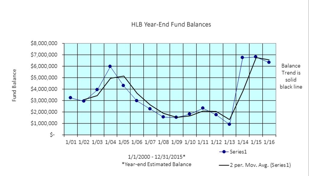
53 C-3
54 page 1 of 3 APPENDIX D: ACTIVE HLB CONTRACTS Permit# Permittee/Lessee HLB No. Site or Legal Address/ TID# Use Permit Term Bill Cycle Amt./Rate COI Exp JC Penney Co. N/A Chugach Electric Assoc A Alyeska Resort Mgmt Co sublease from Seibu USFS Redmond, H.R (ptn.) Alascom, Inc. dba AT&T Contact: Jim Wicks (Alaska Wireless Network - surcharge) 6-048; 6-049; SOA DNR/Div Parks & Outdoor Recreation & Air bridge attached to Blk 71, Lot 1A, Original Anchorage Townsite (TID (adj bdg Sky bridge SE1/4 SE1/4 SE1/4, Sec 33, T13N R3W, ASLS (TID ) Dowling Substation 55 yrs (1/29/73-1/28/2028) 50 yrs (8/23/1966-8/22/2016) Annual $ 2, /1/2017 annual; 5- yr intervals $ 1, /1/ acres: Tract E, T10N, R2E, Sec. 9 Alyeska Subd. (TID ) Hotel/resort 4/1/93-3/31/2048 Monthly variable 12/1/2016 Lot 72 ptn., USS 3042 NW4 SEC 19 T10N R2E (TID ) government facility 5/1/1988-4/30/2023 N/A $50,000 in 1988 N/A 47,775 sq.ft. in Sec.19, T10N R2E (TID ) Industrial storage Annual: 1/1/16-12/31/16 Annual $ 1, /10/2016 Lots 12, 13, 14 (ptn), Blk 2 Girdwood Original Townsite (TID , 39, 53) telecommunication towers 1/1/ /31/2018 annual + surcharge $ Jan16 + surcharge NLT Mar 31 6/1/2016 Lt. 17 SEC 16 T15N R1W; Tract B Spring Creek Subd. (PID ; ) Ptarmigan Valley trailhead 11/4/ /3/2021 N/A N/A self-insured USDOT/FAA 4-034, 4-033A ptn of E2 T13N R4W SEC 31 (North 550' E2SE4NE4SE4 and North 550' W2SW4NW4SW4 T13N R4W SEC 32)(PID )(PID ) west end of runway and includes Non-Directional Beacon Site 7/1/1996-9/30/2016 N/A N/A Federal Tort Claims Act of 1948, as amended (28 USC 2671 et seq) Anchorage Fueling and Service Co Girdwood Volunteer Fire & Rescue, Inc. Tidelands on west side of ARR ROW and 1 Port leased parcel approx acres between Port and TSAIA 12" pipeline 10/12/ /11/ (ptn.) Girdwood Industrial Park Lot 27 (pre-lim Plat S )(TID ) monthly access fee + annual surcharge $ /mo. 9/30/2016 Connex storage; fire-fighting training (no live burns) Annual: 1/1/16-12/31/16 N/A N/A 7/1/ Alaska Botanical Garden, Inc , 40, 41, T13N R3W SEC 35 (ptn); Tract B Save II Subd (ptn)(plat 90-67) ( acres) botanical garden 2/1/2003-1/31/2058 Annual $600 4/16/ Global Tower Partners (GTP) Towers II, LLC/Managed by American Tower Corp (ptn) ADL Lt 2 E2 T15N R2W SEC 36 (ptn) (PID ) telecommunications tower 8/15/08-8/14/18 monthly $ /1/ Andrew J. Hehnlin dba On-Site Snow Removal (ptn.) 6250 sq.ft. in Sec. 19, T10N, R2E (TID ) proposed Girdwood Industrial Park Subd. Ph I Block 2 portions of Lot 4 & 5 vehicle, materials storage Annual: 1/1/16-12/31/2016 Annual $ 1, /20/2016; bond exp Brother Francis Shelter Lot 1-A, Blk. 34-B, OAT homeless shelter 12/ /2043 Annual $ /1/ Chugach Powder Guides 6-295, 6-296, (ptns) Sec's. 3 & 10, T10N R2E No applicable TID # recreation access, Snocat operations and trail maintenance 2/3/ /31/2017 Annual $ 1, /1/ Girdwood Parks & Rec 6-076, (ptns) Girdwood South Townsite, Tracts D-5 & G-6 Frisbee Golf 5/1/2015-4/30/2016 Annual N/A N/A Page 1 of 3
55 page 2 of 3 APPENDIX D: ACTIVE HLB CONTRACTS Permit# Permittee/Lessee HLB No. Site or Legal Address/ TID# Use Permit Term Bill Cycle Amt./Rate COI Exp , & 6- Tracts D-5 & G-7 Girdwood South Townsite; 6/20/08 until permanent PM&E Intra-governmental Permit 149 Tract 1 Glacier View Estates Library Parking parking installed N/A ACS Easement A, B & Pt. Woronzof area Non-Exclusive utility easement Expires 4/29/2028 one time $ 100, /1/2016 Parks & Rec. Intra-governmental Permit Tract F, Alyeska Subd. Trail construction, maintenance No expiration N/A N/A N/A The Salvation Army (Clitheroe Center) (ptn.) 8000 W End Rd; SE4SE4NW4 Sec 32 T13N R4W Rehabilitation Facility 1/1/16-12/31/16 Quarterly 18,300/qtr. 10/1/ SOA/Dept. of Admin. GSA Tract 3 Tudor Municipal Campus Subd Crime Lab 3/01/09-2/28/59 $1/yr. self-insured Northern Lodging, LLC dba Ramada Downtown Anchorage Girdwood Board of Supervisors (ptn) Lot 7A, Block 118, Anchorage Original Townsite parking lot (3rd and A) Ramada parking 3/14/09-4/01/2019 Annual $ 9, /16/2016 Lot 6 Block 3 Proposed Girdwood Industrial Park Subd.; USS 3042 Lot 71 T10N R2E equipment storage; road materials & related activities Annual: 1/1/16-12/31/16 Annual waived N/A Chugach Adventure Guides GW Alpine Hut sale of hut, lease of land Expires: 6/30/2018 Annual $ 1, /1/ ACDA 4-004, 4-005, Parking lot (7th & I) downtown parking 11/1/12-10/31/15; Month-to- Month eff 11/1/15 Monthly $ 3, /31/ Girdwood Parks & Rec Moose meadows: connex box storage Expires 4/30/ years $500 N/A Alaska Ocean Products, LLC (ptn) 29, 091 sq ft of Lot 2, US Survey 4805, T10N R2E Sec 33 Study silt composition in Turnagain Arm; vehicle & equipment use on Premises Bi-Annual: 11/1/14-10/31/2016 Bi-Annual $2500/2 yr term 10/29/ SOA/DOT&PF/TSAIA (ptn.) E2 ptn, T13N, R4W, Section 31 (TID ) geotech survey Annual: 01/01/16-12/31/16 N/A waived self-insured Girdwood Parks & Rec Intragovernmental Permit (ptn) ptn 10N R2W SEC 3 Four Corners Tram management 8/16/2011-8/15/ years waived N/A ML&P Intra-governmental Permit Porcupine Dr electrical service Perpetual N/A waived N/A GEO Contracting, LLC (ptn) Proposed Ph I Lot 3 Bl 2 Girdwood Industrial Park and partial use Lots 2 & 4 Bl 2 GWIP (see pre-liminary plat) Equip. Storage Annual:1/1/16-12/31/16 Annual $ 1, /1/2016 Robert Wolfe dba Snow Free Snowplowing (ptn) Girdwood Industrial Park Lot 3, Blk 3 Sand, equip. storage Annual: 1/1/16-12/31/16 Annual $ 1, /22/ Alaska Pollution Control (APC) (ptn) Girdwood Industrial Park Lot 4 Bl 3 dirt & equip. storage Annual: 8/1/15-7/31/16 annual $ 1, /27/ AKRR (ptn.) Howitzer pad located along Seward Hwy. Howitzer/avalanche control 1/1/ /31/2017 annual $500 self insured GCI Cable, Inc NW4 Sec. 5, T10N R1W (TID ) Telecomm. Easement 20 years (1/1/ /31/2030) annual -adjust at 5 year intervals $ 2, /31/ Chugach Electric Assoc C Lot 1, ASLS in Sec15, T10N, R1W, Bird Creek Page 2 of 3 Lease 20 yrs (7/13/2012-1/31/2032) annual - adjust at 5 year intervals $ 1, /1/ PM&E Intra-governmental Permit Tract G-1D, Strawberry Meadows Install/monitor piezometers 5 years (2018) N/A N/A N/A PM&E Intra-governmental Permit 5-002A Lot 3, ASLS Install/monitor piezometers 5 years (2018) N/A N/A N/A
56 page 3 of 3 APPENDIX D: ACTIVE HLB CONTRACTS Permit# Permittee/Lessee HLB No. Site or Legal Address/ TID# Use Permit Term Bill Cycle Amt./Rate COI Exp E.R. Parks & Rec Intra-governmental Permit (ptn) ADL Lot 2 E2 T15N R2W SEC 36 (ptn.) 2,500 sq.ft. fenced storage of equipment & supplies 11/1/13-10/31/ years N/A N/A AWWU Intra-governmental Permit 3-042, 43 (TID & 03) water well drilling 12/20/13-3/21/2014 one-time $ N/A Alaska Sled Dog Racing Association Far North Bicentennial Park Several parcels in Zone 3 dog sled trails 11/01/15-10/31/16 annual varies (P&R) 2/5/ Backroads 6-011, Girdwood trails hiking/tourism 6/10/15-8/30/15 annual $750 2/1/ SOA/DOT&PF - Seward Hwy Avalanche Program 6-060, 6-071, 72, 73 & 74B Karlsburg Avalanche Path along Orca Ridge on E side of Girdwood Valley brush cutting, clearing & removal of deadfall 5/1/15-4/30/16 annual waived SOA self-insured Xanterra Adventures, LLC dba Austin Adventures+C , Winner Creek/Glacier Creek trails hiking/tourism 6/1/15-8/31/15 annual $ /15/ Chugiak Vol Fire & Rescue FS#35 Lease Glenn Hwy, Fire Station 35 Lease 8/11/14-12/31/2069 one-time $55 7/1/ Chugiak Vol Fire & Rescue LUP Glenn Hwy, Parcel next to Fire Station 35 Permit: parking 7/24/14-7/24/17 N/A waived 7/1/ Alien Species Control, Inc A-1 Mt. View Development; NE corner of Glenn H Permit: Invasive Plant Species Abatement 8/24/14-10/1/17 3 years waived 8/15/ Girdwood Board of Supervisors (ptn) Girdwood Town Square Park & Ride Facility Permit: Operate & Maintain GW Park & Ride Facility 7/1/15-6/30/16 annual waived NO insurance req'd for GBOS Boys & Girls Clubs of Southcentral Alaska; Woodland Park W 36th T13N R4W Sec 25 NW4NW4SW4 Woodland Park School (TID ) Lease: Operate Boys & Girls Club; Ice Rink Mgmt Agreement 6/01/2015-5/31/ years $1/yr 12/31/ Girdwood Forest Fair, Inc Tracts G-6, Girdwood South Townsite (PID ) tent camping 7/2/2015-7/5/ days $500/yr ($5,000 security) 10/1/ McKenna Bros. Paving Co ptn Airport Access Road on GLO Lots 1-4, T13N R4W Sec 31 (PID ) FAA Lease property access to transport Lk Hood muck 7/1/15-7/15/15 2 weeks $1,000 *** Alaska Park Airport Valet Parking - a TDX Co. Formerly Former Armory Lot 2 Airport Gateway Subd (Plat ) 4902 Spenard (PID ) Performance Measure 11/30/ /29/ years N/A N/A Anchorage Coastal Wildlife Refuge Management Agreement various HLB & P&R parcels See pg 1-3 Memorandum of Agreement mgmt of muni lands in ACWR 8/24/15 - mutual termination N/A self-insured Girdwood Nordic Ski Club 6-011, 6-251, 6-295, Public Use Easement recorded on 8/3/09 approx 5 km x 30' 7/29/09-7/28/29 20 years N/A 11/1/2016 **COI Exp. = Certificate of Insurance Expiration (if applicable) Page 3 of 3
57
58
59 APPENDIX F Response to Public and Community Council Comments on the Draft 2016 HLB Work Program/ Five-Year Plan April 2016 Chapter 1 Commenter Comment Response Decline. Turnagain Community Council (TCC) TCC TCC P.4 A spreadsheet of leases and permits currently held by the HLB is attached as Appendix D and is also available online. P.7 Reinsert A graph in Appendix C of this document outlines the fund s activities since 1983, showing annual fund balance at the end of each year, and a trend line of the moving average from year to year. P.7 Disposing of improved lands excess to municipal need, both immediate need and potential future need, from its inventory to the appropriate municipal agency with the capability to manage and utilize improved facilities. We chose to remove the references to the appendices to eliminate confusion as the document is updated from year to year. The appendices are listed below the Table of Contents and are no longer being listed throughout the document. Decline. We chose to remove the references to the appendices to eliminate confusion as the document is updated from year to year. The appendices are listed below the Table of Contents and are no longer being listed throughout the document. Decline. Code does not require land to be improved to transfer to municipal agencies. AMC D. TCC P.9 Add In addition, HLB maintains a standing list of people who request to receive notification of proposed HLB actions, and will mail notices of all proposed actions to this list. Accept. Will add to after maintain on its webpage. Chapter 2 Commenter Comment Response Partial acceptance. Rabbit Creek Community Council (RCCC) P. 13 Restate that the Master Plan lists trails only in parcel Also include the option to survey the wetlands in and deed the rest to the Parks & Recreation Dept. We will reference the Section 36 Master Plan for clarity. A statement regarding the intention to conduct a wetland delineation, G:\Real Estate\Heritage Land Bank\Work Plan\2016\2016 HLB Work Plan draft Appendix F revised docx
60 APPENDIX F Response to Public and Community Council Comments on the Draft 2016 HLB Work Program/ Five-Year Plan April 2016 consider/record a conservation easement, and likely transfer management authority to P&R will be added to this section and consistently throughout the document. Chapter 3 Commenter Comment Response RCCC Restate that the Master Plan lists trails only in parcel Also include the option to survey the wetlands in and deed the See above statement. rest to the Parks & Recreation Dept. RCCC P. 18 Revise: HLB Parcel This acre parcel located above Potter Valley was offered for sale in 2007, 2008, 2009, and 2012 by sealed bid sale, and received no bids. The parcel is being actively marketed at this time, noting that in accordance with the Potter Valley Land Use Study, conditions of the sale require that open space and parkland be reserved by the developer as part of the subdivision platting process. Staff will provide market analysis to indicate whether there is a strong demand that will yield a top purchase price: and if there is no such indication, HLB will withdraw this property from the market. If the parcel remains on the market, staff intends to pursue re-platting the property to enable a more efficient sale and will involve MOA Parks and Recreation and Rabbit Creek Community Council in discussions and proposed re-platting, in order to ensure that community needs are met and adopted plans are followed. Decline. We will adhere to the Potter Valley Land Use Study and we will follow all codes related to public noticing. RCCC P. 21: The southern part of Section 36 encompasses 252 acres, including approximately 92 acres of wetlands and creek corridors. These portions of Section 36 may be added to the HLB Mitigation Bank for conservation of habitat and other ecological values. Trail easements or access through the wetlands areas of Section 36, parcel will need to be defined prior to issuance of a conservation easement: or the non-wetland Partial acceptance. We accept the edits related to acreage of tracts and wetland areas. The MOA will retain the deed to the parcels; our process is to transfer management authority. When it becomes necessary, the wetlands will be delineated, a conservation easement considered/recorded, and likely G:\Real Estate\Heritage Land Bank\Work Plan\2016\2016 HLB Work Plan draft Appendix F revised docx
61 TCC TCC APPENDIX F Response to Public and Community Council Comments on the Draft 2016 HLB Work Program/ Five-Year Plan April 2016 areas may be delineated and deeded to the Parks & Recreation Dept. P.20 TCC requests to be provided a list of the Mayor s requested State-owned parcels to be transferred to the Municipality, to ensure State-owned land that has served as important, long-term wildlife habitat, natural open space, and recreational and parkland uses are included in this list. P.20 The list of requested properties some of these parcels will be disposed of by the entire two tracts will be transferred to the management of P&R. N/A. HLB staff does not have this list. Please forward request to the Mayor s Office. Accept CHAPTER 4 Commenter Comment Response RCCC P. 25: HLB Parcels through 2-134, and and 2-136: Parcels and 2-136, also located in the Potter Valley area, zoned PLI, may be considered for survey or replat once new developments and onsite evaluations are determined, to allow for residential and access reserve through a portion of and access through a portion of 2-135, per the Potter Valley Land Use Analysis and AO Decisions will be compatible with the Potter Valley Land Use Analysis and other adopted plans, including, prescribed open space and any required agreement with the ADOT&PF and Department of Fish and Game. Parcels through should be surveyed with the intent of zoning them as PR open space, compatible with the management of Potter Marsh, as recommended in the Potter Valley Land Use Analysis. Most of and have also been recommended for long-term public open space. RCCC P. 25: HLB Parcel This approximately 9.63-acre parcel is a remnant from the sale of a portion of Tract B, Legacy Pointe, to AWWU in 2013, and will be considered for disposal. The parcel has public value in situ or in exchange for adjoining parcels for watershed protection or Potter Creek Greenbelt Partial acceptance. We accept adding parcels & the sentence regarding adhering to the PVLU Plan. The last sentence we decline to include. After discussion with Long-Range planning, it does not appear that is consistent with the recommendations of the PVLU Plan. Partial Acceptance. We accept the second sentence. The first sentence has not been adopted as a recommendation in an adopted plan. We G:\Real Estate\Heritage Land Bank\Work Plan\2016\2016 HLB Work Plan draft Appendix F revised docx
62 APPENDIX F Response to Public and Community Council Comments on the Draft 2016 HLB Work Program/ Five-Year Plan April 2016 enhancement and access, as noted by the Community Council. The parcel is within a Special Study Area of the Hillside District Plan, for eventual transportation connectivity between Goldenview Drive and Potter Valley Road; road and trail corridors may need to be reserved if the parcel is offered for disposal. would accept this as a comment during any public process related to an action for this parcel. RCCC RCCC P. 27: HLB Parcels & This site is being considered for inclusion including in the wetlands mitigation bank. HLB will work with Parks and Recreation or recreation user groups to allow trail access to and or through these parcels, in keeping with the adopted recreation plans for Storck Park and the rest of Section 36. At such a time as a conservation easement is placed on these parcels, they will be transferred to MOA Parks & Recreation for management and HLB will retain the conservation easement. An additional option is to survey the nonwetlands of 2-126, replat the non-wetlands and deed them to the MOA s Parks & Recreation Dept. Move this section to page 20 to list it under 2016 Potential Projects; broaden the possibilities. P. 28: Chugach State Park Access In order to improve access to Chugach State Park as the Anchorage 2020 Comprehensive Plan encourages, HLB will proactively work to expand public access to Chugach State Park from adjoining or nearby HLB lands. This may involve a public easement and management agreement with MOA Parks or CSP, or may result in exchanging certain HLB parcels, such as HLB Parcel in upper Bear Valley, adjacent to Chugach State Park. In return for state land of equal value elsewhere, the municipality could obtain lands which would have greater utility for public purposes. Chugach State Park has produced an access inventory and trails and access plans. HLB will work with the state and the public to accommodate some Partial Acceptance. Accept these proposed changes minus the last sentence. MOA will retain deed to parcels, management authority may be transferred out of HLB into P&R at some point in the future. Decline. We will keep this item in the 5-year plan; it is unlikely that any effort towards this will occur in G:\Real Estate\Heritage Land Bank\Work Plan\2016\2016 HLB Work Plan draft Appendix F revised docx
63 APPENDIX F Response to Public and Community Council Comments on the Draft 2016 HLB Work Program/ Five-Year Plan April 2016 of these desired access areas, and evaluate these parcels for issuance of access easement across HLB land to provide Chugach State Park access. P. 29 In the coming years, HLB will continue to work on these and other major activities: RCCC RCCC TCC 1. Periodically review and consult with municipal agencies and community councils to determine their need for HLB land to fulfill municipal purposes. Acquire strategic properties when required. Where such needs are identified, the affected agency will submit an application to the HLB that will then be processed to a final decision. Disposing of lands through sale, lease or exchange where doing so will achieve municipal purposes and is in the best interest of the MOA. Also periodically review and consult with municipal agencies to determine which land managed by such agencies should be returned to the HLB land inventory. P. 29: 7. Establishment of the HLB Mitigation Bank and other wetlands mitigation strategies to preserve valuable wetlands and aquatic resources throughout the MOA. The Mitigation Bank list will be public and include the ranking of the wetlands and their relative monetary value to the COE: and low-value HLB wetlands may be designated for other public benefits. P. 26 HLB Parcels and In the future, HLB will manage this land in a manner consistent with the newly adopted West Anchorage District Plan (2012), which provides for potential title and land management authority of these parcels to be transferred to the MOA Parks and Recreation Department, with the intent that it become permanently dedicated parkland. Detailed ordinance language should be written with community and agency input to ensure Accept. Consultation with municipal agencies and community councils is our policy. Decline. The MOA Prioritization list is public information and is used to determine priority for bank site inclusion. Monetary value has not been set; however, at such a time the bank is approved, the price of credits will be publically available. Decline. We will adhere to the West Anchorage District Plan and reference it as such. Additional detail is not necessary. We will add plan adoption year for clarity (West Anchorage District Plan (2012)). G:\Real Estate\Heritage Land Bank\Work Plan\2016\2016 HLB Work Plan draft Appendix F revised docx
64 APPENDIX F Response to Public and Community Council Comments on the Draft 2016 HLB Work Program/ Five-Year Plan April 2016 TCC all easements, plat notes and restrictions are appropriately included in the land transfer. This would conform to the WADP Park Objective #6; permanently preserve the Tony Knowles Coastal Trail as a well-maintained, continuous public recreational corridor with vegetative buffer from Kincaid Park to Westchester Lagoon parks and natural resource, and potentially major transportation facility uses for these parcels. P 27. The list of requested properties to be transferred to MOA ownership has been well received and it is anticipated that some of these parcels will be disposed of to the by the State of Alaska to the MOA during the 5-year work plan horizon. Accept. G:\Real Estate\Heritage Land Bank\Work Plan\2016\2016 HLB Work Plan draft Appendix F revised docx
65 Municipal Clerk's Office Approved Date: 06/21/2016 Submitted by: Chair Gray-Jackson at the Request of the Mayor Prepared by: Real Estate Department/ Heritage Land Bank For reading: May 24, 2016 ANCHORAGE, ALASKA AR No A RESOLUTION APPROVING THE HERITAGE LAND BANK 2016 ANNUAL 2 WORK PROGRAM AND FIVE-YEAR MANAGEMENT PLAN. 3 WHEREAS, pursuant to AMC , it is the mission of the Heritage Land 4 Bank (HLB) to manage uncommitted municipal land and the HLB Fund in a 5 manner designed to benefit the present and future citizens of Anchorage, promote 6 orderly development, and achieve the goals of the Comprehensive Plan; and 7 8 WHEREAS, pursuant to AMC B, the HLB Advisory Commission 9 (HLBAC), following public notice and hearing, shall recommend and submit for 10 Assembly approval an Annual Work Program and a Five-Year HLB Management 11 Plan (Plan) not less than once every five years that identifies proposed land 12 acquisition, management, transfer, inventory and disposal objectives; and WHEREAS, HLBAC held a public hearing on April 14, 2016 approving HLBAC Resolution recommending Assembly approval of the Plan; now, therefore, THE ANCHORAGE ASSEMBLY HEREBY RESOLVES: Section 1: The HLB 2016 Annual Work Program and Five-Year Management Plan is hereby approved. Section 2: This resolution shall take effect immediately upon approval by the Assembly. PASSED AND APPROVED this 215t day of June, ATTEST: Municipal Clerk ' fl/aa ~ -~ air ()

66 MUNICIPALITY OF ANCHORAGE ASSEMBLY MEMORANDUM No. AM Meeting Date: May 24, FROM: MAYOR SUBJECT: A RESOLUTION APPROVING THE HERITAGE LAND BANK 2016 ANNUAL WORK PROGRAM AND FIVE-YEAR MANAGEMENT PLAN The administration forwards for your consideration a Resolution approving the proposed Heritage Land Bank (HLB) 2016 Annual Work Program and Five-Year Management Plan (Plan). Pursuant to AMC B, the HLB shall submit and the HLB Advisory Commission (HLBAC) shall recommend for Assembly approval a Plan not less than once every five (5) years. This Plan serves as a set of guidelines and proposed activities to accomplish the purpose and mission of HLB. The Plan is subordinate to and must comply with all Assembly approved regional and comprehensive plans. The Plan includes details regarding HLB proposed land acquisitions, inventory, management, transfers and disposal activities, including revenues and expenditures of the HLB Fund. AMC B also requires public notice of not less than forty-five (45) days prior to a public hearing by the HLBAC on the Plan. On March 1, 2016, the draft Plan was publicly noticed online and made available for download and sent to all municipal agencies, community councils and municipal department directors for review and comment. On April 14, 2016, HLBAC conducted a public hearing and approved HLBAC Resolution recommending Assembly approval of the Plan. The HLB requests your favorable consideration. Prepared By: Real Estate Department Approved: Tammy R. Oswald, Real Estate Department Director Concur: Christopher M. Schutte, OECD Director Concur: Michael K. Abbott, Municipal Manager Respectfully submitted: Ethan A, Berkowitz, Mayor Attachments: 2016 HLB Work Program & Five-Year Management Plan Appendix A: Maps Appendix B: Policies Appendix C: HLB Fund Balance Report Appendix D: Leases and Permits Appendix E: HLBAC Resolution Appendix F: Response to Public and Community Council Comments
HERITAGE LAND BANK HERITAGE LAND BANK ANNUAL WORK PROGRAM and FIVE-YEAR MANAGEMENT PLAN
 HERITAGE LAND BANK 2016 ANNUAL WORK PROGRAM and Municipality of Anchorage Ethan A. Berkowitz, Mayor MUNICIPALITY OF ANCHORAGE Ethan Berkowitz, Mayor Real Estate Department Tammy R. Oswald, Executive Director
HERITAGE LAND BANK ANNUAL WORK PROGRAM and FIVE-YEAR MANAGEMENT PLAN
 HERITAGE LAND BANK 2012 ANNUAL WORK PROGRAM and 2013-2017 FIVE-YEAR MANAGEMENT PLAN MUNICIPALITY OF ANCHORAGE Daniel A. Sullivan, Mayor REAL ESTATE DEPARTMENT Heritage Land Bank Division Tammy R. Oswald,
Public Review Draft HERITAGE LAND BANK. Municipality of Anchorage. Real Estate Department Robin E. Ward, Executive Director
 [Type here] Municipality of Anchorage Ethan A. Berkowitz, Mayor Public Review Draft HERITAGE LAND BANK Real Estate Department Robin E. Ward, Executive Director Heritage Land Bank Division Nicole Jones-Vogel,
HERITAGE LAND BANK. Municipality of Anchorage. Real Estate Department Robin E. Ward, Executive Director. Heritage Land Bank Division
 [Type here] Municipality of Anchorage Ethan A. Berkowitz, Mayor Real Estate Department Robin E. Ward, Executive Director Heritage Land Bank Division Nicole Jones-Vogel, Land Management Officer Tawny Klebesadel,
Real Estate Department Anchorage: Performance. Value. Results.
 Anchorage: Performance. Value. Results. Mission Manage all municipal land, both uncommitted and under management authority of municipal agencies, in a manner designed to benefit present and future citizens,
Real Estate. Economic & Community Development. Real Estate Approved General Government Operating Budget. Real Estate. Heritage Land Bank
 Economic & Community Development Heritage Land Bank Services Leases RED - 1 Department Description Manage all municipally owned land, both uncommitted and under management authority of municipal agencies,
CHAPTER 21.01: GENERAL PROVISIONS
 CHAPTER 21.01: GENERAL PROVISIONS 21.01.010 TITLE AND EFFECTIVE DATE... 1-2 21.01.020 AUTHORITY... 1-2 21.01.030 PURPOSE OF THIS TITLE... 1-2 21.01.040 APPLICABILITY AND JURISDICTION... 1-3 A. General...
MITIGATION POLICY FOR DISTRICT-PROTECTED LANDS
 MITIGATION POLICY FOR DISTRICT-PROTECTED LANDS Approved by the District Board of Directors on July 18, 2017 The following Mitigation Policy is intended to inform the evaluation of environmental mitigation-related
CURRENT THROUGH PL , APPROVED 11/11/2009
 CURRENT THROUGH PL 111-98, APPROVED 11/11/2009 TITLE 10. ARMED FORCES SUBTITLE A. GENERAL MILITARY LAW PART IV. SERVICE, SUPPLY, AND PROCUREMENT CHAPTER 159. REAL PROPERTY; RELATED PERSONAL PROPERTY; AND
MUNICIPALITY OF ANCHORAGE PLANNING AND ZONING COMMISSION RESOLUTION NO
 MUNICIPALITY OF ANCHORAGE PLANNING AND ZONING COMMISSION RESOLUTION NO. 0-07 A RESOLUTION SUPPORTING THE APPROVAL AND ADOPTION OF THE ANCHORAGE WETLANDS MANAGEMENT PLAN. (Case 0-09) WHEREAS, the Anchorage
Chapter 100 Planned Unit Development in Corvallis Urban Fringe
 100.100 Scope and Purpose. Chapter 100 Planned Unit Development in Corvallis Urban Fringe (1) All applications for land divisions in the Urban Residential (UR) and Flood Plain Agriculture (FPA) zones within
Conservation Easement Stewardship
 Conservation Easements are effective tools to preserve significant natural, historical or cultural resources. Conservation Easement Stewardship Level of Service Standards March 2013 The mission of the
Real Estate Services Division Real Estate Department Anchorage: Performance. Value. Results.
 Anchorage: Performance. Value. Results. Purpose The (RES) provides effective property management of all municipal lands and leased properties, and administers the foreclosure process of delinquent property
MASTER INTERLOCAL AGREEMENT FOR GROWTH MANAGEMENT ACT IMPLEMENTATION IN YAKIMA COUNTY TABLE OF CONTENTS
 MASTER INTERLOCAL AGREEMENT FOR GROWTH MANAGEMENT ACT IMPLEMENTATION IN YAKIMA COUNTY TABLE OF CONTENTS I. PREAMBLE A. Purpose... 1 B. Background... 2 II. AGREEMENT A. Parties to Agreement... 3 B. Authority...
3.23 LANDS AND SPECIAL USES
 3.23 LANDS AND SPECIAL USES Introduction This section addresses those aspects of SJPLC management relating to public land ownership and use. Special Use Permits, rights-of-way (ROW) grants, easements,
REGENTS POLICY PART V FINANCE AND BUSINESS MANAGEMENT Chapter Real Property
 REGENTS POLICY PART V FINANCE AND BUSINESS MANAGEMENT Chapter 05.11 Real Property P05.11.010. Purpose and Scope. A. This chapter establishes guidelines for the prudent management, including trust management,
MIDWAY CITY Municipal Code
 MIDWAY CITY Municipal Code TITLE 9 ANNEXATION CHAPTER 9.01 PURPOSE CHAPTER 9.02 GENERAL REQUIREMENTS CHAPTER 9.03 PROPERTY OWNER INITIATION OF ANNEXATION CHAPTER 9.04 PROCEDURES FOR CONSIDERATION OF PETITION
INVENTORY POLICY For Real Property
 INVENTORY POLICY For Real Property (Consolidated Revenue Fund Entities) Page 1-10 CONTENTS 1. TITLE... 3 2. OVERVIEW... 3 3. PURPOSE... 3 4. POLICY STATEMENT... 3 5. APPLICATION... 7 6. EVALUATION AND
PROJECT SCORING GUIDANCE. Introduction: National Proiect Selection:
 FOREST LEGACY PROGRAM PROJECT SCORING GUIDANCE Introduction: This document provides guidance to the National Review Panel on how to score individual Forest Legacy Program (FLP) projects, including additional
Transfer of Development Rights
 Ordinance Transfer of Development Rights King County s (WA) 2008 ordinance establishes a transfer of development rights program. The ordinance: Sets eligibility criteria for sending and receiving sites
Chapter 10 Local Protection Measures
 The DPC fully supports the protection of private property rights and the DPC will work to ensure that there will be no negative impacts stemming from NHA activities on private property, should the designation
Project File #: SF Project Name: Jackson Ranch Filing No. 4 Parcel Nos.: , and
 COMMISSIONERS: DARRYL GLENN (PRESIDENT) MARK WALLER (PRESIDENT PRO TEMPORE) STAN VANDERWERF LONGINOS GONZALEZ PEGGY LITTLETON PLANNING AND COMMUNITY DEVELOPMENT DEPARTMENT CRAIG DOSSEY, EXECUTIVE DIRECTOR
Town of Bristol Rhode Island
 Town of Bristol Rhode Island Subdivision & Development Review Regulations Adopted by the Planning Board September 27, 1995 (March 2017) Formatted: Highlight Formatted: Font: 12 pt Table of Contents TABLE
TransNet Environmental Mitigation Program: Land Acquisition and Restoration Process and Criteria
 TransNet Environmental Mitigation Program: Land Acquisition and Restoration Process and Criteria On September 26, 2008, the San Diego Association of Governments Board of Directors (BOD) approved the attached
TRANSFERABLE DEVELOPMENT RIGHTS PROCESS GUIDE
 TRANSFERABLE DEVELOPMENT RIGHTS PROCESS GUIDE Clear Creek County Planning Department P.O. Box 2000 Georgetown, Colorado 80444 (303) 679-2436 - phone (303) 569-1103 - fax 1 PURPOSE: A Transfer of Development
NANTUCKET ISLANDS LAND BANK AFFORDABLE HOUSING POLICY Adopted by the vote of the Land Bank Commission on November 10, 2015
 NANTUCKET ISLANDS LAND BANK AFFORDABLE HOUSING POLICY Adopted by the vote of the Land Bank Commission on November 10, 2015 In recent history, the island of Nantucket has experienced a shortage of affordable,
INVENTORY POLICY For Real Property
 INVENTORY POLICY For Real Property (Broader Public Sector Entities) Page 1-12 CONTENTS 1. TITLE... 3 2. OVERVIEW... 3 3. PURPOSE... 3 4. POLICY STATEMENT... 3 5. APPLICATION... 7 6. EVALUATION AND REVIEW...
MUNICIPAL SERVICE BENEFIT UNIT (MSBU) CREATION AND ADMINISTRATION POLICY 16-01
 CREATION AND ADMINISTRATION POLICY 16-01") MUNICIPAL SERVICE BENEFIT UNIT (MSBU) CREATION AND ADMINISTRATION POLICY 16-01 PURPOSE: POLICY: The purpose of this policy is to provide an orderly and efficient method for utilizing the statutory authority
MUNICIPAL SERVICE BENEFIT UNIT (MSBU) CREATION AND ADMINISTRATION POLICY 16-01 PURPOSE: POLICY: The purpose of this policy is to provide an orderly and efficient method for utilizing the statutory authority
Implementation TOWN OF LEON COMPREHENSIVE PLAN 9-1
 9 Implementation 9.1 Implementation Chapter Purpose and Contents This element includes a compilation of regulatory and non-regulatory measures to implement the objectives of this comprehensive plan. The
Amended Noise Mitigation Plan
 1 of 54 Amended Noise Mitigation Plan Runway 9R/27L Expansion Project Broward County Aviation Department PREPARED BY: The Urban Group, Inc. The Jones Payne Group October 8, 2012 00010859-1 2 of 54 Amended
MINERAL COUNTY PLANNING STAFF FINDINGS OF FACT Proposed Elk Run at St. Regis. February 12, 2017
 MINERAL COUNTY PLANNING STAFF FINDINGS OF FACT Proposed The proposed is a five-lot subdivision and is located approximately one mile east of St. Regis on Old Highway 10 East. The property is located in
City of Philadelphia POLICIES FOR THE SALE AND REUSE OF CITY OWNED PROPERTY. Approved By Philadelphia City Council on December 11, 2014
 City of Philadelphia POLICIES FOR THE SALE AND REUSE OF CITY OWNED PROPERTY Approved By Philadelphia City Council on December 11, 2014 City of Philadelphia Disposition Policies December 2014 1 Table of
OFFICE OF THE CITY ADMINISTRATIVE OFFICER
 REPORT FROM OFFICE OF THE CITY ADMINISTRATIVE OFFICER Date: To: From: Reference: October 28, 2014 The Honorable Members of the City Council Miguel A. Santana, City Administrative Officer Chair Municipal
SPECIFIC RESPONSES TO AREA COMMISSION OPPOSITION :
 SPECIFIC RESPONSES TO AREA COMMISSION OPPOSITION 3-14-19: Area Commission reasons for opposition in black APPLICANT S RESPONSE IN RED. The comprehensive planning and design of stream restoration efforts
SEQRA (For Land Surveyors) Purpose of this Presentation
 Purpose of this Presentation") SEQRA (For Land Surveyors) Purpose of this Presentation Understand the basics and legal requirements of SEQRA Recognize the role that Land Surveyors play in the SEQRA Identify the problems posed by SEQRA
SEQRA (For Land Surveyors) Purpose of this Presentation Understand the basics and legal requirements of SEQRA Recognize the role that Land Surveyors play in the SEQRA Identify the problems posed by SEQRA
United States Post Office and Multi-Family Residential; and, Single- Family Residence with an Apartment
 Planning Commission File No.: AME2013 0009 January 9, 2014 Page 2 of 9 Existing Land Use: United States Post Office and Multi-Family Residential; and, Single- Family Residence with an Apartment Surrounding
ARLINGTON COUNTY, VIRGINIA. County Board Agenda Item Meeting of June 17, 2017
 ARLINGTON COUNTY, VIRGINIA County Board Agenda Item Meeting of June 17, 2017 DATE: June 9, 2017 SUBJECT: Request to authorize advertisement of public hearings by the Planning Commission and County Board
The University of Texas System Systemwide Policy. Policy: UTS Title. Environmental Review for Acquisition of Real Property. 2.
 1. Title 2. Policy Environmental Review for Acquisition of Real Property Sec. 1 Sec. 2 Policy Statement. It is the policy of The University of Texas System to minimize its potential for exposure to claims
Public Improvement District (PID) Policy
 Policy") Public Improvement District (PID) Policy OVERVIEW Public Improvement Districts ( PIDs ), per the Texas Local Government Code Chapter 372 ( the code or PID Act ), provide the City of Marble Falls ( the
Public Improvement District (PID) Policy OVERVIEW Public Improvement Districts ( PIDs ), per the Texas Local Government Code Chapter 372 ( the code or PID Act ), provide the City of Marble Falls ( the
Implementation. Approved Master Plan and SMA for Henson Creek-South Potomac 103
 Implementation Approved Master Plan and SMA for Henson Creek-South Potomac 103 104 Approved Master Plan and SMA for Henson Creek-South Potomac Sectional Map Amendment The land use recommendations in the
Noise Mitigation Plan
 Runway 9R/27L Expansion Project Broward County Aviation Department PREPARED BY: The Urban Group, Inc. September 26, 2011 00010859-1 Noise Mitigation Plan Runway 9R/27L Expansion Project Prepared By: The
TRANSFER OF SURPLUS PROPERTIES USING NEW LEGISLATIVE AUTHORITIES
 TRANSFER OF SURPLUS PROPERTIES USING NEW LEGISLATIVE AUTHORITIES Harry H. Zimmerman Jr., PE Marstel Day, LLC (Formerly BAHR Environmental Company) NDIA 29 th Annual Environmental & Energy Symposium & Exhibition
SPECIAL PUBLIC NOTICE
 SPECIAL PUBLIC NOTICE U.S. ARMY CORPS OF ENGINEERS BUILDING STRONG LOS ANGELES DISTRICT APPLICATION FOR PERMIT Coachella Valley In-Lieu Fee Program Public Notice/Application No.: SPL-2013-00324-TOB Project:
Copyright 2019 Dominion Voting Inc. All Rights Reserved REGULAR ELECTION MUNICIPALITY OF ANCHORAGE APRIL 2, OFFICIAL BALLOT
 No. 1001, PCT: 105 ASSEMBLY DISTRICT 6 - SEAT J WEDDLETON, John SCHOOL BOARD - SEAT A BINKLEY SIMS, Kai BELLAMY, Margo SCHOOL BOARD - SEAT B MARSETT, Starr STAFFORD, Ronald NEES, David PROPOSITION. 1 CAPITAL
Noise Mitigation Plan
 1 of 61 Noise Mitigation Plan Runway 9R/27L Expansion Project Broward County Aviation Department PREPARED BY: The Urban Group, Inc. October 25, 2010 2 of 61 Noise Mitigation Plan Prepared By: The Urban
Neighborhood Renewal Program Policies and Procedures
 Neighborhood Renewal Program Policies and Procedures City of Mobile Neighborhood Renewal Program Policies and Procedures Table of Contents I. Mission Statement A. The New Plan for Old Mobile B. Goals and
Municipality of Anchorage WEST ANCHORAGE LAND TRADE TASK FORCE MEETING #5
 Municipality of Anchorage WEST ANCHORAGE LAND TRADE TASK FORCE MEETING #5 Wednesday, February 26, 2014 11:00 am 1:00 pm Federation of Community Councils Conference Room URS Corporation, Meeting Facilitators
Town of Falmouth s Four Step Design Process for Subdivisions in the Resource Conservation Zoning Overlay District
 Town of Falmouth s Four Step Design Process for Subdivisions in the Resource Conservation Zoning Overlay District All subdivisions shall be designed in accordance with the following four-step process.
13 Sectional Map Amendment
 13 Sectional Map Amendment Introduction This chapter reviews land use and zoning policies and practices in Prince George s County and presents the proposed zoning in the sectional map amendment (SMA) to
SUBDIVISION REGULATIONS
 CHAPTER 14 SUBDIVISION REGULATIONS 14-100 Provisions 14-200 Preliminary Plat 14-300 Final Plat 14-400 Replat 14-500 Minor Subdivision 14-600 Administrative Replat 14-700 Vacation of Roadways, Public Easements,
PRELIMINARY PROJECT PLAN AND REINVESTMENT ZONE FINANCING PLAN FOR PROPOSED TAX INCREMENT REINVESTMENT ZONE NO. 1, CITY OF OAK RIDGE NORTH
 PRELIMINARY PROJECT PLAN AND REINVESTMENT ZONE FINANCING PLAN FOR PROPOSED TAX INCREMENT REINVESTMENT ZONE NO. 1, CITY OF OAK RIDGE NORTH DECEMBER 15, 2014 TABLE OF CONTENTS 1. Overview 1.1 Background...
Marion County Board of County Commissioners
 Marion County Board of County Commissioners Date: 6/4/217 P&Z: 9/25/217 BCC Transmittal: 1/17/217 BCC Adopt: TBD Amendment No: 217-L6 Type of Application Large-Scale Comp Plan Amendment Request: Change
CHAPTER 23A: SURPLUS CITY PROPERTY ORDINANCE
 CHAPTER 23A: SURPLUS CITY PROPERTY ORDINANCE Sec. 23A.1. Sec. 23A.2. Sec. 23A.3. Sec. 23A.4. Sec. 23A.5. Sec. 23A.6. Sec. 23A.7. Sec. 23A.8. Sec. 23A.9. Sec. 23A.10. Sec. 23A.11. Sec. 23A.13. Sec. 23A.14.
LLANO CENTRAL APPRAISAL DISTRICT REAPPRAISAL PLAN FOR TAX YEARS 2017 & 2018 AS ADOPTED BY THE BOARD OF DIRECTORS
 LLANO CENTRAL APPRAISAL DISTRICT REAPPRAISAL PLAN FOR TAX YEARS 2017 & 2018 AS ADOPTED BY THE BOARD OF DIRECTORS TABLE OF CONTENTS ITEM PAGE Executive Summary 5 Revaluation Decision (Statutory or Administrative)
Monroe County, Tennessee Property Tax Incentive Program Policies and Procedures
 Monroe County, Tennessee Property Tax Incentive Program Policies and Procedures Revised 1/2010 MONROE COUNTY, TENNESSEE PROPERTY TAX INCENTIVE PROGRAM POLICIES AND PROCEDURES Section I General Purpose
TRANSFER OF DEVELOPMENT RIGHTS (TDR) ORDINANCE Revised November 2013
 ORDINANCE Revised November 2013") ARTICLE III Transfer of Development Rights (TDR) Program Part 301 Establishment and Purpose. 165-301.01. Purpose. Pursuant to the authority granted by 15.2-2316.1 and 2316.2 of the Code of Virginia, there
ARTICLE III Transfer of Development Rights (TDR) Program Part 301 Establishment and Purpose. 165-301.01. Purpose. Pursuant to the authority granted by 15.2-2316.1 and 2316.2 of the Code of Virginia, there
UNIFORM RULE 5. Administration of Williamson Act Contracts
 UNIFORM RULE 5 Administration of Williamson Act Contracts I. PROCEDURE TO ESTABLISH AN AGRICULTURAL PRESERVE AND WILLIAMSON ACT CONTRACT See Appendices 1 and 2 for the following forms: Application Form
Su-Knik Mitigation Bank Modification Memorandum
 Su-Knik Mitigation Bank Modification Memorandum Regarding: Request for Approved Instrument Modification for the Su-Knik Mitigation Bank (Expansion of the Su-Knik Mitigation Bank Service Area) Request:
OPEN SPACE & RECREATION PLAN
 OPEN SPACE & RECREATION PLAN HOPEWELL TOWNSHIP Cumberland County, New Jersey Prepared by: Hopewell Township Environmental Commission Final October 2011 (THIS PAGE INTENTIONALLY LEFT BLANK) PUBLIC MEETINGS
AB 346 (DALY) REDEVELOPMENT: HOUSING SUCCESSOR: LOW AND MODERATE INCOME HOUSING ASSET FUND JOINT AUTHOR ASSEMBLYMEMBER BROUGH
 REDEVELOPMENT: HOUSING SUCCESSOR: LOW AND MODERATE INCOME HOUSING ASSET FUND JOINT AUTHOR ASSEMBLYMEMBER BROUGH") AB 346 (DALY) REDEVELOPMENT: HOUSING SUCCESSOR: LOW AND MODERATE INCOME HOUSING ASSET FUND JOINT AUTHOR ASSEMBLYMEMBER BROUGH IN BRIEF Assembly Bill 346 would authorize a housing successor to use funds
AB 346 (DALY) REDEVELOPMENT: HOUSING SUCCESSOR: LOW AND MODERATE INCOME HOUSING ASSET FUND JOINT AUTHOR ASSEMBLYMEMBER BROUGH IN BRIEF Assembly Bill 346 would authorize a housing successor to use funds
CITY CLERK. Consolidated Clause in Policy and Finance Committee Report 7, which was considered by City Council on July 19, 20, 21 and 26, 2005.
 CITY CLERK Consolidated Clause in Report 7, which was considered by City Council on July 19, 20, 21 and 26, 2005. 3 Regent Park Revitalization - Financial Strategy (Ward 28) City Council on July 19, 20,
Central Pennsylvania Conservancy Project Selection Criteria Form
 Central Pennsylvania Conservancy Project Selection Criteria Form The following criteria guide the actions of the Central Pennsylvania Conservancy s Land Protection Committee and Board of Directors in selecting
Guide to Combined Preliminary and Final Plats
 Guide to Combined Preliminary and Final Plats Introduction The Douglas County is committed to providing open, transparent application processes to the public. This Guide is provided to assist anyone interested
Guide to Preliminary Plans
 Guide to Preliminary Plans Introduction The Douglas County is committed to providing open, transparent application processes to the public. This Guide is provided to assist anyone interested in the procedures
Special Use Permit - Planned Unit Development Checklist. Property Address:
 Special Use Permit - Planned Unit Development Checklist Special Use Permit Number. Parcel Code/s #28-11- - - Property Address: Applicant: ARTICLE VIII Ordinance Reference - Section 8.1.2 Permit Procedures:
CHAPTER Committee Substitute for Committee Substitute for Senate Bill No. 2188
 CHAPTER 2004-372 Committee Substitute for Committee Substitute for Senate Bill No. 2188 An act relating to land development; amending s. 197.502, F.S.; providing for the issuance of an escheatment tax
7. IMPLEMENTATION STRATEGIES
 7. IMPLEMENTATION STRATEGIES A. GENERAL APPROACH FOR IMPLEMENTATION Implementing the plan will engage many players, including the Municipality of Anchorage (MOA), the Government Hill Community Council,
Submittal of the Minutes from the March 9, 2011, April 5, 2011, and April 19, 2011 Cabinet Meetings.
 AGENDA BOARD OF TRUSTEES OF THE INTERNAL IMPROVEMENT TRUST FUND JUNE 16, 2011 Attachments to the items below can be viewed at the following link: http://www.dep.state.fl.us/secretary/cab/public_notices.htm
General Development Plan Background Report on Agricultural Land Preservation
 General Development Plan 2008 Background Report on Agricultural Land Preservation February 2008 I. Introduction Anne Arundel County has been an agricultural community for over 350 years, beginning with
APPENDIX 2 PROCEDURES AND SUPPLEMENTARY INFORMATION
 APPENDIX 2 PROCEDURES AND SUPPLEMENTARY INFORMATION APPENDIX 2 - PROCEDURES AND SUPPLEMENTARY INFORMATION 1. Building Code Act 1.1 General The Building Code Act provides the enabling authority for Councils
A. Preserve natural resources as identified in the Comprehensive Plan.
 1370.08 Conservation Residential Overlay District. Subd. 1 Findings. The City finds that the lands and resources within the Conservation Residential Overlay District are a unique and valuable resource
Rule 80. Preservation of Primary Agricultural Soils Revised and approved by the Land Use Panel during its public meeting on January 31, 2006.
 Rule 80. Preservation of Primary Agricultural Soils Revised and approved by the Land Use Panel during its public meeting on January 31, 2006. (A) Purpose. In accordance with 10 V.S.A. Sections 6025(b)
EXHIBIT A. City of Corpus Christi Annexation Guidelines
 City of Corpus Christi Annexation Guidelines Purpose: The purpose of this document is to describe the City of Corpus Christi s Annexation Guidelines. The Annexation Guidelines provide the guidance and
SENATE BILL No. 35. December 5, 2016
 AMENDED IN ASSEMBLY JULY 5, 2017 AMENDED IN ASSEMBLY JUNE 20, 2017 AMENDED IN SENATE MAY 26, 2017 AMENDED IN SENATE APRIL 4, 2017 AMENDED IN SENATE MARCH 21, 2017 AMENDED IN SENATE MARCH 9, 2017 AMENDED
VOLUNTARY SALES ASSISTANCE PROGRAM CONSISTING OF TWO OPTIONS:
 VOLUNTARY SALES ASSISTANCE PROGRAM CONSISTING OF TWO OPTIONS: STANDARD SALES ASSISTANCE PROGRAM & CONVEYANCE AND RELEASE PROGRAM POLICIES AND PROCEDURES MANUAL Broward County Aviation Department Fort Lauderdale
Town of Yucca Valley GENERAL PLAN 1
 Town of Yucca Valley GENERAL PLAN 1 This page intentionally left blank. 3 HOUSING ELEMENT The Housing Element is intended to guide residential development and preservation consistent with the overall values
CITY OF FORT COLLINS NATURAL AREAS AND CONSERVED LANDS EASEMENT POLICY
 CITY OF FORT COLLINS NATURAL AREAS AND CONSERVED LANDS EASEMENT POLICY Adopted January 3, 2012 PURPOSE: The purpose of the policy statement is to clarify the policies and procedures of the City of Fort
A Guide to the Municipal Planning Process in Saskatchewan
 A Guide to the Municipal Planning Process in Saskatchewan A look at the municipal development permit and the subdivision approval process in Saskatchewan May 2008 Prepared By: Community Planning Branch
EAST GOSHEN TOWNSHIP CHESTER COUNTY, PENNSYLVANIA ORDINANCE NO.
 EAST GOSHEN TOWNSHIP CHESTER COUNTY, PENNSYLVANIA ORDINANCE NO. AN ORDINANCE AMENDING THE EAST GOSHEN TOWNSHIP ZONING ORDINANCE OF 1997, AS AMENDED, WHICH IS CODIFIED IN CHAPTER 240 OF THE EAST GOSHEN
IRS FORM 8283 SUPPLEMENTAL STATEMENT DONATION OF CONSERVATION EASEMENT
 Name(s) shown on income tax return Identifying Number Robert T. Landowner 021-34-1234 Susan B. Landowner 083-23-5555 IRS FORM 8283 SUPPLEMENTAL STATEMENT DONATION OF CONSERVATION EASEMENT On November 12,
DESCRIPTION OF THE DISTRICT
 DESCRIPTION OF THE DISTRICT The project plan for City of Wausau, Tax Increment District #11 has been prepared in compliance with Wisconsin Statutes Chapter 66.1105(4). The plan establishes the need for
The Bonus Zoning policy will be applied in conjunction with the Implementation policies contained within the Official Plan.
 Policy Title: Bonus Zoning Policy Number: 07-03-01 Section: Community Development Subsection: Planning Tools Effective Date: September 26, 2012 Last Review Date: Approved by: Council Owner Division/Contact:
Barbara County Housing Element. Table 5.1 Proposed Draft Housing Element Goals, Policies and Programs
 Table 5.1 Proposed Draft Housing Element Goals, Policies and Programs Goal 1: Enhance the Diversity, Quantity, and Quality of the Housing Supply Policy 1.1: Promote new housing opportunities adjacent to
DOWNTOWN JANESVILLE. Business Improvement District Operating Plan
 DOWNTOWN JANESVILLE Business Improvement District Operating Plan 2019 TABLE OF CONTENTS Introduction..1 District Boundaries. 1 Proposed Operating Plan...1 Method of Assessment 4 Future Year Operating Plans...6
BY BOARD OF COUNTY COMMISSIONERS AN ACT TO BE ENTITLED
 BY BOARD OF COUNTY COMMISSIONERS ORDINANCE NO. AN ACT TO BE ENTITLED AN ORDINANCE AMENDING THE PASCO COUNTY LAND DEVELOPMENT CODE, ARTICLE 700, BY REPEALING EXISTING SECTION 702, ENVIRONMENTALLY SENSITIVE
Chapter SWAINSON S HAWK IMPACT MITIGATION FEES
 The Swainson s Hawk ordinance can also be viewed online at: http://qcode.us/codes/sacramentocounty/ Once at the website, click on Title 16 BUILDINGS AND CONSTRUCTION, then Chapter 16.130 SWAINSON S HAWK
DRAFT FOR PUBLIC HEARING (rev. March, 2016)
") Chapter 200. ZONING Article VI. Conservation/Cluster Subdivisions 200-45. Intent and Purpose These provisions are intended to: A. Guide the future growth and development of the community consistent with
Chapter 200. ZONING Article VI. Conservation/Cluster Subdivisions 200-45. Intent and Purpose These provisions are intended to: A. Guide the future growth and development of the community consistent with
Kitsap County Department of Community Development
 Kitsap County Department of Community Development Staff Report and Recommendation Annual Comprehensive Plan Amendment Process for 2018 Public Facility Designations and Park Classifications Update Report
AGENDA SHEET FOR COMMISSIONER S MEETING OF: December 7th, 2010
 AGENDA SHEET FOR COMMISSIONER S MEETING OF: December 7th, 2010 SUBMITTING DEPARTMENT: Parks, Recreation & Golf CONTACT PERSON: Doug Chase PHONE NUMBER: 477-2720 CHECK TYPE OF MEETING ITEM BELOW: BELOW
Public Notice U.S. ARMY CORPS OF ENGINEERS, GALVESTON DISTRICT AND TEXAS COMMISSION ON ENVIRONMENTAL QUALITY
 Public Notice U.S. Army Corps Permit Application No: SWG-2016-00384 Of Engineers Date Issued: 27 December 2018 Galveston District Comments Due: 29 January 2019 U.S. ARMY CORPS OF ENGINEERS, GALVESTON DISTRICT
GWINNETT COUNTY CSO CONSERVATION SUBDIVISION OVERLAY DISTRICT REQUIREMENTS
 GWINNETT COUNTY CSO CONSERVATION SUBDIVISION OVERLAY DISTRICT REQUIREMENTS Section 1316. CSO Conservation Subdivision Overlay District. 1. Purposes. The purposes of this overlay district are as follows:
78th OREGON LEGISLATIVE ASSEMBLY Regular Session. House Bill 2510 SUMMARY
 th OREGON LEGISLATIVE ASSEMBLY--0 Regular Session Sponsored by Representative CLEM (Presession filed.) House Bill 0 SUMMARY The following summary is not prepared by the sponsors of the measure and is not
SECTION 1 INTRODUCTION TO THE PANAMA CITY BEACH COMPREHENSIVE GROWTH DEVELOPMENT PLAN
 1. PURPOSE SECTION 1 INTRODUCTION TO THE PANAMA CITY BEACH COMPREHENSIVE GROWTH DEVELOPMENT PLAN The purpose of the City of Panama City Beach's Comprehensive Growth Development Plan is to establish goals,
Tejon Ranch Conservation and Land Use Agreement Executive Summary
 Tejon Ranch Conservation and Land Use Agreement Executive Summary The Tejon Ranch Company (TRC) and Audubon California, the Endangered Habitats League, Natural Resources Defense Council, Planning and Conservation
From Policy to Reality
 From Policy to Reality Updated ^ Model Ordinances for Sustainable Development 2000 Environmental Quality Board 2008 Minnesota Pollution Control Agency Funded by a Minnesota Pollution Control Agency Sustainable
Guide to Minor Developments
 Guide to Minor Developments Introduction The Douglas County (DCD) is committed to providing open, transparent application processes to the public. This Guide is provided to assist anyone interested in
Establishing a Wetland Bank in Minnesota
 Establishing a Wetland Bank in Minnesota Updated February 1, 2018 This document provides a general summary of the key steps in establishing an individual wetland bank site within the state wetland banking
KANSAS CITY, MISSOURI HOMESTEADING AUTHORITY POLICIES AND PROCEDURES
 DEFINITIONS KANSAS CITY, MISSOURI HOMESTEADING AUTHORITY POLICIES AND PROCEDURES Property costs: Property costs are those costs associated with the acquisition of a parcel of property. Project costs: Project
BLUEPRINT REAL ESTATE POLICY
 DATE September 19,2007 TITLE BLUEPRINT REAL ESTATE POLICY ORG. AGENCY Blueprint Intergovernmental Agency APPROVED.01 STATEMENT OF POLICY The purpose of this administrative regulation is to establish a
Guide to Replats. Step 1. Step 2. Step 3. Step 4. Step 5. Step 6. Step 7. Step 8. Step 9. Step 10
 Guide to Replats Introduction Douglas County is committed to providing open, transparent application processes to the public. This Guide is provided to assist anyone interested in the procedures and expectations