6. CIRCULATION AND INFRASTRUCTURE
|
|
|
- Wesley Lee
- 6 years ago
- Views:
Transcription
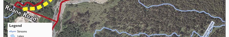
1 6. CIRCULATION AND INFRASTRUCTURE Existing Roads Alyeska Highway is the main arterial road providing ingress and egress to the Girdwood Valley. Alyeska Highway forms the northern border of the study area. Egloff Drive 1 is the southern extension of Hightower Road, which edges the eastern side of the town square in the North Townsite. Egloff Drive is a 1,400-foot-long gravel road within a 70-foot dedicated right-of-way, extending south, then west to the junction with Karolius Drive. Egloff Drive will provide the primary access to the South Townsite commercial district and the new Community Center/Library. The master plan recommends that this road, slightly realigned, become the new main street in the South Townsite neighborhood and that it be renamed South Hightower. Karolius Drive continues south from Egloff for approximately 1,700 feet to provide access to the only developed parcel in the Squirrel Cage area. South of the junction of Silver Fern Circle and Karolius Drive, there is only a platted, 70-foot right-of-way; no road improvements have been made. Ruane Road is a two-lane paved road approximately 1,000 feet in length. It extends from the Alyeska Highway east to the entrance to AWWU s sewage treatment facility and the Municipality of Anchorage Solid Waste Service s Girdwood Transfer Station. The Heritage Land Bank recently completed upgrades to Ruane Road at the south end of the study area to meet municipal standards and to improve access to the MOA s solid waste and AWWU s sewage treatment facilities. Upgrades include a new California Creek culvert, curb and gutter, and a paved drive surface. Construction of the improvements was completed in Existing Rights-of-Way Existing right-of-ways (ROW s) were platted with the original Girdwood Townsite First Addition subdivision in The ROW for major roads is 70 feet in width, while the access roads to individual lots are 50-foot ROW s. The major platted roads are Juniper (which connects Karolius Drive to the Alyeska Highway at the south end of the subdivision) and Glacier Avenue (which connects to the Alyeska Highway on the west from the junction of Egloff Drive and Karolius Drive). All of the remaining ROW s are access roads for the thirteen individual lot clusters. 1 Note: Hightower Road provides the main street for the North Townsite. Where it intersects Alyeska Highway, the roadway continues south through the South Townsite as Egloff Drive. This document will refer to the road in the South Townsite as Egloff Drive, although some plans and maps may refer to it as an extension of Hightower Road. Girdwood South Townsite Master Plan FINAL CIRCULATION AND INFRASTRUCTURE 6.1
2 Map 6.1 Existing Conditions Review Local, Platted and Proposed Roads and Trails 6.2 CIRCULATION AND INFRASTRUCTURE FINAL Girdwood South Townsite Master Plan
3 Traffic Analysis Because of the project study area s limited and recreationally-focused development, Egloff Drive and Karolius Drive are lightly travelled. Traffic counts for Alyeska Highway, between Crow Creek and Hightower Roads, indicate an Annual Average Daily Traffic count of 3,700 trips per day and an average annual growth exceeding 5% (cumulatively equaling 23%) over the most recent three years. The primary trip generator in the area is the Little Bears Day Care Center. The facility is estimated to attract approximately 100 trips per day, with 20 trips during the peak hour. The limited use of Glacier City Hall makes the estimation of daily traffic unreliable, but outside of monthly Board of Supervisor meetings traffic is likely limited. Similarly, the skateboard park, playground and ball fields are also considered minor traffic generators. Consequently, current traffic associated with the study area is considered minor and inconsequential. Post-Development Traffic The proposed master plan development will significantly increase traffic for the study area. At full build-out of the three phases, an estimated 3,000-4,000 trips per day will be attracted to the study area, resulting in a peak-hour load of approximately vehicles entering and exiting the area. The access and mobility requirements associated with these traffic loads will likely require upgrades to the Alyeska Highway/ Hightower-Egloff intersection, inclusive of auxiliary turning lanes with signalization or construction of a roundabout. Phase One Development Phase One proposes three new facilities: a relocated and expanded Little Bears Day Care Center, a gateway commercial building and a mixed-use commercial building. At full build-out, these facilities are estimated to generate 1,100 vehicle trips per day, with a peak-hour volume of 150 vehicles. Peak volumes for comparable facilities are typically evenly divided between entering and exiting vehicles. Even at full build-out, these traffic loads are unlikely to require any traffic control beyond the current stop-control measures for the north and south approaches to Alyeska Highway. Phase Two Development Phase Two proposes several new facilities: a community grocery store, shared with a small mixed-use commercial area, a relocated baseball field and a small campground. At full build-out these facilities are estimated to generate 1,800 vehicle trips per day, with a peak-hour volume of 170 vehicles. Peak volumes for comparable facilities are typically evenly divided between entering and exiting vehicles. Combined with Phase One, these traffic loads will probably require channelization (additional roadway lanes for turning movements) and an evaluation of possible warrants for signalization for the Alyeska Highway/Hightower-Egloff intersection. Phase Three Development Phase Three proposes a 43-unit residential development. At full build-out, these facilities are estimated to generate 400 vehicle trips per day, with a peak-hour volume of 40 vehicles. Peak Girdwood South Townsite Master Plan FINAL CIRCULATION AND INFRASTRUCTURE 6.3
 and an updated evaluation of possible warrants for")

")

4 volumes for comparable facilities are typically occur in the evening, and the majority of movements are entering vehicles. Combined with Phases Two and Three, these traffic loads will require channelization (if these improvements were not constructed during Phase Two) and an updated evaluation of possible warrants for signalization for the Alyeska Highway/Hightower- Egloff intersection. A connection to Ruane Road would significantly reduce the impact of this development on Egloff Drive and its intersection with Alyeska Highway. The upgrades to Ruane Road allows this traffic to likely be accommodated with minimal improvements to the Ruane/Alyeska Highway intersection CAT Plan Recommendations for Circulation Improvements Recognizing the interdependence of transportation and commercial activity, the 2001 Girdwood Commercial Areas and Transportation Plan (CAT) developed specific recommendations for circulation improvements to stimulate economic development in the Girdwood community. Reflecting the widely endorsed priorities of the Girdwood community, these recommendations included the following: Develop Hightower Road as Girdwood s Main Street. Provide improved public parking to support existing and future commercial activities in the New Girdwood Townsite. Improve year-round pedestrian facilities and connections throughout the New Girdwood Townsite, adjacent parks, neighborhoods and school. A central recommendation in both the earlier 1995 Girdwood Area Plan and the CAT Plan is the development of a collector road through the study area as a secondary access route in and out of the South Townsite and to provide convenient access to new development within the neighborhood. The route proposed for this road runs from the intersection of Alyeska Highway and Hightower Road, south on what is currently called Egloff Drive to Karolius Drive, and then continuing south to Ruane Road, where the collector would again intersect the Alyeska Highway. This route coincides with AWWU s sewer main line and its right-of-way. AWWU is supportive of the route because it would provide them with needed access to perform maintenance on their sewer line. The GAP, CAT, and OS&HP recommend different collector road systems in the area of the South Townsite. As the most recently adopted plan, the CAT is viewed as the adopted plan; however, its recommendations were never incorporated into the OS&HP. The Girdwood South Townsite Master Plan recommends a Collector I street at the intersection of Alyeska Highway and Egloff Drive, and extending it southward along the Karolius Drive alignment as shown in the CAT. However, instead of turning southwest and connecting to Alyeska Highway near the platted Juniper Drive connection, the plan recommends extending it southward to connect with Ruane Road (this connection most closely resembles the 1995 GAP). The plan also recommends dropping the connection from Glacier Creek Drive across California Creek to connect with Alyeska Highway west of Crow Creek Road, and instead recommends a 6.4 CIRCULATION AND INFRASTRUCTURE FINAL Girdwood South Townsite Master Plan
5 looped ladder road network to provide secondary access from the South Townsite to Alyeska Highway parallel to California Creek. Because the southern connection will occur in later phases, until a decision is made for the location of the southern connection of the collector road to Alyeska Highway, the platted ROW at Juniper Drive should be retained. In addition to this updated collector system, the plan recommends that Egloff be renamed to South Hightower and become a Main Street. Details on the road section are included in Chapter 8. There are challenges in building this collector road with the proposed alignment, as the extension of Karolius Drive south to Ruane Road would have to cross Class A wetlands. The unavoidable disturbance of wetlands would trigger the need for an extensive permitting process. Permits would be required from the Municipality, the Alaska Department of Environmental Conservation and the US Army Corps of Engineers, which would add significantly to preconstruction costs; mitigation measures would also add to the expense of construction. Consequently, this master plan proposes a different approach to building new roads through the South Townsite and accomplishing the second access (see Chapter 8). Girdwood South Townsite Master Plan FINAL CIRCULATION AND INFRASTRUCTURE 6.5


6 Map 6.2 Girdwood South Townsite Proposed Collector Road (GAP and CAT plans) 6.6 CIRCULATION AND INFRASTRUCTURE FINAL Girdwood South Townsite Master Plan
7 Girdwood Streets and Drainage Improvements Project (2008/2009) To construct the public improvements recommended by the CAT Plan, in 2004 the Alaska Department of Transportation and Public Facilities (ADOT&PF) was granted $10,600,000 in Federal funds to construct street and drainage improvement projects that facilitate and support economic development within the Girdwood community. Subsequently, ADOT&PF and the Municipality entered into a Transfer of Responsibility Agreement that permits the Municipality to administer $4,500,000 of the $10,600,000 grant appropriation for the design and construction of the Girdwood Streets and Drainage Improvements project. It is hoped that some of the grant funds will be available for use in improving the access road to the new library. Due to funding limitations, ADOT&PF and the Municipality solicited input from the Girdwood community through the Girdwood Board of Supervisors (GBOS) to prioritize potential construction projects. To meet the goals and objectives of the Girdwood Streets and Drainage Improvements project, the GBOS and Girdwood community prioritized potential projects based on the findings and recommendations of the CAT Plan. Three roadway segments of the New Girdwood Townsite were identified as the highest priorities: Hightower Road, Lindblad Avenue, and Holmgren Place. The project, named Girdwood Streets and Drainage Improvements (PM&E Project No , Highway Project No. HDP-0001 (307)/5705), is currently in the final design phase and is scheduled for construction in 2008/2009. The GBOS also identified the upgrade of Girdwood Place as a priority project for the community. It is being done as a separate project sponsored jointly by the Municipality of Anchorage People Mover and the Federal Transit Administration (FTA). This project provides a central location for Girdwood commuters to park their vehicles and board a shuttle for Anchorage. The project includes not only the upgrading of Girdwood Place, but also 42 onstreet parking spaces, a bus turnout and a surface parking lot containing 25 spaces. The project, named the Girdwood Transportation Center Park & Ride (PM&E Project No , FTA Project No. AK ), is currently in the construction phase and is expected to be completed in early The Municipality of Anchorage-FTA project is being coordinated with the Girdwood Streets and Drainage Improvements project. Alternate Modes of Transportation A key factor in the success of any community core area is the ability to minimize the intrusion of automobiles without sacrificing convenient access to commercial activity. Lacking access by modes of transportation in addition to vehicles, more area must be dedicated to parking than the community would like to see in order to support new commercial and residential uses. In Girdwood, a major north-south trail spine will provide some essential connections, but other modes of public transit are in their infancy or not yet fundable. The Girdwood South Townsite Master Plan recommends a continuing effort to examine the feasibility of multi-modal transit Girdwood South Townsite Master Plan FINAL CIRCULATION AND INFRASTRUCTURE 6.7


8 facilities to support commuter traffic into Anchorage and attract tourist traffic traveling between Anchorage and the cruise ship ports of Seward and Whittier. Pedestrian Connections Heavy snow levels in winter and the generally disconnected location of existing civic and commercial destinations in Girdwood have combined in the past to frustrate efforts to create a pedestrian network in the center of town. Future development in both the North and South Townsites, however, will be guided by new urban design guidelines that encourage more attention to pedestrian connections. Improved sidewalks were recognized in the CAT Plan as essential components of the circulation system. The plan insisted that the commercial area of the South Townsite have a complete network of sidewalks to provide access to retail establishments, connections to other sectors of town, access to parking, and connection to nearby trails. This master plan endorses conformity with the CAT Plan guidelines and encourages sheltered sidewalks and other streetscape amenities in the South Townsite similar to those that will be constructed in the North Townsite in conjunction with the Girdwood Streets and Drainage Improvements Project. The streetscape improvements that are being detailed in that project will hopefully result in a more pedestrian-friendly environment in the Town Square area, one that will provide a good model for subsequent new development in the South Townsite. Trails The 1996 Areawide Trails Plan is the primary document guiding the development of the Municipality of Anchorage s trail system. It is intended to assist local and state agencies, organizations, and private citizens in establishing trail facilities as part of an overall transportation system. Within the Girdwood South Townsite Master Plan study area, the Areawide Trails Plan recognized the most significant trail in the study area, the Iditarod National Historic Trail. The 1997 Girdwood-Iditarod Trail Route Study evaluated possible routes for a commemorative trail linking the Turnagain Arm bike trail and the New Girdwood Townsite to the Crow Pass- Iditarod trailhead. The restoration of this historic trail was proposed, in part, to enhance pedestrian opportunities in the valley. In the 1997 route study, two easements were identified for an improved Iditarod trail. The easternmost easement parallels the bank of Glacier Creek. The second, alternative easement generally follows the road right-of-way for Karolius and Cottonwood Drives through the center of the study area, but this route is not the one preferred by the community. The Girdwood Trails Committee prefers the alignment near Glacier Creek. 6.8 CIRCULATION AND INFRASTRUCTURE FINAL Girdwood South Townsite Master Plan
 and into the Girdwood Townsite.")


9 An asset to the community, the current trail is marked and sees regular use. For the most part, the trail runs in the Glacier Creek riverbed and on the creek banks. There is an old section of the trail that runs along the length of the platted road (Karolius Drive) and into the Girdwood Townsite. South of the study area; the trail connects the Virgin Creek, Wagon and Alyeska Basin trail systems. It provides a pedestrian and recreational connection to the Girdwood North Townsite and Town Square Park. Undedicated spur trails heading east from the Iditarod Trail end at informal camp spots and overlooks along Glacier Creek; trails heading west generally end at Karolius Drive. There are a number of other, informal trails that could continue to serve as pedestrian circulation paths. The CAT Plan recognized their importance: Trails will play a unique dual role in Girdwood Valley in the future. A welldeveloped trail system will support recreation-based tourism. At the same time, trails should support a growing volume of utilitarian travel, commuting to and from school/work or shopping by bike, skiing or walking. Trail connections between pods of development, between different trails, and between areas of the valley must be implemented (CAT pages 31-34). Consistent with the CAT Plan, this master plan recommends that site plans for proposed residential development in the South Townsite extend path connections among buildings as they are phased in and incorporate a north-south greenbelt spine using the existing utility easement for the sewer line; a greenbelt trail in this location would connect with both the Iditarod Trail and southern portions of the study area. The Girdwood Shuttle Shuttle bus service should be instituted between the two existing resort base areas, any future resort base areas, the Girdwood commercial areas, and a prospective rail service station (when service is offered), to help alleviate some of the summer and winter peak-period traffic congestion. It would also give residents and visitors alike an opportunity to make short trips within the community without the use of a car, particularly during inclement weather. (1995 Girdwood Area Plan, page 87.) As recommended by the Girdwood Area Plan, Alyeska Resort is now partnering with the Municipality of Anchorage Public Transportation Office to support the Glacier Valley Stagecoach, providing local transportation service within Girdwood. Glacier Valley Stagecoach commenced year-round operations in the fall of 2007, with a one-hour loop servicing 19 Girdwood area locations and Alyeska Resort. To increase reliability and minimize wait times, shuttle vehicles follow the same route approximately 30 minutes apart during peak times. Girdwood South Townsite Master Plan FINAL CIRCULATION AND INFRASTRUCTURE 6.9
10 Rail Service The Girdwood Rail Feasibility Assessment was performed as part of the Girdwood Community Impact Study, a component of the comprehensive planning effort for the Girdwood Valley, including revision of the 1987 Turnagain Arm Comprehensive Plan. The proposed rail service would operate from the Alaska Railroad depot on First Avenue in Anchorage to a station location in Girdwood near Alyeska Highway, with intermediate stops at the Dimond Center and in the vicinity of Huffman Road and Old Seward Highway. One or two Rail Diesel Cars (RDCs), depending on the season, would provide service. The study concluded that sizable government support would be required in the near term; however, growth over the twenty-year planning period would improve financial feasibility. (2001 Girdwood Commercial Areas and Transportation Master Plan, Appendix A, page 1.) Some of the identified possible routes for a rail spur go through or near the Girdwood South Townsite study area, but these were not deemed to be the most viable routes. At the time the CAT Plan was adopted by the Anchorage Assembly, the Girdwood community was not supportive of a rail spur into the valley. Utilities Local utility companies report that their existing facilities will be adequate to serve the amount of development envisioned in the South Townsite. Water and sewer main lines have already been installed through the area, and service lines can be extended in phases as development occurs. Realignment of existing water and sewer lines probably would not be necessary, although extensions of these lines would be needed to serve specific buildings. Electrical service is also currently available to the area. As one of its long-term goals, Chugach Electric is interested in constructing a second, alternate feeder line into the Girdwood Valley CIRCULATION AND INFRASTRUCTURE FINAL Girdwood South Townsite Master Plan
11 Map 6.3 Existing Conditions Review Utilities Girdwood South Townsite Master Plan FINAL CIRCULATION AND INFRASTRUCTURE 6.11
 line-to-line distribution system that extends from its Girdwood Substation, located adjacent to the Alyeska Highway in the Old Girdwood Townsite subdivision. Currently, one main 24.")

12 Electrical Service Chugach Electric Association (Chugach) serves the community of Girdwood via a 24.9 kilovolt (kv) line-to-line distribution system that extends from its Girdwood Substation, located adjacent to the Alyeska Highway in the Old Girdwood Townsite subdivision. Currently, one main 24.9 kv overhead feeder circuit, routed along the Alyeska Highway, serves all of Chugach s customers in the Girdwood area. Both single- and three-phase power are available to the proposed Girdwood South Townsite development, via an existing overhead three-phase power line (24.9 kv) which is tapped from the main feeder circuit and extends along the east side of Egloff Drive. While this power line is of ample capacity to serve the type and magnitude of electrical loads currently being considered for the South Townsite development, it is a single supply line to the development; there is no alternate circuit available to serve loads in the event this tap line experiences a fault. Chugach s current five-year ( ) construction plan includes a project to upgrade the Girdwood Substation switchgear in These upgrades will enable Chugach to extend a second feeder circuit into the Girdwood community as new electrical loads, such as the proposed Girdwood South Townsite, develop. As an alternate to the existing overhead feeder, this second feeder circuit will inherently increase the reliability of service to Girdwood customers. Chugach s long-term objectives for the Girdwood Substation include expanding capabilities to accommodate a second power transformer and improving the 115 kv transmission switching flexibility to increase supply reliability. An important issue for Girdwood is the route and location of the second feeder circuit. For reliability purposes, it is advantageous to maintain a degree of physical separation between the existing feeder circuit, routed along the Alyeska Highway, and the new circuit. At present, it appears that most geographically feasible route would be to follow the Karolius Drive/Cottonwood Drive right-of-way which bisects the Girdwood First Addition Subdivision (i.e. the platted New Girdwood Townsite). This right-of-way is currently used as a utility corridor by the Anchorage Water & Wastewater Utility (AWWU), which has an existing sewer line in the ROW. This route would provide redundancy of electrical supply to the proposed townsite development and would facilitate the extension of electrical service to developments within parcels currently owned by the Heritage Land Bank between the Alyeska Highway and Glacier Creek. (This text provided by Chugach Electric.) Stormwater Drainage System Girdwood is located in a coastal rainforest zone and receives more than seventy inches of rain annually. The maritime climate, intensified by cold winter temperatures and heavy snowfall, puts significant strain on the drainage system. During precipitation events in late fall and winter, drainage problems are often exaggerated by frozen culverts and storms in which snowfall warms to rain CIRCULATION AND INFRASTRUCTURE FINAL Girdwood South Townsite Master Plan

 has completed a")
13 Compounding the problem, Girdwood has had a patchwork development history, and much of its development has happened without adequate governmental oversight of road, utility, housing, and drainage construction and design. As limited land has become increasingly valuable, development densities have increased. As the pressure mounts to open more land, development has expanded into less suitable and often steep terrain, putting additional strain on the drainage system. In response to existing drainage problems and the need to design more effective drainage systems, the Municipality of Anchorage Project Management and Engineering Department (PM&E) has completed a draft Girdwood Drainage Study, dated November The study locates existing problem areas and their causes and recommends solutions to prevent similar drainage issues in future development areas. Water and Sewer The Anchorage Water and Wastewater Utility (AWWU) constructed the Girdwood wastewater system in 1977 and Since then, the system has been expanded to accommodate new development and planned growth. The wastewater treatment facility is located at the south end of the study area on Ruane Road, east of Alyeska Highway. The Girdwood sewage collection system serves an area from the Alyeska Hotel south to the Seward Highway and provides service to most of the residents in the Girdwood Valley. The collection area covers the base of the ski resort, the Alyeska basin, the Alyeska subdivision, the New Girdwood Townsite, the school area, and the old townsite and commercial area at the Seward Highway. The system also provides service along Alyeska Highway, from Monarch Mine Road to Crow Creek Road. Commercial development in the area served by AWWU includes the Alyeska Resort, commercial areas of the Girdwood Townsite, and the intersection of Alyeska Highway and Seward Highway. In 1991, the Anchorage Water and Waste Water Utility assumed operational responsibility of the three existing community water systems and several individually developed wells in the Girdwood Valley. Improvements to the water system were made in 1991 and 1992 to replace undersized pipe and integrate the existing distribution system with two wells and a reservoir that was originally developed by the Seibu Corporation. The distribution system was expanded in 2004 to service the fire station, the New Girdwood Townsite and the school. AWWU currently provides water service to the area of Girdwood east of Glacier Creek, as well as the New Girdwood Townsite. The utility s two wells are located just north of the Girdwood airstrip with capacities of 1,000 and 600 gallons per minute. Until improvements to these wells were completed in 2003, only one well at a time was operational, with one acting as a backup. Girdwood South Townsite Master Plan FINAL CIRCULATION AND INFRASTRUCTURE 6.13
14 With the 1991 improvements AWWU now maintains Seibu s one-million-gallon reservoir north of Alyeska Resort. The reservoir is located at 400 feet of elevation, permitting gravity flow into the existing water system. However, because Alyeska Resort is located between the water supply wells and the reservoir, the reservoir may not be considered as a detention tank for disinfection purposes. A project is currently in progress to extend the water transmission main to the west side of Glacier Creek and then across Glacier Creek to complete a looped system (Phase II-B of the 1994 Anchorage Water Master Plan). The project's scope covers design and construction of the proposed improvements, resolution of community issues, and completion of environmental assessments. Specific improvements will include: The design and construction of a new wellhouse to increase reliability and meet current standards, and demolition of the existing wellhouse. The design and construction of a new 16-inch diameter water transmission main and pressure-reducing valve vaults to serve the New Girdwood Townsite, Girdwood Elementary School, and future development areas northwest of Glacier Creek. Completion of environmental assessments for both the wellhouse and water transmission main. This project is currently in the environmental review stage, and AWWU is working with the Heritage Land Bank (HLB) to coordinate the development in the area north of the Girdwood School. A wetlands delineation will be included in the scope of the study. Completion of Phase II-B will be required to provide full fire flow for fire protection of the Girdwood Elementary and Junior High School and the New Girdwood Townsite area, as well as reliable service for the west side of Glacier Creek. Utilities currently within the Egloff Drive right-of-way include the recently constructed 16-inch AWWU water transmission main that runs approximately 600 feet south of the Alyeska Highway and services the fire station and the new library/community center. AWWU also has a sewer main in the existing Egloff Drive/Karolius Drive right-of-way that runs from the Alyeska Highway south to the Ruane Road treatment facility. A sewer main services lots along the Alyeska Highway and connects from the west into the main on Karolius Drive through the platted Juniper Road right-of way. Girdwood s relatively new system has adequate capacity for the next twenty years. Wastewater system expansion will be driven by community growth such as the Crow Creek Neighborhood planned development, Winner Creek resort expansion, and future additional development along Alyeska Highway Water Master Plan (AWWU) Recommendations in the 2005 Water Master Plan for Girdwood are based on anticipated community growth for the planning period. AWWU will be required to serve additional customers in Girdwood in the coming 20-year planning period. AWWU reports that Girdwood has a relatively new water system, with adequate capacity and a sound distribution system. Future planned expansion of the system will be driven by community growth such as in the Crow Creek Neighborhood, Winner Creek and along the Alyeska Highway CIRCULATION AND INFRASTRUCTURE FINAL Girdwood South Townsite Master Plan
15 In developing recommendations for the 2005 Water Master Plan, projects were divided into three project categories: Transmission and Supply, Operation and Redundancy, and Upgrade. Transmission and supply recommendations were developed to provide adequate supply, serve the demands, store water for use, and move bulk water where needed. There are several major transmission main projects identified through evaluations of the Girdwood system to meet anticipated community demand. Additionally, there are several upgrade projects in the master plan that will be required to meet future demands. There are no Operation and Redundancy projects in the plan, as the Operational and Redundancy was addressed in the 1994 plan Wastewater Master Plan (AWWU) In 2006, CH2M Hill updated AWWU s facility plan for the Girdwood Wastewater Treatment Facility. The report evaluated the current treatment process and the general condition of the plant. The report determined that the current facility has adequate capacity to treat expected wastewater flows through 2008, but that precipitation-induced peak flows can exceed the hydraulic capacity of the plant. The plan made several recommendations to address these deficiencies between 2008 and The Girdwood Wastewater Treatment Facility Plan (CH2M Hill 2006) contains a complete description of the recommendations for the Girdwood Wastewater Treatment Facility. Recommendations included in The Girdwood Wastewater Treatment Facility Plan (CH2M Hill 2006) for the Girdwood wastewater collection system are based on community growth for the planning period. Girdwood s relatively new system has adequate capacity for the next 20 years. Wastewater system expansion will be driven by community growth such as the Crow Creek Neighborhood planned development, Winner Creek resort expansion, and development along Alyeska Highway. The Girdwood collection system was modeled by AWWU staff to identify pipes with deficient hydraulic capacity during the Wastewater Management Plan planning period (to 2026). The modeling indicated that the system has adequate capacity to serve projected tourism and population growth through Therefore, no recommended Capital Improvement Projects were identified for Girdwood. Girdwood South Townsite Master Plan FINAL CIRCULATION AND INFRASTRUCTURE 6.15
Girdwood South Townsite Area Master Plan. Final 2014 Amended Plan Municipality of Anchorage Amendment Prepared by:
 Girdwood South Townsite Area Master Plan Final 2014 Amended Plan Municipality of Anchorage 2014 Amendment Prepared by: ACKNOWLEDGEMENTS Special thanks to the following people for their invaluable contributions
SECTION 7000 LAND DEVELOPMENT REQUIREMENTS
 SECTION 7000 LAND DEVELOPMENT REQUIREMENTS 7000 LAND DEVELOPMENT REQUIREMENTS... 1 7001 LEGISLATIVE AUTHORITY... 1 7001.1 LAND DEVELOPMENT... 1 7001.1.1 Title 40, Idaho Code... 1 7001.1.2 Idaho Code 40-1415
Girdwood South Townsite Summary of Public Workshops
 Girdwood South Townsite Summary of Public Workshops INTRODUCTION This document presents major conclusions of November 2007 public workshops to develop options for land use and infrastructure in the South
ARTICLE 23 CONDOMINIUM STANDARDS
 ARTICLE 23 CONDOMINIUM STANDARDS Section 23.01 Intent. The intent of this Article is to provide regulatory standards for condominiums and site condominiums similar to those required for projects developed
Section 4 Master Plan Framework
 Section 4 Master Plan Framework 4.1 PURPOSE The Master Plan, as an implementation tool of the SPC District, establishes the primary framework for the overall development of the Property. Detailed site
7. IMPLEMENTATION STRATEGIES
 7. IMPLEMENTATION STRATEGIES A. GENERAL APPROACH FOR IMPLEMENTATION Implementing the plan will engage many players, including the Municipality of Anchorage (MOA), the Government Hill Community Council,
Details of Girdwood Center for Visual Arts Community Mural designed by Barbara Lavallee, painted by the community
 Details of Girdwood Center for Visual Arts Community Mural designed by Barbara Lavallee, painted by the community FINAL DRAFT MASTER PLAN GIRDWOOD south townsite FOR A VIBRANT, YEAR-ROUND ALASKAN COMMUNITY
Submitted by. Prepared by. ANCHORAGE,ALASKA AO No (S) (as amended)
 (as amended)") I Clerk's Note: Amendments incorporaledfrom AO -(S-) are underlined Bold text are additions in the original A -(S). Amendments made on the I poor on -- are also underlined Submitted by Prepared by ANCHORAGE,ALASKA
I Clerk's Note: Amendments incorporaledfrom AO -(S-) are underlined Bold text are additions in the original A -(S). Amendments made on the I poor on -- are also underlined Submitted by Prepared by ANCHORAGE,ALASKA
4. ZONING AND LAND USES
 4. ZONING AND LAND USES Land Ownership The Girdwood Townsite First Addition was surveyed by the Alaska Housing Authority in June of 1965 following the Good Friday Earthquake in 1964. It includes the areas
M-43 CORRIDOR OVERLAY ZONE
 ARTICLE 26.00 M-43 CORRIDOR OVERLAY ZONE Section 26.01 Findings A primary function of the M-43 state highway is to move traffic through the Township and to points beyond. As the primary east-west arterial
2. MARKET OVERVIEW. Population Growth
 2. MARKET OVERVIEW This section of the master plan briefly reviews economic factors and current trends in Girdwood s real estate market. Girdwood has long been - and continues to be - a popular place to
Draft Model Access Management Overlay Ordinance
 Draft Model Access Management Overlay Ordinance This model was developed using the City of Hutchinson and the Trunk Highway 7 corridor. The basic provisions of this model may be adopted by any jurisdiction
REFERRAL. COUNTY OF SAN LUIS OBISPO Department of Public Works. Colt Esenwein, Director
 COUNTY OF SAN LUIS OBISPO Department of Public Works Colt Esenwein, Director REFERRAL Date: June 5, 2018 To: Terry Wahler, Project Planner From: Glenn Marshall, Development Services Subject: Public Works
9. REZONING NO Vicinity of the northwest corner of 143 rd Street and Metcalf Avenue
 9. REZONING NO. 2002-15 Vicinity of the northwest corner of 143 rd Street and Metcalf Avenue 1. APPLICANT: Andrew Schlagel is the applicant for this request. 2. REQUESTED ACTION: The applicant is requesting
City of Grande Prairie Development Services Department
 City of Grande Prairie Development Services Department COUNTRYSIDE SOUTH OUTLINE PLAN Prepared by: GPEC Consulting Ltd. #202, 10712-100th Street Grande Prairie, AB Council Resolution of August 20, 2001
Section 1: US 19 Overlay District
 Section 1: US 19 Overlay District Section 1.1 Intent and Purpose The purpose of the US Highway 19 Overlay District is to manage access to land development along US Highway 19 in a manner that preserves
Policy and Standards for Public Local Residential Streets And Private Streets
 Appendix A City of Toronto Development Infrastructure Policy & Standards Policy and Standards for Public Local Residential Streets And Private Streets November 2005 Policy and Standards For Public Local
a. provide for the continuation of collector streets and thoroughfare streets between adjacent subdivisions;
 Section 7.07. Intent The requirements of this Section are intended to provide for the orderly growth of the Town of Holly Springs and its extra-territorial jurisdiction by establishing guidelines for:
Public Facilities and Finance Element
 This Element of the General Plan addresses the following public facilities issues: Water Service, including both potable (drinkable) and non-potable water delivery. Sewer Service, and Financing and construction
DRAFT -- PROPOSED EXPANSION AND REVISIONS TO DIVISION 24. SPECIAL DISTRICT--COLLEGE AND UNIVERSITY NEIGHBORHOODS DISTRICT
 DRAFT -- PROPOSED EXPANSION AND REVISIONS TO DIVISION 24. SPECIAL DISTRICT--COLLEGE AND UNIVERSITY NEIGHBORHOODS DISTRICT Sec. 28-831. Purpose. The college and university neighborhoods district purposes
RECOMMENDATION Following the public hearing, consider Zoning Case PD14-16, with a Development Plan.
 Staff Report Zoning Case PD14-16 (Helzer Tract) Planning and Zoning Meeting Date: 12-17-14 Document Being Considered: Ordinance RECOMMENDATION Following the public hearing, consider Zoning Case PD14-16,
Pima Country, Arizona Code of Ordinances : Residential recreation areas.
 Pima Country, Code of Ordinances 18.69.090: Residential recreation areas. A. Purpose. 1. The purpose of this section is to ensure that recreation areas are available for the use and enjoyment of subdivision
THE REDEVELOPMENT PLAN
 PAGE 37 THE REDEVELOPMENT PLAN FUTURE LAND USE The Silver Terrace Redevelopment Area is currently designated as Redevelopment Area #4 on the City of Delray Beach Future Land Use Map (FLUM). This designation
TOTTENHAM SECONDARY PLAN
 TOTTENHAM SECONDARY PLAN AMENDMENT NO. 11 TO THE OFFICIAL PLAN OF THE TOWN OF NEW TECUMSETH The following text and schedules to the Official Plan of the Town of New Tecumseth constitute Amendment No. 11
ARTICLE IV: DEVELOPMENT STANDARDS
 ARTICLE IV: DEVELOPMENT STANDARDS IV-53 409 PRIVATE STREETS A private street means any way that provides ingress to, or egress from, property by means of vehicles or other means, or that provides travel
Rezoning Petition Final Staff Analysis May 21, 2018
 Rezoning Petition 2017-182 Final Staff Analysis May 21, 2018 REQUEST LOCATION Current Zoning: R-3 (single family) and no zoning (current NC State right-of-way) Proposed Zoning: B-2(CD) (general business,
174 North King Street Workforce Housing Development Downtown Jackson, Wyoming
 174 North King Street Workforce Housing Development Downtown Jackson, Wyoming Request for Proposals Release Date November 7, 2017 Information Session December 4, 2017 Submission Deadline February 9, 2018
COMMUNITY BENEFIT REQUIREMENTS & IMPACT FEES FOR DEVELOPMENTS IN VARIOUS CITIES
 COMMUNITY BENEFIT REQUIREMENTS & IMPACT FEES FOR DEVELOPMENTS IN VARIOUS CITIES Prepared by Office of Mayor Tom Bates Current Requirements for Projects in Berkeley Downtown* Under Consideration for Projects
CHAPTER 21.01: GENERAL PROVISIONS
 CHAPTER 21.01: GENERAL PROVISIONS 21.01.010 TITLE AND EFFECTIVE DATE... 1-2 21.01.020 AUTHORITY... 1-2 21.01.030 PURPOSE OF THIS TITLE... 1-2 21.01.040 APPLICABILITY AND JURISDICTION... 1-3 A. General...
APPLICATION PROCEDURE
 ANTRIM PLANNING BOARD P. O. Box 517 Antrim, New Hampshire 03440 Phone: 603-588-6785 FAX: 603-588-2969 APPLICATION FORM AND CHECKLIST FOR MINOR OR MAJOR SITE PLAN REVIEW File Date Received By APPLICATION
CITY OF FORT COLLINS NATURAL AREAS AND CONSERVED LANDS EASEMENT POLICY
 CITY OF FORT COLLINS NATURAL AREAS AND CONSERVED LANDS EASEMENT POLICY Adopted January 3, 2012 PURPOSE: The purpose of the policy statement is to clarify the policies and procedures of the City of Fort
Rezone property from RR(T)D3, D1(T)D3, and RR(T)D15 to D3 and D15 along North Douglas Highway.
D3, D1(T)D3, and RR(T)D15 to D3 and D15 along North Douglas Highway.") DATE: TO: FROM: Planning Commission Chrissy McNally, Planner Community Development Department FILE NO.: AME2013 0016 PROPOSAL: Rezone property from RR(T)D3, D1(T)D3, and RR(T)D15 to D3 and D15 along North
DATE: TO: FROM: Planning Commission Chrissy McNally, Planner Community Development Department FILE NO.: AME2013 0016 PROPOSAL: Rezone property from RR(T)D3, D1(T)D3, and RR(T)D15 to D3 and D15 along North
ANCHORAGE,ALA8KA. AO No. 2001)-124(8)
-124(8)") .a;:~~n,j:~ ~L Submitted by: Assembly Member Fairclough Prepared by: Department of Law~~~'~l-_- ~ For reading: FEBR.UA~Y 0, 00"'V I - ANCHORAGE,ALAKA AO No. 00)-().7. 0 ' l' 7 L. 0, 7 0 S AN ORDINANCE
.a;:~~n,j:~ ~L Submitted by: Assembly Member Fairclough Prepared by: Department of Law~~~'~l-_- ~ For reading: FEBR.UA~Y 0, 00"'V I - ANCHORAGE,ALAKA AO No. 00)-().7. 0 ' l' 7 L. 0, 7 0 S AN ORDINANCE
AGENDA. A. CALL TO ORDER 1:00 PM B. PLEDGE OF ALLEGIANCE C. DISCLOSURES D. APPROVAL OF THE MINUTES: October 13, 2015 Town Council Meeting
 The Regular Meeting of the Brian Head Town Council acting as the Governing Body of the Brian Head Redevelopment Agency Town Hall - 56 North Highway 143 Brian Head, UT 84719 TUESDAY, OCTOBER 27, 2015 @
610 LAND DIVISIONS AND PROPERTY LINE ADJUSTMENTS OUTSIDE A UGB
 ARTICLE VI: LAND DIVISIONS AND PROPERTY LINE ADJUSTMENTS VI-21 610 LAND DIVISIONS AND PROPERTY LINE ADJUSTMENTS OUTSIDE A UGB 610-1 Property Line Adjustments (Property Line Relocation) A property line
5. That the Owner shall agree that all development Blocks shown within the Draft Plan will be connected to full municipal services.
 Conditions Relating to Draft Plan of Subdivision Approval East Fonthill 26T 01014 (Draft Plan dated December 1, 2013, and revised August 28, 2014), the Town of Pelham 1. This approval applies to the Draft
Condominium Unit Requirements.
 ARTICLE 19 CONDOMINIUM REGULATIONS Section 19.01 Purpose. The purpose of this Article is to regulate projects that divide real property under a contractual arrangement known as a condominium. New and conversion
City of Palo Alto (ID # 4882) City Council Staff Report
 City Council Staff Report") City of Palo Alto (ID # 4882) City Council Staff Report Report Type: Consent Calendar Meeting Date: 12/15/2014 Summary Title: Easements for San Francisquito Creek Joint Powers Authority Initial Flood Protection
City of Palo Alto (ID # 4882) City Council Staff Report Report Type: Consent Calendar Meeting Date: 12/15/2014 Summary Title: Easements for San Francisquito Creek Joint Powers Authority Initial Flood Protection
C HAPTER 5: Land Use Plan
 C HAPTER 5: Land Use Plan Relationship to Land Use Regulations and Zoning Map The Turnagain Arm Comprehensive Plan is a policy document designed to guide future development decisions in the Turnagain Arm
REPORT TO THE SHELBY COUNTY PLANNING COMMISSION From the Department of Development Services Planning Services. February 4, 2019
 REPORT TO THE SHELBY COUNTY PLANNING COMMISSION From the Department of Development Services Planning Services February 4, 2019 Case No. Request for Rezoning Approval From E-1 to E-2 SD This is a request
COUNTY OF ALBEMARLE PLANNING STAFF REPORT SUMMARY
 COUNTY OF ALBEMARLE PLANNING STAFF REPORT SUMMARY Project Name: ZMA 2010-00015, Cedar Hill Planning Commission Worksession: February 15, 2011 Public Hearing: Not scheduled Staff: Judith C. Wiegand, AICP
3. Will there be any amenities provided for the apartment or townhouse area, such as play areas or trails?
 .._ - Cityof Maple Grove MEMORANDUM TO: FROM: Elm Creek Estates File Dick Edwards, Community Development Director DATE: December 27,2016 SUBJECT: Community Development Staff Comments 1. Code requires a
City of Valdosta Land Development Regulations
 Chapter 206 Section 206-1 Base Zoning Districts Standards for Uses, Structures, and Property Development (B) (C) Principal Uses and Structures. Principal uses and structures permitted in each base zoning
Chapter Planned Residential Development Overlay
 Chapter 19.29 Planned Residential Development Overlay Sections 010 Purpose 020 Scope 030 Definitions 030 Minimum Size 040 Allowable Uses 050 Minimum Development Standards 060 Density Bonus 070 Open Space
Planning Department Oconee County, Georgia
 Planning Department Oconee County, Georgia STAFF REPORT REZONE CASE #: 6985 DATE: October 31, 2016 STAFF REPORT BY: Andrew C. Stern, Planner APPLICANT NAME: Williams & Associates, Land Planners PC PROPERTY
PLANNING COMMISSION REPORT Regular Agenda Public Hearing Item
 PC Staff Report 11/12/12 Item No. 2B- 1 PLANNING COMMISSION REPORT Regular Agenda Public Hearing Item ITEM NO. 2B: A TO GPI; 110 ACRES; E OF K-10 & N OF W 6 TH ST (MKM) : Consider a request to rezone approximately
Initial Project Review
 Pierce County Department of Planning and Land Services, 2401 South 35th Street, Tacoma, WA (253) 798-7037 Initial Project Review Major Amendment to Preliminary Plat: Hawks Ridge Division 1 Application
SUBDIVISION DESIGN PRINCIPLES AND STANDARDS
 SECTION 15-200 SUBDIVISION DESIGN PRINCIPLES AND STANDARDS 15-201 STREET DESIGN PRINCIPLES 15-201.01 Streets shall generally conform to the collector and major street plan adopted by the Planning Commission
DAUPHIN CREEK ESTATES SUBDIVISION
 # 12 SUB-000076-2017 DAUPHIN CREEK ESTATES SUBDIVISION Engineering Comments: FINAL PLAT COMMENTS (should be addressed prior to submitting the FINAL PLAT for review and/or signature by the City Engineer):
Town of Cary, North Carolina Rezoning Staff Report 14-REZ-31 Cary Park PDD Amendment (Waterford II) Town Council Meeting January 15, 2015
 Town Council Meeting January 15, 2015") Town of Cary, North Carolina Rezoning Staff Report 14-REZ-31 Cary Park PDD Amendment (Waterford II) Town Council Meeting January 15, 2015 REQUEST To amend the Town of Cary Official Zoning Map by amending
Town of Cary, North Carolina Rezoning Staff Report 14-REZ-31 Cary Park PDD Amendment (Waterford II) Town Council Meeting January 15, 2015 REQUEST To amend the Town of Cary Official Zoning Map by amending
Section Preliminary Plat Checklist and Application Forms
 Section 201 - Preliminary Plat Checklist and Application Forms PRELIMINARY SUBDIVISION PLAT REVIEW PROCESS CHART PRELIMINARY SUBDIVISION PLAT APPLICATION PRELIMINARY PLAT REVIEW CHECKLIST CITY OF NAMPA
STAFF REPORT FOR Z19-01 CONDITIONAL ZONING DISTRICT APPLICATION
 STAFF REPORT FOR Z19-01 CONDITIONAL ZONING DISTRICT APPLICATION APPLICATION SUMMARY Case Number: Z19-01 Request: To rezone the southern 2 acres of the subject property along Piner Road to (CZD) B-1 in
Belmead Neighbourhood Structure Plan
 Belmead Neighbourhood Structure Plan Office Consolidation November 2005 Prepared by: Planning and Policy Services Branch Planning and Development Department City of Edmonton Bylaw 6619 was adopted by Council
SUBCHAPTER 02C - SECONDARY ROADS SECTION SECTION SECONDARY ROADS
 SUBCHAPTER 02C - SECONDARY ROADS SECTION SECTION.0100 - SECONDARY ROADS Note: The Department of Transportation publishes a volume entitled "Minimum Design and Construction Criteria for Subdivision Streets"
1 November 13, 2013 Public Hearing APPLICANT & PROPERTY OWNER: HOME ASSOCIATES OF VIRGINIA, INC.
 1 November 13, 2013 Public Hearing APPLICANT & PROPERTY OWNER: HOME ASSOCIATES OF VIRGINIA, INC. STAFF PLANNER: Carolyn A.K. Smith REQUEST: Conditional Change of Zoning (AG-1 & AG-2 Agricultural Districts
Cover Letter with Narrative Statement
 Cover Letter with Narrative Statement March 31, 2017 rev July 27, 2017 RE: Rushton Pointe Residential Planned Unit Development Application for Public Hearing for RPUD Rezone PL2015 000 0306 Mr. Eric Johnson,
Bylaw No , being "Official Community Plan Bylaw, 2016" Schedule "A" DRAFT
 Bylaw No. 2600-2016, being "Official Community Plan Bylaw, 2016" Schedule "A" Urban Structure + Growth Plan Urban Structure Land use and growth management are among the most powerful policy tools at the
FINDINGS OF FACT. Page 1 of 8
 FINDINGS OF FACT The City/County Planning staff has prepared the Findings of Fact for the Emerald View Park Subdivision, Amended Lot 1A, Block 3. These findings are based on the preliminary plat application
AGENDA OF THE COUNCIL OF THE CITY OF FORT COLLINS, COLORADO
 AGENDA OF THE COUNCIL OF THE CITY OF FORT COLLINS, COLORADO April 2, 2002 Proclamations and Presentations 5:30 p.m A. Proclamation Proclaiming the Month of April as Strategic Information Management Month.
Municipality of Anchorage, Alaska Parks & Recreation Department
 Municipality of Anchorage, Alaska Parks & Recreation Department 632 W. 6 th Avenue, Suite 630 P.O. Box 196650 Anchorage, AK 99519 Tel 907-343-4355 URL www.muni.org/departments/parks MEMORANDUM Date: September
MUNICIPALITY OF ANCHORAGE PLANNING AND ZONING COMMISSION RESOLUTION NO
 MUNICIPALITY OF ANCHORAGE PLANNING AND ZONING COMMISSION RESOLUTION NO. 0-07 A RESOLUTION SUPPORTING THE APPROVAL AND ADOPTION OF THE ANCHORAGE WETLANDS MANAGEMENT PLAN. (Case 0-09) WHEREAS, the Anchorage
ESTES VALLEY STORMWATER MANAGEMENT PROGRAM
 ESTES VALLEY STORMWATER MANAGEMENT PROGRAM Phase I. Stormwater Master Plan Phase II. Stormwater Utility Feasibility Study Board of Realtors Meeting May 3, 2018 Stormwater Master Plan Summary Stormwater
HOUSING ELEMENT GOALS, OBJECTIVES, AND POLICIES
 HOUSING ELEMENT GOALS, OBJECTIVES, AND POLICIES GOAL 1: To promote the preservation and development of high-quality, balanced, and diverse housing options for persons of all income levels throughout the
Cobb County Community Development Agency Zoning Division 1150 Powder Springs St. Marietta, Georgia 30064
 Cobb County Community Development Agency Zoning Division 1150 Powder Springs St. Marietta, Georgia 30064 Case # Z-63 Public Hearing Dates: PC: 11-06-18 BOC: 11-20-18 SITE BACKGROUND Applicant: Loyd Development
ARTICLE 13 CONDOMINIUM REGULATIONS
 ARTICLE 13 CONDOMINIUM REGULATIONS Section 13.01 Purpose. The purpose of this Article is to regulate projects that divide real property under a contractual arrangement known as a condominium. New and conversion
CHAPTER IV IMPLEMENTATION
 CHAPTER IV IMPLEMENTATION Chapter Outline IV. Implementation Page A. Public Works Projects/Public Infrastructure IV-1 1. Facilities Master Plan Overview IV-1 2. Facilities Master Plan Service Standards
MAJOR SUBDIVISION APPLICATION
 Revised 2.26.18 The Department is here to assist you with your development application pursuant to the Community Development Code (CDC). This publication outlines the Major Subdivision Development Application
Rule 80. Preservation of Primary Agricultural Soils Revised and approved by the Land Use Panel during its public meeting on January 31, 2006.
 Rule 80. Preservation of Primary Agricultural Soils Revised and approved by the Land Use Panel during its public meeting on January 31, 2006. (A) Purpose. In accordance with 10 V.S.A. Sections 6025(b)
Claremont Club, Spa & Residences Project Description November 22,2016
 Claremont Club, Spa & Residences Project Description November 22,2016 Project Location, Site Description and Ownership The approximate 20.3 acre Claremont Club, Spa and Residences project ( Claremont Resort
CHAPTER 14 SPECIAL DEVELOPMENTS
 10-14-1 10-14-1 CHAPTER 14 SPECIAL DEVELOPMENTS SECTION: 10-14-1: Cluster and Inner Block Development 10-14-2: Planned Unit Development 10-14-1: CLUSTER AND INNER BLOCK DEVELOPMENT: A. Land Use: Cluster
SUBDIVISION, PLANNED UNIT DEVELOPMENT, ZONING AMENDMENT, & SIDEWALK WAIVER STAFF REPORT Date: July 19, 2018
 SUBDIVISION, PLANNED UNIT DEVELOPMENT, ZONING AMENDMENT, & SIDEWALK WAIVER STAFF REPORT Date: July 19, 2018 NAME SUBDIVISION NAME LOCATION West Mobile Properties, LLC U.S. Machine Subdivision 556, 566,
Urban Design Brief. Proposed Medical / Dental Office 1444 Adelaide Street North. Vireo Health Facility Ltd.
 Urban Design Brief Proposed Medical / Dental Office Vireo Health Facility Ltd. November 27, 2013 TABLE OF CONTENTS Page No. INTRODUCTION... 1 SECTION 1 LAND USE PLANNING CONTEXT... 1 1.1 The Subject Lands...
SECTION WATER SYSTEM EXTENSION
 SECTION 10.00 WATER SYSTEM EXTENSION 10.01 General Statement: The Board shall make or cause to be made such extension, or replacements, to the water transmission and distribution system of the Board as
ARTICLE 24 PRIVATE ROAD, SHARED PRIVATE DRIVEWAY AND ACCESS EASEMENT STANDARDS
 ARTICLE 24 PRIVATE ROAD, SHARED PRIVATE DRIVEWAY AND ACCESS EASEMENT STANDARDS SECTION 24.00 INTENT AND PURPOSE The standards of this Article provide for the design, construction and maintenance of private
Note: Staff reports can be accessed at
 The Maryland-National Capital Park and Planning Commission Prince George's County Planning Department Development Review Division 301-952-3530 Note: Staff reports can be accessed at www.mncppc.org/pgco/planning/plan.htm.
SECTION I - INTRODUCTION
 - INTRODUCTION 1 2 - INTRODUCTIONION THE MASTER PLAN State law requires every community to have a Master Plan establishing an orderly guide to the use of lands in the community to protect public health
Planning Justification Report
 Planning Justification Report 101 Kozlov Street, Barrie, Ont. Destaron Property Management Ltd. November 2015 Revised February 2017 TABLE OF CONTENTS Page 1.0 INTRODUCTION... 1 2.0 DESCRIPTION OF SUBJECT
4 June 11, 2014 Public Hearing
 4 June 11, 2014 Public Hearing APPLICANT: FRANKLIN JOHNSTON MANAGEMENT DEVELOPMENT, L.L.C. PROPERTY OWNER: TRUSTEES OF FIRST LYNNHAVEN BAPTIST CHURCH STAFF PLANNER: Stephen J. White REQUEST: Change of
PLAINFIELD CHARTER TOWNSHIP COMMUNITY DEVELOPMENT DEPARTMENT PLANNING, ZONING & BUILDING SERVICES MEMORANDUM
 PLAINFIELD CHARTER TOWNSHIP COMMUNITY DEVELOPMENT DEPARTMENT PLANNING, ZONING & BUILDING SERVICES 6161 BELMONT AVENUE N.E. BELMONT, MI 49306 PHONE 616-364-1190 FAX: 616-364-1170 www.plainfieldchartertwp.org
ARTICLE XI CONDITIONAL USE PERMITS
 ARTICLE XI CONDITIONAL USE PERMITS 11.1 Purpose. The City of Hailey recognizes that certain uses possess unique and special characteristics with respect to their location, design, size, method of operation,
Chapter Plat Design (LMC)
") Chapter 18.14 Plat Design (LMC) Sections: 18.14.010 Lot width 18.14.020 Right-of-way requirements 18.14.030 Pipe stem lots 18.14.040 Division resulting in minimum lot sizes 18.14.050 Flood prone and bad
Chapter 18.14 Plat Design (LMC) Sections: 18.14.010 Lot width 18.14.020 Right-of-way requirements 18.14.030 Pipe stem lots 18.14.040 Division resulting in minimum lot sizes 18.14.050 Flood prone and bad
Washington County, Minnesota Ordinances
 Washington County, Minnesota Ordinances Ordinance No. 153 Text Amendment to the Washington County Development Code - Chapter One, Section 2 and Chapter Two, Part 1, Part 2, Part 3, of the Development Code
Downtown Development Focus Area: I. Existing Conditions
 Downtown Development Focus Area: I. Existing Conditions The Downtown Development Focus Area is situated along Route 1, south of the train tracks, except for the existing Unilever property. It extends west
Section 2: Themes and Strategies for Healthy Apartment Neighbourhoods By Design
 Toward Healthier Apartment Neighbourhoods: A Healthy Toronto by Design Report Section 2: Themes and Strategies for Healthy Apartment Neighbourhoods By Design Themes and Strategies Theme 1: Natural Environment
Residential Project Convenience Facilities
 Standards for Specific Land Uses 35.42.220 E. Findings. The review authority shall approve a Land Use Permit in compliance with Subsection 35.82.110.E (Findings required for approval) or a Conditional
KERN COUNTY COMMUNITY DEVELOPMENT BLOCK GRANT APPLICATION
 KERN COUNTY COMMUNITY DEVELOPMENT BLOCK GRANT APPLICATION To be considered for CDBG assistance, please submit this completed application with the required attachments. Applications which do not contain
City of Edwardsville, Kansas Special Benefit District Policy
 City of Edwardsville, Kansas Special Benefit District Policy Date Adopted: September 12, 2011 Section 1. Objective The objective is to establish a policy to finance public streets, sanitary sewers, water
YELLOWSTONE COUNTY BOARD OF PLANNING FINDINGS OF FACT
 YELLOWSTONE COUNTY BOARD OF PLANNING FINDINGS OF FACT The City-County Planning staff has prepared the Findings of Fact for the Aspen Ridge Subdivision, 2 nd Filing. These findings are based on the preliminary
Request Conditional Rezoning (R-5D Residential Duplex District and I-1 Light Industrial District to Conditional A-36 Apartment District)
") Request Conditional Rezoning (R-5D Residential Duplex District and I-1 Light Industrial District to Conditional A-36 Apartment District) Staff Planner Ashby Moss Location 5833 Sandpit Road & Nearby Parcels
Request Conditional Rezoning (R-5D Residential Duplex District and I-1 Light Industrial District to Conditional A-36 Apartment District) Staff Planner Ashby Moss Location 5833 Sandpit Road & Nearby Parcels
COMMUNITY DEVELOPMENT. Staff Report. Site Plan Review. SP June 19, 2018
 COMMUNITY DEVELOPMENT 333 Broadalbin Street SW, PO Box 490, Albany, Oregon 97321-0144 BUILDING 541-917-7553 PLANNING 541-917-7550 Staff Report Site Plan Review SP-18-18 June 19, 2018 Summary On May 1,
13-2 SUBDIVISION PLANS AND PLATS REQUIRED EXCEPTIONS Subdivision Plats Required To be Recorded
 ARTICLE XIII SUBDIVISIONS 13-1 INTENT AND PURPOSE 13-1-1 Intent: It is the intent of the County Commission through the adoption of this Article to more fully avail itself of the power granted under 17-27-601
GOVERNMENT CODE SECTION GOVERNMENT CODE SECTION 65302
 GOVERNMENT CODE SECTION 65300 65300. Each planning agency shall prepare and the legislative body of each county and city shall adopt a comprehensive, long-term general plan for the physical development
Fraser Neighbourhood Area Structure Plan
 Fraser Neighbourhood Area Structure Plan Bylaw 7357 Adopted October, 9 1984 Office Consolidation February 2016 Prepared by: Current Planning Branch Sustainable Development City of Edmonton Bylaw 7357 (as
September 9, Prepared for: Middletown Township Planning Board Monmouth County, New Jersey. Prepared by:
 Prepared for: Middletown Township Planning Board Monmouth County, New Jersey September 9, 2011 Prepared by: Planning Landscape Architecture Streetscape Design Park Planning & Design Planning Board Consultation
DEPARTMENT OF COMMUNITY PLANNING, HOUSING AND DEVELOPMENT Planning Division
 DEPARTMENT OF COMMUNITY PLANNING, HOUSING AND DEVELOPMENT Planning Division #1 Courthouse Plaza, 2100 Clarendon Boulevard, Suite 700 Arlington, VA 22201 TEL 703.228.3525 FAX 703.228.3543 www.arlingtonva.us
Administration and Calculation of Servicing Agreement Fees and Development Levies
 Administration and Calculation of Servicing Agreement Fees and Development Levies Policy Title: Applies to: Reference # Administration and Calculation of Servicing Agreement Fees and City of Regina ###-XXX-##
Approval of Takoma Amended Joint Development Agreement
 Planning, Program Development and Real Estate Committee Item IV- A October 10, 2013 Approval of Takoma Amended Joint Development Agreement Washington Metropolitan Area Transit Authority Board Action/Information
Courtyards at Kinnamon Park Sketch Plan
 Courtyards at Kinnamon Park Sketch Plan Courtyards at Kinnamon Park Sketch Plan Staff Analysis PART 1: PROJECT SUMMARY Applicant: EPCON Communities Property Owner: Johnsie M. Kinnamon Heirs, Douglas and
DEVELOPMENT POLICY INFRASTRUCTURE GUIDELINES FOR NEW DEVELOPMENT
 CITY OF HAYS SUBJECT DEVELOPMENT POLICY INFRASTRUCTURE GUIDELINES FOR NEW DEVELOPMENT ISSUED BY LAST REVISION DATE POLICY MANUAL REVISION DATE City Commission 3-13-08 10-22-09 POLICY STATEMENT: The City
Enclosed are amended PUD documents for The Grove at Shoal Creek Proposed by
 Enclosed are amended PUD documents for The Grove at Shoal Creek Proposed by The Bull Creek Road Coalition (BCRC) was formed in 2012 and is made up of residents in the six neighborhoods surrounding the