CITY PLANNING COMMISSION AGENDA
|
|
|
- Maria Hampton
- 6 years ago
- Views:
Transcription

1 CITY PLANNING COMMISSION AGENDA THURSDAY, MARCH 21, :30 A.M. CITY HALL COUNCIL CHAMBERS 107 NORTH NEVADA AVENUE COLORADO SPRINGS, CO 80903
2 CITY PLANNING COMMISSION MEETING PROCEDURES MEETING ORDER: The City Planning Commission will hold its regular meeting on Thursday, March 21, 2013 at 8:30 a.m. in the City Hall Council Chambers at 107 North Nevada Avenue, Colorado Springs, Colorado. The Consent Calendar will be acted upon as a whole unless a specific item is called up for discussion by a Planning Commissioner, a City staff member, or a citizen wishing to address the Planning Commission. When an item is presented to the Planning Commission the following order shall be used: City staff presents the item with a recommendation; The applicant or the representative of the applicant makes a presentation; Supporters of the request are heard; Opponents of the item will be heard; The applicant has the right of rebuttal; Questions from the Commission may be directed at any time to the applicant, staff or public to clarify evidence presented in the hearing. VIEW LIVE MEETINGS: To inquire of current items being discussed during the meeting, please contact the Planning & Development Team at , tune into local cable channel 18 or live video stream at
3 CITY PLANNING COMMISSION COMPREHENSIVE PLAN AND REVIEW CRITERIA COMPREHENSIVE PLAN: The City Planning Commission uses the Comprehensive Plan as a guide in all land use matters. The Plan is available for review in the Land Use Review Office, Room 105 of the City Administration Building (30 S. Nevada Avenue). The following lists the elements of the Comprehensive Plan: Introduction and Background Land Use Neighborhood Transportation Natural Environment Community Character and Appearance 2020 Land Use Map Implementation The Comprehensive Plan contains a land use map known as the 2020 Land Use Map. This map represents a framework for future city growth through the year 2020, and is intended to be used with the Comprehensive Plan s goals, policies, objectives and strategies. It illustrates a desired pattern of growth in conformance with Comprehensive Plan policies, and should be used as a guide in city land use decisions. The Comprehensive Plan, including the Land Use Map, may be amended from time to time as an update to city policies. APPLICATION REVIEW CRITERIA: Each application that comes before the Planning Commission is reviewed using the applicable criteria located in the Appendix of the Planning Commission Agenda.
4 CITY PLANNING COMMISSION APPEAL INSTRUCTIONS In accordance with Chapter 7, Article 5, Part 906 (B) (1) of the City Code, Any person may appeal to the City Council any action of the Planning Commission or an FBZ Review Board or Historic Preservation Board in relation to this Zoning Code, where the action was adverse to the person by filing with the City Clerk a written notice of appeal. The notice of appeal shall be filed with the City Clerk no later than ten (10) days after the action from which appeal is taken, and shall briefly state the grounds upon which the appeal is based. Accordingly, any appeal relating to this Planning Commission meeting must be submitted to the City Clerk (located at 30 S. Nevada Avenue, Colorado Springs, CO 80903) by: Monday, April 1, 2013 A $176 application fee and a justification letter specifying your specific grounds of appeal shall be required. The appeal letter should address specific City Code requirements that were not adequately addressed by the Planning Commission. City Council may elect to limit discussion at the appeal hearing to the matters set forth in your appeal letter.
5 CITY PLANNING COMMISSION MEETING AGENDA THURSDAY, MARCH 21, Approval of the Record of Decision for the February 21, 2013 City Planning Commission Meeting 2. Communications 3. Consent Calendar (Item A)... Page 6 4. New Business Calendar (Items 4.A-4.C)... Page 17 Appendix: Development Application Review Criteria... Page 36 CONSENT CALENDAR ITEM PROJECT DESCRIPTION PAGE NO. ITEM: A CPC CU (Quasi-Judicial) PARCEL NO.: PLANNER: Larry Larsen Request by Don Smith, Planning Consultant, on behalf of Academy School District 20 for consideration of a conditional use. This conditional use application would allow for the remodel of the existing KinderCare pre-school building and convert it into the Summit Middle School. Minimal site improvements or exterior building changes are necessary. The property is located at 1470 Chapel Hills Drive, immediately south of Aspen Valley High School and consists of approximately 0.69 acre. NEW BUSINESS CALENDAR ITEM PROJECT DESCRIPTION PAGE NO. 6 ITEM NO.: 4.A CPC PUZ ITEM NO.: 4.B CPC PUD ITEM NO.: 4.C CPC FP (Quasi-Judicial) PARCEL NO.: PLANNER: Mike Schultz Request by NES, Inc on behalf of the Cog Land and Development Company (Broadmoor Hotel) for consideration of the following development applications: A. A change of zone to PUD/HS (Planned Unit Development with Hillside Overlay) to allow a hospitality lodge and cabin facilities in conjunction with the Broadmoor Resort. B. A PUD Development Plan proposing a lodge and cabin facilities for hospitality purposes in conjunction with the Broadmoor Resort. C. The Cloud Camp Final Plat. The subject property is currently zoned PUD/HS (Planned Unit Development with Hillside Overlay) and consists of 9.44 acres. 17

6 CONSENT CALENDAR CITY PLANNING COMMISSION AGENDA ITEM NO: A STAFF: LARRY LARSEN FILE NO: CPC CU QUASI-JUDICIAL PROJECT: APPLICANT: SUMMIT MIDDLE SCHOOL DON SMITH, PLANNING CONSULTANT OWNER: ACADEMY SCHOOL DISTRICT D-20 SITE
7 PROJECT SUMMARY: 1. Project Description: This conditional use application, if approved, would allow for the remodel of the existing KinderCare pre-school building converting it into the Summit Middle School. Minimal site improvements or exterior building changes are necessary. The property is located at 1470 Chapel Hills Drive, immediately south of Aspen Valley High School and consists of approximately 0.69 acre (30,056 square feet). (FIGURE 1) 2. Applicant s Project Statement: (FIGURE 2) 3. Planning and Development Department s Recommendation: Staff recommends approval of the conditional use with minor technical modifications to the development plan. BACKGROUND: 1. Existing Zoning/Land Use: OC (Office Complex) / Vacant Building (Previous Pre-School) (FIGURE 3) 2. Surrounding Zoning/Land Use: North: OC (Office Complex) / High School (Aspen Valley) South: OC (Office Complex) / Mini-Storage Units West: PBC (Planned Business Center) / Retail (Chapel Hills Mall) East: OC (Office Complex) / Vehicle Storage 3. Comprehensive Plan/Designated 2020 Land Use: Regional Center 4. Annexation: Briargate Addition #3 5. Master Plan/Designated Master Plan Land Use: Briargate Master Plan / Office & Public 6. Subdivision: Briargate Subdivision Filing 30A 7. Zoning Enforcement Action: None 8. Physical Characteristics: Previously developed with site landscaping. STAKEHOLDER PROCESS AND INVOLVEMENT: The standard City notification process included mailing postcards to 77 vicinity property owners within 1,000 feet of the project area and posting the site during the internal and pre-application stages. No concerns were expressed. The same posting and notification process will be utilized prior to the CPC public hearing. All applicable agencies and departments were asked to review and comment. No significant concerns were identified. All issues and concerns were incorporated into the revised development plan. ANALYSIS OF REVIEW CRITERIA/MAJOR ISSUES/COMPREHENSIVE PLAN & MASTER PLAN CONFORMANCE: 1. Review Criteria / Design & Development Issues: Conditional Use Criteria: The Summit Middle School Development Plan is submitted in conjunction with the request for a conditional use for this project. This project involves minimal site and building modifications. It is the finding of the City Land Use Review Staff that the request meets the conditional use review findings found in City Code Section and the development plan meets the development plan review criteria found in City Code Section E. Design & Development Issues: None 2. Conformance with the City Comprehensive Plan: Comprehensive Plan 2020 Land Use Map: Regional Center Comprehensive Plan Goal, Objectives and Policies: Infill and Public Places
8 Objective LU 4: Encourage Infill and Redevelopment: Encourage infill and redevelopment projects that are in character and context with existing, surrounding development. Infill and redevelopment projects in existing neighborhoods make good use of the City's infrastructure. If properly designed, these projects can serve an important role in achieving quality, mixed-use neighborhoods. In some instances, sensitively designed, high quality infill and redevelopment projects can help stabilize and revitalize existing older neighborhoods. Objective LU 4: Encourage Infill and Redevelopment: Encourage infill and redevelopment projects that are in character and context with existing, surrounding development. Infill and redevelopment projects in existing neighborhoods make good use of the City's infrastructure. If properly designed, these projects can serve an important role in achieving quality, mixed-use neighborhoods. In some instances, sensitively designed, high quality infill and redevelopment projects can help stabilize and revitalize existing older neighborhoods. Objective CCA 5: Design of Public Spaces: Public spaces and civic buildings are often prominent features in the urban setting and contribute to the character and appearance of a community. The design and location of public spaces and civic buildings will serve as focal points to structure the layout and design of private uses. Policy CCA 501: Support Enhanced Civic Design: Place civic facilities, such as community buildings, government offices, recreation centers, post offices, libraries, and schools, in central locations, and make them highly visible focal points. The urban design and architectural quality will express quality design, permanence, importance, community identity, and sensitivity to climate. It is the finding of the Land Use Review Division that Summit Middle School conditional use substantially conforms to the City Comprehensive Plan 2020 Land Use Map and the Plan s goals, objectives and policies. 3. Conformance with the Area s Master Plan: This project is located in the Briargate Master Plan area designated for office and public use. It is the finding of the Land Use Review Division that the Summit Middle School conditional use is in compliance with the Briargate Master Plan. STAFF RECOMMENDATION: Item No.: A CPC CU Conditional Use Approve the conditional use development plan based upon the finding that the use and plan comply with the criteria for granting conditional uses and development plans as set forth in City Code Sections and E, and is subject to the following technical modifications to the development plan: 1. Add the following new plan note: Landscaping shall be as it currently exists and no additional materials are required at this time for the middle school use. 2. Add the following new plan note: All curb, gutter, pedestrian ramps and sidewalk posing a safety hazard or exhibiting excessive deterioration along Chapel Hills Drive adjacent to the site will need to be removed and replaced if any exterior changes to the existing building are proposed in the future.
, 30 'j /'1 LOr::', 8'?Cf( I // fl~ (. \"\", _'~' r.")
 I---~.l~..-.'I>K.,ltoII.. \" III.... ~.U... \"\"'.,IY... U... -'.,..,dl... \"\"\"..ati.11% s,.. c \"''''' 5.")


9 ~ ~i'. ~.' ~ i1- I ~ ' tl l... {l"'\,( '-, I "-! I... "1 ~; 4. c"....\ 'J < ~ J ~~ ~ ~ ~~ 'I ~~ ~ ~ ", ~ ~~ ~ ~ ~ ~ ~ : 1 ~.-- 'h'.lo. "~ ~ ~\J..-:'- ~.",,r t'~\'!'';:~~'" da A r(;-,. '" J I,J, VISION FILING tv<), 30 'j /'1 LOr::', 8'?Cf( I // fl~ (. "", _'~' r.,~,, 1 "'okr',"... ~,_." ;Y~}~ "'4t;!).,-"""I'.. ~ t ~ 1',1; ---J C::::--v' ~ <0. ;,. " ~o '1 'v... NOTLS....,""'......,-- I. """... cr4...' lqo~r 1..."'Un.II'-!) I---~.l~..-.'I>K.,ltoII.. " III.... ~.U... ""'.,IY... U... -'.,..,dl... """..ati.11% s,.. c "''''' 5. ""u'cllflim"m'u!i., 1';'''''C_'C.W 1~"III'_.I"'.tI"ao ~... tt"...,...s pltlri.,...rwftloli..., tat.hi1i....1~ MI...,'''"IIt.tIN...",,..u_"'... IIw... II~I.M"'lva'~ U' IllktaMloo. h_w l1.t"... i...,.... ~II'I.... "ai""'ii.. M... '... IIwC~HI... I... ~0I.1Od... n. 'Jll1ef '... ai... n...-~,."'-...""'mleoi.,i_...'hi.tit... '. f... ~IIII....,thIo~...;IIMf.. M~IItnOMI """""..,..._"".. OI"*",,,,.. ",, Ic""...,...,... ttoo ". 15 lj'ho.lw.. _... 11IIII,..ao...!W.,HoM "' ibl... _I(DSlClr... ed... " '1. 1"' U;.... I ItII''''.It... Ar~.. (~''&t-.. \ D.lu... '5. u"..., '.....".. tli.ii... C-,c.a..HeOn'... Ik IH" ""'_,... ~I"1 11 W_...,.lI"""~.. O...,.the"..."*"'...:.oo& ~... CtI ~... '.. N'""'".. ""'~""',.ao~... ~Moli 19. _... IMouI..._."... od """'. 11. '... r.t... wooth... v...,ti... Pt-'.,_..._... u... "....,...odtnflo.. '... 'hothlc.. w... IJ ~... I.I","...,... irniidor.. I ' JIIU_II... ""...,..,IIlJ iy'!cann1 This document February 12 OWNER: APPUCANT: Ac 11 Co 71 A 11 Co 71 PROPERTY ADDRES TAX SCHEDULE.: SITE DATA: ~fl.ls 1"" r..., 61ot<~ i Qf J~,~ ACRES NUMBER Of UNITS DENSITY INET) EXISTING ZONING DENSITY (GROSS) ~ BUILDING (OVERA OP N SPACE PARKING LE c~rt~ O~ SCAlEII- 5O' ",,"' r ~T~..vrE"":4l.$ T~N'Wr 4IUD04I ~_~c SUItVCY Dl'1t:lr~,&tlt;..tf ' 1JI't~~T.r ~~nz,w.:"'.kjd" o:w... ~.# J#O J.u~rr' DAreD u""r.~/./m" lot 1. Block 1 Briil tocether with 1.1 book , 2 ~"" CPC PA FIGURE 1
10 "." I ) EI Paso County School District 20 (Academy) Purchase of 1470 Chapel Hills Drive Project Statement DESCRIPTION: The Academy District 20 Board of Education voted Thursday, November 1,2012 to enter into an agreement to purchase a building located at 1470 Chapel Hills Drive anticipating that the district will take ownership of the facility in December. The location was formerly the KinderCare preschool. The district plans to use the building to house the district's middle school alternative education program - Summit Middle School Program. The program will not move until August There will be no disruption for the 30 seventh and 30 eighth grade students in the program that is currently housed at the district's Education and Administration Center. The move of the Summit Middle School Program to its new location will allow for the district's Home School Academy to move into the vacated space at the Education and Administration Center. Again, this move will occur for the beginning of the school year. The Home School Academy is currently housed at Chinook Trail. Giving HSA its own location allows for continued growth and addresses increasing enrollment at Chinook Trail Elementary. Timing of this announcement is important because of the upcoming Choice Enrollment Window which opens January 4,2013. Parents and students in all of the involved programs will know the new locations of these programs so they can make informed decisions during the Choice Enrollment Window January 4 - February 22. The property at 1470 Chapel Hills Drive is -located immediately south of Aspen Valley High School located at 1450 Chapel hills Drive. In fact, the property at 1470 Chapel Hills Drive is accessed via an easement across the district owned property at 1450 Chapel Hills Drive Chapel Hills Drive is currently zoned OC by the City of Colorado Springs. The district is requesting a conditional use permit from the City of Colorado Springs Land Use Review Department to allow a public school to be located in an OC zone which is permitted by existing City Code. There will be minimal if any effect on surrounding properties. The property is bounded on the north by Aspen Valley High School, the east and south by a storage facility and on the west by Chapel Hills Drive. Traffic to the site will be approximately equal to the original child care location on the site. DEVELOPMENT PLAN REVIEW CRITERIA: 1. Will the project design be harmonious with the su"ounding land use and neighborhood? The existing project design will provide minimal exterior changes to the existing facility on this site and is complementary to our Aspen Valley High School which located on the CPC CU PLANNER: LARSEN FIGURE 2

11 \ ) adjoining lot. The balance of the project is adjoined by Chapel Hills Drive and a storage facility. 2. Will the proposed land uses be compatible with the surrounding neighborhood? Will the proposed development overburden the capacities of existing streets, utilities, parks, schools and other public facilities? The requested conditional use as a public school is compatible with the surrounding neighborhood as the project is bounded on three sides by property zoned OC and OC Conditional Use. The proposed development will have minimal, if any, effect on surrounding streets, utilities, parks or other public facilities. 3. Will the structures be located to minimize the impact of their use and bulk on adjacent properties? The existing exterior building configuration is not being changed and its' use and bulk will have no impact on adjacent properties. 4. Will landscape, berms, fences and/or walls be provided to buffer the site from undesirable views, noise, lighting or other off-site negative influences and to buffer adjacent properties from the negative influences that may be created by the proposed development? Existing landscaping conditions on the premises, which is not scheduled for any changes, is sufficient to negate any negative impact from off-site conditions and will not create any negative influence on any surrounding properties. 5. Will vehicular access from the project to the streets outside the project be combined, limited, located, designed and controlled to channel traffic to and from such areas conveniently and safely and in such a manner which minimizes traffic friction, noise and pollution and promotes free traffic flow without excessive interruption? Vehicular access to Chapel Hills Drive for the property is actually provided via a perpetual access easement across the district owned property for Aspen Valley High School. No increase in traffic is anticipated for the requested conditional compared to the previous use as a preschool and daycare which experienced no traffic issues to the site. 6. WiN all the streets and drives provide logical, safe and convenient vehicular access to the facilities within the project? The only access to the site from Chapel Hills Drive provides logical, safe and convenient vehicular access to the site. Traffic issues will actually be minimized as we will now have only District 20 traffic on the site rather than sharing the access with another business. FIGURE 2
12 I ) 7. Will streets and drives within the projects areas be connected to streets outside the project area in such a way that discourages their use by through traffic? No through traffic is possible on the project site as the only access is from Chapel Hills Drive. 8. Will adequately sized parking areas be located throughout the project to provide safe and convenient access to specijicfacilities? Colorado Springs City Code A Public School: Elementary/Junior High School requires 2 spaces per classroom. Summit Middle School, to be located in the existing facility we are purchasing, has only 4 classrooms with 26 existing parking spaces. Existing parking at the Summit Middle School will be restriped for ADA compliance and result in no less than 20 parking spaces which far exceeds the requirement. 9. WiU safe and convenient provision for the access and movement of handicapped persons and parking of vehicles for handicapped be accommodated in the project design? Safe and convenient access provisions for handicapped persons will be provided to this facility and existing parking is being restriped to meet ADA guidelines. 10. Will the design of streets, drives and parking areas within the project result in a minimum of area devoted to asphalt? The design of the site minimizes the amount of site that must be asphalt while adequately providing access and movement for both pedestrian and vehicular traffic along with required parking spaces. 11. WiU pedestrian walkways be functionally separated from vehicular traffic and landscaped to accomplish this? Will pedestrian walkways be designed and located in a combination with other easements that are not used by motor vehicles? There are no existing issues regarding the separation of pedestrian and vehicular traffic on the existing site as constructed and no changes to the existing structures are anticipated in this project. 12. Does the design encourage the preservation of significant natural features such as healthy vegetation, drainage channels, steep slopes and rock outcroppings? Are these signijicant naturalfeatures incorporated into the project? Existing conditions related to any or all of these features will remain as they currently exist on the property. FIGURE 2
13 . '. " '. ) CONDITIONAL USE REVIEW CRITERIA The Planning Commission may approve and/or modify a conditional use application in whole or in part, with or without conditions, only if all three (3) of the following findings are made: A. Su"ounding Neighborhood: That the 'Values and qualities of the neighborhood s""ounding the conditional use are not substantially injured. The values and qualities of the surrounding neighborhood will be unaffected by the requested conditional use permit for the property District 20 is purchasing. Our Aspen Valley High School is located on the adjoining lot to the north, Chapel Hills Drive abounds the property on the west while the south and east sides of the property are abounded by a storage lot. B. Intent of Zoning Code: That the conditional use is consistent with the intent of the Zoning Code to promote public health, safety and general welfare. The conditional use that District 20 is requesting, a public school in an OC Zone, is allowed under current City Code. In addition, the requested use of the existing structure as a public school in the proposed development is nearly the same use as it has been since it was first developed by Children's World back in C. Comprehensive Plan: That the conditional use is consistent with the Comprehensive Plan of the City. The requested conditional use for the property being purchased by Academy School District 20 is consistent with the Comprehensive Plan of the City. USE VARIANCE REVIEW CRITERIA The following criteria must be met in order for au se Variance to be granted: 1. That there are exceptional or extraordinary circumstances or conditions applicable to the property involved or to the intended use of the properly that do not apply generally to the property or class of uses in the same zone so that denial of the petition would result in undo property loss; and Academy District 20 owns and operates its' Aspen Valley High School on the adjacent DC zoned lot to the north of our proposed development. The denial of Academy District 20's petition for a Conditional Use-Public School in an OC zone for would most certainly result in undo property loss to the district. FIGURE 2

14 2. That such variance is necessary for the preservation and enjoyment of a property right of the petitioner; and also, District 20 has purchased this property to meet the program needs of the students of our district. Locating the alternative Summit Middle School adjacent to our existing alternative Aspen Valley High School offers numerous operational efficiencies for the District. Based upon the issues presented, the requested variance is necessary for the preservation and enjoyment of our property rights as our request for a Use Variance is within the established uses for this parcel under existing City Code. 3. That such variance will not be detrimental to the public welfare or convenience nor injurious to the property or improvements of other owners of property. The request for a Conditional Use Permit by Academy School District 20 to operate a public school located within an DC Zone is totally acceptable under existing City Code and will have absolutely no detrimental effect on surrounding property owners. DEVELOPMENT ISSUES TO BE ADDRESSED WITH.THE APPLICATION 1. Provide proof of access: Copies of the following documents are attached to this application detailing the proof of access to 1470 Chapel Hills Drive. The EI Paso County Clerk and Recorder's Reception Number is , recorded in Book 5281, Pages , recorded on December 4, 1986 documents that the described P ARCE C provides for a perpetual nonexclusive easement for ingress and egress. A separate ACCESS EASEMENT AGREEMENT is recorded by the El Paso County Clerk and Recorder's Reception Number , Book 5155, Pages and , recorded on Apri116, The El Paso County Clerk and Recorder's Reception Number , Book 5155, Pages , recorded on April 16, 1986 details the access easement. 2. Adequate Parking. Colorado Springs City Code A-Public School requires a minimum of 2 parking spaces per classroom for Public Elementary and Junior High Schools. The property at 1470 Chapel Hills Drive will provide 4 classrooms for the Summit Middle School Program which would require 8 parking spaces. The existing lot when restriped for ADA compliance will provide a minimum. of20 spaces which far exceeds the requirement. 3. Adequate Utilities: The existing property at 1470 Chapel Hills Drive was originally developed to house child care and preschool programs. The existing utilities provided to the facility are more than adequate to serve this facility and no improvements are pl~ed to the existing services. 4. Development Plan: The original development plan for this property has been updated with minor revisions by Academy District 20. The only changes to the FIGURE 2
15 It I ' I \ ) [ ) existing development plan will be to restripe the parking area to provide the required handicapped parking spaces and changing the existing signage to identify Summit Middle School. s. Drainage Report: The original drainage report is attached. 6. Traffic Study: A new traffic study for this property is unwarranted as the property will have a use very similar to the previous approved use as a preschool and child care facility. 7. AdditionallDformational Documents Included In This Application: Original Elevation Plan Photo showing the elevation of the existing building. Improvement Survey-Lot 1, Block 1 Briargate Subdivision Filing No. 30A Original Site Plan Original Grading Plan Original Utility Plan Original Storm Sewer Plan Flood Plain Map 8. Waste Water Facilities Report and Hydraulic Grade Line Report: These items have not been included in our application as there are no changes being made to any of the utilities that currently serve this facility and the utility usage will be nearly the same as the previous usage by the preschool and child care facility. 9. Geologic Hazard Report: The property has been reviewed by the Colorado Geologic Survey as required by Colorado Revised Statutes prior to our purchase and is attached to this application. FIGURE 2

16 City of Colorado Springs PIP 1 PIP.1 PIP1 OR PU 0 PUD P,UD PU 0 ~ ~ \ 0'b, q Copyright Cffy o(colorado Springs on behalf of the Colorado Springs Uti/ffios AN rights re.erved. This work, and/or Iho dala contained hereon, may not be reproduced, modified. distributed, published, used to prepare derivatne werle's, pubfic/y displayed or commetrlahy exploited in any manner without the prior express written consent of the City of Colorado Spnngs and Colorado Spdngs Utilities, This worl< was prepared utilizing the best data a"bi ab/e at the time of plot fife creation date and is intended (or mtemal use only Neither the City of ColofiJdo Spnngs, the Colorado Spnngs Utilities, nor any of their employees makes any wamlnty. express or implied assumes any Jegalliabflity ofresponsib,hty fer accuracy, completeneu, or usefulness of liny data contained hereon. The City of Colorado Springs, ColcfiJdo Springs Uti/ities and their employees explicitly disc/aim any respon&ibijity for the data conta(ned hereon_ Map Scale 1 inch = 332 feet 3/5/2013 FIGURE 3
: CPC PUZ 13-00001 QUASI-JUDICIAL CPC PUD 13-00002 QUASI-JUDICIAL CPC FP 13-00003 QUASI-JUDICIAL PROJECT:")
17 NEW BUSINESS CALENDAR CITY PLANNING COMMISSION AGENDA ITEM NOS: 4.A-4.C STAFF: MICHAEL SCHULTZ FILE NO(S): CPC PUZ QUASI-JUDICIAL CPC PUD QUASI-JUDICIAL CPC FP QUASI-JUDICIAL PROJECT: APPLICANT: OWNER: CLOUD CAMP NES, INC. COG LAND & DEVELOPMENT COMPANY SITE
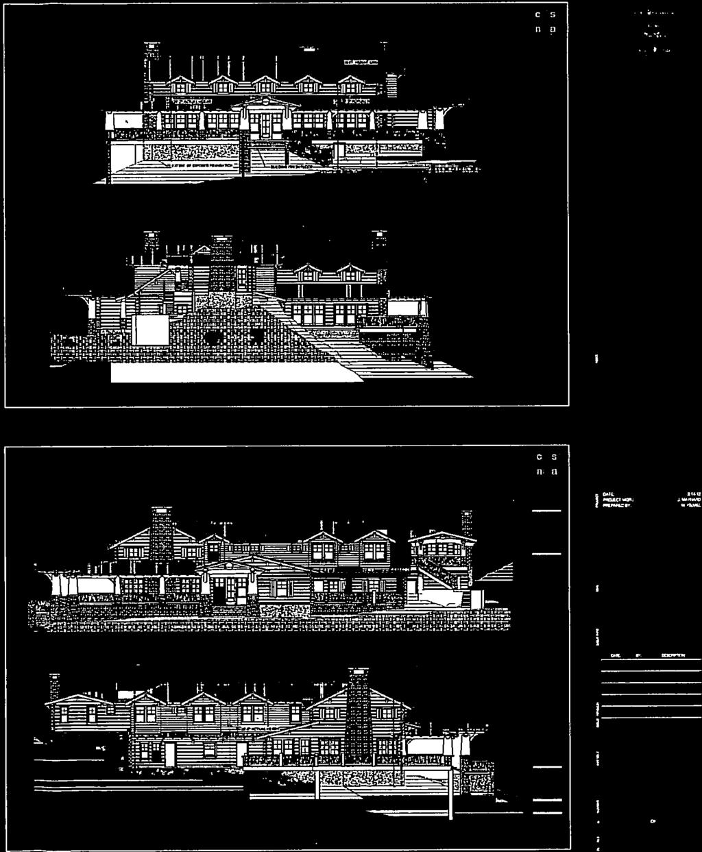
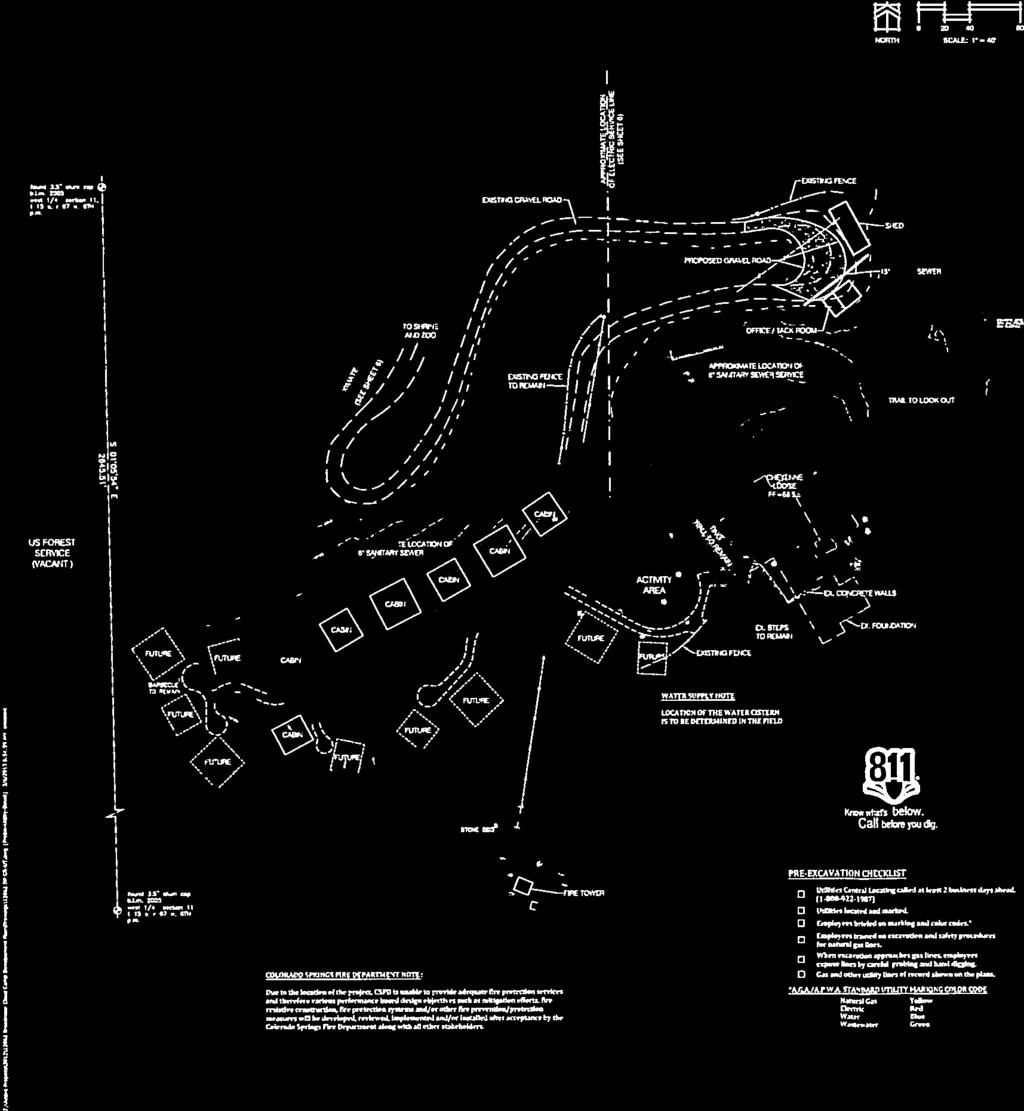
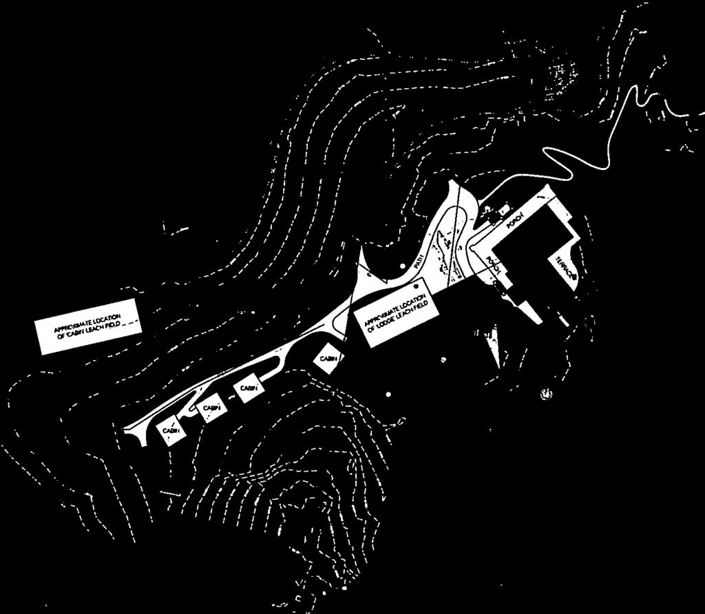
18 PROJECT SUMMARY: 1. Project Description: This request consists of a rezoning, development plan and final plat. The Cog Land & Development Co. (Broadmoor Hotel) proposes to establish a rustic lodging retreat consisting of an 8,000 sq. ft., two-story main lodge and up to 20 freestanding lodges (consisting of 27 guest units). The lodge would be operated in conjunction with the Broadmoor Hotel and accessible for guests only by escort from a hotel employee either by shuttle, guided hike or mule. (FIGURE 1) The change in zone to PUD/HS will allow the property to be used for hotel lodging and associated events; the current PUD zoning allows for residential development at a density specified on the Broadmoor Master Plan. The Cloud Camp plat (FIGURE 2) is a 9.44-acre single lot subdivision of the larger 369 acre parcel. 2. Applicant s Project Statement: (FIGURE 3) 3. Planning and Development Department s Recommendation: Approval of the zone change, development plan and final plat subject to conditions, informational and technical modifications. BACKGROUND: 1. Site Address: Not currently addressed. 2. Existing Zoning/Land Use: PUD/HS (Planned Unit Development with Hillside Overlay) / The property currently sits vacant; it once was the site of the Cheyenne Mountain Lodge 3. Surrounding Zoning/Land Use: North: PUD / Will Rogers Shrine and PCR / Cheyenne Mountain Zoo (both approximately 1 mile from proposed lodge) South: PUD (Mountain Preserve) / Vacant East: A5 (County zoning) / Pikes Peak National Forest West: PUD (Broadmoor) / Vacant 4. Comprehensive Plan/Designated 2020 Land Use: Low Density Residential 5. Annexation: Reannexation of Southwest Annexation Area, Oct Master Plan/Designated Master Plan Land Use: The Broadmoor Master Plan does not graphically show this area on the plan; adjacent uses identified include residential uses of varying densities. 7. Subdivision: Not currently platted. 8. Zoning Enforcement Action: None 9. Physical Characteristics: The site is part of Cheyenne Mountain, although located at the summit of what is referred to as The Horns. The site elevation is around 9,140 feet (as a comparison, Barr Camp is at 10,200 feet). The area around the main lodge is relatively flat, containing 0-8% slopes, and void of vegetation, possibly having been cleared as part of the previous development. Rock outcroppings exist to the east and south of the lodge; the areas north and west of the lodge contain mountain conifers. The guest lodges are proposed west of the main lodge within a densely vegetated area; this area also contains slopes of 25% or greater that slope generally toward the northwest with a portion sloping toward the west and southwest.
19 STAKEHOLDER PROCESS AND INVOLVEMENT: Postcards were sent to six (6) property owners within 500 ft. of the larger 369-acre tract, which also included the Broadmoor Resort Community Homeowner Association. A poster was not provided due to the remote location of the site. Plan copies were also sent to NORAD for review and comment. Staff did not receive any comments from surrounding property owners or NORAD on the proposed development. ANALYSIS OF REVIEW CRITERIA / MAJOR ISSUES / COMPREHENSIVE PLAN AND MASTER PLAN CONFORMANCE: 1. Review Criteria / Design & Development Issues: Background/History: The lodge would be operated in conjunction with the Broadmoor s recent purchase of the Emerald Valley Ranch located within Pike National Forest. The Cloud Camp lodge and cabins will be located at the site of the former Cheyenne Mountain Lodge which was constructed by Spencer Penrose in The original lodge was constructed after the completion of the Cheyenne Mountain Highway in The highway, the lone vehicular access to the site, now begins past the Shrine as a winding dirt road for approximately four miles to the summit. Remnants of the former lodge include a terraced stone wall and stairway, an observation area atop a rock formation, as well as a concrete structure on the south side of the site that will be utilized as a fire tower and contain a lodging unit. The stone wall, stairway and observation platform are planned to be retained and refurbished as part of the new lodge. PUD Zone Change: The proposed zone to PUD/HS (Planned Unit Development with Hillside Overlay) for the 9.44 acres will allow the hotel lodging along with associated uses on the property. PUD zone change requests are reviewed based upon the establishment and development of a PUD zone criteria found in City Code Section It is the finding of the City Land Use Review Staff that the PUD zone change meets the PUD zone change criteria found in City Code Section PUD Development Plan: The Cloud Camp PUD development plan identifies a main lodge, 20 freestanding guest buildings, a fire tower containing one guest unit and two outbuildings. There will be a total of 36 guest units within both the main lodge and guest cabins. Four different cabin designs are proposed ranging in size from 480 sq. ft. to 768 sq. ft. (two-guest unit cabins). Design and Development Issues: Roadway, Emergency and Legal Access: The Broadmoor Hotel has legal access through both the Cheyenne Mountain Zoo property and the adjacent property under the ownership name of End of Trails (c/o El Pomar). The Broadmoor has indicated that it will likely seek outright ownership of the road in order to own and maintain the access as necessary. The Broadmoor has improved the current condition of the Cheyenne Mountain Highway that would allow most passenger vehicles to navigate the road. The Hotel plans on making additional improvements to the road including rock/boulder removal and stabilization, vegetation removal, and installation of guard rails where necessary.
20 As noted above, guests to the lodge will need to be escorted by a Broadmoor employee by vehicle, by foot or by mule. Road access is currently controlled at three locations, at the Cheyenne Zoo, a second electric gate located just past the Zoo and a third gate located just past the Shrine at the beginning of the dirt road. A vehicle turnaround has been provided as requested by Colorado Springs Fire as well as the provision of development plan notes pertaining to fire safe mitigation and the inability to provide adequate fire response (standard response coverage time is typically 8 to 12 minutes). Utilities: Colorado Springs Utilities has reviewed the preliminary utility plan that includes the applicant providing water and electric services as well as a private wastewater system. Colorado Springs Utilities is satisfied with the proposal provided that the applicant is responsible for the design, construction, ownership, operation and maintenance of the water system (notes #12-16 on DP Sheet 16). Wastewater facilities will be handled on site through an individual sewage disposal system (ISDS). There are two (2) leach field septic systems; one field will be provided for the main lodge and one will be provided for the guest cabins. Colorado Springs Utilities has approved the use of the ISDS system on the basis that the Broadmoor coordinates with the El Paso County Health Department on the design of the system. A private water system will be laid over ground to deliver water to the lodge, consisting of a one-inch service line that will be anchored to the ground. Water connection will be made near the Zoo property and delivered through a series of seven (7) pump stations, eventually filling an on-site cistern. Electric service will also be provided originating near the Shrine and following a similar route as the water service. Both routes of both services are considered approximate until field verified (See Sheet 5 of the DP set). Visibility: The proposed lodge will sit back from the overlook platform approximately 160 feet, which is located behind The Horns rock formation. Staff anticipates that there is a very low likelihood that the main lodge will be visible from lower elevations, but the building may possibly been seen from the very southern end of the city along Hwy 115. Guest Safety: The Broadmoor is aware of the safety concerns of its employees and guests and assumes the responsibility for their safe evacuation during either a wild fire, severe weather or other emergency event that may pose a hazardous condition. A note has been added to the development plan outlining the Broadmoor s responsibility in this matter; a similar note and responsibility exists with the Cheyenne Mountain Zoo. The Broadmoor has and will take steps in providing fire safety. They have already completed clearing of vegetation in and around the guest cabins and along the Cheyenne Mountain Highway. The fire tower will be electronically manned with connection to the fire awareness system of the Resort complex and will be manned by hotel staff during the seasonal use of the lodge. Additionally, 30 Broadmoor employees will be trained as wild land fire fighters. Geologic Hazard Evaluation: A geologic hazard evaluation was completed by CTL/Thompson and reviewed by both City Land Use Review and City Engineering Development Review departments as well as the Colorado Geologic Survey (CGS) (the
21 City will occasional utilize CGS as a third party reviewer on certain reports). CGS reported (FIGURE 4) that it concurred with CTL/Thompson s evaluation and they did not have any significant issues other than potential rock fall onto the lone access to the site and guest safety due to surrounding steep slopes and cliff edges. 25% Grade: The Hillside Overlay requires avoiding slopes of 25% or greater for building envelopes (City Code Section D.2.d(1)(C)). Outside of the main lodge and activity area, most of the site consists of slope 25% or greater; thus, construction of the guest lodges will require the submittal of a non-use variance application that can be reviewed administratively. The guest lodges will be situated where access will be gained at or near natural grade, and the downside portion of the lodge will be constructed on piers. Due to the grades on some of the cabin locations, staff will maintain a 35-ft. height maximum based on standard hillside calculation (based on existing natural grade). When staff walked the site with the applicant it was known that there likely would be areas containing 25% slope in the location of the guest cabins; this information was requested as part of the land suitability analysis. However the site survey information determining the location of 25% slope was not yet completed upon the initial submittal which staff commented as part of the review. Although staff and the applicant were aware a non-use variance was probable, the specific extent of the 25% slope determined that a non-use variance would be necessary. Staff has reviewed the land suitability analysis and the 25% grades in the location of the guest cabins; staff will be in full support of the request on the basis that the request will meet the three (3) non-use variance review criteria. Staff finds that the applicant has limited locations where slope is less than 25 percent and that the design (i.e. use of natural grade, minimal building size and use of pier system) will allow minimal disturbance of the natural grade. 2. Conformance with the City Comprehensive Plan: Strategy NE 201b: Incorporate Natural Features into Design of All Development Preserve and incorporate significant natural features into the design of new development by using innovative planning, design and best management practices. Assist such efforts by private landowners and organizations to incorporate natural features into all development and to protect, restore, or enhance privately owned natural features. Strategy NE 201c: Preserve the Natural Contours of the Land Preserve and incorporate the natural contours of the land in the design of new development by using innovative planning, design and management practices. Discourage overlot grading or storage or import/export of material prior to approval of any development application. Objective CCA 6: Fit New Development into the Character of the Surrounding Area Often the overall character of a new development is not realized until the project is completed. This can lead to unintended impacts and incompatible development. Applicants for new developments need to clearly identify how their projects will fit into the character of the surrounding area and the community as a whole with respect to height, scale, bulk, massing, roof forms, signage, overall site design, pedestrian and vehicular access, and relation to the public right-of-way.
22 Policy CCA 601: New Development Will be Compatible with the Surrounding Area New developments will be compatible with the surrounding land uses and will complement the character and appearance of adjacent land uses. It is the finding of the Land Use Review Staff that the Cloud Camp project meets the goals and policies outlined in the City s Comprehensive Plan. STAFF RECOMMENDATION: Item No: 4.A CPC PUD Zone Change to PUD Approve the proposed zone change to PUD/HS (Planned Unit Development with Hillside Overlay that allows the use of hotel lodging, maximum height of 35 feet, maximum density to include the 36 guest units), based upon the finding that the change complies with the zone change criteria found in City Code Section B and the PUD establishment criteria found in City Code Section Item No: 4.B CPC DP PUD Development Plan Approve the Cloud Camp Development Plan based upon the findings that the PUD development plan complies with the review criteria found in City Code Section subject to the following informational and technical modifications. Technical Modifications: 1. Submittal of a non-use variance application is required to allow building footprints on slopes 25% or greater. 2. Note the square footage of the main lodge along with each of the typical guest lodges. 3. Change maximum building height from 25 feet to 35 feet. Remove based on finished grade. 4. Provide a lodging unit chart based on type, number of buildings/units, initial phase and future phase. Item No: 4.C CPC FP Final Plat Approve the Cloud Camp final plat based upon the findings that the final plat complies with the review criteria found in City Code Section


23 FIGURE 1


24 FIGURE 1


25 FIGURE 1

26 FIGURE 1


27 FIGURE 1

28 FIGURE 2


29 FIGURE 2
30 C.l CLOUD CAMP AT THE BROADMOOR Project Statement and Justification December 2012 Cloud Camp at the Broadmoor will be an Eco Tourism destination operated by the Broadmoor Hotel. The site will provide a unique, western/outdoor experience available to visitors to the region. Located at the top of Cheyenne Mountain, the facilities will be accessed by the historic Cheyenne Mountain Highway to the Will Rogers Shrine, which continues to the top of Cheyenne Mountain. This road will be improved to accommodate hotel vehicles. Access for patrons will be provided in one of three ways: patrons can hike to the top; can ride a mule; or can be driven by jeep operated by a hotel employee. The site will be developed with a lodge and guest cabins and associated facilities. Cloud Camp will be operated on a seasonal basis, closed to guests in winter. Months of operation will be from March through November, depending on yearly variations in weather. The lodge will be located generally on the old foundation of the former Cheyenne Lodge, also known as the Honeymoon Lodge, which was constructed by Spencer Penrose in The new lodge will provide common dining facilities, large viewing terraces, and a great room for guests to congregate, and will have seven guest room accommodations. This facility will also attract the Broadmoor's Small Group Incentive Market that will book the lodge and cabins for a conference or training, team building event. Several guest cabins will provide housing for overnight stays. Each cabin will have bathroom and sleeping facilities, but no eating facilities. Cabins will be accessed by a foot path and serviced by golf cart sized vehicles. Twenty cabins will be provided in the ultimate development configuration, with eleven cabins constructed in the first phase. Cloud Camp will be sited on a 369 acre parcel of land owned by the development arm of the Broadmoor Hotel, COG Land Development LLC. For those patrons hiking to the top, rest areas, picnic areas, and observation areas will be available along the route, which is the historic Cheyenne Mountain Highway. Access by mule. will be guided by Hotel employees and will use the same route as pedestrians. A corral area will be placed a few hundred feet below the top of the mountain where patrons can also interact with the animals as a part of the western theme and experience. Trails to observation locations and to sitting areas will be provided, including renovation of the observation platform on top of one of the "horns", a rock feature formerly used for this purpose. There will be no parking on site, except for service vehicles. FIGURE 3
31 o (j The Cloud Camp submittal package consists ofthree applications: Zone Change from PUD to PUD; Development Plan; and Plat. The Cloud Camp use is accessory to the Broadmoor Resort in that it provides an additional venue for the resort. This facility will have the potential to extend the stay of hotel guests for an additional day or two in the Colorado Springs area. The Zone Change from PUD (HS) to PUD (HS) is required to establish the land use for this parcel. No land use was proposed when the property was originally zoned PUD upon annexation in The proposed resort use includes a lodge and up to 20 one and two bedroom cabins, plus associated recreational site features. The lodge will contain a caretaker residence and seven guest rooms. The lodge will be a maximum of 35 feet in height. Cabins will be a maximum of 20 feet in height. Zone Change Criteria 1. The action will not be detrimental to the public interest, health, safety, convenience or general welfare. The proposed use is separated from surrounding properties by lond that is in open space or otherwise restricted from development. Privote access is through properties with a strong relationship to the Broadmoor Hotel. Operation of the facilities by hotel personnel will provide for the safety of guests. This criterion is met. 2. The proposal is consistent with the goals and policies of the Comprehensive Plan. The proposed use will be unique to the region. It will provide an economic benefit to the community by encouroging tourists with a new and different venue. The Comprehensive Plan encouroges this type of environmentally sensitive recreation. 3. Where a master plan exists, the proposal is consistent with such plan or an approved amendment to such plan. Master plans that have been classified as implemented do not have to be amended to be considered consistent with a zone change request. The proposed use is consistent with the historic use of the propertyi and is consistent with the overall resort use. Development Plan Review Criteria 1. Will the project design be harmonious with the surrounding land uses and neighborhood? Yes. This use is surrounded by open lands and is consistent with the surrounding land use. Approximately 365 acres of the 369 acre site will be in open space. 2. Will the proposed land uses be compatible with the surrounding neighborhood? Will the proposed development overburden the capacities of existing streets, utilities, parks, FIGURE 3
32 o schools and other public facilities? There will be no appreciable change to trafficl and utilitiesl and nq impact on parks or schools from this project. 3. Will the structures be located to minimize the impact of their use and bulk on adjacent properties? Yes. Structures will not be visible from adjacent properties. 4. Will landscaping, berms, fences and/or walls be provided to buffer the site from undesirable views, noise, lighting or other off-site negative influences and to buffer adjacent properties from the negative influences that may be created by the proposed development? Buffering of this site is not necessary. Existing vegetation provides buffering. 5. Will vehicular access from the project to the streets outside the project be combined, limited, located, designed and controlled to channel traffic to and from such areas conveniently and safely and in such a manner which minimizes traffic friction, noise and pollution and promotes free traffic flow without excessive interruption? This criterion does not apply to this site. 6. Will all the streets and drives provide logical, safe and convenient vehicular access to the facilities within the project? Yes. Only one street provides access. It is a private drivel and will not be used by public drivers Will streets and drives within the project area be connected to streets outside the project area in such a way that discourages their use by through traffic? This criterion does not apply to this site Will adequately sized parking areas be located throughout the project to provide safe and convenient access to specific facilities? This criterion does not apply to this site. 9. Will safe and convenient provision for the access and movement of handicapped persons and parking of vehicles for the handicapped be accommodated in the project design? On site accommodations will be made for handicapped persons including access to the lodge and to cabins designed for handicapped persons. 10. Will the design of streets, drives and parking areas within the project result in a minimum of area devoted to asphalt? Yes. No asphalt is proposed. 11. Will pedestrian walkways be functionally separated from vehicular traffic and landscaped to accomplish this? Will pedestrian walkways be designed and located in combination with other easements that are not used by motor vehicles? Yes. This is a pedestrian oriented site. Vehicle use will be the exception. Only service vehicles and vehicles that serve handicapped persons will be on site. FIGURE 3
33 12. Does the design encourage the preservation of significant natural features such as healthy vegetation, drainage channels, steep slopes and rock outcrop pings? Are these significant natural features incorporated into the project design? Yes. The site is designed to preserve and enhance the natural features of the site. These features are the attraction to the site. The Plat will create a lot for the proposed improvements. It will encompass only 9.44 acres of the 369 acre parcel. Site improvements will include grading of the road to the top of the mountain to remove debris that has accumulated over the past 50 years; removal of the remains of the old Cheyenne Lodge; removal of standing dead wood for fire mitigation and to accommodate construction activity with a fire safe design; and construction of the planned facilities. Safety to patrons, and particularly fire safety, is of primary concern. Several measures will take place to guarantee the safety of guests and to the surrounding land in general. Fire safe mitigation of existing vegetation on the top of the mountain and along Cheyenne Mountain Highway is currently underway and will be complete prior to construction activity. A Fire Tower will be constructed where an existing concrete structure is currently located at the top of the mountain. This facility will be electronically manned with connection to the fire awareness system of the Resort complex, and will be manned by hotel personnel during seasons of use. From this observation point, monitoring and detection of wild land fires can be quickly spotted, significantly decreasing response times for the proposed use and for the general area. Additionally, 30 Broadmoor employees are being trained as wild land fire fighters, thereby increasing the capability to fight any fire that may occur. Sewer service is being provided to this site. Water service is currently being designed and will be provided by Colorado Springs Utilities as a private system. There is existing electric service to this site that will be re-established by Colorado Springs Utilities. FIGURE 3

34 COLORADO GEOLOGICAL SURVEY 1313 Sherman Street, Room 715 Denver, Colorado Phone Fax February 21, 2013w Mike Schultz Land Use Review Division City of Colorado Springs 30 S. Nevada Ave., Suite 105 Colorado Springs, CO Location: SWY4, Sec 11, Tl5S, R67W, 6th P.M. Karen Berry Acting State Geologist Subject: Cloud Camp Subdivision CGS Unique No. EP Dear Mr. Schultz: Thank you for the submittal. At your request, the Colorado Geological Survey (CGS) has completed its review of the above-referenced minor subdivision application. The submittal packet included plan sheets by N.E.S., Inc. and a project statement and justification. Pertinent to this review, also included was a Geologic Hazards Evaluation letter by CTLlThompson dated January 30, Proposed is the development ofa lodge house and cabins that are be to situated on the former site of the Cheyenne Lodge in the "Horns" vicinity of Cheyenne Mountain. Access is by a currently unimproved 4WD road (Cheyenne Mountain Highway) that continues up along several switchbacks from the Will Rogers shrine parking lot. CGS conducted a site inspection on February 20, We understands that both central water and sewer services will be provided by Colorado Springs Utilities. Please consider the following observations and recommendations as you review this development plan. We have reviewed the geologic hazards report by CTL and generally concur with their findings. Bouldery slopes will be the geologic constraint for the location and building of the cabins. Rockfall and steep slopes will be the more significant hazards. Not mentioned in the CTL report is the rockfall hazard on the road to the lodge. This is the only access to the site and cut slopes expose a range of conditions: from very rocky colluvial soil, to grussy (decomposed) granite, to more intact but fractured rock. We noticed several large rocks and boulders that apparently fell/slid from the cut slopes. The project statement mentioned that road improvements will include the removal of this accumulated debris so, obviously, rocks do periodically fall to the roadway. There was significant snow cover during our site inspection so we cannot state what the frequency or severity of potentially unstable rock features are along the roadway. Improvement to this road need to be very carefully implemented so that cut slopes are not adversely steepened or the cut-slope material is not destabilized in any way. Since this is the only access, and will be used by visitors to the lodge, we would suggest that a comprehensive study of the roadway be completed and areas needing rockfall mitigation identified and implemented. In closing, we concur that there are no significant geologic hazards at the actual lodge location that would preclude the development of the proposed structures. However, the nearby steep slopes and cliff-edges will create potential falling hazards to guests. The most significant geologic hazards will be the potential of rockfall and rock slides along the roadway to the site. While wildfire is a natural hazard, we feel we should EP130004_1 Cloud Camp Subdivision.docxCloud Camp Sub. FIGURE 4
CITY PLANNING COMMISSION AGENDA ITEMS: J & K STAFF: NATALIE BECKER FILE NOS: CPC ZC QUASI-JUDICIAL CPC DP QUASI-JUDICIAL
 Page 92 CITY PLANNING COMMISSION AGENDA ITEMS: J & K STAFF: NATALIE BECKER FILE NOS: CPC ZC 05-00151 - QUASI-JUDICIAL CPC DP 05-00152 - QUASI-JUDICIAL PROJECT: APPLICANT: OWNER: MERCURY CAR WASH SCOTT
CITY PLANNING COMMISSION AGENDA
 Page 60 CITY PLANNING COMMISSION AGENDA ITEM NO: C STAFF: MICHAEL SCHULTZ FILE NO: CPC UV 14-00023 QUASI-JUDICIAL PROJECT: APPLICANT: OWNER: 1534 & 1536 W. CHEYENNE ROAD JOHN DWORAK ESTATES OF ELAINE DWORAK
CITY PLANNING COMMISSION COMPREHENSIVE PLAN AND REVIEW CRITERIA
 Page 3 CITY PLANNING COMMISSION COMPREHENSIVE PLAN AND REVIEW CRITERIA COMPREHENSIVE PLAN: The City Planning Commission uses the Comprehensive Plan as a guide in all land use matters. The Plan is available
CONSENT CITY PLANNING COMMISSION AGENDA ITEM: A STAFF: STEVE TUCK FILE NO.: CPC CU QUASI-JUDICIAL
 Page 11 CONSENT CITY PLANNING COMMISSION AGENDA ITEM: A STAFF: STEVE TUCK FILE NO.: CPC CU 07-00231 QUASI-JUDICIAL PROJECT: APPLICANT: OWNER: PAUL MITCHELL STUDIO COSMETOLOGY SCHOOL LGA STUDIOS LOUDEN
CITY PLANNING COMMISSION AGENDA ITEM NOS: B.1-B.3 STAFF: MEGGAN HERINGTON
 Page 17 CITY PLANNING COMMISSION AGENDA ITEM NOS: B.1-B.3 STAFF: MEGGAN HERINGTON FILE NO(S): CPC MP 87-00381-A13MN14 QUASI-JUDICIAL CPC PUZ 14-00101 QUASI-JUDICIAL CPC PUP 05-00139-A1MJ14 QUASI-JUDICIAL
CPC Agenda July 18, 2013 Page 56 ITEM: E FILE NO: CORPORAT SITE
 Page 56 CITY PLANNING COMMISSION AGENDA ITEM: E STAFF: PETER WYSOCKI FILE NO: CPCC UV 13-00060 QUASI-JUDICIAL PROJECT: APPLICANT: CORPORAT TE CENTER FILING NO. 5 YOW ARCHITECTS OWNER: COLUMBUS REAL ESTATE
CITY PLANNING COMMISSION AGENDA ITEM NO: G.1-G.3 STAFF: JAMES MAYERL
 Page 70 CITY PLANNING COMMISSION AGENDA ITEM NO: G.1-G.3 STAFF: JAMES MAYERL FILE NO(S): 1. - CPC NV 08-00048 QUASI-JUDICIAL 2. - CPC CU 08-00046 QUASI-JUDICIAL 3. - CPC FP 08-00047 QUASI-JUDICIAL PROJECT:
STAFF: RACHEL TEIXEIRA
 Page 7 CONSENT CALENDAR ITEM: A STAFF: RACHEL TEIXEIRA FILE NO: CPC CU 14-00036 QUASI-JUDICIAL PROJECT: APPLICANT: OWNER: AUTOMOTIVE SALES: 3511 3513 NORTH EL PASO STREET CLINT SCRUGGS, PATRIOT MOTORS
ITEM NO(S): B.1 B.3 STAFF: SHARON ROBINSON FILE NO(S): CPC CU QUASI-JUDICIAL CPC UV QUASI_JUDICIAL CPC NV QUASI-JUDICIAL
: B.1 B.3 STAFF: SHARON ROBINSON FILE NO(S): CPC CU QUASI-JUDICIAL CPC UV QUASI_JUDICIAL CPC NV QUASI-JUDICIAL") Page 16 CITY PLANNING COMMISSION ITEM NO(S): B.1 B.3 STAFF: SHARON ROBINSON FILE NO(S): CPC CU 09-00042 QUASI-JUDICIAL CPC UV 09-00130 QUASI_JUDICIAL CPC NV 09-00128 QUASI-JUDICIAL PROJECT: APPLICANT:
Page 16 CITY PLANNING COMMISSION ITEM NO(S): B.1 B.3 STAFF: SHARON ROBINSON FILE NO(S): CPC CU 09-00042 QUASI-JUDICIAL CPC UV 09-00130 QUASI_JUDICIAL CPC NV 09-00128 QUASI-JUDICIAL PROJECT: APPLICANT:
CITY PLANNING COMMISSION AGENDA
 Page 77 CITY PLANNING COMMISSION AGENDA ITEM NO: 6 STAFF: LONNA THELEN FILE NO(S): AR PFP 08-00473(AP) QUASI-JUDICIAL PROJECT: DUBLIN BUSINESS PARK SUBDIVISION FILING NO. 1 APPELLANT: OWNER: COLLETTE DIVINE
Planning Department Oconee County, Georgia
 Planning Department Oconee County, Georgia STAFF REPORT REZONE CASE #: 6985 DATE: October 31, 2016 STAFF REPORT BY: Andrew C. Stern, Planner APPLICANT NAME: Williams & Associates, Land Planners PC PROPERTY
ARTICLE 15 - PLANNED UNIT DEVELOPMENT
 Section 15.1 - Intent. ARTICLE 15 - PLANNED UNIT DEVELOPMENT A PUD, or Planned Unit Development, is not a District per se, but rather a set of standards that may be applied to a development type. The Planned
Planning Department Oconee County, Georgia STAFF REPORT
 Planning Department Oconee County, Georgia STAFF REPORT REZONE CASE #: 7332 DATE: November 28, 2017 STAFF REPORT BY: Gabriel Quintas, Planner APPLICANT NAME: Smith Planning Group PROPERTY OWNER: John Hadden
(if more than one, give square footage for each) ANNEXATION LOT LINE Adjustments PRE/FINAL PLAT SPECIAL USE PERMIT
 ANNEXATION LOT LINE Adjustments PRE/FINAL PLAT SPECIAL USE PERMIT") Planning Commission Application Building & development office 915 Third ST. Rawlins WY ph. 307-328-4599 fax. 307-328-4590 PROJECT REVIEW: GENERAL INFORMATION Project name: OFFICE USE ONLY Site address
Planning Commission Application Building & development office 915 Third ST. Rawlins WY ph. 307-328-4599 fax. 307-328-4590 PROJECT REVIEW: GENERAL INFORMATION Project name: OFFICE USE ONLY Site address
O-I (Office-Institutional) and AG-1(Agricultural)
 and AG-1(Agricultural)") PROPERTY INFORMATION ADDRESS 3503 and 3505 Bethany Bend DISTRICT, LAND LOTS 2/1 973 and 974 OVERLAY DISTRICT State Route 9 PETITION NUMBERS EXISTING ZONING O-I (Office-Institutional) and AG-1(Agricultural)
PROPERTY INFORMATION ADDRESS 3503 and 3505 Bethany Bend DISTRICT, LAND LOTS 2/1 973 and 974 OVERLAY DISTRICT State Route 9 PETITION NUMBERS EXISTING ZONING O-I (Office-Institutional) and AG-1(Agricultural)
CITY PLANNING COMMISSION AGENDA ITEM NOS: 15,16,17,18,19 STAFF: PATRICIA PARISH
 Page 185 CITY PLANNING COMMISSION AGENDA ITEM NOS: 15,16,17,18,19 STAFF: PATRICIA PARISH FILE NOS: CPC A 05-00193 LEGISLATIVE CPC ZC 05-00194 LEGISLATIVE CPC ZC 05-00195 LEGISLATIVE CPC CP 05-00196 QUASI-JUDICIAL
PLANNING AND ZONING DEPARTMENT
 Town of Minturn Development Review Process: Guide To Planned Unit Developments (Concept Plan) This guide describes the Planned Unit Development Process. This guide should be utilized in conjunction with
PLANNED UNIT DEVELOPMENTS (Ordinance No.: 3036, 12/3/07; Repealed & Replaced by Ordinance No.: 4166, 10/15/12)
") 159.62 PLANNED UNIT DEVELOPMENTS (Ordinance No.: 3036, 12/3/07; Repealed & Replaced by Ordinance No.: 4166, 10/15/12) A. PURPOSE 1. General. The Planned Unit Development (PUD) approach provides the flexibility
159.62 PLANNED UNIT DEVELOPMENTS (Ordinance No.: 3036, 12/3/07; Repealed & Replaced by Ordinance No.: 4166, 10/15/12) A. PURPOSE 1. General. The Planned Unit Development (PUD) approach provides the flexibility
UPPER MOUNT BETHEL TOWNSHIP NORTHAMPTON COUNTY, PENNSYLVANIA
 UPPER MOUNT BETHEL TOWNSHIP NORTHAMPTON COUNTY, PENNSYLVANIA JOINDER DEED / LOT CONSOLIDATION TOWNSHIP REVIEW PROCESS When accepting proposed Joinder Deeds / Lot Consolidations, review the Joinder Deed
Special Use Permit - Planned Unit Development Checklist. Property Address:
 Special Use Permit - Planned Unit Development Checklist Special Use Permit Number. Parcel Code/s #28-11- - - Property Address: Applicant: ARTICLE VIII Ordinance Reference - Section 8.1.2 Permit Procedures:
ARTICLE XI CONDITIONAL USE PERMITS
 ARTICLE XI CONDITIONAL USE PERMITS 11.1 Purpose. The City of Hailey recognizes that certain uses possess unique and special characteristics with respect to their location, design, size, method of operation,
REPORT TO THE SHELBY COUNTY PLANNING COMMISSION From the Department of Development Services Planning Services. February 4, 2019
 REPORT TO THE SHELBY COUNTY PLANNING COMMISSION From the Department of Development Services Planning Services February 4, 2019 Case No. Request for Rezoning Approval From E-1 to E-2 SD This is a request
ARTICLE 14 PLANNED UNIT DEVELOPMENT (PUD) DISTRICT
 DISTRICT") ARTICLE 14 PLANNED UNIT DEVELOPMENT (PUD) DISTRICT Section 14.01 Intent. It is the intent of this Article to allow the use of the planned unit development (PUD) process, as authorized by the Michigan Zoning
ARTICLE 14 PLANNED UNIT DEVELOPMENT (PUD) DISTRICT Section 14.01 Intent. It is the intent of this Article to allow the use of the planned unit development (PUD) process, as authorized by the Michigan Zoning
CHAPTER 10 Planned Unit Development Zoning Districts
 CHAPTER 10 Planned Unit Development Zoning Districts Section 10.1 Intent and Purpose The Planned Unit Development (PUD) districts are intended to offer design flexibility for projects that further the
Planned Unit Development (PUD). Sections:
. Sections:") Chapter 19.07. Planned Unit Development (PUD). Sections: 19.07.01. Purpose. 19.07.02. PUD Definition and Design Compatibility. 19.07.03. General PUD Standards. 19.07.04. Underlying Zones. 19.07.05. Permitted
Chapter 19.07. Planned Unit Development (PUD). Sections: 19.07.01. Purpose. 19.07.02. PUD Definition and Design Compatibility. 19.07.03. General PUD Standards. 19.07.04. Underlying Zones. 19.07.05. Permitted
Medical Marijuana Special Exception Use Information
 Medical Marijuana Special Exception Use Information The Special Exception Use information below is a modified version of the Unified Development Code. It clarifies the current section 5:104 Special Exceptions
The following regulations shall apply in the R-E District:
 "R-E" RESIDENTIAL ESTATE DISTRICT (8/06) The following regulations shall apply in the R-E District: 1. Uses Permitted: The following uses are permitted. A Zoning Certificate may be required as provided
E X E C U T I V E S U M M A R Y
 E X E C U T I V E S U M M A R Y CASE PLANNER: Aaron Wilson & Janet Rhoades VINE REVIEWED AND APPROVED BY: Mary McCrea BROADWAY INTERSTATE 90 INTERSTATE 90 PUBLIC HEARINGS: CC: August 22, 2011 AGENDA ITEM:
Chapter 210 CONDITIONAL USES
 Chapter 210 CONDITIONAL USES 210.01 Purpose 210.02 Authorization 210.03 Process Type 210.04 Determination of Major or Minor Conditional Use Review 210.05 Approval Criteria 210.06 Conditions of Approval
Letter of Intent May 2017 (Revised November 2017)
") THE BEACH AT WOODMOOR LETTER OF INTENT MAY 2017 (REVISED NOVEMBER 2017) OWNER/APPLICANT: CONSULTANT: Lake Woodmoor Holdings LLC N.E.S. Inc. 1755 Telstar Drive, Suite 211 619 North Cascade Avenue Colorado
THE BEACH AT WOODMOOR LETTER OF INTENT MAY 2017 (REVISED NOVEMBER 2017) OWNER/APPLICANT: CONSULTANT: Lake Woodmoor Holdings LLC N.E.S. Inc. 1755 Telstar Drive, Suite 211 619 North Cascade Avenue Colorado
Individual Well Individual Septic. Community Well 19. What is the proposed method of sewage disposal? Public. None
 Please Answer the Following Questions: (attach sheet if needed). What type of facility is being proposed? Campground Recreational Vehicle (RV) Park Both 2. What is the total acreage of the proposed facility?
Appendix J - Planned Unit Development (PUD)
") Appendix J - Planned Unit Development (PUD) Intent and Purpose The purpose of the PUD is: 1. To provide development that is consistent with the Comprehensive Land Use Plan and promote the goals and objectives
Appendix J - Planned Unit Development (PUD) Intent and Purpose The purpose of the PUD is: 1. To provide development that is consistent with the Comprehensive Land Use Plan and promote the goals and objectives
PLANNING COMMISSION REPORT Regular Agenda Public Hearing Item
 PC Staff Report 11/12/12 Item No. 2B- 1 PLANNING COMMISSION REPORT Regular Agenda Public Hearing Item ITEM NO. 2B: A TO GPI; 110 ACRES; E OF K-10 & N OF W 6 TH ST (MKM) : Consider a request to rezone approximately
Packet Contents: Page #
 CLEAR CREEK COUNTY PLANNING DEPARTMENT REQUIREMENTS FOR COMMERCIAL AND MULTI-FAMILY DEVELOPMENTS Prior to submitting a building permit application, the Planning staff will review the site plan and construction
Special Exception, SE #15-03 School of Special Instruction
 Town Council December 1, 2015 Title: Special Exception, SE #15-03 School of Special Instruction Staff Contact: Mark R. Holland, Zoning Administrator (703) 787-7380 mark.holland@herndon-va.gov Summary:
MIDWAY CITY Municipal Code
 MIDWAY CITY Municipal Code TITLE 9 ANNEXATION CHAPTER 9.01 PURPOSE CHAPTER 9.02 GENERAL REQUIREMENTS CHAPTER 9.03 PROPERTY OWNER INITIATION OF ANNEXATION CHAPTER 9.04 PROCEDURES FOR CONSIDERATION OF PETITION
PALM BEACH COUNTY PLANNING, ZONING AND BUILDING DEPARTMENT ZONING DIVISION
 PALM BEACH COUNTY PLANNING, ZONING AND BUILDING DEPARTMENT ZONING DIVISION Application No.: CA-2012-00688 Control No.: 2011-00552 Applicant: Garry Bernardo Owners: Garry Bernardo Agent: Frogner Consulting,
ARTICLE VII. NONCONFORMITIES. Section 700. Purpose.
 ARTICLE VII. NONCONFORMITIES. Section 700. Purpose. The purpose of this chapter is to regulate and limit the development and continued existence of legal uses, structures, lots, and signs established either
PLANNED UNIT DEVELOPMENT & SUBDIVISION STAFF REPORT Date: April 18, 2019
 PLANNED UNIT DEVELOPMENT & SUBDIVISION STAFF REPORT Date: April 18, 2019 DEVELOPMENT NAME SUBDIVISION NAME Springhill Village Subdivision Springhill Village Subdivision LOCATION 4350, 4354, 4356, 4358,
MINOR BOUNDARY LINE ADJUSTMENT PROCESS GUIDE
 MINOR BOUNDARY LINE ADJUSTMENT PROCESS GUIDE Clear Creek County Planning Department P.O. Box 2000 Georgetown, Colorado 80444 (303) 679-2436 phone (303) 569-1103 fax 1 PURPOSE To establish criteria and
5.03 Type III (Quasi-Judicial) Decisions
 Decisions") 5.03 Type III (Quasi-Judicial) Decisions 5.03 General Requirements A. The purpose of this Section is to identify what types of actions are considered Type III decisions. Type III decisions involve significant
5.03 Type III (Quasi-Judicial) Decisions 5.03 General Requirements A. The purpose of this Section is to identify what types of actions are considered Type III decisions. Type III decisions involve significant
GENERAL PLAN, DEVELOPMENT CODE AND ZONING MAP AMENDMENT APPLICATION INFORMATION SHEET
 GENERAL PLAN, DEVELOPMENT CODE AND ZONING MAP AMENDMENT APPLICATION INFORMATION SHEET GENERAL INFORMATION This information sheet explains how an application requesting an amendment to the Truckee General
CONDOMINIUM REGULATIONS
 ARTICLE 37 CONDOMINIUM REGULATIONS SECTION 37.01. Purpose The purpose of this Article is to regulate projects that divide real property under a contractual arrangement known as a condominium. New and conversion
ARTICLE IV DISTRICT REGULATIONS
 PART 1. RESIDENTIAL DISTRICTS 4-101. RS. Single-Family Residential Suburban District. The RS District is designed for single-family dwellings, and compatible uses, at a density no greater than one dwelling
PLANNING COMMISSION STAFF REPORT. QUEST ASSISTED LIVING CONDITIONAL USE PLNPCM West 800 North Hearing date: October 14, 2009
 PLANNING COMMISSION STAFF REPORT QUEST ASSISTED LIVING CONDITIONAL USE PLNPCM2009-00971 1820 West 800 North Hearing date: October 14, 2009 Planning Division Department of Community & Economic Development
Staff Report: Date: Applicant: Property Identification: Acreage of Request: Current Zoning of Requested Area: Requested Action: Attached:
 Staff Report: Completed by Jeff Palmer Director of Planning & Zoning Date: November 7, 2018, Updated November 20, 2018 Applicant: Greg Smith, Oberer Land Developer agent for Ronald Montgomery ET AL Property
CHAPTER 14 PLANNED UNIT DEVELOPMENTS
 9-14-1 9-14-1 CHAPTER 14 PLANNED UNIT DEVELOPMENTS SECTION: 9-14-1: Purpose 9-14-2: Governing Provisions 9-14-3: Minimum Area 9-14-4: Uses Permitted 9-14-5: Common Open Space 9-14-6: Utility Requirements
4.2 RESIDENTIAL ZONING DISTRICTS
 4.2 RESIDENTIAL ZONING DISTRICTS A. Purpose: To define regulations and standards for each residential zoning district in the City. The following sections identify uses, regulations, and performance standards
Attachment 4. Planning Commission Staff Report. June 26, 2017
 Planning Commission Staff Report June 26, 2017 Agenda #: Regular Agenda - 2 Title: Applicant: Request: Location: Existing Zoning: Proposed Use: Staff Planner: The Brands and The Brands West Eagle Crossing
Guide to Preliminary Plans
 Guide to Preliminary Plans Introduction The Douglas County is committed to providing open, transparent application processes to the public. This Guide is provided to assist anyone interested in the procedures
Residential Project Convenience Facilities
 Standards for Specific Land Uses 35.42.220 E. Findings. The review authority shall approve a Land Use Permit in compliance with Subsection 35.82.110.E (Findings required for approval) or a Conditional
Village of Glenview Plan Commission
 Village of Glenview Plan Commission STAFF REPORT May 13, 2014 TO: Chairman and Plan Commissioners CASE #: P2014-037 FROM: Community Development Department CASE MANAGER: Tony Repp, Planner SUBJECT: Final
City of Peachtree City. Annexation Review Process
 City of Peachtree City Annexation Review Process Page 1 Annexation Review Process Step One: Initial annexation information The following information is to be completed by the property owner and/ or their
Planning and Zoning Commission STAFF REPORT
 TO: FROM: Planning and Zoning Commission STAFF REPORT CASA GRANDE PLANNING AND ZONING COMMISSION James Gagliardi, AICP, City Planner MEETING DATE: September 1, 2016 REQUEST AGENDA # Request by Marshall
SUMMIT COUNTY DEVELOPMENT CODE CHAPTER 3: Zoning Regulations : Accessory Apartments
 3809.03: Accessory Apartments A. Where Permitted: Accessory apartments are allowed as a permitted use only in single-family dwelling units in County zoning districts as specified in Figure 3-2, and may
APPLICATION PROCEDURE
 ANTRIM PLANNING BOARD P. O. Box 517 Antrim, New Hampshire 03440 Phone: 603-588-6785 FAX: 603-588-2969 APPLICATION FORM AND CHECKLIST FOR MINOR OR MAJOR SITE PLAN REVIEW File Date Received By APPLICATION
Condominium Unit Requirements.
 ARTICLE 19 CONDOMINIUM REGULATIONS Section 19.01 Purpose. The purpose of this Article is to regulate projects that divide real property under a contractual arrangement known as a condominium. New and conversion
SUBJECT: Application for Planned Unit Development and Rezoning 1725 Winnetka Road
 TO: FROM: CHAIRMAN BILL VASELOPULOS AND MEMBERS OF THE PLAN & ZONING COMMISSION STEVE GUTIERREZ DIRECTOR OF COMMUNITY DEVELOPMENT MEETING DATE: September 5, 2017 SUBJECT: Application for Planned Unit Development
Town of Cary, North Carolina Rezoning Staff Report 13-REZ-31 Weston PDD Amendment at Centregreen Park Town Council Meeting March 13, 2014
 Town of Cary, North Carolina Rezoning Staff Report 13-REZ-31 Weston PDD Amendment at Centregreen Park Town Council Meeting March 13, 2014 REQUEST This proposed amendment to the Town of Cary Official Zoning
City of Fayetteville, Arkansas Page 1 of 3
 City of Fayetteville, Arkansas 113 West Mountain Street Fayetteville, AR 72701 (479) 575-8323 Legislation Text File #: 2018-0144, Version: 1 ADM 18-6094 (AMEND UDC 164.19/ACCESSORY DWELLING UNITS): AN
DIVISION 1 PURPOSE OF DISTRICTS
 ARTICLE 2 ZONING DISTRICTS AND MAP DIVISION 1 PURPOSE OF DISTRICTS Section 2.101 Zoning Districts. For the purpose of this Ordinance, the City of Richmond is hereby divided into districts as follows: DISTRICT
Chapter 100 Planned Unit Development in Corvallis Urban Fringe
 100.100 Scope and Purpose. Chapter 100 Planned Unit Development in Corvallis Urban Fringe (1) All applications for land divisions in the Urban Residential (UR) and Flood Plain Agriculture (FPA) zones within
PLANNING COMMISSION STAFF REPORT
 PLANNING COMMISSION STAFF REPORT ZONING MAP AMENDMENT PLNPCM2011-00091- Zoning Map Amendment PLNSUB2011-00090 Subdivision Amendment Approximately 700 North Columbus Court August 10, 2011 Planning and Zoning
City of Nogales Planning & Zoning Commission Rezoning Application
 City of Nogales Planning & Zoning Commission Rezoning Application REZONING APPLICATION PROCEDURES 1450 N. Hohokam Nogales, Arizona 85621 Office (520) 285-5747 FAX (520) 287-6946 T.D.D. (520) The following
STAFF REPORT. City of Ormond Beach Department of Planning. Exception for Outdoor Activity
 STAFF REPORT City of Ormond Beach Department of Planning DATE: March 7, 2019 SUBJECT: Lucky s Market, 101 East Granada Boulevard: Special Exception for Outdoor Activity APPLICANT: Wendy L. Petrillo-Rundle,
Understanding the Conditional Use Process
 Understanding the Conditional Use Process The purpose of this document is to explain the process of applying for and obtaining a conditional use permit in the rural unincorporated towns of Dane County.
Operating Standards Attachment to Development Application
 Planning & Development Services 2255 W Berry Ave. Littleton, CO 80120 Phone: 303-795-3748 Mon-Fri: 8am-5pm www.littletongov.org Operating Standards Attachment to Development Application 1 PLANNED DEVELOPMENT
RE: 6. GILL/GREEN COMPREHENSIVE PLAN AMENDMENT, REZONING AND PRELIMINARY PLAT
 commission memo DATE: Thursday - August 9, 2018 TO: Marion Planning & Zoning Commission FROM: David N. Hockett, AICP Principal Planner RE: 6. GILL/GREEN COMPREHENSIVE PLAN AMENDMENT, REZONING AND PRELIMINARY
Article 7: Residential Land Use and Development Requirements
 Article 7: Residential Land Use and Section 701: Statement of Intent (A) (B) (C) The intent of Article 7 is to develop certain land use and development requirements for the residential uses within Cumru
Guide to Combined Preliminary and Final Plats
 Guide to Combined Preliminary and Final Plats Introduction The Douglas County is committed to providing open, transparent application processes to the public. This Guide is provided to assist anyone interested
Larimer County Planning Dept. Procedural Guide for 1041 PERMITS
 - Larimer County Planning Dept. Procedural Guide for 1041 PERMITS PLEASE NOTE: A PRE-APPLICATION CONFERENCE IS REQUIRED PRIOR TO SUBMITTING THIS APPLICATION. PURPOSE: State Statutes allow local governments
Department of Planning Services Division of Planning SARAH E. KEIFER, AICP Phone: 302/ Director of Planning Services FAX: 302/
 Kent County Department of Planning Services Division of Planning SARAH E. KEIFER, AICP Phone: 302/744-2471 Director of Planning Services FAX: 302/736-2128 KRISTOPHER S. CONNELLY, AICP Assistant Director
Residential Major Subdivision Review Checklist
 Residential Major Subdivision Review Checklist Plan Submittal Requirements: 2 full sets of stamped plans Electric submittal - all plans contained in a single PDF 3 full sets if commercial kitchen or dining
PLANNING COMMISSION STAFF REPORT. Merrimac PLNSUB Planned Development 38 West Merrimac November 9, Request. Staff Recommendation
 PLANNING COMMISSION STAFF REPORT Merrimac PLNSUB2011-00374 Planned Development 38 West Merrimac November 9, 2011 Planning and Zoning Division Department of Community and Economic Development Applicant:
Guide to Replats. Step 1. Step 2. Step 3. Step 4. Step 5. Step 6. Step 7. Step 8. Step 9. Step 10
 Guide to Replats Introduction Douglas County is committed to providing open, transparent application processes to the public. This Guide is provided to assist anyone interested in the procedures and expectations
Administrative Hearing Officer, Salt Lake City Planning Division. Conditional Use for the Salt Flats Brewery Club/Tasting Room (PLNPCM )
") Staff Report PLANNING DIVISION DEPARTMENT of COMMUNITY and NEIGHBORHOODS To: From: Administrative Hearing Officer, Salt Lake City Planning Division David J. Gellner, AICP, Principal Planner (801) 535-6107
Staff Report PLANNING DIVISION DEPARTMENT of COMMUNITY and NEIGHBORHOODS To: From: Administrative Hearing Officer, Salt Lake City Planning Division David J. Gellner, AICP, Principal Planner (801) 535-6107
SPECIAL USE FOR A PLANNED UNIT DEVELOPMENT (P.U.D.), REZONING, and COMPREHENSIVE PLAN AMENDMENT APPLICATION PACKET
, REZONING, and COMPREHENSIVE PLAN AMENDMENT APPLICATION PACKET") SPECIAL USE FOR A PLANNED UNIT DEVELOPMENT (P.U.D.), REZONING, and COMPREHENSIVE PLAN AMENDMENT APPLICATION PACKET VILLAGE OF HANOVER PARK DEVELOPMENT COMMISSION Village of Hanover Park Department of Community
SPECIAL USE FOR A PLANNED UNIT DEVELOPMENT (P.U.D.), REZONING, and COMPREHENSIVE PLAN AMENDMENT APPLICATION PACKET VILLAGE OF HANOVER PARK DEVELOPMENT COMMISSION Village of Hanover Park Department of Community
A Final Plat will be reviewed concurrently with any other development review application(s) that is required.
 that is required.") RELATED FACTS TO KNOW: Adams County Recording Requirements, Annexation, Common Wall Subdivision, Development Plan (PUD Development Permit), Fees, Helpful Contact Information, Lot Line Adjustment, Neighborhood
RELATED FACTS TO KNOW: Adams County Recording Requirements, Annexation, Common Wall Subdivision, Development Plan (PUD Development Permit), Fees, Helpful Contact Information, Lot Line Adjustment, Neighborhood
SECTION 10.7 R-PUD (RESIDENTIAL PLANNED UNIT DEVELOPMENT) ZONE
 ZONE") Article X Zones 10-20 SECTION 10.7 R-PUD (RESIDENTIAL PLANNED UNIT DEVELOPMENT) ZONE A. PURPOSE AND INTENT: The R-PUD Residential PUD Zone is intended to provide alternative, voluntary zoning procedures
Article X Zones 10-20 SECTION 10.7 R-PUD (RESIDENTIAL PLANNED UNIT DEVELOPMENT) ZONE A. PURPOSE AND INTENT: The R-PUD Residential PUD Zone is intended to provide alternative, voluntary zoning procedures
WASCO COUNTY PRELIMINARY SUBDIVISION APPLICATION
 WASCO COUNTY PRELIMINARY SUBDIVISION APPLICATION DETAILED SPECIFIC WRITTEN REQUEST File Number: SDV- Number of Proposed Lots & their Dimensions: PRELIMINARY SUBDIVISION PLAN REQUIREMENTS The approval of
SUBDIVISION, PLANNED UNIT DEVELOPMENT, ZONING AMENDMENT, & SIDEWALK WAIVER STAFF REPORT Date: July 19, 2018
 SUBDIVISION, PLANNED UNIT DEVELOPMENT, ZONING AMENDMENT, & SIDEWALK WAIVER STAFF REPORT Date: July 19, 2018 NAME SUBDIVISION NAME LOCATION West Mobile Properties, LLC U.S. Machine Subdivision 556, 566,
Guide to Minor Developments
 Guide to Minor Developments Introduction The Douglas County (DCD) is committed to providing open, transparent application processes to the public. This Guide is provided to assist anyone interested in
Charter Township of Plymouth Zoning Ordinance No. 99 Page 208 Article 21: Residential Unit Developments Amendments: ARTICLE XXI
 Charter Township of Plymouth Zoning Ordinance No. 99 Page 208 ARTICLE XXI RESIDENTIAL UNIT DEVELOPMENTS PURPOSE The purpose of the Residential Unit Development (RUD) is to permit two (2) optional methods
SECTION 4: PRELIMINARY PLAT
 SECTION 4: PRELIMINARY PLAT After the completion of the sketch plan process, if submitted, the owner or developer shall file with the City an application for preliminary plat. The preliminary plat stage
TOWN OF LEWISTON PLANNING BOARD APPLICATION
 TOWN OF LEWISTON PLANNING BOARD APPLICATION DESCRIPTION OF PROPOSED REQUEST: Name of Property Owner: Phone #: Name of Applicant:Phone #: Address or Location of Proposal:_SBL# Size of Parcel or Structure:Existing
Zoning Board of Appeals
 Zoning Administrator City of Dearborn Economic and Community Development 16901 Michigan Avenue, Suite 6 Dearborn, Michigan 48126 General Information Zoning Board of Appeals The Dearborn Zoning Ordinance
SANDOVAL COUNTY PLANNING AND ZONING COMMISSION DECEMBER 10, 2015 PUBLIC HEARING
 SANDOVAL COUNTY PLANNING AND ZONING COMMISSION DECEMBER 10, 2015 PUBLIC HEARING To: Sandoval County Planning and Zoning Commission From: Sandoval County Planning and Zoning Division Staff Date: December
FINAL SPUD APPLICATION
 The Planning & Development Services Department is here to assist you with your development application pursuant to the Community Development Code (CDC). This publication outlines the Final SPUD Development
City of Huntington Beach Community Development Department STAFF REPORT
 City of Huntington Beach Community Development Department STAFF REPORT TO: Planning Commission FROM: Scott Hess, AICP, Director of Community Development BY: Jessica Bui, Assistant Planner DATE: June 28,
Financial Impact Statement There are no immediate financial impacts associated with the adoption of this report.
 STAFF REPORT Planning and Development Department Subject: Application by RYC Property to rezone a portion of lands on John Murray Dr. and Megan Lynn Dr. from R2 to R3 and to enter into a Development Agreement
P. H. Robinson Consulting Urban Planning, Consulting and Project Management
 PLANNING RATIONALE REPORT FOR SITE PLAN AND DRAFT PLAN OF CONDOMINIUM APPLICATIONS 73-75 HARVEY STREET CITY OF OTTAWA PREPARED BY: P H ROBINSON CONSULTING AUGUST 2012 1 This report has been prepared on
ADMINISTRATIVE HEARING STAFF REPORT
 ADMINISTRATIVE HEARING STAFF REPORT Providence Place Apartments Utility Box No. 2 Conditional Use Petition PLNPCM2011-00426 309 East 100 South September 22, 2011 Planning and Zoning Division Department
SITE PLAN REVIEW ADMINISTRATIVE REVIEW. Please Note: Once submitted to the County, all application materials become a matter of public record.
 200 W. Oak Street, 3rd Floor Fort Collins, CO 80521 (970) 498-7683 / larimer.org/planning SITE PLAN REVIEW ADMINISTRATIVE REVIEW The submittal requirements listed in this packet are intended to collect
SUBDIVISION APPLICATION CHECKLIST SKETCH PLAN PRELIMINARY PLAT FINAL PLAT
 RECEIVED STAMP SUBDIVISION APPLICATION CHECKLIST SKETCH PLAN PRELIMINARY PLAT FINAL PLAT A checklist of background information and submission requirements for processing of a sketch plan, preliminary plat
PROPOSED AMENDMENTS TO THE DERBY ZONING REGULATIONS AUGUST 12, 2008
 ARTICLE II Definitions and word usage 195-7. Definitions and word usage. Modify the following: HOUSING FOR THE ELDERLY OLDER PERSONS Housing in accordance with and as defined in the United States Fair
PC Staff Report 11/18/2013 Z Item No. 1-1
 Z-13-00401 Item No. 1-1 PLANNING COMMISSION REPORT Regular Agenda - Public Hearing Item PC Staff Report 11/18/2013 ITEM NO. 1: Z-13-00401 IG (General Industrial) District TO CS (Strip Commercial) District;
FUTURE LAND USE. City of St. Augustine Comprehensive Plan EAR-Based Amendments
 FUTURE LAND USE City of St. Augustine Comprehensive Plan EAR-Based Amendments Future Land Use Element FLU Goal To create an environment within the City and adjacent areas in which its residents have the
Community Development Department 333 Broadalbin Street SW, P.O. Box 490 Albany, OR 97321
 SUMMARY Community Development Department 333 Broadalbin Street SW, P.O. Box 490 Albany, OR 97321 STAFF REPORT Application for Tentative Partition Plat Review Planning File PA-06-17 Phone: 541-917-7550
CERTIFICATION OF THE APPROVAL OF WATER AND SEWERAGE SYSTEMS
 ARTICLE 9 FORMS AND CHECK LISTS 9.100 On preliminary layout & final subdivision plat CERTIFICATION OF THE APPROVAL OF WATER AND SEWERAGE SYSTEMS I hereby certify that the (...type: private or pubic...)
That the Planning Commission finds and advises EBMUD that the proposed disposal of property is in conformance with the County General Plan.
 STAFF ANALYSIS JUNE 19, 2006 GPC 2006-02 DISPOSAL OF PROPERTY EAST BAY MUNICIPAL UTILITY DISTRICT PROPOSED SALE OF EAST BAY MUNICIPAL UTILITY DISTRICT S SYDNEY RESERVOIR PROPERTY: Request by the Real Estate