NAPLES, FLORIDA TOLLGATE COMMERCIAL CENTER COMMERCIAL/INDUSTRIAL LAND OFFERING MEMORANDUM. Index
|
|
|
- Daniel Lynch
- 6 years ago
- Views:
Transcription
1 NAPLES, FLORIDA TOLLGATE COMMERCIAL CENTER COMMERCIAL/INDUSTRIAL LAND OFFERING MEMORANDUM Index 1. Executive Summary 2. Location Maps 3. Property Aerial 4. New Master Site Plan 5. PUD Ordinance 17-15
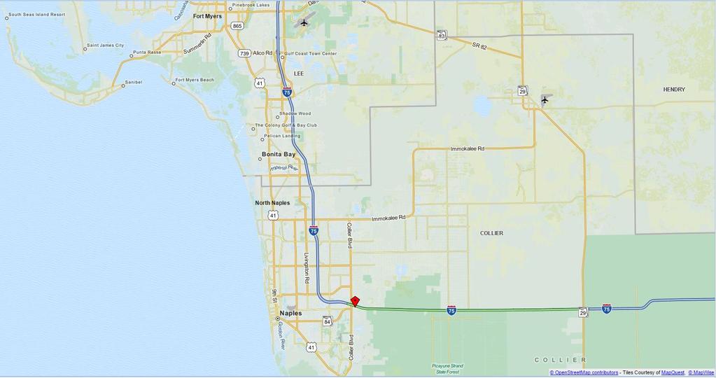
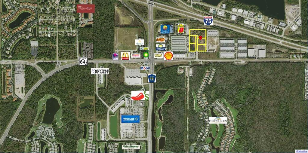
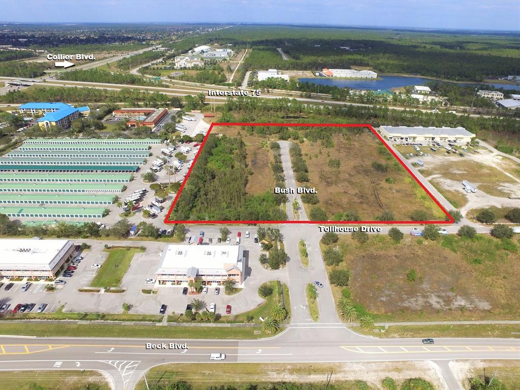
2 TOLLGATE COMMERCIAL CENTER ACRES COMMERCIAL/INDUSTRIAL LAND EXECUTIVE SUMMARY Location The Tollgate Commercial Center PUD/DRI is located in the SEQ of I-75 and Collier Boulevard in Naples. The property is a five minute drive to I- 75, twenty minutes to Olde Naples, thirty minutes to Southwest Florida International Airport and an hour and a half to Miami. Benefits The property is platted with all utilities available. It provides flexibility as it can be purchased in total or divided. The roadway can be abandoned to add an additional third of an acre to the site. A Zoning Amendment is in process adding additional commercial uses such as churches, schools and social services facilities. The traffic count is 45,000 two-way AADT at Collier Blvd. & Beck Blvd. The location has easy access to the airport, major highways, the University, national retailers and entertainment districts. There are over 40,000 affluent rooftops within five miles of the site. Description Permits The property is 5 platted lots located in unincorporated Collier County. Zoning is in place for multiple Commercial and Industrial uses. The current site plan consists of six buildings from 13,000 to 36,000 square feet. A Zoning Amendment adding additional commercial uses has been filed and will be approved by fall No ACOE permit is required. All other permits are complete and active. Utilities Pricing Contact All utilities are available on site. $3,500,000, $7.50 psf Jessica Russo (239) jessica@developmentrealty.org Paul Hardy (239) paul@developmentrealty.org
3
4
5
6
7 ORDINANCE NO AN ORDINANCE OF THE BOARD OF COUNTY COMMISSIONERS OF COLLIER COUNTY, FLORIDA AMENDING ORDINANCE NUMBER 92-10, AS AMENDED, THE TOLLGATE COMMERCIAL CENTER PLANNED UNIT DEVELOPMENT ( PUD), BY AMENDING THE PUD DOCUMENT TO ADD SPECIFIC INSTITUTIONAL USES AS PERMITTED USES ON TRACTS 7, 8 AND 9 OF THE COMMERCIAL USE AREAS, " A" PARCELS, AS SHOWN ON THE PUD MASTER PLAN; BY AMENDING THE PUD DOCUMENT TO ADD SPECIFIC INSTITUTIONAL USES AS PERMITTED USES ON TRACTS AND OF THE COMMERCIAL/ LIGHT INDUSTRIAL USES AREA, " B" PARCELS, AS SHOWN ON THE PUD MASTER PLAN; AND BY PROVIDING AN EFFECTIVE DATE. THE SUBJECT PROPERTY IS LOCATED AT THE INTERSECTION OF COLLIER BOULEVARD ( CR-951) AND BECK BOULEVARD IN SECTION 35, TOWNSHIP 49 SOUTH, RANGE 26 EAST, AND SECTION 2, TOWNSHIP 50 SOUTH, RANGE 26 EAST, COLLIER COUNTY, FLORIDA. [PUDA-PL ] WHEREAS, on February 11, 1992, the Board of County Commissioners adopted Ordinance No , which established the Tollgate Commercial Center Planned Unit Development ( the " Tollgate PUD"); and WHEREAS, on December 14, 1993, the Board of County Commissioners adopted Ordinance No , which amended the Tollgate PUD; and WHEREAS, on September 25, 2015, the Board of County Commissioners adopted Ordinance No which further amended the Tollgate PUD; and WHEREAS, Sky Angel Center, LLC and Toll Gate Naples, LLC represented by Robert L. Duane, AICP of Robert L. Duane & Associates and Richard Yovanovich, Esq. of Coleman, Yovanovich & Koestner, P. A. petitioned the Board of County Commissioners to further amend the Tollgate PUD. NOW, THEREFORE, BE IT ORDAINED BY THE BOARD OF COUNTY COMMISSIONERS OF COLLIER COUNTY, FLORIDA, that: SECTION ONE: Amendment to PUD Document. Exhibit " A" to the PUD Document, attached to Ordinance No , as amended, is hereby amended and replaced with the Exhibit" A" attached hereto and incorporated herein. 16- CPS ] of2 Tollgate Commercial Center PUDA- PL / 28/ 17
8 SECTION TWO: Effective Date. This Ordinance shall become effective upon filing with the Department of State. PASSED AND DULY ADOPTED by sum-majority vote of the Board of County Commissioners of Collier County, Florida, this cl tn. day of G ftp, ATTEST: BOARD IF. I` TY COMMISSIONERS DWIGHT:E.`Bk K;;CLERK COLLIE t 0, TY, FLORID BY: By. // rsg s Jerk PENNY Signa t 0111 YLOR, an Approved as to form and legality: Hei 1 Ashton- Cicko Managing Assistant County Attorney Attachment: Exhibit A PUD Document and Master Plan 16- CPS ] of 2 Tollgate Commercial Center PUDA-PL / 28/ 17 This ordinance filed with the SNstery of tote' s Of ' ce' ttite day of and acknowledgemrpi gf, that day fi. By da., pep clerk
9 PLANNED UNIT DEVELOPMENT TOLL GATE COMMERCIAL CENTER PREPARED BY: RICHARD D. YOVANOVICH COLEMAN, YOVANOVICH& KOESTER, P.A TAMIAMI TRAIL NORTH, SUTIE 300 NAPLES, FLORIDA ) And ROBERT L. DUANE ROBERT L. DUANE& ASSOCIATES, A.LC.P 4880 TAMARIND RIDGE DRIVE, NAPLES, FLORIDA ) DATE REVIEWED BY CCPC: DATE APPROVED BY BCC: ORDINANCE NUMBER: AMENDMENTS AND REPEAL: Page 1 of 28 PUDA- PL rdinance Words strue-kthsengh are deleted; words bold& underlined are added. All distances are in feet unless otherwise noted.*** Indicate break in
10 TABLE OF CONTENTS PAGE) LIST OF EXHIBITS AND TABLE 3 STATEMENT OF COMPLIANCE 4 SECTION I PROPERTY OWNERSHIP & DESCRIPTION 5-9 SECTION II PROJECT DEVELOPMENT REQUIREMENTS SECTION III COMMERCIAL AREAS PLAN FOR PARCEL " A" SECTION IV COMMERCIAL/ LIGHT INDUSTRIAL AREAS FOR PARCEL" B" SECTION V GENERAL DEVELOPMENT COMMITMENTS Page 2 of 28 PUDA- PL rdinance Words struek-through are deleted; words bold& underlined are added. All distances are in feet unless otherwise noted.*** Indicate break in
11 LIST OF EXHIBITS AND TABLES EXHIBIT " A" PUD Master Plan TABLE I Schedule of Development Page 3 of 28 PUDA- PL rdinance Words stwek-through are deleted; words bold& underlined are added. All distances are in feet unless otherwise noted.*** Indicate break in
12 STATEMENT OF COMPLIANCE The development of approximately acres of property in Collier County and within an Interchange Activity Center, as a Planned Unit Development to be known as Tollgate Commercial Center, will be in compliance with the planning goals and objectives of Collier County as set forth in the Growth Management Plan and its provisions for Interchange Activity Center development. includes: Activity Center Project This compliance 1. The subject property is located in an area identified as an Interchange Activity Center in the Future Land Use Element ( FLUE) of the Growth management Plan for Collier County. 2. Interstate Activity Centers are the preferred locations for the concentration of commercial and mixed use development activities. 3. The subject tract is located on the northeast corner of the intersection of CR- 951 and CR- 84. This strategic location allows the site superior access for the placement of commercial/ industrial activities. 4. The project is in compliance with all applicable County regulations. In addition, the project complies with the Growth Management Plan with the adoption of the Plan amendment which allows for specifically approved heavy business/ light industrial uses to be developed in designated interstate activity centers. 5. The project will be served by a complete range of services and utilities as approved by the County. 6. The project is compatible with adjacent land uses through the internal arrangement of structures, the placement of land use buffers and the proposed development standards contained herein. 7. The Planned Unit Development includes open spaces and naturalized open features which serve as project amenities. 8. The project shall be developed in accordance with the approved Master Development Plan and the existing PUD document as approved. In addition, the project shall be developed in accordance with all Collier County regulations in effect at the time of Final SDP or building permit application. 9. Bind the owner' s successor in title to any commitments made under in this document. Page 4 of 28 PUDA- PL rdinance Words stark-through are deleted; words bold& underlined are added. All distances are in feet unless otherwise noted.*** Indicate break in
13 SECTION I PROPERTY OWNERSHIP AND DESCRIPTION 1. 1 PURPOSE The purpose of this Section is to set forth the location and ownership of the property, and to describe the existing conditions of the property proposed to be developed under the project name of Tollgate Commercial Center LEGAL DESCRIPTION Commencing at the southeast corner of Section 35, Township 49 South, Range 26 East, Collier County Florida; thence along the east line of said Section 35 North 1-56' 55" West feet to a point on the north right-of- way line of State Road 84( Alligator Alley); thence along said north right-of- way line, North 89-45' - 01" West feet to a point of intersection of said north right-of- way line of State Road 93 ( I- 75), and the Point of Beginning of the parcel herein described; thence continue along said right-of-way line of State Road 84 ( Alligator Alley) on the following five courses: 1) North 89-45' - 01" West feet; 2) South 89-56' - 16" West feet; 3) North 80-43' - 58" West feet; 4) North 39-52' - 42" West feet; 5) North 10-24' - 33" West Feet to a point on the East Limited Access, right-of way line of State Road 93 ( 1-75); thence continue along said Limited Access, right-of-way line of State 93 ( 1-75) on the following nine courses: 1) North 3-19' - 52" East feet; 2) North 23-37' - 28" East feet; 3) North 64-12' - 39" East feet; 4) North 86-37' - 01" East feet; 5) South 87-55' - 12" East feet; 6) South 78-44' - 38" East feet; 7) South 74-09' - 17" East feet; 8) South 73-00' - 33" East feet; 9) southeasterly feet along the arc of a circular curve concave to the northeast, having a radius of feet, subtended by a chord which bears South 75-35' - 07" East feet to the north right-of- way line of State Road 84 ( Alligator Alley); and the Point of Beginning of the parcel herein described; being a part of south '/ 2, Section 35, Township 49 South, Range 26 East, Collier County, Florida; subject to easements and restrictions of records; containing acres of land more or less; bearings are based on Florida Department of Transportation right-of-way map for State Road 93 ( 1-75). Page 5 of 28 PCDA- PL rdinance Words are deleted; words bold& underlined are added. All distances are in feet unless otherwise noted.*** Indicate break in
14 ALSO INCLUDING THE FOLLOWING: Description of part of Section 35, Township 49 South, Range 26 East, and part of Section 2, Township 50 South, Range 26 East, Collier County, Florida COMMENCE at an iron pipe marking the Northeast Corner of said Section 2; thence North 89 45' 01" West, feet along the North line of said Section 2 for a POINT OF BEGINNING; thence South 00 02' 19" East, feet; thence South 89 57' 41" West, 2, feet; thence on a course traversing from said Section 35, South 89 56' 02" West, 2, feet; thence North 45 46' 16" West, feet; thence North 01 28' 34" West, feet to the Easterly Limited Access R/ W Line of S. R. 951 ( Section ); thence South 10 24' 33" East, feet; thence South 39 52' 42" East, feet; thence South 80 43" 58" East, feet; thence North 89 56' 16" East, 1, feet; thence South 89 45' 01" East, 2, feet to the Southerly Existing Limited Access R/ W Line of S. R. 93 ( ); thence South 00 02' 19" East, feet to the POINT OF BEGINNING. Less and except the East feet thereof. Containing acres, more or less. The entire project area is acres. Number of acres devoted to various categories of land use: Development area Water management area Road Right-of- Way 6. 7 F. P. L Easement GENERAL LOCATION OF PROJECT SITE Tollgate Commercial Center is located in the southeast quadrant of the Interstate I- 75/ CR- 951 interchange, approximately five miles east of the Naples Airport at the eastern terminus of Davis Boulevard ( SR 84) PROPERTY OWNERSHIP The subject property is currently owned by and under the unified control of Tollgate Commercial Center, a Florida General Partnership. The ownership of this property on April 25th, 2017 is Toll Gate Naples LLC, and Sky Angel Center LLC. Page 6 of 28 PCDA- Pl rdinance Words struck through are deleted; words bold& underlined are added. All distances are in feet unless otherwise noted.*** Indicate break in
15 1. 4 GENERAL DESCRIPTION OF PROPERTY AREA A. COMPREHENSIVE PLAN DESIGNATION: The project site is designated Interstate Activity Center on the Collier County Growth Management Plan. B. CURRENT ZONING: The project site is currently zoned PUD. C. EXISTING LAND USE: At the present time the site is unoccupied except for a 104 room motel. D. ADJACENT LAND USE: The adjacent lands are predominately vacant at the present time. The northwest and southwest corners of CR 951 and SR 84 are presently used as gasoline service stations. The properties north of the I- 75 right-of-way and the properties south of CR 84 are vacant PHYSICAL DESCRIPTION The elevation of the project site varies form 9. 8 feet to feet. Tollgate Commercial Center lies within Zone X as identified on the Federal Flood Insurance Rate Map. Zone X is identified as those areas between limits of the 100- year flood and 500- year flood. This means that no development will be occurring within the 100- year flood prone area. A. SOILS: There are three types of soil cover on the project site. They are Arzell fine sands, Keri fine sands and Pompano fine sands. The distribution of these soil types is shown in Map E. B. VEGETATIVE COVER: A breakdown of the vegetative cover of the project area is as follows: VEGETATION COMMUNITY ACREAGE Pineland Saw Palmetto/ Rusty Lyonia Transitional Zone/ Cypress Functional Wetland Cabbage Palm Heads 30 Improved/ Platted Cleared/ Filled Unplatted Former R/ W F. P. L. R/ W TOTAL Page 7 of 28 PL'DA- PL rdinance Words s* uek4i+feugh are deleted; words bold& underlined are added. All distances are in feet unless otherwise noted.*** Indicate break in
16 There are no unique features of the vegetation. All species and associations are typical" for soil types common to pine flatwoods of level sandy areas of Collier County. C. WILDLIFE: Wildlife, observed or noted from tracks, nests, etc. consisted of the representative species, such as raccoon, snakes and wading birds, which normally occur in a habitat such as the Tollgate Commercial Center site. No endangered or threatened species were observed on the site. D. HISTORICAL OR ARCHAEOLOGICAL SITES: John Beriault, Field Representative of the S. W. Florida Archaeological Society, searched for such sites and believes none exist on the tract. E. WASTEWATER MANAGEMENT: Waste water treatment is being provided by the Collier County Sewage Treatment System. Temporary on- site wastewater treatment facilities for which all necessary permits have been granted may be installed during any period of time in which sewage treatment service is not available from Collier County. F. WATER MANAGEMENT: The Water Management Plan provides for site runoff transport to a system of hardwood forest, marsh, and open water ponds. The Water Management Plan is designed to meet SFWMD and County criteria. Minimum road elevations and discharge control will be designed for the 25- year, 3- day rainfall event. The finished floor elevations will be established by the 100 year- zero discharge design event. G. WATER SUPPLY: Potable water is being supplied by the Collier County Water- Sewer District. Non- potable water utilized for landscape irrigation and other non- human consumptive uses will be procured from on- site wells, or from the County treated sewage effluent distribution system. H. SOLID WASTE: Solid waste is being disposed of at the Collier County Sanitary Landfill. Collection is provided by Waste Management of Collier County, a franchised hauler. I. ELECTRICITY: Electricity is being provided by Company, Inc. the Florida Power & Light J. POLICE PROTECTION: Police protection is provided by the Collier County Sheriff Department. Page 8 of 28 PUDA- PL rdinance Words struck h-rough are deleted; words bold& underlined are added. All distances are in feet unless otherwise noted.*** Indicate break in
17 K. FIRE PROTECTION: Fire protection is provided by the Golden Gate Fire Control and Rescue District. L. TELEPHONE: Telephone service is provided by United Telephone of Florida. Page9of28 PUDA- PL rdinance Words stfuel4hreugh are deleted; words bold& underlined are added. All distances are in feet unless otherwise noted.*** Indicate break in
18 SECTION II PROJECT DEVELOPMENT REQUIREMENTS 2. 1 PURPOSE The purpose of this Section is to delineate and generally described the project plan of development, relationships to applicable County ordinances, the respective land uses of the tracts included in the project, as well as other project relationships GENERAL A. Regulations, requirements and references for development of Tollgate Commercial Center shall be in accordance with the contents of this document. Where these regulations fail to provide development standards, then the provisions of the most similar district in the Collier County Land Development Code shall apply. B. Unless otherwise noted, the definitions of all terms shall be the same as the definitions set forth in Collier County Land Development Code. C. All conditions imposed and all graphic material presented depicting restrictions for the development of Tollgate Commercial Center shall become part of the regulations which govern the manner in which the PUD site may be developed. D. Unless specifically waived through variance or waiver provisions within the PUD, those applicable regulations not otherwise provided for in this PUD remain in full force and effect. E. Each tract, as identified on the Master Plan, shall require the submittal, review and subsequent approval of a Site Development Plan prior to the issuance of a Final Local Development Order DESCRIPTION OF PROJECT PLAN AND PROPOSED LAND USES A. The project Master Plan is illustrated graphically by Exhibit " A", PUD Master Development Plan. SCHEDULE OF DEVELOPMENT Project development is underway and will continue to build- out. Page 10 of 28 PIJDA- PL rdinance Words struck through are deleted; words bold& underlined are added. All distances are in feet unless otherwise noted.*** Indicate break in
19 The following schedule indicates the anticipated start and completion dates for the various project development Phases. Phase boundaries are indicated on the Master Development Plan. TABLE I PHASE ACREAGE SITE START COMPLETE I I III TOTALS A. Table I is a schedule of Development, with the approximate acreage of the total project indicated. The arrangement of these land areas are shown on the PUD Master Development Plan ( Exhibit " A"). The Master Development Plan is an illustrative preliminary development plan. Design criteria and layout is illustrative on the Master Development Plan and other exhibits supporting this project. It shall be understood that these exhibits are to remain flexible so the final design may satisfy development objectives and be consistent with the project development, as set forth in this document. Minor changes to the master plan shall be subject to the provisions of Section , Division 2. 7, Article E. - Planned Unit Development ( PUD) Procedures of Land Development Code. The final size of the open space lands will depend on the actual requirements for drive patterns, parking layout and requirements, and development parcel size and configuration. the Collier County B. In addition to the various areas and specific items shown in Exhibit " A", such utility and other easements as are necessary shall be established within or along the various tracts RELATED PROJECT PLAN APPROVAL REQUIREMENTS A. Prior to the recording of a Record Plat, for all or part of the PUD, final plans of all required improvements shall receive approval of the appropriate Collier County governmental agency to insure compliance with the PUD Master Plan, and the Collier County Land Development Code. B. Exhibit " A', PUD Master Development Plan, constitutes the required PUD Development Plan. Subsequent to or concurrent with PUD approval, a Preliminary Subdivision Plat, if Page 11 of 28 PLDA- PL rdinance Words striuek-through are deleted; words bold& underlined are added. All distances are in feet unless otherwise noted.*** Indicate break in
20 applicable, shall be submitted for any area to be subdivided. Any division of property and the development of the land shall be in compliance with the Collier County Land Development Code and the platting laws of the State of Florida. C. The development of any tract or parcel contemplating fee simple ownership of land shall be required to submit and receive approval of a Preliminary Subdivision Plat in conformance with the requirements of Division 3. 2, Article 3, Section Requirements for Preliminary and Final Subdivision Plats of the Collier County Land Development Code, prior to the submittal of construction plans and plat for any portion of the tract or parcel. D. Appropriate instruments will be provided at the time of infrastructural improvements regarding any dedications and method for providing perpetual maintenance of common facilities. E. The developer or subsequent owner of any platted parcel or platted tract shall, prior to application for a building permit, submit a Site Development Plan ( SDP) or Preliminary Subdivision Plat for the tract or parcel to the Development Services Department for approval for applicable development subject to the provisions of Division 3. 3, Article 3 of the Collier County Land Development Code AMENDMENTS TO PUD DOCUMENT OR PUD MASTER PLAN Amendments may be made to the PUD as provided in Section , Division 2. 7, Article E. - Planned Unit Development ( PUD) Procedures of the Collier County Land Development Code LIMITATIONS OF PLANNED UNIT DEVELOPMENT APPROVAL As provided for within Section , Division 2. 7, Article D. - Planned Unit Development (PUD) Procedures of the Collier County Land Development Code POLLING PLACES As provided for in Section , Division 3. 2, Article 3 County Land Development Code Polling Places of the Collier 2. 8 PUD MONITORING An annual monitoring report shall be submitted pursuant to Section , Division 2. 7, Article F. - Planned Unit Development ( PUD) Procedures of the Collier County Land Development Code. Page 12 of 28 Pt DA- PL Ordinance Words are deleted; words bold& underlined are added. All distances are in feet unless otherwise noted.*** Indicate break in
21 SECTION III COMMERCIAL AREAS PLAN 3. 1 PURPOSE The purpose of this Section is to identify the type of Commercial Uses and development standards that will be applied to the areas so designated on Exhibit" A", as " A" Parcels DEVELOPMENT INTENT FOR PARCEL " A" It is the intent of this document that " A" designated development parcels be used for commercial purposes which serve the motoring public using Interstate I- 75 as well as providing limited commercial goods and services of an area- wide nature for the Naples, Marco Island, Golden Gate and the Immokalee urban areas. Further it is the intent of this document that " A" designated development parcels shall be used in accordance with all current Federal, State and County regulations in effect at the time final local development orders are issued except as specified otherwise in this document by the Collier County Board of County Commissioners COMMERCIAL USES PERMITTED No building or structure, or part thereof, shall be erected, altered or used, or land used, in whole or part, for other than the following: A. Principal Uses No building or structure, or part thereof, shall be erected, altered or used or land or water used, in whole or in part, for other than the following: a) Automobile service stations including engine tune- ups and minor repairs, and car wash facilities which are accessory uses. b) Banks and financial institutions, business and professional offices. c) Cocktail lounges and commercial entertainment. d) Convention and exhibition halls. e) Department stores; drug stores; dry cleaning shops and dry goods stores. Page 13 of 28 PUDA- PL rdinance Words struck through are deleted; words bold& underlined are added. All distances are in feet unless otherwise noted.*** Indicate break in
22 f) Electronic games and furniture sales. g) Ice cream shops and dairy drive- in stores. h) Motels; hotels and other transient lodging facilities. i) Research and design labs; restaurants and fast food restaurants. j) Shopping centers. k) Souvenir stores and stationery stores. I) Supermarkets m) Variety stores; vehicle rental- automobile and U- haul type of vehicles and equipment including outside display; veterinary offices and clinics; no outside kenneling. n) Any other commercial or professional service which is comparable in nature with the foregoing uses and which the Planning Implementation Director determines to be compatible in the district. B. Permitted Accessory Uses and Structures a) Any accessory uses or structures customarily associated with the permitted principal uses and structures. b) Caretakers residence. C. Permitted Provisional Uses and Structures a) Car wash facilities which are principal uses. b) Permitted uses with less than one thousand ( 1, 000) square feet gross floor area in the principal structure. Page 14 of 28 PUDA- PL rdinance Words dough are deleted; words bold& underlined are added. All distances are in feet unless otherwise noted.*** Indicate break in
23 Institutional Uses Permitted A. Uses permitted In addition to the uses set forth in Section 3. 3., the following principal uses are permitted on the property described on Tracts 7, 8, 9, on the PUD Master Plan Exhibit A. Amusements and Recreational Services, Not Elsewhere Classified ( SIC Code 7999): limited to: - Gymnastics, Instruction, Judo Instruction, Karate Instruction, Yoga Instruction, Scuba and Skin Diving Instruction, and Day Camps. Business Associations ( SIC Code 8611) Child Daycare Services ( SIC Code 8351) Civil and Fraternal Organizations ( SIC Code 8641) Dance Studios and Schools ( SIC Code 7911) Job Training and Vocational Rehabilitation Services ( SIC Code 8331) Physical Fitness Facilities ( SIC Code 7991) Professional Membership Organizations ( SIC Code 8621) Religious Organizations ( SIC Code 8661) Social Services ( SIC Code 8322) : Excluding: Alcoholism Counseling, Non- Residential Except Medical Treatment, Offender Rehabilitation Agencies, Parole Offices, Probation Offices, and Offender self-help agencies. B. Permitted Accessory Uses and Structures. a) Any accessory uses or structures customarily associated with the permitted principal uses and structures DEVELOPMENT STANDARDS I) Minimum Lot Area: Ten thousand ( 10, 000) square feet. 2) Minimum Lot Width: One hundred ( 100) feet as measured at the front building setback line. 3) Minimum Yard Requirements: a) Front Yard Twenty-five( 25) feet plus one( 1) foot for each two( 2) feet of building height over fifty (50) feet. b) Side Yard None or a minimum of five ( 5) feet with unobstructed passage from front to rear yard for non- residential uses. Fifteen ( 15) feet for motels, hotels and Page 15 of 28 PUDA- PI, Ordinance Words struck through are deleted; words bold& underlined are added. All distances are in feet unless otherwise noted.*** Indicate break in
24 transient lodging facilities plus one ( 1) over fifty (50) feet. foot for each two ( 2) feet of building height c) Rear Yard Twenty- five ( 25) feet. d) Waterfront Twenty- five ( 25) feet from the normal water line of any artificially created body of water, excluding observation decks, bridges and walkways. 4) Maximum Height: One hundred ( 100) feet. 5) Minimum Floor Area of Principal Structure: One thousand( 1, 000) square feet per building on the ground floor, except that gasoline service stations and other permitted areas for which the principal activity does not occur in a structure shall not require a minimum floor area. 6) Maximum Density: Twenty- six ( 26) units per gross acre of land for hotels, motels or transient lodging facilities. 7) Distance between Principal Structures on same Site: one- half the sum of the heights. 8) Signs: As required by Division 2. 5 Section SIGN REGULATIONS AND STANDARDS BY LAND USE CLASSSIFICATION of the Land Development Code. 9) Minimum Off-Street Parking and Off-Street Loading Requirements: As required by Division 2. 3 Section of the Collier County Land Development Code. 10) Minimum Landscaping Requirements: a. Landscape buffer width requirement adjacent to CR- 84 and CR- 951: CR- 84, 5 feet and CR- 951, 10 feet Type D Buffer with the landscape installation requirements set forth in the Land Development Code Section alternative D C. 4. b. Landscape buffer width requirement adjacent to interior platted streets: 5 feet with alternative A of subsection of the buffer standards Type A Buffer pursuant to the Land Development Code Section C. 1. PIiDA- Pl S0Ordinance c. Landscape buffer width requirement adjacent to side lot lines, 5 feet for lots which are independently developed with discreet off street parking and drive systems: none for lots which are developed with an off street parking and drive systems which are planned to extend across one or more side lot lines so as to serve in common the adjoining lot( s). d. All landscaping requirements of Division 2. 4 Section Landscaping, Buffering, and Vegetation Retention of the Land Development Code not in conflict with a, b, and c shall be applicable. Page 16 of 28 Words struck-through are deleted; words bold& underlined are added. All distances are in feet unless otherwise noted.*** Indicate break in
25 e. Landscape buffer plans shall be incorporated in SDP applications for each individual development site. 1 1) Outside Merchandise Storage and displaying: Unless specifically authorized by this PUD documents or by an approved Site Development Plan, outside storage or display of merchandise is prohibited. 12) Uses set forth in Section , shall meet the standards of the " Activity Center # 9 overlay in the Future Land Use Element of the Growth Management Plan." Existing buildings and structures, as shown on an SDP approved before the date of adoption of this Ordinance, may remain as non- conforming until redevelopment. PUDA- PL rdinance Page 17 of 28 Words struck-through are deleted; words bold& underlined are added. All distances are in feet unless otherwise noted.*** Indicate break in
26 SECTION IV COMMERCIAL/ LIGHT INDUSTRIAL USES 4. 1 PURPOSE The purpose of this Section is to identify the type of Commercial/ Industrial Uses and development standards that will be applied to the areas designated on Exhibit" A" as " B" Parcels DEVELOPMENT INTENT FOR PARCEL " B" It is the intent of this document that" B" designated development parcels by-be used for both " A" designated uses and for the sale, service, transportation, storage and distribution of goods and service to the traveling public on 1-75 and to the citizens of the area which can be served via the access road systems. A major function of these parcels is to serve as a focal point for the arrival of goods from other points of the region and country and then be processed for distribution to the local trade market. It is intended that inside storage and warehousing along with limited assembly and manufacturing wholly within a building and not obnoxious by reason of emission of odor, fumes, dust, smoke, noise or vibration be permitted. Further, it is the intent of this document that" B" designated Parcels be used in accordance with all of the current Federal, State and County regulations in effect at the time final local development orders are issued except as specified otherwise in this document or as may be approved otherwise by the Collier County Board of Commissioners USES PERMITTED No building or structure, or part thereof, shall be erected, altered or used, or land or water used, in whole or in part of other than the following: A. Principal Uses: a) Any principal use or structure permitted on " A" designated development parcels. b) Assembly operations in an enclosed building. Page 18 of 28 PUDA- PL Ordinance Words struck-through are deleted; words bold& underlined are added. All distances are in feet unless otherwise noted.*** Indicate break in
27 c) Building supplies and contractors storage facilities; bulk storage yards not including junk or salvage yards. d) Car wash, communications service and equipment repair. e) Freight movers and storage. f) Laboratories, research, design and testing; laundries; lawn maintenance shops and plant nurseries; light manufacturing or processing ( include food processing but not abattoir; packaging or fabricating in a completely enclosed building). g) Miscellaneous uses such as express office; telephone exchange; motor or bus or truck or other transportation terminal and related uses; motorcycle sales, service and repair; museums and tourist attractions. h) New and used car sales, service and repair including outside display. i) Offices, general purpose. j) Warehousing, wholesaling, storage and distributing establishments and similar uses. k) Any other commercial or professional use which is comparable in nature with the foregoing uses and which the Planning Implementation Director determines to be compatible in the district. B. Permitted Accessory Uses and Structures: 1) Any accessory use or structure customarily associated with the permitted uses and structures. C. Permitted Provisional Uses and Structures: 1) Attached residence in conjunction with a business one ( 1) per business. 2) Permitted use with less than 1, 000 square feet gross floor areas in the principal building. Page 19 of 28 PL' DA- PL rdinance Words struck through are deleted; words bold& underlined are added. All distances are in feet unless otherwise noted.*** Indicate break in
28 Institutional Uses Permitted A. Uses permitted In addition to the uses set forth in Section 4. 3., the following principal uses are permitted on Tracts 16-20, and on the PUD Master Plan Exhibit A. Amusements and Recreational Services, Not Elsewhere Classified ( SIC Code 7999): limited to: - Gymnastics, Instruction, Judo Instruction, Karate Instruction, Yoga Instruction, Scuba and Skin Diving Instruction, and Day Camps. Business Associations ( SIC Code 8611) Child Daycare Services ( SIC Code 8351) Civil and Fraternal Organizations ( SIC Code 8641) Dance Studios and Schools ( SIC Code 7911) Job Training and Vocational Rehabilitation Services ( SIC Code 8331) Physical Fitness Facilities (SIC Code 7991) Professional Membership Organizations ( SIC Code 8621) Religious Organizations ( SIC Code 8661) Social Services ( SIC Code 8322) : Excluding: Alcoholism Counseling, Non- Residential Except Medical Treatment, Offender Rehabilitation Agencies, Parole Offices, Probation Offices, and Offender self-help agencies. B. Permitted Accessory Uses and Structures. a) Any accessory uses or structures customarily associated with the permitted principal uses and structures DEVELOPMENT STANDARDS 1) Minimum Lot Area: Ten thousand ( 10, 000) square feet. 2) Minimum Lot Width: One hundred ( 100) feet as measured at the front building setback line. 3) Minimum Yard Requirements: a) Front Yard Twenty- five ( 25) feet. b) Side Yard None, or a minimum of five ( 5) feet with unobstructed passage from front to rear yard for non- residential uses. Fifteen ( 15) feet for hotels, motels and transient lodging facilities plus one ( 1) foot for each two ( 2) feet of building height over fifty (50) feet. Attached residences shall be treated as non- residential. Page 20 of 28 PUDA- PL rdinance Words are deleted; words bold& underlined are added. All distances are in feet unless otherwise noted.*** Indicate break in
29 c) Rear Yard Twenty- five ( 25) feet. d) Waterfront Twenty-five (25) feet from the normal level of any artificially created body of water, excluding observation decks, bridges and walkways. 4) Maximum Height: One hundred ( 100) feet. 5) Minimum Floor Area of Principal Structure: One thousand ( 1, 000) square feet per building on ground floor, except that gasoline service stations and other permitted uses for which the principal activity does not occur in a structure shall not require a minimum floor area. 6) Maximum Density: Twenty- six ( 26) units per gross acre of land for hotel, motel and transient lodging facilities. 7) Distance between Structures: One- half the sum of the heights. 8) Signs: As required by Division 2. 5 Section of the Collier County Land Development Code. 9) Minimum Off-Street Parking and Off-Street Loading Requirements: As required by Division 23 Section Off-Street Parking and Loading ofthe Collier County Land Development Code. 10) Minimum Landscaping Requirements: a. Landscape buffer width requirement adjacent to CR- 84 and CR- 951: CR- 84, 5 feet and CR- 951, 10 feet Type D Buffer with the landscape installation requirements set forth in the Land Development Code Section alternative D C. 4 b. Landscape buffer width requirement adjacent to interior platted streets: 5 feet with alternative A of subsection of the buffer standards Type A Buffer pursuant to the Land Development Code Section C. 1. c. Landscape buffer width requirement adjacent to side lot lines, 5 feet for lots which are independently developed with discreet off street parking and drive systems: none for lots which are developed with an off street parking and drive systems which are planned to extend across one or more side lot lines so as to serve in common the adjoining lot(s). d. All landscape requirements of Division 2. 1 Section Landscape, Buffering, and Vegetation Retention of the Land Development Code not in conflict with a, b, and c shall be applicable. Page 21 of 28 PUDA- PL rdinance Words struck through are deleted; words bold& underlined are added. All distances are in feet unless otherwise noted.*** Indicate break in
30 e. Landscape buffer plans shall be incorporated in SDP applications for each individual development site. 1 1) Merchandise Storage and Display: Unless specifically authorized by this PUD documents or an approved Site Development Plan, or of a nature which is permitted generally, outside storage or display or merchandise is prohibited. 12) Uses set forth in Section , shall meet the standards of the " Activity Center # 9 overlay in the Future Land Use Element of the Growth Management Plan." Existing buildings and structures, as shown on an SDP approved before the date of adoption of this Ordinance, may remain as non- conforming until redevelopment. Page 22 of 28 PUDA- PL rdinance Words sfrwek-through are deleted; words bold& underlined are added. All distances are in feet unless otherwise noted.*** Indicate break in
31 SECTION V GENERAL DEVELOPMENT COMMITMENTS 5. 1 PURPOSE The purpose of this Section is to set forth the standards for the development of the project PUD MASTER PLAN A. The PUD Master Plan is an illustrative preliminary development plan. B. The design criteria and layout illustrated in the Master Development Plan shall be interpreted as preliminary and understood to be flexible so that the final design may best satisfy the project and comply with all applicable requirements. Minor design changes shall be permitted subject to Staff approval. C. All necessary easements, dedication, or other instruments shall be granted to insure the continued operation and maintenance of all service utilities. D. Overall site design shall be harmonious in terms of landscaping, enclosure of structure, locations of all improved facilities and location and treatment of buffer areas ENGINEERING A. The developer and all subsequent petitioners are hereby placed on notice that they shall be required to satisfy the requirements of all County ordinances or codes in effect prior to or concurrent with any subsequent development order relating to this site. This includes, but is not limited to, Preliminary Subdivision Plats, Site Development Plans and any other application that will result in the issuance of a final or final local development order. B. The project shall be platted in accordance with the Collier County Subdivision Cede Section Requirements for Preliminary and Final Subdivision Plats to define the right- of-way, tracts, and water management areas as shown on the master plan. C. Landscaping shall not be placed within the water management areas unless specifically approved by project Review Services. D. Provide a landscape buffer along the entire southern property line in accordance with Section with Section 3. 4 ( 10) and 4. 4 ( 10) of this PUD. PUDA- PL rdinance Page 23 of 28 Words stfeek-thteugk are deleted; words bold& underlined are added. All distances are in feet unless otherwise noted.*** Indicate break in
32 E. Should the South Florida Water Management District, during its permit review process, require a natural vegetative buffer be created between the lots and any jurisdictional wetland Preserve and/ or Conservation tract, the buffer shall not be located within the boundaries of the lot( s) unless otherwise waived by the South Florida Water Management District. It shall be created as a separate platted tract or as a buffer Easement over an expanded limit of the Preserve tracts, which would be dedicated as Preserve/ Drainage tracts, to include the buffer within the Preserve tract. If the buffer is located within a separate tract, that tract shall be dedicated on the plat to the project' s homeowners association or like entity for ownership and maintenance responsibilities and if necessary, to Collier County with no responsibility for maintenance. All Preserve buffer easements or buffer tracts shall be created in conformance with the provisions of Chapter , Florida Statutes. F. Land Development Code, Section Street System Requirements Dead end streets maximum length not to exceed 1, 000 feet: Waived to a maximum length of 1, 050 feet. G. Land Development Regulations, Section Street System Requirements All local streets within commercial subdivision shall be designed according to the typical section for collector streets contained in the County Standards. Waived subject to right- of-way and other dimension requirements for the roads to meet local street standards and the pavements structure to meet collector standards. H. Land Development Code, Section Easements: Utility easements will be provided as needed with Collier County utility fifteen ( 15) feet. easements ( C. U.E.) at a minimum of I. Land Development Code, Section Sidewalks, Bike Lane and Pathways Requirements. Not waived since existing phase already has sidewalks and it will maintain the continuity for pedestrian' s access purposes UTILITIES A. Water distribution, sewage collection and transmission and interim water and/ or sewage treatment facilities to serve the project are to be designed, constructed, conveyed, owned and maintained in accordance with Collier County Ordinance No Collier County Code of Laws and Ordinances Chapter 134 Utilities, Section , Policies and Standards, as amended, and other applicable County rules and regulations. Page 24 of 28 PUDA- PL rdinance Words sfwek-through are deleted; words bold& underlined are added. All distances are in feet unless otherwise noted.*** Indicate break in
33 B. C. All customers connecting to the water distribution and sewage collection facilities to be constructed will be customers of the County and will be billed by the County in accordance with the County' s established rates. The on- site water distribution system to serve the project must be connected to the existing water main on Tollhouse Drive and/ or CR- 84 rights-of-way consistent with the main sizing requirements specified in the County' s project. Water Master Plan and extended throughout the During design of these facilities, dead end mains shall be eliminated by looping the internal pipeline network. D. The utility construction documents for the project' s sewerage system shall be prepared so that all sewage flowing to the County' s master pump station is transmitted by one( 1) main on- site pump station. Due to the design and configuration of the master pump station, flow by gravity into the station will not be possible. The Developer' s Engineer shall meet with the County Staff prior to commencing preparation of construction drawings, so that all aspects of the sewerage system design can be coordinated with the County' s sewer master plan. E. The existing off-site water facilities of the District must be evaluated for hydraulic capacity to serve this project and reinforced as required, if necessary, consistent with the County' s Water Master Plan to insure that the District' s water system can hydraulically provide a sufficient quantity of water to meet the anticipated demands of the project and the District' s existing committed capacity. F. The existing off-site sewage transmission facilities of the district must be evaluated for hydraulic capacity to serve this project improved as required outside the project boundary to provide adequate capacity to transport the additional wastewater generated without adverse impact to the existing transmission facilities WATER MANAGEMENT AND ENGINEERING A. Detailed paving, grading, site drainage and utility plans shall be submitted to Project Review Services for review. No construction permits shall be issued unless and until approval of the proposed construction in accordance with the submitted plans is granted by Project Review Services. B. Work within Collier County right-of-way shall meet the requirements of Collier County Right of Way Ordinance No , as amended. C. An Excavation Permit will be required for the proposed lakes( s) in accordance with Division of the Collier County Land Development Code Collier County Code of Laws Page 25 of 28 PUDA- PL rdinance Words stwek-through are deleted; words bold& underlined are added. All distances are in feet unless otherwise noted.*** Indicate break in
34 and Ordinances Chapter 22, Article IV, Excavation. The standards related to depths may be modified in accordance with DER DEP and ACOE USACE permits. D. Each building site will be required to provide a minimum 1/2 site, unless otherwise waived by South Florida Water Management District. inch of dry pre-treatment on 5. 6 ENVIRONMENTAL A. All jurisdictional wetlands and mitigation areas on- site shall be designated as conservation/ preserve tracts or easements on all construction plans and shall be recorded on the plat with protective covenants similar to or as per Chapter of the Florida Statutes. B. In the case of mitigation off-site any purchase must be within the Conservation and Recreational Lands ( CARL) or the Corkscrew Regional Ecological Watershed Lands CREW) or other areas approved for mitigation by the Florida Department of Environmental Regulation. The ultimate transfer of deed( s) of land( s) to Florida Department of Natural Resources, Division of State Lands must occur prior to final construction plan/ plat approvals. C. Control structures on- site shall be constructed in accordance with State and Federal permits WATER MANAGEMENT A. Detailed paving, grading, and site drainage plans shall be submitted to Project Review Services for review. No construction permits shall be issued unless and until approval of the proposed construction in accordance with the submitted plans is granted by Project Review Services. B. Design and construction of all improvements shall be subject to compliance with the appropriate provisions of the Collier County Subdivision Regulations. C. An Excavation Permit will be required for the proposed lake( s) in accordance with Division 3. 5 of the Collier County Land Development Code Collier County Code of Laws and Ordinances Chapter 22, Article IV, Excavation. The standards related to depths may be modified in accordance with DER DEP and ACOE USACE permits. D. A copy of SFWMD Permit or Early Work Permit is required prior to construction plan approval. E. Each building site will be required to provide a minimum '/ 2 inch of dry pre- treatment onsite, unless otherwise waived by South Florida Water Management District. PUDA- PL rdinance Page 26 of 28 Words struckthrough are deleted; words bold& underlined are added. All distances are in feet unless otherwise noted.*** Indicate break in
35 5. 8 TRANSPORTATION A. The final location of major access points along Davis Boulevard shall be determined during the SMP process approval of the Final Subdivision Plat or Site Development Plan. Such major access points shall provide primary access and internal road circulation and shall typically include turn land improvements based on projected traffic conditions. Secondary access points between Davis Boulevard and individual parcels shall be prohibited unless approved consistent with Ordinance the Final Subdivision Plat as may be amended and with the following access control criteria: 1. safety 2. proper geometric design 3. effects on the capacity of Davis Boulevard 4. traffic volumes using the proposed access point 5. other roadways providing access to the site 6. the combined effect of access to any and all tracts both within this PUD and adjacent PUD' s 7. spacing of access points Collier County reserves the right to close any approved secondary access to and from Davis Boulevard should it at any time be found to create a traffic hazard or to adversely affect the capacity or level of service of that roadway. B. The road impact fee shall be as set forth in Ordinance Collier County Code of Laws and Ordinances Chapter 74, as amended, and shall be paid at the time building permits are issued unless otherwise approved by the Board of County Commissioners. C. Access improvements shall not be subject to impact fee credits and shall be in place before any certificates of occupancy are issued. D. All traffic control devices used shall conform with the Manual on Uniform Traffic Control Devices as required by Chapter Florida Statutes. Page 27 of 28 PUDA- PL rdinance Words ugh are deleted; words bold& underlined are added. All distances are in feet unless otherwise noted.*** Indicate break in
ORANGE BLOSSOM GARDENS PLANNED UNIT DEVELOPMENT PREPARED BY: COASTAL ENGINEERING CONSULTANTS, INC.
 ORANGE BLOSSOM GARDENS A PLANNED UNIT DEVELOPMENT PREPARED BY: COASTAL ENGINEERING CONSULTANTS, INC. REVISED OCTOBER 19, 1992 BY THE COLLIER COUNTY LONG RANGE PLANNING DEPARTMENT REVISED DECEMBER, 2008
PINE RIDGE COMMONS PUD AMEND ORDINANCE NUMBER 99-94
 PINE RIDGE COMMONS PUD AMEND ORDINANCE NUMBER 99-94 Title page of the Planned Unit Development Document, previously attached as Exhibit A to the PUD document of Ordinance Number 99-94, the Pine Ridge commons
SECTION 10.7 R-PUD (RESIDENTIAL PLANNED UNIT DEVELOPMENT) ZONE
 ZONE") Article X Zones 10-20 SECTION 10.7 R-PUD (RESIDENTIAL PLANNED UNIT DEVELOPMENT) ZONE A. PURPOSE AND INTENT: The R-PUD Residential PUD Zone is intended to provide alternative, voluntary zoning procedures
Article X Zones 10-20 SECTION 10.7 R-PUD (RESIDENTIAL PLANNED UNIT DEVELOPMENT) ZONE A. PURPOSE AND INTENT: The R-PUD Residential PUD Zone is intended to provide alternative, voluntary zoning procedures
PINE RIDGE COMMONS PUD AMEND ORDINANCE NUMBER 99-94
 PINE RIDGE COMMONS PUD AMEND ORDINANCE NUMBER 99-94 Title page of the Planned Unit Development Document, previously attached as Exhibit A to the PUD document of Ordinance Number 99-94, the Pine Ridge commons
PROPOSED AMENDMENTS TO THE DERBY ZONING REGULATIONS AUGUST 12, 2008
 ARTICLE II Definitions and word usage 195-7. Definitions and word usage. Modify the following: HOUSING FOR THE ELDERLY OLDER PERSONS Housing in accordance with and as defined in the United States Fair
FOR SALE. +/-.86 Acres at St. Lucie West Blvd & Bayshore in Port St. Lucie, Florida. St. Lucie West Boulevard & Bayshore Boulevard, Port St.
 Shirley Harris (772) 288-6646 sharris@tccommercialre.com FOR SALE +/-.86 Acres at St. Lucie West Blvd & Bayshore in Port St. Lucie, Florida St. Lucie West Boulevard & Bayshore Boulevard, Port St. Lucie,
GC General Commercial District
 Section 712. GC General Commercial District 712.1 Intent of District. It is the intent of this section that the GC Zoning District be developed and reserved for general business purposes. The regulations
4. Public service facilities, such as police and fire stations.
 CHAPTER 500. SECTION 525. ZONING STANDARDS C-1 NEIGHBORHOOD COMMERCIAL DISTRICT 525.1. Purpose The purpose of the C-1 Neighborhood Commercial District is to provide and require a unified and organized
ARTICLE 15 - PLANNED UNIT DEVELOPMENT
 Section 15.1 - Intent. ARTICLE 15 - PLANNED UNIT DEVELOPMENT A PUD, or Planned Unit Development, is not a District per se, but rather a set of standards that may be applied to a development type. The Planned
CHAPTER 10 Planned Unit Development Zoning Districts
 CHAPTER 10 Planned Unit Development Zoning Districts Section 10.1 Intent and Purpose The Planned Unit Development (PUD) districts are intended to offer design flexibility for projects that further the
Exhibit "A" have applied for a re-zoning and re-classification of that property from OPEN RURAL (OR) to that of a PLANNED UNIT DEVELOPMENT (PUD); and
 to that of a PLANNED UNIT DEVELOPMENT (PUD); and") I NSTR # 200632845 OR BK 61439 PGS 0728-0750 RECORDED 06/24/2066 12:25:50 PR JOHN Q. CRAWFOKD CLERK OF CIRCUIT COURT NASSAU COUNTY, FLORIDA RECORDING FEES 1.37.80 ORDINANCE NO. 2006-65 AN ORDINANCE AMENDING
I NSTR # 200632845 OR BK 61439 PGS 0728-0750 RECORDED 06/24/2066 12:25:50 PR JOHN Q. CRAWFOKD CLERK OF CIRCUIT COURT NASSAU COUNTY, FLORIDA RECORDING FEES 1.37.80 ORDINANCE NO. 2006-65 AN ORDINANCE AMENDING
Chapter 100 Planned Unit Development in Corvallis Urban Fringe
 100.100 Scope and Purpose. Chapter 100 Planned Unit Development in Corvallis Urban Fringe (1) All applications for land divisions in the Urban Residential (UR) and Flood Plain Agriculture (FPA) zones within
Medical Marijuana Special Exception Use Information
 Medical Marijuana Special Exception Use Information The Special Exception Use information below is a modified version of the Unified Development Code. It clarifies the current section 5:104 Special Exceptions
FOR SALE. Prime Commercial Land +/ Acres US Highway 1, North of Walton Rd Port St. Lucie, Florida
 FOR SALE Prime Commercial Land +/- 2.36 Acres US Highway 1, North of Walton Rd Port St. Lucie, Florida For Further Information Contact: www.tccommercialre.com Shirley Harris (772) 288-6646 sharris@tccommercialre.com
Cover Letter with Narrative Statement
 Cover Letter with Narrative Statement March 31, 2017 rev July 27, 2017 RE: Rushton Pointe Residential Planned Unit Development Application for Public Hearing for RPUD Rezone PL2015 000 0306 Mr. Eric Johnson,
The following regulations shall apply in the R-E District:
 "R-E" RESIDENTIAL ESTATE DISTRICT (8/06) The following regulations shall apply in the R-E District: 1. Uses Permitted: The following uses are permitted. A Zoning Certificate may be required as provided
FOR LEASE. +/- 1,090 SF Office Condo West Park Professional Center St. Lucie West, FL. 540 NW University Blvd, #209-A, Port St.
 Kyle St. John (772) 288-6646 kyle@tccommercialre.com www.tccommercialre.com FOR LEASE +/- 1,090 SF Office Condo West Park Professional Center St. Lucie West, FL 540 NW University Blvd, #209-A, Port St.
PLANNED UNIT DEVELOPMENTS (Ordinance No.: 3036, 12/3/07; Repealed & Replaced by Ordinance No.: 4166, 10/15/12)
") 159.62 PLANNED UNIT DEVELOPMENTS (Ordinance No.: 3036, 12/3/07; Repealed & Replaced by Ordinance No.: 4166, 10/15/12) A. PURPOSE 1. General. The Planned Unit Development (PUD) approach provides the flexibility
159.62 PLANNED UNIT DEVELOPMENTS (Ordinance No.: 3036, 12/3/07; Repealed & Replaced by Ordinance No.: 4166, 10/15/12) A. PURPOSE 1. General. The Planned Unit Development (PUD) approach provides the flexibility
PERMITTED USES: Within the MX-1 Mixed Use Neighborhood District the following uses are permitted:
 6.25 MX-1 - MIXED USE NEIGHBORHOOD 6.25.1 INTENT: The purpose of the MX-1 Mixed Use Neighborhood District is to accommodate the development of a wide-range of residential and compatible non-residential
THE COUNTY BOARD OF SUPERVISORS OF THE COUNTY OF DOUGLAS DOES ORDAIN AS FOLLOWS:
 8.1 SUBDIVISION CONTROL ORDINANCE THE COUNTY BOARD OF SUPERVISORS OF THE COUNTY OF DOUGLAS DOES ORDAIN AS FOLLOWS: SECTION I. GENERAL INTERPRETATION This ordinance shall not repeal, impair or modify private
Chapter CC COMMUNITY COMMERCIAL ZONES REGULATIONS
 Effective April 14, 2011 Chapter 17.35 CC COMMUNITY COMMERCIAL ZONES REGULATIONS SECTIONS: 17.35.010 Title, Intent, and Description 17.35.020 Required Design Review Process 17.35.030 Permitted and Conditionally
ARTICLE IV: DEVELOPMENT STANDARDS
 ARTICLE IV: DEVELOPMENT STANDARDS IV-53 409 PRIVATE STREETS A private street means any way that provides ingress to, or egress from, property by means of vehicles or other means, or that provides travel
RESOLUTION NO. RESOLUTION APPROVING ZONING PETITION 84-71, Special Exception. WHEREAS, the Board of County Commissioners, as the governing
 /. ;C- C, i RESOLUTION NO. R-@+-l2?8 RESOLUTION APPROVING ZONING PETITION 84-71, Special Exception WHEREAS, the Board of County Commissioners, as the governing body, pursuant to the authority vested in
I. Requirements for All Applications. C D W
 108-16.1. Application checklists. Checklist for Required Submissions to the Planning Board or Zoning Board of Adjustment of Monroe Township All required submissions are to be made to the Administrative
UPPER MOUNT BETHEL TOWNSHIP NORTHAMPTON COUNTY, PENNSYLVANIA
 UPPER MOUNT BETHEL TOWNSHIP NORTHAMPTON COUNTY, PENNSYLVANIA JOINDER DEED / LOT CONSOLIDATION TOWNSHIP REVIEW PROCESS When accepting proposed Joinder Deeds / Lot Consolidations, review the Joinder Deed
Plans shall be drawn at a readable scale, signed, and sealed by a Florida Registered Engineer. The application package shall include:
 CHAPTER 400. SECTION 403. PERMIT TYPES AND APPLICATIONS SITE DEVELOPMENT 403.3. Preliminary Site Plans (PSP) A. Intent and Purpose PSPs are used to identify existing site conditions and demonstrate general
610 LAND DIVISIONS AND PROPERTY LINE ADJUSTMENTS OUTSIDE A UGB
 ARTICLE VI: LAND DIVISIONS AND PROPERTY LINE ADJUSTMENTS VI-21 610 LAND DIVISIONS AND PROPERTY LINE ADJUSTMENTS OUTSIDE A UGB 610-1 Property Line Adjustments (Property Line Relocation) A property line
BY THE CITY COMMISSION ORDINANCE NO.:
 BY THE CITY COMMISSION ORDINANCE NO.: 2005-0868 AN ORDINANCE BY THE CITY COMMISSION OF THE CITY OF DADE CITY, FLORIDA CREATING A DEVELOPMENT REVIEW PROCEDURES ORDINANCE; PROVIDING FOR INTENT, PURPOSE,
Special Use Permit - Planned Unit Development Checklist. Property Address:
 Special Use Permit - Planned Unit Development Checklist Special Use Permit Number. Parcel Code/s #28-11- - - Property Address: Applicant: ARTICLE VIII Ordinance Reference - Section 8.1.2 Permit Procedures:
CITY OF BONITA SPRINGS ZONING ORDINANCE NO
 CITY OF BONITA SPRINGS ZONING ORDINANCE NO. 04-16 A ZONING ORDINANCE OF THE CITY OF BONITA SPRINGS, FLORIDA; APPROVING A REQUEST BY CUSSON S CPD TO REZONE FROM AGRICULTURE (AG-2) AND COMMERCIAL PLANNED
For the purpose of this Zoning Ordinance, the Village is hereby divided into five classes of zoning districts known as:
 Chapter 3 District Regulations SECTION 301. VILLAGE ZONING DISTRICTS. For the purpose of this Zoning Ordinance, the Village is hereby divided into five classes of zoning districts known as: R-1 Low-Density
Chapter CN NEIGHBORHOOD CENTER COMMERCIAL ZONES REGULATIONS
 Chapter 17.33 - CN NEIGHBORHOOD CENTER COMMERCIAL ZONES REGULATIONS Sections: 17.33.010 - Title, intent, and description. 17.33.020 - Required design review process. 17.33.030 - Permitted and conditionally
ARTICLE 7. SPECIFIC USE STANDARDS
 ARTICLE 7. SPECIFIC USE STANDARDS Section 7.1 Applicability The following standards apply to specified uses in all zoning districts in which such uses are allowed. Section 7.2 Accessory Apartments (A)
FORT MYERS, FLORIDA GATEWAY 54 ACRES MIXED USE PLANNED DEVELOPMENT OFFERING MEMORANDUM. Index
 FORT MYERS, FLORIDA GATEWAY 54 ACRES MIXED USE PLANNED DEVELOPMENT OFFERING MEMORANDUM Index 1. Executive Summary 2. Location Maps 3. 4. 5. 6. 7. Property Aerial Conceptual Site Plan Zoning Resolution
MINOR SUBDIVISION FINAL PLAT APPLICATION Town of Apex, North Carolina
 MINOR SUBDIVISION FINAL PLAT APPLICATION Town of Apex, North Carolina This document is a public record under the North Carolina Public Records Act and may be published on the Town s website or disclosed
WESTON COUNTY FINAL PLAT APPLICATION
 WESTON COUNTY FINAL PLAT APPLICATION Property Owner: Mailing Address of owner: Telephone Number(s) of owner: Property Owner: Mailing Address of owner: Telephone Number(s) of owner: (If subdivider/applicant
FOR SALE COMMERCIAL BEACHSIDE LOT
 FOR SALE COMMERCIAL BEACHSIDE LOT 1100 South Patrick Dr., Satellite Beach, Florida 32937.69 Acres, Zoning C-Commercial Lot is Cleared Numerous Allowable Intended Uses (see zoning on next page) High Visibility
Residential Major Subdivision Review Checklist
 Residential Major Subdivision Review Checklist Plan Submittal Requirements: 2 full sets of stamped plans Electric submittal - all plans contained in a single PDF 3 full sets if commercial kitchen or dining
-MENDOCINO COUNTY PLANNING AND BUILDING SERVICES- DIVISION OF LAND REGULATIONS TITLE 17
 ARTICLE VI -- GENERAL REGULATIONS AND PROVISIONS Sec. 17-50. Sec. 17-51 General Plan. Sec. 17-52 Lot and Block Design and Configuration. Sec. 17-53 Lot Access. Sec. 17-54 Private Roads. Sec. 17-55 Water
SHOPPING CENTER DISTRICT (Zone BSC)
") Sec. 3-27. SHOPPING CENTER DISTRICT (Zone BSC) (a) (b) Area. All land designated as Zone BSC is subject to the regulations of this Section and Sec. 20.3-10. Such areas are established to provide for planned
Sec. 3-27. SHOPPING CENTER DISTRICT (Zone BSC) (a) (b) Area. All land designated as Zone BSC is subject to the regulations of this Section and Sec. 20.3-10. Such areas are established to provide for planned
EXHIBIT D. Planned Unit Development Written Description April 13, 2016 Rouen Cove Phase II PUD
 1 EXHIBIT D Planned Unit Development Written Description April 13, 2016 Rouen Cove Phase II PUD Development # 8986.001 Developer: Curtis L. Hart Hart Resources LLC 8051 Tara Lane Jacksonville, Florida
ORDINANCE NOW THEREFORE, BE IT ENACTED BY THE CITY COMMISSION OF THE CITY OF WINTER GARDEN, FLORIDA, AS FOLLOWS:
 ORDINANCE 12-02 AN ORDINANCE OF THE CITY OF WINTER GARDEN, FLORIDA, AMENDING ARTICLE V OF CHAPTER 118 OF THE WINTER GARDEN CODE OF ORDINANCES ENTITLED PLANNED UNIT DEVELOPMENTS CREATING URBAN VILLAGE PLANNED
ZONING ORDINANCE TOWN OF MOUNTAIN CITY
 ZONING ORDINANCE TOWN OF MOUNTAIN CITY AMENDED THROUGH JUNE 2009 ZONING ORDINANCE OFTHE TOWN OF MOUNTAIN CITY An ordinance, in pursuance of the authority granted by Sections 13-7-201 through 13-7- 210
FINAL DRAFT 12/1/16, Rev. to 7/18/17
 FINAL DRAFT 12/1/16, Rev. to 7/18/17 (As Adopted 8/8/17 Effective 9/1/17) SHELTON PLANNING AND ZONING COMMISSION Proposed Amendments to Zoning Regulations I. Amend Section 23 PERMITTED USES by inserting
1105 SUBDIVISIONS, PARTITIONS, REPLATS, CONDOMINIUM PLATS, AND VACATIONS OF RECORDED PLATS
 1105 SUBDIVISIONS, PARTITIONS, REPLATS, CONDOMINIUM PLATS, AND VACATIONS OF RECORDED PLATS 1105.01 PURPOSE AND APPLICABILITY Section 1105 is adopted to provide standards, criteria, and procedures under
ARTICLE 8C SITE CONDOMINIUM DEVELOPMENT ORDINANCE
 ARTICLE 8C SITE CONDOMINIUM DEVELOPMENT ORDINANCE SECTION 8C.01 PURPOSE It is the purpose of this Ordinance to insure that plans for development within Oceola Township proposed under the provisions of
Residential Minor Subdivision Review Checklist
 Residential Minor Subdivision Review Checklist Plan Submittal Requirements: 2 full sets of stamped plans Electric submittal - all plans contained in a single PDF 3 full sets if commercial kitchen or dining
CHAPTER 3 PRELIMINARY PLAT
 10-3-1 10-3-3 SECTION: CHAPTER 3 PRELIMINARY PLAT 10-3-1: Consultation 10-3-2: Filing 10-3-3: Requirements 10-3-4: Approval 10-3-5: Time Limitation 10-3-6: Grading Limitation 10-3-1: CONSULTATION: Each
Part 9. Chatham Overlay District (CV)
") Part 9 Chatham Overlay District (CV) 27-901. District Boundaries on the Zoning Map. The Chatham Overlay District shall be located with the geographic area of the Township that is depicted on the map provided
Part 9 Chatham Overlay District (CV) 27-901. District Boundaries on the Zoning Map. The Chatham Overlay District shall be located with the geographic area of the Township that is depicted on the map provided
ORDINANCE WHEREAS, the adoption of this Ordinance shall not be construed as an admission that the aforesaid claim has merit or is correct; and
 ORDINANCE 12-24 AN ORDINANCE OF THE CITY OF WINTER GARDEN, FLORIDA, REPEALING ORDINANCE 12-02 AND REPLACING IT WITH THE AMENDMENTS TO ARTICLE V OF CHAPTER 118 OF THE WINTER GARDEN CODE OF ORDINANCES CONTAINED
Staff Report: Date: Applicant: Property Identification: Acreage of Request: Current Zoning of Requested Area: Requested Action: Attached:
 Staff Report: Completed by Jeff Palmer Director of Planning & Zoning Date: November 7, 2018, Updated November 20, 2018 Applicant: Greg Smith, Oberer Land Developer agent for Ronald Montgomery ET AL Property
Article 7: Residential Land Use and Development Requirements
 Article 7: Residential Land Use and Section 701: Statement of Intent (A) (B) (C) The intent of Article 7 is to develop certain land use and development requirements for the residential uses within Cumru
Residential-1 District
 Residential-1 District City of Barnum, Minnesota Zoning District Information Sheet It is the purpose of the R-1 District to encourage the establishment and the preservation of residential neighborhoods
SUBDIVISION APPLICATION CHECKLIST SKETCH PLAN PRELIMINARY PLAT FINAL PLAT
 RECEIVED STAMP SUBDIVISION APPLICATION CHECKLIST SKETCH PLAN PRELIMINARY PLAT FINAL PLAT A checklist of background information and submission requirements for processing of a sketch plan, preliminary plat
CHAPTER 1268 R-1-F (SINGLE FAMILY RESIDENTIAL, GOLF COURSE COMMUNITY)
") CHAPTER 1268 R-1-F (SINGLE FAMILY RESIDENTIAL, GOLF COURSE COMMUNITY) 1268.01 PURPOSE: The R-1-F (Single Family Residential - Golf Course Community) zoning district has been established to permit residential
CHAPTER 1268 R-1-F (SINGLE FAMILY RESIDENTIAL, GOLF COURSE COMMUNITY) 1268.01 PURPOSE: The R-1-F (Single Family Residential - Golf Course Community) zoning district has been established to permit residential
PLANNED UNIT DEVELOPMENTS
 PLANNED UNIT DEVELOPMENTS SECTION 9.01 DESCRIPTION AND PURPOSE. A. The purpose of a planned unit development (PUD) is to permit greater flexibility in development than is generally possible under standard
ARTICLE 3 DEFINITIONS
 Sections: 3-1 Rules of Construction 3-2 Definitions ARTICLE 3 DEFINITIONS SECTION 3-1 RULES OF CONSTRUCTION 3-101. a. The language set forth in these regulations shall be interpreted in accordance with
TOWNSHIP OF ALGOMA. County, Michigan, held in the Algoma Township Hall, Algoma Avenue, N.E., within
 TOWNSHIP OF ALGOMA COUNTY OF KENT, MICHIGAN At a special meeting of the Township Board of the Township of Algoma, Kent County, Michigan, held in the Algoma Township Hall, 10531 Algoma Avenue, N.E., within
Appendix A. Definitions
 Definitions 1. Terms Defined. Words contained in this are those having a special meaning relative to the purposes of this Ordinance. Words not listed in this section shall be defined by reference to: (1)
31, Township 29 South, Range 25 East, Polk County, Florida, as depicted by the Land Use Plan attached
 ORDINANCE NO. 2013-04 AN ORDINANCE AMENDING THE ZONING MAP OF THE CITY OF BARTOW, FLORIDA, REZONING APPROXIMATELY 2. 2 ACRES OF LAND OWNED BY BALA3I OF POLK COUNTY, LLC AND LOCATED IN SECTION 31, TOWNSHIP
PLANNED UNIT DEVELOPMENT & SUBDIVISION STAFF REPORT August 18, 2016
 PLANNED UNIT DEVELOPMENT & SUBDIVISION STAFF REPORT August 18, 2016 DEVELOPMENT NAME SUBDIVISION NAME Mullinax Ford Subdivision Mullinax Ford Subdivision LOCATION CITY COUNCIL DISTRICT District 6 Southeast
Conditional Use Permit / Standard Subdivision Application
 Conditional Use Permit / Standard Subdivision Application Name of Proposed Subdivision: Total Area (Acres) Is Proposed Subdivision to be built in phases? Number of Lots If yes, how many phases? Applicant/Owner
CHECKLIST FOR DEVELOPMENT REVIEW
 CHECKLIST FOR DEVELOPMENT REVIEW Petitions and related documents and plans for land development or other proposals regulated by Title 16 of the Municipal Code (Development Ordinance) and Title 17 of the
PUD Ordinance - Cascade Lakes Plat #10 of 1995
 PUD Ordinance - Cascade Lakes Plat #10 of 1995 CASCADE CHARTER TOWNSHIP Ordinance #10 of 1995 AN ORDINANCE TO AMEND THE CASCADE CHARTER TOWNSHIP ZONING ORDINANCE AND ZONING MAP TO ESTABLISH THE CASCADE
YELLOWSTONE COUNTY BOARD OF PLANNING FINDINGS OF FACT
 YELLOWSTONE COUNTY BOARD OF PLANNING FINDINGS OF FACT The City-County Planning staff has prepared the Findings of Fact for the Aspen Ridge Subdivision, 2 nd Filing. These findings are based on the preliminary
May 12, Chapter RH HILLSIDE RESIDENTIAL ZONES REGULATIONS Sections:
 May 12, 2017 Chapter 17.13 RH HILLSIDE RESIDENTIAL ZONES REGULATIONS Sections: 17.13.010 Title, intent, and description. 17.13.020 Required design review process. 17.13.030 Permitted and conditionally
CITY OF BONITA SPRINGS ZONING ORDINANCE NO
 CITY OF BONITA SPRINGS ZONING ORDINANCE NO. 01-02 A ZONING ORDINANCE OF THE CITY OF BONITA SPRINGS, FLORIDA; APPROVING A REQUEST BY BONITA GATEWAY DEVELOPMENT CO., TO REZONE FROM COMMERCIAL PLANNED DEVELOPMENT
MAJOR RESIDENTIAL AND NONRESIDENTIAL SUBDIVISIONS
 Lawrence-Douglas County MAJOR RESIDENTIAL AND NONRESIDENTIAL SUBDIVISIONS Preliminary Plats The applicant shall schedule a Pre-Application meeting with Planning Staff at least seven (7) working days prior
CHAPTER34 PRUD - PLANNED RESIDENTIAL UNIT DEVELOPMENT
 CHAPTER34 PRUD - PLANNED RESIDENTIAL UNIT DEVELOPMENT 17-34-1 17-34-2 17-34-3 17-34-4 17-34-5 17-34-6 17-34-7 17-34-8 17-34-9 Purpose Planned Residential Unit Development Defined Planned Residential Unit
MAJOR SUBDIVISION PRELIMINARY PLAT CHECKLIST
 TOWNSHIP OF EGG HARBOR PLANNING BOARD/ZONING BOARD OF ADJUSTMENT 3515 BARGAINTOWN ROAD EGG HARBOR TOWNSHIP, NJ 08234 MAJOR SUBDIVISION PRELIMINARY PLAT CHECKLIST The following checklist is designed to
ARTICLE 5 MINOR SUBDIVISION/LAND DEVELOPMENT
 ARTICLE 5 MINOR SUBDIVISION/LAND DEVELOPMENT SECTION 501 ONLY FINAL PLAN REQUIRED The classification of a proposed subdivision as a "Minor Subdivision" shall only require the submission, review and approval
ARTICLE VI. SPECIAL EXCEPTION REGULATIONS
 ARTICLE VI. SPECIAL EXCEPTION REGULATIONS SECTION 601. GENERAL DESCRIPTION Special exceptions are deemed to be permitted uses in their respective districts, subject to the satisfaction of the requirements
BOSSIER CITY PARISH METROPOLITAN PLANNING COMMISSION 620 Benton Rd. Bossier City, LA Phone: Fax: PRELIMINARY PLAT
 (OFFICE USE ONLY) Application Fee: Paid: Date: CASE # Project Information BOSSIER CITY PARISH METROPOLITAN PLANNING COMMISSION 620 Benton Rd. Bossier City, LA 71111 Phone: 318-741-8824 Fax: 318-741-8827
GWINNETT COUNTY CSO CONSERVATION SUBDIVISION OVERLAY DISTRICT REQUIREMENTS
 GWINNETT COUNTY CSO CONSERVATION SUBDIVISION OVERLAY DISTRICT REQUIREMENTS Section 1316. CSO Conservation Subdivision Overlay District. 1. Purposes. The purposes of this overlay district are as follows:
Commercial Building for Lease. For Lease at $10.00/SF Gross + Expenses
 Commercial Building for Lease EXECUTIVE SUMMARY 232-242 Boston Post Road Milford, Connecticut 06460 For Lease at $10.00/SF Gross + Expenses 5,750 SF freestanding building with direct access from Plains
A. Preserve natural resources as identified in the Comprehensive Plan.
 1370.08 Conservation Residential Overlay District. Subd. 1 Findings. The City finds that the lands and resources within the Conservation Residential Overlay District are a unique and valuable resource
CHAPTER XIX ANNEXATION ARTICLE 1. ANNEXATION
 CHAPTER XIX ANNEXATION ARTICLE 1. ANNEXATION 19.0101 JABORSKY ADDITION: WHEREAS, The City of Belfield pursuant to Section 40-51.2-07 of the North Dakota Century Code has amended having passed a Resolution
This Ordinance is adopted under the authority and provisions of the General Statutes of North Carolina, Article 6, Chapter 153A 121.
 Section 74, Regulations Governing Manufactured Home Parks 1. Purpose The purpose of these regulations to be known and cited as the Madison County Manufactured Home Park Ordinance is to regulate and guide
ORDINANCE NO. O-5-10
 ORDINANCE NO. O-5-10 AN ORDINANCE OF THE TOWN COMMISSION OF THE TOWN OF PALM BEACH SHORES, FLORIDA, AMENDING THE TOWN CODE OF ORDINANCES AT APPENDIX A. ZONING. SECTION VI. DISTRICT B REGULATIONS BY AMENDING
BE IT ORDAINED by the Township Council of the Township of West Windsor, County of
 ORDINANCE 2017-30 AN ORDINANCE AMENDING THE REDEVELOPMENT PLAN FOR PRINCETON JUNCTION BY MODIFYING PROVISIONS PERTAINING TO DISTRICT RP- 5 WHEREAS, by Resolution adopted on December 19, 2005, the governing
CHAPTER 11 GENERAL REQUIREMENTS AND PROPERTY DEVELOPMENT STANDARDS
 CHAPTER 11 GENERAL REQUIREMENTS AND PROPERTY DEVELOPMENT STANDARDS Section 1101 Establishment of Development Standards: The purpose of development standards is to protect the general health, safety and
ORDINANCE NO. 208 BE IT ORDAINED BY THE CITY COUNCIL OF THE CITY OF UNIVERSITY HEIGHTS, JOHNSON COUNTY, IOWA:
 ORDINANCE NO. 208 AN ORDINANCE AMENDING ORDINANCE NO. 79 (ZONING) TO CREATE A COMMERCIAL HOTEL ZONE AND PERMIT DEVELOPMENT PURSUANT TO A COMMERCIAL HOTEL PUD BE IT ORDAINED BY THE CITY COUNCIL OF THE CITY
to St. Louis County by deed recorded in Book 7954, Page 235 in the St. Louis County, Missouri
 Recommendation of Planning Commission BILL NO. 4032 ORDINANCE NO. 2015-3971 AN ORDINANCE ENACTING A CONDITIONAL USE PERMIT FOR AN ELECTRICAL SUBSTATION AT 11520 DORSETT ROAD Petition of Ameren Missouri)
ARTICLE C. ZONING TEXT, DISTRICT CLASSIFICATIONS AND BOUNDARIES
 ARTICLE C. ZONING TEXT, DISTRICT CLASSIFICATIONS AND BOUNDARIES Sec. 10-2054. ZONING TEXT, DISTRICT CLASSIFICATIONS AND BOUNDARIES. In order to regulate the location of structures, the height and bulk
ARTICLE XI MANUFACTURED AND MOBILE HOME PARKS
 ARTICLE XI MANUFACTURED AND MOBILE HOME PARKS 11.01 General Description Manufactured/Mobile Homes are becoming an increasingly popular form of housing. However, because of their limited size, relative
CHAPTER CC (COMMUNITY COMMERCIAL) ZONE
 ZONE") CHAPTER 17.143 CC (COMMUNITY COMMERCIAL) ZONE Section Title Page 17.143.010 Purpose 1 17.143.020 Permitted Uses 1 17.143.030 Conditional Uses 3 17.143.040 Approval Standards for Conditional Uses 3 17.143.050
CHAPTER 17.143 CC (COMMUNITY COMMERCIAL) ZONE Section Title Page 17.143.010 Purpose 1 17.143.020 Permitted Uses 1 17.143.030 Conditional Uses 3 17.143.040 Approval Standards for Conditional Uses 3 17.143.050
ARTICLE V AGRICULTURAL PRESERVATION AND RURAL RESIDENTIAL DISTRICT
 ARTICLE V AP AGRICULTURAL PRESERVATION AND RURAL RESIDENTIAL DISTRICT Section 500. PURPOSE It is the purpose of the AP, Agricultural Preservation and Rural Residential District, to foster the preservation
GeoPoint 1403 E. 5th Avenue Tampa, Florida
 AIRPORT ROAD PINELAND P.R.D. SUBDIVISION - PHASE 1 DEDICATION: CERTIFICATE OF REVIEW BY SURVEYOR, CITY OF ORMOND BEACH DEDICATION: THIS IS TO CERTIFY THAT FORESTAR (USA) REAL ESTATE GROUP INC., A DELAWARE
ORDINANCE NO. Z REZONING NO
 ORDINANCE NO. Z- 3960 REZONING NO. 2018-00014 AN ORDINANCE RELATING TO ZONING: AMENDING CERTAIN ZONING REGULATIONS SHOWN ON SHEET NO. 15 OF THE ZONING DISTRICT MAP INCORPORATED BY REFERENCE BY OVERLAND
PRELIMINARY SUBDIVISION PLAN APPLICATION INSTRUCTIONS
 City of Chesapeake Department of Planning Post Office Box 15225 Chesapeake, Virginia 23328-5225 (757) 382-6176 FAX (757) 382-6406 PRELIMINARY SUBDIVISION PLAN APPLICATION INSTRUCTIONS PURPOSE A preliminary
PLANNED DEVELOPMENT DISTRICT STANDARDS. Cadence Site
 PLANNED DEVELOPMENT DISTRICT STANDARDS Cadence Site A Planned Development District 1. Statement of General Facts, Conditions and Objectives Property Size: Approximately 57.51 Acres York County Tax Map
MASTER SUBDIVISION FINAL PLAT APPLICATION Town of Apex, North Carolina
 MASTER SUBDIVISION FINAL PLAT APPLICATION Town of Apex, North Carolina This document is a public record under the North Carolina Public Records Act and may be published to the Town s website or disclosed
SITE PLAN REVIEW PROCEDURES SECTION DEVELOPMENTS REQUIRING SITE PLAN APPROVAL
 SECTION 22.01 PURPOSE ARTICLE XXII PROCEDURES The purpose of this Article is to establish uniform requirements of procedure for all developments in the Township. Certain specific types of minor development
PLANNED RESIDENTIAL DEVELOPMENT (PRD)
") PLANNED RESIDENTIAL DEVELOPMENT SECTION 10. PLANNED RESIDENTIAL DEVELOPMENT (PRD) 10.1 Purpose Planned Residential Development allows by special permit from the Board an alternative pattern of residential
PLANNED RESIDENTIAL DEVELOPMENT SECTION 10. PLANNED RESIDENTIAL DEVELOPMENT (PRD) 10.1 Purpose Planned Residential Development allows by special permit from the Board an alternative pattern of residential
ARTICLE 14 PLANNED UNIT DEVELOPMENT (PUD) DISTRICT
 DISTRICT") ARTICLE 14 PLANNED UNIT DEVELOPMENT (PUD) DISTRICT Section 14.01 Intent. It is the intent of this Article to allow the use of the planned unit development (PUD) process, as authorized by the Michigan Zoning
ARTICLE 14 PLANNED UNIT DEVELOPMENT (PUD) DISTRICT Section 14.01 Intent. It is the intent of this Article to allow the use of the planned unit development (PUD) process, as authorized by the Michigan Zoning
Ordinance DRAFT An ordinance amending Clallam County Code, Chapter 29.20, Final Plan Requirements and Process, to (fill-in)
") Ordinance DRAFT 07-03 An ordinance amending Clallam County Code, Chapter 29.20, Final Plan Requirements and Process, to (fill-in) BE IT ORDAINED BY THE BOARD OF CLALLAM COUNTY COMMISSIONERS: Section 1.
Ordinance DRAFT 07-03 An ordinance amending Clallam County Code, Chapter 29.20, Final Plan Requirements and Process, to (fill-in) BE IT ORDAINED BY THE BOARD OF CLALLAM COUNTY COMMISSIONERS: Section 1.
PLANNED UNIT DEVELOPMENT (PUD)
") SECTION 38.01. ARTICLE 38 PLANNED UNIT DEVELOPMENT (PUD) Purpose The purpose of this Article is to implement the provisions of the Michigan Zoning Enabling Act, Public Act 110 of 2006, as amended, authorizing
SECTION 38.01. ARTICLE 38 PLANNED UNIT DEVELOPMENT (PUD) Purpose The purpose of this Article is to implement the provisions of the Michigan Zoning Enabling Act, Public Act 110 of 2006, as amended, authorizing
ORDINANCE NUMBER 2015-
 1 1 1 1 1 1 1 1 0 0 1 ORDINANCE NUMBER 01- AN ORDINANCE OF ESCAMBIA COUNTY, FLORIDA, AMENDING PART III OF THE ESCAMBIA COUNTY CODE OF ORDINANCES, THE LAND DEVELOPMENT CODE OF ESCAMBIA COUNTY, FLORIDA;
Waseca County Planning and Zoning Office
 Waseca County Planning and Zoning Office 300 North State Street Waseca, Minnesota 56093 Phone: 507-835-0650 Fax: 507-837-5310 Form no. PZ 081009 Web Site: www.co.waseca.mn.us FEES: 1) CUP FEE- $400.00
TOWN OF LEWISTON PLANNING BOARD APPLICATION
 TOWN OF LEWISTON PLANNING BOARD APPLICATION DESCRIPTION OF PROPOSED REQUEST: Name of Property Owner: Phone #: Name of Applicant:Phone #: Address or Location of Proposal:_SBL# Size of Parcel or Structure:Existing