Oil and Gas Development: Land Use Considerations
|
|
|
- Dwight Sullivan
- 6 years ago
- Views:
Transcription

1 Oil and Gas Development: Land Use Considerations RMLUI March 12, 2015 Director, Community Development Department
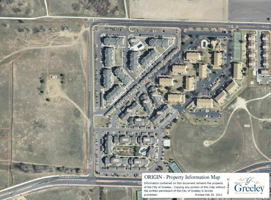
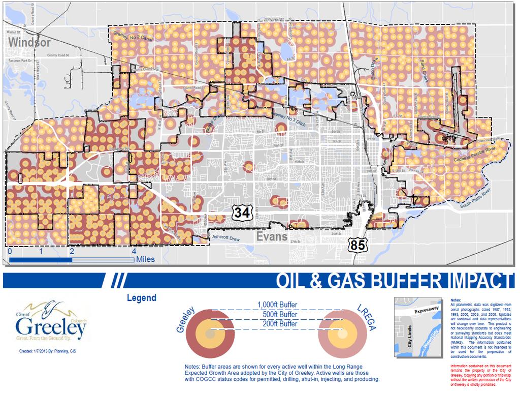
2 Working numbers 435 active wells (approx.) All require Use by Special Review Equals about 800 ac (1.3 sq miles) surface (2.7%) 1,221 within city + Growth Area 259 inactive wells Includes 161 abandoned & 55 plugged/abandoned Generally clustered multiple wells at each site 6 urbanized areas (i.e., not everywhere )
3

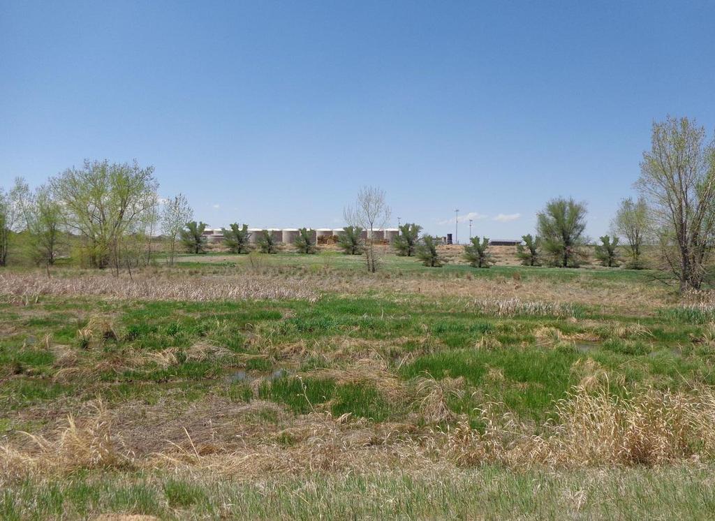
4 Greeley Long-Range Growth Area

5 Bottom Hole Drill


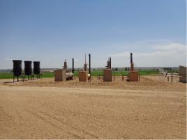


6 Typical Tanks Typical Separators Typical Wellheads

7 Land use process Trained for all types of land use scenarios Regulations start with the general, go to specific Zoning, subdivision, site planning Transparency & public education process Oil and gas mineral extraction process Resource page on website
8 Mineral extraction is exercising a private property right Mineral rights may or may not be severed from the surface property right Operations are regulated by the state Basic land & surface regulation is relegated to local government Handled in context of broader land use controls

9 Considerations during the early site planning process


10 Vertical Wells Directional Wells
11
12
13
14 Colorado law sets rules for downhole spacing of wells Surface locations are different if drilling comes before vs. after surface development Spacing can change with a mutual Surface Use Agreement If drilling (or potential drilling) comes BEFORE development, then Subdivision plats accommodate drilling windows (or Surface Use Agreement) Or, if no objection from mineral owners, plat as desired
15 Notice must be provided to mineral owners at least 30 days prior to platting/surface development decisions (i.e., zoning, preliminary plan, USR) This was a key addition to state law to ensure mineral owners are notified of surface plans
16
17 If drilling comes AFTER surface development in the area, then Drilling facility must meet 500 setback (set by the State), OR per variance criteria set by State statutes Some other setback might be allowed by local regulations
 350 from educational, hospital, etc.")
18 Greeley oil & gas setbacks 150 from roads, trails, railroads, and lowdensity areas 200 from occupied buildings ( high-density ) 350 from educational, hospital, etc. ( highdensity ) Option for less (blast wall, etc.)
19
20 Chapter 18.56, Oil & Gas Operations USR Comp Plan Compatible with surrounding land uses Site physically suitable Traffic flow/parking Cumulative effect of USRs in area

21 Site plan here
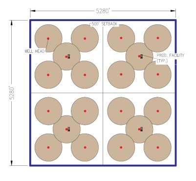
22
23

24
25
26 Fracking impact on water quality Quantity of water used in fracking Disposal of fracking waste water Composition/environmental aspects of drilling fluids Forced pooling arrangements Noise, traffic, air quality for adjacent properties Sub-surface degradation/impact on surface uses
27 State setbacks Other COGCC considerations: Mitigation of impacts Downhole monitoring Coordination with state/fed (water/air) Surface monitoring (drill setup, noise) Chemical tracking/records management

28 Local control on matters that are not state interest Colorado Supreme Court ruling in 1992 Traditional function of local land use control Matters of State interest vs. matters of Local Not always easy to discern A matter of administration The Grey Area: creating operational conflicts
29 Working with mutual understanding & trust (through an MOU) creates better outcome Commitment to communication & coordination Recognize respective authorities Of city: local land use code, including design & development standards Harmonize such regulations COGCC will defer to City, where existing plans
30 Effects & opportunities from directional / horizontal Leap-frog concerns Doubling setbacks (4.5 ac 18 ac) Conceptually, if no development within 500 of existing wells, 1/3 of future would be unbuildable
31

32
33
34
 = 288")
35 500 radius (1000 diameter) = 18 acres 2000 radius (4000 diameter) = 288 acres
36

37 Brad Mueller Director, Community Development Dept. City of Greeley Questions?
Oil and Gas Development: Land Use Considerations. Planning Commission January 14, 2014
 Oil and Gas Development: Land Use Considerations Planning Commission January 14, 2014 Working numbers 431 active wells All require Use by Special Review Equals about 800 ac (1.3 sq miles) surface (2.7%)
SURFACE AND MINERAL CONFLICTS: OIL AND GAS ACCESS AND NEW WEST REAL ESTATE DEVELOPMENT
 SURFACE AND MINERAL CONFLICTS: OIL AND GAS ACCESS AND NEW WEST REAL ESTATE DEVELOPMENT Randall J. Feuerstein, Esq. DUFFORD & BROWN, P.C. 1700 Broadway, Suite 2100 Denver, CO 80290-2101 303/861-8013 (Telephone)
CITY OF LONGMONT OIL AND GAS PROPOSED NO-SURFACE-USE AGREEMENT PUBLIC QUESTION-AND-ANSWER FORUM MAY 15, 2018
 CITY OF LONGMONT OIL AND GAS PROPOSED NO-SURFACE-USE AGREEMENT PUBLIC QUESTION-AND-ANSWER FORUM MAY 15, 2018 PRESENTATION OUTLINE The City Strives to Protect Its Residents and the Environment from Oil
COGCC Staff s First Draft Proposed Rules Implementing Governor s Oil and Gas Task Force Recommendation Nos. 17 and 20 October 6, 2015
 COGCC Staff s First Draft Proposed Rules Implementing Governor s Oil and Gas Task Force Recommendation Nos. 17 and 20 Effective Date: Following adoption by the Commission, these proposed new and amended
MEMO. Upon reviewing the information submitted by the applicant for the proposed wells. Our comments follow:
 ARCHULETA COUNTY ROAD AND BRIDGE DEPARTMENT MEMO Date: June 13, 2018 To: John Shepard From: Yari Davis Cc: Bob Perry RE: BP Cox 3 Proposed Pad Upon reviewing the information submitted by the applicant
Energy and Environment Symposium
 Energy and Environment Symposium Spacing and Pooling Demystified April 20, 2017 Rifle, CO Jane Stanczyk Permitting & Technical Services Manager Mineral Ownership Terms Oil and Natural Gas are Minerals.
ARTICLE 9. Oil and Gas Drilling and Production Oil and Gas Drilling and Production Sec Purpose. Sec Definitions.
 ARTICLE 9. Oil and Gas Drilling and Production Sec. 9.1. Purpose.... 9-1 Sec. 9.2. Definitions.... 9-1 Sec. 9.3. Requirements and procedures.... 9-2 (a) Proposed new wells, redrilling certain wells and
Charles E. Zech Denton, Navarro, Rocha & Bernal, P.C.
 Charles E. Zech Denton, Navarro, Rocha & Bernal, P.C. General Police Powers A municipality may adopt ordinances for the good of the government, peace, or order of the municipality (Health, Safety and Welfare).
PLANNING AND ZONING DEPARTMENT
 Town of Minturn Development Review Process: Guide To Planned Unit Developments (Concept Plan) This guide describes the Planned Unit Development Process. This guide should be utilized in conjunction with
Horizontal Oil Well Requirements
 Horizontal Oil Well Requirements Directive PNG006 November 2015 Revision 1.0 Governing Legislation: Act: The Oil and Gas Conservation Act Regulation: The Oil and Gas Conservation Regulations, 2012 Record
(Ord ) (Ord ) (Ord ) (Ord ) (Ord ) Sec Application fees. Sec Abandonment.
 (Ord ) (Ord ) (Ord ) (Ord ) Sec Application fees. Sec Abandonment.") (Ord. 2012-02) Sec. 16.10.100. - Application fees. Each applicant shall submit a land use application and pay fees as set forth in Appendix B. No permit will be issued until all fees are paid. (Ord. 2012-02)
(Ord. 2012-02) Sec. 16.10.100. - Application fees. Each applicant shall submit a land use application and pay fees as set forth in Appendix B. No permit will be issued until all fees are paid. (Ord. 2012-02)
Surface A&D Group Wattenberg Land Department. February 2014
 Surface A&D Group Wattenberg Land Department February 2014 Agenda Chad Repko Creating Opportunity in a Changing Environment Introduction video into Wattenberg Oil and Gas Operations. Why Collaboration
SUBDIVISION APPLICATION (CHECK THE BOX THAT APPLIES)
") GARFIELD COUNTY Building & Planning Department 108 8 th Street, Suite 401 Glenwood Springs, Colorado 81601 Telephone: 970.945.8212 Facsimile: 970.384.3470 www.garfield-county.com SUBDIVISION APPLICATION
GARFIELD COUNTY Building & Planning Department 108 8 th Street, Suite 401 Glenwood Springs, Colorado 81601 Telephone: 970.945.8212 Facsimile: 970.384.3470 www.garfield-county.com SUBDIVISION APPLICATION
Gas Well Setback Discussion
 Gas Well Setback Discussion City Council Work Session 04.24.18 Community and Neighborhood Development Committee 02.27.18 and 04.10.18 DEFINITIONS SETBACK REGULATION Protected Use (in Gas Drilling and Production
Weld County Oil & Gas Location Assessment (WOGLA) Application Requirements Checklist
 Application Requirements Checklist") Application Requirements Checklist APPLICATION REQUIREMENTS: Name of Location: One completed Application form. One completed Certification of Surface Use Agreement form. One completed Certification of
Application Requirements Checklist APPLICATION REQUIREMENTS: Name of Location: One completed Application form. One completed Certification of Surface Use Agreement form. One completed Certification of
Crown Land Use Operational Policy: Mining APPROVED AMENDMENTS: Summary of Changes: /Approval
 APPROVED AMENDMENTS: Effective Date Briefing Note /Approval Summary of Changes: June 1, 2011 BN 175892 Policy and Procedure update to reflect reorganization of resource ministries April 2011 September
PRELIMINARY PLAT CHECK LIST
 PRELIMINARY PLAT CHECK LIST Name of Proposed Subdivision: The following items must be included with the initial submittal of a Preliminary Plat: Application, filled out completely Project Narrative Pre-application
WELD COUNTY OIL AND GAS LOCATION ASSESSMENT (WOGLA) PROCEDURAL GUIDE SUBMITTAL CHECKLIST
 PROCEDURAL GUIDE SUBMITTAL CHECKLIST") WELD COUNTY OIL AND GAS LOCATION ASSESSMENT (WOGLA) PROCEDURAL GUIDE SUBMITTAL CHECKLIST APPLICATION REQUIREMENTS: One original application form Certification that a Surface Use Agreement (SUA) or other
WELD COUNTY OIL AND GAS LOCATION ASSESSMENT (WOGLA) PROCEDURAL GUIDE SUBMITTAL CHECKLIST APPLICATION REQUIREMENTS: One original application form Certification that a Surface Use Agreement (SUA) or other
CHAPTER 10 Planned Unit Development Zoning Districts
 CHAPTER 10 Planned Unit Development Zoning Districts Section 10.1 Intent and Purpose The Planned Unit Development (PUD) districts are intended to offer design flexibility for projects that further the
LOT AREA AND FRONTAGE
 LOT AREA AND FRONTAGE Lot Area & Frontage for the R2.1 Zone Lot Area & Frontage for the R2.4 Zone Minimum Lot Minimum Lot Zone Area Width R2.1 700 sq m 18 m R2.4 600 sq m 16 m Lot Area means the total
Guide to Preliminary Plans
 Guide to Preliminary Plans Introduction The Douglas County is committed to providing open, transparent application processes to the public. This Guide is provided to assist anyone interested in the procedures
Guide to Combined Preliminary and Final Plats
 Guide to Combined Preliminary and Final Plats Introduction The Douglas County is committed to providing open, transparent application processes to the public. This Guide is provided to assist anyone interested
TOWNSHIP OF SCIO MORATORIUM RESOLUTION REGARDING OIL AND GAS OPERATIONS IN TOWNSHIP
 TOWNSHIP OF SCIO MORATORIUM RESOLUTION REGARDING OIL AND GAS OPERATIONS IN TOWNSHIP At a special meeting of the Township Board of the Township of Scio held at the Township Hall, August 20, 2014. WHEREAS,
ARTICLE II SEWAGE TREATMENT. Sec Purpose and intent. Sec Applicability. Sec Authority. Sec Administration.
 ARTICLE II SEWAGE TREATMENT Footnotes: --- (1) --- Editor's note Ord. No. 50, Second Series, adopted Nov. 5, 2014, amended Art. II in its entirety to read as herein set out. Former Art. II, 74-19 74-42,
PRELMINARY PLAT CHECKLIST
 PRELMINARY PLAT CHECKLIST A. All preliminary plat submitted for approval shall be prepared by a Registered Professional Land Surveyor. B. Preliminary plats must be drawn to a scale of XXX with such accuracy
Planning Commission Hearing Date: 2/21/2017 Board of County Commissioners Hearing Date: 3/8/2017
 COMMISSIONERS: DARRYL GLENN (PRESIDENT) MARK WALLER (PRESIDENT PRO TEMPORE) STAN VANDERWERF LONGINOS GONZALEZ PEGGY LITTLETON PLANNING AND COMMUNITY DEVELOPMENT DEPARTMENT CRAIG DOSSEY, EXECUTIVE DIRECTOR
PLANNING 101. What architects think I do. the what s and how s of land use planning
 PLANNING 101 What architects think I do the what s and how s of land use planning PLANNING 101 Overview of Planning Why Plan? Land Use & Zoning Tools Legal Basics Special Planning Topics Funding Overview
Guide to Minor Developments
 Guide to Minor Developments Introduction The Douglas County (DCD) is committed to providing open, transparent application processes to the public. This Guide is provided to assist anyone interested in
The Application Process
 The Application Process This document is intended as a guide and does not constitute a legal document. For further and more detailed information, please refer to the following Acts and Regulations: The
CASE NO.: PLN CASE NAME: OIL AND GAS TEXT AMENDMENTS TO CHAPTER 4
 COMMUNITY AND ECONOMIC DEVELOPMENT DEPARTMENT CASE NO.: PLN2017-00036 CASE NAME: OIL AND GAS TEXT AMENDMENTS TO CHAPTER 4 TABLE OF CONTENTS EXHIBIT 1 PC Staff Report EXHIBIT 2- Applicant Information 2.1
CITY OF LAREDO Environmental Services Department
 CITY OF LAREDO Environmental Services Department April 4, 2016 Request for Qualifications Project: Provide consulting services, equipment, and personnel for the monitoring and ongoing oversight of the
Project File #: SF Project Name: Jackson Ranch Filing No. 4 Parcel Nos.: , and
 COMMISSIONERS: DARRYL GLENN (PRESIDENT) MARK WALLER (PRESIDENT PRO TEMPORE) STAN VANDERWERF LONGINOS GONZALEZ PEGGY LITTLETON PLANNING AND COMMUNITY DEVELOPMENT DEPARTMENT CRAIG DOSSEY, EXECUTIVE DIRECTOR
CHAPTERS 35 to 37 Reserved CHAPTER 38 PRIVATE WATER WELL CONSTRUCTION PERMITS
 , 8/18/04 Ch 38, p.1 TITLE III WITHDRAWAL, DIVERSION, STORAGE AND USE OF WATER DIVISION A WATER WELL CONSTRUCTION: GENERAL STANDARDS AND REGISTRATION OF CONTRACTORS CHAPTERS 35 to 37 Reserved, 8/18/04
Published by: Alberta Agriculture and Rural Development Street Edmonton, Alberta T6H 5T6. Printed in Canada
 Published by: Alberta Agriculture and Rural Development 7000-113 Street Edmonton, Alberta T6H 5T6 Printed in Canada Copies of this publication are available from: Publications Office Alberta Agriculture
REQUEST FOR CHANGE OF OPERATOR TRANSFER OF INJECTION OR SURFACE PIT PERMIT
 KOLAR Document ID: 1455932 Check Applicable Boxes: KANSAS CORPORATION COMMISSION OIL & GAS CONSERVATION DIVISION REQUEST FOR CHANGE OF OPERATOR TRANSFER OF INJECTION OR SURFACE PIT PERMIT Oil Lease: No.
STAFF REPORT. Financial Impact Statement There are no immediate financial impacts associated with the adoption of this report.
 STAFF REPORT Planning and Development Department Subject: Cottage Country Unsubstantial Amendment to Development Agreement To: CAO for Planning Advisory Committee, December 13, 2016 Date Prepared: December
DEPARTMENT OF PLANNING SERVICES 1555 N 17 th Ave Greeley CO Phone (970) Fax (970)
 Fax (970)") DEPARTMENT OF PLANNING SERVICES 1555 N 17 th Ave Greeley CO 80631 Phone (970) 400-6100 Fax (970) 304-6498 SITE SPECIFIC DEVELOPMENT PLAN USE BY SPECIAL REVIEW PROCEDURAL GUIDE SOLID WASTE DISPOSAL SITES
DEPARTMENT OF PLANNING SERVICES 1555 N 17 th Ave Greeley CO 80631 Phone (970) 400-6100 Fax (970) 304-6498 SITE SPECIFIC DEVELOPMENT PLAN USE BY SPECIAL REVIEW PROCEDURAL GUIDE SOLID WASTE DISPOSAL SITES
TREASURE COAST REGIONAL PLANNING COUNCIL M E M O R A N D U M
 TREASURE COAST REGIONAL PLANNING COUNCIL M E M O R A N D U M To: Council Members AGENDA ITEM 5F From: Date: Subject: Staff July 16, 2010 Council Meeting Local Government Comprehensive Plan Review Draft
TABLE OF CONTENTS CHAPTER 1 INTRODUCTORY PROVISIONS Section 1 Purposes. 6. Section 2 Statutory Authorization. 7.
 An Ordinance requiring permits for buildings, structures and the uses thereof; for land uses and for water supply and sewage treatment facilities; establishing minimum lot sizes, setbacks and side yards,
Conditional Use Permit / Standard Subdivision Application
 Conditional Use Permit / Standard Subdivision Application Name of Proposed Subdivision: Total Area (Acres) Is Proposed Subdivision to be built in phases? Number of Lots If yes, how many phases? Applicant/Owner
STAFF REPORT. To: Planning Commission Meeting date: February 8, 2017 Item: UN Prepared by: Marc Jordan
 # 5 ) UN-08-17 GREAT AMERICAN AUTO SALES SPECIAL USE PERMIT VEHICLE SALES PUBLIC HEARING STAFF REPORT To: Planning Commission Meeting date: February 8, 2017 Item: UN-08-17 Prepared by: Marc Jordan GENERAL
5.03 Type III (Quasi-Judicial) Decisions
 Decisions") 5.03 Type III (Quasi-Judicial) Decisions 5.03 General Requirements A. The purpose of this Section is to identify what types of actions are considered Type III decisions. Type III decisions involve significant
5.03 Type III (Quasi-Judicial) Decisions 5.03 General Requirements A. The purpose of this Section is to identify what types of actions are considered Type III decisions. Type III decisions involve significant
Plans shall be drawn at a readable scale, signed, and sealed by a Florida Registered Engineer. The application package shall include:
 CHAPTER 400. SECTION 403. PERMIT TYPES AND APPLICATIONS SITE DEVELOPMENT 403.3. Preliminary Site Plans (PSP) A. Intent and Purpose PSPs are used to identify existing site conditions and demonstrate general
REQUEST FOR CHANGE OF OPERATOR TRANSFER OF INJECTION OR SURFACE PIT PERMIT
 Check Applicable Boxes: KANSAS CORPORATION COMMISSION REQUEST FOR CHANGE OF OPERATOR TRANSFER OF INJECTION OR SURFACE PIT PERMIT Oil Lease: No. of Oil Wells ** Form KSONA-1, Certification of Compliance
PRELIMINARY STAFF PLANNING REPORT TO THE WALWORTH COUNTY ZONING AGENCY
 This report was prepared prior to the public hearing. This report may be supplemented or amended to reflect the review of additional information presented at the public hearing and written material submitted
June 23, 2009 Initial Meeting RURAL FRAMEWORK COMMITEE
 June 23, 2009 Initial Meeting RURAL FRAMEWORK COMMITEE Committee Member Introductions One minute summary Name Subarea location/stakeholder identification What do you hope will come out of this rural framework
MONTGOMERY COUNTY PLANNING DEPARTMENT THE MARYLAND-NATIONAL CAPITAL PARK AND PLANNING COMMISSION
 MONTGOMERY COUNTY PLANNING DEPARTMENT THE MARYLAND-NATIONAL CAPITAL PARK AND PLANNING COMMISSION MCPB Item No. 8 Date: 03-07-13 Sonoma, Preliminary Plan, 120130040 Melissa Williams, Senior Planner, Melissa.williams@montgomeryplanning.org,
CITY COUNCIL AGENDA MEMORANDUM
 City and County of Broomfield, Colorado CITY COUNCIL AGENDA MEMORANDUM To: Mayor and City Council From: Charles Ozaki, City and County Manager Prepared by: Kevin Standbridge, Deputy City and County Manager
13 NONCONFORMITIES [Revises Z-4]
![13 NONCONFORMITIES [Revises Z-4]](/thumbs/87/97238669.jpg "13 NONCONFORMITIES [Revises Z-4]") Dimensional Standards Building Design Standards Sidewalks Tree Protection & Landscaping Buffers & Screening Street Tree Planting Parking Lot Landscaping Outdoor Lighting Signs 13.1 PURPOSE AND APPLICABILITY
Dimensional Standards Building Design Standards Sidewalks Tree Protection & Landscaping Buffers & Screening Street Tree Planting Parking Lot Landscaping Outdoor Lighting Signs 13.1 PURPOSE AND APPLICABILITY
Oil and Gas Operations
 20 1817. Oil and Gas Operations A. Oil and Gas Operations, which include the construction of compressor stations and gas processing plants, shall be reviewed by the Center Township Planning Commission
ARTICLE V AGRICULTURAL PRESERVATION AND RURAL RESIDENTIAL DISTRICT
 ARTICLE V AP AGRICULTURAL PRESERVATION AND RURAL RESIDENTIAL DISTRICT Section 500. PURPOSE It is the purpose of the AP, Agricultural Preservation and Rural Residential District, to foster the preservation
The following regulations shall apply in the R-E District:
 "R-E" RESIDENTIAL ESTATE DISTRICT (8/06) The following regulations shall apply in the R-E District: 1. Uses Permitted: The following uses are permitted. A Zoning Certificate may be required as provided
Faribault Place 3 rd Addition Preliminary Plat, Final Plat, & PUD
 Faribault Small Town Pride Big City Opportunities! December 5, 2016 Planning Commission Public Hearing Faribault Place 3 rd Addition Preliminary Plat, Final Plat, & PUD Location Maps Faribault 2 Requests
A Minor Land Excavation Operating Permit is used to:
 CHAPTER 400. SECTION 404. PERMIT TYPES AND APPLICATIONS OPERATING PERMITS 404.1. Minor Land Excavation A. Intent and Purpose The intent and purpose of this section is to protect the public health, safety,
ZA and ZA Zoning Change and Concept / Site Plan Preliminary Plat Delta Southlake Center
 ZA16-051 and ZA16-052 Zoning Change and Concept / Site Plan Preliminary Plat Delta Southlake Center ZA16-051 and ZA16-052 Owner: Applicant: Requests: Dominion Southlake Properties, LLC, White Chapel Village
PROJECT ADDRESS ASSESSOR S PARCEL NUMBER G.P. LAND USE DESIGNATION ZONING DISTRICT FLOOD HAZARD ZONE SITE ACREAGE AIRPORT SAFETY ZONE?
 TYPE OR PRINT CLEARLY Submit Completed Applications to: City of Corning Planning Dept. 794 Third Street Corning, CA 96021 PROJECT ADDRESS ASSESSOR S PARCEL NUMBER G.P. LAND USE DESIGNATION ZONING DISTRICT
DEPARTMENT OF PLANNING JEFFERSON PARISH, LOUISIANA
 DEPARTMENT OF PLANNING JEFFERSON PARISH, LOUISIANA SUBDIVISION REPORT DOCKET NO: SUMMARY NO: COUNCIL DISTRICT: 2 - Paul D. Johnston COUNCIL AT LARGE: A - Chris Roberts B - Cynthia Lee-Sheng ADVERTISING
Town zoning: A good option for your town?
 Photo credit: Landslides Aerial Photography Town zoning: A good option for your town? Lynn Markham Town of Auburn May 27, 2015 Main points 1. Zoning is one tool to implement community plans 2. What does
22 History Note: Authority G.S ;
 1 1 1 1 1 1 0 1 1A NCAC 0C.01 is proposed for adoption as follows: Section.00 Permitting and Inspection of Private Drinking Water Wells 1A NCAC 0C.01 SCOPE AND PURPOSE (a) The purpose of the rules of this
Project File #: VA Project Name: Beauperthuy Variance Parcel Nos.: , , , ,
 COMMISSIONERS: DARRYL GLENN (PRESIDENT) MARK WALLER (PRESIDENT PRO TEMPORE) STAN VANDERWERF LONGINOS GONZALEZ PEGGY LITTLETON PLANNING AND COMMUNITY DEVELOPMENT DEPARTMENT CRAIG DOSSEY, EXECUTIVE DIRECTOR
ORDINANCE 90-2 Solid Waste Facility Siting Ordinance of Wythe County, Virginia. ARTICLE I - Title, Authority, and Jurisdiction
 ORDINANCE 90-2 Solid Waste Facility Siting Ordinance of Wythe County, Virginia ARTICLE I - Title, Authority, and Jurisdiction 1.1 Title. This ordinance shall be known as the "Solid Waste Facility Siting
NOTICE APPLICATION MUST BE FILLED OUT COMPLETELY.
 NOTICE APPLICATION MUST BE FILLED OUT COMPLETELY. Only the Applicant or the Authorized Agent, designated on the appropriate form, will be allowed to pick up permits. FEE SCHEDULE Fiscal Year 2013-2014
STAFF REPORT. To: Planning Commission Meeting date: August 10, 2016 Item: UN Prepared by: Marc Jordan. To allow a massage establishment
 # 11 ) UN-48-16 LILAC MASSAGE SPECIAL USE PERMIT MASSAGE ESTABLISHMENT PUBLIC HEARING STAFF REPORT To: Planning Commission Meeting date: August 10, 2016 Item: UN-48-16 Prepared by: Marc Jordan GENERAL
Chapter 100 Planned Unit Development in Corvallis Urban Fringe
 100.100 Scope and Purpose. Chapter 100 Planned Unit Development in Corvallis Urban Fringe (1) All applications for land divisions in the Urban Residential (UR) and Flood Plain Agriculture (FPA) zones within
HUERFANO COUNTY OIL AND GAS REGULATIONS SECTION 6.00
 TABLE OF CONTENTS Section Title Page 6.01 RESERVED... 6-1 OIL AND GAS* GENERALLY 6.02 AUTHORITY OF ARTICLE... 6-1 6.03 PURPOSE OF ARTICLE... 6-1 6.04 DEFINITIONS... 6-1 6.05 GENERAL PROCEDURES... 6-5 6.06
PAPAKAINGA DISTRICT WIDE ACTIVITY
 SECTION 13.1 PAPAKAINGA DISTRICT WIDE ACTIVITY 13.1.1 INTRODUCTION The Resource Management Act 1991 introduced specific and new obligations for those exercising functions and powers under the Act to provide
CHAPTER 7 PROVISIONS GOVERNING USE DISTRICTS
 CHAPTER 7 PROVISIONS GOVERNING USE DISTRICTS 11-701. R-1 Residential and Agricultural. It is the purpose and intent of this district to provide areas that are suitable for low density residential uses,
REPRESENTATIVE: Julie & Brad Nicodemus Black Squirrel Road Colorado Springs, CO 80809
 COMMISSIONERS: DARRYL GLENN (PRESIDENT) MARK WALLER (PRESIDENT PRO TEMPORE) STAN VANDERWERF LONGINOS GONZALEZ PEGGY LITTLETON PLANNING AND COMMUNITY DEVELOPMENT DEPARTMENT CRAIG DOSSEY, EXECUTIVE DIRECTOR
UNDER REVIEW: PLEASE CONTACT LAND TENURES BRANCH FOR MORE INFORMATION (Phone: )
") Land Use Operational Policy Oil and Gas NAME OF POLICY: APPLICATION: ISSUANCE: IMPLEMENTATION: Oil and Gas Applies to surface tenures for Crown land used for petroleum and natural gas purposes including
Land Use Operational Policy Oil and Gas NAME OF POLICY: APPLICATION: ISSUANCE: IMPLEMENTATION: Oil and Gas Applies to surface tenures for Crown land used for petroleum and natural gas purposes including
RE: 6. GILL/GREEN COMPREHENSIVE PLAN AMENDMENT, REZONING AND PRELIMINARY PLAT
 commission memo DATE: Thursday - August 9, 2018 TO: Marion Planning & Zoning Commission FROM: David N. Hockett, AICP Principal Planner RE: 6. GILL/GREEN COMPREHENSIVE PLAN AMENDMENT, REZONING AND PRELIMINARY
Chapter 210 CONDITIONAL USES
 Chapter 210 CONDITIONAL USES 210.01 Purpose 210.02 Authorization 210.03 Process Type 210.04 Determination of Major or Minor Conditional Use Review 210.05 Approval Criteria 210.06 Conditions of Approval
Siting Renewable Energy: Land Use & Environmental Due Diligence. Polly B. Jessen Catherine M. van Heuven March 8, 2013
 Siting Renewable Energy: Land Use & Environmental Due Diligence Polly B. Jessen Catherine M. van Heuven March 8, 2013 1 Due Diligence Generally Due diligence for siting renewable projects involves many
EDMOND PLANNING COMMISSION MEETING. Tuesday, October 5, 2004
 124 EDMOND PLANNING COMMISSION MEETING Tuesday, 5:30 P.M. The Edmond Planning Commission Meeting was called to order by Chairperson David Woods at 5:30 p.m., Tuesday,, in the City Council Chambers at 20
ALAMANCE COUNTY ENVIRONMENTAL HEALTH APPLICATION FOR SERVICES SERVICES REQUESTED
 Improvement Permit (Site Evaluation) (complete pages 1-6) Construction Authorization (Improvement Permit needed prior to this) (complete pages 1-6) Existing Septic System Inspection (for manufactured home
RURAL SETTLEMENT ZONE - RULES
 Chapter 38 RURAL SETTLEMENT ZONE - RULES INTRODUCTION This Chapter contains rules managing land uses in the. The boundaries of this zone are shown on the planning maps. There is limited opportunity for
A Affordable Storage CUP Amendment, in Section 20, T35N R2W NMPM, at 4340B US Hwy 160W and 122 Meadows Dr.
 Archuleta County Development Services Planning Department 1122 HWY 84 P. O. Box 1507 Pagosa Springs, Colorado 81147 970-264-1390 Fax 970-264-3338 MEMORANDUM TO: Archuleta County Planning Commission FROM:
El Paso County Oil and Gas Exploration / Frequently Asked Questions
 El Paso County Oil and Gas Exploration / Frequently Asked Questions El Paso County is working to provide a framework for responsible exploration and production of oil and gas resources which conserves
CITY OF GROVER BEACH COMMUNITY DEVELOPMENT DEPARTMENT Tentative Map Checklist
 CITY OF GROVER BEACH COMMUNITY DEVELOPMENT DEPARTMENT Tentative Map Checklist The following list includes all of the items you must submit for a complete application. Some specific types of information
DOÑA ANA COUNTY PLANNING AND ZONING COMMISSION
 DOÑA ANA COUNTY Doña Ana County Government Complex 845 N. Motel Blvd. Las Cruces, New Mexico 88007 Office: (575) 647-7350 MEETING DATE: September 28, 2017 REQUEST: Preliminary Plat Approval for Vista Rancho
Concept Plan Project Narrative For 852 River Ranch Court
 Concept Plan Project Narrative For 852 River Ranch Court Date: January 5, 2016 Prepared by: Robert W. Jones II, P.E. Vortex Engineering, Inc. 2394 Patterson Rd., Ste 201 Grand Junction, CO 81505 970-245-9051
THE SUBDIVISION PROCESS:
 THE SUBDIVISION PROCESS: With many lenders no longer accepting multiple residences on single properties, the chances of a Realtor dealing with dividing property has increased significantly. This course
PLANNING & DEVELOPMENT
 PLANNING & DEVELOPMENT STAFF REPORT Rezoning PETITION: APPLICANT: PROPERTY OWNER: TYPE OF REQUEST: SIZE OF TRACT: LOCATION: (#17-22) Rezone from A-PUD (Agri-Business Planned Unit Development) to A-PUD
APPLICATION FOR INJECTION WELL
 KANSAS CORPORATION COMMISSION OIL & GAS CONSERVATION DIVISION APPLICATION FOR INJECTION WELL Form must be Typed Form must be Signed All blanks must be Filled Disposal Enhanced Recovery: Date: Operator
DOUGLAS COUNTY SUBDIVISION RESOLUTION Article 4 Preliminary Plan 10/13/2015
 ARTICLE 4 PRELIMINARY PLAN 401 Intent An in-depth analysis of the proposed subdivision, including a review of the design considering the ability to obtain water and sanitation, identified geologic hazards,
KERN COUNTY PLANNING AND NATURAL RESOURCES DEPARTMENT INSTRUCTIONS TO APPLICANT FILING MINISTERIAL OIL AND GAS CONFORMITY REVIEW TIERS 2, 3, AND 5
 KERN COUNTY PLANNING AND NATURAL RESOURCES DEPARTMENT INSTRUCTIONS TO APPLICANT FILING MINISTERIAL OIL AND GAS CONFORMITY REVIEW TIERS 2, 3, AND 5 I. APPLICATION INSTRUCTIONS FOR TIERS 2, 3, AND 5 Please
ZONING & LAND USE APPLICATION
 City of Maple Plain 5050 Independence St P.O. Box 97 Maple Plain, MN 55359 Office: (763) 479-0515 Fax: (763) 479-0519 ZONING & LAND USE APPLICATION APPLICANT INFORMATION Applicant Name Company, if applicable
HHLT Educational Forum: Conservation Subdivisions and the Open Space Overlay. February 5th 2018 Winter Hill
 HHLT Educational Forum: Conservation Subdivisions and the Open Space Overlay February 5th 2018 Winter Hill 1 Topics Covered SECTION I II III IV V TOPIC Comprehensive Plan Open Space Index Conservation
MTC ALABAMA SUBDIVISION
 # 2 SUB-000370-2017 MTC ALABAMA SUBDIVISION Engineering Comments: FINAL PLAT COMMENTS (should be addressed prior to submitting the FINAL PLAT for review and/or signature by the City Engineer): A. Provide
Curtis Talley Jr. Farm Management Educator MSU Extension, Hart, MI
 MINERAL RIGHTS TOWN HALL MEETING 7 28 15 Sponsored by State Representative Tom Cochran Ingham County Mason Historical Museum 200 East Oak Street, Mason, MI Curtis Talley Jr. Farm Management Educator MSU
Miriam J. Baer, Executive Director
 Miriam J. Baer, Executive Director January 28, 2013 North Carolina Real Estate Commission n State government agency n Dedicated to licensing and regulation of real estate brokers n Your source for real
STAFF REPORT. To: Planning Commission Meeting date: February 8, 2017 Item: ZN Prepared by: Johanna Murphy
 # 7 ) ZN-04-17 VILLAGES AT TULE SPRINGS, VILLAGE 3 PCD, PLANNED COMMUNITY DISTRICT TO R-CL / PCD; MEDIUM DENSITY RESIDENTIAL / PLANNED COMMUNITY DISTRICT PUBLIC HEARING STAFF REPORT To: Planning Commission
APPLICATION OF ENRON OIL & GAS COMPANY FOR A RULE 37 EXCEPTION TO DRILL WELL NO. 12, JONES 97 LEASE, SAWYER (CANYON) FIELD, SUTTON COUNTY, TEXAS
 FIELD, SUTTON COUNTY, TEXAS") ************************************************************ * KEY ISSUES: Confiscation * * R37 location necessary even though regular * * location on tract * * R37 location reasonable due in large part
************************************************************ * KEY ISSUES: Confiscation * * R37 location necessary even though regular * * location on tract * * R37 location reasonable due in large part
Financial Impact Statement There are no immediate financial impacts associated with the adoption of this report.
 STAFF REPORT Planning and Development Department Subject: Application by RYC Property to rezone a portion of lands on John Murray Dr. and Megan Lynn Dr. from R2 to R3 and to enter into a Development Agreement
301. Zoning Districts. C-D A-1 R-1 R-V B-1 I-1
 301. Zoning Districts. The Township is divided into the districts set forth by this chapter and as shown by the district boundaries on the Official Zoning District Map. The zoning districts are: C-D Conservation
REPRESENTATIVE: Centerline Solutions Table Mountain Parkway Golden, CO 80403
 COMMISSIONERS: DARRYL GLENN (PRESIDENT) MARK WALLER (PRESIDENT PRO TEMPORE) STAN VANDERWERF LONGINOS GONZALEZ PEGGY LITTLETON PLANNING AND COMMUNITY DEVELOPMENT DEPARTMENT CRAIG DOSSEY, EXECUTIVE DIRECTOR
Inverness Area Planning Advisory Committee Inverness County Planning Advisory Committee Inverness County Council Planning Staff (EDPC)
") STAFF REPORT To: From: Inverness Area Planning Advisory Committee Inverness County Planning Advisory Committee Inverness County Council Planning Staff (EDPC) Date: January 18, 2018 Reference: Request for
STAFF REPORT To: From: Inverness Area Planning Advisory Committee Inverness County Planning Advisory Committee Inverness County Council Planning Staff (EDPC) Date: January 18, 2018 Reference: Request for
PLANNING AND ZONING COMMISSION AGENDA MEMORANDUM
 City and County of Broomfield, Colorado PLANNING AND ZONING COMMISSION AGENDA MEMORANDUM To: Planning and Zoning Commission From: John Hilgers, Planning Director Anna Bertanzetti, Principal Planner Meeting
Letter of Intent May 2017 (Revised November 2017)
") THE BEACH AT WOODMOOR LETTER OF INTENT MAY 2017 (REVISED NOVEMBER 2017) OWNER/APPLICANT: CONSULTANT: Lake Woodmoor Holdings LLC N.E.S. Inc. 1755 Telstar Drive, Suite 211 619 North Cascade Avenue Colorado
THE BEACH AT WOODMOOR LETTER OF INTENT MAY 2017 (REVISED NOVEMBER 2017) OWNER/APPLICANT: CONSULTANT: Lake Woodmoor Holdings LLC N.E.S. Inc. 1755 Telstar Drive, Suite 211 619 North Cascade Avenue Colorado
RAILROAD COMMISSION OF TEXAS HEARINGS DIVISION
 RAILROAD COMMISSION OF TEXAS HEARINGS DIVISION OIL AND GAS DOCKET NO. 02-0297183 IN THE SUGARKANE (AUSTIN CHALK) FIELD, ATASCOSA, BEE, DE WITT, LIVE OAK AND KARNES COUNTIES, TEXAS FINAL ORDER AMENDING
A Guide to the Municipal Planning Process in Saskatchewan
 A Guide to the Municipal Planning Process in Saskatchewan A look at the municipal development permit and the subdivision approval process in Saskatchewan May 2008 Prepared By: Community Planning Branch