Chapter 6. Zoning Ordinance and Subdivision Regulations. City of Ray, North Dakota
|
|
|
- Zoe French
- 6 years ago
- Views:
Transcription


1 Chapter 6 Zoning Ordinance and Subdivision Regulations City of Ray, North Dakota
2 ZONING ORDINANCE AND SUBDIVISION REGULATIONS CITY OF RAY, NORTH DAKOTA Adopted under Ordinance No August 27, 2012
3 ZONING ORDINANCE AND SUBDIVISION REGULATIONS CITY OF RAY, NORTH DAKOTA TABLE OF CONTENTS ARTICLE I GENERAL PROVISIONS Title Authority Purpose and Intent Applicability and Jurisdiction Minimum Requirements Severability Repeal Conflicting Laws and Ordinances Vested Rights Private Agreements Meaning and Intent Responsibility for Interpretation Land Suitability Construction Timing Burden of Proof Computation of Time Sewage Disposal... 3 ARTICLE 2 ZONING DISTRICTS Planning and Zoning Map Permitted Uses Conditionally Permitted Uses Evaluation of Land Uses Land Uses Preempted by State Law... 5
4 Zoning Districts Agricultural District (AG) Residential 1 (R-1) Residential 2 (R-2) Residential 3 (R-3) Highway Commercial (HC) Central Business District (CBD) General Commercial and Industrial (GCI) ARTICLE 3 ZONING ADMINISTRATION Permits Required Zoning Conformance Permits Conditional Use Permits Nonconforming Uses Variance Appeals Amendments Certificate of Compliance/Occupancy Violations and Penalties Public Notice ARTICLE 4 DEVELOPMENT STANDARDS Adequate Public Facilities Required Streets Lots Blocks Pedestrian and Bicycle Facilities Parks and Open Space Utility Easements Grading and Drainage Sewage Disposal System Municipal Water Supply Solid Waste Mail Delivery... 27
5 Survey Monuments Traffic Impact Analysis Large Scale Development Bed and Breakfast Establishments Multiple Family Dwellings and Hotels/Motels Parking and Loading Mobile Home Parks Travel Trailers/Recreational Vehicles Temporary Workforce Housing Facilities Fences, Visibility at Intersections Signs Demolition ARTICLE 5 SUBDIVISION REGULATIONS Purpose Compliance Required Penalty, Injunction, Civil Action Master Plan Required Exemptions Procedures for Subdivision Approval Required Improvements, Developers Agreements Subdivision Variances Phased Development Modifications and Vacations of Plats ARTICLE 6 DEFINITIONS Definitions ARTICLE 7 ORDINANCE EFFECT AND FORCE Effect and Force APPENDIX A... 56
6 ZONING ORDINANCE AND SUBDIVISION REGULATIONS CITY OF RAY, NORTH DAKOTA ARTICLE I GENERAL PROVISIONS Title This ordinance shall be known as Zoning Ordinance and Subdivision Regulations City of Ray, North Dakota Authority This ordinance is adopted under the authority granted by Chapters and of the North Dakota Century Code Purpose and Intent The purpose of this ordinance is to promote the public health, safety and general welfare; to lessen congestion in the streets; to provide for emergency management; to provide adequate light and air; to prevent the overcrowding of land; to avoid undue concentration of population; to facilitate adequate provisions for transportation, water, sewage, schools, parks and other public requirements; to secure the orderly development of the city; to encourage the use of community resources in a socially and economically desirable manner; and to provide a mechanism by which the city can establish and carry out its development policies Applicability and Jurisdiction This ordinance shall apply to all land, buildings, structures, and uses thereof located within the City of Ray and any land outside its boundaries over which the city is authorized to exercise subdivision and zoning powers, and as shown on the Official Planning and Zoning Map of the City of Ray, North Dakota. When development is exempt from the requirements of this ordinance, this ordinance shall be used as a non-binding guideline Minimum Requirements The provisions of this ordinance are the minimum requirements necessary to protect the public health, safety, and general welfare, and to implement the comprehensive plan Severability If any section, provision or portion of this ordinance is adjudged invalid by a court of competent jurisdiction, the remainder of this ordinance shall not be affected thereby. 1
7 Repeal The September 27, 2010 Zoning Ordinance and Subdivision Regulations City of Ray, North Dakota are repealed and replaced with this ordinance Conflicting Laws and Ordinances If the provisions of this ordinance are inconsistent with those of the state or federal government, or if the provisions of this ordinance are inconsistent with one another, the more restrictive shall control Vested Rights A vested right is the right to proceed with development in compliance with the previous zoning and subdivision ordinance. Such vested rights are established only by: 1. Having obtained a permit in compliance with the previous ordinance. Such vested rights expire with the permit; or 2. For subdivisions in the preliminary plat review stage, when the Administrator issues notice that the subdivision application is complete and sufficient for review; or 3. Having recorded a final plat or obtained approval of a preliminary plat in compliance with the previous ordinance. Vested rights are established for a development only as it was approved. Any material change must be in compliance with the current ordinance Private Agreements This ordinance is not intended to revoke or repeal any easement, covenant or other private agreement. However, where this ordinance is more restrictive or imposes higher standards than such easement, covenant or private agreement, the requirements of this ordinance shall govern. In no case shall the city be obligated to enforce the provision of any easement, covenant or agreement between private parties. The city may enforce private restrictions if it is a party to such restrictions, if such restrictions were required by the city during the land permitting and development process, in order to meet the requirements of this ordinance Meaning and Intent The language of this ordinance must be read literally. This ordinance is no more or less strict than stated. Words and terms expressly defined in this ordinance have specific meanings assigned, unless the context expressly indicates another meaning Responsibility for Interpretation In the event that a question arises concerning any provision or the application of any provision of this ordinance, the Administrator, acting on behalf of the city and in consultation with the City Attorney as may be necessary, shall be responsible for such interpretation and shall look to the Ray Comprehensive 2
8 Plan and the overall purpose and intent of this ordinance for guidance. The Administrator shall provide such interpretations in writing upon request and keep a permanent record of said interpretations. Any person who disputes the Administrator s interpretation may appeal to the City Commission as provided in Land Suitability No land shall be divided, subdivided or developed for a use which is held unsuitable by the Planning and Zoning Commission for reasons of soil limitations, designated flood hazard, incompatible land use or any other condition deemed likely to be harmful to the health, safety and welfare of the future residents of the area or harmful to the community unless the conditions and hazards can be eliminated or overcome by approved construction techniques or other mitigation measures. Subdivisions for building purposes shall not be located within the floodway of a flood of 100-year frequency Construction Timing Upon submittal of a subdivision pre-application or application, or another land use permit application, the developer or any subordinate shall not engage in construction or demolition of improvements prior to approval of the application. The Administrator, Planning and Zoning Commission and City Commission are not bound to accept or approve any on-site improvements that exist prior to submittal of a permit application. The City of Ray shall not be responsible if improvements have to be eradicated, moved or rebuilt due to a developer making improvements prior to and/or not in conformance with this ordinance or any condition of approval Burden of Proof The responsibility for demonstrating compliance with this ordinance is the developer s Computation of Time An application is not considered to be officially submitted until it is determined to be complete and sufficient for review. When a time period is specified in this ordinance, the first day shall be the day after the event that triggers the time clock to start. For example, if an action is to be taken within 30 days of the date an application is deemed to be officially submitted, the time clock starts on the day after the date the application is deemed sufficient for review Sewage Disposal To protect public health, abate nuisance and odor conditions, and to control water pollution construction of private sewage disposal systems shall be prohibited except in the Agricultural zoning district. All other development shall be connected to the city sanitary sewer system. 3
9 ARTICLE 2 ZONING DISTRICTS Planning and Zoning Map The location and boundaries of the zoning districts are hereby established as shown on the map entitled Official Planning and Zoning Map on file in the office of the City Auditor. The Ray Planning and Zoning Commission shall regularly update the Official Planning and Zoning Map to show any changes in the planning and zoning district boundaries resulting from amendments to the map or this ordinance. Amendment dates shall be shown on the map. Location of District Boundaries The following rules shall apply with respect to the boundaries of the zoning districts as shown on the Official Planning and Zoning Map: 1. Where the zoning district boundary lines are indicated as following a highway, street, alley or railroad right-of-way, such boundary lines shall be the centerline of said right-of-way unless clearly shown to the contrary. 2. Boundaries indicated as following municipal limits shall be construed as following municipal limits. 3. Boundaries indicated as following platted lots lines shall be construed as following such lot lines. 4. Where any uncertainty exists as to the exact location of a zoning district boundary line, the Administrator shall determine the location of such boundary line. Any person who disputes the Administrator s determination may appeal to the City Commission (see ) Permitted Uses Land uses listed as permitted in a zoning district are allowed in compliance with this ordinance upon the application and approval of a zoning conformance permit Conditionally Permitted Uses Land uses listed as conditional in a zoning district are allowed in compliance with this ordinance upon the application and approval of a conditional use permit Evaluation of Land Uses It is the intent of the zoning to group similar and compatible land uses into specific districts, either as permitted or conditional uses. Evaluation of uses shall be as follows: 1. The Administrator shall determine if a use not listed is materially similar to a permitted or conditional use within that district. Determinations may be appealed to the City Commission. 2. Materially similar means the use provides similar function, occurs within a similar structure or setting, and has a similar scale to a permitted or conditional use listed in that district. 4
10 Land uses deemed not to be materially similar to a permitted or conditional use shall be prohibited unless a variance is received (see ) or amendment to this Article 2 is made (see ) Land Uses Preempted by State Law Land uses that are required to be permitted in a zoning district by state law or those uses that only the state or federal government have jurisdiction over shall be permitted as provided by state or federal law whether or not the use is included in this Article Zoning Districts A zoning district is a geographic area within which development of certain uses and buildings is permitted upon approval of a zoning conformance permit and certain other uses and buildings may be developed upon approval of a conditional use permit (See Article 3, Zoning Administration, for permitting procedures). The following zoning districts and their boundaries, as shown on the Official Planning and Zoning Map, are established: 1. Agricultural (AG) 2. Residential 1 (R-1) 3. Residential 2 (R-2) 4. Residential 3 (R-3) 5. Highway Commercial (HC) 6. Central Business District (CBD) 7. General Commercial and Industrial (GCI) Agricultural District (AG) The purpose of this district is to provide for an area of continued agricultural activity and rural residential use surrounding the City of Ray until such time as that land is deemed desirable for urban expansion with the necessary services. 1. Permitted Uses a. General farming activities b. The usual buildings, structures and operations incidental to the operation of a farm c. Religious institutions and related facilities d. Public parks, playgrounds and conservation areas e. Public and parochial schools f. Temporary structures incidental to construction work not extending beyond the period of such work (does not include temporary workforce housing facilities for more than two non-resident workers. (See ) g. Golf courses 5
11 h. Utility lines and facilities for public service, but not including buildings for offices, exchanges, or storage i. Single family dwellings, including mobile homes, and accessory buildings j. Home occupations k. Plant nurseries, green houses, and roadside stands offering for sale only locally grown farm products l. Cultural and historical features and facilities 2. Conditionally Permitted Uses a. Cemeteries b. Animal hospitals and veterinary clinics c. Grain elevators and agricultural storage facilities d. Airports e. Radio and television towers and accessory buildings f. Mineral extraction, including sand and gravel operations g. Sanitary landfills and incinerator sites h. Skeet, trap and rifle ranges i. Industrial, municipal and/or commercial water reservoirs, storage tanks, pumping stations and sewer facilities. j. Temporary workforce housing facilities (see Development Standards ) 3. Minimum Lot Size The minimum lot size for this district shall be 10 acres. 4. Setbacks All non-farmwork related structures shall be located a minimum of 50 feet from any property boundary Residential 1 (R-1) The purpose of this district is to provide an area for larger lot, single-family residential living connected to public water and sewer services. 1. Permitted Uses a. Single family dwellings and accessory buildings b. Religious institutions, libraries, schools and related facilities c. Home occupations d. Public parks and playgrounds 2. Conditionally Permitted Uses a. Two family dwellings b. Hospitals and group homes c. Public buildings and facilities, not including storage and repair shops 3. Area Requirements 6
12 a. Except as provided in (b) and (c) below, the minimum lot area shall be 10,000 square feet and with a minimum lot width of 75 feet. b. The minimum lot area for two family dwellings shall be 5,000 square feet per unit with a minimum lot width of 100 feet. c. Recorded Lots Excepted Existing lots of record are exempt from the area requirements of this district but no new lots shall be created that do not comply. 4. Setback Requirements a. The minimum setback from the right-of-way of streets and highways for all structures shall be 25 feet. b. The minimum rear setback from all structures shall be 6 feet, except the minimum rear setback for structures accessing into an adjacent alley shall be 20 feet. c. The minimum side setback for all structures except where abutting a street shall be 6 feet. d. When the setback requirements set forth in (a), (b) or (c) above cannot be met on existing lots the City Commission may grant a reasonable variance from these standards (See ). 5. Maximum Building Height a. Residential structures and accessory structures on residential lots shall not exceed 35 feet. b. All other structures shall not exceed 40 feet Residential 2 (R-2) The purpose of this district is to provide an area for residential living of various types served by public water and sewer. 1. Permitted Uses a. Single family and two family dwellings and accessory buildings b. Religious institutions, libraries, schools and related facilities c. Home occupations d. Public parks and playgrounds 2. Conditionally Permitted Uses a. Multiple family dwellings (See ) b. Hospitals and group homes c. Public buildings and facilities, not including storage and repair shops d. Bed and breakfast establishments (See ) e. Day cares f. Undertaking parlors 3. Area Requirements a. Except as provided in (b) and (c) below, the minimum lot area shall be 10,000 square feet and with a minimum lot width of 75 feet. 7
13 b. The minimum lot area for two or more residential dwelling units shall be 5,000 square feet per unit with a minimum lot width of 100 feet. c. Recorded Lots Excepted -Existing lots of record are exempt from the area requirements of this district but no new lots shall be created that do not comply. 4. Setback Requirements a. The minimum setback from the right-of-way of streets and highways for all structures shall be 25 feet. b. The minimum rear setback from all structures shall be 6 feet, except the minimum rear setback for structures accessing into an adjacent alley shall be 20 feet. c. The minimum side setback for all structures except where abutting a street shall be 6 feet. d. When the setback requirements set forth in (a), (b) or (c) above cannot be met on existing lots, the City Commission may grant a reasonable variance. 5. Maximum Building Height a. Single and two family residential structures and accessory structures on residential lots shall not exceed 35 feet. b. All other structures shall not exceed 40 feet Residential 3 (R-3) The purpose of this district is to provide an area for mobile homes and other types of residential development served by public water and sewer. 1. Permitted Uses a. Mobile homes not more than 10 years old on the date of installation b. Single family and two family dwellings and accessory buildings c. Religious institutions, libraries, schools and related facilities d. Home occupations e. Public parks and playgrounds 2. Conditionally Permitted Uses a. Mobile Home Parks (see ) b. Multiple family dwellings (see ) c. Hospitals and group homes d. Public buildings and facilities, not including storage and repair shops e. Bed and breakfast establishments (see ) f. Day cares g. Undertaking parlors 3. Area Requirements a. Except as provided in (b) and (c) below, the minimum lot area shall be 9,000 square feet with a minimum lot width of 75 feet. b. A minimum lot area of 6,000 square feet with a minimum width of 50 feet for mobile home park lots. 8
14 c. A minimum lot area for two or more residential units (not mobile homes) shall be 4,500 square feet per unit with a minimum lot width of 100 feet. d. Recorded Lots Excepted Existing lots of record are exempt from the area requirements of this district but no new lots shall be created that do not comply. 4. Setback Requirements a. Within a mobile home park, the minimum setbacks for all structures shall be 15 feet from any exterior park boundary, 10 feet from an interior park lot boundary, and 25 feet from all streets. b. For all structures outside of a mobile home park: i. The minimum setback from the right-of-way for streets and highways shall be 25 feet. ii. The minimum rear setback shall be 6 feet, except the minimum rear setback for structures accessing into an adjacent alley shall be 20 feet. iii. The minimum side setback for all structures except where abutting a street shall be 6 feet. iv. When the setback requirements set forth in (i), (ii) or (iii) above cannot be met on existing lots, the City Commission may grant a reasonable variance. 5. Maximum Building Height a. Single and two family residential structures and accessory structures on residential lots shall not exceed 35 feet. b. All other structures shall not exceed 40 feet Highway Commercial (HC) The purpose of this district is to provide a place for commercial uses that rely on easy automobile access and may require outdoor sales space. 1. The view from the highway is critical to the city s image so all new development in the HC district requires site plan review and a conditional use permit. However, minor changes of occupancy of existing lots and buildings where the new use has identical or lesser parking requirements, similar traffic generation potential, creates no additional signage (measured by square footage) and has, as determined by the Administrator, similar or lesser impacts on neighboring land uses, are permitted with only a zoning conformance permit (see ). 2. Development in the HC district shall be designed and constructed to minimize the functional and appearance issues associated with the strip development pattern. Conditions to be minimized, to the extent feasible given the location, size and context of the lot or parcel, include: a. Development that is only one lot in depth and has numerous points of access to public streets, and makes no provision for safe pedestrian and bicycle circulation. To address these issues, i. Development shall connect to adjoining properties by providing access and utility easements and vehicle, pedestrian and bicycle facilities; 9
15 ii. Continuous pedestrian walkways shall be provided from the property perimeter to the principal public entrance; iii. Crosswalks shall have contrasting pavement color from the surrounding asphalt surface; and iv. Bicycle parking stands shall be provided. a. View from the road that is dominated by vehicles, asphalt and signs. To address this issue, i. All development shall include landscape buffers comprised of berms, trees, stone, shrubs and fences made of natural looking materials abutting the highway and adjoining properties; ii. Signs shall be architecturally related to the design of the building(s). Freestanding signs shall have landscaping at their base; (See ) iii. Landscaping shall be used to break up parking areas, road frontages and building edges. A minimum of 10% of the parking lot area shall be landscaped. Landscaping that is indigenous to the region and requires limited irrigation is encouraged; iv. Loading areas, truck parking, trash containers, HVAC equipment and other such permanent features shall be screened from public view. Screening shall be made of the same materials as the principal structure, or of material intended to visually blend into a cohesive architectural theme; v. A portion of the parking spaces are encouraged to be located behind the primary structure (away from the Highway). b. Bland, monolithic architecture that has little connection to the setting, community or history and has limited visual appeal. To address this issue, i. Conditional use permit applications shall include elevations showing an architectural theme that acknowledges the local pioneer, farming, rough-rider, coal/oil industry, Native American heritage or a similar design concept. The purpose of this requirement is not to make Ray look like a theme park but to blend local historic and cultural tradition with modern design. ii. Building facades shall be finished in subtle, neutral or earth tones with low reflectivity and be finished with varying materials, textures and colors. iii. Rooflines shall be varied. See Appendix A for design guidelines. 3. Area, Setback and Height Requirements a. Residential uses shall conform to the area and setback requirements of the R-2 district. b. Non-residential uses have no minimum lot size. Non-residential structures shall be set back at least 20 feet from all street and highway rights-of-way and residential property boundaries. c. The maximum building height is 45 feet. 10
16 4. Highway 2 Requirements for Lots Adjacent to and Accessing onto Highway 2 a. All commercial uses shall include with their site plan access control measures to limit the number of accesses directly onto the highway based on land use and traffic generation characteristics. b. Adequate ingress, egress and turn around space shall be provided off-street Central Business District (CBD) The purpose of this district is to encompass the commercial core of the city, and provide a place for the development of uses that depend on pedestrian circulation and a central location. All new development in the CBD requires site plan review and a conditional use permit. However, minor changes of occupancy of existing lots and buildings where the new use has identical or lesser parking requirements, similar traffic generation potential, creates no additional signage (measured by square footage) and has, as determined by the Administrator, similar or lesser impacts on neighboring land uses, are permitted with only a zoning conformance permit (see ). 1. Conditional Uses a. Retail and service uses including drug store, clothing, appliance sales and service, bakeries, cabinet shops, print shops, theaters, professional offices, medical offices and clinics b. Government, public safety/service, libraries, non-profits, civic clubs c. Accessory uses, including residential use of the upper stories of commercial buildings d. Hospitals and nursing homes e. Eating and drinking establishments f. Hotels and motels (see ) g. Hardware h. Automobile service stations i. Laundry and dry cleaning establishments j. Funeral homes k. Grocery stores l. Gyms m. Lumber yards n. Warehouses o. Other business, which, in the opinion of the Administrator, are of the same general character as the uses herein enumerated (see ) 2. Maximum Building Height a. The maximum building height is 40 feet 3. Architectural Design (See Appendix A for design guidelines) a. Building facades shall blend local historic and cultural tradition with modern design and be approved during conditional use permit review. b. Windows or glazed area shall cover at least 15% of the front facade. c. Building facades shall include a diversity of materials, textures and colors. 11
17 4. Off-Street Parking a. All land uses in the CBD except those listed in (1a) and (1b), above, shall provide offstreet parking in accordance with section b. Bicycle parking stands shall be provided. c. All new development in the CBD shall include sidewalks along city streets General Commercial and Industrial (GCI) The purpose of this district is to provide an area for general commercial and industrial activities. 1. Permitted Uses a. Agriculture b. Bottling plants c. Farm equipment factories d. Fertilizer plants e. Fuel storage tanks and terminals f. Grain and feed elevators and mills g. Heavy equipment sales, service and repair h. Lumber yards i. Manufacturing and processing of wood, metal, concrete and blacktop mix j. Sales and service of automobiles and farm implements k. Trucking and freight terminals l. Warehouses m. Facilities for storage and repair n. Temporary workforce housing facilities (see ) o. Hotels and motels (see ) p. Regional water supply facilities q. Eating and drinking establishments 2. Conditional Uses a. Occupancy within a commercial or industrial building that is accessory to the primary use of the structure; that shall not exceed 25% of the building square footage; and that complies with all applicable fire and building codes. 3. Performance Standards a. Buffer Strip: A buffer strip, approved by the Planning and Zoning Commission, shall provide a sight and sound barrier when an industrial use is abutting a R- residential district and/or Highway 2. The buffer shall be comprised of a combination of berms, trees, stones, shrubs and fences made of natural looking materials. Landscaping that is indigenous to the area and requires minimal irrigation is encouraged. b. Storage: The open storage of materials, other than waste products, salvage or wrecked automobiles, may be permitted when located at least 100 feet from any R- residential district and at least 30 feet from any street right-of-way or other lot line. All material 12
18 shall be handled so as to effectively control dust. All combustible material shall be stored in such a way as to permit free access of fire-fighting equipment. c. Loading Requirements: Adequate ingress, egress, parking and turn-around space shall be provided off-street. 13
19 ARTICLE 3 ZONING ADMINISTRATION Permits Required 1. It shall be unlawful for any person to commence any development, including demolition, without obtaining an ordinance permit, except buildings and activities directly used in connection with farming operations. 2. An ordinance permit is any permit issued under this ordinance including a zoning conformance permit, plat approval, rezoning, certificate of compliance, amendment, demolition, variance or other action having the effect of permitting development. 3. Ordinance permits run with the land Zoning Conformance Permits The purpose of this permit is to ensure that routine building activity complies with this ordinance. Zoning conformance permits may be combined and processed simultaneously with permits required by the city s fire and building codes, although the development s compliance with zoning shall be determined prior to action on the building permit. 1. The developer shall file a properly completed application form, a site plan, any supporting materials necessary to demonstrate compliance with this ordinance, and the required application fee with the Administrator (see Appendix A for application forms). 2. The Administrator shall determine whether the application is complete and sufficient for review, and may require more information from the developer. 3. After determining the application is complete and sufficient, the Administrator shall determine whether the proposed development is in compliance with this ordinance and notify the developer of the decision. If it complies, the application shall be approved and a permit shall be issued. If it fails to comply, the application shall be rejected. 4. Zoning conformance permits are valid for two years and may be extended for one additional year by the Administrator if so requested by the developer prior to expiration. 5. The Administrator may attach conditions to the permit to reduce or minimize any potential adverse impact upon other property in the area, or to carry out the purpose and intent of the comprehensive plan, other adopted plans, or this ordinance. In such cases, any conditions shall be directly related to the impacts of the proposed use and shall be roughly proportional in both nature and extent to the anticipated impacts of the use. 6. The Administrator s decision may be appealed to the City Commission using the appeals procedure of A notice of appeal shall be filed with the Administrator within 30 days after the decision is issued. 7. After a permit is granted and prior to permit expiration, the developer shall apply for a certificate of compliance and include information demonstrating the development conforms to 14
20 this ordinance and any conditions of approval. The Administrator shall visit the site to check for conformance and, if verified, issue a certificate of compliance. If the development is determined not to be in conformance, the Administrator shall notify the developer of the deficiencies. The developer must demonstrate conformance within the original or extended approval period, reapply for a permit, or appeal the Administrator s decision (see , below). If voluntary compliance is not achieved a notice of violation may be issued Conditional Use Permits The conditional use permit procedure implements the comprehensive plan and this ordinance by requiring public review of developments that may have a significant impact on the City of Ray, public facilities, or neighboring land uses. A CUP application may be submitted along with a subdivision application and review may take place concurrently. Applications for approval of a conditionally permitted use shall be submitted to the Administrator using the following procedure. 1. Pre-Application a. The developer shall file a pre-application, supplementary information and fee with the Administrator. b. The Administrator shall determine whether the pre-application is complete and sufficient. When an application is determined incomplete or insufficient, the Administrator shall provide written notice to the developer indicating what information must be submitted for the review to proceed. c. Once the application has been deemed complete and sufficient, the Administrator shall conduct a pre-application review. Pre-application review is not a regulatory proceeding, but an opportunity for the applicant to be made aware of the requirements of this ordinance. OR d. If the developer provides written consent, a pre-application review may take place before the Planning and Zoning Commission during the next public meeting for which notice may be published. At the meeting, the Administrator, members of the public and the Commission may provide feedback to the developer regarding compliance with the plan and this ordinance, project design and other issues the developer may address in the CUP application. 2. Application a. The developer shall file with the Administrator a properly completed application form, preliminary plat or site plan, narrative describing the project in light of the evaluation criteria (see 3., below), any supporting materials necessary to demonstrate compliance with the comprehensive plan and this ordinance, and the required application fee. b. After receiving the application, supporting materials and fee, the Administrator shall determine whether the application is complete and sufficient. When an application is determined incomplete or insufficient, the Administrator shall provide written notice to the developer indicating what information must be submitted for the review to proceed. 15
21 c. The Administrator shall place a hearing on the proposed conditional use on the agenda of the next regular Planning and Zoning Commission meeting for which these notice requirements can be met, and at which time will allow for its proper consideration. Notice of the hearing shall be published in a newspaper of general circulation and notice shall be sent to all landowners whose property is located within 150 feet of the subject property at least one week prior to the hearing. d. The Administrator shall prepare or contract for preparation of a report that describes the proposed conditional use, its site, its context, and its compliance, or failure to comply, with the comprehensive plan and this ordinance. In preparation of the report, the Administrator may seek input from the City Engineer, police, fire, parks, department of transportation, solid waste and other departments as well as other agencies and service providers. In the report the Administrator shall propose findings of fact and a recommendation of approval, approval with conditions or denial of the proposal for the Planning and Zoning Commission s consideration. e. The Planning and Zoning Commission shall conduct a hearing on the proposed conditional use. At that hearing, the Commission shall review the particular facts and circumstances of the proposed use and develop findings and conclusions in support of its recommendation. If the Commission finds that it complies with the evaluation criteria in 3., below, it shall recommend approval of the application. If the Commission finds that the proposed conditional use fails to comply, it shall recommend denial of the application. f. Consideration of a CUP application may be tabled for no more than 35 days. g. Within 30 working days of the public hearing, the City Commission shall approve or deny the CUP application and adopt findings and conclusions in support of its decision. h. Conditions may be attached to an approval that are intended to reduce or minimize any potential adverse impact upon other property in the area, or to carry out the purpose and intent of the comprehensive plan, other adopted plans, or this ordinance. In such cases, any conditions shall be directly related to the impacts of the proposed use and shall be roughly proportional in both nature and extent to the anticipated impacts of the use. i. The Administrator shall notify the developer and interested parties who have specifically requested such notice of the City Commission s decision within 14 days after it is made. j. Development related to conditional use permits shall be complete within two years but may be extended for one additional year by the Administrator if so requested by the developer prior to expiration. 3. Evaluation Criteria No conditional use permit shall be granted unless the City Commission finds all of the following: a. The conditional use will not be detrimental to or endanger the public health, safety or general welfare. 16
22 b. The existing permitted uses in the neighborhood will not in any manner be substantially impaired or diminished by the establishment of the conditional use. c. The conditional use will not impede the normal and orderly development and improvement of the surrounding property for uses permitted in the district. d. Adequate utilities, access roads, drainage and other necessary site improvements have been provided or will be provided prior to the conditional use being initiated. e. Adequate measures have been or will be taken to provide ingress and egress so designed as to minimize traffic congestion in the public streets. f. The conditional use shall conform to all applicable regulations of the district in which it is located or a variance has been granted (see ) Nonconforming Uses The lawful use of a building, structure or premises existing at the time of the adoption or amendment of this ordinance may be continued although such use does not conform with the provisions of this ordinance. 1. If a nonconforming use is discontinued for a period of 12 months, any future use of the building, structure or premises shall conform to this ordinance. 2. There shall be no limit on the maintenance and repair of nonconforming uses or buildings, provided that no such activity increases the degree of nonconformity. The degree of nonconformity is the measured extent to which an existing building or use fails to comply with the standards of this ordinance. For example, the degree of nonconformity of a parking lot that has four spaces, but serves a use requiring nine, is five parking spaces. No change in the nonconforming building could be permitted that would reduce the number of parking spaces, because that would increase the degree of nonconformity Variance A variance is a relaxation of the provisions of this ordinance that will not be contrary to the purpose and intent of this ordinance or the public interest. The City Commission, acting as a board of adjustment, shall hear and decide requests for variance from the terms of this ordinance where the literal enforcement will result in practical difficulty or unnecessary hardship. 1. The developer shall file with the Administrator a properly completed variance application form, preliminary plat or site plan, narrative describing the variance request in light of the evaluation criteria (see 4., below), any supporting materials explaining why the variance is necessary, and the required application fee. 2. The Administrator shall place a hearing on the agenda of the next regular City Commission meeting for which the notice requirements can be met and at which time will permit its proper consideration. Notice shall be published in a newspaper of general circulation at least once a week for two consecutive weeks prior to the hearing and notice shall be sent to all landowners 17
23 whose property is located within 150 feet of the subject property at least one week prior to the hearing. 3. The Administrator shall prepare, or contract for preparation of, a report that describes the proposed variance, its site, its context, and an evaluation of the request under the variance criteria and a recommendation for approval, approval with conditions, or denial. 4. The City Commission shall conduct a hearing on the proposed variance. At that hearing, the Commission shall review the particular facts and circumstances of the proposed variance and develop findings and conclusions in support of its decision. The Commission shall base its findings upon evidence presented to it and shall only grant the variance after determining that all of the following conditions are met: a. The particular physical surroundings, lot characteristics, or topographic conditions of the property result in an unnecessary hardship; b. The purpose of the variance request is not based solely on a desire for economic or other gain; c. The alleged difficulty or hardship has not been created by any person presently having an interest in the property; d. The variance shall not be detrimental to the public welfare or injurious to other properties in the area; and e. The variance shall not be contrary to the intent and purpose of this ordinance. 5. Consideration of a variance may be tabled for no more than 35 days. 6. The concurring vote of four members shall be necessary to grant a variance. 7. The Administrator shall notify the developer and interested parties who have specifically requested such notice of the Board s decision within 10 days Appeals Appeal of Administrator s decision to City Commission. The City Commission, acting as a board of adjustment, shall hear appeal of any person, firm or organization aggrieved by the decision or ruling of the Administrator when there are alleged errors in the administration of this ordinance. 1. Within 30 days of publication of the Administrator s decision, the appellant shall file notice of appeal with the Administrator, specifying the grounds thereof. 2. The Administrator shall transmit to the City Commission all papers constituting the record upon which the action appealed from was taken. 3. An appeal stays all proceedings in furtherance of the action appealed unless the Administrator certifies to the City Commission that the stay would cause imminent peril to life or property. In such a case, proceedings shall not be stayed except by a restraining order which may be granted by the Commission or by a court of record. 4. The Commission shall publish notice of the appeal hearing in a newspaper of general circulation at least once a week for two consecutive weeks prior to the hearing and notice shall be sent to all landowners whose property is located within 150 feet of the subject property at least one week prior to the hearing. 18
24 5. At that hearing, the Commission shall review the particular facts and circumstances of the appeal and develop findings and conclusions in support of its decision. 6. The Commission may reverse or affirm, in whole or in part, or may modify, the decision appealed from, and shall make such a decision as in its opinion ought to be made. If there is practical difficulty or unnecessary hardship in the way of carrying out the strict letter of the ordinance, the Commission may modify any of the provisions of this ordinance relating to the use, construction or alteration of buildings or structures or the uses of land so that the spirit of the ordinance shall be observed, public safety and welfare secured, and substantial justice done. 7. The concurring vote of four members shall be necessary to grant an appeal Amendments The City Commission may from time to time on its own motion, or on petition, or on recommendation of the Planning and Zoning Commission and the Administrator, amend, supplement, repeal or revise any provision of this ordinance, including the Official Planning and Zoning Map. Such revisions shall be made using the applicable provisions of the following process: 1. The petitioner shall file a properly completed application form, the required supporting materials, including a narrative evaluating the amendment request under the review criteria in 11., below, and the required application fee with the Administrator. 2. After receiving the application, supporting materials and fee, the Administrator shall determine whether the application is complete and sufficient. If an application is determined incomplete or insufficient, the Administrator shall provide written notice to the petitioner indicating what information must be submitted for the review to proceed. 3. When the petition is determined to be complete and sufficient, the Administrator shall place a hearing on the application for an amendment on the agenda of the next regular Planning and Zoning Commission meeting for which the notice requirements can be met, and at which time allows for its proper consideration. 4. The Administrator shall publish notice of the hearing in the official newspaper once per week for two successive weeks before the time set for the hearing in the official newspaper of the City. For zoning or text amendments impacting a specific property or district, the Administrator may also mail notice to all landowners whose property is located within 150 feet of the subject property at least one week prior to the hearing. 5. The Administrator shall prepare, or contract for the preparation of, a report that describes the proposed amendment and how it complies, or fails to comply, with the comprehensive plan and the amendment criteria (see 11., below). The report shall also include a recommendation for approval, approval with modifications or denial. 6. The Planning and Zoning Commission shall conduct a hearing on the proposed amendment. At the hearing, the Commission shall determine whether the proposed amendment is consistent with the comprehensive plan and meets the amendment criteria below. The Commission shall review the particular facts and circumstances of the proposed amendment and develop findings and conclusions that support its recommendation. 19
25 7. Action on a proposed amendment may be tabled, but for no more than 35 days. 8. The Administrator shall convey the Planning and Zoning Commission s written recommendation and public testimony to the City Commission within 10 days of the public hearing. 9. At a public hearing with public notice issued in accordance with 4., above, the City Commission shall consider the recommendation of the Planning and Zoning Commission and all testimony and written protest received, then approve, reject, or modify and approve the amendment. Action on the proposed amendment may be tabled, but for no more than 35 days. 10. If written protest against a change, supplement, modification, amendment, or repeal is signed by the owners of 20 percent or more: Of the area of the lots included in such proposed change; or of the area adjacent, extending 150 feet from the area to be changed, excluding the width of streets, the amendment shall not become effective except by the favorable vote of 3/4 of all the members of the City Commission. 11. Amendment Criteria. In order to approve an amendment to this ordinance, the City Commission shall find that the amendment substantially complies with the comprehensive plan and furthers the purpose and intent of this ordinance (Section ). The amendment may also be designed to correct an inconsistency or error, address changing conditions or address a specific public challenge such as the need for affordable housing or downtown redevelopment Certificate of Compliance/Occupancy 1. No building or structure shall be occupied until a certificate of compliance/occupancy has been issued by the Administrator after determining conformity with the specifications for which the ordinance permit has been issued. 2. Once all conditions of approval have been met (when applicable) and all construction regulated under this ordinance is complete, the developer may apply for and receive a certificate of compliance/occupancy from the Administrator Violations and Penalties A violation of this ordinance is an offense punishable by a fine not to exceed $ Each day the violation exists shall constitute a separate offense. Whenever a violation of this ordinance occurs, any person may file a complaint in regard thereto. All such complaints shall be filed with the Administrator who shall investigate such violation and report to the Planning and Zoning Commission and City Commission for appropriate action. The process for enforcement of this ordinance shall be as follows: 1. The Administrator shall notify the occupant (and developer if they are not the same) of the violation by certified mail and/or posting on the site. The notice shall describe the violation, cite the section of this ordinance being violated, and order the responsible party to attain compliance within 30 days. 2. The notice may include a stop work order that requires all non-corrective development to cease, states the specific development to be stopped, the specific reasons for the ordered stoppage, and the conditions under which development may resume. If the activity does not cease, the Administrator shall ask the City Attorney to take prompt action to end the 20
26 unpermitted activity and, if a permit is not subsequently issued, to require restoration of the site to its original condition. 3. While a stop work order is in effect or until a violation is corrected, no permits or development approvals shall be granted for the property. 4. Any person who receives a notice of violation may request inspection by the Administrator to show that compliance has been attained within the 30 days allowed; or appeal the Administrator s decision to the City Commission (see , above). 5. If voluntary compliance is not attained or an appeal is not filed within 30 days, the Administrator shall ask the City Commission and City Attorney to begin legal action against any responsible party. 6. This enforcement process may be accelerated where the Administrator finds that public health and safety are endangered by a violation Public Notice All public notices shall contain the following information: 1. The time and place of the hearing; 2. A description of any property involved, by street address if streets have been platted or designated for the area affected; 3. A description of the nature, scope and purpose of the regulation, restriction, boundary, variance request, appeal, or permit request; and 4. A statement of the times at which documentation will be available to the public for inspection and copying at the office of the City Auditor. 21
27 ARTICLE 4 DEVELOPMENT STANDARDS All development shall comply with the following standards, as applicable Adequate Public Facilities Required 1. Unless expressly authorized elsewhere in this ordinance, all development, and all lots or parcels within a development, shall be provided with water, sewer, power, telephone, paved streets, curbs, gutters, stormwater facilities, street lights and sidewalks. 2. All public facilities necessary to serve the development, including any necessary easements, extension of mains, lift stations, streets, sidewalks, and other improvements, shall be provided by the developer as set forth herein. 3. No improvements shall be made until all necessary plans, profiles and specifications have been submitted to and approved by the City Engineer Streets 1. The arrangement, character, extent, width, grade and location of all streets shall be related to: existing and planned streets; topographic conditions; existing natural features including wetlands, marshes and tree growths; public convenience and safety; existing and proposed uses of the land served by the streets, and to the most advantageous development of adjoining uses. 2. The arrangement of streets in a subdivision shall provide, where possible, for the continuation or appropriate extension of existing and proposed streets in the city. 3. Where a subdivision borders on or contains a railroad right-of-way or limited access highway right-of-way, the City of Ray may require a street approximately parallel to such right-of-way, at a distance suitable for the appropriate use of the intervening land. Such distance shall also be determined with regard for the requirements of approach grades and future grade separation. In such instances, non-access restrictions may be required to limit access only to specific points along the right-of-way. Landscape buffering may also be required along the right-of-way to separate incompatible uses. 4. Streets shall be laid out so as to intersect as nearly as possible at right angles, and no street shall intersect any other street at less than 75 degrees, and no more than two streets shall intersect at one point. 5. The use of cul-de-sac streets shall be limited in order to promote a well-connected street network that provides for safe, direct and convenient access by vehicles, bicycles and pedestrians. Such streets are permitted in instances where is no reasonable opportunity to provide for future connections to adjoining streets, including natural barriers such as water features or man-made barriers such as railroad tracks. 6. The maximum length of a cul-de-sac street shall be 750 feet measured from the centerline of the intersection of the through street to the center of the cul-de-sac. 22
28 7. Islands or medians within a cul-de-sac may be permitted so long as a neighborhood association or similar group assumes responsibility for curb and vegetation maintenance. 8. Dead-end streets shall not be permitted without a suitable cul-de-sac or other approved turnaround with a diameter of no less than 120 feet. Appropriate arrangements shall be made for those parts of temporary turnarounds outside of street rights-of-way to revert to the abutting property owners at such time as streets shall be extended. 9. Half streets are prohibited. 10. No street names shall be used which will duplicate or be confused with the names of existing streets in the city. Names of streets aligned with existing streets shall be the same as those of the existing streets. Street names shall be subject to the approval of the City Commission. 11. The width of all alleys shall be at least 20 feet. 12. All streets shall have a grade of not less than 0.4 percent and not more than 10 percent. 13. All streets shall be designed by a licensed engineer with plans and final construction approved by the City Engineer. 14. All streets shall be paved. 15. Streets shall be built to the standards in Table : Table Urban and Rural Street Standards Urban Street Standards Classification Category Lanes Zoning Class Parking Paved Width (curb face to curb face) Sidewalks Right-of- Way Volume (ADT) Max Grade (%) 2 R-1, R-2, Both sides L-1 2 R-3 One side Local 2 None L-2 2 CBD Both sides 49* , GCI, HC Both sides L-3 2 One side None R-1, R-2, Both sides C-1 2 R-3 One side Collector 2 None ,000-8 C-2 2 GCI, HC Both sides ,999 2 One side None Minor Arterial Mi-1 Roadway characteristics subject to City Engineer approval ,000- Typical street width 51 feet 19,999 6 Major Arterial Ma-1 Roadway characteristics subject to City Engineer approval Typical street width 63 feet ,000-29,999 Rural Street Standards (area outside of corporate limits) Classification Lanes Parking Pavement Width Inslope/ Backslope/ Ditch Width Right-of- Way Volume (ADT) Max Grade (%) Local 2 None 26 5:1 / 4:1 / , Collector 2 None 32 6:1 / 6:1 / ,000-9,999 8 Arterial 2 None 42 8:1 / 8:1 / ,000-29,999 6 *Up to 63 feet may be required where angle parking is allowed. 23
29 Lots 1. The size, shape and orientation of lots shall be appropriate for the location of the subdivision and for the type of development and use contemplated. The lots shall be designed to provide an aesthetically pleasing building site and a proper architectural setting for the building contemplated. 2. Every lot shall front or abut a public street. 3. All lots created after the adoption of this ordinance shall comply with the requirements of the zoning district in which they are located unless a variance or other waiver is properly granted. 4. Corner lots shall be designed to have sufficient width to permit appropriate building setbacks from both roads and to provide acceptable visibility for traffic safety. (See the setback requirements of particular zoning districts in Article 2.) 5. Side lot lines shall be substantially at right angles or radials to street lines. 6. Lot lines shall follow municipal and zoning district boundary lines rather than cross them. 7. Depth and width of properties reserved or laid out for commercial or industrial use shall be adequate to provide for the off-street parking and service facilities at a minimum required by this ordinance and by the type of use and development contemplated Blocks 1. The length, width and shape of blocks shall be suited to the planned use of land, zoning requirements, convenient access, control and safety of street traffic and the limitations and opportunities of topography. 2. Blocks must be wide enough to allow for two tiers of lots unless a narrower configuration is essential to provide separation of residential development from traffic arteries, or to overcome specific disadvantages of topography or orientation. 3. Block length shall not be more than 1,320 feet Pedestrian and Bicycle Facilities 1. Sidewalks a. All new development shall include sidewalks and sidewalk easements along all street frontages unless determined unnecessary by the permit authority (Administrator or City Commission, as applicable). b. All sidewalks shall comply with this ordinance or ADA guidelines, whichever is stricter. c. Sidewalks widths shall be in accordance with Table d. Sidewalks shall have a minimum 4-inch concrete thickness and be installed over a minimum of 4 inches of compacted ¾-inch minus base course that extends at least 2 inches beyond the width of the concrete surface. e. Sidewalks shall have a maximum grade of 8% on ramps and 5% on other areas. The cross slope shall be 2% maximum. Control joints shall be placed every 5 feet. 24
30 f. Cluster mailboxes and other obstructions must be placed either separate from or adjoining the sidewalk but shall not obstruct travel along the sidewalk. 2. Combined Pedestrian and Bicycle Routes a. Combined pedestrian and bicycle routes are required where determined necessary by the City Commission to provide circulation or safe access to schools, playgrounds, shopping, adjoining neighborhoods, transportation and other community facilities or for the continuation of existing, planned or reasonably anticipated routes. b. Bicycle facilities may be located along streets. Such facilities shall be a minimum of 10 feet wide and striped to separate the path from traffic. This may necessitate additional easement or right-of-way over and above the standard width. c. Pedestrian and bicycle easements or rights-of-way shall be a minimum of 14 feet wide when separate from roads and on gentle terrain and shall be wider when necessitated by terrain or other features. d. Trails shall comply with this ordinance or ADA guidelines, whichever is stricter. Paved trails shall be a minimum of 10 feet wide with 8 feet, 6 inches of vertical clearance. Trails shall consist of a minimum 3 inches of hot mix asphalt over a minimum compacted base of 6 inches of 3/4-inch minus gravel. The compacted base shall extend at least 6 inches beyond the asphalt surface on both sides of the trail. The maximum grade shall not exceed 8% for ramps and 5% in other areas with landings spaced as per ADA guidelines. The standard cross slope shall be 2% maximum Parks and Open Space Parks and open space provide a valuable asset to the City of Ray, its historical development and the health and general welfare of its residents. These standards are intended to ensure that parks and open space provide focal points for new residential development. A central square or green, for example, may comprise a majority of the area required for dedication. 1. Applicability. The parks/open space dedication requirement applies to all new residential development except in the CBD and AG zoning districts. 2. The location and extent of parks/open space or a proposal for a fee in lieu of park development shall be indicated on all preliminary plats and site plans. 3. Dedication. Parks/open space shall be dedicated to the City of Ray Park District unless expressly authorized by the City Commission. In such cases the park/open space area shall be maintained by a property owners association. 4. Required parks/open space. The amount of required parkland or open space shall be 10% of the gross site area. 5. Cash-in-lieu. At the discretion of the Planning and Zoning Commission and City Commission, a cash payment may be required in combination with or instead of parkland. The monetary amount shall be the pre-development fair market value of the required parks/open space determined by a licensed appraiser. The appraisal shall not more than 30 days old when submitted for final determination. The money shall be paid to the City of Ray Park District prior 25
31 to final platting for subdivisions or certificate of compliance issuance for other development and shall only be used for park acquisition, development, maintenance and recreational programs. 6. Criteria. For the City of Ray to accept a park or open space area, the area must be: a. Large enough to be useful and aesthetically pleasing; b. Suitable for active or passive recreation, but may include areas of slope, drainages, wetlands, or other areas that will not be developed in an amount not to exceed 25% of the total acreage; c. Within ¼ mile of the periphery of the development to be served and safely accessible by pedestrians coming from the residences served; d. Cost effective to develop and maintain; and e. Help to provide for the recreational needs of the future residents as a part of Ray s overall parks and recreation program Utility Easements 1. Easements across lots or along rear or side lot lines shall be provided for utilities and shall be 10 feet wide for gas, communications and electrical, and 20 feet minimum each for water and sewer. 2. Easements shall be centered on lot lines where possible. Total easement width shall be subject to City Engineer discretion. Such easements shall be designated as Utility Easement on the plat or site plan. 3. Subject to utility company approval, utility lines for electric power and telephone service shall be placed underground (unless otherwise specified in this ordinance) in the utility easements. 4. Utility easements shall connect with easements established in adjoining properties Grading and Drainage 1. Drainage plan approval required. Whenever 1 acre (43,560 square feet) or more of land is to be disturbed by development, the developer shall submit a grading and drainage plan to the City Engineer prior to soil disturbance. All improvements required by the City Engineer shall be installed by the developer prior to final subdivision plat approval (unless a developers agreement is in effect) or prior to certificate of compliance issuance, as appropriate. 2. The grading and drainage plan shall include the following: a. Existing features, including a drainage area map showing the topography of the drainage basin contributing to the site, and a site plan showing the site s topography and natural and man-made features including wetlands, drainages, vegetation, soil types, streets, utilities, structures, etc.; b. Proposed alterations to the site, including clearing and grading, cuts, fills, planned contours, phased site work description and timetable (when applicable) and vegetation that is planned to be preserved; 26
32 c. Temporary erosion and sediment control measures (best management practices) during construction; and d. Long term facilities for site drainage and stormwater management including drainage easements of adequate location and width to accommodate drainage from the site and upstream areas and also to accommodate access for maintenance purposes. 3. Culverts of adequate size must be provided and installed by the developer where drainage channels intersect any street right-of-way or easement. The length of the culvert, amount of backfill to be placed over it, and the culvert s capacity shall be approved by the City Engineer. 4. Concrete curbs and gutters shall be installed in all residential subdivisions, also in all development in the CBD and HC zoning districts, and in all multiple family dwelling projects, hotels/motels and where deemed necessary by the City Commission in accordance with the plans and specifications approved by the City of Ray. 5. The full width of all rights-of-way shall be graded and all streets shall be surfaced in accordance with plans and specifications of the City of Ray (see Table ) 6. Stormwater leaving the development property shall not exceed pre-development levels unless otherwise approved by the City Commission. 7. Drainage easements, where necessary, shall be shown on the subdivision plat or site plan (see 2.D., above) Sewage Disposal System Municipal sanitary sewers shall be installed so as to provide service to each lot within the subdivision or development unless in the AG zoning district as permitted in this ordinance. All sewer plans shall be reviewed and approved by the City Engineer prior to installation Municipal Water Supply Water mains shall be installed so as to provide service to each lot within the subdivision or other development that meets or exceeds minimum fire flow requirements. All water plans shall be reviewed and approved by the City Engineer prior to installation Solid Waste Solid waste disposal facilities shall be provided by the developer where deemed appropriate by the City Commission. Visual screening of solid waste facilities may be required Mail Delivery A means of mail delivery such as cluster mailbox units may be required Survey Monuments Monuments shall be placed at all block corners, angle points, points of curves in streets and at intermediate points as shall be required by the Planning and Zoning Commission and City Commission. 27
33 Traffic Impact Analysis When required by this ordinance, the developer shall submit a traffic impact analysis (TIA) to gauge the impacts of development on transportation facilities, safety and traffic flow. 1. Preparation. A professional engineer or transportation planner must prepare the traffic impact analysis. 2. Form and Content. The TIA shall be in written form along with supporting maps and other appropriate information. At a minimum, the report must include the following elements: a. Purpose and goals; b. A description of the site and study area, which shall extend to the most logical collector or arterial road based on trip distribution patterns; c. Existing traffic circulation conditions and patterns including road geometrics, roadway capacity, conditions of roads leading to the development and other relevant information; d. Anticipated traffic circulation conditions and patterns including road geometrics, traffic counts, trip distribution, land uses, crash data, intersection evaluations, roadway capacity and other relevant information; e. Anticipated effects of the development on the existing road network; and f. Recommendations and alternatives to alleviate the negative effects (if any) and maintain the existing level of service after development Large Scale Development Large scale development includes 50 or more residential lots/units, commercial or industrial, or a combination of uses that will potentially generate 500 or more vehicle trips on the average working day (ADT) based on research published by the Institute of Transportation Engineers or a similar source. 1. Large scale development shall provide public facilities necessitated, entirely or in part, by the development. Such facilities include public water, sewer, runoff management, street improvements, pedestrian and bicycle facilities, public parks and playgrounds, emergency medical, police and fire protection and solid waste. 2. At the discretion of the Administrator, the public needs of a large scale development may be determined through a fact finding process at the expense of the developer. The Administrator may retain professional planners or engineers to prepare a community impact report, the purpose of which is to determine what facilities needs may be attributed to the development and at what costs. The Administrator shall inform the developer of this requirement at a preapplication meeting. No final permit shall be granted until the developer has paid for all costs associated with this process. 28
34 Bed and Breakfast Establishments 1. The establishment shall be operated by the owner of the home who must live on the property. 2. The bed and breakfast may not contain more than four guest rooms or serve more than 12 guests. 3. Food service may be provided for resident guests only. 4. Bed and breakfasts may not be leased or offered for use as reception space, office space, meeting space or similar events open to non-resident guests. 5. A maximum of one wall sign, which may be externally lit, not exceeding 8 square feet in area, may be displayed. 6. At least one off-street parking space shall be provided per room. If the parcel abuts an alley, access to guest parking shall be from the alley Multiple Family Dwellings and Hotels/Motels 1. Pedestrian Access. A system of walkways connecting each dwelling or hotel building to public sidewalks, on-site parking, other on-site multiple family dwellings, solid waste disposal areas, mail boxes, recreation areas and storage areas shall be provided. 2. Vehicular Access. At least two roads/approaches accessing public streets shall be provided for more than 15 dwelling units or rooms. The circulation pattern must be acceptable to the local fire department and the City Engineer. 3. Parking. At least two on-site parking spaces shall be provided per dwelling and 1.2 per hotel room. No more than 50% of the parking should be provided between the primary buildings and the primary access street. 4. Design. The architectural style of each building shall be consistent and finished on all sides. Additionally, the developer shall provide at least four of the features below (at the developer s discretion). Also see the Design Guidelines in Appendix A. a. Modulated building wall planes by using projections, recesses and offset planes with a minimum depth of two feet; b. Balconies or bay windows on the front of the building façade; c. Varied rooflines; d. Visual diversity on all building facades by varying materials, texture and color; e. Landscaping adjacent to the building that includes at least one tree and four shrubs per each 25 linear feet of building façade that faces a public street; f. Windows or glazed area equal to at least 15% of the combined total of all the building s facades. 5. Parks and open space: The parks and open space requirements of this ordinance apply to multiple family dwellings (see ) Parking and Loading 1. Purpose and Intent. These standards establish off-street parking requirements designed to lessen congestion in the streets and provide a reasonable amount of parking for developments. 29
35 2. Applicability. Any building or structure erected or located and any use of land established after the effective date of this ordinance, including changes of use and additions to existing uses, shall be required to provide off-street parking in accordance with the standards in this section, with the following two exceptions: a. In the CBD, certain land uses are exempt from these requirements [See (1a) and (1b)]; b. Where a change of land use within an existing building or lot requires an increase in offstreet parking by 10% or less, the increase shall be waived. 3. Size. A standard parking space is 9 feet wide by 20 feet deep. 4. Vertical Clearance. Each space shall have a vertical clearance of at least 8 feet. 5. Location. a. For all residential uses, off-street parking shall be located on the same lot as the use they serve; b. For all other uses, off-street parking shall not be located more than 300 feet from the lot and must be located within the same zoning classification as the use they serve; c. For land uses other than single and two family residential, a portion of parking is encouraged to be located behind the primary structure(s) (i.e., on the opposite side of the building from the street access). d. Parking shall not be located where it inhibits visibility at any intersections. 6. Plan Review and Permit Required. Parking plans including location, circulation pattern, signage, dimensions, lighting, landscaping, pedestrian and bicycle facilities and other specifications shall be drawn to scale and submitted for review and approval for all land uses other than single and two family residential and related accessory uses. 7. Construction. All off-street parking spaces and associated access shall be improved with asphalt or concrete or comparable hard surface except for temporary land uses, which may be gravel. 8. Drainage. All off-street parking areas shall be designed and constructed to allow proper drainage and include stormwater containment to be reviewed and approved by the City Engineer. 9. Landscaping and Screening. a. For land uses requiring 40 or more spaces and for all land uses in the HC District, a minimum of 10% of the parking lot shall be landscaped. b. For all land uses requiring 10 or more spaces, a buffer strip consisting of landscape vegetation and that may include decorative fencing, rock and berms shall be required. 10. Lighting. Parking lot lighting shall be side-shielded and downward pointed to prevent glare from leaving the site. 11. Drive Aisles. Minimum aisle widths shall be a. For two-way circulation and 90 parking: 24 feet; b. For one-way circulation and 60 angle parking: 18 feet; and c. For one-way circulation and 45 angle parking: 15 feet. 12. Snow Storage. A snow storage area at least 2% of the size of the parking lot, drive aisles and circulation shall be provided to avoid the loss of required parking spaces to snow storage. 30
36 13. Required Parking: All development shall provide at least the minimum number of off-street parking spaces established in Table Except as provided in (14), below, if two or more uses occupy the same building or lot, the total requirement shall be the sum of the requirements of the individual uses. 14. Shared Parking. At the discretion of the permitting authority (Administrator or City Commission), up to a 30% reduction in the number of parking spaces required for off-street parking may occur under the following circumstances: a. When at least 50% of the parking spaces required by this section are for primarily night time uses such as theatres, bowling alleys, bars and related uses, and the parking spaces also serve those uses that are provided by day time uses such as banks, offices, furniture stores, retail, wholesale and related uses; b. When at least 50% of the parking spaces required by this section for a religious institution, an auditorium incidental to a school, or a similar use, may be supplied by the off-street parking facilities provided by uses primarily of a day-time nature; c. When the joint parking facility is located within 300 feet of either the building or land use for which the parking facility is required; d. When the applicant for a joint use parking facility can demonstrate there is no substantial conflict in the principal operating hours of the buildings and uses for which the joint use is proposed; and e. When a contract providing for shared use for a period of at least 15 years is executed before issuance of a permit. 15. Required Parking for Uses Not Listed. Where a minimum number of parking spaces for a land use is not listed in the table below, the Administrator shall determine the appropriate number of spaces based on (A) the most similar land use described herein, (B) parking requirements from other jurisdictions, and/or (C) published sources of parking standards such as those produced by the Institute of Transportation Engineers and the American Planning Association. 16. Loading Areas. a. Commercial and industrial buildings shall provide one safe, properly signed off-street freight loading area for each 10,000 square feet of gross floor area or outdoor storage. b. Day care centers, schools, health care facilities, places of assembly and similar land uses shall provide at least one safe, properly signed off-street passenger loading area. 31
37 REQUIRED OFF STREET PARKING Table REQUIRED OFF STREET PARKING Residential Commercial 1 & 2 Family 2/du Bed & Breakfasts 1/room + 2 Accessory Dwelling 1/ du Hotel/Motel 1.2 per rental room Multiple Family 2/ du Automobile Service Stations 2 per bay Mobile Home 2/ du Gas Stations/Convenience Stores 1/300 sq ft of floor area Temporary Housing 2/ du Day Cares 1/employee + 1/ 8 pupils Group Homes 1/ 4 residents + Undertaking Parlors 1/4 seats 1/ employee Religious/Civic Barber/Beauty Parlor One/chair + 1/ employee Churches, Auditoriums, Theatres, Places of Assembly 0.33/ seat General Retail 1/ 500 sq ft of retail area Hospitals 1/4 beds + 1/ employee Professional Office 1/ 300 sq ft of floor area K-12 Schools 1.5 per classroom Medical/Dental Office 1/ 200 sq ft of floor area Commercial or Trade School 1/3 students + Eating and drinking 1/ 4 seats 1/employee at capacity establishments Cemetery 1/employee Shopping centers 4/ 1,000 sq ft of floor area General merchandise, groceries 4 / 1,000 sq ft of floor area Mobile Home Parks 1. Mobile home parks shall contain a minimum of 5 acres of land. 2. A minimum of 10% of the gross site area shall be devoted to open space and recreation facilities. 3. Each mobile home shall be placed within a lot at least 50 feet in width and with a minimum area of 6,000 square feet. 4. All structures shall have a setback of a minimum of 15 feet from any exterior park boundary and 25 feet from all streets. 5. All structures shall be set back at least 10 feet from interior mobile home park lot lines. 6. No mobile home shall be older than 10 years on the date of installation. 7. Underground utility hookups shall be provided to each lot in the park. These utilities shall include water, sewer, gas, electricity and telephone. 8. All lots in the park shall be accessible at all times to emergency vehicles. 32
38 9. Off-street parking of at least two parking spaces for each mobile home unit shall be provided. Additional parking spaces may be required depending on the number of beds and use. 10. Streets in the park shall be dedicated public streets, designed and constructed according to standards recommended by the developer s engineer and approved by the City Engineer. 11. All regulations of North Dakota regulatory agencies and departments relating to mobile homes shall be complied with. 12. One or more common mailbox facility shall be provided to serve the residents. 13. A school bus stop shall be provided if requested by the school district Travel Trailers/Recreational Vehicles 1. Travel trailers shall not be used as residences except as may be permitted in approved temporary workforce housing facilities (6.0421, below) 2. Travel trailers may be occupied and parked on a residential lot as an accessory use for not more than 14 consecutive days. 3. Unoccupied travel trailers may be stored on a residential lot or within a commercial storage area. 4. Unoccupied travel trailers stored on a residential lot shall comply with all setback requirements of the district Temporary Workforce Housing Facilities The following requirements apply to all temporary workforce housing facilities except for farming or construction projects not to exceed 60 days. 1. A conditional use permit and site plan must be approved prior to any land development related to a temporary workforce housing facility. 2. A temporary workforce housing facility conditional use permit is valid for one year. At least 60 days prior to the expiration date the developer may apply for renewal of the permit, subject to review of all of the requirements of this ordinance, or dismantle the facility and reclaim the site. 3. Water, sewage disposal and solid waste disposal facilities must meet the requirements of and be approved by the City of Ray, Upper Missouri District Health Unit and/or R&T Rural Water Association. a. An accessible, adequate, safe and potable supply of water for domestic purposes shall be provided to each dwelling. b. Each dwelling shall be properly connected to the City of Ray sewer system. All connections shall be designed by the developer s engineer and installed with City approval in accordance with all applicable state and city health codes and requirements. c. Solid waste facilities shall be provided by the developer in approved locations that are screened from public view and of sufficient capacity to accommodate the needs of the residents. Solid waste shall be collected weekly or more often by private party and shall be disposed of in an approved manner. 33
39 4. The facility must have adequate emergency medical, fire protection, law enforcement and security services. The level of services shall be determined by the City Commission through consultation with local service providers. 5. Stormwater shall be managed as required in Note: A state Department of Health construction activity permit may also be required. 6. All roads leading to and within the site must be made to city standards. Interior roads are not required to be paved but must be surfaced with a dust free material and maintained as such by the developer through the life of the facility according to a schedule approved by the City Commission. If at any time the City Commission determines the facility is a drainage or dust nuisance, written notice shall be provided to the facility manager and the roads shall be paved within 60 days, weather permitting. 7. Underground utilities shall be provided to each dwelling. These utilities shall include water, sewer, gas, electricity and telephone. No overhead utilities are permitted within the site. 8. Adequate recreational facilities shall be provided to serve the expected number and types of residents. 9. A plan for site maintenance and management shall be submitted, reviewed and approved. Such a plan shall include management of onsite portions of the water supply and sewage disposal systems, solid waste disposal, emergency medical, fire protection, security and law enforcement, street naming and unit numbering, laundry and recreational facilities, road maintenance, parking, operational rules of the facility, an evacuation plan, owner and onsite manager contact information, and require that an updated occupancy and contact list be maintained and be available for City inspection at all times. 10. A site closure and restoration plan setting forth how the temporary housing facility will be dismantled and restored to pre-construction condition shall be reviewed and approved. A developers agreement and restoration bond is required (See 21., below). 11. The following development standards shall apply: a. The minimum distance between any housing units is 15 feet; b. The minimum distance between any building and an internal street right-of-way or easement is 25 feet; c. The minimum distance from any building to an external property/ site boundary is 50 feet; d. Each dwelling unit shall have one parking space per bed for residents. This requirement may be lessened if bussing is provided. No on-street parking shall be permitted. One visitor parking space shall be provided for every 10 resident parking spaces. e. Internal roadways and walkways shall be lit using low-intensity lighting directed away from adjacent uses. 12. Permanently attached porches, carports, awnings, room additions and similar additions are prohibited. 13. Dwellings shall be anchored to the ground in accordance with applicable city and state building codes. 34
40 14. All temporary workforce housing facilities shall be limited for use solely as temporary housing facilities and shall not be converted to any other use without full compliance with all city and state requirements for the new use. 15. All dwelling units installed shall not be older than 10 years on the day of installation. 16. All exterior boundaries of the temporary workforce housing facility site shall be landscaped and bermed in a natural looking manner to provide a visual buffer from adjacent properties. Landscaping shall consist of rocks, shrubs, trees, and grasses that are native to the area and that require minimal maintenance. Non-metal, decorative fences may also be included in the landscape buffer areas. 17. Storage buildings for individual dwelling units are limited to a maximum of 200 square feet of floor area and 10 feet in height. Only one storage building is permitted per residence, which may be located within 15 feet of the residence it serves. Common storage facilities may be provided. 18. Prior to occupancy, all units shall be numbered for easy visual identification and all street signs erected. 19. Prior to occupancy, the developer shall provide evidence of having received all applicable state permits that may include adherence to the International Residential Code, International Building Code, International Plumbing Code, International Mechanical Code, International Fire Code, International Fuel Gas code, International Property Maintenance Code and others adopted by the State of North Dakota or the Ray City Commission. 20. No space may be occupied or used until it has been issued a certificate of occupancy by the Building Inspector. 21. Site Restoration and Bonding. a. Prior to obtaining a certificate of compliance, the developer shall submit to the City Commission a restoration bond intended to cover the cost of restoring the site to predevelopment or more pristine condition. The type of bond (e.g. certificate of deposit, irrevocable letter of credit) shall be one that is acceptable to the City Commission. b. The amount of the bond shall be determined at the developer s expense by an engineer licensed in the State of North Dakota who calculates the costs of removal of all infrastructure and facilities including sewer, water, electrical, telephone, roads, and all site improvements. The cost shall also include re-grading (as applicable), noxious weed control, planting and fertilization. The engineer shall submit for City Commission review all calculations and pricing based on current figures. The bond amount shall be 125% of the engineer s total estimate. The governing body reserves the right to reject the engineer s calculations if it determines the figures do not represent an accurate accounting of the required work and costs. c. The amount of the bond shall be reviewed and updated every year along with the conditional use permit. d. Prior to termination of use of the temporary workforce housing facility, the developer shall restore the site to pre-development condition or a more pristine state. However, if the developer determines a higher and better use exists for the site, the developer may 35
41 seek permission to prepare the site for an alternate use. Upon approval of the City Commission and in compliance with all rules and regulations and this ordinance, the developer shall make all preparations for alternate use prior to the City Commission releasing the bond Fences, Visibility at Intersections Except as otherwise specifically provided in other codes and ordinances of the city, the following regulations shall apply to the placement and construction of fences, landscaping and other visual obstructions at intersections: 1. No fence shall be constructed which will constitute a traffic hazard and no Ordinance Permit shall be granted for the placement of a fence unless the Administrator has certified that the proposed fence will not constitute a traffic hazard. 2. No person shall erect or maintain any fence which will be hazardous or dangerous to persons or animals, or which will materially damage the adjacent property by obstructing the view, shutting out the sunlight or hindering ventilation, or any fence which shall adversely affect the public health, safety and welfare. 3. Within 30 feet on either side of where two streets intersect, fences and vegetation shall be a maximum of 30 inches in height from the crown of the road and tree branches shall hang no lower than six feet higher than the crown of the road to allow drivers to see adequately in both directions. These requirements also exists within 15 feet on both sides of where a driveway intersects with a street Signs 1. Purpose The purpose of these standards is to provide reasonable, effective, consistent, contentneutral and nondiscriminatory sign standards; to recognize that signs are a necessary means of useful communication and convenience to the public; to ensure that signs do not constitute a traffic or pedestrian safety hazard, obstruct public ways, or create a nuisance; to promote both renovation and proper maintenance of signs; to protect and enhance the community s image; to encourage innovative and attractive design; to allow for special circumstances; and to guarantee equal treatment under the law. 2. Scope. These standards govern the type, placement, and physical dimensions of signs within the different zoning districts. These standards shall not regulate official traffic or government signs; the copy of message of signs; signs not intended to be viewed from a public right-of-way; window displays; product dispensers and point of purchase displays (i.e., newspaper dispensers); scoreboards on athletic fields; flags of any nation, government, or noncommercial organization; gravestones; commemorative plaques; the display of street numbers; or any display or construction not defined herein as a sign. 3. Permits required. Unless otherwise provided in (4) below, all new signs shall require a zoning conformance permit as described in and a certificate of compliance as described in
42 4. Signs not requiring permits. The following types of signs are allowed and are exempt from permit requirements but must be in conformance with all other requirements of these standards: a. Signs used by religious institutions, libraries, non-profit public service organizations, museums or civic organizations; b. Construction and neighborhood identification signs, provided they do not exceed 32 square feet in size, one construction sign per contractor, and one neighborhood identification sign per entrance; c. Directional/Informational signs less than 4 feet in overall height and maximum of 12 square feet in area per face; d. Holiday decorations and signs, and seasonal banners and pennants erected by authorized entities; e. Nameplates and address signs f. Political signs provided they do not exceed 10 square feet in residential districts or 32 square feet in other districts. Such signs shall not be erected more than 45 consecutive days prior to the pertinent election or referendum and shall be removed within 14 days following such election or referendum unless federal or state laws would require an earlier removal. Political signs may be placed only on private property; g. Real estate signs provided they do not exceed 10 square feet for residential properties and 32 square feet for all other structures or properties for sale, lease or rent, and are removed within one week after closing; h. Window signs, displays, and painted/vinyl or other substance window lettering; i. Signs that cannot be read from the public right-of-way (e.g., a menu board at drive thru); j. Temporary banners, pennants, balloons, tethered objects, strings of flags, streamers, inflated objects or any device intended as an attractant and that may be affected by the movement of the air. Such signs shall not be displayed for a period of more than two weeks; k. Portable signs including but not limited to portable reader board, sandwich boards, A- frame, tire or tire rim, costumed character, stuffed animal, strings of lights arranged in the shape of a product, arrow or message; l. Holiday decorations and community signs, banners and pennants for events of citywide, civic, or public benefit as authorized by the City Commission. m. Signs identifying private property or hazards; n. Barber pole signs not exceeding 6 feet in height and 6 square feet in area, attached to a building; o. Works of art including wall graphics, murals, carvings and sculptures with no advertising matter and which are not used in connection with a promotion, goods or services or as an advertising device. Such works of art are not limited by the area restrictions in these standards; 37
43 p. Temporary signs advertising a special, one-time event such as a garage sale, not to exceed 4 square feet, and that must be removed within 2 days of the event. 5. Prohibited signs. The following types of signs are prohibited in all districts. a. New signs that exceed the limitations of these standards; b. Signs imitating or resembling official traffic or government signs or signals; c. Any sign attached to a utility pole or structure, street light, tree, fence, fire hydrant, bridge, curb, sidewalk, park bench or other location on public property except as otherwise provided. This prohibition is not intended to include any tags, signs or other informational signs required by utility companies; d. Any sign placed in any public right-of-way except for signs erected by the City or other authorized entity; e. Signs which have been unlawfully or illegally erected and/or maintained; f. Any strobe lights or searchlights, animated, rotating, flashing, blinking signs or signs displaying video; g. Signs that constitute a traffic hazard or nuisance that are detrimental to the health, safety and welfare of the public; and h. Any sign which emits audible sound, odor, smoke, steam, laser, or hologram light. 6. Signs permitted by zoning district. The following signs are permitted on-premises in the indicated zones subject to a permit. Table Sign Standards for the AG, R-1, R-2 and R-3 Zones Sign Type Number Allowed Maximum Allowed Dimensions Nameplate 1 per single family occupancy 4 sq. ft. (single family), 10 sq. ft, (multiple family) Identification Sign 2 per neighborhood entrance, 32 sq. ft. and 8 ft. height permitted or conditional use AG, R-1, R-2 and R-3 Zones a. For each single family or duplex occupancy, 1 nameplate not exceeding 4 square feet in area; b. For each multiple family occupancy, 1 nameplate not exceeding 10 square feet in area; c. For a neighborhood and for other permitted or conditional uses, 2 identification signs per entrance not to exceed 32 square feet in area and 8 feet in height from street grade and must be placed at minimum 5 feet from any property line; d. Signs shall not block windows or any means of ingress or egress. 38

44 Example of neighborhood/tract identification sign within permitted dimensions. Table Sign Standards for the GCI and HC Zones Sign Type Number Allowed Maximum Dimensions Freestanding 1 per principal building 50 sq. ft. and 24 ft. height Projecting 1 per principal building 8 ft. from wall, 6 in. above roof parapet Wall/Awning 1 per principal building Aggregated sign area < 30% of façade GCI and HC Zones a. For each principal building, 1 freestanding sign not exceeding 50 square feet in area and 24 feet in height from street grade; b. Freestanding signs shall have landscaping at their base and be architecturally related to the design of the building; c. For each principal building, 1 wall sign which includes signs affixed to awnings; d. For each principal building, 1 projecting sign not extending more than 8 feet from wall structure and rising not more than 6 inches above roof parapet; For each principal building, 1 wall or awning sign, which may include smaller signs within a larger frame where there is more than one land use (e.g., more than one business) in a building; e. For each principal building, 1 projecting sign not extending more than 8 feet from wall structure and rising not more than 6 inches above roof parapet; f. The total combined wall and projecting sign area shall not exceed 30% of building façade. 39


45 Table Sign Standards for the CBD Zone Sign Type Number Allowed Maximum Allowed Dimensions Projecting 1 per principal building 8 ft. from wall, 6 in. above roof parapet Wall/Awning 1 per principal building Aggregated sign area < 30% of façade 40
46 Demolition Demolition is the complete removal of a structure. The demolition of any structure over 100 square feet in size requires a demolition permit (see Appendix A for a permit application form). The following requirements apply to all structural demolition. 1. All demolition, debris removal and filling of excavated or basement areas shall occur within 30 days of a demolition permit being granted by the Administrator. 2. All debris and related salvage shall be promptly stacked and removed from the site. 3. Excavated or basement areas shall be filled to ground level with clean material if work stops for 7 days or more. 4. Signage of hazard shall be conspicuously posted around the perimeter of the site. 5. Fire protection measures shall be taken when deemed necessary by the Fire Chief. 6. For demolition projects over 5,000 square feet in area, a performance bond of the type and amount approved by the City Commission shall be required. 7. Asbestos inspection may be required, at the discretion of the Administrator. If asbestos is found, the 30 day time period may be extended. 8. Prior to a permit being granted, approval from the following shall be required: a. City Engineer; b. Electric company; c. Solid waste official; d. Building official; e. Gas company official; f. Phone company official; and g. Cable company official. 41
47 ARTICLE 5 SUBDIVISION REGULATIONS Purpose For the purposes of this ordinance as described in , the City of Ray has set forth the following procedures, requirements and standards for the division of land and subdivision approval. These regulations are intended to provide for the proper arrangement of streets in relation to other existing and planned streets and to the master plan, and for adequate and convenient open spaces for traffic, utilities, access of fire-fighting apparatus, recreation, light, and air, for the avoidance of congestion of population, and for easements for building setback lines or for public utility lines Compliance Required No plat of a subdivision or re-subdivision of land within the City of Ray or within the city s extraterritorial jurisdiction shall be filed or recorded until it has been approved by the Planning and Zoning Commission and the Ray City Commission Penalty, Injunction, Civil Action Any owner, or the agent of any owner, of land located within the territory of a subdivision that is subject to the approval by the Planning and Zoning Commission and the Ray City Commission who transfers, sells, agrees to sell, or negotiates to sell any land by reference to or exhibition of a plat of a subdivision, or by any other use thereof, before such plat has been approved by the Planning and Zoning Commission and the Ray City Commission and recorded in the Williams County Recorder s Office shall forfeit and pay the maximum penalty allowed by law for each lot transferred or sold or agreed or negotiated to be sold. The description of such lot or parcel by metes and bounds in the instrument of transfer or other document used in the process of selling or transferring shall not exempt the transaction from such penalties or from the remedies provided in this section. The City of Ray may enjoin such transfer, sale, or agreement by an action for injunction, or it may recover the penalty by a civil action Master Plan Required A master plan is required when only a portion of contiguous land under single ownership is proposed for subdivision. A master plan shall also be used for phased development (see , below) Exemptions Lot line adjustments, aggregations of lots, court ordered division of land and any other land division exempted from subdivision review requirements under North Dakota law shall be exempt from the subdivision review requirements of this chapter, except as follows: 42
48 1. All plats and surveys exempt from subdivision review shall be reviewed and approved by the Planning and Zoning Commission and City Commission prior to transfer of title and the resulting lots shall comply with the zoning requirements of this ordinance unless expressly authorized. 2. All development on lots exempt from subdivision review shall comply with the zoning and development standards of this ordinance. 3. Lands transferred to governmental entities such as the City of Ray and Williams County, utility companies such as R&T Water Supply, and power and telephone companies are also exempt from the pre-application and preliminary plat application requirements of this chapter provided the transfers are for the purpose of public roadway and utility expansion, and provided the parcels are of a strip-like nature not to exceed 200 feet in width Procedures for Subdivision Approval 1. Pre-application procedure a. The developer shall file a pre-application, site plan, supplementary information and review fee with the Administrator. Within 30 days of receiving the pre-application and supporting documents, the Administrator and developer shall meet in person or by telephone or video conference to discuss the proposed subdivision. b. At the pre-application meeting, the Administrator and developer shall discuss the subdivision, zoning, comprehensive plan, annexation, development standards and construction requirements that apply to the subdivision. c. Within 30 days of the pre-application meeting, the Administrator shall provide the developer with: i. a letter summarizing the information discussed at the meeting; ii. a list of information that will be required to be submitted for the preliminary plat application to be considered for approval (see #2 and #3, below); and iii. a list of agencies and service providers that the developer will be required to contact prior to submittal of the preliminary plat application and that the Administrator may also contact during the review period. Information to be sent to the agencies and service providers includes a preliminary plat, a written description of the type(s) of development, timing of the project, and additional information the agency will need to determine whether it can provide adequate service to the subdivision. d. Unless the developer submits a preliminary plat application within one year of the date of the pre-application meeting, a new pre-application is required. 43
49 2. Information that may be required in a Preliminary Plat Application. The Administrator may require the following information to be included in a preliminary plat application: a. Application form signed by the developer and all property owners (if different from the developer) b. Review fee c. Vicinity map d. Phasing plan e. Copies of all correspondence with public agencies and service providers identified in the pre-application letter f. Title abstract (or title report) g. Consent to platting from all lien holders and mortgagees h. Documentation of legal and physical access to the subdivision i. Copies of existing easements j. Description of proposed easements k. A map that includes current names and addresses of all adjacent property owners l. Typical proposed street cross section and preliminary street plans m. Existing and proposed road approach locations n. Existing water rights o. Existing mineral rights p. Traffic impact assessment q. Grading and drainage plan r. Re-vegetation and noxious weed control plan s. Landscaping and maintenance plan t. Building elevations u. Signage plan v. Dust control plan w. Draft developers agreement (if bonding is proposed) x. List of improvements proposed to be dedicated to the City of Ray and improvements that are proposed to be managed privately y. Plans for ownership, use, management and development guidelines for open space and common facilities (parking areas, garbage collection areas, etc.) z. Existing and proposed covenants, conditions & restrictions and deed restrictions aa. Draft engineering plans for all public improvements bb. Information necessary to demonstrate compliance with zoning and development standards cc. Variance request dd. FEMA floodplain map and/or analysis ee. Geotechnical soils analysis and development suitability study ff. Such additional relevant information as identified by the Administrator during the preapplication meeting that is pertinent to the review of the subdivision proposal 44
50 3. Information that is required on a preliminary plat The preliminary plat shall be based upon a survey, may consist of one or more sheets, shall be submitted in three copies at a scale of not more than 200 feet to one inch, and shall show correctly on its face: a. The name, address and telephone number of the person to be contacted regarding the plat and also the names of all landowners and the name of the developer (if different) b. Date, graphic scale and north point c. Name of the proposed subdivision (names cannot be duplicated) d. Location of the proposed subdivision by government lot, quarter section, section, township, range, city and county e. A scaled drawing of the exterior boundaries of the proposed subdivision referenced to the corner established in the US Public Land Survey and the total acreages encompassed thereby f. Names and locations of adjacent subdivisions, parks, cemeteries and other developments g. Location, right-of-way widths and names of any existing or proposed streets, alleys or other public ways, easements and railroad and utility rights-of-ways, included within or adjacent to the proposed subdivision h. Location of existing property lines, buildings, streams or water courses, marshes or wetlands, wooded areas, and other similar significant features within the parcel being sub-divided i. Contours at vertical intervals suitable for evaluating the grades of municipal improvements j. Location and approximate dimensions of any sites to be reserved or dedicated for parks, playgrounds, open space, drainage ways or other public uses k. Existing and proposed land use and zoning included within or adjacent to the proposed subdivision l. Approximate dimensions of all lots and proposed lot and block numbers m. Sidewalks, paths, curbs, gutters, culverts and other improvements on and adjacent to the parcel. 1 n. Utilities on and adjacent to the parcel locations, sizes, invert elevations of sanitary and storm sewers; locations and sizes of water mains; locations of gas lines; fire hydrants, electric and telephone lines, poles and street lights, and railroad lines. If water mains and sewers are not on or adjacent to the tract, indicate the directions and distances to, and sizes of the nearest ones, and invert elevations of sewers. o. Subsurface conditions on the parcel. If required by the Administrator and City Engineer, location and results of tests made to ascertain subsurface soil, rock, and groundwater 1 The items listed in 3.M., N., and O., are only to be shown on the preliminary plat, not on the final plat. 45
51 conditions including depth to groundwater if less than 6 feet during high groundwater season. 4. Preliminary Plat Procedure a. The developer shall file with the Administrator a written application form, 3 paper copies and 1 digital copy of the preliminary plat (24 x 36 and 8.5 x 11 or 11 x 17 ), review fee adopted by the City Commission and all information required to be submitted in the pre-application letter [6.0506(1)(C), above]. If any items required in the pre-application letter are not submitted, the developer shall provide a written explanation. b. After receiving the application, plat, fee and supplementary materials, the Administrator shall determine whether the submittal is complete and sufficient for review. i. When a plat and application are determined incomplete or insufficient, the Administrator shall provide written notice to the developer indicating what information must be submitted for the review to proceed. ii. The day the Administrator determines the plat and application are complete and sufficient the application shall be officially considered submitted for the purposes of review. iii. Following a public hearing on the preliminary plat application, the Planning and Zoning Commission shall, within 30 days from the date the application is deemed to be submitted, approve, conditionally approve or disapprove the preliminary plat by making a recommendation to the Ray City Commission. The Planning and Zoning Commission may attach conditions to a recommendation for preliminary approval intended to ensure compliance with this ordinance and to mitigate anticipated impacts of the subdivision. The Commission shall state the grounds upon which any plat is approved or disapproved, and written findings upon which the decision is based must be included in the Commission s record. iv. If the Planning and Zoning Commission does not recommend that the City Commission approve or disapprove the plat within 30 days of the application being deemed to be submitted, the plat shall be deemed to have been approved by the Planning and Zoning Commission, and a certificate to that effect shall be issued upon demand. The developer, however, may waive the requirement that the Planning and Zoning Commission act within 30 days and may consent to an extension of the period. v. Two times before the date of the public hearing, notice of the hearing shall be published in a newspaper of general circulation in Williams County giving the time and place of the hearing and the character of the subdivision. vi. At least 5 days before the date of the public hearing, a notice of the time and place of the hearing shall be sent by registered mail to the developer at the address shown on the plat and also to all adjacent landowners. 46
52 vii. At least 5 days before the date of the public hearing, the Administrator shall transmit a staff report, findings and recommendations to the Planning and Zoning Commission and the developer, and also make these documents available to other interested parties. viii. Within 14 days following the public hearing, the Administrator shall transmit a report, findings and the Planning and Zoning Commission s recommendation to the Ray City Commission. Figure General Subdivision Review Process Flow Chart 1) Developer submits pre-application, site plan, fee and other info. to the Administrator 8) Planning & Zoning Commission holds public hearing, makes recommendation 9) City Commission approves, conditionally approves or disapproves preliminary plat application 2) Developer and Administrator meet to discuss compliance with zoning, required improvements, etc. 7) Administrator writes and distributes staff report, findings and recommendations 10) Developer complies with conditions of approval & installs required improvements 3) Administrator sends developer letter listing submittal requirements 6) Once determined complete & sufficient, Administrator sets hearing date, mails and publishes notice 11) Developer submits final plat application, shows compliance with conditions, possibly developers agreement 14) If developers agreement in place, developer finishes improvements, city approves & accepts. 4) Developer submits preliminary plat application, fee and supporting materials 5) Adminstrator determines whether application is complete & sufficient (15 days) 12) Planning & Zoning Commission holds hearing, makes recommendation on final approval 13) Ray City Commission approves or disapproves final plat, accepts streets, sewer, sidewalks, etc. c. Ray City Commission Preliminary Plat Review i. Following a public hearing and at the next meeting of the Ray City Commission for which notice may be posted and during which time is available for consideration, the City Commission shall approve, conditionally approve or deny the preliminary plat application. The Commission may attach conditions to a preliminary approval intended to ensure compliance with this ordinance and city policies, and to mitigate anticipated impacts caused by the subdivision. The Commission shall state the grounds upon which any plat is approved or disapproved, and written findings upon which the decision is based must be included in the Commission s record. 47
53 ii. Within 14 days of the Commission rendering its decision, written notice of the decision shall be mailed to the developer. d. Preliminary Plat Decision i. Prior to a decision on a preliminary plat application, the Administrator, Planning and Zoning Commission and the Governing Body shall take into consideration the prospective character of the development of the area included in the plat and of the surrounding territory. ii. The decision to approve, conditionally approve or deny the preliminary plat application shall be based compliance of the plat and application materials with the comprehensive plan, this ordinance and any other applicable ordinances and policies of the City of Ray that were in effect when the application was deemed to be submitted for review. iii. During the preliminary approval period the developer shall meet and demonstrate compliance with any conditions of approval and apply for final plat approval. iv. The preliminary approval for all subdivisions is valid for 3 years unless part of a phased development (6.0509, below), or the developer submits an extension request that is approved prior to expiration. v. If the developer fails to obtain an extension or demonstrate compliance with all conditions, the developer will be required to re-apply for preliminary plat approval subject to the regulations then in effect. e. Effect of Preliminary Plat Approval i. Approval of the preliminary plat is not an acceptance of the subdivision plat for record but is rather an expression of approval of the general plat as a guide to preparation of the subdivision for final approval and recording upon fulfillment of the requirements of this ordinance and any conditions of approval. ii. No building permit shall be issued until a final plat is filed and all public improvements plans are approved. 5. Final Plat Procedure a. After preliminary approval but prior to expiration, the subdivider shall submit a final plat application and review fee, three copies of the final plat or a certified survey map prepared by a registered land surveyor or engineer, a developers agreement (if applicable), a current abstract of title with title opinion, consent to platting from all lien holders and mortgagees, and information demonstrating compliance with all conditions of approval. b. The Planning and Zoning Commission shall hold a public hearing in accordance with the North Dakota Century Code before action on the final plat is taken by the Ray City Commission. At least 5 days before the date of the public hearing, notice of the time and place of the hearing shall be sent by registered mail to the developer at the address shown on the plat, and notice of the hearing shall be published in a newspaper of 48
54 general circulation in Williams County indicating the time and place of the hearing and the character of the subdivision. c. The final plat of the proposed subdivision shall be prepared by a registered land surveyor or engineer and shall conform to the requirements of the preliminary plat approval and any conditions attached thereto by the Planning and Zoning Commission and Ray City Commission. d. If the final plat meets the requirements of this ordinance and has been submitted within the preliminary plat approval period and all conditions have been met, the City Commission of Ray shall approve the final plat of the subdivision. e. The City Commission must expressly accept any and all streets, sidewalks, utilities and other improvements, as well as any land, easements or rights-of-way and any other dedications Required Improvements, Developers Agreements 1. Prior to approval of the final plat, the developer shall have installed all improvements required by the Ray City Commission or have entered into a developers agreement guaranteeing the construction, installation and maintenance of all required improvements. 2. The Ray City Commission requires at a minimum the following improvements to be installed, inspected and approved before entering into a developers agreement: a. Street and alley grading and compaction; b. Rough drainage; c. Water mains; and d. Sewer facilities. 3. A developers agreement for the remaining improvements shall be guaranteed through performance bond, joint certificate of deposit or other security that has been approved by the City Commission. 4. The developers agreement shall include a licensed engineer s itemized estimate, including supporting documentation, of the costs of installing the remaining improvements, as well as a schedule for the developer to install the improvements. The City Commission reserves the right to reject the engineer s estimate. 5. The amount of the guarantee shall be 125% of the engineer s estimate. 6. As the public improvements are installed, certified by the developer s engineer and approved by the City Engineer, the developer may request and the City Commission may grant a reduction in the financial security that is commensurate with the costs of the improvements that have been installed. The financial security release of funds is not intended to be a construction cash account. The release of funds shall only occur after major construction milestones have been reached. 7. Upon final installation of all improvements, the developer shall submit to the City Engineer asbuilt plans stamped by a licensed engineer. 49
55 Subdivision Variances 1. A variance from the development standards of this ordinance (Article 4) may be granted by the Ray City Commission after public hearing and recommendation by the Planning and Zoning Commission when the following criteria are met: a. Strict compliance with the design standards will result in unnecessary hardship to the developer based on conditions that are unique to the property (e.g., lot configuration, physical conditions, etc.). Unnecessary hardship shall not be strictly financial in nature; b. Granting of the variance will not be detrimental to the public health, safety or general welfare or injurious to other adjoining properties; c. The variance will not cause a substantial increase in public costs; and d. The variance will not place the subdivision in nonconformance with any adopted zoning standards. 2. In granting variances, the City Commission may impose reasonable conditions to secure the purpose and objectives of this ordinance Phased Development The developer may propose to file final plats or develop in phases over time according to the following standards: 1. Each phase must be fully capable of functioning with all the required improvements in place in the event future phases are not completed or are completed at a much later time. 2. A phasing plan must be submitted for review and approval that includes: a. A plat or site plan delineating each phase that includes the general timeframe for platting and development of each phase and, b. A public facilities improvement plan showing which improvements will be completed with each phase. 3. The governing body may require that the parkland dedication for the entire development be met prior to final approval of the first phase. 4. The first phase shall be final platted or developed within 3 years of permit approval (preliminary approval for subdivisions). Each successive phase shall be final platted or developed within 3 years of the previous phase. 5. Modifications to an approved phasing plan which do not materially change the impacts on adjoining property may be approved or denied by the Administrator in consultation with the City Engineer. Modifications which materially increase impacts to adjoining property owners shall be approved or denied by the City Commission Modifications and Vacations of Plats Modifications and vacations of recorded plats shall be reviewed and approved by the Ray City Commission after consultation with the Planning and Zoning Commission. 50
56 ARTICLE 6 DEFINITIONS Definitions For the purpose of this ordinance certain words or phrases used herein are defined as follows: 1. Access The way by which pedestrians and vehicles shall have safe and adequate ingress and egress to the property. 2. Accessory building A subordinate building, the use of which customarily is incidental to the main building or the main use of the premises such as garages and tool sheds. A second dwelling on a lot zoned for a single family residence is not considered a permitted accessory building. 3. Administrator The administrative official, designated by the City Commission, to administer and enforce the provisions of this ordinance. 4. Aggregation of Lots The combination of two or more platted lots into fewer lots that does not involve the vacation of existing easements and does not involve lots with more than one zoning classification. 5. Average Daily Traffic (ADT) The average number of vehicles crossing a specific point on a roadway during a 24-hour period on the average working day. The projected or estimated ADT for a development shall be based on the most representative land use(s) described in the manual entitled Trip Generation (latest edition) published by the Institute of Transportation Engineers, or a similar source. 6. Advertising Sign See Sign. 7. Alley A public way which provides only secondary access to abutting property. 8. Amendment Any change, revision or modification of the text of the ordinance or to the Official Planning and Zoning Map. 9. Animal Hospital or Veterinary Clinic A place where animals are treated and accommodated by a veterinarian. 10. Apartment A room or suite of rooms suitable for occupancy as a residence for one family. 11. Bed and Breakfast Establishment A house in which the resident owner offers overnight accommodations and meal service to guests for compensation. 12. Block A parcel of land abutting one street and surrounded by public streets, railroad rights-ofway, parks or the boundary line of the City of Ray. 13. Board of Adjustment A body empowered to hear zoning variances and appeals on the enforcement and interpretation of the provisions of this ordinance. The Ray City Commission maintains the powers of a Board of Adjustment under this ordinance. 14. Building Any structure intended for shelter and use of persons, animals or property. 15. Building Height The vertical distance from mean natural grade to the highest point on a building. Building height excludes chimneys, vents and antennae. 16. Conditional Use Any use to which the Ray City Commission may set specific conditions, all of which must be met prior to the approval of said use in the district. 51
57 17. Day Care Less than 24 hour, out of home care for children. 18. Developer Developer is a generic term used in this ordinance which means the landowner or person or firm who proposes to develop land. The developer may appoint a representative for all proceedings by this ordinance. 19. Development The performance of any building, extraction, clearing, grading or excavating operation; the making of any material change in the use of a building, structure or land; and the division of land into two or more parcels. 20. Dwelling Any building or portion thereof intended for residential purposes on a permanent basis. 21. Dwelling, Multiple Family A building having accommodations for and occupied exclusively by more than two families or households on a permanent basis, which may include apartments, townhouses or condominium buildings. 22. Dwelling, Single Family A detached building designed for occupancy by one family or household. Also includes manufactured homes that (a) comply with the National Manufactured Home Construction and Safety Standards Act or the Uniform Building Code at the time of production, (b) are at least 1,000 square feet in size, (c) are attached to a permanent foundation, (d) are connected to public water and sewer where available, (d) have a pitched roof, eaves and siding materials that are customarily used on site-built homes in the City of Ray, and (e) are built offsite in a factory on or after January 1, Recreational vehicles, mobile homes and travel trailers are not single family dwellings for the purposes of this ordinance. 23. Dwelling Unit A space providing private living quarters for one household. A dwelling unit may include individual cooking and sanitation facilities. An apartment, single family residence and travel trailer are examples of dwelling units. 24. Easement A grant by the property owner to the public, a corporation, or persons, of the use of land for specific purposes. 25. Final Plat A plan or map prepared in accordance with the provisions of the subdivision regulations portion of this ordinance which is prepared to be recorded in the Register of Deeds office. 26. Group Home An assisted living facility or nursing home; a residence for developmentally, mentally or disabled persons; a youth foster home, transitional living facility or the like; a halfway house, and a licensed adult foster care facility. 27. Height see building height. 28. Home Occupation Any occupation or profession carried out by members of a family residing on the premises, which is clearly incidental and secondary to the use of the dwelling purposes and does not change the character thereof. 29. Improvements Street grading and surfacing, curbs and gutters, sidewalks, crosswalks, water mains, sanitary and storm sewers, survey monuments and other facilities. 30. Large Scale Development A large scale development is a project that will contain 50 or more residential lots or units, or is projected to generate 500 or more ADT. 52
58 31. Loading Space An off-street space on the same lot as the use for the temporary parking of a commercial vehicle, while loading or unloading merchandise or material, which has appropriate means of access. 32. Lot A tract of land of at least sufficient size to meet minimum zoning requirements for use, area, and to provide such yards and other open spaces as are herein required. 33. Lot Area The total area within the boundary lines of the lot or parcel of land not including the public right-of-way. 34. Lot, Corner A lot abutting upon two streets at their intersection. 35. Lot Line Adjustment A change of an existing platted boundary line between fewer than 5 adjoining lots that meets the following criteria: a) Does not involve lots within more than one zoning classification; b) Is not one lot line adjustment in a series of lot line adjustments proposed as a way to circumvent the subdivision process; and c) Where both of the resulting parcels conform to the minimum lot area and width for zoning purposes. Lot line adjustments that do not meet those criteria are reviewed as subdivisions. 36. Lot of Record A lot, the description of which is recorded in the Office of the Register of Deeds at the time of adoption of this ordinance. 37. Material (as in a material change to an application or plat) Significant, substantially altering the proposal or having an impact on any of the review criteria, bringing the proposal out of compliance, or impacting the public s ability to have meaningful participation and comment. 38. Minor Change of Occupancy - A change in the use of a lot or primary structure on a lot. A minor change is one that has identical or lesser parking requirements, similar traffic generation potential, creates no additional signage (measured by square footage), and has, as determined by the zoning administrator, similar or lesser impacts on neighboring land uses. 39. Mobile Home A detached residential dwelling unit designed for transportation after fabrication on streets or highways on its own wheels or in a trailer arriving at the site where it is to be occupied as a dwelling complete and ready for occupancy except for minor and incidental unpacking and assembly operations, location on jacks or other temporary supports, connections to utilities and the like. 40. Mobile Home Park A tract of land designed and developed to accommodate mobile homes on lots on a lease or rental basis. 41. Non-conforming Use A building, structure or use of land existing at the time of enactment of this ordinance which does not conform to the provisions of this ordinance. 42. Official Planning and Zoning District Map The map showing the zoning districts of the City of Ray officially adopted by the Ray City Commission. 43. Ordinance Permit Any permit issued under this ordinance including a permit customarily called a zoning conformance permit, preliminary or final plat approval, rezoning, certification, amendment, variance, demolition or other action having the effect of permitting development. 44. Parking Space An area surfaced for the purpose of, and sufficient area within, for storing one parked automobile and which accesses onto a street or alley. A typical parking space is 9 x Plat A map of subdivision recorded in the office of the Register of Deeds. 53
59 46. Setback The shortest distance between the lot line and the building line, at grade, or any above grade extension that projects more than three feet from the outer wall at grade, of any building. a. The front setback is measured from the lot line paralleling the public street on which the building is addressed to the nearest principal or accessory building. However, where a corner lot abuts Highway 2, the yard on Highway 2 shall be the front for the purpose of measuring setbacks, regardless of where the lot is accessed. b. The rear setback is measured from the rear lot line to any building. The rear lot line is generally parallel to the street. Corner lots have two rear yards, but except as provided in (a) above, may treat either as a side yards for the purpose of measuring setbacks. c. The side setback is measured from the side lot line to the closest building. 47. Sign Any outdoor advertising having a permanent location on the ground or attached to or painted on a building, including bulletin boards, billboards and name plates. 48. Street A right-of-way, dedicated to public use, providing vehicular and pedestrian traffic. 49. Structure Anything built, constructed, or erected which requires a permanent location on the ground, but not including fences. 50. Subdivision The division of a tract or parcel into two or more lots for the purpose, whether immediate or future, of sale or lease for building development, and any plat or plan which includes the creation of any part of one or more streets, public easements, or other rights-ofway, whether public or private, for access to or from such lots, and the creation of new or enlarged parks, playgrounds, plazas, or open spaces. 51. Temporary Workforce Housing Facility (man camp, work camp, crew housing facility) means a facility serving more than 2 workers designed and intended to be used on a temporary basis for a specified period of time to house a variety workers. Temporary housing facilities may include the use of skid units, travel-trailers, recreational vehicles, campers, mobile homes or a combination of these. 52. Travel Trailer Any portable unit designed to be used as a temporary dwelling for travel or recreational purposes. The term includes those units that contain toilet and lavatory facilities and those that do not. Travel trailer is synonymous with the term recreational vehicle. 53. Un-subdivided Land Improved or unimproved land not divided into lots or parcels on any map of record. 54. Variance A relaxation of the provisions of this ordinance so that it will not be contrary to the public interest and the purpose and intent of this ordinance. 54
60 ARTICLE 7 ORDINANCE EFFECT AND FORCE Effect and Force This ordinance shall take effect and be in force from and after its passage and publication by the City Commission of the City of Ray. 55
61 APPENDIX A APPLICATION FORMS AND OTHER RESOURCES Application forms may be amended from time to time by the Administrator or the City Auditor. Review fees may be amended by the City Commission. The following application forms and other resources are located in this appendix: 1. Design guidelines 2. Pre-application form (used for conditional use permits and subdivisions) 3. Zoning conformance permit application 4. Conditional use permit application 5. Certificate of compliance/occupancy application 6. Zoning variance application 7. Amendment application 8. Notice of appeal 9. Preliminary plat application 10. Final plat application 11. Demolition permit application 56


62 DESIGN GUIDELINES
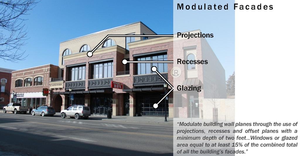

63


64


65


66
 (Image")

67 (Image source: City of Edgewood, WA Design Standards ) (Image source: homeword.org)
Understanding the Conditional Use Process
 Understanding the Conditional Use Process The purpose of this document is to explain the process of applying for and obtaining a conditional use permit in the rural unincorporated towns of Dane County.
ARTICLE 1 GENERAL PROVISIONS
 ARTICLE 1 GENERAL PROVISIONS SECTION 100 TITLE This Ordinance shall be known and cited as the "Rice Township Subdivision and Land Development Ordinance." SECTION 101 AUTHORITY Rice Township is empowered
13 NONCONFORMITIES [Revises Z-4]
![13 NONCONFORMITIES [Revises Z-4]](/thumbs/87/97238669.jpg "13 NONCONFORMITIES [Revises Z-4]") Dimensional Standards Building Design Standards Sidewalks Tree Protection & Landscaping Buffers & Screening Street Tree Planting Parking Lot Landscaping Outdoor Lighting Signs 13.1 PURPOSE AND APPLICABILITY
Dimensional Standards Building Design Standards Sidewalks Tree Protection & Landscaping Buffers & Screening Street Tree Planting Parking Lot Landscaping Outdoor Lighting Signs 13.1 PURPOSE AND APPLICABILITY
Planning and Zoning Code
 2014 Planning and Zoning Code City of Defiance, Ohio December 2014 Planning and Zoning Code City of Defiance, Ohio CHAPTER 1161. General Provisions... 7 1161. 01. Title... 7 1161. 02. Purpose... 7 1161.
201 General Provisions
 201 General Provisions 201.01 Title 201.09 Amendments 201.02 Purpose and Intent 201.10 Public Purpose 201.03 Authority 201.11 Variances and Appeals 201.04 Jurisdiction 201.12 Nonconformances 201.05 Enactment
UPPER MOUNT BETHEL TOWNSHIP NORTHAMPTON COUNTY, PENNSYLVANIA
 UPPER MOUNT BETHEL TOWNSHIP NORTHAMPTON COUNTY, PENNSYLVANIA JOINDER DEED / LOT CONSOLIDATION TOWNSHIP REVIEW PROCESS When accepting proposed Joinder Deeds / Lot Consolidations, review the Joinder Deed
LAND USE AND ZONING OVERVIEW
 OVERVIEW OF PLANNING POLICIES LAND USE AND ZONING OVERVIEW The Minneapolis Plan for Sustainable Growth and Other Adopted Plans Community Planning and Economic Development Development Services Division
Zoning Ordinance and Subdivision Regulations
 Zoning Ordinance and Subdivision Regulations Effective Date: September 15, 2015 Williams County, North Dakota Acknowledgements Williams County Board of Commissioners David Montgomery Chairman Wayne Aberle
13-2 SUBDIVISION PLANS AND PLATS REQUIRED EXCEPTIONS Subdivision Plats Required To be Recorded
 ARTICLE XIII SUBDIVISIONS 13-1 INTENT AND PURPOSE 13-1-1 Intent: It is the intent of the County Commission through the adoption of this Article to more fully avail itself of the power granted under 17-27-601
ORDINANCE NO. 41. PRIVATE ROAD ORDINANCE As Amended Through April 10, 2008
 ORDINANCE NO. 41 PRIVATE ROAD ORDINANCE As Amended Through April 10, 2008 An Ordinance to protect the health, safety, and general welfare of the inhabitants of Port Sheldon Township. The Township of Port
CITY OF HENDERSON TABLE OF CONTENTS. Section 101: Purpose... 1 Section 102: Authority... 1 GENERAL REGULATIONS APPLIED TO ALL DISTRICTS
 TABLE OF CONTENTS ARTICLE 100: PURPOSE AND AUTHORITY Section 101: Purpose... 1 Section 102: Authority... 1 ARTICLE 200: GENERAL REGULATIONS APPLIED TO ALL DISTRICTS Section 201: Jurisdiction and Zoning
TOWN OF WATERVILLE VALLEY NEW HAMPSHIRE SITE PLAN REVIEW REGULATIONS
 TOWN OF WATERVILLE VALLEY NEW HAMPSHIRE Effective date March 17, 1981 Revised March 16, 1982 Revised March 13, 1986 Revised March 10, 1987 Revised March 14, 2013 Revised March 8, 2016 TOWN OF WATERVILLE
4.2 RESIDENTIAL ZONING DISTRICTS
 4.2 RESIDENTIAL ZONING DISTRICTS A. Purpose: To define regulations and standards for each residential zoning district in the City. The following sections identify uses, regulations, and performance standards
City of Harrisburg Variance and Special Exception Application
 City of Harrisburg Variance and Special Exception Application Note: The Planning Bureau will review all applications for completeness; incomplete applications may cause a delay in processing. Contact Ben
ORDINANCE NO. Be it ordained by the City Council of the City of Abilene, Texas:
 ORDINANCE NO. An ordinance repealing Chapter 23, Subpart B of the Code of the City of Abilene, Texas, entitled Mobile Homes and Vacation Travel Trailers; stating the authority; setting forth the scope
WOOD COUNTY ORDINANCE #401 HIGHWAY ACCESS ORDINANCE
 WOOD COUNTY ORDINANCE #401 HIGHWAY ACCESS ORDINANCE TABLE OF CONTENTS 401.01 INTRODUCTION...401-1 (1) Authority...401-1 (2) Title...401-1 (3) Purpose and Intent...401-1 (4) Abrogation and Greater Restrictions...401-1
Midwest City, Oklahoma Zoning Ordinance
 2010 Midwest City, Oklahoma Zoning Ordinance 9/2/2010 Table of Contents Section 1. General Provisions... 5 1.1. Citation... 5 1.2. Authority... 5 1.3. Purpose... 5 1.4. Nature and Application... 5 1.5.
ARTICLE V AGRICULTURAL PRESERVATION AND RURAL RESIDENTIAL DISTRICT
 ARTICLE V AP AGRICULTURAL PRESERVATION AND RURAL RESIDENTIAL DISTRICT Section 500. PURPOSE It is the purpose of the AP, Agricultural Preservation and Rural Residential District, to foster the preservation
ARTICLE 535. PD 535. C.F. Hawn Special Purpose District No. 3
 ARTICLE 535. PD 535. C.F. Hawn Special Purpose District No. 3 SEC. 51P-535.101. LEGISLATIVE HISTORY. PD 535 was established by Ordinance No. 23988, passed by the Dallas City Council on August 25, 1999.
Castle Danger Subordinate Service District Phase I Land Use Ordinance #1
 Castle Danger Subordinate Service District Phase I Land Use Ordinance #1 Effective February 2, 2010 Castle Danger Subordinate Service District Phase I Land Use Ordinance SECTION I PURPOSE The purpose of
ARTICLE 24 SITE PLAN REVIEW
 ARTICLE 24 SITE PLAN REVIEW 24.1 PURPOSE: The intent of these Ordinance provisions is to provide for consultation and cooperation between the land developer and the Township Planning Commission in order
TOWNSHIP OF HARTLAND ORDINANCE NO. 57-1, AN ORDINANCE AMENDING THE LAND DIVISION ORDINANCE
 TOWNSHIP OF HARTLAND ORDINANCE NO. 57-1, AN ORDINANCE AMENDING THE LAND DIVISION ORDINANCE An ordinance to amend the Land Division Ordinance enacted pursuant to but not limited to the State Land Division
ARTICLE 15 - PLANNED UNIT DEVELOPMENT
 Section 15.1 - Intent. ARTICLE 15 - PLANNED UNIT DEVELOPMENT A PUD, or Planned Unit Development, is not a District per se, but rather a set of standards that may be applied to a development type. The Planned
TEMPORARY WORKFORCE HOUSING ZONING
 TEMPORARY WORKFORCE HOUSING ZONING As adopted in October of 2013 Table of Contents: Page Table of Contents 2 1. Definitions 3 2. Workforce Housing Facilities Authorization 4 3. Other Regulations 4 4. Nonconforming
ELK RAPIDS TOWNSHIP ANTRIM COUNTY, MICHIGAN ORDINANCE NO
 ELK RAPIDS TOWNSHIP ANTRIM COUNTY, MICHIGAN ORDINANCE NO. 3-2011 AN ORDINANCE TO REPLACE THE SUBDIVISION CONTROL ORDINANCE WITH A NEW SUBDIVISION DEVELOPMENT ORDINANCE, IN ACCORD WITH THE LAND DIVISION
ARTICLE XI CONDITIONAL USE PERMITS
 ARTICLE XI CONDITIONAL USE PERMITS 11.1 Purpose. The City of Hailey recognizes that certain uses possess unique and special characteristics with respect to their location, design, size, method of operation,
LEMHI COUNTY DEVELOPMENT CODE
 LEMHI COUNTY DEVELOPMENT CODE Adopted June 12, 2017 Ordinance Number 2017-1 Repealing Ordinance No. 2012-1 and subsequent amendments in its entirety. County Commissioners Ken Miner, Rick Snyder & Brett
ARTICLE VII. NONCONFORMITIES. Section 700. Purpose.
 ARTICLE VII. NONCONFORMITIES. Section 700. Purpose. The purpose of this chapter is to regulate and limit the development and continued existence of legal uses, structures, lots, and signs established either
ARTICLE 2: General Provisions
 ARTICLE 2: General Provisions 2-10 Intent The basic intent of the Town of Orange s Zoning Ordinance is to implement the goals and objectives of the adopted Town of Orange Comprehensive Plan, hereafter
CHAPTER 14 PLANNED UNIT DEVELOPMENTS
 9-14-1 9-14-1 CHAPTER 14 PLANNED UNIT DEVELOPMENTS SECTION: 9-14-1: Purpose 9-14-2: Governing Provisions 9-14-3: Minimum Area 9-14-4: Uses Permitted 9-14-5: Common Open Space 9-14-6: Utility Requirements
PROTECTIVE COVENANTS DEED RESTRICTIONS SPENCER BUSINESS/INDUSTRIAL PARK August 11, 1999 Amended, March 3, 2014
 PROTECTIVE COVENANTS DEED RESTRICTIONS SPENCER BUSINESS/INDUSTRIAL PARK August 11, 1999 Amended, March 3, 2014 1. GENERAL PURPOSES and CONDITIONS The real property conveyed hereby, being part of the Spencer
Chapter 22 PLANNED UNIT DEVELOPMENT.
 Chapter 22 PLANNED UNIT DEVELOPMENT. Sec. 22.1 INTENT. The use of land and the construction and use of buildings and other structures as Planned Unit Developments in Georgetown Township may be established
301. Zoning Districts. C-D A-1 R-1 R-V B-1 I-1
 301. Zoning Districts. The Township is divided into the districts set forth by this chapter and as shown by the district boundaries on the Official Zoning District Map. The zoning districts are: C-D Conservation
Stem Zoning Ordinance
 Stem Zoning Ordinance Town of Stem North Carolina September 21, 2016 (Supersedes Stem Zoning Ordinance 04/21/2014) ZoningORD_Final_09-21-16.docx Authority Article 1. General and Legal Provisions... 9
Prince Edward County Zoning Ordinance. Effective October 1, 2007
 Prince Edward County Zoning Ordinance Effective October 1, 2007 ARTICLE I GENERAL PROVISIONS...6 SEC. 1-100 TITLE AND AUTHORITY...6 SEC. 1-102 JURISDICTION...6 SEC. 1-104 PURPOSE...6 SEC. 1-106 EFFECTIVE
Subchapter 5 Zoning Districts and Limitations
 Subchapter 5 Zoning Districts and Limitations 35.5.1 Rural Districts Sections: 35.5.1.1 Purpose. 35.5.1.2 Permitted Uses. 35.5.1.3 General Regulations. 35.5.1.1 Purpose. The purpose of a Rural District
II. What Type of Development Requires Site Plan Review? There are five situations where a site plan review is required:
 I. What is a Site Plan Review? Site Plan Review is a process where the construction of new buildings, new additions, and certain types of canopies and/or tax-exempt institutions are reviewed by the City
Special Use Permit - Planned Unit Development Checklist. Property Address:
 Special Use Permit - Planned Unit Development Checklist Special Use Permit Number. Parcel Code/s #28-11- - - Property Address: Applicant: ARTICLE VIII Ordinance Reference - Section 8.1.2 Permit Procedures:
PIKE TOWNSHIP, OHIO July 6, 2010 ZONING REGULATIONS
 CHAPTER 9 - ADMINISTRATION AND ENFORCEMENT Section A - General Provisions The formulation, administration, and enforcement of these Zoning Regulations is hereby vested in the following offices of Clark
TOWNSHIP OF UPPER MACUNGIE LEHIGH COUNTY, PENNSYLVANIA. ORDINANCE NO [To be considered for Adoption June 1, 2017]
![TOWNSHIP OF UPPER MACUNGIE LEHIGH COUNTY, PENNSYLVANIA. ORDINANCE NO [To be considered for Adoption June 1, 2017]](/thumbs/91/106428876.jpg "TOWNSHIP OF UPPER MACUNGIE LEHIGH COUNTY, PENNSYLVANIA. ORDINANCE NO [To be considered for Adoption June 1, 2017]") TOWNSHIP OF UPPER MACUNGIE LEHIGH COUNTY, PENNSYLVANIA ORDINANCE NO. 2017 05 [To be considered for Adoption June 1, 2017] AN ORDINANCE OF THE BOARD OF SUPERVISORS OF THE TOWNSHIP OF UPPER MACUNGIE, LEHIGH
TOWNSHIP OF UPPER MACUNGIE LEHIGH COUNTY, PENNSYLVANIA ORDINANCE NO. 2017 05 [To be considered for Adoption June 1, 2017] AN ORDINANCE OF THE BOARD OF SUPERVISORS OF THE TOWNSHIP OF UPPER MACUNGIE, LEHIGH
1.1 ENACTMENT AND AUTHORITY
 ARTICLE 1. LEGAL PROVISIONS 1.1 ENACTMENT AND AUTHORITY These regulations are adopted pursuant to the authority vested in the Town of Dobson by its charter, the Session laws, and the General Statutes of
Colleyville, Texas, Land Development Code. Table of Contents
 Table of Contents Chapter 1 General Provisions Section 1.1 Title 1-1 Section 1.2 Applicability 1-1 Section 1.3 Authorization for Adoption of This Land Development Code 1-1 Section 1.4 Purpose of the Land
ARTICLE 14 PLANNED UNIT DEVELOPMENT (PUD) DISTRICT
 DISTRICT") ARTICLE 14 PLANNED UNIT DEVELOPMENT (PUD) DISTRICT Section 14.01 Intent. It is the intent of this Article to allow the use of the planned unit development (PUD) process, as authorized by the Michigan Zoning
ARTICLE 14 PLANNED UNIT DEVELOPMENT (PUD) DISTRICT Section 14.01 Intent. It is the intent of this Article to allow the use of the planned unit development (PUD) process, as authorized by the Michigan Zoning
SITE PLAN REVIEW ADMINISTRATIVE REVIEW. Please Note: Once submitted to the County, all application materials become a matter of public record.
 200 W. Oak Street, 3rd Floor Fort Collins, CO 80521 (970) 498-7683 / larimer.org/planning SITE PLAN REVIEW ADMINISTRATIVE REVIEW The submittal requirements listed in this packet are intended to collect
WAYNE COUNTY, UTAH SUBDIVISION ORDINANCE
 WAYNE COUNTY, UTAH SUBDIVISION ORDINANCE A LAND USE ORDINANCE OF WAYNE COUNTY As Adopted by the Wayne County Board of County Commissioners Effective January 01, 2011 Prepared by: PLANNING AND DEVELOPMENT
Residential Project Convenience Facilities
 Standards for Specific Land Uses 35.42.220 E. Findings. The review authority shall approve a Land Use Permit in compliance with Subsection 35.82.110.E (Findings required for approval) or a Conditional
ZONING ORDINANCE TOWN OF MOUNTAIN CITY
 ZONING ORDINANCE TOWN OF MOUNTAIN CITY AMENDED THROUGH JUNE 2009 ZONING ORDINANCE OFTHE TOWN OF MOUNTAIN CITY An ordinance, in pursuance of the authority granted by Sections 13-7-201 through 13-7- 210
ARTICLE PERMISSIVE USES. A building or premises shall be permitted to be used for the following purposes in the A-1 Agricultural District:
 ARTICLE 3.00 A-1 AGRICULTURAL SECTIONS: 3.01 Intent 3.02 Permissive Uses 3.03 Permitted Special Uses 3.04 Conditional Uses 3.05 Accessory Uses 3.06 Parking Regulations 3.07 Sign Regulations 3.08 Density,
CHAPTER 3 PERMITS, PLANS AND ANNEXATION
 CHAPTER 3 PERMITS, PLANS AND ANNEXATION SECTION: 10-3-1: General Regulations 10-3-2: Building Permit 10-3-3: Plans 10-3-4: Certificate of Compliance and Occupancy 10-3-5: Conditional Use Permits 10-3-6:
SANTA BARBARA COUNTY ZONING ADMINISTRATOR STAFF REPORT January 11, 2008
 SANTA BARBARA COUNTY ZONING ADMINISTRATOR STAFF REPORT January 11, 2008 PROJECT: Gerrity Parking in Side Setback and Gerrity Student Housing Addition HEARINGDATE: January 28, 2008 STAFF/PHONE: J. Ritterbeck,
Part 4, C-D Conservation District
 The Township is divided into the districts set forth by this chapter and as shown by the district boundaries on the Official Zoning District Map. The zoning districts are: C-D Conservation District A-1
Chapter 401. General Provisions
 GENERAL PROVISIONS 401.010 TITLE 401 Chapter 401. General Provisions Section 401.010 Section 401.020 Section 401.030 Section 401.040 Section 401.050 Section 401.060 Title Authority Purpose Applicability
Chapter CC COMMUNITY COMMERCIAL ZONES REGULATIONS
 Effective April 14, 2011 Chapter 17.35 CC COMMUNITY COMMERCIAL ZONES REGULATIONS SECTIONS: 17.35.010 Title, Intent, and Description 17.35.020 Required Design Review Process 17.35.030 Permitted and Conditionally
ARTICLE 7. SPECIFIC USE STANDARDS
 ARTICLE 7. SPECIFIC USE STANDARDS Section 7.1 Applicability The following standards apply to specified uses in all zoning districts in which such uses are allowed. Section 7.2 Accessory Apartments (A)
Buildings for Lease or Rent
 Buildings for Lease or Rent Table of Contents Page 1. Purpose 3 2. Authority & Administration 3 3. Applicability 3 4. Definitions 3 5. Requirements for Buildings for Rent or Lease 4 6. Application & Review
Franklin County Zoning Ordinance Adopted by:
 FRANKLIN COUNTY ZONING ORDINANCE i Franklin County Zoning Ordinance Adopted by: Franklin County Plan Commission................. January 1, 2009 Franklin County Commissioners................... January
White County Subdivision Control Ordinance TABLE OF CONTENTS
 Table of Contents TABLE OF CONTENTS CHAPTER 1: PURPOSE, AUTHORITY, AND JURISDICTION 1.0 Title... 1.1 1.1 Purpose and Authority... 1.1 1.1.1 Purpose... 1.1 1.1.2 Authority... 1.2 1.2 Policy... 1.2 1.2.1
Chapter 210 CONDITIONAL USES
 Chapter 210 CONDITIONAL USES 210.01 Purpose 210.02 Authorization 210.03 Process Type 210.04 Determination of Major or Minor Conditional Use Review 210.05 Approval Criteria 210.06 Conditions of Approval
TABLE OF CONTENTS. Article / Section. Article 1 Administration and Enforcement
 TABLE OF CONTENTS Preamble How To Use This Ordinance Article / Section Page Article 1 Administration and Enforcement... 1-1 Sec. 1.01 Short Title... 1-1 Sec. 1.02 Intent... 1-1 Sec. 1.03 Scope... 1-1 Sec.
Deerfield Township Zoning Resolution
 Deerfield Township Zoning Resolution Effective August 5, 2011 Amended December 1, 2016 TABLE OF CONTENTS Article 1: General Provisions... 1-1 Section 1.01: Title... 1-1 Section 1.02: Purpose... 1-1 Section
HUERFANO COUNTY SIGN REGULATIONS SECTION 14.00
 TABLE OF CONTENTS Section Title Page 14.01 SIGN CODE... 14-1 14.01.01 Intent and Purpose... 14-1 14.02 GENERAL PROVISIONS... 14-1 14.02.01 Title... 14-1 14.02.02 Repeal... 14-1 14.02.03 Scope and Applicability
Please be advised that the Town does not enforce private covenants or deed restrictions. I. SUBJECT ADDRESS: Zoning District. Palm Beach County:
 ZONING APPLICATION TOWN OF PALM BEACH () This application includes requests for: Site Plan Review Special Exception Variance TO BE HEARD BY THE TOWN COUNCIL ON AFTER 9:30 A.M., IN THE TOWN OF PALM BEACH
TOWN OF EPPING, NH ZONING ORDINANCES
 TOWN OF EPPING, NH ZONING ORDINANCES 2017 Contents ARTICLE 1: Preamble, Title & Purpose 3 ARTICLE 2: Zoning 4 1. Highway-Commercial 7 2.Residential-Commercial 11 3. West Epping Commercial Business Zone
This Ordinance shall be known as the Zoning Ordinance of the Town of Holly Ridge, North Carolina.
 CHAPTER 7. ZONING ARTICLE I. LEGAL PROVISIONS Section 7.1 Enactment and Authority The Town Council of the Town of Holly Ridge, North Carolina pursuant to the authority granted by Article 1, Chapter 160A
ARTICLE SINGLE FAMILY SITE CONDOMINIUM DEVELOPMENT STANDARDS
 ARTICLE 28.00 SINGLE FAMILY SITE CONDOMINIUM DEVELOPMENT STANDARDS Section 28.01 PURPOSE The purpose of this Article is to recognize that conventional single family developments, traditionally developed
PLANNED UNIT DEVELOPMENTS (Ordinance No.: 3036, 12/3/07; Repealed & Replaced by Ordinance No.: 4166, 10/15/12)
") 159.62 PLANNED UNIT DEVELOPMENTS (Ordinance No.: 3036, 12/3/07; Repealed & Replaced by Ordinance No.: 4166, 10/15/12) A. PURPOSE 1. General. The Planned Unit Development (PUD) approach provides the flexibility
159.62 PLANNED UNIT DEVELOPMENTS (Ordinance No.: 3036, 12/3/07; Repealed & Replaced by Ordinance No.: 4166, 10/15/12) A. PURPOSE 1. General. The Planned Unit Development (PUD) approach provides the flexibility
Salmon Development Code. December 16, 1992
 Salmon Development Code December 16, 1992 Ordinance No. 92-561 Amended September 22, 1994 Amended October 7, 1996 Amended February 5, 1997 Amended September 17, 1997 Amended April 15, 1998 Amended August
PICKENS COUNTY UNIFIED DEVELOPMENT STANDARDS ORDINANCE. Organization of the Ordinance
 PICKENS COUNTY UNIFIED DEVELOPMENT STANDARDS ORDINANCE Organization of the Ordinance Article 1. Article 2. Article 3. Article 4. Article 5. Article 6. Article 7. Adoption, Applicability and Interpretation
SUBDIVISION APPLICATION
 SUBDIVISION APPLICATION Community Planning and Economic Development Development Services Division 250 South 4 th Street, Room 300 Minneapolis MN 55415-1316 612-673-3000 This application packet is used
ARTICLE 533. PD 533. C.F. Hawn Special Purpose District No. 1
 ARTICLE 533. PD 533. C.F. Hawn Special Purpose District No. 1 SEC. 51P-533.101. LEGISLATIVE HISTORY. PD 533 was established by Ordinance No. 23780, passed by the Dallas City Council on February 10, 1999.
NONCONFORMITIES ARTICLE 39. Charter Township of Commerce Page 39-1 Zoning Ordinance. Article 39 Nonconformities
 ARTICLE 39 NONCONFORMITIES SECTION 39.01. Intent and Purpose It is recognized that there exists within the districts established by this Ordinance lots, structures, sites and uses which were lawful prior
TITLE 14 ZONING AND LAND USE CONTROL CHAPTER 1 MUNICIPAL PLANNING COMMISSION
 14-1 TITLE 14 ZONING AND LAND USE CONTROL CHAPTER 1. MUNICIPAL PLANNING COMMISSION. 2. ZONING ORDINANCE. 3. MOBILE HOMES (TRAILERS). CHAPTER 1 MUNICIPAL PLANNING COMMISSION SECTION 14-101. Creation and
Application for Sketch Plan Review
 Town of Standish 175 Northeast Road Standish, ME - 04084 Phone: (207)642-3461 Fax: (207) 642-5181 Application for Sketch Plan Review Applicant & Owner Information 1) Name of Applicant: Address: Phone:
Chapter 1107: Zoning Districts
 Chapter 1107: Zoning Districts 1107.01 Establishment of Zoning Districts (a) Districts Established In order to carry out the purpose of this code, the City is hereby divided into the zoning districts established
Memorandum: October 13, 2008 REVISED To: Trowbridge Township Planning Commission From: P. Hudson, AICP Re: Suggested New Ordinance
 1 Memorandum: October 13, 2008 REVISED 2-11-09 To: Trowbridge Township Planning Commission From: P. Hudson, AICP Re: Suggested New Ordinance Because of changes in both the Michigan Planning Enabling Act
Charter Township of Plymouth Zoning Ordinance No. 99 Page 208 Article 21: Residential Unit Developments Amendments: ARTICLE XXI
 Charter Township of Plymouth Zoning Ordinance No. 99 Page 208 ARTICLE XXI RESIDENTIAL UNIT DEVELOPMENTS PURPOSE The purpose of the Residential Unit Development (RUD) is to permit two (2) optional methods
ARTICLE III District Regulations. A map entitled "Franklin Zoning Map" is hereby adopted as part of this chapter 1.
 ARTICLE III District Regulations ~ 305-8. Adoption of Zoning Map. A map entitled "Franklin Zoning Map" is hereby adopted as part of this chapter 1. ~ 305-9. Official Zoning Map; amendments. Regardless
CHAPTER URBAN TRANSITION - UT ZONE
 CHAPTER 16.13 URBAN TRANSITION - UT ZONE Section Title Page 16.13.000 Purpose 1 16.13.010 Uses 1 16.13.020 Conditional Uses 2 16.13.030 Conditional Use Criteria 3 16.13.040 Prohibited Uses 4 16.13.100
Town of Truckee. Contents. Article I - Development Code Enactment and Applicability. Chapter Purpose and Effect of Development Code...
 Town of Truckee TITLE 18 - DEVELOPMENT CODE Article I - Development Code Enactment and Applicability Chapter 18.01 - Purpose and Effect of Development Code... I-3 18.01.010 - Title... I-3 18.01.020 - Purposes
TOWN OF ENNIS TITLE 11 ZONING ORDINANCE DRAFT UPDATE
 TOWN OF ENNIS TITLE 11 ZONING ORDINANCE DRAFT UPDATE FEBRUARY 6, 2018 CHAPTER 1: TITLE, PURPOSE, AUTHORITY, AND GENERAL ADMINISTRATIVE PROVISIONS The regulations, standards, and procedures contained herein
The following regulations shall apply in the R-E District:
 "R-E" RESIDENTIAL ESTATE DISTRICT (8/06) The following regulations shall apply in the R-E District: 1. Uses Permitted: The following uses are permitted. A Zoning Certificate may be required as provided
SHOPPING CENTER DISTRICT (Zone BSC)
") Sec. 3-27. SHOPPING CENTER DISTRICT (Zone BSC) (a) (b) Area. All land designated as Zone BSC is subject to the regulations of this Section and Sec. 20.3-10. Such areas are established to provide for planned
Sec. 3-27. SHOPPING CENTER DISTRICT (Zone BSC) (a) (b) Area. All land designated as Zone BSC is subject to the regulations of this Section and Sec. 20.3-10. Such areas are established to provide for planned
City of Xenia, Ohio Official Land Development Code
 City of Xenia, Ohio Official Land Development Code Effective July 9, 2016 Ordinance #16-26 Amendments Effective Date Ordinance # 9/23/2017 17-40 Table of Contents Chapter 1218: General Provisions... 1
PUBLIC RELEASE DRAFT MAY TEXT AND MAP AMENDMENT. A. Purpose
 ARTICLE 16. ZONING APPLICATION APPROVAL PROCESSES 16.1 TEXT AND MAP AMENDMENT 16.2 SPECIAL USE PERMIT 16.3 VARIANCE 16.4 ADMINISTRATIVE EXCEPTION 16.5 SITE PLAN REVIEW 16.6 PLANNED UNIT DEVELOPMENT 16.7
MOBILE HOME PARK ORDINANCE OF THE TOWN OF LIVERMORE FALLS
 1 Section I. TITLE MOBILE HOME PARK ORDINANCE OF THE TOWN OF LIVERMORE FALLS This ordinance shall be known and cited as the Mobile Home Park Ordinance of the Town of Livermore Falls, Maine. Section II.
Village of South Elgin, IL. CHAPTER 156: Unified Development Ordinance
 Village of South Elgin, IL CHAPTER 156: Unified Development Ordinance UNIFIED DEVELOPMENT ORDINANCE (UDO) EFFECTIVE DATE: October 1, 2018 1 TABLE OF CONTENTS SECTION 156.01: TITLE AND APPLICABILITY...4
Salem Township Zoning Ordinance Page 50-1 ARTICLE 50.0: PUD PLANNED UNIT DEVELOPMENT
 Salem Township Zoning Ordinance Page 50-1 ARTICLE 50.0 PLANNED UNIT DEVELOPMENT Section 50.01 Purpose The provisions of this Article provide enabling authority and standards for the submission, review,
GRAND COUNTY Planning Commission May 11, :00 P.M. Regular Meeting Grand County Courthouse Council Chambers 125 E Center, Moab, Utah
 Type of Meeting: Facilitator: Attendees: Regular Meeting Dave Tubbs, Chair GRAND COUNTY Planning Commission May 11, 2016 6:00 P.M. Regular Meeting Grand County Courthouse Council Chambers 125 E Center,
A GUIDE TO PROCEDURES FOR: SUBDIVISIONS & CONDOMINIUM CONVERSION
 A GUIDE TO PROCEDURES FOR: SUBDIVISIONS & CONDOMINIUM CONVERSION A GUIDE TO PROCEDURES FOR: SUBDIVISIONS (TENTATIVE MAPS) PURPOSE Definition: A subdivision is defined as the division of any improved or
ADOPTED AS AMENDED 6/25/09 TABLE OF CONTENTS
 TABLE OF CONTENTS Chapter 18.04 GENERAL PROVISIONS... 939 18.04.100 Zoning Regulations Applicable Within Districts... 939 18.04.010 Adoption.... 939 18.04.020 Title.... 939 18.04.030 Intent.... 939 18.04.040
APPENDIX E FORMS INDEX OF ZONING FORMS
 APPENDIX E FORMS The zoning forms to follow in this appendix are used by Morrow County Zoning on behalf of their zoning resolution. There are two checklist sheets at the front of the forms that will assist
CHAPTER 2 RELATIONSHIP WITH OTHER LAWS.
 CHAPTER 2 General Provisions 12-2-1 Minimum Requirements 12-2-2 Relationship with Other Laws 12-2-3 Effect on Existing Agreements 12-2-4 Scope of Regulations 12-2-5 Building Permit 12-2-6 Nonconforming
CHAPTER 21.11: NONCONFORMITIES...1
 0 0 TABLE OF CONTENTS CHAPTER.: NONCONFORMITIES.....0 General Provisions... A. Purpose... B. Authority to Continue... C. Determination of Nonconformity Status... D. Nonconformities Created Through Government
Draft Model Access Management Overlay Ordinance
 Draft Model Access Management Overlay Ordinance This model was developed using the City of Hutchinson and the Trunk Highway 7 corridor. The basic provisions of this model may be adopted by any jurisdiction
ARTICLE XX THE COUNTY BOARD OF MERCER COUNTY, ILLINOIS RESOLUTION AMENDING THE MERCER COUNTY ZONING ORDINANCE SOLAR ENERGY FACILITIES
 ARTICLE XX THE COUNTY BOARD OF MERCER COUNTY, ILLINOIS RESOLUTION AMENDING THE MERCER COUNTY ZONING ORDINANCE SOLAR ENERGY FACILITIES 20.1 TITLE. This ordinance shall be known as the Solar Energy Ordinance.
DRAFT PARK COUNTY US HIGHWAY 89 SOUTH EAST RIVER ROAD OLD YELLOWSTONE TRAIL ZONING DISTRICT REGULATIONS
 Formatting: Changes recommended by the Board and accepted by the County Commission are formatted in RED: Changes made by the Park County Commission are formatted in YELLOW highlight: and changes made by
ARTICLE 9: VESTING DETERMINATION, NONCONFORMITIES AND VARIANCES. Article History 2 SECTION 9.01 PURPOSE 3
 ARTICLE 9 VESTING DETERMINATIONS, NONCONFORMITIES, AND VARIANCES Table of Contents Article History 2 SECTION 9.01 PURPOSE 3 SECTION 9.02 LOT OF RECORD AND VESTING DETERMINATIONS FOR NONCONFORMING DEVELOPMENTS
Adopted August 22, 2013 by Sanders County Commissioners. Page 1 of 6
 SANDERS COUNTY Buildings for Lease or Rent Review Process 1. Purpose The following regulations are intended to provide an administrative process for the acceptance and review of applications for the creation
ARTICLE 7 R-1 ONE FAMILY RESIDENTIAL DISTRICT
 ARTICLE 7 R-1 ONE FAMILY RESIDENTIAL DISTRICT SECTION 700 STATEMENT OF PURPOSE This district classification is designed to be the most restrictive of the residential districts intended to encourage an
FENCE ORDINANCE. THE CITY OF MADISON Madison, Mississippi. Effective October 21, 2008
 FENCE ORDINANCE OF THE CITY OF MADISON Madison, Mississippi Effective October 21, 2008 AN ORDINANCE REGULATING AND CONTROLLING THE SIZE, LOCATION, CHARACTER, APPEARANCE, PURPOSE, CONTENT AND OTHER PERTINENT