Zoning Code User Guide
|
|
|
- Violet Parker
- 6 years ago
- Views:
Transcription


1 Public Review Draft - February 2014 Zoning Code User Guide Sacramento County Department of Community Development Page 1 of 60
2 This page intentionally left blank Page 2 of 60

3 Sacramento County Zoning Code User Guide Public Review Draft - February 2014 Board of Supervisors Phil Serna, District 1 Jimmie Yee, District 2 Susan Peters, District 3 Roberta MacGlashan, District 4 Don Nottoli, District 5 Bradley Hudson, County Executive Page 3 of 60
4 This page intentionally left blank Page 4 of 60
5 Table of Contents 1. INTRODUCTION CODE ORGANIZATION Code Chapters Code Appendix A Code Chapters Incorporated by Reference NAVIGATING THE CODE Finding the Zoning Code Regulations for your Property Determining Allowable Uses on your Property Determining Standards for Development Determining Required Development/Permit Approvals DEVELOPMENT/PERMIT APPROVAL General Procedures for all Applications Applications for Amendments, Rezones, and Development Agreements Site Plan Review Application Procedures Subdivision Application Procedures Special Permit Procedures Other Application Procedures Appeals, Amendents, Enforcement, and Revocation Procedures APPLICATION OF THE CODE TO DEVELOPMENT EXAMPLES TABLES Table 4-1: Hearing Body Hierarchy Table 4-2: Summary of Notice Requirements Table 4-3: Amendments, Rezonings, DAs, Application Review/Decision/Appeal Table 4-4: Site Plan Application Review/Decision/Appeal DRAFT F EBRUARY 2014 TABLE OF CONTENTS i Page 5 of 60
6 Table 4-5: Subdivision Application Review/Decision/Appeal Table 4-6: Special Permit Application Review/Decision/Appeal Table 4-7: Other Application Review/Decision/Appeal FIGURES Figure 5-1: Primary Automotive Service Station Site Example Figure 5-2: Code References for Primary Automotive Service Station Site Figure 5-3: Design Guideline References for Primary Automotive Service Station Site Figure 5-4: Commercial Site Example with Senior Housing Figure 5-5: Code References for Commercial Site with Senior Housing Figure 5-6: Design Guideline References for Commercial Site with Senior Housing ii TABLE OF CONTENTS DRAFT FEBRUARY 2014 Page 6 of 60
7 1. INTRODUCTION The Sacramento County Zoning Code User Guide (Guide) has been prepared to help property owners and users understand and navigate the County s Zoning Code (Code) and common planning and entitlement application procedures most likely to be encountered when developing property in Sacramento County. This Guide compiles the requirements for application contents, forms, fees, and submission and review schedule. It is intended to be administratively updated by the Planning Director, from time to time, to ensure efficient review and approval processes and simplify common planning and development application procedures, to the extent possible. All new development and uses must comply with the County s Code and Design Guidelines. Both of these documents implement the goals and policies of the Sacramento County General Plan, and address contemporary planning issues, including removing barriers to infill and mixed-use development, minimize regulatory burdens to development and redevelopment in the County, and increase focus on health and the built environment emphasizing active design and sustainability; while continuing to fulfill the County s obligation to protect the public health, safety, and general welfare of the residents of Sacramento County. References to chapters, sections and tables are specific to the Code, unless otherwise indicated, and the electronic version of this Guide provides users with links to these Code references. DRAFT F EBRUARY 2014 INTRODUCTION 1 Page 7 of 60
8 This page intentionally left blank 2 CODE ORGANIZATION DRAFT F EBRUARY 2014 Page 8 of 60
9 2. CODE ORGANIZATION The Code is a reference document that is organized so that users may look up the specific information of interest. Easy to reference tables are provided in place of longer standards to make finding applicable regulations simple to understand Code Chapters The grouping of chapters in the Code s Table of Contents is a helpful start to understanding and navigating the sections of the Code. This section describes the Code s organization and the following section, Navigating the Code, will help you understand how to find specific information. Chapter 1: General Provisions Chapter 1 includes General Provisions that apply to the entire Code and address the Code s legal framework. This section includes provisions related to the Code s purpose, need, and applicability; where to find and how to interpret the County s zoning designations; rules for interpreting zoning boundaries; and relationship to other laws and plans. It also contains rules for governing transition from the County s previous zoning ordinance to the new Code. The following list provides links to the sections in Chapter Title and Effective Date 1.2 Authority 1.3 Purpose of this Code 1.4 Applicability and Jurisdiction 1.5 Delegation of Assigned Authority 1.6 Official Zoning Map 1.7 Relationship to Other Laws and Plans 1.8 Severability 1.9 Nonconformance Chapter 2: Zoning Districts The Code identifies a variety of land use zones or zoning districts that carry out the general purpose and provisions of the Code. A zoning district is a land use designation that can be applied to a single parcel or group of parcels. The boundaries of these districts are delineated on the Comprehensive Zoning Plan, which is adopted by the Board of Supervisors. The Comprehensive Zoning Plan is incorporated by reference as part of the Code, and is maintained on file in the office of the Planning Director. Chapter 2 establishes the base zoning districts, and describes the general purpose statements and summary of each district. Chapter 2 is organized by the following sections: Section Zoning District Name or Section Quick Reference Sections 2.1 General Purpose Applicability Prohibition Sequence of Zoning Districts Abbreviations 2.2 Comprehensive Zoning Plan General DRAFT F EBRUARY 2014 CODE ORGANIZATION 3 Page 9 of 60
10 Section Zoning District Name or Section Quick Reference Sections 2.3 Open Space Zoning Districts 2.4 Agricultural Zoning Districts 2.5 Agricultural-Residential Zoning Districts 2.6 Residential Zoning Districts 2.7 Recreation Zoning Districts 2.8 Mixed-Use Zoning Districts 2.9 Commercial Zoning Districts 2.10 Industrial Zoning Districts Chapter 3: Use Regulations Purpose Construction of Provisions Table of Open Space Zoning Districts Table of Open Space Combining Zoning Districts Variances General Purpose Table of Agricultural Zoning Districts General Purpose Table of Agricultural-Residential Zoning Districts General Purpose Table of Residential Zoning Districts General Purpose Table of Recreation Reserve Zoning Districts General Purpose Table of Mixed-Use Zoning Districts General Purpose Table of Commercial Zoning Districts General Purpose Table of Industrial Zoning Districts Chapter 3 describes the land uses allowed in Sacramento County and the general standards that apply to most land use and development types, regardless of the zoning district. Use standards for primary, accessory, and temporary uses apply in combination with other applicable development standards in the Code, unless otherwise noted. Uses are organized by broad use categories in the Table of Allowed Uses, and include Agricultural Uses, Residential Uses, Public, Institutional Uses, Commercial Uses, and Industrial Uses. Chapter 3 includes the following sections: Section Use Standard Sections Quick Reference Sections 3.1 Purpose and Organization 3.2 Table of Allowed Uses Purpose Chapter Organization 3.3 Use Standards, Generally Applicability Table Organization Explanation of Table Abbreviations Use for Other Purpose Prohibited Uses Not Provided for in Tables Allowed Uses in all Zoning Districts Table 3.1: Allowed Uses Table 3.2: Allowed Accessory Uses Table 3.3: Allowed Temporary Uses 4 CODE ORGANIZATION DRAFT F EBRUARY 2014 Page 10 of 60
11 Section Use Standard Sections Quick Reference Sections 3.4 Agricultural Use Standards 3.5 Residential Use Standards 3.6 Public, Civic, and Institutional Use Standards 3.7 Commercial Use Standards 3.8 Industrial Use Standards 3.9 Accessory Use Standards General Agricultural Uses Beekeeping Feedlots Hog Farm Kill Floor Riding Stable, Corral Roadside Crop Sales Small Winery Large Winery Food Processing Industry Water Impoundment, Constructed Lake/Pond Household Living Uses Group Living Uses Assembly Uses Education and Cultural Uses Government Uses Parks and Open Space Social Care Uses Utility and Public Service Facility Uses Communication Facilities and Uses General Standards Commercial Service Uses Eating/Drinking Uses Entertainment/Recreational Uses Financial Institutions Lodging Uses Office Uses Retail, Auction, and Wholesale Sales Vehicle-Related Uses Extractive Uses Manufacturing and Processing Uses Storage Uses Transportation Facilities and Services Waste Handling and Disposal Purpose General Regulations for All Accessory Uses and Structures Use-Specific Standards for Accessory Uses Prohibited Accessory Uses DRAFT F EBRUARY 2014 CODE ORGANIZATION 5 Page 11 of 60
12 Section Use Standard Sections Quick Reference Sections 3.10 Temporary Use Standards Chapter 4: Special and Combining Zoning Districts Purpose General Requirements for All Temporary Uses and Structures Additional Standards for Specific Temporary Uses The Code also identifies a number of special and combining zoning districts, in addition to the base zoning districts, due to unique characteristics, resources, and environmental conditions for certain properties within the County. In the case of a combining zoning district, the regulations of the base zoning district generally apply; however, additional standards and rules of the combining zoning district may either add to or modify those regulations. These special and combining zoning districts are established and described in Chapter 4, under the following sections: Section Zoning District Name or Section Quick Reference Sections 4.1 General Purpose Table of Special and Combining Zoning Districts Relationship to Base Zoning Districts 4.2 Flood (F) Combining Zoning District Purpose Prohibition Definitions Flood Combining Zoning District Standards Development Standards for Properties Adjacent to Designated Tributaries Food Processing (FP) Combining Zoning District Mobile Home Park (MHP) Combining Zoning District Natural Streams (NS) Combining Zoning District Neighborhood Preservation Area (NPA) Combining Zoning District Parkway Corridor (PC) Combining Zoning District Purpose Allowed Uses Development Standards Procedures Purpose Permitted Uses Site Planning Guidelines and Principles Mobile Home Park Design Standards Purpose Supplemental Use Regulations Development Standards Purpose Establishment Strict Interpretation Purpose Erosion Zones Development Standards Procedures 6 CODE ORGANIZATION DRAFT F EBRUARY 2014 Page 12 of 60
13 Section Zoning District Name or Section Quick Reference Sections Surface Mining (SM) Combining Zoning District Delta Waterways (DW) Zoning District Special Planning Area (SPA) Zoning District Purpose Definitions Prohibition Uses Work Authorization Permit Findings for Approval Process for Seeking Minor Deviations Recordation Fees Severability Application Data for Aggregate Mining Operations Operating Standards for Aggregate Mining Operations Additional Operating Standards for Hard Rock Mining Development Guidelines for Aggregate Mining Operations Application Data for Clay, Lignite, Borrow Sites, and Related Mining Operations Operating Standards for Clay, Lignite, Borrow Sites, and Related Mining Operations Purpose Definitions Development Standards Procedures Purpose Establishment Strict Interpretation DRAFT F EBRUARY 2014 CODE ORGANIZATION 7 Page 13 of 60
14 Chapter 5: Development Standards This chapter of the Code describes the development standards applicable to all land use zoning districts in the unincorporated area of Sacramento County. Development standards are presented in tables that provide the dimensional requirements that define the relationship of buildings and structures to the lot, street, parking, and existing site and neighborhood context. Chapter 5 includes the following sections: Section Zoning District Name or Section Quick Reference Sections 5.1 Introduction 5.2 General Standards and Exceptions 5.3 Agricultural, Open Space, and Recreational Zoning Districts 5.4 Residential Zoning Districts 5.5 Commercial Zoning Districts 5.6 Industrial and Industrial Business Park Zoning Districts 5.7 Mixed-Use Zoning Districts 5.8 Institutional Uses Purpose Chapter Format and Use of Development Standards Setback Standards for All Zoning Districts Building Height Standards for All Zoning District Density Bonuses and Intensity Increases Landscape Standards Development Standards for Walls and Fences Development Standards for General Agricultural Uses Development Standards for Incidental Agricultural Uses and Accessory Structures Purpose Single Family Residential Development Standards Multifamily Residential Development Standards Mobile Subdivision Development Standards Residential Accessory Structures Purpose Commercial Development Standards Purpose Industrial and Industrial Business Park Development Standards Introduction Overview of Mixed-Use Zoning Districts General Development Standards Project Review and Required Findings Introduction Development Standards for Institutional Uses 8 CODE ORGANIZATION DRAFT F EBRUARY 2014 Page 14 of 60
15 Section Zoning District Name or Section Quick Reference Sections 5.9 Off-Street Parking 5.10 Sign Regulations General Provisions Vehicle Parking Requirements Parking Size, Location, and Configuration Improvement Requirements for Parking and Loading Areas Parking Reductions Trip Reduction Requirements Off-Site Parking Requirements Motorcycle Parking Requirement Bicycle Parking Requirements Truck Loading and Unloading Areas General Provisions Signs-Business and Professional Office Zoning Districts Signs-Commercial and Industrial Zoning Districts Signs-Industrial Office Park Zoning Districts On-Site Signs-Primary Automotive Service Stations Signs-Secondary Automotive Service Stations Special Sign Corridors Special Sign Districts Signs-Interim Zoning Districts Chapter 6: Administration While Chapter 1 includes general provisions on how the Code is organized and should be interpreted, Chapter 6 sets forth how the Code is administered by various land use authorities, as well as the entitlement processes for all types of development applications in the County. The described entitlement process includes Code text amendments, rezones, subdivisions, special use permits, variances, certificate of non-compliance, and other applications. Finally, enforcement of the Code is addressed. Chapter 6 includes the following sections: Section Review or Application Type Quick Reference Sections 6.1 General Provisions Purpose and Overview Advisory, Decisions and Appeal Bodies Appeals Fees 6.2 Zoning Amendments Zoning Amendments Development Agreements 6.3 Site Plan Review Development Plan Review Design Review DRAFT F EBRUARY 2014 CODE ORGANIZATION 9 Page 15 of 60
16 Section Review or Application Type Quick Reference Sections 6.4 Special Permits 6.5 Other Applications 6.6 Enforcement 6.7 Fair Oaks Boulevard Corridor Plan Chapter 7: Definitions Special Permits, Generally Minor Use Permits Conditional Use Permits Conditional Use Permits for Condominium Conversions Conditional Use Permits for Uses Not Otherwise Provided in the Code Special Development Permit Temporary Use/Event Permit Variance Certificate of Nonconforming Use Interpretation Density Bonuses for Affordable Housing and Child Care Facilities Housing Incentive Program Administrative Official Compliance Required Void Permits Building Permits Continuation of Prior Enforcement Actions Responsibility for Enforcement Complaint and Inspection Violations Enforcement Actions, Remedies, and Penalties Appeals Time for Contest of Assessment Purpose Applicability Special Provisions-Relating to East Fair Oaks Boulevard, Manzanita, and South Gateway Districts This chapter identifies the meaning and interpretation of important terminology used throughout the Code, including clarifying interpretation of common words and language used in the Code, and defining and providing examples of the general land use types listed in the Use Tables. Chapter 7 includes the following sections: 7.1 Word Usage and Construction of Language 7.2 Interpretations 7.3 Code Terms and Use Definitions 10 CODE ORGANIZATION DRAFT F EBRUARY 2014 Page 16 of 60
17 2.2. Code Appendix A Appendix A of the Code contains all of the adopted Planned Unit Development Ordinances and Development Agreements. These land use ordinances and agreements are project specific and provide regulations tailored to a specific area of the County that supplement or replace the general provisions of this Code Code Chapters Incorporated by Reference There are many project-specific zoning ordinances that provide regulations tailored to a specific area of the County that supplement or replace the general provisions of this Code. Projectspecific ordinances include Planned Unit Developments, Specific Plans, Corridor Plans, Special Planning Areas, Neighborhood Preservation Areas, and other similar area-specific zoning ordinances. Where the provisions of this Code differ from the provisions established within an area controlled by a project-specific zoning ordinance, the regulations of the project-specific zoning ordinance shall control. Title IV: Interim Zones Title IV of this Code, incorporated by reference, contains all of those zoning districts considered to be temporary, and it is the intent to rezone each parcel of property to one of the permanent zoning districts, as defined by this Code, as community plans are updated. Title V: Special Planning Areas and Neighborhood Planning Areas Title V of this Code, incorporated by reference, contains all of the adopted Special Planning Areas and Neighborhood Preservation Areas. The following list provides links to those projectspecific zoning ordinances available for viewing. Other project-specific zoning ordinances may be obtained by visiting the County Business Assistance Center, located at th Street, Room 102, in Sacramento, California. Ordinance Numbering Special Planning Areas Greenback - Garfield Madison - Kenneth Citrus Heights Citrus Road Gold River Folsom - Mather Field Williamson Ranch Edward Kelly School Folsom Boulevard Winding Way - Hackberry Lane Gerber Road/Southern Pacific Railroad Florin - Florin Perkins Road Stockton Boulevard - Gerber Road Garden Highway DRAFT F EBRUARY 2014 CODE ORGANIZATION 11 Page 17 of 60
18 Ordinance Numbering Special Planning Areas Fair Oaks Village Sunrise/Sunset White Rock Road Gerber Road Loma Vista Eskaton Larchmont Countryside Watt Avenue Walnut Grove Donsing Ranch Locke Courtland North Highlands Town Center North Highlands Town Center Attachments Fulton Avenue Lower Andrus Island Metro Air Park Marshall - Fair Oaks Greenback Lane McClellan North Rio Linda Business District Antelope Station Calvine Road/Highway Aerojet Aerojet (Easton Place) Aerojet (Glenborough) South Sunrise Aspen IV Laguna Del Sol McClellan Park Exhibits/Attachments McClellan Park Signage Master Plan Zinfandel Stockton Boulevard Butterfield Light Rail Station Watt Avenue/Elkhorn Boulevard Antelope Town Center Mather Field 12 CODE ORGANIZATION DRAFT F EBRUARY 2014 Page 18 of 60
19 Ordinance Numbering Special Planning Areas West Auburn Boulevard Old Florin Town Fair Oaks Boulevard North Watt Avenue Cordova Hills Ordinance Numbering Neighborhood Preservation Areas Beyerford Heights Cordova Industrial Uses nd Avenue Victory Avenue th Avenue Florin/Florin-Perkin Roads SMUD Station South Sacramento Industrial Stockton Boulevard South Citrus Road Sierra Oaks Vista Arden Oaks Mariemont/Gordon Heights Arden Park Mission Oaks Town of Freeport Carmichael Creek Arcade Oaks Arden Court Carmichael Colony Fair Oaks Village DRAFT F EBRUARY 2014 CODE ORGANIZATION 13 Page 19 of 60
20 Title VI: Specific Plans and Corridor Plans Title VI of this Code, incorporated by reference, contains all of the adopted Specific Plans and Corridor Plans. The following list provides links to those project-specific zoning ordinances available for viewing. Other project-specific zoning ordinances may be obtained by visiting the County Business Assistance Center, located at th Street, Room 102, in Sacramento, California. Ordinance Numbering Specific Plan East Antelope Specific Plan (Ordinance) East Antelope Specific Plan (Plan) Mather Field Special Planning Area (Ordinance) Mather Field Specific Plan (Plan) North Vineyard Station Specific Plan (Ordinance) North Vineyard Station Specific Plan (Plan) Elverta Specific Plan (Ordinance) Elverta Specific Plan (Plan) 14 CODE ORGANIZATION DRAFT F EBRUARY 2014 Page 20 of 60
21 3. NAVIGATING THE CODE This section addresses how to navigate the Code. All properties in the County s unincorporated area are designated on the Comprehensive Zoning Plan by a base zoning district, and in some cases by one or more combining zoning districts that identify permitted uses and applicable development regulations that apply to the particular parcel of land. In the case of a combining zoning district, the regulations of the base zoning district generally apply; however, additional standards and rules of the combining zoning district may either add to or modify those regulations Finding the Zoning Regulations for your Property To identify the zoning regulations applicable to your particular lot or parcel, follow the general steps below. 1. Determine the property s zoning. Resources available to help determine the property s zoning include the following services: a. On-line Service. The Comprehensive Zoning Plan is available in a GIS format on the web page of the Planning and Environmental Review Division, accessible by the following link: b. In Person. Zoning information can be obtained by visiting the Sacramento County Business Assistance Center located at th Street, Room 102, in Sacramento, California. Business hours are Monday through Friday, from 8:30 a.m. to 4:30 p.m. c. Phone or . Zoning information can also be obtained by contacting the Planning and Environmental Review Division by phone at (916) , or by at Sacplan@saccounty.net. Business hours are Monday through Friday, from 8:00 a.m. to 5:00 p.m. 2. After determining the property s base zoning designation, refer to the sections in Chapter 3 to find information on the types of uses allowed on the property, including permitted accessory and temporary uses and standards. In the case of a special or combining zoning districts, it may be necessary to conduct further research to determine if there are any special regulations or restrictions applicable to the property. Special and combining zoning districts regulations can be found in Chapter 4. In addition, special and combining zoning districts such as Special Planning Areas, Neighborhood Planning Areas and Specific Plans are available on the web page of the Planning and Environmental Review Division, accessible by the following link: TitleV-SPA.aspx 3. For information on the standards that govern development of the property, refer to those sections applicable to the property s base zoning district in Chapter 5. The base zoning district s development standards may point to other relevant Code regulations. DRAFT F EBRUARY 2014 NAVIGATING THE CODE 15 Page 21 of 60
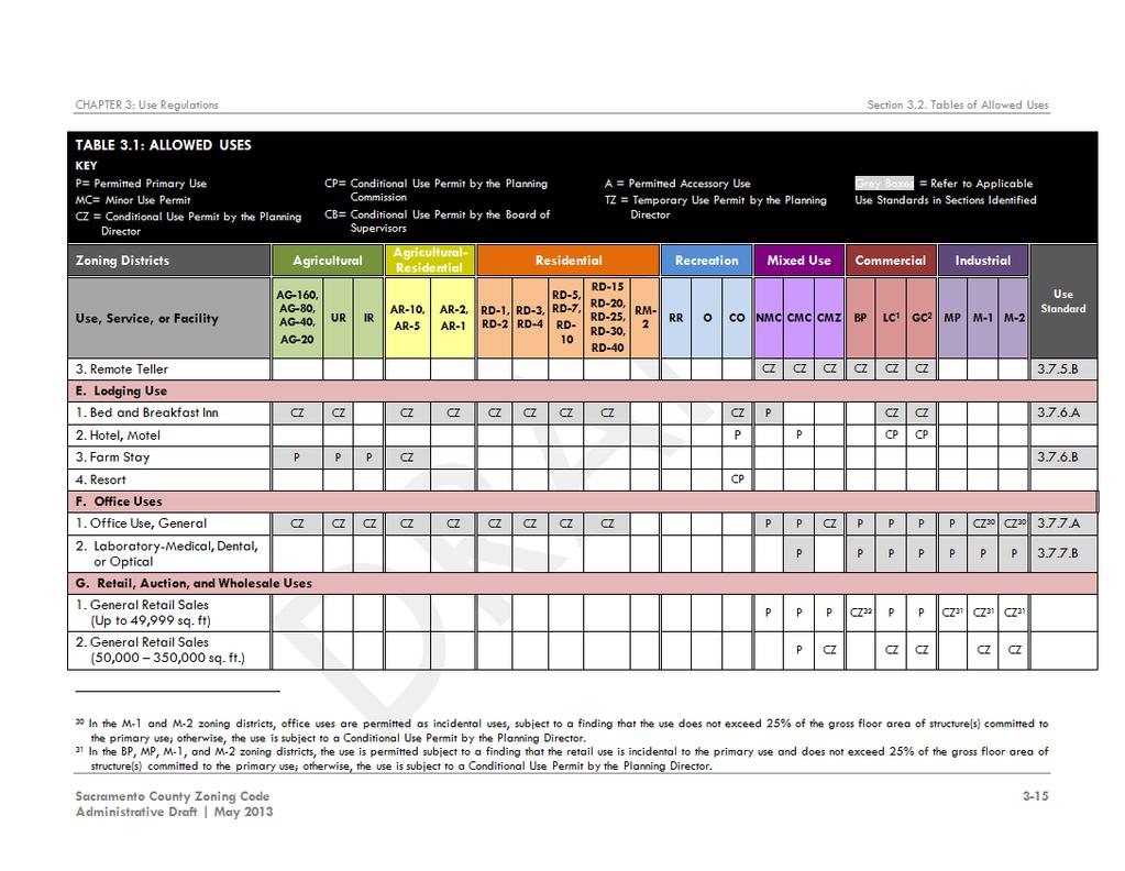
22 3.2. Determining Allowable Uses on Your Property To determine the allowable uses for your particular lot or parcel: 1. Section 3.2 provides a summary table (Table 3.1) of allowed uses. The allowed use table lists permitted uses for each zoning district, those that are allowed with specific limitations, and those requiring a conditional use permit. Use tables are organized under land use categories and subcategories of uses with similar physical or operating characteristics. 2. A partial use table is illustrated below to show the steps necessary to determine whether a desired use is permitted in the zoning district (e.g., whether general agricultural uses are permitted in the AR-1 zoning district). Step 1: Find the AR-1 zoning district designation in the column headings of the use table. TABLE 3.1: TABLE OF ALLOWED USES Zoning Districts Agricultural Agricultural- Residential Residential Use Standard Reference Use, Service, or Facility AG-160, AG-80, AG-40, AG-20 UR IR AR-10, AR-5 AR-2, AR-1 RD-1, RD-2 RD-3, RD-4 RD-5, RD-7, RD-10 AGRICULTURAL USES A. General Agricultural Uses P P P P CZ B. Agricultural Equipment Repair and Maintenance MC Step 2: Refer to the list of uses in the left column, organized by major categories and subcategories of land uses. Find the row indicating General Agricultural Use. TABLE 3.1: TABLE OF ALLOWED USES Zoning Districts Agricultural Agricultural- Residential Residential Use Standard Reference Use, Service, or Facility AG-160, AG-80, AG-40, AG-20 UR IR AR-10, AR-5 AR-2, AR-1 RD-1, RD-2 RD-3, RD-4 RD-5, RD-7, RD-10 AGRICULTURAL USES A. General Agricultural Uses P P P P CZ B. Agricultural Equipment Repair and Maintenance MC 16 NAVIGATING THE CODE DRAFT FEBRUARY 2014 Page 22 of 60
23 Step 3: Note that the cell where the selected column in Step 1and desired use in Step 2 meet (shown in the example below) indicates the approval requirement for the use. Use approvals are classified as either: P for uses that are permitted by right, subject to compliance with the regulations of the respective zoning district that the use is located within. C for a use that requires a Conditional Use Permit, and is allowed if conditionally approved by one of four levels of review and decision-making authorities. Minor Use Permits MC are reviewed and approved by the Planning Director. Conditional Use Permits may be reviewed and approved either by the Zoning Administrator CZ, Planning Commission CP, or Board of Supervisors CB, as reflected by the second letter of the classification. Uses are also subject to the applicable regulations of the Code, including use-specific standards. A for a use that is allowed by right as an accessory use, subject to all other applicable regulations of the Code, including Section 3.9, Accessory Uses. TZ for a use that is allowed by right by the Zoning Administrator as a temporary use, subject to all other applicable regulations of the Code, including Section 3.10, Temporary Uses. TABLE 3.1: TABLE OF ALLOWED USES KEY P= Permitted Primary Use MC= Minor Conditional Use Permit CZ = Conditional Use Permit by the Planning Director CP= Conditional Use Permit by the Planning Commission Grey Boxes = Refer to Applicable Use Standards in Sections Identified Zoning Districts Use, Service, or Facility AGRICULTURAL USES Agricultural AG-160, AG-80, AG-40, AG-20 UR IR CB= Conditional Use Permit by the Board of Supervisors A = Permitted Accessory Use TZ = Temporary Use Permit by the Planning Director Agricultural- Residential AR-10, AR-5 AR-2, AR-1 RD-1, RD-2 Residential RD-3, RD-4 RD-5, RD-7, RD-10 Use Standard Reference A. General Agricultural Uses P P P P CZ B. Agricultural Equipment Repair and Maintenance MC 1 In the AR-1 zoning district, general agricultural uses are permitted on lots of 150 feet or greater in width. As indicated in the example above, general agricultural uses are permitted in an AR-1 zoning district with a Conditional Use Permit by the Zoning Administrator. Step 4: Note that a grey shaded box in the select column indicates that the use is subject to use standards identified in the far right column of the Use Table. Refer to use standards for General Agricultural in the referenced section of the Code. A footnote in any of the cells indicates the use is subject to additional regulations, limitations, or conditions, provided at the bottom of the page. DRAFT F EBRUARY 2014 NAVIGATING THE CODE 17 Page 23 of 60
24 3. Refer to Table 3.2 to find accessory uses that are permitted in the zoning district, subject to the regulations of Section 3.9, Accessory Uses. Certain accessory uses may be subject to additional regulations, with the applicable section reference identified in the Use Standards column in Table Refer to Table 3.3 to find temporary uses and events that are permitted in the zoning district, subject to the regulations of Section Certain temporary uses and events may be subject to additional standards, with applicable section reference identified in the Use Standards column in Table Refer to Chapter 4 for use regulations applicable to special or combining zoning districts Determining Standards for Development To determine standards governing development for your particular lot or parcel: 1. Refer to Chapter 5, Sections 5.3 through 5.7 for development regulations for each category of zoning district. Each section contains general regulations applicable to every base zoning district within the zoning category and development standard tables. Development standard tables provide the dimensional information that governs the size and scale of development such as permitted density or intensity, lot size, setbacks, and structure height. The tables may also refer to other sections of the Code for additional regulations. 2. A partial development standard table from the mixed-use zoning district is shown below to illustrate the steps for finding specific development standards (e.g., the residential density permitted in the CMC zoning district). Step 1: Find the CMC zoning district designation in the column headings of the development standard table. TABLE 5.11: Mixed-Use Development Standards STANDARD* NMC CMC CMZ Density and Intensity Requirements Residential Density [1] (dwelling units/acre) Horizontal Mixed-Use (for Single Use) Floor Area Ratio no max Vertical Mixed-Use Floor Area Ratio no max NAVIGATING THE CODE DRAFT FEBRUARY 2014 Page 24 of 60
25 Step 2: Refer to the various development standards such as density, building setbacks, and building heights in the left column. Locate the row identifying the standard for residential density. TABLE 5.11: Mixed-Use Development Standards STANDARD* NMC CMC CMZ Density and Intensity Requirements Residential Density [1] (dwelling units/acre) Horizontal Mixed-Use (for Single Use) Floor Area Ratio no max Vertical Mixed-Use Floor Area Ratio no max Step 3: The cell where the applicable zoning district column in Step 1 and development standard of interest in Step 2 intersect identifies the regulating measurement for that standard (e.g., DU/ac.). Where a footnote is indicated next to the standard, additional information is provided to regulations, conditions, or references to other relevant Code sections. TABLE 5.11: Mixed-Use Development Standards STANDARD* NMC CMC CMZ Density and Intensity Requirements Residential Density [1] (dwelling units/acre) Horizontal Mixed-Use (for Single Use) Floor Area Ratio no max Vertical Mixed-Use Floor Area Ratio no max Table 5.11 Notes * Alternatives or exceptions to these development standards may be permitted through the Design Review process or granted with a Special Development Permit, in accordance with the standards in section [1] Residential densities of up to up to 40 dwelling units per acre are permitted by right for development adjacent (within a one-half mile) of light rail, BRT, or high frequency bus transit station, as defined in section Additional density bonuses may also be permitted for the provision of affordable housing, as defined in section 5.2.3, Allowed Density and Intensity Increases. Densities above 40 dwelling units per acre shall require a Conditional Use Permit, approved by the Planning Commission. 3. Refer to Chapter 4 for development standards applicable to any special or combining zoning district. 4. Refer to the general standards that apply to every zoning district in the County whether or not a permit or other approval is required, including Section 5.2 for the measurement of setbacks used in the development standards, landscaping standards, wall and fence standards, and exceptions for building heights. Refer to Section 5.9 for parking standards and Section 5.10 for signage standards. DRAFT F EBRUARY 2014 NAVIGATING THE CODE 19 Page 25 of 60

26 3.4. Determining Required Development / Permit Approvals To develop property, build a new building, expand or make major changes to an existing building, development approvals or entitlements may be required. The following chart will help guide you through the development process. 20 NAVIGATING THE CODE DRAFT FEBRUARY 2014 Page 26 of 60

27 4. DEVELOPMENT/PERMIT APPROVAL This Section describes the types of planning entitlement applications required in Sacramento County, the general procedures for all applications, procedures for specific types of applications, and the bodies involved in the review and approval of these applications. The tables in Sections 4.2 through 4.6 of this Guide summarize the applicable steps for certain project applications and the review and decision-making responsibilities of those regularly involved in the application process, including the Planning Director, the Community Planning Advisory Councils (CPAC), Project Review Committee (PRC), Subdivision Review Committee (SRC), County Planning Commission, and the Board of Supervisors. Other reviewers, though not referenced in these tables, including other boards, commissions, government agencies, and non-governmental agencies, may be asked to review and submit comments as necessary on some applications, such as rezonings requests, development plans, and subdivisions General Procedures for All Applications The general procedures for securing a planning entitlement in the County are summarized in this section. The type of entitlement and/or complexity of the project will often determine the steps, but in general, all applications for planning entitlements follow these procedures. Also, some of these steps occur simultaneously, rather than sequentially. Consult Chapter 6 for additional standards and regulations for planning applications. What 1 is the Process? Step 1: Pre-Application Meeting Pre-application meetings provide for informal evaluation of the applicant s proposal and an opportunity to review applicable provisions of this Code, the General Plan, infrastructure requirements, and any other issues that may affect the applicant s proposal. A pre-application meeting is highly encouraged for the following application types: Code Text Amendment Rezoning Development Agreement Tentative Subdivision Map Development Plan for Multi-Family Development Conditional Use Permits Special Development Permit Variance Density Bonus Requests (associated with above applications) DRAFT F EBRUARY 2014 DEVELOPMENT / PERMIT APPROVAL 21 Page 27 of 60
28 1. Initiation of Pre-Application Meeting Pre-application meetings are typically conducted on the second and fourth Thursday of every month. Applications may be submitted one week prior to these scheduled meetings. It is the applicant's responsibility to provide sufficiently detailed plans and a thorough description of the proposal with this application. More information is generally better than less in this case as the staff recommendations discussed below will be more helpful for the applicant in anticipating specific issues that may occur during the entitlement process, based on the initial information submitted by the applicant. Informal meetings with the Design Review Administrator, Fire District, or other departments prior to initiation of the pre-application meeting, are encouraged. 2. Pre-Application Meeting Content The County Planning and Environmental Review staff shall schedule a pre-application meeting after an application has been submitted. During the pre-application meeting, the parties will discuss the proposed development and applicable requirements and standards of the Code, including but not limited to application requirements, CEQA requirements, meeting and hearing requirements, bundled review, and conditions of approval. 3. Pre-Application Meeting Conclusion Any information or suggestions provided by County staff at the meeting are informal and not binding upon the applicant or the County, but are intended to advise the applicant in advance of the formal application of any issues that will or may subsequently be presented to the appropriate decision-making body. Because a preapplication meeting precedes the formal application, and may not be based on sufficiently detailed plans or studies, some key issues relating to a specific proposal (e.g., impacts to wetlands or sensitive environmental species), may not be apparent at the pre-application meeting. 2 Step 2: Early Outreach 1. Purpose and Applicability Early outreach allows applicants the opportunity to engage with nearby residents, businesses, and property owners early in the review process. The applicant often benefits from early neighborhood meetings by gaining a better understanding of local concerns. The exchange typically begins with a general overview of a proposed development by the applicant, a description of how the development will comply with the standards in the Code, and an open forum for public suggestions and neighborhood concerns. A Neighborhood Outreach Plan is required to be submitted with each planning entitlement application. 2. Early Review CPAC Meetings In some cases, the Project Manager may advise the applicant to present the proposed development to the CPAC as part of the early outreach efforts, prior to submission of the application. This early review meeting is noticed by Planning and Environmental Review staff for a regularly scheduled CPAC meeting, and requires a small fee for the noticing. The CPAC members may comment on the development proposal, but shall not issue a formal recommendation to approve, modify, or deny the development 22 DEVELOPMENT / PERMIT APPROVAL DRAFT FEBRUARY 2014 Page 28 of 60
29 proposal. The comments of CPAC members in the meeting shall be non-binding upon the CPAC when it acts in a formal recommendation capacity on the application. 3. Meeting Summary The applicant should prepare a written summary of any neighborhood or early review meeting(s), and include the summary with the Neighborhood Outreach Plan. A written summary, if submitted, may be included in the staff report provided to any advisory and/or decision-making body. At a minimum, the written summary should include the following information: a. Date and location of all meetings where citizens were invited to discuss the applicant s proposals; b. Content, dates mailed, and number of mailings, including letters, meeting notices, and written material; c. The number of people that participated in the meetings; d. A summary of comments received during the meetings and a description of how the applicant addressed such comments. 3 Step 3: Application Submittal 1. Application Submittal Requirements and Fees a. Application Submittal Requirements Prior to submitting an application to the County, applicants are advised to visit the public information counter of the Planning and Environmental Review Division. Planning staff can provide assistance in determining the type of applications or permits needed for the project, and whether the project is consistent with the General Plan and zoning requirements. Staff can also provide information on the application forms and fees to be submitted with the application; provide an estimation of the time necessary to complete the application process; and schedule a pre-application meeting, if required for the project. Planning entitlement application materials and submittal checklists are available online at: b. Fees The County collects fees for the purpose of defraying the expenses involved with the filing, review and approval of all applications. Contact public counter staff or consult the webpage referenced above for current fees. In most cases, fees for the simpler staff-level applications are based on a fixed rates. The fees for more complex projects that are heard by the Planning Commission and Board of Supervisors are based on time and materials. For these more complex applications, the fee collected at time of application submittal is a deposit that may or may not cover the entire process, including public hearings. A cost estimate will be provided at the time of initial project application review. If additional entitlements are necessary, additional fees may be required. CEQA fees for an application depend upon several factors, including the complexity and type of proposed development, and site-specific impacts that may be caused DRAFT F EBRUARY 2014 DEVELOPMENT / PERMIT APPROVAL 23 Page 29 of 60
30 by the proposed development. A cost estimate will be provided at the time of initial project application review. c. Waiver of Application Fees The Chief Deputy County Executive Officer may approve a waiver of any fee, change or expense to any applicant for a permit or entitlement pursuant to the Code, in the case of an error made by a County employee that caused the need for the application to be filed. d. Authority to File Applications Unless otherwise specified in the Code, an application may be initiated by: 1) The owner of the property that is the subject of the application; 2) The owner s authorized agent; 3) A lessee of the property owner; or 4) Any review or decision-making body, which does so without prejudice toward the outcome. An authorized agent or lessee filing an application on behalf of a property owner must provide the County with evidence (written documentation) that the owner of the property has authorized the filing of the application. e. Withdrawal of Applications 1) Timing of Withdrawal. An applicant may withdraw an application at any point up to the date of a scheduled hearing, or, in the case of applications without hearings, any time before the date on which a staff decision is issued. 2) Refund of Application Fees. A portion of the application fee may be refunded in the case of a withdrawn application. The Planning and Environmental Review Division staff shall determine the amount available for refund, and shall consider the following factors: If there has been any initial expenditures made by the County, including the distribution of application materials to other review agencies; and If any field inspections have been conducted, and a CEQA document or staff report has been prepared; and If the application has been noticed or set for any public hearings. 2. Application Logged The project application is logged, assigned a Project Manager, and distributed for early project review. 24 DEVELOPMENT / PERMIT APPROVAL DRAFT FEBRUARY 2014 Page 30 of 60
31 4 Step 4: Early Project Review The next several steps typically occur simultaneously, rather than sequentially. The general procedures for early project review, advisory review body scheduling, and determination of project completeness and type of environmental document necessary are all part of the initial application process for planning entitlement applications. 1. Initial Application Review by Staff Applications will be reviewed for compliance with the General Plan, Code, and requirements of the Californian Environmental Quality Act (CEQA). The Project Manager will prepare a draft timeline and estimated costs and notify the applicant whether additional technical studies or other requests are needed to complete the application. The Project Manager will distribute the application to various review agencies with a request for comments and conditions to be submitted within 30 days of the application submittal date. 2. Initial Application Review by the PRC The Project Manager will schedule the application for review by the PRC within 30 days of the application submittal date, unless critical elements of the application are missing. The PRC is made up of representatives of various review agencies, and is intended to provide applicants with transparency to the review and approval process, early identification of problems, and early intervention and issue resolution. Recommendations by the PRC help in determining the application complete. 5 Step 5: Application Processing and Environmental Once the early review is complete, and all of the requested application materials and technical studies have been submitted, the Project Manager will determine the application complete for the purposes of planning and environmental review. This step shall be completed within 30 days from the date the application is submitted. Multiple applications submitted for a single project, may be bundled for concurrent processing and final decision by a single body to provide additional streamlining and reduced fees for the applicant. 1. Determination of Completeness An application must be deemed to be complete within 30 days from the date the application is submitted. Following the initial application review by the PRC, the Project Manager will make a determination of application completeness (also known as 844 Review) for the purposes of planning and environmental review. If an application is determined to be incomplete, the Project Manager provides notice to the applicant along with an explanation of the application s deficiencies. No further processing of an incomplete application occurs until the deficiencies are corrected and the application is resubmitted. 2. Determination of Environmental Document For each application that is determined complete for the purposes of environmental review, the Project Manager will conduct the appropriate CEQA review, as required by Chapter 20 of the Sacramento County Code. DRAFT F EBRUARY 2014 DEVELOPMENT / PERMIT APPROVAL 25 Page 31 of 60
32 If the Project Manager determines that the application does not meet the definition of a project under CEQA, or is exempt from CEQA, then environmental review is complete. The Project Manager shall report the determination that the application is not a project under CEQA or is exempt from CEQA in the staff report. If the Project Manager determines that the application meets the definition of a project under CEQA, then it shall be subject to additional environmental review. The Project Manager shall transmit the results of such review (for example, a Negative Declaration, Environmental Analysis, or Environmental Impact Report, and written findings from any required public hearing for the environmental review) to all required recommending and decision bodies as outlined in Steps 10 and Bundling When multiple applications are submitted for a single project, the County bundles those applications for concurrent processing and final decision by a single body. The purpose of application bundling is to provide a streamlined process for an applicant and ensure the efficient use of County development review resources. a. Advisory Hearings for Bundled Applications All bundled applications will be forwarded to each advisory body that has review authority for one or more of the applications. Each advisory body will make a recommendation on each application. 1) The order of advisory hearings must follow the hierarchy of hearing bodies, as indicated in Table 4-1, below. Highest Lowest TABLE 4-1: HEARING BODY HIERARCHY Board of Supervisors Planning Commission Subdivision Review Committee b. Decision Hearings for Bundled Applications A single decision body will make a decision for all applications in the bundle. The decision body for a bundle is the highest-ranking body, as indicated in Table 4-1, above, with authority to hear any application in the bundle. (For example, if the Board of Supervisors has authority to decide any application in a bundle, then the decisions on all applications in the bundle will be made by the Board of Supervisors). 26 DEVELOPMENT / PERMIT APPROVAL DRAFT FEBRUARY 2014 Page 32 of 60
33 6 Step 6: CPAC Review and Advisory Recommendations For some procedures, as indicated in Tables 4-3 through 4-7 of this Guide, initial review(s) are required by various advisory review bodies, prior to the completion of the environmental review and preparation of the staff report. The Project Manager forwards the application to the advisory review body(s), indicated in each specific procedures section, and includes the resulting recommendations in the staff report (Step 8). 1. CPAC and Other Required Advisory Review a. The purpose of reviews, conducted by the CPAC and other advisory review bodies such as the PRC, Design Review Administrator (DRA) and Design Review Advisory Committee (DRAC) is to make a recommendation to staff and the decision-making body to approve, approve with conditions, or deny an application for which the advisory body has recommending authority. PRC or CPAC review is required for the application procedures, indicated in Tables 4-3 through 4-7 of this Guide. b. When the CPAC is indicated, such authority shall be designated to the CPAC for that geographic area in which the application is proposed. 7 The Project Manager collects and reviews the draft conditions of approval and mitigation measures from all review bodies, and will schedule a Condition Review by the PRC. Unresolved conflicts or concerns will be communicated with the applicant for resolution, before proceeding to finalize the staff report. 8 Step 7: Condition Review Step 8: Staff Report Preparation and Release In preparing a staff report, the Project Manager shall: 1. Review all aspects of the application, considering relevant provisions of the General Plan, the Code, and other Titles of the Sacramento County Code as applicable; 2. Disclose any conditions attached to any previous zoning classifications of the property as a result of action taken, pursuant to the Code or other laws and regulations adopted by Sacramento County; 3. Make findings regarding whether the application meets applicable approval criteria; and 4. Recommend that the application be approved, approved with conditions, or denied. Upon completion of the staff report and environmental document, the documents are released to the applicant, and the Project Manager will schedule and notice any required public, as defined in Table 4-2, below. Staff reports shall also identify any conditions attached to previous zoning reclassifications of the property as a result of action taken, pursuant to this Code or other County laws and regulations. DRAFT F EBRUARY 2014 DEVELOPMENT / PERMIT APPROVAL 27 Page 33 of 60
34 9 Step 9: Schedule and Notice Hearings 1. Required Notice Whenever the Board of Supervisors, Planning Commission, Board of Zoning Appeals (BZA), Zoning Administrator (ZA), or the SRC hears any application, as required by the Code, the Clerk of the Board of Supervisors or the Planning and Environmental Review Division shall give notice according to the following procedures. a. Notice Content All notice of public hearings shall include the following information: 1) The name of the applicant, owner, and agent, if any; 2) The date, time, and place of the public hearing; 3) If applicable, a description of the property involved in the application by parcel number and by street address, or if no street address has been assigned then by legal description and nearest cross street; 4) The zoning classification and proposed use of the property; 5) The nature, scope, and purpose of the proposed action; 6) A notation that interested parties may appear at the hearing and speak on the matter; and 7) A reference to where additional information on the matter may be obtained. b. Notice Requirements The notice requirements for each procedure shall be as determined by the Planning Director, as required by the California Government Code, and summarized in Table 4-2, below. TABLE 4-2: SUMMARY OF NOTICE REQUIREMENTS KEY: H = Notice is required when a public hearing is required for this procedure. F = Notice of a filed application is required. A = Notice is required if the Planning Director grants approval. PROCEDURE CODE SECTION/ TITLE 22 SECTION NOTICE TYPE Mailed Posted Published ZONING AMENDMENT AND DEVELOPMENT AGREEMENT PROCEDURES Code Text Amendment H H Rezoning H H H Development Agreement H H H SUBDIVISION PROCEDURES Tentative Parcel Map H H H Tentative Subdivision Map H H H Tentative Vesting Map 22.20, H H H Boundary Line Adjustment DEVELOPMENT / PERMIT APPROVAL DRAFT FEBRUARY 2014 Page 34 of 60
35 SITE PLAN REVIEW AND SPECIAL PERMITS Design Review (Discretionary) H H H Design Review (Non-discretionary) Minor Use Permit Conditional Use Permit H H H Special Development Permit H H H Temporary Use Permit VARIANCE AND OTHER PROCEDURES Variance H H H Certificate of Nonconforming Use F, A H H Interpretation H H c. Mailed Notice Whenever a mailed notice is required by Table 4-2, above, the applicant shall provide the list of property owners for required mailed notice. The Planning and Environmental Review Division or Clerk of the Board of Supervisors shall deposit the notice into first class mail, pre-paid at least ten days prior to the hearing. Notice shall be mailed or delivered to the following individuals and agencies: 1) The applicant, at the address shown on the application and all owners of the subject property(s) at their addresses as shown on the most current property tax roll; 2) Owners of all real property, and residents and owners of condominium units on property, located within 500 feet of the subject property boundaries at their addresses as shown on the most current property tax roll. If there are fewer than 30 properties within 500 feet, the notification radius shall be extended to include the 30 closest properties. 3) Where the number of owners described in subsections (a) and (b), above, is greater than 1,000, the County may publish the notice in a newspaper of general circulation instead of sending individual notices. d. Posted Notice Whenever posted notice is required by Table 4-2, above, the Planning and Environmental Review Division shall: 1) Post a notice at the subject site as soon as the environmental document is released; and 2) Post a notice in a public place in the County at least ten days prior to the public hearing. e. Published Notice Whenever published notice is required by Table 4-2, above, the Planning and Environmental Review Division or Clerk of the Board of Supervisors shall publish a legal notice in a newspaper for general circulation. DRAFT F EBRUARY 2014 DEVELOPMENT / PERMIT APPROVAL 29 Page 35 of 60
36 f. Additional Notice The Planning and Environmental Review Division may provide or require the applicant to provide any other notice required by law. 1) The Planning Commission or the Board of Supervisors, when it has decision authority in the matter, may instruct the Planning and Environmental Review Division to give additional notice of the hearing in such other manner as the Commission or Board may deem necessary or desirable. Any failure by the Planning and Environmental Review Division to give such additional notice shall not invalidate any proceeding. Step 10: Recommending Body Review as Necessary 1. For some procedures, certain advisory hearings are required after the completion of the staff report. The purpose is for the recommending body to hold a public hearing to consider the application and, based upon the staff report, the public hearing, and the applicable criteria in the Code, make a written recommendation to the decision body to approve, approve with conditions, or deny the application. a. Bodies that Review Under this Step Reviewing bodies for a specific procedure for this step include one or more of the following, as addressed in Tables 4-3 through 4-7 of this Guide: 1) The Planning Commission for planning and zoning amendments, subdivision review procedures, and Conditional Use Permits approved by the Board of Supervisors, as indicated; 2) The DRAC for Design Review and Special Development Permit review, as indicated. Step 11: Decision Body Approval 1. Decision Body The body with final decision-making authority on an application shall be as indicated in Tables 4-3 through 4-7 of this Guide, except that: a. A higher hearing body shall hear the matter when decision authority is transferred to that body, based on application bundling provisions in Step 5, Application Processing; b. Conditional Use Permits. If the decision authority for a non-residential conditional use permit application rests with the Planning Director, and the CPAC recommends denial, the application is referred automatically to the Planning Commission for decision, with appeal to the Board of Supervisors. 2. Record of Decision a. After consideration of all application materials and such reports and recommendations as required for the procedure and public testimony provided through a hearing, if applicable, the decision body acts to approve, approve with conditions, or deny the application. 1) Except when the Planning Director has decision authority, the decision shall be made following a noticed public hearing. The Clerk of the decision body or Zoning Administrator signs and dates the final approval. 30 DEVELOPMENT / PERMIT APPROVAL DRAFT FEBRUARY 2014 Page 36 of 60
37 2) For some procedures, as indicated in the Code, upon a grant of approval the Clerk of the Board of Directors or Planning Director shall prepare and deliver to the applicant a written statement describing the grant and any applicable conditions. A copy of the statement shall also be delivered to the Chief Building Inspector and to other concerned County officials, if so indicated. 3) The Planning Director shall provide for retention of approved development plans and permits, and shall distribute copies of approved materials to other departments per department regulations. 3. Effective Date of Decision a. Except as otherwise provided in this Guide or the Code, the effective date of a decision shall be the day following the expiration of the appeal period, if no appeal is filed. 1) If an appeal is filed to a decision, the effective date of the decision shall be as indicated in Section ) No approved permit or license shall be issued by any County office until the effective date of a decision. 4. Findings Every quasi-judicial decision made under this chapter shall be based upon written findings, and every finding shall be supported in the record. Findings for specific types of applications, including Special Permits, are addressed in Chapter Conditions of Approval Some procedures authorize the decision-making body to impose such conditions on the approval as may be necessary to reduce or minimize any potential adverse impact upon other property in the area, or to carry out the general purpose and intent of the General Plan and the Code. Except for rezoning approvals, conditions attached to approvals shall be directly related to the impacts of the proposed use or development and shall be roughly proportional in both extent and amount to the anticipated impacts of the proposed use or development. No conditions of approval, except for those attached to variances or exceptions, shall be less restrictive than the requirements of the Code or applicable special limitations. Conditions of approval, where applicable for specific applications, including Rezonings, Conditional Use Permits, Special Development Permits, Variances, and others are addressed in Chapter Approval Criteria Procedures in the Code itemize approval criteria on which the decision-making body is required to base a decision to approve, approve with conditions, or deny an application. a. The purpose of the approval criteria is to reduce or minimize any potential adverse impact upon other property in the area, to establish grounds on which a use may be refused, and to carry out the general purpose and intent of the General Plan and the Code. b. Where approval criteria exist for a matter upon which a decision-making body is authorized to act, the criteria are limitations on the power of the body to act. DRAFT F EBRUARY 2014 DEVELOPMENT / PERMIT APPROVAL 31 Page 37 of 60
38 c. Approval criteria for specific application procedures, including Code Text Amendments, Rezonings, Development Agreements, Conditional Use Permits, Special Development Permits, and others are addressed in the corresponding Code sections, except as otherwise identified in this Guide. Who do I contact for questions or more information? For more information, call to speak to a planner at: (916) or visit the front information counter of the Planning Division. Refer to the contact list also available online at: Applications for Amendments, Rezonings, and Development Agreements Types of Applications Rezonings A rezoning allows the boundaries or classification of any zoning district to be changed on the Comprehensive Zoning Plan for any property, and is not a mechanism to confer special privileges or rights to any person. Zoning Code Text Amendments The Board of Supervisors may amend Code text to address changed conditions or changes in public policy, in the interest of the general welfare of the community. Development Agreements Development Agreements are entered between the County and person having legal or equitable interests in development of property. What is the Process? The review and approval process for all Code Text Amendments, Rezonings, and Development Agreements are set forth in Section 6.2, and the general steps are indicated in Table 4-3, below. Who is Involved? Review/decision authorities and required review steps in the table (below) apply when an application is processed individually. Such authorities may change for bundled applications, as described in Step 5, Section 4.1, of this Guide. 32 DEVELOPMENT / PERMIT APPROVAL DRAFT FEBRUARY 2014 Page 38 of 60
39 KEY: H = Hearing Required General Steps Key Table 4-3: Amendments, Rezonings, DAs Application Review/Decision/Appeal BoS = Board of Supervisors BZA = Board of Zoning Appeals CC = County Counsel CPAC = Community Plan. Advisory Councils DRA/DRAC = Design Review Administrator / Design Review Advisory Committee PRC = Project Review Committee SRC = Subdivision Review Committee PC = County Planning Commission PD = Planning Director ZA = Zoning Administrator Application Type Rezonings Code Text Amendments Development Agreement General Steps [1] (Code Section) Steps 1-11 (Section 6.2.1) Steps 1-11 (Section 6.2.1) Steps 1-11 (Section 6.2.2) Review Body Decision Body Appeal Body PD, CPAC, PC-H PD, CPAC, PC-H PD, CPAC, PC PC-H, BoS-H BoS-H BoS BoS (for PC decisions if denied) Table 4-3 Notes: [1] Refer to Section 4.1 of this Guide for general application procedures, including Table 4-2 for a summary of noticing requirements Site Plan Review Application Procedures Types of Site Plan Applications Development Plan Review Development Plan Review may be required by zoning conditions of approval and some Neighborhood Preservation Area (NPA) and Special Planning Area (SPA) zoned projects to ensure compliance with the standards of the Code. Design Review Design Review is required for all discretionary and non-discretionary commercial, office, mixed-use, industrial, and institutional developments and multifamily and small/lot cluster single subdivisions in all zoning districts, subject to the County s Design Guidelines. What is the Process? Design Review shall comply with the standards set forth in Code Section 6.3, and the general steps indicated in Table 4-4, below. Also, see Additional Submittal Requirements for Discretionary Projects, the Applicant Guide and Checklist for Building Permit/Non-discretionary Projects, and other resources available online at: DRAFT F EBRUARY 2014 DEVELOPMENT / PERMIT APPROVAL 33 Page 39 of 60
40 Who is Involved? Review/decision authorities and required review steps in the table (below) apply when an application is processed individually. Such authorities may change for bundled applications. The decision body for a bundle is the highest-ranking body with authority to hear any application in the bundle, as described in Step 5, Section 4.1, of this Guide. KEY: H = Hearing Required General Steps Key Table 4-4: Site Plan Application Review/Decision/Appeal BoS = Board of Supervisors BZA = Board of Zoning Appeals CC = County Counsel CPAC = Community Plan. Advisory Councils DRA/DRAC = Design Review Administrator / Design Review Advisory Committee PRC = Project Review Committee SRC = Subdivision Review Committee PC = County Planning Commission PD = Planning Director ZA = Zoning Administrator Application Type Design Review (Discretionary) Development Plan Review or Design Review (Nondiscretionary) General Steps [1] (Code Section) Steps 1-11 (Section 6.3.2) Steps 3,5,11 (Sections 6.3.1, 6.3.2) Major Projects Review Body Decision Body Appeal Body DRA, DRAC PC, BoS BoS PRC PD PC Table 4-4 Notes: [1] Refer to Section 4.1 of this Guide for general application procedures, including Table 4-2 for a summary of noticing requirements Subdivision Application Procedures Types of Subdivision Applications Tentative Parcel Map Tentative Parcel Maps are required for subdivisions of land that propose to create four or fewer lots on previously unsubdivided land. Tentative Subdivision Map Tentative Subdivision Maps are required for subdivisions of land that propose to create five or more lots. Tentative Vesting Map Tentative Vesting Maps confer a vested right to proceed, for a limited time, with development in substantial compliance with the ordinances, policies, and standards in effect at the time the map was approved. 34 DEVELOPMENT / PERMIT APPROVAL DRAFT FEBRUARY 2014 Page 40 of 60
41 Boundary Line Adjustments Boundary Line Adjustments allow for a change to a boundary line of a legally-created parcel. What is the Process? Applications for Tentative Subdivision Maps are reviewed pursuant to the standards of the State Subdivision Map Act, the County Land Development Ordinance (Title 22 of the Sacramento County Code), the review steps summarized in Table 4-5, below, and the following additional standards and procedures: 1. Noticing a. Hearing Notice for Tentative Parcel Maps, Tentative Subdivision Maps, and Tentative Vesting Maps The Planning and Environmental Review Division shall provide notice for advisory and decision hearings for a Tentative Parcel Map or Tentative Subdivision Map application, as provided in Section of the Government Code. Notice shall also be given at least 10 days in advance of the public hearing as required and authorized in Section , except that notices shall be given to owners of property within 500 feet of the property, which is the subject of the application and the advisory agency secretary shall not post such notice. b. Hearing Notice for Boundary Line Adjustments No hearing notice is required, unless the application is defined as a project under CEQA. 2. Approval Criteria a. For Tentative Parcel Maps, Tentative Subdivision Maps, and Tentative Vesting Maps In addition to the required criteria provided by the County Land Development Ordinance (Title 22), or the State Subdivision Map Act, a Tentative Parcel Map or Tentative Subdivision Map shall be approved when it meets all of the following criteria: Who is Involved? 1) Is consistent with an adopted community plan; 2) Does not violate the provisions of the Code as to area, setback, frontage, or any other requirements for which no variance or exception has been granted; 3) Does not enlarge, expand, or extend a nonconformance; and 4) The division of land does not violate any other County ordinance or Code provision. Review/decision authorities and required review steps in the table (below) apply when an application is processed individually. Such authorities may change for bundled applications. The decision body for a bundle is the highest-ranking body with authority to hear any application in the bundle, as described in Step 5, Section 4.1, of this Guide. DRAFT F EBRUARY 2014 DEVELOPMENT / PERMIT APPROVAL 35 Page 41 of 60
42 KEY: H = Hearing Required General Steps Key Table 4-5: Subdivision Application Review/Decision/Appeal BoS = Board of Supervisors BZA = Board of Zoning Appeals CC = County Counsel CPAC = Community Plan. Advisory Councils DRA/DRAC = Design Review Administrator / Design Review Advisory Committee PRC = Project Review Committee SRC = Subdivision Review Committee PC = County Planning Commission PD = Planning Director ZA = Zoning Administrator Application Type Tentative Parcel Maps (TPM) Tentative Subdivision Maps (TSM) Tentative Parcel Maps and Tentative Subdivision Maps for Special Circumstances (below) Tentative Vesting Maps Boundary Line Adjustments (CEQA Not Required) Boundary Line Adjustments (CEQA Required) General Steps [1] (Title 22 Section) Steps 1-11; Step 2 is optional (Section 22.20) Steps 1-11 (Section 22.20) Steps 1-11; Step 2 is optional for TPMs (Section 22.20) Steps 1-11; Step 2 is optional (Section 22.20, 22.24) Steps 3,5,11; no CEQA review or hearings (Section 22.20) Steps 1-9, 11; Step 2 is optional (Section 22.20) Review Body Decision Body Appeal Body PD, CPAC SRC-H PC PD, CPAC PC-H BoS PD, CPAC BoS-H - PD, CPAC, PC-H BoS-H - PD PD SRC PD, CPAC SRC-H PC, BoS Notes: [1] Refer to Section 4.1 of this Guide for general application procedures, including Table 4-2 for a summary of noticing requirements. 1. Decision Body a. Approval of Tentative Parcel Maps, Tentative Subdivision Maps, and Vesting Tentative Maps The SRC is the designated decision-making body for all Tentative Parcel Maps. The Planning Commission is the designated decision-making body for all Tentative Subdivision Maps. The Board of Supervisors is the decision-making body for all Vesting Tentative Maps, and matters relating to Tentative Parcel Maps and Tentative Subdivision Maps in those instances when these maps are filed with an application for a General Plan Amendment, Rezone or Community Plan 36 DEVELOPMENT / PERMIT APPROVAL DRAFT FEBRUARY 2014 Page 42 of 60
43 Amendment. The following exceptions in the case of special circumstances are provided in the County Land Development Ordinance (Title 22). 1) Inconsistent with General Plan Policy AG-7. The Planning Commission is the designated decision-making body to all matters relating to all Tentative Subdivision Maps and Tentative Parcel Maps located within an area designated as agricultural cropland, general agriculture, agricultural-urban reserve, and agricultural-recreation reserve lands in the General Plan when the proposed land division is consistent with the Code, but inconsistent with General Plan Policy AG-7. Proposed maps that are consistent with zoning, but inconsistent with General Plan Policy AG-7 shall not be approved unless the Planning Commission finds, in writing, that the proposed subdivision will not deter the General Plan objective to maintain and enhance agricultural production capability. 2) Inconsistent with the Airport Comprehensive Land Use Plan (CLUP). The Board of Supervisors is the decision-making body after a recommendation from the Planning Commission as to all matters relating to Tentative Subdivision Maps and Tentative Parcel Maps located within the area regulated by any CLUP, which does not comply strictly with the policies of the CLUP, upon making the findings by a 4/5 vote. 3) Tentative Subdivision Maps that utilize less than one-half of allowed density. The Board of Supervisors is the decision-making body after a recommendation from the SRC and Planning Commission as to all matters relating to all Tentative Subdivision Maps involving 20 or more units which utilize less than one-half of allowed density as set forth in the Code. 2. Final Verification of Tentative Parcel Maps and Tentative Subdivision Maps After a decision to approve a Tentative Parcel Map or Tentative Subdivision Map, the map shall be reviewed by the Sacramento County Engineering Department for final verification before it shall be deemed a Final Map. No building permit shall be authorized until a Final Map is approved Special Permit Procedures Types of Special Use Permits Minor Use Permit A Minor Use Permit is required for uses that because of their unique and special characteristics make impracticable or undesirable their inclusion as permitted uses. Conditional Use Permit A Conditional Use Permit is required for uses that have the potential for significant impacts on the surrounding area, and need public review and a noticed hearing to help determine whether and under what conditions the use may be appropriate for a given property. Temporary Use Permit A Temporary Use Permit is required for temporary uses and events. DRAFT F EBRUARY 2014 DEVELOPMENT / PERMIT APPROVAL 37 Page 43 of 60
44 Types of Special Development Permits Alternative Design A Special Development Permit is required for development that, because of location, size, or other characteristics does not meet the strict Code development standards for the zoning district, including parking, and permits greater flexibility and alternative compliance to these standards. Density Bonus A Density Bonus allows for an increase in the number of dwelling units based on special project characteristics, including proximity to transit, the provision of affordable housing, provision of special amenities, or use of land conservation practices, as described in Section What is the Process? Special permits are reviewed pursuant to the standards in Section 6.4, and the general steps indicated in Table 4-6, below. Who is Involved? Review/decision authorities and required review steps in the table (below) apply when an application is processed individually. Such authorities may change for bundled applications. The decision body for a bundle is the highest-ranking body with authority to hear any application in the bundle, as described in Step 5, Section 4.1, of this Guide. KEY: H = Hearing Required General Steps Key Table 4-6: Special Permit Application Review/Decision/Appeal BoS = Board of Supervisors BZA = Board of Zoning Appeals CC = County Counsel CPAC = Community Plan. Advisory Councils DRA/DRAC = Design Review Administrator / Design Review Advisory Committee PRC = Project Review Committee SRC = Subdivision Review Committee PC = County Planning Commission PD = Planning Director ZA = Zoning Administrator Application Type Minor Use Permit Conditional Use Permit Approved by the ZA General Steps [1] (Code Section) Steps 3,5,11; CEQA review; Step 2 is optional (Section 6.4.2) Steps 1-8; CEQA review; Step 2 is optional (Section 6.4.3) Review Body Decision Body Appeal Body PD BZA DRA/DRAC, CPAC ZA BZA 38 DEVELOPMENT / PERMIT APPROVAL DRAFT FEBRUARY 2014 Page 44 of 60
45 Conditional Use Permit Approved by the PC Steps 1-11; Conditional Use Permit Approved by the BoS Temporary Use Permit Special Development Permit by ZA Special Development Permit by PC CEQA review (Section 6.4.3) Steps 3,5,11; no CEQA review (Section 6.4.7) Steps 1-8; CEQA review (Section 6.4.6) Steps 1-11; CEQA review (Section 6.4.6) PD, DRA/DRAC, CPAC PD, DRA/DRAC, CPAC, PC-H PC-H BoS-H BoS PD PD BZA DRA/DRAC, CPAC PD PC or BoS PD, DRA/DRAC, CPAC Notes: [1] Refer to Section 4.1 of this Guide for general application procedures, including Table 4-2 for a summary of noticing requirements. PC-H 4.6. Other Application Procedures Application Types Interpretations Interpretations allow individuals to request a formal interpretation of any of the Code s standards, including whether a specific use is permitted within a particular zoning district. Variances In certain cases such as may be required by a zoning agreement or Neighborhood Preservation Area, a Variance may be required to provide limited relief from the requirements of the Code where strict application of particular requirements will create a practical difficulty or unnecessary hardship, prohibiting use of the land in a manner otherwise allowed by the Code. Certificate of Nonconforming Use A Certificates of Nonconforming Use is required to allow continuation of a nonconforming use of land or buildings, subject to the standards for nonconformance in Section Public Convenience or Necessity Letter (PCN) Applicants applying for a State license to sell alcoholic beverages within the unincorporated area of Sacramento County from the Department of Alcoholic Beverage Control (ABC) may also be required to apply for a Public Convenience or Necessity Letter (PCN). A PCN letter will be required if the location is within an area (census tract) designated by ABC to be overconcentrated with establishments selling liquor or located in an area determined to be a high crime concern by the Sheriff. The process for issuing this PCN letter per Sacramento County Code 4.60, involves public hearings before the CPAC and the Board of Supervisors. DRAFT F EBRUARY 2014 DEVELOPMENT / PERMIT APPROVAL 39 Page 45 of 60

46 What is the Process? Other common applications, not described in earlier sections, are reviewed pursuant to the standards in Section 6.5 and the general steps indicated in Table 4-7, below. Who is Involved? Review/decision authorities and required review steps in the table below apply when an application is processed individually. Such authorities may change for bundled applications. The decision body for a bundle is the highest-ranking body with authority to hear any application in the bundle, as described in Step 5, Section 4.1, of this Guide. KEY: H = Hearing Required General Steps Key Table 4-7: Other Application Review/Decision/Appeal BoS = Board of Supervisors BZA = Board of Zoning Appeals CC = County Counsel CPAC = Community Plan. Advisory Councils DRA/DRAC = Design Review Administrator / Design Review Advisory Committee PRC = Project Review Committee SRC = Subdivision Review Committee PC = County Planning Commission PD = Planning Director ZA = Zoning Administrator Application Type Variances Certificate of Nonconforming Use Interpretations Public Convenience or Necessity Letter (PCN) General Steps [1] (Code Section) Required: 1-11 (Section 6.5.1) Required: 1-11 (Section 6.5.2) Steps 1-5 and 6-8; no CEQA review; Step 2 is optional (Section 6.5.3) Steps 3,5,6; no CEQA review; Step 2 is optional Review Body Decision Body Appeal Body CPAC ZA-H, BoS BoS or BZA PD BZA PD PC-H BoS CPAC Notes: [1] Refer to Section 4.1 of this Guide for general application procedures, including Table 4-2 for a summary of noticing requirements. BoS 40 DEVELOPMENT / PERMIT APPROVAL DRAFT FEBRUARY 2014 Page 46 of 60
47 4.7. Appeals, Amendments, Enforcement, and Revocation Procedures Appeals A person may appeal any decision made under the Code, according to this Section. Only final decisions may be appealed. Advisory recommendations or reports may not be appealed. 1. How to Initiate an Appeal Any person may initiate an appeal by filing a written Notice of Appeal with the Clerk of the Board or their designee, no later than 10 calendar days after the decision is made. A filing fee set by resolution of the Board of Supervisors and indicated in the User s Guide shall accompany the Notice of Appeal. The 10-day period for filing the notice of appeal shall not be waived or increased, unless a longer period is provided for in the specific procedures of the Code or this Guide. The Notice of Appeal shall state the act or decision that is being appealed, the identity of the applicant and his interest in the matter, and shall set forth in a concise statement the reason(s) for the appeal. 2. Effect of Filing Notice of Appeal When a Notice of Appeal is filed, it shall have the effect of staying the issuance of any permit, variance, or certificate. Such issuance shall be stayed until the matter is disposed of on appeal, and all records relating to the decision or act appealed have been transmitted to the Planning Director. 3. Appeal Body The body that shall hear the appeal is determined as follows: a. Decisions by the Planning Director and Chief Building Inspector can be appealed to the BZA, except that: 1) If the action appealed may have a significant effect upon the environment as indicated by the CEQA document, then the decision is appealed to the Board of Supervisors; 2) If the stated reason(s) for the appeal assert that Environmental Impact Report is deficient in any manner, including that an Environmental Impact Report should have been prepared but was not, then the decision is appealed to the Board of Supervisors; or 3) If the action appealed relates to an adult use, then the decision is appealed to the Board of Supervisors. b. Non-discretionary design review approval by the Planning Director and decisions by the DRAC can be appealed to the Planning Commission. c. Decisions by the SRC can be appealed to the Planning Commission. d. Decision by the Planning Commission can be appealed to the Board of Supervisors. 4. Appeal Hearings Before the BZA A date for a public hearing of the appeal shall be set by the Clerk of the Board of Supervisors. The BZA may review the entire proceeding or proceedings relating to the act or decision being appealed, and may rehear the matter de novo (i.e., hear the DRAFT F EBRUARY 2014 DEVELOPMENT / PERMIT APPROVAL 41 Page 47 of 60
48 matter anew), and may make any order it deems just and equitable, including the granting of any permit. Any BZA hearing may be continued. All actions of the BZA shall be final. 5. Appeal Hearings Before the Board of Supervisors a. Scheduling A date for a public hearing of the appeal shall be set by the Clerk of the Board of Supervisors for no later than 30 days following the date the Notice of Appeal is received. b. Notice 1) Notice of the hearing shall be given in the same manner as for the original hearing, except where the matter being appealed is a recommendation by the Planning Commission against the adoption of a rezoning, in which case notice given shall be only as required by Section of the Government Code, unless additional notice is directed by the Board of Supervisors. 2) In addition to any other matters set forth in the notice, the notice of the hearing shall contain the following statement: "The decision of the Board of Supervisors shall be final for all purposes, unless a court review thereof is commenced within 30 days after such a decision becomes final." c. Action The Board of Supervisors shall review the entire proceeding held before the Planning Commission, de novo (i.e., hear the matter anew), and may make any order it deems just and equitable, including the grant of any permit. Any hearing of the Board may be continued from time to time. Any decision of the Board, pursuant to the Code, shall be final for all purposes and shall be subject to the limitations of court actions established in subsection d, below. d. Limitation of Court Actions Any court action or proceeding to attack, review, set aside, void, or annul any appeal decision, proceeding, act or determination by the BZA or by the Board of Supervisors, or to determine the reasonableness, legality, or validity of any condition attached thereto, shall be commenced within 30 days after the date such decision becomes final. Amendments to an Approval 1. Minor Amendments in Substantial Compliance Minor amendments to any permit or other form of approval may be approved by the Planning Director, and may be authorized without additional public hearings. Such minor amendments may be authorized by the Planning Director as long as the development approval, as amended, is determined to be in substantial compliance with the approval by the original decision-making body and any approved development plans, is relatively minor in nature, and continues to comply with the standards of the Code. Minor amendments shall be reviewed on a time and materials basis. 42 DEVELOPMENT / PERMIT APPROVAL DRAFT FEBRUARY 2014 Page 48 of 60
49 2. Major Amendments Any amendment to an approved application that, in the opinion of the Planning Director, is not in substantial compliance with the original approval as provided in paragraph 1., above, shall be considered a major amendment, including: a. An Increase in the approved number of dwelling units that exceed allowable density requirements or triggers additional new environmental impacts; or b. An increase in the amount of square footage of a non-residential land use or structure that exceed permitted development intensity requirements or triggers additional new environmental impacts; or c. Results in a change in the housing mix or use ratio that is inconsistent with the standards of the Code; or d. Triggers additional environmental review issues under CEQA, or other law, not adequately addressed in previous project reviews; or e. Results in a change in the character of the development, previously approved. A major amendment to an approved application shall be accomplished in the same manner as the initial approval, however to be expected at a reduced fee, to be performed on a time and materials basis. Termination of Approval 1. Lapse An approval shall lapse when the activity approved by the application has not occurred or begun prior to the lapse period. Except where otherwise noted below, or as granted by a decision body in a specific approval, the lapse period shall be three years after the date of decision. a. Development Agreement. The lapse period for a Development Agreement shall be as set forth in the Development Agreement. b. Subdivision Processes. The lapse period for a Tentative Parcel Map, Tentative Subdivision Map, Tentative Vesting Map, or Boundary Line Adjustment shall be three years from the date of approval, except when extended as provided in the County Land Development Ordinance (Title 22), or by the California Government Code. 2. Extension of Lapse Period The lapse period may be extended when all of the following conditions exist: a. The specific procedure must expressly allow that an extension may be granted; b. An extension request must be filed prior to the applicable lapse-of-approval deadline; and c. The extension request must be in writing and include justification acceptable to the decision body. Authority to extend the lapse period shall rest with the decision-making body that granted the original approval. DRAFT F EBRUARY 2014 DEVELOPMENT / PERMIT APPROVAL 43 Page 49 of 60
50 3. Revocation An approval, such as a permit, may be revoked by the County based on noncompliance with the provisions of the Code or the conditions of the project approval. Section 6.6, Enforcement, sets out the procedures and requirements for revocation. 4. Termination a. Development Agreement. Either party may propose termination in whole or in part of any Development Agreement. Termination shall be by mutual consent of the parties. If the Board initiates termination, it shall be based on the findings of periodic review. Notice and hearing for termination shall be as for notice and hearing for a major amendment. 44 DEVELOPMENT / PERMIT APPROVAL DRAFT FEBRUARY 2014 Page 50 of 60

51 5. APPLICATION OF THE CODE TO DEVELOPMENT EXAMPLES Two scenarios for development examples, with illustrated site plans, are provided in this section to demonstrate how to navigate the Code, application procedures, and other regulations that may be required in order to develop land within the County. Each development scenario includes a brief description followed by an explanation of how the Code can be used to determine allowable uses on the property, applicable development standards, design guidelines, and the application procedures to obtain the necessary land use entitlements. All references are to applicable Code sections and tables, unless otherwise indicated. Project Example 1: An existing primary automotive service station is proposed for redevelopment on a parcel that is approximately 0.7 acres in size and located in the GC zoning district. The parcel is located within 500 feet of a residential zone and is surrounded by commercially-zoned properties in the ABC community. The project will include the demolition of all existing facilities, and the addition of a new 24-hour convenience store and car wash. The fuel islands will be relocated and 4 additional pumping stations will be added, for a total of 12 pumping stations. A new canopy with a design clearance height of 16 feet is proposed over the new fuel islands, which will deviate from the Code height standards. The location of the on-site underground storage tanks will also be relocated. Service Station Store Fuel Canopy Bioswale Figure 5-1: Primary Automotive Service Station Site Example DRAFT F EBRUARY 2014 APPLICATION OF THE CODE TO DEVELOPMENT EXAMPLES 45 Page 51 of 60
52 A. Determining Allowable Uses on the Property 1. Refer to Table 3.1 to determine if the use is permitted in the Zoning District. Auto service stations are listed as a vehicle-related use, under the commercial category. The project is permitted in the GC zoning district, but requires a conditional use permit by the Planning Commission. In addition, a Public Convenience or Necessity Letter (PCN) for alcohol sales may be necessary by the Board of Supervisors if the location is within an area (census tract) designated by the Department of Alcoholic Beverage Control to be over-concentrated with establishments selling liquor or located in an area determined to be a high crime concern by the Sheriff. 2. Refer to the applicable use standards for Primary Automotive Service Stations in Section C. Note that there may be restrictions on convenience store operations such as hours, alcohol sales, security measures, and signage, if the location is within 500 feet of a residential zoning district or within 1,000 feet of a public or private school (K-12). 3. Refer to applicable accessory or temporary use standards. The project includes a car wash, subject to general accessory use standards in Section and Table 3.2, as noted in the use standards for automotive service stations. B. Determining Standards for Development 1. Refer to the applicable development standards for the zoning district. The project shall be subject to the building setback, envelope, and other development standards for the commercial zoning districts in Section 5.5, and the use standards for automotive services station in Section C. Use of alternative development standards than provided in the Code may be permitted through a Special Development Permit. 2. Refer to other applicable general development standards or regulations. Review the project for compliance with the general standards for landscaping Section and walls and fences in Section 5.2.5; parking standards in Section 5.9; and signage standards in Section Special project site considerations may include complying with required vehicular parking and bicycle parking standards; accommodating pedestrian and transit access; addressing site and landscaping design issues, including security landscaping along fence and property lines that discourage trespassing or other undesired activities in landscaped areas out of public visibility, appropriate shading for parking areas, screening of trash and storage areas, and treatment of stormwater runoff. The project shall also comply with on-site source control measures, in accordance with the latest version of the Stormwater Quality Design Manual for the Sacramento and South Placer Regions. 3. Determine if the project is consistent with the vision of the General Plan and/or other applicable Community Plans. The project is consistent with the vision and policies of the General Plan and ABC Community Plan. 46 APPLICATION OF THE CODE TO DEVELOPMENT EXAMPLES DRAFT FEBRUARY 2014 Page 52 of 60

53 4. Determine if the project is located in a Special Planning Area or Corridor Planning Area. The project is not located within a Special Planning Area or Corridor Planning Area and thus, not subject to other applicable County regulations. 5. Determine if the project requires Design Review. Since the project is a commercial use, it is subject to Design Review in accordance with the Countywide Design Guidelines and design guidance in the ABC Community Plan, and other applicable regulating plans, as addressed below. Figure 5-2: Zoning Code References for Primary Automotive Service Station Site DRAFT F EBRUARY 2014 APPLICATION OF THE CODE TO DEVELOPMENT EXAMPLES 47 Page 53 of 60

54 C. Determining Applicable Design Guidelines 1. Consult the Countywide Design Guidelines Review the Commercial Guidelines chapter, including design objectives and applicable design guidelines for the project site. Figure 5-2, above, identifies the sections of the Design Guidelines that should be consulted for specific elements of the project s design. 2. Consult the ABC Community Plan Review design guidance in the ABC Community Plan to ensure the project is designed to address the goals and needs of the community. 3. Consult Other Applicable Design Guidance Refer to applicable guidance on on-site stormwater quality control measures in the County s Guidance Manual for Onsite Stormwater Quality Control Measures. Figure 5-3: Design Guideline References for Primary Automotive Service Station Site 48 APPLICATION OF THE CODE TO DEVELOPMENT EXAMPLES DRAFT FEBRUARY 2014 Page 54 of 60
55 D. Determining Application Procedures 1. Pre-application Meeting. A pre-application meeting is highly encouraged for a Conditional Use Permit, and can be used as a forum to discuss the project approach, process, and expectations, including special project considerations. 2. Application Submittal. Submit a general application form, requesting the following application review and including applicable justification statements, neighborhood outreach plans, and project narratives. a. Conditional Use Permit b. Early Outreach Effort Summary c. Design Review (refer to additional non-discretionary Design Review submittal requirements) d. Special Development Permits, Variances, or Special Review of Parking are not assumed to be required for this project scenario, but would be necessary if not consistent with existing Code standards. 3. Application Processing. Application processing may be bundled, as described in Step 4 in Section 4.2 of this Guide. The most restrictive application process; in this case, the Use Permit determines the application review, approval, and timing for the application process. Applicable review and approval bodies shall be as indicated for the application type, addressed in Sections 4.3 through 4.7 of this Guide. 4. Environmental Review. The project is determined to require a negative declaration under the CEQA analysis. Project Example 2: An infill development is proposed on an underutilized commercial parcel of approximately 7.0 acres is size and located in the LC zoning district. The parcel is located on a busy thoroughfare and is surrounded by commercially-zoned properties in the XYZ community. The project will include the demolition of the existing commercial buildings and construction of 2 new commercial buildings and a 160-unit affordable senior housing complex. The senior housing will include common areas, support amenities; and a large surface parking area. As an urbanized site with existing uses, infrastructure is already in place for public sewer and water. The commercial uses are allowed by right in the LC zoning district, but in this case, the uses will share a common parking area, and since the overall project will not meet the Code parking standards, a Special Development Permit will be necessary. The applicant is requesting a Use Permit to build the senior housing units at a density of 39 units per acre. The senior housing will consist of one-, two-, three-, and four-story buildings, which will include mostly one-bedroom units of 600 square feet. All units will have covered decks and patios. The applicant is also requesting a Special Development Permit for an alternative site design, and Design Review. DRAFT F EBRUARY 2014 APPLICATION OF THE CODE TO DEVELOPMENT EXAMPLES 49 Page 55 of 60

56 Commercial Site (Future Project) Shared Parking Area Bioswale Senior Multi-family Housing Development Figure 5-4: Commercial Site Example with Senior Housing 50 APPLICATION OF THE CODE TO DEVELOPMENT EXAMPLES DRAFT FEBRUARY 2014 Page 56 of 60
57 A. Determining Allowable Uses on the Property 1. Refer to Table 3.1 to determine if the use is permitted in the Zoning District. Residential uses, including multi-family dwellings, up to 30 dwelling units per acre are permitted by right in the LC zoning district, with 40 dwelling units per acre permitted in commercial zoning districts, adjacent to transit. Since the project is served by bus routes, providing 15-minute service to the site, seven days a week, and is envisioned to be served by a future bus trunk line, the project qualifies to have a density of up to 40 dwelling units per acre. However, since the project includes more than 150 units, it requires a Conditional Use Permit by the Planning Commission. 2. Refer to additional use standards for Multifamily Dwellings in Section C. 3. Refer to applicable accessory or temporary use standards. The project includes a swimming pool and spa, gazebos, bocce ball court, and pet area, subject to accessory use standards in Section and Table 3.2. B. Determining Standards for Development 1. Refer to the applicable development standards for the zoning district. The project proposes to utilize an alternative design, rather than the development standards required by the zoning district. 2. Refer to other applicable general development standards or regulations in the Zoning Code. Review the project for compliance with the landscaping standards in Section 5.2, parking standards in Section 5.9, and signage standards in Section The project requires a Special Development Permit to reduce the overall number of parking spaces required by the standards in Section 5.9. The project is also subject to the fulfilling the requirement of the County s Affordable Housing Ordinance. 3. Determine if the project is consistent with the vision of the General Plan and/or other applicable Community Plans. The project is consistent with the vision and policies of the General Plan and XYZ Community Plan. 4. Determine if the project is located in a Special Planning Area or Corridor Planning Area. The project is not located within a Special Planning Area or Corridor Planning Area and thus, not subject to other applicable County regulations. 5. Determine if the project requires Design Review. Since the project is a multi-family residential use, it is subject to Design Review in accordance with the County s Design Guidelines and any applicable design guidelines in the XYZ Community Plan. DRAFT F EBRUARY 2014 APPLICATION OF THE CODE TO DEVELOPMENT EXAMPLES 51 Page 57 of 60

58 Figure 5-5: Zoning Code References for Commercial Site with Senior Housing C. Determining Applicable Design Guidelines 1. Consult the Countywide Design Guidelines Review the Multifamily Design Guidelines chapter for applicable design guidelines for the residential site and Commercial Design Guidelines chapter for applicable design guidelines for the commercial site. Figure 5-6, below, identifies the sections of the Design Guidelines that should be consulted for specific elements of the project s design. 2. Consult the XYZ Community Plan Review design guidance in the XYZ Community Plan to ensure the project is designed to address the goals and needs of the community. 52 APPLICATION OF THE CODE TO DEVELOPMENT EXAMPLES DRAFT FEBRUARY 2014 Page 58 of 60

59 SACRAMENTO COUNTY ZONING CODE USER GUIDE 3. Consult Other Applicable Design Guidance Refer to applicable guidance on on-site stormwater quality control measures in the County s Guidance Manual for Onsite Stormwater Quality Control Measures. Figure 5-6: Design Guideline References for Commercial Site with Senior Housing DRAFT FEBRUARY 2014 APPLICATION OF THE CODE TO DEVELOPMENT EXAMPLES 53 Page 59 of 60
ADOPTED ORDINANCES AFFECTING THE ZONING CODE OF SACRAMENTO COUNTY SUBJECT. Amendments Relative To:
 ADOPTED S AFFECTING THE ZONING CODE OF SACRAMENTO COUNTY 11/23/77 SZC 77-128 Residential Care Homes 405-11 405-21 405-31 405-51 405-71 Family Day Care Facilities 130-144 201-02 Table I 201-04 Zones Permitted
CHAPTER 1: GENERAL PROVISIONS
 CHAPTER 1: GENERAL PROVISIONS ARTICLE 1: INTRODUCTORY PROVISIONS 101-01. Citation This Code shall be known as, and may be cited and referred to as the "Zoning Code of Sacramento County." 101-02. Application
ADOPTED ORDINANCES AFFECTING THE ZONING CODE OF SACRAMENTO COUNTY SUBJECT. Amendments Relative To:
 ADOPTED S AFFECTING THE ZONING CODE OF SACRAMENTO COUNTY 11/23/77 SZC 77-128 Residential Care Homes 405-11 405-21 405-31 405-51 405-71 Family Day Care Facilities 130-144 201-02 Table I 201-04 Zones Permitted
CHAPTER 1: RESIDENTIAL-OPEN SPACE LAND USE TABLE
 CHAPTER 1: RESIDENTIAL-OPEN SPACE LAND USE TABLE ARTICLE 1: PURPOSE 01-01. Purpose The purpose of the Residential-Open Space Land Use Table is to designate the uses permitted within each of the following
LAND USE AND ZONING OVERVIEW
 OVERVIEW OF PLANNING POLICIES LAND USE AND ZONING OVERVIEW The Minneapolis Plan for Sustainable Growth and Other Adopted Plans Community Planning and Economic Development Development Services Division
CHAPTER 2: ZONING DISTRICTS
 CHAPTER 2: ZONING DISTRICTS 2.1. GENERAL 2.1.1. Purpose To carry out the purpose and provisions of this Code, the County is divided into zoning districts. This chapter establishes the base zoning districts
Town of Truckee. Contents. Article I - Development Code Enactment and Applicability. Chapter Purpose and Effect of Development Code...
 Town of Truckee TITLE 18 - DEVELOPMENT CODE Article I - Development Code Enactment and Applicability Chapter 18.01 - Purpose and Effect of Development Code... I-3 18.01.010 - Title... I-3 18.01.020 - Purposes
CITY OF ELK GROVE PLANNING COMMISSION NOTICE OF CONTINUED PUBLIC HEARING
 Development Services - Planning 8401 Laguna Palms Way Elk Grove, California 95758 Tel: 916.478.2265 Fax: 916.691.3175 www.elkgrovecity.org CITY OF ELK GROVE PLANNING COMMISSION NOTICE OF CONTINUED PUBLIC
Truckee Development Code User s Guide TOWN OF TRUCKEE. A. Introduction...3. B. Organization of the Development Code 3
 TOWN OF TRUCKEE Development Code User s Guide A. Introduction...3 B. Organization of the Development Code 3 I. Development Code Enactment and Applicability.3 II. Zoning Districts and Allowable Land Uses....4
CONFIRMATION OF DIRECTION APRIL 2010
 Montgomery County Revised Zoning Code CONFIRMATION OF DIRECTION APRIL 2010 C O D E S T U D I O Rhodeside & Harwell Farr Associates Nelson\Nygaard Today s Presentation Project Update Approach Project Objectives
ABILENE ZONING REGULATIONS TABLE OF CONTENTS
 ABILENE ZONING REGULATIONS TABLE OF CONTENTS ARTICLE SECTION TITLE PAGE 1 TITLE AND PURPOSE 1-1 Title. 1-1 1-2 Purpose and Intent.. 1-1 1-3 Consistency with Comprehensive Plan 1-2 1-4 Jurisdiction. 1-2
Chapter 59 Montgomery county zoning ordinance planning board draft
 Chapter 59 Montgomery county zoning ordinance planning board draft Use of the Zoning Ordinance 1. Coordination with Other Chapters A. The use of structures and land within Montgomery County must satisfy
COUNTY OF SACRAMENTO CALIFORNIA SUBDIVISION REVIEW COMMITTEE REPORT
 COUNTY OF SACRAMENTO CALIFORNIA SUBDIVISION REVIEW COMMITTEE REPORT Control No.: PLNP2013-00066 Type: UPP TO: FROM: SUBDIVISION REVIEW COMMITTEE DEPARTMENT OF COMMUNITY DEVELOPMENT CONTACT: Carol Gregory,
Zoning Code and Design Guidelines
 Zoning Code and Design Guidelines Department of Community Development Tricia Stevens Planning and Environmental Review Items for Today s Public Hearing Changes to Hearing Authorities o Service stations
Supplemental Application Form Request for a Waiver of Development Standards via Density Bonus
 County of Sacramento Office of Planning and Environmental Review (PER) 827 7 th Street, Room 225 Sacramento, CA 95814 (916) 874-6141 Supplemental Application Form Request for a Waiver of Development Standards
Ordinance Page 1
 ORDINANCE NO. 671 (AS AMENDED THROUGH 671.20) AN ORDINANCE OF THE COUNTY OF RIVERSIDE AMENDING ORDINANCE NO. 671 ESTABLISHING CONSOLIDATED FEES FOR LAND USE AND RELATED FUNCTIONS The Board of Supervisors
UPDATED REVISION SHEET October 7, 2014
 UPDATED REVISION SHEET October 7, 2014 Recommended Changes to the: August 2014 Second Public Review Draft of the Zoning Code September 17, 2014, Draft Design Guidelines Includes recommendations from September
Community Development Department Planning Division 1600 First Street + P.O. Box 660 Napa, CA (707)
") Community Development Department Planning Division 1600 First Street + P.O. Box 660 Napa, CA 94559-0660 (707) 257-9530 PLANNING COMMISSION STAFF REPORT July 7, 2016 AGENDA ITEM #6.C. PL16-0038 HEXA PERSONAL
Community Development Department Planning Division 1600 First Street + P.O. Box 660 Napa, CA 94559-0660 (707) 257-9530 PLANNING COMMISSION STAFF REPORT July 7, 2016 AGENDA ITEM #6.C. PL16-0038 HEXA PERSONAL
Claudia Stuart, Williamson Act Program Manager and Nick Hernandez, Planning Intern
 Land Conservation (Williamson) Act Advisory Committee STAFF REPORT September 15, 2014 Prepared by: Claudia Stuart, Williamson Act Program Manager and Nick Hernandez, Planning Intern Subject: Discussion:
New Comprehensive Zoning
 New Comprehensive Zoning By-law Project Phase 2: Strategic Directions Development Services Committee June 14, 2016 Task 1: Guiding Principles and Parameters & Trends and Issues in Zoning 1. Drafting of
An Introduction to the City of Winnipeg s New Zoning By-Law
 An Introduction to the City of Winnipeg s New Zoning By-Law Presentation To: APEGM PIDIM MAA April 30, 2008 1 The Planning Hierarchy Plan Winnipeg s Primary Purpose: To ensure that the use and development
Zoning Most Frequently Asked Questions
 Zoning Most Frequently Asked Questions Zoning is needed to achieve the following: Orderly development consistent with utility location/capacity, street network, public services; Compatible land uses in
TABLE OF CONTENTS. 1.1 Official Title Effective date Authority
 Chapter 1: GENERAL PROVISIONS TABLE OF CONTENTS 1.1 Official Title... 1-1 1.2 Effective date... 1-1 1.3 Authority... 1-1 1.3.1 General Authority... 1-1 1.3.2 References to North Carolina General Statutes...
Fundamentals. New ordinance takes effect April 1, 2016
 Fundamentals New ordinance takes effect April 1, 2016 Overall Concept More sustainable, more livable Update and modernize the code Also, make the code easier to read and understand by: Consolidating and
2.0 LAND USE FRAMEWORK
 Land Use Framework 2.0 LAND USE FRAMEWORK FOLSOM BOULEVARD 2.1 LAND USE OVERVIEW The proposed land uses for Easton Place offer local and regional employment, shopping, and entertainment, highlighting the
AURORA UNIFIED DEVELOPMENT ORDINANCE SUMMARY OF MAJOR CHANGES MAY 2018
 AURORA UNIFIED DEVELOPMENT ORDINANCE SUMMARY OF MAJOR CHANGES MAY 2018 Background Since early 2014, the City of Aurora has been working with Clarion Associates and Winter and Company to develop a new Unified
Planning Department Oconee County, Georgia
 Planning Department Oconee County, Georgia STAFF REPORT REZONE CASE #: 6985 DATE: October 31, 2016 STAFF REPORT BY: Andrew C. Stern, Planner APPLICANT NAME: Williams & Associates, Land Planners PC PROPERTY
ZONING & LAND USE APPLICATION
 City of Maple Plain 5050 Independence St P.O. Box 97 Maple Plain, MN 55359 Office: (763) 479-0515 Fax: (763) 479-0519 ZONING & LAND USE APPLICATION APPLICANT INFORMATION Applicant Name Company, if applicable
OCEANSIDE ZONING ORDINANCE
 OCEANSIDE ZONING ORDINANCE TABLE OF CONTENTS Page PART I - GENERAL PROVISIONS Article 1 Title, Components and Purposes 1-1 110 Title 1-1 120 Components 1-1 130 Purposes 1-1 140 Consideration of Discretionary
APPLICATION PROCESSING. CHECK WITH STAFF - Development Services Staff will explain the requirements and procedures to you.
 PLANNED DEVELOPMENT ZONE 1810 E. HAZELTON AVENUE, STOCKTON CA 95205 BUSINESS PHONE: (209) 468-3121 Business Hours: 8:00 a.m. to 5:00 p.m. (Monday through Friday) STEP 1 STEP 2 FEE FORM DEED SERVICES APPLICATION
SUBLEASE. Retail Box For Olson Drive Rancho Cordova, CA KEY FEATURES/HIGHLIGHTS >> ±76,158 GLA
 Retail Box For SUBLEASE 11051 Olson Drive Rancho Cordova, CA. 95670 MARK ENGEMANN Lic# 00865424 +1 916 563 3007 mark.engemann@colliers.com KEY FEATURES/HIGHLIGHTS >> ±76,158 GLA >> Located directly next
AN ORDINANCE TO AMEND SECTION OF THE RAPID CITY MUNICIPAL CODE TO ALLOW FOR ADMINISTRATIVE DISSOLUTION OF PLANNED DEVELOPMENTS
 Ordinance No. 6231 AN ORDINANCE TO AMEND SECTION 17.50.050 OF THE RAPID CITY MUNICIPAL CODE TO ALLOW FOR ADMINISTRATIVE DISSOLUTION OF PLANNED DEVELOPMENTS WHEREAS, the City of Rapid City has adopted a
Staff recommends the City Council hold a public hearing, listen to all pertinent testimony, and introduce on first reading:
 CITY COUNCIL PUBLIC HEARING JANUARY 16, 2018 SUBJECT: INITIATED BY: MULTI-FAMILY NEIGHBORHOODS ZONE TEXT AMENDMENTS: AMEND MINIMUM DENSITY REQUIREMENTS FOR R3 AND R4 DISTRICTS; AMEND THE DENSITY BONUS
CHAPTER 10: SPECIAL PERMITS
 ARTICLE 1: PERMITS GENERALLY 110-01. Application CHAPTER 10: SPECIAL PERMITS Application for a variance, conditional use permit, lot reduction permit, special development permit, exception, or mobilehome
From Policy to Reality
 From Policy to Reality Updated ^ Model Ordinances for Sustainable Development 2000 Environmental Quality Board 2008 Minnesota Pollution Control Agency Funded by a Minnesota Pollution Control Agency Sustainable
Annotated Outline of a New Zoning Ordinance... 1
 Contents Annotated Outline of a New Zoning Ordinance... 1 Article 1: General Provisions... 1 Title and Effective Date... 1 Purpose... 1 Implementation of Comprehensive Plan... 1 Official Zoning Map...
Implementation Tools for Local Government
 Information Note #5: Implementation Tools for Local Government This Information Note is a guide only. It is not a substitute for the federal Fisheries Act, the provincial Riparian Areas Regulation, or
ARTICLE VII. NONCONFORMITIES. Section 700. Purpose.
 ARTICLE VII. NONCONFORMITIES. Section 700. Purpose. The purpose of this chapter is to regulate and limit the development and continued existence of legal uses, structures, lots, and signs established either
1101 MAIN STREET ANDREWS NC PHONE FAX MAYOR NANCY J. CURTIS MEMORANDUM
 1101 MAIN STREET ANDREWS NC 28901 PHONE 828-321-3113 FAX 828-321-4159 MAYOR NANCY J. CURTIS ALDERMAN RAY FRAZIER ALDERMAN JERRY PULLIUM ALDERMAN GARY JAMES ALDERMAN PHIL HORTON MEMORANDUM March 7, 2017
Prince George s County, Maryland Executive Summary of Module 3: Zoning Ordinance
 Prince George s County, Maryland Executive Summary of Module 3: Zoning Ordinance September 2016 Subtitle 27: Zoning Ordinance Division 27-1: General Provisions Division 27-2: Administration Division 27-6:
Guide to Zoning By-Laws in Manitoba Presentation to AMM Convention
 Guide to Zoning By-Laws in Manitoba Presentation to AMM Convention November 24, 2015 Project Team & Committee Project Team HTFC Planning & Design McCandless Tramley Fotenn Planning & Urban Design Steering
COUNTY PLANNING COMMISSION Staff Report for Transitional and Supportive Housing Ordinance Amendments 1.0 REQUEST
 COUNTY PLANNING COMMISSION Staff Report for Transitional and Supportive Housing Ordinance Amendments Hearing Date: May 3, 2017 Staff Report Date: April 25, 2017 Case Nos.: 17ORD-00000-00002 and 17ORD-00000-00003
PICKENS COUNTY UNIFIED DEVELOPMENT STANDARDS ORDINANCE. Organization of the Ordinance
 PICKENS COUNTY UNIFIED DEVELOPMENT STANDARDS ORDINANCE Organization of the Ordinance Article 1. Article 2. Article 3. Article 4. Article 5. Article 6. Article 7. Adoption, Applicability and Interpretation
Addressing Guidelines I. Introduction
 Addressing Guidelines I. Introduction II. Nomenclature III. Grandfathering IV. Street Names for Private and Public Roads V. Driveways VI. Numerical Addressing A. Single Family Residential Development B.
Indicates Council-recommended changes Introduced by: Mr. Tackett Date of introduction: June 14, 2016 SUBSTITUTE NO. 1 TO ORDINANCE NO.
 Indicates Council-recommended changes Introduced by: Mr. Tackett Date of introduction: June 14, 2016 SUBSTITUTE NO. 1 TO ORDINANCE NO. 16-067 TO AMEND NEW CASTLE COUNTY CODE CHAPTER 40 (ALSO KNOWN AS THE
CHAPTER 3 REGULATIONS INSIDE THE COASTAL ZONE
 CHAPTER 3 REGULATIONS INSIDE THE COASTAL ZONE Organization. Chapter 3 contains the regulations which apply exclusively within the California Coastal Zone in Humboldt County and is organized as follows:
Medical Marijuana Special Exception Use Information
 Medical Marijuana Special Exception Use Information The Special Exception Use information below is a modified version of the Unified Development Code. It clarifies the current section 5:104 Special Exceptions
Kitsap County Department of Community Development. Notice of Administrative Decision
 Kitsap County Department of Community Development Notice of Administrative Decision Date: March 27, 2018 To: Tammy Mabry, tammystattoostudio@gmail.com Interested Parties and Parties of Record RE: Permit
Denver Zoning Code Amendment General Development Plan Revisions REDLINE PUBLIC REVIEW DRAFT 1/16/19
 Denver Zoning Code Amendment General Development Plan Revisions REDLINE PUBLIC REVIEW DRAFT 1/16/19 This document contains the redlined draft of a proposed text amendment and rules and regulations to revamp
October 10, All Interested Parties
 TO: RE: All Interested Parties Addendum to the Final and Supplemental Environmental Impact Statements for the Pierce County Development Regulations. Amendments are proposed in Title 2 Administration, Construction
Appendix H REPETITIVE LOSS PLAN
 Appendix H REPETITIVE LOSS PLAN Sacramento County Appendix H.1 Local Hazard Mitigation Plan Update August 2011 AREA #1 DRY CREEK Elkhorn Blvd East of Rio Linda Blvd PAST FLOOD EVENTS: MAY 1983; FEBRUARY
Staff Report: Date: Applicant: Property Identification: Acreage of Request: Current Zoning of Requested Area: Requested Action: Attached:
 Staff Report: Completed by Jeff Palmer Director of Planning & Zoning Date: November 7, 2018, Updated November 20, 2018 Applicant: Greg Smith, Oberer Land Developer agent for Ronald Montgomery ET AL Property
Affordable Housing Plan
 Affordable Housing Plan CORDOVA HILLS SPECIAL PLANNING AREA 1 Proposed Project Conwy LLC is the master developer ( Master Developer ) of that certain real property in the County of Sacramento ( County
ORDINANCE NO. 5 CASE NO. ORA THIRD SET OF OMNIBUS AMENDMENTS TO THE KOOTENAI COUNTY LAND USE AND DEVELOPMENT CODE
 ORDINANCE NO. 5 CASE NO. ORA18-0003 THIRD SET OF OMNIBUS AMENDMENTS TO THE KOOTENAI COUNTY LAND USE AND DEVELOPMENT CODE AN ORDINANCE OF KOOTENAI COUNTY, IDAHO, A POLITICAL SUBDIVISION OF THE STATE OF
PART 1 Enactment and Applicability
 PART 1 Enactment and Applicability Article 1. Purpose and Effect of the Zoning Ordinance... 3 24-1 Title... 3 24-2 Purpose of the Zoning Ordinance... 3 24-3 Relationship to the General Plan... 4 24-4 Responsibility
ARTICLE 14 PLANNED UNIT DEVELOPMENT (PUD) DISTRICT
 DISTRICT") ARTICLE 14 PLANNED UNIT DEVELOPMENT (PUD) DISTRICT Section 14.01 Intent. It is the intent of this Article to allow the use of the planned unit development (PUD) process, as authorized by the Michigan Zoning
ARTICLE 14 PLANNED UNIT DEVELOPMENT (PUD) DISTRICT Section 14.01 Intent. It is the intent of this Article to allow the use of the planned unit development (PUD) process, as authorized by the Michigan Zoning
CITY OF MADISON, WISCONSIN Responses to Questionnaire for HUD s Initiative on Removal of Regulatory Barriers: May 11, 2007 Status
 America's Affordable Communities Initiative U.S. Department of Housing and Urban Development OMB approval no. 2510-0013 (exp. 03/31/2007) Public reporting burden for this collection of information is estimated
TRANSPORTATION AND CAPITAL IMPROVEMENTS IMPACT FEES
 Effective September 1, 2016 Chapter 15.74 TRANSPORTATION AND CAPITAL IMPROVEMENTS IMPACT FEES Article I General Provisions 15.74.010 Purpose. 15.74.020 Findings. 15.74.030 Definitions. 15.74.040 Applicability.
Town of Bristol Rhode Island
 Town of Bristol Rhode Island Subdivision & Development Review Regulations Adopted by the Planning Board September 27, 1995 (March 2017) Formatted: Highlight Formatted: Font: 12 pt Table of Contents TABLE
Operating Standards Attachment to Development Application
 Planning & Development Services 2255 W Berry Ave. Littleton, CO 80120 Phone: 303-795-3748 Mon-Fri: 8am-5pm www.littletongov.org Operating Standards Attachment to Development Application 1 PLANNED DEVELOPMENT
COUNTY OF SACRAMENTO CALIFORNIA
 COUNTY OF SACRAMENTO CALIFORNIA #60 For the Agenda of: March 24, 2015 Timed: 3:00 p.m. To: From: Subject: Supervisorial District(s): Board of Supervisors Department of Community Development PLNP2012-00092.
ARTICLE 9: VESTING DETERMINATION, NONCONFORMITIES AND VARIANCES. Article History 2 SECTION 9.01 PURPOSE 3
 ARTICLE 9 VESTING DETERMINATIONS, NONCONFORMITIES, AND VARIANCES Table of Contents Article History 2 SECTION 9.01 PURPOSE 3 SECTION 9.02 LOT OF RECORD AND VESTING DETERMINATIONS FOR NONCONFORMING DEVELOPMENTS
Topic Source Proposed Revision Hearing authority for Churches. Planning Commission Staff
 REVISION SHEET Recommended Changes to the August 2014 Second Public Review Draft of the Zoning Code September 22, 2014 Page 1 of 10 Zoning Code Section Table 3.1 Public, Civic and Institutional Uses A.
UDO Advisory Committee Meeting #3 August 18, 2011
 UDO Advisory Committee Meeting #3 August 18, 2011 Today s s Agenda Welcome Recap of Meeting #2 Overview of Strategy Statement Overview of Zoning Districts What changes and what stays the same? Break Putting
SUMMARY TABLE OF CONTENTS
 SUMMARY TABLE OF CONTENTS Article 72-1: General Provisions... 1-1 72-10 Title... 1-1 72-11 Authority... 1-1 72-12 General Purpose and Intent... 1-1 72-13 Applicability and Jurisdiction... 1-2 72-14 Procedures
PLANNING COMMISSION AGENDA REPORT OCTOBER 20, 2016
 PLANNING COMMISSION AGENDA REPORT OCTOBER 20, 2016 TO: FROM: Members of the Planning Commission Krystin Rice, Associate Planner FILE NO.: 160002778 PROPOSAL: APPLICANT: Request for the following permits
Article 6: Planned Unit Developments
 LUDC 2013 GARFIELD COUNTY, COLORADO Article 6: Planned Unit Developments ARTICLE 6 PLANNED UNIT DEVELOPMENTS TABLE OF CONTENTS DIVISION 1. GENERAL.... 1 6-101. GENERAL PROVISIONS.... 1 A. Purpose....
CHAPTER RESIDENTIAL AND OPEN SPACE ZONING DISTRICTS
 Residential and Open Space Zoning Districts 106.24.010 CHAPTER 106.24 - RESIDENTIAL AND OPEN SPACE ZONING DISTRICTS RESIDENTIAL AND OPEN SPACE ZONING DISTRICTS Sections: 106.24.010 - Purpose 106.24.020
Community Development Department Planning Division 1600 First Street + P.O. Box 660 Napa, CA (707)
") Community Development Department Planning Division 1600 First Street + P.O. Box 660 Napa, CA 94559-0660 (707) 257-9530 PLANNING COMMISSION STAFF REPORT AUGUST 6, 2015 AGENDA ITEM 6.A. 15-0109-UP; QVMC
Community Development Department Planning Division 1600 First Street + P.O. Box 660 Napa, CA 94559-0660 (707) 257-9530 PLANNING COMMISSION STAFF REPORT AUGUST 6, 2015 AGENDA ITEM 6.A. 15-0109-UP; QVMC
COUNTY OF SACRAMENTO CALIFORNIA ZONING ADMINISTRATOR REPORT
 COUNTY OF SACRAMENTO CALIFORNIA ZONING ADMINISTRATOR REPORT Control No.: PLNP2011-00104 Type: UPZ TO: FROM: ZONING ADMINISTRATOR COMMUNITY DEVELOPMENT DEPARTMENT CONTACT: Carol Gregory, Planner III, (916)
Residential Project Convenience Facilities
 Standards for Specific Land Uses 35.42.220 E. Findings. The review authority shall approve a Land Use Permit in compliance with Subsection 35.82.110.E (Findings required for approval) or a Conditional
SECTION I AMENDMENT REPORT BROWARD COUNTY LAND USE PLAN TEXT PROPOSED AMENDMENT PCT BrowardNext Corrective Amendments RECOMMENDATIONS/ACTIONS
 SECTION I AMENDMENT REPORT BROWARD COUNTY LAND USE PLAN TEXT PROPOSED AMENDMENT PCT 18-1 BrowardNext Corrective Amendments RECOMMENDATIONS/ACTIONS DATE I Planning Council Staff Transmittal Recommendation
DRAFT PARK COUNTY US HIGHWAY 89 SOUTH EAST RIVER ROAD OLD YELLOWSTONE TRAIL ZONING DISTRICT REGULATIONS
 Formatting: Changes recommended by the Board and accepted by the County Commission are formatted in RED: Changes made by the Park County Commission are formatted in YELLOW highlight: and changes made by
Understanding the Consent Application Process
 Understanding the Consent Application Process Your Step-By-Step Guide for Consent-Granting Authorities 1 2 3 4 5 6 7 8 9 10 11 Section 53 of the Planning Act ontario.ca/municipallearning Understanding
Community Development
 Land Use Petition RZ-16-002 Date of Staff Recommendation Preparation: April 15, 2016 (CEL) Date of Planning Commission Recommendation: May 3, 2016 PROJECT LOCATION: DISTRICT/SECTION/LANDLOT(S): ACREAGE
Zoning Ordinance Update Phase IIC: Summary of Proposed Amendments Preliminary Draft (September 5, 2014)
") Zoning Ordinance Update Phase IIC: Summary of Proposed Amendments Preliminary Draft (September 5, 2014) In the preliminary draft all proposed changes are shown with change-tracking and footnotes, as follows:
Zoning Ordinance Update Phase IIC: Summary of Proposed Amendments Preliminary Draft (September 5, 2014) In the preliminary draft all proposed changes are shown with change-tracking and footnotes, as follows:
4.2 LAND USE INTRODUCTION
 4.2 LAND USE INTRODUCTION This section of the EIR addresses potential impacts from the Fresno County General Plan Update on land use in two general areas: land use compatibility and plan consistency. Under
CITRUS HEIGHTS COMMUNITY SPECIAL PLANNING AREA
 CITRUS HEIGHTS COMMUNITY SPECIAL PLANNING AREA 501-90. INTENT. It is the intent of the Board of Supervisors in adopting this Special Planning Area Ordinance to allow development on the property described
GNV RISE Subdivision. GNV RISE Subdivision
 GNV RISE Subdivision GNV RISE Subdivision A. Purpose and intent. 1. The purpose of this section is to provide a framework of adaptable incentive-based subdivision design standards which are intended to
TENTATIVE MAP INFORMATION SHEET
 TENTATIVE MAP INFORMATION SHEET GENERAL INFORMATION This information sheet explains how your Tentative Map application will be processed, what fees you must pay, and what plans you must submit. If you
NEW AND REVISED. Organization, format and editing. Numbering, page layout, tables, charts, illustrations General editing and plain English voice
 NEW AND REVISED Organization, format and editing Numbering, page layout, tables, charts, illustrations General editing and plain English voice ORGANIZATION AND FORMAT Chapter 1 Introductory Provisions
CHAPTER 21.01: GENERAL PROVISIONS
 CHAPTER 21.01: GENERAL PROVISIONS 21.01.010 TITLE AND EFFECTIVE DATE... 1-2 21.01.020 AUTHORITY... 1-2 21.01.030 PURPOSE OF THIS TITLE... 1-2 21.01.040 APPLICABILITY AND JURISDICTION... 1-3 A. General...
Appendix A: Guide to Zoning Categories Prince George's County, Maryland
 Appendix A: Guide to Zoning Categories Prince George's County, Maryland RESIDENTIAL ZONES 1 Updated November 2010 R-O-S: Reserved Open Space - Provides for permanent maintenance of certain areas of land
ORDINANCE NO. AN ORDINANCE OF THE CITY COUNCIL OF THE CITY OF DALY CITY REPEALING AND REPLACING CHAPTER RE: INCLUSIONARY HOUSING
 ORDINANCE NO. AN ORDINANCE OF THE CITY COUNCIL OF THE CITY OF DALY CITY REPEALING AND REPLACING CHAPTER 17.47 RE: INCLUSIONARY HOUSING The City Council of the City of Daly City, DOES ORDAIN as follows:
II. What Type of Development Requires Site Plan Review? There are five situations where a site plan review is required:
 I. What is a Site Plan Review? Site Plan Review is a process where the construction of new buildings, new additions, and certain types of canopies and/or tax-exempt institutions are reviewed by the City
Chair Mark Seifert Presiding. 1. Roll Call. 2. Approval of Agenda. 3. Recognition by Planning Commission of Interested Citizens.
 If Commissioners have any comments, concerns or questions, they should contact the staff Project Manager prior to the scheduled meeting date. Also, if you are for any reason unable to attend the meeting,
General Manager of Planning, Urban Design, and Sustainability in consultation with the Director of Legal Services
 POLICY REPORT DEVELOPMENT AND BUILDING Report Date: August 16, 2018 Contact: Anita Molaro Contact No.: 604.871.6489 RTS No.: 12299 VanRIMS No.: 08-2000-20 Meeting Date: September 5, 2018 TO: FROM: SUBJECT:
Density Bonus Law Overview. January 5 th, 2016
 Density Bonus Law Overview January 5 th, 2016 1 State Density Bonus Law The State incentivizes development of new housing units by preempting local zoning laws to increase allowable site density and reduce
13 Sectional Map Amendment
 13 Sectional Map Amendment Introduction This chapter reviews land use and zoning policies and practices in Prince George s County and presents the proposed zoning in the sectional map amendment (SMA) to
Elkhart County ZONING ORDINANCE
 Elkhart County ZONING ORDINANCE ADOPTED: December 15, 2014 EFFECTIVE: February 2, 2015 LAST AMENDED: N/A If you are viewing a digital version of this Zoning Ordinance, you may click on any cross-reference
Planned Unit Development (PUD). Sections:
. Sections:") Chapter 19.07. Planned Unit Development (PUD). Sections: 19.07.01. Purpose. 19.07.02. PUD Definition and Design Compatibility. 19.07.03. General PUD Standards. 19.07.04. Underlying Zones. 19.07.05. Permitted
Chapter 19.07. Planned Unit Development (PUD). Sections: 19.07.01. Purpose. 19.07.02. PUD Definition and Design Compatibility. 19.07.03. General PUD Standards. 19.07.04. Underlying Zones. 19.07.05. Permitted
LYON COUNTY TITLE 15 LAND USE AND DEVELOPMENT CODE ZONING REGULATIONS CHAPTERS October 19, 2017 Ordinance Draft DRAFT
 -+ LYON COUNTY TITLE 15 LAND USE AND DEVELOPMENT CODE ZONING REGULATIONS CHAPTERS 15.200 15.403 October 19, 2017 Ordinance Draft This page left blank intentionally DRAFT Lyon County Title 15 Land Use and
Bylaw No , being "Official Community Plan Bylaw, 2016" Schedule "A" DRAFT
 Bylaw No. 2600-2016, being "Official Community Plan Bylaw, 2016" Schedule "A" Urban Structure + Growth Plan Urban Structure Land use and growth management are among the most powerful policy tools at the
INSTRUCTIONAL PACKET FOR VARIANCES
 Community Development Department Counter Hours: 8:00 a.m. to 12:00 noon Monday through Thursday (Please Call to Verify Counter Hours) Address: 1110 West Capitol Avenue, 2 nd Floor West Sacramento, CA 95691
COUNTY OF SACRAMENTO CALIFORNIA For the Agenda of: November 12, 2014 Timed: 4:00 p.m.
 COUNTY OF SACRAMENTO CALIFORNIA For the Agenda of: November 12, 2014 Timed: 4:00 p.m. To: From: Subject: Supervisorial District(s): Board of Supervisors Department of Community Development PLNP2012-00092.
COUNTY OF SACRAMENTO CALIFORNIA
 COUNTY OF SACRAMENTO CALIFORNIA ADDENDUM For the Agenda of: July 22, 2015 Timed: 2:00 p.m. To: From: Subject: Supervisorial District(s): Board of Supervisors Department of Community Development PLNP2012-00092.
HOW TO APPLY FOR A USE PERMIT
 HOW TO APPLY FOR A USE PERMIT MENDOCINO COUNTY PLANNING AND BUILDING SERVICES What is the purpose of a use permit? Throughout the County, people use their properties in many different ways. They build
Deerfield Township Zoning Resolution
 Deerfield Township Zoning Resolution Effective August 5, 2011 Amended December 1, 2016 TABLE OF CONTENTS Article 1: General Provisions... 1-1 Section 1.01: Title... 1-1 Section 1.02: Purpose... 1-1 Section
Omnibus Zoning Amendment (FILE # D ) Proposals
 Proposals") Omnibus Zoning Amendment (FILE # D02-02-17-0011) Proposals The Omnibus Zoning report will recommend amendments to modify the intent of certain provisions and to correct minor errors in the Zoning By-law.
Omnibus Zoning Amendment (FILE # D02-02-17-0011) Proposals The Omnibus Zoning report will recommend amendments to modify the intent of certain provisions and to correct minor errors in the Zoning By-law.
SECTION 16. "PUD" PLANNED UNIT DEVELOPMENT OVERLAY DISTRICT
 SECTION 6. "PUD" PLANNED UNIT DEVELOPMENT OVERLAY DISTRICT Subsection. Purpose. This district is established to achieve the coordinated integration of land parcels and large commercial and retail establishments