Exhibit 13.15: Cassique PDD Application (attached)
|
|
|
- Gillian Hill
- 5 years ago
- Views:
Transcription
1 Exhibit 13.15: Cassique PDD Application (attached)
2 permar Planned Development District Application Charleston County, South Carolina Kiawah Development Partners, Inc. 7 Beachwalker Drive Kiawah Island, SC November 2004
3 November 8, 2004 Ms. Brana S. Rerig, AICP Project Officer II Charleston County Planning Department 4045 Bridge View Drive North Charleston, SC RE: Planned Development District Application Dear Ms. Rerig: In accordance with provisions of the Charleston County Zoning and Land Development Regulations, Articles 3.4 and 3.5, please find attached an application for a zoning map amendment request to rezone approximately 81 acres of property within Cassique, a recreation oriented community located between Kiawah Island and Seabrook Island, to a Planned Development District. It is the intent of the application to provide for certain standards (i.e. lot sizes, setbacks, building configuration, etc.) that would permit siting flexibility of detached and attached single family homes. It is important to note the density limits/standards and listing of permitted uses for the existing RSL Zoning Classification would be retained. This application would specifically address those planning guidelines that would provide a diverse housing type for the market. The proposed application is consistent with the Charleston County Comprehensive Plan regarding long range land use patterns. Included for your review and evaluation are a Charleston County Zoning Change application, fee, property description, and supporting graphics and exhibits. The applicant and associated team members look forward to participating in your review. Sincerely yours, Mark Permar cc: Mr. Charles P. Darby, III Mr. Leonard L. Long, Jr.

4 Planned Development District Application Charleston County, South Carolina Kiawah Development Partners, Inc. 7 Beachwalker Drive Kiawah Island, SC Application History: Submittal... Charleston County Planning... Charleston County Council... First Reading... Final Reading...
5 TABLE OF CONTENTS LIST OF EXHIBITS...iii PROJECT TEAM... iv SECTION 1 STATEMENT OF INTENT... 1 SECTION 2 OWNERSHIP AND PROPERTY DESCRIPTION Short Title Intent and General Location Legal Description of the Real Property... 2 SECTION 3 GENERAL PLAN OF DEVELOPMENT Purpose Master Land Use Plan Land Use Density Development Sequence, Scheduling, Phasing Relationship to Zoning and Land Development Regulations Ordinance Utility Services and Easements Roadways Signage, Buffers & Fencing, Tree Replacement SECTION 4 PROPOSED DEVELOPMENT STANDARDS Permitted Uses Dwelling Units Building Development Standards SECTION 5 GENERAL DEVELOPMENT COMMITMENTS SECTION 6 DEFINITIONS AND ABBREVIATIONS Page ii
6 LIST OF EXHIBITS A. Location Map... B. Survey of Real Property... C. Aerial Photography... D. Master Land Use Plan... E. Letters of Intent to Provide Services... F. Modifications to Charleston County Zoning and Land Development Regulations Ordinance... G. Draft ARB Guidelines... Page iii
7 Master Developer/Planning Kiawah Development Partners, Inc. 7 Beachwalker Drive Kiawah Island, SC PROJECT TEAM Civil Engineering Thomas and Hutton Engineering Company 935 Houston Northcutt Boulevard Suite 100 Mt. Pleasant, SC Legal Pratt-Thomas, Pearce, Epting & Walker, P.A. 16 Charlotte Street P. O. Drawer Charleston, SC Conceptual Programming/Market Research Permar Inc. 76 Wentworth Street Suite 400 Charleston, SC Land Planning/Landscape Development Design Works 50 George Street Charleston, SC Surveying Southeastern Surveying, Inc. 147 Wappoo Creek Drive Suite 102 Charleston, SC Page iv

8 SECTION 1 STATEMENT OF INTENT is a series of residential neighborhoods within the Cassique community that will provide homesites organized around internal garden courtyards. Particular attention will be given to the creative integration of moderate home sizes, privacy courtyards and garages in such a way as to provide an alternative housing type to local/regional markets. Land uses will be limited to those residential and recreational types presently permitted in the existing RSL classification. The applicant is requesting rezoning the property to a Planned Development District (PDD) to allow for flexibility of home/garage placement and courtyard configuration during the planning and development process, while maintaining the overall goals and objectives of the Charleston County Comprehensive Plan. The proposed concept of a series of residential/recreation oriented neighborhoods providing for an alternative housing type to conventional single family subdivision development is consistent with established and anticipated Charleston County growth policies and applicable comprehensive planning objectives. The applicant commits that the proposed Project development is in conformance with such criteria for the following reasons: 1) The Project development is compatible with and complementary to the surrounding land uses. 2) Project improvements are planned to be in substantial compliance with all applicable regulations. 3) The Project development will promote design excellence by featuring amenities and permitting variations in siting, land usage, and a diverse residential use that respond to existing natural features. 4) The Project development will result in an efficient, economical extension of community facilities and services. 5) The Project development will be implemented in a manner that balances community needs, market preferences, and the natural environment. Page 1
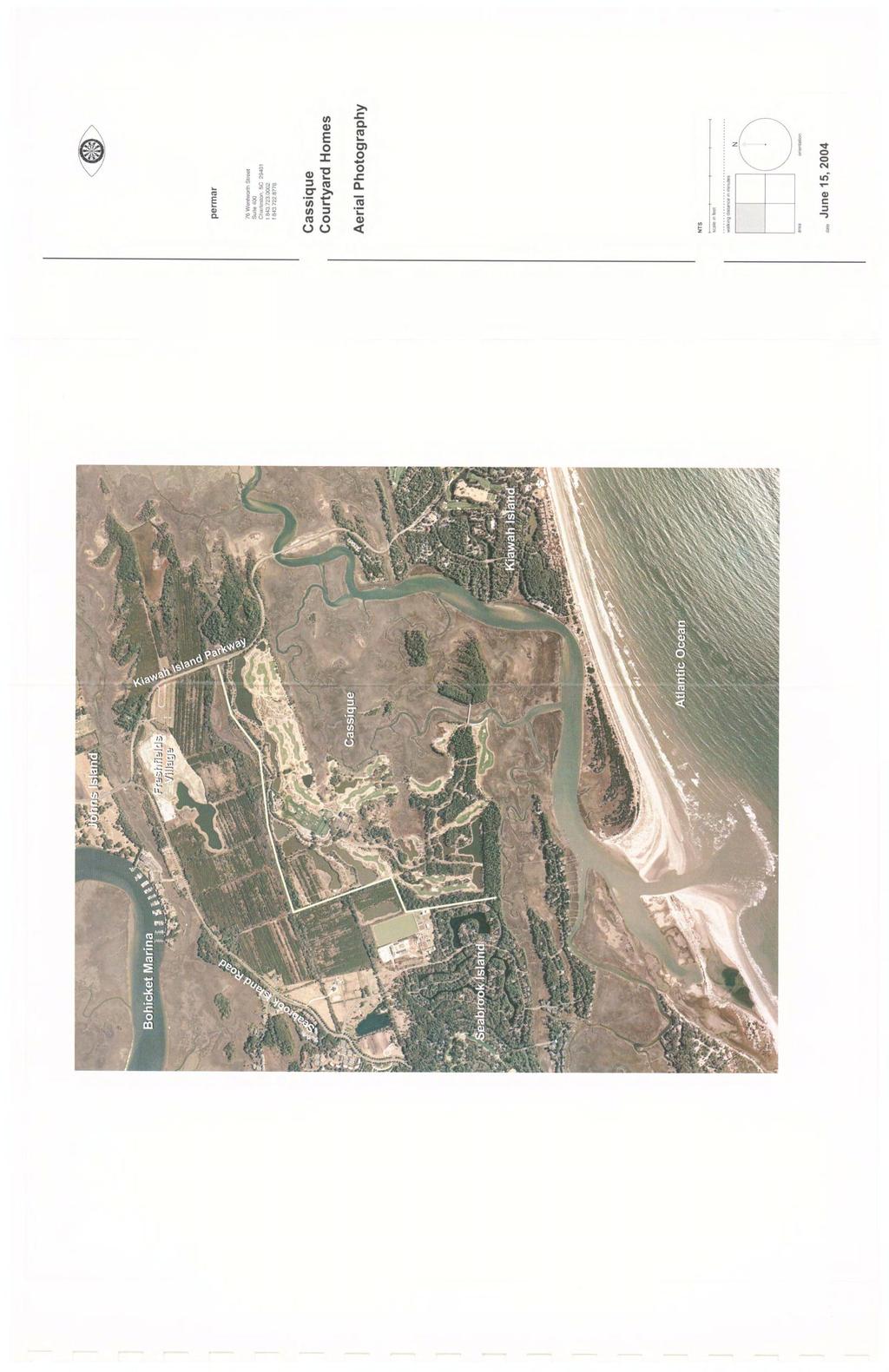
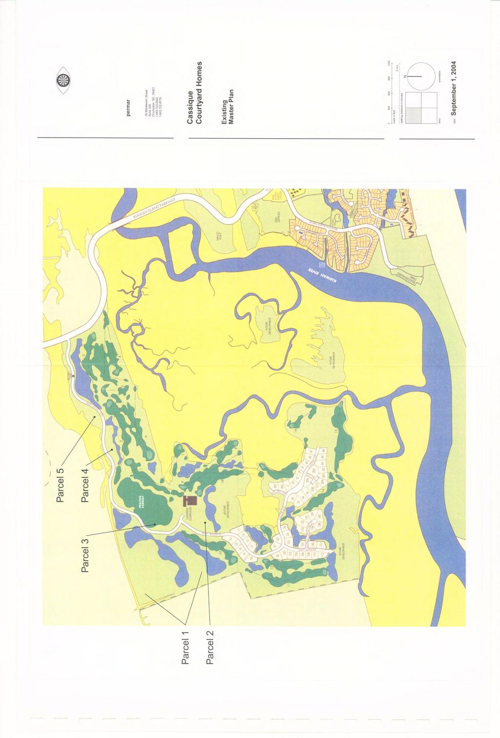
9 SECTION 2 OWNERSHIP AND PROPERTY DESCRIPTION 2.01 Short Title This ordinance shall be known and cited as the The PDD Ordinance Intent and General Location It is the intent of the Applicant to plan and develop a Planned Development Project on a series of parcels totaling approximately 81 acres located in the Cassique community in the unincorporated area of Charleston County, South Carolina. The site is depicted on the Location Map attached as Exhibit A. The Real Property is on Seabrook Island between the planned communities of Kiawah and Seabrook Islands, as depicted on the Survey of Real Property attached as Exhibit B. The series of parcels are generally bounded by Old Cedar Lane (which provides access) and surrounding lands composed of golf fairways or passive open space/ wetlands. Select parcels are further bounded by adjacent undeveloped lands Legal Description of the Property The following describes each individual parcel as further described in Exhibit B: Parcel 1 (Containing Acres) (including proposed Courtyard Homes site) All that certain piece, parcel or tract of land situate, lying and being on Seabrook Island, in Charleston County, South Carolina, containing acres total, more or less, and more particularly described as follows: That tract of land known generally as Parcel 1, containing acres total, and shown on a plat prepared by Southeastern Surveying of Charleston, Inc., entitled A Boundary Plat of Parcel 1, Which is Subdivided out of Parcel 1-A Containing Acres Owned by Kiawah Resort Associates, L.P. and Kiawah Development Partners, Inc., Located on Seabrook Island Charleston County, South Carolina, dated August 31, 2004, last revised on October 7, 2004, and recorded in Plat Book EH at pages 440 and 441 in the R.M.C. Office for Charleston County, South Carolina. The proposed Courtyard Homes site contains acres, more or less, and is shown and designated as Lot 20, Lot 34, Lot 35, Lot 36, and Lot 37, on a plat prepared by Southeastern Surveying of Charleston, Inc., entitled A Conditional Subdivision Plat of Lots 20 and 34 thru 37 Courtyard Homes Phase 1 Containing (sic) Acres Total, Owned by Kiawah Resort Associates, L.P. and Kiawah Development Partners, Inc., Located on Seabrook Island Charleston County, South Carolina dated August 6, 2004, last revised on August 30, 2004, and recorded in Plat Book EH at page 331, in the R.M.C. Office for Charleston County, South Carolina, Page 2
10 ALSO said properties have such location, butts and bounds, metes, courses and distances as will by reference to the aforesaid plats more fully appear. TMS Numbers: Parcel 1: Lot 20: Lot 34: Lot 35: Lot 36: Lot 37: Parcel 2 (Containing Acres) All that certain piece, parcel or tract of land situate, lying and being on Seabrook Island, in Charleston County, South Carolina, containing acres, more or less, shown and designated as Parcel 2 on a plat prepared by Southeastern Surveying of Charleston, Inc., entitled A Boundary Plat of Parcel 2, Which is Subdivided out of 1-C Containing Acres Owned by Kiawah Resort Associates, L.P., Located on Seabrook Island Charleston County, South Carolina, dated August 31, 2004, last revised on October 7, 2004, and recorded in Plat Book EH at page 442, in the R.M.C. Office for Charleston County, South Carolina. TMS # ALSO Parcel 3 (Containing Acres) All that certain piece, parcel or tract of land situate, lying and being on Seabrook Island, in Charleston County, South Carolina, containing acres, more or less, shown and designated as Parcel 3 on a plat prepared by Southeastern Surveying of Charleston, Inc., entitled A Boundary Plat of Parcel 3, Which is Subdivided out of Tract 1-C Containing Acres Owned by Kiawah Resort Associates, L.P., Located on Seabrook Island Charleston County, South Carolina, dated August 31, 2004, last revised on October 7, 2004, and recorded in Plat Book EH at page 443, in the R.M.C. Office for Charleston County, South Carolina. TMS # ALSO Parcel 4 (Containing Acres) All that certain piece, parcel or tract of land situate, lying and being on Seabrook Island, in Charleston County, South Carolina, containing acres, more or less, shown and designated as Parcel 4 on a plat prepared by Southeastern Surveying Page 3
11 of Charleston, Inc., entitled A Boundary Plat of Parcel 4, Which is Subdivided out of Tract 1-C Containing Acres Owned by Kiawah Resort Associates, L.P., Located on Seabrook Island Charleston County, South Carolina, dated August 31, 2004, last revised on October 7, 2004, and recorded in Plat Book EH at page 444, in the R.M.C. Office for Charleston County, South Carolina. TMS # ALSO Parcel 5 (Containing Acres) All that certain piece, parcel or tract of land situate, lying and being on Seabrook Island, in Charleston County, South Carolina, containing acres of highland and acres of marsh, more or less, shown and designated as Parcel 5 on a plat prepared by Southeastern Surveying of Charleston, Inc., entitled A Boundary Plat of Parcel 5, Which is Subdivided out of Tract 1-A Containing Acres Owned by Kiawah Development Partners, Inc., Located on Seabrook Island Charleston County, South Carolina, dated August 31, 2004, last revised on October 7, 2004, and recorded in Plat Book EH at pages 445 and 446, in the R.M.C. Office for Charleston County, South Carolina. TMS # Page 4

12 SECTION 3 GENERAL PLAN OF DEVELOPMENT 3.01 Purpose The Project will be a series of residential neighborhoods organized by clusters of homesites that provide internal garden courtyards. The arrangement of homes, garden courtyards and garages with the internal roadway and lane system will provide an alternative residential type to the more conventional residential subdivision pattern. This neighborhood development pattern is located within Cassique, a residential recreation oriented community of approximately 275 total dwelling units on approximately 465 acres. The community has integrated an 18 hole golf course designed by Tom Watson and will be planning a sports facility (fitness, tennis, and swimming pool) as part of the Cassique Courtyard Home neighborhood development. The inclusion of the courtyard home residential type with the existing (55 lots) and future (approx. 100 lots) large lot pattern, will provide a diverse range of detached homes for the regional market. The courtyard home concept will be located on lands previously farmed and as such allow for site manipulation without adversely impacting more heavily treed areas of Cassique. Page 5
13

14 The project will employ infrastructure design and placement that minimizes disruption to the mix of existing natural features while maintaining a high level of efficiency and economy. The purpose of this ordinance is to encourage environmentally sound development of the Real Property, improve the quality of life for area-wide residents and establish guidelines and standards for development of the Real Property. The standards provided herein are intended to permit the innovation necessary to accomplish this purpose. This ordinance, therefore, contemplates slight modifications from the strict application of select requirements found in the Charleston County zoning and other regulations and ordinances. These modifications to the Charleston County Zoning and Land Development Regulations Ordinance are set forth in Exhibit H. The Developer has had extensive experience applying similar criteria in environmentally sensitive coastal areas. The proposed standards strike a practical balance between more general countywide performance standards and the particular land areas comprising the. The Applicant is requesting a Planned Development classification in order to allow for a more flexible residential development over a multiple phase time period. The proposed PDD would allow for a residential development pattern of integrating courtyard oriented homes in clustered neighborhoods. To address specific requirements of the Planned Development approach, the applicant outlines the following: Page 6
15 Art Planned Development Results A. Greater choice in the type of environment and living units available to the public. This residential type will provide a diverse range of size and configuration when compared to the more conventional pattern of housing types existing in the immediate area. This housing type is not presently available within the immediate market area. B. More open space By concentrating this housing type on sites that allow for efficient circulation and utility placement, greater open space within the overall Cassique community will be retained. C. A creative approach to the use of land and related physical development. A key structuring element of the proposed concept is to orient the principal living areas to a private garden courtyard and to reduce the amount of paving attributed to driveways to garage structures. By more efficiently integrating yard areas normally attributed to side and rear yards into an internal court, the relationships of lot size, home placement, and circulation patterns are more efficient. D. An efficient use of land resulting in smaller networks of utilities and streets, and thereby lower housing costs. Concentration of clustering the courtyard homes/garages will result in a more efficient pattern of primary infrastructure (roads, water, sewer, power, etc.). This should positively impact housing costs attributed to normal site improvements. E. Implementation of the Comprehensive Plan The Comprehensive Plan for this property within Charleston County anticipated the need for a diversity of housing types while maintaining a balance with environmental conditions and market preferences. Page 7
16 3.02 Master Land Use Plan Exhibit D, the Master Land Use Plan, is a conceptual representation which illustrates tentative schematic land uses and locations of potential use types. The Master Land Use Plan is not intended to indicate the final uses and lot/parcel boundaries, but a general representation of use distribution and circulation patterns. The final design of development use and locations as well as lot/parcel boundaries may be shifted to respond to natural conditions and market preferences while still remaining consistent with the overall goals and approach for development provided herein. The Master Land Use Plan establishes an overall Project limit of 120 residential dwelling units Land Use Density The Real Property contains approximately 81 (70.2 high ground) acres within the unincorporated area of Charleston County, South Carolina. Approximately 280 dwelling units could be authorized under current zoning within the Project (4 D.U./Acre). The Master Land Use Plan suggests a mix of single family detached and attached units and a 4 acre Sports Facility to provide for active recreation use. This Plan is consistent with the use allowances and land use pattern as outlined in the Charleston County Comprehensive Plan. The intent of this application is to allow the Developer the ability to assign up to 4 D.U./ Acre to any one parcel provided the overall Project limit does not exceed 120 D.U. The proposed lot size, ground coverage, and structure setback limits are consistent with the courtyard residential type that is oriented toward an internal privacy garden. While individual lot development standards allow for moderately tight density, the overall density limits will be maintained with neighborhood open space and other pervious ground covered areas Development Sequence, Scheduling, Phasing Phasing for the project will ultimately be based on economic and market preference factors influencing applicable demands. Throughout the development process, phasing will vary; however, based upon conditions at the time of this application it is anticipated neighborhood phasing would be implemented up to a years time period Relationship to Zoning and Land Development Regulations Ordinance The Project is consistent with the primary objectives of the Zoning and Land Development Regulations Ordinance (Nov 20, 2001), as outlined in Article 1.5 Purpose and Intent; however, the Developer is proposing certain modifications to select sections of the Ordinance so as to allow for innovative solutions consistent with such objectives. Alternatives to specific sections of the Ordinance, as outlined in Exhibit F, are intended to enhance the flexibility of achieving the objectives without adversely impacting goals of other sections of the Ordinance. Page 8
17 The modifications as outlined in Exhibit F and section 4.03 Building Development Standards are consistent with the courtyard residential use type when planned in a clustered/neighborhood pattern. These standards would maintain overall existing density and use limits while allowing for a more compact development pattern (i.e. less separation between structures and greater ground coverage associated with garden courtyard designs). This flexibility is critical to creating a multi-phased development that must respond to changes in market conditions, and consumer preferences while balancing long range community-wide goals and objectives Utility Services and Easements The Developer anticipates the Real Property will be served by a community water and sewer system. The Developer shall grant the easements necessary and/or required to insure the continued operation and maintenance of all storm water management features, utilities, and other essential services. The Developer anticipates that utility services will be provided by the following: Electric: Telephone Water: Sewer: Berkeley Electric Cooperative BellSouth St. John s Water Company Seabrook Island Utility Commission Attached as Exhibit E are copies of letters from these utility providers indicating their willingness to provide service to the Real Property. Water and sewer infrastructure shall be installed by the Developer and then transferred to the service provider Roadways The developer will construct the roadways serving the Project. The Master Land Use Plan, Exhibit D, illustrates the approximate location of the circulation systems. These locations are subject to change by the Developer depending on topography, natural features, subdivision layouts, amenities, utilities locations, and other pertinent considerations. All roads within the Project will be private. The County shall have no maintenance obligation or responsibility for those roadways that remain private, which shall be maintained by the Developer and/or one or more duly organized homeowners associations. Page 9
18 3.08 Signage, Buffers & Fencing, Tree Replacement The Developer shall provide a uniform and integrated program of signage, buffers and fencing, and tree replacement, which will be enforced through restrictive covenants imposing architectural controls. This program will be implemented through the ARB standards adopted therefore, which shall be in place prior to the construction of any Lots, tracts, or building parcels and prior to the issuance of any building certificate(s) of occupancy. The ARB standards shall contain criteria governing placement, size, shape, and color, and shall conform to the following standards: 1. Signage, related feature walls, and landscaping shall be located such that they do not materially detract from the natural scenic beauty of the Project site. 2. Signage, related feature walls, and landscaping shall be located such that they do not obscure other identification, informational, or vehicular control signs. 3. Signage, related feature walls and landscaping, shall be permitted within rightsof-way providing they do not interfere with traffic or pedestrian safety. These standards shall meet all development standards as outlined in the Charleston County Zoning and Development Regulations with the following exceptions that would be integrated in the PD-Cassique district: Fencing/Garden Walls Landscape fencing and/or garden walls will be permitted as tall as 8 above finish grade. This is to integrate privacy areas within the garden courtyards. Fencing or walls may be permitted within any of the required setbacks, provided vision site triangles at any street intersection are maintained. SECTION 4 PROPOSED DEVELOPMENT STANDARDS 4.01 Permitted Uses All uses listed under the heading PDD-Cassique within the Zoning and Land Development Regulations Ordinance, as modified by Exhibit F shall apply as a matter of right to the Property. This listing includes a range of residential and non-residential uses that is consistent with the vision of an environmentally oriented community adjacent to created freshwater wetlands Dwelling Units The total number of single-family detached, single-family attached, or cluster housing residential Dwelling Units within the Project shall not exceed 120 ( Project Cap ). Page 10
19 Specific housing types will be evaluated prior to each phase based upon market demand and appropriate fit with unique site conditions. Based upon analysis at the time of application, the following is a listing and mix of housing types: 4.03 Building Development Standards a) Single Family Detached 100 b) Single Family Attached 20 TOTAL 120 D.U. All development in the PDD-Cassique district shall be subject to the following density, intensity and dimensional standards: PDD-CASSIQUE DENSITY/INTENSITY AND DIMENSIONAL STANDARDS MAXIMUM DENSITY 4 dwelling units per acre [1] MINIMUM LOT AREA MINIMUM LOT WIDTH 6,000 square feet 60 feet MINIMUM SETBACKS Front/Street Side Interior Side Rear OCRM Critical Line MAXIMUM BUILDING COVER MAXIMUM HEIGHT 10 feet 5 feet (garage/studio) [2] 5 feet (house) 0 feet (garage/studio) 10 feet 30 feet (Ave.) (No less than 20 feet) 40% of parcel 60% of individual lot [3] 35 feet [1] Total dwelling unit cap not to exceed 120. Any parcel not to exceed 4 D.U./Acre. [2] Any wall up to 8 ft. above finish grade may be located within any of the required setbacks, provided vision site triangles at street intersections are maintained. [3] The garden courtyard concept coverage includes house, garage, and pool cavity. I. Statement of Purpose, Intent, Objectives The PDD-Cassique district is a moderate density residential/recreation classification established to respond to unique environmental and siting constraints. The district is composed of various residential types in combination with certain recreational uses that are compatible with the Cassique community. Page 11
20 II. Land Uses Uses permitted as a matter of right are as follows: Residential Single Family Detached Single Family Attached Duplex Dwelling Group Recreation Fitness/Exercise Activities Locker Rooms Spa Tennis Swimming Pool Lawn games (Badminton, Croquet, etc.) Snack Bar (Accessory Use) Parks Utility Service Minor Electric Distribution Sewage Collection/Transmission Service Water Service III. IV. Setback Criteria Setback and dimensional standards are as outlined above. Lot Size Criteria Lot sizes will vary according to site constraints and market preferences but will not be less than listed above. V. Lighting Plan A lighting plan will be developed with each phase that is consistent with Charleston County Standards. VI. VII. Off-Street Parking Off-street parking will meet all dimensional requirements as outlined in Charleston County Standards. Off-street parking in the area of the sports garden will include shared parking for daily and night time operation. Supplemental off-street parking will be integrated within select areas of the proposed private right-of-ways and partially on lots. Based upon the walking distance from the majority of proposed dwelling units, the minimum off-street parking requirements for the amenity center will be 60 spaces. Tree Survey (on lots) The property is largely void of tree cover except for perimeter locations. Prior to more detailed planning of each phase/subphase, appropriate tree surveys will be conducted to evaluate development impact. This will be executed consistent with the Charleston County subdivision/site Plan Review process. Page 12
21 VIII. IX. Screening/Buffer Areas Proper screening of uses as required will be identified on detailed site plans for each phase. Landscaping will meet or exceed Charleston County planting requirements at time the site is developed. The following are modified standards for buffer requirements: MINIMUM BUFFER DEPTH: for amenity structures from property line by roadways for amenity structures from property line Fences and Walls Fencing and walled elements are an important part of the design concept. The height, position and massing will be determined by the Cassique ARB, but shall not exceed 8 above finished grade elevation and shall not be located in such a way as to restrict vision site triangles at street intersections. X. Streets It is intent of the applicant to design, construct, and maintain all roadways and drainage improvements privately. Detailed drawings of the proposed improvements will be prepared and advanced to Charleston County for record purposes. XI. Phasing It is the intent of the Applicant to phase the proposed development up to a year period. The PDD application recognizes the need for long-term development flexibility in order to respond to unanticipated opportunities and constraints; therefore, specifics regarding number or size of each phase cannot be determined at this point. SECTION 5 GENERAL DEVELOPMENT COMMITMENTS The Developer agrees, on behalf of itself, its successors and assigns, to the following commitments as part of the development of the : To act in good faith to implement the plan as described herein. To institute architectural restrictions and covenants ensuring quality development and augmenting governmental regulations. To establish the legal framework for one or more associations or some other appropriate organization to assume responsibility for any common area and community supported areas such as parks, wooded preserves, bike trails, private roads, etc. To employ high standards of planning, design, and management in all phases of development. To evaluate all express conditions adopted as part of this application, and if they are accepted, to faithfully abide by them. Page 13
22 SECTION 6 DEFINITIONS AND ABBREVIATIONS In this Agreement, unless the word or phase is non-capitalized: (a) Agreement means this Planned Development District Application, including the recitals and exhibits attached hereto. (b) ARB means the architectural review board appointed by the Developer that will be established under a binding declaration of covenants, conditions, and restrictions imposed on the Real Property. (c) Comprehensive Plan means the master plan for the County including the official map, adopted pursuant to S.C. Code et seq. (d) County is Charleston County, South Carolina, a local governmental entity organized and existing under the laws of South Carolina. (e) Density means the number of Dwelling Units per acre. Parcel Density equals the number of Dwelling Units divided by the gross acreage above DHEC-OCRM s critical line, including fresh water Wetlands and Water Bodies. In locations where the Property Owner has created new fresh water, Water Bodies or Wetlands, the calculation of Parcel Density shall include newly created lagoon acreage in determining gross acreage. (f) Developer means Kiawah Development Partners, Inc., Kiawah Resort Associates, L.P., (or any one of them) and their successors in interest or successors in title and/or assigns. (g) Development means the planning for or carrying out of a building activity or mining operation, the making of a material change in the use or appearance of any structure or property, or the dividing of land into three or more parcels. Development, as designated in a law or development permit, includes the planning for and all other activity customarily associated with it unless otherwise specified. When appropriate to the context, development refers to the planning for or the act of developing or to the result of development. Reference to a specific operation is not intended to mean that the operation or activity, when part of other operations or activities, is not development. Reference to particular operations is not intended to limit generality of this item. (h) Development Parcel means any tract of land on which Development may occur, including platted Lots and unplatted parcels, but excluding street rights-of-way. (i) (j) Dwelling Unit has the same meaning as Dwelling in the County Zoning and Land Development Regulations Ordinance as modified by Exhibit F. Lot means Development Parcel identified in a Subdivision Plat recorded in the Charleston County RMC office. (k) Open Areas means areas of Pervious Cover and includes, but is not limited to, yards, vegetated areas, lagoons, lakes, Wetlands, and Water Bodies. (l) Parties are the Developer and Charleston County. Page 14
23 (m) Parcel means any of those tracts of the Real Property that are located in the approximate areas identified on the Master Plan. (n) Pervious Cover Means land which permits the absorption of stormwater into the ground. This may include walkways and driveways, which are pervious to stormwater. (o) Project is the Development that has occurred and will occur on the Real Property. (p) Project Cap means the total number of Dwelling Units on the Real Property that shall not exceed 120. (q) Real Property is the real property described in Section 2.03 and includes any improvements or structures customarily regarded as part of real property. (r) Setback means and refers to the minimum distance to the nearest adjacent property line, street, or right-of-way. (s) Single Family Detached Dwelling means a building containing one Dwelling Unit that is not attached to any other Dwelling Unit and is surrounded by yards or open space. (t) Subdivision Plat means a recorded graphic description of property prepared and approved in compliance with the County s Zoning and Land Development Regulations Ordinance as modified by Exhibit H. (u) Water Bodies means property determined to be under water no less than eleven (11) months of the year and under such standing water for a continuous period of no less than nine (9) months of the year. (v) Wetlands means those properties with elevations below the mean high water line, and properties within a pond, lagoon, or other Water Bodies. (w) Zoning Board of Adjustment or ZBA means the duly appointed Zoning Board of Adjustment for the County. Page 15
24 EXHIBIT A LOCATION MAP Page 16

25 CASSIQUE LOCATION MAP
26 EXHIBIT B SURVEY OF REAL PROPERTY Included in this exhibit is a listing of legal descriptions of each of the parcels and a reduced drawing of the plat submitted for filing. Page 18
27 Cassique Planned Development Property Description Parcel 1 (including proposed Courtyard Homes site) All that certain piece, parcel or tract of land situate, lying and being on Seabrook Island, in Charleston County, South Carolina, containing acres total, more or less, and more particularly described as follows: That tract of land known generally as Parcel 1, containing acres total, and shown on a plat prepared by Southeastern Surveying of Charleston, Inc., entitled A Boundary Plat of Parcel 1, Which is Subdivided out of Parcel 1-A Containing Acres Owned by Kiawah Resort Associates, L.P. and Kiawah Development Partners, Inc., Located on Seabrook Island Charleston County, South Carolina, dated August 31, 2004, last revised on October 7, 2004, and recorded in Plat Book EH at pages 440 and 441 in the R.M.C. Office for Charleston County, South Carolina. The proposed Courtyard Homes site contains acres, more or less, and is shown and designated as Lot 20, Lot 34, Lot 35, Lot 36, and Lot 37, on a plat prepared by Southeastern Surveying of Charleston, Inc., entitled A Conditional Subdivision Plat of Lots 20 and 34 thru 37 Courtyard Homes Phase 1 Containing (sic) Acres Total, Owned by Kiawah Resort Associates, L.P. and Kiawah Development Partners, Inc., Located on Seabrook Island Charleston County, South Carolina dated August 6, 2004, last revised on August 30, 2004, and recorded in Plat Book EH at page 331, in the R.M.C. Office for Charleston County, South Carolina, said properties have such location, butts and bounds, metes, courses and distances as will by reference to the aforesaid plats more fully appear. TMS Numbers: Parcel 1: Lot 20: Lot 34: Lot 35: Lot 36: Lot 37:
28 ALSO Parcel 2 All that certain piece, parcel or tract of land situate, lying and being on Seabrook Island, in Charleston County, South Carolina, containing acres, more or less, shown and designated as Parcel 2 on a plat prepared by Southeastern Surveying of Charleston, Inc., entitled A Boundary Plat of Parcel 2, Which is Subdivided out of 1-C Containing Acres Owned by Kiawah Resort Associates, L.P., Located on Seabrook Island Charleston County, South Carolina, dated August 31, 2004, last revised on October 7, 2004, and recorded in Plat Book EH at page 442 in the R.M.C. Office for Charleston County, South Carolina. TMS # ALSO Parcel 3 All that certain piece, parcel or tract of land situate, lying and being on Seabrook Island, in Charleston County, South Carolina, containing acres, more or less, shown and designated as Parcel 3 on a plat prepared by Southeastern Surveying of Charleston, Inc., entitled A Boundary Plat of Parcel 3, Which is Subdivided out of Tract 1-C Containing Acres Owned by Kiawah Resort Associates, L.P., Located on Seabrook Island Charleston County, South Carolina, dated August 31, 2004, last revised on October 7, 2004, and recorded in Plat Book EH at page 443, in the R.M.C. Office for Charleston County, South Carolina. TMS # ALSO Parcel 4 All that certain piece, parcel or tract of land situate, lying and being on Seabrook Island, in Charleston County, South Carolina, containing acres, more or less, shown and designated as Parcel 4 on a plat prepared by Southeastern Surveying of Charleston, Inc., entitled A Boundary Plat of Parcel 4, Which is Subdivided out of Tract 1-C Containing Acres Owned by Kiawah Resort Associates, L.P., Located on Seabrook Island Charleston County, South Carolina, dated August 31, 2004, last revised on October 7, 2004, and recorded in Plat Book EH at page 444, in the R.M.C. Office for Charleston County, South Carolina. TMS #
29 ALSO Parcel 5 All that certain piece, parcel or tract of land situate, lying and being on Seabrook Island, in Charleston County, South Carolina, containing acres of highland and acres of marsh, more or less, shown and designated as Parcel 5 on a plat prepared by Southeastern Surveying of Charleston, Inc., entitled A Boundary Plat of Parcel 5, Which is Subdivided out of Tract 1-A Containing Acres Owned by Kiawah Development Partners, Inc., Located on Seabrook Island Charleston County, South Carolina, dated August 31, 2004, last revised on October 7, 2004, and recorded in Plat Book EH at pages 445 and 446, in the R.M.C. Office for Charleston County, South Carolina. TMS #
30
31
32
33
34
35
36
37 EXHIBIT C AERIAL PHOTOGRAPHY Page 19
38
39 EXHIBIT D MASTER LAND USE PLAN Included in this exhibit is a graphic indicating existing land use conditions and a graphic of a conceptual master land use plan indicating a general circulation system, residential clustering and amenity location. Page 20
40
41
42
43
44 EXHIBIT E LETTERS OF INTENT TO PROVIDE SERVICES Included in this exhibit are letters from principal service providers for development of the Real Property. Page 21
45
46
47
48 EXHIBIT F MODIFICATIONS TO CHARLESTON COUNTY ZONING AND LAND DEVELOPMENT REGULATIONS ORDINANCE The applicant is proposing the following modifications to existing development regulations in order to provide flexibility for planning and design of the courtyard home concept. These proposed standards will allow for lot configuration and structure placement of moderate density fee-simple attached and detached residential dwellings without adversely impacting surrounding environmentally sensitive areas. All references below are as outlined in the Charleston County Zoning and Land Development Regulations (adopted November 20, 2001). Sect Density/Intensity and Dimensional Standards Table DENSITY/INTENSITY AND DIMENSIONAL STANDARDS MAXIMUM DENSITY EXISTING (RSL) 4 dwelling units per acre PROPOSED (PDD) 4 dwelling units per acre [3] MINIMUM LOT AREA 8,000 square feet 6,000 square feet MINIMUM LOT WIDTH 60 feet [1] 60 feet MINIMUM SETBACKS Front/Street Side [2] Interior Side 25 feet 5 feet 10 feet 5 feet (garage/studio) [4] 5 feet (house) 0 feet (garage/studio) Rear 15 feet 10 feet OCRM Critical Line MAXIMUM BUILDING COVER 35 feet 30% of lot 30 feet (Ave.) (No less than 20 feet) 40% of parcel 60% of individual lot [5] MAXIMUM HEIGHT 35 feet 35 feet [1] 70 feet without public water and/or public sewer. [2] Front/Street Side Setback reductions of 15 feet may be approved by the Planning Director when deemed compatible with existing development patterns or setbacks shown on approved plats. [3] Total dwelling unit cap not to exceed 120. Any parcel not to exceed 4 D.U./Acre. [4] Any wall up to 8 ft. above finish grade may be located within any of the required setbacks, provided vision site triangles at street intersections are maintained. [5] The garden courtyard concept coverage includes house, garage, and pool cavity. Page 22
49 Art Waterfront Development Standards Standard Existing Proposed Min. Lot Area (RSL) 12,000 sq.ft. 8,000 sq.ft. Min. Lot Width (ft) Min. Lot Width Average (ft.) Building Setback from (ave.) OCRM Critical Line (ft.) (no less than 20 ) Sect Landscape Buffers Existing Proposed 4. Buffer Depth and County Standards Min. Buffer Depth (Buffer Type S1) For residential and amenity uses 5. Buffer Depth and Landscaping Standards Min. Buffer Depth (Buffer Type B) Sect. 9.7 Wetlands, Waterways and OCRM Critical Line Existing Proposed B. Buffer Depth and Setbacks Min. Buffers/Setbacks (RSL Classification) Setback from OCRM Critical Line (ave.) (no less than 20 ) Page 23
50 EXHIBIT G DRAFT ARB GUIDELINES Included in this exhibit is an example of the existing Cassique Community Architectural Review Board guidelines that will be revised to include the development standards proposed in this application. Page 24
PRIMUS TRACT MOUNT PLEASANT, SOUTH CAROLINA
 DEVELOPMENT GUIDELINES FOR PRIMUS TRACT MOUNT PLEASANT, SOUTH CAROLINA Date February 18, 2015 PLANNING COMMISSION SUBMITTAL Owner/Developer: American Star Development SC, LLC P.O. Box 211 Sullivans Island,
Appendix J - Planned Unit Development (PUD)
") Appendix J - Planned Unit Development (PUD) Intent and Purpose The purpose of the PUD is: 1. To provide development that is consistent with the Comprehensive Land Use Plan and promote the goals and objectives
Appendix J - Planned Unit Development (PUD) Intent and Purpose The purpose of the PUD is: 1. To provide development that is consistent with the Comprehensive Land Use Plan and promote the goals and objectives
DRAFT FOR PUBLIC HEARING (rev. March, 2016)
") Chapter 200. ZONING Article VI. Conservation/Cluster Subdivisions 200-45. Intent and Purpose These provisions are intended to: A. Guide the future growth and development of the community consistent with
Chapter 200. ZONING Article VI. Conservation/Cluster Subdivisions 200-45. Intent and Purpose These provisions are intended to: A. Guide the future growth and development of the community consistent with
CHAPTER34 PRUD - PLANNED RESIDENTIAL UNIT DEVELOPMENT
 CHAPTER34 PRUD - PLANNED RESIDENTIAL UNIT DEVELOPMENT 17-34-1 17-34-2 17-34-3 17-34-4 17-34-5 17-34-6 17-34-7 17-34-8 17-34-9 Purpose Planned Residential Unit Development Defined Planned Residential Unit
ARTICLE 14 PLANNED UNIT DEVELOPMENT (PUD) DISTRICT
 DISTRICT") ARTICLE 14 PLANNED UNIT DEVELOPMENT (PUD) DISTRICT Section 14.01 Intent. It is the intent of this Article to allow the use of the planned unit development (PUD) process, as authorized by the Michigan Zoning
ARTICLE 14 PLANNED UNIT DEVELOPMENT (PUD) DISTRICT Section 14.01 Intent. It is the intent of this Article to allow the use of the planned unit development (PUD) process, as authorized by the Michigan Zoning
ARTICLE FIVE FINAL DRAFT
 ARTICLE FIVE 021218 FINAL DRAFT Sec. 503.6 Open Space Preservation Option Open Space Preservation Option Open Space Preservation developments may be approved in the AR, R-1, R-2 and R-3 zoning districts,
In order to permit maximum applicability of the PUD District, PUD-1 and PUD-2 Districts are hereby created.
 ARTICLE III. PUD ned Unit Development Overlay District 205-128. Purpose. The PUD ned Unit Development Overlay District is intended to provide flexibility in the design of planned projects; to encourage
Cover Letter with Narrative Statement
 Cover Letter with Narrative Statement March 31, 2017 rev July 27, 2017 RE: Rushton Pointe Residential Planned Unit Development Application for Public Hearing for RPUD Rezone PL2015 000 0306 Mr. Eric Johnson,
SPECIAL ZONING DISTRICTS
 SPECIAL ZONING DISTRICTS 5.01 5.99 RESERVED 5.100 PLANNED DEVELOPMENTS: Purpose: This district is intended to accommodate unified design of residential, commercial, office, professional services, retail
PLANNED DEVELOPMENT DISTRICT STANDARDS. Cadence Site
 PLANNED DEVELOPMENT DISTRICT STANDARDS Cadence Site A Planned Development District 1. Statement of General Facts, Conditions and Objectives Property Size: Approximately 57.51 Acres York County Tax Map
The following regulations shall apply in the R-E District:
 "R-E" RESIDENTIAL ESTATE DISTRICT (8/06) The following regulations shall apply in the R-E District: 1. Uses Permitted: The following uses are permitted. A Zoning Certificate may be required as provided
SUBJECT PARCEL(S) Property Owner(s) TMS Number Approximate Acreage Carolina Park Development, LLC
 Property Owner(s) TMS Number Approximate Acreage Carolina Park Development, LLC") Staff Report Special Planning Commission Meeting November 19, 2014 For reference, the Zoning Code and Land Development Regulations are available online. AGENDA ITEM 5c. SKETCH PLAN APPROVAL REQUEST: Request
Staff Report Special Planning Commission Meeting November 19, 2014 For reference, the Zoning Code and Land Development Regulations are available online. AGENDA ITEM 5c. SKETCH PLAN APPROVAL REQUEST: Request
FINAL DRAFT 12/1/16, Rev. to 7/18/17
 FINAL DRAFT 12/1/16, Rev. to 7/18/17 (As Adopted 8/8/17 Effective 9/1/17) SHELTON PLANNING AND ZONING COMMISSION Proposed Amendments to Zoning Regulations I. Amend Section 23 PERMITTED USES by inserting
PLANNED UNIT DEVELOPMENT & SUBDIVISION STAFF REPORT Date: April 18, 2019
 PLANNED UNIT DEVELOPMENT & SUBDIVISION STAFF REPORT Date: April 18, 2019 DEVELOPMENT NAME SUBDIVISION NAME Springhill Village Subdivision Springhill Village Subdivision LOCATION 4350, 4354, 4356, 4358,
PLANNED UNIT DEVELOPMENTS (Ordinance No.: 3036, 12/3/07; Repealed & Replaced by Ordinance No.: 4166, 10/15/12)
") 159.62 PLANNED UNIT DEVELOPMENTS (Ordinance No.: 3036, 12/3/07; Repealed & Replaced by Ordinance No.: 4166, 10/15/12) A. PURPOSE 1. General. The Planned Unit Development (PUD) approach provides the flexibility
159.62 PLANNED UNIT DEVELOPMENTS (Ordinance No.: 3036, 12/3/07; Repealed & Replaced by Ordinance No.: 4166, 10/15/12) A. PURPOSE 1. General. The Planned Unit Development (PUD) approach provides the flexibility
A. Preserve natural resources as identified in the Comprehensive Plan.
 1370.08 Conservation Residential Overlay District. Subd. 1 Findings. The City finds that the lands and resources within the Conservation Residential Overlay District are a unique and valuable resource
ARTICLE 15 - PLANNED UNIT DEVELOPMENT
 Section 15.1 - Intent. ARTICLE 15 - PLANNED UNIT DEVELOPMENT A PUD, or Planned Unit Development, is not a District per se, but rather a set of standards that may be applied to a development type. The Planned
(a) Commercial uses on Laurel Avenue, abutting the TRO District to the
 Commercial uses on Laurel Avenue, abutting the TRO District to the") 32X Zoning Code 150.36 TRANSITIONAL RESIDENTIAL OVERLAY DISTRICT. (A) Intent and purpose. (1) It is the intent of the Transitional Residential Overlay District (hereinafter referred to as the "TRO District")
32X Zoning Code 150.36 TRANSITIONAL RESIDENTIAL OVERLAY DISTRICT. (A) Intent and purpose. (1) It is the intent of the Transitional Residential Overlay District (hereinafter referred to as the "TRO District")
Staff Report: Date: Applicant: Property Identification: Acreage of Request: Current Zoning of Requested Area: Requested Action: Attached:
 Staff Report: Completed by Jeff Palmer Director of Planning & Zoning Date: November 7, 2018, Updated November 20, 2018 Applicant: Greg Smith, Oberer Land Developer agent for Ronald Montgomery ET AL Property
ARTICLE I ZONE BASED REGULATIONS
 ARTICLE I ZONE BASED REGULATIONS RZC 21.08 RESIDENTIAL REGULATIONS 21.08.290 Cottage Housing Developments A. Purpose. The purpose of the cottage housing requirements is to: 1. Provide a housing type that
Chapter 22 PLANNED UNIT DEVELOPMENT.
 Chapter 22 PLANNED UNIT DEVELOPMENT. Sec. 22.1 INTENT. The use of land and the construction and use of buildings and other structures as Planned Unit Developments in Georgetown Township may be established
PLANNING COMMISSION REPORT Regular Agenda Non Public Hearing Item
 PC Staff Report 3/23/15 FDP-14-00551 Item No. 2-1 PLANNING COMMISSION REPORT Regular Agenda Non Public Hearing Item PC Staff Report 3/23/15 ITEM NO. 2: FINAL DEVELOPMENT PLAN FOR HUTTON FARMS WEST PHASE
TOOELE COUNTY LAND USE ORDINANCE CHAPTER 31 Page 1
 CHAPTER 31 PLANNED COMMUNITY ZONE (P-C) Section 31-1 Definitions. 31-2 Purpose. 31-3 Land use districts. 31-4 P-C zone area minimum requirements. 31-5 Permitted uses. 31-6 Conditional uses. 31-7 Planning
ZONING ORDINANCE: OPEN SPACE COMMUNITY. Hamburg Township, MI
 ZONING ORDINANCE: OPEN SPACE COMMUNITY Hamburg Township, MI ARTICLE 14.00 OPEN SPACE COMMUNITY (Adopted 1/16/92) Section 14.1. Intent It is the intent of this Article to offer an alternative to traditional
3.1. OBJECTIVES FOR RESIDENTIAL LAND USE DESIGNATIONS GENERAL OBJECTIVES FOR ALL RESIDENTIAL DESIGNATIONS
 3. RESIDENTIAL LAND USE DESIGNATIONS INTRODUCTION The Residential land use designations provide for housing and other land uses that are integral to, and supportive of, a residential environment. Housing
Staff Report: Date: Applicant: Property Identification: Acreage of Request: Current Zoning of Requested Area: Requested Action: Attached:
 Staff Report: Completed by Jeff Palmer Director of Planning & Zoning Date: November 7, 2018 Applicant: Greg Smith, Oberer Land Developer agent for Ronald Montgomery ET AL Property Identification: Frontage
SECTION 16. "PUD" PLANNED UNIT DEVELOPMENT OVERLAY DISTRICT
 SECTION 6. "PUD" PLANNED UNIT DEVELOPMENT OVERLAY DISTRICT Subsection. Purpose. This district is established to achieve the coordinated integration of land parcels and large commercial and retail establishments
PLANNING AND ZONING DEPARTMENT
 Town of Minturn Development Review Process: Guide To Planned Unit Developments (Concept Plan) This guide describes the Planned Unit Development Process. This guide should be utilized in conjunction with
Town of Cary, North Carolina Rezoning Staff Report 14-REZ-31 Cary Park PDD Amendment (Waterford II) Town Council Meeting January 15, 2015
 Town Council Meeting January 15, 2015") Town of Cary, North Carolina Rezoning Staff Report 14-REZ-31 Cary Park PDD Amendment (Waterford II) Town Council Meeting January 15, 2015 REQUEST To amend the Town of Cary Official Zoning Map by amending
Town of Cary, North Carolina Rezoning Staff Report 14-REZ-31 Cary Park PDD Amendment (Waterford II) Town Council Meeting January 15, 2015 REQUEST To amend the Town of Cary Official Zoning Map by amending
Article 7: Residential Land Use and Development Requirements
 Article 7: Residential Land Use and Section 701: Statement of Intent (A) (B) (C) The intent of Article 7 is to develop certain land use and development requirements for the residential uses within Cumru
Salem Township Zoning Ordinance Page 50-1 ARTICLE 50.0: PUD PLANNED UNIT DEVELOPMENT
 Salem Township Zoning Ordinance Page 50-1 ARTICLE 50.0 PLANNED UNIT DEVELOPMENT Section 50.01 Purpose The provisions of this Article provide enabling authority and standards for the submission, review,
Draft Zoning Changes for the 2nd Planning Board Public Hearing, January 22, 2018.
 Draft Zoning Changes for the 2nd Planning Board Public Hearing, January 22, 2018. No changes were made at the 1st Public Hearing. Proposed wording for the 1 st Public Hearing in red, eliminated text in
4. facilitate the construction of streets, utilities and public services in a more economical and efficient manner;
 PVPC MODEL BYLAW BY-RIGHT CLUSTER ZONING BYLAW Prepared by Pioneer Valley Planning Commission Revised: October 2001 1.00 Development 1.01 Development Allowed By Right Development in accordance with this
Exhibit "A" have applied for a re-zoning and re-classification of that property from OPEN RURAL (OR) to that of a PLANNED UNIT DEVELOPMENT (PUD); and
 to that of a PLANNED UNIT DEVELOPMENT (PUD); and") I NSTR # 200632845 OR BK 61439 PGS 0728-0750 RECORDED 06/24/2066 12:25:50 PR JOHN Q. CRAWFOKD CLERK OF CIRCUIT COURT NASSAU COUNTY, FLORIDA RECORDING FEES 1.37.80 ORDINANCE NO. 2006-65 AN ORDINANCE AMENDING
I NSTR # 200632845 OR BK 61439 PGS 0728-0750 RECORDED 06/24/2066 12:25:50 PR JOHN Q. CRAWFOKD CLERK OF CIRCUIT COURT NASSAU COUNTY, FLORIDA RECORDING FEES 1.37.80 ORDINANCE NO. 2006-65 AN ORDINANCE AMENDING
CONDOMINIUM REGULATIONS
 ARTICLE 37 CONDOMINIUM REGULATIONS SECTION 37.01. Purpose The purpose of this Article is to regulate projects that divide real property under a contractual arrangement known as a condominium. New and conversion
NORMAN, OKLAHOMA OWNER: RCB BANK APPLICATION FOR 2025 PLAN CHANGE PLANNED UNIT DEVELOPMENT PRELIMINARY PLAT. 12 December 2011 Revised 5 January 2012
 THE VILLAGE AT OAKHURST ADDITION NORMAN, OKLAHOMA OWNER: RCB BANK APPLICATION FOR 2025 PLAN CHANGE PLANNED UNIT DEVELOPMENT PRELIMINARY PLAT 12 December 2011 Revised 5 January 2012 PREPARED BY: THE RIEGER
AN ORDINANCE TO AMEND SECTION OF THE RAPID CITY MUNICIPAL CODE TO ALLOW FOR ADMINISTRATIVE DISSOLUTION OF PLANNED DEVELOPMENTS
 Ordinance No. 6231 AN ORDINANCE TO AMEND SECTION 17.50.050 OF THE RAPID CITY MUNICIPAL CODE TO ALLOW FOR ADMINISTRATIVE DISSOLUTION OF PLANNED DEVELOPMENTS WHEREAS, the City of Rapid City has adopted a
Condominium Unit Requirements.
 ARTICLE 19 CONDOMINIUM REGULATIONS Section 19.01 Purpose. The purpose of this Article is to regulate projects that divide real property under a contractual arrangement known as a condominium. New and conversion
THE BLUFFS AT CYPRESS CREEK SUBDIVISION
 THE BLUFFS AT CYPRESS CREEK SUBDIVISION Engineering Comments: Must comply with all stormwater and flood control ordinances. Any work performed in the right-of-way will require a right-of-way permit. Traffic
TOWN OF MOUNT PLEASANT, SOUTH CAROLINA PLANNING & DEVELOPMENT COMMITTEE OCTOBER 31, 2016 MINUTES. Municipal Complex, Building A, Public Meeting Room 1
 TOWN OF MOUNT PLEASANT, SOUTH CAROLINA PLANNING & DEVELOPMENT COMMITTEE OCTOBER 31, 2016 MINUTES Municipal Complex, Building A, Public Meeting Room 1 Members Present: Staff Present: Bob Brimmer, Joe Bustos,
Town of Cary, North Carolina Rezoning Staff Report 14-REZ-20 Habitat for Humanity Evans Road Town Council Meeting October 16, 2014
 Town of Cary, North Carolina Rezoning Staff Report 14-REZ-20 Habitat for Humanity Evans Road Town Council Meeting October 16, 2014 REQUEST To amend the Town of Cary Official Zoning Map by rezoning 0.53
Charter Township of Plymouth Zoning Ordinance No. 99 Page 208 Article 21: Residential Unit Developments Amendments: ARTICLE XXI
 Charter Township of Plymouth Zoning Ordinance No. 99 Page 208 ARTICLE XXI RESIDENTIAL UNIT DEVELOPMENTS PURPOSE The purpose of the Residential Unit Development (RUD) is to permit two (2) optional methods
GNV RISE Subdivision. GNV RISE Subdivision
 GNV RISE Subdivision GNV RISE Subdivision A. Purpose and intent. 1. The purpose of this section is to provide a framework of adaptable incentive-based subdivision design standards which are intended to
Chapter 100 Planned Unit Development in Corvallis Urban Fringe
 100.100 Scope and Purpose. Chapter 100 Planned Unit Development in Corvallis Urban Fringe (1) All applications for land divisions in the Urban Residential (UR) and Flood Plain Agriculture (FPA) zones within
SECTION 10.7 R-PUD (RESIDENTIAL PLANNED UNIT DEVELOPMENT) ZONE
 ZONE") Article X Zones 10-20 SECTION 10.7 R-PUD (RESIDENTIAL PLANNED UNIT DEVELOPMENT) ZONE A. PURPOSE AND INTENT: The R-PUD Residential PUD Zone is intended to provide alternative, voluntary zoning procedures
Article X Zones 10-20 SECTION 10.7 R-PUD (RESIDENTIAL PLANNED UNIT DEVELOPMENT) ZONE A. PURPOSE AND INTENT: The R-PUD Residential PUD Zone is intended to provide alternative, voluntary zoning procedures
Exhibit D. Tallow Ridge PUD. Written Description. Date: January 5, E. City Development Number:
 Exhibit D Tallow Ridge PUD Written Description Date: January 5, 2016 I. SUMMARY DESCRIPTION OF THE PROPERTY A. Current Land Use Designation: RR B. Current Zoning District: PUD C. Requested Zoning District:
EXCERPT Planned Residential Development (PRD)
") LAND DEVELOPMENT CODE ESTABLISHING ZONING DISTRICTS AND REGULATIONS FOR LAND DEVELOPMENT AND SUBDIVISION IN THE CITY OF HATTIESBURG, MISSISSIPPI ORDINANCE NO. 2330 ADOPTED DECEMBER 05, 1989 EXCERPT Planned
LAND DEVELOPMENT CODE ESTABLISHING ZONING DISTRICTS AND REGULATIONS FOR LAND DEVELOPMENT AND SUBDIVISION IN THE CITY OF HATTIESBURG, MISSISSIPPI ORDINANCE NO. 2330 ADOPTED DECEMBER 05, 1989 EXCERPT Planned
THE COUNTY BOARD OF SUPERVISORS OF THE COUNTY OF DOUGLAS DOES ORDAIN AS FOLLOWS:
 8.1 SUBDIVISION CONTROL ORDINANCE THE COUNTY BOARD OF SUPERVISORS OF THE COUNTY OF DOUGLAS DOES ORDAIN AS FOLLOWS: SECTION I. GENERAL INTERPRETATION This ordinance shall not repeal, impair or modify private
RP-2, RP-3, RP-4, AND RP-5 PLANNED RESIDENTIAL DISTRICTS
 6.10 - RP-2, RP-3, RP-4, AND RP-5 PLANNED RESIDENTIAL DISTRICTS 6.10.1 GENERAL DESCRIPTION: 6.10.1.1 The regulations established in this Section are intended to provide optional methods of land development
Washington County, Minnesota Ordinances
 Washington County, Minnesota Ordinances Ordinance No. 153 Text Amendment to the Washington County Development Code - Chapter One, Section 2 and Chapter Two, Part 1, Part 2, Part 3, of the Development Code
DIVISION 9. PLANNED URBAN DEVELOPMENT CLASSIFICATION BY SPECIAL USE FOR ALL ZONING DISTRICTS Sec Statement Of Purpose: (a) Planned
 Planned") DIVISION 9. PLANNED URBAN DEVELOPMENT CLASSIFICATION BY SPECIAL USE FOR ALL ZONING DISTRICTS Sec. 12-169. Statement Of Purpose: (a) Planned developments are such substantially different character from
DIVISION 9. PLANNED URBAN DEVELOPMENT CLASSIFICATION BY SPECIAL USE FOR ALL ZONING DISTRICTS Sec. 12-169. Statement Of Purpose: (a) Planned developments are such substantially different character from
Special Use Permit - Planned Unit Development Checklist. Property Address:
 Special Use Permit - Planned Unit Development Checklist Special Use Permit Number. Parcel Code/s #28-11- - - Property Address: Applicant: ARTICLE VIII Ordinance Reference - Section 8.1.2 Permit Procedures:
Chapter SPECIAL USE ZONING DISTRICTS
 Chapter 20.20 Sections: 20.20.010 Urban Transition (U-T) Zoning District 20.20.020 Planned Development (P-D) Zoning Districts 20.20.010 Urban Transition (U-T) Zoning District A. Purpose. The purpose of
A. Location. A MRD District may be permitted throughout the County provided it meets the standards established herein.
 752. Multi-Residential District (MRD) The Multi-Residential (MRD) District is intended to provide opportunities for rural, suburban and urban density mixed-residential developments consistent with the
City of Sanibel. Planning Department STAFF REPORT
 City of Sanibel Planning Department STAFF REPORT Planning Commission Meeting: July 23, 2013 Planning Commission Agenda Item: No 7b. Application Number: 13-7438DP Applicant Name: Attorney Beverly Grady
PERMITTED USES: Within the MX-1 Mixed Use Neighborhood District the following uses are permitted:
 6.25 MX-1 - MIXED USE NEIGHBORHOOD 6.25.1 INTENT: The purpose of the MX-1 Mixed Use Neighborhood District is to accommodate the development of a wide-range of residential and compatible non-residential
PROPOSED AMENDMENTS TO THE DERBY ZONING REGULATIONS AUGUST 12, 2008
 ARTICLE II Definitions and word usage 195-7. Definitions and word usage. Modify the following: HOUSING FOR THE ELDERLY OLDER PERSONS Housing in accordance with and as defined in the United States Fair
Sec Planned unit development (PUD) zoning district requirements and procedures.
 zoning district requirements and procedures.") Sec. 10-6.696. Planned unit development (PUD) zoning district requirements and procedures. (a) Purpose and intent of district. The planned unit development (PUD) zoning district is intended to provide
Sec. 10-6.696. Planned unit development (PUD) zoning district requirements and procedures. (a) Purpose and intent of district. The planned unit development (PUD) zoning district is intended to provide
ARTICLE 8C SITE CONDOMINIUM DEVELOPMENT ORDINANCE
 ARTICLE 8C SITE CONDOMINIUM DEVELOPMENT ORDINANCE SECTION 8C.01 PURPOSE It is the purpose of this Ordinance to insure that plans for development within Oceola Township proposed under the provisions of
CITY OF MERCED SMALL LOT SINGLE-FAMILY HOME DESIGN GUIDELINES
 CITY OF MERCED SMALL LOT SINGLE-FAMILY HOME DESIGN GUIDELINES Development Services Department Planning and Permitting Adopted August 15, 2005 SMALL LOT SINGLE FAMILY HOME GUIDELINES A. Purpose and Applicability.
Staff Planner Carolyn A.K. Smith
 Applicant Property Owner, Pamela K. & Steven A. Gray Public Hearing April 13, 2016 City Council Election District Princess Anne Agenda Item 8 Request Modification of Proffers (Modification to the proffer
ARTICLE 13 CONDOMINIUM REGULATIONS
 ARTICLE 13 CONDOMINIUM REGULATIONS Section 13.01 Purpose. The purpose of this Article is to regulate projects that divide real property under a contractual arrangement known as a condominium. New and conversion
Article Optional Method Requirements
 Article 59-6. Optional Method Requirements [DIV. 6.1. MPDU DEVELOPMENT IN RURAL RESIDENTIAL AND RESIDENTIAL ZONES Sec. 6.1.1. General Requirements... 6 2 Sec. 6.1.2. General Site and Building Type Mix...
DIVISION 1.3 OFFICIAL ZONING MAP
 Article 1. General Provisions Division 1.3 Official Zone Map DIVISION 1.3 OFFICIAL ZONING MAP SECTION 1.3.1 ADOPTION OF OFFICIAL MAP The digital maps created and maintained by the Department of Community
PLANNING COMMISSION REPORT Regular Agenda -Public Hearing Item
 PDP-13-00518 Item No. 3B- 1 PLANNING COMMISSION REPORT Regular Agenda -Public Hearing Item PC Staff Report 2/24/14 ITEM NO. 3B PRELIMINARY DEVELOPMENT PLAN FOR HERE @ KANSAS; 1101 INDIANA ST (SLD) PDP-13-00518:
1. Cuyler-Brownsville planned neighborhood conservation (P-N-C) districtphase I (section ). (2) Single-family semiattached dwellings;
 districtphase I (section ). (2) Single-family semiattached dwellings;") Sec. 8-3035. Planned unit development multifamily (PUD-M). A. Purpose. The PUD-M district is intended to allow a variety of residential development including single-family residential, two-family residential,
Sec. 8-3035. Planned unit development multifamily (PUD-M). A. Purpose. The PUD-M district is intended to allow a variety of residential development including single-family residential, two-family residential,
Marion County Board of County Commissioners
 Marion County Board of County Commissioners Date: 12/29/2015 P&Z: 12/28/2015 BCC: 1/12/2016 Item Number 160113Z Type of Application Rezoning Request From: A-1 (General Agriculture) To: PUD (Planned Unit
ARTICLE 12 PLANNED UNIT DEVELOPMENT DISTRICTS (PUDS) Sec Intent CHARTER TOWNSHIP OF BRIGHTON ZONING ORDINANCE
 Sec Intent CHARTER TOWNSHIP OF BRIGHTON ZONING ORDINANCE") ARTICLE 12 PLANNED UNIT DEVELOPMENT DISTRICTS (PUDS) Sec. 12-01 Intent 1 2 (a) The intent of this Article is to permit the coordinated development on larger sites, protect significant natural features
ARTICLE 12 PLANNED UNIT DEVELOPMENT DISTRICTS (PUDS) Sec. 12-01 Intent 1 2 (a) The intent of this Article is to permit the coordinated development on larger sites, protect significant natural features
CITY OF SARATOGA SPRINGS ZONING ORDINANCE
 Appendix C: 8. The Village At Saratoga Planned Unit Development (formerly 241.8) Chapter 241.8 AN ORDINANCE PROVIDING FOR THE ESTABLISHMENT OF A PLANNED UNIT DEVELOPMENT DISTRICT TO BE KNOWN AS "THE VILLAGE
ORDINANCE WHEREAS, the adoption of this Ordinance shall not be construed as an admission that the aforesaid claim has merit or is correct; and
 ORDINANCE 12-24 AN ORDINANCE OF THE CITY OF WINTER GARDEN, FLORIDA, REPEALING ORDINANCE 12-02 AND REPLACING IT WITH THE AMENDMENTS TO ARTICLE V OF CHAPTER 118 OF THE WINTER GARDEN CODE OF ORDINANCES CONTAINED
TOWN OF ORO VALLEY PLANNING & ZONING COMMISSION MEETING DATE: December 6, 2011
 PLANNING & ZONING COMMISSION MEETING DATE: December 6, 2011 TO: FROM: SUBJECT: PLANNING & ZONING COMMISSION Matt Michels, Senior Planner mmichels@orovalleyaz.gov; tel. 229-4822 Public Hearing: Rancho de
4.2 RESIDENTIAL ZONING DISTRICTS
 4.2 RESIDENTIAL ZONING DISTRICTS A. Purpose: To define regulations and standards for each residential zoning district in the City. The following sections identify uses, regulations, and performance standards
Chapter Planned Residential Development Overlay
 Chapter 19.29 Planned Residential Development Overlay Sections 010 Purpose 020 Scope 030 Definitions 030 Minimum Size 040 Allowable Uses 050 Minimum Development Standards 060 Density Bonus 070 Open Space
Cluster Development Princeton Township, Mercer County
 Cluster Development Princeton Township, Mercer County Division 9 Residential Clusters Section 10B-189 Statement of purposes. The township committee to implement the goals and objectives of the Princeton
EXHIBIT D. Planned Unit Development Written Description April 13, 2016 Rouen Cove Phase II PUD
 1 EXHIBIT D Planned Unit Development Written Description April 13, 2016 Rouen Cove Phase II PUD Development # 8986.001 Developer: Curtis L. Hart Hart Resources LLC 8051 Tara Lane Jacksonville, Florida
SUBDIVISION, PLANNED UNIT DEVELOPMENT, ZONING AMENDMENT, & SIDEWALK WAIVER STAFF REPORT Date: July 19, 2018
 SUBDIVISION, PLANNED UNIT DEVELOPMENT, ZONING AMENDMENT, & SIDEWALK WAIVER STAFF REPORT Date: July 19, 2018 NAME SUBDIVISION NAME LOCATION West Mobile Properties, LLC U.S. Machine Subdivision 556, 566,
PLANNED RESIDENTIAL DEVELOPMENT (PRD)
") PLANNED RESIDENTIAL DEVELOPMENT SECTION 10. PLANNED RESIDENTIAL DEVELOPMENT (PRD) 10.1 Purpose Planned Residential Development allows by special permit from the Board an alternative pattern of residential
PLANNED RESIDENTIAL DEVELOPMENT SECTION 10. PLANNED RESIDENTIAL DEVELOPMENT (PRD) 10.1 Purpose Planned Residential Development allows by special permit from the Board an alternative pattern of residential
Final Plats for Major Residential and Commercial Subdivisions Checklist
 Project Name: : This form is a checklist of Zoning Ordinance requirements for major residential and commercial subdivision plats to assist the applicant in their submittal. It is not intended to be a comprehensive
UPPER MOUNT BETHEL TOWNSHIP NORTHAMPTON COUNTY, PENNSYLVANIA
 UPPER MOUNT BETHEL TOWNSHIP NORTHAMPTON COUNTY, PENNSYLVANIA JOINDER DEED / LOT CONSOLIDATION TOWNSHIP REVIEW PROCESS When accepting proposed Joinder Deeds / Lot Consolidations, review the Joinder Deed
RESOLUTION NO. B. The proposed amendment would not be detrimental to the public interest, health, safety, convenience, or welfare of the City; and
 RESOLUTION NO. RESOLUTION OF THE PLANNING COMMISSION OF THE CITY OF SANTA ROSA RECOMMENDING TO CITY COUNCIL REZONING TO MODIFY THE EXISTING POLICY STATEMENT AND ADOPT THE BAY VILLAGE HOMES DEVELOPMENT
PLANNING COMMISSION STAFF REPORT. Merrimac PLNSUB Planned Development 38 West Merrimac November 9, Request. Staff Recommendation
 PLANNING COMMISSION STAFF REPORT Merrimac PLNSUB2011-00374 Planned Development 38 West Merrimac November 9, 2011 Planning and Zoning Division Department of Community and Economic Development Applicant:
b) Tangerine Corridor Overlay District 1) Tangerine Corridor District Regulations
 Tangerine Corridor Overlay District 1) Tangerine Corridor District Regulations") Attachment 1 Tangerine Road Corridor Overlay District Section 27.10.D.3.f.vi.b Initiation of Code Amendment September 2, 2014, Planning and Zoning Commission b) Tangerine Corridor Overlay District 1) Tangerine
Attachment 1 Tangerine Road Corridor Overlay District Section 27.10.D.3.f.vi.b Initiation of Code Amendment September 2, 2014, Planning and Zoning Commission b) Tangerine Corridor Overlay District 1) Tangerine
APPLICATION FOR SUBDIVISION APPROVAL OF A SKETCH PLAN with checklist
 Prior to filing any application for SUBDIVISION approval, the applicant shall request in writing that the zoning administrator schedule a pre-submission conference. APPLICATION TO THE PLANNING BOARD TOWN
Midwest City, Oklahoma Zoning Ordinance
 2010 Midwest City, Oklahoma Zoning Ordinance 9/2/2010 Table of Contents Section 1. General Provisions... 5 1.1. Citation... 5 1.2. Authority... 5 1.3. Purpose... 5 1.4. Nature and Application... 5 1.5.
ARTICLE 3: Zone Districts
 ARTICLE 3: Zone Districts... 3-1 17.3.1: General...3-1 17.3.1.1: Purpose and Intent... 3-1 17.3.2: Districts and Maps...3-1 17.3.2.1: Applicability... 3-1 17.3.2.2: Creation of Districts... 3-1 17.3.2.3:
AN ORDINANCE AMENDING THE CITY ZONING ORDINANCE AND THE OFFICIAL CODE OF THE CITY OF CLARKSVILLE RELATIVE TO CLUSTER OPTION DEVELOPMENTS
 ORDINANCE 74-2012-13 AN ORDINANCE AMENDING THE CITY ZONING ORDINANCE AND THE OFFICIAL CODE OF THE CITY OF CLARKSVILLE RELATIVE TO CLUSTER OPTION DEVELOPMENTS BE IT ORDAINED BY THE CITY COUNCIL OF THE CITY
EXHIBIT D. WRITTEN DESCRIPTION For. TOWNSEND VILLAGE PUD December 23, 2015 (Revised)
") I. PROJECT DESCRIPTION EXHIBIT D WRITTEN DESCRIPTION For TOWNSEND VILLAGE PUD December 23, 2015 (Revised) A. This 7.2 acre single-family residential project is located on the East side of Townsend Boulevard,
I. PROJECT DESCRIPTION EXHIBIT D WRITTEN DESCRIPTION For TOWNSEND VILLAGE PUD December 23, 2015 (Revised) A. This 7.2 acre single-family residential project is located on the East side of Townsend Boulevard,
Appendix A: Guide to Zoning Categories Prince George's County, Maryland
 Appendix A: Guide to Zoning Categories Prince George's County, Maryland RESIDENTIAL ZONES 1 Updated November 2010 R-O-S: Reserved Open Space - Provides for permanent maintenance of certain areas of land
Chapter 172. ZONING Article XXD. Cluster Development Community Option
 Chapter 172. ZONING Article XXD. Cluster Development Community Option [Added 2-26-2007 by Ord. No. 2007-03] 172-100.26. Purpose; objectives. A. It is the purpose of this article to encourage greater flexibility
Open Space Model Ordinance
 Open Space Model Ordinance Section I. Background Open space development has numerous environmental and community benefits, including: 1) Reduces the impervious cover in a development. Impervious cover
R e z o n i n g A p p l i c a t i o n S u b m i s s i o n R e q u i r e m e n t s
 H O R R Y C O U N T Y P L A N N I N G & Z O N I N G 1 3 0 1 2 N D A V E., S U I T E 1 D - 0 9 C O N W A Y, S. C. 2 9 5 2 6 P H O N E : 8 4 3. 9 1 5. 5 3 4 0 F A X : 8 4 3. 9 1 5. 6 3 4 1 R e z o n i n
Planned Unit Development (PUD). Sections:
. Sections:") Chapter 19.07. Planned Unit Development (PUD). Sections: 19.07.01. Purpose. 19.07.02. PUD Definition and Design Compatibility. 19.07.03. General PUD Standards. 19.07.04. Underlying Zones. 19.07.05. Permitted
Chapter 19.07. Planned Unit Development (PUD). Sections: 19.07.01. Purpose. 19.07.02. PUD Definition and Design Compatibility. 19.07.03. General PUD Standards. 19.07.04. Underlying Zones. 19.07.05. Permitted
DEVELOPMENT DEPARTMENT STAFF REPORT DRESDEN HEIGHTS PHASE II DCI
 DEVELOPMENT DEPARTMENT Meeting Date: January 10, 2019 Item #: PZ2019-393 Project Name: Applicant and Owner: Proposed Development: Requests: STAFF REPORT DRESDEN HEIGHTS PHASE II DCI Dresden Heights Phase
10.2 ALBION AREA PLAN
 10.2 ALBION AREA PLAN Maple Ridge Official Community Plan Bylaw No. 7060-2014 Chapter 10, Page 5 10.2 ALBION AREA PLAN The following policies are adopted to guide development within the Albion urban area.
Site Plan Application
 Site Plan Application City of St. Pete Beach Community Development Department 155 Corey Avenue St. Pete Beach, Florida 33706 (727) 367-2735 www.stpetebeach.org Case Number: PROPERTY OWNER: Name: Address:
Section 4 Master Plan Framework
 Section 4 Master Plan Framework 4.1 PURPOSE The Master Plan, as an implementation tool of the SPC District, establishes the primary framework for the overall development of the Property. Detailed site
CHAPTER XV PUD PLANNED UNIT DEVELOPMENT DISTRICT
 CHAPTER XV PUD PLANNED UNIT DEVELOPMENT DISTRICT Section 15.1 Planned Unit Development. Planned Unit Development (PUD) includes cluster zoning, plan development, community unit plan, planned residential
CHAPTER 10 Planned Unit Development Zoning Districts
 CHAPTER 10 Planned Unit Development Zoning Districts Section 10.1 Intent and Purpose The Planned Unit Development (PUD) districts are intended to offer design flexibility for projects that further the
Medical Marijuana Special Exception Use Information
 Medical Marijuana Special Exception Use Information The Special Exception Use information below is a modified version of the Unified Development Code. It clarifies the current section 5:104 Special Exceptions
TOTTENHAM SECONDARY PLAN
 TOTTENHAM SECONDARY PLAN AMENDMENT NO. 11 TO THE OFFICIAL PLAN OF THE TOWN OF NEW TECUMSETH The following text and schedules to the Official Plan of the Town of New Tecumseth constitute Amendment No. 11