PART 1 EAST HAMPSHIRE DISTRICT COUNCIL SECTION 1 SCHEDULE OF APPLICATION RECOMMENDATIONS
|
|
|
- Hilda Patterson
- 5 years ago
- Views:
Transcription
1

2 PART 1 EAST HAMPSHIRE DISTRICT COUNCIL PLANNING COMMITTEE REPORT OF THE HEAD OF PLANNING Applications to be determined by the Council as the Local Planning Authority SECTION 1 SCHEDULE OF APPLICATION RECOMMENDATIONS PS.467/ March 2016 Item No.: 01 The information, recommendations and advice contained in this report are correct as at the date of preparation, which is more than one week in advance of the Committee meeting. Because of the time constraints some reports may have been prepared in advance of the final date given for consultee responses or neighbour comments. Any changes or necessary updates to the report will be made orally at the Committee meeting.
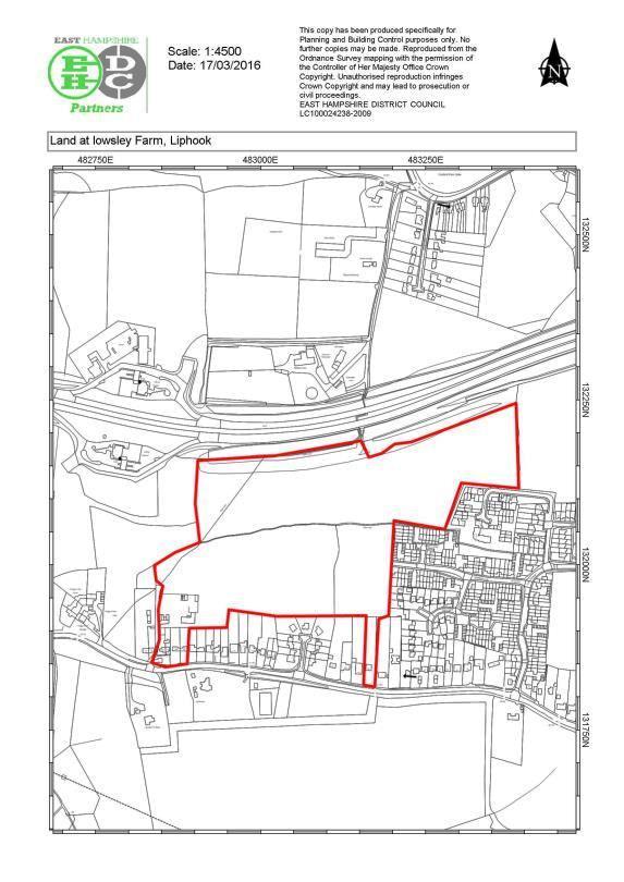
3 PROPOSAL LOCATION: Outline application for phase 1 of 155 dwellings (as per planning consent 34310/016 including approved access from Longmoor Road) and additional phases for a total of 175 dwellings with associated access, car parking, landscaping and public open space following demolition of five dwellings (330 dwellings in total) (Supplementary information received relating to: affordable housing statement, trees technical note and foul / surface water drainage) (Amended sketch layout received 17 March 2016) Land at Lowsley Farm, Lark Rise, Liphook REFERENCE 34310/029 PARISH: Bramshott/Liphook APPLICANT: Easterton Ltd CONSULTATION EXPIRY : 29 March 2016 APPLICATION EXPIRY : 08 April 2016 COUNCILLOR(S): Cllr A Glass, Cllr B Mouland, Cllr R Standish SUMMARY RECOMMENDATION: OUTLINE PERMISSION This application is included on the Agenda as a previous proposal for the development of this site was determined by the Planning Committee at its meeting of 26 January 2015, therefore it is considered appropriate for Members to consider this revised scheme. Site and Development Site The sites are located on the north-western edge of Liphook and comprise agricultural fields extending to hectares. Residential development on Longmoor Road, Yeomans Lane, Hurst Close, Lark Rise and The Avenue abut the site to the south. To the east, there is a further field parcel in the ownership of the applicant which has planning permission for an area of Suitable Alternative Natural Greenspace (SANG) associated with the proposed development, with residential development along Headley Road beyond. To the west, the site is bounded by woodland and the northern boundary is formed by the A3 corridor located behind a substantial acoustic bund and tree planting, which visually contain the site from the surrounding countryside. The road and its associated planting form a strong and robust edge to Liphook.
4 Outline permission is sought for the development of Phase 1 for 155 dwellings, as already consented, with a subsequent Phase 2 to provide 175 dwellings, giving a total of 330 dwellings. The land encompasses a part of the site which already has outline and reserved matters consent for residential development and additional land to the north of the consented residential area to the south of the A3, which was formerly permitted SANG land associated with Phase house scheme. Proposed Development This is an application for outline planning permission, with only approval of the means of access to be considered in detail at this stage. Layout, scale, appearance and landscaping are all reserved for future consideration through a reserved matters application, thus are only indicative at this time. The application is supported by an Indicative Masterplan which shows the access into the development to be from Longmoor Road and through the Phase 1 development as approved. Internal access roads would be provided to serve the Phase 2 development in the northwestern and north-eastern corner of the approved Phase 1 scheme. An emergency access adjacent to 98 Longmoor Road would be provided, as per the consented Phase 1 scheme, restricted to emergency and pedestrian / cycle access only. A further pedestrian / cycle access link would be provided through to Yeomans Lane, with several dwellings having individual accesses onto Lark Rise as frontage development. The dwellings would comprise a mixture of open market and affordable housing, including detached and semi-detached houses, terraced houses and flats offering 1, 2, 3, 4 and 5 bedroom homes. 40% of the dwellings would be provided as affordable housing, equating to a total of 132 dwellings. The Masterplan also shows the incorporation of the consented allotments along the western edge of the Phase 2 dwellings, with the retention of the bank and mature trees and hedgerow along boundary which separate the field parcels. Two SUDS drainage features would be provided within the southern section of the Phase 2 scheme, with a central band of open space running through the site, linking into linear open space feature in the consented scheme. An existing public footpath crossing the north-western corner of the site is indicated as being diverted around the allotments, linking into an open space corridor along the northern edge of the site, and thereon into the approved SANGS. The application has been submitted with the following supporting information: Design and Access Statement Planning Statement Air Quality Assessment (Stuart Michael Associates: January 2016) Affordable Housing Statement (Boyer: January 2016) Ecological Summary Report (HDA: February 2014) and Addendum (HDA: January 2016) Flood Risk Assessment (Stuart Michael Associates: January 2016)
5 Framework Residential Travel Plan (Stuart Michael Associates: January 2016) Landscape and Visual Impact Assessment (HDA: January 2016) Road Traffic Noise Assessment (Stuart Michael Associates: January 2016) Socio-Economic Report (Deloitte: February 2014) Statement of Community Involvement (Instinctif: February 2014) Sustainability Statement (Bluesky Unlimited: January 2016) Transport Assessment (Stuart Michael Associates: January 2016) Tree Survey Report and Arboricultural Implications Assessment (HDA: January 2016) Utilities Report (Stuart Michael Associates: January 2016) Supplementary information has been submitted to clarify issues relating to: affordable housing mix, potential tree impacts within the Square, and foul and surface water drainage details. An amended sketch layout plan has been submitted which revises the layout to reflect the affordable housing mix incorporating some smaller units agreed with the Council's Housing Officer. Relevant Planning History 34310/016 Outline - residential development of one hundred and fifty five dwellings with associated access, car parking, landscaping and public open space following demolition of five dwellings (access off Longmoor Road) /017 Change of use of land from agricultural to suitable alternative natural green space (SANGs) and allotments (access off Longmoor Road) /021 Change of use of land from agricultural to suitable alternative natural green space (SANGS) /022 Outline application - phase 1 of 155 dwellings and additional phases for a total of 175 dwellings with associated access, car parking and public open space following demolition of five dwellings (330 dwellings in total) /026 Reserved matters pursuant to outline application 34310/016 for residential development of 155 dwellings in relation to appearance, landscaping, layout and scale /027 Partial change of use of land from agriculture to allotments with store building, car park and temporary footpath Outline permission - 06/12/2012 Permission - 06/12/2012 Permission - 03/02/2015 Refused - 03/02/2015 Appeal Lodged Approved 24/11/2015 Approved 22/12/2015
6 34310/028 Reserved Matters dwellings with associated access, car parking, landscaping and public open space following demolition of 5 dwellings (access off Longmoor Road) - appearance, landscaping, layout and scale. Not yet determined Development Plan Policies and Proposals East Hampshire District Local Plan: Joint Core Strategy (2014) CP1 - Presumption in favour of sustainable development CP2 - Spatial Strategy CP10 - Spatial strategy for housing CP13 - Affordable housing on residential development sites CP16 - Protection and provision of social infrastructure CP18 - Provision of open space, sport and recreation and built facilities CP19 - Development in the countryside CP20 - Landscape CP21 - Biodiversity CP22 - Internationally designated sites CP24 - Sustainable construction CP25 - Flood Risk CP26 - Water resources/ water quality CP27 - Pollution CP28 - Green Infrastructure CP29 - Design CP30 - Historic Environment CP31 - Transport CP32 - Infrastructure East Hampshire District Local Plan: Second Review (2006) C6 - H14 - P7 - Tree Preservation Other Housing Outside Settlement Policy Boundaries Contaminated Land Planning Policy Constraints and Guidance National Planning Policy Framework (NPPF) The NPPF sets out three roles (economic, social and environmental) that should be performed by the planning system. The Framework states that pursuing sustainable development involves seeking positive improvements in the quality of the built, natural and historic environment, as well as in peoples quality of life, including (but not limited to):
7 making it easier for jobs to be created in cities, towns and villages moving from a net loss of bio-diversity to achieving net gains for nature replacing poor design with better design improving the conditions in which people live, work, travel and take leisure and widening the choice of high quality homes The following sections of the NPPF are considered to be particularly relevant to the assessment of the proposed development. Section 1: Building a strong, competitive economy. Section 4: Promoting sustainable transport. Section 6: Delivering a wide choice of high quality homes. Section 7: Requiring good design. Section 10: Meeting the challenge of climate change, flooding and coastal change. Section 11: Conserving and enhancing the natural environment. Section 12: Conserving and enhancing the historic environment. Consultations and Town/Parish Council comments EHDC Arboricultural Officer No objection in principle subject to the submission of a finalised Tree Removal/Retention Plan, Arboricultural Method Statement and Tree Protection Plan. Trees in The Square should be safeguarded from alterations to the highway EHDC Conservation Officer Comments that the existing trees in The Square should be safeguarded from alterations to the highway. EHDC Contaminated Land Officer No objection, subject to the imposition of conditions in the event planning permission is granted. EHDC Drainage Consultant Following the receipt of supplementary information to demonstrate a satisfactory surface water drainage system without increasing flood risk, the Drainage Consultant has no objection, subject to the imposition of conditions.. EHDC Housing Officer Supports the application in its current form, subject to securing affordable using through a legal agreement, which offers the applicant a degree of flexibility with regard to mix and tenure to respond to market forces and the requirements of the Registered Provider sector. EHDC Environmental Health (Pollution) The air quality modelling is accepted and should not result in a breach of air quality objectives. The EHO comments that the site is likely to be impacted from traffic noise from the A3 with some gardens in the north-west of the site predicted to marginally exceed the recommended guideline upper external daytime values. Conditions relating to noise mitigation and the agreement of a Construction Environmental Management Plan are requested to be attached to any permission.
8 EHDC Landscape Officer No objection following receipt of supplementary information. Standard landscape conditions are requested in the event of a recommendation for approval, which should allow for sufficient landscape screening of the acoustic bund and allow staggered access points through it. EHDC Refuse and Recycling No comments received. Environment Agency Do not wish to comment on this application. Hampshire Constabulary Crime Prevention Design Advisor No comments received. Hampshire Fire and Rescue Service Provide advice for fire access and arrangements to be taken into account in the design of the development, referencing the Building Regulations. Hampshire Primary Care Trust No comments received. HCC Archaeology Comments that there is potential for archaeological remains to be encountered, although there are unlikely to prove to be over riding. Therefore the County Archaeologist has raised no objection, subject to an archaeological condition(s) attached to any planning permission granted which secure the mitigation of the impact on archaeological remains. HCC Ecology Has no overriding concerns in relation to ecological matters and requests a single site wide ecological mitigation, compensation and enhancement strategy is secured through a condition. HCC Highways Raise no objection, subject to completion of a legal agreement to secure off-site highway works, a travel plan and financial contributions. HCC Lead Local Flood Authority - Confirm that the general principles for the disposal of surface water from the development are acceptable. HCC Rights of Way No comments received. HCC Schools Organisation Officer Requests a financial contribution towards the expansion of primary schools in Liphook to accommodate pupils from the development. Highways England Has no objection to the proposed development. Natural England Has an objection to the development, pending sight of the draft legal agreement, to ensure that the SANG will have sufficient security and funds to be delivered in perpetuity. RSPB Object to the proposal on the grounds that the proposed SANG provision is not of sufficient quality to mitigate the impact on the Wealden Heaths Phase 2 SPA.
9 Scottish and Southern Energy No comments received. South Downs National Park Authority No comments received. Southern Gas Networks Advise that there is a gas main near the site and provide advice on procedures to be undertaken when working close to the main. Sport England Object to the development, pending inclusion of a financial contribution towards formal sports provision within the legal agreement. Thames Water No objection, subject to the imposition of a condition to agree a drainage strategy for the site. Bramshott and Liphook Parish Council The Parish Council continue to have objections to this proposal, these particularly relate to public concerns about traffic build up along the Longmoor Road, the use of The Avenue as a 'rat-run' to the Headley Road and the lack of any consideration for an access route from the proposed development through to the Headley Road along the northern boundary of the Phase II development site. We particularly note that traffic movement along the Avenue was not recorded and therefore not taken into consideration within the transport report. These concerns also take in the wider development proposals at Whitehill and Bordon where a considerable increase in traffic into Liphook is anticipated along the Headley Road. We note the funding available as contributions to transport infrastructure in Liphook and where this may not be sufficient for an access route at this time it nevertheless seems prudent to make allowance for a separate route for the future. In relation to this we consider the housing density too high and object to housing being proposed close to the A3 boundary where noise and air pollution are of concern and limit the possibility of an access route. We fully support the obligation for the applicant (and any other developer of the site) to liaise with Bohunt School to formulate a practical united travel plan. We note that there is now no proposal to make any changes to the layout of The Square. We trust that this will not change and would like to emphasise that this Council would strongly object to alterations to any of the junctions. We remain concerned that there is no suitable vehicular access to the proposed SANG for the wider community. Visitors are realistically anticipated to arrive in cars and will either park on the development itself or park along The Avenue. There are very limited footpaths along the Headley Road and no direct access by public footpath on to the SANG. We continue to object to lack of parking spaces for visitors to the SANG. Although approval has been given for the allotments as a community benefit we continue to stress our concerns about the suitability of this area. There are other community needs highlighted in the Parish Plan and should the allotments not be viable we would recommend that the applicant is obligated to provide alternative community facilities.
10 Representations The letters of representation which have been received from third parties, including the Bramshott and Liphook Preservation Society and Liphook in Bloom, object to the development for the following reasons, which are summarised below: a) Proposed road layout changes would have an adverse impact on the character of the Square and the Conservation Area. b) Increase in traffic generation (including HGV s) and congestion in Liphook, contrary to highway safety. c) Longmoor Road is the only point of access. d) There should be a bypass / link road for Liphook, e) Outside the defined settlement policy boundary. f) Overdevelopment of the village and impact on capacity of local services and infrastructure. g) Lack of provision for new amenities for Liphook. h) Adequate provision should be made for attenuation of surface water runoff. i) Adequate provision should be made for foul drainage. j) Adverse impact on air quality. k) Impact on future residents from noise from the A3. l) Loss of privacy to neighbouring properties. m) Adverse impact on wildlife. n) Impact on South Downs National Park. o) Only native species should be planted in the landscaping scheme. p) Affordable housing should provide a mix of homes for rent and shared ownership. q) Lack of a S.106 agreement to secure financial contributions, SANG provision and management of open spaces and SUDS. r) No employment opportunities provided. s) Difficult to appreciate the changes from application that was refused, now at appeal. Determining Issues 1. Development Plan and material considerations 2. Principle of development. 3. Highway Impact 4. Impact on Air Quality 5. Financial Contributions 6. Other Material Considerations
11 Planning Considerations 1. Development Plan and material considerations Key material considerations to be taken into account in the determination of this application relate to the decision taken by the Planning Committee on 26 January 2015 to refuse planning permission for a similar development made under reference 34310/022 and whether there are any material change in circumstances since that decision was taken, in particular in relation to the progression of the development plan. Planning application 34310/022 was refused permission for the following 5 reasons, which for ease of reference are set out in full below; 1.The existing Longmoor Road /Headley Road / London Road roundabout junction within the centre of Liphook is already congested across all arms during peak periods. The Transport Assessment (as amended) submitted with the application indicates that in 2016 the additional traffic generated from the development would add a further overall circa. 1.7% traffic movements to a junction already operating at or close to capacity. No satisfactory mitigation proposals have been identified, having due regard to the location of the roundabout junctions within a Conservation Area and the impact on its character and appearance from physical changes to its environment, as well as the perceived safety risks to pedestrians from an introduction of a more shared surface environment and an increase in traffic at peak times. The likely increase in congestion at this junction will not ensure the continued safe and efficient operation of the local road networks, contrary to Policy CP31 (k) of the Joint Core Strategy The additional impact on an already congested junction is considered to be severe, contrary to paragraph 32 of the NPPF. 2. Given the proximity of the site to the A3, due regard needs to be had to its associated pollution and the effect on local air quality levels. Insufficient information has been received to be able to determine that the level of air quality for future occupiers of the site will be sufficient so as not to prejudice their health, safety and amenity. Furthermore insufficient information has also been received to be able to be certain that the amenity of existing residents of Liphook will be safeguarded having due regard to air quality levels during the construction of a significant major development of 330 dwellings. The application is therefore contrary to Policy CP27 of the Joint Core Strategy. 3. For the above reasons the application represents unjustified and unsustainable development outside the defined settlement boundary where there is a general restraint against development in order to protect the countryside for its own sake. The application is therefore contrary to Policies CP1, CP2, CP10, and CP19 of the Joint Core Strategy, and saved Policy H14 of the Local Plan 2nd Review.
12 4. No provision has been made for a financial contribution to be made towards education facilities within the parishes of Bramshott & Liphook where there is a recognised shortage of school spaces contrary to Policy CP32 of the Joint Core Strategy, the Interim Housing Policy Statement 2014 and the Council's 'Guide to Developers' Contributions and Other Requirements'. 5. In the absence of a Section 106 legal agreement or unilateral undertaking covering; a contribution of 783,835 towards primary school provision (in addition to that already secured with the 155 dwellings already approved); a contribution towards sport pitch provision, community improvements and community project worker; transport contribution to cover the costs and production and implementation of a Travel Plan; the provision of 40% affordable housing and the securing of an appropriate tenure mix and affordability in perpetuity; the provision of a SANG in a phased manner (phasing to be agreed before implementation), before first occupation, and its management arrangements in perpetuity; and the management and maintenance of any other public open space on site, including the surface water drainage system. The development is considered to be contrary to Policies CP13, CP18 and CP32 of the Joint Core Strategy and the Council's 'Guide to Developers' Contributions and Other Requirements. The application has been accompanied by supplementary information, in particular with reference to transportation issues, which seek to address the above reasons for refusal, in addition to consideration of the proposal against the updated position of the development plan. 2. Principle of Development Section 38(6) of the Planning and Compulsory Purchase Act 2004 requires that planning applications must be determined in accordance with the development plan unless other material considerations indicate otherwise. This requirement is reinforced by paragraph 2 of the NPPF. For East Hampshire, the development plan comprises the East Hampshire District Local Plan: Joint Core Strategy (2014) (JCS) and the saved policies of the East Hampshire District Local Plan: Second Review (2006). The Proposals Map forming part of the East Hampshire District Local Plan: Second Review identifies the site as falling outside the Settlement Policy Boundary (SPB) for Liphook. These SPBs have been carried forward into the JCS under saved Policy H14 until their boundaries are formally reviewed through the Local Plan Part 3: Development Management and Other Allocations. As such the site is identified as falling within an area where the Countryside policies of the Plan apply.
13 In terms of the Phase 1 site, this land formed a reserve allocation under Policy HAR12 for 155 dwellings. Outline planning permission (34310/016) was granted for 155 dwellings on this site on 6 December 2012 and all the remaining reserved matters have been approved under 34310/026 in November Thus the principle of residential development on the Phase 1 site has been established through the grant of these permissions. The Phase 1 development could thus proceed, subject to discharge of conditions and S.106 requirements. Policy LP1 of the East Hampshire District Local Plan: Housing and Employment Allocations (Allocations Plan), as modified, allocates the Phase 2 land (10.8ha) for about 175 dwellings. The Examiner s Report into the Allocations Plan was received on 15 February 2016 and recommends that, with the recommended main modifications, the Allocations Plan meets the criteria for soundness in the National Planning Policy Framework. In relation to Liphook, the Examiner concludes that the Lowsley Farm site is the only allocation in Liphook, but it is a sound choice, meets the JCS requirement and is deliverable. It is a natural extension of an existing development site and indeed access would be gained from the adjacent site. It is possible to walk into the centre of the village and there is good access to the A3 and the strategic road network. Although there has been a recent refusal of planning permission for the site, the issues are capable of resolution through the provision of traffic management measures in the village. These are covered by the criteria to the allocation as modified, one of which is to ensure that any negative traffic impact is mitigated on the local road network including Longmoor Road. The Allocations Plan will now been taken to the meeting of the Council on 7 April 2016 with a recommendation that it is adopted. The Allocations Plan has thus reached an advanced stage in its preparation, therefore, very significant weight can be attached to the allocation of this site for about 175 dwellings under Policy LP1. For these reasons the principle of residential development on this site is accepted and the progression of the Allocations Plan has overcome Reason No.3 in the reasons for refusal of application 34310/ Highway Impact Policy LP1 of the Local Plan Part 2: Allocations (as modified), requires; vehicular access to the site from Longmoor Road via Lowsley Farm Phase 1, ensure any significant negative traffic impact is mitigated on the local road network including Longmoor Road.
14 The site is shown to be served via a new vehicular access onto Longmoor Road as a roundabout, with a further emergency access and footway / cycleway adjacent to 98 Longmoor Road. The full details of these accesses have been approved under outline permission 34310/016, with details of the internal road layout and parking arrangements for Phase 1 approved under reserved matters permission 34310/026. The Local Highway Authority has confirmed that this access is suitable to cater for trips generated by the development and would operate well within its theoretical capacity. Details of the internal road / footpath layout for Phase 2 would be considered under a future reserved matters application. Outline application 34310/022 (for both Phases 1 and 2) was refused permission on the basis that the additional traffic generated from the development would add further traffic movements to the roundabout junctions within the centre of Liphook which were already considered to be operating at or close to capacity. This capacity issue was linked to concerns that the resulting alterations to the junctions would adversely impact on the character and appearance of Liphook Conservation Area. Since the consideration of the previous outline planning application, the Council has granted planning permission for a new 6 th form building at Bohunt School. The school application was supported by updated traffic assessments and a package of travel demand management measures through a travel plan are currently been worked up in conjunction with the Local Highway Authority. The applicant proposes to liaise with the Bohunt School and Highway Authority to coordinate a package of measures designed to reduce the number and length of car trips generated by the residential development. It is noted that this approach is supported by the Parish Council. Accessibility The site is located close to several retail outlets, local amenities, a primary school and a secondary school. There is a continuous footway provision to Liphook village centre and the local primary and secondary schools, with new pedestrian and cycle links proposed onto Lark Rise and Yeomans Lane. The Local Highway Authority has commented that whilst the village lies within an acceptable cycling distance, cycle facilities in Liphook are relatively limited. The village centre is also difficult for cyclists to negotiate and there are no specific cycle routes avoiding these roads. An improvement scheme has been identified between Haslemere to Liss which includes a shared use route along Longmoor Road, which would directly serve the proposed development. The Highway Authority has therefore advised that it would be appropriate for a contribution to be secured, to enable this element of the scheme to be implemented. Local bus service provision is poor with the circular 250 currently serving the site, which currently operates three times per week and for mornings only. Additional services are available from the village centre which is 1km from the site. In order to ensure that the site is accessible by all modes it is also considered necessary for a contribution to be secured towards improving bus service provision in the vicinity of the site.
15 Liphook Rail Station is 1.9km from the site. The station is on the Portsmouth to Waterloo Line with hourly services available. Access at the rail station is currently limited with no provision for level access to the southbound platform. Scope for accessibility improvements to the station are under consideration by the County Council, in order ensure connectivity between the site and rail provision. Personal Injury Accidents The Transport Assessment includes accident data for the past five year period. This reveals there have been five reported accidents during this period, four of which were slight and one serious accident. The Local Highway Authority has advised that the data does not suggest any particular trends which could be exacerbated by the development proposal. Traffic Generation and Highway Capacity Trip generation has been derived from the agreed trip rates associated with the permitted Phase 1 development combined with forecast vehicular trips associated with the 175 additional dwellings associated with the Phase 2 development. This forecasts that vehicular trips for the entire site would be 166 in the AM peak and 197 in the evening peak period. It is predicted that 51% of vehicle trips would access the A3 via Longmoor Road and 25% via London Road. 24% of vehicle trips are predicted to use Haslemere Road. The above figures have been used to model the operation of the Longmoor Road/Headley Road/Portsmouth Road/London Road and Portsmouth Road (N)/Haslemere Road/Portsmouth Road (S) junctions as at 2021 with existing, committed and the proposed development. Portsmouth Road (N)/Haslemere Road/Portsmouth Road (S) roundabout The junction modelling reveals that this junction is currently operating at operational capacity during the AM peak period and close to capacity during the PM peak period, with a maximum queue of 7 vehicles. Review of the operational assessment with the addition of committed development in Liphook forecasts that the performance of the junction would deteriorate during both peak periods, with Portsmouth Road (S) predict to experience the most significant queuing during the AM peak period, with a forecast queue of 19 vehicles. The addition of trips at this junction related to the Phase 2 development shows a further increase in queuing at this junction, as summarised below:
16 Arm AM Peak PM Peak RFC Max. Queue (vehicles) RFC Max. Queue (vehicles) Haslemere Road Portsmouth Road (S) Portsmouth Road (N) This confirms that whilst the development is demonstrated to have an impact at this junction, the increase in forecast queuing as a result of the proposal above the committed development is 1-2 vehicles on each arm. The Local Highway Authority has advised that this is not considered severe in the context of the National Planning Policy Framework. Longmoor Road/Headley Road/Portsmouth Road/London Road roundabout Assessment of existing conditions at this roundabout demonstrates that the junction is currently operating above theoretical capacity during the AM peak period on the London Road, Longmoor Road and Headley Road arm and at capacity on the London Road arm during the PM peak period, with a maximum queue of 11 vehicles on the Headley Road arm in the AM peak. Assessment of the 2021 scenario with committed development reveals that the operation of the junction will deteriorate in future years, such that the London Road arm of the junction will be operating above theoretical capacity during the PM peak period and all arms will be operating above theoretical capacity during the AM peak period, as set out below: Arm AM Peak PM Peak RFC Max. Queue (vehicles) RFC Max. Queue (vehicles) London Road Portsmouth Road Longmoor Road Headley Road Inclusion of the proposed traffic for Phase 2 forecasts the operation of the junction to deteriorate further, particularly on Longmoor Road where the maximum queue is forecast to increase from 36 to 53 vehicles in the AM Peak and from 13 to 20 vehicles in the PM peak period. This is set out in the table below:
17 Arm AM Peak PM Peak RFC Max. Queue (vehicles) RFC Max. Queue (vehicles) London Road Portsmouth Road Longmoor Road Headley Road It should also be noted that the latter scenarios above include the proposed sixth form at Bohunt Secondary School, with the School looking to introduce a scheme of staggered arrivals and departures, along with the implementation of a travel plan. These measures would off-set the impact of school traffic upon this junction from the above figures. Alterations to the road layout in The Square In order to offset the traffic impact, the Applicant has explored 3 potential mitigation schemes at this junction. Option 1 shown in Drawing , comprises the scheme as previously proposed under outline application 34310/022, which shows alterations to the Longmoor Road/Headley Road/London Road roundabout. At the time of considering the previous application it was considered that the resultant white lining, widening of roads and potential damage to/removal of trees and planters would harm the setting of the Conservation Area. This scheme has been included within the application solely to demonstrate a technical solution to improve traffic flows at the roundabouts, although has been discounted as an over-engineered solution resulting in adverse environmental impacts. In response, two further schemes have been explored which show reduced levels of alterations to the road layout to allow the retention of all existing landscaping and trees. Option 2 shown in Drawing A, shows a more informal junction arrangement with enhanced pedestrian crossing facilities on all arms and surface treatments that provide for a visual reduction in scale of the junction to minimise vehicle speeds and better channel vehicles through the junction. The scheme shows the removal of formal road markings, in order to signals to drivers that they are passing through a sensitive village centre environment and that pedestrians have a greater level of priority than they would in a conventional road environment. The applicant advises that the junction modifications is unlikely to have any significant impact in terms of capacity, it would improve pedestrian accessibility around the village centre. Option 3 (Drawing A), shows an alternative hybrid layout which retains some elements of conventional road markings but retains the enhanced pedestrian crossing facilities on each arm and some of the surface treatments.
18 The Highway Authority has commented that they are satisfied that a scheme which focuses on environmental enhancements and the introduction of high quality materials in order to enhance conditions in this vicinity for pedestrians and encourage greater interaction between highway users is the preferred approach to mitigating the impact upon the roundabouts in the village centre. It is highlighted to Members that the two options submitted are indicative of how mitigation may be achieved. The Local Highway Authority has confirmed that it is currently undertaking study work (see below) which will explore additional options for an improvement scheme forward and this would enable the local community an opportunity to influence the improvement scheme via consultation. This work could be secured through a financial contribution. Liphook Study Work The County Council has recently commissioned a feasibility study to consider the cumulative impacts of developments across the village. The study is tasked with suggesting improvements to improve traffic management and identifying suitable interventions and mitigation measures. This will build upon the work already undertaken to support the proposed development. The Highway Authority thus consider that it is necessary for a financial contribution to be utilised in the implementation of the options identified in this study work. It is anticipated that this work will be concluded during Spring Travel Plan A Travel Plan has been submitted in support of the application, which has been reviewed by the Local Highway Authority, who advise that in order for it to be approved, it will be necessary for the proposed funded measures to be included in the Action Plan (including estimation for the cost of the Travel Plan co-ordinator). This is so that the amount can be set out in the Section 106 Legal Agreement and bonded against the targets when finalised. The Transport Assessment also confirms that the travel plan will compliment the travel plan for Bohunt Secondary School, and this commitment should also be secured by way of Section 106 Agreement. In addition, the Local Highway Authority is seeking assessment and monitoring fees of 16,500 to be secured by way of a Section 106 Agreement. Financial Contribution In order to mitigate the impact of the proposed development it will be necessary for a financial contribution to be secured via Section 106 Agreement. The Transport Assessment advises a contribution of 1,302,929, which the Local Highway Authority considers is fair and reasonable in relation to the development proposal. This contribution would be utilised to help deliver the following local highway improvements, without which the development would have a significant and unacceptable impact on the local transport network; Accessibility scheme at Liphook railway station. Improved bus service provision to serve the site.
19 Environmental enhancements in The Square or alternative mitigation scheme in the village centre identified in the Liphook feasibility study. Cycle infrastructure provision between Haslemere and Liss. Travel planning measures to support the development proposal and Bohunt Secondary School and sixth form travel plan Highway Conclusions The Local Highway Authority raises no objection to the proposed development, subject to the applicant entering into a Section 106 Obligations to secure the following items; Entering into a Section 278 Agreement in order to implement the proposed access roundabout and post consultation traffic calming scheme on Longmoor Road, as shown indicatively on drawing , and to implement works prior to occupation. A revised Travel Plan to include costed measures in accordance with the HCC Developer related travel plan guidance and synergies with the Bohunt Secondary School and Sixth Form Travel Plan, prior to commencement of the development. Payment of the County Council s Travel Plan assessment and monitoring fees of 16,500, prior to commencement of the development. Provision of a bond or other form of financial surety in respect of the measures within the Travel Plan. A Transport contribution of 1,302,929 to fund the local highway improvements set out above, to be paid prior to commencement. For these reasons the proposal is considered to be in accordance with Policy CP31 of the JCS and Policy LP1 of the Local Plan: Allocations, and that the first reason for the refusal of 34310/022 has been satisfactorily addressed. 4. Air Quality The previous application was refused on the basis that insufficient information was supplied in support of the application to be able to determine that the level of air quality for future occupiers of the site and existing residents would be sufficient so as not to prejudice their health, safety and amenity. The application is supported by an Air Quality Assessment (Stuart Michael Associates: January 2016) which concludes that during the construction phase, the proposal would result in residual effects from dust from earthworks, which would be for a limited period and not considered to be significant. It also concludes that the air quality impacts from altered traffic flows to sensitive receptors would be negligible and not exceed NO 2 and PM 10 NAQO levels in The Council s Environmental Health Officer is satisfied that the Air Quality Assessment is satisfactory and this development should not result in a breach of air quality objectives. In the event of a recommendation for approval a condition relating to the agreement of a Construction Environmental Management Plan is suggested.
20 The application is, therefore, in accordance with Policy CP27 of the Joint Core Strategy and it is advised that the second of the previous reasons for refusal has been satisfactorily addressed. 5. Financial Contributions and Legal Agreement Reason 4 of the previous reasons for refusal related to the lack of a financial contribution towards improvements to local education facilities. The Local Education Authority has requested a financial contribution towards the cost of the expansion of primary school places in Liphook. The total sum requested for the whole development is to 1,706,524, which can be split as 801,549 for the 155 dwellings on Phase 1 and 904,975 for the 175 dwellings on Phase 2. These figures are based on the full number of dwellings being proposed, which would be reduced by 5,171 per dwelling, should the total number not be reached within the reserved matters application(s). The applicant has agreed to this principle, which would need to be secured within a legal agreement made under Section 106 of the Town and Country Planning Act Subject to the completion of a legal agreement, then this previous reason for refusal has been satisfactorily addressed. In terms of a contribution towards public open space, the application makes provision for natural and informal green space in the SANG (approved under permission 34310/021). Associated landscaped buffers, equipped play areas would need to be provided on-site as part of a reserved matters application, in addition allotments have been approved in the western section of Phase 2. Therefore, the provision of formal sports and recreation facilities is the only area were the application does not make any on site provision. A contribution will thus be sought to this item based on the following schedule contained within the Guide to Developers Contributions, the final sum would thus need to be agreed at reserved matters stage once the final mix of dwellings sizes has been established. As a rough indication, based on a median value of 433, the total contribution would be in the region of 142,890, split between Phase 1 ( 67,115) and Phase 2 ( 75,775) although it is stressed this is a very approximate figure, with final sum determined based on the approved mix of dwellings. 1 bed 2 bed 3 bed 4 bed 5+beds The District Council, in liaison with the Parish Council, has identified the following schemes that this contribution could be used towards; the purchase of at least 7.38 hectares of land for sports pitch provision in accordance with the Bramshott and Liphook Parish Plan. This project has been costed at 185,000 and this would be the first contribution secured towards the project as far as pooling is concerned
21 It is noted that Sport England object to the proposal on grounds that no information has been provided to demonstrate how sporting needs arising from the development will be meet, pending sight of the heads of terms for a legal agreement. From the above, the financial contribution above would meet the Council's adopted Guidance towards the off-site provision of formal sports facilities, through a specific costed project and thus meets with the Council's and CIL requirements. Likewise, the application does not make any on site provision towards community facilities, thus a financial contribution is sought towards off site provision based on the following schedule. Again, as a rough indication only, based on a median value of 1,500, the total contribution would be in the region of 495,000, split between Phase 1 ( 232,500) and Phase 2 ( 262,500). 1 bed 2 bed 3 bed 4 bed 5+beds The District Council, in liaison with the Parish Council, has identified the following schemes that this contribution could be used towards; a new sports pavilion, car park and access road along with all other required infrastructure and facilities; a new brick built toilet block with secure male, female and disabled facilities at the War Memorial Recreation Ground. equipment for Liphook in Bloom The first two schemes are in accordance with the Bramshott and Liphook Parish Plan. The sports pavilion project has been costed at 550,000 and the toilet block at 45,000. The contribution to Liphook in Bloom would provide essential equipment for undertaking these community improvements, which have been costed at 2,000. These would be the first contributions secured towards these projects as far as pooling is concerned A contribution of 250 per dwelling will be sought towards a Community Project Worker, since the development is over the 60 unit threshold given in the Guide. From section 3 above, the Local Highway Authority is seeking a contribution of 1,3012,929 towards local highway improvements and also 16,500 towards the production and implementation of a Travel Plan. Due to the complexity of the legal agreement and need for a significant amount of Officer time required to monitor the clauses, a 5% monitoring and administration fee is sought, capped at 10,000. In addition, to the financial contributions outlined above, the S.106 legal agreement will also need to secure the following items; the provision of 40% affordable housing and the securing of an appropriate tenure mix and affordability in perpetuity;
22 the provision of the approved SANG in a phased manner (phasing to be agreed before implementation), before first occupation, and its management arrangements in perpetuity; Provision of the approved allotments (Ref: 34310/027) prior to first occupation and their management arrangements in perpetuity; the management and maintenance of any other public open space on site, including the surface water drainage system; a Section 278 Agreement in order to implement the proposed access roundabout and post consultation traffic calming scheme on Longmoor Road, a revised Travel Plan to include costed measures, synergies with the Bohunt Secondary School and Sixth Form Travel Plan, and a bond to secure such measures; and a local employment and training clause. The preparation of a legal agreement to cover the above items is well advanced, and the granting of any permission would be subject to its satisfactory completion. Members should be aware that this agreement will need to be completed by 7 April 2016 at the very latest, otherwise the development will become CIL liable and be considered under these regulations as opposed to the S.106 regime. Other Material Considerations The previous application was refused for the reasons discussed above, therefore unless there is any material chance in circumstances since the previous determination in February 2015 (such as policy change or material change to the site and is surroundings) it would be unreasonable for the Local Planning Authority to introduce new reasons for refusal at this stage. As discussed above, the only planning policy change is the progression of the Part 2 Allocations Local Plan to a more advanced stage, with the site allocated within this plan. Thus the policy position has strengthened in favour of the principle of this development. The only significant change in local circumstances has been the approval of the 6 th Form building at Bohunt School, and the impact of cumulative traffic movements associated with the school has been assessed as part of the highway considerations above. Other issues are summarised as follows: Affordable Housing The application proposes the on site provision of affordable housing at 40% of the total number of dwellings, which would comply with the requirements of Policy CP13 of the JCS. The affordable housing mix is proposed as 34 one beds, 69 two beds, 21 three beds and 8 four bed properties across both the phases.
23 The Council s Housing Officer has advised the affordable housing mix for Phase 1 should remain as secured under the existing S.106 agreement, with a tenure split of 60% rent to 40% intermediate. The proposed affordable housing mix for Phase 2 shown in the supplementary Affordable Housing Statement proposes the following tenure split and mix of units, based on a 50 / 50 split between affordable rent and intermediate tenure. This mix is proposed following discussions with local Registered Providers since they would prefer a 50:50 tenure split following the 1% reduction in affordable rent introduced by the Government in July The Council s Housing Officer has confirmed that this provision is acceptable, with final details to be secured within the S.106 legal agreement. The sketch layout has been amended to reflect this revised mix of dwellings. Affordable Rent 50% PHASE 2 Intermediate 50% 1 bedroom flat 20 2 bedroom house 27 2 bedroom house 11 3 bedroom house 8 3 bedroom house 4 Total Design and Landscape The application is in outline format, with details relating to layout, external appearance, scale and landscaping reserved for future consideration. An Illustrative Masterplan has been submitted in support of the application which satisfactorily demonstrates that the site could be developed at a density, design and scale appropriate to its context, taking into account local topography and the constraints and opportunities of the site, subject to detailed considered at Reserved Matters stage. The Council s Landscape Officer has highlighted on the layout shown in the illustrative Masterplan, that some plots are positioned too close to the site boundary to afford sufficient space for screen planting and that several properties would be positioned too close to allotments. It is advised that since layout does not form a detailed matter for consideration as part of this application, then these issues are capable of being fully addressed at reserved matters stage. The Council s Landscape Officer also highlights the potential noise mitigation impact upon site layout and landscape, in particular the impact of the noise mitigation barrier and also the impact of road noise on layout. As advised below, the Council s Environmental Health Officer has raised no objection to the proposal in terms of noise impact, which is considered to be capable of mitigation. To allow access for pedestrians through the acoustic fence, the applicant has confirmed that a staggered pedestrian access would be provided at the point where the existing public right of way meets the A3. Details of this staggered entrance would be secured as part of the suggested condition requiring agreement of noise mitigation measures.
24 Since landscaping is a matter for detailed consideration through a future reserved matters application, it is not appropriate to include landscaping conditions on the outline permission, as these would be addressed at the appropriate stage. The development, therefore, accords with Policies CP20 (Landscape) and CP29 (design) of the Joint Core Strategy. Ecology The application is supported by an Ecological Summary report (HAD: February 2014) and various appendices (covering surveys for badger, bats, hazel dormouse, breeding birds and reptiles). Although not provided with this application, an ecological technical note (HDA, 9th October 2015) has been undertaken which looked at issues with dormice in relation to the approved allotments. The County Ecologist has confirmed that the level of information provided is suitable and the ecological constraints and opportunities at the site are well-understood and that there is ample SANG provision. As such the County Ecologist has no overriding concerns in relation to ecological matters and requests that a single site-wide ecological mitigation, compensation and enhancement strategy is provided, if the Local Planning Authority is minded to grant planning permission. The purpose of this document will be to contain, in one readily accessible place, all information pertaining to ecological issues for use in guiding the development going forward. The document should be coherent with any site-wide landscape strategy. Natural England has raised an objection to the development, pending inclusion with the legal agreement of an appropriate clause to ensure that the SANG will have sufficient security and funds to be delivered in perpetuity. The legal agreement to accompany this application is currently being prepared and will include a clause to secure the provision and on-going management and maintenance of the SANG. Natural England has advised that they will remove their objection following agreement of the S.106 document. Subject to the above condition, and completion of the legal agreement, the application is considered to accord with policy CP21 of the JCS and the requirements of the NPPF in this regard.
25 Drainage The Indicative Masterplan is supplemented by a Flood Risk Assessment (FRA) and a surface water drainage strategy. The FRA sets out a strategy on which future detailed designs would be based. The detail, including checks to procedures to be implemented for the various components relating to flood risk, are a matter to be reserved for detailed submission and, therefore, it is the strategy under consideration at this stage. Given the impermeable nature of the application site, a surface-water sustainable drainage solution has been designed to achieve the disposal of attenuated discharges to the ditch located along the southern boundary of the site. This includes a series of attenuation Sustainable Urban Drainage System (SUDs) features to be positioned on the adjoining SANG site. These include swales, retention basins, ponds and wetland habitats. In terms of surface water drainage the Council s Drainage Consultant has commented that the site is located in Flood Zone 1 (low probability of flooding). He has indicated that he is not aware of any historic flooding affecting the site and a generally satisfactory FRA has been submitted, although lacks some detail. Supplementary information has been supplied in relation to a: Foul Water Impact Study, a risk assessment for the design of the SUDS, and surface water flows. From the supplementary information the Drainage Consultant has confirmed that his previous concerns have been satisfied. It is highlighted that the applicant needs to provide a satisfactory maintenance management plan for all drainage features remaining private, secured through the legal agreement. In addition, the risk assessment indicates a medium residual risk to residents/public from the attenuation basins, thus appropriate warning notices and fencing would need to be provided, which could be secured through a condition. Hampshire County Council, as Lead Local Flood Authority has confirmed that the general principles for the disposal of surface water are acceptable, subject to further consideration of the proposals at detailed design stage. In terms of foul water drainage, Thames Water has confirmed there is inadequate capacity within the local network to provide foul sewerage disposal to service the development. Additional on-site sewers, or improvements to existing sewers would be required to provide sufficient capacity to service the development. Section 98 of the Water Industry Act 1991 provides a legal mechanism through which the appropriate infrastructure can be requisitioned (by the developer) and provided to drain to a specific location. Thames Water has raised no objection to the amended proposal, subject to a Grampian condition requiring the developer to provide details of the means of foul sewerage disposal to be submitted to and approved, in writing, prior to the commencement of development. The Environment Agency has confirmed that it does not wish to comment on this application. As such, the proposal is considered to be in accordance with the aims of Policy CP25 of the JCS.
26 Archaeology The County Archaeologist has advised that there is an archaeological potential associated with this area for archaeological remains to be encountered which are as yet unrecorded. However, it considered to be unlikely that any archaeological remains will prove to be overriding issues. On this basis the County Archaeologist has advised that mitigation of any archaeological issues could be secured by an archaeological condition, including an episode of archaeological survey and any mitigation excavation that arises from that survey. Noise The application has been supported by a Road Traffic Noise Assessment to consider the potential constraints on the development from the noise from traffic using the A3 to the north of the site. The Council s Environmental Health Officer (Pollution) has confirmed that he is in agreement with the conclusions and recommended mitigation in the noise report. The mitigation includes the provision of a 2.5 metre high acoustic barrier at the northern boundary of the site. The Environmental Health Officer highlights that the north-western area of the site, probably the gardens of plots 201-3, and a small part of the north-eastern area, is predicted to marginally exceed the recommended upper external daytime limit of 55 db LAeq,16hrs. BS8233: 2014, which also recognises that guideline values might not be achievable in all circumstances where development might be desirable. If it is decided that this development should proceed, with the current layout, it should be recognised that at least one private garden is predicted to partially exceed the guideline noise value for outdoor amenity space. For this reason the Environmental Health Officer has requested that a condition is imposed requiring the agreement of a scheme for protecting the proposed dwellings from traffic noise from the A3. Contaminated Land The Council s Contaminated Land Officer has raised no objection to the proposal, subject to the imposition of planning conditions address outstanding contaminated land issues for this application. Response to Parish/Town Council Comments The Parish Council s main concern to this development relates to traffic impacts of the development on the local highway network. These have been considered in detail in Section 3 of this report above. The Parish Council also consider the housing density too high. The housing density for Phase 1 (as approved under reserved matters) is 31 dwellings per hectare, with the density for Phase 2 shown in the Masterplan at the slightly lower density of 28 dwellings per hectare. This density is in accordance with the numbers of dwellings set out in the Allocations Local Plan.
27 In addition, the Parish Council object to housing being proposed close to the A3 boundary where noise and air pollution are of concern and limit the possibility of an access route. It is noted that the Council s Environmental Health Officer (Pollution) has raised no objection to the development under either of these considerations. Concern is also expressed that there is no parking area for the SANG and no direct access to the SANG from public footpaths. Members should note that the SANG was granted planning permission (34310/02) with planting details approved under application reference 34310/026. The SANG is proposed to mitigate the impacts of the development on the nearby Special Protection Areas to provide an alternative area of informal recreation where residents can for example go to walk dogs. The SANG would be accessible by footpaths from within the development, which is crossed by a public footpath and also from the north of Lark Rise. Finally the Parish Council express concern about the suitability of the allotments. 1,500sq.m of allotments have been approved (reference 34310/027) on 22 December 2015, in a location on the western side of Phase 2. The concerns of the Parish Council were taken into consideration during the planning application process for that development. If the Parish Council does not wish to take over management of the allotments, then this would be taken on by the management company as part of the overall management of the open spaces of the development. Conclusion An outline application (34310/022) for a similar development was refused by the Council s Planning Committee on 26 January Since that date the East Hampshire District Local Plan: Housing and Employment Allocations has reached a very advanced stage, with the site forming a housing allocation within that Plan. As such the principle for the development is established. As set out in the report above, previous reasons for the refusal of planning permission relating to highway impact, air quality issues and financial contributions have also been satisfactorily addressed. In addition, no other material change in circumstances have been identified since that decision was taken. Therefore, for the reasons set out in this report, and summarised above, it is concluded that the benefits of the housing provision proposed, taking into account the development plan and the policies of the NPPF as a whole, clearly outweigh any detrimental social and environmental impacts on the settlement of Liphook. The application constitutes sustainable development and the principle of development can be accepted.
28 RECOMMENDATION That the Solicitor to the Council be authorised to draw up a Section 106 Agreement and provided that by 7 April 2016 all parties enter into the Section 106 Agreement with the District Council to secure financial contributions towards local highway improvements, travel plan, education, community facilities, public open space and a community project worker, as well as clauses to secure provision of; affordable housing, SANG, allotments, open space management, off-site highway works and a local employment training plan, in accordance with Policies CP16, CP18, CP31 and CP32 of the Joint Core Strategy then the Head of Planning be authorised to grant OUTLINE PERMISSION, subject to the following conditions: If the agreement is not completed within this timescale then the application shall be referred back to Committee for determination, unless the Head of Planning, in consultation with the Portfolio Holder for Planning, authorises further time extension(s) for the completion of the legal agreement. 1 Applications for the approval of the matters referred to herein shall be made within a period of THREE years from the date of this permission. The development to which the permission relates shall be begun not later than whichever is the later of the following dates:- (i) three years from the date of this permission; or (ii) two years from the final approval of the said reserved matters, or, in the case of approval on different dates, the final approval of the last such matter to be approved. Reason - To comply with the provisions of Section 92(2) of the Town and Country Planning Act, No development on the relevant phase of the site shall start on site until plans and particulars showing details relating to appearance, landscaping, layout and scale of that phase of the development have been submitted to, and approved in writing by, the Local Planning Authority. These details shall comprise the 'reserved matters' of the relevant phase and shall be submitted within the time constraints referred to in condition 1 above before any development is commenced. Reason - To comply with Article 5 of the Town and Country Planning (Development Management Procedure) (England) Order 2015 (or any Order revoking and re-enacting that Order). 3 The development hereby approved shall provide a maximum number of 155 dwellings on the Phase 1 site and a maximum number of 175 dwellings on the Phase 2 site in accordance with drawing number (X). Reason - To protect the landscape and the amenity of the area and to comply with the East Hampshire District Local Plan: Housing and Employment Allocations.
29 4 The layout of the development hereby approved shall be in general accordance with the details shown on the Illustrative Masterplan (Drawing number: SKL-02 Rev F) Reason - To ensure the details of the development respect the topography of the area and the in the interests of the general amenity of the area. 5 No development on the relevant phase of the site shall take place, including any works of demolition, until a Construction Environmental Management Plan for that phase has been submitted to, and approved in writing by, the local planning authority. Thereafter all works for that phase shall be carried out in accordance with the approved Statement throughout the construction period. The Statement shall provide for: i) the parking of vehicles of site operatives and visitors ii) loading and unloading of plant and materials iii) storage of plant and materials used in constructing the development iv) the erection and maintenance of security hoarding including decorative displays and facilities for public viewing, where appropriate v) wheel washing facilities vi) measures to control the emission of dust and dirt during construction vii) measures to control noise and vibration during construction viii) a scheme for recycling/disposing of waste resulting from demolition and construction works. Reason - In order that the Planning Authority can properly consider the effect of the works on the amenity of the locality. This is required as a pre-commencement condition since the details relate to details for the construction of the development and thus go to the heart of the permission. 6 Construction work on the dwellings hereby approved shall not begin on Phase 2 until a scheme for protecting future occupiers of the dwellings in Phase 2 from traffic noise from the A3 has been submitted to, and approved in writing by, the Local Planning Authority. These details shall include; the specification for the glazing and sound-attenuated ventilation for the affected dwellings, and the specification and detailed location of the acoustic barrier to meet the recommendations of the noise impact assessment (Stuart Michael Associates: Reference: 4631/NA, Dated January 2016). All such works which form part of the agreed noise mitigation barrier scheme shall be completed before any of the dwellings are occupied. The noise mitigation measures for the dwellings shall be implemented as agreed. Validation test results shall be submitted to the Planning Authority before any part of the development is first occupied. Any mitigation measures set out in the approved scheme shall be maintained to the agreed specification thereafter.
30 Reason - To ensure that acceptable noise levels within the dwellings and the curtilage of the dwellings are not exceeded. 7 No development within the relevant phase shall take place until a drainage strategy detailing any on and/or off site drainage works for the disposal of foul and surface from that phase of the development has been submitted to, and approved in writing by, the Local Planning Authority. No discharge of foul or surface water from the site shall be accepted into the public system until the drainage works referred to in the strategy have been completed in relation to the relevant phase. Reason To ensure that satisfactory disposal of foul and surface water from the development. The development may lead to sewage flooding; to ensure that sufficient capacity is made available to cope with the new development; and in order to avoid adverse environmental impact upon the community. 8 No development within the relevant phase shall take place until a single fully-detailed scheme of ecological mitigation, compensation and enhancement measures (to include but not necessarily restricted to: site plan showing all ecological features; location, extent and composition of mitigation/ enhancement habitat; details of management of mitigation/enhancement features; measures to protect ecological features) for that phase has been submitted to, and agreed in writing by, the Local Planning Authority. Such details shall be in accordance with the outline mitigation, compensation and enhancement measures detailed within the Ecological Summary report (HDA, February 2014) and appendices and the Ecological Technical Note (HDA, 9th October 2015). Any such measures shall thereafter be implemented in accordance with the agreed details, unless otherwise agreed in writing by the Local Planning Authority. All ecological mitigation, compensation and enhancement measures hall be permanently retained and maintained. Reason - to provide ecological protection and enhancement in accordance with the Conservation Regulations 2010, Wildlife & Countryside Act 1981, NERC Act 2006, NPPF and Policy CP21 of the East Hampshire District Local Plan: Joint Core Strategy. This is required as a pre-commencement condition to ensure that any requisite ecological mitigation is carried out prior to construction works taking place to avoid an adverse ecological impacts and thus goes to the heart the heart of the planning permission. 9 No development within the relevant phase shall take place until the applicant has secured the implementation of a programme of archaeological assessment for that phase in accordance with a Written Scheme of Investigation that has been submitted to, and approved in writing by, the Local Planning Authority.
31 Reason - To assess the extent, nature and date of any archaeological deposits that might be present and the impact of the development upon these heritage assets. This is required as a pre-commencement condition to ensure that any requisite archaeological mitigation for the relevant phase is carried out prior to construction works taking place to avoid any impacts on heritage assets from construction works and thus goes to the heart the heart of the planning permission. 10 No development within the relevant phase shall take place until the applicant has secured the implementation of a programme of archaeological mitigation of impact for that phase in accordance with a Written Scheme of Investigation that has been submitted to, and approved in writing by, the Local Planning Authority. Reason - To mitigate the effect of the works associated with the development upon any heritage assets and to ensure that information regarding these heritage assets is preserved by record for future generations. This is required as a pre-commencement condition to ensure that any requisite archaeological mitigation for the relevant phase is carried out prior to construction works taking place to avoid any impacts on heritage assets from construction works and thus goes to the heart the heart of the planning permission. 11 Following completion of archaeological fieldwork in the relevant phase a report for that phase will be produced in accordance with an approved programme including where appropriate post-excavation assessment, specialist analysis and reports, publication and public engagement. Reason - To contribute to our knowledge and understanding of our past by ensuring that opportunities are taken to capture evidence from the historic environment and to make this publicly available. 12 No development shall take place within the relevant phase until the following details have been submitted to and approved in writing by the Planning Authority:- (a) a scheme outlining a site investigation and risk assessments designed to assess the nature and extent of any contamination on the site. (b) a written report of the findings which includes, a description of the extent, scale and nature of contamination, an assessment of all potential risks to known receptors, an update of the conceptual site model (devised in the desktop study), identification of all pollutant linkages and unless otherwise agreed in writing by the Planning Authority and identified as unnecessary in the written report, an appraisal of remediation options and proposal of the preferred option(s) identified as appropriate for the type of contamination found on site. and (unless otherwise first agreed in writing by the Planning Authority)
32 (c) Further sampling is required in Field 2 of the proposed development (d) Consideration be given to the risks from ground/bio gas and where required gas monitoring undertaken; (e) A further report consolidating all site investigation works across the site, completed and outstanding, is to be submitted to the LPA for approval. (f) a detailed remediation scheme designed to bring the site to a condition suitable for the intended use by removing unacceptable risks to human health, buildings and other property and the natural and historical environment. The scheme should include all works to be undertaken, proposed remediation objectives and remediation criteria, timetable of works, site management procedures and a verification plan outlining details of the data to be collected in order to demonstrate the completion of the remediation works and any arrangements for the continued monitoring of identified pollutant linkages. The above site works and details submitted in relation to the relevant phase shall be in accordance with the approved scheme and undertaken by a competent person in accordance with DEFRA and the Environment Agency s Model Procedures for the Management of Land Contamination, CLR 11. Reason - To ensure that risks from land contamination to the future users of the land and neighbouring land are minimised, together with those to controlled waters, property and ecological systems, and to ensure that the development can be carried out safely without unacceptable risks to workers, neighbours and other offsite receptors. This is required as a pre-commencement condition to ensure that any requisite mitigation is carried out prior to construction works taking place and thus goes to the heart the heart of the planning permission. 13 Before any part of the relevant phase of development is occupied or used (unless otherwise first agreed in writing by the Local Planning Authority) a verification report demonstrating the effectiveness of the remediation works carried out in that phase and a completion certificate confirming that the approved remediation scheme has been implemented in full shall both have been submitted to and approved in writing by the Planning Authority. The verification report and completion certificate shall be submitted in accordance with the approved scheme and undertaken by a competent person in accordance with DEFRA and the Environment Agency s Model Procedures for the Management of Land Contamination, CLR 11.
33 Reason - To ensure that risks from land contamination to the future user of the land and neighbouring land are minimised, together with those to controlled waters, property and ecological systems, and to ensure that the development can be carried out safely without unacceptable risks to workers, neighbours and other offsite receptors. 14 All development within the relevant phase shall be stopped immediately in the event that contamination on that phase not previously identified is found to be present on the development site and details of the contamination shall be reported immediately in writing to the Planning Authority. Development on that phase shall not re-start on site until the following details have been submitted to and approved in writing by the Planning Authority:- (a) a scheme outlining a site investigation and risk assessments designed to assess the nature and extent of any contamination on the relevant phase of the site. (b) a written report of the findings which includes, a description of the extent, scale and nature of contamination, an assessment of all potential risks to known receptors, an update of the conceptual site model (devised in the desktop study), identification of all pollutant linkages and unless otherwise agreed in writing by the Planning Authority and identified as unnecessary in the written report, an appraisal of remediation options and proposal of the preferred option(s) identified as appropriate for the type of contamination found on the relevant phase of the site and (unless otherwise first agreed in writing by the Planning Authority) (c) a detailed remediation scheme designed to bring the relevant phase of the site to a condition suitable for the intended use by removing unacceptable risks to human health, buildings and other property and the natural and historical environment. The scheme should include all works to be undertaken, proposed remediation objectives and remediation criteria, timetable of works, site management procedures and a verification plan outlining details of the data to be collected in order to demonstrate the completion of the remediation works and any arrangements for the continued monitoring of identified pollutant linkages; Before any part of the relevant phase of the development is occupied or used (unless otherwise first agreed in writing by the Planning Authority) a verification report demonstrating the effectiveness of the remediation works carried out and a completion certificate confirming that the approved remediation scheme has been implemented in full shall both have been submitted to and approved in writing by the Planning Authority.
34 The above site works, details and certification submitted shall be in accordance with the approved scheme and undertaken by a competent person in accordance with DEFRA and the Environment Agency s Model Procedures for the Management of Land Contamination, CLR 11. Reason - To ensure that risks from land contamination to the future users of the land and neighbouring land are minimised, together with those to controlled waters, property and ecological systems, and to ensure that the development can be carried out safely without unacceptable risks to workers, neighbours and other offsite receptors. 15 Surface water attenuation features shall be provided with suitable warning signs and boundary treatments, details of which shall have first been submitted to, and agreed in writing by the Local Planning Authority for the relevant phases of the development. The agreed details shall be implemented prior to the first occupation of any dwellings hereby approved on that phase, and shall be maintained to the agreed specification thereafter. Reason In the interests of public safety from risks associated with the operation of the water features. 16 Before the first occupation of each dwelling on the relevant phase of the site, car parking spaces shall be provided within the curtilage of that dwelling to serve it, in accordance with the details that have first been submitted to, and approved in writing by, the Local Planning Authority for that phase which shall accord with the Council's adopted standard of parking. Such parking shall be subsequently maintained and kept available solely for the approved purpose. Reason - To ensure adequate car parking provision within the relevant phase of the site in the interests of highway safety. 17 Before the first occupation of each dwelling on the relevant phase of the development, plans and particulars showing details of the provisions of bin/cycle storage within its curtilage shall have been submitted to, and approved in writing by, the Local Planning Authority. The agreed bin and cycle storage shall be provided before the dwelling to which it relates is first occupied, and shall be retained thereafter. Reason - To ensure adequate bin/cycle storage provision within the relevant phase of the site. 18 The development hereby permitted shall be carried out in accordance with the following approved plans and particulars for the relevant phase of the site, unless otherwise agreed in writing by the Local Planning Authority: Application form Letter from agent dated 8 January 2016
35 Design and access statement Ecological summary report Bat survey Report Phase 1 bat Survey report Outline Bat mitigation strategy Dormouse Survey report Reptile Survey Breeding birds survey Management Strategy Revision A Affordable Housing Statement (Boyer: March 2016) Air Quality Assessment Arboricultural Impact Assessment 2014 Ecological summary report Addendum Trees Technical Note (hda: 22 February 2016) Foul Water Impact Study for Phase 2 (February 2015) Surface Water Risk Assessment (Campbell Reith: 29 July 2016) Transport Assessment (Stuart Michael Associates: January 2016) Potential off-site junction Improvements Rev A - Potential off-site junction environmental improvements Rev A - Potential off-site junction environmental improvements Rev A - Potential off-site junction environmental improvements SKL-02 Rev F - Sketch Layout LP-05 Rev A - Location Plan Phase Rev D - Scheme Layout Development Access & traffic Calming Improvements PP-02 Rev C - Parameter Plan -02 (Movement) PP-01 Rev C - Parameter Plan -01 (Storey Heights) Rev A - Proposed access arrangements (Alternative 22m ICD) Rev B - Proposed emergency access through number LS03 - Site Survey CD210 Rev P2 - Phase 2 Proposed Surface Water Layout CD211 Rev P2 - Phase 2 Proposed Foul Water Layout Tank Sections Reason - To ensure provision of a satisfactory development Informative Notes to Applicant: 1 In accordance with paragraphs 186 and 187 of the NPPF East Hampshire District Council (EHDC) takes a positive and proactive approach and works with applicants/agents on development proposals in a manner focused on solutions by: offering a pre-application advice service,
36 updating applications/agents of any issues that may arise in the processing of their application and where possible suggesting solutions, and, by adhering to the requirements of the Planning Charter. In this instance the applicant; was provided with pre-application advice, was updated of any issues after the initial site visit, supplementary information was provided. 2 There are public sewers crossing or close to the development. In order to protect public sewers and to ensure that Thames Water can gain access to those sewers for future repair and maintenance, approval should be sought from Thames Water where the erection of a building or an extension to a building or underpinning work would be over the line of, or would come within 3 metres of, a public sewer. Thames Water will usually refuse such approval in respect of the construction of new buildings, but approval may be granted in some cases for extensions to existing buildings. The applicant is advised to contact Thames Water Developer Services on to discuss the options available at this site. 3 A Groundwater Risk Management Permit from Thames Water will be required for discharging groundwater into a public sewer. Any discharge made without a permit is deemed illegal and may result in prosecution under the provisions of the Water Industry Act We would expect the developer to demonstrate what measures he will undertake to minimise groundwater discharges into the public sewer. Permit enquiries should be directed to Thames Water s Risk Management Team by telephoning or by ing wwqriskmanagement@thameswater.co.uk. Application forms should be completed on line via 4 If the proposals include works to an ordinary watercourse, under the Land drainage Act 1991, as amended by the Flood and Water Management Act 2010, prior consent of the Lead Local Flood Authority is required for this work. This consent is required as a separate permission to planning. Information on consenting can be found at the following link CASE OFFICER: Stephen Wiltshire

37 SECTION 1 Item 01 Land at Lowsley Farm, Lark Rise, Liphook Sketch layout
Former OSU Site Area B, Midhurst Road, Liphook /085
 Former OSU Site Area B, Midhurst Road, Liphook. 33993/085 Item No.: 03 The information, recommendations and advice contained in this report are correct as at the date of preparation, which is more than
RYEDALE SITES LOCAL PLAN MATTER 3 PROPOSED HOUSING SITE OPTION REF. 116 LAND AT MIDDLETON ROAD, PICKERING BARRATT HOMES & DAVID WILSON HOMES
 RYEDALE SITES LOCAL PLAN MATTER 3 PROPOSED HOUSING SITE OPTION REF. 116 LAND AT MIDDLETON ROAD, PICKERING BARRATT HOMES & DAVID WILSON HOMES REPRESENTOR ID: 1064 INTRODUCTION 1.1 We write on behalf of
RYEDALE SITES LOCAL PLAN MATTER 4 PROPOSED HOUSING SITE OPTION REF. 116 LAND AT MIDDLETON ROAD, PICKERING BARRATT HOMES & DAVID WILSON HOMES
 RYEDALE SITES LOCAL PLAN MATTER 4 PROPOSED HOUSING SITE OPTION REF. 116 LAND AT MIDDLETON ROAD, PICKERING BARRATT HOMES & DAVID WILSON HOMES REPRESENTOR ID: 1064 INTRODUCTION 1.1 We write on behalf of
CHESHIRE WEST AND CHESTER COUNCIL
 Item No. 10 CHESHIRE WEST AND CHESTER COUNCIL Planning Committee 1 st April 2014 APPLICATION NUMBER: 13/05410/FUL DESCRIPTION OF DEVELOPMENT: Residential development of 17 affordable dwellings and associated
BIRMINGHAM DEVELOPMENT PLAN EXAMINATION 2014 MATTER E: GREEN BELT POLICY & THE LANGLEY SUE
 BIRMINGHAM DEVELOPMENT PLAN EXAMINATION 2014 MATTER E: GREEN BELT POLICY & THE LANGLEY SUE STATEMENT BY SAVILLS ON BEHALF OF THE LANGLEY SUE CONSORTIUM SEPTEMBER 2014 Question 1.Does policy TP10 set out
AT Land Adjacent to Tollgate Cottage, Broughton Grounds Lane, Milton Keynes. Parish: Broughton & Milton Keynes Parish Council
 APPLICATION 06 Application Number: 13/00553/FUL Major Revision to plans approved under 11/01760/MKPC for Plots 59-71 to provide 16 affordable one, two and three bedroom apartments with associated parking
Wigan Core Strategy Examination Additional Hearing Sessions
 Wigan Core Strategy Examination Additional Hearing Sessions Morris Homes & Persimmon Homes Session on Specific Proposals to Meet the Identified Shortfall in Housing Land Golborne & Lowton 6 th March 2013
NORTH LEEDS MATTER 2. Response to Leeds Sites and Allocations DPD Examination Inspector s Questions. August 2017
 NORTH LEEDS MATTER 2 Response to Leeds Sites and Allocations DPD Examination Inspector s Questions August 2017 CLIENT: TAYLOR WIMPEY, ADEL REFERENCE NO: CONTENTS 1.0 INTRODUCTION 2.0 TEST OF SOUNDNESS
REPRESENTATIONS TO SHEPWAY DISTRICT COUNCIL (SDC) PLACES AND POLICIES LOCAL PLAN SUBMISSIONS DRAFT SDC/COZUMEL ESTATES LIMITED
 PLACES AND POLICIES LOCAL PLAN SUBMISSIONS DRAFT SDC/COZUMEL ESTATES LIMITED") REPRESENTATIONS TO SHEPWAY DISTRICT COUNCIL (SDC) PLACES AND POLICIES LOCAL PLAN SUBMISSIONS DRAFT SDC/COZUMEL ESTATES LIMITED OTTERPOOL PARK 19 MARCH 2018 Quod Limited Contents 1 Introduction 3 2 Site
REPRESENTATIONS TO SHEPWAY DISTRICT COUNCIL (SDC) PLACES AND POLICIES LOCAL PLAN SUBMISSIONS DRAFT SDC/COZUMEL ESTATES LIMITED OTTERPOOL PARK 19 MARCH 2018 Quod Limited Contents 1 Introduction 3 2 Site
Hurstpierpoint & Sayers Common Neighbourhood Plan. Habitats Regulations Assessment Screening Report. 4 th April 2014
 Hurstpierpoint & Sayers Common Neighbourhood Plan Habitats Regulations Assessment Screening Report 4 th April 2014 1.0 Introduction 1.1 This Habitats Regulations Assessment (HRA) screening report has been
MAKING THE MOST EFFECTIVE AND SUSTAINABLE USE OF LAND
 165 SOC146 To deliver places that are more sustainable, development will make the most effective and sustainable use of land, focusing on: Housing density Reusing previously developed land Bringing empty
Simon Court 2-4 Neeld Crescent London NW4 3RR
 Location Simon Court 2-4 Neeld Crescent London NW4 3RR Reference: 17/1019/FUL Received: 20th February 2017 Accepted: 23rd February 2017 Ward: West Hendon Expiry 20th April 2017 Applicant: Proposal: Mr
INTRODUCTION This application is brought before committee as Councillor Howell has submitted a red card due to residents concerns.
 APPLICATION NO. APPLICATION TYPE SITE ADDRESS APP/15/00608/F Full 41 Green Road, Poole, BH15 1QH PROPOSALS Alterations and extensions to form a flat unit REGISTERED 13 May, 2015 APPLICANT DWP Housing Partnership
1 Cumbrian Gardens London NW2 1EB
 Location 1 Cumbrian Gardens London NW2 1EB Reference: 16/0469/FUL Received: 25th January 2016 Accepted: 29th January 2016 Ward: Golders Green Expiry 25th March 2016 Applicant: Mr REZA FARD Proposal: Conversion
Test Valley Borough Council Southern Area Planning Committee 12 December 2017
 ITEM 7 APPLICATION NO. 17/02335/FULLS APPLICATION TYPE FULL APPLICATION - SOUTH REGISTERED 25.09.2017 APPLICANT Mr S Dugdale SITE Upper Eldon Farm, Eldon Road, Kings Somborne, SO20 6QN KINGS SOMBORNE PROPOSAL
ITEM REFERENCE LOCATION PAGE. 1 DM/16/3651 Phoenix House, Lingfield Road, East Grinstead, West Sussex, RH19 2EU
 DOCUMENT B MID SUSSEX DISTRICT COUNCIL PLANNING COMMITTEE B 2 FEB 2017 INDEX TO ITEMS REPORTED PART I - RECOMMENDED FOR APPROVAL ITEM REFERENCE LOCATION PAGE 1 DM/16/3651 Phoenix House, 53-59 Lingfield
CA//15/02526/FUL. Canterbury City Council Military Road Canterbury Kent CT1 1YW. Crown copyright and database rights 2016 Ordnance Survey
 O Scale 1:1,250 Map Dated: 08/07/2016 CA//15/02526/FUL Crown copyright and database rights 2016 Ordnance Survey 100019614 Canterbury City Council Military Road Canterbury Kent CT1 1YW AGENDA ITEM NO 9
CONSULTATION STATEMENT
 October 2016 LB BIR.4109 BLOOR HOMES CONSULTATION STATEMENT Tanworth Lane, Cheswick Green PHASES 2 & 2A TOWN & COUNTRY PLANNING ACT 1990 (AS AMENDED) PLANNING AND COMPULSORY PURCHASE ACT 2004 Pegasus Group
Housing White Paper Summary. February 2017
 Housing White Paper Summary February 2017 On Tuesday 7 February, the government published the Housing White Paper, aimed at solving the housing crises in England through increasing the supply of homes
ERECTION OF 42 NO. HOUSING UNITS (OUTLINE) AT Reserve Sites A And D, Hindhead Knoll, Walnut Tree FOR English Partnerships
 AT Reserve Sites A And D, Hindhead Knoll, Walnut Tree FOR English Partnerships") 05/01386/OUT ERECTION OF 42 NO. HOUSING UNITS (OUTLINE) AT Reserve Sites A And D, Hindhead Knoll, Walnut Tree FOR English Partnerships INTRODUCTION The 13 Week Date for the determination of this major
05/01386/OUT ERECTION OF 42 NO. HOUSING UNITS (OUTLINE) AT Reserve Sites A And D, Hindhead Knoll, Walnut Tree FOR English Partnerships INTRODUCTION The 13 Week Date for the determination of this major
Newlands Planning Application - Public Consultation Frequently Asked Questions
 Newlands Planning Application - Public Consultation Frequently Asked Questions 5 th April 2017 We have collated the most frequently raised issues and queries following the latest stage of consultation.
an Inspector appointed by the Secretary of State for Communities and Local Government
 Appeal Decision Hearing held on 17 December 2014 Site visit made on 18 December 2014. by Stephen Brown MA(Cantab) DipArch RIBA an Inspector appointed by the Secretary of State for Communities and Local
 South Worcestershire Development Plan Examination Representation Form Additional Pages Consultation on Proposed Modifications to SWDP: 6 October 14 November 2014 South Worcestershire Councils Additional
UNIT 1 and 2, 23 SALISBURY GROVE, MYTCHETT, CAMBERLEY, GU16 6BP
 2014/0764 Reg Date 15/08/2014 Mytchett/Deepcu t LOCATION: PROPOSAL: TYPE: APPLICANT: OFFICER: UNIT 1 and 2, 23 SALISBURY GROVE, MYTCHETT, CAMBERLEY, GU16 6BP Change of Use from Class B1 (Offices) to Class
Hardwick St Neots Road (S/3064/16/OL) Hardwick St Neots Road (S/3064/16/OL)
 Hardwick St Neots Road (S/3064/16/OL)") Heads of terms for the completion of a Section 106 agreement South Cambridgeshire District Council (Affordable Housing) Affordable housing percentage 40% 70% affordable rent and 30% Affordable housing
Heads of terms for the completion of a Section 106 agreement South Cambridgeshire District Council (Affordable Housing) Affordable housing percentage 40% 70% affordable rent and 30% Affordable housing
16 Sevington Road London NW4 3SB
 Location 16 Sevington Road London NW4 3SB Reference: 18/5641/FUL Received: 19th September 2018 Accepted: 19th September 2018 Ward: West Hendon Expiry 14th November 2018 Applicant: Proposal: Hussaini Conversion
East Herts District Plan Part 1: Strategy Sieve 5: Strategy Testing. Land Owner/Developer Questionnaire
 East Herts District Plan Part 1: Strategy Sieve 5: Strategy Testing Land Owner/Developer Questionnaire ugust 2012 rea of Search: 20. Ware East Sub-rea Call for Sites Ref: 05/020 (as subsection of larger
Notice of Intention by Rob Huntley, a Reporter appointed by the Scottish Ministers
 Appeal: Notice of Intention T: 01324 696 400 F: 01324 696 444 E: dpea@scotland.gsi.gov.uk Notice of Intention by Rob Huntley, a Reporter appointed by the Scottish Ministers Planning appeal reference: PPA-250-2242
108 Holders Hill Road London NW4 1LJ
 Location 108 Holders Hill Road London NW4 1LJ Reference: 16/4234/FUL Received: 28th June 2016 Accepted: 7th July 2016 Ward: Finchley Church End Expiry 1st September 2016 Applicant: Proposal: Mr b menahem
DCLG consultation on proposed changes to national planning policy
 Summary DCLG consultation on proposed changes to national planning policy January 2016 1. Introduction DCLG is proposing changes to the national planning policy framework (NPPF) specifically on: Broadening
DRAFT LOCAL VALIDATION CHECKLIST FOR ALL APPLICATIONS
 DRAFT LOCAL VALIDATION CHECKLIST FOR ALL APPLICATIONS For public consultation 9 February to 9 March 2015 February 2015 1 NATIONAL REQUIREMENTS Application Form Design & Access Statement (DAS) If major
PART 1 EAST HAMPSHIRE DISTRICT COUNCIL SECTION 1 SCHEDULE OF APPLICATION RECOMMENDATIONS
 PART 1 EAST HAMPSHIRE DISTRICT COUNCIL PLANNING COMMITTEE REPORT OF THE SERVICE MANAGER PLANNING DEVELOPMENT Applications to be determined by the Council as the Local Planning Authority SECTION 1 SCHEDULE
PLANNING COMMITTEE REPORT
 PLANNING COMMITTEE REPORT TO: BY: Planning Committee North Head of Development DATE: 05 September 2017 DEVELOPMENT: SITE: WARD: APPLICATION: APPLICANT: Variation to condition 1 of previously approved application
Proposed Demolition of Existing Shop & Erection of New Build Development to Form 11 Flats
 Proposed Demolition of Existing Shop & Erection of New Build Development to Form 11 Flats Wern Goch Hirani Stores, 56 Wern Goch West, Cardiff CF23 7AB Design & Access Statement for Pre-Application Consultation
Persimmon Homes Severn Valley comment St Cuthbert (Out) Neighbourhood Plan Pre-Submission Consultation
 Neighbourhood Plan Pre-Submission Consultation") 150408 Persimmon Homes Severn Valley comment St Cuthbert (Out) Neighbourhood Plan Pre-Submission Consultation On Wednesday, 8 April 2015, 16:54, "Davis, Paul" wrote: See
150408 Persimmon Homes Severn Valley comment St Cuthbert (Out) Neighbourhood Plan Pre-Submission Consultation On Wednesday, 8 April 2015, 16:54, "Davis, Paul" wrote: See
East Lothian Local Development Plan Main Issues Report. Proposed Residential Allocation Land at Glenkinchie. On behalf of Aithrie Estates
 East Lothian Local Development Plan Main Issues Report Proposed Residential Allocation Land at Glenkinchie On behalf of Aithrie Estates February 2015 PPCA Limited Job no: 916.11 East Lothian Local Development
SOUTH CAMBRIDGESHIRE DISTRICT COUNCIL. S/1744/05/F Thriplow House and Garage on land Adjacent 22 Middle Street for S Hurst
 SOUTH CAMBRIDGESHIRE DISTRICT COUNCIL REPORT TO: Development and Conservation Control Committee 2 nd November 2005 AUTHOR/S: Director of Development Services S/1744/05/F Thriplow House and Garage on land
East Hampshire District Council Addendum Report following Consultation into Preliminary Draft Charging Schedule
 East Hampshire District Council Addendum Report following Consultation into Preliminary Draft Charging Schedule November 2014 East Hampshire District Council Addendum report following Consultation into
JOINT CORE STRATEGY FOR BROADLAND, NORWICH AND SOUTH NORFOLK EXAMINATION MATTER 3A GENERAL STRATEGY FOR THE GROWTH LOCATIONS
 Matter 3A General Strategy for the Growth Locations Representor No. 8826 JOINT CORE STRATEGY FOR BROADLAND, NORWICH AND SOUTH NORFOLK EXAMINATION MATTER 3A GENERAL STRATEGY FOR THE GROWTH LOCATIONS SUBMISSION
Mr P. Spong Collingtree C of E Primary School. Concerned regarding the level of noise and disruption residential amenity
 PLANNING COMMITTEE: 12 th January 2010 DIRECTORATE: Planning and Regeneration HEAD OF PLANNING: Susan Bridge N/2009/0955: Variation of Condition 7 of Planning Application 94/0442 requesting four yearly
Briefing: National Planning Policy Framework
 December 2015 Briefing: National Planning Policy Framework DCLG consultation on proposed changes This briefing note: Outlines the policy changes proposed to the NPPF Details the proposed transitional arrangements
Assets, Regeneration & Growth Committee 17 March Development of new affordable homes by Barnet Homes Registered Provider ( Opendoor Homes )
") Assets, Regeneration & Growth Committee 17 March 2016 Title Report of Wards Status Urgent Key Enclosures Officer Contact Details Development of new affordable homes by Barnet Homes Registered Provider
Assets, Regeneration & Growth Committee 17 March 2016 Title Report of Wards Status Urgent Key Enclosures Officer Contact Details Development of new affordable homes by Barnet Homes Registered Provider
CA/15/2006/OUT. Canterbury City Council Military Road Canterbury Kent CT1 1YW. Crown copyright and database rights 2015 Ordnance Survey
 Scale 1:1,250 Map Dated: 28/10/2015 CA/15/2006/OUT Crown copyright and database rights 2015 Ordnance Survey 100019614 Canterbury City Council Military Road Canterbury Kent CT1 1YW AGENDA ITEM NO 10 PLANNING
HAUXTON MILL BUILDINGS CAMBRIDGE ROAD HAUXTON CAMBRIDGE
 FOR SALE BY INFORMAL TENDER UNIQUE DEVELOPMENT/CONVERSION OPPORTUNITIES HAUXTON MILL BUILDINGS CAMBRIDGE ROAD HAUXTON CAMBRIDGE ON THE INSTRUCTION OF CONTENTS 1. INTRODUCTION 2. DESCRIPTION 3. PLANNING
Description: Change of use from job centre (A1) to 15 bedroom sui generis HMO (C4)
 to 15 bedroom sui generis HMO (C4)") 2018/0656 Applicant: Job Centre Plus, c/o Andrew Bailey Architects Description: Change of use from job centre (A1) to 15 bedroom sui generis HMO (C4) Site Address: Job Centre Plus, High Street, Goldthorpe,
2018/0656 Applicant: Job Centre Plus, c/o Andrew Bailey Architects Description: Change of use from job centre (A1) to 15 bedroom sui generis HMO (C4) Site Address: Job Centre Plus, High Street, Goldthorpe,
Brondesbury Cricket Tennis And Squash Club 5A Harman Drive London NW2 2EB
 Location Brondesbury Cricket Tennis And Squash Club 5A Harman Drive London NW2 2EB Reference: 17/0239/FUL Received: 16th January 2017 Accepted: 16th January 2017 Ward: Childs Hill Expiry 13th March 2017
Team Leader: Alex Harrison Minor Applications Team Leader Contact Details:
 APP 04 Application Number: 14/01203/FUL Minor Retrospective change of use from bed and breakfast (use class C1) to 13 bedroom house in multiple occupancy (use class Sui Generis) divided between 2 buildings
Assistant Director of Housing and Built Environment. 109 St Helens Park Road, Hastings, TN34 2JW
 AGENDA ITEM NO: 6 (d) Report to: PLANNING COMMITTEE Date of Meeting: 10 October 2018 Report from: Assistant Director of Housing and Built Environment Application Address: Proposal: Application No: 109
Review of the Plaistow and Ifold Site Options and Assessment Report Issued by AECOM in August 2016.
 Review of the Plaistow and Ifold Site Options and Assessment Report Issued by AECOM in August 2016. Our ref: CHI/16/01 Prepared by Colin Smith Planning Ltd September 2016 1.0 INTRODUCTION 1.1 Colin Smith
Masshouse Plot 3, Land at Masshouse Lane/Park Street, Masshouse Plaza, City Centre, Birmingham, B5
 Committee Date: 21/08/2014 Application Number: 2014/02950/PA Accepted: 07/05/2014 Application Type: Full Planning Target Date: 06/08/2014 Ward: Nechells Masshouse Plot 3, Land at Masshouse Lane/Park Street,
The site is located within the area forming phase 2 of the Town Centre redevelopment scheme. The relevant previous planning history is as follows:-
 2017/1601 Applicant: Barnsley Metropolitan Borough Council, C/o IBI Group Description: Erection of an electrical substation. Site Address: Land at Kendray Street, Barnsley, S70 2JL No comments have been
Land at Sheldon Heath Road and Platt Brook Way, Sheldon, Birmingham, B26 2DS
 Committee Date: 06/02/2014 Application Number: 2013/08937/PA Accepted: 03/12/2013 Application Type: Full Planning Target Date: 04/03/2014 Ward: Sheldon Land at Sheldon Heath Road and Platt Brook Way, Sheldon,
Paragraph 47 National Planning Policy Framework. rpsgroup.com/uk
 To boost significantly the supply of housing, local planning authorities should use their evidence base to ensure that their Local Plan meets the full, objectively assessed needs for market and affordable
UK Housing Awards 2011
 UK Housing Awards 2011 Excellence in Housing Finance and Development: Finalist North Lanarkshire Council: Building For The Future Summary North Lanarkshire Council has been proactive in establishing, developing
an Inspector appointed by the Secretary of State for Communities and Local Government
 Appeal Decision Hearing held on 25 March 2014 Site visit made on 25 March 2014 by Lesley Coffey BA (Hons) BTP MRTPI an Inspector appointed by the Secretary of State for Communities and Local Government
Development of a temporary grass multisport pitch and associated works (in addition to the previously approved park - Phase A).
.") To the Lord Mayor and Report No. 163/2018 Members of Dublin City Council Report of the Chief Executive (a) Planning and Development Act 2000 (as amended) & Planning and Development Regulations 2001 (as
To the Lord Mayor and Report No. 163/2018 Members of Dublin City Council Report of the Chief Executive (a) Planning and Development Act 2000 (as amended) & Planning and Development Regulations 2001 (as
Riverton Properties Ltd Proposed Special Housing Area
 Riverton Properties Ltd Proposed Special Housing Area Housing Accords and Special Housing Areas Act 2013 Expression of Interest 1 This Expression of Interest is made on behalf of Riverton Properties Ltd,
PUBLIC RIGHTS OF WAY. Guidance for Planners and Developers
 PUBLIC RIGHTS OF WAY Guidance for Planners and Developers 1. Introduction Public rights of way (PROW) are significant highway assets, highly valued by local people. They are a material consideration in
18/00994/FUL Land at Newton Grange Farm, Sadberge, Darlington
 18/00994/FUL Land at Newton Grange Farm, Sadberge, Darlington Proposal Erection of 25 dwellings. NPPF (2018) Core Strategy 2011 CS1: Darlington s Sub-Regional Role and Locational Strategy CS2: Achieving
Andrew Cormie s comments on Policies from the BPNDP Draft of May 2015
 Read in conjunction with AC_BPNDP_Comment.doc / pdf Policy as in the BPNDP Draft May 2015 As amended by Andrew Cormie. AC PROPOSED POLICY - This Bray Parish Neighbourhood Development Plan excludes from
RESIDENTIAL DEVELOPMENT OPPORTUNITY FOR SALE
 RESIDENTIAL DEVELOPMENT OPPORTUNITY FOR SALE 01733 897722 Moor Lane, Swinderby, Lincolnshire, LN6 9LX Price: Upon Application Size: 8.304 Ha (21.519 Acres) Substantial self contained site on the edge of
Flat 3 43 Sunny Gardens Road London NW4 1SL
 Location Flat 3 43 Sunny Gardens Road London NW4 1SL Reference: 17/5349/FUL Received: 16th August 2017 Accepted: 22nd August 2017 Ward: Hendon Expiry 17th October 2017 Applicant: Proposal: Sunny Trio Limited
Pre-Applica on Design Statement : Residen al Development, The Gas Works, 113 Bury Road, The ord, Norfolk 1
 13-188 Pre-Applica on Design Statement: Residen al Development, The Gas Works, 113 Bury Road, The ord, Norfolk Prepared by: Gary Johns Architects Date: October 2015 15-311 Pre-Applica on Design Statement
Leeds City Region Statement of Common Ground. August 2018
 Leeds City Region Statement of Common Ground August 2018 1.0 Introduction 1.1 The Leeds City Region partner councils have prepared this Statement of Common Ground in response to the requirement as set
Allesley Parish Council s Response to the Draft Coventry Local Plan 2014
 Allesley Parish Council s Response to the Draft Coventry Local Plan 2014 Introduction The parish of Allesley is situated in Coventry and lies on the north-west fringe of the city. It is a predominantly
Whitby Business Park Area Action Plan. Joint Meeting of Members from North York Moors National Park Authority and Scarborough Borough Council
 Whitby Business Park Area Action Plan Joint Meeting of Members from North York Moors National Park Authority and Scarborough Borough Council Helmsley Town Hall 27 th July 2011 10am AGENDA 1. Appointment
Land at East Bay Close, Cardiff. Planning Statement Proposed Redevelopment to Provide Student Accommodation.
 Land at East Bay Close, Cardiff. Planning Statement Proposed Redevelopment to Provide Student Accommodation. 1. Introduction. 1.1. This Planning Statement is submitted in support of a detailed planning
Rochford Core Strategy Schedule of Changes
 Rochford Core Strategy Schedule of Changes The changes below are expressed either in the conventional form of strikethrough for deletions and underlining for additions of text, or by specifying the change
Proposed Strategic Housing and Employment Land Availability Assessment (SHELAA) Methodology 2018
 Methodology 2018") Proposed Strategic Housing and Employment Land Availability Assessment (SHELAA) Methodology 2018 1.1 This section of the report sets out the methodology to be used in preparing the three South Worcestershire
Proposed Strategic Housing and Employment Land Availability Assessment (SHELAA) Methodology 2018 1.1 This section of the report sets out the methodology to be used in preparing the three South Worcestershire
SESSION ON COUNCIL'S SPECIFIC PROPOSALS TO INCREASE SUPPLY OF HOUSING LAND - GOLBORNE AND LOWTON
 SESSION ON COUNCIL'S SPECIFIC PROPOSALS TO INCREASE SUPPLY OF HOUSING LAND - GOLBORNE AND LOWTON EPP reference: RES3-7261-JC-jc February 2013 1. EXPLANATION OF COUNCIL S PROPOSAL AND MODIFICATION REQUIRED
Assets, Regeneration & Growth Committee 11 July Development of new affordable homes by Barnet Homes Registered Provider ( Opendoor Homes )
") Assets, Regeneration & Growth Committee 11 July 2016 Title Report of Wards Status Urgent Key Enclosures Officer Contact Details Development of new affordable homes by Barnet Homes Registered Provider (
Assets, Regeneration & Growth Committee 11 July 2016 Title Report of Wards Status Urgent Key Enclosures Officer Contact Details Development of new affordable homes by Barnet Homes Registered Provider (
OUTLINE PLANNING PERMISSION
 Correspondence Address: G L Hearn Mr Phil Robinson 1 St James' Square Manchester M2 6DN Applicant: Telereal Trillium 140 London Wall London EC2Y 5DN OUTLINE PLANNING PERMISSION Town and Country Planning
Cressingham Gardens Estate, Brixton. DRAFT Masterplan Objectives for discussion. September 2015
 Cressingham Gardens Estate, Brixton DRAFT Masterplan Objectives for discussion September 2015 Contents Introduction 1 Project objectives 2 Masterplan objectives 4 Draft masterplan objectives for the Cressingham
Item No: 1 Reference: 5007/16 Case Officer: John Pateman-Gee Ward: Stowmarket Central Ward Member/s: Cllr Paul Ekpenyong.
 Committee Report Item No: 1 Reference: 5007/16 Case Officer: John Pateman-Gee Ward: Stowmarket Central Ward Member/s: Cllr Paul Ekpenyong. Cllr Lesley Mayes Description of Development Application for Outline
Perth and Kinross Council Development Management Committee 24 January 2013 Report of Handling by Development Quality Manager
 Perth and Kinross Council Development Management Committee 24 January 2013 Report of Handling by Development Quality Manager 4(1)(iv) 13/30 Modification of existing consent 12/00230/AMM to revise the on-site
Subdivision of existing dwellinghouse to create 1x one bedroom flat and 1x two bedroom flat
 APP 12 Application Number: 16/00335/FUL Minor Subdivision of existing dwellinghouse to create 1x one bedroom flat and 1x two bedroom flat AT 67 Ashfield, Stantonbury, Milton Keynes FOR Mr Matthew Barnes
2. Draft Settlement Boundaries Planning Policy and local principles
 Housing Information 1. Cornwall Local Plan policy position: Cornwall Local Plan sets down key targets for the provision of homes where they can best meet need and sustain the role and function of local
57 Foscote Road London NW4 3SE
 Location 57 Foscote Road London NW4 3SE Reference: 16/0572/FUL Received: 28th January 2016 Accepted: 1st February 2016 Ward: West Hendon Expiry 28th March 2016 Applicant: Mr Dan Tamir Proposal: Part single,
Viability and the Planning System: The Relationship between Economic Viability Testing, Land Values and Affordable Housing in London
 Viability and the Planning System: The Relationship between Economic Viability Testing, Land Values and Affordable Housing in London Executive Summary & Key Findings A changed planning environment in which
2. The Purpose of the Estates Strategy
 Royal National Orthopaedic Hospital NHS Trust Trust Board - December 2012 Estates Strategy 2012 to 2017 - Executive Summary 1. Purpose of the Report The purpose of this report is to advise the Trust Board
SCOTTISH GOVERNMENT RESPONSE TO PRIVATE RENTED HOUSING (SCOTLAND) BILL STAGE 1 REPORT
 BILL STAGE 1 REPORT") SCOTTISH GOVERNMENT RESPONSE TO PRIVATE RENTED HOUSING (SCOTLAND) BILL STAGE 1 REPORT I am writing in response to the Local Government and Communities Committee s Stage 1 Report on the Private Rented Housing
SCOTTISH GOVERNMENT RESPONSE TO PRIVATE RENTED HOUSING (SCOTLAND) BILL STAGE 1 REPORT I am writing in response to the Local Government and Communities Committee s Stage 1 Report on the Private Rented Housing
Community Infrastructure Levy & S106 Workshop
 Community Infrastructure Levy & S106 Workshop Introduction Changes to the planning system in both England and Wales over recent years. Means of securing planning contributions or infrastructure improvements
LAND OFF THETFORD ROAD WATTON, NORFOLK
 LAND OFF THETFORD ROAD WATTON, NORFOLK An exceptional opportunity to acquire a greenfield site benefitting from outline planning permission for the development of up to 180 dwellings. Approximately 7.4
Draft London Plan Review
 Draft London Plan Review Briefing Note Date: 04/12/2017 Ref No: 283 Introduction On the 29th November the Mayor of London, Sadiq Khan, published his draft London Plan for consultation (Regulation 19).
Flinders Avenue, Lara Planning Scheme Amendment Combined Application for Rezoning and Multi-Lot Subdivision Reference : Decembe
 143-179 Flinders Avenue, Lara Planning Scheme Amendment Combined Application for Rezoning and Multi-Lot Subdivision Reference: 14134-03 TGM Group Geelong Melbourne Ballarat 1/27-31 Myers Street (PO Box
SECTION B - GUIDELINES
 SECTION B - GUIDELINES APPLICATION KIT FOR SUBDIVISION RESOURCE CONSENT UNDER SECTION 88 OF THE RESOURCE MANAGEMENT ACT 1991 CONTENTS: PLEASE READ AND COMPLETE 1. Making an Application for a Subdivision
APPLICATION No. 17/01532/MNR APPLICATION DATE: 29/06/2017
 COMMITTEE DATE: 11/10/2017 APPLICATION No. 17/01532/MNR APPLICATION DATE: 29/06/2017 ED: APP: TYPE: RIVERSIDE Full Planning Permission APPLICANT: Mr PROTHERO LOCATION: 49 DESPENSER STREET, RIVERSIDE, CARDIFF,
The application is being presented to the planning committee as Brentwood Borough Council is the applicant.
 COMMITTEE REPORT ITEM 09 Reference: 17/00682/FUL Ward: Brentwood South Site: Land Adjacent 3 King Edward Road Brentwood Essex Proposal: Construction of two x 2 bedroomed semi-detached dwellings. Plan Number(s):
Application No : 14/03502/FULL1 Ward: Copers Cope. Applicant : Mr J Sales Objections : YES
 SECTION 2 Applications meriting special consideration Application No : 14/03502/FULL1 Ward: Copers Cope Address : 61 The Avenue Beckenham BR3 5EE OS Grid Ref: E: 538603 N: 169870 Applicant : Mr J Sales
SOUTH CAMBRIDGESHIRE DISTRICT COUNCIL. Executive Director (Operational Services)/ Corporate Manager (Planning and New Communities)
/ Corporate Manager (Planning and New Communities)") SOUTH CAMBRIDGESHIRE DISTRICT COUNCIL REPORT TO: Planning Committee 3 November 2010 AUTHOR/S: Executive Director (Operational Services)/ Corporate Manager (Planning and New Communities) Notes: S/0244/10/F
SOUTH CAMBRIDGESHIRE DISTRICT COUNCIL REPORT TO: Planning Committee 3 November 2010 AUTHOR/S: Executive Director (Operational Services)/ Corporate Manager (Planning and New Communities) Notes: S/0244/10/F
Stotfold & Arlesey Cllr Dalgarno, Cllr Saunders, Cllr Street & Cllr Turner
 Item No. 11 SCHEDULE B APPLICATION NUMBER LOCATION PROPOSAL PARISH WARD WARD COUNCILLORS CASE OFFICER DATE REGISTERED 01 February 2002 EXPIRY DATE 06 June 2002 APPLICANT AGENT REASON FOR COMMITTEE TO DETERMINE
POLICY H1 Meeting the Housing Requirements of the Cornwall Local Plan to 2030
 36 A PLACE TO LIVE A PLACE TO LIVE AIMS To Meet the housing targets (as in the Local Plan) up to 2030 in a way that enhances the role of Liskeard as the economic centre of a wider rural hinterland Enhance
REGISTER OF LOCAL LAND CHARGES OFFICIAL CERTIFICATE OF SEARCH
 REGISTER OF LOCAL LAND CHARGES OFFICIAL CERTIFICATE OF SEARCH Search Reference: NLIS Reference: Solicitors Reference: Date: 1718_02354 MDJ/GEN218 06-v-2017 Applicant: Lloyd Jones & Co DX 100802 WESTCLIFF
Tudor Court 2 Crewys Road London NW2 2AA
 Location Tudor Court 2 Crewys Road London NW2 2AA Reference: 18/3299/S73 Received: 30th May 2018 Accepted: 30th May 2018 Ward: Childs Hill Expiry 25th July 2018 Applicant: Mr Jack Frankel Proposal: Variation
an Inspector appointed by the Secretary of State for Communities and Local Government
 Appeal Decision Hearing held on 16 September 2015 Site visit made on 16 September 2015 by Michael Boniface MSc MRTPI an Inspector appointed by the Secretary of State for Communities and Local Government
Britannia House High Road London N12 9RY
 Location Britannia House 958-964 High Road London N12 9RY Reference: 16/2602/FUL Received: 20th April 2016 Accepted: 24th May 2016 Ward: Woodhouse Expiry 19th July 2016 Applicant: Aga Sleczka Proposal:
1323 High Road London N20 9HR. Reference: 18/0709/FUL Received: 1st February 2018 Accepted: 1st February 2018 Ward: Totteridge Expiry 29th March 2018
 Location 1323 High Road London N20 9HR Reference: 18/0709/FUL Received: 1st February 2018 Accepted: 1st February 2018 Ward: Totteridge Expiry 29th March 2018 Applicant: Proposal: Mr M Shah Partial demolition
FOR SALE BY TENDER / CONDITIONAL OFFER
 FOR SALE BY TENDER / CONDITIONAL OFFER ON BEHALF OF DEVON COUNTY COUNCIL Brookhayes, Pinhoe, Exeter EX1 3RA Site Area Approximately 0.87ha (2.19 acre) POTENTIAL FOR SOCIAL CARE USES OR RESIDENTIAL DEVELOPMENT
An attractive, edge of town residential development opportunity
 An attractive, edge of town residential development opportunity Bolsover, Derbyshire Brought to you by Sole Agent Why Castlewood Walk? There are many reasons why this highly attractive, edge of town residential
Representation re: Sullivans Cove Planning Scheme /2015 Amendments - Macquarie Point Site Development: Affordable housing
 General Manager, Hobart City Council, GPO Box 503, Tas 7001 16 November, 2015 Representation re: Sullivans Cove Planning Scheme 1997-2/2015 Amendments - Macquarie Point Site Development: Affordable housing